surveying amazon river tributaries for tug … · ocean-going vessels navigate 3,700 km (2,300...
TRANSCRIPT

1
SURVEYING AMAZON RIVER TRIBUTARIES
FOR TUG AND BARGE NAVIGATION
Steven M. Sullivan1
ABSTRACT
The Amazon River system is the longest continuous navigable waterway in the world. Ocean-going vessels can navigate 3,700 km (2,300 miles) upriver as far as Iquitos, Peru. River tributaries upstream (south) of Iquitos are navigable, but only by shallow-draft tugs and barges. None of the rivers upstream of Iquitos have been surveyed, and a few have never been explored. The Peru Navy commissioned a hydrographic survey of the Amazon River system to create a new 2,000 km (1,250 mile) ship channel from Iquitos to the natural gas fields on the eastern flanks of the Andes Mountains. The hydrographic survey mapped the final 500 km (310 miles) of the longest continuous navigation channel on Earth and created electronic maps that allow shallow-draft tugs and barges to transport construction materials upriver during as much of the year as possible. The hydrographic survey was the first to map the lower Urubamba River, a major Amazon tributary. When combined with historical surveys completed further downstream, the survey completes man’s 450-year effort to chart the Amazon River system to its upstream limit of navigation. Accomplishing the survey objectives required overcoming numerous challenges, including:
• Field Logistics: mobilize a survey vessel from 2,000 km (1,250 miles) away and support a survey crew for months on an uncharted river in a pristine rainforest.
• Establish Benchmarks: No benchmarks exist in the Peruvian Amazon, so vertical control has to be brought in using a 2,317 km (1,440 mile) baseline and advanced GPS-techniques.
• Monitor River Levels: A continuous, unbroken record of river levels must be collected along 500 km (310 miles) of river in order to correct soundings for changes in river levels.
• Develop Vertical River Datum: An Extreme Low Water vertical datum is used to correct the soundings and reference the electronic charts to changing river levels.
This paper describes the methods used to accomplish the hydrographic survey and summarizes the results. Keywords: Hydrographic, Amazon, Urubamba River, Pongo de Mainique, Benchmark.
INTRODUCTION The Amazon River system is the longest navigation channel in the world. Originating high in the Peruvian Andes only 160 km (100 miles) from the Pacific Ocean, the Amazon flows nearly 6,500 km (4,000 miles) to the Atlantic Ocean. Ocean-going vessels navigate 3,700 km (2,300 miles) upriver as far as Iquitos, Peru, but only tugs and barges can access the shallow river tributaries upstream (south) of Iquitos. These Amazon tributaries are wild; no dams regulate their flow, no bridges span their banks, and no dredgers alter their course. None of the rivers upstream of Iquitos have been surveyed and a few have never been explored. The largest natural gas field in the Americas is located along the banks of the Urubamba River, a major Amazon tributary on the eastern flanks of the Andes Mountains. Development of this natural gas field is requiring the largest construction investment in Peru's history. To protect the Amazon environment and its indigenous people, the Peru government prohibits the construction of access roads into the pristine rainforest. Instead of roads, shallow-draft
1 Vice-President, Sea Surveyor, Inc., 960 Grant Street, Suite C, Benicia, CA 94510 USA, Tel: 707-746-1853, FAX: 707-746-0184, E-Mail: [email protected], Website: www.seasurveyor.com.

2
tugs and barges use the natural river channels of the Amazon River and its tributaries to transport all equipment and raw materials for gas field development. The Peruvian natural gas fields are located at the top of the longest navigable waterway on Earth (Figure 1). To develop the gas field, equipment and materials are transported to Iquitos by ship and then offloaded on to shallow-draft barges. Tugs then push the loaded barges 2,000 km (1,250 miles) upstream (south) to the end of navigable waters at the gas fields. The route includes 80 km (50 miles) of the Amazon River near Iquitos, 1,600 km (1,000 miles) of the Ucayali River, and 320 km (200 miles) of the lower Urubamba River. The 2,000 km (1,250 mile) river channel is used by tugs to transport barges from near sea level to an elevation of 425 m (1,400 ft) at the gas fields, climbing the final 250 m (800 ft) in elevation during the last 500 km (310 miles) of the route. Tug captains need accurate charts to navigate the 2,000 km (1,250 miles) of river between Iquitos and the natural gas fields. Soundings displayed on the navigation charts must be accurate to +0.5 m (+1.6 ft) when corrected for changing river levels. This paper presents the methods employed to map tributaries of the Amazon River in Peru, and prepare electronic charts of the natural river channels that allow shallow-draft tugs and barges to transport construction materials upriver during as much of the year as possible. The result of this survey is the first navigation chart showing the final 500 km (310 miles) of the longest navigation channel on Earth. When combined with historical surveys completed further downriver, this survey completes man's 450-year effort to chart the Amazon River system to its upstream limit of navigation.
SITE DESCRIPTION The Amazon begins as the Urubamba River at nearly 4,600 m (15,000 ft) elevation. During its first 240 km (150 miles), the whitewater river plunges over 4,000 m (13,123 ft) down an incised gorge past the ruins of the terraced Inca capital of Macchu Pichu. The river bursts out of the Andes Mountains and enters the rainforest at a geological formation called "Pongo de Mainique" (Inca for "Gorge of the Bears"). Located near the gas fields at elevation 460 m (1,500 ft), the Pongo marks the end of navigable waters on the Amazon. The Pongo is the top of a continuous natural waterway that stretches over 5,600 km (3,500 miles) to the Atlantic Ocean - the longest navigation channel on Earth. Although the river extends further upstream, it is unlikely that tugs could ever navigate barges through the whitewater conditions that exist in the gorge above the Pongo. The Urubamba River and other Amazon tributaries flow extremely fast, averaging over 7 knots during the rainy season and over 4 knots during the dry season. The rivers descend in a series of rapids and pools, with boils, whirlpools, and 1 m (3.3 ft) standing waves common. During the rainy season (November-April), the rivers can rise up to 10 m (33 ft) above dry season levels. Flash floods caused by monsoon-like rains can increase the current velocity to 10 knots (whitewater) and quickly raise river levels by 5 m (16 ft), regardless of season. The climate is hot and humid year round.
Figure 1: The Amazon River system is the longest navigation channel on Earth.

3
The shoreline of the river is covered with thick forests and lush vegetation (Figure 2), with occasional clearings created by the indigenous population. The fast-flowing river is incised within a canyon, with steep banks and many 15-30 m (50-100 ft) high cliffs at the river's edge. Rock outcrops in the river create large, dangerous whirlpools. Shoals of gravel and cobblestones are common. Heavy concentrations of wood flotsam, ranging from driftwood to entire trees, occur during flood conditions. The river carries a heavy sediment load and has high turbidity. The river flows through an unbroken tropical rainforest that contains the highest biodiversity of plants and animals on Earth (Jones and Shell, 1998). The environment has remained unchanged since the Pleistocene epoch, untouched by past ice ages or modern development. The region is home to approximately 2,000 nomadic Machiguenga Indians who have limited contact with the outside world. A group of 100 un-contacted Kogapakori (killing or savage people), who launched arrow attacks against oil company prospectors in the 1980's, may still exist (Beier and Michael, 1998). After flowing north past the natural gas fields, the Urubamba River joins the Tambo River to form the Ucayali River. The 1,600 km (1,000 mile) long Ucayali River merges with the Maranon River to become the Amazon River approximately 80 km (50 miles) upstream of Iquitos, Peru.
SURVEY CHALLENGES Mapping natural river channels in the Upper Amazon for tug and barge navigation requires surmounting numerous challenges, including:
• Field Logistics: mobilize a survey vessel from 2,000 km (1,250 miles) away and support a survey crew for months on an uncharted river in a pristine tropical rainforest.
• Establish Benchmarks: No benchmarks exist in the Peruvian Amazon, so vertical control has to be brought in using a 2,317 km (1,440 mile) baseline and advanced GPS-techniques.
• Monitor River Levels: A continuous, unbroken record of river levels must be collected at key locations along 500 km (310 miles) of river in order to correct soundings for changes in river levels.
• Develop Vertical River Datum: An Extreme Low Water vertical datum was developed to correct the soundings and reference the electronic navigation charts to changing river levels.
Figure 2: The Urubamba River flows north out of the Andes through a pristine tropical rain forest.
4
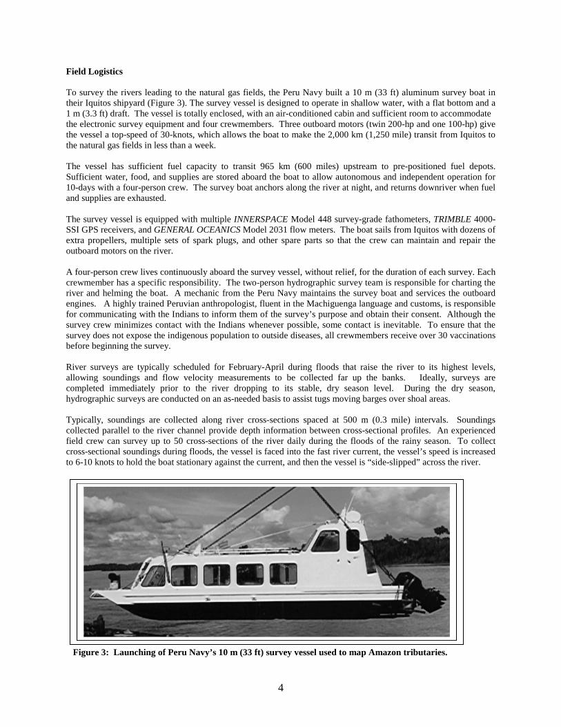
Field Logistics To survey the rivers leading to the natural gas fields, the Peru Navy built a 10 m (33 ft) aluminum survey boat in their Iquitos shipyard (Figure 3). The survey vessel is designed to operate in shallow water, with a flat bottom and a 1 m (3.3 ft) draft. The vessel is totally enclosed, with an air-conditioned cabin and sufficient room to accommodate the electronic survey equipment and four crewmembers. Three outboard motors (twin 200-hp and one 100-hp) give the vessel a top-speed of 30-knots, which allows the boat to make the 2,000 km (1,250 mile) transit from Iquitos to the natural gas fields in less than a week. The vessel has sufficient fuel capacity to transit 965 km (600 miles) upstream to pre-positioned fuel depots. Sufficient water, food, and supplies are stored aboard the boat to allow autonomous and independent operation for 10-days with a four-person crew. The survey boat anchors along the river at night, and returns downriver when fuel and supplies are exhausted. The survey vessel is equipped with multiple INNERSPACE Model 448 survey-grade fathometers, TRIMBLE 4000-SSI GPS receivers, and GENERAL OCEANICS Model 2031 flow meters. The boat sails from Iquitos with dozens of extra propellers, multiple sets of spark plugs, and other spare parts so that the crew can maintain and repair the outboard motors on the river. A four-person crew lives continuously aboard the survey vessel, without relief, for the duration of each survey. Each crewmember has a specific responsibility. The two-person hydrographic survey team is responsible for charting the river and helming the boat. A mechanic from the Peru Navy maintains the survey boat and services the outboard engines. A highly trained Peruvian anthropologist, fluent in the Machiguenga language and customs, is responsible for communicating with the Indians to inform them of the survey’s purpose and obtain their consent. Although the survey crew minimizes contact with the Indians whenever possible, some contact is inevitable. To ensure that the survey does not expose the indigenous population to outside diseases, all crewmembers receive over 30 vaccinations before beginning the survey. River surveys are typically scheduled for February-April during floods that raise the river to its highest levels, allowing soundings and flow velocity measurements to be collected far up the banks. Ideally, surveys are completed immediately prior to the river dropping to its stable, dry season level. During the dry season, hydrographic surveys are conducted on an as-needed basis to assist tugs moving barges over shoal areas. Typically, soundings are collected along river cross-sections spaced at 500 m (0.3 mile) intervals. Soundings collected parallel to the river channel provide depth information between cross-sectional profiles. An experienced field crew can survey up to 50 cross-sections of the river daily during the floods of the rainy season. To collect cross-sectional soundings during floods, the vessel is faced into the fast river current, the vessel’s speed is increased to 6-10 knots to hold the boat stationary against the current, and then the vessel is “side-slipped” across the river. Figure 3: Launching of Peru Navy’s 10 m (33 ft) survey vessel used to map Amazon tributaries.

5
Establishing Benchmarks No reliable benchmarks exist in the Peruvian Amazon, so the survey crew has to establish the first benchmarks in the region. The new benchmarks are set in bedrock or concrete at 65-80 km (40-50 mile) intervals along the river near the location of the water level recorders. The new benchmarks serve as a permanent reference to tie this study to future surveys. The coordinates and ellipsoidal heights for the new benchmarks are determined using existing monuments located hundreds of kilometers away. The closest and most-reliable monuments are located at Arequipa, Peru (located 547 km/340 miles south) and Bogota, Columbia (located 1,770 km/1,100 miles north). The Arequipa and Bogota monuments are located at Continuously Operating Reference (COR) stations where highly accurate receivers continuously record GPS observations and provide the results via the Internet. Establishing new benchmarks over a 2,317 km (1,440 mile) baseline is rarely attempted; however, a technique called "post-processed differential GPS using precise orbits" achieves impressive results. To employ this technique, the survey crew collects GPS observations over the new benchmarks using a highly accurate TRIMBLE Model 4000-SSI receiver and geodetic antennae on a fixed height rod (Figure 4). After recording the GPS observations over each new benchmark for 24-hours, the data is processed by a registered land surveyor. The 24-hours of GPS observations collected at the new benchmarks are compared to simultaneous observations recorded at the COR stations in Arequipa and Bogota. Comparing the GPS observations from two COR stations results in two solutions: one solution from the Arequipa baseline and a second solution from the Bogota baseline. Each solution provides an independent check on the other, and the difference between the solutions is its precision, or repeatability. Amazingly, the coordinates and heights computed from the Arequipa and Bogota COR stations match within about 5 cm (2 inches) at all eight benchmarks surveyed (horizontal range: +0.7-5.5 cm; vertical range: +2.5-6.5 cm). Figure 4: 24-hour GPS observations collected over Benchmark (inset) at well in Indian village of Camisea.

6
Monitoring River Levels The success of an Amazon River survey hinges on one absolute requirement – collect a continuous, unbroken record of the river levels at a series of monitoring stations descending the river. A survey is a failure if there are breaks in the data set at any of the river level monitoring stations. Spaced at 65-80 km (40-50 mile) intervals, the stations are more distant than desired and allow no contingency for equipment failure or data loss. Monitoring water levels on a wild river is difficult because there are no structures on which to mount instruments or staffs. The optimal location for installing water level recorders is in the deepest pools of the river. At the bottom of the deepest pools, the water level recorders remain submerged even after the river drops to dry season levels. Submerged recorders are safe from curious Indians and cannot be disturbed by uprooted trees or other flotsam carried by flashfloods. The deep pools are scoured out during the rainy season when floodwaters generate large whirlpools of 30 m (100 ft) radius. If recorders can be installed during flood conditions in the deepest pools under these large whirlpools, the instruments can monitor the river levels well into the dry season. The survey crew employs a bold strategy of installing self-recording, pressure-sensing water level recorders in the center of large whirlpools, where the flow spins the slowest. When lowered on to specially designed anchors driven into the bottom of the deepest pools, these rugged recorders remain fixed in place for up to 3-months (Figure 5). Every 15-minutes the instruments record underwater pressure, an inferred measure of river height. The survey crew calibrates the water level recorders weekly by directly measuring the height of the river using the nearby benchmark as reference. To install and service the water level recorders, the survey crew has to repeatedly anchor the boat in the center of whirlpools. Using four anchors to secure a boat in the center of immense Amazon whirlpools is not without risk; however, the results justify the method. All water level recorders have functioned perfectly, and a continuous, unbroken record of water levels has been obtained for 500 km (310 miles) of wild river.
Figure 5: Water Level Recorder is strapped to a bracket and lowered on to an anchor in the river bottom.

7
Initially, the results from the water level recorders are displayed in a sequence of time-series plots referenced to ellipsoidal heights. These time-series plots show periods of high-water when floodwaves wash downriver, as well as periods of low, stable river levels when the entire 500 km (310 miles) of river is at steady-state (Figure 6). River level plots are then aligned to an equal and arbitrary elevation, using periods as reference when all 500 km (310 miles) of river flows at steady state. After aligning the water level records from all monitoring stations to a common vertical datum, the velocity and propagation time of flood waves between stations is calculated. Figure 6: Elevation of 500 km (310 miles) of River (left) and Flood Wave Propagation Plots (right). Establishing the Extreme Low Water (ELW) River Datum Amazon tributaries raise and lower by up to 10 m (33 ft) depending upon upstream rainfall. Raw soundings at one river crossing may show a maximum depth of 12 m (40 ft) during floods, but only 3 m (10 ft) during the dry season. To be of use, soundings must be corrected to a common vertical datum in order to chart the depth of river at its lowest stage and expose shoal areas that may be difficult to navigate during the dry season. A new vertical datum, called Extreme Low Water (ELW), was developed to correct the soundings for changes in river levels. The new ELW vertical datum combines the river level data from all monitoring stations along the 500 km (310 miles) of river and reduces them to an equal elevation at a point in time when the river is observed to flow at a steady state. The ELW vertical datum is based upon the shallowest shoal of the river being at elevation zero (0) when soundings are corrected for ELW. River levels measured on the ELW vertical datum translate directly into water depth over the shallowest shoal, and provide tug skippers with depth corrections to add to the soundings shown on the navigation charts. For example, a river level of 6 m (20 ft) ELW means that there is 6 m (20 ft) of water at the shallowest shoal and that 6 m (20 ft) can be added to the soundings shown on the navigation charts. All soundings collected along the 500 km (310 miles) of river are referenced to the ELW vertical datum based upon river level monitoring stations spaced at nominal 80 km (50 mile) intervals. Since soundings are collected between river level monitoring stations, the ELW correction is not derived from river level data collected at any single station. ELW at these intermediate locations is calculated by interpolating the wave travel delay and river levels from stations upstream and downstream of the survey vessel. When soundings collected during the floods at the end of the rainy season are corrected to the ELW vertical datum, the resulting chart provides a prediction of the channel depth when the river drops to its low, dry season levels. Comparing soundings collected during the floods of the rainy season with soundings collected during the dry season indicate that the corrected soundings match to better than +0.5 m (+1.6 ft), with the greatest errors occurring furthest from the water level monitoring stations. Soundings collected at different times under different river stages should match if the ELW is accurately defined. The resulting series of charts (Figure 7), referenced to the UTM Zone 18-South coordinate system in meters, show the depth of river at its predicted lowest water stage and outlines a nearly continuous natural river channel appropriate for tug navigation.

8
Figure 7: Overlapping river navigation charts (left), Chart 9 of 20 (top right), and close-up showing that centerline soundings match cross-sectional soundings at their intersections (bottom right).

9
CONCLUSION The results from surveys of Amazon tributaries are presented as a series of overlapping navigation charts plotted at scale 1:6,000 (1 in = 500 ft). The charts outline a continuous navigation channel of varying width all the way to the Pongo, the end of navigable waters on the Amazon. The only break in the navigation channel occurs during the dry season at a shoal called Fundo Texas, named after a nearby plantation. If a demarcation line existed at the edge of modern society, that line would cross the Urubamba River at Fundo Texas. Located a few miles upstream of the Peru military's most remote outpost on the Urubamba River, the 0.8 km-long (0.5 mile) shoal acts as a barrier during the dry season to tugs bound for the natural gas fields. The shoal near Fundo Texas is created by a semi-buried ridge of bedrock that bisects the river near the mouth of a tributary. The river flows over the bedrock during the high water floods of the rainy season, but during the dry season the river is routed into the delta of a tributary. Tugs can cross over the shoal during high water conditions of the rainy season, and possibly during flashfloods that randomly occur during the dry season. During the dry season, only dredging or portaging will move supplies and materials across the Fundo Texas shoal. Except for the shoal at Fundo Texas, a natural river channel extends all the way to the Pongo. Half a dozen shallow areas exist in the river channel, but these small areas are at least 1 m (3.3 ft) deeper than the Fundo Texas shoal. Some sections of the natural river channel may be too narrow (<100 m/330 ft) for tugs traveling in opposite directions to pass. Vessel traffic controls may have to be implemented in these narrow areas to avoid collisions. Comparing satellite photographs taken during low water conditions in 1996 to the navigation charts of 1998 indicate that the natural river channel changed little during the 2-year period. This suggests that the natural river channel is stable and exists for several years, rather than transient and unpredictable. Indeed, a survey of the river during low water conditions of the following dry season found the river to closely match the navigation charts, except for a few areas where the river built islands or cut through its meanders. During the rainy season, tugs cannot use the river for 1-to-2 days per week because the navigation channel is filled with heavy concentrations of floating wood debris being carried downstream by floodwaters. When the rivers rise to flood levels, massive amounts of wood flotsam concentrate in the navigation channel. The rising floodwaters initially carry driftwood, but the navigation channel becomes choked with uprooted trees at peak river levels. During floods, a river rises twice as fast as it recedes and wood debris disappears after floodwaters begin to ebb. Tug navigation is infrequently possible during the dry season. Upstream rainstorms occasionally generate flood waves that descend the river during the dry season. River level measurements show that the crest of a flood wave travels downstream at about 7 knots, requiring 1.5 days to descend 500 km (310 miles) of the river. If the crest of an infrequent flood wave can be observed as it passes the Pongo, downstream tugs might have hours to days to prepare for using the rising waters as a natural loch to lift barges over shoals and shallow areas. Real-time monitoring of river levels at the Pongo, and at other key locations, might also give tugs advance notice before river levels drop below navigable levels.
REFERENCES Jones, M.G., and Shell. 1998. Environmental Impact Assessment within a Multi-National Enterprise - Adaptive EIA
in the Camisea Project. http://www.camisea.com. Beier, C. and L. Michael. 1998. The Camisea Nanti: A Report on Factors Affecting their Welfare and Autonomy.
A Cabeceras Aid Project Report. Austin, TX 78752. www.onr.com/cabeceras/contents.htm