survey of tropical landforms on the … · survey of tropical landforms on the island of cuba --...
TRANSCRIPT
SURVEY OF TROPICAL LANDFORMS ON THE ISLAND OF CUBA -- EPICENTER OF ANTILLEAN KARST
EXPLORERS CLUB FLAG NO. 99 EXPEDITION REPORT EXPEDITION DATES: NOVEMBER 8 – 23, 2013
LEADER: THOMAS N. AMBROSE MN ‘10
ASSISTANT: NATALIE AMBROSE
CONTENTS Topic Page Introduction 1 Planning and Logistics 2 Itinerary and Route 3 Karst Definitions and Characteristics 5 Karst Around the World 7 Karst in Art 7 Caribbean Karst and Its Cultural Impact 8 Greater Antillean Karst 9 Cuban Karst Areas 12 Conclusions and Accomplishments 19 Team Bios 20 Map Enlargements 21, 22
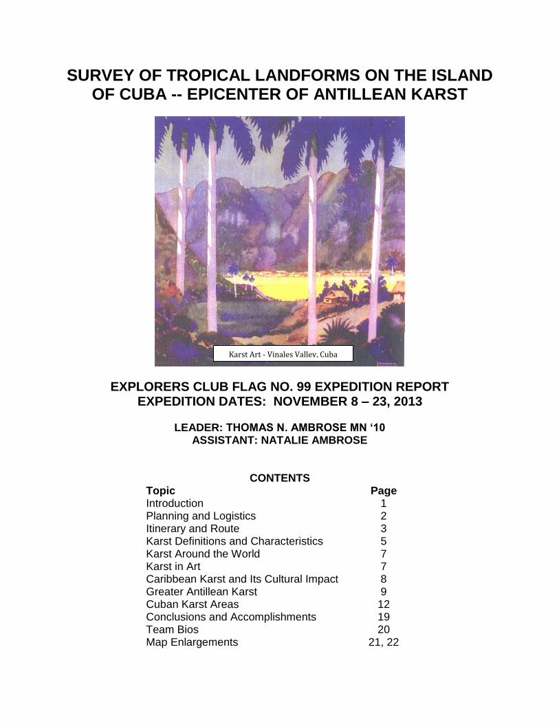
Karst Art - Vinales Valley, Cuba

1
INTRODUCTION
The Expedition objective was to survey, locate and document karst
landforms in Cuba and their relation to similar features in the adjacent
islands of the Greater Antilles which are Puerto Rico, Hispaniola
(Dominican Republic and Haiti), and Jamaica. In past years, the author has
lived on and/or conducted geological field studies on all these islands.
According to EC archives, Flag No.99 expedition was the second in history
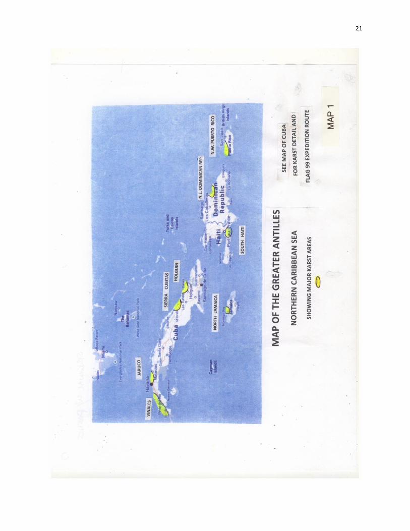
to carry the flag to Cuba. Four major karst areas (all located along the north
coast) were located and photographed during the expedition, one of world-
class significance. The names of the four karst areas were originated by
the author and may not appear in other literature or maps. See Map No. 1
below for locations of the Greater Antillean karst areas.
As expedition leader I had the advantage of having lived and worked in
Cuba for four years during and after the Revolution, with resulting intimate
knowledge of the island. My daughter, Natalie, served as my assistant and
was an excellent choice, having been born in Cuba and being proficient in
Cuban Spanish. She was also the Expedition photographer.
Thanks to Constance Difede, our VP for Flags and Honors, for her special
attention with my Flag applications for Expeditions to both Cuba and Brazil
(2011). Thanks also to Emerald Nash in Member Relations for her
assistance with Flag issuance and receipt.

2
PLANNING AND LOGISTICS
The mid-point of the 2013 Caribbean hurricane season (about September
15th) was allowed to pass before applying for the EC Flag, since an
expedition could be in grave danger during a storm, especially with limited
Cuban emergency relief available to a foreigner. On the other hand the
endeavor had to commence prior to the December high tourist season
when bus and hotel space is very limited, especially since both were
arranged on a day-to-day basis without any advance reservations. As it
turned out, even in November we found most hotels full, so ended up
staying in casa particulares (private houses) where often only Spanish was
spoken.
3
Since travel was along roads with provision vendors, no subsistence
arrangements were required. All outfitting, including field clothing, money
belts (important since only cash is accepted from US citizens in Cuba), field
notebook, etc., was completed in the USA. The fact that Cuba has few if
any infectious diseases, no poisonous snakes, etc., made a medical kit
unnecessary. The expedition felt secure even on isolated back roads due
to the hard-working and friendly nature of the rural folk, the highly
controlled society, and the restricted availability of private firearms as
compared with the US. There is little crime against tourists even on the
poorly lighted night streets of Havana.
My travel to Cuba was permitted under a US general license for
professional scientific study. My assistant Natalie, having been born in
Cuba, required only a Visa from the Cuban Interest Section in Washington
DC. In both cases, this allowed us to fly directly from Miami to Havana
using a US government approved TSP (Travel Service Provider).
Upon arrival in Havana, we were pulled aside by immigration and asked
about our plans and itinerary in Cuba – our reply was to travel the entire
island. Had we been with a formal tour group these questions would
probably not have been asked. During our expedition, nobody or the
MININT (Ministry of Interior) security agents approached us although they
had access to our movements via our passport registrations at each
overnight accommodation. Basically, we had free range to go anywhere.
ITINERARY AND ROUTE
The expedition commenced at 2:30pm on November 8th in Miami, Florida
when an American Airlines charter was boarded for a flight across the
Florida Straits. Less than an hour later, the uplifted and rocky karst coast of
Cuba was below, a notable change from the flat Everglades and mangrove
covered tidelands of Florida Bay and the Keys. Just prior to a 3:30pm
landing at Jose Marti International Airport, twin limestone hills known as the
4
Tetas de Managua marked the horizon some seven miles southeast of the
runway and at 700 feet are the highest elevations in greater Havana.
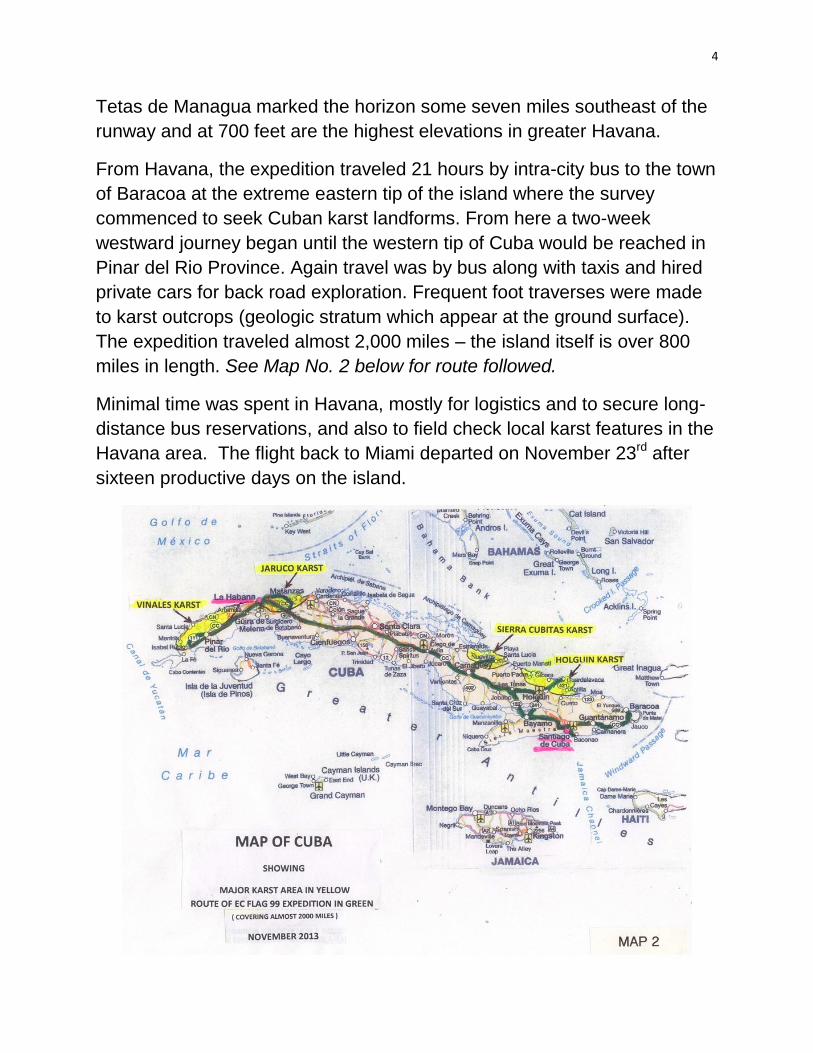
From Havana, the expedition traveled 21 hours by intra-city bus to the town
of Baracoa at the extreme eastern tip of the island where the survey
commenced to seek Cuban karst landforms. From here a two-week
westward journey began until the western tip of Cuba would be reached in
Pinar del Rio Province. Again travel was by bus along with taxis and hired
private cars for back road exploration. Frequent foot traverses were made
to karst outcrops (geologic stratum which appear at the ground surface).
The expedition traveled almost 2,000 miles – the island itself is over 800
miles in length. See Map No. 2 below for route followed.
Minimal time was spent in Havana, mostly for logistics and to secure long-
distance bus reservations, and also to field check local karst features in the
Havana area. The flight back to Miami departed on November 23rd after
sixteen productive days on the island.

5
KARST DEFINITIONS AND CHARACTERISTICS
The term karst derives from the name of a limestone plateau in Slovenia
(Europe) and refers to abrupt and often bizarre-shaped landforms resulting
from weathering or dissolution by water of soluble carbonate (limestone,
occasional dolomite) rocks. Karst refers to both the surface (outcrops) and
the sub-surface (caves) occurrence of thick eroded limestone. These
landscapes are most common in tropical to sub-tropical climates with
abundant rainfall. The type of limestone is important inasmuch as the softer
porous beds will be dissolved more rapidly by acid rain than will those of
hard and dense nature. Limestones are usually whitish and easy to identify.
To experience how rapidly carbonates can dissolve, apply several drops of
dilute hydrochloric acid onto a piece of limestone and watch the rock fizz
away.
Mega surface karst types include ‘positive’ features termed towers (isolated
and near vertical), haystacks, cones, pinnacles, along with ‘negative’
features such as potholes and sinkholes. Mega sub-surface karst includes
caves and underground rivers. Sometimes caves become elevated and
isolated in karst towers due either to lowering of the tower bases by erosion
or by uplift of the towers following cave development. Buttes and pinnacles
of Monument Valley, Arizona, may exhibit similar landforms as karst, but
are not inasmuch as they are composed of sandstone rather than
limestone.
Minor surface karst types include limestone pavements, sharp-edged rocks
called Diente de Perro (Dog’s Teeth), stone forests, stone cities, isolated
stone stacks, and are termed ‘Karren.’ These often develop in horizontal
carbonate beds as remnants at the end of an erosional cycle.
Karstlands frequently originate in structurally uplifted areas of hard
carbonate rocks. The uplift itself commonly induces faulting and fracturing
that provide a path of entry for surface waters and resulting erosion. Other
factors in karst development are depth to the water table and age of the
6
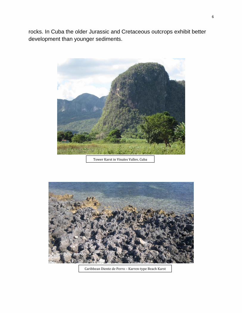
rocks. In Cuba the older Jurassic and Cretaceous outcrops exhibit better
development than younger sediments.
Tower Karst in Vinales Valley, Cuba
Caribbean Diente de Perro – Karren-type Beach Karst
7
KARST AROUND THE WORLD
While karst landscapes are present on most continents, world-class
examples are mainly present in Asia including Guilin, China, Halong Bay,
Vietnam, and Phangnga Bay/Krabi, Thailand. Cuban karst is the most
spectacular in the Americas and of world-class status, some protected
since 1985 by UNESCO as a World Heritage Site along with a Biosphere
Reserve covering some 100 square miles. The maximum karst tower
height in Guilin is 1,600 feet while similar towers (Mogotes) in Vinales
Valley, Cuba sometimes reach 1,300 feet above the valley floor.
KARST IN ART
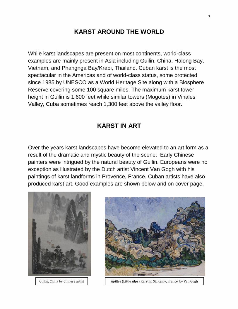
Over the years karst landscapes have become elevated to an art form as a
result of the dramatic and mystic beauty of the scene. Early Chinese
painters were intrigued by the natural beauty of Guilin. Europeans were no
exception as illustrated by the Dutch artist Vincent Van Gogh with his
paintings of karst landforms in Provence, France. Cuban artists have also
produced karst art. Good examples are shown below and on cover page.
Guilin, China by Chinese artist Apilles (Little Alps) Karst in St. Remy, France, by Van Gogh

8
CARIBBEAN KARST AND ITS CULTURAL IMPACT
The Caribbean is one of the world’s premier karst regions with 90 percent
of these landforms present in the Greater Antilles. Karst is one of two
important landscape types, the other being volcanic terrain with recently
active volcanoes present in the Lesser Antilles.
Since Columbus discovered the Greater Antilles, karstlands have been
both beneficial and detrimental to human habitation. Pre-Colombian people
used karst caves for shelter while later the survivors used caves as refuges
against the encroaching Colonials. In Jamaica, remote cockpits (sinkholes)
served as hideouts for people who resisted Colonial authority. On the
northeast coast of Cuba, the Sierra Cubitas karst provided cover and
security for pirates who operated along that coast. The inland Colonial town
of Camaguay resisted pirate attacks by developing a maze-like street plan
to confuse these attackers and finally drove them back to the coast and
their Cubitas cave and ravine lairs.
Agriculture in karst areas has suffered from the lack of rivers and surface
waters. The sinkholes and crevices of karstlands allow rainwater to rapidly
sink into the subterranean, leaving the soil parched between rainfalls. The
lack of rivers and lakes hinders water storage for dry season irrigation.
Rivers are known to disappear into a sinkhole and reappear downstream.
Rapid rainfall runoff in porous karst can result in surface pollutants being
carried underground to mix with and make drinking water unsafe.
‘Negative’ karst features can pose danger to modern habitation. Sink holes
can unexpectedly appear and swallow houses, animals, cars, and people,
especially in areas where ground water levels are lowered due to
overproduction of water resources such as in west central Florida. On the
other hand a beneficiary of karst land is ecotourism, especially if the karst
is near a major city like Havana. Karst offers cave exploration, rock
climbing, underground river tours, archeological sites, and isolated areas
with indigenous wildlife and forest cover. For years small karst hills within
the city of San Juan, Puerto Rico, have been conveniently quarried to

9
provide limestone for landfills, along with construction materials and
cement for roads and buildings.
Lastly, the isolation and low population density -- with lessened human
release of ozone destroying gases -- of most Caribbean karst areas is a
positive factor, if only small, in climate change prevention.
GREATER ANTILLEAN KARST
Puerto Rico
While limestone outcrops all along the north coast of Puerto Rico, the major
karst area is the inland northwest corner of the island (south of Arecibo) in
the Lares Formation of Oligocene age. Here the karst is both surface
(ubiquitous, small, forested, haystack type hills) and sub-surface (caves
and underground rivers). This is not a developed agricultural area due to
its rocky and isolated nature along with a lack of roads. In the 1960s I
conducted geological field studies in this karst zone -- prior to oil
exploration drilling which had negative results, a boon to the island’s
environmental protection.
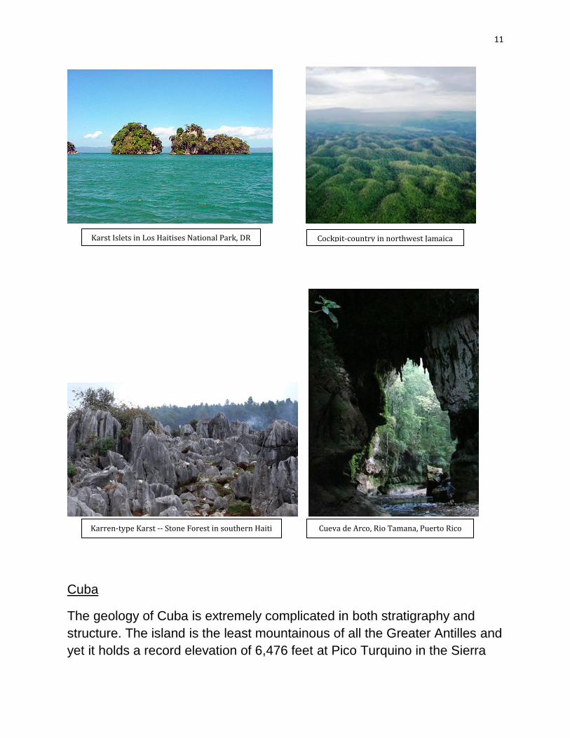
In 1964, EC member Russell Gurnee carried Flag No. 178 to the Rio
Camuy area to explore the underground course of the river with the
recommendation that a park be developed. In 1986 the Rio Camuy Cave
Park was opened and today is visited by over 150,000 annually. The main
attraction is the Clara cave which connects to the world’s third longest
subterranean river. Another attraction is the Tres Pueblos sinkhole which
is 400 feet deep by 650 feet across, at the bottom of which flows the River
Camuy.
In 1971 Gurnee returned with Flag No. 179 with intent to conduct the first
traverse of Rio Tamana which goes underground five times over thirteen
miles. The beautiful and highly visited Cueva de Arco is located along this
river.
10
Dominican Republic
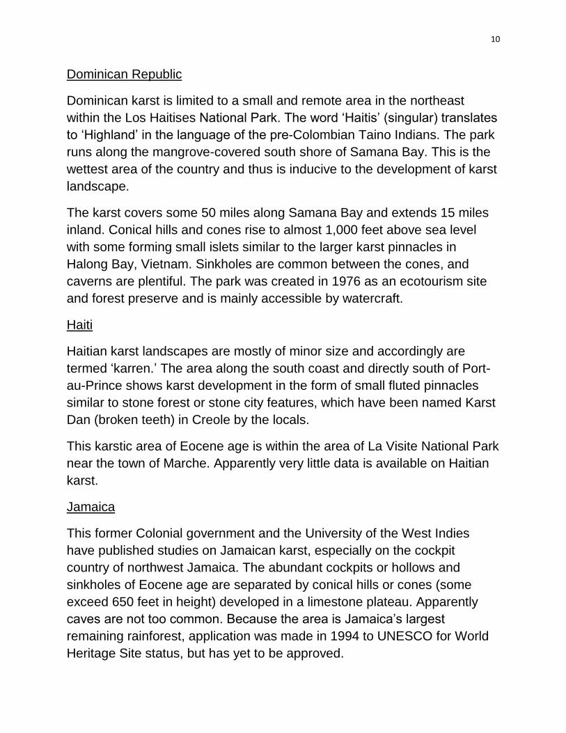
Dominican karst is limited to a small and remote area in the northeast
within the Los Haitises National Park. The word ‘Haitis’ (singular) translates
to ‘Highland’ in the language of the pre-Colombian Taino Indians. The park
runs along the mangrove-covered south shore of Samana Bay. This is the
wettest area of the country and thus is inducive to the development of karst
landscape.
The karst covers some 50 miles along Samana Bay and extends 15 miles
inland. Conical hills and cones rise to almost 1,000 feet above sea level
with some forming small islets similar to the larger karst pinnacles in
Halong Bay, Vietnam. Sinkholes are common between the cones, and
caverns are plentiful. The park was created in 1976 as an ecotourism site
and forest preserve and is mainly accessible by watercraft.
Haiti
Haitian karst landscapes are mostly of minor size and accordingly are
termed ‘karren.’ The area along the south coast and directly south of Port-
au-Prince shows karst development in the form of small fluted pinnacles
similar to stone forest or stone city features, which have been named Karst
Dan (broken teeth) in Creole by the locals.
This karstic area of Eocene age is within the area of La Visite National Park
near the town of Marche. Apparently very little data is available on Haitian
karst.
Jamaica
This former Colonial government and the University of the West Indies
have published studies on Jamaican karst, especially on the cockpit
country of northwest Jamaica. The abundant cockpits or hollows and
sinkholes of Eocene age are separated by conical hills or cones (some
exceed 650 feet in height) developed in a limestone plateau. Apparently
caves are not too common. Because the area is Jamaica’s largest
remaining rainforest, application was made in 1994 to UNESCO for World
Heritage Site status, but has yet to be approved.
11
Cuba
The geology of Cuba is extremely complicated in both stratigraphy and
structure. The island is the least mountainous of all the Greater Antilles and
yet it holds a record elevation of 6,476 feet at Pico Turquino in the Sierra
Karst Islets in Los Haitises National Park, DR Cockpit-country in northwest Jamaica
Karren-type Karst -- Stone Forest in southern Haiti Cueva de Arco, Rio Tamana, Puerto Rico
12
Maestre Mountains of eastern Cuba. Most of the island is flat to rolling hills.
The major mountains are concentrated in several groups with many
outcrops termed Basement Complex composed of volcanic/igneous and
metamorphic rocks (transformed by heat and pressure) with few
limestones. An exception are the mountains in western Pinar del Rio
Province which include the Vinales Valley area with abundant karst
limestones.
The expedition commenced at Baracoa on the eastern tip of Cuba which
was founded by the Spanish in 1512 as the oldest town on the island.
Since no significant limestones were found, the expedition continued west
to the Holguin karst. See Map No.2 above.
CUBAN KARST AREAS
Holguin Karst
This area on the northeast coast of Cuba, between the city of Holguin and
the Guardalavaca beach tourist zone has extensive karst limestone
outcrops in the form of butte-type landforms not usually found in Cuba,
rising from a savanna type arid plain. These impressive features are
known as the Cerros Maniabon, of Cretaceous age. These karst features
were eroded during an earlier geologic time with a wet climate, while today
the Holguin area has the least rainfall in all of Cuba. Outcrops of Basement
Complex rocks (including Serpentines) were also noted in the area. The
pre-Colombian Taino Indians lived in this vicinity and occupied karst caves
for shelter.
Guardalavaca beach exhibits coral limestones with some Diente de Perro
surface. This limestone is thought to be very young, probably Pleistocene
in age.

13
Sierra Cubitas Karst
The Sierra Cubitas is a low northwest-southeast elongate mountain range
lying 8 to10 miles inland from the north coast of Camaguey Province.
These karst mountains reach a maximum elevation 1,082 feet at Cerro
Tuabaguey (Loma Limones on recent maps).
Holguin Area Karst Buttes in Cerros Maniabon Atlantic coastal limestone at Guardalavaca Beach
Cerro Tuabaguey in Sierra Cubitas
14
The Cubitas is famous for the Hoyo de Bonet, Cuba’s largest karst
depression some 295 feet deep. It was named after the pirate Bonet who
used it as a hideout. Another notable site is along the Rio Maximo called
the Paso de los Paredones, a water-cut, steep-sided karst ravine some
325 feet deep and over one-half mile long. Much of the Cubitas surface is
rough and jagged Diente de Perro ‘karren’ type karst with underlying
caverns, some with Taino Indian wall paintings. My friend and EC member
Rudy Mola kindly provided information on these Cubitas caves. Rudy spent
his boyhood in the area and has suggested a possible EC expedition to
revisit the caves.
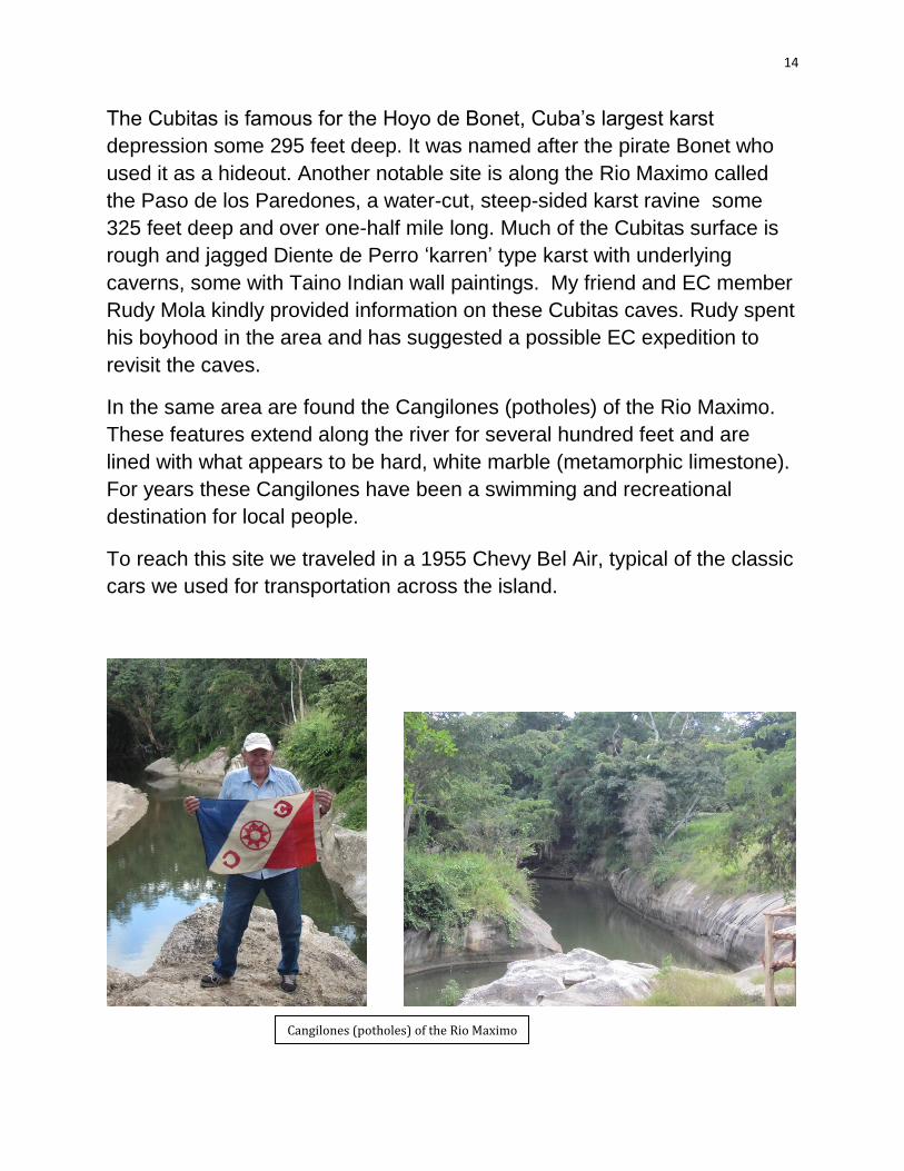
In the same area are found the Cangilones (potholes) of the Rio Maximo.
These features extend along the river for several hundred feet and are
lined with what appears to be hard, white marble (metamorphic limestone).
For years these Cangilones have been a swimming and recreational
destination for local people.
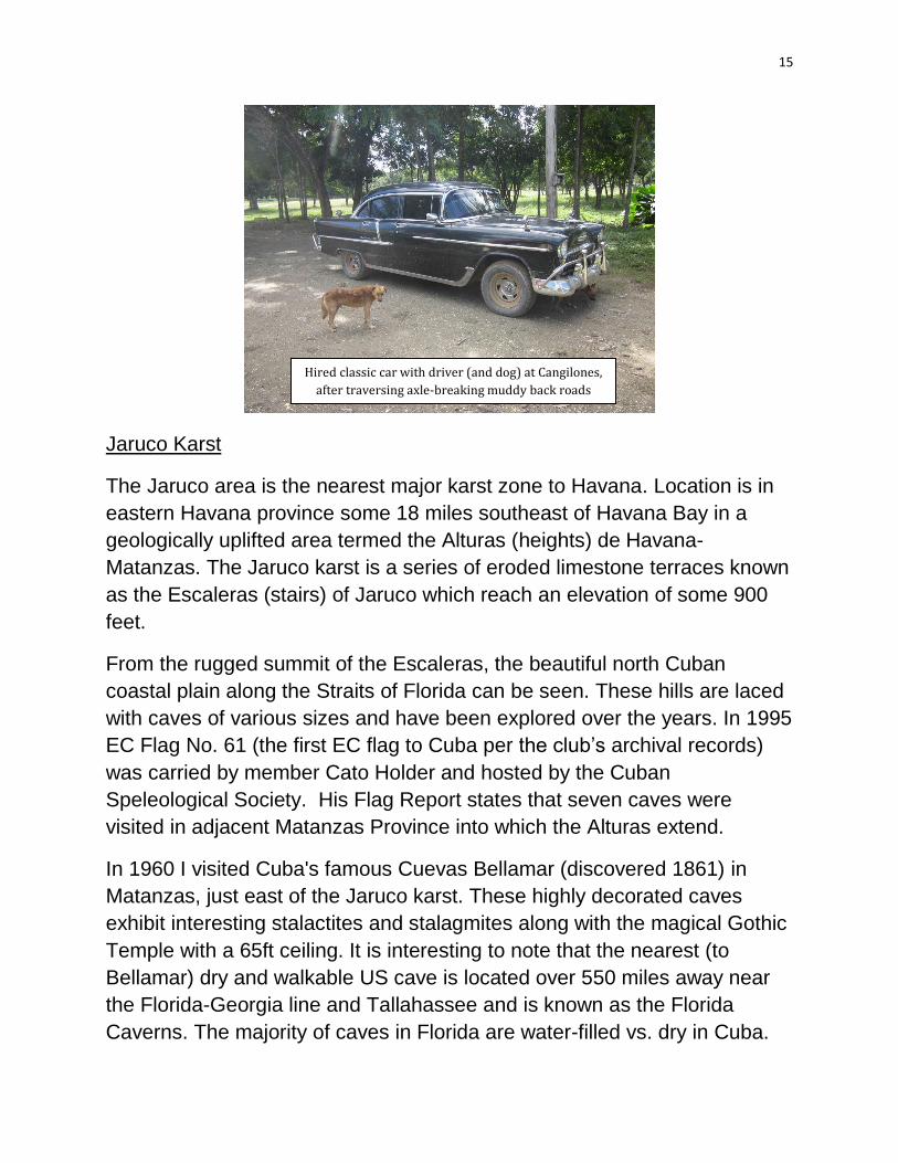
To reach this site we traveled in a 1955 Chevy Bel Air, typical of the classic
cars we used for transportation across the island.
Cangilones (potholes) of the Rio Maximo
15
Jaruco Karst
The Jaruco area is the nearest major karst zone to Havana. Location is in
eastern Havana province some 18 miles southeast of Havana Bay in a
geologically uplifted area termed the Alturas (heights) de Havana-
Matanzas. The Jaruco karst is a series of eroded limestone terraces known
as the Escaleras (stairs) of Jaruco which reach an elevation of some 900
feet.
From the rugged summit of the Escaleras, the beautiful north Cuban
coastal plain along the Straits of Florida can be seen. These hills are laced
with caves of various sizes and have been explored over the years. In 1995
EC Flag No. 61 (the first EC flag to Cuba per the club’s archival records)
was carried by member Cato Holder and hosted by the Cuban
Speleological Society. His Flag Report states that seven caves were
visited in adjacent Matanzas Province into which the Alturas extend.
In 1960 I visited Cuba's famous Cuevas Bellamar (discovered 1861) in
Matanzas, just east of the Jaruco karst. These highly decorated caves
exhibit interesting stalactites and stalagmites along with the magical Gothic
Temple with a 65ft ceiling. It is interesting to note that the nearest (to
Bellamar) dry and walkable US cave is located over 550 miles away near
the Florida-Georgia line and Tallahassee and is known as the Florida
Caverns. The majority of caves in Florida are water-filled vs. dry in Cuba.
Hired classic car with driver (and dog) at Cangilones,
after traversing axle-breaking muddy back roads
16
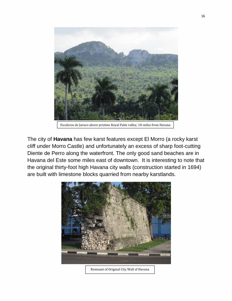
The city of Havana has few karst features except El Morro (a rocky karst
cliff under Morro Castle) and unfortunately an excess of sharp foot-cutting
Diente de Perro along the waterfront. The only good sand beaches are in
Havana del Este some miles east of downtown. It is interesting to note that
the original thirty-foot high Havana city walls (construction started in 1694)
are built with limestone blocks quarried from nearby karstlands.
Escaleras de Jaruco above pristine Royal Palm valley, 18-miles from Havana
Remnant of Original City Wall of Havana

17
Vinales Karst
The world-class Vinales Valley karst area is located about 100 miles west
of Havana in Pinar del Rio Province in the Cordillera de Guaniguanico
mountain chain, which reaches its highest elevation at 2,293 feet on the
sugarloaf-shaped Pan de Guajaibon near the north coast. These mountains
are divided into the Sierra de Rosario in the east and Sierra de los Organos
in the west. These karst limestone outcrops are Jurassic age (earlier maps
show a Cretaceous age) and the oldest in Cuba. The relative nearness to
Havana (population over 2.2 million) makes it a destination for Cubans as
well as for foreign tourists.
The area has several environmentally significant areas including the
Vinales Valley UNESCO World Heritage site, La Guira National Park, and
the UNESCO Sierra Rosario Biosphere Reserve. These karstlands have
many caves including Santo Tomas, a sixteen mile system of passages
and thus the longest in Cuba. Cueva de Indio is very touristic and offers a
subterranean motorboat ride. Many of these caves were inhabited by pre-
Colombian Indians, while another inhabitant is the non-poisonous Pygmy
Boa, the only locality in Cuba where this snake is said to be found.
Pan de Guajaibon peak – only 7 miles from Gulf of Mexico
coastline
18
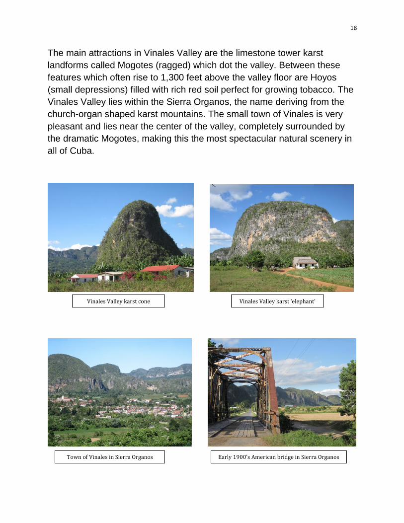
The main attractions in Vinales Valley are the limestone tower karst
landforms called Mogotes (ragged) which dot the valley. Between these
features which often rise to 1,300 feet above the valley floor are Hoyos
(small depressions) filled with rich red soil perfect for growing tobacco. The
Vinales Valley lies within the Sierra Organos, the name deriving from the
church-organ shaped karst mountains. The small town of Vinales is very
pleasant and lies near the center of the valley, completely surrounded by
the dramatic Mogotes, making this the most spectacular natural scenery in
all of Cuba.
Vinales Valley karst cone Vinales Valley karst ‘elephant’
Town of Vinales in Sierra Organos Early 1900’s American bridge in Sierra Organos

19
CONCLUSIONS AND ACCOMPLISHMENTS
This expedition carried the second EC Flag ever planted in Cuba. Surface
karst landforms were documented for the first time for the EC archives.
After conducting comparative studies on the other Greater Antillean karst
areas, it has been concluded that Cuban karst ranks number one in these
islands and is also world-class.
Should Cuba eventually open up to become a major tourist and cruise ship
destination particularly for Americans, Vinales Valley day tours could
become a premier shore excursion, being only a two hour drive from
Havana. Hopefully, advanced, strategic, and visionary planning by the
Cuban government will protect the environment and beauty of this area for
future generations.
Tom and Natalie Ambrose in Vinales Valley, Cuba

20
TEAM BIOS
Thomas Ambrose MN’10 (Expedition Leader and report author) holds BS
and MS degrees in Geology and has lived and worked as an international
exploration and natural resource geologist for many years in Cuba, Puerto
Rico, Trinidad, Colombia, Ecuador, Indonesia, and Singapore. In 2011 he
carried EC Flag No.99 to the Geodetic Center of South America in Brazil.
Ambrose is a member of the Southern Florida Chapter of the Explorers
Club and resides in Ocean Ridge, Florida. He can be reached at (t) 561-
737-3601 and [email protected].
Natalie Ambrose, Expedition Assistant, has an MBA in International
Business and works in trends research and strategic planning. She
believes that Cuba's future attraction will be from the continued
preservation of both its natural and built environments, currently little
changed from the 1950’s. Natalie resides in Washington, DC and can be
reached at [email protected].
Tom Ambrose doing fieldwork in Cuba,
with ‘Karren’ stone column in 1958 Ambrose in Holguin, Cuba hiring a classic
car for fieldwork in 2013
21

22