survey of the port coogee development area · 2 figure 2. mike pollard’s visual transits and...
TRANSCRIPT

Survey of the Port Coogee Development Area
Jeremy Green
Report—Department of Maritime ArchaeologyWestern Australian Museum, No. 213
2006


�
Introduction
The Port Coogee Development involves the construction of breakwaters and dredged channels in an area approximately 500 m offshore extending from latitude 32.0967�8°S longitude ��5.7592�7°E south to the 32.�04926°S ��5.67�788°E (note all latitude and longitude are given in decimal degrees and in WGS�984 datum); a distance of about � 000 m (see Figure �). At the north end of the development the position of two important wreck sites are known: James (�830) and Diana (�878); at the south end of the development the remains of the iron steamship Omeo (�905) are still visible (for the background history of these three vessels see Appendix �). Since the development is in an important historical anchorage area, Owen Anchorage, there is a possibility that other, undiscovered wreck sites exist in the area of the development. It was, therefore, a requirement under the Historic Shipwrecks Act 1976 that the area be investigated for underwater cultural heritage material. In addition, sand pumping or sand by-passing has been proposed as a long-term management solution for the effects that the breakwaters may have on the coastal shoreline. Since the three wrecks lie in an area that is likely to be affected by the coastal changes and the sand pumping, some baseline data was required to identify precisely where the sites are located and their
current positions relative to chart datum. Additionally, historical research was carried out to try and identify other material that was known to have been located in the general area.
The project aims
�. To locate and precisely delineate the James, Diana and Omeo sites;
2. To survey the area of the Port Coogee development that will either cover the sea bed or be affected by dredging for cultural remains; and
3. To establish datum points in the James and Diana site area and on the Omeo so that changes in the level of the sea bed and movements of the wrecks can be monitored in the future.
4. To attempt to identify the location of other material that may have been located in the area.
Figure �. Plan showing breakwater of proposed Port Coogee development, together with positions of wreck sites and objects of interest.
2
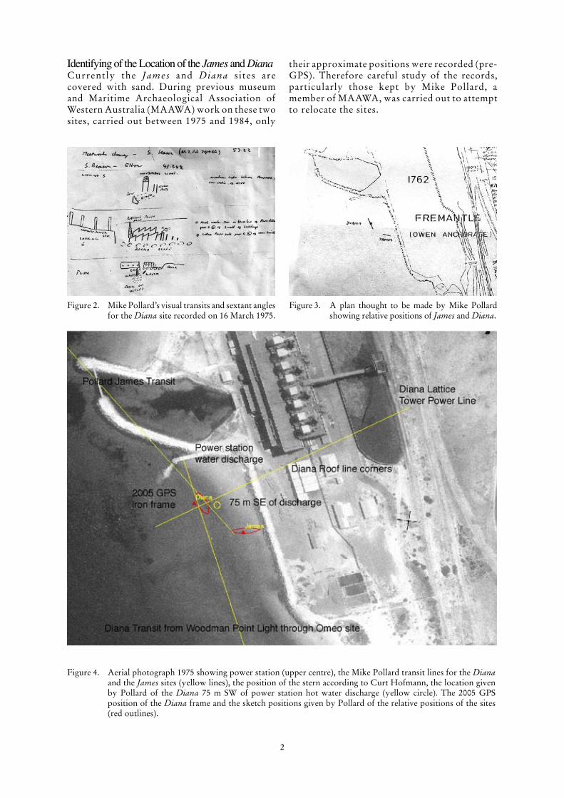
Figure 2. Mike Pollard’s visual transits and sextant angles for the Diana site recorded on �6 March �975.
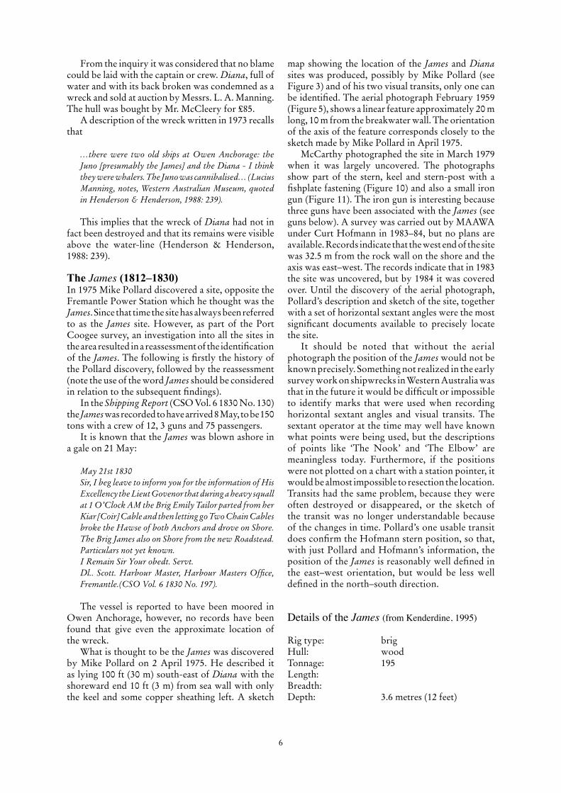
Figure 4. Aerial photograph �975 showing power station (upper centre), the Mike Pollard transit lines for the Diana and the James sites (yellow lines), the position of the stern according to Curt Hofmann, the location given by Pollard of the Diana 75 m SW of power station hot water discharge (yellow circle). The 2005 GPS position of the Diana frame and the sketch positions given by Pollard of the relative positions of the sites (red outlines).
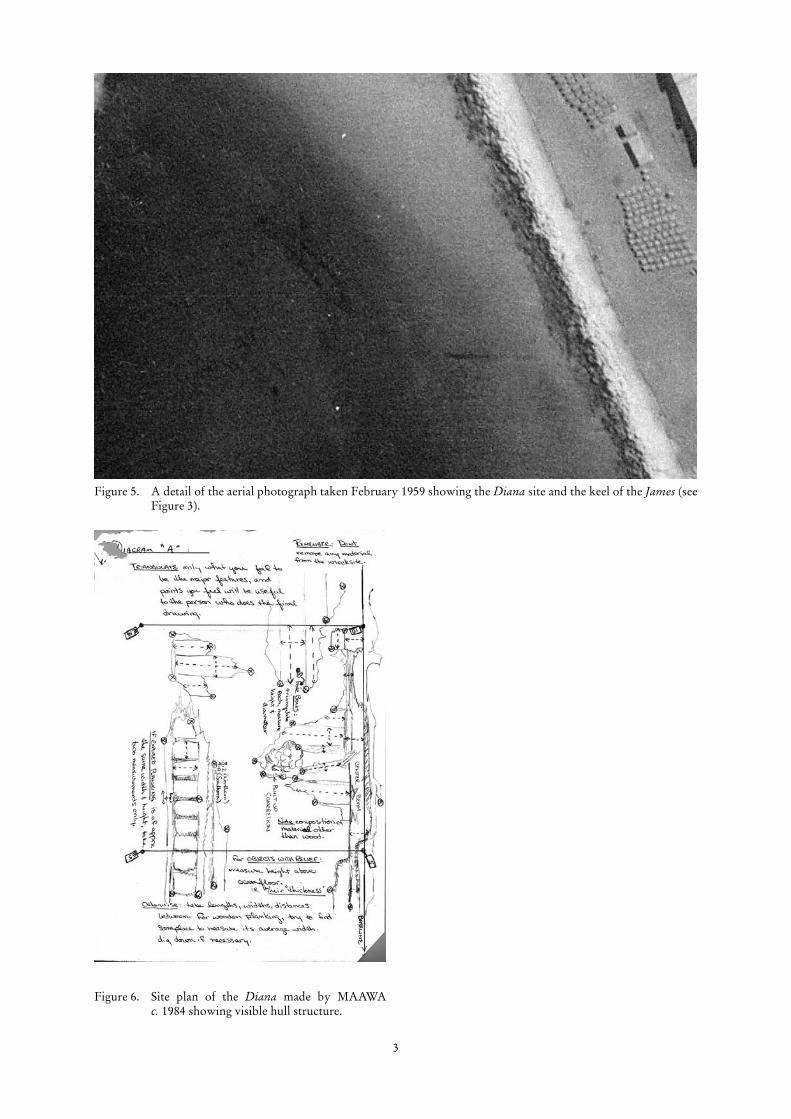
Figure 3. A plan thought to be made by Mike Pollard showing relative positions of James and Diana.
Identifying of the Location of the James and DianaCurrently the James and Diana s ites are covered with sand. During previous museum and Maritime Archaeological Association of Western Australia (MAAWA) work on these two sites, carried out between �975 and �984, only
their approximate positions were recorded (pre-GPS). Therefore careful study of the records, particularly those kept by Mike Pollard, a member of MAAWA, was carried out to attempt to relocate the sites.
3
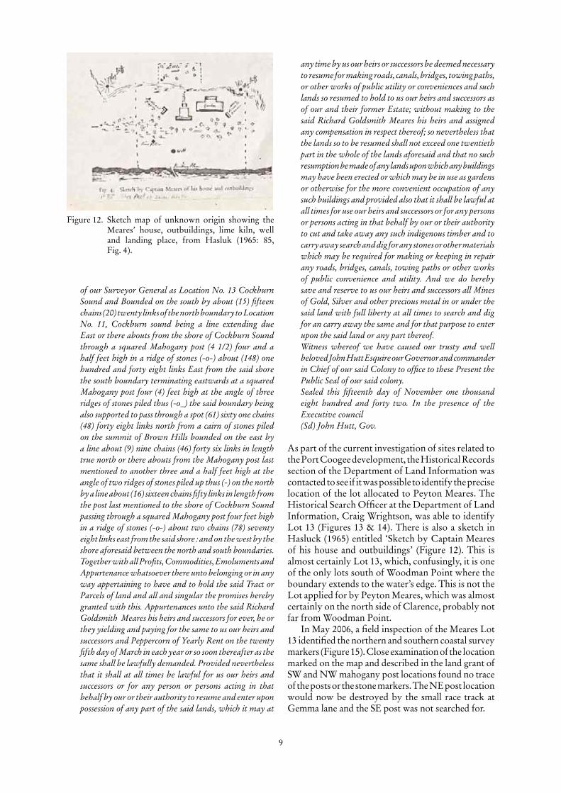
Figure 6. Site plan of the Diana made by MAAWA c. �984 showing visible hull structure.
Figure 5. A detail of the aerial photograph taken February �959 showing the Diana site and the keel of the James (see Figure 3).

4
The Diana (1860–1878)
The wreck of the Diana was first sighted around �965, and later relocated by Mike Pollard and George Green who reported the find to the Museum on �6 March �975. The site was said to lie 75 m south-east of the Fremantle Power Station cooling water outlet and to be �02.5 ft (3�.2 m) long (DMA File 20/80 Diana Wreck Report). The original report showed two visual transits (Figure 2). Unfortunately, many of the structures and buildings in the area around the Power Station have now been demolished, so these transits can no longer be used. However, using GIS software, it is possible to georeference old aerial photographs so that the position of old buildings and features used for the transits can be identified and the transit lines re-identified (Figure 4). Using Pollard’s transits it was, therefore, possible to locate his original position of the Diana. The Diana site transits drawn by Pollard, superimposed on a modern aerial photograph are shown in Figure 4.
In addition, a recently located historical aerial photograph of the area dated February �959 (Metro Regional Run 33(43-80) 3750’6”) obtained from the Department of Land Information (DLI), clearly shows the Diana site (Figure 5). In addition it also shows what appears to be a linear feature corresponding a similar feature in the drawing made by Mike Pollard in �975 (Figure 3) of the keel of the James (see below). By drawing Pollard’s transits on a �975 aerial photograph of the Power Station it is possible to compare his position with the position of the Diana shown in the �959 aerial photograph.
This information is collated in Figure 4 which shows the visual transit lines (in yellow), the point 75 m south-east of the power station water discharge point (yellow circle), the Pollard sketched location (red lozenges) and modern GPS Position of iron frame (red triangle), all superimposed on the �959 aerial photograph. This information clearly indicates the location of the Diana site.
In �984, the Maritime Archaeological Association of Western Australia (MAAWA) conducted a survey of the Diana site and produced a plan of the visible timbers (Figure 6). Illustrations of the site are shown in Figures 7 and 8 and show the site uncovered. The iron frame seen in Figure 8, was in early 2006 completely buried, showing the extent of the sand movement on this site.
Details of the Diana (from Kenderdine, 1995)Official number: 28766Where built: Teignmouth, DevonRegistered: Aberystwyth, WalesRig type: barque (Lloyd’s), schooner
(Fremantle records)Hull: wood, iron boltsTonnage: 224 net, 223 gross, 2�4
under-deckLength: 33.6 metres (��0.2 feet)Breadth: 7.2 metres (23.5 feet)Depth: 5.5 metres (�8.� feet)Port from: Port NatalPort to: FremantleDate lost: �5 July �878GPS position 2006 taken from georeferenced aerial
photograph estimated accuracy ±3 m GDA 94:
Bow S end Lat 32.09565°S Long ��5.758338°EStern N end Lat 32.0954��°S Long ��5.758�4°EFinders: M. Pollard and G. Green
(�975)Protection: Historic Shipwrecks Act
1976 (gazetted �977)Unfinished Voyages: Volume 2: 238–9MA file number: 20/80ASD number: WA ���
The vessel
The wooden hull of Diana was partly fastened with iron bolts and sheathed in felt and yellow metal, which was replaced in �876. There was a raised quarter deck of 8.2 m (27 ft). While first rigged as a barque, the vessel was later changed to a three-masted schooner. It was built by Owen and mastered early in �878 by J. Davies, but at the time of wrecking by H. Humphery. The vessel was owned by Mrs Edwards.
Diana came into Fremantle with a load of ballast from Port Natal on 4 July �878. The first record of the arrival was a telegram from the harbour-master to the colonial secretary reporting that it had struck the Parmelia Bank while sailing into Gage Roads without a pilot. The vessel was safely got off and anchored at Owen Anchorage.
The loss
On the night of �5 July a severe storm drove four vessels (Clarence Packet, Argo, Will Watch and Myth) ashore at Fremantle, and James Service was lost with all hands on Murray Reefs. Captain Humphery had Diana’s royal yards taken down and two anchors laid out.
I had about 97 1/2 fathoms (177 metres) chain on the starboard anchor and about 38 (69 metres) on port - in a heavy squall about 3 pm of 16th she parted both cables and went on the beach and has become a total wreck and been sold as such. I produce a certificate of the testing of the chain (starboard) which was a new one. The port one was the same link (Inquirer, 10 July 1878).

5
Figure 7. View of exposed timbers of Diana site.
Figure 8. Large iron frame or knee, thought to be structure visible in 2005.
6
map showing the location of the James and Diana sites was produced, possibly by Mike Pollard (see Figure 3) and of his two visual transits, only one can be identified. The aerial photograph February �959 (Figure 5), shows a linear feature approximately 20 m long, �0 m from the breakwater wall. The orientation of the axis of the feature corresponds closely to the sketch made by Mike Pollard in April �975.
McCarthy photographed the site in March �979 when it was largely uncovered. The photographs show part of the stern, keel and stern-post with a fishplate fastening (Figure �0) and also a small iron gun (Figure ��). The iron gun is interesting because three guns have been associated with the James (see guns below). A survey was carried out by MAAWA under Curt Hofmann in �983–84, but no plans are available. Records indicate that the west end of the site was 32.5 m from the rock wall on the shore and the axis was east–west. The records indicate that in �983 the site was uncovered, but by �984 it was covered over. Until the discovery of the aerial photograph, Pollard’s description and sketch of the site, together with a set of horizontal sextant angles were the most significant documents available to precisely locate the site.
It should be noted that without the aerial photograph the position of the James would not be known precisely. Something not realized in the early survey work on shipwrecks in Western Australia was that in the future it would be difficult or impossible to identify marks that were used when recording horizontal sextant angles and visual transits. The sextant operator at the time may well have known what points were being used, but the descriptions of points like ‘The Nook’ and ‘The Elbow’ are meaningless today. Furthermore, if the positions were not plotted on a chart with a station pointer, it would be almost impossible to resection the location. Transits had the same problem, because they were often destroyed or disappeared, or the sketch of the transit was no longer understandable because of the changes in time. Pollard’s one usable transit does confirm the Hofmann stern position, so that, with just Pollard and Hofmann’s information, the position of the James is reasonably well defined in the east–west orientation, but would be less well defined in the north–south direction.
Details of the James (from Kenderdine, 1995)
Rig type: brigHull: woodTonnage: �95Length: Breadth: Depth: 3.6 metres (�2 feet)
From the inquiry it was considered that no blame could be laid with the captain or crew. Diana, full of water and with its back broken was condemned as a wreck and sold at auction by Messrs. L. A. Manning. The hull was bought by Mr. McCleery for £85.
A description of the wreck written in �973 recalls that
…there were two old ships at Owen Anchorage: the Juno [presumably the James] and the Diana - I think they were whalers. The Juno was cannibalised… (Lucius Manning, notes, Western Australian Museum, quoted in Henderson & Henderson, 1988: 239).
This implies that the wreck of Diana had not in fact been destroyed and that its remains were visible above the water-line (Henderson & Henderson, �988: 239).
The James (1812–1830)In �975 Mike Pollard discovered a site, opposite the Fremantle Power Station which he thought was the James. Since that time the site has always been referred to as the James site. However, as part of the Port Coogee survey, an investigation into all the sites in the area resulted in a reassessment of the identification of the James. The following is firstly the history of the Pollard discovery, followed by the reassessment (note the use of the word James should be considered in relation to the subsequent findings).
In the Shipping Report (CSO Vol. 6 �830 No. �30) the James was recorded to have arrived 8 May, to be �50 tons with a crew of �2, 3 guns and 75 passengers.
It is known that the James was blown ashore in a gale on 2� May:
May 21st 1830 Sir, I beg leave to inform you for the information of His Excellency the Lieut Govenor that during a heavy squall at 1 O’Clock AM the Brig Emily Tailor parted from her Kiar [Coir] Cable and then letting go Two Chain Cables broke the Hawse of both Anchors and drove on Shore. The Brig James also on Shore from the new Roadstead. Particulars not yet known. I Remain Sir Your obedt. Servt. Dl.. Scott. Harbour Master, Harbour Masters Office, Fremantle.(CSO Vol. 6 1830 No. 197).
The vessel is reported to have been moored in Owen Anchorage, however, no records have been found that give even the approximate location of the wreck.
What is thought to be the James was discovered by Mike Pollard on 2 April �975. He described it as lying �00 ft (30 m) south-east of Diana with the shoreward end �0 ft (3 m) from sea wall with only the keel and some copper sheathing left. A sketch

7
Port from: LiverpoolPort to: FremantleDate lost: 2� May �830GPS position 2006 taken from georeferenced aerial photograph estimated accuracy ±3 m GDA94:Bow E end Lat 32.09579�°S Long ��5.775875�°EStern W end Lat 32.095754°S Long ��5.758528°EFinder: M. Pollard (�975)Protection: Historic Shipwrecks Act
1976 (gazetted �977)Unfinished Voyages: Volume �:�0�–5MA file number: �33/76ASD number: WA �87
The vessel
James was an American-built vessel owned by Chapman and Company. The vessel was sheathed in copper (�828), carried two chain and one hempen cable, and was armed with three cannon. It had a single deck with beams, a raised new deck and new upper works in �828. The vessel was involved in the passenger trade from Europe. Captain Ellis met the vessel at Kingstown, Ireland, on �8 December �829
and described the conditions aboard:
I found her crowded with passengers [of] the class of labourers, men, women and children, whom with passengers taken in at Kingstown, made the ship’s crew 84 persons, and a quantity of sheep, pigs and geese... There was no place for goods, provisions etc..… part of our accommodation was filled up with stores and luggage belonging to the ship. There was scarcely enough room for 24 persons to eat and sleep... We therefore suffered great inconvenience and want of air particularly as the height between the decks in the greater part of our cabins is but 4’6” between the beams and 4’ to the beams instead of 5’6” as required by Act of Parliament (Particulars of the Voyage from Kingstown Ireland (to Swan River in 1828 [sic] per brig James) of Capt. Ellis et al., quoted in Henderson 1980: 101–2).
The journey was very difficult for all on board the vessel and Ellis demanded that a survey be made of the vessel once they had reached Bhaia (Salvador). The captain of James, Goldsfield, refused the request, and conditions continued to deteriorate. Five people died before 4 March �830. James finally reached Swan River on 8 May, with twelve crew and 74 passengers and moored at Owen Anchorage.
Figure 9. Mike Pollard’s sketch of transits for the James site. Note the chimney is no longer identifiable and the sextant angles are not useable.
Figure ��. The third James gun photographed by McCarthy in March �979.
Figure �0. The keel and stern-post of the James showing copper alloy fishplate. Photographed by McCarthy in March �979.

8
My brother, Captain Meares, and Lieutenant Whitfield, having arranged on becoming neighbours at Guildford, induced me to enter on a speculation which it becomes necessary I should have your sanction for, previous to my entering further into the project. The object in view is the purchase of the brig James with an intention of forming a jetty for the convenience of vessels discharging their cargoes and which if completed could be accomplished at all seasons, but that my carrying this object into effect should entitle me to certain charges against such vessels as might choose to discharge there when I should for their accommodation erect Stores. Under these ideas, my wish would be to take a grant of land situated about half a mile from Woodman’s Point/Clarence Side/ to the wreck of the brig James, and only running about the same distance inland, situation more than quantity in this quarter being my object at present. I would also look for your permission to cut spars at Garden Island towards the forwarding of my undertaking. I should feel particularly obliged by an early reply as the vessel is about to be broken up in the ensuing week and if carried into effect to any extent would frustrate altogether my views. I have the honour to remain Sir, your very obt. Serv. P Meares Clarence July 14 1830
Reply:
Mr. Meares to be informed in reply that the land on the coast from Fremantle to Clarence is reserved for further purpose of being laid out in town locations. Mr. Meares will be permitted to occupy sufficient land immediately behind the position of the wreck for the purpose he states further quantity will not exceed 3–4 acres. S. Roe (CS0 7, fol. 174).
Initially, there was some confusion over the locations of the brothers’ lots. Captain Richard Goldsmith Meares lot is given as follows:
No. 067Rd G. MearesNo 13 Cockburn Sound15 AcresVICTORIA, by the grace of God of the United Kingdom of Great Britain and Ireland’s Queen, defender of the Faith To all to whom these presents shall come Greetings. Know ye that We of our special Grace, certain Knowledge and mere notion have given and granted and we do by these presents for us our heirs and successors in consideration of certain Location Duties performed to the satisfaction of our Governor Give and Grant unto Richard Goldsmith Meares of York in our Colony of Western Australia Esquire his kind and assigns All That Pieces or parcel of Land situated and being Cockburn Sound in our said Colony containing (15) fifteen acres more or less marked and distinguished in the Maps and Books kept in the Office
The loss
On 2� May James was blown ashore along with the brig Emily Taylor. Captain Goldsfield refused to deliver passengers their goods until ordered to do so by the Colonial Secretary. Several incidents occurred involving injury to a man using explosives on the vessel, and another drowned during the transfer of goods by boat from the wreck to Fremantle.
Plans were made for the wreckage of the vessel to be incorporated into the building of a jetty but this never eventuated. There are no records to indicate James was ever re-floated.
siTe descripTion
The wreckage lies on a sandy and rock bottom in 4 metres of water. It is significantly affected by sand movement in the area and regularly gets completely covered. Various artefacts have been removed from the vicinity of the site. Three guns have been associated with the wreck of the James (see below).
sTaTemenT of significance
Technical and scientificAnalysis of the design of the carronade from the James wreck site may help in understanding the manufacturing process of this type of gun. Conservation of James’s carronade has resulted in new methods of treating salt impregnated iron artefacts. The in situ analysis of the third remaining gun can also provide useful information.
The Meares brothers and the JamesCaptain Richard Goldsmith Meares, together with his wife, four sons, four daughters and his brother, Peyton Gamble Meares, arrived in Fremantle aboard the Gilmore on �5 December �829. On board the Gilmore was Thomas Peel who brought workmen, equipment and stores in exchange for land. This original scheme stipulated that Peel and the settlers had to be in the Swan River Colony by � November, so the late arrival of the Gilmore meant Peel and the other settlers forfeited their grant. Subsequently, Peel established the Clarence settlement next to Woodman point, but this was never a success, he was later granted land near the Murray River.
Richard Goldsmith Meares was granted a plot of land, Lot �3, adjacent to Peel’s much larger Lot �4, where he established temporary accommodation for his family. On �4 July �830, Peyton Meares wrote to Governor Stirling applying for land near Woodman Point and the wreck of the James. The land grant was to incorporate the wreck of the James as part of a jetty that could be used to unload vessels.
The letter states:
9
of our Surveyor General as Location No. 13 Cockburn Sound and Bounded on the south by about (15) fifteen chains (20) twenty links of the north boundary to Location No. 11, Cockburn sound being a line extending due East or there abouts from the shore of Cockburn Sound through a squared Mahogany post (4 1/2) four and a half feet high in a ridge of stones (-o-) about (148) one hundred and forty eight links East from the said shore the south boundary terminating eastwards at a squared Mahogany post four (4) feet high at the angle of three ridges of stones piled thus (-o_) the said boundary being also supported to pass through a spot (61) sixty one chains (48) forty eight links north from a cairn of stones piled on the summit of Brown Hills bounded on the east by a line about (9) nine chains (46) forty six links in length true north or there abouts from the Mahogany post last mentioned to another three and a half feet high at the angle of two ridges of stones piled up thus (-) on the north by a line about (16) sixteen chains fifty links in length from the post last mentioned to the shore of Cockburn Sound passing through a squared Mahogany post four feet high in a ridge of stones (-o-) about two chains (78) seventy eight links east from the said shore : and on the west by the shore aforesaid between the north and south boundaries. Together with all Profits, Commodities, Emoluments and Appurtenance whatsoever there unto belonging or in any way appertaining to have and to hold the said Tract or Parcels of land and all and singular the promises hereby granted with this. Appurtenances unto the said Richard Goldsmith Meares his heirs and successors for ever, he or they yielding and paying for the same to us our heirs and successors and Peppercorn of Yearly Rent on the twenty fifth day of March in each year or so soon thereafter as the same shall be lawfully demanded. Provided nevertheless that it shall at all times be lawful for us our heirs and successors or for any person or persons acting in that behalf by our or their authority to resume and enter upon possession of any part of the said lands, which it may at
Figure �2. Sketch map of unknown origin showing the Meares’ house, outbuildings, lime kiln, well and landing place, from Hasluk (�965: 85, Fig. 4).
any time by us our heirs or successors be deemed necessary to resume for making roads, canals, bridges, towing paths, or other works of public utility or conveniences and such lands so resumed to hold to us our heirs and successors as of our and their former Estate; without making to the said Richard Goldsmith Meares his heirs and assigned any compensation in respect thereof; so nevertheless that the lands so to be resumed shall not exceed one twentieth part in the whole of the lands aforesaid and that no such resumption be made of any lands upon which any buildings may have been erected or which may be in use as gardens or otherwise for the more convenient occupation of any such buildings and provided also that it shall be lawful at all times for use our heirs and successors or for any persons or persons acting in that behalf by our or their authority to cut and take away any such indigenous timber and to carry away search and dig for any stones or other materials which may be required for making or keeping in repair any roads, bridges, canals, towing paths or other works of public convenience and utility. And we do hereby save and reserve to us our heirs and successors all Mines of Gold, Silver and other precious metal in or under the said land with full liberty at all times to search and dig for an carry away the same and for that purpose to enter upon the said land or any part thereof.Witness whereof we have caused our trusty and well beloved John Hutt Esquire our Governor and commander in Chief of our said Colony to office to these Present the Public Seal of our said colony.Sealed this fifteenth day of November one thousand eight hundred and forty two. In the presence of the Executive council(Sd) John Hutt, Gov.
As part of the current investigation of sites related to the Port Coogee development, the Historical Records section of the Department of Land Information was contacted to see if it was possible to identify the precise location of the lot allocated to Peyton Meares. The Historical Search Officer at the Department of Land Information, Craig Wrightson, was able to identify Lot �3 (Figures �3 & �4). There is also a sketch in Hasluck (�965) entitled ‘Sketch by Captain Meares of his house and outbuildings’ (Figure �2). This is almost certainly Lot �3, which, confusingly, it is one of the only lots south of Woodman Point where the boundary extends to the water’s edge. This is not the Lot applied for by Peyton Meares, which was almost certainly on the north side of Clarence, probably not far from Woodman Point.
In May 2006, a field inspection of the Meares Lot �3 identified the northern and southern coastal survey markers (Figure �5). Close examination of the location marked on the map and described in the land grant of SW and NW mahogany post locations found no trace of the posts or the stone markers. The NE post location would now be destroyed by the small race track at Gemma lane and the SE post was not searched for.

�0
Figure �2B. Part of the Sheet � of Cockburn Sound by R. Clint �830 showing the James wreck site. The map has been georeferenced so that the GPS position of the actual site is shown by the red star.
Figure �2A. Part of the Sheet � of Cockburn Sound by R. Clint �830 with the Department of Planning and Infrastructure Contours superimposed and used with Manning Lake to georeference the Clint map.

��
Figure �5. Top: Present day view of Richard Goldsmith Meares’ Lot �3 looking from the SW seaward corner marker of the allotment NE across the block. Middle: The NW corner iron survey marker pin, centre foreground in front of scale rule. Lower: SW corner iron survey marker pin centre foreground.
Figure �3. Part showing Richard Goldsmith Meares Lot �3 and Thomas Peel’s Lot �4.
Figure �4. Part of the plan of Clarence showing Richard Goldsmith Meares’ Lot �3 and Thomas Peel’s Lot �4.
It is likely that, in �975, Pollard thought he had identified the site, since his field diary on 23 February �975 refers: ‘To Capt. Meares Clarence Rocks Site (Lot �3)…Marker post on cliff edge is just S of its Southern boundary’. On a recent visit to Lot �3, no evidence of posts were found, although a steel pin was found driven into the rocks at the water’s edge, that is almost certainly the southern boundary referred to by Pollard.
It seems therefore that Pollard’s identification of the James was probably based solely on the fact that the vessel was bow on to the shore and thus would have served as a useful jetty. The Shipping Report of 8 May �830 states the James was anchored in Owen Anchorage (north of Woodman Point) and on 2� May it was blown ashore along with the brig Emily Taylor.

�2
Figure �6. A photograph of the Omeo on the beach �9�5 (McKenna Collection).
Figure �7. A photograph of the Omeo on the beach c. �930 (McKenna Collection).
Figure �8. The Omeo in �940s (McKenna Collection).
Figure �9. The bow section of the Omeo with the industrial buildings behind (McKenna Collection).
Therefore, it is almost certain that the James is north of Woodman Point and the Goldsmith Meares Plot �3 is irrelevant to this discussion.
When this report was completed in June 2006, it was considered that the site reported by Pollard might not be the James. Evidence suggesting this was as follows: in June �830, a young man, Joseph Beary, was injured in a gunpowder explosion on board the James and was left unattended on the beach at Woodman Point. Since Woodman Point is further from the Pollard James than Fremantle, one wonders why the person was left there rather than taken to Fremantle. Secondly, the letter of Peyton Meares requesting the land grant including the James site specifies a distance of about half a mile from Woodman Point, whereas the Pollard James site is nearly 2.5 miles. One possibility may help in identification of the site is the matter that on 2� January �83�, Edward Sale, a part owner of the James, was engaged in off loading cargo from the vessel and while swimming ashore drowned. The account mentions that the vessel was 20 to 50 yards from the shore and that a Mr. Bond, who lived on the shore opposite the wreck, swam out to helped in the unsuccessful rescue. It was considered at that time that further archival research may help to resolve this issue.
In August 2006, during some correspondence with Shane Burke, a local archaeologist with interests in the Peel settlement south of Woodmans Point. Burk mentioned that there was a �830 map by Ralph Clint’s maps of the Fremantle area in the State Reference Library that showed two ships on the shore. Richenda Prall, from the Department of Maritime Archaeology, located the Clint maps, four maps entitled Cockburn Sound Sheet �–4 joining together to form a part of the coastline, however it was not immediately obvious what part of Cockburn Sound this was as the sheets simply showed the coastline, the surveyors survey stations and rough sketches of the hills. No features were named, although there were notes pencilled in indicating boundary lines for allotments. On sheet 4 a small, unnamed lake was shown that was almost certainly Manning Lake. This meant that the maps related to the area north of Woodmans Point. On the coastline were marked three ships, obviously wreck sites, two in the north on Sheet � were almost certainly the Thames and the Emily Taylor and the one in the south, on Sheet 4, could be the James. Unfortunaltly there was nothing to make a really good georeference of the Clint maps to confirm this.
Fortunately, the Fremantle marine section of the Department of Planning and Infrastructure were able to assist in providing topographical maps of the area covering the Clint maps. This enabled the Clint maps to be georeferenced against a number of the prominent hills shown on the Clint. By selecting these features and Manning Lake it was possible to very accurately georeference the map and this then showed that the

�3
Figure 2�. Aerial photograph dated �959 (courtesy Department of Land Information).
Figure 20. Aerial photograph dated �942 (courtesy Department of Land Information).

�4
Figure 22. Aerial photograph dated �959 showing anchor chain running at right angles to fore part of vessel (courtesy Department of Land Information).
Figure 23. Aerial photograph dated �963 (courtesy Department of Land Information).

�5
Figure 25. Aerial photograph dated �969 (courtesy Department of Land Information).
Figure 24. Aerial photograph dated �969 (courtesy Department of Land Information).

�6
Figure 27. Aerial photograph dated �975 (courtesy Department of Land Information).
Figure 26. Aerial photograph dated �970 (courtesy Department of Land Information).

�7
three wreck sites were the Thames, Emily Tailor and James. The site thought to be the James lay within a few metres of the position on the Clint map, thus finally confirming that this site is the James.
The Omeo (1858–1905)The Omeo site has always been visible. Early photographs show the ship in reasonable condition (Figures �6–�9), but through time the site has gradually disintegrated so that today only the stern-post and a small section of the transom, together with some small sections including a stanchion, can be see above the water (Figures 20–27). A plan of the site was made by MAAWA (�992) in the �980s, shown in Figure 29 and can be compared with a side scan sonar image of the site, Figure 30. A recent side scan sonar image of the site shows the outline of the development with beginning of the new breakwater in relation to the site. Two anchors were recovered from the site by the Museum in July �993 (Figures 3�–33).
Details of the Omeo (from Kenderdine, 1995)Where built: Newcastle, EnglandRegistered: MelbourneRig type: barqueHull: iron
Figure 28. Side scan sonar image of Omeo site showing its proximity to the breakwater. The curved shape at the top of the trace is the start of the breakwater by the contractors (Image taken 30 March 2006).
Tonnage: 789Length: 64.9 metres (2�3 feet)Breadth: 9.3 metres (30.5 feet)Depth: 5.� metres (�6.7 feet)Port from: at anchor, Cockburn SoundPort to: at anchor, Cockburn SoundDate lost: �� September �905GPS position 2006 taken from georeferenced aerial photograph estimated accuracy ±3 m GDA94:Stern Latitude 32.�0586S Longitude ��5.76�49EBow Latitude 32.�0534S Longitude ��5.76�54EProtection: Historic Shipwrecks Act
1976 (gazetted �977)Unfinished Voyages: Volume 3:235MA file number: �9/80ASD number: WA
The vessel
Omeo was a clinker-built iron barque with one deck, four masts, a square stern, a woman bust figure-head, and was iron framed. Originally the vessel was built as a three-masted barque-rigged steamship with auxiliary power from a �20 hp engine. In �882, the registered quarterdeck length was 27.4 m, the forecastle, 7.62 m,

�8
Figure 29. Plan of the Omeo wreck site taken from MAAWA (�992) Report.
Figure 30. Side scan sonar image of the Omeo wreck site obtained 30 March 2006.

�9
and the bar keel had a measurement of 0.�8 m. It had three water tanks as ballast and a gross under-deck tonnage of 7�0 tons. The auxiliary engine was removed and it was rigged as a four-masted jackass barque. The vessel’s owners were W. H. Smith and Sons.
Omeo was a popular general trading vessel in the international trade and inter-colonial passenger networks. Its original voyage was from England with a cargo of telegraphic cable for Tasmania, and immediately after that it was used on the run to New Zealand, transporting miners to the goldfields at Hokitika.
Omeo had an interesting series of being nearly wrecked and close encounters before it finally came to rest on Coogee Beach in �905. In September �88�, after completing a voyage from Newcastle, New South Wales with a cargo of coal Omeo was involved in a serious accident. Forced to anchor off Queenscliff, Victoria, overnight due to the weather, the vessel was trying to enter the west channel the following morning on the flood tide when it missed stays, lost steerage, and collided broadside with the Swanspit Light, completely destroying the latter. In early October �895, Omeo sailed from Melbourne en route to Hamelin Bay under the command of Captain Campbell. The vessel encountered severe weather off Cape Leeuwin and a lot of cargo was washed overboard.
At Hamelin Bay the vessel loaded a cargo of jarrah. With 500 tons aboard the vessel bumped against the jetty in a severe storm, and finally broke its moorings to run headlong ashore, to the south side of the jetty (Cairns & Henderson, �995: 235).
Omeo had not been badly holed but there was doubt that it could be re-floated. The owners sold the vessel to the North Queensland Insurance Company and a contractor undertook to re-float it. It was connected to the jetty by a trestle bridge and 200 loads of timber were discharged. This sufficiently lightened the hull by �7 March for the barque to be hauled off
Figure 32. One of the two anchors from the Omeo.
Figure 3�. One of the two anchors from the Omeo.
Figure 33. One of the two anchors from the Omeo.
20
Ocean Street where it was finally abandoned. There the vessel remained on Coogee Beach behind the local abattoirs. In September �972, a plan was mooted to move the vessel to the Northern Territory to serve as a permanent memorial to the Overland Telegraph. Inspection of the vessel showed that the wreck had deteriorated to such an extent that this was not feasible.
siTe descripTion
The Omeo wreck site has always been partially visible and photographic documentation shows the process of deterioration over the last 90 years. A photograph taken in �9�5 shows the vessel with the hull intact and with four masts still in place, and some form of deck housing structure. Later the masts had gone, with most of the superstructure collapsing. The hull has remained largely intact, although holes have begun to appear in the cladding as deterioration takes place.
Two of the vessel’s anchors were located on the site. They were raised in �993 and are under conservation. Both chains from the two large anchors remain in situ. Artefacts are also found in the bilge hold. The bow and stern sections are above the water while the rest of the site remains submerged.
sTaTemenT of significance
HistoricalThe vessel had a notable association with the development of the Overland Telegraph.ArchaeologicalThrough the examination of the wreck site information on the construction of the iron plate clinker hull and rare hybrid rig type, the jackass barque can be obtained. Ship’s fittings that remain could also give evidence in the development of shipbuilding techniques.ScientificThe site has been the subject of a conservation assessment and has the potential to yield data on the
by means of a steam winch on the jetty. After survey
the vessel was sold to Connor and Doherty who had the vessel towed to Fremantle, where it was converted to a coal hulk for use by the Blue Star Line.
The loss
On �� September �905 Omeo was at anchor in Cockburn Sound. At 5.30 pm the vessel broke its moorings in a gale and was swept ashore opposite
Figure 37. The trunnion with the cast letter ‘F’.
Figure 36. The James carronade after deconcretion.
Figure 35. The gun after recovery covered in a thick layer of concretion.
Figure 34. Mike Pollard’s sketch map of the position of the James carronade.

2�
Figure 39. The James carronade after conservation mounted on a replica of a truck carriage of the period.
Figure 38. The location of the James carronade according to the measurements given by Pollard.

22
deterioration and preservation of iron hulls situated in
inter-tidal zones subject to surge and tidal movement, and particularly at the air–water interface.
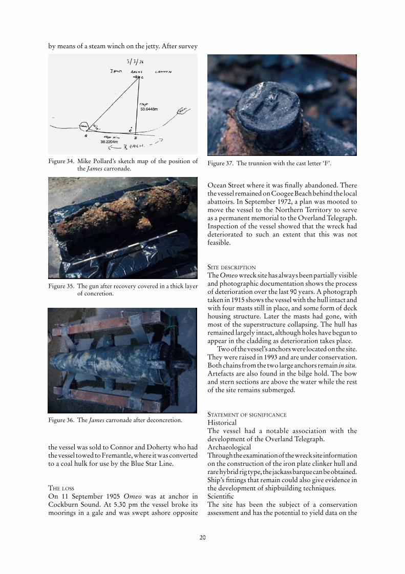
The James carronade and other gunsAs noted above the James is reported to have carried three guns and three guns have been associated with the James. The James carronade, the Abattoir gun and the James gun. The James carronade (Figure 39) was found 6 February �976 by Kenneth Farthing 50 m from beach in 2.5 m of water (Figure 35). The gun was heavily concreted and after cleaning (Figure 36)
Figure 4�. The James wreck site gun.
Figure 40. The Midland’s Abatoir gun.
it was found to be marked with the incised figures
7-0-7 its weight 7 cwt and 7 lbs (359 kg) and SOLID on the right and F on the left trunnion (Figure 37). Various accounts of the position of where the gun was found have been recorded and have been described as 9� m, 400 m and 600 m south of the James. A plan made by Pollard has been recently discovered (Figure 34) which was made on 3 March �976. It shows the gun accurately recorded 35 m north and 53 m west of the small group of rocks on the beach putting the gun 32.099�23°S ��5.759948°E (Figure 38). The details
of the carronade have been published (Green, et al..,
�98�). It is questionable if this gun was in fact from the James as it is so far from the wreck site.
The Midlands Abattoir gunA small gun (900 mm long) was reported by Peter Passmore on 2 February �979 and said to have been found in �977 at the Midland Abattoir (Figure 40). It is thought that this gun may have been brought to
Figure 44. Recovering the James Rocks anchor 2006.
Figure 42. Mike Pollard transits.
Figure 43. James Rock Anchor photographed by Gainsford in 2005.

23
the abattoir in ash spoil from the Fremantle Power Station. Tests on the gun indicated that it had been in the sea for some time.
The James wreck site gunA third gun was photographed by McCarthy in �979 (Figures �� & 4�), unfortunately the photographic negative for this and the fish-plate, keel and stern-post cannot be located and we must rely on rather poor quality prints of the gun. From the picture the gun is of comparable size to the Abattoir gun, estimated to be about 900 mm long. Magnetometer survey of the James site has so far shown no indication of a magnetic anomaly of any sort.
The James Rocks anchorThe James Rocks anchor was first reported by Mike Pollard in �975 and he shows transits for the site (Figure 42). Subsequently the anchor was re-reported by Graham Anderton �8 December 2002 and inspected by Matthew Gainsford and the finder on 3� October 2003 (Gainsford, 2003). Gainsford photographed the anchor (Figure 43) showing it is relatively small with an anchor stock about � m long and one of the arms buried; the whole exposed anchor does not extend more than 0.6 m above the sea bed. Unfortunately, Gainsford’s coordinates for the location of the anchor were incorrect so it was necessary to go back to Pollard’s transits. Using Pollard’s transits and an old aerial photograph on the GIS it was possible to relocate the anchor (Figure 45). On 8 March 2006, as part of the Port Coogee survey, the anchor was relocated by Patrick Baker, its position recorded with a differential
Figure 45. Pollard transits resected on �974 aerial photograph. Note the chimney against the Coogee Beach jetty is probably inaccurate because chimneys may have been demolished or relocated.

24
GPS (-32.�0092°E ��5.75982°E) and then moved from the development area (Figure 44). The anchor an admiralty pattern weighing about 50–80 kg.
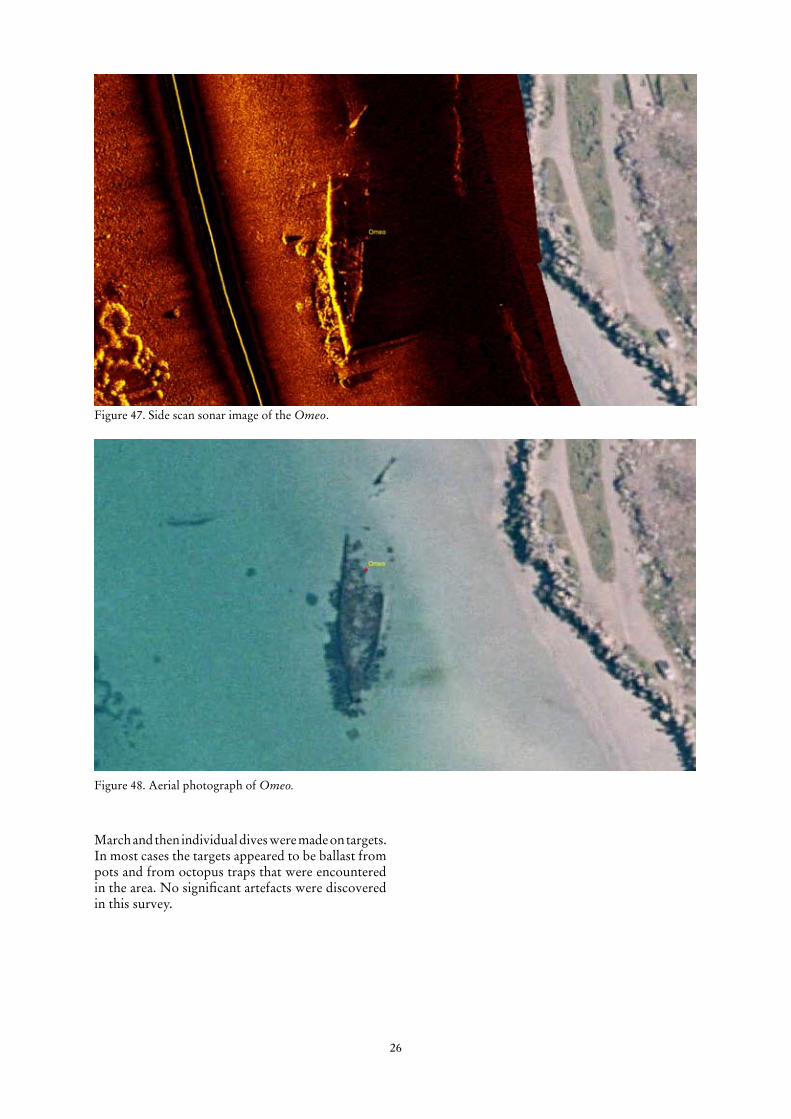
The Side Scan SurveyThree separate days were devoted to side scan sonar survey (�0, �4 and 22 February). Runs were made using the Department of Maritime Archaeology Marine Sonic dual frequency (�50 KHz and 600 KHz) side scan which was operated in conjunction with a OmniStar 8400 GPS receiver, an Elsec Marine Proton Magnetometer and a Furuno Echo sounder. The side scan was operated in high frequency mode (600 KHz) on a range of 75 m on both sides of the tow fish. Good quality images were obtained of the sea bed in both the shallow and deeper water. Figures 46 a to l show the sonar swath for the various runs and days. Of particular interest were the numerous pipes that could be observed running from the beach into the water. In many cases the side scan complemented the aerial photography showing up the pipes in deeper water better than could be seen in the aerial. In addition the magnetometer indicated where the pipelines were buried. A total of seven pipelines were recorded and are shown on Figure 5�. The side scan also produced a good image of the Omeo site, showing the details of the underwater structure Figure 47 and may be compared with the aerial photograph Figure 48. The side scan showed up the complex sea-grass and rocks that extend approximately 250 m offshore. This material made interpretation of the side scan difficult, because it was impossible to differentiate between small natural objects and cultural material, the only objects that could be clearly discerned were the pipelines and some unidentified structural rubbish close to pipeline No. 4. The end of pipeline No. � has an unusual Y-shaped feature that can be clearly seen on the side scan image (Figure 58). An band of sea-grass, approximately 75 m wide was observed on side scan sonar records starting about 75 m from the shore in about 2.5 m of water and extending to about 5 m depth.
MagnetometerThe Elsec 7706 Magnetometer was deployed on five occasions; �0, 20 and 2� February and 9 and �7 March. The magnetometer survey was complex, because of the seven pipelines running from the shore into deep water. These pipelines can be seen on the aerial photograph and the side scan sonar, however, the magnetometer is able to locate the pipelines when they are also buried. So the magnetometer survey then became a problem of delineating the extent of the pipelines in order then to determine what other magnetic targets existed other than the pipelines themselves. Once the pipelines had been delineated, some additional targets that were not associated with the pipelines were further investigated. Isolated targets were pinpointed on �7
Figure 46a–d. Side scan sonar survey tracks over the Port Coogee development area.
B
C
D

25
E
Figure 46e–l. Side scan sonar survey tracks over the Port Coogee development area.
F
G
H
I
J
K
L
26
Figure 47. Side scan sonar image of the Omeo.
Figure 48. Aerial photograph of Omeo.
March and then individual dives were made on targets. In most cases the targets appeared to be ballast from pots and from octopus traps that were encountered in the area. No significant artefacts were discovered in this survey.

27
Fathometer
On 2� February a fathometer survey was carried out to obtain basic depth measurements across the site. This was not intended to be a high precision survey, simply to obtain depth information to assist with the other survey work. The results of the survey are shown in Figure 50.
PipelinesA number of pipelines were observed on the aerial photograph and during the side scan sonar survey (Figure 5�). In all seven pipelines were identified from the side scan sonar survey. The pipes were all buried at the shoreward end. Most pipelines have a series of iron ‘sleepers’ used to help to secure the pipe to the sea bed (see Figures 53 & 55). Pipes were numbered � to 7 starting at the north. Visual inspection of the pipelines was undertaken on 9 March.
pipe 1Single iron pipe appearing about 65 m from LW mark, running in a reasonably straight direction for about �75 m.
pipe 2Single iron pipe staring 60 m from LW mark, running erratically for about �50 m (Figure 52).
pipe 3What appeared from sonar and aerial photograph to be a short pipe, on inspection was rock feature.
Figure 50. Fathometer survey conducted on 2� February 2006 between 0900 and �200 hrs, depths corrected to MLW. Note tidal information on 2� Feb. 0.50 m @ 0445 0.96 m at �459. Estimate tide at �030 to be 0.75 m.

28
pipe 4Short pipeline starting 50 m from LW mark extending about 50 m. On inspection was found to be two large iron pipelines and two small pipelines with a lot of complex machinery associated with the pipes.
pipe 5A long iron pipeline staring 65 m from LW mark and extending 150 m with a Y-shaped end each arm about 10 m long, the southern branch has been bent in the middle of the section (Figures 53–56).
pipe 6A short plastic pipeline broken in several places starting about 45 m from LW mark extending 75 m.
pipe 7Outside the development area, an iron pipe commencing 50 m from LW mark and extending 220 m.
Figure 5�. Plan showing location of seven pipelines in area.

29
Figure 52. Pipeline 2 showing the various valves and machinery.

30
Figure 53. Sleeper plate holding pipeline 5 to sea bed .
Figure 54. Branch at end of pipeline 5.
Figure 55. Sleeper plate holding pipeline 5 to sea bed.
Figure 56. Pipeline 5.
Figure 57. Side scan sonar image of machinery on sea bed around pipeline 2 (see Figure 52).
Figure 58. Side scan sonar image of the Y-shaped branch in pipeline 5.

3�
Sea bed control points
A series of datum points were established on the wreck site on 2� February, three on the Omeo site and one in the general area of the Diana (Figures 59 & 60). Originally, it was hoped that the frame on the Diana site could be used as a datum, but in
Figure 59. Control points on Omeo site.
Figure 60. Control point for Diana site.
February–March 2006 the frame was buried so that a stainless steel stake was driven into the sea bed as a temporary datum. Measurements were made from control points to the level of the sea bed. Locations of the Datum points are shown in Table �

32
Table �: Omeo, James and Diana Survey
Museum survey 28 February 2006 using OmniStar DGPSName Lat Long H to sea bed
Diana -32.09546 115.75811 0.41
Omeo 1 -32.10586 115.76149 3.87
Omeo 2 -32.10553 115.76145 0.77
Omeo 3 -32.10534 115.76154 0.47
All measurements to between � and 7E-06
Adam Neale McMullen Nolan survey 20 March 2006Name Lat Long RL
Diana -32.09546324 115.7581068 -1.08
Omeo 1 -32.10587458 115.7614758 0.94
Omeo 2 -32.10554676 115.7614485 -1.31
Omeo 3 -32.10535986 115.7615339 0.15
AcknowledgementsI would like to thank the staff or the Department of Maritime Archaeology who assisted with this project, particularly Richend Prall who carried out most of the archival work in the Battye Library. For the fieldwork operations: Mack McCarthy, Corioli Souter, Richenda Prall, Ross Anderson, Patrick Baker, Wendy van Duivenvoorde and Jen Rodrigues. Peter Ewens also volunteered to assist on a number of the field operations. Also Myra Stanbury and Susan Cox for assistance with production of this report. Shane Burke for his advice on the location of the Clint maps that lead to the confirmation of the James site. Steven Hearn of the Department of Planning and Infrastructure for help with topographical maps of the Fremantle area and advice on the operation of ArcMap. Graeme Henderson kindly assisted with notes on James. The Department of Land Information helped with aerial photographs and Craig Wrightson, Historical Search Officer, who assisted in locating the site of the Meares’ property.
Assistance was also provided by M P Rogers & Associates with surveying. Geoff Glazier from
OmniStar provided a differential GPS system.
ReferencesBerson, M., �978, Cockburn The Making of a Community.
Private publication.Cairns, L. and Henderson, G., �995, Unfinished Voyages:
Western Australian Shipwrecks 1881–1900 (Volume 3). University of Western Australia Press, Nedlands, WA.
Green, J., Henderson, G. and North, N., �98�, ‘The carronade from the brig James: its history, conservation and gun carriage reconstruction’. International Journal of Nautical Archaeology, �0.2: �0�–8.
Halls, C., �979, ‘Saga of the Omeo’. Port of Fremantle Quarterly, Winter, �979: �8–�9.
Hasluk, A., �965, Thomas Peel of Swan River. Oxford University Press, Melbourne.
Henderson, G., �980, Unfinished Voyages: Western Australian Shipwrecks 1622–1850 (Volume 1). University of Western Australia Press, Nedlands, WA.
Henderson, G. and Henderson, K., �988, Unfinished Voyages: Western Australian Shipwrecks 1851–1880 (Volume 2). University of Western Australia Press, Nedlands, WA.
Heritage Council of Western Australia, �998, Register of Heritage Places—Assessment Documentation: House, 25 Meadow St, Guildford (07/04/1998).
Heritage Council of Western Australia, �999, Register of Heritage Places—Assessment Documentation: Mead Homestead (27/08/1999).
Heritage Council of Western Australia, 2006, Register of Heritage Places—Assessment Documentation: Three Lime Kilns, Cockburn (17/02/2006).
The Inquirer and Commercial News, �0 July, �878. Kenderdine, S., �995, Shipwrecks 1656–1942: A Guide to
Historic Shipwrecks of Perth. WA Museum, Perth.Maritime Archaeological Association of Western Australia
Reports, �990–�992: 6–��.Taggart, N., �984, Rockingham Looks Back, A History of the
Rockingham District 1829–1982. Private publication.

33
Historic shipwreck management recommendations
Currently, as a result of the 2006 Port Coogee survey, no wreck sites have been found within the development area, nor any relics that may relate to the Historic Shipwrecks Act 1976. There is considerable industrial infrastructure in the water (pipelines and valves) but this does not come under Historic Shipwrecks Act 1976 or the Maritime Archaeology Act 1973. Therefore, currently there are no issues regarding the development. However, the location of the three wrecks (Diana, James and Omeo) lie close to the development breakwaters, in the case of the Omeo about 30 m. It is likely, that there will be sand changes at either end of the site. Currently, it is thought that there will be accretion at the northern end and erosion at the southern end, although this is still not absolutely clear. Considerable changes in the line of the foreshore over the period from �945 to the present day can be observed in the aerial photographs. These changes indicate that accretion takes place in some areas and erosion in other areas. It is therefore difficult to predict what the impact of the development will have on the shore line to the north and south of the development. Any changes where there is erosion of the shoreline is likely to have an adverse effect on the sites. Therefore, any erosion, in or around the historic shipwrecks will require remedial sand pumping.
The Department of Maritime Archaeology has been an award-winning recipient for its wreck access programs, including its access to maritime sites for peoples with disability program. The Omeo is a ‘key’ site in the Western Australian Historic Shipwrecks Programme, with individuals, schools and families accessing the site. Recently, the Rockingham Wreck Trail, a project managed by the Department in association with Rockingham Senior High School, highlighted the place of Omeo within the region.
In the context of the Western Australian wreck trail and wreck access programmes, it is important to maintain as many attractive and accessible wrecks sites as possible and the Omeo has educational, recreational and tourist significance. It is desirable that beyond the requirements of the Historic Shipwrecks Act 1976, any development in the area could use the sit�.63/e to enhance the development. The suggestion of establishing an Omeo underwater flora and fauna reserve with access for snorkellers or all ages and with a facility that will allow access for people with disabilities has been discussed with the previous Point Catherine development. This proposed reserve has a number of benefits. Under the plan, the ‘reserve’ will be provided with signs on the wreck site and on the adjacent land providing information about the Omeo. It is suggested that fishing inside the reserve is prohibited. Additionally, the anchors removed from the Omeo in �993 and since conserved by the
Museum, together with the James Rocks Anchor could be mounted on land overlooking the wreck and complemented with appropriate interpretation.
sand moniToring and coasTal managemenT
�. Remedial sand pumping will be required if the level of sand drops more than 500 mm below the existing sand level within �00 m of control points on the Omeo and James and Diana sites.
2. The Department of Maritime Archaeology will monitor the sand levels at the control points at least four times a year and report levels to relevant authorities.
3. An agreement needs to be established with Australand and whoever takes on responsibility for Port Coogee dredging and coastal management (Cockburn Shire Council?) after the initial 5 years regarding the process of initiating sand pumping to ensure minimum sand levels are maintained.
4 Any sand pumping that is undertaken within �00 m of the historic shipwreck sites will require the issue of a Permit to disturb an historic shipwreck site under Section �5 of the Historic Shipwrecks Act 1976.
5. Any dredging inside the development breakwater will require the presence of an archaeologist to check the dredging spoil and ensure that material or parts of shipwrecks that have not been located in this survey are preserved.
furTher research
6. There is still a need to identify some magnetic targets outside the development area.
7. It would be useful to identify the various industrial activities within the development area and produce a history of the site.
recreaTion and inTerpreTaTion
8. The Port Coogee development should allow continued public access to the Omeo shipwreck site with consideration to disabled access (e.g. ramp pathway to beach).
9. Consideration should be given to establishing the Omeo site as a historic shipwreck protected zone to allow recreational diving and snorkelling, but prohibit fishing and boating.
�0. Interpretation should be provided about the Owen Anchorage, the Omeo, James and Diana historic shipwrecks and maritime and industrial history of the Port Coogee site.
��. The two Omeo anchors and the James Rocks Anchor (currently conserved and in storage at Museum) be incorporated as part of interpretation of the site.