survco, inc. - garfield county, colorado correspondence.pdf · survco, inc. rtk gps and...
TRANSCRIPT
Friday, June 11, 2010
Kirk and Melissa Lientz 0263 Riverbend Road New Castle, CO. 81647
Dear Kirk and Melissa;
SURVCO, INC. RTK GPS and Conventional Land Surveying Services
As per your request we have conducted and independent re-survey of the location of the foundation of the garage in relationship to your property lines (i.e. Lot 2, Block 3, Riverbend Subdivision Filing No. 2 as Amended). Having been in business in the area since 1991, and based upon previous surveys I have performed within the subdivision, I have the knowledge that any given property pin in any of the Riverbend Subdivision filings may be in error and that at some locations two property pins are in place having been set to represent the same point. The history of the matter is that the original subdivision was filed in 1979 and it was common practice at that time to set property corners using a theodolite and a steel tape. While very accurate if done correctly, our modern forms of electronic measurement were just being invented and GPS technology was still being conceived by the Department of Defense. The problem with the theodolite and steel tape process is that if an error was introduced while staking any given corner, that error could be propagated throughout other corners being set as it was common practice to "leap-frog"- i.e. set a corner from a corner that had just been set and so on. Sometimes corners were set coming off of two controlling monuments in two different directions and therefore that is why some locations have two sets of monuments. Since we cannot re-invent the subdivision (by law all lot dimensions are equally weighted and all the lots created simultaneously at the time that the plat was recorded) and the existing corners in place used for improvements constructed on the individual lots, I feel the best way to overcome the corner monument discrepancies is by conducting a "best fit" survey of known existing corners within the subdivision.
To complete this process I hold the platted dimensions of each lot as it is drawn, fitting all the found corners accordingly to those dimensions and make them fit proportionately to each other and the plat as well as I can, paying less attention to the corners that deviate from the platted dimensions the most. Based upon my field survey and findings I come to the following professional conclusions: 1) The property pins along your easterly line vary from the plat in that the Northeast corner is 0.37" (4-1/2") to far North but is consistent with the plat in an East;West direction while the Southeast corner is 0.09' (1-1/8") to far North but is 0.42' (5"") to far East. It should be noted that I would classify that survey pin as what we call in laymen's term a "sticker" (a corner that has been knocked out of the ground but stuck back in at a location where someone thought is was) because of the height of it"s protrusion from the existing grade. I would not have used this corner as a controlling corner.
826-1/2 GRAND AVENUE, SUITE NO. 26
POST OFFICE SOX 2782
GLENWOOD SPRINGS, CO. 81602-2782 PH: {970) 945-5945 EMAIL: [email protected] FAX: (970) 945-5946
TOLL FREE 1-866-945-5945
1

2) My measurements to locate the foundation where made using a "pulse laser" directly to the exposed concrete foundation of the front and side of the house. I also measured a dimension of 0.75' (9") from the front of the false column to the foundation. 3) By intersection of the survey measurements to the exposed foundation and my - · · · ··-·· J determination of the location of the property lines I find th.at the foundation is located at a dimension of 24.96' perpendicular to the front property line and the false column is located at a dimension of 24.24' perpendicular to the front property line. ----·-4) The previous survey appears to have relied solely upon the two found corners along your Easterly lot line and the measurements shown thereon must have been to the false column, not the foundation. This can be demonstrated by the fact that if the 0.09' North/South discrepancy in the Southeast property pin is factored in, I would achieve almost the same offset as what is depicted on that survey. (24.24' + 0.09 = 24.33' vs. 24.3 as shown thereon). Also, that if in a worse case scenario the Southeast corner was held, the dimension to the front property line from the foundation would be somewhere around 24.87' (24'-10 1/2").
Please feel free to contact me if you have any further questions or need any clarifications of the mapping.
Sincerely;
Samuel Phelps Colo. Licensed Professional Land Surveyor 27613
I o ,,
fo LiJ\A clGCh\JV\. io fa-.l 'Y. col v\.1!1!1<1 tv
.Gcv\/Lfa.M k ee/ii!Utlll
'1''
2
Sheer J of I
Foundation Location Survey . Lot 2, Block 3
Riverbend Subdivision Filing 2 as Amended SITUATED IN THE SEI/£. Of SECTICN ~L. lewt-;SI-P 5 SOUTH, RANGE 90 WCST fS Ttt: 6TH P."l.
CO\.NTY OF GARFIELD. s-~Te Of COI...CJIU.OO
rocno: ~~>-~•;.u •. C'...,.,,...sac, Jio.J''
0 -~ l -· ,__.r lf/ .r.l~l hrr;"""' : t ... _ ...,., •t .u-. ... IIIII c.,.. ru .... IUt/1 ,' .) .• r : .. c..,""'""· ,1 :,
/ 1:.: I -~ ~
~ ! ~ I ''a. l ~
I •
L_"'f----,,;,,_,_ ,~---,.---tLll ' --t"-
: ·Is : ~ ; I "'
L.,,~, ~ .. --- n.a• -r--
........ ~-t ill ....... . C•l'• f'L:lib. !•)''
S<ll'tll. 'it'W
1 I I I I I I I 1 I r""'"" ~-r .. /lu .. t .. : • : !J AI .... , :;•f'PIIOIUIPI ... l • .,.,.,,., '" ""'' •t ~''"""~·
Lot 3, Block 3 GRAPHIC SCALE
i. • ..l t...: ~ ~
I.!..~ .?: )"-Alo II•••: .,_,_.,_ •-• ~.., ,_ .,,.. l11 IJ-! M!,....,. f-.
Oa1.: 0 -'/Jun•/20 10
·"""1il r.l•: l o-0 14-001
Jotl No.: oe-0211
Lot 1, Block 3 ~~~ ~,~
l ll'l)l; i ...... ~
•\l '!
S"""')e"W
10~29'00" W WGS84 107•28'0ef W
~-=~~~--~--E:~-=~~ ~DN.lla !.I» !OilOIA'lOIS
r"natld ha TOI"'O O'DDWidllowu~(....-,fOPO
.:Ollli!YI:rllllll 'tCII:l'!rJtATIONt
tC~~-oe:·::,~~r-~~~~1.:;~:~·~.;;=~-~T~#~~;'~ ·:R.:":~~IIn. 0t rc-~110• • ., .... ll~l.r'OI'TriiW (UO<\~, . .... . UII.,...,. ,... I)I""C'rCU"'•V'IIOWAhi)C'I"'C"''"'l _,1."11 Tll.lot 11' U fi'~'C .:011!1 ~ 1'0 f'N: HST" OF 'f1' ,._-U:IICC" AIIO ·~til",
C!;LOUOO U~!to ,..lh!UI..U.
~~:~·~ ... ·.f';. ~·~'CO, : .. 1:.
t.\:"C or CIP'!'II'JOit:CIL'r .,.l.t'"JIIC/~1!0
~~'J'fr.t',Jj
. $J g.~~zu-r..;~:~-:r~~~~~T.:~~~ttol)o '~~,.,.. : 1 II(.Utulf .. ~c.~ AAr ......u u-~ ~ PU1' rw uvr-~ ~,.r:r.,r:r~ r'l."o.:ol 100. J •J • .,... • .,.... ""',_ • ..,..,. " ... • c a ,..._..,.r. ~ '-'•'~, ,...., .. 0'011 """ 1 u• III!JWUN rnc roat.D •a.u. Moo .I.&.UthiOH a_,., I'UI ..a. :un ""' n'C '*"'~ CIO"::Inr ~toT l . e:.oo: t.-n .ot. 110. ,a.~ l'tnl"::~t ~ )'OI"1''illl!'ltT~ :w r.:r. 1. 1t.tr~~: 1 • l l ':'I!U «<Il.,.,. II auc.b Otl l " 101' r:y• r.'J.':"IHTCiot. A_ULt:U Of" ft!OIID t""'~TT Cti.W:IU ri''IOU<'. ... OO'r ji!YIJIU~ t~lvl::ll11 l'l~l.rt: lJIC1. t .U -•'eotll I I• ~··"'~"~Till; ~l. '!r'li~II;'II'J :tfDtCATtll Clf T'IC rlll.l~ _,:,•'f'llrVf.~!CH 1'~':'. t~ t U:;TD :>IY'I~IOW.I. tAI0-011..: nr til:; ! J:III/'ItVt:m :•!;
~~~~~~~trt:J.r;:r= ~~~~~~~~~~~~~-~rJll,~tr::CP~c~:.not~.:
•:.;:,:.,.~,:~~J·Llt·,u·r~:~c:~~.: ...,,,. t.EGAt. ~ r:- ror. IllS~, "1"0<1 Av• rri'T"e'l' 1\ "'!!I! ot.-..-n:~ "."' ... ,.-~,... Yr~.-s , ..,..., vw no;COIT~ .sxn N"'ITf:". :11 ~3 ~. M.~r fJlV AtTI~ 1.'\JI:) VI'Oiol .~IY VIE~ !II f ll lt lniiOI!aC .. I IU!I:vtY' 1.1: C<H'IDI~Ul W:U 1A.UI rot ~ r flli.r. 111l' CM~ M ~1.-"flf':C;.A!'I~ .. ~'r;;Nt ~1)111
~~==,;~::~'~ ~~~~-:w~~· :J, IUtl•tt-
CQ.l.C.fJIC<).~.I~Ai ft.l...~l!l
SurvCo, Inc. RTK GPS and Conventlon!!._Land Surveying Services
8 2&-1/Z Grand A v 1nu1 P o lt Otfle e Bo • 27!12
Glenwood Spr\n; e, CO. !1 1150 2-278 2 Ph one: (!i70 ) !i4.'-"'"' "o• : ( t70 ) 'H$-&~4tl
c ..... t _.....••·-


.........
~-----~------~ -- -'"' <:::> ~------~--------~ -s:> --
- I
8 .. -~
_ _._,__
... .., - . -c -a • 0 - _ __. q o- 9
-. 0:: \. \) 1.9 .
• • . 6. -.r • (\. ~ --
' .. ...
0
~1(---~---~ <;::J
-----
- . --~

--- ------ ~~
-2:. __ ()
L_
----
~ ..._ ~
~ -~ '\)
~ 'S:
~ \:L
:-S ,\;;, ~
--\-. ·V, ~ ~
~
•.! '-.
~ s:.
~ \)
--
~--
10 \)
~ ..... s "~ ~
J:,. 0
\:l
------~ ---
-------~-~- --~--- --
... --
--- f 00 •
._ § ( ~ ~
M ~ ~"{
~~---... ~ ~ (")
"'-, {'1)-<:'(..
...........
fir~t ~J of
B~ wn:v~.zm the r :l.f;;_t. of'
LLDYD ~f"' TUTTL.E, K. TUTTLE .
Coun~of Garfiald
fhnt ~art of th* Southaast Qusrter of the Southeas~ Querter (~1::}£Zi) c.: ~~~etio:n Thirty-thr~~ ( 33);; lyir:g tk~utl~ or" t~~-CnlOT~.d-o ri~~t>; th,~t pi1rt of the Snuth Ed1f -(~~·-§-} c:c;f' 3:actin;a· J~hi::~ti
;~ :~~~ ;~~~i! ~-=-· .. : __ ~_'·.· ~--.· ~,~.,;_~;_ ~.'.-~]~ ;; gK~~t_.l_:,' .. r. ____ -._-,~-~ •..• : ~.-.~---~~a'~-- c.-.~_-.· ... o __ i, \·_:,· ~; ., ; ~ L,i;~ f'i ~: t ( ~~f ~ f,) f g}~\. ~·~:.:1 .~J?-;. ---- ,-'. ''~t· .. ~.,, --" --_ -~,!;;;~:;;-:: ''::.!.' ~::.1:.0 ,S)~_:.:ct.h {~)-';2::\)? ...
~ogathar Yith ditches, right o~ ~ay, vator nn~ vat~r rightm; ~l~P~~ihant to cr used upon or_ in connectl-en ~..rith any nf
·--§··:tiO ~l~n~i! i~el't!-~ing ("e.nt ·~r.dJ .. by YG:; of::'!iid.·tat:i'o!~l :th~~W-(!1.~@il . "". • "' "'-- .. -. ' ~ ·' <· •. . i .. ' "' .. . ' ~ S! ~ •. ' - • f • ~- . c, . ' ',. " -~v;,;·to:!l·~,,~,_.·,-J.G~~- et~~..l.·:t'e:JJ:f!Tr~!"::;.t7 .wfi .. i'·,il7) :rt;? :BlJ..3e \~I i:!·.}0-.... ~'1hl .. ..,·.;.;.
t·eat o! w~tsr from Canon Creek, in Vater district Nn~ 39~ ~~ • '
0 0
:: '>.. •: .; • " ,• "• ~ : •" ,; ~r " ·:·. • i-' ;., ;,, ~··· :- 7 .:· :' •' ' A : !,
,, !l ~ ' ! ' i " ft
' ' I ij u ' . ' I -~
' -~
I ~ i ' t t ' I ~ ,. ;! i: " '· r f) H ., )\
" ' Q !!
n ;-¥, I ~
' ' ij " ~ l ~ 1n
''"" ! j ' I ];
l ! • -~
l
I i ~
I ~ i
I I
I I • I I I
I

j! :: ' . '· :;"";; .·
!. I' I' . I 1: r :I ,. ,· ,. ::
.. ·~
109. Subject to the resarvAtion end ex ce ptione co nt~ i ned 1n ~~at cartein d~ed from Earrie D~ Colt to E~~ard J. Berwind, dated Mara~ ~8, 1690 1 reeo ? de d in the Office of the Clerk .s.n£ F.ecoT t~~ :~~ ot G~rfi ~· ld Co1_~7Jt11.J Color.a0o ~ · in Book 2~ at Pac-e
'" . ~ . 0
'Q '"'\ ~ .,~-) ,~_,1!ft'''. ..,.. l l .: ';..I~l. "'"'d .. ~1,- !:t-:\,. :..q .r..l. ~ . ??.,. ~·..l (!~ ~.' J .. * "'"j._.. c.; \ ... -:f) . ~- ~ --+y .,.;;;tJ{: 8. ~~ v J..C J-:: .:'1' f14\ ,l Vee~ .. _ .J' _ -c ·.J ....,.. .... _, C ~ ..:!. &.? '
1 - . 1" • {. "' p q" 1' / . ' p ., <' • J . t "1 ~ .,.. ~ i a_J. ~ n '.:. a .J ,>:>~ J ··o .u ·,~o atn ~-h . :..>t.:.Z:: e.::J ·;;, ~o_ a .... .!. a:~ ... st· ':'lg ~ ·~~'·+- "".~ · r..,~· "" ""'d _, :;. ,,.,..;,.-.-·~c ~.,~::!tv'.l. -·,-,d· t~,.., "' .!... ' ' ':"1 0...- ,;:-"'"'" ,..,., ,:.. .. e,.i: v~ "'":..t ~'.!u.; c:.~1 ·-::.:.J ~ .. C'!!'-' ~ y ;.·2.;:,.'.:..;:.t ,~ ~i.J . ;._.....,, ,!.:.1 1-: •f~~ .. .L ~ ...... -.,;. 6 ;:_ .:f'~
·Tv 6 S~, H.., 90 ~~ ., 6t~.! P .. 1·:": ~ c·on t inir: .~~ 160 ~r:-r~ :; r:lOT=3 o:c l 'r;~ .s"'
,i _l) .. t~1:!"t por'titJ!! ·~ f t ll ..;i S-:f.Nl~;} of Ss;:~tion · 31~~ und ths S\~i1'7~it o ~:r S'S' ctio .P 35 ,_]-·o ,!(·nf;h .iJ:t 2--~-~-~-t_h._, Rr-:n~~ ·~ o ~J:;--B t of t.ha 6th P"'}-ia Y i1 i c h l.i e s a!:> i.! t h <=- :.<1 ~· :· · · •:- t h ~ l-"l .. d d ~~ 1!1 :.. in :e of ~h. e Go 1 -or ado Ri.--.---71r, fo~~t r:: t;l:·/ ·.!~~L\1 1- _"V e? ~ :=..-: i !. flcd,.;a thrii):.lf{ll !!ar··id s·ub~1-..,:i~iona o.11d eit h:e r or s.n~· : . ~. er eof~ ·
AJ.~o th~ Scuth~.Q.* ·~ ~~~?-~ ·~T ( B%-t;-) ~'>leti~l'l t'::>.'~~:ity~thx·!.\}~ ( 23) ~ Tova'bip ai: (6) lau'~~ la~1• Nln mt1 (90} Vaat of ~ho 6 th Prinaip&l ~&;;?1Sia!l. ~CE..P-r; an~ reserving to the ; :r~r:tors, -t:{lei:r~ heirs ::. n 'J..:J.:iiv ~ de ''l o~1e-ru:1lf inte:::est in e..r..:d tn a.ll oil ·, ~nd val ~~bl e miiLeral~ in an.:!. ur~dei- ~et id l.::tnds tin d e}~·};l ~JI· e f'o!. .. ~nd. ·~remo1re the a~1.JJ1e.,
Lloyd W. Tuttle, larl J. Tuttle a~d Me Lloyd We :yne K.; Tuttle.
1~r.:.;rt i e 5 of t~e tint pe;·t,
Tuttle s rld
,.nYenent, grant, haT{!Ain
' :
j,
F
~ I ~ L. t ;• f li ,,
~ l! ,, !I ~
l!.nd. ~.g?'ee to and with th~ <Js!d pari :\;au of the second p!!rl. i'.b,....; r
r
~ ,, :i 'I
a
/,1 I ;·
I '~
.. ' -~ ?~

1 " ' 1 ;i
·,t"=" -"--·'--·"·"""'
.,
' ,; ,, " i il
STATE UF COI.l>RADO. l .. _J .
--- ,,_., --...~.----
~15'7 4~? ;··

rag~ -.,_-,cr--·-'------------~----------------------·-- ----------
Cov,nty of Sanpete~ l
C:n this 3rd day of ~t"Jptem()~r 11
3-ppear~d. b~fOl';3 ra.a 1·if!\.)''1l.:Z K, Tut.tl~~ o.ne ~d::n:r-:;r~'l instrlli"-U'ant, 'ffho duly .:iCk.nDwled,;-o:~d _,_, . • n-~ i3%llH~, ?
d,A
=:> ._ ....... .._. ..
"-• of to
Dij 1955~ pereb~~lly th~?) ;zi.gne:ra o'f th~ m~ that h:s exeou ted
:. ' l .l;j"
c~~ ~~ ·'if
-~ Jl \:. &, . ... ,J ., ~
~ til
~ ......_;, .
154
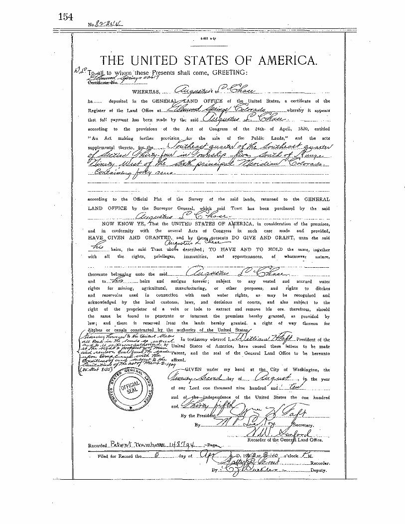
THE UNITED STATES OF AMERICA ~.f"To,.aiL to wh~_these Presents shall come, GREETING: ~-rt"' pfo/;11
e.rnfu''""""''"'''·- -;;;~~~EAS, _a~,J?~~-ha.. deposited in the GENE~AND ~FFI E of the Un:.: States, a cert~cate of the
Register of the Land Office at_ ~ _ ~ ~ ·;·~- _ whereby it appears
that full payment has been made by the satd ~- _.£.., -~~ according to the provisions of the Act of Congress of the 24th, of April, 1820, entitled
"Au Act making further provision, -for the sale of the Public Lauds," and the acts
~~~~ according to the Official Plat of the Survey of the said lands, returned to the GENERAL
LANDNO:F:~~;y4,1~uN]t~~:~:;Iz i•~,:~.,,:::::::::dof ~:, :: .. ,::~~ and in conformity with the several Acts of Congress ill such case made and provided,
HA,YE GIVEN AND GRANTED, and by ys~ DO GIVE AND GRANT, unto -the said
-~-----heirs, the said Tract ~ribe~; TO HAVE AND TO HOLD the same, together
with all the rights, privileges, immunities, and appurtenances, of whatsoever nature,
water
rights for mining, agJ·icultural, mamlfacturiog, or other purposes, and rights to ditches
and reservoirs used in connection with such water rights, as· may be recognized and
acknowledged by the local customs, laws, and decisions of courts, and also subject to the
right of the proprietor of a vein or lode to extract and remove his ore. therefrom, should
the same be found to -penetrate or iiltersect the premises hereby granted, as provided by
law; and there is reserved from the lands hereby granted, a right of way tbe.reon for
fl" jj.tzhes or canal~ constmcted__!:_y__the auth~ of the United Sta~" .
~""''"'J:;e"'""'~~P.r::..Z6u~-e~&~ r . Z J.'h?.'._ -~z·~ . ~ t!'Ar<.b-<:«- .7k _.r ........ .L., ....;!4 _udt(.o...,.e_ n testimony whereof I,.«. .... _ ~-~·-· -~¥"-··-·· Prestdent of the
J::t:Jiif~:'~ United States of America, have caused these letters to be made
a44 ~~ ~Patent, and the seal of the Geueral Land Office to be hereunto
tho


Molly Orkild-Larson
From: Sent: To: Cc: Subject:
Kirk Leintz [[email protected]] Sunday, May 23, 2010 9:38PM Molly Orkild-Larson Cassie Coleman Mineral Rights
Molly here is the final results of the mineral rights search.
1/2 the mineral rights belongs to the following 4 individuals; LLoyd W. Tuttle- deceased 1981, Earl J. Tuttledeceased 1999, Mclloyd Tuttle and Wayne K. Tuttle- address 823 S. Carterville Rd in Orem, UT 84097 phone disconnected.
1/2 the mineral rights belongs to Jim (James) Collins and Rushton Backer with CB Minerals- their legal representative is James Osbourn- address: 2602 McKinney Ste 100 in Dallas TX 75204 phone (214)354-1341 or (214) 720-4484
This should be everything you need.
Melissa
1

ponds on the property near the river. The majority of the land outside of the existing Riverbend Subdivision is either used for crop land, grazing or unimproved open space. One exception is a house built on a portion of the unplatted PUD that was designated for single family use.
B. Request. The applicants are requesting an amendment to the Riverbend PUD Plan for a portion of the property presently shown as being "Utility Facilities" and" Open Space and Agricultural Land" on the PUD plan approved in 1977. The proposed plan amendment and zone district text amendment would create the following three (3) new zone districts in the Riverbend PUD; Single-family, Two-family and Open Space/Parkland zone districts.
The proposed subdivision will have 11 single-family lots and five (5) two-family dwelling Jots on the 10.61 acre tract.(See plan pg.__!}_j All of the Jots range in size from 0.33 ac. to 0.36 ac. each. Water and sewer would come from a privately owned system owned by the applicants, which also serves the existing Filings 1 and 2 ofthe Riverbend Subdivision. Access would be a 50 ft. wide, 890 ft. long, loop road off of County Road 335. The applicant proposes to modify the existing Riverbend Subdivision covenants to include this development.
C. Histor:y: The Riverbend Subdivision was originally approved for 617 d.u. in 1973. In 1977, the development was reduced in size to 198 d.u. in 1977, when it was approved as a PUD .(See zone districts map --8_._) The PUD plan approved at that time had a number of land use designations on a map, but no zone district text to defme the uses allowed in the various zones. The plan included
-118 single faJllily lots and 80 multi-family dwellings. Only the single family area was ever platted. There are two types of open space; Common Area and Open Space/Agricultural. In 1984, NCEC (aka Storm King Mines) modified the original PUD to allow for a coal mine and other industrial support facilities on the western end of the property.
III. MAJOR ISSUES AND CONCERNS
A. PlJD Zoning: To amend a PUD plan, Section 4.12.03 states the following:
All those provisions of the Plan authorized to be enforced by the County may · be modified, removed, or released by the County, subject to the following:
(1) No modification, removal or release of the provisions of the Plan by the County shall affect the rights of the residents, occupants and owners ofthe PUD to maintain and enforce those provisions at law or in equity; and
(2) No substantial modifications, removal or release of the provisions of the Plan by the County shall be permitted except upon a finding by the County, following a public hearing called and held in accordance with the provisions of Section 24-67-104, C.R.S., that the modification, removal orreleaseisconsistent with the efficient development and preservation of the entire PUD, does not affect in a substantially adverse manner either the enjoyment of land abutting upon or across a street from the PUD, or the public interest, and is not granted solely to confer a special benefit upon any person.
The proposed PUD plan and text amendment is on a tract ofland that was originally designated as the Utility Area and Open Space/Agricultural area. The utilities for the frrst two filings have always been owned by a private party, who provides water and
-2-
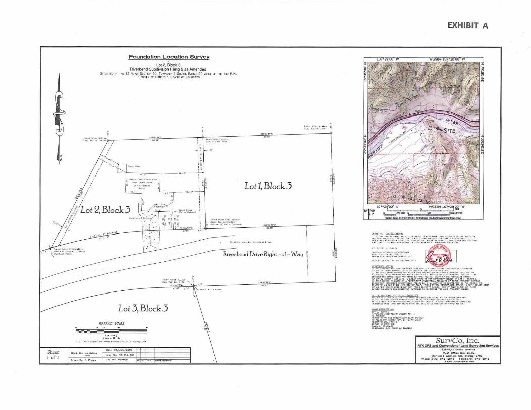
Sheer I of I
Foundation Location Survey •
Lot 2, Block 3 Riverbend Subdivision Filing 2 as Amended
SITUATED IN n£ SCI/L. r7 SECTION 3!., TO',','NSHIP 5 SOUTH, RANGE 90 \'.fEST OF T~ 6TH P. "1. CCllNTY OF GA.RFI::Lo, Sr.ue OF COt..o ~Aoo
r-•'•ll•~ '"'"'·~-e.,, PUJII. h)'l
. -- l ;:-,:",:::"'"~."::~;;·t ' u·~;:- i r ,_,., ...... r .. ,.t.J_, .... 1 1 . e..•, ru .... tH•
I I
I I
I
:':><>r.Q. ~.o04r IIIA.l•• C ... p, P~lt~, HU I
~··Cl''!.''Y>
Lot 3, Block 3 GRAPHIC SCALE
t. • ..I W ~ • ( IJin::a ) , ..,.. __ ft.
"' 11-r "'-••o..• ,_ t•r....u .... h u: •·~~·-r ,...,,,
Dote: ~/ ....... /2010
··~ Ne: IQ-01-001 Job No.: oe-02e
I I I I I I I I I" I I I I
..__..a.u.. . .. Ju, .... ,a..;. .. .. ..,, __ , ... ,., •• .: ••. .u..., - .,.! ... .. ... , .,".-·
Lot 1, Block 3
sM:!-
"I~ ~~
U1 04"t•,..
EXHIBIT A
'• ... J}o(l \ &.1~101$•1.1 "M)t'~IJJOII,U '-"""" 1'.1'1\'&!Qol !• UK Sfo'l t. Go IUi rt :;-J.U tJ: .f r'O(I)OQATJOI< U'.IC.AUg• !'Wivtt KAJ ta:rMC~
...:.:~·~;._~~~~~;; ~;. :~ ~~ !.~:~~~~ ... ..,.,~('!loot) "'"""'''""'' $ ' 00~'\UJ:> Utoel:r ff'lli'J:SI: II):U.L \ IIJ ~tJ~~~'i:~,,·~"'MlG. u.:::. Ill \ -
u.r:: c..r ar.";c.u:<* ~4,~!0!1 ,
fj~jf;..~ • .....,. ,_,._,_ .... •IlS-I'D Cuo:J>T l'..L'i:l&.-~ 'tO- NJo o.DC.IIr•Oo> 0¥' Tn U l tTIHC; ~r; .. U ~T"J Ollt Tn ··~ ... ;N:tr.T. Jt KUIIco.J J~ -All: !l-lt31'017'C"f f'C U:::.O ""'' 1011 •:VIli-C\Il;,JYIIJOII r-~,'ICI 1110. ' . , ... .....-n ~ ·-~'1 ·~·""·"""~"" • ""'"'IGor '-~·oc·u"'W. - ~ ~, ,.,. DCT4!;11 n!: ~0 1 ;tOAA A.'fll iotU!UIII:O. el.,, '"' 1'110. lUt" ~: ~ IIC*fli&:An (QIIII~ M" ur. 1, 't.!IO'' AMIJ. ..:~. ~ •.!1'-~ ~•n ':'11% ~CT"f!'IC~t ~~ c:r ""' 1, )t.OC'f t. J) ':'1111 T.III"'ZT II MJ!D 011 A "l!lM' r'JT" "'A1'1UJCA:II MA~nJS 0'!" rQUIQ ' "'C:ICI'r.' C'O!Uan 1''4r.(;~ IUIIC.!\.U!1•0 .77.JIIIVJ~;(;III nU~to Nil), ~ ·~~ ~'fl:~l;)f;O 11; IXMO'A~:$Q.<I fO Tilt DJ,C.'f::IC"S Jlltlte.-nr> Ol' TTI1 n~L ~tllli:Hvuro" l'tA~. mt.'r. ='='' ~'~ or~rOif\~ ::JL~ 111 rrru '~"'o:·n;HO" 07 Y\I:Uil4 DSCU ;E lf iTI'I K ,\Hr ~lit :!"010'110 l'llb,.,,,., COMU, ;Uo'!l .\ 1' ~Dt!r :.DC.',TIOIU : "LOU: U I U J WrtJc:.t.U PIIOIWIWO'V.I'lCJft U'7V.ot:~ TO II.I:I'UIDIT fd ~~~ AAOI U.rT C.W.NU,
~~l:~~;:§!·!fi~~~~~~~:: " a:.nD~Q.O ~ ~ lVI rUoU fr-a'. nil: MtC Or CDTU:OI.TJ:III UOIIlf illt!UOII,
"'""- WC!IDIO!I•
!f'~~r-.::VUIO!o' .ru .. :JIG n . • .r...'"f;I)II.IIIIIO' TO 'niJ: JV'l/DI VUIO.: ~t.TIT :'!OI~ttiJ'
~~~?~iliF0~- u , an c.~~~ C'Qt.:"A •• IUHG 0 , :2JICjl,l3o\:'l I I.A:T!::I
SurvCo, Inc. RTK GPS and ConvenUona l Land Surveying Services
e2&-1/2 Ciron4 "" ....... ". Po•t Ot neo lllo• 2781;
QOI'I .... ood Sprln'ij._ CO. I!U 602-2782 ~Ott•:(fl70) 9 4$- !i!ii4S ,-ox:(l70) 14$-S!il~
~ .. , __ ........... -

0
" 0
EXHIBIT B
1~2.69' I I I , I~
--~~ I';.; I ~·
1 <'·e0 , I"'~
FDund Reb CB.p, PLS
-7.50'
"...___ I~ I 'J,_II I"
/ ·J,, "''l' co,c. Fdn<. ;;uo----c----~ 6!.2>' ---'~1-~~~"l
I 48.1' I
I ;. Single Family Residence I I I ~
~~ I I Nood Frame Cor-S t • I ~ ~ 1 N 263 Riverhend ,
~ I Drive ~~ &. I 23.?• L~ .. o.-.. ---43.15'--+~~
'_i'lo I U.9' ~ I I ~ / I :i~ ~ / .• O"Jtline of/
'L 2 Bl k 3 "/ /i'oondati~o Ot Oc // 44.4' Drain Cover ' , . , · . . .
1
~~{Folse Col"'"')
\ ,·.;_~ .. ~._... .. ~ ~ t~
Outline oll ~~~<-- ·-. ~rt ~g ~" ,.. __ -~_ .. _; ___ I ~: ~9 ~~ 1: .. _: .. __ -r . ·§- -~ ".!~
• 1'1 · v, •. ' 1'1 (II S8BG()4'59"W
~·~;-' 67.00'
I I
mw (..U!
I 00
I ·;;;
I I I I I I I I I I
Found I I ~ Alum.
0 ilppro I ~
0.42'

May 24, 2010
Mr. and Mrs. Leintz . 263 Riverbend Drive New Castle, CO 81647
RE: VARA-02-10-6322 - Variance
Dear Mr. and Mrs . . Leintz:
Garfield County BUILDING & PLANNING DEPARTMENT
The Garfield County Building and Planning Department is in receipt of your application for a variance for a garage within the 25' front setback on your property located at 263 Riverbend Drive, New Castle, CO. Your application has been determined to be technically complete.
The application will be reviewed by Staff; a staff report will be generated and sent to you, and the Board of Adjustment (BOA). The BOA will discuss and review the application at a public hearing which has been scheduled for Monday, July 26, 2010 at 6:30PM and will be held in the County Commissioners Chambers at the Garfield County Administrative Building, 108 8th Street, Glenwood Springs. The following code sections specify the criteria for meeting notice requirements:
Notice of Public Hearing. Certain land use change applications will require a public hearing. Unless otherwise provided by these Regulations, when a public hearing is required the following public notice shall be required.
1. Notice by Publication. At least thirty (30) and not more than sixty (60) calendar days prior to the date of a scheduled public hearing before the Planning Commission, and at least thirty (30) and not more than sixty (60) calendar days prior to the date of a scheduled public hearing before the Board of County Commissione(s, the applicant shall have published a notice of public hearing in a newspaper of general circulation in the area that the proposed land use change is located. Publication of said notice shall follow a form prescribed by the County.
2. Notice to Adjacent Property Owners. Except for text amendments to the provisions of this Resolution and existing Planned Unit Developments, at least thirty (30) and not more than sixty (60) calendar days prior to the date of a scheduled public
0375 County Road 352, Building #2060 • Rifle, CO 81650 (970) 625-5900 • Fax: (970) 625-5939
108 Eighth Street, Suite 401 • Glenwood Springs, CO 81601 (970) 945-8212 • Fax: (970) 384-3470

hearing, the applicant shall send by certified mail or by a nationally recognized overnight courier, return receipt requested, a written notice of the public hearing to the owners of record, as shown in the office of the County Clerk and Recorder or Assessor at least 30 days prior to sending notice, of all adjacent property within a 200' radius. Within the same time period written notice shall be provided to owners of mineral in interests in the property (other than construction materials as defined in Section 34-32.5-10 CRS, as amended) in accordance with Section 24-65.5-101, et seq., CRS, as amended. (Reso 2009- 53)
3. Posting of Notice. Except for text amendments to the provisions of this Resolution and existing Planned Unit Developments, at least thirty (30) and not more than sixty (60) calendar days prior to the date of a scheduled public hearing the applicant shall post a notice of the public hearing on the property. Such notice shall consist of at least one sign facing each adjacent road right-of-way, and located so as to be fully visible from the road right-of-way generally used by the public. Such signs shall be provided to the applicant by the Planning Department. (Reso 2009 - 53)
4. The notice shall include the property's legal description, a short narrative describing the current zoning and proposed land use change, and an announcement of the date, time and location of the scheduled hearing, names of the owners of the property and their designated representative.
5. Proof of Notice. At the public hearing, the applicant shall provide proof of publication, proof of notification or attempt of notification of to adjacent property owners, and proof of posting notice on the property. The applicant shall provide proof of notification or attempt to notice owners of mineral interest in the subject property.
Attached is a Public Notice Form for your use in the publication (Rifle Citizen Telegram) and adjacent property/mineral owner notice. The poster that is to be posted on your property is also enclosed.
Please note that Staff provides the Notice Form to you as a courtesy, however it remains the responsibility of the applicant to provide adequate notice pursuant to the Code requirements. Prior to the public hearing you will be required to provide the affidavit from the newspaper regarding publication, the proof of mailing and return receipts for adjacent property owners and to mineral owners of the subject site.

Please submit 13 copies of the completed application and 1 complete application on compact disk to this office no later than Tuesday, June 1, 2010. The digital version should include a pdf of the entire application and a Microsoft Word version of the narrative and supporting analysis.
Please feel free to contact me if you have any questions.
Sincerely,
Molly Orkild-Larson, AICP, RLA
CC: Cassie Coleman, Assistant County Attorney

PUBLIC NOTICE
TAKE NOTICE that Kirk and Melissa Leintz have applied to the Board of Adjustments, Garfield County, State of Colorado, to request a Variance for a garage within the 25 ' front setback as required by 3-503 of the Garfield County Unified Land Use Code of2008, as amended, in connection with the following described property situated in the County of Garfield, State of Colorado; to-wit:
Legal Description:
Practical Description:
Request Description:
(Insert Legal Description of the Subject Properly)
263 Riverbend Drive, New Castle, CO.
Request a variance to allow a garage addition and roof eave to encroach into the 25 ' front setback by 8" and 10", respectively.
All persons affected by the proposed Variances are invited to appear and state their views, endorsements or objections. If you cannot appear personally at such meeting, then you are urged to state your views by letter, as the Board of Adjustment will give consideration to the comments of swTounding property owners and others affected in deciding whether to grant or deny the request for the variances. This application may be reviewed at the office of the Planning Department located at 108 8th Street, Suite 401, Garfield County Plaza Building, Glenwood Springs, Colorado, between the hours of 8:30a.m. and 5:00p.m., Monday through Friday.
A public hearing on the application has been scheduled for Monday, July 26t\ 2010, at 6:30 P.M., in the County Commissioners Chambers, Garfield County Plaza Building, Suite 100, 108 8th Street, Glenwood Springs, Colorado.
Planning Department Garfield County

April 26, 2010
Melissa & Kirk Leintz 263 Riverbend Drive
New Castle, CO 81647
Molly Orkild-Larson, AICP, RLA Senior Planner 1 08 Eighth Street, Suite 40 1 Glenwood Springs, CO 81601
RE: VARA-02-10-6322- Variance
Dear Garfield County Building & Planning Department:
T
Thank you for reviewing our application for a vmiance. This submission is to try to complete the application in regards to the four incomplete m·eas referenced in your letter.
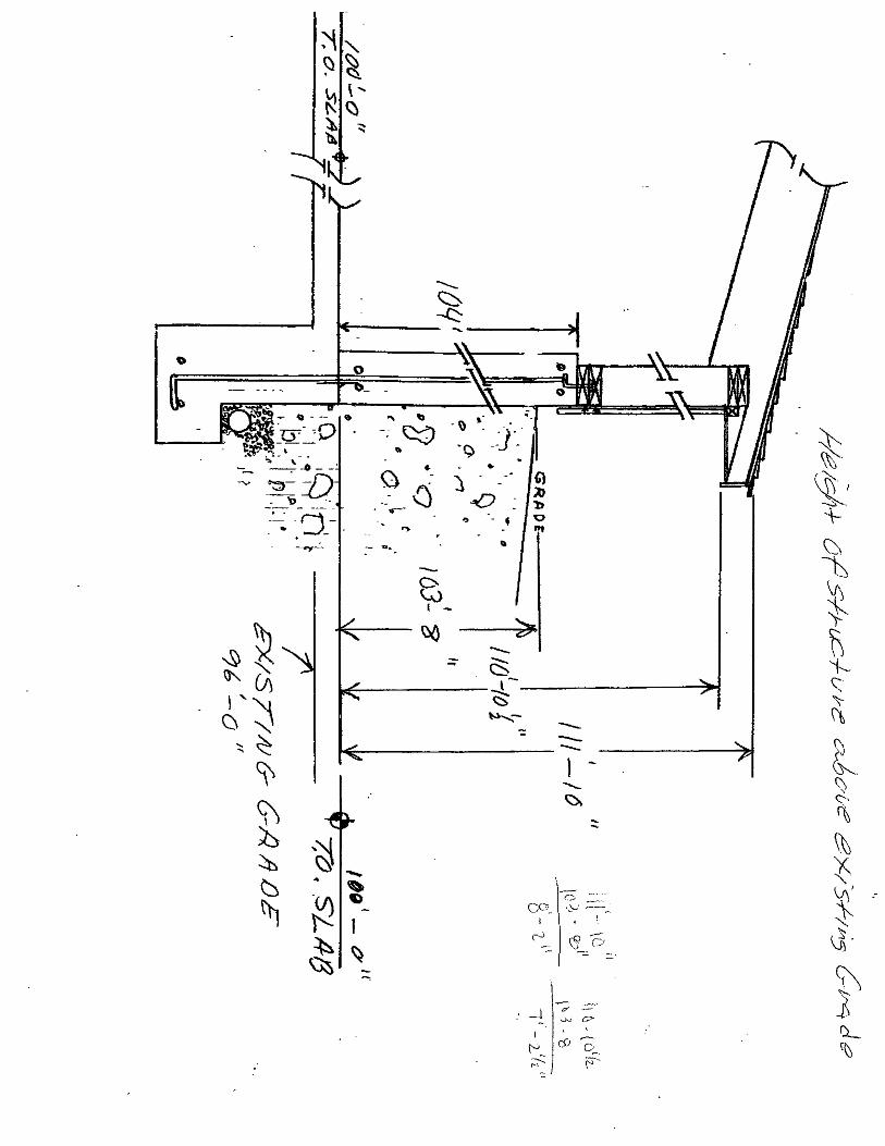
l. The req uest for a topographical m·ea map of the propet1y to show any constrains that may exist: Two maps are provided, a topo map with boundary lines and a topo map with elevation numbers.
2. Elevation drawings showing the existing grade, finished grade and height of the proposed structure above existing grade: Please see enclosed photographs showing the property when we pmchased it for the existing grade and the present time photo showing the finished grade. The drawings provided shows the height of the structure above existing grade.
3. Map of prope11y owners within 200 feet of the subject parcel: 1 have labeled the map with parcel numbers to clmify the referenced owners. T have included the missing parcel owners to complete all property with in 200 feet. In regards to the mislabeled propet1y, what I submitted is COITect. The propet1y I labeled 212334407003 belongs to David Malin the owner being Sacred Mountain Trust. On the assessors site, the prope11y is labeled 212334405003 as Paul Michael Blackford. This property is duplicated inaccurately on the assessors site. Please see enclosed platt. Mike Blackford owns the property on the other side of the road at 370 Gleneagle circle. The assessors site shows this exact parcel number owner and address in both places on their site. Please see the e-mail and attachments from Cheryl Heiberger from Sherman & Howard LLC to prove that what I submitted for Lot 3 Cedm· Ridge is correct.

4. Narrative for Article VII Divisions I & 2:
DIVISION I
Section 7-101 Compliance with Zone District use Restrictions: T11e structure is in compliance with the Zone Dist1ict Use Regulations. We did not change the zoning use. It is still a single family residential and the structure did not add any living space.
Section 7-102 Compliance with Comprehensive Plan and h1tergoverrnnental Agreements: The land use was not changed. It remains residential as it was originally zoned.
Section 7-103 Compatibility: The land used has not changed, the structure is compatible with adjacent land uses and does not alter how the land is used.
Section 7-104 Sufficient Legal and Physical Source of Water: The water supply is existing. The structure built does not require any additional water usage. There isn't any plumbing in the garage.
Section 7-105 Adequate Water Supply: The water supply is existing
Section 7-106 Adequate Central Water Distribution and Wastewater Systems: The water distribution and the wastewater system is existing
Section 7-107 Adequate Public Utilities: The public utilities is existing
Section 7-108 Access and Roadways: The roads are existing
Section 7-109 No Significant Risk from Natural Hazards: The property is not subject to significant risk due to natural hazards
DIVISION 2
Section 7-201 Protection of Agricultural Lands: There is no adverse affect to Agricultural operations. We do not own domestic animals that would interfere with livestock. No fences have been constructed by us. The roads are preexisting. We do not have any irrigation ditch.
Section 7-202 Protection of Wildlife Habitat ATeas: No wildlife habitat was disturbed.
Section 7-203 Protection of Wetlands and Water bodies: We are not located in a wetland or water body location.
Section 7-204 Protection of Water Quality from Pollutants: There were no hazardous materials stored or used for the construction of the structure. There are no water bodies within I 00 feet of the structure.
Section 7-205 Erosion and Sedimentation: We did not disturb more than Y, acre of land to build

the garage.
Section 7-206 Drainage: All drainage is away from the building
Section 7-207 Storm water Run-Off: We are not within 100 feet of a water body
Section 7-208 Air Quality: We have not changed or altered the air quality
Section 7-209 Areas Subject of Wildfire Hazards: The development is not located within a severe wildfire area. The structure does not increase the potential of a wildfire, we do not have a wood burning stove and the roof is made of metal. The propetiy around the structure is mowed to reduce fuel to a wildfire. The safety area in Residential development i I Cul-de-sac I Hammerhead I and Road grade are all not applicable to this situation of building a garage addition.
Section 7-210 Areas Subject to natural Hazards and Geologic hazards: the structure did not impose any hazardous site conditions it is not subject to natural hazards and geologic hazards. It is not located in a red zone hazard area. It is not in a blue zone hazard area. The utilities are existing. It is not located in an avalanche area. There is no hazard of a landslide. The structure is attached to a preexisting house and garage. It is not in an alluvial fan hazard area. It is not build on a 20% slope area. The tests for corrosive or expansive soil was done when the house was originally built. All drainage is away from the structure and runoff is converted to any natural drainage areas. The structure is not in a mudflow area. And nor is it built on a fault.
Section 7-211 Areas with Archeological, Paleontological or Historical hnportance: There is not archeological, Paleontological or historical importance to where the structure was built.
Section 7-212 Reclamation: We have reclaimed the soil with the same natural grasses, added trees, rock retaining wall and if you look hard you may find a flower or two.
Thank you for your time in this matter.
Sincerely
Kirk & Melissa Leintz
ENC:

Map Page 1 of 1
Map
0
http:/ /gismaps.garfield-county .com/aspnet_ client/ESRI/WebADF /PrintTaskLayoutTemplat. .. 4/24/2010

Map
Map
City or Town
0 State Wildlife Area
LJ
US Naval Oil Shale reserve (BlM)
State Recreation Area
Page 1 of 1
Federal Land
BUREAU OF LAND MANAGEMENT,
DP INDICATES DISPOSAL
'US FOREST SERVICE
http:/ I gismaps.garfield-county .corn!aspnet_ client/ESRI/WebAD F /PrintTaskLayout Temp lat... 4/24/20 I 0


·--·····-2: --·· :::.:.-() =
: __ =_=~~ -~= -~--::::-w
=~= :=~-~
' .. ~ \:)
~ i:::: \!)
~ ~ ~ \} ~
·~ /.s;.
·~ ·--..,
~ ~
~ ·~
\
~ Q
·--·----
Q) \J
~ ~- ..._ ·~
~· ~
-\
Lt
....._ <:::::-
~-----~------~)1 0
. \) ·: ·. .
.Q I~
. . ) . _· ~
..0 : b ., - • Q
"'
?d . .-· -.
"
~ ~-
't ,• --.:5
--\-t0
~ I -
I\ ~ )-
- ~ C3; 't--
1,.?------L --------~ <:s ' ";-......... - -- \\ -~--------
1 - t \) ' <> f\ ~ {:
cc~~ '~-) -----~
! ' \
Y'\' :
~ ~-
- -· _j if -: - >._),j C?"
l\ .b
\ - ' ;._ (" c£• 0~. ~ p
~ ~

.-

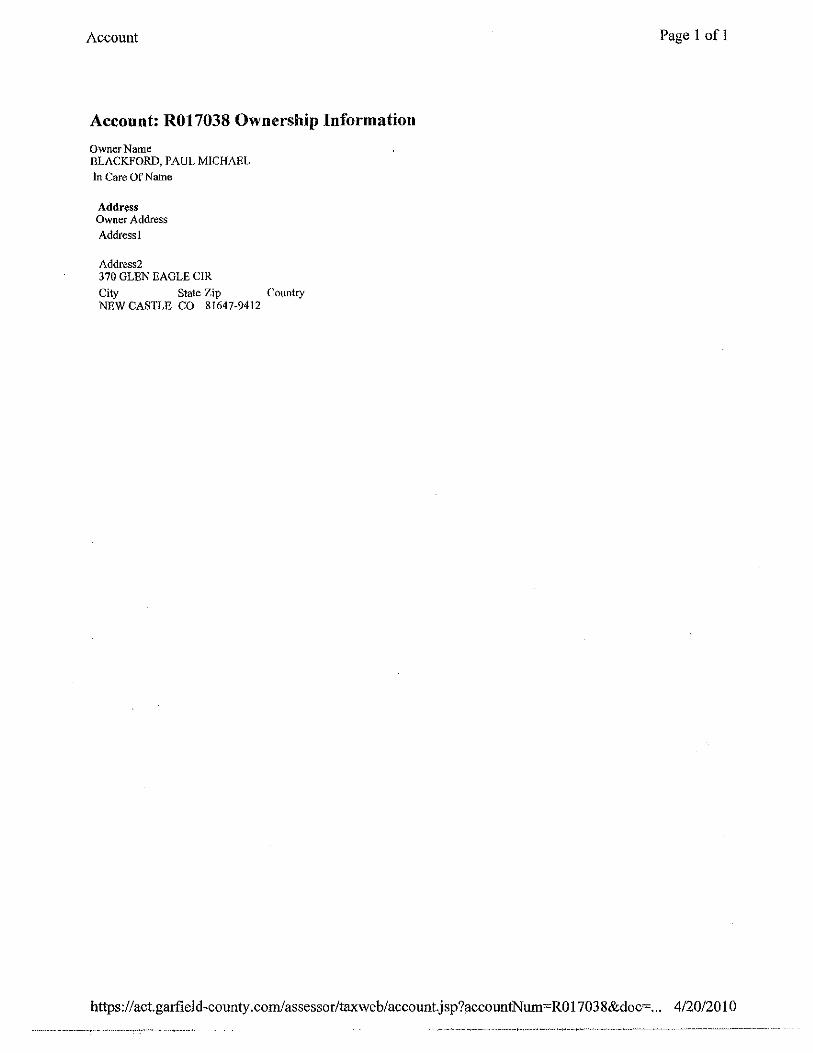
Account
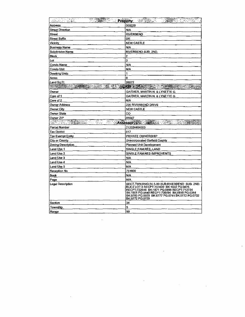
Account: R017038
Location
Owner Name BLACKFORD, PAUL MJCHAEL
Parcel Number 2123-344-05-003
Tax Area 017- 2D-SF- 017
Situs Address 000370 GLENEAGLE ClR
Sibling Account No
Legal Summary Section: 34 Township: 5 Range: 90 Subdivision: RJVERBEND SUB. 2ND. Block: 3 Lot: 3
Transfers
Sale Price
Tax History
Tax Year Taxes
2009 $1,233.60
Owner Information
Owner Name BLACKFORD, PAUL MICHAEL
Owner Address 370 GLEN EAGLE CIR NEW CASTLE, CO 81647-9412
Sale Date
05/14/2008
05/ 14/2008
05/14/2008
06/ 19/ 1998
Images
• Sketch • GIS
Doc Type
NOT
NOT
NOT
Deeds
Page 1 of 1
Assessment History
Actual (2009) $396,390
Primary Taxable $31,550
Tax Area: 017 Mill Levy: 39.1000
Type Actual Assessed SQFT Units
Improvement $246,390 $19,610 1.000
Land $150,000 $11,940 35719.000
Book Page
B: I 073 P: 0792
2008 $906.88 r-----,r---------r-----r----.,
https://act.garfield-county.com/assessor/taxweb/account.jsp?accountNum=R017038 4/2112010

• )
• -··
·~-:J 'I'
/.· 'l ,,
I ..
' If · I
J. ,·; ., /,
/-.-,·
('\ , ,
"'·
Garfield County Clerk & Recorder - Search Results
SEARCHING , Document Search
Search Heln About Garfield County Clerk & Recorder Logout publicweb
Printable Version
Page 1 of I
You s~arched for: RecDateiD >='Wed Jun 30 00:00:00 MDT !982 and<~ Wed Apr 14 00:00:00 MDT 2010 and exact search in GranteeiD for sacred mountain trust
6 items found. displaying all items.l
~~S.~~-iJ~~i~~.. Summary Rcc Date: 12/17/2004 04:20:00 PM BookPage: B: 1648 P: 906 Related:
'Warranty Deed Grantor: COLLINS. TIIOMAS A ·Grantee! SACRED MOUNTAIN TRUST 665397 Notes: Legal: Subdivision: 553680 CEDAR RIDGE SUB
AMD LOT 3 Lot: 3
Statement Of Authority 665398
Warranty Deed 687273
Statement Of Authol"ity 687274
Statement Of Authority 756574
Release Of Deed Of T1·ust 758767
l!ec Date: 12/17/2004 04:23:00 PM Bookl'age: B: 1648 P: 907 Related: Gnmtor: MALIN, DA Vlll T-IND & TRUSTEE Grantee: SACRED MOUNTAIN TRUST Notes: Legal:
Rec Date: 11/29/2005 02:49:00 PM llooltPage: B: 1750 P: 100 Related: G•·anto1·: HERMAN. MINDY S Grantee: SACRED MOUNTAIN TRUST Notes: Legal: Subdivision: 501840 CEDAR RIDGE SUB
Lot: I
Rec Date: 11/29/2005 02:50:00 PM Booi<Pagc: 8: 1750 P: 101 Related: Grantor: MALIN, DAVID Grontee: SACRED MOUNTAIN TRUST Notes: Legal:
Rcc Date: 09/30/2008 09:39:19 AM Book Page: Related: G1·antor: MALIN, DAVIE-TRUSTEE Grantee: SACRED MOUNTAIN TRUST Notes: Legal:
Rec Dllte: 11/17/2008 02:55:27 PM BookPage: Related: 750222 Grantor: Pli81.1C TRUSTEE-GARFIELD COUNTY, Grantee: MALIN, DAVID T-TRUSTEE, SACRED WELLS FAR(;O RANK MOUNTAIN TRUST Notes: Legal:
6 items found, displaying all items.l
https :/ /act.garfield-county .com/recorder/eagleweb/docSe!!!chResults.jsp?searchl d=O 4/20/2010

Garfield County Clerk & Recorder - Search Results
Return to Search Results
You searched for: RecDateiD >=Wed Jun 30 00:00:00 MDT 1982 and<= Wed Apr 14 00:00:00 MDT 2010 and exact search in GranteeiD for sacred mountain trust
6 items found, displaying all items.1
Description Summary
Warranty Deed Rec Date: 1211712004 04:20:00 PM BookPage: B: 1648 P: 906 665397 Related:
Statement Of Authority 665398
Grantor: COLLINS, THOMAS Grantee: SACRED A MOUNTAIN TRUST
Notes: Legal: Subdivision: 553680 CEDAR RIDGE SUB AMD LOT 3 Lot 3
Rec Date: 1211712004 04:23:00 PM BookPage: B: 1648 P: 907 Related:
Grantor: MALIN, DAVID lIND & TRUSTEE
Notes;
Grantee: SACRED MOUNTAIN TRUST
Legal:
Warranty Deed Rec Date: 1112912005 02:49:00 PM BookPage: B: 1750 P: 100 687273 Related:
Statement Of Authority 687274
Statement Of Authority 756574
Release Of Deed Of Trust 758767
Grantor: HERMAN, MINDY S Grantee: SACRED MOUNTAIN TRUST
Notes: Legal: Subdivision: 501840 CEDAR RIDGE SUB Lot: 1
Rec Date: 11/29/2005 02:50:00 PM BookPage: 8: 1750 P: 101 Related:
Grantor: MALIN, DAVID Grantee: SACRED MOUNTAIN TRUST
Notes: Legal:
Rec Date: 09/30/2008 09:39:19 AM BookPage: Related:
Grantor: MALIN, DAVIE- Grantee: SACRED TRUSTEE MOUNTAIN TRUST
Notes: Legal:
Rec Date: 1111712008 02:~55:27 PM BookPage: Related: 750222
Grantor: PUBLIC TRUSTEEGARFIELD COUNTY, WELLS FARGO BANK
Notes:
Grantee: MALIN, DAVID Tc TRUSTEE, SACRED MOUNTAIN TRUST
Legal:
6 items iound, displaying all items 1
Page I of!
https://act.garfield-county.com/recorder/eagleweb/docSearchResults.jsp?searchld=O&print... 4/20/2010

Garfield County- View Document
SEARCHING <> Document Search
Search Help About Garfield County Clerk & Recorder Logout publicweb
Warranty Deed· 687273
Reception Number 687273 Recording Date I 1129/2005 02:49:00 PM Book Page 1750 100
# ofPgs Rec. Fee I $6.00
Doc. Date Doc. Fee 11/23/2005 $30.10
Surcharge Total Fees ($1.00) $0.00
Related
~~~-e.e~-~4)_n_ N~mber Book Page
Return Address SACRED MOUNTAIN TRUST
Address I 9680 COUNTY ROAD 335
Address2
City State Zip NEW CASTLE CO 81647
Mailback Date
Owner Seller Buyer See~nd Party
HERMAN, MINDY S SACRED MOUNTAIN TRUST
Legal Summary
Subdivision: 501840 CEDAR RIDGE SUB Lot: I
Notes or Remarks Notes
Remarks
https:/ /act.garfield-county .com/recorder/ eagleweb/viewDoc.jsp?node=DOCC687273
Page I of!
4/20/2010
Results
Printer fl'iendly view
Query: exact search in OwneriD for sacred mountain trust
Found 1 result on I page
Rl 70347 2123-344-07- SA ClUeD MOliNTAIN 003 TRUST Ne\v c:ast!e 81647
https:/ /act.garfield-cotmty .corn!assessor/taxweb/results.jsp
Section: 34 Township: 5 Range: 90 Subdivision: CEDAR RIDGE SUBDIVISION Lot: 3 AMENDED
Page 1 of 1
Picture
•
4/20/2010
Account
Account: R170347
Location
Owner Name SACRED MOUNTAIN TRUST
Parcel Number 2123-344-07-003
Tax Area 017- 2D-SF- 017
Situs Address
Sibling Account No Legal Summary Section: 34 Township: 5 Range: 90 Subdivision: CEDAR RIDGE SUBDIVISION Lot: 3 AMENDED
Tmnsfers
Sale Pl'ice Sale Date
)_2/14/2004
$125,000 )_2/16/2004
$89,800 HLQJLl992 $4.000 J..QLH1.1999
Tax Histo~~- _
Tax Year Taxes
2009 $606.84
2008 $470.36
Owner Information
Owner Name SACRED MOUNTAIN TRUST
Owner Address 550 REDCLIFF CIRCLE UNIT202 RIDGEWAY, CO 81432
Doc Type SA
WD WD
Deeds
1m ages
Puge 1 of I
Assessment His.~~q:
Actual (2009) $195,000
Pl'imary Taxable $15,520
Tax Area: 017 Mill Levy: 39.1000
~)·p_~_ ~~tu.~.l- ..... A~~-~~-~~~- At:~.e~ Loud $195,000 $15,520 4.026
BookPoge
B: 1648 P: 907
B: 1648 P: 906
B: 1163 P: 440
B· J 155 P: 355-356
https://act.garfield-county.corn!assessor/taxweb/account.jsp?accountNum=Rl70347 4/20/2010

Account
Account: R170347 Ownership Information
OwrterName SACRED MOUNT AlN TRUST In Care Of Name
Address Owner Address Addressl
Address2 550 REDCLIFF CIRCLE UNIT 202
City State Zip Country RIDGEWAY CO 81432
Page 1 of!
https:/ /act. garfield -county .com/assessor/taxweb/account.jsp ?accountNum=R 17034 7 &doc=... 4/20/201 0
Account Page I of 1
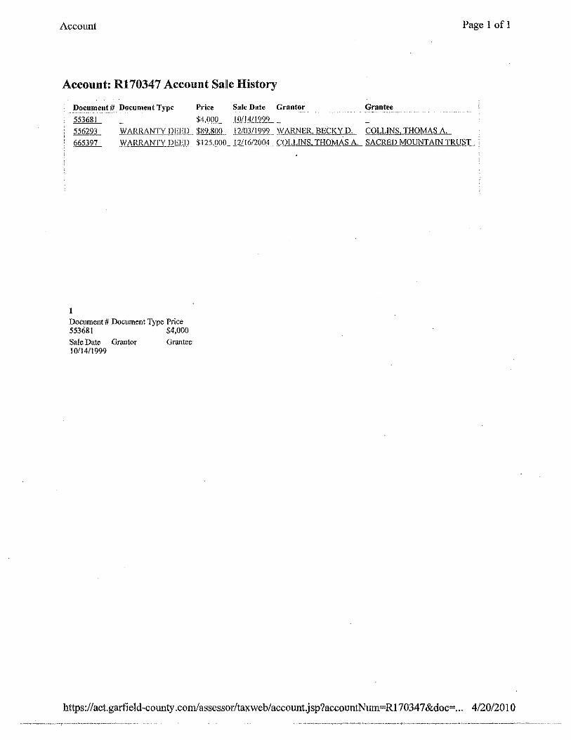
Account: R170347 Account Salle History
-~-~-C-~1~~~~--#. _Document Type Price Sale Date Grantor Grantee 553681 $4 OOQ__ 10/14/1999
556293 1}1 ARRANTYJ?f!lJL. $X9,801L 12/03/1999 'l{i',RNER BECKY D. COLLINS, THOMAS A.
665397 \}/ARRANT\' ll[j];[l_ $]25.000_ IY16/2004 L'Ql,]..INS. THOMAS A. SACRED MOUNTAIN TRUS:L
I
Document # Doctunent Type Price 553681 $4,000
Sale Date Grantor 10114/1999
Grantee
https://act.garfield-county .com/assessor/taxweb/account.jsp?accotmtNum~Rl7034 7 &doc=... 4/20/20 I 0
Account
Account: R170347
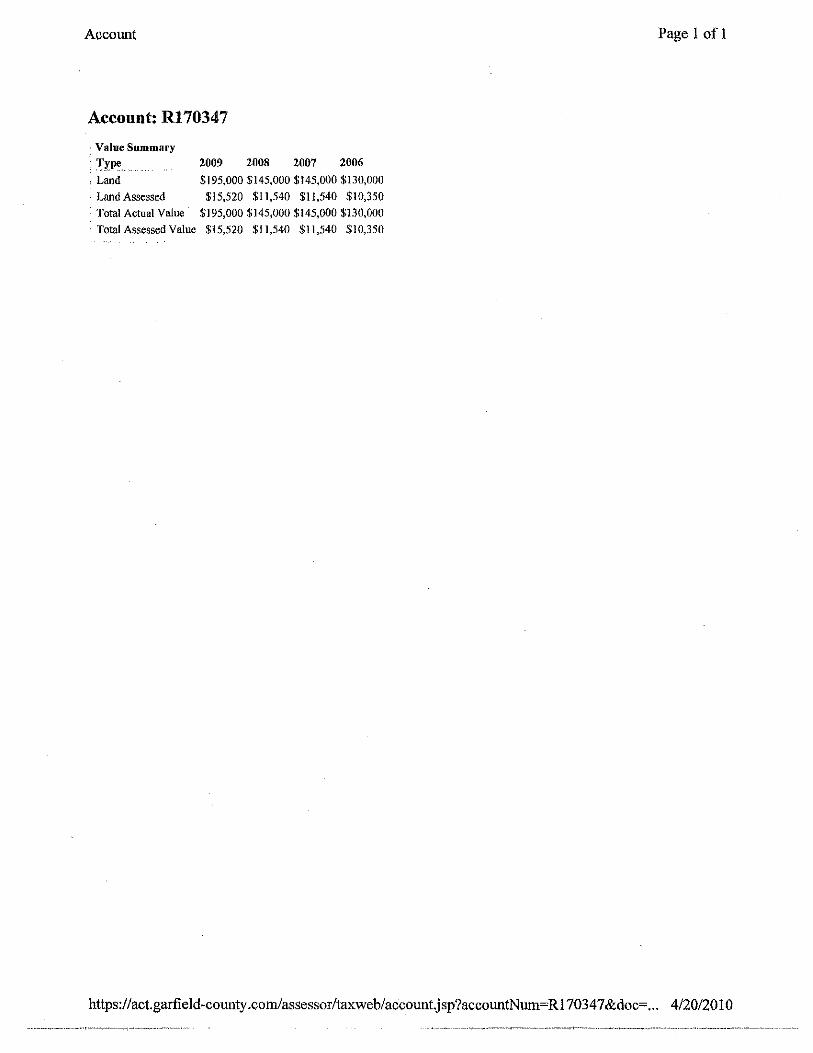
. Value Summary
T.rll" . Land
Land Assessed
2009 2008 2007 2006
$195,000 $145,000 $145,000$130,000
$15,520 $11,540 $11,540 $10,350 Total Actual Value $195,000 $145,000 $145,000 $130,000
· Total Assessed Value $15,520 $11,540 $11,540 $10,350
Page 1 of 1
https:/ /act.garfield-county .cornlassessor/taxweb/accountJ sp?accountNmn=R 17034 7 &doc=... 4/20/2010

Account Page 1 of 1
Account: R170347
Tax Summary
!ax Year Tax Due Interest Due Penalty Due Mise Due Lien Due Lier_J}nt~_~{!-~_! -~-~e ';f~t~l Due
2009 $303.42 $0.00 $0.00 $0.00 $0.00 $0.00 $303.42
Tax Details
':f:~x ~_e_ar ~r~e Effective Date Payor· Amount Balance
2009 Tax Payment 03/0112010 $303.42 $0.00 2009 Tax 01/21/2010 $606.84 $303.42
2008 Tax Payment 04/29/2009 SACRED MOUNTAIN TRUST $470.36 $0.00
2008 Tax 01/01/2009 $470.36 $0.00
2007 Tax Payment 04/10/2008 COS GROUP LLC $461.08 $0.00
2007 Tax 01101/2008 null $461.08 $0.00
2006 Tax Payment 04/26/2007 EFFECTIVE MGMT GRP, LLC $403.48 $0.00
2006 Tax 01/01/2007 $403.48 $0.00
2005 Tax Payment 09/26/2006 EFFECTIVE MANAGEMENT GROUP, LLC $735.43 $0.00
2005 Interest Payment 09/26/2006 EFFECTIVE MANAGEMENT GROUP, LLC $29.42 $0.00
2005 Interest 09/26/2006 EFFECTIVE MANAGEMENT GROUP, LLC $29.42 $0.00 2005 Tax Payment 02127/2006 EFFECTIVE MANAGEMENT GROUP, LLC $735.43 $0.00 2005 Tax 01/01/2006 $1,470.86 $0.00
2004 Tax Payment 06/30/2005 EFFECTIVE MANAGEMENT GROUP, LLC $655.79 $0.00 2004 Interest Payment 06/30/2005 EFFECTIVE MANAGEMENT GROUP, LLC $6.56 $0.00
2004 Jnterest 06/30/2005 EFFECTIVE MANAGEMENT GROUP, LLC $6.56 $0.00 2004 Tax Payment 02/24/2005 EFFECTIVE MANAGEMENT GROUP, LLC $655.79 $0.00
2004 Tax OI/01/2005 $1,311.58 $0.00 2003 Tax Payment 07/12/2004 COLLINS, THOMAS A. $1,474.62 $0.00 2003 Interest Payment 07/12/2004 COLLINS, THOMAS A. $44.24 $0.00
2003 Interest 07/12/2004 COLLINS, THOMAS A. $44.24 $0.00
2003 Tax 01/01/2004 $I,474.62 $0.00
2002 Interest 10/15/2003 COLLINS, THOMAS A. $76.65 $0.00 2002 ADVFEEPMf 10/15/2003 COLLINS, THOMAS A. $27.30 $0.00
2002 Tax:Paymeht 10/15/2003 COLLINS, THOMAS A. $1,277.52 $0.00 2002 Interest Payment 10/15/2003 COLLINS, THOMAS A. $76.65 $0.00
2002 ADVFEECHG 10/03/2003 $27.30 $0.00
2002 Tax 01/01/2003 $1,277.52 $0.00 2001 Ta.'X Payment 02/26/2002 COLLINS, THOMAS A. $1,270.10 $0.00 2001 Tax 01/01/2002 $1,270.10 $0.00
2000 Tax Payment 02/2112001 COLLINS, THOMAS A. $873.40 $0.00 2000 Tax 01/01/2001 $873.40 $0.00 1999 Tax. Payment 03/06/2000 COLLINS, THOMAS A. $272.12 $0.00 1999 Tax Ol/01/2000 $272.12 $0.00 1998 Tax Payment 04/15/1999 WARNER-PEETERS, BECKY $577.95 $0.00
1998 Tax 01/0111999 $577.95 $0.00 1997 Tax Payment 05/14/1998 *PEETERS-WARNER, BECKY $237.32 $0.00
1997 Interest Payment 05!14/1998 *PEETERS-WARNER, BECKY $2.37 $0.00 1997 Interest 05/14/1998 *PEETERS-WARNER, BECKY $2.37 $0.00
1997 Tax 01/01/1998 null $237.32 $0.00
https:/ /act.garfield -county .com/assessor/taxweb/ account.j sp?accountNum=Rl7034 7 &doc=... 4/20/20 1 0

Account Page 1 ofl
Account: R170347 Land
• Attributes
Property Code SINGLE FAM.RES.-LAND
Acres SQFT Units 4.026 0 0
Econ Area Zoning 3 R-1 Frontage Depth Land Size Unit Type
Character 2 Character 3 Characteristics
https:/ /act.garfield-county .com/assessor/taxweb/ account.j sp ?accountNum=Rl 7034 7 &doc=... 4/20/20 I 0
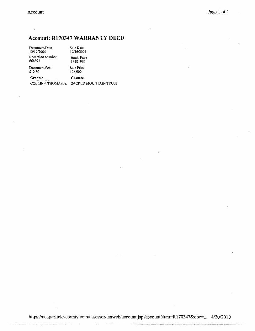
Account
Account: Rl70347 WARRANTY DEED
Document Date !2117/2004 Reception Number 665397
Document Fee $12.50
Grantor
Sale Date 12/16/2004
Book Page 1648 906
Sale Price 125,000
Grf:'ntee
COLLINS, THOMAS A. SACRED MOUNTAIN TRUST
Page 1 ofl
https:/ /act.garfield-county .com/assessor/taxweb/ account.jsp?accountNum= R 17034 7 &doc=... 4/20/20 1 0
Garfield County Clerk & Recorder - Search Results Page 1 of I
SEARCHING o Document Search
Search Heln About Garfield County Clerk & Recorder Logout public\\.'eb
Printable Version
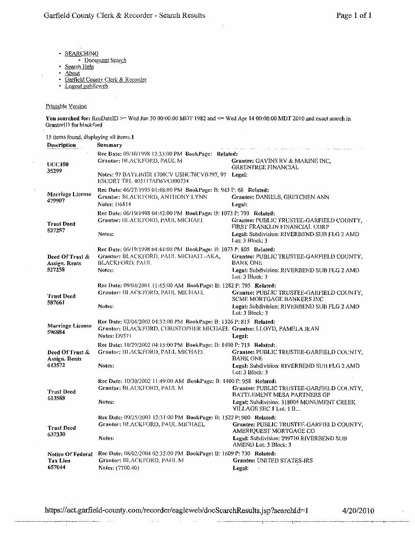
You searched for: RecDate!D >~Wed .lun 30 00:00:00 MDT 1982 and<~ Wed Apr 14 00:00:00 MDT 2010 and exact search in GrantoriD for blackford
15 items found, displaying all items. I
UCCIOO 35299
Marriage License 479907
Trust Deed 527257
Deed OF Trust & Assign. Rents 527258
Trust Deed 587661
Ma1·riage License 596884
Deed Ot'Trust & Assign. Rents 613572
Trust Deed 613588
Trust Deed 637330
Notice Of Federal Tax Lien 657044
Summary
Rec Date: 09/!0//998 12:33:00 PM Booi~Page: Grantor: ill ACKFORD, PAUL M
llelated: Grantee: GA ViNS RV & MARINE INC, ORE ENTREE FINANCIAL
Notes: 97 BAYL!NER 1700CV USI-IC7SCVJ3797, 97 Legal: ESCORT TRL 405117i\1)6VC000734
Rec Date: 06/27/1995 01:48:00 PM BookPage: B: 945 P: 68 Related: Gnmtor: BLACI<FORD, ANTHONY LYNN Grantee: DANIELS, GRETCHEN ANN Notes: D6814 Legal:
Rec Date: 06/19fl9l)8 04:43:00 PM BookPage: 8: 1073 P: 793 Related: G1·antor: 131 .AC!<FORO, PAUL MICHAEL Grantee: PUBLIC TRUSTEE-GARFIELD COUNTY,
FIRST FRANKLIN FINANCIAL CORP Notes: Legal: Subdivision: RIVERBEND SUB FLO 2 AMD
Lot: 3 Block: 3
Rcc Date: ()6/19/1998 04:44-:00 PM fiookP:lgc: 13: 1073 P: 805 .Related: Grantor: BLACKFORD, PAUL MICI IAEL-AKA, Grantee: PUBLIC TRUSTEE-GARFIELD COUNTY, BLACKFORD. P,\ lll. BANK ONE
Legal: Subdivision: RJVERBEND SUB FLO 2 AlviD Lot: 3 Block: 3 ·
Notes:
Rec Date: 09/04/211111 II :45:110 AM lloold'age: B: 1282 P: 795 Related: Grantor: lll.ACI<FORD, PAUl. MICI-IAI'I. Grantee: PUBLIC TRUSTEE-GARFIELD COUNTY,
SCME MORTGAGE BANKERS INC Noteso Legal: Subdivision: RIVERBEND SUB FLO 2 AMD
Lot: 3 Block: 3
Rcc Date: 02/04/2002 04:37:00 PM BookPage: B: 1326 P: 815 Related: Granto1·: BLACKFORD, Cl IRISTOPIIER MICHAEL Grantee: LLOYD, PAMELA JEAN Notes: D9571 Legal:
Rec Date: I 0/29/2002 04:15:00 PM lloold'age: B: 1400 P: 715 Related: G1·ant01·: lli.ACKFORD, PAUL MICHAEl. Grantee: PUBLIC TRUSTEE-GARFIELD COIJNJ'Y,
BANK ONE Notes: Legal: Subdivision: RIVERBEND SUB FLO 2 AMD
Lot: 3 Block: 3
Rec Date: 10/30/2002 II :49:00 AM BookP;\ge: B: 1400 P: 958 Related: Go·nntor: BLACKFORD, PAUL M Grantee: PUBLIC TRUSTEE-GARFIELD COUNTY,
Notes: BATTLEMENT MESA PARTNERS GP Legal: Subdivision: 318004 MONUMENT CREEK VILLAGE SEC I Lot: I B ...
Rec Date: 09/25/2001 12:31:00 PM llookPnge: B: 1522 P: 900 Related: Grant<n·: IJLACI<FORD, PAUL MICHAEL Grantee: PUBLIC TRUSTEE-GARFIELD COUNTY,
AMERIQUEST MORTGAGE CO Notes: Legal: Subdivision: 299710 RJVERBEND SUB
AMEND Lot: 3 Block: 3
Rcc Oate: 08/02i2004 01:35:00 PM RookPagc: B: 1609 P: 730 Related: Grantor: BLACKFORD, PAUL M Grantee: UNtrED STATES-IRS Notes: (7700.40) Legal: ·
https:/ I act.garfield-cotmty .com/recorder/eagleweb/docSearchResults.jsp?searchld= 1 4/20/2010

Garfield Cotmty - View Document
SEARCHING Q Document Search
Search Help About Garfield Count' Clerk & Recorder Logout publicwt::b
Trust Deed- 527257
Reception Number 527257 Recording Date 06/19/1998 04:43:00 PM
Book Page 1073 793
# ofPgs Rec. Fee 12 $61.00 Doc. Date Doc. fee 06/!911998 Surcharge Total Fees
$0.00
Related
Rec_~p-~ion ~umber Book Page
Return Address FIRST FRANKLIN fiNANCIAL CORP
Address I 2150N ISTST
Address2
City State Zip SANJOSE CA 95131
Mailback Date
Owner borrower Beneficiary lender
BLACKFORD, PAUL MICHAEL PUBLIC TRUSTEE-GARFIELD COUNTY
FIRST FRANKLIN FINANCIAL CORP
~gal Summar;y
Subdivision: RIVERBEND SUB FLG 2 AMD Lot: 3 Block: 3
Notes or Remarks · Notes
Remarks
https:/ I act.garfield-county .com/recorder/ eaglewe b/viewDoc.j sp?node=DOCC527257
Page I of 1
4/20/2010

Gartield County - View Document
SEARCHING o Document Search
Search Help About Garfield County Clerk & Recorder Logout publicweb
Deed Of Trust & Assign. Rents~ 527258
Reception Number 527258 Recording Date 06/19/1998 04:44:00 PM
Book Page 1073 805
# ofPgs 5
Rec. Fee $26.00
Doc. Date Doc. Fee 06/19/1998
Surcharge Total Fees $0.00
Related
Reception Number Book Page
Borrower
Return Address BANK ONE
Address! PO BOX 710079
Address2
City State Zip COLUMBUS OH 43271-0079
Mail back Date
Beneficiary lender
BLACKFORD, PAUL MlCHAEL-AKA PUBLIC TRUSTEE-GARFIELD COUNTY
BLACKFORD, PAUL BANK ONE
.!:-e~al Su_m~.·~ry. Subdivision: RIVERBEND SUB FLG 2 AMD Lot: 3 Block: 3
Notes or Remarks , Notes
Remarks
https://act.gartield-county.com/recorder/eagleweb/viewDoc.jsp?node=DOCC527258
Page I of I
4/20/2010

Garfield County - View Document
SEARCHING c Document Search
Search Help About Garfield County Clerk & Recorder 'Logout publicweb
Trust Deed- 587661
Reception Number 587661 Recording Date 09/04/200111:45:00 AM Book Page 1282 795
# ofPgs Rec. Fee 15 $75.00
Doc. Date Doc. Fee 08/08/2001
Surcharge Total Fees $0.00
Related
Return Address SCME MORTGAGE BANKERS INC .
Address I 6265 GREEiNWICH DR #200
Address2
City State Zip SAN Dl EGO CA 92122
Mailback Date
Owner borrower Beneficiary lender
BLACKFORD, PAUL MICHAEL PUBLIC TRUSTEE-GARFIELD COUNTY
SCME MORTGAGE BANKERS INC
Legal Summary
Subdivision: RJVERBEND SUB FLG 2 AMD Lot: 3 Block: 3
Notes or Remarl\s Notes
· Remarks
https://act.gatfield-county.corn!recorder/eagleweb/viewDoc.jsp?node=DOCC587661
Page I of I
4/20/2010

Garfield County - View Document
SEARCHING g DOcument Search
Search Help About Garfield County Clerk & Record~r Logout publicweb
Deed Of Trust & Assign. Rents- 6I3572
Reception Number 613572 Recording Date 10/29/2002 04: I5:00 PM
Book Page I400 7I5
# ofPgs Rec. Fee 6 $32.00
Doc. Date Doc. Fee 10/18/2002
Surcharge Total Fees ($1.00) $0.00
Related
Borrower
Return Address TRANSUNION SETTLEMENT SOLUTIONS
Address! 760 W SPROUL RD
Address2
City State Zip SPRINGFIELD PA I9064
Mailback Date
Beneficiary lender
BLACKFORD, PAUL MICHAEL PUBLIC TRUSTEE-GARFIELD COUNTY
BANK ONE
L~_gal S~mm~.•·.:v. Subdivision: RIVERBEND SUB FLG 2 AMD Lot: 3 Block: 3
Notes or Remarks Notes
Remarks
https:/ /act.garfield-county .com/recorder/ eaglcweb/viewDoc.j sp?node= DOCC613 572
Page 1 ofl
4/20/2010

Garfield County- View Document
SEARCHING o Document Search
Search Help About Garfield County Clerk & Recorder Logout publicwcb
Trust Deed - 637330
Reception Number 637330 Recording Date 09/2512003 12:31 :00 PM
Book Page 1522 900
# ofPgs Rec. Fee 18 $91.00
Doc. Date Doc. Fee 09/08/2003
Surcharge Total Fees ($1.00) $0.00
Related
~-~~_e_p~ion Number Book Page
Owner boYrower
Return Addlress CPR TITLE
Address I 1860 BLAKE STREET SUITE 900
Address2
City DENVER
Mailback Date
State Zip co 80202
Beneficiary Jender
BLACKFORD, PAUL MICHAEL PUBLIC TRUSTEE-GARFIELD COUNTY
AMERIQUEST MORTGAGE CO
~-~-~~! Summa_~y Subdivision: 299710 RIVERBEND SUB AMEND Lot: 3 Block: 3
Notes or Remarks
Notes
; Remarks
https://act.garfield-county.com/recorder/eagleweb/viewDoc.jsp?node=DOCC637330
Page 1 ofl
4/20/2010
Garfield County- View Document
SEARCHING Q Document Search
Search Help About oa:;ffeld County Clerk & Recorder Logout publicwcb
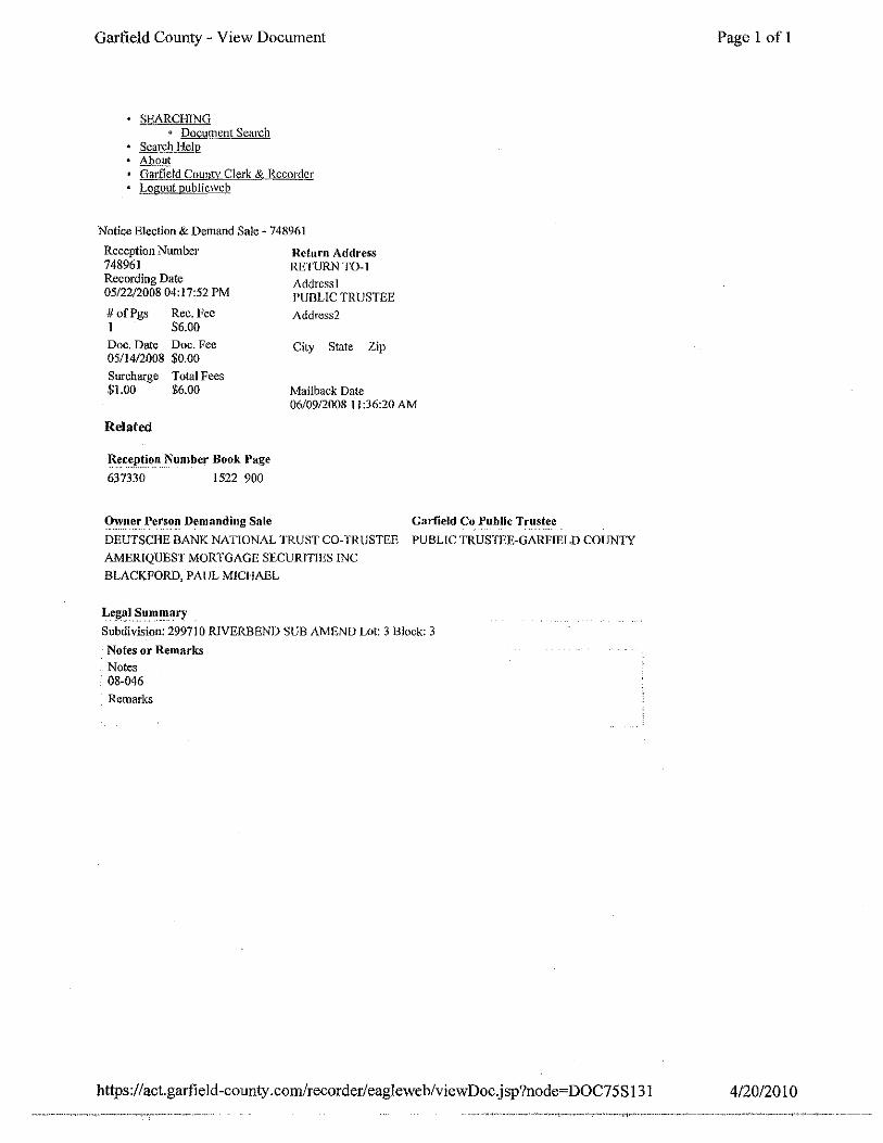
Notice Election & Demand Sale~ 748961
Reception Number 748961 Recording Date 05/22/2008 04:17:52 PM
# ofpgs I .
Rec. Fee $6.00
Doc, Date Doc. Fee 05/14/2008 $0.00
Surcharge Total Fees $1.00 $6.00
Related
R:~~~p-~_i_f)_" Number Book Page 637330 1522 900
Return Address RETURN TO-I
Address! PUBLIC TRUSTEE
Address2
City State Zip
Mailback Date 06/09/2008 II :36:20 AM
Owner Person Demanding Sale Garfield Co Public Trustee
DEUTSCHE BANK NATIONAL TRUST CO-TRUSTEE PUBLIC TRUSTEE-GARFIELD COUN1Y
AMERIQUES I MORTGAGE SECURITIES INC
BLACKFORD, PAUL MICHAEL
Le_~~~ Summar~
Subdivision: 299710 R!VERBEND SUB AMEND Lot: 3 Block: 3
Notes or Remarks Notes
• 08-046
_Remarks
https ://act. garfield -county. com/recorder/eaglewe b/viewDoc.j sp?node=DOC7 5 S 131
Page 1 of 1
4/20/2010

Garfield County- View Document
SEARCHING o Document Search
Search Help About Garfield County Clerk & Recorder Logout publicweb
Notice Election & Demand Sale- 754274
Reception Number 754274 Recording Date 08/I9/2008 10:43:44 AM
# ofPgs Rec. Fee I $6.00
Doc. Date Doc. Fee 05il4/2008 $0.00
Surcharge Total Fees $1.00 $6.00
Related
~.e~~p-~_i_o~ N~_mber Book Page
637330
74896I
1522 900
Return Addlress RETURN TO-I
Address I PUBLIC TRUSTEE
Address2
City State Zip
Mailback Date 08/28/2008 05:02:25 PM
Owner Pers_~~- Demanding Sale Garfield Co Public Trustee
DEUTSCHE BANK NATIONAL TRUST CO-TRUSTEE PUBLIC TRUSTEE-GARFIELD COUNTY
AMERIQVEST MORTGAGE SECURITIES INC
BLACKFORD, PAUL MICHAEL
L~-~~~-~~lll~a~~ Subdivision: 299710 RIVERBEND SUB AMEND Lot: 3 Block: 3
, Notes or Remarks Notes 08-046
Remarks
https://act.garfield-county. com/recorder/ eagle we b/viewDoc.j sp?node= DOC89S 1341
Page 1 of 1
4/20/2010

Garfield County - View Document
SEARCHiNG "' Document Search
Search Help About Garfield County Clerk & Recorder Logout publicwcb
Notice Election & Demand Sale- 775712
Reception Number 775712 Recording Date 09/28/2009 04:31:33 PM
# ofPgs Rec. Fee l $6.00 Doc. Date Doc. Fee 05/14/2008 $0.00 Surcharge Total Fees $1.00 $6.00
Return Address RETIJRNTO-l Address] PUBLIC TRUSTEE
Address2
City State Zip
Mailback Dale l 0/05/2009 09:49:41 AM
Related
Recep!~.?n Number Book Page
74896]
754274 637330 1522 900
Owner Person Demanding Sale
BLACKFORD, PAUL MICHAEL
DEUTSCHE BANK NATIONAL TRUST CO-TRUSTEE
AMERIQUEST MORTGAGE SECURITIES INC
~~.~a.~. ~ummar_y
Garfield Co Public Trustee
PUBLIC TRUSTEE-GARFIELD COUNTY
Subdivision: 299710 RIVERBEND SUB AMEND Lot: 3 Block: 3
; Notes or Remarks Notes 08-046
Remarks
h.ttps:/ I act.garfield-county .com/recorder/ eagleweb/view Doc.j sp ?node= DOC 145S 101
Page 1 of I
4/20/2010

Results
Printer fdend!y view
Query: exact search in OwncriD for blackford
Found 1 reSult oh 1 page
Account# Summal'y
ROI 7038 2123-344-05-003
llLACKFORD, l'AIJL I\IICHARL
000370 GLENEAGLE ClR New Castle 81647
https :// act.garfield-county .corn!assessor/taxweb/results.j sp
Page 1 of 1
Section: 34 Township: 5 Range: 90 Subdivision: RIVERBEND SUB. 2ND. Block: 3 Lot: 3
Pictur·e
•
4/20/2010

Account
Account: R017038
Location
Owner Name BLACKFORD, PAUL MICHAEL
Parcel Number 2123-344-05-003
Tax Area 017 • 2D-SF • 017
Situs Address 000370 GLENEAGLE CJR
Sibling Account No Legal Summary Section: 34 Township: 5 Range: 90 Subdivision: RIVERBEND SUB. 2ND. Block: 3 Lot: 3
Transfers
Sale Price
Tax History
Tax Year Taxes
2009 $\,233.60
Owner ftnformation
Owner Name BLACKFORD, PAUL MICHAEL
Owner Address 370 GLEN EAGLE CJR NEW CASTLE, CO 81647-9412
Sale Date Doc Type (15/J4/2Q_@ NOT
Q5/14120QR NOT
(15/l4/2.Q08 NOT
lli>JJW 199£ Deeds
Images
Pagel of 1
Assessment History
Actual (2009) $396,390
PrimaryTaxable $31,550 Tax Area: 017 Mill Levy: 39.1000
'l)'P.~. Actual Asse_s_se.~ ~QF.~ Units Improvement $246,390 $19,610 1.000
Lnnd $150,000 $11,940 35719.000
Book Page
B: 1073 P: 0792
2008 $906.88 ~--------------------.
ow• 11713~
https://act.garfield-county.com/assessor/taxweb/accountjsp?accountNum=ROl7038 4/20/2010

Account
Account: R017038
Local'ion ·
Owner Name BLACKFORD, PAUL MICHAEL
Parcel Number 2123-344-05-003
Tax Area 017 -2D-SF- 017
Situs Address 000370 GLEN EAGLE CIR
Sibling Account No
Legal Summary Section: 34 Township: 5 Range:'90 Subdivision: RIVERBEND SUB. 2ND. Block: 3 Lot: 3
Trunsfcrs
Sale Price
Tax H!s~.?~Y
Tax Year Taxes
Owner lnfomwtion
Owner Name BLACKFORD, PAUL MICHAEL
Owner Address 370 GLEN EAGLE CIR NEW CASTLE, CO 81647-9412
Sale Date
05/ 14/;hJ_QJl.
05/14/700~
05/14/200~
06/IW199~
Images
Sketch
Doc Type
NOT
NOT
NOT
Deeds
2009 $1,233.60 (liS
2008 $906.88 ..-----..-
Assessment Histor_y
Actual (2009)
Page 1 of 1
$396,390
Primary Taxable $31,550 Tax Area: 017 Mil! Levy: 39.1000
Tree.. Actual As.s~ssed SQFT Units
Improvement $246,390 $19,610 1.000
Land $150,000 $11,940 35719.000
Book Page
https :/ /act.garfield -county .com/assessor/taxweb/ account.j sp?accountN urn= RO 1703 8 4/20/2010
Account
Account: R017038 Ownership Information
Owner Name BLACKFORD, PAUL MICHAEL
In Care Of Name
Address Owner Address Address!
Address2 370 GLEN EAGLE CIR
City State Zip Country NEW CASTLE CO 81647-9412
Page I of!
https:// act.garfield-county .corn!assessor/taxweb/account.j sp ?<tccountN um=RO I 703 8&doc=... 4/20/201 0

Account
Account: R017038 Account Sale History
Document# Document Type Price Sale Date Grantor Grantee
B: 000933 P: 000205 :,Yj\RRANTY DI)ED $140,000_ y_;l/0 111995 _
B · 001073 P: 000792 }YA!\_Il_6NT'L!)Jl!;[J __ $164 OOo_ !.l~L191l998 _
I
Document# Document Type Price B: 000933 P: 000205 WARRANTY DEED $140,000
Sale Date 03/0111995
Grantor Grantee
Page 1 of I
https:/ /act.garfield-count y .com/assessor/taxwe b/ account.j sp ?accountNum=RO 1703 8&doc=. .. 4/20/201 0
Account
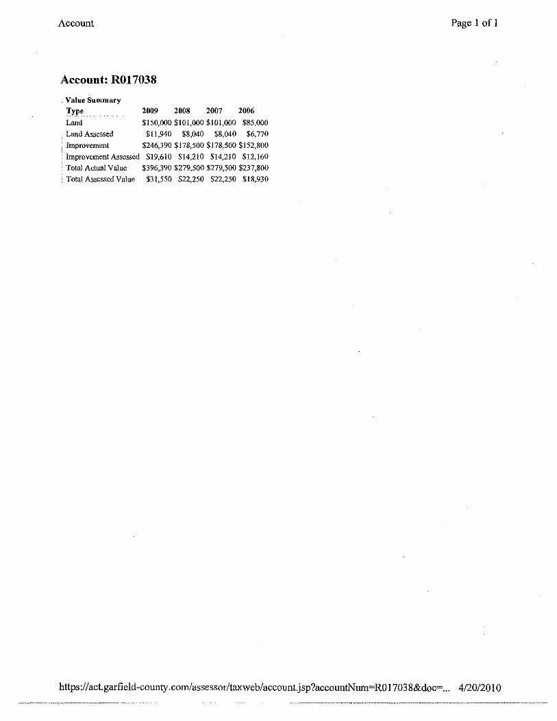
Account: R017038
Value Summary
Type. Land
Land Assessed
2009 2008 2007 2006 $150,000$101,000 $101,000 $85,000
$11,940 $8,040 $8,040 $6,770 • Improvement $246,390 $178,500 $178,500 $152,800
lmprovementAssessed $19,610 $14,210 $14,210 $12,160 . Total Actual Value $396,390 $279,500 $279,500 $237,800 · TotalAssessedValue $31,550 $22,250 $22,250 $18,930
Page 1 of 1
https :/ /act.garfield -county. com/assessor/taxweb/account.j sp ?accmmtNum=RO 1703 S&doc=... 4/20/20 1 0
Account
Account: R017038
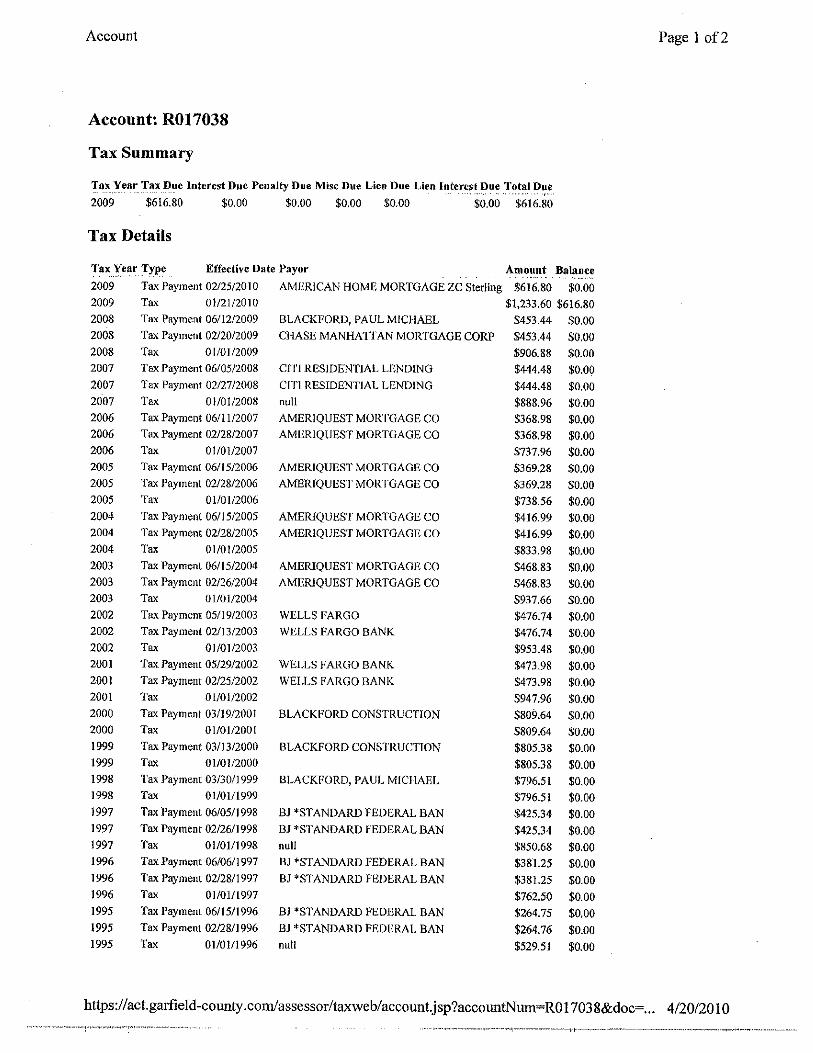
Tax Summary
Tax Year_ Ta:x Due Interest Due Penalty Due Mise Due Lien Due Lien Interest D~~ T~.~~l D~~
2009 $616.80 $0.00 $0.00 $0.00 $0.00 $0.00 $616.80
Tax Details
Tax Year Type Effective Date Payor Amount Balance 2009 Tax Payment 02/25/2010 AMERICAN HOME MORTGAGE ZC Sterling $616.80 $0.00 2009 Tax 01/21/2010 $1,233.60 $616.80 2008 Tax Payment 06/12/2009 BLACKFORD, PAUL MICHAEL $453.44 $0.00 2008 Tax Payment 02120/2009 CHASE MANHATTAN MORTGAGE CORP $453.44 $0.00 2008 Tax 01/01/2009 $906.88 $0.00 2007 Tax Payment 06/05/2008 Cl'l't RESIDENTJAL LENDING $444.48 $0.00 2007 Tax Payment 02/27/2008 CIT! RESIDENTIAl. LENDING $444.48 $0.00 2007 Tax 01/01/2008 null $888.96 $0.00 2006 Tax Payment 06/ll/2007 AMERIQUEST MORTGAGE CO $368.98 $0.00 2006 Tax Payment 02/28/2007 AMERlQUEST MORTGAGE CO $368.98 $0.00 2006 Tax 01/01/2007 $737.96 $0.00 2005 Tax Payment 06/15/2006 AMERIQUEST MORTGAGE CO $369,28 $0.00 2005 Tax Payment 02/28/2006 AMERIQUEST MORTGAGE CO $369.28 $0.00 2005 Tax 01/01/2006 $738.56 $0.00 2004 Tax Payment 06/15/2005 AMERIQ\JEST MORTGAGE CO $416.99 $0.00 2004 Tax Payment 02/28/2005 AMERIQ\JEST MORTGAGE CO $416.99 $0.00 2004 Tax 01/01/2005 $833.98 $0.00 2003 Tax Payment 06/15/2004 AMERIQUES'!' MORTGAGE CO $468.83 $0.00 2003 Tax Payment 02/26/2004 AMERJQUEST MORTGAGE CO $468.83 $0.00 2003 Tax 01/01/2004 $937.66 $0.00 2002 Tax Payment 05/19/2003 WELLS FARGO $476.74 $0.00 2002 Tax Payment 02/13/2003 WELLS FARGO BANK $476.74 $0.00 2002 Tax 01/01/2003 $953.48 $0.00 2001 Tax Payment 05/29/2002 WELLS FARGO BANK $473.98 $0.00 2001 Tax Payment 02/25/2002 WELLS FARGO BANK $473.98 $0.00 2001 Tax 01/01/2002 $947.96 $0.00 2000 Ta.~ Payment 03/19/2001 BLACKFORD CONSTRUCTION $809.64 $0.00 2000 Tax 01/0112001 $809.64 $0.00 1999 Tax Payment 03/13/2000 BLACKFORD CONSTRUCTION $805.38 $0.00 1999 Tax 01/0112000 $805.38 $0.00 1998 Tax Payment 03/30/1999 BLACKFORD, PAUL MICHAEL $796.51 $0.00 1998 Tax 01/01/1999 $796.51 $0.00 1997 Ta' Payment 06/05/1998 BJ *STANDARD FEDERAL BAN $425.34 $0.00 1997 Tax Payment 02/26/1998 BJ *STANDARD FEDERAL BAN $425.34 $0.00 1997 Tax 01/01/1998 null $850.68 $0.00 1996 Tax Payment 06/0611997 BJ *STANDARD FEDERAL BAN $381.25 $0.00 1996 Tax Payment 02/2811997 BJ 'STANDARD FEDERAL BAN $381.25 $0.00 1996 Tax 01/01/1997 $762.50 $0.00 1995 Ta,, Payment 06/15/1996 BJ *STANDARD FEDERAL BAN $264.75 $0.00 1995 Tax Payment 02/28/1996 BJ *STANDARD FEDERAL BAN $264.76 $0.00 1995 Tax 01/01/1996 null $529.51 $0.00
Page 1 of2
https:/ /act.garfield-county .com/assessor/taxweb/account.j sp?accountN urn= RO 1703 8&doc=... 4/20120 10

Account Page 2 of2
1994 Tax Payment 02/06/1995 RB HOMES, INC. $384.36 $0.00
1994 Tax 01/01/1995 $384.36 $0.00
1993 Tax Payment 06/13/1994 RB HOMES, INC. $158.24 $0.00
1993 Tax Payment 02/25/1994 RB HOMES, INC. $158.24 $0.00
1993 Tax 01/01/1994 $316.48 $0.00
1992 Tax Payment 06/ 14/J 993 RB HOMES, INC. $88.72 $0.00
1992 Tax Payment 02/26/1993 RB HOMES, INC. $88.73 $0.00
1992 Tax 01/0111993 $!77.45 $0.00
1991 Tax Payment 06/12/]992 $92.46 $0.00
1991 Tax Payment 02/1411992 $92.46 $0.00
1991 Tax 01/01/1992 $184.92 $0.00
https://act.garfield-county .com/assessor/taxwe b/account.j sp ?accountNum=RO 1703 8&doc=... 4/20/20 10

Account Page 1 of 1
Account: R017038
https:/ /act.garfield -county .com/assessor/taxweb/ account.jsp ?accountNwn=RO 1703 8&doc=... 4/20/201 0

Account Page I of I
Account: ROI7038 QUIT CLAIM DEED
Document Date Sale Date 1111211990 1111211990
Reception Number Book Page 0813 0267
Document Fee Sale Price $0.00 0
Grantor Grantee
https ://act.garfield -county .com/assessor/taxweb/account.j sp ?accountNum= RO 170 3 8&doc=... 4/20/20 I 0

Account Page 1 of1
Account: R017038 Deeds
Document Date Sale Date 03/01/1995 03/0111995
Reception Number Book Page 0933 0205
Docun1ent Fee Sale Price $14.00 0
Grantor Grantee
https://act.garfield-county .com/assessor/taxweb/account.jsp?accountNurn=RO 1703 8&doc=... 4/20/2010
Account Page 1 of 1
Account: R017038 Deeds
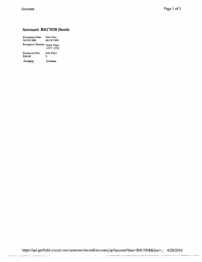
Document Date Sale Date 06/19/1998 06/19/1998
Reception Number Book Page 1073 0792
Docmnent Fee Sale Price $16.40 0
Grantor Grantee
https :/ /act.garfield -cotmty. com/assessor/taxweb/account.j sp ?accountNum~ RO 1703 8&doc= .. . 4/20/20 1 0
Account
Account: R017038 NOTICE
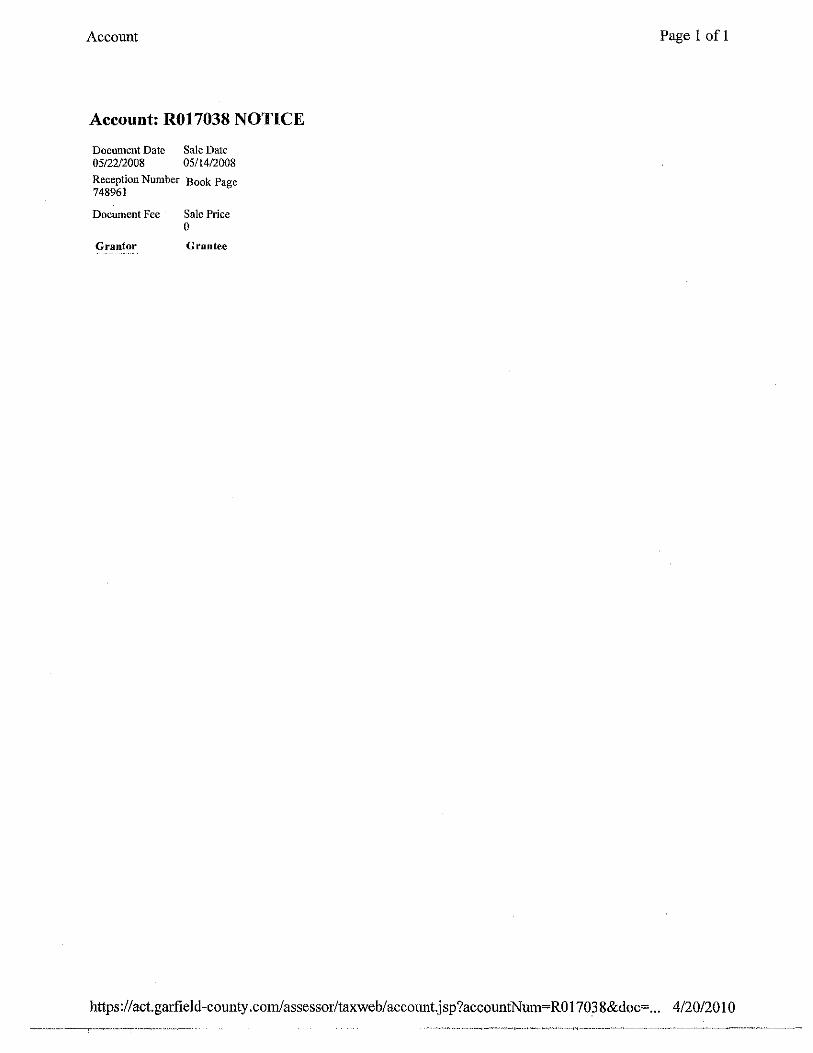
Document Date Sale Date 05/22/2008 05/14/2008
Reception Number Book Page 748961
Document Fee
Grantor
Sale Price 0
Grantee
Page 1 of 1
https :/ /act.garfield -county .com/assessor/taxweb/ account.jsp ?accountNum= RO 1703 8&doc=... 4/20/20 I 0

Account
Account: R017038 NOTICE
Document Date Sale Date 08/19/2008 05/14/2008
Reception Number Book Page 754274
Document Fee Sale Price 0
Grantor Grantee
Page I of I
https://act.garfield-county .com/assessor/taxweb/account.j sp?accountNum=RO 17038&doc= ... 4/20/20 I 0
Account
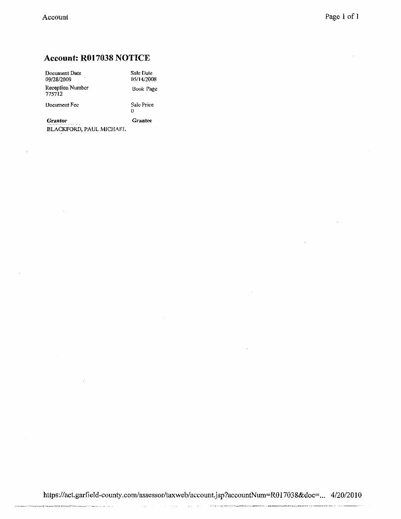
Account: R017038 NOTICE
Document Date 09/28/2009 Reception Number 775712
Docwnent Fee
Grantor
BLACKFORD, PAUL MICHAEL
Sale Date 0511412008
Book Page
Sale Price 0
Grantee
Page 1 of 1
https:/ /act.garfield-county .com/assessor/taxweb/ account.j sp ?accountN um=RO 1703 8&doc=... 4/20/20 I 0

Account Page I of I
Account: R017038 XFOB
• Attributes • Areas
Actual Area SubAreas 96.0000 . XFOB UNITS
. 96 -
https://act.garfield-county.com/assessor/taxweb/accountjsp?accountNum=ROI7038&doc=... 4/20/2010
Account
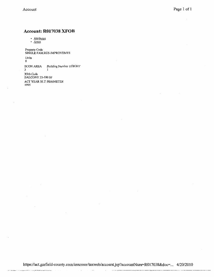
Account: R017038 XFOB
• Attributes • Areas
Property Code SINGLE F AM.RES-IMPROVEMTS
Units 0
ECON AREA Building Number HEIGHT 3 l
Xfob Code BALCONY 25- I 00 SF
ACT YEAR BLT PERIMETER 1995
Page 1 of 1
https ://act.garfield-cotmty .com/assessorltaxweb/ account.j sp ?accountNum= RO 1703 8&doc=... 4/20/201 0

Account
Account: R017038 XFOB
.. Attributes • Areas
Actual Area 96.0000
SubAreas XFOB UNITS 96 -
Page I of I
https:/ /act. garfield-county .com/assessor/taxwe b/accountj sp ?accountNum=RO I 703 8&doc=... 4/20/20 I 0

Account
Account: R017038 XFOB
• AHTibutcs • Areas
Property Code SINGLE FAM.RES-IMPROVEMTS
Units 0
ECON AREA Building Number HEIGHT 3 I Xfob Code WOOD DECK 25-100 SF
ACTYEARBLT PERIMETER 1995
Page I of I
https:/ I act.garfield-county .com/assessor/taxweb/account.j sp ?accountNum= RO 17038&doc=... 4/20/20 I 0

Account
Account: R017038 XFOB
• Attributes • Areas
Actual Area SubAreas 1.0000 XFOB_UNITS
I
Page I of I
https://act.garfield-county.com/assessor/taxweb/account.jsp?accountNum=ROl7038&doc=... 4/20/2010
Account
Accourtt: R017038 XFOB
Attl'ibutes • Areas
Property Code SINGLE FAM.RES-IMPROVEMTS
Units 0
ECON AREA Building Number HEIGHT 3 I
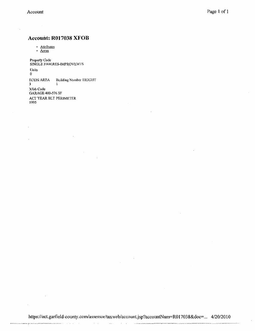
XfobCode GARAGE 400-576 SF ACT YEAR BLT PERIMETER 1995
Page I of I
https:/ I act. garfield -county .com/assessor/taxweb/account.jsp?accountNum= RO I 703 8&doc= .. . 4/20/20 I 0
Account
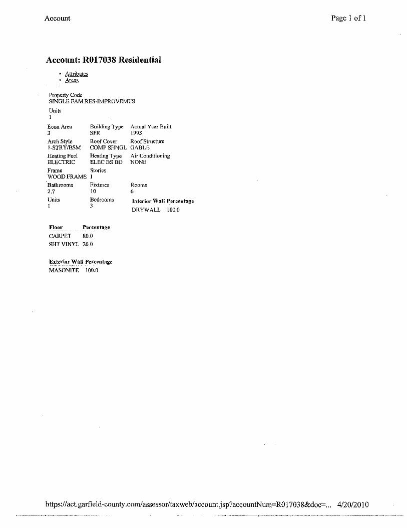
Account: R017038 Residential
Attributes • Areas
Property Code SINGLE FAM.RES-IMPROVEMTS
Units I
Econ Area Building Type Actual Year Built 3 SFR 1995
Arch Style Roof Cover Roof Structure I-STRY/BSM COMP SHNGL GABLE
Heating Fuel ELECTRIC
Heating Type Air Conditioning ELEC BS BD NONE
Frame Stories WOODFRAME I
Bathrooms 2.7
Units I
Floor
CARPET
Fixtures to Bedrooms 3
Percentage
80.0
SHT VINYL 20.0
E_xte~_i~r __ ~ai_J ~ercentage
MASONITE 100.0
Rooms 6
Interior Wall ~ercentage
DRYWALL 100.0
Page I of I
https://act.gmfield-county .com/ assessor/taxweb/ account.j sp ?accountNum=RO 1703 8&doc"'. .. 4/20/20 I 0

AccoLmt
Account: R017038 Land
• Attributes
Property Code SINGLE F AM.RES.-LAND
Acres SQFT Units 0 35719 0
Econ Area Zoning 3 R-PlJD
Frontage Depth Land Size Unit Type
Character 2 Character 3 Characteristics
Page 1 of 1
https :/I act.garfi eld-county .com/assessor/taxweb/ account.j sp?accountNum=RO 1703 8&doc=. .. 4/20/20 10

Account
Account: R017038 QUIT CLAJ[M DEED
Document Date Sale Date 02113/1990 02113/1990
Reception Number Book Page
Document Fee $0.00
Grantor
0772 0732
Sale Price 0
Grantee
Page I ofl
https :/ /act.garfield -county. com!assessor/taxweb/ account.jsp ?accountNum= RO 1 703 8&doc=... 4/20/20 1 0
Accotmt Page I of I
Account: R017038 QUIT CLA][M DEED
Document Date Sale Date ll/1211990 1111211990
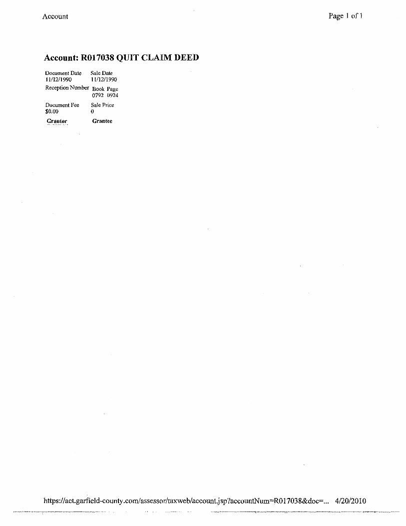
Reception Number Book Page 0792 0924
Document Fee Sale Price $0.00 0
Grantor Grantee
https:/ /act.garfield-county .com/assessor/taxweb/accmmtj sp ?accotmtN um=RO 17038&doc=... 4/20/201 0

Account Page I of I
Account: R017038 Deeds
Document Date Sale Date 02/13/1990 02/!3/1990
Reception Number Book Page 0772 0729
Document Fee Sale Price $18.00 0
Grantor Gl'antee
https:/ /act.garfield-county. com/assessor/taxweb/account.j sp?accountNum=RO 1703 8&doc=... 4/20/20 10

Account Page 1 ofl
Account: R017038 Deeds
Document Dat~ Sale Date 01101/1900 0110111900
Reception Nmnber Book Page 0554 0313
Docwnent Fee Sale Price $0.00 0
Grantor Grantee
https :/I act.garfield-county .com/assessor/taxweb/account.j sp?accountN um=RO 1703 8&doc=... 4/20/20 I 0

April6, 2010
Mr. and Mrs. Leintz 263 Riverbend Drive New Castle, CO 81647
RE: VARA-02-10-6322- Variance
Dear Mr. and Mrs. Leintz:
·Garfield County BUILDING & PLANNING DEPARTMENT
This office is in receipt of an Application (received February 23, 201 0) for a Variance in the PUD Zone District. The Permit requested is for a property owned by Kirk and Melissa Leintz and is described by tax ID 2123-344-05-002.
The application this office received has been deemed technically incomplete. The following Application Submittal Requirements were not provided in the application.
1. As per Section 4-502 (C) (3) provide topography and constraints to establish the grade and any constraints that may exist on the property.
2. As per Section 4-502 (C) (3) provide elevations drawings showing the existing grade;finished grade, and height of the proposed structure above existing grade.
3. The map provided that identifies the property owners within 200 feet of the subject parcel doesn't include all the parcel owners within this given distance, and some of the property owners are mislabeled. Please make the appropriate revisions to this map. Also, please add the parcel numbers to this map which will make it easier to reference the own'ers from the property owner list/information provided.
4. Please provide narrative for Divisions 1 and 2, Article VII of the Unified Land Use· Regulations of 2008, as amended. If not applicable, please indicate this in your narrative.
1 108 Eighth Street, Suite 401 • Glenwood Springs, CO 81601
(970) 945-8212 • (970) 285-7972 • Fax:(970) 384-3470
This office will not continue to process this application until the aforementioned deficiencies have been addressed. Please note that if the applicant fails to correct the deficiencies within 60 calendar days, the application shall be considered withdrawn and returned to the applicant Please call if you have any questions.
Sincerely,
~~~LAvtWJ MOIJYOfklld-L'arson, AICP, RLA Senior Planner
970.625.5903
cc: File
2

MELISSA J LEINTZ KIRK LEINTZ
1516 263 RIVER BEND DR NEW CASTLE, CO 81647
® ' 82-340/1021
~;;hpro DATE
tiib~n~E~-(r'e/d GO&[flf ~~~.SUH'r- I$ ~s-0.~ Twoltu""-'4~ +tl'-1-; Jl!~ t IVJbv-: DOLLARS tD liliil:.
"~!!~.~,!.Bank ~~ ~- ~ New Cll111e, CO 8'1647 4 ~ ® (970) 984-2600 • Alpine lnki-Lrne (970) 945-4433 ...,
FOR fa_r-t'A...._ c_.e.-lc£622 __ -·-- ··-= ~--·-·---···~--~
~HAAlAND