supplement to the san juan islands national monument ...the coast guard lighthouse needs huge...
TRANSCRIPT

Supplement with full text of comments from
San Juan Islands National Monument Planning Process
Human Use Workshops
U.S. Department of the Interior
Bureau of Land Management
San Juan Islands National Monument Resource Management Plan
and Environmental Impact Statement

1
Contents Introduction to Supplement ......................................................................................................................... 3
Specific Comments on:
Blind Island .................................................................................................................................................... 3
Blind Island Rock: North &South (78) ........................................................................................................... 4
Broken Point (31) .......................................................................................................................................... 4
Cape Saint Mary (115) ................................................................................................................................... 4
Carter Point (119).......................................................................................................................................... 5
Cattle Point (118) .......................................................................................................................................... 5
Chadwick Hill (116) ....................................................................................................................................... 6
Chuckanut Rocks (5) .................................................................................................................................... 10
Danger Rocks............................................................................................................................................... 11
Davis Bay Island and Rocks (15) .................................................................................................................. 11
Eliza Point (92) ............................................................................................................................................ 11
Fauntleroy Rock (6) ..................................................................................................................................... 11
Freeman Island (23) .................................................................................................................................... 12
Govt lot 2 (121) ........................................................................................................................................... 12
Guthrie Cove Rock (98) ............................................................................................................................... 12
Iceberg Point (112) ...................................................................................................................................... 12
Indian Island (22) ........................................................................................................................................ 18
Jones Bay Rocks (87) ................................................................................................................................... 19
Kanaka Bay Islands (28) ............................................................................................................................... 19
Kellett Bluff (120) ........................................................................................................................................ 20
Little Patos (29) ........................................................................................................................................... 20
Lopez Pass (114) .......................................................................................................................................... 20
Lummi Rocks (3) .......................................................................................................................................... 21
Mackaye Harbor Rocks (72) ........................................................................................................................ 21
McConnell Rocks (30).................................................................................................................................. 22
Mud Island (103) ......................................................................................................................................... 22

2
Oak Island and Rock (20) ............................................................................................................................. 22
Outer Bay Rocks (73) ................................................................................................................................... 22
Parks Bay Island (29) ................................................................................................................................... 22
Patos Island (76) .......................................................................................................................................... 22
Point Colville (113) ...................................................................................................................................... 24
Posey Island (32) ......................................................................................................................................... 26
Provost Harbor Rocks (36) .......................................................................................................................... 27
Pudding Island (34) ..................................................................................................................................... 27
Quadrant A (general) .................................................................................................................................. 27
Quadrant C (general) .................................................................................................................................. 27
Reads Bay Island (9) .................................................................................................................................... 28
Reservation Bay Rocks (39) ......................................................................................................................... 28
Skull Island (17) ........................................................................................................................................... 29
Small rocks and island ................................................................................................................................. 29
Trinka Rock (19) .......................................................................................................................................... 30
Turn Point (122) .......................................................................................................................................... 30
Twin Rocks (10) ........................................................................................................................................... 30
Unnamed Iceberg Point Rocks (86) ............................................................................................................. 30
Victim Island (21) ........................................................................................................................................ 31
Watmough Bay (117) .................................................................................................................................. 31
Genera Comments on the Monumnet ....................................................................................................... 33

3
Introduction to the Supplement This document is a supplement to the Summary of Input from Human Use Workshops and Outreach for
the Bureau of Land Management’s San Juan Islands National Monument planning process. The full
report summarizes input received by the Bureau on human use management in the San Juan Islands
National Monument during the winter and spring of 2016. The full report can be found online at
www.blm.gov/or/plans/sanjuanislandsnm
This document contains the full text of the 554 comments received during this time. The great majority
of these comments were handwritten on notecards, which have been transcribed in the table below. The
table also includes the meeting location at which the comment was submitted (or the method of delivery if
submitted outside a meeting) and the specific Monument location, if any, addressed in the comment.
In some cases, comments include references to the number or sticker color associated with the question to
which a response is being provided. At the workshops participants were given sets of stickers that were
color coded to these questions and could be affixed to large maps to make the comments geographically
specific. The questions and associated colors are as follows:
What specific human uses and experiences do you value within the Monument? Are there any
new opportunities you’d like to see managed for? (blue)
What types of human use opportunities would you like to see restricted or prohibited and where?
Why would you like to see these restrictions/prohibitions? Should seasonality be a factor? (red)
Which trails would you like to see maintained? Which closed? Are there any new trails you’d like
to see built? What uses would you like to see allowed or prohibited on the trails? (green)
Is there any additional input you’d like to provide at this time that we haven’t captured? (yellow)
Comments sometimes also include the reference number of the map to which the comment refers; these
numbers are including in the column listing Monument locations (e.g., Blind Island (4)).
Meeting location
Location about which comment was made Comment
MAC Meeting (4/18)
Blind Island (4) Blue: Blind Bay continue to allow access and camping.
Orcas Blind Island (4)
Manage in the current way and use current level of use as the limit for the future, monitor trails and campsites, and use current as the limit for acceptable change. Human powered arrival only.
Lopez Blind Island (4)
Blind Island is a great place to camp. I have taken middle school and high school students camping there--it is great!

4
Lopez Blind Island (4)
No motor boats!!! Few developments--outhouses and tables only. Maybe no fires.
Lopez Blind Island (4)
(4) Camping should be limited to 12 people and the existing campsites. No camping or trails on the E sides which are wildflower and ancient garden sites--they should be strictly closed.
Lopez Blind Island (4)
Q1 Blind Island: Mark a single clear route and campsites. Improve the single route. No camping or fires outside of marked sites.
Lopez
Blind Island Rock: North &South (78)
Blind Island Rocks (78) Change the name. Have local schools do a naming contest!
Lopez
Blind Island Rock: North &South (78) (78) Very sensitive archaeology--close it!
Lopez
Blind Island Rock: North &South (78)
Q3 Blind Island Rock: Access by permit only to protect rare plants and archaeological material.
Lopez Broken Point (31) (31) Very small; sensitive plants; use should be limited.
Lopez Broken Point (31) Q3 Broken Point Island: close all trails. Allow access by permit only.
MAC Meeting (4/18)
Cape Saint Mary (115) Work with County for land access through road end, etc.-Cape Saint Mary
Lopez Cape Saint Mary (115)
Reserve Cape St. Mary for solitude only. Also, see if BLM can gain right-of-way access to this site.
Lopez Cape Saint Mary (115) Cape St. Mary needs to be untouched.
Lopez Cape Saint Mary (115) Cape Saint Mary--Construct trail on RW from Oles Ln to Cape So. Of Cabin.
Lopez Cape Saint Mary (115) Cape St. Mary: Do not advertise no legal access.
Lopez Cape Saint Mary (115) Cape Saint Mary--No trail development. Keep open space. Very fragile.
Lopez Cape Saint Mary (115) Cape St. Mary--no public advertising of this small spot.
Lopez Cape Saint Mary (115)
Cape Saint Mary; I would like this piece to remain undeveloped and unadvertised.
Lopez Cape Saint Mary (115)
Investigate if Cape St. Mary (115) access is possible. Is Oles land really a County Road end?
Lopez Cape Saint Mary (115) (115) Keep closed to recreational users.

5
Lopez Cape Saint Mary (115)
Q4 Cape St. Mary: Protect patch of locally rare perideridia gairdneri (Yampah)
Lopez Carter Point (119)
I would love to see public access to Carter Point from Lummi Island (not from boat). Is there any way to reach Carter Point?
Lopez Carter Point (119)
(119) This has potential for a trail. Only the rocky south tip--the water access point--has sensitive plants--the woods are beautiful but not especially rare or sensitive.
Lopez Carter Point (119)
Q2--Carter Point: Explore options for managed hunting of deer. Including collaborations with Tribes and Tribal youth.
MAC Meeting (4/18)
Cattle Point (118)
Cattle Pt--simplify and maintain trail web--drop social trails and make designated trails durable.
MAC Meeting (4/18)
Cattle Point (118) Blue: most visited. Manage for heavy use. Develop trails. One bike trail.
Anacortes Cattle Point (118)
Designate and maintain CP-20 trail along top of bluff, work w/DNR to sign from parking turnout on Cattle Point Road. * the route continues to the northwest up to the turnout off Cattle Point rd.
Anacortes Cattle Point (118)
Quad B--Cattle Point: where will CP-20 trail connect--to NPS/DNR? Is there an existing connection? I think so but not sure. Use best restricted to hiking only; no bicycles or motorized use, in order to be consistent with neighboring DNR +NPS lands.
Outside of meeting
Cattle Point (118)
Please do nothing with the Cattle Point NM. Leave it as it is: no signs, no trails, no human use opportunities, with no advertising. I value land that shows no sign of human intervention so let’s not invite it here. Let’s give this small triangle of land the gift of no development or exploitation and leave it natural and wild like it is.
Lopez Cattle Point (118)
The Coast Guard lighthouse needs huge improvement is an eyesore/danger to visitors. It is a wasted landmark that deserves attention, care, and funding to preserve.
San Juan Cattle Point (118)
Provide parking along cattle point RD for 4-6 vehicles to provide access to trails.
San Juan Cattle Point (118)
Cattle Point: Important site for migratory birds, butterflies, and dragon flies. Therefore possible seasonal closure of some trails to accommodate best interest of birds.
San Juan Cattle Point (118)
Provide a place to sit near lighthouse. Provide mutt mitt bags for dog walkers and trash can for people bringing up beach trash.
San Juan Cattle Point (118)
Cattle Point: plan where trails are best: avoiding special areas, encouraging controlled exploration, making great signs, saying no to horses and dogs, NO HUNTING!
San Juan Cattle Point (118) Keep free of trail
6
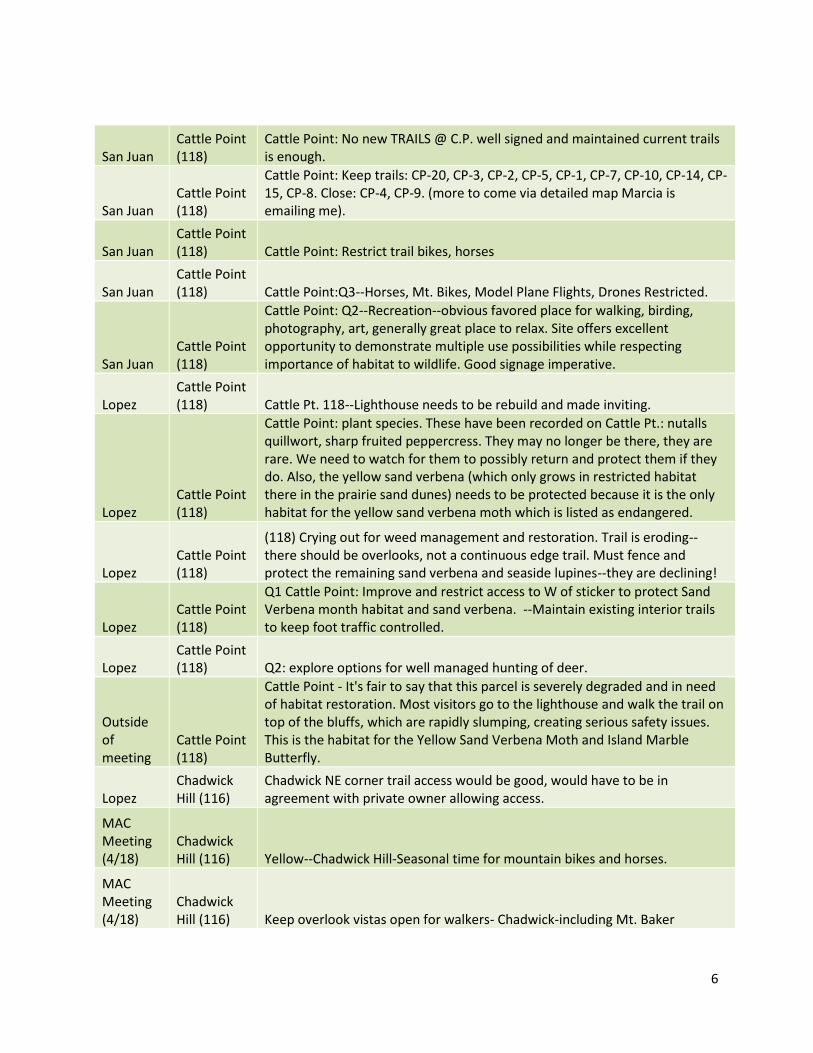
San Juan Cattle Point (118)
Cattle Point: No new TRAILS @ C.P. well signed and maintained current trails is enough.
San Juan Cattle Point (118)
Cattle Point: Keep trails: CP-20, CP-3, CP-2, CP-5, CP-1, CP-7, CP-10, CP-14, CP-15, CP-8. Close: CP-4, CP-9. (more to come via detailed map Marcia is emailing me).
San Juan Cattle Point (118) Cattle Point: Restrict trail bikes, horses
San Juan Cattle Point (118) Cattle Point:Q3--Horses, Mt. Bikes, Model Plane Flights, Drones Restricted.
San Juan Cattle Point (118)
Cattle Point: Q2--Recreation--obvious favored place for walking, birding, photography, art, generally great place to relax. Site offers excellent opportunity to demonstrate multiple use possibilities while respecting importance of habitat to wildlife. Good signage imperative.
Lopez Cattle Point (118) Cattle Pt. 118--Lighthouse needs to be rebuild and made inviting.
Lopez Cattle Point (118)
Cattle Point: plant species. These have been recorded on Cattle Pt.: nutalls quillwort, sharp fruited peppercress. They may no longer be there, they are rare. We need to watch for them to possibly return and protect them if they do. Also, the yellow sand verbena (which only grows in restricted habitat there in the prairie sand dunes) needs to be protected because it is the only habitat for the yellow sand verbena moth which is listed as endangered.
Lopez Cattle Point (118)
(118) Crying out for weed management and restoration. Trail is eroding--there should be overlooks, not a continuous edge trail. Must fence and protect the remaining sand verbena and seaside lupines--they are declining!
Lopez Cattle Point (118)
Q1 Cattle Point: Improve and restrict access to W of sticker to protect Sand Verbena month habitat and sand verbena. --Maintain existing interior trails to keep foot traffic controlled.
Lopez Cattle Point (118) Q2: explore options for well managed hunting of deer.
Outside of meeting
Cattle Point (118)
Cattle Point - It's fair to say that this parcel is severely degraded and in need of habitat restoration. Most visitors go to the lighthouse and walk the trail on top of the bluffs, which are rapidly slumping, creating serious safety issues. This is the habitat for the Yellow Sand Verbena Moth and Island Marble Butterfly.
Lopez Chadwick Hill (116)
Chadwick NE corner trail access would be good, would have to be in agreement with private owner allowing access.
MAC Meeting (4/18)
Chadwick Hill (116) Yellow--Chadwick Hill-Seasonal time for mountain bikes and horses.
MAC Meeting (4/18)
Chadwick Hill (116) Keep overlook vistas open for walkers- Chadwick-including Mt. Baker

7
MAC Meeting (4/18)
Chadwick Hill (116) Seasonality for bicycles (mt. bikes) and horse-Chadwick
MAC Meeting (4/18)
Chadwick Hill (116) No motorized on Chadwick or any BLM-Chadwick
MAC Meeting (4/18)
Chadwick Hill (116)
Comments on trails on Chadwick Hill: No motorized vehicles, to conserve peace, quiet, and exercise. No trail #14. Bikes and Horses on limited trails 16, 15. Yes to directional trails. Allow horse logging to manage for old growth characteristics everywhere. Make areas without trails and further than 1/4 mile from nearest trail. Fewer to no trails on wet and north facing slopes. Design bike trails to be low speed.
MAC Meeting (4/18)
Chadwick Hill (116)
No motorized, no mountain bikes, no horses at higher elevation. Horses permitted at lower level as a future option. Two way trails on all trails.
Lopez Chadwick Hill (116) Folks keep getting lost on Chadwick Hill.
Lopez Chadwick Hill (116) No trail access to Chadwick Marsh.
Lopez Chadwick Hill (116) Chadwick: legal access across field--signage to protect private lands.
Lopez Chadwick Hill (116) (116) I value the privacy of Chadwick.
Lopez Chadwick Hill (116) (116) No signage, no camping, no advertisement, no app, at trail.
Lopez Chadwick Hill (116) A trail on public right of way to the road.
Lopez Chadwick Hill (116) Yellow: --leave no trace signage at the trailhead --close to mountain bikes
San Juan Chadwick Hill (116)
Make long trail along Chadwick Hill and re-plan maze of social trails at the beginning add information signs.
San Juan Chadwick Hill (116)
Finding access to Chadwick--is there a way to make planned trails more clearly marked, desirable so people might access having boot-built trails closed?
Lopez Chadwick Hill (116) Keep both main route open heading so. Off Chadwick summit.
Lopez Chadwick Hill (116) Chadwick: Keep open back side trail. Very mystical in the woods and mosses.
Lopez Chadwick Hill (116) Bird blinds so we can do it w/o scaring.

8
Lopez Chadwick Hill (116)
Hiking is (in my mind) the main activity on the Lopez portion of SJINM. I and others find many of these trails a little short. I would love a long, well maintained single tack trail connecting Chadwick Marsh to Chadwick Hill to Watmough to Colville.
Lopez Chadwick Hill (116)
CH-1: This trail has a history of conscious equine use and should stay open to equestrians.
Lopez Chadwick Hill (116)
CH-1: I value the opportunity to take this historic trail on horseback as Lopez settlers did!
Lopez Chadwick Hill (116)
Chadwick: no horse, bike traffic on trails. Passive use only. No camping anywhere.
Lopez Chadwick Hill (116) CH-1: I would like to see this trail maintained for equestrian use.
Lopez Chadwick Hill (116) Same with Chadwick Hill [as Point Colville] limit promotion of trails.
Lopez Chadwick Hill (116) Enjoy trail going around ch loop here.
Lopez Chadwick Hill (116) Chadwick Hill--no motorized vehicles, no camping, no bikes.
Lopez Chadwick Hill (116) Hunting here only ok.
Lopez Chadwick Hill (116)
CH-1: I would like to see the lower portion this trail maintained for equestrian use.
Lopez Chadwick Hill (116)
Blue--I value the opportunity to ride my horses on this historic trail. I would like to be able to continue to do this.
Lopez Chadwick Hill (116)
yellow--I would like to see low profile, visually appealing, appropriate to surroundings signage to help people from getting lost on the Chadwick Hill trail system.
Lopez Chadwick Hill (116)
NE Chadwick: I would like this area to have the possibility of a new multi-use trail system developed--especially for equestrian use. .
Lopez Chadwick Hill (116)
Back to NE Chadwick Hill: although I would like to have the possibility of this area being developed for new trails, I have conflicting feelings about too many people overusing the area.
Lopez Chadwick Hill (116)
Please no public outreach or publicity for this location. Yes, to access and trailhead signage (subtle, away from roads, etc…) but does not need to be on maps or publicized.
Lopez Chadwick Hill (116)
Keep CH-4 & CH-5 minimally maintained as a walking trail. Do not allow mountain bikes.
Lopez Chadwick Hill (116)
Blue--Manage for individual use for non-fire overnight visioning retreat or coming of age ritual fasting.
Lopez Chadwick Hill (116)
I value the opportunity for a longer day hike from Chadwick to Pt. Colville via Watmough. More connectivity in hiking trails.

9
Lopez Chadwick Hill (116)
Chadwick Hill: please restrict trails in the NE 80 acres of Chadwick Hill, saving it for wildlife and climate refugia.
Lopez Chadwick Hill (116) Extend Ch-6 along marsh with bird blinds for winter.
Lopez Chadwick Hill (116) Keep bicycles off CH-4 and Chadwick Hill.
Lopez Chadwick Hill (116) No public camping on Chadwick unless vision questing (spiritual rituals).
Lopez Chadwick Hill (116)
Chadwick Hill--Please do not put signage for this trail. I appreciate that this is more of a private, local hike.
Lopez Chadwick Hill (116)
Walking only please. No bikes or motorized vehicles. No camping. Anything other than trail walking disturbs the ambiance of land--the quiet wildness. It also would be detrimental to the flora and fauna of the area, which in turn would affect the wildlife.
Lopez Chadwick Hill (116)
The trail as is is fine, but some gutter markings would be helpful because of the many side trail.
MAC Meeting (4/18)
Chadwick Hill (116)
2) Chadwick--No bikes, horses, or motorized vehicles (they have lots of other places to go).
MAC Meeting (4/18)
Chadwick Hill (116) 3) Close the scramble route up Chadwick near the big cedar.
Lopez Chadwick Hill (116) Chadwick trails--love them and want to see them maintained as is.
Lopez Chadwick Hill (116) Would like to see hunting prohibited. (or VERY limited)
Lopez Chadwick Hill (116)
CH-1: Historical use as a horse trail connecting Cape St. Mary rd. with the Watmough Rd. (I have ridden my horses here for 15 years). Equine respect: keep manure off trail; no use in winter months or muddy conditions to prevent trail damage.
Lopez Chadwick Hill (116)
Value: accessibility for horses so we have safe travel vs. having to stay on roads (and now the country ditches the shoulders of our roads in a way that makes them unsafe for horse travel. WE NEED OUR OFF ROAD TRAILS!
MAC
Meeting
(4/18)
Chadwick
Hill (116)
and General
In general we can use additional trails to handle increasing visitation and, if
well designed, disperse visitors to improve solitude, minimize social trails, and
reduce habitat damage. At Chadwick summit, for example, a simple but very
clear trail could allow for access to view while reducing damage to balds.
Lopez
Chadwick Hill (116) and Iceberg Point Remove non-native species to all Iceberg and Chadwick including holly.

10
Lopez
Chadwick Hill (116) and Point Colville (113)
Red-- Allow access but do not promote access to Chadwick and Colville. Do not showcase it on promotional material and request that other organizations to respect the no promotion as a way to minimize impact.
Lopez
Chadwick Hill (116), Point Colville (113), Watmough Bay (117) No bikes or horses on Chadwick Hill, Pt. Colville, or Watmough. No hunting.
Lopez
Chadwick Hill (116), Watmough (117), and Iceberg Point (116)
Iceberg (112), Watmough (117), and Chadwick (116): Allow bikes on trails. --Good idea to close in wet season. --OK to close certain trails for environmental and safety reasons.--Consider limiting bikes to certain days, e.g. Saturday and Wed. --since trails are narrow consider making on-way for bikes.
Lopez
Chadwick Hill (116), Watmough (117), Point Colville (113), and Iceberg Point (116)
Watmough, Chadwick, Iceberg, Point Colville: I appreciate quiet, exercise, observing the natural world. To some extent I can experience quiet by choosing when I visit.
Lopez
Chadwick Hill (116), Watmough Bay, Iceberg Point
Possibly really good signage at each of these amazing spots--emphasizing the need to be gentle on the land, and to stay aware of the trails and why, pack it in/ pack it out etc… Perhaps a little history as to why these spots are important.
MAC Meeting (4/18)
Chuckanut Rocks (5) Red: No humans on Chuckanut rocks due to wildlife.
MAC Meeting (4/18)
Chuckanut Rocks (5) Yellow: Protecting nesting on Chuckanut Rock--no access without permit.
MAC Meeting (4/18)
Chuckanut Rocks (5) Red: Chuck Rocks Leave alone
Lopez Chuckanut Rocks (5) (5) leave it for the birds--literally! Nesting area.

11
Lopez Chuckanut Rocks (5) Access by permit only to protect seal habitat and nesting seabirds.
Outside of meeting
Chuckanut Rocks (5)
Chuckanut Rocks - ditto my comments on McConnell Rocks. Good grief, these should be seabird refuges! [ ["if commercial sea kayak operators are using Little Mac routinely, I would strongly recommend requiring that they get special use permits or stay off -- it's pretty small and fragile and it's getting more weedy."]
Lopez Danger Rocks Q3 Danger Rocks: Access by permit only to protect seal/shore bird nesting.
Lopez
Davis Bay Island and Rocks (15) Q3 Davis Bay Rocks: Access by permit only for seabird habitat.
MAC Meeting (4/18)
Eliza Point (92)
Work with Eliza community to maintain benefits they receive but consider ways to extend benefits to outsiders.
Lopez Eliza Point (92) (92) Ok to develop existing trail and overlooks in coop with residents.
Lopez Eliza Point (92)
Q1: Eliza Point: Maintain existing trail in partnership with the local community.
MAC Meeting (4/18)
Eliza Point and Carter Point Blue: Eliza Pt, Carter Pt. allow landing.
Lopez Fauntleroy Rock (6)
Q3 Fauntleroy Rock: Access by permit only--allow access by Decatur Residents and research by students at Decatur school.
Lopez
Fauntleroy Rock (6), Dot Rock (7), Outer Bay Rocks (73), Davis Bay Islands and Rocks (15), Richardson Rocks (16), Mackaye Harbor Rocks (72), Reads Bay Islands (9), Lea Reef Rocks (68a), Reservation Bay Rocks
Red-restrict human use to scientific research and intertidal harvesting to the small rocks in Quadrant C. # 73, 15, 16, 72, 9, 68a, 6, 39, 7

12
Lopez Freeman Island (23)
(23) Maintain and sign the one trail that runs the length of the island. Build a barrier e.g., split rail fence at west end to protect flower covered outcrops!
Lopez Freeman Island (23)
Q1 Freeman Island: Mark and improve a single route (to the west of the sticker) . Close all other trails.
Lopez Freeman Island (23)
Freeman Q2: Develop a safe route up to Freeman from the beach, potentially a metal staircase.
Outside of meeting
Freeman Island (23)
Freeman Island - Kwiaht's field team did not identify this as an especially diverse plant community, just as a surprisingly intact one with few weeds. Heavily used by Camp Orkila and by people staying at West Beach Resort, estimate 1,000 visitors per year. We've noted that the exposed bedrock geology is spectacular.
MAC Meeting (4/18)
Govt lot 2 (121) Yellow-more info on govt lot 2 especially if access comes from Land Bank.
Orcas Govt lot 2 (121)
Manage as wilderness, allow camping for those who arrive via human power via water in a limited number of marked campsites by permit only.
Orcas Govt lot 2 (121)
Provide kayak landing area and trail connecting to land bank trail system on turtle back. Restrict use seasonally if applicable for nesting or other animal conservation needs, or fragile landscape conservation. But please don't implement another deforestation/clearcut for single "species restoration" (i.e., Garry oaks!)
Orcas Govt lot 2 (121)
Valued for potential kayak haul-out, picnicking, and link to Turtle back trail system.
Lopez Govt lot 2 (121) Govt Lot 2--Restore lime kilns or at least protect.
Lopez Govt lot 2 (121)
(121) This is the "ghost town" of the ocean which minded limestone and disintegrated economically by the 1920s--cool archaeology can be developed as a historical landmark. Contact Orcas Museum.
Lopez Govt lot 2 (121)
Q2--Ocean (Govt Lot 2): Explore collaboration with the Orcas Historical Society to interpret and protect the Ghost Town of Ocean.
Lopez
Guthrie Cove Rock (98)
(98) A tiny fragile jewel with no easy access from land or water--keep it closed. It's also close to homes and private beaches.
Anacortes Iceberg Point (112)
As the owner of the private ingress to Iceberg Point I will not allow any camas harvested by tribes to be transported across my land. Reason: the Swinomish Tribe's harassment of the agricultural community in Skagit County over water use.
Anacortes Iceberg Point (112) No overnight use.
Anacortes Iceberg Point (112)
Please restore the meadow. Get rid of all of the new growth Douglas fir, snow berries, blackberries, wild rose, and all of the other brush! Get some sheep or goats to "mow" the meadow.

13
Anacortes Iceberg Point (112)
Every day the trees get bigger! Clearcut the meadow. Restore the beauty and vision of the 1950s, goats and/or sheep will survive to keep the conifers, roses, blackberries, pop-berries at bay. DO NOT DELAY. I've been there since 1954. It has really gone downhill since the sheep left circa 1970.
MAC Meeting (4/18)
Iceberg Point (112) Yellow-Iceberg Point --too wooded now--value camas and wildlife meadow.
Outside of meeting
Iceberg Point (112)
Google earth map with trail marked for closure and trail marked for maintenance.
Lopez Iceberg Point (112) IP-31 signage: Primitive Trail.
Lopez Iceberg Point (112)
Retire/close many of the human deer trails, interconnections between primary trails.
Lopez Iceberg Point (112)
Iceberg Trails: I support the recent closures of some of the social trails. We need to be aware especially of the rare and/or endangered plant species at Iceberg , such as the white topped aster, the slender crazy weed, showy Jacob's ladder, etc. (California buttercup). Visitors at present have no way of knowing where these grow and how to avoid hurting where these grow and how to avoid hurting them. Education (not an app, but a map w/ information) available at the trailhead is what I envision.
Lopez Iceberg Point (112)
Iceberg Point: Given the number of visitors @ Iceberg--should there be an outhouse facility provided there? Positioned in a subtle location and styled in a rustic manner…
Lopez Iceberg Point (112)
Iceberg Access--work with Public Work study of Agate Beach relocation of road to improve access and parking to serve Iceberg.
Lopez Iceberg Point (112) The beauty, the quietude, the wildness.
Lopez Iceberg Point (112) (112) Reduce trails to a single main loop with appropriate overlooks.
Lopez Iceberg Point (112)
112: To identify social trails and protect plants and species utilize the most subtle means necessary such as natural rope and stakes.
San Juan Iceberg Point (112) Keep opportunities for courteous solitude at Iceberg Pt.
San Juan Iceberg Point (112) Put trails along N edge of Iceberg Pt.
San Juan Iceberg Point (112)
So happy to have a long trail all along the edge of Iceberg, etc. Openness, view--continue to manage for what we have now--also explanatory signs can help people stay on designated trails.
Lopez Iceberg Point (112)
For all of Iceberg Pt., please incorporate a statement that no weapons may be discharged despite of the hunting rules in which bow hunting is allowed.

14
Lopez Iceberg Point (112)
Also, for all of Iceberg Pt., please restrict use by not allowing mountain bikes, horses, and no motorized use. In short, hiking only.
Lopez Iceberg Point (112)
How about having the "prairie area reserved" for quiet strolling and meditative spots designated for solitude.
Lopez Iceberg Point (112)
I'd like a trail on the entire north side of Iceberg, especially along cove in front of Johnsons. I want this to be a single track trail without any social trails. Preferably hiking only.
Lopez Iceberg Point (112)
Prairie trail--please add a positive sign about rare plants, such as the cactus grouping, indicating no off-trial exploration around them. Consider signage only at the point of entering "the prairie area," indicating visitors are entering a very sensitive flora area.
Lopez Iceberg Point (112)
IP-1--would like to restrict groups to 10 or less and require permits for groups of 10 to 15.
Lopez Iceberg Point (112) Nice little cave. How about a safe way to get down to beach?
Lopez Iceberg Point (112) Ip-9: Nice to have a trail along this side of the point (north).
Lopez Iceberg Point (112)
IP-31: East side of monument. No scrambling social trails going up to monument.
Lopez Iceberg Point (112) Such a peaceful point IP-7.
Lopez Iceberg Point (112) IP-41 Signage--Primitive Trail on rock above water.
Lopez Iceberg Point (112)
Construct new trail from light marker. Go ENE 1/4 mi; then back to east boundary on entrance trail.
Lopez Iceberg Point (112)
Bicycle access to Iceberg only on main out trail to edge of forest and only with yielding to walkers--keep bike track.
Lopez Iceberg Point (112) Iceberg: no hunting.
Lopez Iceberg Point (112)
Trail IP-3: improve trail so the most beautiful beach on Lopez can be a quiet refuge.
Lopez Iceberg Point (112)
Don’t close Iceberg @dusk. Nigh walkers for moon gazing, star gazing. Provide benches for night time sitting to protect meadows.
Lopez Iceberg Point (112)
Iceberg: create ways to protect the lichen and flowers from rest stops, picnic areas--encourage sitting on rocks or create possible driftwood bench for those that need a resting spot without sitting or squashing the fragile plant life.
Lopez Iceberg Point (112)
Iceberg: Signage at entrance of Iceberg that talks about the extremely fragile and rare wildflower and lichen environment and how the wind and weather restrict natural rehabilitation= Please stay on trails and look for trails that are restricted>marked Do not run, skip, jump, lay, picnic, trample, through the meadows.

15
Lopez Iceberg Point (112) Iceberg: Tom's wildflower walk 1X per year.
Lopez Iceberg Point (112)
Iceberg Point--Limit people to the well-marked main trails. No bikes. No horses. No camping. No fires.
Lopez Iceberg Point (112)
These are National Monuments, not Lopez secret places. Allow others the opportunity to experience what we so highly value.
Lopez Iceberg Point (112) Negative impact is not entirely due to off island visitors :(.
Lopez Iceberg Point (112)
Because of the number of visitors Marcia offered (1000 12/14-3000 12/15) when does the BLM start limiting the number of visitors to specific sites on the islands.
Lopez Iceberg Point (112)
I am concerned about overuse of Iceberg Point. The "social trails" are outnumbering the designated trails. Some of the "ST" have been blocked and there are flags for special signage but I hope that these measures are monitored as a sign of the future for Watmough , Chadwick etc.
Lopez Iceberg Point (112) Figure out parking access to Iceberg--Agate is overused.
Lopez Iceberg Point (112) (112) Limit use of bikes, horses, less trails more protection.
Lopez Iceberg Point (112)
(112) Some form of fence to keep out predators of bird species. Possible deer fence too. *protect area of firs taking over meadow area. * I've been to island in BC off of Sydney where they did a portion of island fenced off to teach the damage of deer. Sydney spit.
Lopez Iceberg Point (112) (112) Tobacco free zone due to sensitive area +fire and trash.
Lopez Iceberg Point (112)
I'd like to see trails leading to the water @ Iceberg limited to 3 or 2. 1: gradual path to peninsula between western most point and monument marker (not on map) 2) IP-31, 3) small trail at far east portion of Iceberg
Lopez Iceberg Point (112) No wheeled vehicles (bikes, baby carriers) on Iceberg Point.
Lopez Iceberg Point (112) No unleashed dogs on Iceberg.
Lopez Iceberg Point (112)
I'd like to see some informative signage at Colville Pt. about heath lichen in the environment. Colville has the most healthy (arguably diverse) lichen community I've seen in SJINM and in the San Juans. It's important to teach people about lichens. They (lichens) are fascinating and if people learned about them, those folks may feel a stronger feeling of stewardship towards the landscape. Also I'd like walking off trails prohibited.
Lopez Iceberg Point (112)
Keep main trails open and signed--so that fragile areas are protected. We need ed. Materials that educate those who are using Iceberg.
Lopez Iceberg Point (112) Limit social trails.
16
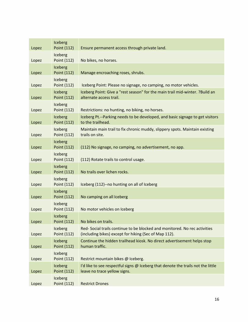
Lopez Iceberg Point (112) Ensure permanent access through private land.
Lopez Iceberg Point (112) No bikes, no horses.
Lopez Iceberg Point (112) Manage encroaching roses, shrubs.
Lopez Iceberg Point (112) Iceberg Point: Please no signage, no camping, no motor vehicles.
Lopez Iceberg Point (112)
Iceberg Point: Give a "rest season" for the main trail mid-winter. ?Build an alternate access trail.
Lopez Iceberg Point (112) Restrictions: no hunting, no biking, no horses.
Lopez Iceberg Point (112)
Iceberg Pt.--Parking needs to be developed, and basic signage to get visitors to the trailhead.
Lopez Iceberg Point (112)
Maintain main trail to fix chronic muddy, slippery spots. Maintain existing trails on site.
Lopez Iceberg Point (112) (112) No signage, no camping, no advertisement, no app.
Lopez Iceberg Point (112) (112) Rotate trails to control usage.
Lopez Iceberg Point (112) No trails over lichen rocks.
Lopez Iceberg Point (112) Iceberg (112)--no hunting on all of Iceberg
Lopez Iceberg Point (112) No camping on all Iceberg
Lopez Iceberg Point (112) No motor vehicles on Iceberg
Lopez Iceberg Point (112) No bikes on trails.
Lopez Iceberg Point (112)
Red- Social trails continue to be blocked and monitored. No rec activities (including bikes) except for hiking (Sec of Map 112).
Lopez Iceberg Point (112)
Continue the hidden trailhead kiosk. No direct advertisement helps stop human traffic.
Lopez Iceberg Point (112) Restrict mountain bikes @ Iceberg.
Lopez Iceberg Point (112)
I'd like to see respectful signs @ Iceberg that denote the trails not the little leave no trace yellow signs.
Lopez Iceberg Point (112) Restrict Drones

17
Lopez Iceberg Point (112)
(112) tracks on Iceberg--rather than allow rutting which causes people to create new nearby trails make the trails "permanent" e.g., gravel etc…to decrease wear or else to maintain the integrity of each trail and stop trail creation.
Lopez Iceberg Point (112)
Blue--112--allow experimentation with fire and or historical grazing to maintain historical openness of landscape and find best management practices.
Lopez Iceberg Point (112)
Green: Quadrant C-Iceberg: Designate main trail and close all side/social trails. Prefer a main "loop" trail. Improve easement access-muddy in winter.
Lopez Iceberg Point (112) I also value bird watching and wildlife viewing opportunities at Iceberg Point.
Lopez Iceberg Point (112)
Iceberg (112): Reduce user trails. 2 or 3 parallel trails down the length of the peninsula.
Lopez Iceberg Point (112) No trails to east along north edge.
Lopez Iceberg Point (112)
Red dot Iceberg Point: I would like to see tourist restrictions at this location. Whatever is in the best interest of the land, wildlife, and local residents of Lopez.
Lopez Iceberg Point (112)
Iceberg pt: consider addressing the depth of the cliff trail--it is getting deep--also encourage 1 track instead of 2.
Lopez Iceberg Point (112)
Iceberg Pt.: Seasonal summer educational hikes offered to cover and inform ecological and historical information. These walks could be advertised and encouraged to visitors and locals alike.
Lopez Iceberg Point (112) No camping on Iceberg. Ever.
Lopez Iceberg Point (112) Public parking for Iceberg clear and ample.
Lopez Iceberg Point (112)
Please provide doggie bags and a clear expectation of owner-responsibility for pets.
Lopez Iceberg Point (112)
If there were some way to make designated trails in a very low key way to keep down the creation of the many cross trails that develop over time --I realize some of these are animal trails but… Foot traffic only--no wheels, but wheel chairs for the handicapped would be allowed.
Lopez Iceberg Point (112) Do not improve parking--making it hard to park is a lovely deterrent.
Lopez Iceberg Point (112)
(112) Close remaining wildflower and lichen meadows to recreational use. Continue to prohibit camping, fires, bicycles, off leash dogs.
Lopez Iceberg Point (112) Q2 Iceberg Point: Allow continued, well-managed hunting of deer.
Outside of meeting
Iceberg Point (112)
Iceberg Point - THIS is the most important part of the Monument for diverse rare flora. The other parcels with impressive floral diversity are Skull and Reed's Bay Islands.

18
MAC Meeting (4/18)
Iceberg Point (112), Chadwick Hill, Point Colville, Watmough Bay.
Build new trails though woods north of meadows at Iceberg, northeast sides of Chadwick, west edge of Colville back toward Watmough Parking.
Lopez
Iceberg Point (112), Lopez Hill, Watmough Bay, Chadwick Hill
1) Favor modest trail networks open for hike/bike with adequate signage and monitoring to flag/restrict when overuse threatens delicate areas. Bikes should be restricted to major trails, and prohibited in wet conditions or when over use tears up the base. (This requires adequate monitoring).
MAC Meeting (4/18)
Iceberg Point (112), Point Colville
At Iceberg and Colville design rest/picnic/beach locations so people resting to enjoy view are somewhat hidden from view by topography or woods.
MAC Meeting (4/18)
Indian Island (22) Red-Indian Island-seasonal closure or permanent closure of human access.
Outside of meeting
Indian Island (22)
Sorry I missed the meeting on Orcas. My comments are about Indian Island. I am a volunteer docent for the Indian Island Marine Health Observatory and for KWIAHT. I have been working with them for 3 years. As far as Indian Island, I feel there are many, many visitors as well as locals, that do not know anything about the island. They assume it’s a free, public use island, to walk all over and picnic on. I think the biggest problem is SIGNAGE. The signs we DO have are homemade and look very floppy, and flimsy. We really need Govt signage to convince people what the rules are. Even when we talk to the visitors, they really don’t believe us, and think we are just tree huggers who want to control their freedoms.
Lopez Indian Island (22) Dirt bikes should be allowed w/access from the spit.
Orcas Indian Island (22)
Indian Island--Need permanent year-round signage on the mainland, at the entrance to the island, and around the island. Need to regulate what visitors do. Need to keep people away from nesting areas. Need to keep people from entering the back (south). Need to keep people off top--maybe, unless people can be kept on trail and away from nesting areas.
Orcas Indian Island (22) No bicycles or horses on Indian Island.
Orcas Indian Island (22)
Provide well-designed signage on Indian Island--a map indicating preferred access points, trail, prohibited areas, etc…
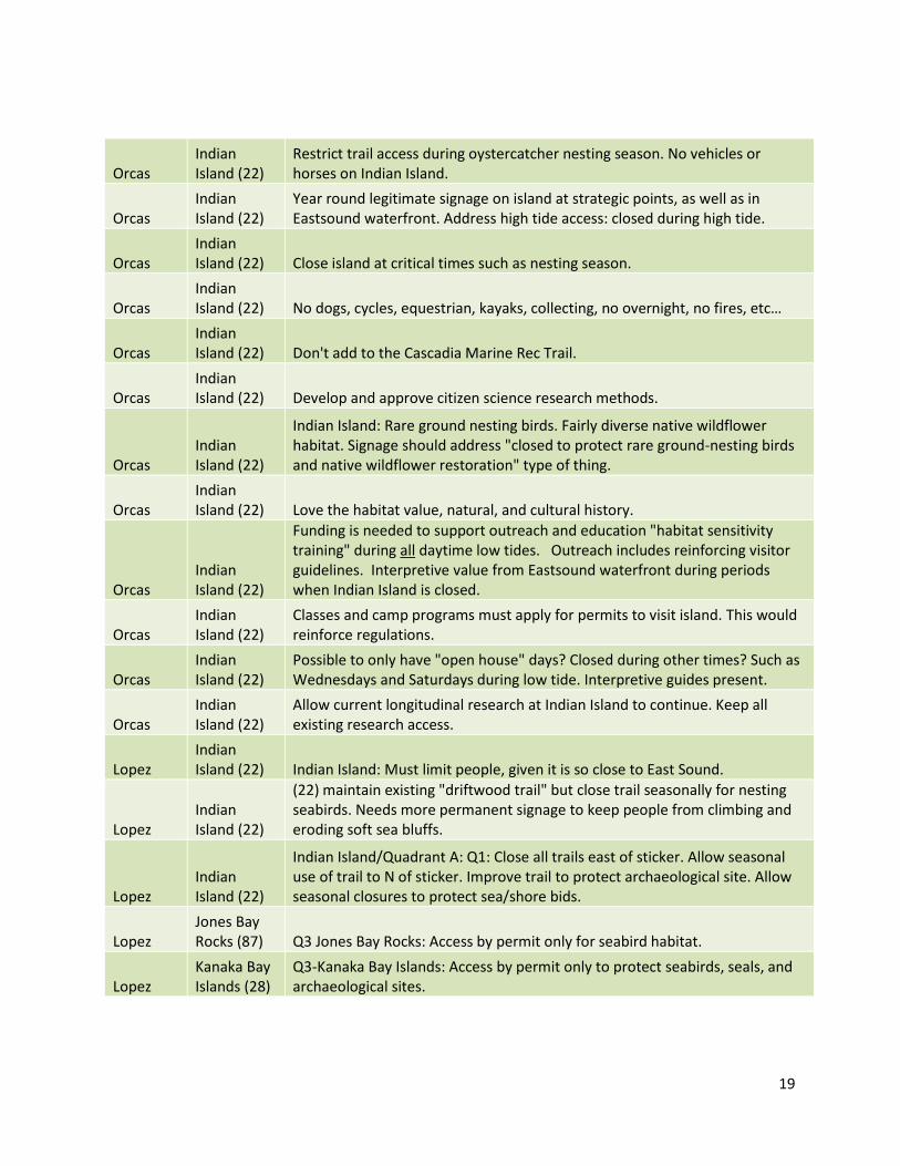
19
Orcas Indian Island (22)
Restrict trail access during oystercatcher nesting season. No vehicles or horses on Indian Island.
Orcas Indian Island (22)
Year round legitimate signage on island at strategic points, as well as in Eastsound waterfront. Address high tide access: closed during high tide.
Orcas Indian Island (22) Close island at critical times such as nesting season.
Orcas Indian Island (22) No dogs, cycles, equestrian, kayaks, collecting, no overnight, no fires, etc…
Orcas Indian Island (22) Don't add to the Cascadia Marine Rec Trail.
Orcas Indian Island (22) Develop and approve citizen science research methods.
Orcas Indian Island (22)
Indian Island: Rare ground nesting birds. Fairly diverse native wildflower habitat. Signage should address "closed to protect rare ground-nesting birds and native wildflower restoration" type of thing.
Orcas Indian Island (22) Love the habitat value, natural, and cultural history.
Orcas Indian Island (22)
Funding is needed to support outreach and education "habitat sensitivity training" during all daytime low tides. Outreach includes reinforcing visitor guidelines. Interpretive value from Eastsound waterfront during periods when Indian Island is closed.
Orcas Indian Island (22)
Classes and camp programs must apply for permits to visit island. This would reinforce regulations.
Orcas Indian Island (22)
Possible to only have "open house" days? Closed during other times? Such as Wednesdays and Saturdays during low tide. Interpretive guides present.
Orcas Indian Island (22)
Allow current longitudinal research at Indian Island to continue. Keep all existing research access.
Lopez Indian Island (22) Indian Island: Must limit people, given it is so close to East Sound.
Lopez Indian Island (22)
(22) maintain existing "driftwood trail" but close trail seasonally for nesting seabirds. Needs more permanent signage to keep people from climbing and eroding soft sea bluffs.
Lopez Indian Island (22)
Indian Island/Quadrant A: Q1: Close all trails east of sticker. Allow seasonal use of trail to N of sticker. Improve trail to protect archaeological site. Allow seasonal closures to protect sea/shore bids.
Lopez Jones Bay Rocks (87) Q3 Jones Bay Rocks: Access by permit only for seabird habitat.
Lopez Kanaka Bay Islands (28)
Q3-Kanaka Bay Islands: Access by permit only to protect seabirds, seals, and archaeological sites.

20
MAC Meeting (4/18)
Kellett Bluff (120) Yellow-want to protect Garry oaks Kellett Bluff.
MAC Meeting (4/18)
Kellett Bluff (120)
Yellow. Kellett Bluff: encourage SJPT to acquire public access easement between Kellett and the soon-to-be land bank property to the north.
MAC Meeting (4/18)
Kellett Bluff (120)
Kellett Bluff: manage for trail access w/landbank and future connection through current private lands. Toilet facility.
San Juan Kellett Bluff (120) Add trails and picnic facilities at Kellett Bluff
San Juan Kellett Bluff (120) We've kayaked here, would love a planned trail to the top.
Lopez Kellett Bluff (120)
I would not like to see any more trails on Kellett Bluff. There is currently a primitive trail.
Lopez Kellett Bluff (120)
Kellett Bluff (120): No camping, day use only, encourage oak habitat, one single trail, buy neighboring parcel.
Lopez Kellett Bluff (120)
(120) Badly degraded meadows. Weed control and trails would be OK, but needs a legal access point!
Lopez
Kellett Bluff (120), Turn Point (122), Posey Island (32)
Blue--120+32+122--allow for permitted, non-fire visioning and coming of age retreats.
San Juan Little Patos (29) Little Patos: A gem paired with Patos! Should be kept off limits!
San Juan Little Patos (29)
Little Patos should be observed but no human access. Similar to NWR would protect the beauty of the archipelago and safe haven for wildlife.
Lopez Little Patos (29) Little Patos: access by permit only, no trails.
Lopez Little Patos (29) Little Patos should be closed to recreational use.
Lopez Lopez Pass (114)
Please negotiate a right-of-way across the Allen property so non-boat people--hikers--might have access to Sperry Point. Access could be along beach so as not to interfere with his privacy needs. Perhaps it could be open only in the off season to avoid hoards of people. The beach route to be determined by the BLM staff.
Lopez Lopez pass (114) Public access to Sperry.
Lopez Lopez Pass (114) Sperry Point--Kayak Landing--Camping.

21
Lopez Lopez Pass (114) Know more--camping
Lopez Lopez Pass (114) Like to see Sperry open to camping and maintained trails. Bird blinds.
Lopez Lopez Pass (114)
Green--114--make sure this stays open and available to kayaks and available for permitted, overnight non-fire visioning and coming of age retreats.
Lopez Lopez Pass (114)
Sperry Point--what are kayaker visitation options on Sperry Pt? I value public landing and camping sites throughout the islands.
Lopez
Lopez Pass (114) and Cape Saint Mary (115)
Lopez Pass (114) and Cape Saint Mary (115) are not well known. Would like to have a map of all possible hikes available. Apparently there are trails on Sperry Point.
MAC Meeting (4/18)
Lummi Rocks (3)
Yellow: Lummi Rocks-concerns about potential camping-don't know enough about site to make a judgment.
MAC Meeting (4/18)
Lummi Rocks (3) Yellow: Lummi Rocks allow seasonal access.
Lopez Lummi Rocks (3)
Q3 Lummi Rocks: Close Lummi Rocks during gull nesting season. Gulls primary nest on the island with the sticker.
Lopez Lummi Rocks (3)
Q1-Lummi Rocks: rocks, restrict trails to the tombolo to protect habitat and seabirds. Allow other access by permit only.
Lopez Lummi Rocks (3)
(3) Lummi is least disturbed of any landscape in the monument. Also, 1000s of seabirds--over 100 nests. Tombolo has shell midden. This should be used as little as possible. No trail, restricted access, and no official recreational use (tho' some people will land there anyway--but should not be encouraged or sanctioned. We found camping garbage there for the 1st time in 2015.
Outside of meeting
Lummi Rocks (3)
Lummi Rocks - ditto my comments on McConnell Rocks. ["if commercial sea kayak operators are using Little Mac routinely, I would strongly recommend requiring that they get special use permits or stay off -- it's pretty small and fragile and it's getting more weedy."
Lopez
Mackaye Harbor Rocks (72) Q3 Mackaye Harbor Rocks: Access by permit only to protect oyster catchers.
Lopez
MacKaye Harbor Rocks (72), Unnamed Iceberg Point Rocks (86), Dot Rock (7) (7) (86) (72) Leave small rocks only wildlife.

22
Lopez McConnell Rocks (30)
(30) Restrict access to existing trail. This islet has great wildflowers and native bees but could be trampled easily.
Outside of meeting
McConnell Rocks (30)
McConnell Rocks (Little Mac) - "popular day use area" -- what is the source for this statement? We found little evidence of use. Also, if commercial sea kayak operators are using Little Mac routinely, I would strongly recommend requiring that they get special use permits or stay off -- it's pretty small and fragile and it's getting more weedy.
Lopez Mud Island (103) Q3: Mud Island: Access by permit only.
Lopez
Oak Island and Rock (20) (20) Close to protect graves.
Lopez
Oak Island and Rock (20)
Q3 Oak Island: Close all trails. Access by permit only to protect archaeological sties.
Lopez Outer Bay Rocks (73)
Rock off Agate Beach, various rocks in Aleck Bay: I've seen people walking on the rocks, dogs at low tide, and golfers. Please install signs asking people not to come onto the rocks.
Lopez Outer Bay Rocks (73) Outer Bay Rocks (73): Allow use at low tide.
Lopez Outer Bay Rocks (73)
Q2 Outer Bay Rocks: Opportunity for exploring glacial history and intertidal diversity. Allow access on low tides.
Lopez Parks Bay Island (29)
(29) Lovely overlooks and meadows, many songbirds. This could stand a single loop trail (it's deer tracks now) and day use only without fires or pets. May take some pressure off Indian, Skull, and other small pretty islands.
Lopez Parks Bay Island (29) Q1 Consider a single developed trail for Parks Bay Island.
Lopez Parks Bay Island (29) Q2 Parks Bay Island Consider limited day use.
Outside of meeting
Parks Bay Island (29)
Parks Bay Island - It's not clear to me that the UW has any remaining interest in this scenic island, since no one at the Labs does terrestrial research any longer since Gene Kozloff retired a decade ago.
MAC Meeting (4/18)
Patos Island (76) Yellow-Patos-for such large numbers of visitors is there enough toilet facility?
MAC Meeting (4/18)
Patos Island (76) Yellow--Patos--more tribal awareness.
MAC Meeting (4/18)
Patos Island (76) Blue--Patos--love docent opportunities and restoration of lighthouse.
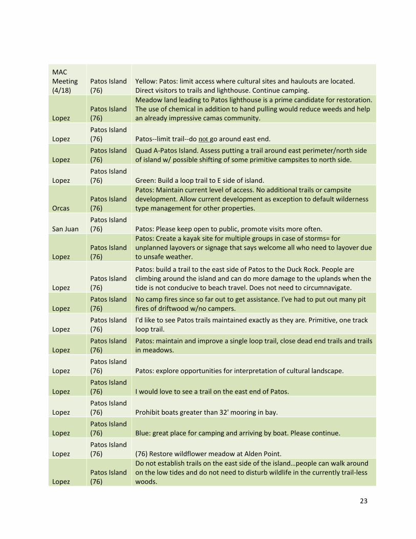
23
MAC Meeting (4/18)
Patos Island (76)
Yellow: Patos: limit access where cultural sites and haulouts are located. Direct visitors to trails and lighthouse. Continue camping.
Lopez Patos Island (76)
Meadow land leading to Patos lighthouse is a prime candidate for restoration. The use of chemical in addition to hand pulling would reduce weeds and help an already impressive camas community.
Lopez Patos Island (76) Patos--limit trail--do not go around east end.
Lopez Patos Island (76)
Quad A-Patos Island. Assess putting a trail around east perimeter/north side of island w/ possible shifting of some primitive campsites to north side.
Lopez Patos Island (76) Green: Build a loop trail to E side of island.
Orcas Patos Island (76)
Patos: Maintain current level of access. No additional trails or campsite development. Allow current development as exception to default wilderness type management for other properties.
San Juan Patos Island (76) Patos: Please keep open to public, promote visits more often.
Lopez Patos Island (76)
Patos: Create a kayak site for multiple groups in case of storms= for unplanned layovers or signage that says welcome all who need to layover due to unsafe weather.
Lopez Patos Island (76)
Patos: build a trail to the east side of Patos to the Duck Rock. People are climbing around the island and can do more damage to the uplands when the tide is not conducive to beach travel. Does not need to circumnavigate.
Lopez Patos Island (76)
No camp fires since so far out to get assistance. I've had to put out many pit fires of driftwood w/no campers.
Lopez Patos Island (76)
I'd like to see Patos trails maintained exactly as they are. Primitive, one track loop trail.
Lopez Patos Island (76)
Patos: maintain and improve a single loop trail, close dead end trails and trails in meadows.
Lopez Patos Island (76) Patos: explore opportunities for interpretation of cultural landscape.
Lopez Patos Island (76) I would love to see a trail on the east end of Patos.
Lopez Patos Island (76) Prohibit boats greater than 32' mooring in bay.
Lopez Patos Island (76) Blue: great place for camping and arriving by boat. Please continue.
Lopez Patos Island (76) (76) Restore wildflower meadow at Alden Point.
Lopez Patos Island (76)
Do not establish trails on the east side of the island…people can walk around on the low tides and do not need to disturb wildlife in the currently trail-less woods.

24
Lopez Patos Island (76) Campsites should not be increased.
Lopez
Patos Island (76) and Little Patos (29) Patos (76): Restrict trails on east half, or little Patos (29)
MAC Meeting (4/18)
Point Colville (113) Red-ban hunting Point Colville
MAC Meeting (4/18)
Point Colville (113)
1) Colville-close several social + trails on the outer (seaward) region. Have 1 main trail with 1 other loop to the overlook to Castle/Colville Islands.
Lopez
Point Colville (113)
When I hike over to Pt. Colville from Watmough I am not sure I am following a "kosher" trail once I get to the electrical poles and head down to the road that passes the Pt. Colville trailhead. More signage?
Lopez
Point Colville (113) Point Colville green: Only open to foot traffic.
Lopez
Point Colville (113)
Area N. of Pt. Colville parking --needs trail built on steep terrain--makes a good connection from PT. Colville to Watmough. Possible re-route social trail--make one trail across power line rd. to Pt. Colville Parking [WH-2]
Lopez
Point Colville (113) Close WH-4
Lopez
Point Colville (113)
Pt Colville: if possible create safer trails to beach--especially on west side. Beach walking protects upland fauna.
Lopez
Point Colville (113) Colville--no motorized vehicles.
Lopez
Point Colville (113) Do not advertise or map trails up over rock to Watmough.
Lopez
Point Colville (113)
Point Colville: Please do not put signage for this. No motorized vehicles. No camping. Only leave no trace signage.
Lopez
Point Colville (113)
Point Colville: Please Please Please limit advertising of these trails! Fine to have them on maps, but keep PC out of promotional literature.
Lopez
Point Colville (113) Do not advertise Point Colville Trail. Do not close Point Colville Trail.
Lopez Point Colville Leave trail maintained and open as equestrian trail.

25
(113)
Lopez
Point Colville (113)
Point Colville: No PR about this spot. Fragile; limited parking. No mountain bikes.
Lopez
Point Colville (113) (113) No signage, no camping, no advertisement, no app.
Lopez
Point Colville (113)
(113) Blue--I value the solitude here and low traffic. It's like how Watmough used to be. Please preserve it.
Lopez
Point Colville (113)
Expand trail system to make use of west side of Colville--from PC-19 and back to road near boundary w/ Beck rd.
Lopez
Point Colville (113) No hunting on Colville
Lopez
Point Colville (113) No camping on Colville
Lopez
Point Colville (113) No bikes on Colville
Lopez
Point Colville (113) No motorized vehicles on Colville.
Lopez
Point Colville (113)
No parking there at trail entrance--make new parking lot for Pt. Colville at Watmough at Beck edge boundary and dirt road.
Lopez
Point Colville (113)
While current access and use should be maintained, this area should NOT be publicized on any outreach materials. PLEASE PLEASE PLEASE. I think it is important that some locations are not necessarily publicizing and advertising all locations…does it have to be on the maps etc.? Please limit visitors there by limiting and curbing outreach for this location. Thank you.
Lopez
Point Colville (113)
Red--113--Do not feature Pt. Colville on any outreach, promotional material as a way to limit exposure. Ask other agencies to respect this as well.
Lopez
Point Colville (113)
Designate main trail and close side/social trails. Ditto to main loop trail. Improve beach access--staircase like neighbors?
Lopez
Point Colville (113) PC-3 remove the rope to the beach.
Lopez Point Colville PC-2 Make a more formal trail.

26
(113)
Lopez
Point Colville (113) No access to the Pt. Colville bog.
Lopez
Point Colville (113)
Pt. Colville--Please do not create overt signage on Roads to publicize this part of the monument. I appreciate that this is more of a private, local hike.
Lopez
Point Colville (113)
Pt Colville: please make clear signs to create awareness of beach and property access.
Lopez
Point Colville (113)
Colville Pt. Please restrict mini-off road trails. Protect lichen/mosses and fragile habitat of cliffs and rock ledges.
Lopez
Point Colville (113) (113) Maintain and limit to existing loop trail.
Lopez
Point Colville (113)
(113) Absolutely must close the remaining lichen-covered rocky outcrops both seaward and inland from the trail. Reindeer moss is rapidly disappearing.
Lopez
Point Colville (113)
Q1 Point Colville: designate and improve a single looping route. Close all dead-end trails and all trails on lichen covered rocks.
Lopez
Point Colville (113) Q2 Point Colville: allow continued, well-managed hunting of deer.
Lopez
Point Colville (113) Red--Care for the mosses. No camping.
Lopez
Point Colville (113) Blue--a very spiritual walk.
Lopez
Point Colville (113) 113: No camping, no advertising, no bikes, no app, no horses.
Lopez
Point Colville (113), Iceberg Point (112), Watmough Bay Eliminate hunting.
MAC Meeting (4/18)
Posey Island (32) yellow--need to know more about tribal significance of Posey Island.

27
MAC Meeting (4/18)
Posey Island (32) Posey: allow camping while protecting tribes.
Lopez Posey Island (32)
(32) Badly damaged--campsite can remain but weed removal and protection of archaeology are essential.
Lopez Posey Island (32)
Q2 Posey Island: Restrict camping and fire to marked sites. Relocate camp site on S side (sticker) to protect archaeological material.
MAC Meeting (4/18)
Provost Harbor Rocks (36) Provost Harbor Rocks most shoreline is protected salmon habitat.
Lopez Pudding Island (34) Q3 Pudding Island--Access by permit only to protect rare plants.
Lopez
Pudding Island (34), Kanaka Bay Islands (28), King Islands (27), Danger Rocks Really best left as seabird and sea mammal preserves.
MAC Meeting (4/18)
Quadrant A (general)
A) Again-signs designating BLM jurisdiction and uses. Also advice on where to/not anchor.
Lopez Quadrant A (general) Quadrant A--NO DRONES!!!
Lopez Quadrant C (general)
There are already sufficient trails on all properties. More would take away pristine ambiance.
Lopez Quadrant C (general)
No vehicles of any type should be allowed. This maintains quiet for wildlife--prevents stamping--and leaves visitor peaceful experiences.
Lopez Quadrant C (general)
yellow--quadrant C--continue to allow hunting but have days when other activities are prohibited and hunting happens--maybe one day a week?
Lopez Quadrant C (general)
Iceberg Island: Prioritize conservation of rare plants of Iceberg Island if it is ever transferred to NM ownership. Access by permit only.
Lopez Quadrant C (general) Yellow: leave no trace principles at every trailhead/site :).
Lopez Quadrant C (general)
Is there anyway that we can restrict promoting certain areas of the monument--i.e. Chadwick Hill and Colville?
Lopez Quadrant C (general)
General (Quad C) philosophy: we sought to preserve these lands as they were before their designation as "monument." Therefore the plan must seek to preserve the lands as we now have and use them which was the purpose of designating them a monument.

28
Outside
of
meeting
Quadrant C
(general)
and General
My comment concerns the national monument land on Lopez Island but
certainly applies to all of the islands. I wish to comment on behalf of the
equestrians on Lopez Island. As more and more large sections of land on
Lopez Island are divided up and sold, the area that equestrians can ride is
shrinking markedly. Often new owner put up fences and are not friendly or
accommodating to horseback riders. Riding on narrow winding island roads
with sometimes heavy fast traffic as in the summer is perilous to horse and
rider. There have been serious accidents here on Lopez between cars and
horses. This makes it even more important that monument lands remain
open to equestrian use. I think most riders are thoughtful and safety minded
when meeting hikers and bikers. We also understand that wet muddy winter
months are not a good time to use monument trails because horse hooves
can damage the trails.
Monument lands must remain open to equestrians. If the character of the
islands is to remain rural and peaceful, horseback riding should be a part of
that, especially on monument land.
Lopez Quadrant D (general)
Yellow: leave no trace signage. Continue human powered crafts only near shore land.
Lopez Reads Bay Island (9)
(9) This is an overlooked, very fragile jewel with deep moss lichen carpets and dense wildflowers. No improvement of access please, but, it would help to have a designated access of landing point and one short trail from there to the top (as a lookout) to try to avoid people walking all over the meadows. The compromise would be the one short trail-but I would not promote it or make it easier for boats to tie up( at the old kelp mill or anywhere else).
Lopez Reads Bay Island (9)
Q1 Reads Bay Island: Develop no trails, restore existing areas impacted by trails.
Lopez Reads Bay Island (9)
Q1 Reads Bay Island: Access by permit only to protect coastal meadow--allow customary access by Decatur residents and research by Decatur school.
Lopez
Reservation Bay Rocks (39) (39) ditto, like (86) a seabird haven.
Lopez Richardson Rocks (16)
(16) A great opportunity to remove weeds and restore a coastal meadow, but for the time being no improvement of public access.
Lopez Richardson Rocks (16)
Q3 Richardson Rocks: Access by permit only to protect rare Venus' looking glass flowers.

29
Orcas Skull Island (17)
Maintain (e.g., thru citizen volunteers) small trail to top; install "please stay on trail signage." at kayak haul out location. No camping. Restrict use seasonally if applicable for nesting or other animal conservation needs, or fragile landscape conservation. But please don't implement another deforestation/clear-cut for single "species restoration" (i.e., Garry oaks!)
Orcas Skull Island (17) Valued for wildflowers.
Lopez Skull Island (17)
(17) Skull--clearly demarcate a single loop trail, need signage on the landing beach --no fires, camping, or pets.
Lopez Skull Island (17)
Q1 Skull Island--Designate and improve a single trail/similar to currently identified route but ground truthed to protect meadows.
MAC Meeting (4/18)
Skull, Freeman, Victim Islands Yellow: manage for educational purposes Skull Island, Freeman, Victim.
Outside of meeting
small rocks and island and general
I will be unable to attend the meetings coming up next week about managing visitation to the National Monument. I am re-iterating my previous comments here: The stated purpose of the National Monument is to preserve, protect and restore. Opening additional new areas of the National Monument to visitors would result in the opposite of this goal. In particular, I am concerned about small off-shore rocks and islands which are currently real refuges for marine life and terrestrial wildlife, including coastal birds. (Coastal birds are among the most challenged for their existence of all birds.) There are so few places left beyond the interference of humans and their dogs and their noise. The small rocks and islands are also scattered over a wide area, remote from BLM staff. These small rocks and islands are really not useful for anything other than conservation areas, so why not designate them as such? I am also concerned about visitors being encouraged by the creation of maps and trails (on land or sea) of the National Monument to visit areas very close to private property. This is placing an undue burden of supervision, education and reporting on neighboring private citizens. Please see my previous comments in the scoping report for specific examples of my experience with the public and the wildlife in this beautiful area. Let us keep it beautiful by providing habitat for wildlife.
San Juan Small rocks and islands
Any islands or rocks under .5 acres should be observed but no access--protected for wildlife only.
San Juan Small rocks and islands
Small rocks should give highest priority to wildlife, second priority to scientific studies of wildlife + flora

30
Lopez Small rocks and islands Small rocks & smaller islands left TOTALLY for birds.
Lopez small rocks and islands
Rocks used by wildlife as habitat/ breeding ground: establish min. distance marine traffic has to maintain, no human use.
MAC Meeting (4/18)
Trinka Rock (19) Red: No fires or camping but define landing area for kayak.
Lopez Trinka Rock (19) (19) Sensitive archaeology; probably best to leave unknown and unused.
MAC Meeting (4/18)
Turn Point (122) Blue--really love the restoration of residence.
MAC Meeting (4/18)
Turn Point (122)
Yellow--Turn Point--are there access issues with locals? How does Stuart generally feel about the Lighthouse highlighting?
MAC Meeting (4/18)
Turn Point (122)
Yellow--Turn Point--cute new toilet but very overused--need more adequate toilet facilities.
MAC Meeting (4/18)
Turn Point (122) Turn Pt. Develop trail access cultural.
San Juan Turn Point (122) Turn Pt. should have more signage about steep cliffs and dangerous areas.
San Juan Turn Point (122)
Stuart/Turn Point: Existing trails are good, promote "respect private properties."
San Juan Turn Point (122) Stuart/Turn Point: No fires, no hunting
Lopez Turn Point (122)
Light station--living quarters made to appear as it did during early operation-to be toured as a walk-thru "museum." Charge fee or donation.
Lopez Turn Point (122)
Turn Pt. 122--very much enjoy trails to Turn Point and around the lovely grounds and refurbished quarters, yeh volunteers!
Lopez Turn Point (122)
Q2: Turn Point: Explore options for managed hunting including collaborations with tribes and tribal youth.
Lopez Twin Rocks (10)
(10) Archaeology--close to recreational uses for cultural reasons--also is seabird nesting.
Lopez Twin Rocks (10)
Q3 Twin Rocks: No trails, access by permit only to protect archaeological sites.
Lopez
Unnamed Iceberg Point Rocks (86)
Unnamed Iceberg Rocks (86)--it should be named, local school students should have a contest.

31
Lopez
Unnamed Iceberg Point Rocks (86) (86) Critical for birds and seals--no access please.
Lopez Victim Island (21) (21) restoration !! Weed removal. Then demarcate a single loop trail.
MAC Meeting (4/18)
Watmough Bay (117) Value tribal significance Watmough
MAC Meeting (4/18)
Watmough Bay (117) Keep loop open at Watmough and correct where goes through private land.
Lopez Watmough Bay (117)
Comment is on a print out of a google map and proposes route maintenance and route closure between Watmough Bay and Point Colville.
Lopez Watmough Bay (117)
Limit people to the well-marked main trails. No bikes. No fires. No hunting--kids play here.
Lopez Watmough Bay (117)
WB2: I would like to ride the out and back trail to Watmough Beach off season, off hours for equestrian use. We remove manure and ride consciously.
Lopez Watmough Bay (117) Maintain current trails, uses.
Lopez Watmough Bay (117) (117): A new trail that connects WH-4 trail back to WB-1 or WB-2 as a loop.
Lopez Watmough Bay (117)
Red dot Watmough Bay: I would like for there to be seasonal restrictions for tourists in this area. This beach is a spiritual haven for me and to have it full of people all summer long is sad. Also the number of boats mooring there is sometimes overwhelming, If that could be minimized that would be appreciated.
San Juan Watmough Bay (117) Add trails at Watmough and Chadwick Hills.
San Juan Watmough Bay (117) Better Restrooms.
San Juan Watmough Bay (117) I prefer people use only. Bike, horses--no. Find other places for them.
San Juan Watmough Bay (117)
I find it difficult to understand clearly what's private and what's public. More signs needed?
Lopez Watmough Bay (117) No Tobacco Use Zone
Lopez Watmough Bay (117) Concerned for eelgrass & moorings--so if we did not allow dingy beaching.
Lopez Watmough Bay (117) Restrict scrambling up cliff from Watmough to Chadwick. On Trail only.

32
Lopez Watmough Bay (117)
Protect peregrine habitat and nest. Prohibit taking of chicks from nest for falconry.
Lopez Watmough Bay (117)
Watmough Bay--no unleashed dogs and no smoking. Signage that informs why there is a need to stay on the trails and maintain the trails.
Lopez Watmough Bay (117) How about improving the swell outhouse. Could you have water available?
Lopez Watmough Bay (117) No hunting.
Lopez Watmough Bay (117)
Watmough Bight: Wb-2 Marsh side: no mountain bikes or horses, fragile. Wb-2: main trail: keep access to beach for horses (traditional use_. Equine respect: avoid crowded summer days; remove manure.
Lopez Watmough Bay (117) (117) Only car & foot traffic, no camping, no app.
Lopez Watmough Bay (117)
(117) Trail usage--trail is becoming over used at Cedar Tree--block during some parts of year.
Lopez Watmough Bay (117) Watmough Bay (117) No hunting on all of Watmough.
Lopez Watmough Bay (117) No camping on all Watmough
Lopez Watmough Bay (117) No motor vehicles on Watmough Trails
Lopez Watmough Bay (117) No bikes on trails.
Lopez Watmough Bay (117)
I think the trails behind Watmough parking lot should be closed to public. Those are native burial grounds that should be left alone.
Lopez Watmough Bay (117) WB: WH-3 new connecting trail is great. Keep maintained.
Lopez Watmough Bay (117) Incorporate power lines into trail system.
Lopez Watmough Bay (117)
Value: quietude and beauty and respect of personal space (noise control)/Watmough Bay
Lopez Watmough Bay (117) Please restrict large boat mooring/anchoring w/in Watmough Bay.
Lopez Watmough Bay (117)
(117) Protect the beach and shallows from disturbance--no fires, digging, camping--no motorized watercraft on beach--this is a critical Puget Sound Chinook nursery.
Lopez Watmough Bay (117)
(116) Consider restoration of Chadwick Marsh, a highly degraded peat bog complex--and only class 1 wetland of its kind in the monument.
Lopez Watmough Bay (117)
Q3 Watmough Bight: restrict access by motorized craft to protect juvenile salmon

33
Lopez Watmough Bay (117) 117: Only car and foot traffic, no camping, no app.
Lopez
Watmough Bay and Iceberg Point Have a license requirement for motorized wheelchairs.
Anacortes General
I would like to see all areas large enough to accommodate overnight camping, open to overnight camping. This is with the understanding that no open fire pits/ burning of on-site wood is allowed, but cook stove fires for cooking would be allowed using packed in gas and cook stoves only.
MAC Meeting (4/18) General
Yellow. Work with USFWS so that both NWR and NM rocks are clearly signed and/or mapped. It is vital that public knows what land they can or cannot land on without having to figure out ownership.
MAC Meeting (4/18) General
Yellow. General-in general try to avoid public use of rocks that are marine mammal haul-outs.
MAC Meeting (4/18) General Define, maintain main trails really well to diminish social trails.
MAC Meeting (4/18) General
Collaborate w/USFWS so refuge-like islands in the NM can be effectively and efficiently managed. Likewise for recreation sites (e.g. Turn Island) in the wildlife refuge.
MAC Meeting (4/18) General
Might a way to deal with dog be construction of dog park nearby? Then ban them? (again--signage to explain why: *Canine giardia pathogen to seals--problem. *Destruction of habitat. *Nesting song birds in low brush. *Nesting of sea birds on ground. *etc.
MAC Meeting (4/18) General
One way to mitigate public negative reaction to new trail development is to use interpretive educational signage to teach about the concept of preserving delicate habitat through construction of boardwalks, gathering/picnic or siting spaces and the closing of "social trails" that utilize erosional pathways.
Anacortes General I am NOT supportive of allowing any motorized vehicles such as ATVs, motorcycles allowed in any areas.
Anacortes General I am supportive of allowing bicycles including mountain bike access to all areas.
Anacortes General
Other: As I look at the archipelago of islands here I am of mixed emotions. Happy to have such wonderful BLM-NM leadership reaching out to us. Sad at what our ancestors lost and how painful that mush have been as I learn the stories shared by the few elders we have that remember. I look forward to working with BLM and SJICC, NPS, FSJ more so we can ensure our children remember.
Anacortes General Tribal--to have youth/explore/GIS mapping/ for all BLM/SJINM property.

34
Anacortes General Camp fires where it makes sense.
Anacortes General Educate tribal law enforcement.
Anacortes General Land use for Coast Salish People.
Anacortes General Land or water access clarify through maps/apps
Anacortes General Tribal liaison
Lopez General I would like to see all areas open to everyone.
Lopez General General for all SJINM: no hunting, no horses, no fires--smoking not allowed.
Lopez General There could be an opportunity to use mobile technology (e.g., an app) to education humans on how they should use SJINM lands.
Lopez General
General: with likely increased visitation in coming years is BLM considering changing or limiting publicity of these lands? I would like to see stewardship be the main subject of publicity.
Orcas General
All property: Maintain developed trails to a foot trail only standard. Encourage no new social or way trail development. Definition to concentrate use to one (where multiple exist) social trail is acceptable.
San Juan General Have reference to website.
San Juan General Work towards creating App which will show folks basic maps and info.
San Juan General My main interests in the areas are hiking, wildlife watching, and appreciating the views, natural vegetation and peace and quiet.
San Juan General Larger island plan for access but limit to day use except in current state parks camping facilities.
Orcas General I value hiking opportunities.
Orcas General No mountain bikes on any property.
Orcas General No horses on any property.
Orcas General I have no problem with seasonal closures. It is important to make the case form an eco or science point of view. Need to maintain credibility.
Orcas General
Identify areas which those with disabilities can access and publicize those widely. Otherwise trails should be primitive. Equestrian and bikes should understand their responsibilities (e.g., clean up and stay on trail)
Orcas General
Seasonal access restrictions are welcome if scientifically justified. Ditto for "foot traffic only" and "day use only." I do believe though that it is important to allow some access (whether time-bound or spatially bound or use bound) ; just so long as places are not completely closed all the time.
Orcas General It would be nice to see more publicity about the Cascadia Marine Trail so we know where it is.
Orcas General It would be nice to have designated landing sites on islands for kayakers. Hopefully these could be in spots that aren't sensitive. Permeant signs to

35
label these spots would be great.
Orcas General Permanent signs needed at monument islands regarding what is ok and not ok and times of year as to what you can do.
Orcas General All property: no dogs permitted.
Orcas General All property: no horse use.
Orcas General All property: no mountain bike use.
Orcas General Any use by scientific research must conform to all rules that apply to the general public. Provide no special access.
Orcas General General comment for all properties: landing and picnicking by kayak
Orcas General Restrict "assisted locomotion" (e.g., mountain bikes) in most locales, but allow foot-traffic (albeit controlled to trails) in most. No dogs
Orcas General
Outreach to the public on thinks like (i) when are the "sensitive times" and why are they sensitive, (ii) why are certain restrictions applied, this could be through quarterly press releases, Facebook, website, Orcas Issues. Active outreach is best (e.g., press releases, column in Sounder) over passive ones (Facebook, website).
Orcas General
More information-I really would like to see more information provided to the public in a timely (and time specific) manner. Articles (monthly) in the local papers. Posters on the ferries.
Orcas General
All science research should be permitted. Permitting process should require the sharing of survey results and reports with the land management agency (BLM). BLM should then make this info publically available through a central online location.
Orcas General I think non-motorized camping is probably okay in many locations, including small campfires during low fire risk times of the year.
Orcas General
There should be a monument specific wildland fire management plan which recognizes fire use and plans for ecosystem restoration-maintenance through use of prescribed fire. BLM should be more directly (at least notified) involved when there is any report of fire on any BLM property.
Orcas General Be open to additional camping only at the request of the Cascadia Water Trail.
Orcas General In weed management, determine what is to be protected, what damage in action will cause, and what the least noxious control method is.
San Juan General Larger properties should restrict human activities to muscled-powered uses: walking, paddling, and non-motorized sailing. No horses or mountain biking.
San Juan General In places where human visitation is intended add signs informing people of ecological or cultural values.
San Juan General Work towards creating app which will show folks basic maps and info.
San Juan General
For all the rocks that are easy/enticing to access, create signs suggesting best use, from " please keep off" to " enjoy your picnic" to "give priority to wildlife." Not everyone will cooperate but a lot will once they/ we get the info.

36
San Juan General (a q but I don't have an answer, sorry!!) How to get all of these wonderful maps more widely accessible?
San Juan General
Another general--Only pedestrian use in all land areas. There are lots of other islands places for horses and bikes. If an island is big enough and has a good landing site encourage kayaks. Also no camping. Limited picnicking OK.
San Juan General
Two general ideas: 1) link trail systems throughout the Monument in the way the Cascadia system works--not necessarily providing shelter or accommodation, but linkages between sites. 2) Link the lighthouses as a "system" or "theme" (or extended trail)--and even across the border (the whole Salish Sea) (sorry I don't have specific site comments)
San Juan General
I think certain currently less-visited sites (islands, rocks) should be reserved as nature preserves, and only "explored" virtually. I would also like to see more emphasis on the remote enjoyment of the monument--mainly virtual (by website etc.).
San Juan General
Is it possible to have more public access to some remote sites by the monument, for those who can't go by their own boat? Like the expeditions to the Patos Lighthouse?
San Juan General Prohibiting motorized vehicles on trail in general throughout the monument.
San Juan General
Please designate culturally sensitive sites (such as the middens at Watmough Bay, or even the former homestead site) and restrict use at these sites so that they will not be damaged (another example is the reef net shacks on Kellett Bluff). Locate trails away from these sites.
San Juan General Specifically designate mountain bike trails to separate from foot traffic.
San Juan General
At areas that have sensitive native vegetation, e.g., Iceberg Pt., Pt. Colville, efforts should be made to limit numbers of visitors and reduce impact of visitors e.g., education about the sensitivity of the plants, staying on trails etc.
San Juan General I can't think of any trails/areas that should be opened to more intensive use than they currently are. Very few are suitable for anything other than hiking.
San Juan General
A key element in limiting visitor numbers to sensitive areas is how these areas are "advertised" within and outside the islands and promoted by the tourism industry.
San Juan General Continue policy of no hunting or fires. Pack it in pack it out.
San Juan General Think about system for accountability thru access fees. Could also control commercial operations.
San Juan General Maintain access with control of impact.
Lopez General
In the entire SJI National Monument, preserve all native sites, working closely with your tribal partners to preserve both sacred and traditional properties/sites. Please make sure ALL sites are protected and preserved, restricting access by treasure hunters and the public.
Lopez General Also make sure all growler planes from Whidbey Naval Air Station are prohibited from flying over all SJI National Monument sites.
Lopez General All San Juan Islands site w/ Native American connection e.g. middens, sites of long houses, graves--protect, limit access.

37
Lopez General Create a noise tolerance level and work towards this=especially with regards to growlers.
Lopez General In general--S. Lopez SJINM properties should be ACEC.
Lopez General In general--I support restricting access to let land recover.
Lopez General SJINM in general no motorized vehicles no bikes on trails.
Lopez General In general: no additional campsites on SJINM.
Lopez General No competitive events on SJINM.
Lopez General Limiting group size for commercial companies.
Lopez General Zero (NO!) drones allowed.
Lopez General Kayaks should be allowed to all locations except bird hatching rocks.
Lopez General Please create a space for off-road motorcycles.
Lopez General Please create a space for off-roading cars.
Lopez General Please create a space for horses.
Lopez General General Idea: closing off areas sensitive to nesting birds--close during these times.
Lopez General Do not advertise access to most sensitive areas. Track impact and close it down if necessary.
Lopez General Do not include in apps that make access into a game. Educate people about sensitivities, cultural, values.
Lopez General
Allow small rocky islands- uninhabited-be used for spiritual coming of age ceremonies including overnight camping-no fires--with permission. No outdoor fires or camping on any BLM monument land accept above.
Lopez General No interface necessary through media w/any of these places.
Lopez General Are there any trails that might support equestrian use--besides Lopez Hill?
Lopez General
Enforcement: as rules and restrictions are crafted to protect the monument in perpetuity, what is the plan for enforcement? 1 BLM ranger--in Wenatchee. Partner/Contract w/local law enfo. For patrol and enforcement of monument properties would provide visibility and deterrent value, as well as a significant measure of protection.
Lopez General Signage to stay on trail, clear demarcations of trail.
Lopez General Prohibit motorized vehicles and human-powered vehicles except wheelchairs and strollers.
Lopez General Prohibit all use or removal of natural materials (wood, plants, wildlife, rocks…
Lopez General Require parties larger than 10 people to get permissions/ use permit ; restrict # of large parties per day ("bus tours").
Lopez General Dogs should be on leash
Lopez General
Many/some BLM lands don't have very much parking…the parking should not be extended, human use/traffic should be reduced to what existing parking can accommodate.
Lopez General No electronic display screens, no location-based content delivery devices, no advertising, no surveillance cameras, no microphones, no loudspeakers.
Lopez General Eliminate beach erosion.

38
Lopez General Areas w/rare/endangered species: restrict human use.
Lopez General No camping.
Lopez General I am not a horse person but I think it is very important to provide some trails available for riding horses.
Lopez General Outhouses in public points (Iceberg etc…) to limit people going outside & not digging cat holes.
Lopez General No more campsites/grounds in national monument.
Lopez General Continue no campfires allowed.
Lopez General Enforcement. Officials in the field monitoring/educating public (LNT educator? Nudge nudge hehe)
Lopez General Interpretive info w/delicate flora/fauna in the area and how to protect it.
Lopez General
General: Continue to restrict camping--except Patos. While it would be enjoyable at these beautiful places, I do not think the land could support it. Keep ACEC. Restrict and manage off trail human use. Closed to motor vehicles and mountain biking. Restrict/prohibit access to small rocks that are bird habitat to protect species.
Outside of meeting General
I just wanted to weigh in on the issue of equestrian use of our trails. We are blessed to live on this incredible island, and appreciate every opportunity to interact with our stunning environment. Those of us fortunate enough to enjoy these outings with our horses encourage you to keep the island trails open for everyone, whether on two or four legs!
Outside of meeting General Please allow us to share the trails with those on horseback.
Outside of meeting General
Thank you for all the great work and community outreach you’re doing on the development of the resource management plan. I’m sorry I wasn’t able to attend the workshop on SJI. Thank you for taking comments via email. As you consider the maintenance and/or development of trails on NM properties, and the protection of the natural and habitat areas, I just want to be sure you’ve seen the SJC Land Bank’s development of trails on Mt. Grant. It appears that the use of very low split rail fences are effective in keeping hikers to the paths and protecting the fragile open areas without being visibly obtrusive. Thank you for considering this!
MAC Meeting (4/18) General 4) NAME THE ROCKS!
Lopez General
General: We have already over-promoted tourism. Even tourists can feel crowded and they don't visit in order to be in lines--like to feel peaceful and privileged. Over promotion actually drives business away.
39
Lopez General Q2) walk w/dog (leashed), hike, and bike in each of the major areas several times a year. Also sail in monument area waters.
Lopez General
Q 3) Don't have enough experience with sensitive areas to suggest or evaluate the prohibition of most activities except that hunting on monument lands should be prohibited if it's not already. I guess that should rightfully include fishing/shellfish harvesting.
Lopez General
Q4) Also concerned about the 468 app and it’s effect on use of sensitive areas--I believe a constructive dialogue can and should result in the incorporation of education about wise use of sensitive areas.
Lopez General
General--the monument needs a values statement and story that is given to agencies such as the chamber of commerce, the visitors Bureau that has language about how these lands are to be portrayed in outreach material, how visitors are expected to treat them as sacred, and what lands are to be excluded from any outreach materials.
Lopez General Yellow--General Comment: please name an unnamed rock after Nick Teague. "Gregario Rock" or "Teague Rock(s)"
Lopez General I don't hunt, but value that the opportunity is available.
Lopez General General: At all locations I would like to see whatever is ecologically in the best interest of the land and wildlife implemented.
Lopez General
General: I would like to continue seeing BLM lands remaining relatively undeveloped (i.e., minimum of kiosks, fencing, and other non-native works of man).
Lopez General General: I would like to see BLM working with and encouraging traditional native communities, uses, and stewardship of land.
Lopez General
BLM/Monument Lands in general. Are there plans for land management practices that involve using fire on the landscape, or earthworks to control erosion, etc… I would like to see more use of fire and preparing for fire.
Lopez General
Does the BLM allow for leasing of land/space for cell towers, pipelines or other potentially harmful or non-stewardship activities? I would like to see this prohibited.
Lopez General Q3-- No camping, no fires, on all islands w/o designated camp sites.
Lopez General
General--The areas we deem more sensitive and protected areas could have a fee for non-residents of SJ County to provide funding for the lands and help lower use due to the fee.
Lopez General General: no competitive events on national monument lands.
Lopez General General: limited commercial activities on monument lands, e.g. limit group size.
Lopez General General: look to the way wildernesses are managed as a template for how we manage national monuments.
Lopez General
General: Augment the website to include current use information for all monument sites for public knowledge so that they can more accurately comment on specific areas and include comprehensive maps that were used in the public meetings.

40