sunday june 24th pot luck picnic 100th birthday ... · westmoreland. in 1698 jacob remey and mary...
TRANSCRIPT

June 2018 1
INSIDE THIS ISSUE:
A survey map of Willoughby Newton’s land recently digitized by the Library of Congress gives us a glimpse of the Centreville area in 1748. Claudette Ward’s article on early settlers helps to expand our knowledge of that period and highlights what we have yet to discover. This quarter also introduces “Off the Shelf,” a new book recommendation section. Have you read a historical book you’d like to share with HCS? Submit your comments to the editor at [email protected].
Update from the Board Paul Hancq p. 1
The Early Settlement Claudette Ward p. 3
History Op Ed Margo Khosravi p. 5
Remembering the 1950s Bonnie Garber p. 5
Saint John’s Church Cheryl Repetti p. 6
UPDATE FROM THE BOARD OF DIRECTORS
Greetings to all the members of the Historic
Centreville Society (HCS)!
Our quarterly event in March began with an
election. Every two years, we elect (or reelect) the
officers of the Society. Once again, all five of us were
reelected. The lineup continues with me as President,
Ted McCord as First Vice President, Cheryl Repetti
as Second Vice President, Claudette Ward as
Secretary, and Linda Mellott as Treasurer. As I
remember telling someone that evening, I would have
been very embarrassed if I had lost this election,
especially since I did not have an opponent.
After the election, the real history began. Our
speaker, Michael F. Johnson, the former Senior
Archaeologist of the Fairfax County Park Authority,
did a presentation with projected slides titled,
Sunday JUNE 24th
historic tour,
POT LUCK PICNIC
& 100th BIRTHDAY
CELEBRATION for
mildred debell
Meet at Sully Historic Site
at 1:00 pm for an Exclusive
Tour for HCS members.
Meet at Mount Gilead for a
Potluck Picnic & Birthday
Celebration at 3:00 pm
.

The Millrace, June 2018 2
ARROWS POINT TO HOMES OF JAMES GARNER AND JOHN GORAM (TO THE RIGHT).“CAPTN. WILLOBY NEWTON'S INCLUDING DEED FOR 6421 ACRER OF LAND IN THE COUNTY OF FAIRFAX : [VIRGINIA] : DEED DRAWN.” 1748. LIBRARY OF CONGRESS. HTTPS://WWW.LOC.GOV/ITEM/2015587372/
The Millrace, June 2018 3
Update continued …
“Environment and Prehistory at Thoroughfare Gap.”
To give you an idea of the breadth and scope of his
experience in the area of local archaeology, he said he
has discovered about 2,500 Indian sites in this area,
and some of those go back as far as 18,000-20,000
years. He began this presentation chronologically,
starting with a time long ago when glaciers
created the topography and the continents of Africa
and North America separated from each other. He
described the systematic approach that involved
digging test pits with shovels and trowels in order to
discover artifacts that tell the story of what happened
in each place. He uncovered much evidence of
Indians but it was not enough to reveal how the
Indians got there. He was able to determine that the
study area, a square west of the Chesapeake Bay that
includes Centreville, was a rendezvous area for
Indians during the period 1,000-6,000 years ago and it
also served as a seasonal living area. At the conclu-
sion of this presentation, members of the audience of
14 people asked him many questions. I found this to
be an interesting and informative evening.
Our next event will be a tour of Sully Historic
Site. Rumor has it that this will be cost free. Follow-
ing that tour, we will have our usual potluck picnic at
Mount Gilead. So, come on out and join us!
— Paul Hancq, President
A 1748 map of Willoughby Newton's land
shows the names of the earliest settlers and where
they lived. Two of the houses shown on the map are
still in existence.
"Samuel Garner's house" is Level Green. In
March 1748 Samuel Garner bought 239 acres of land
from Willoughby Newton. The deed stated that it
was the same land "where Richard Omohundro had
lived." Samuel Garner and Tamar, his wife, sold the
place back to Newton in July 1749.
In 1741 Richard Omohundro, Ann his wife,
Richard his son, and Mary Omohundro, their
daughter, leased 200 acres of land "on Little Rocky
Run where one Richard has built a small house, for
the life of the longest liver of them for 500 pounds of
tobacco annually, he will build one dwelling house 20
feet by 16 and a tobacco house 32 feet by 20 feet,
plant one hundred apple trees, also pay 4 shillings
sterling money yearly for the quit rent."
Ann was Richard's second wife, the widow of
Jacob Remey. His first wife was Mary Browning. She
was alive in 1726 when her father named her in his
will. He also mentioned her sister, the wife of
Andrew Hutchison. Sometime between 1726 and
1739, Mary died and Richard remarried. In 1739 he
sold the land in Westmoreland County that he had
inherited from his father.
The Omohundro and Remey (sometimes
spelled Ramey) families were long time residents of
Westmoreland. In 1698 Jacob Remey and Mary
The Early Settlement By Claudette Ward
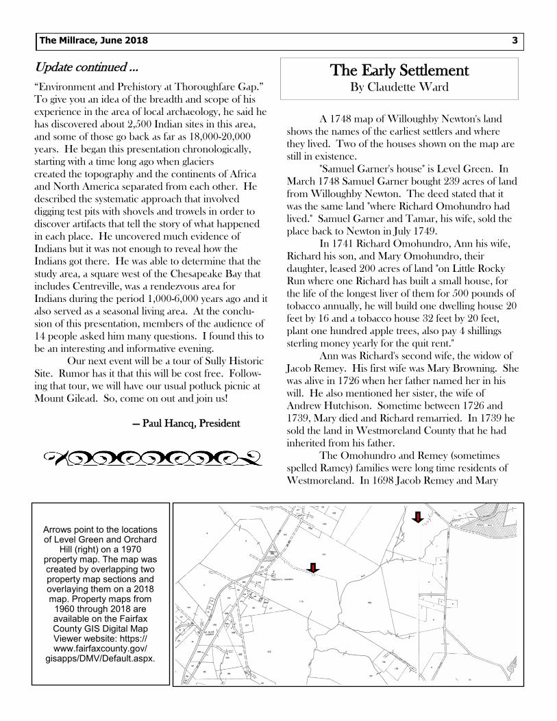
Arrows point to the locations of Level Green and Orchard
Hill (right) on a 1970 property map. The map was created by overlapping two property map sections and overlaying them on a 2018 map. Property maps from
1960 through 2018 are available on the Fairfax County GIS Digital Map Viewer website: https://www.fairfaxcounty.gov/
gisapps/DMV/Default.aspx.

Early Settlement continued ….
Remey witnessed the will of Joseph Hardwich. They
were most likely the parents of Ann's husband. Richard
Omohundro and Ann were probably married in
Westmoreland before they moved up to this area.
Ann's son Jacob Remey had a lease from W. Newton
in 1739 for land near Level Green (He also had a son
named Jacob).
Richard Omohundro died in 1745. He either
added to the original small house or built a larger one,
but the present day house is believed to have been
built by him (others may have added on to it later).
Richard Omohundro, Andrew Hutchison, Thomas
Brown, and Coleman Read (Brown's father-in-law)
were on a jury in Westmoreland County in 1735 and
1736 to decide a land issue. Andrew Hutchison
patented 1,119 acres of land on Salisbury plain
(between present day Centreville and Chantilly) in July
1726.
Richard Omohundro, Andrew Hutchison,
Thomas Brown, Jacob Remey, John Goram and
William Buckley were on the Poll list of 1744, for the
election of Burgesses for Fairfax County.
The other house on the 1748 map that still
exists was marked "John Goram's house." It is the
house we now know as "Orchard Hill." (I don't know
when or by whom it acquired that name.)
In October 1739 Willoughby Newton leased
200 acres to John Goram "where one Paul Howell for-
merly built a small house, on Little Rocky Run, a little
above the rolling road." The present house may have
been built by Goram in 1740. There are many
references to Goram in the Loudoun County records.
1762 - John Goram testified for Joseph Brown
(this was the case where Joseph Brown said his father
Thomas Brown gave him two slaves.)
1764 - Thomas Goram was added to the list of
tithables (meaning he was now 16 years old)
1766 - John Goram, Jr. was appointed Consta-
ble to replace Jacob Remey, Jr.
1766 - Orphans Zachariah Jenkins, 10 years
old, and Elizabeth Barett, 6 years old, were bound out
to John Goram, a shoe maker.
In 1764, a 3 year old orphan, James Buckley,
was bound out to William Buckley to teach him the
trade of a Cordwainer. This is interesting, there were
two shoe makers in the area as early as 1764 and 1766.
Was there a tannery that early?
More interesting though is that a license for an
ordinary "on the mountain road near Little Rock Run"
was issued to Sanford Goram for 1766-1768. Other
ordinaries on the mountain road were John Peake
1752-1768: "John Peake a resident of the area above
the Mountain Road to the west of the Rocky Run
Church founded an ordinary in his house in 1752."
The Newgate Tavern site was purchased by
William Carr Lane from John Newton in 1761. Lane's
license to keep an ordinary was recorded in 1768 and
1769.
In 1760 John Newton, Willoughby Newton's
son, sold the Level Green property to William Carr
Lane.
The earliest settlers lived here before it was
Centreville or even Newgate. The early land patents
were issued when this was part of Stafford County.
From 1731 to 1742 it was Prince William County.
Fairfax County from 1742 to 1757, when the area west
of Difficult Run became Loudoun County until 1798
when it was given back to Fairfax.
Thus you may find, as I did, that someone who
lived in Prince William County, then Fairfax, and died
in Loudoun County, didn't move at all!
The Millrace, June 2018 4
Arrows point to the locations of Level Green and Orchard Hill (right) on a 2018 property map. The straight road that cuts across the image is New Braddock Road.. Fairfax County GIS Digital Map Viewer website: https://www.fairfaxcounty.gov/gisapps/DMV/Default.aspx.

The [Washington Post] April 16 front-page
article “Expanding the Civil War’s narrative” reported
on Christy Coleman’s efforts at inclusiveness in relat-
ing Civil War history as the new chief executive of the
American Civil War Museum. She said “you can learn
something from anything.” I agree.
Many years ago, as a young bride, so proud of
my new diamond-and-gold band, I was captivated by a
wedding ring carved from a peach pit by a Southern
soldier. It was in a small Confederate museum in
Front Royal, Va., and was accompanied by a note
from the groom to his intended stating that he had
nothing left to give her but his love and a humble little
peach pit of a ring. I hope she said yes because I’ve
carried the spirit of that ring in my heart ever since.
As a privileged child of suburbia, it made me
think about what it means to be human — and
American. As Americans, we may have many points of
view, and we may fight for what we think is right, even
though it might not always be, but, if or when we lose,
we pick ourselves back up and persevere. Love and
the human spirit can endure. Life can go on even
when one loses all, and there’s always the hope for a
new and better future. Somehow, that dried-up
Confederate ring conveyed the essence of the
American ethos better than any great seal or billowing
flag.
You can indeed learn something from any-
thing, even a peach pit. Reprinted Letter to the Editor, Washington Post, April 20, 2018. Printed with the permission of the author.
Remembering the 1950’s. When I was three
years old, in 1955, my family moved from Annandale,
Virginia to a small farm in Centreville. It was a good
place to grow up. I stayed until college, jobs, and a
husband moved me further south. My parents, grand-
parents, and aunt were residents of Centreville until
their deaths.
So, imagine my surprise when at my local
library book sale, I found a book titled From a Country Boy’s View: Clifton, Virginia – the 1950’s. It
was written by Michael (Mike) Foley, Sr. His family
moved from Falls Church to Clifton, Virginia on
February 1, 1951. That was the day before his third
birthday. His family lived in Clifton until he was
fifteen. Then the family moved to a subdivision in
Fairfax.
It has been enjoyable reading Foley’s experi-
ences, which mirrored many of my own. If you are
interested in life in western Fairfax County in the
1950’s you might enjoy this book, too. I looked at the
on-line catalog and it is available at the Fairfax County
Library, but I don’t think it can be checked out. Some
of you longtime residents might even recognize some
of the people mentioned in this book, but I did not.
—Bonnie Wood Garber, Spotsylvania County, VA
The Millrace, June 2018 5
Yes, ‘You Can Learn
Something from Anything’ By Margo Khosravi
OFF THE SHELF: Where Readers Recommend & Share
Books on History

In the days following the first Battle of
Manassas, journalists in the north and the south were
seeking to define the character of their enemy. The
discovery that a modest church in a small town had
been desecrated by soldiers thus became a newsworthy
subject, debated on the front page of New York
Times.
Seven days after the Confederate victory on
July 21, 1861, the London Morning Herald’s special
correspondent to the Richmond Daily Dispatch, took
a tour of the battleground and General James
Longstreet’s camp at Centreville. Though his name is
never given, the correspondent was likely Samuel
Phillips Day. During the course of the visit, General
Longstreet escorted Day to “the little Episcopal church
on the hill.” There, Day “was perfectly horrified upon
beholding the sacrilegious manner in which a building
devoted to the worship of the Omnipotent had been
desecrated and polluted by the enemy.” Drawings and
inscriptions written in charcoal covered every wall,
even “the very neighborhood of the altar … for in close
proximity to it I read the words ‘Death to Traitors —
thus saith the Lord!’ This sentiment was accompanied
by a sketch of Jefferson Davis hanging from a gallows.
Outraged, Day concluded that “there can be no
palliation for such a crime.”
After reading Day’s account, a New York Times reporter, who wrote under the name “Leo,”
denied that Union soldiers were responsible for
vandalizing Saint John’s Church and asserted instead
that the names scrawled on the walls, “were there
before the Union troops ever reached Centreville.”
Leo’s story, printed on the front page of the paper,
recounted how he had arrived with General
McDowell’s column before the battle and found that
the church vestry room had been used as a headquar-
ters and the main body of the church had quartered
troops: “for around the church were evidences that
The Millrace, June 2018 6
Photographers in March 1862 captured the only known image of the original St. John’s Church, showing some of the damage it had sustained. Photograph by George Barnard and James Gibson, March 1862, Library of Congress.
The Desecration of
Saint John’s Church By Cheryl Repetti

Saint John’s Church continued ….
horses had been picketed there, and in the pew-seats
were the remains of straw beds, or litter upon which
the men had slept. There were bits of bridles and one
old saddle on the floor, and scraps of paper upon
which had been written memorandums relating to
cavalry service.” Leo, “having been educated to some
respect for the Episcopal service” asked that a guard
be placed to protect the church. Noting the that there
had been a Confederate camp nearby, Leo concluded
that those who had desecrated the church, were those
who had also desecrated “the altars of patriotism.”
Leo didn’t comment on the anti-Confederate
sentiments described by the British journalist, he
simply asserted that Day had “perverted the facts” (a
few days later the Times did reprint part of Day’s
account, including the anti-Confederate epithets).
Another Richmond correspondent, however, also saw
the church and added new details that supported
Day’s description:
The chancel had been torn to pieces. Nearly every spot on the walls, as high as it was possible for a man to reach, was covered with large fire coal sketches and inscriptions, a few specimens of which I will give you. Jefferson Davis is represent-ed as hanging on a gallows with a most disgusting inscription below. In another place he was represented with his arms stretched out, as if nailed to a cross, and lastly he was portrayed as if dropping into a coffin, with the words above, "Old
Jeff. going into the box." Above the pulpit, in large letters was "Death to traitors — thus saith the Lord."
This reporter, who went by the initials H.R.S.,
also visited the Old Stone Church, which had been
used as a hospital by Federal troops:
As I walked from the church with a sad heart, meditating on the deep degradation of fallen nature, I stepped into the hospital where were collected a large number of the wounded Yankees; and there I saw our own people striving to the extent of their ability to retrieve their suffer-ings and promote their comfort. … I need not say how deeply I was impressed by the contrast which these two churches — less than two hundred yards apart — presented.
But Leo’s account of Centreville also rings
true. He gives a detailed description of how he found
the church copy of the Bible and some prayer books
and then walked through town, knocking on doors,
searching for someone willing to care for the books
until the church once again resumed its function as a
house of worship. Eventually he found “Mrs.
Alexander, … a lady, wife of the resident physician,
who not only joyfully received the books, but warmly
thanked me for having brought them to her.” The
Alexanders occupied a house on Braddock Road near
the present location of the Centre Square Professional
Park.
Soon enough, the desecration of an un-
occupied church would no longer be regarded as
newsworthy. Atrocities would overshadow petty
vandalism, and pain and weariness would replace self-
righteousness and the rationalizations for war. But in
the summer of 1861, the thought of men deliberately
damaging a sacred place of worship still had the power
to outrage and disturb. This was apparent not only on
the front pages of the Times, but in the stories that
circulated in the camps that summer and appeared in
letters home. In one version, a Union soldier who
raised his gun up to smash one of the church
windows and was killed when the gun suddenly
discharged. A variation of this tale was recounted by a
member of Longstreet’s staff, Thomas Jewett Goree,
who wrote to his sister that, “it seems like a just
retribution that the man’s name written the oftenest
was killed in the battle and buried within steps of the
Church he had so desecrated.”
Historic sites with Civil War graffiti are prized
today, as the inscriptions create a palpable link to the
common soldiers who fought the war. By war’s end,
however, much of “the little Episcopal church on the
hill” was destroyed. Had the old church and the graffiti
been preserved, historians today could trace the
names and perhaps determine objectively who had
desecrated the church. But perhaps it is better that the
passions that fed the war have been lost, while Saint
John’s remains. Rebuilt beginning in 1867 on the
foundations of the old building, the new church, as
one of Saint John’s pastors once expressed it, is
testament to how people in Centreville were “still
faithful after the ravages of war.”
The author is indebted to the Reverend John Kempsel for the “still faithful” phrase that also serves as the title for the Civil War Trails sign located at Saint John’s Church.
The Millrace, June 2018 7

Do you have a friend who might like to join the society?
Pass on our newsletter and bring potential members to meetings.
Members receive The Millrace four times a year.
If you have an article or a book review or recommendation
that might be of interest to our members, please send it to
the editor.
Deadlines for submissions are the 1st of February, May, August
and November.
Send to: to Cheryl Repetti at [email protected]
or by US mail to:
The Historic Centreville Society, P.O. Box 1512, Centreville, VA 20122
OFFICERS & DIRECTORS
Paul Hancq, President; Ted McCord, First Vice President; Cheryl Repetti, Second Vice President;
Claudette Ward, Secretary; Linda Mellott, Treasurer; Joan Orvis, Debbie Robison, Michael Frey
The Historic Centreville Society
P.O. box 1512
Centreville, VA 20122
The Millrace, June 2018 8
Detail from “Ruins of the bridge over the Shenandoah. Loudon Heights beyond.” By Alfred Waud, Fall, 1864.
Library of Congress. http://www.loc.gov/pictures/