summary report on amendments to arlington … report on amendments to arlington county’s...
TRANSCRIPT
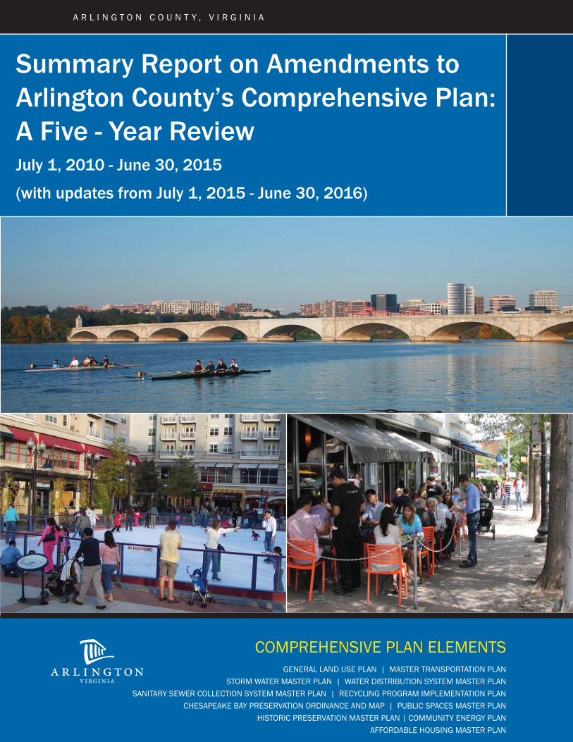
GENERAL LAND USE PLAN | MASTER TRANSPORTATION PLANSTORM WATER MASTER PLAN | WATER DISTRIBUTION SYSTEM MASTER PLAN
SANITARY SEWER COLLECTION SYSTEM MASTER PLAN | RECYCLING PROGRAM IMPLEMENTATION PLANCHESAPEAKE BAY PRESERVATION ORDINANCE AND MAP | PUBLIC SPACES MASTER PLAN
HISTORIC PRESERVATION MASTER PLAN | COMMUNITY ENERGY PLANAFFORDABLE HOUSING MASTER PLAN
Summary Report on Amendments to Arlington County’s Comprehensive Plan:A Five - Year ReviewJuly 1, 2010 - June 30, 2015
(with updates from July 1, 2015 - June 30, 2016)
COMPREHENSIVE PLAN ELEMENTS
A R L I N G T O N C O U N T Y , V I R G I N I A
Summary Report on Amendments to Arlington County’s Comprehensive Plan: A Five-Year Review
July 1, 2010 – June 30, 2015 with updates from July 1, 2015 – June 30, 2016
February 21, 2017
3
Table of Contents
I. Introduction ............................................................................................................ 4
II. The Comprehensive Plan .......................................................................................... 5
Background ............................................................................................................ 5
Goals and Objectives ............................................................................................... 5
Elements of the Comprehensive Plan ........................................................................ 7
III. Summary Report…………………………………………………………………………………………………..17
Major Achievements and Amendments………………………………………………………….………..17
IV. Updates from July 1, 2015 to June 30, 2016…………………………………………………………...25
Major Achievements and Amendments……………………………………………………………………25
V. Upcoming Reviews of the Comprehensive Plan ………………………………….……………………27
VI. Public Review Process……………………………………………………………………………….………….30
VII. Appendices…………………..………………………………………………………………………………………31
A. Excerpts from the Code of Virginia…………………………………………………………………….31
B. Awards…………..………………………………………………………………………………………………35
C. Planning Commission Recommendations…………………………………………………..……….41

Arlington will be a diverse and inclusive world–class urban community with
secure, attractive residential and commercial neighborhoods where people
unite to form a caring, learning, participating, sustainable community in
which each person is important.
Arlington County Vision
4
I. Introduction The Code of Virginia requires all governing bodies in the Commonwealth to have an adopted
Comprehensive Plan and for the local planning commission to review the plan at least once
every five years.1 The Comprehensive Plan was established in order that Arlington County may
remain a safe, healthy, convenient and prosperous community and an attractive place in which
to live, work and play, with stable or expanding values and potentialities for growth and
continued economic health. The purpose of the Comprehensive Plan is to guide the
coordinated and harmonious development of Arlington County through the provision of high
standards of public services and facilities.
Since its original adoption, Arlington’s Comprehensive Plan has been continually updated and
expanded and now comprises several elements including the General Land Use Plan, the Master
Transportation Plan, the Storm Water Master Plan, the Water Distribution System Master Plan,
the Sanitary Sewer Collection System Master Plan, the Recycling Program Implementation Plan
and Map, the Chesapeake Bay Preservation Ordinance and Plan, the Public Spaces Master Plan,
the Historic Preservation Master Plan and the Community Energy Plan.2 The Summary Report
on Amendments to the Comprehensive Plan provides the County Board the opportunity to
review the changes made to the Comprehensive Plan over the past five years. This review
helps the County Board determine whether any element of the Comprehensive Plan should be
amended within the next five-year period. Staff concludes that, in general, the Comprehensive
Plan continues to address the land use goals and planning policies adopted by the County
Board. However, during the next five years, updates to certain elements of the Comprehensive
Plan may be needed.
The Planning Division of the Department of Community Planning, Housing and Development
has prepared this report primarily as a summary of the amendments to the Comprehensive Plan
approved by the County Board between July 1, 2010 and June 30, 2015. The report is divided
into eight primary sections. Sections I and II provide an overview of this document and a brief
description of each element of the Comprehensive Plan. Section III summarizes updates and
amendments to the Comprehensive Plan elements and sub-elements. Section IV provides
updates from June 30, 2015 to July 1, 2016. Section V includes a list of initiatives related to the
Comprehensive Plan elements and sub-elements that may be undertaken between now and
2020. Section VI provides a summary of the public review process, while Section VII is the
appendix which includes excerpts from the Code of Virginia, a listing of awards related to the
County’s Comprehensive Plan elements and concludes with recommendations from the Planning
Commission.
1 See appendix for excerpts from the Code of Virginia. 2 See section IV for an update to the list of Comprehensive Plan elements from July 1, 2015 to June 30, 2016.

5
II. The Comprehensive Plan as of June 30, 2015
Background The Code of Virginia requires all governing bodies in the Commonwealth to have an adopted
Comprehensive Plan. Arlington County’s Comprehensive Plan was established by resolution of
the County Board on August 27, 1960. This resolution called for the preparation of Arlington
County’s Comprehensive Plan, which originally included five elements: the General Land Use
Plan, the Water Distribution System Master Plan, the Sanitary Sewer Collection System Master
Plan, the Storm Sewer Plan and the Major Thoroughfare and Collector Streets Plan. In later
years, additional elements were added to the Comprehensive Plan and some were replaced by
new plans. For example, the Major Thoroughfare and Collector Streets Plan was replaced in
1986 by the Master Transportation Plan. Elements added to the Comprehensive Plan include
the Recycling Program Implementation Plan and Map in 1990, the Chesapeake Bay Preservation
Ordinance and Plan in 1992, the Open Space Master Plan, now the Public Spaces Master Plan,
in 1994, the Chesapeake Bay Preservation Ordinance and Plan in 2001, the Historic Preservation
Master Plan in 2006 and the Community Energy Plan in 2013.
Goals and Objectives The Comprehensive Plan was established in order that Arlington County may remain a safe,
healthy, convenient and prosperous community and an attractive place in which to live, work
and play, with stable or expanding values and potentialities for growth and continued economic
health. The purpose of the Comprehensive Plan is to guide the coordinated and harmonious
development of Arlington County through the provision of high standards of public services and
facilities based on the following general principles3:
Retention of the predominantly residential character of the County, and limitation of
intense development to limited and defined areas;
Promotion of sound business, commercial and light industrial activities in designated areas appropriately related to residential neighborhoods;
Development of governmental facilities which will promote efficiency of operation and optimum public safety and service, including the areas of health, welfare, culture and recreation;
Provision of an adequate supply of water effectively distributed;
Maintenance of sewage disposal standards acceptable to the immediate County area and its neighbors in the entire Washington Metropolitan Area and consistent with the program of pollution abatement of the Potomac River;
Provision of an adequate storm water drainage system; and
Provision of an adequate system of traffic routes which is designed to form an integral part of the highway and transportation system of the County and region, assuring a safe, convenient flow of traffic, thereby facilitating economic and social interchange in the County.
3 These principles were included in the County Board Resolution concerning the Comprehensive Plan
adopted by the County Board in 1960.

6
In addition, the County Board has endorsed a land use policy which has evolved from an
extensive citizen participation process and is designed to ensure that Arlington is a balanced
community which provides residential, recreational, educational, health, shopping and
employment opportunities with good transportation supported by a strong tax base and the
effective use of public funds. An overarching theme of many of Arlington’s initiatives, from land
use to transportation to stormwater management, is that of sustainability and transit-oriented
development. In support of Arlington’s overall policy goals, the following adopted land use
goals and objectives have been incorporated into the Comprehensive Plan4:
Concentrate high density residential, commercial and office development within designated Metro Station Areas in the Rosslyn-Ballston and Jefferson Davis Metrorail transit corridors. This policy encourages the use of public transit and reduces the use of motor vehicles.
Promote mixed-use development in Metro Station Areas to provide a balance of residential, shopping and employment opportunities. The intent of this policy is to achieve continuous use and activity in these areas.
Increase the supply of housing by encouraging construction of a variety of housing types and prices at a range of heights and densities in and near Metro Station Areas. The Plan allows a significant number of townhouses, mid-rise and high-rise dwelling units within designated Metro Station Areas.
Preserve and enhance existing single-family and apartment neighborhoods. Within Metro Station Areas, land use densities are concentrated near the Metro Station, tapering down to surrounding residential areas to limit the impacts of high-density development. Throughout the County, the Neighborhood Conservation Program and other community improvement programs help preserve and enhance older residential areas and help provide housing at a range of price levels and densities.
Preserve and enhance neighborhood retail areas. The County encourages the preservation and revitalization of neighborhood retail areas that serve everyday shopping and service needs and are consistent with adopted County plans. The Commercial Revitalization Program concentrates public capital improvements and County services in these areas to stimulate private reinvestment.
Other goals and objectives have been incorporated into the Comprehensive Plan through the
years, including the provision of an adequate supply of beneficial open space which is safe,
accessible and enjoyable, as outlined in the Public Spaces Master Plan, energy goals as
described in the Community Energy Plan, and targets for affordable housing, as set forth in the
General Land Use Plan.
4 These goals and objectives were incorporated into the General Land Use Plan (an element of the
Comprehensive Plan) which is the primary policy guide for the development of Arlington County.

7
Elements of the Comprehensive Plan As of June 30, 2015, Arlington County’s Comprehensive Plan is comprised of the following ten elements: General Land Use Plan Master Transportation Plan
o Goals & Policies Element o Map Element o Bicycle Element o Pedestrian Element o Transportation Demand & System Management Element o Transit Element o Parking & Curbspace Management Element o Streets Element
Storm Water Master Plan Water Distribution System Master Plan Sanitary Sewer Collection System Master Plan Recycling Program Implementation Plan and Map Chesapeake Bay Preservation Ordinance and Plan Public Spaces Master Plan
o Urban Forest Master Plan o Natural Resources Management Plan o Public Art Master Plan
Historic Preservation Master Plan Community Energy Plan5 Although the Planning Division in the Department of Community Planning, Housing and
Development is responsible for the overall coordination and review of the Comprehensive Plan,
several agencies within Arlington County are responsible for the review of the specific elements
that make up the Comprehensive Plan. A description of each element and the name of the
agency responsible for that element follows. The most recent version of each element is
available on the County’s Comprehensive Plan webpage.
General Land Use Plan Initial Adoption: August 12, 1961
Current Plan: General Land Use Plan with amendments through December 10, 2011 (print version); General Land Use Plan updated quarterly with all amendments (web version)
Purpose and Scope: The General Land Use Plan is the primary guide for the future development of the County. The plan establishes the overall character, extent and location of various land uses and serves as
5 See section IV for an update (Affordable Housing Master Plan) to the list of Comprehensive Plan elements from July 1, 2015 to June 30, 2016.
8
the guide to communicate the policy of the County Board to citizens, businesses, developers and others involved in the development of the County. In addition, the General Land Use Plan serves as a guide for the County Board in its decisions concerning future development.
The County first adopted a General Land Use Plan in 1961. Since then, the plan has been updated and periodically amended to more clearly reflect the intended use for a particular area. The plan is amended either as part of a long-term planning process for a designated area or as the result of an individual request for a specific change. Since its initial printing, there have been numerous updates and amendments to the General Land Use Plan.
Any person may request a change to the General Land Use Plan by writing a letter to the Chairman of the County Board identifying the specific area and requested General Land Use Plan designation.
Publications: The General Land Use Plan was first printed in 1961. Reprintings, to reflect revisions to the Plan, have taken place in 1964, 1966, 1975, 1979, 1983, 1987, 1990, 1996, 2004 and 2011. The General Land Use Plan is also available online and is updated biannually to reflect ongoing amendments.
Agency Responsible: Department of Community Planning, Housing and Development; Planning Division
Master Transportation Plan Initial Adoption: 1941
Current Plan: Master Transportation Plan:
Goals & Policies Element (2007) - This document presents the County’s long-term goals and policies for transportation. It provides a policy framework to guide the development of projects and programs, advance the County’s goals and objectives and help direct investment in transportation facilities and services.
Map Element (2007) - This document is the County’s official map of planned and existing public streets, transit facilities and bikeways. The document includes three separate maps, one each for existing and planned Streets, Bikeways and Transit routes. This map is amended periodically to reflect changes to the transportation network that are specified during other planning processes, such as for sector or site plans.
9
Bicycle Element (2008) - This document provides polices and implementation measures for completing the planned bikeway network, increasing bicycle use, enhancing safety, managing and maintaining bicycle facilities and better integrating bicycling with other modes. Included in the document is a listing of more than 100 facilities to be constructed or improved in order to complete Arlington’s planned bikeway network.
Pedestrian Element (2008) - This document establishes policies, implementation actions and design guidance for the development and improvement of the pedestrian walkway network in Arlington. Primary principles include achieving ADA-accessibility, better network connectivity, improved pedestrian safety and encouragement of higher levels of pedestrian travel.
Transportation Demand & System Management Element (2008) - This document provides policies and implementation strategies for Transportation Demand Management (TDM) measures to influence travel behavior and mode choice in such a way as to maximize the efficiency and sustainable use of transportation facilities. Also addressed are Transportation System Management (TSM) measures that make better use of the existing transportation system by better tailoring the supply to existing demand.
Transit Element (2009) - This document specifies policies, implementation actions and new or upgraded facilities and services that will encourage and accommodate planned growth in the use of public transit within Arlington. The plan establishes networks of transit service based upon service frequency, quality and coverage that are tailored to meet the anticipated demand of adjacent land uses.
Parking & Curb Space Management Element (2009) - This document provide policy guidance related to the provision, and management of both on and off-street parking resources in the County. In addition, the plan establishes a scheme for prioritization for use of curb space on publicly-managed streets.
Streets Element (2011) - This document focuses on the multi-modal use of public streets and rights-of-way. It provides policies for the development of a well-connected network of public streets that are compatible with adjacent land uses and which provide for comfortable and safe use by all travelers. Included is a new street typology that guides the design and operation of locally-managed arterial and neighborhood streets.
Purpose and Scope: Arlington’s original transportation plan was the Major Thoroughfare and Collector Streets Plan. Since its adoption in 1941, the plan has been updated and expanded to address multiple travel modes. For streets, the initial plan of 1941 was

10
updated in 1960 and 1975, and became part of the 1986 Master Transportation Plan. For bikeways, the initial plan adopted in 1974 was updated in 1977, 1986 and again in 1994 as part of the Master Transportation Plan. The initial Master Transit Plan adopted in 1976 was partially updated in 1989 with the inclusion of the Paratransit Plan. The 1978 Master Walkways Policy Plan was also updated in 1986 as a part of the Master Transportation Plan and in 1997 as the Pedestrian Transportation Plan.
The Master Transportation Plan establishes the principles to guide the implementation of transportation facilities to address future transportation needs and challenges in Arlington County. The Master Transportation Plan provides:
the overall rationale for developing transportation facilities (transit networks, roads, walkways and/or bikeways) to meet future travel needs;
a basis for establishing County transportation-related program priorities;
a framework for offering advice to other agencies responsible for transportation in this area; and
an overall direction to guide transportation projects in Arlington County.
In October 2004, the Arlington County Board directed the Transportation Commission and County staff to undertake an update of the County's Master Transportation Plan. Eight elements constitute the updated Master Transportation Plan and seven of the eight individually written components were adopted by June 30, 2010. Completion of the final component, the Streets Element, occurred in February 2011 (see section IV for update).
Publications: The adopted elements of the Master Transportation Plan were printed between 2007 and 2011 and are also available online.
Agency Responsible: Department of Environmental Services; Transportation Division Storm Water Master Plan Initial Adoption: December 1957
Current Plan: September 2014
Purpose and Scope: The County Board originally adopted the Storm Sewer Plan in 1957. In 1975, Water Resources Engineers, Inc. prepared the Four Mile Run Watershed Runoff Control Program Hydrology Report, which included a computer model of the watershed. The purpose of this study was to provide the tools to help ensure that new development and redevelopment do not increase the one percent annual flow in Four Mile Run. The one percent annual

11
flow is the flow that on average will be equaled or exceeded once every 100 years.
The Storm Water Master Plan (1996) and Watershed Management Plan (2001) were updated and combined into a comprehensive Storm Water Master Plan that was adopted by the County Board on September 20, 2014. The plan contains information on the condition of the County’s stormwater management systems, streams and watersheds, in addition to prioritizing projects.
Publications: The Storm Water Master Plan was printed in September 2014 and is available online.
Agency Responsible: Department of Environmental Services; Office of Sustainability and Environmental Management
Water Distribution System Master Plan Initial Adoption: March 15, 1958
Current Plan: May 2014
Purpose and Scope: The Water Distribution System Master Plan, adopted by the County Board in September 2014, is the policy document that guides the operation, maintenance and expansion of the County water system. The plan evaluates the existing water distribution system facilities and operation practices and determines the policy and facility improvements that will be necessary to provide and maintain the desired quality of service.
Publications: The Water Distribution System Master Plan was printed in September 2014.
Agency Responsible: Department of Environmental Services; Water, Sewers, Streets Bureau
Sanitary Sewer Collection System Master Plan Initial Adoption: September 23, 1961
Current Plan: September 2002
Purpose and Scope: The Arlington County sanitary sewer collection system collects and treats wastewater produced in Arlington County and some adjoining portions of Fairfax County, the City of Alexandria and the City of Falls Church. The Sanitary Sewer Collection System Master Plan, adopted by the County Board in December 2002, evaluates the current sanitary sewer collection system facilities, practices and programs and determines the policies and facility improvements needed to provide and maintain adequate service now and in the future.

12
Publications: The Sanitary Sewer Collection System Master Plan was printed in December 2002.
Agency Responsible: Department of Environmental Services; Water, Sewers, Streets Bureau
Recycling Program Implementation Plan and Map Initial Adoption: December 8, 1990
Current Plan: Recycling Program Implementation Plan, February 1990; Recycling Centers Map, December 2008
Purpose and Scope: The Recycling Program Implementation Plan was prepared in compliance with a requirement in the Code of Virginia to include the location of existing recycling centers in the Comprehensive Plan. The purpose of the plan is to provide a guide for the development of effective recycling programs in Arlington. The plan includes major recommendations related to the implementation of multi-material curbside collection of source separated recyclables from single-family dwellings; the implementation of a multi-material source separation recycling in the multifamily and commercial waste segments; planning of a materials recovery facility to serve the County; and, the implementation of a public education/promotion program which stresses source reduction and recycling. The plan also includes a map that shows the location of existing recycling centers.
Publications: The Recycling Program Implementation Plan was printed in February 1990 and the Recycling Centers Map was first printed in April 1995, with an updated version printed in December 2008. Both are available online.
Agency Responsible: Department of Environmental Services; Solid Waste Bureau Chesapeake Bay Preservation Ordinance and Plan Initial Adoption: May 1992 (original ordinance); April 2001 (plan); February 2003
(revised ordinance); July 2014 (revised ordinance)
Current Plan: Same
Purpose and Scope: Arlington County is required to adopt and maintain a Chesapeake Bay element of its Comprehensive Plan, under the provisions of 9 VAC 10-20-220(A)(2) (renumbered 9 VAC 25-830-170). The purpose of the Chesapeake Bay Preservation Plan is to satisfy this requirement of the Chesapeake Bay Preservation Area Designation and Management Regulations. The plan addresses the following issues: Arlington County’s water resources; existing and potential sources of pollution; existing County programs that address water
13
quality management; policies and programs that relate to the County’s implementation of the Chesapeake Bay Preservation Ordinance; and implementation measures to protect and improve the County’s streams and riparian buffers adjacent to streams.
Publications: The Chesapeake Bay Preservation Plan was printed in April 2001 and is available online.
Agency Responsible: The Department of Environmental Services; Office of Sustainability and Environmental Management
Public Spaces Master Plan Initial Adoption: September 1994 (Open Space Master Plan)
Current Plan: The Public Spaces Master Plan replaced the Open Space Master Plan in December 2005.
Purpose and Scope: The Public Spaces Master Plan provides policy guidance for the future of Arlington's public space. The plan is designed to establish the overall character, extent and location of public space. The plan includes objectives, strategies and recommended actions designed to ensure the provision of an adequate supply of beneficial public space, which is safe, accessible and enjoyable for this and future generations in the County. The Public Spaces Master Plan also identifies open space deficiencies and potential acquisition sites. The plan sets forth six major objectives to guide policy-making, public investments and County management of public spaces during the next two decades. The objectives are to balance acquisition and development of public spaces; preserve and enhance the environment; improve access and usability; enhance arts, culture and history; develop and enhance partnerships; and manage assets effectively. The Department of Parks and Recreation began working on an update to the Public Spaces Master Plan in early 2015. The update is expected to be completed in 2017.
Arlington’s Urban Forest Master Plan, an element of the Public Spaces Master Plan, was initiated by the Department of Parks and Recreation and Arlington’s Urban Forestry Commission, under the direction of the Arlington County Board, to facilitate the County’s ongoing commitment to enhance and preserve Arlington’s tree canopy. The plan was adopted by the County Board in July 2004. The Master Plan has the following components: a Geographic Information Systems (GIS) street tree inventory, a tree canopy satellite analysis, long-range goals and recommendations, along with a final Urban Forest Master Plan report including GIS-based planting plans. In 2008 and 2011, updated satellite analyses of tree canopy coverage were conducted for Arlington County. The analyses provided Arlington with the ability to compare recent
14
changes in tree canopy coverage, which decreased from approximately 43% in 2008 to 40% in 2011. They also provide Arlington with GIS layers that enable staff to calculate tree canopy coverage (and changes) in any geographical area of the County, such as within individual civic associations, land use areas, residential neighborhoods and business corridors. The Department of Parks and Recreation will update the Urban Forest Master Plan in 2017/2018, after completion of the updated Public Spaces Master Plan. The updated Urban Forest Master Plan will contain canopy coverage goals and strategies that will ultimately contribute to the attractiveness and sustainability of Arlington.
As one of its priority recommendations, the 2005 Public Spaces Master Plan called for the creation of a “Natural Resource Policy and Management Plan.” The Natural Resources Management Plan, an element of the Public Spaces Master Plan, was adopted in November 2010. This plan defines natural resource issues and recommends policies and actions to preserve Arlington’s natural resources. The Department of Parks and Recreation will update the Natural Resources Management Plan in 2017/2018 to reflect additional goals and management strategies to preserve Arlington’s natural resources.
The Public Art Master Plan, another element of the Public Spaces Master Plan, outlines a strategy for how public art, with elevated standards for design, architecture and landscape architecture, will improve the quality of public spaces and the built environment in Arlington for civic placemaking. The creation of Arlington’s first Public Art Master Plan was stipulated by the Public Art Policy adopted by the County Board in September 2000 to help refine the policy’s direction that public art should be sited in “prominent locations.” The Public Art Master Plan defines “prominent” as a confluence of civic, residential, and commercial activities, as well as an opportunity for public art as provided by a Capital Improvement Program or other major capital project within which the public art would be an integrated component. The master plan provides guidance for project prioritization and implementation processes for public art associated with County-funded projects, site plan/special exception projects and community-initiated projects. The master plan’s development included a survey of other planning processes and initiatives, including sector plans, Neighborhood Conservation Plans and studies to ensure that its recommendations would be in support of these other policy tools. An update is currently being drafted.
Publications: The Open Space Master Plan was printed in September 1994, the Urban Forestry Master Plan in July 2004 and the Public Art Master Plan in December 2004. The Public Spaces Master Plan, which replaced the Open Space Master Plan, was printed in 2005. The

15
Natural Resources Management Plan was adopted in November 2010.
Agency Responsible: Department of Parks and Recreation; Park Development Division Historic Preservation Master Plan Initial Adoption: December 9, 2006
Current Plan: Same Purpose and Scope: The Historic Preservation Master Plan is the primary guide for
historic resources in the County. The purpose of this plan is to establish proactive priorities, goals, and objectives for County historic preservation activities that involve the historic built environment and County history in general. The Historic Preservation Master Plan serves as a guide to communicate the County’s historic preservation policies to citizens, businesses, developers, and others.
The County adopted the Historic Preservation Master Plan in 2006.
Publications: The Historic Preservation Master Plan was first printed in 2008 and is available online.
Agency Responsible: Department of Community Planning, Housing and Development; Neighborhood Services Division
Community Energy Plan Initial Adoption: June 15, 2013
Current Plan: Same
Purpose and Scope: The Community Energy Plan is a roadmap for transforming how the Arlington community uses, generates, distributes, and stores energy. The purpose of this plan is to define the community’s energy goals and describe the energy policies that will help Arlington remain economically competitive, environmentally committed, and have secure energy sources.
Accompanying the CEP is the Community Energy Plan Implementation Framework (CEP Implementation Framework). The CEP Implementation Framework lays out the strategies that the County will deploy as well as the tools – both existing and potential – that could be used to advance the goals and policies of the CEP. The County will work with stakeholders to ensure CEP

16
implementation improves Arlington’s economic competitiveness, energy security, and environmental commitment.
The County adopted the Community Energy Plan in 2013. The first update to the plan will be in 2018.
Publications: The Community Energy Plan is available online.
Agency Responsible: Department of Environmental Services; Office of Sustainability and Environmental Management
17
III. Five-Year Review of the Comprehensive Plan
July 1, 2010 – June 30, 2015
The Virginia State Code (Section 15.2-2230) provides that:
“At least once every five years the comprehensive plan shall be reviewed by the local planning commission to determine
whether it is advisable to amend the plan.” The statute, however, does not set specific standards to determine what constitutes a
review of the Comprehensive Plan or how such a review should be conducted. In
Arlington, the documents that comprise the Comprehensive Plan are reviewed and
amended on a continuing basis, as needed. However, every five years, the Planning
Commission and the County Board receive an update summarizing the reviews and
amendments to the Comprehensive Plan which have taken place during the allotted
timeframe.
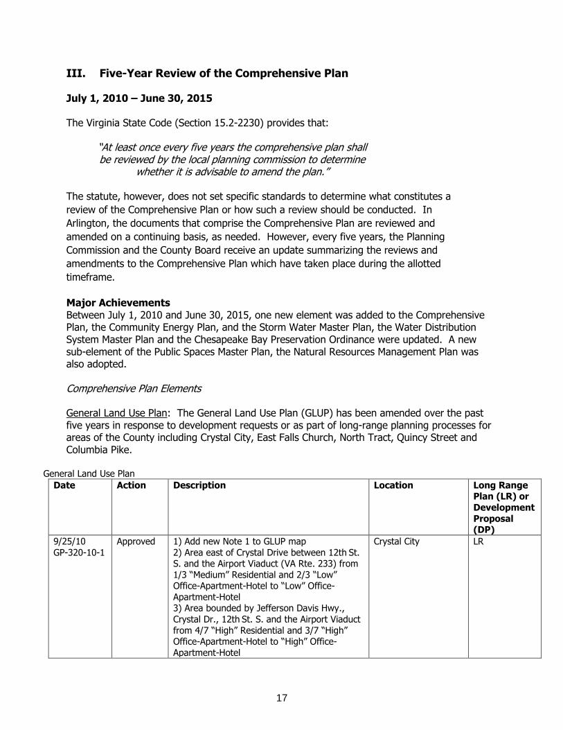
Major Achievements Between July 1, 2010 and June 30, 2015, one new element was added to the Comprehensive Plan, the Community Energy Plan, and the Storm Water Master Plan, the Water Distribution System Master Plan and the Chesapeake Bay Preservation Ordinance were updated. A new sub-element of the Public Spaces Master Plan, the Natural Resources Management Plan was also adopted. Comprehensive Plan Elements General Land Use Plan: The General Land Use Plan (GLUP) has been amended over the past five years in response to development requests or as part of long-range planning processes for areas of the County including Crystal City, East Falls Church, North Tract, Quincy Street and Columbia Pike.
General Land Use Plan
Date Action Description Location Long Range Plan (LR) or
Development
Proposal (DP)
9/25/10
GP-320-10-1
Approved 1) Add new Note 1 to GLUP map
2) Area east of Crystal Drive between 12th St. S. and the Airport Viaduct (VA Rte. 233) from
1/3 “Medium” Residential and 2/3 “Low” Office-Apartment-Hotel to “Low” Office-
Apartment-Hotel 3) Area bounded by Jefferson Davis Hwy.,
Crystal Dr., 12th St. S. and the Airport Viaduct
from 4/7 “High” Residential and 3/7 “High” Office-Apartment-Hotel to “High” Office-
Apartment-Hotel
Crystal City LR
18
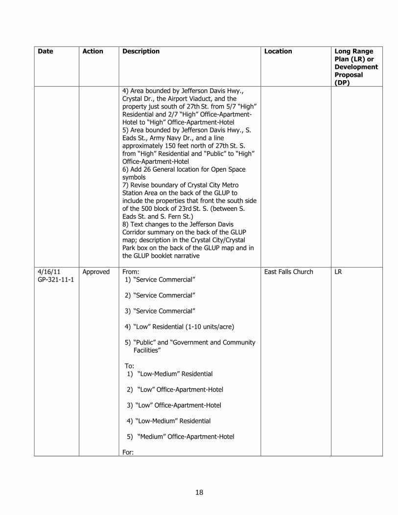
Date Action Description Location Long Range
Plan (LR) or Development
Proposal
(DP)
4) Area bounded by Jefferson Davis Hwy.,
Crystal Dr., the Airport Viaduct, and the property just south of 27th St. from 5/7 “High”
Residential and 2/7 “High” Office-Apartment-
Hotel to “High” Office-Apartment-Hotel 5) Area bounded by Jefferson Davis Hwy., S.
Eads St., Army Navy Dr., and a line approximately 150 feet north of 27th St. S.
from “High” Residential and “Public” to “High”
Office-Apartment-Hotel 6) Add 26 General location for Open Space
symbols 7) Revise boundary of Crystal City Metro
Station Area on the back of the GLUP to include the properties that front the south side
of the 500 block of 23rd St. S. (between S.
Eads St. and S. Fern St.) 8) Text changes to the Jefferson Davis
Corridor summary on the back of the GLUP map; description in the Crystal City/Crystal
Park box on the back of the GLUP map and in
the GLUP booklet narrative
4/16/11 GP-321-11-1
Approved From: 1) “Service Commercial”
2) “Service Commercial”
3) “Service Commercial”
4) “Low” Residential (1-10 units/acre)
5) “Public” and “Government and Community
Facilities”
To:
1) “Low-Medium” Residential
2) “Low” Office-Apartment-Hotel
3) “Low” Office-Apartment-Hotel
4) “Low-Medium” Residential
5) “Medium” Office-Apartment-Hotel
For:
East Falls Church LR
19
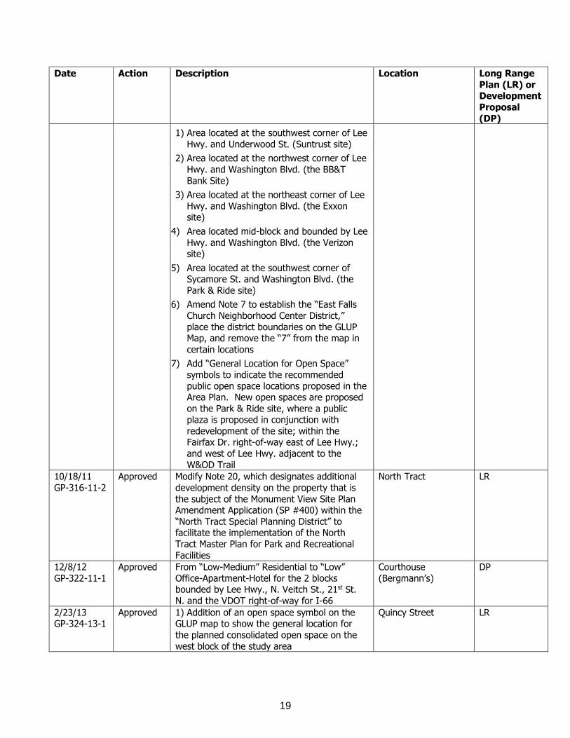
Date Action Description Location Long Range
Plan (LR) or Development
Proposal
(DP)
1) Area located at the southwest corner of Lee
Hwy. and Underwood St. (Suntrust site)
2) Area located at the northwest corner of Lee
Hwy. and Washington Blvd. (the BB&T
Bank Site)
3) Area located at the northeast corner of Lee
Hwy. and Washington Blvd. (the Exxon site)
4) Area located mid-block and bounded by Lee
Hwy. and Washington Blvd. (the Verizon site)
5) Area located at the southwest corner of Sycamore St. and Washington Blvd. (the
Park & Ride site)
6) Amend Note 7 to establish the “East Falls
Church Neighborhood Center District,”
place the district boundaries on the GLUP Map, and remove the “7” from the map in
certain locations
7) Add “General Location for Open Space”
symbols to indicate the recommended
public open space locations proposed in the Area Plan. New open spaces are proposed
on the Park & Ride site, where a public plaza is proposed in conjunction with
redevelopment of the site; within the Fairfax Dr. right-of-way east of Lee Hwy.;
and west of Lee Hwy. adjacent to the
W&OD Trail
10/18/11
GP-316-11-2
Approved Modify Note 20, which designates additional
development density on the property that is
the subject of the Monument View Site Plan Amendment Application (SP #400) within the
“North Tract Special Planning District” to facilitate the implementation of the North
Tract Master Plan for Park and Recreational
Facilities
North Tract LR
12/8/12
GP-322-11-1
Approved From “Low-Medium” Residential to “Low”
Office-Apartment-Hotel for the 2 blocks bounded by Lee Hwy., N. Veitch St., 21st St.
N. and the VDOT right-of-way for I-66
Courthouse
(Bergmann’s)
DP
2/23/13 GP-324-13-1
Approved 1) Addition of an open space symbol on the GLUP map to show the general location for
the planned consolidated open space on the
west block of the study area
Quincy Street LR
20
Date Action Description Location Long Range
Plan (LR) or Development
Proposal
(DP)
2) Update to Note 14 on the GLUP map to
indicate the “North Quincy Street Mixed-Use District” was amended February 2013
3/16/13 GP-323-13-1
Approved From “Low" Office-Apartment-Hotel and "Medium" Residential to “Public” for the area
generally bordered by Long Bridge Drive and
the I-395 clover leafs to the west, the George Washington Memorial Pkwy. to the north, the
CSX Railroad to the east, and 6th St. S. to the south
North Tract LR
6/15/13 GP-326-11-1
Approved From “Low-Medium” Residential to “Low” Office-Apartment-Hotel for the property
known as 1700 Lee Hwy. (RPC# 16-025-008), generally located on the northeast
portion of the block bounded by Lee Hwy. to
the north, N. Quinn St. to the east, and N. Scott St. to the south and west
Rosslyn (Colony House)
DP
11/16/13 GP-327-13-1
Approved Columbia Pike Neighborhoods Special Revitalization District
Columbia Pike LR
1/25/14 GP-328-13-1
Approved From “Low-Medium” Residential to “High Medium Residential Mixed Use” for 4318 N.
Carlin Springs Rd. (RPC #20-012-010), generally located on the southwest portion of
the block bounded by N. Glebe Rd. to the
north, N. Henderson Rd. to the east, N. Thomas St. to the south, and N. Carlin Springs
Rd. to the west
West Ballston DP
3/15/14
GP-325-11-1
Approved From "Service Commercial" to "Medium”
Office-Apartment-Hotel for the property
known as 2401 and 2407 Wilson Blvd. (RPC #15-060-001 and 15-060-002), generally
located on the southern half of the block bounded by 16th St. N. to the north, Wilson
Blvd. to the south, N. Adams St. to the east
and reaching approximately halfway across the block west towards N. Barton St.
Courthouse
(2401 Wilson Blvd.)
DP
3/14/15
GP-329-13-1
Approved From “General Commercial” to “Medium”
Office-Apartment-Hotel for 2026 and 2038 Wilson Blvd.
Courthouse
DP
5/16/15
GP-330-15-1
Approved Amendment from “Medium” Residential to
Public
Ballston
(Mosaic Park)
DP
Master Transportation Plan: The Master Transportation Plan (MTP) Streets Element was adopted in February 2011. It is the eighth and final element of the MTP update that began in

21
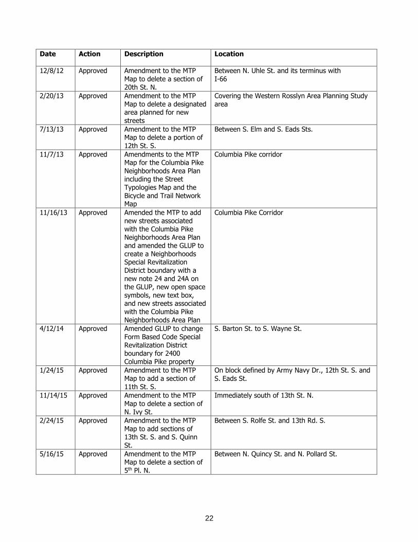
2007. This element focuses on multi-modal use of public streets and rights-of-way. The plan includes policies, implementation actions and performance measures to plan for, manage and evaluate public use of County streets. A key element of the document is the introduction of a new typology for all streets in Arlington, with descriptions and design guidance for the ten types of streets that can be found in Arlington. Amendments to the MTP are made in response to development requests or as part of long-range planning processes.
Master Transportation Plan
Date Action Description Location
7/10/10 Approved Amendment of the MTP
Map and the MTP Bicycle Element to add an
Appendix F which lists general planned locations
of bicycle sharing stations
Various
9/25/10 Approved Amendments to the MTP Map for the Crystal City
Metro Station Area
including the Street Typology Map, Bicycle and
Trail Network Map and Transit Network Map
Crystal City Metro Station Area
2/12/11 Adopted Adopted the Streets
Element of the MTP
Countywide
3/21/11 Approved Amendment to the MTP
Map to add a new Urban Center Local Street in the
block bordered by S. Glebe
Rd. and S. Monroe St. to connect the planned 11th
St. S. and the planned 12th St. S.
Between 11th and 12th Sts. S., and between S. Glebe
Rd. and S. Monroe St.
4/16/11
Approved Amendments to the MTP
Map for the East Falls Church Station Area
including the Bicycle and Trail Network Map and
Appendix B of the MTP
Bicycle Element
East Falls Church Station Area
4/16/11 Approved Amended the MTP and
GLUP to add new segment of Lincoln St.
11th St. S. to 12th St. S.
5/14/11 Approved Amendment of the MTP
Pedestrian Element concerning sidewalk widths
Various
5/19/12 Approved Amendment to the MTP
Map to add a section of N. Tazewell St.
Approximately 210 feet south of N. Carlin Springs
Rd.
22
Date Action Description Location
12/8/12 Approved Amendment to the MTP
Map to delete a section of
20th St. N.
Between N. Uhle St. and its terminus with
I-66
2/20/13 Approved Amendment to the MTP
Map to delete a designated area planned for new
streets
Covering the Western Rosslyn Area Planning Study
area
7/13/13 Approved Amendment to the MTP Map to delete a portion of
12th St. S.
Between S. Elm and S. Eads Sts.
11/7/13 Approved Amendments to the MTP Map for the Columbia Pike
Neighborhoods Area Plan including the Street
Typologies Map and the
Bicycle and Trail Network Map
Columbia Pike corridor
11/16/13 Approved Amended the MTP to add
new streets associated with the Columbia Pike
Neighborhoods Area Plan and amended the GLUP to
create a Neighborhoods Special Revitalization
District boundary with a
new note 24 and 24A on the GLUP, new open space
symbols, new text box, and new streets associated
with the Columbia Pike
Neighborhoods Area Plan
Columbia Pike Corridor
4/12/14 Approved Amended GLUP to change
Form Based Code Special
Revitalization District boundary for 2400
Columbia Pike property
S. Barton St. to S. Wayne St.
1/24/15 Approved Amendment to the MTP
Map to add a section of
11th St. S.
On block defined by Army Navy Dr., 12th St. S. and
S. Eads St.
11/14/15 Approved Amendment to the MTP
Map to delete a section of
N. Ivy St.
Immediately south of 13th St. N.
2/24/15 Approved Amendment to the MTP
Map to add sections of 13th St. S. and S. Quinn
St.
Between S. Rolfe St. and 13th Rd. S.
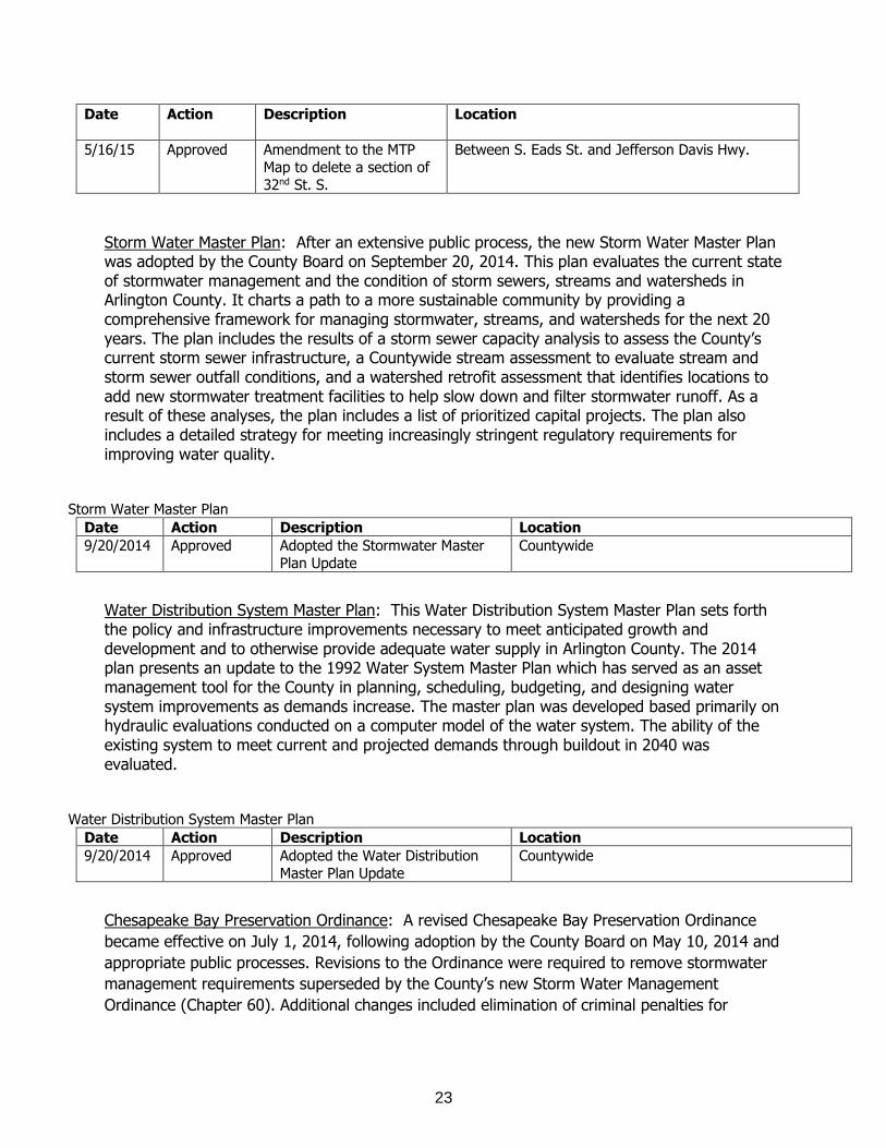
5/16/15 Approved Amendment to the MTP Map to delete a section of
5th Pl. N.
Between N. Quincy St. and N. Pollard St.
23
Date Action Description Location
5/16/15 Approved Amendment to the MTP
Map to delete a section of
32nd St. S.
Between S. Eads St. and Jefferson Davis Hwy.
Storm Water Master Plan: After an extensive public process, the new Storm Water Master Plan was adopted by the County Board on September 20, 2014. This plan evaluates the current state of stormwater management and the condition of storm sewers, streams and watersheds in Arlington County. It charts a path to a more sustainable community by providing a comprehensive framework for managing stormwater, streams, and watersheds for the next 20 years. The plan includes the results of a storm sewer capacity analysis to assess the County’s current storm sewer infrastructure, a Countywide stream assessment to evaluate stream and storm sewer outfall conditions, and a watershed retrofit assessment that identifies locations to add new stormwater treatment facilities to help slow down and filter stormwater runoff. As a result of these analyses, the plan includes a list of prioritized capital projects. The plan also includes a detailed strategy for meeting increasingly stringent regulatory requirements for improving water quality.
Storm Water Master Plan
Date Action Description Location
9/20/2014 Approved Adopted the Stormwater Master
Plan Update
Countywide
Water Distribution System Master Plan: This Water Distribution System Master Plan sets forth the policy and infrastructure improvements necessary to meet anticipated growth and development and to otherwise provide adequate water supply in Arlington County. The 2014 plan presents an update to the 1992 Water System Master Plan which has served as an asset management tool for the County in planning, scheduling, budgeting, and designing water system improvements as demands increase. The master plan was developed based primarily on hydraulic evaluations conducted on a computer model of the water system. The ability of the existing system to meet current and projected demands through buildout in 2040 was evaluated.
Water Distribution System Master Plan
Date Action Description Location
9/20/2014 Approved Adopted the Water Distribution
Master Plan Update
Countywide
Chesapeake Bay Preservation Ordinance: A revised Chesapeake Bay Preservation Ordinance
became effective on July 1, 2014, following adoption by the County Board on May 10, 2014 and
appropriate public processes. Revisions to the Ordinance were required to remove stormwater
management requirements superseded by the County’s new Storm Water Management
Ordinance (Chapter 60). Additional changes included elimination of criminal penalties for
24
violations (such penalties are not authorized by state statute) and updating of the Ordinance
language to clarify requirements with regard to the siting of stormwater management facilities.
Chesapeake Bay Preservation Ordinance and Plan
Date Action Description Location
5/10/2014 Approved Adopted Revised Chesapeake Bay Preservation Ordinance
Countywide
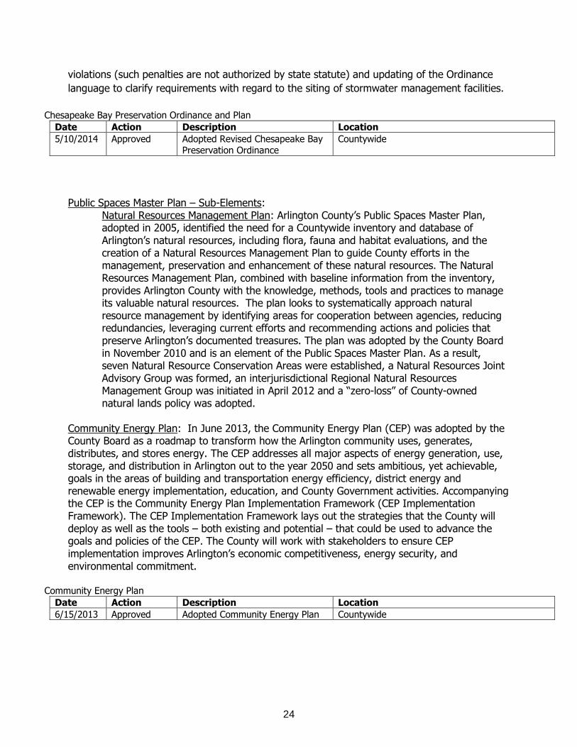
Public Spaces Master Plan – Sub-Elements:
Natural Resources Management Plan: Arlington County’s Public Spaces Master Plan, adopted in 2005, identified the need for a Countywide inventory and database of Arlington’s natural resources, including flora, fauna and habitat evaluations, and the creation of a Natural Resources Management Plan to guide County efforts in the management, preservation and enhancement of these natural resources. The Natural Resources Management Plan, combined with baseline information from the inventory, provides Arlington County with the knowledge, methods, tools and practices to manage its valuable natural resources. The plan looks to systematically approach natural resource management by identifying areas for cooperation between agencies, reducing redundancies, leveraging current efforts and recommending actions and policies that preserve Arlington’s documented treasures. The plan was adopted by the County Board in November 2010 and is an element of the Public Spaces Master Plan. As a result, seven Natural Resource Conservation Areas were established, a Natural Resources Joint Advisory Group was formed, an interjurisdictional Regional Natural Resources Management Group was initiated in April 2012 and a “zero-loss” of County-owned natural lands policy was adopted.
Community Energy Plan: In June 2013, the Community Energy Plan (CEP) was adopted by the County Board as a roadmap to transform how the Arlington community uses, generates, distributes, and stores energy. The CEP addresses all major aspects of energy generation, use, storage, and distribution in Arlington out to the year 2050 and sets ambitious, yet achievable, goals in the areas of building and transportation energy efficiency, district energy and renewable energy implementation, education, and County Government activities. Accompanying the CEP is the Community Energy Plan Implementation Framework (CEP Implementation Framework). The CEP Implementation Framework lays out the strategies that the County will deploy as well as the tools – both existing and potential – that could be used to advance the goals and policies of the CEP. The County will work with stakeholders to ensure CEP implementation improves Arlington’s economic competitiveness, energy security, and environmental commitment.
Community Energy Plan
Date Action Description Location
6/15/2013 Approved Adopted Community Energy Plan Countywide
25
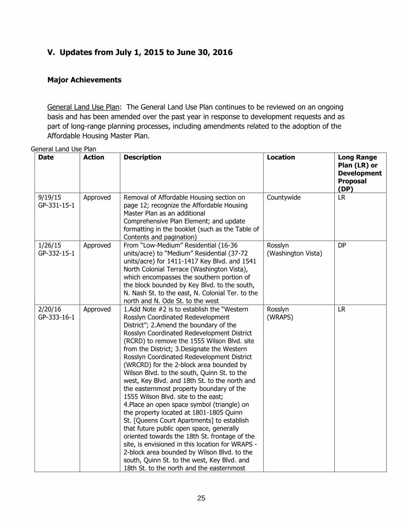
V. Updates from July 1, 2015 to June 30, 2016
Major Achievements
General Land Use Plan: The General Land Use Plan continues to be reviewed on an ongoing
basis and has been amended over the past year in response to development requests and as
part of long-range planning processes, including amendments related to the adoption of the
Affordable Housing Master Plan.
General Land Use Plan
Date Action Description Location Long Range
Plan (LR) or
Development Proposal
(DP)
9/19/15 GP-331-15-1
Approved Removal of Affordable Housing section on page 12; recognize the Affordable Housing
Master Plan as an additional Comprehensive Plan Element; and update
formatting in the booklet (such as the Table of
Contents and pagination)
Countywide LR
1/26/15
GP-332-15-1
Approved From “Low-Medium” Residential (16-36
units/acre) to “Medium” Residential (37-72 units/acre) for 1411-1417 Key Blvd. and 1541
North Colonial Terrace (Washington Vista),
which encompasses the southern portion of the block bounded by Key Blvd. to the south,
N. Nash St. to the east, N. Colonial Ter. to the north and N. Ode St. to the west
Rosslyn
(Washington Vista)
DP
2/20/16
GP-333-16-1
Approved 1.Add Note #2 is to establish the “Western
Rosslyn Coordinated Redevelopment District”; 2.Amend the boundary of the
Rosslyn Coordinated Redevelopment District (RCRD) to remove the 1555 Wilson Blvd. site
from the District; 3.Designate the Western
Rosslyn Coordinated Redevelopment District (WRCRD) for the 2-block area bounded by
Wilson Blvd. to the south, Quinn St. to the west, Key Blvd. and 18th St. to the north and
the easternmost property boundary of the
1555 Wilson Blvd. site to the east; 4.Place an open space symbol (triangle) on
the property located at 1801-1805 Quinn St. [Queens Court Apartments] to establish
that future public open space, generally oriented towards the 18th St. frontage of the
site, is envisioned in this location for WRAPS -
2-block area bounded by Wilson Blvd. to the south, Quinn St. to the west, Key Blvd. and
18th St. to the north and the easternmost
Rosslyn
(WRAPS)
LR
26
Date Action Description Location Long Range
Plan (LR) or Development
Proposal
(DP)
property boundary of the 1555 Wilson Blvd.
site to the east
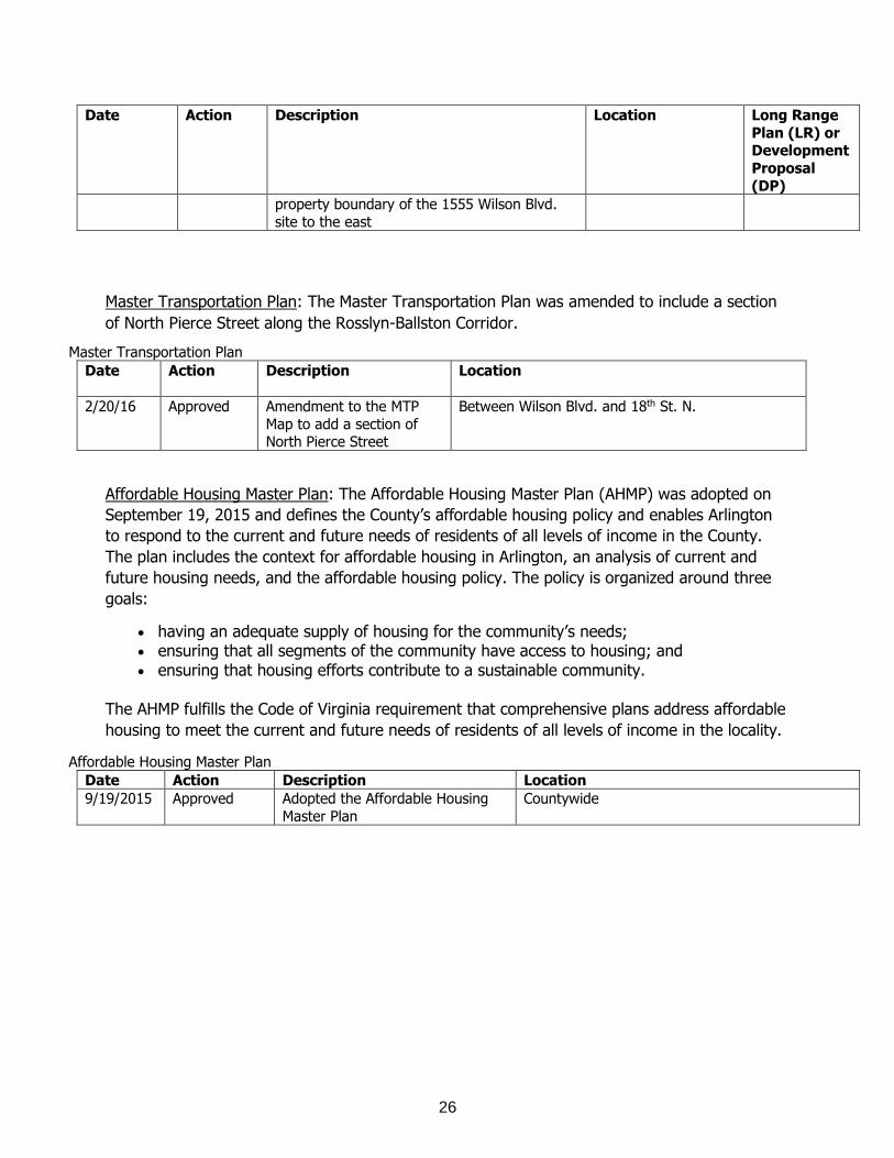
Master Transportation Plan: The Master Transportation Plan was amended to include a section
of North Pierce Street along the Rosslyn-Ballston Corridor.
Master Transportation Plan
Date Action Description Location
2/20/16 Approved Amendment to the MTP
Map to add a section of North Pierce Street
Between Wilson Blvd. and 18th St. N.
Affordable Housing Master Plan: The Affordable Housing Master Plan (AHMP) was adopted on
September 19, 2015 and defines the County’s affordable housing policy and enables Arlington
to respond to the current and future needs of residents of all levels of income in the County.
The plan includes the context for affordable housing in Arlington, an analysis of current and
future housing needs, and the affordable housing policy. The policy is organized around three
goals:
having an adequate supply of housing for the community’s needs; ensuring that all segments of the community have access to housing; and ensuring that housing efforts contribute to a sustainable community.
The AHMP fulfills the Code of Virginia requirement that comprehensive plans address affordable
housing to meet the current and future needs of residents of all levels of income in the locality.
Affordable Housing Master Plan
Date Action Description Location
9/19/2015 Approved Adopted the Affordable Housing
Master Plan
Countywide
27
VI. Upcoming Reviews of the Comprehensive Plan
Planning Initiatives The Comprehensive Plan has been updated and periodically amended to more clearly reflect the
intended use for particular areas. The Plan is reviewed and often amended either as part of a
long-term planning process for a designated area or as a result of an individual request for a
specific change.
The following Comprehensive Plan elements are to be updated over the next four years (July 1, 2016 to June 30, 2020):
Comprehensive Plan Elements
General Land Use Plan: The General Land Use Plan will continue to be reviewed on an ongoing
basis and amended as needed in response to development requests and long range planning
processes. A reprinting is anticipated in the 2017-2018 timeframe.
Master Transportation Plan:
Bike Element: Staff will begin an update of the Master Transportation Plan (MTP) Bicycle Element in early 2017. Staff anticipates the project taking 12 to 15 months to complete. The effort will be an update to include development of a new bicycle facility network and will incorporate facilities such as protected bicycle lanes (also known as “Cycle Tracks”) and integration of the Capital Bikeshare system across Arlington and in neighboring jurisdictions. The MTP Map will need to be amended to reflect the adopted plan revisions.
Master Transportation Plan:
Transit Element: With the County Board’s adoption of the Transit Development Plan (TDP), there will also be an effort to update the MTP’s Transit Element as well as amend parts of the MTP Map. Staff anticipates this effort to start in late 2016 and continue into early 2017.
Sanitary Sewer Collection System Master Plan: Staff has been working on an update to the Sanitary Sewer Collection System Master Plan, last updated in 2002. Staff anticipates the updated Master Plan will be completed in 2017. Recycling Program Implementation Plan and Map: In 2016, amendments to the Recycling Map will be proposed to remove the location shown at Columbia Pike/Four Mile Run Drive and to change the symbol shown at the Arlington County Trades Center. In 2017, the Department of Environmental Services Solid Waste Bureau (SWB) plans to replace the existing Recycling Program Implementation Plan and Map element with the current Solid Waste Management Plan, adopted by the County Board in 2004.

28
In November 2015, the Arlington County Board passed a Zero Waste Resolution which aims to divert 90 percent of the County’s waste away from landfilling or incineration by 2038. As part of this resolution, the County Board directed the County Manager, along with the community and the citizen-led Solid Waste Committee to develop a Zero Waste plan for County Board consideration. The Zero Waste Plan will include an analysis of existing practices and opportunities to achieve the goals identified and an assessment of the Plan’s environmental, operational and economic impacts. The Zero Waste Plan is expected to be completed in 2020 and will replace the existing Solid Waste Management Plan that has been the roadmap for the Solid Waste Bureau since adoption by the County Board in 2004. Chesapeake Bay Preservation Ordinance and Plan: Phase III of local government implementation of the Chesapeake Bay Preservation Act requires the 84 Tidewater local governments to review local land development ordinances, and revise them if necessary, in order to ensure these ordinances adequately address the protection of the quality of state waters. An important element of Phase III is the requirement for local ordinances to have specific standards to ensure that development in Chesapeake Bay Preservation Areas minimizes land disturbance, preserves indigenous vegetation, and minimizes impervious cover, as well as six specific requirements for approved plats and development plans. Phase III will also involve the identification and resolution of obstacles and conflicts to achieving the water quality goals of the Chesapeake Bay Preservation Act within local programs and ordinances. The Commonwealth’s review of Arlington County’s local program began in 2010 and has been substantially completed. Any changes to Arlington’s Chesapeake Bay Preservation Ordinance required as part of this review effort must be implemented by December 2016. In addition, a Countywide stream inventory completed in 2010 will result in an update to the adopted Resource Protection Area map. Additionally, consultation with staff of the Virginia Department of Environmental Quality indicates that the Chesapeake Bay Preservation Ordinance is not a required element of the Comprehensive Plan. In order to facilitate future revisions of the Ordinance, it will be removed from the Comprehensive Plan when the new Resource Protection Area map is adopted. Public Spaces Master Plan and Sub-Elements: The Public Spaces Master Plan (PSMP) was adopted in 2005. The Department of Parks and Recreation has begun work on the Public Spaces Master Plan Update in early 2015. The purpose of this update, known as POPS (A Plan for Our Places and Spaces) is to assess various aspects of the public spaces system and develop strategies to meet future needs for parks, recreation, leisure, and the protection of natural resources. Anticipated outcomes include recommendations for a classification system, land acquisition, dog parks, synthetic fields, lighting, commerce in parks, and others. The major elements of this plan will include an inventory update, needs assessment, policy review, benchmarking, access/Level of Service standards, and an implementation/action plan. It is anticipated that the PSMP Update will be completed in 2017. Upon completion of the PSMP Update, the Department of Parks and recreation will begin work on updating the Urban Forest Master Plan and the Natural Resources Management Plan. The updated Urban Forest Master Plan and the Natural Resources Management Plan will contribute to the attractiveness and sustainability of Arlington through enhancements to the tree canopy and natural resources. Both plans are expected to be completed in 2018.

29
Urban Forest Master Plan: Upon completion of the Public Spaces Master Plan Update,
the Department of Parks and recreation will begin work on updating the Urban Forest
Master Plan. The updated Urban Forest Master Plan will contribute to the attractiveness
and sustainability of Arlington through enhancements to the tree canopy. This plan is
expected to be completed in 2018.
Natural Resources Management Plan: Upon completion of the Public Spaces Master Plan
Update, the Department of Parks and recreation will begin work on updating the Natural
Resources Management Plan. The updated Natural Resources Management Plan will
contribute to the attractiveness and sustainability of Arlington through enhancements to
natural resources. This plan is expected to be completed in 2018.
Public Art Master Plan: The Public Art Master Plan will improve the quality of public
spaces and the built environment in Arlington for civic placemaking and will be updated
in 2017 as part of the development of an Arts & Culture Strategic Plan for the County.
Historic Preservation Master Plan: The Historic Preservation Master Plan was adopted in 2006.
It is anticipated to be updated between 2017 and 2020.
Community Energy Plan: The Community Energy Plan was adopted in 2013. The plan, its
underlying assumptions and model, and its accompanying Implementation Framework will be
reviewed by 2018.
30
VII. Public Review Process Preparation of the aforementioned plans will likely involve a comprehensive review process that
may include the evaluation of existing policies and the development of alternatives and
recommendations by County staff in cooperation with the Planning Commission, County Board-
appointed commissions and task forces, neighborhood and civic organizations and businesses.
These processes may require public hearings with the Planning Commission and the County
Board and may result in the adoption of recommendations for future development that may
include amendments to the Comprehensive Plan.
In addition, detailed land use studies may be undertaken for designated areas of the County at
the County Board's directive where conditions warrant a comprehensive framework of policies
for community improvement through redevelopment, revitalization or conservation. Also, if
directed by the County Board, land use policies may be developed to address specific issues.
Furthermore, any person may request an amendment to the General Land Use Plan, at any
time, by writing a letter to the Chairman of the County Board identifying the specific area and
the requested General Land Use Plan designation. For those requests that are in unplanned
areas of the County or where the proposed request is inconsistent with the recommendations of
the relevant adopted plan, a Special General Land Use Plan Study is required which involves the
submission of an application and application fee, followed by a review process led by the Long
Range Planning Committee of the Planning Commission, followed by Planning Commission and
County Board hearings. For all General Land Use Plan amendments, if the County Board
decides to hear the amendment, public hearing dates for the Planning Commission and the
County Board are set and publicly advertised. At the public hearing, the Planning Commission
receives a recommendation from the County Manager and hears public testimony. The
commission then makes a recommendation to the County Board regarding the requested
amendment. At its meeting, the County Board also receives the County Manager's report, hears
public testimony and ultimately makes the final decision. This same public review process is
followed for the review of proposed amendments to other elements of the Comprehensive Plan.
31
IX. Appendices Appendix A Excerpts from the Code of Virginia6
15.2-2223. Comprehensive plan to be prepared and adopted; scope and purpose.
A. The local planning commission shall prepare and recommend a comprehensive plan for the
physical development of the territory within its jurisdiction and every governing body shall
adopt a comprehensive plan for the territory under its jurisdiction.
In the preparation of a comprehensive plan, the commission shall make careful and
comprehensive surveys and studies of the existing conditions and trends of growth, and of the
probable future requirements of its territory and inhabitants. The comprehensive plan shall be
made with the purpose of guiding and accomplishing a coordinated, adjusted and harmonious
development of the territory which will, in accordance with present and probable future needs
and resources, best promote the health, safety, morals, order, convenience, prosperity and
general welfare of the inhabitants, including the elderly and persons with disabilities.
The comprehensive plan shall be general in nature, in that it shall designate the general or
approximate location, character, and extent of each feature, including any road improvement
and any transportation improvement, shown on the plan and shall indicate where existing lands
or facilities are proposed to be extended, widened, removed, relocated, vacated, narrowed,
abandoned, or changed in use as the case may be.
B.1. As part of the comprehensive plan, each locality shall develop a transportation plan that
designates a system of transportation infrastructure needs and recommendations that include
the designation of new and expanded transportation facilities and that support the planned
development of the territory covered by the plan and shall include, as appropriate, but not be
limited to, roadways, bicycle accommodations, pedestrian accommodations, railways, bridges,
waterways, airports, ports, and public transportation facilities. The plan shall recognize and
differentiate among a hierarchy of roads such as expressways, arterials, and collectors. In
developing the plan, the locality shall take into consideration how to align transportation
infrastructure and facilities with affordable, accessible housing and community services that are
located within the territory in order to facilitate community integration of the elderly and
6Statute last updated in 2014. Virginia General Assembly Legislative Information System
(http://law.lis.virginia.gov/)
32
persons with disabilities. The Virginia Department of Transportation shall, upon request, provide
localities with technical assistance in preparing such transportation plan.
2. The transportation plan shall include a map that shall show road and transportation
improvements, including the cost estimates of such road and transportation improvements from
the Virginia Department of Transportation, taking into account the current and future needs of
residents in the locality while considering the current and future needs of the planning district
within which the locality is situated.
3. The transportation plan, and any amendment thereto pursuant to § 15.2-2229, shall be
consistent with the Commonwealth Transportation Board's Statewide Transportation Plan
developed pursuant to § 33.2-353, the Six-Year Improvement Program adopted pursuant to
subsection B of § 33.2-214, and the location of routes to be followed by roads comprising
systems of state highways pursuant to subsection A of § 33.2-208. The locality shall consult
with the Virginia Department of Transportation to assure such consistency is achieved. The
transportation plan need reflect only those changes in the annual update of the Six-Year
Improvement Program that are deemed to be significant new, expanded, or relocated
roadways.
4. Prior to the adoption of the transportation plan or any amendment to the transportation plan,
the locality shall submit such plan or amendment to the Department for review and comment.
The Department shall conduct its review and provide written comments to the locality on the
consistency of the transportation plan or any amendment to the provisions of subdivision 1. The
Department shall provide such written comments to the locality within 90 days of receipt of the
plan or amendment, or such other shorter period of time as may be otherwise agreed upon by
the Department and the locality.
5. The locality shall submit a copy of the adopted transportation plan or any amendment to the
transportation plan to the Department for informational purposes. If the Department
determines that the transportation plan or amendment is not consistent with the provisions of
subdivision 1, the Department shall notify the Commonwealth Transportation Board so that the
Board may take appropriate action in accordance with subsection E of § 33.2-214.
6. Each locality's amendments or updates to its transportation plan as required by subdivisions
2 through 5 shall be made on or before its ongoing scheduled date for updating its
transportation plan.
33
C. The comprehensive plan, with the accompanying maps, plats, charts, and descriptive matter,
shall show the locality's long-range recommendations for the general development of the
territory covered by the plan. It may include, but need not be limited to:
1. The designation of areas for various types of public and private development and use, such
as different kinds of residential, including age-restricted, housing; business; industrial;
agricultural; mineral resources; conservation; active and passive recreation; public service;
flood plain and drainage; and other areas;
2. The designation of a system of community service facilities such as parks, sports playing
fields, forests, schools, playgrounds, public buildings and institutions, hospitals, nursing homes,
assisted living facilities, community centers, waterworks, sewage disposal or waste disposal
areas, and the like;
3. The designation of historical areas and areas for urban renewal or other treatment;
4. The designation of areas for the implementation of reasonable ground water protection
measures;
5. A capital improvements program, a subdivision ordinance, a zoning ordinance and zoning
district maps, mineral resource district maps and agricultural and forestal district maps, where
applicable;
6. The location of existing or proposed recycling centers;
7. The location of military bases, military installations, and military airports and their adjacent
safety areas; and
8. The designation of corridors or routes for electric transmission lines of 150 kilovolts or more.
D. The comprehensive plan shall include the designation of areas and implementation of
measures for the construction, rehabilitation and maintenance of affordable housing, which is
sufficient to meet the current and future needs of residents of all levels of income in the locality
while considering the current and future needs of the planning district within which the locality
is situated.
1975, c. 641, § 15.1-446.1; 1976, c. 650; 1977, c. 228; 1988, c. 268; 1989, c. 532; 1990, c. 19;
1993, cc. 116, 758; 1996, cc. 585, 600; 1997, c. 587; 2003, c. 811; 2004, cc. 691, 799; 2005,
cc. 466, 699; 2006, cc. 527, 563, 564; 2007, c. 761; 2012, cc. 729, 733; 2013, cc. 561, 585,
646, 656; 2014, cc. 397, 443.
34
§ 15.2-2230. Plan to be reviewed at least once every five years.
At least once every five years the comprehensive plan shall be reviewed by the local planning commission to determine whether it is advisable to amend the plan.
(Code 1950, § 15-964.8; 1962, c. 407, § 15.1-454; 1975, c. 641; 1997, c. 587.)

35
Appendix B Awards from July 1, 2010 to June 30, 2015 From 2010 to 2015, Arlington County received the following awards related to the policies put forth in the Comprehensive Plan:
General Land Use Plan
Shirlington Village Recognized for Sustainability with CoreNet Mid-Atlantic Award (2010)
Awarded the 2012 Benjamin Banneker Award for Outstanding Social Commitment and Community Initiatives for the Columbia Pike Neighborhoods Area Plan by the National Capital Area Chapter of the American Planning Association (2012)
Arlington ranked Virginia’s second healthiest county in the 2012 County Health Rankings in a study from the Robert Wood Johnson Foundation and the University of Wisconsin (2012)
Achievement Award for Innovation in Economic Planning and Development for the Crystal City Sector Plan (2013)
Arlington Mill Community Center received the Award of Excellence from NAIOP (National Association of Industrial and Office Properties) Northern Virginia, in the “Build-to-Suit Institutional Facility: $20 Million and Above” category (2013)
Salon.com recognized Arlington County as the “suburb of the future,” and noted how Arlington “avoided the worst of suburbanization and revealed the path toward sustainable urban development.” (2014)
Best Corridor Plan for the Columbia Pike Initiative by the Congress for New Urbanism (2014)
Ranked #1 Coolest City in the U.S. by Forbes Magazine (2014) Awarded Best In My Backyard (“IMBY”) for the Columbia Pike Planning Initiative by
the Governor’s Housing Awards (2014)
Ranked #1 Post-college town by USA Today (2014) Selected as a Top 7 Intelligent Communities in the World by the Intelligent
Communities Forum (2014, 2015)
Ranked #2 Best Place to Retire by Bankrate.com (2015) Ranked #6 Top 10 Healthiest Cities by Livability.com (2015) Ranked #3 of the 100 Best Places to Live by Livability.com (2015) For cities with populations of 100,000 to 500,000, Arlington took the top spot for
Best Cities for Staying Healthy, according to AARP. In terms of overall livability, Arlington took the sixth spot for populations between 100,000 and 500,000 (2015)
Arlington received the national “Stars and Stripes Award” from the Election Center, which applauded the County’s efforts to identify new polling place locations in high-density projects (2015)
Livability.com ranked Arlington the #3 best place to live in the nation among small- to mid-sized cities (2015)

36
Master Transportation Plan Arlington’s Car-Free Diet Skeptics campaign won First Place in the American Public
Transportation Association’s (APTA) 2011 AdWheel, in the marketing/promotional campaign category (2011)
Bicycle Friendly Community Silver Level awarded by the League of American Bicyclists (2011, 2015)
Walk Friendly Community Gold Level awarded by Walk Friendly Communities (2012) Arlington Named #23 Top Bike-Friendly City by Bicycling Magazine (2012)
Arlington Named #19 Top Bike-Friendly City by Bicycling Magazine (2014) Received a Bicyclists’ Choice Award in the category of the “Biggest Advocacy Win of
2014” for snow removal on Arlington County Trails from the Washington Area Bicyclist Association (2015)
Recycling Program Implementation Plan and Map
Arlington County received an award for Outstanding Organics Program (2012), Outstanding Litter Prevention (2012), Outstanding Local Government (2013) and Outstanding Leadership (2014) from the Virginia Recycling Association for notable recycling and waste reduction efforts
Arlington received the Gold Award from the Solid Waste Association of North America (SWANA) for Special Waste Management for its Earth Products Recycling Yard (2015)
Public Spaces Master Plan
Parks and Community Centers
Awarded for the “Best New Facility- Parks, Playgrounds, Blueways, Greenways, and trails (population greater than 100,000) by the Virginia Recreation and Park Society for Long Bridge Park (2011)
Awarded a Community Appearance Award for Long Bridge Park (Phase I) by the Community Appearance Alliance of Northern Virginia (2012)
Received a Craftsmanship Award for Exterior Stone at Long Bridge Park from the Washington Building Congress (2012)
Received the Award of Excellence for the Arlington Mill Community Center from the National Association of Industrial and Office Properties Northern Virginia, in the “Built-to-Suit Institutional Facility: $20 Million and Above” category (2013)
Received a Merit Award from the American Society of Landscape Architects, Potomac and Maryland Chapters, for Long Bridge Park (2013)
Ranked Barcroft Park (Tucker Field) the top A-10 ballpark and the 68th best facility in the nation by Stadium Journey Magazine (2014)
Awarded a Community Appearance Award for Public Space for Penrose Square by the Community Appearance Alliance of Northern Virginia (2014)
Recognized the Department of Parks and Recreation as a “Champion of Safety” and “the company whose Incident Rate improved the most, on a percentage basis, every
37
year for three years beginning with 2011” by the Chesapeake Region Safety Council (2014)
Recognized as the “Best New Facility - Parks, Playgrounds, Blueways, Greenways, and Trails (population greater than 100,000)” by the Virginia Recreation and Park Society for James Hunter Park (2014)
Public Art
National Endowment for the Arts Our Town Grant to support a Public Art Learning Project with Arlington Arts Center (2011)
National Endowment for the Arts Our Town Grant to support the work of Walter Hood in the design of the Nauck Town Square (2013)
Public Art Network Year in Review Award for one of the fifty best new public art projects in the U.S. for Richard Deutsch, Echo at Penrose Square (2013)
American Society of Landscape Architect’s Potomac Chapter Merit Award in the Built/Design category for Long Bridge Park Phase 1 – Doug Hollis, Wave Arbor public art project cited (2013)
DESIGNArlington Honorable Mention for Long Bridge Park Phase 1 Doug Hollis, Wave Arbor public art project (2013)
American Council of Engineering Companies, Metropolitan Washington Engineering Excellence Honor Award for Vicki Scuri, Arlington Boulevard (2014-2015)
Public Art Network Year in Review Award for one of the 30 best new public art projects in U.S. for Christian Moeller, Quill at 1812 North Moore Street (2015)
Urban Forestry
Named a “Tree City USA” by the National Arbor Day Foundation (2011, 2012, 2013, 2014, 2015)
Recognized with a Sterling Tree City Award from the Arbor Day Foundation, as one of the communities that have earned 10 Growth Awards, and are regarded as leaders in community forestry and are often looked upon as innovators (2014)
Community Energy Plan
The Arlington County Justice Center was awarded the Energy Star label (2010,
2012, 2013, 2014) Arlington County is ranked #7 in the nation for Government Green Fleets, according
to Green Fleet Magazine (2012)
Arlington was named one of the Top 50 Government Green Fleets (#34) (2013) Awarded the American Planning Association (APA) National Planning Achievement
Award for Environmental Planning for the Community Energy Plan (2014)
Arlington County’s Justice Center earned the EPA’s ENERGY STAR certification for superior energy performance (2014)
Arlington County’s Community Energy Plan was named a winner of the American Planning Association (APA) 2014 National Planning Achievement Award in Environmental Planning (2014)
38
American Graphic Design USA Award for Arlington Initiative to Rethink Energy (AIRE) Booklet (2014)
The Virginia Municipal League (VML) once again awarded Arlington the “Go Green Virginia” award, which recognizes environmental policies and practice actions that reduce carbon emissions and save money (2014, 2015)
Arlington was named #3 “Greenest City” by NerdWallet (2015)
Affordable Housing Master Plan
Awarded Best Housing Preservation/Revitalization Efforts at the Virginia Governor’s Housing Conference for Buckingham Village 3 (2011)
The 2012 National Conference on Ending Homelessness recognized the County’s successful efforts to house the chronically homeless. The County’s ongoing drive to house the vulnerable, chronically homeless members of the community is part of Arlington’s 10 Year Plan to End Homelessness (July 2012)
County-financed vPoint won the “Best Affordable Housing Development” at the 2012 Governor’s Housing Conference (2012)
Hunter’s Park, which received financing from numerous sources including a $2 million loan from Arlington County, was selected by Affordable Housing Finance magazine as one of five nationwide finalists in the area of new senior developments and received a 2012 PACE Award from the Property Management Association (2012)
Awarded Multi-Family New Construction Project of the Year by EarthCraft Virginia for the Arlington Partnership for Affordable Housing’s Arlington Mill Residences (2014)
Awarded Best In My Backyard (“IMBY”) for the Columbia Pike Planning Initiative by the Governor’s Housing Conference (2014)
Arlington Mill Residences, a joint effort with the Arlington Partnership for Affordable Housing (APAH), was named “Best Housing Development” at the Virginia Governor’s Housing Conference (2014)
Named Metropolitan/Urban Housing winner at the 21st Annual Charles L. Edson Tax Credit Excellence Awards for the Arlington Partnership for Affordable Housing’s Arlington Mill Residences (2015)
Received Excellence in Housing Development Award from the Urban Land Institute for the Arlington Partnership for Affordable Housing’s Arlington Mill Residences (2015)

39
Awards from July 1, 2105 to June 30, 2016
From 2015 to 2016, Arlington County received the following awards related to the policies put forth in the Comprehensive Plan and its supporting documents:
General Land Use Plan
The American Planning Association (APA)’s Virginia Chapter recognized the Arlington
Community Facilities Study with the 2016 Public Outreach and Engagement Award
(2016)
Courthouse Sector Plan Addendum: Courthouse Square was selected by the
American Planning Association (APA)’s Virginia Chapter to receive an honorable
mention for both the Outstanding Plan and Public Outreach and Engagement
categories (2016)
Ranked #1 Best Place in the Country in Which to Retire by Bankrate.com (2016)
Ranked the Best City to Live in the United States by Niche (2016)
Ranked #2 Best Cities for Millennials by the Digital Counties Survey (2016)
Ranked #8 Happiest Cities to Work In by Forbes Magazine (2016)
Ranked #1 Best City for Recent Grads by NerdWallet (2016)
Ranked one of the Top 10 Happiest Cities To Work In by Forbes Magazine (2016)
Master Transportation Plan
The County is one of only 15 communities across the nation — out of the 58 ranked
since the inception of the Pedestrian and Bicycle Information Center program — to
receive the Gold rating from Walk Friendly Communities (WFC) (2016)
Arlington was named 3rd healthiest community in the Commonwealth of Virginia, in
a Robert Wood Johnson Foundation program (2016)
Arlington County earned Gold Status as a Bicycle Friendly Business (2016)
Arlington County has improved from silver to gold status and is among more than
1,100 businesses across the U.S. recognized by the League of American Bicyclists as
a Bicycle Friendly Business (BFB). The County is one of 157 gold ranking awardees
and is one of only six local government agencies to rank as a platinum or gold
BFB. Arlington also holds a silver ranking as a Bicycle Friendly Community (2016)
Walk Friendly Community Gold Level awarded by Walk Friendly Communities (2016)

40
Public Spaces Master Plan
Parks and Community Centers
DESIGNArlington-Rocky Run Park received a Merit Award for Open Space/Park
Renovations (2015)
The Trust for Public Land’s ParkScore® index ranked the County fourth on its list of
public park systems (2016)
Barcroft Magnolia Bog Restoration Project received an Innovation Achievement
Award from The Virginia Association of Counties (VaCo) as a model for natural
resource management by highlighting opportunities to incorporate community
groups in environmental stewardship activities (2016)
Public Art
CODA Top 100: Vicki Scuri, Arlington Boulevard (2015)
DESIGNArlington Honorable Mention for Vicki Scuri, Arlington Boulevard, and Remy
+ Veenhuizen, Ripple (2016)
IDA Achievement Award for Public Displays of Innovation (2016)
Urban Forestry
Arlington received its 20th consecutive Tree City USA Award from the National Arbor
Day Foundation for its commitment to effectively managing its urban forest (2016)
Community Energy Plan
SmartAsset has ranked Arlington second in its list of the best green cities for families
(2016)
The Arlington County Justice Center once again was awarded the Energy Star label
(2016)
The Virginia Municipal League (VML) was once again awarded Arlington the “Go
Green Virginia” award which recognizes environmental policies and practice actions
that reduce carbon emissions and save money (2016)
Affordable Housing Master Plan
DESIGNArlignton-Arlington Mill Community Center received an Award of Excellence for New Construction/Institutional/Civic (2015)
HAND Recognizes Arlington with “Best Partner Award” from the Housing Association of Nonprofit Developers (HAND) based on outstanding and innovative housing developments, programs and solutions across the metropolitan region (2016)

41
Appendix C
Planning Commission Recommendations
In late 2016, the Planning Commission and Long Range Planning Committee of the Planning Commission Chairs developed the following recommendations to guide future work on the Comprehensive Plan, which were further refined by the Long Range Planning Committee.
1. Make the Comprehensive Plan more present in citizens’ lives: a. Clearly articulate what the Comprehensive Plan is and how it is used to guide
decisions at the staff, commission, and County Board-levels. b. Summarize policy goals and objectives from the individual Comprehensive Plan
elements to provide a fuller picture of Arlington’s long term vision. c. Make the Comprehensive Plan more accessible and relevant to the public
through web tools and other means.
2. Strengthen the connection between the Comprehensive Plan and its implementation through Site Plans and Special Exception project documents:
a. Include citations to Comprehensive Plan elements and other supporting documents in staff reports evaluating site plans and other special exception projects.
b. Ensure that the County Manager’s recommendations to the County Board are supported by Comprehensive Plan policy goals and objectives.
3. In coordination with Arlington Public Schools (APS), include APS in the Comprehensive Plan, through one or more of the following:
a. Initiate a process to develop and adopt a Comprehensive Plan element for schools.
b. Include schools and school impacts in planning studies and updates to Comprehensive Plan elements.
c. Add existing, planned, and potential future school locations to the General Land Use Plan.
4. Add performance metrics to each Comprehensive Plan element to evaluate implementation progress.
5. Create a matrix of the goals from all of the Comprehensive Plan elements to ascertain whether there may be duplication and/or potential conflicts among goals.
6. To better address current and future County needs, initiate a process to develop and
adopt a Comprehensive Plan element for public facilities.


Department of Community Planning, Housing and Development2100 Clarendon Boulevard, Suite 700Arlington, Virginia 22201TEL 703.228.3525 FAX 703.228.3543
www.arlingtonva.us