summary of week: students will identify oklahoma landforms
TRANSCRIPT
Instruction Plan — Week 4: Oklahoma Landforms
Oklahoma Social Studies Practices:Read Critically and Interpret InformationSources
Strand: Geography
Standards:3.2.1 Examine Oklahoma’s political and physical features.3.2.1.A Identify the state of Oklahoma using relative location, absolute location(latitude and longitude), direction, scale, size, and shape using physical andpolitical maps.3.2.1.B Interpret thematic maps of Oklahoma with the essential map elements oftitle, legend, scale, and directional indicators.3.2.1.C Identify Oklahoma’s major landforms and bodies of water on a physicalmap.3.B.2-3.3 Describe the community and state’s human and physical environmentthrough the use of geographic representations, including aerial photographs.
Vocabulary:absolute location: exact location of a place (noun)compass rose: shows us the directions north, south, east, and west (noun)gypsum: a soft, shiny mineral (noun)legend: shows us what the symbols and colors mean on the map (noun)scale: helps us figure out how far it is from one place to another (noun)relative location: where a place is compared to, or relative to, something else(noun)High Plains: a raised part of the Great Plains (noun)latitude: imaginary lines that run from east to west around the Earth (noun)longitude: imaginary lines that run from the North Pole to South Pole (noun)panhandle: an area of Oklahoma that looks like the handle on a pan jutting outin a long strip of land from the main state’s western border (noun)
Summary of Week: Students will identify Oklahoma landforms and bodies ofwater.
Literature:● Oklahoma (A True Book: My United States) by Tamra B. Orr● Oklahoma (The Bilingual Library of the United States of America) by
Vanessa Brown
Essential Questions:1. What is latitude and longitude?2. What is relative and absolute location?3. What are the 10 different regions in Oklahoma? Where are they located?
What are some unique landforms found in each region?4. What are the major rivers and lakes found in Oklahoma?
Student Edition for Week 4

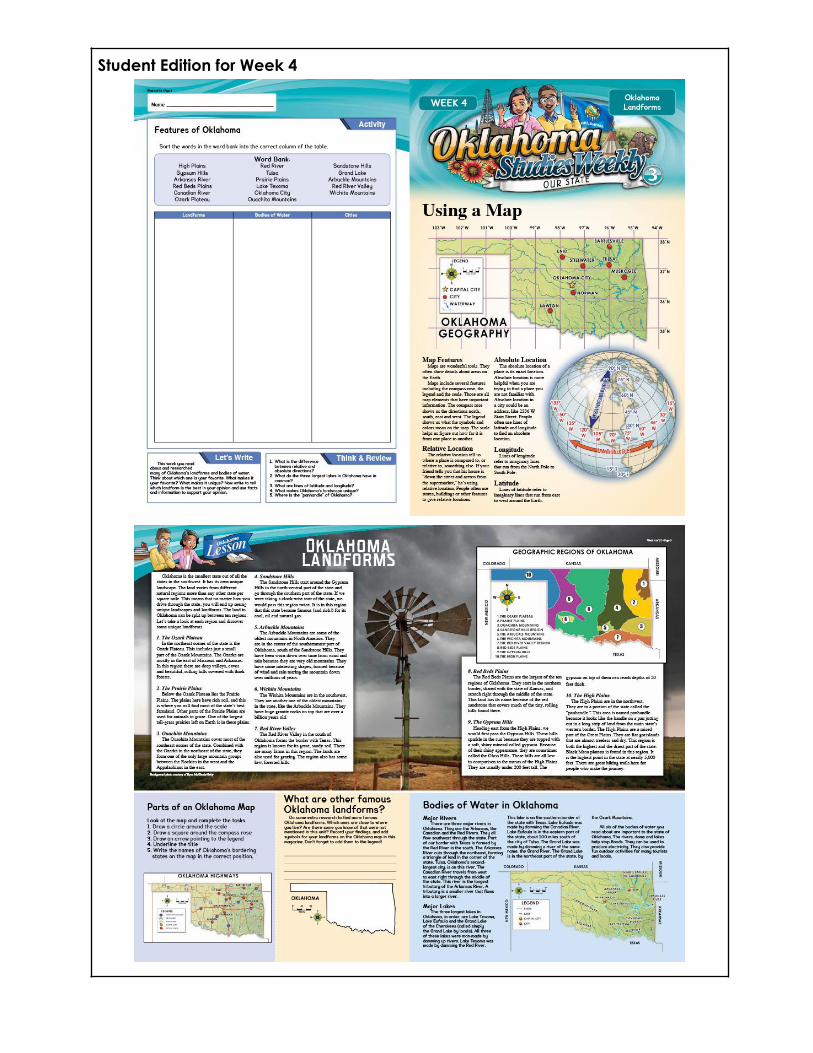
Using a Map
Lesson Plan:1. Watch the “Location Intro” video. Stop the video at each major section
and discuss absolute location, relative location, longitude, and latitude.2. Read the article and ask students to point out an example of each map
feature.3. Have the students review map features using the map.
Article Assessment:1. What will a physical map show?
a. man-made featuresb. land and water featuresc. different cities’ populationsd. what crops grow in the region
2. Where would you look if you wanted to understand the symbols on amap?
a. You would look at the map legend.b. You would look at the compass rose.c. You would look at the scale.d. You would look at the boundaries.
3. What is an example of an absolute location?a. being on time for an appointmentb. an exact addressc. a place you have been befored. a place near a landmark
Materials Needed:“Location Intro” video
Oklahoma Landforms
Lesson Plan:1. Watch the “Landforms, Bodies of water, and Physical Features - 2nd”
video.2. Show the pictures of landforms (mountains, hills, plateaus, and plains) from
the images in Explore More. Label them on the board.3. Remind the students that mountains are the highest landforms on Earth’s
surface and that they may be steep and covered with snow or havegentle slopes with a rounded top. Explain that a group of mountains iscalled a mountain range.
4. Show the students a picture of hills and explain that these are areas ofraised land.
5. Point out the picture of a plateau. Explain that plateaus are areas of highland that often have steep sides but are typically flat or hilly on top.
6. Display an example of the plains, informing the students that these arelarge areas of flat land.
7. Remind the students that valleys are low areas that lie between twomountains or hills and that they are often formed by rivers or glaciers.
8. Hand out at least three pieces of paper to each student to make a minidictionary of the terms from this lesson. Instruct students to fold their papersin half to create a booklet and staple them on the sides. Title the booklet“Oklahoma’s Landform Dictionary.” Have the students create a page foreach vocabulary word, write the definitions, and include a sketch of eachlandform.
9. Show the students a photograph of the Rocky Falls in Ozark NationalScenic Riverway in Explore More and discuss what a plateau is.
10. Invite the students to add “plateau” to their Oklahoma LandformDictionary.
11.Show the students the image of Prairie Grass at Sunset from Explore Moreand discuss what the term “plains” means.
12. Invite students to add “plains” to their Oklahoma Landform Dictionary.13.Show the students the picture of the Ouachita Mountains in Explore
Moreand discuss what a mountain is.14. Invite students to add “mountain” to their Oklahoma Landform Dictionary.15.Show the students a photograph of the Sandstone Hills and discuss what a
hill is.16. Invite students to add “hill” to their Oklahoma Landform Dictionary.17.Show the students a photograph of the Arbuckle Mountains and discuss
how these mountains are similar to and different from the OuachitaMountains.
18.Discuss the process of how the mountains have been worn down byerosion. Ask the students:
a. What two forces have caused the erosion? (wind and rain)19. Invite students to locate the Wichita Mountains on the map of Oklahoma.20.Ask the students: Using the compass rose, how would you describe the
location of the Wichita Mountains? (southwest)21.Discuss the type of rock found in this region. Show the students the image
of Sandstone Rock in Explore More. Ask the students what they noticeabout the rock. (The rock is formed in layers.) Discuss how sandstone isformed. (Sedimentary rock is formed when layers of sediment aredeposited on top of each other.)
22.Discuss the type of rock found in this region. Show the students anexample of gypsum rock. Ask the students what they notice about therock. (It is shiny and soft; it can easily be scratched.) Discuss how gypsumis formed. Explain that gypsum is typically found in thick beds or layers.Massive gypsum rock forms within layers of sedimentary rock. It isprocessed and used as prefabricated wallboard, as industrial or buildingplaster, in cement manufacture, in agriculture, and in other ways. Ifpossible, show the students a piece of drywall wallboard to make theconnection. Explain that Oklahoma is one of the largest producers ofgypsum.
23.Show the students a pan with a handle. Ask the students what apanhandle is.
24.Have the students draw a diagram of Oklahoma and label thepanhandle, including surrounding state names.
25.Ask the students: Why is this area of Oklahoma called the panhandle?26.Research why there is such an unusual shape to the state by answering:
How was the panhandle determined?27.Have the students write key facts inside the diagram of Oklahoma.28. Invite the students to share the results of their research.
Article Assessment:1. What special area is preserved in the Prairie Plains?
a. a buffalo reserveb. one of the largest tall grass prairies left on Earthc. the sod houses of the early settlersd. the flattest land in America
2. Where are most of the Ozark Mountains?a. the eastern part of Arkansas and Missourib. in Kansasc. near the Ozark Riverd. on the other side of the state
3. Why are the Gypsum Hills sometimes called the Glass Hills?a. The rocks break off easily.b. It looks like you can see through them.c. The gypsum has a shiny appearance.d. They were discovered by a man named Ira Glass.
Materials Needed:“Landforms, Bodies of Water, and Physical Features - 2nd” videoGreat Plains View imageAppalachian Plateau imageRolling Hills image

Valley and Mountains imagePaper and writing/drawing utensils
Parts of an Oklahoma Map [Activity]
Ensure that students have completed the task correctly.
What are other famous Oklahoma landforms? [Activity]
Answers will vary
Bodies of Water in Oklahoma
Lesson Plan:1. Explain that the students are going to read about some of the bodies of
water in our state. Ask the students to see if they can find a unique thingthat all of the lakes have in common as they read.
2. Read the article.3. To review, ask the students:
a. What is something that the lakes all have in common? (They are allman-made.)
b. What are some ways that these bodies of water help the people inOklahoma? (They stop floods, produce electricity, provide funoutdoor activities, etc.)
4. Optional Activity: Have the students create a lake. Either outside or on asand table, allow students to form a river and then create a dam to form alake. Discuss the landscape before and after the dam is built. Pose thequestion for discussion: What things need to be considered when buildinga dam to make a man-made lake?
Assessment:1. In what direction do the major rivers of Oklahoma flow?
a. northeastb. westc. southwestd. southeast
2. What is the largest lake in Oklahoma?a. Cherokee Lakeb. Lake Oklahomac. Lake Texomad. Lake Eufaula
3. Why are the major lakes in Oklahoma called man-made?a. Humans created them by putting dams on rivers.

b. Scientists captured hurricane-force wind and rain to create a lake.c. Humans dug holes that were filled with rainfall.d. Scientists changed the atmosphere to produce rain that flooded
the plains.
Materials Needed:Optional Activity: sand table and small-scale dam building materials
Features of Oklahoma [Activity]
(Landforms: High Plains, Gypsum Hills, Red Beds Plains, Ozark Plateau, PrairiePlains, Ouachita Mountains, Sandstone Hills, Arbuckle Mountains, WichitaMountains, Red River Valley; Bodies of Water: Arkansas River, Canadian River,Red River, Lake Texoma, Lake Eufala, Grand Lake; Cities: Oklahoma City, Tulsa)
Teacher Notes
Sequencing of articles: The sequencing of the articles this week was designed toboth scaffold and build upon each other.
Think Deeply (Think & Review):1. What is the difference between relative and absolute directions? Answers
may vary. Sample response: absolute directions are specific and will helpyou find a location when you don't have experience in an area or have amap. Relative locations are often used when you are traveling somewherethat you are familiar with or close to where you live.
2. What do the three largest lakes in Oklahoma have in common? The threelargest lakes in Oklahoma were all formed by damming up rivers.
3. What are lines of latitude and longitude? Imaginary lines on the Earth thathelp you find places.
4. What makes Oklahoma's landscape unique? Answers will vary. Look forstudents to understand that there are different landforms throughout thestate.
5. Where is the "panhandle" of Oklahoma? The "panhandle" is in thenortheastern section of the state.
Let’s Write Prompt:● This week, you read about and researched many of Oklahoma's landforms
and bodies of water. Think about which one is your favorite. What makes ityour favorite? What makes it unique? Now, write about which landform isthe best in your opinion. Use facts and information to support your opinion.

Weekly Assessment:1. What makes one region different from another region? (climate,
vegetation, landforms)2. What are some ways that bodies of water help the people in Oklahoma?
(They stop floods, produce electricity, provide fun outdoor activities, etc.)3. Which river forms part of the southern border of Oklahoma?
a. The Red Riverb. The Arkansas Riverc. The Canadian Riverd. The Oklahoma River
4. The northeast corner of the state is the Ozark __________.PlateauPlainsGrasslandsRiver
5. Choose an Oklahoma landform and describe it. Include facts thatdescribe the significance of this landform. (Answers will vary.)
6. What will a physical map show?a. man-made featuresb. land and water featuresc. different cities’ populationsd. what crops grow in the region
7. What is the largest lake in Oklahoma?a. Cherokee Lakeb. Lake Oklahomac. Lake Texomad. Lake Eufaula
8. What is an example of an absolute location?a. being on time for an appointmentb. an exact addressc. a place you have been befored. a place near a landmark
Integrated Standards:English Language Arts:3.1.R.1 Students will actively listen and speak clearly using appropriate discussionrules.3.1.R.2 Students will ask and answer questions to seek help, get information,or clarify about information presented orally through text or other media toconfirm understanding.3.6.R.2 Students will use graphic features including photos, illustrations, captions,titles, labels, headings, subheadings, italics, sidebars, charts, graphs, and legendsto define a text.

3.4.W.1 Students will use domain-appropriate vocabulary to communicate ideasin writing.3.1.W.1 Students will report on a topic or text, tell a story, or recount anexperiencewith appropriate facts and relevant, descriptive details, speaking audibly incoherent sentences at an appropriate pace.

Oklahoma: Our State
Week 4 Assessment
1. What makes one region different from another region?
2. What are some ways that bodies of water help the people in Oklahoma?
3. Which River forms part of the southern border of Oklahoma?
a. The Red River
b. The Arkansas River
c. The Canadian River
d. The Oklahoma River
4. The northeast corner of the state is the Ozark _____________________________ .
a. Plateau
b. Plains
c. Grasslands
d. River
Name ___________________________________________________________ Date _____________
Oklahoma Studies Weekly–Our State

5. Choose an Oklahoma landform and describe it. Include facts that describe the significance of this landform.
6. What will a physical map show?
a. man-made features
b. land and water features
c. different cities’ populations
d. what crops grow in the region
7. What is the largest lake in Oklahoma?
a. Cherokee Lake
b. Lake Oklahoma
c. Lake Texoma
d. Lake Eufaula
8. What is an example of an absolute location?
a. being on time for an appointment
b. an exact address
c. a place you have been before
d. a place near a landmark