summary ep - flowlines installation rev0 121213 final · flooding, cleaning, gauging, testing,...
TRANSCRIPT
© Chevron Australia Pty Ltd
0 13 Nov 2013 Issued For Review UABV EFLH AXPA
REV DATE DESCRIPTION ORIG CHK APPR
IP Security Company Confidential Total number of Pages (including Cover sheet):
For Contractor Documents
Contract No Contractor Document No Contractor
Rev.
Company Document Control No.
Project Area Discipline Type Originator Package Sequence-Sht Revision
WS2 0000 HES PLN CVX 000 00044-000 0
Wheatstone Project Summary Environment Plan – Flowline Installation
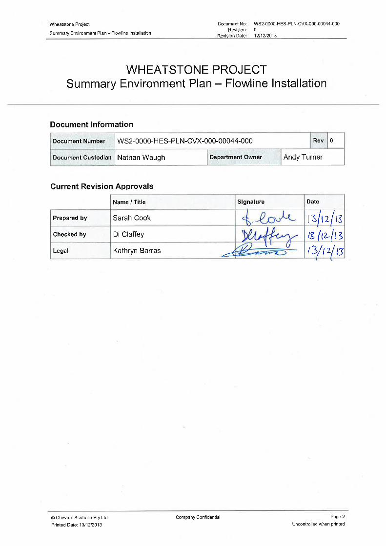
Wheatstone Project Document No: WS2-0000-HES-PLN-CVX-000-00044-000
Summary Environment Plan – Flowline Installation Revision: 0
Revision Date: 12/12/2013
© Chevron Australia Pty Ltd Company Confidential Page 3
Printed Date: 13/12/2013 Uncontrolled when printed
TABLE OF CONTENTS
1.0 INTRODUCTION ............................................................................................................ 4
1.1 Location ................................................................................................................. 4 1.2 Timeframe ............................................................................................................. 4 1.3 Operator Details .................................................................................................... 4
2.0 ACTIVITY DESCRIPTION .............................................................................................. 6
2.1 Planned Activity Summary .................................................................................... 6 2.1.1 Flowline pipelay ....................................................................................... 6 2.1.2 Post-pipelay survey and span correction ................................................. 7 2.1.3 Flooding, Cleaning, Gauging, Testing, Dewatering & Drying .................. 7 2.1.4 Supporting activities. ............................................................................... 7
2.2 Emergency Condition Summary ............................................................................ 8
3.0 DESCRIPTION OF THE ENVIRONMENT ..................................................................... 9
The EMBA by the petroleum activity (including in the event of an emergency) is described below. ................................................................................................... 9
3.1 Physical Environment ............................................................................................ 9 3.2 Ecological and Socio-economic Environment ....................................................... 9
4.0 MAJOR ENVIRONMENTAL HAZARDS AND CONTROLS ........................................ 16
5.0 MANAGEMENT APPROACH ...................................................................................... 19
5.1 Roles and Responsibilities .................................................................................. 19 5.2 Training and Competency ................................................................................... 19 5.3 Monitoring and Reporting .................................................................................... 19 5.4 Compliance assurance ........................................................................................ 19 5.5 Documentation and Records ............................................................................... 19 5.6 Environment Plan Review ................................................................................... 20
6.0 CONSULTATION ......................................................................................................... 21
6.1 Stakeholder Identification and Analysis ............................................................... 21 6.2 Communication Engagement Plan ...................................................................... 21
7.0 CONTACT DETAILS .................................................................................................... 22
TABLES
Table 1: Areas of conservation significance and key ecological features which occur within the EMBA ................................................................................................ 11
Table 2: Key Environmental Risks and their Management and Mitigation Measures ............ 17
FIGURES
Figure 1.1: Location of Wheatstone Project Infrastructure ....................................................... 5 Figure 2.1 Wheatstone Flowline Route Field Layout Schematic ............................................. 6
Wheatstone Project Document No: WS2-0000-HES-PLN-CVX-000-00044-000
Summary Environment Plan – Flowline Installation Revision: 0
Revision Date: 12/12/2013
© Chevron Australia Pty Ltd Company Confidential Page 4
Printed Date: 13/12/2013 Uncontrolled when printed
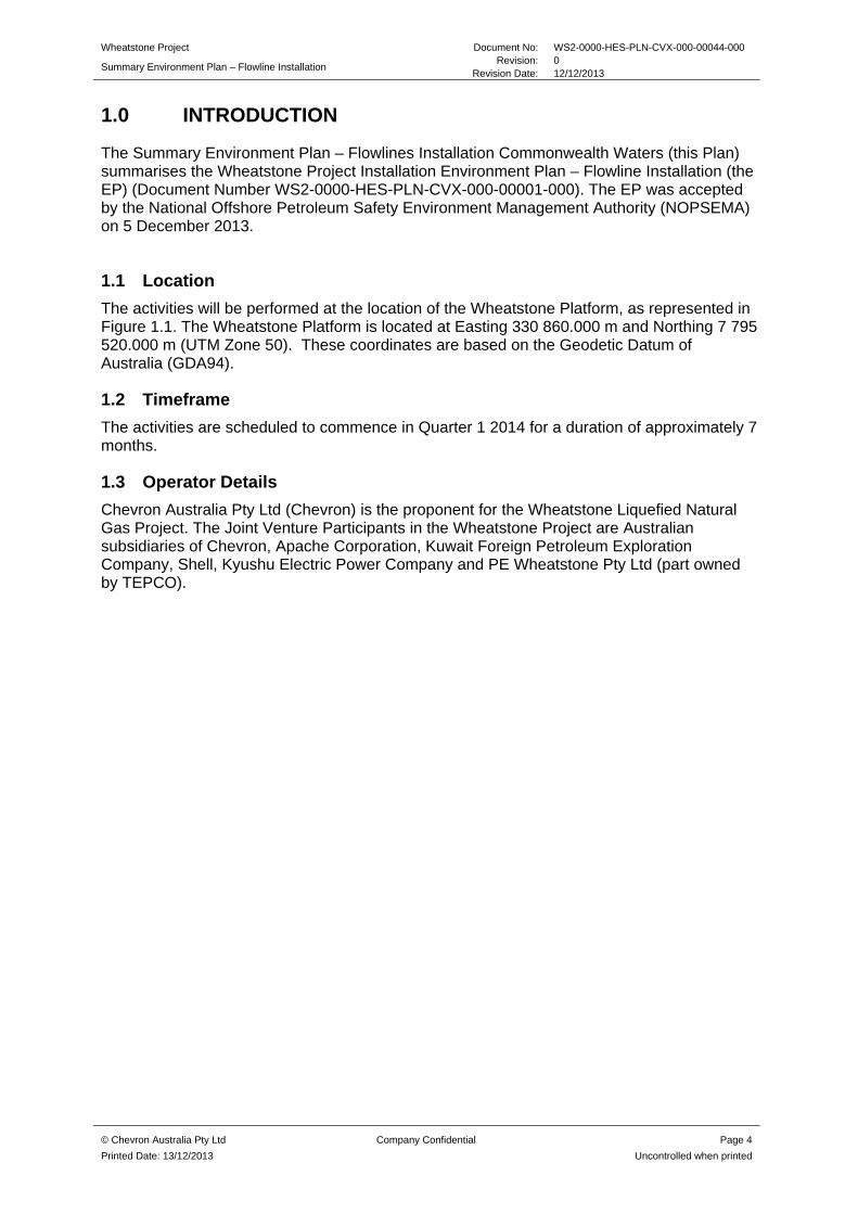
1.0 INTRODUCTION
The Summary Environment Plan – Flowlines Installation Commonwealth Waters (this Plan) summarises the Wheatstone Project Installation Environment Plan – Flowline Installation (the EP) (Document Number WS2-0000-HES-PLN-CVX-000-00001-000). The EP was accepted by the National Offshore Petroleum Safety Environment Management Authority (NOPSEMA) on 5 December 2013.
1.1 Location
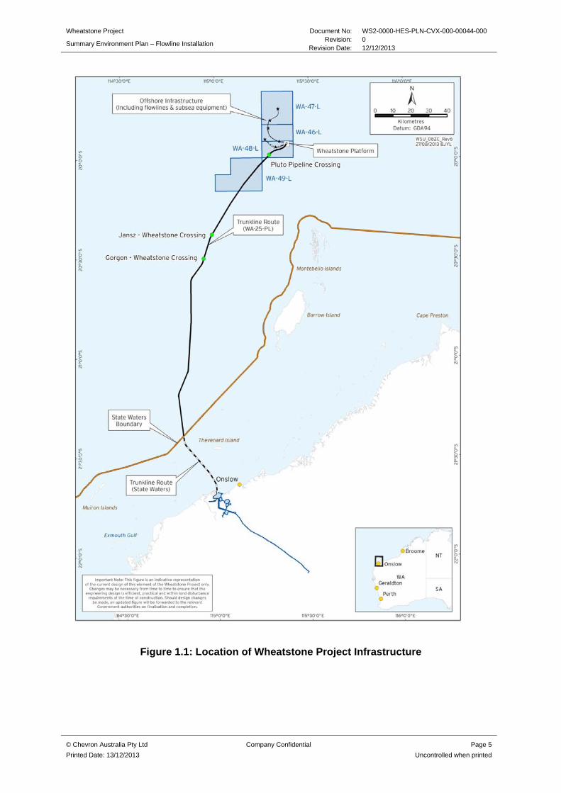
The activities will be performed at the location of the Wheatstone Platform, as represented in Figure 1.1. The Wheatstone Platform is located at Easting 330 860.000 m and Northing 7 795 520.000 m (UTM Zone 50). These coordinates are based on the Geodetic Datum of Australia (GDA94).
1.2 Timeframe
The activities are scheduled to commence in Quarter 1 2014 for a duration of approximately 7 months.
1.3 Operator Details
Chevron Australia Pty Ltd (Chevron) is the proponent for the Wheatstone Liquefied Natural Gas Project. The Joint Venture Participants in the Wheatstone Project are Australian subsidiaries of Chevron, Apache Corporation, Kuwait Foreign Petroleum Exploration Company, Shell, Kyushu Electric Power Company and PE Wheatstone Pty Ltd (part owned by TEPCO).
Wheatstone Project Document No: WS2-0000-HES-PLN-CVX-000-00044-000
Summary Environment Plan – Flowline Installation Revision: 0
Revision Date: 12/12/2013
© Chevron Australia Pty Ltd Company Confidential Page 5
Printed Date: 13/12/2013 Uncontrolled when printed
Figure 1.1: Location of Wheatstone Project Infrastructure

Wheatstone Project Document No: WS2-0000-HES-PLN-CVX-000-00044-000
Summary Environment Plan – Flowline Installation Revision: 0
Revision Date: 12/12/2013
© Chevron Australia Pty Ltd Company Confidential Page 6
Printed Date: 13/12/2013 Uncontrolled when printed
2.0 ACTIVITY DESCRIPTION
2.1 Planned Activity Summary
The following activities are associated with the Plan:
Flowline pipelay
Post-pipelay survey and span correction
Flooding, cleaning, gauging, testing, dewatering and drying of flowlines
Supporting activities.
2.1.1 Flowline pipelay
The flowline route along the seabed is shown in Figure 2.1. The flowline route was chosen to minimise the number of subsea connections present, provide connectivity to the drill centres and create the required configuration on the seabed. A full multi-beam survey was conducted to confirm the seabed topography prior to design.
Figure 2.1 Wheatstone Flowline Route Field Layout Schematic
A Dynamically Positioned Pipelay Vessel will be used for the installation of flowlines. The dynamic positioning system employed by the vessel assists to maintain the correct position and speed while laying pipe. Pipeline laydown will be completed using a single wire or dual wire system. Pipe sections generally 12.2 m in length will be joined at welding stations on the deck of the vessel and the pipe will be deployed over a stinger structure with rollers, to
Wheatstone Project Document No: WS2-0000-HES-PLN-CVX-000-00044-000
Summary Environment Plan – Flowline Installation Revision: 0
Revision Date: 12/12/2013
© Chevron Australia Pty Ltd Company Confidential Page 7
Printed Date: 13/12/2013 Uncontrolled when printed
provide a smooth and controlled curvature of the pipe. The pipe is fed over the stinger into the sea by moving the vessel forwards. Non-destructive testing onboard will occur before the pipeline is deployed to the seabed.
As part of the pipelay process, antiscour protection structures will be deployed using a survey/support vessel with a Remotely Operated Vehicle (ROV). Antiscour systems will comprise of grout inflated geotextile mats or as a contingency, grout bags, concrete mattresses or locally ROV placed rock.
2.1.2 Post-pipelay survey and span correction
The post-pipelay survey activities will be performed along the flowline route to record the as-laid position of the flowline, visually inspect flowline integrity, inspect existing infrastructure at pipeline crossings and identify any post-pipelay spans which may require correction. The post-pipelay survey will be performed along the flowline using a ROV, bathymetric and visual surveys.
Post-pipelay spans that require correction will be rectified using either concrete mattresses or grout bags installed under the pipeline to add support. The mattresses and grout bags will be installed using the survey vessel or a multipurpose construction vessel.
2.1.3 Flooding, Cleaning, Gauging, Testing, Dewatering & Drying
Upon completion of the flowlines pipelay, post-pipelay survey and span correction activities, the flowlines will be flooded with chemically treated seawater, cleaned, gauged and hydrotested to verify pipeline integrity. Once tested the flowlines will remain flooded for a period of up to 36 months. Prior to the introduction of hydrocarbons, the flowlines will be dewatered resulting in discharge of chemically treated seawater to the marine environment. The flowlines will be dried prior to hydrocarbon being introduced.
2.1.4 Supporting activities
Supporting activities will include vessel bunkering to fuel the flowline installation vessel, transfer of pipe from the pipe supply vessel to the installation vessel and the transfer of general supplies.
It is anticipated the flowlines installation vessel will need to be bunkered approximately five to eight times over the course of the activities. All other vessels will bunker in State waters and/or ports and will not use the bunkering vessel.
Transfer of pipe to the flowlines installation vessel will occur as required during the course of installation. Approximately three of the pipe supply vessels will be operating during flowline installation.
The transfer of supplies will occur via supply vessels which will transport dry and wet provisions, ship spares and equipment from shore support bases to the vessels as required. Support activities will include helicopter transfer of personnel from Barrow Island to the flowline installation vessel.

Wheatstone Project Document No: WS2-0000-HES-PLN-CVX-000-00044-000
Summary Environment Plan – Flowline Installation Revision: 0
Revision Date: 12/12/2013
© Chevron Australia Pty Ltd Company Confidential Page 8
Printed Date: 13/12/2013 Uncontrolled when printed
2.2 Emergency Condition Summary
The credible hydrocarbon and chemical spill scenarios associated with the activity were identified and assessed and are as follows:
Unplanned dewatering of the flowlines Loss of fuel (heavy fuel oil) during vessel refuelling in the operational area Vessel collision resulting in rupture of a fuel tank and loss of fuel (heavy fuel oil or
marine diesel oil) to the marine environment.
Modelling of these scenarios determined the environment that may be affected (EMBA) in the event of an unplanned emergency condition.

Wheatstone Project Document No: WS2-0000-HES-PLN-CVX-000-00044-000
Summary Environment Plan – Flowline Installation Revision: 0
Revision Date: 12/12/2013
© Chevron Australia Pty Ltd Company Confidential Page 9
Printed Date: 13/12/2013 Uncontrolled when printed
3.0 DESCRIPTION OF THE ENVIRONMENT
The EMBA by the petroleum activity (including in the event of an emergency) is described below.
3.1 Physical Environment
The region is largely characterised by an arid, subtropical climate. Daily temperatures range from 20 °C to 34 °C between the months of October and March in summer, and 15 °C to 26 °C between May and August in winter. The transitional season occurs in April and September. During summer, prevailing winds are from the north-west and south-west, typically varying between 10–13 ms-1. During winter months, north-easterly to south-easterly winds average between 6–8 ms-1 (Chevron, 2010d). The cyclone season runs from Mid-December to April, peaking in February and March (Bureau of Meteorology 2012).
Waters in the region show temporal and spatial variation in water temperature, with a mean sea surface temperature in open shelf waters around 29.3 °C in March dropping to 24 °C in August. Nearshore temperatures in semi-enclosed waters of the NWS may fluctuate through a higher range from 19-30.4 °C (Chevron, 2010). Tides in the region are semi-diurnal with a spring tide range of 1.9 m.
The large-scale currents predominantly flow southwest through the region influenced by the Indonesian Throughflow and Leeuwin Current (Buchan 1998). Below the surface currents, there are a number of subsurface currents, the most important of which are the Leeuwin Undercurrent and the West Australian Current. Surface currents on the North West Shelf are largely dominated by moderate to strong east-west surface current patterns from tidal variations.
Offshore waters are characterised by a relatively clear water column. In shallower, nearshore waters turbid conditions are usually the result of tidal, wave action or current- induced re-suspension of sediments and from episodic runoff of adjoining rivers. Turbidity levels >80 NTU have been recorded during cyclonic activity.
The cyclone season runs from Mid-December to April, peaking in February and March (Bureau of Meteorology 2012). Cyclonic events can deliver up to 300 mm of rainfall. On average about five tropical cyclones pass through the warm ocean waters off the north-west coast annually (Bureau of Meteorology 2012).
3.2 Ecological and Socio-economic Environment
A Matters of National Environmental Significance (MNES) search was undertaken for the area enclosed by the boundaries of the EMBA. According to the SEWPaC (now Department of Environment [DotE]) Protected Matters database, the following were identified:
1 world heritage properties
2 national heritage properties
3 Commonwealth Heritage Places
11 places on the Register of the National Estate (RNE). EPBC listed ‘threatened’ and ‘migratory’ fauna are known to occur within the reserves including marine turtles, marine mammals, marine seabirds and migratory

Wheatstone Project Document No: WS2-0000-HES-PLN-CVX-000-00044-000
Summary Environment Plan – Flowline Installation Revision: 0
Revision Date: 12/12/2013
© Chevron Australia Pty Ltd Company Confidential Page 10
Printed Date: 13/12/2013 Uncontrolled when printed
shorebirds. For the purposes of this document, regionally important ecological and socio-economic / heritage features within the environment that may be affected have been summarised within Table 1.
Wheatstone Project Document No: WS2-0000-HES-PLN-CVX-000-00044-000
Summary Environment Plan – Flowline Installation Revision: 0
Revision Date: 12/12/2013
© Chevron Australia Pty Ltd Company Confidential Page 11
Printed Date: 13/12/2013 Uncontrolled when printed
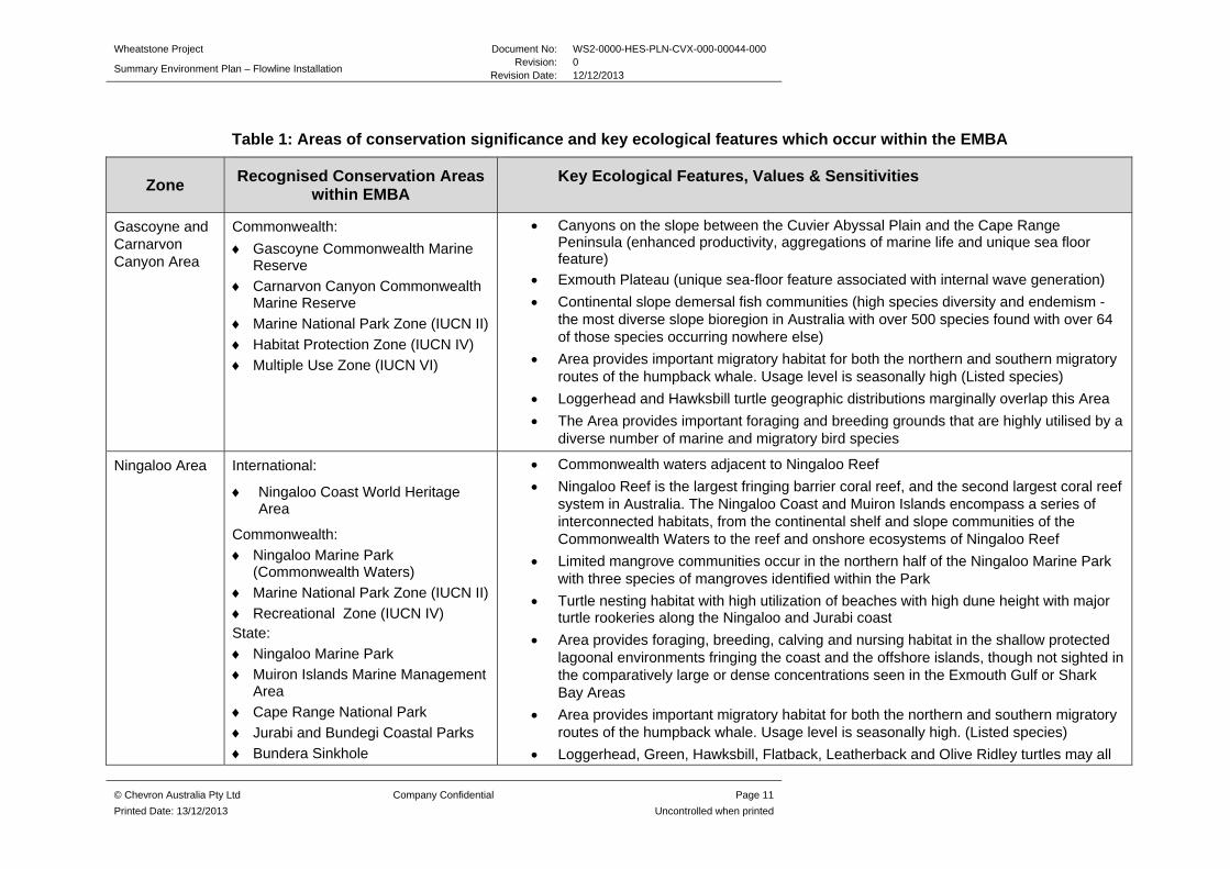
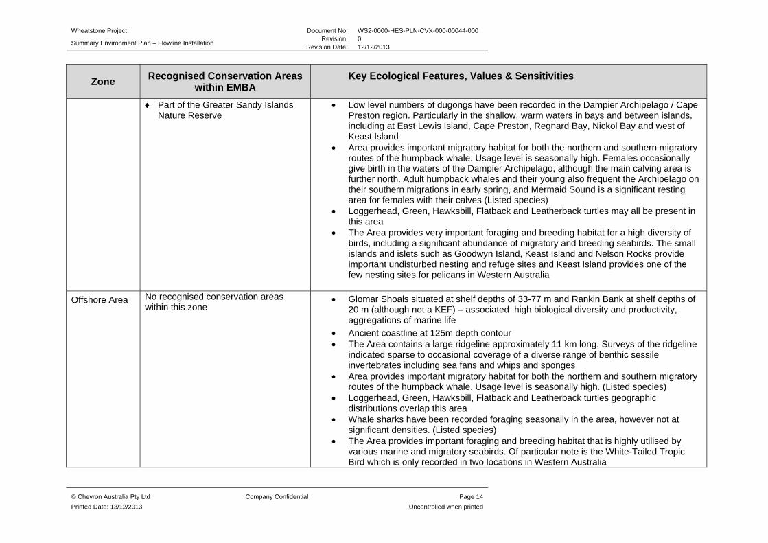
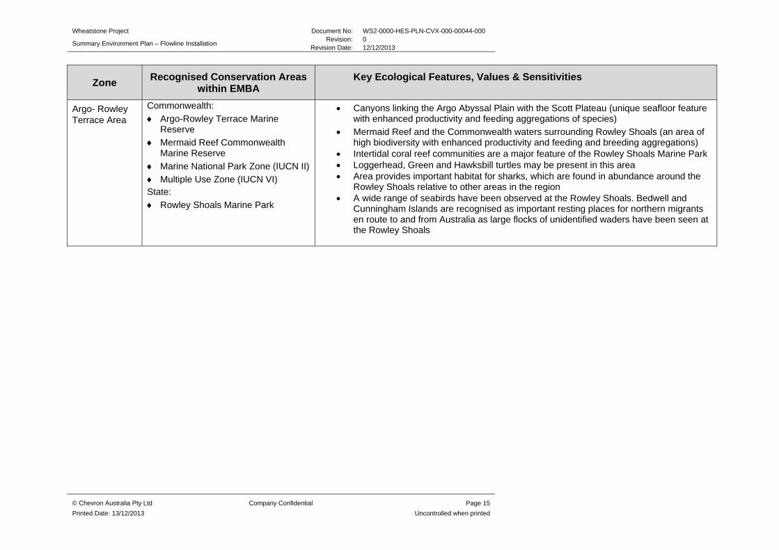
Table 1: Areas of conservation significance and key ecological features which occur within the EMBA
Zone Recognised Conservation Areas
within EMBA Key Ecological Features, Values & Sensitivities
Gascoyne and Carnarvon Canyon Area
Commonwealth:
Gascoyne Commonwealth Marine Reserve
Carnarvon Canyon Commonwealth Marine Reserve
Marine National Park Zone (IUCN II)
Habitat Protection Zone (IUCN IV)
Multiple Use Zone (IUCN VI)
Canyons on the slope between the Cuvier Abyssal Plain and the Cape Range Peninsula (enhanced productivity, aggregations of marine life and unique sea floor feature)
Exmouth Plateau (unique sea-floor feature associated with internal wave generation)
Continental slope demersal fish communities (high species diversity and endemism - the most diverse slope bioregion in Australia with over 500 species found with over 64 of those species occurring nowhere else)
Area provides important migratory habitat for both the northern and southern migratory routes of the humpback whale. Usage level is seasonally high (Listed species)
Loggerhead and Hawksbill turtle geographic distributions marginally overlap this Area
The Area provides important foraging and breeding grounds that are highly utilised by a diverse number of marine and migratory bird species
Ningaloo Area International:
Ningaloo Coast World Heritage Area
Commonwealth:
Ningaloo Marine Park (Commonwealth Waters)
Marine National Park Zone (IUCN II)
Recreational Zone (IUCN IV) State:
Ningaloo Marine Park
Muiron Islands Marine Management Area
Cape Range National Park
Jurabi and Bundegi Coastal Parks
Bundera Sinkhole
Commonwealth waters adjacent to Ningaloo Reef
Ningaloo Reef is the largest fringing barrier coral reef, and the second largest coral reef system in Australia. The Ningaloo Coast and Muiron Islands encompass a series of interconnected habitats, from the continental shelf and slope communities of the Commonwealth Waters to the reef and onshore ecosystems of Ningaloo Reef
Limited mangrove communities occur in the northern half of the Ningaloo Marine Park with three species of mangroves identified within the Park
Turtle nesting habitat with high utilization of beaches with high dune height with major turtle rookeries along the Ningaloo and Jurabi coast
Area provides foraging, breeding, calving and nursing habitat in the shallow protected lagoonal environments fringing the coast and the offshore islands, though not sighted in the comparatively large or dense concentrations seen in the Exmouth Gulf or Shark Bay Areas
Area provides important migratory habitat for both the northern and southern migratory routes of the humpback whale. Usage level is seasonally high. (Listed species)
Loggerhead, Green, Hawksbill, Flatback, Leatherback and Olive Ridley turtles may all
Wheatstone Project Document No: WS2-0000-HES-PLN-CVX-000-00044-000
Summary Environment Plan – Flowline Installation Revision: 0
Revision Date: 12/12/2013
© Chevron Australia Pty Ltd Company Confidential Page 12
Printed Date: 13/12/2013 Uncontrolled when printed
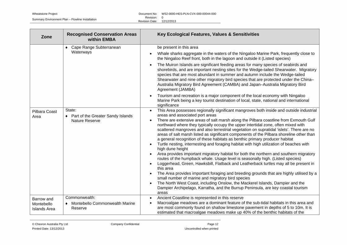
Zone Recognised Conservation Areas
within EMBA Key Ecological Features, Values & Sensitivities
Cape Range Subterranean Waterways
be present in this area
Whale sharks aggregate in the waters of the Ningaloo Marine Park, frequently close to the Ningaloo Reef front, both in the lagoon and outside it (Listed species)
The Muiron Islands are significant feeding areas for many species of seabirds and shorebirds, and are important nesting sites for the Wedge-tailed Shearwater. Migratory species that are most abundant in summer and autumn include the Wedge-tailed Shearwater and nine other migratory bird species that are protected under the China–Australia Migratory Bird Agreement (CAMBA) and Japan–Australia Migratory Bird Agreement (JAMBA)
Tourism and recreation is a major component of the local economy with Ningaloo Marine Park being a key tourist destination of local, state, national and international significance
Pilbara Coast Area
State:
Part of the Greater Sandy Islands Nature Reserve
This Area possesses regionally significant mangroves both inside and outside industrial areas and associated port areas
There are extensive areas of salt marsh along the Pilbara coastline from Exmouth Gulf northward where they typically occupy the upper intertidal zone, often mixed with scattered mangroves and also terrestrial vegetation on supratidal ‘islets’. There are no areas of salt marsh listed as significant components of the Pilbara shoreline other than a general recognition of these habitats as benthic primary producer habitat
Turtle nesting, internesting and foraging habitat with high utilization of beaches with high dune height
Area provides important migratory habitat for both the northern and southern migratory routes of the humpback whale. Usage level is seasonally high. (Listed species)
Loggerhead, Green, Hawksbill, Flatback and Leatherback turtles may all be present in this area
The Area provides important foraging and breeding grounds that are highly utilised by a small number of marine and migratory bird species
The North West Coast, including Onslow, the Mackerel Islands, Dampier and the Dampier Archipelago, Karratha, and the Burrup Peninsula, are key coastal tourism areas
Barrow and Montebello Islands Area
Commonwealth:
Montebello Commonwealth Marine Reserve
Ancient Coastline is represented in this reserve Macroalgae meadows are a dominant feature of the sub-tidal habitats in this area and
are most commonly found on shallow limestone pavement in depths of 5 to 10m. It is estimated that macroalgae meadows make up 40% of the benthic habitats of the

Wheatstone Project Document No: WS2-0000-HES-PLN-CVX-000-00044-000
Summary Environment Plan – Flowline Installation Revision: 0
Revision Date: 12/12/2013
© Chevron Australia Pty Ltd Company Confidential Page 13
Printed Date: 13/12/2013 Uncontrolled when printed
Zone Recognised Conservation Areas
within EMBA Key Ecological Features, Values & Sensitivities
Multiple Use Zone (IUCN VI) State:
Montebello Islands Marine Park
Barrow Island Marine Park
Barrow Island Marine Management Area
Lowendal Islands Nature Reserve
Montebello/Barrow Islands Marine Conservation Reserve and make the major contribution to primary production
This Area possesses regionally significant mangroves. Six species of mangrove are found in the reserves, with the Montebello Islands’ mangrove communities considered globally unique as they occur in lagoons of offshore islands
Significant turtle nesting habitat particularly at sandy beaches on Varanus Island, Lowendal Island Group and Barrow Island
Dugongs are frequently recorded in the shallow, warm waters in the vicinity of the Montebello Islands, Lowendal Islands and Barrow Shoals, where they feed on seagrass meadows and algae, though not in the comparatively large or dense concentrations seen further south in the Exmouth Gulf and Shark Bay Areas
Area provides important migratory habitat for both the northern and southern migratory routes of the humpback whale. Usage level is seasonally high. Female humpback whales and their calves use the sheltered water to the west of Trimouille Island in the Montebello group as a resting area during their southerly migration to feeding grounds in Antarctica (Listed species)
Several dolphin species have resident populations within the Barrow Island area including bottlenose and Indo-pacific humpbacked dolphin (Listed species)
Loggerhead, Green, Hawksbill and Flatback turtles may all be present in this area Whale sharks have been recorded foraging seasonally in the area, however not at
significant densities. (Listed species) The Montebello/Lowendal/Barrow Island region has significant rookeries for 15 seabird
species, including the largest breeding colony of Roseate Terns in WA, located on the Montebello Islands
Dampier Archipelago Area
Commonwealth:
Dampier Commonwealth Marine Reserve
Marine National Park Zone (IUCN II)
Special Purpose Zone (IUCN VI) State:
Dampier Archipelago Marine Park (proposed)
Dampier Archipelago Island Reserves
Extensive macroalgal and seagrass communities occur within the proposed reserves in this Area. Macroalgae dominate submerged limestone reefs and also grow on stable rubble and boulder surfaces in the Dampier Archipelago/Cape Preston region
This Area possesses regionally significant mangroves both inside and outside industrial areas and associated port areas. There are six species of mangrove found in the proposed reserves and extensive mangrove communities line over 50% of the mainland shore. Many of these communities are considered to be of international significance
The intertidal sand and mudflat communities of the proposed reserves are primary producers and have an abundance of invertebrate life, which provides a valuable food source for shorebirds
Wheatstone Project Document No: WS2-0000-HES-PLN-CVX-000-00044-000
Summary Environment Plan – Flowline Installation Revision: 0
Revision Date: 12/12/2013
© Chevron Australia Pty Ltd Company Confidential Page 14
Printed Date: 13/12/2013 Uncontrolled when printed
Zone Recognised Conservation Areas
within EMBA Key Ecological Features, Values & Sensitivities
Part of the Greater Sandy Islands Nature Reserve
Low level numbers of dugongs have been recorded in the Dampier Archipelago / Cape Preston region. Particularly in the shallow, warm waters in bays and between islands, including at East Lewis Island, Cape Preston, Regnard Bay, Nickol Bay and west of Keast Island
Area provides important migratory habitat for both the northern and southern migratory routes of the humpback whale. Usage level is seasonally high. Females occasionally give birth in the waters of the Dampier Archipelago, although the main calving area is further north. Adult humpback whales and their young also frequent the Archipelago on their southern migrations in early spring, and Mermaid Sound is a significant resting area for females with their calves (Listed species)
Loggerhead, Green, Hawksbill, Flatback and Leatherback turtles may all be present in this area
The Area provides very important foraging and breeding habitat for a high diversity of birds, including a significant abundance of migratory and breeding seabirds. The small islands and islets such as Goodwyn Island, Keast Island and Nelson Rocks provide important undisturbed nesting and refuge sites and Keast Island provides one of the few nesting sites for pelicans in Western Australia
Offshore Area No recognised conservation areas within this zone
Glomar Shoals situated at shelf depths of 33-77 m and Rankin Bank at shelf depths of 20 m (although not a KEF) – associated high biological diversity and productivity, aggregations of marine life
Ancient coastline at 125m depth contour The Area contains a large ridgeline approximately 11 km long. Surveys of the ridgeline
indicated sparse to occasional coverage of a diverse range of benthic sessile invertebrates including sea fans and whips and sponges
Area provides important migratory habitat for both the northern and southern migratory routes of the humpback whale. Usage level is seasonally high. (Listed species)
Loggerhead, Green, Hawksbill, Flatback and Leatherback turtles geographic distributions overlap this area
Whale sharks have been recorded foraging seasonally in the area, however not at significant densities. (Listed species)
The Area provides important foraging and breeding habitat that is highly utilised by various marine and migratory seabirds. Of particular note is the White-Tailed Tropic Bird which is only recorded in two locations in Western Australia
Wheatstone Project Document No: WS2-0000-HES-PLN-CVX-000-00044-000
Summary Environment Plan – Flowline Installation Revision: 0
Revision Date: 12/12/2013
© Chevron Australia Pty Ltd Company Confidential Page 15
Printed Date: 13/12/2013 Uncontrolled when printed
Zone Recognised Conservation Areas
within EMBA Key Ecological Features, Values & Sensitivities
Argo- Rowley Terrace Area
Commonwealth:
Argo-Rowley Terrace Marine Reserve
Mermaid Reef Commonwealth Marine Reserve
Marine National Park Zone (IUCN II)
Multiple Use Zone (IUCN VI) State:
Rowley Shoals Marine Park
Canyons linking the Argo Abyssal Plain with the Scott Plateau (unique seafloor feature with enhanced productivity and feeding aggregations of species)
Mermaid Reef and the Commonwealth waters surrounding Rowley Shoals (an area of high biodiversity with enhanced productivity and feeding and breeding aggregations)
Intertidal coral reef communities are a major feature of the Rowley Shoals Marine Park Loggerhead, Green and Hawksbill turtles may be present in this area Area provides important habitat for sharks, which are found in abundance around the
Rowley Shoals relative to other areas in the region A wide range of seabirds have been observed at the Rowley Shoals. Bedwell and
Cunningham Islands are recognised as important resting places for northern migrants en route to and from Australia as large flocks of unidentified waders have been seen at the Rowley Shoals

Wheatstone Project Document No: WS2-0000-HES-PLN-CVX-000-00044-000
Summary Environment Plan – Flowline Installation Revision: 0
Revision Date: 12/12/2013
© Chevron Australia Pty Ltd Company Confidential Page 16
Printed Date: 13/12/2013 Uncontrolled when printed
4.0 MAJOR ENVIRONMENTAL HAZARDS AND CONTROLS
All aspects of the activity have been subjected to a comprehensive impact and risk assessment to understand the potential environmental risks associated with the activity and ensure risks are reduced to as low as reasonably practicable and are of an acceptable level. The risk assessment was undertaken in alignment with the processes outlined in Australian Standard/New Zealand Standard (AS/NZS) ISO 31000:2009 Risk Management and HB 203:2012 Managing Environment-Related Risk, using the Chevron Integrated Risk Prioritization Matrix.
The following environmental hazards/risks have identified and assessed for this activity:
Physical Presence Benthic Disturbance Light Emissions Noise Atmospheric Emissions Introduced Marine Pests Hazardous and Non-Hazardous Solid Waste Hazardous and Non-Hazardous Liquid Waste
To ensure the potential environmental impacts identified through the risk assessment are managed appropriately, Chevron has developed a range of performance standards (controls) that will be implemented throughout the course of flowlines installation. A summary of some of the major environmental hazards and controls are detailed in Table 2.
Wheatstone Project Document No: WS2-0000-HES-PLN-CVX-000-00044-000
Summary Environment Plan – Flowline Installation Revision: 0
Revision Date: 12/12/2013
© Chevron Australia Pty Ltd Company Confidential Page 17
Printed Date: 13/12/2013 Uncontrolled when printed
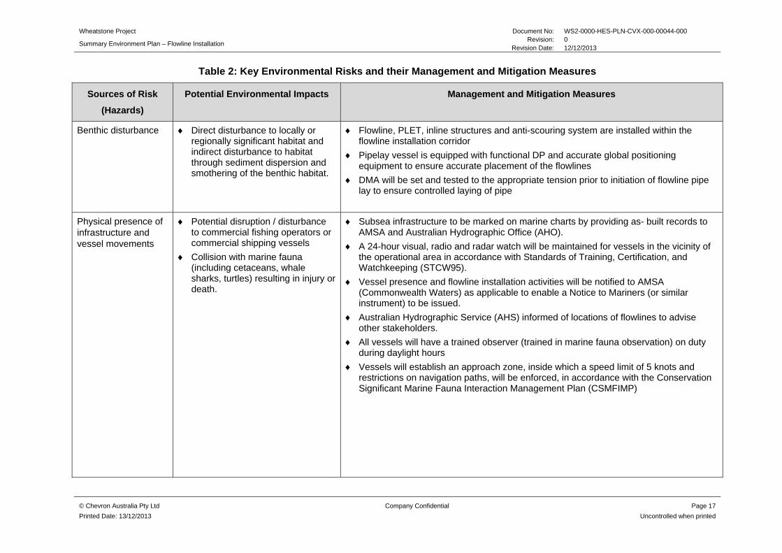
Table 2: Key Environmental Risks and their Management and Mitigation Measures
Sources of Risk
(Hazards)
Potential Environmental Impacts Management and Mitigation Measures
Benthic disturbance Direct disturbance to locally or regionally significant habitat and indirect disturbance to habitat through sediment dispersion and smothering of the benthic habitat.
Flowline, PLET, inline structures and anti-scouring system are installed within the flowline installation corridor
Pipelay vessel is equipped with functional DP and accurate global positioning equipment to ensure accurate placement of the flowlines
DMA will be set and tested to the appropriate tension prior to initiation of flowline pipe lay to ensure controlled laying of pipe
Physical presence of infrastructure and vessel movements
Potential disruption / disturbance to commercial fishing operators or commercial shipping vessels
Collision with marine fauna (including cetaceans, whale sharks, turtles) resulting in injury or death.
Subsea infrastructure to be marked on marine charts by providing as- built records to AMSA and Australian Hydrographic Office (AHO).
A 24-hour visual, radio and radar watch will be maintained for vessels in the vicinity of the operational area in accordance with Standards of Training, Certification, and Watchkeeping (STCW95).
Vessel presence and flowline installation activities will be notified to AMSA (Commonwealth Waters) as applicable to enable a Notice to Mariners (or similar instrument) to be issued.
Australian Hydrographic Service (AHS) informed of locations of flowlines to advise other stakeholders.
All vessels will have a trained observer (trained in marine fauna observation) on duty during daylight hours
Vessels will establish an approach zone, inside which a speed limit of 5 knots and restrictions on navigation paths, will be enforced, in accordance with the Conservation Significant Marine Fauna Interaction Management Plan (CSMFIMP)

Wheatstone Project Document No: WS2-0000-HES-PLN-CVX-000-00044-000
Summary Environment Plan – Flowline Installation Revision: 0
Revision Date: 12/12/2013
© Chevron Australia Pty Ltd Company Confidential Page 18
Printed Date: 13/12/2013 Uncontrolled when printed
Sources of Risk
(Hazards)
Potential Environmental Impacts Management and Mitigation Measures
Introduced marine pests (IMP)
Introduction of IMP to the operational area
If mobilising from International waters, vessels will have Department of Agriculture, Fisheries and Forestry (DAFF) clearance to operate in Australian waters, will submit a Quarantine Pre-Arrival Report (QPAR) to DAFF prior to entry
All vessels to maintain a current anti-fouling coating that complies with the requirements of Annex 1 of the International Convention on the Control of Harmful Anti-Fouling Systems on Ships
All vessels, as required by the Introduced Marine Pest Risk Assessment Procedure (IMPRAP), will have completed a vessel risk assessment as per the IMPRAP
All high risk vessels (as assigned through the IMPRAP) will be inspected by a Department of Fisheries officer (or suitably qualified IMP expert approved by DoF)
All required vessels will implement the DAFF Australian Ballast Water Management Requirements
Solid waste Temporary and localised reduction in water quality associated with increase in nutrients
Food waste will be discharged to the ocean beyond 12 nm from land in accordance with MARPOL, Annex V
Vessels > 100 T (or certified for > 15 persons on-board) will have a Waste Management Plan, in accordance with MARPOL 73/78
Waste either incinerated or appropriately disposed of at a licensed onshore facility if disposed of in Australia
Liquid Waste Temporary and localised reduction in water quality
Waste management and housekeeping requirements are communicated to all personnel during inductions.
Offshore discharge of sewage in accordance with MARPOL Annex IV
Oily bilge water will be disposed at an onshore licensed facility or discharged in accordance with MARPOL 73/78, Annex I
Spill kits will be provided on all vessels and maintained and personnel will be trained in their use
Wheatstone Project Document No: WS2-0000-HES-PLN-CVX-000-00044-000
Summary Environment Plan – Flowline Installation Revision: 0
Revision Date: 12/12/2013
© Chevron Australia Pty Ltd Company Confidential Page 19
Printed Date: 13/12/2013 Uncontrolled when printed
5.0 MANAGEMENT APPROACH
The implementation strategy identifies the systems, practices and procedures to be used to ensure the environmental impacts and risks of the activities are reduced to ALARP and are acceptable, and the environmental performance objectives and standards are met. The implementation strategy is split between planned operational activities and unplanned event response, enabling roles and responsibilities to be clearly defined and to provide a clear chain of command for both.
The implementation strategy is to be enacted in accordance with Chevron Australia’s Operational Excellence Management System. Chevron’s Operational Excellence Management System is aligned to ISO 14001:2004 and key components of the management system are described in the subsections below.
5.1 Roles and Responsibilities
Accountabilities and responsibilities are defined for personnel involved in the projects implementation for both planned activities and unplanned events.
5.2 Training and Competency
All personnel are required to attend environmental inductions and training relevant to their role for the activities. Training and induction programs facilitate the understanding personnel have of their environmental responsibilities, and increase their awareness of the management and protection measures required to reduce potential impacts on the environment. In addition to project training, personnel will also receive spill response training. A number of personnel have also been AMOSC trained.
5.3 Monitoring and Reporting
The implementation strategy outlines the requirements for the following: oil spill monitoring plan, emissions and discharges, routine external reporting and non-routine reporting (including internal incident reporting and investigations and external incident and near misses reporting).
5.4 Compliance assurance
A multi-tiered environmental compliance assurance program will be implemented for the duration of the activities described in the detailed Plan, including tools, processes and procedures to deliver and verify compliance with the detailed Plan. Assurance activities will include both Chevron-led and contractor-led audits and inspections. Chevron-led audits and inspections will be undertaken as required and in accordance with Chevron’s ABU Compliance Assurance Process and the Health, Environment and Safety Audit Schedule for the Project.
5.5 Documentation and Records
Chevron Australia’s ABU Operational Excellence Management System (OEMS) has dedicated information management tools and processes to ensure critical information is developed, accessible and maintained by the workforce. Wheatstone documentation shall be managed in accordance with this Process, and specifically via the Project’s Document Management System. Accordingly, all documentation and records demonstrating compliance against environmental performance objectives and standards will be effectively maintained and retained for the life of the Project and not less than five years.
Wheatstone Project Document No: WS2-0000-HES-PLN-CVX-000-00044-000
Summary Environment Plan – Flowline Installation Revision: 0
Revision Date: 12/12/2013
© Chevron Australia Pty Ltd Company Confidential Page 20
Printed Date: 13/12/2013 Uncontrolled when printed
5.6 Environment Plan Review
Chevron’s Management of Change process will be followed to document and assess the impact of any changes to the activities described in the detailed EP. These changes will be addressed to determine if there is potential for any new or increased environmental impact or risk not already provided for in the detailed EP. The detailed EP will be re-submitted to NOPSEMA for approval in accordance with Regulation 17 of the Offshore Petroleum and Greenhouse Gas Storage (Environment) Regulations 2009 (OPGGS(E)R).

Wheatstone Project Document No: WS2-0000-HES-PLN-CVX-000-00044-000
Summary Environment Plan – Flowline Installation Revision: 0
Revision Date: 12/12/2013
© Chevron Australia Pty Ltd Company Confidential Page 21
Printed Date: 13/12/2013 Uncontrolled when printed
6.0 CONSULTATION
Chevron prepared a Stakeholder Consultation Plan specific for this activity. The Stakeholder Consultation Plan describes:
stakeholder identification and analysis communication engagement plan, comprising the level and trigger of engagement,
type of engagement, and frequency stakeholder engagement log, including any issues raised and Chevron responses full text of consultation.
6.1 Stakeholder Identification and Analysis
Relevant stakeholders have been identified through a stakeholder analysis process to ensure persons or organisations that may potentially be affected by the overall Wheatstone Platform and associated activities including flowline installation work have been consulted. Stakeholders were identified by reviewing:
social / commercial receptors within the EMBA historical consultation undertaken for Chevron and applicable legislation to identify regulatory agencies.
6.2 Communication Engagement Plan
Once the stakeholder analysis was completed, a Communication Engagement Plan was developed to determine the following, for each stakeholder:
the level of engagement required the type of engagement required when engagement would be undertaken and the frequency of communication.
The Communication Engagement Plan covers both initial and ongoing stakeholder engagement and covers both planned activities and unplanned events. Chevron will maintain communications with identified stakeholders as required ensuring they are informed of any aspects of the flowline installation activity that may potentially affect other users of the area.
Wheatstone Project Document No: WS2-0000-HES-PLN-CVX-000-00044-000
Summary Environment Plan – Flowline Installation Revision: 0
Revision Date: 12/12/2013
© Chevron Australia Pty Ltd Company Confidential Page 22
Printed Date: 13/12/2013 Uncontrolled when printed
7.0 CONTACT DETAILS
Further information associated with the proposed activities may be obtained from:
Andy Turner
Wheatstone Upstream HES Manager
Phone: +61 8 9216 4952
Fax: +61 8 9413 6885
Email: [email protected]