sulphur creek watershed management plan
TRANSCRIPT

Napa County Resource Conservation District · 1303 Jefferson Street, Suite 500B · Napa, CA 94559 · (707) 252-4188 · www.naparcd.org
Sulphur Creek Watershed Management Plan
prepared for
Sulphur Creek Watershed Task Force
by Sulphur Creek Watershed Task Force
Napa County Resource Conservation District with
San Francisco Estuary Institute Pacific Watershed Associates
Bay-Delta Authority Watershed Program
December, 2004

Sulphur Creek Watershed Management Plan Napa County Resource Conservation District · 1303 Jefferson Street, Suite 500B · Napa, CA 94559 · (707) 252-4188 · www.naparcd.org
Contents List of Figures…………………………………………………………………… ii Acknowledgements…………………………………………………………….. iii Introduction…………………………………………………………………………….. 1
The Sulphur Creek Watershed…………………………………………………………. 2
History of Watershed Development and Management………………………………… 4
Existing Watershed Conditions………………………………………………………… 9
Riparian Function………………………………………………………………. 10
Upland Ecology………………………………………………………………… 11
Salmonid Habitat……………………………………………………………….. 13
Soil Erosion and Excess Sediment……………………………………………… 15
Flood Hazards…………………………………………………………………... 18
Waters Supply…………………………………………………………………... 19
Watershed Management Recommendations……………………………………………. 20
Recommendations for the Upper, Middle & Heath Canyon Reaches…………… 21
Recommendations for the Lower Reach………………………………………… 27
Future Research and Recommended Monitoring ………………………………………. 33
Sources of Public Funding & Assistance…..……………………………………………. 38
Attachments: Executive Summaries from Watershed Assessment Technical Reports……
Historical Ecology………………………………………………………………… 42
Geomorphology…………………………………………………………………. 45
Sediment Source Assessment…………………………………………………… 48
Fish Habitat Assessment……………………………………………………….. 52
i

Sulphur Creek Watershed Management Plan Napa County Resource Conservation District · 1303 Jefferson Street, Suite 500B · Napa, CA 94559 · (707) 252-4188 · www.naparcd.org
List of Figures
Figure 1: Map of Sulphur Creek watershed……………………………………………. 2
Figure 2: Sulphur Creek Watershed Land Use Table, 1993……………………………… 3
Figure 3: Sulphur Creek Watershed Land Use, GIS Image, 1993………………………..
Figure 4: Qualitative summary showing the relative timing and intensity of major land management activities in the Sulphur Creek watershed over the past two centuries………………………………………………….. 5
Figure 5: Land use and major vegetation types in the Sulphur Creek watershed Circa 1942 and 1993…………………………………………………………. 8
Figure 6: Map of creek reaches within the Sulphur Creek watershed…………………. 9
Figure 7: Typical riparian vegetation in the middle reaches of Sulphur Creek………… 11
Figure 8: Tree of Heaven, Bigleaf Periwinkle, Tamarisk and Yellow Star Thistle……. 12
Figure 9: Map high quality steelhead habitat in the Sulphur Creek watershed………… 14
Figure 10: Devil’s Slide, on the Northwest Branch of Sulphur Creek…………………… 16
ii

Sulphur Creek Watershed Management Plan Napa County Resource Conservation District · 1303 Jefferson Street, Suite 500B · Napa, CA 94559 · (707) 252-4188 · www.naparcd.org
Acknowledgements This watershed management plan and its associated watershed assessment technical reports were made possible with funding from the California Bay-Delta Authority Watershed Program (project number WSP-01-FB-00145). Without these funds, the assessments and research necessary to make informed watershed planning decisions to protect, restore, and enhance our ecological and community resources would not be possible. Other contracted partners who contributed to this management plan and the associated technical reports include San Francisco Estuary Institute and Pacific Watershed Associates. The final technical reports that are the foundation of this management plan are available on CD from the Napa County Resource Conservation District and will be made available on-line in the future. Several people contributed to the writing of this management plan, including Leigh Sharp, Jonathan Koehler and Bob Zlomke from the Napa County Resource Conservation District; Sarah Pearce, Robin Grossinger, and Lester McKee from San Francisco Estuary Institute; Phill Blake from USDA Natural Resources Conservation Service; and Chris Howell, John Kelly, Michael Marston, Homer Dunn, Susan Card, David Garden, and John Perry from the Sulphur Creek Watershed Task Force. We are also grateful for support and assistance from the following agencies and groups. California Bay-Delta Authority, Watershed Program California Department of Conservation California Department of Fish and Game Information Center for the Environment, UC Davis Napa County Assessor’s Office Napa County Information Technology Services Napa County Public Works (Road Department) O’Connor Environmental Pacific Watershed Associates San Francisco Bay Regional Water Quality Control Board San Francisco Estuary Institute Sulphur Creek Watershed Task Force USDA Natural Resources Conservation Service
iii

Sulphur Creek Watershed Management Plan Napa County Resource Conservation District · 1303 Jefferson Street, Suite 500B · Napa, CA 94559 · (707) 252-4188 · www.naparcd.org
Introduction A group of concerned stakeholders formed the Sulphur Creek Watershed Task Force (Task Force) with the mission to preserve and maintain Sulphur Creek watershed in a natural and beautiful state and to promote both agricultural as well as private recreational usage of the watershed. The Task Force aims to preserve and maintain the watershed for functions that are mutually agreeable among interested local residents. Over the past several years, the group constructed a set of resource questions, helped to instigate a multi-disciplinary science project to research watershed conditions, and expressed interest in developing a management plan to help guide future protection and enhancement of the watershed. This management plan is the product of the Task Force’s interests and draws upon watershed assessment research that was conducted during the summer and fall of 2002. The Plan was drafted specifically to provide management recommendations for the portion of the watershed that is above the City of St. Helena (principally Heath Canyon and the middle and upper reaches of Sulphur Creek). However, the watershed assessment research necessarily considers the watershed as a single ecological unit. Several types of empirical data collection and/or review of existing information were conducted and resulted in five technical reports regarding watershed history, channel form and function, hillslope and sediment form and function, fish and fish habitat, and water quality. Copies of each of the reports are available on CD from the Napa County Resource Conservation District, and the executive summaries of those reports are included here for reference purposes. In the process of preparing this plan the Task Force utilized numerous sources of information. The Task Force found in some instances that different studies focusing on different objectives provided conflicting conclusions. The Task Force attempted to reconcile these differences in such a manner as to end up with the best total plan for the watershed. This plan differs in some instances from the specific conclusions contained in the attachments. The attachments should therefore be viewed as background information and not as parts of the plan. Where this plan differs from the attachments, the plan reflects the final position of the task force. The plan provides a summary of existing conditions and recommendations for management, monitoring, and further research. The management plan is meant to be used as a tool for the local community and is meant to be voluntary in nature. It also builds upon a long history of on-going community efforts to protect and restore the natural function of the watershed, some of which will be discussed in the following section. The plan describes the local setting, discusses the history of watershed development and management, summarizes existing watershed conditions, and provides recommendations for ongoing watershed management and monitoring. The appendices include a reference document that provides more detail regarding existing conditions and recommendations, and includes the executive summaries from each of the technical reports produced for the watershed assessment.
1
Sulphur Creek Watershed Management Plan Napa County Resource Conservation District · 1303 Jefferson Street, Suite 500B · Napa, CA 94559 · (707) 252-4188 · www.naparcd.org
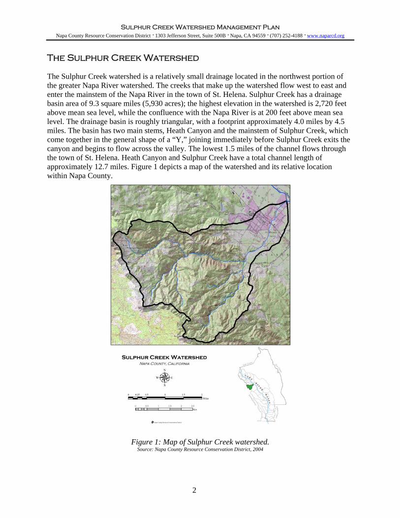
The Sulphur Creek Watershed The Sulphur Creek watershed is a relatively small drainage located in the northwest portion of the greater Napa River watershed. The creeks that make up the watershed flow west to east and enter the mainstem of the Napa River in the town of St. Helena. Sulphur Creek has a drainage basin area of 9.3 square miles (5,930 acres); the highest elevation in the watershed is 2,720 feet above mean sea level, while the confluence with the Napa River is at 200 feet above mean sea level. The drainage basin is roughly triangular, with a footprint approximately 4.0 miles by 4.5 miles. The basin has two main stems, Heath Canyon and the mainstem of Sulphur Creek, which come together in the general shape of a “Y,” joining immediately before Sulphur Creek exits the canyon and begins to flow across the valley. The lowest 1.5 miles of the channel flows through the town of St. Helena. Heath Canyon and Sulphur Creek have a total channel length of approximately 12.7 miles. Figure 1 depicts a map of the watershed and its relative location within Napa County.
Figure 1: Map of Sulphur Creek watershed. Source: Napa County Resource Conservation District, 2004
2
Sulphur Creek Watershed Management Plan Napa County Resource Conservation District · 1303 Jefferson Street, Suite 500B · Napa, CA 94559 · (707) 252-4188 · www.naparcd.org
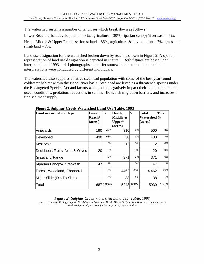
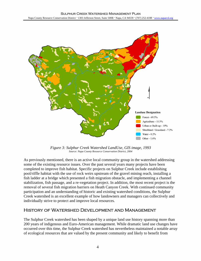
The watershed sustains a number of land uses which break down as follows: Lower Reach: urban development – 63%, agriculture – 30%; riparian canopy/riverwash – 7%; Heath, Middle & Upper Reaches: forest land – 86%, agriculture & development – 7%, grass and shrub land – 7%. Land use designation for the watershed broken down by reach is shown in Figure 2. A spatial representation of land use designation is depicted in Figure 3. Both figures are based upon interpretation of 1993 aerial photographs and differ somewhat due to the fact that the interpretations were conducted by different individuals. The watershed also supports a native steelhead population with some of the best year-round coldwater habitat within the Napa River basin. Steelhead are listed as a threatened species under the Endangered Species Act and factors which could negatively impact their population include: ocean conditions, predation, reductions in summer flow, fish migration barriers, and increases in fine sediment supply.
Figure 2. Sulphur Creek Watershed Land Use Table, 1993 Land use or habitat type Lower
Reach* (acres)
% Heath, Middle & Upper* (acres)
% Total Watershed (acres)
Total %
Vineyards 190 28% 310 6% 500 8%
Developed 430 63% 50 1% 480 8%
Reservoir 0% 12 0% 12 0%
Deciduous Fruits, Nuts & Olives 20 3% 0% 20 0%
Grassland/Range 0% 371 7% 371 6%
Riparian Canopy/Riverwash 47 7% 0% 47 1%
Forest, Woodland, Chaparral 0% 4462 85% 4,462 75%
Major Slide (Devil’s Slide) 0% 38 1% 38 1%
Total 687 100% 5243 100% 5930 100%
Figure 2: Sulphur Creek Watershed Land Use, Table, 1993 Source: Historical Ecology Report. Breakdown by Lower and Heath, Middle & Upper is a Task Force estimate, but is
considered generally accurate for the purposes of representation.
3
Sulphur Creek Watershed Management Plan Napa County Resource Conservation District · 1303 Jefferson Street, Suite 500B · Napa, CA 94559 · (707) 252-4188 · www.naparcd.org
Figure 3: Sulphur Creek Watershed LandUse, GIS image, 1993
Source: Napa County Resource Conservation District, 2004 As previously mentioned, there is an active local community group in the watershed addressing some of the existing resource issues. Over the past several years many projects have been completed to improve fish habitat. Specific projects on Sulphur Creek include establishing pool/riffle habitat with the use of rock weirs upstream of the gravel mining reach, installing a fish ladder at a bridge which presented a fish migration obstacle, and implementing a channel stabilization, fish passage, and a re-vegetation project. In addition, the most recent project is the removal of several fish migration barriers on Heath Canyon Creek. With continued community participation and an understanding of historic and existing watershed conditions, the Sulphur Creek watershed is an excellent example of how landowners and managers can collectively and individually strive to protect and improve local resources. History of Watershed Development and Management The Sulphur Creek watershed has been shaped by a unique land use history spanning more than 200 years of indigenous and Euro-American management. While dramatic land use changes have occurred over this time, the Sulphur Creek watershed has nevertheless maintained a notable array of ecological resources that are valued by the present community and likely to benefit from
4

Sulphur Creek Watershed Management Plan Napa County Resource Conservation District · 1303 Jefferson Street, Suite 500B · Napa, CA 94559 · (707) 252-4188 · www.naparcd.org
future restoration and enhancement activities. An understanding of how human use of the land has changed through time, and how those uses have transformed watershed functions, is an important part of developing a watershed management plan for Sulphur Creek. Documenting land use dynamics is a critical component of understanding changes in creek and landscape function and quality and of identifying future management options. In addition, an understanding of historic land use and watershed conditions helps ensure that management and restoration recommendations are based on actual local landscape characteristics, and thus are more likely to succeed. The Sulphur Creek watershed is characterized by a number of specific and locally uncommon landscape features that together shaped the lives of the people who settled here. This combination – including redwood forests, unstable hillsides, warm water springs, a braided channel, a broad alluvial fan, and a stream running through an unusually large valley oak grove -- led to early logging, agricultural development, gravel mining, resort development, and a position as a center for American settlement in the upper Napa Valley. Figure 4 and the following summary of development in the watershed demonstrate the primary management activities that have occurred and their relative intensity over time. Further information regarding the history of the Sulphur Creek watershed can be found in the Historical Ecology technical report that was completed as part of the watershed assessment.
Figure 4: Qualitative summary showing the relative timing and intensity of major land management activities in the Sulphur Creek watershed over the past two centuries. Intensities
are not necessarily comparable across categories. Source: San Francisco Estuary Institute, 2004
Prior to European contact, the Sulphur Creek watershed was occupied and managed by the native peoples of the upper Napa Valley, the Canijolmano, whose territory was centered in the vicinity
5

Sulphur Creek Watershed Management Plan Napa County Resource Conservation District · 1303 Jefferson Street, Suite 500B · Napa, CA 94559 · (707) 252-4188 · www.naparcd.org
of Sulphur Creek. Sites of native artifacts are still common throughout the watershed. It is probable that indigenous fire management took place in the Sulphur Creek watershed prior to the Spanish and American eras. This practice likely caused the vegetation of the upper watershed to have a more open understory, and greater area of grassland/savanna, at the time of European contact than would have existed without indigenous management. Based upon conversations with local residents, vegetation management through the use of controlled burns may well have continued in a semi-organized fashion during the 19th and early 20th centuries. In 1823, Mission San Francisco de Solano (the “Sonoma Mission”) was established, the final and northernmost of the California missions. The Sonoma Mission grew over the next 10 years, recruiting Indians from the local tribes, and developing agricultural fields and ranchos. These activities constitute the first direct, non-indigenous management activity in the Sulphur Creek area. During Mission times, unfenced lands probably allowed horses, and later cattle, to enter the Sulphur Creek watershed by the latter part of the decade. Because of its distance from the Sonoma Mission, though, the upper Valley was probably not as intensively grazed as other areas, such as Carneros, prior to the dissolution of the Mission system in 1834. The Northern part of Napa Valley was first divided into the Mexican Ranchos in 1841, when Edward Turner Bale received the valley lands above Rancho Caymus, roughly from Whitehall Lane through Calistoga. As deeded by General Alvarado, the Rancho was bordered on the south by Yount and “on the other sides by the unchristianized Indians.” Rancho Carne Humana thus included the lower part of Sulphur Creek watershed, below the canyon openings on Heath and Sulphur Creeks. Bale, an American citizen turned Mexican, appears to have transliterated the Indian tribal name Canijolmano into the odd name “Carne Humana.” American settlers began to build houses in St. Helena in 1853, and the early development of resort facilities on Sulphur Creek led St. Helena to become an important disembarkation point for decades. Established in 1855, White Sulphur Springs was Napa's first resort, celebrated as “the most delightful of spot of Napa County.” The agricultural value of the alluvial fan portion of the watershed led to its rapid agricultural development around the same time. By the late 1840s, York and Hudson had planted relatively large and early orchards in the St. Helena area, with “plums, peaches, apples, and other fruits.” Wheat fields and later vineyards followed, as a relatively diversified agricultural landscape developed. When the extent of grape-growing was reduced by the devastating effects of the vine louse phylloxera in the 1890s and late 1880s, orchards and other crops were introduced or reintroduced, again producing a mixed agricultural setting in the lower watershed, which was still visible by the era of aerial photography (circa 1940). Ranching activities in the watershed also increased under American ownership. The McCormick family established their ranch in the 1870s at the headwaters of Sulphur Creek. York developed a large stock ranch just over the ridge into Sonoma County, presumably also in the later 19th century. Parts of the watershed have been cleared over the years to open up flats and less steep slopes for grazing, and stock ponds have been installed. The Learned family grazed sheep (as many as 1,000 head) as well as cattle on the McCormick Ranch. Ranching activity has decreased in recent decades, but has been a sustained activity in the watershed for over a century.
6
Sulphur Creek Watershed Management Plan Napa County Resource Conservation District · 1303 Jefferson Street, Suite 500B · Napa, CA 94559 · (707) 252-4188 · www.naparcd.org
During the last decades of the 19th century, St. Helena became a center of commerce for the upper Valley, and the wine industry in general, and expanded greatly. During the most recent half-century, the city has also grown substantially resulting in a substantial expansion of developed areas between 1942 and 1993. By 1993, nearly all of the orchards and grain of the lower watershed had been replaced, partly by vineyards, but mostly by urban expansion. During the period 1942-1993, the area of vineyards in the upper watershed increased from an estimated 20 to 310 acres, most of this being associated with a conversion of previously cleared grassland. During the same period, forest land increased slightly from 4,363 to 4,462 acres as previously cleared areas became reforested . Associated with the expansion of agriculture has been an increase in surface storage of water. Approximately 12 acres of reservoirs or storage ponds were created in the upper watershed by 1993, where there were none in 1942. Today, it is estimated that approximately 216 acre feet of water are permitted for withdrawal from the Sulphur Creek watershed during the months of winter flow, representing 3% of average total runoff between October and March (Wagner and Bonsignore Consulting, 2002). Figure 5 allows for a visual comparison of land uses and major vegetation types in 1942 and 1993. One of the significant local activities associated with Sulphur Creek has been gravel mining in the lower reach within the City of St. Helena. Mining has been a long-term use of the creek, from the approximate canyon mouth to the vicinity of Main Street. The Harold Smith & Son Company harvested gravel from 1910 to 1999, and was preceded by 19th century mining operations that produced rock for train track beds and the roadbeds of the city of Napa's street system. The land use history of Sulphur Creek watershed differs from other watersheds in Napa Valley because of these locally distinct influences on cultural activity. The associated management activities have had a range of impacts. Some long-term activities, such as gravel removal and controlled burns, have tended to maintain historical conditions, probably reducing the extent of physical or ecological change that would have taken place otherwise. Other activities, such as the redirection of streams and the expansion of agriculture, have cause more dramatic, immediate changes. It is clear that the Sulphur Creek watershed has been managed for human use over several hundred years from controlled burning of vegetation by indigenous tribes to more recent urban development. Given that the watershed will continue to support a variety of land uses into the future, the question becomes how to better integrate human land uses with the function and needs of the watershed. The following section discusses the results of land use impacts on the watershed by describing the current condition of significant biological and physical characteristics of the Sulphur Creek watershed.
7

Sulphur Creek WateNapa County Resource Conservation District · 1303 Jefferson Str
rshed Management Plan eet, Suite 500B · Napa, CA 94559 · (707) 252-4188 · www.naparcd.org
8
Figure 5: Land use and major vegetation types in the Sulphur Creek watershed circa 1942 (left) and 1993 (below), based upon interpretation of aerial photography and other sources. Source: San Francisco Estuary Institute Historical Ecology Project, 2002

Sulphur Creek Watershed Management Plan Napa County Resource Conservation District · 1303 Jefferson Street, Suite 500B · Napa, CA 94559 · (707) 252-4188 · www.naparcd.org
Existing Watershed Conditions In the following discussion, and as depicted in Figure 6, individual reaches of Sulphur Creek are identified as upper, middle, and lower. Upper refers to the portion of the creek made up by the northern and southern branches of the main stem; below their confluence is the middle reach, which is taken to continue all the way to the point where the stream reaches the canyon mouth. Below this point is the lower reach, the first section of which is sometimes called the alluvial or historic gravel mining reach because of the extensive gravel deposition in the area and historic gravel mining activity that occurred. The Heath Canyon branch is described by name.
Figure 6: Map of creek reaches within the Sulphur Creek watershed Source: Napa County Resource Conservation District, 2004
This section is broken down into several resource topics including riparian function, upland resources, salmonid habitat, soil erosion, sedimentation, flood hazards, and water supply. The relative importance of each resource issue depends upon specific watershed management goals and interests and is not discussed. Further detail regarding the existing condition of the watershed can be found in the Reference Document that accompanies this plan and in the various technical reports that were conducted as a part of the watershed assessment.
9
Sulphur Creek Watershed Management Plan Napa County Resource Conservation District · 1303 Jefferson Street, Suite 500B · Napa, CA 94559 · (707) 252-4188 · www.naparcd.org
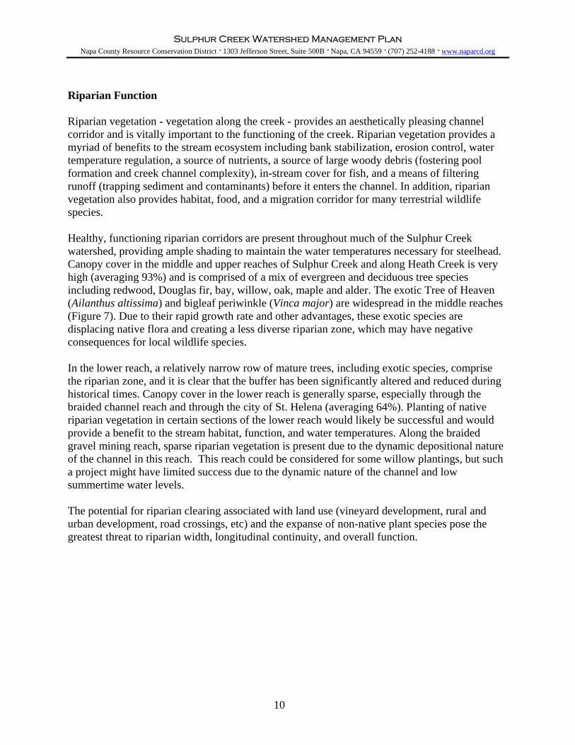
Riparian Function Riparian vegetation - vegetation along the creek - provides an aesthetically pleasing channel corridor and is vitally important to the functioning of the creek. Riparian vegetation provides a myriad of benefits to the stream ecosystem including bank stabilization, erosion control, water temperature regulation, a source of nutrients, a source of large woody debris (fostering pool formation and creek channel complexity), in-stream cover for fish, and a means of filtering runoff (trapping sediment and contaminants) before it enters the channel. In addition, riparian vegetation also provides habitat, food, and a migration corridor for many terrestrial wildlife species. Healthy, functioning riparian corridors are present throughout much of the Sulphur Creek watershed, providing ample shading to maintain the water temperatures necessary for steelhead. Canopy cover in the middle and upper reaches of Sulphur Creek and along Heath Creek is very high (averaging 93%) and is comprised of a mix of evergreen and deciduous tree species including redwood, Douglas fir, bay, willow, oak, maple and alder. The exotic Tree of Heaven (Ailanthus altissima) and bigleaf periwinkle (Vinca major) are widespread in the middle reaches (Figure 7). Due to their rapid growth rate and other advantages, these exotic species are displacing native flora and creating a less diverse riparian zone, which may have negative consequences for local wildlife species. In the lower reach, a relatively narrow row of mature trees, including exotic species, comprise the riparian zone, and it is clear that the buffer has been significantly altered and reduced during historical times. Canopy cover in the lower reach is generally sparse, especially through the braided channel reach and through the city of St. Helena (averaging 64%). Planting of native riparian vegetation in certain sections of the lower reach would likely be successful and would provide a benefit to the stream habitat, function, and water temperatures. Along the braided gravel mining reach, sparse riparian vegetation is present due to the dynamic depositional nature of the channel in this reach. This reach could be considered for some willow plantings, but such a project might have limited success due to the dynamic nature of the channel and low summertime water levels. The potential for riparian clearing associated with land use (vineyard development, rural and urban development, road crossings, etc) and the expanse of non-native plant species pose the greatest threat to riparian width, longitudinal continuity, and overall function.
10

Sulphur Creek Watershed Management Plan Napa County Resource Conservation District · 1303 Jefferson Street, Suite 500B · Napa, CA 94559 · (707) 252-4188 · www.naparcd.org
Figure 7: Typical riparian vegetation in the middle reaches of Sulphur Creek, including native tree species and non-native vinca understory.
Upland Ecology The overall ecological health of a watershed can be assessed both in the aquatic and upland environment, which continuously interact to provide habitat for a diverse community of plant and animal species. The landscape adjacent to streams influences the biology, chemistry, and form of the creek in addition to supporting much of the natural diversity associated with the Sulphur Creek watershed. Upland habitat is also where land use changes made over the past century are most visibly apparent. Increased rural development, intensive land use, urban expansion, fire suppression, and altered watershed hydrology can all adversely impact terrestrial habitat in a variety of ways. Some of these impacts are reflected by shifts in vegetation patterns at the watershed scale, habitat fragmentation, spread of invasive species, and overall reduction in the amount of high quality habitat across the landscape. The Sulphur Creek watershed has experienced substantial change from natural historical vegetation patterns as a result of historic and present day land uses such as residential development, agriculture, logging, and grazing. A sizable amount of high quality terrestrial habitat is currently present in the upper watershed (above the City of St. Helena). The habitat is somewhat fragmented due to development of roads, rural residential expansion, and vineyard fencing. Roads in the area are generally unsurfaced and vineyard enclosures are limited to no more than 90 acres and are widely dispersed (Cain, 2004). Persistent obstacles such as roads, fences, large structures, and agricultural areas can isolate subpopulations of certain animals and cause a decrease in the amount of genetic exchange within the watershed. Reduced habitat connectivity in upland habitat is offset somewhat by the presence of dense riparian corridors which act as migration routes for wildlife from one area of the watershed to another. Exotic vegetation is also relatively abundant in the watershed and includes Tree of Heaven (Ailanthus altissima), Bigleaf Periwinkle (Vinca major), and Yellow Star Thistle (Centaurea
11
Sulphur Creek Watershed Management Plan Napa County Resource Conservation District · 1303 Jefferson Street, Suite 500B · Napa, CA 94559 · (707) 252-4188 · www.naparcd.org
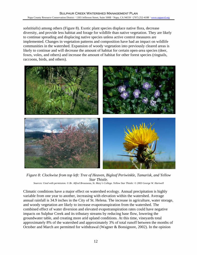
solstitialis) among others (Figure 8). Exotic plant species displace native flora, decrease diversity, and provide less habitat and forage for wildlife than native vegetation. They are likely to continue spreading and displacing native species unless active control measures are implemented. Changes in vegetation patterns and composition have had an impact on wildlife communities in the watershed. Expansion of woody vegetation into previously cleared areas is likely to continue and will decrease the amount of habitat for certain open-area species (deer, foxes, voles, and others) and increase the amount of habitat for other forest species (ringtails, raccoons, birds, and others).
Figure 8: Clockwise from top left: Tree of Heaven, Bigleaf Periwinkle, Tamarisk, and Yellow
Star Thistle. Sources: Used with permission. © Br. Alfred Brousseau, St. Mary’s College. Yellow Star Thistle: © 2003 George W. Hartwell
Climatic conditions have a major effect on watershed ecology. Annual precipitation is highly variable from one year to another, increasing with elevation within the watershed. Average annual rainfall is 34.9 inches in the City of St. Helena. The increase in agriculture, water storage, and woody vegetation are likely to increase evapotranspiration from the watershed. The combined effect of water diversion and elevated evapotranspiration rates could have negative impacts on Sulphur Creek and its tributary streams by reducing base flow, lowering the groundwater table, and creating more arid upland conditions. At this time, vineyards total approximately 8% of the watershed and approximately 3% of total runoff between the months of October and March are permitted for withdrawal (Wagner & Bonsignore, 2002). In the opinion
12

Sulphur Creek Watershed Management Plan Napa County Resource Conservation District · 1303 Jefferson Street, Suite 500B · Napa, CA 94559 · (707) 252-4188 · www.naparcd.org
of the Watershed Task Force, impacts from water withdrawal associated with agriculture is limited at this time. Salmonid Habitat The Sulphur Creek watershed supports a population of steelhead (anadromous rainbow trout, Oncorhynchus mykiss), which is a federally listed threatened species. As a coldwater fish, steelhead are generally sensitive to overall watershed conditions and represent the needs and sensitivities of many species within the system. Because their habitat requirements overlap with many other native fish and aquatic species found within the watershed, efforts to improve conditions for steelhead have far reaching benefits. A dynamic mix of physical, chemical, and biological processes shape aquatic habitat within a stream. Different life stages of salmonids require various habitat elements, but most elements are universal to the different stages. In general, steelhead require cool water temperatures (below 68° F / 20° C), high water quality, access to the ocean, year-round stream flow, adequate food resources, channel complexity (e.g. pools, velocity shelters, cover), suitable spawning gravels, and riparian canopy cover, in addition to other factors. Steelhead have been reported consistently throughout Sulphur Creek's recorded history and today it still contains some of the best year-round coldwater habitat within the Napa River basin. Although humans have altered the watershed extensively, much of Sulphur Creek has dense riparian buffers, perennial flow, suitable spawning gravels, and cool water. However, the amount of habitat available to fish has been greatly reduced from historical conditions. The lower parts of Sulphur Creek are no longer capable of supporting coldwater fish communities, due to urban encroachment and physical alterations to the creek channel. Several factors limit the lower reach to function only as a fish migration corridor. Natural barriers restrict the uppermost available habitat in the upper reaches of all of the tributaries. The last remaining high quality steelhead habitat is limited to less than two miles of Sulphur Creek and one and a half miles of Heath Canyon Creek (Figure 9). Multiple factors are limiting the success of steelhead in the Sulphur Creek watershed. Surface flow has always been limited in much of Sulphur Creek during summer months; these low flows greatly reduce the amount of habitat and food available to juvenile steelhead. In general, the alluvial reach of the creek has no surface flow from mid-summer until the first rains of the season in November or December. This is a natural feature of the watershed and this area historically went dry in most years. All other reaches of the stream maintain some level of flow during summer, with the upper reaches having the most flow year-round. Heath Canyon typically has surface flow through July and then goes dry until early fall, leaving some deep pools for fish.
13
Sulphur Creek Watershed Management Plan Napa County Resource Conservation District · 1303 Jefferson Street, Suite 500B · Napa, CA 94559 · (707) 252-4188 · www.naparcd.org
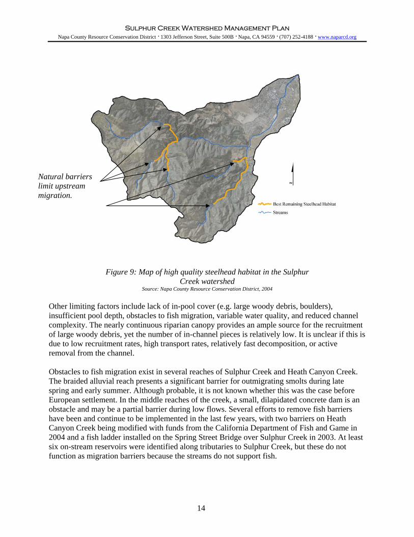
Natural barriers limit upstream migration.
Figure 9: Map of high quality steelhead habitat in the Sulphur Creek watershed
Source: Napa County Resource Conservation District, 2004
Other limiting factors include lack of in-pool cover (e.g. large woody debris, boulders), insufficient pool depth, obstacles to fish migration, variable water quality, and reduced channel complexity. The nearly continuous riparian canopy provides an ample source for the recruitment of large woody debris, yet the number of in-channel pieces is relatively low. It is unclear if this is due to low recruitment rates, high transport rates, relatively fast decomposition, or active removal from the channel. Obstacles to fish migration exist in several reaches of Sulphur Creek and Heath Canyon Creek. The braided alluvial reach presents a significant barrier for outmigrating smolts during late spring and early summer. Although probable, it is not known whether this was the case before European settlement. In the middle reaches of the creek, a small, dilapidated concrete dam is an obstacle and may be a partial barrier during low flows. Several efforts to remove fish barriers have been and continue to be implemented in the last few years, with two barriers on Heath Canyon Creek being modified with funds from the California Department of Fish and Game in 2004 and a fish ladder installed on the Spring Street Bridge over Sulphur Creek in 2003. At least six on-stream reservoirs were identified along tributaries to Sulphur Creek, but these do not function as migration barriers because the streams do not support fish.
14

Sulphur Creek Watershed Management Plan Napa County Resource Conservation District · 1303 Jefferson Street, Suite 500B · Napa, CA 94559 · (707) 252-4188 · www.naparcd.org
Water quality may also be limiting the success of steelhead, specifically inputs of sediment, nutrients, and chemicals. Runoff from grazing, residential, and agricultural areas can contain sediment, chemicals, pesticides, and nutrients. Although not explicitly included in this study, many sources of runoff were observed entering the creek at different locations. Water quality has a significant impact on pools in the lower reach within the city of St. Helena. Filamentous green algae are common in several pools near the confluence with the Napa River, a situation which indicates warm, nutrient-rich conditions. Elevated summer temperatures and poor water quality in this reach create unsuitable conditions for steelhead rearing and favorable conditions for warm water introduced fish species such as bluegill and green sunfish.
Soil Erosion and Excess Sediment Soil erosion currently occurring in the Sulphur Creek watershed include stream bank erosion, gully erosion, sheet and rill erosion, and landslides. Erosion throughout the watershed is due to many different physical processes and land uses. While natural processes are causing most of the erosion, some erosion is caused or aggravated by land use, management practices, drainage rerouting, altered or removed vegetation cover, man-made structures, and bank revetments. Erosion along roads and on developed property has immediate monetary impacts to landowners and local governments, while chronic erosion has long-term deleterious effects on aquatic habitat and the aesthetic value of the stream system. Increasing the volume of sediment supplied to a stream can degrade water quality, increase local sediment storage (e.g. bars, pool deposits), and cause reach-scale channel bed aggradation. Many negative impacts can result from increased sediment storage, including decreased channel volume for water routing, increased flood hazards, increased channel width and bank erosion, decreased channel depth, decreased pool volumes, decreased aquatic habitat quality, and decreased summer surface flows. Controlling sources of excess erosion and sediment supply is important for maintenance of channel form and function and of aquatic habitat quality. Landslides and other hillslope mass movements provide the largest contribution of sediment to the fluvial system. A total of 84 landslides were identified in the historic air photo analysis, and the majority of these appear to be controlled by the local geology rather than by management-related activities. Approximately 50% of the total sediment delivered from air photo identified landslides in Sulphur Creek originates from one large composite landslide located near the ridge of the south-facing slope above Sulphur Canyon. In comparison, management related past erosion and sediment delivery represents an estimated 10% of the total past erosion and sediment delivery estimated for the Sulphur Creek watershed. Landslides that impinge on the channel in combination with lateral channel movement have the potential to produce large volumes of sediment, particularly in the upper reaches of the watershed. Steep canyon walls and bedrock exposure limit lateral channel migration, but in many locations the toe of the bank or landslide can become destabilized by the channel, causing erosion of the entire bank height. Figure 10 shows the development over time of Devil’s Slide on the Northwest Branch of Sulphur Creek.
15

Sulphur Creek Watershed Management Plan Napa County Resource Conservation District · 1303 Jefferson Street, Suite 500B · Napa, CA 94559 · (707) 252-4188 · www.naparcd.org
1940 1942 1999
Figure 10: Devil’s Slide on the Northwest Branch of Sulphur Creek (double sided arrow). There appears to be evidence of increased erosion at the toe of the slide (bottom arrows) between 1940 and ’42, perhaps because of recent activation from the unusually wet winters in the early 1940s following a decade of drought and a new road (top arrow). By 1999, an agricultural
reservoir has been installed near the upper center of the slide (circle). Source: San Francisco Estuary Institute cology Project, 2002.
16
Historical E
Sulphur Creek Watershed Management Plan Napa County Resource Conservation District · 1303 Jefferson Street, Suite 500B · Napa, CA 94559 · (707) 252-4188 · www.naparcd.org
Streambank erosion is also prevalent throughout the watershed. Although bank erosion is a natural process, some observed erosion is excessive and can be linked to land uses or channel modifications. An increase in impervious surfaces associated with land use (e.g. roads and rural residential development) is increasing the volume and speed of surface runoff reaching the channel. This, in turn, is increasing surface erosion and the channel’s erosive ability. The land use history demonstrates that rural residential development increased from approximately 21 acres to nearly 104 acres of the total watershed area between 1940 and 2002. This expansion may be a factor in increased rates of gullying, channel downcutting and bank erosion in small and medium size channels in the watershed. Bank erosion within the past 10 years has occurred at a slightly accelerated rate when compared to long-term erosion rates. Drainage from roads, ditch relief culverts, and undersized culverts at stream crossings is generally contributing to erosion. Undersized or plugged culverts can potentially divert stream flow onto steep, potentially unstable slopes and can trigger large hillslope landslides and gullies. In the Sulphur Creek watershed, 40% of the existing culverts have a moderate to high plugging potential and nearly 48% of the stream crossings exhibit a diversion potential. In addition, roads are being undercut by high creek flows, especially those built across the channel, along the stream inner gorge, and along the steep headwall areas of small, seasonal streams. Three road-related landslides were inventoried, and all three have been recommended for erosion control and erosion prevention treatment. Vineyard development on hillsides also has the potential to create significant erosion. A majority of vineyards in the watershed have vine rows oriented parallel to contour, a practice which can minimize rilling, gullying and terrace failure. Rilling and minor gullying are found at the beginning of the wet season and prior to cover crop growth in vineyards with rows planted perpendicular to contour. In very steep terrain (>20%), some contoured terraces have minor failures along the outside terrace edge. In low gradient plots, surface flow and surface erosion were observed to be minimal. Subsurface drainage pipes and vineyard avenues generate the most erosion and sediment delivery associated with viticulture practices in Sulphur Creek. In some locations, drainage pipes are discharged above natural stream channels, which can lead to stream bank collapse and/or gullying. Vineyard avenues typically have the same problems as those associated with unpaved rural road systems including excessive ditch length, lack of adequate road surface drainage treatments (e.g. ditch relief culverts, water bars or rolling dips), and no surface layer. Vineyard avenues located below vineyard plots and adjacent to streams pose the greatest risk for erosion and sediment delivery, due to their close proximity to the channel. The most dominant erosion source from reservoirs evaluated is the outlets. The most severe erosion is from flow discharged from culverted outlets onto steep unprotected hillslopes, which causes very large gullies that deliver eroded sediment directly to the stream system. Two reservoirs assessed in the Sulphur Creek watershed did not have emergency overflow spillways or culverted outlets, which could lead to failure during periods of high flow. Lastly, the cessation of gravel mining combined with ongoing sediment production and transport in the watershed is causing the channel bed to aggrade (build up). Observations since the termination of gravel mining indicate continual deposition of substantial amounts of sediment and gravel, with aggradation of as much as five feet in the past three years. It is expected that the streambed will continue to aggrade without the removal of sediment from the braided section. Continued aggradation will likely result in increased bank erosion, flooding and channel migration. In light of these issues, especially the
17

Sulphur Creek Watershed Management Plan Napa County Resource Conservation District · 1303 Jefferson Street, Suite 500B · Napa, CA 94559 · (707) 252-4188 · www.naparcd.org
possibility of increased flooding, a study to predict the likely evolution of the channel and its floodplain is warranted. The majority of erosive processes in Sulphur Creek are attributable to natural physical and geologic conditions, however, a significant portion is due to anthropogenic modifications and land uses. Identified management-related causes of erosion include road drainage, residential development, viticulture, and changes in the riparian vegetation community. Improvement efforts to stabilize erosional areas and upgrade current infrastructure would benefit the riparian and aquatic ecosystem, at the same time creating a more stable environment for landowners throughout the watershed.
Flood hazards Floods can damage streamside property, bridges, and roads, and they often cause high rates of bank erosion and sediment transport. However, periodic flooding is also important to maintain channel function and stream ecology. Flooding occurs naturally in fluvial systems in response to climate and stream conditions with some degree of regularity over time. Reducing the damage caused by floods is possible with careful planning and implementation of key prevention strategies throughout the watershed. Human activity can alter the frequency and force of flood events through modifications to the stream system. Natural and anthropogenic factors are contributing to the flood hazard in Sulphur Creek and its tributaries. These factors include channel aggradation (build-up), increased impervious surfaces associated with development, inadequately constructed stream crossings, and on- and off-stream reservoirs. Perhaps the factor of most importance on a watershed scale is channel bed aggradation in the lower reach where gravel mining was historically conducted. Sulphur Creek continues to supply and deposit substantial amounts of sediment in this reach and local observations suggest that as much as 5 feet of material has built up in the channel bed since the cessation of gravel mining in 1999. Given this scenario, the increased volume of sediment storage in the current channel will decrease the volume available for floodwater, possibly causing an increased flood hazard locally and in the city of St. Helena. Historically, gravel mining removed approximately 40,000 to 50,000 cubic yards of material annually, with production diminished substantially in dry years to compensate for lack of replenishment. It is expected that the streambed will continue to aggrade without the removal of coarse sediment from the braided section. Multiple channel crossings and constrictions exist along Sulphur Creek and its tributaries. The main stem of Sulphur Creek has seven major road crossings comprised of bridges and box culverts. Additional, smaller crossings are located on tributaries. Most of the seven major crossings are large enough to handle flood flow, but many smaller crossings and culverts on the tributaries have been identified as undersized. At stream crossings, an undersized or plugged culvert can cause storm flow to spill onto or across the road. In addition, during a storm, the potential for wood recruitment is high due to the well-developed riparian corridor along much of the channel. Although large woody debris is currently sparse in the stream, freshly recruited debris can catch on bridge pilings and culvert inlets, backing up flood waters and diverting flow outside of the channel. The hazards associated with in-channel woody debris and the habitat benefits it provides should be considered on a case-by-case basis. In general, aquatic habitat benefits from woody debris being left in the creek and efforts to minimize removal should be made. Consultation with the California Department of Fish and Game should occur prior to disturbing any woody debris.
18

Sulphur Creek Watershed Management Plan Napa County Resource Conservation District · 1303 Jefferson Street, Suite 500B · Napa, CA 94559 · (707) 252-4188 · www.naparcd.org
Channel modifications including both on and off-stream reservoirs are altering flow patterns in the watershed. The watershed currently contains 10 on- and off-stream reservoirs, which intercept and retain storm flow, acting to reduce the peak of the hydrograph and flooding. Several of these reservoirs have inadequate overflow protection (i.e. spillways) and have the potential to cause severe erosion and/or catastrophic failure of the dam.
Water Supply Water is an essential component of aquatic and terrestrial habitats. Seasonal surface flow patterns largely determine the quantity and quality of habitat available to aquatic and riparian species. Additionally, groundwater and surface flow within a watershed play a significant role in determining the suitability of that area for various land uses such as agriculture, livestock, and residential development. Year round water is generally limited in the Sulphur Creek watershed, as it is in the larger Napa River basin, which is characterized by well-defined arid summers and wet winters. All tributaries to Sulphur Creek, with the exception of Heath Canyon, dry completely by mid-summer. The upper reaches of both forks of Sulphur Creek maintain moderate flow year-round. There is little direct evidence to indicate whether current flow patterns differ significantly from historic conditions. In reaches that experience drastic seasonal recessions of surface flow during summer and fall, water quality plays a critical role in the quality of summer rearing habitat for juvenile steelhead. During this time, water quality can quickly degrade without the flushing effects of continuous surface flow. Low flows also tend to amplify the impacts of reduced riparian cover, which can lead to lethal temperatures. Some of the many competing uses for water include irrigation and livestock, diversion for storage, and extraction from wells. Factors responsible for the limited water supply in Sulphur Creek include natural climatic patterns, high sediment loads, and channel aggradation. Secondary factors include consumptive demands from humans through greater diversion and extraction associated with more water-intensive land uses. A moderate proportion of seasonal stream flow is diverted or extracted for human uses. However, increases in viticulture and rural residential development are requiring more diversions and wells to supply water for various needs. A relatively small volume of water is being stored in reservoirs. A total of ten on- and off-stream reservoirs exist and collect runoff from approximately 8% of the watershed. The total surface area of these reservoirs is 12 acres and they act to intercept approximately 3% of total watershed runoff between October and March. Reservoirs collect storm flow and sediment and slowly release the sediment-free water over the growing season.
19

Sulphur Creek Watershed Management Plan Napa County Resource Conservation District · 1303 Jefferson Street, Suite 500B · Napa, CA 94559 · (707) 252-4188 · www.naparcd.org
Watershed Management Recommendations In response to historic and existing conditions of the Sulphur Creek watershed, a number of specific objectives and several watershed management recommendations are offered to improve and restore natural resources for the benefit of the community and wildlife habitat. What follows is identification of seven specific objectives that have been developed to address the resource related concerns of the Sulphur Creek Watershed Task Force and several matrices that provide specific recommended actions to achieve each objective. Recognizing the different land management histories, land use patterns, and local ecology of the creek reaches, as well as the geographic boundary of the Task Force for whom this Plan has been prepared, the recommendations have been divided into two sections – one for the upper and middle reaches and the other for the lower reach. The broad watershed objectives remain the same for all of the reaches. All of the objectives and recommended actions are supportive of the values of the Sulphur Creek Watershed Task Force and strive to maintain or restore a naturally functioning creek and watershed system in the context of human land use. The recommended actions are meant to be voluntary in nature and meant to provide the Task Force, local landowners, and local land managers with several actions that could be implemented over time to meet the various local goals that exist in the watershed. The relative importance of each recommendation depends on the specific interests that Task Force members bring to the table. For this reason, we have prioritized the recommendations on the basis of various “watershed interests.” We hope this will satisfy the curiosity of a landowner who might want to know, for example, how valuable a proposed riparian project might be from a habitat or flood damage perspective. The priority is designated as high, medium or low for each recommendation, as it pertains to each of the identified potential watershed interests. In addition, the relative cost of each action is denoted on a scale of $ to $$$, where $ is relatively inexpensive and $$$ is fairly costly .
20
Sulphur Creek Watershed Management Plan Napa County Resource Conservation District · 1303 Jefferson Street, Suite 500B · Napa, CA 94559 · (707) 252-4188 · www.naparcd.org
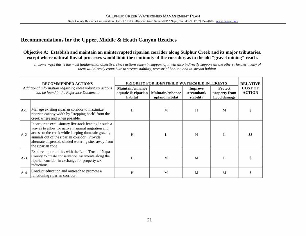
Recommendations for the Upper, Middle & Heath Canyon Reaches
Objective A: Establish and maintain an uninterrupted riparian corridor along Sulphur Creek and its major tributaries, except where natural fluvial processes would limit the continuity of the corridor, as in the old "gravel mining" reach.
In some ways this is the most fundamental objective, since actions taken in support of it will also indirectly support all the others; further, many of
them will directly contribute to stream stability, terrestrial habitat, and in-stream habitat.
PRIORITY FOR IDENTIFIED WATERSHED INTERESTS RECOMMENDED ACTIONS Additional information regarding these voluntary actions
can be found in the Reference Document. Maintain/enhance aquatic & riparian
habitat Maintain/enhance
upland habitat
Improve streambank
stability
Protect property from flood damage
RELATIVE COST OF ACTION
A-1 Manage existing riparian corridor to maximize riparian canopy width by "stepping back" from the creek where and when possible.
H M H M $
A-2
Incorporate exclusionary livestock fencing in such a way as to allow for native mammal migration and access to the creek while keeping domestic grazing animals out of the riparian corridor. Provide alternate dispersed, shaded watering sites away from the riparian zone.
H L H L $$
A-3
Explore opportunities with the Land Trust of Napa County to create conservation easements along the riparian corridor in exchange for property tax reductions.
H M M L $
A-4 Conduct education and outreach to promote a functioning riparian corridor.
H M M M $
21

Sulphur Creek Watershed Management Plan Napa County Resource Conservation District · 1303 Jefferson Street, Suite 500B · Napa, CA 94559 · (707) 252-4188 · www.naparcd.org
Recommendations for the Upper, Middle & Heath Canyon Reaches, cont.
Objective B: Promote contiguous upland habitat and biodiversity.
Many actions taken in support of other objectives will also support this objective, particularly actions which increase and maintain the
extent of riparian corridor along the creek and tributaries.
PRIORITY FOR IDENTIFIED WATERSHED INTERESTS RECOMMENDED ACTIONS
Additional information regarding these voluntary actions can be found in the Reference Document.
Maintain/enhance aquatic & riparian
habitat Maintain/enhance
upland habitat
Improve streambank
stability
Protect property from flood damage
RELATIVE COST OF ACTION
B-1 Provide terrestrial wildlife habitat enhancements such as birdhouses, raptor roosts, and bat boxes.
L H L L $
B-2 Maintain continuous habitat corridors across the watershed into other watersheds.
L H L L $
B-3 Collaborate with Acorn Soupe to conduct education and outreach to promote contiguous habitat and biodiversity.
H H L L $
22

Sulphur Creek Watershed Management Plan Napa County Resource Conservation District · 1303 Jefferson Street, Suite 500B · Napa, CA 94559 · (707) 252-4188 · www.naparcd.org
Recommendations for the Upper, Middle & Heath Canyon Reaches, cont.
Objective C: Maintain and improve in-stream habitat. Many actions taken under this objective will promote streambank stability
PRIORITY FOR IDENTIFIED WATERSHED INTERESTS RECOMMENDED ACTIONS
Additional information regarding these voluntary actions can be found in the Reference Document.
Maintain/enhance aquatic & riparian
habitat Maintain/enhance
upland habitat
Improve streambank
stability
Protect property from flood damage
RELATIVE COST OF ACTION
C-1 Continuing with existing efforts, maintain a "fish-barrier-free" stream network.
H L H M Unknown
C-2 Encourage formation of pools via large woody debris in ways that do not increase the risk of flooding.
H L M L $ - $$
C-3
Protect and improve water quality through general septic tank maintenance; minimized use of pesticides, chemicals and fertilizers; proper disposal of winery and industrial waste; proper storage of all chemicals, fertilizers, fuels, and debris; filtration of urban runoff; and improved road drainage.
H H L L $ - $$$
C-4 Implement stream restoration using ‘soft’ bio-engineered techniques, incorporating live plant material whenever possible. Also consider "stepping back" development from the creek to provide for natural meandering.
H L H M $ - $$
C-5 Conduct education and outreach regarding actions that can help improve water quality.
H M L L $
23

Sulphur Creek Watershed Management Plan Napa County Resource Conservation District · 1303 Jefferson Street, Suite 500B · Napa, CA 94559 · (707) 252-4188 · www.naparcd.org
Recommendations for the Upper, Middle & Heath Canyon Reaches, cont.
Objective D: Reduce soil erosion.
Actions to reduce soil erosion from upland surfaces will help protect economic resources, and have the potential to improve in-stream habitat and improve water quality in general, as do actions to prevent streambank erosion.
PRIORITY FOR IDENTIFIED WATERSHED INTERESTS OBJECTIVES & ACTIONS
Additional information regarding these voluntary actions can be found in the Reference Document.
Maintain/enhance aquatic & riparian
habitat Maintain/enhance
upland habitat
Improve streambank
stability
Protect property from flood damage
RELATIVE COST OF ACTION
D-1 Use sustainable agricultural practices to minimize soil erosion, as recommended in the Napa River Watershed Owners Manual and the Fish Friendly Farming (Napa Green) Manuals.
H M M M $
D-2 Protect existing livestock crossings and access points to minimize bank degradation at those sites. Where possible, exclude livestock from the creek.
H L H L $$
D-3 Maintain and improve roadways, and minimize new road construction.
H M H M $ - $$$
D-4 Promote streambank stability using ‘soft’ bio-engineered techniques and consider "stepping back" development from the creek to provide for natural meandering.
H L H M $ - $$
D-5 Maintain and improve reservoir outlets to ensure that they are operating properly
H L H L $ - $$$
D-6 Conduct education and outreach regarding roads, vineyard practices, and bio-engineered streambank protection.
H M M M $
24
Sulphur Creek Watershed Management Plan Napa County Resource Conservation District · 1303 Jefferson Street, Suite 500B · Napa, CA 94559 · (707) 252-4188 · www.naparcd.org
Recommendations for the Upper, Middle & Heath Canyon Reaches, cont.
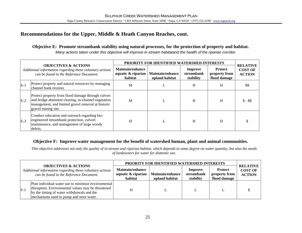
Objective E: Promote streambank stability using natural processes, for the protection of property and habitat. Many actions taken under this objective will improve in-stream habitatand the health of the riparian corridor.
PRIORITY FOR IDENTIFIED WATERSHED INTERESTS
OBJECTIVES & ACTIONS Additional information regarding these voluntary actions
can be found in the Reference Document. Maintain/enhance aquatic & riparian
habitat Maintain/enhance
upland habitat
Improve streambank
stability
Protect property from flood damage
RELATIVE COST OF ACTION
E-1 Protect property and natural resources by managing channel bank erosion.
M L H H $$
E-2 Protect property from flood damage through culvert and bridge abutment clearing, in-channel vegetation management, and limited gravel removal at historic gravel mining site.
M L H H $ - $$
E-3 Conduct education and outreach regarding bio-engineered streambank protection, culvert maintenance, and management of large woody debris.
H L H H $
Objective F: Improve water management for the benefit of watershed human, plant and animal communities.
This objective addresses not only the quality of in-stream and riparian habitat, which depends to some degree on water quantity, but also the needs of landowners for water for domestic use.
PRIORITY FOR IDENTIFIED WATERSHED INTERESTS OBJECTIVES & ACTIONS
Additional information regarding these voluntary actions can be found in the Reference Document.
Maintain/enhance aquatic & riparian
habitat Maintain/enhance
upland habitat
Improve streambank
stability
Protect property from flood damage
RELATIVE COST OF ACTION
F-1
Plan individual water use to minimize environmental disruption. Environmental values may be threatened by the timing of water withdrawals and the mechanisms used to pump and store water.
H L L L $
25

Sulphur Creek Watershed Management Plan Napa County Resource Conservation District · 1303 Jefferson Street, Suite 500B · Napa, CA 94559 · (707) 252-4188 · www.naparcd.org
Recommendations for the Upper, Middle & Heath Canyon Reaches, cont.
Objective G: Encourage land stewardship and sustainable land use.
Actions which educate land users about stewardship and sustainability tend to support the whole range of objectives identified in this
plan, because educated land users are more likely to consider the environmental consequences of management decisions.
PRIORITY FOR IDENTIFIED WATERSHED INTERESTS OBJECTIVES & ACTIONS
Additional information regarding these voluntary actions can be found in the Reference Document.
Maintain/enhance aquatic & riparian
habitat Maintain/enhance
upland habitat
Improve streambank
stability
Protect property from flood damage
RELATIVE COST OF ACTION
G-1
Organize community events and develop other mechanisms to increase awareness of this plan and support for its implementation.
H H H H $
G-2 Develop a creek restoration demonstration site on Sulphur Creek and utilize it for community events.
H M H H $$
G-3 Develop and distribute a “creek care guide” to landowners and managers.
H H H H $$
G-4
Facilitate permitting for environmental restoration projects. Support DFG and NRCS efforts to develop a local consolidated permit program.
H H H H $$
G-5 Obtain funding for watershed work done under this plan.
H H H H $ - $$
26
Sulphur Creek Watershed Management Plan Napa County Resource Conservation District · 1303 Jefferson Street, Suite 500B · Napa, CA 94559 · (707) 252-4188 · www.naparcd.org
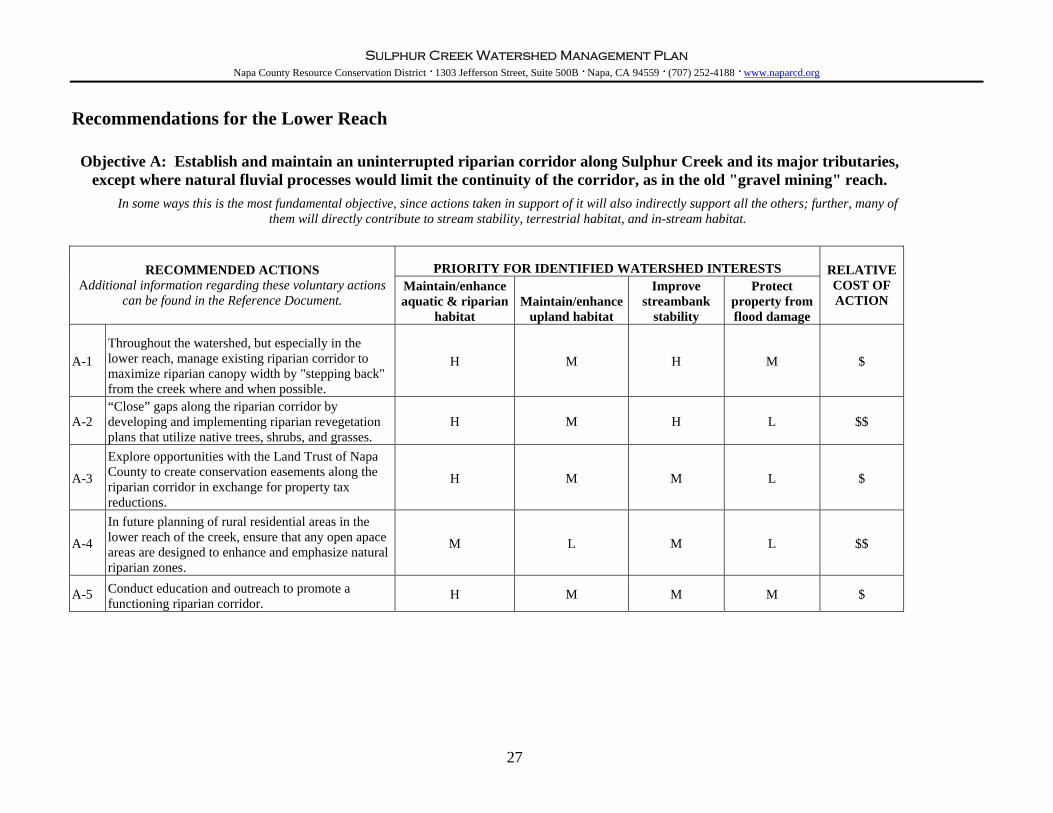
Recommendations for the Lower Reach
Objective A: Establish and maintain an uninterrupted riparian corridor along Sulphur Creek and its major tributaries, except where natural fluvial processes would limit the continuity of the corridor, as in the old "gravel mining" reach.
In some ways this is the most fundamental objective, since actions taken in support of it will also indirectly support all the others; further, many of
them will directly contribute to stream stability, terrestrial habitat, and in-stream habitat.
PRIORITY FOR IDENTIFIED WATERSHED INTERESTS RECOMMENDED ACTIONS Additional information regarding these voluntary actions
can be found in the Reference Document. Maintain/enhance aquatic & riparian
habitat Maintain/enhance
upland habitat
Improve streambank
stability
Protect property from flood damage
RELATIVE COST OF ACTION
A-1 Throughout the watershed, but especially in the lower reach, manage existing riparian corridor to maximize riparian canopy width by "stepping back" from the creek where and when possible.
H M H M $
A-2 “Close” gaps along the riparian corridor by developing and implementing riparian revegetation plans that utilize native trees, shrubs, and grasses.
H M H L $$
A-3
Explore opportunities with the Land Trust of Napa County to create conservation easements along the riparian corridor in exchange for property tax reductions.
H M M L $
A-4
In future planning of rural residential areas in the lower reach of the creek, ensure that any open apace areas are designed to enhance and emphasize natural riparian zones.
M L M L $$
A-5 Conduct education and outreach to promote a functioning riparian corridor.
H M M M $
27

Sulphur Creek Watershed Management Plan Napa County Resource Conservation District · 1303 Jefferson Street, Suite 500B · Napa, CA 94559 · (707) 252-4188 · www.naparcd.org
Recommendations for the Lower Reach, cont.
Objective B: Promote contiguous upland habitat and biodiversity.
Many actions taken in support of other objectives will also support this objective, particularly actions which increase and maintain the
extent of riparian corridor along the creek and tributaries.
PRIORITY FOR IDENTIFIED WATERSHED INTERESTS RECOMMENDED ACTIONS
Additional information regarding these voluntary actions can be found in the Reference Document.
Maintain/enhance aquatic & riparian
habitat Maintain/enhance
upland habitat
Improve streambank
stability
Protect property from flood damage
RELATIVE COST OF ACTION
B-1 Provide terrestrial wildlife habitat enhancements such as birdhouses, raptor roosts, and bat boxes.
L H L L $
B-2 Maintain continuous habitat corridors across the watershed into other watersheds.
L H L L $
B-3 “Close” gaps along the riparian corridor by developing and implementing riparian revegetation plans that utilize native trees, shrubs, and grasses.
H M H L $
B-4 Preserve existing and establish new oak woodland habitat.
L M L L $
B-5 Collaborate with Acorn Soupe to conduct education and outreach to promote contiguous habitat and biodiversity.
H H L L $
28

Sulphur Creek Watershed Management Plan Napa County Resource Conservation District · 1303 Jefferson Street, Suite 500B · Napa, CA 94559 · (707) 252-4188 · www.naparcd.org
Recommendations for the Lower Reach, cont.
Objective C: Maintain and improve in-stream habitat. Many actions taken under this objective will promote streambank stability
PRIORITY FOR IDENTIFIED WATERSHED INTERESTS RECOMMENDED ACTIONS
Additional information regarding these voluntary actions can be found in the Reference Document.
Maintain/enhance aquatic & riparian
habitat Maintain/enhance
upland habitat
Improve streambank
stability
Protect property from flood damage
RELATIVE COST OF ACTION
C-1 Continuing with existing efforts, maintain a "fish-barrier-free" stream network.
H L H M Unknown
C-2
Protect and improve water quality through general septic tank maintenance; minimized use of pesticides, chemicals and fertilizers; proper disposal of winery and industrial waste; proper storage of all chemicals, fertilizers, fuels, and debris; filtration of urban runoff; and improved road drainage.
H H L L $ - $$$
C-3 Implement stream restoration using ‘soft’ bio-engineered techniques, incorporating live plant material whenever possible. Also consider "stepping back" development from the creek to provide for natural meandering.
H L H M $ - $$
C-4 Conduct education and outreach regarding actions that can help improve water quality.
H M L L $
29
Sulphur Creek Watershed Management Plan Napa County Resource Conservation District · 1303 Jefferson Street, Suite 500B · Napa, CA 94559 · (707) 252-4188 · www.naparcd.org
Recommendations for the Lower Reach, cont.
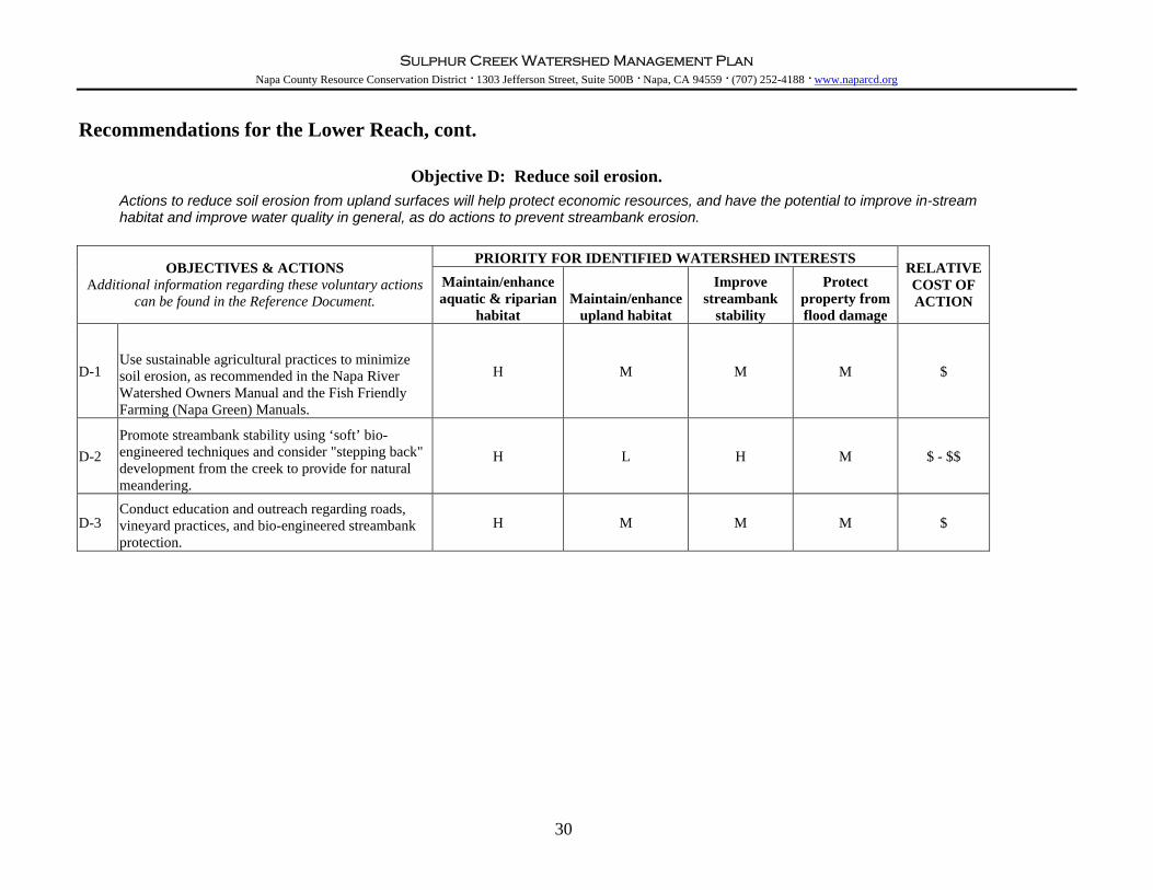
Objective D: Reduce soil erosion.
Actions to reduce soil erosion from upland surfaces will help protect economic resources, and have the potential to improve in-stream habitat and improve water quality in general, as do actions to prevent streambank erosion.
PRIORITY FOR IDENTIFIED WATERSHED INTERESTS OBJECTIVES & ACTIONS
Additional information regarding these voluntary actions can be found in the Reference Document.
Maintain/enhance aquatic & riparian
habitat Maintain/enhance
upland habitat
Improve streambank
stability
Protect property from flood damage
RELATIVE COST OF ACTION
D-1 Use sustainable agricultural practices to minimize soil erosion, as recommended in the Napa River Watershed Owners Manual and the Fish Friendly Farming (Napa Green) Manuals.
H M M M $
D-2 Promote streambank stability using ‘soft’ bio-engineered techniques and consider "stepping back" development from the creek to provide for natural meandering.
H L H M $ - $$
D-3 Conduct education and outreach regarding roads, vineyard practices, and bio-engineered streambank protection.
H M M M $
30

Sulphur Creek Watershed Management Plan Napa County Resource Conservation District · 1303 Jefferson Street, Suite 500B · Napa, CA 94559 · (707) 252-4188 · www.naparcd.org
Recommendations for the Lower Reach, cont.
Objective E: Promote streambank stability using natural processes, for the protection of property and habitat. Many actions taken under this objective will improve in-stream habitatand the health of the riparian corridor.
PRIORITY FOR IDENTIFIED WATERSHED INTERESTS
OBJECTIVES & ACTIONS Additional information regarding these voluntary actions
can be found in the Reference Document. Maintain/enhance aquatic & riparian
habitat Maintain/enhance
upland habitat
Improve streambank
stability
Protect property from flood damage
RELATIVE COST OF ACTION
E-1 Protect property and natural resources by managing channel bank erosion.
M L H H $$
E-2 Protect property from flood damage through culvert and bridge abutment clearing, in-channel vegetation management, and limited gravel removal at historic gravel mining site.
M L H H $ - $$
E-3 Conduct education and outreach regarding bio-engineered streambank protection, culvert maintenance, and management of large woody debris.
H L H H $
Objective F: Improve water management for the benefit of watershed human, plant and animal communities.
This objective addresses not only the quality of in-stream and riparian habitat, which depends to some degree on water quantity, but also the needs of landowners for water for domestic use.
PRIORITY FOR IDENTIFIED WATERSHED INTERESTS
OBJECTIVES & ACTIONS Additional information regarding these voluntary actions
can be found in the Reference Document. Maintain/enhance aquatic & riparian
habitat Maintain/enhance
upland habitat
Improve streambank
stability
Protect property from flood damage
RELATIVE COST OF ACTION
F-1 Conduct education and outreach to promote wateruse efficiency practices.
L L L L $
31

Sulphur Creek Watershed Management Plan Napa County Resource Conservation District · 1303 Jefferson Street, Suite 500B · Napa, CA 94559 · (707) 252-4188 · www.naparcd.org
Recommendations for the Lower Reach, cont.
Objective G: Encourage land stewardship and sustainable land use.
Actions which educate land users about stewardship and sustainability tend to support the whole range of objectives identified in this
plan, because educated land users are more likely to consider the environmental consequences of management decisions.
PRIORITY FOR IDENTIFIED WATERSHED INTERESTS OBJECTIVES & ACTIONS
Additional information regarding these voluntary actions can be found in the Reference Document.
Maintain/enhance aquatic & riparian
habitat Maintain/enhance
upland habitat
Improve streambank
stability
Protect property from flood damage
RELATIVE COST OF ACTION
G-1
Organize community events and develop other mechanisms to increase awareness of this plan and support for its implementation.
H H H H $
G-2 Develop a creek restoration demonstration site on Sulphur Creek and utilize it for community events.
H M H H $$
G-3 Develop and distribute a “creek care guide” to landowners and managers.
H H H H $$
G-4
Facilitate permitting for environmental restoration projects. Support DFG and NRCS efforts to develop a local consolidated permit program.
H H H H $$
G-5 Obtain funding for watershed work done under this plan.
H H H H $ - $$
G-6
Develop a watershed group and hold educational workshops focusing on issues specifically relevant to the lower reach.
H L H H $
32

Sulphur Creek Watershed Management Plan Napa County Resource Conservation District · 1303 Jefferson Street, Suite 500B · Napa, CA 94559 · (707) 252-4188 · www.naparcd.org
Future Research and Recommended Monitoring Although a great effort was made to assess existing watershed conditions in 2002 as part of the extensive watershed assessment, some additional research needs were discovered. They include the following:
- species and habitat diversity within the watershed - water flow characteristics and timing - various management strategies for gravel accumulation in the braided reach of the channel
Beyond additional research, watershed conditions should be monitored over time to allow the community to track changes within the watershed and adapt their land management strategies accordingly. Several recommendations for on-going and future watershed monitoring resulted from the watershed assessment and are summarized in the following pages in matrix format for each of the identified objectives. For each recommendation, we have tried to identify relative priority, cost and effort; frequency of monitoring; and success criteria.
33

Sulphur Creek Watershed Management Plan Napa County Resource Conservation District · 1303 Jefferson Street, Suite 500B · Napa, CA 94559 · (707) 252-4188 · www.naparcd.org
Objective A: Establish and maintain an uninterrupted riparian corridor along Sulphur Creek and its major tributaries, except where natural fluvial processes would limit the continuity of the corridor, as in the old "gravel
mining" reach.
RECOMMENDED MONITORING Additional information regarding these monitoring
recommendations can be found in the Reference Document. Frequency Success Priority Relative Cost Relative Effort
A-1 Monitor vegetation growth and continuity and width of riparian corridor
Annually for 3 years then once every 5 years
M $ L
A-2 Monitor vegetation growth at restoration sites
Pre-project baseline, post project for 5 years - then once every 3 years
corridor is 95% continuous, with no single gap larger than 66 ft in length H $ - $$ L - M
A-3 Observations of vines infected with Pierce's Disease should be recorded. Every other year
For Task Force Discussion
Objective B: Promote contiguous upland habitat and biodiversity.
RECOMMENDED MONITORING Additional information regarding these monitoring
recommendations can be found in the Reference Document. Frequency Success Priority Relative Cost Relative Effort
B-1
Measure and record the shape, area and connectivity of wildlife habitat and migration corridors including riparian corridors and east-west corridors connecting habitat to adjacent watersheds.
Annually for 3 years then once every 5 years
M $ L
B-2 Document number of wildlife species present in the watershed Once every 5 years
M $ M
B-3
Monitor grazed areas, specifically grazing-related erosion; grass species composition, condition, and density; percent of area composed of exotic invasive species; and effectiveness of best management practices
Annually for 5 years then once every 3 years
L $ L
34

Sulphur Creek Watershed Management Plan Napa County Resource Conservation District · 1303 Jefferson Street, Suite 500B · Napa, CA 94559 · (707) 252-4188 · www.naparcd.org
Objective C: Maintain and improve in-stream habitat.
RECOMMENDED MONITORING Additional information regarding these monitoring
recommendations can be found in the Reference Document. Frequency Success Priority Relative Cost Relative Effort
C-1 Conduct a survey of complete and partial migration barriers for salmonids and other fish species Every 5 years
Maintenance of a "barrier-free" stream network for fish migration.
M $$ H
C-2 Monitor the number, depth, volume, complexity, and location of pools
Every 3 years and the dry-season following large storm events
Pool habitat quality and quantity is stable for 2 consecutive monitoring periods.
H $$ H
C-3 Monitor restoration projects - inventory of pools and channel form
Pre-project and post project for 5 years
Achievement of project design goals.
H $ H
C-4 Document the location and condition of cattle crossings Every 5 years
Removal and/or improvements to the crossings having an impact upon the stream
M $ - $$ L
C-5 Conduct snorkel surveys of fish species during the summer.
Annually for 3 years, then once every 3 years.
Fish distributions and densities are documented
H $$ H
C-6 Conduct steelhead spawning surveys during adult migration season (December – March)
Annually for 5 years, then once every 3 years.
Population estimates can be generated.
H $$ M
C-7
Monitor projects impacting in-stream habitatPre-project baseline and post project for 5 years
Project limits erosion in the project reach, does not induce erosion adjacent to the project, encourages natural channel processes, and encourages native vegetation
H $ M
C-8 Monitor water quality particularly temperature, dissolved oxygen, pH, and conductance Year-round
Maintain year-round temperatures below 68° F
H $ L
C-9 Measure turbidity Year-round
Maintain turbidity levels at less than 2 NTU when flow is present.
M $$ L
C-10 Sample benthic macroinvertebrates Every 3 years
Diversity and abundance of species is maintained or improved.
H $$ H
35

Sulphur Creek Watershed Management Plan Napa County Resource Conservation District · 1303 Jefferson Street, Suite 500B · Napa, CA 94559 · (707) 252-4188 · www.naparcd.org
Objective D: Reduce soil erosion.
RECOMMENDED MONITORING Additional information regarding these monitoring
recommendations can be found in the Reference Document. Frequency Success Priority Relative Cost Relative Effort
D-1 Monitor vineyard plots and avenues for rill and gully development throughout the wet season.
Annually throughout the wet season Problems are corrected as found
H $ L
D-2 Monitor and remove debris from bridges and culverts to prevent the buildup of debris
Annually pre-rain and throughout the wet season Problems are corrected as found
H $ M
D-3 Conduct physical and biological monitoring at outlets that drain to the creek and reservoir outlets Annually
Culverts/ditches/roads that are contributing or have the potential to contribute significant amounts of sediment to the fluvial system are repaired or removed.
H $ L
Objective E: Promote streambank stability using natural processes, for the protection of property and habitat.
RECOMMENDED MONITORING
Additional information regarding these monitoring recommendations can be found in the Reference
Document. Frequency Success Priority Relative Cost Relative Effort
E-1 Monitor bank erosion and measure channel cross sections Every other year
The volume of bank erosion caused by human sources is reduced by 50% over the next five years.
M $$ H
E-2 Monitor locations with excess in-channel vegetation and amount of in-channel large woody debris Annually
Significant flooding is avoided and a maximum amount of vegetation and woody debris can remain in-channel.
M $$ H
E-3 Monitor effectiveness of bank stabilization projects.
Pre-project and then post-project for 5 years on an annual basis. Project design goals are achieved.
H $$ M
36

Sulphur Creek Watershed Management Plan Napa County Resource Conservation District · 1303 Jefferson Street, Suite 500B · Napa, CA 94559 · (707) 252-4188 · www.naparcd.org
Objective F: Improve water management for the benefit of watershed human, plant and animal communities.
RECOMMENDED MONITORING Additional information regarding these monitoring
recommendations can be found in the Reference Document. Frequency Success Priority Relative Cost Relative Effort
F-1 Monitor water level and discharge, making the information available to those who divert water. Annually
Accurate data exists to allow for a comprehensive water budget model to be completed for the watershed.
M $$ M
Objective G: Encourage land stewardship and sustainable land use.
RECOMMENDED MONITORING
Additional information regarding these monitoring recommendations can be found in the Reference
Document. Frequency Success Priority Relative Cost Relative Effort
G-1
Document number of watershed community events that support watershed awareness and implementation of actions suggested in this plan. Annually
8 events are held and attendance goals for each event are met
H $ L
G-2 Track progress of development of creek-care guide within 5 years
Available on-line and distributed to 100 property owners or managers within the watershed
H $ L
G-3
Track progress of establishing a restoration demonstration site and once completed, track its use. within 5 years
Site completed and utilized annually for community events and monitoring.
H $ L
G-4
Document, to the extent feasible, implementation of the recommendations in this management plan. Annually
H $ L
G-5
Document efforts to obtain funding and funding received to implement actions suggested in this management plan. Annually
Sufficient funding is available to landowners who choose to implement suggested actions.
H $ L
37

Sulphur Creek Watershed Management Plan Napa County Resource Conservation District · 1303 Jefferson Street, Suite 500B · Napa, CA 94559 · (707) 252-4188 · www.naparcd.org
Sources of Public Funding & Assistance Several sources of public funds are available to assist in projects or programs that protect, preserve, or restore ecosystem functions. Many of the financial assistance programs are available for implementation on private lands. Sources of funds include various resource agencies from Federal, State, and Local government as well as private foundations. Below is a list of possible funding sources with a brief description of the organization, the types of projects they might be interested in funding and a link to an appropriate website (or other contact information). Some funding programs will contract directly with landowners; others will only contract with state or local agencies or non-profit organizations. Please note that this list is not exhaustive and is subject to change over time. US Department of Agriculture Natural Resources Conservation Service (USDA NRCS) The NRCS maintains a local office in Napa and can provide general conservation assistance to agricultural landowners in Napa County. They also operate two grant programs to provide cost share for implementation of conservation practices on agricultural land. Conservation practices may include but are not limited to: cover crops, streamside buffer vegetation, livestock troughs and water development, erosion control practices, management of noxious weeds, and Pierce’s disease management. Additional information is available at www.ca.nrcs.usda.gov or inquiries can be made to [email protected]. Environmental Protection Agency (EPA) The EPA has a regional office in San Francisco. Grant programs administered by the EPA generally involve pollution prevention; terrestrial aquatic, and coastal ecosystem research and monitoring; wetland protection; and ecosystem restoration projects. Additional information about specific grants offered through EPA can be found through a federal grant site at http://fedgrants.gov/Applicants/index.html. US Fish and Wildlife Service (FWS) The Mission of the U.S. Fish & Wildlife Service is to work with others to conserve, protect and enhance fish, wildlife, and plants and their habitats for the continuing benefit of the American people. They generally fund projects that involve habitat protection and restoration, species status surveys, public education and outreach, and restoration of species at risk. Additional information about grant programs administered by FWS can be found at: http://grants.fws.gov. Alternatively, FWS grant programs can also be searched on a federal grant website through the Department of Interior: http://fedgrants.gov/Applicants/index.html. National Oceanic and Atmospheric Administration – Fisheries Division (NOAA Fisheries) NOAA Fisheries (previously National Marine Fisheries Service) is dedicated to the stewardship of living marine resources through science-based conservation and management, and the promotion of healthy ecosystems. They have a local office in Santa Rosa. They generally fund projects that involve habitat protection and restoration (particularly habitat for threatened and endangered species), public education and outreach, and restoration of species at risk. Additional information about current grants offered through NOAA Fisheries can be found at http://www.nmfs.noaa.gov/mb/grants/. Alternatively, NOAA Fisheries grant programs can be searched on a federal grant website through the Department of Commerce at http://fedgrants.gov/Applicants/index.html.
38

Sulphur Creek Watershed Management Plan Napa County Resource Conservation District · 1303 Jefferson Street, Suite 500B · Napa, CA 94559 · (707) 252-4188 · www.naparcd.org
California Bay-Delta Authority The California Bay-Delta Authority oversees 23 state and federal agencies working cooperatively through the CALFED Bay-Delta Program to improve the quality and reliability of California’s water supplies while restoring the Bay-Delta ecosystem. The mission of the CALFED Bay-Delta Program is to develop and implement a long-term comprehensive plan that will restore ecological health and improve water management for beneficial uses of the Bay-Delta System. The program supports 11 different elements to support its 4 objectives: Water Supply Reliability, Levee System Integrity, Water Quality, and Ecosystem Restoration. Grant opportunities available can generally be found at the Bay-Delta homepage: http://calwater.ca.gov/. California State Water Resources Control Board (SWRCB) The SWRCB's mission is to preserve, enhance and restore the quality of California's water resources, and ensure their proper allocation and efficient use for the benefit of present and future generations. The SWRCB and their Regional Offices administer a variety of water quality and habitat restoration funds. Available grants are posted on the following website: http://www.swrcb.ca.gov/funding/index.html. California State Coastal Conservancy – SF Bay Area Conservancy Program The San Francisco Bay Area Conservancy Program, administered by the Coastal Conservancy, was established to address the natural resource and recreational goals of the nine-county Bay Area in a coordinated and comprehensive way. The Conservancy may award grants to help achieve the following Bay Program goals: (1) protect, restore, and enhance natural habitats and other open-space resources of regional significance throughout the nine-county area; (2) improve public access and related facilities to and around the Bay, its surrounding hills, and the coast, through completion of bay, coast, and ridge trails that are part of a regional trail system; and (3) promote projects that provide open space that is accessible to urban populations for recreational and educational purposes. Applications for funding are accepted on a continual basis. Additional information about the Program and the application package are available on line at: http://www.coastalconservancy.ca.gov/Programs/BACP.htm. California Department of Conservation The Department of Conservation provides services and information that promote environmental health, economic vitality, informed land-use decisions and sound management of our state's natural resources. Most of the applicable assistance provided is offered through the Division of Land Resource Protection and includes voluntary programs that help to meet individual needs, including property tax incentives, grants for the purchase of agricultural conservation easements, and funding for conservation projects conducted by Resource Conservation Districts. Additional information is available at: http://www.consrv.ca.gov/DLRP/index.htm. California Department of Fish and Game (DFG) The Mission of the Department of Fish and Game is to manage California's diverse fish, wildlife, and plant resources, and the habitats upon which they depend, for their ecological values and for their use and enjoyment by the public. They administer a number of grant programs that make funds available for several types of projects including: restoration implementation, education, assessment, and monitoring. Additional information about DFG can be found at: http://www.dfg.ca.gov.
39

Sulphur Creek Watershed Management Plan Napa County Resource Conservation District · 1303 Jefferson Street, Suite 500B · Napa, CA 94559 · (707) 252-4188 · www.naparcd.org
Wildlife Conservation Commission of Napa County The Wildlife Conservation Commission awards grant funds to local projects that support the preservation, propagation, and protection of birds, mammals, fish and amphibians. Funds are generated through local fines levied by the California Department of Fish & Game and may be used for a variety of projects including, but not limited to: education, monitoring, land acquisition, or restoration work. Contact Patrick Lowe at the Napa County Conservation, Development and Planning Department for additional information: 707.253.4188. Napa County Public Works Program Napa County has funds available to help with watershed restoration work related to creeks for properties that are not eligible for alternative funds, such as NRCS Environmental Quality Incentive Program (EQIP). Mike Forte, with Napa County Public Works Department, can be contacted regarding these funds. Napa County Resource Conservation District (Napa RCD) The Napa RCD is a local non-regulatory agency whose mission is to promote responsible watershed management through voluntary community stewardship and technical assistance. The RCD is available to assist with grant writing for projects and is available on a limited basis to provide advice and assistance to landowners and managers.
40

Sulphur Creek Watershed Management Plan Napa County Resource Conservation District · 1303 Jefferson Street, Suite 500B · Napa, CA 94559 · (707) 252-4188 · www.naparcd.org
ATTACHMENTS
41

Sulphur Creek Watershed Management Plan Napa County Resource Conservation District · 1303 Jefferson Street, Suite 500B · Napa, CA 94559 · (707) 252-4188 · www.naparcd.org
EXECUTIVE SUMMARY ECOLOGICAL, GEOMORPHIC, AND LAND USE HISTORY OF THE SULPHUR CREEK WATERSHED: A COMPONENT OF THE WATERSHED MANAGEMENT PLAN FOR THE SULPHUR CREEK WATERSHED, NAPA COUNTY, CALIFORNIA Draft Final Report, June 9, 2003 By Robin Grossinger, Chuck Striplen, Elise Brewster, and Lester McKee
PREPARED FOR STEWARDSHIP SUPPORT AND WATERSHED ASSESSMENT IN THE NAPA RIVER WATERSHED: A CALFED PROJECT During 2002-2003, the San Francisco Estuary Institute, with the assistance of the Napa County Resource Conservation District, carried out a study of the historical ecology of the Sulphur Creek Watershed. The resulting technical report is one of five produced to inform the development of a watershed management plan through a participatory process that includes the community, natural resource agencies, and scientists. To assess historical land use and associated changes within the watershed, we used a multifaceted approach to collect and synthesize a diverse range of information. This process included collecting numerous historical documents from the 19th and early 20th centuries, analyzing historical maps and aerial photography, interviewing local residents, and assessing field conditions with other project team members. Interpretations were analyzed in the context of the findings of the other technical teams through project team meetings. The Sulphur Creek watershed is characterized by a number of specific and locally uncommon landscape features that together have shaped the ways of life of the peoples who have settled in the watershed. This combination – including redwood forests, unstable hillsides, warm water springs, a braided channel, a broad alluvial fan, a stream running through an unusually large valley oak grove -- led to early logging, the development of a resort by the early 1850s, and the lower watershed’s continued position as a center for American settlement in the upper Napa Valley. The land use history of Sulphur Creek watershed differs from other watersheds in Napa Valley because of these locally distinct influences on cultural activity. Management activities have had a range of impacts, some of them quite complex. Some long-term activities, such as gravel removal and controlled burns, have tended actually to maintain existing conditions, probably reducing the extent of physical or ecological change that would have taken place otherwise. Other activities, such as the redirection of streams and the expansion of agriculture, have cause more dramatic, immediate changes. Despite intensive land use during recent centuries, the Sulphur Creek watershed maintains a remarkable array of ecological resources that are valued by the community and likely to benefit from future stewardship. Understanding the sequence of natural and anthropogenic changes that have shaped the watershed to-date is an important part of establishing future directions for environmental management of this unique watershed. This Historical Ecology report presents a number of specific implications for future management of the watershed; these are listed below. The report also provides a detailed summary of land use history and historical information resources, which are intended to provide a basis for answering subsequent questions about the watershed history.
42

Sulphur Creek Watershed Management Plan Napa County Resource Conservation District · 1303 Jefferson Street, Suite 500B · Napa, CA 94559 · (707) 252-4188 · www.naparcd.org
1. The broad, braided channel reach of Sulphur Creek is a natural phenomenon that is a unique feature in the Napa Valley. This persistent channel pattern has been created by relatively high sediment production rates in the watershed associated with the inherently erosive Franciscan Formation. The braided channel reach of Sulphur Creek contributes substantially to the diversity of stream habitat within the Napa Valley.
2. Sediment produced by the watershed has effectively balanced long-term gravel mining, which
has been a significant activity since the latter 19th century. Observations since the termination of gravel mining indicate continued substantial deposition, with aggradation of as much as five feet in the past three years. It is expected that the stream bed will continue to aggrade without the removal of sediment from the braided section. This could lead to increased flooding and the risk that Sulphur Creek could reinitiate fan-building, reoccupying other parts of its alluvial fan.
3. With the cessation of gravel mining, additional sediment may be transported to the confluence
with Napa River, particularly if engineering adjustments are made to reduce sediment deposition in the braided reach. The potential for backwater deposition in lower Sulphur Creek should be considered, particularly in relation to proposed flood control efforts.
4. Landslides are dated back to at least 1869, in the case of Devil’s Slide. Landslides are a natural
process within the watershed, but may also be triggered or exacerbated by land use activities. Clearing has been common in the watershed during historical times, but has increased substantially with the extension of vineyards into the upper watershed in recent decades. The extension of agriculture, and associated changes in drainage patterns, has the potential to trigger additional sediment production and watershed managers should be careful to avoid triggering new slope failures.
5. The density of woody vegetation in the upper watershed has increased substantially during the
past 60 years, likely as a result of decreased fire frequency. This has probably increased the risk of significant fire in the watershed. A number of other valuable attributes of the watershed may also be affected by this change, with possible effects including reduced wildlife habitat, less accessibility to people, and decreased base flow in the stream. Controlled burns may be considered to address some of these concerns.
6. The braided channel section of Sulphur Creek has been both narrowed and shortened over the
past 60 years, decreasing a significant area of sediment deposition/storage and reducing associated aquatic and riparian habitat.
7. The creation of a single thread channel in the presently braided reach would actually make the
channel less similar to its historical, or “natural” character. Such a constructed channel may have difficulty moving the substantial sediment loads through this section and has some potential risk of failure.
8. The creek's riparian corridor on the valley floor is heterogeneous due to a diverse history of
channel changes. Several distinct reaches were identified, with specific associated concerns: a. Downstream of Main Street and upstream of the Pope Street Bridge, efforts should be
made to enhance the limited riparian overstory;
43

Sulphur Creek Watershed Management Plan Napa County Resource Conservation District · 1303 Jefferson Street, Suite 500B · Napa, CA 94559 · (707) 252-4188 · www.naparcd.org
b. On the lower creek upstream of the flood control channel, an older section of mature riparian canopy was identified. Many of the trees in this section, which provide shading for fish passage and aesthetic value to the neighborhood, are substantially undercut. Further incision could cause a high rate of fall into the creek;
c. A section of new riparian canopy that has developed on a reach of the stream constructed less than 60 years ago suggests the potential success of riparian habitat restoration with adequate protection from adjacent impacts.
9. Qualitative observations of both incision and aggradation in the lower reaches suggest that the
creek is actively responding to recent changes in its management, such as the termination of gravel mining and, perhaps, the original creation of the existing flood control channel. Further study is appropriate to assess these responses and the potential responses to current and future projects. A continuous stream survey of bed elevation and bank erosion may be useful to assess the preliminary observations of stream bed change. Projects proposed in the braided channel and flood control reaches should be considered with regard to their effects on incision/aggradation in the reaches upstream and downstream.
10. The historical valley oak savanna that characterized the lower watershed still exists as remnant
trees within the town of St. Helena. This element of the community's heritage could be enhanced and maintained for future generations by restoration activities.
44

Sulphur Creek Watershed Management Plan Napa County Resource Conservation District · 1303 Jefferson Street, Suite 500B · Napa, CA 94559 · (707) 252-4188 · www.naparcd.org
CHANNEL GEOMORPHOLOGY ASSESSMENT: A COMPONENT OF THE WATERSHED MANAGEMENT PLAN FOR THE SULPHUR CREEK WATERSHED, NAPA COUNTY, CALIFORNIA:
PREPARED FOR
STEWARDSHIP SUPPORT AND WATERSHED ASSESSMENT IN THE NAPA RIVER WATERSHED: A CALFED PROJECT BY Sarah Pearce Matthew O’Connor Lester McKee Blaine Jones Sarah Pearce and Lester McKee: San Francisco Estuary Institute Matthew O’Connor: O’Connor Environmental, Inc. Blaine Jones: Napa County Resource Conservation District EXECUTIVE SUMMARY
The Sulphur Creek Stewardship has a mission to preserve and maintain the watershed for functions that are mutually agreeable among interested local residents. Over the past several years, the group constructed a set of management questions, and helped to instigate a multi-disciplinary science project to help answer these questions. This report is one of five technical reports written to inform the development of a watershed management plan through a participatory process that includes the community, agencies and scientists. It was made possible through funding from a project entitled “Stewardship Support and Watershed Assessment in the Napa River Watershed”. The Napa RCD led CALFED project also provides the same kind of support for the Stewardship of Carneros Creek, which drains to the Napa River adjacent to San Pablo Bay. During the summer and fall of 2002, empirical observational data was collected to assess the geomorphological condition of Sulphur Creek. This technical report describes the methods, results and conclusions derived from this assessment. This report will be integrated with the other four technical reports by the project partners in close consultation with the Sulphur Creek Stewardship to create a management plan for the local community and the Sulphur Creek watershed.
Sulphur Creek is a western tributary to the Napa River, entering the river in the town of St.
Helena. The lower watershed consists primarily of suburban residential area, with some open space and a gravel mining plant. The upper watershed is primarily open space, with some vineyards, grazing, and residential areas. Sulphur Creek historically and currently supports salmonid spawning and rearing, while also providing habitat for other aquatic species. Data collected in this channel geomorphic assessment include surface and subsurface grain size measurements, channel cross-section geometry, channel slope, bank and riparian vegetation characteristics, bank condition, large woody debris (LWD) in the bankfull channel, debris jams, number, type and volume of bars and sediment deposits, number,
45

Sulphur Creek Watershed Management Plan Napa County Resource Conservation District · 1303 Jefferson Street, Suite 500B · Napa, CA 94559 · (707) 252-4188 · www.naparcd.org
type and residual depth of pools, indicators and volume of bank erosion, and type and condition of bank revetment.
Surveyed cross-sections illustrate the wide variety of channel morphologies observed throughout
the watershed, with the largest contrast between the alluvial fan reaches and the uppermost reaches. Surface and subsurface sediment size analyses suggest that Sulphur Creek has a large sediment supply, yet with low percentages of fine sediment (< 2 mm). Despite the forested upper watershed, and nearly continuous riparian corridor in the upper and middle reaches, Sulphur Creek does not contain many in-channel LWD pieces. Only 15% of all pools measured are formed by or associated with LWD. In addition, the pools measured are relatively shallow, with no pool deeper than 0.7 m (2.3 ft). Sediment deposits and bars are numerous in all reaches of the creek, especially in the alluvial fan reaches, and downstream of large landslides. Approximately 96% of the total volume of measured sediment deposits is stored in 33% of the total number of deposits. These large sediment deposits are generally more important than LWD in shaping the morphology of the channel. Most (90%) sediment deposits have been active within the past five years, illustrating the ability of Sulphur Creek to rework and modify the sediment that is supplied to the creek. In sampled reaches, subsurface sediment size distributions are slightly finer than ideal for steelhead spawning, but within documented ranges. However, suitable gravel patches and hydraulic locations for spawning are reasonably abundant. Hillslope processes, namely landslides, are the largest contributor of sediment to the channel, especially in the upper reaches. These landslides dominate the local sediment supply and channel morphology. Measured bank erosion is greatest in reaches coinciding with a high incidence of landslides. The downstream reaches, especially in St. Helena, have the largest percentage of bank revetments relative to channel length and modifications to the channel morphology.
The habitat in the channel of Sulphur Creek is currently able to maintain a steelhead population.
Salmonid success is primarily limited by the lack of perennial flow, and the resultant barrier to migration, especially through the alluvial fan reaches. Additionally, these reaches lack channel complexity and riparian cover; these issues along with the relatively short windows of flow limit the function of the fan reaches to support a fish migration corridor only. Other secondary limitations to salmonid success include partial physical barriers that limit migration to only the strongest swimmers, spawning gravels that are slightly finer than ideal, shallow pool depths, and lack of LWD cover elements in pools. The middle reaches of the main stem and the majority of the Heath Canyon tributary, provide the best salmonid spawning and rearing habitat. These reaches provide the best combinations of perennial discharge, spawning gravels, pool spacing, pool depth and cover, and riparian shading and channel complexity.
The reaches of Sulphur Creek in the town of St. Helena are not ideal for steelhead spawning or rearing habitat. These reaches are highly impacted by the town; runoff from the streets and residential areas is contributing to the poor water quality, some sections are lacking riparian vegetation, and some sections are dominated by non-native plant species. The cessation of gravel mining in the alluvial fan reaches could cause an increased flood risk to the adjacent neighborhoods and to the town of St. Helena if sediment builds up in the channel to a point where flood capacity is insufficient during heavy rainstorms. Observations suggest that the channel is filling with sediment, decreasing the in-channel volume available to transport floodwaters, but at this time it is uncertain what the equilibrium channel conditions will be.
46

Sulphur Creek Watershed Management Plan Napa County Resource Conservation District · 1303 Jefferson Street, Suite 500B · Napa, CA 94559 · (707) 252-4188 · www.naparcd.org
Throughout Sulphur Creek, LWD does not play an important role in pool formation, despite the nearly continuous riparian canopy in the middle and upper watershed. The best steelhead spawning and rearing habitat is in the middle reaches of the main stem, and the majority of the Heath Canyon tributary, because these reaches contain the best combination of habitat elements. Landslides provide the majority of sediment to the channel, and have a large effect on overall sediment supply, storage, and channel morphology. Besides steelhead spawning and rearing habitat, Sulphur Creek also supplies other resources to watershed residents including flood conveyance, habitat for wildlife and other aquatic species, and an aesthetically pleasing setting to live, work and play.
47

Sulphur Creek Watershed Management Plan Napa County Resource Conservation District · 1303 Jefferson Street, Suite 500B · Napa, CA 94559 · (707) 252-4188 · www.naparcd.org
Sediment Source Assessment Sulphur Creek Watershed, Napa County, California
prepared by
Pacific Watershed Associates
for Stewardship Support and Watershed Assessment in the
Napa River Watershed: A CALFED Project CALFED contract no. 4600001703
Executive Summary In March 2002, Pacific Watershed Associates was contracted to conduct a sediment source assessment as a part of the watershed management plan for the Sulphur Creek watershed. The assessment consisted of 3 work elements to identify past and potential sediment sources that may be affecting water quality and fish habitat. The first phase of the assessment included a historic air photo analysis of the 1940, 1985 and 2002 air photo periods. The historic air photo analysis was conducted to record road construction, land use, landslide and stream channel disturbance histories for the Sulphur Creek watershed. The second phase of the project involved a systematic field inventory of road systems in the watershed to identify road-related sites that pose a risk of sediment delivery to streams. Sites of potential sediment delivery identified in the road inventory were characterized and quantified, and prioritized treatment prescriptions were suggested to reduce or eliminate future erosion and sediment delivery. The second phase of the assessment also included a stream channel erosion assessment of selected tributaries to identify sites of past and future erosion and sediment delivery and the need for erosion control and erosion prevention treatment. Finally, Phase 2 of the assessment also included a field review and reconnaissance sampling of non road-related sediment sources associated with a variety of other land uses including viticulture, reservoir development and maintenance, and rural residential development. Land use practices were evaluated in the field for their contribution to erosion and sediment delivery to streams. The third phase of the sediment source assessment involved the development of a prioritized erosion control and erosion prevention treatment plan to cost effectively control current and potential road-related erosion and sediment delivery. It also included a cursory evaluation of the magnitude of past sources of erosion and sediment delivery in the watershed, as well as an evaluation of current non road-related land use practices that may still be contributing erosion and sediment delivery to streams. Phase 1- As of the 2002 air photo period, nearly 50 miles of road had been constructed in the Sulphur Creek watershed. Of the 50 miles of road, 25 miles (50%) were constructed as of the 1940 air photo period, 18 miles (36%) were constructed between the 1940 and 1985, and 7 miles (14%) were constructed between 1985 and 2002. The majority of roads in the watershed were constructed within Sulphur Canyon, Heath Canyon and within the small sub-basin located north of the lower reach of Sulphur Canyon.
48

Sulphur Creek Watershed Management Plan Napa County Resource Conservation District · 1303 Jefferson Street, Suite 500B · Napa, CA 94559 · (707) 252-4188 · www.naparcd.org
As of the 1942 air photo period, land use in the Sulphur Creek watershed was primarily composed of open space with some localized areas characterized by grazing, viticulture and agricultural activities such as orchards and other activities. Between the 1942 and 2002 air photo periods, grazing activity and non viticulture agricultural activities decreased in the watershed and vineyard development increased dramatically. By the time of the 2002 air photo period, vineyard development had increased steadily through the conversion of open space, grazing and “other” agricultural areas. Rural residential development in the watershed increased slowly over the entire air photo period. Eighty-four (84) landslides were identified in the historic air photo analysis. Landslide types included debris landslides, deep seated landslides, composite landslides and debris flows. The majority of landslides appear to be controlled by the local geology rather than by management-related activities. Approximately 419,600 yds3 of sediment was estimated to have been delivered to Sulphur Creek and its tributaries during the period of photo record. Approximately 49% (206,500 yds3) of the total estimated sediment delivery from air photo identified landslides in the watershed originated from one large composite landslide identified in the 1940 air photo set. The majority of landslides occurred in oak woodland and mixed conifer settings on steep inner gorge and streamside slopes. Phase 2-Roads- Approximately 23.7 miles of road were field inventoried to identify road-related sites of current and future sediment delivery to streams. Two basic types of erosion were identified in the road assessment including episodic erosion and persistent or chronic road surface erosion. Episodic erosion occurs in response to large and infrequent storms and includes stream crossing washouts and road-related landslides and gullying. Persistent road surface erosion is caused by excessive road and ditch lengths that are “hydrologically connected” to streams. Road surface erosion is generated from the mechanical breakdown of the road surface from vehicle use, cutbank erosion and failures, and ditch erosion. A total of 188 sites of future episodic erosion and sediment delivery were identified from the 23.7 miles of inventoried road. Of the 188 sites, 156 were recommended for erosion control and erosion prevention treatment including 112 stream crossings, 3 potential landslides, 30 ditch relief culverts and 11 “other” sites. Approximately 10.8 miles of road were identified as “hydrologically” connected to streams along roads inventoried in the Sulphur Creek watershed. Of the 10.8 miles of connected road, 9.6 miles were recommended for erosion control and erosion prevention treatment. If left untreated, it is estimated that up to 16,281 yds3 of fine sediment could be delivered to streams. Other treatments include upgrading stream crossing culverts to handle the 100 year design storm flow, excavating potential road-related landslides that could deliver sediment to streams, and disconnecting the road surface and ditch from streams and stream crossing culverts. Treatments in the watershed were prioritized based on their immediacy and included consideration of factors such as the potential volume of sediment to be delivered to streams, the likelihood of future erosion, the urgency of treating the site, and the ease and cost of the accessing the site for treatment. Costs to implement treatments along the 23.7 miles of inventoried in the Sulphur Creek watershed is estimated at approximately $458,000. The cost estimate includes the costs to upgrade approximately 1.8 miles of county maintained roads. Stream channels- Approximately 1.5 miles of tributary stream channel was inventoried to identify past, current and future sediment sources that could deliver sediment to the stream system. Two 0.5 mile reaches were inventoried in Sulphur Canyon and one 0.5 mile reach was inventoried in Heath Canyon. A total of 25 sites with >20 yds3 of past and/or future erosion and sediment delivery were identified in
49
Sulphur Creek Watershed Management Plan Napa County Resource Conservation District · 1303 Jefferson Street, Suite 500B · Napa, CA 94559 · (707) 252-4188 · www.naparcd.org
the assessment. From the 25 sites, approximately 1,922 yds3 of sediment have been delivered to streams in the past and nearly 572 yds3 is estimated to be delivered in the future. Of the 25 sites, 72% of the sites were classified as debris landslides, 24% were classified as bank erosion and 4% were classified as gully erosion. Approximately 65% of the sites had no apparent management cause and 35% were associated with viticulture activities. Seventy-one (71) small sites (<20 yds3) were also identified in the assessment. Approximately 710 yds3 of sediment is estimated to have been delivered to streams from these small features. Other sediment sources- Reservoirs, viticulture and rural residential activities were evaluated as part of the non road-related sediment source sampling. Ten reservoirs were identified in the Sulphur Creek watershed constituting less than 1% of the total watershed area. Of the 10 reservoirs, 6 were classified as on-stream reservoirs and these collect runoff from approximately 8% of the watershed area. The majority of observed erosion from reservoirs resulted from a few reservoir outlets where flow discharged onto unprotected slopes causing large hillslope gullies. In general, reservoirs act as large effective sediment retention traps allowing the majority of fine and coarse sediment transported from upstream areas to settle out before flow is released into a natural stream. Although reservoirs can be used as sediment traps, sediment infilling can occur and result in lowered capacity and an increase in the likelihood of failure and overtopping. Reservoirs should be monitored regularly it they are used as sediment traps. Five vineyard plots were inspected in the Sulphur Creek watershed to assess the magnitude of vineyard related erosion and sediment delivery. Vineyard plots ranged in size from 3 acres to 20 acres. The majority of erosion from vineyards consisted of sheet, rill and gully erosion along bare sections of vineyard rows and along long sections of undrained vineyard avenues. Rilling and gullying on vineyard slopes was more prominent on steeper slopes (>10%). Once cover crops were established along vineyard rows, rilling and gullying were significantly reduced in the observed vineyards. Another source of erosion from vineyards resulted from slope drainage pipes that discharge flow onto stream banks above the stream channel causing local stream bank collapse and/or gullying. Past sediment sources- The largest source of erosion and sediment delivery in the Sulphur Creek watershed over the past 50 years were non road-related debris landslides (74%). As mentioned previously, fifty percent (206,500 yds3) of the erosion and sediment delivery from debris landslides originated from one large composite landslide identified in the 1940 air photo set. The estimate of past erosion and sediment delivery from roads is a minimum because it does not include past erosion from stream crossing washouts and small road-related landslides that have been repaired and are no longer visible. Although management related past erosion and sediment delivery represents only 10% of the total past erosion and sediment delivery estimated for the Sulphur Creek watershed, management-related sources can be eliminated or reduced through a variety of treatments or changes in land management practices. Road-related erosion and sediment delivery can be addressed by disconnecting the road system from nearby streams by: 1) applying adequate road drainage, 2) upgrading stream crossings to the 100-year design storm flow and 3) excavating landslides that could deliver sediment to streams. Road-related erosion and sediment delivery is the most easily identified and the most cost effectively treated sediment source in the watershed.
50

Sulphur Creek Watershed Management Plan Napa County Resource Conservation District · 1303 Jefferson Street, Suite 500B · Napa, CA 94559 · (707) 252-4188 · www.naparcd.org
Vineyard surface erosion can be reduced through the more extensive application of cover crops along vineyard rows and avenues before the winter period. In vineyards which currently drain to streams, local improvements can be made so that slope drainage discharges into sediment retention traps or is downspouted directly to streams (rather than on steep, unstable streambanks). Vineyard avenues should be disconnected from the stream system through the installation of road surface drainage structures, including ditch relief culverts, rolling dips and/or water bars. The majority of debris landslides identified in the air photo analysis had no management related cause. In contrast to management-related erosion and sediment delivery, debris landslides caused by natural processes are difficult and expensive to control. These features are primarily influenced by the local geology and climatic conditions. Other non management related sources of erosion including bank erosion along the mainstem and tributary stream channels can also be difficult to control. Engineered structures can be constructed to control bank erosion but they can be costly and potentially ineffective. The key to reducing sediment production and delivery in the Sulphur Creek watershed should not be to control natural erosion and sediment delivery, but to reduce the amount of management-related erosion and sediment delivery to the stream system through the application of relatively straightforward and cost-effective erosion prevention measures and land management actions.
51

Sulphur Creek Watershed Management Plan Napa County Resource Conservation District · 1303 Jefferson Street, Suite 500B · Napa, CA 94559 · (707) 252-4188 · www.naparcd.org
FISH HABITAT ASSESSEMENT: A COMPONENT OF THE WATERSHED MANAGEMENT PLAN FOR THE SULPHUR CREEK WATERSHED, NAPA
COUNTY, CALIFORNIA
Prepared For Stewardship Support and Watershed Assessment in the Napa River Watershed:
A CALFED project CALFED contract no. 4600001703
by
Jonathan Koehler, Biologist
Napa County Resource Conservation District 1303 Jefferson Street, Suite 500B
Napa, CA 94559
April 1, 2003 EXECUTIVE SUMMARY A fish habitat assessment of Sulphur Creek was performed to examine current conditions within the stream that impact aquatic organisms and fish, specifically steelhead (anadromous rainbow trout, Oncorhynchus mykiss). The objective of this study was to identify key elements affecting fish habitat and make recommendations to improve and restore the health of the stream. The assessment included habitat-typing surveys, water temperature monitoring, reviewing and summarizing existing data, and GIS analysis. Other habitat conditions were also examined including migration barriers, and suitability of spawning habitat. The fish habitat component is intended to integrate with other technical tasks on geomorphology, water quality, hydrology, sediment delivery, and historical ecology.
Fish habitat conditions were inventoried using CDFG habitat-typing protocols focusing on life history requirements of steelhead. This study found that perennial fish habitat is limited to the middle and upper reaches of Sulphur Creek and most of Heath Canyon. The portion of Sulphur Creek downstream of the Spring street bridge functions primarily as a migration corridor for steelhead, but does not provide adequate summer rearing habitat due primarily to the absence of stream flow. The far upper reaches of Sulphur Creek are not accessible to migrating steelhead due to several natural barriers. Tributaries to Sulphur Creek were not surveyed due to absence of water. Heath Canyon was inventoried recently by CDFG and was not included in the current survey.
In general, pool habitat is lacking good quality cover such as large woody debris (LWD) for juvenile steelhead rearing throughout Sulphur Creek. Pool cover is especially lacking in reach 2 where pools were relatively shallow and open. Pool frequency in this reach was also greatly deficient. Reach 3 and 4 had abundant pools with suitable cover elements including root masses and aquatic vegetation. These pools had the highest number of observed fish including several age classes of steelhead.
Fish were observed throughout the survey including juvenile steelhead, California roach, and sculpin in the middle reaches and steelhead and sculpin further up the watershed. Heath Canyon also has a significant population of steelhead that were observed during temperature and water quality monitoring visits. Heath Canyon provides high quality spawning and rearing habitat that retains surface
52

Sulphur Creek Watershed Management Plan Napa County Resource Conservation District · 1303 Jefferson Street, Suite 500B · Napa, CA 94559 · (707) 252-4188 · www.naparcd.org
flow well into the summer. Several large trout were seen in reach 4, which were likely resident fish. The lower reaches had predominantly roach and stickleback in isolated pools. Only one age class of steelhead (young of year) were observed in reach 2. This suggests that few juvenile steelhead successfully overwintered due to lack of high-flow refugia, seasonal drying, or predation in this reach.
Summer water temperatures in pools appear to be suitable for steelhead rearing in reach 2, 3, 4, and 5. Water temperatures measured in reach 1 were above the physiological stress threshold for steelhead. Filamentous green algae was abundant in the isolated pools of reach 1, which had patchy riparian canopy. Urban development encroaches on the riparian zone and into the channel throughout much of lower Sulphur Creek creating unsuitable habitat conditions. Tolerant fish species were observed frequently in this lower reach.
The best available habitat for steelhead spawning and rearing is presently in reach 3 and 4 of main-stem Sulphur Creek, and all of Heath Canyon Creek. Deep pools with good cover and spawning gravels are much more abundant in reach 3 and 4 than all other surveyed reaches.
Steelhead habitat in reach 3 and 4 currently make the most significant contribution to the population, and it appears to be where the majority of fish are located within the main-stem. It is not clear whether the habitat conditions in these reaches reflect historic conditions for most of Sulphur Creek. Efforts to expand the extent of this high-quality habitat into reach 2 and reach 5 could have a great benefit to the steelhead population within Sulphur Creek.
Several potential migration barriers were identified along Sulphur Creek including the extensive dry lower reach. It is important to maintain the extreme lower extent of the stream as a migration corridor for adults and smolts; however, in a given year, the dry lower part of Sulphur probably presents a complete barrier to outward migration during late spring and early summer. Improvements to the lower part of the stream that create more favorable habitat conditions within the creek would increase the odds of a stranded steelhead smolt surviving the dry season in the lower reach. Other potential partial migration barriers include a dam at the top of reach 2, an abandoned summer dam on Heath Canyon and a double-barreled culvert on Heath Canyon. Both obstacles are being removed by CDFG in the next two years. The dam on Sulphur Creek does not prevent fish passage, and likely does not present a major obstacle during most high to moderate flows. However, it has the potential to limit outmigrating smolts during low flows and possibly adults that are moving upstream at the tail end of a high-flow event. Modifications to this structure would not be difficult to allow for complete fish passage. Natural barriers on both the north fork and main-stem limit the upper extent of the fishery.
Riparian canopy density is generally high throughout Sulphur Creek. The stream has a relatively narrow riparian tree zone in the lower reach, which could be improved by planting riparian trees that would provide shade, forage, and a long term source of wood for the aquatic ecosystem. Successful steelhead spawning appears to occur in reaches 2, 3, 4, and 5 with the best success in reaches 3 and 4 where suitable spawning gravel is abundant. Analysis of spawning gravels in reach 1 and the areas downstream show levels of fine sediment that are just on the cusp of being unfavorable to salmonids. Fine sediment levels measured at several sites are near the threshold at which impacts to steelhead egg survival and fry emergence begin. Reducing the amount of fine sediment delivery to Sulphur Creek may help to maintain current sediment levels. However, geologic sources of fine sediment inputs may provide high background levels, and reductions in anthropogenic sources may not be significant over time (Sediment Source Assessment, Channel Geomorphology). Reducing the amount of fine sediment would likely improve spawning success and the range of suitable spawning habitat.
53