suffolk flood plan - home - suffolk resilience€¦ · norfolk resilience forum essex resilience...
TRANSCRIPT
Suffolk Flood Plan
Author: SRF Working on Wednesday Group on behalf of SRF
Date of Implementation: April 2018
Review: April 2021
Version Issue 7.1

ii
FREEDOM OF INFORMATION ACT 2000
This document will be made publicly available through the SRF website. Where content has been redacted under the freedom of Information Act 2000 (FOI) in the publically available version, the paragraph number will be highlighted to show there has been a redaction and the relevant section of FOI referenced.
ENVIRONMENTAL INFORMATION REGULATIONS 2004 This plan presumes disclosure of all environmental information, such as likely radiation emissions, under Environment Information Regulations. Where exemptions are claimed under Environment Information Regulation 12 (5)a, this will only be where one of the responder agencies has judged that the information may adversely affect either international relations, defence, national security or public safety. Where such content has been identified, the paragraph number will be highlighted and the paragraph text removed from public versions of the plan.
PROTECTIVE MARKING This plan uses the national protective marking system to ensure that any information within this document is protected according to its degree of sensitivity.
DATA PROTECTION ACT 1998 This plan does not include personal data that has been shared under the Data Protection Act 1998. It does include data relevant to achieve planning arrangements and identifies how more specific personal data will be used during any emergency.
STATEMENT OF COPYRIGHT This document is subject to copyright legislation and no part or parts thereof shall be copied by any means without the approval of the Head of Emergency Planning, Suffolk Joint Emergency Planning Unit, Endeavour House, 8 Russell Road, Ipswich IP1 2BX.
REVIEW This plan will be reviewed by the Suffolk Resilience Forum at least every 3 years. Earlier reviews will take place if there is a change in legislation or if learning from other emergencies and exercises identify the necessity for any amendments.
AMENDMENTS Minor amendments to this plan will be issued by way of replacement page(s). Should significant changes be required, a complete re-issue of the plan will take place. Any queries about this document or suggested amendments should be sent to:
Suffolk Resilience Forum Partnership Manager Suffolk Joint Emergency Planning Unit Endeavour House (GFB3) 8 Russell Road Ipswich IP1 2BX Telephone: 01473 265321 Email: [email protected]

iii
DISTRIBUTION
Addressee
MHCLG
DfT
Maritime & Coastguard Agency
Highways England
Met Office
National Grid - Gas
National Grid - Electricity
UK Power Networks
BT
Network Rail
EDF
Magnox Ltd
NHS England
USAFE (UK)
JRLO HQ 7th Infantry Brigade
RAFLO
Animal and Plant Health Agency
Anglian Water
Essex & Suffolk Water
Greater Anglia
Public Health England
East of England Ambulance Service NHS Trust
Environment Agency
Suffolk Constabulary
Suffolk Fire & Rescue Service
Suffolk CCGs
Suffolk Local Authorities
ABP Ipswich
ABP Lowestoft
Hutchison Ports Felixstowe
Harwich Haven Authority
Norfolk Resilience Forum
Essex Resilience Forum
Cambridgeshire Resilience Forum
iv
AMENDMENT RECORD
AmendNo.
Date Carried out
by Amendments made
7.1 19 Feb 19 LANGFORD Various changes to Annex H.
v
CONTENTS FREEDOM OF INFORMATION ACT 2000 .................................................................................. ii ENVIRONMENTAL INFORMATION REGULATIONS 2004 ......................................................... ii PROTECTIVE MARKING ............................................................................................................ ii DATA PROTECTION ACT 1998 .................................................................................................. ii STATEMENT OF COPYRIGHT ................................................................................................... ii REVIEW ....................................................................................................................................... ii AMENDMENTS ........................................................................................................................... ii DISTRIBUTION ............................................................................................................................iii AMENDMENT RECORD ............................................................................................................ iv CONTENTS ................................................................................................................................. v 1 INTRODUCTION .................................................................................................................. 1
1.1 Background ........................................................................................................................ 1
1.2 Major flooding incident ........................................................................................................ 1 1.3 Related/inter-dependant plans ........................................................................................... 1
2 AIM AND OBJECTIVES ........................................................................................................ 2 2.1 Aim ..................................................................................................................................... 2 2.2 Objectives ........................................................................................................................... 2
3 RISK ..................................................................................................................................... 2 3.1 Risk .................................................................................................................................... 2
3.2 Types of Flooding ............................................................................................................... 3
3.3 Fluvial Flooding .................................................................................................................. 3 3.4 Coastal Flooding................................................................................................................. 4 3.5 Tidal flooding ...................................................................................................................... 4
3.6 Surface water flooding ........................................................................................................ 4 3.7 Groundwater flooding ......................................................................................................... 4
3.8 Reservoir flooding / dam inundation ................................................................................... 4 3.9 Flooding of property ............................................................................................................ 5
4 ALERTING PROCEDURES .................................................................................................. 5 4.1 Environment Agency Flood Information Services ............................................................... 5
4.2 Flood Warning Codes ......................................................................................................... 6 4.3 Targeted Flood warnings .................................................................................................... 6 4.4 Environment Agency gauges & river level information ....................................................... 6
4.5 Severe Weather Warnings ................................................................................................. 6 4.6 Flood Guidance Statements ............................................................................................... 7 4.7 Flood Advisory Service ....................................................................................................... 8
4.8 Met Office Hazard Manager ............................................................................................... 8 5 ACTIVATION ........................................................................................................................ 8
5.1 Alerting ............................................................................................................................... 8 5.2 Activation criteria ................................................................................................................ 9
5.3 Activation Procedure ........................................................................................................ 10 6 INCIDENT MANAGEMENT ................................................................................................ 11
6.1 Response Framework ...................................................................................................... 11
6.2 Coastal Flood Aide Memoire ............................................................................................ 11 6.3 Reservoir Flooding ........................................................................................................... 11
6.4 Local Authority Operational Flood Plans .......................................................................... 11 7 WARNING AND INFORMING ............................................................................................ 11
7.1 Warning and informing the public ..................................................................................... 11 7.2 Environment Agency Information, Warnings and Advice .................................................. 12
7.3 Key messages .................................................................................................................. 12 7.4 Communication methods .................................................................................................. 12
8 ROLES AND RESPONSIBILITIES ..................................................................................... 13

vi
8.1 Category 1 and 2 Roles and Responsibilities ................................................................... 13
8.2 Voluntary Organisations ................................................................................................... 13
8.3 Community Emergency Groups ....................................................................................... 14
8.4 Spontaneous (Convergent) Volunteers ............................................................................ 15 9 ADDITIONAL INFORMATION ............................................................................................ 15
9.1 Vulnerable People ............................................................................................................ 15 9.2 Humanitarian Assistance. ................................................................................................. 16 9.3 Flood Defences ................................................................................................................ 16
9.4 Provision of sandbags ...................................................................................................... 16 9.5 Mutual aid ......................................................................................................................... 17 9.6 Health and Safety ............................................................................................................. 18
10 CRITICAL INFRASTRUCTURE ....................................................................................... 18 10.1 Types of critical infrastructure ......................................................................................... 18
10.2 Infrastructure at risk of flooding in Suffolk ....................................................................... 20 11 EVACUATION .................................................................................................................. 20
12 RECOVERY ..................................................................................................................... 21 12.1 Recovery ........................................................................................................................ 21 12.2 Transfer from Response to Recovery ............................................................................. 21 12.3 Suggested actions for the RCG ...................................................................................... 21
Annexes ..................................................................................................................................... 23
Annex A Generic Off-Site Reservoir Emergency Plan .......................................................... 24
Annex B Suffolk Flood Alert Areas ........................................................................................ 28 Annex C Flood Warning Code Descriptions .......................................................................... 32 Annex D Flood Advisory Service ........................................................................................... 36
Annex E Coastal Flood Aide Memoire .................................................................................. 38 Annex F Flood Information and Advice ................................................................................ 52
Annex G Category 1 and 2 organisations - Roles and Responsibilities ................................ 53 Annex H Lowestoft Temporary Flood Barrier (LTFB) ............................................................ 60
Annex I Flood Risk Summary Sheets by District ..................................................................... 64 Annex J Specimen Evacuation Notice .................................................................................... 74 Glossary ..................................................................................................................................... 77
1
1 INTRODUCTION
1.1 Background
This plan summarises the Suffolk response to major flood events to allow co-ordinated contingency planning to take place between individual agencies. This plan accords with national policies on flood and coastal erosion risk owned by Department for Environment, Food and Rural Affairs (DEFRA), the National Flood Emergency Framework for England which covers the development, maintenance, testing and, where necessary, implementation of operational response arrangements and the flood information services managed by the Environment Agency (EA). The plan also links with the Government Coastal Flood Group: Response and Recovery Guide and the East Coast Flood Emergency Framework.
This multi-agency flood plan is supported by the detailed plans of each agency involved to deliver the roles and responsibilities mentioned later. This plan does not cover the provision of coastal defences that are covered separately in works programmes agreed between DEFRA and local authorities as part of the strategy, ‘Making Space for Water’.
1.2 Major flooding incident
A major flooding incident is one involving, or threatening to involve, any of the following: • The flooding of a significant number of properties. • A risk to the safety and/or welfare of the public. • Disruption to critical infrastructure.
The emergency response encompasses the direct effects of flooding (e.g. rescuing individuals, ensuring the welfare of evacuees) and the indirect effects (e.g. economic disruption, media interest). Depending on the scale of flooding, the response / recovery effort may last for weeks.
This plan does not cover flood risks from: • Foul sewage • Burst water main • Private lakes.
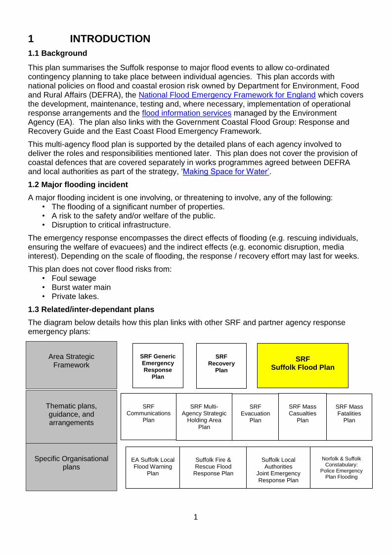
1.3 Related/inter-dependant plans
The diagram below details how this plan links with other SRF and partner agency response emergency plans:
SRF Generic Emergency Response
Plan
Area Strategic
Framework
SRF
Communications Plan
SRF
Evacuation Plan
SRF Mass Casualties
Plan
SRF Mass Fatalities
Plan
Thematic plans, guidance, and arrangements
EA Suffolk Local Flood Warning
Plan
Suffolk Local Authorities
Joint Emergency Response Plan
Norfolk & Suffolk
Constabulary: Police Emergency
Plan Flooding
Specific Organisational
plans
SRF Suffolk Flood Plan
Suffolk Fire & Rescue Flood
Response Plan
SRF Multi-
Agency Strategic Holding Area
Plan
SRF
Recovery Plan

2
2 AIM AND OBJECTIVES
2.1 Aim
The aim of this plan is to provide a multi-agency framework to coordinate the response plan to a large-scale flood event in Suffolk.
2.2 Objectives
The objectives of the plan are to:
• Identify the types and nature of the flood risk in Suffolk.
• Prepare key parts of the community susceptible to flooding through the provision of advice and information.
• Outline the activation procedures for the multi-agency emergency response.
• Agree areas of responsibility between organisations.
• Manage the wider impact on Suffolk of flooding events to reduce disruption to the countryside, utilities, infrastructure, or communities.
• Outline the actions needed for successful recovery.
• Link to national and neighbouring local Flood Response Plans.
3 RISK
3.1 Risk
The Suffolk Community Risk Register identifies the overall threat of flooding as MEDIUM. Therefore, procedures have been developed to reduce or eliminate the risk, and that mitigation exists in the form of multi-agency planning. Flood risk is identified and analysed in three stages:
• Establishing the source of a potential flood hazard, e.g. river, drainage system, or tidal or coastal waters.
• Identifying the paths (pathway) that the source would take during times of flood, and at different levels of flooding. For example, whether the source would run into and fill natural areas like flood plain, be stored in man-made flood areas, or spread into a residential area.
• Evaluating what the impact would be the on the people, property and the environment (the receptors) affected by flooding. This includes physical, emotional, social or economic harm.
Risk Description Risk Level
Flooding: Major coastal flooding
MEDIUM
Local / urban flooding (pluvial or surface water
run-off) MEDIUM
Local tidal flooding MEDIUM
Local fluvial flooding LOW

3
In total, approximately 14,935 properties in Suffolk are at risk of flooding of which 11,736 are at risk on the coast. In addition, many more people who either work in, visit or travel through potentially vulnerable areas, could be unfamiliar with the risk.
As a result of climate change, both the chances and consequences of flooding are likely to increase. Sea level rises, more frequent and higher storm surges, wetter winters and more intense summer rainfall will add to the existing risk and it may not prove possible to improve fixed defences sufficiently to maintain or raise protection standards.
An assessment of the risk of flooding in Suffolk is available on the SRF Community Risk Register (www.suffolkresilience.com/community-risk-register).
3.2 Types of Flooding
Sources and types of flood risk in Suffolk include:
• Fluvial flooding (rivers)
• Coastal flooding
• Surface water flooding/pluvial flooding (excessive run-off)
• Groundwater flooding (high water table)
• Reservoir flooding/dam inundation.
In some areas it is difficult to establish the underlying cause of flooding. Increased infiltration and a rise in the water table may result in failure of drainage systems such as sewers; these cease to function properly when experiencing excess groundwater flow. Failure of the drainage system may cause surface water flooding which can increase the level of watercourses and the likelihood of them breaking their banks.
The command and control response structure described in this plan will be used regardless of the type of flooding experienced.
3.3 Fluvial Flooding
River (fluvial) flooding occurs as a result of water overflowing from river channels. The two key factors in fluvial flooding are: the volume of rainfall; and the capacity of the ground and rivers to absorb and transport the water. The 5 main rivers in Suffolk are below:
• The River Stour forms the main part of Suffolk’s southern border with Essex and is the longest River in the County. Predominantly rural, there are three main urban centres: Haverhill in the upper catchment, Sudbury on the mid-Stour and Hadleigh on the River Brett, a tributary of the Stour.
• The River Waveney forms the majority of the northern border with Norfolk. The second longest river is again predominantly rural; the main urban centres are Diss, Norfolk at the top of the catchment, Bungay and Beccles at the tidal limit where it becomes one of the Broadland rivers and Lowestoft on the coast.
• The River Lark flows northwards through Bury St Edmunds, into the River Ouse in Cambridgeshire.
• The River Gipping rises above Stowmarket and flows southeast into Ipswich at its’ tidal limit where it becomes the River Orwell which flows into the sea at Felixstowe.
• The River Deben rises above Debenham is mostly rural, apart from Woodbridge near the tidal limit.
The east of the county comprises numerous, mostly rural rivers: the Blyth, the Walpole, the Thorpeness Hundred River and the rivers Alde, Ore, Minsmere and Fromus.

4
3.4 Coastal Flooding
The primary factors for coastal flooding in Suffolk are the low-lying nature of the land, the length of the coastline and the proximity of the population to that coastline. The Suffolk coastline, including the numerous estuaries, is 223 miles long with both defended and undefended floodplains. The defences are owned and maintained by the Environment Agency or Local District Council depending on the stretch of coast. The standard of coastal defences varies from area to area, for more details see the Suffolk Local Flood Warning Plan, owned by the Environment Agency.
Flooding from the sea is most likely during a North Sea Surge event when an area of low pressure, moves eastwards across the Atlantic towards the British Isles, it can raise the level of seawater beneath it by up to a third of a metre. If this 'plateau' of sea water passes north of Scotland and then down into the shallow basin of the North Sea, perhaps further heightened by strong winds from the north, it can cause excessively high surge tides into the Southern North Sea of up to 2 metres. When a surge tide coincides with a spring tide, which occurs twice monthly, flooding would be a serious possibility.
Dependent on weather conditions a storm surge can also create an increased risk of subsequent cliff collapse when strong onshore winds and higher tides erode cliff edges. Management of large sections of the cliff edge rests with Coastal Partnership East, part of East Suffolk Council. They are responsible for promulgating information and warnings through the winter and after significant coastal tide surges.
3.5 Tidal flooding
Suffolk is also affected by tidal flooding. This is where the high water affects the ability of fresh water to drain to the sea, or salt water is forced deeper into fluvial systems. This can cause flooding in some parts of Suffolk:
• Tidal parts of the River Waveney which is part of the larger Norfolk Broads system which can only drain out into the North Sea at Great Yarmouth.
• Rivers Alde and Ore.
• River Deben.
3.6 Surface water flooding
The critical factors for surface water flooding, also known as pluvial flooding, are: the volume of rainfall; where it falls; and its’ intensity. In urban areas, sudden and intense rainfall cannot drain away as quickly as it can in rural areas where the soil is exposed. It can also occur where no watercourse exists. Due to its’ nature, surface water flooding is hard to predict and the scope for providing warnings is limited.
3.7 Groundwater flooding
In some parts of west Suffolk, due to underlying geology, very high groundwater levels can see ephemeral springs develop or groundwater levels to be such that basement cellars can occasionally be inundated. This tends to occur after much longer periods of sustained rainfall. Higher rainfall means more water will infiltrate the ground, thus causing the water table to rise above normal levels. The main risk area is in the west of the county. When properties suffer from groundwater flooding there is very little that can be done to prevent the water rising. It also takes longer to disperse because groundwater dissipates more slowly than surface water.
3.8 Reservoir flooding / dam inundation
The ‘Reservoirs Act 1975’ provides a legal framework to ensure the safety of reservoirs. This only applies to reservoirs which hold a certain threshold of water above natural ground level. Under the Flood and Water Management Act 2010, upper tier Local Authorities are required to

5
prepare specific off-site plans for any reservoirs within their geographical area that have been assessed as being of ‘high priority’. There are a number of high risk reservoirs within Suffolk. The Reservoir Emergency Off-site Plans which provides information and instructions for reservoir inundation emergencies within Suffolk are at Annex A. IF YOU ARE RESPONDING TO A RESERVOIR EMERGENCY, TURN IMMEDIATELY TO ANNEX A FOR ACTIVATION, NOTIFICATION & IMMEDIATE TASKS.
A complete list of reservoirs and relevant contact details are available on the Environment Agency’s website available at:
http://watermaps.environment-agency.gov.uk/wiyby/wiyby.aspx?topic=reservoir#x=357683&y=355134&scale=2 The maps which have been produced for emergency planning purposes depict the maximum area that could be flooded in the event of a worst-case reservoir failure scenario if the dams completely failed. They are based on a simplified modelling approach. Actual reservoir failure may give rise to conditions (flooded areas, flood depth, extent, velocity, hazard, and timing) which vary significantly from those indicated. The maps show the consequences of reservoir flooding, not the likelihood of the risk of flooding.
3.9 Flooding of property
Flooding can impinge on properties in a variety of ways. The definitions below may help to distinguish between these effects:
• ‘Flooded’ properties are those in which floodwater has entered the main interior of the home/business. This includes flooding of basements or sub-floors.
• ‘Affected’ properties are those which have had their exterior damaged by floodwater. Sheds, garages, outbuildings, gardens and walls are included in this category.
• ‘Impacted’ properties are those where floodwater has caused no actual damage to the interior or exterior, but has had other consequences for the owner (e.g. difficulty in access/egress due to the highway being flooded).
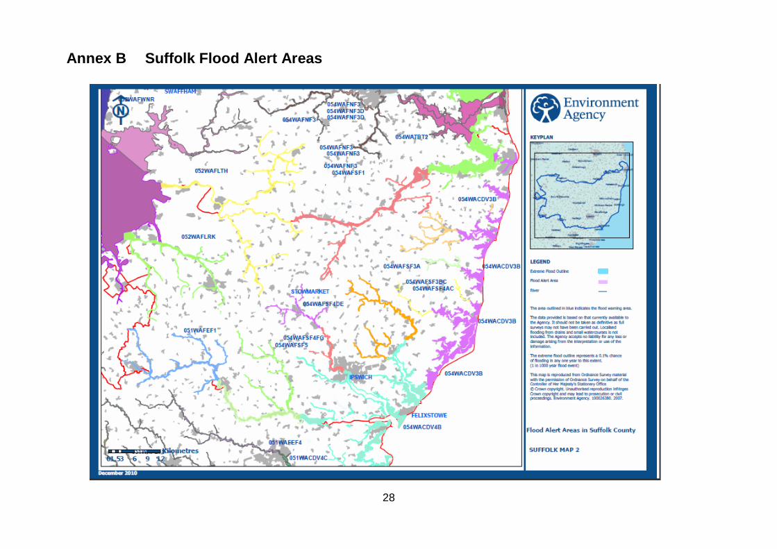
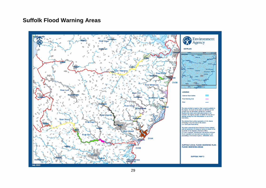
For a map of the Flood risk areas for Suffolk and a list of Environment Agency Flood Alert and Flood Warning Areas, see Annex B.
4 ALERTING PROCEDURES
4.1 Environment Agency Flood Information Services
The Environment Agency provide a continuous flood information service to the public, media, businesses and partner organisations. This service includes: Monitoring river levels, weather and tidal conditions using Met Office warnings, radar, gauge stations and rainfall levels. Utilising scientific models to forecast the likelihood of flooding. The Environment Agency can only provide a flood information service for main-river (fluvial) and coastal (tidal) flooding. They cannot provide a flood warning service for surface water flooding or sewer flooding. The Environment Agency’s warnings are disseminated through a variety of mediums e.g. broadcast medium and automated messages. If the usual mediums are unavailable then alerts can be disseminated to the public via alternative means: social media, loud hailer, door-to-door communications, local Community Emergency Teams and telephone operators.
6
The ‘Environment Agency Local Flood Warning Plan’ includes information about each of the flood warning catchments areas. Each section contains a map and information about: Areas affected:
• The number of properties affected
• The probability of flooding
• The communication of flood warnings
• The history of flooding
• The location of flood defences
• The Environment Agency’s operational response
• Contingency warning arrangements. The Environment Agency provides individual warnings to communities in danger of flooding. It is important to note that communities within the county may be issued with different warnings dependent upon the conditions within the individual area. For more information about the Environment Agency’s flood information service (including a list of which organisations receive flood warnings) refer to the ‘Environment Agency Local Flood Warning Plan’.
4.2 Flood Warning Codes
“Flood Warning Codes” is the name given to the three stages that the Environment Agency uses to warn the public of impending flooding. They are sent to the media for dissemination and also to resilience partners for information or action. The ‘Flood Alert’ and ‘Flood Warning’ warnings used are based on likelihood and timing of different levels of flooding within a community / catchment area. Severe Flood Warnings are based on likelihood and/or impact. They do not relate to the personal impact on individual members of the public. More detail information on the Flood Alert and Warning Codes is at Annexes B and C.
4.3 Targeted Flood warnings
The EA provide a Targeted Flood Warning Service (TFWS) which is a web-based flood warning service to provide organisations with a more targeted and efficient service for a number of registered assets and locations. This service provides email notifications and displays flood warnings relating to relevant assets stored within the system being affected by flood warnings as a stand-by / preparedness notification as well as a stand-down once the risks have receded.
4.4 Environment Agency gauges & river level information
The Environment Agency use gauges on watercourses to monitor river levels. Gauges are strategically located throughout Suffolk. When river levels reach a pre-identified threshold the Environment Agency may issue a flood warning for the relevant area. On-site observation and other factors (e.g. weather conditions) may also be considered before issuing a flood warning. Current river level information can be accessed via the Environment Agency website: www.environment-agency.gov.uk/riverlevels.
4.5 Severe Weather Warnings
The Met Office warns relevant organisations, the media and the public of severe weather through the National Severe Weather Warning Service (NSWWS) - www.metoffice.gov.uk/public/weather/warnings. Severe Weather Warnings are issued when the following types of weather are forecasted:
• Severe gales
• Storms

7
• Heavy snow
• Blizzard
• Heavy rain
• Fog
• Widespread icy roads, glazed frost, freezing rain. These weather conditions can increase the likelihood of flooding and/or have a detrimental effect on any emergency response. Met Office Advisors (Civil Contingencies) can make media statements regarding the weather.
4.6 Flood Guidance Statements
‘Flood Guidance Statements’ are issued by the Flood Forecasting Centre (FFC). This service, run jointly by the Met Office and the Environment Agency, aims to provide more accurate forecasts all types of natural flooding - river, coastal, groundwater and surface water flooding. Flood Guidance Statements (see example below) provide:
• An overview of the flood risk across England and Wales over a five-day period
• A summary of any Flood Warnings and Severe Weather Warnings in force
• A description of the current situation and how it may develop.
If the assessment is YELLOW, the EA will issue a narrative e-mail to key SRF partners giving more local information and the likely progress of the situation. If the assessment is AMBER, this will be supplemented by a Flood Advisory Service teleconference (see below), convened by the EA, to ensure a common picture and understanding of developing flood risk is available. This will enable SRF partners to assess and share flood risk information, coordinate any multi-agency preparatory activity and possibly to consider the need to activate the Strategic and Tactical Co-ordination Centres. The public can view a version of the FGS for 3 days ahead via Gov.uk - https://flood-warning-information.service.gov.uk/5-day-flood-risk.
8
4.7 Flood Advisory Service
The Environment Agency Flood Advisory Service (FAS) is designed to provide more co-ordinated and consistent information for partners on developing flood risk, to enable them to make more comprehensive decisions on whether to activate flood plans. The service involves a joint teleconference chaired by a local Environment Agency representative, with the assistance of the Met Office Advisor (Civil Contingencies) where possible. The Environment Agency will decide when to initiate a teleconference based on forecasts in the Flood Guidance Statement e.g. when Suffolk is indicated as a medium (AMBER) risk of flooding, or upon receiving other significant information (See Annex D).
4.8 Met Office Hazard Manager
During a flooding incident, Met Office Hazard Manager may prove a useful tool for responders. Hazard Manager is a web portal providing a one-stop information source for the emergency response community, allowing access to all services in one location. The services currently available on Hazard Manager are:
• Flood Forecasting Centre with extreme Rainfall Alert updates in England and Wales
• Interactive Map Viewer with weather information
• National Severe Weather Warning Service
• Natural Hazards Partnership Daily Weather Assessment
• Emergency Support – this service provides two types of information: up-to-date observations and forecast information and emergency event-specific contents
• FireMet and CHEMET services (approved subscribers only).
When appropriate, the Met Office Advisors (Civil Contingencies) will also send an e-mail to local partners informing them of weather-related risks. In response, the JEPU will consider whether to convene a multi-agency teleconference on behalf of SRF partners to plan and identify any requirement for a multi-agency response.
5 ACTIVATION
5.1 Alerting
Any incident attended to by the Emergency Services has the potential to expand into an emergency or major incident situation. The Emergency Services control rooms have agreed to routinely share incident information with Suffolk Local Authorities (through the JEPU) when a certain level of routine response is reached to provide warning of the potential for a major incident situation and to initiate emergency preparedness arrangements. Additionally, any Category 1 or 2 responder can also request the convening a formal or informal meeting (known as a GOLD-lite meeting) through the Joint Emergency Planning Unit Duty Officer (EPDO), if they consider that a potential flood incident has been identified, formally or informally, that is likely to necessitate a multi-agency response. This should include all SRF partners (Cat 1 & 2) likely to play a role in a full multi-agency preparedness and response (SCG Checklist). The Major Incident declaration at paragraph 5.3 below recognises that an early decision by the SCG (full or lite) enables responders to resource and manage the incident. In a ‘Rising Tide’ event this may entail the formation of the TCG to conduct planning and coordinate the implementation of plans (evacuation or deployment of temporary defences) ahead of predicted events. The SCG is able to provide oversight without having convened at the StratCC as laid
9
out in paragraph 2.2 of the SRF Generic Response Plan - http://www.suffolkresilience.com/emergency-plans/generic-emergency-response-plan/.
5.2 Activation criteria
The triggers that may lead to the activation of this plan are:
• Met Office National Severe Weather Warning
• Environment Agency Flood Warnings (more than one warning forecast or actual Flood Warning in place in SRF area)
• Flood Guidance Statement (YELLOW, AMBER or RED)
• Decision made by organisations participating in a Flood Advisory Service (FAS) teleconference, based on forecast information provided. (See Annex D)
• Higher than average river levels
• Breach of a reservoir affecting SRF area
• Reports of flooding problems within SRF area from other organisations
• High numbers of calls from the public reporting flooding.
This plan may also be activated if flooding affects/or is likely to affect Suffolk in any of the following ways:
• Requiring resources or services not normally/immediately available to the emergency services
• Threatening the health and safety of the public
• Threatening critical infrastructure, such as power and water supplies.

10
5.3 Activation Procedure
The following diagram shows the steps to be taken in the activation of the SRF flood response:
EA Flood Warning or FFC AMBER FGS
received or
Actual flooding occurs
No
Continue to review situation
EA Flood Alert or FFC YELLOW FGS received
EA establish contact with SRF partners & monitor the situation
EA Flood Advisory Service Telecon
Risk assessment, situational
awareness, further activity considered by SRF partners.
By Emergency Planners from each agency
During Normal Working Hours
By Duty Officers/Control
Rooms from each agency
Outside Normal Working Hours
If routinely available resources likely to be
or have been exceeded by any agency
Convene Practitioners meeting, or SCG
Meeting, (Lite or Full) as appropriate
Establish SRF and single agency
Command and Control arrangements
Major Incident?
Emergency Planners monitor
situation
Current or projected response within
resource availabilities from all agencies
Yes
Consider establishing TCG for ‘Rising Tide’ event
initial planning
11
6 INCIDENT MANAGEMENT
6.1 Response Framework
The generic emergency response framework for a major flood incident is in line with the SRF Generic Response Plan. The outline roles and responsibilities of each organisation during a major flooding incident are listed in Section 8. Each responding organisation must ensure that they have operational procedures and plans in place for responding to flood incidents. Such plans should include specific roles and responsibility for their staff.
6.2 Coastal Flood Aide Memoire
This plan is a generic over-arching plan; however, response to a major flooding incident will involve a number of organisations working together at a Tactical level. The Coastal Flood Aide Memoire, at Annex E, outlines significant planning considerations to be actioned within optimum timescales in order to facilitate a coordinated response including deployments of national mutual aid resources. It is designed to assist SRF multi-agency responders in preparing and implementing effective multi-agency tactical arrangements for a forecast coastal flood event.
6.3 Reservoir Flooding
The plan also includes response to a reservoir flood event. Again the response will be conducted under the auspices of the SRF Generic Emergency Response Plan. The framework, (See Annex A), provides guidance for response to the off-site or downstream consequences of flooding from any of the reservoirs in Suffolk, or close to the borders, where an inundation may affect areas in the county.
6.4 Local Authority Operational Flood Plans
Local Authority District Flood Plans inform and support the local authority operational response to flooding for locations considered to have a high flood risk. These plans provide local intelligence that may be useful during a flooding event such as:
• Risk information –, flooding source (coastal, tidal, fluvial, surface water or reservoir inundation), properties affected.
• Vulnerable people – identification of vulnerable locations e.g. schools, care homes.
• Key infrastructure – locations of infrastructure that may be affected by flooding
• Community information – Links to local Community Emergency Plans, etc.
Local Community Emergency Plans may also have been developed by local groups (Parish Councils, etc.) and these will be listed in the plans in the community section. Responders should have regard for these community plans as they could play a major part in the successful response and recovery to a flooding event. All flood plans are located for Responders on Resilience Direct
7 WARNING AND INFORMING
7.1 Warning and informing the public
During a major incident, the process for warning and informing the public is initially led by the EA; the SRF will subsequently establish an Information Centre/ Media Coordination Cell (see the SRF Communications Plan for further details). Each organisation will be responsible for

12
keeping their own websites, social media accounts and media statements up to date and linked to the key messages and information agreed via TCG/SCG and the EA.
7.2 Environment Agency Information, Warnings and Advice
The EA’s ‘Floodline’ and the flood information (link below) will be the predominant method of providing information on areas liable to (or actually) flooding. The EA will issue a flood alert, flood warning or severe flood warnings using a variety of methods:
• Automated voice messages to landline and mobile phones; via the ‘Floodline’ service (See below):
• Fax
• SMS text
• Social media –Facebook (www.facebook.com/environmentagency) and Twitter (@EnvAgency)
• Broadcast (by using radio and television stations or other suitable means).
The EA’s ‘Floodline’ service is available 24/7 and provides the public with advice on flood incident related issues. The number is 0345 988 1188. The public can access either pre-recorded information or talk to a call handler. The EA’s live flood warning and river level information can be accessed via the public through:
https://www.gov.uk/check-if-youre-at-risk-of-flooding
7.3 Key messages
During the response to a flood incident, the following information / key messages should be provided to the public:
• Basic details about the incident / warnings in place / and weather forecasts
• Implications for health and welfare
• Advice, guidance, and reassurance
• Latest information on response and recovery efforts
• Information about the practical implications of the emergency (e.g. effect on traffic, power supplies, telephones, water supplies)
• Information on how the public can help themselves protect their homes and family, including the purchasing flood protection equipment and sandbags
• Information on support facilities that have been established e.g. helplines, information points in communities
• Information on any disruption to organisations’ services
• Information on use / availability of sandbags / flood protection equipment in general.
7.4 Communication methods
Information will be communicated to the public via a variety of media during a flood emergency including:
• Individual organisation websites, and SRF website (www.suffolkresilience.com).
• Social media networks - Facebook and Twitter
• Local media – both print and broadcast. Local radio stations (not complete listing):
BBC Radio Suffolk 01473 250000 [email protected] 01473 340707
Heart FM 01603 671180 [email protected]
13
Town 102 01473 530100 [email protected] The Beach 0845 345 1050 [email protected]
• Helplines (Suffolk County Council are able to activate a Suffolk Emergency Helpline to supplement local points of contact for the public, if requested by SRF partners. This will augment information being provided by other organisations contact centres, but can also act a single, local point of contact for the public)
• Organisations’ electronic newsletters/ circulations that are public facing
• Telephone contact with Community Emergency Groups
• Appropriate organisations contacting any vulnerable service users in affected areas
• Door knocking – usually used for residents in immediate danger where evacuation may be necessary. Police will lead on this, but other organisations / community representatives may be asked to support
• Public information points in affected communities
• Leaflets / publications (flood related leaflets already in existence).
A list of flood public information and guides is at Annex F.
8 ROLES AND RESPONSIBILITIES
8.1 Category 1 and 2 Roles and Responsibilities
The roles and responsibilities relevant to a major flood event are listed in Annex G:
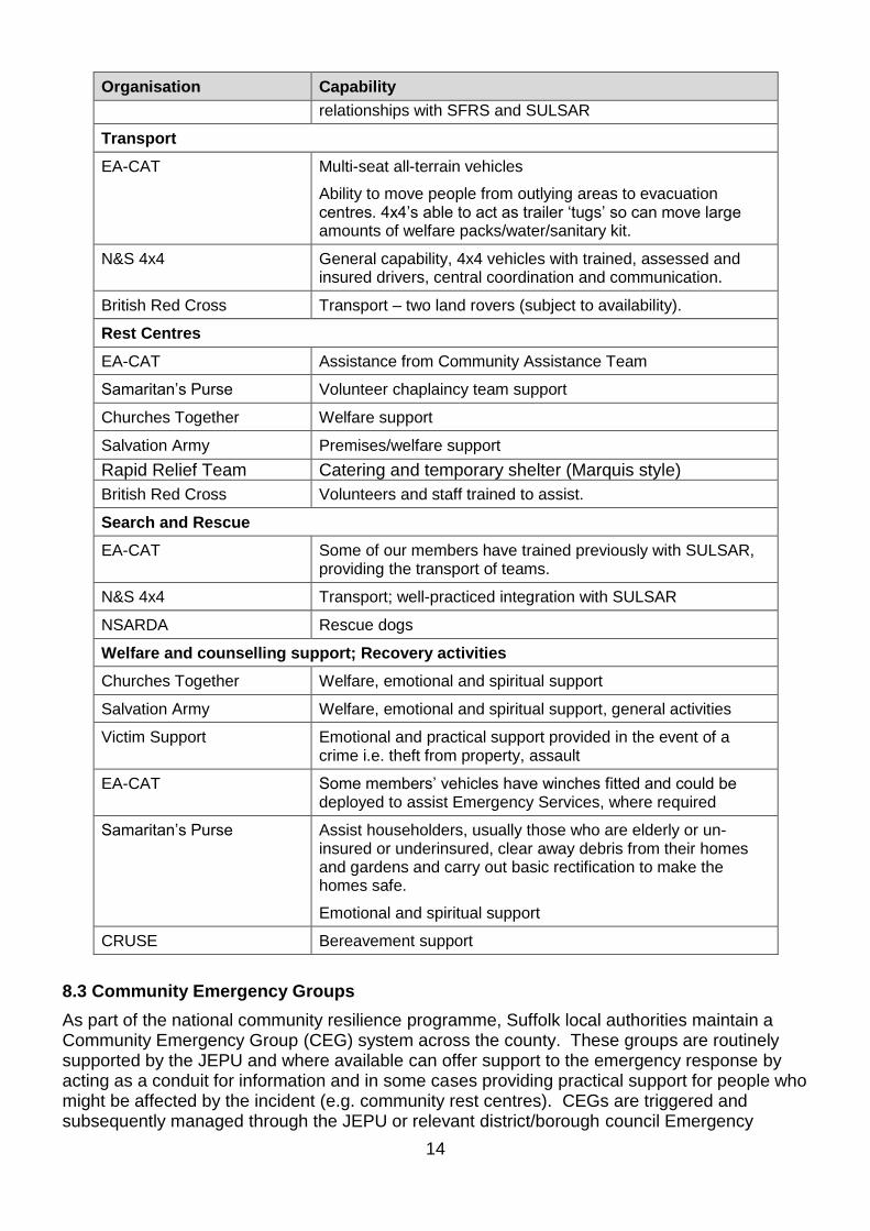
8.2 Voluntary Organisations
The numerous voluntary organisations, nationally, regionally and in Suffolk, have the potential to provide additional capacity and specialist capability for any incident response or during the recovery phase. A dedicated Suffolk Voluntary Organisations Group (SVOG) is part of the SRF framework. An electronic directory (available on Resilience Direct) has been produced by the SRF to highlight each organisation’s capabilities and how they can be contacted in times of crisis. SRF plans acknowledge the support that voluntary organisations provide but will not rely upon this support to deliver a core response unless this has been formally agreed. There are formal agreements between some Category 1 & 2 responders and SVOG members. The capacity/coordination of voluntary organisations during large scale, widespread incident, should be an SRF consideration. Probable support roles for voluntary organisations are shown below:
Organisation Capability
General support
Salvation Army Premises/welfare support/ recovery activities
British Red Cross Volunteers and staff trained to assist with a range of emergency situations.
Warning and Informing
Eastern Community Assistance Team (EA-CAT)
May be able to assist with door to door, etc.
Evacuation
EA-CAT Multi-seat, all-terrain vehicles
N&S 4x4 Multi-seat transport capable of limited wading, working
14
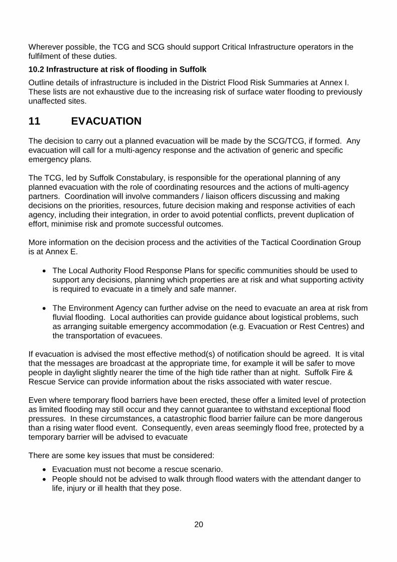
Organisation Capability
relationships with SFRS and SULSAR
Transport
EA-CAT Multi-seat all-terrain vehicles
Ability to move people from outlying areas to evacuation centres. 4x4’s able to act as trailer ‘tugs’ so can move large amounts of welfare packs/water/sanitary kit.
N&S 4x4 General capability, 4x4 vehicles with trained, assessed and insured drivers, central coordination and communication.
British Red Cross Transport – two land rovers (subject to availability).
Rest Centres
EA-CAT Assistance from Community Assistance Team
Samaritan’s Purse Volunteer chaplaincy team support
Churches Together Welfare support
Salvation Army Premises/welfare support
Rapid Relief Team Catering and temporary shelter (Marquis style)
British Red Cross Volunteers and staff trained to assist.
Search and Rescue
EA-CAT Some of our members have trained previously with SULSAR, providing the transport of teams.
N&S 4x4 Transport; well-practiced integration with SULSAR
NSARDA Rescue dogs
Welfare and counselling support; Recovery activities
Churches Together Welfare, emotional and spiritual support
Salvation Army Welfare, emotional and spiritual support, general activities
Victim Support Emotional and practical support provided in the event of a crime i.e. theft from property, assault
EA-CAT Some members’ vehicles have winches fitted and could be deployed to assist Emergency Services, where required
Samaritan’s Purse Assist householders, usually those who are elderly or un-insured or underinsured, clear away debris from their homes and gardens and carry out basic rectification to make the homes safe.
Emotional and spiritual support
CRUSE Bereavement support
8.3 Community Emergency Groups
As part of the national community resilience programme, Suffolk local authorities maintain a Community Emergency Group (CEG) system across the county. These groups are routinely supported by the JEPU and where available can offer support to the emergency response by acting as a conduit for information and in some cases providing practical support for people who might be affected by the incident (e.g. community rest centres). CEGs are triggered and subsequently managed through the JEPU or relevant district/borough council Emergency

15
Control Centre, when activated. Further detail on Suffolk CEGs can be found at: http://www.getpreparednow.co.uk/.
8.4 Spontaneous (Convergent) Volunteers
A spontaneous volunteer is defined as an ‘individual who is unaffiliated with official response organisation [organised voluntary sector organisations are recognised as part of the official response], yet without extensive pre-planning, is motivated to provide unpaid support to the response and/or recovery to an emergency’. If spontaneous volunteers are not properly managed they can divert resources and attention away from response and recovery activities. Spontaneous volunteers who are not involved in the official response activities, may also engage in providing emergency help away from the official response, potentially placing themselves and those they aim to help in danger. At the earliest opportunity during the response to an emergency, a senior local authority officer should assess situation around the incident scene to determine the scale of spontaneous support; this assessment should include discussions with any pre-existing community groups. This assessment and consultation may subsequently lead to the tasking of the organised voluntary sector with a view to the engaging of spontaneous volunteers as required to support humanitarian assistance response. If the situation dictates, and it is appropriate for the ‘employment’ of spontaneous volunteers, the establishment of a Volunteer Reception Centre (VRC) facility should be considered for the administration/management of the volunteers. A Spontaneous Volunteer Coordinator should be appointed and dependent on local authority resources, consideration should be given to approaching organised voluntary sector organisations or an established Community Emergency Group, to assist in staffing/management of the VRC. Operational communications links should be created between the local authority ECCs and the Tactical Coordinating Group (TCG) Voluntary and Community Sector Coordinator (VCS Coord).
All agencies at the incident scene should be made aware of the establishment of a VRC in order to direct potential SVs away from the immediate incident scene. An appropriate public communication message should be prepared for media/social media broadcast indicating the SV approach/requirement.
9 ADDITIONAL INFORMATION
9.1 Vulnerable People
Suffolk response and recovery strategies for dealing with incidents take account of considerations posed by vulnerable people. There is no central list of vulnerable people, instead information held by many different agencies will be brought together at the time of an incident as part of an Evacuation Cell at the TCG, or just prior if warnings are available, to ensure that vulnerable people can be supported during any emergency. Sources of information on vulnerable people within Suffolk, are known as ‘list of lists’. It should be noted that during a major flood incident anyone has the potential to become vulnerable due to the factors in disaster-related incidents. However, for a significant number of people the experience can be serious as it has the potential to remove them from established support mechanisms and expose vulnerabilities. Vulnerable groups within the community may need special provision both in implementing any preparatory or precautionary measures for a potential flood event (moving furniture, personal effects,

16
or putting flood protection measures in place), or in response to a flood incident (evacuation). There is a SRF Protocol to assist in the identification of vulnerable groups and individuals. This provides a flexible process for collating and sharing information between Category 1 and 2 Responders whilst maintaining individual’s confidentiality.
9.2 Humanitarian Assistance.
During a flood incident, care of the public affected by the event is a primary objective of any response or recovery activity. This may entail the provision of physical assistance psychological support and social aftercare in the short, medium and long term. Rest Centres will be established either by the Local Authority with assistance individuals or from Voluntary Organisations. Local Community Emergency groups may also set up evacuation centres supporting their communities. These will provide a place of safety for people directed to evacuate their properties. In the longer term, after the immediate impacts for any flood have subsided, Local Authorities may establish a Community Help Point (CHP) or a Humanitarian Assistance Centre (HAC) close to the incident scene. The role of the CHP is to help signpost people to shelter in Rest Centres and provide guidance and advice on where people can access support, care and advice.
9.3 Flood Defences
The provision of flood defences is covered in works programmes agreed between DEFRA and local authorities. Flood defences in Suffolk are owned, maintained and operated by a mixture of the Environment Agency, Local authorities and private land owners. In some areas where the flood risks are significant, specific arrangements have been put in place to reduce the flood risk.
Lowestoft Temporary Flood Barrier. Waveney District Council (WDC) has 1400m of temporary tidal defences to protect the centre of Lowestoft in the event of a tidal surge, until the permanent flood defence capital project is completed. Details of the LTFB are at Annex H.
9.4 Provision of sandbags
Local authorities do not have a statutory duty to supply sandbags. The current policy moved away from the historic position where sandbags were provided or made available to individuals. This is because sandbags are relatively ineffective and have a number of serious deficiencies:
• Sacking material is biodegradable and is costly to store for long periods of time.
• Filling and laying bags is strenuous, labour intensive and time consuming. It takes 2 people one hour to fill 12 sandbags and each sandbag will need approximately 15kg of sand. Building a sandbag wall up to 60cm high by 1 metre in length requires approximately 80 filled sandbags.
• Sandbags do not prevent properties flooding.
• When contaminated by flood waters, they need to be disposed of in landfill as they may be contaminated by chemicals and sewage.
• Large parts of the county are sparsely populated which presents a problem supplying individuals at risk, in time, across a wide area.
This Policy was accepted by the Local Authority Joint Emergency Planning Policy Panel in March 2009 and was endorsed and adopted by all Suffolk councils in 2014 and restated in 2016. It has also been agreed as the Suffolk Resilience Forum (SRF) policy.

17
The Suffolk Flood Risk Management Partnership also promotes flood resilience and provides advice through the Suffolk Flood Risk Management Strategy. This is designed to help everyone in Suffolk understand and manage the risk of flooding, and sets out the responsibilities of all major stakeholders, including water companies, landowners, households and community groups to manage flood risk. The partnership establishes the extent, risk and potential impact of flooding from all sources (tidal, river, surface water) across the county to enable strategic decisions to be made about the level of acceptable risk and the extent of resources to be allocated to reduce this risk. The picture below demonstrates the ineffectiveness of sandbags (with water having penetrated the sandbag wall), compared to propriety flood protection equipment (keeping water out of the house).
If the property is at risk, they should:
• register to receive flood warnings.
• consult with their insurer regarding taking protective measures that may reduce excess charges or premiums.
• Install proprietary flood mitigation and flood protection measures (e.g. air brick covers, sandbags, floodgates).
The public and businesses are strongly urged to identify if their properties are at risk of flooding. Flood protection advice and information is available through the sources listed at Annex F.
However, NO house can be made totally flood proof. The SRF contingency planning will respond to assist with the protection of properties identified as ‘at risk’ and to provide community protection i.e. where several properties or businesses can be protected by diverting water.
9.5 Mutual aid
Mutual aid should not be relied upon as a vital component of any planned activities as key equipment and personnel will be in high demand. It is probable that other counties on the East coast (and indeed, the UK) will be involved trying to access the same resources in their own emergency response.

18
Suffolk Constabulary and Suffolk Fire & Rescue Service have national mutual aid arrangements in place. During a major flooding incident, mutual aid will be co-ordinated on behalf of Suffolk Constabulary through the National Police Co-ordination Centre (NPoCC). Suffolk Fire & Rescue Service will seek mutual aid through the Fire & Rescue Service National Co-ordination Centre (FRSNCC).
Requests for mutual aid can also be made to other local authorities. Appeals will always be considered, but it may be difficult for organisations to provide support. Other organisations may also have mutual aid arrangements (e.g. memorandums of understanding) in place.
Other requests for mutual aid from organisations should be coordinated with MHCLG Resilience and Emergencies Division (RED) or any multi-SCG/LRF Response Coordinating Group (ResCG) arrangement, set up by MHCLG.
9.6 Health and Safety
Operating in floodwater brings dangers not normally encountered in an everyday working environment.
All responders should obey the health and safety guidelines of their own organisation. Wherever possible, staff who attend the scene of flooding should have received water awareness training; if at all viable, Personal Protective Equipment (PPE) should be worn by emergency responders on-scene.
Staff should undertake a dynamic risk assessment before working near floodwater or operating in hazardous conditions. Care should be taken over the following dangers:
• Floodwater can cover ditches, manholes, access hatches and other hazards, leaving a deep hole into which people can fall or drive into
• The force of floodwater can sweep people off their feet
• Floodwater may be contaminated with sewage, hazardous chemicals and debris
• Water conducts electricity.
10 CRITICAL INFRASTRUCTURE
10.1 Types of critical infrastructure
Some locations in Suffolk are designated Critical National Infrastructure (CNI). Their nature and location is classified. Suffolk Constabulary will advise locations that are identified as Critical National Infrastructure if the warning level is increased and instigate liaison to ensure that these locations are protected as required. Other infrastructure which provides essential services is designated as Critical Infrastructure (CI). The nature of public service provision and the inter-dependence between public and private interests is complicated. Flooding can affect essential public services provided by private companies, who in turn rely on public sector organisations to support the emergency response. Examples of Critical Infrastructure include:
• Power stations
• Primary electrical sub-stations
• Ports
• Hospitals
• Telephone exchanges and telecommunications masts
• Railway network
• Major roads, highways and bridge structures
• Water and sewage treatment works

19
• Reservoirs/dams
• Emergency Services’ stations / HQs.
Consideration is also to be given to other important sites:
• COMAH sites
• Nursing and care homes
• Nurseries and schools
• Caravan, camp and mobile home sites
• Fuel depots and petrol stations
• Prisons
• Nature reserves and Sites of Special Scientific Interest (e.g. Minsmere).
A loss of Critical Infrastructure carries a serious threat to personal health and has adverse effects on the emergency response. The TCG should be capable of assisting critical infrastructure operators in their response to flooding. Examples of asset failure include:
• Reservoir/dam failure
• Power failure
• Closure of port
• Pumping station failure
• Structural damage or collapse of a road or rail bridge, or major drain. Critical Infrastructure operators are recommended to attend or be represented at the TCG and/or SCG. Infrastructure operators have detailed knowledge about their sites; they can accurately estimate if asset failure will occur and the consequences of it doing so. Furthermore, operators are aware of back-up options in their network that can secure or ‘re-zone’ supply. Sharing this information with the SCG/TCG is integral to the emergency response. Each Critical Infrastructure operator should have:
• Trained and experienced personnel
• Stockpiles of contingency equipment
• Dedicated, resilient communications
• Command and control facilities
• Methods of notification to regulators and other stakeholders
• Robust Business Continuity arrangements.
Vulnerable people are especially at risk from disruptions in service provision. The TCG should aid organisations and facility owners in the identification and support of such people. Asset failure within the administrative boundaries of neighbouring authorities may still directly affect Suffolk. Similarly, asset failure in Suffolk may affect other areas. The Critical Infrastructure operator should ensure all relevant organisations are notified of threats to their facilities, any possible asset failure or requests for multi-agency assistance. All Critical Infrastructure operators are to:
• Secure their services, equipment and continuity of supply
• Repair any disrupted services
• Provide alternative means of supply during service disruption (if public health is threatened)
• Provide information and advice to the SCG, TCG, media, businesses and public.
20
Wherever possible, the TCG and SCG should support Critical Infrastructure operators in the fulfilment of these duties.
10.2 Infrastructure at risk of flooding in Suffolk
Outline details of infrastructure is included in the District Flood Risk Summaries at Annex I. These lists are not exhaustive due to the increasing risk of surface water flooding to previously unaffected sites.
11 EVACUATION The decision to carry out a planned evacuation will be made by the SCG/TCG, if formed. Any evacuation will call for a multi-agency response and the activation of generic and specific emergency plans. The TCG, led by Suffolk Constabulary, is responsible for the operational planning of any planned evacuation with the role of coordinating resources and the actions of multi-agency partners. Coordination will involve commanders / liaison officers discussing and making decisions on the priorities, resources, future decision making and response activities of each agency, including their integration, in order to avoid potential conflicts, prevent duplication of effort, minimise risk and promote successful outcomes. More information on the decision process and the activities of the Tactical Coordination Group is at Annex E.
• The Local Authority Flood Response Plans for specific communities should be used to support any decisions, planning which properties are at risk and what supporting activity is required to evacuate in a timely and safe manner.
• The Environment Agency can further advise on the need to evacuate an area at risk from fluvial flooding. Local authorities can provide guidance about logistical problems, such as arranging suitable emergency accommodation (e.g. Evacuation or Rest Centres) and the transportation of evacuees.
If evacuation is advised the most effective method(s) of notification should be agreed. It is vital that the messages are broadcast at the appropriate time, for example it will be safer to move people in daylight slightly nearer the time of the high tide rather than at night. Suffolk Fire & Rescue Service can provide information about the risks associated with water rescue. Even where temporary flood barriers have been erected, these offer a limited level of protection as limited flooding may still occur and they cannot guarantee to withstand exceptional flood pressures. In these circumstances, a catastrophic flood barrier failure can be more dangerous than a rising water flood event. Consequently, even areas seemingly flood free, protected by a temporary barrier will be advised to evacuate
There are some key issues that must be considered:
• Evacuation must not become a rescue scenario.
• People should not be advised to walk through flood waters with the attendant danger to life, injury or ill health that they pose.

21
The method of notification will depend on the area; some may be appropriate for house to house visits by Community Emergency Groups or police. Local flood plans contain more specific detail. Evacuees may initially be directed to a place of safety, such as a community or village hall or public house, by the emergency services. The relevant local authorities should be informed of the whereabouts of this place of safety. The needs of evacuees will be assessed, and a suitable Rest Centre activated. Suffolk Constabulary will, as far as practicable, take steps to ensure the security of property left empty after evacuation. In the event of an extended evacuation local authorities may have to consider other security arrangements. More information on evacuation issues is contained in the SRF Guide to Evacuation and Shelter and in Section 8 of the SRF Generic Emergency Response Plan.
12 RECOVERY
12.1 Recovery
Although the immediate protection of life is the priority, the way in which the recovery / reoccupation element is managed is very important. In accordance with Suffolk’s response to other types of major incidents this will be considered during the immediate response phase. A Recovery Working Group (RWG) will be established as soon as practicable, so that when conditions are appropriate to transfer the coordination role from the police to the local authority, this be a seamless process.
12.2 Transfer from Response to Recovery
The decision to move from the response phase to the recovery phase should be taken by the SCG. This decision may be made when the EA issue a relevant ’warning no longer in force’ message, but should also be based on personal judgement, experience and consultation with partner organisations. When this decision has been taken, a formal handover from the SCG (or TCG, if SCG not convened) to a Recovery Coordinating Group (RCG) should be made and a meeting to discuss recovery arrangements immediately (on transfer of authority, the RWG becomes the RCG). This transfer of responsibility should be agreed upon and recorded by all organisations involved in the response. The SCG and TCG should be stood-down; however, the RCG may still require support from the STAC and Media Cell (if established); these groups should be stood-down by the RCG at an appropriate time. The RCG chair should decide which organisations should be represented at the RCG.
12.3 Suggested actions for the RCG
Aims and objectives for the recovery phase should be agreed by the RCG. Suggested initial targets may include the following:
• Providing guidance and support to flooded residents and businesses
• Restoring utility supplies and transport infrastructure
• Ensuring the demand on public services (including healthcare) is returned to normal levels
• Safeguarding the environment
• Re-establishing tourism in the area.

22
The process used will reflect those laid down in the SRF Recovery Plan. Further information and advice is also available from the National Recovery Guidance: (www.gov.uk/national-recovery-guidance)
23
Annexes
A. Generic Off-Site Reservoir Emergency Plan
B. Flood Alert and Flood Warning Area Maps and Codes
C. Flood Alert and Flood Warning descriptions
D. Flood Advisory Service
E. Tactical Aide Memoire for coastal flooding
F. Flood Information and Advice
G. Category 1 and 2 organisations - Roles and Responsibilities
Specimen Evacuation Notice
H. Lowestoft Temporary Flood Barrier (LTFB)
I. Flood Risk Summary Sheets by District
J. Specimen Evacuation Notice.

24
Annex A Generic Off-Site Reservoir Emergency Plan
IF YOU ARE RESPONDING TO A RESERVOIR EMERGENCY, TURN IMMEDIATELY TO NEXT PAGE FOR ACTIVATION, NOTIFICATION & IMMEDIATE TASKS. 1. Introduction This Annex is a stand-alone response plan that addresses the off-site, or downstream, consequences of flooding from any of the reservoirs in Suffolk, or close to the borders where an inundation may affect areas in the county. It provides a framework in order that those responding to an incident can work together as efficiently and effectively as possible. The direct consequences of an incident may include the need to provide for the evacuation, transport and accommodation of a number of evacuees, as well as damage to the local infrastructure and environment. 2. Plan Triggers The following events may lead to activation of the plan either as actual or potential breaches, and will require site specific planning and response:
• Reservoir inspections – any 1975 Reservoir Act section 10 / 12 enforcement action indicates a requirement for closer monitoring of the potential risk.
• Land slippage following heavy rain / saturated ground may lead to overtopping or failure.
• Earth embankment movement – earthquake or other cause such as terrorism.
• A Cascade failure following heavy rain and overtopping of one reservoir into others. 3. In the Event of an Emergency If a reservoir breach is occurring or deemed imminent, the initial alert or notification will normally be received from the Reservoir owner/manager/operator (known as the Undertaker), (it may come from any other informant) to the Police, the Environment Agency or the Local Authority (LA), this generic plan should be activated. All registered large raised reservoirs have a legal requirement to contact the EA incident hotline on 0800 80 70 60 to report any incident:
https://www.gov.uk/reservoirs-a-guide-for-owners-and-operators The Police, Environment Agency and / or the Joint Emergency Planning Unit (JEPU), will activate the plan and co-ordinate the initial activities of the SRF response of the emergency services, local authority and other key partners under the control of the Police-designated Tactical (Silver) Commander. If appropriate, and time permitting, a full SRF Command and Coordination structure may be established. Notification & main tasks for responders when incident is occurring or imminent are in the figure on the next page:

25
POLICE, ENVIRONMENT AGENCY and LOCAL AUTHORITY (LA): Liaise with undertaker, supervising engineer to determine: - Whether sudden influx or rising tide scenario - Timing of failure and time available to evacuate.
SUFFOLK FIRE & RESCUE SERVICE may assist with: - Identifying vulnerable places & property evacuation - Search & rescue - Pumping eqpt. - Aerial Survey
Note: - SCG may be called - SRF Communicate Suffolk activates Comms Action Card (Appendix. 2) to warn public and inform media.
LA: Organise evacuation transport
UNDERTAKER notifies: Police, and/or Environment Agency, Fire & Rescue, if appropriate, that failure is imminent or occurring.
POLICE / EA / FIRE notify: JEPU Emergency Planning Duty Officer (EPDO) (through IBC ESC); Environment Agency (EA); and Suffolk Constabulary / Suffolk Fire & Rescue Service (SFRS).
ENVIRONMENT AGENCY: advice on flooding scenario and if required: - Assist in warning people in the immediate hazard area - provide materials, equipment & staff
LOCAL AUTHORITY (Initially EPDO): - liaise with other relevant authorities (incl. cross-border where relevant) - Set up reception / rest centres with other LAs.
POLICE: Co-ordinate response: - Assigning TCG commander - Divide affected area into management areas and appointing bronze commanders - Consider arranging media messages to warn immediate hazard area through SRF Communicate Suffolk.
POLICE: Put in place any road closures with support (signage) from LA Highways Services
POLICE: Set up and coordinate RVPs with LA
LA: Identify & prioritise vulnerable people and establishments (with NHS England and SFRS) at risk.
POLICE: Co-ordinate evacuation (for details - refer to SRF Evacuation Guidance)
ALL relevant responder organisations: - Provide liaison at multi agency planning and response at TCG, SCG & FCP) - Activate internal emergency procedures.

26
Communications Overview and Action Card
5. Media In the event of a major potential or actual dam breach incident the Police will initially take the co-ordinating lead in the response to the media in its’ overall Public Information role. This diagram represents the notification process for a reservoir incident and the subsequent activation and multi-agency working process to ensure that all responding agencies coordinate activities aimed at providing unified warnings and advice to the public and common information to the media.
6. Activation This action card is activated in consultation between the responding organisations when an Offsite Reservoir emergency may be, or has been, declared. 7. Key Actions
• Is the notification for action, standby or information only?
• Police will lead media response until/if a SRF Media & Communications Cell (MCC) is set up.
• Establish which Agency will lead and coordinate communications response for the incident.
• Consult SRF responding agencies Comms Teams / Officers regarding warning advice and further media releases.
• Confirm if a Major Incident has been declared; review and confirm details and confirm release of holding statement.

27
• Disseminate warning advice to residents within the Risk Area (with Incident Commander) via media outlets and share information with partner agencies.
• Discuss with Chair of the SCG the requirement to establish MCC with SRF responding agencies to support response activity.
• Establish frequency and content of further media releases and information with SCG / TCG / Incident Commander.
• Notify ALL agency Call / Contact Centre facilities of all media releases for information to support any public queries directed to the call centre (Consider need for FAQs).
• Establish where the media response will be coordinated from ‘on the ground’.
• Identify and provide briefing to Spokesperson for the incident.
• Identify requirement for a Media RV Point (in consultation with Incident Commander).
• Consider activating SRF public website homepage with ‘Incident' news alert, holding statement & link to further information.
• Consider need for Mutual Aid support from SRF Communicate Suffolk partners, not directly involved in the incident.
• Confirm contact details & ‘cc’ alternative generic Comms email details for SRF responding agency Comms Teams / Officers.
• Produce in conjunction with the MCC closing statements, including recovery issues / advice and provide update for all SRF participating responders website pages as appropriate.
More details on arrangements for Warning and Informing are in the SRF Communications Plan
28
Annex B Suffolk Flood Alert Areas
29
Suffolk Flood Warning Areas

30
Suffolk Flood Alert Area Codes
BROADS:
054WATBT3 Tidal River Waveney
TIDAL:
054WACDV3B Suffolk coast from Lowestoft to Bawdsey
054WACDV3C The Suffolk Coast at Southwold
054WACDV4A The Tidal Deben Estuary
054WACDV4B The Suffolk and Essex Coast from Felixstowe to Clacton including the Orwell and Stour Estuaries
SUFFOLK FLUVIAL:
054WAFSF1 River Waveney upstream of Ellingham
054WAFSF2 Suffolk Coastal Rivers
054WAFSF3A Rivers Minsmere and Yox
054WAFSF3BC Thorpeness Hundred River & River Ore
054WAFSF4AC Rivers Deben and Lark
054WAFSF4DE Rattlesden River and River Gipping
054WAFSF4FG River Gipping downstream of Needham Market
054WAFSF5 Rivers Box and Brett
052WAFLRK The Rivers Lark and Kennett in Suffolk
052WAFLTH Little Ouse and River Thet
Suffolk Flood Warning Area Codes
BROADS:
054FWTBT3a The tidal River Waveney from Ellingham Marshes to Belton
054FWTBT3b Isolated low lying properties along the tidal River Waveney
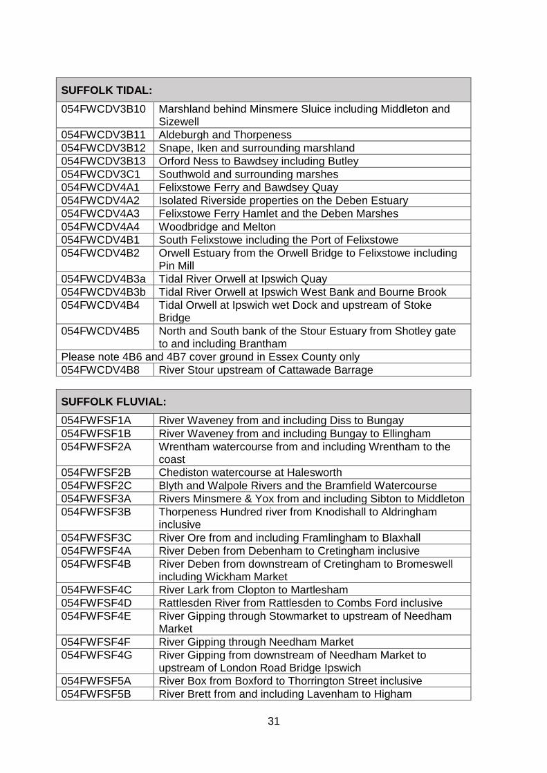
SUFFOLK TIDAL:
054FWCDV3B1 Lowestoft Seafront and Docks
054FWCDV3B2 North bank of Lake Lothing
054FWCDV3B3 South bank of lake Lothing, Brooke Business park to Mutford Lock
054FWCDV3B4 Oulton Broad near Mutford Lock
054FWCDV3B5 Riverside Business park and Kirkley
054FWCDV3B6 Benacre Marshes and Kessingland Beach
054FWCDV3B7 Walberswick, Dunwich and surrounding marshes
054FWCDV3B8 Tidal river Wang including Wangford
054FWCDV3B9 Blythburgh and marshes upstream of A12
31
SUFFOLK TIDAL:
054FWCDV3B10 Marshland behind Minsmere Sluice including Middleton and Sizewell
054FWCDV3B11 Aldeburgh and Thorpeness
054FWCDV3B12 Snape, Iken and surrounding marshland
054FWCDV3B13 Orford Ness to Bawdsey including Butley
054FWCDV3C1 Southwold and surrounding marshes
054FWCDV4A1 Felixstowe Ferry and Bawdsey Quay
054FWCDV4A2 Isolated Riverside properties on the Deben Estuary
054FWCDV4A3 Felixstowe Ferry Hamlet and the Deben Marshes
054FWCDV4A4 Woodbridge and Melton
054FWCDV4B1 South Felixstowe including the Port of Felixstowe
054FWCDV4B2 Orwell Estuary from the Orwell Bridge to Felixstowe including Pin Mill
054FWCDV4B3a Tidal River Orwell at Ipswich Quay
054FWCDV4B3b Tidal River Orwell at Ipswich West Bank and Bourne Brook
054FWCDV4B4 Tidal Orwell at Ipswich wet Dock and upstream of Stoke Bridge
054FWCDV4B5 North and South bank of the Stour Estuary from Shotley gate to and including Brantham
Please note 4B6 and 4B7 cover ground in Essex County only
054FWCDV4B8 River Stour upstream of Cattawade Barrage
SUFFOLK FLUVIAL:
054FWFSF1A River Waveney from and including Diss to Bungay
054FWFSF1B River Waveney from and including Bungay to Ellingham
054FWFSF2A Wrentham watercourse from and including Wrentham to the coast
054FWFSF2B Chediston watercourse at Halesworth
054FWFSF2C Blyth and Walpole Rivers and the Bramfield Watercourse
054FWFSF3A Rivers Minsmere & Yox from and including Sibton to Middleton
054FWFSF3B Thorpeness Hundred river from Knodishall to Aldringham inclusive
054FWFSF3C River Ore from and including Framlingham to Blaxhall
054FWFSF4A River Deben from Debenham to Cretingham inclusive
054FWFSF4B River Deben from downstream of Cretingham to Bromeswell including Wickham Market
054FWFSF4C River Lark from Clopton to Martlesham
054FWFSF4D Rattlesden River from Rattlesden to Combs Ford inclusive
054FWFSF4E River Gipping through Stowmarket to upstream of Needham Market
054FWFSF4F River Gipping through Needham Market
054FWFSF4G River Gipping from downstream of Needham Market to upstream of London Road Bridge Ipswich
054FWFSF5A River Box from Boxford to Thorrington Street inclusive
054FWFSF5B River Brett from and including Lavenham to Higham

32
Annex C Flood Warning Code Descriptions
Flood Alert Flood Warning code, icon and strapline
Purpose Triggers Impact on ground (when threshold exceeded)
Multi-agency Response
Prepare
To warn people of the possibility of flooding and encourage them to start making simple / low impact preparations for flooding. Notes The aim is for customers to receive a Flood Alert between 2 and 12 hours prior to levels exceeding Flood Alert thresholds and during waking hours. Flood Alerts can be issued for individual tides or a specified series of tides. Updates are issued to the Internet and Floodline only, to inform customers of new developments or continuing situation.
Forecasts received, based on; threshold exceedance, telemetry data (rain gauge, river level, groundwater levels, etc), forecasts of Result Threshold exceedances, etc that indicate that flooding will occur. Forecast rainfall which sufficiently correlates to expected rapidly responding flooding. High astronomical tides, surge & wind forecasts and alerts from UKCMF that threshold levels are likely to be exceeded. Output from our tidal forecasting models, tide detection gauges and observations. Site observations
For low lying land and floodplain warnings, issued in advance of: Flooding of fields, recreation land and car parks; Flooding of minor road infrastructure (A (non-trunk) B, C & Unclassified) Farmland flooding (arable & pasture) Spray/waves overtopping on coast Overland flow from rivers and streams Localised flooding due to heavy storms (could be linked to river flooding re: surcharge from drains) For Alerts in advance of flooding to property, likely to be issued when the conditions above have already been met.
Monitor situation: Check current FGS (Hazard Manager) for additional information. Maintain watch on National Severe Weather Warning Service or EA Flood Warnings. If concerned, contact EA Duty Officer / Incident Room. Alert EA & Cat 1 & 2 partners to any incidents of flooding.

33
Flood Warning
Flood Warning code, icon and strapline
Purpose Triggers Impact on ground (when threshold exceeded)
Multi-agency Response
Act
To warn people of expected flooding and prompt them to take action to protect themselves and their property Notes
The aim is for customers to receive a Flood Warning at least 2 hours prior to the onset of flooding. A Flood Warning can be issued directly (i.e. without the prior issue of a Flood Alert) if warranted by a forecast or observations. Sent to all customers in Flood Warning areas who are registered, including EDW customers
Information received based on threshold exceedance, telemetry data, tidal forecasting models, weather radar data, rain gauge alarms, rainfall forecasts, flow forecast model output, forecasts of Result thresholds exceedances that indicate flooding will occur; Actual flooding; Site observations; High astronomical tides, surge & wind forecasts and alerts from UKCMF that threshold levels are likely to be exceeded A breach in defences or failure of a tidal surge barrier or dam.
Flooding of homes. Flooding of businesses. Flooding of cellars and basements. Flooding to roads with Major impacts. Flooding to rail infrastructure. Wave/spray overtopping; Extensive flood plain inundation (including caravan parks or campsites). Flooding of major tourist/recreational attractions.
EA to inform partners of identified risk area(s) and level of threat. Consider establishing TCG / SCG Consider implementing Tactical / Operational Flood Plan actions. Review supporting Emergency Plans. Consider mobilisation of resources – personnel, plant, flood protection, voluntary organisations Consider Implement / activation of evacuation plans and arrange for rest centres to be set up.
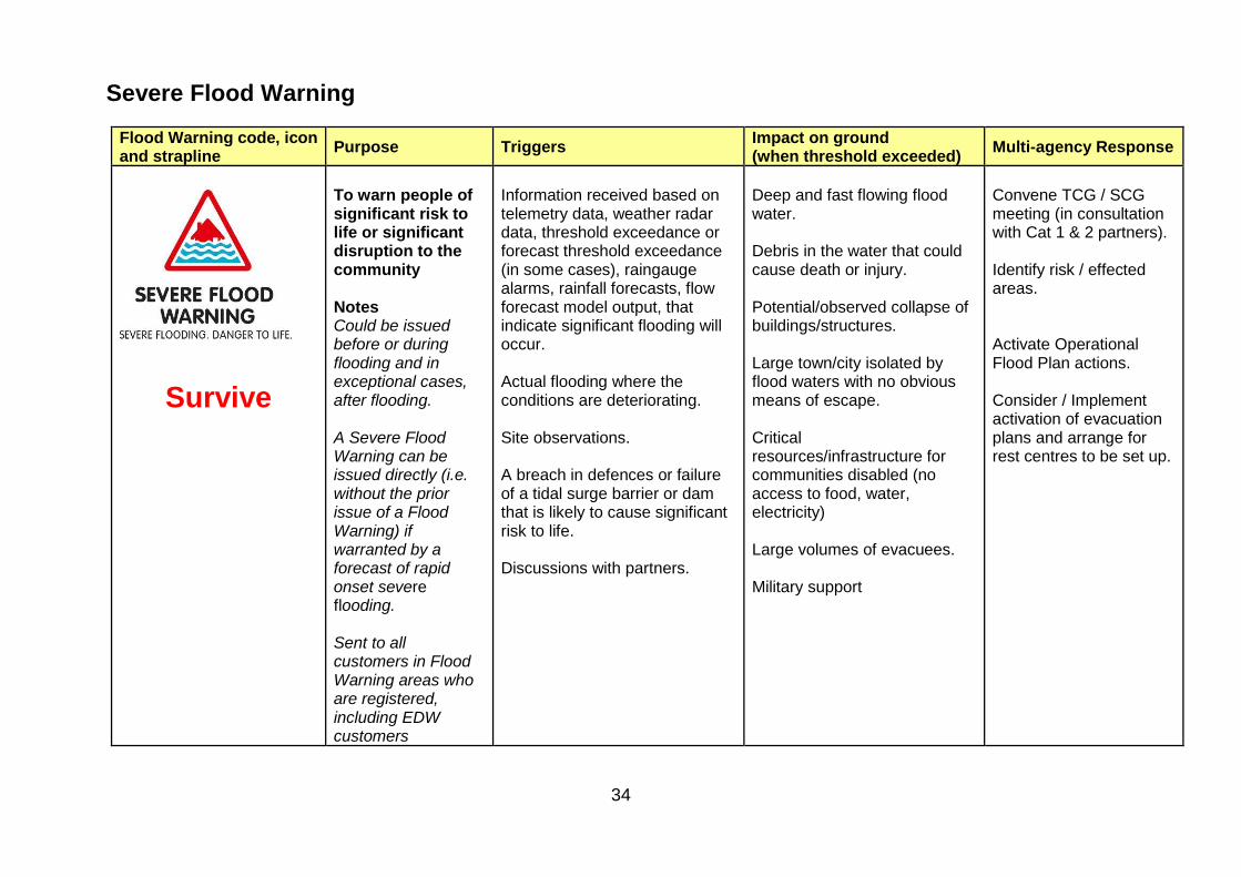
34
Severe Flood Warning
Flood Warning code, icon and strapline
Purpose Triggers Impact on ground (when threshold exceeded)
Multi-agency Response
Survive
To warn people of significant risk to life or significant disruption to the community Notes Could be issued before or during flooding and in exceptional cases, after flooding. A Severe Flood Warning can be issued directly (i.e. without the prior issue of a Flood Warning) if warranted by a forecast of rapid onset severe flooding. Sent to all customers in Flood Warning areas who are registered, including EDW customers
Information received based on telemetry data, weather radar data, threshold exceedance or forecast threshold exceedance (in some cases), raingauge alarms, rainfall forecasts, flow forecast model output, that indicate significant flooding will occur. Actual flooding where the conditions are deteriorating. Site observations. A breach in defences or failure of a tidal surge barrier or dam that is likely to cause significant risk to life. Discussions with partners.
Deep and fast flowing flood water. Debris in the water that could cause death or injury. Potential/observed collapse of buildings/structures. Large town/city isolated by flood waters with no obvious means of escape. Critical resources/infrastructure for communities disabled (no access to food, water, electricity) Large volumes of evacuees. Military support
Convene TCG / SCG meeting (in consultation with Cat 1 & 2 partners). Identify risk / effected areas. Activate Operational Flood Plan actions. Consider / Implement activation of evacuation plans and arrange for rest centres to be set up.
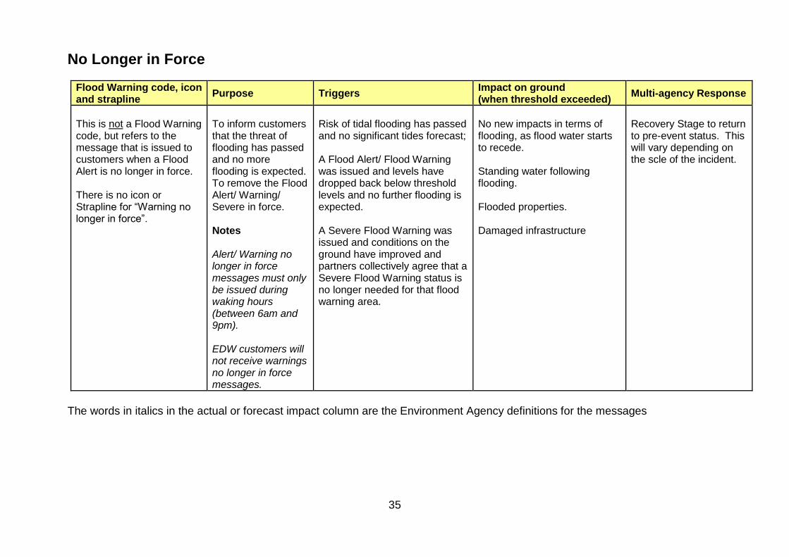
35
No Longer in Force
Flood Warning code, icon and strapline
Purpose Triggers Impact on ground (when threshold exceeded)
Multi-agency Response
This is not a Flood Warning code, but refers to the message that is issued to customers when a Flood Alert is no longer in force. There is no icon or Strapline for “Warning no longer in force”.
To inform customers that the threat of flooding has passed and no more flooding is expected. To remove the Flood Alert/ Warning/ Severe in force. Notes Alert/ Warning no longer in force messages must only be issued during waking hours (between 6am and 9pm). EDW customers will not receive warnings no longer in force messages.
Risk of tidal flooding has passed and no significant tides forecast; A Flood Alert/ Flood Warning was issued and levels have dropped back below threshold levels and no further flooding is expected. A Severe Flood Warning was issued and conditions on the ground have improved and partners collectively agree that a Severe Flood Warning status is no longer needed for that flood warning area.
No new impacts in terms of flooding, as flood water starts to recede. Standing water following flooding. Flooded properties. Damaged infrastructure
Recovery Stage to return to pre-event status. This will vary depending on the scle of the incident.
The words in italics in the actual or forecast impact column are the Environment Agency definitions for the messages

36
Annex D Flood Advisory Service
Each morning the Flood Forecasting Centre and the Environment Agency (EA) in conjunction with the Met Office, hold a teleconference to decide on the detail of the Flood Guidance Statement.
The Flood Guidance Statement (FGS) provides a 5 day outlook of the weather and highlights potential problems by colouring each county one of four colours. These are explained in the table below.
Key Very low risk Low risk Medium risk High risk
River & Coastal Flooding Probability > 100 properties will Flood, or extreme danger to life From rivers or the sea
< 20% ≥ 20% to <40% ≥ 40% to 60% ≥ 60%
Extreme Rainfall Probability that ERA thresholds will be met, leading to possible surface water flooding
< 10% ≥ 10% to<20% ≥ 20% to 60% ≥ 60%
Suggested actions
• Business as usual
• Consider liaising with partner organisation
• Be aware of the latest weather flood warnings and alerts
• Consider liaising with partner organisations
• Consult surface water flood maps and local flood warning plan maps as appropriate
• Consider activating emergency procedures
If any counties are coloured AMBER, the EA will consider inviting partners, by Local Resilience Forum (LRF) boundaries, to a teleconference to assess the risk and coordinate a multi-agency response.
The EA Area Incident Room will initiate this and there will be input from the Met Office. Where an LRF boundary crosses an EA Boundary, the EA will decide with our colleagues which incident room should manage the teleconference.
The teleconference should last no more than 30 minutes and will be chaired by the EA.
Partners should be contacted by either email and/or telephone and invited to dial in to the teleconference at the agreed time.
Potential Participants: (Contact details in SRF Alerting Directory)
• EA - Duty Officer / or local Flood Incident Team
• Met Off - Duty Forecaster / Civil Contingencies Advisor
• Police - Contact & Control Room Inspector
• Fire - Combined Fire Control
• Ambulance - EEAST Resilience Manager
• JEPU - representing Local Authorities.
• Category 2 responders, as appropriate:
• UK Power Network
37
• Highways England
• Anglian Water
• BT.
• Joint Regional Liaison Officer.
The following agenda items should be covered:
• Introduction, welcome and confirm attendees;
• Update on the weather situation (Met Office Civil Contingencies Advisor, if present / FWDO) & flooding conditions
• Update on possible warnings to be issued, the affected areas and the local impact on the ground
• Update from the cat 1 & 2 responders
• Questions from the cat 1 & 2 responders
• Agree responses and time of the next teleconference.
An appropriate EA Duty Officer will be nominated to take notes of the decisions and actions and will email these to the wider partner group immediately after each teleconference.
The EA have a dedicated BT MeetMe account specifically for this purpose.

38
Annex E Coastal Flood Aide Memoire
OVERVIEW This Aide Memoire is designed to assist Suffolk multi-agency responders in preparing and implementing effective arrangements required to deal with a forecast coastal flood event. It outlines significant planning considerations to be actioned within optimum timescales to facilitate a coordinated response including deployments of national mutual aid resources. Triggers and multi-agency response planning actions commencing with Met Office notification(s) up to 2 days prior to a severe coastal flood event are detailed in this aide memoire. These actions are planned on the basis of 2 days advance notice from the point of flooding. High water at Lowestoft will be denoted as ‘D’, it should be noted that a tidal surge may not coincide directly with the high tide timings; hence D is given as high water. ALERTING AND NOTIFICATION These actions can be initiated at any point before D-481 if notifications from the EA Flood Advisory Service (FAS) or MHCLG ResCG generate the need to commence precautionary activity earlier in response to a high impact tidal surge event. The EA convene a FAS teleconference with Emergency Services and Local Authority representatives to review the forecast and confirm confidence, nature and scale of flood event forecast. An SRF SCG teleconference may also be called to confirm that all partners, including the Category 2 partners specifically listed in the SCG Check list, are aware of the situation and to give an initial overview of their readiness to react to the event or to highlight any potential problem areas. WARNING AND INFORMING At D-48, weather and flood forecasting information would be available internally and publicly during this phase raising public awareness and interest in the approaching storm. Government will be providing the higher-level messaging on national level preparation. Media interest will escalate. Communicate Suffolk in conjunction with EA, would start to develop and coordinate a communications strategy for local messaging, focussing on what people in the affected area should do. Public websites will be updated to inform the public of the current situation and to signpost advice and guidance for use in the event of a flood by the public, ideally from a Single Point of Contact. Consider activation of the Suffolk Helpline to reduce call load on Emergency Services.
1 D-48 = 48 hrs prior to initial identified high water with potential for significant coastal inundation.

39
FLOOD RESPONSE ACTIONS The TCG will usually form once the SCG initiate the response (possibly initial teleconference or at Landmark House) and confirm initial shared situational awareness and to initiate multi-agency tactical response planning. A Checklist to assist with TCG planning is on the following page. Once it is initiated, the flood response actions will be implemented and managed by the TCG chair. JESIP principles and processes use the Joint Decision-Making Model which should be applied by commanders / officers at all levels in various command and coordinating locations. Further info at www.JESIP.org.uk
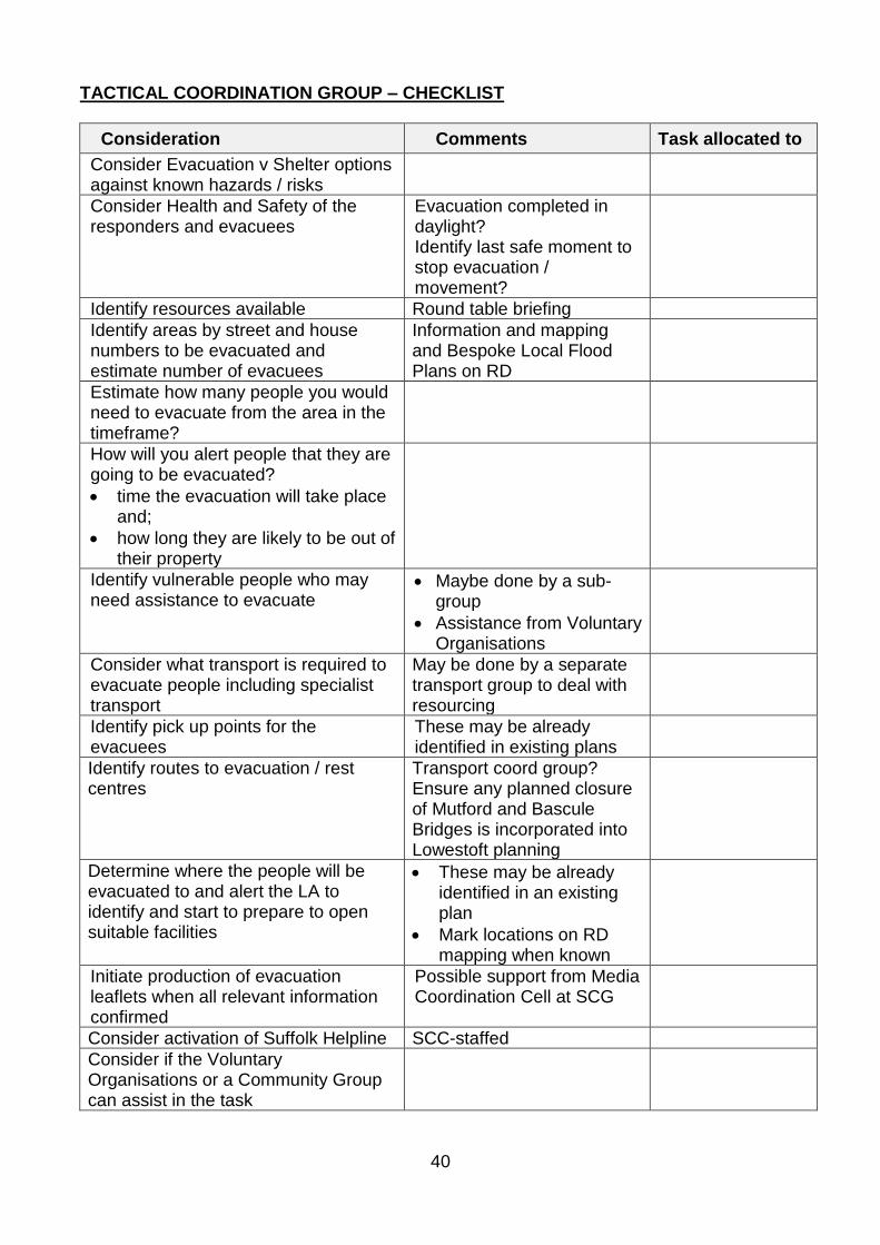
40
TACTICAL COORDINATION GROUP – CHECKLIST
Consideration Comments Task allocated to
Consider Evacuation v Shelter options against known hazards / risks
Consider Health and Safety of the responders and evacuees
Evacuation completed in daylight? Identify last safe moment to stop evacuation / movement?
Identify resources available Round table briefing
Identify areas by street and house numbers to be evacuated and estimate number of evacuees
Information and mapping and Bespoke Local Flood Plans on RD
Estimate how many people you would need to evacuate from the area in the timeframe?
How will you alert people that they are going to be evacuated?
• time the evacuation will take place and;
• how long they are likely to be out of their property
Identify vulnerable people who may need assistance to evacuate
• Maybe done by a sub-group
• Assistance from Voluntary Organisations
Consider what transport is required to evacuate people including specialist transport
May be done by a separate transport group to deal with resourcing
Identify pick up points for the evacuees
These may be already identified in existing plans
Identify routes to evacuation / rest centres
Transport coord group? Ensure any planned closure of Mutford and Bascule Bridges is incorporated into Lowestoft planning
Determine where the people will be evacuated to and alert the LA to identify and start to prepare to open suitable facilities
• These may be already identified in an existing plan
• Mark locations on RD mapping when known
Initiate production of evacuation leaflets when all relevant information confirmed
Possible support from Media Coordination Cell at SCG
Consider activation of Suffolk Helpline SCC-staffed
Consider if the Voluntary Organisations or a Community Group can assist in the task

41
ACTION REQUIRED TIME STARTED TIME
COMPLETED ALLOCATED TO COMMENTS
D – 48 hours
Evacuation Planning: Evacuation
planning Cell / TCG
Key partners: SRF Category 1 and 2 responders, and Vol. Orgs.
Decide on and plan the evacuation notification process (leafleting / door knocking)
Identify potential Vulnerable People and other multi-occupancy sites at risk (e.g. caravan sites and parks, residential care homes)
Additional information available from Cat 1 and 2 orgs, Vol. Orgs, Local Community Emergency Planning Gps [VP Protocol on RD]
Liaise with JRLO regarding potential resource requests
SCG may direct
Additional support for LTFB construction; Manpower; Specialist transport
Calculate evacuation initiation timings, if not proposed by SCG
Information needed on evacuation leaflets by Media Coordination Cell (MCC) / Communicate Suffolk Gp.
Agree timing and / or mechanism for communicating when evacuation efforts must be stopped for responder and public safety reasons
Information needed on evacuation leaflets and by MCC / Communicate Suffolk Gp.
Confirm Rest Centre locations and possible areas for moving cars to safety within relevant District / Borough
Information needed on evacuation leaflets, by MCC / Communicate Suffolk Gp and Police ‘door knocking teams.
Arrangement of transport for evacuees including vulnerable persons (Consider assistance of Suffolk / Norfolk 4x4 Response)
Information needed on evacuation leaflets and by MCC / Communicate Suffolk Gp.

42
Pre-deployment of resources:
Agree locations for FCPs and during response phase and initiate plans to secure each location
Confirm MASHA / SHA locations, if required, and be prepared to facilitate / staff the MASHA up to D-24hrs or when the national assets are released
MASHA considerations: size, welfare, location, staffing levels, duration, 24hr working, security
Confirm primary access / egress routes for command locations, response sectors and resource holding areas
Police, HE, SCC Highways
Confirm if any road works, etc. on pre-planned routes (roadworks.org) Consider and review historical infrastructure loss through coastal surge
Lowestoft Temporary Flood Barrier. Liaise with WDC ECC
SCG may direct
Resources placed on Standby Landowners contacted Additional resources required?
• JRLO early heads up.
Agree geographical sector responsibilities for each identified Bronze FCP
Develop Interoperable multi-agency Command and Communications plan / contact lists
For Airwave users consider sectorised use of Interagency talk groups ES1 – 3 for North / South Operational Commanders
Confirm welfare policies invoked to provide suitable arrangements at all locations
Identify potential for cross border working to maximise effective response capability:
Consider Joint MASHA with Essex at Orwell Truck Stop for NCAF resources

43
Confirm SITREP with regional partner agencies to develop shared situational awareness and assess capacity for supporting actions
Consider single Bronze sector for North Lowestoft / Gorleston / Great Yarmouth Island community)
Liaise with Norfolk LRF agencies
Consider arrangements and coordination of Bridge closures in Lowestoft
Liaise with SCG
Consider Voluntary organisation contributions:
Establish Volunteer Coordinator at TCG
Contact key organisations to raise awareness and review Vol Orgs capacity to assist response and recovery operation
LA See Section 8.2 Early engagement, potential assistance from:
• Salvation Army and Rapid Relief Team for Response hub catering;
• British Red Cross for FESS;
• SuLSAR to assist in coordinating search planning and management;
• Suffolk / Norfolk 4x4 Response for transport and logistics support for response teams, vulnerable person evacuation, SAR operations, etc.
Local Community Emergency Groups:
Establish contact with Community Emergency Groups
LA

44
Confirm critical infrastructure protection priorities
SCG decision Early call for National assets and mutual aid to support strategy
Identify mutual aid requirements, including requests for MOD assets, and inform SCG of requests
TCG to SCG to request
Consider Flood rescue teams, High Volume Pumping and Drone Aerial Surveillance teams and related Tactical Advisors
D – 36 hours
Last safe moment for a decision to construct full and complete LTFB (both south and north sides).
Barrier deployment confirmed with WDC (CPE). Final notification to landowners Supporting agencies notified: Emergency Services, HE, Suffolk Highways, ABP Lowestoft
D – 24 hours
Review and execute any outstanding/unresolved D – 48hr checklist actions or initiate D – 48hr actions if notification not received prior to D – 24hr
Confirm road closure plans and implementation timings
HE, SCC Highways, Police
Finalise evacuation plans and confirm implementation timings
Agree when evacuation should be completed in line with High water timings notified by EA
Circulate details of evacuation plan to SCG, MCC and FCP staff, if identified.
Details to be included in leaflets and for MCC / Communicate Suffolk Group.

45
Prepare plans for ground /aerial reconnaissance after initial surge
Competent resources available may include SFRS, Vol orgs – S&N 4x4 Response and SULSAR Assets; Drone Assets; Military if applicable.
Confirm agencies staffing rotas in place for multiagency locations (including welfare arrangements and liaison / command / administration roles)
Plan for sustaining a 96 hr deployment post D point and initial inundation
Confirm mutual aid arrangements are in place
Confirm and communicate battle rhythm for ResCG / SCG / TCG / Operational meetings
D - 12 hours
Review and execute any outstanding/unresolved D – 24hr checklist actions or initiate D - 48 and D - 24 actions if notification not received prior to D – 12hr
Initiate multi agency staffing of FCPs (Bronze response hubs)
Monitor impacts as surge moves down the East coast to confirm accuracy of forecast, planning assumptions and W&I strategy
D-6 hours

46
Review and execute any outstanding/unresolved D – 12hr checklist actions or initiate D – 48 / 24 / 12hr actions if notification not received prior to D – 6hr
Confirm resources (including mutual aid) in place or en route to command locations or relevant holding area(s)
Conduct full test of multi-agency command and communications systems
Confirm LTFB fully operational, traffic management complete, and monitoring staff in place.
Confirm which Agencies have staff deployed locations along the coast to provide reporting network of flood effects

47
D Hour
High water time at Lowestoft
(Initiate ground reconnaissance plans ASAP)
Great Yarmouth
• T + 0hrs Lowestoft
• T + 40mins Southwold
• T + 1hr 40 min Aldeburgh
• T + 2hrs 15mins A12 Blyth Estuary
• T + 2hrs 40mins Felixstowe
• T + 3hrs 15mins Harwich
• T + 3hrs 25mins Ipswich
• T + 3hrs 55mins Manningtree (Stour estuary)
• T + 3hrs 55mins Beccles
• T + 4hrs 35mins Snape
• T + between 3 and 6 hours depending on weather conditions and surge timing.
• Great Yarmouth (next high tide) 12hrs and 24 mins after the last
Time of high tide and surge may be different Establish situational awareness

48
Post Surge actions
Review future tide forecasting and delayed at upstream locations or second high tide surge effects with EA
Primary Survey
• Initiate risk assessed initial ground reconnaissance plans by responder agencies (where resources permit).
• Review any media / other available aerial reconnaissance and/or consider organising Suffolk reconnaissance to assess initial impact of surge if safe to do so.
• Establish initial assessment of immediate rescue needs and infrastructure damage and cliff erosion / collapse hazards.
• Feed information into the SCG / RWG
• Complete Recovery Impact Assessment
• Establish further resource requirements
Consider use of Drones for aerial survey at sites of specific interest
Review response plans and deployments to ensure safety of staff and reaffirm priority of taskings to account for impact of first surge and any potential for significant

49
damaging second surge.
Secondary survey
Infrastructure damage assessment to SCG / RWG.
Update Recovery Impact Assessment

50
Planned Forward Control Point Deployment Locations

51
COMMAND CONTROL & COMMUNICATIONS Command locations The TCG will be at Landmark House, Ipswich. Multi-Agency Forward Control Point (FCP) location options for Bronze coordination include:
Location Facility
Lowestoft South Fire Station Bronze North FCP
Lowestoft North Fire station
FCP option– NB Potential Island community consider sharing with Norfolk
Framlingham Fire Station Bronze Central Command FCP
Saxmundham Fire Station Bronze Central FCP
Ipswich East Fire Station Bronze South FCP
Felixstowe Fire Station Bronze South FCP
All the stated locations should remain resilient in terms of maintaining key utilities supplies during a tidal surge event and therefore considered suitable for a four day deployment. Most have suitable landing sites nearby for helicopter operations e.g. Casevac. The command locations identified above may be provided as a holding point (close to flood hazard sector) for single or multi-agency resources to standby waiting tasking by Bronze Commanders. Resilient Communications (preferably interoperable Airwave will be crucial for all agencies to ensure effective multi-agency operations). Refer to SRF Resilient Telecommunications plan and Agency plans. Air Support Combined Tactical Air Cell (CTAC) is invoked on request of Police Silver Commander for Major Incident requiring provision and coordination of significant airborne response and is coordinated by National Police Air Service. CTAC liaison is required to confirm suitable landing site options for standing by and casevac, etc. Strategic Holding Area Multi or Single Agency Strategic Holding Areas will be needed to receive mutual aid resources in Suffolk. Consideration should be given to sharing SHA locations with neighbouring LRF partners agencies. Location options include:
• Orwell Crossing Lorry Park (Accessed between Jct 57 and 58 A14 Eastbound)
• Rougham truck Stop Bury St Edmunds (Jct 44 A14)
• Rock Barracks, Woodbridge (SRF MASHA Plan) (Access to Rock Barracks may be compromised so may not be appropriate for use - Authorised via JRLO).
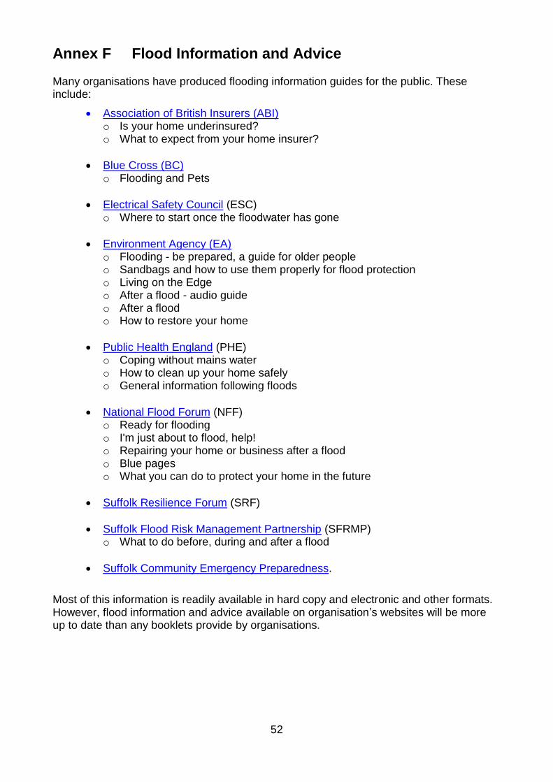
52
Annex F Flood Information and Advice
Many organisations have produced flooding information guides for the public. These include:
• Association of British Insurers (ABI) o Is your home underinsured? o What to expect from your home insurer?
• Blue Cross (BC) o Flooding and Pets
• Electrical Safety Council (ESC) o Where to start once the floodwater has gone
• Environment Agency (EA) o Flooding - be prepared, a guide for older people o Sandbags and how to use them properly for flood protection o Living on the Edge o After a flood - audio guide o After a flood o How to restore your home
• Public Health England (PHE) o Coping without mains water o How to clean up your home safely o General information following floods
• National Flood Forum (NFF) o Ready for flooding o I'm just about to flood, help! o Repairing your home or business after a flood o Blue pages o What you can do to protect your home in the future
• Suffolk Resilience Forum (SRF)
• Suffolk Flood Risk Management Partnership (SFRMP) o What to do before, during and after a flood
• Suffolk Community Emergency Preparedness.
Most of this information is readily available in hard copy and electronic and other formats. However, flood information and advice available on organisation’s websites will be more up to date than any booklets provide by organisations.
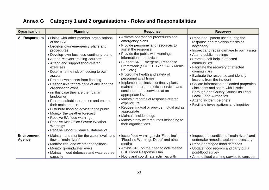
53
Annex G Category 1 and 2 organisations - Roles and Responsibilities
Organisation Planning Response Recovery
All Responders • Liaise with other member organisations of the SRF
• Develop own emergency plans and procedures
• Develop own business continuity plans
• Attend relevant training courses
• Attend and support flood-related exercises
• Determine the risk of flooding to own assets
• Protect own assets from flooding
• Responsible for drainage of any land the organisation owns
• (in this case they are the riparian landowner)
• Procure suitable resources and ensure their maintenance
• Distribute flooding advice to the public
• Monitor the weather forecast
• Receive EA flood warnings
• Receive Met Office Severe Weather Warnings
• Receive Flood Guidance Statements.
• Activate operational procedures and emergency plans
• Provide personnel and resources to assist the response
• Provide the public with warnings, information and advice
• Support SRF Emergency Response Framework (SCG / TCG / STAC / Media Cell, etc.)
• Protect the health and safety of personnel at all times
• Implement business continuity plans; maintain or restore critical services and continue normal services at an appropriate level
• Maintain records of response-related expenditure
• Request mutual or provide mutual aid as appropriate
• Maintain incident logs
• Maintain any watercourses belonging to their organisations.
• Repair equipment used during the response and replenish stocks as necessary
• Inspect and repair damage to own assets
• Attend public meetings
• Promote self-help in affected communities
• Facilitate the recovery of affected communities
• Evaluate the response and identify lessons from the incident
• Collate information on flooded properties / incidents and share with District, Borough and County Council as Lead Local Flood Authorities
• Attend incident de-briefs
• Facilitate investigations and inquiries.
Environment Agency
• Maintain and monitor the water levels and flow of ‘main rivers’
• Monitor tidal and weather conditions
• Monitor groundwater levels
• Maintain flood defences and watercourse capacity
• Issue flood warnings (via ‘Floodline’, ‘Floodline Warnings Direct’ and other media)
• Advise SRF on the need to activate the SRF Flood Response Plan’
• Notify and coordinate activities with
• Inspect the condition of ‘main rivers’ and undertake remedial action if necessary
• Repair damaged flood defences
• Update flood records and carry out a post-flood survey
• Amend flood warning service to consider
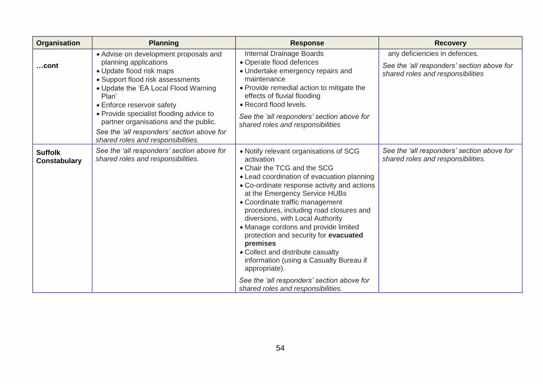
54
Organisation Planning Response Recovery
…cont
• Advise on development proposals and planning applications
• Update flood risk maps
• Support flood risk assessments
• Update the ‘EA Local Flood Warning Plan’
• Enforce reservoir safety
• Provide specialist flooding advice to partner organisations and the public.
See the ‘all responders’ section above for shared roles and responsibilities.
Internal Drainage Boards
• Operate flood defences
• Undertake emergency repairs and maintenance
• Provide remedial action to mitigate the effects of fluvial flooding
• Record flood levels.
See the ‘all responders’ section above for shared roles and responsibilities
any deficiencies in defences.
See the ‘all responders’ section above for shared roles and responsibilities
Suffolk Constabulary
See the ‘all responders’ section above for shared roles and responsibilities.
• Notify relevant organisations of SCG activation
• Chair the TCG and the SCG
• Lead coordination of evacuation planning
• Co-ordinate response activity and actions at the Emergency Service HUBs
• Coordinate traffic management procedures, including road closures and diversions, with Local Authority
• Manage cordons and provide limited protection and security for evacuated premises
• Collect and distribute casualty information (using a Casualty Bureau if appropriate).
See the ‘all responders’ section above for shared roles and responsibilities.
See the ‘all responders’ section above for shared roles and responsibilities.

55
Organisation Planning Response Recovery
Suffolk Local Authorities
• Carry-out responsibilities under role of Lead Local Flood
• Authority
• Maintain highway drainage systems
• Identify riparian landowners and enforce remedial action on watercourses where necessary
• Emergency action to remove obstructions in watercourses and protect assets
• Liaise with community representatives on drainage issues
• Maintain protocol to share information on vulnerable persons, in consultation with emergency services, health agencies and utility services
• Maintain database of pre-planned rest, evacuation and media centres
• Encourage communities to form their own Community Emergency Groups (CEGs) and develop emergency plans
• Exercise powers under the Land Drainage Act 1991 and byelaws to ensure that activities in and alongside the drainage system do not reduce flood protection standards and unnecessarily increase flood risk.
See the ‘all responders’ section above for shared roles and responsibilities.
• Chair the RWG/RCG
• Co-ordinate the local authority response across councils
• Liaise with Police on implement road closures, diversion routes, flood warning signs and the re-opening of roads
• Implement footpath closures
• Co-ordinate with the EA, distribution of temporary flood protection resources to protect areas at risk (NOT single properties)
• Provide transport for evacuees to rest centres
• Provide welfare and emergency accommodation, as required, for evacuees
• Liaise with voluntary organisations and co-ordinate their response (See 8.2)
• Liaise with utility and transport companies to ensure identification of problems areas
• Provide Environmental Health advice
• Maintain regular contact with parish/town councils and CEGs
• If applicable, liaise with HM Coroner for the provision of temporary mortuary and/or activation of mass fatalities plan.
See the ‘all responders’ section above for shared roles and responsibilities.
• SCC survey, maintain and repair buildings/structures/highways for which is responsible
• Inspect the condition of cliffs and undertake remedial action and disseminate warnings, if necessary (CPE)
• Consider Public Health and Environmental Health implications
• Distribute grants to those who have been flooded
• Arrange for the re-housing of those made homeless by flooding
• Advise on long-term regeneration of the community and the environment
• Collate accurate records of flooded properties
• Coordinate the provision of care for those who have been affected by flooding
• Develop strategy on how community will be involved in physical rehabilitation
• Arrange for the collection and removal of debris and disposal of non-toxic waste materials.
• Organise recovery meetings for the public and businesses to attend
• Collate and analyse information on property flooding / flood incidents
• Carry-out flood risk investigations as appropriate.
See the ‘all responders’ section above for shared roles and responsibilities.

56
Organisation Planning Response Recovery
Suffolk Fire & Rescue Service
See the ‘all responders’ section above for shared roles and responsibilities.
• Rescue people trapped by fire, flood, wreckage, or debris
• Assist agencies with the removal or dispersal of critical quantities of flood water
• Manage issues associated with hazardous materials or other contaminants.
• Assist ambulance services with casualty handling and or decontamination as required.
• Coordinate search & rescue operations with other agencies.
• Provision of Aerial surveillance drones for Responder situational awareness
See the ‘all responders’ section above for shared roles and responsibilities.
• Assist other agencies to minimise the impact on the community.
• Assist the Police with the recovery of bodies
• Assist agencies with the removal or dispersal of critical quantities of flood water.
• Provision of Aerial surveillance drones for Responder situational awareness
See the ‘all responders’ section above for shared roles and responsibilities.
East of England Ambulance Service Trust (EEAST)
• Ensure compatibility and exercise Regional and local response plans.
See the ‘all responders’ section above for shared roles and responsibilities
• Provide emergency medical treatment for casualties
• Transport injured people to hospitals
• Co-ordinate the support of voluntary organisations in the management and transportation of casualties
• Co-ordinate the response of the National Health Service on-site
• Carry out decontamination (in conjunction with SFRS).
See the ‘all responders’ section above for shared roles and responsibilities
• To maintain emergency cover throughout the East of England Ambulance Service area, and return to a state of normality at the earliest time.
See the ‘all responders’ section above for shared roles and responsibilities
PHE • Ensure appropriate procedures are in place to provide health protection advice
• Coordinate the provision of the Chair and support for STAC with Director of Public
• Provide appropriate scientific and technical input into the RCG and sub

57
Organisation Planning Response Recovery
cont to the response
• Produce advice in advance to responders and the public in relation to exposure hazards from flooding.
See the ‘all responders’ section above for shared roles and responsibilities.
Health
• Provide timely and appropriate health protection advice to the response
• Activate an emergency operation centre as applicable.
See the ‘all responders’ section above for shared roles and responsibilities.
groups
• Provide support to NHS and Clinical Commissioning Groups in relation to the development of long term public health monitoring strategies of the long-term health effects of flooding.
See the ‘all responders’ section above for shared roles and responsibilities.
NHS England See the ‘all responders’ section above for shared roles and responsibilities.
See the ‘all responders’ section above for shared roles and responsibilities.
• Facilitate long term health monitoring.
• Ensure the restoration of health services to the affected area(s)
See the ‘all responders’ section above for shared roles and responsibilities.
Internal
Drainage
Boards
• Maintain drains, pumping stations, flood defences, watercourses and sluices
• Enforce riparian owners to undertake remedial action on watercourses where necessary
• Promote capital schemes for drainage and flood defence improvement
• Provide advice on new developments to local authorities and developers
• Provide advice and support to partners
• Exercise powers under the Land Drainage Act 1991 and byelaws to ensure that activities in and alongside the drainage system do not reduce flood protection standards and unnecessarily increase flood risk
• Monitor levels and flows within designated watercourses
• Where possible, support the emergency response through provision of staff, resources and local knowledge.
See the ‘all responders’ section above for shared roles and responsibilities.
• Assist where possible in remedial and clearance works
• Update flood records and carry out a post-flood survey.
See the ‘all responders’ section above for shared roles and responsibilities.

58
Organisation Planning Response Recovery
…cont • Deploy staff to remove obstructions and protect assets.
See the ‘all responders’ section above for shared roles and responsibilities.
Utilities • Internal contingency plans, which would be activated as required
• Clear blockages in public sewers and outfall grills
• Maintain and repair public sewers.
See the ‘all responders’ section above for shared roles and responsibilities.
• Close liaison between the utilities, principal emergency services, local authorities and the public will, in the event of substantial flooding, be provided through SCG.
• Emergency pumping at failed pumping stations
• Repairing burst sewage and water pumping mains
• Secure services and equipment to ensure continuity of supply
• Repair disrupted services
• Provide alternative means of
supply during service disruption
• Advise partner organisations, the
media and the public when disrupted
services will be reinstated
• May take action to protect property
flooding from public water mains or
discharges from sewerage systems.
See the ‘all responders’ section above for shared roles and responsibilities.
• Inspect the condition of public sewers and undertake remedial action if necessary.
See the ‘all responders’ section above for shared roles and responsibilities.
Met Office • Provide weather forecasts
• Issue Severe Weather Warnings
• Work with Flood Forecasting Centre to issue Flood Guidance Statements and
• Activate the Met Office Emergency Support Service
• Provide guidance and support to emergency responders.
See the ‘all responders’ section above for shared roles and responsibilities.

59
Organisation Planning Response Recovery
maintaining Hazard Manager.
See the ‘all responders’ section above for shared roles and responsibilities.
See the ‘all responders’ section above for
shared roles and responsibilities.
Maritime & Coastguard Agency
See the ‘all responders’ section above for shared roles and responsibilities.
• Initiate and coordinate civil maritime search and rescue (includes mobilising, organising and dispatching resources to assist people in distress at sea, or in danger on cliffs or shoreline, or in certain inland areas)
• Coordinate response to pollution at sea and assist local authorities with shoreline clean up
• Support emergency service and local authorities during emergencies, e.g. flooding.
See the ‘all responders’ section above for shared roles and responsibilities.
See the ‘all responders’ section above for shared roles and responsibilities.
MHCLG • Provide support to SRF planning arrangements
• Cascade information and policy from national level
• Address any mutual aid requests not covered elsewhere on a national and cross border level and arrangements for ResCG.
See the ‘all responders’ section above for shared roles and responsibilities.
• Establish and facilitate the Multi-SCG Response Co-ordinating Group (ResCG), if appropriate
• Provide Government Liaison Office to the SCG
• Coordinate submission of SRF Situation Reports to central government, and receipt of the Common Recognised Information Picture (CRIP).
See the ‘all responders’ section above for shared roles and responsibilities.
• Support the recovery phase by linking
with national and regional agencies
• Co-ordinate and provide advice on VIP visits
• Monitor the recovery process and
provide update reports to central
government.
See the ‘all responders’ section above for
shared roles and responsibilities.

60
Annex H Lowestoft Temporary Flood Barrier (LTFB) Overview
East Suffolk District Council (ESDC) has 1400m of temporary tidal defences to reduce the risk of
flooding to the centre of Lowestoft in the event of a tidal surge, until the permanent flood defence
capital project is completed (by 2023).
The decision to construct the LTFB is made by ESDC in conjunction with the SRF, using information
provided by the Environment Agency (EA) either during a Flood Advisory Service or Suffolk
Resilience Forum (SRF) teleconference.
The LTFB is manufactured by GeoDesign, stored on each of the four sites and constructed using
manpower from Waveney Norse and Water Management Alliance (WMA), both ESDC strategic
partners.
The alignment of the LTFB is along Commercial Road (two locations), Waveney Road, Kirkley Ham
and Belvedere Road (see Annex A). The sites are predominantly on private land, including ABP
Lowestoft and access has been pre-arranged with the landowners.
The complete barrier requires a minimum of 30 hours to construct, which takes account of inclement
weather, fatigue and darkness. For safety, the LTFB should be completed 6 hours prior to the
estimated high water from the surge. This gives a total time of 36 hours (see Timings)
Incident Management Structure
Coastal Partnership East (CPE), part of ESDC, provide the overall management of the LTFB and
conduct all liaison with strategic partners and private landowners. During periods of increased flood
risk, a member of CPE is on duty and available via the JEPU Duty Officer to provide advice to the
SRF or ESDC and dial into any teleconference.
Operational resource to construct, monitor and maintain security of the barrier is provided by the
WMA and Waveney Norse.
The Traffic Management Organisation (TMO) provide predetermined temporary road closures for the
footpath on Kirkely Ham and for pumping water during maintenance operations.
Deployment Decisions
The Environment Agency (EA) model the various factors that create a tidal surge through their Flood
Forecasting Centre (FFC) and provide advice, including the predicted high water height, twice daily.
The prediction starts with ‘low confidence’ but probability and accuracy improves , with a ‘high
confidence’ deterministic forecast approximately 36hrs prior to the tidal surge.
The trigger for the deployment of the temporary flood barriers is a predicated high water height of
>2.3m AODN (the lowest point of the quay on the south side of Lake Lothing).
If the predicted high water heights is <2.8m AODN (quay height for the north side of Lake Lothing)
then the decision may be made not to construct the barriers in Commercial Road and Waveney Road.
The decision to deploy the LTFB and start construction is made by ESDC in conjunction with the SRF
during either an EA Flood Advisory Service or SRF teleconference. The EA will provide the following
information about the anticipated highest water height at Lowestoft which will guide decision making:

61
Serial Data Value
1 Date of high water xx Month 20xx
2 Time(s) of high water xxxx hrs
3 Astronomical at high water m AODN
4 Predicated surge at high water m
5 Forecast wind strength and direction XXX Bft
6 Forecaster adjustment to high water m
7 Final high water predication, including all meteorological data m AODN
Any LTFB deployment decisions, the implication for SRF partners and suitable communications
messages made on the EA FAS teleconference should be confirmed by the SRF SCG to ensure that
the appropriate SRF co-ordination measures are in place.
Timings
A suggested deployment timeline is as follows (T is the predicted time of highest water height):
Timeframe Action
Up to 5 days ahead Informal discussions with JEPU/EA/ESDC about emerging issues. Initial contact with landowners and strategic partners. CPE confirm duty roster with JEPU. Enabling resources (transport and handling equipment) hired (if weekend or bank holiday)
T - 48 hours Construction resources placed on standby. Traffic management resource placed on standby. Access to land confirmed and ABP Lowestoft approve access.
T - 36 hours Last safe moment for a decision to construct the complete LTFB (both south and north sides). Barrier deployment confirmed with CPE. Final notification to landowners. ESDC Emergency Control Centre (ECC) set-up
T – 24 hours Last safe moment for a decision to construct the LTFB for the most vulnerable areas (Belvedere and Waveney roads and Kirkley Ham
T – 6 hours Barrier fully operational, traffic management in place.
Reporting
CPE will provide regular updates to the Emergency Control Centre (ECC) for the ESDC
representatives at both the TCG and SCG.
Media
A LTFB media communication strategy has been produce by ESDC for use by Communicate Suffolk
if required.
Monitoring and Security
Once the decision has been made to deploy the LTFB the strategic partners maintain small
monitoring and security teams to prevent theft / vandalism and monitor barrier performance. The
teams are able to pump any minor water seepage into the storm drains that enter Lake Lothing.
When the surge water reaches the barriers a decision will be made by CPE to withdraw these teams
for their own safety.

62
Recovery
The following timescale is based on an estimate of the time to dismantle, clean and store the
equipment. The decision to dismantle the LTFB will be made by ESDC in conjunction with the SRF,
once the Environment Agency confirm that the threat from coastal flooding has receded.
Timing Action
48 hours Initial dismantling, focusing on priority areas/frontages to allow continuation of traffic and working practices.
Up to 10 days Cleaning and storage or disposable of contaminated materials
Military Involvement
The military could be considered to assist with the construction of the LTFB. The military has
experience of the GeoDesign temporary flood barrier and developed a set of Standard Operating
Procedures for its construction. Any request for military assistance will need to consider the time for
travel, briefing and some familiarisation training provided by Norse/WMA.
Military involvement in the dismantling and recovery of the LTFB is not recommended due to the
requirement to decontaminate, dry, reconcile and correctly store the barriers for further use.
Appendix 1: LTFB Alignment.

63
Appendix 1: LTFB Alignment

64
Annex I Flood Risk Summary Sheets by District (Information on flood warning uptake correct as of April 2017)
District: Babergh
Fluvial flood risk in Babergh exists along the River Stour, which forms the southern Boundary, and its major tributaries, the rivers Box and Brett. The tributaries are susceptible to flash flooding as they react quickly to thunderstorms. Flooding is possible in the towns of Hadleigh and Sudbury and in the villages of Stratford St Mary, Nayland, Bures, and Long Melford. On the tributaries flooding is a risk in Layham, Monks Eleigh and Lavenham on the Brett. On the River Box, Boxford is at risk. Flooding is also a risk at Glemsford on the River Glem. The tidal Rivers Orwell and Stour are also in this area. Refer to the Suffolk Local Flood Warning Plan for more information on these areas.
No. of properties at risk Key vulnerable infrastructure
1010 2 Health Care Facilities 1 Sub station 3 Water Services Pumping Stations Babergh District Council Offices
No. of properties registered onto Flood Warning Service
Lead Time
678 2 hours
Flooding History
Significant flooding in September 1968 along the Stour valley and its tributaries. Areas flooded included Stratford St Mary, Bures, Nayland, Ballingdon and Long Melford. Flooding also took place in 1981, 1987(twice) and 2001. In these events flooding was confined to particularly isolated and vulnerable properties along the rivers Stour, Box, Brett and Chad Brook. In December 2013, 1 property in Pin Mill flooded and Foxes Marina was affected by the tidal surge.
Flood Warning Level
Flood Alert Fluvial:
• 054WAFSF5
• 054WAFSF4FG
• 051WAFEF1
• 051WAFEF3 Tidal:
• 054WACDV4B
Flood Warning & Severe Flood Warning
Fluvial:
• 051FWFEF2
• 051FWFEF3a
• 051FWFEF3b
• 054FWFSF4G
• 054FWFSF5A
• 054FWFSF5B Tidal:
• 054FWCDV4B2
• 054FWCDV4B3b
• 054FWCDV4B5
• 054FWCDV4B8

65
District: Forest Heath
The rivers Kennett, Lark and Thet flow through the district with parts of the towns of Mildenhall and Brandon at risk of flooding. Refer to the Suffolk Local Flood Warning Plan for more information on these areas.
No. of properties at risk Key vulnerable infrastructure
326
1 Primary School 1 Substation 1 water treatment works 2 Health Care Facilities
No. of properties registered onto Flood Warning Service
Lead Time
305 2 hours
Flooding History
In September 1968 35 properties in Dalham and 41 properties in Moulton flooded from the River Kennett.
Flood Warning Level
Flood Alert • 052WAFLTH
Flood Warning Level
Flood Warning & Severe Flood Warning
• 052FWFKE1DL
• 052FWFFLA1BL
• 052FWFFLA2FL

66
Borough: Ipswich
The risk of flooding to Ipswich is most likely in a situation when high river flows are combined with a high tidal surge. Defences have been constructed to protect against events of the magnitude of 1939, 1947 and 1953. The Ipswich Tidal Barrier is due to be completed and commissioned throughout 2018, which will further improve protection to Ipswich. Nevertheless, flooding purely from the River Gipping is possible in an extreme event and this is most likely to affect the area around the Boss Hall Industrial estate and the area between the River and Yarmouth Road. Flooding in a combined event is likely to prove much more extensive (see coastal flooding risk assessment). Refer to the Suffolk Local Flood Warning Plan for more information on these areas.
No. of properties at risk Key vulnerable infrastructure
3,461
Cliff Quay sewage treatments works Handford Hall Primary school Fire station, Princes Street Suffolk County Council HQ Ipswich Borough Council HQ 1 Sub-station Ipswich Buses main depot. First Buses Garage 1 Health Care Facility Ipswich Crown Court.
No. of properties registered onto Flood Warning Service
Lead Time
2,130 2 hours
Flooding History
In 2013, 1 property was flooded in Ipswich, caused the December 5th tidal surge.
Flood Warning Level
Flood Alert Fluvial:
• 054WAFSF4FG Tidal:
• 054FWCDV4B
Flood Warning Level
Flood Warning & Severe Flood Warning
Fluvial:
• 054FWFSF4G Tidal:
• 054FWCDV4B2
• 054FWCDV4B3a
• 054FWCDV4B3b
• 054FWCDV4B4

67
District: Mid Suffolk
The area covers 4 significant river catchments. The Northern boundary of the River Waveney has a large flood plain, but only particularly isolated properties have been known to flood – although an unusually large event may reach the lower parts of Mendham or Oakley. The River Dove flows through Brockford Street, Eye and Hoxne but, again, there are relatively few properties in the flood plain. No flood warning service is currently available for the River Dove. Debenham is vulnerable to flash flooding of the headwaters of the River Deben and 33 properties were flooded in 1993. Flooding here can be very quick. In the Gipping Valley, properties along the river are vulnerable in significant flood events. Regents Street has been flooded on more than one occasion and various Mills in Stowmarket, Needham Market and Great Blakenham have had documented floods. Stowmarket is defended by flood storage reservoirs upstream on both the River Gipping and the River Rat.
No. of properties at risk Key vulnerable infrastructure
906 1 COMAH site 1 Police Station 3 Fire Stations 1 Health Care Facility 3 Care Homes 3 Education establishments 3 Sewerage treatment works 1 Sub station
No. of properties registered onto Flood Warning Service
Lead Time
591 2 hours
Flooding History
There are documented records of 4 floods of historical significance. 1987 – Heavy rainfall in August caused flooding in the Gipping Valley at Stowmarket and Needham Market. At least 10 properties were flooded. 1988 – Properties flooded in Regent Street, Stowmarket. 1993 – Heavy rainfall caused flooding of vulnerable properties in Stowmarket, Combs Ford, Great Finborough and Needham Market. Rainfall was heavier at Debenham where 33 properties were flooded. 2000 – Heavy rainfall flooded 6 properties in Stowmarket and Needham Market. 2012 – Heavy rainfall flooded 5 properties in Needham Market
Flood Warning Level
Flood Alert
Fluvial:
• 054WAFSF1
• 054WAFSF4DE
• 054WAFSF4FG
• 054WAFSF4AC
Flood Warning & Severe Flood Warning
Fluvial:
• 054FWFSF4D
• 054FWFSF4E

68
• 054FWFSF4F
• 054FWFSF4G
• 054FWFSF1A
• 054FWFSF4A

69
Borough: St Edmundsbury
The catchment of the River Stour forms the southern part of the local authority area. This is the upper part of the catchment and reacts quickly to heavy rainfall or prolonged periods of wet weather. Cavendish, Clare and Stoke by Clare are all at risk of flooding. This can affect both properties and the A1092 road. Haverhill is located alongside the Stour Brook and 170 properties flooded in 1968. Since then, a flood storage reservoir has been constructed upstream of the town and this reduced the flooding experienced in 2001. Flood alleviation scheme in Bury St. Edmunds on the River Lark in early 1980’s
No. of properties at risk Key vulnerable infrastructure
220
Haverhill Police station Haverhill Fire station 1 Education establishment 1 Care home 5 Sewerage treatment works 1 Substation 3 Bus Depots
No. of properties registered onto Flood Warning Service
Lead Time
294
2 hours
Flooding History
The southern part of the area forms the catchment of the river Stour and its principal tributaries. The largest historical flood on this river was in 1968 when over 220 properties were flooded, 170 of them in Haverhill. Kedington, Clare and Cavendish were also affected. Further flooding took place in 1987 and 2001 when properties were flooded in Kedington, Clare and Cavendish.
Flood Warning Level
Flood Alert
Fluvial:
• 051WAFEF1
Flood Warning & Severe Flood Warning
Fluvial:
• 051FWFEF1a
• 051FWFEF2

70
District: Suffolk Coastal District Council
Much of Suffolk Coastal is vulnerable to coastal flooding should defences be overwhelmed or breached. Significant flood defences exist at Felixstowe and Woodbridge. Felixstowe Ferry, Waldringfield, Shingle Street, Orford, Aldeburgh, Thorpeness, Dunwich and Walberswick are all vulnerable to varying degrees of flooding from the sea. Properties are also at risk along the Estuaries of the Rivers Orwell, Deben, Ore, Alde and Blyth. Actual properties at risk are few, but significant amounts of marsh reclaimed for agricultural use could be inundated in a major flood. Major infrastructure is only at risk during a major coastal flood exceeding 1953.
No. of properties at risk Key vulnerable infrastructure
3,340
Sizewell A & B could be cut off by flood waters. 2 Railway stations. 2 Ambulance stations 1 Fire station 4 Care homes 7 Education establishments 4 Sub stations 1 Health care establishment 14 Treatment works International Port HMP Hollesley Bay
No. of properties registered onto Flood Warning Service
Lead Time
2,731 2 hours
Flooding History
The major incident of coastal flooding occurred in 1953. Most coastal settlements were affected. In Felixstowe, 48 people lost their lives and over 1000 were made homeless. Since 1953 coastal flooding has been on a much lower scale. In 1978, 40 properties were flooded in Felixstowe and 25 in Aldeburgh. High tides in 1993 flooded few properties. December 2013 tidal surge caused 62 properties to flood – 24 in Snape, 2 in Orford, 14 in Waldringfield, 13 in Felixstowe Ferry, 7 in Woodbridge, 1 in Aldeburgh and 1 in Levington.
Flood Warning Level
Flood Alert
Fluvial:
• 054WAFSF2
• 054WAFSF3a
• 054WAFSF3BC
• 054WAFSF4AC Tidal:
• 054WACDV3B
• 054WACDV4A
• 054WACDV4B
Flood Warning & Severe Flood Warning
Fluvial:
• 054FWFSF2C
71
• 054FWFSF3A
• 054FWFSF3B
• 054FWFSF3C
• 054FWFSF4A
• 054FWFSF4B
• 054FWFSF4C Tidal:
• 054FWCDV3B7
• 054FWCDV3B8
• 054FWCDV3B9
• 054FWCDV3B10
• 054FWCDV3B11
• 054FWCDV3B12
• 054FWCDV3B13
• 054FWCDV4A1
• 054FWCDV4A2
• 054FWCDV4A3
• 054FWCDV4A4
• 054FWCDV4B1
• 054FWCDV4B2
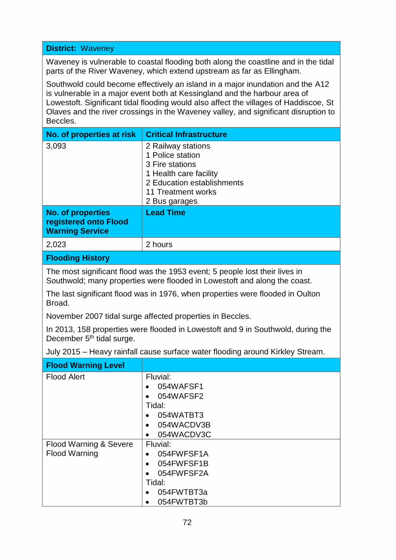
72
District: Waveney
Waveney is vulnerable to coastal flooding both along the coastline and in the tidal parts of the River Waveney, which extend upstream as far as Ellingham.
Southwold could become effectively an island in a major inundation and the A12 is vulnerable in a major event both at Kessingland and the harbour area of Lowestoft. Significant tidal flooding would also affect the villages of Haddiscoe, St Olaves and the river crossings in the Waveney valley, and significant disruption to Beccles.
No. of properties at risk Critical Infrastructure
3,093 2 Railway stations 1 Police station 3 Fire stations 1 Health care facility 2 Education establishments 11 Treatment works 2 Bus garages
No. of properties registered onto Flood Warning Service
Lead Time
2,023 2 hours
Flooding History
The most significant flood was the 1953 event; 5 people lost their lives in Southwold; many properties were flooded in Lowestoft and along the coast.
The last significant flood was in 1976, when properties were flooded in Oulton Broad.
November 2007 tidal surge affected properties in Beccles.
In 2013, 158 properties were flooded in Lowestoft and 9 in Southwold, during the December 5th tidal surge.
July 2015 – Heavy rainfall cause surface water flooding around Kirkley Stream.
Flood Warning Level
Flood Alert Fluvial:
• 054WAFSF1
• 054WAFSF2 Tidal:
• 054WATBT3
• 054WACDV3B
• 054WACDV3C
Flood Warning & Severe Flood Warning
Fluvial:
• 054FWFSF1A
• 054FWFSF1B
• 054FWFSF2A Tidal:
• 054FWTBT3a
• 054FWTBT3b

73
• 054FWCDV3B1
• 054FWCDV3B2
• 054FWCDV3B3
• 054FWCDV3B4
• 054FWCDV3B5
• 054FWCDV3B6
• 054FWCDV3B8

74
Annex J Specimen Evacuation Notice 2
See next page
2 Based on a specimen evacuation notice produced by Norfolk County Council and Norfolk Constabulary

75
BACK PAGE
Radio Stations
FRONT PAGE
BBC Radio Suffolk
Town 102
The Beach
Heart FM
Web sites www.environment-agency.gov.uk @EnvAgency www.metoffice.gov.uk www.bbc.co.uk/weather
Evacuation Notice for ………………………… As a result of the risk to life from severe coastal flooding we advise that you evacuate your property. You should evacuate by……………. on …………… Your nearest Rest Centre will open at……… ……and is located at…………………… Transport will be available at ……………..…from ………… You will be advised when it is safe to return by messages on local radio and at Rest Centres. If you were out when police officers / flood wardens delivered this leaflet, contact the following number ………………… to obtain further information and notify the Emergency Services that you have returned to your address/place of work.
Suffolk County Council Helpline Number - 03456 032814

76
INSIDE PAGES
If evacuation becomes necessary
o Stay calm and do not panic.
o Police officers and / or other officials will try to visit all properties at risk to advise on the requirement to evacuate.
o If road conditions permit, move vehicles to unaffected areas for example higher ground; ask friends / family if you can share their parking facilities.
o If you require transport to evacuate, the location of your evacuation point is included on the front page of this leaflet or you will be informed by an officer knocking on your door.
o Try to check that any elderly / vulnerable family members or neighbours know about the evacuation.
o Try to inform family members / friends as to where you are evacuating.
o Listen to the advice of the authorities and follow any instructions to leave the property.
o Take any special foods and medicines; o witch off gas and electricity. o Parents take toys or materials to occupy young
children:
o If possible, move electrical equipment and furniture upstairs.
o Ensure that any precious or important documents
(such as photographs, insurance documents, etc.) are placed in a safe location.
o Any furniture that you cannot move upstairs, try to
raise well off the floor.
o Do not forget to lock all doors and windows.
o Attempt to block doorways and air bricks.
o Avoid walking and driving through floodwater, there could be hidden hazards.

77
Glossary ABI Association of British Insurers
AIR Area Incident Room (Environment Agency)
BDC Babergh District Council
CCS Civil Contingency Secretariat
CPE Coastal Partnership East
MHCLG (RED) Ministry of Housing, Communities and Local Government (Resilience and Emergencies Division)
DEFRA Department for Environment, Food and Rural Affairs
DfT Department for Transport
EA Environment Agency
EDW Extended Direct Warnings
FAS Flood Advisory Service (Environment Agency)
FCP Forward Control Point
FGS Flood Guidance Statement
FHDC Forest Heath District Council
FWD Floodline Warnings Direct
PHE Public Health England
IBC Ipswich Borough Council
JEPU Joint Emergency Planning Unit
LRF Local Resilience Forum
LTFB Lowestoft Temporary Flood Barrier
MACA Military Aid to the Civil Authorities
MASHA Multi-agency Strategic Holding Area
MCA Maritime & Coastguard Agency
MCC Media & Communications Cell
RCG Recovery Coordination Group
RVP Rendezvous Point
RWG Recovery Working Group
SCC Suffolk County Council
SEBC St Edmundsbury Borough Council
SCDC Suffolk Coastal District Council
SCG Strategic Coordination Group
SVOG Suffolk Voluntary Organisations Group
STAC Scientific and Technical Advisory Cell
TCG Tactical Coordination Group
STFS Storm Tide Forecasting Service
WDC Waveney District Council