such problems are common to all remote rock art · pdf filethe trenches were situated on ......
TRANSCRIPT
16 PAST
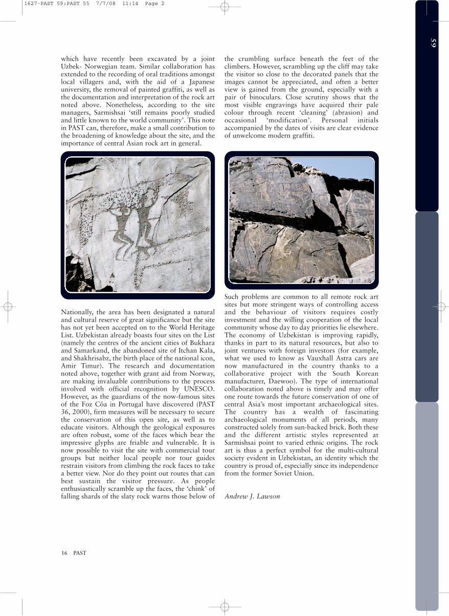
which have recently been excavated by a jointUzbek- Norwegian team. Similar collaboration hasextended to the recording of oral traditions amongstlocal villagers and, with the aid of a Japaneseuniversity, the removal of painted graffiti, as well asthe documentation and interpretation of the rock artnoted above. Nonetheless, according to the sitemanagers, Sarmishsai ‘still remains poorly studiedand little known to the world community’. This notein PAST can, therefore, make a small contribution tothe broadening of knowledge about the site, and theimportance of central Asian rock art in general.
Nationally, the area has been designated a naturaland cultural reserve of great significance but the sitehas not yet been accepted on to the World HeritageList. Uzbekistan already boasts four sites on the List(namely the centres of the ancient cities of Bukharaand Samarkand, the abandoned site of Itchan Kala,and Shakhrisabz, the birth place of the national icon,Amir Timur). The research and documentationnoted above, together with grant aid from Norway,are making invaluable contributions to the processinvolved with official recognition by UNESCO.However, as the guardians of the now-famous sitesof the Foz Côa in Portugal have discovered (PAST36, 2000), firm measures will be necessary to securethe conservation of this open site, as well as toeducate visitors. Although the geological exposuresare often robust, some of the faces which bear theimpressive glyphs are friable and vulnerable. It isnow possible to visit the site with commercial tourgroups but neither local people nor tour guidesrestrain visitors from climbing the rock faces to takea better view. Nor do they point out routes that canbest sustain the visitor pressure. As peopleenthusiastically scramble up the faces, the ‘chink’ offalling shards of the slaty rock warns those below of
the crumbling surface beneath the feet of theclimbers. However, scrambling up the cliff may takethe visitor so close to the decorated panels that theimages cannot be appreciated, and often a betterview is gained from the ground, especially with apair of binoculars. Close scrutiny shows that themost visible engravings have acquired their palecolour through recent ‘cleaning’ (abrasion) andoccasional ‘modification’. Personal initialsaccompanied by the dates of visits are clear evidenceof unwelcome modern graffiti.
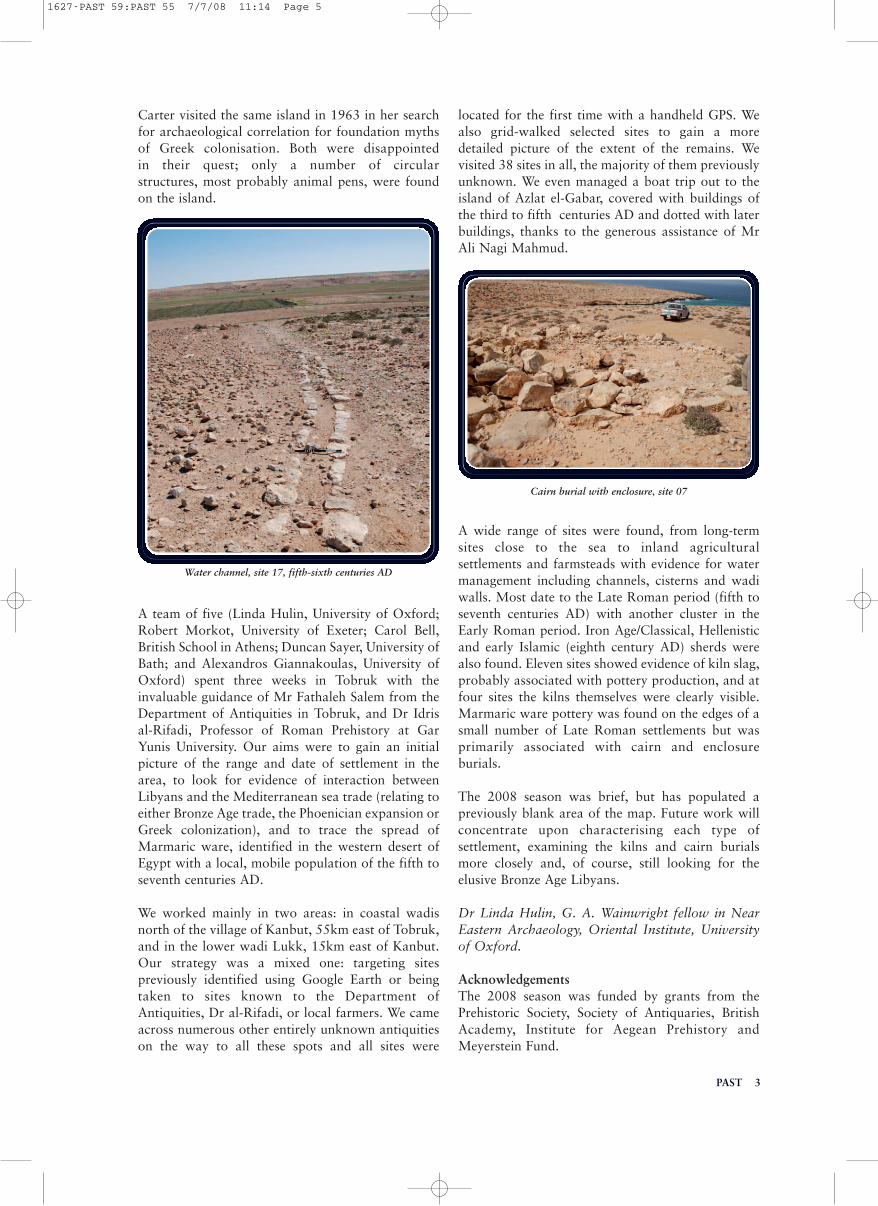
Such problems are common to all remote rock artsites but more stringent ways of controlling accessand the behaviour of visitors requires costlyinvestment and the willing cooperation of the localcommunity whose day to day priorities lie elsewhere.The economy of Uzbekistan is improving rapidly,thanks in part to its natural resources, but also tojoint ventures with foreign investors (for example,what we used to know as Vauxhall Astra cars arenow manufactured in the country thanks to acollaborative project with the South Koreanmanufacturer, Daewoo). The type of internationalcollaboration noted above is timely and may offerone route towards the future conservation of one ofcentral Asia’s most important archaeological sites.The country has a wealth of fascinatingarchaeological monuments of all periods, manyconstructed solely from sun-backed brick. Both theseand the different artistic styles represented atSarmishsai point to varied ethnic origins. The rockart is thus a perfect symbol for the multi-culturalsociety evident in Uzbekistan, an identity which thecountry is proud of, especially since its independencefrom the former Soviet Union.
Andrew J. Lawson
59
1627-PAST 59:PAST 55 7/7/08 11:14 Page 2

PAST 1
NNEEWW WWOORRKK NNEEAARRNNUUTTBBOOUURRNNEE,, WWEESSTTSSUUSSSSEEXX
On the crest of the Greensand escarpment inPulborough parish, near the hamlets of Nutbourneand North Heath, lies an area containing bothBorough Farm Roman villa and Beedings “Castle”.The latter is a nineteenth century house and duringits construction and in recent years archaeologicalinvestigations have found both Upper Palaeolithicand Late Iron Age material. The 2007 volume ofPPS contains a superbly detailed account by RogerJacobi of the original Upper Palaeolithic finds whichamply demonstrates their significance. The Late IronAge and early Roman material was retrieved by ConAinsworth and a report by Caroline Wells in relationto those finds is in preparation. The presence ofDressel 1A and 1B amphorae fragments is notable.Recent PPG16 work confirmed this evidence for lateprehistoric and early Roman activity without findingclear structural details to help analysis. The landaround the site now belongs to Redfold Farm and isearmarked for viticulture. Surveyed fieldwalkingprior to vine planting was conducted in February2008 and a broad scatter of finds of prehistoric,Roman and medieval date was retrieved; these arecurrently being processed as part of a new EnglishHeritage-funded review of the site.
Renewed Upper Palaeolithic research excavationstargeted the crest of the hill in the summer of 2007.The work, directed by Matt Pope (UCL) and withthe help of volunteers from Worthing ArchaeologicalSociety, focussed on a field to the immediate east ofBeedings Castle. The trenches were situated onanomalies revealed by earlier geophysical surveyswhich had been carried out by Brighton and HoveArchaeological Society at the request of Caroline
Wells. The trenches were placed across areas oflower resistance which proved to be fissures in the underlying Lower Greensand (Hythe Beds) rock formations.
Two trenches showed only superficial deposits abovegeological bedding structures and upper layerscontained some Mesolithic flint work and a singlepiece of Samian ware. The principal and largesttrench revealed a geological feature of a differentcharacter, a 3 metre-wide fissure more than 3 metresdeep filled with fine grained sediments of a loessicnature. This feature differed in that it contained asmall but significant assemblage of blue-patinated,sediment-polished flint which includes large flakeelements, a scatter of tiny spalls of flint and part of alarge blade (of non-Mesolithic character). The tinyspalls suggest that this fissure fill contains flint-working traces either in situ or derived from theimmediate locality without much lateral movement.
NUMBER 59 July 2008
THE NEWSLETTER OF THE PREHISTORIC SOCIETY Registered Office University College London, Institute of Archaeology, 31–34 Gordon Square, London WC1H 0PY
http://www.prehistoricsociety.org/
The copy date for PAST 60 is 1 October 2008. Contributions to Joanna Brück, School of Archaeology, NewmanBuilding, University College Dublin, Belfield, Dublin 4, Ireland. Email: [email protected] Contributions on disc oras e-mail attachments are preferred (either word 6 or rtf files) but hardcopy is also accepted. Illustrations can be sentas drawings, slides, prints, tif or jpeg files. The book reviews editor is Dr Mike Allen, Wessex Archaeology, PortwayHouse, Old Sarum Park, Salisbury, Wilts, SP4 6EB. Email: [email protected] Queries over subscriptions and
membership should go to the Society administrator Tessa Machling at the London address above.
Middle Palaeolithic artefact from the fissure at Beedings
59
PAST1627-PAST 59:PAST 55 7/7/08 11:14 Page 3

Although small, the assemblage presented somesurprises. Aside from the blade element, which couldperhaps sit happily within the original BeedingsUpper Palaeolithic leaf-point assemblage, theadditional material is of a quite different character.The deeper patina may indicate a greater age anddifferent depositional history and, whiletechnologically ambiguous, the material has greateraffinity with the Late Middle Palaeolithic (LMP)technology of late Neanderthal hunting groups thanwith the Early Upper Palaeolithic technologiestraditionally associated with anatomically modernhumans. An initial comparison of these pieces withmaterial from the LMP site of Oldbury, Kent,confirms some broad technological similarities andalmost identical patination, which is significantconsidering that Oldbury sits adjacent to fissuredbeds of the Kentish Greensand and close to theIghtham fissure which produced a rich Pleistocenefaunal assemblage in the nineteenth century.
Consideration of two other previous finds from theBeedings area also suggests a Neanderthal presence.A single artefact, recorded as having come from the
hill, is in the original Beedings assemblage. Thisartefact sits uncomfortably alongside the UpperPalaeolithic artefacts in that it bears a blue-whitepatina and technologically seems to be a large sidescraper, manufactured on a large flake withindications of working at the tip of the piece.Typologically, it is a piece which would sit betterwith a Late Middle Palaeolithic assemblage, and yetuntil the 2007 excavations there had been no hint offurther LMP artefacts from the hill. In addition, asingle finely-made sub-triangular or Bout Coupébiface typical of LMP assemblages from Britain wasfound, in an identical topographic position, at thetop of the Lower Greensand scarp-slope at WoodsHill, West Chiltington, only 2km to the east of thesite. These finds, interpreted alongside the possiblein situ artefacts from the Beedings fissure, supportthe idea that Neanderthals, prior to the activities ofearly Upper Palaeolithic hunters, were alsooccupying the hill. The continuity of the use of thehill, seen also in the substantial quantities ofMesolithic flintwork from the site, supports Jacobi’ssuggestion that the hill offered a superb location forgame observation posts or hunting camps.
The newly excavated finds may be of nationalsignificance. Not only do they indicate the survivalof both Middle and Upper Palaeolithic material onthe hill, we think that these assemblages cover thereplacement period from the last Neanderthalhunters of the British Isles and incoming early‘modern’ peoples. Further excavation planned forthe summer of 2008 will throw more light on thissite and will form the first phase of an EnglishHeritage-funded review of potential for similarfissure sites fringing the Weald. This work, to becarried out by Archaeology South East and theBoxgrove Project in the coming year, will determinewhether the fissure at Beedings is unique or ispointing the way to a hitherto untapped componentof the British ice age record.
Matthew Pope (UCL), [email protected]; CarolineWells, [email protected]
AA CCOOAASSTTAALL SSUURRVVEEYY OOFFWWEESSTTEERRNN MMAARRMMAARRIICCAA
The area between Tobruk and Bardia, Libya,represents something of a terra incognita to thewider archaeological community, with only sporadicattention being paid to a region devoid of theextensive ruins that attracted early travellers toCyrenaica and Tripolitania. Oric Bates spent alimited amount of time there in 1906, exploring asfar west as Seal Island, 66km west of Tobruk, insearch of Bronze Age Libyans. Theresa Howard
2 PAST
Beedings Castle
The site of the 2007 excavations
1627-PAST 59:PAST 55 7/7/08 11:14 Page 4
Carter visited the same island in 1963 in her searchfor archaeological correlation for foundation mythsof Greek colonisation. Both were disappointed in their quest; only a number of circular structures, most probably animal pens, were foundon the island.
A team of five (Linda Hulin, University of Oxford;Robert Morkot, University of Exeter; Carol Bell,British School in Athens; Duncan Sayer, University ofBath; and Alexandros Giannakoulas, University ofOxford) spent three weeks in Tobruk with theinvaluable guidance of Mr Fathaleh Salem from theDepartment of Antiquities in Tobruk, and Dr Idrisal-Rifadi, Professor of Roman Prehistory at GarYunis University. Our aims were to gain an initialpicture of the range and date of settlement in thearea, to look for evidence of interaction betweenLibyans and the Mediterranean sea trade (relating toeither Bronze Age trade, the Phoenician expansion orGreek colonization), and to trace the spread ofMarmaric ware, identified in the western desert ofEgypt with a local, mobile population of the fifth toseventh centuries AD.
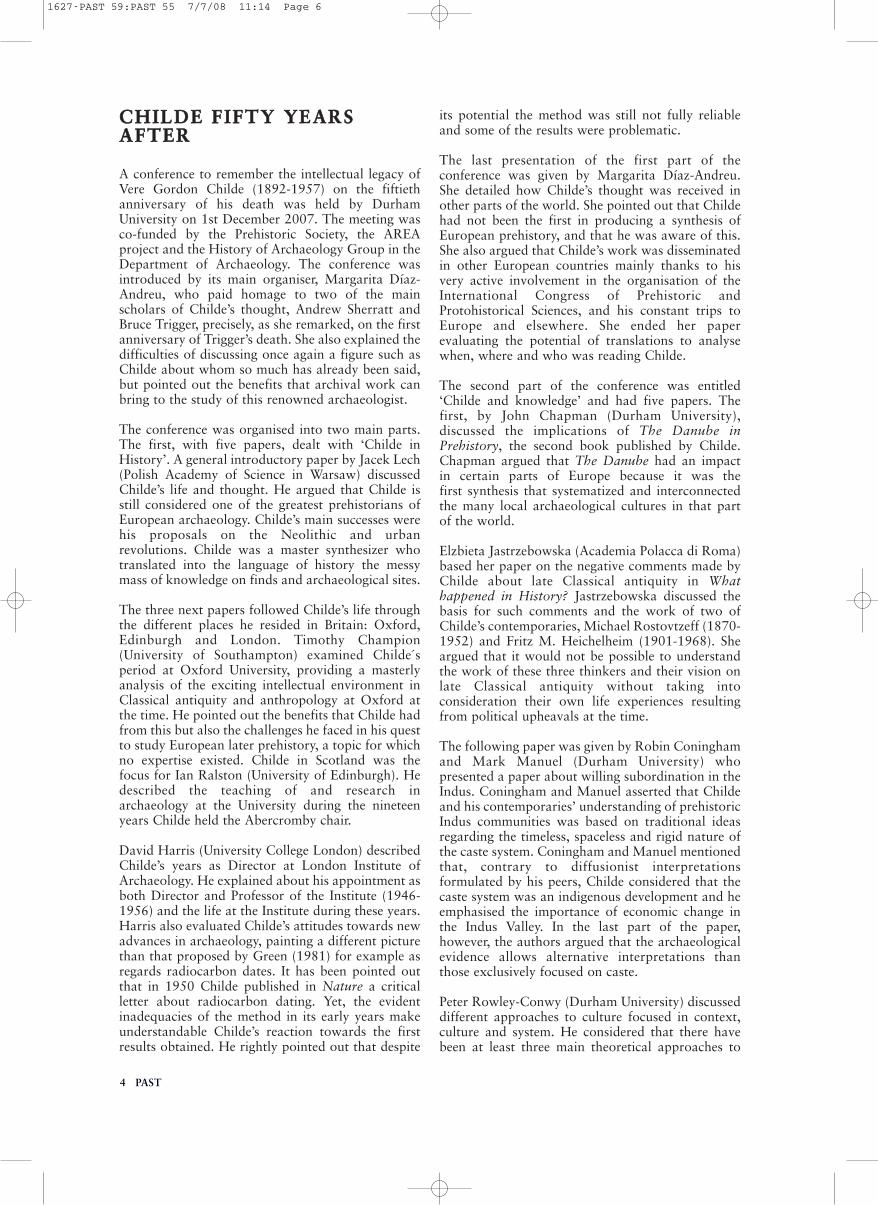
We worked mainly in two areas: in coastal wadisnorth of the village of Kanbut, 55km east of Tobruk,and in the lower wadi Lukk, 15km east of Kanbut.Our strategy was a mixed one: targeting sitespreviously identified using Google Earth or beingtaken to sites known to the Department ofAntiquities, Dr al-Rifadi, or local farmers. We cameacross numerous other entirely unknown antiquitieson the way to all these spots and all sites were
located for the first time with a handheld GPS. Wealso grid-walked selected sites to gain a moredetailed picture of the extent of the remains. Wevisited 38 sites in all, the majority of them previouslyunknown. We even managed a boat trip out to theisland of Azlat el-Gabar, covered with buildings ofthe third to fifth centuries AD and dotted with laterbuildings, thanks to the generous assistance of MrAli Nagi Mahmud.
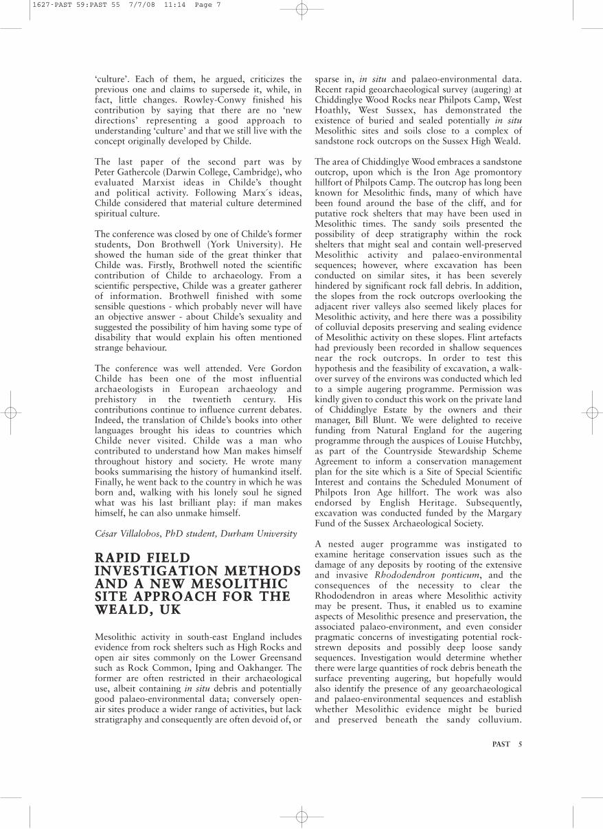
A wide range of sites were found, from long-termsites close to the sea to inland agriculturalsettlements and farmsteads with evidence for watermanagement including channels, cisterns and wadiwalls. Most date to the Late Roman period (fifth toseventh centuries AD) with another cluster in theEarly Roman period. Iron Age/Classical, Hellenisticand early Islamic (eighth century AD) sherds werealso found. Eleven sites showed evidence of kiln slag,probably associated with pottery production, and atfour sites the kilns themselves were clearly visible.Marmaric ware pottery was found on the edges of asmall number of Late Roman settlements but wasprimarily associated with cairn and enclosureburials.
The 2008 season was brief, but has populated apreviously blank area of the map. Future work willconcentrate upon characterising each type ofsettlement, examining the kilns and cairn burialsmore closely and, of course, still looking for theelusive Bronze Age Libyans.
Dr Linda Hulin, G. A. Wainwright fellow in NearEastern Archaeology, Oriental Institute, Universityof Oxford.
AcknowledgementsThe 2008 season was funded by grants from thePrehistoric Society, Society of Antiquaries, BritishAcademy, Institute for Aegean Prehistory andMeyerstein Fund.
PAST 3
Water channel, site 17, fifth-sixth centuries AD
Cairn burial with enclosure, site 07
1627-PAST 59:PAST 55 7/7/08 11:14 Page 5
CCHHIILLDDEE FFIIFFTTYY YYEEAARRSSAAFFTTEERR
A conference to remember the intellectual legacy ofVere Gordon Childe (1892-1957) on the fiftiethanniversary of his death was held by DurhamUniversity on 1st December 2007. The meeting wasco-funded by the Prehistoric Society, the AREAproject and the History of Archaeology Group in theDepartment of Archaeology. The conference wasintroduced by its main organiser, Margarita Díaz-Andreu, who paid homage to two of the mainscholars of Childe’s thought, Andrew Sherratt andBruce Trigger, precisely, as she remarked, on the firstanniversary of Trigger’s death. She also explained thedifficulties of discussing once again a figure such asChilde about whom so much has already been said,but pointed out the benefits that archival work canbring to the study of this renowned archaeologist.
The conference was organised into two main parts.The first, with five papers, dealt with ‘Childe inHistory’. A general introductory paper by Jacek Lech(Polish Academy of Science in Warsaw) discussedChilde’s life and thought. He argued that Childe isstill considered one of the greatest prehistorians ofEuropean archaeology. Childe’s main successes werehis proposals on the Neolithic and urbanrevolutions. Childe was a master synthesizer whotranslated into the language of history the messymass of knowledge on finds and archaeological sites.
The three next papers followed Childe’s life throughthe different places he resided in Britain: Oxford,Edinburgh and London. Timothy Champion(University of Southampton) examined Childe´speriod at Oxford University, providing a masterlyanalysis of the exciting intellectual environment inClassical antiquity and anthropology at Oxford atthe time. He pointed out the benefits that Childe hadfrom this but also the challenges he faced in his questto study European later prehistory, a topic for whichno expertise existed. Childe in Scotland was thefocus for Ian Ralston (University of Edinburgh). Hedescribed the teaching of and research inarchaeology at the University during the nineteenyears Childe held the Abercromby chair.
David Harris (University College London) describedChilde’s years as Director at London Institute ofArchaeology. He explained about his appointment asboth Director and Professor of the Institute (1946-1956) and the life at the Institute during these years.Harris also evaluated Childe’s attitudes towards newadvances in archaeology, painting a different picturethan that proposed by Green (1981) for example asregards radiocarbon dates. It has been pointed outthat in 1950 Childe published in Nature a criticalletter about radiocarbon dating. Yet, the evidentinadequacies of the method in its early years makeunderstandable Childe’s reaction towards the firstresults obtained. He rightly pointed out that despite
its potential the method was still not fully reliableand some of the results were problematic.
The last presentation of the first part of theconference was given by Margarita Díaz-Andreu.She detailed how Childe’s thought was received inother parts of the world. She pointed out that Childehad not been the first in producing a synthesis ofEuropean prehistory, and that he was aware of this.She also argued that Childe’s work was disseminatedin other European countries mainly thanks to hisvery active involvement in the organisation of theInternational Congress of Prehistoric andProtohistorical Sciences, and his constant trips toEurope and elsewhere. She ended her paperevaluating the potential of translations to analysewhen, where and who was reading Childe.
The second part of the conference was entitled‘Childe and knowledge’ and had five papers. Thefirst, by John Chapman (Durham University),discussed the implications of The Danube inPrehistory, the second book published by Childe.Chapman argued that The Danube had an impact in certain parts of Europe because it was the first synthesis that systematized and interconnectedthe many local archaeological cultures in that part of the world.
Elzbieta Jastrzebowska (Academia Polacca di Roma)based her paper on the negative comments made byChilde about late Classical antiquity in Whathappened in History? Jastrzebowska discussed thebasis for such comments and the work of two ofChilde’s contemporaries, Michael Rostovtzeff (1870-1952) and Fritz M. Heichelheim (1901-1968). Sheargued that it would not be possible to understandthe work of these three thinkers and their vision onlate Classical antiquity without taking intoconsideration their own life experiences resultingfrom political upheavals at the time.
The following paper was given by Robin Coninghamand Mark Manuel (Durham University) whopresented a paper about willing subordination in theIndus. Coningham and Manuel asserted that Childeand his contemporaries’ understanding of prehistoricIndus communities was based on traditional ideasregarding the timeless, spaceless and rigid nature ofthe caste system. Coningham and Manuel mentionedthat, contrary to diffusionist interpretationsformulated by his peers, Childe considered that thecaste system was an indigenous development and heemphasised the importance of economic change inthe Indus Valley. In the last part of the paper,however, the authors argued that the archaeologicalevidence allows alternative interpretations thanthose exclusively focused on caste.
Peter Rowley-Conwy (Durham University) discusseddifferent approaches to culture focused in context,culture and system. He considered that there havebeen at least three main theoretical approaches to
4 PAST
1627-PAST 59:PAST 55 7/7/08 11:14 Page 6
PAST 5
‘culture’. Each of them, he argued, criticizes theprevious one and claims to supersede it, while, infact, little changes. Rowley-Conwy finished hiscontribution by saying that there are no ‘newdirections’ representing a good approach tounderstanding ‘culture’ and that we still live with theconcept originally developed by Childe.
The last paper of the second part was by Peter Gathercole (Darwin College, Cambridge), whoevaluated Marxist ideas in Childe’s thought and political activity. Following Marx´s ideas, Childe considered that material culture determined spiritual culture.
The conference was closed by one of Childe’s formerstudents, Don Brothwell (York University). Heshowed the human side of the great thinker thatChilde was. Firstly, Brothwell noted the scientificcontribution of Childe to archaeology. From ascientific perspective, Childe was a greater gathererof information. Brothwell finished with somesensible questions - which probably never will havean objective answer - about Childe’s sexuality andsuggested the possibility of him having some type ofdisability that would explain his often mentionedstrange behaviour.
The conference was well attended. Vere GordonChilde has been one of the most influentialarchaeologists in European archaeology andprehistory in the twentieth century. Hiscontributions continue to influence current debates.Indeed, the translation of Childe’s books into otherlanguages brought his ideas to countries whichChilde never visited. Childe was a man whocontributed to understand how Man makes himselfthroughout history and society. He wrote manybooks summarising the history of humankind itself.Finally, he went back to the country in which he wasborn and, walking with his lonely soul he signedwhat was his last brilliant play: if man makeshimself, he can also unmake himself.
César Villalobos, PhD student, Durham University
RRAAPPIIDD FFIIEELLDDIINNVVEESSTTIIGGAATTIIOONN MMEETTHHOODDSSAANNDD AA NNEEWW MMEESSOOLLIITTHHIICCSSIITTEE AAPPPPRROOAACCHH FFOORR TTHHEEWWEEAALLDD,, UUKK
Mesolithic activity in south-east England includesevidence from rock shelters such as High Rocks andopen air sites commonly on the Lower Greensandsuch as Rock Common, Iping and Oakhanger. Theformer are often restricted in their archaeologicaluse, albeit containing in situ debris and potentiallygood palaeo-environmental data; conversely open-air sites produce a wider range of activities, but lackstratigraphy and consequently are often devoid of, or
sparse in, in situ and palaeo-environmental data.Recent rapid geoarchaeological survey (augering) atChiddinglye Wood Rocks near Philpots Camp, WestHoathly, West Sussex, has demonstrated theexistence of buried and sealed potentially in situMesolithic sites and soils close to a complex ofsandstone rock outcrops on the Sussex High Weald.
The area of Chiddinglye Wood embraces a sandstoneoutcrop, upon which is the Iron Age promontoryhillfort of Philpots Camp. The outcrop has long beenknown for Mesolithic finds, many of which havebeen found around the base of the cliff, and forputative rock shelters that may have been used inMesolithic times. The sandy soils presented thepossibility of deep stratigraphy within the rockshelters that might seal and contain well-preservedMesolithic activity and palaeo-environmentalsequences; however, where excavation has beenconducted on similar sites, it has been severelyhindered by significant rock fall debris. In addition,the slopes from the rock outcrops overlooking theadjacent river valleys also seemed likely places forMesolithic activity, and here there was a possibilityof colluvial deposits preserving and sealing evidenceof Mesolithic activity on these slopes. Flint artefactshad previously been recorded in shallow sequencesnear the rock outcrops. In order to test thishypothesis and the feasibility of excavation, a walk-over survey of the environs was conducted which ledto a simple augering programme. Permission waskindly given to conduct this work on the private landof Chiddinglye Estate by the owners and theirmanager, Bill Blunt. We were delighted to receivefunding from Natural England for the augeringprogramme through the auspices of Louise Hutchby,as part of the Countryside Stewardship SchemeAgreement to inform a conservation managementplan for the site which is a Site of Special ScientificInterest and contains the Scheduled Monument ofPhilpots Iron Age hillfort. The work was alsoendorsed by English Heritage. Subsequently,excavation was conducted funded by the MargaryFund of the Sussex Archaeological Society.
A nested auger programme was instigated toexamine heritage conservation issues such as thedamage of any deposits by rooting of the extensiveand invasive Rhododendron ponticum, and theconsequences of the necessity to clear theRhododendron in areas where Mesolithic activitymay be present. Thus, it enabled us to examineaspects of Mesolithic presence and preservation, theassociated palaeo-environment, and even considerpragmatic concerns of investigating potential rock-strewn deposits and possibly deep loose sandysequences. Investigation would determine whetherthere were large quantities of rock debris beneath thesurface preventing augering, but hopefully wouldalso identify the presence of any geoarchaeologicaland palaeo-environmental sequences and establishwhether Mesolithic evidence might be buried and preserved beneath the sandy colluvium.
1627-PAST 59:PAST 55 7/7/08 11:14 Page 7

Thus, the augering examined archaeological,palaeo-environmental, geoarchaeological andconservation issues.
Due to the nature of the deposits (typically sandy)and the necessity to record full soil and sedimentsequences, as well as keep intrusion to a minimum,hand augering was conducted using 40mm diameterdutch augers and a 30mm diameter gouge auger.This geoarchaeological survey comprised threeseparate surveys. First, a walkover survey to definesuitable locations for the auger survey andprobablistic augering to ‘test-the-water’ and examinethe feasibility of the survey were carried out. Thesecond survey involved the construction of theprofile from the rock outcrops, down the slope to thevalley and river, examining the possibility of organicdeposits or the presence of colluvium and definingthe soil catenary sequence. An archaeological surveytargeting zones around the foot of the rock outcropsin locations where Mesolithic artefacts had beenrecorded in the past completed the nested strategy.
This nested programme of survey and targeted andconsidered augering was conducted over just threedays with a small group of students from the
University of Sussex in November 2007. Ittranspired that contrary to our initial beliefs, therewas little or no rock debris around the foot of therock outcrop, nor indeed within the rock shelters.This is highly significant as it meant that augeringwas easily possible in a number of locations, andthat other investigations were unlikely to besignificantly hindered by rock-fall and could beconsidered viable.
6 PAST
Augering near Great-upon-Little
Location of auger surveys and auger transect
1627-PAST 59:PAST 55 7/7/08 11:14 Page 8
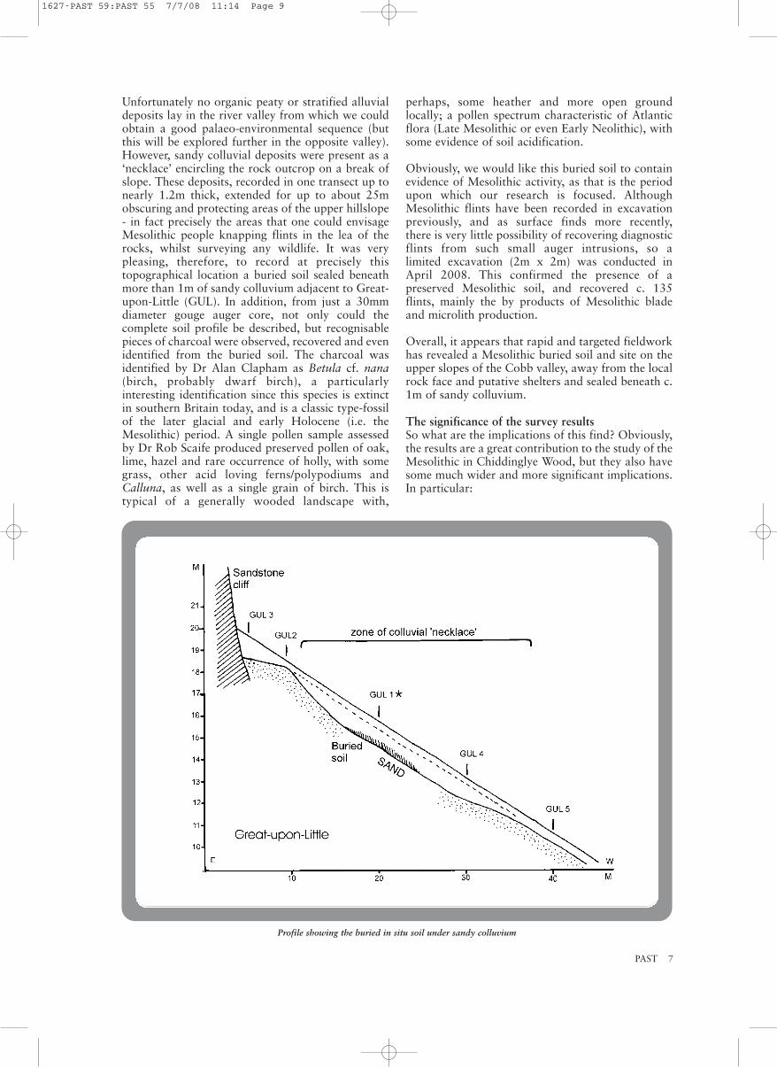
Unfortunately no organic peaty or stratified alluvialdeposits lay in the river valley from which we couldobtain a good palaeo-environmental sequence (butthis will be explored further in the opposite valley).However, sandy colluvial deposits were present as a‘necklace’ encircling the rock outcrop on a break ofslope. These deposits, recorded in one transect up tonearly 1.2m thick, extended for up to about 25mobscuring and protecting areas of the upper hillslope- in fact precisely the areas that one could envisageMesolithic people knapping flints in the lea of therocks, whilst surveying any wildlife. It was verypleasing, therefore, to record at precisely thistopographical location a buried soil sealed beneathmore than 1m of sandy colluvium adjacent to Great-upon-Little (GUL). In addition, from just a 30mmdiameter gouge auger core, not only could thecomplete soil profile be described, but recognisablepieces of charcoal were observed, recovered and evenidentified from the buried soil. The charcoal wasidentified by Dr Alan Clapham as Betula cf. nana(birch, probably dwarf birch), a particularlyinteresting identification since this species is extinctin southern Britain today, and is a classic type-fossilof the later glacial and early Holocene (i.e. theMesolithic) period. A single pollen sample assessedby Dr Rob Scaife produced preserved pollen of oak,lime, hazel and rare occurrence of holly, with somegrass, other acid loving ferns/polypodiums andCalluna, as well as a single grain of birch. This istypical of a generally wooded landscape with,
perhaps, some heather and more open groundlocally; a pollen spectrum characteristic of Atlanticflora (Late Mesolithic or even Early Neolithic), withsome evidence of soil acidification.
Obviously, we would like this buried soil to containevidence of Mesolithic activity, as that is the periodupon which our research is focused. AlthoughMesolithic flints have been recorded in excavationpreviously, and as surface finds more recently, there is very little possibility of recovering diagnosticflints from such small auger intrusions, so a limited excavation (2m x 2m) was conducted inApril 2008. This confirmed the presence of apreserved Mesolithic soil, and recovered c. 135flints, mainly the by products of Mesolithic bladeand microlith production.
Overall, it appears that rapid and targeted fieldworkhas revealed a Mesolithic buried soil and site on theupper slopes of the Cobb valley, away from the localrock face and putative shelters and sealed beneath c.1m of sandy colluvium.
The significance of the survey resultsSo what are the implications of this find? Obviously,the results are a great contribution to the study of theMesolithic in Chiddinglye Wood, but they also havesome much wider and more significant implications.In particular:
PAST 7
Profile showing the buried in situ soil under sandy colluvium
1627-PAST 59:PAST 55 7/7/08 11:14 Page 9

1) Augering as a survey method demonstratedexcellent value in terms of minimal resource time,and minimal intrusion versus maximum researchgain. We were able to confirm that both at the baseof the cliff and within the rock shelters relativelylittle rock fall had occurred. At the foot of the rockoutcrop, deposits seem to have been eroded andremoved, a process probably exacerbated by humanactivity and trampling during the Victorian and laterperiods. Significantly, it did indicate the presence ofa colluvial ‘necklace’ on the upper slope away fromthe rock outcrop. Further, this was proven to sealand bury an in situ Mesolithic soil, which wasconfirmed by limited excavation. The recovery ofMesolithic flints in the area and excavation confirmsa Mesolithic date. Both upslope, and in particularalong the downslope margins of the colluvial‘necklace’, Mesolithic flint detritus was also presenton the surface.
2) The results here, if repeated elsewhere at similartopographical locations in southern England, mightprovide evidence for widespread Mesolithic activity in the Weald, not previously recognised.Rock shelter sites often contain evidence of a limitedarray of activities; they may be seasonally used andrelated to specific activities so may not be trulyrepresentative of the Mesolithic lifestyle. All toooften, Mesolithic finds, even when encountered,have been restricted to artefact distributions, lackingin a contemporaneous sediment and palaeo-environmental context, or even where such depositsare encountered, palaeo-environmental enquiry isnot instigated. Previous research has focused on theshelters themselves and areas within a few metres ofthe base of the rock outcrops, while this workindicates that important evidence could be presentfurther from the rocks and which is afforded greaterprotection by virtue of being sealed by hillwash. AtChiddinglye Wood Rocks, it is possible that we havea site that is neither a rock-shelter nor a typical open-air site, but one with stratigraphy, potentiallyin situ artefacts and deposits, and possibly a full
array of palaeo-environmental data. Furthermore, it is located on a hillslope bench, away from anyrock outcrops, overlooking the valley and streambelow, and is an ideal spot for Mesolithic activity. Itis a topographical location not often previouslyexplored archaeologically and one with numeroustopographic parallels locally, as well as across theWeald of southern England.
These early research results invite further questions.Is this buried soil and burning activity Mesolithic?What further important Mesolithic evidence liespreserved in Chiddinglye Wood, and how manyother similar such sites lie undetected withpotentially excellent preservation? Research led byAndrew Maxted, a D.Phil. student at the Centre forContinuing Education, University of Sussex(supervised by Dr Richard Carter), with Mike Allen(AEA: Allen Environmental Archaeology) hopes toexplore these and other important questions.
Mike Allen, Richard Carter and Andrew MaxtedAEA: Allen Environmental Archaeology &University of Sussex
MMEEEETTIINNGGSS PPRROOGGRRAAMMMMEE22000088--22000099
The programme for next year’s lectures and meetingsis coming together. However, details for a number ofevents have yet to be finalised - these will be postedon our website, together with contact informationand booking forms as applicable, as soon as theybecome available. We are also planning some one-day visits to ‘live’ field projects but these may beorganised at fairly short notice and will be verymuch on a first-come-first-served basis, so for allevents please do keep checking the website. Bookingforms will be included in later editions of PAST. Ifyou would like to be kept updated by email pleasecontact Tessa Machling on [email protected](see front page).
8 PAST
Visit to the Excavations at Star CarrLed by Dr Chantal Conneller
The 8th Sara Champion Memorial Lecture‘Wheeler’s Legacy: The Bioarchaeology of MaidenCastle’ by Dr Rebecca Redfern
‘Preseli-Stonehenge Bluestone Project: StonehengeExcavations 2008’ by Prof. Timothy Darvill & DrGeoffrey WainwrightJoint Prehistoric Society/Bournemouth University
Cave Archaeology in Britain: Recent WorkBringing together the results of a variety of recentinvestigations and surveys covering a widegeographical and chronological range
Sun 24 Aug 11am
Wed 29 Oct 5pm
Wed 12 Nov 7pm
Sat 6 Dec
Lecture and site visit: StarCarrVenue: TBC
Lecture: LondonVenue: Society of Antiquaries,Burlington House, Piccadilly
Lecture: BournemouthVenue: Shelly LectureTheatre, BournemouthUniversity
Day conference: BradfordVenue: Bradford University
1627-PAST 59:PAST 55 7/7/08 11:14 Page 10

PAST 9
‘A Bronze Age Pompeii? Interpreting the MustFarm Platform’ by Mark KnightJoint Prehistoric Society/Cambridge AntiquarianSociety
Neolithic of the Thames Valley (details TBC)
‘Understanding Change 6000-3500 BC on theEastern Fen-Edge’ by Dr Fraser SturtJoint Prehistoric Society/Norfolk & NorwichArchaeological Society
Speaker and Title TBCJoint Prehistoric Society/Devon ArchaeologicalSociety
Tribes and Prejudice: Exploding the Late BritishIron AgeAn examination of many aspects of the Late BritishIron Age, aiming to break down the seeminglyimpermeable terms ‘Iron Age’ and ‘Roman’Joint Prehistoric Society/Bournemouth University
4th Student Study TourLed by Dr Bob Johnston
‘Living at the Limit: A Sussex Perspective on thePalaeolithic of Northern Europe’ by Dr MatthewPopeJoint Prehistoric Society/Sussex ArchaeologicalSocietyPrice: £2. Places must be booked in advance.Cheques should be made payable to ‘Sussex Past’,and sent to Lorna Gartside, Sussex ArchaeologicalSociety, Barbican House, 169 High Street, LewesBN7 1YE
Middens and Deposition in Prehistoric Britain Lectures on Friday and Saturday followed by a fieldtrip on Sunday. For details please contact WayneBennett, Dillington House, Ilminster TA19 7DZ.Tel: 01460 52427, email:[email protected]
Title TBC by Prof. Peter WoodmanNB There will be a fee for the conference (TBC) butthe Europa Lecture will be free to members.
Prehistory of the Isle of Wight
Archaeology and AstronomyJoint Prehistoric Society/Royal AstronomicalSociety
Hidden Wessex RevisitedBack by popular demand, a re-run of our 2006 tourof Salisbury Plain and the Wylye Valley
Mon 5 Jan 6pm
Sat 7 Jan 10am
Sat 10 Jan 2.30pm
Jan TBC
Fri 3-Sun 5 Apr
Fri 24-Sun 26 Apr
Sat 25 Apr 2.30pm
Fri 15-Sun 17 May
May TBC
June TBC
July TBC
Mon 17-Fri 21Aug
Lecture: CambridgeVenue: Law Faculty Building,Sidgwick Site, West Road,Cambridge
Day conference: LondonVenue: TBC
Lecture: NorwichVenue: Town CloseAuditorium, Norwich CastleMuseum
Lecture: ExeterVenue: TBC
Conference: BournemouthVenue: BournemouthUniversity
Weekend study tour: NorthWalesVenue: Bangor
Lecture: LewesVenue: St Thomas a BecketChurch Hall, Lewes
Weekend study tour:Dillington HouseVenue: Dillington House,Ilminster
Day conference and EuropaLecture: York
Budget study weekend: Isle ofWight
Conference: Jodrell BankVenue: Jodrell Bank Centrefor Astrophysics, Macclesfield
British study tour: WessexVenue: Urchfont Manor, Wilts
1627-PAST 59:PAST 55 7/7/08 11:14 Page 11

10 PAST
In the planning stages:Field trip and lecture: Creswell CragsLecture: ‘The Prehistory of the American SouthWest’ by Pete Topping Day conferences: Recent Investigations in the Stonehenge and AveburyWorld Heritage Site (venue: Salisbury)The Creation of ‘Homes’ in European Prehistory(venue: Durham)Launching the English Heritage Research Strategyfor Prehistory (venue: London)Recent Developments in Palaeolithic Archaeology:The Impact of the Aggregates LevyEnvironmental Techniques: Recent Applications forInterpreting ArchaeologyConferences: Archaeology and Climate Change
RREESSEEAARRCCHH AANNDDCCOONNSSEERRVVAATTIIOONNFFRRAAMMEEWWOORRKK FFOORR TTHHEEBBRRIITTIISSHH PPAALLAAEEOOLLIITTHHIICC
English Heritage and the Prehistoric Society arepleased to announce the launch of a new Researchand Conservation Framework for the BritishPalaeolithic, published with the help of a grant fromthe Aggregates Levy Sustainability Fund throughDefra and English Heritage. The Framework hasbeen developed by a working group representing abroad range of interests in all aspects of Palaeolithicand Pleistocene research. Building on the success ofan earlier document published in 1999, andacknowledging the major developments in studies ofthe Palaeolithic that have taken place over the lastdecade, the Framework outlines a number ofprimary and strategic themes for current and futureresearch, ranging from understanding the impact ofPleistocene climate change to developing newaudiences for the story of early humans in Britain.The editors and specialist contributors hope that thedocument will become a useful resource for all thoseresearching or managing Palaeolithic sites, depositsand artefacts, whether in the academic, curatorial,commercial or voluntary sector.
To receive a copy of the Research and ConservationFramework for the British Palaeolithic, pleasecontact Jonathan Last, Head of Research Policy forPrehistory at English Heritage (email:[email protected]).
BBOOOOKK OOFFFFEERR
The Destruction of Cultural Heritage in IraqThe Prehistoric Society in conjunction with thepublishers can offer The Destruction of CulturalHeritage in Iraq to our members at a special 25% discount price. This book, edited by Peter G.Stone and Joanne Farchakh Bajjaly, is an importantstudy of the treatment of cultural property, and cultural heritage in general, in all moderntheatres of conflict. Full price: £50.00; 25% discountprice: £37.50, plus £3.00 postage UK or £6.50overseas. 44 b/w illus., 24 colour illus.; 352pp,hardback, 978 1 84383 384 0. Offer code = 08144;cut off date = 30 September 2008
Orders can be placed by phone on 01394 610600, byfax on 01394 610316, by email [email protected] or using the publisher’s secureordering website at www.boydell.co.uk/souk.htm.However this title is ordered, the special discountoffer code must be quoted. If using the secure onlineorder form, the offer code should be put in thebottom box of the form where it says “Please use thisspace to add any notes or special instructions.”
RRUUNN OOFF PPPPSS
Free to a good home: PPS volumes from 1969 to1993 inclusive. Interested parties must be willing tocollect or to pay for postage. For furtherinformation, please contact Marjut Rimminen-Arnall via email [email protected]
RREECCEENNTT DDIISSCCOOVVEERRIIEESS OOFFPPEETTEERRBBOORROOUUGGHH WWAARREE IINNCCEENNTTRRAALL LLOONNDDOONN
The prehistoric archaeology of central London isboth figuratively overshadowed and literally buriedby that of the later periods of the capital’s historywhich always grab the news headlines. Therefore, itis sometimes overlooked that before the Romansarrived, Londinium and its environs were part of theLower Thames Valley, the rest of which we know has a rich and varied prehistoric archaeology. Theaim of this article is to highlight two recentdiscoveries of Peterborough Ware in the City ofLondon and Southwark.
Highlights of Prehistoric SardiniaLed by Colin Burgess
American Mid-West (Mound Builder) TourIf numbers allow - another trip to the USA,following the successful 2007 tour to the South-West. For more information contact DaveMcOmish at [email protected]’.
Sat 12-Sat 19 Sept
Summer 2010 TBC
Overseas study tour: Sardinia
Overseas study tour: USA
1627-PAST 59:PAST 55 7/7/08 11:14 Page 12
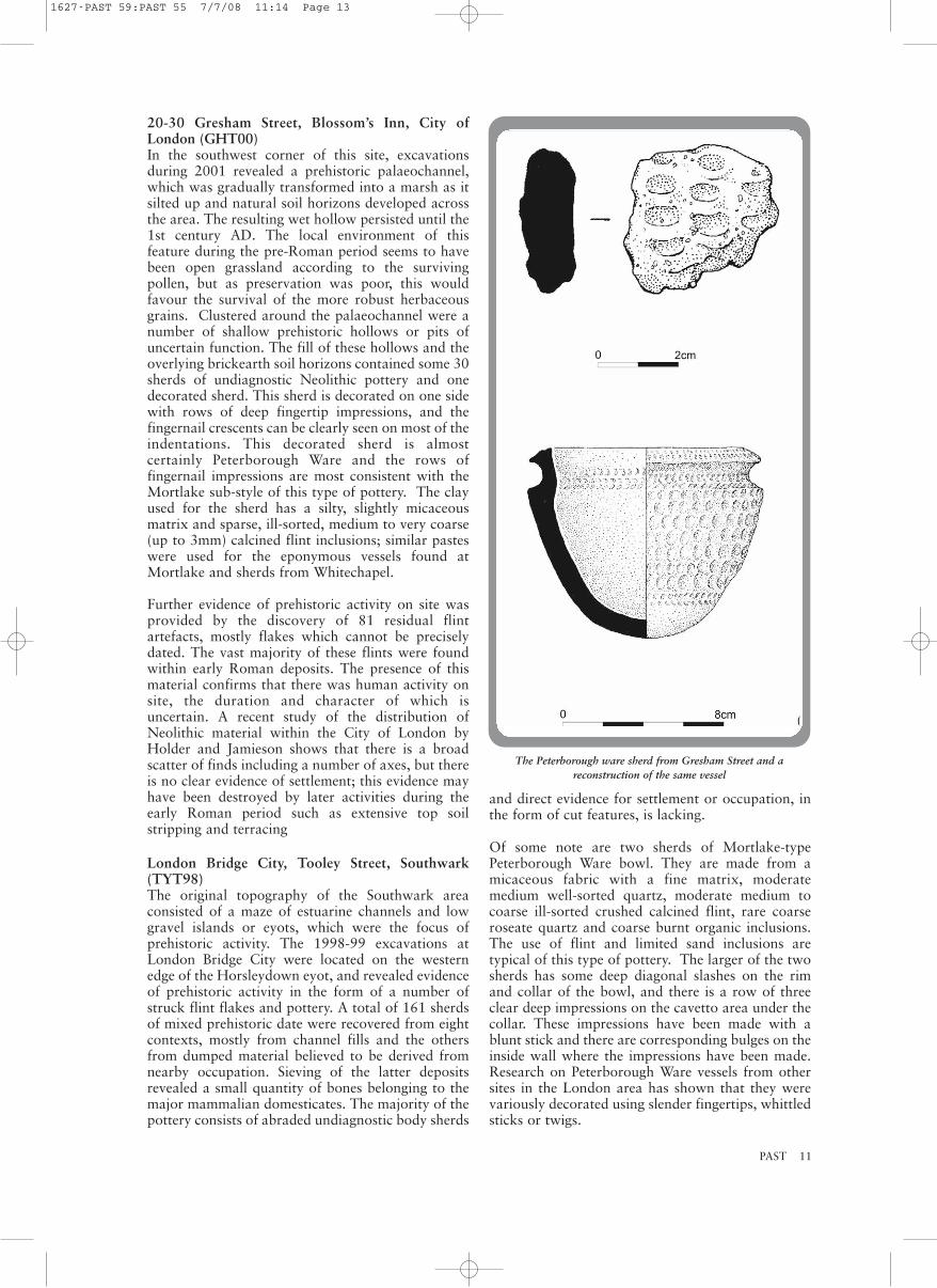
20-30 Gresham Street, Blossom’s Inn, City ofLondon (GHT00)In the southwest corner of this site, excavationsduring 2001 revealed a prehistoric palaeochannel,which was gradually transformed into a marsh as itsilted up and natural soil horizons developed acrossthe area. The resulting wet hollow persisted until the1st century AD. The local environment of thisfeature during the pre-Roman period seems to havebeen open grassland according to the survivingpollen, but as preservation was poor, this wouldfavour the survival of the more robust herbaceousgrains. Clustered around the palaeochannel were anumber of shallow prehistoric hollows or pits ofuncertain function. The fill of these hollows and theoverlying brickearth soil horizons contained some 30sherds of undiagnostic Neolithic pottery and onedecorated sherd. This sherd is decorated on one sidewith rows of deep fingertip impressions, and thefingernail crescents can be clearly seen on most of theindentations. This decorated sherd is almostcertainly Peterborough Ware and the rows offingernail impressions are most consistent with theMortlake sub-style of this type of pottery. The clayused for the sherd has a silty, slightly micaceousmatrix and sparse, ill-sorted, medium to very coarse(up to 3mm) calcined flint inclusions; similar pasteswere used for the eponymous vessels found atMortlake and sherds from Whitechapel.
Further evidence of prehistoric activity on site wasprovided by the discovery of 81 residual flintartefacts, mostly flakes which cannot be preciselydated. The vast majority of these flints were foundwithin early Roman deposits. The presence of thismaterial confirms that there was human activity onsite, the duration and character of which isuncertain. A recent study of the distribution ofNeolithic material within the City of London byHolder and Jamieson shows that there is a broadscatter of finds including a number of axes, but thereis no clear evidence of settlement; this evidence mayhave been destroyed by later activities during theearly Roman period such as extensive top soilstripping and terracing
London Bridge City, Tooley Street, Southwark(TYT98)The original topography of the Southwark areaconsisted of a maze of estuarine channels and lowgravel islands or eyots, which were the focus ofprehistoric activity. The 1998-99 excavations atLondon Bridge City were located on the westernedge of the Horsleydown eyot, and revealed evidenceof prehistoric activity in the form of a number ofstruck flint flakes and pottery. A total of 161 sherdsof mixed prehistoric date were recovered from eightcontexts, mostly from channel fills and the othersfrom dumped material believed to be derived fromnearby occupation. Sieving of the latter depositsrevealed a small quantity of bones belonging to themajor mammalian domesticates. The majority of thepottery consists of abraded undiagnostic body sherds
and direct evidence for settlement or occupation, inthe form of cut features, is lacking.
Of some note are two sherds of Mortlake-typePeterborough Ware bowl. They are made from amicaceous fabric with a fine matrix, moderatemedium well-sorted quartz, moderate medium tocoarse ill-sorted crushed calcined flint, rare coarseroseate quartz and coarse burnt organic inclusions.The use of flint and limited sand inclusions aretypical of this type of pottery. The larger of the twosherds has some deep diagonal slashes on the rimand collar of the bowl, and there is a row of threeclear deep impressions on the cavetto area under thecollar. These impressions have been made with ablunt stick and there are corresponding bulges on theinside wall where the impressions have been made.Research on Peterborough Ware vessels from othersites in the London area has shown that they werevariously decorated using slender fingertips, whittledsticks or twigs.
PAST 11
The Peterborough ware sherd from Gresham Street and areconstruction of the same vessel
1627-PAST 59:PAST 55 7/7/08 11:14 Page 13

12 PAST
A small assemblage of 83 pieces of worked flint wasrecovered from the excavations, mostly in residualcontexts. No diagnostic artefacts were recovered,but it is likely from the composition of theassemblage and the technology employed that themajority of the material is of mid-late Neolithic date.The retouched component is dominated by serratedand retouched flakes. The assemblage suggestsdomestic activity with evidence for knapping,various processing tasks and possibly hidepreparation. The other retouched forms includescrapers, one made on a fragment from a polished implement, a piercer and a miscellaneousretouched piece.
DiscussionPeterborough Ware is part of the pan-British andIrish ‘impressed ware’ phenomenon, which appearsshortly before 3300 BC. Recent re-evaluation byAlex Gibson of the radiocarbon dates available forPeterborough Ware pottery indicates that all three ofthe Peterborough Ware types - Ebbsfleet, Mortlakeand Fengate - were fully developed by 3000 BC, butthat these were ‘no longer in vogue’ by the middle ofthe third millennium.
Peterborough Ware sherds have been recovered froma number of sites in the City of London and itsenvirons. The general pattern for the Thames Valleyis that Peterborough Ware has been recovered frompits, middens, monumental ditches, burials andwatery deposits. In the London region, research byCotton and Johnson has shown that most of thePeterborough Ware finds have come from pits (49instances); the next most common depositionalcontext is a river channel or foreshore (16 instances).It is of note that in the London area the vast majorityof the complete and semi-complete PeterboroughWare vessels come from the Thames. The closest findspots for Peterborough Ware in south London to theLondon Bridge City find are 29 Addington Street; 11St Thomas’s Street, Southwark; and SkinmarketPlace, Bankside.
Charlotte Thompson (Archaeology South-East) withDavid Saxby and Bruce Watson (MoLAS)
Acknowledgements The excavations at 20-30 Gresham Street wereundertaken by the Museum of London ArchaeologyService (MoLAS) and were funded by LandSecurities plc. The excavations at London BridgeCity were undertaken by MoLAS and funded byCIT/Markborough. The flint reports were producedby Tony Grey (GHT00) and Philippa Bradley(TYT98). Figure 1 was produced by Faith Vardy andfigure 2 by Sandra Rowntree of the MoLAS DrawingOffice.
CCOONNFFEERREENNCCEESS
British Association for Biological Anthropology andOsteoarchaeology St Anne’s College, Oxford, 5-7 September 2008
The tenth annual BABAO conference will be jointlyhosted by Oxford Archaeology and the University ofOxford. Sessions include ‘The modified body: bio-cultural approaches to the study of human skeletalmodification’ and ‘Ten years down the line:osteoarchaeology at the molecular level’. There willalso be a round table discussion on human remainsand ethics in Britain. The conference is open to bothmembers and non-members. Registration details,session abstracts, details of conference venue andaccommodation are available at www.babao.org.uk.For any further enquiries please contact Louise Loe([email protected]) or Ceri Boston([email protected]) at OxfordArchaeology, Janus House, Osney Mead, Oxford,0X2 OES; tel 01865 263800.
From Desert to WetlandA weekend conference in honour of Professors BryonyColes and Valerie Maxfield on their retirement.University of Exeter, 27-28 September 2008
Speakers will include Lindsay Allason-Jones, AlanBowman, David Breeze, John Coles, Ralph Fyfe,Frances Griffith, Bill Hanson, Anthony Harding,Mark Hassall, Neil Holbrook, Linda Hurcombe,Rebecca Jones, Paul Mellars, Henrietta Quinnell,Denis Ramseyer and Alison Sheridan. Programmeand application form available athttp://www.sogaer.ex.ac.uk/archaeology/conferences/present/desert-wetland2008-programme.shtml
Bronze Age Forum 2008University of Sheffield, 22-23 November 2008
The next meeting of the Bronze Age Forum will behosted by the Department of Archaeology,University of Sheffield. The meeting is open toanyone with an interest in the Bronze Agearchaeology of Britain, Ireland and our nearestContinental neighbours. 20 minute papers areinvited on new research and recent discoveries in anyof these regions. To propose a paper, please visitwww.shef.ac.uk/archaeology/conferences/baf2008.The deadline for paper proposals is 30 September2008.
The Mortlake-type Peterborough Ware bowl sherd from LondonBridge City
1627-PAST 59:PAST 55 7/7/08 11:14 Page 14

PAST 13
TTHHEE SSOOUUTTHHEERRNN KKIINNTTYYRREEPPRROOJJEECCTT:: IINNTTEERRAACCTTIIOONNSSAACCRROOSSSS TTHHEE IIRRIISSHH SSEEAA
Background to the projectRecent research on the early prehistory of Britainand Ireland has highlighted how little we understandabout social interaction between communities.Historically, there is plenty of evidence to show closeconnections between western Scotland and easternIreland, but were these also present in prehistory?The evidence as it currently stands is ratherambiguous. In the Late Mesolithic (c. 6000-4000BC) different styles of stone tools were found eitherside of the Irish Sea which has led scholars to suggestthat people were not in contact. However, we alsoknow that people were excellent sailors and fishersin the Mesolithic, and were more than capable ofcrossing the Irish Sea. By the beginning of theNeolithic (c. 4000-2500 BC), there is much strongerevidence for contact between Scotland and Ireland.Antrim flint is found in Scotland, Arran pitchstone isfound in Ireland, and polished stone axes wereregularly crossing the Irish Sea. Monument andpottery forms were also similar. However, the natureof interaction across the Irish Sea in the Neolithic isstill poorly understood, and it is often modelled asepisodic. This project was thus designed to gain amuch fuller understanding of interactions across theIrish Sea, and Kintyre, just 12 miles from Ireland, isa perfect study area for investigating these questions.
Previous work Prior to this project, members of the KintyreAntiquarian Society had identified flint scattersthrough fieldwalking in southern Kintyre. In 2006,we fieldwalked 20 fields, most of which are locatedin our study area around Southend, Blasthill andMacharioch. We found a considerable quantity offlint which indicates Mesolithic, Neolithic andBronze Age occupation of this landscape. Ofparticular note was an assemblage of Neolithic findsfrom Brunerican Farm, including arrowheads. Were-walked a field at Macharioch where a LateMesolithic scatter had already been identified byAngus Martin. Here, we found more Mesolithicflints. We also conducted a small excavation atMacharioch and found the remains of a woodenstructure which may be prehistoric in date.
Fieldwalking 2007In 2007, we walked a total of 11 fields. We found somuch flint that we are still in the process of analysingit. However, we have completed the analysis on the material we found at Macharioch, where we re-walked the field where last year’s excavationswere located. We have also analysed the flint foundby Angus Martin in this field, and it confirms theprevious interpretation that this was a major LateMesolithic occupation site. Last year, we took somesoil samples from the remains of the woodenstructure associated with this scatter at Macharioch,
and these have produced charcoal from trees as wellas a small fragment of a hazelnut shell. These areexciting finds because it means that we can get themradiocarbon dated. This means we may well be ableto date the wooden structure and the flintassemblage from this field.
We found sizeable assemblages at Low Machrimoreand in another field at Macharioch which appear tobe Late Neolithic/Early Bronze Age in date. AtGartvaigh, we walked three fields: two of theseproduced a large assemblage of burnt flint, as well assome diagnostically Neolithic and Bronze Ageartefacts. The assemblage of burnt flint from thesefields is very interesting. Flint does not occurnaturally in western Scotland so people in prehistorywould have had to collect beach flint or import flint(from Antrim for example) and this has led tosuggestions that flint was quite a rare resource. Ifthis was the case, why were people burning largequantities of it? Was this a form of conspicuousconsumption, the deliberate destruction of avaluable resource?
At the site of Machribeg we found many thousandsof flints, which look to be Mesolithic in date. Thissite is potentially very exciting since this will be thesecond major Mesolithic site in southern Kintyre.
Survey 2007We also conducted a walkover survey of Blasthillwhere we found a number of possible structures,including a possible round house. This wassubsequently chosen for exploratory excavation (seebelow). A series of boundary walls were also foundon Blasthill, and a few possible cairns. We alsoexamined the molehills and erosion scars on ourwalks and found a surprising quantity of materialincluding a very nice thumbnail scraper and someprehistoric pottery.
Geophysical survey was conducted at Machariochover the structure excavated in 2006. Unfortunately,results did not show the remaining part of thestructure. This may be because the structure was soephemeral in the first place. We also conductedgeophysical survey around the unscheduled part ofthe chambered tomb at Macharioch. Nothing wasvisible in the plots, which suggests that any cairnwhich may once have existed at this site has beencompletely ploughed away. We also conductedgeophysical survey on Blasthill over a section ofboundary wall. This was more successful, and thereis the possibility that geophysics could be used totrace these walls where they disappear into peat.
Excavation 2007Our walkover survey of Blasthill revealed a numberof hitherto unknown archaeological features and inthe summer of 2007, we decided to open a numberof small exploratory trenches to examine these.
Blasthill site 1: this was the site of a possible round house. We opened a small trench over what appeared
1627-PAST 59:PAST 55 7/7/08 11:14 Page 15

to be the wall of the round house. We did notexcavate this as we did not have the means toconduct the post-excavation analysis potentiallyrequired from such a site. However, we did find aclearly defined faced wall in our trench, whichconfirmed that this was a round house. This is thefirst of its kind in southern Kintyre. The interior ofthe house was not excavated but topsoil findsincluded two thumbnail scrapers, almost certainlyindicative of a Bronze Age date. The site bears astriking resemblance to Bronze Age round houses inthe Inner Hebrides. We opened a small test pit to thesouth of the round house and although there were noarchaeological features, we did find the tip of a flintknife. This is also probably Bronze Age in date.
Blasthill site 2: in our walkover survey, we identifieda boundary wall running close to the round house.We put a small trench though it, to reveal that itwould once have been a boundary of considerablesize. It was primarily constructed of earth, with somestones. We took samples of the soil from theboundary which were analysed for macrofossils inGlasgow, but unfortunately no material was found.At present, then, we have no idea if this feature wascontemporary with the round house, but futureexcavation may be able to answer this question.
Blasthill site 3: this site was also found throughwalkover survey, and was the remains of a sub-rectangular structure. On excavation, it appears wefound the remains of a post-Medieval structure (lateeighteenth/early nineteenth century). The walls weremade of turf, so it may have been a fairly short-livedconstruction. A small assemblage of post-Medievalmaterial culture, including ceramic and glass,suggests that people lived here. There was also asmall quantity of earlier flint finds from this sitewhich suggests that the post-Medieval structure mayhave reused an earlier feature.
Conclusions and plans for 2008Our four weeks of work in 2007 were verysuccessful. We have found more material that addsto our picture of life in southern Kintyre inprehistory. We have also shown that Blasthill hasmany prehistoric remains which would benefit fromfurther archaeological investigation. Both walkoverand geophysical survey are useful ways of findingmore archaeological sites in this area. We plan toreturn to southern Kintyre this year to carry on withthe project, with more fieldwalking and moreexcavation planned.
Vicki Cummings (University of Central Lancashire)and Gary Robinson (University of Wales, Bangor)
AcknowledgementsWe would like to thank all the farmers who gave usaccess to their land, and to Messers McCorkindale atMacharioch Farm who granted us permission toexcavate on Blasthill. Many thanks to Angus Martin,Frances Hood and Mary-Ann and Andy Buntin forall their help, and to the excavation team fromCardiff and Preston. Many thanks to the BritishAcademy and the Prehistoric Society for funding theproject in 2007.
RRAAMMBBLLEESS IINN RROOCCKK AARRTTPPAARRTT 33:: TTHHEEPPEETTRROOGGLLYYPPHHSS OOFFSSAARRMMIISSHHSSAAII
Bumping along the narrow tarmac road across thesweltering sands of central Uzbekistan, there is nohint of the richly decorated chasm which lies ahead.For miles the road undulates across the barrenlandscape as it heads towards the low rounded hillsof the Karatau ridge, a westerly extension of thelarger Zarafshan mountain range. But then the roadturns and descends rapidly into a previously hiddenvalley, soon passing exposures of the blockysedimentary rocks which higher have eroded toprovide the base minerals of the desert. Farther on,and deeper still, the exposures are of jaggedmetamorphic rocks, highly fractured by tectonicmovement and blackened through long exposure tosun and wind. The floor of the valley, however,contains a narrow strip of relatively flat land crossedby a fast-flowing stream which offers life to both aribbon of luxuriant trees and a small community ofinhabitants. A single whitewashed farmhouse nearwell-tended plots stands at the entrance to a narrowwinding gorge but just round the corner looms thebizarre spectacle of a fantasy land - a holiday campfor children of the industrious workers from thedistrict’s factories and mines. With the necessaryauthorisation, paperwork and guides, keys can beobtained from the camp to unlock the gates to thewild landscape beyond and the rich archaeologicaltreasure trove it contains.
14 PAST
Blasthill round house outer facing wall (view looking south)
1627-PAST 59:PAST 55 7/7/08 11:14 Page 16

Thus, one reaches Sarmishsai, a natural gorgesituated in the centre of Uzbekistan, 30km north-east of Navoi, a major mining town on the southernfringe of the extensive Kyzyl Kum desert, and 170kmnorth-west of the better known Silk Road city ofSamarkand. It is not marked on maps but the use ofa GPS places it at 40° 15’ 47” N, 65°35’ 09” E at anaverage elevation of 750m a.m.s.l. Abandoning thevehicle, one follows narrow paths that hug the baseof the steep craggy cliffs. Soon it becomes apparentthat many of the vertical rock faces (and some of thehorizontal ledges) on both sides of the valley bearpecked engravings of animals, people and abstractsymbols. The rock itself is naturally split into blocksof various sizes so the proportions of the ‘canvas’available for decoration are varied, but they areusually flat and smooth. In some apparently speciallocations the symbols seem to cover every rock facefrom below the level of the path to as high as it is possible to see. Some are quite distinct while other, deeply patinated examples are more difficultto discern.
Though doubtless known to generations of localpeople, the petroglyphs of Sarmishsai were only‘discovered’ by an archaeologist (K. I.Mukhammedov) in 1959, and the first descriptionwith drawings was published in 1966 (by N. K.Tashkenbayev). However, there followed severalseasons of fieldwork in the 1960s (by A. Kabirov),which led to a major publication ten years later.Subsequently, there has been an even more detailedstudy by a joint Uzbek-Polish team, which resulted ina number of comprehensive reports (including anexcellent introduction, Symbols through time:interpreting the rock art of central Asia, written byDr Andrzej Rozwadowski and published in 2004 byInstytut Wschodni, Adam Mickiewicz University,Poznan, ISBN 83-86094-94-X). These studies haveidentified some 4000 petrogplyphs throughout thegorge, the majority concentrated in its narrowmiddle section.
The Sarmish Gorge is the most exuberant of the 150rock art sites in Uzbekistan, and has been comparedwith other important Central Asian locations, suchas Tamgaly in Kazahkstan (PAST 56, 2007), the
almost inaccessible Saimaly Tash in Kyrgyzstan, andGobustan in Azerbijan, amongst others. Thedistribution of such rock art sites also extendseastward into the Bardaku and Altay mountains ofXinjiang, Siberia and Mongolia. There areundeniable similarities between the sites, especiallyin the animal species depicted, but each has its owndistinctive range of styles. At Sarmishsai, thesuperimposition of images and the use of differenttechniques of execution are often apparent.
The most striking designs are those of bulls withlong curved horns, their coats and musculatureindicated by complicated internal patterns. Some ofthe representations with elongated bodies, raisedheads and upward curved horns are considered to bethe earliest, and are thought to depict aurochsenrather than domesticates. Most commentators placetheir execution at the end of the Mesolithic, in thethird millennium BC, and argue against an earlier(Upper Palaeolithic) date. Human figures with bowsand accompanied by dogs are often placed beside thewild animals, and the compositions seem to depicthunting scenes, acts of bravery, or even metaphoricbattles against the forces of life. But it is oftenquestionable whether all the images arecontemporaneous. Human figures with strong legsand thin arms, often held aloft, seem to representsomething totally different. The majority probablydate from the Bronze Age, the time when theterritory was settled by Indo-Iranian people.Elsewhere, images of delicate ungulates with longcurved horns, possibly argali (wild mountain sheep)or ibex, abound. The flowing style of these images isthought to belong to the so-called Sako-Scythiantradition associated with the early nomads of thefirst millennium BC. Later scenes show warriorswith crown-like hats, riding saddled horses andbrandishing scimitar swords. Clearly, the artwork isa palimpsest from many different periods.
The surrounding area also contains a range ofarchaeological sites which are the subject of on-going research. They include settlements, enclosures,funerary precincts and burial mounds, some of
PAST 15
1627-PAST 59:PAST 55 7/7/08 11:14 Page 17