submitted by: dogtown wind, llc - paxton record · submitted by: dogtown wind, llc ` 150 n michigan...
TRANSCRIPT

Dogtown Wind Project
WECS Special Use Permit
Application
Ford County, Illinois
submitted by:
Dogtown Wind, LLC
` 150 N Michigan Avenue
150 N Michigan Ave Suite 2800
Chicago, IL 60601 January 18, 2013 Larry Knilands Ford County Zoning Officer 200 W State, Room B-5 Paxton, IL 60957 RE: Special Use Permit Application Submission Dogtown Wind, LLC Dear Mr. Knilands, Please find herein our application for special use approval for our wind project on approximately 6,000 acres of mainly farm ground east of Paxton, all in Ford County. On behalf of Matt Kauffman, and Ross Johnson, the Stewardship energy team, all of us at Akuo Energy, and the many Ford County landowner participants we believe the project will be a success and for many years be a big benefit to the community. We enjoy the Paxton area and have gone out of our way to meet and communicate with non-participating residents in Patton and Buttton Townships and have accommodated their concerns with changes in design. Stewardship and Akuo are a strong and secure group. Stewardship has been the local presence throughout the project and has built and operated wind facilities in Illinois. For financial and development security, Akuo established in 2006 its own Investment Fund that invests in projects at the construction stage. This reached a billion dollars in investments in 2011. The application form and binder documents are submitted on this date. It addresses all of the requirements laid out in the Ordinance. We hope you, the County and Township Boards, Planning Commission, and County residents find our wind energy project thoroughly planned. And we would look forward to a hearing and building as soon as possible. Please contact me at [email protected] or (312) 291-4622 if there are questions or feedback. Sincerely, Douglas Krause, PE Project Manager

TABLE OF CONTENTS1 Introduction & Purpose .......................................................................................... 1
2 Dogtown Wind Project Summary .......................................................................... 2 GENERAL DESCRIPTION ....................................................................................................................... 2 SITE PLAN ................................................................................................................................................ 3 ECONOMIC AND ENVIRONMENTAL BENEFITS ................................................................................... 4 APPLICANT, OWNER/ OPERATOR, AND PROPERTY OWNERS ........................................................ 5
3 Compliance with the Ford County Zoning Ordinance ......................................... 6 VI DESIGN AND INSTALLATION ........................................................................................ 6
A. Design Safety Certification ............................................................................................................... 6 B. Controls and Brakes ......................................................................................................................... 6 C. Electrical Components ...................................................................................................................... 6 D. Color ................................................................................................................................................. 6 E. Turbine Consistency ......................................................................................................................... 6 F. Compliance with the Federal Aviation Administration (FAA) ............................................................ 6 G. Lighting ............................................................................................................................................. 7 H. Warnings ........................................................................................................................................... 7 I. Climb Prevention ................................................................................................................................ 7 J. Height ................................................................................................................................................ 7 K. Blade Clearance ............................................................................................................................... 7 L. Setbacks ............................................................................................................................................ 7 M. Drainage Repair ............................................................................................................................... 9 N. Compliance with Additional Regulations .......................................................................................... 9 O. Use of Public Roads ......................................................................................................................... 9 P. Term .................................................................................................................................................. 9
VII OPERATION ...............................................................................................................10 A. Maintenance ................................................................................................................................... 10 B. Interference ..................................................................................................................................... 10 C. Coordination with the Local Fire Department ................................................................................. 11 D. Materials Handling, Storage, and Disposal .................................................................................... 12
VIII NOISE LEVELS ..........................................................................................................12 IX BIRDS ............................................................................................................................12 X PUBLIC PARTICIPATION ..............................................................................................13 XI LIABILITY INSURANCE AND INDEMNIFICATION ........................................................14 XII DECOMMISSIONING PLAN .......................................................................................14 Natural Resources Inventory Report ......................................................................................15
4 Project Impact Assessments ............................................................................... 16 Additional ENVIRONMENTAL IMPACT ASSESSMENTS .....................................................16
A Bats ............................................................................................................................................. 16 B Wetlands ..................................................................................................................................... 16 C Cultural Resources ...................................................................................................................... 16 D Agency Consultations ................................................................................................................. 17
PROPERTY VALUE IMPACTS .............................................................................................17 SHADOW FLICKER IMPACT ................................................................................................17
EXHIBITS
Exhibit A Dogtown Wind Project Site Maps
Exhibit B 2012 Economic Impact Report - Illinois State Center for Renewable Energy
Exhibit C Applicant & Property Information
Exhibit D FAA Obstruction Determination
Exhibit E Setback Waiver
Exhibit F Comsearch Microwave, Tower & Mobile Reports
Exhibit G Epsilon Sound Level Assessment Report
Exhibit H Normandeau Associates Inc. Dogtown Avian and Bat Report Digest
Exhibit I Property Value Assessment
Dogtown Wind Project - Ford County, IL Special Use Permit Application 1
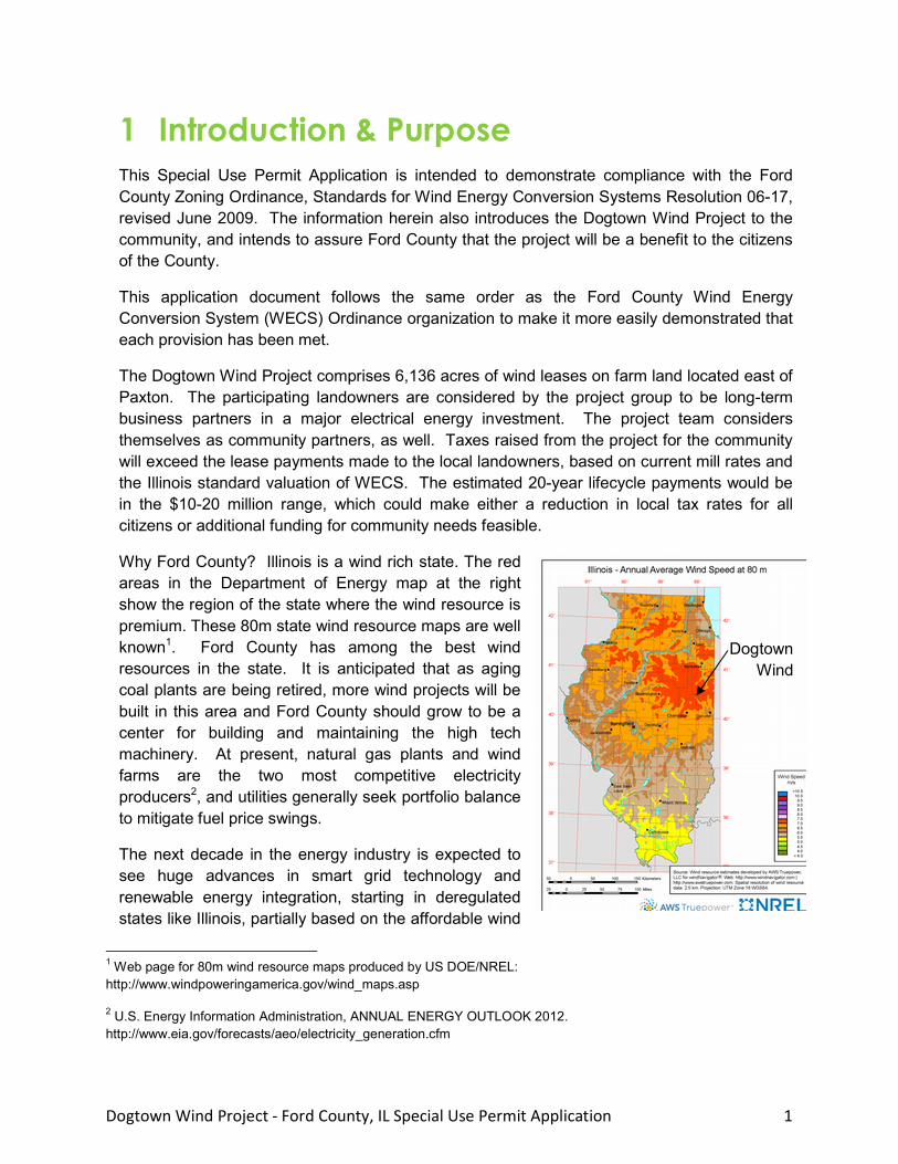
1 Introduction & Purpose This Special Use Permit Application is intended to demonstrate compliance with the Ford County Zoning Ordinance, Standards for Wind Energy Conversion Systems Resolution 06-17, revised June 2009. The information herein also introduces the Dogtown Wind Project to the community, and intends to assure Ford County that the project will be a benefit to the citizens of the County.
This application document follows the same order as the Ford County Wind Energy Conversion System (WECS) Ordinance organization to make it more easily demonstrated that each provision has been met.
The Dogtown Wind Project comprises 6,136 acres of wind leases on farm land located east of Paxton. The participating landowners are considered by the project group to be long-term business partners in a major electrical energy investment. The project team considers themselves as community partners, as well. Taxes raised from the project for the community will exceed the lease payments made to the local landowners, based on current mill rates and the Illinois standard valuation of WECS. The estimated 20-year lifecycle payments would be in the $10-20 million range, which could make either a reduction in local tax rates for all citizens or additional funding for community needs feasible.
Why Ford County? Illinois is a wind rich state. The red areas in the Department of Energy map at the right show the region of the state where the wind resource is premium. These 80m state wind resource maps are well known1. Ford County has among the best wind resources in the state. It is anticipated that as aging coal plants are being retired, more wind projects will be built in this area and Ford County should grow to be a center for building and maintaining the high tech machinery. At present, natural gas plants and wind farms are the two most competitive electricity producers2, and utilities generally seek portfolio balance to mitigate fuel price swings.
The next decade in the energy industry is expected to see huge advances in smart grid technology and renewable energy integration, starting in deregulated states like Illinois, partially based on the affordable wind
1 Web page for 80m wind resource maps produced by US DOE/NREL: http://www.windpoweringamerica.gov/wind_maps.asp
2 U.S. Energy Information Administration, ANNUAL ENERGY OUTLOOK 2012. http://www.eia.gov/forecasts/aeo/electricity_generation.cfm
Dogtown Wind
Dogtown Wind Project - Ford County, IL Special Use Permit Application 2
power in Central Illinois. Smart grid technologies will balance electricity consumption with intermittent wind production, for example, by charging urban electric vehicle fleets at night with nighttime wind. This in turn will provide a profitable use for the utility's transmission lines at night, as well as reduce smog in urban areas, increase the nation's energy and fuel security, and provide for local high tech jobs and industry. The connection of Dogtown power to the Ameren grid will enhance reliability locally, with immediate benefits as well as a long-term reliable grid to attract businesses.
The Dogtown Wind team is proud to bring this project to the community for the mutual benefit of all parties.
2 Dogtown Wind Project Summary GENERAL DESCRIPTION
The wind project was personally named Dogtown by the local landowners participating on the project. The locals refer to the area east of Paxton as Dogtown, which relates to the original city to be platted in the area. That town location never came to be when the anticipated railway was routed through what is now Paxton in 1859, and for a short time the area was only occupied by dogs. The Dogtown area remained prime farming ground and this practice continues today.
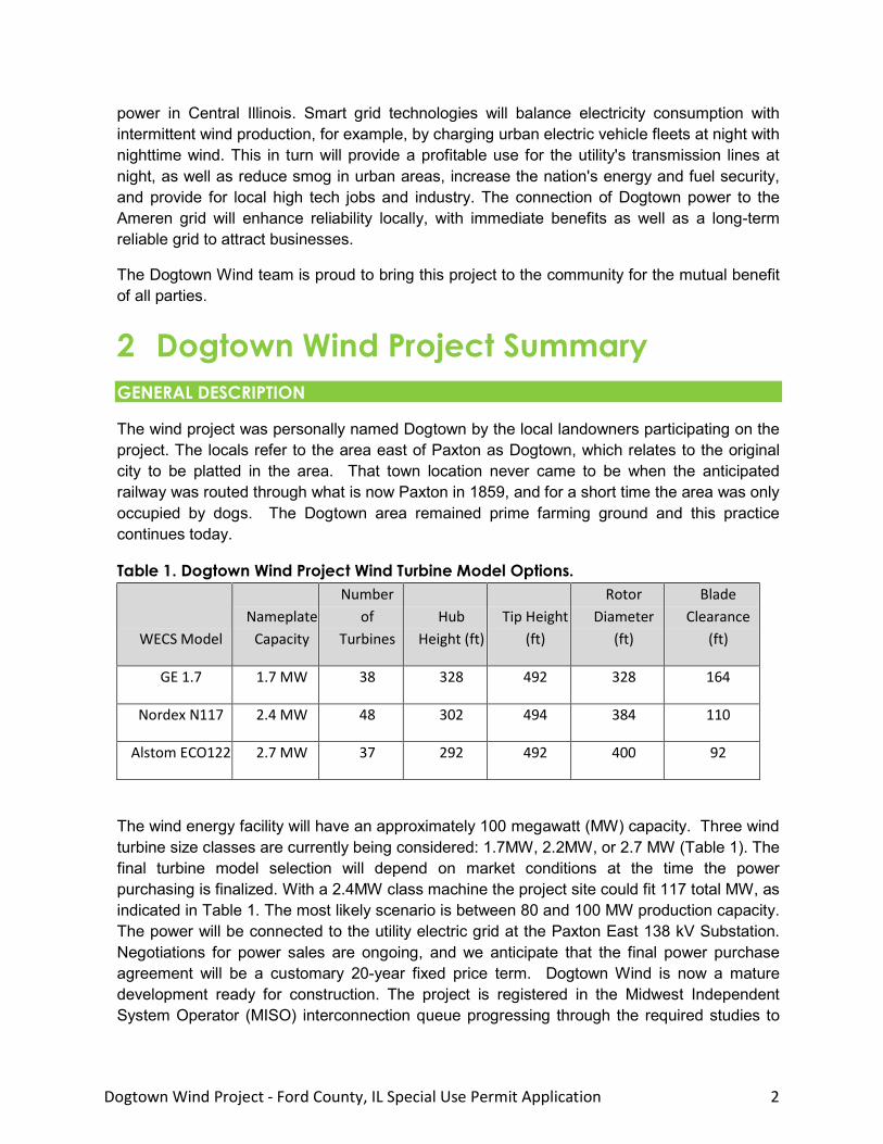
Table 1. Dogtown Wind Project Wind Turbine Model Options.
WECS Model Nameplate
Capacity
Number of
Turbines Hub
Height (ft) Tip Height
(ft)
Rotor Diameter
(ft)
Blade Clearance
(ft)
GE 1.7 1.7 MW 38 328 492 328 164
Nordex N117 2.4 MW 48 302 494 384 110
Alstom ECO122 2.7 MW 37 292 492 400 92
The wind energy facility will have an approximately 100 megawatt (MW) capacity. Three wind turbine size classes are currently being considered: 1.7MW, 2.2MW, or 2.7 MW (Table 1). The final turbine model selection will depend on market conditions at the time the power purchasing is finalized. With a 2.4MW class machine the project site could fit 117 total MW, as indicated in Table 1. The most likely scenario is between 80 and 100 MW production capacity. The power will be connected to the utility electric grid at the Paxton East 138 kV Substation. Negotiations for power sales are ongoing, and we anticipate that the final power purchase agreement will be a customary 20-year fixed price term. Dogtown Wind is now a mature development ready for construction. The project is registered in the Midwest Independent System Operator (MISO) interconnection queue progressing through the required studies to

Dogtown Wind Project - Ford County, IL Special Use Permit Application 3
complete an interconnection agreement. The project has several years’ worth of onsite wind resource monitoring data, as well as monitoring for the range of environmental impacts.
Wind turbine warranties typically cover defects in materials and workmanship, power curve performance, and availability, for a range of two to five years. All components are sourced from established vendors in the wind and electrical industries. All major equipment will be brand new. Some of the major local procurement will include millions of dollars in concrete batch plant work, road materials, road work, regionally sourced steel towers.
The Project will use a SCADA3 system supplied by the turbine manufacturer or other reputable sub-supplier to provide real-time telemetering data. The controller in each turbine tower will continuously collect data on operating conditions at the turbine, including wind speed and direction, kWh production, voltage, power factor, frequency, generator and rotor RPM, availability, component (gearbox oil, generator) and ambient temperatures, and faults. The controllers are networked using fiber optical cable and connected to a SCADA reporting server, the database where wind plant data is hosted for reporting. Remote access to the SCADA system via VPN allows for centralized data collection, remote control, monitoring, troubleshooting, and e-mail alarm notification.
SITE PLAN
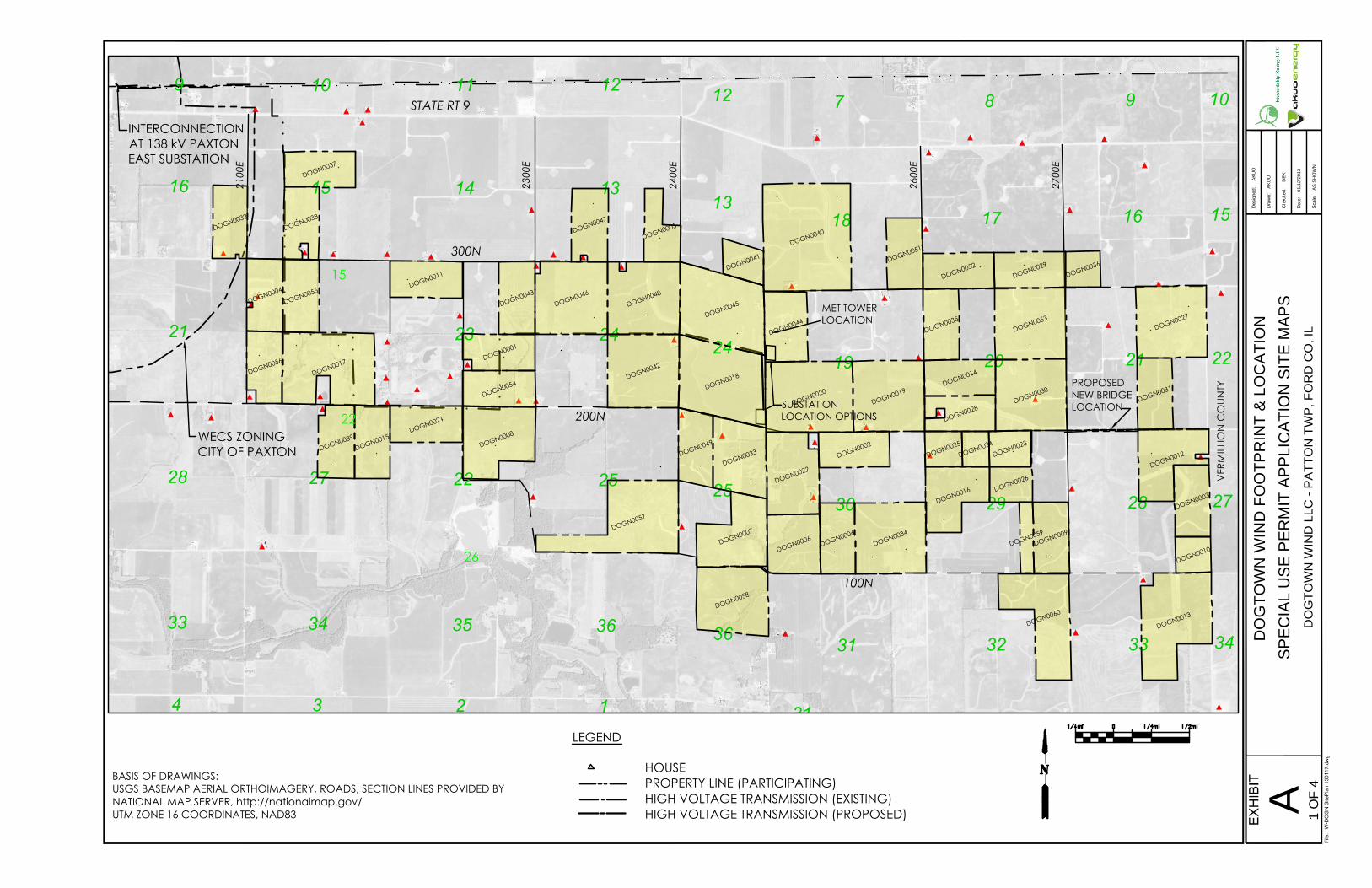
Site maps for the three project layouts associated with the different turbine models are provided in Exhibit A. The maps show the planned locations of:
• Each WECS Tower; • Primary Structure(s);
• Property lines (including identification of adjoining properties); • Setback lines; • Public access roads and turnout locations;
• Substations; • Electrical cabling from the WECS Towers to the Substation;
• Ancillary equipment; • Third party transmission lines; • Layout of all structures within the geographical boundaries of any applicable setback. The location of the turbines (micrositing) is an extremely complex process that goes through various necessary iterations up until the final engineering and logistics analysis is performed.
3 SCADA is an acronym for Supervisory Control and Data Acquisition. SCADA refers to the industrial computer system that monitors and controls the WECS and wind facility process.
Dogtown Wind Project - Ford County, IL Special Use Permit Application 4
The locations and turbine types may be subject to change. The final design may be updated and will be submitted for review prior to the issuance of construction permits by the County.
ECONOMIC AND ENVIRONMENTAL BENEFITS
A 100 MW wind farm would represent a massive investment into the infrastructure of the County. Roads will receive millions of dollars in improvement. The Ameren high voltage transmission lines will receive upgrades that will improve the reliability of the regional electric supply and make the County attractive to business for reliable power or industry related to renewable power.
Additional economic benefits include:
$200M capital investment into the County.
Production of approximately $10-20M over 20 years in local tax revenue with the potential for tax rate reductions for all County citizens.
Production of millions of dollars in a second income for agricultural lands, without removing significant acreage from cultivation.
Approximately eight long-term local jobs created.
Provision of 30,000 homes with electricity, or all of the power needed for the entire City of Chicago to operate CTA transportation annually, without burning any coal or gas into the atmosphere.
A positive step toward the nation's energy and fuel security.
Environmental benefits:
◦ Displaces 180,000 tons of CO2 emissions into the atmosphere, annually,
◦ Removes 1,000 pounds of acid rain compounds from the atmosphere, annually,
◦ Provides for habitat investment in nearby higher benefit places.
The 20120 Economic Impact Report produced by the Illinois State University Center for Renewable Energy is provided in Exhibit B. According to this economic analysis (projects over 50 MW), the 23 largest wind farms in Illinois:
Created approximately 19,047 full-time equivalent jobs1 during construction periods with a total payroll of over $1.1 billion.
Supports approximately 814 permanent jobs in rural Illinois areas with a total annual payroll of nearly $48 million.
Supports local economies by generating $28.5 million in annual property taxes.
Generates $13 million annually in extra income for Illinois landowners who lease their land to the wind farm developer.
Will generate a total economic benefit of $5.98 billion over the life of the projects.

Dogtown Wind Project - Ford County, IL Special Use Permit Application 5
APPLICANT, OWNER/ OPERATOR, AND PROPERTY OWNERS
The project is organized as Dogtown Wind LLC, an LLC partnership between Stewardship Energy and Akuo Energy USA, who are jointly developing the project. Dogtown Wind LLC is the Applicant, Owner, and future Operator of the wind energy facility.
Matt Kaufmann, the principal of Stewardship Energy, has farming roots in Princeton, Illinois. Together with Ross Johnson, a farmer from Watseka, Stewardship began working with local landowners in 2008. Stewardship has a proven track record of wind energy development including two completed Illinois projects consisting of 8.4 MW and 75 MW.
Akuo Energy USA joined the partnership in 2010. Akuo develops, constructs, owns, and operates wind and solar projects in North America. The company is fully owned by its parent company, Akuo Energy SAS, an established Europe-based leader in the renewable energy sector that designs, develops, manages and operates power plants that generate electricity using only renewable energy sources around the world. Akuo is a privately held company by principals who have pioneered in renewable energy, and take pride in producing clean power. Akuo Energy entered the U.S. market in 2009 and is headquartered in Chicago. The company develops in all renewable energy sectors. Recently Akuo has provided innovation to the solar energy industry by combining agriculture and solar power land uses - for example by using greenhouses with solar power generating roofs. Akuo has 150 MW of wind and 180 MW of solar in production.
Stewardship Energy LLC can be reached at:
Stewardship Energy LLC 100 West Main Street Tiskilwa, Illinois 61368 815-915-4325 Participating Property Owners:
The participating lands are located in Patton and Button Townships in Ford County. This collaborative effort has produced a cohesive team of Ford County residents that are invested in the success of the project. As required by the Ordinance, the lands (PIN ID numbers) and the landowners are identified in Exhibit C. The site maps identify the property using a project ID number, for example DOGN0001 which is related to the PIN and landowner in Exhibit C.
AKUO ENERGY USA Inc. can be reached at:
Akuo Energy USA Inc. 150 North Michigan Avenue Suite 2800 Chicago, IL 60601 Office: 312-624-7656

Dogtown Wind Project - Ford County, IL Special Use Permit Application 6
3 Compliance with the Ford County Zoning Ordinance In order to demonstrate compliance with the Ford County WECS Ordinance, this section follows the same order as Articles IV through XII. Italicized text repeats the Ordinance language verbatim, but is written to indicate that the Applicant shall comply with the provisions.
VI DESIGN AND INSTALLATION
A. Design Safety Certification 1. Dogtown Wind Project WECS(s) shall conform to applicable industry standards, including those of the American National Standards Institute (“ANSI”). Prior to the issuance of construction permits, Applicant shall submit certificates of design compliance that equipment manufacturers have obtained from Underwriters Laboratories (“UL”), Det Norske Veritas (“DNV”), Germanischer Lloyd Wind Energie (“GL”), or an equivalent third party. All turbines shall be new equipment commercially available; no used or experimental equipment shall be approved by the Zoning Enforcing Officer or the Zoning Board of Appeals without the issuance of a variance.
2. Following the granting of the special use permit under this Ordinance, a Professional Engineer shall certify, as part of the construction permit application that the foundation and tower design of the WECS is within accepted professional standards, given local soil and climate conditions.
B. Controls and Brakes All WECS shall be equipped with a braking system that conforms to applicable industry standards.
C. Electrical Components All electrical components of the WECS shall conform to applicable codes and standards.
D. Color WECS towers and blades shall be painted white or gray or another non-reflective, unobtrusive color.
E. Turbine Consistency The project shall consist of turbines of similar design and size, including tower height. All turbines shall rotate in the same direction.
F. Compliance with the Federal Aviation Administration (FAA) The WECS shall comply with all applicable FAA requirements. Dogtown Wind has applied for FAA approvals for turbines located around the entire perimeter of the project. The cases can

Dogtown Wind Project - Ford County, IL Special Use Permit Application 7
be reviewed at the FAA Obstruction Evaluation / Airport Airspace Analysis (OE/AAA) website and database at: https://oeaaa.faa.gov/oeaaa/external/portal.jsp.
Prior to construction commencement, Dogtown Wind will finalize and permit all of the WECS locations with the FAA. The “Determination of No Hazard” Letter for the project’s existing Met tower is provided in Exhibit D.
G. Lighting Projects shall utilize minimal lighting. No exterior tower lighting other than normal security lighting shall be permitted except as may be required by the FAA.
H. Warnings 1. A reasonably visible warning sign concerning voltage will be placed at the base of all pad-mounted transformers and Substations.
2. Visible, reflective, colored objects, such as flags, reflectors, or tape shall be placed on the anchor points of guy wires and along the guy wires up to a height of 15 feet from the ground.
I. Climb Prevention All WECS Towers shall be unclimable on the outside by design.
J. Height WECS Tower Tip Height shall not exceed 500 feet, as demonstrated in Table 1.
K. Blade Clearance The minimum distance between the ground and any protruding blades(s) utilized on a WECS shall be fifteen (15) feet, as demonstrated in Table 1.
L. Setbacks All setbacks have been mapped on the Site Maps in Exhibit A. At the time of financing of the project (immediately prior to construction) the project will obtain, as a requirement of the wind finance industry, an ALTA/ACSM certified survey of the project. This survey will be performed by a licensed surveyor from the State of Illinois, which will establish the exact survey grade locations planned for project work. This data will be passed to the general contractor in order to locate and stake the work. The mapping shown in Exhibit A was performed to the highest quality GIS standards and supervised by a State of Illinois licensed civil engineer.
1. Primary Structure setback. All WECS Towers are located a minimum distance of 1,640 feet (500 meters) from any Primary Structure in existence or which has received construction permits for construction as of the date of approval of the special use permit. Distance shall be measured from the point of the Primary Structure foundation closest to the WECS Tower to the center of the WECS Tower foundation. The Ordinance requires a setback of 1,000 feet.
Dogtown Wind Project - Ford County, IL Special Use Permit Application 8
2. Platted communities. The City of Paxton observes a 1.0 mile setback from city boundaries. The Applicant met with city officials in order to verify that the setback was properly observed. The Site Maps in Exhibit A show the Paxton corporate setback limit.
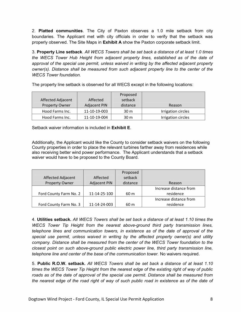
3. Property Line setback. All WECS Towers shall be set back a distance of at least 1.0 times the WECS Tower Hub Height from adjacent property lines, established as of the date of approval of the special use permit, unless waived in writing by the affected adjacent property owner(s). Distance shall be measured from such adjacent property line to the center of the WECS Tower foundation.
The property line setback is observed for all WECS except in the following locations:
Affected Adjacent Property Owner
Affected Adjacent PIN
Proposed setback distance Reason
Hood Farms Inc. 11-10-19-003 30 m Irrigation circles Hood Farms Inc. 11-10-19-004 30 m Irrigation circles
Setback waiver information is included in Exhibit E.
Additionally, the Applicant would like the County to consider setback waivers on the following County properties in order to place the relevant turbines farther away from residences while also receiving better wind power performance. The Applicant understands that a setback waiver would have to be proposed to the County Board.
Affected Adjacent Property Owner
Affected Adjacent PIN
Proposed setback distance Reason
Ford County Farm No. 2 11-14-25-100 60 m Increase distance from
residence
Ford County Farm No. 3 11-14-24-003 60 m Increase distance from
residence
4. Utilities setback. All WECS Towers shall be set back a distance of at least 1.10 times the WECS Tower Tip Height from the nearest above-ground third party transmission lines, telephone lines and communication towers, in existence as of the date of approval of the special use permit, unless waived in writing by the affected property owner(s) and utility company. Distance shall be measured from the center of the WECS Tower foundation to the closest point on such above-ground public electric power line, third party transmission line, telephone line and center of the base of the communication tower. No waivers required.
5. Public R.O.W. setback. All WECS Towers shall be set back a distance of at least 1.10 times the WECS Tower Tip Height from the nearest edge of the existing right of way of public roads as of the date of approval of the special use permit. Distance shall be measured from the nearest edge of the road right of way of such public road in existence as of the date of

Dogtown Wind Project - Ford County, IL Special Use Permit Application 9
approval of the special use permit. The Township Road Commissioner or County Highway Superintendent, or similar authorized representative with respect to local or state roadways, may waive this setback requirement as to roads within their respective jurisdictions.
6. The Applicant does not need to obtain a variance or other approval from the County upon written waiver by the applicable State, County, Township, utility company or property owner(s) of any of the above setback requirements. Any waiver of any of the above setback requirements shall run with the land and be recorded as part of the chain of title in the deed of the subject property.
M. Drainage Repair The Owner or Operator will repair waterways, drainage ditches, field tiles, or any other infrastructures damaged during construction and maintenance phases.
N. Compliance with Additional Regulations Nothing in this Ordinance is intended to preempt other applicable state and federal laws and regulations.
O. Use of Public Roads 1. Prior to the issuance of construction permits, the Applicant will execute with the County and Townships a ROAD UPGRADE AND MAINTENANCE AGREEMENT based on the Agreement that the County has executed successfully with prior wind projects. The Applicant has been in significant communication and consultation with the County and Townships. The Applicant has identified public and private road alternatives.
The final decision of whether the equipment will arrive by either rail or by State Highway will be made by the selected WECS turbine supplier and their logistics team. The potential access points to the County and Township road network are shown on the Site Maps in Exhibit A.
Of special note:
• Township Road 100N, a gravel road three miles South of State Route 9 and not heavily travelled, is a likely route to carry the majority of hauls, which are concrete and gravel loads.
• County Route 17 (200N) is under consideration for upgrade as the main east west haul route for heavy loads.
• Township Road 200N east of 2600E is unimproved since a bridge washout event several decades past. The Applicant would like to repair the bridge and improve the road to the mutual benefit of the community and local farmers who could access their fields more directly. The Applicant would intend to seek Township permission to make use of the right-of-way for an electric cable in exchange for the upgrade.
P. Term Notwithstanding any other provisions of the County Zoning Ordinance, a special use permit for a WECS shall be effective and may be relied upon so long as construction of the WECS is

Dogtown Wind Project - Ford County, IL Special Use Permit Application 10
commenced within 36 months after issuance of the special use permit, which period may be extended by the Board of Appeals without further public hearing.
VII OPERATION
A. Maintenance Any physical modification to the WECS that alters the mechanical load, mechanical load path, or major electrical components shall require re-certification under Section VI(A)(1) of this Ordinance. Like-kind replacements shall not require re-certification. Prior to making any physical modification (other than a like-kind replacement), the Owner or Operator shall confer with a relevant third-party certifying entity identified in Section VI(A)(1) of this Ordinance to determine whether the physical modification require re-certification.
B. Interference 1. The Applicant shall provide the applicable microwave transmission providers and local emergency service provider(s) (911 operators) copies of the project summary and site plan, as set forth in Section V.B.1. and V.B.3. of this Ordinance. To the extent that the above provider(s) demonstrate a likelihood of interference with its communications resulting from the WECS(s), the Applicant shall take reasonable measures to mitigate such anticipated interference. If, after construction of the WECS, the Owner or Operator receives a written complaint related to the above-mentioned interference, the Owner or Operator shall take reasonable steps to respond to the complaint.
2. If, after construction of the WECS, the Owner or Operator receives a written complaint related to interference with local broadcast residential television, the Owner or Operator shall take reasonable steps to respond to the complaint.
Toward these ends, the Applicant commissioned Comsearch to conduct an extensive study to explore possible interference with microwave towers using “Wind Power GeoPlanner™”. Comsearch “has developed and maintains comprehensive technical databases containing information on licensed microwave networks throughout the United States. Microwave bands that may be affected by the installation of wind turbine facilities operate over a wide frequency range (900 MHz – 23 GHz). These systems are the telecommunication backbone of the country, providing long-distance and local telephone service, backhaul for cellular and personal communication service, data interconnects for mainframe computers and the Internet, network controls for utilities and railroads, and various video services.” The report found no microwave paths and no obstruction in the proposed Project area. The full Licensed Microwave Report can be found in Exhibit F.
Additionally, the Applicant commissioned a second study with Comsearch to explore possible interference with communications towers. Using “Wind Power GeoPlanner™”, Comsearch reports their methodology by stating, “Our tower structures report is derived from a variety of sources including the FCC’s Antenna Structure Registration (ASR) database and the top ten nationwide tower owner databases. The data is imported into GIS software and the structures are geographically mapped with the wind energy area of interest defined by the customer.

Dogtown Wind Project - Ford County, IL Special Use Permit Application 11
Each tower location on the map is identified with an ID number associated with detailed structure information provided in a data table.” The results of the Tower Structures Report state that using the data sources described above, Comsearch does not identify any tower structures within the wind energy area of interest. The summary of the Tower Structures Report and can be found in Exhibit F.
Finally, the Applicant commissioned a third study with Comsearch to explore possible interference with mobile phone service. Again using “Wind Power GeoPlanner™”, Comsearch reports their methodology by stating, “Comsearch compiles and provides information on land mobile sites identified within or near a defined area of interest related to proposed wind energy facilities. This information is useful in the planning stages of the wind energy facilities to identify fixed land mobile stations where critical telecommunication services are provided such as emergency (police, fire, 911, e.g.) response, public safety and local government communications, or industrial and business wireless radio operations. This data can be used in support of the wind energy facilities communications needs or to avoid any potential impact to the current land mobile services provided in that region.” The Land Mobile Report states that “Five land mobile sites [are] within the wind energy area of interest using the data sources described in our methodology above. The majority of the towers are located close to the town of Minonk.” The report goes on to state that, “the frequencies of operation used by the land mobile sites are generally unaffected by the presence of wind turbines. In the unlikely event that a land mobile licensee believes their coverage has been compromised by the presence of the wind energy facility, they have many options to improve their signal coverage to the area through optimization of a nearby base station or even adding a repeater site. Utility towers, meteorological towers or even the turbine towers within the wind project area can serve as the platform for a land mobile base station or repeater site.” The summary of the Land Mobile Report is provided in Exhibit F.
C. Coordination with the Local Fire Department 1. Prior to commencement of construction, the Applicant, Owner or Operator shall submit to the local fire department a copy of the site plan.
2. Prior to the issuance of construction permits, the Owner or Operator shall cooperate with the local fire department to develop and implement a fire protection plan in coordination with local emergency response authorities to ensure that all the appropriate emergency services agencies are cognizant of actions required in the event of a fire or other emergency at the wind power facility. In addition, the owner of the wind power facility shall provide training for, and the necessary equipment to, local emergency response authorities and their personnel so that they can properly respond to a potential emergency at the wind project.
3. Nothing in this section shall alleviate the need to comply with all other applicable fire laws and regulations.
Dogtown Wind Project - Ford County, IL Special Use Permit Application 12
D. Materials Handling, Storage, and Disposal 1. All solid wastes related to the construction, operation and maintenance of the WECS shall be removed from the site promptly and disposed of in accordance with all federal, state, and local laws.
2. All hazardous materials related to the construction, operation and maintenance of the WECS shall be handled, stored, transported and disposed of in accordance with all applicable local, state, and federal laws.
VIII NOISE LEVELS
Noise levels from each WECS or WECS Project shall be in compliance with applicable Illinois Pollution Control Board (IPCB) regulations. The Applicant has already taken extensive steps to exceed the guidelines regarding the noise levels from each planned WECS at Primary Structures. The Applicant commissioned a noise study through Epsilon Associates, Inc., a nationally-recognized company in the field of noise assessment and impact reduction, using the most impacting wind turbine class for the project in terms of noise levels, which is the 2.7 MW machine size. Based on their feedback, several adjustments to the project layout have been made. The study states that “the results of the assessment show that the Project will meet the noise limits put forth in the Illinois Pollution Control Board (IPCB) regulations for the most stringent land use classifications (Class “A”).” The full report from Epsilon Associates, Inc. can be found in Exhibit G. The Project is in compliance with applicable Illinois Pollution Control Board (IPCB) regulations.
.
IX BIRDS
The Applicant recognizes that certain issues specific to wind projects, such as avian and bat mortality, are a concern across the US. Therefore, the project site was selected in part because of the lack of high-risk landscape features, such as ridge tops or wetlands, and the Applicant retained several qualified environmental specialists to assess potential project impacts to avian, bat, wetland, and cultural resources. Information received during the course of these surveys was incorporated into the project design, and implementation of careful avoidance and minimization measures has limited as many detrimental environmental impacts as possible before project construction even commences. Additionally, Dogtown Wind LLC maintains close consultation with the Illinois Department of Natural Resources (IDNR) and US Fish and Wildlife Service (USFWS), and has received feedback that the project is in a suitable location.
Based on requests received from the USFWS and IDNR, the Applicant has completed two full years of pre-construction wildlife monitoring at the project site to determine if the installation of WECSs will have a substantial adverse impact on species of concern. Normandeau Associates, Inc., conducted the avian surveys using bird identification experts to perform on-site bird point-counts across all seasons in order to observe both resident and migrant bird
Dogtown Wind Project - Ford County, IL Special Use Permit Application 13
activity. The second year of the avian surveys is complete and the professionals consistently found no fatal flaws, with only a low to moderate risk to all of the species observed at the site. The vast majority of the observed species are predicted to have low risk of collisions with wind turbines based on current research and the proportion of flight within the theoretical rotor swept zone.
The full reports for each of these surveys total several hundred pages; therefore, in order to provide an indicative representation of the avian species, habitat, and potential impacts of the project observed at the site, we have included a digest of these reports as Exhibit H. This abbreviated compilation includes the executive summary of the 2011 Dogtown Avian and Bat Report, as well as Normandeau’s subsequent survey reports through spring of 2012. For parties wishing to view the full report(s), they are available upon request.
Additional consultations with local residents and County officials has made us aware that potential project impacts to ring-necked pheasants, which are a favored game species in this area, are of particular concern. It is our assessment that the project will not have an impact on ring-necked pheasant populations or the ability of residents to recreationally hunt them for the following reasons:
• The project is located solely on privately owned land. The land lease agreements we have with participating landowners do not limit the ability to hunt around the wind turbines once they are constructed.
• The leased land to be used for the project is almost all agriculturally cultivated, which has already degraded suitable pheasant habitat.
• The nearby IDNR 635-acre Sibley Habitat Area located in Ford County provides pheasant hunting to Illinois residents.
• Almost all ring-necked pheasants observed at the site during the course of the avian point-count surveys were perched – not flying – and the few pheasants observed flying did so at a height well below the projected turbine rotor-swept zone. This species is a low-flying bird in general, so they are not at risk of collision with the rotating blades.
• The species is not state- or federally-listed threatened or endangered.
The Applicant has also conducted a comprehensive suite of environmental impact assessments specifically addressing other wildlife and natural resources at the site in addition to birds. These are discussed further in Section 4 [Project Impact Assessments] below.
X PUBLIC PARTICIPATION
The Applicant understands that nothing in the Ordinance is meant to augment or diminish existing opportunities for public participation in the County’s consideration of the special use application.
Dogtown Wind Project - Ford County, IL Special Use Permit Application 14
XI LIABILITY INSURANCE AND INDEMNIFICATION
A. Commencing with the issuance of construction permits, the Applicant, Owner or Operator of the WECS(s) shall maintain a current general liability policy covering bodily injury and property damage with limits of at least $3 million per occurrence and $5 million in the aggregate. Such insurance may be provided, pursuant to a plan of self insurance, by a party with a net worth of $50 million or more. The County shall be named as an additional insured on the policy to the extent the County is entitled to indemnification in accordance with Section XI.B.
B. Applicant, Owner or Operators shall defend, indemnify and hold harmless the County and its officials, employees and agents (collectively and individually, the “Indemnified Parties”) from and against any and all claim, demands, losses, suits, causes of action, damages, injuries, costs, expenses and liabilities whatsoever, including reasonable attorney’s fees, except to the extent arising in whole or in part out of the negligence or intentional acts of such Indemnified Parties (such liabilities together known as “liability”) arising out of Applicant, Owner or Operators selection, construction, operation and removal of the WECS and affiliated equipment including, without limitation, liability for property damage or personal injury (including death), whether said liability is premised on contract or on tort (including without limitation strict liability or negligence). This general indemnification shall not be construed as limiting or qualifying the County’s other indemnification rights available under the law.
XII DECOMMISSIONING PLAN
The Applicant understands that prior to the issuance of construction permits by Ford County a Decommissioning Plan must be approved by the County with the following elements:
• Provisions describing the triggering events for decommission the WECS Project;
• Provisions for the removal of above-ground structures, debris and cabling, and provisions for the removal of underground foundations and cables down to a depth of 3½ feet below the soil surface;
• Provisions for the restoration of the soil and vegetation;
• An estimate of the decommissioning costs and salvage value, certified by a Professional Engineer or other qualified professional reasonably acceptable to the County, which shall be updated and submitted to the Ford County Zoning Enforcing Officer every five years;
• Financial Assurance, secured by the Owner or Operator, for the purpose of adequately performing decommissioning, in an amount equal the positive difference, if any, between the Professional Engineer’s certified estimate of the decommissioning costs and salvage value;
• Identification of and procedures for County access to Financial Assurances;
• A provision that the terms of the Decommissioning Plan shall be binding upon the Owner or Operator and any of their successors, assigns, or heirs; and

Dogtown Wind Project - Ford County, IL Special Use Permit Application 15
• A provision that the County shall have access to the site, pursuant to reasonable notice, to effect or complete decommissioning.
The Applicant understands the community's concern and appreciates the need for assurance that these imposing structures not be abandoned on the properties at the end of the project. The Applicant also understands that the County has an executed template for Decommissioning.
The Applicant will comply with the County’s preference, but will propose an approach that reduces the hard cost to the project, but retains the assurance for the community. There are few cases in other industries where financial assurance for site restoration is held for an event 20-30 years down the road. In the last decade when the modern utility scale wind turbine era began, about 30,000 1-3 MW class machines have been installed. None of the projects have failed or been abandoned. By 2023, there will be more than 50,000 machines, approximately $75 billion in capital investment. By then a new industry will be in place to retool, disassemble, and recycle the materials efficiently. The price of steel will continue to become more valuable, and new specialized cranes will cost less to mobilize. As a result it is more and more likely that within two decades the salvage will be worth much more than the removal expense.
The Applicant would like to propose that the County entertain an approach where the financial assurance can be activated at any point during operation if the County feels that the condition needed to be imposed. As a result, more beneficial uses of the resources can be used or shared during the financially constrained first five years phase of the project.
NATURAL RESOURCES INVENTORY REPORT
Ford County requires the Soil and Water Conservation District’s (SWCD) Natural Resources Inventory (NRI) Report be completed prior to Special Use Permit approval.
The NRI Report is available through the County or the SWCD. The NRI Report considers soil, water, environmental, and drainage issues, as well as conservation practices that are on the properties. During the course of the NRI Report, SWCD works with the Applicant and project participants regarding conservation practices on the lands, such as terraces and waterways, which are required to be maintained to the standards and specifications to which they were designed and built for the duration of the Farm Service Agency, Natural Resources Conservation Service, or SWCD contract.
The NRI Report contains two recommendations to consider moving turbines due to planned gravel access roads crossing waterways. The two turbines are from the base case layout (ECO 122).
Since the turbines cannot be moved without losing the turbine site all together, the Applicant will follow the SWCD specifications for crossing a waterway, which includes larger rock, and not raising the bed of the waterway. This would apply if the layout in question becomes the final design.

Dogtown Wind Project - Ford County, IL Special Use Permit Application 16
4 Project Impact Assessments ADDITIONAL ENVIRONMENTAL IMPACT ASSESSMENTS
The Applicant invested in an extensive suite of environmental studies in order to verify that little or no negative environmental impacts will be realized by the Project. These studies are not required by County Ordinance, but are described in this section.
A Bats Normandeau Associates also used state-of-the-art bat acoustic monitoring equipment installed on-site in order to document the presence of all bat species existing within the Project area. Two years of bat monitoring is complete, and the Indiana bat (Myotis sodalis) was the only federally-listed species found at the site. Because of initial project siting and design to avoid sensitive bat habitat, overall bat activity is moderate when compared to other sites; there have been extremely few Myotis species detections thus far and no fatal flaws were identified. Consultations with the USFWS and IDNR are on-going specifically regarding potential impacts to the Indiana bat, and the project will remain in full compliance with the relevant federal and state regulations.
Additionally, as a result of requests made by the USFWS and IDNR, the Applicant retained Copperhead Environmental Consulting to perform a targeted bat mist-netting survey in July 2010 in order to assess the summer maternity colony presence of Indiana bats. Sampling locations were chosen based on habitat suitability on or near riparian corridors. All of these locations were sited outside of the Project boundary, due to an absence of suitable habitat within the Project footprint. Copperhead determined that the species composition and number of bats captured was typical for the geographic location and habitats found there. Evidence of Indiana bat reproductive colonies was found and the Applicant proactively included a riparian corridor buffer in the Project design based on USFWS guidelines.
B Wetlands The Applicant retained Indiana-based experts Cardo JFNew to perform a wetland delineation survey. Given the current and historical agricultural use of the land area, their site evaluation determined that potential project impacts will be minimal and the Applicant will continue to consult with the US Army Corps of Engineers to confirm compliance of the final project layout.
C Cultural Resources Cardo JFNew also conducted an on-site cultural resources survey to assess potential historical and archaeological concerns in the Project area. Their field reconnaissance found a limited number of structures and artifacts and overall low potential impacts to cultural resources. Our site plan has been adapted in order to account for identified sites, and we have maintained a buffer around sites such as historical buildings. The survey and potential impacts will be verified through consultation with the Illinois Historic Preservation Agency prior to construction commencement.
Dogtown Wind Project - Ford County, IL Special Use Permit Application 17
D Agency Consultations The Applicant continues to proactively engage with all relevant local, state, and federal environmental agencies in order to maintain full compliance with all relevant regulations for the life of the Project. As described above, these agencies include USFWS, IDNR, SHPO, and the USACE.
PROPERTY VALUE IMPACTS
Non-participating residents in the vicinity of wind projects have logical concerns about the effect of the development on their property value. The Center for Renewable Energy at Illinois State University has conducted many highly respected property value studies in Illinois. The most recent study is referenced in Exhibit I. The summary states "this study utilizes a hedonic price model to assess the impacts on 1,298 real estate transactions from 1998 to 2010. The analysis indicates that residential properties located near wind turbines in Lee County have not been affected by their presence."
SHADOW FLICKER IMPACT
Shadow flicker becomes a concern to residents when a shadow is cast by a moving wind turbine rotor onto a residence or yard. The community will see that Dogtown Wind LLC has conducted its micrositing of turbine locations with a conservative allowance for shadow flicker on residences. This project will not exceed the shadow flicker international standard of 30 hours of shadow flicker per year in sum on a given residence. The industry and Applicant considers the estimate to be conservative, as the model assumes that any shadow will affect the residence. In other words, the blocking by trees, or location of windows in the home, is not considered as mitigating of the shadow flicker.
As a result of these methods, the Applicant has applied a setback of greater than 2,200 feet from a WECS site where the azimuth angle may align with the maximum sunrise or sunset alignments.
Prior to finance and construction, lenders will require that shadow flicker concerns are satisfied at which point the Applicant will conduct third party verification studies on the final layout and turbine size.
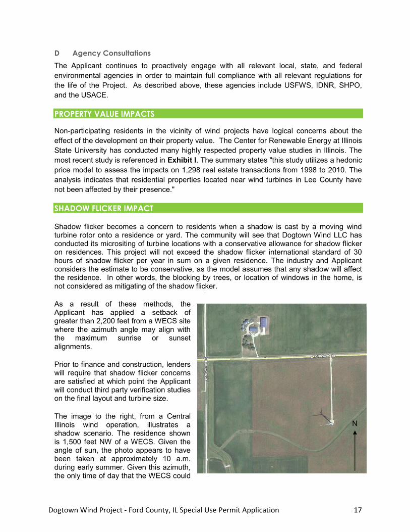
The image to the right, from a Central Illinois wind operation, illustrates a shadow scenario. The residence shown is 1,500 feet NW of a WECS. Given the angle of sun, the photo appears to have been taken at approximately 10 a.m. during early summer. Given this azimuth, the only time of day that the WECS could
N
Dogtown Wind Project - Ford County, IL Special Use Permit Application 18
cast a shadow near the house is approximately 10 a.m. during a brief spell of winter. The rest of the year, the sunrise would cast a shadow West and South (when the Sun is in the Northern hemisphere), or else the Sun would already be too high at 10 a.m. during most of the winter.
In summary, the shadow flicker can affect a residence only during a predictable narrow period of the year. Residences are typically not within shadow range of more than one turbine.
A. Site Maps
DOGN0055
DOGN0043DOGN0046
DOGN0048
DOGN0045
DOGN0044
DOGN0020DOGN0018
DOGN0049
DOGN0002
DOGN0047
DOGN0041
DOGN0040
DOGN0035
DOGN0022
DOGN0019
DOGN0029
DOGN0004
DOGN0030
DOGN0028
DOGN0014
DOGN0033
DOGN0032
DOGN0005
DOGN0011
DOGN0010
DOGN0013
DOGN0009
DOGN0012
DOGN0036
DOGN0027
DOGN0017
DOGN0031
DOGN0003DOGN0016
DOGN0006
DOGN0006DOGN0007
DOGN0037
DOGN0001
DOGN0042
DOGN0038
DOGN0034
DOGN0026
DOGN0054
DOGN0021
DOGN0008
DOGN0056
DOGN0039DOGN0015
DOGN0053
DOGN0052
DOGN0023
DOGN0024DOGN0025
DOGN0051
DOGN0060
DOGN0059DOGN0057
DOGN0058
10
34
27
3029
21
19
333231
20
28
22
15
8
18
17
16
9
7
31
24
12
36
25
13
21
1615 14
23
22
3635
3433
119 1210
13
27
25
24
28
34
12
AS
S
HO
WN
01
/1
2/2
01
3
DE
K
AK
UO
AK
UO
1 O
F 4
A
DO
GT
OW
N W
IN
D L
LC
- P
AT
TO
N T
WP
, F
OR
D C
O, IL
SP
EC
IA
L U
SE
P
ER
MIT
A
PP
LIC
AT
IO
N S
IT
E M
AP
S
DO
GT
OW
N W
IN
D F
OO
TP
RIN
T &
L
OC
AT
IO
N
LEGEND
HOUSEPROPERTY LINE (PARTICIPATING)HIGH VOLTAGE TRANSMISSION (EXISTING)HIGH VOLTAGE TRANSMISSION (PROPOSED)
22
26
15
BASIS OF DRAWINGS:USGS BASEMAP AERIAL ORTHOIMAGERY, ROADS, SECTION LINES PROVIDED BYNATIONAL MAP SERVER, http://nationalmap.gov/UTM ZONE 16 COORDINATES, NAD83

DOGN0055
DOGN0043DOGN0046
DOGN0048
DOGN0045
DOGN0044
DOGN0020DOGN0018
DOGN0049
DOGN0002
DOGN0047
DOGN0041
DOGN0040
DOGN0035
DOGN0022
DOGN0019
DOGN0029
DOGN0004
DOGN0030
DOGN0028
DOGN0014
DOGN0033
DOGN0032
DOGN0005
DOGN0011
DOGN0010
DOGN0013
DOGN0009
DOGN0012
DOGN0036
DOGN0027
DOGN0017
DOGN0031
DOGN0003DOGN0016
DOGN0006
DOGN0006DOGN0007
DOGN0037
DOGN0001
DOGN0042
DOGN0038
DOGN0034
DOGN0026
DOGN0054
DOGN0021
DOGN0008
DOGN0056
DOGN0039DOGN0015
DOGN0053
DOGN0052
DOGN0023DOGN0024
DOGN0025
DOGN0051
D
O
G
N
0
0
6
0
D
O
G
N
0
0
5
7
D
O
G
N
0
0
5
8
37 35
34
33
31
30
29
28
27
26
25
2423
22
21
2019
18
17
1615
14
13
12
11
10
9
7
6
5
4
3
2
10
34
27
30
21
19
333231
20
28
22
15
8
18
17
16
9
7
24
12
36
25
13
21
1614
23
22
36353433
119 1210
13
27
25
28
36A
S S
HO
WN
01
/1
2/2
01
3
DE
K
AK
UO
AK
UO
2 O
F 4
A
DO
GT
OW
N W
IN
D L
LC
- P
AT
TO
N T
WP
, F
OR
D C
O, IL
SP
EC
IA
L U
SE
P
ER
MIT
A
PP
LIC
AT
IO
N S
IT
E M
AP
S
DO
GT
OW
N W
IN
D 2
.7
MW
W
EC
S L
AY
OU
T &
S
ET
BA
CK
S
22
26
15
LEGEND
PARTICIPATING PROPERTY SETBACK LIMITS
WECS - ACTUAL ROTOR DIAMETER SHOWNHOUSEPROPERTY LINE (PARTICIPATING)RIGHT-OF-WAYHIGH VOLTAGE TRANSMISSION (PROPOSED)
BASIS OF DRAWINGS:USGS BASEMAP AERIAL ORTHOIMAGERY, ROADS, SECTION LINES PROVIDED BYNATIONAL MAP SERVER, http://nationalmap.gov/UTM ZONE 16 COORDINATES, NAD83
PRIMARY STRUCTURE SETBACK
PROPERTY LINE SETBACK
RIGHT-OF-WAY SETBACK
SETBACK NOTES:PARTICIPATING PROPERTY SETBACKS ARE SHOWN AS PER ABOVE,COMBINING ALL SETBACKS. THE RESULTING AREA INDICATESCOMPLIANCE WITH THE ZONING ORDINANCE RULES FOR SETBACKS.PRIMARY STRUCTURE SETBACK IS 1000;. 1640' IS OBSERVED.

DOGN0055
DOGN0046DOGN0048
DOGN0045
DOGN0044
DOGN0020DOGN0018
DOGN0049
DOGN0002
DOGN0047
DOGN0041
DOGN0040
DOGN0035
DOGN0022
DOGN0019
DOGN0028
DOGN0033
DOGN0032
DOGN0005
DOGN0011
DOGN0013
DOGN0009
DOGN0012
DOGN0017
DOGN0031
DOGN0016
DOGN0006
DOGN0006DOGN0007
DOGN0001
DOGN0042
DOGN0038
DOGN0026
DOGN0054DOGN0056
DOGN0039
DOGN0024
DOGN0051
D
O
G
N
0
0
6
0
D
O
G
N
0
0
5
8
49
48
47
46
4544
43
4241
40
39 38
3736
35
34
33
32
31
30
29
28
27
26
252423
22
21
20
19
18
17
1615
14
13
12
11
10
9
8
7
6
5
4
3
2
1
AS
S
HO
WN
01
/1
2/2
01
3
DE
K
AK
UO
AK
UO
3 O
F 4
A
DO
GT
OW
N W
IN
D L
LC
- P
AT
TO
N T
WP
, F
OR
D C
O, IL
SP
EC
IA
L U
SE
P
ER
MIT
A
PP
LIC
AT
IO
N S
IT
E M
AP
S
DO
GT
OW
N W
IN
D 2
.4
M
W W
EC
S L
AY
OU
T &
S
ET
BA
CK
S
22
26
15
LEGEND
PARTICIPATING PROPERTY SETBACK LIMITS
WECS - ACTUAL ROTOR DIAMETER SHOWN, 117mHOUSEPROPERTY LINE (PARTICIPATING)RIGHT-OF-WAYHIGH VOLTAGE TRANSMISSION (PROPOSED)
BASIS OF DRAWINGS:USGS BASEMAP AERIAL ORTHOIMAGERY, ROADS, SECTION LINES PROVIDED BYNATIONAL MAP SERVER, http://nationalmap.gov/UTM ZONE 16 COORDINATES, NAD83
PRIMARY STRUCTURE SETBACK
PROPERTY LINE SETBACK
RIGHT-OF-WAY SETBACK
SETBACK NOTES:PARTICIPATING PROPERTY SETBACKS ARE SHOWN AS PER ABOVE, COMBINING ALLSETBACKS. THE RESULTING AREA INDICATES COMPLIANCE WITH THE ZONINGORDINANCE RULES FOR SETBACKS. PRIMARY STRUCTURE SETBACK IS 1000;. 1640' ISOBSERVED FOR DOGTOWN WIND.

DOGN0055
DOGN0043DOGN0046
DOGN0048
DOGN0045
DOGN0044
DOGN0020DOGN0018
DOGN0049
DOGN0002
DOGN0047
DOGN0041
DOGN0040
DOGN0035
DOGN0022
DOGN0019
DOGN0029
DOGN0004
DOGN0030
DOGN0028
DOGN0014
DOGN0033
DOGN0032
DOGN0005
DOGN0011
DOGN0010
DOGN0013
DOGN0009
DOGN0012
DOGN0036
DOGN0027
DOGN0017
DOGN0031
DOGN0003DOGN0016
DOGN0006
DOGN0006DOGN0007
DOGN0037
DOGN0001
DOGN0042
DOGN0038
DOGN0034
DOGN0026
DOGN0054
DOGN0021
DOGN0008
DOGN0056
DOGN0039DOGN0015
DOGN0053
DOGN0052
DOGN0023DOGN0024
DOGN0025
DOGN0051
D
O
G
N
0
0
6
0
D
O
G
N
0
0
5
7
D
O
G
N
0
0
5
8
39
3837
3635
34
33
32
31
3029
28
26 25
2423
22
21
20
1918
16
14
13
12
11
10
987
65
43
2
1
2715
AS
S
HO
WN
01
/1
2/2
01
3
DE
K
AK
UO
AK
UO
4 O
F 4
A
DO
GT
OW
N W
IN
D L
LC
- P
AT
TO
N T
WP
, F
OR
D C
O, IL
SP
EC
IA
L U
SE
P
ER
MIT
A
PP
LIC
AT
IO
N S
IT
E M
AP
S
DO
GT
OW
N W
IN
D 1
.7
M
W W
EC
S L
AY
OU
T &
S
ET
BA
CK
S
22
26
15
LEGEND
PARTICIPATING PROPERTY SETBACK LIMITS
WECS - ACTUAL ROTOR DIAMETER SHOWN, 117mHOUSEPROPERTY LINE (PARTICIPATING)RIGHT-OF-WAYHIGH VOLTAGE TRANSMISSION (PROPOSED)
BASIS OF DRAWINGS:USGS BASEMAP AERIAL ORTHOIMAGERY, ROADS, SECTION LINES PROVIDED BYNATIONAL MAP SERVER, http://nationalmap.gov/UTM ZONE 16 COORDINATES, NAD83
PRIMARY STRUCTURE SETBACK
PROPERTY LINE SETBACK
RIGHT-OF-WAY SETBACK
SETBACK NOTES:PARTICIPATING PROPERTY SETBACKS ARE SHOWN AS PER ABOVE, COMBINING ALLSETBACKS. THE RESULTING AREA INDICATES COMPLIANCE WITH THE ZONINGORDINANCE RULES FOR SETBACKS. PRIMARY STRUCTURE SETBACK IS 1000;. 1640' ISOBSERVED FOR DOGTOWN WIND.
Links to online reports provided in the Appendices, other Appendices are removed here for email space, let me know if you want a digital copy, [email protected]
B. 2012 Economic Impact Report - Illinois State University Center for Renewable Energy
Hard copy of report submitted to county. Available online here:
http://renewableenergy.illinoisstate.edu/wind/publications/2012EconomicImpactReportForWeb.pdf
http://renewableenergy.illinoisstate.edu/
C. Applicant & Property Information
D. FAA Obstruction Determination
E. Setback Waiver
F. Comsearch Microwave, Tower & Mobile Reports
G. Epsilon Sound Level Assessment Report
H. Normandeau Associates Inc. Dogtown Avian and Bat Report Digest
I. Property Value Assessment
Hard copy of report submitted to county. Available online here:
http://renewableenergy.illinoisstate.edu/wind/publications/2011%20Wind%20Farms%20Effect%20on%20Property%20Values%20in%20Lee%20County.pdf