structure and emplacement of the nandurbar–dhule mafic dyke swarm, deccan traps, and the
TRANSCRIPT
RESEARCH ARTICLE
Structure and emplacement of the Nandurbar–Dhule maficdyke swarm, Deccan Traps, and the tectonomagmaticevolution of flood basalts
Ranjini Ray & Hetu C. Sheth & Jyotirmoy Mallik
Received: 2 February 2006 /Accepted: 20 July 2006 / Published online: 15 September 2006# Springer-Verlag 2006
Abstract Flood basalts, such as the Deccan Traps of India,represent huge, typically fissure-fed volcanic provinces. Wediscuss the structural attributes and emplacement mechanicsof a large, linear, tholeiitic dyke swarm exposed in theNandurbar–Dhule area of the Deccan province. The swarmcontains 210 dykes of dolerite and basalt >1 km in length,exposed over an area of 14,500 km2. The dykes intrude anexclusively basaltic lava pile, largely composed of highlyweathered and zeolitized compound pahoehoe flows. Thedykes range in length from <1 km to 79 km, and inthickness from 3 to 62 m. Almost all dykes are vertical,with the others nearly so. They show a strong preferredorientation, with a mean strike of N88°. Because they arenot emplaced along faults or fractures, they indicate theregional minimum horizontal compressive stress (σ3) tohave been aligned ∼N–S during swarm emplacement. Thedykes have a negative power law length distribution but anirregular thickness distribution; the latter is uncommonamong the other dyke swarms described worldwide. Dykelength is not correlated with dyke width. Using the aspectratios (length/thickness) of several dykes, we calculatemagmatic overpressures required for dyke emplacement,and depths to source magma chambers that are consistentwith results of previous petrological and gravity modelling.The anomalously high source depths calculated for a fewdykes may be an artifact of underestimated aspect ratiosdue to incomplete along-strike exposure. However, thermalerosion is a mechanism that can also explain this. Whereas
several of the Nandurbar–Dhule dykes may be verticallyinjected dykes from shallow magma chambers, others,particularly the long ones, must have been formed by lateralinjection from such chambers. The larger dykes could wellhave fed substantial (≥1,000 km3) and quickly emplaced(a few years) flood basalt lava flows. This work highlightssome interesting and significant similarities, and contrasts,between the Nandurbar–Dhule dyke swarm and regionaltholeiitic dyke swarms in Iceland, Sudan, and elsewhere.
Keywords Volcanism . Flood basalt . Deccan .Magma .
Dyke swarm . Rifting . India
Introduction
Continental flood basalt provinces (CFBs) are products offissure eruptions on a grand scale. The plumbing systems ofthese vast lava fields can be both extensive and complex(e.g., Walker 1999; Elliot and Fleming 2004), and dyke–sillnetworks are important parts of these. CFBs that are erodedexhibit dense swarms of mafic dykes that arguably representcongealed magma-filled fissures through which these lavaspoured out. Mafic dyke swarms are of great currentinternational interest, because of their value in understand-ing mantle-crust evolution and dynamics (e.g., Halls andFahrig 1987; Parker et al. 1990; Baer and Heimann 1995;Ernst et al. 1995, 2001; McHone et al. 2005).
The ∼65-million-year-old Deccan CFB of India (with apresent-day areal extent of 500,000 km2; Fig. 1) has beenextensively studied in terms of geochemistry, palaeomag-netism, and stratigraphy. The flood basalts are best exposedin the Western Ghats (Sahyadri) region, where they reach astratigraphic thickness of 3 km. Three regional-scale dykeswarms outcrop in the province (Auden 1949; Deshmukh
Bull Volcanol (2007) 69:537–551DOI 10.1007/s00445-006-0089-y
Editorial responsibility: J. White
R. Ray :H. C. Sheth (*) : J. MallikDepartment of Earth Sciences,Indian Institute of Technology (IIT) Bombay,Powai, Mumbai (Bombay) 400076, Indiae-mail: [email protected]
and Sehgal 1988; Bondre et al. 2006; Fig. 1). TheNarmada–Satpura–Tapi swarm is a linear, ENE–WSW-trending, giant dyke swarm (Sant and Karanth 1990; Ernstet al. 1995), apparently continuing westward into theSaurashtra peninsula. The NNW–SSE-trending Konkan orwest coast dyke swarm (e.g., Dessai and Viegas 1995) isexposed on the Konkan plain, between the Arabian Sea andthe Western Ghats escarpment to the east. Both theseswarms contain profuse dykes of tholeiites as well asultramafic, silicic, alkalic and carbonatitic rocks, plus largerintrusions. The third important dyke swarm in the provinceis the Western Ghats swarm northeast of Bombay, exclu-sively tholeiitic in composition (Beane et al. 1986;Vanderkluysen et al. 2004; Bondre et al. 2006).
Here, we discuss the geology, structural attributes andemplacement mechanics of a large tholeiitic dyke swarm,part of the Narmada–Satpura–Tapi giant dyke swarm, thatoutcrops in the Nandurbar–Dhule region of the centralDeccan CFB (Fig. 1). Our study has the followingobjectives: (1) To provide field and structural data on thisdyke swarm, (2) to estimate palaeostresses using thesestructural data, (3) to calculate the magmatic overpressures
and source depths for the dykes and understand theiremplacement mechanics, and (4) to discuss the broaderimplications of the data for the tectonomagmatic evolutionof the Deccan Traps, and for flood basalts in general.
Regional geology
Much of the Nandurbar–Dhule area is flat, at a generalelevation of ∼200 m above mean sea level, and exposeshighly weathered, zeolitized basalt lava flows of thecompound pahoehoe type. In the Satpura Range to thenorth, thick basalt sequences such as the 870-m-thickToranmal sequence (Fig. 1) are dominated by columnar-jointed “simple” flows. Geochemical–isotopic data forsome of the basalt lavas and dykes (e.g., Sheth et al.1997, 2004; Chandrasekharam et al. 1999; Mahoney et al.2000) show broad to strong similarities with lava flowsexposed in the Western Ghats. No felsic lavas or tuffs areseen, and red beds (altered tuffaceous materials or palaeo-weathering profiles) are very few and localized (a few tensof metres in lateral extent). Along the Tapi River, Tertiary and
TAPI RIVER
TAPI
SCARP
21o 10'
10 km
24
25 HattiIndve
Balsana
Dushane
26
Anjanvihire
Degaori
Shevade
Mandal
Vardhane
Bhamer
RojgaonNizampur
Kalambhir
Saitale
Shirdhane
VedapavlaPhulsare
Khandbara
Kakarpada
Navagaon
Kondaibar
4
56
2
3
7
1
34
33
35
Ranjnipada
Chhadvel
PLATEAU
PLATEAU
39
40
3637
38
83B
Nandurbar
Nijhar
Dondaicha
Sindkheda
RIVER
74o 00' 74o 15' 74o 30' 74o 45'
SDPD1
IchchhapurKaothi
PimpalkoteNavalnagar
BahadarpurDhule
Sakri
Parola
SDPD2
Panjhra River
DND1
27 2841
42
N
9 10 11
Thanepada
12
1314151617
18
19
2021
22
23Aichala
1BRanala
30Samsherpur
31Bamdod
32Kalmadi
29Prakasha(2 km)
alluvium
basalt flows
SH43 Shahada (5 km)
74o 00'
21o 20'
21o 25'
21o 15'
21o 05'
21o 00'
20o 50'
20o 55'
75o 00' 75o 15'74o 45'
n = 210
680 m
713 mBombay
20o
22o
24o
70o 76o
ARABIANSEA
Archaean-Proterozoiccrystalline basement
Late Precambriansedimentary basins
Palaeo-Mesozoic sedimentary basins
Tertiary-Quaternarysedimentary basins
0 100 200
km
Dhule
DECCAN PLATEAU
Sangamner
Tapi R.
Narmada R.
SATPURA RANGE
72o 80o
SAURASHTRA
18o
KACHCHH
Rajkot
Dediapada
Nandurbar
BAY OFBENGAL
NasikW
ES
TE
RN
GH
AT
S
KONKANPLAIN
ToranmalPachorabari
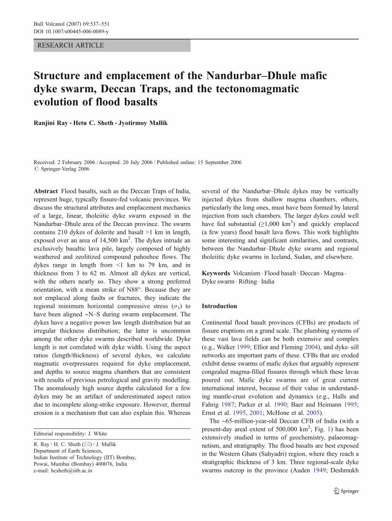
Vadbara
Fig. 1 Map of the Nandurbar–Dhule dyke swarm showing the majorphysiographic and geological features, the dykes, and samplinglocations. All numbers have the prefix NBD (not shown). Thealluvium belt along the Tapi River is shaded. At right is a key mapshowing the Deccan flood basalt province (shaded), its principal dykeswarms, and important localities. Box shows the location of the area ofthis study covering twenty toposheets of 1:50,000 scale. The toposheet
nos. are: 46 K/2, 3, 4, 6, 7, 8, 10, 11, 12, 14, 15, 16; 46 L/1, 5, 9, 13;46 O/2, 3, 4; 46 P/1. A rose diagram of the trends of 210 dykes(>1 km) measured over this region is shown at bottom left. TheNandurbar–Dhule dykes are shown on the map with uniform thicknessso that the structural trends can be easily recognized and appreciated;the dykes are by no means of the same thickness or equallypronounced (see text)
538 Bull Volcanol (2007) 69:537–551
Quaternary alluvium, 30-km-wide and 200–400 m thick, capsthe basalt pile. The base of the lava pile is not exposed, and thelava pile may be a few hundred metres thick. Whereas thelavas are horizontal around Dhule and Dondaicha, they showdistinct, gentle (5–10°) northward dips around places likeShahada and Kondaibar (Fig. 1). The Nandurbar–Dhuletholeiitic dyke swarm cuts the basalt flows. Being muchmore erosion-resistant than the lavas, the dykes form linear,often-prominent ridges that run for many kilometres.Duraiswami (2005) has discussed how the dykes controlthe local groundwater table in the Sakri area.
Published petrographic, mineral chemical and whole-rock geochemical data for many dykes in the Nandurbar–Dhule area (Melluso et al. 1999) suggest magma evolutionin relatively shallow magma chambers. The magmas areevolved (MgO=3.30–6.00 wt.%, n=48) tholeiitic basaltsand basaltic andesites, and low-pressure equilibration andfractional crystallization (especially of olivine) are evident.The Deccan lava pile in the Western Ghats and much of theSatpura region is also made up almost exclusively of suchevolved subalkalic basalts and basaltic andesites (Sheth2005), and the Nandurbar–Dhule dykes may well havesupplied upper levels of the regional lava stratigraphy nowlost to erosion, but likely preserved in sections elsewhere inthe province, including the Western Ghats. Singh (1998),based on gravity modelling, postulated an igneous layer, 8–24 km thick, under the entire Narmada–Satpura–Tapiregion, with its base at the Moho. Bhattacharji et al.(2004) carried out further gravity modelling and postulatedshallow-level (7–8 km) magma chambers in this generalregion, consistent with Melluso et al.’s (1999) conclusions.
The dykes are very abundant just to the south of Nandurbar,but become fewer and more widely spaced farther away. Fig. 1shows the part of our study area where the dykes are themost profuse, and covers six Survey of India topographicsheets of 1:50,000 scale (Nos. 46K/3, 7, 11, 4, 8, 12), withparts of others to the southeast. We have not represented ourentire study area (covering twenty toposheets and an area of14,500 km2) in Fig. 1, as this would render the smallestdykes (here, 1 km long) invisible at the scale of the figure.This larger area is bounded by latitudes 20° 45′ N and 21°45′ N and longitudes 74° 00′ E and 75° 15′ E.
Methodology
The first step in our study was to locate the dykes on thetwenty toposheets. The sheets are commercially availablefrom the Survey of India, and have a contour interval of20 m. They beautifully depict the dykes as linear ridgesmany kilometres or tens of kilometres long, each with equalslopes on either side of the crest. Many dykes rise at leastone contour interval above the lava flows, and dykes that
are not so high are also well shown by dotted contours. Asingle dyke certainly does not always form a singlecontinuous ridge over all its length, though two long dykes(∼35 and 54 km) just south of Nandurbar indeed do so formuch of their length (Fig. 1). Most dykes are made up ofseveral linear segments that lie nearly on a straight line inmost cases, with a spacing between the segments usuallyabout 10% or so of the segment length, leaving little doubtas to a dyke’s continuity. In some cases the dykes do notform continuous ridges, but can be identified by stronglyaligned spot heights over long distances.
We were primarily interested in the strike, dip, length andthickness parameters for the dykes and their statisticaldistributions. Statistical treatment of structural data on high-density dyke swarms, made up of hundreds or thousands ofdykes, is both valuable and essential in structural–tectonicinterpretations (e.g., Klausen and Larsen 2002; Mandal et al2006). The strike and length were noted for each individuallydiscernible dyke on the toposheets. Many of the smallestdykes are offshoots of the larger ones (see also Melluso et al.1999). Some of these were stubby in plan (low length/widthratios), and their exact trends were in fact difficult todetermine. We have therefore excluded from our statisticalanalysis all dykes shorter than 1 km. We measured 210 dykeslonger than 1 km; many are several kilometres long, someseveral tens of kilometres long, and the longest is 79 km long.
The toposheet measurements were followed by field workto examine and sample the dykes and their host rocks, andparticularly to measure dyke widths. Previous experienceshows that dyke thicknesses measured from a topographicmap (or an aerial photograph) are usually significant over-estimates because the dyke ridges always include screens ofthe host basalts on either side, and no simple relationshipexists between ridge width and actual dyke width.
Field observations
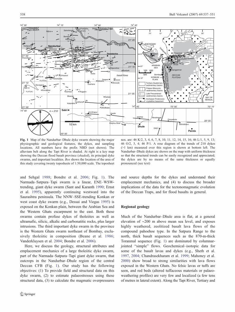
The dykes are all typical dolerites and basalts, quite freshand undeformed, and almost all appear aphyric in handsample, though thin sections show common micropheno-crysts of plagioclase, clinopyroxene or olivine, in agroundmass largely of the same minerals with Fe–Tioxides. No felsic dykes or composite dykes were found.No dykes passing into lava flows were observed, and noshallow-dipping sheets, sills, or plugs were observed either.No dyke tips were seen in vertical or lateral sections. Thedyke ridges often rise sharply over the surrounding basaltlavas, and run for many kilometres (Fig. 2a, b). Almost alldykes are vertical, with a very few that are very steeplydipping (85°, Fig. 2b, c). A few thick dykes (e.g., Fig. 2c)show multiple cooling layers with horizontal columnarjointing, and may be the products of several magma
Bull Volcanol (2007) 69:537–551 539
injections over hundreds or thousands of years as inferredby Gudmundsson (1995a) for Tertiary dykes in Iceland.Many thick dykes show large-scale jointing that divides thedyke rock into roughly cubic blocks, and some other dykesare represented only by bouldery mounds. We did not comeacross any dyke forming low ground relative to the lavas,though one dyke forms a notch at the summit of a butte of
the compound lavas (Fig. 2d). Thus, our methodology oflocating dykes on toposheets followed by field work islikely to have located most dykes.
By no means are all dykes shown in Fig. 1 equallyprominent. Dykes at high angles to the general ENE–WSWtrend are often inconspicuous. Some are not even 5 m high,and yet easily identifiable on the toposheets from dotted
Fig. 2 The Nandurbar–Dhuledykes in the field. See Fig. 1 forlocations. (a) Large ridgeformed by dyke NBD1, atPachorabari village, ~5 km W ofNandurbar. Dyke trends N85°, isvertical, 5.4 m wide and54.3 km long. Field party forscale. (b) Dyke NBD25 inroadcut, near Hatti. Dyke strikesN83°, dips 85°, is 15.9 km longand 7 m wide, and shows platyjointing. (c) Dyke NBD9 nearThanepada, viewed along strike(N75°). Dyke dips steeply north(right), is >23 m thick, andshows some ten columnar-joint-ed rows, each ∼2 m wide. (d)Dyke NBD27 (exactly behindthe person) in a conspicuouslava butte near Bhamer, N ofSakri. The dyke trends N85°, isvertical, 5.2 km long and 3.5–4 m wide. (e) Intersecting dykes.Dyke NBD2 (foreground) isvertical, and slightly curved inplan but with an overall N75°trend. It is almost totally soil-covered and therefore of un-known width. Photo at ChikaniDagadi village, 1 km S ofPhulsare. In the distance (west-wards), the dyke meets thelarger N85°-trending dykeNBD1, but cross-cutting rela-tionships are ambiguous. (f) E–W-trending dyke NBD41 inroadcut S of Saitale, with twovery clear margins (exactly be-hind students). Dyke is 23.3 kmlong and 7 m wide. (g) DykeNBD40 NE of Shevade. Dyketrends E–W, is vertical, 5 kmlong, 13 m wide, well-jointedand bouldery, with very clearcontact with compound flow ofbasalt (lower ground). (h) The79-km-long Sakri–Dhule–Paroladyke forming a spine on a hillof compound flows, nearIchchhapur
540 Bull Volcanol (2007) 69:537–551

contours. For example, a thin, >5-km-long dyke strikingN10°W meets an ∼E–W dyke just south of Kalmadi village(northeast of Nandurbar, Fig. 1). The N10°W dyke is sosubdued, however (relief ∼1–2 m) and so completelyweathered and soil-covered that we were unable todetermine which of the two intrudes the other. Similar isthe situation with dykes NBD2 and NBD1 south ofPhulsare, west of Nandurbar (Fig. 1, 2e). The contacts ofthe dykes with the country rock (where the dykes usuallydisplay finer grain size and small-scale blocky jointing) aresometimes very clearcut (Fig. 2f, g), making widthmeasurement easy, but often one or both margins of thedyke are not visible because of weathering and soil cover.
The longest, 79-km-long, dyke (Fig. 2h) runs roughly E–W from near Sakri, through just north of Dhule, to Parola(SDPD in Fig. 1). It is only 7 to 6.5 m wide throughout itslength. The thickest dykes (two) in the area are 62 m wide.Two long (54.3 and 35.8 km) dykes just south of Nandurbarshow considerable thickness variation along strike; one ofthem also has a gentle but distinct curvature. The depth of thepresent-day exposure level beneath the initial top of the lavapile is not known, but from comparisons to the thicker basaltsections in the province, we estimate it to be ∼1–1.5 km.
Structural attributes of the dykes
Dyke trends and palaeostresses
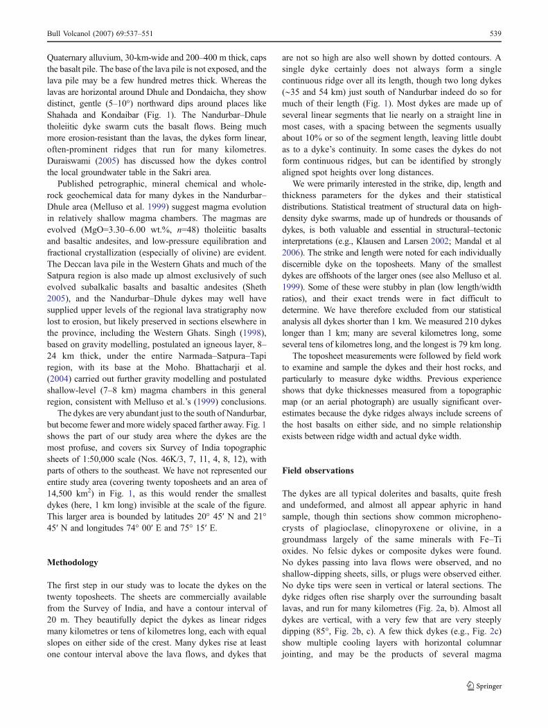
Most dykes strike roughly ENE–WSW or E–W. No faultsor pre-existing fractures, along which dykes might havebeen emplaced, were noticed. Fig. 1 contains a rosediagram of the 210 dyke trends showing their strongpreferred orientation. Fig. 3a shows the strike frequencyhistogram for the dykes, with a normal (Gaussian)distribution, and the mean strike is N88°. Undeformeddykes are very useful palaeostress indicators, because mostdykes propagate as magma-driven extension fractures(mode I cracks) akin to hydraulic fractures that formperpendicular to the minimum principal compressive stress(e.g., Pollard 1987; Valko and Economides 1995; Ida 1999;Ernst et al. 2001; Gudmundsson and Marinoni 2002). Themaximum (σ1) and intermediate (σ2) principal compressivestress directions lie normal to one another within the planeof the dyke, whereas the minimum principal compressivestress (σ3) is perpendicular to the plane of the dyke. Ourdata suggest that the regional minimum principal compres-sive stress (i.e., maximum tensile stress, σ3) was aligned∼N–S during dyke swarm emplacement. σ3 was alsohorizontal, as the perfectly vertical (and rarely, very steep-dipping) dykes require. The spread in dyke strike mayreflect fluctuations in the direction of σ3 about a time-
averaged mean direction. Gudmundsson (1995b) has madeessentially similar observations in northern Iceland.
The few dykes at high angles to the general trend (Fig. 1)are similar to those often observed in regions of crustalextension and rifting, such as Iceland, and must indicate atemporary rotation of the three mutually perpendicular stressdirections (Gudmundsson 1990, 1995a,b). Many E–W-trending dykes may, for example, be emplaced under asituation involving a N–S-oriented σ3 direction and E–W-oriented σ1, but the pressurization associated with theemplacement of these dykes may temporarily increase thecompressive stress in the crust enough to make the σ1direction N–S and the σ3 direction E–W. New dykesemplaced under these conditions acquire a N–S preferredorientation. With continued crustal extension and rifting, andcompressive stresses generated by the N–S oriented dykes,the temporary stress field can rotate to the original with a N–S σ3. New dykes emplaced in it would again acquire E–Wpreferred orientations. Thus, large numbers of parallel dykesthat largely define the average direction of the swarmindicate the time-averaged, regional σ3, whereas dykes thatare at high angles to the general swarm trend indicatetemporary (and sometimes spatially localized) rotation of thestress field (Babiker and Gudmundsson 2004).
Dyke lengths
The dykes show a great range in exposed length, from <1 kmto 79 km. No dyke terminated laterally in such a way that wecould be sure it did not continue further, so all measuredlengths are minimum values. The swarm contains many dykestens of kilometres long, and such dykes are also known fromother areas in the province, such as central Saurashtra wherethe Sardhar dyke southeast of Rajkot (Fig. 1) runs for 55 km(Auden 1949). The 79-km-long dyke that runs from nearSakri through Dhule to Parola is probably the longestdocumented dyke in the province. It does not form acontinuous ridge along this entire length, but consists ofmany segments. Keshav et al. (1998) mapped this dykebetween Dhule and Parola and noted strike-perpendicularseparations of several hundred metres between adjacentsegments, much larger than the dyke thickness of ∼7 m.They found no obvious connections (such as thin igneousveins) between consecutive segments, though such may existat depth. Segmentation is an inherent and universal feature ofdykes, owing to common lateral variations in crustal stressesthat affect magmatic overpressures (dyke driving pressures),and discontinuities and layering in rocks (e.g., Delaney andPollard 1981; Baer and Beyth 1990; Gudmundsson 1990,1995a, 2002, 2003, 2005, 2006).
Length distributions of many dyke swarms show apower law relationship (e.g., Gudmundsson, 1995a,b; Megeand Korme 2004). Figure 3b shows the length size
Bull Volcanol (2007) 69:537–551 541

distribution of the Nandurbar–Dhule dykes, which is alsodescribed by a power law with a negative exponent. Themean length (5.4 km) differs from the mode (2 km).Because outliers affect the mean, the median (3.3 km) is arepresentative average length for these dykes. A plot ofdyke strike vs. length (Fig. 3c) shows that it is mostly theE–W-trending dykes that are >30 km long. The dispersionfrom the mean trend is much greater for the smaller dykesthan for the larger dykes (Fig. 3d), and the larger dykes thusbetter represent the direction of the time-averaged σ3.
Dyke thicknesses
The thicknesses of twenty-seven dykes could be measured attheir sampling sites with a tape (Fig. 2f), without anyambiguity. For the others, no margin or only one marginwas distinct owing to weathering and soil cover. Themeasured thicknesses range from 3 to 62 m with a mean of17 m and median of 10 m. Dyke swarms typically displaythickness size distributions that are power law (e.g.,Gudmundsson 1995a,b; Babiker and Gudmundsson 2004)
or log-normal (e.g., Walker et al. 1995). The thickness sizedistribution for the Nandurbar–Dhule dykes is neither(Fig. 4a). We are not sure if this is an artifact of havingfew thickness measurements. Figure 4b shows that it is againthe E–W-trending dykes that reach considerable thicknesses.
The two long dykes south of Nandurbar (Fig. 1) showconsiderable thickness variation along strike. One of these(54.3 km long) is 5.4 m thick where sample NBD1 wastaken, but 24 m thick some 23 km to the east (sampleNBD1B). The other dyke is ≥10 m thick where sampleNBD3 was taken (only one visible margin), but 42 m thick10 km to the east (sample NBD3B) (Table 1).
Aspect ratios
The aspect ratios (length/thickness) of the twenty-seven dykesare given in Table 1. Typically, longer dykes in regional dykeswarms are also thicker, as they are in the Tertiary dykeswarms in Iceland (Gudmundsson 1983, 1984). However,thickness and length show absolutely no correlation for theNandurbar–Dhule dykes (Fig. 4c). The 79-km-long Sakri–
20 40 60 800 100 120 140 1600
10
30
50
70
90
Nu
mb
er o
f d
ykes
Strike (deg)
(a)
Nu
mb
er o
f d
ykes
Length (km)20 400 10 30 50 60 70 80
10
20
30
40
50
60
70
0
(b)
0 20 40 60 8010 30 50 700
20
40
60
80
100
120
140
160
180
Str
ike
(deg
)
Length (km)
(c)
20 40 60 8030 50 70
20
40
60
80
100
0
-20
-40
-60
-80
-100
(d)
Length (km)D
isp
ersi
on
(de
g)
y = 83.14x -1.2986
R 2 = 0.848
mean strike (N88o)
Fig. 3 (a) Histogram showing the distribution of 210 dyke trendsmeasured. (b) Plot of the 210 dykes showing a typical power lawdistribution (of the general form y=axk). The exponent k is negative(−1.2986) and a, the constant of proportionality, is 83.14. Correlationcoefficient R2=0.848. (c) The variation in length as a function of dyketrend indicating that mostly the E–W-trending dykes achieve lengths
>30 km. (d) Dispersion from mean trend as a function of length.Vertical lines connect the maximum and minimum dispersion (blackcircles) observed for a particular length, and thus define the range ofdispersion observed in all dykes of a given length. Single black circlesindicate only one dyke of that particular length
542 Bull Volcanol (2007) 69:537–551
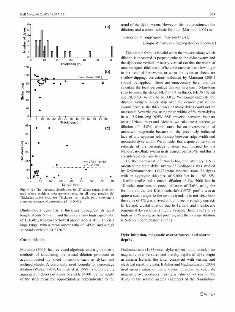
Dhule–Parola dyke has a thickness throughout its greatlength of only 6.5–7 m, and therefore a very high aspect ratioof 11,630:1, whereas the lowest aspect ratio is 70:1. This is alarge range, with a mean aspect ratio of 1493:1 and a highstandard deviation of 2326.7.
Crustal dilation
Marinoni (2001) has reviewed algebraic and trigonometricmethods of calculating the crustal dilation produced oraccommodated by sheet intrusions such as dykes andinclined sheets. A commonly used formula for percentagedilation (Walker 1959; Gautneb et al. 1989) is to divide theaggregate thickness of dykes or sheets (×100) by the lengthof the strip measured approximately perpendicular to the
trend of the dyke swarm. However, this underestimates thedilation, and a more realistic formula (Marinoni 2001) is:
% dilation = aggregate dyke thicknessð Þ=length of traverse�aggregate dyke thicknessð Þ
This simple formula is valid when the traverse along whichdilation is measured is perpendicular to the dyke swarm andthe dykes are vertical or nearly vertical (so that the width ofoutcrop equals thickness). Where the traverse is at a low angleto the trend of the swarm, or when the dykes or sheets areshallow-dipping, corrections indicated by Marinoni (2001)should be applied. These are unnecessary here, and wecalculate the local percentage dilation in a small 5-km-longstrip between the dykes NBD1 (5.4 m thick), NBD8 (62 m)and NBD3B (42 m), to be 3.8%. We cannot calculate thedilation along a longer strip over the densest part of theswarm because the thicknesses of many dykes could not bemeasured. Nevertheless, using ridge widths of fourteen dykesin a 12.5-km-long NNW–SSE traverse between Vadbara(east of Nandurbar) and Aichala, we calculate a percentagedilation of 15.8%, which must be an overestimate ofunknown magnitude because of the previously indicatedlack of any apparent relationship between ridge width andmeasured dyke width. We consider that a quite conservativeestimate of the percentage dilation accomodated by theNandurbar–Dhule swarm in its densest part is 5%, and this isconsiderable (but see below).
To the northwest of Nandurbar, the strongly ENE-oriented tholeiitic dyke swarm of Dediapada was studiedby Krishnamacharlu (1972) who reported some 71 dykeswith an aggregate thickness of 5,000 feet in a ∼NE–SW,18-mile profile and a crustal dilation of 4%. 5000 feet in18 miles translates to crustal dilation of 5.6%, using theformula above, and Krishmacharlu’s (1972) profile was atquite a small angle to the swarm trend. It is not clear howthe value of 4% was arrived at, but it seems roughly correct.In Iceland, crustal dilation due to Tertiary and Pleistoceneregional dyke swarms is highly variable, from 1–2% to ashigh as 28% along partial profiles, and the average dilationis 5–6% (Gudmundsson 1995b).
Dyke initiation, magmatic overpressures, and sourcedepths
Gudmundsson (1983) used dyke aspect ratios to calculatemagmatic overpressures and thereby depths of dyke originin eastern Iceland, the latter consistent with seismic andelectrical resistivity data. Babiker and Gudmundsson (2004)used aspect ratios of mafic dykes in Sudan to calculatemagmatic overpressures. Taking a value of ∼8 km for thedepth to the source magma chambers of the Nandurbar–
10 20 4030 50 600
1
2
3
4
5
6
0
Thickness (m)
Nu
mb
er o
f d
ykes
10 15 20 2550 30 35 40 45 50 55 60 650
20
40
60
80
100
120
Thickness (m)
Str
ike
(deg
)
15
5
25
35
45
55
65
0 10 20 30 40 50 60 70 80Length (km)
Th
ickn
ess
(m)
y = 2-5x + 16.415R 2 = 0.0003
(a)
(b)
(c)
mean strike (N88o)
Fig. 4 (a) The thickness distribution for 27 dykes (mean thicknessused where multiple measurements exist, in all three panels). (b)Thickness–strike plot. (c) Thickness vs. length plot, showing acomplete absence of correlation (R2=0.0003)
Bull Volcanol (2007) 69:537–551 543
Dhule dykes, based on previous petrological and gravitymodelling, we can calculate the magmatic overpressures inthe same way. We assumed, as did Gudmundsson (1983)and Babiker and Gudmundsson (2004) for dykes in Icelandand Sudan, respectively, that those Nandurbar–Dhule dykesthat have a strike dimension (trace length) shorter than thedip dimension (dyke height above magma chamber, ∼8 km)were emplaced essentially vertically. There is, of course, noa priori reason why these dykes cannot have formed in partby lateral injection, but vertical injection from shallowmagma chambers is a plausible assumption for these selectdykes.
In general, dykes initiate when a magma chamber orreservoir ruptures, and this happens when the followingcondition is met (Gudmundsson 1995a):
PT ¼ σ3 þ To ð1Þ
where PT is the total magmatic pressure in the reservoir, andσ3 and To are the minimum principal stress and the in situtensile strength, respectively, in the roof rocks of the sourcereservoir.
If PL is the lithostatic stress, then the magmatic excesspressure
pe ¼ PT � PL ð2Þ
Equation (1) can then be rewritten as
PL þ pe ¼ σ3 þ To� � ð3Þ
The magmatic excess pressure pe in the source magmachamber, buoyancy effects, and the state of stress in thehost rock together determine the magmatic overpressure Po
(also called net pressure or driving pressure). Po is thepressure available at any particular point to drive open thewalls of a dyke-fracture. A long-lived magma chamber is in
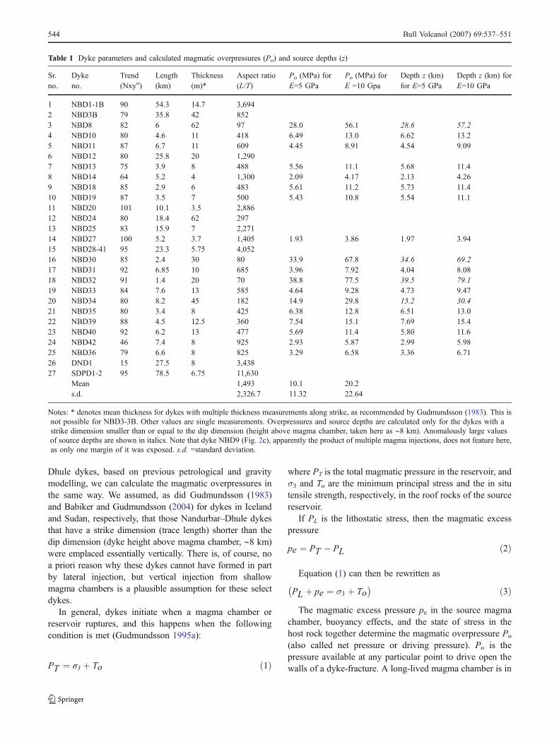
Table 1 Dyke parameters and calculated magmatic overpressures (Po) and source depths (z)
Sr.no.
Dykeno.
Trend Length Thickness Aspect ratio Po (MPa) forE=5 GPa
Po (MPa) forE =10 Gpa
Depth z (km)for E=5 GPa
Depth z (km) forE=10 GPa(Nxyo) (km) (m)* (L/T)
1 NBD1-1B 90 54.3 14.7 3,6942 NBD3B 79 35.8 42 8523 NBD8 82 6 62 97 28.0 56.1 28.6 57.24 NBD10 80 4.6 11 418 6.49 13.0 6.62 13.25 NBD11 87 6.7 11 609 4.45 8.91 4.54 9.096 NBD12 80 25.8 20 1,2907 NBD13 75 3.9 8 488 5.56 11.1 5.68 11.48 NBD14 64 5.2 4 1,300 2.09 4.17 2.13 4.269 NBD18 85 2.9 6 483 5.61 11.2 5.73 11.410 NBD19 87 3.5 7 500 5.43 10.8 5.54 11.111 NBD20 101 10.1 3.5 2,88612 NBD24 80 18.4 62 29713 NBD25 83 15.9 7 2,27114 NBD27 100 5.2 3.7 1,405 1.93 3.86 1.97 3.9415 NBD28-41 95 23.3 5.75 4,05216 NBD30 85 2.4 30 80 33.9 67.8 34.6 69.217 NBD31 92 6.85 10 685 3.96 7.92 4.04 8.0818 NBD32 91 1.4 20 70 38.8 77.5 39.5 79.119 NBD33 84 7.6 13 585 4.64 9.28 4.73 9.4720 NBD34 80 8.2 45 182 14.9 29.8 15.2 30.421 NBD35 80 3.4 8 425 6.38 12.8 6.51 13.022 NBD39 88 4.5 12.5 360 7.54 15.1 7.69 15.423 NBD40 92 6.2 13 477 5.69 11.4 5.80 11.624 NBD42 46 7.4 8 925 2.93 5.87 2.99 5.9825 NBD36 79 6.6 8 825 3.29 6.58 3.36 6.7126 DND1 15 27.5 8 3,43827 SDPD1-2 95 78.5 6.75 11,630
Mean 1,493 10.1 20.2s.d. 2,326.7 11.32 22.64
Notes: * denotes mean thickness for dykes with multiple thickness measurements along strike, as recommended by Gudmundsson (1983). This isnot possible for NBD3-3B. Other values are single measurements. Overpressures and source depths are calculated only for the dykes with astrike dimension smaller than or equal to the dip dimension (height above magma chamber, taken here as ∼8 km). Anomalously large valuesof source depths are shown in italics. Note that dyke NBD9 (Fig. 2c), apparently the product of multiple magma injections, does not feature here,as only one margin of it was exposed. s.d. =standard deviation.
544 Bull Volcanol (2007) 69:537–551

lithostatic equilibrium with the host rocks, and thenPL=σ3(=σ1). New magma entering the chamber, or areduction in σ3 because of extension in the roof, temporar-ily makes pe>To, and a dyke is initiated. Possible stressconcentration effects due to the irregular shape of themagma chamber are included in the local magnitude of σ3(Gudmundsson 2002).
Dykes that never reached the surface can be modelled ascircular interior cracks. Volcanic fissures (feeder dykes),and probable feeder dykes exposed at shallow depths in riftzones (such as here) can be modelled as two-dimensionalthrough-the-thickness cracks between two free surfaces,one the Earth’s surface and the other the surface of themagma chamber (Babiker and Gudmundsson 2004). Thestrike dimension (trace length, L) for such dykes is smallerthan the dip dimension (height above the chamber), whichis treated as being effectively infinite (Gudmundsson 2005).The magmatic overpressure Po can be calculated using theequation (Sneddon and Lowengrub 1969):
Po ¼ bmaxEð Þ�2L 1� v2� � ð4Þ
where bmax is the maximum dyke thickness, and E and v arethe Young’s modulus and Poisson’s ratio respectively, ofthe host rock. bmax is directly proportional to overpressurebut inversely proportional to the Young’s modulus E of thehost rock, a measure of stiffness. Stiffness increases withconfining pressure (depth) but decreases with increasingrock porosity, water content, and temperature, and mostimportantly fractures. Because of fractures and discontinu-ities with different frequencies (Priest 1993), values of E forcommon in situ rocks can be 20–65% of values based onsmall-sample laboratory measurements. Laboratory mea-surements on basalts and gabbros yield stiffnesses as highas 110–130 GPa; volcanic tuffs, on the other hand, havelaboratory values as low as 0.05–0.1 GPa (Afrouz 1992;Bell 2000). Static laboratory stiffnesses vary between0.5 GPa and 8 GPa for most young hyaloclastites inIceland, and between 10 GPa and 35 GPa for near-surfaceHolocene and Pleistocene basaltic lava flows in Iceland(Oddson 1984; Egilsson et al. 1989; Gudmundsson 2006).The stiffnesses of these rocks generally increase with ageand depth of burial. Corresponding contrasts in Poisson’sratio in a multilayered sequence are much more limited.Appropriate values of Poisson’s ratio are 0.25 for graniticcrust, 0.28 for basaltic crust, and 0.30 and higher forultramafic rocks (Babiker and Gudmundsson 2004; Mohanand Ravi Kumar 2004).
Babiker and Gudmundsson (2004) calculated magmaticoverpressures of early Cretaceous and late Proterozoicdykes in Sudan, emplaced in much older (and cooler)granitic basement. They used values of E for the graniticbasement of 10 and 30 GPa, values that are appropriateconsidering the antiquity of the basement relative to the
dykes. In contrast, the Nandurbar–Dhule dykes wereemplaced at shallow levels (presumably 1–1.5 km) in abasaltic lava pile that was itself forming and was thusyoung, warm, and with low stiffness. Almost the whole pileis made up of compound pahoehoe lava flows, and suchflows are composed of hundreds of small (metre-scale)pahoehoe flow units, lobes and toes (Bondre et al. 2004a,b;Sheth 2006), which again means low stiffness.
Considering these factors, in situ E values of 5–10 GPaare most appropriate for the basaltic lava pile (A.Gudmundsson, pers. comm.). Using these values, and acorresponding Poisson’s ratio of 0.28, we calculated themagmatic overpressures of the Nandurbar–Dhule dykes(Table 1). The range of calculated magmatic overpressuresis from 1.93 to 38.8 MPa (for E=5 GPa), and 3.86 to77.5 MPa (for E=10 GPa). Most of the calculated Po valuesseem very reasonable, and are within the range obtained byBabiker and Gudmundsson (2004) for the Sudanese dykes(though the latter were emplaced in granitic rocks).
We used the overpressures to calculate the depths tosource magma chambers as done by Gudmundsson (1983)for some regional Icelandic dykes, using the equation:
z ¼ Po= ρr � ρmð Þg ð5Þwhere ρr is the average crustal density (assumed to be2,800 kg/m3), ρm is magma density (2,700 kg/m3, Pinel andJaupart 2004), and g the acceleration due to gravity. Thecalculated depths to magma chambers (Table 1) are low(a few kilometres) for fourteen of the dykes, consistent withthe petrological and gravity modelling. For these dykes,therefore, the assumption of vertical injection from shallowmagma chambers and the use of Eq. (4) are valid. Fourdykes, however, have anomalously large values of sourcedepths, and these are notably the stubbier dykes with lowaspect ratios: NBD34 (182:1), NBD8 (97:1), NBD30(80:1), and NBD32 (70:1). The latter three dykes areparticularly short for their width. In comparison, theSudanese dykes have aspect ratios between 243:1 and2330:1. As noted, all length estimates here are lowerbounds, and so all overpressure values are upper bounds, asthey are in the study of Babiker and Gudmundsson (2004).A distinct possibility exists that these stubbier dykes areactually longer but not exposed throughout their length atthe present level of exposure, and their aspect ratios havetherefore been underestimated — perhaps significantly.Notably, the dykes NBD30 (2.4 km long, 30 m wide) andNBD32 (1.40 km long, 20 m wide) are exposed in thealluvium of the Tapi River, and probably do run forconsiderable distances under the alluvium. However,whereas incomplete along-strike exposure can be invokedto explain the low aspect ratios and therefore the relativelyhigh calculated magmatic overpressures and source depthsthese few Nandurbar–Dhule dykes, thermal erosion (Fialko
Bull Volcanol (2007) 69:537–551 545
and Rubin 1999) must also be considered as a mechanismthat can create the same effect.
Discussion
Thermal erosion
Thermal erosion of wall rocks by magma flowing in a dykeis a non-dilational mechanism of dyke widening, i.e., ifthermal erosion occurred, the measured dyke thicknesswould not represent the crustal dilation associated withfracture opening and dyke emplacement (Fialko and Rubin1999). Fialko and Rubin (1999) found that thermal erosionis most significant in wide dykes (∼7 m and upwards) withturbulent magma flow and wall rocks of granitic composi-tion. Some of the Nandurbar–Dhule dykes (Fig. 1) are tensof metres thick, and the median thickness is 10 m. We didnot observe any obvious evidence of thermal erosion (suchas xenoliths) in any of the dykes, including the thickerones. A few of these apparently formed by repeated magmainjections in the same fracture, as shown by many columnarcooling layers (Fig. 2c). Gudmundsson and Marinoni(2002) and Babiker and Gudmundsson (2004) describedsuch dykes from Iceland and Sudan respectively, andargued that their multiple nature suggested insignificantthermal erosion. Kristjansson (1985) found from magneticstudies that a typical 4-m-thick Tertiary dyke in Iceland wasable to reset the remanence in the adjacent lava flows(at ∼500°C) out to a distance only about 10% of the dykewidth. However, our dykes are much thicker than this, andturbulent flow as opposed to laminar flow is animportant factor (Huppert and Sparks 1985; Fialko andRubin 1999). A dolerite dyke described from this region byChandrasekharam et al. (1999) has chemical and isotopiccharacteristics reflecting significant bulk assimilation ofgranitic crust, which the authors postulated occurred duringturbulent flow during ascent through the crust (cf. Huppertand Sparks 1985). The dyke, 15 m thick at the level ofexposure, notably has the highest initial 87Sr/86Sr ratio(0.72315) of any Deccan rock analyzed to date, and thelowest initial ɛNd value (−20.2) as well.
Fialko and Rubin (1999) showed that thermal erosion ofbasaltic wall rocks (fusion temperature 1,150°C, Bruce andHuppert 1990) by mafic dyke magma (say, at 1,250°C) maybe as low as a few percent, though dyke width andturbulent flow are important, and mechanical erosion ofwall rocks can also occur. In any case, the chilled dykemargins with fine jointing that we have seen are notevidence against thermal erosion. Though chilled marginshave been thought to indicate that the wall rocks wereeffectively sealed off from the flowing magma, Fialko andRubin (1999) present a scenario of repeated chipping-off of
chilled margins due to magma turbulence, so that thechilled margins seen today are only the final survivingones. Overall, for the few dykes in our study which areabnormally thick for their length, we consider thermalerosion as likely an explanation as incomplete along-strikeexposure. This is, of course, not to say that thermal erosionhas not occurred in the other dykes, because if these dykesfed substantial lava flows at higher levels (which weconsider probable), then hot, mafic magma flowed forseveral years past any single point within the dyke fractureand may have caused some thermal erosion. Thermalerosion can explain not only the anomalously low aspectratios of these few dykes, but also the unusual thicknessdistribution for the dykes and the absolute lack ofcorrelation between dyke length and width.
If thermal erosion did occur on a large scale in a largenumber of Nandurbar–Dhule dykes, our estimate of theaverage crustal dilation would clearly be an overestimate,though it would be difficult to assess its magnitude.Thermal erosion is not a required mechanism for most ofthe Nandurbar–Dhule dykes, but it cannot be ruled out as apossible cause of the very low aspect ratios of some of thedykes.
Lateral dyke propagation and magma flow
As seen, vertical injection from a magma chamber is areasonable assumption for dykes with a strike dimensionsmaller than the dip dimension (where the latter isindependently known) (Table 1). Lateral injection must beconsidered for the rest. Several workers have studied thedynamics of lateral magma transport in dykes (e.g., Listerand Kerr 1991; Rubin 1995; Ernst et al. 1995; Fialko andRubin 1999). In continental giant dyke swarms, such as the2,000-km-long Mackenzie dyke swarm in Canada, magmaflow was predominantly vertical in the central area of thetopographic uplift and changed to horizontal farther away,as inferred from measurements of anisotropy of magneticsusceptibility (AMS), dyke fabrics, and dyke wall structures(Greenough and Hodych 1990; Ernst and Baragar 1992).Doubts have been raised recently on the usefulness of AMSand magnetic fabrics to infer magma flow directions,because in several cases these characteristics appear tohave been affected or even decided by late-stage crystalsettling of magnetite grains around plagioclase laths, andsimilar mechanisms unrelated to magma flow itself(McHone et al. 2005).
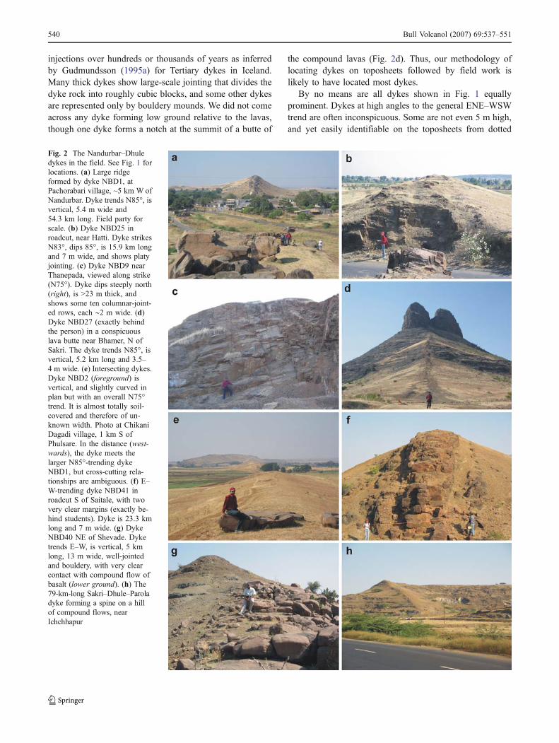
Gudmundsson (1990, 1995a,b) argued that linear, re-gional dyke swarms in Iceland form by essentially verticalinjection from regional magma reservoirs located below thecrust (Fig. 5), because crustal magma chambers that candrive lateral dykes are absent in many areas. In theNarmada–Satpura–Tapi region, magma chambers at shal-
546 Bull Volcanol (2007) 69:537–551
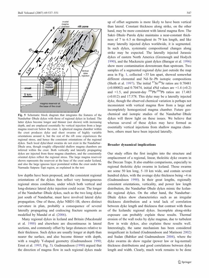
low depths have been proposed, and the consistent regionalorientations of the dykes then reflect very homogeneousregional stress conditions, under which both vertical andlong-distance lateral dyke injection could occur. The longerof the Nandurbar–Dhule dykes, such as the two long dykesjust south of Nandurbar, must have involved lateral dykepropagation. One of these, dyke NBD1-1B, shows distinctcurvature in plan, probably a consequence of severallaterally propagating and coalescing fracture segments asmodelled by Mandal et al. (2006).
Many regional dykes in Iceland and Britain (Macdonaldet al. 1988) and elsewhere are discontinuous in lateralsections, and commonly offset by large distances relative totheir thickness. Such dykes are usually longer at depth thannearer the surface, and also become thinner with depth,with a roughly Y-shaped geometry (Gudmundsson 1990;Ernst et al. 1995; Fig. 5). Gudmundsson (1990) argued thatthe direction of magma flow in such regional dykes made
up of offset segments is more likely to have been verticalthan lateral. Constant thickness along strike, on the otherhand, may be more consistent with lateral magma flow. TheSakri–Dhule–Parola dyke maintains a near-constant thick-ness of 7 to 6.5 m throughout its 79 km length, and likemany laterally injected dykes worldwide, it is segmented.In such dykes, systematic compositional changes alongstrike may be expected. The laterally injected Jurassicdykes of eastern North America (Greenough and Hodych1990), and the Mackenzie giant dykes (Baragar et al. 1996)show more contamination downstream than upstream. Twosamples of a segmented regional dyke just outside the maparea in Fig. 1, collected ∼35 km apart, showed somewhatdifferent elemental and Nd–Sr–Pb isotopic compositions(Sheth et al. 1997). The initial 87Sr/86Sr ratios are 0.70481(±0.00002) and 0.70474, initial ɛNd values are +1.4 (±0.2)and +1.5, and present-day 206Pb/204Pb ratios are 17.483(±0.012) and 17.578. This dyke may be a laterally injecteddyke, though the observed chemical variation is perhaps notinconsistent with vertical magma flow from a large andincompletely homogenized magma chamber. Future geo-chemical and isotopic studies of the Nandurbar–Dhuledykes will throw light on these issues. We believe thatwhereas several of these dykes may have formed asessentially vertical injections from shallow magma cham-bers, others must have been injected laterally.
Broader dynamical implications
Our study offers the first insights into the structure andemplacement of a regional, linear, tholeiitic dyke swarm inthe Deccan Traps. It also enables comparisons, especially toregional tholeiitic dyke swarms in Iceland. Those swarmsare some 50 km long, 5–10 km wide, and contain severalhundred dykes, with the average dyke thickness being ∼4 m(Gudmundsson 1990). In their great lengths, regionallyconsistent orientations, verticality, and power law lengthdistribution, the Nandurbar–Dhule dykes mimic the Icelan-dic regional dykes. On the other hand, the Nandurbar–Dhule dykes show characteristics such as an irregularthickness distribution and a total lack of correlationbetween dyke length and thickness that contrast with thoseof the Icelandic regional dykes. Incomplete along-strikeexposure can probably explain these results. Thermalerosion of the wall rocks by dyke magmas, due to turbulentflow in wide dykes, also explains these results well.Interestingly, the same mechanism has been consideredinsignificant in Iceland (Gudmundsson and Marinoni 2002)and Sudan (Babiker and Gudmundsson 2004), where thedyke swarms do show regular (power law or log-normal)thickness distributions and good correlations between dykelength and width. Clearly, much work remains to be done
magma reservoir at the base of the crust
crustalmagma chamber
5 km
σ3
rift zoneE5
km
crust
Late
ral d
yke
inje
ctio
n
Vertical dyke
injection
crustal magma chamber
σ3
W
Fig. 5 Schematic block diagram that integrates the features of theNandurbar–Dhule dykes with those of regional dykes in Iceland. Thelatter dykes become longer and thinner (not shown) with increasingdepth, and are emplaced essentially by vertical injection from a largemagma reservoir below the crust. A spherical magma chamber withinthe crust produces dyke and sheet swarms of highly variableorientations around it, but the rest of the rift zone experiences theregional stress, and hence the consistent orientations of the regionaldykes. Such local dyke/sheet swarms do not exist in the Nandurbar–Dhule area, though roughly ellipsoidal shallow magma chambers areinferred within the crust. Both vertically and laterally propagatingdykes are injected from these magma chambers, and the consistentlyoriented dykes reflect the regional stress. The large magma reservoirshown represents the reservoir at the base of the crust under Iceland,and also the large igneous layer postulated within the crust under theNarmada–Satpura–Tapi region, as explained in the text
Bull Volcanol (2007) 69:537–551 547
on the Nandurbar–Dhule and other dyke swarms in theDeccan province, but the following broader dynamicalinterpretations can be considered reasonably robust.
Magma reservoirs and magma chambers
Gudmundsson’s (1990, 1995a,b) thesis that the regionaldykes in Iceland are emplaced directly from large, sub-crustal magma reservoirs (Fig. 5) was essentially based onthe absence of crustal magma chambers in many parts of therift zones, and also supported by the primitive (MgO-rich) compositions of many lavas and regional dykes. Theroughly spherical magma chambers that do develop undercentral volcanoes in Icelandic rift zones produce their ownstress patterns and dyke-sheet swarm configurations thatoverprint the regional rift- and plate-scale ones (Fig. 5).Dykes and sheets in such central volcanic swarms havehighly variable strike, and average dips of (45–60°), usuallytowards the centre of the associated central volcano. Theyare also much thinner (1 m thick on the average) than theregional dykes (Gudmundsson 1990). It is of interest thatthe Saurashtra–Kachchh region, northwestern Deccan prov-ince, abounds in plugs and plutons with radial and arcuatedykes (e.g., Auden 1949). The shallowly emplaced dykes inour study area have a clear and strong E–W-preferredorientation, suggesting that shallow magma chambers wereunable to overprint the regional stress during dykeemplacement, probably due to significant crustal extension.Based on gravity modelling, Bhattacharji et al. (2004)postulate up to eight of these shallow, disconnected fossilmagma chambers (with the average density of 2.96 g/cm3),which were apparently sourced from a larger, deeperreservoir represented by a dense body at ∼25 km depth.The fossil magma chambers are 23.8±2.4 km in length,15.9±1.5 km wide and 12.4±1.2 km thick on average, andthus roughly prolate ellipsoids in shape. Their roofs are atan average depth of 6.5±0.6 km below the Earth’s surface(Fig. 5).
Previously, Singh (1998) postulated, based on gravitymodelling, a large, thick mafic igneous layer (of density3.02 g/cm3) under much of the extent of the Narmada–Satpura–Tapi zone. This igneous layer has been intrudedinto the crust, which he determined to be of normal crustalthickness (38 km), with the base of the layer at the Moho.The layer is as much as 24 km thick under the west coast,west of our study area, and ∼16 km thick under Nandurbar–Dhule, thinning to 8 km towards the east. This means thatthe top of the igneous layer under the Nandurbar–Dhuleregion is at a depth of ∼22 km. This layer is in many wayssimilar to the regional magma reservoir that exists under theIcelandic crust, and some of our dykes may have beenderived directly from it. We look forward to acquiring andmodelling geochemical and isotopic data on these dykes.
Ponding, crustal extension, and magma drainage
A provocative idea proposed recently (McHone et al. 2005,Silver et al. 2006) is that the stupendous flood basalt eventsare not the result of catastrophic melting events in mantleplumes, but catastrophic drainage events. These authorspostulate that CFB melts form and accumulate to form vastponds or reservoirs beneath the lithosphere, over long timeperiods (several million years). When lithospheric exten-sion allows magma ascent, a huge number of lithosphericdykes form that drain the melt rapidly from the magmareservoirs to the surface, with or without crustal magmachambers.
The Nandurbar–Dhule dyke swarm was evidently asso-ciated with significant crustal extension. A role for pre-volcanic or syn-volcanic crustal extension in flood basaltshas not been acknowledged by all workers however. Forexample, Hooper (1990) stated that crustal extensionsucceeded the Deccan eruptions and did not precede it. Heargued that the feeder dykes of the Western Ghats lava pilewere a group of somewhat randomly oriented tholeiiticdykes in the same region (Beane et al. 1986), and that thealkalic compositions of many dykes in the Narmada–Satpura–Tapi region meant that they could not have fedthe uniformly tholeiitic Western Ghats sequence. Hisargument essentially was that the Narmada–Satpura–Tapidykes (including the huge tholeiitic ones) did show strongpreferred orientations, were intrusive into the lava pile, andtherefore indicated extension to have succeeded volcanism,whereas in the Western Ghats, the randomly oriented feederdykes indicated the lack of pre-volcanic extension.
Sheth (2000) analyzed Hooper’s (1990) thesis and pointedout that the fact that many dykes in the Narmada–Satpura–Tapi and west coast regions were intrusive into the lava pile(e.g., Auden 1949) did not preclude the possibility that thesedykes produced lava flows at higher levels, now lost toerosion but likely preserved in sections elsewhere. Sheth(2000) pointed out that most of these dykes were truncated atthe present ground level. The Nandurbar–Dhule dykes areexactly so (Fig. 2). It is important that not a single case of adyke tip ending vertically in the lava pile has been reported.As regards the alkalic dykes, we do agree with Hooper(1990) that they could not have supplied the tholeiitic lavapile-but the large tholeiitic dykes did, in all probability.
Interestingly, the new data of Vanderkluysen et al.(2004) and Bondre et al. (2006) on dykes from Sangamner(Fig. 1) and other areas of the Western Ghats show that theorientations of the potential feeder dykes are not as randomas they have been thought to be previously (Beane et al.1986; Hooper 1990), and whereas several of these dykesmay well have fed substantial lava flows that make up thelocal stratigraphy, some other dykes that show closechemical similarities to the lava flows show significant
548 Bull Volcanol (2007) 69:537–551
differences in their isotopic compositions. Several lavaflows in the Western Ghats may have been locally erupted,whereas others probably extended to long distances of up toseveral hundred kilometres from massive tholeiitic feederdykes located in the Narmada–Satpura–Tapi and west coastregions. Thick lava sections (>1 km) in the Satpuramountain range were arguably formed similarly, with somelavas being locally derived and others covering longdistances (Mahoney et al. 2000). If flood lavas could coverdistances of 500 km or more after eruption in the ColumbiaRiver basalt province (Hooper 1997), they could have doneso in the Deccan.
Eruption rates and time scales
For the huge Roza Member of the Columbia River CFB ofnorthwestern U.S.A., Thordarson and Self (1998) calculatedan eruption rate of 4,000 m3/s, using a total emplacementtime of 10 years, and an exposed linear eruptive vent–fissure system 150 km long. This rate is the same as thepeak eruption rate of the 1783–84 Laki eruption in Iceland,the world’s largest historic eruption (Thordarson et al.1996). Individual segments in the 27-km-long Laki fissureremained active one after another over several months.Several large compound pahoehoe flows in the Deccanhave volumes of 1,000 km3 and larger, though how muchlarger cannot be answered because individual flow fieldshave not been systematically mapped. Even if the eruptionrates for the lava flows were only of the order of 1 m3/s permetre of feeder dyke length (the average for Kilauea, Selfet al. 1997), then a 5-km-long segment of a 50-km-longfeeder dyke, active at any one time, would produce5,000 m3/s of lava, or ∼105 km3 over eight months. Theneruptive activity could shift to another 5-km-long segmentby lateral magma migration, and thus the 50-km-longfissure would produce 1,050 km3 of lava over 80 months,or ∼6.66 years. This is directly comparable to the figuresfor the Columbia River basalts obtained by Self et al.(1997) and Petcovic and Dufek (2005), and, the eruptionrate per metre length of fissure (1 m3/s) is no greater thanthat for modern Kilauea eruptions. If larger dyke segmentsor entire dykes were active throughout their length,however, a large, 1,000 km3 lava flow may well have beenemplaced in a couple of years — or much less.
Conclusions
The large tholeiitic dyke swarm around Nandurbar andDhule in the central Deccan flood basalt province, mappedover an area of 14,500 km2, exposes 210 dykes >1 km inlength. The dykes intrude highly weathered basalt flows,mostly compound pahoehoe. The longest dyke is 79 km
and several are tens of kilometres long. All are vertical oralmost so, and from 3 to 62 m thick. The dykes show strongpreferred orientations, with an average trend of N88°.Because the dykes are not emplaced along faults or pre-existing fractures, the data indicate that the regionalminimum horizontal compressive stress (σ3) was alignedapproximately N–S during the emplacement of the swarm.The length distribution of the dykes is described by a powerlaw with a negative exponent, as are dyke lengths withinmany swarms worldwide, but the thickness distribution isirregular. Dyke length and width show no correlation.Using the aspect ratios (length/thickness) of the dykes, wecalculate very reasonable values of magmatic overpressuresand shallow depths (a few kilometres) to source magmachambers, consistent with previous petrological and gravitymodelling studies. Relatively high overpressures and sourcedepths calculated for a few dykes, on the other hand, maybe an artifact of systematically underestimated aspect ratiosdue to insufficient along-strike exposure of the dykes.However, thermal erosion can also explain the anomalousresults. Whereas many of the dykes may be verticalinjections from shallow magma chambers, others, especial-ly the long ones, must have been formed by lateral injectionfrom such chambers. The larger of the Nandurbar–Dhuledykes could have produced substantial volumes of Deccanlavas; at low, Kilauea-like eruption rates of 1 m3 per metrelength of fissure, a 50-km-long dyke in the region withconsecutively active 5-km-long segments could produce alava flow >1,000 km3 in volume, in <7 years. Given long-enough feeder dykes, huge Deccan lava flows could eruptand extend to considerable distances within years. Futuresystematic mapping and geochemical characterization ofindividual large Deccan lava flows and flow fields, as wellas of regional dykes, should provide fundamental insightsinto the volcanological, stratigraphic, and tectonic evolutionof flood basalt provinces.
Acknowledgements Field work was supported by the IndustrialResearch and Consultancy Centre (IRCC) of IIT Bombay (grant03IR014 to Sheth). Raymond Duraiswami provided helpful field tipsand reference material, and Loyc Vanderkluysen, Avanti Shirke, andDeepak Gosain provided valuable field assistance. We highlyappreciate valuable, very constructive journal reviews by RichardErnst and an anonymous reviewer, many thought-provoking editorialcomments from James White, and unofficial comments and ever-available help from Agust Gudmundsson.
References
Afrouz AA (1992) Practical handbook of rock mass classificationsystems and modes of ground failure. CRC, Boston
Auden JB (1949) Dykes in western India — a discussion of theirrelationships with the Deccan Traps. Trans Nat Inst Sci Ind3:123–157
Bull Volcanol (2007) 69:537–551 549

Babiker M, Gudmundsson A (2004) Geometry, structure andemplacement of mafic dykes in the Red Sea Hills, Sudan. J AfrEarth Sci 38:279–292
Baer G, Beyth M (1990) A mechanism of dyke segmentation infractured host rock. In: Parker AJ, Rickwood PC, Tucker DH(eds) Mafic dykes and emplacement mechanisms. Balkema,Rotterdam, pp 3–11
Baer G, Heimann A (eds) (1995) Physics and chemistry of dykes.Balkema, Rotterdam, pp. 339
Baragar WRA, Ernst RE, Hulbert L, Peterson T (1996) Longitudinalpetrochemical variations in the Mackenzie dyke swarm, north-western Canadian shield. J Petrol 37:317–359
Beane JE, Turner CA, Hooper PR, Subbarao KV, Walsh JN (1986)Stratigraphy, composition and form of the Deccan Basalts,Western Ghats, India. Bull Volcanol 48:61–83
Bell FG (2000) Engineering properties of soils and rocks, 4th edn.Blackwell, London
Bhattacharji S, Sharma R, Chatterjee N (2004) Two- and three-dimensional gravity modelling along western continental marginand intraplate Narmada–Tapti rifts: its relevance to Deccan floodbasalt volcanism. In: Sheth HC, Pande K (eds) Magmatism inIndia through time. Proc Ind Acad Sci (Earth Planet Sci)113:771–784
Bondre NR, Duraiswami RA, Dole G (2004a) Morphology andemplacement of flows from the Deccan volcanic province, India.Bull Volcanol 66:29–45
Bondre NR, Duraiswami RA, Dole G (2004b) A brief comparison oflava flows from the Deccan volcanic province and the Columbia–Oregon Plateau flood basalts: Implications for models of floodbasalt emplacement. In: Sheth HC, Pande K (eds) Magmatism inIndia through time. Proc Ind Acad Sci (Earth Planet Sci)113:809–817
Bondre NR, Hart WK, Sheth HC (2006) Geology and geochemistry ofthe Sangamner mafic dyke swarm, western Deccan volcanicprovince, India: implications for regional stratigraphy. J Geol114:155–170
Bruce PM, Huppert HE (1990) Solidification and melting alongdykes by the laminar flow of basaltic magma. In: Ryan MP(ed) Magma transport and storage. John Wiley, New York, pp87–101
Chandrasekharam D, Mahoney JJ, Sheth HC, Duncan RA (1999)Elemental and Nd–Sr–Pb isotope geochemistry of flows anddykes from the Tapi rift, Deccan flood basalt province, India.J Volcanol Geotherm Res 93:111–123
Delaney PT, Pollard DD (1981) Deformation of host rocks and flow ofmagma during growth of minette dykes and breccia-bearingintrusions near Ship Rock, New Mexico. U S Geol Surv Prof Pap1202:1–61
Deshmukh SS, Sehgal MN (1988) Mafic dyke swarms in the Deccanvolcanic province of Madhya Pradesh and Maharashtra. In:Subbarao KV (ed) Deccan flood basalts. Geol Soc Ind Mem10:323–340
Dessai AG, Viegas AAAA (1995) Multi-generation mafic dyke swarmrelated to Deccan magmatism, south of Bombay: implications onthe evolution of the western Indian continental margin. In:Devaraju TC (ed) Dyke swarms of peninsular India. Geol SocInd Mem 33:435–451
Duraiswami RA (2005) Dykes as potential groundwater reservoirs insemi-arid areas of Sakri taluka, Dhule district, Maharashtra.Gond Geol Mag 20:1–9
Egilsson D, Hardarson BA, Jonsson B (1989). Dynamic properties ofrock. Yearbook of the Engg. Assoc. Iceland: 226–233 (inIcelandic)
Elliot DH, Fleming TH (2004) Occurrence and dispersal of magmas inthe Jurassic Ferrar large igneous province, Antarctica. Gond Res7:223–237
Ernst RE, Baragar WRA (1992) Evidence from magnetic fabric for theflow pattern of magma in the Mackenzie giant radiating dykeswarm. Nature 356:511–513
Ernst RE, Head JW, Parfitt E, Grosfils E, Wilson L (1995) Giantradiating dyke swarms on Earth and Venus. Earth-Sci Rev39:1–58
Ernst RE, Grosfils EB, Mege D (2001) Giant dyke swarms on Earth,Venus, and Mars. Ann Rev Earth Planet Sci 29:489–534
Fialko YA, Rubin AM (1999) Thermal and mechanical aspects ofmagma emplacement in giant dyke swarms. J Geophys Res104:23,033–23,049
Gautneb H, Gudmundsson A, Oskarsson N (1989) Structure,petrochemistry and evolution of a sheet swarm in an Icelandiccentral volcano. Geol Mag 126:659–673
Greenough JD, Hodych JP (1990) Evidence for lateral magmainjection in the early Mesozoic dykes of eastern NorthAmerica. In: Parker AJ, Rickwood PC, Tucker DH (eds) Maficdykes and emplacement mechanisms. Balkema, Rotterdam, pp35–46
Gudmundsson A (1983) Form and dimensions of dykes in easternIceland. Tectonophysics 95:295–307
Gudmundsson A (1984) Tectonic aspects of dykes in northwesternIceland. Jökull 34:81–96
Gudmundsson A (1990) Dyke emplacement at divergent plateboundaries. In: Parker AJ, Rickwood PC, Tucker DH (eds) Maficdykes and emplacement mechanisms. Balkema, Rotterdam,pp 47–62
Gudmundsson A (1995a) The geometry and growth of dykes. In: BaerG, Heimann A (eds) Physics and chemistry of dykes. Balkema,Rotterdam, pp 23–34
Gudmundsson A (1995b) Infrastructure and mechanics of volcanicsystems in Iceland. J Volcanol Geotherm Res 64:1–22
Gudmundsson A (2002) Emplacement and arrest of sheets and dykesin central volcanoes. J Volcanol Geotherm Res 116:279–298
Gudmundsson A (2003) Surface stresses associated with arresteddykes in rift zones. Bull Volcanol 65:606–619
Gudmundsson A (2005) Effects of mechanical layering on thedevelopment of normal faults and dykes in Iceland. Geodin Acta18:11–30
Gudmundsson A (2006) How local stresses control magma chamberruptures, dyke injections, and eruptions in composite volcanoes.Earth Sci Rev: in press
Gudmundsson A, Marinoni LB (2002) Geometry, emplacement andarrest of dykes. Annal Tecto 13:71-92
Halls HC, Fahrig WF (eds) (1987) Mafic dyke swarms. GeologicalAssociation of Canada Paper 34: pp 503
Hooper PR (1990) The timing of crustal extension and the eruption ofcontinental flood basalts. Nature 345:246–249
Hooper PR (1997) The Columbia River flood basalt province: currentstatus. In: Mahoney JJ, Coffin MF (eds) Large igneousprovinces: continental, oceanic, and planetary flood volcanism.Am Geophs Union Geophys Monogr 100:1–27
Huppert HE, Sparks RSJ (1985) Cooling and contamination of maficand ultramafic magmas during ascent through continental crust.Earth Planet Sci Lett 74:371–386
Ida Y (1999) Effects of the crustal stress on the growth of dykes:conditions of intrusion and extrusion of magma. J Geophys Res104:17897–17909
Keshav S, Sheth HC, Chandrasekharam D (1998) Field geology,petrography, and orthopyroxene clusters of the Dhule–Paroladyke, Tapi valley, central Deccan basalt province. Curr Sci74:252–254
Klausen MB, Larsen HC (2002) East Greenland coast-parallel dykeswarm and its role in continental breakup. In: Menzies MA,Klemperer SL, Ebinger CJ, Baker J (eds) Volcanic rifted margins.Geol Soc Am Spec Pap 362:137–162
550 Bull Volcanol (2007) 69:537–551
Krishnamacharlu T (1972) Dykes around Dadiapada, Broach district,Gujarat. In: Aswathanarayana U (ed) Proceedings of symposiumon Deccan Trap and other flood eruptions (Sagar, India). BullVolcanol 35:947–956
Kristjansson L (1985) Magnetic and thermal effects of dyke intrusionsin Iceland. J Geophys Res 90:129–135
Lister JR, Kerr RC (1991) Fluid-mechanical models of crackpropagation and their application to magma transport in dykes.J Geophys Res 96:10049–10077
Macdonald R, Wilson L, Thorpe RS, Martin A (1988) Emplacementof the Cleveland dyke: evidence from geochemistry, mineralogy,and physical modelling. J Petrol 29:559–583
Mahoney JJ, Sheth HC, Chandrasekharam D, Peng ZX (2000)Geochemistry of flood basalts of the Toranmal section, northernDeccan Traps, India: implications for regional Deccan stratigra-phy. J Petrol 41:1099–1120
Mandal N, Mitra AK, Misra S, Chakraborty C (2006) Is the outcroptopology of dolerite dykes of the Precambrian Singbhum Cratonfractal? J Earth Sys Sci: in press
Marinoni LB (2001) Crustal extension from exposed sheet intrusions:review and method proposal. J Volcanol Geotherm Res 107:27–46
McHone JG, Anderson DL, Beutel EK, Fialko YA (2005) Giantdykes, rifts, flood basalts, and plate tectonics: a contention ofmantle models. In: Foulger GR, Natland JH, Presnall DC,Anderson DL (eds) Plates, plumes, and paradigms. Geol SocAm Spec Pap 388:401–420
Mege D, Korme T (2004) Fissure eruption of flood basalts fromstatistical analysis of dyke fracture length. J Volcanol GeothermRes 131:77–92
Melluso L, Sethna SF, Morra V, Khateeb A, Javeri P (1999) Petrologyof the mafic dyke swarm of the Tapti River in the Nandurbar area(Deccan volcanic province). In: Subbarao KV (ed), Deccanvolcanic province. Geol Soc Ind Mem 43:735–755
Mohan G, Ravi Kumar M (2004) Seismological constraints on thestructure and composition of western Deccan volcanic provincefrom converted phases. Geophys Res Lett 31:L02601
Oddson B (1984) Geology and geotechnical behaviour of the youngvolcanic rocks of Iceland with emphasis on the effects ofpetrography: PhD Thesis, ETH, Zürich (in German)
Parker AJ, Rickwood PC, Tucker DH (eds) (1990) Mafic dykes andemplacement mechanisms. Balkema, Rotterdam
Petcovic HL, Dufek JD (2005) Modelling magma flow and cooling indykes: Implications for emplacement of Columbia River floodbasalts. J Geophys Res 110:1–15
Pinel V, Jaupart C (2004) Likelihood of basaltic eruptions as afunction of volatile content and volcanic edifice size. J VolcanolGeotherm Res 137:201–217
Pollard DD (1987) Elementary fracture mechanics applied to thestructural interpretation of dykes. In: Halls HC, Fahrig WF (eds)Mafic dyke swarms. Geol Assoc Canada Spec Pap 34:5–24
Priest SD (1993) Discontinuity analysis in rock engineering. Chapman& Hall, London
Rubin AM (1995) Propagation of magma-filled cracks. Ann Rev EarthPlanet Sci 23:287–336
Sant DA, Karanth RV (1990) Emplacement of dyke swarms in theLower Narmada valley, western India. In: Parker AJ, RickwoodPC, Tucker DH (eds) Mafic dykes and emplacement mecha-nisms. Balkema, Rotterdam, pp 383–389
Self S, Thordarson Th, Keszthelyi L (1997) Emplacement ofcontinental flood basalt lava flows. In: Mahoney JJ, Coffin MF(eds) Large igneous provinces: continental, oceanic, and plane-tary flood volcanism. Am Geophys Union Geophys Monogr100:381–410
Sheth HC (2000) The timing of crustal extension, dyking, and theeruption of the Deccan flood basalts. Int Geol Rev 42:1007–1016
Sheth HC (2005) Were the Deccan flood basalts derived in part fromancient oceanic crust within the Indian continental lithosphere?Gond Res 8:109–127
Sheth HC (2006) The emplacement of pahoehoe lavas on Kilauea andin the Deccan Traps. J Earth Sys Sci: in press
Sheth HC, Duncan RA, Chandrasekharam D, Mahoney JJ (1997)Deccan Trap dioritic gabbros from the western Satpura–Tapiregion. Curr Sci 72:755–757
Sheth HC, Mahoney JJ, Chandrasekharam D (2004) Geochemicalstratigraphy of Deccan flood basalts of the Bijasan Ghat section,Satpura range, India. J Asian Earth Sci 23:127–139
Silver PG, Behn MD, Kelley K, Schmitz M, Savage B (2006)Understanding cratonic flood basalts. Earth Planet Sci Lett245:190–201
Singh AP (1998) 3-D structure and geodynamic evolution of accretedigneous layer in the Narmada–Tapti region (India). J Geodyn25:129–141
Sneddon IN, Lowengrub M (1969) Crack problems in the classicaltheory of elasticity. John Wiley, New York, p. 221
Thordarson Th, Self S, Oskarsson N, Hulsebosch T (1996) Sulfur,chlorine, and fluorine degassing and atmospheric loading by the1783–84 AD Laki (Skaftar Fires) eruption in Iceland. BullVolcanol 58:205–225
Thordarson Th, Self S (1998) The Roza Member, Columbia RiverBasalt Group: a gigantic pahoehoe lava flow field formed byendogenous processes? J Geophys Res 103:27411–27445
Valko P, Economides MJ (1995) Hydraulic fracture mechanics. JohnWiley, New York, p.298
Vanderkluysen L, Mahoney JJ, Hooper PR (2004) Implications for theemplacement of the Deccan Traps (India) from isotopic andelemental signatures of dykes. EOS, Trans AGU, Fall MeetSuppl 45:V51B-0561 (abstract)
Walker GPL (1959) Geology of the Reydarfjördur area, easternIceland. Quat J Geol Soc 114:367–393
Walker GPL (1999) Volcanic rift zones and their intrusion swarms.J Volcanol Geotherm Res 94:21–34
Walker GPL, Eyre R, Spengler SR, Knight MD, Kennedy K (1995)Congruent dyke-widths in large basaltic volcanoes. In: Baer G,Heimann A (eds) Physics and chemistry of dykes. Balkema,Rotterdam, pp 35–40
Bull Volcanol (2007) 69:537–551 551