stress, strain, and mountain building in central...
TRANSCRIPT

Stress, strain, and mountain building in central Japan
John Townend1 and Mark D. Zoback2
Received 3 April 2005; revised 18 September 2005; accepted 16 November 2005; published 28 March 2006.
[1] The work described here has two key objectives: to investigate the geometricrelationships between the principal directions of crustal stress and crustal strain rate incentral Japan and to evaluate how crustal stresses are related to the rates of horizontal strainproduced by different tectonic processes. Specifically, we consider the extent to whichtectonic stress directions reflect transient deformation produced by interseismicsubduction thrust locking. The axis of maximum horizontal compressive stress obtainedfrom focal mechanism inversion agrees well with the axis of greatest contractional strainrate in central and southwest Japan only after the effects of interseismic strain accumulationon geodetic observations have been accounted for according to an elastic dislocationmodel of subduction thrust locking. The residual deformation, which is presumed torepresent net upper plate deformation, is broadly confined to the area of pronouncedtopography in central Japan and is consistent with the deformation expected for horizontalmotion of the Amurian plate with respect to northeastern Honshu. These observationssuggest that part of the apparent discrepancy between crustal stress and strain rate directionsreported by previous authors stems from a comparison of parameters representingprocesses occurring on different timescales. In this case, the strain rates associated withcyclic subduction zone locking are not reflected in the crustal stress field; conversely, long-term horizontal motion between northeast and southwest Japan exerts a stronger influenceon the crustal stress field and neotectonic mountain-building processes in central Japan thando intermittent subduction zone earthquakes.
Citation: Townend, J., and M. D. Zoback (2006), Stress, strain, and mountain building in central Japan, J. Geophys. Res., 111,
B03411, doi:10.1029/2005JB003759.
1. Introduction
[2] In this paper, we address the question of how tectonicstresses in the crust, as estimated using focal mechanismdata, are related to horizontal strain rates measured geodeti-cally. We focus on central Japan, where two potentialsources of tectonic deformation (interseismic locking ofthe Nankai Trough and Japan Trench subduction thrustsand relative motion between southwestern and northeasternHonshu) appear to exist and where topographic and heatflow data provide a means of linking long-term deformationand mountain building to crustal stresses, strain rates, andthermal conditions.[3] As originally proposed, global plate tectonic theory
presumes there to be no internal deformation of the platesand thus cannot be straightforwardly reconciled with eitherdistributed intraplate deformation or seismicity [cf. Gordon,1998; Thatcher, 1995]. While structures of all scales ac-commodate such deformation, kinematic data alone do not
explain how intraplate faults actually accomplish this. Atthe very least, determining how the rheology of the litho-sphere is related to deformation mechanisms operating atmuch smaller scales requires that the ambient stress andstrain conditions both be known.[4] Our motivation for studying intraplate stress in Japan
is to provide a means of interpreting crustal seismicity in thecontext of longer-term deformation and of relating a dis-crete, stress-mitigated brittle failure mechanism to regionaldistributed crustal strain. This is a somewhat pragmatic goalbecause it may provide a means of relating intraplate crustalearthquakes to geodetic deformation; at present, the vastmajority of the earthquakes recorded at local and regionalscales are too small to be readily compared with geodeticsignals, as the associated coseismic strains are too small bedetected with surface-based instruments. Computing stressparameters [e.g., Angelier, 1979, 1984; Michael, 1984;Gephart, 1990; Abers and Gephart, 2001] instead of strainparameters makes it possible to work with small-magnitudeearthquakes whose negligible contribution to a region’s totalmoment release is overwhelmed in focal mechanism sum-mations [e.g., Kostrov, 1974; Lewis et al., 2003] by that oflarger earthquakes.
1.1. Contemporary Crustal Deformation
[5] The four main islands of Japan, which together formthe upper plate of the Nankai Trough and Japan Trench
JOURNAL OF GEOPHYSICAL RESEARCH, VOL. 111, B03411, doi:10.1029/2005JB003759, 2006
1School of Earth Sciences, Victoria University of Wellington, Well-ington, New Zealand.
2Department of Geophysics, Stanford University, Stanford, California,USA.
Copyright 2006 by the American Geophysical Union.0148-0227/06/2005JB003759$09.00
B03411 1 of 11

subduction zones (Figure 1), are composed of the Amurianplate, the North American or Okhotsk plate, and severalmicroplates that behave as coherent tectonic units but whoseboundaries and velocities with respect to one anotherremain equivocal [e.g., Heki et al., 1999; Sagiya et al.,2000; Henry et al., 2001; Mazzotti et al., 2001; Miyazakiand Heki, 2001]. In southwestern Japan, the Philippine Seaplate (PHS) is being subducted beneath the Amurian plate(AMU) along the Nankai Trough at a rate of 63–68 mm yr�1
toward 305� [Miyazaki and Heki, 2001]. In centralJapan, the Zenisu and Izu-Bonin ridges collide with theKanto region; microseismicity and geodetic data suggestthat the subducting Philippine Sea plate is torn or at leaststrongly bent beneath Kanto, due to the complexity ofsubduction along the Sagami and Suruga troughs [Ishida,1992; Mazzotti et al., 1999]. Both the Tokai and Kantoforearc regions exhibit significant motion with respect to theAmurian plate [Henry et al., 2001; Mazzotti et al., 2001].The subduction geometry along the northeastern coast ofHonshu is somewhat simpler than that in central andsouthwestern Japan, although the relationship of the upperplate to either the Amurian plate or the North American/
Okhotsk plate is unclear [Mazzotti et al., 2001]. The Pacificplate (PAC) is subducting beneath the northeastern Honshuarc at a velocity similar to the NUVEL-1A Pacific–NorthAmerica (NAM) prediction [Mazzotti et al., 2000; DeMetset al., 1994].[6] The task of delineating the plates, microplates, or
crustal blocks present in central Japan and determining theirrelative velocities is complicated by the much larger strainrates associated with interseismic loading than with secularplate motions [Wang, 2000; Henry et al., 2001; Mazzotti etal., 2001; Miyazaki and Heki, 2001; Tabei et al., 2003].Conversely, the stresses associated with interseismic lock-ing are much smaller than the secular tectonic stresses onwhich they are superimposed: The former are typicallyestimated to be of the order of 0.1–1 MPa [e.g., Zhao etal., 2004], whereas midcrustal differential stresses inferredfrom extrapolations of deep borehole measurements exceed100 MPa [Townend and Zoback, 2000], as predicted byfrictional faulting theory for hydrostatic fluid pressureconditions [Sibson, 1974; Brace and Kohlstedt, 1980]. Itis important therefore to distinguish deformation associatedwith interseismic strain accumulation and the earthquake
Figure 1. Map of Japan showing the principal tectonic elements and their relative motions. The boxenclosing central Japan indicates the area shown in Figures 2, 5, and 6. IP, Izu Peninsula; KP, KiiPeninsula; MTL, Median Tectonic Line. Faults and plate boundaries after Heki et al. [1999] andMiyazakiand Heki [2001].
B03411 TOWNEND AND ZOBACK: STRESS, STRAIN, AND MOUNTAIN BUILDING
2 of 11
B03411

cycle from any irrecoverable deformation associated withrelative plate motions in order to compare tectonic stressand strain patterns.[7] Mazzotti et al. [2001] subtracted the calculated effects
of contemporary subduction interface locking from the total(observed) deformation field in central Japan to obtain aresidual deformation field they interpreted to correspond tolong-term deformation of central Japan (Figure 2). Theauthors estimated the deformation associated with interseis-mic locking using an inverse model of back slip on thesubduction thrusts [Mazzotti et al., 2000; Henry et al.,2001]. A similar decomposition of the geodetically mea-sured deformation field in southwest Japan (west of ap-proximately 137�E) was made by Miyazaki and Heki[2001], who used a forward model of interseismic lockingin the Nankai Trough. In each case, the geometry of eachsubduction thrust was inferred from seismicity profiles, andeach thrust was assumed to be uniformly locked betweenupdip and downdip transition zones [Hyndman et al., 1995]in which coupling was linearly tapered.[8] In studies such as those of Mazzotti et al. [2001] and
Miyazaki and Heki [2001], the residual deformation fielddepends directly on the particular elastic model of inter-seismic locking being employed and discretion must beused in interpreting the residual component of deformationas anything other than mismodeling [cf. Wallace et al.,2004]. The forward modeling approach has the advantage ofavoiding contamination of the locking estimate by processesother than locking alone. Importantly, however, where theMazzotti et al. [2001] and Miyazaki and Heki [2001] studiesoverlap, they yield comparable residual strain rate patterns,which correspond well with the pattern of crustal deforma-tion expected on geological grounds for the collision of theAmurian plate with northeastern Japan.[9] Specifically, the localization of high strain rates
(100–200 � 10�9 yr�1) within a 100-km-wide zoneextending across the Kinki region from the Median TectonicLine to the northern Japanese Alps is consistent with thegeographic distribution of faults thought to have been activeduring the Quaternary, paleoseismic estimates of Quaternarystrain rates and independent triangulation estimates, and thepredicted motion of the Amurian plate with respect tonortheastern Japan [Mazzotti et al., 2001]. Moreover, theresidual strain rate data exhibit a distinct region of low strainrates in southwesternmost Honshu, which is thought onindependent grounds to deform relatively little [Heki et al.,1999].[10] Therefore, while any residual strain might be as-
cribed to the use of an inappropriate locking model, thegeneral similarities between the Mazzotti et al. [2001] andMiyazaki and Heki [2001] studies’ results in spite of thedifferent methodologies employed suggest that the residualstrain is not an artifact of unrealistic locking estimates. Forthe purposes of this work, therefore, we treat the deforma-tion field obtained by subtracting a model of interseismiclocking effects from the observed deformation measure-ments as representative of long-term upper plate deforma-tion related to secular crustal motions in central andsouthwestern Japan and refer to it as ‘‘residual strain.’’[11] We focus below on comparing the stress results with
the strain rate fields presented by Mazzotti et al. [2001] andbriefly summarize their locking model here for reference;
Figure 2. Crustal velocities relative to the Amurian platein central Japan overlain on maps of maximum shear strainrates, _gmax = ( _�1 � _�3)/2 (data modified after Mazzotti et al.[2001]). (a) ‘‘Total’’ data corresponding to the observedvelocities and corresponding strain rates [cf. Mazzotti et al.,2001, Figure 2b]. (b) ‘‘Model’’ data corresponding to thepredictions of an elastic dislocation model. (c) ‘‘Residual’’data corresponding to the difference between the total andmodel data [cf.Mazzotti et al., 2001, Figure 3b]. See text forfurther details.
B03411 TOWNEND AND ZOBACK: STRESS, STRAIN, AND MOUNTAIN BUILDING
3 of 11
B03411

full details are given in their earlier papers [Mazzotti et al.,2000; Henry et al., 2001], as indicated. The southern JapanTrench is treated as fully locked between the trench and55 km depth with a subduction velocity of 81 mm yr�1
toward 311� and a linear transition to free slip beneath70 km [Mazzotti et al., 2000]. The Sagami Trough ismodeled as being fully locked between 5 km and 25 kmdepth with a PHS/Kanto subduction velocity of 26 mm yr�1
toward 336� and upper and lower transitions in the 0–5 kmand 25–30 km depth ranges [Henry et al., 2001]. Theeastern Nankai-Suruga Trough is fully locked between thetrench and 20 km depth, with a 10-km-wide transition tofree slip beneath 30 km depth [Henry et al., 2001].Subduction of PHS beneath the Tokai region is describedby rotation at �5.6� Myr�1 about a pole located at(139.8�N, 36.4�N). Finally, the central Nankai Trough istreated as being fully locked between 8 km and 25 km depth,with updip and downdip transitions over the 0–8 km and 25–33 km depth ranges, respectively, and a subduction velocityof approximately 40 mm yr�1 toward 311� [Mazzotti et al.,2000]. In each case, the geometry of the subduction interfaceused in the dislocation modeling is that obtained by Ishida[1992] by contouring the upper surface of inclined planes ofseismicity beneath central Japan.
1.2. Previous Stress Orientation Studies
[12] The pressure (P) and tension (T) axes of a momenttensor or focal mechanism are often mistakenly equatedwith the axes of maximum (S1) and minimum compressivestress (S3), respectively. However, the two sets of axes arenot necessarily coaxial, and conflation of the two has led tosome confusion in the literature about what stress informa-tion a moment tensor or focal mechanism conveys. In fact,depending on the relative magnitudes of the principalstresses, the axis of maximum (minimum) compressivestress need only lie somewhere within the dilatational(compressional) quadrant of the focal sphere for a fault toslip in the direction of resolved shear traction [McKenzie,1969; Aki and Richards, 1980]. In this paper, we haveattempted to differentiate between the two sets of terminol-ogy wherever possible. For comparison with the horizontalstrain rate estimates, we mainly focus on the axis ofmaximum horizontal compression, SHmax.[13] Nakamura and Uyeda [1980] offered a generaliza-
tion of the state of stress in Japan based on patterns of stressseen in island arcs elsewhere, most importantly in theAleutians. They argued for trench-normal compression inthe accretionary wedge, arc-normal strike-slip faulting in theimmediate vicinity of the volcanic arc, and arc-normalextension in the back-arc area. In order to test thisand other models, several authors [Shiono et al., 1980;Tsukahara and Kobayashi, 1991; Tsukahara and Ikeda,1991] have estimated the azimuth of SHmax throughoutcentral and western Honshu using average focal mechanismP axes and a very limited number of in situ stress measure-ments at depth. However, the procedure used to estimateSHmax in these studies is based on a frictional failurecriterion applied to individual earthquakes: The uncertain-ties in stress orientation (±30�) are not appreciably less thanthose that would arise from simply treating the P axis as S1(±45�). Nevertheless, these and other authors have com-mented on a general pattern of SW-NE trending SHmax in
southern Honshu and Kyushu, and an approximately NW-SE orientation in northern Honshu.[14] Seno [1999] accounted for the orientations of earth-
quake P and T axes throughout Japan using a simplifiedmodel of the regional plate configuration and driving forces.With the exception of Kyushu and Hokkaido, the Japanesestress field was concluded to be reasonably explained vialong-range ridge push and slab pull forces on which arejuxtaposed the effects of variable cross-arc topography andcrustal thickness. Overall, however, the average P axisorientation in southwestern Japan has proven difficult toreconcile with the SE-NW direction of convergence be-tween the Philippine Sea plate and the overlying arc.Several researchers have investigated stress states withinthe upper plate using numerical models [e.g., Hassani et al.,1997;Wang and He, 1999; Zhao and Takemoto, 2000; Babaet al., 2001; Hyodo and Hirahara, 2003]. In each of thesemodels, the effective coefficient of friction on the mainsubduction thrust plays an important role in controllingstresses in the forearc.
2. A Consolidated Focal Mechanism Catalog
[15] In order to conduct comprehensive focal mechanisminversions to map stress orientations and relative magni-tudes throughout central Japan, we have combined andsynthesized three independently recorded earthquake phasedata catalogs (arrival times and first motion polarities): theJapan Meteorological Agency (JMA) catalog, the JapanUniversity Network Earthquake Catalog (JUNEC), and theNational Research Institute for Earth Science and DisasterPrevention’s Kanto-Tokai Network Catalog (KTK). Thefirst two catalogs include data recorded by a national arrayof seismometers, whereas the KTK network is concentratedprimarily in central Japan between latitudes 33.5�N and36.5�N and longitudes 135�E and 142�E. Merging thedifferent data sets is complicated by the fact that they notonly contain different numbers of earthquakes, but alsocontain slightly different hypocentral parameters for thoseearthquakes that they do in fact share in common. We firstmerge the JMA and JUNEC catalogs, and then merge theresult with the KTK data to produce the final consolidatedcatalog. In each of the two steps, an event in one catalog ispresumed to be represented in the other if it occurred withina given time (10 s), horizontal distance (0.65�), and verticaldistance (60 km) of an event. In practice, the timingconstraint alone is sufficient to match most earthquakes,and the average origin time difference is generally <1 s.[16] Hypocenters were recomputed for the consolidated P
and S phase data using Hypoinverse2000 [Klein, 2002] with�8 arrivals, 0.1 s standard timing error, standard distanceand residual weighting parameters, and the Ukawa et al.[1984] Kanto-Tokai velocity model. We computed focalmechanisms using Fpfit [Reasenberg and Oppenheimer,1985] and tolerant quality parameters (�8 first motions,500 km maximum epicentral distance, all magnitudes, anddefault error rates).[17] Merging the phase data produces an overall improve-
ment in the average number of P and S arrival data for eachevent (an average of 102 combined arrivals for the �16,000earthquakes recorded by all three networks, compared to 54,21, and 25 arrivals reported by the KTK, JUNEC, and JMA
B03411 TOWNEND AND ZOBACK: STRESS, STRAIN, AND MOUNTAIN BUILDING
4 of 11
B03411

networks individually) and the station geometry (in terms ofthe maximum azimuthal gap, which decreases from >120�to 73� on merging), and correspondingly smaller travel timeresiduals and standard errors with respect to the hypocenterscomputed using phase information from a single data setalone. Computing focal mechanisms with the consolidatedcatalog yields approximately 25,000 well-resolved focalmechanisms, of which almost 9000 have strike, dip andrake uncertainties of less than 10� (Figure 3).
3. Tectonic Stress Directions in Central Japan
[18] All methods of estimating principal tectonic stressdirections from focal mechanism data are based on thepresumption that faults slip in the direction of maximumresolved shear traction, commonly referred to as the ‘‘Wal-lace-Bott hypothesis’’ [McKenzie, 1969]. Here we use thelinearized inversion method developed by Michael [1984];this algorithm has been shown to produce optimal stressdirections that closely agree with independent estimatesmade using borehole data [Townend and Zoback, 2004].The algorithm is used to estimate three angles specifying theorientation of the principal stress axes and a fourth param-eter, f = (S2 � S3)/(S1 � S3) [after Angelier, 1979],representing the relative principal stress magnitudes or
equivalently the shape of the stress ellipsoid. S1 is the axisof maximum compressive stress (as noted above), S2 is theaxis of intermediate compressive stress, and S3 is the axis ofminimum compressive stress. These four parameters aresufficient to compute the true axis of greatest horizontalcompressive stress, SHmax; this transformation does notrequire the principal stress magnitudes to be knownindependently [Lund, 2000].[19] Before computing the stress parameters, we employ
a nonhierarchical clustering algorithm (K-means [e.g.,Hartigan, 1975]) to subdivide the focal mechanism catalogon the basis of each earthquake’s hypocentral coordinates.This approach is similar to the recursive gridding methodwe have used previously [Townend and Zoback, 2001,2004], but differs in that we base the clusters solely onthe distance between earthquakes (with depths weighted bya factor of 10 so that clusters tend to be more extensive inthe horizontal plane than in the vertical direction) and do notuse a square grid. Doing so enables us to compute stressdirections with as high a spatial resolution as the datathemselves warrant, and to obtain stress estimates at differ-ent depths. Although the K-means algorithm does notgenerally find the globally optimum cluster positions, it isguaranteed to partition the data so that each data point(hypocenter) is closer to its cluster’s centroid than to any
Figure 3. Consolidated focal mechanism catalog used in this study. Beach balls have only been drawnfor those earthquakes larger than M4.
B03411 TOWNEND AND ZOBACK: STRESS, STRAIN, AND MOUNTAIN BUILDING
5 of 11
B03411

other cluster’s centroid [Hartigan, 1975]. We ran theclustering algorithm 30 times and used the clusteringsolution for which the sum over all k clusters of thewithin-cluster summed centroid–hypocenter distances wasa minimum. On the basis of previous experience with thestress inversion algorithm [Townend and Zoback, 2001,2004] and some experimentation, we set the mean clustersize to be 40 focal mechanisms, and computed stressparameters only for those clusters containing more than20 focal mechanisms.[20] Figure 4 illustrates maximum horizontal compressive
stress (SHmax) directions computed using earthquakesthroughout Japan with hypocenter depths of less than35 km. The�17,000 earthquakes meeting this criterion weregrouped into 424 clusters, of which 314 contained sufficient(�20) focal mechanisms to warrant computing the stresstensor parameters. A separate set of results was obtained for104 of the 149 clusters of �6,000 focal mechanismsshallower than 35 km whose strike, dip, and rake uncer-tainties were less than 10�. Overall, the effect of includingsome less well determined observations in the stress calcu-
lations appears to be minor. In both sets of results, someclear patterns emerge: (1) SHmax directions at nearby loca-tions exhibit a high degree of similarity, although which ofthe principal stresses is subvertical appears to vary some-what as indicated by either normal and strike-slip stresstensor results (implying S1 � S2) or strike-slip and reversestress tensor results in close proximity (S2 � S3); (2) normalfaulting in the outer rise of the Japan Trench (�143.5�E,�40.0�N) and southwest Nankai Trough east of Kyushu(�132�E, �32�N) is clearly discriminated in the computedstress directions from forearc reverse faulting; (3) northernHonshu and Hokkaido exhibit a systematic SE-NW SHmax
orientation and strike-slip or reverse faulting conditions; (4)SHmax is oriented approximately ENE-WSW in southwest-ern Honshu, Shikoku, and Kyushu, with strike-slip andreverse faulting predominating in Honshu and Shikoku,and strike-slip and normal faulting predominating inKyushu; and (5) SHmax rotates in central Japan betweenthe orientations characteristic of northern and southwesternJapan in a fan-shaped pattern emanating from north of theIzu Peninsula.
Figure 4. Axis of maximum horizontal compressive stress (SHmax) estimated throughout Japan forclusters of more than 20 focal mechanisms shallower than 35 km. Normal, strike-slip, and reverse stressstates are shown in blue, green, and red, respectively, and the large and small symbols represent stressorientations computed with and without restricting the focal mechanism data to those with strike, dip, andrake uncertainties of �10�. The box demarcates the area of central Japan shown in Figures 5 and 6.
B03411 TOWNEND AND ZOBACK: STRESS, STRAIN, AND MOUNTAIN BUILDING
6 of 11
B03411

[21] This last point, the regional rotation of SHmax from awell-developed ENE-WSW orientation west of �136� to aWNW-ESE orientation in the northeast of the region, is ofparticular interest. Seismicity south of the Izu Peninsulareveals a pronounced N-S direction of maximum compres-sion, altering to a more NW-SE orientation immediately eastof the peninsula. The use of focal mechanisms of differentdepths, especially given the clustering algorithm’s biastoward horizontal clusters and notwithstanding the relativelyrestricted depth range of interest (35 km), juxtaposes stressestimates from different crustal levels when displayed inplan view, notably in the Tokai region west of the IzuPeninsula. Here, the more northerly SHmax orientation isassociated with earthquakes deeper than 15–20 km, where-as with very few exceptions the rest of the seismicitycontributing to the central Japan stress results, includingthose south and east of the Izu Peninsula, is upper crustal.Such rotations of stress orientation with depth are rareworldwide [cf. Zoback, 1992] and in this case probablyrepresent a slight contamination of the focal mechanismcatalog by subducted PHS slab seismicity.
4. Stress, Strain, and Mountain Building
[22] Each focal mechanism in a seismicity catalog pre-sumably describes, to first order, frictional slip on a planarsurface. As noted above, it is possible to relate a suite ofsuch discontinuous slip processes to the continuous bulkstrain in a region via moment tensor summation [e.g.,Kostrov, 1974], but this calculation is dominated by thefocal mechanisms of the largest magnitude earthquakes andconsequently subject to a variety of catalog completenessissues. In contrast, computing regional stress tensor param-eters does not make use of magnitude information, and hasbeen shown in numerous studies to give stress estimatescompatible with those from other observations includingborehole deformation, geologic features, and large-scalelithospheric force balance calculations in areas such as thewestern United States [Zoback et al., 2003; Townend andZoback, 2004]. An outstanding question, however, iswhether the stress axes inferred from earthquake data beara straightforward geometric relationship to the strain rateaxes documented using geodetic techniques.[23] If the deformation processes manifest in the seismo-
logically determined stress field and the geodetically deter-mined strain rate field were the same, we would expect tofind that the axes of greatest horizontal compressive stress(SHmax) and greatest contractional strain rate ( _�3) wereparallel [cf. Flesch et al., 2000, 2001]. That is, we mightanticipate the crust to contract in the direction of greatestcompression. However, a comparison of the stress results incentral Japan illustrated in Figure 4 with the observedprincipal strain rate directions corresponding to the veloc-ities illustrated in Figure 2a [after Mazzotti et al., 2001]reveals reasonably large angular discrepancies (Figure 5a)between the SHmax and _�3 directions throughout much ofcentral Japan and especially in the Chubu, Kinki, and Tokaidistricts. Note that in computing these discrepancies, wehave compared only the nearest neighboring pairs of stressand strain rate orientations, and then only when the twoobservation points are less than 35 km apart; the stress dataused here are those computed without the 10� focal mech-
Figure 5. Rotational wedges illustrating the angulardifference between the azimuths of the axis of maximumhorizontal compressive stress (SHmax) and the axis ofgreatest contractional strain rate ( _�3) for the (a) total, (b)modeled, and (c) residual strain rate fields. Red and bluedenote locations at which SHmax is oriented clockwise andcounterclockwise of _�3, respectively; the darker shadescorrespond to larger angular differences. Each stressestimate has been compared with its nearest neighboringstrain rate estimate, as long as the nearest neighbor is within35 km. The rotational wedges are overlain on maps of arealcontraction rate, _D (i.e., negative dilatation rate; datamodified after Mazzotti et al. [2001]).
B03411 TOWNEND AND ZOBACK: STRESS, STRAIN, AND MOUNTAIN BUILDING
7 of 11
B03411
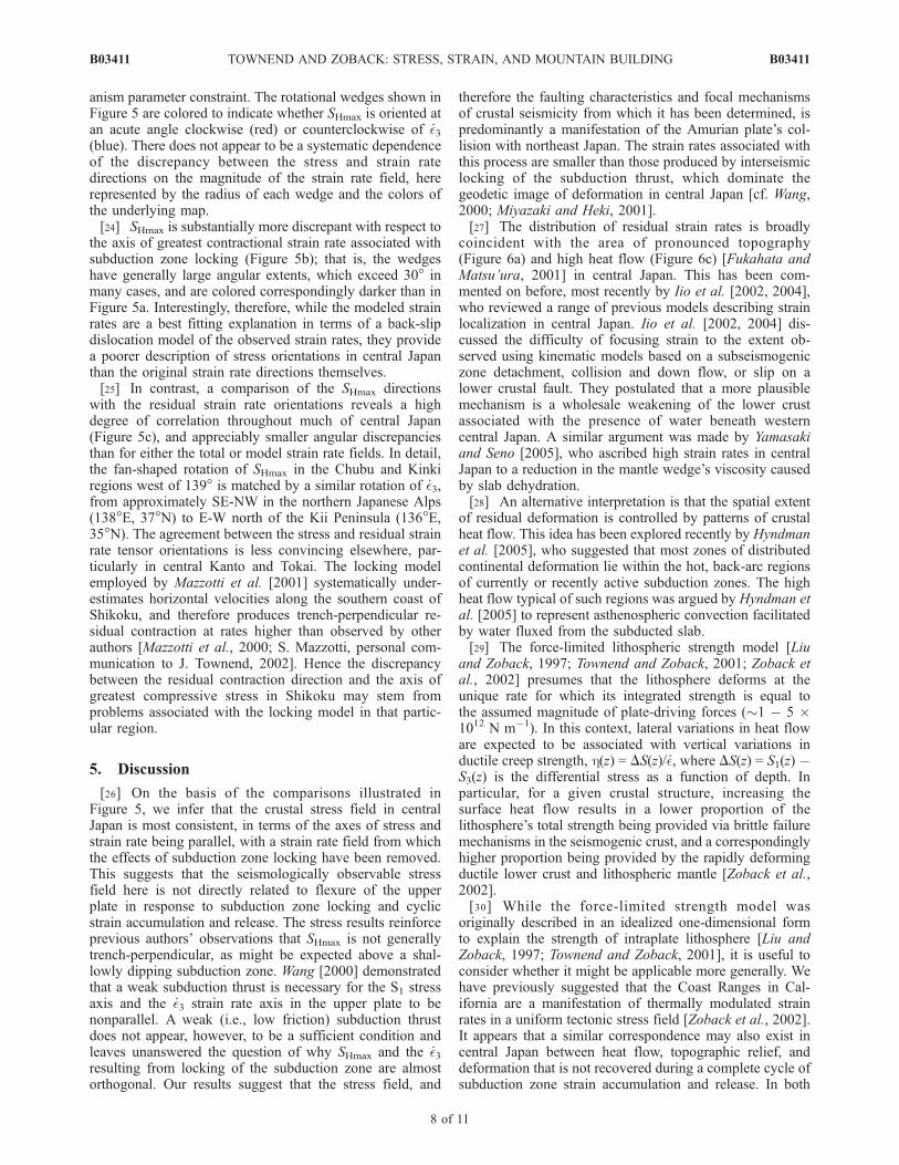
anism parameter constraint. The rotational wedges shown inFigure 5 are colored to indicate whether SHmax is oriented atan acute angle clockwise (red) or counterclockwise of _�3(blue). There does not appear to be a systematic dependenceof the discrepancy between the stress and strain ratedirections on the magnitude of the strain rate field, hererepresented by the radius of each wedge and the colors ofthe underlying map.[24] SHmax is substantially more discrepant with respect to
the axis of greatest contractional strain rate associated withsubduction zone locking (Figure 5b); that is, the wedgeshave generally large angular extents, which exceed 30� inmany cases, and are colored correspondingly darker than inFigure 5a. Interestingly, therefore, while the modeled strainrates are a best fitting explanation in terms of a back-slipdislocation model of the observed strain rates, they providea poorer description of stress orientations in central Japanthan the original strain rate directions themselves.[25] In contrast, a comparison of the SHmax directions
with the residual strain rate orientations reveals a highdegree of correlation throughout much of central Japan(Figure 5c), and appreciably smaller angular discrepanciesthan for either the total or model strain rate fields. In detail,the fan-shaped rotation of SHmax in the Chubu and Kinkiregions west of 139� is matched by a similar rotation of _�3,from approximately SE-NW in the northern Japanese Alps(138�E, 37�N) to E-W north of the Kii Peninsula (136�E,35�N). The agreement between the stress and residual strainrate tensor orientations is less convincing elsewhere, par-ticularly in central Kanto and Tokai. The locking modelemployed by Mazzotti et al. [2001] systematically under-estimates horizontal velocities along the southern coast ofShikoku, and therefore produces trench-perpendicular re-sidual contraction at rates higher than observed by otherauthors [Mazzotti et al., 2000; S. Mazzotti, personal com-munication to J. Townend, 2002]. Hence the discrepancybetween the residual contraction direction and the axis ofgreatest compressive stress in Shikoku may stem fromproblems associated with the locking model in that partic-ular region.
5. Discussion
[26] On the basis of the comparisons illustrated inFigure 5, we infer that the crustal stress field in centralJapan is most consistent, in terms of the axes of stress andstrain rate being parallel, with a strain rate field from whichthe effects of subduction zone locking have been removed.This suggests that the seismologically observable stressfield here is not directly related to flexure of the upperplate in response to subduction zone locking and cyclicstrain accumulation and release. The stress results reinforceprevious authors’ observations that SHmax is not generallytrench-perpendicular, as might be expected above a shal-lowly dipping subduction zone. Wang [2000] demonstratedthat a weak subduction thrust is necessary for the S1 stressaxis and the _�3 strain rate axis in the upper plate to benonparallel. A weak (i.e., low friction) subduction thrustdoes not appear, however, to be a sufficient condition andleaves unanswered the question of why SHmax and the _�3resulting from locking of the subduction zone are almostorthogonal. Our results suggest that the stress field, and
therefore the faulting characteristics and focal mechanismsof crustal seismicity from which it has been determined, ispredominantly a manifestation of the Amurian plate’s col-lision with northeast Japan. The strain rates associated withthis process are smaller than those produced by interseismiclocking of the subduction thrust, which dominate thegeodetic image of deformation in central Japan [cf. Wang,2000; Miyazaki and Heki, 2001].[27] The distribution of residual strain rates is broadly
coincident with the area of pronounced topography(Figure 6a) and high heat flow (Figure 6c) [Fukahata andMatsu’ura, 2001] in central Japan. This has been com-mented on before, most recently by Iio et al. [2002, 2004],who reviewed a range of previous models describing strainlocalization in central Japan. Iio et al. [2002, 2004] dis-cussed the difficulty of focusing strain to the extent ob-served using kinematic models based on a subseismogeniczone detachment, collision and down flow, or slip on alower crustal fault. They postulated that a more plausiblemechanism is a wholesale weakening of the lower crustassociated with the presence of water beneath westerncentral Japan. A similar argument was made by Yamasakiand Seno [2005], who ascribed high strain rates in centralJapan to a reduction in the mantle wedge’s viscosity causedby slab dehydration.[28] An alternative interpretation is that the spatial extent
of residual deformation is controlled by patterns of crustalheat flow. This idea has been explored recently by Hyndmanet al. [2005], who suggested that most zones of distributedcontinental deformation lie within the hot, back-arc regionsof currently or recently active subduction zones. The highheat flow typical of such regions was argued by Hyndman etal. [2005] to represent asthenospheric convection facilitatedby water fluxed from the subducted slab.[29] The force-limited lithospheric strength model [Liu
and Zoback, 1997; Townend and Zoback, 2001; Zoback etal., 2002] presumes that the lithosphere deforms at theunique rate for which its integrated strength is equal tothe assumed magnitude of plate-driving forces (�1 � 5 �1012 N m�1). In this context, lateral variations in heat floware expected to be associated with vertical variations inductile creep strength, h(z) = DS(z)/ _�, where DS(z) = S1(z) �S3(z) is the differential stress as a function of depth. Inparticular, for a given crustal structure, increasing thesurface heat flow results in a lower proportion of thelithosphere’s total strength being provided via brittle failuremechanisms in the seismogenic crust, and a correspondinglyhigher proportion being provided by the rapidly deformingductile lower crust and lithospheric mantle [Zoback et al.,2002].[30] While the force-limited strength model was
originally described in an idealized one-dimensional formto explain the strength of intraplate lithosphere [Liu andZoback, 1997; Townend and Zoback, 2001], it is useful toconsider whether it might be applicable more generally. Wehave previously suggested that the Coast Ranges in Cal-ifornia are a manifestation of thermally modulated strainrates in a uniform tectonic stress field [Zoback et al., 2002].It appears that a similar correspondence may also exist incentral Japan between heat flow, topographic relief, anddeformation that is not recovered during a complete cycle ofsubduction zone strain accumulation and release. In both
B03411 TOWNEND AND ZOBACK: STRESS, STRAIN, AND MOUNTAIN BUILDING
8 of 11
B03411

locations, the style of deformation associated with the highrelief is different from that predicted on the basis ofdislocation models. Reverse faulting perpendicular to theSan Andreas fault in the Coast Ranges is difficult toreconcile with the geodetically detectable but insignificantrate of fault-normal contraction of �0.9 ± 7.9 � 10�9 yr�1
[Savage et al., 2004], but is compatible with the observednear-fault-normal SHmax direction [Townend and Zoback,2004].[31] With respect to possible thermal constraints on upper
plate deformation central Japan, we have not taken intoconsideration either variations in crustal thickness or theeffect on surface heat flow of active uplift and erosion. As
Iio et al. [2002] and Hyndman et al. [2005] have argued,water driven off the subducting slab may ultimately beresponsible for concentrated deformation, either via a directmechanical weakening effect [Iio et al., 2002] or via itsdeep-seated influence on shallow mantle convection andheat flow [Hyndman et al., 2005]. Interestingly, the highestresidual strain rates and topographic elevations occur wherethe Philippine Sea and Pacific plates interleave [Ishida,1992], and where the volume of devolved water mightconsequently be anomalously large. In this case, while thehigh crustal temperatures might be the key control on upperplate strength, and the localization of long-term deforma-tion, the ultimate smoking gun might be the subductedplates.[32] To summarize, the congruence of the SHmax and
residual _�3 axes illustrated in Figure 5c and the spatialcoincidence of high residual strain rates, high topographicrelief, and high surface heat flow illustrated in Figure 6suggest that long-term deformation in central Japan reflectshorizontal collision between northeast and southwest Hon-shu [Mazzotti et al., 2001; Miyazaki and Heki, 2001] and isnot necessarily interpretable using models based primarilyon subduction processes. Nevertheless, if the underlyingcause of the high heat flow is the presence of two inter-leaved slabs, PHS and PAC, then deformation associatedwith mountain building in central Japan might best beviewed as the combined result of subduction-related thermalmodulation of a collision-related stress field.
6. Conclusions
[33] Modern geodetic and seismographic networks enablepatterns of crustal deformation and seismicity to be deter-mined with unprecedented accuracy and detail. To date,however, little effort has been made to determine how thedifferent tectonic signals recorded geodetically and seismo-logically are related. In this study, comparisons of crustalstrain rates computed from geodetic observations withcrustal stress directions determined from seismological datareveal that much of the deformation occurring in centralJapan is not associated with subduction per se but ratherwith collision of southwest Japan with northeastern Honshu.
Figure 6. (a) Topographic relief map of central Japan. Allelevations higher than 2 km are red. (b) Axis of maximumhorizontal compression (SHmax) computed for clusters ofmore than 20 focal mechanisms shallower than 35 km.Normal, strike-slip, and reverse stress states are shown inblue, green, and red, respectively, and the large and smallsymbols represent stress orientations computed with andwithout restricting the focal mechanism data to those withstrike, dip, and rake uncertainties of �10�. The underlyingmap is of the residual areal contraction rate field (Figure 5c).(c) Heat flow map of central Japan [Yamano, 1995]. Thedots indicate measurement sites; only those measurementsless than 200 mW m�2 have been used [cf. Fukahata andMatsu’ura, 2001], and the resulting surface has been low-pass filtered to retain only those features with wavelengthslonger than 100 km. No correction has been applied for thethermal effects of Quaternary uplift and erosion [Harayama,1992]. Black triangles denote the locations of volcanoesactive during the Holocene.
B03411 TOWNEND AND ZOBACK: STRESS, STRAIN, AND MOUNTAIN BUILDING
9 of 11
B03411

[34] Previous authors have used geodetic data to computethe horizontal crustal strain rate field and attempted todistinguish a component of the total strain rate field asso-ciated with contemporary locking of the Nankai Trough andJapan Trench subduction interfaces [Mazzotti et al., 2001;Miyazaki and Heki, 2001]. In those studies, the residualstrain rates exhibit spatial patterns, magnitudes, and orien-tations suggesting that they are meaningful representationsof real deformation, rather than unmodeled errors. Inparticular, Mazzotti et al. [2001] concluded that the local-ization of residual strain rates in the western area of centralJapan is a robust observation and not solely an artifactstemming from an inappropriate locking model.[35] Our observations reveal that the SHmax horizontal
stress axis in central Japan exhibits a high degree ofcongruence with the residual _�3 horizontal strain rate axis.This bolsters previous authors’ conclusions that the residualstrain rates have a physical significance, and are not merelyunmodeled errors. Further, these observations suggest thatpart of the apparent discrepancy between crustal stress andstrain rate directions stems from a comparison of parametersrepresenting processes occurring at different timescales. Inthe particular case of central Japan, it appears that the high-frequency, relatively low-magnitude strain rates associatedwith subduction zone locking do not greatly affect thecrustal stress field, whereas long-term horizontal motionbetween northeast and southwest Japan is more evident inthe crustal stress field than in the total strain rate field. Wesuggest that localization of long-term, irrecoverable defor-mation in central Japan is a consequence of the higher heatflow in that area than elsewhere. In this context, mountainbuilding in the Japanese Alps appears to be related more tocrustal collision than to subduction.
[36] Acknowledgments. We are grateful to staff at the NationalInstitute for Earth Science and Disaster Prevention, the EarthquakeResearch Institute, and the Japanese Meteorological Agency for theirassistance with obtaining the seismicity data; to Shin’ichi Miyazaki andStephane Mazzotti for kindly sharing and discussing their geodetic results;to Phil Cummins (Geoscience Australia) for help in merging the seismicitycatalogs; and to the Japan Marine Science and Technology Center(JAMSTEC) and a Stanford Lieberman Fellowship for financial support.The thought-provoking comments of two anonymous reviewers are alsoappreciated. The stress results reported here have been submitted to theWorld Stress Map database (http://www.world-stress-map.org/).
ReferencesAbers, G. A., and J. W. Gephart (2001), Direct inversion of earthquake firstmotions for both the stress tensor and focal mechanisms and applicationto southern California, J. Geophys. Res., 106, 26,523–26,540.
Aki, K., and P. G. Richards (1980), Quantitative Seismology, 1st ed., W. H.Freeman, New York.
Angelier, J. (1979), Determination of the mean principal directions ofstresses for a given fault population, Tectonophysics, 56, T17–T26.
Angelier, J. (1984), Tectonic analysis of fault slip data sets, J. Geophys.Res., 89, 5835–5848.
Baba, T., T. Hori, S. Hirano, P. Cummins, J.-O. Park, M. Kameyama,and Y. Kaneda (2001), Deformation of a seamount subducting beneathan accretionary prism: Constraints from numerical simulation, Geo-phys. Res. Lett., 28, 1827–1830.
Brace, W. F., and D. Kohlstedt (1980), Limits on lithospheric stressimposed by laboratory measurements, J. Geophys. Res., 85, 6248–6252.
DeMets, C., R. Gordon, D. Argus, and S. Stein (1994), Effect of recentrevisions to the geomagnetic reversal time scale on estimates of currentplate motions, Geophys. Res. Lett., 21, 2191–2194.
Flesch, L. M., W. E. Holt, A. J. Haines, and B. Shen-Tu (2000), Dynamicsof the Pacific –North American plate boundary in the western UnitedStates, Science, 287, 834–836.
Flesch, L. M., A. J. Haines, and W. E. Holt (2001), Dynamics of the India–Eurasia collision zone, J. Geophys. Res., 106, 16,435–16,460.
Fukahata, Y., and M. Matsu’ura (2001), Correlation between surface heatflow and elevation and its geophysical implication, Geophys. Res. Lett.,28, 2703–2706.
Gephart, J. W. (1990), Stress and the direction of slip on fault planes,Tectonics, 9, 845–858.
Gordon, R. G. (1998), The plate tectonic approximation: Plate nonrigidity,diffuse plate boundaries, and global plate reconstructions, Annu. Rev.Earth Planet. Sci., 26, 615–642.
Harayama, S. (1992), Youngest exposed granitoid pluton on Earth: Coolingand rapid uplift of the Pliocene–Quaternary Takidani Granodiorite in theJapan Alps, central Japan, Geology, 20, 657–660.
Hartigan, J. A. (1975), Clustering Algorithms, 351 pp., John Wiley,Hoboken, N. J.
Hassani, R., D. Jongmans, and J. Chery (1997), Study of plate deformationand stress in subduction zone processes using two-dimensional numericalmodels, J. Geophys. Res., 102, 17,951–17,965.
Heki, K., S. Miyazaki, H. Takahashi, M. Kasahara, F. Kimata, S. Miura,N. Vasilenko, A. Ivashchenko, and K.-D. An (1999), The Amurianplate motion and current plate kinematics in eastern Asia, J. Geophys.Res., 104, 29,147–29,155.
Henry, P., S. Mazzotti, and X. Le Pichon (2001), Transient and permanentdeformation of central Japan estimated by GPS: 1. Interseismic loadingand subduction kinematics, Earth Planet. Sci. Lett., 184, 443–453.
Hyndman, R., K. Wang, and M. Yamano (1995), Thermal constraints on theseismogenic portion of the southwestern Japan subduction thrust, J. Geo-phys. Res., 100, 15,373–15,392.
Hyndman, R., C. Currie, and S. Mazzotti (2005), Subduction zone back-arcs, mobile belts, and orogenic heat, GSA Today, 15, 4–10, doi:10.1130/1052-5173(2005)015.
Hyodo, M., and K. Hirahara (2003), A viscoelastic model of interseismicstrain concentration in Niigata–Kobe Tectonic Zone of central Japan,Earth Planets Space, 55, 667–675.
Iio, Y., T. Sagiya, Y. Kobayashi, and I. Shiozaki (2002), Water-weakenedlower crust and its role in the concentrated deformation in the Japaneseislands, Earth Planet. Sci. Lett., 203, 245–253.
Iio, Y., T. Sagiya, and Y. Kobayashi (2004), Origin of the concentrateddeformation zone in the Japanese Islands and stress accumulation processof intraplate earthquakes, Earth Planets Space, 56, 831–842.
Ishida, M. (1992), Geometry and relative motion of the Philippine Sea plateand Pacific plate beneath the Kanto-Tokai district, Japan, J. Geophys.Res., 97, 489–513.
Klein, F. (2002), User’s guide to Hypoinverse-2000, a Fortran program tosolve for earthquake locations and magnitudes, version 1.0, U.S. Geol.Surv. Open File Rep., 02-171.
Kostrov, B. V. (1974), Seismic moment and energy of earthquakes, andseismic flow in rocks, Izv. Phys. Solid Earth, 1, 22–44.
Lewis, J. C., J. R. Unruh, and R. J. Twiss (2003), Seismogenic strain andmotion of the Oregon coast block, Geology, 31, 183–186.
Liu, L., and M. D. Zoback (1997), Lithospheric strength and intraplateseismicity in the New Madrid seismic zone, Tectonics, 16, 585–595.
Lund, B. (2000), Crustal stress studies using microearthquakes and bore-holes, Ph.D. thesis, Uppsala Univ., Uppsala, Sweden.
Mazzotti, S., P. Henry, X. Le Pichon, and T. Sagiya (1999), Strain partition-ing in the zone of transition from Nankai subduction to Izu-Bonin colli-sion (central Japan): Implications for an extensional tear within thesubducting slab, Earth Planet. Sci. Lett., 172, 1–10.
Mazzotti, S., X. Le Pichon, P. Henry, and S. Miyazaki (2000), Full inter-seismic locking of the Nankai and Japan-west Kurile subduction zones:An analysis of uniform elastic strain accumulation in Japan constrainedby permanent GPS, J. Geophys. Res., 105, 13,159–13,177.
Mazzotti, S., P. Henry, and X. Le Pichon (2001), Transient and permanentdeformation of central Japan estimated by GPS: 2. Strain partitioning andarc–arc collision, Earth Planet. Sci. Lett., 184, 455–469.
McKenzie, D. (1969), The relationship between fault plane solutions forearthquakes and the directions of the principal stresses, Bull. Seismol.Soc. Am., 59, 591–601.
Michael, A. J. (1984), Determination of stress from slip data: Faults andfolds, J. Geophys. Res., 89, 11,517–11,526.
Miyazaki, S., and K. Heki (2001), Crustal velocity field of southwest Japan:Subduction and arc–arc collision, J. Geophys. Res., 106, 4305–4326.
Nakamura, K., and S. Uyeda (1980), Stress gradient in arc–back arc re-gions and plate subduction, J. Geophys. Res., 85, 6419–6428.
Reasenberg, P. A., and D. Oppenheimer (1985), Fpfit, Fpplot, and Fppage:Fortran computer programs for calculating and displaying earthquakefault-plane solutions, U.S. Geol. Surv. Open File Rep., 85-739.
Sagiya, T., S. Miyazaki, and T. Tada (2000), Continuous GPS array andpresent-day crustal deformation of Japan, Pure Appl. Geophys., 157,2303–2322.
B03411 TOWNEND AND ZOBACK: STRESS, STRAIN, AND MOUNTAIN BUILDING
10 of 11
B03411

Savage, J. C., W. Gan, W. H. Prescott, and J. L. Svarc (2004), Strainaccumulation across the Coast Ranges at the latitude of San Francisco,1994 – 2000, J. Geophys. Res. , 109 , B03413, doi :10.1029/2003JB002612.
Seno, T. (1999), Syntheses of the regional stress fields of the Japaneseislands, Island Arc, 8, 66–79.
Shiono, K., T. Mikumo, and Y. Ishikawa (1980), Tectonics of the Kyushu-Ryukyu arc as evidenced from seismicity and focal mechanism of shal-low to intermediate-depth earthquakes, J. Phys. Earth, 28, 17–43.
Sibson, R. H. (1974), Frictional constraints on thrust, wrench and normalfaults, Nature, 249, 542–544.
Tabei, T., M. Hashimoto, S. Miyazaki, and Y. Ohta (2003), Present-daydeformation across the southwest Japan arc: Oblique subduction of thePhilippine Sea plate and lateral slip of the Nankai forearc, Earth PlanetsSpace, 55, 643–647.
Thatcher, W. (1995), Microplate versus continuum descriptions of activetectonic deformation, J. Geophys. Res., 100, 3885–3894.
Townend, J., and M. D. Zoback (2000), How faulting keeps the cruststrong, Geology, 28, 399–402.
Townend, J., and M. D. Zoback (2001), Implications of earthquake focalmechanisms for the frictional strength of the San Andreas fault system, inThe Nature and Significance of Fault Zone Weakening, edited by R. E.Holdsworth et al., Geol. Soc. Spec. Publ., 186, 13–21.
Townend, J., and M. D. Zoback (2004), Regional tectonic stress near theSan Andreas fault in central and southern California, Geophys. Res. Lett.,31, L15S11, doi:10.1029/2003GL018918.
Tsukahara, H., and R. Ikeda (1991), Crustal stress orientation pattern in thecentral part of Honshu, Japan: Stress provinces and their origins (inJapanese), J. Geol. Soc. Jpn., 97, 461–474.
Tsukahara, H., and Y. Kobayashi (1991), Crustal stress in the central andwestern parts of Honshu, Japan (in Japanese), J. Seismol. Soc. Jpn., 44,221–231.
Ukawa, M., M. Ishida, S. Matsumura, and K. Kasahara (1984), Hypocenterdetermination method of the Kanto-Tokai observational network for mi-croearthquakes (in Japanese), Res. Notes 53, Natl. Res. Inst. for Earth Sci.and Disaster Prev., Tokyo.
Wallace, L. M., J. Beavan, R. McCaffrey, and D. Darby (2004), Subductionzone coupling and tectonic block rotations in the North Island, NewZealand, J. Geophys. Res., 109, B12406, doi:10.1029/2004JB003241.
Wang, K. (2000), Stress – strain ‘‘paradox’’, plate coupling, and forearcseismicity at the Cascadia and Nankai subduction zones, Tectonophysics,319, 321–338.
Wang, K., and J. He (1999), Mechanics of low-stress forearcs: Nankai andCascadia, J. Geophys. Res., 104, 15,191–15,205.
Yamano, M. (1995), Recent heat flow studies in and around Japan, inTerrestrial Heat Flow and Geothermal Energy in Asia, edited by M. L.Gupta and M. Yamano, pp. 173–201, IBH Publ., New Delhi.
Yamasaki, T., and T. Seno (2005), High strain rate zone in central Honshuresulting from the viscosity heterogeneities in the mantle, Earth Planet.Sci. Lett., 232, 13–27.
Zhao, S., and S. Takemoto (2000), Deformation and stress change asso-ciated with plate interaction at subduction zones: A kinematic modelling,Geophys. J. Int., 142, 300–318.
Zhao, S., X. Wu, T. Hori, Y. Kaneda, and S. Takemoto (2004), Crustaldeformation and stress localization in Kanto-Tokai, central Japan re-vealed by GPS, Geophys. J. Int., 157, 737–752.
Zoback, M. D., J. Townend, and B. Grollimund (2002), Steady-state failureequilibrium and deformation of intraplate lithosphere, Int. Geol. Rev., 44,383–401.
Zoback, M. D., et al. (2003), Determination of stress orientation and mag-nitude in deep wells, Int. J. Rock Mech. Min. Sci., 40, 1049–1076.
Zoback, M. L. (1992), First- and second-order patterns of stress in thelithosphere: The World Stress Map Project, J. Geophys. Res., 97,11,703–11,728.
�����������������������J. Townend, School of Earth Sciences, Victoria University of Wellington,
P.O. Box 600, Wellington, New Zealand. ([email protected])M. D. Zoback, Department of Geophysics, Stanford University, Stanford,
CA 94305-2215, USA. ([email protected])
B03411 TOWNEND AND ZOBACK: STRESS, STRAIN, AND MOUNTAIN BUILDING
11 of 11
B03411