strengthening the hydrometeorological services in south eastern europe
TRANSCRIPT

Strengthening the Hydrometeorological Services in South Eastern Europe
South Eastern Europe Disaster Risk Mitigation and Adaptation Programme


iii
PrefaceThe assessment presented here was undertaken within the scope of the South Eastern Europe Disaster Risk Mitigation and Adaptation Programme (SEEDRMAP). SEEDRMAP is a collaborative initiative developed by the World Bank and the secretariat of the United Nations International Strategy for Disaster Reduction (UN/ISDR), together with the European Commission, the Council of Europe, the Council of Europe Development Bank, the World Meteorological Organization, the Finnish Meteorological Institute and other partners.
SEEDRMAP’s objective is to reduce the vulnerability of the countries of South Eastern Europe to the risks of disasters. It addresses the loss of life, property and economic productivity caused by weather extremes and other natural hazards. To that end, SEEDRMAP has three focus areas: (i) hydrometeorological forecasting, data sharing and early warning; (ii) coordination of disaster mitigation, preparedness and response; and (iii) financing of disaster losses, reconstruction and recovery, and of disaster risk transfer (disaster insurance).
This document, undertaken in the context of SEEDRMAP’s first focus area, assesses existing infrastructure, capacity and data-sharing procedures among the hydrometeorological services of South Eastern Europe, identifying the needs both with respect to staff capacity and training and with respect to equipment and facilities.

iv
Acknowledgments
The main author of this report is Bengt Tammelin. The Task Team Leader for the South Eastern Europe Disaster Risk Mitigation and Adaptation Programme (SEEDRMAP) who guided the development of the report is Wael Zakout, Sector Manager in the World Bank Sustainable Development Department of Europe and Central Asia Region (ECSSD). The UN/ISDR Regional Coordinator for Europe, Paola Albrito, coordinated, facilitated and greatly supported development of the presented report and the SEEDRMAP.
The World Bank and the UN/ISDR secretariat gratefully acknowledge the contributions made to this document by many partners, institutions and individuals: Dr. Vlasta Tutiš (DHMZ), who assisted in preparation of the questionnaires sent to the National Hydrometeorological Services, coordinated work in DHMZ and missions to Croatia and Albania, and who kindly provided local knowledge, support and scientific assistance during the project; Dr. Pekka Leviäkangas, Raine Hautala, Marja-Liisa Ahtiainen and the others from the Technical Research Centre of Finland and the Finnish Meteorological Institute for cooperation and their contribution to the study of the socio-economic benefits of improved hydrometeorological services in the SEE countries; Mary Power (WMO) for the provision of valuable background material, advice, and revision of the early draft report; Nathalia Berghi (WMO) for all her assistance, and especially for cooperation during the mission to Moldova.; Lucy Hancock (World Bank consultant) who substantially contributed and edited the report; Jolanta Kryspin-Watson (World Bank, ECSSD) who as a member of the SEEDRMAP programme provided her support to this effort and reviewed the report; directors and all the contact persons from the national hydrometeorological services in Albania, Bosnia and Herzegovina, Croatia, the Former Yugoslav Republic of Macedonia, Moldova, Montenegro and Serbia, for all the support, assistance and cooperation; and Biljana Markova (UN/ISDR secretariat) for the consolidation of the publication.
Special thanks are extended to Ivan Čačić, Director of Croatian DHMZ, Permanent Representative with WMO and Chair of the Informal Conference of the Directors of Hydromet in SEE (ICEED), Professor Petteri Taalas (WMO); Dušan Hrček (WMO).
The study review was developed through funding by the Global Facility for Disaster Reduction and Recovery (GFDRR), a partnership of Australia, Canada, Denmark, the European Commission, Finland, France, Germany, Italy, Japan, Luxembourg, Norway, Spain, Sweden, Switzerland, the United Kingdom, the United Nations International Strategy for Disaster Reduction, the USAID Office of U.S. Foreign Disaster Assistance, and the World Bank. GFDRR’s mandate is to help developing countries reduce their vulnerability to natural hazards.

v
Table of contentsPreface .............................................................................................................................................................................iiiAcknowledgments ...........................................................................................................................................................ivList of abbreviations and acronyms ................................................................................................................................ixExecutive summary ..........................................................................................................................................................x
The current role of the hydrometeorological services in South Eastern Europe: Challenges and opportunities 1
User needs assessment - Hydrometeorogical services 9
2.1 Climate variability and climate change ........................................................................ 102.2 The SEE countries in a nutshell .................................................................................. 122.3 Natural hazards and disaster reduction management ................................................. 122.4 Aviation ....................................................................................................................... 152.5 Protection of the environment and renewable energy sources ..................................... 162.6 Identification of other customers and end-users and their needs for hydrometeorological services....................................................................................... 18
Socio-economic benefits 21
3.1 Methodology ............................................................................................................... 223.2 VTT-FMI study for the SEE countries ..................................................................... 243.3 Summary of findings on socio-economic benefits ....................................................... 30
State of affairs in the NMHSs 35
4.1 Legal status ................................................................................................................. 374.2 Premises ...................................................................................................................... 374.3 Financial and human resources ................................................................................... 374.4 Training ....................................................................................................................... 374.5 Productivity ................................................................................................................. 384.6 International cooperation and data sharing ................................................................. 394.7 Weather services .......................................................................................................... 394.8 Hydrological services .................................................................................................. 40
1
2
3
4

vi
5
4.9 Environmental services ............................................................................................... 404.10 Visibility of the national meteorological and hydrological services ............................. 414.11 The Internet ................................................................................................................ 414.12 Mission and vision ...................................................................................................... 414.13 Agencies providing hydrometeorological services ...................................................... 41
Main technical findings 45
5.1 Numerical weather forecasting ..................................................................................... 465.2 Observation network ..................................................................................................... 475.3 Communication, data management and information technology ................................. 505.4 Data sharing .................................................................................................................. 52
Recommended project and investments 59
6.1 International cooperation - European dimension ....................................................... 666.2 Training ....................................................................................................................... 706.3 Weather forecasting ..................................................................................................... 716.4 Communications and data sharing .............................................................................. 726.5 Data management ....................................................................................................... 736.6 Observation network ................................................................................................... 74
References .................................................................................................................... 82
6

vii
List of figures
Figure 1. The NMHSs need to cooperate with a wide range of socio-economic sectors ........................................ 2Figure 2. “Poverty trap” of the NMHSs ................................................................................................................. 4Figure 3. Expected flows of information and financing ........................................................................................... 6Figure 4. Flow chart of an early warning system: the early warning centre in each country could
be the NMHS ........................................................................................................................................ 14Figure 5. The logic of impact mechanisms ............................................................................................................ 26Figure 6. A curve for estimating flood warning benefits ....................................................................................... 30Figure 7. Schematic illustration of the relationship between current economic benefits, potential economic benefits and estimated economic benefits to be achieved during the initial five-year period, and
during the following five years ............................................................................................................... 32Figure 8. Schematic illustration of the meteorological IT infrastructure the Finnish Meteorological Institute .... 53Figure 9. Regional Meteorological Data Network, WMO Regional Association VI (Europe) ........................... 55Figure 10. Internet Protocol Virtual Private Network (IPVPN) topology .............................................................. 56Figure 11. An integrated end-to-end production system of hydrometeorological services ...................................... 60Figure 12. A meteorologist working on an automatic processing and visualization tool.. ....................................... 70Figure 13. Principle of an advanced (duplicated) IT system ................................................................................... 72Figure 14. Iced cup anemometer and heated ice-free sonic anemometers… ........................................................... 73Figure 15. A schematic presentation of different types of wind profilers and their typical properties ..................... 76
List of tables
Table 1. Cost-benefit ratios for SEE countries .................................................................................................... xviTable 2. Distribution (per cent) of investment needs by item for a regionally-based upgrade of SEE NMHSs ...........................................................................................................................................5Table 3. Summary of natural hazard-related disasters for selected SEE countries ..............................................13Table 4. Calculated average annual impact of weather services offered to the road traffic sector ........................23Table 5. Summary of estimated benefits of DHMZ information services to maritime industries derived from corresponding Finnish estimations....................................................................................24Table 6. Basic data collected on rail transportation ...............................................................................................25Table 7. Data on reliability and safety of rail traffic ..............................................................................................27Table 8. Annual benefits (in euros) in the rail traffic sector from improved hydrometeorological services .........28Table 9. Benefits of meteorological services for aviation in selected SEE countries in 2005 ...............................28Table 10. The impacts of hydrometeorological services in the energy sector .........................................................29Table 11. Summarized data on floods from 1979 to 2006 ......................................................................................29Table 12. The estimated added value (in millions of euros per year) of economic benefits that can be gained by agro-meteorological services in the SEE countries ................................................................31Table 13. Potential socioeconomic benefits (in millions of euros per year) of improved meteorological and hydrological services in SEE as estimated by VTT-FMI .......................................31Table 14. Economic benefits (in millions of euros per year) of improved hydrometeorological services, as calculated by the World Bank .............................................................................................................32Table 15. The estimated actual cumulative economic benefits (in millions of euros) of improved hydrometeorological services in the SEE countries ................................................................................33Table 16. Different main activities performed by NMHSs from different SEE countries ...................................36Table 17. Some international memberships and partnerships.................................................................................38Table 18. Type of weather forecasts produced by each SEE NMHS, the number of daily products available and the number of staff preparing weather forecasts ..............................................................................40Table 19. Summary of numerical weather prediction activities and models used ...................................................46Table 20. Number of meteorological stations in the Present and Target observation networks, and density of stations (1/x km2) in SEE countries, Finland and Switzerland .......................................48

viii
Table 21. Number of operational hydrological stations ..........................................................................................49Table 22. List of current SEE NMHS weather radars and their properties .........................................................51Table 23. Current information technology resources ..............................................................................................52Table 24. Number of different types of stations reported to the WMO-GTS in December 2006 ........................54Table 25. Investment Plan A: Costs (in thousands of euros) .................................................................................61Table 26. Investment Plan B: Costs (in thousands of euros) .................................................................................63Table 27. Requirements for upper-air observations ................................................................................................75
List of maps
Map 1. Predicted impacts on precipitation due to climate ..................................................................................11Map 2. Predicted water stress due to climate ......................................................................................................12Map 3. Some examples of EUMETNET cooperation ......................................................................................15 Map 4. Memberships in the ECAC, EUROCONTROL and the EU ...........................................................16Map 5. Sites for special wind measurement campaigns in the ongoing international project for mapping of wind energy resources in the SEE countries .....................................................17Map 6. ECMWF data coverage of temperature observations on 6 November 2007, at 00 Coordinated Universal Time .......................................................................................................................................49Map 7. MSG Telecommunications coverage area presented by WMO .............................................................50Map 8. ECMWF Member States and Cooperating States, and their share (as a per cent) of total contributions in 2006 .............................................................................................................................65Map 9. An example of ECMWF analysis of relative humidity and wind at 700 hPa ........................................69Map 10. The CWINDE wind profiler network ................................................................................................77Map 11. European weather radars in January 2007 ............................................................................................77Map 12. Coverage of the EUMETNET OPERA network ..............................................................................78Map 13. Coverage of the NORDRAD weather radar network ...........................................................................78Map 14. Example of a setup for lightning detection in SEE ................................................................................79Map 15. Potential lightning detection network for Moldova and Romania .........................................................80

ix
List of abbreviations and acronymesALADIN A limited area-version of the ARPEGE/Integrated Forecast SystemAMDAR Aircraft Meteorological Data ReportingARPEGE Action de Recherche Petite Echelle Grande EchelleCOST European Cooperation in the field of Scientific and Technical ResearchCWINDE The Coordinated Wind Profiler Network in Europe, EUMETNETDHMZ Croatian Hydrological and Meteorological ServiceDWD Deutscher Wetterdienst, Germany ECMWF European Centre for Medium-Range Weather ForecastsECAC European Civil Aviation ConferenceEFTA European Free Trade AssociationEU European UnionEUMETNET The network of European meteorological services EUMETSAT European Organisation for the Exploitation of Meteorological SatellitesFHMI Federal Hydrometeorological Institute (Bosnia and Herzegovina)FMI Finnish Meteorological InstituteGDP Gross Domestic ProductGPRS General Packet Radio ServiceGPS Global Positioning SystemGSM Global System for Mobile communicationsGTS Global Telecommunication System of the World Meteorological OrganizationHIRLAM HIgh Resolution Limited Area ModelICAO International Civil Aviation OrganizationIOC Intergovernmental Oceanographic CommissionIT Information TechnologyMM5 The PSU/NCAR mesoscale modelMSG Meteosat Second GenerationNCAR National Center for Atmospheric Research (USA)NMHS National Meteorological and Hydrological ServiceNOAA National Oceanic and Atmospheric Administration (USA)RTH Regional Telecommunication Hub (within the World Meteorological Organization network)SEE South Eastern EuropeSEEDRMAP South Eastern European Disaster Risk Mitigation and Adaptation ProgrammeSEVIRI Spinning Enhanced Visible and InfraRed Imager - the radiometer, or scanner, carried by the MSG satelliteSMS Short Message Service (for mobile phones)UN/ISDR United Nations, secretariat of the International Strategy for Disaster ReductionVTT Technical Research Centre of FinlandWMO World Meteorological Organization

x
South Eastern Europe Disaster Risk Mitigation and Adaptation Programme
Executive summary
Background
Reliable weather forecasts and outlooks; functioning warning systems for natural hazards; knowledge of weather, water and climate events, and their extremes and alterations in the changing climate; and adaptation to climate change are all necessary for sound and sustainable development of national socio-economic and environmental programmes in any country. The value of hydrometeorological data, good forecasting and high-quality scientific research and development services are increasingly understood and appreciated by various sectors within South Eastern Europe (SEE). The value of hydrometeorological services is growing.
However, in order to be able to improve hydrometeorological services, particularly early warning services for civil protection efforts that help to keep natural weather-related hazards from becoming disasters, it is necessary to extend the on-line hydrometeorological observation network, to adopt state-of-the-art equipment and software, to foster international cooperation and data sharing, and to introduce new public-private partnerships at national and international levels.
The expected role of the SEE region’s national meteorological and hydrological services (NMHSs) is changing rapidly. Traditionally, the public sector has formed the major customer and end-user group for hydrometeorological and environmental data and services. However, in the SEE countries, the NMHSs are not responsible for producing services for the aviation sector, which is typically the most profitable sector in terms of revenue (at least in the case of the European NMHSs). The legislative package concerning “Single European Sky”1, adopted by the European Parliament and the Transport Council in March 2004, opened the market for new types of national and international service providers for meteorological services for the European aviation sector.
Developments in information technology, availability of commercial forecasting models and software, and open markets all create possibilities for new commercial providers of hydrometeorological services. Most NMHSs and commercial companies provide forecasts not only to their own country but also over the borders regionally and even globally. At the same time, general needs to reduce expenses of the public sector affect and often complicate the situation of the NMHSs.
Thus the future of each NMHS lies in its ability to develop and more effectively deliver hydrometeorological products and services that have a recognizable value to government, to different socio-economic sectors and to environmental protection efforts.
In the SEE region, several NMHSs currently do not have the financial and human capacity to fully meet the international obligations, and growing national needs and requirements, for production of data and services. Nor can they adequately invest in their development in order to achieve the productivity level of Western European NMHSs.
Lack of governmental appreciation and adequate financing, together with unidentified customer and end-users, and under-developed cooperation with the private sector, has led to a situation where some NMHSs in the SEE countries have fallen into a “poverty trap”. While caught in this trap, the NMHSs have very few possibilities to improve their technical and personnel conditions so as to better promote the national development goals of their home countries.
There are, therefore, compelling reasons to strengthen these national hydrometeorological services with international support, in view of the vital role that they could play in the socio-economic development of these countries and the region. In addition, improvements could promote global and European weather forecasting, and thus also the
1 The Single European Sky initiative aims to restructure European airspace so that it is managed at the European level, with more efficient air traffic flows and interoperable air traffic management systems.

xi
Strengthening the Hydrometeorological Services in South Eastern Europe
NMHSs own hydrometeorological and environmental forecasts, as well as acting country and regional disaster risk management efforts.
It is critical to invest in new state-of-the-art observation and monitoring technology, and in modern communications systems, software and training. In many of the SEE countries, there is an urgent need to increase the number of IT staff and forecasters in order to ensure sound use of any new investments and to ensure 24/7/365 services.
Regional cooperation will have a significant impact on the size of the investment required. If the NMHSs of seven countries of South Eastern Europe (Albania, Bosnia and Herzegovina, Croatia, the Former Yugoslav Republic of Macedonia, Moldova, Montenegro and Serbia) were strengthened individually, country by country, and without better cooperation with national aviation weather services, the cumulative investment needs (hardware plus operational costs; without interest) are estimated at about €90.3 million over five years. However, if regional cooperation and data sharing could be carried out, and the hardware was designed to allow for cooperation with the rest of Europe, the total investment needs for these seven countries could be reduced to approximately €63.2 million.
However, it is impossible to strengthen the NMHSs in the countries, and to ensure their sustainable development, without strong government commitment to added financial support, establishment of national public-private partnerships, investment in capacity-building and staff training, and strong and active regional cooperation. As investments in hydrometeorological and environmental monitoring networks will in addition immediately benefit many public and private sectors, it is critical that these beneficiaries also participate in these investments.
Government and private-sector efforts to strengthen the NMHSs, so as to promote their ability to produce better hydrometeorological and environmental (air quality and water quality) services, must not be seen as merely a national expenditure, but rather as an investment in national and regional development.
The national strategy for the improvement of meteorological and hydrological services should be linked to the WMO RA VI Strategic Plan 2008-2011, which outlines a carefully-developed strategy to meet the hydrometeorological needs of Europe as a whole.
Objective
The objective of this report is to outline a recommended project that will introduce sufficient financing and methods to strengthen the technical and human capacity of the NMHSs to a level where the organizations:
• Can provide sufficient data for global, regional and national use. • Can provide requested services to disaster reduction management efforts, different socio-economic sectors and the
public. • Have resources to participate in European hydrometeorological and environmental cooperation.• Can prepare a clearer vision for their futures, to better promote the sustainable development of their countries and
the region.
This report is based on a technical feasibility study, an assessment of the current level of international cooperation and data sharing, identification of potential customers and end-users of hydrometeorological services, an assessment of end-user needs for hydrometeorological and air and water quality services in the SEE countries, and a parallel study of socio-economic benefits from improved hydrometeorological services.
This report is part of the SEEDRMAP 2007 Hydromet Initiative, which aims to strengthen the production of hydrometeorological and environmental services by NMHSs in the SEE countries. This report is prepared for

xii
South Eastern Europe Disaster Risk Mitigation and Adaptation Programme
Executive summary
Albania, Bosnia and Herzegovina, Croatia, the Former Yugoslav Republic of Macedonia, Moldova, Montenegro and Serbia. The other component of the Initiative, “Development and Upgrade of Hydrometeorological Information and Flood Warning/Forecasting Systems in the Sava River Basin”, concerns Albania, Bosnia and Herzegovina, Croatia, Montenegro, Slovenia and Serbia.
Rationale
In general, all SEE NMHSs need to promote the production of services to disaster risk and emergency management efforts on a 24/7/365 basis, and to improve their “nowcasting” and short-term forecasting (0-24 hours) for weather, hydrological variables and air quality. Effective and modern production of hydrometeorological and ecological data, products and services requires an integrated system. If one of the components is missing or dysfunctional, the whole chain will be useless. The required technical level, and needed investment, for each component depends on the planned activities and types of products.
Immediate benefits for improvement of NMHS services to disaster risk and emergency management efforts, to governments and to socio-economic sectors in each of the SEE countries can be gained by:
• Memberships in and cooperation with the European Centre for Medium-Range Weather Forecasts (ECMWF), the European Organization for the Exploitation of Meteorological Satellites (EUMETSAT) and the network of European meteorological services (EUMETNET), which groups 24 European national meteorological services.
• Improvement of integrated hydrological, meteorological and environmental networks, including enhancement of on-line or near real-time surface monitoring systems and remote sensing equipment.
• Specifying networks to allow for EUMETNET cooperation. • Updating communications and data management systems.• Automating weather forecasting processes.• Improved cooperation between industry, national scientific institutions and other producers of hydrometeorological
data and services, especially between the NMHSs and aviation weather services. • Improved regional cooperation and data sharing between all the SEE countries.
Natural Hazard Risk Management: Natural hazards cannot be avoided, but timely, accurate and high-quality scientific prediction of hydro-climate extremes helps societies to prepare for and mitigate disasters, and to reduce losses in infrastructure and productive activities. Early warnings and forecasts providing adequate lead time, together with awareness, education and preparedness, are key steps required to increase human safety and to reduce the socioeconomic and environmental impact of natural hazards. The lead time obtained by forecasts depends on the accuracy of global and regional numerical weather prediction models and local-scale forecasting skills. These in turn depend on the availability and quality of hydrometeorological observation data and the technical and human resources of the NMHSs, as well as on international cooperation and data sharing.
In order to promote civil protection, disaster risk and emergency management, and forecasting, it is critical to improve NMHS forecasting capabilities; to increase the number of on-line meteorological, hydrological and environmental measurements; and to reduce the number of manned stations. Currently, the operational costs of manned stations are not extremely high compared to investment costs for automation, due to the low salary levels of the observers. However, automation and on-line data better meet the requirements of today, promote production of more accurate and usable data, and protect human safety. Automation therefore will, in the long run, be an economically sound investment.
Climate change: Climate change produces risks, but also opportunities. Risks arise from the uncertainties of future climate variability. It is necessary to carry out an evaluation of risk under increased uncertainty to improve decision-making in a changing climate. In order to optimize the adaptation to climate change, it is necessary to integrate risk

xiii
Strengthening the Hydrometeorological Services in South Eastern Europe
and uncertainty in decision support tools. Scientists of the NMHSs are part of social and technical systems, and can effectively provide regional and local data on climate change by interpreting model results for stakeholders and by working across disciplines.
Socio-economic effects: The socio-economic effects of improved hydrometeorological services could be significant in each of the SEE countries. Currently, the available data on impacts of weather and climate on different socio-economic sectors is very limited. The results presented in this report are very coarse, but give a good indication of the potential that could be achieved. In order to convince SEE Governments and communities of the possible benefits from improved hydrometeorological services, it will be necessary to perform a more detailed study in each of the countries.
Components of the recommended project
There are a number of important components of forecasting and services to address in the SEE NMHSs.
Staff: The most critical component in the service and forecasting processes is the staff. Currently the number of NMHS staff is very high, with the majority of the personnel being observers, while the number of highly educated staff members such as meteorologists, hydrologists and IT experts is relatively low. Due to governmental employment policies and the low salary levels at the NMHSs, it is difficult to get the right balance of staff. Currently most of the NMHSs do not have adequate personnel to operate a 24/7/365 forecasting system. At the same time, however, many staff members are occupied in manual operations, which could easily and at a low cost be automated. In order to improve the current level of services, and to fully benefit from the recommended new investments, it is critical to provide NMHS staff with post-graduate education, updated career training, management training, and international cooperation and networking opportunities.
Communications systems and data management: Next in importance are the communications systems and data management. The current status of these elements varies widely between the SEE countries. In general, the data management systems in use are not the most end-user friendly systems available, nor are they designed to manufacture tailored, customer-specific products in near real-time. Functioning communications and data management systems are critical for international and regional data sharing.
Observation network: The density and location of the current surface observation network is in general quite adequate for monitoring the climate and for basic weather forecasts. The problems with the network lie in its obsolete equipment; poor maintenance and calibration facilities; and the high number of manned synoptic stations, in relation not only to the low number of automatic weather stations, but also to the low number of both on-line hydrometeorological stations and off-shore observations. In response, this report recommends increasing the number of automatic weather stations, which should mainly be used to replace the existing manned stations, and also establishing some new stations in cooperation with service end-users.
Remote sensing: Because of the transboundary nature of weather, it is critical to develop regional, rather than national, remote sensing networks. Remote sensing components include satellites, upper-air soundings, radars and lightning detection. These are essential tools for short-term forecasting and nowcasting, as well as for numerical weather prediction. (Numerical weather prediction on a global scale is the key to weather forecasts covering periods of more than two days.) Upper air: It is very important to ensure the operation of the current number of upper-air soundings in the SEE region through financing the operation of the region’s sounding stations for the project period. Upper-air soundings are the backbone of numerical weather prediction. They also provide critical information for forecasters, especially for short-term weather forecasts (such as those necessary for aviation safety).

xiv
South Eastern Europe Disaster Risk Mitigation and Adaptation Programme
Executive summary
Currently, not all of the weather services (which comprise both aviation weather services and NMHSs) have access to daily sounding data. Traditional upper-air soundings are expensive to perform: two soundings a day (radiosondes + balloons) cost about €140,000 per year. In order to improve the amount of upper-air data without increasing the investment and running costs, it is critical to promote production and use of aircraft meteorological data reporting (AMDAR) data.
Weather radar: Additional investment is needed in a regional radar network, including radars, radar towers, and maintenance and operations. A weather radar is used to locate and identify precipitation, to calculate its motion, to estimate its type (i.e. rain, snow, hail), and to forecast future position and intensity. Radars and radar-based nowcasting procedures are currently the most reliable way to ensure advance warning of flash floods. In addition, the radar network should be adjusted to the EUMETNET Operational Programme for the Exchange of Radar Information (OPERA)2.
Lightning: Lightning information is vital for meteorologists when working with thunderstorm and severe weather short-term forecasting. Lightning data is also of great interest to the aviation and energy sectors, which could be potential co-investors. Currently the SEE aviation sectors operate (or will operate) some stand-alone lightning detection systems at airports, with a 10-20 kilometre range.
Establishment of a lightning detection network in each country will require some 3-8 sensors, and a hub to collect and analyse the data. In a regional project, the number of hubs can be reduced to one, and the total number of sensors can be reduced significantly, while the accuracy of the measurements will increase.
Editing meteorological data and forecasts, and visualization: A software tool for editing meteorological data and forecasts, and for visualizing different types of information and products, is critical for improvement and localization of numerical weather predictions by an experienced forecaster, and to increase the number of products provided by SEE NMHSs. At present, the number of weather forecast products created in the SEE countries ranges between several dozens and some hundreds, while, for example, the Finnish Meteorological Institute currently produces some 1,000,000 products per day.
Dissemination of information and services: Investments to support automated, effective and end-user orientated dissemination of information and services, including professional and effective visual layout, are critical for the reliability, visibility, image and customer relationships of NMHSs. The Internet is an excellent way to deliver hydrometeorological forecast products and other services. As the number of mobile phones is rapidly increasing, this medium also provides a good opportunity to increase dissemination of information in real-time.
International cooperation: International cooperation is essential for effective provision of hydrometeorological services. Therefore it is important for all of the SEE NMHSs to participate in European cooperative efforts, and to become members of the most important European hydrometeorological organizations like ECMWF, EUMETSAT and EUMETNET. The membership fees will be very high in comparison to the total current governmental financing for NMHSs in most of the SEE countries. Thus it will be critical that the value of this cooperation is clearly represented to the governments.
It is also necessary to increase the participation in European Union (EU) research and development programmes, and to promote mobility and networking for SEE NMHS scientific staff with more advanced European NMHSs and other research institutes.
2 OPERA aims to provide a European platform for exchanging expertise on operationally-oriented weather radar issues and optimizing holistic management procedures. In addition, it supports the application of radar data from the European Weather Radar Network. OPERA also acts to harmonize data and product exchange at the European level.

xv
Strengthening the Hydrometeorological Services in South Eastern Europe
Regional cooperation: Regional cooperation among all providers of hydrometeorological services, and improved data production and data sharing, will significantly benefit the quality of weather forecasting and production of early warning services at European and regional levels, and in each SEE country. It will also bring significant financial savings, as indicated by a higher number of different types of observing systems needed if all countries are strengthened separately as “stand-alone systems”.
Financial summary
The estimated financing needed to strengthen the seven SEE countries’ NMHSs individually, without regional cooperation and coordination, would be around €90.3 million. In comparison, the tentative budget to strengthen the NMHSs as a regional project, assuming deeper cooperation, is around €63.2 million for this report’s recommendations. If the timing of investments is tailored to the capability of the NMHSs to receive and implement the investments over a five-year period, the total financing needs can be reduced somewhat further.
The financing needs for this project are calculated for five years. The given tentative budget for each component includes direct investment costs (including a service contract for some systems), annual average maintenance costs, and communication costs. Communication costs will rise due to strongly increasing on-line data collection and data sharing. Operational costs for upper-air soundings are €140,000, with two soundings per day. Maintenance costs will be significant, especially for radar networks and marine observations, at 15 per cent annually. For the IT sector, the annual maintenance cost is expected to be about 15 per cent of the investment, due to the typically very short lifetime of the technology (3-5 years). For automatic weather stations, the lifetime is long (15-20 years). Data communication costs are estimated at €100 per month per station. Use of General Packet Radio Service (GPRS), when that is available, will reduce the communication costs. Most of the NMHSs also need additional staff, especially IT staff and meteorologists, to operate 24/7/365 analysing and forecasting services. Due to high operation costs, the timing of implementation of different components has a significant impact on the total budget within the five-year window.
The hydrological component proposed by the corresponding Sava River Basin project will add to the financing needs significantly3.
Economic justification
Improved data production and data sharing will significantly contribute to European weather forecasting, and will promote reduction of the negative socio-economic effects of weather extremes and weather-related phenomena like floods. The economic effect from improved hydrometeorological services at a European level, however, has not been assessed in this report’s economic analysis.
Climatological data and analyses, and accurate and timely weather forecasts, are also critical for socio-economic development of the countries. Public and commercial organizations need specialized weather and climate information services to support their decision-making. The economic value of hydrometeorological services is today assessed by looking at the losses that can be avoided within different economic sectors. The value of forecasts, however, is actually more than a reduction of economic losses. Better weather forecasts and products, and better exploitation of services by end-users, also help to improve industrial production and to promote human well-being.
3 Sava River countries covered in this report are: Bosnia and Herzegovina, Croatia, Montenegro and Serbia. The costs for the hydrological com-ponent for those countries are taken from: Andjelić, M. and Roškar, J., (2007). Development of Upgrading of Hydrometeorological Information and Flood Warning/Forecasting System in the Sava River Basin. WB/UN-ISDR/WMO.

xvi
South Eastern Europe Disaster Risk Mitigation and Adaptation Programme
Executive summary
According to the World Meteorological Organization (WMO), the average cost-benefit ratio for investments in the development and strengthening of hydrometeorological services, in terms of reduced economic losses, is about 1:7 (for an illustration of cost-benefit ratios for each country, see table 1). The ratio depends naturally on the time frame and period of amortization, the interest rate used for investments, the needs of added personnel, and the operations and maintenance costs stemming from the investments. At the present time, it is quite difficult to get appropriate estimates of losses due to weather and climate in developing and transition countries.
In the SEE region, the national economies depend heavily on weather-dependent sectors like agriculture, water management, transportation, construction, tourism and on performance of the national and regional disaster risk management and civil protection efforts. The territorial areas of countries are small, and their economies are also small by overall European standards.
For this report, the impact of weather and climate on relevant economic sectors was studied by sending questionnaires to each country. Data was also gathered by interviewing representatives of different sectors in the countries, through a literature review, and finally through drawing on recent studies performed for Finland and Croatia. The results will be published in a separate report produced in cooperation of two Finnish research institutes, the Technical Research Centre of Finland (VTT) and the Finnish Meteorological Institute (FMI)4 .
Table 1. Cost-Benefit ratios for SEE countries
Albania Bosnia and Herzegovina Croatia FYR
Macedonia Moldova Montenegro Serbia
Estimated potential effect in millions of euros 19-24 10-22 34-44 9-37 8-17 1-4 26-33
Estimated average effect years 1-5 in millions of euros 8-10 4-9 14-18 4-15 3-7 0-1 10-14
Estimated average effect years 6-10 in millions of euros 16-21 9-19 29-38 8-32 7-15 1-3 20-30
Current budget of the NMHSs in millions of euros5 n/a 1,6 11,0 1,4 0,8 1,3 12,4
Investment need B in thousands of euros 8,1 7,7 11,3 9,2 7,1 7,5 7,5
% of 5-year budget n/a 133 17 123 181 113 10
Cost benefit (1: x) years 1-5 5-6 2-4 7-9 2-9 2-5 0-1 7-11
Operational costs for years 6-106 4,0 4,6 2,8 4,0 1,9 1,7 2,2
Cost benefit (1 : x) years 1-10 10-13 4-9 17-22 5-19 6-13 1-3 17-26
4 VTT-FMI, (2007). Authors: Raine Hautala, Pekka Leviäkangas. Jukka Räsänen, Risto Öörni, Sanna Sonninen, Pasi Vahanne, Martti Hekkanen and Mikael Ohlström (VTT), and Seppo Saku and Ari Venäläinen (FMI). Socio-economic Benefits of Meteorological Services in South Eastern Europe. Project report - VTT. Coarse Draft version 4 October 2007.
5 The personnel costs are more than 60 % of the total budget in Albania, Bosnia and Herzegovina, Croatia and FYR Macedonia. In Bosnia and Herzegovina it is even close to 80 %. In general, the current salary level is low.
6 Costs include annual fees of ECMWF, EUMETSAT and EUMETNET for those who have not been members in year one, and labor force costs caused by the project without impact of possible savings from closed-manned stations, etc.
xvii
Strengthening the Hydrometeorological Services in South Eastern Europe
It is estimated that the potential average annual economic effect of establishing perfect hydrometeorological services for agriculture, the transportation sector, the construction sector and for electricity production, combined with reduced costs in flood protection, could be between €107 million and €186 million, in total, for the SEE countries. However, it is unrealistic to expect for these countries to achieve 100 per cent of potential benefits within the project window, as they will have to make and adjust to many changes in their hydrometeorological service production first. Assuming a conservative learning curve for improvement of services and exploitation of them among the economic sectors (ramping up to 75 per cent of the perfect level by the end of the fifth year, and up further from there), it could be expected that a realistic total effect over 10 years could be between €450 million and €790 million.
The ratio of investments to benefits for the SEE countries commonly could be a bit higher than the general 1:7 value calculated by WMO; in the long run (1-10 years) it could run from around 1:6 to 1:20, according to the study on economic impacts made in connection to this feasibility study, and assuming a certain level of growth in the economic effect. The calculated ratio varies widely from country to country. In some cases the ratio is lower; due, for example, to the small size of the national economy, or to the lack of beneficiary information from different sectors. However, if the NMHSs in the countries were strengthened individually as “stand-alone projects”, the ratios are much lower.
Taking into account also the costs coming from the corresponding Sava River project, the ratio would decrease slightly. But it would not decrease much, as the annual operational costs after the investments are quite low for that project.
As industry and other economic sectors, including aviation weather services, will benefit immediately from the investments, it is critical to establish countrywide public-private and public-public partnerships to partially cover investment and operational costs. Allowing and promoting commercial services by the NMHSs would significantly promote the sustainable development of these organizations, and would provide increased benefits from the investments.
Risks
Risks in planned investments are mainly related to the difficulty of securing adequate governmental financing for:
• Future operation and maintenance of the investments.• International data sharing.• Employing adequate high-level staff and experts, especially IT staff. • Membership fees and participation in critical organizations and networks like ECMWF, EUMETSAT and
EUMETNET.• Sustainable development of the NMHSs.
Currently the most profitable customer, aviation, is not served by NMHSs but by separate organizations financed directly or indirectly by the civil aviation sector of government.
In addition, neither the current accounting system of the NMHSs, nor the general economic situation in the countries, nor the low level of customer orientation at the NMHSs currently support immediate extension of the NMHSs’ commercial activities.

xviii

�
The current role of the hydrometeorological
services in South Eastern Europe: Challenges and
opportunities
1

�
South Eastern Europe Disaster Risk Mitigation and Adaptation Programme
The international weather forecasting centres like the European Centre for Medium-Range Weather Forecasts (ECMWF), and strong advanced national centres like Deutscher Wetterdienst (DWD) in Germany, Météo-France and the UK Met Office in Europe, and the National Oceanic and Atmospheric Administration in the United States of America, all have the capability and resources to operate the best global hydrometeorological models. They can take advantage of all hydrometeorological measurements provided by World Meteorological Organization (WMO) member countries, and produce global numerical weather prediction forecasts and outlooks. The role of the smaller national centres is to ensure the quantity and quality of the globally-needed input data for these models, to use the large centres’ outputs as bases for their own forecasting, and to bring added value to the general weather, hydrological and environmental forecasts by creating site and end-user specific products, in order to meet the needs of their own national communities.
By providing timely, accurate and high-quality scientific weather and hydrological information and services for disaster reduction management, as well as for various authorities, business and the general public, the national
meteorological and hydrological services (NMHSs) help to ensure the safe functioning of society and the safety of people. Knowledge of weather and climate events and their extremes, and adaptation to climate change, are all necessary for the development of sound socio-economic and environmental programmes for sustainable development.
The various sectors of society need to understand how the environment affects them; how weather, climate and water information help them make decisions and reduce risks; and what changes would be needed to improve decision-making. On their side, service providers need to have better knowledge about how their products and services are used, and how their value to civil society and the economy can be improved. Thus it is critical to have active dialogues between the producers and the users of hydrometeorological services.
The expected role of the NMHSs is changing rapidly. Traditionally, the public sector has formed the major customer and end-user group of hydrometeorological and environmental data and services. However, recently the demand for more end-user specific (i.e. commercial) products, both for the public and for different economic sectors, has been significantly
7 All figures and tables appearing without a source throughout this document should be considered as authored by Bengt Temmelin, FMI, 2007.
The NMHSs need to cooperate with a wide range of socio-economic sectors
PROTECTION OF LIFE AND PROPERTYNuclear accidentsPollutionMarine rescueFlooding, hail, etc.
GENERAL PUBLICWarning services: marine, traffic, UV,air pollution, multihazards, etc.TV, radio, Internet
TRANSPORTATIONSafety: aviation, marine, road trafficEnvironmental impacts on trafficSmooth flow of traffic
COMMERCIAL CUSTOMERSEntreprisesPrivate individuals
ENVIRONMENTAir and water qualityClimate changeCommunity planning
WATER MANAGEMENTPrecipitation, dischargeSurface and ground water
AGRICULTURE AND FORESTRYWeather servicesAdaptation to climate change
INTERNATIONAL OBLIGATIONSWMO, ICAO, EUMETSAT, ECMWF,EUMETNET, etc.
RESEARCH AND DEVELOPMENTAtmospheric researchHydrometeorological observationsRemote sensing
HEALTHHeat wavesExtraordinary weatherAir and weather qualityCommunity planning
DEFENSEService for normal andexceptional situations
Source: Tammelin, FMI, 20077
Figure 1

�
Strengthening the Hydrometeorological Services in South Eastern Europe
increasing. Figure 1 illustrates some application areas in the public and private sectors, which would benefit from having accurate and customized hydrometeorological and environmental (air quality and water quality) products and services.
The weather forecasting market is also changing with developments in information technology (IT). These IT developments allow fast dissemination of large amounts of data and big computing power at relatively low cost. They make commercial forecasting models available, and stimulate growing demand for more local, short-term and customer-specific forecasts from the public and various socio-economic sectors. They increase awareness of weather and climate, as well as the growing number of disasters caused by the impact of natural hazards, which has in turn made the hydrometeorological business more interesting to the private sector. These changes have led to strong growth in the value of hydrometeorological services.
The future of each NMHS lies in its capability to develop and more effectively deliver hydrometeorological products and services that produce added value, addressing their country’s social and economic needs and helping to protect the environment. Production of relevant hydrometeorological information, forecasts and warnings requires seamless international cooperation, monitoring of hydrometeorological data, adequate observation networks and operational atmospheric and hydrological models, qualified and motivated staff, and national and international data sharing and cooperation. Scientific improvement in hydrometeorological products and services is not enough in itself; the information needs to be disseminated efficiently to all relevant levels, all the way down to the grass roots level. The information also needs to be properly understood and to be adequately used to improve decision-making processes.
Currently the NMHSs of South Eastern Europe (SEE) lack the capacity to fully meet the international obligations and growing national needs and requirements for production of data and services. Meteorological and hydrological information production and sharing in the region are not sufficiently adequate:
• Data-gathering capacity and data quality are declining in absolute terms.
• There is a shortfall in on-line hydrometeorological observations.
• Data sharing has declined. This is an unintended consequence of the political changes in the region, which have dissolved the legal and institutional basis for data-sharing arrangements that were in place before the collapse of the Soviet Union.
• These constraints have emerged against a global background of improving longer-lead-time forecast modelling, which is necessary for mitigation of the impacts of natural hazards.
By contrast with the SEE region, the atmosphere over other areas of Europe is sampled more densely and more often, and the data obtained is more reliably transmitted to forecasting centres, where, as input to models, these data sets enable production of high-quality forecasts at high resolution. Similarly, water resources in some of the other basins of Europe are sampled more often than in the SEE basins, and the gathered data is shared more widely. Supplied as input to hydrological models, these water resource data sets enable valuable forecasts of flood conditions, as well as routine optimization of water resources.
The same constraints are evident also in relation to climate data. Climate-trend analysis is an increasingly important function to help address concerns of the SEE Governments about human-induced climate change and climate variability.
In contrast to Western Europe, and its improved warnings systems for weather-related hazards, the data analysing and forecasting centres in most of the SEE countries are not operational 24/7/365. The SEE NMHSs do not have forecasters making necessary calculations and preparing weather alerts around the clock.
Furthermore, the SEE countries suffer from a lack of international cooperation, especially with the Western European meteorological and hydrological organizations. Cooperation in the European Union (EU) between the NMHSs has a long tradition and yields several benefits, including state-of-the-art hydrometeorological models and other products and services that are highly valuable to communities, and to socio-economic development and human well-being in the countries. Right now, these benefits cannot be achieved in the SEE countries.
In SEE countries, the meteorological services for the aviation sector are often produced by organizations other than the NMHSs. Nonetheless, the quality

�
South Eastern Europe Disaster Risk Mitigation and Adaptation Programme
of those services still suffers due to the NMHSs’ shortcomings.
Thus it is of international, regional and national interest to strengthen the production of hydrometeorological data and services in all of the SEE countries. The need to improve the production of hydrometeorological data for international and national use and to improve NMHS services to their countries and communities is today well-recognized by the NMHSs themselves. However, most of the NMHSs do not see any opportunities to significantly improve their services. The main constraints are a lack of proper governmental financing, a lack of external revenues and, to a certain extent, a lack of adequate staff.
The lack of adequate financing stems primarily from several factors: the low visibility of the NMHSs, low appreciation for current services provided by NMHSs, good capacity of the current aviation sector providers of meteorological services, a lack of adequate legislation to promote the capacity of the NMHSs, and low awareness among the SEE Governments and industry about potential hydrometeorological services which could be produced by better-equipped NMHSs. The financial shortfalls also partially result from the fact that NMHSs have not adequately identified their customers
and end-users, as well as a lack of public-private partnerships, and the low capacity of the NMHSs to cooperate internationally and to raise international funding (which is available from a large number of sources). In many of the SEE NMHSs, neither the organizational structures nor the types of cooperation between the departments and units support a common objective of providing more valuable services to the community. In many cases the NMHSs also suffer from lack of vision and ambition to be much more that what they are today.
This “poverty trap” can be eliminated by strategies such as rapid and effective external financial support. Such support needs to be large enough to bring the NMHSs to adequate technical levels, to promote adequate human resources, and to guarantee sustainable operation of investments made, for a number of years. It is critical to invest in internal training programmes for staff and management, in development programmes for the staff, and in international cooperation. Memberships in ECMWF, the European Organization for the Exploitation of Meteorological Satellites (EUMETSAT) and the network of European meteorological services (EUMETNET), which groups 24 European national meteorological services, would bring immediate benefits to the
“Poverty trap” of the NMHSs
Source: P. Taalas, WMO, 2007
Figure 2

�
Strengthening the Hydrometeorological Services in South Eastern Europe
NMHSs and the countries, as would participation in the European Union Framework Programme8, cooperation and partnerships with more advanced European NMHSs, and better cooperation among the NMHSs of all the SEE countries.
Based on detailed gap analyses, assessment of the needs of customers and end-users, and reference to some more advanced European NMHSs, it was calculated that the required investment over five years would be around €102.5 million. This investment would bring the SEE NMHSs up to a level where they are capable of providing the expected products to the community and industry. Out of the total, €90.3 million would finance this report’s recommendations, and around €13 million would support relevant recommendations from the related project proposal “Flood Warning System in the Sava River”.
In addition, the proposed €90.3 million required to support this report’s recommendations could be reduced to some €63.2 million, if the investment is based on regional cooperation, effective data sharing and collective purchase of equipment and services, instead of on strengthening the NMHSs individually. Major savings could be achieved by reducing the number of radars and amount of other equipment required, by timing the investment in order to reduce operational costs, and by reducing the cost of training courses. Additional efficiencies could be gained by merging the two NMHSs in Bosnia and Herzegovina.
The major part of the investment is required for equipment, but operational costs will also remain significant during the five-year project. One restriction to increasing the number of on-line measurements and data sharing has been the high cost of communication. Thus it is important to include the communication costs into in the total financing. Such costs are built into this report’s estimates for components like data management and IT, weather stations, and hydrological measurements.
The proposed investments do not ensure that the NMHSs in SEE countries will reach the technical or scientific level of the more advanced European NMHSs. More investments in state-of-the-art technology, and especially in the staff, would be
Table 2: Distribution (per cent) of investment needs by item for a regionally-based upgrade of SEE NMHSs
Investments including start-up training 63
Operational costs 18
Additional staff 5Membership fees and international cooperation 7
Training 3Research and development (R&D) projects 2Project management 2
Consulting and other costs 3
required to further expand upon the achievements that could be gained by implementing this report’s recommendations.
In order to get national support for strengthening the NMHSs, and to ensure their sustainable development, it is essential to demonstrate convincingly to the SEE Governments, industry and the public that meteorological products and services contribute to different economic sectors and to sustainable socio-economic development of the community. It is critical to build a general awareness that sustainable development in the countries will only occur through incorporating weather and climate information in the national policies and strategic planning that cover crucial areas like risk and vulnerability assessment; preparedness and early warning systems for the mitigation of severe weather effects on the economies and communities; and development of the economic sectors in the countries, and in the region.
It is also critical for the NMHSs to recognize the modern structure of production of hydrometeorological services, to secure financing for such production, and to identify the current and potential customers and end-users of their services. Furthermore, in order to expand the capital base of the NMHSs in the SEE countries it will be necessary to develop the national legislation and regulations so that the NMHSs can produce commercial services, and that they can use the revenue for both investments and wage system development.
8 The Framework Programme for Research and Technological Development is the EU’s main instrument for supporting and encouraging col-laborative and transnational research, development and innovation in science, engineering and technology.
�
South Eastern Europe Disaster Risk Mitigation and Adaptation Programme
According to the World Meteorological Organization (WMO), the cost-benefit ratio (cost: economic effect) for investing in the development and strengthening of hydrometeorological services is, on average, 1:7. The equivalent ratio for the SEE countries commonly could be around the same or even somewhat higher; in 1-10 years, it could range from around 1:6 to 1:20, according to a study on economic impacts made in connection to this report. The calculated ratios assume a conservative learning curve for improvement and exploitation of services among the economic sectors. The ratios vary significantly from country to country. If the NMHSs in the countries were strengthened individually, as stand-alone projects, the ratios are much lower; but still, for
most of the countries, the typical ratio is higher than the 1:7 average estimated by the WMO.
Within the SEE Governments, and also in the relevant socio-economic sectors, the recommended strengthening of the hydrometeorological sector should not be seen as merely a national expenditure. It is more accurately understood as a national and regional investment, from which the economies of each country will significantly benefit. The investments will not only strengthen the NMHSs, but also improve the aviation weather services and the national and regional disaster management efforts.
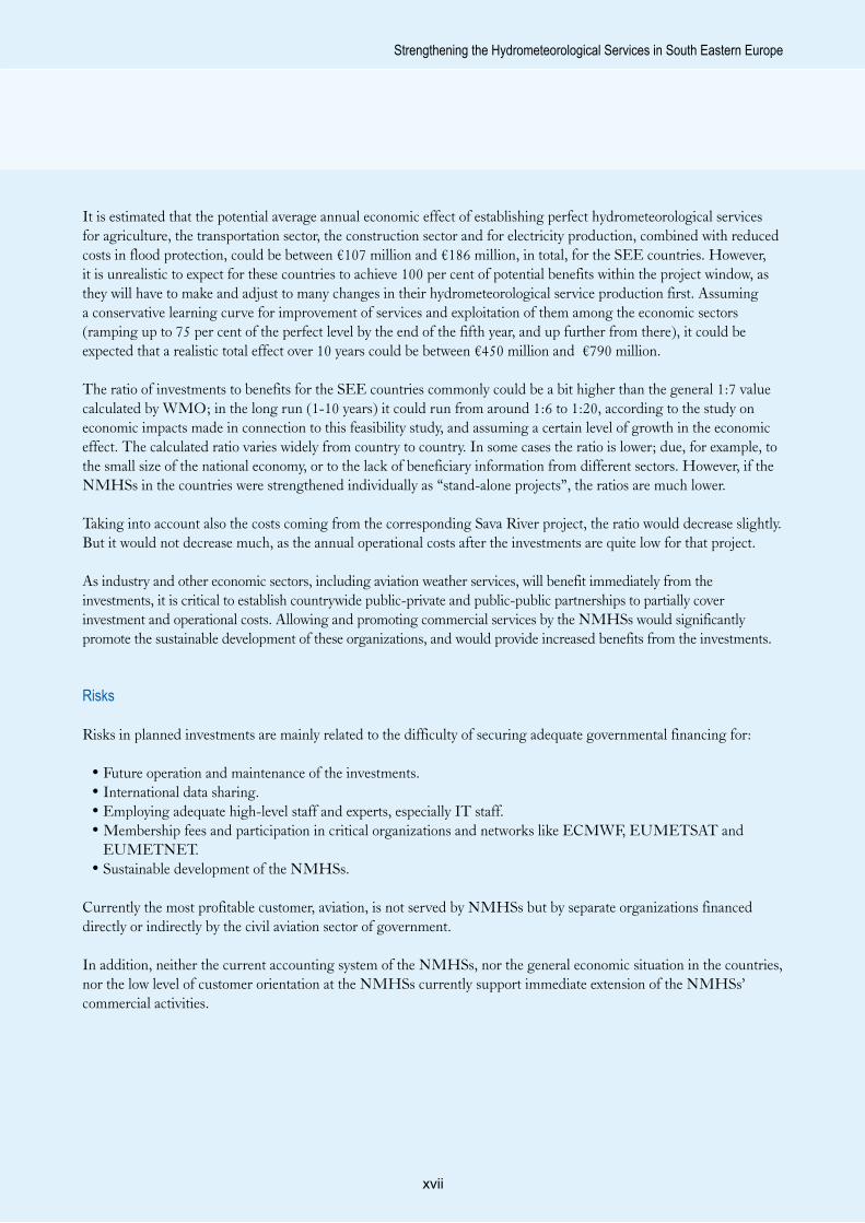
Expected flows of information and financing Figure 3

�
Strengthening the Hydrometeorological Services in South Eastern Europe

�

�
User needs assessment -
Hydrometeorogical services
2

�0
South Eastern Europe Disaster Risk Mitigation and Adaptation Programme
The value of hydrometeorological information for end-users is more than just the total reduction of economic losses. Monitoring of the environment, together with climate and hydrometeorological forecasting, are a few of the management tools that can play an important role in decision-making, and can increase both human safety and business efficiency and productivity.
However, improved scientific knowledge of hydrometeorology does not automatically increase the socio-economic value of the products provided by NMHSs. Even a correct forecast has no value if it is not disseminated to the end-user at the right time and in the right and understandable format.
The need for national and regional data and forecasting and other expert services is growing, as awareness of the options and possibilities of modern science and technology increases among end-users. Unfortunately, the utility and especially the potential of hydrometeorological services are often poorly understood by economic sectors other than aviation. At the same time, the need for hydrometeorological services of current and potential customers and end-users is often poorly identified and assessed by the NMHSs.
For this report, the need for different types of hydrometeorological and environmental data and services in SEE countries was assessed by sending questionnaires to representatives of selected economic sectors (the road traffic, railway traffic, maritime, aviation, energy production, civil protection, agriculture and construction sectors) and by interviewing staff from these and other sectors. The meetings with representatives from Ministries and the different socio-economic sectors were arranged by the NMHSs.
The common needs of different customers and end-users of hydrometeorological services were identified as:• Sector-specific tailored products, based on a better
understanding of the needs of end-users.• Better and more location-specific timely weather
forecasts of different hydrometeorological parameters and air-quality, for shorter (“nowcasting”) and longer (more than 7-10 days) periods.
• Seasonal and annual climate outlooks.• More real-time hydrometeorological and
environmental data, including radar data. • Transboundary real-time data. • Better and more location-specific analyses on climate
variability and extremes.
• Local-scale studies on impacts of climate change (averages, extremes, variability) for different socio-economic sectors in different time frames.
• Improved awareness of hydrometeorological applications and services.
• Better dialogue with the NMHSs. • Public-private partnerships.• An integrated decision and information system to
forecast severe hydrometeorological and environmental events, and to provide advance warnings to commercial, municipal and government organizations.
Additionally, the end-users expressed a number of more detailed needs, varying from country to country and depending on the sector in question. Generally, it was seen that the needs among end-users increased along with the awareness of possibilities and services available. It was also clear that many of the sectors and individual companies would be willing to invest through public-private or public-public multi-partnerships in strengthening the national observation network and hydrometeorological services, if they could use on-line data for their own purposes and gain from tailored products.
2.1 Climate variability and climate change
States of emergency, including exceptional hydrometeorological events, have become more significant components for the emergency management systems adopted by SEE Governments, and also for an increasing number of companies within different economic sectors. Disturbances and costs caused to different socio-economic sectors by possible changes in such extremes as floods, droughts, storms and wave heights need to be addressed. Uncertainty translates into riskier decisions at all levels within the sectors, including decisions on operational and market issues, short-term responses and investments.
It is increasingly necessary to manage climate-related risks, because:• The climate system is changing rapidly.• Losses associated with climate hazards are rising.• Climate change also brings opportunities.• Societies are becoming increasingly interdependent.
According to the regional climate projections produced by IPCC in 20079, the climate will change substantially in the SEE region, with significant consequences for
9 IPCC, 2007. Fourth Assessment Report. IPCC Secretariat, World Meteorological Organization. Geneva, Switzerland. Available at: www.ipcc.ch/ipccreports/assessments-reports.htm

��
Strengthening the Hydrometeorological Services in South Eastern Europe
the economies of most of these countries, especially if the economic pillars and dependency on weather and climate remains at current levels. Precipitation will very likely decrease and temperature and evaporation will increase, which will lead to increased droughts and smaller water discharge. This will have a crucial impact, especially on agriculture and the production of hydroelectric power and biomass, and on water management in general, but also on land-use and general planning. Maps 1 and 2 illustrate the IPCC 2007 scenarios for summer, and the predicted rate of water stress.
In some of the SEE countries, some national programmes have been implemented to produce information on climate change for individual countries. However, in many of the countries, climate change issues have not been a priority for the Government, communities, industry or the public, compared to many more burning economic and social problems.
Regardless, various economic sectors in the countries have expressed a need for more information on local-scale climate variability and climate change, and its sector-specific impacts, within the time frame of investments and strategic planning. It is necessary to produce practical tools to incorporate climate information into business decision-making, to manage climate risk and to help sectors adapt their practices.
It is necessary to study both short-term climate variability and longer-term climate change, not only the trends of averages, but also the changes in extremes and compositions of different parameters. It is very important to establish national and regional climate change projects, in order to increase the awareness of the future, to analyse the risks, and to improve preparedness and adaptation. Climate change does not only create threats, but also opportunities. Some advanced countries have already used some of the implications of climate change and climate change information to their advantage.
Predicted impacts on precipitation due to climate
Source: IPCC, 2007
Map 1

��
South Eastern Europe Disaster Risk Mitigation and Adaptation Programme
2.2 The SEE countries in a nutshell
The seven countries included in this report are Albania, Bosnia and Herzegovina, Croatia, the Former Yugoslav Republic of Macedonia, Moldova, Montenegro and Serbia. They are all relatively small in terms of territorial area. The biggest country is Serbia, covering 88,361 square kilometres, and the smallest is Montenegro, at 14,026 square kilometres. The common area for all seven countries is 297,982 square kilometres, which is less than the size of Finland (which extends over 338,000 square kilometres). The total population of these countries equals 14.6 million.
Country Gross Domestic Product (GDP) per capita varies from the Croatian level of USD 12,400, to the Moldovan level of USD 1,900 (adjusted for purchasing power parity). Agriculture still contributes to a significant share of GDP, and also to employment. Reduction of poverty is one of the critical Millennium Development Goals10 for many of the countries.
2.3 Natural hazards and disaster reduction management
Typical natural hazards in the SEE region are drought, hail, floods and frost (see table 3). Several times in recent years, the impacts of these hazards have
turned into disasters with devastating socio-economic consequences. According to climate change projections, it can be expected that the frequency of extreme weather conditions and weather-related hazards will increase.
Many of the SEE countries have very mountainous topography. In such terrain, flash floods can arise during or a few hours after a rainfall. Therefore, the need for development of reliable and accurate flash flood forecast systems exists and is growing. To meet this need, it is essential to be able to integrate meteorological and hydrological model databases with geographical information systems containing topographical information.
Natural hazards cannot be avoided, but timely, accurate and high-quality scientific prediction of hydro-climate extremes helps societies to prepare for and mitigate disasters, and to reduce losses in infrastructure and productive activities. Early warnings and forecasts providing adequate lead time, together with awareness, education and preparedness, are key steps required to increase human safety and to reduce the socio-economic and environmental impact of natural hazards. Disaster risk reduction is at the core of the WMO mission, and of the NMHSs. The lead time obtained by forecasts depends on the accuracy of global and regional numerical weather prediction models and
Predicted water stress due to climate
Source: IPCC, 2007
Map 2
10 The Millennium Development Goals are eight time-bound and measurable goals and targets for combating poverty, hunger, disease, illiteracy, environmental degradation and discrimination against women. They form a blueprint for development agreed to by all the world’s countries and all the world’s leading development institutions.

��
Strengthening the Hydrometeorological Services in South Eastern Europe
Table
3 Su
mmar
y of n
atura
l haz
ard-
relat
ed di
saste
rs for
selec
ted S
EE co
untrie
sNa
tural
haza
rd-re
lated
disa
sters
Alba
niaBo
snia
and
Herze
govin
aCr
oatia
FYR
Mace
donia
Moldo
vaSe
rbia
and
Monte
negr
oDr
ough
t1
21
11
-kil
led0
00
02
-tot
al aff
ected
3 20
0 00
062
575
010
000
0-
aver
age
dama
ge (i
n US
D)n/a
204
000
000
330
000
000
n/an/a
-Ea
rthqu
ake
5-
1-
-1
killed
47-
0-
-1
total
affec
ted8
279
-2
000
--
100
aver
age
dama
ge (i
n US
D)n/a
-n/a
--
n/aEp
idemi
c2
1-
11
2kil
led7
0-
00
0tot
al aff
ected
292
400
-20
01
647
869
aver
age
dama
ge (i
n US
D)n/a
n/a-
n/an/a
n/aEx
treme
temp
eratu
re2
-2
21
2kil
led71
-45
3013
6tot
al aff
ected
7 08
5-
200
00
70av
erag
e da
mage
(in
USD)
n/a-
120
000
000
n/an/a
n/aFlo
od7
44
75
9kil
led19
00
224
14tot
al aff
ected
116
384
290
100
2 05
011
1 40
026
092
125
398
aver
age
dama
ge (i
n US
D)3
525
000
n/an/a
50 5
14 0
0030
517
000
n/aSl
ides
11
--
--
killed
576
--
--
total
affec
ted26
403
--
--
aver
age
dama
ge (i
n US
D)n/a
n/a-
--
-W
ild fir
es-
13
1-
1kil
led-
01
0-
0tot
al aff
ected
-0
00
-12
aver
age
dama
ge (i
n US
D)-
n/a12
583
000
13 5
63 0
00-
n/aW
ind st
orm
22
11
21
Note:
This
table
cove
rs the
follo
wing
time p
eriod
s: Al
bania
1967
-200
5, Bo
snia
and H
erze
govin
a 199
9-20
05, C
roati
a 199
6-20
06, F
YR M
aced
onia
1993
-200
6, Mo
ldova
1994
-200
6, Se
rbia
and M
onten
egro
1992
-200
6. Inf
orma
tion f
or
Serb
ia an
d Mon
teneg
ro is
pres
ented
in co
mbine
d for
m, as
indiv
idual
infor
matio
n is n
ot av
ailab
le be
caus
e the
two c
ountr
ies on
ly be
came
inde
pend
ent in
2006
.So
urce
: EM-
DAT,
2007

��
South Eastern Europe Disaster Risk Mitigation and Adaptation Programme
local-scale forecasting skills. These in turn depend on the availability and quality of hydrometeorological observation data and the technical and human resources of the NMHSs, as well as on international cooperation and data sharing.
Scientific research is important in developing long-term strategies for disaster risk and emergency management based on risk assessment and response systems. The interrelated issues that need attention are:
• Prediction• Detection, monitoring and early warning on a
24/7/365 basis• Impact assessment• Adaptation• Response
It is critical to have access to sufficient historical hydrometeorological databases, and to have the capability to compile existing information into forms that can be compared with other data and summarized for policymakers. It is also critical to have adequate
early warning and monitoring systems, in order to be able to generate information on the onset, duration, intensity and termination of natural hazard conditions for use by decision makers at all levels.
The current situation of the SEE countries’ civil protection, disaster risk and emergency management efforts, and the status and defined duties of SEE NMHSs, are not yet organized in the best possible way, even if there are significant differences between the countries. At the same time, a series of factors mean that the SEE NMHSs do not currently have the required qualifications to effectively support disaster risk management efforts, governmental development plans, the growing needs of relevant socio-economic sectors, or efforts to meet the WMO requirements for international hydrometeorological data sharing. Limiting factors include inadequate hydrometeorological data, lack of technical equipment and software, insufficient number and quality of the staff, and inadequate premises available, together with lack of regional cooperation and data sharing.
Flow chart of an early warning system: the early warning centre in each country could be the NMHS
Source: FMI and Tammelin, 2007
Figure 4

��
Strengthening the Hydrometeorological Services in South Eastern Europe
Weather forecasting, together with adequate on-line hydrometeorological data, is critical for forecasting of all weather-related hazards. The outputs can then be used and developed by hydrologists, air quality experts and others to manufacture adequate products. Thus establishment of an effective national and regional forecasting system is a major concern for all of these countries.
In particular, it is critical that all the SEE NMHSs can ensure full 24/7/365 operation for their observation network, data management and forecasting, which is not the current case for many. All the NMHSs consider that they are 24/7/365 operative, as they have manned meteorological stations with observational staff on standby. However, most of the SEE countries do not have the staff resources for forecasting to run an actual 24/7/365 weather forecasting service. In addition, currently there are too few on-line meteorological and hydrological observations available, and there is no common real-time radar data for the region.
In addition, it is very important to plan the early warning systems for natural hazards around the NMHSs, in order to gain from their scientific resources and natural connections to the WMO-Global Telecommunications System (WMO-GTS).
In order to reduce the impacts of natural hazards and to optimize adaptation to climate change, it is critical to establish governmental climate and energy strategies, and disaster risk reduction strategies in the countries that do not yet have one. It is also critical to promote European cooperation: in particular, participation in the EUMETNET Meteoalarm and OPERA programmes.
2.4 Aviation
Historically, the SEE NMHSs have had a mandate to produce measurements and weather services for the aviation sector. Aviation sectors have typically been the most profitable and stable source of revenue for the NMHSs. In some European countries, the military organizations have had their own aviation weather service and meteorologists. Today the weather services for civil aviation are produced by national weather services or by other government-controlled enterprises. The quantity and quality of meteorological monitoring and meteorological services for aviation are regulated and controlled by the International Civil Aviation Organisation and the European Organisation for the Safety of Air Navigation (EUROCONTROL).
Some examples of EUMETNET cooperation. Left: New European alarm system of weather-related hazards; right, coverage and composite picture of the EUMETNET weather radar network.
Sources: EUMETNET/www.meteoalarm.eu and EUMETNET/OPERA/www.knmi.nl/opera, 2007
Map 3

��
South Eastern Europe Disaster Risk Mitigation and Adaptation Programme
Typically, the meteorological data from airports has been among the most valuable and most representative daily and historical data. Recently, the aviation authorities in many countries have assumed the role of provider of weather observations and monitoring, mostly for purposes and use of air-traffic controllers. This can cause some difficulties for the NMHSs. In Finland, for example, the data from the airport stations owned by aviation authorities has become very expensive for the former producer of these services, the Finnish Meteorological Institute (FMI). Thus FMI has started to establish new automatic weather stations close to airports, partly in order to try to continue the long-time series of data taken at these locations.
In all of the SEE countries, the aviation weather services are currently provided by governmentally controlled enterprises or services other than the NMHSs. In most cases, cooperation between these services and NMHSs is at a very low level, or negligible. However, in Croatia the exchange of data and services is quite well organized.
The market in the aviation weather service sector is changing rapidly. Unlike the United States of America, Europe has not historically had a single sky for aviation, one in which air navigation is managed at the European level. In 2004, however, the legislative package establishing a Single European Sky was adopted by the European Parliament and the European Transport Council. The Single European Sky will be
achieved through the adaptation of implementing rules developed by EUROCONTROL.
With enactment of a Single European Sky, the production of weather services will obviously change. The market will be opened, and it will become possible for any authorized and qualified company to produce services for any country in Europe. However, the national aviation authorities will still have the ability to choose their producer.
2.5 Protection of the environment and renewable energy sources
Protection of the environment, in respect to biodiversity and human well-being, is a present-day problem that is heavily internalized in EU policy. Hydrometeorology is strongly associated with the environment and with protection of the environment, through water management, oversight of air quality and water quality, and forecasting for dispersion of airborne and waterborne pollutants. For the future, it is important that SEE countries’ national air and water quality legislation and monitoring are adjusted to EU directives and standards. Upgrading of relevant elements, such as the countries’ air pollution monitoring networks, needs to be strongly linked to the hydrometeorological network and an integrated data management system.
Memberships in the ECAC, EUROCONTROL and the EU
Source: Somov, 2007
Map 4

��
Strengthening the Hydrometeorological Services in South Eastern Europe
Renewable energy sources have a significant role in European climate and energy policy. The EU target is to cover 20 per cent of its energy demand through renewable sources by the year 2020. There is potential to increase the production of hydroelectricity in the SEE countries, and biomass and biofuel could also have some role. In addition, wind energy has significant potential.
According to SEE Ministries end electricity companies, there is strong interest in making wind energy investments in the near future. However, currently the wind energy potential is not very well mapped in the SEE countries. The NMHSs could have a significant (and profitable) role in analysing wind resources, preparing national wind atlases and in predicting the site-specific wind energy production. In Finland, FMI provides a good example of this type of NMHS activity and of strong NMHS participation in EU-funded research and development wind energy projects11.
Currently there is at least one ongoing EU-funded research and demonstration project in the SEE region on wind energy. The objectives of the project are to investigate wind energy resources at different sites in the SEE countries using mesoscale modelling and on-
site wind measurement campaigns, with demonstration turbines in Bosnia and Herzegovina, Croatia and Serbia. The partners of this research and development consortium are from Austria, Germany and Switzerland, and also include the Federal Hydrological and Meteorological Institutes, the University of Mostar and Vjetroenergetica d.o.o. from Bosnia and Herzegovina, Adria Wind Power d.o.o. from Croatia, and Cleps d.o.o. from Serbia. The project will run 2007-2010, with a total budget of close to €10 million, and an EU contribution of about 40 per cent.
Hydrometeorological services are in principle strongly related to protection of the environment through their activities in air quality and water quality monitoring, their production of hydrometeorological data to be used by different sectors, and their studies of climate change. There are significant financial resources available in the EU to promote environmental protection-related national legislation and data management, as well as dissemination of information and environmental measurements. This provides good opportunities also for NMHSs to strengthen their services and hydrometeorological monitoring network, as can be seen happening, for instance, in Lithuania, and also in some of the SEE countries.
11 For more information, see the FMI website at www.ilmatieteenlaitos.fi/research_meteorology/meteorology_3.html
Sites for special wind measurement campaigns in the ongoing international project for mapping of wind energy resources in the SEE countries
Source: René Cattain, METEOTEST, 2007Base map sources: VMap Level 0 (DCW fifth edition), NIMA; ArcWorld, ESRI; Dem, USGS EDC; UN Cartographic SectionCartography: based on Dominique Del Pietro, UNEP/DEWA/GRID-Europe, November 2002The boundaries and names shown and the designations used on maps and graphics do not imply official endorsement or acceptance by the United Nations.
Map 5

��
South Eastern Europe Disaster Risk Mitigation and Adaptation Programme
2.6 Identification of other customers and end-users and their needs for hydrometeorological services
In most of the SEE countries, the current customers, and in many cases also the end-users, are mainly the Government, different ministries, research institutes and the media. The number of private meteorological companies is very limited or practically nonexistent. The utility and potential benefits of hydrometeorological services are often poorly understood by economic sectors other than aviation. In many of the SEE countries, however, different industrial sectors in need of hydrometeorological services have started, or are planning to start, their own measurements.
Generally most of the SEE NMHSs have not tried very actively to identify their end-users and these users’ real need for hydrometeorological services, nor their potential commercial customers. On the other hand, current mandates for the NMHSs and the existing accounting system (where all the possible revenue goes directly to the government) do not support such NMHS activities.
In order to identify their customers and end-users, and to assess user needs for hydrometeorological information, the NMHSs were asked to arrange meetings with potentially interested sectors and companies as part of this study. Relevant sectors included health, agriculture, road traffic, aviation, rail traffic, maritime
traffic, military, police, energy production, electricity production and transmission, media, television, civil protection, fire brigades, private road maintenance, environmental protection, and the public. As the NMHSs have not been very commercially oriented, their contacts, cooperation and partnerships with the SEE Governments, various socio-economic sectors, industry and community have not been on a particularly high-priority level. The number of meetings arranged by NMHSs in various countries with potential customers and end-users remained quite limited. However, the meetings which were arranged to help prepare this report supported this report’s objectives, and also promoted connections and dialogue between NMHSs and their potential customers and end-users.
Generally the meetings proved that the use of hydrometeorological services is limited to a few traditional services. This is mainly due to the lack of tailored timely products for different end-user segments, lack of willingness to pay for new services, lack of awareness of potential services that could be achieved and provided using modern technology, and, within the NMHSs, a lack of real information about potential uses of hydrometerological information by different socio-economic sectors.
The common needs for the different socio-economic sectors are presented above, at the beginning of section 2.


�0

��
Socio-economic benefits
3

��
South Eastern Europe Disaster Risk Mitigation and Adaptation Programme
Adequate amounts of hydrometeorological data from each country and region are necessary for global and regional monitoring of the hydrological cycle and production of weather services. Such monitoring and services, in turn, are essential for daily human safety, operation of many economic sectors, and for prediction of climate change, not only nationally, but also for the benefit of all humankind. In all of the SEE countries, economic sectors sensitive to variability in climate and weather contribute significantly to the national GDP and national socio-economic development.
Protection of the environment, in respect to biodiversity and human well-being, is a present-day problem and one that is strongly internalized in EU policy. Hydrometeorology is strongly associated with the environment and protection of environment through air quality and water quality, and forecasting of dispersion of airborne and waterborne pollutants.
Weather itself has a profound effect on human health and well-being. Many diseases are related to weather conditions. Extreme temperatures, air humidity, rainfall rates and air and water pollution have an impact on mortality, which could be reduced by preparedness and proper early warning.
The future of each NMHS lies in its capacity to develop and more effectively deliver hydrometeorological products and services to support and promote sustainable national and regional social and economic development, protection of the environment and adaptation to climate change. It is thus necessary to demonstrate the value of current hydrometeorological services, and especially the potential value that could be achieved through their use within different socio-economic sectors, and through subsequent growth in the national economy and social well-being. SEE Governments, political decision makers, industry and the public must be shown that national ventures to strengthen the NMHSs and production of hydrometeorological and environmental services will not merely be expenditures, but rather an investment. However, it must be taken into account that hydrometeorological products have no value before they are disseminated to the end-users and used properly for decision making.
Socio-economic benefits of hydrometeorological services have been studied to some extent in different countries. Also, in undertakings such as research and development project proposals to the EU Research Framework Programmes, researchers have had to
indicate the socio-economic benefits to be yielded to the community. In addition, recently WMO has raised the value of information production on the socio-economic benefits of NMHSs within its own actions and priorities. The value of hydrometeorological services can be also seen in the increasing number of private consultants employed in recent years.
3.1 Methodology
One method for measuring the value of hydrometeorological services is to assess their use and the need for them within different socio-economic sectors. Such qualitative study gives good indication of the services’ value to the community. However, application of this practice in several developing countries shows that the NMHSs do not know very well what should be produced and offered to different economic sectors. Experience also shows that the possibilities to create different types of tailored products, and possibilities to use state-of-the-art observing and production systems by NMHSs, are poorly recognized by the customers and end-users, leaving the expectations of the customers and end-users often at a very modest level.
The economic value of weather and climate forecasts was widely discussed during the end of 1990s, for example in Katz and Murphy (1997). Various methods have been used for measuring the quantitative (or monetary) value of meteorological services. For instance, Freebairn and Zillman (2002 a and b) have conducted research in this area, analysing the applicability of various methodologies proposed for measuring the economic benefits of meteorological services. According to Gunasekera (2003), there is more than one method of assessing the economic value of meteorological services.
To assess the benefits resulting from utilization of hydrometeorological information, several things should be taken into account:
• Identification of economic losses caused by weather and climate.
• Benefits coming from current information.• Definition of ideal services for various sectors.• Estimation of the potential reduction of losses
resulting from different levels of improved information.
• Estimation of potential improvement in operations coming from different levels of improved information.

��
Strengthening the Hydrometeorological Services in South Eastern Europe
Table 4. Calculated average annual impact of weather services offered to the road traffic sector
Calculated results (minimum) Albania Bosnia and
Herzegovina Croatia FYR Macedonia Moldova Montenegro
The impact of information services offered to road users on injury accidents (accidents)
0,30 7,29 25,81 4,60 4,69 2,15
The impact of information services offered to road users on fatal accidents (accidents)
0,27 0,23 0,60 0,14 1,80 0,06
The impact of information services offered to road users on injury accidents (in millions of euros per year)
0,02 0,54 3,68 0,34 0,12 0,15
The impact of information services offered to road users on fatal accidents (in millions of euros per year)
0,11 0,11 0,58 0,07 0,31 0,03
Socio-economical benefits of meteorological information services (in millions of euros per year)
0,12 0,66 4,25 0,41 0,42 0,18
The impact of information services offered to road users on injury accidents (accidents)
0,60 14,60 51,71 9,21 9,43 4,31
The impact of information services offered to road users on fatal accidents (accidents)
0,53 0,46 1,21 0,28 3,63 0,11
The impact of information services offered to road users on injury accidents (in millions of euros per year)
0,04 1,09 7,37 0,69 0,24 0,30
The impact of information services offered to road users on fatal accidents (in millions of euros per year)
0,21 0,23 1,15 0,14 0,61 0,05
Socio-economical benefits of meteorological information services (in millions of euros per year)
0,25 1,31 8,52 0,83 0,85 0,35
Source: VTT-FMI, 2007

��
South Eastern Europe Disaster Risk Mitigation and Adaptation Programme
Table 5. Summary of estimated benefits of DHMZ information services to maritime industries derived from corresponding Finnish estimations
Key figure Finland Croatia
Number of boats 420 000 200 000
Annual number of boating accidents at sea
700 1 000
Fatalities in weather- related accidents - 3-7
Fatalities avoided due to delivered met-information
10-20 5-10
VOSLs per annum € 17.5 – € 35 million
€ 3.6 – € 7.2 million
Number of rescue missions avoided 34 17
Savings in rescue mission costs per annum
€ 0.24 million € 0.05 million
Number of port calls 44 988 5 806
Planning and conducting of oil combating per annum
€ 12.1 million € 0.64 million
Total benefits per annum
€ 4.3 – 7.9 million
Source: VTT-FMI, 2007
For the SEE countries, preliminary economic impact studies have been carried out by the World Bank for Albania and Serbia. With support from the Finnish Government, a socio-economic study was conducted by VTT, FMI and DHMZ (the Croatian Meteorological and Hydrological Service) in 2006-2007 for Croatia (Leviäkangas et al.).
A common feature of the above mentioned studies is that the weather-dependent economic sectors had to be limited to a very few. It was also very difficult to find adequate data to produce reliable figures for the value of current hydrometeorological services and the benefits yielded from improved observations and services.
3.2 VTT-FMI study for the SEE countries
For this report, a separate study on socio-economic impacts of improved hydrometeorological services
was executed for five SEE countries - Albania, Bosnia and Herzegovina, the Former Yugoslav Republic of Macedonia, Moldova and Montenegro (and partially for Serbia) - in cooperation with VTT and FMI. The study was mainly financed by FMI and partially supported by the Finnish Government (VTT-FMI).
The objective was to find the effect (E), or the value of improvements, of enhanced hydrometeorological information, compared to current effects with the data and services available today:
E = (Expected Benefit with Perfect Information) - (Expected Benefit with Current Information)
The sectors studied were road traffic, railway traffic, maritime industry, aviation, construction industry, energy production and air quality, flood protection and agriculture production. The quality and quantity of data and services provided by FMI were used as a reference.
In order to collect necessary background economic data, questionnaires were prepared for each sector. The questionnaires were sent to all SEE NMHSs in order to be forwarded to representatives of these sectors. It was also expected that additional economic data could be collected in meetings with different sectors, and also by the NMHSs. However, fully adequate economic data was received from only one country, and fully adequate economic data on some sectors from one other. Thus the study of socio-economic impacts had to be based on previous VTT-FMI studies made for Croatia and Finland, on data collected from the Internet, on shares of different weather-dependent sectors of GDP in different countries, and on assumed similarities between the countries.
Road traffic
For road traffic, road safety and maintenance costs were analysed. Relevant information such as the number of different types of road accidents could be found in international statistics handbooks. Table 4 shows the results.
According to a Finnish expert interview, meteorological information and warning services offered to road users reduce by 1-2 per cent the number of road accidents involving personal injury or death on public roads in Finland (Kulmala 2006). Therefore, impacts of weather services were estimated twice, to show the minimum (one per cent) and maximum (two per cent) impact. The figure from Finland was also scaled to reflect the

��
Strengthening the Hydrometeorological Services in South Eastern Europe
shares of accidents happening in adverse weather and road conditions in different SEE countries, considering the data from Croatia for scaling.
In SEE countries, winter maintenance of roads is a significant expenditure. According to the data from Moldova, for instance, 1,000 tons of road salt is used every year on public roads, at a total cost of €100 per ton. In Finland, a five per cent reduction in use of road salt was achieved because of better meteorological support for road winter maintenance operations. Assuming a similar result in Moldova, that country could save 50 tons of salt, or €5,000, per year.
In the case of other countries included in the study, the amount of road salt used in a year is not known. For this reason, it is not possible to give exact figures describing the potential benefits in road winter
maintenance. However, almost all countries spend considerable amounts of money on winter maintenance of roads. If even a small cost reduction in per cents could be achieved, the benefits would be considerable.
Maritime transport
The impact areas of maritime transport are divided into four domains: safety of human beings, environment, economy and material. In this analysis, the impact to maritime transport was considered from the point of view of different activities and the domains were considered to be part of these activities. Only data for Croatia was available. For the other coastal countries - Albania, Bosnia and Herzegovina and Montenegro - the impact on the maritime sector was not studied.
Table 6. Basic data collected on rail transportation
Country Railway and infrastructure companies, 2006
Freight volume, 2006
(in millions of tonnes per kilometre,and millions of
tonnes)
Passenger volume, 2006
(in millions of passengers per kilometre, and
millions of passengers)
Track length, 2006
(in kilometres)
Albania Hekurudha Shqiptare, HSH, is the integrated railway of Albania. n/a n/a 677
Bosnia and Herzegovina
Two companies, ŽFBH (Federation of Bosnia and Herzegovina) and ŽRS (Republic of Srpska); both provide transport services and manage the rail infrastructure.
ŽFBH - 6826.6
ŽRS - 4070.4
ŽFBH - 6820.4
ŽRS - 4070.8
n/a
FYR Macedonia
Infrastructure and transport entities have been separated into two
companies from the Railways of the Former Yugoslav Republic of
Macedonia (RFYROM).
6143.8
1051.0 925
Moldova Integrated railway 3 65611.1
4715.3 1 153
Montenegro
Divided into infrastructure and transport companies (ŽCG-
Infrastruktura d.o.o. and ŽCG-Prevoz d.o.o.) operating under one holding company (ŽCG Crne Gore
a.d.)
182n/a
112n/a 328
n/a = not received from the questionnaire or not found.

��
South Eastern Europe Disaster Risk Mitigation and Adaptation Programme
Seven different maritime industry activities were selected to be considered when assessing the socio-economic impact of services from the Croatian NMHS (DHMZ). These activities were: 1) search and rescue 2) vessel traffic (sea traffic), 3) oil combating and pollution prevention, 4) river traffic, 5) boating and other recreational use of water areas, 6) tourism and 7) fishing and fisheries. In table 5 above, the benefits gained in these activities from potential development of future services are described.
Railways
The railways of the SEE region play an important role in the region’s economy and exchange of goods. The SEE railways have experienced much of the same restructuring processes as other European railways, i.e. separation of infrastructure from operations and development of a more market-oriented corporate structure.
Better hydrometeorological information is expected to have at least the following beneficial impacts:
• Maintenance of tracks can be proactive, and managers can initiate just-right-time maintenance operations, such as snow removal and subsystem (e.g. train control systems) maintenance; this should provide significant opportunities to improve the reliability of train movements and enable the
maintenance operators to plan optimal performance of their activities in terms of manpower and equipment.
• More efficient maintenance and better preparedness should improve the safety of rail transport, resulting in savings in terms of human lives12 and material damages.
For time savings achieved through better hydrometeorological information, the data used included:
• The assumption that it is possible to eliminate at least 10 per cent of delays.
• 0.5 h was used for avoided delays (as given in one of the questionnaires).
• Average salaries of passengers in each country. • Number of passengers in each country.
The data on reliability and safety used is given in table 7. As this data was incomplete, assumptions were made based on data received to calculate results for other countries. The impression from the questionnaire was that the data from Montenegro and the Former Yugoslav Republic of Macedonia was quite reliable, and the further assessment is based on the data from those countries. The Macedonian figures also corresponded exactly to the figures of UIC (International Union of Railways). (For additional information on how the benefit estimates were performed, please see the supplementary VTT-FMI study.)
12 The value of human life has been discussed in studies such as Leviäkangas et al. 2007. This analysis relies on the same assumptions.
The logic of impact mechanisms
Source: P. Leviäkangas, 2007
Figure 5
Meteorological
information services
Traffic
and train safety
Trains on time
Track availability
Safety benfits (€) Time savings (€)
Railway workersan train staff
Proactive maintenance
and train control
Passengers Freight
Optimisation of resources
through better planning
and more efficient
operation (€)

��
Strengthening the Hydrometeorological Services in South Eastern Europe
Table 7. Data on reliability and safety of rail traffic
CountryRail traffic reliability (per cent of departures and arrivals on
time)
Reliability problems due to weather
conditions
Safety of rail transport (number of accidents)
Weather-related
accidents
Number of casualties and injured in the
accidentsAlbania n/a n/a n/a n/a n/aBosnia and Herzegovina n/a n/a n/a n/a n/a
FYR Macedonia
Severe problems in reliability* None reported 83 accidents
in 2006 2 7
Moldova Departures around 98%, arrivals around 90% on time None to be reported n/a n/a 26 in 2000**
Montenegro
Passenger trains: departures around 90%, arrivals around
20% on timeFreight trains: departures
around 20%, arrivals around 5% on time
Some part of the deviations of
scheduled times are weather-related
56 in 2005 1 270***
n/a = no answer or no data available.* 0 per cent was reported as the reliability indicator; either there are severe problems (i.e. all the trains experience time reliability problems) or the question was misunderstood.** Source: Moldovan Railways Restructuring, SCR-E/111005/CSV/MD, Safety and Environmental Considerations, October 2002 (NEI B.V., DE-Consult, ARRC & VTT).*** One major accident occurred where the majority of injuries and casualties were experienced.
The annual benefits are estimated to be somewhat higher in these countries than the value calculated for Croatia (€0.15 million per year), as seen in table 9.
Aviation
The aviation sector is still quite modest in the countries under discussion. The number of flights, trips and volume of air freight, however, is expected to grow. The estimates of current savings shown above (table 9) are mainly based on the number of passengers, freight and flights per year during 2005-2006, compared to Croatian and Finnish numbers. For Moldova it was also possible to calculate some additional ratios. Unfortunately it was not possible to treat Serbia separately from Montenegro, as data from before 2006, when they became independent, is normally in a combined form. The main shortcoming in the input data for all countries was the lack of comparable accident data. Therefore it was generally assumed that the safety situation in the SEE countries is at a European average level, even though the current situation may in fact be somewhat worse.
The aviation sector is an important and stable source of revenue for most of the NMHSs in Europe. However, in all of the SEE countries, the aviation weather services are produced by other institutions and players than the NMHSs.
Construction industry
The construction industry is vulnerable to weather during phases of excavation work, foundation works and when companies are putting up frames. Additionally, weather causes a risk of wetting for isolation and roof work. Typically these working site costs represent one-third of total construction costs. The value of building volume was available only for the Former Yugoslav Republic of Macedonia, Moldova and Montenegro. For Albania and Bosnia and Herzegovina, a value of four per cent of GDP was used. Profile of construction or trend of building was not available.
It was estimated that the weather risk is three per cent of the value of construction work. Thus the potential value of annual additional construction costs are for

��
South Eastern Europe Disaster Risk Mitigation and Adaptation Programme
Albania, €2.7 million; Bosnia and Herzegovina, €3.9 million; the Former Yugoslav Republic of Macedonia, €2.3 million; Moldova, €1 million, and for Montenegro, €0.5 million. According to experimental data, good weather services can reduce these additional costs by some 25-50 per cent.
Energy sector
For the energy sector, answers to questionnaire studies were received from only three countries, and cost data from only one. This means that even rough cost-benefit ratios could not be calculated for these countries. Furthermore, all these countries import a big share of their electricity, so the national benefits of hydrometeorological data in the energy sector will be a bit lower than in the case of 100 per cent own-energy production. Table 10 displays the information that is available on the impacts and benefits of improving hydrometeorological services.
Flood protection
Floods affect all of the SEE countries. Except for Moldova, no data was received on flooding through the questionnaires. Thus data available from the International Emergency Events Database EM-DAT on the Internet was used (table 11).
Forecasting and warning, when coupled with effective response plans, enable citizens and public servants to act to protect people and property before floodwaters reach critical levels. With sufficient warning, for example, actions like temporary removal of property from the flood plain can be taken.
According to data from the National Hydrological Warning Council in the United States, the maximum practical per cent reduction in flood damages depends on the lead time of the warnings. The quality of 48-hour warnings depends very much on the quality
Table 9. Benefits of meteorological services for aviation in selected SEE countries in 2005
Benefits of meteorological services for aviation
Current savings (in millions of euros per
year)
Potential benefits (in millions of euros per
year)Albania 2-4 6.5Bosnia and Herzegovina 0.5 1Croatia 12 18FYR Macedonia 2-3.5 5.5Moldova 2-4 6Serbia and Montenegro 5.5-10 16
Table 8. Annual benefits (in euros) in the rail traffic sector from improved hydrometeorological services
Safety of rail transport
Time savings of
passengers
Savings in track
maintenance
Totaleuros per
yearAlbania 248 000 n/a 21 000 305 000Bosnia and Herzegovina 426 000 12 000 n/a 438 000
FYR Macedonia 387 000 9 000 39 000 435 000
Moldova 142 000 17 500 17 000 177 000Montenegro 203 000 n/a 7 000 210 000
Note: Information for Serbia and Montenegro is presented in combined form, as individual information is not available because the two countries only became independent in 2006.

��
Strengthening the Hydrometeorological Services in South Eastern Europe
Table 10. The impacts of hydrometeorological services in the energy sector
Industry/sector Main impact mechanisms Main benefits Annualized value (in millions of euros)
Energy production(provided already)
Energy production forecasts (operation
control); security of supply (operation, maintenance,
damage prevention); infrastructure (electricity
grids);hydropower (dam
controlling, overflows)
Prediction of power demands; power failure
reduction; savings in material (damages) and working time
(repairing, maintenance costs); prevention of damage
to buildings and plants; avoiding generation shortfalls
and overflows; energy savings
Electricity production: 0.3 (USD 0.5 million) and 5 human lives for Moldova; values not available for FYR Macedonia
and Montenegro
Other types of energy (heating plants, oil and gas production,
etc.): unknown
Air quality monitoring and warnings (in the future)
Air quality forecasts and warnings (in the
future); health impacts (fine particles causing
pulmonary diseases and deaths)
Reducing adverse health impacts; saving human lives
in possible environmental accidents (evacuations)
Air quality (dispersion models): 0 million at the moment with some future potential; very useful for the authorities
Table 11. Summarized data on floods from 1979 to 2006
Number of events/ average per year
Total deaths/average
deaths per event
Injured Homeless AffectedTotal affected/ average per
event
Total cost of damages/
average cost per event
(in US dollars)
Albania 7/0.2 19/3 0* 0* 116 384 116 384/16 626
24 673 000/ 3 525 000
Bosnia and Herzegovina 4/0.6 0 0* 0* 290 000 290 000/
72 525 -
FYR Macedonia 7/0.5 2/0 0* 150 111 250 111 400/
15 914353 600 000/ 50 514 000
Moldova 5/0.4 24/5 0* 849 25 243 26 092/5 218
152 584 000/ 30 517 000
Montenegro 4/0.1 23/6 - 6 000 21 000 27 000/6 750 -
* 0 per cent was reported as the reliability indicator; either there are severe problems (i.e. all the trains experience time reliability problems) or the question was misunderstood. Source: EM-DAT, 2007

�0
South Eastern Europe Disaster Risk Mitigation and Adaptation Programme
of weather forecasts provided by big centres. For short-time forecasts, the importance of local on-line observations increases.
For the SEE countries, a conservative assumption of reduction of about 10 per cent of damages was used. Thus the average annual impacts of hydrometeorological services were €56,000 for Albania, €2.4-€7.2 million for Bosnia and Herzegovina, €2 million for the Former Yugoslav Republic of Macedonia, €1 million for Moldova, and €0.2 million for Montenegro.
Agricultural sector
For the agricultural sector, again, very little data was collected for this study. However, it was assumed that the impact of good hydrometeorological services could be similar to that achieved in Finland, namely 0.5 per cent. Taking into account the size of the agricultural sector in each country, the annual benefits from saved losses and improved production were calculated (table 12).
The costs to agriculture incurred due to unfavourable weather conditions in the SEE countries are also substantial. Thus there potentially could be additional economic benefits from enhanced weather forecasts, which could prevent, at least partially, the damage
caused by hail, frost, drought and floods, given that the SEE region is prone to more extreme weather conditions than Finland. To give a sense of the magnitude of damages in the region, below are the average costs per year caused by the unfavourable weather events in Croatia (for the period 1995-2005):
• Hail: €42.7 million• Frost: €16.5 million• Drought: €50.6 million• Floods: €19.8 million
3.3 Summary of findings on socio-economic benefits
The sectoral analyses discussed above show that strengthening the SEE region’s NMHSs, and improving the products they produce and their dissemination of information, would yield significant benefits to national and regional economies. Table 13 summarizes the potential benefits as calculated in the VTT-FMI study.
In relative terms, the benefits are biggest in Moldova (about 0.2 per cent of GDP), due to its very low GDP, while for Croatia the benefits would equal about 0.05 per cent of GDP.
Table 14 provides, as supplementary information, the results of a 2006 World Bank analysis of the economic
A curve for estimating flood warning benefitsFigure 6
Sources: National Hydrologic Warning Council 2006; VTT-FMI, 2007
Maximum practical percent reduction in damages
Percent reduction in damages
Warning time, hours
40
30
20
10
6 12 24 30 36 40 4818

��
Strengthening the Hydrometeorological Services in South Eastern Europe
benefits of improved hydrometeorological services. The World Bank analysis, as mentioned earlier, looks only at two of the SEE countries, Albania and Serbia.
There are significant differences between the results of these two studies. The differences certainly stem in part from the lack of adequate input data available in both cases. The VTT-FMI study suffers significantly from lack of adequate data from the SEE countries. Only Moldova was able to produce proper data for this study. Croatian data that was quite relevant had been collected earlier by Leviäkangas et al., 2007.
When comparing the results produced by the two studies for Albania and Serbia, there is a significant discrepancy in the estimated value of improved hydrometeorological services for the agriculture sector. Partly, this large difference arises from variations in the approach: In the World Bank study, only reduced losses were studied, while in the VTT-FMI study, the value of increased production of hydrometeorological services was also taken into account.
Other uncertainties exist. Only a subset of the weather-dependent sectors has been studied, and only direct costs were calculated. Important sectors, like the health sector and water management, were not included. Air
Table 12. The estimated added value (in millions of euros per year) of economic benefits that can be gained by agro-meteorological services in the SEE countries
Albania 16.6
Croatia 15.0
Bosnia and Herzegovina 4.7
FYR Macedonia 2.9
Moldova 3.6
Serbia and Montenegro 21.6
quality, which is related to meteorological conditions, also has a significant impact on human well-being, but has not been included. When the impact of micro-particles is studied more, the importance of this sector will increase further.
In the VTT-FMI study, the potential effects of improved hydrometeorological services have been
Table 13. Potential socioeconomic benefits (in millions of euros per year) of improved meteorological and hydrological services in SEE as estimated by VTT-FMI
Albania Bosnia and Herzegovina Croatia FYR
Macedonia Moldova Montenegro Serbia and Montenegro
Road traffic 0.25-0.50 1.31-2.62 8.5-17.0 0.83-1.66 0.85-1.70 0.35-0.70Railway traffic 0.3 0.44 0.44 0.18 0.21Maritime industry n/a n/a 1.9-3.6 not relevant not
relevant n/a not relevant
Aviation 1.5-4.5 0.5 5.8 2.5-3.5 2-4 n/a 6.0-11.5Construction production 0.68-1.35 0.98-1.95 1.2 0.58-1.15 0.25-0.50 0.13-0.25 1.2
Energy production n/a n/a current 2.0 n/a current 0.3 n/a
Flood protection 0.06-1.41 2.41-12.06 2.0 2.03-28.13 0.98-7.23 0.24-2.45
Agriculture production 16.6 4.7 15.0 2.9 3.6 n/a 21.6
Potential benefits 19.3-24.7 10.3-22.3 34.4-44.6 9.3-37.8 8.1-17.5 0.9-3.6 26.6-33.1
Note: Information for Serbia and Montenegro is presented in combined form, as individual information is not available because the two countries only became independent in 2006. Source: VTT-FMI 2007
Note: Information for Serbia and Montenegro is presented in combined form, as individual information is not available because the two countries only became independent in 2006.

��
South Eastern Europe Disaster Risk Mitigation and Adaptation Programme
estimated with reference to both current levels of service in the SEE countries, and to the amount of hydrometeorological products and services that are available in Finland (as produced by FMI). However, it will not be possible to bring actual benefits in SEE countries up too quickly to the potential benefit levels. Capacity will constrain implementation of the proposed investments, regardless of the level of willingness. Learning to produce improved services and integrating these improved services into the decision-making processes within different economic sectors takes time. Specific constraints include:
• Time needed by NMHSs to adopt new technology, to manufacture new products, recruit new employees and train the required staff.
• Lack of tradition of cooperation with end-users and economic sectors.
• Lack of marketing skills.• Lack of both appreciation for NMHSs
and awareness of the potential benefits of hydrometeorological services among the economic sectors.
• Lack of tradition of fully incorporating hydrometeorological information in decision-making processes by a number of economic sectors.
Regardless of these uncertainties, the results from all studies available indicate that improved hydrometeorological services could significantly benefit the national economic development in the SEE countries. However, it will be critical for the SEE NMHSs to promote production of more precise studies with better data to fully demonstrate the potential socio-economic impacts of strengthening of their hydrometeorological services.
Table 14. Economic benefits (in millions of euros per year) of improved hydrometeorological services, as calculated by the World Bank
Albania Serbia Transport 0.32 2.213
Energy 3.54 0.5Emergency 2.05 0.414
Agriculture 0.36 6.815
13 Road maintenance plus civil aviation.14 Flood protection.15 Hail supression, floods and droughts combined.
Schematic illustration of the relationship between current economic benefits, potential economic benefits and estimated economic benefits to be achieved during the initial five-year period, and during the following five years
Figure 7
Estimated potential effectof improved services
Effect achieved throughimproved services
Current level of economic effect
year 1 year 2 year 3 year 4 year 5 year 6-10
Ann
uale
ffect
M€

��
Strengthening the Hydrometeorological Services in South Eastern Europe
Table 15. The estimated actual cumulative economic benefits (in millions of euros) of improved hydrometeorological services in the SEE countries
Potential cumulative
benefits over the first five years
Estimated actual cumulative benefits over
the first five years
Estimated actual cumulative benefits during years 6-10
Albania 97-124 39-49 82-105Bosnia and Herzegovina 52-112 21-45 44-95Croatia 172-223 69-89 146-190FYR Macedonia 47-189 19-76 40-161Moldova 41-88 16-35 34-74Montenegro 5-18 2-7 4-15Serbia 120-175 48-70 102-149TOTAL 554-929 214-371 350-789
The needs of the public for short-term, site-specific weather forecasts and representative on-line data will increase significantly, as tourism and leisure activities normally increase in improving economies. The economic impact of improved weather services can mainly be demonstrated with data from more developed countries. For instance, in Finland the FMI homepages are among the most popular in the country, the peak value for daily visitors on the pages are close to six per cent of the entire population, and the use of mobile Internet services to receive weather information has increased continuously by some 50 per cent per year.
In order to find a cost-benefit ratio for the recommended investments, it is estimated that, given the capacity constraints discussed above, the
actual savings, or economic benefits, from improved hydrometeorological services could gradually ramp up over five years to the point where they would, in year five, provide approximately 75 per cent of potential economic benefits. (Potential benefits are those that could be achieved by good services, such as the current level provided by FMI). This assumes a very conservative learning curve for the first five years (figure 7). During the following five years, an 80 per cent level of potential annual economic benefits is assumed. The corresponding fiscal savings are given in table 15.
During the years 6-10, the operational costs would be around 50 per cent of the total investment provided in years 1-5. These costs include the salaries of additional staff required.

��

��
State of affairs in the NMHSs
4

��
South Eastern Europe Disaster Risk Mitigation and Adaptation Programme
The activities of the NMHSs cover a wide range of sciences. NMHSs have expertise within the whole area of the hydrological cycle and related environmental topics, which provides them with comprehensive opportunities to provide good combinations of this expertise for production of multidisciplinary science-based services for the SEE Governments and the communities.
The NMHSs carry out hydrometeorological and environmental monitoring and provide extreme weather events warnings. In the case of extreme events, the
information is forwarded to state authorities, economic agents, and the mass media, in order to protect people and national economies against extreme weather events, and to avoid or mitigate damage.
In general, the activities of the NMHSs are not very end-user oriented, but instead focus on general products and services. The products are mainly disseminated to governmental agencies and authorities. In many cases, the public accessibility and availability of the products is very low.
Table 16. Different main activities performed by NMHSs from different SEE countries
Albania Bosnia and Herzegovina Croatia FYR
Macedonia Moldova Montenegro Serbia
Weather forecasts x x x x x x x • 24/7/365 no no x x x no xMeteorological observation network x x x x x x x
Aviation meteorological service no no no no no no no
Marine weather forecasts x no x no no x no
Agrometeorology x x x x x xHydrological observation network x x x x x x
Hydrological forecasts n/a x x x x no xHydrological forecasts based on numerical weather prediction
no no no no no no no
Hydrometeorological research and development
low x x no no
Hail suppression no no x x no no xAir quality monitoring and measurement x x x x x x x
Dispersion modelling noWater quality x x no x x x xRadiation x no x x xAstronomy no x no no no no noSeismology no x no no no no noCommercial services some some some x x x someTraining programme no no no no no observers x

��
Strengthening the Hydrometeorological Services in South Eastern Europe
4.1 Legal status
The legal status of the NMHSs is not always clear, especially since weather services are typically provided by between two and four governmental agencies in each country. The political support for aviation weather services is much better and more profitable than the support for NMHSs, which in turn provides aviation services with much better financial, technical and human preconditions for production of required weather services.
4.2 Premises
Generally the premises of the SEE NMHSs are old and/or in relatively poor condition. They do not meet the requirements of a modern hydrometeorological service, either in terms of placement of modern technology, or in terms of the safety of data and other property. The space for staff does not meet typical standards of 10-15 square metres per person. The resulting need to share a relatively small room with up to five other other people does not support productivity, especially in the academic staff. Nor do the premises promote the image of the NMHSs. All the offices of the aviation weather services were much more modern and in better shape, indicating to the visitor the existence of more dynamic and business-like activities.
4.3 Financial and human resources
Hydrometeorology as both science and services is very expensive today. The annual budgets available to the NMHSs, however, are in general very low, and strongly oriented towards personnel costs. They typically do not support any modernization plans for the NMHSs.
Generally the NMHSs are not allowed to have their own accounts. This means that all revenues from services to customers go directly to central government accounts. This state of affairs does not motivate the NMHSs to promote innovation and production of new services, or commercial services in general.
The total number of staff working in these institutes is 2,085. Most of the NMHSs have staff overcapacities, which are due in particular to the high number of observers. Generally the educational level and scientific and technical qualifications of the staff do not meet the current requirements and expectations of the communities and industry. Lack of an adequate
number of staff with proper knowledge of English is a significant obstacle for improved international cooperation.
In comparison, as a reference: In Finland, which has about the same territorial area as these SEE countries put together, the annual budget of FMI is €45 million, including external revenues of 35 per cent. The number of staff is 550 man months per year, including 220 people working full time on research and development. The staff also includes 40 IT personnel, with about 15 people who perform three-shift work as supervisory staff. About 18 per cent of the staff has a PhD.
Currently the level of governmental financing for international cooperation at the SEE NMHSs is too low, given modern needs and the advantages that such cooperation would provide for both the NMHSs and the SEE countries.
Low governmental financing and low budgets, together with difficulties in employing adequate IT and other technical staff and educated experts (due to factors such as low salary levels), are a threat to sustainable development of the NMHSs. This threat would exist even if the NMHSs’ technical capabilities were suddenly increased through international financing.
Annual reporting: The NMHSs’ annual reporting to their governments is generally very brief. It is critical to define evaluation and evaluation criteria for the NMHSs, and to introduce new measures to better describe the activities and achievements, in order to improve the annual reporting so that it becomes more end-user and stakeholder friendly.
Accounting systems: The accounting systems of the NMHSs are simple and old-fashioned. Future changes in the operating and business environments of the NMHSs, and increasing cooperation with EU research programmes, will require the NMHSs to rapidly renew their financial administration and to adopt state-of-the-art electronic and automatic tools. This in turn will require that they invest in the training of administrative staff and in recruitment of new skills.
4.4 Training
Generally all the NMHSs suffer from a lack of proper training programmes for the hydrological and meteorological staff, the technical staff and the managers. The NMHSs do not have full-time training planners, and lack skilled trainers. The budget for

��
South Eastern Europe Disaster Risk Mitigation and Adaptation Programme
training is minimal, if training even receives a budget allocation. Therefore, the level of training provided currently to the staff is at an extremely low level compared to more advanced NMHSs such as FMI. In addition, the NMHSs have not adequately exploited the training possibilities provided by WMO, through EU cooperation and with other international sources.
4.5 Productivity
Generally in most of the SEE NMHSs, the productivity of hydrometeorological staff is very low due to the high level of manual work performed. The number of personal computers and workstations is often very low, and current data management supports neither manufacturing of products and services, nor the production of weather services. Within the environmental service departments of the NMHSs, however, the situation seems to be much better.
In many cases, the lack of commonly accepted missions, strategies and objectives, as well as the lack of an internalized sense of cooperation and teamwork, all pose mental obstacles for staff. They block development of a better feeling of solidarity and of being part of common processes.
In general, the NMHSs have limited abilities to use any incentives (like salary increases) to increase productivity and to promote staff commitment. Lack of financial resources for international cooperation and networking of the experts and scientific staff, as well as lack of internal training programmes, also reduces motivation and productivity. Furthermore, management methods that still remain from past times, together with recruitment, promotion, salary and general personnel policies, do not promote rapid increase of production.
Table 17. Some international memberships and partnerships
Albania Bosnia and Herzegovina Croatia FYR
Macedonia Moldova Montenegro Serbia
ECMWF yes yes yesEUMETSAT yes yesEUMETNET yesECOMETMED-HYCOS16 yes yes yes yes yes yes yesICH/CIS yesICCED yesICEED yes yes yes yes yes yes yesHIRLAMRC LACE yesGEO yes yesETA yesALADIN yesUNIFIED MODELCOSMOEU R&D yesEU COST yesEU CARDS yes yesEMEP yes yes yes yesBilateral yes yes yes yes yes yes
16 Mediterranean Hydrological Cycle Observing System.

��
Strengthening the Hydrometeorological Services in South Eastern Europe
4.6 International cooperation and data sharing
Regional cooperation, better cooperation on an EU level, and institutional cooperation with more advanced NMHSs would all yield better services, higher scientific levels, and reduced investment needs in technical facilities and human resources for the SEE NMHSs.
In the hydrometeorological sector, international cooperation and data sharing is essential for production of good-quality weather and hydrological services for national purposes. It also allows NMHSs to maximize the utility of modern technology (which is very expensive) and to minimize national expenditures. Flood forecasting, and general forecasting of discharge in rivers, both depend strongly on adequate national data. They also, however, require real-time transboundary data and dissemination of information between the NMHSs, power companies and water management authorities.
Today, as meteorology and hydrology have become very expensive scientific and service sectors, and state-of-the-art technical equipment and software make it possible to significantly increase the quantity and quality of services, it is critical, especially for small- and medium-sized NMHSs, to take advantage of existing international hydrometeorological cooperation, organizations and their services. Given the geographical location of the SEE countries, it would be natural for them to cooperate with European organizations. In most cases, European organizations also use the best models and tools available, and provide the best possible services to the members. Through national memberships in WMO, the International Civil Aviation Organization and other relevant United Nations organizations, SEE Governments also have pledged to provide data for global and regional use.
Currently the level of international cooperation and memberships in different types of organizations and consortiums are at a very low level. This is partly due to the relatively high fees for such memberships compared to the governmental financing available to pay for them. On the other hand, not all of the SEE NMHSs have used all the lower-fee participation possibilities available.
At present, the awareness of possibilities available in different EU programmes has been very limited, and only a very few, if any, opportunities have been utilized by the SEE NMHSs. In that sense, the environmental sector, public enterprises and private companies have all done better. During development of this report, information on different opportunities to gain from EU cooperation was disseminated to NMHSs, and to individual scientists and managers.
In order for the SEE countries and the NMHSs to strengthen their participation in relevant European organizations, they should establish memberships and networks with EUMETSAT, ECMWF, EUMETNET, and participate in EU Seventh Research Framework Programme17 activities. It must be noted that for some such EU activities, for instance in EU COST18 cooperation, all the costs for participation can be fully covered by the European organizations. Whatever development planning is done and investments planned among the SEE NMHSs, it is important to aim to comply with the EUMETNET protocols and standards.
In addition to expanding international collaboration, it is also critical to increase regional cooperation among the SEE NMHSs. Such cooperation could take the form, for example, of establishing some regional “centres of excellence”, like the already established Drought Management Centre for South East Europe. This would help to achieve a critical mass of scientific and technical knowledge and financing, leading to better services for all countries and increased economic efficiencies in new investments. Based on the structure of the country GDPs, of national development, and of technical and financial data available from the NMHSs, and taking into account urgent needs and human resources available, establishment of three centres is recommended: A maritime centre for the Adriatic Sea, a flood forecasting centre, and a regional agro-meteorological centre.
4.7 Weather services
Forecasts for all the SEE countries and for many of the towns are available on the Internet. Two to five day forecasts from big centres like ECMWF are useful and quite accurate for the whole region. It is critical for
17 The Seventh Framework Programme (FP7) bundles all research-related EU initiatives together under a common roof, playing a crucial role in reaching the goals of growth, competitiveness and employment outlined in the EU Lisbon Strategy.
18 COST is a European framework for the coordination of nationally funded research, involving 35 member countries.

�0
South Eastern Europe Disaster Risk Mitigation and Adaptation Programme
the SEE NMHSs to be able to produce added value for this existing forecast information. Local expertise, exploitation of local-area numerical weather models, and access to data from adequate observation networks, all can produce significant added value for weather forecasts within time frames of between 12 hours and two days. Currently, due to a shortage of adequate hydrometeorological observations, regional and national on-line data, and adequate data management facilities, it is not possible to provide “nowcasting” and warning services for aggressive (0-12 hours) hydrometeorological phenomena.
Unfortunately, currently in many of the SEE countries the analyzing, forecasting and issuing of warnings and alarms is not operative on a 24/7/365 basis. Additionally, the amount of real-time hydrometeorological and environmental data available for forecasters is very low, and the communications systems used by the NMHSs are neither secure nor updated.
The production of weather information for the general public varies from country to country. In Croatia, the DHMZ has a visible and respected role via frequent television shows, while in Albania the public weather service is introduced by the military weather service. In all of the SEE countries, aviation weather services, which are the most profitable activities for most of the European NMHSs, are provided by other governmental organizations than the NMHSs.
In comparison, as a reference: In Finland, the FMI serves the aviation as well as other sectors, runs its
own numerical weather prediction models, is fully operational 24/7/365, produces all forecasts other than seasonal outlooks, has almost fully automated analysing and production systems, and produces about one million different forecasting products. The number of staff participating in making forecasts is 100, including 60 serving the aviation sector. The number of meteorologists is 50.
4.8 Hydrological services
All SEE NMHSs have relatively strong hydrological sectors. However, these sectors provide quite general information, which does not meet the current and increasing needs of end-users. There is a considerable need to promote services for water management and the hydroelectricity sector, and in particular to support the early warning systems for floods. It is also critical to increase the number of automatic hydrological stations, to promote capability to produce numerical weather prediction-based forecasts for discharge, and to increase regional and international cooperation.
4.9 Environmental services
Provision of environmental services and monitoring activities is not very common for NMHSs in Europe. However, in some countries, such as Finland, the NMHS is very strong in this sector.
Most of the SEE NMHSs are active in environmental monitoring: taking measurements of air, water and soil
Table 18. Type of weather forecasts produced by each SEE NMHS, the number of daily products available and the number of staff preparing weather forecasts
Albania Bosnia and Herzegovina Croatia FYR
Macedonia Moldova Montenegro Serbia
Nowcasting and warning services (0-12 hours) no no/no yes yes no no yes
Daily (12 hours-2 days) yes yes/yes yes yes yes yes yesMedium term 5-10 days no no yes yes yes yes yesOne-month outlooks no yes D no no no yesSeasonal outlooks no no F no no no yesClimate scenarios no no F no no no noForecasting 24/7/365 no no yes yes yes no yesNumber of forecasters 3 5+4 23 20 20 4 44
X = currently offered, D = currently offered but needs additional development, F = planned for development in the future. Note: For Bosnia and Herzegovina, both hydrometeorological services are included.

��
Strengthening the Hydrometeorological Services in South Eastern Europe
quality. There are no active commercial environmental monitoring activities. However, in most cases, the connection between environmental measurements and the NMHSs’ main activities (meteorology and hydrology), as well as the synergy benefits, is quite weak. This is mainly due to lack of dispersion modelling of airborne and waterborne pollutants. Currently there is no active boundary layer research in the countries, which would support dispersion modelling and analyses.
Environmental monitoring will become more important due to governmental activities and interest, especially due to the high priority given to environmental issues in EU policy. For this reason, there are good reasons to strengthen the SEE NMHSs in the area of environmental monitoring. There is also significant potential for commercial air and water quality measurements and analyses.
4.10 Visibility of the national meteorological and hydrological services
Croatia’s DHMZ has very good visibility in the country through the national television channels, with several presentations per day given by DHMZ meteorologists. DHMZ also has its own office in the headquarters of the national television station.
For most of the SEE NMHSs, however, visibility is very low. Media organizations receive hydrometeorological information from the NMHSs, but typically do not mention the NMHSs in published data. In some cases, the media produces its own “forecasts” based on data taken from the Internet and other sources.
4.11 The Internet
The Internet is, or will become, the most important way to disseminate forecasts, real-time or near real-time reports on the weather and environmental situations, and general hydrometeorological and environmental information. The NMHSs in all SEE countries, except Albania, have an Internet website providing weather forecasts and other data and services. As many of the websites have been under construction for a long time, much of the promised information is still lacking, which is not very good for the image of the services. Additionally, the information given, the layout, technical quality, and number and quality of web managers all vary significantly between the NMHSs.
4.12 Mission and vision
The missions of the NMHSs are based, in principle, on existing legislation, which may not reflect current needs and abilities, and on the principle of “business as usual”. The value of potential hydrometeorological services and needs of stakeholders, end-users and potential customers are not always adequately taken into account. In addition, most of the NMHSs, both their staff and their strategy, lack a clear vision of what the NMHSs would like to be and do in the future. Given all these factors, adaptation of aggressive and objective-orientated policies to renew and upgrade the NMHS is recommended.
4.13 Agencies providing hydrometeorological services
In many of the SEE countries, the market for production of hydrometeorological and environmental services is quite scattered and incoherent. NMHSs generally take action and responsibilities in a wide range of activities, without adequate technical, financial and human resources. In all of the countries, for the most part the cooperation between the NMHSs and other agencies and players is very limited, if it exists at all.
Typically the weather service for SEE civil aviation, which is usually, especially in these countries, the most profitable sector of services, is operated by agencies other than the NMHSs in the SEE countries. In most cases, the aviation weather services are governmental agencies or companies. In general, they are technically and financially much better equipped than the NMHSs, and, because they provide considerably higher salary levels and have better (more business-like) reputations, are also more alluring employers.
Weather modification, that is to say hail suppression, has been and is a significant sector within hydrometeorology. There is no recommendation of WMO to Member Countries to carry out operational hail suppression. In fact, weather modification should be seen as a customer and end-user of hydrometeorological services; but in many of the SEE countries, weather modification is the most essential, and costly, part of the NMHSs. In some of the countries, a big part of the costs of weather modification activities has been, at least partially, financed by the agriculture and insurance sectors.
All NMHSs have hydrological observations and services as part of their activities. However, in some of the countries there are several players within the water

��
South Eastern Europe Disaster Risk Mitigation and Adaptation Programme
management sector that operate measurements and provide hydrological data of unknown quality.
The current situation causes confusion and unclear situations for civil protection efforts, media and the public, especially concerning warnings. It is also a waste of national financial, technical and human resources.
Many of the NMHSs already have long traditions and good expertise in complex operating and business environments, including meteorological, hydrological, maritime and environmental monitoring and services (all of which are strongly related to each other scientifically and in terms of products and services). Given this, it is vital for the SEE Governments to invest in strengthening the NMHSs, and to promote merging, or at least close cooperation, between the governmental agencies currently providing hydrometeorological services.
Currently new visions are being developed, and public and private entities are preparing strategies and planning future hydrometeorological work and organizations in all the countries. Entities involved include the SEE Governments, Ministries, civil protection and disaster risk and emergency management efforts, public enterprises, companies and institutes. This provides the NMHSs with excellent opportunities to promote their status and to integrate their needs into the planning efforts. It is critical to increase the awareness of benefits offered to each sector by exploitation of hydrometeorological services and forecasts. Unfortunately, however, currently only a few NMHSs in the SEE region have a clear vision, development plan and strategy; most are poorly situated for active participation in planning for development and new mandates in their countries.

��
Strengthening the Hydrometeorological Services in South Eastern Europe

��

��
Main technical findings
5

��
South Eastern Europe Disaster Risk Mitigation and Adaptation Programme
5.1 Numerical weather forecasting
Numerical weather prediction modelling is the meteorologist’s main tool for forecasting atmospheric change, and hence the weather. In numerical weather prediction, the physical laws governing the behaviour of the atmosphere are formulated into a form that computers understand. The initial state of the atmosphere can be presented by a sample of numbers. This model of the initial state is created by analysing the measurements collected from different observation stations or remote observations (by radiosondes, satellites, radars and other instruments). The irregularly-spaced observations are processed by data assimilation and objective analysis methods, which
perform quality control and obtain values at locations usable by a model’s mathematical algorithms (usually an evenly-spaced grid). Given the initial state of the atmosphere or the initial analysis, the atmosphere’s future state can be computed by the model in a powerful computer. This future state of atmosphere is the basis of actual weather forecasts.
Currently only the Albanian and Moldovan NMHSs lack any numerical weather prediction. Serbia has a long tradition in numerical weather prediction, and they operate their own ETA model19. In Croatia, the DHMZ runs the ALADIN model20. In Bosnia and Herzegovina and the Former Yugoslav Republic of Macedonia, local-scale models are the main tools for
Table 19. Summary of numerical weather prediction activities and models used
Albania Bosnia and Herzegovina Croatia FYR
Macedonia Moldova Montenegro Serbia
NWP in operation no yes yes yes no yes yes
Model MM521
ARPS22 ALADIN23/HR WRF24-NMM - ETAMN
versions ETA
Mesoscale model no MM5 MM5, COAMPS25,
RegCM same no NMM
Boundaries DWD ARPEGE26 NCEP/ NOAA ECMWF DWD
ECMWFECMWF member no no co-member no no no co-member
Data assimilation no no no no no no no
Other partnerships no Turkey ALADIN, LACE ALADIN,
Romania P-P Serbia
19 An ETA model is a national short-range forecasting model that forecasts variables such as temperature at various levels of the atmosphere, amount of precipitation, position of upper level toughs and ridges, and the position of surface high and low pressure areas.22 Flood protec-tion
20 Another model using numerical weather prediction, in use in Central and Eastern Europe.21 The PSU/NCAR mesoscale model (known as MM5) is a limited-area, non-hydrostatic, terrain-following sigma-coordinate model designed to
simulate or predict mesoscale atmospheric circulation.22 Advanced Regional Prediction System (ARPS) in a 3-dimensional non-hydrostatic model designed for explicit representation of convective and
cold-season storms produced by Center for Analysis and Prediction of Storms, University of Oklahoma, USA.23 ALADIN is a limited area version of ARPEGE-IFS. The ALADIN library has been developed jointly by Météo-France and national hydrometeo-
rological services in following countries: Algeria, Austria, Belgium, Bulgaria, Croatia, the Czech Republic, Hungary, Morocco, Poland, Portugal, Romania, Slovakia, Slovenia and Tunisia.
24 The Weather Research and Forecasting (WRF) model is a next-generation mesocale numerical weather prediction system designed to serve both operational forecasting and atmospheric research needs. It features multiple dynamical cores, a 3-dimensional variational (3DVAR) data assimilation system, and a software architecture allowing for computational parallelism and system extensibility. www.wrf-model.org/index.php
25 The Coupled Ocean/Atmosphere Mesoscale Prediction System (COAMPS) was developed by the Marine Meteorology Division of the Naval Research Laboratory in the United States of America.
26 ARPEGE (Action de Recherche Petite Echelle Grande Echelle) is the Météo-France variable mesh global model run in Toulouse for short range predictions (1-4 days). ARPEGE-IFS (Integrated Forecast System) is a common product of Météo-France and ECMWF.

��
Strengthening the Hydrometeorological Services in South Eastern Europe
numerical weather prediction. The boundaries are taken from different models and sources, including ECMWF, Deutscher Wetterdienst, Germany (DWD), Météo-France and the United States National Oceanic and Atmospheric Administration’s National Weather Service. Currently none of the NMHSs use data assimilation.
In comparison, as a reference: In FMI, the numerical weather predictions are run on a supercomputer owned by FMI. ECMWF forecasts are used as boundaries for FMI´s own numerical weather predictions. The operational numerical weather prediction model is HIRLAM27, with 9 and 7.5 kilometre grids used for two-day forecasts. For the regional reference runs, a 16 kilometre grid is used. FMI is currently testing the HARMONIE (= HIRLAM + AROME) model, with a 2.5 kilometre grid. The MM5 and WRF mesoscale models are mainly used for research purposes (0.5 -3 kilometre grids). Data assimilation varies, but it could include following data (Météo-France): SYNOP, SHIP, BUOY, BATHY, TEMP, TEMPSHIP, PILOT, profilers, AIREP, AMDAR, ACARS, SATOB, AMSU-A and AIRS.
5.2 Observation network
In general, the current surface observation network in the SEE region, in terms of density and type of measurements taken, is adapted to its purpose. The total number of current synoptic stations in the region is 209, giving a density of one station per 1,425 square kilometres. The corresponding figure for Finland, which covers some 40,000 square kilometres more than all the SEE countries together, is one station per 1,876 square kilometres. In Switzerland, which is a mountainous country and therefore requires more stations to collect observations, the density is one station for every 305 square kilometres.
However, the main parts of equipment, instruments and tools in the SEE NMHSs are obsolete, and need to be repaired and permanently renewed. Some of the necessary instrumental measures are not taken.
The major disadvantage in the SEE countries is the low number of automatic stations (101) and the lack of on-line data. As can be seen in table 20, the NMHSs want to increase the number of synoptic and rainfall stations; but unlike the more advanced NMHSs in Europe
and elsewhere, they also plan to increase the number of manned stations.
Typical reasons to increase the number of automatic stations, and to replace manned stations with automatic weather stations, are to achieve better and more data, and to reduce the operational costs. Currently the low salary level of observers in the SEE countries and the (relatively) high costs of automatic weather stations do not support this reasoning in SEE NMHS planning.
The number of the SEE NMHS staff working with observations and measurements is very high. Due to low salaries, a reduction in human resources, with a corresponding increase in the number of (expensive) automatic stations, would not at this point significantly improve the finances of these NMHSs. But as the costs increase for the NMHSs, the benefits of automation will increase. Additionally, with automation, the amount of data increases significantly, which corresponds to changing NMHS requirements for numerical weather prediction models and the needs of the public and NMHS customers. Furthermore, the experiences of advanced NMHSs show that overall data quality increases with automation.
Hydrological stations
Hydrological stations measuring water level, or direct discharge, are critical for optimization of hydroelectricity production and flood forecasting. In order to improve services to these sectors, it is critical to implement hydrological forecasting models based on numerical weather prediction, and to increase the number of automatic on-line hydrological stations.
Marine stations
Albania, Croatia and Montenegro have large sea and coastal areas where forecasts for coastal and archipelago settlements, maritime activities and tourism are important. Currently Albania has nine tidal stations, one of which is equipped with meteorological sensors. Croatia has five tidal stations, of which two are equipped with meteorological sensors. Data from 15-60 ships are available. There are no off-shore automatic weather stations or buoys available.
27 HIRLAM = High Resolution Limited Area Model. The first HIRLAM was established in 1989 with support from the Nordic Council of Ministers and the EU.

��
South Eastern Europe Disaster Risk Mitigation and Adaptation Programme
Table
20. N
umbe
r of m
eteor
ologic
al sta
tions
in th
e Pre
sent
and T
arge
t obs
erva
tion n
etwor
ks, a
nd de
nsity
of st
ation
s (1/x
km2 ) in
S
EE co
untrie
s, Fin
land a
nd S
witze
rland
Alba
nia(2
8 74
8 km
2)Bo
snia
and
Herze
govin
a(5
1 12
9 km
2 )Cr
oatia
(56
542
km2 )
FYR
Mace
donia
(25
333
km2 )
P1/k
m2
T1/k
m2
P1/k
m2
T1/k
m2
P1/k
m2
T1/k
m2
P1/k
m2
T1/k
m2
Surfa
ce sy
nop
1716
9116
+16
1598
3913
1172
785
7476
517
1490
M
anne
d1
2874
813
+14
1894
2619
6640
1416
4014
1614
1810
A
utoma
tic1
2874
83+
228
4113
3933
3217
6634
1663
384
44
Agr
omet
1519
160
n/a0
n/aRa
infall
92
312
2626
9150
010
233
716
840
014
116
515
4Cl
imate
10+9
1967
205
249
114
496
120
471
1814
07To
wers
00
Soun
ding
01
2874
80
151
129
228
271
228
271
125
333
Rada
r0
214
374
02
2556
43
1884
78
7067
384
44Lig
htning
0n/a
03
1703
05
Moldo
va(3
3 84
3 km
2 )Mo
ntene
gro
(13
812
km2 )
Serb
ia(8
8 36
1 km
2 )Fin
land
(338
145
km2 )
Switz
erlan
d (4
1 285
km2 )
P1/k
m2
T1/k
m2
P1/k
m2
T1/k
m2
P1/k
m2
T1/k
m2
P1/k
m2
P1/k
m2
Surfa
ce sy
nop
2414
1036
1410
1876
732
431
2930
7595
930
180
1876
135
305
Mann
ed18
1880
1818
808
1726
1217
2628
3155
3525
259
3757
260
688
Auto
matic
656
4118
1880
1013
8120
690
188
361
6014
7315
621
6845
917
Agro
met
3791
437
914
2831
5535
2528
937
572
2020
64Ra
infall
7843
478
434
6920
090
153
400
220
600
147
347
975
340
121
Clim
ate20
690
2069
070
1262
100
883
3110
908
2516
51To
wers
00
010
3381
5So
undin
g1
3384
31
3384
30
188
361
244
180
311
2715
141
285
Rada
r0
216
922
013
6797
1558
908
4226
83
1376
1Lig
htning
00
422
090
842
268

��
Strengthening the Hydrometeorological Services in South Eastern Europe
Upper air observations
Locally, upper-air observations provide an immediate vertical profile of the atmosphere. They are essential for numerical weather prediction and invaluable as a forecast tool, particularly for severe weather and general aviation forecasts.
A radiosonde makes an in situ point measurement of the atmosphere that it passes through. In contrast, a radar or lidar profiler makes a remotely sensed volumetric measurement of the atmosphere above the profiler location. Radiosonding data is critical for
aviation applications and short-term weather predictions in general. Sounding data allows prediction of atmospheric icing, and it produces essential information for dispersion modelling of airborne pollutants.
Currently upper-air sounding stations are available in Croatia (two stations), the Former Yugoslav Republic of Macedonia (one station), Moldova (one station) and Serbia (one station). However, the Moldovan station is not operational, and in the Former Yugoslav Republic of Macedonia, only 200 launchings are done annually due to financial problems. The Croatian sounding stations represent both inland and coastal regions. Serbia is planning to add one more sounding station.
Satellite data
Satellite data and images are very useful for forecasters, helping them to correctly locate the positions of fronts and cloud areas.
The Meteosat Second Generation (MSG) satellites (from Meteosat-8 onwards) produce image data from their radiometer, or scanner (known as SEVIRI, or the Spinning Enhanced Visible and InfraRed Imager) in the form of both high- and low-rate SEVIRI image data. The High Resolution Visible (HRV) channel provides measurements with a resolution of one kilometre.
Currently MSG data is collected by Croatia, the Former Yugoslav Republic of Macedonia and Serbia. In Bosnia and Herzegovina, data is collected by the Federal Hydrometeorological Institute in Sarajevo, but not by the other hydrometeorological service in Banja Luka. Albania gets satellite images through a bilateral agreement with Météo-France, and Moldova uses images from the Romanian NMHS. Currently Montenegro has no resources to actively collect and process satellite data, and it has no bilateral agreements to receive any data.
Weather radars
A weather radar is used to locate and identify precipitation, calculate its motion, estimate its type (such as rain, snow, or hail), and forecast future position and intensity. Modern weather radars are mostly Doppler radars, capable of detecting the motion of rain droplets in addition to the intensity of precipitation, and when rain droplets are found, also to calculate the winds. Both types of data can be analysed to determine
Table 21. Number of operational hydrological stations
Hydrological stations Automatic
Albania 92Bosnia and
Herzegovina 60 46
Croatia 380 27FYR
Macedonia 66 7
Moldova 47Montenegro 41
Serbia 185 25
ECMWF data coverage of temperature observations on 6 November 2007, at 00 Coordinated Universal Time
Source: ECMWF, 2007
Map 6

�0
South Eastern Europe Disaster Risk Mitigation and Adaptation Programme
the vertical and horizontal structure of storms and their potential to cause severe weather.
Weather radar can be used to improve the reliability of forecasts and the accuracy of local precipitation and wind predictions, and is thus a vital tool for meteorologists, especially for forecasting rapidly changing weather. Radar and radar-based nowcasting procedures are also the most reliable way to ensure advance warnings of flash floods.
Weather radar data and products are also very useful for emergency warning systems, the energy sector, traffic safety and road maintenance, agriculture and today even for the public. Radar products also provide very important data and information for aviation safety and improve the efficiency of aviation.
Currently there are a large number of weather radars in operation in the SEE region: Croatia has 11(8?), the Former Yugoslav Republic of Macedonia has three, Moldova has one (operated by MET Aviation) and Serbia has 13. Most of the radars are very old X-band radars, with some newer S-band (10 cm). Most of the radars are installed and operated for hail suppression.
Radar data is mainly used by the NMHSs themselves, but some of the data is also available on the Internet for public use. No national composite (mosaic) pictures are produced in these countries. Currently the value of
radar information available has no or very little value to the socio-economic sectors, to SEE Governments, and to most other end-users in these countries. Additionally, at present there is limited real radar data sharing between the countries.
Neighbouring countries Romania and Hungary operate new weather radars and also produce near real-time composite pictures for certain areas. Romania (238,392 square kilometres) has eight new WSR-98 D radars, and some of them are used to produce composite pictures generated every 10 minutes. Slovenia has one weather radar. To the south, Greece has five weather radars, but that data is not available on the Internet either.
5.3 Communication, data management and information technology
The IT sector is the heart of modern activities and operation and production of services for NMHSs. At present, the collection of data at SEE NMHSs is mainly handled using conventional methods like leased telephone lines, given the low number of automatic on-line stations.
This report has already detailed SEE NMHS needs to improve international data sharing, together with needs for new processes and technologies that will increase the data flow to and from the NMHSs. These new
MSG Telecommunications coverage area presented by WMO
Source: WMO, 2007
Map 7
Latitude (deg)
Longitude (deg)
60 N
60 S
0
0 60 E60 W

��
Strengthening the Hydrometeorological Services in South Eastern Europe
processes and technologies include automatic stations and remote sensing, numerical weather prediction products, dissemination of information, 24/7/365 services and automated analyzing and production systems.
All these needs together will require upgrading and modernization of the SEE NMHS data management systems, increased power in the hardware and software, an increase in IT safety up to an international level, and the hiring of qualified IT staff. This last item will be a challenge for the SEE NMHSs, due to the lack of available IT experts in the countries, the low salaries paid by the NMHSs, and, in most cases, the poor image of NMHSs as employers for young people.Currently most SEE countries would be unable to
handle the new requirements. Moreover, current NMHS premises and set-up of data management do not support safe operations of modern IT equipment. Even in an agency that has a good number of staff working with IT, the technical set-up may be very simple and not adequate to support more complex processes.
Implementing new automatic stations and significantly increasing the data flow will increase communication costs. Thus it is critical to begin using the General Packet Radio Service system (GPRS) as soon as possible. GPRS is a mobile data service available to users of the Global System for Mobile Communications (GSM) and IS-136 mobile phones. GPRS data transfer is typically charged per kilobyte of transferred
Table 22. List of current SEE NMHS weather radars and their properties
Radar station
Latitude(East)
Longitude (North)
Elevation (in metres above sea level) Type Model Wave length
(in cm)Year of
purchaseCroatiaPuntijarka 15.966 45.907 1025 analog 1981Varaždin 16.363 46.293 172 analog 1995Trema 16.605 46.001 229 analog 1995Bilogora 17.207 45.883 231 digital D 1994Stružec 16.580 45.529 140 analog 1995Gorice 17.290 45.222 133 analog 1995Gradište 18.711 45.154 120 analog 1995Osijek 18.566 45.502 88 analog D 1981FYR Macedonia Guriste 21 50 41 53 860 WSR 74 X/S 3,2 & 10,7 1985 Topolčani 21 25 41 14 856 MRL 5 3,1 & 10,1 1992 Pozar 22 26 41 28 1030 3 MK 7 10 1952SerbiaValjevo 44.37 19.92 387 MitsuRC34A 10,7Bukulja 44.29 20.53 695 MitsuRC34A 10,7Petrovac 44.32 21.34 280 MitsuRC34A 10,7Crni vrh 44.12 21.95 1027 MitsuRC34A 10,7Užice 43.88 19.84 832 MitsuRC34A 10,7Besnjaja 43.99 21.05 559 MitsuRC34A 10,7Sjenica 43.26 19.97 1244 MitsuRC34A 10,7Kruševac 43.62 21.25 406 MitsuRC34A 10,7Niš 43.40 21.95 813 MitsuRC34A 10,7Kukavica 42.79 21.95 1438 MitsuRC34A 10,7Samoš 45.18 20.77 105 Gematr. 400S 10Bajsa 45.78 19.60 105 Gematr. 400S 10Fruška gora 45.15 19.81 507 Gematr. 500S 10

��
South Eastern Europe Disaster Risk Mitigation and Adaptation Programme
data, while data communication via traditional circuit switching is billed per minute of connection time, whether or not the user has actually transferred data or has been in an idle state. GPRS can be used for services such as Wireless Application Protocol (WAP) access, Short Message Service (SMS), Multimedia Messaging Service (MMS), and for Internet communications services such as email and World Wide Web access.
In comparison, as a reference: FMI in Finland has in recent years increased its number of on-line automatic stations, remote sensing systems, and the amount of data dissemination, so that current data flow is about 160 gigabytes (GB) per day. Most data is communicated through GPRS. This has decreased the annual communication costs to a fraction of the potential costs of using more conventional communications systems.
Data storage needs are likely to grow. Currently SEE NMHS sectors like research and development are quite small, and they operate very few models, but in the future the storage needs could grow very significantly.
In comparison, as a reference: FMI two years ago purchased the Supercomputer SGI Altix 3700 Bx2. It is divided into four units: 256 processors and 256 GB, 48 processors and 96 GB, and 2 x 8 processors and 32 GB. The investment needs for computer systems of this size are typically several million Euros. The value of FMI’s IT hardware is around €3 million. The typical
lifetime for hardware is about four years. For data storage, FMI has 200 terabytes of space. FMI´s IT staff numbers around 40 (15 people work in three shifts to ensure 24/7/365 operations).
5.4 Data sharing
On a national level, data sharing by most of the SEE NMHSs with aviation weather services, other organizations and end-user sectors is generally quite poor. In some cases, data sharing is even entangled with departments and users within the NMHSs. Exceptions exist, however: Croatia’s DHMZ, for instance, delivers a great amount of data through its Internet pages, which are available for different users on a contract basis.
International data sharing is based on the WMO-GTS. The WMO-GTS network is shown in figure 9. Currently Montenegro and Bosnia and Herzegovina are not connected to the WMO-GTS network.
During the summer of 2007, a new Regional Meteorological Data Communication Network (RMDCN) was adopted among the ECMWF members (figure 10). Currently Croatia, the Former Yugoslav Republic of Macedonia and Serbia are members in this new RMDCN system. The system includes the WMO-GTS network, but also other data exchange. Within this system, the ECMWF is
Table 23. Current information technology resources
Albania Bosnia and Herzegovina28 Croatia FYR
Macedonia Moldova Montenegro Serbia
Equipment PCs 3 servers 7 servers
1 server+5 PCs 3 PCs PC 1 server+8
PCs
Disk space in gigabytes n/a 40+160 GB n/a n/a 8+20+80
GB
2x160, 80 , 40, 68, 6, 4, 1.6, 1 GB
Data volume n/a 13 GB n/a n/a 20-200 GB
Storage n/a tape tape PC CD, DVDBackup n/a tape+DVD 2 tapes DVD, CD CD, DVD DVD, CD 2 HD drivers
Security n/a Firewall n/a none none Symantec AntiVirus
IT staff 2 meteorologists 4+2 2 8 1 17
Note: PC = personal computer; GB = gigabyte; DVD=digital versatile disc; CD=compact disc.
28 In common for the two hydrometeorological services, FHMI and RHMI RS.

��
Strengthening the Hydrometeorological Services in South Eastern Europe
Figure 8 Schematic illustration of the meteorological IT infrastructure at the Finnish Meteorological Institute

��
South Eastern Europe Disaster Risk Mitigation and Adaptation Programme
a contractor with a network service operator. Thus the members no longer need to establish or order any point-to-point GTS connections. The data transmission for the new network is based on Multi-Protocol Label Switching (MPLS), which assures that data packages are handled in the order of their priority. Priority 1, for example, includes the WMO-GTS data and data (such as radar and lightning) of the ECMWF members, while data from the non-members are on a Silver level.
At present, the amount of hydrometeorological data disseminated for international use via the WMO-GTS network from most of the SEE countries is very
low, as seen in table 24. In order to be able to improve regional and national weather forecasts, it is critical to add significantly to the number of hydrometeorological stations and observations that report regularly to this network.
In comparison, as a reference: Finland used to send data from 48 meteorological stations to the WMO-GTS network. In 2007, the number of stations was increased by 103, so today the number of FMI stations in the WMO-GTS network is 151. Additionally, Finnish hydrological data is provided to WMO-GTS by the Finnish Environmental Institute.
Table 24. Number of different types of stations reported to the WMO-GTS in December 2006
2006 Albania Bosnia and HerzegovinaFMHI + RHMS Croatia FYR
Macedonia Moldova Montenegro Serbia
Manned synoptic 4 + 5 40 4 1 8 28Aviation weather serviceClimate stations 2Upper-air sounding 2
Pilot balloon 1 1Weather radar 2Hydrological stations 21
Air quality 2 + 0Global Atmosphere Watch
2 + 0
Ozone, near surface 2 + 0

��
Strengthening the Hydrometeorological Services in South Eastern Europe
Regio
nal M
eteor
ologic
al Da
ta Ne
twor
k, W
MO R
egion
al As
socia
tion V
I (Eu
rope
). In
yello
w cir
cuits
the
trans
miss
ion sp
eed i
s in k
ilobit
/s.
Sour
ce: W
MO 20
04, w
ith s
ome u
pdate
s
Figur
e 9
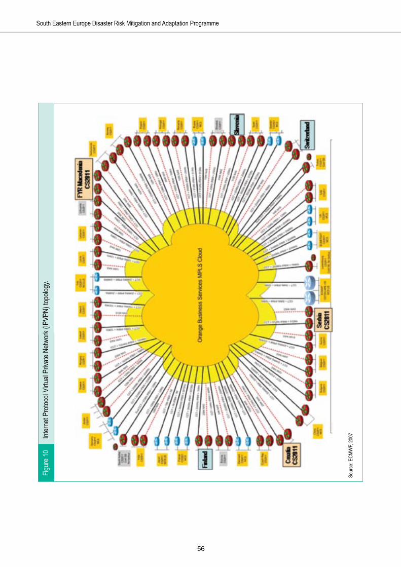
��
South Eastern Europe Disaster Risk Mitigation and Adaptation Programme
Inter
net P
rotoc
ol Vi
rtual
Priva
te Ne
twor
k (IP
VPN)
topo
logy.
Sour
ce: E
CMW
F, 20
07
Figur
e 10

��
Strengthening the Hydrometeorological Services in South Eastern Europe

��

��
Recommended project and investments
6

�0
South Eastern Europe Disaster Risk Mitigation and Adaptation Programme
Effective and modern production of hydrometeorological and ecological data and services requires an integrated system of all the elements shown in the figure 11, in order to ensure successful operation. If one of the components is missing or dysfunctional, the whole chain will be useless. The required technical level and needed investment for each component depend on the planned activities and type of products.
In addition, meteorology, including hydrology, is a multidisciplinary science which is highly international in nature. Therefore weather forecasting cannot be carried out without international cooperation and data sharing.
However, with such international cooperation, all the NMHSs in the SEE countries do not necessarily need to have and fully operate all possible state-of-the-art equipment and models. Through cooperation with ECMWF, EUMETNET and the NMHSs of the EU and neighbouring countries, and by establishing some regional centres of excellence for selected topics, better end-products and services can be produced with smaller investments, smaller operation and maintenance costs and by less staff.
Recommended investment plan
This report presents two alternative investment plans that cover investment in hardware, software and operation and maintenance costs for a period of five years:
A) The strengthening of hydrometeorological services will be done on the national level only.
B) The strengthening of hydrometeorological services will be done as a part of a regional SEE project oriented towards EUMETNET cooperation.
This report recommends Investment Plan B. Investment Plan B focuses on strengthening the whole process of each NMHS as part of regional network, to a level where each NMHS can produce both adequate data and information for civil protection, disaster risk and emergency management efforts nationally and regionally, and adequate data for the global hydrometeorological community in order to improve global, regional and local weather forecasts. Through
An integrated end-to-end production system of hydrometeorological servicesFigure 11

��
Strengthening the Hydrometeorological Services in South Eastern Europe
Table 25. Investment Plan A: Costs (in thousands of euros )
Version A: Countries strengthened alone Albania Bosnia and
Herzegovina Croatia FYR Macedonia Moldova Montenegro Serbia Total
ECMWF 50 80 50 50 50 280EUMETSAT 690 1024 724 348 98 2884EUMETNET 50 50 50 25 10 185International cooperation of experts 100 200 100 125 100 100 100 825
Communication systems- hardware + software 400 250 170 820- annual operation 200 80 100 380IT Center- hardware 125 250 125 125 125 125 875- consulting 125 200 125 200 125 125 900- annual maintenance + operation 80 160 80 50 80 80 530
- IT staff 384 432 384 384 1584Data management- hardware + installation 125 400 125 125 149 125 1049- storage 30 TB 50 100 100 50 50 50 400- consulting + training 125 125 125 125 125 125 750- annual maintenance 80 160 80 80 80 80 560Meteorological observation network
- sensors and other spare parts 90 60 150
- manned stations 0- automatic weather stations (P, T, U, ww, wd, G)
220 220 484 220 220 220 440 2024
- ceilometers 125 130 180 100 100 100 140 875- communicationcosts 60 60 120 60 60 60 120 540
- agrometeorological stations 120 120 70 300 610
Hydrological observation network
- automatic hydrological stations 325 300 625
- data communication and maintenance 120 80 200
Maritime observation network
- maritime observations 330 700 150 1180

��
South Eastern Europe Disaster Risk Mitigation and Adaptation Programme
- data communication and maintenance 375 660 12 1047
Environmental observation network- automatic air quality + weather stations 385 585 645 1615
- communication costs 6 18 24
Remote sensing network
- upper air observations; investments 280 310 200 170 280 1240
- sonds 700 700 250 700 700 3050- sounding technicians 120 400 125 645- weather radars; upgradings 1150 400
- new weather radars (including towers) 3900 3900 6800 3600 6450 4300 3200 32150
- radars, operation and maintenance 1600 1600 2400 1600 2400 1600 1600 12800
- radar technicians 150 180 100 54 96 580- lightning detection 460 460 760 460 460 460 820 2880Calibration and maintenance 200 200 200 40 640
Forecasting and manufacturing tools- visualization system 250 600 300 250 250 250 300 2200- training 50 50 50 50 50 50 50 350- staff to promote 24/7/365 288 360 380 1028
- annual fees 125 250 125 125 125 125 125 1000Local area model 100 100Training 325 375 456 420 345 410 377 2708R&D 0- impacts of climate change 350 350 350 300 300 300 400 2350
-socio-economic impacts 150 150 150 150 180 780
- national seminar on socio-economic benefits 50 50 50 50 50 250
- end-user seminar 30 30 30 30 30 30 30 210Website 45 50 95Project management- consultant 200 200 200 200 200 200 200 1400- local project coordinator 36 50 100 50 25 54 100 415
Total Version A 12523 14526 15925 11629 14539 11844 9347 90333

��
Strengthening the Hydrometeorological Services in South Eastern Europe
Table 26. Investment Plan B: Costs (in thousands of euros )
Version B: Countries strengthened alone Albania Bosnia and
Herzegovina Croatia FYR Macedonia Moldova Montenegro Serbia Total
ECMWF 50 80 50 50 50 280EUMETSAT 690 1024 724 348 98 2884EUMETNET 50 50 50 25 10 185International cooperation of experts 100 200 100 125 100 100 100 825
Communication systems
- hardware + software 125 250 170 545- annual operation 80 80 100 260IT Center- hardware 125 125 100 125 125 125 725- consulting 125 125 25 200 125 125 725- annual maintenance + operation 80 80 80 50 80 80 450
- IT staff 384 259 384 384 1411Data management
- hardware + installation 125 125 125 125 149 125 774
- storage 30 TB 50 50 100 50 50 50 350- consulting + training 125 125 100 125 125 125 725- annual maintenance 80 80 80 80 80 80 480Meteorological observation network- sensors and other spare parts 90 60 150
- manned stations 0- automatic weather stations (P, T, U, ww, wd, G)
220 220 484 220 220 220 440 2024
- ceilometers 125 130 180 100 100 100 140 875- communicationcosts 60 60 120 60 60 60 120 540
- agrometeorological stations 120 120 70 300 610
Hydrological observation network- automatic hydrological stations 325 300 625
- data communication and maintenance 120 80 200
Maritime observation network
- maritime observations 700 150 850
- data communication and maintenance 660 12 672

��
South Eastern Europe Disaster Risk Mitigation and Adaptation Programme
Environmental observation network- automatic air quality + weather stations 385 585 645 1615
- communication costs 6 18 24
Remote sensing network
- upper air observations; investments 280 310 200 170 280 1240
- sonds 700 700 250 700 700 3050- sounding technicians 137 168 125 430- weather radars; upgradings 1150 400
- new weather radars (including towers) 2150 2150 4400 3600 2000 2150 3200 19650
- radars, operation and maintenance 800 800 1600 1600 800 800 1600 8000
- radar technicians 60 60 100 24 96 340- lightning detection 80 70 620 80 160 0 350 1360Calibration and maintenance 200 200 100 40 540
Forecasting and manufacturing tools- visualization system 250 250 300 250 250 250 300 1850- training 50 50 50 50 50 50 50 350- staff to promote 24/7/365 288 252 380 920
- annual fees 125 125 125 125 125 125 125 875Local area model 100 100Training 175 275 246 280 215 275 162 1628R&D 0- impacts of climate change 79 79 86 86 68 79 81 558
-socio-economic impacts 75 75 75 75 75 375
- national seminar on socio-economic benefits 50 40 40 40 40 210
- end-user seminar 30 30 30 30 30 30 30 210Website 45 50 95Project management- consultant 120 121 120 117 121 119 105 823- local project coordinator 36 36 36 36 25 54 60 283
Total Version B 8239 8849 11817 10613 7633 7882 8208 63241

��
Strengthening the Hydrometeorological Services in South Eastern Europe
these improvements, the capability of the NMHSs to produce better services for their communities, in order to promote socio-economic development, will also be significantly improved. In addition, the improvements will give the NMHSs a basis for sustainable development, in part by helping them to prepare a clearer vision for their futures.
Investment Plan B would invest in the range of elements required for producing quality modern hydrometeorological services. It greatly expands international cooperation by the NMHSs. It involves training for NMHS staff, management and customers. It provides improvements in weather forecasting capabilities, an update of communications and data sharing systems, and an enhancement of data management. And finally, it significantly augments the national and regional observation networks. This report describes these key components of the recommended project in more detail above.
The required level of investments and other actions to strengthen the NMHSs depends finally on the
role and duties of each NMHS, as determined by the SEE Governments, and on the vision and the level of ambition of each NMHS. In addition, the total costs for both alternatives depend significantly on the timing of the investments. Annual operational and maintenance costs for weather radars and upper-air soundings are very large, totalling hundreds of thousands of euros. Thus with proper project management and timing of investments, the total costs, based on unit prices and duration of the five-year project, can be significantly reduced.
The total tentative budget for Investment Plan A is €90.3 million, including a hydrological component for Moldova and the Former Yugoslav Republic of Macedonia. These two countries are outside the Sava River Project, and therefore have supplemental hydrological needs not covered elsewhere. The details of this cost estimate are provided in table 25 above. The estimate assumes that investments are made in the first year of the project, and that operational and maintenance costs, including staff, are ensured for the initial five-year project period.
ECMWF Member States and Cooperating States, and their share (as a per cent) of total contributions in 2006
Source: ECMWF, 2007
Map 8

��
South Eastern Europe Disaster Risk Mitigation and Adaptation Programme
For recommended Investment Plan B, the total budget for a five-year project is reduced to around €63.2 million. This cost estimate, based on the same assumptions used for Plan A, is shown in detail in table 26 above.
In both cases, it is expected that the current cooperation between NMHSs and the aviation weather services sector will be improved, and that both sectors will gain from the investments for the public good and improved human and economic safety.
The proposed investments also require investments in new qualified staff. In many of the NMHSs, the current number of meteorologists, forecasters and IT staff is not enough to run 24/7/365 services. New hydrometeorological monitoring systems, data collection and data management will require in particular enactment of a significant increase in the number of IT staff which, at the current salaries paid by the NMHSs, will not be a simple task.
6.1 International cooperation - European dimension
The most profitable and quickest way for SEE NMHSs to improve their hydrometeorological services is through membership in ECMWF, EUMETSAT and EUMETNET, and other relevant European organizations. In order to make this possible, the relevant fees must be included in the investment plan for those NMHSs that do not yet have these memberships.
When planning future operations and technical solutions for observation and communications systems, it is critical to adjust them to the protocols of ECMWF, EUMETSAT and EUMETNET.
ECMWF - The European Centre for Medium-Range Weather Forecasts
ECMWF is an international organization supported by 30 States, based in Reading, West of London, in the United Kingdom of Great Britain and Northern Ireland (United Kingdom). The member states are: Austria, Belgium, Denmark, Finland, France, Germany, Greece, Ireland, Italy, Luxembourg, the Netherlands, Norway, Portugal, Spain, Sweden, Switzerland, Turkey and the United Kingdom. ECMWF currently has cooperation agreements with Croatia, the Czech Republic, Estonia, Hungary, Iceland, Lithuania, Montenegro, Morocco, Romania,
Serbia, Slovakia and Slovenia. The annual budget of ECMWF in 2006 was about €40.5 million. The annual fees are scaled relative to national GDP. The contribution, for example, of Finland comprises 1.41 per cent of the ECMWF annual budget, while the contribution of Cooperating States varied between 0.36 and 0.03 per cent.
The principal goal of ECMWF in the coming ten years will be to maintain the current, rapid rate of improvement of its global, medium-range weather forecasting products, with particular emphasis on early warnings of severe weather.
Complementary goals are:
• To improve the quality and scope of monthly and seasonal-to-interannual forecasts.
• To enhance support to Member States’ national forecasting activities by providing suitable boundary conditions for limited-area models.
• To deliver real-time analyses and forecasts of atmospheric composition.
• To carry out climate monitoring through regular re-analyses of the Earth system.
• To contribute towards the optimization of the Global Observing System.
Due to their constrained financial resources, it is necessary to support cooperation with ECMWF for Albania, Bosnia and Herzegovina, the Former Yugoslav Republic of Macedonia, Moldova and Montenegro. It is estimated that at current fee levels, the total financing required for five years could be around €280,000.
EUMETSAT - The European Organisation for the Exploitation of Meteorological Satellites
The main purpose of EUMETSAT is to deliver weather and climate-related satellite data, images and products - 24 hours a day, 365 days a year. This information is supplied to the national meteorological services of the organization’s 20 Member and 10 Cooperating States in Europe, as well as to other users worldwide. EUMETSAT is an international organization and was founded in 1986. The members are: Austria, Belgium, Denmark, Finland, France, Germany, Greece, Ireland, Italy, Luxembourg, the Netherlands, Norway, Portugal, Slovakia, Spain, Sweden, Switzerland, Turkey and the United Kingdom. Current cooperating states are: Bulgaria, Croatia, the Czech Republic, Hungary, Latvia, Iceland, Lithuania, Poland, Romania and Slovenia.

��
Strengthening the Hydrometeorological Services in South Eastern Europe
As an organization providing services to European meteorological offices, and as a partner in a number of global climate monitoring and other initiatives, meeting the EUMETSAT objectives requires both a European angle and a global perspective. This global perspective applies to all technical cooperation, and is especially important in the context of global monitoring of the climate and environment, and the support EUMETSAT provides to developing countries.
Membership in EUMETSAT is expensive but profitable. The estimated revenue from membership fees for 2008 is around €161 million, and this total is expected to increase to close to €400 million by the year 2012.
The level of fees for different SEE countries is estimated based on the current fee for Croatia. For most of the SEE countries, it is not possible to cover the estimated annual fee by current national financing. Thus it is necessary to include in the investment plan the five-year membership fees for Albania, Bosnia and Herzegovina, the Former Yugoslav Republic of Macedonia, and Moldova; at an estimated total of €2,884,000.
EuroGOOS
EuroGOOS is an association of agencies, founded in 1994, to further the goals of the Global Ocean Observing System (GOOS), and in particular the development of operational oceanography in the European sea areas and adjacent oceans. GOOS is an international programme preparing a permanent global framework of observations, modelling and analysis of ocean variables needed to support operational ocean services, wherever they are undertaken. GOOS was launched at the Second World Climate Conference in 1990. It provides the ocean component of the Global Climate Observing System (GCOS).
EuroGOOS provides information regularly to the Intergovernmental Oceanographic Commission-WMO-United Nations Environment Programme Committee for GOOS (I-GOOS), and to the GOOS Steering Committee (GSC). EuroGOOS is established with full recognition of the importance of existing systems in research and operational oceanography in Europe at national and European scales. EuroGOOS now has 33 Members in 17 European countries.
EDIOS
EDIOS is an information system for marine observing stations (including moored buoys, coastal installations, seabed stations, drifting buoys, repeated sections and sampling stations, and airborne repeated tracks) where there are routine, repeated, and consistent long-term observations of the marine environmental conditions, and where the data is made available for use in real-time, or near real-time.
EUMETNET
EUMETNET is a network grouping 24 European national meteorological services (Austria, Belgium, Croatia, Cyprus, Denmark, Estonia, Finland, France, Germany, Greece, Hungary, Iceland, Ireland, Italy, Latvia, Luxembourg, the Netherlands, Norway, Portugal, Slovenia, Spain, Sweden, Switzerland and the United Kingdom). EUMETNET provides a framework to organize cooperative programmes between its members in the various fields of basic meteorological activities such as observing systems, data processing, basic forecasting products, research and development, and training. Through EUMETNET programmes, the members seek to develop their collective capability to serve environment management and climate monitoring, and to bring to all European users the best available quality of meteorological information.
The annual fees for participation in EUMETNET cooperation depend mainly on how many programmes each NMHS wants to join. The common costs for running the EUMETNET office are very marginal for the EUMETNET members. EUMETNET currently has a number of programmes that could benefit SEE NMHSs, described below.
1) EUCOS - the EUMETNET Composite Observing System
The objectives of EUCOS are to: • Design and coordinate the evolution of the
ground-based EUMETNET Composite Observing System (EUCOS) to be optimized at a European scale with a view to improving short-range forecasting over Europe without increasing the overall cost.
• Monitor and control EUCOS performance. • Ensure integrated management for agreed

��
South Eastern Europe Disaster Risk Mitigation and Adaptation Programme
components such as E-ASAP and E-AMDAR.
2) E-ASAP - EUMETNET Automated Shipboard Aerological Programme
An automated shipboard aerological programme (ASAP) system is a radiosonde station designed for operation on ships. The objective of E-ASAP is to satisfy EUCOS requirements and to improve the cost-efficiency by integrated management of existing national ASAP systems.
3) E-AMDAR - European Aircraft Meteorological Data Relay Programme
EUMETNET’s E-AMDAR Programme is extensive. Its objective is to serve EUCOS requirements for additional upper-air measurements of wind and temperature and to maximize the efficiency/cost ratio of implementing AMDAR systems for EUMETNET participants by reducing duplication in the use of resources and seeking to meet requirements in the most cost-effective manner.
The Swedish Meteorological and Hydrological Institute is the Responsible Member of E-AMDAR for the period of 2007-2011. The plan is to have data from ascent/descent at 140 European airports in 2008, 40 of which should provide at least three hourly profiles during daytime. EUMETNET members get AMDAR data in an analysed format similar to sounding data30.
4) Surface Marine Programme The objective of the Surface Marine Programme
is to coordinate, optimize and progressively integrate the activities for surface observations over the sea within the EUCOS operational framework. The Programme is divided into two stages:
• Stage l will formulate an optimum overall surface marine network design, and establish a suitable framework to implement and coordinate operational surface marine networks.
• Stage 2 will implement the network design based on the monitoring of the performances obtained and in the light of the results gained during the first two years of Stage 1.
5) OPERA - Operational Programme for the Exchange of Weather Radar Information
The fundamental objective of OPERA is to provide a European platform wherein expertise on operationally oriented weather radar issues is exchanged and holistic management procedures are optimized. With the establishment of its data hub, OPERA is now organized to support the application of radar data from the European Weather Radar Network. Another important objective of OPERA is to act to harmonize data and product exchange at the European level.
6) EMMA - the European Multi-service Meteorological Awareness project
The EMMA project will develop a graphical information system accessible via the Internet by the general public, European meteorological forecasters, and all concerned authorities, providing information on potential meteorological risks over 24-hour periods.
7) UNIDART - Uniform Data Request Interface programme
The UNIDART concept is aimed at the development of an information system, based on Internet technologies, offering uniform access to all kinds of meteorological data and products, including climatological data sets. The first phase of the programme has been completed. The objectives of this first phase were to define a set of requirements, to make a feasibility assessment, and to estimate the costs for implementation of UNIDART.
8) Meteoalarm Meteoalarm is a European-wide public and
multilingual web-based service for providing alerts to the public and authorities about possible occurrences of same-day or next-day severe weather forecasts. It has been developed by EUMETNET in cooperation with 20 EU countries31. Phenomena covered include heavy rain that can lead to flooding, severe thunderstorms, gale-force winds, heat waves and extreme cold, forest fires, fog and avalanches.
9) Eumetcal - The European Virtual Organisation for Meteorological Training
The Eumetcal programme started in 2001 as an extension of the EU Fourth Framework Programme meteorological computer-assisted learning project entitled EuroMET. The initial three-year programme was continued in a second

��
Strengthening the Hydrometeorological Services in South Eastern Europe
phase from 2004 to 2007. The third Eumetcal programme phase will continue and further develop European training cooperation in the field of meteorology until June 2012.
The tasks of Eumetcal have significantly evolved from system maintenance into a true collaboration between member institutions in training activities. Today Eumetcal’s objectives are:
1. To serve as the European virtual training organization, responding to the training needs of EUMETNET national meteorological services, and providing a forum for the creation and exchange of training resources covering the whole field of meteorology and related environmental topics.
2. To provide a mechanism whereby European national meteorological services collaborate to enhance their training capabilities on a long-term basis.
3. Keeping in mind evolving technologies used for education and training, to ensure that the training requirements of European national meteorological services are met long-term.
The current wealth of resources developed in the Eumetcal programme, along with expertise in computer-aided learning methods, creates a natural platform from which to build a cooperative approach, and makes Eumetcal a central solution to all of the above-mentioned challenges faced by the meteorological community. Today new challenges create a new situation in aviation meteorology where national meteorological services need to find a resource-efficient approach to competency assessment and qualification of personnel. The courses are given by international teachers, and candidates wanting to participate in a course are presumed to have good skills in English.
An example of ECMWF analysis of relative humidity and wind at 700 hPa
Source: ECMWF, 2007
Map 9

�0
South Eastern Europe Disaster Risk Mitigation and Adaptation Programme
Other EU programmes
Additionally it is vital for SEE NMHSs to participate in the EU Seventh Framework Programme research and development activities, and to exploit other possibilities like the Community Assistance for Reconstruction, Development and Stabilisation programme (CARDS) provided by the EU. FMI, for instance, is a member of the EU Marie Curie Research Training Network, and has provided one-year participation for one scientist from the SEE NMHSs.
It is typical for EU Framework Programme projects that the participation costs are covered fully or partially by the EU. For example, as noted above, for COST actions the traveling costs are reimbursed. In research projects, the financing is 40-50 per cent. Even if the salary levels in SEE countries are low, and thus also the share of overheads is low compared to, for instance, traveling costs, in practice participation in EU cooperation does not require extra governmental funding for the NMHSs. Good knowledge in English is typically required.
6.2 Training
Meteorology is a specialized field that is heavily dependant upon the effective exploitation of the most modern technologies available. Operational forecasters need continuous professional development in their daily activities to maintain high standards in weather products. IT staff and other technical staff need to be proficient with the state-of-the-art technology. There is a need to train the SEE NMHS managers and scientists in good management, project management, international cooperation, EU Seventh Framework Programme cooperation and fund-raising. It is also critical to educate the staff to recognize the changing and increasing demands to better serve their communities and to meet the strategic plans of NMHSs.
In general the NMHSs of Europe are facing ever tighter financial restrictions, creating a situation where training needs cannot be met without cooperation. Sharing, reprocessing and exchanging training material and organizing material into comprehensive online
A meteorologist working on an automatic processing and visualization tool
Source: Saukkonen, FMI, 2007
Figure 12
��
Strengthening the Hydrometeorological Services in South Eastern Europe
training modules significantly reduces development time for the teacher, and provides NMHSs with ready-made packages for the student, without excessive use of staff resources. E-learning methods provide a fast response to new technologies and can be used to reach a wide audience, potentially spanning the entire globe.
The investment plan reserves €2.7 million for training of staff, management and customers, in addition to the training given by manufacturers of different equipment, if the NMHSs are strengthened individually. However, by implementing the recommended cooperative regional project, including all countries, the costs of the training programme could be reduced to around €1.6 million.
6.3 Weather forecasting
A modern weather service is based on numerical weather prediction models fed by a high-quality real-time observation system. The numerical weather prediction output provides the basis for weather and warning services and automated product generation for different customers.
As noted in the introduction to the recommended project, however, numerical weather prediction is only one component of the production system. Effective and modern production of hydrometeorological and ecological data, services and products require an integrated system of the multiple elements (shown in figure 11) in order to ensure successful operation. If one of the components is missing or dysfunctional, the whole chain will be useless. The required technical level, and needed investment, for each component depends on the planned activities and type of products.
In general, the SEE NMHSs need to improve short-term (0-48 hour) forecasting, automation of measurements, monitoring, data handling, production processes, and capabilities to produce end-user specific tailored products, to disseminate information, and to participate in international cooperation. There are many similarities and common development needs for the NMHSs, but also needs for individual priorities, depending on the foreseen activities and current technical situation.
The forecasting results of the SEE NMHSs numerical models can in most cases be improved by human selection and correction processes executed by meteorological and hydrological experts. Because of the enormous amount of the environmental end-user
products generated, it is, however, not possible for the experts to manually monitor and correct each product.
Numerical weather prediction
The upgrade of numerical weather prediction activities at some of the SEE NMHSs is a widespread task, involving capacity-building and training, as well as investments in high-performance computing facilities.
The potential numerical weather prediction configurations are as follows:
• Configuration 1: A full global/limited-area model, with data assimilation on site.
• Configuration 2: A full global/limited-area model, with data assimilation only for the limited-area model (the global model data with lateral boundaries can be gained from some outside source).
• Configuration 3: A limited-area model without data assimilation (the global model data with lateral boundaries can be gained from some outside source).
A numerical weather prediction system can choose among a large variety of options regarding features such as actual models and data assimilation systems. The needed high-performance computing system depends very much on the chosen model configuration. For high-end systems like Configuration 1, above, the global numerical weather prediction model requires investment in high-performance computing systems, fast local area networks and effective data storage systems. A global model is expensive to run, due to the large integration area and the data assimilation system, which requires global data from all data sources, including surface, upper-air, aircraft, and satellites. Due to the large data flow, the continuous telecommunication requirements and expenses also become higher.
For high-end systems, the number of experts needed is also higher than for low-end systems. Typically the best way to start is to begin from the less-demanding end (from Configuration 3), and then to develop the system and expertise step-by-step, moving towards a more demanding system.
There are several possibilities for the numerical weather prediction model. A widely used and still actively developed model would be the best option at the start. However, the expertise for implementation and integration of observational data sources is a demanding task.

��
South Eastern Europe Disaster Risk Mitigation and Adaptation Programme
Automatic processing and visualisation
Today, producing and disseminating certain weather service products can be fully automated. Automation is vital, especially for small weather services, but it also brings great profits to large services. Automation makes it possible to improve numerical weather prediction forecasts, to produce easily customer-tailored products, to increase production modules according to needs, and to increase the number of daily products from a few to thousands. Automation also allows for:
• Viewing and editing of all hydrometeorological data.• Use of computer-to-computer type products by
bigger customers like broadcasting companies, newspapers and air traffic control.
• Easier website production. The Internet is a great option for delivering weather data and forecast products for the public sector and private users.
• Delivery of all the data supplied by the Internet to mobile phones as well.
Forecast visualisation and editing tools allow meteorologists to make needed changes and modifications to initial forecasts provided by numerical weather prediction models. It is critical that professional meteorologists have the ability to add their experience and knowledge, which is not perhaps taken into account by numerical weather prediction, into the forecasts.
None of the SEE NMHSs has proper visualisation and production tools. Therefore it is vital to purchase similar systems for all of the NMHSs, in order to fully realize the financial and technical advantages of regional networking. Estimated total costs for a proper
tool, including licences for five years, are around €2.5 million.
Forecasting staff
In many of the SEE NMHSs, human resources are significantly below the level required for operation of a 24/7/365 forecasting service. It is critical to increase the number of staff to a minimum in Albania, Bosnia and Herzegovina and Montenegro. This cannot be done within the countries’ current budgets. Even if the current salary levels for scientific and technical staff in the SEE countries is very low compared to Western Europe, the salary costs will increase significantly in coming years. The estimated external total financing needed for five years is around €0.8 million.
6.4 Communications and data sharing
Modern environmental analysis and forecasting systems demand an ever-increasing amount of input data originating from heterogeneous sources (such as local point observation collecting, satellite imaging, weather radar networks, and global weather observations through the GTS network). In addition to the increasing data demands, this poses challenges to incoming data flow monitoring and quality control.
Real-time transmission of data from observation sites to the monitoring and forecasting centres, and then to the WMO-GTS network, is crucial in order to provide accurate and on-time information to the users. Recent technological developments provide various means to transmit the data: GSM/GPRS networks, radio and telephone, satellite and the Internet.
The costs of data communication will increase significantly with the addition of the recommended new on-line automatic stations and radar network. This needs to be taken into account in financing and in ensuring sustainability to the project. However, moving to GPRS networks will then significantly reduce the communication costs.
Principle of an advanced (duplicated) IT system
Source: Silen, FMI, 2007
Figure 13
Virtual servers
Terminals Terminals
DB Server HW DB Server HW
Backup
Server HW Server HW

��
Strengthening the Hydrometeorological Services in South Eastern Europe
6.5 Data management
Adequate data management is the basis for all other NMHS activities. Currently, the barrier to achieving a proper level of data management in the SEE NMHSs is not the technology, but the availability of adequate IT experts.
Data management is a critical component in the hydrometeorological and environmental forecast production process. The general duty of an NMHS data collection and preprocessing system is to provide quality-controlled data from different gathering systems, to be used by other processes according to the pre-defined delivery schedule. Thus it is critical that all the observations related to each other, and also the final products, be stored in a centralized database. It is essential to have in the database system adequate automatic data quality and verification procedures.
Typically at advanced NMHSs, all of the equipment is duplicated into two separate computer halls for safety and to achieve maximum system up-time in every situation.
At this point, investment needs for the recommended project vary from country to country. All countries lack adequate storage. The estimated costs to upgrade the IT and data management systems, and to hire required IT staff for some of the NMHSs, are around €5.9 million, including five-year operational costs and preparation to renew the hardware every fifth year.
In this segment, the recommended regional alternative does not bring significant short-term financial savings compared to the alternative where all the NMHSs are strengthened individually. But purchase of similar systems and networking will yield operational and scientific benefits.
This report does not make specific recommendations on data storage. The storage needs of the SEE NMHSs depend very much on future activities and what is going to be saved. It is clear that the amount of data will significantly increase when data from improved radar systems, satellite data and numerical weather prediction data are available. For instance, currently the HIRLAM forecasting model produces some 10 terabytes of data per year. Typical storage costs are around €50,000 for 30 terabytes.
Iced cup anemometer (left) and heated ice-free sonic anemometers (right)
Source: Tammelin et al., 2004; EUMETNET SWS II
Figure 14

��
South Eastern Europe Disaster Risk Mitigation and Adaptation Programme
6.6 Observation network
The density and quality of the observation network for hydrometeorological and environmental monitoring and measurements need to be built both according to the priority needs of the national and regional disaster reduction management efforts, and to promote forecasting. The possibility of “creating observations” with modern numerical weather predictions should be taken into account.
The required type and density of national observation networks depends on the national assets of weather services, the regional observation network and level of data sharing, regional cooperation, and cooperation with European and other organizations. Typically there is not an urgent need to improve the density of surface observation networks of SEE NMHSs, but rather to increase the number of on-line and real-time automatic monitoring stations, in order to improve the quality and immediate benefits of observations. In the long run it is critical to reduce the number of manned stations, in order to decrease the labour costs and amount of less profitable and productive work.
It might be that in the near future, much denser and much more versatile observation networks become a necessity in order to be able to meet the increasing demands from communities, economic sectors and the public, but that scenario is not taken into account in this report.
Synoptic stations
It is assumed that the current number of synoptic stations is quite representative of current services.
It is necessary to increase the number of automatic on-line meteorological stations in all SEE countries. The primary goal is to replace strategically important manned stations with automatic weather stations. New automatic stations to be established should be located and sited to meet the requirements especially of civil protection efforts, and also the needs of different economic sectors and potential customers. The number of automatic weather stations required, for instance, in mountainous regions depends on the demands of potential customers like traffic authorities, and their
plans to install their own road weather stations.
The automatic stations need to be equipped with a transmission module, which supports use of fixed line, GSM, GPRS and other transmission means; which can check whether the data was sent successfully or not; and which serves also as short-term data storage. With this, it will be possible to reach close to 100 per cent data availability.
Establishment of new manned synoptic stations is not supported by this report.
At this stage, the number of new automatic weather stations proposed for the recommended project is 92, which is 44 per cent of the total number of current synoptic stations in the countries, and about 90 per cent of the current manned synoptic stations. It is necessary to equip especially the new stations (which will not have observers) with ceilometers from the beginning.
In mountainous areas it is necessary to equip the automatic weather stations with properly heated ice-free sensors, in order to avoid awkward measurement errors caused by atmospheric icing. References to icing and proper sensors can be found in the EUMETNET Severe Weather Sensors I and Severe Weather Sensors II reports29.
The investment needs in synoptic stations do not significantly vary if the project is implemented as the recommended regional alternative, or as separate projects for each country. Joint purchase of the automatic weather stations from one manufacturer will surely reduce the unit price of the stations, but that efficiency is not taken into account in this report. The tentative budget proposal for automation and some enlargement of the meteorological observation network is around €4 million.
Climatic and precipitation stations
There is a need to replace manned climatic and precipitation stations with automatic stations (temperature, pressure, relative humidity and wind) and automatic precipitation gauges. Currently the climatic and precipitation stations that make only a few observations per day, and deliver data to the SEE
29 Tammelin, B., Heimo, A., Leroy, M., Rast, J., Säntti, K., Bellevaux, C., Dal Cin, B., Musa, M. and Peltomaa, A., 2004. Improvement of severe weather measurements and sensors – EUMETNET SWS project, Final Report. Reports 2004:3, Finnish Meteorological Institute, Helsinki. SWS II report available at: www.dwd.de/EUMETNET/Berichte/1.1(05)Tammelin1.doc

��
Strengthening the Hydrometeorological Services in South Eastern Europe
NMHSs only monthly, do not meet the requirements of the communities and their different sectors.
Hydrological stations
Automatic hydrological stations provide critical information for water management, flood protection and hydroelectric production that cannot be achieved by other methods. It is critical to include the hydrological measurements and on-line data in the integrated hydrometeorological data management system. In addition, in order to improve the SEE early warning systems, it is necessary to produce discharge forecasting based on numerical weather prediction, or rather as a part of the numerical weather prediction runs.
As the Sava River project will concentrate on flood protection and hydrological measurements, this report includes hydrological recommendations only for the Former Yugoslav Republic of Macedonia and Moldova. The report’s recommended alternative aims to increase the number of automatic observations, rather than to increase the total number of hydrological stations, even though that is required. It is expected that the hydrological components will be fully integrated into the general data collection, data management and service production systems.
Marine observation
Tourism in these countries is growing strongly in the coastal regions and on the archipelago. In order to improve the data from the large sea areas lining the SEE countries, which have a significant impact on regional climate and weather, it is critical to increase the amount of meteorological data from the Adriatic Sea.
Anchored buoys are suitable to produce data from the water (on factors such as temperature, salinity and wave height) and to carry an automatic weather station. Due to the impact of the living organisms clinging to the buoys, it is necessary to change the buoys perhaps twice a year. Thus two buoys are needed for each spot.
To maintain the buoys, heavy ships are needed, which will be quite expensive, and increases the annual operation costs significantly. In order to minimize the maintenance costs it is profitable to cooperate with the Navy in the respective SEE countries. Additionally it is vital to install on-line tidal stations, equipped also with automatic weather stations, in the coastal countries.
The need for the Adriatic Sea area would be three buoys. However, this report proposes investment in two buoy stations. It is vital to put the buoys under the new regional centre for marine weather services,
Table 27. Requirements for upper-air observations
(a) Horizontal resolution Vertical resolution Frequency of observation
Air temperature 250 km 10 layers in troposphere> 5 layers in stratosphere 2-4 per day
Wind 260 km 10 layers in troposphere> 5 layers in stratosphere 2-4 per day
Relative humidity 250 km > layers 2-4 per day
(b) Horizontal resolution Vertical resolution Temporal resolution
Temperature 100 km 0.1 km up to 2 km0.5 km up to 16 km 3 hours
Wind 100 km 0.1 km up to 2 km0.5 km up to 16 km 3 hours
Relative humidity 100 km 0.1 km up to 2 km0.5 km up to tropopause 3 hours
Source: www.metoffice.gov.uk, 2007

��
South Eastern Europe Disaster Risk Mitigation and Adaptation Programme
in Split, Croatia. The tentative budget proposed for the maritime component is around €1.6 million; €1.1 million for investments, and €0.5 million for maintenance during the five-year project window.
Upper-air observations
For general meteorology including numerical weather prediction, the basic set of global requirements for upper-air observational data for global observing systems is as shown in the following table 27 (a). As the numerical weather prediction community seeks to capture increasing amounts of upper-air observations, some even more stringent requirements for data needed to obtain optimum results from numerical weather prediction have been developed (see table 27 (b)).
Upper-air soundings
It is critical to ensure the operation of the current number of upper-air soundings in the SEE region. Upper-air sounding is the only method to get relevant data from the whole atmosphere. Thus it cannot be replaced by other currently available observation systems.
The number of upper-air sounding stations required depends on how well data is shared in the region. If the operation of upper-air soundings at the stations is not ensured, and international data sharing does not work, then in practice all of the SEE countries would need at least one upper-air station making at least two soundings per day.
For sustainable development of the stations, it is critical to finance the operation of the stations for the five-year project period. The annual costs for two daily soundings are estimated to be around €140,000. As the sounding stations will bring immediate benefits to the aviation sector, it would be profitable to build partnerships with aviation weather services in order to reduce the costs per institute, and to optimize use of the data.
AMDARAutomated meteorological observations from passenger aircrafts have been available in one form or another since the late 1970s. AMDAR (Aircraft Meteorological Data Relay) is a programme initiated by WMO. AMDAR collects data on wind speed and direction, temperature, and can include turbulence and humidity (which is not measured in Europe). AMDAR is particularly useful for now-casting situations and is
A schematic presentation of different types of wind profilers and their typical properties
Source: www.vaisala.com, 2007
Figure 15

��
Strengthening the Hydrometeorological Services in South Eastern Europe
used especially by aviation forecasters. AMDAR data is also useful for numerical weather prediction models. Currently the upper-air sounding stations (profiles up to 30-35 kilometres) cannot be replaced by AMDAR data (profiles up to 10 kilometres), but AMDAR provides complimentary upper-air data and, in many cases, first-hand data from the lower atmosphere.
AMDAR data is collected in collaboration with national domestic and international airlines. In Europe, the data collection costs via WMO-GTS are paid by E-AMDAR, while the instrumentation on the planes is financed by the respective airline companies.
It is critical that the SEE NMHSs increase their use of AMDAR data. As AMDAR produces benefits especially to the aviation sector and aviation weather forecasts, it is in the interest of the NMHSs and aviation weather services that more of the flights landing at their airports have the AMDAR equipment.
Windprofilers
A windprofiler is a ground-based application of a pulsed Doppler radar developed for measuring the
vertical echo intensity caused by small irregularities in temperature or humidity, and thus in air density, in the atmosphere. These small irregularities are called turbulent eddies, and are transported by bulk air movement.
Wind profiling provides a state-of-the-art methodology for continuously monitoring the state of vertical wind and turbulence profiles in the upper atmosphere. When the Radio Acoustic Sounding System (RASS) option is added, it can provide vertical virtual temperature profiles.
Lower- or mid-tropospheric profilers would provide very usable data, especially in mountainous and coastal regions. For instance at airports, orography and topography create local meteorological phenomena (such as wind shears, turbulence, waves and the height of the inversion layer) which are not cached by other observations.
The EUMETNET WINPROF (Wind Profilers) programme deals with operation of wind profiler radars in Europe. Currently there are 22 wind profiler systems networked to the existing CWINDE (Coordinated Wind Profiler Network in Europe) network shown in map10.
The CWINDE wind profiler network
Source: EUMETNET (www.eumetnet.eu.org; http://www.knmi.ni/opera/; and http://www.metoffice.gov.uk/corporate/interproj/cwinde/index.html, EUMETNET WINPROF project), 2007
Map 10 European weather radars in January 2007
Source: EUMETNET (www.eumetnet.eu.org; http://www.knmi.ni/opera/), 2007
Map 11

��
South Eastern Europe Disaster Risk Mitigation and Adaptation Programme
Current costs for a LAP 8000-type profiler would be around €600,000, including installation. Even if the investment cost is quite high compared to that required for an upper-air sounding system, the amount of data provided from the lower atmosphere is much more frequent, and the annual operation costs are lower than those for a sounding system.
Taking into account the SEE current wind profiler and upper-air sounding networks, and the complex terrain in the SEE countries, it could be profitable to install one wind profiler (with RASS) into the region in cooperation with the aviation sector. It could replace one of the proposed upper-air sounding stations.
Weather radarsIf the SEE NMHSs are strengthened individually, the countries would need about 22-24 operational radars to provide good national coverage with the possibility of high lead times.
However, radars are very expensive investments (roughly €1.4 million for radar and software, and from around €0.5 million to €1 million for the radar
Coverage of the EUMETNET OPERA network
Source: EUMETNET (www.eumetnet.eu.org; http://www.knmi.ni/opera/), 2007
Map 12
The coverage of the NORDRAD weather radar network. The data is available in near real-time on the Internet. NORDRAD uses its own code.
Source: FMI, 2007
Map 13
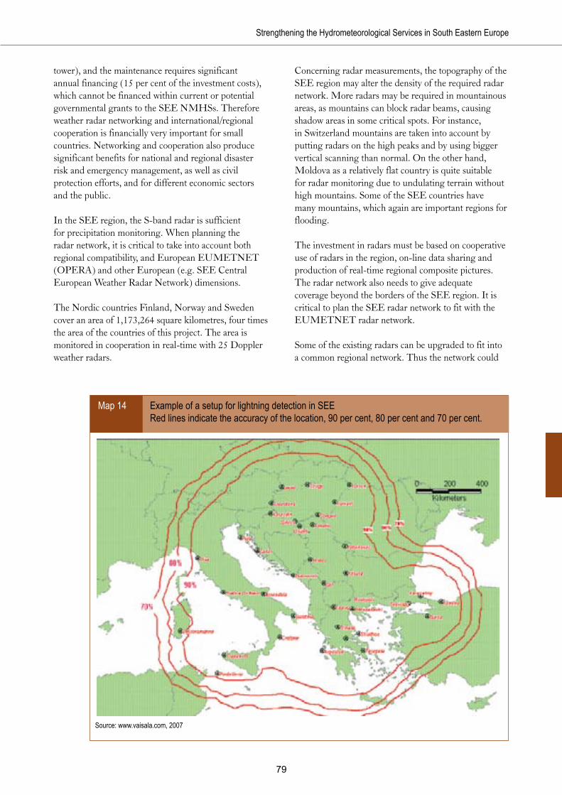
��
Strengthening the Hydrometeorological Services in South Eastern Europe
tower), and the maintenance requires significant annual financing (15 per cent of the investment costs), which cannot be financed within current or potential governmental grants to the SEE NMHSs. Therefore weather radar networking and international/regional cooperation is financially very important for small countries. Networking and cooperation also produce significant benefits for national and regional disaster risk and emergency management, as well as civil protection efforts, and for different economic sectors and the public.
In the SEE region, the S-band radar is sufficient for precipitation monitoring. When planning the radar network, it is critical to take into account both regional compatibility, and European EUMETNET (OPERA) and other European (e.g. SEE Central European Weather Radar Network) dimensions.
The Nordic countries Finland, Norway and Sweden cover an area of 1,173,264 square kilometres, four times the area of the countries of this project. The area is monitored in cooperation in real-time with 25 Doppler weather radars.
Concerning radar measurements, the topography of the SEE region may alter the density of the required radar network. More radars may be required in mountainous areas, as mountains can block radar beams, causing shadow areas in some critical spots. For instance, in Switzerland mountains are taken into account by putting radars on the high peaks and by using bigger vertical scanning than normal. On the other hand, Moldova as a relatively flat country is quite suitable for radar monitoring due to undulating terrain without high mountains. Some of the SEE countries have many mountains, which again are important regions for flooding.
The investment in radars must be based on cooperative use of radars in the region, on-line data sharing and production of real-time regional composite pictures. The radar network also needs to give adequate coverage beyond the borders of the SEE region. It is critical to plan the SEE radar network to fit with the EUMETNET radar network.
Some of the existing radars can be upgraded to fit into a common regional network. Thus the network could
Example of a setup for lightning detection in SEE Red lines indicate the accuracy of the location, 90 per cent, 80 per cent and 70 per cent.
Source: www.vaisala.com, 2007
Map 14

�0
South Eastern Europe Disaster Risk Mitigation and Adaptation Programme
consist of 15 radars (seven to nine less than are required if SEE NMHSs are strengthened individually), including upgrading four current radars and adding 11 new ones. Many of the existing facilities with permission to send microwaves may be used for new radars, depending on factors like the ability of the building to carry heavier loads. More detailed sitting requires investigation of the topography and orography, and negotiation with authorities.
The estimated investment need for this recommended regional radar plan is about €15.5 million for the radars, approximately €5.6 million for radar towers, and €8 million for maintenance and operation. Total maintenance costs during the project depend significantly on the time of radar installations.
Lightning detection
Lightning information is vital for meteorologists when working with thunderstorm and severe weather short-term forecasting.
Potential lightning detection network for Moldova and Romania The colours indicate the accuracy (in kilometres) of locating the lightning.
Source: www.vaisala.com, 2007
Map 15
Lightning may be a hazard for human safety, households, aviation, electricity production and distribution, communication, mining, construction and other activities. Real-time information on lightning and potential lightning risk is vital, especially for managers responsible for human safety, property protection and risk management.
Interests including electric power entities, insurance companies and land management agencies need historic lightning data to correlate and document suspected lightning damage with recorded lightning activity. Seasonal or multi-year studies of lightning trends are important for risk assessment, site selection and optimal protection schemes.
There are several ways of establishing a lightning detection network:
• Stand-alone systems (10-20 kilometres) around airports and other important sites; location accuracy is limited.

• A national network: 3-5 sensors, and a hub with software, per country.
• Regional networking: 1-6 sensors per country, and one regional hub.
• Larger SEE cooperation: 1-6 sensors per country, and merging with an existing hub.
• Establishment of individual sensors in each country, and membership in the European EUCLID network, which provides real-time analyses with homogenous quality in terms of detection efficiency and location accuracy, and some remuneration for each sensor included into the network (currently some €1,000 per sensor).
• Separate networks for cloud-to-ground (200 kilometres; good location accuracy), and for cloud-to-cloud and cloud-to-ground monitoring (100 kilometres; less accurate in location).
Lightning detection systems monitor both cloud-to-cloud and cloud-to-ground lightning activity. Lightning intensity can be displayed by specific software.
By installation of 2-6 lightning sensors and a hub in each SEE country, the territory can be well covered with very good detection accuracy. However, it is much more profitable in terms of both finance and accuracy to build a common net with one hub for Albania, Bosnia and Herzegovina, Croatia, the Former Yugoslav Republic of Macedonia,
Montenegro and Serbia. In each SEE country, the aviation, electricity production and distribution industries are willing to participate, with financial support, in the lightning detection project component. The Nordic lightning detection network is a good example of a functioning system based on cooperation with neighbouring countries.
Moldova would be outside of this net. By installation of 1-2 lightning sensors for its NMHS, and cooperation with the Romanian NMHS, the Moldovan territory can be well covered with very good detection accuracy.
Thus through a regional approach, the number of hubs could be decreased from seven to one, and the number of sensors from 31 to 15. The investment needs would be reduced from €3.9 million to €1.4 million.
EUCLID (European Cooperation for Lightning Detection) is a new collaboration among national lightning detecting networks with the aim of identifying and detecting lightning all over the European area. The EUCLID network provides data management and analysis services. EUCLID data is used and disseminated commercially, so there has been some payment back to the NMHSs for each sensor (in 2000, about €1,000). It would be profitable to join the EUCLID community as a consortium instead of as single countries.

��
South Eastern Europe Disaster Risk Mitigation and Adaptation Programme
References30
30 Unless otherwise noted, all website references were accessed in June 2007
Alcinova, S. and Spiridonov, V., (date unknown). Country Profile - Republic of Macedonia. Version 2.0. HMS. Andjelić, M. and Roškar, J., (2007). Development and Upgrading of Hydrometeorological Information and Flood
Warning/Forecasting Systems in the Sava River Basin. Draft Interim Project Proposal. WB-UN/ISDR-WMO SEEDRMAP Hydromet Initiative. Sava River Component.
Bergant, K., (2006). Climate Change Scenarios for Macedonia - Review of Methodology and Results. University of Nova Gorica, Centre for Atmospheric Research.
Bogdanovic, D., et al., (2006). Black Smoke Air Pollution and Daily Non-Accidental Mortality in Nis, Serbia. Central European Journal of Medicine. Vol. 1, No 3, Sept. 2006.
Čekerevac, Z., (2006). Flood Disaster in Serbia in the Spring 2006. Security Magazine. Available at: www.securitymagazine.sk
Christensen, J., Hewitson, B., et al., (2007). Regional Climate Projections - Chapter 11. IPCC. CIA, (2007). The World Factbook, accessed February 2007. Available at: https://www.cia.gov/cia/publications/
factbook/geos/rb.htmlDecision on Promulgation of the Energy Law. Official Gazette of the Republic of Croatia, Issue no. 68, 27 July 2001. Department of Emergency Situations, (2006). Disaster Preparedness in the Republic of Moldova - Current Status and
Perspectives. South East Disaster Preparedness Conference, Dubrovnik, Croatia, 20-24 March 2006. PowerPoint Presentation.
DHMZ, (2006). Establishment of Regional Marine Meteorological Centre for the Eastern Part. Djrdjević, D., et al., (2006). Advanced River Water Quality Monitoring Stations at the Moravica River in Serbia.
FACTA UNIVERSITATIS - Architecture and Civil Engineering. Vol. 4, No 2, 2006.Djordjevic, S, (date unknown). Climate Change and Variability of Extreme Climate Events in Belgrade. Republic
Hydrometeorological Service of Serbia. Electropower Company of Macedonia, (2004). Annual Report 2003. ELEM, (2005). Company Presentation. ELEM - Department for Development and Investments. CD-ROM. EWEA, (2007). Wind Power Installation in Europe by End of 2006 (cumulative). FAO, (2007). Country Profiles. Available at www.fao.org/countryprofilesFejizibegovic, S., (2007). Energy Efficiency and Renewable Energy - Bosnia and Herzegovina - National Study’s
Summary. UNEP-MAP-Plan Bleu. Freebairn J. and Zillman, J., (2002). Economic Benefits of Meteorological Services. Meteorological Applications,
9(1), 33-44.Freebairn J. and Zillman, J., (2002). Funding Meteorological Services. Meteorological Applications, 9(1), 45-54.Freshwater, (2004). Freshwater Country Profile - Serbia-Montenegro. Galupa, D., (1997). Forest and Forest Products Country Profile - Republic of Moldova. Garibija, M. and Sehbajraktarevic, K., (2006). Reconstruction of GCOS-GSN Meteorological Station.
METEOBIH. Gathara, S. et al., (2002). Report of the Working Group on the Impacts of the Desertification and Drought and of
other Extreme Meteorological Events. WMO, Commission for Agricultural Meteorology. Glanovjic, B., et al., (2005). Forest and Forest Products Country Profile: Serbia and Montenegro. Geneva Timber and
Forest Discussion Paper 40. United Nations. Glavatović, B., (2007). Harmonization of Seismic Hazard Maps for the Western Balkan Countries (Project number:
Sfp -983054). Regional Disaster Preparedness and Prevention Initiative (DPPI) meeting. Bucharest, Romania 16-17 April 2007. PowerPoint Presentation.
Gunasekera, D., (2003). Measuring the Economic Value of Meteorological Information. WMO Bull., 53(4), 366-373.
Harsten, S. and Tollan, A., (2006). Water Cooperation between Norway and Balkan Countries in the Field of Operational Hydrology. Norwegian Water Resources and Energy Directorate.

��
Strengthening the Hydrometeorological Services in South Eastern Europe
Hautala, R., Leviäkangas, P., Räsänen, J., Öörni, R., Sonninen, S., et al., (2007). Ilmatieteen laitoksen palveluiden yhteiskuntataloudellisten hyötyjen arviointi. Luonnos, toukokuu 2007. [Evaluation of the Finnish Meteorological Institute’s Services’ Socioeconomic Benefits.] Draft May 2007. Forthcoming in VTT Publications series.
Hautala, R., Leviäkangas, P., Räsänen, J., Öörni, R., Sonninen, S., et al., (2007). Socio-economic Benefits of Meteorological Services in South Eastern Europe. Project report – VTT. Coarse Draft version, 4 October 2007. VTT-FMI.
Hekkanen, M., (2007). The Meaning of Meteorological Data in Building Construction, Infrastructure and Facility in Croatia. Draft.
Hrček, D., (2003). WMO Fact-Finding Mission to Albania (8-12 September 2003). Final report. WMO, October 2003.
Institute for Strategic Studies and Prognoses: Available at www.isspm.orgIPCC 2007. Fourth Assessment Report. IPCC Secretariat, World Meteorological Organization. Geneva, Switzerland.
Available at: http://www.ipcc.ch/ipccreports/assessments-reports.htmKalkstein, L. S., and Valimont, K. M., (1987). “Climate Effects on Human Health.” In Potential Effects of Future
Climate Changes on Forests and Vegetation, Agriculture, Water Resources, and Human Health. EPA Science and Advisory Committee Monograph no. 25389, 122-52. Washington, D.C.: U.S. Environmental Protection Agency. Reproduction prepared by L- Kalkstein and K. Valimont. Available at www.ciesin.org/docs/001-338/001-338.html
Katušin, Z., (2005). Croatian Climate Observing System. Publisher: Meteorological and Hydrological Service, Croatia.
Katz, R. and Murphy, A., (editors), (1997). Economic Value of Weather and Climate Forecasts. Cambridge University Press.
Lauriala, J., et al., (2006). From Innovation to Cash-Flows. IT Press. Law on Crisis Management. Adopted by the Assembly of Macedonia Onits Session Held on 22 April 2005. Leviäkangas, P., Hautala, R., Räsänen, J., Öörni, R., Sonninen, S., et al., (Draft 4.10.2007). Benefits of
Meteorological Services in Croatia. To be published in: VTT Tiedotteita – Research Notes. Lockheed, M., (2006). Building Lasting Partnerships to Assist in Meeting the National Goals and Objectives of Our
Customers. MAFW: Strategy for Sustainable Development of Forestry in the Republic of Macedonia. Available at www.mkdsumi.com.mk/pages/Strategy-en.htmlMarjanović, N., (2006). Water Management in Serbia. Conference of the Water Directors of the Ruro-Mediterranean
and South Eastern European countries, Athens, 6-7 November 2006.Meinke, H., et. al. Using Climate Risk Technologies to Align Best Policies with Best Practice for Agriculture.
APSRU. MED-HYCOS: Mediterranean Hydrological Observing System. Available at http://medhycos.mpl.ird.fr/Mihailescu, C., (2004). Climate Change and Hazards Prediction in the Black Sea Region. Publishing House Licorn
Ltd. Mikičič, D., et al., (2006). Wind Energy Potential in the World and in Serbia and Montenegro. ELEC. ENERG.
Vol. 19, April 2006, 47-61. Milutinovic, Z. and Garevski, M., (2005). National Reporting and Information on Disaster Reduction - Republic of
Macedonia. World Conference on Disaster Reduction, Kobe-Hyogo, Japan, 18-22 January 2005. Ministry of Agriculture: Preparation of National Forest Policy in the Republic of Montenegro - Action Plan. Ministry of Ecology and Natural Resources, (2006). State Hydrometeorological Service 60 years.Ministry of Health of Montenegro, (2007). First Meeting of the Parties to Protocol on Water and Health, Geneva,
17-19 January 2007. Ministry of Local Government, (2004). National Civil Emergency Plan of Albania. Misurovic, A., (2005). Role of the Center for Ecotoxicological Research of Montenegro in Food and Feed Control -
Experiences and Problems. In: TAIEX - Food Safety and Quality in Support of EU Policies, Ljubljana, Slovenia, October 2005.
Monstat, (2006). Crna Gora Montenegro- Statistical Office, Republic of Montenegro. NASA, (2006). Earth Observations Serving Society. National Aeronautical and Space Administration. National Hydrologic Warning Council, (2006).Ohlström, M., (2007). Energy Production and Air Quality - Croatia. Draft May 2007. OHR, (2002). Law of Ministries of the Republika Srpska. “Official Gazette” of Republika Srpska, 70/02.

��
South Eastern Europe Disaster Risk Mitigation and Adaptation Programme
Öörni, R., (2007). Effects of Meteorological Information in Road Traffic in Croatia. VTT Working Papers. Draft April 2007.
OSCE, (2007). Briefing Paper: A Look at Water Management in Bosnia and Herzegovina. Second Preparatory Conference to the 15th OSCE Economic and Environmental Forum, Zaragosa, Spain 12-13 March 2007.
Petersen, W. et al. (editors). FerryBox: From On-line Oceanographic Observations to Environmental Information. EU Project FerryBox 2002-2005. Available at: www.ferrybox.org
Protic, N. et al. The Status of Soil Surveys in Serbia and Montenegro. European Soil Bureau - Research Report No. 9. Road and Traffic Safety Policy in the Public Enterprise “Roads of Serbia”. Available at: http://www.asecap.com/pdf_files/
PERoadsofSerbia_000.pdf Russian Academy of Science, (1998). National Report to the International Associations of Meteorology and Atmospheric
Sciences of the International Union of Geodesy and Geophysics 1995-1998. Savković, M., (2006). Is Serbia Energy Secure. WBSO Energy Security. 30-37.Senter, (1999). Agriculture Sector Study, Macedonia. Senter. PSO98/MA/1/3, May 1999. Somov, K., (2007). MOLDOVA Aviation Legislative System & Organization. PowerPoint Presentation, 13 June 2007.Sonninen, S, (2007). EVASERVE - Case Croatia - Socio-economical Benefits of Meteorological Services for Maritime
Industry in Croatia. VTT Working Papers. Draft, May 2007. Spiridonov, V., (2005). Hydrometeorological Service of Macedonia. PowerPoint Presentation. World Bank Workshop
“Economic Benefits of Hydromet Services”, Vienna, April 26-28, 2005.State Statistical Office, (2005): Macedonia in Figures.Steblez, W., (date unknown), The Mineral Industries of Bosnia and Herzegovina. Stojev, V., (2006). River Monitoring System in Macedonia - RIMSYS. Available at http://balwois.mpl.ird.fr/balwois/
administration/full_paper/ffp-869.pdfTammelin, B., Heimo, A., Leroy, M., Rast, J., Säntti, K., et al., (2004). Improvement of Severe Weather Measurements
and Sensors – EUMETNET SWS project, Final Report. Reports 2004:3, Finnish Meteorological Institute, Helsinki.
Tibaldi, S., (2006). Emergency Project for the Reconstruction and Rehabilitation of the METEO-BIH network. WMO.
UN, (2000). MOLDOVA - Storm, Rain and Frost OCHA Situation Report No1. UN Office for the Coordination of Humanitarian Affairs. OCHA/GVA-2000/0224.
UNCCD and WMO, (2007). Drought Management Centre for Southeastern Europe (DMCSEE) Within the Context of the UNCCD. WMO, Draft - 1 July 2007.
UNDP-Albania, (2003). Disaster Risk Assessment in Albania. UN/ISDR. Country Information - Albania. Available at www.unisdr.org/eng/country-inform/albania-general.htmVenäläinen, A., (2007). The Importance of Meteorological Services to Agriculture in Croatia. Draft, May 2007. Vidic, S., (2002). Transboundary Air Pollution in Croatia. Available at www.emep.int/assessment/Part2/029-046_Part2.
pddVucetic, M. and Loncar, Z. Growing Degree Days Between the Phonological Phases of Forest Trees and Shrubs in the
NW Part of Croatia.Vukelic, Z. et al. Water Management for Agriculture in Macedonia Related to the Environmental Awareness. Vultić, D. and Ištok, I. National Forestry Policy and Strategy - Country Case Croatia - NFP. VODNO, (2007). Public Enterprise “Water Catchment Area of the Sava River Basin.” Available at: http://www.voda.
ba/engVTT, (2007). Impacts of Meteorological Services for Aviation in Croatia.World Bank Study Group, (2006). Economic Benefits of RHMS of Serbia. Report, Republic Hydrometeorological
Service of Serbia and the World Bank. Belgrade, May 2006. World Bank, (2005). Albania – Country Assistance Evaluation. WB Report No. 33532.WMO, (2007). Assessment in the Priority Requirement for Technical Assistance in Support of WMO Programmes.
IPM/VCP/TCO(2007)/Doc.4(3). WMO, (2007). Global Telecommunication System. 2007-06-11.WMO, (2006). WMO Country-Level Disaster Prevention and Mitigation Programme Survey. WMO, (2006). WMO Country-Level Disaster Prevention and Mitigation Programme Survey - Croatia. WMO SG/
DSG/DPM, Annex 3. WHO, (2005). Health and Climate Change - the “Now and How”, A Policy Acting Guide. World Health
Organization.

��
Strengthening the Hydrometeorological Services in South Eastern Europe
WMO, (2005). Report of the European Expert Meeting on Enhanced Floods Forecasting. Bratislava, Slovakia, 12-14 December 2005.
WMO, (2004). Statement of Guidance of Hydrology.WMO, (2004). WMO Fact-Finding Mission to the Republic of Moldova. Final Report, October 2004. WMO. WMO, (2003). WMO Mission to Serbia and Montenegro (1-7 June 2003). Final Report. 12. WMO, (2002). Working Group for the Impacts of Desertification and of Drought and Other Extreme Meteorological
Events.WMO, (date unknown). National Meteorological and Hydrometeorological Services for Sustainable Development
- Guidelines for Management. WMO/TD-No. 947. WMO, (1996). Guide to Meteorological Instruments and Methods of Observation. WMO - No. 8. Sixth edition.WMO Bull., 53(4), 366-373.WMO. WMO Guidelines for Design of Aviation Weather Website. WMO & ICAO, (2003). Draft report of Joint ICAO/WMO Mission to Bosnia and Herzegovina (10-14 March
2003).

Secretariat Europe, GenevaTel.: +41 (0) 22 917 8905 Fax: +41 (0) 22 917 [email protected]/europe
Postal Address:Palais des Nations, CH-1211Geneva, Switzerland
The World Bank1818 H Street, NW WashingtonDC 20433 USATel.: (202) 473-1000Fax: (202) [email protected]
World Meteorological Organization7bis, avenue de la PaixCase postale No. 2300CH-1211 Geneva 2SwitzerlandTel.: + 41 (0) 22 730 8111Fax: + 41 (0) 22 730 8181
Finnish Meteorological InstituteErik Palménin aukioFI-00560 HELSINKIFINLANDtel. +358 9 19291fax +358 9 179 581www.fmi.fi