street tree strategy - innerwest.nsw.gov.au
TRANSCRIPT

Street Tree Strategy
Adopted10 November 201520
15

The Vision v
PART A - Street Tree Strategy A-11.0 Introduction A-2
1.1 Introduction - The Future A-21.2 How to Use This Plan A-31.3 The Street Tree Strategy Objectives A-41.4 Strategic Vision, Framework and Council Policies A-51.5 What Makes a Great Street? A-71.6 Context, History and Street Tree Planting in Ashfield A-81.7 Biodiversity & The GreenWay Corridor A-211.8 Community Involvement in Our Street Trees A-24
2.0 Street Trees and the Ashfield Urban Forest A-262.1 Overview A-262.2 The Benefits of Street Trees A-262.3 Street Trees and Their Interaction With the Urban Environment A-282.4 The Current Street Tree Population A-302.5 Current Street Tree Related Issues A-332.6 Pests, Diseases & Climate Change A-382.7 Dealing With Large or Problematic Street Trees A-402.8 General Hazard and Issue Abatement Strategies A-442.9 New Development and Management of Street Tree Impacts A-462.10 Street Tree Risk Management A-472.10 Transplanting of Street Palms A-48
PART B - Street Tree Management Guidelines & Policies B-13.0 Trees Species Selection B-2
3.1 Street Tree Selection Criteria B-23.2 Environmental Issues B-33.3 Functional Issues B-43.4 Aesthetic & Design Issues B-53.5 Fruit Trees B-53.6 Unique Planting Opportunities B-63.7 Master Species Listing B-7
4.0 Street Tree Placement and Design Guidelines B-104.1 General Design Guidelines B-104.2 Solar panels or Digital Data Receiver Access Considerations B-114.3 A Precinct Based Approach B-124.4 Street Typology Summary B-134.5 Locating Street Trees B-134.6 Trees & Power Lines B-154.7 In-Road Planting Opportunities B-174.8 Narrow Streets & Verges B-204.9 Vehicle Sensitive In-Road Street Tree Protection B-22
5.0 Civic Planting, Gateways and Main Road Corridors B-245.1 Overview B-245.2 Gateway and Civic Tree Planting B-245.3 State & Major Roads B-275.4 Other Regional & Local Collector Roads B-275.5 Commercial Centres B-27
© Ashfield Street Tree Strategy 2015 - Adopted 10 November 2015 ii
Contents
6.0 Precinct Plans and Proposed Street Tree Species B-306.1 Ashfield Town Centre B-326.2 Ashfield North B-346.3 Ashfield South B-366.4 Croydon North / Ashfield West B-386.5 Croydon South / Croydon Park B-406.6 Croydon Village B-426.7 Dobroyd Point B-446.8 Haberfield B-466.9 Haberfield Village B-486.10 Hurlstone Park / Ashbury B-506.11 Summer Hill B-526.12 Summer Hill Village B-54
7.0 Street Tree Action Plan and Implementation B-567.1 Overview B-567.2 Inventory Maintenance B-567.3 Tree Removals and Replacements B-567.4 New Tree Planting Program B-587.5 Tree Establishment and Formative Pruning B-607.6 Mature Tree Pruning and Ongoing Management B-617.7 Street Tree Action Plan and Priorities B-627.8 Costs and Resourcing B-637.9 New Planting Areas - Priority Streets and Upgrades B-647.10 ABC Priority Streets B-657.11 In-Road Planting Opportunities B-667.12 References B-67
PART C - Street Tree Technical Guidelines, Details & Specifications C-18.0 APPENDICES C-2
8.1 Street by Street Species Listings by Precinct C-28.2 Street Tree Supply and Installation Specifications C-308.3 Typical Street Planting Details C-348.4 Palm Transplanting Specifications C-478.5 Street Tree Pruning Specifications C-488.6 Street Tree Data Sheets C-49
© Ashfield Street Tree Strategy 2015 - Adopted 10 November 2015 iii

Acknowledgements:The Ashfield Council would like to acknowledge the following people for their contribution to the production of this Street Tree Strategy, 2015.
Ashfield Council TeamHarry DiversiPeter Kapocius
External AdvisorsRobert Smart - Arterra Design Pty LtdEmma Paling - Arterra Design Pty LtdIan Groundwater - Arterra Design Pty Ltd
This Page - Service Avenue, Hurlstone Park
© Ashfield Street Tree Strategy 2015 - Adopted 10 November 2015 iv

The VisionStreet trees are an important natural asset that improve the amenity of our local streets and add to the value and character of local streetscapes. The Ashfield Street Tree Strategy 2015 has been developed to ensure that the ongoing greening of our local streets occur in a manner that is reflective of the needs of local residents. The Strategy considers the collective ecological, environmental, economic, cultural and social contributions of Ashfield’s street trees.
This Strategy is a guide to aid in the management, maintenance and future planting of street trees across the entire Local Government Area. The objective of the Strategy is to provide a sustainable and strategic framework for the greening of Ashfield. The Strategy will work to ensure appropriate street tree planning, maintenance, enhancement and reinforcement of Ashfield’s ongoing commitment to the protection and planting of trees.
Through the implementation of this Strategy, Council will continue to provide a population of street trees which beautify and define our urban environment today and into the future.
"They are beautiful in their peace, they are wise in their silence. They will stand after we are dust. They teach us, and we tend them."
Galeain ip Altiem
Councillor Lucille McKennaMayor Ashfield


PART A - Street Tree Strategy
Ashfield Street Tree Strategy2015

1.1 Introduction - The Future This Strategy is a comprehensive suite of documents that outlines the proposed street tree planting principles and practices to be followed and identify the proposed future street tree species to be used throughout the Ashfield Local Government Area (LGA).
Trees are a vital part of our urban environment. They provide a substantial contribution to the “sense of place”, and character of an area. They can have historical significance and provide numerous environmental and psychological benefits to visitors and residents. Like our predecessors, we need a strategic and long term vision for certain streets and other key areas. It is hoped that the trees will mature gracefully and provide a long lasting legacy for future generations and make Ashfield a memorable and beautiful place.
Some benefits that a tree can offer to the community include:-
• reducing urban heat island effects and moderation of other weather extremes
• providing cooling and shading to pedestrians and buildings
• lowering energy use (due to the above)• increasing longevity of shaded pavements and road
surfaces• interception of rainwater / stormwater through their
leaves and roots• production of atmospheric oxygen and uptake of
carbon dioxide• filtering of particulate matter and polluting gases• shading of parked cars and reduction in hydrocarbon
emissions• storage of carbon• provision of habitat for native fauna, birds and insects• general human health, calming and well being
Trees are living organisms and a long term inter-generational investment.Trees can take decades to mature and can live for many more decades. Most of the benefits of trees are exponentially increased, the larger the tree is. It is therefore important to try and establish the largest but still appropriate tree, within the reasonable limits of the surrounding infrastructure and resident tolerance.
We must also remember that while trees take decades to grow and mature, most residents will increasingly occupy their homes on average for only a 5-10 year time frame. Even if a resident plants a tree or wants a particular species, it is highly likely they will not be there to appreciate it or manage it when it reaches anywhere near its maturity.
Trees must be given the necessary requirements to sustain life - that is, space, air, water, nutrients, light and soil. Trees, to survive, must grow, and in doing so will inevitably shed leaves, bark, fruit, flowers and even branches. Their roots will grow and their trunks will expand. The challenge is to select the species for a given street that maximises the benefits and minimises the negative impacts to residents, infrastructure and road users. Compromise is always needed when one is dealing with trees in a busy and densely populated urban environment.
1.0 Introduction
Finally, the key role of a street is to convey vehicles, pedestrians and utility services throughout the community. There is often opportunity for tree planting as well, but not in all cases. It must be remembered that poor and inappropriate tree planting may actually detract from a streets function and residents enjoyment, and potentially create a serious burden on Council resources both now, and well into the future.
The key principles for the street tree planting in the Ashfield Local Government Area shall be to:-
• Provide safe and attractive street trees that enhance the amenity of pedestrians and buildings and are sensitive to the landscape, infrastructure and environmental conditions of the locality.
• Utilise trees to provide shade for street users in summer and when appropriate allow maximum solar access in winter.
• Create a recognisable identity & individual character for streets and help identify special precincts or villages.
• Expand and contribute to the overall urban forest and canopy coverage of Ashfield.
• Contribute to the long term sustainability and efficient management of the Ashfield LGA.
To achieve the above objectives, Council shall focus on specifying a greater number of appropriate 'medium' sized trees (10-15m height with 10-15m spread) and larger trees only where space permits. We will also identify new street tree planting opportunities, and provide best practice planting techniques to ensure the health and longevity of each tree is maximised.
Figure 1.1 - The future of our streets depends on what we do today. Ashfield has a rich legacy of excellent street planting (Photo - Arterra)
© Ashfield Street Tree Strategy 2015 - Adopted 10 November 2015 A-2

1.2 How to Use This Plan This document is one part of the Ashfield’s suite of documents used to proactively manage its tree resources. Trees, like all living things, grow, age and eventually die. It is therefore important that we have a strategy and a proper plan to deal with our street trees.
The Strategy is divided into 3 main Parts.Part A - Street Tree StrategyThis section outlines the broad framework under which street trees are to be managed and the physical and historical factors that affect street trees within the LGA.
Part B - Street Tree Management Guidelines & PoliciesThis section outlines the more detailed requirements for street tree planting including how the tree species are selected, their physical placement in the streets, how they can be used to define important civic spaces and precincts and how the Strategy is to be implemented over time.
Part C - Street Tree Technical Guidelines, Details and SpecificationsThis final section provides a series of technical appendices that provide specifications on how trees are to be pruned, planted and managed. It also includes street by street listings of the proposed species for each identified precinct.
Council aims to continue the existing street characters and tree planting as much as possible, unless there are specific problems to address or opportunities for improvement and increased canopy cover. If a certain type of tree is proposed for a street, it does not mean that Council will remove the existing street trees in the short term to implement the proposed new species. This change will typically only happen over an extended time, as trees need replacing or when opportunity arises to plant a new tree in an otherwise vacant area.
Existing street trees will normally be left to grow for their safe useful life and will only be removed once they become an unacceptable hazard or are clearly failing to provide worthwhile streetscape amenity. The exception to this may be when major street improvements or upgrade works are required or it is planned to revitalise a specific area, but even then existing tree removal will normally be avoided where possible.
As a member of the community, the way you might use this Strategy is outlined below:-
1. Refer to Part B on detailed tree management, tree species selection and placement to understand the many complex considerations involved in selecting any street tree and its placement.
2. Refer to Part B - Section 6 that has maps of the Ashfield Local Government Area (LGA) area and identify which precinct your street lies within.
3. Once you have located the precinct in which your street lies, you should then refer to that precinct's summary page and the proposed species maps.
4. If you are unfamiliar with the tree species, you may want to refer to Section 8.6 in Part C where a brief Tree Data Sheet is provided for all the tree species proposed, giving a photograph, a brief description of the trees and an outline of their key features.
We hope you find this document useful and share our passion in making Ashfield a green, sustainable and beautiful area.
Figure 1.2 Overview of the typical extent of canopy cover in Ashfield. It is contributed to by private trees, street trees and park trees. Together they operate as the urban forest.
A-3
Section 1 - INTRODUCTION
© Ashfield Street Tree Strategy 2015 - Adopted 10 November 2015

1.3 The Street Tree Strategy Objectives The Street Tree Strategy is a plan for the effective short and long term management of the Council owned and managed street trees. This document establishes a clear direction for the future development, planting and management of street trees within the Ashfield LGA.
The principle aim of the Street Tree Strategy is to create " a caring community of linked villages inspired by its rich history, heritage and diversity" in accordance with the Community Strategic Plan - a sustainable, safe, thriving community.
The key objectives of the Street Tree Strategy are to:-• Promote and capitalise on the benefits of Ashfield’s
existing urban forest whilst minimising the ongoing costs of street tree and infrastructure maintenance;
• Provide direction on the most appropriate species and planting techniques;
• Establish an appropriate street tree species palette that is suited to the environmental conditions of Ashfield's public domain;
• Improve any new street tree establishment, habits and survival rates;
• Guide the maintenance and management of existing and new trees to ensure that they survive and flourish in otherwise harsh and unnatural urban conditions;
• Support and enhance the biodiversity values in the local area;
• Improve the Council's wider community’s knowledge and understanding of good urban tree and forest management;
• Guide Council’s decision making and provide a transparent and accountable processes for planting, maintenance, customer requests and development application assessments and
• Assist Council staff in the planning, budgeting, implementation, and maintenance of street tree planting by providing consistent guidance on suitable species, locations and planting patterns.
Figure 1.3 Haberfield Road, one of the historic and signature streets
A-4
Section 1 - INTRODUCTION
© Ashfield Street Tree Strategy 2015 - Adopted 10 November 2015

1.4 Strategic Vision, Framework and Council Policies Ashfield Council currently has a number of Council documents that provide some guidance on how urban trees are to be managed, these include:
• Ashfield - Community Strategic Plan - Ashfield 2023-Our Place, Our Future.
• Ashfield Local Environment Plan 2013 – in particular :-- Clause 5.9 Preservation of Trees and Vegetation
and- Clause 5.10 Heritage Conservation
• Ashfield Interim Development Assessment Policy 2013 - Ashfield Town Centre Strategy
• Ashfield Interim Development Assessment Policy 2013 - Outdoor Dining and Footpath Trading Policy
• Ashfield Development Control Plan- Part C7 - Haberfield Heritage Conservation
Area- Part C10 Heritage Conservation
• Ashfield Heritage Study 1998• Footpath Repair and Maintenance Policy 2000• Guidelines for Converting Paved Footpaths to Grass
Verges 2014• Policy - Planting Additional Trees & Shrubs in Parks
and Reserves 1998• Sustainable Ashfield: An Ecologically Sustainable
Development Policy 2011• Tree Preservation Policy 2013• Noxious Weeds Policy 2012
Some others documents of relevance include:-• Roads Act 1993;• Electricity Supply and the NSW Electricity Supply Act
1995 No 94;• Greenway Corridor - Cooks River to Iron Cove - Master
Plan and Coordination Strategy 2009;• New Parramatta Road - Draft Parramatta Road Urban
Renewal Strategy 2014;• Where are all the trees - 202020 Vision;• Environmental Protection and Biodiversity
Conservation Act 1999;• NSW Threatened Species Conservation Act 1995;• Statewide Best Practice Manual - Trees and Tree Root
Management 2006 & 2011• Marrickville Street Tree Master Plan 2014.
Ashfield - Community Strategic Plan - Ashfield 2023-Our Place, Our Future.This is the over arching document for the Ashfield LGA. It strives to create “a caring community of linked villages inspired by its rich cultural history, heritage and diversity”. It is based around the following principles:-
• a creative and inclusive community• unique and distinctive neighbourhoods• safe and connected and accessible places• sustainable living• thriving local economy• an active and lively town centre• engaging and innovative local democracy
COUNCIL STRATEGIC FRAMEWORK
Ashfield 2023 - Our Place, Our FutureCommunity Strategic Plan
(a caring community of linked villages inspired by its rich cultural history, heritage and diversity)
COUNCIL POLICIES & STRATEGIES
Development Control Plans - Heritage Conservation
Tree Preservation Policy
Sustainable Ashfield : ESD Policy
Finance Plan (10 year)
Ashfield Street Tree StrategyPart A - Street Tree StrategyPart B - Detailed Street Tree Guidelines and Tree ManagementPart C - Technical Details
Ashfield Local Environment Plan (LEP)(Key planning policies to preserve trees and amenity)
Footpath Repair and Maintenance Policy
GreenWay Corridor Master Plan
Ashfield Town Centre Strategy
Asset Management Plan (10 year)
Workforce Management Plan (4 year)
Delivery Program (4 year)
Operation Plan(1 year)
Figure 1.4 - The Ashfield Street Tree Strategy and the strategic framework and its relationship to the Council's Community Strategic Plan and other key planning documents
A-5
Section 1 - INTRODUCTION
© Ashfield Street Tree Strategy 2015 - Adopted 10 November 2015

The street tree strategy (STS) supports many of these policies and legislative requirements by:-
• Protecting and celebrating the past landscaping styles and historically important streets. The STS documents the continuation and protection of significant and historically important in-road planting and heritage avenues.
• The identification of many new and replacement planting opportunities within the LGA, particularly the continuation and expansion of further strategic in-road planting/ kerb extensions, or planting in currently under treed streets. This also offers opportunities to implement Water Sensitive Urban Design and passive irrigation improvements.
• Helping to achieve more attractive and visually distinct local Town Centres through coordinated tree planting and gateway definition. Well treed and attractive streets have been shown to promote visitation and that shopper’s and diners tend to dwell longer, than in streets that are not well treed or attractive.
• Helping to deliver better streets that in turn will engender civic pride and encourage non-car forms of transport such as walking and cycling.
• A larger inclusion in the STS of medium sized tree species (and larger trees wherever technically possible), to improve the overall LGA canopy cover. In many cases existing small trees have been suggested to be replaced, over time, with medium sized trees particularly on the side of the road opposite overhead wires.
• The introduction of more locally indigenous and native tree species to provide for increased ecological benefits and biodiversity particularly along the identified Greenway Corridors. This will also improve the overall diversity of the street tree population.
• Selection of the best species to maximise the benefits of shading and solar access - right tree for the right place. This will help reduce energy use and urban heat island effects, intercept stormwater, and extend pavement life and reduce maintenance of road surfaces.
• Provision of a variety of improved planting details for various situations providing technical details on tree planting, their positions and soil conditions to ensure the health and longevity of each tree is maximised. This helps to ensure waste and maintenance inputs are minimised in the future.
Figure 1.5 - Street trees are important assets in an urban environment. (Photo - Arterra)
A-6
Section 1 - INTRODUCTION
© Ashfield Street Tree Strategy 2015 - Adopted 10 November 2015

1.5 What Makes a Great Street? What makes a great street? In the widely recognised book ‘Great Streets’ by Allan Jacobs he studied what people commonly consider ‘great streets’, and found they typically comprise a number of definite physical qualities. The most significant factor that makes “a place” is often the street tree planting.
Interestingly it has been found that evenly spaced trees using a single species usually has the greatest impact on peoples perception of a ‘great street’.
Trees have the ability to transform a street and create definition within a street and can be just as important as the built forms in many locations. Many streets throughout the LGA should be targeted to improve the consistency of planting and thereby the aesthetic impact and overall appeal to the wider community.
Figure 1.6 - Great streets often have excellent tree planting that provides an over arching canopy and use a consistent palette of species. (Photo - Arterra)
Figure 1.7 - An example like David Street, Marrickville provides a memorable and desirable residential street with in-road planting, an over arching canopy and the use of a consistent palette of one species (Photo - Arterra)
A-7
Section 1 - INTRODUCTION
© Ashfield Street Tree Strategy 2015 - Adopted 10 November 2015

It is bordered by Iron Cove to the north, and the now attenuated Hawthorne Canal and Iron Cove Creek to the east and Dobroyd Canal to the west (fomerly known as Long Cove). It is mostly developed, predominantly with low density residential housing, but with numerous blocks of apartments now scattered throughout.
Figure 1.8 Ashfield - The Local Government Area and Context Plan (Source: NearMap November 2014)
MarrickvilleLGA
Iron CoveCity of Canada Bay
Ashfield Town Centre
Leichhardt LGA
1.6 Context, History and Street Tree Planting in AshfieldOverviewAshfield has a population of approximately 44,000 (ERP 2013) is approximately 829 hectares in area and is between 6-9km from the Sydney CBD. It is known as the inner west of Sydney. It contains the whole of the suburbs of Ashfield, Summer Hill, Haberfield and parts of Croydon, Hurlstone Park and Ashbury.
CanterburyLGA
BurwoodLGA
A-8
Section 1 - INTRODUCTION
© Ashfield Street Tree Strategy 2015 - Adopted 10 November 2015

Table 1 - GENERAL COMPARISON OF ASHFIELD LGA WITH OTHER SIMILAR COUNCILS
LGA Area
(ha)
Aprro
x. Po
pula
tion
Aver
age
Popu
latio
n De
nsity
LGA
(p
eopl
e/ha
)
No. E
quiva
lent
As
sess
ed S
treet
s
Medi
an H
ouse
Pr
ice
% o
f Pr
oper
ty
Turn
ed o
ver i
n la
st 5
yrs
CommentsAshfield 829 44,175 53 299 $ 987,000 38.7% Mostly suburban streets and detached
housing or low rise apartments/ terraces, consistent street types and widths variety of environmental conditions, pollution, in-road planting, heritage. Extensive power line conflict.
City of Sydney 2674 169,500 63 747 $920,000 53.7% CBD/ Inner city streets & suburbs/ terraces, variety of environmental conditions, pollution, narrow verges, heritage.
MarrickvilleCouncil
1655 81,689 49 615 $855,000 41.0% Inner suburbs, large amount of narrow verges, extensively clay soils, extensive power line conflict.
Woollahra Municipal Council
1220 52,160 42 356 $2,000,000 41.0% Diverse range of street types, and widths exposure, many areas with power UG, views. Heritage.
Lane Cove Municipal Council
1056 31,510 33 326 $1,350,00 35.4% Large areas of bush land, extensive history of native street planting, wide verges, power line conflict.
City of Botany Bay 1419(excluding airport/Port Botany)
42,317 30 (excluding airport/Port Botany)
294 $825,000 34.1% Sandy impoverished soils, high water table, consistent street types and widths, power line conflict. Large areas of industrial development.
Figure 1.9 Long Cove Viaduct in 1864, showing the then very rural nature of Ashfield and its surrounds (Source: Coupe, 1988)
A-9
Section 1 - INTRODUCTION
© Ashfield Street Tree Strategy 2015 - Adopted 10 November 2015

Figure 1.12 Ashfield Park c1850, one of the first homesteads within the area and most certainly contributing the current name of the municipality (Source: Pollon, 1996)
Figure 1.10 - Map showing the approximate location and size of land grants made near Ashfield between 1793 and 1810. The circled numbers indicate the order in which the grants were issued (Source: Coupe, 1988)
Figure 1.11 - Map showing the development of Ashfield LGA circa 1886. Note that Ashfield, Croydon and Summer Hill have been developed to the street pattern that exists today. Apart from Ramsay Street, Haberfield and Dobroyd Point was largely undeveloped and the remnants of Ashfield Park Estate in Croydon remained in the far upper left. (Source: Historical Atlas of Sydney - CoS Archives)
A-10
Section 1 - INTRODUCTION
© Ashfield Street Tree Strategy 2015 - Adopted 10 November 2015

Ashfield's Historical ContextOriginally well timbered with native forests, the area began to be cleared after 1790 as the rough tracks, later to become known as Parramatta Road and Liverpool Road, were cleared. The area was soon used for crops, fruit growing and grazing, given the relatively fertile land and proximity to the fledgling Sydney. In these early times it was an attractively undulating area with fine vistas which lead to many grand residences being established. Many new and historically significant species of plants, both native and exotic, were introduced into these gardens including:-
• Araucaria cunninghamii (Hoop Pine)• Araucaria heterophylla (Norfolk Island Pine)• Araucaria bidwillii (Bunya Pine)• Cinnamomum camphora (Camphor Laurel)• Quercus spp. (Oaks)• Ficus spp. (primarily Morton Bay, Port Jackson and
Hill’s Weeping Figs)
The Camphor Laurel remains one of the most prominent remnants of the Victorian era landscaping, although many of the others are still easily seen in many older gardens and parks within the LGA.
A village started to grow along Liverpool Road in 1838. The arrival of the railway in 1855 brought Ashfield within easy reach of the city and a village started to expand. This was part of the celebrated and original estate known as ‘Ashfield Park’.Ramsay’s Bush out on Dobroyd Point was the last remnant of native vegetation in the district and was cleared in the early 1900’s for the development of the ‘Garden Suburb’ Haberfield.
Alt Street was one of the first streets created between Parramatta Road and Liverpool Road, together with Bland and Elizabeth Street. Other early streets included John, Church, Holden, Norton and Milton Streets. In 1841 further subdivision of southern Ashfield was made, offering allotments for ‘Gardeners Homes’ showing their use for market gardens and the like, with good soil and good road access to Sydney. 1840 saw the erection of the Church on Alt Street, opposite Church Street, known as ‘Church of John the Baptist’ (now St Johns).
1855 saw increasing development of salubrious suburban retreats for wealthy city businessmen. The coming of the railway involved the construction of the Long Cove Viaduct, which was one of the largest bridges that had been so far built.
The death of Elizabeth Underwood in 1858 saw the subdivision of the Ashfield Park Estate near Parramatta Road. Ashfield then began to be an area of grand houses from 1870’s onwards. There was a marked increase in building activity in the late 1880’s, including numerous churches and schools.
During the period between the onset of the depression of the 1890’s and the Great War in 1914 there was a significant change in the physical and social characteristics of Ashfield and its surroundings. Larger and smaller estates were being subdivided to accommodate smaller and humbler dwellings. Both Ashfield and Summer Hill became thriving and important commercial centres. In early 1891 the Ashfield Post Office was completed and the Town Hall, with the later being extensively remodelled only 50 years later in 1937.
Kerbing and asphalting of streets began in the late 1890’s after the depression of the earlier years. Ashfield’s population grew steadily from the 1880’s and into the early 1900's. The first decade of the 1900's saw more than 1700 new houses built. The original wealthy land owners either died or moved elsewhere with their homes coming up for sale and sometimes subdivided.
Perhaps most significantly, in 1901 Richard Stanton, headed a syndicate that purchased a large part of Dobroyd Estate, that belonged to the Ramsays, and calling it the Haberfield Estate. The hallmark of the development was the covenants that controlled what was built and the cost of the buildings erected – villas, kerbed streets and Brush Box (Lophostemon confertus) lined streets became the norm. The aesthetic appeal of the suburb was further enhanced by the home-owners careful landscaping, planting and the maintenance of the tree lined streets, which was an essential aspect of the ‘Garden Suburb’. Brush Box (Lophostemon confertus) was overwhelmingly the predominant species used, although others also define this era of planting including the Jelly Palm (Butia capitata), Camphor Laurel (Cinnamomum camphora) and Port Jackson Fig (Ficus rubiginosa). Between 1903 and 1912 the company bought and developed 3 more estates. Together with other such estates that developed in competition, Haberfield as a whole developed with an architectural and streetscape homogeneity that makes it, today, one of Sydney’s finest repositories of Federation Style suburban residences. Most of the well developed street trees that exist today, hark from this early 1900's period.
Figure 1.13 - Aerial view circa 1930’s - Haberfield and Parramatta Road with Yasmar House at the centre (Source: SLNSW). Note the majority of streets are planted with street trees at this time which was relatively rare for most other parts of Sydney.
A-11
Section 1 - INTRODUCTION
© Ashfield Street Tree Strategy 2015 - Adopted 10 November 2015

Figure 1.14 - Map illustrating the currently existing important and historic street tree avenues within the LGA, which should be reinforced and continued to maintain Ashfield character.
REVISION
P WF
SUITE 602 / 51 RAWSON STREET,
ARTERRA DESIGN PTY LTD
02 9957 2466 02 9957 3977 ARTERRA.COM.AU
EPPING NSW 2121
ABN 40 069 552 610
Ashfield Street Tree StratgeyExisting Important Single Species Streets
Scale
RICH
ARD
M
URDE
N
RE
SERV
E
W JEGOROW
RESERVE
MUNICIPALITY OF
MARRICKVILLE
MUNICIPALITY OFLEICHHARDT
CITY OF CANADA BAY
MUNICIPALITY OFBURWOOD
CANTERBURY
MUNICIPALITY OF
RobsonPark
Reg CoadyReserve
AlgiePark
AshfieldPark
HammondPark
AshfieldCentenarySport Area
PrattenPark
LewisHerman
Res
AllmanPark
DJGardens
YeoPark
GoughRes
STRE
ET
SEAVIEWSTREET
STREET
VICT
ORIA
SQUA
RE
STRE
ET
STRE
ET
STRE
ET
ROAD
GOWER
STREET
STREET
STREET
ROSE ST
ANTHONY
STREET
STREE
T
STREETMILLS ST
STREET
ALT
JULIA ST
PARA
DE
CROYDON
ASHFIELDSTATION
STATION
JONE
S STR
EET
TAWA ST
RECTORY AVE
HENRY STREET
RICHMOND
MORTLEY
AVENUE
LEARMONTH
AVEN
UE
AVENUE
AVENUE
BOOM
ERAN
G
STREET
CHEL
MSFO
RD
MILLER STREET
LOUDON
CRANE
STRE
ET
STRE
ET
STRE
ET
STREET
NIXO
N AVE
BLAN
D ST
ALT S
T
WOOD
STSTATION ST
ST
PAGE
AVENUE
EARLE
AVENUE
ALLUM
STREET
ROAD
STREET
DUDL
EY
STRE
ET
STREET STRE
ET
STREET
AVENUE
AVENUE
TURNER
BARTON
TILLO
CK
STRE
ET
FORREST ST
DEAKIN
AVENUE
DICKSON ST
TRESSIDER
AVENUE
ROAD
STREET
STANTON
DALH
OUSIE
STRE
ET
O'CONN
OR
ST DA
VID'S
DALHOUSIE
NICHOLLSAVE
LOGAN
AVE
HABE
RFIE
LD
ROAD
MARIONSTREET
PERCY ST
LORD ST
ROAD
HAW
THOR
NE
IDA S
TFLOR
ENCE
STPRINCESS
WATKIN
STREET
MOUNT STREET
HILL
COT S
T
STREET
GRIFFITHS
HOLD
EN
STREET
STREET
SERV
ICE
VICT
ORIA
AVEN
UE
HARLAND STREET
PROS
PECT
R
OAD
HOLWOOD AVE
HENS
ON
JAMES ST
HERBERT STREET
HURLSTONE AVE
STREETSEAVIEW
ROSE
MOUN
T AVE
YEO
AVE
ARMSTRONG
STREET
HILLCREST AVE
ASHFORD ST
HANKS
GOOD
WIN
AVE
FARL
EIGH
ST
REET
CLISSOLD
NEW ST
QUEE
N
WILL
IAM
ROBERT STREET
STRE
ET
PYRMONT ST
STRE
ET
ROSE
STRE
ET
AVE
JOSE
PH
ABEC
KETT
TINT
ERN
ROAD
TEAK
LE S
T
ROBERT STREETDRYNAN STREET
LOUI
SAST
LINDS
AY AV
E
SHORT ST
HUGH
STR
EET
KING
STR
EET
HAMP
DEN
STRE
ET
CARL
ISLE
STRE
ET
MILL
ER AV
E
LIVERPOOL
WETHE
RILL
ST
HIGHB
URY
MILT
ON S
T
NORT
HFR
EDER
ICK
STRE
ET
THOMAS
PAISL
EY LN
WALTE
R ST
STREET
BEATRICE ST
STREE
T
EDWIN
STRE
ET
SOUT
H
AVE
HEIGHWAY
PAISLEY RD
BAST
ABLE
STRAILW
AY ST
HORD
ERN P
DE
MACKAY ST
ETON
VILLE
PDE
HEDGER AVE
BANKS ST
CROY
DON
HUNT ST
ALBERT
PARADE
VINE ST
EDWIN
CANTO
R CR
MARG
ARET
TARINGA ST
TARINGA ST
BROUGHTON ST
CHARLOTTE
STREET
CHURCH STREET
JOHN
COMET ST
ECCLES AVE
BENALLA
AVE
GRAIN
GER A
VE
BROWN ORPIN
GTON
WEBBS
AVE
STREET
OAK
ESPLANADE
ASHFIELD ST STRE
ET
ORMOND
PEMBROKE
STREET
SUNNING PL
TIDESWELL ST
SLOANE
BOGAN STREET
DOVER
STREET
CARLTON CRESCENT
CRESCENT
HAIG AVE
ROAD
CHAP
MAN
STFLEE
T ST
EDW
ARD
STRE
ET
STRE
ET
STRE
ET
STRE
ET
WELLESLEY STREET
CARR
INGT
ON
SPEN
CER
NOW
RANI
EST
REET
LORNE ST
MORR
IS
STRE
ET
MOON
BIE
BART
LETT
REGENT STREET
SMITH ST
SHORT ST
CARLTON CRESCENT
OAKLANDSAVE
ROAD
ALLM
AN AV
E
AVE
HARD
IE
SMITH ST
MURR
ELL S
T
KNOX
ST
THE A
VENU
E
CAVIL
L AVE
NORTON
SOMERVILLE AVE
LION
STRE
ET
STRE
ET
STRE
ET
STRE
ET
GREE
NHILL
S HOLB
OROW
CARS
HALT
ON
CROM
WEL
L
GEORGES RIVER
ROAD
HAY
ST
FORB
ES S
T
LEOP
OLD
ST
WAT
SON
AVE
DOUG
AN S
T
YABS
LEY
AVE
MILTON
STREET
PALACESTREET
PARKAVENUE
ALMA
STR
EET
SHEP
HERD
STR
EET
BRUN
SWIC
K PD
E
SUNBEAM AVE
WEST ST
AUSTRALIA ST
JOHN
ALEXANDRA ST
RANGER ROAD
ASTW
IN ST
KENILWORTH STGREGORY AVE
KNOCKLAYDE
LUCY
STREET
HENRY STREET
STREET
ILFORD AVE
DOBROYD PDE
COVE ST
WOLSELEY
NORTHCOTE
WALKER
WATTLE
ALT
BLAND
DENMAN
CHANDOS ST
TINANA
ROGERS
ST
AVE
LOFTUS
STREET
CECILCHAN
DOS
STRE
ET
STREET
STREET
STREET
CURT STSTREET
AVENUE
GILLIES
YASMAR
AVENUE
AVENUE WINCHCOMBE AVENUE
EMPIR
E
RAWSO
N
STREET
STREET
AVENUE
STREETSTREET
STREET
STREET
STREET
BURN
S S
T
SCOT
T
STREET
BAY
HAMM
OND
AVE
BIRR
IGA
RD
BRID
GES
AVE
CHURCH
STREET
LANG
BYRO
N ST
STRE
ET
DALMAR
MARTIN
DOBR
OYD
PARADECITY WEST LINK ROAD
MINT
O AV
E
CRESCENT
PARA
DE
HAW
THOR
NE
WEBBS ST
KENSINGTON
WALLACE
STREET
FEDERAL AVE
STRE
ET
ARTHUR STREET
NORTON
WARATAH
RAMSAY
STREET
LAPI
SH AV
ENUE
GROSVENOR CRESCENT
VICTORIA ST
STRE
ET
KINGS
TON
STRE
ET
KINGSTONQU
EEN
HARD
Y
VICT
ORIA
STRE
ET
STRE
ET
STRE
ET
HOLD
EN
BROW
N ST
STREET
HOLD
EN S
T
ARTHUR
STREET
ELIZABETH
ELIZABETH
RAMSAY
STREET
ROAD
JUNCTION
DICKIN
SON
AVE
LONGPORT ST
ALLIB
ONE
AVE
THE
CAVILL
LACK
EY S
T
BOWLING CLUB
DOBROYD PDE
HAWT
HORN
E C
ANAL
FRED
ERIC
K
ST
PROS
PECT
QUEE
N ST
HERCULE
S ST
HOLD
EN
QUEEN
BLACKWOOD AVE
AVE
WETHE
RILLLIVERPOOL
MILT
ON
ORCHARD CR
GROSVENOR
CARLTON
CRESCENT
SMITH ST
LUCY CT
JOHNPATON
RESERVE
ALT
EMPIR
E
RAWSO
N
DALH
OUSIE
STRE
ET
STRE
ET
STRE
ET HAWTH
ORNE
PARA
DE
SLOANE
STREET
STREETSTREET
STREET
BLAN
D
STREET
GOWER
LIVERPOOL
STREET
AVENUE
HEIGHWAYSTREET
THOMAS
BEATRICE ST
ROAD ROADLIVERPOOL
ROAD
STRE
ET
STRE
ET
PARRAMATTA
ROAD
PARRAMATTA
ROAD
PARRAMATTA
ROAD
OLD CAN
TERBU
RY
ROAD
OLD CANTERBURY
ROAD
STRE
ET
NORT
H
ELIZABETHST
EDWIN ST
REET
NORT
H
COLL
EGE S
T
HENNESSY ST
ELIZABETH STREET
ELIZABETHST
Phoenix canariensis(Canary Island Date Palms)
Butia capitata(Wine Palm)Cinnamomum camphora(Camphor Laurel)Lagerstroemia indica(Crepe Myrtle)
Lophostemon confertus(Brush Box)
LEGEND
CHAR
LOTT
E
BYRO
N ST
NORTON
STREET
RAMSAY
STREET
O'CONNOR
STREET
STREETSEAVIEW
PEMBROKE
STREET
BRUCE STREET
DALH
OUSIE
STRE
ETRAMSAY
STREET
1:7,000@A1, 1:14,000@A3
ADate: 15 January 2015
A-12
Section 1 - INTRODUCTION
© Ashfield Street Tree Strategy 2015 - Adopted 10 November 2015

Figure 1.15- Turner Ave, Dobroyd Point circa 1912 - the architecture and style of planting. Note the roadways were still relatively conducive to tree planting being dirt finish (Source: Historic Houses Trust)
Figure 1.18 Victoria St, Ashfield South - Canary Island Date Palms (Photo-Arterra)
Figure 1.19 Victoria St, Hurlstone Park - Jelly Palms (Photo - Arterra)
Figure 1.16 Turner Avenue, Dobroyd Point - Lophostemon confertus (Brushbox) (Photo-Arterra)
Figure 1.17 Tintern Road, Ashfield South - Lophostemon confertus (Brushbox) (Photo-Arterra)
A-13
Section 1 - INTRODUCTION
© Ashfield Street Tree Strategy 2015 - Adopted 10 November 2015

Figure 1.20- Aerial view circa 1943 - Haberfield (Source: NSW Land Dept. - Six Viewer). Note the majority of streets planted with street trees at this time which was relatively rare for most other parts of Sydney.
Figure 1.21 - Tintern Road, Ashfield circa 1920 - early photo of the extensive tree lined streets that still dominate Ashfield even today. (Source: Coupe 1988)
A-14
Section 1 - INTRODUCTION
© Ashfield Street Tree Strategy 2015 - Adopted 10 November 2015

ClimateThe municipality is approximately 13km inland from the coast, and therefore shares the general climate of the Sydney region with moderate temperatures, good rainfall and minimal climatic and weather extremes. It is typically described as a ‘temperate’ climate with hot to warm summers and cold winters, with relatively uniform rainfalls greater than 800mm / year. There is no distinct dry season.
The nearest weather recording station is taken as Sydney Airport AMO, approximately 4.2km away from Ashfield centre. It has an average annual rainfall of 1083mm, fairly evenly spread across the year but with a slightly drier period from July - October. The highest rainfall usually occurs in June with an average of 120mm and the driest month is September with an average of 60mm.
Maximum average daily temperatures, recorded range from 26.5ºC in January and to 17ºC in July. The minimum average daily temperatures range from a high of 19ºC in February down to lows of 7.2ºC in July. The primary wind direction is from the northeast to southeast in the afternoons while it is predominantly from the west and northwest in the mornings. This is common of coastal areas dominated by ‘sea breeze’ affects. The strongest winds (>30km/h) are normally experienced from the southeast and southerly directions and later in the day. (Source : Australian Bureau of Meteorology).
In comparison with other areas of the greater western Sydney region that experience much higher maximum temperatures, lower minimum temperatures and substantially lower annual rainfall, the Ashfield area enjoys a very comfortable climate which in turn lends itself to a very diverse range of tree species that will happily grow in the area. There are no noticeable microclimatic influences in the area and frosts are rare.
Geology and SoilsThe majority of the municipality is a residual landscape comprising of gently undulating rises on Wianamatta Group Shales (covering Ashfield, Summer Hill, most of Croydon and Hurlstone Park). The result being that shale derived clay or
clay loam soils dominate in these areas, generally having reasonable nutrient and water holding capacities which provide favourable conditions for street tree planting. The potential for compaction of these types of soil however is also great.
Small pockets of Hawkesbury Sandstone geology are located in the northern parts of Haberfield and in particular Dobroyd Point. These areas typically contain shallower and sandy soils or sandy loams. In some cases rock outcrops are even evident along the ridge lines. Street tree planting in these areas is more limited, and consideration of the species selection should allow for hardier species that can tolerate poorer quality soils and frequent drought conditions. Tree sizes will typically be smaller and more stunted than they may be on the better clay soils.
Parts of Croydon and the edges of the Canals near Hawthorne Canal are alluvial or floodplains areas, dominated by silty clay loams derived from the upstream shales. Highly disturbed soils and land fill areas are located along the harbour edge and associated with the reclamation of the creeks and mangroves. Generally these are the areas that were previously swamps, estuaries and wetlands and have been subject to filling where the soil origin or quality is completely unknown. Tree species selected should be hardy and more tolerant of variable and most likely poor soil qualities.
TopographyThe topography of the Ashfield LGA is typically one of gently rolling hills. A broad crest runs north-south through the centre of the LGA with the general aspects on either side either facing north-west for the western suburbs or easterly for the eastern suburbs.
There are very few prominent topographical features other than the two flanking creeks that define the eastern and western boundaries of the LGA.
Figure 1.22 Hennessey St, Croydon - relatively good clay based soils dominate much of the area. These are easily compacted but have good water holding capacity and depth for tree establishment. (Photo: Arterra)
Figure 1.23 Learmonth St, Dobroyd Point - sandstone based soils that typically have shallow and impoverished soils with bedrock often impeding proper drainage. (Photo: Arterra)
A-15
Section 1 - INTRODUCTION
© Ashfield Street Tree Strategy 2015 - Adopted 10 November 2015

REVISION
P WF
SUITE 602 / 51 RAWSON STREET,
ARTERRA DESIGN PTY LTD
02 9957 2466 02 9957 3977 ARTERRA.COM.AU
EPPING NSW 2121
ABN 40 069 552 610
Ashfield Street Tree StratgeySoil Types Plan
Scale
MUNICIPALITY OF
MARRICKVILLE
MUNICIPALITY OFLEICHHARDT
CITY OF CANADA BAY
MUNICIPALITY OFBURWOOD
CANTERBURY
MUNICIPALITY OF
HABERFIELD
ASHFIELD NORTH
CROYDON
SUMMER HILL
CROYDONPARK
HURLSTONEPARK
ASHBURY
CANTERBURY
DULWICHHILL
LEWISHAM
LEICHHARDT
FIVE DOCK
CROYDON
DOBROYD POINT
ASHFIELD TOWN CENTRE
ASHFIELD SOUTH
SOILS / GEOLOGY
Shale derived clay or clay loam soils
Alluvial/ Floodplain - silty loam or silty clayloams derived from upstream shales
Sandstone derived - usually shallow sandysoils or sandy loams/ rock outcropping
Highly disturbed / landfilling of unknown originand qualities
1:7,000@A1, 1:14,000@A3
ADate: 16 January 2015
Figure 1.24 Map of Soils / Geology across Ashfield LGA
A-16
Section 1 - INTRODUCTION
© Ashfield Street Tree Strategy 2015 - Adopted 10 November 2015

Residential and Development TypologyThe area has a fairly uniform development of suburban residential housing, developed mostly between 1890-1930. It is characterised by:-
• Houses are typically detached, set back, with driveways and most with off street car parking.
• Scattered apartment developments, some older, but most from the 1970’s and a few more modern examples.
• Most commercial areas restricted to major roads including Parramatta and Liverpool Road.
• Some minor pockets of terraces, with narrow frontages.• Some harbour front land and other raised areas that
offer district and attractive views.• Some very well established and attractive Parks and
open spaces. Figure 1.25 Canterbury Road, Hurlstone Park - commercial development (Photo - Arterra)
Figure 1.27 King St, Ashfield South - example of modern flat buildings (Photo - Arterra)
Figure 1.28 Lion St, Croydon - early workers style terraces (Photo - Arterra)
Figure 1.29 Holborow St, Croydon - typical housing (Photo - Arterra)
Figure 1.30 Kensington Street, Summer Hill - typical housing (Photo - Arterra)
Figure 1.31 Victoria Sqr, Ashfield South - typical housing (Photo - Arterra)
Figure 1.26 Victoria St, Hurlstone Park - example of early style mansion (Photo - Arterra)
A-17
Section 1 - INTRODUCTION
© Ashfield Street Tree Strategy 2015 - Adopted 10 November 2015

Figure 1.32 Typical narrow verge, Knocklayde Street, Croydon North (Photo - Arterra)
Figure 1.33 Cromwell St, Croydon South - example of narrow grass verge (Photo - Arterra)
Figure 1.34 Typical fully-paved verge with tree planting, Dougan Street, Croydon South (Photo - Arterra)
Figure 1.35 Typical in-road tree planting, Arthur Street, Croydon South (Photo - Arterra)
Figure 1.36 Typical 3.5m+ wide verge Griffiths Street, Hurlstone Park (Photo - Arterra)
Figure 1.37 Typical 5m+ wide verge, Service Avenue, Hurlstone Park (Photo - Arterra)
Street Typology and VergesThe street typology of Ashfield LGA is fairly consistent across most of the precincts, particularly when compared to other nearby Council areas. There are always some exceptions but on the whole most roads have a verge that is approximately 2.4-3.5m wide with a grassed strip adjoining the road carriage way and a concrete pedestrian footpath close to the property boundary.
There are a few streets that are very narrow and these usually have fully paved verges. These are often difficult to plant and usually represent the streets that currently have little or no street tree planting. Where footpaths are fully paved it is usually related to a narrow verge or a shopping or commercial area.
There are also a number of streets with very generous verges or median style parks in excess of 5m in width with matching generous grassed areas that can, and often do, support the planting of larger trees. These should be treasured and continued.
A-18
Section 1 - INTRODUCTION
© Ashfield Street Tree Strategy 2015 - Adopted 10 November 2015

Heritage and Street Tree SignificanceThe Ashfield LGA contains some of the ‘great’ streets in Sydney that typify an era when street planting and beautification was really just starting to take hold in a meaningful way. These streets need to be retained and protected as significant heritage elements and also for the contribution they make to the Ashfield urban forest and canopy coverage.
Many have been diluted and lost over the years. Some are relatively intact but are starting to be diluted by planting of new species and smaller trees. It is important that the main avenues are identified and the existing heritage planting maintained. Some may need to be changed in species (eg. Camphor Laurels) but the character should be retained using similar evergreen and rainforest style species that were common of that era.
There are also several more modern streets that represent some excellent examples of modern day street planting. (eg. Service Avenue, Hurlstone Park and Croydon Road, Croydon)
Related to the heritage above, there is an extremely strong history of in-road planting, particularly of Brush Box, Palms and Camphor Laurels. This presents a unique quality that is still found in only a few other inner city Councils such as Marrickville, Burwood, and Strathfield. It is important that these existing in-road plantings are protected and continued along these streets to ensure the historical character of the street and area is not diluted.
Much of the in-road planting we see today was installed in a different era, one where carriageways were dirt roads and the road edges were far more informal and conducive to street tree establishment. Modern engineering practices and standards now dictate a road construction approach that is often in direct contrast with the needs of street tree planting. Any new in-road plantings must be installed with great care and with well considered tree pit design. Well prepared tree pits should take into consideration improved soil/rooting volumes, trunk and vehicle conflict protection and adequate drainage.
The streets within parts of the Ashfield LGA are the epitome of an early 1900’s era of landscaping within Sydney. In summary:-
• Together with Daceyville in the City of Botany Bay and some areas of Burwood and Strathfield they define the ‘Garden Suburb’ movement.
• Ashfield contains some excellent and extensive in-road tree planting examples which many Councils are now striving for and paying large amounts of money to recreate.
• The in-road location of many of the trees provides excellent canopy coverage and better deals with numerous tree and resident issues that are common when trees are planted closer to private property and power lines.
• The heritage of palms as street trees is an increasing rarity in many residential streets - there is a need to pick the best example streets and continue the character and use of the palms for as long as possible, as an important historical record.
• Species consistency is key in many historically significant streets. There should not be a change from the original planting lightly. Brush Box (Lophostemon confertus) are one of the truly great urban trees from a hardiness and success point of view and they also define the character of the area.
• It is also some of the only suburbs in wider Sydney where certain species have been used such as the Weeping Paper Bark (Melaleuca leucadendra).
Figure 1.38 Service Ave, Hurlstone Park (Photo - Arterra)
Figure 1.39 Victoria St, Ashfield South (Photo - Arterra)
Figure 1.40 Brunswick Parade, Ashfield South (Photo - Arterra)
Figure 1.41 Sloane Street, Summer Hill (Photo - Arterra)
A-19
Section 1 - INTRODUCTION
© Ashfield Street Tree Strategy 2015 - Adopted 10 November 2015

Table 2 - EXISTING STREETS WITH IN-ROAD PLANTING01. Ashfield Town CentreBeatrice StreetHeighway Avenue (East of Frederick Street)Knox StreetMiller AvenueThe Avenue
02. Ashfield NorthBenalla AvenueBruce StreetCecil StreetChandos StreetEccles AvenueFederal AvenueJohn StreetLoftus StreetOak StreetOrpington StreetPembroke StreetRectory AvenueWebbs Avenue
03. Ashfield SouthA’Beckett AvenueAlma StreetBrunswick ParadeCarlisle StreetFarleigh StreetHampden StreetHugh StreetKing StreetPark AvenueShepherd StreetTintern RoadVictoria Street (between Norton St and Seaview Street)William Street
04. Croydon North/Ashfield WestBanks StreetDalmar StreetHammond AvenueMackay StreetScott StreetVine Street
05. Croydon South/Croydon ParkArthur Street (between Greenhills St and Milton St)Beatrice Street (between Milton St North and Frederick St)Edwin Street SouthHeighway AvenueHolborow StreetLeopold StreetWetherill Street
Table 2 - (cont.)
06. Croydon VillageEdwin Street North (between Liverpool Rd and Norton St)Elizabeth Street
07. Dobroyd PointBarton AvenueChelmsford AvenueCrane AvenueDudley StreetEmpire Street (between Waratah St and Martin St)
Kingston StreetLearmonth StreetLoudon AvenueMiller StreetMinto StreetMortley AvenueRawson Street (between Waratah Street and Martin Street)Tillock StreetTurner Venue
08. HaberfieldAlt Street (between Ramsay and Parramatta Road)Bland Street (between Ramsay Street and Parramatta Road)Cove StreetDeakin AvenueDenman AvenueEmpire Street (between Ramsay Street and Martin Street)Forrest StreetGillies AvenueHaberfield RoadHawthorne Parade (between Parramatta Rd and Marion Street)Kingston Street (between Ramsay Street and Barton Avenue)Logan AvenueNicholls AvenueNorthcote StreetO’Connor Street (between Ramsay and Parramatta Road)O’Connor StreetRawson StreetRogers AvenueSloane Street (between Ramsay Street amd Parramatta Road)St Davids RoadStanton RoadTinana StreetWalker AvenueWinchcombe AvenueWolseley Street
Table 2 - (cont.)
09. Haberfield VillageRamsay Street
10. Hurlstone ParkGoodwin Avenue (north section)Griffiths StreetHillcot StreetHillcrest AvenueVictoria Street (between Seaview Street and Old Canterbury Road)
11. Summer HillCarrington StreetDrynan StreetGower StreetHaig AvenueHurlstone AvenueJunction RoadKensington RoadMoonbie StreetMorris StreetNowraine StreetSpencer StreetWellesley Street
A-20
Section 1 - INTRODUCTION
© Ashfield Street Tree Strategy 2015 - Adopted 10 November 2015

1.7 Biodiversity & The GreenWay Corridor Green Web Sydney was an initiative of the combined Sydney Regional Organisations of Council’s (SROC) that promoted the establishment of a ‘web’ of native vegetation corridors throughout the wider Sydney Region. These corridors aimed to protect, conserve and enhance remnant bushland and as a result improve biodiversity values, habitat quality and connectivity across the Sydney region. The Sydney Metropolitan Catchment Management Authority took over responsibility for the program in 2003 and since then have been working with local Councils, State Government and private landholders to continue implementing the Green Web program.
The protection of ‘core’ bushland and habitat areas remains of central importance for the conservation of biodiversity, however ‘corridors’ play an important role in a highly fragmented landscape like Sydney where they are used to link ‘core’ areas of bushland and habitat. Ashfield contains an important element of the Green Web, known as the 'GreenWay'.
The GreenWay is a 5km urban green corridor connecting the Cooks River to Iron Cove. It involves the conversion of a weed infested rail corridor to local provenance species, resulting in elimination of a major local source of noxious weeds, and management and protection of the corridor. It is a rare green corridor in inner western Sydney. It contains an endangered population of Long Nose Bandicoots.
Figure 1.43 Entrance to the GreenWay through Cadigal Reserve, off Grosvenor Cresent, Summer Hill (Photo-Arterra)
Figure 1.42 The GreenWay (Photo-Arterra)
A-21
Section 1 - INTRODUCTION
© Ashfield Street Tree Strategy 2015 - Adopted 10 November 2015

Figure 1.44 - Diagram illustrating the Greenway corridor linking between Cooks River and Iron Cove. (Source Greenway.org.au)
A-22
Section 1 - INTRODUCTION
© Ashfield Street Tree Strategy 2015 - Adopted 10 November 2015

REVISION
P WF
SUITE 602 / 51 RAWSON STREET,
ARTERRA DESIGN PTY LTD
02 9957 2466 02 9957 3977 ARTERRA.COM.AU
EPPING NSW 2121
ABN 40 069 552 610
Ashfield Street Tree StratgeyBiodiversity Priority Planting Areas
Scale
RICH
ARD
M
URDE
N
RE
SERV
E
W JEGOROW
RESERVE
MUNICIPALITY OF
MARRICKVILLE
MUNICIPALITY OFLEICHHARDT
CITY OF CANADA BAY
MUNICIPALITY OFBURWOOD
CANTERBURY
MUNICIPALITY OF
RobsonPark
Reg CoadyReserve
AlgiePark
AshfieldPark
HammondPark
AshfieldCentenarySport Area
PrattenPark
LewisHerman
Res
AllmanPark
DJGardens
YeoPark
GoughRes
STRE
ET
SEAVIEWSTREET
STREET
VICT
ORIA
SQUA
RE
STRE
ET
STRE
ET
STRE
ET
ROAD
GOWER
STREET
STREET
STREET
ROSE ST
ANTHONY
STREET
STREE
T
STREETMILLS ST
STREET
ALT
JULIA ST
PARA
DE
CROYDON
ASHFIELDSTATION
STATION
JONE
S STR
EET
TAWA ST
RECTORY AVE
HENRY STREET
RICHMOND
MORTLEY
AVENUE
LEARMONTH
AVEN
UE
AVENUE
AVENUE
BOOM
ERAN
G
STREET
CHEL
MSFO
RD
MILLER STREET
LOUDON
CRANE
STRE
ET
STRE
ET
STRE
ET
STREET
NIXO
N AVE
BLAN
D ST
ALT S
T
WOOD
STSTATION ST
ST
PAGE
AVENUE
EARLE
AVENUE
ALLUM
STREET
ROAD
STREET
DUDL
EY
STRE
ET
STREET STRE
ET
STREET
AVENUE
AVENUE
TURNER
BARTON
TILLO
CK
STRE
ET
FORREST ST
DEAKIN
AVENUE
DICKSON ST
TRESSIDER
AVENUE
ROAD
STREET
STANTON
DALH
OUSIE
STRE
ET
O'CONN
OR
ST DA
VID'S
DALHOUSIE
NICHOLLSAVE
LOGAN
AVE
HABE
RFIE
LD
ROAD
MARIONSTREET
PERCY ST
LORD ST
ROAD
HAW
THOR
NE
IDA S
TFLOR
ENCE
STPRINCESS
WATKIN
STREET
MOUNT STREET
HILL
COT S
T
STREET
GRIFFITHS
HOLD
EN
STREET
STREET
SERV
ICE
VICT
ORIA
AVEN
UE
HARLAND STREET
PROS
PECT
R
OAD
HOLWOOD AVE
HENS
ON
JAMES ST
HERBERT STREET
HURLSTONE AVE
STREETSEAVIEW
ROSE
MOUN
T AVE
YEO
AVE
ARMSTRONG
STREET
HILLCREST AVE
ASHFORD ST
HANKS
GOOD
WIN
AVE
FARL
EIGH
ST
REET
CLISSOLD
NEW ST
QUEE
N
WILL
IAM
ROBERT STREET
STRE
ET
PYRMONT ST
STRE
ET
ROSE
STRE
ET
AVE
JOSE
PH
ABEC
KETT
TINT
ERN
ROAD
TEAK
LE S
T
ROBERT STREETDRYNAN STREET
LOUI
SAST
LINDS
AY AV
E
SHORT ST
HUGH
STR
EET
KING
STR
EET
HAMP
DEN
STRE
ET
CARL
ISLE
STRE
ET
MILL
ER AV
E
LIVERPOOL
WETHE
RILL
ST
HIGHB
URY
MILT
ON S
T
NORT
HFR
EDER
ICK
STRE
ET
THOMAS
PAISL
EY LN
WALTE
R ST
STREET
BEATRICE ST
STREE
T
EDWIN
STRE
ET
SOUT
H
AVE
HEIGHWAY
PAISLEY RD
BAST
ABLE
STRAILW
AY ST
HORD
ERN P
DE
MACKAY ST
ETON
VILLE
PDE
HEDGER AVE
BANKS ST
CROY
DON
HUNT ST
ALBERT
PARADE
VINE ST
EDWIN
CANTO
R CR
MARG
ARET
TARINGA ST
TARINGA ST
BROUGHTON ST
CHARLOTTE
STREET
CHURCH STREET
JOHN
COMET ST
ECCLES AVE
BENALLA
AVE
GRAIN
GER A
VE
BROWN ORPIN
GTON
WEBBS
AVE
STREET
OAK
ESPLANADE
ASHFIELD ST STRE
ET
ORMOND
PEMBROKE
STREET
SUNNING PL
TIDESWELL ST
SLOANE
BOGAN STREET
DOVER
STREET
CARLTON CRESCENT
CRESCENT
HAIG AVE
ROAD
CHAP
MAN
STFLEE
T ST
EDW
ARD
STRE
ET
STRE
ET
STRE
ET
STRE
ET
WELLESLEY STREET
CARR
INGT
ON
SPEN
CER
NOW
RANI
EST
REET
LORNE ST
MORR
IS
STRE
ET
MOON
BIE
BART
LETT
REGENT STREET
SMITH ST
SHORT ST
CARLTON CRESCENT
OAKLANDSAVE
ROAD
ALLM
AN AV
E
AVE
HARD
IE
SMITH ST
MURR
ELL S
T
KNOX
ST
THE A
VENU
E
CAVIL
L AVE
NORTON
SOMERVILLE AVE
LION
STRE
ET
STRE
ET
STRE
ET
STRE
ET
GREE
NHILL
S HOLB
OROW
CARS
HALT
ON
CROM
WEL
L
GEORGES RIVER
ROAD
HAY
ST
FORB
ES S
T
LEOP
OLD
ST
WAT
SON
AVE
DOUG
AN S
T
YABS
LEY
AVE
MILTON
STREET
PALACESTREET
PARKAVENUE
ALMA
STR
EET
SHEP
HERD
STR
EET
BRUN
SWIC
K PD
E
SUNBEAM AVE
WEST ST
AUSTRALIA ST
JOHN
ALEXANDRA ST
RANGER ROAD
ASTW
IN ST
KENILWORTH STGREGORY AVE
KNOCKLAYDE
LUCY
STREET
HENRY STREET
STREET
ILFORD AVE
DOBROYD PDE
COVE ST
WOLSELEY
NORTHCOTE
WALKER
WATTLE
ALT
BLAND
DENMAN
CHANDOS ST
TINANA
ROGERS
ST
AVE
LOFTUS
STREET
CECILCHAN
DOS
STRE
ET
STREET
STREET
STREET
CURT STSTREET
AVENUE
GILLIES
YASMAR
AVENUE
AVENUE WINCHCOMBE AVENUE
EMPIR
E
RAWSO
N
STREET
STREET
AVENUE
STREETSTREET
STREET
STREET
STREET
BURN
S S
T
SCOT
TSTREET
BAY
HAMM
OND
AVE
BIRR
IGA
RD
BRID
GES
AVE
CHURCH
STREET
LANG
BYRO
N ST
STRE
ETDALMAR
MARTIN
DOBR
OYD
PARADE
CITY WEST LINK ROAD
MINT
O AV
E
CRESCENT
PARA
DE
HAW
THOR
NE
WEBBS ST
KENSINGTON
WALLACE
STREET
FEDERAL AVE
STRE
ET
ARTHUR STREET
NORTON
WARATAH
RAMSAY
STREET
LAPI
SH AV
ENUE
GROSVENOR CRESCENT
VICTORIA ST
STRE
ET
KINGS
TON
STRE
ET
KINGSTON
QUEE
N
HARD
Y
VICT
ORIA
STRE
ET
STRE
ET
STRE
ET
HOLD
EN
BROW
N ST
STREET
HOLD
EN S
T
ARTHUR
STREET
ELIZABETH
ELIZABETH
RAMSAY
STREET
ROAD
JUNCTION
DICKIN
SON
AVE
LONGPORT ST
ALLIB
ONE
AVE
THE
CAVILL
LACK
EY S
T
BOWLING CLUB
DOBROYD PDE
HAWT
HORN
E C
ANAL
FRED
ERIC
K
ST
PROS
PECT
QUEE
N ST
HERCULE
S ST
HOLD
EN
QUEEN
BLACKWOOD AVE
AVE
WETHE
RILLLIVERPOOL
MILT
ON
ORCHARD CR
GROSVENOR
CARLTON
CRESCENT
SMITH ST
LUCY CT
JOHNPATON
RESERVE
ALT
EMPIR
E
RAWSO
N
DALH
OUSIE
STRE
ET
STRE
ET
STRE
ET HAWTH
ORNE
PARA
DE
SLOANE
STREET
STREETSTREET
STREET
BLAN
D
STREET
GOWER
LIVERPOOL
STREET
AVENUE
HEIGHWAYSTREET
THOMAS
BEATRICE ST
ROAD ROADLIVERPOOL
ROAD
STRE
ET
STRE
ET
STRE
ET
PARRAMATTA
ROAD
PARRAMATTA
ROAD
PARRAMATTA
ROAD
OLD CAN
TERBU
RY
ROAD
OLD CANTERBURY
ROAD
STRE
ET
NORT
H
ELIZABETHST
EDWIN ST
REET
NORT
H
COLL
EGE S
T
HENNESSY ST
ELIZABETH STREET
ELIZABETHST
Locally indigenous speciesplanting or from Sydney Basin
BIODIVERSITY PRIORITYPLANTING AREAS
Existing parks and publicopen space
Harbour / Canal
CHAR
LOTT
E
BYRO
N ST
NORTON
STREET
RAMSAY
STREET
O'CONNOR
STREET
STREETSEAVIEW
PEMBROKE
STREET
BRUCE STREET
DALH
OUSIE
STRE
ETRAMSAY
STREET
1:7,000@A1, 1:14,000@A3
ADate: 16 January 2015
Figure 1.45 Map highlighting the proposed Biodiversity Priority Planting Corridors within the Ashfield LGA. These areas will typically be planted with a more diverse range of endemic species to help expand and promote the biodiversity initiatives associated with the GreenWay, the Parramatta River foreshore and the Iron Cove Creek.
A-23
Section 1 - INTRODUCTION
© Ashfield Street Tree Strategy 2015 - Adopted 10 November 2015

It follows the light rail line from Leichhardt to Dulwich Hill. It links the Hawthorne Canal in the north to the Cooks River in the south. Both these ends have substantial connections to wider open space networks. It also seeks to combine and provide a shared cycleway/ pedestrian path along its length.
There are numerous active bushcare sites (eg. Marion St, Grosvenor Crescent & Hawthorne Park near Lord Street.) There are opportunities to enhance the habitat and biodiversity potential on some streets adjoining the Greenway corridor that would compliment the “Creating a Bush Link” work, and to encourage sympathetic revegetation and other planting more broadly within the GreenWay catchment.
The GreenWay Area has been considered in preparation of the STS, by promoting a native dominated planting along a number of critical streets. These corridors are predominantly located along the GreenWay corridor and the railway line through Haberfield. (Refer to Figure 1.45)
These corridors provide an opportunity to link in with other Council initiatives. Where the streets are located within the biodiversity priority area the proposed future street trees shall be a locally indigenous species wherever possible, (or at the very least a species from the Sydney Basin area).
However, where a main road corridor runs through a biodiversity priority area, it is recommended that the proposed species for the main road corridor still takes precedence - the reason being that the main road corridor usually extends through a number of precincts / suburbs and should read visually despite traversing the corridor.
Adherence to the above native dominance may also become an issue when needing to select a suitable deciduous tree species, given the limited native choices available. The selection of an exotic species may be more appropriate in some very tough environments where there is a lot of constraints, particularly planting beneath power lines. Heritage conservation may also need to be considered in some streets.
1.8 Community Involvement in Our Street Trees Ashfield Council are committed to working with local residents, businesses and community groups in all matters to improve Council services and facilities. In order to ensure maximum input from the community the Street Tree Strategy 2015 was put on public exhibition for a period of 4 weeks to allow community members, residents, business owners and visitors to review the plan and provide feedback to the Council.
Council reviewed all of the feedback received and considered the comments made before finalising the strategy.
Feedback from residents has also been received through informal conversations with the Mayor, Councillors and Council staff and through other platforms such as social media.
The involvement of the local community in the planting and management of street trees is an important concern for the Council. Community involvement in street tree planting and management, however, does raise many serious issues and liabilities for Council. The Council is ultimately responsible for the activities that are undertaken on public streets and liable for the long term maintenance and management of all street trees.
We must remember that trees may be present and growing for many decades, long after the residents who originally saw it installed have ceased to live in the area or have become unable or unwilling to care for it.
The ways that residents will be encouraged to have involvement in the Council's street trees are to:-
• Look out for opportunities in which to plant further street trees in your locality and report them to Council.
• Report any problems with, or damage to, existing trees that you notice.
• Assist Council with watering around the base of newly planted street trees and maintain the immediate tree surrounds in a neat and tidy condition.
• Report concerns regarding trees that may need pruning or are potentially causing clearance issues, damage to public or private infrastructure.
• Participate in supervised community planting days, where particular areas and streets may be targeted for new street tree installations and the community can participate in preparation, planting, staking and early establishment of the young trees.
If a resident wishes to have a tree planted in front of their property they should contact Council and either fill in a standard application form and mail it to Council or fill in the on-line form requesting a street tree to be planted. Council officers will then assess the site conditions and advise on the outcome of the assessment and the species that will be chosen.
Figure 1.46 Hawthorne Canal and the Greenway Corridor from Marion Street Bridge (Photo - Arterra)
A-24
Section 1 - INTRODUCTION
© Ashfield Street Tree Strategy 2015 - Adopted 10 November 2015

If the season is appropriate for planting and the species is available in suitable sizes and quality, the planting will be undertaken normally within a 6-8 week period, or as otherwise noted. Typically, requests for alternative species, not listed in this Strategy for that street, will not be accommodated, due to the importance of achieving the over-arching goals of this Strategy.
Conclusions from Community FeedbackThe responses received, confirm that Council’s main focus should be planting the 'right trees' in the 'right places'. They also confirm that the majority of respondents were generally supportive of Council’s Street Tree Strategy.
Figure 1.48 - A more consistent row of Brush Box along Tintern Road, Ashfield South. This is a good example of using large to medium sized trees (where space permits) that contribute greatly to the character of the area and the overall urban canopy cover. (Photo - Arterra)
Figure 1.47 - Streets that most of the population seem to relate with as being attractive, are streets that have single species dominance, with larger canopies arching over and meeting or almost meeting across the road and fairly regular spacing, (not too close or too far apart). These are often the streets people desire and aspire to live in, and linger and shop longer in. (Photo - Arterra)
A-25
Section 1 - INTRODUCTION
© Ashfield Street Tree Strategy 2015 - Adopted 10 November 2015

2.0 Street Trees and the Ashfield Urban Forest
2.1 Overview We must remember that streets are typically extremely artificial environments. Streets and the developments that they service are 'human' constructs that have largely altered the natural environment, hydrology, soils and even the microclimate. Many of our native tree species have adapted over aeons to exposure, impoverished soils, bushfire regimes and interactions with other naturally occurring plants, fungi and animals - most of which, if not all, have been permanently altered.
We also live and work in very close proximity to the street and the street trees they contain. By necessity we interact with them closely and on a daily basis. Although ideologically it may be preferable to lean towards the naturally occurring trees and shrubs of the area, the reality often severely limits this desire. Street trees often live within an entirely artificial and human focused environment and the best tree for a given situation should be selected, regardless of its origin.
We must also remember that although non-native trees may not support wildlife and local fauna to the same extent as an indigenous species, often they do still offer food, refuge, and shelter to many birds and fauna and still continue to provide numerous environmental benefits - often even better and for longer than endemic species.
2.2 The Benefits of Street Trees Street trees are a vital urban and suburban element that can transform the character of streets and provide numerous environmental, aesthetic, cultural and economic benefits. In the long term, they often create a very real ‘sense of place’ and dramatically enhance the public domain. The benefits of street tree planting can be viewed in the following categories. Environmental Benefits
• Carbon sequestration and storage. A single mature tree can absorb carbon dioxide at a rate of 21 kg/year and release enough oxygen back into the atmosphere to support 2 people's needs.
• Shading of pavement, cars and buildings, thereby reducing our energy consumption. Shading of asphalt pavements can also extend its life.
• Removal of gaseous pollutants by absorbing them with normal air components through the stomates in the leaf surface. (eg. Sulphur Dioxide, Ozone, Nitrogen Oxide), plus capture and removal of particles such as dust from the air.
• Acting as natural pollution filters. Their canopies, trunks, roots, and associated soil, filter polluting particulate matter out of stormwater flows and also slow and reduce the flow of runoff, reducing the amount of pollution that is washed into drains and catchment areas. Trees also take up and utilise nutrients like nitrogen, phosphorus, and potassium that can otherwise pollute streams.
• Intercepting and reducing raindrop impact and runoff and thereby reduce erosion of exposed soils and siltation of creeks and drains.
• Providing habitat, roosting and food sources for urban fauna.
Figure 2.2 Prospect Road, a recently planted Caesalpinia performing well in a narrow verge (Photo-Arterra)
Figure 2.1 Grainger Street, a semi-mature Robinia performing well in a narrow verge and providing an excellent character and seasonal interest to this urban street (Photo-Arterra)
© Ashfield Street Tree Strategy 2015 - Adopted 10 November 2015 A-26

Figure 2.3 - Hercules Street, Ashfield Town Centre. A well treed street can have excellent benefits for commercial areas. Research consistently shows that appropriate street planting adds to peoples perception of the area and people have a tendency to linger longer and shop and dine within such streets. (Photo - Arterra)
Economic Benefits• Improving economic performance by increasing the
attractiveness of business and tourism areas. It has been shown that people typically linger, shop and dine longer in tree-lined streets.
• Reducing energy consumption, through shading and reductions in the "urban heat island" effects.
• Shops, apartments and housing in well planted areas usually attract higher rents and sale prices.
Social and Psychological Benefits• Trees provide a buffer between pedestrians and cars.
They are also useful in delineating and signifying curves in a street.
• Improved sociological benefits with studies showing strong correlation of well planted areas with reduced social services, domestic violence, and strengthened community ties.
• Creation of feelings of relaxation and well-being. Hospital patients, for example, are shown to recover quicker and with fewer complications when in rooms with views of trees. Workers and students are also shown to be more productive when their environments have views to trees.
• Improving comfort and general amenity as street tree canopies can shade pedestrians, diminish traffic noise, screen unwanted views and reduce glare.
• Defining precincts and links with history. Tree lined streets can provide orientation, define road hierarchy, and contribute to the overall urban character.
• Providing a human scale that contrasts with apartments and larger buildings that can otherwise dominate some streets.
• Providing seasonal interest and natural beauty through foliage and their interesting leaf patterns, flowers, bark, fruit and canopy.
Section 2 - STREET TREES AND THE URBAN FOREST
© Ashfield Street Tree Strategy 2015 - Adopted 10 November 2015 A-27

2.3 Street Trees and Their Interaction With the Urban Environment Although trees present a myriad of benefits we have to recognise that they may also present problems, costs and risks, particularly if poorly planned, planted or managed. A tree is a dynamic living organism and can be a potentially large ‘structure’. Every species is genetically determined to achieve certain proportions, within the limits imposed by its immediate environment. A tree’s mature size has to be accounted for when planning any new planting and when designing new structures that are close to existing trees.
Despite the above, and our best intentions, trees can present a variety of forms and habits even within the one species and within the one street. Street trees are often planted within an artificial and constructed environment that is far removed from its natural habitat, which in turn leads to some negative aspects. However, it is generally considered that the benefits that trees contribute to our wider environment most often outweigh many of their negative aspects.
The Ashfield LGA has a wide and varied population of residents, living in apartments, terrace houses, small and large lot suburban housing. Each resident will have a different perspective and interaction with street trees and the wider urban forest. The community as a whole also includes business owners and employees who may visit and engage with the area and its trees every day. As such, Ashfield encompasses many people with an extremely diverse range of interests and attitudes towards street trees.
The most common causes of problems and concerns with street trees are:-
• cracking and lifting of pavement and walls;• clogging of pipes and services;• obstruction of views;• obstruction of pedestrian and vehicle access and
street signage;• obscuring of street lighting or traffic signals;• dropping of leaves and fruit;• attraction of animals and birds that may cause mess
and irritation;• shedding of larger branches;• excessive shading or blocking of sunlight.
Many of theses common issues can be adequately addressed without tree removal. Appropriate and timely maintenance and pruning can often alleviate most concerns, and appropriate repair, realignment or redesign of nearby infrastructure can also be undertaken with little impact to the tree and the tree can continue its valuable contribution for many decades.
It is also important that people recognise, and are informed about, the need for change. As trees age they will typically require increasing maintenance and then eventually will require removal and replacement. In a natural ecosystem this happens gradually and with little problem or impact to people. In an urban environment an aging or hazardous tree cannot be left until it completely fails, as is the case in natural areas.
Tree removal can be traumatic and emotional. Often trees have been there for many decades - people have grown up with them and become attached to their presence, their size and their aesthetic appeal. The trees may also represent associations to past events and historical places. For these and many other reasons, some parts of the community often have unrealistic expectations of trees being retained for very long periods. There will come a time, however, when the benefit of keeping an individual tree is far outweighed by the
risk to life or property and the monetary cost of maintaining it. In summary, when managing and establishing any 'urban forest' the needs of the ‘many’ may often have to override the desires of the ‘few’.
Street trees can also evoke a very negative perception within the community. Based on feedback from some residents and related surveys, the three main concerns raised are damage to public infrastructure such as footpaths and drainage, leaf and branch drop on cars, houses and footpaths, and their potential to cause allergies and irritation. Each of these are discussed in a little more detail below.
Figure 2.5 - All trees, even evergreen tree like Lophostemon will drop leaves and fruit. This needs to be accepted and managed. (Photo - Arterra)
Figure 2.4 - Disfiguring pruning for overhead power clearances. (Photo - Arterra)
Section 2 - STREET TREES AND THE URBAN FOREST
© Ashfield Street Tree Strategy 2015 - Adopted 10 November 2015 A-28

Damage to pavements and structures Many old and established trees (often the more vigorous and larger growing species) can, and have, caused footpath and kerb uplift and cracking. In adhering to the principle of the 'right tree for the right location' any future pavement damage can be significantly minimised by planting trees that are less likely to cause these issues.
Another important factor is site preparation, planting and the establishment techniques used for new tree planting. To minimise pavement damage, the use of expanded planting pits, and in-road blisters or kerb extensions (where possible) should also be considered. Also maximising the size of the planting 'cut outs' in the pavement and the use of flexible pavements and other devices such as the “Tripstop™” jointing system will assist in minimising future issues.
Other factors that commonly contribute to negative interactions between trees and structures include:-
• The nature of the prevailing soil type, structure and depth;
• The tree species and its genetic dispositions that influences its ultimate size and shape;
• The design and age of the nearby structures;• The construction materials used, quality of installation
and methods adopted;• The age of the adjoining structure (as with trees, most
structures have a ‘useful life span’ and have to be maintained and then replaced within set time frames); and
• The type of previous land use (eg. industrial sites where soil contamination and/or layers of fill can impede normal biological processes).
Whilst roots are opportunistic they do not act ‘aggressively’ as often believed. Root growth occurs via extension at the very end of the root tip and it can only occur when there is sufficient soil oxygen and moisture. They will not grow if there is too much water, not enough oxygen, or if the spaces in the soil are too small or compacted. Knowledge of root growth characteristics can be used in the design of infrastructure in proximity to trees. Equally important is the provision of sufficient space for the growth of healthy trees. If sufficient space is not provided at the time of planting, roots will typically occupy the spaces directly under the pavement surface, increasing the risk of pavement lifting within quite short timeframes.
Tree roots are also storage organs and they do have the potential to generate new roots after being cut. In most cases, a tree will generate new roots when the roots are cut cleanly, but if roots are torn or crushed then they are most likely to decay and die leading to a potential loss of tree stability and ingress of unwanted pathogens.
Figure 2.6 - Although street trees have many benefits, large trees can also often cause disruption to surrounding infrastructure, particularly when they are planted close to kerbs and guttering. This can also cause disruption to drainage and lead to further road degradation. In quiet streets this can often be rectified through kerb extensions or the creation of rain gardens and the like, while still retaining the tree. (Photo - Arterra)
Section 2 - STREET TREES AND THE URBAN FOREST
© Ashfield Street Tree Strategy 2015 - Adopted 10 November 2015 A-29

Leaf, fruit and branch droppingsAll trees, including evergreen species, drop leaves. Likewise nearly all trees will at some time during the year drop fruit, flowers and bark. Strategies that can be employed to reduce the impact of leaf and fruit litter in our streets will be the coordination of our street sweeping resources to target problem areas and seasons.
Species that are known to develop excessive fruit production or very fleshy fruits or leaves that become slippery on decomposition will typically be avoided for selection, particularly in paved or heavily trafficked commercial areas.
Likewise, trees that are particularly susceptible or currently known to shed large limbs on a semi-regular basis will typically be avoided. It must be remembered that all trees can shed limbs from time to time, as a result of mechanical breakage in strong winds, or pest and disease attack. Appropriate preventative maintenance and formative pruning can substantially reduce the risks associated branch failures.
AllergiesConcern is sometimes raised that particular tree species cause allergies, irritation and respiratory problems. It is important to note there is a difference between an allergic reaction and an irritation. All flowering plants including grasses produce pollen. Generally species that rely on wind pollination create a greater pollen load to ensure continuation of the species. Pollen in the air can contribute to hayfever, eye allergies and other respiratory problems.
Grass species are by far the most prevalent pollen producers and have a long pollen season. Grasses rely on wind to disperse their microscopic pollens, which are produced in vast quantities. In Sydney the grass pollen season goes from September into January or February depending on prevailing weather. Eye allergy symptoms may be reduced by sufferers wearing wrap around sunglasses and a hat. This has the potential to exclude the majority of pollen grains affecting the eyes.
2.4 The Current Street Tree Population Prior to the STS project, Council has undertaken a rudimentary street tree inventory of the existing street trees. This has been further compiled and analysed and identifies that the LGA contains approximately 9,000 street trees.
Species DiversityA total of 151 different species were found growing in Ashfield Streets. (This is much less than nearby Marrickville which recorded 363 different species). Despite 151 sounding like a large diversity, most of the less common species are represented by only few individual specimens. Like many other similar Councils the top five most-represented species equate to over 68% of the total species mix. The breakdown is:-
•Lophostemon confertus (Brush Box) (23.77% of total mix)•Callistemon sp. (Bottle Brushs) (16.16% of total mix)•Melaleuca sp. (Paperbarks) (15.52% of total mix)•Lagerstroemia indica (Crepe Myrtle) (7.24% of total mix)•Tristaniopsis laurina (Water Gum) (5.74% of total mix)
This is a relatively low overall diversity, especially compared to nearby Marrickville that had only 45% of the street trees represented by the top 5 species. Council's aim is to increase the species mix, so that the future reliance is not as weighted on just a few species. Increasing the distribution of the species mix will support Council’s objective to increase the diversity of suitable tree species and will include locally endemic, indigenous and exotic species. However, the overriding principle must be that the tree species selected be, most importantly, inherently suitable to the chosen planting site and the street typology.
Figure 2.7 - Water Gums are excellent smaller urban trees and have been extensively and successfully used for many decades. Even these trees produce flowers and fruit capsules which some find a problem. We must accept this in return for the substantial benefits they provide. (Photo - Arterra)
Figure 2.8 - Lophostemon confertus (Brush Box) is one of the hardiest and most successful street trees within wider Sydney and elsewhere. (Photo - Arterra)
Section 2 - STREET TREES AND THE URBAN FOREST
© Ashfield Street Tree Strategy 2015 - Adopted 10 November 2015 A-30

Figure 2.9- The top 20 Street Trees by Genus based on the current Street Tree Inventory Data. Note the overwhelming predominance of the top 5 species and in particular the Lophostemon confertus (Brush Box)
Section 2 - STREET TREES AND THE URBAN FOREST
© Ashfield Street Tree Strategy 2015 - Adopted 10 November 2015 A-31

Species SizesThe inventory illustrates that there is a predominance of smaller growing trees, with nearly 50% of all street trees being trees that are likely to achieve only 6-8m height and spread. However there is also a very good percentage of larger trees, most likely due to the very high percentage of Brush Box that have been planted in-road. The STS shall aim to use a few more medium sized tree species wherever possible, which will increase the average street tree dimensions. There are many instances where larger trees could be planted on the non-wire side of streets, while small trees could be maintained on the wire-side. In general terms the aim should be to have small, medium and large trees more equally represented at about 30% each.
Species OriginsThe current species mix, based on the trees origin, is:-
•Australian Native (not from Sydney): 58%•Australian Native (from Sydney Area): 20%•Exotic: 22%
The existing species mix is very good and fairly consistent with the general community views. There are often issues that arise in relying solely on native trees when it is desirable to use deciduous trees or in very tough and specialised urban conditions, where many native trees are not suited. A balanced strategy will always include a suitable mix of exotic trees as well as native.
Tree TypesThe current inventory indicates the following tree type breakup:-
•Evergreen: 83%•Deciduous: 13%•Semi-Deciduous: 0.7%•Palms: 3%
This is a reasonable and desirable breakup and does not raise any particular concerns. It does reflect that 4 out of the 5 most common species are evergreen and particularly the dominance of the Brush Box in many streets. Adding deciduous trees to the population should not cause any great issue and in fact will help balance the population of trees. Alternating planting of evergreen and deciduous trees may be a very favourable solution for many streets, particularly where the Brush Box Avenues may already be highly degraded.
Tree Age ClassThe current inventory indicates the following age class breakup:-
•Young: 12%•Semi Mature: 23%•Mature: 64%•Over-Mature: <1%
This is a reasonable and desirable breakup and does not raise any particular concerns. It indicates that the older trees are being well managed and that there has been adequate numbers of young and replacement trees planted in the LGA over recent years. Council should maintain a proactive program to replace failing and aging trees to maintain a diverse age population, moving forward, and limit the opportunity for catastrophic replacement or maintenance burdens in the future.
Figure 2.10- Various graphs demonstrating the break up of the existing street tree population with regard to various criteria
Section 2 - STREET TREES AND THE URBAN FOREST
© Ashfield Street Tree Strategy 2015 - Adopted 10 November 2015 A-32

2.5 Current Street Tree Related Issues Overhead Power Lines Extremely CommonVirtually all streets (96%) of streets are impacted by overhead power lines, which greatly affects tree planting on at least one side of the street. When combined with typically narrow grass strips or verges this means that street trees have to be planted under the wires on one side unless in-road planting exists or is explored. Only approximately 7% of Ashfield streets have any ABC installation, which allows for larger trees to be planted beneath and minimises disfiguring pruning. This is a relatively low percentage but generally in line with most other Councils except for the City of Botany Bay. The compensating factor for Ashfield is the much higher percentage of in-road planting that has been undertaken compared to most other Council areas.
For comparison with other nearby Councils refer below:-
Table 3 - OVERHEAD AND ABC POWER COMPARISONSLGA Streets with OH
Power ConflictsStreets with ABC Power Installed
Ashfield 96% 7.0%Marrickville 89% 7.3% Woollahra 61% 8.7% Lane Cove 81% 7.4% City of Botany Bay 74% 19.7%
Over-reliance on a Relatively Few Species and FamiliesSpecies diversity is often measured by the percentage of the tree population in particular families, genera and species. Accepted rules of thumb for a sustainable street tree population are in the range of no more than:-
• 30% - 40% for any particular family; • 20% - 30% for any particular genus and • 5% - 10% for any one species.
The largest concern at the moment is the extreme over representation of plants from the Myrtaceae family. Although this dominance is often very common, few Councils have such a large representation. The issue becomes serious when one considers the still unknown and longer term effects of the recently introduced disease, Myrtle Rust.
The existing tree species palette relies too heavily on 3-4 species, being Lophostemon confertus,(Brush Box) Callistemon sp. & cultivars (Bottle Brush), Melaleuca sp. (Paperbarks & Black Tea Tree) and Tristaniopsis laurina (Water Gum).
(Brush Box) Lophostemon confertus makes up 23.7%. This tree, however, is an extremely useful and historically important native tree, particularly when in-road and near powerlines. It is
Figure 2.11 - The top 20 Street Trees by family based on the current Street Tree Inventory Data. Note the overwhelming dominance of the Myrtaceae Family. This is common in many Council areas, but seldom to this extreme.
Section 2 - STREET TREES AND THE URBAN FOREST
© Ashfield Street Tree Strategy 2015 - Adopted 10 November 2015 A-33

Figure 2.12 - Watson Avenue, Croydon South. Pruning for wire clearance is usually undertaken by Ausgrid contractors and is out of the direct control of Council. As a result many medium and larger trees grown under wires can be substantially disfigured by clearance pruning. Some trees will be more suited to training of branches around such obstacles. Appropriate formative pruning from a young age can also radically improve the shape and clearances of trees under the wires, avoiding the need for major and disfiguring pruning in later life. (Photo - Arterra)
Figure 2.13 - Alt Street, Dobroyd Point. Pruning for wire clearance is usually undertaken by Ausgrid contractors and is out of the direct control of Council. As a result many medium and larger trees grown under wires can be substantially disfigured by clearance pruning. Some trees will be more suited to training of branches around such obstacles. Appropriate formative pruning from a young age can also radically improve the shape and clearances of trees under the wires, avoiding the need for major and disfiguring pruning in later life. (Photo - Arterra)
Section 2 - STREET TREES AND THE URBAN FOREST
© Ashfield Street Tree Strategy 2015 - Adopted 10 November 2015 A-34

suggested to continue this species for all important avenues, but avoid any new and expanded uses. Some streets could be converted to other similar character species over time.
Callistemons (C. viminalis, C. citrinus C. salignus and other unidentified cultivars) make up 16.16% of the total species mix. It is recommended this species is maintained at no more than what currently exists, and ideally reduced in overall proportion by minimising any new or expanded use.
Melaleucas (M. quinquenervia, M. bracteata M. styphelioides and M. leucadendra) make up 15.52% of the total species mix. M. bracteata represents 9.88% alone. This is approaching the commonly accepted maximum figure. The larger growing M. quinquenervia should be almost completely discontinued due to the demostrated infrastructure damage and resident impacts. The smaller growing species are more benign and represent species that have proved to be very good trees that have performed well in the Ashfield LGA. It is recommended these species are maintained at no more than what currently exists, and any new or expanded uses are minimised. Careful consideration needs to be given to M. leucadendra. It should be maintained where possible but not in areas where infrastructure damage is likely to be unacceptable.
Crepe Myrtles (Lagerstroemia indica) makes up 7.24% of the total species mix which is an acceptable number. This tree is an extremely useful small deciduous tree, particularly under powerlines. It is suggested to continue this species, but care needs to be exercised to not over do its use in every difficult situation or where it may dilute a more desirable street character.
Water Gum (Tristaniopsis laurina) makes up 5.74% of the total species mix which is an acceptable number. This tree is a useful small native tree, particularly under powerlines. It is recommended to continue this species, but be careful about excessive or expanded uses.
Generally Diversely Planted StreetsDespite the above mentioned issue, typically many of the non-Brush Box dominated streets have quite a diverse mixture of street tree species due to periods of minimal control and/or strategic coordination of street tree planting. This has also manifested itself when Council have tried to change over from the Brush Box dominated streets. This has resulted in many streets having a very diluted street planting character with a great many species occurring on any one street.
Table 4 - STREET TREE DIVERSITY COMPARISON SUMMARYStreet Planting Consistency Number of Streets % of StreetsDiverse Mix 144 48.2%Single Species 77 25.8%Two Species 30 10.0%No planting 48 16.0%Grand Total 299 100.00%
Wide Streets and Streets with a Lack of Canopy CoverThere are a number of streets that are now extremely wide for the amount of traffic that they carry. They may have worked well when in-road planting was present but now seem overly wide and visually barren. Similarly, there are a few examples where streets have wide verges and could be provided with excellent canopy trees, particularly if ABC is implemented concurrently. Inappropriately Positioned Larger TreesConversely, there are a number of street tree species that have proved to be too large for narrow streets and narrow grass strips. Combined with overhead power lines this can cause multiple problems. The most problematic species appear to be Melaleuca quinquenervia, Melaleuca leucadendra, Corymbia citriodora, Ficus hillii and Eucalyptus nicholli. These have, or are now causing, many conflicts with infrastructure and residents.
In comparison Melaleuca bracteata and Callistemon sp. are often good trees with a good scale and relationship to most of the streets however they too are often disfigured by pruning for overhead power lines.
Figure 2.15 - Opportunity for installation of street planting and even verge gardens or a turf strip to improve the aesthetics of this street, Bland Street - Ashfield Town Centre (Photo-Arterra)
Figure 2.14 - Edwin Street, Croydon South is an example of large trees being planted in relatively narrow grass strips, that are now causing increasing issues for both Council's street tree management and local residents. (Photo - Arterra)
Section 2 - STREET TREES AND THE URBAN FOREST
© Ashfield Street Tree Strategy 2015 - Adopted 10 November 2015 A-35

Narrow Verges & StreetsTypically verges with less than 2.0-1.8 metres width are quite common in some of the longer streets within Ashfield LGA., such as Arthur Street, Alt Street, Bland Street, Norton Street, and Elizabeth Street.
This becomes an issue for street tree planting in regard to pavement damage, pedestrian access, and impacts with houses, vehicles and overhead wires. Tree planting in these streets needs to be very carefully evaluated and either restricted to the non-wire side of the street or to strategically positioned in-road blisters.
A problem also exists due to street trees historically being planted into too small a space or within relatively narrow grassed strips. The prevailing soil conditions have meant that some trees have been able to achieve sizable proportions but this has often also resulted in excessive pavement damage and lifting.
This has been most noticeable with the following species:-• Melaleuca quinquenervia (Broad-laved Paperbark)• Casuarina glauca (Swamp She-oak)• Eucalyptus botryoides (Bangalay)• Eucalyptus saligna (Blue Gum)• Eucalyptus grandis (Flooded Gum)• Harpephyllum caffrum (Kaffir Plum)• Platanus x acerifolia (London Plane Tree)• Corymbia citriodora (Lemon-scented Gum)
This is not to say these species are inherently unsuitable for street planting, it just indicates that far greater care is needed in their planting and placement to ensure they are given enough room to properly expand and grow over time. Expanded tree pits and surrounds would be a positive move towards correcting this.
Young trees should also be mulched around their bases to aid in their establishment and prevent whipper-snipper damage. Better approaches to planting and establishment may cost extra in the short term but in the longer term should reduce costs in pavement replacement, tree maintenance and removals.
ViewsAlthough not a large problem in Ashfield there are areas where views are afforded to residents and street planting, where reasonable, should consider the retention of those views, by using lower trees or very high branching trees with thinner canopies or trees with thinner and narrower canopies.
Tree Spacing Often Too Close and Resident PlantingTypically, Council's policy has been to plant street trees at 1 tree per lot frontage but sometimes there are more trees, that are very closely spaced. Often it is the adjoining resident who is responsible for this, but in some cases it may have been intentional planting by the Council or a developer. This means that some street trees may be too close together. This can create a visual wall along the street, a lot of shading and overcrowding of trees, that when mature, are either suppressed or malformed. It also results in trees fighting with each other for otherwise limited resources.
A far better approach is to space each tree with more concern for the ultimate size to which it will grow. Many streets look better with a little more spacing between the trees which allows sufficient shade but also a little natural light to reach the pavement. This is also better for street lighting outcomes
Figure 2.16 - Illustration of potentially large trees planted in too small planting areas and potentially too close together (Photo-Arterra)
Figure 2.18 - Illustration of too many trees planted and inappropriate species (Photo-Arterra)
Figure 2.17- Harbour views from higher areas in northern Dobroyd Point (Photo-Arterra)
Section 2 - STREET TREES AND THE URBAN FOREST
© Ashfield Street Tree Strategy 2015 - Adopted 10 November 2015 A-36

and views to and from the street and adjoining park. It may also result in less complaints from residents who may not want so many trees impacting their property. The following spacings have been determined from analysis and measuring successful street planting in mature situations.
Taking into account other relevant clearance requirements, street trees should be typically planted as follows:-
• small trees – spaced at a minimum of 7 to 10 metre intervals.
• medium trees – spaced at a minimum of 10 to 15 metre intervals.
• large trees – spaced at a minimum of 15 to 20 metre intervals.
This may still work very closely to the policy of one tree per property, but not always. Council officers will assess each planting scenario and determine the finals spacings based on a number of factors. Where appropriate, trees will be located near the centre of the adjoining lots to maintain flexibility for future or existing lot access.
Street Trees and Park Planting ConflictPlanting of street trees in front of park frontages is often inappropriate. A better approach is to have the larger and better formed trees set well within the park and let them contribute to the streetscape (as they often do). Adjoining residences would profit from better views to the park, and more often than not, the street trees are suppressed and malformed by the better and larger trees growing adjacent in the park.
It is recommended to refrain from further street tree planting in front of parks, unless the park trees are set well back and verges are wide enough for successful street tree planting.
Figure 2.19- Loudon Ave, Dobroyd Point illustrating appropriate planting and spacing of trees. (Photo - Arterra)
Figure 2.20- Boomerang St, Dobroyd Point illustrating appropriate park planting strategy where the park trees are allowed to contribute to the streetscape without intervening and usually compromised smaller street trees. (Photo - Arterra)
Section 2 - STREET TREES AND THE URBAN FOREST
© Ashfield Street Tree Strategy 2015 - Adopted 10 November 2015 A-37

2.6 Pests, Diseases & Climate Change Climate ChangeClimate change is the change in the average pattern of weather over a long period of time. There is clear evidence that our climate is changing, due largely to human activities.
Climate change is not just about warming. The science indicates that the climate will be altered in many other ways. For example, there will be changes in rainfall patterns and ocean currents, changes to the intensity and frequency of extreme events such as storms, droughts and floods, rising global sea levels and ocean acidification (AGCCD 2011).
The impacts of climate changes are often talked about at the global level. However there are real and tangible impacts at a federal, state and local government level. The Climate Commission, an independent body that provides information on climate change to the Australian people and Government, has produced numerous reports on climate change. Key issues from their report titled The Critical Decade: New South Wales climate impacts and opportunities (2011) found that NSW is becoming hotter and drier. Record-breaking hot days have more than doubled across Australia since 1960 and heatwaves in the greater Sydney region, especially in the western suburbs, have increased in duration and intensity. The period from 2000-2009 was the state's hottest decade on record.
What does this mean for Ashfield and our street trees? The following is a summarised snap shot of the key risks and impacts from climate change on the urban forest.
Higher than average temperatures• Decline in health for the existing trees species suited to
Sydney’s current (cooler) climate.• Increased impact from pests, as their life cycle and
reproduction rates increase, coupled with improved ability to survive over winter, will increase the detrimental impact on tree health.
• Increase in the range of pests or other pathogens that can extend their geographical range to include Sydney, effectively increasing urban forest vulnerability.
• Increase in the range of tree species from northern NSW, QLD that may now be more suitable for planting in the changing climate.
Heatwaves• Premature death of some trees / species, not tolerant to
heat or associated water stress. This will be particularly evident in young trees, that have not built up the stored energy or resources required to survive such events.
• Trees' leaves are scorched, leading to decline in tree health.
Long-term drought and decreased rainfall• Increase premature tree deaths, and detrimental
impacts to tree health, particularly in the older and younger trees.
• Impact on the number of new trees able to be planted in the event of water restrictions.
Flood and increased rainfall intensity• Heavy rains can lead to tree stability issues, and health
impacts where inundation occurs over longer periods.• Disease impacts may also worsen, with inundation
improving the environment for pathogens that cause root rot or decay in trees.
Extreme weather events• High winds and heavy rains can lead to increased
branch and whole tree failures. Importantly, this can impact trees that are in otherwise perfect health and condition.
• Increased risk, claims and litigation, from any damage caused by tree failure.
• Increased community concern about large canopy trees, due to perceived risk impacts. Desire by many to remove trees, which only worsens urban heat island and climate change impacts. (City of Sydney, UFS 2013)
Pests and DiseasesOverseas experience shows that widespread infestations of harmful pests and diseases can have devastating consequences on parts of our urban tree populations.
The impact of pest and disease on the urban forest is only likely to increase. This is due to a range of factors, such as climate change, with increased temperatures, storm events, greater or lower rainfall events, coupled with the increase in international travel with the risk of a pest ‘hitching a ride’ to Sydney.
Climate Change
Over many decades thousands of scientists have painted an unambiguous picture: the global climate is changing and humanity is almost surely the dominant cause. The risks have never been clearer and the case for action has never been more urgent.
Our Earth’s surface is warming rapidly and we can already see social, economic and environmental impacts in Australia. Failing to take sufficient action today entails potentially huge risks to our economy, society and way of life into the future. This is the critical decade for action.
Climate Commission, 2011
Figure 2.21 - Numbers of days expected to exceed 35º in the coming decades (Source: Climate Commission - The Critical Decade New South Wales climate impacts and opportunities 2012. - originally from CSIRO, and cited in Garnaut, 2008)
Section 2 - STREET TREES AND THE URBAN FOREST
© Ashfield Street Tree Strategy 2015 - Adopted 10 November 2015 A-38

Current pest and diseases impacting most Council's trees include;
• Australian Honey Fungus (Armillaria luteobubalina)• Plane Anthracnose (Apiognomonia veneta)• Cuban Laurel Thrips (Gynaikothrips ficorum)• Fig Psyllid (Mycopsylla fici)• Figleaf Beetle (Poneridia australis)• Fusarium Wilt (Fusarium oxysporum)• Painted Apple Moth (Teia anartoides)• Pink Wax Scale (Ceroplastes rubens)• White Rot (Phellinus sp.)• Phytophthora dieback (Phytophthora cinnamomi)• Sycamore Lace Bug (Corythucha ciliata)• Winter Bronzing Bug (Thaumastocoris sp.)• Myrtle Rust (Uredo rangelii)
Tree species selection is an important part of managing the risk from pest and diseases. The more diversification, the less risk of canopy cover loss from a major pest or disease event.
Incursion of pests and outbreaks of disease can take tree managers by surprise. Trees once thought to be ‘bullet proof' can be severely debilitated by previously unknown pests and diseases. Sycamore Lace Bug and Myrtle Rust are two such examples. Some recently arrived pests and diseases, such as these, will be impossible to eradicate and treatment has proved to be expensive, difficult or limited in its efficacy.
A tree's ability to cope with a pest or disease depends in part on the environment in which it is growing. The Ashfield LGA’s street trees, especially in the commercial and more urban areas, are growing in very tough environments. Coping with compacted soils, exposure, wind, pollution, limited water, constricted root system and regular pruning for wire and building clearances makes it difficult for trees to also deal with pests and diseases.
This represents a key challenge to future street planting. To improve biodiversity, reduce the risk of canopy cover loss from pest or disease, we need to ensure the species selected are able to thrive and provide the canopy cover the LGA needs.
Figure 2.22 - Illustration of the purple discolouration and distortion of leaves and the prominent yellow fruiting spores of the Myrtle Rust. The long term implication of this disease is still unknown, but places more emphasis on using a range of hardy species from a range of families, to spread the risk over the urban forest. (Source: www.flickr.com/photos/48395196@N05/5402288905/sizes/o/in/photostream/ - accessed 5/3/11)
Figure 2.23 - A row of Phoenix canariensis (Canary Island Date Palm) along Victoria Street, Ashfield South. Although they will be retained for as long as possible, their future ongoing use is now doubtful due to the continuing spread of the incurable Fusarium Wilt disease throughout wider Sydney. (Photo - Arterra)
Figure 2.24 - Sycamore Lace Bug damage to London Plane Tree illustrating the premature death of some leaves, the attempt by the tree at secondary foliage growth late in the season and the subsequent chlorosis also occurring to those new leaves as a result of the pest. (Photo-Arterra)
Section 2 - STREET TREES AND THE URBAN FOREST
© Ashfield Street Tree Strategy 2015 - Adopted 10 November 2015 A-39

2.7 Dealing With Large or Problematic Street Trees Although trees present a myriad of benefits we have to recognise that they may also present problems, costs and risks. To deal with these Council will follow a systematic process to evaluate the issues. Refer to the following flow charts that outline the 3 step process to dealing with any trees that are potentially causing problems for the Council or the community. Reference should also be made to Part B- Section 7.3 of the Strategy.
A tree is a dynamic living organism and can be a potentially large ‘structure’. Every species is genetically determined to achieve certain proportions, within the limitations imposed by its immediate environment. A tree’s mature size should be accounted for when planning any new planting or when designing or modifying structures that are close to an existing tree.
We also need to address trees that were planted often long ago and perhaps without adequate thought for their ultimate proportions. Despite the best intentions, trees can also present a variety of forms and habits even within the one species type and within the one street. Although it is generally considered that the social, environmental and economic benefits trees contribute to our wider environment usually outweighs many of the more minor negative aspects - when the issues become severe we have to weigh up the importance of keeping the tree versus its potential removal.
Often many of the common issues associated with street trees can be adequately addressed without tree removal. Appropriate maintenance and pruning can often alleviate most concerns, and appropriate repair or redesign of infrastructure can also be undertaken with little impact to the tree and the tree can continue its valuable contribution for many decades. The issue of problematic streets trees, however, can be complex and many layered.
The following street tree assessment flowcharts provide an outline of the Council’s systematic approach to making an assessment regarding any problematic street trees. It is divided into 3 basic parts:-
• First we must assess the trees' wider significance;• Second we must consider how long the tree may
continue to safely contribute to the street and• Finally we must consider the available options and
practicality of designing around the existing tree.
The assessment of the trees should be based on an educated arboricultural assessment. Decisions to either remove or retain a problematic tree shall be made by Council, following advice and consideration from either their in-house or an independent Arborist (minimum AQF Level 5).
For particularly complex or high-profile trees Council shall engage the services of an independent and qualified consulting Arborist (AQF level 5).
Assessments of problematic trees :- Step 1 - RETENTION VALUEThis involves the allocation of a “retention value” or significance rating for the tree, so that the tree is rated as either a High, Medium or Low Retention Value tree.
Step 2 - SAFE USEFUL LIFE EXPECTANCY AND THE NATURE OF PROBLEMFollowing on from Part 1 we must then consider the realistic useful life expectancy of the tree and the feasibility of retaining the tree if rectification and disturbance works should occur around the tree. The nature of the problem, in relation to the street tree, is then also broken down into one of three categories for further analysis, including:-
1. Overhead wires; 2. Growing area size; and 3. Private property damage
Step 3 - HAZARD ABATEMENTThis assessment process is broken into two charts, referring to the two main problems associated with Council street trees. These include a flowchart for:-
(A) Trees under overhead wires – which helps to make a decision with regard to ABC installation, or removal and replacement of the tree with a more suitable species.
(B) Growing Area Size – which helps analyse whether the size of the tree pit or surrounds be increased to reduce damage to kerb and pavement or whether the tree should be removed and replaced with a more suitable species or in a better location or with a different planting detail.
In both of the final flowcharts, new in-road planting may be a solution that Council should also consider, which may address multiple issues and be a better long term outcome.
Figure 2.25 - A Fig that is now reaching the end of its useful urban life and will soon require removal (Photo-Arterra)
Section 2 - STREET TREES AND THE URBAN FOREST
© Ashfield Street Tree Strategy 2015 - Adopted 10 November 2015 A-40

The tree is greater than 10 metres high
Tree is in average to good health and condition
High Retention Value
IMPORTANT ADDITIONAL NOTE :A tree’s value may be moved to the next lower Retention Value for the following reasons:• It is an exempt species under the Council’s Tree Preservation Order• It is a recognised invasive weed species• It has serious structural defects or major decay present, is hazardous or is in irreversible decline• Is obviously causing unacceptable damage to significant private property structures or to critical infrastructure. (Refer to Part B -Section 7.3 for further definition and explanation)
Medium Retention Value Low Retention Value
Tree greatly contributes to the streetscape due to its size and scale or forms part of a consistent avenue planting or is considered to hold important historic, cultural or environmental values
Tree greatly contributes to the streetscape due to size and scale but does not form part of a consist-ent avenue planting nor is it considered to hold important historic, cultural or environmental value
Tree is in average to good health and condition
Tree is in fair to poor condition
Tree is only in fair or poor health and conditionNO
YES
If Very Poor
STEP 1: TREE RETENTION VALUE RATING
Section 2 - STREET TREES AND THE URBAN FOREST
© Ashfield Street Tree Strategy 2015 - Adopted 10 November 2015 A-41

What is the retention value of the tree? (Refer to Step 1: Tree Retention Value Rating)
Is the Safe Useful Life Expectancy of the tree estimated to be greater than 15 years and is it likely to withstand the disturbance required to rectify the problem?
Is it likely to be possible to undertake reasonable rectification or improvement works to fix or ameliorate the problem for a minimum of 8-10 years and still retain the tree? (Refer to hazard abatement table for potential solutions to consider)
What is the primary nature or cause of the problem with the tree?
OVERHEAD WIRES GROWING SIZE AREA PRIVATE PROPERTY DAMAGE
High Retention Value
Tree has been repeatedly pruned or is likely to be severely disfigured for wire clearance.
The tree species is not an ideal species to be planted beneath powerlines.
Tree is planted in a narrow verge strip or within fully paved area and is resulting in
excessive services, pavement/kerb damage and lifting.
MINOR structural
damage that can be rectified
MAJOR structural
damage that cannot be realistically
rectified
Medium Retention Value Low Retention Value
Schedule tree removal within the next 1- 3 years.
Refer to Hazard Abatement Strategy TableGo to PART 3(B)Go to PART 3(A)
STEP 2: SAFE USEFUL LIFE EXPECTANCY and NATURE OF PROBLEM
YES
YES
NO
NO
Section 2 - STREET TREES AND THE URBAN FOREST
© Ashfield Street Tree Strategy 2015 - Adopted 10 November 2015 A-42

Is the tree located in a road verge greater than 1.8 metres wide?
Would the implementation of ABC (Aerial Bundled Cabling) benefit more than 5 existing trees in the street?
ABC instal-lation viable and within funding budg-ets
Prioritise ABC installation and retain tree
STEP 3(A): ISSUE - OVERHEAD WIRES
YES
YESNO
NO
NO
NO
The trees are located on a main road corridor or a street which is considered to have a high historical, cultural or environmental sig-nificance
The trees are located on a street that is not a main road corridor or a street consid-ered to be of special historical, cultural or environmental signifi-cance
Replace tree with a smaller growing tree species or remove and consider an in-road planting option (eg. kerb extension, blister, or median island)
YES
Is the tree located in a position that allows for its mature size (realistically within an urban setting), without causing major structural damage to private prop-erty or critical underground services, or causing a severe obstruction to sunlight to a dwelling window?
Can the surround be made larger (either kerb side or pavement side) whilst still maintaining ac-ceptable access for pedestrians and/or vehicles?
Make good pavement/kerb damage and retain tree.
STEP 3(B): ISSUE - GROWING AREA SIZE
YES
YES
NO
Increase the size of the tree pit with greater space/soil volumes. Rectify any pavement/kerb dam-age as necessary.
Can last resort alternative solutions be used such as:-- Flexible pathways / Bridging footpaths?- Selective root pruning and root barriers?- Tunnelling for or relocate / replace services?
Final issues needing to be considered:• Are the rectification costs likely to be ongoing and occurring on a frequent basis for the remaining life of the tree?• Are there multiple trees with the same ongoing problem in the street?• Does the adjoining building or infrastructure being affected significantly pre-date the tree planting or is it particularly historic?• Would the tree’s removal allow for the installation of an more integrated tree pit and planting solution including WSUD?
If the answer is yes to one of more of the above, tree removal should still be considered.
NO
Can the damage be easily rectified and last for at least 10 years before further work is required?
NOYES
NO
Section 2 - STREET TREES AND THE URBAN FOREST
© Ashfield Street Tree Strategy 2015 - Adopted 10 November 2015 A-43

2.8 General Hazard and Issue Abatement Strategies The table below outlines some of the common tree impacts and hazards and the issues raised regarding street trees. It outlines how Council may approach resolution of these issues. Refer also to Part B - Section 7.3 of this Strategy.
Table 5 - TREE IMPACT AND ISSUE ABATEMENT STRATEGIES FOR TREE RELATED ISSUESIdentified Issue Description of Approach / Issue Abatement StrategyExcessive Leaf or Fruit Drop Council to maintain a regular and ongoing program of street cleaning targeting areas and seasons where fruit and
leaf drop may cause unacceptable issues. Council may consider a gradual change over to more suitable species if such a change is recommended under this Strategy, subject to financial and other work priorities.
Wildlife Wildlife (including birds, bats, bees, spiders, ants, termites and other insects and caterpillars) that cause problems for residents are not tree issues and will not be considered as a reason to remove or prune a street tree. Where possible and feasible, the management of wildlife issues will be carried out by appropriately trained wildlife/animal officers or pest controllers.
Sap Drop / Sooty Moulds Falling sap and/or sooty mould from street trees is typically not considered a reason for street tree removal or pruning. These problems are usually seasonal in nature and best managed by protective covers, relocation of parked cars or increased cleaning regimes.
Leaf and Bark Litter Blocking Drainage
Council to maintain a program of street cleaning targeting areas and seasons where fruit and leaf drop may cause unacceptable issues. Council to maintain a regular program of stormwater pit cleaning, particularly in areas where blockage may cause unacceptable inundation.
Monitor trip points Enlarge tree pit/ planting areas to remove uplifted pavement. Where no other practical method can be employed to prevent this occurring, a regular trip point inspection program will be instigated and pavement replaced or repaired as necessary.
“Tripstop™” jointing system Install pavement jointing system that helps prevent creation of trip hazards even when minor displacement of concrete footpaths occur due to roots.
Flexible pathways Use of flexible material such as bitumen, paving, or rubber compounds for footpaths and tree surrounds, will reduce the occurrence of trip points and is less expensive and easier than concrete to maintain or replace when necessary.
Re-direct pathways Where space allows, pathways should be re-directed away from trees/tree roots. It may also be beneficial to reduce the newly directed pathway width.
Bridging Footpaths Self-supporting construction methods, such as pier and beam could be used to raise pathways above the roots, allowing for root expansion without damaging the pavement. Timber bridges are an effective option.
Wall cracking and displacement -Bridging Footings
Repair and or replace damaged masonry walls with a pier and beam style of footing that may be able to bridge existing major roots and allow trees to retained with minimal root loss.
Root pruning Non-structural roots could be pruned on a predetermined basis under the guidance of a qualified arborist. This practice could be combined with installation of root barriers where appropriate.
Root barriers Where future problems can reasonably foreseen or damage by tree roots can be proven, barriers in specific cases may be installed to deflect roots away from structures or services. These are typically very site-specific and are not encouraged except as a last resort.
Tunnelling for services Tunnelling (directional boring) rather than open trenching for underground service installation, will greatly reduce public risk as well as reducing injury to tree roots. If located deeply, root contact with the pipelines may be minimised as the majority of roots of most species will remain within the top 1 metre of soil (based on a soil with medium texture).
PVC welded piping Replacement of old earthenware pipes with PVC or polyurethane will significantly reduce the potential for tree root entry.
Preventative tree maintenance Trees in public areas should be regularly inspected and maintenance activities, such as dead-wooding and formative pruning carried out as prescribed. Pruning should always be undertaken in accordance with AS 4373-2007.
Raising pathways Where appropriate, pathways could be raised to reduce direct root pressure on the pavement. Care must be taken not to build up soil against the trunk of a tree. Aeration piping, in conjunction with geotextile fabric and gravel should be installed between root zone and new pavement to aid with gas exchange to roots. Care should be taken to shape the new surface to drain water away from the trunk of the tree.
Section 2 - STREET TREES AND THE URBAN FOREST
© Ashfield Street Tree Strategy 2015 - Adopted 10 November 2015 A-44

Table 5 cont. - HAZARD ABATEMENT STRATEGIES FOR TREE RELATED ISSUESIdentified Issue Description of Approach / Hazard Abatement StrategyPowerline Clearances Pruning for powerline clearance is the responsibility of Ausgrid. Only approved Contractors are allowed to work
within 3m of power lines. Council can initiate formative pruning to set up form and branching habits that keep tree canopies clear of power lines for much longer and then facilitate easier training of canopies around wires when ABC may be achieved. Trees that are excessively disfigured by clearances pruning should be removed and replaced with more suitable species.
Insulated (ABC) cabling Replacement of uninsulated overhead powerlines with insulated and bundled cables will reduce both the clearances needed and the pruning costs and severity. This work may also be implemented as part of Development Consents related to adjoining property redevelopment.
Undergrounding of power andcommunications cables
The initially high cost of installing power underground may in fact be a practical option when compared with the projected cost of repeated pruning, the risk that this work involves to operators, the negative impact on tree health, loss of public amenity and of urban forest economic contributions.
Tree Hazards and Failures (both perceived and real)
Council to maintain a documented program of preventative inspection and maintenance of all street trees over 6m tall. (Refer preventative tree maintenance above) This should be done on a rotational basis using the Precincts established under this Plan. Councils shall also initiate a website page that describes typical tree hazards and educates residents that the risks from tree failures are typically very low, but that Council will take all concerns seriously and if necessary undertake inspections using a qualified arborist for any trees specifically identified by a resident as causing concern.
Figure 2.26 - Trees can cause issues, but in many instances these are relatively minor and can be managed without tree removal. When damage is to minor or ancillary structures such as landscape walls, the retention of the tree should be given priority using some of the strategies listed in Table 5. (Photo-Arterra)
Section 2 - STREET TREES AND THE URBAN FOREST
© Ashfield Street Tree Strategy 2015 - Adopted 10 November 2015 A-45

2.9 New Development and Management of Street Tree ImpactsNew developments can significantly impact on existing street trees adjacent to the development. Tree removal should be a last resort, unless the tree(s) has clearly reached the end of its safe useful life expectancy.
When new development is likely to have an impact on an existing street tree, the developer/ adjoining owner needs to clearly demonstrate that alternative design solutions have been explored to preserve the existing street trees, before being allowed to remove an otherwise healthy street tree.
Driveway AccessWhere there is a request to expand an existing driveway or install a new driveway (or other access) to a private property and it requires the removal of a street tree, the following considerations shall be assessed in Council reaching a determination.
• Are there alternatives or options to relocate the driveway elsewhere?
• How significant and prominent is the tree and its contribution to the local streetscape?
• Is the tree healthy and vigorous?• Are there suitable alternative locations for a
replacement street tree?• Allocation of removal and replacement costs if removal
and a replacement tree is agreed.
Tree Protection MeasuresOnce it has been agreed or conditioned that an existing street tree needs to be protected, the developer/ adjoining owner must ensure that suitable measures are implemented to protect the tree(s) throughout the life of the construction phase. Protection measures shall generally be required to follow the guidelines as outlined in the AS4970-2009 Protection of Trees on Development Sites.
All new development must adhere to the Ashfield Street Tree Strategy for any new and replacement street planting. If the new development has demonstrated that the tree must be removed and the removal has been approved by Council, then replacement of the street tree will follow the species selection as outlined in this document. The supply of the tree, the tree pit preparation and the methods of planting the tree shall follow the technical guidelines, specifications and the appropriate details as shown in Part C of the strategy.
Pruning for Site AccessStreet trees will typically not be allowed to be pruned for temporary or construction related access. The developer/ adjoining owner must ensure that suitable measures are implemented to protect the tree(s) throughout the life of the construction phase. If no other alternatives are available, the Council may approve minor pruning, in which case this is to be strictly in accordance with AS4373-2007 Pruning of Amenity Trees. Pruning is only to be undertaken by qualified arborists (under the supervision of a person with AQF Level 4 or above).
Figure 2.28 - Depending on the nature of the development Council may also require suitable temporary tree protection fencing and signage (Photo: Arterra)
Figure 2.27 - An example of the minimum tree protection that would be required around an existing street tree while work is undertaken on an adjoining property (Photo: Arterra)
Section 2 - STREET TREES AND THE URBAN FOREST
© Ashfield Street Tree Strategy 2015 - Adopted 10 November 2015 A-46

2.10 Street Tree Risk ManagementTrees are living organisms and will eventually decline as they age. Urban trees are also often growing in harsh and unnatural environments and may be subject to damage or other influences that could lead to increased risk of tree failure. They are also growing in close proximity to people, traffic and structures.
Any tree may fail, and often the causes may not be evident or identifiable before the failure. It is also important to not become overly risk averse. All risks, including tree related risks must be managed in an appropriate and balanced way. When Council manage their tree risks it is important to not only consider the absolute worst that could happen if a tree was to fail, but rather more importantly consider what is the most likely outcome from a tree failure.
Council shall typically apply a probabilistic method to tree risk assessment that properly quantifies the risk of significant harm from tree failures. Such a system applies established and accepted risk management principles to tree safety management. An example of this sort of system is the internationally recognised 'Quantified Tree Risk Assessment' (QTRA) method that has been developed by Mike Ellison in the United Kingdom. This is the preferred method that the Council will apply to most tree risk assessments.
Firstly, the targets (people and property) upon which trees could fail are assessed and quantified, enabling tree managers to determine whether or not, and to what degree of rigour, a detailed inspection of the trees is required. Where necessary, the tree, or branch, is then considered in terms of both impact potential (size) and the probability of failure. Values derived from the assessment of these three components (target, impact potential and probability of failure) are then combined to statistically calculate the probability of significant harm.
In summary, the Council will maintain a proactive regime to manage the risks associated with its street tree population. In summary the main risk mitigation strategies that the Council shall employ are:-
• any known or identified street tree structural or health issues shall be checked by Council staff in a timely fashion using the QTRA system.
• identified and documented senescent or over-mature street trees shall be targeted for replacement ahead of other less pressing trees.
• general 'windshield' inspections of the street tree population shall be made after any major storm events to check for broken limbs or other serious defects.
• a regular update of the existing street tree inventory is to be undertaken to identify and manage any underlying structural issues that may be evident in street trees as they are inspected and recorded.
• a program of formative pruning for all newly installed street trees is to be implemented to remove obvious structural defects at an early age before they manifest into more serious hazards and when pruning wounds are small and easily sealed over.
• any third party reports of tree failures or structural issues shall be dealt with and inspected in a timely fashion.
• records shall be kept of all of the above to allow reference in the case of any incidents involving injury, or damage.
Figure 2.29 - Trees can and do fail, however, the reality is that most failures do not result in serious injury or damage and it is important to assess tree risks in a balanced, informed and systematic way. It is important for tree managers to consider the acceptable risks that can reasonably be tolerated. It is not realistic to remove all risk, particularly given the substantial benefits provided to the wider community. (Photo: Arterra)
Section 2 - STREET TREES AND THE URBAN FOREST
© Ashfield Street Tree Strategy 2015 - Adopted 10 November 2015 A-47
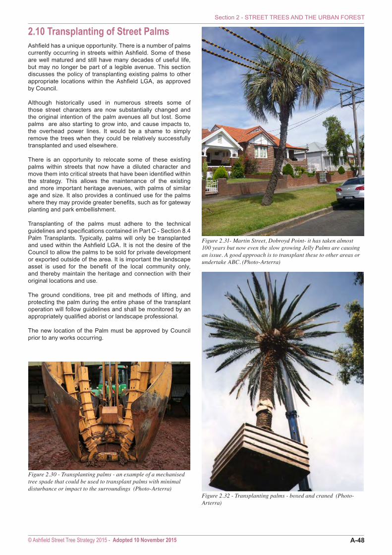
2.10 Transplanting of Street PalmsAshfield has a unique opportunity. There is a number of palms currently occurring in streets within Ashfield. Some of these are well matured and still have many decades of useful life, but may no longer be part of a legible avenue. This section discusses the policy of transplanting existing palms to other appropriate locations within the Ashfield LGA, as approved by Council.
Although historically used in numerous streets some of those street characters are now substantially changed and the original intention of the palm avenues all but lost. Some palms are also starting to grow into, and cause impacts to, the overhead power lines. It would be a shame to simply remove the trees when they could be relatively successfully transplanted and used elsewhere.
There is an opportunity to relocate some of these existing palms within streets that now have a diluted character and move them into critical streets that have been identified within the strategy. This allows the maintenance of the existing and more important heritage avenues, with palms of similar age and size. It also provides a continued use for the palms where they may provide greater benefits, such as for gateway planting and park embellishment. Transplanting of the palms must adhere to the technical guidelines and specifications contained in Part C - Section 8.4 Palm Transplants. Typically, palms will only be transplanted and used within the Ashfield LGA. It is not the desire of the Council to allow the palms to be sold for private development or exported outside of the area. It is important the landscape asset is used for the benefit of the local community only, and thereby maintain the heritage and connection with their original locations and use.
The ground conditions, tree pit and methods of lifting, and protecting the palm during the entire phase of the transplant operation will follow guidelines and shall be monitored by an appropriately qualified aborist or landscape professional.
The new location of the Palm must be approved by Council prior to any works occurring.
Figure 2.32 - Transplanting palms - boxed and craned (Photo-Arterra)
Figure 2.31- Martin Street, Dobroyd Point- it has taken almost 100 years but now even the slow growing Jelly Palms are causing an issue. A good approach is to transplant these to other areas or undertake ABC. (Photo-Arterra)
Figure 2.30 - Transplanting palms - an example of a mechanised tree spade that could be used to transplant palms with minimal disturbance or impact to the surroundings (Photo-Arterra)
Section 2 - STREET TREES AND THE URBAN FOREST
© Ashfield Street Tree Strategy 2015 - Adopted 10 November 2015 A-48