stratigraphy /~t * 1 and 1 i * facies t ^ or f-» · stratigraphy and sedimentary facies of the...
TRANSCRIPT
/"~t * 1 1 f~^ "I * T ^ f-»Stratigraphy and Sedimentary Facies or the Madison Limestone and Associated Rocks in Parts pf Montana, Nebraska, North Dakota, South Dakota, and Wyoming
GEOLOGICAL SURVEY PROFESSIONAL PAPER 1273-A
Stratigraphy and Sedimentary Fades of the Madison Limestone and Associated Rocks in Parts of Montana, Nebraska, North Dakota, South Dakota, and WyomingBy JAMES A. PETERSON
GEOLOGY AND HYDROLOGY OF THE MADISON LIMESTONE AND ASSOCIATED ROCKS IN PARTS OF MONTANA, NEBRASKA, NORTH DAKOTA, SOUTH DAKOTA, AND WYOMING
GEOLOGICAL SURVEY PROFESSIONAL PAPER 1273-A
UNITED STATES GOVERNMENT PRINTING OFFICE, WASHINGTON : 1984
DEPARTMENT OF THE INTERIOR
WILLIAM P. CLARK, Secretary
U.S. GEOLOGICAL SURVEY
Dallas L. Peck, Director
Library of Congress Cataloging in Publication Data
Peterson, James A.
Stratigraphy and sedimentary facies of the Madison Umestone and associated rocks in parts of Montana, Nebraska, North Dakota, South Dakota, and Wyoming.
(Geological Survey professional paper ; 1273A)Bibliography: p.Supt. of Docs, no.: 119.16:1273-A1. Limestone Middle West. 2. Geology, Stratigraphic Paleozoic. I. Title. II. Series.QE471.15.L5P47 1981 552'.5 82-600376
For sale by the Distribution Branch, U.S. Geological Survey, 604 South Pickett Street, Alexandria, VA 22304
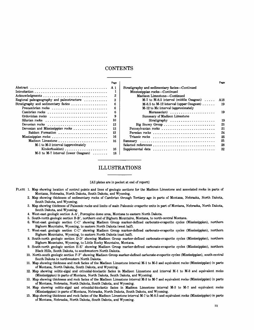
CONTENTS
Page
Abstract ._.__.__.._.................._-.__.. AlIntroduction.................................. 1Acknowledgments .............................. 2Regional paleogeography and paleostructure ........... 3Stratigraphy and sedimentary facies ................. 6
Precambrian rocks .......................... 6Cambrian rocks ....................______._ 6Ordovician rocks ......__...._...____....... 9Silurian rocks ............................. 10Devonian rocks ............................ 13Devonian and Mississippian rocks ................ 13
Bakken Formation ..................._._. 13Mississippian rocks _.._._...._..._.__........ 16
Madison Limestone ....................... 16M-l to M-3 interval (approximately
Kinderhookian) .................... 16M-3 to M-7 interval (lower Osagean) ....... 18
Page
Stratigraphy and sedimentary facies Continued Mississippian rocks Continued
Madison Limestone ContinuedM-7 to M-8.5 interval (middle Osagean) ..... A18M-8.5 to M-12 interval (upper Osagean) ...... 19M-12 to Me interval (approximately
Meramecian) .....................Summary of Madison Limestone
Stratigraphy ...........-.-.----..Big Snowy Group ...------.-._----------.
Pennsylvanian rocks ___.__-------..---------.Permian rocks ......---.---.-.------------Triassic rocks .............---.---.----.-.
Summary .............---------.-..--------- 25Selected references _____._..-_------..---------- 28Supplemental data ___.....-----.-.---------_-_- 32
ILLUSTRATIONS
[All plates are in pocket at end of report]
PLATE 1. Map showing location of control points and lines of geologic sections for the Madison Limestone and associated rocks in parts of Montana, Nebraska, North Dakota, South Dakota, and Wyoming.
2. Map showing thickness of sedimentary rocks of Cambrian through Tertiary age in parts of Montana, Nebraska, North Dakota, South Dakota, and Wyoming.
3. Map showing thickness of Paleozoic rocks and limits of main Paleozoic evaporite units in part of Montana, Nebraska, North Dakota, South Dakota, and Wyoming.
4. West-east geologic section A-A', Porcupine dome area, Montana to eastern North Dakota.5. South-north geologic section B-B', northern end of Bighorn Mountains, Montana, to north-central Montana.6. West-east geologic section C-C' showing Madison Group marker-defined carbonate-evaporite cycles (Mississippian), northern
Bighorn Mountains, Wyoming, to eastern North Dakota (west half).7. West-east geologic section C-C' showing Madison Group marker-defined carbonate-evaporite cycles (Mississippian), northern
Bighorn Mountains, Wyoming, to eastern North Dakota (east half).8. South-north geologic section D-D' showing Madison Group marker-defined carbonate-evaporite cycles (Mississippian), northern
Bighorn Mountains, Wyoming, to Little Rocky Mountains, Montana.9. South-north geologic section E-E' showing Madison Group marker-defined carbonate-evaporite cycles (Mississippian), northern
Black Hills, South Dakota, to southwestern North Dakota.10. North-south geologic section F-F' showing Madison Group marker-defined carbonate-evaporite cycles (Mississippian), south-central
South Dakota to northwestern North Dakota.11. Map showing thickness and rock facies of the Madison Limestone interval M-l to M-3 and equivalent rocks (Mississippian) in parts
of Montana, North Dakota, South Dakota, and Wyoming.12. Map showing oolitic-algal and crinoidal-bioclastic facies in Madison Limestone and interval M-l to M-3 and equivalent rocks
(Mississippian) in parts of Montana, North Dakota, South Dakota, and Wyoming.13. Map showing thickness and rock facies of the Madison Limestone interval M-3 to M-7 and equivalent rocks (Mississippian) in parts
of Montana, Nebraska, North Dakota, South Dakota, and Wyoming.14. Map showing oolitic-algal and crinoidal-bioclastic facies in Madison Limestone interval M-3 to M-7 and equivalent rocks
(Mississippian) in parts of Montana, Nebraska, North Dakota, South Dakota, and Wyoming.15. Map showing thickness and rock facies of the Madison Limestone interval M-7 to M-8.5 and equivalent rocks (Mississippian) in parts
of Montana, Nebraska, North Dakota, South Dakota, and Wyoming.
in
IV CONTENTS
PLATE 16. Map showing oolitic-algal and crinoidal-bioclastic fades in Madison Limestone interval M-7 to M-8.5 and equivalent rocks (Mississippian) in parts of Montana, Nebraska, North Dakota, South Dakota, and Wyoming.
17. Map showing thickness and rock facies of the Madison Limestone interval M-8.5 to M-12 and equivalent rocks (Mississippian) in parts of Montana, Nebraska, North Dakota, South Dakota, and Wyoming.
18. Map showing oolitic-algal and crinoidal-bioclastic facies in Madison Limestone interval M-8.5 to M-12 and equivalent rocks (Mississippian) in parts of Montana, Nebraska, North Dakota, South Dakota, and Wyoming.
19. Map showing thickness of the Madison Limestone interval M-12 to Me and equivalent rocks (Mississippian) in parts of Montana, North Dakota, South Dakota, and Wyoming.
20. Map showing oolitic-algal and crinoidal-bioclastic facies in Madison Limestone interval M-12 to Me and equivalent rocks (Mississippian) in parts of Montana, North Dakota, South Dakota, and Wyoming.
Page
FIGURE 1. Map showing location of study area ________________________-_--------------------------------- A22. Map showing regional paleogeography and paleostructure during Paleozoic time, Western Interior, United States .... 43. Map showing present-day structural features, Western Interior, United States ________-______-___-.------- 54. Map showing thickness and rock facies of Deadwood Formation or equivalent rocks (Cambrian and Lower Ordovician). 75. Map showing thickness of Middle and Upper Ordovician rocks ...........___________-_---.----.-.---- 86. Map showing thickness and rock facies of Red River Formation or equivalent rocks (Upper Ordovician) .......... 117. Map showing thickness and rock facies of Interlake Formation (uppermost Ordovician and Silurian) __.__._...... 128. Map showing thickness and salt distribution of Middle and Upper Devonian rocks .......--._-----....--_--- 149. Map showing thickness of the Bakken Formation (uppermost Devonian and lowermost Mississippian) _._..__..... 15
10. Illustration showing example of well-log patterns and lithology of Madison Group marker units ................ 1711. Map showing thickness and rock facies of the Madison Limestone and equivalent rocks (Lower and Upper Mississippian). 2012. Map showing thickness and rock facies of Big Snowy Group (Upper Mississippian) ..___.................___ 2213. Map showing thickness and rock facies of Pennsylvania!! and Permian rocks .........-.----.-------.----- 2314. Map showing thickness and rock facies of Triassic rocks ........-.---.----_-----------.------------ 26
TABLE
TABLE 1. Generalized correlation chart of Paleozoic rocks [in pocket]
METRIC CONVERSION TABLE
[Inch-pound units in this report may be converted to the International System (SI) of units by using the following conversion factors:]
Multiply inch-pound units By To obtain metric units
foot (ft) 0.3048 meter (m)30.48 centimeter
square mile (mi2) 2.590 square kilometer (km2)mile 1.609 kilometer
National Geodetic Vertical Datum of 1929 (NGVD of 1929): A geodetic datum derived from a general adjustment of the first-order level nets of both the United States and Canada; formerly called "mean sea level." NGVD of 1929 is referred to as sea level in this report.
GEOLOGY AND HYDROLOGY OF THE MADISON LIMESTONE AND ASSOCIATED ROCKS IN PARTS OF MONTANA, NEBRASKA, NORTH DAKOTA, SOUTH DAKOTA, AND WYOMING
STRATIGRAPHY AND SEDIMENTARY FACIES OF THE MADISONLIMESTONE AND ASSOCIATED ROCKS IN PARTS OF MONTANA,
NEBRASKA, NORTH DAKOTA, SOUTH DAKOTA, AND WYOMING
By JAMES A. PETERSON
ABSTRACT
Paleozoic sedimentary rocks in the Northern Great Plains and Northern Rocky Mountains region include a sequence of mostly shallow-water marine carbonate, clastic, and evaporite deposits of Middle Cambrian through Late Permian age. During most of this time, sedimentary processes and distribution of sedimentary facies were affected by the growth of several ancestral regional structural features, including the Williston basin, Transcontinental arch, Central Montana trough, Alberta shelf, and Wyoming shelf. Other features that more locally influence sedimentary patterns were the Central Montana uplift, Cedar Creek anticline, Sweetgrass arch, Black Hills uplift, Chadron arch, Laramie uplift, Bighorn uplift, Miles City arch, and Powder River basin.
The lower part of the Paleozoic section is a sequence of marine sandstone, shale, and minor limestone, about 1,000 feet thick in the central part of the Williston basin, of Middle Cambrian through Middle Ordovician age. Some porous sandstone beds occur in this section, mainly in the eastern and southern border areas of the Williston basin and Central Montana trough. The Upper Ordovician through middle Upper Mississippian rocks are primarily carbonate beds which contain numerous widespread cyclic interbeds of evaporite and fine-grained clastic deposits. Reefs or carbonate mounds were deposited throughout most of the late Ordovician to late Mississippian time in the shallow-water areas of the Williston basin and Northern Rocky Mountains. Porous units, mainly dolomite or dolomitic limestone, are widespread but discontinuous in most of the Upper Ordovician to Upper Mississippian rocks and are more prominent in the eastern and southern border regions of the Williston basin. The Devonian and Mississippian sedimentary section is particularly cyclic in nature, and the Mississippian carbonate section can be divided into at least 13 regional cyclic marker units, on the basis of the common occurrence of shaly marker beds which are identified on geophysical well logs.
The upper Paleozoic beds are dominated by clastic rocks, beginning with the marine green and gray shales, carbonates, red beds, and some evaporites of the Upper Mississippian Big Snowy Group, and terminating with the relatively thick marine and aeolian sandstones and widespread red bed and evaporite facies of Pennsylvanian and Permian age. The Big Snowy Group is present only in the Central Montana trough and the central part of the Williston basin. Pennsylvanian and Permian beds unconformably overlie the Big Snowy Group, where present, and overlie Mississippian or Devonian rocks in most of the rest of the Northern Great Plains and Northern Rocky Mountains, pinching out northward in central Montana. Thick
porous sandstone beds are present in the Upper Pennsylvanian and Lower Permian section in Wyoming, southeastern Montana, southwestern North Dakota, and northwestern South Dakota.
Triassic marine and continental red shale, siltstone, sandstone, and some evaporites overlie the Permian in most of the area. These beds thicken southwestward to more than 1,000 feet in central Wyoming. Some discontinuous porous sandstones are present in this section, mostly in the southern border of the Williston basin.
Important regional unconformities occur in the Paleozoic sequence at the base of each of the following: Cambrian, Middle Ordovician, Devonian, Pennsylvanian, and Permian. A major unconformity at the base of the Middle Jurassic overlies upper Paleozoic rocks throughout the area and is particularly prominent in north-central Montana, where pre-Jurassic erosion has removed the upper part of the Madison Limestone and younger Paleozoic beds.
INTRODUCTION
In 1976, Congress provided funds for this study to evaluate the Madison Limestone and associated rocks as a potential source of water supplies, and to provide the information necessary for an orderly development of the aquifer. The objectives of the Madison Limestone study were to1. Define the regional geologic framework that controls
the flow of ground water;2. Determine the quantity of water that may be
available from the Madison Limestone;3. Define the chemical and physical properties of the
water;4. Determine the effects of existing developments on
the potentiometric or freshwater head, storage, recharge and discharge, springs, streamflow, and pattern of ground-water flow;
5. Predict the probable hydrologic effects of proposed withdrawals of water from large-scale develop ments at selected rates and locations; and
6. Determine areas suitable for the development of deep wells that would obtain optimum yields.
Ai
A2115°
GEOLOGY AND HYDROLOGY OF THE MADISON LIMESTONE
110° 105° 100°
45°
EXPLANATION
/ Area of study
40°
Base from U.S. Geological Survey. 1:7.500.000.1970
100 200 300 400 KILOMETERS
0 100 200 MILES
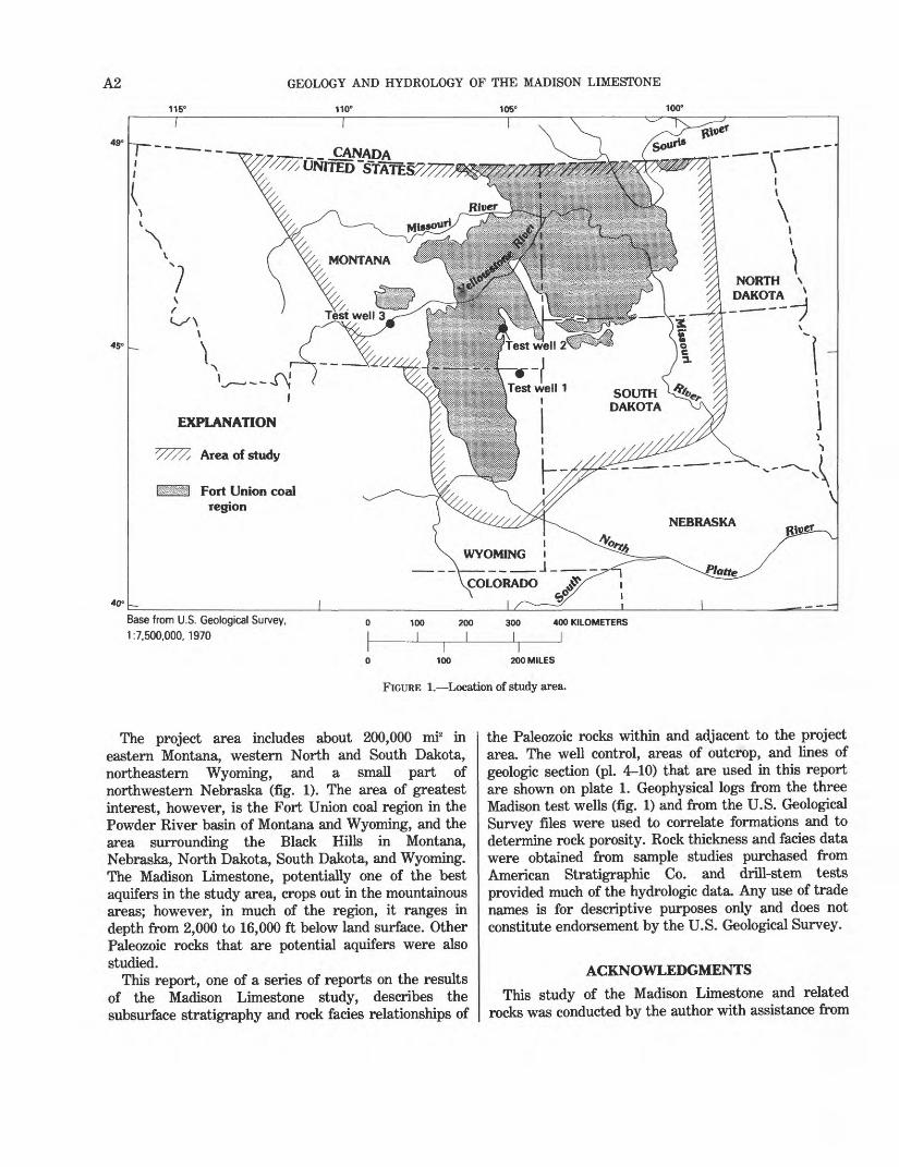
FIGURE 1. Location of study area.
The project area includes about 200,000 mi2 in eastern Montana, western North and South Dakota, northeastern Wyoming, and a small part of northwestern Nebraska (fig. 1). The area of greatest interest, however, is the Fort Union coal region in the Powder River basin of Montana and Wyoming, and the area surrounding the Black Hills in Montana, Nebraska, North Dakota, South Dakota, and Wyoming. The Madison Limestone, potentially one of the best aquifers in the study area, crops out in the mountainous areas; however, in much of the region, it ranges in depth from 2,000 to 16,000 ft below land surface. Other Paleozoic rocks that are potential aquifers were also studied.
This report, one of a series of reports on the results of the Madison Limestone study, describes the subsurface stratigraphy and rock facies relationships of
the Paleozoic rocks within and adjacent to the project area. The well control, areas of outcrop, and lines of geologic section (pi. 4-10) that are used in this report are shown on plate 1. Geophysical logs from the three Madison test wells (fig. 1) and from the U.S. Geological Survey files were used to correlate formations and to determine rock porosity. Rock thickness and facies data were obtained from sample studies purchased from American Stratigraphic Co. and drill-stem tests provided much of the hydrologic data. Any use of trade names is for descriptive purposes only and does not constitute endorsement by the U.S. Geological Survey.
ACKNOWLEDGMENTS
This study of the Madison Limestone and related rocks was conducted by the author with assistance from
STRATIGRAPHY AND SEDIMENTARY FACIES OF THE MADISON LIMESTONE A3
personnel of the U.S. Geological Survey, Central Region, and the district offices in Montana, North Dakota, South Dakota, and Wyoming. Cristi V. Hansen and Edward R. Banta, both in the Central Region office, compiled and plotted the data for the rock type and facies maps and prepared the data base. Several of the maps used in this report are modified from those constructed by Donald L. Brown (formerly with the U.S. Geological Survey). Helpful information, advice, and suggestions were provided by Peter R. Rose (formerly with the U.S. Geological Survey); Sidney B. Anderson, North Dakota Geological Survey; and James L. Wilson, University of Michigan. An earlier version of this report was critically reviewed by Sidney B. Anderson, North Dakota Geological Survey, and James L. Wilson, University of Michigan.
REGIONAL PALEOGEOGRAPHY AND PALEOSTRUCTURE
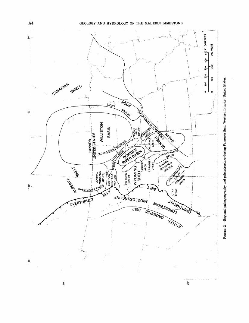
Paleozoic sedimentation, facies patterns, and paleogeography of the Northern Great Plains area are related to the history of the western border of the North American craton, the stable interior of the continent. The central part of the Paleozoic craton was composed of a stable core, the Canadian shield, and its southwestward extension, the Transcontinental arch (fig. 2). The stable core of the craton was composed of older Precambrian rocks. The early-to-middle Paleozoic Transcontinental arch was an elongate paleostructural feature, emergent at times, that effectively separated the continent into eastern and western marine shelf and geosynclinal provinces, each an approximate mirror image of the other.
To the west of the Canadian shield and Transcontinental arch, the broad western flank of the Paleozoic craton comprised the Cordilleran shelf, which was the site of shallow-water marine cyclic sedimentation during most of Paleozoic time. The Cordilleran shelf was bordered on the west by the Cordilleran miogeosyncline (miogeocline of some authors), and on the east by the Transcontinental arch. The miogeosyncline was a slowly subsiding complex of marginal basins, where thick, mainly shallow-water marine Paleozoic carbonate rock, sandstone, and shale, as much as 50,000 ft thick, accumulated along a belt extending from southwestern United States to northwestern Canada. The Antler Orogenic belt, which began active growth in Middle Devonian time, lay to the west of the miogeosyncline province, and formed a linear, relatively narrow system of thrusting, mountain building, and island growth that continued through the rest of Paleozoic time. West of the Antler Orogenic belt, thick eugeosynclinal deposits of Paleozoic deep-
water shale, fine-grained limestone, coarse clastic rocks, and submarine volcanic deposits accumulated during most of Paleozoic time. The area of study lies within the eastern part of the Cordilleran shelf adjacent to the Transcontinental arch. Within this area, sedimentary processes were influenced in varying degrees by the growth of several paleostructural elements associated with the development of the Cordilleran shelf.
The major Paleozoic paleostructural element in the Northern Great Plains area was the Williston basin, which began subsiding during Ordovician or Late Cambrian time. Other important elements of regional size include the Central Montana trough, Alberta shelf, and Wyoming shelf, all of which show evidence of regional structural activity during most of Paleozoic time. Other features that exerted important local influences on Paleozoic sedimentary patterns include the Sweetgrass arch, Central Montana uplift, Cedar Creek anticline, Miles City arch, Black Hills uplift, Chadron arch, Laramie uplift, Bighorn uplift, and the Powder River basin.
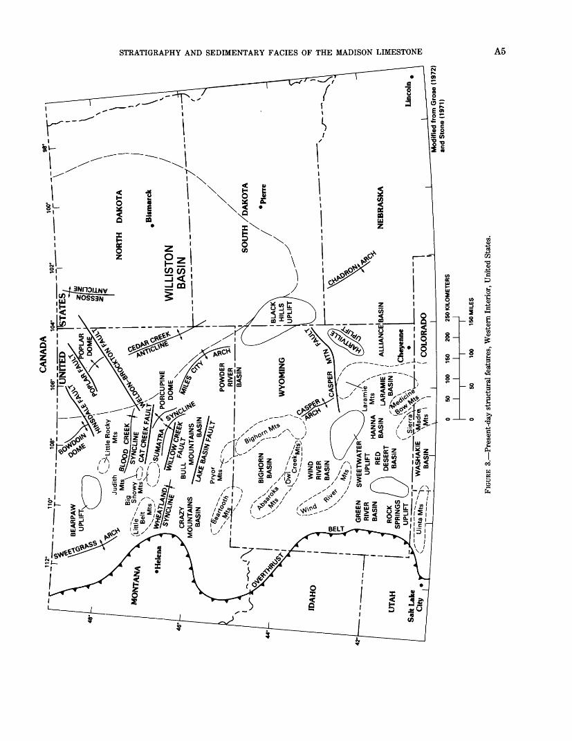
The Williston basin is a structural-sedimentary intracratonic basin covering an area of more than 50,000 mi2 in North and South Dakota, parts of southern Canada and eastern Montana (fig. 3). The basin in western North Dakota contains a relatively complete sedimentary rock section of Late Cambrian through Tertiary age that is more than 15,000 ft thick in the axial part of the basin (pi. 2). Total thickness decreases to less than 10,000 ft on the western border of the basin in eastern Montana. The basin began to take shape as a distinctive area of increased subsidence during Middle Ordovician time (Carlson and Anderson, 1965), although there is also evidence, based on limited control, of an increased thickness of Cambrian rocks in the basin center (fig. 4). Carbonate sedimentation prevailed within the basin and surrounding area during much of early-to-middle Paleozoic time, changing to principally clastic sedimentation in late Paleozoic, Mesozoic, and Tertiary time. The shape of the basin remained virtually the same throughout Paleozoic time, when more than 8,000 ft of marine sediments accumulated in the basin center (pi. 3).
The Central Montana trough was an east-west linear belt of increased subsidence connecting the Williston basin and the Cordilleran miogeosyncline. Evidence for profound subsidence in this area, extending from late Precambrian (Belt embayment) through Mississippian (Big Snowy trough), and Jurassic to Early Cretaceous time, has been discussed by several authors, including Sloss (1950), Alpha (1958), Theodosis (1955), Andrichuk (1951), Weimer and Haun (1960), McMannis (1965),
120°
100°
90°
50°
36°
__C
AN
AD
AUN
ITED
STAT
ES
WY
OM
ING
S
HE
LF CA
SP
ER
A
RC
H
LAR
AM
IE
o
o s 55
D W
D
O r § o w s 55
FIGU
RE 2
. Reg
iona
l pal
eoge
ogra
phy
and
pale
ostr
uctu
re d
urin
g Pa
leoz
oic
time,
Wes
tern
Int
erio
r, U
nite
d St
ates
.
CA
NA
DA
106°
10
4°
48
°
' *
?-~
\--*
-\
48°
46°
TST
AT
ES,
Jud
ith
Mts
MtS
0
00
WIL
LIS
TON
BA
SIN
__ _
__
__
__
"AS
"1 /A
R
ED
UT
AH
Sah
Lak
e
44'
1 50 1
)
100 1
1 50
150
200
1 1
1 10
0
2! 1 15
0250
KIL
OM
ET
ER
S
Mod
ified
fro
m G
rose
(19
72)
and
Sto
ne (
1971
)
o n a a 03 M a o 03 O O3 O I
FIGU
RE 3
. Pre
sent
-day
str
uctu
ral f
eatu
res,
Wes
tern
Int
erio
r, U
nite
d St
ates
.
A6 GEOLOGY AND HYDROLOGY OF THE MADISON LIMESTONE
Peterson (1966), Maughan (1967), Sando (1972), and Craig (1972).
The Alberta shelf extended northward from the northern border of the Central Montana trough into Canada. The late Paleozoic expression of the southern part of the Alberta shelf is referred to as the Milk River uplift by Maughan (1966). The influence of this feature on Paleozoic and Mesozoic sedimentary patterns in Montana is discussed by Peterson (1966).
The Central Montana uplift attained maximum growth during the Devonian, although some evidence indicates that it may have also been active to a lesser extent during pre-Devonian time, as shown by thinning of Cambrian rocks in this area (Peterson, 1966; Lochman-Balk, 1972) (fig. 4). Further discussion of the Devonian history of the Central Montana uplift is presented by Alpha (1958), Norwood (1965), and others.
According to Clement (1976), the Cedar Creek anticline underwent four main periods of growth: Early Devonian, Late Devonian, Late Mississippian through Triassic, and post-Paleocene time. Devonian rocks are thin or absent, Silurian rocks are thin in several places along the crest of the anticline, and several upper Paleozoic sedimentary facies changes also occur in the vicinity of the anticline.
The Sweetgrass arch is the southern part of a paleostructural element of the Alberta shelf. Evidence for paleostructural activity in this general area during Cambrian time is reported by van Hees and North (1964); evidence for Jurassic growth is discussed by Cobban (1945), and Peterson (1957, 1966, 1972); and for Early Cretaceous growth by Haun and Kent (1965).
The Black Hills uplift and Chadron arch show evidence of growth primarily during the Pennsylvanian and Permian (Tenney, 1966; Peterson, 1978, 1980b), but some evidence indicates that these features may also have influenced the distribution of Mississippian and perhaps earlier Paleozoic sedimentary facies.
The Powder River trough (designated the Lusk Embayment by Bates, 1955) is identified on upper Paleozoic facies and thickness maps as a northwest- southeast trend in northeastern Wyoming that extends northwest from the Alliance basin (fig. 2) (Bates, 1955) Tenney, 1966; Peterson, 1980a). This ancestral trough was located somewhat east of the present-day axis of the Powder River basin.
Evidence for the late Paleozoic expression of the Laramie-Bighorn paleohigh trend has been discussed by several authors, including Tenney (1966), Maughan (1967), Mallory (1972), and Peterson (1980b). The Miles City arch is a present-day feature that shows some evidence of minor paleostructural effect on distribution of sediments in the upper Paleozoic, Mississippian, Devonian, and Cambrian.
STRATIGRAPHY AND SEDIMENTARY FACIES PRECAMBRIAN ROCKS
The upper Precambrian Belt Supergroup sequence of sandstone or quartzite, shale or argillite, or siltstone and carbonate rocks is thickest in westernmost Montana (Harrison, 1972). These rocks are also present in an elongate belt extending eastward across south- central Montana (McMannis, 1965), (Belt embayment or Central Montana trough), perhaps at least as far east as the Miles City arch. Upper Precambrian sedimentary rocks have been identified in the Black Hills and in the subsurface of northern Yellowstone County, Mont., indicating that discontinuous remnants of a once widespread Belt-equivalent sequence may be present in the subsurface of the Northern Great Plains, although these rocks have not been penetrated by wells drilled to basement in the Williston basin.
Precambrian rocks forming the basement of the Northern Great Plains range in age from about 1,750 m.y. (million years) to about 2,700 m.y. in northeastern Wyoming and western South Dakota (Hedge, 1972). The U.S. Geological Survey drilled three hydrologic- stratigraphic test wells to the Precambrian. Test well 1 is in Crook County, Wyo.; test well 2 is in Custer County, Mont.; and test well 3 is in Yellowstone County, Mont. (fig. 1). Basement rocks were cored and age dated by the U.S. Geological Survey in all three wells. The age of the Precambrian in test well 1 is 2,640±160 m.y., in test well 2 is about 2,800 m.y., and in test well 3 is about 2,780 ±270 m.y. (Zell Peterman, U.S. Geological Survey, written communication, 1980). Upper Cambrian rocks overlie Precambrian rocks in most of the Northern Great Plains.
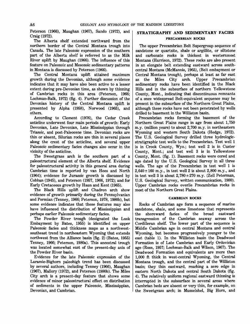
CAMBRIAN ROCKS
Rocks of Cambrian age form a sequence of marine sandstone, shale, and some limestone that represents the shoreward facies of the broad eastward transgression of the Cambrian seaway across the Cordilleran shelf. The lower part of the sequence is Middle Cambrian age in central Montana and central Wyoming, but becomes progressively younger to the east (table 1). In the Williston basin the Deadwood Formation is of Late Cambrian and Early Ordovician age (Ross, 1957; Lochman-Balk and Wilson, 1967). The Deadwood Formation and equivalents are more than 1,000 ft thick in west-central Wyoming, the Central Montana trough, and the central part of the Williston basin; they thin eastward, reaching a zero edge in eastern North Dakota and central South Dakota (fig. 4). The relatively uniform regional eastward thinning is interrupted in the subsurface in several areas where Cambrian beds are absent or very thin, for example, on the Sweetgrass arch; in Musselshel, Big Horn, and
STRATIGRAPHY AND SEDIMENTARY FACIES OF THE MADISON LIMESTONE A7
*
8-
-§
?L <\"-vwsr VfV'o-f## «|8
>"_ ^ l«
-I
EXPLANATION
ERTIARY IGNEOUS IN
TRUSIVE ROCKS
PLIFT AREA Cambrian or older rocks exposed a
land surface
ANDSTONE FACIES
H
r
3
^
W)
Q
REEN SHALE FACIES
HALE, SANDSTONE, AN
MINOR LIMESTONE
FACIES
O W
TT H ill Hi
< <"
^ -o S I3 aU$ > 9 s
I 2
2<J" (fl
3%
§3* UJ £ ^U, H Oo z S
|Si
\
96°
Appro
xim
ate
lim
it
Ord
ovi
cian
rock
sE
XPL
AN
AT
ION
TE
RT
IAR
Y I
GN
EO
US
IN-
I T
RU
SIV
E R
OC
KS
UP
LIF
T A
RE
A O
rdo
vic
ian
or
old
er r
ock
s ex
pose
d at
HJ
[
lan
d s
urf
ace
LIN
E O
F E
QU
AL
TH
ICK
N
ES
S I
nte
rval
s 10
0 an
d j
200
feet
100
200
300
KIL
OM
ET
ER
S
0 10
0 20
0 M
ILE
S
FIGU
RE 5
. Thi
ckne
ss o
f Mid
dle
and
Upp
er O
rdov
icia
n ro
cks.
O
M
O s o O 55 o 2 r 1
STRATIGRAPHY AND SEDIMENTARY FACIES OF THE MADISON LIMESTONE A9
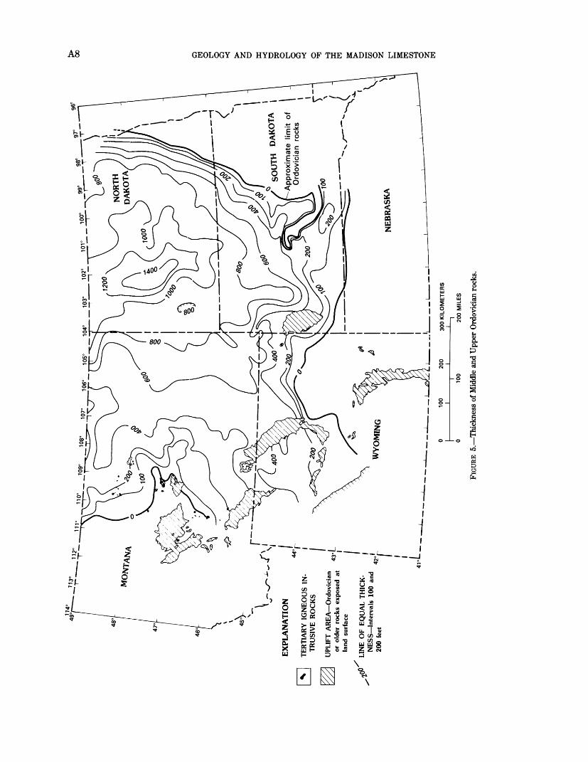
Carter Counties, Mont.; and in the southern part of the Cedar Creek anticline. It is not certain, because of inadequate subsurface control, whether or not these areas of thin deposition are related to depositional draping over Cambrian structural highs or buried hills on the Precambrian surface. A basal transgressive sandstone, the Flathead Sandstone, overlies the Precambrian with major unconformity in most of Montana and Wyoming, and grades eastward into the lower part of the Deadwood Formation in eastern Montana and eastern Wyoming. Overlying the Flathead Sandstone in central Montana and Wyoming is a thick sequence of marine green and gray shale and limestone, which thickens markedly toward the west but thins eastward, where it grades into sandstone beds of the Deadwood Formation (fig. 4; pi. 4, 5, see Supplemental Data). Limestone content is greatest in east-central Montana and northwestern North Dakota.
In most of North and South Dakota and eastern Wyoming, the Deadwood Formation is predominantly sandstone (fig. 4). The basal unit is a quartzose, slightly feldspathic sandstone, commonly cemented with iron oxide; it ranges in thickness from less than 50 ft in south-central Montana to as much as 500 ft to the east and southeast. The main clastic source areas are the emergent Canadian shield and the Transcontinental arch to the northeast and east (fig. 2).
In southeastern Montana, northeastern Wyoming, western South Dakota, and western North Dakota, the Cambrian sandstone beds are porous and have yielded substantial amounts of water on drill-stem tests in some wells. Lack of data makes the appraisal and prediction of porosity distribution difficult because these sandstones may be silica-cemented due to burial compaction effects in the deeper subsurface.
ORDOVICIAN ROCKS
Rocks of Ordovician age in the Northern Great Plains comprise the Bighorn Dolomite, Winnipeg, Red River, and Stony Mountain Formations, and the upper part of the Deadwood Formation (pi. 4; table 1), which is designated as Lower Ordovician on the basis of limited faunal data (Ross, 1957; Lochman-Balk and Wilson, 1967; Foster, 1972). Subsurface studies of Ordovician rocks in the Williston basin include those by Carlson (1960), Fuller (1961), Porter and Fuller (1959, 1964), Patterson (1961), Carlson and Anderson (1965), Ballard (1969), and Foster (1972). The correlation framework and stratigraphic facies relations of the Ordovician in the basin were established by Ross (1957), Porter and Fuller (1959), Fuller (1961), and Patterson (1961). This work was updated by Foster (1972) for the Williston basin and by Ballard (1969) for an area in the central part of the basin. Foster presented a thorough review
and summary of the lithology, facies relationships, and stratigraphy of the Ordovician rocks for the entire basin.
Strata of Ordovician age are major petroleum objectives in the Williston basin; as a result, many exploratory wells have been drilled into and through these beds. Ordovician rocks are not present in southeastern Wyoming, southwestern South Dakota, and western Montana, because of nondeposition or removal by erosion during Devonian and Early Mississippian time. Thickness increases eastward and northward from the zero line in central Montana and northeastern Wyoming to more than 1,000 ft in the central part of the Williston basin (fig. 5).
Studies by Lochman-Balk and Wilson (1967) and Ross (1957) indicate that the Cambrian-Ordovician boundary is conformable in the Williston basin, and may occur as much as 650 ft below the top of the Deadwood Formation in the central part of the basin (pi. 4). These authors also assign the upper part of the Emerson Formation of central Montana to the Lower Ordovician (table 1). Subsurface geologists usually do not attempt to identify the Cambrian-Ordovician boundary as a mappable horizon, preferring to map the Deadwood as a stratigraphic unit separate from the overlying Middle and Upper Ordovician units.
The Deadwood Formation is overlain unconformably by sandstone, shale, and siltstone of the Winnipeg Formation and equivalents of Middle Ordovician age throughout the Williston basin and in northeastern Wyoming and northwestern South Dakota (table 1, pi. 4). The basal unit is a clean quartzose sandstone, the "Winnipeg sandstone" (of informal subsurface usage), that is more than 150 ft thick in the central part of the basin. These beds are overlain by the green-gray shale facies of the Icebox Formation (of McCoy, 1952), which is more than 100 ft thick in the central basin area. The relatively thin Roughlock Formation (of McCoy, 1952) of calcareous siltstone and silty carbonate beds comprises the upper formation of the Winnipeg Group and is thickest in eastern North Dakota (Carlson and Anderson, 1965). (Icebox Formation, Roughlock Formation, and Winnipeg Group are terms used by the North Dakota Geological Survey.) According to Foster (1972), the sands of the Winnipeg Formation were probably derived mainly from a western source with possibly a minor source to the east. Ketner (1968), however, presented evidence that much of the sand in the Middle Ordovician sandstones of the Cordilleran geosyncline was derived from the erosion of Cambrian sandstones in northern Alberta. Some of the Winnipeg beds may have had a similar derivation.
Porosity and permeability of the Winnipeg sandstone beds are variable, probably depending in part on
A10 GEOLOGY AND HYDROLOGY OF THE MADISON LIMESTONE
compaction effects related to depth of burial. However, in areas of shallower drilling, such as southeastern Montana and northwestern South Dakota, the rocks are porous, and substantial amounts of water have been recovered during drill-stem tests of some wells.
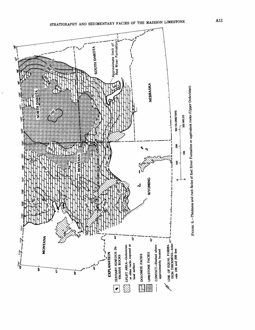
The carbonate sequence of the Red River Formation overlaps sandstone and shale beds of the underlying Winnipeg Formation and extends consistently farther outward toward the borders of the Williston basin. The Red River is more than 600 ft thick in the central part of the Williston basin (fig. 6), and is truncated by Devonian erosion around the borders of the basin and along a line extending between the central Black Hills and southern Bighorn Mountains. According to Porter and Fuller (1964), the Red River in the depocenter of the Williston basin consists of a lower unit of fragmental limestone and dolomite and an upper unit containing three evaporite cycles of fragmental limestone and anhydrite (pi. 4).
The Stony Mountain Formation, which conformably overlies the Red River Formation, includes basal beds of shaly limestone and shale (table 1; pi. 4). These beds are in general confined to the interior of the Williston basin, are truncated on the east and south, and grade into the upper part of the Bighorn Dolomite to the west. The middle part of the Stony Mountain Formation is a fossiliferous dolomite and dolomitic limestone unit that includes a thin anhydrite bed at the top. The upper part is composed of carbonate, shaly carbonate, and some anhydrite beds in cyclic repetition. The unit grades upward into the Interlake Formation according to Porter and Fuller (1964).
Both the Red River and the Stony Mountain Formations were eroded during Devonian time around the periphery of the Williston basin. The Stony Mountain Formation erosional edge is some distance basinward from that of the underlying Red River Formation.
Major porosity in the Middle and Upper Ordovician rocks of the Northern Great Plains occurs in dolomite beds of the Red River Formation; porosity is less in the overlying Stony Mountain Formation. Both of these formations become entirely dolomite over a broad area extending from north-central to south-central Montana, eastward across northeastern Wyoming and western South Dakota, thence northward along the eastern slope of the Williston basin (fig. 6; pi. 4). Within this belt, porosity and permeability are generally large; however, much of the major porosity and (particularly) permeability development tends to occur in southwest- northeast trending belts (MacCary, 1981). Consistently largest porosity and permeability occur in the more coarsely crystalline sucrosic dolomite intervals, that may be greater than 100 ft thick individually. Most of
the total porosity in the Ordovician carbonate section is in dolomite beds of the middle and lower parts of the Red River Formation. The Stony Mountain Formation (pi. 4) is considerably less porous.
SILURIAN ROCKS
Subsurface stratigraphic studies of the Interlake Formation in the Williston basin include those by Porter and Fuller (1959), Rader (1952), Carlson and Eastwood (1962), and Gibbs (1972). Porter and Fuller (1959) outlined the basic stratigraphic framework and lithologic aspect of the "Interlake Group"; they divided the interval on the basis of shaly marker beds into lower, middle, and upper units without assigning names to the subdivisions. Most subsurface geologists have not used the "Interlake Group" terminology, but refer to the Silurian dolomite section as the "Interlake Dolomite" or "Interlake Formation." Gibbs (1972) applied this terminology in updating the Silurian stratigraphy of the Williston basin.
Rocks of the Interlake Formation which are uppermost Ordovician in the basal part, are more than 1,000 ft thick in the central part of the Williston basin (pi. 4 and fig. 7). Except for surface exposures in Manitoba, the unit is entirely restricted to the subsurface of the basin and adjacent area, and is uniformly truncated by Middle to Upper Devonian beds around the periphery of the basin. The interval is mostly dolomite throughout its distribution, but some shale and limestone are present in the eastern part of the basin (fig. 7). The lower part of the Interlake is composed mainly of light-colored, very fine-grained dolomite, containing fossil-fragmental dolomite or limestone and thin anhydrite interbeds. The lithology of the middle part of the Interlake is similar to that of the lower part, but the upper part contains widespread beds of porous oolitic, algal, and coralline dolomite. The upper part of the Interlake contains the most porous beds in the formation, but these beds are restricted to the central part of the basin, where Devonian erosion did not cut as deeply into the section. These beds consist of vuggy dolomitic limestone and dolomite interbedded with very fine-grained anhydritic to argillaceous dolomite. In Montana, Silurian rocks are all dolomite. They thin westward from about 700 ft in northeastern Montana to a northwest-southeast erosional edge that crosses the area of the Porcupine dome (fig. 7).
Porosity and permeability values are highly varied in the Silurian dolomite beds in much of the area, and good-porosity fades are more prevalent in the central and northeastern parts of the basin (MacCary, 1981). Elsewhere, porous dolomite facies tend to occur in somewhat isolated areas.
712°
"1
111° r^
I I fc
IK "f
fv-)°
10
9°
1(
\'i
}f\
l >
^4
f£
r-
m , I V
..
. 4)8
° 10
7°
/
//
/I
/
/
' }
J
-i
106°
10
5°
/ u
t
/ '
/r\y
ti
. /
. (r
, i&
..
/-..
.
&..
..,!
*¥*
104°
MO
NT
AN
A
tf I
,/ J
q
SO
UT
H D
AK
OT
A/
l^?
t /
~Tf
'j
s* /
/
r7
\
Ap
pro
xim
ate
lim
it o
f I
Red
R
iver
F
orm
atio
n^
_TE
RTI
AR
Y I
GN
EO
US
IN
TR
USI
VE
RO
CK
S
UPL
IFT
AR
EA
Ord
ovic
ian
or o
lder
roc
ks e
xpos
ed a
t la
nd s
urfa
ce
43j
DO
LOM
ITE
FAC
IES
LIM
EST
ON
E F
AC
IES
CO
NT
AC
T D
ashe
d w
here
ap
prox
imat
ely
loca
ted
*
LIN
E O
F E
QU
AL
FO
RM
A-
I__
_
TIO
N T
HIC
KN
ESS
Int
er
vals
100
and
200
fee
t
FIGU
RE 6
.-T
hick
ness
and
roc
k fa
des
of R
ed R
iver
For
mat
ion
or e
quiv
alen
t roc
ks (
Upp
er O
rdov
icia
n).

-U.
I , I I ,
i .
' .\'\
J .
lit*
fa .{
l^ J
\,
' \~
-'I.
*
. t
I
*)
{' "
»/
I I
r^
Jf
I f
g>:
7y
' ,
/ ,
/ X.
oI
7 \r
.J-'J
**
t Y
t f
i _
^-T
I >7
/ <
r~y
/ '
. /
' 7
~
V
\ ' \
V /
-, X
.
7
. 7
L, ' .\\
f\ '\
.'*
s/
^\i
/ .'
V /
I. /
/\
Tsf
fly T
' i
>t~~
-), '
y ' c
^~V
Vb
"^
/ /
/i/ \i
\ /
\
/>>^f',
_ j
/ /
y A
\ /
\ /
.</
[ /
/
i I
/ T
/\
/\
>j-j:
/ ^%
\ ^^
-».
/ f/
i
"\
^^
XA
^ii^
!
<>
A \
/ /Q
^y
I
/""
\ 7
X^
^ /
A
/ fS
'/X
/
/ ̂
-~*-'
r '
t\
l.
fjil
i }
7~r~
i
EX
PLA
NA
TIO
N
II
TER
TIA
RY
IG
NE
OU
S IN
-
TR
USI
VE
RO
CK
S
/ U
PLIF
T A
RE
A S
iluri
an o
r ol
der
rock
s ex
pose
d at
land
su
rfac
e
LIM
EY D
OL
OM
ITE
FA
CIE
S
DO
LOM
ITE
FAC
IES
C
ON
TA
CT
Das
hed
whe
re
42°
appr
oxim
atel
y lo
cate
d
,300
" LI
NE
OF
EQ
UA
L F
OR
MA
T
ION
TH
ICK
NE
SS I
nter
va
ls 1
00 a
nd 2
00 f
eet
§ o G
W Kj
G Kj
O o as i as M
200
MIL
ES
fcW
IV
IIL
.&O
FIGU
RE 7
,-T
hick
ness
and
rock
fad
es o
f Int
erla
ke F
orm
atio
n (u
pper
mos
t Ord
ovic
ian
and
Silu
rian)
.
STRATIGRAPHY AND SEDIMENTARY FACIES OF THE MADISON LIMESTONE A13
DEVONIAN ROCKS
Middle or Upper Devonian clastic rocks un- conformably overlie the Interlake Formation in the Williston basin and overlie Ordovician or older beds throughout most of the Rocky Mountain (Cordilleran shelf) area. The Middle Devonian is more completely developed in the central part of the Williston basin, where the total thickness of both Middle and Upper Devonian beds is more than 1,000 ft (pi. 4 and 5; fig. 8). Upper Devonian units (Souris River, Jefferson or Duperow, Birdbear ("Nisku" of subsurface geologists), and Three Forks Formations) overlap the Middle Devonian and extend across most of Montana, central- to-western Wyoming, and westward into the Cordilleran geosyncline. The Devonian thins uniformly southward across northern and northeastern Montana toward the Central Montana uplift, in a belt that extends generally across the Little Belt and Big Snowy Mountains and Porcupine dome, and southeastward in the vicinity of the Miles City arch. A second prominent belt of thinning occurs along the crest of the Cedar Creek anticline (fig. 8). Both the Central Montana uplift and the Cedar Creek anticline underwent marked structural growth during Devonian time; along their axes, Devonian beds and the upper part of the Silurian Interlake Formation are locally absent because they were deeply eroded during latest Devonian or Early Mississippian time.
Devonian stratigraphy, correlations, and facies relationships in the Williston basin are described in several published studies, especially those by Andrichuk (1951), Baillie (1955), Wilson (1955, 1967), Sandberg and Hammond (1958), Sandberg (1961), Sandberg and Mapel (1967), Anderson and Hunt (1964), and Kent (1964). The detailed Devonian stratigraphy of the basin is thoroughly discussed by Sandberg and Mapel (1967) and will not be repeated here.
In general, the Devonian of the Williston basin and central Montana is a cyclic sequence of shallow-water fossiliferous carbonate, shaly carbonate or shale, and evaporites, including some Middle Devonian halite ("Prairie salt" of subsurface geologists) in the basin center (pi. 4; fig. 8). A detailed description of the faunal and lithologic aspects of the Devonian cycles is given by Wilson (1955, 1967). On the outcrop in western Montana, each cycle grades upward from silty to argillaceous carbonate at the base, through massive, porous, stromatoporoid and coralline dolomite, to solution breccia or anhydrite at the top. This cyclic repetition exhibits a similar pattern in the subsurface of the Williston basin, where several repeated porous dolomite intervals overlain by anhydrite and argillaceous carbonate beds are recognized. Most of the porous dolomite is in the Middle and Upper Devonian
Dawson Bay, Duperow, and Birdbear ("Nisku") Formations. The Devonian carbonate section tends to become more limy and less porous toward the interior of the basin, containing as much as 50 percent or more of limestone in the central part of the basin. Upper Devonian beds are chiefly dolomite throughout a wide belt extending from southeastern Montana to the northwest across the central part of the State. This belt tends to follow the general trend of the Central Montana uplift, Miles City arch, and Black Hills uplift, indicating that this paleostructural belt may have influenced dolomitization processes late in Devonian or Early Mississippian time.
Almost all porosity in the Devonian carbonate section is associated with dolomite beds. Porosity patterns tend to be somewhat irregular in shape. Areas of good porosity occur in north-central Montana, north of the Central Montana uplift (MacCary, 1981). Total porosity is poor along the Central Montana uplift and is generally poor to the south of this trend of thin Devonian rocks.
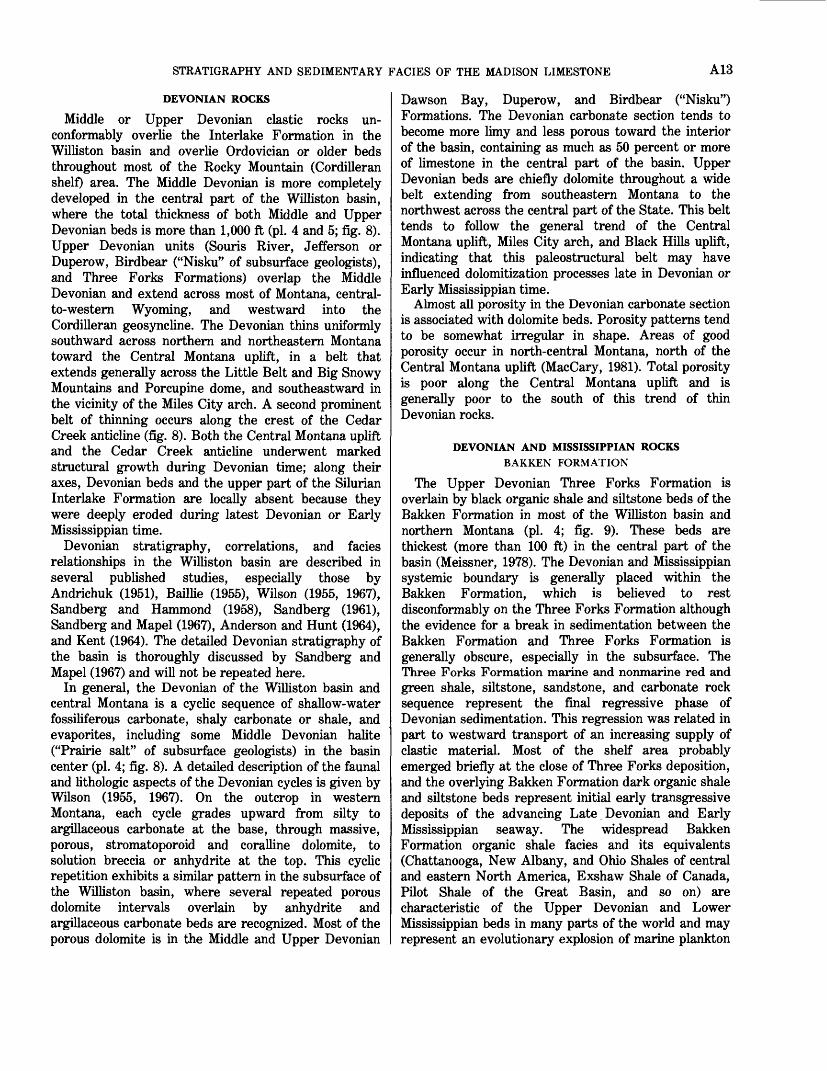
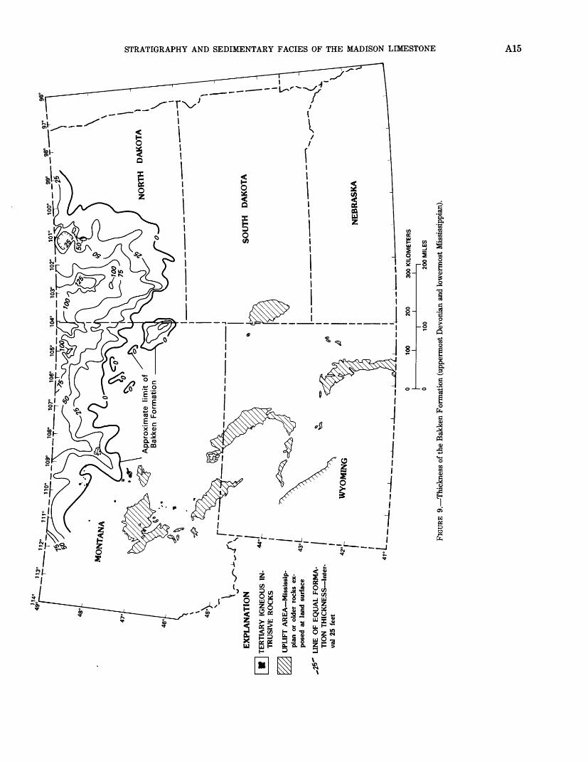
DEVONIAN AND MISSISSIPPIAN ROCKSBARKEN FORMATION
The Upper Devonian Three Forks Formation is overlain by black organic shale and siltstone beds of the Bakken Formation in most of the Williston basin and northern Montana (pi. 4; fig. 9). These beds are thickest (more than 100 ft) in the central part of the basin (Meissner, 1978). The Devonian and Mississippian systemic boundary is generally placed within the Bakken Formation, which is believed to rest disconformably on the Three Forks Formation although the evidence for a break in sedimentation between the Bakken Formation and Three Forks Formation is generally obscure, especially in the subsurface. The Three Forks Formation marine and nonmarine red and green shale, siltstone, sandstone, and carbonate rock sequence represent the final regressive phase of Devonian sedimentation. This regression was related in part to westward transport of an increasing supply of clastic material. Most of the shelf area probably emerged briefly at the close of Three Forks deposition, and the overlying Bakken Formation dark organic shale and siltstone beds represent initial early transgressive deposits of the advancing Late Devonian and Early Mississippian seaway. The widespread Bakken Formation organic shale facies and its equivalents (Chattanooga, New Albany, and Ohio Shales of central and eastern North America, Exshaw Shale of Canada, Pilot Shale of the Great Basin, and so on) are characteristic of the Upper Devonian and Lower Mississippian beds in many parts of the world and may represent an evolutionary explosion of marine plankton

EX
PLA
NA
TIO
N
TE
RT
IAR
Y I
GN
EO
US
IN-
TR
USI
VE
RO
CK
S
UPL
IFT
AR
EA
Dev
onia
n or
old
er r
ocks
exp
osed
at
land
sur
face
LIN
E O
F E
QU
AL
TH
ICK
N
ES
S I
nter
val
200
feet
LIM
IT O
F P
RA
IRIE
SA
LT
O
F I
NFO
RM
AL
SU
BSU
R-
42°
FAC
E U
SAG
E
\ t 4
\ < ^ \\ \ \ \\
o o r o
o > o K h^ o o
r
o
...L10
0 I20
030
0 K
ILO
ME
TE
RS
0 10
0 20
0 M
ILE
S
FIG
URE
8. T
hick
ness
and
sal
t di
stri
butio
n of
Mid
dle
and
Upp
er D
evon
ian
rock
s.
2 r
i i S i o as
96°
Ap
pro
xim
ate
lim
Bak
ken
Fo
rmat
ion
TER
TIA
RY
IG
NE
OU
S IN
T
RU
SIV
E R
OC
KS
UPL
IFT
AR
EA
Mis
siss
ip
pian
or
olde
r ro
cks
ex
pose
d at
lan
d su
rfac
e
.26
- LI
NE
OF
EQ
UA
L F
OR
MA
T
ION
TH
ICK
NE
SS I
nter
va
l 25
fee
t
100
200
300
KIL
OM
ET
ER
S
100
0 10
0 20
0 M
ILE
S
FIG
URE
9. T
hick
ness
of t
he B
akke
n Fo
rmat
ion
(upp
erm
ost
Dev
onia
n an
d lo
wer
mos
t M
issi
ssip
pian
).
O o CO M
O g CQ
O S3 o cn
A16 GEOLOGY AND HYDROLOGY OF THE MADISON LIMESTONE
assemblages at this time. The dark shale and siltstone beds of the Bakken Formation are overlain conformably by argillaceous carbonate beds of the basal Lodgepole Limestone in most of the Williston basin, but in north- central Montana and the northeastern part of the Williston basin, crinoid mounds overlie the Bakken Formation in several places.
MISSISSIPPIAN ROCKSMADISON LIMESTONE
The Madison Limestone is undivided in some parts of the study area and is divided into formations in other parts of the area. Where divided into formations, it is called the Madison Group (table 1). However, for consistency, the term Madison Limestone is used in this report, except where the Madison Group is specifically discussed.
The stratigraphy of the Madison Group (Lodgepole Limestone, Mission Canyon Limestone, and Charles Formation) in the Williston basin and adjacent areas is described in detail in several publications, including those of Andrichuk (1951), Nordquist (1953), Sando (1967, 1974, 1976a, 1976b), Roberts (1966), Gries and Michelson (1964), Craig (1972), Sando, Mamet, and Dutro (1969), Sando and Mamet (1974), Rose (1976), Roberts (1979), Sheldon and Carter (1979), and Smith and Gilmour (1979). Detailed subsurface aspects of the Madison Group are described by Nordquist (1953), Gries and Mickelson (1964), and Rose (1976), as well as in numerous published oil-field papers.
In general, the Madison Group consists of a lower unit of gray to dark-gray argillaceous to shaly or silty, in places cherty, thin- to medium-bedded limestone (Lodgepole Limestone); a middle unit of generally thick- to massive-bedded fossiliferous to oolitic carbonate rock (Mission Canyon Limestone); and an upper unit of anhydrite and halite with interbedded carbonate rock and shale (Charles Formation). These gross facies intertongue with one another, and the total section is composed of numerous cyclic, marker-defined units that incorporate variable amounts of the main rock facies.
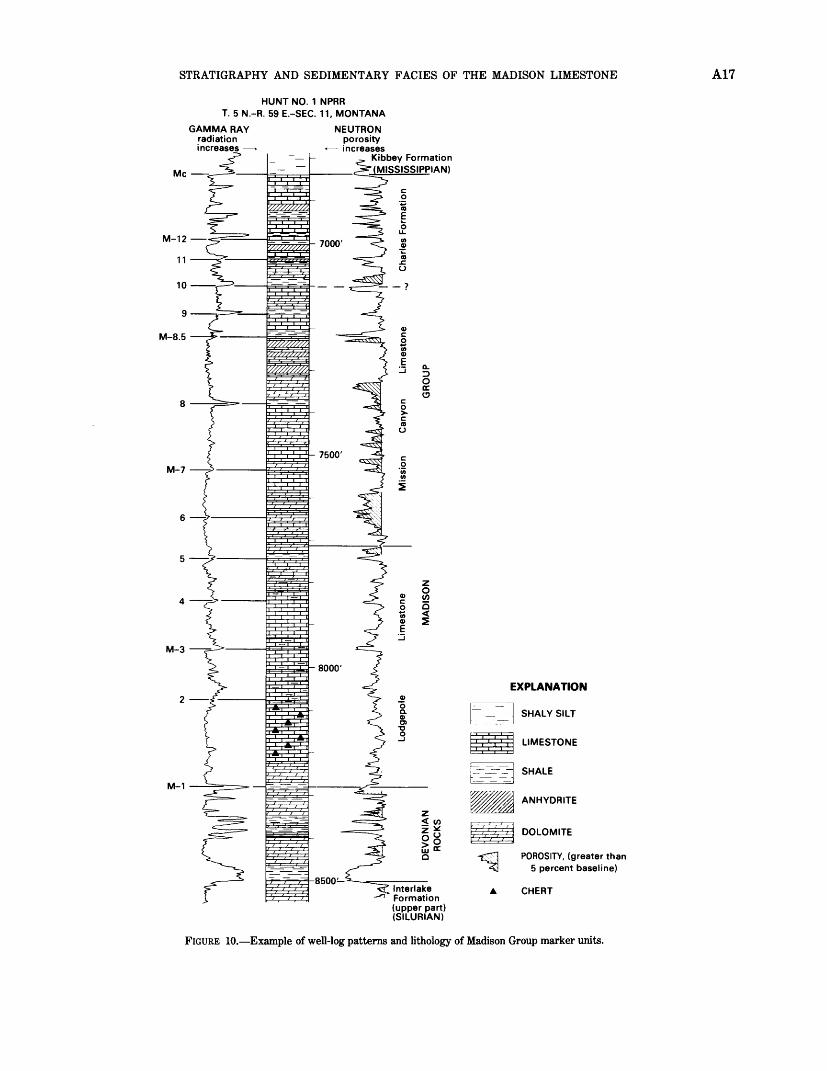
In this study, the Madison Limestone (Group) was subdivided into 13 units for the purposes of establishing a correlation framework (fig. 10). Each correlation unit is bounded by marker beds that consist of thin and widespread shaly carbonate or dark-shale intervals that are recognizable in the subsurface on gamma ray neutron or gamma ray sonic logs and are traceable throughout large parts of the project area. Similar marker beds characterize the Madison Limestone and its equivalents throughout most of the Rocky Mountain area. In general, log definition of the marker beds is best expressed in the main part of the Williston basin;
however, most of them can be traced with reasonable confidence throughout Montana, Wyoming, and South Dakota. The five marker beds that have proved to be the most useful for regional correlation purposes are shown in figure 10 and on plates 4 to 10. Marker M-l represents the base of the Madison Limestone; M-3 is near the Kinderhookian and Osagean boundary; M-7 and M-8.5 fall within the Osagean; and M-12 is near the Osagean and Meramecian boundary. The top of the Madison Limestone is designated as the Me marker.
The M-8.5 marker is the top of the thick anhydrite in terval in the middle part of the Madison Limestone that is present in the Central Montana trough and extends eastward across southeastern Montana, western North Dakota, and northwestern South Dakota (fig. 10; pis. 4- 10). M-8.5 is equivalent to the top of the lower solution zone, recognized by Sando (1974) in north-central Wyoming.
A lower, thinner, and less widespread anhydrite in terval is present in the Central Montana trough in the approximate stratigraphic position of the M-7 marker; it also extends eastward with approximately the same geographic distribtuion as that of the anhydrite interval in the middle part of the Madison Limestone (fig. 10; pis. 4-10).
M-10 is the "Richey shale marker" of subsurface geologists; M-12 is correlated to outcrop data in the Bighorn Mountains as equivalent to the upper solution zone of Sando (1974).
The five main marker-defined intervals are useful in construction of layer maps and geologic sections for studying the interrelationship between thickness, lithofacies, porosity, and paleostructural trends within the Madison Limestone. Porosity and rock facies distri bution patterns are somewhat different for each layer; therefore, detailed layer maps and sections of the Madi son Limestone or Group have been constructed (see pis. 6-20).
M-l to M-3 Interval (Approximately Kinderhookian)
The basal Lodgepole Limestone overlies the Three Forks Formation, Bakken Formation, or older beds with sharp contact on the flanks of the Williston basin and in central Montana, eastern Wyoming, and western South Dakota. However, in the basin interior, the Bak ken Formation tends to grade into the overlying shaly carbonate and dark shale beds of the lower part of the Lodgepole Limestone. The lower half of the M-l to M-3 interval contains the Waulsortian crinoidal carbonate mound facies on the west, southwest, and east flanks of the basin (pis. 4-12). Several publications that give a detailed description of the Waulsortian mound beds in clude Cotter (1965), Smith (1972), Stone (1972), and Bjorle and Anderson (1978). The main crinoidal mound
STRATIGRAPHY AND SEDIMENTARY FACIES OF THE MADISON LIMESTONE A17
HUNT NO. 1 NPRR T. 5 N.-R. 59 E.-SEC. 11, MONTANA
GAMMA RAY radiation increases
Me
NEUTRpNporosity
- increasesKibbey Formation (MISSISSIPPIAN)
M-3
M-1
EXPLANATION
SHALY SILT
LIMESTONE
Interlake Formation (upper part) (SILURIAN)
SHALE
ANHYDRITE
DOLOMITE
POROSITY, (greater than 5 percent baseline)
CHERT
FIGURE 10. Example of well-log patterns and lithology of Madison Group marker units.
A18 GEOLOGY AND HYDROLOGY OF THE MADISON LIMESTONE
belt appears to follow the general trends of the Central Montana uplift and the Cedar Creek anticline (pis. 5 and 12), probably reflecting continued paleostructural influence of these features into earliest Mississippian time. This mound belt is dolomitized and has good porosity in places, especially in its southwestern and southern parts. In north-central and northwestern Wyoming and south-central Montana, the lower part of the interval is entirely dolomite, much of it fine-grained and cherty. In central, south-central, and southeastern Montana, northeastern Wyoming, and northwestern South Dakota, the upper half of the interval is com posed of oolitic carboante banks. Toward the interior of the basin, oolitic and crinoidal mound beds grade into fine-grained argillaceous and pyritic limestone. The oolitic beds are primarily poor porosity limestones, ex cept in western South Dakota where they are dolomitized and porous. On the east flank of the basin, porous dolomitized crinoidal mounds occupy most of the interval.
The M-l to M-3 interval is about 250 to 300 ft thick (pi. 11), except for the basin center where it is about 400 ft thick, and locally along the south and west flanks of the basin where carbonate mound buildups are also as much as 400 ft thick. Some anhydrite or gypsum is present in the uppermost beds of the cycle (pis. 8 and 9), but in most places the upper beds are overlain by thin argillaceous carbonates or gray calcareous shale of the M-3 marker bed.
Maximum porosity development in this interval oc curs on the east and southeast flanks of the Williston basin and along a trend extending northwesterly from the Bighorn Mountains. Significant porosity also occurs in places along the Cedar Creek anticline (D. L. Brown, written commun., 1980).
M-3 to M-7 Interval (Lower Osagean)
The M-3 to M-7 interval ranges in thickness frm 200 to 300 ft around the flanks of the basin to more than 600 ft in the Central Montana trough and in the central part of the Williston basin (pi. 13). The approximate lower two-thirds of the interval makes up the upper half of the argillaceous Lodgepole Limestone in the basin interior and the Central Montana trough. Oolitic carbonate beds dominate the M-3 to M-7 interval in the basin flank facies, the upper part prograding toward the interior of the basin where some crinoid mounds are present (pis. 6-10, and 14). These beds compose the lower part of the Mission Canyon Limestone. The ooli tic facies also grades into crinoidal limestone in north- central Montana, in the vicinity of the southern margin of the Alberta shelf. Anhydrite beds as much as 100 ft thick are present at the top of the cycle in the Central Montana trough (pis. 6-10). In the rest of the area, the
cycle is overlain by argillaceous limestone or gray cal careous shale beds of the M-7 marker.
Porosity is best developed in dolomite beds on the east flank of the basin in North Dakota, and significant northwest-trending porosity belts are present along the Cedar Creek anticline trend and the Bighorn-Pryor Mountains trend (D. L. Brown, written commun. 1980). In general, toward the basin interior, the oolite beds change to predominantly poor-porosity oolitic limestone having a finely crystalline to dense limestone matrix.
M-7 to M-8.5 Interval (Middle Osagean)
The M-7 to M-8.5 interval is dominated by crinoidal and oolitic carbonates of the upper part of the Mission Canyon Limestone in most of the area. In the center of the Williston basin, the facies changes to finer grained limestone and some crinoidal beds (pis. 6-10, 15, and 16). The oolitic facies is distributed along the east and southeast flanks of the basin in North and South Dakota and extends northwestward to include the area southwest of the general trend of the Central Montana uplift, Miles City arch, and Cedar Creek anticline. The crinoidal bank facies is well developed in the area of the Alberta shelf and along the northwestern flank of the basin. The oolitic facies is generally dolomitized, and much of it has good porosity. The bedded anhydrite unit in the middle part of the Madison Limestone, as much as 150 ft thick in places, is at the top of the interval, and is especially well developed in the Central Montana trough and the eastern and southeastern parts of the Williston basin. A map of porosity in this interval (MacCary, 1981) shows porosity trends that coincide with the dolomitic facies on the west, south, and east flanks of the Williston basin. Some porosity distributions coincide with the limestone facies on the west flank of the basin and along the northern border of North Dakota. Porosity trends on the east side of the Williston basin coincide with areas shown as anhydrite (pi. 15); however, this porosity is within the limestone, dolomite, and oolite facies beneath the anhydrite (Section C-C', pis. 6 and 7). In general, the best porosity development is in the oolitic facies and in dolomitized rock. The limestones on the flanks of the Williston basin exhibit some porosity but those near the center of the basin have little porosity. Some halite also is present in the upper part of the evaporite interval in the central part of the basin. The anhydrite interval in the middle part of the Madison Limestone comprises the basal beds of the Charles Formation at its type well, east of the Big Snowy Mountains, Mont. (Seager, 1942).
Porosity in this interval is best developed in dolomite facies on the eastern and southern flanks of the basin in North Dakota, northwestern South Dakota,
STRATIGRAPHY AND SEDIMENTARY FACIES OF THE MADISON LIMESTONE A19
northeastern Wyoming, and southeastern Montana. Large areas of good porositiy are also present along the Bighorn-Pryor Mountains trend and in the southeastern part of the Albert shelf (MacCary, 1981).
M-8.5 to M-12 Interval (Upper Osagean)
This interval is 150 to 250 ft thick around the flanks of the basin, and thickens to about 400 ft in the Central Montana trough and the interior of the Williston basin (pi. 17). In some places, pre-Kibbey or pre-Jurassic erosion has removed all or part of the interval. The unit is composed of oolitic and crinoidal carbonates (mostly limestone) interbedded with finer grained carbonate and some shale that grade into halite, anhydrite, carbonate, and shale beds of the Charles Formation in the basin center (pis. 6-10, and 18). In general, the upper part of the interval is dominated by anhydrite beds that grade into halite in the basin center. A moderate number of porous carbonate beds are present in the eastern and southeastern flanks of the basin and along the Bighorn-Pryor Mountains belt: however, in general, the porous facies occurs in small isolated patches associated with oolitic or crinoidal mound buildups (D. L. Brown, written commun. 1980).
M-12 to Me Interval I Approximately Meramecian)
The M-12 to Me interval contains the major part of the "Charles salt" in the center of the Williston basin (pis. 19, 20). The halite beds grade into interbedded anhydrite, fine-grained dolomite, and relatively thin oolitic limestone beds outward from the basin center. Pre-Kibbey or pre-Jurassic erosion has removed varied amounts of material from this interval in much of the area, especially around the flanks of the basin. In general, these beds are present only within the Central Montana trough and the central Williston basin, where the interval is represented by more than 500 ft of halite, anhydrite, and some shale. These rocks generally have poor porosity and porous carbonate has developed in only a few scattered areas (D. L. Brown, written commun. 1980).
Summary of Madison Limestone Stratigraphy
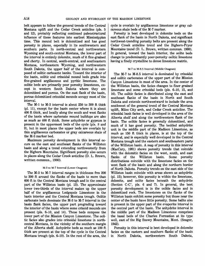
Isopach and facies maps of the total Madison Limestone section show the influence of several important paleostructural trends. The Madison Limestone is thickest in the central part of the Williston basin and in the Central Montana (Big Snowy) trough (fig. 11); coincidentally, within these areas of greater thickness, the main part of the evaporite section also occurs, indicating greater subsidence during deposition of the Madison Limestone cycles. The westward projection of the thick anhydrite interval in
the middle part of the Madison Limestone below the M- 8.5 marker is restricted to the Central Montana trough, pinching out to the north and south. The northern pinchout edge follows a line approximating the southern border of the Alberta shelf; north of there, the upper part of the Madison Limestone is absent, because of either nondeposition or pre-Middle Jurassic erosion, or both. The pre-M-8.5 Madison Limestone section changes facies from predominantly dolomite in the Central Montana trough, to primarily crinoidal and silty to argillaceous limestone just north of the boundary between the Alberta shelf and the Central Montana trough (pi. 5). The facies change indicates that these elements influenced distribution of dolomitized and nondolomitized facies, as well as crinoidal buildups. A trend where the Madison Limestone is thin coincides with increased development of smaller crinoid and oolite carbonate mounds in the Lodgepole Limestone in the general vicinity of the Cedar Creek anticline (fig. 11; pis. 11, 12). This trend coincides approximately with the area where the Devonian is thin along the ancestral Cedar Creek structure, reflecting continued growth of this feature into the Early Mississippian. However, an area of thickening occurs in the vicinity of the Devonian Central Montana uplift, indicating reversal of movement on that feature during Madison Limestone deposition.
In general, the more prominent good porosity area of the Madison Limestone is on the east flank of the Williston basin (MacCary, 1981). Other significant areas of good porosity are present along the Cedar Creek anticline, and along the Bighorn-Pryor Mountains trend in south-central Montana and north-central Wyoming. Except for the Cedar Creek anticline area, the total porosity decreases toward the main basin area, as the limestone content of the carbonate section increases. Total volume of porosity within the limestone facies is small in comparison to the crystalline dolomite facies, which tend to be prominent along the flanks of the basin. In general, areas of greatest total porosity and permeability appear to occur where amounts of dolomite and limestone are roughly equal within the carbonate section. Lithologic studies indicate that a larger proportion of coarser crystalline dolomite is present in this facies.
Correlation studies thus far indicate that individual Madison Limestone porosity units tend to consist of relatively tabular, porous dolomite beds, ranging from a few feet up to 50 feet or more thick, extending over many tens of square miles (Peterson, 1978). To the northwest, in the general area south and west of the Sweetgrass arch and north of the Little Belt Mountains, a broad area of relatively good porosity is present in the coarsely crystalline dolomite facies of the
96°
rTT
vs I
I
U
A I
Appro
xim
ate
lim
it o
f M
adis
on
Lim
est
one
EX
PLA
NA
TIO
N
TER
TIA
RY
IG
NE
OU
S IN
- T
RU
SIV
E R
OC
KS
UPL
IFT
AR
EA
Mis
siss
ip
pian
or
olde
r ro
cks
ex
pose
d at
lan
d su
rfac
e
DO
LOM
ITE
FAC
IES
PRIM
AR
ILY
LIM
EST
ON
E
AN
D S
HA
LY
LIM
EST
ON
E
42°r
FA
CIE
S |
- C
ON
TA
CT
Das
hed
whe
re
appr
oxim
atel
y lo
cate
d
,,00X
LIN
E O
F EQ
UA
L FO
RM
A-
TIO
N T
HIC
KN
ES
S I
nter
va
l 20
0 fe
et
-A-
-a-
LIM
IT O
F C
HA
RL
ES
SALT
O
F IN
FOR
MA
L SU
BSU
R
FAC
E U
SAG
E
-"- Jt
LI
MIT
OF
MID
DLE
PA
RT
O
F A
NH
YD
RIT
E O
F T
HE
M
AD
ISO
N L
IME
STO
NE
<rL
__
100 I
200
300
KIL
OM
ET
ER
S
100
200
MIL
ES
s o 9 I s a H I H
FIGU
RE 1
1. T
hick
ness
and
roc
k fa
cies
of t
he M
adis
on L
imes
tone
and
equ
ival
ent r
ocks
(Lo
wer
and
Upp
er M
issi
ssip
pian
).
STRATIGRAPHY AND SEDIMENTARY FACIES OF THE MADISON LIMESTONE A21
Sun River Member of the Castle Reef Dolomite at the top of the Madison Group. Correlation of marker beds indicates that this porous dolomite interval may be partly equivalent to the anhydrite in the middle part of the Madison Limestone in south-central and southeastern Montana.
BIG SNOWY GROUP
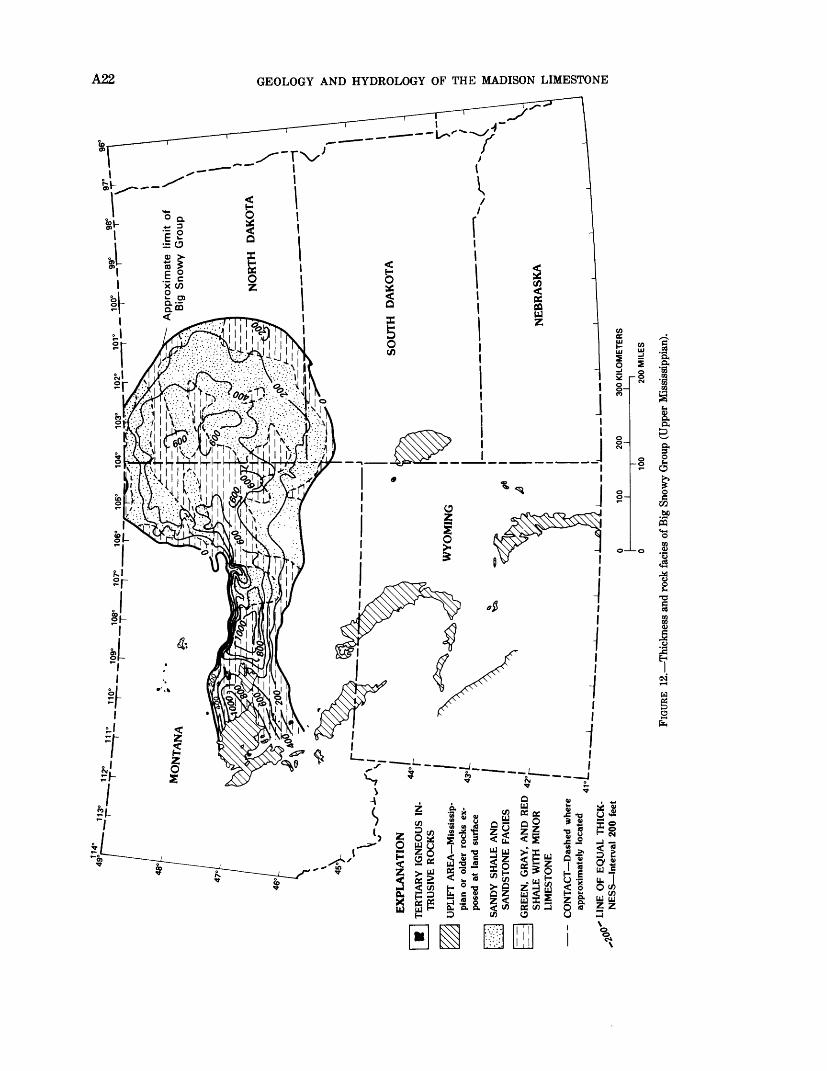
Rocks of Chesterian age, the Big Snowy Group, are present only in the Williston basin and the Central Montana (Big Snowy) trough. These beds are primarily clastic rocks containing minor amounts of fine-grained to argillaceous carbonate rock. The Big Snowy Group consists of the Kibbey, Otter, and Heath Formations (table 1). The Big Snowy Group is more than 1,000 ft thick in the Central Montana trough, and more than 600 ft thick in the central part of the Williston basin in eastern Montana and western North Dakota (fig. 12). In north-central and south-central Montana and around the periphery of the Williston basin, these rocks were eroded during Late Mississippian, Early Pennsylvanian, and early Mesozoic time.
The Kibbey Formation consists of 200 to 300 ft of red shale, siltstone, and sandstone, primarily of nearshore marine origin. Sandstone content is greatest in the northern and eastern parts of the Williston basin, indicating that a clastic source lay in that direction (pi. 4). A widespread, relatively thin carbonate marker unit, "Kibbey lime," (informal subsurface usage) is present in the approximate middle of the formation throughout most of the Williston basin and Central Montana trough. The basal sandstone and the upper sandstone beds of the Kibbey Formation are porous locally (pis. 4 and 5).
In most places, the Kibbey Formation disconformably overlies the Meramecian and Osagean (Charles Formation) rocks, with the possible exception of the central part of the Williston basin and the Central Montana trough, where red shale and some anhydrite overlies halite or anhydrite beds of the Charles Formation, and the depositional break may have been minor. In south-central Montana and north- central Wyoming, the Darwin Sandstone Member of the Amsden Formation is partly Chesterian age (Mallory, 1967; Craig, 1972).
The middle unit of the Big Snowy Group, the Otter Formation, consists of 200 to 300 ft of marine, nearshore, and tidal flat beds of green shale and minor finely crystalline, usually stromatolitic, nonporous limestone or dolomite.
The overlying Heath Formation is composed of 200 to 400 ft of dark gray to black, highly organic marine shale, limestone, and minor siltstone or fine-grained
sandstone. These beds were deposited primarily under conditions of restricted marine circulation. The unit is present in the interior of the Central Montana trough and in the western part of the Williston basin, but it was locally removed by Early Pennsylvanian erosion in many places, especially within the Central Montana trough. Few or no porous beds are present in either the Otter or the Heath Formations.
PENNSYLVANIAN ROCKS
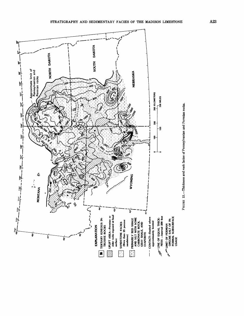
Late Mississippian and Pennsylvanian time marked the growth of numerous paleotectonic elements that affected most of the Rocky Mountains area. Several new features developed and growth of older features intensified. Among the more important features affecting deposition of Pennsylvanian and Permian sediments in the northern Rocky Mountains and Northern Great Plains were the Wyoming shelf; the Front Range, Laramie, and Bighorn uplift belt; and the Powder River, Alliance, and Denver basin trend; and the Miles City arch, Black Hills uplift, and Chadron arch belt. Also important was continued paleostructural growth of the Siouxia uplift, Williston basin, Central Montana trough, and the Alberta shelf (figs. 2, 13). Pennsylvanian and Permian rocks are more than 1,000 ft thick in the central Williston basin and the Powder River basin (fig. 13). The stratigraphy of Pennsylvanian rocks in the northern Rocky Mountains and adjacent area has been studied in detail by several autors, including Agatston (1954), Bates (1955), Foster (1958), Tenney (1966), Maughan and Roberts (1967), Mallory (1972), Maughan (1975), and Smith and Gilmour (1979).
Pennsylvanian or younger rocks unconformably overlie Mississippian rocks in most of the Northern Great Plains and northern Rocky Mountains. However, in the area of the Central Montana (Big Snowy) trough and in the central part of the Williston basin, where the Mississippian and Pennsylvanian boundary is difficult to pick, these rocks may be conformable.
Lower Pennsylvanian (lower part of Morrowan) beds include marine quartzose sandstone, shale, and minor limestone of the Tyler Formation and equivalent rocks, which are restricted in distribution to the Central Montana trough and the central part of the Williston basin. The Tyler Formation grades southward into red shale, siltstone, and sandstone of the lower part of the Amsden Formation in south-central Montana and north-central Wyoming and into the lower part of the Minnelusa Formation in southeastern Montana, northwestern South Dakota, southwestern North Dakota, and northeastern Wyoming. The lower part of the Tyler Formation cuts deeply into the underlying Otter or Heath Formations in many places. This
Ap
pro
xim
ate
lim
B
ig
Snow
y G
roup
EX
PLA
NA
TIO
N
TER
TIA
RY
IG
NE
OU
S IN
T
RU
SIV
E R
OC
KS
UPL
IFT
AR
EA
Mis
siss
ip
pian
or
olde
r ro
cks
ex
pose
d at
lan
d su
rfac
e
SAN
DY
SH
ALE
AN
D
SAN
DST
ON
E F
AC
IES
GR
EE
N,
GR
AY
, A
ND
RE
D
42o'
SH
ALE
WIT
H M
INO
R
| IC
ON
TA
CT
Das
hed
whe
re
I ap
prox
imat
ely
loca
ted
I
LIN
E O
F E
QU
AL
TH
ICK
N
ES
S I
nter
val
200
feet
LIM
EST
ON
E
100
200
300
KIL
OM
ET
ER
SI
o s o O
O I o = 2 r 2 H
0 10
0 20
0 M
ILE
S
FIGU
RE 1
2. T
hick
ness
and
roc
k fa
cies
of B
ig S
now
y G
roup
(U
pper
Mis
siss
ippi
an),
[ / .''
;!\.:J
_.
104°
1
03
°__
10r_
__1°
1I__
EX
PLA
NA
TIO
N
TE
RT
IAR
Y I
GN
EO
US
IN
TR
USI
VE
RO
CK
S
UPL
IFT
AR
EA
Per
mia
n o
r ol
der
rock
s ex
pose
d at
lan
d su
rfac
e
SAN
DST
ON
E F
AC
IES
(Mor
e th
an 2
5 pe
rcen
t sa
ndst
one)
trir
] PR
IMA
RIL
Y R
ED
SH
AL
E
AN
D S
ILT
WIT
H S
OM
E
CA
RB
ON
AT
E R
OC
K,
GR
AY
SH
AL
E,
AN
D
EV
APO
RIT
E
-
CO
NT
AC
T D
ashe
d w
here
ap
prox
imat
ely
loca
ted
QQ"
LIN
E O
F E
QU
AL
TH
ICK
- '*
N
ES
S
Inte
rval
200
fee
t
> *
LIM
IT O
F P
ER
MIA
N
r
OP
EC
HE
SA
LT
OF
IN
FO
RM
AL
SU
BSU
RFA
CE
U
SAG
E
300
KIL
OM
ETE
RS
100
200
MIL
ES
S3 S K K! > * o £ o O CQ
O
FIGU
RE 1
3. ^
Thi
ckne
ss a
nd r
ock
faci
es o
f Pen
nsyl
vani
an a
nd P
erm
ian
rock
s.

A24 GEOLOGY AND HYDROLOGY OF THE MADISON LIMESTONE
unconformable relation has been interpreted as representing folding of underlying Mississippian strata at the close of Mississippian time (Fanshawe, 1978) and as stream channeling by others (for example, Kranzler, 1966). Regardless of interpretation, the evidence of unconformity and erosion is well documented. According to Grenada (1978), the faunas and lithofacies of the Tyler Formation and equivalent rocks in western North Dakota indicate a deltaic environment of deposition. Fanshawe (1978) proposes a similar interpretation for the Tyler beds in the Central Montana trough. Some of the clastic material for the basal sands was probably derived from the south and east and transported by stream systems that entered the subsiding basin and trough areas from that direction.
In the Central Montana trough area, carbonate and dark shale beds of the Alaska Bench and Devils Pocket Formations of the upper part of the Amsden Group overlie the Tyler Formation (Maughan, 1975). To the south, the carbonate beds intermix with red shale beds in the lower to middle parts of the Minnelusa Formation and in the Ranchester Limestone Member of the Amsden Formation, and perhaps in the lower part of the Tensleep Sandstone. Farther south, in the southern and eastern parts of the Powder River basin, the carbonate facies probably is represented by the "Mule Creek dolomite" of subsurface usage, or the middle part of the Hartville Formation. Carbonate beds are sparse in the equivalent of the lower and middle parts of the Minnelusa Formation (table 1) in the central Williston basin, where this interval is largely red shale, siltstone, and sandstone. The "Fairbanks sandstone" of subsurface usage in the Powder River basin is the approximate age equivalent of the Tyler Formation to the north.
The upper part of the Middle Pennsylvanian section is represented mainly by the Tensleep and Quadrant Sandstones in southern Montana and north-central Wyoming, and most of the middle part of the Minnelusa Formation in the Williston basin, northeastern Wyoming, and the Black Hills. Middle Pennsylvanian rocks are truncated in Central Montana because pre- Jurassic erosion has increasingly removed them northward, reaching a zero line approximately near the axis of the Central Montana trough (pi. 5).
Porous sandstone beds of Pennsylvanian age are present in the Tensleep Sandstone in central to north- central Wyoming and south-central Montana, and in the middle and upper part of the Minnelusa Formation in western South Dakota and along the east side of the Williston basin. Lower Pennsylvanian porous sand stones of somewhat discontinuous distribution are also present in the Darwin Sandstone Member of the
Amsden Formation, "Fairbanks sandstone," and Tyler Formation. The basal part of the Amsden is latest Mississippian age.
PERMIAN ROCKS
Regional analyses of Permian rocks in the Northern Great Plains and Northern Rocky Mountains have been published by Foster (1958), Tenney (1966), Maughan (1966, 1967), Rascoe and Baars (1972), and Peterson (1980a, 1980b). Lower Permian (upper Wolfcampian) rocks rest disconformably on Middle and Upper Pennsylvanian rocks wherever they occur in the Northern Great Plains (Mallory, 1972; Rascoe and Baars, 1972). In the Powder River basin and in western South Dakota, the Pennsylvanian and Permian systemic boundary is believed to be near the base of a widespread red shale unit ("red marker," of subsurface usage) which has been interpreted as a buried soil surface on the regional Pennsylvanian-Permian unconformity (Foster, 1958).
The Permian section is widely truncated by Triassic and younger Mesozoic rocks in central Montana and around the northern and eastern flanks of the Williston basin. Rocks of late Wolfcampian age comprise a sequence of sandstone, carbonate, red shale, and some anhydrite beds of the upper part of the Minnelusa Formation in the Powder River and Williston basins and in western South Dakota. Sandstones are commonly porous and are dominant adjacent to the eastern and western borders of the Powder River basin and in western South Dakota. The sandstone facies extends northward and occupies the southeastern part of the Williston basin, where a substantial thickness has good porosity. The upper sand facies of the Minnelusa Formation is believed to have been derived from reworking of Pennsylvanian sands deposited earlier in the vicinity of paleostructures on the Wyoming shelf (Foster, 1958). Additional sources were the Siouxia uplift and the Canadian shield on the eastern and northeastern borders of the Williston basin.
The red shale of the Opeche Formation overlies the upper part of the Minnelusa Formation in most of the Northern Great Plains area and intertongues with halite ("Opeche salt," of subsurface usage) in northwestern Nebraska (Alliance basin) and in the central part of the Williston basin (pi. 4). Except where removed by the post-Permian erosion in southern Montana, the Minnekahta Limestone overlies the Opeche Formation. The Minnekahta Limestone is a widespread carbonate marker bed that represents a broad, eastward-projecting tongue of the Phosphoria or Park City Formation of central and western Wyoming. Red shale, carbonate tongues of the Park City Formation, siltstone, and some sandstone beds of the Goose Egg or Spearfish Formations overlie the
STRATIGRAPHY AND SEDIMENTARY FACIES OF THE MADISON LIMESTONE A25
Minnekahta Limestone. In the Williston basin, the middle part of this sequence contains halite beds 300 ft or more thick, approximately at the Permian and Triassic boundary (pi. 4).
TRIASSIC ROCKS
Permian rocks in the Northern Great Plains are overlain by red shale, siltstone, and minor carbonate or gypsum beds of the Triassic upper part of the Goose Egg Formation in south-central Montana and the Powder River basin, and by the Triassic upper Spearfish Formation in western South Dakota and the Williston basin (table 1). This interval is 200 to 400 ft thick in the central Williston basin, and thickens southwesterly to more than 900 ft in the Powder River basin. Sandstone content is greatest in the eastern part of the Williston basin, where sandstone occurs in elongate northeast-southwest belts that probably were deposited by streams draining the adjacent Siouxia uplift and Canadian shield (fig. 14). Triassic beds are truncated by pre-Middle Jurassic rocks along the south and east margins of the Alberta shelf and on the east side of the Williston basin (pis. 4, 5). These beds are overlain unconformably by either the Piper or the Nesson Formation of Middle Jurassic age.
SUMMARY
Paleozoic sedimentary rocks in the Northern Great Plains and northern Rocky Mountains region comprise a sequence of mostly shallow-water marine carbonate, clastic, and evaporite deposits of Middle Cambrian through Late Permian age. The lower part of the Paleozoic section is a sequence of marine sandstone, shale, and minor limestone, about 1,000 ft thick in the central part of the Williston basin, of Middle Cambrian through Middle Ordovician age. Porous sandstone beds occur in this section, mainly in the Winnipeg Formation in southeastern Montana and northwestern South Dakota.
Upper Ordovician through middle Upper Mis- sissippian rocks are primarily carbonate beds which contain numerous widespread cyclic interbeds of evaporite and fine-grained clastic deposits. Major porosity in this sequence occurs in dolomite or dolomitic limestone of the Red River Formation, and is most prominent in the eastern and southern border regions of the Williston basin.
Rocks of the Interlake Formation are more than 1,000 ft thick in the central part of the Williston basin. The lower part of the Interlake is composed mainly of light-colored, very fine grained dolomite, having fossil- fragmental dolomite or limestone and thin anhydrite interbeds. The lithology of the middle part of the
Interlake is similar to that of the lower part, but the upper part contains widespread beds of porous oolitic, algal, and coralline dolomite. The beds in the upper part of the Interlake are the most porous in the formation, but these beds are restricted to the central part of the basin, where Devonian erosion did not cut as deeply into the section. These beds consist of vuggy dolomitic limestone and dolomite interbedded with very fine grained anhydritic or argillaceous dolomite.
In general, the Devonian rocks of the Williston basin and central Montana are a cyclic sequence of shallow- water fossiliferous carbonate, shaly carbonate or shale, and evaporites, including some Middle Devonian halite. Each cycle grades upward from silty to argillaceous carbonate at the base, through massive, porous, stromatoporoid and coralline dolomite, to solution breccia or anhydrite at the top. Most of the porous dolomite is in the Middle and Upper Devonian Dawson Bay, Duperow, and Birdbear ("Nisku") Formations. The Devonian carbonate section tends to become more limy and less porous toward the interior of the basin. In the central part of the basin, limestone constitutes as much as 50 percent of these rocks. Almost all porosity in the Devonian carbonate section is associated with dolomite beds. Porosity patterns tend to be somewhat irregular in shape. Areas of good porosity occur north of the Central Montana uplift. Total porosity is very poor along the Central Montana uplift and is generally very poor to the south of this trend of thin Devonian rocks.
In general, the Madison Group consists of a lower unit of gray to dark-gray argillaceous to shaly or silty, in places cherty, thin- to medium-bedded limestone; a middle unit of generally thick- to massive-bedded fossiliferous to oolitic carbonate rock; and an upper unit of anhydrite and halite with interbedded carbonate rock and shale. These gross facies intertongue with one another, and the total section is composed of numerous cyclic, marker-defined units that incorporate varied amounts of the main rock facies. Marker M-l represents the base of the Madison Limestone; M-3 is near the Kinderhookian-Osagean boundary; M-7 and M- 8.5 occur within the Osagean; and M-12 is near the Osagean-Meramecian boundary. The top of the Madison Limestone is designated as the Me marker.
The lower half of the M-l to M-3 interval contains the Waulsortian crinoidal carbonate mound facies on the west, southwest, and east flanks of the Williston basin. The main crinoidal mound belt appears to follow the general trends of the Central Montana uplift and the Cedar Creek anticline, probably reflecting continued paleostructural influence of these features into earliest Mississippian time. This mound belt is dolomitized and highly porous in places, especially in its southwestern
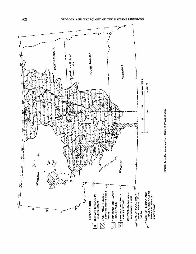
712,
00"
*
EX
PLA
NA
TIO
N
TE
RT
IAR
Y I
GN
EO
US
IN
TR
USI
VE
RO
CK
S
UPL
IFT
AR
EA
Tri
assi
c or
ol
der
rock
s ex
pose
d at
lan
d su
rfac
e
SAN
DST
ON
E A
ND
SA
ND
Y
SHA
LE
FA
CIE
S
PRIM
AR
ILY
RE
D S
HA
LE
A
ND
SIL
TST
ON
E
CO
NT
AC
T D
ash
ed w
here
ap
prox
imat
ely
loca
ted
LIN
E O
F E
QU
AL
TH
ICK
N
ES
S I
nte
rval
s 10
0 an
d 20
0 fe
et
LIM
IT O
F PE
RM
IAN
AN
D
TR
IASS
IC P
INE
SA
LT O
F IN
FOR
MA
L SU
BSU
R
FAC
E U
SAG
E
106°
10
5°
104"
10
3°
102
Appro
xim
ate
T
riass
ic r
ocks
100 I
200
300
KIL
OM
ET
ER
SI
100
200
MIL
ES
O r o
»
o *<
O H
FIGU
RE 1
4. T
hick
ness
and
rock
fad
es o
f Tri
assi
c ro
cks.
STRATIGRAPHY AND SEDIMENTARY FACIES OF THE MADISON LIMESTONE A27
and southern parts. In central, south-central, and southeastern Montana, northeastern Wyoming, and northwestern South Dakota, the upper half of the M-l to M-3 interval is composed of oolitic carbonate banks. Toward the interior of the basin, oolitic and crinoidal mound bids grade into fine-grained argillaceous and pyritic limestone. The oolitic beds are primarily poor porosity limestones, except in western South Dakota where they are dolomitized and porous. On the east flank of the basin, porous dolomitized crinoidal mounds occupy most of the interval. Maximum porosity development in this interval occurs on the east and southeast flanks of the Williston basin and along a trend extending northwesterly from the Bighorn Mountains. Significant porosity also occurs in places along the Cedar Creek anticline.
The M-3 to M-7 interval ranges in thickness from 200 to 300 ft around the flanks of the basin to more than 600 ft in the Central Montana trough and in the central part of the Williston bain. The approximate lower two- thirds of the interval makes up the upper half of the argillaceous Lodgepole Limestone in the basin interior and the Central Montana trough. Oolitic carbonate beds dominate the M-3 to M-7 interval in the basin flank facies, the upper part prograding toward the interior of the basin where some crinoid mounds are present. These beds compose the lower part of the Mission Canyon Limestone. The oolitic facies also grades into crinoidal limestone in north-central Montana, in the vicinity of the southern margin of the Alberta shelf. Porosity is best developed in dolomite beds on the east flank of the basin in North Dakota, and significant northwest-trending porosity belts are present along the Cedar Creek anticline trend and the Bighorn-Pryor Mountains trend. In general, toward the basin interior, the oolite beds change to predominantly poor-porosity oolitic limestone having a finely crystalline to dense limestone matrix.
The M-7 to M-8.5 interval is dominated by crinoidal and oolitic carbonates of the upper part of the Mission Canyon Limestone in most of the area, except in the center of the Williston basin where the facies changes to finer grained limestone and some crinoidal beds. The oolitic facies is distributed along the east and southeast flanks of the basin in North and South Dakota, and extends northwestward to cover the area southwest of the general trend of the Central Montana uplift, Miles City arch, and Cedar Creek anticline. The crinoidal bank facies is well developed in the area of the Alberta shelf and along the northwestern flank of the basin. The oolitic facies is generally dolomitized, and much of it has good porosity. Porosity in this interval is best developed in dolomite facies on the eastern and southern flanks of the basin in North Dakota,
northwestern South Dakota, northeastern Wyoming, and southeastern Montana. Large areas of good porosity are also present along the Bighorn-Pryor Mountains trend and in the southeastern part of the Alberta shelf.
The M-8.5 to M-12 interval is 150 to 250 ft thick around the flanks of the basin and thickens to 400 ft or more in the Central Montana trough and the interior of the Williston basin. In some places, pre-Kibbey or pre- Jurassic erosion has removed all or part of the interval. The unit is composed of oolitic and crinoidal carbonates (mostly limestone) interbedded with finer grained carbonate and some shale that grade into halite, anhydrite, carbonate, and shale beds of the Charles Formation in the basin center. In general, the upper part of the interval is dominated by anhydrite beds that grade into halite in the basin center. A moderate number of porous carbonate beds are present in the eastern and southeastern flanks of the basin and along the Bighorn-Pryor Mountains belt; however, in general, the porous facies occurs in small isolated patches associated with oolitic or crinoidal mound buildups.
The M-12 to Me interval contains the major part of the Charles salt (of subsurface usage) in the center of the Williston basin. The halite beds grade into interbedded anhydrite, fine-grained dolomite, and relatively thin oolitic limestone beds outward from the basin center. In general, these beds are present only within the Central Montana trough and the central Williston basin, where the interval is represented by more than 500 ft of halite, anhydrite, and some shale. These rocks generally have poor porosity, and porous carbonate has developed in only a few scattered areas.
In general, the more prominent good porosity area of the Madison Limestone is on the east flank of the Williston basin. Other significant areas of good porosity are present along the Cedar Creek anticline, and along the Bighorn-Pryor Mountains trend in south-central Montana and north-central Wyoming. Except for the Cedar Creek anticline area, the total porosity decreases toward the main basin area, as the limestone content of the carbonate section increases. Total volume of porosity within the limestone facies is small in comparison to the crystalline dolomite facies, which tend to be prominent along the flanks of the basin. In general, areas of greatest total porosity and permeability appear to occur where amounts of dolomite and limestone are roughly equal within the carbonate section. Lithologic studies indicate that a larger proportion of coarser crystalline dolomite is present in this facies
Correlation studies thus far indicate that individual Madison Limestone porosity units tend to consist of relatively tabular, porous dolomite beds, ranging from
A28 GEOLOGY AND HYDROLOGY OF THE MADISON LIMESTONE
a few feet to about 50 ft thick and extending over many tens of square miles.
To the northwest, in the general area south and west of the Sweetgrass arch and north of the Little Belt Mountains, a broad area of relatively good porosity is present in the coarsely crystalline dolomite facies of the Sun River Member of the Castle Reef Dolomite at the top of the Madison Group. Correlation of marker beds indicates that this porous dolomite interval may be partly equivalent to the anhydrite in the middle part of the Madison Limestone in south-central and south eastern Montana.
The upper Paleozoic beds are dominated by clastic rocks, beginning with the marine green and gray shales, carbonates, red beds, and some evaporites of the Upper Mississippian Big Snowy Group, and terminating with the relatively thick marine and aeolian sandstones and widespread red bed and evaporite facies of Pennsylvanian and Permian age. Rocks of Chesterian age, the Big Snowy Group, are present only in the Williston basin and the Central Montana (Big Snowy) trough. These beds are primarily clastic rock containing minor amounts of fine-grained to argillaceous car bonate.
The Big Snowy Group consists of the Kibbey, Otter, and Heath Formations. The Kibbey Formation consists of 200 to 300 ft of red shale, siltstone, and sandstone, primarily of nearshore marine origin. Sandstone content is greatest in the northern and eastern parts of the Williston basin. The basal sandstone and the upper part of the Kibbey Formation sandstone beds are porous locally. The Otter Formation consists of 200 to 300 ft of marine, nearshore, and tidal flat beds of green shale and minor finely crystalline, commonly stromatolitic, nonporous limestone or dolomite. The overlying Heath Formation is composed of 200 to 400 ft of dark-gray to black, highly organic marine shale, limestone, and minor siltstone or fine-grained sandstone. Few or no porous beds are present in either the Otter or the Heath Formations.
Pennsylvanian or younger rocks unconformably overlie Mississippian rocks in most of the Northern Great Plains and Northern Rocky Mountains. However, in the area of the Central Montana (Big Snowy) trough and in the central part of the Williston basin, where the Mississippian-Pennsylvanian boundary is difficult to locate, these rocks may be conformable. Porous sandstone beds of Pennsylvanian age are present in the Tensleep Sandstone in central to north- central Wyoming and south-central Montana, and in the middle to upper parts of the Minnelusa Formation in western South Dakota and along the east side of the Williston basin. Lower Pennsylvanian porous sand stones of somewhat discontinuous distribution are also
present in the Darwin Sandstone Member of the Amsden Formation, Fairbanks sand, (of subsurface usage) and Tyler Formation. The basal part of the Amsden is of latest Mississippian age.
Permian rocks rest disconformably on Middle to Upper Pennsylvanian rocks over all of the area of their occurrence in the Northern Great Plains. In the Powder River basin and in western South Dakota, the Pennsylvanian-Permian systemic boundary is believed to be near the base of a widespread red shale unit (red marker, of subsurface usage) which has been interpreted as a buried soil surface on the regional Pennsylvanian-Permian unconformity. Rocks of late Wolfcampian age comprise a sequence of sandstone, carbonate, red shale, and some anhydrite beds of the upper part of the Minnelusa Formation in the Powder River and Williston basins and in western South Dakota. Sandstones are usually porous and are dominant adjacent to the eastern and western borders of the Powder River basin and in western South Dakota. The sandstone facies extends northward and occupies the southeastern part of the Williston basin, where a substantial thickness has good porosity.
Permian rocks in the Northern Great Plains are overlain by red shale, siltstone, and minor carbonate or gypsum beds of the Triassic upper part of the Goose Egg Formation in south-central Montana and the Powder River basin, and by the Triassic upper part of the Spearfish Formation in western South Dakota and the Williston basin. This interval is 200 to 400 ft thick in the central Williston basin, and thickens south westerly to more than 900 ft in the Powder River basin. Some discontinuous porous sandstones are present in the Triassic section, mostly along the southern border of the Williston basin.
SELECTED REFERENCES
Agatston, R. S., 1954, Pennsylvanian and lower Permian of northern and eastern Wyoming: American Association of Petroleum Geologists, v. 38, no. 4, p. 508-583.
Alpha, A. G., 1955, Tectonic history of northeastern Montana, in Billings Geological Society Guidebook: Sixth Annual Field Conference, Billings Geological Society, September 1955, p. 129- 142.
______ 1958, Tectonic history of Montana, in Billings Geological Society Guidebook: Ninth Annual Field Conference, August 1958, p. 57-68.
Anderson, S. B., and Hunt, J. B., 1964, Devonian salt solution in north central North Dakota, in Third International Williston Basin Symposium Proceedings: Billings Geological Society, North Dakota Geological Society, and Saskatchewan Geological Society, p. 93-104.
Andrichuk, J. M., 1951, Regional stratigraphic analysis of the
STRATIGRAPHY AND SEDIMENTARY FACIES OF THE MADISON LIMESTONE A29
Devonian system in Wyoming, Montana, southern Saskatchewan and Alberta: American Association of Petroleum Geologists Bulletin, v. 35, p. 2368-2408.
1955, Mississippian-Madison group stratigraphy andsedimentation in Wyoming and southern Montana: AmericanAssociation of Petroleum Geologists Bulletin, v. 39, no. 11, p.2170-2210.
Baillie, A. D., 1950, Devonian geology of Lake Manitoba-LakeWinnepegosis area: Manitoba Department of Mines and NaturalResources, Winnipeg, Manitoba, Mines Branch Publication 49-2,72 p.
______ 1955, Devonian system of Williston basin: AmericanAssociation of Petroleum Geologists Bulletin, v. 39, p. 575-629.
Ballard, W. W., 1969, Red River of northwest Montana andnorthwest North Dakota, in Eastern Montana Symposium:Billings, Mont., Montana Geological Society, 20th AnnualConference, October 1969, p. 15-24.
Bates, R. L., 1955, Permo-Pennsylvanian formations betweenLaramie Mountains, Wyoming and Black Hills, South Dakota:American Association of Petroleum Geologists Bulletin, v. 39, p.1979-2002.
Bjorle, P. F., and Anderson, S. B., 1978, Stratigraphy anddepositional setting of the Carrington Shale facies (Mississippian)of the Williston basin, in Williston Basin Symposium: MontanaGeological Society, Billings, Mont., 24th Annual Conference,September 1978, p. 165-176.
Brown, D. L., 1978, Wrench-style deformational patterns associatedwith a meridional stress axis recognized in Paleozoic rocks inparts of Montana, South Dakota, and Wyoming, in WillistonBasin Symposium: Montana Geological Society, Billings, Mnt.,24th Annual Conference, September 1978, p. 17-31.
Carlson, C. G., 1960, Stratigraphy of the Winnipeg and DeadwoodFormations in North Dakota: North Dakota Geological SurveyBulletin 35, 149 p.
Carlson, C. G., and Anderson, S. B., 1965, Sedimentary and tectonichistory of North Dakota part of Williston basin, AmericanAssociation of Petroleum Geologists Bulletin, v. 49, p. 1833-1846.
Carlson, C. G., and Eastwood, W. P., 1962, Upper Ordovician andSilurian rocks of North Dakota: North Dakota Geological SurveyBulletin 38, 52 p.
Carroll, W. K., 1978, Depositional and paragenetic controls onporosity development upper Red River Formation, NorthDakota, in Williston Basin Symposium: Montana GeologicalSociety, Billings, Mont., 24th Annual Conference, September1978, p. 79-94.
Clement, J. H., 1976, Geologic history-key to accumulation of CedarCreek: American Association of Petroleum Geologists Bulletin, v.60, no. 11, p. 2067-2068.
Cobban, W. A., 1945, Marine Jurassic formations of SweetgrassArch, Montana: American Association of Petroleum GeologistsBulletin, v. 29, p. 1262-1303.
Cotter, E. J., 1965, Waulsortian-type carbonate banks in theMississippian Lodgepole Formation of central Montana: Journalof Geology, v. 73, p. 881-888.
Craig, L. C., 1972, Mississippian System, in Mallory, W. W., ed.,Geologic atlas of the Rocky Mountain region: Denver, RockyMountain Association of Geologists, p. 100-110.
Fanshawe, J. R., 1978, Central Montana tectonics and the TylerFormation, in Williston Basin Symposium: Montana GeologicalSociety, Billings, Mont., 24th Annual Conference, September1978, p. 239-248.
Foster, D. I., 1958, Summary of the stratigraphy of the MinnelusaFormation, Powder River Basin, Wyoming, in WyomingGeological Association Guidebook: 13th Annual Field Conference,p. 39-44.
Foster, N. H., 1972, Ordovician system, in Geologic Atlas of theRocky Mountain Region: Denver, Rocky Mountain Association ofGeologists, p. 76-85.
Fuller, J. G. C. M., 1961, Ordovician and contiguous formations inNorth Dakota, South Daktoa, Montana, and adjoining areas inCanada and the United States: American Association ofPetroleum Geologists Bulletin, v. 45, p. 1334-1363.
Gibbs, F. K., 1972, Silurian system, in Geologic Atlas of the RockyMountain Region: Denver Rocky Mountain Associatioin ofGeologists, p. 86-89.
Grenda, J. C., 1978, Paleozoology of oil-well cores from the TylerFormation (Pennsylvanian) in North Dakota, United States ofAmerica, in Williston Basin Symposium: Montana GeologicalSociety, Billings, Mont., 24th Annual Conference, September1978, p. 249-260.
Gries, J. P., and Mickelson, J. C., 1964, Mississippian carbonaterocks in western South Dakota and adjoining areas, in ThirdInternational Williston Basin Symposium Proceedings: BillingsGeological Society, North Dakota Geological Society, andSaskatchewan Geological Society, p. 109-118.
Grose, L. T., 1972, Tectonics, in Geologic Atlas of the RockyMountain Region: Denver, Rocky Mountain Association ofGeologists, p. 35-44.
Harrison, J. E., 1972, Precambrian Belt basin of northwesternUnited States, its geometry, sedimentation, and copperresources: Geological Society of America Bulletin, v. 83, p. 1215-1240.
Haun, J. D., and Kent, H. C., 1965, Geologic history of the RockyMountain region: American Association of Petroleum GeologistsBulletin, v. 49, p. 1781-1800.
Hedge, C. E., 1972, Age of major Precambrian rock units, inGeologic Atlas of the Rocky Mountain Region: Denver, RockyMountain Association of Geologists, p. 54-55.
Kent, D. M., 1964, The geologic history of the Devonian system inthe northern Great Plains, in Third International Williston BasinSymposium Proceedings: Billings Geological Society, NorthDakota Geological Society, and Saskatchewan Geological Society,p. 57-71.
Ketner, K. B., 1968, Origin of Ordovician quartzite in the Cordilleranmiogeosyncline: U.S. Geological Survey Professional Paper 660-B, p. 169-177.
Kindle, E. M., 1914, The Silurian and Devonian section of westernManitoba: Geological Survey of Canada, Summary Report for1912, p. 247-261.
Kranzler, Irvin, 1966, Origin of oil in lower member of TylerFormation of central Montana: American Association ofPetroleum Geologists Bulletin, v. 50, p. 2245-2259.
Kupsch, W. 0., 1953, Ordovician and Silurian stratigraphy of eastcentral Saskatchewan: Saskatchewan Geological Survey,Department of Natural Resources no. 10, 62 p.
Lochman-Balk, Christina, 1972, Cambrian system, in Geologic atlasof the Rocky Mountain region: Denver, Rocky MountainAssociation of Geologists, p. 60-75.
Lochman-Balk, Christina, and Wilson, J. L., 1967, Stratigraphy ofUpper Cambrian-Lower Ordovician subsurface sequence in theWilliston basin: American Association of Petroleum GeologistsBulletin, v. 51, p. 883-917.
MacCary, L. M., 1981, Apparent water resistivity, porosity andground-water temperature of the Madison Limestone andunderlying rocks in parts of Montana, Nebraska, North Dakota,South Dakota, and Wyoming: U.S. Geological Survey Open-FileReport 81-629, 36 p.
McCoy, M. R., 1952, Ordovician sediments in the northern BlackHills, in Billings Geological Society Guidebook, Third AnnualField Conference, September 1952, p. 44-47.
A30 GEOLOGY AND HYDROLOGY OF THE MADISON LIMESTONE
McMannis, W. J., 1965, Resume of depositional and structural history of western Montana: American Association of Petroleum Geologists Bulletin, v. 49, no. 11, p. 1801-1823.
Mallory, W. W., 1967, Pennsylvanian and associated rocks in Wyoming: U.S. Geological Survey Professional Paper 554-G, 31P-
______ 1972, Regional synthesis of the Pennsylvanian system, inGeologic atlas of the Rocky Mountain region: Denver, RockyMountain Association of Geologists, p. 111-127.
Maughan, E. K., 1966, Environment of deposition of Permian salt inWilliston and Alliance basins, in Second Symposium on SaltProceedings, v. 1: Geology, Geochemistry, Mining: Cleveland,Northern Ohio Geological Society, p. 35-47.
______ 1967, Eastern Wyoming, eastern Montana, and theDakotas, Chapter G, in McKee, E. D., Oriel, S. S., and others,Paleotectonic investigations of the Permian system in the UnitedStates: U.S. Geological Survey Professional Paper 515-G, p. 125-152.
1975, Montana, North Dakota, northeastern Wyoming,and northern South Dakota, Chapter 0, in McKee, E. D., Crosby, E. J., and others, Paleotectonic investigations of the Pennsylvanian system in the United States - Part I; Introduction and regional analyses of the Pennsylvanian System: U.S. Geological Survey Professional Paper 853-0, p. 279-293.
Maughan, E. K., and Roberts, A. E., 1967, Big Snowy and Amsden Groups and the Mississippian-Pennsylvanian boundary in Montana: U.S. Geological Survey Professional Paper 554-B, p. B1-B27.
Meissner, F. F., 1978, Petroleum geology of the Bakken Formation, Williston, basin, North Dakota and Montana, in Williston Baisn Symposium: Montana Geological Society, Billings, Mont., 24th Annual Conference, September 1978, p. 17-31.
Nordquist, J. W., 1953, Mississippian stratigraphy of northern Montana, in Billings Geological Society Guidebook: Fourth Annual Field Conference, September 1953, p. 68-82.
Norwood, E. E., 1965, Geological history of central and south-central Montana: American Association of Petroleum Geologists Bulletin, v. 49, p. 1824-1832.
Patterson, J. R., 1961, Ordovician stratigraphy and correlations in North America: American Association of Petroleum Geologists Bulletin, v. 45, p. 1364-1377.
Peterson, J. A., 1957, Marine Jurassic of the northern Rocky Mountains and Williston basin: American Association of Petroleum Geologists Bulletin, v. 41, p. 399-440.
______ 1966, Sedimentary history of the Sweetgrass Arch, in Billings Geological Society Proceedings: 17th Annual Field Conference and Symposium, Great Falls, Mont., August 1966, p. 112-133.
1972, Jurassic system, in Geologic atlas of the RockyMountain region: Denver, Rocky Mountain Association of Geologists, p. 177-189.
1978, Subsurface geology and porosity distribution,Madison Limestone and underlying formations, Powder River basin, northeastern Wyoming and southeastern Montana, and adjacent areas: U.S. Geological Survey Open-File Report 78-783, 9 p.
1980a, Depositional history and petroleum geology of thePermian Phosphoria and Park City Formations, Wyoming and southeastern Idaho: U.S. Geological Survey open-file report 80- 667, 42 p.
1980b, Permian paleogeography and sedimentaryprovinces, West-central United States, in Symposium of Paleozoic Paleogeography of West-Central United States: Denver, Society of Economic Paleontologists and Mineralogists, p. 271-292.
Porter, J. W., and Fuller, J. G. C. M., 1959, Lower Paleozoic rocks of northern Williston basin and adjacent areas: American Association of Petroleum Geologists Bulletin, v. 43, no. 1, p. 124- 189.
______ 1964, Ordovician-Silurian, in Geological history of western Canada: Alberta Society of Petroleum Geologists, Calgary, Alberta, p. 34-42.
Rader, M. T., Jr., 1952, Ordovician and Silurian carbonate of the central Williston basin, in Third Annual Field Conference Guidebook: Billings Geological Society, September, 1952, p. 48- 55.
Rascoe, B., Jr., and Baars, D. L., 1972, Permian System, in Geologic atlas of the Rocky Mountain Region: Denver, Rocky Mountain Association of Geologists, p. 143-165.
Roberts, A. E., 1966, Stratigraphy of Madison Group near Livingston, Montana, and discussion of karst and solution-breccia features: U.S. Geological Survey Professional Paper 526-B, p. B1-B23.
______ 1979, Northern Rocky Mountains and adjacent plains region, in Craig, L. C., Connor, C. W., and others, Paleotectonic investigations of the Mississippian System in the United States-Part I: Introduction and regional analyses of the Mississippian System: U.S. Geological Survey Professional Paper 1010, p. 221-248.
Rocky Mountain Association of Geologists, 1972, Geologic atlas of the Rocky Mountain region: Denver, A. B. Hirschfeld Press, 331 p.
Roehl, P. 0., 1967, Stony Mountain (Ordovician) and Interlake (Silurian) facies analogs of recent low energy marine and subaerial carbonates, Bahamas: American Association of Petroleum Geologists Bulletin, v. 51, p. 1979-2032.
Rose, P. R., 1976, Mississippian carbonate shelf margins, western U.S.: U.S. Geological Survey Journal of Research, v. 4, no. 4, p. 449-466.
Ross, R. J., Jr., 1957, Ordovician fossils from wells in the Williston basin, eastern Montana: U.S. Geological Survey Bulletin 1021-M, p. 439-510.
Sandberg, C. A., 1961, Distribution and thickness of Devonian rocks in Williston basin and in central Montana and north-central Wyoming: U.S. Geological Survey Bulletin 1112-D, p. 105-127.
______ 1962, Geology of the Williston basin, North Dakota, Montana, and South Dakota, with reference to subsurface disposal of radioactive wastes: U.S. Geological Survey Open-File Report TEI-809, 148 p.
Sandberg, C. A., and Hammond, C. R., 1958, Devonian system in Williston basin and central Montana: American Association of Petroleum Geologist Bulletin, v. 42, no. 10, p. 2293-2334.
Sandberg, C. A., and Mapel, W. J., 1967, Devonian of the northern Rocky Mountain Plains, in Oswald, D. H., ed., International Symposium on the Devonian System: Calgary, Alberta Society of Petroleum Geologists, v. 1, p. 843-877.
Sando, W. J., 1967, Mississippian depositional provinces in the northern Cordilleran region: U.S. Geological Survey Professional Paper 575-D, p. D29-D38.
______ 1972, Madison Group (Mississippian) and Amsden Formation (Mississippian and Pennsylvanian) in the Beartooth Mountains, northern Wyoming and southern Montana: Montana Geological Society Guidebook, 21st Annual Geological Conference, September 1972, p. 57-63.
______ 1974, Ancient solution phenomena in the MadisonLimestone (Mississippian) of north-central Wyoming: U.S. Geological Survey Journal of Research, v. 2, no. 2, p. 133-141. ____ 1976a, Madison Limestone, east flank of BighornMountains, Wyoming, in Wyoming Geological Association Guidebook, 28th Field Conference, September, 1976, p. 45-52. ____ 1976b, Mississippian history of the northern Rocky
STRATIGRAPHY AND SEDIMENTARY FACIES OF THE MADISON LIMESTONE A31
Mountain Region: U.S. Geological Survey Journal of Research,v. 4, no. 3, p. 317-338.
Sando, W. J., Dutro, J. T., Jr., Sandberg, C. A., and Mamet, B. L.,1976, Revision of Mississippian stratigraphy, eastern Idaho andnortheastern Utah: U.S. Geological Survey Journal of Research,v. 4, no. 4, p. 467-479.
Sando, W. J., Gordon, G. M., Jr., and Dutro, J. T., Jr., 1975,Stratigraphy and geologic history of the Amsden Formation(Mississippian and Pennsylvanian) of Wyoming: U.S. GeologicalSurvey Professional Paper 848-A p. A1-A83.
Sando, W. J., and Mamet, B. L., 1974, New evidence on the age ofthe top of the Madison Limestone, Bighorn Mountains, Wyomingand Montana: U.S. Geological Survey Journal of Research, v. 2,p. 619-624.
Sando, W. J., Mamet, B. L., and Dutro, J. T., Jr., 1969,Carboniferous megafaunal and microfaunal zonation in thenorthern Cordillera of the United States: U.S. Geological SurveyProfessional Paper 613-E, 29 p.
Seager, 0. A., 1942, Test on Cedar Creek anticline, southeasternMontana: American Association of Petroleum Geologists Bulletin,v. 26, p. 861-864.
Sheldon, R. P., and Carter, M. D., 1979, Williston basin region, inCraig, L. C., Connor, C. W., and others, Paleotectonicinvestigations of the Mississippian System in the UnitedStates-Part I: Introduction and regional analyses of theMississippian System: U.S. Geological Survey Professional Paper1010, p. 249-272.
Sloss, L. L., 1950, Paleozoic sedimentation in Montana area:American Association of Petroleum Geologists Bulletin, v. 34, p.423-451.
Smith, D. L., 1972, Depositional cycles of the Lodgepole Formation(Mississippian) in central Montana: Montana Geological SocietyGuidebook, 21st Annual Field Conference, September 1972, p.29-36.
Smith, D. L., and Gilmour, E. H., 1979, The Mississippian and
Pennsylvanian (Carboniferous) Systems in the United States Montana: U.S. Geological Survey Professional Paper 1110-X, p.X1-X31.
Stone, D. S., 1971, Tectonic sketch map of the central RockyMountains, in Wyoming Geological Association Guidebook: 23rdAnnual Field Conference, September, 1971, scale 1 in=30 mi, 1sheet.
Stone, R. A., 1972, Waulsortian-type bioherms (reefs) ofMississippian age, central Bridger Range, Montana, in MontanaGeological Society Guidebook, 21st Annual Field Conference,September 1972, p. 37-56.
Tenney, C. S., 1966, Pennsylvanian and Lower Permian deposition inWyoming and adjacent areas: American Association of PetroleumGeologists Bulletin, v. 50, no. 2, p. 227-250.
Theodosis, S. D., 1955, Belt series of northwestern Montana, inBillings Geological Society Guidebook: Sixth Annual FieldConference, September 1955, p. 58-63.
van Hees, Hendrik, and North, F. K., 1964, Cambrian, in Geologicalhistory of western Canada: Calgary, Alberta Society ofPetroleum Geologists, p. 20-33.
Weimer, R. J., and Haun, J. D., 1960, Cretaceous stratigraphy,Rocky Mountain region, U.S.A., in Regional Paleogeography:International Geological Congress, Norden, 21st Copenhagen, pt.XII, p. 178-184.
Wilson, J. L., 1955, Devonian correlations in northwestern Montana,in Billings Geological Society Guidebook: Sixth Annual FieldConference, September 1955, p. 70-77.
______ 1967, Carbonate-evaporite cycles in lower DuperowFormation of Williston basin: Bulletin of Canadian PetroleumGeologists, v. 15, p. 230-312.
______ 1969, Microfacies and sedimentary structures in "deeperwater" lime mudstones: Society of Economic Paleontologists and Mineralogists Special Publication, no. 14, p. 4-19. ____ 1975, Carbonate fades in geologic history: New York,Springer-Verlag, 471 p.
A32 GEOLOGY AND HYDROLOGY OF THE MADISON LIMESTONE
SUPPLEMENTAL DATA
Well number, name, and location for the wells used in the lines of geologic section
Well
No.
Well location
Well name Township Range Section
Section A-A'
M-Y-5 The Texas Co., 6N 33E 23#1 Horsky
M-R-9 Am. Met.-Am. Republic, 7N 38E 3#1 Erickson
M-R-2 Pure Oil, 12N 41E 25#1 N.P.R.R.
M-MC-9 PanAmerican-N.P.R.R. 17N 45E 33 M-MC-25 Sinclair Oil, 21N 45E 27
N.P.R.R.^002-McCone #1 M-MC-4 Shell Oil, 22N 48E 33
N.P. 32-33 B M-RL-7 Superior-N.P.R.R., 24N 54E 33
#12-33 N.P.R.R. M-RL-10 King Resources, 25N 56E 23
#1 Dayton ND-MK-18 J. H. Moore etal., 151N 103W 18
#1 Olson ND-MK-21 Phillips-Gulf-Skelly, 152N 102W 13
#1 Hoehn ND-WI-2 The Texas Co., 154N 100W 23
#1 Joseph Donahue ND-WI-23 Texaco, Inc., 154N 98W 15
#1 L. J. Hovde ND-MK-20 Amerada Petr. Corp., 152N 95W 1
#1 Antelope Unit "A" ND-MO- 7 William Herbert Hunt, 155N 90W 24
#1 W. & D. Dunham ND- W- 2 Stanolind Oil & Gas, 153N 85W 2
#1 Walter Waswick ND- W- 1 W. H. Hunt, 152N 82W 33
#1 F. C. Neumann ND-ML- 2 Stanolind Oil & Gas, 150N SOW 28
#1 McLean County ND-SH- 2 Caroline Hunt Trust, 146N 76W 19
#1 Walter E. Bauer ND-WL- 4 Caroline Hunt Trust, 147N 71W 31
#1 N. Thormadsgaard ND-WL-2 Calvert Drilling Co., 146N 68W 8
#1 Z winger ND-F-5 Cardinal Drilling Co., 146N 66W 23
#1 N. A. Graves-Federal ND-ED- 1 Wetchetal., 148N 62W 9
#1 C. E. Blaskey ND-GF- 1 A. J. Scott-Ben Larson, 151N 53W 15
#1 A. J. & L. Scott M- R- 5 Continental Oil, ION 32E 29
N.P.#1 M- R- 3 The Texas Co., UN 33E 36
#2-State B
Section B-B'
M-BH- 1 Inland Empire, 6S 32E 34#52-34 Govt.-Crow #2119
Well number, name, and location for the wells used in the lines of geologic section Continued
Well
No.
Well location
Well name Township Range Section
Section B-B' Continued
Big Horn Canyon, Mont. 6S 30E 32, (surface section) 33
M-BH-10 Stanolind, 3S 30E 30 Crow Tribal #1 Unit #3
M-BH- 8 George Greer, Trustee, IN 34E 32 Ottun #1
M-BH-6 Amerada Petr. Corp., 3N 33E 13#1 Van Cleve
M- Y- 5 The Texas Co., 6N 33E 23#1 Horsky
M- R-3 The Texas Co., UN 33E 36#2 - State B
M- R-12 Amerada, 12N 34W 6#1 Savage Bros.
M-GF- 5 Ralph Lowe, 16N 36E 28Sandquist #1
M-GF-18 Sinclair, 17N 36E 10#1 Federal #38 Garfield
M-GF-13 J. W. Brown, 20N 39E 21#1 Binion Ranch
M- V-12 Miami, 24N 38E 7#1 Federal (577)
M- V- 9 California, 26N 34E 33#lGovt.
M-PH-10 Shell, 31N 33E 26#13-26 Govt.
M-PH-15 Fulton-French-Barnes 26N 28E 7#43-7 Veseth
M-PH- 1 Texas, 34N 31E 11Govt. #1
M-PH-12 United Western, 37N 30E 16#16-1 State
Section C-C' (west half)
Little Tongue River, Wyo. 56N 87W 15, (surface section) 26,27
W- S- 1 Shell Oil, 58N 84W 30 Buskieswic #1
M-BH- 1 Inland Empire, 6S 32E 34#52-34 Govt.-Crow #2119
M-BH-19 Farmers Union, 3S 31E 34#1 Tribal
M-BH-21 George J. Greer, IS 35E 6Kendrick#3
M-BH-8 George Greer, Trustee, IN 34E 32Ottun #1
M-BH-13 RenwarOil, 2N 34E 15Kelly #1
M-BH-6 Amerada Petr. Corp., 3N 33E 13#1 Van Cleve
M- Y-ll Cities Service, 4N 33E 27 Buyse #1
STRATIGRAPHY AND SEDIMENTARY FACIES OF THE MADISON LIMESTONE A33
WelI number, name, and location for the wells usedin the lines of geologic section Continued
Well
No.
Well location
Well name Township Range Section
Section C-C' (west half) Continued
M- Y- 5
M- Y- 1
M- Y- 3
M- R- 5
M- R- 3
M- R-12
M-GF-12
M-GF- 9
M-GF- 6
M-GF-23
M-GF-20
M-GF- 3
M-MC- 6
M-MC-25
M-MC-21
M-MC-29
M-DW-21
M-RL- 7
M-RL-10
M-RL-10
ND-MK-18
ND-MK-21
ND-WI- 2
ND-MK^31
ND-MO- 7
ND- W- 2
The Texas Co.,#1 Horsky
Carter Oil Co.,Yellowstone#l
Atlantic Refining,Horton Estate #1
Continental Oil,N.P.#1
The Texas Co.,#2- State B
Amerada,#1 Savage Bros.
Phillips,Alice Dome (N.P.)#1
Atlantic Refining,#lN.P.-33
General Petroleum,#5-25 P
Gulf,#1N.P.R.R.
Sun,#l-T.Schmidt
Gulf, #lPadon-Federal
Superior,#22-10 Goff
Sinclair Oil,N.P.R.R.-#4002-McCone#l
APCOOil, #1-A-N.P.R.R.
Gulf States#2Curtis
Louisiana Land & Expl. ,#1B.N- Lazy Am Ranch
Superior -N. P. R.R.#12-33 N.P.R.R.
King Resources,#1 Dayton
Section C-C' (east half)
King Resources,#1 Dayton
J. H. Moore et al.,#1 Olson
Phillips-Gulf-Skelly,#1 Hoehn
The Texas Co.,#1 Joseph Donahue
Amerada Petr. Corp.,#1 Harry Mendenhall
William Herbert Hunt#lW.&D.Dunham
Stanolind Oil & Gas,#1 Walter Waswick
6N
6N
7N
ION
UN
12N
13N
15N
16N
16N
17N
18N
19N
21N
21N
22N
22N
24N
25N
25N
151N
152N
154N
154N
155N
153N
33E
32E
32E
32E
33E
34E
34E
37E
38E
40E
40E
42E
44E
45E
47E
48E
50E
54E
56E
56E
103W
102W
100W
96W
90W
85W
23
2
18
29
36
6
9
33
25
15
26
24
10
27
11
26
5
33
23
23
18
13
23
34
24
2
Well number, name, and location for the wells usedin the lines of geologic section Continued
Well
No.
Well location
Well name Township Range Section
Section C-C' (east half) Continued
ND- W- 1
ND-ML- 2
ND-SH- 2
ND-WL- 4
ND-WL- 2
ND- F- 5
ND- F- 9
ND-ED- 1
ND- N- 8
M-BL-13
M-FG-15
M-FG- 3
M-FG- 5
_ _
M-GV- 1
M-GV- 4
M-GV- 2
M- Y- 9
M- Y-21
M- Y-25
M- Y-14
M-BH-10
M-BH- 1
M- S- 1
W. H. Hunt,#1F. C.Neumann
StanolindOil&Gas,#1 McLean County
Caroline Hunt Trust,#1 Walter E.Bauer
Caroline Hunt Trust,#1 N. Thormadsgaard
Calvert Drilling Co.,#1 Zwinger
Cardinal Drilling Co. ,#1 N.A. Graves-Federal
Calvert Drilling,#!WoodrowTopp
Wetchetal.,#1 C. E. Blaskey
Wetchetal.,#1 Twete
Section D-D'
Little Rocky Mountains, Mont, (surface section)
Mule Creek Oil Co., #1 Govt.
Empire State Oil Co., #1 Ford
Miami Oil Producers,#1 Julian
Youngblood, #1 Shannon Cross
Swimming Woman Canyon,Mont.(surface section)
Shell,#21-19 N.P.
Phillips,#l-AJensen
Aries,Spidel #1
Cities Service,Cleveland #1
Nyvatex Oil Corp.,#1 Davis
uses,Madison Limestone TestWell #3
Lion Oil,#1 Hereford
Stanolind,CrowTribal#lUnit#3
Inland Empire,#52-34 Govt.-Crow #2119
Shell OilBuskieswic#l
152N
150N
146N
147N
146N
146N
147N
148N
149N
26N
26N
22N
18N
16N
UN
9N
7N
5N
4N
2N
2N
IN
3S
6S
58N
82W
SOW
76W
71W
68W
66W
64W
62W
61W
24E
20E
20E
19E
22E
19E
21E
22E
23E
25E
26E
27E
28E
30E
32E
84W
33
28
19
31
8
23
2
9
5
32
23
3
17
7
9
19
27
12
11
1
35
1
30
34
30

A34 GEOLOGY AND HYDROLOGY OF THE MADISON LIMESTONE
Well number, name, and location for the wells used in the lines of geologic section Continued
Well
No.
Well location
Well name Township Range Section
Section D-D' Continued
_ _
ND-DU-14
ND-BI- 8
ND-GV- 5
ND-GV- 2
M-WB- 7
M- F-27
M- F-26
M- F-14
M- C-23
M-CU-12
M- C-12
M- C-20
M- C-24
M- C-4
M- C- 3
W-CR-25
W-CR-26
W-CR- 2
Little Tongue River, Wyo.(surface section)
Section E-E'
StewartPetr. Co.,#1 Jack Dvirnak
ShellOil-N.P.R.R.,#41X-5-l Federal
GulfOil-N.P.R.R.,#1 Govt.-Dorough
Blackwood & Nichols,#1 Gilman
DavisOilCo.,Lutts #1
Miami Oil Producers,#1N.P.R.R.
Shell Oil,N.P.R.R.#M-12-15N.P.
F. R. Anderson,#1 Bohle
McDonald Hydraulic,Tucker #1
USGS,Madison Test Well #2
Shannon,#1 Govt. -Pure
Sinclair,#1 Kreitel
Amerada Petr.,Washburn #1
Carter,Mobil #F-13-18-G Govt.
Union Oil,#1 Govt. - Newton
USGS,Madison Test Well #1
Hunt Oil Co.,#1 Govt. -Miller
Mobil Producing, Helmer#F 13-21 P
56N
146N
143N
143N
140N
UN
ION
9N
7N
3N
IN
IS
3S
5S
8S
9S
57N
56N
54N
87W
96W
101W
103W
105W
60E
59E
58E
57E
59E
54E
56E
55E
57E
58E
59E
65W
61W
60W
15,26,27
20
5
24
15
28
29
15
20
19
18
35
13
31
18
23
15
14
21
Well number, name, and location for the wells used in the lines of geologic section Continued
Well
No.
- -
ND-MK-26
ND-MK-^30
ND-DU-15
ND-DU-14
ND-DU- 1
ND-ST 7
ND- H- 2
SD- P- 4
SD- P- 6
SD- P- 8
SD- P- 1
SD- P- 3
SD- M- 1
SD-PN- 1
SD-HA- 2
SD-JA-2
SD-JA- 3
Well location
Well name Township
Section E-E ' Continued
Spearfish Canyon, S. D. ,(surface section)
Deadwood, S.D.,(surface section)
Section F-F'
Amerada Petr. Corp. ,#1 C. C. Mogen Tract
Amerada Petr. -Texaco,#2 Angus Kennedy
Amerada Petroleum,#1 Signalness
Stewart Petr. Co.,#1 Jack Dvirnak
Socony- Vacuum ,#F^426P Dvorak
Sinclair Oil & Gas,#UoeMuecke
Secony- Vacuum,#F-14-24 Jacobs
W. H. Hunt &Z. Brooks,#1 Federal
Shell,#1 Homme
Shell Oil Co.,#lVeal
Shell Oil Co.,#22-7M.C.Bastian
J. P. Evans,#1 Capp
Herndon,#1 A. Oakland
Pure Oil,#1 Knox-Govt.
Kerr-McGee,#1 Chute
Sorelle & Sorelle,#1 State
Cities Service Oil,#A-1 Phipps
6N
5N5N
153N
151N
148N
146N
141N
140N
134N
22N
20N
17N
15N
13N
ION
5N
3N
IS
2S
Range
2E
3E4E
96W
96W
96W
96W
94W
94W
96W
HE
12E
15E
16E
16E
17E
17E
19E
22E
23E
Section
33
1,2,136,7
10
29
10
20
6
29
24
8
13
7
7
9
20
29
33
16
4