stratigraphic analysis of the distributary fan in ...oa/publications/lewis2006_jgr.pdf ·...
TRANSCRIPT
Stratigraphic analysis of the distributary fan in
Eberswalde crater using stereo imagery
Kevin W. Lewis1 and Oded Aharonson1
Received 15 August 2005; revised 1 February 2006; accepted 7 February 2006; published 3 June 2006.
[1] The eroded remains of a fluvial distributary network in Eberswalde crater are uniquelywell preserved among similar structures on Mars. A quantitative analysis of the exposedstratigraphy has been performed to investigate the internal structure of the deposit.Using topographic information derived from stereo pairs of high-resolution Mars OrbiterCamera images, we have for the first time quantified the orientation of individuallayers exposed along the distal end of the distributary network. In combination withtopographic data from the Mars Orbiter Laser Altimeter, we have examined plausiblescenarios for the formation of this structure. We find that the evidence is inconsistent withformation both as an alluvial fan and as a progradational delta. Instead, we find thatan aggradational delta best fits the observed characteristics of the channel network and theEberswalde basin as a whole. We conclude that the delta likely formed not in a stablelong-lived lake but over the course of a small number of shorter lacustrine episodes, whichwere not sustained at equilibrium conditions.
Citation: Lewis, K. W., and O. Aharonson (2006), Stratigraphic analysis of the distributary fan in Eberswalde crater using stereo
imagery, J. Geophys. Res., 111, E06001, doi:10.1029/2005JE002558.
1. Introduction
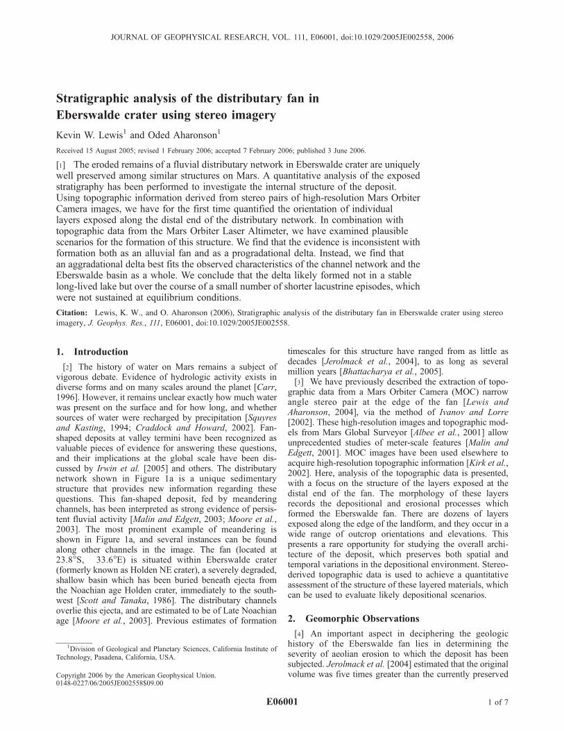
[2] The history of water on Mars remains a subject ofvigorous debate. Evidence of hydrologic activity exists indiverse forms and on many scales around the planet [Carr,1996]. However, it remains unclear exactly how much waterwas present on the surface and for how long, and whethersources of water were recharged by precipitation [Squyresand Kasting, 1994; Craddock and Howard, 2002]. Fan-shaped deposits at valley termini have been recognized asvaluable pieces of evidence for answering these questions,and their implications at the global scale have been dis-cussed by Irwin et al. [2005] and others. The distributarynetwork shown in Figure 1a is a unique sedimentarystructure that provides new information regarding thesequestions. This fan-shaped deposit, fed by meanderingchannels, has been interpreted as strong evidence of persis-tent fluvial activity [Malin and Edgett, 2003; Moore et al.,2003]. The most prominent example of meandering isshown in Figure 1a, and several instances can be foundalong other channels in the image. The fan (located at23.8�S, �33.6�E) is situated within Eberswalde crater(formerly known as Holden NE crater), a severely degraded,shallow basin which has been buried beneath ejecta fromthe Noachian age Holden crater, immediately to the south-west [Scott and Tanaka, 1986]. The distributary channelsoverlie this ejecta, and are estimated to be of Late Noachianage [Moore et al., 2003]. Previous estimates of formation
timescales for this structure have ranged from as little asdecades [Jerolmack et al., 2004], to as long as severalmillion years [Bhattacharya et al., 2005].[3] We have previously described the extraction of topo-
graphic data from a Mars Orbiter Camera (MOC) narrowangle stereo pair at the edge of the fan [Lewis andAharonson, 2004], via the method of Ivanov and Lorre[2002]. These high-resolution images and topographic mod-els from Mars Global Surveyor [Albee et al., 2001] allowunprecedented studies of meter-scale features [Malin andEdgett, 2001]. MOC images have been used elsewhere toacquire high-resolution topographic information [Kirk et al.,2002]. Here, analysis of the topographic data is presented,with a focus on the structure of the layers exposed at thedistal end of the fan. The morphology of these layersrecords the depositional and erosional processes whichformed the Eberswalde fan. There are dozens of layersexposed along the edge of the landform, and they occur in awide range of outcrop orientations and elevations. Thispresents a rare opportunity for studying the overall archi-tecture of the deposit, which preserves both spatial andtemporal variations in the depositional environment. Stereo-derived topographic data is used to achieve a quantitativeassessment of the structure of these layered materials, whichcan be used to evaluate likely depositional scenarios.
2. Geomorphic Observations
[4] An important aspect in deciphering the geologichistory of the Eberswalde fan lies in determining theseverity of aeolian erosion to which the deposit has beensubjected. Jerolmack et al. [2004] estimated that the originalvolume was five times greater than the currently preserved
JOURNAL OF GEOPHYSICAL RESEARCH, VOL. 111, E06001, doi:10.1029/2005JE002558, 2006
1Division of Geological and Planetary Sciences, California Institute ofTechnology, Pasadena, California, USA.
Copyright 2006 by the American Geophysical Union.0148-0227/06/2005JE002558$09.00
E06001 1 of 7
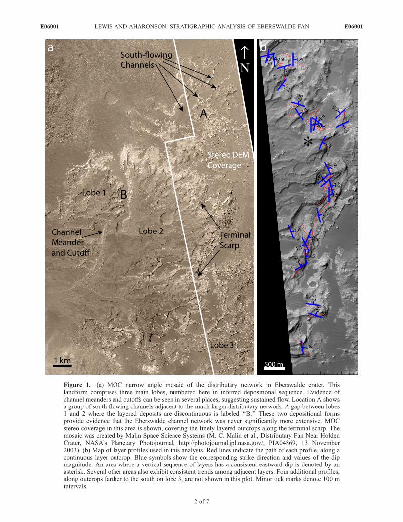
Figure 1. (a) MOC narrow angle mosaic of the distributary network in Eberswalde crater. Thislandform comprises three main lobes, numbered here in inferred depositional sequence. Evidence ofchannel meanders and cutoffs can be seen in several places, suggesting sustained flow. Location A showsa group of south flowing channels adjacent to the much larger distributary network. A gap between lobes1 and 2 where the layered deposits are discontinuous is labeled ‘‘B.’’ These two depositional formsprovide evidence that the Eberswalde channel network was never significantly more extensive. MOCstereo coverage in this area is shown, covering the finely layered outcrops along the terminal scarp. Themosaic was created by Malin Space Science Systems (M. C. Malin et al., Distributary Fan Near HoldenCrater, NASA’s Planetary Photojournal, http://photojournal.jpl.nasa.gov/, PIA04869, 13 November2003). (b) Map of layer profiles used in this analysis. Red lines indicate the path of each profile, along acontinuous layer outcrop. Blue symbols show the corresponding strike direction and values of the dipmagnitude. An area where a vertical sequence of layers has a consistent eastward dip is denoted by anasterisk. Several other areas also exhibit consistent trends among adjacent layers. Four additional profiles,along outcrops farther to the south on lobe 3, are not shown in this plot. Minor tick marks denote 100 mintervals.
E06001 LEWIS AND AHARONSON: STRATIGRAPHIC ANALYSIS OF EBERSWALDE FAN
2 of 7
E06001
remains. A greater volume is required if the sediment wasdeposited in an alluvial fan which followed a smooth profileto the crater floor. This scenario also requires a 35 kmerosional retreat of the distal end of the distributary system.Jerolmack et al. [2004] point to the scattered fluvialdeposits around the floor of Eberswalde in support of agreater original extent of an alluvial fan, although theyconcede the evidence does not definitively discriminatebetween alluvial and deltaic scenarios. However, many ofthese channels have elevations and flow directions incon-sistent with a direct relationship to the main distributarynetwork. The alternative hypothesis is that the depositrepresents the remains of a delta that built into a lake whichpartially filled Eberswalde crater at some point in its history.The deltaic scenario requires far less aeolian erosion be-cause of the fact that the subaqueous margin of a delta canbe much steeper than the profile required for a purelysubaerial alluvial fan. In this case, the current scarp at theedge of the Eberswalde structure would be more represen-tative of the original distal limit of the fluvial channels, asopposed to a purely erosional feature.[5] While we find no solid evidence of a much more
extensive alluvial fan, some observed features do suggestthe modern scarp is close to the original distal limit of thedeposit, favoring formation as a delta. In several places pastthe current margins of the distributary channels, otherfluvial deposits are situated within the distance expectedfor a purely subaerial alluvial surface. In one instance,deposits associated with fluvial channels to the northeastof the fan lie as little as 1.5 km away (location A inFigure 1a). Using the MOC stereo topographic data de-scribed in detail below, it is clear that these channels flowedto the south, originating from a distinct source on thenorthern wall of the crater. There are several plausiblescenarios which could produce the observed relationshipsbetween these channels and the larger, northeast flowingdistributary network. To simplify this problem, we assumethat all of the fluvial deposits were emplaced beforesignificant aeolian erosion had occurred. Given this con-straint, there are two possibilities for the order of depositionof the distributary system and the smaller south flowingchannels nearby. If these channels were deposited after, orconcurrent with the larger distributary network, they place afirm constraint on its original extent. If the south flowingchannels were instead deposited first, the constraint is moreambiguous. However, a differential erosional mechanismwould need to be invoked whereby several tens of meters ofsediment from the large distributary network was strippedaway, while these more delicate channels beneath (of order10 m high and 30 m wide in some cases) remained wellpreserved. Such differential resistance to erosion wouldrequire a significant difference in cohesiveness or grainsize, for example, though there is no independent evidencefor such a difference here.[6] As a second key relationship, the two largest lobes of
the fan are separated by only hundreds of meters in places(location B in Figure 1a). Thus, using the labels in Figure 1a,the potential extent of channels in lobe 1 is limited by laterchannels in lobe 2. The distance between the lobes,however, is too great for this truncation to have been causedby fluvial erosion of lobe 1 by lobe 2 channels. Thisexample is particularly difficult to explain by simple head-
ward retreat of an alluvial deposit, as erosion here would benear the center of the currently preserved structure. Instead,the current limit of the channels in lobe 1 is likelyrepresentative of their original termini.[7] The two examples described here outline a scenario of
fairly limited aeolian erosion within Eberswalde. Fromthese observations, we suggest that the 10�–15� distal slopeof the fan, as measured from stereo data, is not primarily anerosional feature, but is instead a remnant of the originaldepositional form. Modest postfluvial erosional retreat ofthe scarp is possible, but is limited by this argument to be<1 km or so in lateral extent.
3. Stereo Topography
3.1. Methodology
[8] For this study we have used high-resolution MOCnarrow-angle images from the MGS spacecraft. Theseimages have a maximum resolution of around 1.5 m/pixeland are typically 3 km wide. MOC has taken images of theMartian surface both in nadir and in various off-nadirorientations. Where coverage exists from multiple viewingangles, high-resolution stereogrammetry is possible.[9] Stereo images are processed according to the tech-
nique developed by Ivanov and Lorre [2002] and Ivanov[2003]. To begin, radiometric calibration of the images isperformed using the Integrated Software for Imagers andSpectrometers (ISIS) software package. Calibrated imagesare then rectified using VICAR tools and the MGS telem-etry data and then adjusted manually to bring them into amore precise alignment. When the stereo pair has beenproperly aligned, an automatic correlator is used to locate tiepoints between the two images. Tie points are typicallycollected in a 2-pixel grid, and hundreds of thousands aregenerally collected for a given pair of MOC images.VICAR routines are again used to extract elevation datafrom the tie points.[10] Once the elevation data has been collected, Digital
Elevation Models are created by regridding, interpolating,and projecting the elevation data. The final DEMs aregridded at a resolution of 6 m/pixel in the horizontaldirection. In the vertical direction, accuracy of the data isapproximately 1–2 m. The DEMs in the Eberswalde regionthat have been used in this study include a component of thejitter reported by Ivanov and Lorre [2002] and Kirk et al.[2002]. This was removed by separating the parallax be-tween the images into its along-track and cross-track com-ponents. The vibration onboard MGS is evidently limited tothe along-track direction, so that any parallax in the cross-track direction is free from jitter. A comparison shows long-wavelength tilts in this area derived from the MOC stereoDEM differ from MOLA topographic measurements by lessthan 0.1�. This estimate represents an upper limit; thedifference is difficult to constrain further because of thesparse distribution of MOLA points. As any discrepanciesof this nature would be small compared to the topographicslopes being studied, the stereo DEM was not adjusted toconform to the MOLA data set.
3.2. Observations
[11] Two stereo pairs were used for our study, of imagesE14-01039/E23-00003 and E14-01039/E22-01159. The
E06001 LEWIS AND AHARONSON: STRATIGRAPHIC ANALYSIS OF EBERSWALDE FAN
3 of 7
E06001
area for which stereo coverage is available is shown inFigure 1a. The DEMs produced in this area have goodcoverage over most of the original images. The automaticcorrelator fails to find matches in some particularly smoothor shadowed regions, but this is uncommon in areas withhigh-contrast features, including the layered outcrops.[12] The stereo-derived DEMs were used in conjunction
with MOC imagery to extract elevation segments along theedges of exposed layers. Dozens of individual segmentswere selected manually, each ranging from a few hundredmeters to over 1 km in length. Data was only taken where alayer outcrop was clearly continuous; no attempts weremade to connect or extend layers where they becomeindistinct in the images. Efforts were made to choose layerexposures with some natural curvature in the horizontaldirection, to provide more accurate constraints on the three-dimensional geometry of the layer. This was done inrecognition of the fact that a linear segment provides noinformation in the direction perpendicular to the line.Otherwise, segments were taken from a variety of areaswithin the DEM. For our analysis, we used 40 such seg-ments along the margin of the layered deposits.[13] Since each segment extracted here is much smaller
than the overall extent of the fan, it is assumed that thelayers should be very close to planar on this scale. Toevaluate this hypothesis, and to gain a quantitative measureof the attitude of the layers, a plane was fit to each profileusing linear regression. From the derived coefficients, thedip direction and slope are computed, along with theircorresponding error estimates, on the basis of the confi-dence intervals. While a more mathematically precise erroranalysis can be derived than the one used here (R. Phillips,personal communication, 2005), our method is sufficient fordiscriminating poor fits. Segments for which thecorresponding dip azimuth had an error of more than 30�,or for which the slope had an error of more than 1� wereeliminated from further analyses. 80% of our sample waswithin these limits, while the remaining 20% fell outside of
at least one of the constraints. The wide error bounds forsome profiles can be traced mostly to noise in the DEM, orto a lack of significant curvature in the segment, whichproduces a poorly constrained fit. However, the largemajority of continuous layer outcrops in the fan are wellapproximated by a plane. Those that are constrained by thefits according to the criteria above are shown in Figure 1b.[14] The layered nature of this formation permits analysis
of both vertical and lateral trends in addition to measure-ments of the structure as a whole. The mean gradient of allof the measured layers which could be well fit is 2.1�.Figure 2 shows a histogram of the observed slopes. The dipangles measured are consistently shallow, and have astandard deviation of 1.1�. The average dip direction isroughly eastward, parallel to the channel direction in thispart of the fan, though there is wide variation within the dataset as indicated by the strike-dip marks in Figure 1b. Onetrend among the sampled layers is that in many cases thelayers have a component of dip in the direction perpendic-ular to the surrounding channels, in addition to the expecteddown-channel slope. Several of the layers exhibit this trendover hundreds of meters. No signs of postdepositionaldeformation are obvious from MOC imagery, indicatingthe cross-channel slopes are original depositional attributes.The reason for these strike directions is unclear. Howeversuch an attribute is consistent with the complex architectureassociated with deltaic deposition, where erosional surfaces,levees and overbank deposits can all lead to nonparallelstrata [Reading, 1996; Prothero and Schwab, 2004]. Asecond important trend is lateral and vertical consistencyof the measured dips. One notable occurrence of this trendis marked with an asterisk in Figure 1b. Several layers hereexhibit comparable eastward dips, at different outcrops andat varying levels in the stratigraphic sequence. This mayindicate long-standing flow patterns here and in other out-crops where this trend is found. Regions where strikes anddips are more widely scattered may record a more dynamicdepositional history.
4. Basin Analysis
[15] While stereo-derived topographic data is availableover a restricted area, Mars Orbiter Laser Altimeter(MOLA) data provides a far more extensive, though coarsercoverage of the entire basin into which the fluvial networkonce drained. Here, the 128 pixel per degree (ppd) MOLAgridded elevation data is utilized to examine the broadertopography of Eberswalde crater [Smith et al., 2001]. It hasbeen hypothesized that the fluvial deposits in Eberswaldehave undergone significant burial and exhumation, account-ing for the relative lack of cratering on presently exposedsurfaces [Malin and Edgett, 2003; Moore et al., 2003]. Thisscenario could imply a modern basin surface which issignificantly altered from that at the time of fluvial deposi-tion, complicating potential lake volume estimates and othercalculations. However, evidence for the exposure of theoriginal depositional surface is present in the form of fluvialchannels which are found in several places on the floor ofthe crater, as seen in MOC images R07-00821, R07-01352,E21-00076, and E23-00003. These deposits have beenmapped on the basis of available MOC imagery, and areshown in Figure 3. The presence of these widespread
Figure 2. Histogram of observed slopes, as determinedfrom MOC stereo topography. The mean dip of themeasured layers is 2.1�.
E06001 LEWIS AND AHARONSON: STRATIGRAPHIC ANALYSIS OF EBERSWALDE FAN
4 of 7
E06001
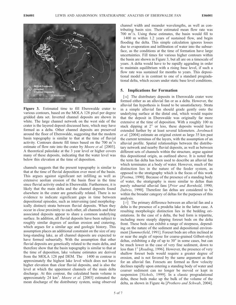
channels suggests that the present topography is similar tothat at the time of fluvial deposition over most of the basin.This argues against significant net infilling as well asextensive aeolian erosion of the basin floor in the timesince fluvial activity ended in Eberswalde. Furthermore, it islikely that the main delta and the channel deposits foundelsewhere in the crater are genetically related. There is noevidence to indicate significant gaps in time betweendepositional episodes, such as intervening (and morpholog-ically distinct) strata between fluvial deposits. When theyoccur in close proximity to each other, all channels and theirassociated deposits appear to share a common underlyingsurface. In addition, all fluvial deposits have been subject toroughly similar degrees of aeolian erosion and cratering,which argues for a similar age and geologic history. Thisassumption places an additional constraint on the size of anylong-standing lake, as all channel deposits are expected tohave formed subaerially. With the assumption that otherfluvial deposits are genetically related to the main delta, andtherefore show that the basin topography is similar to that atthe time of deposition, lake volume estimates are derivedfrom the MOLA 128 ppd DEM. The �1400 m contour isapproximately the highest lake level which does not havehigher elevation than clear fluvial deposits, and is also thelevel at which the uppermost channels of the main deltadischarge. At this contour, the calculated basin volume isapproximately 24 km3. Moore et al. [2003] estimated themean discharge of the distributary system, using observed
channel width and meander wavelengths, as well as con-tributing basin size. Their estimated mean flow rate was700 m3/s. Using these estimates, the basin would fill to�1400 m within 1.2 years of sustained flow, and beginflooding the delta. This simple calculation ignores lossesdue to evaporation and infiltration of water into the subsur-face, as the conditions at the time of formation have largeuncertainties. Fill times for various higher contours withinthe basin are shown in Figure 3, but all are on a timescale ofyears. A delta would have to be rapidly aggrading in orderto maintain equilibrium with a rising base level, if such aflow rate was sustained for months to years. This deposi-tional model is in contrast to one of a standard prograda-tional delta, which occurs under static base level conditions.
5. Implications for Formation
[16] The distributary deposits in Eberswalde crater wereformed either as an alluvial fan or as a delta. However, thealluvial fan hypothesis is found to be unsatisfactory. Stratain a simple alluvial fan should grade gently onto theunderlying surface at the distal end, which would requirethat the deposit in Eberswalde was originally far moreextensive at the time of deposition. With a roughly 100 mstack dipping at 2� or less, these deposits would haveextended further by at least several kilometers. Jerolmacket al. [2004] estimate an original extent as large 35 km pastthe current terminus of the layers, with the assumption of analluvial profile. Spatial relationships between the distribu-tary network and nearby fluvial deposits, as well as betweendifferent sets of channels within the structure, argue againstthis depositional origin, as outlined above. It is noted thatthe term fan delta has been used to describe an alluvial fanwhich terminates at a body of water. However, much of thedistinction lies in the nature of the feeder system, asopposed to the stratigraphy which is the focus of this work[Postma, 1990]. Because of the presence of a standing bodyof water, the stratigraphy is more similar to deltas thanpurely subaerial alluvial fans [Prior and Bornhold, 1990;Dabrio, 1990]. Therefore fan deltas are considered to bewithin the broader category of deltas for the purposes of thisanalysis.[17] The primary difference between an alluvial fan and a
delta is the presence of a prodelta lake in the latter case. Aresulting morphologic distinction lies in the bedding ori-entations. In the case of a delta, the bed form is tripartite,including more steeply dipping foreset beds on the deltafront. These beds can exhibit a range of steepness, depend-ing on the nature of the sediment and depositional environ-ment [Summerfield, 1991]. Foreset beds are often inclined ator near the angle of repose for coarse-grained Gilbert-styledeltas, exhibiting a dip of up to 30� in some cases, but canbe much lower in the case of very fine sediment, down toless than 1� [Reading, 1996]. However, the presence of veryshallow foreset beds would require a greater degree oferosion, and is not favored by the same argument as thatfor an alluvial fan. Foresets are formed as flow velocitydeclines rapidly upon entering a standing body of water andcoarser sediment can no longer be moved or kept insuspension [Nichols, 1999]. In a classic progradationaldelta, these beds make up the bulk of the volume of thedelta, as shown in Figure 4a [Prothero and Schwab, 2004].
Figure 3. Estimated time to fill Eberswalde crater tovarious contours, based on the MOLA 128 pixel per degreegridded data set. Inverted channel deposits are shown inwhite. The large channel network on the west side of thecrater is the layered deposit discussed here, which may haveformed as a delta. Other channel deposits are preservedaround the floor of Eberswalde, suggesting that the modernbasin topography is similar to that at the time of fluvialactivity. Contours denote fill times based on the 700 m3/sestimate of flow rate into the crater by Moore et al. [2003].A theoretical paleolake at the 3 year level or higher coversmany of these deposits, indicating that the water level wasbelow this elevation at the time of deposition.
E06001 LEWIS AND AHARONSON: STRATIGRAPHIC ANALYSIS OF EBERSWALDE FAN
5 of 7
E06001
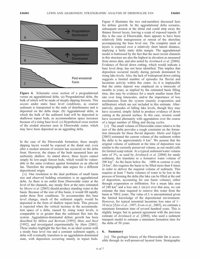
In the case of the Eberswalde formation, these steeplydipping layers would be exposed at the distal end, evenafter a modest amount of erosion has occurred on the deltafront. However, the slopes of the beds measured here areuniformly shallow. As stated above, these layers cannotsimply be low-angle foreset beds, which would be vulner-able to the same evidence against formation as an alluvialfan. Therefore the stratigraphic data argues for a differentdepositional origin.[18] One resolution to the dual problems of small basin
size and observed bedding orientation is an aggradationaldelta. As there is no outlet from Eberswalde crater at thelevel of the channels, any steady flow at the rates estimatedby Moore et al. [2003] should produce standing water in thebasin. Because of the size of this basin, it would fill rapidlyunder these flow conditions. To accommodate this baselevel change, much of the sediment supply would bedeposited in the form of shallow topset beds. This processis expected when the vertical increase in the accommoda-tion space of a delta, caused by rising water levels, iscomparable to or greater than the sediment flux into thesystem. Aggradation-dominated deltaic growth has beendescribed by Milton and Bertram [1995]; Muto and Steel[1992], and investigated experimentally by Muto [2001].These studies highlight the fact that, in an ideal system witha steady base level rise and a constant sediment supply, adelta will eventually transition to an aggradation-dominatedstate, with deposition occurring mainly in topset beds.
Figure 4 illustrates the two end-members discussed herefor deltaic growth. In the aggradational delta scenario,subsequent erosion at the distal end could strip away thethinner foreset layers, leaving a scarp of exposed topsets. Ifthis is the case at Eberswalde, there appears to have beenrelatively little transgression or retreat of the shorelineaccompanying the base level rise. The complete stack oflayers is exposed over a relatively short lateral distance,implying a fairly static delta margin. The aggradationalmodel is buttressed by the fact that the most recent channelsin this structure are also the highest in elevation as measuredfrom stereo data, and also noted by Jerolmack et al. [2004].Evidence of fluvial down cutting, which would indicate abase level drop, has not been identified. This implies thatdeposition occurred mostly during periods dominated byrising lake levels. Also, the lack of widespread down cuttingsuggests a limited number of episodes for fluvial andlacustrine activity within this crater. As it is implausiblethat the entire deposit was emplaced on a timescale ofmonths to years, as implied by the estimated basin fillingtime, this may be evidence for a much smaller mean flowrate over long timescales, and/or the importance of lossmechanisms from the system (mainly evaporation andinfiltration) which are not included in this estimate. Alter-natively, episodes of falling lake levels, though they mayhave occurred, simply failed to produce evidence of downcutting at the present surface. In this case, erosion couldhave occurred alternately with aggradation over the courseof a larger number of filling and drying cycles.[19] The small volume of Eberswalde crater relative to the
size of the delta provides a rough constraint on the forma-tion timescale for these fluvial deposits. Malin and Edgett[2003] estimated the current volume of the sediment withinthe delta to be approximately 6 km3. We assume that theoriginal volume of sediment at the time of deposition wassimilar to the currently preserved volume, as our model callsfor limited scarp retreat. At a typical sediment/water volumeratio of 3%, as used by Jerolmack et al. [2004] for sandysediment, this translates to a formative water volume of200 km3. As the basin below the �1400 m contour is only24 km3, this requires the basin to be filled more than 8 timesin order to deliver the required volume of sediment. Thisrequires at least 7 basin volumes of water to be lost in theprocess of forming the delta (the lake can be filled at the endof deposition, accounting for one basin volume), eitherthrough evaporation or infiltration. For a mean lake areaof 240 km2 and a loss rate L (m/yr) over that area, we canestimate the time required to remove this water from thebasin at 700/L years. The value of L is unconstrained giventhe limited knowledge of the depositional environment.However, for typical terrestrial lacustrine loss rates of 1–10 m/yr [Tyler et al., 1997; Irwin et al., 2005], we estimate aminimum formation time of several hundred years. This isslightly longer, but in general agreement with the previousestimate of Jerolmack et al. [2004], who used a sedimenttransport model to estimate a minimum formation time forthe delta of 50 years.
6. Summary
[20] The geologic history of the Eberswalde fan is acces-sible through its well-preserved layered form. Stratigraphic
Figure 4. Schematic cross section of a progradationalversus an aggradational delta. (a) Progradational delta, thebulk of which will be made of steeply dipping foresets. Thisoccurs under static base level conditions, as coarsersediment is transported to the ends of distributaries and isdeposited on the delta slope. (b) Aggradational delta, inwhich the bulk of the sediment load will be deposited inshallower topset beds, as accommodation space increasesbecause of a rising base level. (c) Hypothetical cross sectionof the eroded structure seen in Eberswalde crater, whichmay have been deposited as an aggrading delta.
E06001 LEWIS AND AHARONSON: STRATIGRAPHIC ANALYSIS OF EBERSWALDE FAN
6 of 7
E06001
studies of depositional structures on Mars such as this oneare finally possible with high-resolution stereo imagery.Stereo-derived topographic data was used to examine thestructure of individual layers which outcrop at the distal endof the deposit. This analysis revealed that the exposed layershave uniformly shallow slopes, and are not consistent withthe steep foreset beds found in many terrestrial coarse-grained deltas. Volume calculations of Eberswalde craterrevealed that the basin should fill to the level of thepreserved channels in roughly one year under estimatedflow rates. These observations and others presented herehave shown the inconsistencies associated with both analluvial fan and a prograding delta for the origin of theEberswalde deposit. A potential solution to the observedcharacteristics has been proposed, in the form of a rapidlyaggrading delta. In this scenario, the exposed layers weredeposited as deltaic topset beds, as the lake level in thiscrater rose over a timescale of years. Modest erosionalretreat of the delta front by subsequent aeolian activitywould have erased the volumetrically smaller foresets. Thisscenario implies the Eberswalde deposits formed not in asustained long-lived lake, but more likely within a smallnumber of shorter lacustrine episodes marked by a con-stantly rising base level, which were never able to reachequilibrium conditions.
[21] Acknowledgments. We thank John Grotzinger and Kerry Siehfor illuminating discussions and Anton Ivanov for sharing software hedeveloped. This work was supported by NASA’s Mars Data AnalysisProgram grants NAG5-13326 and NAG5-13232.
ReferencesAlbee, A. L., R. E. Arvidson, F. Palluconi, and T. Thorpe (2001), Overviewof the Mars Global Surveyor mission, J. Geophys. Res., 106(E10),23,291–23,316.
Bhattacharya, J. P., T. H. D. Payenberg, S. C. Lang, and M. Bourke (2005),Dynamic river channels suggest a long-lived Noachian crater lake onMars, Geophys. Res. Lett., 32, L10201, doi:10.1029/2005GL022747.
Carr, M. H. (1996), Water on Mars, 229 pp., Oxford Univ. Press, NewYork.
Craddock, R. A., and A. D. Howard (2002), The case for rainfall on awarm, wet early Mars, J. Geophys. Res., 107(E11), 5111, doi:10.1029/2001JE001505.
Dabrio, C. J. (1990), Fan-delta facies associations in late Neogene andQuaternary basins of southeastern Spain, in Coarse-Grained Deltas, edi-ted by A. Colella and D. B. Prior, pp. 91–111, Blackwell Sci., Malden,Mass.
Irwin, R. P., III, A. D. Howard, R. A. Craddock, and J. M. Moore (2005),An intense terminal epoch of widespread fluvial activity on early Mars: 2.Increased runoff and paleolake development, J. Geophys. Res., 110,E12S15, doi:10.1029/2005JE002460.
Ivanov, A. B. (2003), Ten-meter scale topography and roughness of MarsExploration Rover landing sites and Martian polar regions, Lunar Planet.Sci., XXXIV, abstract 2084.
Ivanov, A., and J. Lorre (2002), Analysis of Mars Orbiter Camera stereo-pairs, Lunar Planet. Sci., XXXIII, abstract 1845.
Jerolmack, D. J., D. Mohrig, M. T. Zuber, and S. Byrne (2004), A minimumtime for the formation of Holden Northeast fan, Mars, Geophys. Res.Lett., 31, L21701, doi:10.1029/2004GL021326.
Kirk, R. L., L. A. Soderblom, E. Howington-Kraus, and B. A. Archinal(2002), USGS High-resolution topomapping of Mars with Mars OrbiterCamera narrow-angle images, in Geospatial Theory: Processing andApplications [CD-ROM], Int. Arch. Photogramm. Remote Sens., 34(4),article 200.
Lewis, K., and O. Aharonson (2004), Characterization of the distributaryfan in Holden NE crater using stereo analysis, Lunar Planet. Sci., XXXV,abstract 2083.
Malin, M. C., and K. S. Edgett (2001), Mars Global Surveyor Mars OrbiterCamera: Interplanetary cruise through primary mission, J. Geophys. Res.,106(E10), 23,429–23,570.
Malin, M. C., and K. S. Edgett (2003), Evidence for persistent flow andaqueous sedimentation on early Mars, Science, 302, 1931–1934.
Milton, N. J., and G. T. Bertram (1995), Topset play types and their con-trols, in Sequence Stratigraphy of Foreland Basin Deposits, edited byJ. C. Van Wagoner and G. T. Bertram, pp. 1–9, Am. Assoc. of Pet. Geol.,Tulsa, Okla.
Moore, J. M., A. D. Howard, W. E. Dietrich, and P. M. Schenk (2003),Martian layered fluvial deposits: Implications for Noachian climatescenarios, Geophys. Res. Lett., 30(24), 2292, doi:10.1029/2003GL019002.
Muto, T. (2001), Shoreline autoretreat substantiated in flume experiments,J. Sediment. Res., 71, 246–254.
Muto, T., and R. J. Steel (1992), Retreat of the front in a prograding delta,Geology, 20, 967–970.
Nichols, G. (1999), Sedimentology and Stratigraphy, Blackwell Sci., Mal-den, Mass.
Postma, G. (1990), Depositional architecture and facies of river and fandeltas: A synthesis, in Coarse-Grained Deltas, edited by A. Colella andD. B. Prior, pp. 13–28, Blackwell Sci., Malden, Mass.
Prior, D. B., and B. D. Bornhold (1990), The underwater development ofHolocene fan deltas, in Coarse-Grained Deltas, edited by A. Colella andD. B. Prior, pp. 75–90, Blackwell Sci., Malden, Mass.
Prothero, D. R., and F. Schwab (2004), Sedimentary Geology, W. H.Freeman, New York.
Reading, H. G. (Ed.) (1996), Sedimentary Environments: Processes, Fa-cies, and Stratigraphy, Blackwell Sci., Malden, Mass.
Scott, D. H., and K. L. Tanaka (1986), Geologic map of the western equa-torial region of Mars, U.S. Geol. Surv. Misc. Invest. Map I-1802-A, scale1:15,000,000.
Smith, D. E., et al. (2001), Mars Orbiter Laser Altimeter: Experimentsummary after the first year of global mapping of Mars, J. Geophys.Res., 106(E10), 23,689–23,722.
Squyres, S. W., and J. F. Kasting (1994), Early Mars: How warm and howwet?, Science, 265, 744–749.
Summerfield, M. (1991), Global Geomorphology, Longman, NewYork.
Tyler, S. W., S. Kranz, M. B. Parlange, J. Albertson, G. G. Katul, G. F.Cochran, B. A. Lyles, and G. Holder (1997), Estimation of groundwaterevaporation and salt flux from Owens Lake, California, USA, J. Hydrol.,200, 110–135.
�����������������������O. Aharonson and K. W. Lewis, Division of Geological and Planetary
Sciences, California Institute of Technology, MC 150-21, Pasadena, CA91125, USA. ([email protected])
E06001 LEWIS AND AHARONSON: STRATIGRAPHIC ANALYSIS OF EBERSWALDE FAN
7 of 7
E06001