stratigraphic analysis of lake level fluctuations in lake …. lindhorst et al.: stratigraphic...
TRANSCRIPT

Biogeosciences, 7, 3531–3548, 2010www.biogeosciences.net/7/3531/2010/doi:10.5194/bg-7-3531-2010© Author(s) 2010. CC Attribution 3.0 License.
Biogeosciences
Stratigraphic analysis of lake level fluctuations in Lake Ohrid: anintegration of high resolution hydro-acoustic data and sedimentcores
K. Lindhorst 1, H. Vogel2, S. Krastel1, B. Wagner2, A. Hilgers3, A. Zander3, T. Schwenk4, M. Wessels5, and G. Daut6
1Leibniz-Institute for Marine Sciences, IFM-GEOMAR, Cluster of Excellence: The Future Ocean,Christian-Albrecht-University, Kiel, Germany2Institute for Geology and Mineralogy, University of Cologne, Cologne, Germany3Institute of Geography, University of Cologne, Cologne, Germany4Department of Geosciences at University of Bremen, Bremen, Germany5Institute for Lake Research, LUBW, Langenargen, Germany6Institute for Geography, Friedrich Schiller University, Jena, Germany
Received: 3 May 2010 – Published in Biogeosciences Discuss.: 20 May 2010Revised: 21 October 2010 – Accepted: 3 November 2010 – Published: 10 November 2010
Abstract. Ancient Lake Ohrid is a steep-sided, oligotrophic,karst lake that was tectonically formed most likely within thePliocene and often referred to as a hotspot of endemic biodi-versity. This study aims on tracing significant lake level fluc-tuations at Lake Ohrid using high-resolution acoustic datain combination with lithological, geochemical, and chrono-logical information from two sediment cores recovered fromsub-aquatic terrace levels at ca. 32 and 60 m water depth. Ac-cording to our data, significant lake level fluctuations withprominent lowstands of ca. 60 and 35 m below the presentwater level occurred during Marine Isotope Stage (MIS) 6and MIS 5, respectively. The effect of these lowstands onbiodiversity in most coastal parts of the lake is negligible,due to only small changes in lake surface area, coastline,and habitat. In contrast, biodiversity in shallower areas wasmore severely affected due to disconnection of today sub-lacustrine springs from the main water body. Multichannelseismic data from deeper parts of the lake clearly image sev-eral clinoform structures stacked on top of each other. Thesestacked clinoforms indicate significantly lower lake levelsprior to MIS 6 and a stepwise rise of water level with in-termittent stillstands since its existence as water-filled body,which might have caused enhanced expansion of endemicspecies within Lake Ohrid.
Correspondence to:K. Lindhorst([email protected])
1 Introduction
Within the terrestrial realm, ancient lakes are valuablearchives providing crucial information on past climate, en-vironmental conditions, and speciation among endemic taxa.With its inferred existence since the Pliocene, its location inthe northern Mediterranean borderland and its high degreeof endemic diversity (Stankovic, 1960; Albrecht and Wilke,2008), Lake Ohrid (Fig. 1) provides a unique site to study cli-matic and environmental changes over long time scales andtheir possible links to evolutionary patterns.
As documented by numerous paleoclimate studies, theMediterranean region has experienced large scale climatefluctuations over the last glacial-interglacial cycle (Allen etal., 1999, 2002; Bar-Matthews et al., 1999, 2000; Tzedakiset al., 2003; Martrat et al., 2004; Drysdale et al., 2005;Zanchetta et al., 2008; Vogel et al., 2010a). While infor-mation on past temperature variability at relatively high spa-tial resolution has become available during the past decade(Peyron et al., 1998; Allen et al., 1999; Martrat et al., 2004;Hayes et al., 2005; Marino et al., 2009), information on hy-drological changes in the northern Mediterranean borderlandis relatively sparse over long time scales (Tzedakis et al.,2003; Bordon et al., 2009). In order to gain a better un-derstanding of the variability of hydrologic changes in thisclimate-sensitive region, additional spatially distributed pa-leoclimate records must be investigated. Ancient Lake Ohridcan provide such a record in the northern Mediterraneanborderland with its sensitivity to recent and past climaticand environmental changes (Matzinger et al., 2006, 2007;
Published by Copernicus Publications on behalf of the European Geosciences Union.

3532 K. Lindhorst et al.: Stratigraphic analysis of lake level fluctuations in Lake Ohrid
33
1
Fig. 1. Map of southern Europe with Lake Ohrid and its sister Lake Prespa located on the 2
Balkan Peninsula. 3
4
Fig. 1. Map of southern Europe with Lake Ohrid and its sister LakePrespa located on the Balkan Peninsula.
Wagner et al., 2009; Vogel et al., 2010a). This promisinglocation, however, has never been the subject of a quanti-tative study reconstructing past changes in hydrology. Thedetection and dating of subaquatic and subaerial terraces isa robust approach to infer past variations in the hydrologicalbudget of an individual lake (Magny et al., 2009; Moernautet al., 2010).
Among different possible climate-related factors affectinglacustrine ecosystems, changes of the water budget and asso-ciated lake level fluctuations have been identified as one im-portant mechanism influencing biodiversity (Johnson et al.,1996; Sturmbauer et al., 2001; Genner et al., 2010). Thisis because lake level fluctuations are commonly accompa-nied with changes of the lake chemistry, surface area, coast-line, and habitat distribution and thus directly affect speciesliving in the lake (Martens, 1997). Many studies have in-vestigated lake level fluctuations with special focus on cli-mate change (Scholz and Rosendahl, 1988; D’Agostino etal., 2002; Anselmetti et al., 2006, 2009; Daut et al., 2010;Moernaut et al., 2010). In this study we try to minimizeuncertainties in magnitude and timing of lake level changesby combining acoustic and sedimentological data in order tolink it to biodiversity and speciation in Lake Ohrid.
Seismo-acoustic data provide images of continuous sub-surfaces illustrating stacking trends, strata terminations, andgeomorphology (Catuneanu et al., 2009). Depositional se-quences can be subdivided into smaller stratigraphic units,termed system tracts, indicating their depositional regimeduring specific intervals of relative lake level changes (Posa-mentier et al., 1992; Hunt and Tucker, 1992; Allen and Allen,
2005). Shoreline trajectory describes the cross-sectional pathof the shoreline as it migrates due to a change in lake level(Helland-Hansen and Martinsen, 1996). Three main fac-tors determine the direction of the migration of the shore-line. These are the rate of relative lake level change, sedi-ment supply, and basin physiography (Helland-Hansen andMartinsen, 1996). On a flat shelf area sediment is bypassedand falling relative lake level may cause the deposition ofa set of down stepping prograding wedges in a forced re-gression system tract (FRST, Hunt and Tucker, 1992; Allenand Allen, 2005). Following a rise in lake level a HighstandSystem Tract (HST) with clinoform geometries evolves thatonlaps onto the underlying sequence boundary in a landwarddirection (Allen and Allen, 2005). Clinoforms composed oftopset, foreset and bottomset reflections are the fundamentalbuilding blocks of sedimentary basins (Gilbert, 1890; Pirmezet al., 1998).
While the magnitude of lake level change can be in-ferred relatively easily from the shoreline trajectory, datingof one particular stillstand is a rather difficult task. Ra-diocarbon dating of organic macrofossils is one tool, whichcan provide age control for the past∼40 kyrs. Beyond thattime, dating of lacustrine sediments requires other techniqueswith generally higher uncertainties. Positioned downwind ofmost of the Italian volcanoes active during the Quaternary,Lake Ohrid contains a sediment record that is an excellentarchive of volcanic ash (Wagner et al., 2008a, b; Vogel etal., 2010b; Sulpizio et al., 2010). Since these tephra layerscan be identified and, most importantly, correlated based ontheir chemical and morphological characteristics to eruptionswith known ages, they serve as important stratigraphic andchronological markers. Other techniques such as lumines-cence and electron spin resonance (ESR) dating extend thedatable range of the lake terrace levels.
The main objectives of this study are to describe and quan-tify lake level changes within ancient Lake Ohrid that havebeen identified in seismic data up to a penetration depth of0.7 s Two Way Travel Time (TWT). We investigated patternsof lake level fluctuations by combining hydro-acoustic datawith sedimentological and chronological data from lake sed-iment records. Specific objectives are: (i) to analyze whetherlake level changes have occurred quickly, (ii) to date peri-ods with constant lake levels in the past, (iii) to reconstructancient coastlines, (iv) to investigate the paleoenvironmentalevolution of Ohrid Bay since the penultimate glacial period(MIS 6), and (v) to evaluate whether changes of the lake sur-face area and volume can be linked to changes in biodiversitywithin ancient Lake Ohrid.
2 Setting
Lake Ohrid (41◦01′ N, 20◦43′ E; Fig. 1) is located in a tec-tonically active graben system of the Western Macedoniangeotectonic zone (Aliaj et al., 2001) at an altitude of 693 m
Biogeosciences, 7, 3531–3548, 2010 www.biogeosciences.net/7/3531/2010/
K. Lindhorst et al.: Stratigraphic analysis of lake level fluctuations in Lake Ohrid 3533
34
1
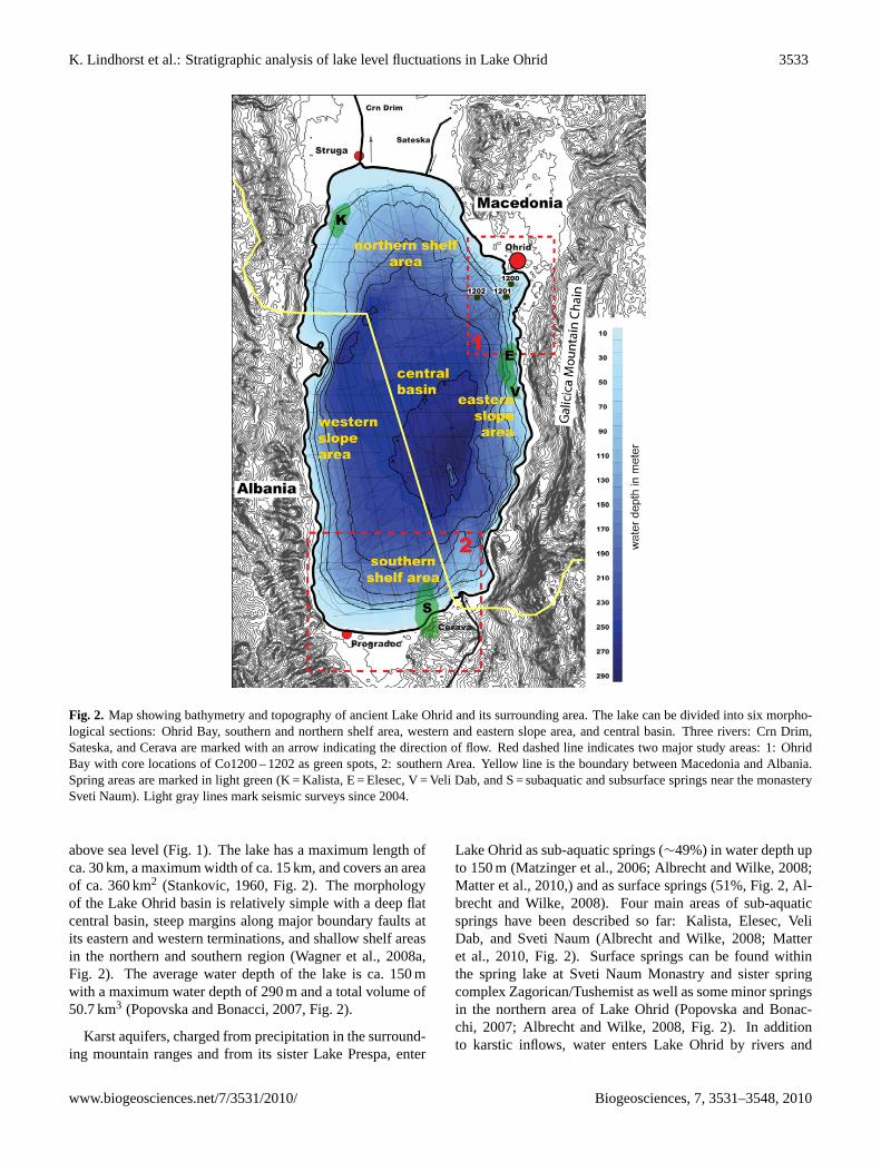
Fig. 2. Map showing bathymetry and topography of ancient Lake Ohrid and its surrounding 2
area. The lake can be divided into six morphological sections: Ohrid Bay, southern and 3
northern shelf area, western and eastern slope area, and central basin. Three rivers: Crn Drim, 4
Sateska, and Cerava are marked with an arrow indicating the direction of flow. Red dashed 5
line indicates two major study areas: 1: Ohrid Bay with core locations of CO1200 - 1202 as 6
green spots, 2: southern Area. Yellow line is the boundary between Macedonia and Albania. 7
Spring areas are marked in light green (K= Kalista, E= Elesec, V= Veli Dab, and S= 8
subaquatic and subsurface springs near the monastery Sveti Naum). Light gray lines mark 9
seismic surveys since 2004. 10
Fig. 2. Map showing bathymetry and topography of ancient Lake Ohrid and its surrounding area. The lake can be divided into six morpho-logical sections: Ohrid Bay, southern and northern shelf area, western and eastern slope area, and central basin. Three rivers: Crn Drim,Sateska, and Cerava are marked with an arrow indicating the direction of flow. Red dashed line indicates two major study areas: 1: OhridBay with core locations of Co1200 – 1202 as green spots, 2: southern Area. Yellow line is the boundary between Macedonia and Albania.Spring areas are marked in light green (K = Kalista, E = Elesec, V = Veli Dab, and S = subaquatic and subsurface springs near the monasterySveti Naum). Light gray lines mark seismic surveys since 2004.
above sea level (Fig. 1). The lake has a maximum length ofca. 30 km, a maximum width of ca. 15 km, and covers an areaof ca. 360 km2 (Stankovic, 1960, Fig. 2). The morphologyof the Lake Ohrid basin is relatively simple with a deep flatcentral basin, steep margins along major boundary faults atits eastern and western terminations, and shallow shelf areasin the northern and southern region (Wagner et al., 2008a,Fig. 2). The average water depth of the lake is ca. 150 mwith a maximum water depth of 290 m and a total volume of50.7 km3 (Popovska and Bonacci, 2007, Fig. 2).
Karst aquifers, charged from precipitation in the surround-ing mountain ranges and from its sister Lake Prespa, enter
Lake Ohrid as sub-aquatic springs (∼49%) in water depth upto 150 m (Matzinger et al., 2006; Albrecht and Wilke, 2008;Matter et al., 2010,) and as surface springs (51%, Fig. 2, Al-brecht and Wilke, 2008). Four main areas of sub-aquaticsprings have been described so far: Kalista, Elesec, VeliDab, and Sveti Naum (Albrecht and Wilke, 2008; Matteret al., 2010, Fig. 2). Surface springs can be found withinthe spring lake at Sveti Naum Monastry and sister springcomplex Zagorican/Tushemist as well as some minor springsin the northern area of Lake Ohrid (Popovska and Bonac-chi, 2007; Albrecht and Wilke, 2008, Fig. 2). In additionto karstic inflows, water enters Lake Ohrid by rivers and
www.biogeosciences.net/7/3531/2010/ Biogeosciences, 7, 3531–3548, 2010

3534 K. Lindhorst et al.: Stratigraphic analysis of lake level fluctuations in Lake Ohrid
35
1
Fig. 3. Bathymetric map of Ohrid Bay (left) with major morphological features such as upper 2
and lower terrace, deep central basin, three morphological steps (1, 2, 3 at water depth 15 m, 3
35 m, and 60 m, respectively). Locations of sediment cores (Co1200, Co1201) are marked as 4
white dots. Sidescan sonar mosaic (right) images the upper portion of Ohrid Bay. Bright 5
colors are areas of high backscatter. The outline of the sidescan sonar mosaic is shown as 6
dashed line on the bathymetry. Note the different scales for each map. See Fig. 2 for location. 7
8
Fig. 3. Bathymetric map of Ohrid Bay (left) with major morphological features such as upper and lower terrace, deep central basin, threemorphological steps (1, 2, 3 at water depth 15 m, 35 m, and 60 m, respectively). Locations of sediment cores (Co1200, Co1201) are markedas white dots. Sidescan sonar mosaic (right) images the upper portion of Ohrid Bay. Bright colors are areas of high backscatter. The outlineof the sidescan sonar mosaic is shown as dashed line on the bathymetry. Note the different scales for each map. See Fig. 2 for location.
direct precipitation (Matzinger et al., 2006). At present, theSateska and Cerava Rivers are the main riverine inflows toLake Ohrid. Water leaves Lake Ohrid through the River CrnDrim (∼60%) and by evaporation (∼40%, Matzinger et al.,2006, Fig. 2). No significant riverine inlets are found in closeproximity to Ohrid Bay.
3 Methods
3.1 Hydro-acoustics
The first hydro-acoustic data were acquired in spring 2004 bymeans of a parametric sediment echosounder (Wagner et al.,2008a). In September 2007 and June 2008 we carried out twomultichannel seismic surveys using a small airgun (0.25 l and0.1 l) and a 100 m-long 16-channel streamer. The process-ing procedure included trace editing, set-up geometry, staticcorrections, velocity analysis, normal move-out corrections,band-pass frequency filtering (frequency content: 35/60–600/900 Hz), stack, and time migration. We applied a com-mon midpoint spacing of 5 m throughout. During both mul-tichannel surveys a parametric sediment echosounder witha main frequency of 10 kHz was operated simultaneously.
Stacking of two adjacent pings improved the signal-to-noiseratio. We calculated water depth and penetration from theechosounder using a constant velocity of 1470 ms−1. Adense net of sediment echosounder lines with a spacing ofless than 500 m (in Ohrid Bay even less than 100 m) is nowavailable for Lake Ohrid (Fig. 2).
Sidescan sonar data were acquired in 2008 using a Klein3000 dual frequency sonar with 100 kHz and 500 kHz. TheOhrid Bay area was mapped between 3 and about 100 m wa-ter depth. The sonar was usually adjusted to cover 75–100 mon either side with individual profiles spaced 75–100 m apart.In this way, complete coverage of the working area wasachieved.
In September/October 2009, we collected high-resolutionbathymetric data by means of ELAC Seabeam 1180 system.The system uses 126 beams with a total opening angle of153◦ and operates with a frequency of 180 kHz. The trans-ducers were mounted at the bow of the vessel. Vessel motionwas measured using an OCTANS IV motion sensor that pro-vides roll, pitch, and heave correction. We collected soundvelocity profiles at different locations across Lake Ohrid.Processing of the data was mainly done by means of thesoftware package MBSystem (Caress and Chayes, 2005) and
Biogeosciences, 7, 3531–3548, 2010 www.biogeosciences.net/7/3531/2010/

K. Lindhorst et al.: Stratigraphic analysis of lake level fluctuations in Lake Ohrid 3535
Table 1. Radiocarbon ages and calendar ages inferred using CalPal-2007online (Danzeglocke et al., 2008) of plant macrofossils from coresCo1200 and Co1201.
Sample ID Core ID Depth(cm) 14C age (yrs BP) Calendar age (cal yrs BP)
KIA37138 Co1200 6 1954 AD 1954 ADKIA37139 Co1200 13 21 610± 185 25 815± 522KIA37140 Co1201 15 5010± 35 5773± 82KIA37141 Co1201 18 15 810± 155 19 030± 244
Table 2. Dating results and radioactivity data. Ages from core Co1201 were derived by IRSL dating, sample K-5764 from core Co1200 wasESR1 dated.
Lab.Code
Sample ID Water content(weight-%)2
Burialdepth(m)
U (ppm)3 Th (ppm) K (%) De(Gy)
D0(Gyka−1)
Age(ka)
IRSL-AgeFading cor-rected(ka)
C-L2573 Co1201-5 I(340-377 cm)
30.3± 4.5 17.75 4.11± 0.14 15.75± 0.72 2.45± 0.05 479.6± 33.0 4.0± 0.2 119± 10 157± 21
C-L2574 Co1201-5 I(377-408 cm)
29.9± 4.5 17.95 4.19± 0.14 16.00± 0.74 2.47± 0.05 558.0± 31.8 4.1± 0.3 137± 127 181± 24
C-L2575 Co1201-5 III(503-550 cm)
29.2± 4.4 19.50 3.76± 0.13 14.86± 0.68 2.45± 0.05 372.3± 24.6 4.0± 0.2 93.4± 8.1 123± 16
C-L2576 Co1201-5 III(550-597 cm)
30.9± 4.6 20.00 4.04± 0.14 15.67± 0.72 2.50± 0.05 438.1± 40.2 4.0± 0.3 109± 12 143± 21
K-5764 Co1200-6 III(230-262 cm)
35–50 0.41± 0.04 0.33± 0.03 0.06± 0.01 16.40± 1.23 130± 28
1 The dose rates and ESR-ages were calculated for different water contents and different thicknesses of an overlying sediment unit and water column, as the depositional history wascomplex. The age estimate is the average from the maximum and minimum ages resulting from dose rate modelling.2 Water content is the in-situ water content with 15 % uncertainty.3 Internal U-content: 0.07± 0.01 ppm
GMT (Wessel and Smith, 1991). The area of Ohrid Bay iscovered from 20 m water depth into the deep basin.
3.2 Sediment cores
Cores Co1200 and Co1201 were recovered in fall 2007 fromthe northeastern part of Lake Ohrid where hydro-acousticsurveys indicated two sub-aquatic terrace levels at 32 and60 m water depth (Fig. 3). The surface sediments and deepersediments were collected using a 0.6-m gravity corer and a 3-m-long percussion piston corer, respectively (both UWITECCo.). The overlapping 3-m long core segments were subdi-vided into 1-m-long segments in the field.
Prior to sub-sampling one core halve was used for high-resolution X-ray fluorescence (XRF) scanning by means ofan ITRAX core scanner (COX Ltd.), equipped with a Mo-tube set to 30 kV and 30 mA and a Si-drift chamber detector.Scanning was performed at 2.5 mm resolution and an analy-sis time of 20 s per measurement. The obtained count ratesfor Ti, K, and Ca can be used as estimates of the relativeconcentrations for these elements (Croudace et al., 2006).
Sub-sampling was performed at 2 cm intervals. The wa-ter content (WC) for each sample was determined from the
weight difference between wet and freeze-dried samples.Aliquots of the freeze-dried subsamples were ground to aparticle size below 63 µm using a planetary mill for subse-quent biogeochemical analyses, which was done at 6 cm res-olution. Total carbon (TC) concentrations, were measuredwith a Vario Micro Cube combustion CNS elemental ana-lyzer (VARIO Co.). Samples for total organic carbon (TOC)analysis were pre-treated with HCl (10%) at a temperature of80◦C to remove carbonates and then analyzed using a LecoCS-225 carbon-sulfur detector (LECO Corp.). The amountof total inorganic carbon (TIC) was determined from the dif-ference between TC and TOC. The calcite (CaCO3) con-tent was calculated from TIC under the assumption that TICsolely originates from CaCO3.
In order to develop a chronological framework for coresCo1200 and Co1201 radiocarbon, infrared stimulated lumi-nescence (IRSL), electron spin resonance (ESR) dating, andtephrostratigraphy was applied. For radiocarbon dating plantmacrofossils from 6 and 13 cm depth in core Co1200 andfrom 15 and 18 cm depth in core Co1201 were used (Ta-ble 1). Radiocarbon dating was performed by acceleratormass spectrometry (AMS) at the Leibniz Laboratory for Ra-diometric Dating and Isotope Research in Kiel, Germany.The obtained ages were calibrated into calendar years before
www.biogeosciences.net/7/3531/2010/ Biogeosciences, 7, 3531–3548, 2010

3536 K. Lindhorst et al.: Stratigraphic analysis of lake level fluctuations in Lake Ohrid
Table 3. Relationship between morphological, seismic (multichannel and sediment echosounder) and lithological data of Ohrid Bay.LGM = Last Glacial Maximum, MIS = Marine Isostage.
Morphology stratigraphy cores system age lake base shorelinetracts level level trajectory
seismic Litho-step 1 units facies
upper H I Co1200 HST 9 Holocene modern transgressionterrace G II Co1200 HST 9 LGM modern transgression
F III Co1200 FRST 8 MIS 5 stage 3 ∼ 35 m minorregression
outcrop III Co1200 FRST 8 MIS 5 stage 3 ∼ 35 m minorstep 2 F regression
lower H I Co1201 HST 9 Holocene modern transgressionterrace G II Co1201 HST 9 LGM modern transgression
E2 – – HST 7 late MIS 6/ MIS 5 stage 2 ∼ 25 m transgressionE1 IV Co1201 FRST 6 MIS 6 stage 1 ∼ 60 m continuous
regression
outcrop IV Co1201 FRST 6 MIS 6 stage 1 ∼ 60 m continuousstep 3 E regression
deep centralbasin
present (cal yrs BP) using CalPal-2007online and the Cal-Pal2007HULU calibration curve (Danzeglocke et al., 2008).
IRSL dating was solely performed on four samples fromcore Co1201. In the laboratory under subdued illuminationabout 20 cm3 material was taken from four different depths(340–377, 377–408, 503–550, and 550–597 cm, Table 2)using the core half, which was not XRF scanned. Addi-tionally samples at each of the four depths were taken fordose rate measurements. The concentrations of U, Th andK were determined by gamma-ray spectrometry using ap-proximately 400 g of sediment per sample. Several datingattempts applied to quartz extracts like a standard opticallystimulated luminescence single aliquot regeneration protocolor an isothermal TL approach failed due to saturation effects.Hence, IRSL measurements were carried out on potassium-rich feldspar extracts in the blue detection range (410 nm in-terference filter) using a single aliquot regeneration proto-col. Fading tests and fading corrections were applied to theIRSL ages as described by Auclair et al. (2003), Lamothe etal. (2003), and Preusser et al. (2008) for further details onluminescence dating and the problem of fading.
We performed ESR dating only on one horizon in coreCo1200. For this purpose we collected large mollusk shellfragments from a horizon at 230–262 cm depth (Table 2). Inorder to determine the radionuclide contents of the surround-ing sediment and of the mollusks themselves we applied in-ductively coupled plasma (ICP)-mass spectrometry. We car-ried out ESR measurements using an additive dose protocol
for multiple aliquots (Schellmann et al., 2008). Results ofIRSL and ESR dating are summarized in Table 2.
Both cores Co1200 and Co1201 contained peculiar hori-zons consisting almost entirely of volcanic glass shards(tephra). Tephra horizons in core Co1200 occur at 38–40and 85.5–120.5 cm. Tephra horizons in core Co1201 oc-cur at 110–126, 184–186, and 190–192. From these hori-zons we washed and sieved about 1 cm3. The>40 µm frac-tion was embedded in epoxy resin and screened for glassshards and micro-pumice fragments using scanning elec-tron microscopy (SEM). We performed energy-dispersive-spectrometry (EDS) analyses of glass shards and micro-pumice fragments using an EDAX-DX micro-analyzermounted on a Philips SEM 515 (operating conditions: 20 kVacceleration voltage, 100 s live time counting, 200–500 nmbeam diameter, 2100–2400 shots per second, ZAF cor-rection is a common matrix correction used in electronmicroprobe analysis. Z = atomic number, A = absorption,F = flourescence).
3.3 Seismic stratigraphy and correlation with cores
In total we defined 8 seismic units named from A (oldest unitoverlying the basement) to H (most recent deposition onlyfound in Ohrid Bay). Seismic sequences identified withinthe sediment echosounder profiles in Ohrid Bay could be di-rectly assigned to lithofacies described in cores Co1200 andCo1201. A major fault at the southwestern end of Ohrid Bay
Biogeosciences, 7, 3531–3548, 2010 www.biogeosciences.net/7/3531/2010/

K. Lindhorst et al.: Stratigraphic analysis of lake level fluctuations in Lake Ohrid 3537
36
1
Fig. 4. East-west directed sediment echosounder line across Ohrid Bay over a distance of 2 2
km (see map inlet for location). (A) Uninterpreted section with projection of sediment cores 3
(B) line drawing and interpretation of the section (colors indicating the base of each seismic 4
unit are the same as colors used for Lithofacies in Fig 5, 6). The profile shows the internal 5
structure of the upper and lower terraces. Seismic units E1, E2 F, G, H and System tracts 6, 7, 6
8, 9, a tephra layer most likely assigned to (CI)/Y5 and areas with mass wasting deposits as 7
evidenced by a hummocky topography are labeled. Slope angles are indicated at the bottom of 8
the line drawing. 9
Fig. 4. East-west directed sediment echosounder line across Ohrid Bay over a distance of 2 km (see map inlet for location).(A) Uninterpretedsection with projection of sediment cores(B) line drawing and interpretation of the section (colors indicating the base of each seismic unitare the same as colors used for Lithofacies in Figs. 5, 6). The profile shows the internal structure of the upper and lower terraces. Seismicunits E1, E2 F, G, H and System tracts 6, 7, 8, 9, a tephra layer most likely assigned to (CI)/Y5 and areas with mass wasting deposits asevidenced by a hummocky topography are labeled. Slope angles are indicated at the bottom of the line drawing.
anticipated a direct tracing of prominent reflections withinthe sediment echosounder data in Ohrid Bay through the cen-tral basin into the southern area. For that reason we used ad-ditional lithological data available from Co1202 (Vogel et al.,2010a) below this fault in a water depth of 145 m compris-ing the same lithofacies as found in Co1200 and Co1201 ofthis study. This approach allowed correlating seismic signalsobserved in Ohrid Bay into the deeper part of the lake.
4 Results
4.1 Ohrid Bay
4.1.1 Bathymetry and lake floor morphology
High-resolution bathymetric data gathered offshore from theCity of Ohrid show two gently dipping (<1◦) plateaus (up-per and lower terraces in Fig. 3) as well as three distinct mor-phological steps. The first morphological step drops downto a water depth of 30 m. The upper terrace in∼30 m water
www.biogeosciences.net/7/3531/2010/ Biogeosciences, 7, 3531–3548, 2010

3538 K. Lindhorst et al.: Stratigraphic analysis of lake level fluctuations in Lake Ohrid
37
1
Fig. 5. Lithofacies, lithology, Ti-, K- , Ca- intensities, CaCO3, total organic carbon (TOC) dry 2
weight percentages, water content (WC), and age control points of core Co1200. 14C = 3
calibrated radiocarbon age, T = tephra age, ESR = electron spin resonance age. Location of 4
core is shown on Figs. 3 and 4. 5
Fig. 5. Lithofacies, lithology, Ti-, K- , Ca- intensities, CaCO3, total organic carbon (TOC) dry weight percentages, water content (WC), andage control points of core Co1200.14C = calibrated radiocarbon age, T = tephra age, ESR = electron spin resonance age. Location of core isshown on Figs. 3 and 4.
depth has an average width of 400 m (Figs. 3, 4). The outeredge of this upper terrace is characterized by a clear breakin the slope gradient from∼2◦ to ∼4◦ (step 2 on Fig. 4),which can be traced in a half circle parallel to the present-day northern coastline. At this break in slope the lake floordrops down to the up to 800 m-wide lower terrace in∼60 mwater depth. Another prominent step in morphology (labeled3 on Fig. 4) defines the outer edge of the lower terrace. Atthis step the lake floor drops to more than 200 m water depthwith a slope angle of up to 10◦ down into the central basin.A sub-lacustrine basement high that crops out in the southernpart of the Ohrid Bay area is clearly visible in the bathymetricdata (Fig. 3). The terminology used for each data set withinOhrid Bay is summarized in Table 3.
A side scan sonar mosaic images the surface texture ofeach individual terrace. High backscatter values along mor-phological steps mark exposures of terrace-building sedi-ment sequences (Fig. 3). Small-scale patches of strongbackscatter values on top of the upper terrace in a water depth
of 30 m are indications of ancient eroded surfaces partlyoverlain by younger sediments. The distribution of macro-phytes in littoral areas of Ohrid Bay is traceable by side scansonar data.
4.1.2 Stratigraphy
The sediment echosounder dataset covers the entire OhridBay showing the internal structure of the sediments up to asub-surface depth of 50 m below the lake bottom. The grid ofseismic lines is very dense (Fig. 4, map inlet). A set of par-allel lines is running from north to south with a line spacingof less than 100 m. In addition, numerous profiles were col-lected from the central lake basin perpendicular to the coast-line across both terraces. The density of high-resolution seis-mic profiles allows us to correlate between the profiles.
Stratigraphic Unit E is divided into sub-units E1 and E2(Fig. 4). Sub-unit E1 is characterized by oblique, parallelto sub-parallel reflections with increasing dip angles to the
Biogeosciences, 7, 3531–3548, 2010 www.biogeosciences.net/7/3531/2010/

K. Lindhorst et al.: Stratigraphic analysis of lake level fluctuations in Lake Ohrid 3539
38
1
2 Fig. 6. Lithofacies, lithology, Ti-, K- , Ca- intensities, CaCO3, total organic carbon (TOC) dry 3
weight percentages, water content (WC), and age control points of core Co1201. 14C = 4
calibrated radiocarbon age, T = tephra age, IRSL = infrared stimulated luminescence age. 5
Location of core is shown on Figs. 3 and 4. 6
Fig. 6. Lithofacies, lithology, Ti-, K- , Ca- intensities, CaCO3, total organic carbon (TOC) dry weight percentages, water content (WC), andage control points of core Co1201.14C = calibrated radiocarbon age, T = tephra age, IRSL = infrared stimulated luminescence age. Locationof core is shown on Figs. 3 and 4.
west, and a toplap surface as upper boundary. Due to thelimited penetration of the acoustic waves, the lower bound-ary of Sub-unit E1 cannot be detected. A steep slope withan angle of 15◦ forms the transition to the profundal part ofthe lake. Sub-unit E2 forming a prograding clinoform withmedium amplitude reflections (Fig. 4) is stacked on top ofsub-unit E1.
Unit F appears in the seismic data as a low-amplitudewedge truncated by erosional surfaces on top and to the west.Penetration into Unit F is limited, therefore only a few in-ternal reflections are visible that indicate slightly basinwarddipping strata (Fig. 4). Towards the west, Unit F crops outand causes high backscatter visible in the sidescan data.
Sediment depositions assigned to units G and H are foundon both terraces. In a water depth of about 50 m (lower ter-race) Unit G onlaps onto Unit F suggesting a transgressive
sequence boundary (Fig. 4). A thinning of strata towards thewest is observed. In close proximity to the lakeshore at wa-ter depths of about 30 m (upper terrace), sediments of unitsG and H discordantly cover Unit F. A high amplitude hori-zon within Unit G can be assigned to Y-5 tephra (see below).The youngest seismic Unit H is recognized by slightly lower-amplitude reflections. A hummocky topography on both ter-races indicates deposits of mass wasting processes (Fig. 4).
The cores recovered from the terraces in Ohrid Bay mea-sure 2.63 m (Co1200) and 5.97 m (Co1201) after correlationby lithological core descriptions and XRF data of individ-ual core segments. Lithological characteristics, geochemicalindicators, and chronological constrains imply a subdivisionof the sedimentary successions of cores Co1200 and Co1201into four distinctly different lithological facies (Figs. 5, 6).
www.biogeosciences.net/7/3531/2010/ Biogeosciences, 7, 3531–3548, 2010

3540 K. Lindhorst et al.: Stratigraphic analysis of lake level fluctuations in Lake Ohrid
39
1
Fig. 7. Multichannel seismic cross section of sedimentary structures within the southern area 2
running in a north-south direction over a distance of 5.5 km. (A) uninterpreted and (B) 3
interpreted section (colors indicating the base of each seismic unit are the same as colors used 4
for Lithofacies in Fig 5, 6). Interpretation of the seismic section shows that Lake Ohrid has a 5
complex sedimentary evolution with a stepwise lake-level rise since its existence as water 6
filled body as suggested by five major clinoform structures (1-5). Within younger sequences 7
several mass wasting deposits were found indicating that sliding events are common in the 8
southern area. A correlation of prominent reflections that bound major seismic units (A-G) 9
with well stratified sediments in the central basin of Lake Ohrid is shown in (C). 10
11
Fig. 7. Multichannel seismic cross section of sedimentary structures within the southern area running in a north-south direction over adistance of 5.5 km.(A) uninterpreted and(B) interpreted section (colors indicating the base of each seismic unit are the same as colors usedfor Lithofacies in Fig. 5, 6). Interpretation of the seismic section shows that Lake Ohrid has a complex sedimentary evolution with a stepwiselake-level rise since its existence as water filled body as suggested by five major clinoform structures (1–5). Within younger sequences severalmass wasting deposits were found indicating that sliding events are common in the southern area. A correlation of prominent reflections thatbound major seismic units (A–G) with well stratified sediments in the central basin of Lake Ohrid is shown in(C).
Lithofacies IV corresponding to seismic Unit E (see Ta-ble 3) forms the basal succession of core Co1201 between305 and 597 cm depth and is limited at its top by a 0.5 cmthick sand layer with clear erosional base (Fig. 6). The sed-iments appear laminated with laminae width of 0.2–1 cm,dark to light grey, and are mainly composed of clastic sandysilt. The dominance of clastic material in Lithofacies IV iswell correlated to high Ti and K intensities. Terrestrial plantmacrofossils and reworked mollusk shells are abundant invariable quantities explaining relatively high TOC concen-trations and detectable amounts of CaCO3. Chronologicalcontrol for Lithofacies IV sediments is given by IRSL datingof feldspar specimens sieved from the sand fraction of fourhorizons. IRSL dating on feldspars from the horizons at 340–377, 377–408, 503–550, and 550–597 cm yielded ages of
157± 21, 181± 24, 123± 16, and 143± 21 ka, respectively(Fig. 6, Table 2). These results can be regarded as minimumages, since underestimation of the burial age for feldsparsamples from deposits beyond 100 ka notwithstanding cor-rection procedures can be assumed (Wallinga et al., 2007).Dose rate measurements yielded very consistent nuclide con-centrations (Table 2) for the four samples, suggesting a uni-form sediment deposition. By contrast, the IRSL ages showno age increase with depth but an inconsistent array. Thisindicates partly insufficient bleaching before deposition orpost-sedimentary influences and changes in the stratigraphicsequence after sedimentation. Variations in density, thick-ness of the overlying sediments or the water column do af-fect the dose rate calculations and might also contribute to thescatter of the ages. Taking all uncertainties into account, the
Biogeosciences, 7, 3531–3548, 2010 www.biogeosciences.net/7/3531/2010/

K. Lindhorst et al.: Stratigraphic analysis of lake level fluctuations in Lake Ohrid 3541
IRSL dating results support a correlation of this stratigraphicunit with MIS 6.
Lithofacies III (corresponding to seismic Unit F, see Ta-ble 3) comprises the basal succession of core Co1200 be-tween 181.5 and 263 cm (Fig. 5). A similar lithofacies isabsent in core Co1201 (Fig. 6). Sediments assigned to Litho-facies III appear grayish-white and consist almost entirelyof silt-sized endogenicic calcite (CaCO3>70%), intact mol-lusk shells, and mollusk shell fragments. As indicated byextremely low Ti and K intensities clastic matter is almostabsent. Low TOC (<1.2%) concentrations originate fromfinely dispersed organic matter (OM) and few leave and shaftfragments of chara algae. ESR dating of mollusk shells col-lected in between 230 and 262 cm yielded a modeled age of130± 28 ka (Table 2). This age, however, has a high un-certainty, because the post-depositional history regarding thethickness of the overlying sediment and water column hasa high impact on the dose rate calculation for these depositswith very low radioactivity. A larger data set would be prefer-able to support this first age estimation. The transition fromsediments of lithofacies III to II in core Co1200 is abruptand occurs within a few centimeters. These transitional cen-timeters contain gravel, sand, and reworked mollusk shellswithout any grading.
Sediments deposited between 120.5–181.5 and 16–85.5 cm in core Co1200 (Fig. 5) and between 126–305 and18.5–110 cm in core Co1201 (Fig. 6) are assigned to Litho-facies II (corresponding to seismic Unit G, see Table 3). Itssediments appear dark-gray and consist of clastic clayey-sandy silts with frequent occurrences of gravel grains. Smallreworked shell fragments occur in low abundance at bothsites. CaCO3 concentrations are<40% and TOC concentra-tions are<2%. Despite the general similarities for Lithofa-cies II sediments at both sites, some differences were also ob-served. For example, larger intact chara fragments are abun-dant in sediments of core Co1200, but only small leave andshaft pieces were found in core Co1201. Another differenceis the amount of finely dispersed OM and CaCO3, which ishigher in Lithofacies II of core Co1200 compared to Co1201.
A prominent and extensive tephra horizon can be seenby visual core inspection between 85.5–120.5 cm in coreCo1200 and 110–126 cm in core Co1201. Geochemical andmorphological correlation of glass shards from both tephradeposits point to the Campanian Ignimbrite (CI)/Y-5 erup-tion of the Campi Flegrei Caldera (Figs. 5, 6; Sulpizio et al.,2010), which is Ar/Ar dated to 39.2± 0.1 ka (De Vivo et al.,2001). Apart from this extensive tephra deposit additionaltephra layers are found in both cores (Figs. 5, 6). A slightlyyounger tephra layer only identified in core Co1200 at 38–40 cm can be correlated to the Y-3 tephra layer (Campi Fle-grei, Sulpizio et al., 2010), which is dated at 30.67± 0.2 ka(Sulpizio et al., 2003). Two additional tephra layers wererecovered only in Co1201: One layer recognized at 184–186 cm that can be correlated to the C20 marine tephra (datedat 79–80 ka, Paterne et al., 1988). A second layer at 190–
192 cm corresponds to the marine tephra X-5 (Sulpizio et al.,2010), which has an age of 105±2 ka (Keller et al., 1978;Kraml, 1997).
The transition from Lithofacies II to Lithofacies I (cor-responding to seismic Unit F, see Table 3) is characterizedby a 2–3 cm thick sand layer between 13–16 cm (Co1200,Fig. 5) and 16.5–18.5 cm (Co1201, Fig. 6) with apparent ero-sive base in both cores. The sand layers show no upward fin-ing in grain size, which would be typical for deposition fromturbidity current, but is probably best explained as originat-ing from some sort of mass movement process rather thanlake level low stand. Radiocarbon dating of plant macrofos-sils just below the sand layer at 13 cm in core Co1200 andat 18 cm in core Co1201 yielded ages of 25 815± 522 and19 030± 244 cal kyrs BP (Table 1), respectively, implying ahiatus in the cores after the Last Glacial Maximum (LGM).
Lithofacies I occurring in both cores (0–13 cm in Co1200and 0–16.5 cm in Co1201; Figs. 5, 6) as light-brown layeris composed of calcareous (CaCO3 > 40 %) clayey silt andcontains complete bivalve shell and their fragments. TOCconcentrations of up to 2% can be explained by finely dis-persed OM as well as small leave and shaft parts fromchara algae. Radiocarbon dating of plant macrofossils fromLithofacies I at 15 cm in core Co1201 yielded an age of5773± 82 cal yrs BP (Table 1). The modern age of plantmacrofossils from 6 cm in core Co1200 is probably a resultof contamination with recent plant material.
4.2 Southern area
We observed several well-preserved prograding delta de-posits within multichannel seismic data in the southern partof Lake Ohrid reflecting significant lake level changes inthe past (Fig. 7). Stacked sigmoidally shaped clinoformsare recognized in the seismic cross section (Fig. 7). Theseclinoforms are characterized by low-amplitude bodies com-posed of topset, foreset, and bottomset reflections. Reflec-tions within individual clinoform packages are marked in theinterpreted seismic section (Fig. 7). Several high-amplitudereflections overly each wedge numbered as 1 to 5 from oldestto youngest.
Basinward of the clinoforms seven depositional sequences(A to G) were defined by tracing unconformities or theircorrelative conformities of reflections-bounding clinoformstructures. The acoustic basement that limits penetrationis recognized in the southern part of the profile rising upfrom the deeper central basin towards shallower shore ar-eas. Unit A, the oldest sequence overlying the basement ischaracterized by several high amplitude reflections. UnitsB and C have very similar seismic characteristics showingwell-stratified, continuous reflections with medium ampli-tudes that onlap on foresets of clinoforms. Within each unitone or more prominent reflections are observed and markedin the interpreted section (Fig. 7). The next younger units, Dand E, display the most complex seismic architecture within
www.biogeosciences.net/7/3531/2010/ Biogeosciences, 7, 3531–3548, 2010

3542 K. Lindhorst et al.: Stratigraphic analysis of lake level fluctuations in Lake Ohrid
this cross-section. Three major mass movements deposits(S2 to S4, Fig. 7), imaged as transparent units, are identifiedin units D and E. Prominent and continuous horizons occa-sionally mark the base of mass movement deposits and dividethe unit in sub-units. Additional high-amplitude reflectionswithin Unit E are well imaged. We speculate that the top ofUnit E most likely marks the transition of the penultimateglacial period (MIS 6) to the last interglacial period (MIS 5)as the bounding reflection is of the same age as its counter-part in Ohrid Bay. Furthermore, units F and G correspond tothe last interglacial period (MIS 5), and the last glacial period(MIS 4, 3, and 2), respectively. Although a direct correlationto cores in Ohrid Bay is not possible, prominent reflections ofeach individual unit (F and G) can be traced to core Co1202located within the bottomset of the lower terrace assigned toLithofacies IV (Fig. 2, Vogel et al., 2010b) and therefore arereliably dated to the same age as their corresponding unitsidentified in Ohrid Bay. Within well-stratified sediments ofUnit G, a prominent reflection most likely correlates to tephralayer Y-5 found in both cores described in this study (Figs. 4–7) as well as in Co1202 (Vogel et al., 2010a, b). Towards thenorth, one thick slide deposit characterized by a chaotic seis-mic facies is onlapping on well-stratified sediments of UnitG. Seismic stratigraphic units described above can be tracedinto the central basin characterized by thick undisturbed sed-iments (Fig. 7c).
5 Discussion
5.1 Paleoenvironmental reconstructions
Based on the data available, we reconstructed four mainphases of lake level dynamics back to MIS 6 in Ohrid Bay. Ina temporal context these phases can be described as follows:(1) the buildup of a lower terrace, 60 m below the presentwater table (Unit E1, Lithofacies IV) during the penultimateglacial period (MIS 6), (2) the development of the upper ter-race (Unit F, Lithofacies III) during the last interglacial pe-riod (MIS 5), (3) sedimentation of Lithofacies II assigned toseismic Unit G during the last glacial period, and (4) mid-Holocene to modern sedimentation as evident by LithofaciesI referring to seismic Unit H.
High amounts of coarse silt to sand-sized clastic materialin Lithofacies IV in combination with the width of the lowerterrace, implies sedimentation close to a river mouth overa significant time span. The seismic and sedimentologicaldata suggest that the water-level of Lake Ohrid was up to60 m lower than today, which could be due to significantlydrier conditions. A drier climate at Lake Ohrid during MIS 6correlates well with other reconstructions from northeasternGreece (Tzedakis et al., 2003) and the Levant region (BarMatthews et al., 2003) and infers that most of the easternMediterranean was affected by these conditions. Since there
is no significant inlet close to Ohrid Bay today, we assumethat dewatering of the watershed during MIS 6 differed sig-nificantly in the past.
The only significant valley, which enters the Ohrid Bay, isa valley expanding from the northwestern slope of GalicicaMountains (Fig. 2). Today, this valley not drained by a sig-nificant river. However, higher discharge in the past, with asignificant supply of clastic material forming the lower ter-race, could have been due to abundance and advance of localglaciers, which are known to have reached mid-valley posi-tions during MIS 6 in the region (Hughes et al., 2006). Theseglaciers might have supplied enough water and eroded ma-terial during spring-summer melt water pulses even thoughclimate conditions were probably significantly drier than to-day.
The observed sediment characteristics of Lithofacies IIIdeposited on the upper terrace (Table 3), in combination withchronological and stratigraphical constrains, point to depo-sition of the corresponding sediments in a shallow-water,low-energy regime during the last interglacial period. Theidentification of gently dipping foresets supports a deposi-tion of sediments in a low-energy regime. However, at thesame time the area was affected by wave-action resulting ina transport of material towards the edge of the subaquaticterrace. Input of coarse-grained clastic material by riverineinflows was negligible, thus implying the river draining thevalley on the northeastern slope of Lake Ohrid was activeduring the last interglacial period (MIS 5). The high amountof bio-induced carbonate and the absence of clastic mate-rial within Lithofacies III indicate a warm climate and alsosupport humid conditions favoring Mediterranean tree coverand related soil stability in the surrounding mountains as sug-gested by Lezine et al. (2010). Warm climate conditions dur-ing the last interglacial period are reported from other pale-oclimate records within the Mediterranean region (Tzedakiset al., 2003; Martrat et al., 2004; Allen and Huntley, 2009;Vogel et al., 2010a).
Lithofacies II has been identified in both cores but withslight differences in composition indicating that time anddepth of deposition slightly changed. In core Co1201 on thelower terrace the chara fragments were less abundant and lessintact compared to the upper terrace pointing to a higher en-ergy regime during deposition. Furthermore the finely dis-persed OM and CaCO3 was less than in Lithofacies II ofcore Co1200. Our interpretation is that the water level atthe beginning of the last glacial period (MIS 4, 3, and 2) wasabout 30 m or less so that sediment got deposited mostly onthe lower terrace. Broken fragments within Lithofacies II ofcore Co1201 indicate a transport of material from the upperterrace before final deposition. At the end of the last glacialperiod the water level must have rose and finally covered alsothe upper terrace. Another indication for a lake level risewithin the last glacial period is the difference in thicknessand age between the cores within the same Lithofacies. Incore Co1201 (lower terrace) Lithofacies II is 120 cm thicker
Biogeosciences, 7, 3531–3548, 2010 www.biogeosciences.net/7/3531/2010/

K. Lindhorst et al.: Stratigraphic analysis of lake level fluctuations in Lake Ohrid 3543
Fig. 8. The conceptual model illustrates the sedimentary evolution of terraces in Ohrid Bay since MIS 6 (penultimate glacial period).(FRST = Forced Regression System Tract, HST = Highstand System Tract, MIS = Marine Isotope Stage). As the significantly older clino-forms within the southern area are labeled 1–5, the numbering in this model for Ohrid bay starts with FRST 6. After a continuous regressionduring MIS 6 with subsequent formation of FRST 6(A) the lake level rose to about 35 m as indicated by HST 7(B). This period is followedby a falling lake level evidenced by FRST 8(C). After a lowstand with an exposure of the upper terrace and subsequent erosion of HST 7and FRST 8 the lake level rose in two steps during MIS 4, 3, and 2. After the first rise, only the lower terrace was covered by lake water(D)following the second lake level rise, also the upper terrace was then covered by water and sediments were deposited on both terraces(E).Finally, deposition of sediments assigned to lithofacies II and I took place(F) at modern water depth.
compared to core Co1200 and comprises two additional ashlayers (C-20, X-5) that could be dated to 80 ka and 105 ka.Only the CI/Y-5-tephra dated to 39 ka was identified in bothcores.
The most recent sediments comprising Lithofacies I incores Co1200 and Co1201 represent a deposition of mid-Holocene to modern-day sediments at both sites. Since largerintact chara fragments and coarser clasts are absent through-out Lithofacies I we conclude that both sites remained wellbelow the chara belt (>30 m) throughout the period of de-position. The hemipelagic characteristics of units G and Hsuggest environmental conditions comparable to those of to-day.
By now we have shown that our data can be used to re-construct paleoenvironmental conditions in Lake Ohrid sincethe penultimate glacial period though the effect of subsidencewas neglected. Lake Ohrid is a tectonic active basin that ex-perienced subsidence since its formation although exact sub-sidence rates are unknown. Ohrid Bay is one area withinthe lake that only subsided slightly at least during the time
span we investigated in this study because it is comparableto a hinged margin setting or a relay ramp (linkage betweentwo segments between overlapping faults, Gawthorpe andLeeder, 2000) within the eastern major boundary fault com-plex. These settings are well known to experience the lowestsubsidence rates within a fault complex. Hence subsidenceis assumed to be small. In addition we do not observe activefaults on our sediment echosounder profiles of Ohrid Bayand therefore no indication for active local tectonics. Sub-sidence caused by sediment load due to the load itself andcompaction processes is also expected to be low because sig-nificant effects are only reported for larger time spans andhigher dimensional margins (Sclater et al., 1980; Reynoldset al., 1991; Moore et al., 1997).
Our detailed survey by means of echosounder profilingand bathymetric mapping of almost the entire lake floor re-vealed that Ohrid Bay is the only area suitable for investi-gating lake level fluctuations. One would assume that suchdeltaic structure as observed offshore the City of Ohrid couldalso be found in the northern shore area and/or offshore Sveti
www.biogeosciences.net/7/3531/2010/ Biogeosciences, 7, 3531–3548, 2010
3544 K. Lindhorst et al.: Stratigraphic analysis of lake level fluctuations in Lake Ohrid
Naum where the river Cerava enters the lake. The latter areashows a huge delta structure but unfortunately it is altered bytectonic forces anticipating an interpretation in terms of lakelevel fluctuations. In addition, no core information is avail-able for this part of the lake, which is essential to date promi-nent reflectors in sediment echosounder data. The northernarea on the other hand is not suitable for two reasons. Noriver enters Lake Ohrid in that area hence there is a lack ofdepositional material. More importantly, this area has experi-enced several events of mass movement resulting in a down-ward transport of reworked material and hence the loss ofstratigraphic information.
5.2 Lake level fluctuations and biodiversity
We interpreted four major shoreline trajectories inferredfrom system tracts since the penultimate glacial period asinferred from sediment echosounder data from Ohrid Bay,which were combined with lithological information (Fig. 8).These system tracts include: (i) a forced regression systemtract (FRST 6), (ii) a Highstand system tract (HST 7), (iii) aminor FRST 8, and (iv) a transgressive system tract or HST9. All numbers referring to lake levels are given in metersbelow the modern water table.
A base level for the formation of FRST 6 (Fig. 8a) cannotclearly be identified. However, ostracods found within corestaken on land in vicinity to Ohrid Bay suggest that the shore-line of the lake was further landwards than at present (Hoff-mann et al., personal. commun.). Hence we conclude that thebase level must have been higher than today. A maximum ofregression at a base level of 60 m is evident by truncation oftopsets of FRST 6 (stage 1, Fig. 8b). A relative wide lowerterrace still evident within the modern morphology, furthersuggests that the process of sediment bypassing took placeover a long period (Figs. 3, 4, 8).
HST 7, which is only detectable by sediment echosounderdata (Figs. 4, 8) and stacked on top of FRST 6, probablyformed after a subsequent transgression to a base level ofabout 25 m (stage 2, Fig. 8b). Since the sediment cores didnot recover material from sub-unit E2, exact dating of thisperiod was not possible. Based on the superposition of HST7 on top of the truncated surface of FRST 6, we suggest thatHST 7 occurred during late MIS 6 or early MIS 5 (Fig. 8b).
A minor drop within MIS 5 (stage 3, Fig. 8c) following theprevious HST 7 period is evidenced by FRST 8 (Unit F andLithofacies III). Since Unit F shows evidences for calm con-ditions during deposition and subsequent sub-aerial exposurewe conclude that the base level fell below the upper terracelevel to a depth of about 35 m (Fig. 8c).
At the beginning of the last glacial period MIS 4 (stage4, Fig. 8d) accumulation of sediments only took place onthe lower terrace as evident by a difference in thickness ofLithofacies II of core Co1201 (seismic unit G) on the lowerterrace and core Co1200 on the upper terrace. We speculatethat deposition of seismic unit G on the upper terrace started
41
1
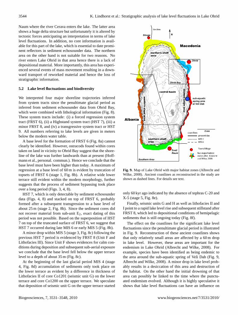
Fig. 9. Map of Lake Ohrid with major habitat zones (Albrecht and Wilke, 2008). Ancient 2
coastlines as reconstructed in the study are shown as dashed lines. For details see text. 3 Fig. 9. Map of Lake Ohrid with major habitat zones (Albrecht andWilke, 2008). Ancient coastlines as reconstructed in the study areshown as dashed lines. For details see text.
only 60 kyr ago indicated by the absence of tephras C-20 andX-5 (stage 5, Fig. 8e).
Finally, seismic units G and H as well as lithofacies II andI point to a rapid lake level rise and subsequent stillstand afterFRST 8, which led to depositional conditions of hemipelagicsediments that is still ongoing today (Fig. 8f).
The effect on the coastlines for the significant lake levelfluctuations since the penultimate glacial period is illustratedin Fig. 9. Reconstruction of these ancient coastlines showsthat only relatively small areas are affected by a 60 m dropin lake level. However, these areas are important for theendemism in Lake Ohrid (Albrecht and Wilke, 2008). Forexample, species have been identified as being endemic tothe area around the sub-aquatic spring of Veli Dab (Fig. 9,Albrecht and Wilke, 2008). A minor drop in lake level prob-ably results in a desiccation of this area and destruction ofthe habitat. On the other hand the initial drowning of thatarea can possibly be linked to the time where the punctu-ated endemism evolved. Although it is highly speculative itshows that lake level fluctuations can have an influence on
Biogeosciences, 7, 3531–3548, 2010 www.biogeosciences.net/7/3531/2010/
K. Lindhorst et al.: Stratigraphic analysis of lake level fluctuations in Lake Ohrid 3545
the biodiversity within Lake Ohrid. Furthermore, Hauffe etal. (2010) observed that almost all gastropods live within adepth zone of 5–50 m. A minor drop in lake level may leadto a disconnection and/or isolation of certain areas from theproper lake resulting in allopatric speciation. Therefore wesuggest that the evolution of endemic species is tentativelycorrelated with significant lake level fluctuations. Never-theless this correlation remains speculative due to high un-certainties in speciation rate (Martens, 1997) and the tim-ings of lake level stages or changes (Genner et al., 2010and this study). Allopatric speciation involves a strict geo-graphical barrier that prevents or reduces gene flow amongsubpopulations (for details see Albrecht and Wilke, 2008),and such a barrier apparently did not exist in ancient LakeOhrid. The bathymetry of Lake Ohrid indicates that no sub-basins or sub-aerial islands existed during MIS 6, when thelake level was 60 m lower than present day (Fig. 8). In com-parison to the African Lake Malawi, where a magnitude oflake level changes greater than 550 m and subsequent expan-sion and establishment of rock fish populations was recon-structed (Genner et al., 2010), the magnitude of lake levelchange for Lake Ohrid since MIS 6 was probably too smallfor a major effect on speciation. One explanation is that theinferred lake level changes at Lake Ohrid had only a mi-nor impact on the environment, particularly at the easternshore, where rocky cliffs continue into deeper waters andan adaptation of species to a new living environment wasnot necessary. A change from calm conditions during lakelevel highstands to more dynamic conditions within the lit-toral zone after a drop in lake level may have an effect onspecies, which have been evolved during calm conditions asexplained by Martens (1997). Within Lake Ohrid this is validfor small areas bounded by cliffs along the eastern shore lineand more importantly within Ohrid Bay. These areas, al-though they were not completely desiccated, experienced asignificant change in water depth with subsequent change indynamic conditions.
Significant changes could have also affected the northernshore area where the bathymetry indicates a gently dippingsandy lake floor (Fig. 9). Here, even a minor transgres-sion/regression of the shoreline would lead to drastic changesof subsurface properties and, subsequently, may have a majorimpact on the living environment.
In a longer term perspective, the endemism in the lakecould have been affected by gradual lake level rise, sinceLake Ohrid became established as water filled body. Thislake level rise can be deduced from the five clinoform struc-tures seen in the multichannel seismic data (Fig. 7) at thesouthern part of Lake Ohrid. Ancient depths of lake levelscan be estimated by picking topset reflections. Using an av-erage sound velocity of 1600 ms−1 for sediments, distinct re-flections occur at 200, 285, 300, 330, and 360 m depth belowthe modern lake level. We cannot assume that these numbersdirectly correspond to ancient lake levels because the sub-sidence history of the basin is not well known and current
depths of the clinoforms are a combined effect of tectonicmovements and lake level fluctuations. Nevertheless, pro-nounced clinoforms indicate significantly lower lake levelsin the past with subsequent sudden changes in lake level.
A first attempt of dating individual clinoforms in the south-ern part of lake Ohrid was done by tracing reflections directlyabove or below the clinoforms to areas of undisturbed sedi-ments within the central lake basin and assuming constantsedimentation rates. For example, the reflection interpretedto mark the transition of MIS 6 to MIS 5 can be traced allover Lake Ohrid. By using this reflection as a marker horizonan average sedimentation rate of 0.28 mm/yr for the periodyounger than 130 ka. can be calculated for the deep basin.This sedimentation rate would provide an age of∼41 kyr forthe Y-5 tephra, which is close to its real age. Extrapolation ofthis sedimentation rate leads to age estimations of∼510 kyr,∼600 kyr,∼800 kyr,∼940 kyr, and∼1.1 Myr for the base ofUnit E, D, C, B, and the basement (or base of Unit A), re-spectively. However, these numbers are only first estimatesand inhibit great uncertainties due to a lack of lithological in-formation of sediments older than 130 ka. For example, ourage estimate for the basement is much lower than ages sug-gested by other authors (Aliaj et al., 2001; Spirkovski et al.,2001; Dumurdzanov et al., 2005; Susnik et al., 2006) thoughthe actual age of Lake Ohrid is still highly debated. The cal-culated ages can probably regarded as minimum values asvelocities for sediments increase with depth and our modeldoes not include possible hiatuses that would lead to olderages for the basement of Lake Ohrid. Seismic stratigraphy,however, shows that clinoforms offshore Sveti Naum are sig-nificantly older than MIS 6 (Fig. 7). Final interpretation canonly be achieved by combining seismic data with the infor-mation from a deep drilling campaign, which will providecrucial information for reconstructing the subsidence historyof the basin and a profound age model for the older sedi-ments.
6 Conclusions
Our study illustrates that a combined geophysical and sedi-mentological approach is a powerful tool to investigate lakelevel fluctuations and link them to biodiversity in ancientlakes. Hydro-acoustic data show that Lake Ohrid has under-gone significant lake level fluctuations. Multichannel seis-mic data penetrating into deeper parts of the sediments sug-gest that, in general, lake level rose stepwise since its estab-lishment as water filled body. The topset reflections up todepths of 360 m below modern lake level as evident by pro-nounced clinoforms offshore Sveti Naum suggest that lakesurface of Lake Ohrid was significantly reduced in formertime periods. Further lithological data is needed to reduceuncertainties with respect to age estimates of prominent re-flections as well as the subsidence history of the entire basin.An analysis of sediment echosounder profiles and core data
www.biogeosciences.net/7/3531/2010/ Biogeosciences, 7, 3531–3548, 2010
3546 K. Lindhorst et al.: Stratigraphic analysis of lake level fluctuations in Lake Ohrid
within Ohrid Bay allows a more detailed reconstruction backto the penultimate glacial period. Two terraces are well pre-served as morphological pattern within Ohrid Bay. The lowerterrace (Unit E1, Lithofacies IV, FRST 6) is most likely arelic of a fan delta that formed in a high energy shallow wa-ter environment close to a river mouth during MIS 6. Incontrast, the upper terrace (Unit F, Lithofacies III, FRST 8)formed in a low energy regime potentially under warm cli-mate conditions with only minor rivers draining into OhridBay during MIS 5. Four major shoreline trajectories can bededuced since the penultimate glacial period. A formationof sub-basins or sub-aerial parts since penultimate glacial isunlikely, since the lake level lowering by 30 or 60 m did notsignificantly affect the overall surface area of Lake Ohrid.However, the lake level changes may have had a significantimpact on the speciation, since a great proportion of endemicspecies are found above 50 m water depth in modern LakeOhrid.
Acknowledgements.We would like to thank our Macedoniancolleagues G. Kostski, S. Trajanovski, and Z. Brdarovski fromthe Hydrobiological Institute Ohrid for their administrative andlogistic support during numerous field campaigns to Lake Ohrid.Our undergraduate and graduate students are greatly acknowledgedfor their enthusiasm and help in the field and laboratory. We wouldlike to thank workgroup of H. Villinger for providing a Streamersystem in 2008. Thanks to W. Weinrebe and N. Lindhorst fortheir technical support during the field campaign in 2009. We aregrateful to S. Hall for valuable comments on earlier version ofthe manuscript. We received helpful reviews and short commentsfrom M. Strasser of the MARUM in Bremen, Germany, C. Beckfrom Universite de Savoie in France, and Jens Holtvoeth fromUniversity of Liverpool. This research was supported by DFGgrants Kr2222/7, WA2109/1, We2210/3, and Da563/2.
Edited by: V. Brovkin
References
Albrecht, C. and Wilke, T.: Ancient Lake Ohrid: biodiversity andevolution, Hydrobiologia, 615, 103–140, 2008.
Aliaj, S., Baldassarre, G., and Shkupi, D.: Quaternary subsidencezones in Albania: some case studies, B. Eng. Geol. Environ., 59,313–318, 2001.
Allen, J., Brandt, U., Brauer, A., Hubberten, H., Huntley, B., Keller,J., Kraml, M., Mackensen, A., Mingram, J., and Negendank, J.:Rapid environmental changes in southern Europe during the lastglacial period, Nature, 400, 740–743, 1999.
Allen, J., Watts, W., McGee, E., and Huntley, B.: Holocene environ-mental variability – the record from Lago Grande di Monticchio,Italy, Quatern. Int., 88, 69–80, 2002.
Allen, J. and Huntley, B.: Last Interglacial palaeovegetation,palaeoenvironments and chronology: a new record from LagoGrande di Monticchio, southern Italy, Quaternary Sci. Rev., 28,1521–1538, 2009.
Allen, P. A. and Allen, J. R.: Basin Analysis Principles and Appli-cations, 2nd ed., Blackwell Publishing, 549 pp., 2005.
Anselmetti, F., Ariztegui, D., Hodell, D., Hillesheim, M., Bren-ner, M., Gilli, A., McKenzie, J., and Mueller, A.: Late Qua-ternary climate-induced lake level variations in Lake Peten Itza,Guatemala, inferred from seismic stratigraphic analysis, Palaeo-geogr. Palaeocl., 230, 52–69, 2006.
Anselmetti, F., Ariztegui, D., Batist, M., Gebhardt, A., Haberzettl,T., Niessen, F., Ohlendorf, C., and Zolitschka, B.: Environ-mental history of southern Patagonia unraveled by the seismicstratigraphy of Laguna Potrok Aike, Sedimentology, 873–892,doi:10.1111/j.1365-3091.2008.01002.x, 2009.
Auclair, M., Lamothe, M., and Huot, S.: Measurement of anoma-lous fading for feldspar IRSL using SAR, Radiat. Meas., 37,487–492, 2003.
Bar-Matthews, M., Ayalon, A., Kaufman, A., and Wasserburg, G.:The Eastern Mediterranean paleoclimate as a reflection of re-gional events: Soreq cave, Israel, Earth Planet Sc. Lett., 166,85–95, 1999.
Bar-Matthews, M., Ayalon, A., and Kaufman, A.: Timing and hy-drological conditions of Sapropel events in the Eastern Mediter-ranean, as evident from speleothems, Soreq cave, Israel, Chem.Geol., 169, 145–156, 2000.
Bar-Matthews, M., Ayalon, A., Gilmour, M., Matthews, A., andHawkesworth, C.: Sea-land oxygen isotopic relationships fromplanktonic foraminifera and speleothems in the Eastern Mediter-ranean region and their implication for paleorainfall during inter-glacial intervals, Geochimica et Cosmochimica Acta, 67, 3181–3199, 2003.
Bordon, A., Peyron, O., Lezine, A., Brewer, S., and Fouache, E.:Pollen-inferred Late-Glacial and Holocene climate in southernBalkans (Lake Maliq), Quatern. Int., 200, 19–30, 2009.
Caress, D. and Chayes, D.: MB-SYSTEM Release 5,www.ldgo.columbia.edu/MB-System, 2005.
Catuneanu, O., Abreu, V., Bhattacharya, J., Blum, M., Dalrymple,R., Eriksson, P., Fielding, C., Fisher, W., Galloway, W., and Gib-ling, M.: Towards the standardization of sequence stratigraphy,Earth Science Reviews, 92, 1–33, 2009.
Croudace, I., Rindby, A., and Rothwell, G.: ITRAX: descriptionand evaluation of a new multi-function X-ray core scanner, Newtechniques in sediment core analysis, 267, 51–63, 2006.
D’Agostino, K., Seltzer, G., Baker, P., Fritz, S., and Dunbar,R.: Late-Quaternary lowstands of Lake Titicaca: evidence fromhigh-resolution seismic data, Palaeogeogr. Palaeocl., 179, 97–111, 2002.
Danzeglocke, U., Joris, O., and Weninger, B.: CalPal-2007online,http://calpalonline.de/, 2008.
Daut, G., Mausbacher, R., Baade, J., Gleixner, G., Kroemer, E.,Mugler, I., Wallner, J., Wang, J., and Zhu, L.: Late Quater-nary hydrological changes inferred from lake level fluctuationsof Nam Co (Tibetan Plateau, China), Quatern. Int., 218, 86–93,doi:10.1016/j.quaint.2010.01.001, 2010.
De Vivo, B., Rolandi, G., Gans, P., Calvert, A., Bohrson, W., Spera,F., and Belkin, H.: New constraints on the pyroclastic eruptivehistory of the Campanian volcanic Plain (Italy), Miner. Petrol.,73, 47–65, 2001.
Drysdale, R., Zanchetta, G., Hellstrom, J., Fallick, A., and Zhao,J.: Stalagmite evidence for the onset of the Last Interglacialin southern Europe at 129± 1 ka, Geophys. Res. Lett., 32,doi:10.1029/2005GL024658, 2005.
Dumurdzanov, N., Serafimovski, T., and Burchfiel, B.: Cenozoic
Biogeosciences, 7, 3531–3548, 2010 www.biogeosciences.net/7/3531/2010/

K. Lindhorst et al.: Stratigraphic analysis of lake level fluctuations in Lake Ohrid 3547
tectonics of Macedonia and its relation to the South Balkan ex-tensional regime, Geosphere, 1, 1–22, 2005.
Gawthorpe, R., and Leeder, M.: Tectono-sedimentary evolution ofactive extensional basins, Basin Res., 12, 195–218, 2000.
Genner, M., Knight, M., Haesler, M., and Turner, G.: Establishmentand expansion of Lake Malawi rock fish populations after a dra-matic Late Pleistocene lake level rise, Mol. Ecol., 19, 170–182,doi: 10.1111/j.1365-294X.2009.04434.x, 2010.
Gilbert, G.: Lake Bonneville, United States Geological Survey,438 pp., 1890.
Hauffe, T., Albrecht, C., Schreiber, K., Birkhofer, K., Trajanovski,S., and Wilke, T.: Spatially explicit analyses of gastropod biodi-versity in ancient Lake Ohrid, Biogeosciences Discuss., 7, 4953–4985, doi:10.5194/bgd-7-4953-2010, 2010.
Hayes, A., Kucera, M., Kallel, N., Sbaffi, L., and Rohling, E.:Glacial Mediterranean sea surface temperatures based on plank-tonic foraminiferal assemblages, Quaternary Sci. Rev., 24, 999–1016, 2005.
Helland-Hansen, W. and Martinsen, O.: Shoreline trajectories andsequences: description of variable depositional-dip scenarios, J.Sediment. Res. B., 66, 670–688, 1996.
Hughes, P., Woodward, J., and Gibbard, P.: Quaternary glacial his-tory of the Mediterranean mountains, Prog. Phys. Geog., 30,334–364, doi: 10.1191/0309133306pp481ra, 2006.
Hunt, D. and Tucker, M.: Stranded parasequences and the forcedregressive wedge systems tract: deposition during base-level fall,Sediment. Geol., 81, 1–9, 1992.
Johnson, T., Scholz, C., Talbot, M., Kelts, K., Ricketts, R., Ngobi,G., Beuning, K., Ssemmanda, I., and McGill, J.: Late Pleistocenedesiccation of Lake Victoria and rapid evolution of cichlid fishes,Science, 273, 1091–1093, doi:10.1126/science.273.5278.1091,1996.
Keller, J., Ryan, W., Ninkovich, D., and Altherr, R.: Explosive vol-canic activity in the Mediterranean over the past 200,000 yr asrecorded in deep-sea sediments, Bull. Geol. Soc. Am., 89, 591–604, 1978.
Kraml, M.: Laser-Ar/Ar-Datierungen and distalen marinen Tephrendes jung-quartaren mediterranen Vulkanismus (Ionisches Meer,M25/4), Ph. D., Albert-Ludwings-Universitat Freiburg, Freiburg,216 pp., 1997.
Lamothe, M., Auclair, M., Hamzaoui, C., and Huot, S.: Towardsa prediction of long-term anomalous fading of feldspar IRSL,Radiat. Meas., 37, 493–498, 2003.
Lezine, A., Von Grafenstein, U., Andersen, N., Belmecheri, S., Bor-don, A., Caron, B., Cazet, J., Erlenkeuser, H., Fouache, E., andGrenier, C.: Lake Ohrid, Albania, provides an exceptional multi-proxy record of environmental changes during the last glacial-interglacial cycle, Palaeogeogr. Palaeocl., 287, 116–127, 2010.
Magny, M., Peyron, O., Gauthier, E., Roueche, Y., Bordon, A., Bil-laud, Y., Chapron, E., Marguet, A., Petrequin, P., and Vanniere,B.: Quantitative reconstruction of climatic variations during theBronze and early Iron ages based on pollen and lake-level datain the NW Alps, France, Quatern. Int., 200, 102–110, 2009.
Marino, G., Rohling, E., Sangiorgi, F., Hayes, A., Casford, J.,Lotter, A., Kucera, M., and Brinkhuis, H.: Early and middleHolocene in the Aegean Sea: interplay between high and lowlatitude climate variability, Quaternary Sci. Rev., 28, 3246–3262,2009.
Martens, K.: Speciation in ancient lakes, Trends in Ecology & Evo-
lution, 12, 177–182, 1997.Martrat, B., Grimalt, J., Lopez-Martinez, C., Cacho, I., Sierro,
F., Flores, J., Zahn, R., Canals, M., Curtis, J., and Hodell, D.:Abrupt temperature changes in the Western Mediterranean overthe past 250 000 years, Science, 306, 1762, 2004.
Matter, M., Anselmetti, F. S., Jordanoska, B., Wagner, B., Wes-sels, M., and Wuest, A.: Carbonate sedimentation and effectsof eutrophication observed at the Kalista subaquatic springs inLake Ohrid (Macedonia), Biogeosciences Discuss., 7, 4715–4747, doi:10.5194/bgd-7-4715-2010, 2010.
Matzinger, A., Spirkovski, Z., Patceva, S., and Wuest, A.: Sensi-tivity of ancient Lake Ohrid to local anthropogenic impacts andglobal warming, J. Great Lakes Res., 32, 158–179, 2006.
Matzinger, A., Schmid, M., Veljanoska-Sarafiloska, E., Patceva, S.,Guseska, D., Wagner, B., Muller, B., Sturm, M., and Wuest,A.: Eutrophication of ancient Lake Ohrid: Global warming am-plifies detrimental effects of increased nutrient inputs, Limnol.Oceanogr., 52, 338–353, 2007.
Moernaut, J., Verschuren, D., Charlet, F., Kristen, I., Fagot, M.,and Batist, M. D.: The seismic-stratigraphic record of lake-levelfluctuations in Lake Challa: Hydrological stability and changein equatorial East Africa over the last 140 kyr, Earth Planet Sc.Lett., 290, 214–223, doi:10.1016/j.epsl.2009.12.023, 2010.
Paterne, M., Guichard, F., and Labeyrie, J.: Explosive activity ofthe South Italian volcanoes during the past 80,000 years as de-termined by marine tephrochronology, J. Volcanol. Geoth. Res.,34, 153–172, 1988.
Peyron, O., Guiot, J., Cheddadi, R., Tarasov, P., Reille, M., deBeaulieu, J., Bottema, S., and Andrieu, V.: Climatic reconstruc-tion in Europe for 18 000 yr BP from pollen data, QuaternaryRes., 49, 183–196, 1998.
Pirmez, C., Pratson, L., and Steckler, M.: Clinoform developmentby advection-diffusion of suspended sediment: Modeling andcomparison to natural systems, J. Geophys. Res.-Sol. Ea., 103,24141–24157, 1998.
Popovska, C. and Bonacci, O.: Basic data on the hydrology ofLakes Ohrid and Prespa, Hydrol. Process., 21, 658–664, 2007.
Posamentier, H., Allen, G., James, D., and Tesson, M.: Forced re-gressions in a sequence stratigraphic framework: concepts, ex-amples, and exploration significance, AAPG Bull., 76, 1687–1687, 1992.
Preusser, F., Degering, D., Fuchs, M., Hilgers, A., Kadereit, A.,Klasen, N., Krbetschek, M., Richter, D., and Spencer, J.: Lumi-nescence dating: Basics, methods and applications, QuaternaryScience Journal (Eiszeitalter und Gegenwart), 57, 95–149, 2008.
Schellmann, G., Beerten, K., and Radtke, U.: Electron spin res-onance (ESR) dating of Quaternary materials, Eiszeitalter undGegenwart, 57, 150–178, 2008.
Scholz, C. and Rosendahl, B.: Low lake stands in Lakes Malawiand Tanganyika, East Africa, delineated with multifold seismicdata, Science, 240, 1645–1648, 1988.
Sclater, J. and Christie, P.: Continental stretching: an explanationof the post-mid-Cretaceous subsidence of the central North Seabasin, J. Geophys. Re., 85, 3711–3739, 1980.
Spirkovski, Z., Avramovski, O., and Kodzoman, A.: Watershedmanagement in the Lake Ohrid region of Albania and Macedo-nia, Lakes & reservoirs: research and management, 6, 237–242,2001.
Stankovic, S.: The Balkan Lake Ohrid and Its Living World, W.
www.biogeosciences.net/7/3531/2010/ Biogeosciences, 7, 3531–3548, 2010

3548 K. Lindhorst et al.: Stratigraphic analysis of lake level fluctuations in Lake Ohrid
Junk, 357 pp., 1960.Sturmbauer, C., Baric, S., Salzburger, W., Ruber, L., and Verheyen,
E.: Lake level fluctuations synchronize genetic divergences ofcichlid fishes in African lakes, Mol. Biol. Evol., 18, 144–154,2001.
Sulpizio, R., Zanchetta, G., Paterne, M., and Siani, G.: A reviewof tephrostratigraphy in central and southern Italy during the last65 ka, Il Quaternario, 16, 91–108, 2003.
Sulpizio, R., Zanchetta, G., D’Orazio, M., Vogel, H., and Wag-ner, B.: Tephrostratigraphy and tephrochronology of lakesOhrid and Prespa, Balkans, Biogeosciences, 7, 3273–3288,doi:10.5194/bg-7-3273-2010, 2010.
Susnik, S., Knizhin, I., Snoj, A., and Weiss, S.: Genetic and mor-phological characterization of a Lake, J. Fish Biol., 68, 2–23,2006.
Tzedakis, P., Frogley, M., and Heaton, T.: Last Interglacial con-ditions in southern Europe: evidence from Ioannina, northwestGreece, Global Planet. Change, 36, 157–170, 2003.
Vogel, H., Wagner, B., Zanchetta, G., Sulpizio, R., and Rosen,P.: A paleoclimate record with tephrochronological age controlfor the last glacial-interglacial cylce from Lake Ohrid, Albaniaand Macedonia, J. Paleolimnol., doi:10.1007/s10933-009-9404-x, 2010a.
Vogel, H., Zanchetta, G., Sulpizio, R., Wagner, B., and Nowaczyk,N.: A tephrostratigraphic record for the last glacial–interglacialcycle from Lake Ohrid, Albania and Macedonia., J. QuaternarySci., 25, 320–338, 2010b.
Wagner, B., Reicherter, K., Daut, G., Wessels, M., Matzinger, A.,Schwalb, A., Spirkovski, Z., and Sanxhaku, M.: The potential ofLake Ohrid for long-term palaeoenvironmental reconstructions,Palaeogeogr. Palaeocl., 259, 341–356, 2008a.
Wagner, B., Sulpizio, R., Zanchetta, G., Wulf, S., Wessels, M.,Daut, G., and Nowaczyk, N.: The last 40 ka tephrostratigraphicrecord of Lake Ohrid, Albania and Macedonia: a very distalarchive for ash dispersal from Italian volcanoes, J. Volcanol.Geoth. Res., 177, 71–80, 2008b.
Wagner, B., Lotter, A., Nowaczyk, N., Reed, J., Schwalb, A.,Sulpizio, R., Valsecchi, V., Wessels, M., and Zanchetta, G.: A40,000-year record of environmental change from ancient LakeOhrid (Albania and Macedonia), J. Paleolimnol., 41, 407–430,2009.
Wallinga, J., Bos, A., Dorenbos, P., Murray, A., and Schokker, J.: Atest case for anomalous fading correction in IRSL dating, Quat.Geochronol., 2, 216–221, 2007.
Wessel, P. and Smith, W.: Free software helps map and display data,Eos Trans. AGU, 72, 445–446, 1991.
Zanchetta, G., Sulpizio, R., Giaccio, B., Siani, G., Paterne, M.,Wulf, S., and D’Orazio, M.: The Y-3 tephra: A Last Glacialstratigraphic marker for the central Mediterranean basin, J. Vol-canol. Geoth. Res., 177, 145–154, 2008.
Biogeosciences, 7, 3531–3548, 2010 www.biogeosciences.net/7/3531/2010/