strategic environmental assessment options evaluation …
TRANSCRIPT

STRATEGIC ENVIRONMENTAL ASSESSMENT
OPTIONS EVALUATION REPORT
Hyder - Mott Connell Joint Venture
This report is prepared by Hyder-Mott Connell Joint Venture for information and discussion purposes. The findings and recommendations do not necessarily represent the views of the HKSARG.

2
TABLE OF CONTENTS
Summary
1. Introduction
2. Vision-Based Approach of HK2030 Study
3. Framework for formulating options
4. Development Options
5. Assumptions on Environmental Enhancement
6. Evaluation Methodology
7. Options Evaluation
8. Discussion
References
Abbreviations
Footnotes

3
Summary
S.1 The Options Evaluation Report contains the broad-brush environmental assessment results of the development options formulated under the Reference Scenario of the HK2030 Study. The results are comparative and qualitative in nature and form only part of the staged Strategic Environmental Assessment (SEA) of the HK2030 Study, with further detailed assessments of the preferred option(s) to be carried out in the next stage (i.e. Stage 4 of HK2030 Study).
S.2 The Reference Scenario has been formulated to take into account the vision targets for Hong Kong and current broad trends, as well as existing policies and known commitments, to identify the key elements of development and their corresponding land requirements based on which the long-term spatial development patterns could be formulated and assessed. Various planning choices have been devised to accommodate the additional land requirements. Having examined the implications of various planning choices, the core components are consolidated under two broad development patterns (i.e. consolidation and decentralisation patterns). As the core components are mostly past development proposals, the focus is to critically re-examine the past proposals with particular reference to the timing and priority for implementation.
S.3 Under this SEA, only two of the four possible port locations (i.e. Southwest Tsing Yi and Northwest Lantau) recommended by the PDSR have been considered with the two broad development patterns since the East Lantau site is rendered non-feasible by the Hong Kong Disneyland project, and the West Tuen Mun site has already been covered by the Tuen Mun Port Development Study.
S.4 The objective of the evaluations was to provide an indicative comparison of the four development options. Performance Indicators were selected for use in the comparative evaluations covering a broad range of environmental aspects. The evaluations were qualitative and based on the likely performance when judged against the other development options. The likely environmental issues for each option have been highlighted. However, whether the development options would meet the environmental standards cannot be confirmed at present, but will be further assessed in the next stage of the SEA.
S.5 Impacts of the development options in the short term include the potential air and noise problems associated with the predicted increase in cross-boundary vehicle trips. The effects of such will be examined in Stage 4 of the SEA. It is important to note that in the short term the components of the development options are committed or planned projects, i.e. there are no novel components.
S.6 In the medium to long term, the key issues identified relate to vehicle emissions, wastewater disposal (include the timely implementation of the HATS) as well as the generation of solid wastes and disposal thereof.

4
1. Introduction
1.1 Background
1.1.1 The HK2030: Planning Vision and Strategy (Main Study) is a strategic planning study tasked with preparing a strategic land use planning framework for Hong Kong for a period of 30 years. It will address ‘how much, what type and where land for development should be provided’.
1.1.2 The Government is committed to supporting and promoting sustainable development and to this end major policy and strategy initiatives must undergo a sustainability assessment. Under the overall goal of adhering to the principle of sustainable development a planning objective of the HK2030 Study is to provide a good quality living environment. To assist in achieving this aim we need to strike a balance in the demand for, and supply of, environmental resources. An integral component of the HK2030 Study is the Strategic Environmental Assessment (SEA).
1.1.3 To put the SEA into context it is important to note that the Main Study involves four key stages of work viz.:
Stage 1: Agenda Setting, Baseline Review and Identification of Key Issues
Stage 2: Examination of Key Issues
Stage 3: Formulation and Evaluation of Scenarios and Options
Stage 4: Formulation of Development Strategies and Response Plans
1.1.4 This report forms part of the third stage of the SEA and responds to Task 5 of the Brief. Stage 3 is intended to provide a broad assessment of the development options using a series of agreed performance indicators for the comparative merits and demerits of the options or components thereof.
1.1.5 The SEA is being integrated with the Main Study by providing environmental input at all stages. This includes strategic environmental information and suggestions to help facilitate the formulation, development and identification of development options that would be likely to meet the requirements for environmentally sustainable development. The SEA scope is focused on those environmentally related issues which have potential to significantly affect land use strategies.
1.1.6 The main deliverables of the SEA Study so far have been an Inception Report, Initial Assessment Report (IAR) and Key Issues Report (KIR). The IAR was prepared under Tasks 1 – 3 of the SEA Study Brief and reviewed Baseline Conditions, discussed Environmental Capital Stock and Carrying Capacity, identified Environmental Target areas as well as listing Environmental Constraints, Opportunities and Key Issues. The KIR was prepared under Task 4 of the SEA Study Brief and examined the Key Issues and Influencing Factors identified previously in greater detail to facilitate their consideration during the Options Development and help to ensure that they are given due weight and attention in the Main Study deliberations.
1.1.7 T he environmental factors identified in the IAR and KIR have been taken into consideration by the Main Study Team in the formulation of the development options and a brief summary is provided in Section 3.2.
5
1.2 Purpose of Report and Objectives
1.2.1 The Options Evaluation Report (OER) is the 4th deliverable of the SEA Study and has been prepared in accordance with the requirements of the SEA Study Brief. The main objective of this Task is to examine the strategic environmental performance of the development options so that preferred options can be identified for future detailed assessment. The OER presents the results of the broad-brush assessment based on the environmental targets, baseline and capacity developed in Tasks 1 and 2 and focusing on the key issues identified from Tasks 3 and 4. Taking into account the level of detail available the OER presents a qualitative ranking of the development options.
2. Vision-Based Approach of HK2030 Study
2.1 Vision-Based Approach
2.1.1 The HK2030 Study adopts a vision-based approach based on which a future development scenario (known as the “Reference Scenario”) is devised by taking into account the Chief Executive’s vision for HK, the community’s aspirations on future development and various planning assumptions on population, employment and land requirement for strategic infrastructures.
2.2 Reference Scenario
2.2.1 The Reference Scenario sets out the context against which development options are drawn up. In effect, it represents a translation of the vision into planning objectives and parameters. The following three strategic directions are identified to which future development of HK should be geared towards:
(a) Providing a quality living environment – In line with the emphasis of the Population Policy on quality of our population to meet the challenges of a knowledge-based economy and world-class city, a population growth of 2.5 million in the next 30 years is anticipated (instead of a million a decade as in the past), reaching some 9.2 million by 2030 [1] As a result of the slower growth, there is a lower demand for housing than previously anticipated and therefore allows the approach of the HK2030 Study to change from housing-development-led to a focus on the quality of the living environment. This change reflects the growing community aspirations for a more spacious living environment, more convenient connection with work places and facilities, better protection of natural resources and cultural heritage, as well as better urban design complementary to the image of a world city.
(b) Enhancing economic competitiveness – In terms of enhancing economic competitiveness, the role of town planning is to ensure provision of adequate and timely delivery of land of the right kind to meet various needs of the economy, especially the four pillar industries.
(c) Strengthening links with the Mainland – Closer social and economic integration with the PRD calls for planning consideration in the wider regional context. The key is to enhance connectivity which allows freer movements of people, vehicles and goods. Important elements will be the planning for cross-boundary infrastructure and associated boundary-crossing facilities, as well as the future development of the Frontier Closed Area (including the Lok Ma Chau Loop) and Northern New Territories.

6
3. Framework for formulating options
3.1 Population and Employment forecasts
3.1.1 Under the Reference Scenario, a population of 9.2 million and an employment of 4.0 million by 2030 have been assumed. Table 3.1 summarises the population and employment forecasts for the Reference Scenario:
Table 3.1 Population and Employment Forecasts
2001 2010 2020 2030
Resident Population (million) 6.72 7.55 8.47 9.16
Employment (million) 3.26 3.58 3.87 4.03
Demand Supply Demand Supply Demand Demand
Accommodation for Economic Uses (million m² GFA) - CBD Grade A
Offices - General Business *
4.14 4.54 33.38 36.98
5.07 5.91 35.71 41.84
6.24
37.44
7. 22
38.84
* General business includes private office (except CBD Grade A office) space, private industrial/office space, private flatted factories and private storage facilities.
3.2 Environmental Considerations
3.2.1 In formulating the development options, recommendations from the IAR, KIR and the View Sharing Workshop held in November 2002 have been taken into consideration and where considered feasible, and appropriate, incorporated into the spatial development patterns.
3.2.2 The following highlights the environmental considerations taken into account in formulating the development options:
• Optimise utilisation of existing and committed infrastructure
• Facilitate urban renewal
• Planning for integrated communities – jobs closer to home
• Development density
- Reduction of population density does not necessarily bring about benefits. Should selectively thin out those densely populated areas with acute environmental problems while maintaining high density at development nodes in order to support an efficient mass transport system.

7
• Explore opportunities to enhance resources with conservation value
• Maintain and enhance the planning functions of the five sub-regions :
- Metro Area – the Pulse of Hong Kong
- NWNT & NENT – Gateways to PRD (with the development of the West Rail and new cross-boundary facilities, these sub-regions will provide a main source of land for new strategic growth)
- SENT – Leisure Garden of Hong Kong
- SWNT – Distinctive planning themes for various parts of SWNT. They are NE Lantau (tourism & recreation); North Lantau (the 9th new town); NW Lantau (religious, cultural & leisure); South Lantau (conservation & sustainable recreation); outlying islands (conservation, recreation & area-by-area approach development)
• Reclamation in the Harbour should only be carried out to meet essential community needs and public aspirations.
3.3 Consideration of Planning Choices
3.3.1 Based on the forecasted demand, a number of planning choices, including intensification of existing and planned development areas as well as identification of new growth areas, are devised to accommodate the additional demand for various land uses. After that, an Initial Scoping Exercise has been conducted to identify the more realistic and practical development options by examining the key considerations of various planning choices. Having examined the implications of the various planning choices, the core components are consolidated under two broad development patterns (i.e. consolidation and decentralization patterns) for a more comprehensive assessment.
3.3.2 It should be noted that, while planning choices are numerous, the various components proposed under the development patterns have largely been structured upon recommendations of past and current studies as well as community views which were gathered in earlier stages of the HK2030 Study. The focus of the Study is therefore to critically re-examine the past development proposals, with particular reference to the timing and priority for implementation. It should also be noted that the broad proposals of these patterns are not mutually exclusive, although the common ones may still vary in detail.
8
4. Development Options
4.1 Key Features of Spatial Development Patterns
4.1.1 Under the Reference Scenario, the population in 2030 is about 9.2 million which is marginally higher than the previously forecasted population of 8.9 million by 2016 in the last round of TDSR. This slower population growth would significantly reduce the housing land requirements and associated environmental impacts that were anticipated in the past planning exercises. As the planned and identified development areas originally targeted to meet 2016 demand would now be broadly sufficient up to year 2030, the planning choice, as reflected in the two broad development patterns, namely the “Consolidation” and “Decentralisation” Patterns, would be a matter of timing and priority. The key features of the two development patterns are provided at Table 4.1, whereas the comparison of the population and employment data of the two patterns for five planning sub-regions are shown in Table 4.2.
4.1.2 Regarding the provision of housing land, the Consolidation Pattern gives priority to making best use of land and infrastructure facilities in the Metro Area whereas the Decentralisation Pattern focuses on development of the NT in the medium term. In the longer term, it is necessary to develop NDAs in Northern NT to accommodate additional population in both of the patterns. Eventually, there will have two more NDAs under the Decentralisation Pattern (i.e. San Tin/Ngau Tam Mei and Kwu Tung South) with a difference of 220,000 populations residing in the NT by 2030.

9
Table 4.1 Key Housing and Employment Components in the Two Spatial Development Patterns
Consolidation Decentralisation
Provision of Housing Land Up to 2020 w Former Kai Tak Airport (whole) w Urban renewal (more redevelopment,
less rehabilitation) w Government land at existing built-up
areas w No NDAs in the New Territories
w Former Kai Tak Airport (partial) w Urban renewal (more rehabilitation,
less redevelopment) w Government land at existing built-up
areas w 3 NDAs at: w Hung Shui Kiu w Kwu Tung North w Fanling North
Provision of Land for Office / Business
w Existing and oncoming supply w Redevelopment / conversion of
existing industrial buildings
w Mainly from existing and oncoming supply
w Premier Office Centre at the former Kai Tak Airport
w Provision of land for office / business uses in Hung Shui Kiu which will lead to a slower pace of redevelopment of old buildings
w Lok Ma Chau Loop to be developed for a “trade expo” and / or other special economic activities
Provision of Housing Land Beyond 2020
w Development at former Kai Tak Airport completed before 2020
w Urban renewal (more redevelopment, less rehabilitation)
w 5 NDAs at: w Hung Shui Kiu w Kwu Tung North w Fanling North w Hung Shui Kiu North w Kam Tin / Au Tau
w Government land at existing built-up areas
w Former Kai Tak Airport (remaining areas)
w Urban renewal (more rehabilitation, less redevelopment)
w 4 NDAs at: w Hung Shui Kiu North w Kam Tin / Au Tau w Kwu Tung South w San Tin / Ngau Tam Mei
w Government land at existing built-up
areas
Provision of Land for Office/ Business
w Premier Office Centre at the former Kai Tak Airport
w Private-sector redevelopment for office and general business uses
w Government land at existing built-up areas
w Development of Premier Office Centre completed before 2020
w Private-sector redevelopment for office and general business uses
w Government land at existing built-up areas

10
Table 4.2 Consolidation Pattern Vs Decentralisation Pattern
Population Employment Planning Sub-
region Consolidation (a)
Decentralisation (b)
b – a (b – a) / a
Consolidation (a)
Decentralisation (b)
b – a (b – a) / a
2020
METRO 4,831,254 4,608,361 -222,893 -5% 2,902,504 2,848,490 -54,014 -2%
NWNT 1,332,563 1,396,084 63,521 5% 287,477 314,441 26,964 9%
NENT 1,418,775 1,592,350 173,575 12% 396,810 427,232 30,422 8%
SENT 553,396 541,770 -11,626 -2% 121,891 116,369 -5,522 -5%
SWNT 331,224 328,647 -2,577 -1% 158,519 160,668 2,149 1%
Total 8,467,212 8,467,212 0 0% 3,867,201 3,867,201 0 0%
2030
METRO 5,049,573 4,831,052 -218,520 -4% 2,990,954 2,928,211 -62,733 -2%
NWNT 1,563,659 1,672,570 108,911 7% 311,116 373,550 62,434 20%
NENT 1,603,840 1,740,467 136,627 9% 426,441 432,669 6,228 1%
SENT 603,246 577,393 -25,853 -4% 134,386 127,314 -7,072 -5%
SWNT 338,627 337,463 -1,164 0% 169,317 170,460 1,143 1%
Total 9,158,945 9,158,945 0 0% 4,032,214 4,032,214 0 0%
4.1.3 Regarding employment related uses, the provision will be mainly market-led. For the purpose of testing, the Decentralisation Pattern assumes that a new secondary employment node at Hung Shui Kiu and a trade expo at Lok Ma Chau Loop will be in place by 2020.
4.2 Other Major Land Use and Infrastructure Projects
4.2.1 Apart from the provision of land to accommodate future increase in population and employment needs, there are a number of major land use and infrastructure facilities that are essential in supporting the growth of our economy. Many of the proposals have been or are being examined under various studies conducted by relevant bureaux and departments. These proposals have been taken into account in the development options as common elements if they have been confirmed, otherwise suitable assumptions have been made in consultation with relevant bureaus. A brief account on the assumptions related to these proposals under the Reference Scenario is provided in Table 4.3.

11
Table 4.3 Assumptions Related to Major Land Use and Infrastructure Facilities
Facilities Assumptions
Airport The HK International Airport Master Plan 2020 formulated by the HK Airport Authority (AA) in 2001 has found that aviation demands up to 2020 could largely be met by enhancements within the confines of the existing airport, supported by new logistics facilities in North Lantau.
Given the growth trends in air traffic flows and HK’s vision to become the aviation hub of Southern China, it is possible that the capacity of the existing two runways could become saturated in about 2020. There may be a need for an additional runway and transport infrastructure beyond this time-frame.
AA is conducting studies to update growth forecasts to 2030 and examining alternatives to meet the anticipated demand.
At this stage of the HK2030 Study, the aviation forecasts of AA (i.e. 105 million air passengers and 14 million tonnes air cargo by 2030) have been taken into account in carrying out the transport assessment model runs.
Logistics Facilities In line with the vision to enhance HK’s position as a regional logistics and supply chain management centre, a number of logistics facilities have been proposed including the ones at CLK, Tsing Yi (behind CT 9) and North Lantau.
Special Industries It is assumed that existing and planned facilities including the Science Park, the Cyberport, the Business Park at CLK and the three industrial estates will be adequate in meeting demand in this respect.
Tourism/Cultural Facilities
All known major projects for tourism and cultural facilities, such as HK Disneyland and the West Kowloon Cultural District, together with related hotel developments, have been assumed under the development patterns.
4.3 Environmental and Strategic Infrastructure
4.3.1 Environmental and strategic infrastructure, such as solid waste handling and disposal facilities, sewage treatment and disposal facilities, power supply facilities, water treatment and supply facilities and telecommunications facilities etc., are as much population-driven as policy-driven. Higher public aspirations, improved standards and technological advancement could also affect land requirements for these facilities. The HK2030 Study has taken on board the recommendations of various relevant studies on those environmental and strategic infrastructure facilities which have significant land implications, as well as requirements specified by relevant bureaux and departments. Table 4.4 provides the assumptions on environmental and strategic facilities that have been adopted under the Reference Scenario:

12
Table 4.4 Assumptions Related to Environmental and Strategic Facilities
Power Supply Gradual change from coal to gas power generation, supplemented by environmentally sustainable sources of energy.
Co-operation with Guangdong in power generation expected to continue – no major additional land requirements in this respect assumed.
Water Supply Dongjiang water will remain as one of the major sources of raw water and the supply quantity should be commensurate with the demand.
Supplementary water sources include desalination - coastal site for such installation may be required subject to further study.
Waste Management The feasibility to extend existing landfills in the New Territories and to develop integrated waste management facility(ies) are being examined.
The establishment of a Recovery Park in Tuen Mun is under planning.
The existing fill banks and planned measures could only provide adequate public filling capacity up to mid 2005. At the moment, the Government has to rely on fill banks to stockpile the inert C&D material temporarily for later reuse. All possible avenues to reuse inert C&D materials are being explored, and the feasibility of reusing inert C&D materials in reclamation projects outside Hong Kong are being exmined.
Sewage Treatment Additional sewage treatment facilities as recommended by the HATS and review of sewage master plan are assumed.
Telecommunications Extension of the Teleport is envisaged to cater for long-term requirements.
4.4 Port Location
4.4.1 The Port Development Strategy Review (PDSR) 2001 has recommended that, if new container terminal facilities are required, four possible sites, namely Tuen Mun West, Northwest Lantau, Lantau East and Southwest Tsing Yi are to be considered. The East Lantau site is now rendered non-feasible by the Hong Kong Disneyland project. The other three sites are being evaluated under the Study on Hong Kong Port – Master Plan 2020 (HKP2020 Study) in terms of environmental impacts, traffic impacts and other concerned factors.
4.4.2 However, due to the timing of the HKP2020 Study, a single preferred location is not available for incorporation into the HK2030 development options at this stage. In view of that the West Tuen Mun site has already been covered by the Tuen Mun Port Development Study, the broad-brush assessments for the Study will be carried out based on the other two possible port locations, i.e. Southwest Tsing Yi and Northwest Lantau. Together with the two broad spatial development patterns, four options have been generated as follows:
§ Consolidation Pattern with Tsing Yi Port Option

13
§ Consolidation Pattern with Northwest Lantau Port Option
§ Decentralisation Pattern with Tsing Yi Port Option
§ Decentralisation Pattern with Northwest Lantau Port Option
4.5 Domestic Transport Infrastructure
4.5.1 Building new transport infrastructure involves huge costs and could generate environmental concerns. Given the already extensive existing road and rail system, in planning for future development, it is important that a robust transport network is devised which could make the best use of the available transport infrastructure and cope with different development patterns. An integrated land use-transport-environmental approach is, therefore, adopted for the Study, aiming at formulating an appropriate development pattern which would minimise the need for additional transport infrastructure. Where the need for new transport infrastructure is well established, due consideration will be given to reduce adverse impacts, especially on the environment.
4.5.2 Regarding the domestic transport infrastructure for the development options, it is assumed that all committed projects will be completed as programmed and the following strategic transport projects will be in place :
By 2020
(Road)
w Central Kowloon Route / T2 / Western Coast Road
w Lantau Road P1 / Tsing Yi-Lantau Link
w Strategic North-South Link (West) between Northwest New Territories and North Lantau (i.e. Tuen Mun-Chek Lap Kok Link and Tuen Mun Western Bypass)
w Strategic North-South Link (East) between Northwest New Territories and North Lantau (i.e. Route 10 and Tsing Lung Bridge)
w either Route 7 or South Hong Kong Island Line
(Rail)
w West Hong Kong Island Line
w Northern Link
By 2030
(Road)
w Eastern Highway (Northern New Territories to Hong Kong Island)
(Rail)
w North Hong Kong Island Line
4.5.3 It should be noted that the transport projects assumed under the Reference Scenario are purely used for the strategic assessments of the development options. The need, scope and timing of each of the assumed transport projects would be subject to further review. For example, the need for the Strategic North-South Link

14
(West) between Northwest New Territories and North Lantau would very much depend on the future position of our Airport in the PRD region as well as the extent of future development in North Lantau.
4.5.4 The transport assessment conducted by the Main Study Team [ 2 ] indicate that there are no major differences in transport demand between the two development patterns except on the average journey length. In comparison, the Decentralisation Pattern will have an overall average journey length of about 2 to 3% longer than the Consolidation Pattern. Such a difference would not trigger alternative requirements on strategic transport infrastructure. It is envisaged that with all the proposed transport projects introduced, all strategic corridors will be able to cope with the demands. However, in densely populated areas, local traffic problems will have to be addressed separately.
5. Assumptions on Environmental Enhancement
5.1 Assumptions Proposed in Development Options
5.1.1 There are many ways to tackle environmental problems. Good physical planning can contribute substantially to environmental enhancement, but it requires a comprehensive environmental strategy to fully address the problems.
5.1.2 Table 5.1 provides a brief account of the key assumptions on environmental enhancement that are proposed in the development options:
Table 5.1 Assumptions on Environmental Enhancement Proposed in Development Options
Environmental Discipline
Assumptions on Environmental Enhancement
Water Quality v While further port development would require reclamation, the extent of new reclamations will be limited to the scale required to accommodate essential infrastructure or other uses expected to generate an over-riding improvement to the economy, functioning of the area concerned or quality of life.
Air Quality v The spatial development pattern of housing and employment land has taken into account the concept of “jobs closer to home” hence enabling reduction in work trips as well as travelling time.
v The transport network for the options have incorporated the provision of additional railways, i.e. West Island Line Extension, South HK Island Line and Northern Link (West Rail) in the medium term as well as North Island Line in the longer term which is considered beneficial in improving the air quality, otherwise increase in diesel-powered vehicles will further exacerbate the air pollution problem.
v Major NDAs in the New Territories are planned along railway lines (e.g. Hung Shui Kiu, Kwu Tung North, Kam Tin/Au Tau) which are more environmentally friendly than road-based transport mode.
v Development of new areas allows the incorporation of environmentally

15
friendly transport options such as depressed road in town centre, comprehensive pedestrian network, use of electric trolley bus etc. which can ensure better air quality for the communities concerned.
Noise v Similar to Air Quality above, the environmental considerations could also improve the noise environment.
Waste v More rehabilitation and less redevelopment is assumed under the Decentralisation Pattern, hence will generate lesser amount of C&D materials which may be required for disposal at landfills.
v Further port development will require reclamation which may provide outlets to accommodate inert C&D materials.
Hazard v New developments at the former Kai Tak Airport would provide an opportunity to relocate existing users such as the Chlorine Loading/Unloading Point and the Kerry Dangerous Goods Godown at the Kowloon Bay waterfront which may pose a potential hazard.
v Reduction of existing proposed population in the PHI consultation zones is of benefit in terms of societal risks.
Ecology v All recognised conservation areas will be protected.
v Considering the significance in conservation value, no major developments have been proposed at the rural parts of Sai Kung and Lantau.
Energy and Natural Resources
v New developments at the former Kai Tak Airport would provide an opportunity to incorporate environmentally friendly initiatives such as District Cooling System for Seawater Air-conditioning and utilisation of solar energy.
v Reduction in work trips and travelling distances help to save energy.
Cultural Heritage
v Development of NDAs in Northern New Territories will improve the accessibility of certain sites with cultural heritage significance, hence provide incentives for enhancement of these sites which may otherwise be just left “unattended”.
Landscape and Visual
v Development of NDAs in Northern New Territories will provide an opportunity to “tidy up” the scattered port backup and open storage sites and relocate them to properly designed designated areas.
v Planning of NDAs will take full account of landscape and visual concerns.
5.2 Other Assumptions
5.2.1 Apart from those assumptions mentioned in Section 5.1 above, there are other assumptions which are not proposed in the development options but have been taken into account in the assessment of options. They are briefly discussed in the following paragraphs.
5.2.2 According to the HKP2020 Study, reprovisioning site for the existing five LPG/oil terminals on south Tsing Yi would be required if port facilities were developed there. While the consultants of HKP2020 Study are identifying suitable sites for reprovisioning needs, our assessment at this stage has not assumed any replacement site as the relocation of these facilities is still uncertain. However, it is important that the future sites for the relocation of PHIs should be carefully selected, and that the unavailability of reprovisioning site may hinder the feasibility of the

16
Tsing Yi port sub-option.
5.2.3 The following Table 5.2 compares the HATS population and employment data for the Year X scenario used in the current Environmental and Engineering Feasibility Studies (EEFS) with the HK2030 Study Reference Scenario. It shows that there is spare capacity in most of the Metro districts. Residential population increase in excess of the EEFS Study figures is planned to occur in Wanchai, Hong Kong Island East and Hong Kong Island West in year 2030. However, the excess is in the range of 6,900 to 9,000 (less than 3%) for Sandy Bay Outfall and about 16,700 (less than 2%) for Stonecutters Island Outfall (Table 5.3 refers).
Table 5.2 Comparison Between EEFS Year-X Scenario (HATS) and Development Patterns under HK2030 Study for year 2030
Resident Population Employment
PVS District (Year-X
Scenario) – (Consolidation
Pattern)
(Year-X Scenario) –
(Decentralisation Pattern)
(Year-X Scenario) –
(Consolidation Pattern)
(Year-X Scenario) –
(Decentralisation Pattern)
C & W 12,643 22,655 15,263 16,601 WAN CHAI -10,971 -8,937 6,033 7,554 HKIE -18,420 -11,696 39,422 40,686 HKIS -8,977 -6,903 32,482 32,180 HONG KONG ISLAND
-25,723 -4,881 93,201 97,021
YAU MA TEI 6,808 18,751 41,897 49,038 MONG KOK 3,814 14,728 13,549 14,216 SHAM SHUI PO 36,466 98,076 29,232 39,508 KOWLOON CITY 1,377 78,509 15,902 25,613 KWUN TONG 82,241 102,289 56,506 84,986 WONG TAI SIN 46,865 59,606 38,076 40,584 KOWLOON 177,570 371,959 195,162 253,943
TSUEN WAN 15,275 17,271 4,334 3,908 KWAI CHUNG 30,689 31,470 103,327 102,678 TSING YI 752 1,264 21,848 23,054 TSUEN KWAI TSING
46,716 50,005 129,509 129,640
METRO TOTAL 198,563 417,083 417,871 480,604
TSEUNG KWAN O
38,053 63,680 29,847 37,225

17
Table 5.3 Breakdown of Resident Population for Various Districts in HK Island
(a) (b) (c)
EEFS Year-X
Scenario
Consolidation Pattern
(year 2030)
Decentralisation Pattern
(year 2030)
(a)-(b) (a)-(c)
Stonecutters Island Outfall (SIO) C&W 304,879 292,236 282,224 12,643 22,655 Wan Chai 168,216 179,186 177,153 -10,970 -8,937
HKIE 593,931 612,351 605,627 -18,420 -11,696 Sub-total for SIO 1,067,026 1,083,773 1,065,004 -16,747 2,022
Sandy Bay Outfall
HKIS 329,235 338,211 336,137 -8,976 -6,902
Total for HK Island 1,396,261 1,421,984 1,401,142 -25,723 -4,881
5.2.4 While there are environmental benefits of placing roads/expressways underground, such as removing air quality impacts from vehicle emissions and noise impacts from sensitive receivers, the approach of locating roads underground has a number of environmental implications such as increased energy requirements for lighting and the need for ventilation and the decision to place a road underground will need full justification, in particular for the greater costs construction and connectivity difficulties associated with going underground. For the assessment of options in the OER, it is assumed that all the strategic roads planned for the future are at-grade expressways unless otherwise specified.
5.2.5 The current set of Fleet Average Emission Factors adopted in HK is based on EURO III emissions standard. It is noted that EURO IV standard will be introduced in year 2005 and EURO V in year 2008 according to European Parliament and the Council of Environment Ministers.
5.2.6 Currently, there are only a small number of private vehicles that are allowed to cross the boundary from the Mainland. These in-coming vehicles are controlled by the issue of permits, one of the requirements is that the emissions standard of the vehicles concerned needs to comply with HK’s prevailing standards. It is assumed that such requirement will remain valid during the planning horizon of the Study.
5.2.7 The use of environmentally sound technologies (EST) has a major role to play in minimising environmental impacts and in progressing towards sustainability. In particular, they can be applied to polluting processes to prevent rather than cure pollution. However, whether utilising EST will produce an overall environmental benefit is not necessary, in some cases the overall environmental benefit may not be so obvious and a life cycle analysis/assessment would be required to determine the ultimate environmental preference. In the assessment of options, it is assumed that the existing level of technology prevails. While existing level of technology is assumed, a more widespread application of renewable energy (such as solar energy, windmills etc.) will definitely much improve the environmental condition.

18
6. Evaluation Methodology
6.1 Evaluation Method
6.1.1 The objective of the evaluation at this stage is to provide a broad qualitative assessment of the key environmental issues carried out on a comparative basis without reference to required standards and criteria. This has been undertaken to provide an indicative comparison of the development options. A preferred option, which will be formulated in the next stage of the Study, will be assessed quantitatively as far as possible. It should be noted that the level of detail available for option evaluation at this stage has meant that environmental issues have been addressed on a qualitative basis, using existing information/studies/knowledge where available.
6.1.2 The evaluation of options was conducted using a comprehensive indicator system of environmental performance. The development of the environmental performance measures is described in Section 6.2 below. The assessment is carried out on a comparative basis and based on the likely performance as judged against the other development options. There are no implications for whether the indicated “preferred” options are likely to meet required environmental standards and criteria, or whether the cumulative environmental impacts associated with the “preferred” option or its components are likely to be acceptable. Such assessment will require further quantitative analysis which will be undertaken in the next stage of the HK2030 SEA Study.
6.2 Environmental Performance Indicators
6.2.1 The objective in the development of the indicator system was to ensure that it is:
§ comprehensive, incorporating all major environmental factors;
§ sensitive, to distinguish the significant differences between options;
§ robust, to achieve consistency in evaluation;
§ simplistic, to allow for sufficiently rapid evaluation;
§ compatible with CASET; and
§ flexible, so that it can be adapted to future needs.
6.2.2 Recognising the limits of such an indicator system that many of the inputs to the system have to rely heavily on individuals’ judgment, input has been sought from specialist experts in each of the disciplines. Extensive reference has been made to recently completed or ongoing relevant studies, e.g. TDSR and SUSDEV 21. In addition, consultation with relevant Government departments and the Main Study Team has enabled refinement of the performance measures and ensured that the resulting system effectively fulfils the objectives listed above.
6.2.3 For each of the performance measures, a brief description of the environmental aspects and potential impacts, both positive and negative, of the development option is given.
6.2.4 A discussion of mitigation measures for key environmental issues identified is included in Section 8.1.

19
7. Options Evaluation
7.1 Introduction
7.1.1 A broad-brush environmental evaluation of options for the three benchmark years of 2010, 2020 and 2030 has been conducted. As most of the major projects to be completed before 2010 are already in the pipeline, both development patterns for year 2010 are very similar, giving rise to broadly the same environmental assessment results. The biggest difference between the patterns is seen in the medium term (i.e. year 2020) due to the NDAs, new land for office/general business uses in Northern NT and new port facilities, together with new transport infrastructure.
7.1.2 This stage of the assessment will focus on a qualitative comparison of the likely environmental impacts of those components that comprise the difference between the options. This will provide an indication of which options are likely to be the least environmentally damaging. At the present stage of assessment, it is not possible to provide an indication of whether or not the “preferred” option will have acceptable levels of environmental impact. A detailed assessment of the preferred option will be conducted at Stage 4 of the Study to determine whether or not the preferred option and its components are likely to meet required environmental standards and criteria.
7.2 Impacts of Development Projects for the Short Term (up to 2010)
7.2.1 Differences Between the Options
7.2.1.1 Variations between the two spatial development patterns in the short term are minimal as alternative land use patterns are only feasible over a longer time horizon. In fact, various development and infrastructure projects assumed under the Reference Scenario in the short term are mostly committed projects of which the potential impacts to the environment have already been thoroughly examined under relevant studies with possible mitigation measures identified. As a result, there will not be significant differences in terms of major impacts between the options. In view of the above, the environmental impacts of the major projects proposed for the short term against the baseline situation are briefly discussed.
7.2.1.2 It should also be stressed that the assessments which have been carried out are based on available information and no additional modelling has been carried out at this stage. The results of the modelling work being undertaken at present for the HKP2020 Study and the update of CT3 will be taken into account in the next round of assessments.
7.2.2 Water Quality
7.2.2.1 With a projected increase of about 0.3 million populations in the Metro Area within this period, particularly at the HK Island catchments not served by Stage 1 of HATS, the Victoria Harbour may be significantly affected. While Stage 1 of HATS (which was fully commissioned at the end of 2001) has enabled 70% of the sewage flow to be treated before entering the Harbour, the remaining stages of HATS will not proceed as originally planned due to a review conducted in year 2000.
7.2.2.2 The timing for the implementation of the remaining stages of HATS is subject to the outcome of the trials and studies to be completed by early 2004, and the

20
subsequent public consultation for the way forward of HATS. Any increase in population and employment within the Metro Area may affect the water quality in the Harbour Area in the short term if the implementation programme of HATS does not match the growth.
7.2.2.3 In the New Territories, the Deep Bay Water Control Zone (WCZ) is a sensitive water body and the Government’s Zero Discharge Policy requires that developments should not cause a net increase in pollution load to Deep Bay. Sewerage networks in the Deep Bay catchment are mainly covered by the North District Sewerage Master Plan (SMP) and the Yuen Long & Kam Tin SMP. The North District SMP will provide for the proper collection, treatment, and disposal of wastewater in the Sheung Shui and Fanling area, whereas the Yuen Long & Kam Tin SMP covers the areas of Yuen Long, Tin Shui Wai, Kam Tin, San Tin and Ngau Tam Mei. Under the latter scheme, wastewater will be exported and disposed of at Urmston Road via the North West New Territories Effluent Tunnel.
7.2.2.4 According to the approved Sheung Shui to Lok Ma Chau (LMC) Spur Line EIA Report, the construction and operational impacts of the rail on water quality would be minimized through various measures. Particularly, in order to comply with the Zero Discharge Policy for the Deep Bay, a reedbed around LMC Station will be used to polish (a “natural” treatment mechanism in the form of reedbeds) sewage effluent and to treat pollution load from the adjacent river channel.
7.2.3 Air Quality
7.2.3.1 Hong Kong people generally perceive air quality as the key environmental issue. Deterioration in air quality may be related to a number of factors, including emissions from trans-boundary sources and locally from vehicle emissions and power plants (nitrogen oxide (NOx) and respirable suspended particulates (RSP)) as well as construction works (total suspended particulates (TSP) or RSP).
7.2.3.2 Poor air quality is a health issue, particularly roadside pollution due to the emission of RSP by motor vehicles, which has been linked to higher death and disease rates. As a result of the enhanced vehicle emission control programme implemented by the Government since 2000, concentrations of RSP and NOx at roadside have been dropping gradually over the past few years. Whereas concentrations of sulphur dioxide (SO2), carbon monoxide (CO) and lead remained at levels well below their respective Air Quality Objectives (AQOs) limits in 2002.
7.2.3.3 Over the past decade, concentrations of ozone have been on a slow rising trend which generally indicates deterioration in regional air quality. On this front, the HKSAR Government has reached a consensus with the Guangdong Provincial Government to endeavour to reduce four major regional pollutants by 20% to 55% by 2010. The two governments are now working on a regional air management plan to achieve the emissions reduction targets.
7.2.3.4 Moreover, there are a number of new railway projects planned for completion in the short term, namely East Rail Extension (Hung Hom to Tsim Sha Tsui), Kowloon Southern Link, Ma On Shan to Tai Wai Rail Link, West Rail (Nam Cheong to Tuen Mun), Penny’s Bay Rail Link and LMC Spur Line. The use of railway will significantly reduce road traffic, thereby eliminating pollutants from vehicles, e.g. West Rail will help to reduce about 1,000 tonnes of vehicular pollutants a year [3].

21
7.2.3.5 With the completion of the Hong Kong – Shenzhen Western Corridor (HK-SWC) and Deep Bay Link (DBL) as well as the opening of Hong Kong Disneyland within this period, substantial increase in cross-boundary vehicle trips may result which could have the potential to generate significant impacts. Air quality modelling results conducted under the respective “Deep Bay Link Investigation and Preliminary Design” and “Shenzhen Western Corridor Investigation and Planning” studies show no exceedance of the respective AQOs for NO2, RSP, CO and SO2 at all identified existing and future sensitive receivers in the vicinity of the proposed HK-SWC & DBL. The effects of the increases in cross-boundary vehicle trips, however, will be a key concern and will be investigated in detail during the next stage of the SEA Study.
7.2.4 Noise
7.2.4.1 As the population continues to grow, there will be a need for more housing. More people will be accommodated within the existing urban areas, thus intensifying the population density and increasing the population exposed to excessive road traffic noise. For existing urban areas, there are not many immediate solutions available regarding noise reduction. It is particularly problematic where flyovers pass through high-rise residential neighbourhoods.
7.2.4.2 For new development areas, there are opportunities for noise mitigation and reduction through better planning of land use and different hierarchy of roads, undergrounding of major roads, provision of mitigation at source, and in building design and layout, and protecting noise sensitive uses by non-sensitive uses. Nonetheless, it is sometimes unavoidable that some of the new dwellings may expose to excessive road traffic noise in NDAs, especially those at the periphery. The building layout plans will have to be carefully designed to minimise the exposure of sensitive facades to noise sources. Proper land use zoning could be used to ameliorate the noise impact.

22
7.2.5 Waste
7.2.5.1 Between 1996 and 2000, the total volume of municipal solid waste increased at an annual rate of 3.5%. For domestic waste, the annual increase was over 4%, which was much higher than the average population growth of 0.9%. Waste prevention and recycling has been the main focus in tackling the waste problem. However, as the amount of waste requiring disposal has been increasing, the landfills have been filling up much faster than planned. The existing landfills would only last 8 to 12 years if waste continues to grow at the current trend.
7.2.5.2 No matter how good we are in dealing with waste prevention and recovery, we still need to handle large volumes of non-recyclable waste. Hence, the Government is examining the appropriate technologies for the development of large-scale waste treatment facilities in Hong Kong to reduce the volume of waste requiring disposal. Even with large-scale waste treatment facilities, there are residual wastes that must be handled safely and landfills are still required for final waste disposal. The Government is examining the feasibility of extending the existing landfills and identifying new landfill sites.
7.2.5.3 The potential impact of the major projects to be completed in the short term would come from the generation of construction and demolition (C&D) materials. If all such C&D materials were to be disposed of at landfills, the existing strategic landfills could be exhausted in a couple of years.
7.2.5.4 Large projects that are producing/would produce large quantities of C&D materials include Route 9 project, site formation for the housing development near Choi Wan Road and Jordan Valley, LMC Spur Line and Kowloon Southern Link etc. Although a portion of the surplus materials has been/will be beneficially reused and inert materials sorted out as public fill, the remaining C&D waste would still need to be disposed of at landfills. Moreover, for the disposal of inert materials, while the reclamation associated with the Theme Park development provides capacity to accommodate about 13 million m³ of public fill, it is estimated that the shortfall in public filling capacity would reach about 13.5 million m³ by end 2005. In the interim, we are relying on fill banks which could provide temporary stockpiling capacity of about 10 million m³.
7.2.6 Potentially Hazardous Installations (PHIs)
7.2.6.1 None of the existing PHIs will be affected by the proposals within this period although the issue of development constraints imposed by the consultation zones of PHIs remains.
7.2.7 Ecology
7.2.7.1 The housing and business developments/redevelopments to be completed in the short term are mainly located within existing built-up areas, hence no significant impact on ecology is expected.

23
7.2.7.2 According to the approved EIA report, habitat loss / disturbance caused by LMC Spur Line will be compensated for through the enhancement of fishponds beyond the disturbance zone of the works. In addition, to reduce disturbance during operation of the railway, a marsh area will be created within 100m of the station building, and stands of bamboo and mixed trees and shrubs will be planted as a buffer around the station complex. An additional 5 ha to the east of the station will be used as a reedbed for polishing effluent from the station sewage treatment works and provide additional areas of marsh and deep water for habitat diversity.
7.2.7.3 Based on the approved EIA report, the proposed location of SWC is the most ecologically acceptable option and several design features of the bridge could effectively minimize ecological impacts, including increasing pier spacing, adopting submerged pile caps, locating cable-stayed structure outside intertidal zone, bridge deck height, and no power line suspended on the bridge.
7.2.7.4 Mitigation measures will also be taken to compensate for the loss of important habitats along DBL, e.g. an equivalent area will be re-created near the route at Ngau Hom Shek as compensation for the loss of 0.6 ha of fishponds and agricultural wetlands.
7.2.8 Energy and Natural Resources
7.2.8.1 Increase in population and employment will lead to higher consumption of energy. However, with the implementation of demand side management measures and the growing awareness of the community of the need to practise energy efficiency and conservation, per capita consumption of energy is expected toslow down in the rate of increase and may even fall in the long run.
7.2.8.2 The expansion of rail network and the adoption of new technologies in the rail system could also help to save on energy use. For example, West Rail could save about 25% of traction power consumption by using a regenerative braking system. However, in the short term, there is still a trend of increasing vehicle use as evident in the steady / slightly increasing vehicle ownership over the last five years, increasing per vehicle mileage, and continuous increase in energy use in transport sector, etc. Moreover, a trend of increasing vehicle weight and engine sizes (due to the growing use of multipurpose vans and four-wheel-drive vehicles) is observed which will increase fuel use. Furthermore, the dispersal of population to new towns and the growing cross-boundary traffic flows, both passenger and freight transport, will further increase fuel use. These factors might offset the reduction in fuel consumption brought about by the use of railway transport.
7.2.9 Cultural Heritage
7.2.9.1 For the construction of SWC, an archaeological survey has been carried out and identified Ngau Hom Shek Beach Site as a site of cultural heritage. The rescue excavation work has been completed before construction works commence. Whereas the alignment of DBL has taken into account the significance of identified clan graves and burial grounds.
7.2.10 Landscape and Visual
7.2.10.1 According to study findings of various transport infrastructures to be completed within the period, the residual landscape and visual impacts are considered acceptable with mitigation measures.

24
7.3 Impacts of Development Options for the Medium Term (before 2020) and Long Term (up to 2030)
7.3.1 The differences in environmental impacts among the various development options are much more significant in the medium to long term than in the short term. A number of indicators have therefore been introduced for each environmental aspect with a view to distinguishing the difference in environmental impacts as realistically as possible.
Consolidation Pattern with Tsing Yi Port option
7.3.2 The consolidation pattern assumes sites in the Metro Area to be developed first and no NDAs in the New Territories (NT) will be required before 2020. The provision of housing land to meet the medium-term demand will mainly be generated from developments at the former Kai Tak Airport (a reduced scale reclamation with only the filling up of Approach Channel), existing vacant or under-utilised sites, urban renewal schemes (assuming more redevelopment and less rehabilitation) and redevelopment of other existing buildings within the built-up areas. In the long term, five NDAs at Hung Shui Kiu, Kwu Tung North, Fanling North, Hung Shui Kiu North and Kam Tin/Au Tau would be required to accommodate housing needs.
7.3.3 In this respect, the consolidation pattern performs comparatively better than the decentralisation pattern mainly because priority is given to the use of development opportunities within the Metro Area, and makes less use of Northern NT (which is mainly rural in character) for development. Moreover, due to the more compact development form, the consolidation pattern creates less potential adverse impact on the sensitive ecological, heritage and landscape resources in the NT.

25
7.3.4 The consolidation pattern assumes that the Kai Tak Approach Channel (about 65 ha) will be filled up. According to the environmental impact assessment for the South East Kowloon Development, reclamation carried out in Kai Tak Approach Channel could rectify the existing odour nuisance from the channel which has arisen due to poor water quality and low flushing rate, although the odour problem could also be addressed by other means such as capping or treatment of sediments.
7.3.5 Noise has been evaluated less favourably for certain performance indicators for the consolidation pattern. The reason is that while new roads and railways will be designed and built in compliance with the EIAO, noise impact of existing roads on the population may be greater under the consolidation pattern as more population will live within the Metro Area.
7.3.6 The consolidation pattern assumes more redevelopment and less rehabilitation of urban renewal projects which would generate larger amount of C&D materials than the decentralisation pattern which focuses more on rehabilitation of buildings. On the other hand, as the strategic landfill at Tseung Kwan O will likely close down in the years to come, the consolidation pattern may in the long term generate other consequential environmental issues such as noise and other emissions associated with the longer hauling distances for waste disposal.
7.3.7 Future port development at Tsing Yi site would require relocation of the existing LPG/oil depots. The current assessment has not assumed any reprovisioning site as the location of the future port is still uncertain. The SEA will take into account the proposal for a replacement site in the detailed assessments, pending availability of further information from the HKP2020 Study. The reclamation for the proposed Tsing Yi Port will be located very close to the HATS outfall. Whether the presence of the reclamation would affect the water current in the area, therefore affecting the performance of the HATS outfall which could result in significant water quality impacts, has to be further assessed quantitatively at the next stage of the Study, if this site is selected for port development. Also, there would be a problem of treatment and disposal of contaminated soil associated with port development at Tsing Yi due to the industrial nature of the current land-base activities in the area. Moreover, the noise impact on residents from off-site traffic (i.e. movement of container trucks and heavy vehicles to and from the port) due to the port activities will be greater for Tsing Yi site as the areas in the vicinity have already been developed with high density residential blocks.
7.3.8 On the other hand, locating the new port facilities in Tsing Yi could utilise a brownfield site and has considerably less potential adverse direct and indirect impact (through the construction of necessary supporting infrastructure) on human or other sensitive receivers. Nonetheless, should the replacement site for the LPG/oil depots be a greenfield site, it may pose development restrictions on the land uses which fall within the consultation zone (CZ) boundary.

26
Decentralisation Pattern with Tsing Yi Port option
7.3.9 The decentralisation pattern takes a different orientation and focuses on development of the NT in the initial stage. Three “pri ority” NDAs in Hung Shui Kiu, Kwu Tung North and Fanling North will be developed before 2020. NDA development would provide greater diversity of densities, design and built forms as well as allow greater flexibility for adopting environmental measures and facilities. Development/redevelopment in the Metro Area, in particular at the former Kai Tak Airport (no reclamation is assumed), will proceed more slowly and spread over a longer period. Urban renewal will focus on rehabilitation rather than redevelopment. Compared to the other pattern, the process of intensification in the Metro Area will be slower, allowing more space between buildings, better air circulation and penetration of natural lighting, therefore achieving in a better living environment. Beyond 2020, four additional NDAs in Hung Shui Kiu North, Kwu Tung South, Kam Tin/Au Tau and San Tin/Ngau Tam Mei will be implemented.
7.3.10 Regarding employment related uses, this pattern assumes that a new secondary employment node in Hung Shui Kiu and, subject to further studies and assessment, a “trade expo” and/or other special economic activities in the LMC Loop will be in place in the short to medium term.
7.3.11 In the medium term, a key environmental concern will be the proposed development in the LMC Loop. LMC Loop was previously used as a dump site for soft sediment, of which more than 1,000,000 m3 are contaminated. The issue of the contaminated material must be addressed before any decision on future developments is made. Also, there is a lack of existing public sewerage connection and sewage treatment capacity to handle the wastewater generated from the development at LMC Loop. Moreover, there are concerns about the possible impacts of developments at LMC Loop on the nearby ecological sensitive areas, the water quality of Deep Bay, air quality of the area, and the old river bend at LMC that was restored and conserved as a measure to mitigate the fishpond loss arising from the Shenzhen River training project etc.
7.3.12 Deep Bay WCZ is a sensitive water body and the Government’s Zero Discharge Policy requires that developments should not cause a net increase in pollution load to the Deep Bay. Development of NDAs within the catchment area of Deep Bay WCZ may need to “export” treated effluent away from the Deep Bay , which means the relative sewage infrastructure costs would be higher than those in other areas.
7.3.13 In both medium and long term, there would be more NDAs and faster development of NDAs under the decentralisation pattern. Due to fundamental changes in landscape character resulting from NDA developments in the rural areas of the New Territories, the potential Landscape/Visual impacts would be greater than the consolidation pattern, although such impacts could be minimised by careful design of the new towns.
7.3.14 Impacts due to Tsing Yi port sub-option are the same as discussed in sections 7.3.7 and 7.3.8 above.

27
Consolidation Pattern with NW Lantau Port option
7.3.15 The NW Lantau port sub-option heavily influences the overall performance of this option. In the medium term, the development of port facilities at either NW Lantau or Tsing Yi is likely to have a marked effect on the flow regime and therefore the Water Quality and Marine Ecology in the vicinity of the port facilities, which should be quantified in future further studies.
7.3.16 In the long term, the operation of the port and the associated navigation channels would also have greater impacts on Water Quality and Ecology (due to the maintenance dredging of fairways).
Decentralisation Pattern with NW Lantau Port option
7.3.17 This option performs at lower levels across all environmental disciplines compared to the other development options under consideration.
Overall Assessment
7.3.18 As the current approach to the assessment has been qualitative and comparative, there is insufficient information at this stage to substantiate the extent of impact on many environmental aspects and it is impossible to draw any conclusive remarks on the performance of the development options. The next stage of the SEA will examine the overall potential impacts of the preferred option quantitatively as far as possible.
7.3.19 However, under both the consolidation and decentralisation patterns, the location of the future port has strong influence on the overall performance. The reason is that further port development might raise concerns on water quality and marine ecology due to the reclamation works it may involve. In addition, there are off-site impacts to be considered, for example the number of trucks/vehicles on the roads associated with the port operation. This will contribute to the deterioration in noise and air quality vis-à-vis the background levels. These will be investigated in detail under the HKP2020 Study.
7.3.20 It should be noted that relevant studies have already been carried out separately to assess the environmental impacts of some development components (such as the “priority” NDAs) covered by the development patterns. The findings of these studies, together with consideration of suitable mitigation measures, will be taken into account in the next stage of the SEA Study.
7.3.21 Summaries of the strategic environmental assessment by each environmental performance indicator for the two spatial development patterns with Tsing Yi Port and North West Lantau Port are provided in Tables 7.1 and 7.2 for the medium term and the long term respectively.

28
Table 7.1 Evaluation of Development Options for the Medium Term (before 2020)
Environmental Indicator Consolidation with Tsing Yi Port Decentralisation with Tsing Yi Port Consolidation with NW Lantau Port Option Decentralisation with NW Lantau Port Option
Water Quality
1. Area of development without connection to trunk sewers or sewage treatment facilities
• Most of the Metro Areas are served by existing sewerage facilities. Implementation of HATS will further improve the capacity of sewerage system serving Metro Area through a higher level of sewage treatment, additional treatment capacity and associated new trunk sewer system.
• The establishment of NDAs will need to be accompanied by additional sewerage infrastructure in order to achieve full sewerage connection for all NDAs.
• Lack of existing public sewerage connection and sewage treatment capacity to handle the wastewater generated from development at LMC Loop. Sufficient time and resources have to be allocated for the timely provision of these supporting infrastructure.
2. Surplus capacity in the trunk sewers and sewage treatment facilities
• New sewerage infrastructure will be provided to cater for development in SE Kowloon, hence would not impose any strain on trunk sewers capacity.
• Development of NDAs will be accompanied by construction of additional sewage treatment facilities, e.g. expansion/ upgrading of Shek Wu Hui STW.
• New sewerage infrastructure needs to be pro vided to cater for development at LMC Loop.
• New sewerage infrastructure will be provided to cater for development in SE Kowloon, hence would not impose any strain on trunk sewers capacity.
• Development of NDAs will be accompanied by construction of additional sewage facilities, e.g. expansion/ upgrading of Shek Wu Hui STW.
• New sewerage infrastructure needs to be provided to cater for development at LMC Loop.
3. Projected maximum daily effluent flow (domestic and industrial)
• Population is expected to cont inue to increase resulting in increased domestic effluent flows. However, population projections are the same in all options hence makes no difference in the projected domestic effluent flow.
• As many manufacturing industries relocate to outside HKSAR an i ncrease in toxic chemical effluent discharges is not expected
• Population is expected to continue to increase resulting in increased domestic effluent flows. However, population projections are the same in all options hence makes no difference in the projected domestic effluent flow.
• As many manufacturing industries relocate to outside HKSAR an increase in toxic chemical effluent discharges is not expected
4. Flows in excess of committed disposal capacity
• The planned population under HATS Year-X Scenario is greater than that under Consolidation Pattern, it is therefore not expected to have flows in excess of committed disposal capacity
• There will be a higher demand of sewage treatment and disposal capacity in rural areas. However, planned sewage treatment schemes such as HATS, upgrading of Pillar Point STW and the on-going implementation of SMPs will provide increased disposal capacity if sufficient resources are allocated for their provision/upgrading.
• There may be delay in the provision of new public sewerage networks and treatment facilities to serve the planned base growth in areas associated with the development of NDAs.
5. Proximity of outfall to: SSSI, Marine Reserve and Park, Mariculture Zone, Gazetted Beach
• Locations of outfalls unknown at this stage awaiting outcome of HATS and SMPs currently under review
• However, reclamation for Tsing Yi port will be located very close to the HATS outfall and may
• Locations of outfalls unknown at this stage awaiting outcome of HATS and SMPs currently under review
• However, reclamation for Tsing Yi port will be located very close to the HATS outfall and may
• Locations of outfalls unknown at this stage awaiting outcome of HATS and SMPs currently under review
• Locations of outfalls unknown at this stage awaiting outcome of HATS and SMPs currently under review

29
Environmental Indicator Consolidation with Tsing Yi Port Decentralisation with Tsing Yi Port Consolidation with NW Lantau Port Option Decentralisation with NW Lantau Port Option
result in significant water quality impacts. result in significant water quality impacts.
6. Proximity of outfalls to confined water body
• Locations of outfalls unknown at this stage awaiting outcome of HATS and SMPs currently under review
• Locations of outfalls unknown at this stage awaiting outcome of HATS and SMPs currently under review
• Development at LMC Loop may affect the water quality of Deep Bay.
• Locations of outfalls unknown at this stage awaiting outcome of HATS and SMPs currently under review
• Locations of outfalls unknown at this stage awaiting outcome of HATS and SMPs currently under review
• Development at LMC Loop may affect the water quality of Deep Bay.
7. Area of new reclamation • Only the Approach Channel (about 65 ha) of the former Kai Tak Airport will be filled up.
• Tsing Yi port option forms a reclamation extending from the existing Tsing Yi coastline. Less area of reclamation is required.
• No reclamation is assumed for the development at the former Kai Tak Airport.
• Tsing Yi port option forms a reclamation extending from the existing Tsing Yi coastline. Less area of reclamation is required.
• Only the Approach Channel (about 65 ha) of the former Kai Tak Airport will be filled up.
• Reclamation required to construct artificial island for port option at NW Lantau which is significantly larger than that for Tsing Yi option
• No reclamation is assumed for the development at the former Kai Tak Airport.
• Reclamation required to construct artificial island for port option at NW Lantau which is significantly larger than that for Tsing Yi option.
8. Significance of the location of the reclamation
• Filling up the Approach Channel of the former Kai Tak Airport could rectify the existing odour nuisance from the channel which has arisen due to poor water quality and low flushing rate.
• No particular significance of port reclamation in Tsing Yi as much as it adds to what is already there. Existing water quality is low making this site less sensitive to change but it may affect the performance of the HATS outfall .
• No reclamation at the former Kai Tak Airport is assumed.
• No particular significance of port reclamation in Tsing Yi as much as it adds to what is already there. Existing water quality is low making this site less sensitive to change but it may affect the performance of the HATS outfall .
• Filling up the Approach Channel of the former Kai Tak Airport could rectify the existing odour nuisance from the channel which has arisen due to poor water quality and low flushing rate.
• The proposed location for port reclamation may have major impacts to Western Waters, particularly Tung Chung Bay as it may affect the flushing capacity of the Airport Channel.
• No reclamation at the former Kai Tak Airport is assumed.
• The proposed location for port reclamation may have major impacts to Western Waters, particularly Tung Chung Bay as it may affect the flushing capacity of the Airport Channel.
9. Area of dredging required for port access
• Minimal dredging required (about 0.04 million m ³ of dredged mud from dredging for fairways *)
• Additional dredging at the west of Lamma Island to accommodate increased marine traffic may be required subject to detail design and Strategic Marine Impact Assessment.
• Minimal dredging required (about 0.04 million m ³ of dredged mud from dredging for fairways * )
• Additional dredging at the west of Lamma Island to accommodate increased marine traffic may be required subject to detail design and Strategic Marine Impact Assessment.
• Substantial dredging required (about 8.13 million m ³ of dredged mud from dredging for fairways *)
• Substantial dredging required (about 8.13 million m ³ of dredged mud from dredging for fairways * )
10. Significance of the location of port access dredging
• Some maintenance dredging may be required during the operation.
• Some maintenance dredging may be required during the operation.
• High siltation rate may necessitate considerable maintenance dredging in close proximity to existing contaminated mud pit of East Sha Chau and Lung Kwu Chau Marine Park.
• High siltation rate may necessitate considerable maintenance dredging in close proximity to existing contaminated mud pit of East Sha Chau and Lung Kwu Chau Marine Park.
11. Volume of contaminated mud from dredging/reclamation requiring disposal
• The no dredging option is preferable for reclamation at the former Kai Tak Airport, however contaminated sediment will require either in situ or ex situ treatment to reduce the risk of biogas emissions.
• No reclamation is assumed for development at the former Kai Tak Airport.
• Dredged sediment from dockyards and industrial areas to the south and east of Tsing Yi is potentially highly contaminated. The estimated
• The no dredging option is preferable for reclamation at the former Kai Tak Airport site, however contaminated sediment wi ll require either in situ or ex situ treatment to reduce the risk of biogas emissions.
• No reclamation is assumed for development at the former Kai Tak Airport.
• The estimated quantity of contaminated mud is 5.90 million m³. These may need to be disposed
* Source of information : GHK, Study on Hong Kong Port – Master Plan 2020, Technical Note A – Coarse Screening Assessment (24 March 2003)

30
Environmental Indicator Consolidation with Tsing Yi Port Decentralisation with Tsing Yi Port Consolidation with NW Lantau Port Option Decentralisation with NW Lantau Port Option
• Dredged sediment from dockyards and industrial areas to the south and east of Tsing Yi is potentially highly contaminated. The estimated quantity of contaminated mud is 3.28 million m3. This needs to be disposed of at the contaminated mud pits at Sha Chau.
quantity of contaminated mud is 3.28 million m3. This needs to be disposed of at the contaminated mud pits at Sha Chau.
• The estimated quantity of contaminated mud is 5.90 million m³. These may need to be disposed of at the contaminated mud pits at Sha Chau.
of at the contaminated mud pits at Sha Chau.
12. Number of beach days per year ranked ‘good’ or ‘fair’
• Bathing water quality has been improving during recent years and this trend is expected to continue
• Bathing water quality has been improving during recent years and this trend is expected to continue
• No gazetted beach in the vicinity of the NDAs
• Bathing water quality has been improving during recent years and this trend is expected to continue
• Bathing water quality has been improving during recent years and this trend is expected to continue
• No gazetted beach in the vicinity of the NDAs
13. Percentage of rivers ranked ‘excellent’ or ‘good’
• River water quality has improved steadily since the late 1980s and this trend is expected to continue.
• River water quality has improved steadily since the late 1980s and this trend is expected to continue.
• Rivers potentially affected during construction (construction site runoff) and operational (stormwater runoff and sewage effluent discharges) phases include Kam Tin River, Hung Shui Kiu River, Sheung Yue River, Ma Wat/Ng Tung River, River Indus
• Construction phase impacts may be controlled by implementation of adequate mitigation measures
• Within the NDAs new sewerage systems would be required, treatment levels at existing Sewage Treatment Works (STWs) would need upgrading and further mitigation measures would be necessary to reduce the risk of untreated discharges.
• River water quality has improved steadily since the late 1980s and this trend is expected to continue.
• River water quality has improved steadily since the late 1980s and this trend is expected to continue.
• Rivers potentially affected during construction (construction site runoff) and operational (stormwater runoff and sewage effluent discharges) phases include Kam Tin River, Hung Shui Kiu River, Sheung Yue River, Ma Wat/Ng Tung River, River Indus
• Construction phase impacts may be controlled by implementation of adequate mitigation measures
• Within the NDAs new sewerage systems would be required, treatment levels at existing STWs would need upgrading and further mitigation measures would be necessary to reduce the risk of untreated discharges.
14. Projected trend for Composite Index for marine water quality
• The Composite Index for marine water quality has not yet been established
• Concentration of population in the Metro Area during the short-medium term may exacerbate Water Quality Objective (WQO) non-compliance if the treatment facilities under the HATS project could not be in place at the time. Pollution levels in Victoria Harbour Water Control Zone (WCZ) had been increasing over the recent 15 years (upto the completion of HATS stage I), the main cause of Harbour pollution was the continued rise in sewage volume from the growing Metro Area population.
• Upon the full implementation of HATS, the water quality in the Victoria Harbour WCZ is expected to improve significantly. Any significant fluctuation of the quality of discharges is not expected unless the discharge quantity exceeds the designed treatment capacity. However, the marine water quality within Hong Kong is still under the
• The Composite Index for marine water quality has not yet been established
• Establishment of NDAs in the NWNT has the potential to further impact Deep Bay WCZ for which consistent non-compliance with DO, TIN and NH3 WQOs has been observed
• In order to prevent a breach of the Deep Bay Zero Discharge Policy, within the NDAs new sewerage systems would be required, treatment levels at existing STWs would need upgrading and further mitigation measures would be necessary to reduce the risk of untreated discharges.
• The potential pollutant loads due to stormwater runoff may breach the Deep Bay Zero Discharge Policy and mitigation measures would be required (potentially reducing loadings to below existing levels)
• The Composite Index for marine water quality has not yet been established
• Concentration of population in the Metro Area during the short-medium term may exacerbate Water Quality Objective (WQO) non-compliance if the treatment facilities under the HATS project could not be in place at the time. Pollution levels in Victoria Harbour Water Control Zone (WCZ) had been increasing over the recent 15 years (upto the completion of HATS stage I), the main cause of Harbour pollution was the continued rise in sewage volume from the growing Metro Area population.
• Upon the full implementation of HATS, the water quality of the Victoria Harbour WCZ is expected to improve significantly. Any significant fluctuation of the quality of discharges is not expected unless the discharge quantity exceeds the designed treatment capacity. However, the marine water quality within Hong Kong is still under the
• The Composite Index for marine water quality has not yet been established
• Establishment of NDAs in the NWNT has the potential to further impact Deep Bay WCZ for which consistent non-compliance with DO, TIN and NH3 WQOs has been observed
• In order to prevent a breach of the Deep Bay Zero Discharge Policy, within the NDAs new sewerage systems would be required, treatment levels at existing STWs would need upgrading and further mitigation measures would be necessary to reduce the risk of untreated discharges.
• The potential pollutant loads due to stormwater runoff may breach the Deep Bay Zero Discharge Policy and mitigation measures would be required (potentially reducing loadings to below existing levels)
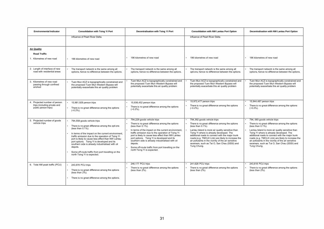
31
Environmental Indicator Consolidation with Tsing Yi Port Decentralisation with Tsing Yi Port Consolidation with NW Lantau Port Option Decentralisation with NW Lantau Port Option
influence of Pearl River Delta. influence of Pearl River Delta.
Air Quality
Road Traffic
1. Kilometres of new road
• 196 kilometres of new road
• 196 kilometres of new road
• 196 kilometres of new road
• 196 kilometres of new road
2. Length of interface of new road with residential areas
• The transport network is the same among all options, hence no difference between the options.
• The transport network is the same among all options, hence no difference between the options.
• The transport network is the same among all opti ons, hence no difference between the options.
• The transport network is the same among all options, hence no difference between the options.
3. Kilometres of new road passing through confined airshed
• Tuen Mun ACZ is topographically constrained and the proposed Tuen Mun Western Bypass will potentially exacerbate this air quality problem
• Tuen Mun ACZ is topographically constrained and the proposed Tuen Mun Western Bypass will potentially exacerbate this air quality problem
• Tuen Mun ACZ is topographically constrained and the proposed Tuen Mun Western Bypass will potentially exacerbate this air quality problem
• Tuen Mun ACZ is topographically constrained and the proposed Tuen Mun Western Bypass will potentially exacerbate this air quality problem
4. Projected number of person trips (including private and public person trips)
• 15,981,928 person trips
• There is no great difference among the options (~0.2%).
• 15,936,452 person trips
• There is no great difference among the options (~0.2%).
• 15,972,477 person trips
• There is no great difference among the options (~0.2%).
• 15,944,487 person trips
• There is no great difference among the options (~0.2%).
5. Projected number of goods vehicle trips
• 794,558 goods vehicle trips
• There is no great difference among the opti ons (less than 0.1%).
• In terms of the impact on the current environment, traffic emission due to the operation of Tsing Yi port is likely to cause less effect than NW Lantau port options. Tsing Yi is developed and its southern side is already industrialised with oil depots.
• Some off-route traffic from port travelling on the north Tsing Yi is expected.
• 794,229 goods vehicle trips
• There is no great difference among the options (less than 0.1%).
• In terms of the impact on the current environment, traffic emission due to the operation of Tsing Yi port is likely to cause less effect than NW Lantau port options. Tsing Yi is developed and its southern side is already industrialised with oil depots.
• Some off-route traffic from port travelling on the north Tsing Yi is expected.
• 794,392 goods vehicle trips
• There is no great difference among the options (less than 0.1%).
• Lantau Island is more air quality sensitive than Tsing Yi where is already developed. The additional roads to connect with the major trunk roads (e.g. TMCLK Link) are likely to increase the air pollutants in the vicinity of the air sensitive receivers, such as Tai O, San Chau (SSSI) and Tung Chung.
• 794, 060 goods vehicle trips
• There is no great difference among the options (less than 0.1%).
• Lantau Island is more air quality sensitive than Tsing Yi where is already developed. The additional roads to connect with the major trunk roads (e.g. TMCLK Link) are likely to increase the air pollutants in the vicinity of the air sensitive receivers, such as Tai O, San Chau (SSSI) and Tung Chung.
6. Total AM peak traffic (PCU) • 243,978 PCU trips
• There is no great difference among the options (less than 2%).
• There is no great difference among the options.
• 246,177 PCU trips
• There is no great difference among the options (less than 2%).
• 241,628 PCU trips
• There is no great difference among the options (less than 2%).
• 243,818 PCU trips
• There is no great difference among the options (less than 2%).

32
Environmental Indicator Consolidation with Tsing Yi Port Decentralisation with Tsing Yi Port Consolidation with NW Lantau Port Option Decentralisation with NW Lantau Port Option
7. Estimated CO emission rates – peak AM (x 106 gram)
• There is no great difference among the options.
• In terms of the impact on the current environment, traffic emission due to the operation of Tsing Yi port is likely to cause less effect than NW Lantau port options. Tsing Yi is developed and its southern side is already industrialised with oil depots.
• Some off-route traffic from port travelling on the north Tsing Yi is expected.
• There i s no great difference among the options.
• Lantau Island is more air quality sensitive than Tsing Yi where is already developed. The additional roads to connect with the major trunk roads (e.g. TMCLK Link) are likely to increase the air pollutants in the vicinity of the air sensitive receivers, such as Tai O, San Chau (SSSI) and Tung Chung.
• There is no great difference among the options.
• Lantau Island is more air quality sensitive than Tsing Yi where is already developed. The additional roads to connect with the major trunk roads (e.g. TMCLK Link) are likely to increase the air pollutants in the vicinity of the air sensitive receivers, such as Tai O, San Chau (SSSI) and Tung Chung.
8. Estimated daily emission of RSP, NOx and VOC (x 106 gram)
• There is no great difference among the options.
• In terms of the impact on the current environment, traffic emission due to the operation of Tsing Yi port is likely to cause less effect than NW Lantau port options. Tsing Yi is developed and its southern side is already industrialised with oil depots.
• Some off-route traffic from port travelling on the north Tsing Yi is expected.
• There is no great difference among the options.
• Lantau Island is more air quality sensitive than Tsing Yi where is already developed. The additional roads to connect with the major trunk roads (e.g. TMCLK Link) are likely to increase the air pollutants in the vicini ty of the air sensitive receivers, such as Tai O, San Chau (SSSI) and Tung Chung.
• There is no great difference among the options.
• Lantau Island is more air quality sensitive than Tsing Yi where is already developed. The additional roads to connect with the major trunk roads (e.g. TMCLK Link) are likely to increase the air pollutants in the vicinity of the air sensitive receivers, such as Tai O, San Chau (SSSI) and Tung Chung.
9. Percentage of industry/commerce (i.e. jobs) rail served
• Insufficient information available to differentiate between the options.
• Insufficient information available to differentiate between the options.
• Insufficient information available to differentiate between the options.
• Insufficient information available to differentiate between the options.
Marine Traffic
10. Projected increase in number of vessels
• Insufficient information available to differentiate between the options
• Insufficient information available to differentiate between the options
• Insufficient information available to differentiate between the options
• Insufficient information available to differentiate between the options
11. Estimated daily emission of RSP, NOx and VOC
• Insufficient detail available at this stage • Insufficient detail available at this stage • Insufficient detail available at this stage • Insufficient detail available at this stage
Industry/Power Generation
12. Estimated daily emission of RSP, NOx and VOC
• 1,280,000m² (net gain in GFA) redevelopment and conversion at industrial sites zoned for business use. Emission of RSP, NOx and VOC from industrial sites will reduce.
• 550,000m² (net gain in GFA) redevelopment and conversion at industrial sites zoned for business use. Emission of RSP, NOx and VOC from industrial sites will reduce.
• More industrial sites still maintained under the Decentralisation Pattern.

33
Environmental Indicator Consolidation with Tsing Yi Port Decentralisation with Tsing Yi Port Consolidation with NW Lantau Port Option Decentralisation with NW Lantau Port Option
13. Total greenhouse gas emissi ons (as CO2)
• Insufficient detail available at this stage • Insufficient detail available at this stage • Insufficient detail available at this stage • Insufficient detail available at this stage
14. Proximity to residential areas • Industry is assumed to be moving away from the Metro Area reducing the occurrence of incompatible land uses and close juxtaposition of industrial and residential uses.
• In the medium term, industry relocation and the subsequent benefits will be more apparent under this option.
• Industry is assumed to be moving away from the Metro Area reducing the occurrence of incompatible land uses and close juxtaposition of industrial and residential uses.
• In the medium term, industry relocation from the Metro Area is assumed at a slower pace than the consolidation pattern. Hence, benefits of this will not be as significant under this option. However, the relocation or rezoning of industrial areas within the NDAs will also reduce undesirable industrial/residential interface.
• Industry is assumed to be moving away from the Metro Area reducing the occurrence of incompatible land uses and close juxtaposition of industrial and residential uses.
• In the medium term, industry relocation and the subsequent benefits will be more apparent under this option.
• Industry is assumed to be moving away from the Metro Area reducing the occurrence of incompatible land uses and close juxtaposition of industrial and residential uses.
• In the medium term, industry relocation from the Metro Area is assumed at a slower pace than the consolidation pattern. Hence, benefits of this will not be as significant under this option. However, the relocation or rezoning of industrial areas within the NDAs will also reduce undesirable industrial/residential interface.
15. Proximity to pollution blackspots
• 1,280,000m2 (net gain in GFA) redevelopment and conversion at industrial sites zoned for business use. Residential areas in proximity to pollution blackspots reduced.
• 550,000m2 (net gain in GFA) redevelopment and conversion at industrial sites zoned for business use. Residential areas in proximity to pollution blackspots reduced but not as much as consolidation Pattern.
• 1,280,000m2 (net gain in GFA) redevelopment and conversion at industrial sites zoned for business use. Residenti al areas in proximity to pollution blackspots reduced.
• 550,000m2 (net gain in GFA) redevelopment and conversion at industrial sites zoned for business use. Residential areas in proximity to pollution blackspots reduced but not as much as consolidation Pattern.
16. Impact on existing air quality (cumulative effects)
• Insufficient information available to differentiate between the options
• Insufficient information available to differentiate between the options
• Insufficient information available to differentiate between the options
• Insufficient information available to differentiate between the options
17. Population within a confined airshed or with existing poor/bad air quality
• The existing infrastructure and prevalence of high-rise buildings restrict air movements in the urban area, the so-called ‘canyon effect’. In the medium term, consolidation of the population in the Metro Area will result in an increase in the population exposed to poor air quality.
• The dispersal of population to rural areas with good air quality will at least in the medium term result in a decrease in the percentage of the population exposed to poor air quality.
• The existing infrastructure and prevalence of high-rise buildings restrict air movements in the urban area, the so-called ‘canyon effect’. In the medium term, consolidation of the population in the Metro Area will result in an increase in the population exposed to poor air quality
• The dispersal of population to rural areas with good air quality will at least in the medium term result in a decrease in the percentage of the population exposed to poor air quality
18. Length of interface between industry or undesirable uses and residential areas
• New or existing waste disposal facilities having the potential to cause odour or dust nuisance should be designed/upgraded with appropriate mitigation measures to eliminate residual impact
• 1,280,000m2 (net gain in GFA) redevelopment and conversion at industrial sites zoned for business use. Interface between residential areas and industry/ undesirable uses reduced.
• New or existing waste disposal facilities having the potential to cause odour or dust nuisance should be designed/upgraded with appropriate mitigation measures to eliminate residual impact
• 550,000m2 (net gain in GFA) redevelopment and conversion at industrial sites zoned for business use. Interface between residential areas and industry/ undesirable uses reduced but not as much as consolidation Pattern.
• New or existing waste disposal facilities having the potential to cause odour or dust nuisance should be designed with appropriate mitigation measures to eliminate residual impact
• 1,280,000m2 (net gain in GFA) redevelopment and conversion at industrial sites zoned for business use. Interface between residential areas and industry/ undesirable uses reduced.
• New or existing waste disposal facilities having the potential to cause odour or dust nuisance should be designed with appropriate mitigation measures to eliminate residual impact
• 550,000m2 (net gain in GFA) redevelopment and conversion at industrial sites zoned for business use. Interface between residential areas and industry/ undesirable uses reduced but not as much as consolidation Pattern.
19. Industry within confined airsheds
• It is assumed that existing and planned facilities including the Science Park, the Cyberport, the Business Park at CLK and the three industrial estates will be adequate in meeting demand for industrial uses.
• It is assumed that existing and planned facilities including the Science Park, the Cyberport, the Business Park at CLK and the three industrial estates will be adequate in meeting demand for industrial uses.
• It is assumed that existing and planned facilities including the Science Park, the Cyberport, the Business Park at CLK and the three industrial estates will be adequate in meeting demand for industrial uses.
• It is assumed that existing and planned facilities including the Science Park, the Cyberport, the Business Park at CLK and the three industrial estates will be adequate in meeting demand for industrial uses.

34
Environmental Indicator Consolidation with Tsing Yi Port Decentralisation with Tsing Yi Port Consolidation with NW Lantau Port Option Decentralisation with NW Lantau Port Option
20. Projected non-compliance with Air Quality Objectives (AQOs) (emissions from industry/power generation and/or vehicular traffic)
• Air pollution problems in Hong Kong have changed as its economy has changed, in the 1980s the pollutant of most concern was sulphur dioxide from factories however in the 1990s diesel fuelled vehicle emissions (RSP and NOx) were highlighted as the key concern.
• Air quality in the PRD region is predicted to deteriorate due to the increase in emissions from both power generation/industrial activities and road vehicles. Whilst Hong Kong’s highly visible ambient air pollution is largely caused by local sources, it is also affected by regional problems and cannot be considered or addressed in isolation.
• Additional off-site traffic from the port operation is expected to increase the air pollutant emission.
• Insufficient information to justify the compliance of AQOs.
• Air pollution problems in Hong Kong have changed as its economy has changed, in the 1980s the pollutant of most concern was sulphur dioxide from factories however in the 1990s diesel fuelled vehicle emissions (RSP and NO2) were highlighted as the key concern.
• Air quality in the PRD region is predicted to deteriorate due to the increase in emissions from both power generation/industrial activities and road vehicles. Whilst Hong Kong’s highly visible ambient air pollution is largely caused by local sources, it is also affected by regional problems and cannot be considered or addressed in isolation.
• Additional off-site traffic from the port operation is expected to increase the air pollutant emission.
• Insufficient information to justify the compliance of AQOs.
• Air pollution problems in Hong Kong have changed as its economy has changed, in the 1980s the pollutant of most concern was sulphur dioxide from factories however in the 1990s diesel fuelled vehicle emissions (RSP and NOx) were highlighted as the key concern.
• Air quality in the PRD region is predicted to deteriorate due to the increase in emissi ons from both power generation/industrial activities and road vehicles. Whilst Hong Kong’s highly visible ambient air pollution is largely caused by local sources, it is also affected by regional problems and cannot be considered or addressed in isolation.
• Additional off-site traffic from the port operation is expected to increase the air pollutant emission. In terms of the sensitivity of the area, Lantau Island is more air quality sensitive than Tsing Yi.
• Insufficient information to justify the compliance of AQOs.
• Air pollution problems in Hong Kong have changed as its economy has changed, in the 1980s the pollutant of most concern was sulphur dioxide from factories however in the 1990s vehicle emissions (RSP and NOx) were highlighted as the key concern.
• Air quality in the PRD region is predicted to deteriorate due to the increase in emissions from both power generation/industrial activities and road vehicles. Whilst Hong Kong’s highly visible ambient air pollution is largely caused by local sources, it is also affected by regional problems and cannot be considered or addressed in isolation.
• Additional off-site traffic from the port operation is expected to increase the air pollutant emission. In terms of the sensitivity of the area, Lantau Island is more air quality sensitive than Tsing Yi.
• Insufficient information to justify the compliance of AQOs.
21. Projected improvement or deterioration in Air Pollution Index (API)
• The implementation of measures identified in the IAR and KIR to reduce vehicular road traffic, or emissions from it, would have a beneficial effect on air quality.
• Insufficient information available to differentiate between the options
• The implementation of measures identified in the IAR and KIR to reduce vehicular road traffic, or emissions from it, would have a beneficial effect on air quality.
• Insufficient information available to differentiate between the options
• The implementation of measures identified in the IAR and KIR to reduce vehicular road traffic, or emissions from it, would have a beneficial effect on air quality.
• Insufficient information available to differentiate between the options
• The implementation of measures identified in the IAR and KIR to reduce vehicular road traffic, or emissions from it, would have a benefi cial effect on air quality.
• Insufficient information available to differentiate between the options
22. Projected improvement or deterioration in level of Toxic Air Pollutants (TAPs)
• Insufficient information available to differentiate between the options
• Insufficient information available to differentiate between the options
• Insufficient information available to differentiate between the options
• Insufficient information available to differentiate between the options
Noise
Rail
1. Length of interface with residential areas
• West Island Line Extension, South Island Line and Northern Link (West Rail) are proposed by 2020. While the proposed alignments may be subject to change, the first two railways within the Metro Area will have greater chance of interface with existing residential areas. This implies mitigation measures will need to be implemented during the design stage of the railways.
• Hung Shui Kiu and Kwu Tung NDAs are planned with rail. The problem of interface with residential areas could be mitigated by placing non-sensitive receivers along the alignment or by using other noise abatement methods. The future Kwu Tung Station to be built along with Kwu Tung North NDA will be placed undergroud.
2. Estimated volume of rolling stock
• Insufficient information available at this stage • Insufficient information available at this stage • Insufficient information available at this stage • Insufficient information available at this stage

35
Environmental Indicator Consolidation with Tsing Yi Port Decentralisation with Tsing Yi Port Consolidation with NW Lantau Port Option Decentralisation with NW Lantau Port Option
3. “Peak flows” • Insufficient information available at this stage • Insufficient information available at this stage • Insufficient information available at this stage • Insufficient information available at this stage
Road Traffic
4. Length of interface with residential areas
• The traffic network is the same among all options.
• Minimum length of interface with residential area is expected in the development of former Kai Tak Airport.
• The traffic network is the same among all options.
• Minimum length of interface with residential area is expected in the NDAs, especially most of them are railway served.
• The traffic network is the same among all options.
• Minimum length of interface with residential area is expected in the development of former Kai Tak Airport.
• The traffic network is the same among all options.
• Minimum length of interface with residential area is expected in the NDAs, especi ally most of them are railway served.
5. Estimated noise levels • Insufficient detail available at this stage. • Insufficient detail available at this stage. • Insufficient detail available at this stage. • Insufficient detail available at this stage.
6. Estimate the relative noise levels compared to the existing situation (increase/decrease)
• The predicted increase in traffic volume implies an associated increase in generated noise.
• The predicted increase in traffic volume implies an associated increase in generated noise.
• The predicted increase in traffic volume implies an associated increase in generated noise.
• The predicted increase in traffic volume implies an associated increase in generated noise.
7. Population exposed to noise levels above agreed standards
• Insufficient detail available at this stage. However, it should be noted that this refers to existing populations as new roads will be designed and built in compliance with the EIAO. By implication the Consolidation Pattern has greater potential effect on existing populations than the Decentralisation Pattern. Nonetheless, the orientation and building design will affect the noise levels at the NSRs.
• Insufficient detail available at this stage. However, it should be noted that this refers to existing populations as new roads will be designed and built in compliance with the EIAO. By implication the Consolidation Pattern has greater potential effect on existing populations than the Decentralisation Pattern. Nonetheless, the orientation and building design will affect the noise levels at the NSRs.
• Insufficient detail available at this stage. However, it should be noted that this refers to existing populations as new roads will be designed and built in compliance with the EIAO. By implication the Consolidation Pattern has greater potential effect on existing populations than the Decentralisation Pattern. Nonetheless, the orientation and building design will affect the noise levels at the NSRs.
• Insufficient detail available at this stage. However, it should be noted that this refers to existing populations as new roads will be designed and built in compliance with the EIAO. By implication the Consolidation Pattern has greater potential effect on existing populations than the Decentralisation Pattern. Nonetheless, the orientation and building design will affect the noise levels at the NSRs.
Ports
8. Proximity to residential areas and other noise sensitive receivers
• The port will be located at the southern side where the residenti al area is located at the northern side of Tsing Yi Island, the distance between them is over 1km and the two locations are separated by a mountain.
• Negligible impact from port operation.
• The port will be located at the southern side where the residential area is located at the northern side of Tsing Yi Island, the distance between them is over 1km and the two locations are separated by a mountain.
• Negligible impact from port operation.
• The port will be located at the Northwest of Lantau where is over 1.5km from the nearest Tai O village.
• Negligible impact from port operation.
• The port will be located at the Northwest of Lantau where is over 1.5km from the nearest Tai O village.
• Negligible impact from port operation.
9. Estimated noise levels • In general the noise environment in the vicinity of the new port will be increased. However, noise generated from port operation will need to comply with the HKPSG noise standards.
• Off-site traffic due to the port activities will be generated. Additional container trucks / lorries will travel on the two major existing trunk roads: Kwai Tsing Road and Tsing Tsuen Road (although Route 9 may share some of them) and also some
• In general the noise environment in the vicinity of the new port will be increased. However, noise generated from port operation will need to comply with the HKPSG noise standards.
• Off-site traffic due to the port activities will be generated. Additional container trucks / lorries will travel on the two major existing trunk roads: Kwai Tsing Road and Tsing Tsuen Road (although Route 9 may share some of them) and
• In general the noise environment in the vicinity of the new port will be substantially increased comparing with the current low background noise level. However, noise generated from port operation will need to comply with the HKPSG noise standards.
• Off-site traffic due to the port activities will be generated. Two major access roads to the port will be the existing North Lantau Expressway and the
• In general the noise environment in the vicinity of he new port will be substantially increased comparing with the current low background noise level. However, noise generated from port operation will need to comply with the HKPSG noise standards.
• Off-site traffic due to the port activities will be generated. Two major access roads to the port will be the existing North Lantau Expressway and the

36
Environmental Indicator Consolidation with Tsing Yi Port Decentralisation with Tsing Yi Port Consolidation with NW Lantau Port Option Decentralisation with NW Lantau Port Option
local roads on Tsing Yi. The noise impact from off-site traffic on the residents will increase.
• Excessive noise impact on the developments at former Kai Tak Airport is unlikely.
also some local roads on Tsing Yi. The noise impact from off-site traffic on the residents will increase.
• Excessive noise impact on the NDAs is unlikely.
future Tuen Mun – Chek Lap Kok Link. Traffic loading will be added on to North Lantau Expressway where residential developments are erected along a section of the Expressway in Tung Chung.
• The development of Tung Chung is relatively new and better urban planning is implemented. The NW Lantau port location will be built on an artificial island which is more remote from the city than Tsing Yi Port. In addition, there is less population in Tung Chung than in Tsing Yi. Compared to the Tsing Yi Port option, the noise impact due to the NW Lantau port operation is less, and less population will be affected.
• Excessive noise impact on the developments at former Kai Tak Airport is unlikely.
future Tuen Mun – Chek Lap Kok Link. Traffic loading will be added on to North Lantau Expressway where residential developments are erected along a section of the Expressway in Tung Chung.
• The development of Tung Chung is relatively new and better urban planning is implemented. The NW Lantau port location will be built on an artificial island which is more remote from the city than Tsing Yi Port. In addition, there is less population in Tung Chung than in Tsing Yi. Compared to the Tsing Yi Port option, the noise impact due to the NW Lantau port operation is less, and less population will be affected.
• Excessive noise impact on the NDAs is unlikely.
Airports
10. Population within the Noise Exposure Forecast 25 contour
• Insufficient information to distinguish between the options.
• Insufficient information to distinguish between the options.
• Insufficient information to distinguish between the options.
• Insufficient information to distinguish between the options.
Waste
1. Projected domestic waste production
• Household waste arisings have risen steadily in line wi th growth in population and wealth of the community.
• Insufficient information to differentiate between the options
• Household waste arisings have risen steadily in line with growth in population and wealth of the community.
• Insufficient information to differentiate between the options
• Household waste arisings have risen steadily in line with growth in population and wealth of the community.
• Insufficient information to differentiate between the options
• Household waste arisings have risen steadily in line with growth in population and wealth of the community.
• Insufficient information to differentiate between the options
2. Volume of domestic waste requiring disposal
• Volume of domestic waste requiring disposal will be identical for all options due to same population growth.
• Volume of domestic waste requiring disposal will be identical for all options due to same population growth.
• Volume of domestic waste requiring disposal will be identical for all options due to same population growth.
• Volume of domestic waste requiring disposal will be identical for all options due to same population growth.
3. Projected industrial and commercial waste production
• Insufficient information to differentiate between the options
• Insufficient information to differentiate between the options
• Insufficient information to differentiate between the options
• Insufficient information to differentiate between the options
4. Volume of industrial and commercial waste requiring disposal
• Volume of industrial and commercial waste requiring disposal will be identical for all options due to same economic growth.
• Volume of industrial and commercial waste requiring disposal will be identical for all options due to same economic growth.
• Volume of industrial and commercial waste requiring disposal will be identical for all options due to same economic growth.
• Volume of industrial and commercial waste requiring disposal will be identical for all options due to same economic growth.
5. Volume of C&D material requiring disposal
• Urban renewal will be more focussed on redevelopment hence create greater amount of C&D materials.
• Urban renewal will be more focussed on rehabilitation, hence create smaller amount of C&D materials.
• Urban renewal will be more focussed on redevelopment hence create greater amount of C&D materials.
• Urban renewal will be more focussed on rehabilitation, hence create smaller amount of C&D materials.

37
Environmental Indicator Consolidation with Tsing Yi Port Decentralisation with Tsing Yi Port Consolidation with NW Lantau Port Option Decentralisation with NW Lantau Port Option
• Port development could however be viewed as a valuable depository for surplus inert C&D materials. The reclamation area for Tsing Yi port option will be smaller than that for NW Lantau, hence the environmental benefits in terms of accommodation of surplus inert C&D materials will also be smaller.
• Development of NDAs in greenfield sites in the Northern NT will create large quantities of C&D materials.
• Port development could however be viewed as a valuable depository for surplus inert C&D materials. The reclamation area for Tsing Yi port option will be smaller than that for NW Lantau, hence the environmental benefits in terms of accommodation of surplus inert C&D materials will also be smaller.
• Port development could however be viewed as a valuable depository for surplus inert C&D materials. The reclamation area for NW Lantau port option will be larger than that for Tsing Yi, hence the environmental benefits in terms of accommodation of surplus inert C&D materials will also be greater.
• Development of NDAs in greenfield sites in the Northern NT will create large quantities of C&D materials.
• Port development could however be viewed as a valuable depository for surplus inert C&D materials. The reclamation area for NW Lantau port option will be larger than that for Tsing Yi, hence the environmental benefits in terms of accommodation of surplus inert C&D materials will also be greater.
6. Volume of C&D waste requiring disposal
• Insufficient information to differentiate between the options
• Insufficient information to differentiate between the options
• Insufficient information to differentiate between the options
• Insufficient information to differentiate between the options
7. Volume of chemical waste requiring disposal
• Insufficient information to differentiate between the options
• Insufficient information to differentiate between the options
• Insufficient information to differentiate between the options
• Insufficient information to differentiate between the options
8. Volume of excavated contaminated soil requiring treatment/disposal
• Contamination from chemical storage tanks at the disused former Kai Tak Airport will result in the generation of soil requiring treatment and disposal
• Large quantity of contaminated soil from current land-based activities in south and east Tsing Yi site area.
• Contamination from chemical storage tanks at the disused former Kai Tak Airport will result in the generation of soil requiring treatment and disposal.
• LMC Loop was previously used as a dump site for soft sediment, of which more than 1,000,000 m³ are contaminated.
• Large quantity of contaminated soil from current land-based activities in south and east Tsing Yi site area.
• Contamination from chemical storage tanks at the disused former Kai Tak Airport will result in the generation of soil requiring treatment and disposal.
• No contaminated soil from current land based activities associated with this port option.
• Contamination from chemical storage tanks at the disused Kai Tak Airport will result in the generation of soil requiring treatment and disposal.
• LMC Loop was previously used as a dump site for soft sediment, of which more than 1,000,000 m³ are contaminated.
• No contaminated soil from current land based activities associated with this port option.
9. Proximity to appropriate disposal facilities
• Non-inert privately-collected wastes (commercial, industrial and C&D) generated in the Metro Area are disposed of to SENT landfill, however current predictions show that SENT landfill will run out as early as 2005. Expansion is constrained by competing land uses.
• Even in the medium term waste disposal facilities will be located further from developed areas.
• Non-inert wastes (domestic, commercial , industrial and C&D) generated in the NENT and NWNT are disposed of to WENT or NENT either directly or via NWNT transfer station. At current disposal rates, capacity in these two landfills will be full by 2015. Opportunities for expansion have been identified at both existing landfills.
• Even in the medium term waste disposal facilities will be located further from developed areas.
10. Extent of interface of waste facilities wi th residential areas
• Extension of NENT and WENT landfills or establishment of proposed new facilities has no anticipated impact on planned developments
• Insufficient information to differentiate between the options
• Extension of NENT and WENT landfills or establishment of proposed new facilities has no anticipated impact on planned developments
• Insufficient information to differentiate between the options
• Extension of NENT and WENT landfills or establishment of proposed new facilities has no anticipated impact on planned developments
• Insufficient information to differentiate between the options
• Extension of NENT and WENT landfills or establishment of proposed new facilities has no anticipated impact on planned developments
• Insufficient information to differentiate between the options
11. Extent of interface of waste • Extension of NENT and WENT landfills • Landfills in the New Territories are not spatially • Extension of NENT and WENT landfills • Landfills in the New Territories are not spatially
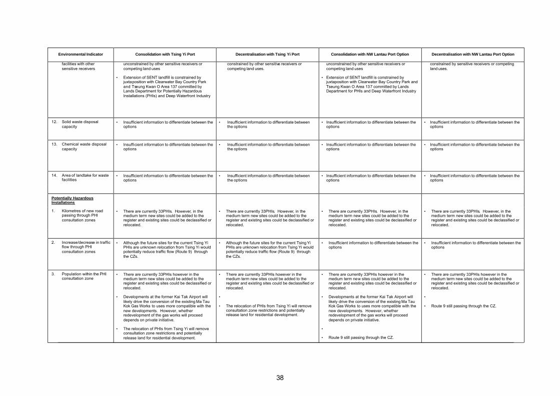
38
Environmental Indicator Consolidation with Tsing Yi Port Decentralisation with Tsing Yi Port Consolidation with NW Lantau Port Option Decentralisation with NW Lantau Port Option
facilities with other sensitive receivers
unconstrained by other sensitive receivers or competing land uses
• Extension of SENT landfill is constrained by juxtaposition with Clearwater Bay Country Park and Tseung Kwan O Area 137 committed by Lands Department for Potentially Hazardous Installations (PHIs) and Deep Waterfront Industry
constrained by other sensitive receivers or competing land uses.
unconstrained by other sensitive receivers or competing land uses
• Extension of SENT landfill is constrained by juxtaposition with Clearwater Bay Country Park and Tseung Kwan O Area 137 committed by Lands Department for PHIs and Deep Waterfront Industry
constrained by sensitive receivers or competing land uses.
12. Solid waste disposal capacity
• Insufficient information to differentiate between the options
• Insufficient information to differentiate between the options
• Insufficient information to differentiate between the options
• Insufficient information to differentiate between the options
13. Chemical waste disposal capacity
• Insufficient information to differentiate between the options
• Insufficient information to differentiate between the options
• Insufficient information to differentiate between the options
• Insufficient information to differentiate between the options
14. Area of landtake for waste facilities
• Insufficient information to differentiate between the options
• Insufficient information to differentiate between the options
• Insufficient information to differentiate between the options
• Insufficient information to differentiate between the options
Potentially Hazardous Installations
1. Kilometres of new road passing through PHI consultation zones
• There are currently 33PHIs. However, in the medium term new sites could be added to the register and existing sites could be declassified or relocated.
• There are currently 33PHIs. However, in the medium term new sites could be added to the register and existing sites could be declassified or relocated.
• There are currently 33PHIs. However, in the medium term new sites could be added to the register and existing sites could be declassified or relocated.
• There are currently 33PHIs. However, in the medium term new sites could be added to the register and existing sites could be declassified or relocated.
2. Increase/decrease in traffic flow through PHI consultation zones
• Although the future sites for the current Tsing Yi PHIs are unknown relocation from Tsing Yi would potentially reduce traffic flow (Route 9) through the CZs.
• Although the future sites for the current Tsing Yi PHIs are unknown relocation from Tsing Yi would potentially reduce traffic flow (Route 9) through the CZs.
• Insufficient information to differentiate between the options
• Insufficient information to differentiate between the options
3. Population within the PHI consultation zone
• There are currently 33PHIs however in the medium term new sites could be added to the register and existing sites could be declassified or relocated.
• Developments at the former Kai Tak Airport will likely drive the conversion of the existing Ma Tau Kok Gas Works to uses more compatible with the new developments. However, whether redevelopment of the gas works will proceed depends on private initiative.
• The relocation of PHIs from Tsing Yi will remove consultation zone restrictions and potentially release land for residential development.
• There are currently 33PHIs however in the medium term new sites could be added to the register and existing sites could be declassified or relocated.
•
• The relocation of PHIs from Tsing Yi will remove consultation zone restrictions and potentially release land for residential development.
• There are currently 33PHIs however in the medium term new sites could be added to the register and existing sites could be declassified or relocated.
• Developments at the former Kai Tak Airport will likely drive the conversion of the existing Ma Tau Kok Gas Works to uses more compatible with the new developments. However, whether redevelopment of the gas works will proceed depends on private initiative.
•
• Route 9 still passing through the CZ.
• There are currently 33PHIs however in the medium term new sites could be added to the register and existing sites could be declassified or relocated.
•
• Route 9 still passing through the CZ.

39
Environmental Indicator Consolidation with Tsing Yi Port Decentralisation with Tsing Yi Port Consolidation with NW Lantau Port Option Decentralisation with NW Lantau Port Option
4. Increase/decrease in population within PHI consultation zone
• An appraisal of CZs to determine alternative solutions or means to circumvent the problems identified should be conducted when further detail is available.
• Developments at the former Kai Tak Airport will likely drive the conversion of the existing Ma Tau Kok Gas Works to uses more compatible with the new developments. However, whether redevelopment of the gas works will proceed depends on private initiative.
• The majority of the PHIs are located in rural areas and therefore restrictions on expansion or establishment of new development areas abutting CZs need to be reviewed when further detail is available
• Potential increase in WSD’s Sheung Shui Water Treatment Works CZ in the short – medium term
• Developments at the former Kai Tak Airport will likely drive the conversion of the existing Ma Tau Kok Gas Works to uses more compatible with the new developments. However, whether redevelopment of the gas works will proceed depends on private initiative.
• An appraisal of CZs to determine alternative solutions or means to circumvent the problems identi fied should be conducted when further detail is available
• Developments at the former Kai Tak Airport will likely drive the conversion of the existing Ma Tau Kok Gas Works to uses more compatible with the new developments. However, whether redevelopment of the gas works will proceed depends on private initiative.
• Route 9 still passing through the CZ.
• The majority of the PHIs are located in rural areas and therefore restrictions on expansion or establishment of new development areas abutting CZs need to be reviewed when further detail is available
• Potential increase in WSD’s Sheung Shui Water Treatment Works CZ in the short – medium term
• Developments at the former Kai Tak Airport will likely drive the conversion of the existing Ma Tau Kok Gas Works to uses more compatible with the new developments. However, whether redevelopment of the gas works will proceed depends on private initiative.
• Route 9 still passing through the CZ.
Ecology
1. Extent of interface of new developments with ecologically signi ficant sites (terrestrial)
• There is not anticipated to be any interface between new developments and ecologically significant sites.
• The establishment of the NENT NDAs will result in direct and indirect i mpacts on high ecological value habitats. Combined habitat losses require mitigation to compensate for ecological impacts
• The establishment or expansion of NDAs in NWNT should prevent adverse impacts to wetland habitats, particularly the important areas such as the Deep Bay, the Mai Po Ramsar site and other SSSIs.
• Furthermore, in rural areas consideration should be given to formation of ecological corridors in order to avoid fragmentation of existing habitats or to provide links between areas of significance to increase viability.
• Development at LMC Loop may have potential impacts on nearby ecological sensitive areas and the old river bend that was restored and conserved as a measure to mitigate the fishponds loss arising from Shenzhen River training project.
• There is not anticipated to be any interface between new developments and ecologically significant sites.
• The establishment of the NENT NDAs in the short-medium term will result in direct and indirect impacts on high ecological value habitats. Combined habitat losses require mitigation to compensate for ecological impacts
• The establishment or expansion of NDAs in NWNT should prevent adverse impacts to wetland habitats, particularly the important areas such as the Deep Bay, the Mai Po Ramsar site and other SSSIs.
• Furthermore, in rural areas consideration should be given to formation of ecological corridors in order to avoid fragmentation of existing habitats or to provide links between areas of significance to increase viability.
• Development at LMC Loop may have potential impacts on nearby ecological sensitive areas and the old river bend that was restored and conserved as a measure to mitigate the fishponds loss arising from Shenzhen River training project.
2. Extent of interface of new developments with ecologically significant sites (marine)
• It is not anticipated that there will be any interface between new developments and marine ecologically significant sites
• It is not anticipated that there will be any interface between new developments and marine ecologically significant sites
• Marine sensitive sites may be affected since the NW Lantau Port option is located within an important Chinese White Dolphin habitat in Hong Kong.
• Marine sensitive sites may be affected since the NW Lantau Port option is located within an important Chinese White Dolphin habitat in Hong Kong.
3. Extent of interface of new transport infrastructure with ecologically significant
• Tuen Mun Western Bypass may affect some trees/shrubs.
• Tuen Mun Western Bypass may affect some trees/shrubs.
• Tuen Mun Western Bypass may affect some trees/shrubs.
• Tuen Mun Western Bypass may affect some trees/shrubs.

40
Environmental Indicator Consolidation with Tsing Yi Port Decentralisation with Tsing Yi Port Consolidation with NW Lantau Port Option Decentralisation with NW Lantau Port Option
sites (terrestrial)
4. Extent of interface of new transport infrastructure with ecologically significant sites (marine)
• TMCLK Link passes through Chinese White Dolphin habitat
• TMCLK Link passes through Chinese White Dolphin habitat
• TMCLK Link passes through Chinese White Dolphin habitat
• TMCLK Link passes through Chinese White Dolphin habitat
5. Area of sites of ecological significance degraded, threatened or lost
• There is not anticipated to be any impact from new developments in the Metro Area on ecologically significant sites.
• Dredging for port access west of Lamma Island in porpoise habitat
• Surveys have recorded 21 species of conservation concern (SCC) within the proposed NENT NDAs including four globally threatened species. Key habitats include marsh, pond and stream habitats. These habitats should be avoided as far as possible, and if not, the adverse impacts should be mitigated and compensated.
• Hung Shui Kiu NDA will impact directly on ecologically significant flooded wetlands/grasslands. Adverse impacts should be minimised, mitigated and compensated.
• Extent of NWNT wetland degraded threatened or lost through reclamation or other development proposals is unknown, potential to adversely affect fragile wetland ecosystem both during and following construction.
• Dredging for port access west of Lamma Island in porpoise habitat.
• There is not anticipated to be any impact from new developments in the Metro Area on ecologically significant sites.
• In the vicinity of NW Lantau port there is considerable natural coastline, including mangrove stands along Tai O Creek, coastal San Chau SSSI, existing marine parks at Sha Chau and Lung Kwu Chau, potential sites for designation as marine parks at south west Lantau and at Soko Islands and Lantau North Country Park and the potential site for its extension.
• The epifauna community is diverse in bays along the NM Lantau coastline and includes the locally restricted Horseshoe Crab
• The proposed port site also includes the habitat of the internationally protected Chinese White Dolphin, and is an area where the dolphins are frequently sighted.
• Offshore NW Lantau is an important spawning ground for commercially valuable fish and crustaceans. Commercially valuable shrimp species are also found toward Sha Chau and Lung Kwu Chau
• Marine access for this port option is in close proximity to the existing contaminated mud pit at East Sha Chau. Disturbance of the capping layers and consequent deterioration of water quality may impact on Lung Kwu Chau and the Chinese White Dolphin habitat
• Surveys have recorded 21 species of conservation concern (SCC) within the proposed NENT NDAs including four globally threatened species. Key habitats include marsh, pond and stream habitats. These habitats should be avoided as far as possible, and if not, the adverse impacts should be mitigated and compensated
• Hung Shui Kiu NDA will impact directly on ecologically significant flooded wetlands/grasslands. Adverse impacts should be minimised, mitigated and compensated.
• Extent of NWNT wetland degraded threatened or lost through reclamation or other development proposals is unknown, potential to adversely affect fragile wetland ecosystem both during and following construction
• In the vicinity of NW Lantau port there is considerable natural coastline, including mangrove stands along Tai O Creek, coastal San Chau SSSI, existing marine parks at Sha Chau and Lung Kwu Chau, potential sites for designation as marine parks at south west Lantau and at Soko Islands and Lantau North Country Park and the potential site for its extension.
• The epifauna community is diverse in bays along the NM Lantau coastline and includes the locally restricted Horseshoe Crab
• The proposed port site also includes the habitat of the internationally protected Chinese White Dolphin, and is an area where the dolphins are frequently sighted.
• Offshore NW Lantau is an important spawning ground for commercially valuable fish and crustaceans. Commercially valuable shrimp species are also found toward Sha Chau and Lung Kwu Chau.
• Marine access for this port option is in close proximity to the existing contaminated mud pit at East Sha Chau. Disturbance of the capping layers and consequent deterioration of water quality may impact on Lung Kwu Chau and the Chinese White Dolphin habitat.

41
Environmental Indicator Consolidation with Tsing Yi Port Decentralisation with Tsing Yi Port Consolidation with NW Lantau Port Option Decentralisation with NW Lantau Port Option
6. Area of sites of ecological significance restored/enhanced
• Insufficient information available • Insufficient information available • Insufficient information available • Insufficient information available
7. Extent of coast line degraded
• Tsing Yi Island coastline already extensively developed for industrial uses and dockyards, natural coastline absent
• Tsing Yi Island coastline already extensively developed for industrial uses and dockyards, natural coastline absent
• NW Lantau natural coastline will potentially be degraded through construction of the adjacent port facilities and local roads.
• NW Lantau natural coastline will potentially be degraded through construction of the adjacent port facilities and local roads.
8. Extent of coast line lost • It is not anticipated that any natural coast line will be lost
• It is not anticipated that any natural coast line will be lost
• As the NW Lantau port will be built on an artificial land, some natural coast line may be lost due to the construction of additional roads linking to major trunk road (i.e. TMCLK Link)
• As the NW Lantau port will be built on an artificial land, some natural coast line may be lost due to the construction of additional roads linking to major trunk road (i.e. TMCLK Link)
9. Extent of coast line restored/enhanced
• Insufficient information available • Insufficient information available • Insufficient information available • Insufficient information available
10. Area of seabed disturbance
• Developments and infrastructure which will impact on the seabed include: TMCLK Link (tunnels and bridges have different environmental impacts, a tunnel would result in significantly greater seabed disturbance), Tsing Lung Bridge, Tsing Yi Port and the SEKD reclamation.
• Developments and infrastructure which will impact on the seabed include: TMCLK Link (tunnels and bridges have different environmental impacts, a tunnel would result in significantly greater seabed disturbance), Tsing Lung Bridge and Tsing Yi Port.
• Developments and infrastructure which will impact on the seabed include: TMCLK Link (tunnels and bridges have different environmental impacts, a tunnel would result in significantly greater seabed disturbance), Tsing Lung Bridge, NW Lantau Port and the SEKD reclamation.
• Developments and infrastructure which will impact on the seabed include: TMCLK Link (tunnels and bridges have different environmental impacts, a tunnel would result in significantly greater seabed disturbance), Tsing Lung Bridge and NW Lantau Port.
Energy and Natural Resources
1. Percentage of total energy supplied by renewable energy sources
• Insufficient information to differentiate between the options, but it would be reasonable to assume that the energy consumption rates are highly dependent on population, aspirations of the communities and GDP. To that end the options will be expected to perform in a similar manner in overall terms – although not necessarily at the micro level (too refined for this phase of the Study).
• Insufficient information to differentiate between the options.
• Insufficient information to differentiate between the options.
• Insufficient information to differentiate between the options
2. Opportunities for utilisation of renewable energy sources
• Insufficient information to differentiate between the options, it would however be expected that over the period of the Study there may be more opportunities to utilitise centralised systems (district cool ing etc.) in this option. More details are required before the options can be differentiated.
• Insufficient information to differentiate between the options
• Insufficient information to differentiate between the options, it would however be expected that over the period of the Study there may be more opportunities to utilitise centralised systems (district cooling etc.) in this option. More details are required before the options can be differentiated.
• Insufficient information to differentiate between the options
3. Consumption of energy per unit of output ($GDP)
• Insufficient information to differentiate between the options. As the consumption of energy is linked to the GDP and the populations then it is reasonable to assume there would be insignificant difference between the options.
• Insufficient information to differentiate between the options
• Insufficient information to differentiate between the options.
• Insufficient information to differentiate between the options

42
Environmental Indicator Consolidation with Tsing Yi Port Decentralisation with Tsing Yi Port Consolidation with NW Lantau Port Option Decentralisation with NW Lantau Port Option
4. Volume of freshwater supplied per capita
• Insufficient information to differentiate between the options. The current agreement in which Hong Kong obtains around 75% of freshwater from the Mainland suggests that there is little to differentiate these options. This is further supported by the fact that freshwater consumption rates are linked to population and aspirations (like energy) also suggests that there is little to differentiate between the options.
• Insufficient information to differentiate between the options
• Insufficient information to differentiate between the options.
• Insufficient information to differentiate between the options
5. Percentage of demand met by locally-derived freshwater resources
• Insufficient information to differentiate between the options – also see above with regard to the high dependence on Mainland for the majority of the freshwater resources. Notwithstanding the foregoing it must be remembered that the Guangdong Province is developing at a fast pace and therefore demand for water resources will also increase from within Guangdong itself.
• Insufficient information to differentiate between the options
• Insufficient information to differentiate between the options.
• Insufficient information to differentiate between the options
Cultural Heritage
1. Number/type/status of known sites of cultural heritage value including archaeological sites affected by new developments or transport infrastructure.
• Many sites of heritage value have been identified throughout Hong Kong however only declared and deemed monuments are afforded legal protection.
• In the short-medium term there is greater potential impact in the Metro Area with the implementation of urban renewal projects and new developments at the former Kai Tak Airport.
• New developments at the former Kai Tak Airport will impact on sites of cultural heritage importance include the former Far East Flying Training School, post war buildings of Kai Tak Airport, cultural relics and archaeological remains within the area, area at the foot of former Sacred Hill, si te of the Kowloon City Public Pier and rock from Kowloon Walled City.
• No known terrestrial or marine resources adjacent to Tsing Yi port .
• Many sites of heritage value have been identified throughout Hong Kong however only declared and deemed monuments are afforded legal protection.
• New developments at the former Kai Tak Airport will impact on sites of cultural heritage importance include the former Far East Flying Training School, post war buildings of Kai Tak Airport, cultural relics and archaeological remains within the area, area at the foot of former Sacred Hill, site of the Kowloon City Public Pier and rock from Kowloon Walled City.
• NENT NDAs have avoided potential impact to declared monuments, graded buildings and old villages as far as possible. However impact on a number of ungraded sites is considered unavoidable, and mitigation measures such as rescue excavation are required for identified archaeological deposits.
• Hung Shui Kiu NDA has been positioned so as to impact as few buildings and sites of importance as possible in this culturally rich area. Sensitive zoning is planned for protection of historical sites within the NDA.
• No known terrestrial or marine resources adjacent to Tsing Yi port .
• Many sites of heritage value have been identified throughout Hong Kong however only declared and deemed monuments are afforded legal protection.
• In the short-medium term there is greater potential impact in the Metro Area with the implementation of urban renewal projects and new developments at the former Kai Tak Airport.
• New developments at the former Kai Tak Airport will impact on sites of cultural heritage importance include the former Far East Flying Training School, post war buildings of Kai Tak Airport, cultural relics and archaeological remains within the area, area at the foot of former Sacred Hill, site of the Kowloon City Public Pier and rock from Kowloon Walled City.
• NW Lantau port adjacent to several coastal archaeological sites, marine archaeological value unknown.
• Many sites of heritage value have been identified throughout Hong Kong however only declared and deemed monuments are afforded legal protection.
• New developments at the former Kai Tak Airport will impact on sites of cultural heritage importance include the former Far East Flying Training School, post war buildings of Kai Tak Airport, cultural relics and archaeological remains within the area, area at the foot of former Sacred Hill, site of the Kowloon City Public Pier and rock from Kowloon Walled City.
• NENT NDAs have avoided potential impact to declared monuments, graded buildings and old villages as far as possible. However impact on a number of ungraded sites is considered unavoidable, and mitigation measures such as rescue excavation are required for identified archaeological deposits
• Hung Shui Kiu NDA has been positioned so as to impact as few buildings and sites of importance as possible in this culturally rich area. Sensitive zoning is planned for protection of historical sites within the NDA
• NW Lantau port adjacent to several coastal archaeological sites, marine archaeological value unknown
Landscape and Visual

43
Environmental Indicator Consolidation with Tsing Yi Port Decentralisation with Tsing Yi Port Consolidation with NW Lantau Port Option Decentralisation with NW Lantau Port Option
1. Area of open space within urban area
• Comprehensive urban renewal and new developments at the former Kai Tak Airport would improve the provision of open space in the areas concerned.
• The dispersal of population and commercial activities to the NDAs could reduce pressure on land resources and allow opportunities for lower density development and provision of open space in the Metro Area.
• Comprehensive urban renewal and new developments at the former Kai Tak Airport would improve the provision of open space in the areas concerned.
• The dispersal of population and commercial to the NDAs could reduce pressure on land resources and allow opportunities for lower density development and provision of open space in the Metro Area.
2. Preferential development of brownfield sites over greenfield sites
• Preferential development of brownfield sites in Metro Area is assumed under the Consolidation Pattern.
• The Tsing Yi port site, which is currently occupied by LPG/oil terminals, is also a brownfield site.
• Additional population and business activities will be dispersed to greenfield sites in NT including NDAs under the Decentralisation Pattern.
• The Tsing Yi port site, which is currently occupied by LPG/oil terminals, is also a brownfield site.
• Preferential development of brownfield sites in Metro Area is assumed under the Consolidation Pattern.
• NW Lantau port site is a greenfield site of rural nature.
• Additional population and business activities will be dispersed to greenfield sites in NT including NDAs under the Decentralisation Pattern.
• NW Lantau port site is a greenfield site of rural nature.
3. Area of greenfield site landtake
• It is anticipated that no greenfield site would be taken up for housing and business developments.
• The strategic growth areas within the Hung Shui Kiu, Kwu Tung North and Fanling North NDAs will take up about 1136 ha of land in total which are mostly greenfield sites.
• It is anticipated that no greenfield site would be taken up for housing and business developments.
• The NW Lantau port site would form an offshore island to the NW of Tai O. The area of greenfield site landtake is unknown at this stage of the Study.
• The strategic growth areas within the Hung Shui Kiu, Kwu Tung North and Fanling North NDAs will take up about 1136 ha of land in total which are mostly greenfield sites.
• The NW Lantau port site would form an offshore island to the NW of Tai O. The area of greenfield site landtake is unknown at this stage of the Study.
4. Area of countryside landtake
• It is anticipated that countryside area would not be taken up for housing and business developments.
• Some countryside areas might be taken up for the development of NDAs in the New Territories.
• It is anticipated that countryside area would not be taken up for housing and business developments.
• However, some countryside areas might be taken up for further port development at NW Lantau.
• Some countryside areas might be taken up for the development of NDAs in the New T erritories and further port development at NW Lantau.
5. Number/area mature trees/woodland lost
• Insufficient detail available at this stage • Insufficient detail available at this stage • Insufficient detail available at this stage • Insufficient detail available at this stage
6. Length of interface of new transport infrastructure causing change in landscape character
• The transport network is the same for all options. • The transport network is the same for all options. • The transport network is the same for all options. • The transport network is the same for all options.
7. Extent of interface of new developments causing change in landscape character
• The former Kai Tak Airport will be redeveloped primarily for high-rise residential use and would accommodate open space linkages, park and sports fields, a waterfront promenade and view corridors to Lion Rock, the Kowloon hills and Victoria Harbour. In particular the landscape character of the former Kai Tak Airport is likely to benefit from the proposals.
• The existing land use at Tsing Yi site is compatible with further port development without significant impacts to landscape character.
• The former Kai Tak Airport will be redeveloped primarily for high-rise residential use and would accommodate open space l inkages, park and sports fields, a waterfront promenade and view corridors to Lion Rock, the Kowloon hills and Victoria Harbour. In particular the landscape character of the former Kai Tak Airport is likely to benefit from the proposals.
• Development of NDAs would cause a fundamental change in landscape character. Nonetheless, temporary container storage, warehouses and workshops are often found adjacent to filled
• The former Kai Tak Airport will be redeveloped primarily for high-rise residential use and would accommodate open space linkages, park and sports fields, a waterfront promenade and view corridors to Lion Rock, the Kowloon hills and Victoria Harbour. In particular the landscape character of the former Kai Tak Airport is likely to benefit from the proposals.
• The existing landscape character of NW Lantau is remote and exposed, characterized by open seascapes (punctuated by marine vessels) as well as natural coastline and uplands of Lantau Island.
• The former Kai Tak Airport will be redeveloped primarily for high-rise residential use and would accommodate open space linkages, park and sports fields, a waterfront promenade and view corridors to Lion Rock, the Kowloon hills and Victoria Harbour. In particular the landscape character of the former Kai Tak Airport is likely to benefit from the proposals.
• Development of NDAs would cause a fundamental change in landscape character. Nonetheless, temporary container storage, warehouses and workshops are often found adjacent to filled

44
Environmental Indicator Consolidation with Tsing Yi Port Decentralisation with Tsing Yi Port Consolidation with NW Lantau Port Option Decentralisation with NW Lantau Port Option
fishponds and agricultural lands particularly near Kam Tin and Fanling. Such temporary uses cause fragmentation and degradation of the rural fringe scenic qualities. Development of NDAs within these areas could upgrade or regenerate the areas for other appropriate uses with higher landscape quality.
• The development of Hung Shui Kiu NDA will seek to retain traditional village developments, heritage sites and Fung Shui woodlands. However the vertical scale and high-density configuration would cause significant change to landscape character and cause visual obstruction
• The Kwu Tung NDA will transform a rural area into a new urban development. Landscape features to be protected include the surrounding hillsides and Fung Shui hills and areas of woodland or mature trees.
• Development of the Fanling North NDA will transform an area of rural land to an urban extension of the existing Fanling New Town. Current expansive views will be partially blocked.
• The existing land use at Tsing Yi site is compatible with further port development without significant impacts to landscape character.
This area is sensitive to change. fishponds and agricultural lands particularly near Kam Tin and Fanling. Such temporary uses cause fragmentation and degradation of the rural fringe scenic qualities. Development of NDAs within these areas could upgrade or regenerate the areas for other appropriate uses with higher landscape quality.
• The development of Hung Shui Kiu NDA will seek to retain traditional village developments, heritage sites and Fung Shui woodlands. However the vertical scale and high-density configuration would cause significant change to landscape character and cause visual obstruction
• The Kwu Tung NDA will transform a rural area into a new urban development. Landscape features to be protected include the surrounding hillsides and Fung Shui hills and areas of woodland or mature trees.
• Development of the Fanling North NDA will transform an area of rural land to an urban extension of the existing Fanling New Town. Current expansive views will be partially blocked.
• The existing landscape character of NW Lantau is remote and exposed, characterized by open seascapes (punctuated by marine vessels) as well as natural coastline and uplands of Lantau Island. This area is sensitive to change.
8. Provision for landscape/view corridors, protection of views, connection of open space, parks etc
• Development at the former Kai Tak Airport and other urban renewal projects provide many opportunities to positively change the urban landscape character through for example improved provision and design of open space, streetscape improvements, provision of pedestrian movement corridors.
• Development at the former Kai Tak Airport and other urban renewal projects provide many opportunities to positively change the urban landscape character through for example improved provision and design of open space, streetscape improvements, provision of pedestrian movement corridors.
• The dispersal of population to the NDAs should facili tate the enhancement of the living environment within the Metro Area.
• The Hung Shui Kiu, Kwu Tung North and Fanling North NDAs have all identified potential for mitigating unavoidable landscape impacts through good urban design and landscape planning including view corridors and linking open spaces.
• Development at the former Kai Tak Airport and other urban renewal projects provide many opportunities to positively change the urban landscape character through for example improved provision and design of open space, streetscape improvements, provision of pedestrian movement corridors.
• Development at the former Kai Tak Airport and other urban renewal projects provide many opportunities to positively change the urban landscape character through for example improved provision and design of open space, streetscape improvements, provision of pedestrian movement corridors.
• The dispersal of population to the NDAs should facilitate the enhancement of the living environment within the Metro Area.
• The Hung Shui Kiu, Kwu Tung North and Fanling North NDAs have all identified potential for mitigating unavoidable landscape impacts through good urban design and landscape planning including view corridors and linking open spaces.
9. Area of landtake for rail • The rail network is the same for all options. • The rail network is the same for all options. • The rail network is the same for all options. • The rail network is the same for all options.
10. Area of landtake for road • The transport network to Tsing Yi port is more comprehensive than Lantau port. The additional area of landtake for roads may not be very extensive.
• The transport network to Tsing Yi port is more comprehensive than Lantau port. The additional area of landtake for roads is less extensive.
• As the NW Lantau port will be built on an artificial land, area of landtake for additional roads linking to major trunk road (i.e. TMCLK Link) is more extensive.
• As the NW Lantau port will be built on an artificial land, area of landtake for additional roads linking to major trunk road (i.e. TMCLK Link) is more extensive.

45
Environmental Indicator Consolidation with Tsing Yi Port Decentralisation with Tsing Yi Port Consolidation with NW Lantau Port Option Decentralisation with NW Lantau Port Option
11. Area of landtake for other infrastructure
• Insufficient information to differentiate between the options
• Insufficient information to differentiate between the options
• Insufficient information to differentiate between the options
• Insufficient information to differentiate between the options
12. Proximity of port facilities to residential and other sensitive receivers
• The existing landuse in this area is compatible with further port development without significant change to landscape character. Impact on visual receivers in West Kowloon is unlikely to significantly increase
• The existing landuse in this area is compatible with further port development without significant change to landscape character. Impact on visual receivers in West Kowloon is unlikely to significantly increase
• The existing landscape character is remote and exposed characterised by open seascapes punctuated by marine vessels as well as natural coastline and uplands of Lantau Island. This area is sensitive to change. Although views from Tai O are restricted by the topography, the port will be visible to tourists, hikers and pleasure craft users as well as scattered village houses
• The existing landscape character is remote and exposed characterised by open seascapes punctuated by marine vessels as well as natural coastline and uplands of Lantau Island. This area is sensitive to change. Although views from Tai O are restricted by the topography, the port will be visible to tourists, hikers and pleasure craft users as well as scattered village houses

46
Table 7.2 Evaluation of Development Options for the Long Term (up to 2030)
Environmental Indicator Consolidation with Tsing Yi Port Decentralisation with Tsing Yi Port Consolidation with NW Lantau Port Option Decentralisation with NW Lantau Port Option
Water Quality
1. Area of development without connection to trunk sewers or sewage treatment facilities
• Most of the Metro Areas are served by existing sewerage facilities. Implementati on of HATS would further improve the capacity of sewerage system serving Metro Area through a higher level of sewage treatment, additional treatment capacity and associated new trunk sewer system.
• The establishment of NDAs will need to be accompanied by additional sewerage infrastructure in order to achieve full sewerage connection for all NDAs.
• The establishment of NDAs will need to be accompanied by additional sewerage infrastructure in order to achieve full sewerage connection for all NDAs.
• Most of the Metro Areas are served by existing sewerage facilities. Implementation of HATS would further improve the capacity of sewerage system serving Metro Area through a higher l evel of sewage treatment, additional treatment capacity and associated new trunk sewer system.
• The establishment of NDAs will need to be accompanied by additional sewerage infrastructure in order to achieve full sewerage connection for all NDAs.
• The establishment of NDAs will need to be accompanied by additional sewerage infrastructure in order to achieve full sewerage connection for all NDAs.
2. Surplus capacity in the trunk sewers and sewage treatment facilities
• Development of NDAs will be accompanied by construction of additional sewerage facilities, e.g. expansion/ upgrading of Shek Wu Hui STW.
• Development of NDAs will be accompanied by construction of additional sewerage facilities.
• Surplus capacity is sufficient for new developments at the former Kai Tak Airport.
• Development of NDAs will be accompanied by construction of additional sewerage facilities, e.g. expansion/ upgrading of Shek Wu Hui STW.
• Development of NDAs will be accompanied by construction of additional sewerage facilities.
• Surplus capacity is sufficient for new developments at the former Kai Tak Airport .
3. Projected maximum daily effluent flow (domestic and industrial)
• Population is expected to continue to increase resulting in increased domestic effluent flows. However, population projections are the same in all options hence makes no difference in the projected domestic effluent flow.
• As many manufacturing industries relocate to outside HKSAR an increase in toxic chemical effluent discharges is not expected
• Population is expected to continue to increase resulting in increased domestic effluent flows. However, population projections are the same in all options hence makes no difference in the projected domestic effluent flow.
• As many manufacturing industries relocate to outside HKSAR an increase in toxic chemical effluent discharges is not expected, and a gradual decrease of such discharge is expected.
• Population is expected to continue to increase resulting in increased domestic effluent flows. However, population projections are the same in all options hence makes no difference in the projected domestic effluent flow.
• As many manufacturing industries relocate to outside HKSAR an increase in toxic chemical effluent discharges is not expected
• Population is expected to continue to increase resulting in increased domestic effluent flows. However, population projections are the same in all options hence makes no difference in the projected domestic effluent flow.
• As many manufacturing industries relocate to outside HKSAR an increase in toxic chemical effluent discharges is not expected, and a gradual decrease of such discharge is expected.
4. Flows in excess of committed disposal capacity
• The planned population under HATS Year-X Scenario is greater than that under the Consolidation Pattern, it is therefore not expected to have flows in excess of committed disposal capacity.
• SMPs will be implemented to cater for the population growth in NDAs.
• The planned population under HATS Year-X Scenario is greater than that under the Consolidation Pattern, it is therefore not expected to have flows in excess of committed disposal capacity.
• SMPs will be implemented to cater for the population growth in NDAs.
• The planned population under HATS Year-X Scenario is greater than that under the Consolidation Pattern, it is therefore not expected to have flows in excess of committed disposal capacity.
• SMPs will be implemented to cater for the population growth in NDAs.
• The planned population under HATS Year-X Scenario is greater than that under the Consolidation Pattern, it is therefore not expected to have flows in excess of committed disposal capacity.
• SMPs will be implemented to cater for the population growth in NDAs.
5. Proximity of outfall to: SSSI, Marine Reserve and Park, Mariculture Zone, Gazetted Beach
• Locations of outfalls unknown at this stage awaiting outcome of HATS and SMPs currently under review.
• However, reclamation for Tsing Yi port will be located very close to the HATS outfall, and may result in significant water quality impacts.
• Locations of outfalls unknown at this stage awaiting outcome of HATS and SMPs currently under review
• However, reclamation for Tsing Yi port will be located very close to the HATS outfall, and may result in significant water quality impacts.
• Locations of outfalls unknown at this stage awaiting outcome of HATS and SMPs currently under review
• Locations of outfalls unknown at this stage awaiting outcome of HATS and SMPs currently under review
6. Proximity of outfalls to • Locations of outfalls unknown at this stage • Locations of outfalls unknown at this stage • Locations of outfalls unknown at this stage • Locations of outfalls unknown at this stage

47
Environmental Indicator Consolidation with Tsing Yi Port Decentralisation with Tsing Yi Port Consolidation with NW Lantau Port Option Decentralisation with NW Lantau Port Option
confined water body awaiting outcome of HATS and SMPs currently under review
awaiting outcome of HATS and SMPs currently under review
awaiting outcome of HATS and SMPs currently under review
awaiting outcome of HATS and SMPs currently under review
7. Area of new reclamation • No additional reclaimed land is assumed under this option for the long term.
• No reclamation is assumed under this option. • No additional reclaimed land is assumed under this option for the long term.
• No reclamation is assumed under this option.
8. Significance of the location of the reclamation
• No additional reclaimed land is assumed under this option for the long term.
• No reclamation is assumed under this option. • No additional reclaimed land is assumed under this option for the long term.
• No reclamation is assumed under this option.
9. Area of dredging required for port access
• Some maintenance dredging would be expected. • Some maintenance dredging would be expected. • Due to high siltation rate, considerable
maintenance dredging will be required. [4]
• Due to high siltation rate, considerable maintenance dredging will be required. [4]
10. Significance of the location of port access dredging
• Impact on Ma Wan Fish Culture Zone (FCZ) on the leeward side of Ma Wan to the west of Tsing Yi may occur.
• Impact on Ma Wan Fish Culture Zone (FCZ) on the leeward side of Ma Wan to the west of Tsing Yi may occur.
• High siltation rate may necessitate considerable maintenance dredging in close proximity to existing contaminated mud pit of East Sha Chau and Lung Kwu Chau Marine Park.
• High siltation rate may necessitate considerable maintenance dredging in close proximity to existing contaminated mud pit of East Sha Chau and Lung Kwu Chau Marine Park.
11. Volume of contaminated mud from dredging/reclamation requiring disposal
• Contaminated sediment from further dredging may be found.
• Contaminated sediment from further dredging may be found.
• Contaminated sediment from further dredging may be found.
• Contaminated sediment from further dredging may be found.
12. Number of beach days per year ranked ‘good’ or ‘fair’
• Bathing water quality has been improving during recent years and this trend is expected to continue
• No gazetted beach in the vicinity of the NDAs.
• Bathing water quality has been improving during recent years and this trend is expected to continue
• No gazetted beach in the vicinity of the NDAs
• Bathing water quali ty has been improving during recent years and this trend is expected to continue
• No gazetted beach in the vicinity of the NDAs.
• Bathing water quality has been improving during recent years and this trend is expected to continue
• No gazetted beach in the vicinity of the NDAs
13. Percentage of rivers ranked ‘excellent’ or ‘good’
• River water quality has improved steadily since the late 1980s and this trend is expected to continue.
• Rivers potentially affected during construction (construction site runoff) and operational (stormwater runoff and sewage effluent discharges) phases include Kam Tin River, Hung Shui Kiu River, Sheung Yue River, Ma Wat/Ng Tung River, River Indus
• Construction phase impacts may be controlled by implementation of adequate mitigation measures
• Within the NDAs new sewerage systems would be required, treatment levels at existing Sewage Treatment Works (STWs) would need upgrading and further mitigation measures would be necessary to reduce the risk of untreated discharges.
• River water quality has improved steadily since the late 1980s and this trend is expected to continue.
• Rivers potentially affected during construction (construction site runoff) and operational (stormwater runoff and sewage effluent discharges) phases include Kam Tin River, Hung Shui Kiu River, Sheung Yue River, Ma Wat/Ng Tung River, River Indus
• Construction phase impacts may be controlled by implementation of adequate mitigation measures
• Within the NDAs new sewerage systems would be required, treatment levels at existing Sewage Treatment Works (STWs) would need upgrading and further mitigation measures would be necessary to reduce the risk of untreated discharges.

48
Environmental Indicator Consolidation with Tsing Yi Port Decentralisation with Tsing Yi Port Consolidation with NW Lantau Port Option Decentralisation with NW Lantau Port Option
14. Projected trend for Composite Index for marine water quality
• The Composite Index for marine water quality has not yet been established
• Upon the full implementation of HATS, the water quality in the Victoria Harbour WCZ is expected to improve significantly. Any significant fluctuation of the quality of discharges is not expected unless the discharge quantity exceeds the designed treatment capacity. However, the marine water quality within Hong Kong is still under the influence of Pearl River Delta.
• Establishment of NDAs in the NWNT has the potential to further impact Deep Bay WCZ for which consistent non-compliance with DO, TIN and NH3 WQOs has been observed.
• In order to prevent a breach of the Deep Bay Zero Discharge Policy, within the NDAs new sewerage systems would be required, treatment levels at existing STWs would need upgrading and further mitigation measures would be necessary to reduce the risk of untreated discharges.
• The potential pollutant loads due to stormwater runoff may breach the Deep Bay Zero Discharge Policy and mitigation measures would be required (potentially reducing loadings to below existing levels).
• The Composite Index for marine water quality has not yet been established
• Establishment of NDAs in the NWNT has the potential to further impact Deep Bay WCZ for which consistent non-compliance with DO, TIN and NH3 WQOs has been observed
• In order to prevent a breach of the Deep Bay Zero Discharge Policy, within the NDAs new sewerage systems would be required, treatment levels at existing STWs would need upgrading and further mitigation measures would be necessary to reduce the risk of untreated discharges.
• The potential pollutant loads due to stormwater runoff may breach the Deep Bay Zero Discharge Policy and mitigation measures would be required (potentially reducing loadings to below existing levels)
• The Composite Index for marine water quality has not yet been established
• Upon the full implementation of HATS, the water quality in the Victoria Harbour WCZ is expected to improve significantly. Any significant fluctuation of the quality of discharges is not expected unless the discharge quantity exceeds the designed treatment capacity. However, the marine water quality within Hong Kong is still under the influence of Pearl River Delta.
• Establishment of NDAs in the NWNT has the potential to further impact Deep Bay WCZ for which consistent non-compliance with DO, TIN and NH3 WQOs has been observed.
• In order to prevent a breach of the Deep Bay Zero Discharge Policy, within the NDAs new sewerage systems would be required, treatment levels at existing STWs would need upgrading and further mitigation measures would be necessary to reduce the risk of untreated discharges.
• The potential pollutant loads due to stormwater runoff may breach the Deep Bay Zero Discharge Policy and mitigation measures would be required (potentially reducing loadings to below existing levels).
• The Composite Index for marine water quality has not yet been established
• Establishment of NDAs in the NWNT has the potential to further impact Deep Bay WCZ for which consistent non-compliance with DO, TIN and NH3 WQOs has been observed
• In order to prevent a breach of the Deep Bay Zero Discharge Policy, within the NDAs new sewerage systems would be required, treatment levels at existing STWs would need upgrading and further mitigation measures would be necessary to reduce the risk of untreated discharges.
• The potential pollutant loads due to stormwater runoff may breach the Deep Bay Zero Discharge Policy and mitigation measures would be required (potentially reducing loadings to below existing levels)
Air Quality
Road Traffic
1. Kilometres of new road
• 236 kilometres of new road
• 236 kilometres of new road
• 236 kilometres of new road
• 236 kilometres of new road
2. Length of interface of new road with residential areas
• The transport networks are the same among all options, hence no difference between the options.
• The transport networks are the same among all options, hence no difference between the options.
• The transport networks are the same among all options, hence no difference between the options.
• The transport networks are the same among all options, hence no difference between the options.
3. Kilometres of new road passing through confined airshed
• No additional roads planned for areas which are constrained topographically
• No additional roads planned for areas which are constrained topographically.
• No additional roads planned for areas which are constrained topographically.
• No additional roads planned for areas which are constrained topographically.
4. Projected number of person trips (including private and public person trips)
• 16,944,278 person trips
• There is no great difference among the options (~0.2%).
• 16,930,196 person trips
• There is no great difference among the options (~0.2%).
• 16,959,782 person trips
• There is no great difference among the options (~0.2%).
• 16,914,580 person trips
• There is no great difference among the options (~0.2%).
5. Projected number of goods vehicle trips
• 835,207 goods vehicle trips
• There is no great difference among the options
• 835,286 goods vehicle trips
• There is no great difference among the options
• 834,748 goods vehicle trips
• There is no great difference among the options
• 834,739 goods vehicle trips
• There is no great difference among the options
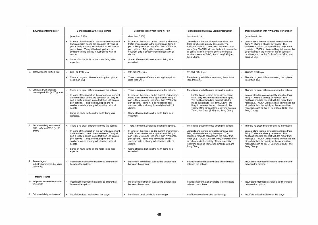
49
Environmental Indicator Consolidation with Tsing Yi Port Decentralisation with Tsing Yi Port Consolidation with NW Lantau Port Option Decentralisation with NW Lantau Port Option
(less than 0.1%).
• In terms of the impact on the current environment, traffic emission due to the operation of Tsing Yi port is likely to cause less effect than NW Lantau port options. Tsing Yi is developed and its southern side is already industrialised with oil depots.
• Some off-route traffic on the north Tsing Yi is expected.
(less than 0.1%).
• Lantau Island is more air quality sensitive than Tsing Yi where is already developed. The additional roads to connect with the major trunk roads (e.g. TMCLK Link) are likely to increase the air pollutants in the vicinity of the air sensitive receivers, such as Tai O, San Chau (SSSI) and Tung Chung.
(less than 0.1%).
• Lantau Island is more air quality sensi tive than Tsing Yi where is already developed. The additional roads to connect with the major trunk roads (e.g. TMCLK Link) are likely to increase the air pollutants in the vicinity of the air sensitive receivers, such as Tai O, San Chau (SSSI) and Tung Ch ung.
6. Total AM peak traffic (PCU) • 265,157 PCU trips
• There is no great difference among the options (less than 3%).
• 268,373 PCU trips
• There is no great difference among the options (less than 3%).
• 261,156 PCU trips
• There is no great difference among the options (less than 3%).
• 264,520 PCU trips
• There is no great difference among the options (less than 3%).
7. Estimated CO emission rates – peak AM (x 106 gram)
• There is no great difference among the options.
• In terms of the impact on the current environment, traffic emission due to the operation of Tsing Yi port is likely to cause less effect than NW Lantau port options. Tsing Yi is developed and its southern side is already industrialised with oil depots.
• Some off-route traffic on the north Tsing Yi is expected.
• There is no great difference among the options.
• Lantau Island is more air quality sensitive than Tsing Yi where is already developed. The additional roads to connect with the major trunk roads (e.g. TMCLK Link) are likely to increase the air pollutants in the vicinity of the air sensitive receivers, such as Tai O, San Chau (SSSI) and Tung Chung.
8. Estimated daily emission of RSP, NOx and VOC (x 106 gram)
• There is no great difference among the options.
• In terms of the impact on the current environment, traffic emission due to the operation of Tsing Yi port is likely to cause less effect than NW Lantau port options. Tsing Yi is developed and its southern side is already industrialised with oil depots.
• Some off-route traffic on the north Tsing Yi is expected.
• There is no great difference among the options.
• Lantau Island is more air quality sensitive than Tsing Yi where is already developed. The additional roads to connect with the major trunk roads (e.g. TMCLK Link) are likely to increase the air pollutants in the vicinity of the air sensitive receivers, such as Tai O, San Chau (SSSI) and Tung Chung.
• There is no great difference among the options.
• Lantau Island is more air quality sensiti ve than Tsing Yi where is already developed. The additional roads to connect with the major trunk roads (e.g. TMCLK Link) are likely to increase the air pollutants in the vicinity of the air sensitive receivers, such as Tai O, San Chau (SSSI) and Tung Chung.
9. Percentage of industry/commerce (i.e. jobs) rail served
• Insufficient information available to differentiate between the options.
• Insufficient information available to differentiate between the options.
• Insufficient information available to differentiate between the options.
• Insufficient information available to differentiate between the options.
Marine Traffic
10. Projected increase in number of vessels
• Insufficient information available to differentiate between the options
• Insufficient information available to differentiate between the options
• Insufficient information available to differentiate between the options
• Insufficient information available to differentiate between the options
11. Estimated daily emission of • Insufficient detail available at this stage • Insufficient detail available at this stage • Insufficient detail available at this stage • Insufficient detail available at this stage

50
Environmental Indicator Consolidation with Tsing Yi Port Decentralisation with Tsing Yi Port Consolidation with NW Lantau Port Option Decentralisation with NW Lantau Port Option
RSP, NOx and VOC
Industry/Power Generation
12. Estimated daily emission of RSP, NOx and VOC
• Insufficient detail available at this stage
• Insufficient detail available at this stage
• Insufficient detail available at this stage
• Insufficient detail available at this stage
13. Total greenhouse gas emissions (as CO2)
• Insufficient detail available at this stage • Insufficient detail available at this stage • Insufficient detail available at this stage • Insufficient detail available at this stage
14. Proximity to residential areas • Industry is assumed to be moving away from the Metro Area reducing the occurrence of incompatible land uses and close juxtaposition of industrial and residential uses.
• Industry is assumed to be moving away from the Metro Area reducing the occurrence of incompatible land uses and close juxtaposition of industrial and residential uses. Benefits will not be as significant under this option as the planned population increase in the Metro Area is not as great.
• Industry is assumed to be moving away from the Metro Area reducing the occurrence of incompatible land uses and close juxtapositi on of industrial and residential uses.
• Industry is assumed to be moving away from the Metro Area reducing the occurrence of incompatible land uses and close juxtaposition of industrial and residential uses. Benefits of this will not be as significant under this option, however the relocation or rezoning of industrial areas within the NDAs will also reduce undesirable industrial/residential interface.
15. Proximity to pollution blackspots
• Much of the pollution blackspots from industrial uses is gone after the redevelopment of industrial buildings for business uses.
• Much of the pollution blackspots from industrial uses is gone after the redevelopment of industrial buildings for business uses.
• Much of the pollution blackspots from industrial uses is gone after the redevelopment of industrial buildings for business uses.
• Much of the pollution blackspots from industrial uses is gone after the redevelopment of industrial buildings for business uses.
16. Impact on existing air quality (cumulative effects)
• Insufficient information available to differentiate between the options
• Insufficient information available to differentiate between the options
• Insufficient information available to differentiate between the options
• Insufficient information available to differentiate between the options
17. Population within a confined airshed or with existing poor/bad air quality
• As major residential areas and transport network are the same among the options, their condition will be the same among the options.
• As major residential areas and transport network are the same among the options, their condition will be the same among the options
• As major residential areas and transport network are the same among the options, their condition will be the same among the options
• As major residential areas and transport network are the same among the options, their condition will be the same among the options
18. Length of interface between industry or undesirable uses and residential areas
• As major residential areas and transport network are the same among the options, their condition will be the same among the options
• As major residential areas and transport network are the same among the options, their condition will be the same among the options
• As major residential areas and transport network are the same among the options, their condition will be the same among the options
• As major residential areas and transport network are the same among the options, their condition will be the same among the options
19. Industry within confined airsheds
• Industry is assumed to be moving away from the Metro Area and into SENT (Tseung Kwan O) where air flow is considerably less restricted.
• Industry is assumed to be moving away from the Metro Area and into predominantly topographically unconstrained airsheds.
• Industry is assumed to be moving away from the Metro Area and into SENT (Tseung Kwan O) where air flow is considerably less restricted.
• Industry is assumed to be moving away from the Metro Area and into predominantly topographically unconstrained airsheds.
20. Projected non-compliance with Air Quality Objectives (AQOs) (emissions from industry/power generation and/or vehicular traffic)
• New or renewable energy technologies are being investigated as alternative sources of energy. For example, fuel cell technology can generate electricity without combustion by combining hydrogen ions with oxygen atoms. These clean energy technology will contribute much improvement of the air quality. However, this
• New or renewable energy technologies are being investigated as alternative sources of energy. For example, fuel cell technology can generate electricity without combustion by combining hydrogen ions with oxygen atoms. These clean energy technology will contribute much improvement of the air quality. However, this
• New or renewable energy technologies are being investigated as alternative sources of energy. For example, fuel cell technology can generate electricity without combustion by combining hydrogen ions with oxygen atoms. These clean energy technology will contribute much improvement of the air quality. However, this
• New or renewable energy technologies are being investigated as alternative sources of energy. For example, fuel cell technology can generate electricity without combustion by combining hydrogen ions with oxygen atoms. These clean energy technology will contribute much improvement of the air quality. However, this

51
Environmental Indicator Consolidation with Tsing Yi Port Decentralisation with Tsing Yi Port Consolidation with NW Lantau Port Option Decentralisation with NW Lantau Port Option
technology is still in its early stages of development and generation costs at present are high.
• Insufficient information to justify the compliance of AQOs at this stage of the Study.
technology is still in its early stages of development and generation costs at present are high.
• Insufficient information to justify the compliance of AQOs at this stage of the Study.
technology is still in its early stages of development and generation costs at present are high.
• Insufficient information to justify the compliance of AQOs at this stage of the Study.
technology is still in its early stages of development and generation costs at present are high.
• Insufficient information to justify the compliance of AQOs at this stage of the Study.
21. Projected improvement or deterioration in Air Pollution Index (API)
• TThe implementation of measures identified in the IAR and KIR to reduce vehicular road traffic, or emissions from it, would have a beneficial effect on air quality.
• Insufficient information available to differentiate between the options.
• TThe implementation of measures identified in the IAR and KIR to reduce vehicular road traffic, or emissions from it, would have a beneficial effect on air quality.
• Insufficient information available to differentiate between the options.
• TThe implementation of measures identified in the IAR and KIR to reduce vehicular road traffic, or emissions from it, would have a beneficial effect on air quality.
• Insufficient information available to differentiate between the options.
• TThe implementation of measures identified in the IAR and KIR to reduce vehicular road traffic, or emissions from it, would have a beneficial effect on air quality.
• Insufficient information available to differentiate between the options.
22. Projected improvement or deterioration in level of Toxic Air Pollutants (TAPs)
• Insufficient information available to differentiate between the options
• Insufficient information available to differentiate between the options
• Insufficient information available to differentiate between the options
• Insufficient information available to differentiate between the options
Noise
Rail
1. Length of interface with residential areas
• North Island Line is proposed by 2030. While the proposed alignment may be subject to change, its location within the built-up Metro Area will have greater chance of interface with existing resi dential areas. This implies mitigation measures will need to be implemented during the design stage of the railway.
• Hung Shui Kiu and Kwu Tung NDAs are planned with rail. The problem of interface with residential areas could be mitigated by placing non-sensitive receivers along the alignment or by using other noise abatement methods. The future Kwu Tung Station to be built along with Kwu Tung North NDA will be placed undergroud.
• A new station is proposed at Au Tau on the Northern Link.
• North Island Line is proposed by 2030. While the proposed alignment may be subject to change, its location within the built-up Metro Area will have greater chance of interface with existing residential areas. This implies mitigation measures will need to be implemented during the design stage of the railway.
• Hung Shui Kiu and Kwu Tung NDAs are planned with rail. The problem of interface with residential areas could be mitigated by placing non-sensitive receivers along the alignment or by using other noise abatement methods. The future Kwu Tung Station to be built along with Kwu Tung North NDA will be placed undergroud.
• A new station is proposed at Au Tau on the Northern Link.
• North Island Line is proposed by 2030. While the proposed alignment may be subject to change, its location within the built-up Metro Area will have greater chance of interface with existing residential areas. This implies mitigation measures will need to be implemented during the design stage of the railway.
• A new station is proposed at Au Tau on the Northern Link.
2. Estimated volume of rolling stock
• Insufficient information available at this stage • Insufficient information available at this stage • Insufficient information available at this stage • Insufficient information available at this stage
3. “Peak flows” • Insufficient information available at this stage • Insufficient information available at this stage • Insufficient information available at this stage • Insufficient information available at this stage
Road Traffic
4. Length of interface with residential areas
• Eastern Highway is proposed by year 2030. This road will likely affect the eastern side of the
• Eastern Highway is proposed by year 2030. This road will likely affect the eastern side of the
• Eastern Highway is proposed by year 2030. This road will likely affect the eastern side of the
• Eastern Highway is proposed by year 2030. This road will likely affect the eastern side of the
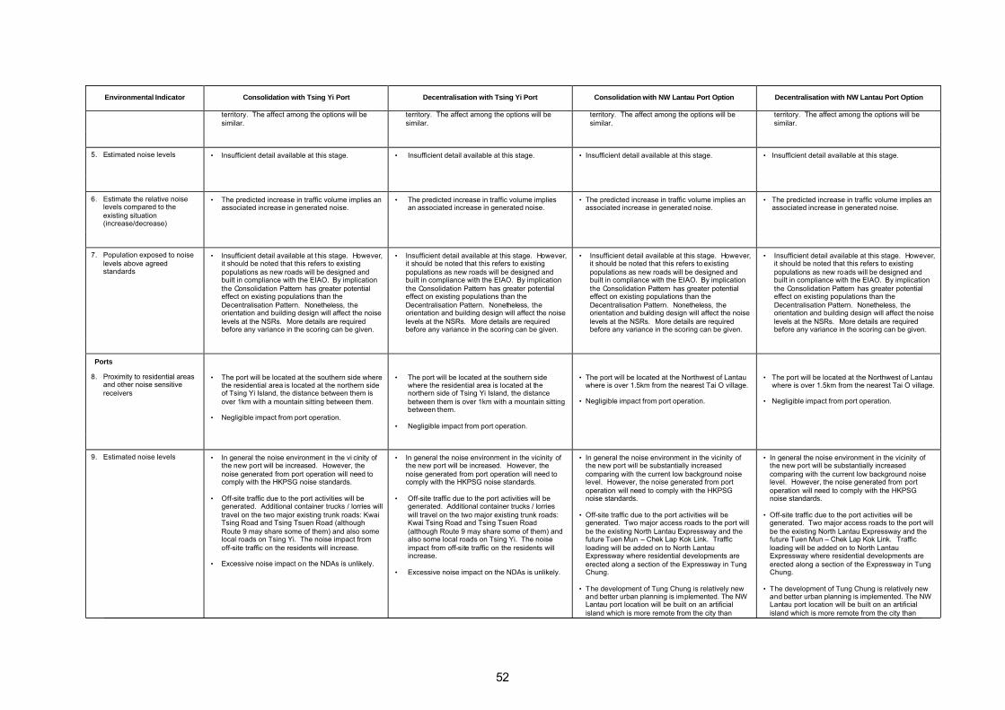
52
Environmental Indicator Consolidation with Tsing Yi Port Decentralisation with Tsing Yi Port Consolidation with NW Lantau Port Option Decentralisation with NW Lantau Port Option
territory. The affect among the options will be similar.
territory. The affect among the options will be similar.
territory. The affect among the options will be similar.
territory. The affect among the options will be similar.
5. Estimated noise levels • Insufficient detail available at this stage. • Insufficient detail available at this stage. • Insufficient detail available at this stage. • Insufficient detail available at this stage.
6. Estimate the relative noise levels compared to the existing situation (increase/decrease)
• The predicted increase in traffic volume implies an associated increase in generated noise.
• The predicted increase in traffic volume implies an associated increase in generated noise.
• The predicted increase in traffic volume implies an associated increase in generated noise.
• The predicted increase in traffic volume implies an associated increase in generated noise.
7. Population exposed to noise levels above agreed standards
• Insufficient detail available at this stage. However, it should be noted that this refers to existing populations as new roads will be designed and built in compliance with the EIAO. By implication the Consolidation Pattern has greater potential effect on existing populations than the Decentralisation Pattern. Nonetheless, the orientation and building design will affect the noise levels at the NSRs. More details are required before any variance in the scoring can be given.
• Insufficient detail available at this stage. However, it should be noted that this refers to existing populations as new roads will be designed and built in compliance with the EIAO. By implication the Consolidation Pattern has greater potential effect on existing populations than the Decentralisation Pattern. Nonetheless, the orientation and building design will affect the noise levels at the NSRs. More details are required before any variance in the scoring can be given.
• Insufficient detail available at this stage. However, it should be noted that this refers to existing populations as new roads will be designed and built in compliance with the EIAO. By implication the Consolidation Pattern has greater potential effect on existing populations than the Decentralisation Pattern. Nonetheless, the orientation and building design will affect the noise levels at the NSRs. More details are required before any variance in the scoring can be given.
• Insufficient detail available at this stage. However, it should be noted that this refers to existing populations as new roads will be designed and built in compliance with the EIAO. By implication the Consolidation Pattern has greater potential effect on existing populations than the Decentralisation Pattern. Nonetheless, the orientation and building design will affect the noise levels at the NSRs. More details are required before any variance in the scoring can be given.
Ports
8. Proximity to residential areas and other noise sensitive receivers
• The port will be located at the southern side where the residential area is located at the northern side of Tsing Yi Island, the distance between them is over 1km with a mountain sitting between them.
• Negligible impact from port operation.
• The port will be located at the southern side where the residential area is located at the northern side of Tsing Yi Island, the distance between them is over 1km with a mountain sitting between them.
• Negligible impact from port operation.
• The port will be located at the Northwest of Lantau where is over 1.5km from the nearest Tai O village.
• Negligible impact from port operation.
• The port will be located at the Northwest of Lantau where is over 1.5km from the nearest Tai O village.
• Negligible impact from port operation.
9. Estimated noise levels • In general the noise environment in the vi cinity of the new port will be increased. However, the noise generated from port operation will need to comply with the HKPSG noise standards.
• Off-site traffic due to the port activities will be generated. Additional container trucks / lorries will travel on the two major existing trunk roads: Kwai Tsing Road and Tsing Tsuen Road (although Route 9 may share some of them) and also some local roads on Tsing Yi. The noise impact from off-site traffic on the residents will increase.
• Excessive noise impact on the NDAs is unlikely.
• In general the noise environment in the vicinity of the new port will be increased. However, the noise generated from port operation will need to comply with the HKPSG noise standards.
• Off-site traffic due to the port activities will be generated. Additional container trucks / lorries will travel on the two major existing trunk roads: Kwai Tsing Road and Tsing Tsuen Road (although Route 9 may share some of them) and also some local roads on Tsing Yi. The noise impact from off-site traffic on the residents will increase.
• Excessive noise impact on the NDAs is unlikely.
• In general the noise environment in the vicinity of the new port will be substantially increased comparing with the current low background noise level. However, the noise generated from port operation will need to comply with the HKPSG noise standards.
• Off-site traffic due to the port activities will be generated. Two major access roads to the port will be the existing North Lantau Expressway and the future Tuen Mun – Chek Lap Kok Link. Traffic loading will be added on to North Lantau Expressway where residential developments are erected along a section of the Expressway in Tung Chung.
• The development of Tung Chung is relatively new and better urban planning is implemented. The NW Lantau port location will be built on an artificial island which is more remote from the city than
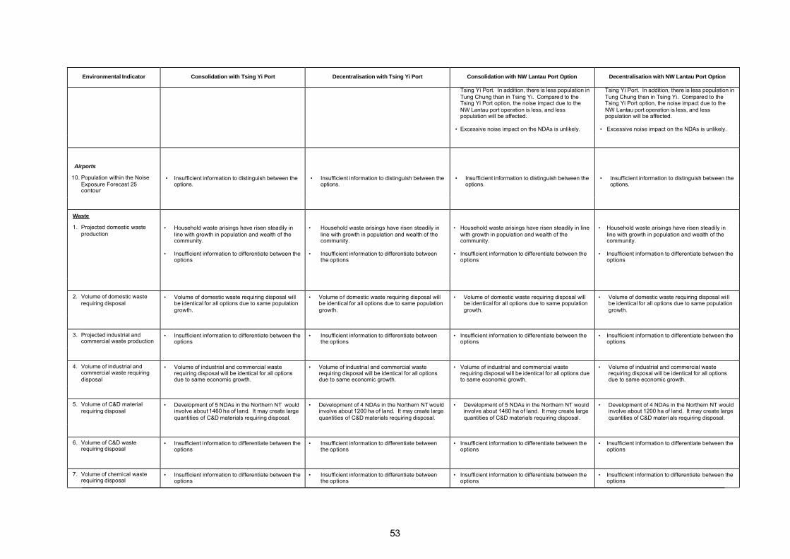
53
Environmental Indicator Consolidation with Tsing Yi Port Decentralisation with Tsing Yi Port Consolidation with NW Lantau Port Option Decentralisation with NW Lantau Port Option
Tsing Yi Port. In addition, there is less population in Tung Chung than in Tsing Yi. Compared to the Tsing Yi Port option, the noise impact due to the NW Lantau port operation is less, and less population will be affected.
• Excessive noise impact on the NDAs is unlikely.
Tsing Yi Port. In addition, there is less population in Tung Chung than in Tsing Yi. Compared to the Tsing Yi Port option, the noise impact due to the NW Lantau port operation is less, and less population will be affected.
• Excessive noise impact on the NDAs is unlikely.
Airports
10. Population within the Noise Exposure Forecast 25 contour
• Insufficient information to distinguish between the options.
• Insufficient information to distinguish between the options.
• Insufficient information to distinguish between the options.
• Insufficient information to distinguish between the options.
Waste
1. Projected domestic waste production
• Household waste arisings have risen steadily in line with growth in population and wealth of the community.
• Insufficient information to differentiate between the options
• Household waste arisings have risen steadily in line with growth in population and wealth of the community.
• Insufficient information to differentiate between the options
• Household waste arisings have risen steadily in line with growth in population and wealth of the community.
• Insufficient information to differentiate between the options
• Household waste arisings have risen steadily in line with growth in population and wealth of the community.
• Insufficient information to differentiate between the options
2. Volume of domestic waste requiring disposal
• Volume of domestic waste requiring disposal will be identical for all options due to same population growth.
• Volume of domestic waste requiring disposal will be identical for all options due to same population growth.
• Volume of domestic waste requiring disposal will be identical for all options due to same population growth.
• Volume of domestic waste requiring disposal wi ll be identical for all options due to same population growth.
3. Projected industrial and commercial waste production
• Insufficient information to differentiate between the options
• Insufficient information to differentiate between the options
• Insufficient information to differentiate between the options
• Insufficient information to differentiate between the options
4. Volume of industrial and commercial waste requiring disposal
• Volume of industrial and commercial waste requiring disposal will be identical for all options due to same economic growth.
• Volume of industrial and commercial waste requiring disposal will be identical for all options due to same economic growth.
• Volume of industrial and commercial waste requiring disposal will be identical for all options due to same economic growth.
• Volume of industrial and commercial waste requiring disposal will be identical for all options due to same economic growth.
5. Volume of C&D material requiring disposal
• Development of 5 NDAs in the Northern NT would involve about 1460 ha of land. It may create large quantities of C&D materials requiring disposal.
• Development of 4 NDAs in the Northern NT would involve about 1200 ha of land. It may create large quantities of C&D materials requiring disposal.
• Development of 5 NDAs in the Northern NT would involve about 1460 ha of land. It may create large quantities of C&D materials requiring disposal.
• Development of 4 NDAs in the Northern NT would involve about 1200 ha of land. It may create large quantities of C&D materi als requiring disposal.
6. Volume of C&D waste requiring disposal
• Insufficient information to differentiate between the options
• Insufficient information to differentiate between the options
• Insufficient information to differentiate between the options
• Insufficient information to differentiate between the options
7. Volume of chemical waste requiring disposal
• Insufficient information to differentiate between the options
• Insufficient information to differentiate between the options
• Insufficient information to differentiate between the options
• Insufficient information to differentiate between the options

54
Environmental Indicator Consolidation with Tsing Yi Port Decentralisation with Tsing Yi Port Consolidation with NW Lantau Port Option Decentralisation with NW Lantau Port Option
8. Volume of excavated contaminated soil requiring treatment/disposal
• No excavated contaminated soil is anticipated under this option in the long term.
• No excavated contaminated soil is anticipated under this option in the long term.
• No excavated contaminated soil is anticipated under this option in the long term.
• No excavated contaminated soil is anticipated under this option in the long term.
9. Proximity to appropriate disposal facilities
• Waste disposal facilities will be located further from developed areas.
• Non-inert wastes (domestic, commercial , industrial and C&D) generated in the NENT and NWNT are disposed of to WENT or NENT either directly or via NWNT transfer station. At current disposal rates, capacity in these two l andfills will be full by 2015. Opportunities for expansion have been identified at both existing landfills.
• Waste disposal facilities will be located further from developed areas.
• Non-inert wastes (domestic, commercial , industrial and C&D) generated in the NENT and NWNT are disposed of to WENT or NENT either directly or via NWNT transfer station. At current disposal rates, capacity in these two landfills will be full by 2015. Opportunities for expansion have been identified at both existing landfills.
10. Extent of interface of waste facilities with residential areas
• Extension of NENT and WENT landfills or establishment of proposed new facilities has no anticipated impact on planned developments
• Insufficient information to differentiate between the options
• Extension of NENT and WENT landfills or establishment of proposed new facilities has no anticipated impact on planned developments
• Insufficient information to differentiate between the options
• Extension of NENT and WENT landfills or establishment of proposed new facilities has no anticipated impact on planned developments
• Insufficient information to differentiate between the options
• Extension of NENT and WENT landfills or establishment of proposed new facilities has no anticipated impact on planned developments
• Insufficient information to differentiate between the options
11. Extent of interface of waste facilities with other sensitive receivers
• Extension of NENT and WENT landfills unconstrained by other sensitive receivers or competing land uses
• Extension of SENT landfill is constrained by juxtaposition with Clearwater Bay Country Park and Tseung Kwan O Area 137 committed by Lands Department for Potentially Hazardous Installations (PHIs) and Deep Waterfront Industry
• Landfills in the New Territories are not spatially constrained by other sensitive receivers or competing land uses.
• Extension of NENT and WENT landfills unconstrained by other sensitive receivers or competing land uses
• Extension of SENT landfill is constrained by juxtaposition with Clearwater Bay Country Park and Tseung Kwan O Area 137 committed by Lands Department for PHIs and Deep Waterfront Industry
• Landfills in the New Territories are not spatially constrained by sensitive receivers or competing land uses.
12. Solid waste disposal capacity • Insufficient information to differentiate between the options
• Insufficient information to differentiate between the options
• Insufficient information to differentiate between the options
• Insufficient information to differentiate between the options
13. Chemical waste disposal capacity
• Insufficient information to differentiate between the options
• Insufficient information to differentiate between the options
• Insufficient information to differentiate between the options
• Insufficient information to d ifferentiate between the options
14. Area of landtake for waste facilities
• Insufficient information to differentiate between the options
• Insufficient information to differentiate between the options
• Insufficient information to differentiate between the options
• Insufficient information to differentiate between the options
Potentially Hazardous Installations
1. Kilometres of new road passing through PHI
• There are currently 33PHIs however in the long term new sites could be added to the register and
• There are currently 33PHIs however in the long term new sites could be added to the register and
• There are currently 33PHIs however in the long term new sites could be added to the register and
• There are currently 33PHIs however in the long term new sites could be added to the register and

55
Environmental Indicator Consolidation with Tsing Yi Port Decentralisation with Tsing Yi Port Consolidation with NW Lantau Port Option Decentralisation with NW Lantau Port Option
consultation zones existing sites could be declassified or relocated.
• Eastern Highway alignment in close proximity to PHIs in Tai Po area
existing sites could be declassified or relocated
• Eastern Highway alignment in close proximity to PHIs in Tai Po area
existing sites could be declassified or relocated
• Eastern Highway alignment in close proximity to PHIs in Tai Po area
existing sites could be declassified or relocated
• Eastern Highway alignment in close proximity to PHIs in Tai Po area
2. Increase/decrease in traffic flow through PHI consultation zones
• Eastern Highway alignment in close proximity to PHIs in Tai Po area
• Eastern Highway alignment in close proximity to PHIs in Tai Po area
• Eastern Highway alignment in cl ose proximity to PHIs in Tai Po area
• Eastern Highway alignment in close proximity to PHIs in Tai Po area
3. Population within the PHI consultation zone
• There are currently 33PHIs however in the long term new sites could be added to the register and existing sites could be declassified or relocated.
• There are currently 33PHIs however in the long term new sites could be added to the register and existing sites could be declassified or relocated.
• There are currently 33PHIs however in the long term new sites could be added to the register and existing sites could be declassified or relocated.
• There are currently 33PHIs however in the long term new sites could be added to the register and existing sites could be declassified or relocated.
4. Increase/decrease in population within PHI consultation zone
• An appraisal of CZs to determine alternative solutions or means to circumvent the problems identified should be conducted when further detail is available
• Potential increase in WSD’s Sheung Shui Water Treatment Works CZ in the long term
• Potential increase in WSD’s Au Tau Water Treatment Works CZ in the long term
• Potential decrease in Ma Tau Kok CZ in the longer term (due to new developments at the former Kai Tak Airport ).
• The majority of the PHIs are located in rural areas and therefore restrictions on expansion or establishment of new development areas abutting CZs need to be reviewed when further detail is available
• Potential increase in WSD’s Au Tau Water Treatment Works CZ in the long term
• Potential increase in WSD’s proposed Ngau Tam Mei Treatment Works in the long term
• Potential decrease in Ma Tau Kok CZ in the longer term (due to new developments at the former Kai Tak Airport ).
• An appraisal of CZs to determine alternative solutions or means to circumvent the problems identified should be conducted when further detail is available
• Potential increase in WSD’s Sheung Shui Water Treatment Works CZ in the long term
• Potential increase in WSD’s Au Tau Water Treatment Works CZ in the long term
• Potential decrease in Ma Tau Kok CZ in the longer term (due to new developments at the former Kai Tak Airport ).
• The majority of the PHIs are located in rural areas and therefore restrictions on expansion or establishment of new development areas abutting CZs need to be reviewed when further detail is available
• Potential increase in WSD’s Au Tau Water Treatment Works CZ in the long term
• Potential increase in WSD’s proposed Ngau Tam Mei Treatment Works in the long term
• Potential decrease in Ma Tau Kok CZ in longer term (due to new developments at the former Kai Tak Airport).
•
Ecology
1. Extent of interface of new developments with ecologically significant sites (terrestrial)
• The establishment of the NENT NDAs will result in direct and indirect impacts on high ecological value habitats. Combined habitat losses require mitigation to compensate for ecological impacts.
• The establishment or expansion of NDAs in NWNT should prevent adverse impacts to wetland habitats, particularly the important areas such as the Deep Bay, the Mai Po Ramsar site and other SSSIs.
• The potential interface of new developments with terrestrial ecologically significant sites is as follows:
- Au Tau adjacent to Wetland Buffer Area (BA) / Conservation Area (CA)
• Furthermore, in rural areas consideration should be given to formation of ecological corridors in order to avoid fragmentation of existing habitats or to provide links between areas of significance
• The establishment of the NENT NDAs will result in direct and indirect impacts on high ecological value habitats. Combined habitat losses require mitigation to compensate for ecological impacts.
• The establishment or expansion of NDAs in NWNT should prevent adverse impacts to wetland habitats, particularly the important areas such as the Deep Bay, the Mai Po Ramsar site and other SSSIs.
• The potential interface of new developments with terrestrial ecologically significant sites are as follows:
- Au Tau adjacent to Wetland Buffer Area (BA) / Conservation Area (CA)
- San Tin located in/adjacent to Wetland BA/CA
- Ngau Tam Mei adjacent to Lam Tsuen Country Park
• The establishment of the NENT NDAs will result in direct and indirect impacts on high ecological value habitats. Combined habitat losses require mitigation to compensate for ecological impacts.
• The establishment or expansion of NDAs in NWNT should prevent adverse impacts to wetland habitats, particularly the important areas such as the Deep Bay, the Mai Po Ramsar site and other SSSIs.
• The potential interface of new developments with terrestrial ecologically significant sites is as follows:
- Au Tau adjacent to Wetland Buffer Area (BA) / Conservation Area (CA)
• Furthermore, in rural areas consideration should be given to formation of ecological corridors in order to avoid fragmentation of existing habitats or to provide links between areas of significance
• The establishment or expansion of NDAs in NWNT should prevent adverse impacts to wetland habitats, particularly the important areas such as the Deep Bay, the Mai Po Ramsar site and other SSSIs. The potential interface of new developments with terrestrial ecologically significant sites are as follows:
- Au Tau adjacent to Wetland BA/CA
- San Tin located in/adjacent to Wetland BA/CA
- Ngau Tam Mei adjacent to Lam Tsuen Country Park
• Furthermore, in rural areas consideration should be given to formation of ecological corridors in order to avoid fragmentation of existing habitats or to provide links between areas of significance to increase viability.

56
Environmental Indicator Consolidation with Tsing Yi Port Decentralisation with Tsing Yi Port Consolidation with NW Lantau Port Option Decentralisation with NW Lantau Port Option
to increase viability. • Furthermore, in rural areas consideration should be given to formation of ecological corridors in order to avoid fragmentation of existing habitats or to provide links between areas of significance to increase viability.
to increase viability.
2. Extent of interface of new developments with ecologically significant sites (marine)
• It is not anticipated that there will be any interface between new developments and marine ecologically significant sites
• It is not anticipated that there will be any interface between new developments and marine ecologically significant sites
• Marine sensitive sites may be affected since the NW Lantau Port option is located within an important Chinese White Dolphin habitat in Hong Kong.
• Marine sensitive sites may be affected since the NW Lantau Port option is located within an important Chinese White Dolphin habitat in Hong Kong.
3. Extent of interface of new transport infrastructure with ecologically significant sites (terrestrial)
• Eastern Highway passes through Ma On Shan Country Park and Tai Po Kau Nature Reserve
• Eastern Highway passes through Ma On Shan Country Park and Tai Po Kau Nature Reserve
• Eastern Highway passes through Ma On Shan Country Park and Tai Po Kau Nature Reserve
• Eastern Highway passes through Ma On Shan Country Park and Tai Po Kau Nature Reserve
4. Extent of interface of new transport infrastructure with ecologically significant sites (marine)
• It is not anticipated that there will be any interface between new transport infrastructure and marine ecologically significant sites
• It is not anticipated that there will be any interface between new transport infrastructure and marine ecologically significant sites
• It is not anticipated that there will be any interface between new transport infrastructure and marine ecologically significant sites
• It is not anticipated that there will be any interface between new transport infrastructure and marine ecologically significant sites
5. Area of sites of ecological significance degraded, threatened or lost
• Dredging for port access west of Lamma Island in porpoise habitat
• In the longer term the same consideration needs to be given to preventing both direct and indirect impacts on ecologically sensitive areas within and adjacent to the NDAs.
• Surveys have recorded 21 species of conservation concern (SCC) within the proposed NENT NDAs including four globally threatened species. Key habitats include marsh, pond and stream habitats. These habitats should be avoided as far as possible, and if not, the adverse impacts should be mitigated and compensated
• Hung Shui Kiu NDA will impact directly on ecologically significant flooded wetlands/grasslands. Adverse impacts should be minimised, mitigated and compensated
• Extent of NWNT wetland degraded threatened or lost through reclamation or other development proposals is unknown, potential to adversely affect fragile wetland ecosystem both during and following construction
• Eastern Highway passes through Ma On Shan Country Park and Tai Po Kau Nature Reserve
• Dredging for port access west of Lamma Island in porpoise habitat
• In the longer term the same consideration needs to be given to preventing both direct and indirect impacts on ecologically sensitive areas within and adjacent to the NDAs.
• Eastern Highway passes through Ma On Shan Country Park and Tai Po Kau Nature Reserve
• Marine access for this port option is in close proximity to the existing contaminated mud pit at East Sha Chau. Disturbance of the capping layers and consequent deterioration of water quality may impact on Lung Kwu Chau and the Chinese White Dolphin habitat.
• Maintenance dredging will affect the marine water quality and the marine organisms.
• In the longer term the same consideration needs to be given to preventing both direct and indirect impacts on ecologically sensitive areas within and adjacent to the NDAs.
• Surveys have recorded 21 species of conservation concern (SCC) within the proposed NENT NDAs including four globally threatened species. Key habitats include marsh, pond and stream habitats. These habitats should be avoided as far as possible, and if not, the adverse impacts should be mitigated and compensated
• Hung Shui Kiu NDA will impact directly on ecologically significant flooded wetlands/grasslands. Adverse impacts should be minimised, mitigated and compensated.
• Extent of NWNT wetland degraded threatened or lost through reclamation or other development proposals is unknown, potential to adversely affect fragile wetland ecosystem both during and following construction
• Marine access for this port option is in close proximity to the existing contaminated mud pit at East Sha Chau. Disturbance of the capping layers and consequent deterioration of water quality may impact on Lung Kwu Chau and the Chinese White Dolphin habitat.
• Maintenance dredging will affect the marine water quality and the marine organisms.
• In the longer term the same consideration needs to be given to preventing both direct and indirect impacts on ecologically sensitive areas within and adjacent to the NDAs.
• Eastern Highway passes through Ma On Shan Country Park and Tai Po Kau Nature Reserve.

57
Environmental Indicator Consolidation with Tsing Yi Port Decentralisation with Tsing Yi Port Consolidation with NW Lantau Port Option Decentralisation with NW Lantau Port Option
• Eastern Highway passes through Ma On Shan Country Park and Tai Po Kau Nature Reserve.
6. Area of sites of ecological significance restored/enhanced
• Insufficient information available • Insufficient information available • Insufficient information available • Insufficient information available
7. Extent of coast line degraded
• North Island Line may affect the coast line. • North Island Line may affect the coast line. • North Island Line may affect the coast line. • North Island Line may affect the coast line.
8. Extent of coast line lost • North Island Line may affect the coast line. • North Island Line may affect the coast line. • North Island Line may affect the coast line. • North Island Line may affect the coast line.
9. Extent of coast line restored/enhanced
• Insufficient information available • Insufficient information available • Insufficient information available • Insufficient information available
10. Area of seabed disturbance
• Further disturbance of seabed is unlikely unless port extension is considered necessary.
• Further disturbance of seabed is unlikely unless port extension is considered necessary.
• Further disturbance of seabed is unlikely unless port extension is considered necessary.
• Further disturbance of seabed is unlikely unless port extension is considered necessary.
Energy and Natural Resources
1. Percentage of total energy supplied by renewable energy sources
• Insufficient information to differentiate between the options, but it would be reasonable to assume that the energy consumption rates are highly dependent on population, aspirations of the communities and GDP. To that end the options will be expected to perform in a similar manner in overall terms – although not necessarily at the micro level (too refined for this phase of the Study).
• Insufficient information to differentiate between the options.
• Insufficient information to differentiate between the options.
• Insufficient information to differentiate between the options
2. Opportunities for utilisation of renewable energy sources
• Insufficient information to differentiate between the options.
• Insufficient information to differentiate between the options.
• Insufficient information to differentiate between the options.
• Insufficient information to differentiate between the options.
3. Consumption of energy per unit of output ($GDP)
• Insufficient information to differentiate between the options. As the consumption of energy is linked to the GDP and the populations then it is reasonable to assume there would be insignificant difference between the options.
• Insufficient information to differentiate between the options
• Insufficient information to differentiate between the options.
• Insufficient information to differentiate between the options
4. Volume of freshwater supplied per capita
• Insufficient information to differentiate between the options. The current agreement in which Hong Kong obtains around 75% of freshwater from the Mainland suggests that there is little to differentiate these options. This is further
• Insufficient information to differentiate between the options
• Insufficient information to differentiate between the options.
• Insufficient information to differentiate between the options

58
Environmental Indicator Consolidation with Tsing Yi Port Decentralisation with Tsing Yi Port Consolidation with NW Lantau Port Option Decentralisation with NW Lantau Port Option
supported by the fact that freshwater consumption rates are linked to population and aspirations (like energy) also suggests that there is little to differentiate between the options.
5. Percentage of demand met by locally-derived freshwater resources
• Insufficient information to differentiate between the options – also see above with regard to the high dependence on Mainland for the majority of the freshwater resources. Notwithstanding the foregoing it must be remembered that the Guangdong Province is developing at a fast pace and therefore demand for water resources will also increase from within Guangdong itself.
• Insufficient information to differentiate between the options
• Insufficient information to differenti ate between the options.
• Insufficient information to differentiate between the options
Cultural Heritage
1. Number/type/status of known sites of cultural heritage value including archaeological sites affected by new developments or transport infrastructure.
• NENT NDAs have avoided potential impact to declared monuments, graded buildings and old villages as far as possible. However impact on a number of ungraded sites is considered unavoidable, and mitigation measures such as rescue excavation are required for identified archaeological deposits
• Hung Shui Kiu NDA has been positioned so as to impact as few buildings and sites of importance as possible in this culturally rich area. Sensitive zoning is planned for protection of historical sites within the NDA.
• Preservation in total and in-situ of the Tung Tau Tsuen Archaeological Site presents a constraint to the development of Hung Shui Kiu North NDA.
• There are a number of important historical sites within the Kam Tin/Au Tau NDA which should be specifi cally zoned to preserve these structures or enhance their accessibility. Moreover, a section of Kam Tin Road could be downgraded or disconnected from the major road to restrict traffic and preserve the village environment of various culturally important villages in Kam Tin, e.g. Kat Hing Wai.
• Preservation in total and in-situ of the Tung Tau Tsuen Archaeological Site presents a constraint to the development of Hung Shui Kiu North NDA.
• There are a number of important historical sites within the Kam Tin/Au T au NDA which should be specifically zoned to preserve these structures or enhance their accessibility. Moreover, a section of Kam Tin Road could be downgraded or disconnected from the major road to restrict traffic and preserve the village environment of various culturally important villages in Kam Tin, e.g. Kat Hing Wai.
• The large Man Clan Grave may pose a likely constraint to the development of San Tin/Ngau Tam Mei NDA.
• NENT NDAs have avoided potential impact to declared monuments, graded buildings and old villages as far as possible. However impact on a number of ungraded sites is considered unavoidable, and mitigation measures such as rescue excavation are required for identified archaeological deposits
• Hung Shui Kiu NDA has been positioned so as to impact as few buildings and sites of importance as possible in this culturally rich area. Sensitive zoning is planned for protection of historical sites within the NDA
• Preservation in total and in-situ of the Tung Tau Tsuen Archaeological Site presents a constraint to the development of Hung Shui Kiu North NDA.
• There are a number of important historical sites within the Kam Tin/Au Tau NDA which should be specifically zoned to preserve these structures or enhance their accessibility. Moreover, a section of Kam Tin Road could be downgraded or disconnected from the major road to restrict traffic and preserve the village environment of various culturally important villages in Kam Tin, e.g. Kat Hing Wai.
• Preservation in total and in-situ of the Tung Tau Tsuen Archaeological Site presents a constraint to the development of Hung Shui Kiu North NDA.
• There are a number of important historical sites within the Kam Tin/Au Tau NDA which should be specifically zoned to preserve these structures or enhance their accessibili ty. Moreover, a section of Kam Tin Road could be downgraded or disconnected from the major road to restrict traffic and preserve the village environment of various culturally important villages in Kam Tin, e.g. Kat Hing Wai.
• The large Man Clan Grave may pose a likely constraint to the development of San Tin/Ngau Tam Mei NDA.
Landscape and Visual
1. Area of open space within urban area
• Comprehensive urban renewal and new developments at the former Kai Tak Airport would improve the provision of open space in the areas concerned.
• The dispersal of population and commercial activities to the NDAs could reduce pressure on land resources and allow opportunities for lower density development and provision of open space in the Metro Area.
• Comprehensive urban renewal and new developments at the former Kai Tak Airport would improve the provision of open space in the areas concerned.
• The dispersal of population and commercial to the NDAs could reduce pressure on land resources and allow opportunities for lower density development and provision of open space in the Metro Area.
2. Preferential development of brownfield sites over
• Extensive development of greenfield sites. • More extensive development of greenfield sites • Extensive development of greenfield sites • More extensive development of greenfield sites

59
Environmental Indicator Consolidation with Tsing Yi Port Decentralisation with Tsing Yi Port Consolidation with NW Lantau Port Option Decentralisation with NW Lantau Port Option
greenfield sites
3. Area of greenfield site landtake
• Extensive development of greenfield sites
• More extensive development of greenfield sites • More extensive development of greenfield sites • More extensive development of greenfield sites
4. Area of countryside landtake
• Extensive development of rural areas. • More extensive development of rural areas • Extensive development of rural areas • More extensive development of rural areas
5. Number/area mature trees/woodland lost
• Insufficient detail available at this stage • Insufficient detail available at this stage • Insufficient detail available at this stage • Insufficient detail available at this stage
6. Length of interface of new transport infrastructure causing change in landscape character
• All new transport infrastructure will cause change in landscape character. Same transport network among all options.
• All new transport infrastructure will cause change in landscape character. Same transport network among all options.
• All new transport infrastructure will cause change in landscape character. Same transport network among all options.
• All new transport infrastructure will cause change in landscape character. Same transport network among all options.
7. Extent of interface of new developments causing change in landscape character
• Development of NDAs would cause a fundamental change in landscape character. Nonetheless, temporary container storage, warehouses and workshops are often found adjacent to filled fishponds and agricultural lands particularly near Kam Tin and Fanling. Therefore in terms of landscape quality these temporary uses are leading to the fragmentation and degradation of the rural fringe scenic qualities. These areas could be upgraded or regenerated for other appropriate uses with higher landscape quality.
• The development of Hung Shui Kiu NDA will seek to retain traditional village developments, heritage sites and Fung Shui woodlands. However the vertical scale and high-density configuration would cause significant change to landscape character and cause visual obstruction
• The Kwu Tung NDA will transform a rural area into a new urban development. Landscape features to be protected include the surrounding hillsides and Fung Shui hills and areas of woodland or mature trees
• Development of the Fanling North NDA will transform an area of rural land to an urban extension of the existing Fanling New Town. Current expansive views will be partially blocked.
• Additional NDA development at San Tin/Ngau Tam Mei and Kwu Tung South as well as Trade Expo at Lok Ma Chau Loop under this option, which may cause more changes in landscape character than the Consolidation Pattern.
• Development of NDAs would cause a fundamental change in landscape character. Nonetheless, temporary container storage, warehouses and workshops are often found adjacent to filled fishponds and agricultural lands particularly near Kam Tin and Fanling. Therefore in terms of landscape quality these temporary uses are leading to the fragmentation and degradation of the rural fringe scenic qualities. These areas could be upgraded or regenerated for other appropriate uses with higher landscape quality.
• The development of Hung Shui Kiu NDA will seek to retain traditional village developments, heritage sites and Fung Shui woodlands. However the vertical scale and high-density configuration would cause significant change to landscape character and cause visual obstruction
• The Kwu Tung NDA wil l transform a rural area into a new urban development. Landscape features to be protected include the surrounding hillsides and Fung Shui hills and areas of woodland or mature trees
• Development of the Fanling North NDA will transform an area of rural land to an urban extension of the existing Fanling New Town. Current expansive views will be partially blocked.
• Additional NDA development at San Tin/Ngau Tam Mei and Kwu Tung South as well as Trade Expo at Lok Ma Chau Loop under this option, which may cause more changes in landscape character than the Consolidation Pattern.
8. Provision for landscape/view corridors, protection of views,
• The dispersal of population to the NDAs should facilitate the enhancement of the living environment within the Metro Area.
• The unavoidable potential landscape impacts from the development of additional NDAs at San Tin/Ngau Tam Mei and Kwu Tung South as well
• The dispersal of population to the NDAs should facilitate the enhancement of the living environment within the Metro Area.
• The unavoidable potential landscape impacts from the development of additional NDAs at San Tin/Ngau Tam Mei and Kwu Tung South as well

60
Environmental Indicator Consolidation with Tsing Yi Port Decentralisation with Tsing Yi Port Consolidation with NW Lantau Port Option Decentralisation with NW Lantau Port Option
connection of open space, parks etc • The Hung Shui Kiu, Kwu Tung North and Fanling
North NDAs have all identified potential for mitigating unavoidable landscape impacts through good urban design and landscape planning including view corridors and linking open spaces.
as Trade Expo at Lok Ma Chau Loop might be reprovisioned through good urban design and landscape planning including view corridors and linking open spaces.
• The Hung Shui Kiu, Kwu Tung North and Fanling North NDAs have all identified potential for mitigating unavoidable landscape impacts through good urban design and landscape planning including view corridors and linking open spaces.
as Trade Expo at Lok Ma Chau Loop might be reprovisioned through good urban design and landscape planning including view corridors and linking open spaces.
9. Area of landtake for rail • North Island Line is proposed in the long term. However, insufficient details available at this stage.
• North Island Line is proposed in the long term. However, insufficient details available at this stage.
• North Island Line is proposed in the long term. However, insufficient details available at this stage.
• North Island Line is proposed in the long term. However, insufficient details available at this stage.
10. Area of landtake for road • The road network is the same among the options. • The road network is the same among the options. • The road network is the same among the options. • The road network is the same among the options.
11. Area of landtake for other infrastructure
• Insufficient information to differentiate between the options
• Insufficient information to differentiate between the options
• Insufficient information to differentiate between the options
• Insufficient information to differentiate between the options
12. Proximity of port facilities to residential and other sensitive receivers
• The existing landuse in this area is compatible with further port development without significant change to landscape character. Impact on visual receivers in West Kowloon is unlikely to significantly increase
• The existing landuse in this area is compatible with further port development without significant change to landscape character. Impact on visual receivers in West Kowloon is unlikely to significantly increase
• The existing landscape character is remote and exposed characterised by open seascapes punctuated by marine vessels as well as natural coastline and uplands of Lantau Island. This area is sensitive to change. Although views from Tai O are restricted by the topography, the port will be visible to tourists, hikers and pleasure craft users as well as scattered village houses.
• The existing landscape character is remote and exposed characterised by open seascapes punctuated by marine vessels as well as natural coastline and uplands of Lantau Island. This area is sensitive to change. Although views from Tai O are restricted by the topography, the port will be visible to tourists, hikers and pleasure craft users as well as scattered village houses.

61
8. Discussion
8.1 Introduction
8.1.1 Tables 7.1 and 7.2 have attempted to point out the relative environmental merits and demerits of the different options. This section presents a brief discussion of the key environmental issues identified during the broad-brush assessment and an analysis of the availability of practicable mitigation measures. Whilst most of these issues and measures may also apply to the West Tuen Mun Site, more detailed considerations are highlighted in the working paper entitled “Initial Assessment of Possible Port Development Sites”.
8.1.2 It should be noted that the present assessment is broad-brush and qualitative in nature while quantitative assessment and detailed modelling, if required, will be carried out in the next stage. As such, the assessment results are preliminary only and should not be viewed as the conclusive evaluation of the proposals. Rather they contribute to identifying the key areas of concern which would be taken into account in the formulation of preferred option(s) at the next stage of the Study.
8.2 Key Environmental Issues
8.2.1 Water Quality
8.2.1.1 The key water quality issue for the spatial development patterns relates to the treatment and disposal of wastewater.
8.2.1.2 The implementation of the NDAs and associated facilities provides an excellent opportunity to improve water quality in some of the major water bodies in the Northern NT. This would occur through relocation or disappearance of unplanned and polluting uses, provision of adequate stormwater and sewerage facilities, provision of mitigation measures for identified adverse impacts and adherence to the Deep Bay Zero Discharge Policy and WQOs. However, in view of the potential development pressure, review of relevant SMPs is required to ensure that the provisions already made for sewage collection facilities and capability of treatment and disposal facilities are appropriate with respect to the timing and size of developments planned.
8.2.1.3 In general the HATS will be able to cater for the increase in population in the Metro Area. Although HATS Stage 1 has brought about an improvement in water quality in Victoria Harbour, the remaining 30% of sewage flow entering the Harbour has only received preliminary treatment. With continued population growth and development in the Metro Area, deterioration may occur if the remaining stages of HATS do not proceed as planned.
8.2.1.4 Regarding the proposed port facilities, key water quality issue relates to the dredging and disposal of marine sediment. The mitigation of construction phase impacts may be possible by using new technologies and improved dredging and disposal methods for the port options. Detailed hydrodynamic and water quality modelling will be required to quantitatively assess the significance of the impacts associated with the port options.
8.2.1.5 Moreover, large-scale reclamations for port facilities may permanently affect water flow patterns, and the reclamation for the proposed Tsing Yi Port will be located

62
very close to the HATS outfall. Whether the presence of the reclamation would affect the water current in the area, therefore affecting the performance of the HATS outfall which could result in significant water quality impacts, has to be further assessed quantitatively at the next stage of the Study.
8.2.2 Air Quality
8.2.2.1 The major contributor to Hong Kong’s roadside air pollution is vehicular traffic emissions. Therefore any alternatives which will reduce road traffic or emissions from it would have a beneficial effect on the air quality. Conversely, alternatives which are likely to cause an increase in road traffic will probably cause adverse impacts, in particular on air quality. The potential impacts from the possible increases in cross-boundary traffic will need to be considered in the next stage of the Study.
8.2.2.2 The Reference Scenario assumes substantial increases in population over both the medium and long term, hence expansion of the road network is required to cope with the subsequent increase in road traffic. Additional local roads will also be necessary to link up the port and major trunk roads, especially for the NW Lantau Port sub-option if it is to be built on an artificial island. The movement of container trucks and heavy vehicles due to the port operation may also significantly increase the traffic flows within the district. Apart from the contribution from port-related road traffic emissions, trans-boundary air quality conditions also have a major effect on the regional air quality. In future, it should however be emphasized that with the continued development and adoption of “cleaner fuels” and advanced technology, as well as appropriate institutional arrangements (such as more cooperation with Guangdong governments in addressing cross-boundary environmental issues), the regional air pollution problem is likely to be tackled.
8.2.2.3 Consideration needs to be given to the topographical constraints which would limit development in certain areas. A case in point is the topographically confined Deep Bay airshed which is the recipient of trans-boundary air pollution from Shenzhen and further afield. Development in this airfield needs to be carefully considered in connection with its available carrying capacity. The decision by the Government to designate Mai Po as an SSSI and its internationally recognized designation as a Ramsar Site have offered a degree of protection to the airshed as development controls are, at least in part, in place. Other confined airsheds include the Tung Chung valley which is influenced by the mountainous region behind, the airport in the foreground and new town developments in between. When considering the development framework, consideration must be given to the airsheds, their carrying capacities and their ability to assimilate cumulative pollution loads.
8.2.2.4 In order to determine whether the individual Air Control Zones (ACZs) could accommodate the level of emissions forecast from the development options and components without compromising the AQOs, quantitative modelling may be required in the next stage of the Study.
63
8.2.3 Noise
8.2.3.1 It is assumed that major NDAs (such as Hung Shui Kiu and Kwu Tung North) will be developed with rail as the major transportation link. This would result in reduction in vehicle noise and air pollution. The railway alignments need to be well planned to avoid noise impact on the surrounding developments. This requirement has already been taken on board in some current projects, for instance, the future Kwu Tung Station to be built along with the Kwu Tung North NDA, will be placed underground. The tunnelling of railway has significantly avoided the railway noise impact on the developments in the vicinity. The noise generated from railway and associated installations such as ventilation buildings needs to comply with Noise Control Ordinance (NCO) standards.
8.2.3.2 However, appropriate planning is also required on the recipient end. Within NDAs, better urban design and planning measures, such as undergrounding, provision of mitigation at source (e.g. better road design, noise barriers and low noise road surfacing), building facade and podium design, and protecting sensitive receivers by non-sensitive uses, would help to mitigate and reduce traffic noise. Nonetheless, the development of Kam Tin/Au Tau NDA would be subject to the Shek Kong Airfield Height Restriction, and the aircraft noise could be a concern to the sensitive receivers within the NDA.
8.2.3.3 The greatest potential interface between roads and residential areas exists in the Metro Area. For existing urban environments, there are few practicable solutions available for excessive noise and it is particularly problematic where flyovers pass through high-rise residential areas. Large-scale comprehensive urban renewal and restructuring projects may provide opportunities to improve the location and layout of noise sensitive uses and incorporate mitigation measures to achieve compliance with noise control standards.
8.2.3.4 Regardless of which location is selected, the future port would be required to comply with noise planning standards and NCO standards. Although details currently available are not sufficient to allow discussions on the extent of the mitigation measures, taking into account the topographical features of the port locations, the noise impact directly from port operation will be minimal. However the off-site traffic arising from the port operation may significantly increase the traffic load on existing roads in the vicinity and additional roads may be required to link up the port and the major trunk roads. The noise impact from the additional traffic loading and the alignment of the port associated additional roads will need to be evaluated in the next stage of the Study.
8.2.3.5 In view of insufficient information currently available, a conclusion of the best noise performance option cannot be made at this stage. The exposure of population to excessive noise depends on (i) the alignment of the new railways and the new roads; (ii) the possible increase/decrease of the current flight and rail frequency and road traffic flow on existing roads; and (iii) the feasibility of the implementation of noise mitigation measures at existing noise sources.
8.2.3.6 Under the current planning requirements, new railways and new roads are governed by the EIAO and HKPSG. Noise impact of new railways and new roads on the population would not be substantial. However, the possible change in traffic flow along the new roads may increase/decrease the exposure of population to excessive noise. For existing roads generating excessive traffic noise, there is currently a programme to retrofit them with noise barriers and/or resurface them

64
with low-noise surfacing materials where practicable. However, it is not practicable to provide noise mitigation measures on all existing noisy roads due to constraints including technical infeasibility.
8.2.4 Waste
8.2.4.1 The Government has been tackling the waste problem on different fronts, such as studying the feasibility of extending the existing landfills, selecting the appropriate technologies for developing large-scale waste treatment facilities, and promoting waste prevention and recycling, etc.
8.2.4.2 The Government has been testing out various waste recovery systems in order to identify the modes that are the most cost-effective and will best suit local needs. For example, a wet/dry waste sorting pilot programme was launched in March 2003 at four housing estates in the Eastern District. Under the programme, dry waste is separately collected and delivered to a temporary sorting facility at the Island East Transfer Station where recyclables are recovered for recycling purpose. In planning new development areas, consideration could be given to the provision of appropriate facilities for waste collection and recovery.
8.2.4.3 Another key waste disposal issue arising from the assessment is the potential generation of large quantities of C&D material either from redevelopment schemes, land formation works associated with NDA developments as well as major infrastructure projects. It is anticipated that there will be an acute shortage public filling capacity to accommodate C&D materials in the coming years. Nonetheless, the potential generation of large quantities of C&D materials from the development of NDAs may be reduced if suitable measures are explored and adopted during the early planning and design stages.
8.2.4.4 Although there may be difficulties in coordinating project timetables, large reclamations may provide outlets for C&D materials. From a strategic waste management viewpoint, the NW Lantau Port development, which would require significantly larger reclamation area than the Tsing Yi Port, could better help to alleviate the capacity problem.
8.2.4.5 An effective soil remediation strategy would be required to deal with land-based contamination at the Tsing Yi port site and the LMC Loop. As the space within the strategic landfills becomes more scarce, off-site disposal of contaminated soil must be reduced and future techniques will focus on in-situ treatment. Alternative treatment techniques such as those demonstrated by the Cheoy Lee Shipyard example are available, however further detailed investigation is required to determine the appropriate treatment method.
8.2.4.6 Port development would require the disposal of large amount of contaminated dredged marine sediment would also impose considerable pressure on the limited disposal capacity of contaminated mud pits. However, decontamination of the dredged sediment prior to disposal would allow open sea dumping. Moreover, alternative reclamation design should be explored to reduce the total volume of marine sediment excavated.
8.2.5 Potentially Hazardous Installations
8.2.5.1 The identified PHIs in the NWNT are the chlorine storage and handling facilities at the existing Au Tau Water Treatment Works and the future extension of Ngau Tam Mei Water Treatment Works. Details of possible overlap between the NDAs and

65
the respective consultation zones are currently not available. However, in order to comply with the risk guidelines, the areas within the Fanling North NDA which extend into the CZ of the Sheung Shui Water Treatment Works is limited to low density land use.
8.2.5.2 New developments at the former Kai Tak Airport will likely drive the conversion of surrounding areas to uses more compatible with the new land use proposals. Whether the existing Ma Tau Kok Gas Works, which is classified as PHI and under private ownership, will be redeveloped for other uses depends on private initiatives.
8.2.5.3 Restrictions on the expansion or establishment of any residential areas abutting or overlapping with CZs need to be reviewed to determine alternative solutions or means to circumvent the problems when more detail is available.
8.2.5.4 According to the HKP2020 Study, reprovisioning site for the existing five LPG/oil terminals on south Tsing Yi would be required if port facilities were developed there. While the consultants of HKP2020 Study are identifying suitable sites for reprovisioning needs, our assessment at this stage has not assumed any replacement site as the relocation of these facilities is still uncertain. However, it is important that the future sites for the relocation of PHIs should be carefully selected, and that the unavailability of reprovisioning site may hinder the feasibility of the Tsing Yi port sub-option.
8.2.5.5 Major economies in the world are putting into a vast amount of R&D effort into the development of hydrogen economy, and many economies (including USA, EC and Japan) are forecasting the full commercialisation of hydrogen or fuel cell vehicles by 2020. The construction for hydrogen infrastructure will be taken into consideration in the assessment when more information on the requirements is available. The availability of such facilities would, on the other hand, have positive impacts on the air quality.
8.2.6 Ecology
8.2.6.1 The key ecological issues associated with the options are mainly related to the development of NDAs in the New Territories and new container terminal facilities.
8.2.6.2 Ecological assessments have been carried out for the priority NDAs at Kwu Tung North, Fanling North and Hung Shui Kiu under the North-east New Territories (NENT) and NWNT planning studies. Results indicate that while some valuable habitats will be affected by developments, the habitat loss could be compensated for within the respective NDAs. NDA development could also result in fragmentation of habitats, however this could be minimised by maintaining open spaces as corridors for species movements.
8.2.6.3 There is not yet detailed assessment on the ecological impacts of the Kwu Tung South, Hung Shui Kiu North, Kam Tin/Au Tau or San Tin/Ngau Tam Mei NDAs. However, it should be noted that some of the areas within the NWNT are in close proximity to the Wetland Conservation Buffer Area and Conservation Area, which protect this fragile and ecologically significant wetland ecosystem. This must be taken into consideration in the future planning of the concerned NDAs.
8.2.6.4 There may be ecological impact due to the proposed special economic development at LMC Loop, which is located close to the Mai Po Ramsar site and is surrounded by contiguous fishponds with high ecological value. LMC Loop is largely covered with vegetation, particularly colonized naturally by reedbed in

66
certain locations where water may be retained in wet season. As the site is in direct vicinity of the restored old river bend and the Wetland Conservation Area, the potential ecological impact will need to be carefully assessed.
8.2.6.5 The proposed NW Lantau port is located within an ecological sensitive area (the area consists of the habitat of Chinese White Dolphin, and extensive natural coastline exhibiting mangrove stands and diverse epifauna). There is a designated marine park at Sha Chau and Lung Kwu Chau and a potential site for designation as marine park in southwest Lantau at Fan Lau. The area is also an important spawning ground for commercial fisheries. Further study to understand the significance of potential habitat loss or degradation is warranted.
8.2.6.6 The alignment of the associated road networks for NW Lantau Port should be carefully planned to minimize the loss of natural coastline and avoid any disturbance to the valued ecological sites, e.g. San Chau SSSI on Lantau Island.
8.2.7 Energy and Natural Resources
8.2.7.1 Energy consumption rates are linked to population size and GDP, and as such there is little to differentiate between the options. It is important to note that as the aspirations of the public increase so will their consumption of energy (and water consumption etc.). The key point to note here is that the energy requirements are expected to increase and would impact on the world’s natural resources unless there is a switch to renewable energy. There are many “clean energy” sources which have been developed or are in the process of being developed. These have been discussed in the previous Key Issues Report which include wind and solar power, etc. The government is actively studying the feasibility of wider application of these “clean energy” sources in Hong Kong.
8.2.7.2 Energy efficiency measures, such as water-cooled air conditioning systems, are being accorded a higher status when developing plans and designs for new buildings. This is an area being explored in Hong Kong and which will no doubt become more important in future planning. As air conditioning constitutes as much as 30% of total electricity consumption in Hong Kong, future planning should cater for implementation of high energy efficient air conditioning systems such as district cooling systems, which save 30% of power, as compared with air-cooled air conditioning system.
8.2.8 Cultural Heritage
8.2.8.1 The primary conclusion of this broad assessment is that whilst impacts to cultural heritage and archaeological resources (from NDAs, urban renewal or other residential and infrastructure projects) are amenable to mitigation, it is necessary to ensure that the principle to preserve sites or features of cultural or archaeological significance is fully embraced in detailed planning of major development projects. It is also important to adopt a holistic approach in conservation of cultural heritage and historical buildings/sites. In addition to giving appropriate protection to historical buildings, the concept of conserving clusters of heritage buildings, streets and areas needs to be considered with a view to preserving the cultural ambience and enhancing the community’s sense of belongings. During the next stage of the Study, the preferred option(s) will be assessed for their implications on recognised sites of cultural heritage importance, and potential mitigation measures will also be identified.

67
8.2.9 Landscape and Visual
8.2.9.1 The key landscape and visual issue relating to the spatial development options is that associated with the fundamental change in landscape character resulting from the development of NDAs in the New Territories. It will be impossible to mitigate the impacts resulting from the transformation from largely rural landscapes to high-rise urban environments. However, the development layout for the NDAs has been designed to minimize the impacts. Important existing landscape features have generally been preserved within the NDA proposals. Other mitigation measures such as landscape planting and stepped building heights have also been recommended.
8.2.9.2 The NW Lantau port sub-option would form an offshore island to the northwest of Tai O. The existing landscape character in this area is remote and exposed, characterized by open seascapes (punctuated by marine vessels) as well as natural coastline and uplands of Lantau Island. This area is comparatively more sensitive to development and it will be more difficult to mitigate the visual impacts of the port facility on tourists, hikers and pleasure craft.
REFERENCES
BBV - Planning and Development Study on North West New Territories: Consolidated Stage 1 Report (Final), TDD & PlanD, September 2001
Comprehensive Feasibility Study for The Revised Scheme of South East Kowloon Development - Environmental Impact Assessment Study, TDD, 2001 (www.epd.gov.hk/epd/eia/register/)
DSD Website www.info.gov.hk/dsd/sewerage/
EPD Website www.info.gov.hk/epd/
ERM - Material Recovery/Recycling Facilities Study Final Report, Volume 1, Main Report, EPD, May 2001
ERM - Sustainable Development for the 21st Century Final Report, EPD, August 2000
GHK - Study on Hong Kong Port - Master Plan 2020 Technical Note A: Coarse Screening Assessment, PlanD, March 2003 (extracted pages 3-43 to 3-47)
HATS Website www.info.gov.hk/cleanharbour/
Hyder - Mott Connell JV Hong Kong 2030: Planning Vision and Strategy Environmental Assessment Final Key Issues Report, PlanD, January 2003
Hyder - Mott Connell JV Hong Kong 2030: Planning Vision and Strategy Environmental Assessment Final Initial Assessment Report, PlanD, January 2003
Hyder - Mott Connell JV Hong Kong 2030: Planning Vision and Strategy Environmental Assessment View Sharing Workshop Notes of Discussion, PlanD, November 2002
Maunsell - Planning and Development Study on North East New Territories (Stage 2): Technical Paper 13 Environmental Impact Assessment Draft Final Assessment Report, TDD & PlanD, January 2003 (extracted pages)
Maunsell - Planning and Development Study on North East New Territories: Consolidated Stage 1 Report (Final) TDD & PlanD, April 2002 (extracted pages)
Maunsell - Planning and Development Study on North East New Territories: Technical Paper No. 15 Part B Implementation and Costing Study, TDD & PlanD, Draft Final (extracted pages)
Maunsell - Planning and Development Study on North East New Territories: Technical Paper No. 6 Environmental Assessment, TDD & PlanD, November 1999 (extracted pages)
Port Development Strategy Review 2001, ESB/PlanD/Marine Department, September 2001
Scott Wilson - Working Paper WP2.3 (Part A) Landfill Extension Studies: Site Selection Report Initial Draft, EPD, March 2001
Scott Wilson - Working Paper WP3.1 (Revised) New Site Studies: Site Search Short-List, EPD, January 2001.
68

Technical Memorandum on the Environmental Impact Assessment Process, EPD
Territorial Development Strategy Review - Strategic Environmental Assessment of the Medium-Term Options, PlanD, July 1996
Urbis - Landscape Value Mapping of Hong Kong: Technical Report No. 3 Desk Top Scoping Exercise, PlanD, November 2002
69

FOOTNOTES
1. In the light of the vision-based approach, the HK2030 Study has adopted a slightly different set of assumptions as compared to C&SD’s 2001-based forecasts (which were based on policies prevailing at the time of compilation, i.e. 2002). C&SD forecasts that HK’s population will grow to 8.7 million by 2031.
2. Reference Demand Forecasts, Transport Studies Unit, Planning Department, March 2003
3. Source of Information – KCRC website
4. Port Development Strategy Review 2001, September 2001
70

ABBREVIATIONS
ACZ Air Control Zone
API Air Pollution Index
AQO Air Quality Objective
BA Buffer Area
CA Conservation Area
C&D Construction and Demolition
CO2 Carbon Dioxide
C&SD Census and Statistics Department
CZ Consultation Zone
DO Dissolved Oxygen
DSD Drainage Services Department
EPD Environmental Protection Department
GDP Gross Domestic Product
HATS Harbour Area Treatment Scheme
HKSAR Hong Kong Special Administrative Region
IAR Initial Assessment Report
KIR Key Issues Report
NDAs New Development Areas
NEF Noise Exposure Forecast
NENT North East New Territories
NWNT North West New Territories
NOx Nitrogen Oxides
OER Options Evaluation Report
OU(B) Other Specified Uses (Business)
PDSR Port Development Strategy Review
PHI Potentially Hazardous Installations
PlanD Planning Department
PRD Pearl River Delta
RSP Respirable Suspended Particulates
SCC Species of Conservation Concern
SEA Strategic Environmental Assessment
SENT South East New Territories
SMP Sewerage Master Plan
71

SR Sensitive Receiver
SSSI Site of Special Scientific Interest
STW Sewage Treatment Works
SUSDEV 21 Sustainable Development for the 21st Century
SWNT South West New Territories
TAP Toxic Air Pollutant
TDD Territory Development Department
TDSR Territorial Development Strategy Review
TIN Total Inorganic Nitrogen
VOC Volatile Organic Compounds
WCZ Water Control Zone
WENT West New Territories
WQO Water Quality Objective
WSD Water Supplies Department
72