storm surge and tsunami coastal flooding processes · pdf filestorm surge and tsunami coastal...
TRANSCRIPT
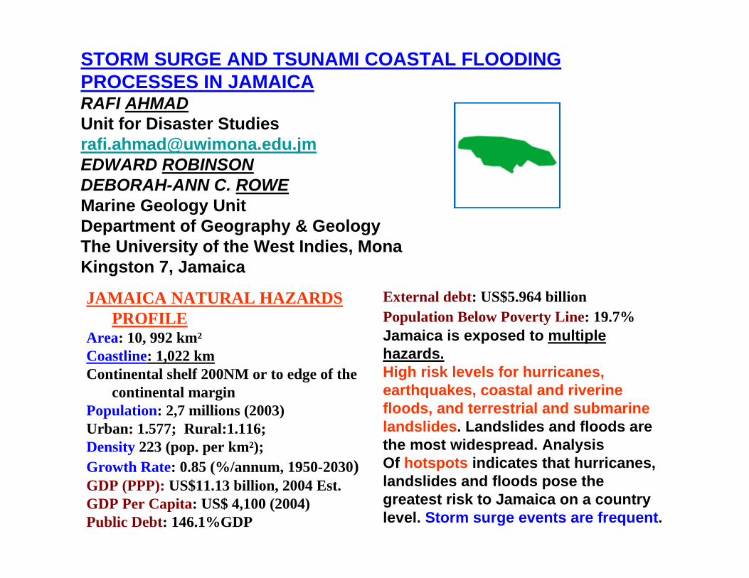
STORM SURGE AND TSUNAMI COASTAL FLOODING PROCESSES IN JAMAICARAFI AHMADUnit for Disaster [email protected] ROBINSONDEBORAH-ANN C. ROWEMarine Geology UnitDepartment of Geography & GeologyThe University of the West Indies, MonaKingston 7, Jamaica
External debt: US$5.964 billionPopulation Below Poverty Line: 19.7%Jamaica is exposed to multiplehazards.High risk levels for hurricanes,earthquakes, coastal and riverinefloods, and terrestrial and submarinelandslides. Landslides and floods arethe most widespread. AnalysisOf hotspots indicates that hurricanes,landslides and floods pose thegreatest risk to Jamaica on a countrylevel. Storm surge events are frequent.
JAMAICA NATURAL HAZARDS PROFILE
Area: 10, 992 km²Coastline: 1,022 km Continental shelf 200NM or to edge of the
continental marginPopulation: 2,7 millions (2003)Urban: 1.577; Rural:1.116; Density 223 (pop. per km²); Growth Rate: 0.85 (%/annum, 1950-2030)GDP (PPP): US$11.13 billion, 2004 Est.GDP Per Capita: US$ 4,100 (2004)Public Debt: 146.1%GDP

WE CONSIDERWE CONSIDERIDENTIFICATION OF COASTAL FLOODING SOURCES,
PREPARATION OF INNUNDATION MAPS,
MAPPING OF PREVIOUS FLOODING SIGNATURES PRESERVED AS SEDIMENTARY DEPOSITS,
AND EDUCATION, OUTREACH
AS BASIC COMPONENTS OF A TSUNAMI WARNING AND MITIGATION PROGRAMME
OUR PAPER DEALS WITH THE ABOVE IN A JAMAICAN CONTEXT.OUR PAPER DEALS WITH THE ABOVE IN A JAMAICAN CONTEXT.
TO SYSTEMATICALLY ASSESS COASTAL FLOODING PROCESSES IN JAMAICA, THE ENTIRE SPECTRUM OF PROCESSES THAT LEAD TO COASTAL
FLOODING MUST BE CONSIDERED.
THESE PROCESSES INCLUDE:• STORM SURGE--- FREQUENT• TSUNAMI • COASTAL SUBSIDENCE• SEA LEVEL RISE • METEORITIC IMPACT
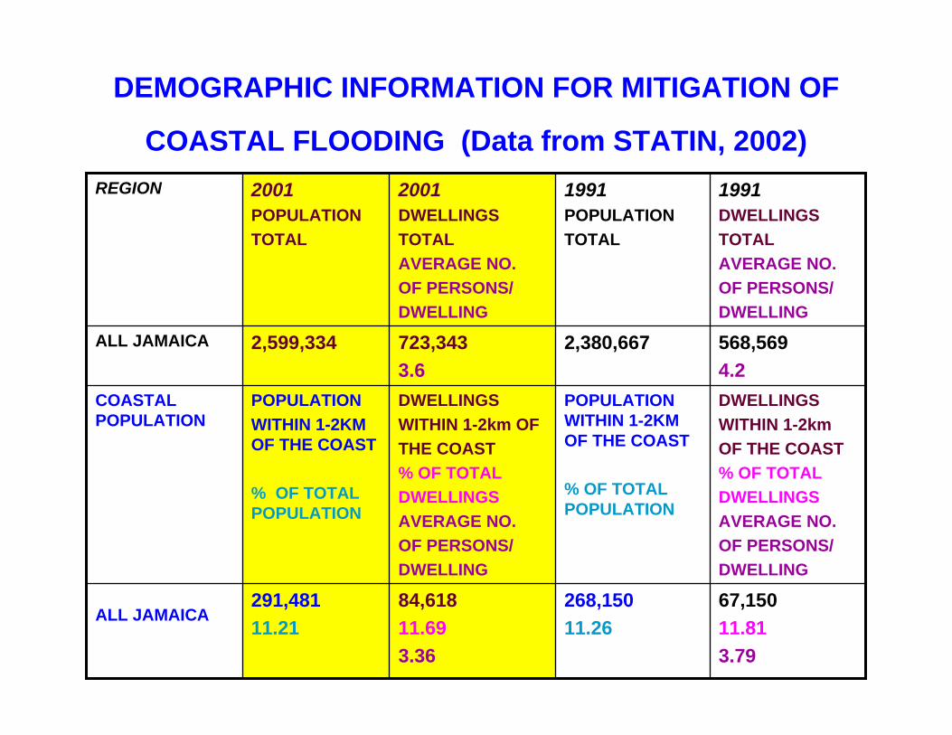
DEMOGRAPHIC INFORMATION FOR MITIGATION OF
COASTAL FLOODING (Data from STATIN, 2002)
67,15011.813.79
268,15011.26
84,61811.69 3.36
291,48111.21
ALL JAMAICA
DWELLINGSWITHIN 1-2kmOF THE COAST% OF TOTAL DWELLINGSAVERAGE NO.OF PERSONS/DWELLING
POPULATION WITHIN 1-2KM OF THE COAST
% OF TOTAL POPULATION
DWELLINGSWITHIN 1-2km OFTHE COAST% OF TOTALDWELLINGSAVERAGE NO.OF PERSONS/DWELLING
POPULATIONWITHIN 1-2KM OF THE COAST
% OF TOTAL POPULATION
COASTAL POPULATION
568,5694.2
2,380,667 723,3433.6
2,599,334 ALL JAMAICA
1991DWELLINGSTOTALAVERAGE NO.OF PERSONS/DWELLING
1991POPULATION TOTAL
2001DWELLINGSTOTALAVERAGE NO.OF PERSONS/DWELLING
2001POPULATION TOTAL
REGION

TSUNAMI SOURCES IN THE CARIBBEANTsunami hazard for the Caribbean is unique in that all of the knowntsunami causes are present in the Greater Caribbean.
• Movements/displacements of crustal blocks, Earthquakes = Tectonic Tsunamis
• Volcanic processes = Volcanic Tsunamis• Mass movement, landslide processes =
Landslide TsunamisIn Jamaica, most tsunami’s are related to
landslides ( Lander, Whiteside, Lockridge, 2002)
• Tsunami from remote sources = Teletsunamis
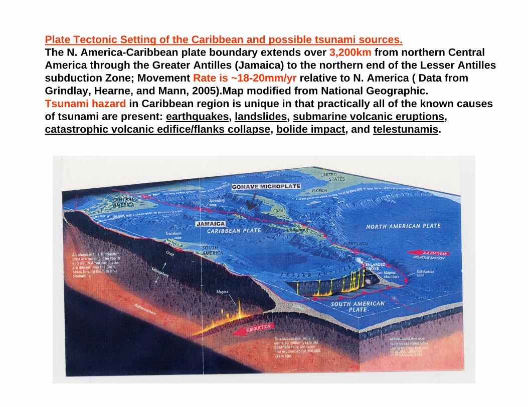
Plate Tectonic Setting of the Caribbean and possible tsunami sources.The N. America-Caribbean plate boundary extends over 3,200km from northern Central America through the Greater Antilles (Jamaica) to the northern end of the Lesser Antilles subduction Zone; Movement Rate is ~18-20mm/yr relative to N. America ( Data from Grindlay, Hearne, and Mann, 2005).Map modified from National Geographic.Tsunami hazard in Caribbean region is unique in that practically all of the known causes of tsunami are present: earthquakes, landslides, submarine volcanic eruptions, catastrophic volcanic edifice/flanks collapse, bolide impact, and telestunamis.
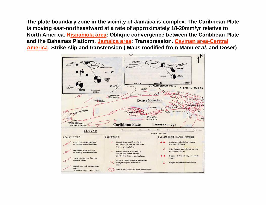
The plate boundary zone in the vicinity of Jamaica is complex. The Caribbean Plate is moving east-northeastward at a rate of approximately 18-20mm/yr relative to North America. Hispaniola area: Oblique convergence between the Caribbean Plate and the Bahamas Platform. Jamaica area: Transpression. Cayman area-Central America: Strike-slip and transtension ( Maps modified from Mann et al. and Doser)

List of Tsunamis That Have Affected Jamaica Between
1688 and 1907 http://www.sthjournal.org/214/pel.pdf
Date Surface Tsunami MaximumMagnitude Intensity Wave Height ft.
01.03.1688 2 Port Royal07.06.1692 7 3 10 Port Royal11.06.1766 7 2 Jamaica03.10.1780 7 2 3.2 Savanna la Mar11.11.1812 2 Annotto Bay14.01.1907 7 2 9.1 Annotto Bay
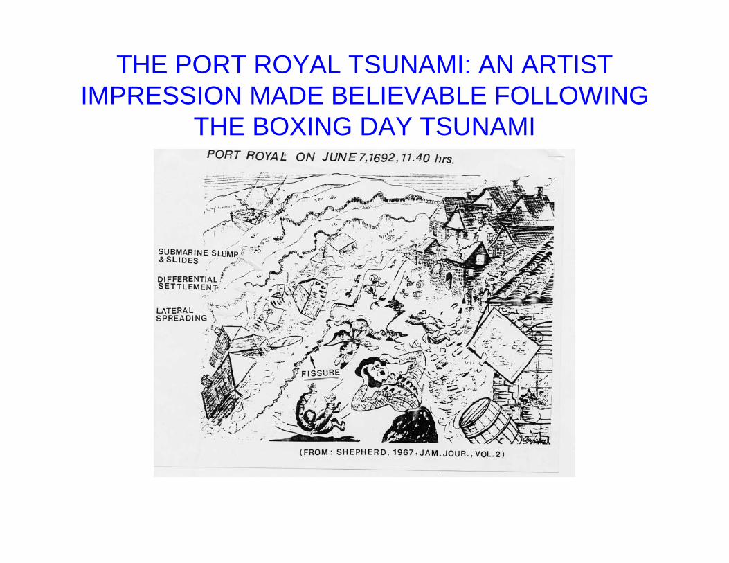
THE PORT ROYAL TSUNAMI: AN ARTIST IMPRESSION MADE BELIEVABLE FOLLOWING
THE BOXING DAY TSUNAMI

A submarine landslide destroyed Port Royal following the earthquake of June 7, 1692 and caused a tsunami. Cartoons of submarine landslide, from Ahmad.The shore line of Kingston Harbour and Palisadoes preserve signatures of previous tsunami and storm surge deposits. Detailed sampling and sedimentologic analyses of coastal flood deposits in this area might provide criteria to differentiate paleo-storm surge and tsunami deposits.Source for Port Royal Map: http://nautarch.tamu.edu/portroyal/PRhist.htm

THE 1907 TSUNAMI
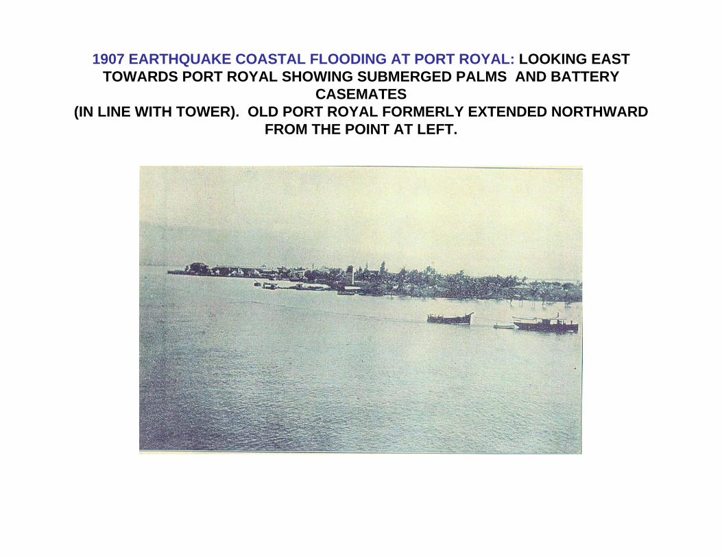
1907 EARTHQUAKE COASTAL FLOODING AT PORT ROYAL: LOOKING EAST TOWARDS PORT ROYAL SHOWING SUBMERGED PALMS AND BATTERY
CASEMATES (IN LINE WITH TOWER). OLD PORT ROYAL FORMERLY EXTENDED NORTHWARD
FROM THE POINT AT LEFT.
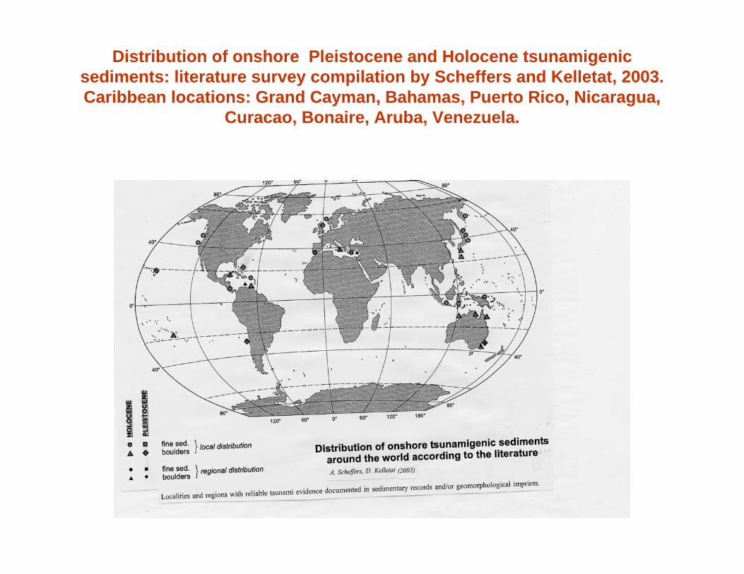
Distribution of onshore Pleistocene and Holocene tsunamigenicsediments: literature survey compilation by Scheffers and Kelletat, 2003.Caribbean locations: Grand Cayman, Bahamas, Puerto Rico, Nicaragua,
Curacao, Bonaire, Aruba, Venezuela.

FREQUENT COASTAL FLOODING HAS OCCURRED ON JAMAICAN COAST FROM STORM SURGE DUE TO HURRICANES
(2004 Hurricane season, From NOAA)

COASTAL FLOODINGDUE TO STORM SURGE
Photo source: E. Robinson
HURRICANE LENNY, NOVEMBER 1999
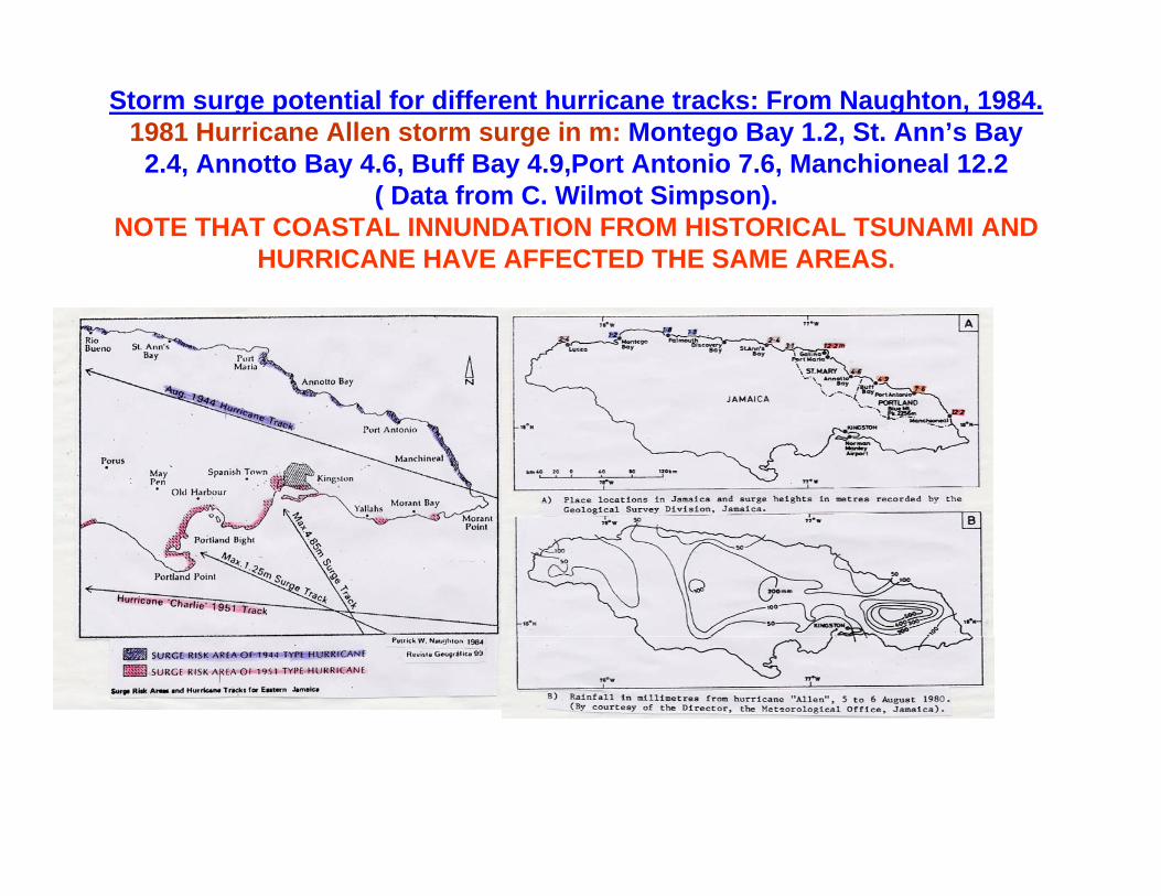
Storm surge potential for different hurricane tracks: From Naughton, 1984.1981 Hurricane Allen storm surge in m: Montego Bay 1.2, St. Ann’s Bay
2.4, Annotto Bay 4.6, Buff Bay 4.9,Port Antonio 7.6, Manchioneal 12.2 ( Data from C. Wilmot Simpson).
NOTE THAT COASTAL INNUNDATION FROM HISTORICAL TSUNAMI AND HURRICANE HAVE AFFECTED THE SAME AREAS.
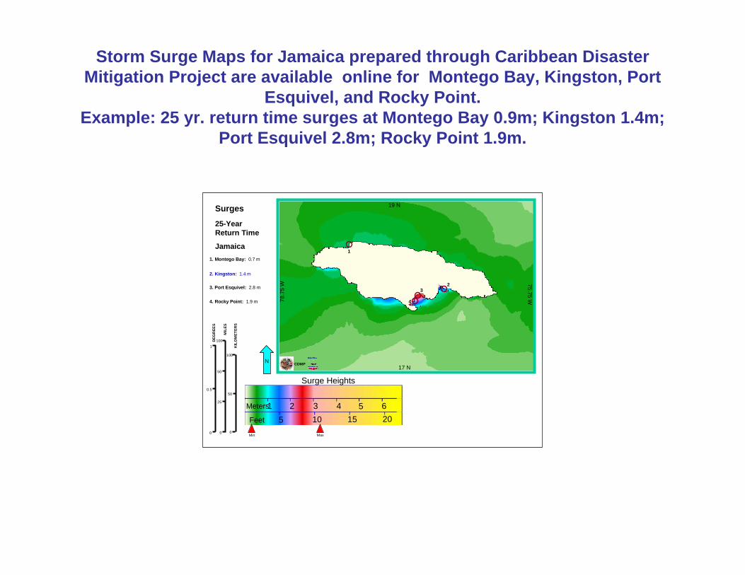
Storm Surge Maps for Jamaica prepared through Caribbean DisasterMitigation Project are available online for Montego Bay, Kingston, Port
Esquivel, and Rocky Point.Example: 25 yr. return time surges at Montego Bay 0.9m; Kingston 1.4m;
Port Esquivel 2.8m; Rocky Point 1.9m.
N
Ross Wagenseilfor CDMPJanuary 2000
17 N
19 N
75.75 W78.7
5 W
CDMP
Jamaica
25-Year Return Time
Surges
Surge Heights
1 2 3 4 5 65 10 15 20
Meters
Feet
MIL
ES
0
0.5
1
0
50
100
DEG
REE
S
KIL
OM
ETER
S
0
25
50
100
1
2
2. Kingston: 1.4 m
1. Montego Bay: 0.7 m
MaxMin
33. Port Esquivel: 2.8 m
44. Rocky Point: 1.9 m

Coastal Flood Susceptibility Map for a section of the South Coast of Jamaica.

Generalized Tsunami/Storm surge map for Jamaica
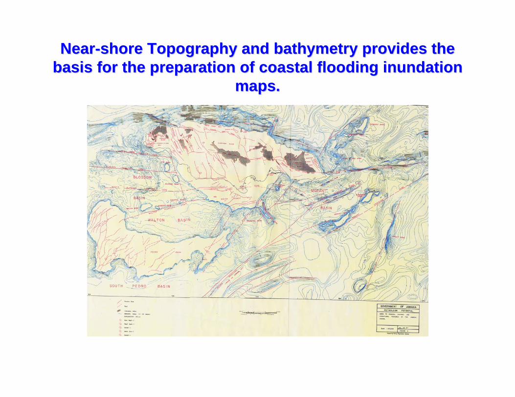
NearNear--shore Topography and bathymetry provides the shore Topography and bathymetry provides the basis for the preparation of coastal flooding inundation basis for the preparation of coastal flooding inundation
maps.maps.

Tsunami Sources on the north coast of Jamaica: Structural map of northern plate boundary zone of Jamaica compiled from seismic reflection profiles collected during Seacarib II cruise, 1987, and Casis cruise,1992 ( Leroy and others, 1996).
Recent deformation of the northern Jamaica slope seen on the Casismultichannel seismic profile (Leroy et al.1996).This deformation zone connects the Wagwater Belt with the North Jamaica Fault.Arrows from right to left:1. Reverse faults on the upper Slopes2. A seaward inclination of recent layers.3. A deep decollementwhich may be presently inactive.
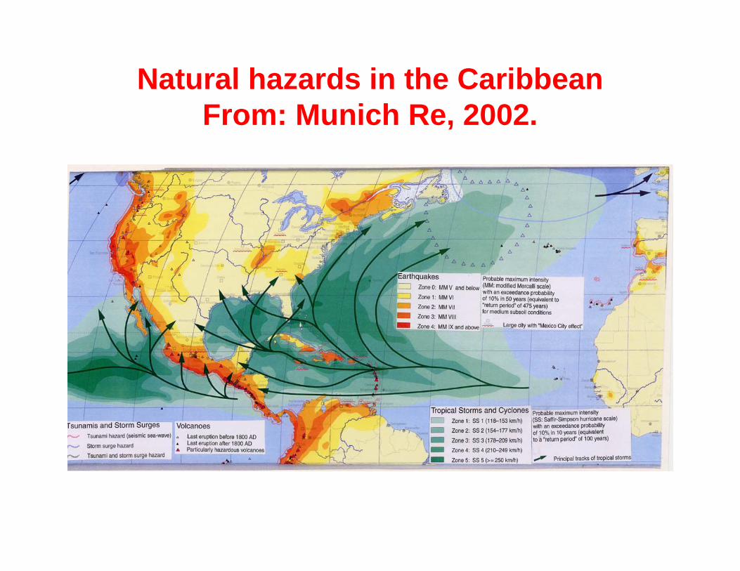
Natural hazards in the CaribbeanFrom: Munich Re, 2002.
RECOMMENDATIONS:RECOMMENDATIONS:MITIGATION AND PROTECTION OF LIFE AND
PROPERTY FROM COASTAL FLOODING
1. Jamaican coastal communities are threatened by tsunamis that are generated by both local and distant sources.
A. Local tsunamis give residents only a few minutes to evacuate to a safe place.B. Distant tsunamis give more time for warning and evacuation.
2. Any tsunami warning system/hazard mitigation programme should address both local and distant tsunamis.
3. Implementation of a comprehensive coastal flooding hazards mitigation programme will address both tsunami and storm surge hazards.
.
RECOMMENDATIONS RECOMMENDATIONS contd.contd.
4. Late Quaternary history of deformation, particularly that of the Holocene epoch is important in understanding active faults and sources of flooding
5. Given limited historical observations on tsunamis, support should be provided to programmes aimed at identifying sediments and landforms related to past tsunami and storm surge events
6. Coastal flood hazard mitigation should include:(a) tsunami hazard and warning system, and (b) modifying the coastal environment to reduce potential tsunami/ storm surge risks/ losses.

Thank you
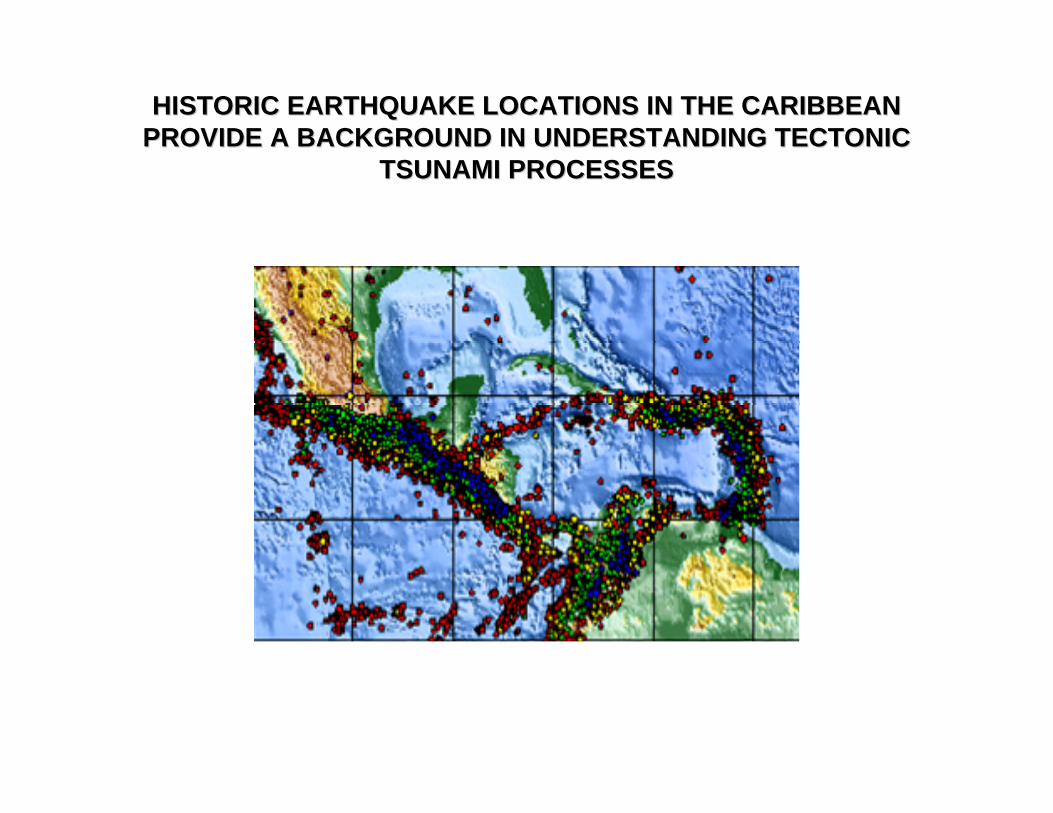
HISTORIC EARTHQUAKE LOCATIONS IN THE CARIBBEAN HISTORIC EARTHQUAKE LOCATIONS IN THE CARIBBEAN PROVIDE A BACKGROUND IN UNDERSTANDING TECTONIC PROVIDE A BACKGROUND IN UNDERSTANDING TECTONIC
TSUNAMI PROCESSESTSUNAMI PROCESSES
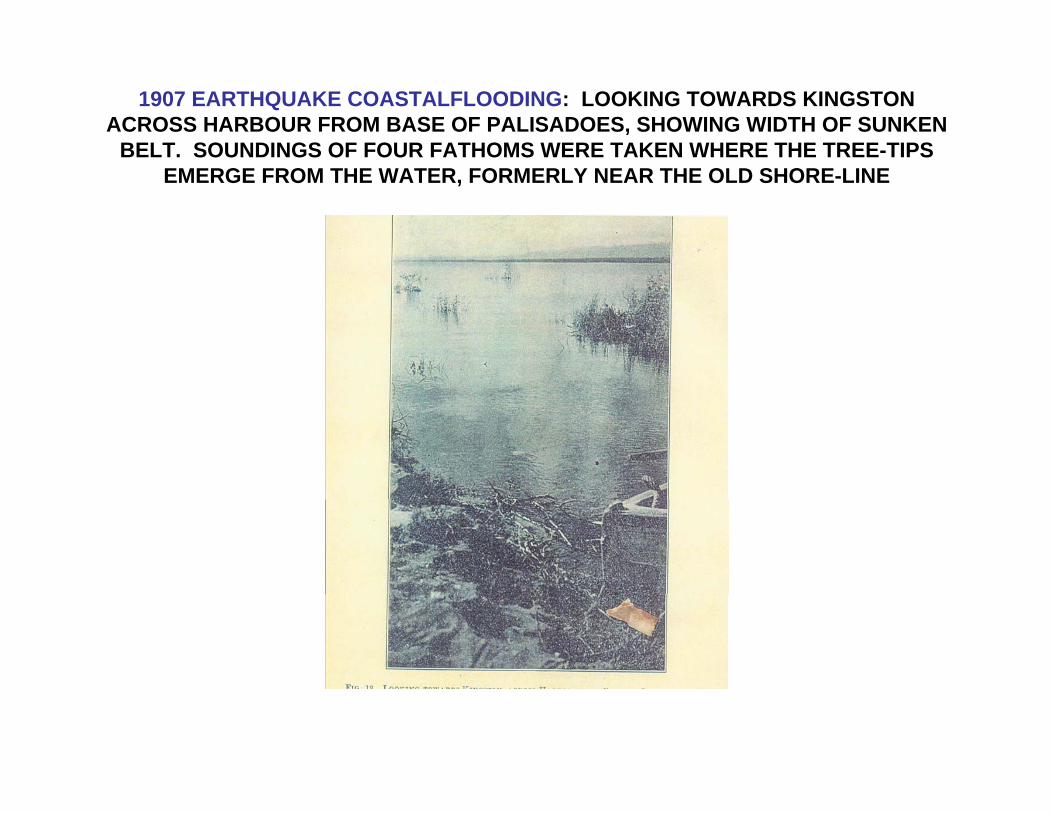
1907 EARTHQUAKE COASTALFLOODING: LOOKING TOWARDS KINGSTON ACROSS HARBOUR FROM BASE OF PALISADOES, SHOWING WIDTH OF SUNKEN
BELT. SOUNDINGS OF FOUR FATHOMS WERE TAKEN WHERE THE TREE-TIPS EMERGE FROM THE WATER, FORMERLY NEAR THE OLD SHORE-LINE


Tsunami travel-time chart for Charlotte Amalie, St. Thomas. Wave fronts are drawn at 10 minute intervals. A similar wave generated at Kick ‘em Jenny would probably take about two
and a half hours to reach Kingston, Jamaica. From E Robinson
St. Thomas
Kick ‘em Jenny.
.Kingston
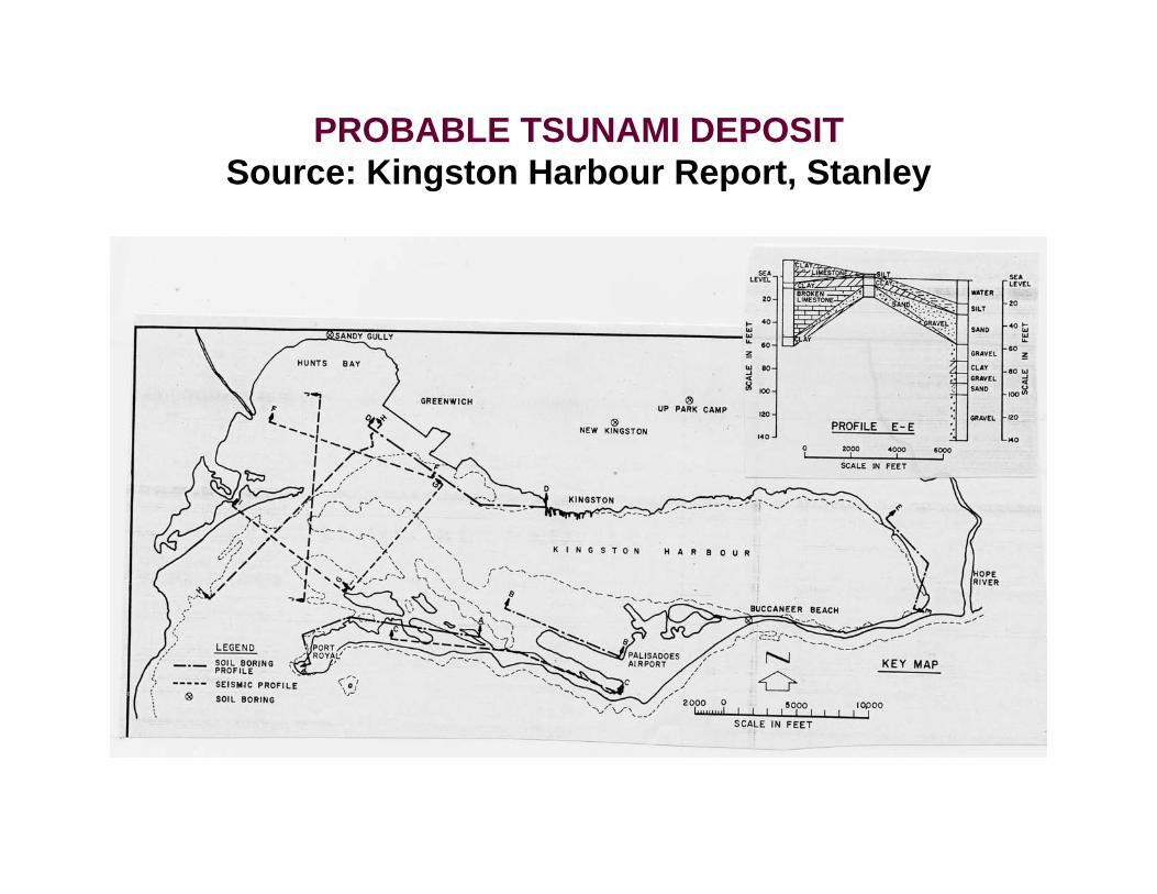
PROBABLE TSUNAMI DEPOSITSource: Kingston Harbour Report, Stanley