stewart state forest unit management plan - dec.ny.gov · -ii-preface stewart state forest unit...
TRANSCRIPT

New York StateDepartment of Environmental Conservation
GEORGE E. PATAKI, Governor DENISE M. SHEEHAN, Commissioner
Division of Lands & Forests
STEWART STATE FORESTUNIT MANAGEMENT PLAN
FINAL
Towns of Montgomery, New Windsor and Hamptonburgh and the Village of Maybrook
December 2006
Lead Agency:NYS Department of Environmental Conservation
Region 321 South Putt Corners Road
New Paltz, NY 12561
i

-ii-
Preface
STEWART STATE FORESTUNIT MANAGEMENT PLAN
In August, 1998, Governor Pataki announced that at least 6200 acres of the forest landswest of Stewart International Airport would be transferred from the jurisdiction of theNew York State Department of Transportation (DOT) to the New York StateDepartment of Environmental Conservation (DEC or Department) to permanentlypreserve the lands. On March 4, 1999, the Governor announced the official transfer of5264 acres from DOT to DEC. The land transferred to DEC is administered as aReforestation Area called Stewart State Forest. On June 30, 2006, anotherapproximately 1600 acres were transferred from DOT to Stewart State Forest, for a totalof approximately 6700 acres.
In October, 1998, a Citizens Advisory Committee (CAC) was appointed by then DECCommissioner John Cahill. The CAC prepared a series of recommendations whichwere submitted to Commissioner Cahill on November 4, 1999 (Appendix D). Twopublic meetings were held on December 9, 1999 at the Little Britain Elementary Schoolin the Town of New Windsor to describe the Unit Management Planning process andprovide the public an opportunity to meet and exchange ideas with DEC staff prior tothe development of a Draft Unit Management Plan (UMP). (See Appendix D). OnOctober 26, 2006, two public meetings were held at the Town of New WindsorCommunity Center to provide the public an opportunity to comment on the Draft UnitManagement Plan leading to this final plan.
Most of the land in the current and future Stewart State Forest was formerly in farm andresidential use. The Metropolitan Transportation Authority (MTA) acquired the landby eminent domain in the 1970s to “establish, construct, expand, rehabilitate, improve,maintain, reconstruct and operate” Stewart Airport (Chapter 472 of the 1971 Laws of theState of New York), then being converted from military to civilian use. In 1982, the landwas transferred to DOT including about 800 acres leased for agriculture. Agriculturecontinues, and six farmers currently farm more than 400 acres. The U.S. Postal Serviceleases a building along State Route 207. Five adjacent historic buildings along routes207 and 208 are owned by the Orange County Historical Society.
The land supports diverse wildlife, including increasingly rare grassland and shrubland bird species, amphibians and reptiles. The old roads and fields provide superioraccess for hiking, biking, horseback riding and carriage driving, bird watching,snowmobiling, cross-country skiing and snowshoeing, and casual recreation. Since1974, when the property was designated a Cooperative Hunting Area, it has providedsmall and big game hunters access to the property. Several small ponds provide warm-water fishing throughout spring and summer.

-iii-
Dog clubs hold a series of field trials on the ponds and nearby open fields in late springand summer to train and evaluate sporting breeds, drawing participants from all overthe northeast and the country.
The property is currently closed to motor vehicles, except for hunters during theOctober to December hunting season or by special permit.
The Wildlife Conservation Society’s 2000 biological survey of the area as well asinformation provided by Breeding Bird Surveys and the Natural Heritage programhave been instrumental in the DEC’s unit management planning process.
This UMP will govern the management activities on the site for 10 years following itsfinal adoption by the Department. Some of the information and issues presented in thisDraft are:
• An inventory of the natural resources and human-made facilities on theproperty
• Establishment of a formal trail system• Parking and access• Use of the property by different groups• Interpretation, including kiosks and a brochure• Use of the property by people with disabilities• Farming• Maintenance of fields and brush land to maintain plant and animal species
diversity• Forest inventory and management• Historic sites• State Police facility• Management to protect natural resources while developing the area’s
potential for passive recreation• Insuring a viable and sustainable State Forest by considering the impacts
of key inholdings or adjacent parcels• Budget and staffing
The Department manages State lands for multiple uses to serve the People of New YorkState. This UMP is the first step in carrying out this policy. However, factors such asbudget constraints, unforeseen changes in circumstances, staffing, and forest healthproblems may require deviation from the scheduled management activities.
The Department’s ecosystem management goal is to maintain a balanced ecosystemwhile providing for diverse human use. The basic objective of this UMP allows forcompatible human use of the Stewart State Forest so that these lands are passed on tofuture generations in better condition than when they were acquired.

-iv-
The following DEC Region 3 staff members serve on the Unit Management Team for theStewart State Forest. These members are assigned to the DEC’s New Paltz office:
Team Members BureauGeorge Profous, Forester, Coordinator ForestryJeffrey Wiegert, Robert Messenger Forestry Charles Antzak Real PropertyLen Bouren OperationsDan Walsh/Greg Tyrell/Kenneth Gierloff Forest RangerWayne Elliot/Leslie Surprenant FisheriesTed Kerpez/Pat Vissering/Nathan Ermer WildlifePeg Duke/Larry Biegel Environmental PermitsRick Martin/Neil Watt Law EnforcementWilliam Rudge Supervisor of Natural Resources
Support Staff BureauRenee O’Connor AdministrationGary Coutu Real PropertyMike Carroll Real PropertyGary Van Laer OperationsMike Callan Forestry
Special Thanks to
Robert Herberger ForestryFred Gerty Forestry
For further information, please contact:
NYS Department of Environmental ConservationDivision of Lands and Forests21 South Putt Corners RoadNew Paltz, NY 12561-1696Tel (845) 256-3000
-v-
Table of ContentsStewart State Forest
Letter to the Record . . . . . . . . . . . . . . . . . . . . . . . . . . . . . . . . . . . . . . . . . . . . . . . . . . . . . . . . . -i-
Preface . . . . . . . . . . . . . . . . . . . . . . . . . . . . . . . . . . . . . . . . . . . . . . . . . . . . . . . . . . . . . . . . . . . . -ii-
Stewart State Forest - Executive Summary . . . . . . . . . . . . . . . . . . . . . . . . . . . . . . . . . . . . . -1-
I. INTRODUCTION . . . . . . . . . . . . . . . . . . . . . . . . . . . . . . . . . . . . . . . . . . . . . . . . . . . . . . . -5-A. Location . . . . . . . . . . . . . . . . . . . . . . . . . . . . . . . . . . . . . . . . . . . . . . . . . . . . . . -5-B. Definition of Land Classification . . . . . . . . . . . . . . . . . . . . . . . . . . . . . . . . . -5-C. History of the State Forest and surrounding area . . . . . . . . . . . . . . . . . . . -5-
II. INFORMATION ON THE STATE FOREST . . . . . . . . . . . . . . . . . . . . . . . . . . . . . -9-A. Inventory of Real Property . . . . . . . . . . . . . . . . . . . . . . . . . . . . . . . . . . . . . . -9-B. Geographical & Geological Information . . . . . . . . . . . . . . . . . . . . . . . . . . -11-
1. Geology . . . . . . . . . . . . . . . . . . . . . . . . . . . . . . . . . . . . . . . . . . . . . . . . -11-2. Soils . . . . . . . . . . . . . . . . . . . . . . . . . . . . . . . . . . . . . . . . . . . . . . . . . . . -11-
C. Climate . . . . . . . . . . . . . . . . . . . . . . . . . . . . . . . . . . . . . . . . . . . . . . . . . . . . . . -12-D. Vegetative Types and Stages . . . . . . . . . . . . . . . . . . . . . . . . . . . . . . . . . . . . -12-E. Wildlife . . . . . . . . . . . . . . . . . . . . . . . . . . . . . . . . . . . . . . . . . . . . . . . . . . . . . . -14-
1. Reptiles and Amphibians . . . . . . . . . . . . . . . . . . . . . . . . . . . . . . . . . -15-2. Breeding Birds . . . . . . . . . . . . . . . . . . . . . . . . . . . . . . . . . . . . . . . . . . -15-3. Hawk Survey . . . . . . . . . . . . . . . . . . . . . . . . . . . . . . . . . . . . . . . . . . . -16-4. Mammals . . . . . . . . . . . . . . . . . . . . . . . . . . . . . . . . . . . . . . . . . . . . . . -16-5. Game Species . . . . . . . . . . . . . . . . . . . . . . . . . . . . . . . . . . . . . . . . . . . -16-6. Fish . . . . . . . . . . . . . . . . . . . . . . . . . . . . . . . . . . . . . . . . . . . . . . . . . . . -16-7. Butterflies and Invertebrates . . . . . . . . . . . . . . . . . . . . . . . . . . . . . . -17-8. Rare, Threatened and Endangered Animals and Species of Special
Concern . . . . . . . . . . . . . . . . . . . . . . . . . . . . . . . . . . . . . . . . . . . . . . . . -17-F. Wetlands and Water Resources . . . . . . . . . . . . . . . . . . . . . . . . . . . . . . . . . -17-
1. Freshwater Wetlands . . . . . . . . . . . . . . . . . . . . . . . . . . . . . . . . . . . . -17-2. Ponds or Lakes . . . . . . . . . . . . . . . . . . . . . . . . . . . . . . . . . . . . . . . . . -18-3. Surface Water Hydrology . . . . . . . . . . . . . . . . . . . . . . . . . . . . . . . . -19-4. Water Quality Classifications . . . . . . . . . . . . . . . . . . . . . . . . . . . . . -19-
G. Inventory of Man-made Facilities . . . . . . . . . . . . . . . . . . . . . . . . . . . . . . . . -20-1. Impoundment Structures (Dams) . . . . . . . . . . . . . . . . . . . . . . . . . . -20-2. Existing Road System . . . . . . . . . . . . . . . . . . . . . . . . . . . . . . . . . . . . -21-3. Dirt Roads . . . . . . . . . . . . . . . . . . . . . . . . . . . . . . . . . . . . . . . . . . . . . -21-4. Trails . . . . . . . . . . . . . . . . . . . . . . . . . . . . . . . . . . . . . . . . . . . . . . . . . . -21-5. Facility Signs . . . . . . . . . . . . . . . . . . . . . . . . . . . . . . . . . . . . . . . . . . . -22-

-vi-
6. Structures (Buildings) . . . . . . . . . . . . . . . . . . . . . . . . . . . . . . . . . . . . -22-7. Boundary Lines . . . . . . . . . . . . . . . . . . . . . . . . . . . . . . . . . . . . . . . . . -22-8. Group Camping Sites (1) . . . . . . . . . . . . . . . . . . . . . . . . . . . . . . . . . -22-9. Gates (11) . . . . . . . . . . . . . . . . . . . . . . . . . . . . . . . . . . . . . . . . . . . . . . -23-10. Fences . . . . . . . . . . . . . . . . . . . . . . . . . . . . . . . . . . . . . . . . . . . . . . . . . -23-11. Parking lots . . . . . . . . . . . . . . . . . . . . . . . . . . . . . . . . . . . . . . . . . . . . -23-12. Non-ambulatory Parking and Hunting Areas . . . . . . . . . . . . . . . -23-13. CP-3 Access for People with Disabilities . . . . . . . . . . . . . . . . . . . . -23-
III. RESOURCE DEMANDS . . . . . . . . . . . . . . . . . . . . . . . . . . . . . . . . . . . . . . . . . . . . . -23-A. Multiple Use Recreation - General . . . . . . . . . . . . . . . . . . . . . . . . . . . . . . . -23-B. Multiple Use Recreation - Specifics . . . . . . . . . . . . . . . . . . . . . . . . . . . . . . -24-
1. Hunting . . . . . . . . . . . . . . . . . . . . . . . . . . . . . . . . . . . . . . . . . . . . . . . -24-2. Fishing . . . . . . . . . . . . . . . . . . . . . . . . . . . . . . . . . . . . . . . . . . . . . . . . -25-3. Dog Club Training and Events . . . . . . . . . . . . . . . . . . . . . . . . . . . . -25-4. Snowmobile Use . . . . . . . . . . . . . . . . . . . . . . . . . . . . . . . . . . . . . . . . -26-
C. Multiple Use - Land Management . . . . . . . . . . . . . . . . . . . . . . . . . . . . . . . -26-1. Farming . . . . . . . . . . . . . . . . . . . . . . . . . . . . . . . . . . . . . . . . . . . . . . . -26-2. Forest Management . . . . . . . . . . . . . . . . . . . . . . . . . . . . . . . . . . . . . -26-3. Historic Sites . . . . . . . . . . . . . . . . . . . . . . . . . . . . . . . . . . . . . . . . . . . -27-4. State Police Facility . . . . . . . . . . . . . . . . . . . . . . . . . . . . . . . . . . . . . . -27-5. Motorized Vehicles . . . . . . . . . . . . . . . . . . . . . . . . . . . . . . . . . . . . . . -27-
IV. RESOURCE MANAGEMENT ISSUES . . . . . . . . . . . . . . . . . . . . . . . . . . . . . . . . . -27-
V. GOALS FOR THE STEWART STATE FOREST . . . . . . . . . . . . . . . . . . . . . . . . . . -29-A. Introduction . . . . . . . . . . . . . . . . . . . . . . . . . . . . . . . . . . . . . . . . . . . . . . . . . . -29-B. The Americans with Disabilities Act (ADA) and Its Influence on
Management Actions for Recreation and Related Facilities . . . . . . . . . . -30-
VI. OBJECTIVES OF THE UNIT MANAGEMENT PLAN . . . . . . . . . . . . . . . . . . . -31-A. Resource Protection . . . . . . . . . . . . . . . . . . . . . . . . . . . . . . . . . . . . . . . . . . . -31-B. Public Use and Recreation . . . . . . . . . . . . . . . . . . . . . . . . . . . . . . . . . . . . . . -32-C. Wildlife . . . . . . . . . . . . . . . . . . . . . . . . . . . . . . . . . . . . . . . . . . . . . . . . . . . . . . -32-D. Fisheries . . . . . . . . . . . . . . . . . . . . . . . . . . . . . . . . . . . . . . . . . . . . . . . . . . . . . -32-E. Education and Research . . . . . . . . . . . . . . . . . . . . . . . . . . . . . . . . . . . . . . . . -32-F. Forestry . . . . . . . . . . . . . . . . . . . . . . . . . . . . . . . . . . . . . . . . . . . . . . . . . . . . . . -33-G. Land Acquisition . . . . . . . . . . . . . . . . . . . . . . . . . . . . . . . . . . . . . . . . . . . . . . -33-H. Airport Safety. . . . . . . . . . . . . . . . . . . . . . . . . . . . . . . . . . . . . . . . . . . . . . . . . .-33-

-vii-
VII. PROPOSED RESOURCE MANAGEMENT ACTIONS . . . . . . . . . . . . . . . . . . . -33-A. Protective Actions . . . . . . . . . . . . . . . . . . . . . . . . . . . . . . . . . . . . . . . . . . . . . -33-
1. Insect and Disease . . . . . . . . . . . . . . . . . . . . . . . . . . . . . . . . . . . . . . . -33-2. Fire Control, State Land Security and Public Safety . . . . . . . . . . -34-3. Temporary Revocable Permits . . . . . . . . . . . . . . . . . . . . . . . . . . . . -34-4. Wetlands . . . . . . . . . . . . . . . . . . . . . . . . . . . . . . . . . . . . . . . . . . . . . . . -34-5. Invasive Species . . . . . . . . . . . . . . . . . . . . . . . . . . . . . . . . . . . . . . . . . -34-6. Rare and Endangered Species . . . . . . . . . . . . . . . . . . . . . . . . . . . . . -35-7. Cultural Resources . . . . . . . . . . . . . . . . . . . . . . . . . . . . . . . . . . . . . . -36-8. Mineral Resources . . . . . . . . . . . . . . . . . . . . . . . . . . . . . . . . . . . . . . . -36-9. Soils. . . . . . . . . . . . . . . . . . . . . . . . . . . . . . . . . . . . . . . . . . . . . . . . . . . . .-37-
B. Recreational Management Actions . . . . . . . . . . . . . . . . . . . . . . . . . . . . . . . -37-1. Hunting . . . . . . . . . . . . . . . . . . . . . . . . . . . . . . . . . . . . . . . . . . . . . . . -37-2. Trapping . . . . . . . . . . . . . . . . . . . . . . . . . . . . . . . . . . . . . . . . . . . . . . . -38-3. Fishing . . . . . . . . . . . . . . . . . . . . . . . . . . . . . . . . . . . . . . . . . . . . . . . . -38-4. Dog Trials and Training . . . . . . . . . . . . . . . . . . . . . . . . . . . . . . . . . . -39-5. Trails . . . . . . . . . . . . . . . . . . . . . . . . . . . . . . . . . . . . . . . . . . . . . . . . . . -40-
Descriptions of major trail systems . . . . . . . . . . . . . . . . . . . . . . . . -41-Summary of proposed trail use . . . . . . . . . . . . . . . . . . . . . . . . . . . . -49-
6. Snowmobiles . . . . . . . . . . . . . . . . . . . . . . . . . . . . . . . . . . . . . . . . . . . -50-7. All Terrain Vehicles . . . . . . . . . . . . . . . . . . . . . . . . . . . . . . . . . . . . . -50-8. Camping and Fires . . . . . . . . . . . . . . . . . . . . . . . . . . . . . . . . . . . . . . -51-9. Youth Hunting and Fishing Opportunities . . . . . . . . . . . . . . . . . . -52-
C. Facilities Management Actions . . . . . . . . . . . . . . . . . . . . . . . . . . . . . . . . . . -52-1. Parking . . . . . . . . . . . . . . . . . . . . . . . . . . . . . . . . . . . . . . . . . . . . . . . . -52-2. Access for People With Disabilities . . . . . . . . . . . . . . . . . . . . . . . . -55-3. Sanitary Facilities . . . . . . . . . . . . . . . . . . . . . . . . . . . . . . . . . . . . . . . -56-4. Historic/Archaeologic Sites . . . . . . . . . . . . . . . . . . . . . . . . . . . . . . -56-5. State Police Facility . . . . . . . . . . . . . . . . . . . . . . . . . . . . . . . . . . . . . . -57-6. Post Office . . . . . . . . . . . . . . . . . . . . . . . . . . . . . . . . . . . . . . . . . . . . . -57-7. Wildlife Check Station . . . . . . . . . . . . . . . . . . . . . . . . . . . . . . . . . . . -57-8. Storage-Maintenance Facility . . . . . . . . . . . . . . . . . . . . . . . . . . . . . -57-9. Roads . . . . . . . . . . . . . . . . . . . . . . . . . . . . . . . . . . . . . . . . . . . . . . . . . . -58-10. Gates . . . . . . . . . . . . . . . . . . . . . . . . . . . . . . . . . . . . . . . . . . . . . . . . . . -58-11. Boundary Lines . . . . . . . . . . . . . . . . . . . . . . . . . . . . . . . . . . . . . . . . . -58-12. Stewart International Airport Security . . . . . . . . . . . . . . . . . . . . . -58-13. Utility Right-of-Ways . . . . . . . . . . . . . . . . . . . . . . . . . . . . . . . . . . . . -60-14. Wetland Mitigation . . . . . . . . . . . . . . . . . . . . . . . . . . . . . . . . . . . . . . -61-15. Dams . . . . . . . . . . . . . . . . . . . . . . . . . . . . . . . . . . . . . . . . . . . . . . . . . . .-62-
D. Outreach Management Actions . . . . . . . . . . . . . . . . . . . . . . . . . . . . . . . . . -62-1. Informational Kiosks . . . . . . . . . . . . . . . . . . . . . . . . . . . . . . . . . . . . -62-2. Interpretation . . . . . . . . . . . . . . . . . . . . . . . . . . . . . . . . . . . . . . . . . . . -62-3. Great Swamp Observation Boardwalk . . . . . . . . . . . . . . . . . . . . . -63-

-viii-
E. Resource Management Actions . . . . . . . . . . . . . . . . . . . . . . . . . . . . . . . . . -63-1. Forest Management . . . . . . . . . . . . . . . . . . . . . . . . . . . . . . . . . . . . . -63-2. Farming . . . . . . . . . . . . . . . . . . . . . . . . . . . . . . . . . . . . . . . . . . . . . . . -64-3. The Great Swamp . . . . . . . . . . . . . . . . . . . . . . . . . . . . . . . . . . . . . . . -66-
a. Introduction . . . . . . . . . . . . . . . . . . . . . . . . . . . . . . . . . . . . . . -66-b. Purple Loosestrife Control . . . . . . . . . . . . . . . . . . . . . . . . . . -67-c. Water Control Structure . . . . . . . . . . . . . . . . . . . . . . . . . . . . -67-
4. Mowing and Habitat Enhancement for Wildlife Management. . . . . . . . . . . . . . . . . . . . . . . . . . . . . . . . . . . . . . . . . . . . . . . . . . . . . . . -67-
5. Bird Habitat Management . . . . . . . . . . . . . . . . . . . . . . . . . . . . . . . . -70-F. Completing a Viable Stewart State Forest . . . . . . . . . . . . . . . . . . . . . . . . . -70-
1. Barron Road Development Area . . . . . . . . . . . . . . . . . . . . . . . . . . -71-2. Barron Road - Easterly Parcels . . . . . . . . . . . . . . . . . . . . . . . . . . . . -72-3. Forrester Road . . . . . . . . . . . . . . . . . . . . . . . . . . . . . . . . . . . . . . . . . . -72-4. Maple Avenue to Drury Lane . . . . . . . . . . . . . . . . . . . . . . . . . . . . . -72-5. Barron Road, Decker Road and Second Street within the Village of
Maybrook . . . . . . . . . . . . . . . . . . . . . . . . . . . . . . . . . . . . . . . . . . . . . . -72-6. Clark Street and Jackson Avenue . . . . . . . . . . . . . . . . . . . . . . . . . . -72-
G. Proposed Rules and Regulations . . . . . . . . . . . . . . . . . . . . . . . . . . . . . . . . -72-
VIII. Update of the Unit Management Plan . . . . . . . . . . . . . . . . . . . . . . . . . . . . . . . . . . -73-
IX. MANAGEMENT BUDGET AND STAFFING: 10 YEAR SCHEDULE . . . . . . -74-A. Annual Maintenance Budget . . . . . . . . . . . . . . . . . . . . . . . . . . . . . . . . . . . . -74-B. Construction and Projects Budget . . . . . . . . . . . . . . . . . . . . . . . . . . . . . . . -75-C. Equipment Budget . . . . . . . . . . . . . . . . . . . . . . . . . . . . . . . . . . . . . . . . . . . . -77-D. Annual Budget for Personnel . . . . . . . . . . . . . . . . . . . . . . . . . . . . . . . . . . . -77-
X. Bibliography and References . . . . . . . . . . . . . . . . . . . . . . . . . . . . . . . . . . . . . . . . . . . . . -78-
XI. Public Comments and DEC Response . . . . . . . . . . . . . . . . . . . . . . . . . . . . . . . . . . -79-
APPENDICES . . . . . . . . . . . . . . . . . . . . . . . . . . . . . . . . . . . . . . . . . . . . . . . . . . . . . . . . . . . . -84-
Appendix A: Soils of the Stewart State Forest
Appendix B: Wildlife B-1 Amphibians/Reptiles B-2 Mammals B-3 New York Breeding Bird Atlas for Stewart State Forest Blocks 5659
(A-D)
Appendix C: 2006 Transfer of Jurisdiction and Consent Decree

-ix-
Appendix D: Stewart Land Citizen's Advisory Committee Report to DEC Commissioner JohnP. Cahill November 4, 1999 and a List of Committee Members.
Appendix E: Features of ECL Title 20 New York State Bird Conservation Area program.
Appendix F: State Environmental Quality Review
Appendix G: Forest Stand Mosaic Map
Appendix H: Forest Stand Inventory Table and Treatment Schedule
Appendix I: Stewart State Forest Mowing and Shrubland Management Map
Appendix J : Stewart State Forest Agricultural Fields Map
Appendix K: Proposed Trails System and Facilities Map/ Wetlands Map
Appendix L: Hunter Parking Map for Stewart State Forest

-1-
Stewart State Forest - Executive SummaryIntroduction
Careful balancing is required by the DEC to successfully manage the 6,700+ acre Stewart StateForest with the competing priorities of protecting the land’s natural resources and ruralcharacter and encouraging public access and recreational uses. The management of theproperty is guided by its classification as State Reforestation Area, and by the 1999 and 2006orders for transfer of jurisdiction from the DOT to DEC. The Department was also guided by Citizen’s Advisory Committee’s recommendations (December, 1999) and two public meetingsheld shortly afterward, as well as comments received from two public meetings on October 26,2006. The property is heavily used, including illegal motor vehicle trespass. DEC must takesteps to control users and manage habitat through permits, physical improvements to theproperty and special regulations. These are discussed in this UMP. Recommendationsaddressing the major issues are summarized below.
This UMP will govern DEC’s management activities on Stewart State Forest for ten yearsfollowing its final adoption by the Department.
Major Issues
Recreational Uses
< The property will be open to all users throughout the year, except during the big gamehunting season (approximately mid-November to mid-December), when access will belimited to licensed hunters and their companions.
< Improvements to the property will be made to enhance access, including posting trailand internal roadway signs, and parking areas.
< A loop system of trails based primarily on designated existing trails.< Camping and fires will be prohibited except by permit.< Dog trials will be allowed through the Temporary Revocable Permit (TRP) process.
Limited mowing will be allowed to facilitate dog trials and other wildlife relatedrecreational uses.
< All terrain vehicles (ATV’s) will continue to be prohibited. < Snowmobiles will continue to be permitted on designated trails.
Natural Resource Management
< Habitat will be managed to reduce exotic invasive species, promote native animal andplant species, maintain regionally rare grass and shrub land habitat and protectwetlands and vernal pools.
< Forest resources will be managed in a sustainable manner to enhance wildlife habitat, maintain biodiversity, and provide wood products.
< Steps are outlined to protect rare plants and animals on the property.< The original land transferred to Stewart State Forest in 1999 is subject to the DOT
Transfer of Jurisdiction which allows the property to be used to mitigate wetlandimpacts associated with the airport’s development.

-2-
Public Access
< Existing gates will be maintained and new gates added to control motor vehicle access.< Motorized access is limited to hunters during the October through December hunting
season. Motorized access by other users is by permit only.< Users with mobility impairments will be allowed motorized access by special permit on
designated roads and access points.< Six parking areas will be located on the periphery for a total of approximately 120 cars
and 15 horse trailer spaces (snowmobile trailer spaces in winter).
Environmental Education and Interpretation
< Kiosks with interpretive materials will be developed and will include information aboutproper land use etiquette, brochures, maps, regulations and user information.
< The check station building on Weed Road will be improved to make room for limitedinterpretive displays, a small office and a bathroom. The post office building, if itbecomes available, will also be considered for other DEC uses.
Farming
< Farming will continue at a scale similar to what has taken place in the past, as a tool toenhance biodiversity and foster the viability of farming at the local level. Currently,farming on the property takes place through TRPs by farmers who were cultivatingfields at the time the property was transferred to DEC in 1999. Farming practices willbe subject to DEC requirements for irrigation; wetlands; best management practices;plant, wildlife, and habitat concerns; soil disturbance, and access.
Public Safety
< No development or wildlife habitat alteration, which interferes with the safe operationof Stewart International Airport, will take place. The DEC will work closely with airportpersonnel to monitor the property.
< DEC will explore a Transfer of Jurisdiction to New York State Police of the small parcelof land east of Barron Road that State Police are presently using to detonate and burnexplosives.
Land Acquisition
< Specific properties along South and North Baron Roads are of interest to the Departmentto ensure the integrity of Stewart State Forest. Any potential acquisition will be fromwilling sellers only. These properties are identified.
Funding/Staffing
< An annual maintenance budget is estimated at $197,950 dollars.< Full Staffing requested is one Senior Forestry Technician, Grade 13 or above, and two
Seasonal Assistant Forest Rangers (one May through December, one October throughDecember).

-3-
< The total 10 year maintenance, capital improvements and personnel services budget isestimated at about 3 million dollars.

-4-

-5-
I. INTRODUCTION
A. Location
The Stewart State Forest is located due west of Stewart International Airport, near Newburgh,Orange County, New York, in the Towns of Montgomery, New Windsor and Hamptonburghand the Village of Maybrook. It is accessed from the south via State Routes 207 and 208 andForrester Road and from the north by Ridge and Barron Roads, off Route 17K.
B. Definition of Land Classification
The Stewart lands are classified as State Forest. The State Forest classification was initiated bythe New York State Reforestation Law of 1929 and the Hewitt Amendment of 1931, thelegislation which authorized the Conservation Department (predecessor agency to the DEC) toacquire land by gift or purchase for Reforestation Areas. These State Forests, consisting of notless than 500 acres of contiguous lands, were to be forever devoted to “reforestation and theestablishment and maintenance thereon of forests for watershed protection, the production oftimber, and for recreation and kindred purposes.” This program is presently authorized underArticle 9, Title 5 of the NYS Environmental Conservation Law.
Today, there are nearly 710,000 acres of State Forests and Multiple Use Areas throughout theState. The use of these lands for a variety of purposes such as timber production, hiking, skiing,fishing, trapping and hunting is of tremendous importance economically, and to the health andwell-being of the people of the State.
The Stewart State Forest consists of about 6,700 acres of gently rolling hills, wetlands, ponds,forests and fields. Manmade structures consisting of buildings, roads, trails, signs, gates andparking lots are located on this State Forest..
C. History of the State Forest and surrounding area
Pre-European History
Human occupancy of the Hudson Valley began at the end of the Pleistocene with the retreat ofthe Wisconsin Glacier. The first human populations in the valley, known as the Paleo-Indians,occupied a tundra environment to the south of the receding glacial margin from circa 10,500 BCto 8000 BC. Between 8000 BC and 1000 BC, known as the Archaic period, the sparse population(possibly due to a great reduction in the density of game that accompanied the shift from aspruce and tundra environment to a mixed deciduous/coniferous forest) slowly climbed withincreasing use of coastal, riverine and plant resources. The Woodland period from 1000 BC to1350 AD was characterized by increasing plant cultivation, including grain storage, althoughwoodland hunting and gathering continued to provide a large part of the diet (NYSDOT,Stewart International Airport Properties Final Federal Environmental Impact Statement 1992)
At the time of European contact, the Native American groups who inhabited this portion of theHudson Valley were Lenape or Delaware. The Lenape consisted of two related groups, theMunsee and Unami, who were characterized by distinct Algonquain dialects. The Munsee

-6-
occupied the territory that became northern New Jersey and southern New York. Among theMunsee-speaking groups, the Esopus occupied the area west of the Hudson River, between theCatskills and the highlands at West Point. Local subgroups included Waoranecks, theWarranwankongs, and the Wappingers (New York State DOT, 1992; Ruttenber and Clark 1981).
According to a summary on prehistoric occupation in Orange County produced by theIncorporated Orange County Chapter of the New York Archeological Association (1979),aboriginal sites were clustered on highlands bordering major streams and the margins ofswamps, wetlands, and sinkholes. The heaviest prehistoric occupation in the county appears tohave been during the Late Archaic period. There is also a good representation of TransitionalArchaic sites. Woodland occupation in Orange County was relatively sparse and is restricted toupland rockshelters and flats along the Wallkill, Ramapo, Neversink, and Delaware rivers. Nolarge Woodland base camps or villages have been located in the county.
European History
The first European settlers in this area were Dutch. Colonization increased after the territorycame under English control in 1664. Orange County was established in 1683 as one of NewYork’s original 12 counties. The original county boundaries included what is now the southernportion of Orange County and all of Rockland County (Ruttenber and Clark 1981).
Numerous land patents were issued in the late seventeenth and early eighteenth century,following the purchase of Native American lands. The early settlers in this area weredispossessed of their land in 1694, when Captain John Evans obtained a patent from ColonelFletcher, Governor of the New York Colony. The Evans Pattent consisted of 650,000 acres alongthe west shore of the Hudson, approximately from New Paltz on the north, Stony Brook on thesouth, and the Shawangunk Mountains on the West (Headley 1908:34-35). In 1699, the EvansPatent was annulled and the territory conveyed in small tracts by numerous patents issuedbetween 1701 and 1775 (Ruttenber and Clark 1981). The early inhabitants of Orange Countywere characterized by diverse ethnicity, including Dutch, English, French, German, Irish andScot and supported themselves through subsistence farming.
The southeasterly corner of Stewart State Forest , part of the western half of the Town of NewWindsor has been known for over a century as Little Britain. This name probably comes fromPeter Mullinar who bought 200 acres of land in 1729 and probably came from Little Britain, orBretagne Street, in London, after which he named his farm. The cemetery near Bull Road wasonce part of his farm and bears his name (Orange County Post, September 14, 1978).
Rock Tavern is named after an early landmark - a tavern built on a large rock and owned andoperated by John Humphrey in 1740 - once located near the intersection of present dayForrester Road and Route 207. At this tavern, plans were made for the organization of thepresent Orange County. Today, the former site of this tavern is somewhere near realigned Rt. 207. The ruins of Morris Tavern are on the property between Forrester Road and the RockTavern Post Office.
In 1798, the county lines of New York State were revised and Orange County annexed thetowns of Newburgh, New Windsor, Wallkill, Montgomery and Deerpark.

-7-
The Stewart properties fall within the towns of New Windsor, Hamptonburgh andMontgomery. New Windsor was established as a town in 1798, the township became part ofOrange County (Ruttenber and Clark 1981). The northwestern part of the town is a marshyarea known as the Great Swamp. Until the Revolutionary War, New Windsor was the center oftrade through Orange County. Local industries included brick and glass works, in addition tothe many grain mills. During the nineteenth century, New Windsor lost much of its commercialtrade to Newburgh, which had the advantages of Hudson River frontage.
Montgomery Township was originally part of the Precinct of Shawangunk, established in 1714,although the area became part of Wallkill in 1743 until the formation of Hanover Precinct in1772. In 1782, the Hanover Precinct was renamed Montgomery, which then became a township1789. Subsequently, the creation of Crawford in 1823 and Hamptonburgh in 1830 reduced thearea of Montgomery Township by almost one half. Woolens manufacturing was established inMontgomery in 1830 and became a primary industry by the late nineteenth century. Other localmanufacturers included cutlery and bricks.
Hamptonburgh was formed in 1830 from parts of the townships of Goshen, Blooming Grove,New Windsor, Montgomery and Wallkill (Ruttenber and Clark 1981:653). The area wasoriginally part of Wawayanda Patent of 1703.
By 1830, the Erie Canal had a large impact on commerce in Newburgh. In response, Newburghofficials approached the New York and Erie Railroad in 1835 to make Newburgh the easternterminus of the railroad. Construction of the Newburgh to New York railroad, however, wasnot completed until 1869.
The City of Newburgh was incorporated in 1865. Most of the township’s manufacturing tookplace in this area and included saw and grist mills, iron works, and clothing manufactures.
Although the early communities supported themselves by subsistence farming, by thenineteenth century, corn, wheat, oats, rye and buckwheat were important crops. Fruits werealso extensively grown in the Hudson River region (Headley 1908:638-639). The fine grasslandsof Orange County also nurtured an early emphasis on horse-breeding. Dairy farming wasintensively practiced and many areas in Orange County produced cheese and butter. In 1842the New York and Erie Railroad carried Orange County’s first milk consignment to New YorkCity. Soon, creameries were established at each station in the dairy region. However, shippingliquid milk proved to be more profitable, and by the 1880's the county contained 70 milkshipping stations, three condenseries, two cheese and one butter and cheese factory (Headley1908:764).
The rural economy of the county continued into the twentieth century, as the countyincreasingly felt the influences of an ever expanding New York City metropolitan area.However, the commercial hub in the area shifted from New Britain toward Newburgh. WhiteCloud Farms, 1917-1957, is an example of the interesting changes which have occurredthroughout the region over the past century. Starting as an apple orchard/farm, it becamefamous for its pottery and tiles, and among other famous projects made the mosaic street signsfor the New York City Subway System (Visakay, 2006; Marshall, personal communication). The farm acreage became part of the land for the Stewart Airport expansion. The area of
-8-
Stewart State Forest continues to be a crossroads where major arteries like the New York StateThruway and Interstate 84, railroads, air traffic and the Hudson River intersect, providing a linkto major metropolitan areas.
The Stewart Property Since 1970
The Stewart State Forest is a large block of rural landscape surrounded by largely developedsuburban and urban areas of eastern Orange County. In 1969, the U.S. Air Force closed itsairbase and declared the property surplus. In March of 1970 the Air Force transferred title ofthe 1,600 - acre airport to the state Metropolitan Transportation Authority (MTA). The land tothe west of Stewart International Airport has been in public ownership since approximately1971, when the MTA acquired and appropriated 802 parcels of land which totaled 8,076 acres inanticipation of the airport’s expansion. State officials thought Stewart would become the fourthmajor airport serving the New York City metropolitan area. There is also some indication thatthe State intended to develop Stewart as the east coast’s supersonic transport (SST) airport -hence, the very long runway and large buffer area. The State bought 802 parcels of land with337 residences and farmhouses - mostly through eminent domain. About 1,200 people lived onthese properties. Remnants of house foundations, driveways, and old orchards are still foundon the land, testifying to the residential and agricultural uses which took place here.The buildings on the property were demolished starting in 1972. The airport expansion wasabandoned by 1982 and the state legislature transferred ownership from the MTA to the DOT. This allowed the MTA to return to its core business of providing mass transportation for themetropolitan area. Commercial passenger flights began at Stewart Airport in 1990.
On March 4, 1999, Governor Pataki announced the transfer of 5260 acres west of the StewartInternational Airport from the DOT to the Department to be managed as a Reforestation Area - Stewart State Forest (subsequently revised to approximately 5100 acres to account for powerline lands owned by Central Hudson passing through the property). A copy of the Transfer ofJurisdiction document is provided in the Appendix C. DOT retained certain rights on theproperty, including the use of the area as an aircraft noise buffer, and for wetland enhancementand creation as mitigation for DOT and airport expansion wetland impacts. Subsequently, approximately 1600 more acres were transferred from DOT to DEC on June 29, 2006, pursuantto a November, 2005 Consent Decree and Order of Dismissal, [No. 00-cv-1606, Stewart Parkand Reserve Coalition, Orange County Federation of Sportsmen’s Clubs, Inc and Sierra Club v.Rodney E. Slater (US Department of Transportation), et al.)]
Former DEC Commissioner Cahill set the stage for the property’s management; when he said“We will make the Stewart lands a premier outdoor destination while providing maximumprotection for its natural resources.”
Management of Stewart International Airport was privatized to the National Express GroupPLC of the United Kingdom in June, 2000.

-9-
II. INFORMATION ON THE STATE FOREST
A. Inventory of Real Property
This information should be used in conjunction with the “Transfer of Jurisdiction” maps anddescriptions cited in Table 1 which provide more detail about the property, as well as the 2005Consent Decree and Order of Dismissal (No. 00-cv-1606, Stewart Park and Reserve Coalition,Orange County Federation of Sportsmen’s Clubs, Inc and Sierra Club v. Rodney E. Slater (USDepartment of Transportation), et al.)
Table #1 Parcels included in the Stewart State Forest
Parcel Acres Date Acquired Funding Source Previous Owner
Orange 4 5100+ 3/4/1999 T.O.J.* NYSDOT/MTA
Orange 4 1600+ 6/29/2006 T.O.J.* NYSDOT
Total 6700+ (* Transfer of Jurisdiction)
1. Burdens, Exceptions, Leases, Easements and Right-of-Ways
a. Property Burdens• Wetland creation and/or enhancement as mitigation for wetland impacts
of Department of Transportation and airport projects.
b. Exceptions• Cemetery along Rt. 207 between Maple Avenue and Drury Lane.• Belknap Family Cemetery between Rt. 207 and Barrett Road.• United States military housing parcel.• Little Britain Elementary School.
• Excepted Parcel No. 1 Is a parcel of land located on Barron Road along the northwest border ofStewart State Forest. Although it is outside the State Forest, DOT retainsaccess rights on northerly Barrron Road which may affect future accessand parking in that vicinity.
• Excepted Parcel No. 2A parcel of land being 600 feet along the westerly line of Barron Road andbeing 300 feet deep, containing approximately 4 acres of land, designatedas “Excepted Parcel No. 2 for Division State Police” as generally shownupon O.G.S. Map No. 1751 revised March 4, 1999.
-10-
Together with a 50 foot wide right-of-way, for ingress and egress, alongthe existing Barron Road, from NYS Route 208, to along the abovedescribed Excepted Parcel No. 2.
• Excepted Parcel No. 3A parcel of land being 150 foot wide, located along the southerlyboundary of said Interstate Route 84 containing approximately 32 acres ofland, designated as “Excepted Parcel No. 3 to be reserved by NYSDOT”as generally shown upon O.G.S. Map No. 1751 revised March 4, 1999.
• Village of Maybrook. The sections of Barron Road, Decker Road andSecond Street that are within the Village limits were not appropriated bythe DOT. These roads remain as Village property, in fee, with a 50 footwide right-of-way.
c. Leases• A five-year lease agreement between the United State Post Office and
DOT was assumed by the DEC. The current agreement was entered intoon December 1, 2004. The U.S. Postal Service has two additional five yearlease options that will expire in 2014.
d. Easements/Rights-of-Way• Central Hudson Gas & Electric Corporation owns and manages about 118
acres under transmission lines surrounded by the State Forest, along withanother 41 acres in a transmission right-of-way.
• Access easement between the United States Military Housing and LittleBritain Elementary School (Orange Co. Clerk filed map 1740, February 10,1958.
• Easement for sewer and water lines between United States MilitaryHousing and Jackson Avenue extension/airport (map 1740).
• Clark Street access easement (map 1740).• Drainage easement north of United States military housing • 33 foot right-of-way for a transcontinental coaxial underground telephone
cable (kept free of trees and mowed) from Route 207 north, betweenMaple Avenue and Drury Lane.
2. Real Estate Taxes Paid on the Unit
New York State pays school, fire district and town taxes on State Forest lands ofover 500 contiguous acres under Real Property Tax Law Section 534. Taxes arenot paid to the County, or on buildings. Thus, recreational and open-spacebenefits are provided to the region with continued support of the local tax base. Taxes paid by the State in 2004 were approximately $800,000.
-11-
B. Geographical & Geological Information
1. Geology
The eastern part of Orange County is a complex of folded and faulted rocks ranging from thePre-Columbian to the Triassic period. Metamorphic rock predominates the area. OrangeCounty was moderately affected by glaciation. The movements of the glaciers modified thetopography and soils. The last ice age started approximately 300,000 years ago and retreated12,000 years ago. Glacial fill is the dominant overburden. Topographic relief in the area ismoderate but irregular. Bedrock ridges reach elevations of approximately 600 feet above meansea level (MSL) and in addition, there are areas of exposed bedrock. The highest point withinthe project area is Buchanan Hill, which is located between Maple Avenue and Drury Lane andreaches an elevation of 658 feet. Low lying areas between the ridges are 340 to 360 feet aboveMSL and are often swamps and marshes.
2. Soils
The primary soils of the Stewart State Forest consist of two major classifications, the Mardin-Erie series and the Nassau-Bath- Rock outcrop series.
The Mardin-Erie series can be described as a gravelly silt loam. These soils were formed byglacial till deposits in uplands. The Mardin component can be characterized as deep,moderately well drained, while the Erie component consists of deep, poorly drained soils.
The Nassau-Bath-rock outcrop series can be described as shaly silt loam. These soils wereformed in thin glacial till deposits on bedrock controlled uplands. The Nassau soil ismoderately drained and shallow over bedrock, the Bath soils are well drained and deeper overbedrock. The Nassau-Bath-rock outcrop soils are associated with Mardin and Erie soils. Incontrast to the Mardin-Eric soils, these soils (Nassau-Bath) have better natural drainage and aredeeper over fragipan.
Carlisle muck is found in the Great Swamp and East of Drury Lane, and is up to 96" deep. Theseasonal high water table is near the surface in spring, but lowers quickly through the drainagenetwork once upland runoff subsides. Trees are red maple, willow and alder.
Madalin Silt Loam, formed in glacial lake deposits of silt and clay, the predominant feature inthe wetland east of Drury Lane. Partially drained, these areas were once used for pasture. Surrounding soils are very poorly drained and have prolonged wet periods, including:- Canandaigua silt loam- Histic humaquepts (Ponded soils commonly called freshwater marsh with typically 1-6 inchesof water, muck from 4 to 16 inches thick).- Limited areas of Palms muck (ponded organic deposits 16 to 50 inches thick over mineral soildeposits). Palms muck is found in depressions and bogs in uplands, and concave basins inlowlands plains.
Also, human activities form Udorthents, best described as soils formed in man-made cut-and-fill areas. Excavated cut and fill areas and soil stockpiles are typical examples (see Appendix Afor soils list)
-12-
C. Climate
(Prepared by the National Climatic Center, Asheville, North Carolina)
Winters are cold in Orange County. Summers are moderately warm with occasional hot spells. Precipitation is well distributed throughout the year and is nearly always adequate for all crops. Winter snows occur frequently, occasionally as blizzards.
In winter the average temperature is 29 degrees F, and the average daily minimum temperatureis 21 degrees. The lowest temperature on record, which occurred at West Point on February 8,1963, is -11 degrees. In summer the average temperature is 73 degrees, and the average dailymaximum temperature is 84 degrees. The highest recorded temperature , which occurred onSeptember 2, 1953, is 105 degrees.
The total annual precipitation is 48 inches. Of this, 24 inches, or 50 percent, usually falls inApril through September, which includes the growing season for most crops. In 2 years out of10, the rainfall in April through September is less than 20 inches. The heaviest 1-day rainfallduring the period of record was 4.76 inches at West Point on September 12, 1960. Thunderstorms occur on about 31 days each year, and most occur in summer.
Average seasonal snowfall is 43 inches. The greatest snow depth at any one time during theperiod of record was 40 inches. On an average of 25 days, at least 1 inch of snow is on theground. The number of such days varies greatly from year to year.
The average relative humidity in mid-afternoon is about 60 percent. Humidity is higher atnight, and the average at dawn is about 80 percent. The sun shines 60 percent of the timepossible in summer and 40 percent in winter. The prevailing wind is from the southwest. Average wind-speed is highest, 10 miles per hour, in April.
D. Vegetative Types and Stages
Stewart State Forest is a 6,700 acre complex of second growth deciduous woodlands,agricultural and post-agricultural lands, and interconnected wetlands.
Virtually all the Stewart State Forest property has been subjected to some form of disturbance inthe recent past. Most of this disturbance is the result of agricultural activities that have been thepredominant land use throughout the region for hundreds of years. When agriculturalactivities cease, as they have on much of the Stewart property, ecological succession results in avariety of habitats that eventually revert to a mesic hardwood forest. Similar patterns ofsuccession have taken place over much of the northeast with the decline of agriculture over thepast century. The current forest is a result of soil type, past land use and time.

-13-
Table #2 Approximate Acreage of Vegetative Types and Land Uses in the Stewart StateForest.
Land Cover Type Forest Non-forest Total Acres Percent
Agriculture 519 519 7.7
Old Field-Grass/Forb 414 414 6.1
Brushy Fields 378 378 5.6
Open Wetlands 670 670 10.0
Brushy Wetland 384 384 5.7
Wetland Forest 1312 1312 19.5
Mature Upland Forest-Oak/Hickory, N. Hdwd
1385 1385 20.6
Sapling Forest 1560 1560 23.2
Open Water 70 70 1.0
Roads/Bldg/Park Lot/Other 40 40 0.6
TOTAL 4257 2475 6732 100.0
The exact acreage of the property is not available at this time, but is estimated at around 6700acres. The above estimates are within an acceptable margin of error, until exact boundaries arere-surveyed.
The two major forest types, Wetland Forest and Upland Forest, constitute 61% of the landclassification of Stewart State Forest.
The Wetland Forest can be characterized as semi-permanently flooded with red maple (Acerrubrum) as the dominant tree species, associated with green ash (Fraxinus pennsylvania) andAmerican elm (Ulmus americana). Pin oak (Quercus palustris) and swamp white oak (Quercusbicolor) are associated around the periphery of the wetland.
The oak-hickory upland forest type is dominated by black oak (Quercus velutina), white oak(Quercus alba), red oak (Quercus rubra), shag bark hickory (Carya ovata), pignut hickory(Carya glabra) and white ash (Fraxinus americana). Minor associates of this forest type arescarlet oak (Quercus coccinea), red maple (Acer rubrum), sweet birch (Betula lenta), sugarmaple (Acer saccharum) and black cherry (Prunus serotina). On the driest locations and ridgetops chestnut oak (Quercus prinus) dominates.
In addition to the broad vegetative cover types, rare, threatened, endangered and species ofspecial concern were identified (see Table #4).

-14-
Table #4 Rare, Threatened, Endangered Plants and Plant Species of Special Concern foundon Stewart State Forest.
SPECIES CLASSIFICATION1. Winged Monkey Flower Mimulus alatus State, Rare
2. Small Flowered Agrimony Agrimony parviflora State, Rare
3. Slender Knotweed Polygonum tenue State, Rare
4. Purple Milkweed Asclepias purpurascens State, Special Concern
Also found within the broad vegetative cover types are invasive plants.
Table #5 Common Invasive plants of Stewart State Forest
1. Mile-A-Minute Weed (Polygonum perfoliatum)2. Japanese Knotweed (Polygonum cuspidatum)3. Barberry (Berberis spp.)4. Phargmites (Phragmites australis)5. Purple Loose Strife (Lythrum salicaria)6. Multiflora Rose (Rosa multiflora)7. Norway Maple (Acer platanoides)8. Autumn Olive (Elaeagnus umbellata)9. Spotted Knapweed (Centaurea maculosa)10. Wild grapes (Vitis spp.)11. Japan. Honeysuckle (Lonicera japonica)12. Privet (Ligustrum vulgare) 13. Leafy Spurge (Euphorbia esula)
Invasive plants are plants not naturally found in an area. Their spread can harm native plants,animals and natural communities, and sometimes even people. Many invasive plants spreadwhen forest areas are disturbed, or large openings are created in the canopy. Any silviculturalactivities must be carefully assessed so as not to assist in the spread of invasives from otherparts of the world, or other nuisance species such as Poison ivy (Rhus radicans) or wild grape(Vitis spp), which although native, can also become invaders when an area is disturbed.
E. Wildlife
Following extensive field work at the Stewart State Forest, the Metropolitan ConservationAlliance (a program of the Wildlife Conservation Society), provided scientific data on wildlifeand their habitat. In addition, the NYS Breeding Bird Atlas, the DEC Reptile and AmphibianAtlas, Robert Chamber’s list of species by ecosystem, and staff observations providedinformation on wildlife species of the unit. From this, wildlife management recommendationswere formulated for this UMP. Information was also collected on species whose presence orabsence gives important information regarding the health of the biological systems on the site,

-15-
as well as those threatened, endangered, or of special concern. The presence/absence of thesespecies can allow the delineation of critical habitat zones that may require special managementconsiderations. Another goal of this study was to understand the relative ecological importanceof the contiguous properties that are at present outside the boundaries of the Stewart StateForest. Areas may be important ecologically because of the species that inhabit them orbecause they are part of the Stewart State Forest ecosystem. This information will be helpful inevaluating acreage for future inclusion in the State Forest.
1. Reptiles and Amphibians
Fifteen (15) species of amphibians (8 salamanders and 7 frogs) and 11 species of reptiles (5turtles and 6 snakes) were observed by the Wildlife Conservation Society (WCS, 2000). TheDEC Reptile and Amphibian Atlas Database (see appendix) and this research allows species tobe broken down into those that are generally common and widespread in the region, and thosethat may be relatively common at present, but that are dependent on certain specific types ofhabitat or habitat complexes (for example, large grassland or shrub land areas) to satisfy theirrequirements. The habitat dependent species are vulnerable to sharp population declines whensubjected to landscape-level changes such as wetland destruction and woody plant successionin abandoned meadows and grasslands) (Wildlife Conservation Society, 2000).
2. Breeding Birds
810 individuals comprising 60 species were observed during a breeding bird survey conductedin June 1999 . Additional bird species were recorded outside of the June survey window (seeappendix for a list of breeding species from the 2000-2005 Breeding Bird Atlas). Many of thespecies that were documented are those that are generally common and widespread in theregion. There are however, certain species and groups of species found in the Stewart StateForest that are regionally significant, primarily because the habitat they require is decliningthroughout the northeast. These include:
A. grassland and shrub land nesting species, which require early successional communities topersist;
B. neo-tropical migrant species, some of which require relatively large contiguous forest tractsto breed successfully;
C. and some wetland species, which either nest colonially, or have relatively specific habitatrequirements.
Representatives of these regionally significant species groups are found on the Stewartproperty, making it important in maintaining many of the less common species in the region. Examples of these groups include Field and Song Sparrows (Spizella pusilla, Melospizamelodia) and Blue-winged and Prairie warblers (Vermivora pinus, Dendroica discolor), whichnest in early successional habitats; Oven Bird (Seiurus aurocapillus), Scarlet Tanager (Pirangaolivacea), and Veery (Catharus fuscescens) which nest in forest habitats; and the coloniallynesting Great Blue Heron (Ardea herodius). No grassland breeding bird species were observedduring the breeding bird survey in 1999. Additional surveys for grassland bird species shouldbe made in suitable habitat.

-16-
A Blue Heron rookery was reported in the southern half of the Stewart State Forest betweenRidge and Maple Avenues and east of Drury Lane in 2002. A Blue Heronrookery has also been found at the Armstrong Lane wetland east of Drury Lane.
3. Hawk Survey
Red-tailed Hawks (Buteo jamaicensis) were observed on 15 occasions (1-3 individuals). ANorthern Harrier (Circus cyaneus) was observed on two occasions, and a Cooper’s Hawk(Accipiter cooperii) and Sharpshinned Hawk (Accipiter striatas) on one occasion each. Hawksurvey results are not robust and few generalizations can be made from them. Red-tailedHawks are generally common in the region and frequent observations in surveys are expected. There are many open areas for hunting and prey species are likely to be abundant. NorthernHarrier were also observed on a number of occasions.
4. Mammals
Forty-two species of mammals have been verified on the property (See Appendix). Theproperty has a great deal of promise regarding habitat for the federally endangered Indiana bat(Myotis sodalis) (Alan Hicks, DEC Bureau of Wildlife).
The relatively large size of the property near large protected areas in the Hudson Highlandsmake it a potentially significant habitat for wide-ranging, area sensitive carnivores, includingotter and black bear (Metropolitan Conservation Alliance, 2000).
A nuisance beaver release program was conducted on the property years ago by the DEC. As aresult of this reintroduction effort, the property currently supports an active beaver population.
5. Game Species
Game species may be defined as species of interest for hunting, fishing or trapping. TheStewart State Forest has a long tradition of providing these sporting opportunities. Gamespecies on Stewart State Forest are white-tail deer (Odocoileus virginianus), turkey (Meleagrisgallopavo sylvestris), woodcock (Scolopax minor), ringneck pheasant (Phasianus colchicustorquatus), raccoon (Procyon lotor), short-tail and long-tail weasel (Mustela frenata), mink(Mustela vison), river otter (Lutra canadensis), striped skunk (Mephitis mephitis), coyote (Canislatrans), red and gray fox (Volpes fulva, Urocyon cinereoargenteus), bob cat (Lynx rufus),woodchuck (Marmota monax), eastern gray squirrel (Sciurus carolinensis), muskrat (Ondatrazibethica) , snowshoe hare (Lepus americanus) and eastern cottontail (Sylvilagus floridanus).
6. Fish
Ponds on the property contain warm water fish species, including largemouth bass, and panfish (bluegill, pumpkinseed sunfish, yellow perch, bullheads and crappies). Trout fingerlingsare supported on a section of tributary in the southwest corner of the property.

-17-
7. Butterflies and Invertebrates
On July 10, 11 and 26th, and again on September 8, 9, and 10, 2003, John Yrizarry and 3observers, members of the North American Butterfly Association, sampled the Barron Roadarea specifically, as well as the larger property along existing roads (Maple Avenue west). Including skippers, over 30 different species were found, including several that are uncommonin Orange County (Pine elfin and Meadow fritillary). Also found, was a small population ofRufus-vented Tiger beetles east of Barron Road (a species rare south of Albany).
8. Rare, Threatened and Endangered Animals and Species of Special Concern
Threatened species are native species likely to become endangered within the foreseeable futurein New York (See Table 5). One such species, the Indiana bat (Myotis sodalis), has been foundroosting within a quarter mile of the State Forest. Since it has a forage range of two miles fromits roost, it is likely that it can be found on the property, although no individuals have yet beenobserved.
Table #6: Rare, Threatened and Endangered Animal Speciesof Special Concern found on Stewart State Forest
SPECIES CLASSIFICATIONNorthern Harrier (Circus cyaneus) State - ThreatenedUpland Sandpiper (Bartramia longicauda) State - ThreatenedLeast Bittern (Ixobrychus exilis) State - ThreatenedGrasshopper Sparrows (Ammodramus savannarum) State - ThreatenedCoopers Hawk (Accipiter cooperii) State - ThreatenedRed shoulder Hawk (Buteo lineatus) State - ThreatenedSharpshinned Hawk (Accipiter striatas) State - ThreatenedPied-billed Grebe (Podilymbus podicaps) State - ThreatenedHorned Lark (Eremophilia alpcstris) State - ThreatenedYellow-breasted Chat (Icteria virens) State - ThreatenedJefferson Salamander (Ambystoma jeffersonianum) State - ThreatenedBlue-spotted Salamander (Ambystoma laterale) State - ThreatenedMarbled Salamander (Ambystoma opacum) State - Threatened
F. Wetlands and Water Resources
1. Freshwater Wetlands
Large wetland areas exist on the property. Twenty-one DEC mapped and regulated wetlandsare located on the property. These wetlands range in size from 16.5 to 327 acres and have atotal area of approximately 2,000 acres. Many smaller wetlands are found on the State Forest aswell. These smaller wetlands include ephemeral or seasonal wetlands and an extensivecomplex of vernal pools, primarily located in the more topographically varied western part ofthe property. In total, all types of wetlands (including palustrine emergent, scrub anddeciduous forest) make up about one-third of the State Forest (Stewart International Airport

-18-
Properties FEIS, 1992). The extensive wetland systems found on this property provide valuablewildlife habitats, as well as resources for educational, interpretive, recreation and researchprograms.
Vernal pools are essential to the survival of populations of many species of invertebrates andamphibians. These species rely on vernal pools to complete at least part of their life cycles. Forexample, wood frogs and spotted and marbled salamanders breed almost exclusively in thesepool and spend the rest of their lives in the surrounding uplands.
Because some vernal pools may dry out before larval amphibians metamorphose, maintaining acomplex of these ponds within a woodland matrix is critical in maintaining populations of thesespecies over time. This allows the recolonization of pools that fail in some years withindividuals from source ponds that have successful reproduction. This dynamic is an aspect ofvernal systems that is often lacking in unprotected areas in the lower Hudson Valley wherefragmentation and other types of disturbance tend to disrupt the connections betweencomplexes of vernal pools.
Beavers currently control the water levels of the property’s “Great Swamp,” the extensivewetland between Maple Avenue and Ridge Road. Another wetlands system in the property’ssouthwest corner, was expanded several years ago when a dam (Restoration Pond)wasconstructed between Drakes Lane and Rowe’s Pond, north of Forrester Road. This project wasundertaken to mitigate wetland destruction during the construction of the airport. Dammaintenance and control on existing water control structures is a DEC responsibility.
In the transfer of jurisdiction document between the DOT and DEC, Stewart State Forest isreserved as a land bank for “Wetland creation and/or enhancement as mitigation for wetlandimpacts of Department of Transportation and Airport projects.” A mitigation wetland wascreated in 2001, west of New Road. In February 2006, the DOT began building a 13-acrewetland mitigation project west of Barron Road. However, wetland mitigation projects areprohibited in the 1600+ acre addition east of Maple Avenue (transferred in June, 2006).
See Appendix K. for a freshwater wetlands map of the Stewart State Forest.
2. Ponds or Lakes
Table #7Ponds & Lakes on Stewart State Forest
1. Rowe’s Pond 2 acres2. Restoration Pond 10 acres3. Beaver Pond 6 acres4. Pittman-Robertson Pond 1 acre5. Stick Pond 4 acres6. Whalenburgh Pond 6 acres7. Tenney’s Pond (access) 12 acres8. Clark Ave (Pond 234n) 8 acres

-19-
Many smaller remnants of farm ponds are found on the property. These ponds contain warmwater species including largemouth bass, bluegill, pumpkinseed, yellow perch, crappie, brownbullhead and carp.
3. Surface Water Hydrology
The Stewart State Forest contributes storm water to the Moodna Creek and Wallkill River BasinWatersheds.
Two subbasins on the property contribute storm water runoff to the Wallkill River (via TinBrook). The northwest corner of the Forest drains north along New Road, crossing under I-84to the west of New Road. The center of the property, including the large wetland known as theGreat Swamp, drains north along Maple Avenue passing under I-84 just east of Maple Avenue. This area includes approximately half the lands between Maple Avenue and Drury Lane.
The remaining areas of the Stewart State forest and adjacent properties drain toward MoodnaCreek. In the southwest of the property a number of small wetlands drain south under NYSRoute 208 to the Otter Kill, a tributary of Moodna Creek.
4. Water Quality Classifications
The DEC Division of Water Resources established water quality standards for water bodies inthe State (6NYCRR Part 701). These standards classify streams according to their water qualityand provide the basis for determining what uses are appropriate for these waters.
The minimum classification assigned to the waters on Stewart State Forest is C. Class “C”waters are suitable for fishing, and fish propagation and survival. The water quality is suitablefor primary and secondary contact recreation even though other factors may limit the use forthat purpose.
Two tributaries on the property are classified Class B - a more stringent classification than C -with a water quality suitable for swimming:
• H139-13-33-3 (Tributary 3 of Tin Brook, a tributary to the Wallkill River. Flows northunder Ridge Road near north Scofield Lane).
• H139-13-33 (The Great Swamp is the headwaters of Tin Brook which flows north to theWallkill River).
Two tributaries on the property are classified Class C:
H89-12-P234-1-4 (Tributary 4 of the main tributary of Beaverdam Lake flows from Tenney’sPond to Drury Lane and Route 207 south to Moodna Creek).
-20-
H89-12-P234-1 (Main tributary from the area south/southwest of Stewart International Airportflowing south to Beaverdam Lake and Moodna Creek).
A section of tributary H89-20-5 flowing into the Otter Kill, a tributary of Moodna Creek, in thesouthwest corner of the Stewart State Forest near Maybrook is designated C (T). It is capable ofsupporting trout for 1.4 miles of its length in Stewart State Forest. The remaining section of thistributary, to the outlet of Maybrook Reservoir, has a “C” classification.
G. Inventory of Man-made Facilities
The Stewart State Forest’s roads, trails and water bodies are used for hiking, hunting, fishing,trapping , hunting dog training, group camping, bicycling, cross country skiing, snowmobiling,horseback riding, nature study, bird watching, and wildlife observation. These activities takeadvantage of trails, roads and water control structures that predominantly predate theestablishment of Stewart State Forest.
1. Impoundment Structures (Dams)
• Restoration Pond - between Drakes Lane and Barron Road. 400' soil berm, 14' outflowstructure, two 4' culverts.
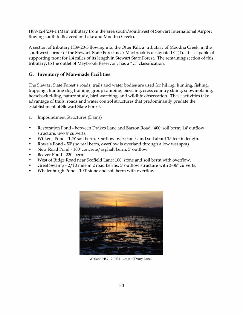
• Wilkens Pond - 125' soil berm. Outflow over stones and soil about 15 feet in length.• Rowe’s Pond - 50' (no real berm, overflow is overland through a low wet spot).• New Road Pond - 100' concrete/asphalt berm, 5' outflow.• Beaver Pond - 220' berm.• West of Ridge Road near Scofield Lane: 100' stone and soil berm with overflow.• Great Swamp - 2/10 mile in 2 road berms, 5' outflow structure with 3-36" culverts.• Whalenburgh Pond - 100' stone and soil berm with overflow.
Wetland H89-12-P234-1, east of Drury Lane.

-21-
2. Existing Road System
Table #8: Paved and gravel roads (11)Name MileageRidge Road 3.2Maple Avenue (Rte 207 to Ridge Road )* 3.05Barron Road ** 3.8New Road (Ridge Road to Ridge Road North) 4.0Weed Road 0.45Lindsay Road 0.3Orlando Drive 0.8Giles Road 0.9Drakes Lane 0.65Decker Road ***(to railroad tracks in SW) 0.4Total of Paved & Gravel Roads 17.55 miles
* DOT retains all roadway access** DEC owns road, but State Police and the Barron Road Development Area (DOT) retain
rights*** The Village of Maybrook retains road right of way on Decker and Barron Roads that are
located within the village boundaries.
3. Dirt Roads
Table #9 Dirt Roads (6)Name Mileage• Old Creamery Road (stream crossing washed out) 0.4• Unnamed road west of Drakes Lane 0.3• Windsor Woods Road/Trail (Trail F) 1.0• Road between the Fields (Ridge to New Roads) (Trail E) 1.0• Forrester to Restoration and Beaver Ponds (Trail N) 0.8• The Armstrong Lane Farm Trail (Rte 207, east of Drury, Trail P) 0.5Total Dirt Roads 4.0 miles
4. Trails
Numerous multiple use trails crisscross the property. Some of the major trails are listed below. See the appendix for a map of trail locations. The trail system is used by equestrians, hikers,mountain bikers, cross-country skiers and snowmobilers. These trails are not intended formotor vehicle access. Descriptions of these trails systems and their designated uses can befound in Section VIIB5.

-22-
Table #10 Trails (20)Trail/Name Mileage• Trail A/ Southern Maple Avenue to Weed Road connector 1.3• Trail B/ New Road near Ridge Road intersect to Barron Road 2.9• Trail B2/Spur connecting Trail B to Restoration Pond 0.6• C Trails/New Road to Barron Road 1.0/0.5• Trail D/Orlando Road to Barron connector 1.3• Trail E/Northern Ridge Road to New Road connector (Pittmann-Robertson) 1.0• Trail F1/Windsor Woods Road to Ridge Road 1.2• Trail F2/New Road to Senior Hill 0.6• Trail F3/Trail east of Windsor Woods Road to Senior Hill (Lindsay Rd.) 1.0• Trail F4/Senior Hill Road to New Road 0.4• Trail G/Windsor Woods to Pittman-Robertson Road near New Road 1.0• Trail H/Scofield Lane Ridge Trail 2.0• Trail I/Great Swamp Trail 0.8• Trail L/Old Raincoat Factory to Barron Road and Lindsay 0.7• Trail N/Farm Lane from Forrester to Restoration Pond to Beaver Pond 0.8• Barron Rd wetland mitigation site to farm fields west of New Rd, S. of Lindsay Rd. 0.6• Trail O/Buchanan Hill 1.8• Trail P/Armstrong Land Farm Trail spur 0.8Total Trails 20.3 miles
5. Facility Signs
• Kiosk (Weed Road Parking Lot)• Kiosk (Ridge Road Parking Lot)• Kiosk (Barron Road North)• Various road signs
6. Structures (Buildings)
• Post Office Building on Rt. 207• Old Barn ruins at Creamery Road• DEC Hunter check station on Weed Road• Shed on Rt. 208• N. Barron Rd. Raincoat factory ruins
7. Boundary Lines
• Exterior 22.1 miles• Interior (Electric transmission line ROW) 6.4 miles
Total 28.5 miles8. Group Camping Sites (1)
• West of Ridge Road in the old Orchard.

-23-
9. Gates (11)
• Barron Road south (at 208)• Barron road north (at Route 84 underpass)• Forrester Road (at Route 208)• Giles Road (at Route 207)• Ridge Road north (at Route 84 overpass)• New Road (at Route 84 overpass)• Maple Avenue (at Route 84 overpass)• Ridge Road south (at 207)• Weed Road (at Route 207)• Weed Road (near Check Station Building)• Maple Avenue (at Route 207)
10. Fences
• 300 feet chain link fence on lands behind the raincoat factory separating the State Forestfrom lands used heavily by ATVs.
• Along the length of I-84 on DOT land.• Short lengths of plastic fencing closing off trails and openings adjacent to some main road
entry gates.
11. Parking lots
• Weed Road/Route 207 (42 cars, 2 horse trailers)• Ridge Road North (25 cars and 9 horse trailers)• 76 seasonal hunter parking spaces (distributed throughout the State Forest).
12. Non-ambulatory Parking and Hunting Areas
• Orlando Drive at New Road• Ridge Road (south of Weed Road intersection)• Orchard to the west of Ridge Road.
13. CP-3 Access for People with Disabilities
• 14.2 miles of roads designated for access.• 3 designated hunting sites.
III. RESOURCE DEMANDS
A. Multiple Use Recreation - General
In winter, the Stewart State Forest is used by snowshoers and cross-country skiers. During therest of the year, the property is used by walkers, joggers, bicyclists and equestrians. Hunting,fishing and trapping takes place on the property during legally open seasons.

-24-
The State Forest is used by a diverse mix of people on primarily multiple use trails. However,this UMP proposes management strategies to separate some users to avoid conflict. These usesinclude hunting, mountain biking, dog trials, hiking, horseback riding and horse/carriageriding.
For many years, the property has hosted hunting dog training and field trial events sponsoredby various dog clubs. Each year for the past several years over 150 days of these events werescheduled through Temporary Revocable Permits (TRPs). Birdwatching has also grown inpopularity with visitors and bird counts scheduled by various organized groups.
Aside from recreational uses, other resource demands on the land unit include timber, wildlifeand fisheries management. The harvesting of trees for wood products is a chief tool in themanagement of the land for various multiple-use purposes including forest health, wildlifehabitat, and recreational use. All short-term and long-term forest treatments will be designed tointegrate and benefit these varied uses.
B. Multiple Use Recreation - Specifics
1. Hunting
The Stewart State Forest was managed by the DEC as a Cooperative Hunting Area , underagreement with the Metropolitan Transportation Agency (MTA) and the DOT. The 1974 Fishand Wildlife Cooperative Area Agreement, which established the “Stewart Airport CooperativeHunting Area,” regulated public hunting on the property for 25 years. The agreement appliedonly to hunting, fishing and trapping. Under the terms of the Cooperative Area Agreement,hunting access was controlled during hunting seasons through the use of permits, allocated byeither reservations or a “first-come, first-served” system. Since 1974 over 210,000 hunter visitshave been recorded at the property’s check station. Hunter parking was allowed in designatedlocations during this approximately 10-week period. Hiking, biking and other activities wereallowed by special permit from the DOT during the non-hunting season, but the procedure wasnot widely publicized and use remained limited primarily to special events, such as dog trialsor bicycle races, with a $100/day permit fee. The general public as well as groups with permits could use the property between March 1 and September 30. Winter recreational use wasprohibited by DOT. Non-hunter public parking was and continues to be limited to theperiphery of the property.
Initially, Stewart hunters were most interested in small game hunting as deer were uncommon. Pheasants were stocked by DEC’s Region 3 Division of Wildlife and grey squirrels, turkeys andcottontail rabbits were abundant. However, as deer became more numerous, deer huntingincreased in popularity. In 1983, 152 deer were taken. This was followed by a record take onthe area in 1987, when 333 deer were harvested. By 1993, 258 deer were taken. During the 2000archery and big game season, the last season on record, 332 deer were taken.
Hunters come from many different locations within New York and from neighboring states. Approximately 30 percent of the hunter visits recorded from 1974-1998 were by huntersresiding in Orange County. Region 3 counties (Dutchess, Putnam, Orange, Rockland, Sullivan,

-25-
Ulster and Westchester) accounted for 60 percent of the recorded hunting trips. About 30%were made by hunters who reside in New York City or Long Island. The remaining 10 percentof the recorded trips were made by hunters from elsewhere in New York, neighboring states,Canada, England and Ireland.
There have been two hunting accidents on the property during the past 26 years that resulted inpersonal injuries.
In reviewing hunting history on the property, it became clear that the information gathered atthe check station was interesting, but was not used for managing the deer herd or the property. The check station and parking system were created as a means of allowing hunting andtrapping on the property while providing a level of hunter management requested by theformer owners of the land, MTA and DOT. During periods of high hunting pressure, whichoccur roughly two weeks per year, the parking system continues to work well to dispersehunters throughout the property.
With the transfer of land to DEC, individual permits are no longer required for recreational useof the property, although DEC does require Temporary Revocable Permits (TRP’s) for groupuses.
Since the transfer, the property continues to be closed to all other uses during the height of thehunting season (October 1 through mid-December). Daily entry for hunting is limited todaylight hours for persons possessing a valid hunting license, and controlled by availableparking. These restrictions achieve an overall hunter density of three hunters per 100 acres.
Hunting use is heaviest during the opening weekends of small game, duck and bow seasons,and through the first week of the regular deer season. Environmental Conservation Officers,Forest Rangers and Assistant Forest Rangers patrol the property.
2. Fishing
The ponds on the property are lightly fished, primarily by local residents. The best fishingwaters on the property are Rowe’s Pond, Wilkins Pond and Whalenburgh Pond, as well asadjacent Tenny’s Pond.
3. Dog Club Training and Events
One to two dozen field trials and hunt tests are held on the State Forest each year, as well asover 100 days of dog training. These events are conducted through TRPs. Between five andten clubs use the property.
The retriever and other dog clubs have in the past brushed or mowed the following areaspursuant to TRPs:
• West side of Beaver Pond and horseshoe-shaped edge on east side of pond.• Southeast and SW side of Restoration Pond to farm fields (about 4 acres).
-26-
• Most of Franks Field around, but not within, the New Road wetland mitigation pond.• Senior Hill (east end Lindsay Road).• Area 53 south of Orlando (150 by 30 yards).• Area 27 - right side of Ridge Road, north of road leading to Pittman Robertson Pond and to
the east of the pond. Most of field on left side of road also.• Sections of “Big Trees” area north of Wilkens Pond and the southern edge of Wilkens
Pond.• South-southwest shore of Rowes Pond.
4. Snowmobile Use
Currently the existing roadways, with sufficient snow cover, provide snowmobilingopportunities. Potential conflict exists between snowmobiles, cross-country skiers andsnowshoers.
C. Multiple Use - Land Management
1. Farming
Prior to 1971, farming took place on much of Stewart State Forest. Agricultural use declinedafter the land came into public ownership. In 1980 almost 1,200 acres of the property was usedfor active agriculture, including the segment between Maple Avenue and Drury Lane. By 1989,only 890 acres were actively being farmed in potatoes, oats, alfalfa, squash, cabbage andstrawberries.
In 1999, when DOT transferred jurisdiction of the property to DEC, 6 farmers were farming theproperty. DEC took over the management of this property subject to these agreements andallows this agricultural use through TRPs.
There are currently four Temporary Revocable Permits (TRP’s) for Agriculture at variouslocations and two Sale of Products Agreements within the State Forest. Agricultural fieldscover 458.5 acres of the State Forest (about 36 farm field acres are on lands owned by CentralHudson Gas and Electric).
2. Forest Management
A 1983 letter from DEC reported the following conditions on the property:
“Aerial photos and on the ground inspection of the property indicate a large portion of the8,000-acre property is wooded. The size of the trees range from seedlings to mature sawtimber. Much of the woodland is in the immature stages and that is due in part to the prior agriculturaluse.”
In 1986-87 most of the accessible forested acreage on Stewart State Forest was logged. Significant volumes of sawtimber and firewood were removed from 400 acres between Newand Ridge Roads, and 75 acres between Ridge and Drury Lanes.

-27-
A fifteen-acre sale of black walnut trees was completed in late 2000/early 2001 to harvestmaturing trees in the southwest corner of the forest.
3. Historic Sites
Orange County Historical Society (OCHS) currently has 5 historic properties (Tellford Tavern,James Clinton House, Denniston, Hawkins House, and Elmwood Schoolhouse) bordering theState Forest along Route 207/208. The properties (10.79 acres in total), once part of StewartState Forest, were transferred to OCHS in 2005.
4. State Police Facility
The New York State Police retain a four-acre parcel to the west of Barron road surrounded byStewart State Forest. The facility is used for target practice and training. The State Police alsouse an old gravel pit on roughly one acre of land to the east of their facility and Barron Road todetonate and burn explosives. This informal arrangement dates back to a time the StewartProperties were controlled by the MTA and DOT.
5. Motorized Vehicles
A major objective of the Department is to ensure the safety of the public when visiting theforest. Motor vehicle operation, particularly at high speeds, is seen as incompatible andhazardous to people on foot, bicycles, and horses, as well as to other vehicle operators. DECprohibits motorized vehicles within the Stewart State Forest except when authorized by permit,for farming operations, access for persons with with disabilities, recreational events, groupcamping, research, and maintenance of certain high-tension power lines. The roadway speedlimit is 25 mph.
During the fall hunting season, DEC allows hunters and trappers to enter the area by vehicle toevenly distribute use while the area is closed to non-hunters (see 6NYCRR Part 92).
Police agencies enter the area to access their shooting range, generally from the gate at BarronRoad off Rt. 208.
Persons with disabilities may apply for a permit to enter the area with motorized vehicles (noATVs). Three hunting access sites are reserved for non-ambulatory hunters.
IV. RESOURCE MANAGEMENT ISSUES
The Stewart State Forest Unit Management Plan has been developed in accordance with theEnvironmental Conservation Law, New York Code of Rules and Regulations, and applicablepolicies and procedures for the administration of State lands as promulgated by the Departmentof Environmental Conservation under the authority granted in appropriate sections of the ECL.The following is a list of applicable State laws, rules, regulations and Department policiesgoverning the administration and management of State lands.

-28-
Environmental Conservation Law (ECL)
Article 9 Lands & ForestsArticle 11 Fish & WildlifeArticle 15 Water ResourcesArticle 23 Mineral ResourcesArticle 24 Freshwater WetlandsArticle 33 PesticidesArticle 51 Implementation of Environmental Quality Bond Act of 1972.Article 52 Implementation of Environmental Quality Bond Act of 1986.Article 71 Enforcement
New York Code of Rules and RegulationsTitle 6Chapter I Fish & WildlifeChapter II Lands & Forests
(Management will be guided by 6NYCRR Part 190, Use of State Lands, except as proposedfor amendment by “Special Regulations” for Stewart State Forest.)
Chapter III Air ResourcesChapter IV Quality ServicesChapter V Resource Management ServicesChapter X Division of Water Resources
Parks, Recreation and Historic Preservation Law Article 14Chapter 354 Cultural & Historic Resources
FederalThe Americans with Disabilities Act 1990 (ADA) along with the Architectural Barrier Act of1968 (ABA) and the Rehabilitation Act of 1973, Title U, Section 504.
Department Guidelines, Practices, Procedure, Rules& Regulations
Public UseTemporary Revocable PermitsMotor Vehicle UseUnit Management PlanPesticidesPrescribed BurningInventoryAcquisitionRoad ConstructionFish Species ManagementHabitat ManagementWildlife ManagementCP-3 (Motorized Access for Persons with Disabilities)
-29-
V. GOALS FOR THE STEWART STATE FOREST
A. Introduction
The Department manages State Forests for multiple uses to serve the needs of the People ofNew York State. This management is on a landscape level, not only to ensure the biologicaldiversity and protection of the forest ecosystem, but to optimize the many benefits these landsprovide to the public. This goal will be accomplished by integrating compatible and sound landmanagement practices.
State Forests are managed for multiple uses including watershed protection, wildlife, timber,recreational use, and other kindred purposes. The resource demands (Section III), along with along time frame, allow us to envision a landscape that provides for the sustainability of diversehabitats, forest products and recreational opportunities. This forms the basis for the followingschedule of management actions:
• Allowable use intensity will be guided by the monitoring of impacts on natural resources(carrying capacity). User permits, guidelines, and public education may be employed tomanage public use of the property. Uses expected to cause unacceptable impacts will becurtailed or prohibited.
• Management of the land will be guided by the goal of protecting and enhancing the valueand diversity of the property’s wildlife habitat and animal species.
• Sustainable forestry practices will yield forest products, such as lumber, firewood, wildlifehabitat, watershed protection, recreation, reflecting the properties designated purpose. Theproperty will showcase best management forestry practices.
• Limited areas will be mowed year-round to keep grass short in order to facilitate dog trialsand training while minimizing wildlife habitat conflicts. The main purpose of this mowingis to support permitted recreational use. Dog field trial mowing will be integrated withplans to maintain a diversity of habitats on the property.
• Management will enhance or protect all existing wetlands. All construction, mowing andfarming practices must meet the requirements of ECL Article 24, the Freshwater WetlandsLaw and the Army Corps of Engineers.
• Management proposals on the Stewart State Forest will consider development activities onadjacent lands as part of a landscape approach to management.
• An open water/upland mix of habitats will be maintained to benefit waterfowl and
wildlife species, and improve opportunities for hunting, fishing and retriever field trials.
• Provide a safe and effective buffer for airport operations. All management decisions willtake into account the unique public safety concerns raised by the proximity of the propertyto Stewart International airport. No management actions will be undertaken that willconflict with the safe operation of the airport.

-30-
• The State Forest’s location immediately beyond the end of the airport’s main runwaydictates that the property continue to be accessible to vehicles in the event of an emergency. Any use which might prove a danger to airport operations will be prohibited.
• The DEC will enhance the existing trail system while ensuring environmental stability.
B. The Americans with Disabilities Act (ADA) and Its Influence on ManagementActions for Recreation and Related Facilities
The Americans with Disabilities Act (ADA), along with the Architectural Barriers Act of 1968(ABA) and the Rehabilitation Act of 1973; Title V, Section 504, have had a profound effect on themanner by which people with disabilities are afforded equality in their recreational pursuits. The ADA is a comprehensive law prohibiting discrimination against people with disabilities inemployment practices, use of public transportation, use of telecommunication facilities and useof public accommodations. Title II of the ADA applies to the Department and requires, in part,that reasonable modifications must be made to its services and programs, so that when thoseservices and programs are viewed in their entirety, they are readily accessible to and usable bypeople with disabilities. This must be done unless such modification would result in afundamental alteration in the nature of the service, program or activity or an undue financial oradministrative burden to the Department. Since recreation is an acknowledged publicaccommodation program of the Department, and there are services and activities associatedwith that program, the Department has the mandated obligation to comply with the ADA, TitleII and ADA Accessibility Guidelines, as well as Section 504 of the Rehabilitation Act.
The ADA requires a public entity to thoroughly examine each of its programs and services todetermine the level of accessibility provided. The examination involves the identification of allexisting programs and services and an assessment to determine the degree of accessibilityprovided to each. The assessment includes the use of the standards established by FederalDepartment of Justice Rule as delineated by the Americans with Disabilities Act AccessibilityGuidelines (ADAAG, either adopted or proposed) and/or the New York State Uniform FirePrevention and Building Codes, as appropriate. The development of an inventory of all therecreational facilities or assets supporting the programs and services available on the unit wasconducted during the UMP process. The assessment established the need for new or upgradedfacilities or assets necessary to meet ADA mandates, in compliance with the guideleines andcriteria set forth in the Adirondack Park State Master Plan. The Department is not required tomake each of its existing facilities and assets accessible. New facilities, assets and accessibilityimprovements to existing facilities or assets proposed in this UMP are identified in the“Proposed Management Recommendations” section.
The Americans with Disabilities Act Accessibility Guidelines
The ADA requires public agencies to employ specific guidelines which ensure that buildings,facilities, programs and vehicles as addressed by the ADA are accessible in terms of architectureand design, transportation and communication to individuals with disabilities. A federalagency known as the Access Board has issued the ADAAG for this purpose. The Department ofJustice Rule provides authority to these guidelines.

-31-
Currently adopted ADAAG address the built environment: buildings, ramps, sidewalks, roomswithin buildings, etc. The Access Board has proposed guidelines to expand ADAAG to coveroutdoor developed facilities: trails, camp grounds, picnic areas and beaches. The proposedADAAG is contained in the September, 1999 Final Report of the Regulatory NegotiationCommittee for Outdoor Developed Areas.
ADAAG apply to newly constructed structures and facilities and alterations to existingstructures and facilities. Further, it applies to fixed structures or facilities, i.e., those that areattached to the earth or another structure that is attached to the earth. Therefore, when theDepartment is planning the construction of new recreational facilities, assets that supportrecreational facilities, or is considering an alteration of existing recreational facilities or theassets supporting them, it must also consider providing access to the facilities or elements forpeople with disabilities. The standards which exist in ADAAG or are contained in the proposedADAAG also provide guidance to achieve modifications to trails, picnic areas, campgrounds,campsites and beaches in order to obtain programmatic compliance with the ADA.
ADAAG Application
Current and proposed ADAAG will be used in assessing existing facilities or assets todetermine compliance to accessibility standards. ADAAG is not intended or designed for thispurpose, but using it to establish accessibility levels lends credibility to the assessment result. Management recommendations in each UMP will be proposed in accordance with the ADAAGfor the built environment, the proposed ADAAG for outdoor developed areas, the New YorkState Uniform Fire Prevention and Building Codes, and other appropriate guiding documents. Until such time as the proposed ADAAG becomes an adopted rule of the Department of Justice,the Department is required to use the best information available to comply with the ADA; thisinformation includes, among other things, the proposed guidelines.
VI. OBJECTIVES OF THE UNIT MANAGEMENT PLAN
A. Resource Protection
These objectives will facilitate protection of the cultural and biological resources fromdetrimental activities.
• Protect wetlands throughout the unit (both regulated and unregulated) through adherenceto ECL Article 24 and implementation of silvicultural best management practices.
• Protect all streams on the unit through the use of silvicultural best management practicesand riparian buffer zones.
• Protect the Stewart State Forest from nuisance wildlife, insects and diseases by monitoringand control.
• Protect State lands from trespass by maintaining 28.5 miles of boundary lines and patrol byDEC Forest Rangers and Environmental Conservation Officers.
• Protect cultural resources such as foundations, stonewalls and at least one known familycemetery on lands of the State Forest. This will be accomplished by avoiding these areas,leaving a buffer zone adjacent to these areas, and in certain instances, active vegetationmanagement.

-32-
• Protect the native environment by determining the extent of invasive species, institutingcontrol methods where possible, and monitoring for new population occurrences.
• Protect and enhance sites of rare & endangered species. Enhancement may involvevegetative manipulation to improve their chances of survival.
B. Public Use and Recreation
The opportunity for public use and recreation is one of the most direct benefits that this forestprovides the average citizen. These objectives provide for a number of recreationalopportunities that are compatible and consistent with the natural characteristics of the land.
• A variety of appropriate recreational uses should be encouraged including, but not limitedto hiking, bicycling, hunting, fishing, trapping, nature study, cross-country skiing,horseback riding and dog training.
• Provide and improve public access.• Improve and expand the existing trail system, while ensuring environmental stability.• Provide maps and informational kiosks.• Identify the State Forest through maintenance of boundary lines, posting of State signs
along highways and maintaining State Forest identification signs.• Limit public access or other recreational activities where degradation of the State Forest
resources is occurring.
C. Wildlife
These objectives will enhance the diversity and recreational values as related to the variouswildlife species on Stewart State Forest.
• Manage the State Forest to provide for a variety of wildlife (game and non-game) species inconjunction with management for forest products, within natural resource limits.
• Promote “watchable wildlife” viewing areas.• Improve habitats for species of special concern, rare, threatened or endangered species,
such as the Indiana bat, Myotis sodalis, and purple milkweed, Asclepias purpurascens.• Designate a proportion of the State Forest as a Bird Conservation Area.• Improve hunting opportunities for both ambulatory hunters and hunters with disabilities.
D. Fisheries
• Provide and improve fishing opportunities and access to the ponds on the State Forest.• Work cooperatively with DOT to provide public access to Tenny’s Pond.
E. Education and Research
• Encourage research and education by accommodating researchers and educators wherepossible and appropriate.
• Provide information to the general public about the unit through brochures, signs, pressreleases and woods walks.

-33-
F. Forestry
These objectives will provide for sustainable forestry that will yield forest products, bothtangible and intangible without compromising the overall health and productivity of the forestecosystem.
• Maintain a variety of tree species and age classes on the State Forest in order to provide forbiodiversity of both flora and fauna.
• Establish an average allowable cut that will provide a sustained yield of forest productsthat is within the productive biological capacity of the forest and which does notcompromise other resource values.
• Manage forest stands based on stand characteristics and data obtained in the inventory. • Re-inventory every 10 years.• Maintain sustainability and biodiversity.
G. Land Acquisition
• Actively pursue acquisition of contiguous private land for buffer and habitat protection. This land will be bought in fee from willing sellers.
H. Airport Safety
• Manage wildlife through habitat manipulation which will not pose an increased threat toairport operations
• Work with the airport to monitor any observed changes
VII. PROPOSED RESOURCE MANAGEMENT ACTIONS
A. Protective Actions
The Department will request information from the public, Natural Resources staff, ForestRangers and Environmental Conservation Officers regarding changes in land uses or abuse ofsites, water quality and plant and animal species. The Department may conduct inventories ordelineate sample plots to monitor the habitats, plants and animals at Stewart State Forest.
1. Insect and Disease
The health of plant populations on the State Forest will be monitored and maintained throughthe integrated pest management approach. Observations and/or inventory of potential insector disease outbreaks will be recorded. When warranted, appropriate control strategies will bedeveloped to reduce health and aesthetic impacts. More common problems such as beech barkdisease, hemlock wooly adelgid, ash decline, cankers, etc. will be controlled through individualtree selection (and harvesting) as a part of specific stand management.

-34-
2. Fire Control, State Land Security and Public Safety
Local fire districts having jurisdiction will provide initial response to all calls for fire response,be it structural or wildland. Forest Ranger staff will also respond as necessary for support andtake an active role in wildland fire suppression. Under New York State EnvironmentalConservation law, all wildfires will be suppressed within New York State.
Reports of lost or injured persons will also initiate a response by both the Department’s ForestRangers and the local fire district having jurisdiction.
Enforcement of applicable laws governing Stewart State Forest will be conducted by theDepartment’s Forest Rangers and Environmental Conservation Officers to promote the safe andsecure enjoyment of the resource by the public.
3. Temporary Revocable Permits
Permits may be issued for the temporary use of State Lands by the public within statedguidelines and legal constraints so as to protect State Lands and their resources. Authority forthis is authorized by Section 9-0105 of the Environmental Conservation Law (ECL) and byprovisions of the Policy and Procedures Manual, Section 8426, “Temporary Revocable Permitsfor the use of State Lands.”
4. Wetlands
Wetlands will be maintained by adhering to the requirements of ECL Article 24 and 6 NYCRRPart 663. Silvicultural Best Management Practices will be followed during forest managementactivities. The Department will use appropriate state-of-the-art management strategies toprotect special areas such as vernal pools and wetland mitigation sites.
5. Invasive Species
Staff will identify and monitor locations of invasive species, assess their impact and rate ofspread and eradicate them whenever feasible and necessary. Mechanical removal, herbicideapplication, silvicultural treatments or a combination of these options may be applied.
The management strategy for invasives includes environmental assessment and long termmonitoring. Mechanical and silvicultural treatments will be considered first, but if they fail tocontrol the invasives outbreak or spread or if studies show that mechanical treatment is noteffective, a herbicide application plan will be prepared.
A herbicide application plan describes the location and character of the site where invasives arepresent, the steps to be taken (and/or herbicides to be used), method of application, safetyprocedures, and alternative methods of control. Monitoring methods and post-applicationevaluations are also described. All provisions of the State Environmental Quality Review Act(SEQR) will be followed.

-35-
6. Rare and Endangered Species
Endangered, threatened, special concern, and other DEC-recognized rare species will beprotected at Stewart State Forest through habitat and recreational user management; i.e. theneeds of these species will take priority over other uses of the property, including recreationaluse. When developing management prescriptions, the requirements of these species will beconsidered and adverse effects avoided if at all possible. Furthermore, specific wildlife andforest management projects may be undertaken to improve habitat for these species.
Stewart State Forest is scheduled to be surveyed by the Natural Heritage Program in 2008. Thesurvey will include an assessment of areas likely to contain rare plant and animal species,preliminary field surveys and screenings, and recommendations for further study based on thefindings. The DEC will use this information for identifying locations for more detailed studyand followup by professional biologists and botanists.
Indiana Bat
Indiana bats (Myotis sodalis) have been positively identified and monitored in theMaybrook/Cambell Hall/Rock Tavern/Middletown area Stewart State Forest provides suitablehabitat for summer roost sites.
Indiana bats usually prefer large shagbark hickory (Carya ovata) and black locust trees (Robiniapseudoacacia) for their roosts. Roosting bats have been found on trees larger than 8 inches indiameter with 40% or more roosting on Shagbark hickory. Other trees with large cracks (10-12'long and ½ inch wide,) and flaky bark are also preferred roost sites. At the roost trees, at leastseveral bats congregate, seeking warm shelter in direct sunlight. Therefore, cutting more treesto the south and west of potential roost trees will improve potential habitat for Indiana bats byreducing shading and warming the trees. Tree removals for forest management are best donein winter months when the bats are not using roost trees. However, forest managementactivities which are sensitive to managing the two key tree species in the forest stands of thearea, will have little impact on the Indiana bat population, and can be used to improve theirhabitat.
Pied-billed Grebe
At least one nesting pair of pied-billed grebes was confirmed to be using Restoration Pond in2006. The pied-billed grebe is listed as Threatened in New York State. No permits will beissued for any use of Restoration Pond before May 31, in order to determine whether or not thegrebes are using the pond for nesting. If the grebes are not confirmed to be nesting onRestoration Pond, permits for use of the southern end of the pond will be issued if requested. Ifthe grebes are confirmed to be nesting on the pond, such permits will be issued after such timeas the young grebes have hatched and fully fledged. If pied-billed grebes are confirmed to benesting on other ponds on the property, these same restrictions will be applied.
In the event that other rare, threatened or endangered species are confirmed on the property,similar measures, as appropriate, will be taken to encourage their success.
-36-
7. Cultural Resources
The Department has followed procedures established in concert with the New York State Officeand Parks, Recreation and Historic Preservation (OPRHP) in determining the presence ofcultural resources on this unit. This involved completion of the Structural-ArchaeologicalAssessement Form (SAAF) and reviewing the New York State Archaeological Site LocationsMap. OPRHP and the New York State Museum have been consulted in any instance where theSite Locations Map indicated an archaelogical or historic site may occur on management unitlands. The results of the SAAF evaluation indicate that there is a site located within the unit. DEC will consult with OPRHP before conducting any activities within one-half mile of the site,and will take those measures necessary to protect this resource.
Protection of the old house sites and stone walls will be provided when planning individualtimber harvests, recreational activities, and/or construction projects.
Any archaeological sites located within Stewart State Forest are protected by the provisions ofthe New York State Historic Preservation Act (SHPA - Article 14 PRHPL), Article 9 of theEnvironmental Conservation Law and Section 233 of the Education Law. No activitiesimpacting these resources are proposed in this UMP. Future proposals will be reviewed inaccordance with SHPA.
The archaeological sites located on this land unit as well as additional unrecorded sites that mayexist on the property will be made available for appropriate research. All future archaeologicalresearch to be conducted on the property will be accomplished under the auspices of allappropriate permits. Research permits will be issued only after consultation with the New YorkState Museum and the Office of Parks, Recreation and Historic Preservation. Extensiveexcavations are not contemplated as part of any research program in order to assure that thesites are available to future researchers.For additional management actions regarding cultural resources, see Section VII.C.4.
8. Mineral Resources
Any party desiring to procure minerals, rocks or oil & gas resources (or the use of the mineralestate in the case of gas or liquid storage in geological formations) from the mineral estate understate lands included in this UMP, must obtain contractual rights (such as a lease contract) tothose minerals from the appropriate state entity administering those resources. The party mustalso obtain appropriate consent (temporary revocable permit) from the state to access thesurface estate during operations. Prior to the commencement of operations the appropriatepermits must be obtained. These procedures are further outlined below.
The Department has no plans to lease Oil and Gas rights or permit any commercial miningoperations on the properties included in this UMP. Any change in this direction would requirean amendment of this UMP including the opportunity for public review.
-37-
9. Soils
Protection of soils from erosion will be accomplished through the use of Best ManagementPractices (BMP) as well as other procedures such as winter logging on highly erodible soils,water bars, ditching, bridging and planting of cover crops or grasses to stabilize landings or logdocks.
B. Recreational Management Actions
The property will be open to all users throughout the year, but will be limited to hunters andtrappers during the regular big game season. Non-hunting companions will be permitted toaccompany hunters during the big game season, but will be required to remain with the hunterat all times while on the property. Interior travel in the forest is expected to be by foot, bike orhorse, except for special events under permit, persons with disabilities, and hunters andtrappers from October 1 through December.
Replacing multiple trails or trail webs with clearly delineated loop trails connecting the maintravelways on the property will improve recreation for all of the diverse users of the property. The existing network of formerly paved town roads will constitute the back bone of the trailnetwork, while providing limited vehicle access to the forest for administrative and patrolpurposes, farming operations, and specially permitted activities such as dog field trials andtraining, access for persons with disabilities, and hunting in the fall.
Horse club events, organized dog field trials, ongoing scientific research and education efforts,and other special or group uses will continue to be allowed under TRP, with appropriateconditions and restrictions. These uses enhance the property’s value and are permitted whenthey do not impose unreasonable conflicts with other uses or pose a threat to its naturalsystems.
Permits for use of the trail system may be granted from time to time for organized grouprecreational activities like bike rallies, horse club rides, ski tours, group camping, militarytraining, and other events of a similar nature. Permits will not be issued for motorizedcompetitive events like motorcycle enduro runs or ATV races, as these uses would conflict withmanagement objectives and other property uses. (See analysis in item #7, below)
1. Hunting
Hunting will be allowed throughout the property except for several restricted areas whichinclude the one acre site east of Barrens Road that is used by the State Police and two small sitescontaining the remnants of the raincoat factory just west of Wilkens Pond and another site onOld Creamery Road in the southwest corner of the property. All hunting activities are subjectto state-wide regulations regarding hours, seasons and bag limits. In 6NYCRR Part 92 the use ofrifles and handguns is prohibited in the Stewart Airport Cooperative Hunting Area. This planrecommends that in the future, the use of .22 caliber rimfire handguns be allowed on theproperty while rifles and other handguns remain prohibited. It will be necessary to changepertinent regulations before this can become effective. Hunters will be allowed to use shotguns,bows, and muzzleloaders during the appropriate seasons

-38-
From October 1 through the end of the regular deer season, the main vehicle gate at Weed Roadwill be open, allowing hunters to drive into the property. In order to maximize huntingopportunities, consideration will be given to leaving the Weed Road gate open until the end ofDecember if weather and staffing allow. Hunters will be allowed to drive or park vehicles onthe internal roads and parking areas only from one hour before sunrise to one hour after sunset. Hunters may not enter the property by vehicle at other times, unless they first obtain a TRP or CP3 permit. All other users may not enter the property by vehicle at any time, unless they firstobtain a TRP or CP-3 permit.
As in the past, hunters will be required to use designated parking areas, hunt on the same sideof the road as their vehicle, and will not be allowed to cross roads. The parking areas arelocated so that these regulations will keep hunters spread out on the property, providing a highquality hunting experience. In addition, the Department will continue patrols byEnvironmental Conservation Officers and Forest Rangers to maintain a high quality huntingexperience on the property. Proposed changes to area hunting regulations include eliminationof both the hunting party size restriction and restriction on number of dogs per hunting party.
In the past, reservations have been required during the first week of the regular deer season,and more recently with a Saturday opening, for the first nine days. The Department willconsider reducing the number of days that reservations are required and may eliminate themaltogether in the future, if that does not cause significant user conflicts.
Wheelchair or non-ambulatory hunters will be admitted to specially designated areas if theyhave a valid non-ambulatory hunting permit issued by the Department. A non-ambulatoryhunter may be accompanied by one non-hunter. Hunters with other mobility impairmentsmay access other hunter parking areas throughout the property open from October 1 throughthe regular deer season. If the need arises, several locations may be identified as more suitablefor persons with less severe impairments.
2. Trapping
Trapping will be allowed throughout the property. Trapping for all legal game during openseasons will be permitted. Trappers will be allowed to access the property with a vehicle whenthe gates are open (October thru December). Trappers that want to enter the property with avehicle at all other times must first obtain a TRP.
3. Fishing
New signs will give information about ponds nearest parking facilities. Only boats withoutmotors or with electric motors will be allowed on ponds in the State Forest. Amendments toState Regulation, 6NYCRR 92.4(b), will be proposed to allow electric motor use. Boats must becarried or wheeled on dolleys from designated parking lots.
Ice fishing will be allowed on the ponds, limited to pedestrians. If a fish kill occurs on theshallower ponds, or sampling finds low fish populations, stocking will be considered.

-39-
Under special circumstances, such as providing fishing access for people with disabilities, TRPsmay be issued for transport of car top boats to a pond. In these cases travel on interiorroadways will be limited and cars may be required to park in peripheral parking lots duringthe event.
Through the Invasive Species Task Force the DEC will investigate use of appropriate signs atfishing and waterway access sites to reduce the spread of non-native or invasive plants.
Fishing opportunities will be described in a brochure about the property.
The parcel of land which contains 12-acre Tenney’s Pond (north and east of Stewart StateForest, west of Drury Lane) remains under the jurisdiction of DOT. However, the 2005 ConsentDecree (00-cv-1606) between the Stewart Park and Reserve Coalition (SPARC) et al and DOT etal provides the following:
“NYSDOT shall reserve to the State of New York public access to Tenney’s Pond, including at aminimum: access from Drury Lane to the Pond, an area for launching boats, a 25 foot widereserved access around the entire shoreline of the Pond, and the use of the entire waters of thePond. Prior to any sale or other transfer of such lands, NYSDOT shall continue to allow suchpublic access to Tenney’s Pond.”
The DOT also commits “to encourage SWFAA (SWFAirport Aquisition, Inc.) to continue toallow public access for fishing and other purposes to Maroney’s Pond,” which is located onleased lands.
4. Dog Trials and Training
The State Forest will continue to be used for field trials. Alternate sites in the region may beconsidered for some dog trials currently taking place at Stewart State Forest in order to reducepressures on the area.Limits and management guidelines for dog club concentration areas will continue to evolve asDEC assesses the situation over the next decade. Some activities will require modification ornot be allowed at environmentally sensitive locations. However, the DEC encourages these andother long-term recreational uses of the property. Roads and trails will be shared with otherusers. Good public relations and communication fosters understanding and will be anincreasingly important tool at Stewart State Forest to keep visitors informed.
TRPs for special activities, including dog field trials, are issued on a first come/first servedbasis. TRPs will include conditions so that special activities will not impact the resource.
To achieve a sustainable balance between natural processes and human disturbances, thefollowing parameters will guide mowing on the property:
- Mowing will, whenever possible, be done in late summer, early fall, or late winter to earlyspring to avoid nest/habitat disturbances. When mowing is necessary on a limited number offields, steps such as strip mowing and keeping cutting blades at least 5-6 inches high will beused to reduce wildlife disturbance.

-40-
-Mowing around ponds will continue to provide adequate access for dog trials and trainingwhile preserving long-term vegetational stability and wetland habitats. Mowing of no morethan 30-40 per cent of the current grassland/wetland edges on a 2-3 year rotation will allowaccess as well as recovery time for the habitat.
-Access roads to certain mowed pond areas (Wilkens, Stick, Restoration and Pittman-Robertson)will be hardened to avoid rutting and prevent erosion.
Dog field trials and training share Stewart State Forest with other users, often in the same area. Notices on bulletin boards will be used to inform other visitors about the use of designatedareas for dog training, but will not restrict visitors. Dog clubs as well as any other specialgroups under permit, should use the opportunity to acquaint other visitors about their activity.
5. Trails
A map of the proposed trail system is provided in Appendix K. In general, trails on theStewart State Forest will be open for shared use i.e, hikers, bikers, horseback riders, and otherswill all be allowed on the trail system; however, some trails may be limited to single use toavoid user conflict. Visitors to the area will be expected to share use of all areas, and recognizeand cooperate with the safe passage of one another. Our objective is to provide an extensivenetwork of safe, well designed and maintained trails for the use and enjoyment of the public toreplace the current maze of trails. However, new trails will not be designated for biking orequestrian use when nearby trails provide equivalent experiences.
In general, trails will be minimally marked, unless site conditions dictate otherwise. Signs willbe posted where the trails enter or depart the roadways. All road intersections will be signedwith the name(s) of the roads.All trail systems and routes proposed for the property are currently usable except for parts ofthe Scofield Lane Trail, the Great Swamp Trail, and parts of the Maple Avenue to Weed RoadTrail. The Maple Avenue to Weed Road trail will be reopened and widened with culverts forwatercourses and gravel fill in wet or boggy sections. Reopening of trails will be a matter ofimprovement and maintenance of the existing trails, roads, culverts, and in some cases,hardening of surfaces to eliminate any possibility of future erosion. Proposed trails will bereviewed by the Bureau of Habitat and wetland permits obtained if necessary.The Department will enhance the existing trails listed in this section and ensure theirenvironmental stability by:
• Providing a mix of multiple-use and single use areas to avoid conflicts and give users achoice of trails to use.
• Limiting trail use to foot traffic in wetlands (the Great Swamp) and steep areas, to avoidconflicts with mountain bikes.
• Providing for continued snowmobile use on the main roads with four connector trailscreating a series of long distance loops for riders at the same time providing for the needsof other users. Snowmobiles will be limited to designated trails including and west ofMaple Avenue.

-41-
• Advising visitors to the area not to enter farm fields, trample or damage crops, and to keepall travel to the edge of the fields.
• Providing access to the varied terrain and major points of interest on the property.• Enhancing views at a select number of sites - i.e. Great Swamp, views of the Shawangunks
off Ridge Road, and pond and field views. • Designating multiple use trails whenever appropriate.• Providing access to the general public for as much of the year as possible.• Providing well placed access on the periphery of the property.• Giving priority to using existing trails.• Closing duplicate, parallel, poorly-sited trails and removing trails in places where “trail
webs” (dense concentrations of trails which have formed to avoid or bypass locations) haveformed.
Descriptions of major trail systems: (Letters correspond to the Proposed Trail andFacilities Map in Appendix K). All trails are multiple use trails, unless specificallydesignated as single use.
A. Maple Avenue to Weed Road Trail (horseback riding, hiking, mountain biking andsnowmobiling)
Sections of an existing old farm road and sections of an overgrown footpath with blowdown inplaces.
Proposed Actions:
• Rehabilitate to eight feet wide (approx. 1.3 miles) to complete the southern part of a loop between Maple and Ridge Roads.
• Widen to eight feet to complete a loop for snowmobiles (1 of 4 connector trails beingproposed), equestrian carriages and horses, as well as for hikers and mountain bikers.
Constraints:
• There are several wet spots in the easterly ½ of the trail which will need four culverts aswell as Item 4 gravel on 1/4 mile of the trail
• Portions of this trail will skirt farm fields and steps to minimize disturbance to farmoperations will be needed.
Proposed Actions:
• Improve trail for multiple uses, including snowmobiles.
-42-
B. New Road to Barron Road (hiking and mountain biking, part of trail from intersectionwith Trail N to Barron Road for snowmobiling)
The 2.9 mile trail starts at New Road and proceeds west, tying into a trail spur east of BeaverPond (B2, 0.7 miles), then traversing old farm field lanes intersecting with an old farm road(once called Woodruff Lane), and the dam forming Restoration Pond on its way to Barron Road. The trail will be routed to the edge of fields or within the tree line along the fields to an existingwoods road linking to Barron Road.
• This trail exists, mostly as a well delineated single track winding at times through andaround high tension electric wires. Currently used by mountain bikers.
• The trail completes a southern loop across Stewart State Forest and is linked to theimproved access road to Beaver Pond from New Road and Forrester Lane.
• Trail west of Restoration Pond Road (N) can use the edge of farm fields.
Constraints:
• Careful siting near farm fields east of Rowes Pond will be needed to avoid conflict withfarm operations. A single track bike loop exists within the woods to the north of the farmfields west of Restoration Pond, but has too many switchbacks for pedestrian use.
• A small 15‘ raised boardwalk (less than 2 feet above grade) will be needed to cross a streamentering Beaver Pond and connect the trail to existing road loops east of Beaver Pond (onB-2).
• Separation of snowmobile and bike/hike loop may be needed between the northerlyboundary of farm fields and Barron Road.
Proposed Actions:
• The trail will be designated for hikers, mountain bikers and west of Trail N forsnowmobilers (one of four connections for snowmobile loops).
• Construct boardwalk to connect to existing road loops.• Adjust bike loop to eliminate some of the curves.
C. New Road to Barron Road North, 1.0 miles (north of Wilkens Pond, 2 spurs, hiking andmountain biking/horses)
Background:
• This trail lies 0.55 miles north of the Lindsay Road - New Road intersection and 0.8 milesnorth of the Lindsay Road-Barron Road intersection.
• This trail exists as a roughly 6-8 foot wide swath, probably formed by illegal ATV use. It iscurrently used by mountain bikers, hikers and horses.
• This trail will help enhance the loop system between New and Barron Roads.• The trail spur leaves New Road from within 200 of the “Pittman-Robertson Pond Trail”
(Trail E).• Allows for separation of uses, such as mountain bike and horses.• 3 wet spots in trail, but localized, not part of any wetland system.• White pines and cedars on the ridge provide a change in scenery.

-43-
Constraints:
• Crosses stream in field on New Road side and will require a small pedestrian bridge at thislocation.
• Crosses at least two streams and one wet area toward the Barron Road half which willrequire trail improvement with gravel and culverts.
• The section of trail on Barron Road may one day need re-routing if the Barron RoadDevelopment Area interchange is built on DOT lands or lands formerly of Penn CentralTransportation Company, and would necessitate a rerouting of the trail system.
• At times, retriever clubs using area near Wilkens Pond known as “Big Tree Field” will postarea to warn users that field trials are going on. At these times, some trail use may betemporarily rerouted to avoid user conflicts.
Proposed Actions:
• Close the two (2) single track trails which head north from main trail.• Construct small foot bridge (15–20 feet) near the New Road end of the trail.• Install 3 culverts and gravel on trail on the westerly half of the trail nearer to Barron Road.• Upgrade existing spur trail at New Road end to create an optional trail away from the
mowed field used by farmers and retriever clubs.
D. Orlando Road to Barron Road, 1.3 miles (horseback riding, hiking, mountain biking,snowmobiles)
Background:
This trail follows old farm lanes and is located 1.3 miles north of Lindsay (0.5 mile south of thegate on Barron Road), connecting to the southerly turn of Orlando Drive.• 6+ feet wide mountain bike path • Wetlands skirted at several points, so trail work may require a wetlands permit.• This is one of two trails in the area - the other is to be managed as a smaller secondary trail.
Constraints:
• Property to the west of Barron Road is not part of Stewart State Forest and is currentlyheavily used by illegal ATVs. Future development may impact use of this trail.
Proposed Actions:
• Maintain trail for current uses, insuring a minimum 8 foot width at all points.• Improve signs• One of 4 connector trails proposed to create trail loops for snowmobiles)

-44-
E. North Ridge Road to north New Road, past Pittman-Robertson Pond, 1.0 mile (horsebackriding, hiking, mountain biking)
Background:
• Located 0.7 miles south of Route 84/Ridge Road crossing and 1.15 miles south of NewRoad as it turns into the Rt. 84 parallel access Road. Excellent connector between RidgeRoad and New Roads.
• An old one lane farm road through fields and woods near several farm ponds.• The old farm road can be hardened to make it suitable for horse and buggies, and was
tentatively marked as a horse trail in 2000.
Constraints:
• Will require gravel hardening along 1200 feet of its length.• Will require replacement of at least one 10 inch culvert for wetland streams passing under
the old road.• Will require a wetlands permit for the work in or adjacent to the wetlands.
Proposed Actions:
• Gravel hardening along 1200 feet of its length• Harden with gravel to make suitable for horse and buggy use.• Replace 10-inch culvert.
F. Windsor Woods Road to Ridge Road (Multiple-use trail, possible for snowmobiles ifchosen instead of connection to Ridge in the long term, or the connection to Ridge notavailable due to flooding). Ridge Road to New Road near Lindsay, 1.2 miles (F3/F4) forhiking, mountain biking (no snowmobiles), Ridge Road to New Road (hiking, biking, etc,including snowmobiles starting on F and proceeding on Trail G to New Road - 1.0 miles)
Background:
• Horse and buggy trail is 0.5 miles west of Ridge Road/Weed Road intersection on NewRoad. Marked as a horse trail in 2000. Beaver-caused flooding along Ridge Road in thepast 3 years.
• Mountain bike trail parallels and proceeds to Ridge Road (F1). At intersection proceedswest to New Road just south of Lindsay Road.
• From “Senior Hill,” single track mountain bike spur continues north to New Road, 0.35miles away from the first intersection (F2).
• F3 single track trail links Senior Hill and Trail F (Steep, eroded and confusing in placesoccur needing renovating and relocating). F4 single track to New Road.
• F5 horse trail marked north to Pittman -Robertson Pond
Constraints:
• On the westerly end, toward New Road and Senior Hill (near Lindsay) there is a maze ofATV/mountain bike trails in a highly damaged and overused field and woodland setting.

-45-
• Spur trail is needed to reroute the woods road which has had long-term beaver floodingnear Ridge Road.
• F5 marked horse trail is wet in many places and is not suitable for snowmobilkes ormountain bikes.
Proposed Actions:
• Route trail to skirt the field on an existing woods road to New Road and avoid the steephill (a/k/a Senior Hill) leading to the Lindsay Road intersection.
• Construct spur trail to avoid beaver flooded area.• The maze of ATV/mountain bike trails will be closed.• Part of trail F from Ridge Road to intersect with Trail G will be for snowmobiles (8 feet
minimum width). Windsor Woods Road may be used as an alternate.• Marked horse trail (F5) passes through wet areas and will need to be
monitored/improved/or rerouted to avoid damage rutting, enlarging and erosion.
G. Windsor Woods (Ridge Road to Pittman Robertson Pond Road connecting to New Road),1.0 mile (horse, snowmobile, hiking & mountain biking)
Background:
• 2 small wet segments will require a stone culvert/rockwork.
Constraints:
• Trail also used by horses.• A southerly spur off this trail runs through wet and steep areas before connecting to New
Road to the south (This area has been damaged by bike and trail use.)
Proposed Actions:
• Will require 3 culverts with headwalls.• Close southerly spur trail to New Road.• Upgrade segments which are not 8 feet wide for snowmobiles. Existing old roads will be
used whenever possible (one of four trails proposed to create snowmobile loops).
H. Scofield Lane Ridge Trail, 2.0 miles (horseback riding, hiking, mountain biking)
Background:
• Starts at Scofield Lane, runs the ridge west of the Great Swamp, and ends at the RidgeParking lot.
• 4 feet wide, cleared to appropriate height.• In the south, trail starts as overgrown Scofield Lane and joins an existing trail on the ridge.
Proposed Actions:
• Maintain for current uses.

-46-
I. Great Swamp Trail/Ridge Road to Maple Avenue via Great Swamp, 0.8 miles (hikingonly)
Background:
• Hiking trail from Scofield Lane across the Great Swamp via a boardwalk. Roughly 600 feetlong, the boardwalk will be three to four feet above the water, and cross the swamp at itsnarrowest point.
• Excellent interpretive and wildlife viewing potential.
Constraints:
• Only pedestrian access.• Boardwalk design depends on decisions regarding the repair and reconstruction of the
water control structure affecting water levels in the Great Swamp.
Proposed Actions:
• Construct boardwalk.
J. Great Swamp Scenic Overlook, 0.4 miles (hiking only)
Background:
• Overlooks Great Swamp from a Peninsula near its northerly end.• Siting depends on decisions made about water control structures for the Great Swamp.
Proposed Actions:
• Construct overlook and access trail.
K. 18 miles of existing roads are part of the multiple use trail systems
Background:• (Motorized use is only allowed for TRP holders, people with disabilities, and fall season
hunters. Roads are also open to horseback riding, hiking, mountain biking andsnowmobiling)
Constraints:
• Development along Barron Road may impact its future use and available parking.• Development of Penn Central Transport Company lands and access rights via Barron Road
may also have an impact on the use of Barron Road.• Development between Drury and Maple may impact Maple Avenue and curtail its use in
the trail system, currently allowed by DOT.

-47-
• Development of the Barron Road and Drury lane interchanges may remove the northernaccess roads connecting Maple, Ridge, and New Roads. They are not part of Stewart StateForest. A 150 foot wide ROW was retained along the southerly boundary of Route 84 byDOT as part of this transfer, which includes roads surfaces within the Stewart State Forest.
• The Village of Maybrook owns all roads in fee within the village limits.
Proposed Actions:
• Rehabilitate roads to gravel surface and maintain for limited public motor vehicle accessand administrative motor vehicle access.
L. Old Raincoat Factory/Wilkens Pond loop south to the Barron Road/Lindsay Road intersection, 1.4 miles (horseback riding, hiking, mountain biking)
Background:
• Mountain biking on trail and disturbed areas, with some ponds to the west of Barron Road,and a mix of woodlands and wetlands to the east of Barron Road.
• Used to access Stick Pond and field, skirts Wilkens Pond to the west, old quarries, andbypasses Baron Road.
• Main purpose is to separate conflicting uses.
Constraints:
• Wetlands in area and ponding on old roads.• The trail north of the factory ruins is heavily trespassed by ATVs.
Proposed Actions:
• Forty feet of trail between Barrow Road and Wilkens Pond (which is occasionally used forvehicle access for dog trial judges and administrative purposes) and a fifty foot section nearthe raincoat factory needs to be resurfaced with 18" of Item 4 gravel. All ditches need to becleaned out. The finished road will be adequately graded to facilitate proper crossdrainage.
• Maintain for current uses.
M. Decker Road Connector, 0.4 mile (hiking, mountain biking)
Constraints:
• Decker Road, Second Street and parts of Barron Road remain Village of Maybrook roads.
Proposed Actions:
• Designate for pedestrian and bicycle use only.

-48-
N. Farm Lane from Forrester Road to Restoration Pond to Beaver Pond, 0.8 mile (horseback riding, hiking, mountain biking, snowmobiles from Trail B north to New Road)
Background:
• Access for hikers and groups, including dog field trials and training.• Reduces vehicle traffic on property by providing vehicle access to two frequently used dog
training areas, bypassing the main roadway network. • Old farm road
Constraints:
• Could disturb farming operations if used improperly.
Proposed Actions:
• Surfacing, ditching and grading are needed. Approximately 12" of Item 4 gravel will bespread over 1/3 of a mile on this road.
• Maintain road for limited public motor vehicle access and administrative access.• North of Trail B, will be used to complete one of four snowmobile loops.
O. Buchanan Hill Trail, 1.8 miles (horseback riding, hiking, mountain biking)
Background:
• 0.55 miles north of Maple Avenue and Route 207 intersection to Buchanan Hill and returnto Maple Avenue at about 1.6 miles north of this intersection (across the dam ofWhalenburgh Pond).
• Trail leads to highest point on the property (658 feet) with good views in all directions,especially southerly toward the Hudson River .
Constraints:
A small segment of the existing trail leaves the State Forest property and crosses a corner of the“Stewart Airport runway protection zone.” Currently, access is unrestricted onto this parcel.
Proposed Actions:
• Reroute trail into State Forest to avoid the “Stewart Airport runway protection zone” ifaccess is restricted in the future.
P. Armstrong Lane Wetland and Farm Trail, 0.5 mile (horseback riding, hiking, mountainbiking), and old field and woodlands trail spur north to Clark Street, 0.8 mile (hiking only)
• Trail starts approximately 0.6 miles east of Drury Lane on Route 207, and uses an oldroadway to access the peninsula heights east of wetland CO1.
• Trail uses a combination of old farm roads, existing paths through old fields, and woodsroads, to reach Clark Street.
-49-
Constraints:
• Farm Trail , 0.5 miles, exists on old roadway and leads around wetland to old farm woodsand fields. However, the two-car parking pad forthe spur connection to Clark Street willdepend on the clarification of public access rights to Clark Street.
• A small parking area of 2-3 cars could be built near the northerly end of this trail oncepublic access rights are clear.
• Approximately 200 feet requires resurfacing, landscape fabric and 12" of Item 4 gravel.
Summary of proposed trail use
Horseback Riding Trails
Horse trail designation allows hiking and mountain biking, unless otherwise indicated by DECdue to trail rehabilitation or safety. Horse trails will be six -eight feet wide with a 12 foot highclearance.
• 1.2 miles - Windsor Woods Road (no mountain biking) to Ridge Road (Trail F) • 1.1 miles - Ridge Road to New Road (Trail G)• 1.0 miles - Orlando Road to Barron Road connector (Trail D)• 1.3 miles - Southern Maple Avenue to Weed Road connector (Trail A)• 1.0 miles - Northern Ridge Road to New Road connector (Pittmann-Robertson) (Trail E)• 0.7 miles - Old Raincoat Factory to Barron Road - Lindsay Road intersection (western half
of loop Trail L))• 0.7 miles - Farm Lane from Forrester to Restoration Pond to Beaver Pond (Trail N).• 2.0 miles - Scofield Lane Ridge Trail (Trail H)• 0.5 miles - Armstrong Lane Farm and Wetland Trail (Trail P)• 1.8 miles - Buchanan Hill Trail (Trail O)• 18 miles - Main Road Complex • 0.5 mile - New Road to Barron (Trail spur, p/o Trail C). Total: 29.8 miles
Hiking only (no horses or bikes)
• 0.8 miles - Great Swamp Trail (Trail I)• 0.6 miles - Barron Road Spur Trail (Mitigation site east to fields)• 0.4 miles - Great Swamp Scenic Overlook (Trail J)• 0.8miles - Armstrong Lane Woodland Trail Spur (East of Drury Lane)
Total: 2.6 miles
Mountain Biking only
Biking trails in close proximity to one another will be closed and multiple tracks reduced to onepath. This will also require the rerouting of certain trails, and depositing gravel, new culverts,or installing boardwalks to reduce the impacts.
• 1.0 miles - Trail east of Windsor Woods Road. (Trail F1)

-50-
Hiking and mountain biking only
• 1.0 miles - Windsor Woods to Pittman-Robertson Road near New Road (Trail F4,F3,F2)• 0.4 miles - Senior Hill to New Road (Trail F2)• 0.7 miles - Wilkens Pond south to Lindsay (East side of Trail Loop L)• 2.9 miles- Weed Road to Barron Road (Trail B)• 0.5 miles - New Road to Barron Road (Trail C, one spur)
Total: 5.5 miles
Ski Trails
All trails may be used for skiing when covered with snow or ice.
6. Snowmobiles
The Department has developed guidelines for snowmobiling in Stewart State Forest, and hasdelineated a snowmobile trail system in this UMP (See Appendix K), which will be put intoplace by the passing of Special Regulations for the property. The snowmobile system isdesigned to limit snowmobiles to the existing gravel/paved roadways (with street names),supplemented by 4 connector trails to create loops of significant length. These connector trailsare: Trail D (Orlando Drive to Barron Road), Trail A (Maple Avenue to Weed Road), Trail F to G(Ridge Road to New Road), and Trail B to N (from Barron Road to New Road).
Other provisions for snowmobiles at Stewart State Forest are: 1) available wintertime parkingwill have an indirect limiting effect on the overall numbers of snowmobiles, 2) providingsnowmobile access at four locations: North Barron Road, North Ridge Road and Weed Road,3) Limiting maximum speed limits on the connector trails to 25 mph and stressing acceptedetiquette for passing pedestrians, 4) posting snowmobiling Do’s and Don’ts at all kiosks andmajor entrances, 5) Stressing the recommendations for a minimum compacted snow base of 2-3inches (an absolute minimum of a 4-inch snowfall) and 6) continuing to enforce the substantialNew York State registration, insurance and safety course requirements for snowmobiles alreadyin place.
7. All Terrain Vehicles
All Terrain Vehicle use will continue to be prohibited on Stewart State Forest. It has beendetermined that this State Forest will not be developed for public ATV use due to managementobjectives, resource carrying capacity, incompatibility with other public use, adequate existingaccess, maintenance issues and enforcement challenges.
a. Management Objectives- This UMP strives to maintain the natural character of the area bylimiting public motor vehicle access to peripheral parking areas (with the exception of controlledmotor vehicle (no ATV) access for hunters from October 1st to the end of regular deer season orother users by permit throughout the year). In addition the value of this property as a noisebuffer for surrounding residents from Stewart Airport and Interstate Route 84 would be lost ifmotorized off road uses were permitted.

-51-
b. Resource Carrying Capacity - Over one-third of the acreage on Stewart State Forest isclassified as wetlands or open water (2436 acres) with a significant acreage in poorly drainedsoils in the Erie component of the Mardin-Erie series. Together with other sensitive areas,appropriate buffers, and agricultural use, a majority of the land base on Stewart State Forest cannot support ATV use.
c. Incompatability With Other Uses- Stewart State Forest is a popular recreational area forhiking, horseback riding, mountain biking, birdwatching, cross country skiing, dog training,trapping, fishing and hunting. These non-motorized uses could not be enjoyed at the same levelif ATV use by the general public was permitted. The property also supports over 400 acres ofagricultural fields that could be negatively impacted by ATVs.
d. Existing Access - Public access to Stewart State Forest has been addressed by this plan andwith the construction of additional parking opportunities and permits for individuals withdisabilities and is considered adequate without the development of off road vehicle access.
e. Maintenance and Enforcement Issues - Historic illegal ATV use exists on adjacent privatelands and on the Village of Maybrook Reservoir to the west of the property. Stewart State Forestpresently suffers from a maze of deeply rutted and muddy trails caused by illegal ATV use. Thissituation has been a challenge to correct with existing enforcement and maintenance resources.These problems would only be aggravated by developing ATV use on the property. Theexperience of the Department and with sister agencies in adjoining States has proven that thedevelopment of designated ATV trails does not, in itself, solve problems with illegal use ofdesignated trails.
8. Camping and Fires
As a Reforestation Area, Stewart is governed by 6 NYCRR Part 190, which allows for no morethan 3 nights at one location, by fewer than ten people, at least 150 feet away from trail, road, orbody of water. Longer stays and larger groups require a permit.
Due to the current level of public recreational use of the property, as well as anticipatedsignificant increases over the next decade with improved signs and parking, and closeproximity of Stewart Airport, the DEC will prohibit camping except by permit in twodesignated group camping areas on Ridge Road and Barron Road (See Appendix K, ProposedTrail and Facilities Map), and will not permit camping during big game hunting season. Fireswill also be allowed only by permit. The property is surrounded by growing residential andcommercial areas which increase the number of day-use people using the property, making itnecessary to have additional control over camping and fires with permits. These proposalsrequire the adoption of special regulations. Motor vehicles are not allowed entry for campingat any time, except under special permit. Large group camping and access with motor vehicleswill be controlled through TRPs (Temporary Revocable Permits), smaller groups throughCamping Permits for State Land issued by Forest Rangers.
-52-
A large group camping site is proposed in the orchard west of Ridge Road, which has beenused for group camping in the past because its open, flat to gently sloping, lightly shaded, andrelatively close to the Weed Road entrance. Another group campsite is proposed for the openfields behind the old raincoat factory, west of Baron Road and Wilkens Pond. The dirt accesslanes to the sites will be hardened with Item 4 or other material. For large groups, Port-O-Johnswill be required.
9. Youth Hunting and Fishing Opportunities
In recent years, the Department has conducted an annual Youth Hunting Day at Stewart StateForest during October to provide youth hunters (< 16 years in age) with a high qualityintroduction to hunting during which outdoor enjoyment and hunter safety are emphasized. To provide the best possible experience, the Department has generally stocked pheasantsimmediately prior to Youth Hunting Day and has limited access to the property for the day tohunting parties containing a youth hunter. Furthermore, adults accompanying youth huntersare encouraged to give youth hunters the first opportunity to harvest game.
In the future, the Department may conduct or sanction a fall Youth Hunting Day or other eventsto encourage youth participation in wildlife or fisheries recreation. These programs mayinvolve restricting access for one day to all or part of the property for users other than youthparticipants.
C. Facilities Management Actions
1. Parking
Limiting parking to the property’s perimeter protects the character of the State Forest andreduces conflicts between vehicles and recreational users. Multiple parking lots on theperimeter will improve access to different parts of the Forest, as well as provide for more evenuse of the property.
DOT will be consulted on the steps needed to improve safety at these parking areas. This mayinclude improving road signs and providing turn lanes off route 207 at Weed Road, BarronRoad, Lorraine Drive and at the East Drury Wetland Farm Trail.
Weed Road Parking
This parking area provides parking space at Weed Road and Route 207 for 42 cars and 2 horsetrailers. Two spaces are reserved for people with disabilities. A sign standard “Stewart StateReforestation Area,” is located at the entrance to the lot. An existing DOT sign on the north sideof Rt. 207, “Check Station Ahead 500 feet” will be removed and replaced with a sign sign“Stewart State Forest, Weed Road Parking - 500 feet ahead” and appropriate cautions. A similarsign will be requested for the south side of Rt. 207.
The Weed Road area will be the primary site for absorbing additional parking on Stewart StateForest.

-53-
Ridge Road North Parking
A ½ acre gravel parking lot at Ridge Road, just south of the I-84 overpass, provides parking for25 cars and 9 horse trailers. 2 parking spaces will be designated for persons with disabilities. Traffic islands delineate parking spaces. Gates on Ridge Road, Maple Road and New Roadprovide access for emergency vehicles and permit holders. A pass through structure allows easy access for horse carriages at the Ridge Road, Maple Road and New Road gates. Access for snowmobiles will be constructed for the site.
The parking facility uses the access road along I-84 and is substantially within a 150 foot wideparcel reserved by DOT, leaving it vulnerable to future roadway expansions. However, the2005 Consent Decree and Order of Dismissal (00-cv-1606) addresses this concern, stating:
“In the event that NYSDOT develops or conveys said 150 foot wide parcel, NYSDOT shallpreserve access across I-84 and any new or modified transportation facility via said overpassand NYSDOT and NYSDEC shall relocate an equivalent parking area and equivalent road andtrail access into the Stewart State Forest from said overpass, with determining what facilities are“equivalent” to be determined by NYSDOT in its reasonable discretion.”
Of great concern , if relocating this parking becomes necessary, is a continuing connection fromRidge Road to Maple Avenue in the north - because of the severe limitations on access to theeastern half of the property posed by the Great Swamp. The DEC deems it essential to maintaina connection for recreational users, as well as for administrative access.
Barron Road North Parking
Currently, parking outside of the Barron Road North gate on land administered by DOTminimizes the need for providing parking on the State Forest in this area.However, if this arrangement continues, a Concurrent Use and Occupancy Agreement withDOT needs to be formalized.
A 1/4 acre parking lot for 15 cars and two horse trailers will be constructed to the east of BarronRoad, including one accessible parking space for users with disabilities. The parking area andportion of the property along Barron Road accessing the lot will be bordered with largeboulders to block illegal entry of vehicles onto the property. The gate on Barron Road will berelocated to the south.
The construction of this parking facility may be affected by DOT’s plans to develop BarronRoad, as well as the development of privately-owned properties to the south. This and thecurrently available parking on the shoulder of Barron Road adjacent to the State Forest, makesthis the lowest priority of all the parking areas proposed. However, the 2005 Consent Decreeand Order of Dismissal (00-cv-1606) states:
“In the event that NYSDOT develops or conveys said 150 foot wide parcel [alongRoute 84], or if the lands to be retained by NYSDOT along Barron Road are everdeveloped, NYSDOT shall adopt feasible and prudent measures to maintain access toand parking for the Stewart State Forest in that vicinity. Until such time as such 150

-54-
foot wide parcel and such lands retained by NYSDOT along Barron Road aredeveloped or transferred, access and parking in that vicinity shall be maintained attheir existing levels.”
Barron Road South Parking
Currently sections of Barron Road South, Decker Road and Second Street are retained by theVillage of Maybrook. However, a parking lot for 15 cars will be constructed at Barron RoadSouth (80 by 80 feet). This lot will include one accessible van parking space as regulated byADA. The current entry gate will be moved north of the new parking facility on the west side ofBarron Road, and will include a kiosk and sign standard. The parking facility will be as closeas possible to Route 208, but still on the old field - minimizing cut and fill. Boulders will beplaced around the lot and to reinforce the 120' of road edge and farm hedge south of the newlot. A Port-A-Jon may be installed during peak use season.
Forrester Road Parking
The Forrester - Beaver Pond Road is slated to become a significant entry for retriever club usersaccessing Restoration and Beaver Ponds. This entry would greatly reduce retriever club use ofthe major roadways within the property, especially during training. Other areas, nearbyentrances to the state forest, such as Wilkens and Rowes Ponds are also slated for retriever clubtraining in an effort to reduce the distances vehicles travel on interior roads.
The roadway to Restoration and Beaver Ponds will be gravel hardened, stabilized andencroaching vegetation removed. This will allow enough space for cars to pass each othersafely. A gravel pad for five cars including one van accessible parking spot will be provided inthe grassy field at least 250 feet away from the Restoration Pond. This pad will be usedfrequently by people training their dogs. At times, during infrequent larger events, the grassedarea is adequate for parking.
The road will be improved up to Beaver Pond, where a gravel parking area for 10 cars alreadyexists along the roadway on the west side of the pond. This parking lot is in an inconspicuouslocation and in compliance with freshwater wetlands laws.Providing access from the south will also reduce the number of vehicles driving over the watercontrol structure.
Lorraine Drive Parking
A gravel parking lot for 15 cars will be built to the east of Maple Avenue off Route 207(approximately 80 by 110 feet), with a sign standard, kiosk, and one space for persons withdisabilities. A gate will control access just beyond the parking lot. A Port-A-John will beavailable at this parking lot from Memorial Day to Columbus Day.
Armstrong Lane (Route 207) Parking
A gravel parking lot for 10 cars will be built along Route 207 to the east of Drury Lane(approximately 60 by 70 feet), with a sign standard, kiosk, access gate, and one space forpersons with disabilities.
-55-
Drury Lane Parking
The 2005 Consent Decree provides that “NYSDEC shall provide suitable parking and accesspoints/trailheads, to be located on Drury Lane and Route 207, for the lands east of DruryLane.” The large wetland east of Drury Lane prevents access to a large portion of the areas, soa formal parking area would not be beneficial on Drury. Therefore, one of the three hunter parking areas could be enlarged to provide space for up to three cars.
Other Parking
Vehicle access by hunters to the interior will continue during the small and big game huntingseasons (October to mid-December) through the Weed Road gate. Parking for hunters will belimited to no more than 83 parking spaces and hunter density will continue to be managed for adensity of approximately three hunters for every 100 acres of land. Hunter parking spaces 77-83 will be added to the east of Drury Lane, and parking spaces 16-17 and 1-3 will eventually berelocated from the Tenney’s Pond area, which is being retained by DOT.
During big game hunting season, parking spaces on the perimeter of the property may be usedonly by hunters.
Interior parking will be available to provide persons with disabilities access to the property, andto support research efforts or land management.
Parking for dog club members and group events will be limited to one shoulder of the roadnear training and event areas or as specified by the TRP. Limited parking, 2-3 spaces may beprovided near ponds for judges and emergency vehicles. However, parking will not intrude onthe ponds and be inconspicuous.
2. Access for People With Disabilities
DEC is guided by the Federal Americans with Disabilities Act (ADA) and other laws to provideaccess and recreational opportunities at its sites to people with disabilities. Persons withmobility impairments may use motor vehicles with a CP-3 Permit on the paved and graveledroads on the Stewart State Forest under permit. Eligible persons will be provided combinationsto the most appropriate gates. Applications for CP-3 permits are available from the New PaltzRegional DEC Office.
Non-ambulatory Hunter parking spaces are provided at New Road near Orlando Drive, onRidge Road south of the Weed Road , and at the former apple orchards on Ridge Road.
Parking spaces for person’s with mobility impairments will be provided at the Weed Road (3spaces), Ridge Road North (2 spaces), Barron Road North (1 space), and Barron Road South (1space), Lorraine Drive (1 space) and Rte 207-East of Drury (1 space) parking lots.

-56-
3. Sanitary Facilities
Groups using the property by TRP are required to provide one Port-a-John for every 40 persons. DEC will monitor the need for Port-a-Johns near major entry points. An accessible Port-a-Johnwill be provided near the Weed Road Parking facility and at Ridge Road North. The need foradditional Port-a-Johns inside the property will be evaluated annually.
4. Historic/Archaeologic Sites
The abandoned Benedict House in the southwest corner of Stewart State Forest was completelydestroyed by a fire on August 13, 2000. The two small cemeteries along Rt. 207 and BarrettDrive are not part of Stewart State Forest.
A family cemetery, identified as the McClaughry Cemetery is located near the intersection of Drury Lane and Route 207 in the Town of New Windsor. In 1999, SPARC (The Stewart Parkand Reserve Coalition) applied to the NYS Office of Parks, Recreation and Historic Preservation(OPRHP) with the assistance of County Historian Theodore Sly, and Historian and DocentBarbara Clark to establish eligibility of the site for listing on the State and Federal Historicregisters. On August 17, 1999, a determination was made by OPRHP that the property waseligible for inclusion on the Register. (Project Reference 96-PR-1641, USN 07115.000593), withthis description:
“The McClaughry Burial Ground is historically significant as a highly intact example of a mid tolate eighteenth century burial ground. The property derives additional significance in the areaof Funerary Art from its fine collection of eighteenth century funerary motifs. Despite years ofabandonment and neglect the site retains a high degree of integrity and is unquestionably asignificant local landmark.”
The 1971 appropriation of lands for Stewart Airport included an exception for lands “...nowbeing used or dedicated for cemetery purposes, and the access thereto.” The intent being toexclude such lands from State ownership. However, the DEC is prepared to work cooperativelywith the Town of New Windsor and Orange County to help maintain and protect this cemeteryand any others that may be found in the future. Historical records indicate a cemetery betweenMaple Avenue and Drury Lane (the Humphrey Cemetery), and other burial plots somewherenorth of Telford Tavern, west of Maple Avenue.
Site testing and evaluation was conducted at four prehistoric sites in 1985 and 1987. Anextensive program of cultural resource investigations established that ground disturbance in thevicinity of demolished structures has destroyed the integrity of associated archaeologicalremains (Stewart International Airport Properties FEIS, 1992). Additional areas with moderatepotential for prehistoric sites have been identified in the FEIS, (Stewart International AirportProperties FEIS, 1992 Fig. 1V-15).
The Department has followed procedures established in concert with the OPRHP indetermining the presence of cultural resources on this Unit. This involves reviewing the NewYork State Archaeological Site Locations Map. One site has been identified on the Stewart StateForest.

-57-
5. State Police Facility
The State Forest lands to the east of the Police facility on Barron Road are sometimes used todetonate and destroy hazardous materials. The continued use of this area hinges on theadoption of a special agreement between the DEC and the State Police, conforming withEnvironmental Conservation Law and DEC Regulations.
6. Post Office
The 727 square foot Rock Tavern Post Office is located on the periphery of the property alongRoute 207 (total site, including parking is 4,072 square feet). Its use as a Post Office has littleimpact on the State Forest. The basic lease term is for a period of ten years with the currentlease beginning December 1, 2004 (with a five year renewal option for December 1, 2009) andexpiring on November 30, 2014. If the U.S. Postal Service, decides to discontinue the lease of theRock Tavern Post Office (12575), the building may be useful as a small information center withoffices and storage for the property. Additional storage sheds could be built alongside theexisting building
The Department lacks the authority to enter into future leases on Reforestation Areas.
7. Wildlife Check Station
The former check station building on Weed Road is used as a clearinghouse for hunterinformation and to manage a hunter reservation system during the first part of big gamehunting season. The building will continue to support DEC management of the property. Thebuilding may be improved, making room for some interpretive displays and a small office.
8. Storage-Maintenance Facility
The Stewart Citizen Advisory Committee recommended new building construction be limitedto the perimeter of the property, to preserve existing natural conditions and provide security forthe structure (routes 207, 208 and Forrester Road).
A storage-maintenance facility is needed for staff and equipment. A three bay pole barn storageand maintenance building, with two open and one enclosed bay will provide secure storage anda work room for equipment used on the area. Electric and phone service will be needed aswell, with a desk, chairs, files, etc. A gated fence will provide security.
One option, would be the reuse of the Post Office property along 207 if the lease is not renewed.
Another location for this facility is the southwest corner of the property along Route 208 orForrester Road (between Barron Road and the farm shed on Forrester Road). This location isnot used by the public, yet is visible and open to the highway and farmer nearby. Frequententry by police to the firing range offers additional passive security. The proximity toMaybrook, and DOT near Stewart International Airport is convenient for fuel and supplies.
Before constructing this facility, the possibility of storing equipment in sheds on DOT propertycloser to Stewart International Airport will be pursued.

-58-
9. Roads
a. Culverts will be marked and cleaned, and roads ditched. Thereafter, they will bemaintained every two to three years. All improvements or maintenance of culverts will besubmitted for DEC Freshwater Wetlands Program review. Ditching near wetlands must beapproved so proper specifications can be incorporated before work proceeds.
b. Roads will be graded and graveled. Deteriorating paved roads will be returned to gravel.c. The shale pit south of New Road and west of Drakes Lane (along the unnamed road to
Beaver Pond) may be used as a source of shale for small projects on the property. In theevent that the shale pit is reopened, the requirements set forth under ECL Article 23, Title27, Section 11 of the New York State Mined Land Reclamation Law will be followed.
d. Signs will be installed and upgraded at all road intersections. Brown and yellowdirectional signs with mileages will be posted at all major road and trail intersections.
e. Under the provisions of 6 NYCRR Section 190.8(k) the speed limits on all roads within theState Forest is 25 mph. Once graded and graveled, roads will be maintained, but notimproved, in order to keep vehicle speeds low.
10. Gates
Maintain the 11 existing gates. Maintain the existing gate at Giles Road until the gate can bemoved closer to the Post Office parking lot, where parking may be provided on part of oradjacent to the existing lot (for 5-6 cars). The existing Giles gate may be replaced with largestones in the future, as may Ridge Road South, when the gates reach the end of their usefulness. These gates are not essential for emergency vehicle access to the State Forest. Gates alongBarron Road may need to be added or moved if access to DOT or private land holdingswarrant. A new gate may be needed at the East Drury Farm Trail dirt road (Along Rt. 207).
11. Boundary Lines
A survey of the westerly property boundary of Stewart State Forest was completed in Summer,2001 and the lines posted. A survey of portions of the property transferred in 2006 will beundertaken to clearly define the expanded state forest boundary.
12. Stewart International Airport Security
Wildlife
Stewart State Forest was a Cooperative Hunting Area from 1974 until transfer to the DEC, as theairport has grown to its current stature. DEC habitat management for hunting has notchanged during that time, although the number of fields on the property has been reduced by2/3. This decrease has greatly reduced the habitat for species most likely to be involved inairplane collisions as listed in Wildlife Management at Airports (Cleary andf Dolbeer, 2006)and Wildlife Strikes to Civil Aircraft in the United States (Cleary, Dolbeer and Wright, 2006).
The bird groups most frequently involved in aircraft strikes were gulls (23 percent of collisions),doves/pigeons (14 percent), raptors (13 percent), waterfowl (10 percent), sparrows (7 percent)and starlings (6 percent) (Cleary, Dolbeer and Wright, 2006). In this group, only raptors have

-59-
consistently maintained a presence at Stewart because at one time almost half of the propertywas farmed. Management of a maximum of 950 acres in some form of earlier succession orfarming is a reduction of this habitat to about 14 percent of the property. Also, DEC has strivedin its protocols guiding users of the property mowing near ponds to decrease the areas of opengrass lawn near water which are known to attract nuisance geese and waterfowl.
In the sections on “Mowing and Habitat Enhancement for Wildlife Management ,“ some ofDEC’s management actions are described (In Section E. Resource Management Actions). Management for grassland and shrubland nesting birds benefits small, non-flocking songbirdsthat according to FAA publications do not pose a significant risk to aircraft. Many of the largergeneralist species of birds that pose a hazard to aircraft, such as gulls, crows, raptors andCanada geese have been present at Stewart State Forest for many years and will continue to bepresent in the future. The proposed management of the property is not expected to increasepopulations of these species above current levels. Indeed, grassland management calls for thecreation of larger blocks of grassland, reducing field edges and forested hedgerows whichattract large raptors. None of the birds that cause the greatest threat to aircraft benefit fromgrassland management.
Several studies are available from Vermont and Massachussetts which discuss grassland birds,management options and safety issues/benefits at airports (Allen, 2000; Jones & Vickery, 1997; Mass Audubon [www.massaudubon.org/Birds_&_Beyond/grassland]). MassachussettsAudubon has worked with several large airports, including Westover Air Force Base, FortDevons, and the Massachusetts Military Reservation at Cape Cod on grassland birdmanagement (Wayne Petersen, personal. communication, Important Bird Area Program, Mass.Audubon).
In conclusion, although some non -target birds may be affected by grassland and shrublandmanagement, its is not anticipated that bird populations of species posing any increased threatto the airport will result. DEC will work closely with airport management to assess andmonitor the wildlife situation. If at any time, such an unlikely event arises, immediate stepswill be taken to eliminate any safety hazard. The airport’s wildlife damage managementbiologist might also review, in coordination with local farmers and producers, the seasonal landuses which could attract hazardous wildlife and incorporate them in the Airport’s WildlifeHazard Management Plan (WHMP).
Vegetation
Certain FAA regulations require the removal of potential obstructions to aircraft taking off orlanding. DEC will coordinate with Stewart International Airport staff to ensure that all treesthat constitute potential obstructions are removed from those portions of the flight path thattraverse the State Forest.
Access/Security
Municipal emergency service agencies in the immediate area have been provided with lockcombinations to all gates on the property. DEC through its Forest Rangers and EnvironmentalConservation Police and staff will continue an ongoing dialogue with the local police, fire and

-60-
emergency services, airport security, NYC Department of Environmental Protection police andthe Orange County Office of Emergency Services to ascertain the best ways to deal withsituations that may occur on or near Stewart State Forest. The poor conditions of the roadwayson the State Forest are problematic. All existing roads on the property are to be graded andgraveled so as to make travel by emergency vehicles easier. 13. Utility Right-of-Ways
The appropriation of lands creating Stewart Airport excluded all utilities: “Excepting all landsfrom appropriation held in public use... for transmission of or distribution of electricity, fluids,gasses, or messages by use of electricity.”
The major high voltage power distribution line running between Barron Road and New Roaddown to the Forrester Road substations is retained in-fee by Central Hudson Gas and Electric. In the Town of Montgomery, the in-fee distribution line impacts about 48 acres, in NewWindsor, 69.15 acres. Approximately 43 acres under the distribution lines are actively farmed. A 50 foot right-of-way parallels the in-fee line, originally part of a 125 foot right-of-wayacquired in 1925-26 (approximately 13.1 acres). The in-fee line overlaps 75 feet of the original1925-26 right-of-way. The in-fee line is 275 feet wide and was acquired in 1969 prior to theappropriation of lands for Stewart Airport.
Central Hudson has the right to cross and recross State Forest lands anywhere, but must use themost reasonable route. The original owners surrounding the Central Hudson ROW were giventhe right for roads to cross a set number of times. Such information is provided in each deed,generally dating back to 1969. The original owners were also given rights to cultivate land in theROW without restriction as long as there was no interference with the towers.The high voltage distribution lines running from Forrester Road to the vicinity of Weed Roadare on a 150 foot right-of-way, acquired by Central Hudson Gas and Electric in 1954 (about 28acres).
Central Hudson Gas and Electric will be required by the Department to obtain TRPs to performmaintenance on vegetation outside their fee holdings. Central Hudson’s ROW managementenhances habitat diversity. The power line corridors provide benefits as shrublands and openfields, and often cross wetlands. Areas subject to TRPs are limited to the Forrester/Weed Roadright-of-way in the south and a narrow strip abutting Central Hudson’s in-fee lands betweenNew Road and Barron Road.
All lands under these power lines, not actively farmed, are hydroaxed by Central Hudson on anaverage 8 to 9 year cycle. Accord basal spray is used to suppress tree sprouting and encourageshrub closure at intervals. The shrubs become so dense that they exclude trees. Hydroaxing isnot repeated unless access to an area becomes almost impossible for future tree and lineclearing (McManus, pers. comm., 2001). The 8-9 year cycle is ideal for the maintenance of shrublands on the property and meets most of the standards for creating good shrub land habitat(Askins, 1999). An active utility line runs down Weed Road, supplying power and telephoneservice to the check station.

-61-
Utility pole maps on the area supplied by Central Hudson indicate that all roads within StewartState Forest have easements for electric distribution from the original landowners. Theeasements are still valid since they run with the land, but almost all the poles and conductorshave been removed (McManus, pers. comm., 2001).
Starting at Route 207 and proceeding north between Maple Avenue and Drury Lane, a 33 foot ROW is kept free of trees and occasionally mowed by AT&T for a transcontinental coaxialunderground telephone cable. The easements are filed at the Orange County Clerks office.Before heavy machinery or any digging crosses the ROW, AT&T should be contacted. (ADigSafely NY inquiry was made, Ticket # 03026-044-065, 1-800-962-7962, AT&T, 203-269-4338,M. Burkhart).
14. Wetland Mitigation
When the property was transferred to the Department, DOT retained the right to use StewartState Forest as a wetland mitigation site for construction on Stewart Airport which unavoidablydestroys wetlands. A 1.5 acre site, west of New Road, was constructed in the Summer 2001 andwas planted with wetland plants. A 14.4-acre wetland along Barron Road was created under aDEC Freshwater Wetlands Permit starting in 2006, as mitigation for the Stewart Airport AccessRoad Project.
New Road Mitigation Wetland (2001)
DEC will work with DOT and/or airport officials to select sites most appropriate and beneficialto the environment. DEC will also encourage DOT to avoid construction of mitigation siteswhich would disrupt recreational use.
The 2005 Consent Decree and Order of Dismissal (Point 13 Appendix C.) limits the DOT to:
“construction of mitigation wetlands only for Airport projects and for NYSDOT projects locatedwithin Orange County, and only when it has exhausted all feasible and prudent alternatives atthe site of the project in question, and only with the approval of NYSDEC and/or the U.S. ArmyCorp of Engineers, as required by law.”The 2005 Consent Decree and Order of Dismissal (Point 14 Appendix C.) also states that thenew lands transferred to Stewart State Forest, east of Maple Avenue, by NYSDOT to NYSDEC,shall not be used “for such wetlands mitigation construction purposes and NYSDEC shall notgrant such right to NYSDOT or any other person or entity.”
New Road Mitigation Wetland (2005)

-62-
15. Dams
The earthen dams at Stewart State Forest are hazard class A - no safety issue (as most are lessthan 6 feet high from toe to crest) and impound less than 3 million gallons. Although formalpermits are not required for state-owned dams, all required steps must be followed as for theissuance of a permit. Maintenance of a dam does not require a permit for vegetation and brushremoval of < 4 inch diameter.
Several of the earthen “dams” at the State Forest will be visually inspected by DEC’s DamSafety in 2007 (Whalenburgh Pond, Beaver Pond and Restoration Ponds). If needed, anengineering evaluation will be completed either by DEC’s Division of Operations or an outsideconsultant in accordance with “Guidelines for Design of Dams.”
These dams were chosen as they are either taller (6-15 feet high) or have larger impoundments,and in the case of Beaver Pond Dam, the outlet stream on the dam is crossed by cars. The DECstrives to maintain and preserve the ponds on the property. In the future, Tenney’s Pond mayrequire a similar evaluation.
D. Outreach Management Actions
1. Informational Kiosks
• Maintain three existing kiosks at Weed Road, North Barron Road and Ridge Road North.• All new kiosks will be constructed to ADA accesibility standards.• Construct 2-sided kiosk on proposed South Barron Road parking lot.• Construct kiosk at the intersection of Weed and Ridge Roads (two-sided).• Construct two-sided kiosks at proposed Maple Avenue Route 207 parking lots.• Construct 2-sided kiosk at proposed Lorraine Drive parking lot.• Construct 2-sided kiosk at Rt. 207, east of Drury Lane parking lot.
Each kiosk will contain a map, information on the property including rules and regulations, andcontact information for DEC Forest Rangers, Environmemntal Conservation Officers andappropriate local emergency services. Each kiosk near areas used for special events will alsohave a small, easily accessible 11 inch by 17 inch water proof case to hold information aboutspecial events and permit users.
2. Interpretation
A brochure is needed to interpret the major features of the property. A map of the major trailsand the key rules governing the use of the State Forest will be included. The goal is to educateusers about Stewart State Forest, hunting, access to the property, and our goal of managing theland to protect and preserve transitional species, wildlife and game while encouragingcompatible recreational opportunities. DEC may produce this brochure in conjunction with avolunteer organization as well as post the information on the DEC public web site.No visitor center is needed at this time and the buildings on the property are not suitable forthis purpose. Several environmental and interpretive centers in nearby communities might beinterested in cooperating with the creation or delivery of interpretive programs on the site. Apotential clearly exists for programs with nearby school districts.
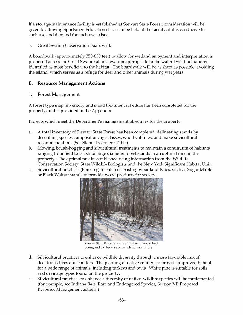
-63-
If a storage-maintenance facility is established at Stewart State Forest, consideration will begiven to allowing Sportsmen Education classes to be held at the facility, if it is conducive tosuch use and demand for such use exists.
3. Great Swamp Observation Boardwalk
A boardwalk (approximately 350-650 feet) to allow for wetland enjoyment and interpretation isproposed across the Great Swamp at an elevation appropriate to the water level fluctuationsidentified as most beneficial to the habitat. The boardwalk will be as short as possible, avoidingthe island, which serves as a refuge for deer and other animals during wet years.
E. Resource Management Actions
1. Forest Management
A forest type map, inventory and stand treatment schedule has been completed for theproperty, and is provided in the Appendix.
Projects which meet the Department’s management objectives for the property.
a. A total inventory of Stewart State Forest has been completed, delineating stands bydescribing species composition, age classes, wood volumes, and make silviculturalrecommendations (See Stand Treatment Table).
b. Mowing, brush-hogging and silvicultural treatments to maintain a continuum of habitatsranging from field to brush to large diameter forest stands in an optimal mix on theproperty. The optimal mix is established using information from the WildlifeConservation Society, State Wildlife Biologists and the New York Significant Habitat Unit.
c. Silvicultural practices (Forestry) to enhance existing woodland types, such as Sugar Mapleor Black Walnut stands to provide wood products for society.
Stewart State Forest is a mix of different forests, bothyoung and old because of its rich human history.
d. Silvicultural practices to enhance wildlife diversity through a more favorable mix ofdeciduous trees and conifers. The planting of native conifers to provide improved habitatfor a wide range of animals, including turkeys and owls. White pine is suitable for soilsand drainage types found on the property.
e. Silvicultural practices to enhance a diversity of native wildlife species will be implemented(for example, see Indiana Bats, Rare and Endangered Species, Section VII ProposedResource Management actions.)
-64-
f. Management practices to remove invasive species where economical and practical.
Black Walnut Trees
Until recently, black walnut was the most valuable hardwood tree grown in the country. Thatposition has been surpassed by Sugar Maple and black cherry, but walnut remains a highlyvaluable tree for furniture, veneer, gun stocks, and a variety of speciality products. A measure of the fertility of some soils on the Stewart State Forest is the presence of numerousblack walnut trees, in scattered and localized locations. Trees vary from seedlings and saplingsto two feet in diameter. Most fall in between these sizes, and the vast majority are 10-16 inchesin diameter.
Many walnut trees are found in the vicinity of old homesteads and nearby roads, and mayreflect past plantings by farmers and early residents. Some of these trees contain hardware(clothesline pulleys, nails, bolts, etc.) lowering their value for timber.
Given its commercial and wildlife value, the DEC intends to manage all black walnut trees. Competing, poor quality trees of lesser value and vines shading black walnut trees will beremoved. Low quality black walnut trees with poor form, decay, or other defects will also beremoved when competing with better quality walnut trees. Low pruning of branches, to aheight of 17 feet, will also be undertaken from time to time, to improve lower stem quality.
DEC will also consider planting this species in selected abandoned farm fields with appropriatesoils. Five acres may be planted at a 12' by 12' spacing in field RM 30 along the southwestern edge of the Great Swamp.
A small sale of black walnut trees was completed in late 2000/early 2001, to harvest maturingtrees in one location. The sale allowed DEC staff to gauge the market, and plan futuremanagement to keep it in the mix of trees on the property. The sale was done on an area ofabout 15 acres in the SW corner of the property where black walnut was growing in an area notideal for its growth. The walnut (roughly 12-24 inches in diameter [DBH]) was removedreleasing the understory. The main purpose of the timber sale was to remove black walnut fromcompetition with the sugar maple, which is more suited to the site. Within this 15-acre salearea, patches of young and older black walnut trees on good soils were also released byremoving poor quality cherry and white ash competition. These trees, released fromcompetition, will grow more quickly and supply seeds for future walnut generations.
2. Farming
Farming is a long standing historic use of the property. DEC took over jurisdiction of theproperty subject to several agricultural leases. Currently, farming on the property takes placethrough TRP’s, and is limited to farmers who were cultivating fields at the time the propertywas transferred to DEC in 1999. DEC will continue to support agricultural use on the property.
Current farmers will be allowed to continue farming. Farmers are required to locate their farmfields on a specially numbered map provided by DEC. The Department will require farmers tohave an approved “Conservation Compliance Plan” prepared in conjunction with the Orange

-65-
County Soil and Water Conservation District. Because of the unique circumstancessurrounding farming at Stewart State Forest, an “Agricultural Environmental Management(AEM)” plan addressing such issues as implementing best management practices for rareplants, wildlife and wetland protection, liability concerns for state land open to the public,outreach to the non-farm community, and supporting farmers in complying with existing andfuture environmental regulations will also be required. (The AEM Program is outlined in theAppendix or at www.nys.soilandwater.org). These two programs provide a clear accountingof all farming activities past, present and planned by describing the treatments and practicesapplied to each field. Conditions such as new gates, seasonal mowing restrictions, field edge and wildlife habitatimprovement measures, and avoiding critical wildlife areas will be included in the TRPs issuedto farmers. Although most agricultural activities are exempt from Article 24 permitting,farmers leasing Stewart lands will be required to apply best management practices. Use ofpesticides on the property requires approval from the DEC (see Part 190.0) and will be reportedby the farmers in a yearly summary, will be a component of an Integrated Pest Management(IPM) approach, and will be subject to applicable SEQRA reviews. The DEC’s Division ofPesticide Enforcement requires farmers to maintain records for “restricted usepesticides”(Agricultural Use Observation Inspections), including dates applied, equipment usedand crop treated. There is no requirement for farmers to be certified applicators or to record“general use pesticides” applied on lands they own or lease. However, since this is a StateForest, , the Division of Pesticides “Agricultural Use Observation Inspections” will beaugmented with a requirement in the TRP for listing all ‘general use’ herbicides and pesticidesused on the property, and farmers using Stewart State Forest will be “private applicatorcertified.”
Farmers regularly use the existing ponds for irrigation during droughts, and have deepenedsome ponds for this purpose. A protocol will be established for ponds with special wildlifepopulations which might be impacted by drawdown during these periods. Farmers will berequired to remove all barbed wire and cable gates, and replace with farm gates. Where fieldsare open to a road, a farm gate will be installed.
Stewart State Forest may be suitable for applying agro-forestry practices. Appropriateinformation will be researched and provided to farmers and staff.
3. The Great Swamp
a. Introduction
The Great Swamp is classified as palustrine deciduous forested wetland. The raising of thewater levels by beavers has killed the trees and the swamp has been opening up over the years,leading to swamp forest, dead forest and open water. The Great Swamp is designated WD-48,Class II, and is estimated at 301 acres (page IV 257, Stewart International Airport PropertiesFEIS, 1992). The Great Swamp is hydrologically tied to wetland MD-11 (Class III, 96 acres), aswamp forest, via a stream corridor to its southwest. The wetlands are described in AppendixD, Vegetation Descriptions for the Stewart Property (Stewart International Airport PropertiesFEIS, 1992). Hydrological influences from changes in the Great Swamp water levels can

-66-
influence land as far south as Weed Road. The southern half of the area containing the GreatSwamp between Maple Avenue, Ridge Road and Weed Road is considered a significant habitatas a deer concentration/wintering area.
Large segments of The Great Swamp are dominated by purple loosestrife and phragmites. Water levels are lower than in the past, but fluctuate radically from year to year, depending onweather conditions and beaver dam building activity.
Drainage from the swamp is to the north through a series of culverts under I-84. Currently,three 24" pipes drain the wetland, but only one is partially open. Beavers have dammed theculverts in the past and some damming is evident today. In the northern portion of the swamp,flooding once reached heights in excess of 10 to 12 feet above pre-flooded conditions. In thesummer of 1988, the water in the northern half of the swamp stabilized at depths between sixand eight feet above pre-flooded conditions (Stewart International Airport FEIS, 1992). Sincethen, new beaver dams and yearly changes have resulted in widely fluctuating water levels.
Because the bottom elevations of the Great Swamp are not uniform, the impacts of the floodinghave not been universal over the swamp forest. The vegetation in the southern third of theswamp is intact with a strong tree, scrub and herbaceous layer. Here, there is little indication ofexcessive flooding beyond normal field conditions. The vegetation here is typical ofpermanently flooded forested wetland. Although the tree layer is still alive in the central thirdof The Great Swamp, the scrub and herbaceous layers have been severely impacted by theflooding and are sharply reduced or altered in composition. A mat of various duckweeds(Lemna, Spirodela, and Wolffia) is found floating on the water surface and there are extensiveareas of arrow arum and bur reed. The northern third of the swamp is dead flooded forest witha mat of duckweeds on the water surface (Stewart International Airport FEIS, 1992). Morerecently, alternating drought in 1999 with wet periods in 2000, along with reduced beaveractivity, have lowered overall Great Swamp water levels, allowing purple loosestrife toestablish a significant presence in the wetland.
The Great Swamp

-67-
b. Purple Loosestrife Control
There have been several attempts to control purple loosestrife through the experimental releaseof Hylobius transversovittatus, a root-boring beetle and Galerucella beetles, which eat loosestrifeleaves. Hylobius beetles were released at the Great Swamp and a wetland just west of theStewart Airport runway and Drury Land in late Spring 2001. The leaf -eating beetles are doingwell in the wetland along Drury Lane. In Spring 2006, purple loosestrife beetles were againreleased at the Great Swamp and for the first time at Wilkens Pond. Purple loosestrife controlprojects may continue on the property, as needed, for up to five consecutive years, especially inwetlands along Barron Road.
c. Water Control Structure
The merits of reconstructing the water control structure along the northerly boundary of theGreat Swamp will be studied. The structure is on DOT land, along I-84. Any alterations to theGreat Swamp will require a Freshwater Wetlands and Dam Safety Program permit.
An improved control structure would help create a limited area of open water habitat to benefitwaterfowl and wildlife diversity, improve recreational and hunting opportunities and openwater fishing without creating habitat for nuisance species, such as Canada Geese, swans, andseagulls. Raising water levels by 18 to 24 inches would also help eliminate nuisance invasive species such as purple loosestrife and phragmites to improve the wetland’s diversity. However,raising water levels can have an impact on adjacent wetlands, vernal ponds and forest lands. On the other hand, the deterioration of beaver dams has caused a permanent lowering of waterlevels. Species dependent on vernal ponds and seasonally flooded woodlands could beadversely affected.
4. Mowing and Habitat Enhancement for Wildlife Management
Mowing on the Stewart State Forest will improve habitat diversity for grassland species. Withthe decline of agriculture, farm fields throughout the Hudson Valley region are reverting toforest and habitat diversity is decreasing. Techniques to improve habitat diversity will includemaintaining a mix of agricultural land, mowing fields and managing brush land.
110 to 120 acres will be mowed per year on a 6 year rotation. The total area to be maintainedover the long-term is about 950 acres. However, certain fields with high concentrations ofmultiflora rose may be mowed on a shorter 3-year rotation to get the infestation under control. Roughly 13-15 percent of the property will be maintained in early to mid-successional stages,including farm fields. Farmland - cultivated, fallow, and abandoned - will be an integral part ofachieving the wildlife goals on the property. The mowing plan indicates priority locations forgrassland and shrubland maintenance, as well as mowing locations for views, a group campingsite, and retriever trials (which may be done annually over small areas). Mowing will be doneby DEC Operations Staff or outside contractors supplemented by occasional supervisedvolunteer, farmer, or user groups. (See Mowing Plan in Appendix). Mowing will, wheneverpossible, be scheduled to avoid the grassland bird nesting season (May to July 15).

-68-
Throughout the property, early successional habitats include active farm fields (hay, cropped orcover-cropped), limited areas mowed near ponds, as well as abandoned farm fields in varioussuccessional stages. Some farm fields, if abandoned, will be mowed (See Agricultural FieldsMap in the Appendix). Mowing is also a priority to maintain a balance of diverse habitatsthroughout the property, with continued mowing of smaller areas northern New Road (twofields) and Orlando Drive (the field here should be cleared of trees, retaining some shrubs), partsof the Ridge Road Orchard and several fields west of Maple Avenue near 207. Ridge Road andBuchanan Hill field complexes have been mowed in the past 3 years to maintain the existingfields.
In addition, Central Hudson Gas and Electric manages 158 acres of land within the State Forestwhich it owns in-fee or part of its transmission line right-of-way. About 116 acres are managedas shrublands, the remainder being farm fields. The Department proposes to rejuvenate andmaintain between 7 and 11 acres of brushland per year in addition to the Central Hudson lands. This requires the removal of all tree species shading shrubs in designated locations.
In some cases, grassland management at Stewart SF may require activities more intensive thanperiodic mowing. This management might include the removal of hedgerows and forest patcheswithin a grassland matrix, planting of appropriate native grasses and wildflowers withingrasslands to improve habitat suitability for grassland-dependent wildlife, and annual breedingbird surveys to assess the success of this management. The removal of trees from grassland landscapes is important because trees, especially linearrows of trees, fragment grassland habitats. Because most grassland bird species are areasensitive, meaning they require continuous habitat patches that meet some minimum sizethreshold, fragmented habitats without unbroken grassland areas of 100 acres or more are notideal for grassland birds and, in many instances, simply not used for nesting. Ideally, withingrasslands, all non-grassland habitats, including hedgerows, forest patches, and shrublands, areconverted to grassland. This course of action is the preferred management option within theproposed grassland habitat complexes at Stewart State Forest. However, recognizing that thecost and effort of completely converting forest patches and/or hedgerows to grassland may beprohibitive, the periodic removal of the tallest vegetation (i.e. trees) while leaving stumps, largerocks, shrubs, and other short vegetation (anything <10 feet in height) provides a good lowercost alternative that minimizes both fragmentation and investment.
Because high intensity grassland management is not practical or prudent for all fields at StewartSF, five areas were identified as good candidates for designation and management as grasslandcomplexes. The criteria used for selecting these areas included size, configuration, currentvegetative condition, and compatibility to grassland management. Within these complexes,connectivity will be improved to the greatest extent possible through removal of hedgerows andforest patches. As previously stated, whenever possible, these forested habitats will beconverted to grassland. However, when conversion to grassland is impossible, these habitatswill be managed as shrublands dominated by low-growing native shrubs such as dogwood andviburnum species. Actively farmed fields make up a significant portion of the four grasslandcomplexes listed below. While grassland birds do not generally nest in agricultural fields asidefrom hayfields, pastures, and fallow cropfields, these areas add to the overall size of treelessgrassland habitat complexes, and if farming of these fields is discontinued, they will be managed

-69-
as grasslands. On farms fields that are purposely being left fallow as part of an approved farmplan, certain management activities will be encouraged to increase their attractiveness tograssland wildlife, such as planting appropriate cover crops and delaying cultivation until afternesting season. Additionally, farmers will be encouraged to delay mowing of hayfields as longas possible to promote nesting success.
The four areas proposed for management as grassland complexes (including some shrublands)are as follows (acreage includes small areas of shrubland/woodland-hedgerow/wetlandhabitats, as well as mowed areas):
1. South Barron Road/Restoration Pond area fields (215 acres);2. Barron Road mitigation wetland area fields (200 acres);3. Northern Ridge Road fields (117 acres);4. Route 207 fields east of Maple Avenue (105 acres).
These areas are listed in priority order; i.e. resources will be dedicated to improving thegrassland habitat at the South Barron Road/Restoration Pond complex before the Barron Roadmitigation wetland complex, and so forth. Lower priority fields may be mowed, but may notreceive additional habitat improvements. All fields, particularly those east of Maple Avenue,will be monitored in cooperation with Stewart International Airport.
Roadway edges are also important travelways for many wildlife species species as well asneeding to be mowed to keep roads passable, maintain visibility and views (Up to 6 footshoulders wherever terrain, ditches and stone walls permit). Wet areas and steep slopes will bebypassed. Roadways will be mowed in the following order: Weed Road, Ridge Road, NewRoad, Lindsay Road, Barron Road North, Barron Road South, Maple Avenue, Drakes Lane,Giles Road, Ridge Road South to Route 207, and Orlando Drive. The following trails will be amowing priority once the roadways are mowed: Windsor Woods Road, Buchanan Hill Trail,Armstrong Farm Lane, Scofield Lane, and the Barron Road to New Road Connector pastWilkins Pond.
Habitat enhancement will also include the planting of native conifers for diversity and habitat on suitable sites not exceeding 15 acres, and efforts to remove exotic plants.
Butterflies and Invertebrates
Areas have been tentatively identified which may need special consideration because of thepresence of certain species, habitats or plants. In a small number of locations, the timing ofmowing may need to be adjusted. Barron Road is particularly rich in specimens and numbersand offers excellent habitat, with Blue stem, Knapweed, Ironweed and substantial stands ofMilkweed. Barron Road South Purple Milkweed Field
In order to maintain the populations of purple milkweed (Asclepias purpurascens) near the DOTBarron Road Wetland Mitigation site, regular liming of the field may be needed. If highcalcium and manganese levels are determined to be indicative of purple milkweed habitat,testing for these elements will be undertaken. If either element is lacking liming will be

-70-
undertaken. In order to maintain access to the purple milkweed, reduce competition whichcould impact the species and keep the area in the early successional stage preferred by the plant,the field and its adjacent upland will be mowed approximately once every 3 years (A drumbrush hog should never be used).
Mowing at the site also serves to limit invasive species like purple loosestrife. Between mowing, purple loosestrife may be removed mechanically (snipping and pulling) or by applyingan herbicide.
In 2005 purple milkweed seed was gathered at this site to be germinated and grown at the DECSaratoga Tree Nursery. In July of 2006 DEC, the New York State Department of Transportation(DOT) and volunteers planted 400 of these seedlings to enhance the existing population.
5. Bird Habitat Management
The diverse landscape at Stewart State Forest provides habitat for a broad variety of birds and asnoted in the natural resources inventory, this includes habitat for certain groups of specieswhose habitat is declining throughout the northeast. Management as a state forest provides anopportunity to protect and enhance habitat for these and other bird species. However, due tothe proximity of the forest to the Stewart International Airport the Department will limitmanagement actions to those which will not result in unacceptable risks to airport operations.
The Department will continue to monitor bird populations including any potential threat theymay pose to airport operations and work with DOT, the FAA and Airport managers to ensuremanagement actions do not compromise airport safety. Management actions have beendeveloped to enhance (favor) habitat for bird species which do not pose a threat to airportoperations and actions to discourage use of the property by those species known to conflict withairport operations will be pursued.
Because this property has the potential to provide habitat for bird species at risk, includinggrassland and shrubland birds, neotropical migrant species and wetland dependant species, theDepartment will work in partnership with Audubon, the Wildlife Conservation Society’sMetropolitan Conservation Alliance and other interest groups to undertake surveys and studiesto determine the extent to which these species currently utilize the property, the importance ofthis habitat to their continued existence in the region and what management actions areappropriate. With this data the Department will also determine if portions of the property meetthe criteria in Environmental Conservation Law Article 11 (section 2001) to be designated as aBird Conservation Area (BCA). A recommendation to designate a portion of the property as aBCA would only be pursed if, after consultation with the FAA and airport managers, it isdetermined that designation would not conflict with airport operations.
F. Completing a Viable Stewart State Forest
“The transfer of jurisdiction of approximately 5264 acres from the Department of Transportationto the Department of Environmental Conservation” in 1999 is provided in the Appendix. Anadditional 1600 acres were transferred in June 2006. The Unit Management Plan recommendsseveral properties be considered for addition to the State Forest. These properties will reduce

-71-
management costs and maintain the area’s long term natural stability and recreational benefits. All proposed land acquisitions will be conservative, limited to key parcels of land which simplifymanagement and insure the integrity of the State Forest.
The Department will pursue the acquisitions proposed in this plan where the existing owner isinterested in selling and funding is available. The Department will only use eminent domain asa tool to clear a faulty title or to establish value in cases where the owner has expressed awillingness to sell, but an agreement on price cannot be reached. All land acquisitions will bereviewed and meet the criteria and “resource value rating systems” in the Conserving OpenSpace in New York State Plan. Notification will be made to the affected Town of the State’sintent to acquire any parcels which are purchased with Environmental Protection Fund (EPF). ATown has 90 days from notification to reject a proposed acquisition. For more information onland acquisition proposed for New York State, please consult the “2006 New York State OpenSpace Conservation Plan.”
1. Barron Road Development Area
The impact of developing the 100-acre North Barron Road, Road Development Area could bereduced with vehicle access limited to the north. A gate on Barron beyond the point of vehicleaccess to the Development Area along with roughly 0.75 mile of fence along the easterly edge ofBarron Road, would successfully limit dumping and illegal access. Any new roadwaydevelopment should include a parking and a bike/pedestrian walkway alongside Barron Road,to allow safe access to the State Forest.
All but 100 of the 300 acres of the Barron Road Development Area were transferred for inclusionto Stewart State Forest in 2006. However, some of the best kettlehole and vernal pool wetlandsfor amphibians are to the west of Baron Road, north of Wilkins Pond. Many species ofamphibians depend on vernal ponds and kettlehole bogs at different stages in their life history,and are extremely sensitive to landscape-level disruptions that fragment or degrade habitat. Thecomplex of ponds and vernal pools in this area, allows for recolonization after drought or otherdisturbance. (McDougal, WCS, pers. comm.). Development proposals should reflect the uniquecharacter of the area.
2. Barron Road - Easterly Parcels
Two parcels to the east of Barron Road and north of Decker Road are not part of the Barron RoadDevelopment Area and were not included in the original airport lands condemnationproceedings. They were part of the Penn Central Railroad at the time and were either inreceivership or in quasi-public ownership and not subject to eminent domain proceedings. Parcel 6, 8.5089 acres is described in Liber 2272, page 833, 837-38 and the adjacent Parcel 7 (4.83acres) is described in Liber 2272, page 820, 826-27. These parcels, totaling 13.3 acres, should beacquired from willing sellers to reduce the number of developable inholdings. A large parcel between Stewart State Forest and the Village of Maybrook, fronts on the westshoulder of Barron Road. This parcel, part of the former Penn Central Railroad holdings (SeeDOT claim map 1470), has potential to significantly impact Stewart SF along North Barron Roadnear Wilkins Pond and Decker Road. Appropriate additions of adjacent properties will bepursued from willing sellers to enhance management and protect natural resources.

-72-
3. Forrester Road
Central Hudson Gas and Electric owns two lots along Forrester Road (Liber 1824, page 125; Liber1825 page 1203) totaling 26.65 acres which include three long distance transmission lines. Central Hudson also owns in-fee a power transmission corridor with a power line stretching thelength of the property from I-84 to Forrester Road, immediately adjacent to a second power linefor which it has an easement through the property. If these lots are offered for sale for anyreason, the state should acquire them to keep the property a cohesive unit bordering ForresterRoad, keeping the boundary lines of the Forest simple and avoiding encroachment bydevelopment.
4. Maple Avenue to Drury Lane
This area, east of Maple Avenue and north of the runway protection zone of StewartInternational Airport, remains with the Department of Transportation. However, the DOT in2006 transferred to DEC the Maple Avenue right-of way, which insures access throughout thissection of Stewart State Forest. Also, development setbacks agreed to in Consent Order No. 00-cv-1606, will preserve the viewshed of the entire State Forest, and hunting opportunities. Thelands retained by DOT to the east of northern Maple Avenue “Reserved for Development”, shallhave “no construction of buildings or other action taken by NYSDOT, its successors and assigns,within 500 feet of Stewart State Forest, which would cause a limitation on hunting on the StewartState Forest pursuant to New York Environmental Conservation Law 11-0931.(Consent Decree00-cv-1606).
5. Barron Road, Decker Road and Second Street within the Village of Maybrook
The Village of Maybrook owns the roads, in-fee within the village limits. Decker Road, SecondStreet and a section of Barron Road remain the responsibility of the Village. The Village right-of-way is 50' wide. Acquisition of these roads from the Village should be considered in order tosimplify management and access issues for the property.
6. Clark Street and Jackson Avenue
Public access rights to the easterly lands of Stewart State Forest require clarification. Clark Streetand Jackson Avenue on the easterly boundaries may or may not provide public access for theuse and enjoyment of the property.
G. Proposed Rules and Regulations
Special rules and regulations are needed to implement some of the management actionsproposed under Section VII of the Stewart State Forest Unit Management Plan. Regulations willbe updated or amended for:
• Hunting reservations, parking and vehicular access during hunting season.• Fishing w electric/non-motorized craft • Snowmobile use• Camping and fires• Firearms

-73-
The Cooperative Hunting Area Regulations for Public Use at Stewart (Part 92) which governthe property will be repealed and replaced with unit specific rules and regulations under Part190. As proposed in this unit management plan, these rules and regulations are in addition tothe general guidelines already codified in Title 6NYCRR, Part 190 of the EnvironmentalConservation Law and are necessary because of circumstances unique to the Stewart StateForest. Below is a chart which illustrates the existing regulations on the unit and also outlinesthe proposed changes to the current regulations put forth in the UMP.
Issue Existing regulations Proposed regulations
Firearms Shotguns and muzzle loaders only;handguns and rifles prohibited
Shotguns, muzzle loaders and .22 caliber rimfire handguns permitted; riflesprohibited
Snowmobiles Snowmobile use allowed Snowmobile use limited to designatedtrails.
Camping Camping allowed for no more than 3nights in one location by fewer than 10people and 150 feet away from trail,road or water. Longer stays and largergroups require a permit. Limited bycurrent Coop Regulations.
Camping allowed by permit only.Camping prohibited during big-gamehunting season.
Fires Fires not allowed Fires by permit only.
Fishing/boats Use of boats prohibited on Wilkins,Rowe’s, Tenny’s and Maroney’s Ponds. Fishing prohibited on Tenny’s Pondfrom Sept. 1 through the end ofFebruary, and on Wilkins and Rowe’sPonds from October 1 through the endof February.Ice fishing by special permit during hunting season (10/1-3/1)
Fishing and non-motorized/electricmotor boats allowed on all ponds in theState Forest.1
Ice fishing permitted except duringregular big-game hunting season.
Hunting/access General public access limited to March 1through September 30 with a specialpermit. A hunter permit systemrequired for use of the property fromOctober 1 through big-game huntingseason. Hunting party size limited to threehunters and two dogs.
Property open to all users except duringthe regular big-game hunting season(approximately Mid-November to mid-December), when it is limited to hunterswith valid hunting licenses. Non-hunting companions may accompanyhunters, but must stay with hunter at alltimes while on property.No party size or dog restrictions.
1 Tenny’s Pond is located on NYS DOT property. Public access to the pond is allowed under the 2005 consentdecree. Use of boats on the pond is under the jurisdiction of NYS DOT.
VIII. Update of the Unit Management Plan
The Final Unit Management Plan (UMP) will need updating 10 years after its adoption or ifsubstantial changes or amendments are made due to changes in circumstances.

-74-
IX. MANAGEMENT BUDGET AND STAFFING: 10 YEAR SCHEDULE
A. Annual Maintenance Budget
The following tables outline a schedule for the implementation of proposed management actionsand their estimated costs. Accomplishments are contingent upon sufficient staffing levels andfunding. It is expected that most tasks will be done by Department Staff. To conform withprogram budgeting practices, estimated project costs are based on current costs for materials andwages for seasonal staff labor, excluding fringe benefits and indirect costs. The contruction ormaintenance projects costs do not include permanent program staff salaries. Therefore costs aresignificantly lower than they would be for outside contractors.
• Yearly mowing of both sides of roughly 18 miles of truck roads and 4 miles of access roadsto keep brush and shrubs from encroaching on the traveled ways with DEC staff &equipment . $ 6,000
• Mowing of an average of 115 acres per year on a 6 year rotation to maintain grasslandhabitat on the property with DEC staff and equipment. $ 7,000
• Manage a minimum of 7 acres per year for shrubs (Rowes Pond area, BN6, NR48, RidgeRoad north, NR21, 37, 40, 38). (5 days per year). $ 2,000
• Invasive plant control. $ 1,500
• Hazardous tree removal. Contracting or DEC staff removal of trees damaged by disease,insects, lightening or other weather events which pose a potential hazard to visitors alongroads or major travelways. $ 2,500
• Maintain/renovate 3.5 miles of roads per year (grade, drain, resurface). $ 130,000
• Yearly parking lot snow removal. $ 1,500
• Yearly parking lot maintenance. $ 1,500
• Yearly trail maintenance. $ 3,000
• Yearly property line maintenance. $ 1,000
• Maintain and repair gates, install/maintain one new gate every two years on average.$ 3,000
• Yearly upkeep and repair of forest headquarters building (former Cooperative HuntingArea Check Station). $ 1,200
• Mow and maintain six dams a year. $ 6,000

-75-
• Maintain Kiosks and information on a yearly basis. $ 1,000
• Reprint Stewart State Forest brochure for multiple users $ 2,000
• Install/Rent accessible Port-A-John at Weed Road, Ridge Road, and regular P-O-J at BarronRoad and Lorraine Drive as needed from April 1 to mid-December. Totaling about 2.5 yearsof coverage every year. $ 3,750
Annual Maintenance Budget $197, 950
B. Construction and Projects Budget
Year 1-5
• Install parking facility at Baron Road South. $10,000
• Install parking facility at Rt. 207/Armstrong Lane trailhead. $ 10,000
• Install parking facility at Lorraine Drive (East of Maple Ave.). $ 15,000
• Install parking facility at Barron Road North. $19,000
• Small hardened parking areas at Restoration Pond and Beaver Pond. $ 8,000
• Construct 7 hunter parking spaces along Drury Lane and east, and two along Maple Avenue. $ 7,000
• Rebuild farm lane, 10-12' road surface cut brush to 25' wide, pull-offs every 250 feet or so,grade, fill and culverts. (Forrester to Restoration Pond, suitable for one-lane car access).
$12,000• Rebuild farm lane between New and Ridge Roads past Pittman-Robertson Pond to 8 feet
wide, suitable for horse carriages (fill, culverts, permit, fabric and drainage). $14,000
• Demolish 20 by 35' shed off Forester Road. $ 3,000
• Storage/maintenance facility:A three bay pole barn storage/maintenance building, withthree bays enclosed. $50,000
• Remove 2-story wood frame barn and other wood frame structures on Old Creamery Road(Old Route 208, Maybrook). $20,000
• Install DEC signs on 12.6 miles of boundary lines. $ 5,000• Install five additional informational kiosks at major entry points (Barron Road South. Weed
Road intersection with Ridge Road) ,Lorraine Drive South, and Rte 207-East Drury. Maintain existing three kiosks and bulletin boards. $15,000
• Install directional and trails signs at all major trail and road intersections. $ 1,500

-76-
• Install 3 sign standards at southerly Barron Road, northerly Ridge Road, and northerlyBarron Road. $ 2,000
• Investigate and assess maintenance of other dams on ponds throughout the property.$ 1,000
• Removal of trash, debris, and old structures (one-time). $ 2,000
• Upgrade and complete 21 trail segments and loops as follows:
- Costs per mile ($1,500) for 12 miles of foot trails $ 18,000 - Cost per mile ($3,000) for 9 miles of horse and buggy, multiple use trails: $ 27,000 (Costs include 2 culverts and small wooden footbridge on trail C and maintenance/upgrade of boardwalk on trail B2)
• Upgrade existing small hunter check station, by winterizing, and adding a restroom andseptic system. Expand to provide an office/contact station for the visiting public. Electricand phone service exists already. $50,000
• Establish and maintain group camping area at Ridge Road Orchard (Mow areas, establishparking, harden access routes, provide area for horse tethering and
buggies). $ 8,000
• Boardwalk over Great Swamp, maximum 600 feet (@ $20 foot) $12,000
• Plant 5 acres of black walnuts at 12x12 spacing (300 trees per acre with protective tubes, 300trees per day = 5 person days.) $ 4,000
• Plant 5 acres of white pine (300 trees per acre, 12x12 spacing, 300 trees per day = 5 persondays). $ 5,000
• Plant app. 5 acres of tree buffer along Forrester Road and route 208 (Sugar maple, oak,poplar, white pine, walnut and hickory) $ 2,000
• Demolish 150' by 150' one story masonry building west of Barron Road. $75,000
• Disposal of 150 ‘by 150' masonry building at approved C&D site. $397,000
• Install approximately 2 miles of chain link fence along Barron Road, if needed. $150,000
• Add parallel parking on one shoulder of Weed Road, if needed. $10,000Total construction costs for years 1-5: $ 952,500

-77-
C. Equipment Budget
• 4-wheel drive truck for staff $25,000
• Loftness Timber Ax (80-93"blade) or equivalent (Allows mowing, larger brushing and treeremoval in fields and on uneven ground. Purchase of this equipment would reduce yearlymaintenance costs for mowing by up to an equivalent amount) $45,000
• 6-wheel ATV $ 8,000
• Two chain saws - one medium and one small $ 700
• Hand tools, including hammers, shovels, pickaxes, loppers, etc for a crew of six. $ 500
• Safety Equipment, including hard hats, with ear and face protection, chain saw chaps,gloves, etc. for a crew of three. $ 500
• Two two-way radios or cell phones $ 300
Equipment Budget Total: $80,000
D. Annual Budget for Personnel
• Senior Forestry Technician 1 staff year• 2 Assistant Forest Rangers from October 1 through December and May to December 1 staff year
Annual Budget for Personnel 2 staff years
10 YEAR TOTAL $ 3,012,000

-78-
X. Bibliography and References
Allen, T et al. 2000. 1999 Survey Results for Grassland Nesting Birds at Seven Vermont StateAirports. Vermont Audubon Council, Central Vermont Audubon Society, 3 pp.
New York State Department of Environmental Conservation. 2001. New York State BirdConservation Area Program. Delmar, NY.
New York State Department of Environmental Conservation et al. 2006. New York State OpenSpace Conservation Plan. Albany, NY.
Askins, Robert A. 1999. Restoring North America’s Birds: Lessons from Landscape Ecology,First Edition. Yale University Press, 352 pp.
Bollinger, Eric K. and T. Gavin. 1989. “Eastern Bobolink Populations: Ecology and Conservationin an Agricultural Landscape” in Manomet Symposium: 497-506.
Central Vermont Audubon Society & Vermont Agency of Transportation et al. Undated. Grassland Habitat Management Agreement for Vermont State Airports, 6 pp.
Cleary, Edward C. and R. A. Dolbeer. 2005. Wildlife Hazard Management at Airports-A Manualfor Airport Personnel, USDA FAA & USDA APPHIS, 360 pp.
Cleary, Edward C., R.A. Dolbeer and S. E. Wright . 2006. Wildlife Strikes to Civil Aircraft in theUnited States 1990-2005. Federal Aviation Administration (Serial Report Number 12). Washington, DC.
Forman, Richard T. and R.D. Deblinger. 2000. “The Ecological Road-Effect Zone of aMassachusetts (U.S.A.) Suburban Highway” in Conservation Biology 14 (1):36-46.
Headley, Russel. 1908. The History of Orange County, New York. Van Deusen and Elms,Middletown, New York.
Jones, Andrea L. And P. Vickery. 1997. Conserving Grassland Birds: Managing LargeGrasslands, Including Conservation Lands, Airports and Landfills over 75 acres for GrasslandBirds. Grassland Conservation Program, Center for Biological Conservation, MassachusettsAudubon Society, Lincoln, Mass (in collaboration with the Sylvio O. Conte NFWR and USFWSNA Waterfowl Management Program.
McDougal, James. 2000. Personal communication. Metropolitan Conservation Alliance, WildlifeConservation Society, Rye, NY.
McManus, John. 2001. Personal communication. Central Hudson Gas and Electric,Poughkeepsie, NY.
Metropolitan Conservation Alliance. 2000. Biological Surveys of the Stewart State Forest: AReport to the New York State Department of Environmental Conservation. WildlifeConservation Society, 14 pp + Appendices.

-79-
New York State Department of Transportation. July 1992. Stewart International AirportProperties Final Federal Environmental Impact Statement, Vol 1, DOT and FAA, 350 pp.
Olsson, Karl et at. 1981. Soil Survey of Orange County, New York, US Department ofAgriculture Soil Conservation Service and Cornell University Agricultural Experiment Station,192 pp + maps.
Pauley, Thomas K., J. Mitchell, R. Buech and J. Moriarty. 2000. “Ecology and Management ofRiparian Habitats for Amphibians and Reptiles”in Riparian Management in Forests of theContinental Eastern United States (Verry, E. et al, editors). Lewis Publishers, NY 401 pp.
Ruttenber, Edward M. and L.H. Clark. 1981. History of Orange County, New York (2volumes). Everts and Peck, Philadelphia.
Semlitsch, Raymond D. 1998. “Biological Delineation of Terrestrial Buffer Zones for Pond-Breeding Salamanders” in Conservation Biology 12(5):1113-1119.
Semlitsch, Raymond D. and J.R. Bodie. 1998. “Are Small, Isolated Wetlands Expendable?” inConservation Biology 12(5):1129-1133.
Snodgrass, Joel W., M.J. Komoroski, A.L. Bryan Jr., and J. Burger. 2000. “Relationships amongIsolated Wetland Size, Hydroperiod, and Amphibian Species Richness: Implications for WetlandRegulations” in Conservation Biology 14(2):414-419.
Trombulak, Stephen C. and C.A. Frissell. 2000. “Review of Ecological Effects of Roads onTerrestrial and Aquatic Communities” in Conservation Biology 14(1):18-30.
Vickery, Peter D., M. Hunter and S. Melvin. 1994. Effects of Habitat Area on Distribution ofGrassland Birds in Maine. Conservation Biology 8(4):1087-1097.
Visakay, Steve. 2006. White Cloud Farms: The Curious Story of the Most famous Unknown Art Pottery Company in America, July/Aug 2006, American Art Pottery Association, 10 pp.(www.maineantiquedigest.com)
XI. Public Comments and DEC Response
Wildlife
Comment: Unit Management Plan fails to provide adequate protection for nesting pied-billedgrebes at Restoration Pond and other locations on the property from recreational userdisturbance.
Response: Specific language has been added under the heading “Rare and Endangered Species” in the“Protective Actions” subsection of the “Proposed Resource Management Actions” section to provide pied-billed grebes with additional protection from disturbance during the nesting season. Furthermore, generallanguage has been added under this heading stating that the needs of rare, endangered, threatened, andspecial concern species supercede recreational use of the property.

-80-
Comment: Unit Management Plan fails to discuss butterfly surveys conducted on Stewart StateForest and proposed management for rare butterfly species found on the property.
Response: Language providing information about the butterfly surveys conducted on the property hasbeen added to the “Wildlife” subsection of the “Information On The State Forest” section. Language hasbeen added to the “Protective Actions” subsection of the “Proposed Resource Management Actions”section under the “Rare and Endangered Species” heading stating that the needs of rare species will takepriority over other uses of the property.
Comment: Because of the proximity of Stewart International Airport, management activities atStewart State Forest, including its designation as a Bird Conservation Area, will increase the riskof bird-aircraft collisions.
Response: DEC will not pursue BCA designation at this time. However, the Department will consultwith airport and FAA staff, and if deemed appropriate, may pursue designation of part or all of StewartState Forest as a Bird Conservation Area (BCA) in the future. Proposed habitat management at Stewart State Forest for birds focuses primarily on two groups of birdswhich are declining in the Northeast: grassland and shrubland nesting birds. In general, bird species thatwill benefit from this proposed management are small, non-flocking songbirds that do not represent asignificant risk to aircraft. Many of the large, generalist species of birds that pose the greatest hazard toaircraft, such as gull species, crows, raptors, and Canada geese, have been present at Stewart State Forestfor many years and will continue to be present there in the future. The proposed management of theproperty is not expected to increase populations of these species above current levels. Indeed, grasslandmanagement calls for the creation of larger blocks of grassland, reducing field edges and forested hedgerowswhich attract large raptors. None of the birds that cause the greatest threat to aircraft benefit fromgrassland management. DEC will also pursue management actions which discourage species which couldcause a threat to the airport.Language has also been added to address these concerns under Stewart International Airport Security(Wildlife) under Facilities Management, Section C and Proposed Management Actions, Section 7.
Comment: The Department should manage specific areas at Stewart State Forest for grasslanddependent wildlife as this habitat type, and the wildlife that depends on it, is declining acrossthe state, especially in the Hudson Valley.
Response: Because of the public support for grassland management, additional information regarding themanagement and enhancement of grasslands has been added under the “Mowing and HabitatEnhancement for Wildlife Management” heading in the “Resource Management Actions” subsection ofthe “Proposed Resource Management Actions” section.
Comment: Appendix B-1 (the list of amphibians and reptiles in the vicinity of Stewart StateForest) contains references to species that were not observed during the Wildlife ConservationSociety/Metropolitan Conservation Alliance biological survey of the property.
Response: Appendix B-1 lists amphibian and reptile species recorded in the vicinity of Stewart StateForest during the New York State Amphibian and Reptile Atlas Project and does not reflect observationsmade by the Wildlife Conservation Society/Metropolitan Conservation Alliance. Because the New YorkState Amphibian and Reptile Atlas Project uses large blocks to document the presence/absence of species,the data are not specific to the area encompassed by Stewart State Forest. A short list of amphibians andreptiles documented during the Wildlife Conservation Society/Metropolitan Conservation Alliance surveyof Stewart State Forest has been added to Appendix B, and the comments will be reviewed by the NaturalHeritage Program staff and biologists in future assessments of the property .

-81-
Comment: The New York State Breeding Bird Atlas data in Appendix B-3 are not specific toStewart State Forest.
Response: The list of breeding bird species in Appendix B-3 is from the four Breeding Bird Atlas blocksthat cover Stewart State Forest and surrounding areas rather than being exclusive only to Stewart. Therefore, it may contain breeding bird species that were not observed on the property, but in the nearbyvicinity. The title of the table has been revised to eliminate any confusion. Clarifications noted will bekept on file for use by biologists in future surveys of the property.
Comment: Habitat management proposals specific to ruffed grouse should have been includedin the UMP.
Response: While ruffed grouse are present at Stewart State Forest, they have never been abundant on theproperty and were not recorded there during the most recent Breeding Bird Atlas. Although notspecifically mentioned as a species of management concern, ruffed grouse will benefit from the earlysuccessional habitat management proposed in the plan.
Hunting
Comment: Motor vehicle access to interior roads of Stewart State Forest for hunters should beavailable during all hunting seasons.
Response: Current and anticipated staffing levels do not allow the main gate at Weed Road to be openduring all hunting seasons. However, language has been added under the “Hunting” heading in the“Recreational Management Actions” subsection of the “Proposed Resource Management Actions” sectionthat would allow for the Weed Road gate to be open until the end of December if conditions permit.
Comment: An area of Stewart State Forest should be dedicated to youth sportsperson education.
Response: A new heading has been added to the “Recreational Management Actions” subsection of the“Proposed Resource Management Actions” section entitled “Youth Hunting and Fishing Opportunities”that addresses youth sporting events at Stewart State Forest, especially the annual Youth Hunting Day. Additionally, language has been added under the “Interpretation” heading in the “Outreach ManagementActions” subsection of the “Proposed Resource Management Actions” section stating that if a storage-maintenance facility was established at Stewart State Forest, consideration would be given to allowingsportsmen education classes to be held there.
Comment: Stewart State Forest should be open later than one half hour after sunset for motorvehicle access during hunting season to allow hunters more time to recover game and leave theproperty.
Response: Language under the “Hunting” heading in the “Recreational Management Actions”subsection of the “Proposed Resource Management Actions” section regarding the hours when theproperty is open to motor vehicle access has been changed from “one half hour after sunset” to “one hourafter sunset.”
Comment: The hunting party size restriction (3 hunters per vehicle) should be eliminated in partto encourage youth participation in hunting. For example, under the current regulations, aparent with three children could not take all three children hunting with them simultaneously.

-82-
Response: The regulation restricting hunting party size to three hunters dates back to when Stewart StateForest was operated as a Cooperative Hunting Area. This regulation will be rescinded and hunting partieswill no longer be limited to three hunters. Language has been added under the “Hunting” heading in the“Recreational Management Actions” subsection of the “Proposed Resource Management Actions” sectionthat clarifies this change.
Comment: Limiting access to Stewart State Forest to licensed hunters during hunting seasondiscourages youth participation in hunting because children under the age of 12 cannot obtain ahunting license and therefore cannot accompany an adult while hunting. This regulation shouldbe eliminated.
Response: Non-hunting companions will be permitted to accompany hunters during the big game season,but must remain with the hunter at all times while on the property. During the rest of hunting season, allother users are allowed on the property, and therefore friends and relatives of hunters may accompanythem without restriction.
General Management and User Considerations
Comment: Snowmobile Use should not be prohibited at Stewart State Forest (45 comments andseveral petitions). Snowmobile Use should be prohibited (13 Comments).
Information was presented - in support of and objecting to - snowmobiles. Most reservationsabout snowmobiles were about their noise, exhaust, large numbers at one time, andinconsiderate behavior by what appears to be a small minority of riders. The Section underSnowmobiles was changed to allow snowmobiles on the main roadway system and four connectortrails on the property. Snowmobiles will not be allowed east of Maple Avenue and on non-designated trails. These steps and others, designed to provide a balance among users, areoutlined under Section VII Proposed Resource Management Actions, B. RecreationalManagement Actions, Snowmobiles in the UMP.
Comment: Farming should continue and be encouraged (13 comments received). Farmingshould sunset with the current farmers (2).
Current farmers will continue farming.. The DEC supports agricultural use of the property andhas been working, whenever possible within the framework the regulations governing themanagement of State Forests toward this goal. DEC will consider agro-forestry and bio-fuelsresearch proposals, in cooperation with universities and research institutes, with existingfarmers, as long as it is compatible with protecting the long term sustainability of the naturalresources on the property. Legislative guidance for agricultural use is required over the longerterm. Farm fields east of Maple Avenue will continue to be farmed under TRP by the presentfarmer and have been added to the inventory of farm fields on the property.
Comment: The property should make provisions for ATV use/should not make provisions forATV use.
The DEC stands by the guidelines prohibiting ATV’s presented in the Draft UMP.
Comments: Describe and define “camping permit” and the reasoning behind the proposedcamping guidelines.

-83-
Clarification has been added under Section VII Proposed Resource Management Actions,Recreational Management Actions-Camping.
Comments: On public use, hunting practices, volunteers, dedicated funding and management, theproperty description, alternative development and Norway spruce trees to name just a few.
These comments were all considered in the creation of the Final UMP. Some of the commentsare within the purview of the goals and objectives outlined in the UMP and will be kept on fileand considered as management options. Your support through the comments on funding,management and volunteers is greatly appreciated.
Comments: The State is urged to incorporate public uses such as a golf course, tennis and ballfields in its plans for the property.
The consideration of such uses is beyond the scope of this Unit Management Plan and thelegislation authorizing the creation of Stewart State Forest under the category of StateReforestation Area.
The State is urged to take into account the emergency planning process for emergency respondersaccessing the property.
Access to the property by emergency responders and fire services is coordinated through DEC’sForest Rangers (Division of Forest Protection and Fire Management) and EnvironmentalConservation Officers (ECO’s). Forest rangers monitor the daily use of the property throughpatrols and through the monitoring of Temporary revocable Permits (TRP’s) issued to groupsand for special uses. Forest Rangers and Assistant Forest Rangers also provide additionalmonitoring during the fall hunting season and will control the enforcement and/or issuance ofcamping permits in the future. This coordination should continue with improvements incommunication as a need is identified. A Section has been added under Facilities Managementactions entitled ‘Stewart International Airport Security” (Under VII. Proposed ResourceManagement Actions, C. Facilities Management Actions).

APPENDICES
Appendix A: Soils of the Stewart State Forest
Appendix B: Wildlife
B-1 Amphibians/Reptiles
B-2 Mammals
B-3 New York Breeding Bird Atlas for Stewart State Forest Blocks5659 (A-D)
Appendix C: 2006 Transfer of Jurisdiction and Consent Decree
Appendix D: Report to Commissioner John P. Cahill of the NYS Department
of Environmental Conservation from the Stewart Lands
Citizen’s Advisory Committee:
Recommendations regarding the management and use of theStewart State Forest, Towns of Montgomery, New Windsor andHamptonburgh, Orange County, November 4, 1999
Appendix E: Features of ECL Title 20 New York State Bird Conservation
Area program
Appendix F: State Environmental Quality Review - Negative Declaration
Appendix G: Forest Stand Mosaic Map
Appendix H: Forest Stand Inventory Table and Treatment Schedule
Appendix I: Stewart State Forest Mowing and Shrubland Management Map
Appendix J : Stewart State Forest Agricultural Fields Map
Appendix K: Proposed Trails System and Facilities Map/ Wetlands Map
Appendix L: Hunter Parking Map for Stewart State Forest

Appendix A - Soils
Appendix A

Appendix A - Soils
APPENDIX A: SOILS WITHIN THE STEWART STATE FOREST
The following list of soil types are believed to occur within the Stewart State Forest asdocumented in “Soil Survey of Orange County, New York, U.S. Agriculture, Soil Conservation
Services in Cooperation with Cornell University Agricultural Experiment Station”, published in1975. Abbreviations represent the following soil names as found on Soil Maps18, 19, 29, 30.
UPLAND SOILS
ABAlden silt loam, broadly defined
abAlden silt loam
ACAlden extremely stony soils
BmBBath-Nassau shaly loams 3 to 8 percent slopes
BmCBath-Nassau shaly loams 8 to 15 percent slopes
CaCanandagua silt loam
CmBChenango gravelly silt loam 3 to 8 percent slopes
ErAErie gravelly silt loam 0 to 3 percent slope
ErBErie gravelly silt loam 3 to 8 percent slope
ESBErie extremely stony soils, gently sloping
HoBHoosic gravelly sandy loam 3 to 8 percent slope
MaMadalin silt loam
MdBMardin gravelly silt loam 3 to 8 percent slope
MdCMardin gravelly silt loam 8 to 15 percent slope
MdDMardin gravelly silt loam 15 to 25 percent slope
MyMiddleburg silt loam
OtBOtisville gravelly sandy loam 8 to 15 percent slope
RaRaynham silt loam
RhBRiverhead sandy loam 3 to 9 percent slope
SXCSwartswood and Mardin very stony soild, very steep
UHUdorthents, smoothed
WdWayland silt loam

Appendix A - Soils
WETLAND SOILS
CeCarlisle muck, very deep
CfCarlisle muck, ponded
HHHistic Humaquepts, ponded
PaPalms muck
PbPalms much, ponded
GRAVEL/ROCK OUT CROP
PgGravel pits
RSDRockout Crop - Nassau Complex - hilly

Appendix B - Wildlife
Appendix B.

Appendix B - Wildlife
Appendix B-1:Stewart State Forest Vicinity
Preliminary New York State Amphibian and Reptile Atlas Project Data
April 1, 2002
Town Species Common Name
Hamptonburgh Thamnophis sirtalis Common GarterSnake
Hamptonburgh Diadophis punctatus edwardsii Northern Ringneck Snake
Montgomery Elaphe o. obsoleta Black Rat Snake
Montgomery Rana catesbeiana Bullfrog
Montgomery Thamnophis sirtalis Common GarterSnake
Montgomery Sternotherus odoratus Common MuskTurtle
Montgomery Chelydra s. serpentina Common Snapping Turtle
Montgomery Bufo a. americanus Eastern AmericanToad
Montgomery Hyla versicolor Gray Treefrog
Montgomery Rana clamitans melanota Green Frog
Montgomery Ambrystoma jeffersonianum JeffersonSalamander
Montgomery Ambystoma opacum MarbledSalamander
Montgomery Storeria d. dekayi Northern BrownSnake
Montgomery Plethodon cinereus Northern Redback Salamander
Montgomery Plethodon glutinosus Northern Slimy Salamander
Montgomery Pseudacris c. crucifer Northern Spring Peeper
Montgomery Eurycea bislineata Northern Two-lined Salamander
Montgomery Nerodia s. sipedon Northern WaterSnake
Montgomery Chrysemys picta Painted Turtle
Montgomery Rana palustris Pickerel Frog

Appendix B - Wildlife
Montgomery Notophthalmus v. viridescens Red-spotted Newt
Montgomery Liochlorophis vermalis Smooth GreenSnake
Montgomery Ambystoma maculatum SpottedSalamander
Montgomery Clemmys guttata Spotted Turtle
Montgomery Rana sylvatica Wood Frog
New Windsor Rana catesbeiana Bullfrog
New Windsor Thamnophis sirtalis Common GarterSnake
New Windsor Chelydra s. serpentina Common Snapping Turtle
New Windsor Bufo a. americanus Eastern AmericanToad
New Windsor Lampropeltis t. triangulum Eastern Milk Snake
New Windsor Rana clamitans melanota Green Frog
New Windsor Ambystoma jeffersonianum x laterale JeffersonSalamanderComplex
New Windsor Coluber c. constrictor Northern BlackRacer
New Windsor Agkistrodon contortrix mokasen NorthernCopperhead
New Windsor Plethodon cinereus Northern Redback Salamander
New Windsor Pseudacris c. crucifer Northern Spring Peeper
New Windsor Nerodia s. sipedon Northern WaterSnake
New Windsor Chrysemys picta Painted Turtle
New Windsor Rana palustris Pickerel Frog
New Windsor Notophthalmus v. viridescens Red-spotted Newt
New Windsor Ambystoma maculatum SpottedSalamander
New Windsor Clemmys guttata Spotted Turtle

Appendix B - Wildlife
Appendix B-2. Status and occurrence of New York mammals in the Stewart State Forest,Orange County in the southern ecozone, Hudson Valley ecologicalsubzone as listed in “Integrating Timber and Wildlife ManagementHandbook” (Robert Chambers, 1983, SUNY College of EnvironmentalScience and Forestry & NYSDEC).
SPECIES STATUS
Masked Shrew
Smoky Shrew
Longtail Shrew
Northern Water Shrew
Least Shrew
Shorttail Shrew
Starnose Mole
Hairy-tailed Mole
Eastern Mole
Easter Woodrat Threatened
Pygmy Shrew
Little Brown Bat
Keen’s Bat
Indiana Bat Endangered
Small-Footed Bat Special Concern
Silver-Haired Bat
Eastern Pipistrelle
Big Brown Bat
Red Bat
Hoary Bat
Snowshoe Hare Game Species
Raccoon Game Species
White-tailed Deer Game Species
Shorttail Weasel Game Species
River Otter Game Species
Striped Skunk Game Species
Red Fox Game Species
Bobcat Game Species
Eastern Chipmunk
Gray Squirrel Game Species
Appendix B - Wildlife
Red Squirrel
Southern Flying Squirrel
Northern Flying Squirrel
Beaver Game Species
Deer Mouse
White-Footed Mouse
Woodland Jumping Mouse
Yellownose Vole
Pine Vole
Southern Bog Lemming
Meadow Jumping Mouse
Southern Red-Backed Vole
Meadow Vole
Woodland Vole
Muskrat Game Species
Gray Fox Game Species
Woodchuck Game Species
Porcupine
Opossum Game Species
Eastern Cottontail Game Species
Mink Game Species
Longtail Weasel Game Species
Coyote Game Species
Appendix B - Wildlife
Appendix B-3: Breeding Bird Atlas Data
COMMON NAME SCIENTIFIC NAME CODE TYPECanada Goose Branta canadensis NE ConfirmedMute Swan Cygnus olor NE ConfirmedWood Duck Aix sponsa ON ConfirmedAmerican Black Duck Anas rubripes X1 PossibleMallard Anas platyrhynchos FL ConfirmedMallard x Am. Black Duck Hybrid Anas platyrhynchos x A. rubripes X1 PossibleHooded Merganser Lophodytes cucullatus P2 ProbableRing-necked Pheasant Phasianus colchicus FL ConfirmedWild Turkey Meleagris gallopavo NE ConfirmedNorthern Bobwhite Colinus virginianus FL ConfirmedPied-billed Grebe Podilymbus podiceps S2 ProbableAmerican Bittern Botaurus lentiginosus X1 PossibleGreat Blue Heron Ardea herodias NY ConfirmedGreen Heron Butorides virescens FY ConfirmedBlack Vulture Coragyps atratus X1 PossibleTurkey Vulture Cathartes aura D2 ProbableSharp-shinned Hawk Accipiter striatus T2 ProbableCooper's Hawk Accipiter cooperii T2 ProbableRed-shouldered Hawk Buteo lineatus X1 PossibleBroad-winged Hawk Buteo platypterus T2 ProbableRed-tailed Hawk Buteo jamaicensis NY ConfirmedAmerican Kestrel Falco sparverius D2 ProbableVirginia Rail Rallus limicola T2 ProbableCommon Moorhen Gallinula chloropus T2 ProbableKilldeer Charadrius vociferus FL ConfirmedSpotted Sandpiper Actitis macularia P2 ProbableAmerican Woodcock Scolopax minor S2 ProbableRock Pigeon Columba livia NY ConfirmedMourning Dove Zenaida macroura NE ConfirmedBlack-billed Cuckoo Coccyzus erythropthalmus X1 PossibleYellow-billed Cuckoo Coccyzus americanus S2 ProbableGreat Horned Owl Bubo virginianus NY ConfirmedBarred Owl Strix varia T2 ProbableChimney Swift Chaetura pelagica NY ConfirmedRuby-throated Hummingbird Archilochus colubris T2 ProbableBelted Kingfisher Ceryle alcyon FY ConfirmedRed-bellied Woodpecker Melanerpes carolinus NY ConfirmedDowny Woodpecker Picoides pubescens NY ConfirmedHairy Woodpecker Picoides villosus NY ConfirmedNorthern Flicker Colaptes auratus NY ConfirmedPileated Woodpecker Dryocopus pileatus NY ConfirmedEastern Wood-Pewee Contopus virens FY ConfirmedAlder Flycatcher Empidonax alnorum X1 PossibleWillow Flycatcher Empidonax traillii FY ConfirmedLeast Flycatcher Empidonax minimus NY ConfirmedEastern Phoebe Sayornis phoebe NY ConfirmedGreat Crested Flycatcher Myiarchus crinitus NY ConfirmedEastern Kingbird Tyrannus tyrannus NY ConfirmedWhite-eyed Vireo Vireo griseus D2 Probable

Appendix B - Wildlife
Yellow-throated Vireo Vireo flavifrons FY ConfirmedWarbling Vireo Vireo gilvus FY ConfirmedRed-eyed Vireo Vireo olivaceus FY ConfirmedBlue Jay Cyanocitta cristata NE ConfirmedAmerican Crow Corvus brachyrhynchos NY ConfirmedHorned Lark Eremophila alpestris X1 PossibleTree Swallow Tachycineta bicolor NY ConfirmedNorthern Rough-winged Swallow Stelgidopteryx serripennis ON ConfirmedBank Swallow Riparia riparia FY ConfirmedBarn Swallow Hirundo rustica NY ConfirmedBlack-capped Chickadee Poecile atricapillus FY ConfirmedTufted Titmouse Baeolophus bicolor NY ConfirmedWhite-breasted Nuthatch Sitta carolinensis FY ConfirmedBrown Creeper Certhia americana FY ConfirmedCarolina Wren Thryothorus ludovicianus FL ConfirmedHouse Wren Troglodytes aedon NY ConfirmedMarsh Wren Cistothorus palustris FY ConfirmedBlue-gray Gnatcatcher Polioptila caerulea FY ConfirmedEastern Bluebird Sialia sialis NY ConfirmedVeery Catharus fuscescens FY ConfirmedWood Thrush Hylocichla mustelina NE ConfirmedAmerican Robin Turdus migratorius NY ConfirmedGray Catbird Dumetella carolinensis NE ConfirmedNorthern Mockingbird Mimus polyglottos NY ConfirmedBrown Thrasher Toxostoma rufum FY ConfirmedEuropean Starling Sturnus vulgaris NY ConfirmedCedar Waxwing Bombycilla cedrorum FY ConfirmedBlue-winged Warbler Vermivora pinus FY ConfirmedGolden-winged Warbler Vermivora chrysoptera X1 PossibleBrewster's Warbler Vermivora pinus x V. chrysoptera X1 PossibleLawrence's Warbler Vermivora chrysoptera x V. pinus X1 PossibleYellow Warbler Dendroica petechia NY ConfirmedChestnut-sided Warbler Dendroica pensylvanica FY ConfirmedPrairie Warbler Dendroica discolor FY ConfirmedBlack-and-white Warbler Mniotilta varia FY ConfirmedAmerican Redstart Setophaga ruticilla NY ConfirmedWorm-eating Warbler Helmitheros vermivorus FY ConfirmedOvenbird Seiurus aurocapilla FY ConfirmedNorthern Waterthrush Seiurus noveboracensis T2 ProbableLouisiana Waterthrush Seiurus motacilla T2 ProbableCommon Yellowthroat Geothlypis trichas NE ConfirmedScarlet Tanager Piranga olivacea FY ConfirmedEastern Towhee Pipilo erythrophthalmus FY ConfirmedChipping Sparrow Spizella passerina FY ConfirmedField Sparrow Spizella pusilla FY ConfirmedSavannah Sparrow Passerculus sandwichensis T2 ProbableSong Sparrow Melospiza melodia FY ConfirmedSwamp Sparrow Melospiza georgiana FL ConfirmedNorthern Cardinal Cardinalis cardinalis FY ConfirmedRose-breasted Grosbeak Pheucticus ludovicianus NY ConfirmedIndigo Bunting Passerina cyanea FY ConfirmedBobolink Dolichonyx oryzivorus FY ConfirmedRed-winged Blackbird Agelaius phoeniceus NY Confirmed
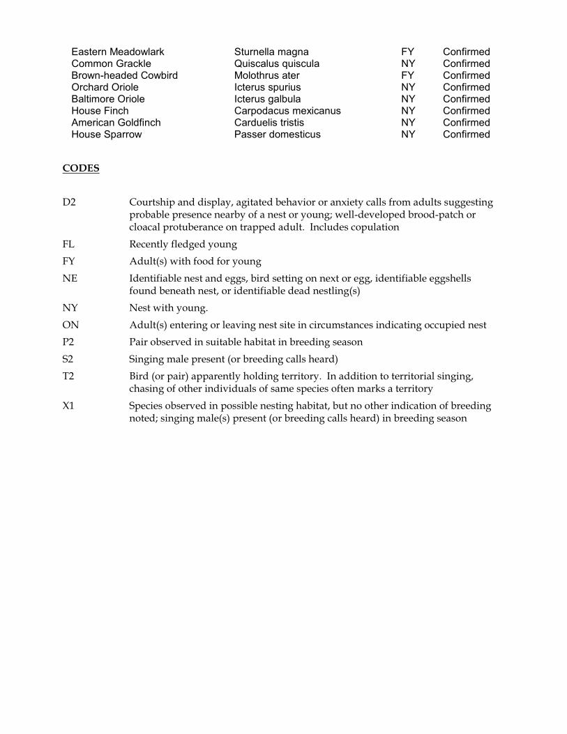
Eastern Meadowlark Sturnella magna FY ConfirmedCommon Grackle Quiscalus quiscula NY ConfirmedBrown-headed Cowbird Molothrus ater FY ConfirmedOrchard Oriole Icterus spurius NY ConfirmedBaltimore Oriole Icterus galbula NY ConfirmedHouse Finch Carpodacus mexicanus NY ConfirmedAmerican Goldfinch Carduelis tristis NY ConfirmedHouse Sparrow Passer domesticus NY Confirmed
CODES
D2 Courtship and display, agitated behavior or anxiety calls from adults suggestingprobable presence nearby of a nest or young; well-developed brood-patch orcloacal protuberance on trapped adult. Includes copulation
FL Recently fledged young
FY Adult(s) with food for young
NE Identifiable nest and eggs, bird setting on next or egg, identifiable eggshellsfound beneath nest, or identifiable dead nestling(s)
NY Nest with young.
ON Adult(s) entering or leaving nest site in circumstances indicating occupied nest
P2 Pair observed in suitable habitat in breeding season
S2 Singing male present (or breeding calls heard)
T2 Bird (or pair) apparently holding territory. In addition to territorial singing,chasing of other individuals of same species often marks a territory
X1 Species observed in possible nesting habitat, but no other indication of breedingnoted; singing male(s) present (or breeding calls heard) in breeding season

Appendix C.


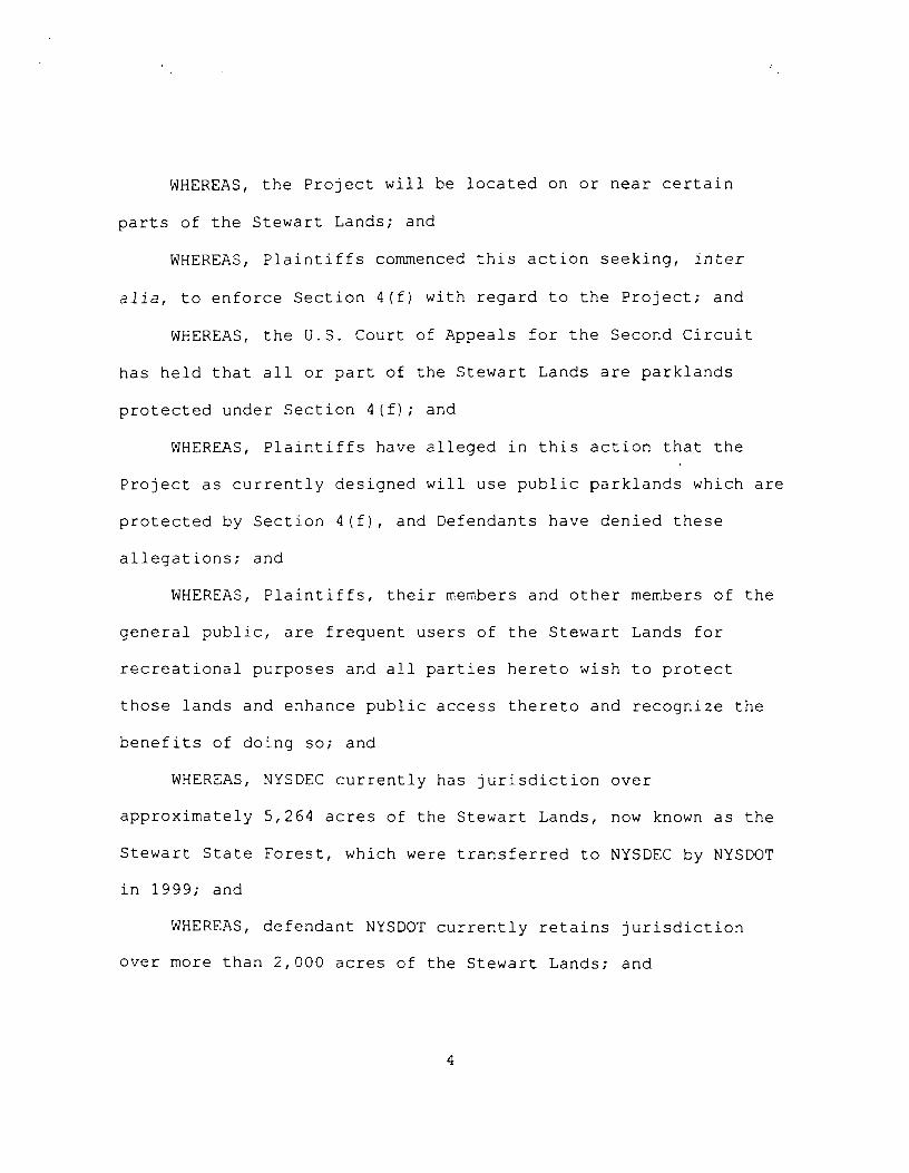


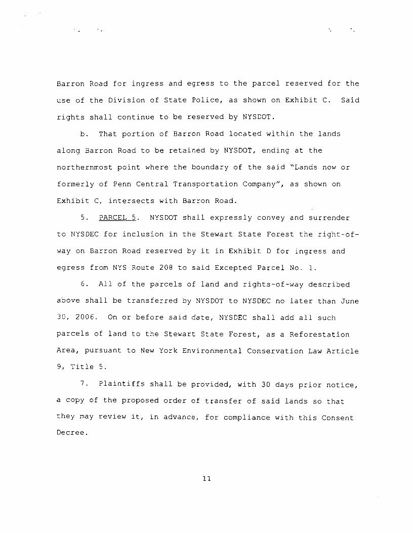


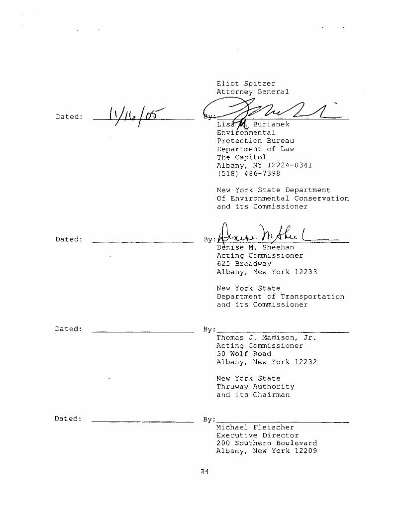


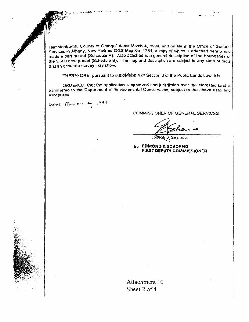


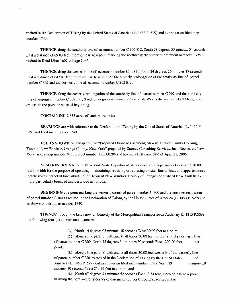


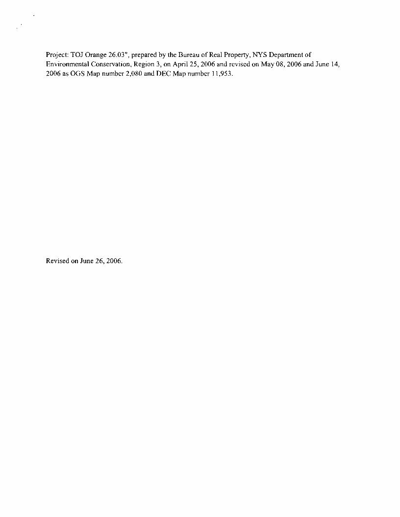

Appendix D.

Executive Summary and Membership List, Stewart Lands Citizens Advisory Committee Report toCommissioner John P. Cahill
Executive Summary
The 23-member Stewart Lands Citizens Advisory Committee has carefully evaluated issues of publicaccess, recreational uses, natural resources management, environmental education & interpretation,farming, historic preservation, public safety, and funding related to the future use and management of theStewart State Forest. A total of 34 specific recommendations were developed. In summary, theCommittee recommends that:
• The Stewart State Forest should be managed in a manner which fosters appropriaterecreation, research and environmental education & interpretation, but which alsoprotects the land’s natural resources and rural character.
• A variety of appropriate recreational uses should be encouraged, including hiking,bicycling, hunting, nature study, cross-country skiing, horseback riding, etc.
• Camping should be allowed only for organized groups, and by special permit.
• The recreational use of motorized vehicles should not be allowed.
• Golf courses, ball fields and similar recreational facilities should not be developed on theStewart State Forest.
• A diverse wildlife population should be encouraged, through the protection andenhancement of diverse wildlife habitat.
• Partnerships should be developed to foster interpretation of the land.
• Farming should be encouraged to continue on the property.
• Ownership of historic properties should be transferred to the Orange County HistoricalSociety.
• Special attention must be given to unique public safety concerns raised by the StewartState Forest’s location immediately adjacent to an international airport.
• Funding should be adequate to support management of this land and to promote modesteducational, interpretive and research efforts.
Membership List
George P. Bucci, Jr. - Supervisor, Town of NewburghJohn Buttarazzi - Vice President, Empire State Development Corp.Nancy Calhoun - New York State AssemblywomanWilliam R. Conners - Director, Board of Directors, Federation of Dutchess County Fish and Game ClubsHoward Cushing - President, New York State Conservation CouncilDr. John A. D’Ambrosio - President, Chamber of Commerce of Orange CountyDeborah Meyer DeWan - Program Director, Riverfront Committee, Scenic Hudson Inc.
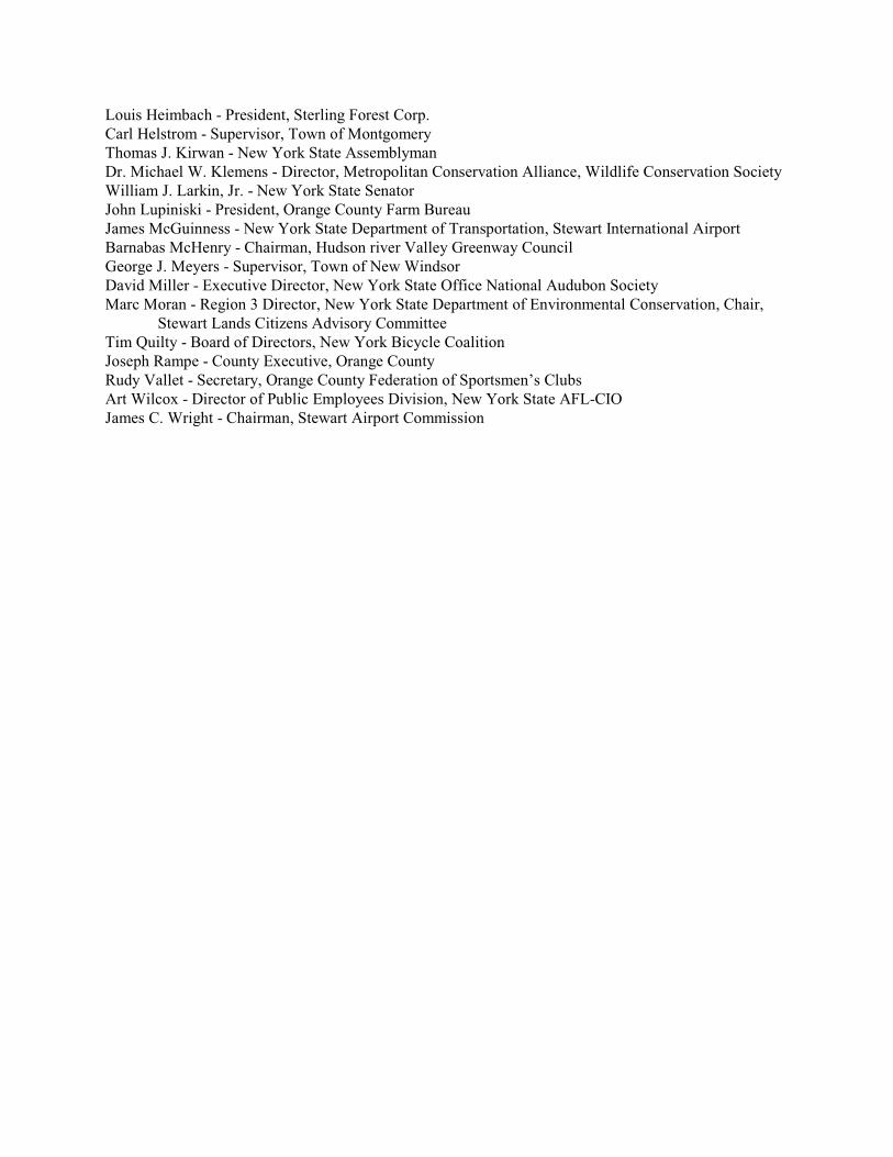
Louis Heimbach - President, Sterling Forest Corp.Carl Helstrom - Supervisor, Town of MontgomeryThomas J. Kirwan - New York State AssemblymanDr. Michael W. Klemens - Director, Metropolitan Conservation Alliance, Wildlife Conservation SocietyWilliam J. Larkin, Jr. - New York State SenatorJohn Lupiniski - President, Orange County Farm BureauJames McGuinness - New York State Department of Transportation, Stewart International AirportBarnabas McHenry - Chairman, Hudson river Valley Greenway CouncilGeorge J. Meyers - Supervisor, Town of New WindsorDavid Miller - Executive Director, New York State Office National Audubon SocietyMarc Moran - Region 3 Director, New York State Department of Environmental Conservation, Chair,
Stewart Lands Citizens Advisory CommitteeTim Quilty - Board of Directors, New York Bicycle CoalitionJoseph Rampe - County Executive, Orange CountyRudy Vallet - Secretary, Orange County Federation of Sportsmen’s ClubsArt Wilcox - Director of Public Employees Division, New York State AFL-CIOJames C. Wright - Chairman, Stewart Airport Commission

Appendix E.

Bird Conservation Area ProgramECL §11-2001
Legislation establishing the Bird Conservation Area (BCA) program was enacted by the NewYork State Legislature, and signed into law by Governor Pataki on September 5, 1997. Thefeatures of it are as follows:
Creates the Bird Conservation Area Program on state-owned lands and waters to "safeguardand enhance populations of wild birds native to New York State and the habitats thereinthat birds are dependent upon for breeding, migration, shelter, and sustenance."
Designated properties are to be mapped, and copies of all pertinent documents forwarded tothe Department of Environmental Conservation (DEC) "for inventory, research, andreference purposes for the general public."
A master inventory list and maps of BCAs shall be kept on file by DEC, with duplicates atthe New York State Museum and Cornell Laboratory of Ornithology.
Defines BCAs: waterfowl concentration site, pelagic seabird site, shorebird concentrationsite, wading bird concentration site, migratory concentration site, diverse speciesconcentration site, individual species concentration site, species at risk site, and birdresearch site.
BCAs to be designated by DEC Commissioner, Office of Parks, Recreation and HistoricPreservation (OPRHP) Commissioner, or Secretary of State, for appropriate propertiesunder their jurisdictions and consistent with their respective missions.
Establishes an Advisory Committee - no pay, meet at least two times annually.
States the purpose of the BCA Program: to advise as to the designation, management,educational research and utilization of those sites that are individually designated as partof and collectively comprise the New York State Bird Conservation Area Program.Provided, however, the utilization of such sites shall be consistent with the respectivemissions of the Department, the Office of Parks, Recreation and Historic Preservation,and the Department of State.
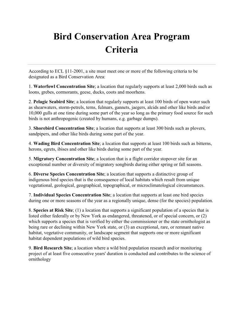
Bird Conservation Area Program
Criteria
According to ECL §11-2001, a site must meet one or more of the following criteria to bedesignated as a Bird Conservation Area:
1. Waterfowl Concentration Site; a location that regularly supports at least 2,000 birds such asloons, grebes, cormorants, geese, ducks, coots and moorhens.
2. Pelagic Seabird Site; a location that regularly supports at least 100 birds of open water suchas shearwaters, storm-petrels, terns, fulmars, gannets, jaegers, alcids and other like birds and/or10,000 gulls at one time during some part of the year so long as the primary food source for suchbirds is not anthropogenic (created by humans, e.g. garbage dumps).
3. Shorebird Concentration Site; a location that supports at least 300 birds such as plovers,sandpipers, and other like birds during some part of the year.
4. Wading Bird Concentration Site; a location that supports at least 100 birds such as bitterns,herons, egrets, ibises and other like birds during some part of the year.
5. Migratory Concentration Site; a location that is a flight corridor stopover site for anexceptional number or diversity of migratory songbirds during either spring or fall seasons.
6. Diverse Species Concentration Site; a location that supports a distinctive group ofindigenous bird species that is the consequence of local habitats which result from uniquevegetational, geological, geographical, topographical, or microclimatological circumstances.
7. Individual Species Concentration Site; a location that supports at least one bird speciesduring one or more seasons of the year as a regionally unique, dense (for the species) population.
8. Species at Risk Site; (1) a location that supports a significant population of a species that islisted either federally or by New York as endangered, threatened, or of special concern, or (2)which supports a species that is verified by either the commissioner or the state ornithologist asbeing rare or declining within New York state, or (3) an exceptional, rare, or remnant nativehabitat, vegetative community, or landscape segment that supports one or more significanthabitat dependent populations of wild bird species.
9. Bird Research Site; a location where a wild bird population research and/or monitoringproject of at least five consecutive years' duration is conducted and contributes to the science ofornithology

Appendix F.

SEQR review for this unit management plan (UMP) has been initiated with the preparation of theLong Environmental Assessment Form (LEAF), the preparation of this document and the publicreview process. Non-significant impacts will be addressed in a Negative Declaration that will beincluded as a appendix in the final UMP

Appendix G.

2
14
27
30
7
4
4
73
4
38
22
355
36
85
3
6881
2
9
29
32
31
21
4360
6
16
53
8
9
33
17
11
10
61
76
90
9
21
1
37
9
40
82
87
48
44
78
19
52
20
41
2
75
2865
64 10
816
11
30
72
50
79
91
77
1380
34
24
22
62
5
84
23
47
24
25
46
23
1
66
25
18
83
51
56
84
92
74
7
1
6
4560
25
2
626
1
30
22
26
60
49
20
39
81
15
5
21
70
24
11
52
14
15
55
19
42
28
18
1689
3
17
31
5
58
12
1222
20
19
13
32
88
8
69
67
71
57
7
33
58
860
56
33
59
63
22
23
28
53
54
77
10
52
711 26
29
14
4
72
13 21
17
33
4679
31
35
50
12
22
14
16
27
6
58
18
7
13
20
35 33
6433
35
18
29
57
15
88
33
59
18
82
77
10
27
73
15
41
13
29
00
13
82
±
Stewart State Forest Stand Boundaries
GIS is approximate and should notbe considered a substitute for onsite inspection and survey.M.C. PaulNYSDEC DLF
LegendCompartment 1Compartment 2Compartment 3
1 inch equals 3,000 feet

Appendix H.
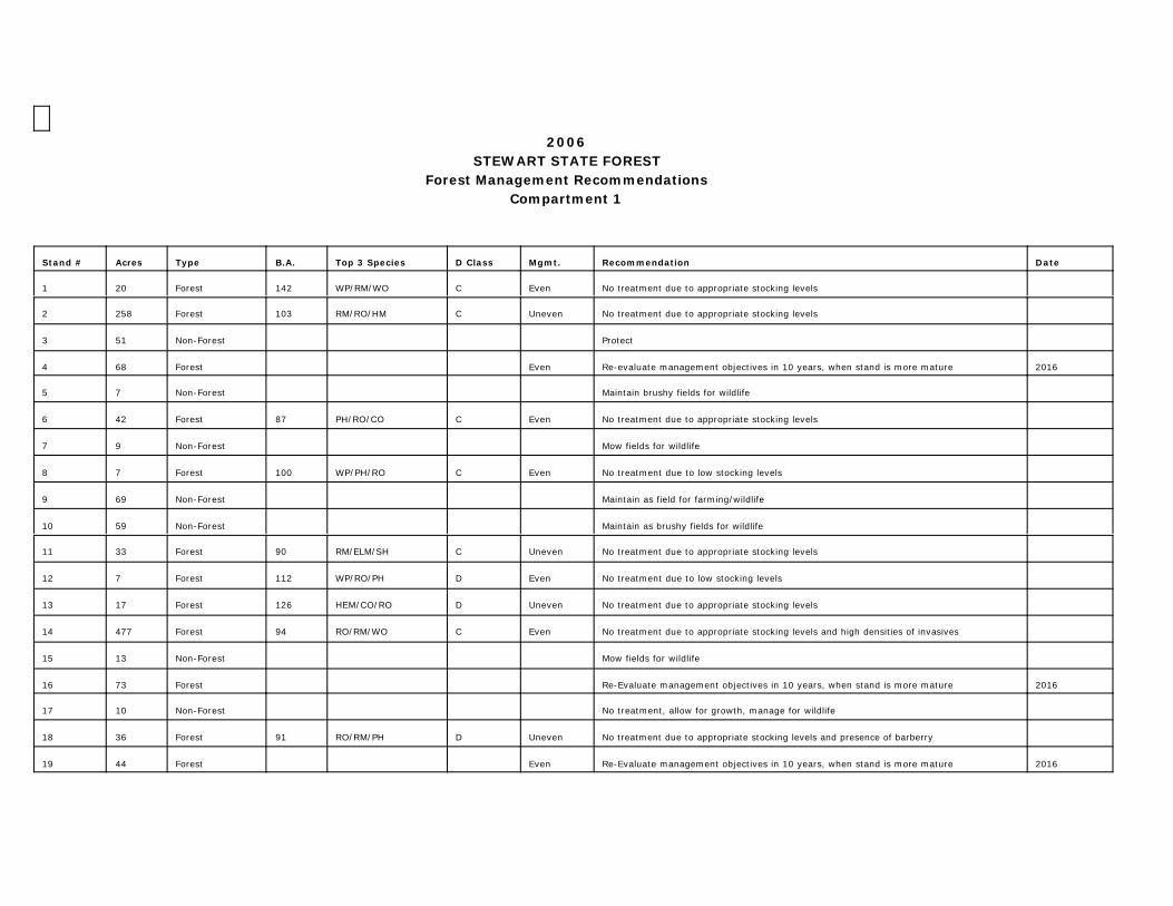
2006STEWART STATE FOREST
Forest Management RecommendationsCompartment 1
Stand # Acres Type B.A. Top 3 Species D Class Mgmt. Recommendation Date
1 20 Forest 142 WP/RM/WO C Even No treatment due to appropriate stocking levels
2 258 Forest 103 RM/RO/HM C Uneven No treatment due to appropriate stocking levels
3 51 Non-Forest Protect
4 68 Forest Even Re-evaluate management objectives in 10 years, when stand is more mature 2016
5 7 Non-Forest Maintain brushy fields for wildlife
6 42 Forest 87 PH/RO/CO C Even No treatment due to appropriate stocking levels
7 9 Non-Forest Mow fields for wildlife
8 7 Forest 100 WP/PH/RO C Even No treatment due to low stocking levels
9 69 Non-Forest Maintain as field for farming/wildlife
10 59 Non-Forest Maintain as brushy fields for wildlife
11 33 Forest 90 RM/ELM/SH C Uneven No treatment due to appropriate stocking levels
12 7 Forest 112 WP/RO/PH D Even No treatment due to low stocking levels
13 17 Forest 126 HEM/CO/RO D Uneven No treatment due to appropriate stocking levels
14 477 Forest 94 RO/RM/WO C Even No treatment due to appropriate stocking levels and high densities of invasives
15 13 Non-Forest Mow fields for wildlife
16 73 Forest Re-Evaluate management objectives in 10 years, when stand is more mature 2016
17 10 Non-Forest No treatment, allow for growth, manage for wildlife
18 36 Forest 91 RO/RM/PH D Uneven No treatment due to appropriate stocking levels and presence of barberry
19 44 Forest Even Re-Evaluate management objectives in 10 years, when stand is more mature 2016

20 18 Forest 84 RM/ELM/SWO C Uneven No treatment due to appropriate stocking levels
21 128 Non-Forest Mow fields for wildlife
22 182 Forest 121 RM/ELM/SWO C Uneven No treatment due to appropriate stocking levels and very poor drainage
23 24 Non-Forest Protect
24 25 Forest 99 RM/ELM/WA D Uneven No treatment due to appropriate stocking levels and high densities of invasives
25 17 Non-Forest Protect
26 14 Forest Even Re-Evaluate management objectives in 10 years, when stand is more mature 2016
27 444 Forest Even Re-Evaluate management objectives in 10 years, when stand is more mature 2016
28 11 Non-Forest Maintain as field for farming/wildlife
29 82 Non-Forest Manage for wildlife
30 280 Non-Forest Manage for wildlife
31 88 Forest 99 RM/HM/BC C Uneven No treatment due to appropriate stocking levels and high densities of invasives
32 81 Forest 102 RM/HM/WO D Uneven No treatment due to appropriate stocking levels
33 107 Non-Forest Mow fields for wildlife
34 27 Forest 138 RM/YP/RO C Uneven Thinning - Selection Cut - bring stand down to a B.A. of 75 2009
35 19 Non-Forest Mow fields for wildlife
36 112 Non-Forest Protect
37 51 Forest 115 RM/WA/ELM C Uneven No treatment due to appropriate stocking levels
38 147 Forest Even Re-evaluate management objectives in 10 years, when stand is more mature 2016
39 14 Non-Forest Manage for wildlife
40 56 Forest 89 RM/HM/PO C Uneven No treatment due to appropriate stocking levels
41 45 Non-Forest Manage for wildlife
42 11 Forest 106 PH/HM/RO C Uneven Thinning - Selection Cut - bring stand down to a B.A. of 75 2009
43 73 Forest 86 RM/YP/HM C Uneven No treatment due to appropriate stocking levels and high densities of invasives
44 47 Forest Even Re-evaluate management objectives in 10 years, when stand is more mature 2016
45 17 Non-Forest Manage for wildlife

46 32 Forest 93 HM/BC/RO D Uneven No treatment due to appropriate stocking levels and presence of invasives
47 27 Forest 96 PO/RM/BC D Uneven No treatment due to appropriate stocking levels and high densities of invasives
48 48 Non-Forest Manage for wildlife
49 14 Forest Even Re-evaluate management objectives in 10 years, when stand is more mature 2016
50 40 Forest Even Re-evaluate management objectives in 10 years, when stand is more mature 2016
51 22 Non-Forest Manage for wildlife
52 64 Non-Forest Manage for wildlife
53 75 Forest 131 RM/ELM/WA C Uneven B.A. is very high, but no thinning recommended in wetland
54 10 Non-Forest Manage for wildlife
55 128 Forest Even Re-evaluate management objectives in 10 years, when stand is more mature 2016
56 30 Forest 112 RM/HM/PO C Uneven Thinning - Selection Cut - bring stand down to a B.A. of 65 2009
57 18 Forest Re-evaluate management objectives in 10 years, when stand is more mature 2016
58 26 Non-Forest Manage for wildlife
59 11 Non-Forest Manage for wildlife
60 100 Non-Forest Manage for wildlife
61 59 Forest 91 RO/PO/RM C Even No treatment due to appropriate stocking levels
62 26 Non-Forest Manage for wildlife
63 11 Non-Forest Manage for wildlife
64 44 Non-Forest Manage for wildlife
65 40 Non-Forest Manage for wildlife
66 22 Forest Even Re-evaluate management objectives in 10 years, when stand is more mature 2016
67 13 Non-Forest Manage for wildlife
68 88 Forest Even Wetland/swamp woods. Harvesting limited/selective due to constraints. Re-evaluate management objectives in 10 years, when stand is more mature.
2016
69 14 Non-Forest Manage for wildlife
70 13 Forest Even Re-evaluate management objectives in 10 years, when stand is more mature 2016

71 13 Forest 103 RM/BC/PO C Uneven No treatment due to appropriate stocking levels
72 42 Non-Forest Manage for wildlife
73 192 Non-Forest Manage for wildlife
74 19 Forest Even Re-evaluate management objectives in 10 years, when stand is more mature 2016
75 41 Forest 99 PO/RM/BC C Uneven No treatment due to appropriate stocking levels
76 56 Forest 115 RO/HM/PH D Uneven Thinning - Selection Cut - bring stand down to a B.A. of 65 2009
77 41 Non-Forest Manage for wildlife
78 45 Forest Even Re-evaluate management objectives in 10 years, when stand is more mature 2016
79 38 Forest 99 PO/BC/HM C Uneven No treatment due to appropriate stocking levels
80 27 Non-Forest Other
81 78 Non-Forest Manage for wildlife
82 51 Forest Even Re-evaluate management objectives in 10 years, when stand is more mature 2016
83 22 Non-Forest Manage for wildlife
84 27 Non-Forest Mow fields and manage for wildlife
85 86 Forest 135 RM/WA/BA C Uneven Swamp - too wet to harvest
86 11 Non-Forest Wetland and open water. Manage for wildlife
87 48 Forest 91 PO/BC/RM D Uneven No treatment due to appropriate stocking levels and high densities of invasives
88 19 Forest 110 RM/ELM/WA C Uneven Thinning - Selection Cut - bring stand down to a B.A. of 65 2009
89 10 Forest Even Re-evaluate management objectives in 10 years, when stand is more mature 2016
90 54 Forest 94 RO/RM/SM C Uneven Re-evaluate management objectives in 10 years, when stand is more mature 2016
91 30 Forest 80 SM/RM/PO C Uneven Re-evaluate management objectives in 10 years, when stand is more mature 2016
92 13 Forest Even Manage for wildlife (shrubs). Re-evaluate management objectives in 10 years. 2016

2006 STEWART STATE FOREST MANAGEMENT RECOMMENDATIONSCompartment 2
Stand # Acres Type B.A. Top 3 Species D Class Mgmt. Recommendation
1 25 Forest N/A WA, RM, E A Even Seedling and sapling. Re-evaluate management objectives in 10 years whenstand is more mature
2016
2 45 Forest N/A RM, BW, E A Even Grassy fields in first stage of forest establishment.. Re-evaluate managementobjectives in 10 years when stand is more mature
2016
3 59 Non-forest N/A N/A N/A N/A Farm fields or mow fields for wildlife
4 111 Non-forest N/A N/A N/A N/A Mow fields for wildlife
5 5 Forest 160 WA, E, BA A Uneven BA is very high, but no thinning recommended in wetland, Invasives present.
6 9 Forest 77 RM, SM, WO B Uneven Re-evaluate management objectives in 10 years. No treatment. Highly variablearea. Invasives present
2016
7 9 Forest 60 BL, BW, BHick A Uneven Re-evaluate management objectives in 10 years when stand is more mature andinvasive species diminish
2016
8 30 Forest 92 RM, E, WA, C Uneven No treatment due to appropriate stocking levels and the presence of invasivesand wet soils
9 30 Forest 56 PO, RM, E C Uneven Re-evaluate management objectives in 10 years when stand is more mature. High density of invasives.
2016
10 39 Forest 78 RM, PO, SWO D Uneven No treatment due to appropriate stocking levels and high densities of invasives
11 56 Forest 96 SM, B, WA C Uneven No treatment due to appropriate stocking levels and invasives present on 50%of plots
12 8 Forest 92 PO, RM, Hick C Uneven No treatment due to appropriate stocking levels and high densities of invasives
13 27 Forest 104 PO, RM, SM C Uneven No treatment due to appropriate stocking levels. Wetter soils.
14 8 Forest 90 PO, RM, WA C Uneven No treatment due to appropriate stocking levels
15 11 Forest 123 RM, PO, E C Uneven B.A. is very high, but thinning is not recommended in the wetland. Invasivespresent on 50% of the stand
16 34 Non-forest N/A N/A N/A N/A Protect
17 59 Forest 69 SM, PHick, BC C Uneven No treatment due to low stocking levels and high densities of invasives. Re-evaluate in 10 years.
2016

18 5 Forest 158 WP, RP, BC D Even Protect, Manage for wildlife
19 17 Forest N/A WA, E, RM A Even Seedling/Sapling. Re-evaluate management objective in 10 yrs when stand ismore mature. Invasives present. Highly variable
2016
20 42 Forest N/A WA, E, RM A Even Seedling/sapling. High variability. Re-evaluate management objectives in 10years. Invasives present
21 8 Forest 90 BL, BW, BC C Uneven No treatment due to appropriate stocking levels and high densities of invasives
22 15 Forest 103 ASP, BL, PHick C Uneven No treatment due to appropriate stocking levels and high densities of invasives
23 25 Forest 37 BL, E, BW N/A N/A Protect. Manage for wildlife (brush, grass, wetland w/few trees)
24 26 Forest 111 SM, PH, WA C Uneven Thinning - selection cut. Bring stand down to BA of 75. Re-evaluate role ofinvasives before cut
2011
25 22 Forest 81 SM, PH, WB B Uneven Re-evaluate management objectives in 10 years when stand is more mature 2016
26 16 Non-Forest N/A N/A N/A N/A Manage for wildlife (brushy wetland and open water)
27 3 Forest N/A WA, E, RM A Even Old field Seedling/sapling. Re-evaluate management objectives in 10 yearswhen stand is more mature
2016
28 10 Forest 116 PHick, E, RO, C Uneven No treatment due to appropriate stocking levels. Re-evaluate in 5 years 2011
29 10 Non-forest N/A N/A N/A N/A Mow fields for wildlife
30 33 Forest 91 RM, WA, SM, C Uneven No treatment due to high densities of invasives and variability. Re-evaluatemanagement objectives in 10 yrs when stand more mature
2016
31 7 Forest 37 PO, RM, shrubs C Uneven Protect, Manage for wildlife
32 14 Forest 123 RM, RO, BO C Uneven No treatment due to high densities of invasives on nearby sites. Re-evaluatemngmt obj in 10 yrs . Selection cut due to proximity of pond
2016
0 6.0 Open Water - - - - - - - - - - - - - - - - - - - - - - - - - - Wahlenburgh Pond, Manage for wildlife/Open water/wetland on perimeter

2006 STEWART STATE FOREST MANAGEMENT RECOMMENDATIONSCompartment 3
Stand # Acres Type B.A. Top 3 Species D Class Mgmt. Recommendation
1 8 Forest 40 RM/PO/SM C Uneven No treatment due to low stocking levels and high densitites of invasives
2 8 Forest 100 PO/BC/WA D Uneven No treatment due to appropriate stocking levels and high densities of invasives
3 5 Forest 98 WA/RM/SWO C Uneven No treatment due to very poor drainage and high densities of invasives
4 76 Forest 54 WA/E/PO B Uneven Seedling/Sapling. No treatment due to low stocking levels and high densities ofinvasives. Highly variable.
5 13 Forest 76 BC/PO/RM B Uneven No treatment due to appropriate stocking levels and high densities of invasiveson periphery.
6 3 Forest 130 PO/RM/SWO C Uneven Management w/selective cut due to proximity of wetland. Re-evaluate in 5 years. 2011
7 128 Non-forest N/A N/A N/A N/A Wetland - Manage for wildlife
8 18 Forest 102 SM/BC/RM D Uneven No treatment due to appropriate stocking levels. Invasives on edge. ControlAilanthus.
9 27 Non-forest N/A N/A N/A Even Old field with invasives. Re-evaluate management objectives in 10 years whenstand is more mature
2016
10 9 Forest N/A N/A N/A Uneven Extremely high density of invasives. No treatment due to low stocking levelsand former farmstead sites.
11 11 Forest 121 PO/RM/WA C Uneven Oak regeneration in some places may suggest even-aged management.. Thinning possible, but re-evaluate due t high levels of peripheral invasives.
2011
12 7 Forest 98 RM/PO/E B Uneven Re-evaluate management objectives in 10 years when stand is more mature. Old orchard with high density of invasives.
2016
13 16 Forest 112 RM/WA/E C Uneven Poor drainage, appropriate levels of stocking
14 7 Forest 100 RM/GBirch/PO B Uneven No treatment due to appropriate stocking levels. Re-evaluate managementobjectives in 10 years when stand is more mature
2016
15 7 Non-forest N/A N/A N/A Even Re-evaluate management objectives in 10 years when stand is more mature 2016
16 10 Forest 121 RM/E/Shrub B Uneven Re-evaluate management objectives in 10 years when stand is more mature,High invasive density and wet soils.
2016
17 8 Forest 75 RC/WA/RM B Uneven Re-evaluate management objectives in 10 years when stand is more mature,High invasive density
2016

18 6 Forest 165 NS/RM/BC C Even Thinning - bring stand down incrementally to a basal area of 80. Re-evaluate in10 years. Wind-throw issues
2009
19 11 Forests 70 ASP/PO/BCr B Uneven No treatment due to low stocking levels and high densitites of invasives. Re-evaluate management objectives in 10 yrs
2016
20 12 Non-forestOpen waterl
N/A N/A N/A N/A Manage for wildlife-open water, shrub and emergent wetland.
21 13 Forest 120 RM/PO/E C Uneven No treatment due to low or appropriate stocking levels and very poor drainage
22 7 Forest 88 RM/BC/PO C Uneven Protect, Access limitations to the peninsula due to stream and nearby wetland.
23 10 Forest 99 WA/E/BC C Uneven No treatment allow for growth, high densities of invasives, high variability
24 - - - - - - - - - - - - - N/A N/A N/A N/A Cancelled
25 24 Forest 110 RM/WA/E C Uneven Wetland woods, very poor drainage and wet soils. Protect, manage for wildlife
26 9 Forest 72 WA/Shr/E B Uneven No treatment due to low stocking levels and high densitites of invasives
27 6 Non-forest N/A N/A N/A Even Field. Re-evaluate management objectives in 10 years 2016
28 39 Forest 73 E/BL/BW C Uneven Re-evaluate management objectives in 10 years when stand is more mature;high densities of invasives
2016
29 7 Forest N/A RO/SM/BL N/A Uneven Highly variable former homestead site with landscaped field/trees. Re-evaluatemanagement objectives in 10 years when stand is more mature; high levels ofinvasives.
2016
30 16 Forest 94 RM/SM/RO B Uneven No treatment due to appropriate stocking levels and high densities of invasives.Control Ailanthus.

Appendix I.


Appendix J.


Appendix K.


Appendix L.
