sterling mountain smugglers’ notch hiking · smugglers’ notch, vt 05464-9537 sterling mountain...
TRANSCRIPT
802-332-6842 • www.smuggs.com
4323 Vermont Route 108 SouthSmugglers’ Notch, VT 05464-9537
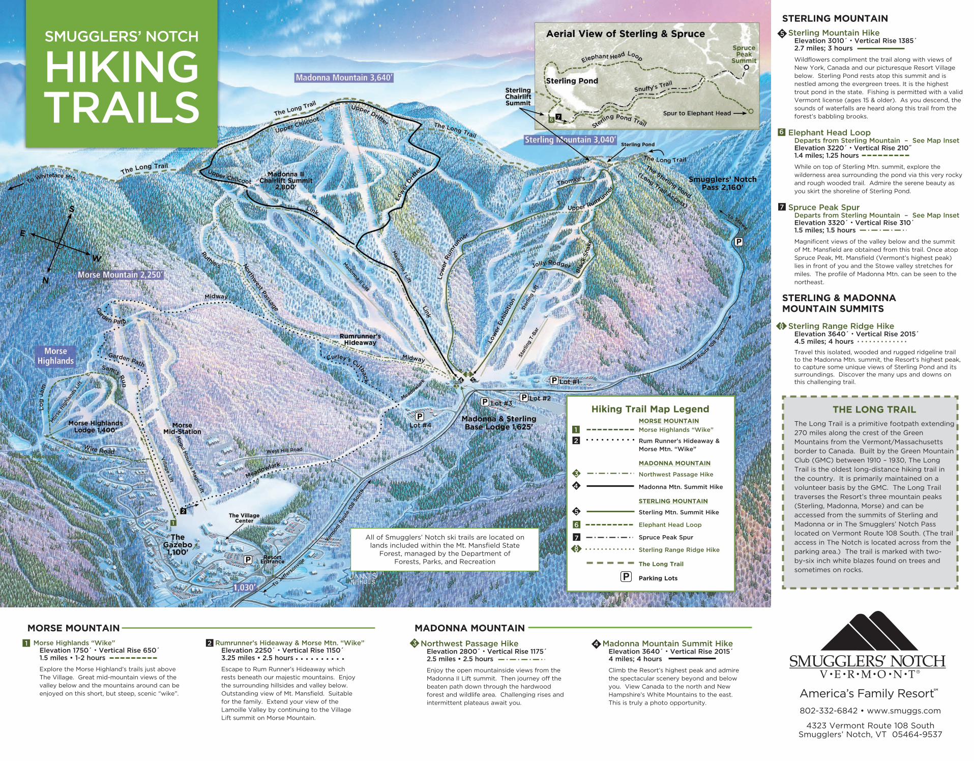
STERLING MOUNTAIN
Sterling Mountain HikeElevation 3010´ • Vertical Rise 1385´2.7 miles; 3 hours
Wildflowers compliment the trail along with views of New York, Canada and our picturesque Resort Village below. Sterling Pond rests atop this summit and is nestled among the evergreen trees. It is the highest trout pond in the state. Fishing is permitted with a valid Vermont license (ages 15 & older). As you descend, the sounds of waterfalls are heard along this trail from the forest’s babbling brooks.
Elephant Head LoopDeparts from Sterling Mountain – See Map InsetElevation 3220´ • Vertical Rise 210˝1.4 miles; 1.25 hours
While on top of Sterling Mtn. summit, explore the wilderness area surrounding the pond via this very rocky and rough wooded trail. Admire the serene beauty as you skirt the shoreline of Sterling Pond.
Spruce Peak SpurDeparts from Sterling Mountain – See Map InsetElevation 3320´ • Vertical Rise 310´1.5 miles; 1.5 hours
Magnificent views of the valley below and the summit of Mt. Mansfield are obtained from this trail. Once atop Spruce Peak, Mt. Mansfield (Vermont’s highest peak) lies in front of you and the Stowe valley stretches for miles. The profile of Madonna Mtn. can be seen to the northeast.
STERLING & MADONNA MOUNTAIN SUMMITS
Sterling Range Ridge HikeElevation 3640´ • Vertical Rise 2015´ 4.5 miles; 4 hours
Travel this isolated, wooded and rugged ridgeline trail to the Madonna Mtn. summit, the Resort’s highest peak, to capture some unique views of Sterling Pond and its surroundings. Discover the many ups and downs on this challenging trail.
THE LONG TRAIL
The Long Trail is a primitive footpath extending
270 miles along the crest of the Green
Mountains from the Vermont/Massachusetts
border to Canada. Built by the Green Mountain
Club (GMC) between 1910 – 1930, The Long
Trail is the oldest long-distance hiking trail in
the country. It is primarily maintained on a
volunteer basis by the GMC. The Long Trail
traverses the Resort’s three mountain peaks
(Sterling, Madonna, Morse) and can be
accessed from the summits of Sterling and
Madonna or in The Smugglers’ Notch Pass
located on Vermont Route 108 South. (The trail
access in The Notch is located across from the
parking area.) The trail is marked with two-
by-six inch white blazes found on trees and
sometimes on rocks.
■6
■7
◆5
◆ ◆8
MORSE MOUNTAIN
Morse Highlands “Wike”
Rum Runner’s Hideaway &Morse Mtn. “Wike”
MADONNA MOUNTAIN
Northwest Passage Hike
Madonna Mtn. Summit Hike
STERLING MOUNTAIN
Sterling Mtn. Summit Hike
Elephant Head Loop
Spruce Peak Spur
Sterling Range Ridge Hike
The Long Trail
Parking Lots
■6
■7
■1■2
◆5
◆4◆3
Hiking Trail Map Legend
◆ ◆8
Morse Highlands “Wike”Elevation 1750´ • Vertical Rise 650´1.5 miles • 1-2 hours
Explore the Morse Highland’s trails just above The Village. Great mid-mountain views of the valley below and the mountains around can be enjoyed on this short, but steep, scenic “wike”.
Rumrunner’s Hideaway & Morse Mtn. “Wike”Elevation 2250´ • Vertical Rise 1150´ 3.25 miles • 2.5 hours
Escape to Rum Runner’s Hideaway which rests beneath our majestic mountains. Enjoy the surrounding hillsides and valley below. Outstanding view of Mt. Mansfield. Suitable for the family. Extend your view of the Lamoille Valley by continuing to the Village Lift summit on Morse Mountain.
MORSE MOUNTAIN
■1 ■2 Northwest Passage Hike Elevation 2800´ • Vertical Rise 1175´2.5 miles • 2.5 hours
Enjoy the open mountainside views from the Madonna II Lift summit. Then journey off the beaten path down through the hardwood forest and wildlife area. Challenging rises and intermittent plateaus await you.
Madonna Mountain Summit HikeElevation 3640´ • Vertical Rise 2015´4 miles; 4 hours
Climb the Resort’s highest peak and admire the spectacular scenery beyond and below you. View Canada to the north and New Hampshire’s White Mountains to the east. This is truly a photo opportunity.
MADONNA MOUNTAIN
◆3 ◆4
All of Smugglers’ Notch ski trails are located on lands included within the Mt. Mansfi eld State
Forest, managed by the Department of Forests, Parks, and Recreation
SMUGGLERS’ NOTCH
HIKING TRAILS

ATTENTION – Bear Habitat
• The survival of the Black Bear depends on their use of remote
areas free from human intrusion.
• Please do not use MEADOWLARK TRAIL on Morse Mtn. from
May 1st – June 15th and from Labor Day – November 1st .
• Use of Meadowlark Trail is discouraged on all Fridays and
Sundays as this area crosses a wildlife travel
corridor.
Cooperation with this conservation
effort is greatly appreciated!
BLACK BEARursus americanus
The mountains
around Smugglers’
Notch are home
to many different
species of plants and animals. One
of the most interesting animals that
makes this area its home is the Black
Bear. Although bears commonly
have the reputation of being fierce,
the Black Bear is a shy and elusive
animal. Black Bears are very
frightened by any human presence, and most often will run away
if they encounter people. If you notice any wildlife along the trails,
please be respectful of their “wildness” and maintain your distance.
Remember that we are visitors in their home.
Vermont Bears:• Are omnivores, feed mostly on plants, but they also feed on meat.
• Are among the smallest of all the world’s bear species, but one
of Vermont’s largest mammals. An average adult bear weighs
150 – 300 lbs. and is 4’-5’ long.
• Are very agile creatures even though they may seem clumsy.
They can swim, run swiftly and are excellent tree climbers.
• Have an excellent sense of smell and hearing, but have poor
eyesight.
• Are a game animal in many states, including Vermont.
To learn more about the Black Bear and their habitat visit our “Follow the Bear” cross-country nature trail.
HIKER’S RESPONSIBILITY CODE “LEAVE NO TRACE”
You can help preserve Vermont’s “footpath in the wilderness” as you enjoy it by leaving no trace of your visit. While you hike, please follow a few guidelines to ensure the trail and the backcountry experience will be there for others to enjoy. Please leave no trace of your passing. – Courtesy of the Green Mountain Club.
Stay on the trails… respect private and state forest land.
Pack it in, pack it out… keep the environment clean.
Take only pictures… leave only footprints.
Enjoy the wildflowers… please do not pick them. Many are protected by state law.
Leave pets at home… they are likely to encounter their own trail problems.
Fires are not permitted… on state lands at higher elevations.
Walking, Hiking & Biking Trail Map
AAAAAAAAAAAA
AAAAAAAAAAA
AAAAAAAAAAA
AAAAAAAAAA
AAAAAAAAA
AAA
AAAA
BBBBBBBBBBBBBBBBB
BBBBBB
BBBBB
BBBBBBB
BBBBBBBBBB
BBBBBBB
BBBBBBBBB
BBBB
BBBBB
BBBBBBBBBBBBB
CCCCCC CCCCCC
CCCC
CCCCCC
CCCCCCCCCCCCCC
CCCC
CCCC
DDDDDDDDDDDD
DDDDDDDDDDD
DDDDDD
DDDDDDDDDDD
DDDDDDDDDDDDDDDD
DDDDDD
D
BBBBBBB
General Hiking Information
Smugglers’ Notch Resort Environmental Policy
Smugglers’ policy of environmental stewardship pervades all our activities. We seek to raise the environmental awareness of guests and employees and to broaden their knowledge and appreciation through educational programs along with our active and passive use of the land for year round recreation.
Smugglers’ Notch Resort Management and Employees are committed to being responsible stewards of Vermont’s natural resources. Vermont’s intrinsic beauty and healthfulness are integral to our business. We live here, and working to maintain it comes naturally.
Hiking Safety• Never hike alone. Leave your hiking plans with a friend.
• Familiarize yourself with the route. Stay on the designated trails.
• Always check a local weather forecast before departing.
• Stretch before and after you hike to prevent injury.
• Zigzag the trail when ascending and descending steep terrain to
avoid excessive muscle strain.
• Only drink water which you have brought with you.
• Please keep off the chairlifts.
Gear List• Hiking Boots • Back Pack • Water (1-2 qts.) • Food
• Layered Clothing • Rain/Wind Jacket • First Aid Kit
• Bug Repellent • Sunscreen
Wildlife Viewing• Wildlife is most active in the early morning or early evening.
• Wildlife scares easily around loud noises.
• Stand behind the trees to observe.
• Stop, look and listen often. Be patient while animals enter
and leave an area.
• Keep your distance. Feeding or chasing wildlife is unsafe.
• Leave your pets at home. They may startle, chase or even
kill wildlife.
Trail KeyHiking distances and times are round trip. Hiking times are
estimates and may vary with personal fitness. Elevation and
vertical rise are given in feet to help determine the difficulty of
the hike.
Walk: A 1-2 hour walk involving mild to moderate exercise.
“Wike”: A little longer in duration, up to 3 hours, and moderate to
demanding exercise.
Hike: The most physically demanding and time consuming.
4-6 hours is the typical hike duration. Caution and evaluation of personal fitness is urged.
Vertical Rise is the difference between the highest and
lowest points of land. Hiking a vertical rise of 10´ is equivalent to
walking up one flight of stairs. Therefore, a vertical rise of 650´
is equivalent to walking up 65 flights of stairs.
Skate ParkPump Track
WALKING TRAILS● Easiest
■ More Difficult
◆ Most Difficult
◆ ◆ Experts Only
MOUNTAIN BIKE TRAILS
Easiest Double Track
More Difficult Double Track
Pump Track
Disc Golf Course
Disc Golf Pro Shop
Our cross-country nature trails area is located behind the Tennis Center and extends around The Village to the Morse Highlands area. There are 28 kilometers/17 miles of trails used for cross-country skiing and snowshoeing in the Winter and for walking in the Spring, Summer, and Fall. This trail system provides an excellent area to view many wildlife habitats. Some trails have information posts along their routes with topics relating directly to the surrounding area. The terrain varies and the elevation climbs gently, but steadily from the No Name Brook. Supportive footwear is strongly recommended in this area.
Forest Loop Walk
Elevation 1,300´ • Vertical Rise 225´ 1.5 miles • 45 minutes Stroll along the shaded banks of the No Name Brook. Follow it upstream to the Village Reservoir and enjoy its peaceful surroundings. An abundance of wildflowers and berries line the trail. Discover the numerous insects and amphibians that live in and around the brook and reservoir. Suitable for the family.
Country Road Woody’s Way WalkElevation 1,200´ • Vertical Rise 125´1.75 miles • 1.5 hoursSample the nature trails by walking this perimeter loop over rolling terrain through the hardwood forest and open meadows. You will cross many small streams and have the opportunity to explore this bird lover’s paradise and wildlife habitat.
Follow The Bear “Wike”Elevation 1,520´ • Vertical Rise 445´ 2 miles • 1 hourTravel up through this hardwood forest and look for signs of wildlife. The upper loop is a little more remote, but really just a short distance from The Village. There are information posts about the Vermont Black Bear, their habitat, and our surroundings.
Wire Road Watson’s Wanderer “Wike”Elevation 1,775´ • Vertical Rise 675´ 3.5 miles • 1.5 hoursWander your way up to the highest point of the cross-country nature area on this scenic old logging road by traversing part of Morse Mountain. Lush foliage outlines the road as you walk through the forest. A little more isolated, this is surely one to check out as wildlife abounds. Note the elevation, vertical rise, and length of time.
A
BB
C
D
SUGGESTED NATURE TRAIL LOOPS
SMUGGLERS’ NOTCH WALKING AND BIKING TRAILS
You can help preserve Vermont’s “footpath in the wilderness” as you enjoy it by leaving no trace of your visit.
Download the Smuggs app for hiking, biking and walking maps accessible right at your fi ngertips
on your iPhone or Android with GPS functionality.
smuggs.com/app
6/2014