status quo, swot analysis & evaluation methodology 7...the status quo includes a swot analysis,...
TRANSCRIPT
4/8/2011
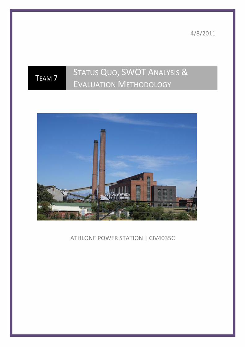
ATHLONE POWER STATION | CIV4035C
TEAM 7 STATUS QUO, SWOT ANALYSIS &
EVALUATION METHODOLOGY

i
TEAM LIST
GROUP 7
Christopher Georgiades Justin Watts
Daniel Coulson Murday Chellembron
Jonathan Briner Rhett Edwards
Deney van Rooyen Erin Fick
Marc Callanan Jarryd Buratovich
James Murray Karl Bester
Rowan Anderson Asif Khan
James Payaneeandee
ii
CONTENTS
Team List i
Contents
1. Introduction 1
2. Overview of Site Aspects and SWOT Analyses
2.1 Site Locality 2
2.2 Title Deed Information 3
2.3 Transport and Access 4
2.4 Area Analysis drawings 6
2.5 Geotechnical Report 7
2.6 Sub-Surface Environmental Contamination Assessment 9
2.7 Environmental Aspects 10
2.8 Existing Services Layout 12
2.9 Existing Electrical Cables and Electrical Servitude Drawing 13
2.10 Existing Buildings 14
2.11 Structural Integrity Report 16
2.12 Health and Safety Audit Report 18
2.13 Property Value Commentary 21
2.14 Wards and Sub-Councils 22
3. Evaluation Methodology 25
1
1 Introduction
This document serves as a preliminary study for the redevelopment of the Athlone Power Station
site. The site has been zoned for mixed-land use by the Cape Town Spatial Development
Framework.
The coal-fired power station was decommissioned in 2003 after it became economically unviable.
The total site area is approximately 36 hectares and is situated adjacent to the Pinelands, Langa and
Athlone neighbourhoods.
This document begins with a status quo on the following topics:
Site Locality
Title Deed Information
Transport and Access
Area Analysis drawings
Geotechnical Report
Sub-Surface Environmental Contamination Assessment
Environmental Aspects
Existing Services Layout
Existing Electrical Cables and Electrical Servitude Drawing
Existing Buildings
Structural Integrity Report
Health and Safety Audit Report
Property Value Commentary
Wards and Sub-Councils
The status quo includes a SWOT analysis, which identifies the strengths, weaknesses, opportunities
and threats for each topic.
The document concludes with a description of the evaluation methodology. This section describes
how a Multi Criteria Decision Analysis (MCDA) will be used to evaluate the proposed developments.
2
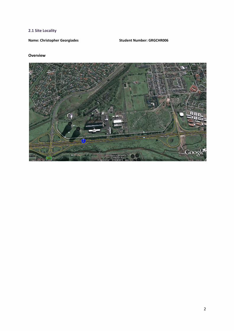
2.1 Site Locality
Name: Christopher Georgiades Student Number: GRGCHR006
Overview
3
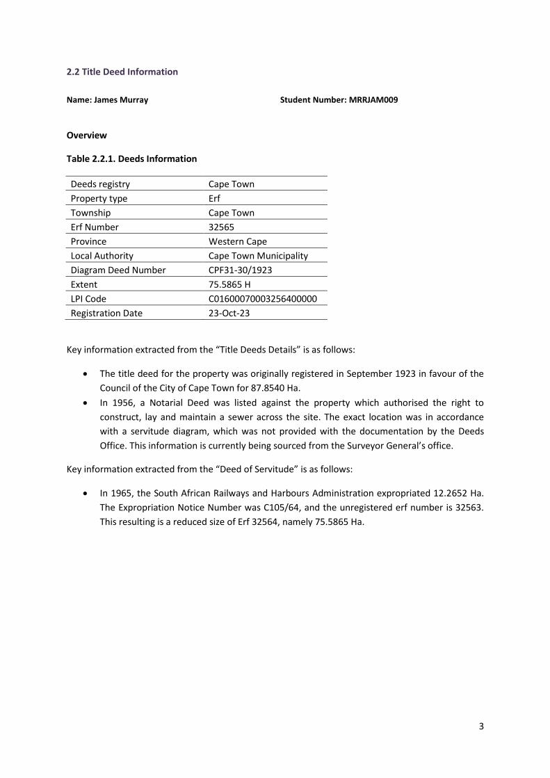
2.2 Title Deed Information
Name: James Murray Student Number: MRRJAM009
Overview
Table 2.2.1. Deeds Information
Deeds registry Cape Town
Property type Erf
Township Cape Town
Erf Number 32565
Province Western Cape
Local Authority Cape Town Municipality
Diagram Deed Number CPF31-30/1923
Extent 75.5865 H
LPI Code C01600070003256400000
Registration Date 23-Oct-23
Key information extracted from the “Title Deeds Details” is as follows:
The title deed for the property was originally registered in September 1923 in favour of the
Council of the City of Cape Town for 87.8540 Ha.
In 1956, a Notarial Deed was listed against the property which authorised the right to
construct, lay and maintain a sewer across the site. The exact location was in accordance
with a servitude diagram, which was not provided with the documentation by the Deeds
Office. This information is currently being sourced from the Surveyor General’s office.
Key information extracted from the “Deed of Servitude” is as follows:
In 1965, the South African Railways and Harbours Administration expropriated 12.2652 Ha.
The Expropriation Notice Number was C105/64, and the unregistered erf number is 32563.
This resulting is a reduced size of Erf 32564, namely 75.5865 Ha.
4
2.3 Transport and Access
Name: Jonathan Briner Student Number: BRNJON017
Overview
INTRODUCTION:
The site is not well located with respect to public access and therefore does not lend itself to
commercial development.
The site can be made easily accessible by rail due to the proximity of the primary rail
network.
The city can subsidise the development via the national Government’s Neighbourhood
Development Grant. This grant is intended to stimulate and encourage the mixing of
neighbourhoods and social classes.
In summary, this is a great opportunity to showcase the ability of the City of Cape Town to
create a mixed land use development where public space is integrated into a functioning
utility complex, a fully fledged transport modal transfer point, and learning & recreational
centre.
SURROUNDING TRANSPORT ROUTES:
Roadways:
The site is bounded by the Settlers Way (N2), Jan Smuts Drive (M17), and Bhunga Avenue
Railways:
The site has a major railway passing on the northern edge of the site, where a internal
railway has been set up that has access into the middle of the site to transfer solid waste
from the transfer station.
ACCESS WEAKNESSES:
The current solid waste transfer station is vital to the waste removal operations of the city,
and would be very costly to move elsewhere. So, assuming that the transfer station is not
moved, access options are restricted
The railways offer a large obstacle in gaining access from the northern side of the site
Bhunga Avenue theoretically have adequate road reserve but there have been encroaching
informal dwellings
ACCESS THREATS:
Jan Smuts operates at absolute capacity during peak hours (22ooveh/h)
Inter-neighbourhood links mean that there will be direct access links between Pinelands,
Athlone, and Langa – which will be stongly resisted by Pinelands residents
N’Dabeni Road could be extended through the sports fields, but this will surely be met with
much public resistance

5
SWOT Analysis
STRENGTHS WEAKNESSES
Located near major transport routes There is insufficient space and physical obstacles that make it difficult to gain access to the site
OPPORTUNITIES THREATS
The surrounding neighbourhoods can be linked together, thus abolishing the inter-neighbourhood boundaries set up in Aparteid
Pinelands residents will meet the inter-neighbourhood links with much resistance
6
2.4 Area Analysis drawings
Name: Deney van Rooyen Student Number: VRYDEN001
Overview
Aerial photographs of Athlone Power Station visually present a number of important site
characteristics:
- Base Aerial Photo shows the site before the destruction of the cooling towers.
- Main Traffic Routes are highlighted to show the site in relation to the main roads
surrounding the site. This shows that the site is bordered by the N2 and Jan Smuts Drive.
- Generators and movement generators are pointed out at their various locations.
- Public Areas and shared public areas are depicted. This gives an idea of the types of
developments that surround the site, thereby directing the redevelopment of the site
toward something that will not negatively affect the public, and can integrate with existing
public facilities.
- The Non-Motorized Transport Network in the surrounding area is shown, including primary
and secondary routes, as well as major and minor nodes. The railway line and BRT route is
shown in relation to the site.
SWOT Analysis
STRENGTHS WEAKNESSES
The site is in a prime location, between highly used transport routes and suburbs
The railway and highway adjacent to the site restrict direct access to the site from these networks
The nearby location of both Athlone and Langa may provide a workforce for activities on site
The only non-motorized transport with access to the site is the railway
The site is a large, flat area with scope for a range of developments
The site is far from taxi ranks, which means further restricted accessibility
BRT Route does not assist access to the site
OPPORTUNITIES THREATS
The nearby wastewater treatment plant implies that this location is ideal for an industrial zone
The city’s planning may not allow for the development of an industrial zone in this area
With minimal exceptions, public areas are far from the site, opening up opportunities for developments of this nature
The nearby location of Athlone, Langa and Pinelands restricts the type of development that may be allowed
A proposed taxi rank near the site could be beneficial
The nearness of the wastewater treatment plant may restrict the type of development that is feasible
The size and location of the site present many opportunities for various developments
7
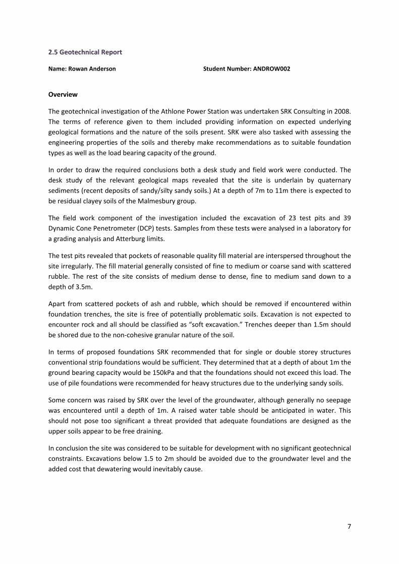
2.5 Geotechnical Report
Name: Rowan Anderson Student Number: ANDROW002
Overview
The geotechnical investigation of the Athlone Power Station was undertaken SRK Consulting in 2008.
The terms of reference given to them included providing information on expected underlying
geological formations and the nature of the soils present. SRK were also tasked with assessing the
engineering properties of the soils and thereby make recommendations as to suitable foundation
types as well as the load bearing capacity of the ground.
In order to draw the required conclusions both a desk study and field work were conducted. The
desk study of the relevant geological maps revealed that the site is underlain by quaternary
sediments (recent deposits of sandy/silty sandy soils.) At a depth of 7m to 11m there is expected to
be residual clayey soils of the Malmesbury group.
The field work component of the investigation included the excavation of 23 test pits and 39
Dynamic Cone Penetrometer (DCP) tests. Samples from these tests were analysed in a laboratory for
a grading analysis and Atterburg limits.
The test pits revealed that pockets of reasonable quality fill material are interspersed throughout the
site irregularly. The fill material generally consisted of fine to medium or coarse sand with scattered
rubble. The rest of the site consists of medium dense to dense, fine to medium sand down to a
depth of 3.5m.
Apart from scattered pockets of ash and rubble, which should be removed if encountered within
foundation trenches, the site is free of potentially problematic soils. Excavation is not expected to
encounter rock and all should be classified as “soft excavation.” Trenches deeper than 1.5m should
be shored due to the non-cohesive granular nature of the soil.
In terms of proposed foundations SRK recommended that for single or double storey structures
conventional strip foundations would be sufficient. They determined that at a depth of about 1m the
ground bearing capacity would be 150kPa and that the foundations should not exceed this load. The
use of pile foundations were recommended for heavy structures due to the underlying sandy soils.
Some concern was raised by SRK over the level of the groundwater, although generally no seepage
was encountered until a depth of 1m. A raised water table should be anticipated in water. This
should not pose too significant a threat provided that adequate foundations are designed as the
upper soils appear to be free draining.
In conclusion the site was considered to be suitable for development with no significant geotechnical
constraints. Excavations below 1.5 to 2m should be avoided due to the groundwater level and the
added cost that dewatering would inevitably cause.
8
SWOT Analysis
STRENGTHS WEAKNESSES
Only “soft” excavation
Perched water table
Near-surface soils suitable for construction materials
Trenches deeper than 1 -1.5m will require shoring
OPPORTUNITIES THREATS
Suitable for development with no major constraints
Escalated costs might be incurred due to dewatering for excavations
9
2.6 Sub-Surface Environmental Contamination Assessment
Name: Justin Watts Student Number:WTTJUS002
Overview
To the west of the coal storage building there was a semi-formal waste dumping site. Waste was
dumped and stored here but has been removed recently. This waste site was underlain with a
concrete slab which prevented any subsurface contamination. Scrap metal and other waste was
found around this area, and just south of the semi-formal dumping site asbestos containing materials
were found in one of the test pist- ASTP 12. Dumping also took place in the forest area which is north
of the coal storage unit and two other informal dumping areas were found around the cooling
towers.
Coal chips were found in the top 10-20cm of the ground in the coal storage areas. A formation of
yellow sulphate minerals were found in nearly all of the trial pits which were excavated. This is due to
the leaching of the upper coal layer.
On the east side of the site a railway siding was found to be about 1m below the surface of the
ground which was wet and marshy.
Large scale waste ash was dumped over a wide proportion of the site. This ash like material was
found in most of the trial pits around the site. A large amount of this material was found in the forest
area of the site.
SWOT Analysis
STRENGTHS WEAKNESSES
Levels of contamination were low Coal chips will need to be removed
Asbestos and metal materials will need to be found and removed
OPPORTUNITIES THREATS
Sub surface ash could be used in construction industry
Asbestos contamination
Scrap metal could be sold or used by the poorer surrounding areas
Petroleum contamination

10
2.7 Environmental Aspects
Name: Erin Fick Student Number: FCKERI001
Overview
The information used in this section of the status quo was obtained from the Athlone Power Station
Site Redevelopment Pre-feasibility Study: Background Information on Environmental Aspects,
produced by SRK Consulting Engineers and Scientists. The environmental aspects considered,
include: climate, air quality, noise, flora and fauna, as well as cultural/heritage aspects.
Climate: The climate is typical of the Western Cape winter rainfall region. The north-westerly wind
dominates in the winter, whilst the south-easterly winds dominate in the summer. It is anticipated
that the redeveloped Athlone Power Station site will experience wind speeds of up to 60km/h.
These winds are likely to occur on a frequent basis, specifically in the summer months.
Air Quality: An air quality monitoring site is located at the Athlone wastewater treatment works
(WWTW), approximately 700m to the south of the Athlone Power Station site. An exceedance of
NO2 and O3 has been measured at this monitoring station. This was most likely caused by vehicular
exhausts. The major sources of air pollution include: the surrounding road network, the Athlone
WWTW, the onsite stand-by gas turbine power plant, the onsite Langa sewage pump station and the
onsite Athlone transfer station. The prevailing winds on the site are likely to disperse airborne
pollutants and odours.
Asbestos containing material is known to be present on the site. Respirable asbestos fibres are likely
to be present on site and could be hazardous to on-site personnel during construction and
decommissioning.
Flora and Fauna: Any patches of endangered vegetation that may remain on the site will be heavily
disturbed and will contain very little conservation significance. The rest of the site is mostly limited
to alien species. A strip of mature exotic trees are present on the site (serving as a visual screen for
the residential suburb of Pinelands). No fauna species of conservation significance are expected on
the site. There has been some evidence of a pair of Rock kestrels, Falco (tinnunculus) rupicolus,
nests in the power station.
Cultural and Heritage resources: Since this is a brownfield site and its distance from the sea, it is
unlikely that it contains any archaeological artefacts. The cultural significance of the site is related to
the industrial heritage and history of the cooling towers, power station building and stacks, which
has been a Cape Town landmark since the 1960’s.
The south-eastern portion is used by the Xhosa people for initiation rituals; it is therefore associated
with living or intangible heritage resources.
Environmental Authorisation Requirements: It must be noted that these are the most significant
requirements, but that other legislation and policies should also be considered.
National Environmental Management Act (NEMA): Authorisation is required in terms of Section
24(1) of NEMA and related Environmental Impact Assessment (EIA) Regulations. As the site is larger
11
than 20 hectares, it is likely that a full Scoping and EIA process be required. This will need to be
undertaken by an independent environmental assessment practitioner. Specialist studies might be
required for: Air quality and health; noise; hydrology and contamination, traffic, heritage, and socio-
economic impacts.
National Heritage Resource Act: The Act states that if a development is undertaken on a site
exceeding 5000m2, which will change the character of the site, a Heritage Impact Assessment (HIA)
must be undertaken. The HIA can be done as part of the EIA.
It could take between 10-18 months for the environmental authorisation. It is estimated that the
process could cost between R600 000 and R1 000 000 (including professional fees, specialist studies
and other expenses).
It can be concluded that there are no major environmental constraints to the redevelopment of the
Athlone Power Station site.
SWOT Analysis
STRENGTHS WEAKNESSES
There are no major environmental constraints to the redevelopment
Odour and wind-blown litter from other on-site activities
South-east portion of site cannot be developed (used for initiations by Xhosa people)
OPPORTUNITIES THREATS
Developers can improve the flood prone areas of the site
Air pollution from the surrounding transport network
Preservation of heritage and making it accessible to the public
Noise level onsite might detract potential residents
Could find archaeological material (but unlikely) Redevelopment is potentially constrained by industrial heritage of the site
12
2.8 Existing Services Layout
Name: Jonathan Briner Student Number: BRNJON017
SERVICES:
Storm Water:
The only storm water pipe shown runs from next to the power station building underneath
the N2 to the other side.
Water Reticulation:
A 225 mm diameter bulk water reticulation pipeline runs directly through the middle of the
site from East to West. This pipeline runs just north the transfer station and power station
buildings.
Foul Sewer:
There are many sewer pipes running from the NE, and SSE towards the sewer pump station
which lies on the Western side of the site.
Foul Sewer Rising Main :
All the sewage collects at the pump station and is pumped in a SSE direction, underneath the
highway to the other side where the Athlone Waste Water Treatment Plant.
And so in summary,
SWOT Analysis
STRENGTHS WEAKNESSES
Existing services could reduce the cost of the development if the services do not need to be upgraded or moved – but this is highly unlikey
The site will be faced with many obstacles in the form of existing services
OPPORTUNITIES THREATS
Services can be given the opportunity to be upgraded if necessary
The threats of moving or removing the existing services pose a threat to the people that rely on them, and the development project will encounter much resistance if these services are disconnected
13
2.9 Existing Electrical Cables and Electrical Servitude Drawing
Name: Justin Watts Student Number:WTTJUS002
Overview
There are two high voltage distribution substations on the site. The 66kV substation is situated in the
power station building and the 132kV substation is situated on the eastern side of the site.
The high voltage electrical circuit on site consists of either over head lines or underground cables.
Most of the cables on site are underground and take up less space than the overhead lines. These
cables are centrally located on site and branch out in all directions. There are still vast areas that do
not include electric cables on the site. The electricity cables on site consist of overhead power
cables and sub surface power cables.
The electrical servitude drawing consists of blue and pink shading. The blue shading represents
unregistered servitude routes in which electrical cables lie and the pink shading represents registered
servitudes where cables or overhead lines exist. These servitudes are central on the site and branch
out in all directions.
SWOT Analysis
STRENGTHS WEAKNESSES
Existing power cable circuit on site in good condition
Power cables are found all over the site
Construction will be tough unless power cables are removed
Expensive to remove power cables
OPPORTUNITIES THREATS
New power plant could be put in place Destroying power cables during construction
Sale or re-use if existing power cables Damage of power cables during removal
14
2.10 Existing Buildings
Name: Erin Fick Student Number: FCKERI001
Overview
The information used in this section of the status quo was obtained from the Existing Building
Analysis, conducted by Urban Studio.
Turbine Hall: Building 1 consists of 5 parts; Turbine House, Pumping Bay, Boiler House, Distribution
Area and Chimney 1&2. The building is currently not in use and is unoccupied. There has not been
much upkeep of the existing structure and degradation is evident – especially along heavily used
areas, such as metal staircases and catwalks. The building has been stripped of all asbestos. The
building is largely intact, but requires external concrete work and brickwork, especially around the
roof. As the building is older than 60 years and is an unique example of South Africa’s 1960’s
Industrial architecture, it is worthy of conservation.
Switch House/ Office building: The central block houses administrative offices, whilst the flanks are
switching houses. The operations rooms and switching houses are still in use and form part of the
City of Cape Town’s electrical network. The external of the building is in fair condition, but the
internal partitioning, doors and walls require renovation. Urban Studio understood that the
switching houses are to remain and advise that the building should be retained as it is older than 60
years and forms the foreground to the turbine hall.
Coal Storage: The building is currently not in use and contains no coal. The lower level and
basement contains a thin layer of coal which could pose a health risk. The building is older than 60
years, but contains no architectural merit.
Ash Handling: This structure is currently disused and is a safety hazard. The structure can either be
demolished or be made safe if it is to be used as a heritage artefact.
Coal Offloading: The building is currently not in use. It may b demolished due to its structural
degradation. It should be noted that the building serves a significant historical role as it signalises
the beginning of the coal burning process.
Metal Separation; Conveyor House (to coal store) & Conveyor House (to coal store): These
buildings are currently not in use. The buildings are older than 60 years, but have no architectural
merit. It does however form part of the process related to coal fired power generation and can
therefore be seen as a heritage artefact.
Main Store: This building is still in use as a general store and is in generally good condition, but the
asbestos roof will have to be replaced in the future. The buildings are older than 60 years, but have
no architectural merit and does not form part of the process related to coal fired power generation.
Workers Block: This building is in still partially in use and is in generally good condition. The
architecture relates to that of the turbine hall and it forms part of the group of buildings that should
be retained.
15
Workshop 1: This is the largest of the three workshops, it is in need of attention, but is still partially
in use. A portion has been converted to office space. The architecture relates to that of the turbine
hall and it forms part of the group of buildings that should be retained.
Workshop 2: The building is currently in use. The building has no noteworthy architectural character
and it should be considered to demolish this building.
Smoke Stack 1&2: The stack houses are currently not in use. They are older than 60 years and are
beacons which form a part of the industrial character of the site. They should be retained.
Gantry 1: The gantry is not in use. It is older than 60 years and forms a part of the industrial
character of the site. It is important to the historical functioning of the site.
SWOT Analysis
STRENGTHS WEAKNESSES
There is a potential to re-use a lot of construction material that is found onsite
Some structures will need to be demolished (time and money)
OPPORTUNITIES THREATS
Existing structures offer opportunity for re-use
16
2.11 Structural Integrity Report
Name: Christopher Georgiades Student Number: GRGCHR006
Overview
This section concerns the existing building and structures on the Athlone Power Station Site.
Investigation into the buildings structural conditions was performed. Below is a summary of the
buildings that can be retained for future development and the ones that are considered to be
structurally unstable.
Structurally Stable Buildings
The Pump House is in fair condition however minor brick repair is needed and general
maintenance to the roof and substructure is required. The reuse of the building is limited to a
security house, storage facility etc.
The concrete in the Coal Storage Building is in fair condition with minor spalling in some
places. There is some surface rust to the roof structural elements. The options for reuse are
limited.
The Train Tipping Building is in fair condition. Minor brick repair is needed and general
maintenance to the roof and substructure is required. The structure can be converted into a
store, shop, office, accommodation or be demolished and the area can be used for bulk on
site.
The conveyor houses are in fair condition. Minor brick repair and general maintenance to the
roof and substructure is required. The concrete is in fair condition with minor spalling in
places and the lintels are palled in places. The building can be used for its current purpose or
as a store. The workshop can also be converted into offices or into a medium sized shop.
The stores on site are in fair condition and can be utilized as per current utilization.
The buildings that house the offices and switch rooms have been built to their ultimate height.
Further extension to these buildings cannot commence until a detailed foundation and
element analysis is carried out.
The switch gear rooms are perceived to remain operational which dictates that the office
building will continue to be utilized as offices.
The chimney Stacks are in fair condition. Minor brick work is required at the bottom becoming
more intense nearing the top. Metal bracing straps are in place at the top of each chimney
securing further brick work deterioration. The steel access ladder is heavily corroded and
unsafe. There is no immediate utilization for these chimneys except to leave them in tact as a
beacon/icon.
The Boiler House, Pumping station and Turbine House is in fair condition. The structural steel
was exposed to high temperatures which will have caused a decrease in strength. The
buildings are structurally sounds under current loading conditions and detailed analysis is
necessary if loading conditions change. General maintenance to the roof and substructure is
required. The older mechanical equipment is the Boiler House could be retained on the site or
stored elsewhere for museum viewing. The building could be used for numerous options, i.e.,
offices or apartments once all the equipment is removed. The turbine house can be utilized
for several purposes by adding floor plates for offices or for a mini shopping mall.

17
Structurally Unstable Buildings
The ash handling plant is structurally unsafe for reuse. The structure is heavily spalled and the
reinforcement has been exposed in some areas. This structure should be demolished or made safe
to view as a heritage artifact. If it were to be made safe, it must happen immediately.
SWOT Analysis
STRENGTHS WEAKNESSES
Existing buildings can be reused Certain aspects of the buildings are damaged and require repair
OPPORTUNITIES THREATS
The structurally stable buildings can be reused which reduce costs
The structurally unstable buildings will have to be demolished as these are unfit for reuse
18
2.12 Health and Safety Audit Report
Name: Karl Bester Student Number: BSTKAR003
Overview
All Information was obtained from the Health and Safety Audit Report for Athlone Power Station,
which was completed on the 13th March 2009 by Aspirata. This section will discuss the status quo as
regards the health and safety on this site.
Section 17 and 19 of the Occupational Health & Safety Act refers to H&S Representation and
Committee meetings respectively.
The Athlone Power station currently has one representative for the operation of the gas turbines;
however, there is no representative for the operation of the entire Power station. There was a
process of nomination at the time of the inspection regarding this issue. This means that the safety
representation for the site falls within the minimum requirements; however it is recommended that
a H&S representative for the Power Station be appointed as soon as possible.
It was determined that the H&S representative for the Gas turbines does attend committee meeting
at the Steenbras Power Station, as well as that the Athlone premises is subjected to visits from a
safety official. This therefore means that the site once again only just satisfies the minimum safety
requirements as regards the Committee meetings.
The site was also evaluated in terms of how they recorded Incidents, first aid and general facilities.
It was found that the investigation and recording of incidents on site were done in accordance with
requirements. As regards First Aid, it was noted that there was two fully stocked first aid boxes, one
available at the offices of the Gas Turbine Section and the other at the offices of the Athlone Power
Station Section. There was also seen to be two trained first aiders appointed for the Gas Turbine
Section, but no trained first aider for the Power Station Section and thus it was recommended that a
staff member from the Power Station be trained in First Aid. The inspection of the general facilities
yielded the finding that the facilities provided were acceptable, but that the kitchen was unhygienic
and that vermin control should be implemented and the kitchen facilities adequately cleaned and
maintained.
The Electrical installations; Lift, escalator and passenger conveyor; as well as the Vessel under
pressure regulations were investigated.
It was found that the electrical compliance certificate could not be produced and it was therefore
recommended that it should be located and available for future reference. One of the elevators on
site was decommissioned and the measures followed for the decommission were seen to be
sufficient. There were issues found with both the pressure vessels for the newly purchased Gas
Turbine Section as well as the pressure vessels inside the Power Station. It was recommended that
the manufacturing codes and test pressures for the Gas turbine facility should be located and
available for future reference. It was also recommended that the pressure vessels be tested on an
annual basis in accordance with regulations.
19
The site was also investigated in terms of lighting, housekeeping and fire precautions.
The lighting was seen to be an issue in that there was insufficient lighting in places where staff were
expected to work and as a result it was recommended that there be adequate lighting provided for
all areas where staff are required to work. There were also issues found with housekeeping with
respect to certain parts of the floor area posing a permanent tripping hazard and the culverts being
overgrown. Thus is was dually recommended that the floor be repaired and the culvert cleared. As
regards the fire precautions, it was observed that there was fire fighting equipment throughout the
premises and all had been serviced within the last twelve months, with the exception of the fire
hydrants servicing the bulk fuel tanks, for which it was recommended that records of annual
servicing be sourced and stored for future reference as well as that there be signs placed at the Gas
turbine fuel tanks prohibiting smoking and open flames.
The final four categories investigated on site were the asbestos regulations, noise induced hearing
loss regulations, driven machinery regulations and finally security.
The medical surveillance of staff in terms of the asbestos regulations was observed to be ongoing. It
was also noted that should the power station be demolished, that all asbestos roof sheeting be
dismantled and removed in accordance with the relevant regulations. The only issue found regarding
noise was that the compressor room servicing the power station pressure vessels should be marked
as a noise zone. The lifting gear on site was seen to be properly identified and subjected to annual
load tests and inspections by an external service provider. This is considered to be sufficient on
terms of the minimum requirements. The issue of security on site is one of concern in that the
security on site was deemed to be minimal and numerous indications of theft was observed on site.
Thus it was recommended that there be a review of the security procedure implemented to reduce
unauthorised access to the facilities and the occurrence of theft and vandalism.
It was also clearly stated that any work within or access to the Power station turbine hall is
considered to be unsafe due to inadequate lighting and the aggressive corrosion present on the
overhead installation and machinery, which was felt to be a serious hazard for collapse.
Further recommendations that were given are as follows:
Access to the power station turbine halls be barricaded.
Access to power station turbine halls be restricted to a minimum.
Decommissioning process be finalised be finalised as soon as possible.
Remaining working phases be phased out as soon as possible.
Client ensures that indemnification paperwork for persons having access to emission stacks
are in order.
No public groups are given permission to enter power station on educational tour.
It was stated that General Compliance to the Occupational Health & Safety Act would be achieved if
the issues mentioned throughout, be addressed appropriately.
From the above analysis it can be seen that the Athlone Power Station as a whole in many respects
only just complies with regulations, and that in many cases is in need of better records being kept

20
and better processes and procedure being put in place so that it would comply with the required
standards.
SWOT Analysis
STRENGTHS WEAKNESSES
Some aspects meet the regulatory requirements Poor maintenance
Insufficient records
Cleanliness
High amount of asbestos still present on site.
OPPORTUNITIES THREATS
In some cases compliance requires simple, and cost efficient procedures being put in place.
In other cases, such as the corrosion of the roof sheeting will require a significant amount of funding to repair. Therefore could be seen by some to be more financially viable to demolish.
21
2.13 Property Value Commentary
Name: James Murray Student Number: MRRJAM009
Overview
In order to ascertain potential property valuations for the redevelopment of the site within the
context of its environment, surroundings, and the current economic climate, a professional valuer
was approached to look at the site and do some background research for the project.
The baseline upon which the valuation was done was as follows:
Rezoned, serviced (bulk) sites
Upgraded access
Land parcels of ±5 – 15ha
Anticipated land use will be commercial (offices), retail and industrial
Greenfields site (no existing buildings or facilities)
The land is uncontaminated and fit for development
The study considered both the APS site as well as the crescent shaped portion of site between the
railway and Jan Smuts Drive (referred to as Property B) adjacent to the APS site.
The location of the site alongside major routes will have a positive impact on marketability.
The potential use of the properties would be dependent on its highest and best use:
There may well be a good demand for property here, taking into consideration the close
proximity to the CBD and access to major routes. A combination of the current global
economic crisis, and odour issues arising from the close proximity of Athlone WWTP, have a
negative impact on marketability.
An opportunity maybe present itself in this regard for property B, as it is further from the
WWPT. Access may be problematic though.
Retail market may too be stifled as a result of these negative aspects nearby. Although
several residential suburbs do surround APS and present a potential retail market.
Industrial properties seem more viable. Close proximity to industrial areas of Epping and
Ndabeni and major routes.
22
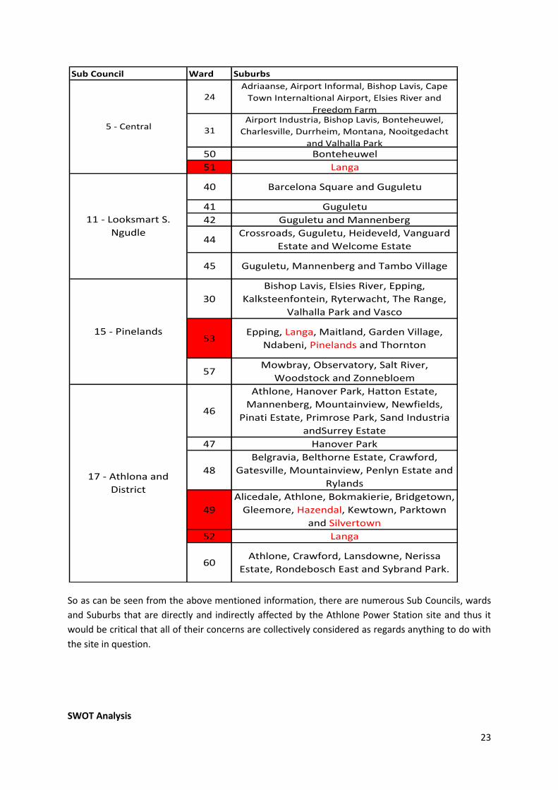
2.14 Wards and Sub-Councils
Name: Karl Bester Student Number: BSTKAR003
Overview
All information regarding the wards and Sub Councils was obtained from Appendix N.
There are four sub councils associated with the Athlone Power Station site, which are ‘led’ by Sub
Council 15 – Pinelands.
The four sub councils are:
Sub Council 15 – Pinelands
Sub Council 5 – Central
Sub Council 11 – Looksmart Solwandle Ngudle
Sub Council 17 – Athlone and Ditrict
Four wards are immediately associated with the Athlone Power Station Site. The site is situated in
ward 51 and borders on wards 53. And wards 49 and 52 are within a kilometre of the site.
The following table will show the sub councils and their associated wards and suburbs (with the red
wards and suburbs being those most immediately affected by the Athlone Power Station site):
23
So as can be seen from the above mentioned information, there are numerous Sub Councils, wards
and Suburbs that are directly and indirectly affected by the Athlone Power Station site and thus it
would be critical that all of their concerns are collectively considered as regards anything to do with
the site in question.
SWOT Analysis
Sub Council Ward Suburbs
24Adriaanse, Airport Informal, Bishop Lavis, Cape
Town Internaltional Airport, Elsies River and
Freedom Farm
31Airport Industria, Bishop Lavis, Bonteheuwel,
Charlesville, Durrheim, Montana, Nooitgedacht
and Valhalla Park50 Bonteheuwel
51 Langa
40 Barcelona Square and Guguletu
41 Guguletu
42 Guguletu and Mannenberg
44Crossroads, Guguletu, Heideveld, Vanguard
Estate and Welcome Estate
45 Guguletu, Mannenberg and Tambo Village
30
Bishop Lavis, Elsies River, Epping,
Kalksteenfontein, Ryterwacht, The Range,
Valhalla Park and Vasco
53Epping, Langa, Maitland, Garden Village,
Ndabeni, Pinelands and Thornton
57Mowbray, Observatory, Salt River,
Woodstock and Zonnebloem
46
Athlone, Hanover Park, Hatton Estate,
Mannenberg, Mountainview, Newfields,
Pinati Estate, Primrose Park, Sand Industria
andSurrey Estate
47 Hanover Park
48
Belgravia, Belthorne Estate, Crawford,
Gatesville, Mountainview, Penlyn Estate and
Rylands
49
Alicedale, Athlone, Bokmakierie, Bridgetown,
Gleemore, Hazendal, Kewtown, Parktown
and Silvertown
52 Langa
60Athlone, Crawford, Lansdowne, Nerissa
Estate, Rondebosch East and Sybrand Park.
5 - Central
11 - Looksmart S.
Ngudle
15 - Pinelands
17 - Athlona and
District
24
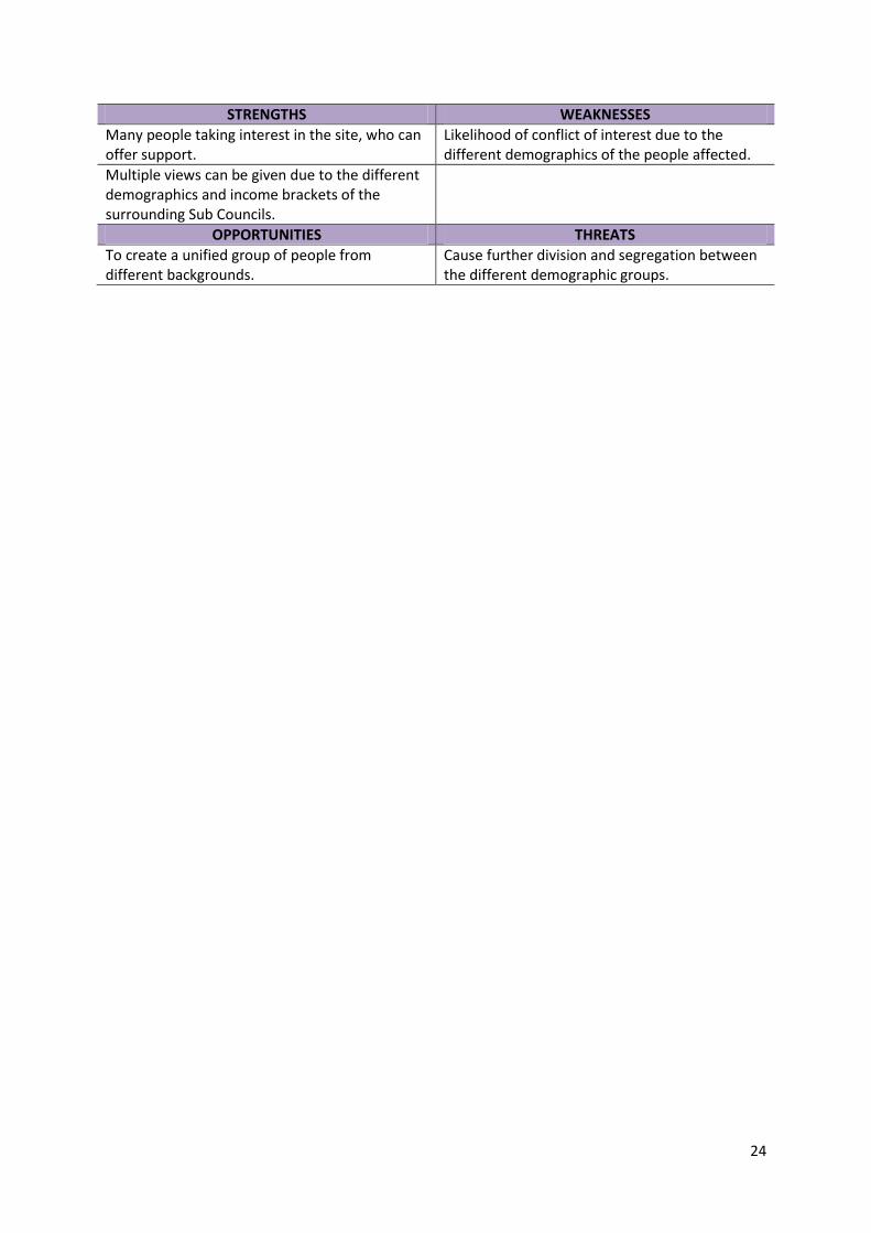
STRENGTHS WEAKNESSES
Many people taking interest in the site, who can offer support.
Likelihood of conflict of interest due to the different demographics of the people affected.
Multiple views can be given due to the different demographics and income brackets of the surrounding Sub Councils.
OPPORTUNITIES THREATS
To create a unified group of people from different backgrounds.
Cause further division and segregation between the different demographic groups.
25
3 Evaluation Methodology
Introduction
Any development within the Cape Town municipality is guided by the Cape Town Spatial
Development Framework (CTSDF). The purpose of the spatial development framework is to provide
a long-term plan to manage growth and change in Cape Town. The SDF was shaped by several acts
and policies. These include The Municipals Systems Act (MSA) and The National Environmental
Management Act (NEMA). Therefore any development that complies with the CTSDF will
consequently adhere to National and Provincial legislative requirements.
According to Table Bay District Plan, a sub section of the CTSDF, the Athlone Power Station site is
zoned for mixed-use intensification. These zones are areas identified for intensive economic activity
and where residential densification should be promoted.
Criteria for Evaluating Conceptual Designs
Before a methodology for evaluating conceptual designs can be formulated, there needs to be a set
of criteria from which a holistic evaluation can be performed. The criteria will be based on the
guiding principles of the City of Cape Town Spatial Development Framework (CTSDF). In aligning the
criteria with the SDF principles the evaluation of conceptual designs will be sensitive to the long
term development strategies for the Cape Town metropolitan area.
It must be noted that principles in the SDF related to the location of the site in the city context will
be ignored as they will apply to all conceptual designs and thus do not provide a basis to evaluate
different concepts.
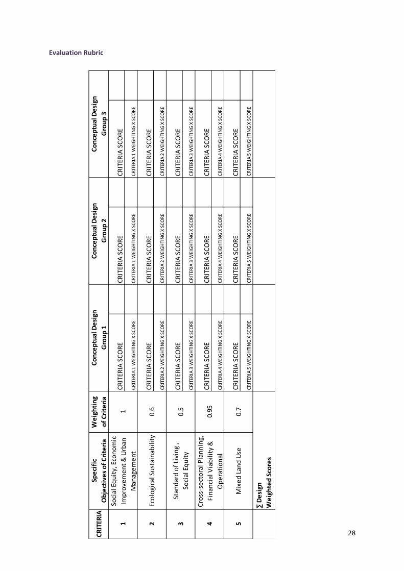
Criteria 1: The proposed development must offer the city the highest and best use; this means
that the development should maximise potential benefits for all members of the public. The
project should improve urban efficiency, and align planned growth with infrastructure provision
and employment generation.
Criteria 2: The development should adopt an ecologically sustainable approach, reducing the
city’s ecological footprint, mitigating negative environmental impacts and introducing sustainable
disaster risk management measures.
Criteria 3: Conceptual designs incorporating residential units should create safe, high quality
living environments that accommodate a range of lifestyles, and offer a vibrant mix of land uses.
The designs should incorporate social and economic equity.
Criteria 4: Conceptual designs should promote cross-sectoral planning, budgeting and growth
management approaches. This criterion focuses on the technical competency of the development
with reference to the broad objectives of the SDF as well as how the site will interact with other
city functions. This criterion will focus on the planning, management, operation and maintenance
of the development; the focus being financial viability and operational sustainability of the
project.
26
Criteria 5: The proposed land use of the site should comply with the CTSDF Table Bay District Plan
which highlight that the sight should accommodate mixed land use patterns. This criterion for
mixed land use is important in achieving the overall goals of the CTSDF and incorporates all three
strategies of the CTSDF that will be discussed under the evaluation Methodology.
Evaluation Methodology
The methodology to be used will be the Multi Criteria Decision Analysis (MCDA). The criteria will be
weighted according to the three key strategies identified by the CTSDF. These strategies inform the
development in the Cape Town metropolitan region and thus are a sound benchmark from which to
evaluate conceptual designs.
The Three key Issues
Key strategy 1: Plan for employment, and improve access to economic opportunities
This strategy is aimed at influencing the economic status quo of the City, the promotion of mixed
land use is supported and the concentration of economic activity at highly accessible locations which
generate employment opportunities is highlighted, particularly for the Metro Southeast region. The
development of Small, medium and Micro enterprises (SMME) through increased access to larger
markets is also advocated through the SDF strategy, the SDF also notes that tools should be
developed to support formal and informal small business in larger market places.
Key strategy 2: Manage urban growth, and create a balance between urban development and environmental protection This strategy focuses on the environmental sustainability of the City. The City will have to adopt an
approach that balances growth, human benefit, the environment and the economy. Development
should attempt to achieve a more compact city form to promote the more sustainable use of
resources. The strategy also incorporates consideration of the biodiversity network and realises that
water resource protection as well as alternative energy sources will be key factors to a sustainable
future. There is particular attention given to designing for resilience; the SDF requires that designs
be sensitive to the impacts of climate change particularly with respect to adaption and mitigation.
Key strategy 3: Build an inclusive, integrated, vibrant city The third strategy is centred on social equity and development, this strategy highlights the need to
redress past social inequalities with specific attention given to the unequal distribution of public and
social facilities. The SDF also advocates the enhancement of the city built form which orders the
relationship between people, urban space and the built, cultural and natural environment. It is also
noted that the cultural and heritage aspects are fundamental to the identity of Cape Town and
should be preserved.
27
Weighting Criteria
Using the summary of the three key strategies, the specific objectives of each criterion will be
weighted based on a value judgment (by each team member) of their relative importance. This
process will allow the team to reach a consensus of the relative importance of each criterion. This
weighting will then be multiplied with a score out of 100 for each proposed design. These scores will
be added to give a weighted design score. The highest score being the preferred option.
28
CR
ITER
IASp
eci
fic
Ob
ject
ive
s o
f C
rite
ria
We
igh
tin
g
of
Cri
teri
a
CR
ITER
IA S
CO
RE
CR
ITER
IA S
CO
RE
CR
ITER
IA S
CO
RE
CR
ITER
IA 1
WEI
GH
TIN
G X
SC
OR
EC
RIT
ERIA
1 W
EIG
HTI
NG
X S
CO
RE
CR
ITER
IA 1
WEI
GH
TIN
G X
SC
OR
E
CR
ITER
IA S
CO
RE
CR
ITER
IA S
CO
RE
CR
ITER
IA S
CO
RE
CR
ITER
IA 2
WEI
GH
TIN
G X
SC
OR
EC
RIT
ERIA
2 W
EIG
HTI
NG
X S
CO
RE
CR
ITER
IA 2
WEI
GH
TIN
G X
SC
OR
E
CR
ITER
IA S
CO
RE
CR
ITER
IA S
CO
RE
CR
ITER
IA S
CO
RE
CR
ITER
IA 3
WEI
GH
TIN
G X
SC
OR
EC
RIT
ERIA
3 W
EIG
HTI
NG
X S
CO
RE
CR
ITER
IA 3
WEI
GH
TIN
G X
SC
OR
E
CR
ITER
IA S
CO
RE
CR
ITER
IA S
CO
RE
CR
ITER
IA S
CO
RE
CR
ITER
IA 4
WEI
GH
TIN
G X
SC
OR
EC
RIT
ERIA
4 W
EIG
HTI
NG
X S
CO
RE
CR
ITER
IA 4
WEI
GH
TIN
G X
SC
OR
E
CR
ITER
IA S
CO
RE
CR
ITER
IA S
CO
RE
CR
ITER
IA S
CO
RE
CR
ITER
IA 5
WEI
GH
TIN
G X
SC
OR
EC
RIT
ERIA
5 W
EIG
HTI
NG
X S
CO
RE
CR
ITER
IA 5
WEI
GH
TIN
G X
SC
OR
E
Co
nce
ptu
al D
esi
gn
Gro
up
2
Co
nce
ptu
al D
esi
gn
Gro
up
3
∑ D
esi
gn
We
igh
ted
Sco
res
1 0.6
0.5
0.95
0.7
Co
nce
ptu
al D
esi
gn
Gro
up
1
Soci
al E
qu
ity,
Eco
no
mic
Imp
rove
me
nt
& U
rban
Man
age
me
nt
Eco
logi
cal S
ust
ain
abil
ity
Stan
dar
d o
f Li
vin
g ,
Soci
al E
qu
ity
Cro
ss-s
ect
ora
l Pla
nn
ing,
Fin
anci
al V
iab
ilit
y &
Op
era
tio
nal
Mix
ed
Lan
d U
se
1 2 3 4 5
Evaluation Rubric