status of mardi gras pass, the sundown/eland permit ... · email [email protected] cmd reviewer:...
TRANSCRIPT

Status of Mardi Gras Pass, the Sundown/Eland Permit Application, and Alternative Solutions
John A. Lopez, Andy Baker, Ezra Boyd, Theryn Henkel, Andreas Moshogianis, Eva Hillmannp y y y g
toGovernor’s Coastal Advisory Commission
l i i l bli ibAlgiers Regional Public LibraryNew Orleans, La.
Tuesday February 26 2013Tuesday February 26, 2013

Bohemia Spillway Area
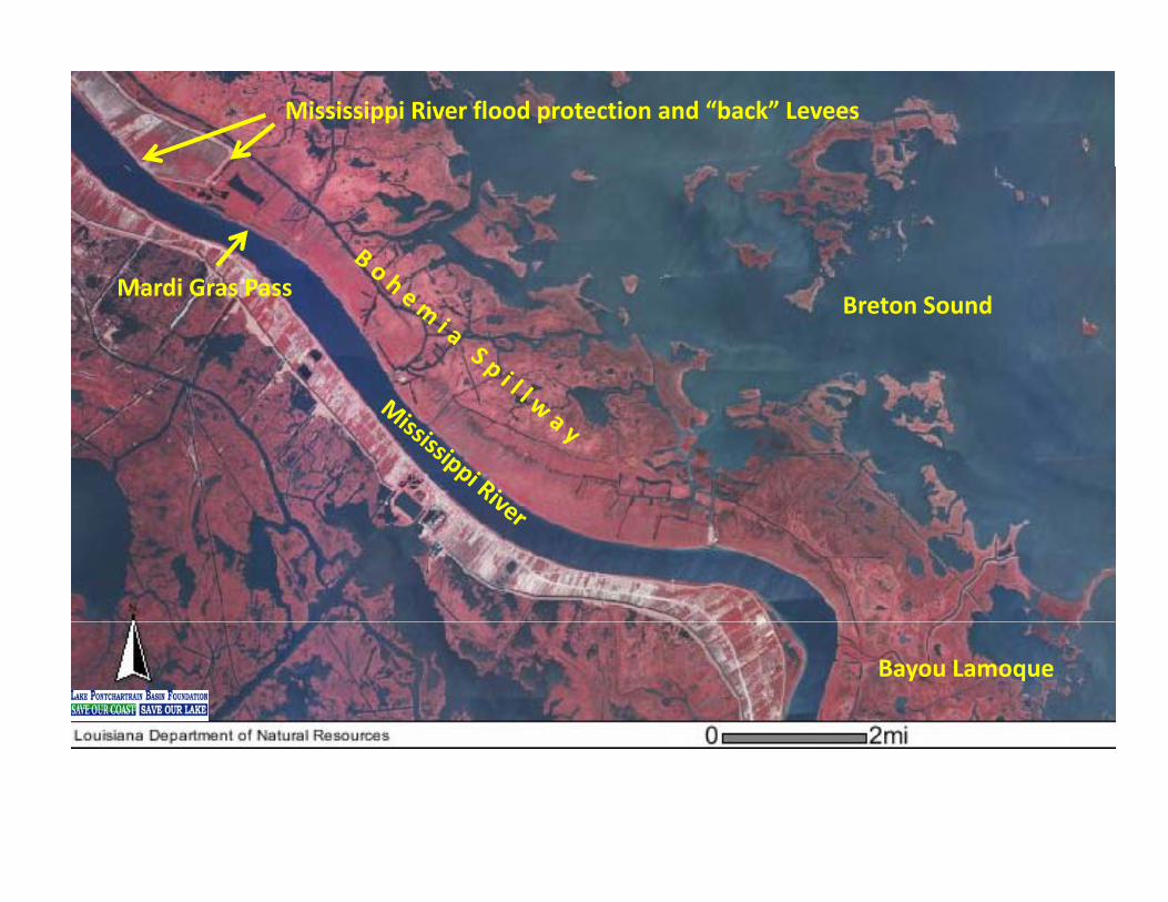
Mississippi River flood protection and “back” Levees
M di G PBreton Sound
Mardi Gras Pass
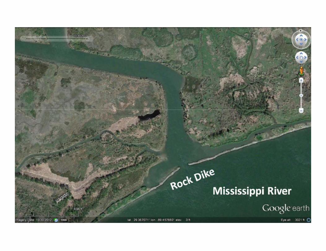
Bayou Lamoque

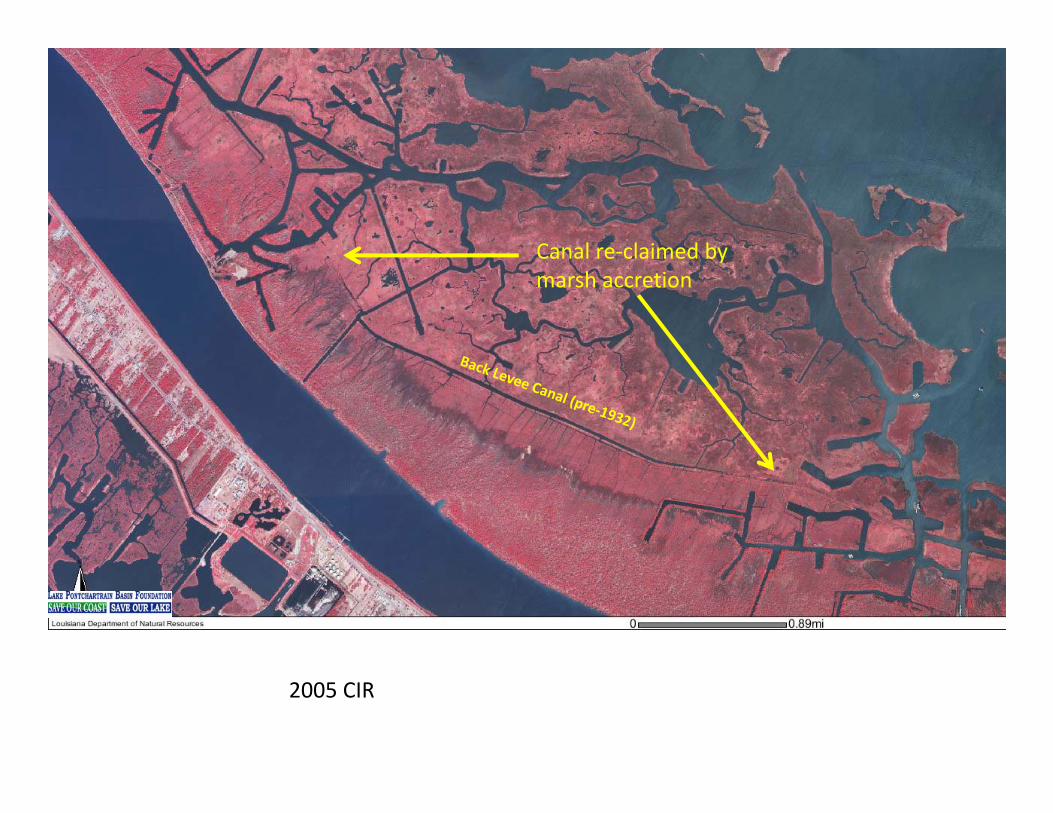
Canal re‐claimed byCanal re‐claimed by marsh accretion
2005 CIR

A naturally recovered or re‐claimed canal: Back Levee Canal (old route) in the Bohemia Spillway near Nester Canal (view looking north). Oak trees are on the original spoil bank of the canal. The Back levee Canal was probably in‐filled by sediment deposited by early discharges (1926 to 1940) through the Bohemia Spillway. Photograph taken February 14, 2013.p y g p y ,

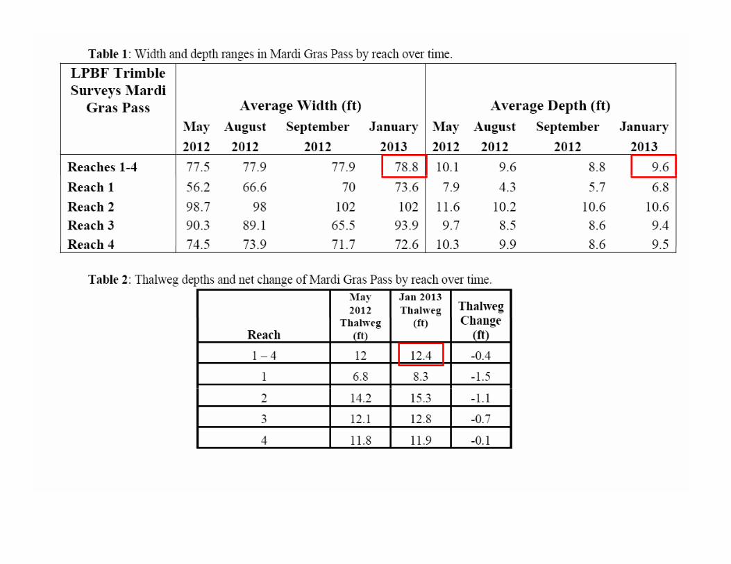
Mardi Gras Pass May 5, 2012 picture by Frank Cole OCM
Reach 4
Back levee Canal
Reach 3
Reach 2Road
Reach 1
Mississippi River
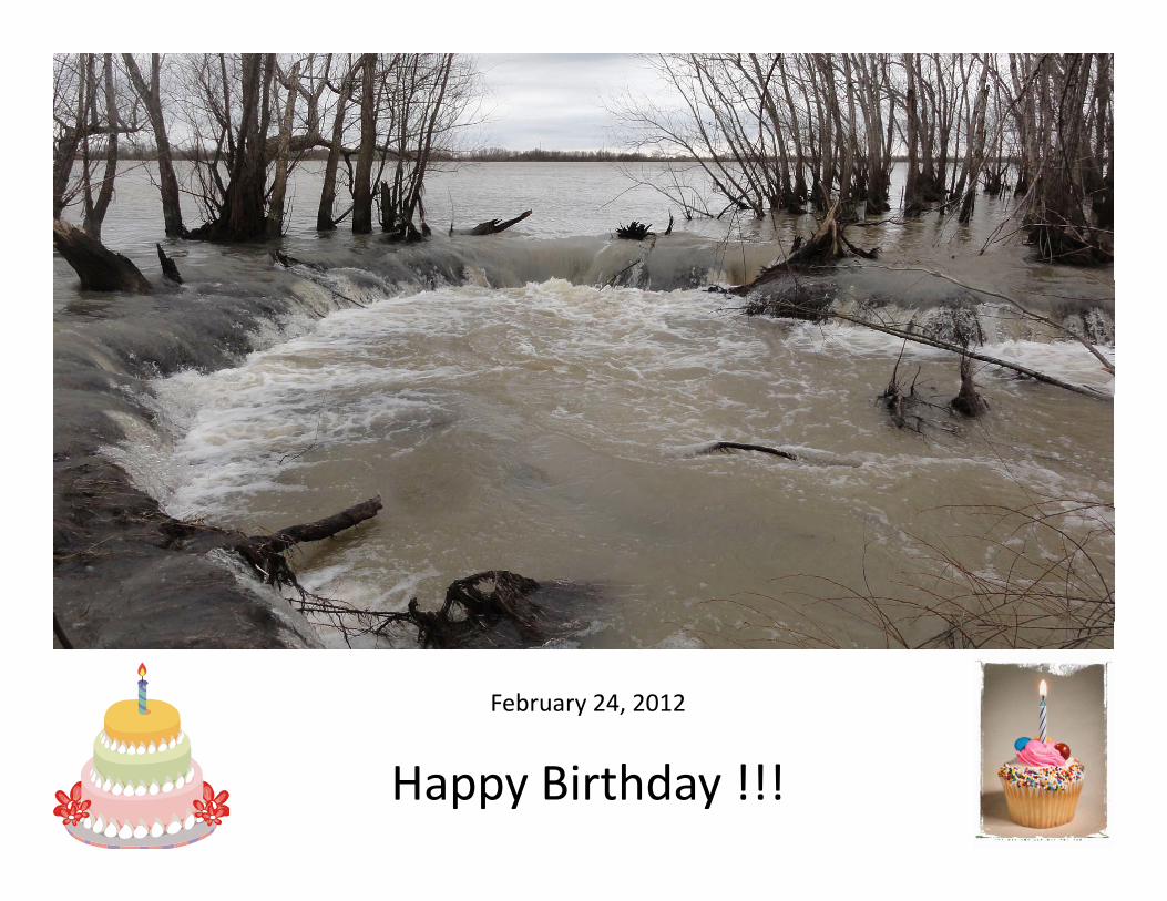
February 24, 2012
Happy Birthday !!!

Last MGP discharge measurement is 2,095 cfs (2/2013) when the river was at 4.8 feet, which is 2.8 feet lower than the peak stage in 2011. We estimate that the MGP discharge could be 5,300 cfs at maximum river stage here.


Governor’s Coastal Advisory Commission Meeting – August 2012 Mardi Gras Pass at the Mississippi River


63 to 79 downed trees in Reach 1 estimated June 29, 2012
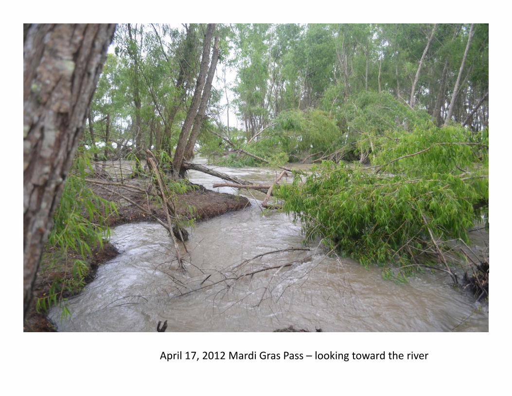
April 17, 2012 Mardi Gras Pass – looking toward the river

Channel width now exceeds the tree heights and reduces bridging effect of logjamseffect of logjams
Average width of Reach 1 Jan 2013
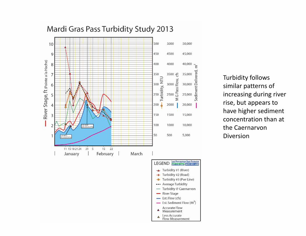
Turbidity follows similar patterns of increasing during river rise but appears torise, but appears to have higher sediment concentration than at the Caernarvon Diversion


Recreational Fishers in Mardi Gras Pass

State’s MGP Monitoring Plan Location of additional water level and salinity recorders (MGP H01 MGPsalinity recorders (MGP‐H01, MGP‐H02, and MGP‐H03) and accretion sites (MGP‐A01, MGP‐A02, MGP‐A03, MGP‐A04, MGP‐A05 and MGP‐A06).

Mardi Gras Pass
Lower Breton Diversion 50,000 cfs in Approved State Master Plan cost $220 M , 2014 Annual
Mardi Gras Pass Plan Design budget $2m 2014, $6 m 2015, $10 m 2016 Bohemia Mississippi River
Reintroduction BS‐1510,000 cfs CWPPRA PPL 1710,000 cfs CWPPRA PPL 17 $10‐20M De‐Authorized

With 4 culverts
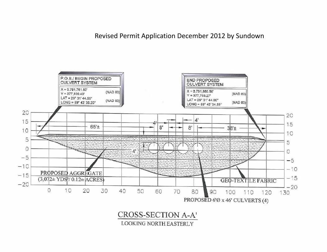
Revised Permit Application December 2012 by Sundown


StageTime
Head limitsFlood 5
Flood 1Flood 2
Flood 4
Flood 3
Discharge
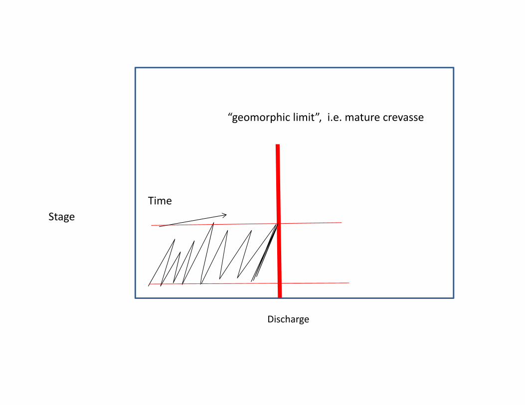
“geomorphic limit”, i.e. mature crevasse
StageTime
Discharge

“geomorphic limit i.e. mature crevasse”“Acceptable di h ” l
“Acceptable discharge” less
pdischarge” greater
StageTime
Discharge


PUBLIC NOTICEFebruary 14
STATE OF LOUISIANADEPARTMENT OF NATURAL RESOURCESDEPARTMENT OF NATURAL RESOURCES
OFFICE OF COASTAL MANAGEMENT DIVISIONP. O. BOX 44487
BATON ROUGE, LA 70804-4487Phone (225) 342-7943Phone (225) 342 7943
Fax (225) 342-9439Email [email protected]
CMD REVIEWER:Jesse DerocheJesse DerocheCUP NUMBER:
P20111629Interested parties are hereby notified that in accordance with LAC Title 43, Chapter 7, §723.C.6 the
Office of Coastal Management of the Department of Natural Resources received a request for aOffice of Coastal Management of the Department of Natural Resources received a request for a Public Hearing concerning the following application for a Coastal Use Permit. Interested parties are
hereby notified that a Public Hearing will be held on March 20th at 6:00 PM at the Belle Chasse Auditorium, located at 8398 Hwy. 23, in Belle Chasse.

EPA comment letter excerpt
NMFS comment letter excerpt

Issues Raised concerning the Sundown Permit
Issue:
l lMore Alternative Analysis
By:
COALITION TO RESTORE COASTAL LOUISIANAENVIRONMENTAL DEFENSE FUNDLAKE PONTCHARTRAIN BASIN FOUNDATIONNATIONAL AUDUBON SOCIETYNATIONAL AUDUBON SOCIETYNATIONAL WILDLIFE FEDERATIONTULANE INSTITUTE ON WATER RESOURCES LAW AND POLICYNATIONAL MARINE FISHERIES SERVICENATIONAL MARINE FISHERIES SERVICEENVIRONMENTAL PROTECTION AGENCYSOUTH LOUISIANA FLOOD PROTECTION AUTHORITY ‐ EAST
Issues Raised concerning the Sundown Permit
Issue:
l f l l d h d
B
Evaluation of environmental impact including the indirect impacts
By:COALITION TO RESTORE COASTAL LOUISIANAENVIRONMENTAL DEFENSE FUNDLAKE PONTCHARTRAIN BASIN FOUNDATIONNATIONAL AUDUBON SOCIETYNATIONAL WILDLIFE FEDERATIONTULANE INSTITUTE ON WATER RESOURCES LAW AND POLICYTULANE INSTITUTE ON WATER RESOURCES LAW AND POLICYNATIONAL MARINE FISHERIES SERVICEENVIRONMENTAL PROTECTION AGENCYGULF RESTORATION NETWORKGULF RESTORATION NETWORKSOUTH LOUISIANA FLOOD PROTECTION AUTHORITY ‐ EAST

Issues Raised concerning the Sundown Permit
Issue:
dd l h d l lAdditional hydrologic Analysis
By:COALITION TO RESTORE COASTAL LOUISIANACOALITION TO RESTORE COASTAL LOUISIANAENVIRONMENTAL DEFENSE FUNDLAKE PONTCHARTRAIN BASIN FOUNDATIONNATIONAL AUDUBON SOCIETYNATIONAL AUDUBON SOCIETYNATIONAL WILDLIFE FEDERATIONTULANE INSTITUTE ON WATER RESOURCES LAW AND POLICYENVIRONMENTAL PROTECTION AGENCYSOUTH LOUISIANA FLOOD PROTECTION AUTHORITY ‐ EAST

Issues Raised concerning the Sundown Permit
Issue:
l b l b d dLegal Navigability must be determined
By:By:COALITION TO RESTORE COASTAL LOUISIANAENVIRONMENTAL DEFENSE FUNDLAKE PONTCHARTRAIN BASIN FOUNDATIONNATIONAL AUDUBON SOCIETYNATIONAL WILDLIFE FEDERATIONTULANE INSTITUTE ON WATER RESOURCES LAW AND POLICYTULANE INSTITUTE ON WATER RESOURCES LAW AND POLICY

Issues Raised concerning the Sundown Permit
Issue:
h lInconsistent with State Master Plan
By:By:
GULF RESTORATION NETWORKLAKE PONTCHARTRAIN BASIN FOUNDATIONLAKE PONTCHARTRAIN BASIN FOUNDATIONSOUTH LOUISIANA FLOOD PROTECTION AUTHORITY ‐ EAST
Issues Raised concerning the Sundown Permit
Issue:
h ll ll f d d fl dBohemia Spillway still functions and provides flood protection benefits
By:By:
SOUTH LOUISIANA FLOOD PROTECTION AUTHORITY ‐ EAST

Why is Mardi Gras Pass a good location for a diversion?
State Master plans recommend a diversion at virtually the same locationState Master plans recommend a diversion at virtually the same location indicating a need and an effectiveness of a diversion here
Sediment concentration is relatively high and the river bar indicates excess sediment load in the river
The Back Levee Canal effectively shunts water north and south distributing water and sediment over a large reach of the marsh adjacent to the river
Closing Mardi Gras pass in lieu of a new diversion delays benefits for years
Adaptive management if needed seems to simple and cost effectiveAdaptive management, if needed, seems to simple and cost effective

Permit Alternative Scenarios
Deny Permit and the company continues to use their existing dock
Suspend approval pending:• Navigability determination• Navigability determination• Fuller environmental analysis• Alternatives evaluated which could leave Mardi Gras Pass open• Fuller hydrologic analysisFuller hydrologic analysis• Evaluate suitability of Mardi Gras Pass as the Lower Breton Diversion
Construction of a bridgeConstruction of a bridgeConsider use of BP Early‐NRDA funding or other funding