statewide aerial imagery program - michigan.gov · − city of ann arbor
TRANSCRIPT

© 2008, The Sanborn Map Company, Inc. Privileged and confidential information.
Distribution or copying prohibited unless approved in writing. 1
Statewide Aerial Imagery Program Presentation to the Michigan GIS User’s Group February 7, 2013, 1:00pm
Presented By:
Everett Root, State of Michigan, DTMB/CSSTP
Manager, GeoData Services
Krysia Sapeta, Sanborn
Senior Project Manager
Brad Arshat, Sanborn
Director, Strategic Accounts
© 2008, The Sanborn Map Company, Inc. Privileged and confidential information.
Distribution or copying prohibited unless approved in writing.
Presentation Topics
• Introduction
• Sanborn Profile
• Imagery Program History
• Orthoimagery Offerings
• Break
• LiDAR Offerings
• Data as a Service
• Pricing
• How to Order
2 Michigan GIS User's Group
© 2008, The Sanborn Map Company, Inc. Privileged and confidential information.
Distribution or copying prohibited unless approved in writing. 3
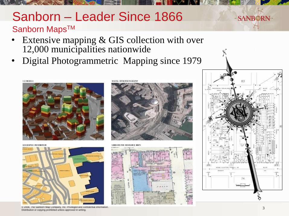
Sanborn – Leader Since 1866 Sanborn MapsTM
• Extensive mapping & GIS collection with over 12,000 municipalities nationwide
• Digital Photogrammetric Mapping since 1979
© 2008, The Sanborn Map Company, Inc. Privileged and confidential information.
Distribution or copying prohibited unless approved in writing.
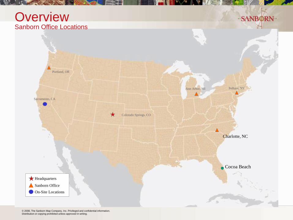
Overview
Sanborn Office
Headquarters
On-Site Locations
Portland, OR
Sacramento, CA
Colorado Springs, CO
Ann Arbor, MI Pelham, NY
Sanborn Office Locations
Cocoa Beach
Charlotte, NC
© 2008, The Sanborn Map Company, Inc. Privileged and confidential information.
Distribution or copying prohibited unless approved in writing. 5 5
Decision Support
Visualization
Systems
Software Applications
Value Added Services
GIS Data and Map Production
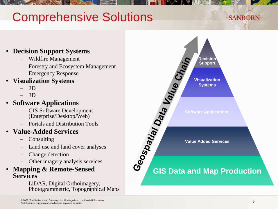
Comprehensive Solutions
• Decision Support Systems – Wildfire Management
– Forestry and Ecosystem Management
– Emergency Response
• Visualization Systems – 2D
– 3D
• Software Applications – GIS Software Development
(Enterprise/Desktop/Web)
– Portals and Distribution Tools
• Value-Added Services – Consulting
– Land use and land cover analyses
– Change detection
– Other imagery analysis services
• Mapping & Remote-Sensed Services
– LiDAR, Digital Orthoimagery, Photogrammetric, Topographical Maps

© 2008, The Sanborn Map Company, Inc. Privileged and confidential information.
Distribution or copying prohibited unless approved in writing.
• Offices in 5 states
• 150 employees
• Services include:
− Aerial Imagery
− Aerial & Terrestrial LiDAR
− Land Surveys
− Digital Terrain Modeling
− Planimetric/Topographic Maps
− 3D Modeling and Simulation
− Satellite Imagery
− Remote Sensing
− Parcel & Utility Conversion
− GeoIT Services
Sanborn Company Profile
6 Michigan GIS User's Group
© 2008, The Sanborn Map Company, Inc. Privileged and confidential information.
Distribution or copying prohibited unless approved in writing. 7
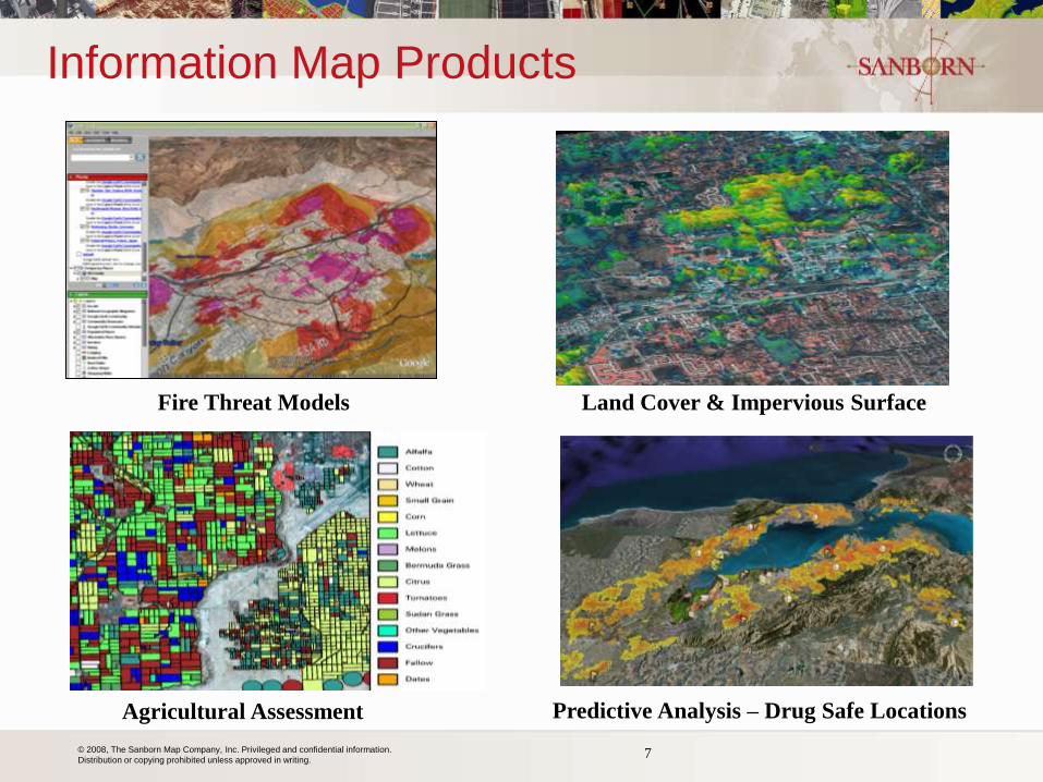
Information Map Products
Land Cover & Impervious Surface
Agricultural Assessment
Fire Threat Models
Predictive Analysis – Drug Safe Locations
© 2008, The Sanborn Map Company, Inc. Privileged and confidential information.
Distribution or copying prohibited unless approved in writing. 8
Qualifications: Relevant Experience
on Programs in the Region
• Sanborn is presently the statewide imagery and mapping contractor for: – Commonwealth of Virginia (2006-2016)
– State of New York (2008-2013)
– State of Michigan (2013-2015, 2016, 2017)
• Prior Michigan projects completed for: − Oakland, Manistee, Grand Traverse, Hillsdale, Otsego, Wayne and Livingston
Counties
− City of Ann Arbor
• Imagery and LiDAR under federal contracts in: − New Hampshire, Vermont, Massachusetts, and Maine
• Sanborn understands regional challenges − Short window of opportunity between snow-free and leaf-on
− Weather patterns
− Sanborn’s Ann Arbor office performing final QC of imagery
Michigan GIS User's Group

© 2008, The Sanborn Map Company, Inc. Privileged and confidential information.
Distribution or copying prohibited unless approved in writing.
Project Management
Primary Roles:
– Implement ISO 9001: 2008
– Regular status reports and project meetings
– Customer liaison to operations
– Project scope and schedule compliance
– Provide project work plan
– Implement use of P3E® Integrated
Scheduling & Productivity Tracking System
– Implement Sharepoint Site
– Implement GeoServe
• Rigorously applied Project Management Institute model
© 2008, The Sanborn Map Company, Inc. Privileged and confidential information.
Distribution or copying prohibited unless approved in writing.
Krysia Sapeta
• Technical Base; Photogrammetry, Orthoimagery, Planimetric Update
• Over 20 years managing mapping programs
– Project Management Professional (PMP)
– Certified Photogrammetrist (CP)
– GIS Professional (GISP)
• Recent Programs:
– State Of Virginia
– FL Department of Revenue (multi-year; Orthoimagery)
– State of Kansas (Multi-year; FEMA LiDAR)
– New York City (since 1997)
– City of Colorado Springs (multi-year; Ortho, LiDAR, planimetric
update)
– LOJIC (orthoimagery, planimetric update, LiDAR)
10
© 2008, The Sanborn Map Company, Inc. Privileged and confidential information.
Distribution or copying prohibited unless approved in writing.
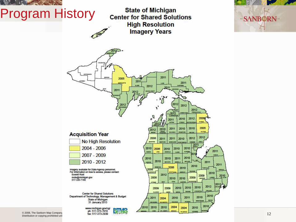
Program History
Michigan GIS User's Group 11
© 2008, The Sanborn Map Company, Inc. Privileged and confidential information.
Distribution or copying prohibited unless approved in writing. Michigan GIS User's Group 12
Program History
© 2008, The Sanborn Map Company, Inc. Privileged and confidential information.
Distribution or copying prohibited unless approved in writing. Michigan GIS User's Group 13
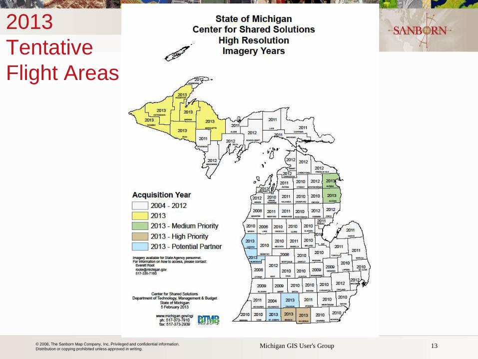
2013
Tentative
Flight Areas
© 2008, The Sanborn Map Company, Inc. Privileged and confidential information.
Distribution or copying prohibited unless approved in writing.
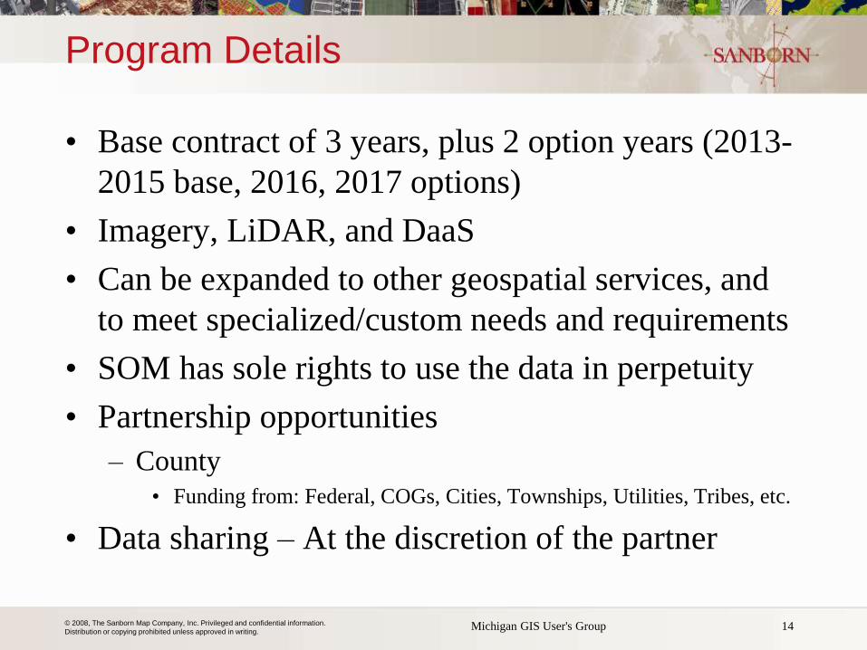
Program Details
• Base contract of 3 years, plus 2 option years (2013-
2015 base, 2016, 2017 options)
• Imagery, LiDAR, and DaaS
• Can be expanded to other geospatial services, and
to meet specialized/custom needs and requirements
• SOM has sole rights to use the data in perpetuity
• Partnership opportunities
– County
• Funding from: Federal, COGs, Cities, Townships, Utilities, Tribes, etc.
• Data sharing – At the discretion of the partner
14 Michigan GIS User's Group
© 2008, The Sanborn Map Company, Inc. Privileged and confidential information.
Distribution or copying prohibited unless approved in writing.
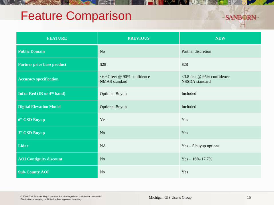
Feature Comparison
FEATURE PREVIOUS NEW
Public Domain No Partner discretion
Partner price base product $28 $28
Accuracy specification <6.67 feet @ 90% confidence
NMAS standard <3.8 feet @ 95% confidence
NSSDA standard
Infra-Red (IR or 4th band) Optional Buyup Included
Digital Elevation Model Optional Buyup Included
6” GSD Buyup Yes Yes
3” GSD Buyup No Yes
Lidar NA Yes – 5 buyup options
AOI Contiguity discount No Yes – 16%-17.7%
Sub-County AOI No Yes
Michigan GIS User's Group 15
© 2008, The Sanborn Map Company, Inc. Privileged and confidential information.
Distribution or copying prohibited unless approved in writing.
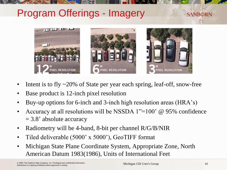
Program Offerings - Imagery
• Intent is to fly ~20% of State per year each spring, leaf-off, snow-free
• Base product is 12-inch pixel resolution
• Buy-up options for 6-inch and 3-inch high resolution areas (HRA’s)
• Accuracy at all resolutions will be NSSDA 1”=100’ @ 95% confidence
= 3.8’ absolute accuracy
• Radiometry will be 4-band, 8-bit per channel R/G/B/NIR
• Tiled deliverable (5000’ x 5000’), GeoTIFF format
• Michigan State Plane Coordinate System, Appropriate Zone, North
American Datum 1983(1986), Units of International Feet
16 Michigan GIS User's Group
© 2008, The Sanborn Map Company, Inc. Privileged and confidential information.
Distribution or copying prohibited unless approved in writing.
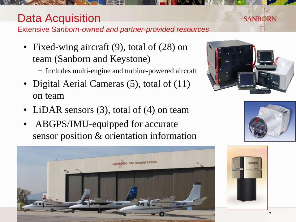
Data Acquisition Extensive Sanborn-owned and partner-provided resources
• Fixed-wing aircraft (9), total of (28) on
team (Sanborn and Keystone)
− Includes multi-engine and turbine-powered aircraft
• Digital Aerial Cameras (5), total of (11)
on team
• LiDAR sensors (3), total of (4) on team
• ABGPS/IMU-equipped for accurate
sensor position & orientation information
Michigan GIS User's Group 17
© 2008, The Sanborn Map Company, Inc. Privileged and confidential information.
Distribution or copying prohibited unless approved in writing.
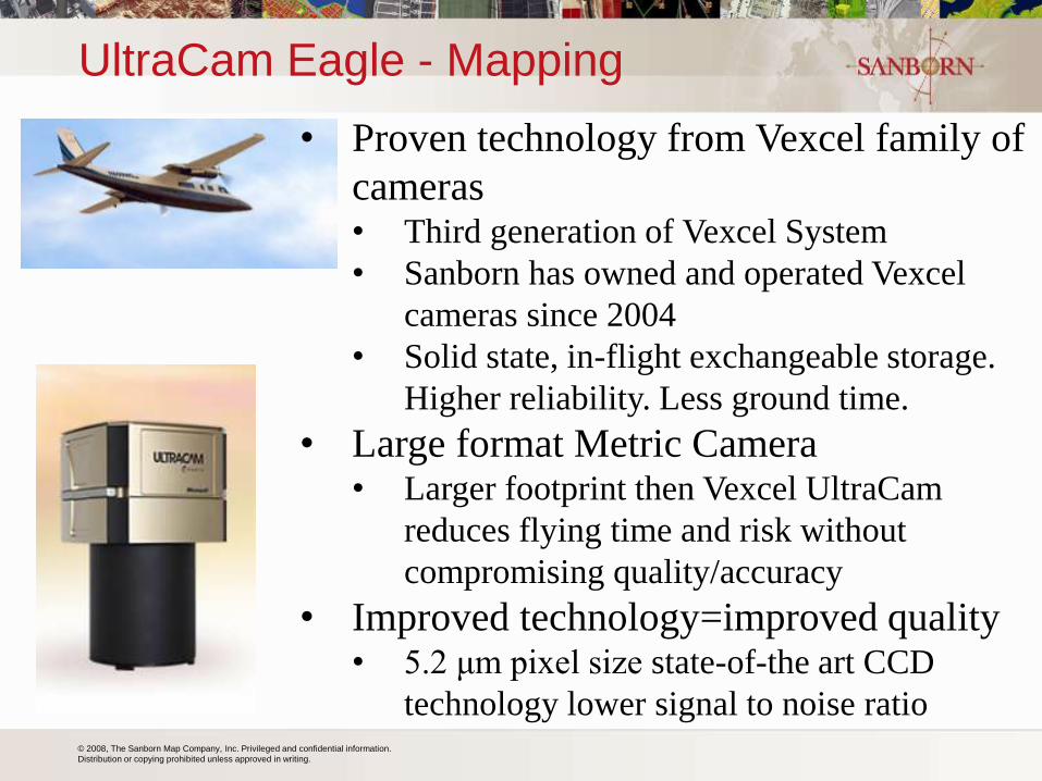
UltraCam Eagle - Mapping
• Proven technology from Vexcel family of
cameras • Third generation of Vexcel System
• Sanborn has owned and operated Vexcel
cameras since 2004
• Solid state, in-flight exchangeable storage.
Higher reliability. Less ground time.
• Large format Metric Camera • Larger footprint then Vexcel UltraCam
reduces flying time and risk without
compromising quality/accuracy
• Improved technology=improved quality • 5.2 μm pixel size state-of-the art CCD
technology lower signal to noise ratio
© 2008, The Sanborn Map Company, Inc. Privileged and confidential information.
Distribution or copying prohibited unless approved in writing.
19
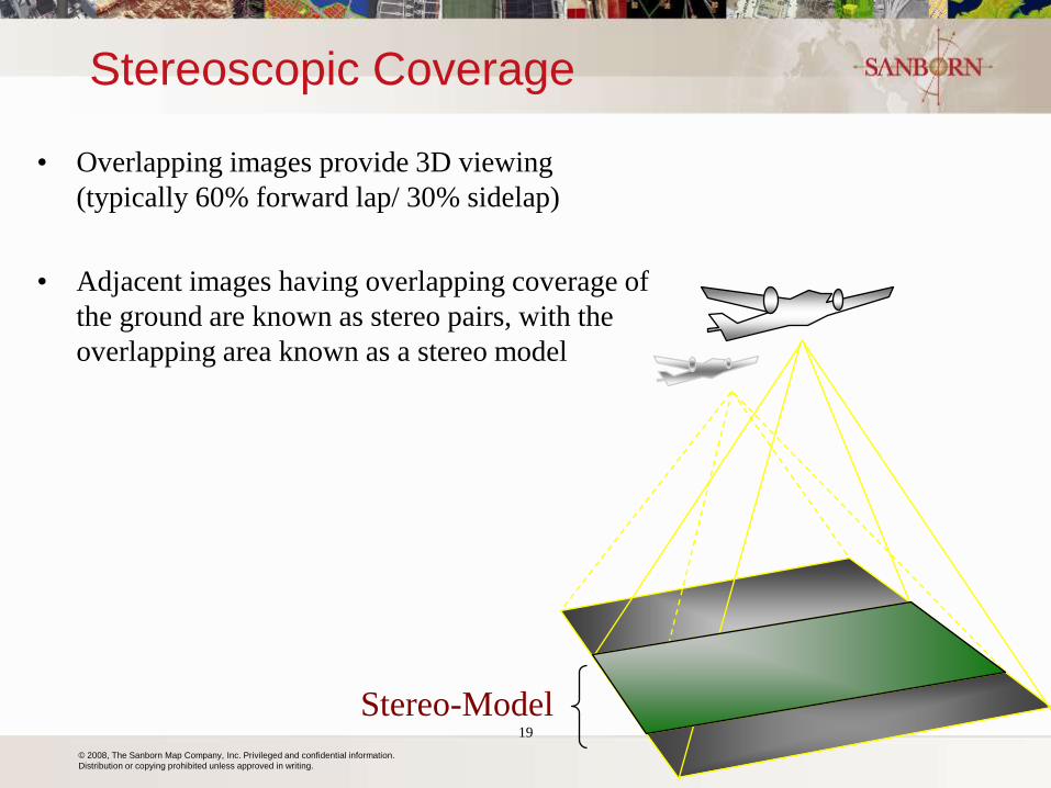
Stereo-Model
Stereoscopic Coverage
• Overlapping images provide 3D viewing
(typically 60% forward lap/ 30% sidelap)
• Adjacent images having overlapping coverage of
the ground are known as stereo pairs, with the
overlapping area known as a stereo model
© 2008, The Sanborn Map Company, Inc. Privileged and confidential information.
Distribution or copying prohibited unless approved in writing.
20
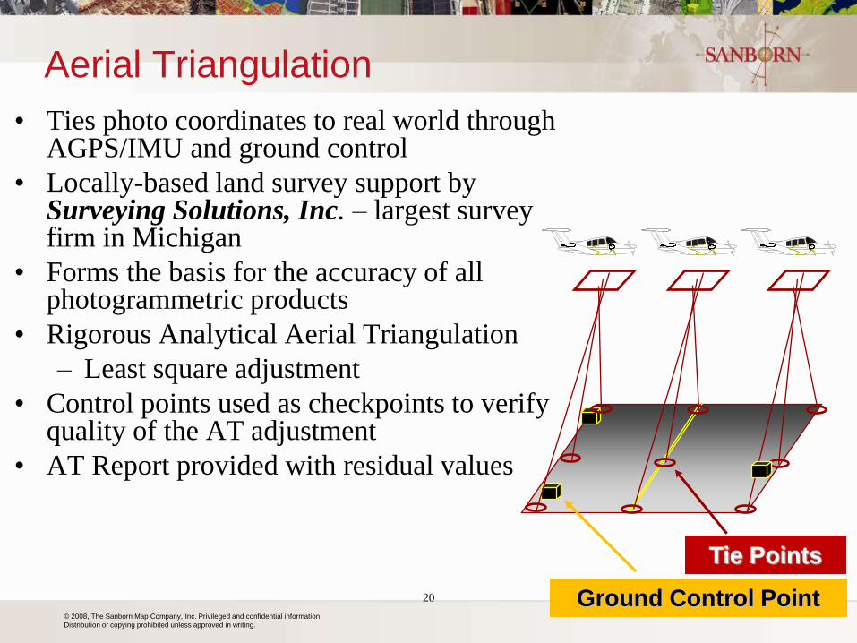
Aerial Triangulation
• Ties photo coordinates to real world through AGPS/IMU and ground control
• Locally-based land survey support by Surveying Solutions, Inc. – largest survey firm in Michigan
• Forms the basis for the accuracy of all photogrammetric products
• Rigorous Analytical Aerial Triangulation
– Least square adjustment
• Control points used as checkpoints to verify quality of the AT adjustment
• AT Report provided with residual values
Tie Points
Ground Control Point
© 2008, The Sanborn Map Company, Inc. Privileged and confidential information.
Distribution or copying prohibited unless approved in writing.
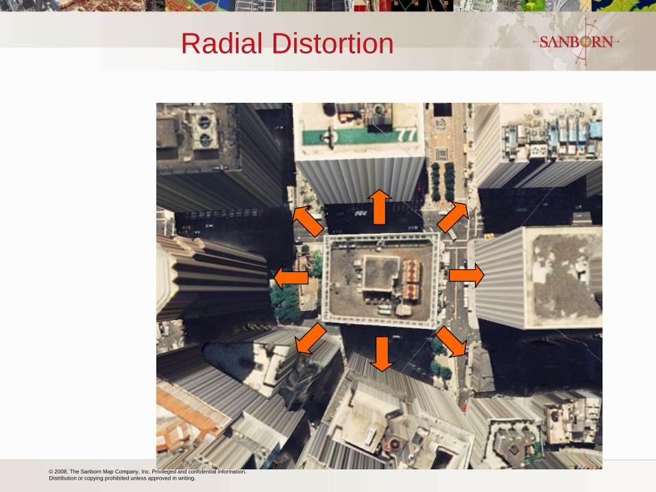
Radial Distortion
© 2008, The Sanborn Map Company, Inc. Privileged and confidential information.
Distribution or copying prohibited unless approved in writing.
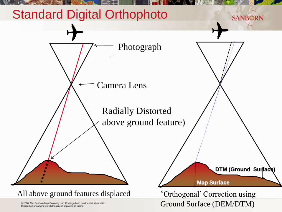
Standard Digital Orthophoto
All above ground features displaced ‘Orthogonal’ Correction using
Ground Surface (DEM/DTM)
DTM (Ground Surface)
Map Surface
Camera Lens
Radially Distorted
above ground feature)
Photograph
© 2008, The Sanborn Map Company, Inc. Privileged and confidential information.
Distribution or copying prohibited unless approved in writing.
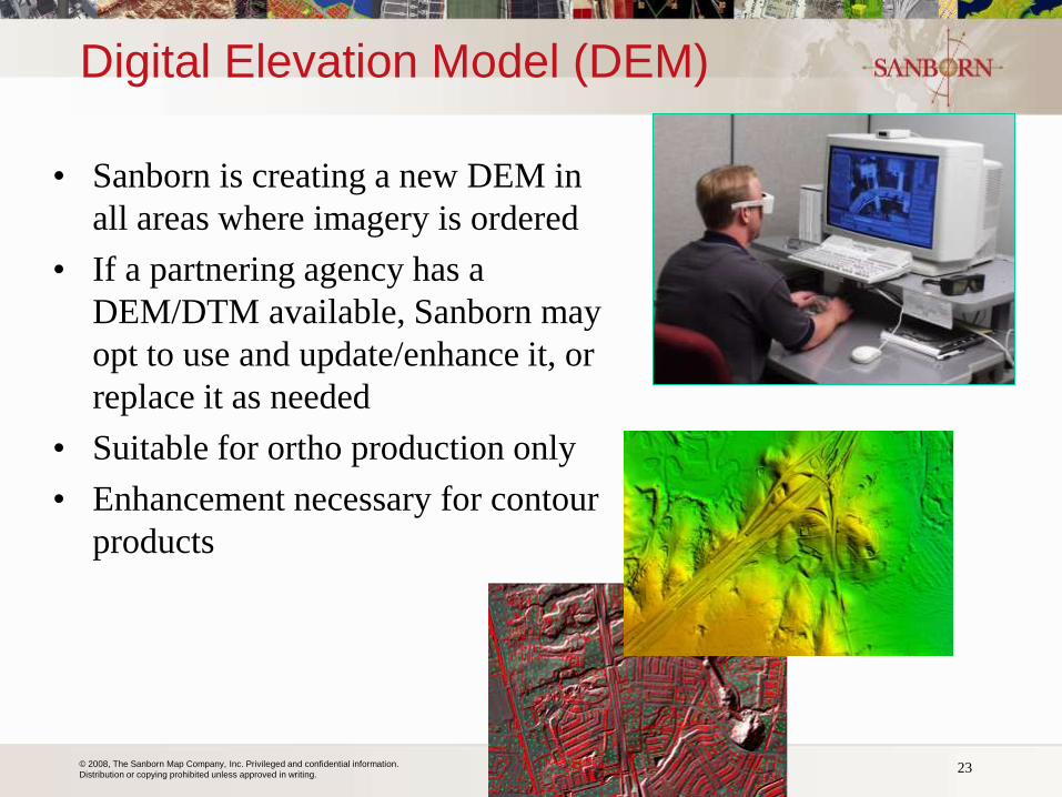
Digital Elevation Model (DEM)
• Sanborn is creating a new DEM in
all areas where imagery is ordered
• If a partnering agency has a
DEM/DTM available, Sanborn may
opt to use and update/enhance it, or
replace it as needed
• Suitable for ortho production only
• Enhancement necessary for contour
products
23 Michigan GIS User's Group
© 2008, The Sanborn Map Company, Inc. Privileged and confidential information.
Distribution or copying prohibited unless approved in writing.
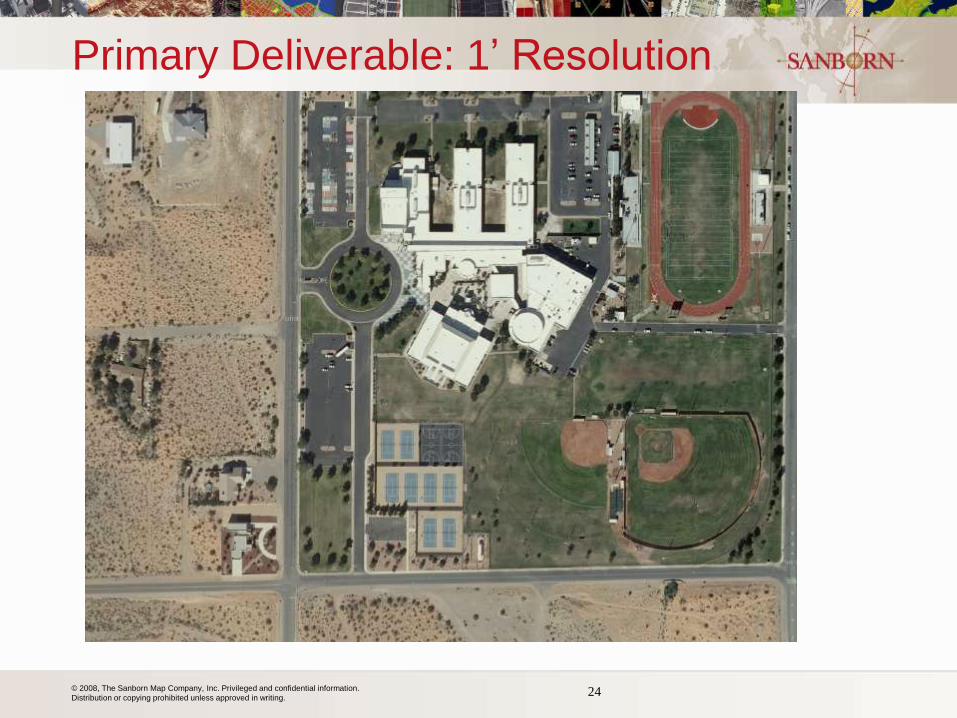
Primary Deliverable: 1’ Resolution
24
© 2008, The Sanborn Map Company, Inc. Privileged and confidential information.
Distribution or copying prohibited unless approved in writing.
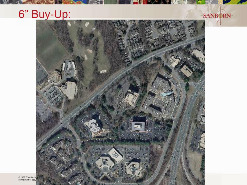
6” Buy-Up:
25
© 2008, The Sanborn Map Company, Inc. Privileged and confidential information.
Distribution or copying prohibited unless approved in writing.
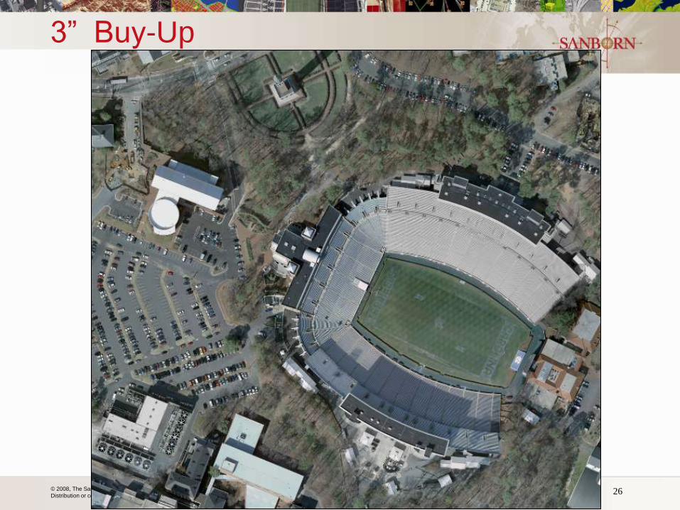
3” Buy-Up
26
© 2008, The Sanborn Map Company, Inc. Privileged and confidential information.
Distribution or copying prohibited unless approved in writing.
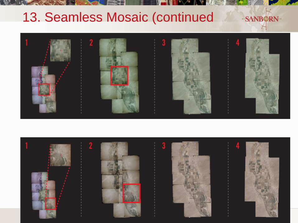
13. Seamless Mosaic (continued
27
© 2008, The Sanborn Map Company, Inc. Privileged and confidential information.
Distribution or copying prohibited unless approved in writing.
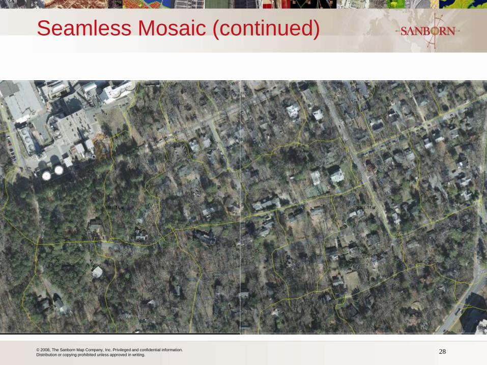
Seamless Mosaic (continued)
28

© 2008, The Sanborn Map Company, Inc. Privileged and confidential information.
Distribution or copying prohibited unless approved in writing.
Mosaic
29
© 2008, The Sanborn Map Company, Inc. Privileged and confidential information.
Distribution or copying prohibited unless approved in writing.
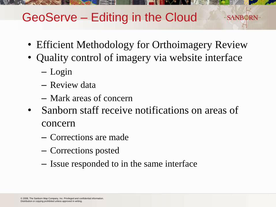
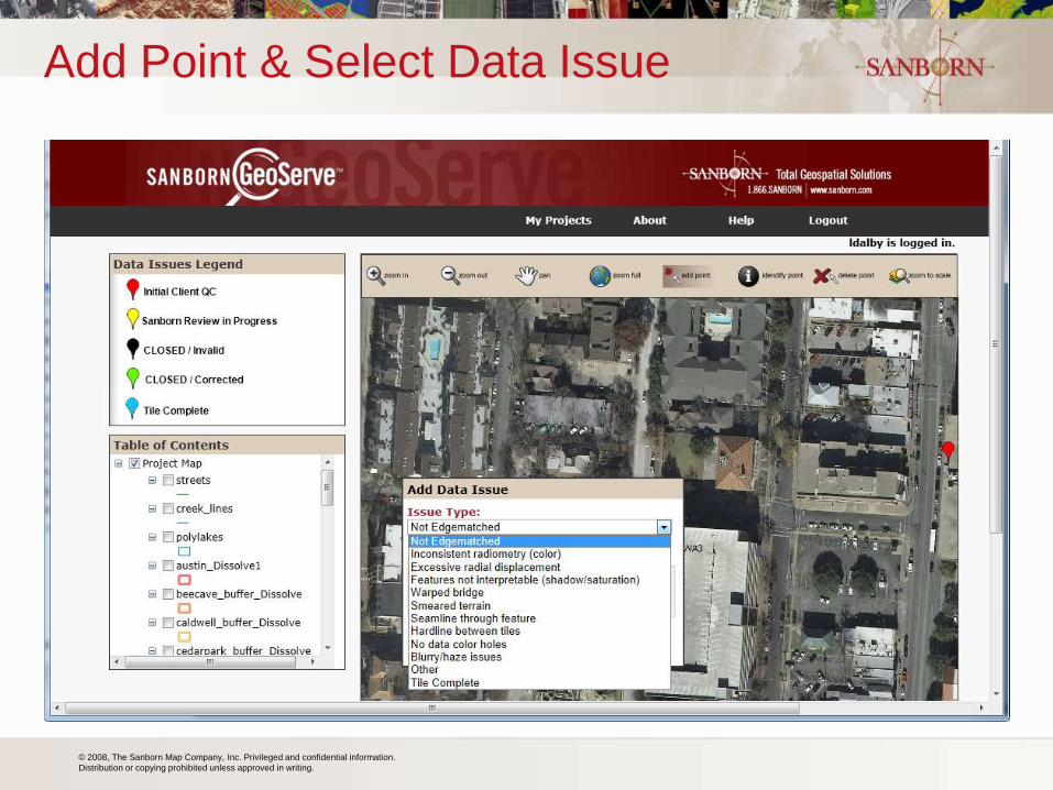
GeoServe – Editing in the Cloud
• Efficient Methodology for Orthoimagery Review
• Quality control of imagery via website interface
– Login
– Review data
– Mark areas of concern
• Sanborn staff receive notifications on areas of
concern
– Corrections are made
– Corrections posted
– Issue responded to in the same interface
© 2008, The Sanborn Map Company, Inc. Privileged and confidential information.
Distribution or copying prohibited unless approved in writing.
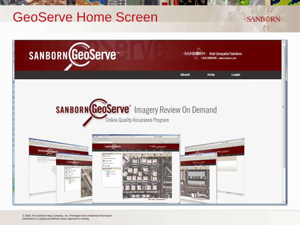
GeoServe Home Screen
© 2008, The Sanborn Map Company, Inc. Privileged and confidential information.
Distribution or copying prohibited unless approved in writing.
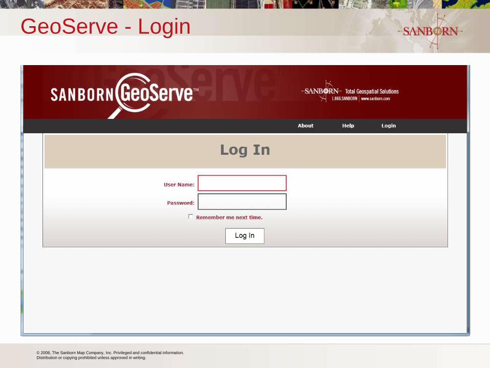
GeoServe - Login
© 2008, The Sanborn Map Company, Inc. Privileged and confidential information.
Distribution or copying prohibited unless approved in writing.
Add Point & Select Data Issue
© 2008, The Sanborn Map Company, Inc. Privileged and confidential information.
Distribution or copying prohibited unless approved in writing.
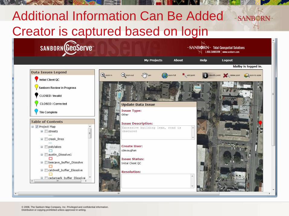
Additional Information Can Be Added
Creator is captured based on login
© 2008, The Sanborn Map Company, Inc. Privileged and confidential information.
Distribution or copying prohibited unless approved in writing. 35
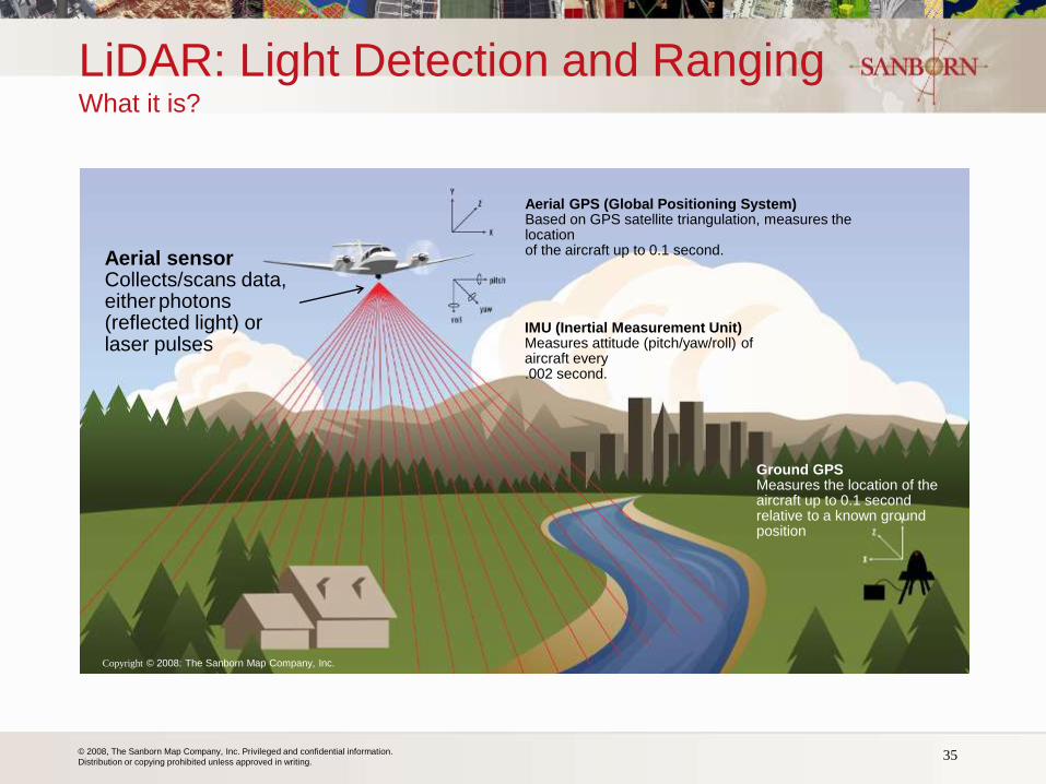
LiDAR: Light Detection and Ranging What it is?
Aerial sensor Collects/scans data, either photons (reflected light) or laser pulses
Aerial GPS (Global Positioning System) Based on GPS satellite triangulation, measures the location of the aircraft up to 0.1 second.
IMU (Inertial Measurement Unit) Measures attitude (pitch/yaw/roll) of aircraft every .002 second.
Ground GPS Measures the location of the aircraft up to 0.1 second relative to a known ground position
Copyright © 2008: The Sanborn Map Company, Inc.
© 2008, The Sanborn Map Company, Inc. Privileged and confidential information.
Distribution or copying prohibited unless approved in writing. 36
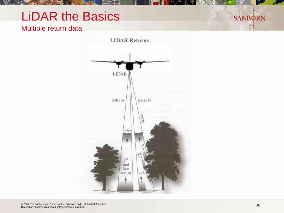
LiDAR the Basics Multiple return data
© 2008, The Sanborn Map Company, Inc. Privileged and confidential information.
Distribution or copying prohibited unless approved in writing.
LiDAR Data
• LiDAR is a optional service offering under the contract
• Base product is Quality Level 2 (QL-2) LiDAR collection:
– 2pts/m^2, 0.7m NPS,
– Accuracy RMSEZ = 9.25cm,
– Supports creation of 1-foot contours
– Includes collection, delivery of calibrated-unclassified point cloud in LAS
V1.1 or 1.2 format, intensity images, metadata, pertinent documentation
• Specifications are based largely on USGS Base Spec V1.0
• Spatial reference system is MSPCS, appropriate zone, units of
Int’l Feet, most current realization of NAD83, NAVD88 datums
• Options include higher/lower quality levels, classified point
cloud, bare earth DEM, hydro flattening, hydro enforcement,
LAS V1.4 data format
37 Michigan GIS User's Group
© 2008, The Sanborn Map Company, Inc. Privileged and confidential information.
Distribution or copying prohibited unless approved in writing. 38
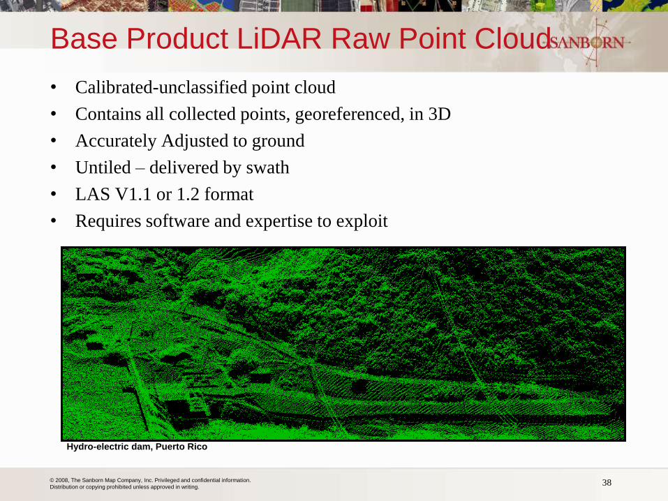
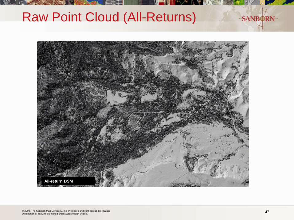
Base Product LiDAR Raw Point Cloud
• Calibrated-unclassified point cloud
• Contains all collected points, georeferenced, in 3D
• Accurately Adjusted to ground
• Untiled – delivered by swath
• LAS V1.1 or 1.2 format
• Requires software and expertise to exploit
Hydro-electric dam, Puerto Rico
© 2008, The Sanborn Map Company, Inc. Privileged and confidential information.
Distribution or copying prohibited unless approved in writing.
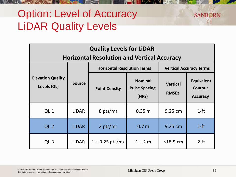
Option: Level of Accuracy
LiDAR Quality Levels
Quality Levels for LiDAR
Horizontal Resolution and Vertical Accuracy
Elevation Quality
Levels (QL) Source
Horizontal Resolution Terms Vertical Accuracy Terms
Point Density Nominal
Pulse Spacing
(NPS)
Vertical
RMSEz
Equivalent
Contour
Accuracy
QL 1 LiDAR 8 pts/m2 0.35 m 9.25 cm 1-ft
QL 2 LiDAR 2 pts/m2 0.7 m 9.25 cm 1-ft
QL 3 LiDAR 1 – 0.25 pts/m2 1 – 2 m ≤18.5 cm 2-ft
39 Michigan GIS User's Group
© 2008, The Sanborn Map Company, Inc. Privileged and confidential information.
Distribution or copying prohibited unless approved in writing.
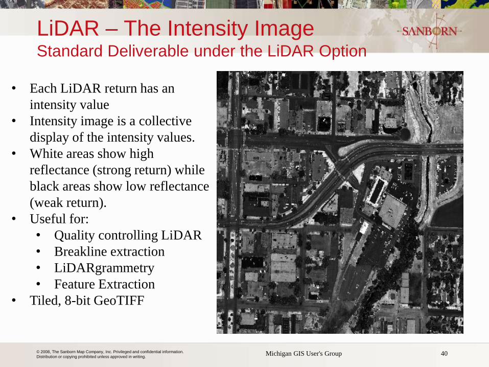
LiDAR – The Intensity Image Standard Deliverable under the LiDAR Option
40 Michigan GIS User's Group
• Each LiDAR return has an
intensity value
• Intensity image is a collective
display of the intensity values.
• White areas show high
reflectance (strong return) while
black areas show low reflectance
(weak return).
• Useful for:
• Quality controlling LiDAR
• Breakline extraction
• LiDARgrammetry
• Feature Extraction
• Tiled, 8-bit GeoTIFF
© 2008, The Sanborn Map Company, Inc. Privileged and confidential information.
Distribution or copying prohibited unless approved in writing.
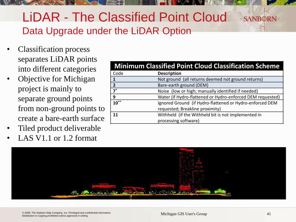
LiDAR - The Classified Point Cloud Data Upgrade under the LiDAR Option
41 Michigan GIS User's Group
• Classification process
separates LiDAR points
into different categories
• Objective for Michigan
project is mainly to
separate ground points
from non-ground points to
create a bare-earth surface
• Tiled product deliverable
• LAS V1.1 or 1.2 format
Minimum Classified Point Cloud Classification Scheme Code Description
1 Not ground (all returns deemed not ground returns) 2 Bare-earth ground (DEM) 7* Noise (low or high; manually identified if needed) 9 Water (if Hydro-flattened or Hydro-enforced DEM requested) 10** Ignored Ground (if Hydro-flattened or Hydro-enforced DEM
requested; Breakline proximity) 11 Withheld (if the Withheld bit is not implemented in
processing software)
© 2008, The Sanborn Map Company, Inc. Privileged and confidential information.
Distribution or copying prohibited unless approved in writing.
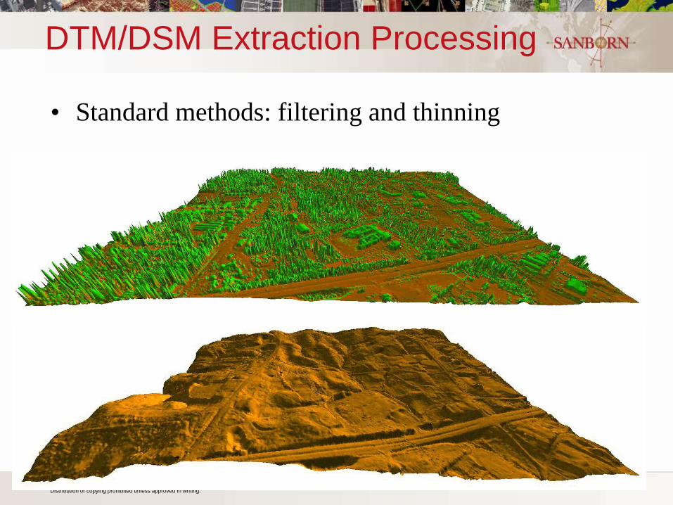
DTM/DSM Extraction Processing
• Standard methods: filtering and thinning
© 2008, The Sanborn Map Company, Inc. Privileged and confidential information.
Distribution or copying prohibited unless approved in writing. 43
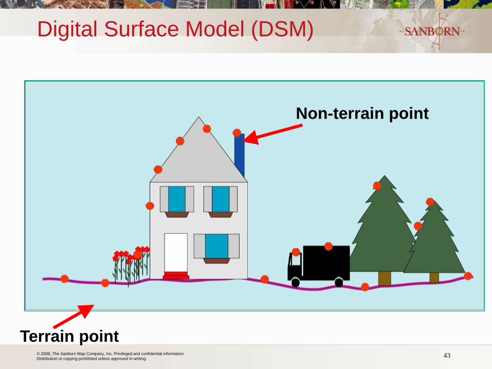
Digital Surface Model (DSM)
Non-terrain point
Terrain point
© 2008, The Sanborn Map Company, Inc. Privileged and confidential information.
Distribution or copying prohibited unless approved in writing.
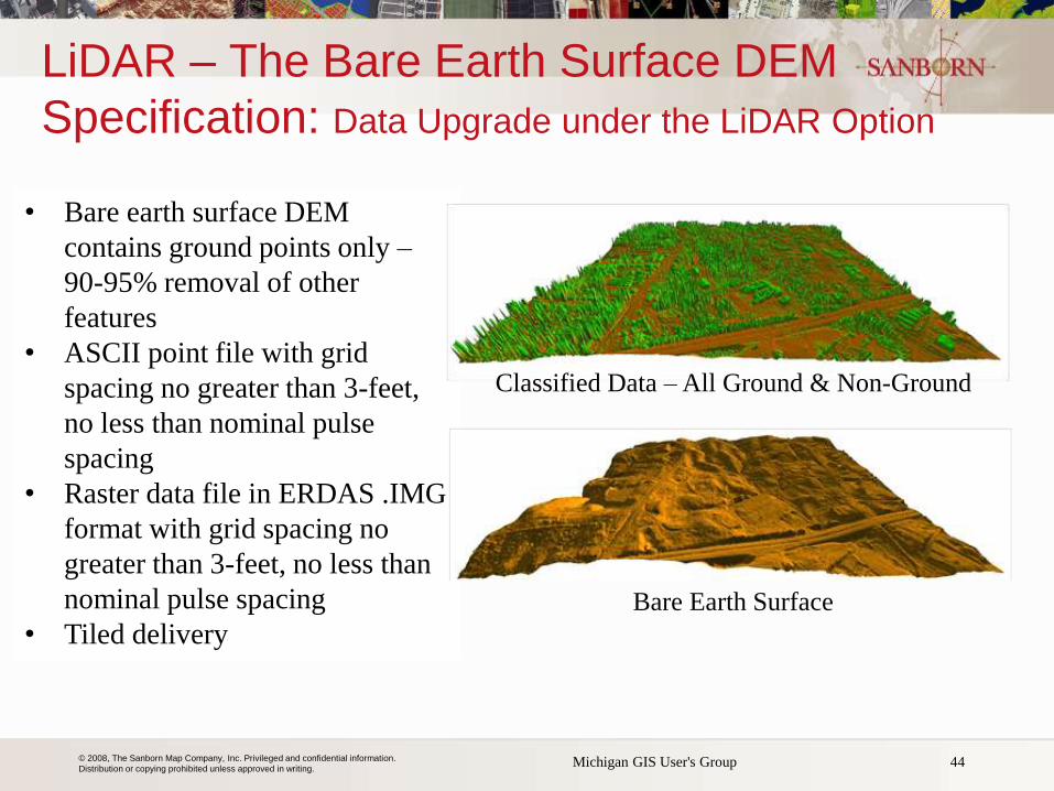
LiDAR – The Bare Earth Surface DEM
Specification: Data Upgrade under the LiDAR Option
44 Michigan GIS User's Group
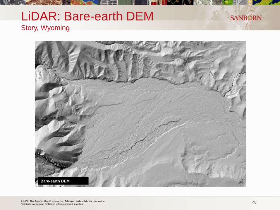
• Bare earth surface DEM
contains ground points only –
90-95% removal of other
features
• ASCII point file with grid
spacing no greater than 3-feet,
no less than nominal pulse
spacing
• Raster data file in ERDAS .IMG
format with grid spacing no
greater than 3-feet, no less than
nominal pulse spacing
• Tiled delivery
Bare Earth Surface
Classified Data – All Ground & Non-Ground
© 2008, The Sanborn Map Company, Inc. Privileged and confidential information.
Distribution or copying prohibited unless approved in writing.
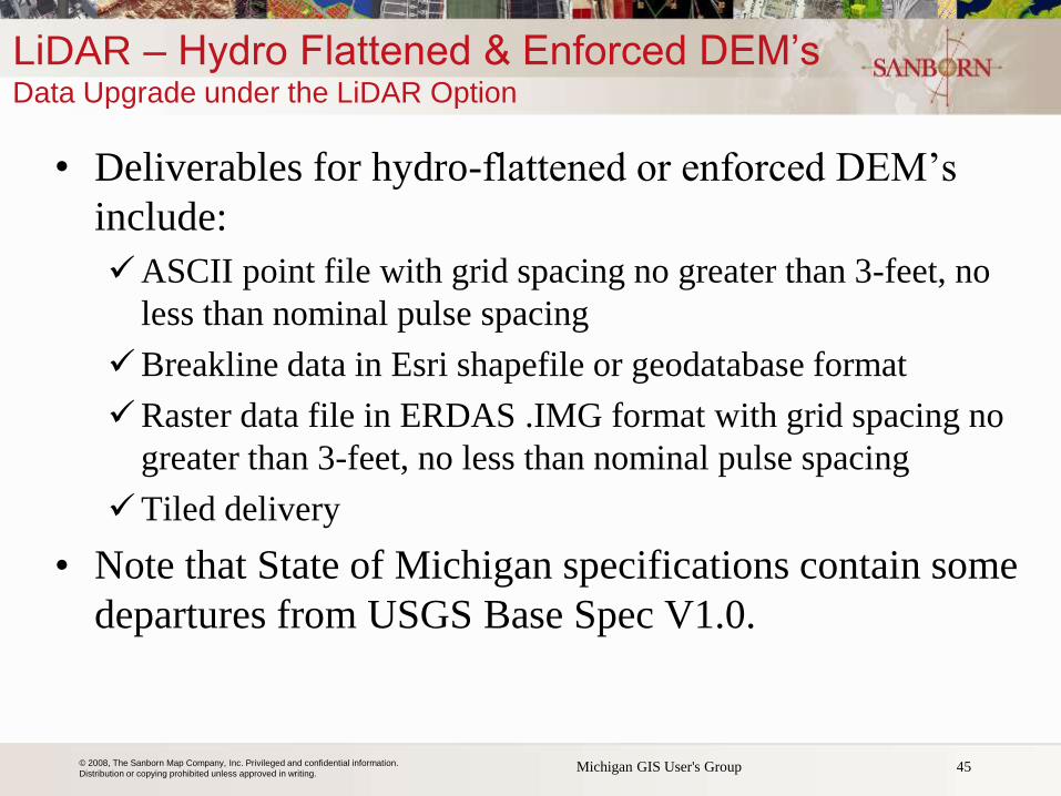
• Deliverables for hydro-flattened or enforced DEM’s
include:
ASCII point file with grid spacing no greater than 3-feet, no
less than nominal pulse spacing
Breakline data in Esri shapefile or geodatabase format
Raster data file in ERDAS .IMG format with grid spacing no
greater than 3-feet, no less than nominal pulse spacing
Tiled delivery
• Note that State of Michigan specifications contain some
departures from USGS Base Spec V1.0.
45 Michigan GIS User's Group
LiDAR – Hydro Flattened & Enforced DEM’s Data Upgrade under the LiDAR Option
© 2008, The Sanborn Map Company, Inc. Privileged and confidential information.
Distribution or copying prohibited unless approved in writing.
LiDAR – Hydro Flattened & Enforced DEM’s Data Upgrade under the LiDAR Option
46 Michigan GIS User's Group
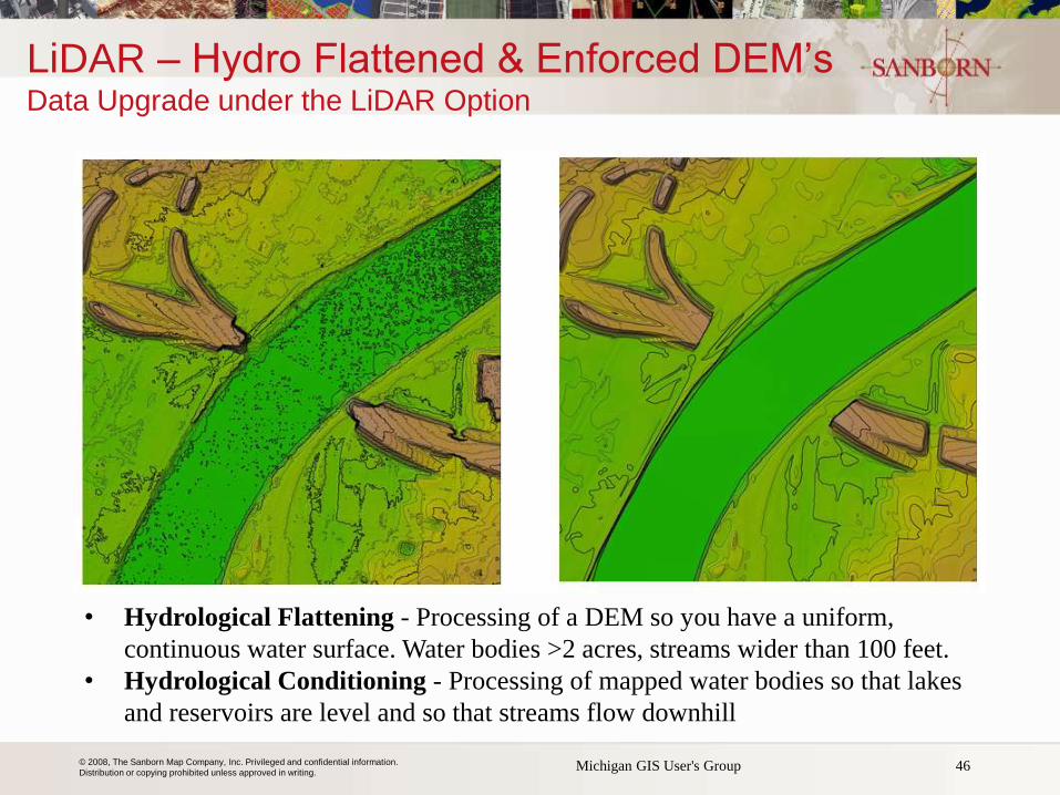
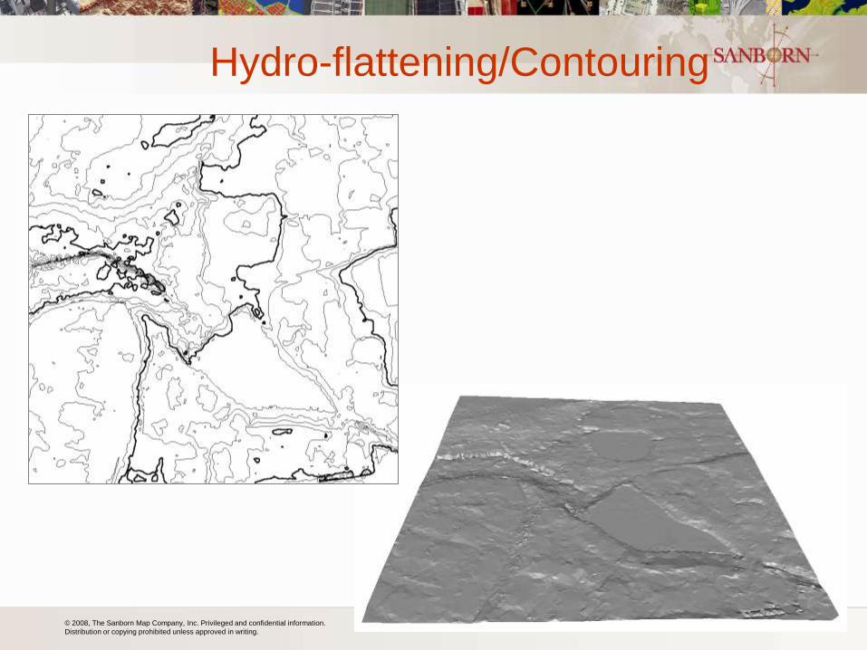
• Hydrological Flattening - Processing of a DEM so you have a uniform,
continuous water surface. Water bodies >2 acres, streams wider than 100 feet.
• Hydrological Conditioning - Processing of mapped water bodies so that lakes
and reservoirs are level and so that streams flow downhill
© 2008, The Sanborn Map Company, Inc. Privileged and confidential information.
Distribution or copying prohibited unless approved in writing. 47
Raw Point Cloud (All-Returns)
All-return DSM
© 2008, The Sanborn Map Company, Inc. Privileged and confidential information.
Distribution or copying prohibited unless approved in writing. 48
LiDAR: Bare-earth DEM Story, Wyoming
Bare-earth DEM
© 2008, The Sanborn Map Company, Inc. Privileged and confidential information.
Distribution or copying prohibited unless approved in writing.
Hydro-flattening/Contouring
© 2008, The Sanborn Map Company, Inc. Privileged and confidential information.
Distribution or copying prohibited unless approved in writing. 50
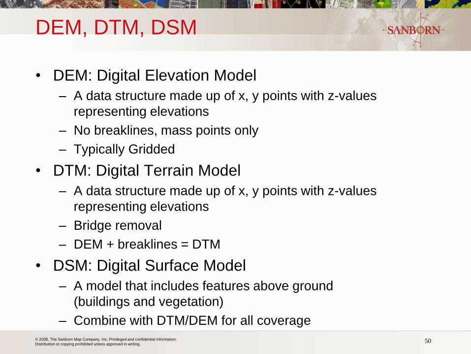
DEM, DTM, DSM
• DEM: Digital Elevation Model
– A data structure made up of x, y points with z-values
representing elevations
– No breaklines, mass points only
– Typically Gridded
• DTM: Digital Terrain Model
– A data structure made up of x, y points with z-values
representing elevations
– Bridge removal
– DEM + breaklines = DTM
• DSM: Digital Surface Model
– A model that includes features above ground
(buildings and vegetation)
– Combine with DTM/DEM for all coverage
© 2008, The Sanborn Map Company, Inc. Privileged and confidential information.
Distribution or copying prohibited unless approved in writing.
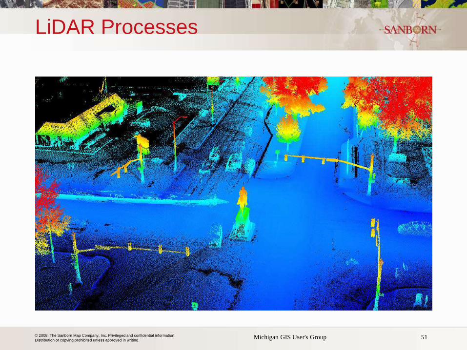
LiDAR Processes
Michigan GIS User's Group 51
© 2008, The Sanborn Map Company, Inc. Privileged and confidential information.
Distribution or copying prohibited unless approved in writing. 52 52
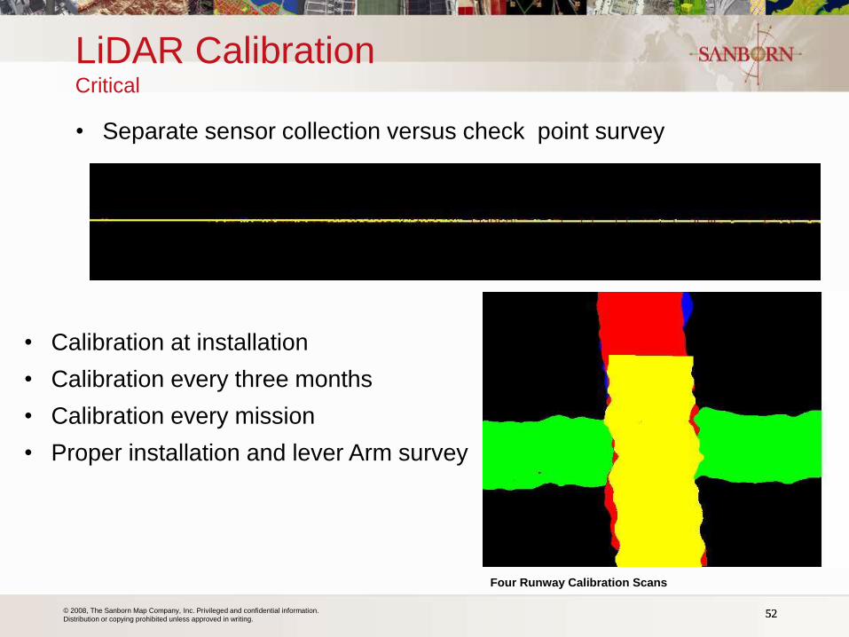
• Separate sensor collection versus check point survey
• Calibration at installation
• Calibration every three months
• Calibration every mission
• Proper installation and lever Arm survey
LiDAR Calibration Critical
Four Runway Calibration Scans
© 2008, The Sanborn Map Company, Inc. Privileged and confidential information.
Distribution or copying prohibited unless approved in writing.
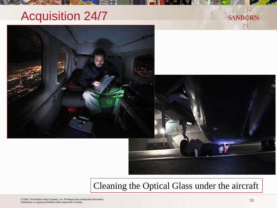
Acquisition 24/7
53
Cleaning the Optical Glass under the aircraft

© 2008, The Sanborn Map Company, Inc. Privileged and confidential information.
Distribution or copying prohibited unless approved in writing.
DTM/DSM Extraction Processing
• Standard methods: filtering and thinning
© 2008, The Sanborn Map Company, Inc. Privileged and confidential information.
Distribution or copying prohibited unless approved in writing.
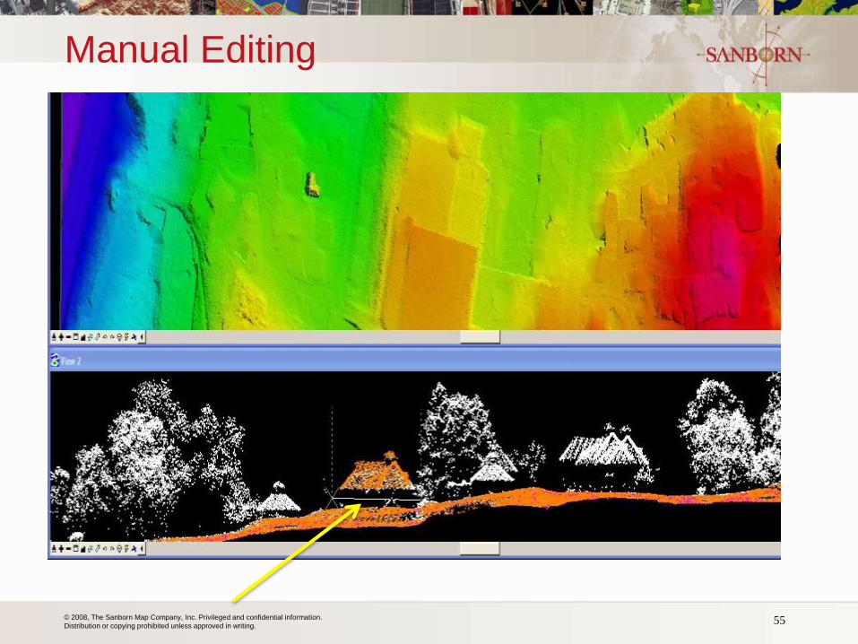
Manual Editing
55
© 2008, The Sanborn Map Company, Inc. Privileged and confidential information.
Distribution or copying prohibited unless approved in writing.
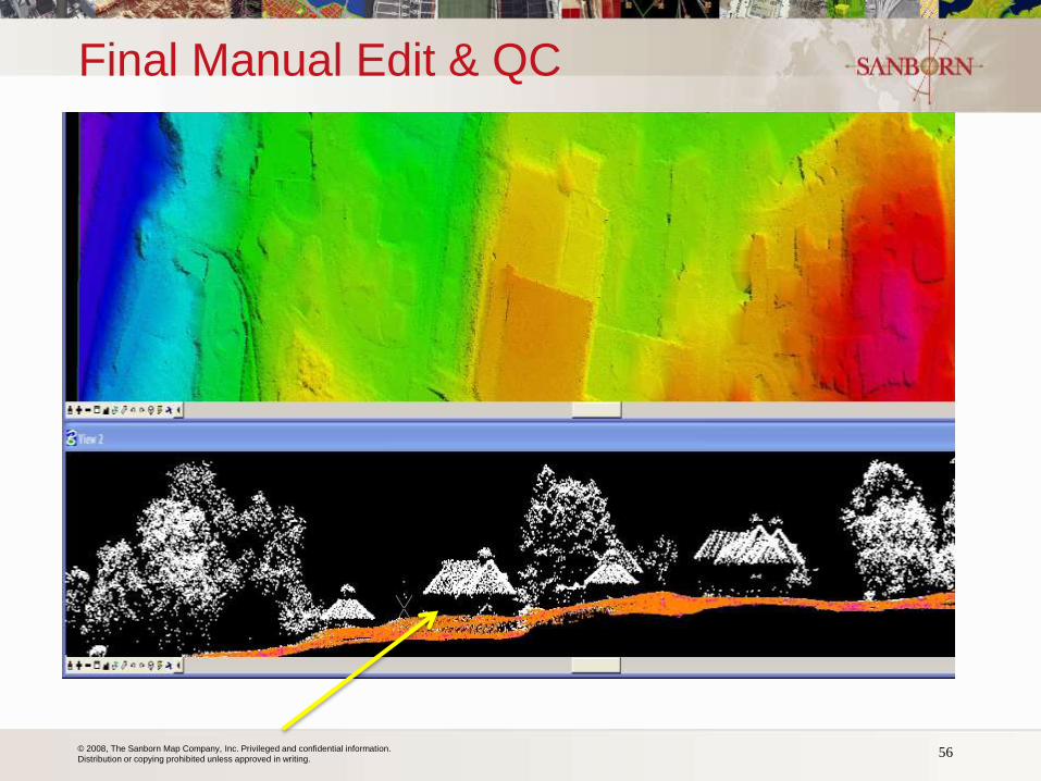
Final Manual Edit & QC
56
© 2008, The Sanborn Map Company, Inc. Privileged and confidential information.
Distribution or copying prohibited unless approved in writing. 57
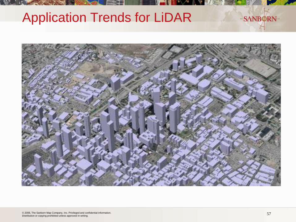
Application Trends for LiDAR
© 2008, The Sanborn Map Company, Inc. Privileged and confidential information.
Distribution or copying prohibited unless approved in writing. 58
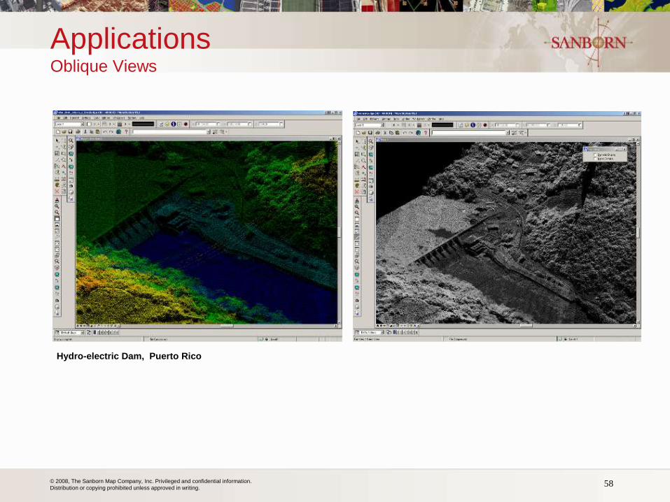
Applications Oblique Views
Hydro-electric Dam, Puerto Rico
© 2008, The Sanborn Map Company, Inc. Privileged and confidential information.
Distribution or copying prohibited unless approved in writing.
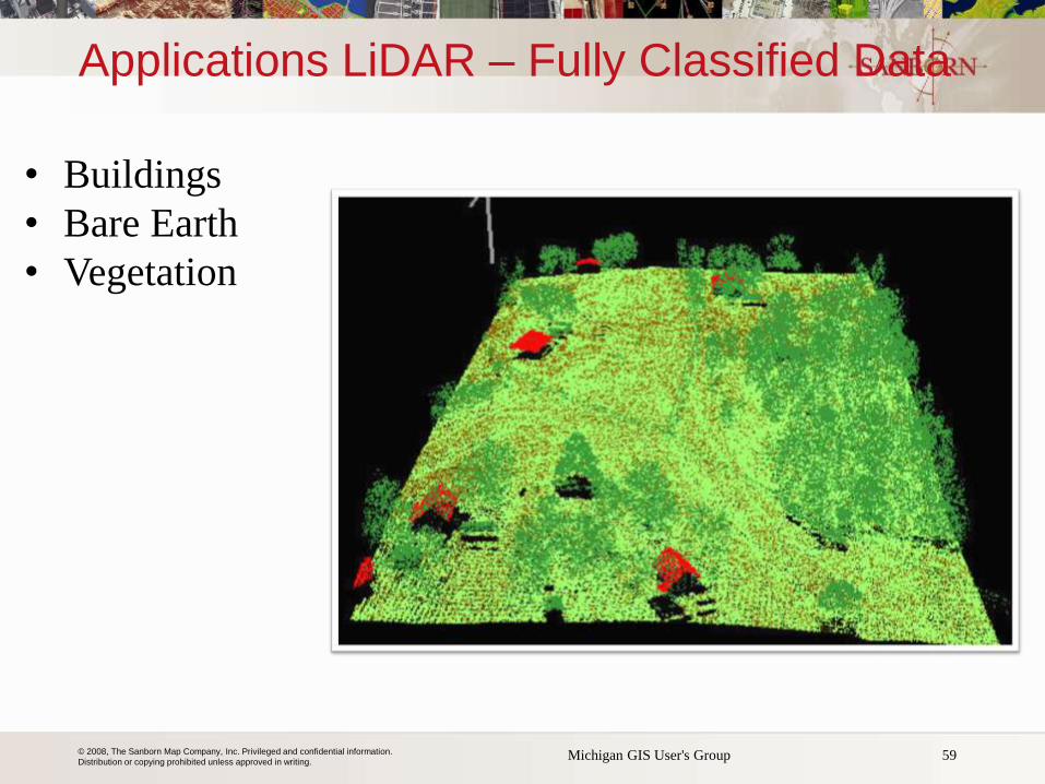
Applications LiDAR – Fully Classified Data
59 Michigan GIS User's Group
• Buildings
• Bare Earth
• Vegetation
© 2008, The Sanborn Map Company, Inc. Privileged and confidential information.
Distribution or copying prohibited unless approved in writing. 60
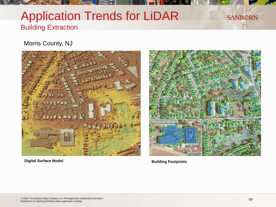
Application Trends for LiDAR Building Extraction
Morris County, NJ
Digital Surface Model Building Footprints
© 2008, The Sanborn Map Company, Inc. Privileged and confidential information.
Distribution or copying prohibited unless approved in writing. 61
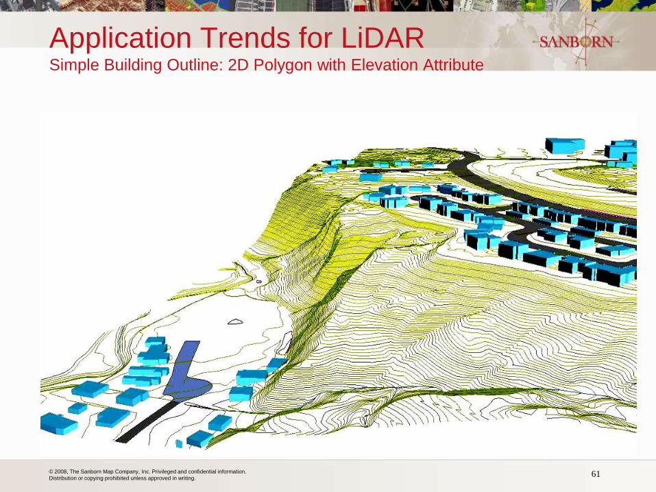
Application Trends for LiDAR Simple Building Outline: 2D Polygon with Elevation Attribute
© 2008, The Sanborn Map Company, Inc. Privileged and confidential information.
Distribution or copying prohibited unless approved in writing.
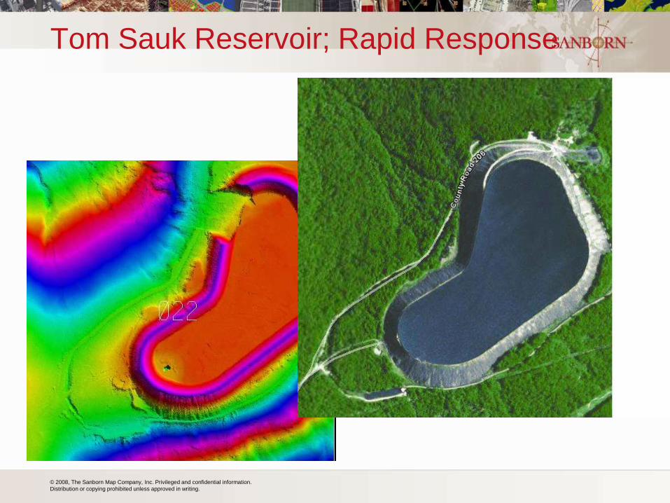
Tom Sauk Reservoir; Rapid Response
© 2008, The Sanborn Map Company, Inc. Privileged and confidential information.
Distribution or copying prohibited unless approved in writing. 63
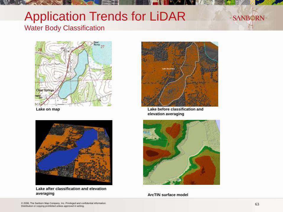
Lake on map Lake before classification and
elevation averaging
Lake after classification and elevation
averaging ArcTIN surface model
Application Trends for LiDAR Water Body Classification
© 2008, The Sanborn Map Company, Inc. Privileged and confidential information.
Distribution or copying prohibited unless approved in writing.
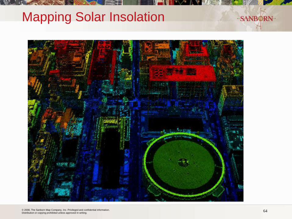
Mapping Solar Insolation
64
© 2008, The Sanborn Map Company, Inc. Privileged and confidential information.
Distribution or copying prohibited unless approved in writing.
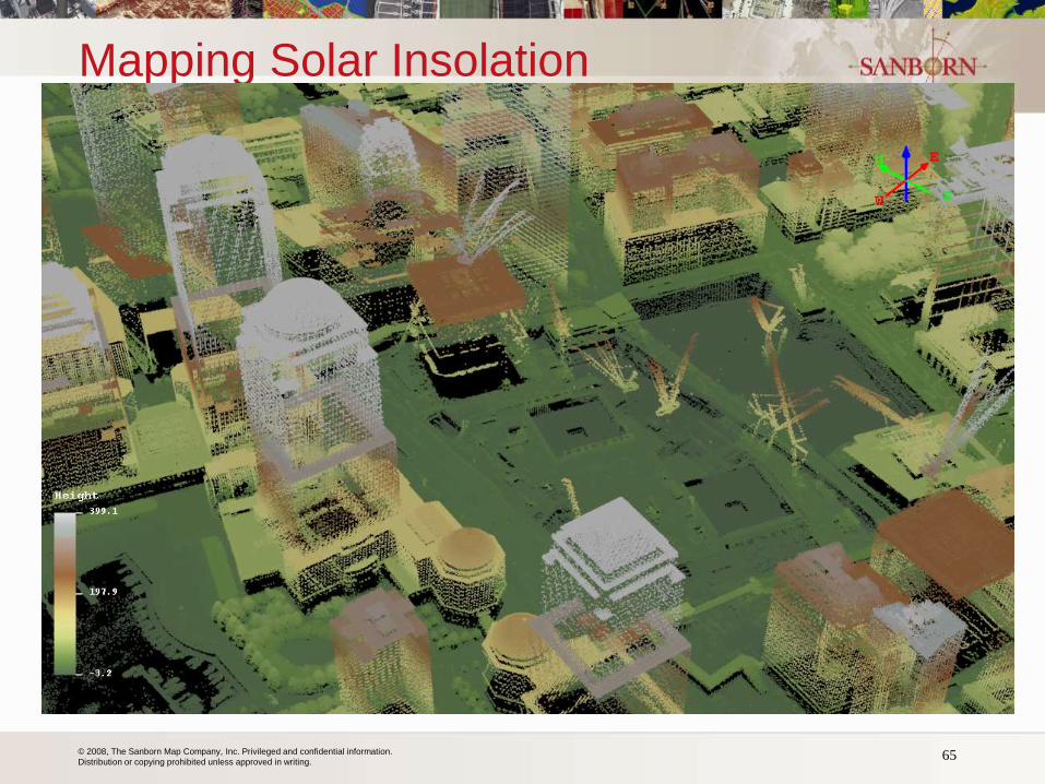
Mapping Solar Insolation
65
© 2008, The Sanborn Map Company, Inc. Privileged and confidential information.
Distribution or copying prohibited unless approved in writing.
Michigan – DaaS (Option)
66
• Imagery hosted in the ‘Cloud’
• State to load and test accessibility and performance
• Determine what requirements are met
• Assess viability and cost of implementing additional
requirements
• Test and determine course of action
• Possible offering to partners
© 2008, The Sanborn Map Company, Inc. Privileged and confidential information.
Distribution or copying prohibited unless approved in writing.
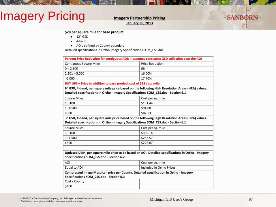
Imagery Pricing
67 Michigan GIS User's Group
Imagery Partnership Pricing January 30, 2013
$28 per square mile for base product: 12” GSD
4-band
AOIs defined by County boundary Detailed specifications in Ortho-Imagery Specifications SOM_CSS.doc
Percent Price Reduction for contiguous AOIs – assumes consistent GSD collection over the AOI
Contiguous Square Miles Price Reduction
0 – 2,500 0%
2,501 – 5,000 16.00%
>5,000 17.70%
BUY UPS – Price in addition to base product cost of $28 / sq. mile
6” GSD, 4-band, per square mile price based on the following High Resolution Areas (HRA) values. Detailed specifications in Ortho - Imagery Specifications SOM_CSS.doc - Section 6.1
Square Miles Cost per sq. mile
10-100 $151.44
101-500 $94.08
>500 $82.53
3” GSD, 4-band, per square mile price based on the following High Resolution Areas (HRA) values. Detailed specifications in Ortho - Imagery Specifications SOM_CSS.doc - Section 6.1
Square Miles Cost per sq. mile
10-100 $359.14
101-500 $243.57
>500 $226.87
Updated DEM, per square mile price to be based on AOI. Detailed specifications in Ortho - Imagery Specifications SOM_CSS.doc - Section 6.2
AOI Cost per sq. mile
Equal to AOI Included in Ortho Prices
Compressed Image Mosaics - price per County. Detailed specification in Ortho - Imagery Specifications SOM_CSS.doc - Section 6.3
Cost / County
$400
© 2008, The Sanborn Map Company, Inc. Privileged and confidential information.
Distribution or copying prohibited unless approved in writing. Michigan GIS User's Group 68
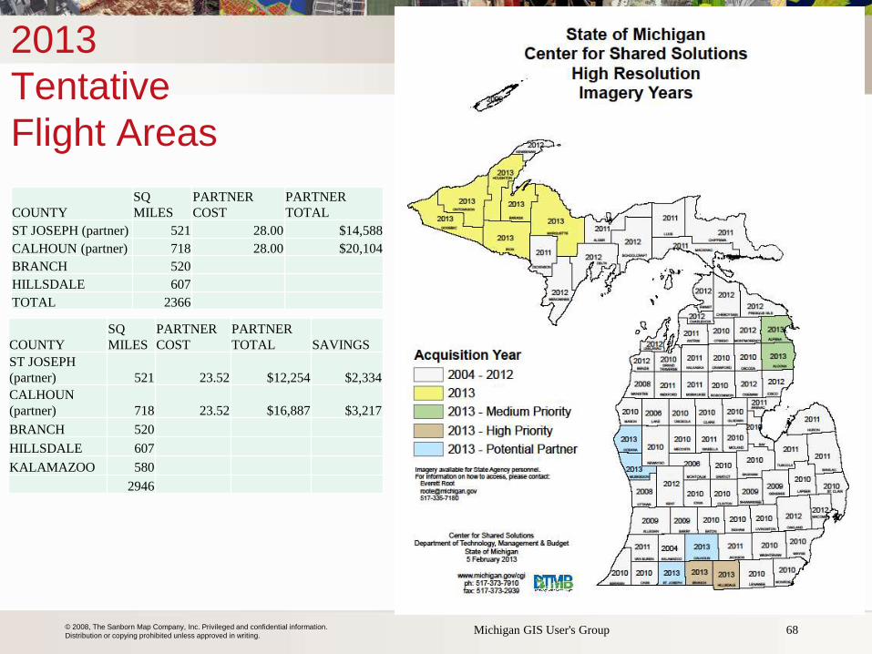
2013
Tentative
Flight Areas
COUNTY SQ
MILES PARTNER
COST PARTNER
TOTAL
ST JOSEPH (partner) 521 28.00 $14,588
CALHOUN (partner) 718 28.00 $20,104
BRANCH 520
HILLSDALE 607
TOTAL 2366
COUNTY SQ
MILES PARTNER
COST PARTNER
TOTAL SAVINGS
ST JOSEPH
(partner) 521 23.52 $12,254 $2,334
CALHOUN
(partner) 718 23.52 $16,887 $3,217
BRANCH 520
HILLSDALE 607
KALAMAZOO 580
2946
© 2008, The Sanborn Map Company, Inc. Privileged and confidential information.
Distribution or copying prohibited unless approved in writing.
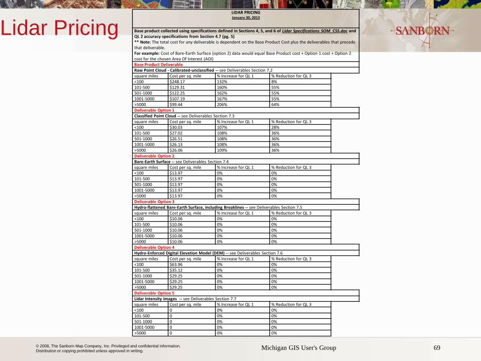
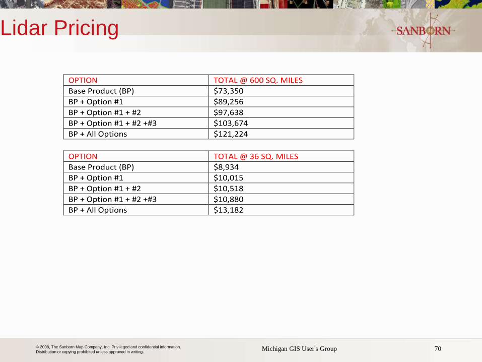
Lidar Pricing
69 Michigan GIS User's Group
LIDAR PRICING January 30, 2013
Base product collected using specifications defined in Sections 4, 5, and 6 of Lidar Specifications SOM_CSS.doc and QL 2 accuracy specifications from Section 4.7 (pg. 5) ** Note: The total cost for any deliverable is dependent on the Base Product Cost plus the deliverables that precede that deliverable. For example: Cost of Bare-Earth Surface (option 2) data would equal Base Product cost + Option 1 cost + Option 2 cost for the chosen Area Of Interest (AOI) Base Product Deliverable Raw Point Cloud - Calibrated-unclassified -- see Deliverables Section 7.2 square miles Cost per sq. mile % Increase for QL 1 % Reduction for QL 3
<100 $248.17 132% 8%
101-500 $129.31 160% 55%
501-1000 $122.25 162% 55%
1001-5000 $107.19 167% 55%
>5000 $99.44 206% 64%
Deliverable Option 1 Classified Point Cloud -- see Deliverables Section 7.3 square miles Cost per sq. mile % Increase for QL 1 % Reduction for QL 3
<100 $30.03 107% 28%
101-500 $27.02 108% 36%
501-1000 $26.51 108% 36%
1001-5000 $26.13 108% 36%
>5000 $26.06 109% 36%
Deliverable Option 2 Bare-Earth Surface -- see Deliverables Section 7.4 square miles Cost per sq. mile % Increase for QL 1 % Reduction for QL 3
<100 $13.97 0% 0%
101-500 $13.97 0% 0%
501-1000 $13.97 0% 0%
1001-5000 $13.97 0% 0%
>5000 $13.97 0% 0%
Deliverable Option 3 Hydro-flattened Bare-Earth Surface, including Breaklines -- see Deliverables Section 7.5 square miles Cost per sq. mile % Increase for QL 1 % Reduction for QL 3
<100 $10.06 0% 0%
101-500 $10.06 0% 0%
501-1000 $10.06 0% 0%
1001-5000 $10.06 0% 0%
>5000 $10.06 0% 0%
Deliverable Option 4 Hydro-Enforced Digital Elevation Model (DEM) -- see Deliverables Section 7.6 square miles Cost per sq. mile % Increase for QL 1 % Reduction for QL 3
<100 $63.96 0% 0%
101-500 $35.12 0% 0%
501-1000 $29.25 0% 0%
1001-5000 $29.25 0% 0%
>5000 $29.25 0% 0%
Deliverable Option 5 Lidar Intensity Images -- see Deliverables Section 7.7 square miles Cost per sq. mile % Increase for QL 1 % Reduction for QL 3
<100 0 0% 0%
101-500 0 0% 0%
501-1000 0 0% 0%
1001-5000 0 0% 0%
>5000 0 0% 0%
© 2008, The Sanborn Map Company, Inc. Privileged and confidential information.
Distribution or copying prohibited unless approved in writing.
Lidar Pricing
70 Michigan GIS User's Group
OPTION TOTAL @ 600 SQ. MILES
Base Product (BP) $73,350
BP + Option #1 $89,256
BP + Option #1 + #2 $97,638
BP + Option #1 + #2 +#3 $103,674
BP + All Options $121,224
OPTION TOTAL @ 36 SQ. MILES
Base Product (BP) $8,934
BP + Option #1 $10,015
BP + Option #1 + #2 $10,518
BP + Option #1 + #2 +#3 $10,880
BP + All Options $13,182
© 2008, The Sanborn Map Company, Inc. Privileged and confidential information.
Distribution or copying prohibited unless approved in writing.
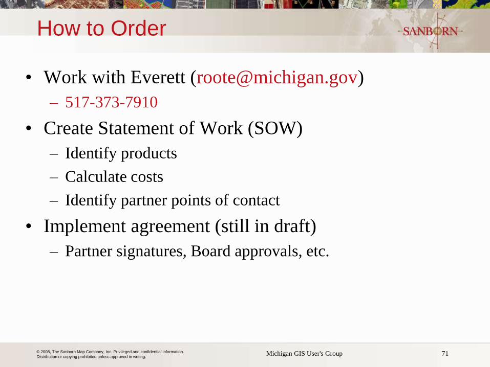
How to Order
• Work with Everett ([email protected])
– 517-373-7910
• Create Statement of Work (SOW)
– Identify products
– Calculate costs
– Identify partner points of contact
• Implement agreement (still in draft)
– Partner signatures, Board approvals, etc.
71 Michigan GIS User's Group

© 2008, The Sanborn Map Company, Inc. Privileged and confidential information.
Distribution or copying prohibited unless approved in writing.
Thank you to State of Michigan
for this Opportunity
72
Krysia Sapeta (321) 613.2809 [email protected] Brad Arshat (443) 603.7725 [email protected]