state vehicular recreation area final general · pdf file13.12.2012 · table of...
TRANSCRIPT

State Clearinghouse Number 2010092003
June 2012
Final General Plan
S T A T E V E H I C U L A R R E C R E A T I O N A R E A

This page intentionally left blank.

CALIFORNIA STATE PARKS
Final General Plan
State Clearinghouse Number 2010092003
Edmund G. Brown, Jr.
Governor
John Laird
Secretary, The Natural Resources Agency
Ruth Coleman
Director, California State Parks
P.O. Box 942896
Sacramento, CA 94296-0001
Adopted June 23, 2012

This page intentionally left blank.


TABLE OF CONTENTS
Section Page
Clay Pit State Vehicular Recreation Area Final General Plan i June 2012
Chapter 1.0 – Introduction .......................................................................................................................................... 1-1
1.1 Local and Regional Context .................................................................................................................... 1-1
1.2 Site Characteristics .................................................................................................................................... 1-4
1.3 Purpose Acquired ...................................................................................................................................... 1-4
1.4 Sense of Place .............................................................................................................................................. 1-5
1.5 Purpose of the General Plan .................................................................................................................. 1-5
1.6 Organization of the General Plan ......................................................................................................... 1-5
1.7 Subsequent Planning and Environmental Review ........................................................................ 1-6
1.8 The Planning Process ............................................................................................................................... 1-7
1.9 Interagency and Stakeholder Involvement ..................................................................................... 1-9
Chapter 2.0 – Existing Conditions ............................................................................................................................. 2-1
2.1 Regional Land Use and Facilities ......................................................................................................... 2-1
2.2 Existing Clay Pit SVRA Land Use and Facilities .............................................................................. 2-6
2.3 Significant Resource Values ................................................................................................................... 2-9
2.4 Operations ................................................................................................................................................. 2-40
2.5 Interpretation and Education ............................................................................................................ 2-42
2.6 Park Support ............................................................................................................................................. 2-43
2.7 Planning Influences ................................................................................................................................ 2-43
Chapter 3.0 – Issues and Analysis ............................................................................................................................. 3-1
3.1 Planning Assumptions ............................................................................................................................. 3-1
3.2 SVRA Planning Issues ............................................................................................................................... 3-1
Chapter 4.0 – The Plan .................................................................................................................................................. 4-1
4.1 Purpose and Vision ................................................................................................................................... 4-1
4.2 Unit Classification ...................................................................................................................................... 4-1
4.3 Land Use Management............................................................................................................................. 4-2
4.4 Goals and Guidelines ............................................................................................................................. 4-13
4.5 Managing Visitor Capacity ................................................................................................................... 4-35
Chapter 5.0 – References .............................................................................................................................................. 5-1 Figures
Figure 1-1 Regional Location of Clay Pit SVRA ............................................................................................. 1-2 Figure 1-2 Local Context of Clay Pit SVRA ...................................................................................................... 1-3 Figure 1-3 The General Plan Process ................................................................................................................ 1-8 Figure 2-1 Land Use ................................................................................................................................................. 2-2 Figure 2-2 Existing Conditions ......................................................................................................................... 2-13 Figure 2-3 Sacramento Valley Groundwater Basin Information ......................................................... 2-16 Figure 2-4 Photo Viewpoints ............................................................................................................................ 2-36 Figure 2-5 Clay Pit SVRA Visitor Estimates per Fiscal Year .................................................................. 2-65 Figure 4-1 Use Areas and Headquarters Facilities ...................................................................................... 4-4 Figure 4-2 Anticipated Facilities ...................................................................................................................... 4-11

TABLE OF CONTENTS
Section Page
Clay Pit State Vehicular Recreation Area June 2012 ii Final General Plan
Tables
Table 2-1: Countywide Population Growth ....................................................................................................... 2-64
Table 4-1: Use Area Matrix .......................................................................................................................................... 4-3
Table 4-2: Desired Outcomes and Indicators for Visitor Capacity ............................................................ 4-38
Appendices
A Public Participation and Outreach Process Summary B Traffic Report C Visitor Projections D Geotechnical Investigations

ACRONYMS AND ABBREVIATIONS
Clay Pit State Vehicular Recreation Area Final General Plan iii June 2012
ADA Americans with Disabilities Act
ALUC airport land use commission
ALUCP Airport Land Use Compatibility Plan
AQMD Air Quality Management District
CARB California Air Resources Board
ASI All-Terrain Vehicle Safety Institute
ATV all-terrain vehicle
BCAG Butte County Association of Governments
BCFD Butte County Fire Department
BLM U.S. Department of the Interior Bureau of Land Management
BMO Basin Management Objective
BMP best management practice
CAA federal Clean Air Act
CAAQS California Ambient Air Quality Standards
CAL FIRE California Department of Forestry and Fire Protection
Cal/EPA California Environmental Protection Agency
CEQA California Environmental Quality Act
CESA California Endangered Species Act
CFR Code of Federal Regulations
CH4 methane
CHP California Highway Patrol
City City of Oroville
CNDDB California Natural Diversity Database
CO2 carbon dioxide
CRHR California Register of Historical Resources
CWA Clean Water Act of 1972
Department Butte County Department of Water and Resource Conservation
DFG California Department of Fish and Game
DMA Drainage Management Area
DOF California Department of Finance
DU Development Use Area
DWR California Department of Water Resources

ACRONYMS AND ABBREVIATIONS
Clay Pit State Vehicular Recreation Area June 2012 iv Final General Plan
E-Street MX E Street Motocross
EIR environmental impact report
EPA U.S. Environmental Protection Agency
ESA federal Endangered Species Act
GHG greenhouse gas
HCP habitat conservation plan
IPCC Intergovernmental Panel on Climate Change
LEED® Leadership in Energy and Environmental Design
LOS levels of service
MBTA Migratory Bird Treaty Act
MLD most likely descendent
mph miles per hour
MPO metropolitan planning organization
NAAQS National Ambient Air Quality Standards
NAHC Native American Heritage Commission
N2O nitrous oxide
NCCP natural community conservation plan
NIC Northeast Information Center
NOAA National Oceanic and Atmospheric Administration
NOX oxides of nitrogen
NPDES National Pollutant Discharge Elimination System
NRHP National Register of Historic Places
NRM Natural Resource Management
SVAB Sacramento Valley Air Basin
OHMVR Off-Highway Motor Vehicle Recreation
OHV off-highway vehicle
OHV BMP Manual OHV BMP Manual for Erosion and Sediment Control
OM Operations and Management
PEF Project Evaluation Form
PM2.5 fine particulate matter with an aerodynamic resistance diameter of 2.5 micrometers or less

ACRONYMS AND ABBREVIATIONS
Clay Pit State Vehicular Recreation Area Final General Plan v June 2012
PM10 respirable particulate matter with an aerodynamic diameter of 10 micrometers or less
PRC California Public Resource Code
RD Resource Conservation land use designation
ROG reactive organic gas
RTP Regional Transportation Plan
RWQCB Regional Water Quality Control Board
SCOR Sewerage Commission—Oroville Region
SCRCD Sutter County Resource Conservation District
SHPO State Historic Preservation Officer
SIP State Implementation Plan
SIU Sub-Inventory Unit
SOI sphere of influence
SPPO State Parks Peace Officer
SR State Route
SRA State Recreation Area
State Parks California Department of Parks and Recreation
SVAB Sacramento Valley Air Basin
SVRA State Vehicular Recreation Area
SWP State Water Project
TAC toxic air contaminant
TMDL total maximum daily load
USACE U.S. Army Corps of Engineers
USFS U.S. Forest Service
USFWS U.S. Fish and Wildlife Service
USGS United States Geological Survey
UTV Utility Terrain Vehicle
VELB valley elderberry longhorn beetle
VEO Visitor Experience and Opportunities

Clay Pit State Vehicular Recreation Area June 2012 vi Final General Plan
This page intentionally left blank.

1.0 Introduction
Clay Pit State Vehicular Recreation Area Final General Plan 1-1 June 2012
Chapter 1.0 – Introduction
SVRA visitors parked beneath the cottonwoods
Clay Pit State Vehicular Recreation Area (Clay Pit SVRA or the SVRA) is a 220-acre site that is used
for off-highway vehicle (OHV) recreational use. The Clay Pit basin is a large, shallow, excavated
depression that was formed when clay was mined and used to construct the Oroville Dam. After
construction of the dam was complete, California State Parks (State Parks) entered into an
agreement with the California Department of Fish and Game (DFG) and the California Department
of Water Resources (DWR) to take over management of the northern section of the Clay Pit site for
the purpose of providing OHV recreation. The DFG manages a shooting range on the southern
portion of the Clay Pit site.
1.1 Local and Regional Context
Clay Pit SVRA is located in unincorporated Butte County (Figure 1-1). The site is on Larkin Road, 2
miles south of Oroville Dam Boulevard (State Route [SR] 162). The Oroville Municipal Airport is
located north and northwest of the SVRA, scattered residences and agricultural uses are located to
the west, and DFG’s Oroville Wildlife Management Area is located to the east and south (Figure 1-
2). The closest SVRAs to Clay Pit SVRA are Prairie City SVRA in Rancho Cordova, approximately 90
miles to the south, and Carnegie SVRA in Livermore, 160 miles to the south. Mammoth Bar OHV
Area is located within the Auburn State Recreation Area (SRA) located in the Sierra Nevada
foothills approximately 70 miles southeast of Clay Pit SVRA. Lake Oroville SRA northeast of
Oroville is the closest state park unit.
The nearest population centers include the City of Oroville (15,000 population), just north and
east of Clay Pit SVRA; the City of Biggs (1,800 population), approximately 6 miles southwest; and
the City of Gridley (6,500 population), approximately 9 miles southwest. The largest city in the
region is Chico (88,000 population), approximately 30 miles to the northwest. Sacramento
(447,000 population) is approximately 70 miles to the south. The population within
unincorporated Butte County includes approximately 84,000 people (DOF 2010).

1.0 Introduction
Clay Pit State Vehicular Recreation Area June 2012 1-2 Final General Plan
Source: Adapted by AECOM in 2010
Regional Location of Clay Pit SVRA Figure 1-1

1.0 Introduction
Clay Pit State Vehicular Recreation Area Final General Plan 1-3 June 2012
Source: Adapted by AECOM in 2010
Local Context of Clay Pit SVRA Figure 1-2

1.0 Introduction
Clay Pit State Vehicular Recreation Area June 2012 1-4 Final General Plan
1.2 Site Characteristics
The natural topography of Clay Pit SVRA was highly altered by the excavation of clay materials
used to construct Oroville Dam. A terrace surrounding the excavated pit contains the only
remaining natural topography and vegetation. A central drainage canal transects the site from the
northwest to the southeast. During the rainy season, runoff from the airport property to the north
is conveyed through a culvert under Larkin Road and into this canal. This water is then discharged
off-site to a remnant oxbow lake within the DFG Oroville Wildlife Area to the east, adjacent to the
Feather River.
Plant communities in the SVRA consist of degraded annual grassland and wetlands. Wetland
communities include vernal pools, an intermittent drainage, the drainage canal, and an emergent
marsh. Degraded annual grasslands occur primarily along the bluffs and elevated rim along the
northern and western perimeter of the SVRA, but also are located throughout the basin floor
where slight elevations in microtopography occur.
Clay Pit SVRA is considered a destination for beginner and intermediate riders and offers hills to
climb, an open riding area, and informal trails. Clay Pit SVRA contains a limited number of
developed facilities, including a paved parking lot, an interpretive sign, two shade ramadas, two
picnic tables, and a vault toilet.
Northeast section of Clay Pit SVRA: existing restroom, parking lot, ramadas, and picnic tables
1.3 Purpose Acquired
In 1981, State Parks entered into an agreement with DFG and DWR, the land owners, to take over
management of the Clay Pit site, previously known as “the impervious materials borrow area at
Oroville Division.” The Agreement for Transfer to Department of Parks and Recreation of the

1.0 Introduction
Clay Pit State Vehicular Recreation Area Final General Plan 1-5 June 2012
Impervious Materials Borrow Area at Oroville Division was signed on January 22, 1981. The
agreement gave State Parks the right to plan, develop, and administer real and personal property
for the site as an OHV park, and the site was designated as an SVRA. DWR retains the right to
inundate the site or remove additional borrow material if necessary for the Oroville Division of the
State Water Project (Oroville Dam); however, to date, DWR has not exercised these rights nor
expressed an interest in exercising these rights.
1.4 Sense of Place
Clay Pit SVRA is a destination for beginner and intermediate OHV recreationists who generally
visit the site for a few hours of practice and then return to the local communities. Clay Pit SVRA
provides an inexpensive local opportunity for OHV recreation.
OHV recreationist in the Clay Pit SVRA basin
1.5 Purpose of the General Plan
This Clay Pit SVRA General Plan is a broad-based policy document that establishes a long-range
vision and provides goals and guidelines to direct future improvements, services, and programs in
Clay Pit SVRA. By providing a clear purpose and vision, and long and short-term goals and
guidelines, the General Plan defines the broadest management framework possible for Clay Pit
SVRA including program development, ongoing management, and public use. This framework is
intended to guide day-to-day decision making and serve as the basis for developing focused
feasibility and management plans, specific project plans, and other management actions necessary
to implement the goals of the General Plan. General Plans do not expire, per se, but are
reconsidered for amendments or revisions when circumstances and needs dictate, such as
additional land acquisitions and/or substantial development considerations that were not
addressed in the General Plan or evaluated during the General Plan process.
1.6 Organization of the General Plan
This General Plan is organized into six chapters. The first three chapters provide an overview of
Clay Pit SVRA. Chapter 4.0 presents goals and guidelines for Clay Pit SVRA. Chapters 5.0 and 6.0

1.0 Introduction
Clay Pit State Vehicular Recreation Area June 2012 1-6 Final General Plan
provide references and plan contributor information. A brief description of each General Plan
chapter is provided below.
► Chapter 1.0 provides an introduction to Clay Pit SVRA.
► Chapter 2.0 presents a summary of existing conditions, facilities, and important resources.
► Chapter 3.0 summarizes and analyzes key issues identified during the planning process.
► Chapter 4.0 provides an overview of the proposed General Plan components, including SVRA
classification, purpose, vision, goals and guidelines, and land use management.
► Chapter 5.0 lists references cited.
► Chapter 6.0 identifies General Plan contributors.
1.7 Subsequent Planning and Environmental Review
The General Plan provides a framework to guide the management and planning for Clay Pit SVRA;
however, future programs and projects may require plans that offer more specific guidance or
details. Subsequent plans for Clay Pit SVRA may include management plans or project plans, as
described below. Any subsequent planning efforts must be consistent with the General Plan. If a
subsequent program or project would be inconsistent with the General Plan (e.g., a proposed
change in use within a designated use area), a General Plan amendment or revision would be
required.
Subsequent Plan Type Description Examples
Management plan Defines the objectives, methodologies, and/or designs for accomplishing management goals. Management plans are consistent with systemwide plans and policies and with the unit’s General Plan. Prepared on an as-needed basis, management plans typically focus on specific management topics, goals, or issues.
Resource management plans Trail management plans Operation plans Interpretive plans Concession plans
Specific project plan Detailed implementation plans are needed to accomplish specific projects.
Design concepts Facility development plans (e.g., OHV track, developed trail system)
A General Plan is considered a “project” under the California Environmental Quality Act (CEQA)
and is subject to environmental review. The proposed project involves the adoption of a General
Plan, which of itself would cause no environmental impacts. Implementation of the General Plan
would include actions that could physically alter the environment. Possible actions that may result
from the adoption and implementation of the General Plan are anticipated, and potential impacts
resulting from these actions were analyzed in an environmental impact report (EIR). The EIR
addresses all of the points required by Article 9 of the State CEQA Guidelines, including existing

1.0 Introduction
Clay Pit State Vehicular Recreation Area Final General Plan 1-7 June 2012
setting, impact analysis, alternatives analysis, and cumulative impacts. The EIR is an
accompanying document to this General Plan, bound as a separate volume.
The goals, guidelines, proposed use areas, uses, and facilities described in this General Plan were
evaluated in the EIR for their potential effects on the environment. The environmental analysis
was conducted concurrent with the development of the General Plan. Impact minimization
measures were incorporated within the General Plan wherever possible to help ensure that
planned actions described in the General Plan, including those to be implemented in the future,
will not result in significant environmental impacts.
Therefore, the CEQA analysis detailed in the EIR that accompanies this General Plan is intended to
be adequate for many future projects implemented in a manner consistent with the goals and
guidelines herein. Some actions described in the General Plan may require additional CEQA
analysis documentation once the project details are known. Projects that may be implemented in
the future as a result of adopting this General Plan must be subjected to CEQA review according to
CEQA Guidelines Section 15168, in light of the information in the EIR prepared for this General
Plan, to determine if additional CEQA documentation is necessary. The type of additional CEQA
documentation completed would be determined based on CEQA Guidelines Sections 15162–
15164. When future projects requiring additional environmental review are implemented, State
Parks may refer to the EIR prepared for this General Plan as a starting point for a “tiered CEQA
analysis,” per Section 15168 of the State CEQA Guidelines.
Although most of the General Plan was analyzed at a programmatic level, the specific proposal for
new headquarters facilities was analyzed at a “project” level per Section 15161 of the State CEQA
Guidelines. Once the General Plan has been approved and the accompanying EIR has been certified
by the Off-Highway Motor Vehicle Recreation (OHMVR) Commission, construction of the new
headquarters facilities may move forward without further CEQA review.
1.8 The Planning Process
1.8.1 Overview of the Planning Process
This is the first General Plan prepared for Clay Pit SVRA. Key phases in the General Plan process
included researching existing conditions and evaluating resources, gathering public input,
developing and evaluating land use alternatives, selecting a preferred alternative, and preparing
the General Plan document. Eight major steps completed while preparing the General Plan are
illustrated in Figure 1-3.
Existing conditions research included the preparation of a cultural resources survey, a wetland
delineation, a reconnaissance-level wildlife survey, a survey for special-status shrimp species, a
survey for special-status plants, a hydrologic assessment, a noise and sound assessment, and a
visitor survey. Steps used for gathering public input are described in section 1.9 below. Existing
1.0 Introduction
Clay Pit State Vehicular Recreation Area June 2012 1-8 Final General Plan
The General Plan Process Figure 1-3
conditions opportunities and constraints and public input on land use alternatives were combined
to develop goals, guidelines, and a land use plan.
1.8.2 The Planning Framework
The General Plan was prepared consistent with the planning framework established by the State
Parks Planning Division. The Classification, Declaration of Purpose, SVRA Vision, goals and
guidelines, and Use Areas established within the General Plan guide the specific development of
Clay Pit SVRA under guidance set forth by the OHMVR Division. A description of the planning
hierarchy that provides direction for the future of Clay Pit SVRA is included in the table below.
Planning Concept Description
OHMVR Division Mission The OHMVR Division mission guides acquisition, planning, and management of the SVRAs as part of the OHMVR Division’s responsibility to provide leadership for a statewide OHV program.
Classification SVRA management, operation, and development are guided by the classification of a park unit. Clay Pit is a State Vehicle Recreation Area.
Declaration of Purpose This is a broad statement of direction unique to each SVRA. The California Public Resources Code (PRC) Section 5090.43 (a) indicates that SVRAs shall be developed, managed, and operated for the purpose of making the fullest public use of the outdoor recreational opportunities present, while balancing the protection of natural and cultural resources.
SVRA Vision The Vision Statement is a view of the desired future conditions for Clay Pit SVRA. It expresses what Clay Pit SVRA should ultimately be and look like and what kinds of visitor experiences should be available in the future.
Goals and Guidelines Goals are developed to address existing issues and provide ongoing guidance for management of the SVRA. Guidelines provide the direction that the OHMVR Division will consider to achieve these goals.
Use Areas Use Areas allow for specialized management by area. These Use Areas are developed through consideration of a variety of factors, including topographic features, resource values, ecological parameters, management issues and goals, types and intensities of use, and visitor use and experience. Targeted goals and guidelines are developed for each Use Area.

1.0 Introduction
Clay Pit State Vehicular Recreation Area Final General Plan 1-9 June 2012
1.9 Interagency and Stakeholder Involvement
Opportunities for public and stakeholder input occurred throughout the General Plan process, and
results are summarized in Appendix A. Specifically, the public participation program included the
following elements:
► Visitor Surveys—A questionnaire was provided on the Internet and hard copies were
distributed at public meetings. A total of 105 people responded to the survey between May and
October 2010.
► Stakeholder Interviews—Interviews were
conducted with OHV and Clay Pit SVRA stakeholders
regarding potential ideas, concerns, and common
goals associated with development of the General
Plan. The interviews were conducted in spring and
summer 2010.
► Three Public Workshops—Workshops were held
to gather public input during the formulation of the
General Plan. At the first workshop, held in June
2010, OHMVR Division staff presented the General
Plan process and asked for input regarding potential
facility improvements. The second workshop was
held on August 28, 2010, at Clay Pit SVRA where staff
met with visitors and meeting attendees. Staff
presented visitors with a draft conceptual diagram,
requested comments on the conceptual plans being
presented, and requested suggestions for refining
the plans. The third public workshop was held on
September 14, 2010, and included a discussion of
three development alternatives. Staff manned three
stations to collect comments from attendees. Comment cards were distributed and collected.
This workshop also served as a formal CEQA Scoping Meeting.
► Fact Sheet and Newsletters—These documents were distributed to individuals on the
mailing list and posted at Clay Pit SVRA to provide background information on the project,
updates on project progress, and announcements of the public workshops.
On-site meeting
Public scoping meeting
1.0 Introduction
Clay Pit State Vehicular Recreation Area June 2012 1-10 Final General Plan
► Flyer—A flyer advertising the second and third public
workshops was posted on-site and sent to libraries, OHV-
related shops, and user groups.
► State Parks Website—The Website was updated regularly
with information pertaining to the General Plan process,
opportunities for public input, information concerning the
online survey, and a list of project documents.
► Agency Check-Ins—Throughout the General Plan process,
OHMVR Division staff contacted various responsible
agencies including the U.S. Fish and Wildlife Service
(USFWS), DFG, DWR, and Central Valley Regional Water
Quality Control Board (RWQCB), to obtain their input on
plans proposed for the SVRA. These contacts included phone
calls, e-mails, U.S. mail, public meetings, and interagency
meetings. OHMVR Division staff also met on-site with a
USFWS representative to obtain their input on the proposed
plan. Coordination with these agencies will continue as this
General Plan is implemented.
Clay Pit Fact Sheet
Public Meeting Flyer
2.0 Existing Conditions
Clay Pit State Vehicular Recreation Area Final General Plan 2-1 June 2012
Chapter 2.0 – Existing Conditions
Sutter Buttes behind Clay Pit SVRA
This chapter describes the environmental setting and context of Clay Pit SVRA. It summarizes
agency roles and the influence of local planning efforts. It also describes recreational
opportunities, natural and cultural resources, existing land uses, and aesthetic resources at the
site. The information in this chapter provides the baseline data for the General Plan goals and
guidelines and serves as the setting for environmental review.
2.1 Regional Land Use and Facilities
2.1.1 Regional Land Use
Clay Pit SVRA is located in unincorporated Butte County southwest of the City of Oroville. North of
the site is the Oroville Municipal Airport and associated industrial uses (Figure 2-1). To the east
and south is the DFG’s Oroville Wildlife Area, which includes a shooting range. Grazing land and
scattered residences are to the west and south.
The closest urban center is the City of Oroville (City). The City has grown in population from
13,004 to 14,687 between 2000 and 2010 (City of Oroville 2009). Clay Pit SVRA shares its
northern boundary with the City. When updating its General Plan recently, the City expanded its
sphere of influence (SOI) to include the area containing Clay Pit SVRA and areas to the south of
Clay Pit SVRA. As stated in the City’s General Plan, “the updated SOI represents a geographic area
that better defines the greater Oroville area and establishes where the City intends to focus
development for the next 25 years and beyond.” Clay Pit SVRA and the adjacent Oroville Wildlife
Area are owned by the state and would not be annexed to the City. Descriptions of the County’s
zoning and General Plan land use designations for these areas are provided in Section 2.7.2,
“Regional Planning.”

2.0 Existing Conditions
Clay Pit State Vehicular Recreation Area June 2012 2-2 Final General Plan
Source: BCAG 2007
Land Use Figure 2-1
2.0 Existing Conditions
Clay Pit State Vehicular Recreation Area Final General Plan 2-3 June 2012
2.1.2 Regional Recreation Facilities
Clay Pit SVRA plays an important role of meeting the recreational needs of the local and regional
community. OHV recreation is a popular pastime in the region, as evidenced by the number of
private OHV facilities available in the vicinity. However, Clay Pit SVRA provides the only local,
publicly owned, low-cost alternative for novice and intermediate OHV recreationists. A number of
high-quality public natural areas exist in the region, including the DFG Oroville Wildlife Area
directly adjacent to Clay Pit SVRA. Therefore, Clay Pit SVRA is not frequently used for natural-
resource-oriented recreation. However, opportunities for improved education and interpretation
of natural and cultural resources exist at the SVRA.
Many parks and recreational facilities are located within or near Butte County. The facilities
located within Butte County and near Clay Pit SVRA range from small neighborhood parks to
regional recreation facilities. These parks provide opportunities for passive and active recreation
such as picnic areas, sports fields, trails, and fishing and boating opportunities. Opportunities to
use OHVs are not provided by any publicly-operated parks within Butte County, but are provided
in nearby counties. No designated trail corridors are located near Clay Pit SVRA.
Federal Properties
Clay Pit SVRA is in the vicinity of an extensive network of federal lands, including land owned by
the U.S. Army Corps of Engineers (USACE), U.S. Department of the Interior Bureau of Land
Management (BLM), and U.S. Forest Service (USFS). Several areas within 100 miles of Clay Pit
SVRA allow OHV use, including the Chappie-Shasta Off-Highway Vehicle Area managed by BLM;
the Black Butte Lake area managed by USACE; and several areas managed by USFS within the
Grindstone, Nevada City, Foresthill, American River, Mt. Hough, Feather River, and Beckwourth
ranger districts.
State Owned Properties
The State of California has a significant recreational presence in Butte County. Near Clay Pit SVRA,
the state manages Bidwell Mansion State Historic Park, located within the City of Chico near
California State University, Chico; Bidwell-Sacramento River State Park, located west of Chico; and
Lake Oroville SRA, located east of the City of Oroville. None of these facilities provide OHV
recreation opportunities.
DFG manages the Oroville Wildlife Area located directly east and south of Clay Pit SVRA. The
11,869-acre Wildlife Area primarily includes riparian woodland habitat along the Feather River,
and grasslands around the Thermalito Afterbay. Recreational opportunities include camping,
fishing, hunting, boating, horseback riding, dog training, and shooting at the rifle range.
The closest state-managed OHV facility is the Mammoth Bar OHV Area located within the Auburn
SRA. This OHV area is located in the Sierra Nevada foothills approximately 70 miles southeast of

2.0 Existing Conditions
Clay Pit State Vehicular Recreation Area June 2012 2-4 Final General Plan
Clay Pit SVRA. This motorcycle and all-terrain vehicle (ATV) riding area has been used by OHV
enthusiasts for nearly 25 years and offers a wide range of trails and opportunities in a beautiful
setting next to the Middle Fork of the American River. The area is under the jurisdiction of the
Bureau of Reclamation and is operated by State Parks.
The closest state-managed SVRA is Prairie City SVRA located in Rancho Cordova approximately
90 miles to the south. This SVRA offers OHV enthusiasts a variety of interesting terrain, trails and
OHV facilities for motorcycles, ATVs, and 4-wheel drive vehicles, an environmental training center,
a paved Kart track, and a paved Quarter Midget track. There are flat, open grasslands, rolling hills
with native blue oak trees, and acres of cobbled mine tailings left after gold dredges combed
ancient river beds in search of gold during the late 1800s. Beginners as well as experts find the
variety of terrain both challenging and enjoyable.
Because no designated trail corridors are located near Clay Pit SVRA, no opportunities exist for
connecting Clay Pit SVRA to the California Statewide Motorized Trail (described below in Section
2.7.1, “Systemwide Planning”).
Regional Parks
Five recreation districts are within Butte County: Feather River Recreation and Park District,
Durham Recreation and Park District, Richvale Recreation and Park District, Paradise Recreation
and Park District, and Chico Area Recreation and Park District. In addition, the county maintains
two county service areas, C.S.A. 31 and C.S.A. 34, for the Biggs and Gridley swimming pools (Butte
County GIS Division 2008).
The parks managed by each district are listed below:
Feather River Recreation and Park District
► Riverbend Park
► Bedrock Skate and Bike Park
► Bedrock Park
► Palermo Park
► Playtown Park
► Martin Luther King Jr. Park
► Forbestown Park
Durham Recreation and Park District
► Durham Community Park
► Dwight Brinson Swim Center
► Louis Edwards Park
► Ravekes Park
► Midway Park
► Nelson Park
► Durham Memorial Hall
Richvale Recreation and Park District
► Richvale Elementary School Park
Paradise Recreation and Park District
► Bille Park
► Bille Park Expansion
► Moore Road Park
► Coutolenc Park
► Aquatic Park
2.0 Existing Conditions
Clay Pit State Vehicular Recreation Area Final General Plan 2-5 June 2012
Chico Area Recreation and Park District
► Community Park
► DeGarmo Park
► Hooker Oak Park
► Oak Way Park
► Peterson Park
► Rotary Park
Municipal Parks
The five incorporated municipalities in Butte County (Paradise, Biggs, Gridley, Oroville, and Chico)
provide parks within their boundaries. These parks include Paradise Community Park in Paradise;
Family Park, Pocket Park, and Rio Bonito Park in Biggs; Daddow Park, Quota Park, Gridley Skate
and Water Park, Vierra Park, and Rotary Park in Gridley; Hammon Park, Hewitt Park, and Rotary
Park in Oroville, and Bidwell Park in Chico. Bidwell Park is the third-largest municipal park in the
nation. Facilities within Bidwell Park include Caper Acres, Chico Creek Nature Center, Five-Mile
Recreation Area, One-Mile Recreation Area, Upper Park, and Wildwood Park.
Private OHV Recreation Facilities
In addition to public parkland, several nearby private recreational facilities provide opportunities
for OHV use. Four of these private facilities are located within 30 miles of Clay Pit SVRA. The
following is not intended as an all-inclusive list and is subject to change based upon operator
circumstances.
MMX Racing
MMX Racing is located in Marysville, approximately 30 miles south of Clay Pit SVRA. This private
motocross facility is available for practice, group rental, and special events. Several groomed
tracks are available for all ages and abilities, and practice fees are charged (MMX Racing 2010).
E-Street Motocross Track
The E Street Motocross Track, located in Marysville, is operated by E-Street MX, and is open to the
public for practice and special events. This facility has three tracks: a main track, a sandy track,
and a 50cc track. Fees to practice vary depending on whether or not the rider is a member (E-
Street MX 2010).
Riverfront Park
Riverfront Park, located in Marysville, is also operated by E-Street MX. It has multiple tracks for
users of all skill levels and age ranges, it includes a drag strip, and practice fees are charged.
Cycleland Speedway
Located 14 miles south of Chico, this facility includes several tracks accommodating karts,
midgets, and motocross. The tracks are used for practice and events. The cost to use the track

2.0 Existing Conditions
Clay Pit State Vehicular Recreation Area June 2012 2-6 Final General Plan
depends on the type of vehicle, the level of the rider, and whether the rider is practicing or racing.
(Cycleland Speedway 2010).
2.2 Existing Clay Pit SVRA Land Use and Facilities
2.2.1 Land Use
Clay Pit SVRA comprises 220 acres of a broad, excavated depression surrounded by remnant
terraces of grassland. It provides basic, informal riding and open spaces for OHV use; the low hills
and smooth landscape generally do not provide for more extreme riding or hill climbing. The
SVRA has limited infrastructure and improvements including one vault toilet, two shaded picnic
tables, and one interpretive sign. The SVRA is open only for day use.
2.2.2 Circulation
Site Access
Regional access to Clay Pit SVRA is provided by a road network that includes SR 70 to the east and
SR 99 to the west (Figure 1-1). SR 70 and SR 99 are parallel north/south highways connecting the
cities of Chico to the north with Marysville and Yuba City to the south. Local access is provided by
Larkin Road, which connects to SR 162 (Oroville Dam Boulevard West) to the north and Biggs
Highway East to the south. Larkin Road is classified as a two-lane arterial and has a 55 mph speed
limit.
The main entrance for Clay Pit SVRA is located on Larkin Road approximately 1 mile south of
SR 162 and 1,000 feet east of the Larkin Road/Airport Park intersection. This entry point is
marked with State Parks signage, and the intersection is not stop controlled. No left turn lane is
provided on Larkin Road at the entrance to the SVRA. The main access road into the SVRA leads to
a parking lot, picnic tables, and restrooms in the northeast corner of the site. Internal OHV
circulation consists of informal open terrain across the entire site.
Clay Pit SVRA generates minimal traffic and access to the site from Larkin Road functions at a
satisfactory level (Appendix B). Intersections along Larkin Road and near the SVRA operate at
acceptable levels of service (LOS) during peak traffic periods. Intersection improvements at Larkin
Road and SR 162 are included in the Butte County General Plan. No date has been determined to
make these improvements and they have not yet been funded. No other near- or long-term road
projects are planned in the project area.
Alternative Modes of Transportation
The Butte Regional Transit agency operates transit routes in the City of Oroville, but none of the
routes are near Clay Pit SVRA. No other alternative modes of transportation, such as rail, bicycle,
or pedestrian facilities, are available in the area. Because OHVs are typically transported to
2.0 Existing Conditions
Clay Pit State Vehicular Recreation Area Final General Plan 2-7 June 2012
Ramada
recreational areas by vehicle (many OHVs, with the exception of trucks and jeeps, cannot legally
be driven on public roads), the use of alternative transportation options is limited.
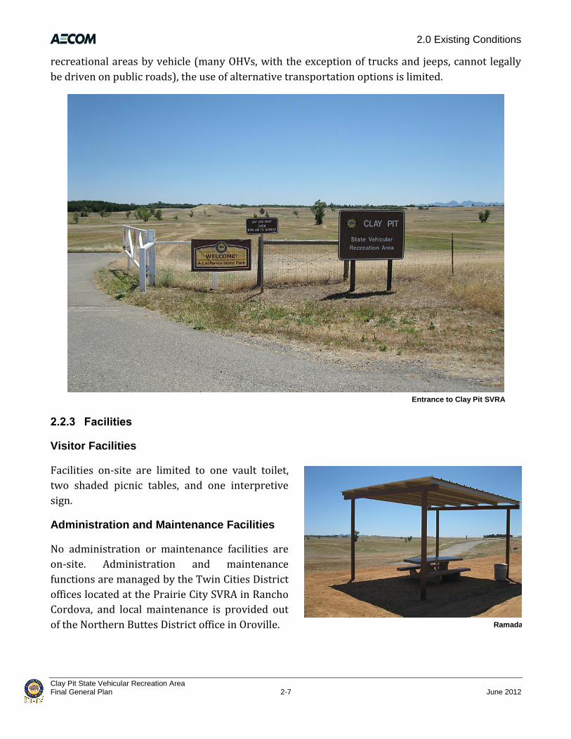
Entrance to Clay Pit SVRA
2.2.3 Facilities
Visitor Facilities
Facilities on-site are limited to one vault toilet,
two shaded picnic tables, and one interpretive
sign.
Administration and Maintenance Facilities
No administration or maintenance facilities are
on-site. Administration and maintenance
functions are managed by the Twin Cities District
offices located at the Prairie City SVRA in Rancho
Cordova, and local maintenance is provided out
of the Northern Buttes District office in Oroville.

2.0 Existing Conditions
Clay Pit State Vehicular Recreation Area June 2012 2-8 Final General Plan
Utilities
No utilities are currently provided on-site; however, utilities (e.g., telephone, electricity, water,
sewer, fiber optic cable) are provided to the Oroville Municipal Airport and adjacent businesses
across Larkin Road. These utilities could be extended to Clay Pit SVRA. Water also could be
provided by constructing one or more wells on-site; water tables in nearby wells are shallow.
Percolation tests indicate that on-site soils likely are not suitable for a standard gravity-fed septic
system (Geocon 2010).
Recology Butte Colusa Counties provides trash collection and recycling services for residents and
businesses of Butte County. Solid waste is transported to the Neal Road Recycling and Waste
Facility. The Neal Road Recycling and Waste Facility is located at 1023 Neal Road in an
unincorporated area, south of the City of Chico and approximately 15 miles north of the project
site. Permitted waste types at the Neal Road Recycling and Waste Facility include Class II and III,
non-hazardous, municipal waste including construction/demolition, green materials, inert, metals,
mixed municipal, sludge (biosolids), tires, and wood waste. The permitted rate of disposal for the
landfill is a maximum of 1,500 tons per day and it has a remaining capacity of 20,847,970 cubic
yards (CalRecycle 2010).
2.2.4 Visitor Use and Recreation
Clay Pit SVRA serves a wide age group of visitors, generally from the local area. The site is known as
a suitable location to bring children and beginning users. According to the visitor survey conducted
between May and October 2010, most respondents come to the site with their family or friends,
while approximately 20 percent enjoy coming alone. Respondents also indicated that 78 percent
reside less than 50 miles from the SVRA and 94 percent reside within 100 miles.
2.2.5 Recreation Trends
Federal research on OHV use indicates that the OHV-using population has been growing
nationwide, and a larger proportion of people under age thirty have participated in OHV use. The
same research found that “OHV users as a whole are more active in almost every recreation
activity relative to the general U.S. population age 16 and older” (USFS 2005). According to State
Parks, residents in Northern California think that OHV areas are important (State Parks 2009a).
2.2.6 Future Opportunities
Opportunities for circulation, facility, and recreation improvements exist at Clay Pit SVRA. The
SVRA is largely undeveloped. There have been suggestions from the public that recreation
facilities, such as tracks, trails, and obstacles be built (Appendix A). As part of this General Plan,
State Parks proposes to improve access to the site with a new entry and headquarters facilities,
envisions improvements to internal circulation with the construction and installation of internal

2.0 Existing Conditions
Clay Pit State Vehicular Recreation Area Final General Plan 2-9 June 2012
roadways and directional signage, and envisions providing additional recreation and maintenance
facilities. The proposed and envisioned changes are described in Chapter 4.0, “The Plan.”
2.3 Significant Resource Values
2.3.1 Physical Resources
This section describes the topography; geology, soils,
and minerals; hydrology and water resources; and
climate and air resources present at Clay Pit SVRA.
Topography
The bowl-shaped topography of the Clay Pit SVRA
basin was created by past excavation of clay materials
used in the construction of the Oroville Dam. Some
areas of natural topography remain on a narrow
terrace of grassland bordering Larkin Road, and on
rangeland bordering the northeast portion of the
SVRA. The basin was excavated to approximately 30 to
40 feet below the surrounding grade, it has a relatively
flat bottom, and it is surrounded by gently inclined
side slopes. Based on a United States Geological Survey
(USGS) topographic map (7.5-minute Palermo
quadrangle), the bottom elevation is approximately
135 feet above mean sea level and the elevation of the
rim is approximately 170 feet above mean sea level.
An artificial berm is located within the perimeter of
the park fence on the east and southeast. The berm
provides a visual and physical separation between the
park and surrounding properties, including a partial
separation between the park and the adjacent
shooting range. Dredge tailings, primarily in the
southeastern corner of the park, are a reminder of the
past history of placer mining along the Feather River
(Martin 2005).
Geology, Soils, and Minerals
The site is underlain by a Tertiary-aged Laguna
Formation. This formation generally consists of
interbedded alluvial deposits comprising poorly
graded gravel with silt, clay, sand and cobbles, silty
Drainage from southwest culvert under Larkin Rd.
Drainage from north culvert under Larkin Rd.
Cobbled soil on-site
Vernal Pools on-site
2.0 Existing Conditions
Clay Pit State Vehicular Recreation Area June 2012 2-10 Final General Plan
gravel, and clayey gravel. Consistency and relative density of the Laguna Formation varies because
of variations in weathering, cementation, and deposition, but is generally stiff/dense to hard/very
dense. The cemented layers are generally slightly to moderately cemented and difficult to
excavate.
The soil profiles originally present throughout Clay Pit SVRA have been virtually eliminated by
historic placer mining and clay soil extraction activities. The grassland terrace along Larkin Road
contains some undisturbed areas, although an informal road and OHV use have disturbed and
altered these areas. In some places within the SVRA
the surface substrate is gravel and cobble-sized
alluvium deposits associated with the
hydrogeomorphology of the Feather River. The
parent material of the alluvium is derived from
igneous and metamorphic rock in the upper
watershed of the Feather River, located on the
western slopes of the Sierra Nevada Range. The
Natural Resource Conservation Service mapped two
soil types within Clay Pit SVRA. The terrace along the
northern and western rim consists of Oroville-
Thermalito-Fernandez-Thompsonflat Complex
(gravelly fine sandy loam), and the basin floor
consists of Pits (i.e., silty clay).
Hydrology and Water Resources
Surface Water Resources
Clay Pit SVRA is located within the Lower Feather
River Watershed (EPA 2011). This watershed is
situated within the Lower Feather River hydrologic
area and subarea of the Marysville hydrologic unit,
within the Sacramento Valley hydrological region
(DOC 2010).
The nearby Oroville Ranger Station receives an
average of 29 inches of rain annually (State Parks
2011a). Winter months tend to be wetter than
summer months. The wettest month of the year is
January, with an average rainfall of 5.52 inches. The
majority of the precipitation over the area occurs
from October to April, with July being the driest
month, receiving typically less than 0.07 inches. In a
Thermalito Forebay (view southwest)
Thermalito Afterbay (view northwest)
Lake Oroville (source: NASA/JPL image)

2.0 Existing Conditions
Clay Pit State Vehicular Recreation Area Final General Plan 2-11 June 2012
year, an average of 66 days experience measurable precipitation. The July high temperature is
approximately 96 °F in most years, although it varies between 80 to and the low 100s. The January
low temperature is approximately 37 °F in most years, but varies between the upper 30s to mid
40s.
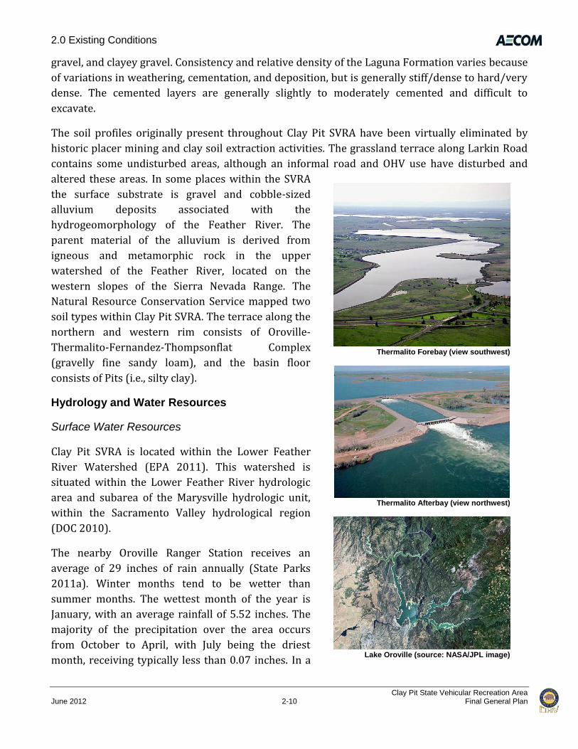
The SVRA lies within 7 miles of four major bodies of water: Thermalito Forebay (2 miles north),
Thermalito Afterbay (2 miles west), the Feather River (1 mile east), and Lake Oroville (6.5 miles
northeast).
Constructed between 1965 and 1968, Thermalito Forebay is an offstream reservoir contained by
Thermalito Forebay Dam on the south and east, and by the Campbell Hills on the north and west.
It is located about 4 miles west of the City of Oroville. The forebay conveys water between
Thermalito Power Canal and Thermalito Powerplant, provides regulatory storage and surge
damping for the Hyatt-Thermalito power complex, and serves as a recreational site. The maximum
operating storage is 11,770 acre-feet (DWR 2010).
Constructed at the same time as Thermalito Forebay, Thermalito Afterbay is also an offstream
reservoir. Located about 6 miles southwest of the City of Oroville, the afterbay stores water
required for pumping operations at Lake Oroville, helps regulate the Thermalito power system,
produces controlled flow in the Feather River downstream from the Oroville-Thermalito facilities,
and provides opportunities for recreation. It also serves as a warming basin for delivery of
agricultural water to farms east of the afterbay. The maximum operating storage is 57,040 acre-
feet (DWR 2010).
Oroville Dam and Lake Oroville lie in the foothills on the western slope of the Sierra Nevada, 1
mile downstream of the junction of the Feather River's major tributaries. Work on the dam site
began in 1961, and the embankment was topped out in 1967. The lake stores winter and spring
runoff, which is released into the Feather River to meet downstream water needs. The reservoir
has a maximum operating storage of 3,537,580 acre-feet (NCWA 2010).
The drainage area that includes Clay Pit SVRA comprises 1,315 acres. It includes the Oroville
Municipal Airport, the Table Mountain Golf Course, and surrounding farmland. The SVRA
encompasses 18 percent of the watershed, yet the entire watershed drains through the SVRA to an
outlet at its eastern boundary. The overall drainage area consists of relatively flat topography with
mound and swale features that allow the formation of vernal/ephemeral pools and swales that
collect water during the wet season (State Parks 2011a).
Since the 1940s the Clay Pit basin and surrounding areas have experienced significant land
disturbance from construction activities. After gold mining operations first disturbed the land, any
naturally occurring drainage patterns that remained were altered when the Oroville Municipal
Airport was constructed in the 1940s and when the pit was excavated in 1964. According to a study
of airport drainage conditions commissioned by the City of Oroville in 2008, the land used by the
airport business park and surrounding runways was leveled to build the airport infrastructure,

2.0 Existing Conditions
Clay Pit State Vehicular Recreation Area June 2012 2-12 Final General Plan
leaving almost no natural hydrology or topography
(Rolls Anderson & Rolls 2008, as cited in State Parks
2011a). A series of human-made ditches exist to drain
water away from the airport runways and transport it off
the property through five culverts under Larkin Road,
four of which drain into Clay Pit SVRA. Furthermore, the
Table Mountain Golf Course has a series of human-made
ditches that discharge onto the airport property,
eventually draining to the SVRA (State Parks 2011a).
Water enters Clay Pit SVRA from direct precipitation,
sheet flows from surrounding properties, and through a
series of culverts under Larkin Road (Figure 2-2).
Because of its low elevation, the southeastern portion of
the basin within the SVRA is inundated periodically
during high-flow events with backflow from the Feather
River (State Parks 2011a). However, according to the
Federal Emergency Management Agency’s Flood
Insurance Rate Maps, the SVRA is outside of the 500-
year floodplain of the Feather River.
When the Clay Pit basin was excavated to provide
materials needed to build the Oroville dam, a drainage
canal was constructed to drain the water from the
impervious clay soils. The canal bisected the area in a
west-east direction. The east end of the drainage canal
is the discharge point for Clay Pit SVRA, and thus, the
discharge point for most of the watershed. The drainage
canal leads to a remnant oxbow of the Feather River
within the DFG Oroville Wildlife Area. A large berm,
approximately 25 feet high, constructed to haul
material by train from the borrow pit (the basin) to the
Oroville dam site, obstructed any drainage connection
between the pit and the remnant oxbow. The existing
hydraulic connection between Clay Pit SVRA and the
oxbow was created when a section of the berm was
removed.
Other artificial landforms and evidence of significant
disturbance to the natural landforms are common in
Lower Feather River hydrologic area and subarea
Marysville hydrologic unit
Sacramento Valley hydrologic region

2.0 Existing Conditions
Clay Pit State Vehicular Recreation Area Final General Plan 2-13 June 2012
Source: Topo provided by David Evans and Associates 2008, data compiled by AECOM in 2010
Clay Pit SVRA Existing Conditions Figure 2-2

2.0 Existing Conditions
Clay Pit State Vehicular Recreation Area June 2012 2-14 Final General Plan
this area, as evidenced by 1.6 miles of large mine tailings between the eastern boundary of Clay Pit
SVRA and the Feather River (State Parks 2011a). Also, two access roads and a levee within the
wildlife refuge lie between the SVRA and the Feather River.
Severe soil erosion is evident in two places at the outfalls of the culverts under Larkin Road,
creating deeply incised channels along the northern and western boundaries of Clay Pit SVRA. A
narrow roadside ditch runs along the northern perimeter of the SVRA. The ditch begins at a
culvert under Larkin Road on the north side of the project site, runs parallel to Larkin Road, and
empties into the main drainage canal. However, the ditch is disjointed in areas because it has been
disturbed.
The 220-acre project site contains 25.69 acres of jurisdictional waters of the United States,
including wetlands (AECOM 2010). A preliminary wetland delineation report submitted to the
USACE was verified in March 2011. Based on proximity to the Feather River and existing drainage
patterns, all mapped wetland and water features exhibit a “significant nexus” to the Feather River
system; thus, these features are under USACE jurisdiction. These waters and wetlands include
vernal pools, emergent marsh, ephemeral drainage, nonrelatively permanent waters, ponds,
canals, and intermittent drainage or relatively permanent waters. Section 2.3.2, “Biotic Resources,”
includes additional descriptions of these features.
Surface Water Management
Surface water is an important piece of Butte County’s integrated water network; it is integral to
the local economy, communities and ecosystem (Butte County 2010a). Management of Butte
County’s State Water Project allocation (27,500 acre feet) is a priority for the County. Since Butte
County became a State Water Project contractor in the1960s, the County has sought to find in-
county uses for its entire allocation. However, because water costs and water infrastructure costs
are high, Butte County has been unable to use the entire 27,500 acre feet allocation within the
County. Although the in-county utilization doubled in 2008-09, the Butte County Department of
Water and Resource Conservation (Department) is continuing a feasibility study to investigate
options for the use of their entire contracted allocation. Until full in-county utilization can be
achieved (estimated to be within the next 7–10 years), the Department will continue to pursue
opportunities that allow for the management of surplus water (Butte County 2010b). In 2010 the
Department administered the second year of a 2-year sale of surplus water to another State Water
Project Contractor, the Palmdale Water District. The sale of this surplus water provided sufficient
revenue to cover the County’s allocation charges for at least three years (Butte County 2010a). As
Butte County continues to develop the means to use more of its water allocation in-county, less
will be sold to other State Water Project contractors. No surface water is currently used at Clay Pit
SVRA.

2.0 Existing Conditions
Clay Pit State Vehicular Recreation Area Final General Plan 2-15 June 2012
Surface Water Quality
Clay Pit SVRA is located within the jurisdiction of the Central Valley (RWQCB), which is
responsible for implementing federal and state laws and regulations to protect water quality
within the Central Valley Basin. Water quality within the state is regulated under the California
Water Code (Section 13240) and supported by the federal Clean Water Act (CWA) by means of
regional basin plans. Basin plans define beneficial uses of regional waters, water quality objectives
to protect those uses, and a program of implementation for achieving the objectives (Central
Valley RWQCB 2009).
The Water Quality Control Plan (Basin Plan) for the Sacramento River and the San Joaquin River
Basins (or the Central Valley Region Basin Plan) defines beneficial uses of the Feather River
(Hydrologic Unit 515) from the Fish Barrier Dam downstream of Lake Oroville to the confluence
with the Sacramento River as “municipal and domestic water supply, irrigation, recreation,
freshwater habitat-warm and cold, migration-warm and cold, spawning-warm and cold, and
wildlife habitat” (Central Valley RWQCB 2009). Surface water in the Feather River watershed is
generally high-quality water. However, in 1994, the Feather River was listed under Section 303d
of the CWA for impaired beneficial uses along its 60-mile reach from Oroville Dam to the
confluence of the Sacramento River (i.e., Lower Feather River). Beneficial uses are impaired by
diazinon, mercury, group A pesticides, temperature, and other toxins (SCRCD 2010b; SWRCB
2008).
The basin plan includes objectives and parameters for turbidity, dissolved oxygen, and diazinon,
among others. According to the basin plan, waters “shall be free of changes in turbidity that cause
nuisance or adversely affect beneficial uses”. Increases in turbidity attributable to controllable
water quality factors cannot exceed limits that are defined relative to existing background
turbidity levels. The basin plan specifies a water quality objective for dissolved oxygen for
Hydrologic Unit 515 of 8.0 milligrams per liter from September 1 through May 31 (CRWQCB
2009). High concentrations of diazinon in surface runoff caused the Central Valley RWQCB to
establish total maximum daily load (TMDL) regulations for diazinon on the Lower Feather River
(SCRCD 2010b; SWRCB 2008). Other parameters of the basin plan that are exceeded in some
surface waters include temperature and level of chlorpyrifos, aluminum, arsenic, iron, manganese,
mercury, zinc, bacteria, and viruses (SCRCD 2010a).
Clay Pit SVRA receives runoff directly from the Oroville Municipal Airport and Larkin Road and
indirectly from the Table Mountain Golf Course. Surface water quality may be affected by
operations at the airport resulting from fuel spills, from the accumulation of lubricants on paved
surfaces associated with aircraft maintenance and support equipment, and from the use of
herbicides to control unwanted vegetation. Similarly, runoff from Larkin Road may degrade water
quality primarily from the accumulation of lubricants on the road surface. Water quality may also
be affected by debris from tire wear with associated heavy metals (primarily zinc) that can
accumulate on and adjacent to the road surface (Adachi and Tainosho 2004). Runoff from the

2.0 Existing Conditions
Clay Pit State Vehicular Recreation Area June 2012 2-16 Final General Plan
Table Mountain Golf Course may include fertilizers, herbicides, and pesticides; the most likely
pollutant in the runoff water is phosphorous (Zwierschke 2009). Activities within Clay Pit SVRA
may also contribute pollutants to surface waters. Turbidity may be increased by soil erosion
caused by OHV use, and pollutants such as fuels and lubricants from OHVs may enter runoff
waters.
Goals have been established in the basin plan to address these water quality issues. Goals that may
apply to Clay Pit SVRA include, among others, those that encourage the use of vegetated filter
strips and other best management practices (BMPs) to reduce pollutant loads, and those that
support the efforts of the Sacramento Valley Water Quality Coalition and the Butte/Yuba/Sutter
Water Quality Coalition to implement a BMP program and a program to monitor BMP
effectiveness to protect regional water quality
(SCRCD 2010b; SWRCB 2008).
Groundwater Resources
In the Sacramento Valley Region of Butte County,
formations that bear groundwater include, from
youngest (shallowest) to oldest (deepest), the
Modesto, Riverbank, Laguna, Tehama, and Tuscan
Formations. Those formations included in the
Thermalito Sub-Inventory Unit (SIU), which
includes Clay Pit SVRA, are the Riverbank
Formation, Laguna Formation, and the Tuscan Unit
B (Lower Tuscan). In the Thermalito SIU, spring
groundwater moves south and southwest. Locally,
groundwater mounding caused by recharge from
the Thermalito Afterbay causes groundwater to
move southeast toward the Feather River and then
southwest. The average groundwater gradient in
the Thermalito SIU is about 5 feet per mile
(Thermalito Water and Sewer District 2010).
Groundwater contours were constructed in 2009
(Figure 2-3) using groundwater level
measurements taken by the California Department
of Water Resources (DWR) and its local
cooperators between March 1 and March 20, 2009.
The groundwater level measurements were taken
from wells constructed within the middle portion
of the aquifer system (100 to 400 feet deep). This
portion of the aquifer supplies approximately 70 Figure 2-3 Sacramento Valley Groundwater Basin Information

2.0 Existing Conditions
Clay Pit State Vehicular Recreation Area Final General Plan 2-17 June 2012
percent of all domestic, agricultural, and municipal wells. Blue contour lines represent
measurements made in 20-foot intervals and yellow contour lines represent measurements made
in 10-foot intervals (Thermalito Water and Sewer District 2010).
Clay Pit SVRA is located within the east-central part of the East Butte subbasin, and groundwater
depths in this subbasin have remained fairly stable over time, ranging from 5 to 20 feet below land
surface. Shallow wells can yield large quantities of water, reported from 200 to 2,000 gallons per
minute (SCRCD 2010a). A review of well data from DWR indicates depth to groundwater within
Clay Pit SVRA and vicinity varies seasonably from approximately 30 to 45 feet below ground
surface (Geocon 2010).
Well 18N/03E-21G01M is located in the southern portion of the Thermalito SIU, approximately
1mile west of the Feather River (Butte County 2005). This well is an active irrigation well
producing groundwater from the shallow to intermediate portion of the aquifer system.
Groundwater levels have been recorded since the late 1940s (Figure 2-3). Groundwater levels in
this well were monitored on a semiannual basis to 1991, and on a monthly basis from 1991 to
about 1994. Since 1994, this well has been monitored four times a year during March, July, August,
and October.
This well indicates a fluctuation in groundwater levels between spring and summer, and between
drought years and years with normal precipitation. Groundwater levels fluctuate from spring to
summer between 5 and 8 feet during years of normal precipitation, and fluctuate between 2 and
5 feet during drought years. This decrease in spring to summer fluctuation is the result of a drop
in spring groundwater levels, while summer levels remain constant. The drop in spring
groundwater levels indicates that the aquifer system in this area does not fully recharge during
years of drought. The quick drop, then relatively constant draw-down during drought years
indicates that the aquifer system in this area is likely being recharged from a steady source of
surface water; in this case the Feather River. During drought years, groundwater levels drop
relatively quickly until they reach the point where the aquifer is interconnected with the Feather
River. The hydrograph indicates that, in this area, the surface water–groundwater interconnection
takes place at about 23 feet below ground surface, or at an elevation of about 80 feet above mean
sea level (Butte County 2005).
A long-term comparison of spring-to-spring groundwater levels shows an overall decline during
the 1976-77 and 1986-94 droughts, followed by recovery to predrought levels. A long-term
comparison of spring-to-spring groundwater levels during normal years indicates very little
change between the late 1950s until 1998. Successive spring groundwater levels have declined
steadily in this well by about 1½ feet per year since 1998. Fall and summer groundwater levels
have also declined but at a slower rate of about one-half foot per year during the same period.
These declines are probably climate related and not the result of overusing the groundwater
resource. Examining the overall record reveals that long-term depletion of groundwater in storage
is probably not occurring at this time (Butte County 2005).

2.0 Existing Conditions
Clay Pit State Vehicular Recreation Area June 2012 2-18 Final General Plan
Constituents of concern for groundwater quality within the East Butte subbasin include
manganese, iron, magnesium, total dissolved solids, conductivity, the adjusted sodium absorption
ratio, calcium, arsenic, and nitrate in the Walton Groundwater Area (SCRCD 2010a).
Groundwater Management
Butte County’s groundwater is considered an important resource and is the backbone of the
County’s economy, communities, and ecosystems. Approximately 75 percent of the County’s
residential water supply is extracted from groundwater (Butte County 2010c). In 2005, the County
adopted a groundwater management plan that established goals and actions to sustain
groundwater resources (Butte County 2010a).
Fundamental pieces of Butte County’s groundwater protection efforts come from Groundwater
Conservation and Well Head Protection Ordinances. These ordinances provide protection for
people who rely on groundwater by regulating groundwater transfers or substitution of
groundwater for surface water as part of a water transfer outside the county and by setting
standards for wells. The Butte County Department of Water and Resource Conservation
(Department) requires that any project submitted under Chapter 33 of the Butte County Code
(Groundwater Conservation) receive the appropriate environmental analysis, have a mitigation
component, and assess impacts on neighboring groundwater users. Any project submitted under
Chapter 33 will not be approved if it causes unmitigated impacts on existing groundwater users.
The Basin Management Objective (BMO) process, Chapter 33A of the Butte County Code, builds on
the Groundwater Conservation Ordinance by establishing a process for determining alert levels at
the local level. The BMOs are set annually by each SIU working through the Water Advisory
Committee and the Water Commission (Butte County 2010a).
The Department, in cooperation with DWR, assesses groundwater resources through monitoring
of groundwater elevation, land subsidence, and water quality parameters. These data help to
assess changes to our groundwater resources. The network of wells throughout the county is
monitored during March, July, August, and October. Groundwater pumping can lead to land
subsidence; however, no known incidents of subsidence exist in Butte County. During the 2009-
2010 fiscal year the Department was working with other neighboring counties to establish a
regional subsidence network, which will be a key monitoring tool for the department to use to
identify inelastic land subsidence. Assessing groundwater quality can also play an integral role in
managing water. The Department will continue to acquire groundwater temperature, ph, and
electrical conductivity for a subset of wells annually. These data are the cornerstones of
supporting groundwater protection efforts (Butte County 2010a).
Water Supply and Demand
In 2001, Butte County conducted a comprehensive inventory of its water resources and evaluated
its overall water supply in the document entitled Butte County Water Inventory and Analysis (Butte
County 2001). The evaluation and document were updated in 2008. The Butte County Water

2.0 Existing Conditions
Clay Pit State Vehicular Recreation Area Final General Plan 2-19 June 2012
Inventory and Analysis indicates that the majority of the water demand in Butte County occurs in
the valley areas because of the concentration of urban populations and farming. Agricultural water
needs constitute 71 percent of the total demand in all of Butte County, including the incorporated
municipalities (Butte County 2010b).
The Butte County Water Inventory and Analysis indicates that no shortfall of water supply exists
during normal years, but that shortages occur during dry conditions in specific areas. Shortages
are concentrated in the southwestern portion of the county, where agricultural demand is higher
and where supply is limited by the geology of the aquifer and groundwater fluctuations during
drier summer months (Butte County 2010b).
Users in certain parts of the county rely on groundwater pumping as an alternative to importing
water from outside the county. According to investigations by the U.S. Geological Survey
documented in the 1977 Safety Element of Butte County’s previous General Plan, the areas of
heaviest groundwater withdrawal extend about 2 miles north and south of Chico and in a 1-mile
radius around Gridley (Butte County 2010b).
Air Quality
Clay Pit SVRA is located in Butte County within the northern Sacramento Valley Air Basin (SVAB).
The northern SVAB includes Shasta County, Tehama County, Glen County, Colusa County, Sutter
County, Yuba County, and Butte County. The SVAB is bounded on the north and west by the
Coastal Mountain Range and on the east by the southern portion of the Cascade Range and the
northern portion of the Sierra Nevada Range. The mountain ranges surrounding the SVAB reach
heights greater than 6,000 feet, with individual mountains reaching much higher elevations. The
surrounding mountains create a substantial barrier to airflow, which leads to the entrapment of
air pollutants when meteorological conditions are unfavorable for the pollutants’ transport and
dilution. The pollutants are both locally produced and transported north from the Sacramento
Metropolitan area. The SVAB is also prone to atmospheric inversions and high summertime
temperatures. These conditions combined with the geological barriers create the potential for air
pollution problems.
The highest frequency of poor air movement occurs in the fall and winter when high-pressure
cells exist over the SVAB. The lack of surface wind during these periods, combined with the
reduced vertical flow because of less surface heating, reduces the influx of air and leads to the
concentration of air pollutants under stable meteorological conditions. Surface concentrations of
air pollutant emissions are highest when these conditions occur in combination with agricultural
burning activities or temperature inversions, which hamper dispersion by creating a ceiling over
the area and trapping air pollutants near the ground.
May to October is ozone season in the SVAB. This period is characterized by poor air movement in
the mornings and the arrival of the Sacramento–San Joaquin Delta sea breeze from the southwest
in the afternoons. Longer daylight hours provide plentiful sunlight to fuel photochemical reactions

2.0 Existing Conditions
Clay Pit State Vehicular Recreation Area June 2012 2-20 Final General Plan
between reactive organic gases (ROGs) and oxides of nitrogen (NOX) which result in
ozone formation.
Typical winter day at Clay Pit SVRA
Characteristic SVAB winters are periods of dense and persistent low-level fog, which are most
prevalent between storms. The prevailing winds are moderate in speed and vary from moisture-
laden breezes from the south to dryland breezes from the north. Local meteorology of the project
area is represented by measurements recorded at the Chico station. The predominant wind
direction and speed is from the south-southeast at around 11 miles per hour (mph) (CARB 1994).
Most precipitation in the area results from air masses that move in from the Pacific Ocean, usually
from the west or northwest, during the winter months. More than half the total annual
precipitation falls during the winter rainy season (November–February). The normal annual
precipitation, measured at the Chico station, is approximately 26 inches. January temperatures
range from a normal minimum of 35°F to a normal maximum of 54°F. July temperatures range
from a normal minimum of 61°F to a normal maximum of 94°F (NOAA 1992).
Butte County Air Quality Management District (Butte County AQMD) attains and maintains air
quality conditions in Butte County through comprehensive programs of planning, regulation,
enforcement, technical innovation, and promotion of the understanding of air quality issues. Both
the California Air Resources Board (CARB) and U.S. Environmental Protection Agency (EPA)
designate areas according to their attainment status for criteria air pollutants. The three basic
designation categories are nonattainment, attainment, and unclassified. If an area is redesignated
from nonattainment to attainment, the federal Clean Air Act (CAA) requires a revision to the State
Implementation Plan (SIP), called a maintenance plan, to demonstrate how the air quality
standard will be maintained for 10 years.
The northern SVAB is currently designated by national standards as a nonattainment area for the
8-hour ozone standard, and a nonattainment area for respirable particulate matter with an
aerodynamic diameter of 2.5 micrometers or less (PM2.5). The SVAB is in attainment with national
standards for the remaining criteria air pollutants. The SVAB is currently designated by state
standards as a nonattainment area for the 1-hour and the 8-hour ozone standard, and a

2.0 Existing Conditions
Clay Pit State Vehicular Recreation Area Final General Plan 2-21 June 2012
nonattainment area for PM2.5 and PM10 (particulate matter with an aerodynamic diameter of 10
micrometers or less). The SVAB is in attainment with state standards for the remaining criteria air
pollutants.
Ozone located in the upper atmosphere (stratosphere) acts in a beneficial manner by shielding the
earth from harmful ultraviolet radiation that is emitted by the sun. However, ozone located in the
lower atmosphere (troposphere) is a major health and environmental concern. The adverse health
effects associated with exposure to ozone pertain primarily to the respiratory system. Scientific
evidence indicates that ambient levels of ozone affect not only sensitive receptors, such as
asthmatics and children, but healthy adults as well.
PM10 consists of particulate matter emitted directly into the air, such as soot and smoke from
mobile and stationary sources; natural windblown dust; dust generated by human activities such
as construction operations; and fires. Generally, adverse health effects associated with PM10 may
result from both short-term and long-term exposure to elevated concentrations and may include
breathing and respiratory symptoms, aggravation of existing respiratory and cardiovascular
diseases, alterations to the immune system, carcinogenesis, and premature death (EPA 2009).
The majority of Clay Pit SVRA comprises a clay pan area with loose gravel, silt, and cobbles. When
the loose soils are disturbed by OHV use during the dry months, fugitive dust (up to PM10)
becomes airborne. The presence of geographic barriers and inversions resulting in a stable
atmosphere cause particulate matter to accumulate and achieve elevated concentrations, thus
reducing visibility and increasing periods with potentially adverse health effects. The periods of
greatest concern for elevated PM10 concentrations (the summer months) do not coincide with the
highest OHV activity at Clay Pit SVRA (the spring and fall). High average daily temperatures in the
summer discourage use of Clay Pit SVRA. Peak SVRA use tends to be during the late spring and fall,
when the soils within the clay pit are still wet but the standing water has either started drying out
or has not accumulated yet.
In addition, using OHVs within Clay Pit SVRA creates exhaust emissions from fuel combustion to
operate the OHVs. These emissions include gasses known as ozone precursors, which, when
exposed to sunlight, react with other gases in the atmosphere to form ozone. The ozone
precursors typically regulated are ROGs and NOX. By limiting either of these gases the amount of
ozone produced in a given area can be limited as well. Typically, few OHVs have devices to control
emissions, so all gases generated from the combustion of fuel are emitted to the atmosphere,
including ROGs and NOX. The addition of ozone precursors contribute to the existing ozone
nonattainment.
Climate Change
Certain gases in the earth’s atmosphere, classified as greenhouse gases (GHGs), play a critical role
in determining the earth’s surface temperature. Solar radiation enters the earth’s atmosphere
from space. A portion of the radiation is absorbed by the earth’s surface, and a smaller portion of

2.0 Existing Conditions
Clay Pit State Vehicular Recreation Area June 2012 2-22 Final General Plan
this radiation is reflected back toward space. The absorbed radiation is then emitted from the
earth, not as high-frequency solar radiation, but lower frequency infrared radiation.
The frequencies at which bodies emit radiation are proportional to temperature. The earth has a
much lower temperature than the sun; therefore, the earth emits lower frequency (longer
wavelength) radiation. Most solar radiation passes through GHGs; however, infrared radiation is
selectively absorbed by GHGs. As a result, infrared radiation released from the earth that
otherwise would have escaped back into space is instead “trapped,” resulting in a warming of the
atmosphere. This phenomenon, known as the “greenhouse effect,” is responsible for maintaining a
habitable climate on earth. Without the greenhouse effect, the earth would not be able to support
life as we know it.
Prominent GHGs contributing to the greenhouse effect are carbon dioxide (CO2), methane (CH4),
nitrous oxide (N2O), and fluorinated compounds. Human-caused emissions of these GHGs in
excess of natural ambient concentrations are responsible for intensifying the greenhouse effect
and have led to a trend of unnatural warming of the earth’s climate, known as global climate
change (IPCC 2007).
Climate change is a global problem. GHGs are global pollutants, unlike criteria air pollutants and
toxic air contaminants (TACs), which are pollutants of regional and local concern. Whereas
pollutants with localized air quality effects have relatively short atmospheric lifetimes (about
1 day), GHGs have long atmospheric lifetimes (1 year to several thousand years). GHGs persist in
the atmosphere for long enough time periods to be dispersed around the globe. Although the exact
lifetime of any particular GHG molecule depends on multiple variables and cannot be pinpointed,
more CO2 is currently emitted into the atmosphere than is sequestered by ocean uptake,
vegetation, and other forms of sequestration. Of the total annual human-caused CO2 emissions
within a year, approximately 54 percent is sequestered through ocean uptake, uptake by northern
hemisphere forest regrowth, and other terrestrial sinks, whereas the remaining 46 percent of
human-caused CO2 emissions remains stored in the atmosphere (Seinfeld and Pandis 1998). The
biggest source of GHG emissions in the U.S. by percent is combustion of fossil fuels at
approximately 79 percent of the 2010 inventory (EPA 2009).
Natural resource management is changing as warming trends take place or scientific predictions
of future warming are known. As a result of these trends, resource management is focused on
reducing key environmental stressors on biologic resources, providing hedges against resource
losses from impacts of climate change, and possible evolutionary responses. At Clay Pit SVRA,
climate change could lead to changes in water supply and atmospheric temperature. In turn, these
could change the ecosystem health of sensitive habitats and species on site, such as vernal pools
and the shrimp species that inhabit these pools.
The quantity of GHGs that it takes to ultimately result in climate change is not precisely known,
although the quantity would be enormous. No single project would be expected to measurably
contribute to a noticeable incremental change in the global average temperature, or to global,

2.0 Existing Conditions
Clay Pit State Vehicular Recreation Area Final General Plan 2-23 June 2012
local, or micro climates. The use of OHVs within Clay Pit SVRA creates exhaust emissions from fuel
combustion to operate the OHVs and from driving vehicles varying distances to reach Clay Pit
SVRA. These emissions include GHGs. Because, typically, few OHVs have devices to control
emissions, all gases generated from the combustion of fuel are emitted to the atmosphere,
including GHGs. The addition of these GHGs will add to the cumulative impacts on our changing
climate.
2.3.2 Biotic Resources
This section describes the vegetation communities and plant and animal life present at Clay Pit
SVRA.
Vegetation
Four vegetation communities are present within Clay Pit SVRA: northern hardpan vernal pool,
California annual grassland, cattail, and arroyo willow.
Northern Hardpan Vernal Pools
Vernal pools are a type of seasonal wetland found in shallow depressions within ancient soil
formations having an impervious or restrictive soil layer (e.g., hardpan or claypan) near the
surface, resulting in a perched water table. Vernal pools have a hydrologic regime characterized
primarily by inundation rather than saturation because of the restrictive soil layer. They are
distinguished by a unique host of plant and wildlife species adapted to the extreme conditions
created by the cycles of inundation and drying. Vernal pools generally remain inundated during
the wet season (winter) and dry out through spring and early summer. The hydroperiod
(inundation duration) for an individual pool depends on many factors including the size and depth
of the pool, the hardpan/clay pan soil depth, topography, and annual precipitation.
Northern hardpan vernal pools are a type of vernal pool that occurs in the Northeastern
Sacramento Valley Vernal Pool Region of California (USFWS 2005). They tend to occur on old,
acidic, iron-silica cemented soils (Sawyer et al. 1995). Due to the location of Clay Pit SVRA within
the Northeastern Sacramento Valley Vernal Pool Region of California and also the presence of
iron-silica cemented soils on the site, the vernal pools at the SVRA are considered northern
hardpan vernal pools. The terrace area along Larkin Road supports remnant vernal pool grassland
with distinct pools and mima mounds (humps of soil). The rest of the vernal pool habitat on the
site is the result of unnatural depressions that formed after excavation of hardpan soils.
Approximately 23 acres of northern hardpan vernal pool habitat is present on the project site,
concentrated in the excavated pit area with a few scattered pools on the terrace along Larkin Road
(Figure 2-2). The vernal pool habitat along the terrace and in the pit is currently open to OHV use.
Characteristic plant species of the vernal pools at Clay Pit SVRA include pale spikerush (Eleacharis
macrostachya), coyote thistle (Eryngium castrense), stipitate popcorn flower (Plagiobothrys

2.0 Existing Conditions
Clay Pit State Vehicular Recreation Area June 2012 2-24 Final General Plan
stipitatus), annual hairgrass (Deschampsia danthonioides), and Fremont’s goldfields (Lasthenia
fremontii). Other frequently observed plants in vernal pools and swales include native vernal pool
wildflowers such as white-headed navarretia (Navarretia leucocephala), horned downingia
(Downingia bicornuta), needleleaf navarretia (Navarretia intertexta), bractless hedge-hyssop
(Gratiola ebracteata), Sacramento mesa mint (Pogogyne zizyphoroides), and woolly marbles
(Psilocarphus brevissimus). Nonnative species commonly observed in the vernal pools include
Italian ryegrass (Lolium multiflorum) and hyssop loostrife (Lythrum hyssopifolium) (AECOM 2010).
Informal OHV trails in grasslands
California Annual Grassland
The majority of Clay Pit SVRA (approximately 194 acres) is characterized by degraded annual
grassland between and surrounding wetland features. Typically this vegetation is sparse because
of the rocky soils exposed by historic placer mining and clay soil extraction activities. It consists
primarily of nonnative ruderal (weedy) species adapted to disturbance, although some native
flora is present. The terrace along Larkin Road (approximately 25 acres) includes some remnant
natural vernal pool grassland. Numerous OHV trails traverse the degraded annual grassland
habitat creating large swaths of bare ground throughout the SVRA.
The native grassland species at the SVRA occur in greater numbers in moister locations, especially
near vernal pools. Conversely, drier upland sites are more likely to be dominated by nonnative
species (AECOM 2010; Martin 2005). Commonly observed nonnative grasses include wild oat
(Avena fatua), medusa-head (Taeniatherum caput-medusae), barbed goat grass (Aegilops
triuncialis), and soft chess (Bromus hordeaceus). Common native plant species include foothill
calycadenia (Calycadenia spicata), blue dicks (Dichelostemma capitatum), purple clarkia (Clarkia
purpurea), purple navarretia (Navarretia pubescens), marigold navarretia (Navarretia tagetina),
California goldfields (Lasthenia californica), vinegar weed (Trichostema lanceolatum), and
Fremont’s tidytips (Layia fremontii). Nonnative plant species commonly observed include long-
beaked filaree (Erodium botrys), rough cat’s-ear (Hypochaeris radicata), rose clover (Trifolium
hirtum), and hairy vetch (Vicia villosa). Fremont cottonwood (Populus fremontii) trees are present
as widely scattered individuals and small stands in the annual grassland habitat on the eastern
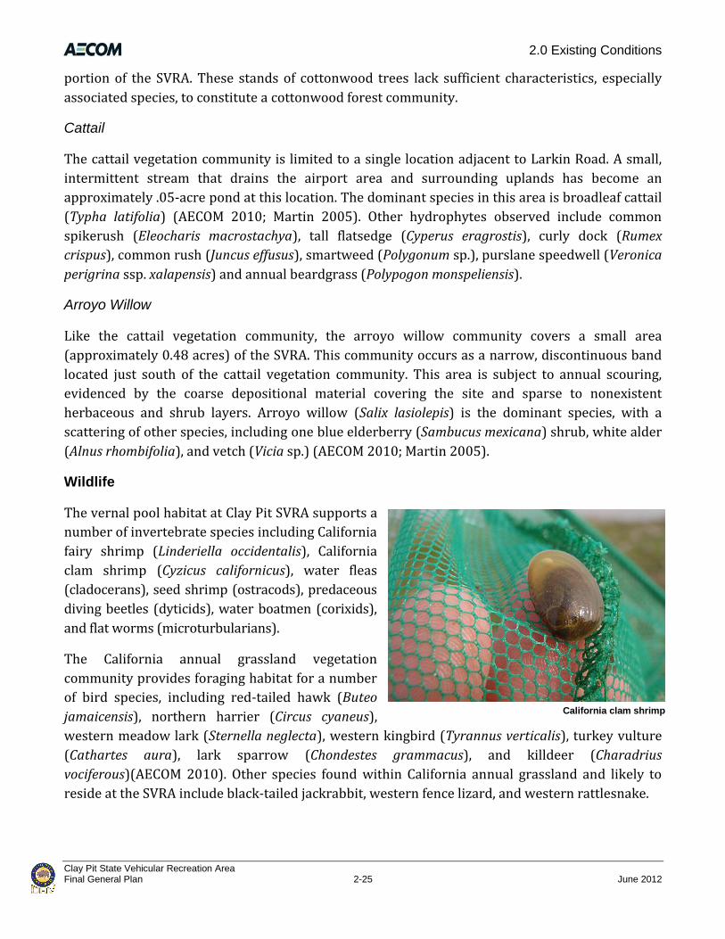
2.0 Existing Conditions
Clay Pit State Vehicular Recreation Area Final General Plan 2-25 June 2012
California clam shrimp
portion of the SVRA. These stands of cottonwood trees lack sufficient characteristics, especially
associated species, to constitute a cottonwood forest community.
Cattail
The cattail vegetation community is limited to a single location adjacent to Larkin Road. A small,
intermittent stream that drains the airport area and surrounding uplands has become an
approximately .05-acre pond at this location. The dominant species in this area is broadleaf cattail
(Typha latifolia) (AECOM 2010; Martin 2005). Other hydrophytes observed include common
spikerush (Eleocharis macrostachya), tall flatsedge (Cyperus eragrostis), curly dock (Rumex
crispus), common rush (Juncus effusus), smartweed (Polygonum sp.), purslane speedwell (Veronica
perigrina ssp. xalapensis) and annual beardgrass (Polypogon monspeliensis).
Arroyo Willow
Like the cattail vegetation community, the arroyo willow community covers a small area
(approximately 0.48 acres) of the SVRA. This community occurs as a narrow, discontinuous band
located just south of the cattail vegetation community. This area is subject to annual scouring,
evidenced by the coarse depositional material covering the site and sparse to nonexistent
herbaceous and shrub layers. Arroyo willow (Salix lasiolepis) is the dominant species, with a
scattering of other species, including one blue elderberry (Sambucus mexicana) shrub, white alder
(Alnus rhombifolia), and vetch (Vicia sp.) (AECOM 2010; Martin 2005).
Wildlife
The vernal pool habitat at Clay Pit SVRA supports a
number of invertebrate species including California
fairy shrimp (Linderiella occidentalis), California
clam shrimp (Cyzicus californicus), water fleas
(cladocerans), seed shrimp (ostracods), predaceous
diving beetles (dyticids), water boatmen (corixids),
and flat worms (microturbularians).
The California annual grassland vegetation
community provides foraging habitat for a number
of bird species, including red-tailed hawk (Buteo
jamaicensis), northern harrier (Circus cyaneus),
western meadow lark (Sternella neglecta), western kingbird (Tyrannus verticalis), turkey vulture
(Cathartes aura), lark sparrow (Chondestes grammacus), and killdeer (Charadrius
vociferous)(AECOM 2010). Other species found within California annual grassland and likely to
reside at the SVRA include black-tailed jackrabbit, western fence lizard, and western rattlesnake.

2.0 Existing Conditions
Clay Pit State Vehicular Recreation Area June 2012 2-26 Final General Plan
Some special-status species have also been observed at the SVRA, such as vernal pool fairy shrimp
(Branchinecta lynchi), Swainson’s hawk (Buteo swainsonii), and tri-colored blackbirds (Agelaius
tricolor). These species are discussed further below.
Special-Status Plant and Wildlife Species
Special-status species are generally defined as those species that are legally protected or
otherwise considered sensitive by federal, state, or local resource conservation agencies and
organizations.
Plants
A protocol-level special-status plant survey of Clay Pit SVRA was conducted by a qualified DWR
botanist in 2005 (Martin 2005). Based on this survey, no special-status plant species are known to
occur within the SVRA. Special-status vernal pool plants have been documented within 5 miles of
the SVRA (CNDDB 2010; CNPS 2010). Ahart’s dwarf rush (Juncus leiospermus var. ahartii), a CNPS
List 1B.21 species, is known to occur at the Oroville Municipal Airport just west of the project site
(CNDDB 2010). Other special-status vernal pool plant species that occur within 5 miles (CNDDB
2010) include:
► Ahart’s paronychia (Paronychia ahoartii )(CNPS List 1B.12);
► Butte County golden clover (Trifolium jokerstii) (FE,3 CE,4 CNPS List 1B.2);
► Butte County meadowfoam (Limnanthes floccosa ssp. californica) (CNPS List 1B.1);
► Greene’s tuctoria (Tuctoria greenei) (FE, CR,5 CNPS List 1B.1); and
► slender orcutt grass (Orcuttia tenuis) (FT,6 CE, CNPS List 1B.1).
The vernal pool habitat in the excavated basin of the SVRA is unlikely to support special-status
plant species because of the degraded nature of this area. While the remnant natural vernal pool
grassland on the terrace along Larkin Road provides potential habitat for special-status vernal
pool plants, protocol level special-status plant surveys conducted in 2005 did not document the
presence of special status plants. While it is possible that seeds of special-status vernal pool plants
from nearby source populations could drift onto the project site through natural seed dispersal
mechanisms (e.g., wind, wildlife deposition), continuing disturbance of the site would likely
prevent the establishment of a permanent population.
Suitable habitat for Sanford’s arrowhead (Sagittaria sanfordi) (CNPS List 1B.2) is present in the
cattail vegetation community at Clay Pit SVRA. This species has not been observed during special- 1 CNPS List 1B = Rare, threatened or endangered in California or elsewhere. .2 = Fairly endangered in California. 2 CNPS List 1B = Rare, threatened or endangered in California or elsewhere. .1 = Seriously endangered in California. 3 FE = Federally Endangered 4 CE = California Endangered 5 CR = California Rare 6 FT = Federally Threatened

2.0 Existing Conditions
Clay Pit State Vehicular Recreation Area Final General Plan 2-27 June 2012
status plant surveys conducted at the SVRA. Sanford’s arrowhead is known to occur
approximately 2 miles southwest of the SVRA (CNDDB 2010).
Wildlife
Three special-status wildlife species have been observed at Clay Pit SVRA: vernal pool fairy
shrimp, Swainson’s hawk, and tri-colored blackbird.
Vernal pool fairy shrimp, a species federally listed as threatened, was observed in several of the
surveyed vernal pools at the SVRA (EcoAnalysts 2010). Vernal pool tadpole shrimp (Lepidurus
packardi), a species federally listed as endangered, has not been observed at the SVRA; however,
suitable habitat for this species is present in the vernal pools along the terrace and in the
excavated basin at the project site. The nearest known occurrence of vernal pool tadpole shrimp is
1.4 miles north of the SVRA (CNDDB 2010).
DFG lists Swainson’s hawk as threatened and tri-colored blackbird as a California species of
special concern. Although these species were observed flying over the SVRA (AECOM 2010),
Swainson’s hawk likely prefer the superior foraging and nesting habitat present within the
adjacent DFG Oroville Wildlife Area. No known Swainson’s hawk or tri-colored nests are present
in the SVRA, and the SVRA does not support habitat suitable for tri-colored blackbirds.
One blue elderberry shrub, the host plant for valley
elderberry longhorn beetle (VELB) (Desmocerus
californicus), a species federally listed as threatened, is
present within the arroyo willow habitat on the project site.
Because of the isolated nature of the shrub, it is not likely to
be inhabited by VELB. The nearest known VELB occurrence
is along the Feather River, 1.4 miles south of Clay Pit SVRA
(CNDDB 2010).
Giant garter snake (Thamnophis gigas), a species federally
listed as threatened, is not known to occur at the SVRA. The
nearest known occurrence is in rice fields approximately 5
miles west (CNDDB 2010). Suitable habitat occurs near the
SVRA in the DFG Oroville Wildlife Area to the east, which is
sometimes hydrologically connected to the drainage canal
that traverses the project site during high flood events.
However, the drainage canal traversing Clay Pit SVRA is dry
during the summer months and this species needs a
permanent source of water. Therefore, suitable habitat for
giant garter snake is not present at the SVRA.
Cottonwood Tree
2.0 Existing Conditions
Clay Pit State Vehicular Recreation Area June 2012 2-28 Final General Plan
Sensitive Plant Communities
Sensitive plant communities may be of special concern to resource agencies and conservation
organizations for a variety of reasons, including their local or regional decline, or because they
provide important habitat to common and special-status species. Many of these communities are
tracked in DFG’s California Natural Diversity Data Base (CNDDB). Northern hardpan vernal pool is
considered a sensitive plant community (DFG 2003, 2007).
Exotic Plants and Wildlife
Exotic plant and wildlife species are those that have been introduced through human activities,
either incidentally or deliberately. Most exotic or nonnative species are not invasive and do not
cause adverse effects on natural plant and animal communities. Nevertheless, some exotic plant
species have resulted in the conversion of native habitats to a nonnative vegetation type. While
numerous exotic annual plant species are found at Clay Pit SVRA, none of these species are
common enough to have converted the native habitats to nonnative plant communities.
Introduced wildlife (such as feral cats and dogs) can compete with and negatively affect native
wildlife. Bullfrogs (Rana catesbeiana) have been observed in vernal pools and wetlands at the
SVRA and are considered a nonnative predator of vernal pool fairy shrimp.
2.3.3 Cultural Resources
Cultural resources investigations for Clay Pit SVRA include background research and a pedestrian
archaeological survey conducted by State Park archaeologists. A records search was conducted at
the Northeast Information Center (NIC) on October 21, 2008, and was followed by the
archaeological survey on October 28, 2008. A cultural resource inventory was completed for Clay
Pit SVRA by OHVMR Division archaeologists (Perez and Long 2009). During the records search, no
known prehistoric resources were discovered in or within a 1-mile radius of the SVRA, and no
historic-era resources were identified within the SVRA. Eight historic-era resources were
identified by the NIC as being within a 1-mile radius of the SVRA.
In the 1950s and 1960s, archaeological investigations were conducted in conjunction with the
construction of the Lake Oroville dam and reservoir. According to Perez and Long 2009, the
absence of previous cultural resource inventories and recorded sites for Clay Pit SVRA indicates
that this portion of the Oroville Dam project was not included in the archaeological surveys and
excavations undertaken during that time The pedestrian survey conducted in October 2008
focused on segments of the project site’s original surface elevation along the existing SVRA
boundary. Visibility of the ground surface was not hindered by vegetation. The interior of the
basin was not surveyed because previous mining activity conducted during the late 19th and early
20th centuries likely removed any cultural resources that may have existed.

2.0 Existing Conditions
Clay Pit State Vehicular Recreation Area Final General Plan 2-29 June 2012
The 2008 archaeological survey of the project site resulted in identifying one historic-era site: a
ditch complex (Primary number P-04-3142). This complex appears to be associated with the
extensive gold-dredging operations that occurred in the area between 1898 and 1916, although it
could be associated with construction of the clay pit itself. Such ditches are found throughout the
gold-bearing regions of California and were used as part of elaborate systems for conveying water to
placer diggings. However, this particular complex is not presently known to be directly associated
with any specific significant mining operation. The integrity of the ditch complex was compromised
by activities that took place during the construction of the Lake Oroville Dam, and the condition of
the ditches is recorded as affected by modern-day activities. Although there are OHV crossings on
the ditches, the ditches remain in fair condition and retain some historic integrity as interpretive
elements of the landscape. The ditches lack a significant association, these types of ditches are
ubiquitous, and the integrity of the ditches has been compromised. A Determination of Eligibility
Statement was prepared for the State Historic Preservation Officer (SHPO) and submitted on June
16, 2010. SHPO concurred that this resource was not eligible as a historical resource defined by
PRC 5020.1[j].
The 2008 archaeological survey also resulted in the documentation of three resources (a culvert
concentration, a historic refuse pile, and a wire cable concentration) that are associated with the
excavation of the basin for the construction of the Lake Oroville Dam. These artifacts date from 1964
and will not become potentially significant cultural resources until they are 50 years old.
This potential would occur within the lifetime of the General Plan so these potential resources
were included in the June 16, 2010 Determination of Eligibility Statement for SHPO. It was decided
by SHPO that the 1964-era resources are not considered eligible as historical resources defined by
PRC 5020.1[j].
A description of the existing environmental conditions, including prehistoric and historic-era
cultural overviews, follows.
Prehistory
Clay Pit SVRA is located within the northern reaches of California’s Central Valley. Therefore, the
following describes the Lake Oroville Sequence (the prehistory of the immediate region) and the
prehistoric cultures of the Central Valley.
The earliest well-documented entry and spread of humans into California occurred at the
beginning of the Paleo-Indian Period (11,550 to 8550 B.C.). Social units are thought to have been
small and highly mobile. Known sites have been identified within the contexts of ancient pluvial
lake shores and coastlines, as evidenced by the presence of such characteristic hunting
implements as fluted projectile points and chipped stone crescent forms. Prehistoric adaptations
over the ensuing centuries have been identified in the archaeological record by numerous
researchers working in the area since the early 1900s, as summarized by Fredrickson (1974) and
Moratto (1984). Because of the Central Valley’s plentiful resources and temperate climate, the

2.0 Existing Conditions
Clay Pit State Vehicular Recreation Area June 2012 2-30 Final General Plan
valley was well populated prehistorically and served as the location for some of the more
substantial village sites known in California.
Beardsley (1948) and others conducted numerous studies that form the core of our early
understanding of upper Central Valley archaeology. Little has been found archaeologically that
dates to the Paleo-Indian or the Lower Archaic time periods (8550 to 5550 B.C.); however,
archaeologists have recovered a great deal of data from sites occupied by the Middle Archaic
Period (5550 to 550 B.C.). The lack of sites from earlier periods may be attributable to high
sedimentation rates that left the earliest sites deeply buried and inaccessible. During the Middle
Archaic Period, the broad regional patterns of strategies for foraging for subsistence gave way to
more intensive procurement practices. Subsistence economies were more diversified, possibly
including the introduction of acorn-processing technology. Human populations were growing and
occupying more diverse settings. Permanent villages that were occupied throughout the year were
established, primarily along major waterways. The onset of status distinctions and other
indicators of growing sociopolitical complexity mark the Upper Archaic Period (550 B.C. to A.D.
1100). Exchange systems became more complex and formalized. Evidence of regular, sustained
trade between groups was seen for the first time.
Several technological and social changes characterize the Emergent Period (A.D. 1100–A.D. 800).
The bow and arrow were introduced, ultimately replacing the dart and atlatl (a spear-throwing
device). Territorial boundaries between groups became well established. It became increasingly
common that distinctions in an individual’s social status could be linked to acquired wealth. The
exchange of goods between groups became more regularized with more goods, including raw
materials, entering into the exchange networks. In the latter portion of this period, exchange
relations became highly regularized and sophisticated. The clamshell disk bead became a
monetary unit for exchange, and increasing quantities of goods moved greater distances.
Specialists arose to govern various aspects of production and exchange.
The construction of the Oroville Dam in Butte County during the 20th century provided the
opportunity for researchers to develop a local sequence of prehistoric cultural developments;
referred to as the Oroville Sequence. The Oroville Sequence has been divided into four distinct
groups based largely on their predominant technological and subsistence patterns:
► The Mesilla Complex (1000 B.C. to A.D. 1) includes the heavy use of handstones and milling
slabs for food processing although mortars and pestles were also occasionally used.
Populations during this time were relatively mobile.
► The Bidwell Complex (A.D. 1 to A.D. 800) shares similar characteristics with the Mesilla
Complex in its preference for milling stones and handstones versus the use of mortars and
pestles. A larger variety of projectile points were used during the Bidwell Phase compared to
the Mesilla Complex. Additionally, carved steatite bowls were used. Mobility decreased and
fixed settlements began to develop.

2.0 Existing Conditions
Clay Pit State Vehicular Recreation Area Final General Plan 2-31 June 2012
► The Sweetwater Phase (A.D. 800 to A.D. 1600) is characterized by a distinct shift from milling
stones and handstones to mortars and pestles for food processing. Smaller projectile points
were used during this time period, acorns were increasingly used for subsistence, and
populations became more sedentary. Because of the Sweetwater Phase’s similarities to the
Bidwell Phase some contend that they should be combined into one inclusive phase.
► The Oroville Complex (A.D. 1600 to A.D. 1850) contains the only exclusive representation of
mortars and pestles and smaller Desert Side-Notched projectile points. Shell ornamentation
and Cottonwood Points were also used during this period.
Ethnography
Ethnographically, the Oroville area was inhabited primarily by the Maidu (also referred to as the
Konkow or the Mechoopda near Clay Pit SVRA). The Maidu controlled extensive territory in the
region, particularly on the east side of the Sacramento River (Perez and Long 2009). The most
extensive documentation of the Maidu, as noted in Perez and Long (2009), was compiled by Dixon
(1905), with other works by Hill (1978), Kroeber (1925, 1932), Riddell (1978), and Voegelin
(1942).
The name Konkow, derived from the anglicized version of the native term koyo-mkawi, meaning
“meadow land,” refers to peoples whose territory included sections of the Sacramento Valley floor
and portions of the Sierra foothills east of the present-day cities of Chico and Oroville (Perez and
Long 2009). Formal delineations of the territory may have included prominent physiographic
features and landforms, although any certainty as to the early historic-period boundaries have
been lost through the decimation of the tribe through disease and the removal of the people from
their traditional lands during the 19th century. In general, such boundaries may not have been as
hard and fast as reported in ethnographic accounts because extensive trail systems existed within
the valley and foothill regions that connected the Konkow with the Maidu and other tribes
throughout northern and central California.
With a few notable exceptions, the lifeways of the Konkow differed little from their neighbors in
the valley and in the Sierra foothills to the east. The main difference, other than linguistic
variation, occurred in the spiritual realm because the Konkow adhered to the ritual and belief
systems associated with the Kuksu cult involving the impersonation of deity figures (White
2003:21). Many other groups in the area did not practice these rituals, although the Nisenan and
other non-Maiduan central California peoples did (Dixon 1905:322).
Konkow settlement conformed to a “village community” pattern, which served as the only formal
political structure of the tribe (Kroeber 1925:398). Village communities, which consisted of
several closely spaced small settlements and a larger village containing a semi-subterranean
earth-covered ceremonial lodge, were autonomous and self-sufficient units (White 2003:21).
Individual communities probably numbered around 200 inhabitants and “owned” or controlled
specific territories in which hunting, gathering, and fishing areas were considered common
2.0 Existing Conditions
Clay Pit State Vehicular Recreation Area June 2012 2-32 Final General Plan
property. The most politically influential man of each community lived in the central village. The
head-man acted as an advisor and spokesman for his group, although he possessed little in the
way of concrete power. This individual was not selected by members of the village community nor
was the position hereditary. Rather, the head-man was chosen by the village shaman with the aid
of various messenger spirits who could also remove him as they saw fit (Dixon 1905:223-224).
Konkow economic and subsistence patterns were largely based on a seasonal cycle that involved
residence in winter village sites in the valley and summer journeys into the mountains for hunting.
In the spring, various types of roots, stems, leaves, seeds, and fruits were gathered in large
quantities to be dried for winter consumption (Dixon 1905:187). As with many Native American
groups in California, the acorn, gathered from a variety of oak species, formed the staple food of
the Konkow diet.
In general, Konkow and Maidu life remained unchanged for generations until a disease epidemic,
possibly malaria, in 1833 decimated tribes throughout central California. The Konkow population
and cultural systems probably never fully recovered from the effects of the epidemic by the time
the Gold Rush period began in 1849. These two factors combined to thoroughly disrupt their
social, spiritual, economic, and subsistence patterns and the Konkow and Maidu were quickly
reduced to a marginal existence in the region. Population estimates best illustrate the impact these
events had on the Konkow and the Nisenan neighbors: In 1846, approximately 8,000 people from
these groups were recorded. By 1910, that population was reduced to less than 1,000 (Riddell
1978:386). Today, however, the Maidu people are enjoying a resurgence in their community and,
through new-found cultural, economic, and political influence, are reinvesting in their traditions.
Historic Era
Early Euro-American History of Butte County
The European presence in Butte County extends back to 1808 when Gabriel Moraga crossed the
Feather River at the site of present-day Oroville. Moraga was journeying to the uncharted
northern regions of Spain’s province of Alta (Upper) California, making contact with native
populations, and scouting for potential mission sites. In 1817, Captain Luis Arguello, who was also
sent to scout the province, ventured into present-day Butte County. Upon reaching the
intersection of the Sacramento and Feather Rivers, Arguello reportedly saw wild pigeon feathers
floating on the surface of the easternmost river, and thus named it the “Rio de las Plumas,” the
River of the Feathers, currently recognized as the Feather River (Perez and Long 2009:17).
The first Euro-Americans journeyed through present-day Butte County in 1825 under the
direction of fur trapper Jedediah Smith. Smith led a party of approximately 40 American fur
traders from the east into California. Butte would become one of the original 27 counties in the
new State of California (Perez and Long 2009).

2.0 Existing Conditions
Clay Pit State Vehicular Recreation Area Final General Plan 2-33 June 2012
Gold Rush
The presence of gold in California was known at least as early as a discovery made by Jedediah
Smith near Mono Lake in 1825. While such deposits had been worked on a limited scale by
indigenous cultures for some time it wasn’t until 1848 when James W. Marshall discovered the
precious metal at Sutter’s Mill in Coloma, El Dorado County (Perez and Long 2009) that a true gold
“rush” occurred. General John Bidwell’s 1848 discovery of gold on the Feather River in Hamilton,
Butte County occurred 4 months after Marshall’s discovery. Shortly thereafter gold was
discovered on the Calaveras, Stanislaus, Mokelumne, Yuba, Trinity, Klamath, American, and Scott
Rivers. These watercourses are documented as having received the greatest amount of attention
from gold prospectors during the Gold Rush and were quickly overtaken with large mining
operations (Wells and Chambers 1882:120).
The pursuit of gold in Butte County and throughout the Sierra foothills led to a boom in population
and construction. One of the more notable early engineering projects started in 1855 when Lewis
Cunningham and John C. Fall created the Feather River and Ophir Water Company. The objective
of the company was to construct a 14-mile-long ditch beginning at the South Fork of the Feather
River near Stringtown and Enterprise, to Ophir City (present-day Oroville). The transportation of
water from the South Fork made mining possible in the dry diggings that had all but been
abandoned in the earliest years of the Gold Rush, thereby creating more opportunities for the
town’s prosperity (Wells and Chambers 1882: 235). Similarly, many of the present-day cities in
Butte County were established as a result of the numerous mining operations located along the
Feather River.
The Establishment and Development of Oroville
In its early years, Ophir (present-day Oroville) was documented as being one of the most
dangerous and “wickedest” camps among the Feather River mines. Some in the community made
efforts to change the town’s bad reputation, such as in the case of preachers who tried to reform
some of the more unruly inhabitants (Perez and Long 2009). Local merchants worked together to
provide the town with some order and an appearance of consistency, which ultimately lead to
community developments such as main roads leading into Ophir from the mountains (Talbitzer
1987:41 and 47).
By 1856 the county seat moved to Ophir, thus requiring a name change because a town in Placer
County shared the same name. James Burt, who originally named the town in 1849, renamed the
community Oroville, meaning “City of Gold” in fractured Spanish (Talbitzer 1987:47–48). Oroville
continued to thrive and at one point ranked as the fifth-largest town in the state (Talbitzer
1987:48).
Oroville and the surrounding region drew entrepreneurs, farmers, and would-be miners from all
over the world. The Chinese were one of many groups adding cultural diversity to California’s
population during the Gold Rush. However, it wasn’t until the early 1860s that Butte County

2.0 Existing Conditions
Clay Pit State Vehicular Recreation Area June 2012 2-34 Final General Plan
experienced a marked increase in its Chinese population (Perez and Long 2009). By 1873,
Oroville’s population consisted of approximately 5,000 Chinese miners who were involved in the
operations at Oroville (Mansfield 1918:270).
Other significant historical development occurred in Butte County and the surrounding region.
Agriculture, water conveyance for farms and mines, hydroelectric power activities, and railroad
developments also occurred parallel to the Gold Rush in Oroville and in other areas of Butte
County. However, agriculture and the construction of Oroville Dam in the latter decades of the
20th century had a more significant effect on the economy and landscape of the region than most
other endeavors.
Agriculture
Shortly after the discovery of gold in Butte County, agriculture rapidly developed into one of the
most significant economic pursuits in the region (Wells and Chambers 1882:206). Prime farming
and grazing lands were quickly exploited, resulting in a booming agricultural and ranching
economy. Although successful at gold prospecting, General John Bidwell also established a
successful wheat ranch in Chico, and eventually established one of the first grist mills in the
county in 1853 (Wells and Chambers 1882:206). In addition to wheat, Butte County successfully
yielded large harvests of fruit, grapes, mulberry, almonds, walnuts, oats, and barley (Wells and
Chambers 1882:206).
Butte County also had great success in raising livestock, which developed into an important
industry in the area. Beef was used by the mining camps and hides and tallow were used for other
purposes (Wells and Chambers 1882:206).
Oroville Dam and Clay Pit SVRA
Oroville Dam was constructed as part of the State Water Project (SWP). The purpose of the SWP is
to manage the flow of water from the Feather River to Southern California, approximately 650
miles, by using natural courses and the 444-mile California Aqueduct (Perez and Long 2009:21).
Construction of the dam resulted in one of the world’s largest earth-moving jobs, consisting of
more than 80,000,000 cubic yards of fill material. Suitable earth and rock materials played an
important role in constructing the Oroville dam. Materials located in and around the 1869 dredge
tailing fields near Oroville provided an abundant source of varying types of earth and rock
material for the major embankment zones of the dam. Excavation of the borrow areas began in
1964 using a diesel power shovel equipped with a 3-cubic-yard bucket. The shovel was used to
excavate a nearly vertical face and the material was then hauled by bottom-dump trucks to a
loading station for processing. A railroad along the Feather River was used to haul the material
from the impervious borrow areas to a car dumper at the dam site (Perez and Long 2009:21).
The site that is now Clay Pit SVRA was one of the five areas containing dredge tailings that were
used as borrow areas for the construction of Oroville Dam. The site was selected in favor of other

2.0 Existing Conditions
Clay Pit State Vehicular Recreation Area Final General Plan 2-35 June 2012
dredge tailing areas because its impervious material consisted of a uniform Red Bluff Formation
that was deposited from a river floodplain, and because it was close to transportation facilities
used for the pervious borrow areas. The site was used as the favored impervious borrow area for
the construction of Oroville Dam until the dam reached its current elevation of 922 feet and was
completed on October 6, 1967 (Perez and Long 2009:21).
2.3.4 Aesthetic Resources
The setting of Clay Pit SVRA can be described as a broad, flat, dirt basin containing scattered pools,
grasses, and trees. This basin is surrounded by a natural grassland terrace on the north, west, and
northeast; vernal pool grasslands on the south; and a remnant oxbow lake surrounded by riparian
woodland on the southeast (Figure 2-4).
Photo viewpoint locations at Clay Pit SVRA

2.0 Existing Conditions
Clay Pit State Vehicular Recreation Area June 2012 2-36 Final General Plan
1: View across Clay Pit SVRA looking east; basin rim in foreground, cottonwood stand in
middle ground, Sierra Nevada in background. (AECOM 2010)
2: View across Clay Pit SVRA looking west; basin rim in foreground, drainage canal and
vernal pool in middle ground. (Photograph by TRA in 2010)
Photo Viewpoints Figure 2-4

2.0 Existing Conditions
Clay Pit State Vehicular Recreation Area Final General Plan 2-37 June 2012
3: View of Clay Pit SVRA looking southwest; basin rim and fencing in the foreground; basin
floor, northern drainage canal, elderberry bush, and hill climbs in the middle ground,
neighboring residence and Sutter Buttes in the background. (Photograph by AECOM in 2010)
4: View from inside the floor of Clay Pit SVRA basin looking northwest; cottonwood stand in
the middle ground, airport industrial park in the background. (AECOM 2010)
Photo Viewpoints Figure 2-4

2.0 Existing Conditions
Clay Pit State Vehicular Recreation Area June 2012 2-38 Final General Plan
5: View from inside the floor of Clay Pit SVRA basin looking northeast; large vernal pool in
foreground; biologist in middle ground; hill climbs, industrial park, and Sierra Nevada
mountains in background. (AECOM 2010)
Photo Viewpoints Figure 2-4
Approaching Clay Pit SVRA on Larkin Road from the southwest or the northeast, the grassland
terrace is visible along the border of the SVRA, as are portions of the excavated basin as it slopes
away to the southeast. Buildings and utility poles associated with the airport are visible on the
north side of Larkin Road, farmland is visible on the east side of Larkin Road to the north of the
SVRA, and one residence is visible on the northwest. On clear days the snow-capped Sierra Nevada
Range can be viewed to the east and the Sutter Buttes to the southwest.
At the entrance to the SVRA along the elevated terrace on the north, almost the entire excavated
basin is visible below and to the south. Distant views of the adjacent grasslands and shooting
range are to the south, and distant views of the woodland surrounding the oxbow lake are to the
southeast. During the wet season, this sweeping view of the basin includes green grasslands
interspersed with pools of water and bare dirt areas throughout the SVRA. In the spring and early
summer, scattered wildflowers exist throughout the SVRA and at the edges of some pools. During
the hot summer months, as the vegetation and pools dry out, the prominent feature of the
landscape is the large dirt basin. Scattered cottonwood trees are visible in the eastern portion of
the basin and a lone mulberry tree and lone elderberry shrub are visible in the northwest corner
of the basin.

2.0 Existing Conditions
Clay Pit State Vehicular Recreation Area Final General Plan 2-39 June 2012
The view from inside the basin consists primarily of the flat basin floor and the slopes leading to
the terraced grasslands along the rim. The excavated walls of the basin are up to 40 feet tall and
vary from gentle hills to steep slopes. While inside the basin, this topography screens much of the
view of the surrounding area. Because the main drainage canal that transects the site is incised
several feet into the basin floor, unless one is near this feature, it is not generally visible
throughout the SVRA. Within the perimeter of the SVRA fence to the east and southeast is an
artificial berm that provides a visual separation between the SVRA and surrounding properties,
including a partial separation between the SVRA and the adjacent shooting range. Dredge tailings
are visible primarily in the southeastern corner of the park.
2.3.5 Sound
Acoustic Fundamentals
Atmospheric conditions such as wind speed, turbulence, temperature gradients, and humidity may
change the type of sounds and noise levels at a receptor. The presence of a large object (e.g.,
barrier, topographic features, intervening building façades) between a noise source and a receptor
can provide significant attenuation of noise levels at the receptor. The “shielding” or reduction of
noise levels provided by a barrier primarily depends on the size of the barrier, the location of the
barrier relative to the source and receptors, and the frequency spectra of the noise. Natural
barriers such as berms, hills, or dense woods and human-made features such as buildings and
walls may serve as noise barriers.
Existing Sound Environment
The existing sound environment at Clay Pit SVRA is influenced by aircraft overflights, light industrial
uses, shooting range activities, and transportation sound emanating from vehicular traffic on the site
and on nearby roadways. The off-site noise from vehicular traffic near the SVRA originates from
Larkin Road, west and north of the SVRA. Noise originating from the Oroville Municipal Airport
and the adjacent industrial park, both located north of the SVRA, contributes to the existing
ambient sound environment. The shooting range located south of the SVRA within the DFG
Oroville Wildlife Area is in frequent use, although a large berm separates the two uses and reduces
some of the noise drifting into the SVRA. The operation of recreational vehicles is the predominant
sound source from within the SVRA. Other minor on-site sound sources include vehicle sounds as
visitors come and go from the SVRA, people conversing and calling out to other visitors, and small
gas-powered generators. Visitors can also enjoy the sounds of nature, such as birds singing, frogs
croaking, and wind rustling through the trees and grasses.
The topographic features of Clay Pit SVRA and surrounding areas influence the sound environment.
The SVRA is located within a depressed clay basin, which is surrounded by a terrace along its
northern, western, and eastern boundaries. The terrace is at the same elevation as the surrounding
properties on the north, west, and east. In addition, a large berm stretches along a portion of the

2.0 Existing Conditions
Clay Pit State Vehicular Recreation Area June 2012 2-40 Final General Plan
southern boundary of the SVRA. These topographic
features attenuate the noises generated from OHV
activities for receptors outside of the SVRA.
Existing Noise-Sensitive Land Uses
Noise-sensitive land uses include those that require quiet
as an essential element (e.g., a library) or uses that could
result in health-related risks to individuals who are
exposed to noise. Residential dwellings are of primary
concern because there is a potential for increased and
prolonged exposure of individuals, both at interior and
exterior locations. Land uses such as parks, historic sites,
cemeteries, and recreation areas are considered sensitive
to increases in exterior sound levels. Schools, places of
worship, hotels, libraries, and other places where low
interior sound levels are essential are also considered
noise-sensitive land uses.
The land surrounding the SVRA is zoned for light
industrial, residential, wildlife area, open space, and
airport uses. Noise-sensitive receptors near the SVRA
include off-site residences adjacent to the SVRA. Four
single-family residential dwellings are scattered at
irregular intervals to the west and south of the SVRA. One
residential dwelling is located west of Larkin Road within
165 feet of the SVRA boundary. In addition, the DFG
Oroville Wildlife Area adjacent to the SVRA on the
southeast corner is a noise-sensitive land use. In some
portions of the wildlife area, visitors may experience noise
created by the OHV activities in the SVRA.
2.4 Operations
2.4.1 Visitor Services
Clay Pit SVRA is open 7 days a week from 8:00 a.m. until
dusk. Clay Pit SVRA has a limited number of developed
facilities including a paved parking lot (approximately ½
acre), a three-sided interpretive sign, two shade ramadas,
two picnic tables, and a vault toilet. Clay Pit offers hills to
climb and a small open riding area.
Visitors at a shade ramada and picnic table
Interpretive sign
Vault toilet
Hill Climb

2.0 Existing Conditions
Clay Pit State Vehicular Recreation Area Final General Plan 2-41 June 2012
2.4.2 Public Safety
One hazard (a gully) is present on the site and is marked with a hazard sign. Vehicle collisions at
Clay Pit SVRA are relatively infrequent; one collision was recorded in 2010 and four collisions
were recorded in 2009 (State Parks 2011b).
The ATV Safety Institute (ASI) provides training and certification in ATV safety. The OHMVR
Division of State Parks has ASI-trained instructors who provide this training to all OHMVR
Division staff and others interested in obtaining certification, including other state and federal
employees and the public. Certification is required for anyone under 18 who is operating an ATV.
Clay Pit SVRA is often used for these training and certification courses.
The Dirt Bike Safety Foundation offers a similar certification for dirt bike riders, although this
certification is not required for visitors at state facilities. Clay Pit SVRA would also be a suitable
location to provide these training courses.
Emergency Services
Security
State Park Peace Officers (SPPOs) provide law enforcement and emergency services 7 days per
week. Emergency services can also be contacted through the 911 emergency number, and radio
communications are available at the site. Emergency calls in this area are routed through the
California Highway Patrol (CHP) and are dispatched to CHP officers or to SPPOs from the Oroville
offices of the State Parks Northern Buttes District. In addition, State Parks operates the Norcom
Communication Center which covers the area of Clay Pit SVRA. Norcom provides dispatch and
telecommunications support services for SPPOs, Fish and Game Wardens, and numerous other
law enforcement personnel in various agencies located throughout the northern part of the state,
including the DFG, the National Parks Service, the USFWS, and the Department of Development
Services. Through this communication center, State Parks and its partners coordinate efforts to
protect both the public and California’s natural and cultural treasures.
Fire Protection
Butte County Fire Department (BCFD) is the jurisdictional agency responsible for responding to
fires within Clay Pit SVRA; however, fire management is provided through California Department
of Forestry & Fire Protection (CAL FIRE). Butte County contracts with CAL FIRE to provide staffing
to the BCFD through an annual cooperative agreement. Under the terms of this agreement, Butte
County funds CAL FIRE professional command, fire-fighting, and administrative staff for
operations. Through this arrangement, CAL FIRE and the BCFD function together as a fully
consolidated fire protection agency and provide cost-effective fire protection service for Butte
County (Butte County 2007:7-22). The closest Butte County fire station, Station 72, is located at

2.0 Existing Conditions
Clay Pit State Vehicular Recreation Area June 2012 2-42 Final General Plan
2290 Palermo Road in Palermo, approximately 5 miles southeast of Clay Pit SVRA. No fire
incidents have been recorded at Clay Pit SVRA (Buckingham-Garcia, pers. comm., 2010)
Medical Aid
BCFD responds to 911 calls, and Oroville Ambulance responds to 911 medical aid calls originating
from within Clay Pit SVRA. On-site SPPOs are trained in emergency responder medical aid and
typically serve as first responders to medical emergencies. Medical equipment kept on-site in law
enforcement vehicles includes oxygen, trauma kits, and equipment to assess the extent of injuries,
such as blood pressure gauges and stethoscopes.
Emergency Access/Egress
Regional emergency access to Clay Pit SVRA is provided by State Route 70 and State Route 99,
while direct access is provided by Larkin Road. There are no formal internal access roads within
Clay Pit SVRA boundary. However, an existing entrance road and parking lot at the northeastern-
most portion of the SVRA provide primary access for emergency responders. Overall, Clay Pit
SVRA is dominated by open dirt areas that are accessible by all law enforcement vehicles and most
emergency response vehicles.
2.4.3 Accessibility
Title II of the Americans with Disabilities Act (ADA) requires places of public accommodation,
commercial facilities, and certain private entities to be accessible to and usable by persons with
disabilities. The Access to Parks Guidelines were first published in 1994, and the most recent
revision took place in 2009. The guidelines provide details on procedures to make state parks
universally accessible while maintaining the quality of park resources. Also included in the
guidelines are recommendations and regulations for complying with the standards for
accessibility. The guidelines most applicable to Clay Pit SVRA concern picnic sites, fixed benches,
ramps, restrooms, drinking fountains, and signage.
The vault toilet at Clay Pit SVRA is universally accessible; no other universally accessible facilities
are located in the SVRA. The paved parking lot is not striped so no parking spaces are designated.
New facilities described within this General Plan would be constructed to comply with ADA
requirements.
2.5 Interpretation and Education
2.5.1 Existing Interpretation and Education
Clay Pit SVRA does not currently have a formal visitor or interpretive center, and no published
materials or maps of the SVRA are distributed at the SVRA. A three-sided interpretive sign is
located in the SVRA near the parking lot. One panel provides information on the creation of the
clay pit, one describes wildlife found in the area, and one outlines rules for riders under the age of

2.0 Existing Conditions
Clay Pit State Vehicular Recreation Area Final General Plan 2-43 June 2012
18. ASI training is periodically conducted at Clay Pit SVRA, and is often taught by OHMVR Division
staff.
2.5.2 Support for Interpretation and Education
Because many OHV recreationists also participate in other
recreational activities, such as visiting nature centers (67
percent) or historic sites (57 percent), an audience exists for a
range of interpretive and educational programming at Clay Pit
SVRA (USFS 2005). The full-time SPPO on staff at the SVRA
could provide or assist with some interpretive or educational
programming. Additional staff that may be hired to support
the goals of this General Plan could also contribute to an
interpretive or educational program. Although no cooperating
associations or supporting organizations contribute to
interpretive or educational efforts at the SVRA, opportunities
for this type of cooperation exist. Local 4x4 groups have been
supportive of Clay Pit SVRA planning efforts in the past.
During the preparation of this General Plan these same groups
repeatedly expressed interest in providing support for the
development of Clay Pit SVRA in the form of donations of time
and resources (Appendix A). Other local groups, such as
motocross clubs, birding groups, youth groups, and historians, may also be interested in
cooperating with the OHMVR Division to provide interpretive or educational programs.
The Lake Oroville Visitor Center, the Bidwell Mansion, the Greenline Tour from Riverbend Park to
the Lake Oroville Visitor Center, and the Nature Center at Bidwell Park provide interpretive and
educational programming near Clay Pit SVRA.
2.6 Park Support
Currently, no State Parks volunteers, other nonprofit organizations, or other volunteer groups are
associated with Clay Pit SVRA. During the public workshops for the General Plan, several
individuals expressed interest in volunteering their time and/or their group’s time (e.g., the
California Association of 4-Wheel Drive Clubs) to help with various improvement efforts at the
SVRA.
2.7 Planning Influences
2.7.1 Systemwide Planning
A variety of factors must be considered when making planning decisions for an SVRA. To
understand land use, resource, and facility issues in a larger context, planning for an SVRA must
Interpretive sign at Clay Pit SVRA

2.0 Existing Conditions
Clay Pit State Vehicular Recreation Area June 2012 2-44 Final General Plan
ATV
Dirt bike rider catching air
consider issues that cross regional, local, and park boundaries. Therefore, the OHMVR Division
addresses SVRA planning issues from a perspective that includes the entire State Parks system. In
addition, other federal and state agencies may be responsible for providing oversight of various
resources present within SVRAs. The following systemwide directives are relevant to Clay Pit
SVRA planning effort:
► State Parks mission statement,
► OHMVR Division mission statement,
► OHMVR Division vision statement,
► OHMVR Division Strategic Plan,
► State Parks Strategic Initiatives,
► Accessibility Guidelines 2009,
► California Statewide Motorized Trail,
► California Public Resources Code,
► Off-Highway Motor Vehicle Recreation Act,
► Soil Conservation Standard and Guidelines,
► OHV BMP Manual for Erosion and Sediment Control,
► OHMVR Resource Management Protocols, and
► Complete Findings of the Survey on Public Opinions
and Attitudes on Outdoor Recreation in California 2009
State Parks Mission Statement
The mission of the California Department of Parks and Recreation is to provide for the health,
inspiration and education of the people of California by helping to preserve the state's
extraordinary biological diversity, protecting its most valued natural and cultural resources, and
creating opportunities for high‐quality outdoor recreation.
OHMVR Division Mission Statement
The mission of the OHMVR Division is to provide leadership statewide in the area of OHV
recreation; to acquire, develop, and operate state-owned vehicular recreation areas; and to
otherwise provide for a statewide system of managed OHV recreational opportunities through
funding to other public agencies. The OHMVR Division also aims to ensure that quality
recreational opportunities remain available for future generations by providing for education,

2.0 Existing Conditions
Clay Pit State Vehicular Recreation Area Final General Plan 2-45 June 2012
gumplant (Grindelia camporum) at Clay Pit SVRA
conservation, and enforcement efforts that balance OHV recreation impacts with programs that
conserve and protect cultural and natural resources.
OHMVR Division Strategic Plan
The California State Parks Off- Highway Motor Vehicle
Recreation Division Strategic Plan (OHMVR Strategic Plan)
provides guidance to the OHMVR Division on a strategic
approach for administering SVRAs and a statewide financial
assistance program that provides off-highway vehicle-related
activities. It reaffirms a commitment to protecting California’s
unique natural areas by providing for well-managed OHV
recreation. The plan seeks to actively engage the public to
achieve its goals through multiple approaches including
providing transparency in program management, and
providing opportunities for children to connect with the
natural environment. The plan provides a road map for the
OHMVR Division based on four strategic themes and five
guiding principles. Based on these strategic themes and
guiding principles, the OHMVR Strategic Plan adopts a
framework of six goals for the OHMVR Program to meet its
legislative mandates.
Themes:
Emphasize the Basics – Maintaining existing OHV areas in good condition and preventing
environmental damage are central to the success of the OHMVR Program.
The Greening of OHV Recreation- New technologies are becoming available which present
opportunities for OHV recreation to be managed in ways that significantly reduce impacts to the
environment.
Improving Technology – New vehicles now available are far more capable than those sold in the
past. The OHMVR Program must respond to these improvements in technology by providing
facilities appropriate for more capable vehicles.
The New Gateway – The OHMVR Program will take advantage of the opportunity presented by
the presence of large numbers of young people and non-traditional user groups in OHV recreation
areas by providing educational programs which teach appreciation of nature and the outdoors.
Guiding Principles:
Sustainability- We must manage lands and resources in such a way that they will be available for
the enjoyment of many generations of Californians to come.

2.0 Existing Conditions
Clay Pit State Vehicular Recreation Area June 2012 2-46 Final General Plan
Transparency in Decision Making- Restoring public trust in the administration of the OHMVR
Program depends upon people understanding the reasons behind decisions made by program
managers.
Working with Partners and Volunteers- Meeting OHMVR Program goals is far too complex an
undertaking to attempt without the assistance of numerous related agencies, and participation
from individuals and volunteer organizations.
Considering the Needs and Concerns of Stakeholders- The OHMVR program will only be
relevant to the degree to which it responds to the needs and concerns of those who are most
invested in the success of the OHMVR Program.
Sound Data for Management Decision Making- In an era of diminishing opportunities, there is
little room for mistakes. Commitment of resources and management actions must be based on the
best available information to ensure success.
Goals:
Goal 1- Sustain Existing Opportunity: Protect, preserve, and enhance existing OHV opportunities
in a manner that ensures well-managed, interesting, and high quality experiences, and address the
environmental impacts that may be associated with those activities.
Goal 2- Increase OHV Opportunity: Add new OHV opportunities where appropriate and needed to
replace loss of existing opportunities and respond to changing and future demand.
Goal 3- Staff Development: Enhance the abilities of program managers and staff dedicated to the
development, management, and implementation of the OHMVR Program.
Goal 4- Develop an Informed and Educated Community: Achieve a highly informed and educated
community associated with OHV recreational activities, dedicated to safe and lawful OHV
operation and responsible environmental stewardship.
Goal 5- Cooperative Relationships: Establish and maintain productive relationships between
individuals, organizations, industry, and government agencies to cooperatively identify problems
and develop and implement solutions to advance the Mission and Goals of the OHMVR Program.
Goal 6- Informed Decision Making: Improve the quality, quantity, and accessibility of information
needed to support sound decision making, transparency of administration, and communication
with the interrelated groups interested in, and associated with, the OHMVR Program.
State Parks Strategic Initiatives
State Parks’ Strategic Initiatives are the implementation strategy for the Strategic Vision of State
Parks, the image of the future of the State Parks System (State Parks 2010a). Each initiative has its
own implementation plan and outcome. They have been crafted to correspond with State Parks’

2.0 Existing Conditions
Clay Pit State Vehicular Recreation Area Final General Plan 2-47 June 2012
philosophy to preserve, protect, and interpret California’s natural, cultural, and recreational
resources. The Strategic Initiatives include:
► increasing diversity and leadership,
► using technology,
► creating an urban connection,
► developing a new image,
► focusing on cultural resources, and
► expanding recreational opportunities.
The development of Clay Pit SVRA would expand recreational opportunities to keep pace with the
needs of California’s growing, diverse population and changing lifestyles. Annual visitation to
California’s SVRAs has increased from 1,720,548 to 4,160,989 over the last 10 years (OHMVR
Division 2010). The development of Clay Pit SVRA would provide an improved outlet for meeting
the demands of this growing past-time.
California State Parks Accessibility Guidelines 2009
The Access to Parks Guidelines detail the procedure to make State Parks universally accessible
while maintaining the quality of park resources. Also included in the guidelines are
recommendations and regulations for complying with the standards for accessibility. The vision of
the guidelines is embodied in the General Plan. The guidelines that would be most applicable to
Clay Pit SVRA involve picnic sites, fixed benches, ramps, restrooms, drinking fountains, and
signage.
California Statewide Motorized Trail
Section 5090.44 of the PRC provides for the designation of corridors in California as Statewide
Motorized Trails. A California Statewide Motorized Trail consists of corridors that are designated
and maintained for recreational travel by OHVs. Portions of a California Statewide Motorized Trail
may include lands designated and maintained as trailheads. Although multiple areas located
within 100 miles of Clay Pit SVRA allow OHV use, no designated trail corridors are near Clay Pit
SVRA.
Public Resources Code
PRC Sections 5019.50–5019.80, Classification of the State Parks System, provides guidelines for
the designation of State Parks and guiding principles for park improvements. The PRC classifies
different types of California State Park units and provides guidelines for the upkeep and
improvements of parks. It is also used as a general guide to plan appropriate improvements.
Section 5090.35(a) states:
2.0 Existing Conditions
Clay Pit State Vehicular Recreation Area June 2012 2-48 Final General Plan
The protection of public safety, the appropriate utilization of lands, and the
conservation of land resources are of the highest priority in the management of the
state vehicular recreation areas; and, accordingly, the division shall promptly repair
and continuously maintain areas and trails, anticipate and prevent accelerated and
unnatural erosion, and restore lands damaged by erosion to the extent possible.
Soil Conservation Standard and Guidelines
The 2008 Soil Conservation Standard and Guidelines (State Parks 2008) require that the State Parks
OHMVR Division manage OHV recreation facilities to meet the following soil standard:
Off-highway vehicle (OHV) recreation facilities shall be managed for sustainable
long-term prescribed use without generating soil loss that exceeds restorability, and
without causing erosion or sedimentation which significantly affects resource
values beyond the facilities. Management of OHV facilities shall occur in accordance
with Public Resources Code, Sections 5090.2, 5090.35, and 5090.53.
The soil guidelines provide tools and techniques that may be used to meet the soil standard. Other
tools and techniques that are more applicable to specific facility conditions and organizational
protocols also may be used as appropriate to comply with the soil standard.
The 2008 Soil Conservation Standard and Guidelines (Soil Standard) provides guidance for
conserving soil in parks managed by the OHMVR Division, and includes measures to maintain
trails to a standard that allows for feasible restoration by natural resource managers. The Soil
Standard applies to OHV areas funded by the California OHV Trust Fund, including all SVRAs. In
the context of the Soil Standard and the Public Resources Code, restoration means the restoration
of land to the contours, the plant communities, and the plant covers comparable to those on
surrounding lands or to those that existed prior to OHV use. The Soil Standard also provides
measures to help anticipate and prevent accelerated and unnatural erosion, and to guide the
maintenance and repair of trails.
OHV BMP Manual for Erosion and Sediment Control
The OHV BMP Manual for Erosion and Sediment Control (State Parks 2007) provides guidance on
selecting, implementing, and maintaining best management practices (BMPs) for OHV-type
facilities and construction activities. BMPs detailed in the manual include BMPs for erosion control
(e.g., blankets, mulches, hydroseeding techniques), scour control (e.g., check dams and armoring
as in upland swales and ditches), dust control, sediment traps, and waste management.
Off-Highway Motor Vehicle Recreation Act and OHMVR Commission
The Off-Highway Motor Vehicle Recreation Act (Act) requires the OHMVR Division to implement
and administer the OHMVR Program, which provides and supports sustainable, ecologically based
opportunities for OHV recreation at specified areas throughout the state (PRC Section 5090 et

2.0 Existing Conditions
Clay Pit State Vehicular Recreation Area Final General Plan 2-49 June 2012
seq.). The Act states that ecologically balanced recreation requires effectively managed areas, and
adequate facilities for the use of OHVs, conservation, and enforcement. The duties and
responsibilities of the OHMVR Commission are advisory in nature, in line with those of the State
Parks and Recreation Commission. Nine commissioners are appointed to represent a broad range
of groups including OHV recreation enthusiasts, biological or soil scientists, rural landowners, law
enforcement, environmental protection organizations, and non-motorized recreation interests.
The Commission is responsible for reviewing all plans for new and expanded vehicle recreation
areas that have applied for grant funds, reviewing and commenting on the strategic plans and
General Plans developed by the OHMVR Division, receiving public comment on the plans, and
reporting to the Governor and various Legislative committees.
OHMVR Resource Management Protocols
The Wildlife Habitat Protection Program (WHPP) (mandated by PRC Section 5090.35) and the
Habitat Management System (HMS) (developed by the OHMVR Division) are a major part of each
SVRA’s resource monitoring and evaluation program. The HMS emphasizes a broad range of
scientifically accepted techniques and measures that are appropriate for the unique habitats found
within each SVRA. This monitoring system provides information on protocols for baseline studies,
focused studies, monitoring, and surveys, and is used by SVRA resource managers as a tool to aid
the development of park-specific monitoring plans and techniques. The goals of the WHPP are to
monitor and manage wildlife and plant populations and restore habitats where necessary to
sustain a viable species composition within each SVRA. The plans enable adaptive management,
allowing management practices and strategies to change, or “adapt,” as warranted by new
monitoring information. Environmental scientists for each SVRA conduct and oversee the
monitoring based on the HMS and other monitoring protocols. Biological resource assessments
conducted at Clay Pit SVRA have been compiled according to the guidelines set forth by this
system.
2.7.2 Regional Planning
A number of regional planning influences should be understood to anticipate and coordinate with
regional planning issues while planning for Clay Pit SVRA. The programs, plans, and organizations
that could involve or influence the SVRA are described below.
Butte County Association of Governments Blueprint Planning Activities and Growth
Projections
Butte County Association of Governments (BCAG) is an association of all local governments within
Butte County. Its members include the cities of Biggs, Chico, Gridley, Oroville, the Town of
Paradise, and Butte County. BCAG is responsible for developing federal and state transportation
plans and programs that secure transportation funding for the region's highways, transit, streets
and roads, and pedestrian and other transportation system improvements. BCAG is also the
administrative and policymaking agency for the region's public transit service, coordinates the

2.0 Existing Conditions
Clay Pit State Vehicular Recreation Area June 2012 2-50 Final General Plan
preparation of the Butte Regional Conservation Plan, and prepares the state-mandated regional
housing needs plan.
In response to growth pressures in the Butte County region, BCAG has been involved in a
multifaceted planning process aimed at providing a more informed land use and transportation
decision-making process. This effort includes the initiation of the Butte Regional Conservation Plan
and the development of regional growth projections, regional guiding principles, an ecological
baseline assessment report, land cover mapping, a biological constraints analysis, an analysis of
meadowfoam (Limnanthes floccosa) in Butte County, and the integration of General Plan updates
with other city and county documents and with the Butte Regional Conservation Plan.
Butte County General Plan
Clay Pit SVRA is located within Butte County, but because it is owned by the State of California it is
not subject to compliance with the Butte County General Plan policies or Butte County Zoning
Ordinance. However, consideration of these documents is desirable to account for regional
planning issues and to provide conscientious and neighborly land stewardship.
Butte County adopted an updated General Plan in November 2010. Resource Conservation (RD) is
the land use designation for Clay Pit SVRA site and adjacent lands to the south and east. Other
nearby land areas are designated Agriculture and Rural Residential. The Oroville Municipal
Airport is located the north and west of the SVRA. The SVRA is within Airport Land Use
Compatibility Zones B2 (Extended Approach and Departure Zone) and C (Traffic Pattern) which
include land use restrictions described the Butte County Airport Land Use Compatibility Plan
(ALUCP) (Butte County 2000:64).
The Resource Conservation designation indicates natural, wilderness, and study area land uses
with limited recreational and commercial recreational uses that do not detract from the area’s
value for habitat, open space, or research (Butte County 2000:54)
Butte County Zoning
Butte County zoning ordinance designates Clay Pit SVRA and areas to the south as Resource
Conservation. Land to the north, west, and northeast are zoned Agricultural-Residential and
Agricultural. The Oroville Municipal Airport is located north and west of the SVRA.
Butte Regional Conservation Plan
The Butte Regional Conservation Plan is a joint habitat conservation plan/natural communities
conservation plan (HCP/NCCP) that focuses on the western half of the county where there is the
greatest conflict between urban development and federal- and state-protected species. BCAG is
facilitating the development of this plan on behalf of the cities in this area and Butte County. State
Parks is not a signatory to this document.
2.0 Existing Conditions
Clay Pit State Vehicular Recreation Area Final General Plan 2-51 June 2012
The plan will result in an improved and streamlined environmental permitting process for future
land use activities and transportation projects that are identified in the city and Butte County
General Plans and for regional transportation projects indentified in the regional transportation
plan. The plan is intended to help balance open space, habitat, agriculture, and urban development
and provide greater conservation values than the project-by-project, species-by-species
environmental permitting process that currently exists. It will allow for appropriate and
compatible growth and development in the Butte County region while facilitating the preservation
of aquatic and terrestrial resources and providing habitat for threatened and endangered species
through conservation partnerships with local agencies (BCAG 2008:3-1, 3-2). Since the summer of
2007, two of the five phases of the Butte Regional Conservation Plan have been completed with a
final project completion date expected in mid-2011 (Butte County 2010b:4.9-5).
Butte County Association of Governments Regional Transportation Plan
The Regional Transportation Plan (RTP) specifies the policies, projects, and programs necessary
over a more than 20-year period to maintain, manage, and improve the region’s transportation
system. The Butte County 2008 RTP covers the 27 years between 2008 and 2035 and must be
updated every 4 years. The RTP provides a comprehensive long-range view of transportation
needs and opportunities for Butte County and serves as the foundation for the development of the
Federal Transportation Improvement Program, the Regional Transportation Improvement
Program, and the Interregional Transportation Improvement Program for Butte County (BCAG
2008:1-2, 1-2). At this time, Clay Pit SVRA site is not located near any of the proposed regional
priority projects or local projects identified in the RTP. Changes at the SVRA may affect regional
transportation planning efforts required for the regular update of this RTP.
Butte County Airport Land Use Compatibility Plan
The Butte County ALUCP establishes procedures and criteria for the Airport Land Use Commission
(ALUC) to review proposed land use development and affected municipalities for compatibility
with airport activity. State law requires public access airports to develop comprehensive land use
plans, designating airport vicinity and use and clear zones. Such plans are adopted by the ALUC.
The purpose of an ALUCP is to ensure that incompatible development does not occur on lands
surrounding the airport. Oroville Municipal Airport is included in the Butte County ALUCP
adopted by the ALUC in December 2000.
2.7.3 Regulatory Influences
A number of regulatory influences should be understood to anticipate and incorporate regulatory
issues while planning for Clay Pit SVRA. Regulatory programs pertinent to the SVRA are described
below.

2.0 Existing Conditions
Clay Pit State Vehicular Recreation Area June 2012 2-52 Final General Plan
Water and Biotic Resources
Biological resources in California are subject to a variety of state and federal laws and regulations.
A brief description of the most relevant laws and regulations that apply to the biological resources
found at Clay Pit SVRA are briefly described below.
Federal Regulations and Laws
Federal Endangered Species Act
Species listed under the federal Endangered Species Act (ESA) could be present within or near
Clay Pit SVRA. The USFWS has authority over projects that may result in “take” of a species listed
as threatened or endangered under ESA. Take is defined under Section 9 of ESA as “to harass,
harm, pursue, hunt, shoot, wound, kill, trap, capture, or collect, or to attempt to engage in any such
conduct.” Under federal regulation, take is further defined to include habitat modification or
degradation that would be expected to result in death or injury to listed wildlife. If a project would
result in take of a federally listed species, either an incidental take permit, under Section 10(a) of
ESA, or a federal interagency consultation, under Section 7 of ESA, is required before the take can
occur. Such a permit typically requires minimization of, and compensation for take.
Migratory Bird Treaty Act
The Migratory Bird Treaty Act (MBTA), first enacted in 1918, implements a series of treaties
between the United States and Great Britain (on behalf of Canada), Mexico, Japan, and the former
Soviet Union that provide for international migratory bird protection. The MBTA authorizes the
Secretary of the Interior to regulate the taking of migratory birds. The act provides that it shall be
unlawful, except as permitted by regulations, “to pursue, take, or kill any migratory bird, or any
part, nest or egg of any such bird…” (U.S. Code Title 16, Section 703). This prohibition includes
both direct and indirect acts, although harassment and habitat modification are not included
unless they result in direct loss of birds, nests, or eggs. The current list of species protected by the
MBTA includes several hundred species and includes nearly all native birds.
Clean Water Act Section 404
The EPA is the lead federal agency responsible for water quality management. The Clean Water
Act of 1972 (CWA) is the primary federal law that governs and authorizes water-quality control
activities by EPA and the states.
CWA Section 404 requires a project proponent to obtain a permit from the USACE before engaging
in any activity that involves discharge of dredged or fill material into “waters of the United States,”
including wetlands. Fill material means any material that has the effect of replacing any portion of
a water of the United States with dry land or changing the bottom elevation of any portion of a
water of the United States. Waters of the United States include navigable waters of the United
States; interstate waters; all other waters where the use, degradation, or destruction of the waters

2.0 Existing Conditions
Clay Pit State Vehicular Recreation Area Final General Plan 2-53 June 2012
could affect interstate or foreign commerce; tributaries to any of these waters; and many
wetlands. Jurisdictional wetlands must be adjacent to traditional navigable waters, must directly
abut relatively permanent waters, or must have a significant nexus with a traditional navigable
water. Wetlands are defined as those areas that are inundated or saturated by surface water or
groundwater at a frequency and duration sufficient to support, and that under normal
circumstances do support a prevalence of vegetation typically adapted for life in saturated soil
conditions. Jurisdictional wetlands must meet three criteria: hydrophytic vegetation, hydric soil,
and wetland hydrology.
Before USACE can issue a permit under CWA Section 404, it must determine that the project
complies with the CWA Section 404(b) (1) guidelines. The Section 404(b) (1) guidelines
specifically require that “no discharge of dredged or fill material shall be permitted if there is a
practicable alternative to the proposed discharge which would have less adverse impact on the
aquatic ecosystem, so long as the alternative does not have other significant adverse
environmental consequences” (Title 40 of Code of Federal Regulations [CFR] Section 230.10[a] [40
CFR 230.10(a)]). To comply with this provision, the applicant must evaluate opportunities that
would result in less adverse impact on the aquatic ecosystem.
In 2008, USACE and EPA issued regulations governing compensatory mitigation for activities
authorized by permits issued by USACE. These regulations establish a preference for the use of
mitigation banks to reduce some of the risks and uncertainties associated with compensatory
mitigation.
State Regulations and Laws
California Endangered Species Act
The California Endangered Species Act (CESA) directs state agencies to decline approval of
projects that would jeopardize the continued existence of an endangered or threatened species or
result in the destruction or adverse modification of habitat essential to the continued existence of
a species. Furthermore, CESA states that reasonable and prudent alternatives shall be developed
by the DFG, together with the project proponent and any state lead agency, consistent with
conserving the species, while at the same time maintaining the project purpose to the greatest
extent possible. A “take” of a species, under CESA, is defined as an activity that would directly or
indirectly kill an individual of a species. The CESA definition of take does not include “harm” or
“harass” as is included in the federal ESA. As a result, the threshold for a take under CESA may be
higher than under the ESA because habitat modification is not necessarily considered take under
CESA.
Sections 2081(b) and (c) of CESA allow DFG to issue an incidental take permit for a state-listed
threatened and endangered species only if certain criteria are met, including that take is incidental
to an otherwise lawful activity; that the impacts of the authorized take have been minimized and

2.0 Existing Conditions
Clay Pit State Vehicular Recreation Area June 2012 2-54 Final General Plan
fully mitigated; and that issuance of the permit will not jeopardize the continued existence of a
state-listed species.
Under CESA, DFG maintains a list of threatened and endangered species. In addition, DFG
maintains lists of candidate species and species of special concern. Candidate species are those
species under review for addition to either the list of threatened or endangered species. Species of
special concern status applies to animals not listed under the federal ESA or CESA, but which
nonetheless are declining at a rate that could result in listing, or to animals that have historically
occurred in low numbers and known threats to their persistence currently exist. The designation
is intended to result in special consideration for these animals during environmental review.
California Fish and Game Code
Fully Protected Species
The California Fish and Game Code strictly prohibits the incidental or deliberate take of fully
protected species. DFG cannot issue a take permit for fully protected species, except under narrow
conditions for scientific research or the protection of livestock; therefore, avoidance measures
may be required to avoid take of fully protected species.
Protection of Bird Nests
Section 3503 of the California Fish and Game Code states that it is unlawful to take, possess, or
needlessly destroy the nest or eggs of any bird. Section 3503.5 of the California Fish and Game
Code specifically states that it is unlawful to take, possess, or destroy raptors (e.g., hawks, owls,
eagles, falcons), including their nests or eggs.
Lake and Streambed Alteration
Rivers, streams, and lakes in California are subject to regulation by DFG, pursuant to Section 1602
of the California Fish and Game Code. Activities regulated by DFG include diversions, obstructions,
or changes to the natural flow or bed, channel, or bank of any river, stream, or lake. DFG defines a
stream as a body of water that flows at least periodically or intermittently through a bed or
channel having banks and that supports fish or other aquatic life.
Porter-Cologne Water Quality Control Act and Section 401 of the Clean Water Act
Under Section 401 of the federal CWA, an applicant for a Section 404 permit must obtain a
certificate from the appropriate state agency stating that the intended dredging or filling activity is
consistent with the state’s water quality standards and criteria. In California, the authority to
grant water quality certification is delegated by the State Water Resources Control Board
(SWRCB) to the nine RWQCBs. The Clay Pit SVRA site is under the jurisdiction of the Central Valley
RWQCB.

2.0 Existing Conditions
Clay Pit State Vehicular Recreation Area Final General Plan 2-55 June 2012
Each of the nine RWQCBs must also prepare and periodically update basin plans in accordance
with the state Porter-Cologne Water Quality Control Act. Each basin plan sets forth water quality
standards for surface water and groundwater and actions to control nonpoint and point sources of
pollution. These actions seek to achieve and maintain the basin plan standards. Basin plans offer
an opportunity to protect waterways and wetlands by establishing water quality objectives.
The RWQCB’s jurisdiction includes federally protected waters under CWA Section 401 and state-
protected waters under the Porter-Cologne Water Quality Control Act. A “water of the state” is
defined as any surface water or groundwater, including saline waters, within the boundaries of the
state. The RWQCB has the discretion to take jurisdiction over areas not federally protected under
Section 401 provided they meet the definition of waters of the state. The RWQCB typically
requires mitigation for impacts on waters and wetlands such that no net loss of functions and
values occurs.
Statewide General Permit for Construction Activity
The State of California adopted a new Construction General Permit on September 2, 2009, and
enforcement began on July 1, 2010. SWRCB Water Quality Order 2009-0009-DWQ (Construction
General Permit) regulates construction site storm water management under the federal National
Pollutant Discharge Elimination System, which is promulgated to the SWRCB. Dischargers whose
projects disturb 1 or more acres of soil, or whose projects disturb less than 1 acre but are part of a
larger common plan of development that in total disturbs 1 or more acres, are required to obtain
coverage under the Construction General Permit for discharges of storm water associated with
construction activity. Construction activity subject to this permit includes clearing, grading, and
disturbances to the ground, such as stockpiling or excavation, but does not include regular
maintenance activities performed to restore the original line, grade, or capacity of the facility.
Permit applicants are required to submit a notice of intent to SWRCB and to prepare a SWPPP. The
SWPPP identifies BMPs that must be implemented to reduce construction effects on receiving
water quality based on pollutants anticipated at the construction site. The BMPs identified are
directed at implementing both sediment- and erosion-control measures and other measures to
control potential chemical contaminants. The SWPPP also includes descriptions of
postconstruction BMPs intended to reduce pollutants in storm water discharges after all
construction phases have been completed.
Criteria Air Quality Regulations
Air quality in Butte County is regulated by EPA, CARB, and the Butte County Air Quality
Management District (Butte County AQMD). Each of these agencies develops rules, regulations,
policies, and/or goals to comply with applicable legislation. Although EPA regulations may not be
superseded, both state and local regulations may be more stringent.

2.0 Existing Conditions
Clay Pit State Vehicular Recreation Area June 2012 2-56 Final General Plan
Federal Regulations and Laws
EPA is responsible for implementing national air quality programs. Its air quality mandates are
drawn primarily from the federal 1970 Clean Air Act, as amended. The Clean Air Act requires EPA
to establish primary (to protect public health) and secondary (to protect public welfare) National
Ambient Air Quality Standards (NAAQS) for ozone, carbon monoxide, nitrogen dioxide, sulfur
dioxide, respirable particulate matter with an aerodynamic resistance diameter of 10 micrometers
or less (PM10), fine particulate matter with an aerodynamic resistance diameter of 2.5
micrometers or less (PM2.5), and lead. EPA is also charged with ensuring that each state meets
these standards. These air pollutants are commonly referred to as "criteria air pollutants” because
they are based on scientific criteria for human and/or environmental health.
To ensure that these standards are met, each state is required to prepare a comprehensive,
strategic, and enforceable air quality control plan with set deadlines for attaining the NAAQS in air
basins that do not meet one or more of the federal standards. These comprehensive plans are
called State Implementation Plans, and they must be updated periodically to keep up with EPA
requirements and new control measures.
A State Implementation Plan is not a single document, but is actually a compilation of new and
previously approved air quality management plans prepared by air districts that do not meet the
NAAQS. Air districts are local special districts created by state law to enforce federal, state, and
local air pollution regulations. While individual air districts prepare the individual plans, CARB is
the lead agency for each of these plans and oversees their preparation.
Concerning the NAAQS, Northern Sacramento Valley Air Basin is designated as a nonattainment
area for ozone and PM2.5, and as an attainment area for all other NAAQS. Therefore, the North
Sacramento Valley Planning Area 2006 Air Quality Plan (described below) was prepared as part of
the state’s State Implementation Plan.
State Regulations and Laws
California Air Resources Board
CARB, which is part of the California Environmental Protection Agency (Cal/EPA), is responsible
for implementing the federal and state air quality regulations in the State of California. The agency
approves air quality management plans/State Implementation Plan revisions; monitors air quality
throughout the state; determines and updates area attainment designations and maps; sets and
enforces emission standards for new mobile sources, consumer products, small utility engines, off-
road vehicles, and fuels; and implements the California Clean Air Act. The CARB, in coordination
with air districts in the state such as the Butte County AQMD, also develops air quality models to
calculate stationary and mobile source air emissions from various land uses and activities.
2.0 Existing Conditions
Clay Pit State Vehicular Recreation Area Final General Plan 2-57 June 2012
The California Clean Air Act requires the CARB to establish California Ambient Air Quality
Standards (CAAQS), which include the federal criteria pollutants and sulfates, hydrogen sulfide,
vinyl chloride, and visibility-reducing particulate matter. The California Clean Air Act requires all
local air districts in the state to achieve and maintain the CAAQS by the earliest practical date. The
districts are responsible for developing the overall attainment strategy for their jurisdiction. This
involves maintaining emission inventories; modeling of air pollutants; and developing,
quantifying, and comparing emission reduction strategies. Air districts in state nonattainment
areas are also responsible for developing and implementing transportation control measures (in
cooperation with the regional transportation planning agencies) necessary to achieve local
ambient air quality standards. Districts have their own authority to regulate area sources of
emissions.
In most cases CAAQS are more stringent than NAAQS. Differences in the standards are generally
the result of the interpretation of the health-effects studies considered during the standard-setting
process and a desire for an added margin of safety to protect sensitive individuals. Butte County is
currently designated as a CAAQS nonattainment area for ozone, PM10, and PM2.5 and as an
attainment area for all other CAAQS.
California Off-Highway Recreational Vehicle Regulations
Regulations for California Off-Highway Recreational Vehicles control the emissions from mobile
sources (including evaporative emissions) by ensuring that all OHVs operating in California meet
emission standards. In January 1994, CARB adopted emission-control regulations for dirt bikes
and ATVs requiring all dirt bikes and ATVs sold in California, model year 1998 and later, to be
certified by the On-Road Light-Duty Certification Section of CARB. In 1998 CARB revised the OHV
regulations to allow noncompliant dirt bikes and ATVs that do not meet the new emission
standards to be used during certain periods of the year—mainly fall, winter, and spring months
when ozone levels are low. Noncompliant vehicles are issued a red registration sticker from the
Department of Motor Vehicles. Certified compliant vehicles and all OHVs 2002 model year and
later are issued a green registration sticker, which allows these vehicles to be operated in any
designated use area at any time during the year.
CARB approved evaporative emission standards for OHVs that went into effect in 2008. These
standards allowed changes to the use seasons for OHVs with red sticker registration based on new
air basin data and added three vehicle types subject to OHV regulations: off-road utility vehicles,
off-road sport vehicles, and sand cars (e.g., dune buggies, sand rails).
CARB’s Enforcement Program is responsible for preventing the illegal sale and use of
nonconforming or non-California certified vehicles, engines, and emissions-related parts in
California.

2.0 Existing Conditions
Clay Pit State Vehicular Recreation Area June 2012 2-58 Final General Plan
Regional Plans, Rules, and Regulations
Northern Sacramento Valley Planning Area 2006 Air Quality Attainment Plan
The North Sacramento Valley Planning Area 2006 Air Quality Attainment Plan (2006 Attainment
Plan) is part of the State Implementation Plan described above, and a collaborative document
developed by the air districts located in the northern Sacramento Valley Air Basin. The 2006
Attainment Plan is a comprehensive plan that addresses the progress of previous plans and
proposes control measures required to attain and maintain the CAAQS for ozone. Similar to the
previous plans, the 2006 Attainment Plan focuses on the adoption and implementation of control
strategies for stationary, areawide, and indirect sources. In addition, the 2006 Attainment Plan
discusses how pollutant transport from adjacent air basins affects the ability of the northern
Sacramento Valley Air Basin to attain and maintain CAAQS.
Butte County Air Quality Management District
Butte County AQMD attains and maintains air quality conditions in Butte County through
comprehensive programs of planning, regulation, enforcement, technical innovation, and
promotion of the understanding of air quality issues. The clean-air strategy of Butte County AQMD
involves preparing plans and programs to attain ambient air quality standards, adopting and
enforcing rules and regulations, and issuing permits for stationary sources. The district also
inspects stationary sources, responds to citizen complaints, monitors ambient air quality and
meteorological conditions, and implements other programs and regulations required by the Clean
Air Act and California Clean Air Act. All projects in Butte County are subject to applicable Butte
County AQMD rules and regulations in effect at the time of construction.
In 2008, Butte County AQMD released and adopted the CEQA Air Quality Handbook; Guidelines for
Assessing Air Quality Impacts for Projects Subject to CEQA Review (Butte County AQMD 2008). This
handbook provides lead agencies, consultants, and project applicants with uniform guidelines for
assessing and mitigating air quality in environmental documents.
Greenhouse Gas Emissions Regulations
Greenhouse gas (GHG) emissions in Butte County are regulated by EPA, CARB, Cal/EPA, and Butte
County AQMD. Each of these agencies develops rules, regulations, policies, and/or goals to comply
with applicable legislation.
Federal Regulations and Laws
On December 7, 2009, EPA adopted its Proposed Endangerment and Cause or Contribute Findings
for Greenhouse Gases under the CAA (Endangerment Finding). The Endangerment Finding states
that six key GHGs (carbon monoxide, methane, nitrous oxide, hydrofluorocarbons,
perfluorocarbons, and sulfur hexafluoride) in the atmosphere threaten the public health and
welfare of current and future generations and that emissions from new motor vehicles and motor

2.0 Existing Conditions
Clay Pit State Vehicular Recreation Area Final General Plan 2-59 June 2012
vehicle engines are contributing to air pollution, which is endangering public health and welfare.
The findings allowed EPA to finalize the GHG standards proposed earlier in 2009 for new light-
duty vehicles as part of the joint rulemaking with the California Department of Transportation.
State Plans, Regulations, and Laws
Executive Order S-3-05
Executive Order S-3-05 states that GHG emissions shall be reduced to the 2000 level by 2010, the
1990 level by 2020, and to 80% below the 1990 level by 2050. The Secretary of Cal/EPA is
directed to coordinate a multiagency effort to reduce GHG emissions to the target levels.
Assembly Bill 32, the California Global Warming Solutions Act of 2006
AB 32, the California Global Warming Solutions Act of 2006, establishes mechanisms to reduce
GHGs to 1990 levels by 2020. This reduction will be accomplished through a declining statewide
cap on GHG emissions that will be phased in starting in 2012.
In December 2008, CARB adopted its Climate Change Scoping Plan (Scoping Plan), which contains
the main strategies that California will implement to achieve the reductions required by AB 32.
The Scoping Plan calls for reductions in GHG emissions by improving emissions standards for
light-duty vehicles, implementing the Low-Carbon Fuel Standard, applying energy efficiency
measures to buildings and appliances, widely developing combined heat and power systems, and
applying a renewable portfolio standard for electricity production.
Senate Bill 375
SB 375, signed in September 2008, aligns regional transportation planning efforts, regional GHG
reduction targets, and land use and housing allocation. On September 23, 2010, CARB set regional
GHG targets for passenger vehicles and light trucks for 2020 and 2035 for the 18 MPOs in the
state, including the Butte County Association of Governments MPO.
Executive Order S-1-07
Executive Order S-1-07 proclaims that the transportation sector is the main source of GHG
emissions in California, at more than 40% of statewide emissions. It establishes a goal that the
carbon intensity of transportation fuels sold in California should be reduced by a minimum of 10%
by 2020. CARB adopted the Low Carbon Fuel Standard on April 23, 2009, and it went into effect
January 1, 2011.
Senate Bill 97 and CEQA Amendments
SB 97 acknowledges that climate change is a prominent environmental issue that requires analysis
under CEQA. The resulting State CEQA Guideline amendments for GHG emissions include
requirements for determining the significance of impacts from GHG emissions (Section 15064.4).
2.0 Existing Conditions
Clay Pit State Vehicular Recreation Area June 2012 2-60 Final General Plan
In January, 2010, the California Attorney General’s Office released a document to assist local
agencies with addressing climate change and sustainability at the project level under CEQA. The
document provides examples of various measures that may reduce the impacts related to climate
change at the individual project level. As appropriate, the measures can be included as design
features of a project, required as changes to the project, or imposed as mitigation (whether
undertaken directly by the project proponent or funded by mitigation fees).
California Off-Highway Recreational Vehicle Regulations
There are currently no regulations directly addressing the GHG emissions of off-road vehicles in
California. However, the California Off-Highway Recreational Vehicle Regulations, described above
in the Criteria Air Quality Pollutants section, that are used to control mobile source emissions of
all OHVs operating in California also serve to regulate and reduce the impact of these pollutants as
GHGs.
Cultural
Cultural resources in California are subject to a variety of federal and state laws and regulations.
This section provides brief descriptions of the laws and regulations that apply to cultural
resources at Clay Pit SVRA.
Federal Laws and Regulations
Section 106 of the National Historic Preservation Act of 1966 and its implementing regulations
(36 CFR Part 800, as amended in 1999) requires federal agencies to consider the effects of their
actions, or those they fund or permit, on properties that may be eligible for listing or are listed in
the National Register of Historic Places (NRHP).
The NRHP is a register of districts, sites, buildings, structures, and objects of significance in
American history, architecture, archaeology, engineering, and culture. The regulations provided in
36 CFR Part 60.4 describe the criteria used to evaluate cultural resources for inclusion in the
NRHP. Cultural resources can be significant on the national, state, or local level. Properties may be
listed in the NRHP if they possess integrity of location, design, setting, materials, workmanship,
feeling, and association, and (36 CFR Part 60.4):
a. are associated with events that have made a significant contribution to the broad patterns
of our history;
b. are associated with the lives of persons significant in our past;
c. embody the distinctive characteristics of a type, period, or method of construction, or
represent the work of a master, or possess high artistic values, or represent a significant
and distinguishable entity whose components may lack individual distinction; or
d. have yielded, or may be likely to yield, information important in prehistory or history.
2.0 Existing Conditions
Clay Pit State Vehicular Recreation Area Final General Plan 2-61 June 2012
To determine whether an undertaking could affect historic properties, cultural resources
(including archaeological, historical, and architectural properties) must be identified, inventoried,
and evaluated for listing in the NRHP. Although compliance with Section 106 is the responsibility
of the lead federal agency, the work necessary to comply can be undertaken by others. The Section
106 review process involves a four-step procedure:
1. Initiate the Section 106 process by establishing the undertaking, developing a plan for public
involvement, and identifying other consulting parties.
2. Identify historic properties by determining the scope of efforts, identifying cultural resources,
and evaluating their eligibility for inclusion in the NRHP.
3. Assess adverse effects by applying the criteria of adverse effect on historic properties
(resources that are eligible for inclusion in the NRHP).
4. Resolve adverse effects by consulting with the State Historic Preservation Officer and other
consulting agencies, including the Advisory Council on Historic Preservation if necessary, to
develop an agreement that addresses the treatment of historic properties.
If implementation of the General Plan requires a CWA Section 404 permit from USACE, or any
other federal permit, or if any federal funding was used to implement certain aspects of the
General Plan, compliance with Section 106 also would be required.
State Regulations and Laws
CEQA offers directives regarding impacts on historical resources and unique archaeological
resources. CEQA states generally that if implementing a project would result in significant
environmental impacts, then public agencies should determine whether such impacts can be
substantially lessened or avoided through feasible mitigation measures or feasible alternatives.
Only significant cultural resources (e.g., “historical resources” and “unique archaeological
resources”) need to be addressed. State CEQA Guidelines define a “historical resource” as, among
other things, “a resource listed or eligible for listing on the California Register of Historical
Resources” (CRHR) (State CEQA Guidelines, Section 15064.5, subdivision [a][1]; see also Public
Resources Code Sections 5024.1, 21084.1). A historical resource may be eligible for inclusion on
the CRHR, as determined by the State Historical Resources Commission or the lead agency, if the
resource meets any of the following criteria:
1. Is associated with events that have made a significant contribution to the broad patterns of
California’s history and cultural heritage; or
2. Is associated with the lives of persons important in our past; or
2.0 Existing Conditions
Clay Pit State Vehicular Recreation Area June 2012 2-62 Final General Plan
3. Embodies the distinctive characteristics of a type, period, region, or method of construction, or
represents the work of an important creative individual, or possesses high artistic values; or
4. Has yielded, or may be likely to yield, information important in prehistory or history.
In addition, a resource is presumed to constitute a “historical resource” if it is included in a “local
register of historical resources” unless “the preponderance of evidence demonstrates that it is not
historically or culturally significant.” (State CEQA Guidelines, Section 15064.5, subdivision [a] [2]).
The State CEQA Guidelines require consideration of unique archaeological sites (Section 15064.5).
(See also Public Resources Code Section 21083.2.) A “unique archaeological resource” is defined as
“an archaeological artifact, object, or site about which it can be clearly demonstrated that, without
merely adding to the current body of knowledge, there is a high probability that the resource
[Section 21083.2]:
1. Contains information needed to answer important scientific research questions and that there
is a demonstrable public interest in that information,
2. Has a special and particular quality such as being the oldest of its type or the best available
example of its type, or
3. Is directly associated with a scientifically recognized important prehistoric or historic event or
person.
If an archaeological site does not meet the criteria for inclusion on the CRHR but does meet the
definition of a unique archaeological resource as outlined in the Public Resource Code (Section
21083.2), it is entitled to special protection or attention under CEQA. Treatment options under
Section 21083.2 of CEQA include activities that preserve such resources in place in an undisturbed
state. Other acceptable methods of mitigation under Section 21083.2 include excavation and
curation or study in place without excavation and curation (if the study finds that the artifacts
would not meet one or more of the criteria for defining a “unique archaeological resource”).
Public Resources Code Section 15064.5(e) of the State CEQA Guidelines requires that excavation
activities be stopped whenever human remains are uncovered and that the county coroner be
called in to assess the remains. If the county coroner determines that the remains are those of
Native Americans, the Native American Heritage Commission must be contacted within 24 hours.
At that time, Section 15064.5(d) of the State CEQA Guidelines directs the lead agency to consult
with the appropriate Native Americans as identified by the Native American Heritage Commission
and directs the lead agency (or applicant), under certain circumstances, to develop an agreement
with the Native Americans for the treatment and disposition of the remains.

2.0 Existing Conditions
Clay Pit State Vehicular Recreation Area Final General Plan 2-63 June 2012
Sound
State Regulations and Laws
The Off-Highway Motor Vehicle Recreation Act of 2003 and California Vehicle Code Section 38370
establishes standards for regulating noise levels generated from the operation of off-highway
motor vehicles. The Off-Highway Motor Vehicle Recreation Act adopted the SAE J-1287 stationary
test procedure for OHVs (measuring the noise from a stationary vehicle at 20 inches from the
exhaust outlet and 45 degrees to the exhaust axis) and established the following noise level limits:
On and after January 1, 2003, off-highway motor vehicles, when operating pursuant to
Section 38001, shall at all times be equipped with a silencer, or other device, which limits
noise emissions. (1) Noise emissions of competition off-highway vehicles manufactured on
or after January 1, 1998, shall be limited to not more than 96 dB, and if manufactured prior
to January 1, 1998, to not more than 101 dB, when measured from a distance of 20 inches
using test procedures established by the Society of Automotive Engineers under Standard
J-1287, as applicable. Noise emissions of all other off-highway vehicles shall be limited to
not more than 96 dB if manufactured on or after January 1, 1986, and not more than
101 dB if manufactured prior to January 1, 1986, when measured from a distance of
20 inches using test procedures established by the Society of Automotive Engineers under
Standard J-1287, as applicable.
2.7.4 Demographic Trends and Projections
Regional Demographics
According to California Department of Finance (DOF) data, the population of Butte County,
including the incorporated municipalities, was approximately 221,768 in January 2010. The City
of Oroville is the nearest incorporated city to Clay Pit SVRA. DOF estimated the population of
Oroville to be 14,687 in January 2010 (DOF 2010). As a whole, the population in Butte County
increased by 9 percent between 2000 and 2010 (Table 2-1), while the City of Oroville grew almost
13 percent.
In the year 2000 80% of the population in Butte County was white, while 11% was Hispanic. The
DOF estimates that in the year 2010 78% of the population of Butte County was white, while
approximately 14% was Hispanic. The DOF projects that the percentage of persons with Hispanic
ethnicity will continue to increase; by the year 2030 whites are projected to make up 72% of the
population while Hispanics are projected to make up 20% of the population (DOF 2010).
The median age in Butte County has shown a decrease in recent years. In the year 2000 the
median age was recorded as 35.8 by the U.S. Census (DOF 2010). Estimates in the U.S. Census
American Community Survey for the years 2006–2008 recorded a median age of 34.5 years for the
county (DOF 2010).

2.0 Existing Conditions
Clay Pit State Vehicular Recreation Area June 2012 2-64 Final General Plan
TABLE 2-1: COUNTYWIDE POPULATION GROWTH
County/City 2000 2010 % Increase
Biggs 1,793 1,787 -0.3%
Chico 60,516 88,228 45.8%
Gridley 5,408 6,454 19.3%
Oroville 13,004 14,687 12.9%
Paradise 26,408 26,310 -0.4%
Unincorporated Butte County 96,042 84,302 -12.2%
Butte County Total 203,171 221,768 9.2%
Park Visitation
Two sources of information were used to estimate the number of people now visiting Clay Pit
SVRA (Appendix C): traffic counts gathered at the SVRA in support of the General Plan by a traffic
consultant in spring 2010, and estimates compiled in the California State Park System Statistical
Report 2008/09 Fiscal Year (Statistical Report) (State Parks 2010b). Figure 2-5 provides a
graphical presentation of Clay Pit SVRA visitor estimates from the Statistical Report. These two
sources, which provide baselines that are similar in magnitude, were used to establish a range of
estimated visitation. Estimates based on data gathered by the traffic consultant are assumed to be
more accurate because they were based on recent on-site data. This data provides a low baseline
estimate. Attendance figures in the statistical report for various park units are usually the result of
estimates, and produce results of different levels of accuracy. Although the accuracy of these
figures is limited, these estimates can be used as a high baseline estimate.
Extrapolating from the traffic counts provides an annual visitation estimate of 11,125 vehicles.
Because these traffic counts were considered to be average daily counts for the busy season,
subtracting 20 percent generates an average estimate of 8,900 vehicles per year. Averaging the
data in the statistical report provides an estimated vehicle count of 13,800 vehicles per year.
Therefore, estimates of visitation provided by both methods range from 8,900 to 13,800 vehicles
per year. Using a ratio of 2.5 people per vehicle generates an estimated range of 22,250–34,500
visitors per year.
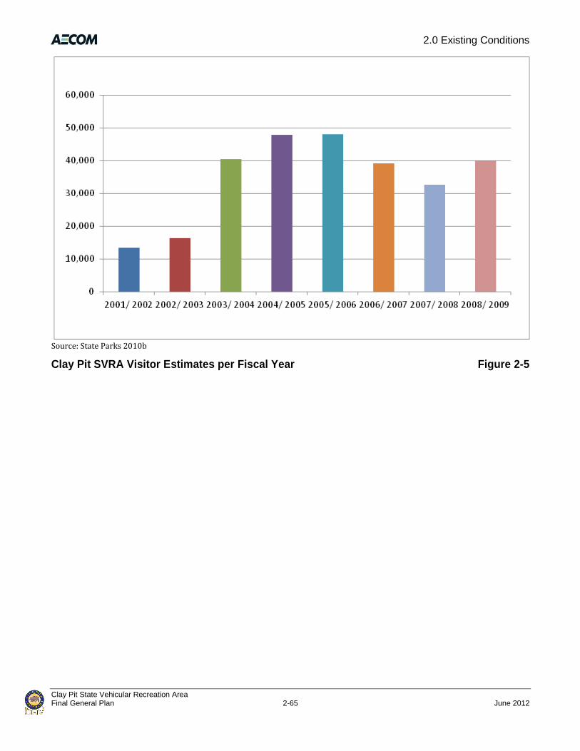
2.0 Existing Conditions
Clay Pit State Vehicular Recreation Area Final General Plan 2-65 June 2012
Source: State Parks 2010b
Clay Pit SVRA Visitor Estimates per Fiscal Year Figure 2-5

2.0 Existing Conditions
Clay Pit State Vehicular Recreation Area June 2012 2-66 Final General Plan
This page intentionally left blank.

3.0 Issues and Analysis
Clay Pit State Vehicular Recreation Area Final General Plan 3-1 June 2012
Chapter 3.0 – Issues and Analysis
This chapter details the planning assumptions and key SVRA issues that were identified during the
planning process and are addressed in Chapter 4.0 of this General Plan. Key SVRA issues were
identified through research of existing conditions, public outreach efforts, interviews with local
experts, and discussions with State Parks OHMVR Division staff.
3.1 Planning Assumptions
The following planning assumptions are based on OHMVR Division policy, core program
initiatives, statewide planning issues, and current federal and state law. The assumptions provide
the planning context and parameters for addressing General Plan issues for Clay Pit SVRA.
The OHMVR Division will implement the following actions at Clay Pit SVRA:
► maintain and enhance OHV recreational opportunities;
► manage Clay Pit SVRA in a manner that encourages responsible OHV recreation;
► provide education and enforcement efforts that balance OHV recreational opportunities with
programs that conserve and protect natural resources at Clay Pit SVRA;
► manage and protect rare, threatened, and endangered species and sensitive wildlife habitat as
required by federal and state law; and
► coordinate and collaborate with agencies and regional and local partners on local issues such
as air quality, water supply, water quality, and public utilities and services.
3.2 SVRA Planning Issues
3.2.1 Regional Planning Context
Regional Importance
OHV recreation is an important pastime in the Oroville region, Butte County, and foothills of the
Sierra Nevada. No other publicly owned OHV facilities exist in the immediate vicinity of Clay Pit
SVRA. While privately owned facilities are present in Marysville and Yuba City, these venues
charge significant admissions, and Clay Pit SVRA is the only low-cost OHV area available for
recreating in the region. Furthermore, the privately owned facilities are often only available for
special events, and therefore don’t provide regular hours for recreation by casual visitors. For
these reasons, Clay Pit SVRA functions as a highly valued regional park and recreation resource for
residents of Butte County, particularly for beginning riders and families.

3.0 Issues and Analysis
Clay Pit State Vehicular Recreation Area June 2012 3-2 Final General Plan
Air Pollution, Greenhouse Gas Emission, and Dust Control
Air quality is an issue of regional concern in the northern Sacramento Valley and in Butte County.
OHV use, similar to any other vehicle use, is a contributing factor. Vehicle emissions generated
from travel to Clay Pit SVRA and from recreation activities at the SVRA contribute to regional air
pollution and climate change. Furthermore, constructing facilities and operating the SVRA could
temporarily increase dust particulates in the air and could be a contributing factor to local air
pollution. Measures to reduce air pollution, greenhouse gas emission, and release of fugitive dust
during construction and operation are addressed in the General Plan.
Water Supply/Conservation
Proposed improvements at Clay Pit SVRA would generate the need for additional water supply.
Water would be needed to support the SVRA headquarters and to control dust generated by the
use of proposed OHV tracks. The General Plan addresses potential sources of water and provides
goals and guidelines for efficient water use and reuse.
3.2.2 Area-Specific Issues
Existing Clay Pit SVRA Uses
Clay Pit SVRA does not have any developed facilities for OHV recreation; the entire SVRA consists
of open recreation terrain. While this type of recreation opportunity is appreciated by those who
visit and use the SVRA, the area is generally considered underused. Many visitors who took the
online survey or participated in public meetings and stakeholder interviews would like some
managed facilities (e.g., motocross track, ATV track, 4x4 rock crawl) to be developed. The General
Plan addresses this issue by planning for a range of developed tracks and facilities while
maintaining opportunities for open-terrain recreation in areas of the SVRA not planned for
developed facilities.
Site Access
The existing entrance to Clay Pit SVRA has no traffic controls such as traffic signals or turning
lanes. Visitors turn into the SVRA directly from Larkin Road, a relatively busy County road. This
direct turn could create a local traffic hazard with increased use of the SVRA, especially with
vehicles pulling trailers. The General Plan describes the intent to move the main SVRA entrance
from its current location to a new location directly across from Airport Road. This would create a
four-way intersection with better opportunities for traffic control. Lines of sight would also be
better at this location. The existing entrance would be maintained as a service entrance.
Circulation
Currently, Clay Pit SVRA does not have any formal roads or trails to direct internal circulation.
While visitors generally appreciate the opportunity for open terrain recreation, OHV
3.0 Issues and Analysis
Clay Pit State Vehicular Recreation Area Final General Plan 3-3 June 2012
recreationists can unexpectedly cross each other’s path. The General Plan addresses internal
circulation by establishing designated use areas, by planning access roads to the western terrace
and the floor of the pit, and by installing directional signage in any blind areas. Large portions of
the SVRA would remain available for open terrain recreation.
Headquarters
Clay Pit SVRA has no on-site administrative or maintenance facilities for park management. SPPOs,
maintenance staff, and administrative staff service the SVRA from State Park’s Northern Buttes
District office in nearby Oroville and from the Prairie City SVRA offices in Rancho Cordova. The
absence of administrative and maintenance facilities is a disadvantage for those managing and
servicing the SVRA. The General Plan includes new headquarters facilities with an entry kiosk,
administrative and maintenance offices, a staff bathroom, and landscaping. The presence of these
facilities will enable site managers to better administer and serve the SVRA and provide better
visitor and emergency services.
Visitor Facilities
On-site visitor facilities at Clay Pit SVRA are very limited and consist of one vault toilet, a small
paved parking area, two picnic tables with shade ramadas, and one three-sided interpretive sign.
The picnic tables receive limited use because they are located along the perimeter of the site.
Visitors often stage their vehicles in the shade of the cottonwood trees near the eastern boundary
of the SVRA. The General Plan envisions additional facilities of various types to better serve
current and future visitors. Proposed facilities include new restrooms, interpretive facilities,
picnic facilities, roadways, and parking and staging areas.
Utilities
No utilities are available on-site. Electricity, phone, sewer, and water are available across Larkin
Road at the Oroville Municipal Airport and could be extended into Clay Pit SVRA. The General Plan
includes plans for the drilling of an on-site well to provide water for use at the new entrance
station, and for track watering, if sufficient water is available. If additional water is needed for dust
control, it could be provided by the local water agency. Sewage from the headquarters facilities
would be treated on-site via an engineered septic system near the entry station. The existing vault
toilet would remain, and additional vault toilets would be provided for visitor use.
Physical Resources/Topography
The topography at Clay Pit SVRA does not include a lot of variety or challenge to most visitors.
Stakeholders have repeatedly expressed a desire for developed facilities such as tracks to provide
more recreation options at the SVRA. The native substrate includes clay and cobble, which can
make OHV use of the SVRA uncomfortable or dangerous for visitors. The engineered substrate
used in developed facilities would provide a more variable and comfortable environment.

3.0 Issues and Analysis
Clay Pit State Vehicular Recreation Area June 2012 3-4 Final General Plan
Stakeholders also suggested that the OHMVR Division use logs and large rocks in the SVRA to
provide obstacles to climb and navigate. The General Plan includes a variety of developed uses
that would provide a variety of substrates and challenges to riders of different abilities and
experience.
Soil Conservation
Soil conservation is a priority at Clay Pit SVRA. The 2008 Soil Conservation Standard and Guidelines
(State Parks 2008) require assessment, maintenance, and monitoring activities for all projects
funded by the OHV Trust Fund. These activities ensure that all OHV facilities are managed for their
sustainable prescribed use without generating soil loss that exceeds restorability and without
causing erosion or sedimentation that significantly affects resource values beyond the facilities.
The General Plan includes goals and guidelines to ensure compliance with this standard.
Habitat Management
Habitat management is a priority at Clay Pit SVRA. The 1988 OHMVR Act requires that the OHMVR
Division develop wildlife and habitat monitoring and protection programs. In 1999 the OHMVR
Division prepared the Habitat Monitoring System (HMS) which provides guidance and sets overall
goals for the entire SVRA system. The system is intended to be adaptive to the needs of the
resources at each SVRA, and to changes in scientific knowledge and methods. The General Plan
includes goals and guidelines to ensure compliance with this system.
Water Quality
During the wet months Clay Pit SVRA receives runoff from the Oroville Municipal Airport located
immediately to the north. Runoff enters the SVRA via an incised drainage, often carrying sediment
and other pollutants. OHV use of the SVRA also creates sediment and vehicle-related pollutants.
Both are carried off-site to the east into a remnant oxbow of the Feather River. The General Plan
addresses water quality issues through coordination with neighboring property owners, proposed
on-site treatment of runoff, and management of pollution sources.
Sensitive Biological Resources
Clay Pit SVRA supports vernal pools and other wetlands, and a drainage canal traverses the site.
These features are waters of the U.S. subject to U.S. Army Corps of Engineers (USACE) jurisdiction
under Section 404 of the federal CWA. Any placement of fill material into waters of the United
States would require a CWA Section 404 permit from USACE. The vernal pools at the SVRA are
known to support vernal pool fairy shrimp, which is federally listed as threatened. This species
has persisted and thrived at the SVRA despite ongoing OHV activity. However, because of its
federal listing status, the presence of this species on-site may require specific management actions
in some areas known to support this species. Clay Pit SVRA also includes one elderberry shrub.
Elderberry shrubs with branches greater than 1 inch in diameter are considered potential habitat

3.0 Issues and Analysis
Clay Pit State Vehicular Recreation Area Final General Plan 3-5 June 2012
for the valley elderberry longhorn beetle, an invertebrate federally listed as threatened. The
planning team is addressing issues related to federally protected wetlands and listed species
through informal consultation with USACE and the USFWS (the federal agencies regulating these
resources). The General Plan also includes goals and guidelines to protect these resources,
including formal consultation with these agencies before construction begins in any areas where
these resources are found.
Cultural Resources
Much of the land near Clay Pit SVRA was mined for gold and river substrates, and the “pit” itself
was created when the site was mined for clay during construction of the Oroville Dam in the
1950s. While this history is interpreted briefly in the on-site interpretive sign, additional
opportunities exist to accentuate the local history via additional interpretive displays. The SVRA
has been inventoried for prehistoric and historic resources of potential significance and does not
contain any resources that would cause constraints to SVRA management and use.
Educational Opportunities
Interpretation at Clay Pit SVRA is limited to one small three-sided interpretive sign placed near
the parking lot. The addition of new facilities, including the headquarters building and constructed
OHV facilities, would provide additional opportunities for site interpretation and educational
outreach. Interpretation could address the physical, biological, and cultural resources found at the
site, local geology and geography, issues related to water quality and treatments, and other topics.
Educational outreach could also provide information on safe OHV use. The General Plan includes
goals and guidelines related to interpretation and education.
Aesthetic Resources
During the public outreach process conducted in support of the General Plan, some visitors
suggested taking measures to beautify the site. Planting trees; enhancing the drainage
management area; and restoring some vernal pools and grasslands could improve SVRA
aesthetics. Opportunities to enhance the site and restore habitat are addressed in the General
Plan. The General Plan also includes provision for the screening and landscaping of newly
proposed facilities.
Noise
Noise generated by visitors to Clay Pit SVRA has the potential to adversely affect nearby sensitive
receptors. The General Plan addressed this issue through careful site planning to avoid increased
noise levels at nearby receptors and by recommending noise barriers (berms) between proposed
facilities and a nearby residence. The General Plan also includes guidelines to encourage the
supporting organizations that use the SVRA to coordinate periodic and voluntary noise testing for
vehicles and education to help maintain acceptable ambient noise levels.

3.0 Issues and Analysis
Clay Pit State Vehicular Recreation Area June 2012 3-6 Final General Plan
Public Safety
Clay Pit SVRA is patrolled by SPPOs 7 days per week, but includes no staffed entry kiosk. The
General Plan includes plans for permanent administration buildings, which would improve park
oversight, enhance public safety, and limit opportunities for inappropriate or illegal use of the
SVRA.
Relationships with User Groups
During the public outreach process conducted in support of the General Plan, several groups
expressed strong support for Clay Pit SVRA and a willingness to help with efforts related to site
development and maintenance. The General Plan includes provisions to continue positive
relationships with user groups and to foster volunteer stewardship.
Providing Places for Family Gatherings
Clay Pit SVRA is considered a family-friendly park partly because the relatively easy terrain is
suitable for inexperienced visitors. However, no specific riding areas exist for children, and no
other activities are provided for families and individuals who are not riding OHVs. The General
Plan proposes creating a designated youth riding area in the SVRA and providing additional
gathering places with recreational facilities for use by groups and/or families. The facilities could
include clustered ramadas and picnic tables and facilities for passive recreation, such as horseshoe
pits.
Clay Pit is a place for families to recreate

4.0 The Plan
Clay Pit State Vehicular Recreation Area Final General Plan 4-1 June 2012
Chapter 4.0 – The Plan
This General Plan establishes the long-range purpose and vision for Clay Pit SVRA. Specific use
areas described in this plan clarify the management intent and desired visitor experiences within
these areas and within proposed facilities. The goals and guidelines in this General Plan provide
guidance on how to achieve the purpose, vision, and management intent for the SVRA. The goals
and guidelines were developed to address known planning issues while providing a foundation for
resource protection, development, and interpretation of the SVRA. The goals and guidelines also
provide a framework for subsequent planning and development for the various elements of the
SVRA.
4.1 Purpose and Vision
4.1.1 Declaration of Purpose
The declaration of purpose describes the purpose of Clay Pit SVRA and is the broadest statement
of management goals designed to fulfill the vision of the SVRA. A declaration of purpose is
required by PRC 5002.2(b). The following declaration of purpose was developed for Clay Pit SVRA
during the General Plan process:
The purpose of Clay Pit SVRA is to provide effectively managed, responsible off-highway
vehicle (OHV) and related recreational opportunities with recognition of the significance of
Clay Pit SVRA to the local population. The unit’s relatively small size and unique outdoor
recreational setting provide opportunities for various forms of OHV use, family and social
gathering, and interpretive programs.
4.1.2 SVRA Vision
The vision for Clay Pit SVRA describes the SVRA in future years, when the OHMVR Division has
achieved its General Plan objectives. The following vision was developed for Clay Pit SVRA during
the General Plan process:
Clay Pit SVRA provides a safe and convenient place for individuals, families, and groups to
enjoy an outdoor recreational setting. On any given day, visitors are able to take part in
managed OHV recreation and other activities, and to enjoy the unique setting. Clay Pit SVRA’s
natural and cultural history provides opportunities for education and interpretation. Clay Pit
SVRA provides high-quality outdoor experiences for both the local and regional community in
the greater Oroville area already known for its extensive recreational activities.
4.2 Unit Classification
Clay Pit is an SVRA.

4.0 The Plan
Clay Pit State Vehicular Recreation Area June 2012 4-2 Final General Plan
4.3 Land Use Management
4.3.1 Planning Alternatives
Several planning alternatives were developed during the planning process. The alternatives
explored a range of scenarios in terms of management zones, types of potential facilities, and
locations of potential facilities. All alternatives aimed to provide a balance between protecting on-
site resources and providing a range of recreational experiences. The plan described in this
section presents the preferred alternative, as developed based on a variety of factors, including
geographic relationships, resource values, ecological parameters, management issues and goals,
types and intensities of land use, visitor use and experience, desired outcomes for staff and
visitors, regional recreation trends, and population trends.
4.3.2 Use Areas
Management zones or land use areas (use area) for Clay Pit SVRA have been developed to allow
for specialized management by area based on the factors described above in Section 4.3.1. This
General Plan defines three use areas: the Developed Use Area, the Open OHV Recreation Area, and
the Drainage Management Area.
A brief description of features, primary management intent, intended activities, proposed
facilities, and potential facilities in these use areas are listed in Table 4.1 and described in more
detail below. Figure 4-1, “Use Areas and Headquarters Facilities”, shows the location and extent of
each of the three use areas in Clay Pit SVRA, as well as the headquarters facilities proposed for
construction within the Developed Use Area.
Developed Use Area
The primary management intent of the Developed Use Area is to accommodate the more intense
uses and built facilities envisioned at Clay Pit SVRA. The Developed Use Area contains a paved
parking lot, two shade ramadas, two picnic tables, one vault toilet, and one interpretive sign. Other
types of built facilities such as paved access roads, water tanks, OHV tracks, and 4X4 obstacles
could be located within the Developed Use Area.
Headquarters facilities are proposed for construction in the Developed Use Area and will include a
new entry off of Larkin Road, a headquarters building with an attached maintenance shop and
maintenance yard, an entry kiosk, and an internal roadway connecting the new entry with the
existing parking lot. A fuel station for gas and diesel may be installed in the maintenance yard for
use by OHMVR Division vehicles, motorcycles, ATVs, and maintenance equipment that will be
operated by staff. The proposed headquarters facilities are described in more detail in Section
4.3.3, “Proposed Facilities.”

4.0 The Plan
Clay Pit State Vehicular Recreation Area Final General Plan 4-3 June 2012
TABLE 4-1: USE AREA MATRIX
TOPICS DEVELOPED USE AREA OPEN OHV RECREATION AREA DRAINAGE MANAGEMENT AREA
Description The Developed Use Area contains desirable topographic features for OHV use and fewer sensitive natural resources than other parts of Clay Pit SVRA.
The Open OHV Recreation Area has fewer desirable topographic features and a higher density of natural resources.
The Drainage Management Area bisecting Clay Pit SVRA contains a linear drainage and several pond features which dry up during the hot summer months.
Primary Management Intent
The primary management intent for the Developed Use Area is to accommodate the more intense uses and built facilities envisioned at Clay Pit SVRA.
The primary management intent for the Open OHV Recreation Area is to continue to provide informal open OHV recreation and trail use while preserving natural resources.
The primary management intent for the Drainage Management Area is to allow for recreational enjoyment of this feature while preventing water quality degradation and soil loss.
Intended Activities It is well suited for built facilities such as parking lots, OHV tracks, and 4X4 obstacles.
Generally, this area will be left in its current state and will continue to be used for multi-purpose OHV use.
This use area will be actively managed to address water quality issues related to this drainage.
Facilities (proposed and anticipated)
Facilities suitable in the Developed Use Area include an entry area; a headquarters building; maintenance facilities; developed OHV facilities such as tracks, trails, a 4X4 play area and obstacle course; accompanying staging facilities such as restrooms and picnic areas; and educational facilities such as interpretive displays or an outdoor classroom area.
Facilities suitable in the Open OHV Recreation Area include marked or developed trails, informal trails, unpaved staging areas, accompanying staging facilities such as restrooms and picnic areas, and educational facilities such as interpretive displays or an outdoor classroom area. Developed tracks, paving, and other built facilities are not suitable in this use area.
This use area is not appropriate for developed facilities. Drainage crossings may be constructed, which could include culverts, bridges, or other circulatory management features.
Natural Resources Sensitive natural resources in this area include a few scattered vernal pools. Sensitive natural resources in this area include a large number of vernal pools scattered throughout, many of which are known to support special status invertebrate species.
This area contains recreational and natural features that change depending on climatic conditions. During the wet months, this area conveys and ponds large amounts of water. During the dry season, this area does not sustain water.
Typical Visitor Activities
Visitor activities in the Developed Use Area may include the use of MX track(s), ATV track(s), obstacle courses, hill climbs, mud pits, marked and developed trails, informal trails, staging areas, picnicking areas, educational programs and exhibits, and other built facilities. Overnight use is limited to special event permits.
Visitor activities in the Open OHV Recreation Area may include the use of marked and developed trails, informal trails and open OHV use areas, staging areas, picnicking areas, and educational programs and exhibits. Overnight use is limited to special event permits.
Visitor activities in the Drainage Management Area depend upon the season. Use will be managed according to water quality and soil loss management requirements.
Public Access Visitors will be able to access facilities within the Developed Use Area via roadways that may be constructed between the SVRA entrance and the various developed use facilities. Informal trails or developed trails may be created throughout this use area.
Generally, access to the Open OHV Recreation Areas will be limited to off highway vehicles and pedestrians. From the staging areas where most street vehicles will park, visitors will be able to ride throughout this use area along existing informal trails, potential future marked trails, or in open terrain.
This area will be accessible by two roads and by informal trails. Driving within the drainage will be discouraged.
Source: AECOM 2010

4.0 The Plan
Clay Pit State Vehicular Recreation Area June 2012 4-4 Final General Plan
Source: Topographic information provided by David Evans and Associates 2008, planning data developed by AECOM in 2010
Use Areas and Headquarters Facilities Figure 4-1

4.0 The Plan
Clay Pit State Vehicular Recreation Area Final General Plan 4-5 June 2012
Additional facilities that could be built in the Developed Use Area include, but are not limited to,
OHV tracks (e.g., ATV tracks, motocross tracks, training tracks), a 4X4 and trials play area and
obstacle course, trails and internal roadways, parking areas, staging facilities such as restrooms
and picnic areas, spectator stands, and educational facilities such as interpretive displays or an
outdoor classroom area. Visitor access to facilities within the Developed Use Area will be via an
internal roadway and trail system that will be constructed between Clay Pit SVRA entrance and
various developed facilities. The anticipated facilities and roadways depicted in Figure 4-2,
“Anticipated Facilities”, serve as examples of the type and location of facilities that could be built
in the Developed Use Area. Future conditions and demands will determine the actual locations and
facilities built within this use area. Overnight use will be limited to special events. Anticipated
facilities are described in more detail in Section 4.3.4, “Anticipated Facilities and Services.”
Open OHV Recreation Area
The primary management intent of the Open OHV Recreation Area is to continue to provide
informal open OHV recreation and trail use while preserving natural resources. Generally, this
area will be left in its current state and will continue to be used for multipurpose OHV use.
Facilities within the Open OHV Recreation Area could include marked or developed trails, informal
trails, unpaved staging areas, accompanying staging facilities such as restrooms and picnic areas,
and educational facilities such as interpretive displays or an outdoor classroom area. Developed
tracks, paving, and other built facilities will not be located in this use area. Visitor access to this
area will be limited to OHVs and pedestrians. From the staging areas where most street vehicles
will park, visitors will be able to ride throughout this use area along existing informal trails,
potential future marked trails, or in open terrain.
Typical visitor activities in this area will include OHV use of marked and developed trails, informal
trails, open areas, and staging areas and visitor use of picnic areas and educational exhibits or
facilities. Overnight use will be limited to special events.
Drainage Management Area
The primary management intent of the Drainage Management Area is to prevent water quality
degradation and soil loss while allowing for recreational enjoyment of this area as appropriate.
This use area will be actively managed to address water quality and soils management issues
related to the linear drainage canal that bisects Clay Pit SVRA.
No recreational facilities are proposed for this use area. Drainage crossings will be constructed,
which may include culverts, bridges, or other features that will guide circulation through the area.
Driving up and down the drainage will be discouraged. Visitor activities will be managed
according to the season and site conditions. Visitor use of this area will be managed in accordance
with water quality requirements.

4.0 The Plan
Clay Pit State Vehicular Recreation Area June 2012 4-6 Final General Plan
4.3.3 Proposed Facilities
Most of the facilities in the headquarters area (Figure 4-1) within the Developed Use Area are
estimated to be constructed at Clay Pit SVRA in 2013. The proposed facilities include a
headquarters building, septic system, maintenance yard, new entrance and roadway alignment,
and an entrance kiosk. These new facilities will play an important role in enabling other proposed
facilities and visitor uses in the future. These buildings will include the materials and staff needed
to maintain Clay Pit SVRA at a higher intensity of use. State Parks anticipates charging a fee for
each car that enters Clay Pit SVRA once these improvements are finalized. Funds obtained from
site entrance fees will be used to maintain Clay Pit SVRA and provide funding for future
improvements.
Construction of the proposed headquarters facilities is expected to last 3–6 months. Construction
will occur between 7:00 a.m. and 7:00 p.m. Monday through Friday and between 9:00 a.m. and
5:00 p.m. on Saturdays. No construction will occur on Sundays or holidays.
Headquarters Building
The headquarters building will include approximately 2,800 square feet of administrative offices,
staff restrooms, a maintenance shop and offices, and storage. Visitor services staff will be available
to welcome visitors in an entry area. The structure will be single story and will be 15 feet tall at
the office roof’s ridge and 23 feet tall at the garage’s roof ridge. Because the building will be less
than 70 feet tall, it will comply with height restrictions related to the Oroville Airport compatibility
zones. The building will have gable roofs and be painted in earth tones. Nighttime security
lighting, similar to security lighting present at the Oroville Municipal Airport, may be installed at
the headquarters building and parking area for safety and security purposes. The building will be
constructed in compliance with Federal Aviation Administration requirements to avoid glare or
distracting lights that could be mistaken for airport lights. The building will also be constructed to
incorporate Leadership in Energy and Environmental Design (LEED®) standards.
Maintenance Yard
The maintenance shop will open to a 0.5-acre maintenance yard to be used for storing
maintenance and patrols vehicles, ATVs, and motorcycles. This maintenance yard may include
storage sheds for equipment needed for building and maintaining tracks, trails, and other OHV
facilities. This equipment could include bulldozers, water trucks, tractors, back hoes, or other
similar equipment. Some equipment may be shared with the Prairie City SVRA and may not be
stored on-site. Approximately 1,800 cubic yards of material will be excavated to create the
maintenance yard, and this material will be stored temporarily for later use in Clay Pit SVRA. It
will be stored in upland areas west of the headquarters building in locations that will not obstruct
views of the surrounding area, and erosion control measures will be used. The maintenance yard
will be surfaced with crushed rock about 6 inches deep.

4.0 The Plan
Clay Pit State Vehicular Recreation Area Final General Plan 4-7 June 2012
Roadways
Development of the headquarters facility will include the construction of a new entrance into Clay
Pit SVRA at the Airport Park intersection with Larkin Road. Construction of the new entrance will
result in a four-way intersection at Airport Park and Larkin Road, and will include left- and right-
turn channelization from Larkin Road into the SVRA. This new entrance will be approximately
1,000 feet to the west of the existing entrance. A new access road will join the new entrance with
the existing access road leading from the entrance down to the existing parking lot. The existing
entrance will be maintained as a service entrance. From the headquarters building to the new
kiosk the new access road will be a single two-way road. It will then divide around the new kiosk,
and become a single two-way road past the kiosk to the existing parking lot. The existing access
road will be used as secondary emergency/service access. A total of approximately 2 acres of new
paving will be required for the entrance and internal roadway.
Kiosk
An entry kiosk will be located approximately 250 feet inside the entrance of the park. The 160-
square-foot kiosk will be made from materials similar to those at the headquarters building, and
will be a maximum of 15 feet tall. Two lanes will be constructed on either side of the kiosk to
accommodate visitor check-in and exit.
Utilities and Services
Utilities and services needed to serve the headquarters facilities include water, wastewater
disposal, propane, electricity, and solid waste disposal. A new on-site well will be constructed to
meet water needs. Because percolation tests indicate that on-site soils likely are not suitable for a
standard gravity-fed septic system, an engineered septic system will be used at the headquarters
facilities. This engineered septic system will be designed and constructed according to site
constraints, and could involve the use of an above-ground leach field, a sand filtration system, or
other engineered components. It is anticipated that the leach field will be approximately 100 feet
wide, 100 feet long, and 10 feet deep. It is estimated that approximately 3,700 cubic yards of
native material will be excavated and stored temporarily for later use in Clay Pit SVRA. The
material will be temporarily stored in upland areas west of the headquarters building in locations
that will not obstruct views of the surrounding area, and erosion control measures will be used.
An approximately 250-gallon liquefied petroleum (propane) tank will be installed adjacent to the
headquarters building for water heating and space heating. Overhead or underground electric
lines will be extended to the SVRA from lines at Larkin Road, which currently serve the airport.
Solid waste disposal will continue to be provided by Recology and the Neal Road Recycling and
Waste Facility.

4.0 The Plan
Clay Pit State Vehicular Recreation Area June 2012 4-8 Final General Plan
4.3.4 Anticipated Facilities and Services
As described above, the facilities and roadways depicted in Figure 4-2 serve as examples of the
type and location of facilities that are anticipated at Clay Pit SVRA. Future conditions and demands
will determine the actual locations and facilities built within the SVRA. These new facilities will be
an important part of achieving the purpose of the SVRA to provide effectively managed,
responsible OHV and related recreational opportunities with recognition of the significance of the
SVRA to the local population. Clay Pit SVRA is underutilized now, partly because of a lack of
developed OHV facilities. Constructing these facilities will fulfill an objective of this General Plan to
maximize the use of the SVRA as a recreation resource while also protecting natural and cultural
resources on-site. Constructing these anticipated facilities will allow the OHMVR Division to
maintain the SVRA at a higher intensity of use and help to fulfill the vision of the SVRA as a safe
and convenient place for individuals, families, and groups to enjoy the outdoor recreational
setting. It will also enable Clay Pit SVRA to host special events.
Facilities
Most of the anticipated facilities are estimated to be built during the 2016/2017 fiscal year (June
2016 through May 2017). Construction of the anticipated facilities will last approximately 12
months. Construction will occur between 7:00 a.m. and 7:00 p.m. Monday through Friday and
between 9:00 a.m. and 5:00 p.m. on Saturdays. No construction will occur on Sundays or holidays.
Anticipated facilities could include the following components:
► training track, approximately 620 feet long and covering approximately 1 acre;
► track for 110cc vehicles, approximately 1,200 feet long and covering approximately 2 acres;
► ATV track approximately 1mile long and covering approximately 3–5 acres;
► motocross track approximately 1mile long and covering approximately 3–5 acres;
► 4x4 and trials obstacle course, hill climb, and mud pit covering approximately 10–12 acres;
► sediment traps and basins for the treatment of surface water runoff, covering approximately
1.25 acres;
► marked and developed trails and informal trails;
► one or more staging areas/parking lot(s) covered with road base;
► vault toilets with odor control systems;
► picnic areas with tables and shade ramadas, with no permanent fire pits or barbeque grills;
► spectator stand(s)

4.0 The Plan
Clay Pit State Vehicular Recreation Area Final General Plan 4-9 June 2012
► educational facilities such as interpretive displays and/or an outdoor classroom area;
► low water crossings, culverts, and/or bridges across the Drainage Management Area;
► paved roads between the new SVRA entrance and selected OHV facilities;
► one or more wells and two water storage tanks; and
► a fuel station consisting of one aboveground fuel tank with pumps, which will be installed on a
concrete slab with concrete berms to provide full containment in case of an accidental spill.
The aboveground tank will hold and dispense both gasoline and diesel for use in State Parks
vehicles.
Hours of Operation
Clay Pit SVRA is anticipated to be open from 8:00 a.m. to sunset 7 days a week, 365 days per year.
The entry kiosk will be staffed during open hours, and the administrative offices will be available
to staff during open hours. Overnight usage of the SVRA will be limited to special events. Open
hours will vary according to the time of year as follows:
Season Hours
Winter (November through February) 8 a.m. to 5 p.m.
Summer (May through August) 8 a.m. to 8 p.m.
Spring
March 8 a.m. to 6 p.m.
April 8 a.m. to 7 p.m.
Fall
September 8 a.m. to 7 p.m.
October 8 a.m. to 7 p.m.
Operations and Maintenance
The anticipated facilities will require maintenance. Tracks will receive grooming as needed,
approximately once per week in the summer months. Grooming may require the use of a dozer,
farm disc, and a 4-wheel drive tractor. Tracks will require watering in the summer months to
control dust and to minimize soil movement. A 4,000-gallon water truck will run loops around all
tracks, as needed, with an estimated water use of 0–240,000 gallons/day. The 4x4 mud drag will
require watering in the summer months approximately biweekly, with an estimated water use of
40–60,000 gallons per watering. Based on water use at other similar SVRAs (i.e., similar facilities
and climate), water requirements at Clay Pit SVRA are estimated to be approximately 24,500,000
4.0 The Plan
Clay Pit State Vehicular Recreation Area June 2012 4-10 Final General Plan
gallons/year. Water could be supplied from onsite well(s), or could be brought to the site from
water supply facilities serving the Oroville Municipal Airport.
Dust control products (e.g., Dust Off) will be applied to roads and staging areas as needed, usually
once per year in the spring, to control fugitive dust. Approximately once per year, usually in the
spring, an imported amendment of sand, rice hulls, chip bark, bark mulch, and/or top soils
(approximately 640 cubic yards) will be incorporated into the tracks for texture and to control
dust by holding moisture. The 4x4 mud drag will require resurfacing to smooth out ruts and
depressions, approximately bi-annually when soils are still damp. Adding amendments and
resurfacing may require the use of a dozer, farm disc, and a 4-wheel drive tractor. The rock crawl
will require replenishment of boulders very rarely, perhaps every 10 years.
Vendors and concessioners are anticipated only during special events.
Staffing
The OHMVR Division anticipates that Clay Pit SVRA will employ five full-time employees and two
to three seasonal employees following construction of all facilities anticipated within this General
Plan. This includes SPPOs, maintenance staff, administrative staff, and visitor services staff. SPPOs
will patrol the park and use office space within the headquarters building. Maintenance staff will
work throughout Clay Pit SVRA and within the headquarters building. Visitor services employees
will staff the entry kiosk, provide office support, and work within the headquarters building. It is
estimated that no more than five staff will be on-site at a time, on average. Staffing levels will
increase as needed during special events, consistent with staffing levels provided at special events
currently held at other SVRA facilities.
Visitor Use Estimates
Existing traffic at Clay Pit SVRA is estimated at an average of between 8,900 and 13,800 vehicles
per year (Appendix C). Using a ratio of 2.5 people per vehicle generates an estimated range of
22,250–34,500 visitors per year. Constructing the recreation facilities envisioned in the General
Plan is expected to result in an estimated 50% increase of visitors. Combining this increase with
an estimated local population increase of 2% per year provides a median visitor increase to
49,593 visitors per year in 2030 (Appendix C). Following construction of anticipated facilities, the
percentage of various types of OHVs used at Clay Pit SVRA is estimated to be 35% ATVs, 45%
motorcycles, 10% utility vehicles, and 10% 4x4s.

4.0 The Plan
Clay Pit State Vehicular Recreation Area Final General Plan 4-11 June 2012
Source: Topographic information provided by David Evans and Associates 2008, planning data developed by AECOM in 2011
Anticipated Facilities Figure 4-2

4.0 The Plan
Clay Pit State Vehicular Recreation Area June 2012 4-12 Final General Plan
This page intentionally left blank.

4.0 The Plan
Clay Pit State Vehicular Recreation Area Final General Plan 4-13 June 2012
4.4 Goals and Guidelines
Goals and guidelines have been developed to address existing issues and to provide ongoing
guidance for management of the SVRA. Goals and guidelines can be implemented to achieve the
long-term vision for Clay Pit SVRA. The goals establish the purpose and the desired future
conditions of the SVRA, while the guidelines provide the direction that the OHMVR Division will
consider to achieve these goals. The first set of goals and guidelines applies to the entire Clay Pit
SVRA; these are called parkwide goals and guidelines. Additional goals and guidelines were
developed for specific use areas to allow for specialized management by zone; these are called use
area goals and guidelines. Section 4.4.1 presents parkwide goals and guidelines applicable across
the entire SVRA, and Section 4.4.2 presents use area goals and guidelines specific to each use area.
4.4.1 Parkwide Goals and Guidelines
Visitor Experience and Opportunities (VEO)
VEO Goal 1: When planning for recreation opportunities and visitor services, provide a broad range of OHV
recreation experiences and opportunities for visitors to enjoy and appreciate.
► VEO Guideline 1.1: Anticipate a variety of OHV activities that visitors will engage in, which
could include the use of motocross bikes, dirt bikes, trials bikes, ATVs, UTVs (side-by-sides),
and 4x4s.
► VEO Guideline 1.2: Anticipate a range of age and skill levels from novice through expert OHV
recreationists.
► VEO Guideline 1.3: Anticipate changes in the percentage of visitors of different types of OHV
equipment as technologies, designs, and interests change. (Current estimates of use are 49
percent ATVs, 40 percent motorcycles, 1 percent UTVs, and 10 percent 4x4s. Estimates of use
following facilities construction are 35 percent ATVs, 45 percent motorcycles, 10 percent
UTVs, and 10 percent 4x4s.)
► VEO Guideline 1.4: Anticipate changes in regional demographics and trends.
► VEO Guideline 1.5: Ensure that use levels are appropriate to OHMVR Division resource
protection guidelines. (See Section 4.5, “Managing Visitor Capacity” and associated Guidelines.)
► VEO Guideline 1.6: Incorporate universal access standards wherever feasible.
VEO Goal 2: Provide state of the art visitor serving facilities to enhance the visitor experience.
► VEO Guideline 2.1: Develop additional recreation facilities to increase utilization of the SVRA,
to meet the recreation needs of the regional and local community, and to attract visitors from
outside the region.

4.0 The Plan
Clay Pit State Vehicular Recreation Area June 2012 4-14 Final General Plan
► VEO Guideline 2.2: Locate facilities for effective and efficient visitor use and to provide
opportunities for social interaction between user groups while minimizing potential user
conflicts.
► VEO Guideline 2.3: When planning to develop new facilities, consider the need for
maintenance and public safety personnel, equipment, communications, and emergency vehicle
access.
VEO Goal 3: Enhance individual-, family-, and community-centered recreational opportunities.
► VEO Guideline 3.1: Provide recreational opportunities that respond to local needs and
interests, which could include special events for children new to OHV recreation, events
planned to celebrate important local historical events, and events that emphasize safety and
responsible OHV recreation.
► VEO Guideline 3.2: Seek to provide additional group-oriented recreational opportunities,
social gathering opportunities, and facilities that are compatible with OHV use.
► VEO Guideline 3.3: Explore opportunities to create partnerships for coordinated educational
programming and special events that connect Clay Pit SVRA to the broader region. For
example, coordinate with the adjacent Oroville Wildlife Management Area to provide
programming about local wildlife. (Also see Interpretation and Education goals and
guidelines.)
Natural Resources Management (NRM)
NRM Goal 1: Manage the SVRA for a balance of uses that allow protection of natural resources while
maintaining a quality OHV recreational experience.
► NRM Guideline 1.1: To the extent feasible, locate visitor-serving facilities in areas already
subject to considerable disturbance or in areas of low resource value (e.g., the Developed Use
Area) to minimize disturbance to higher value habitat areas.
► NRM Guideline 1.2: Avoid sensitive biological resources present within areas that would be
affected by construction or operation of facilities envisioned in this General Plan.
► NRM Guideline 1.3: In the event that disturbing a sensitive biological resources is
unavoidable, identify and implement measures to offset those impacts in consultation with a
qualified biologist and the appropriate resource agency (or agencies) (e.g., California
Department of Fish and Game [DFG], U.S. Fish and Wildlife Serviced [USFWS], U.S. Army Corps
of Engineers [USACE], and the Regional Water Quality Control Board [RWQCB]). Comply with
all applicable rules and regulations relating to the protection of special-status species and
protected resources (e.g., U.S. Endangered Species Act (ESA), California Endangered Species
Act, Clean Water Act [CWA] Section 404, Porter-Cologne Water Quality Control Act). If

4.0 The Plan
Clay Pit State Vehicular Recreation Area Final General Plan 4-15 June 2012
required, obtain necessary authorizations/permits from these agencies and abide by all permit
conditions. (Also see Wildlife Guidelines 1.1-1.4, Plants Guidelines 1.1 and 1.2, and Water
Guideline 1.2.)
► NRM Guideline 1.4: Implement the OHMVR Division’s Habitat Management System (HMS)
consistent with biological provisions in the Off-Highway Motor Vehicle Recreation Act to
monitor and manage natural processes of vegetation succession, to control the spread of
noxious and invasive weeds, and to protect natural wildlife habitat. Select scientifically
accepted techniques and measures appropriate for the unique habitats found within Clay Pit
SVRA. Develop protocols for baseline studies, focused studies, monitoring, and surveys. Use the
HMS as a tool to aid in the development of park-specific monitoring plans and management
techniques.
► NRM Guideline 1.5: Concentrate new trail development in areas of low habitat value. Route
new trails around the edges of high-quality habitat to avoid habitat fragmentation.
NRM Goal 2: Encourage a balance of uses within Clay Pit SVRA that allow the restoration or enhancement
of natural habitats while maintaining a quality OHV recreational experience.
► NRM Guideline 2.1: Develop an adaptive management plan for biological resources that
combines the results of monitoring implemented through the HMS (NRM Guideline 1.4) and
monitoring for soil conservation (Soils Guideline 1.2). Identify and establish Adaptive
Management Opportunity Zones in areas of high-quality natural habitat (e.g., remnant vernal
pool grassland) and sensitive habitat (e.g., particular vernal pools), around areas showing
indications of natural succession toward a desirable natural community type (e.g., volunteer
cottonwood seedling growth), or where populations of special-status native wildlife and
special-status plant species occur or could occur (e.g., elderberry shrub). Implement
management actions to protect these zones from activities that could disturb sensitive
resources or to enhance/restore them as part of the adaptive management process, should
resource degradation be detected during monitoring.
► NRM Guideline 2.2: Consider temporary or rotating closures around Adaptive Management
Opportunity Zones and around areas experiencing heavy use to allow for natural regenerative
processes to occur before degradation of resources requires more restrictive management
actions. Use directional signage to inform visitors of sensitive and closed areas. (See IE
Guideline 3.3).
► NRM Guideline 2.3: Work with local groups interested in performing noninvasive forms of
habitat enhancement activities at the SVRA (e.g., dispersal of native plant seed, removal of
nonnative plant and wildlife species). Preclude the intentional introduction of special-status
plant or wildlife species that would present a risk of conflict with future OHV activities.

4.0 The Plan
Clay Pit State Vehicular Recreation Area June 2012 4-16 Final General Plan
Soils Management (Soils)
Soils Goal 1: Manage the SVRA for a balance of uses that allow protection and conservation of soil while
maintaining a quality OHV recreational experience.
► Soils Guideline 1.1: Manage Clay Pit SVRA recreation facilities to meet the 2008 Soil
Conservation Standard:
Off-highway vehicle (OHV) recreation facilities shall be managed for sustainable
long-term prescribed use without generating soil loss that exceeds restorability, and
without causing erosion or sedimentation which significantly affects resource
values beyond the facilities. Management of OHV facilities shall occur in accordance
with Public Resources Code, Sections 5090.2, 5090.35, and 5090.53.
► Soils Guideline 1.2: Develop an adaptive management plan for soil resources consistent with
California Public Resource Code (PRC) Section 5090.35(a) and the 2008 Soil Conservation
Standard and Guidelines. Incorporate the tools and techniques identified in the 2008 Soil
Conservation Standard and Guidelines as appropriate to site conditions at Clay Pit SVRA. Also
incorporate other tools and techniques that may apply to specific facility conditions and
management structure at the SVRA.
► Soils Guideline 1.3: Incorporate the guidance provided in the OHV BMP Manual for Erosion
and Sediment Control (OHV BMP Manual) (State Parks 2007) when planning for the
development of new facilities. Select, implement, and maintain best management practices
(BMPs), including those designed for stockpiles, during and following construction activities to
avoid soil loss and potential resulting air pollution or degradation of water quality.
► Soils Guideline 1.4: To minimize or eliminate risks from expansive soils, follow all
recommendations contained in the geotechnical investigation report Geotechnical
Investigation, Clay Pit SVRA, Oroville, Butte County, California (geotechnical investigation)
(Geocon 2010; Appendix D of the General Plan) addressing site grading, foundations, and other
surface improvements while planning for and constructing all facilities at Clay Pit SVRA.
► Soils Guideline 1.5: Design and construct all facilities proposed and envisioned in the General
Plan in compliance with all regulatory requirements related to soil safety and geologic stability
and safety, such as those contained in the California Building Standards Code (Title 24).
► Soils Guideline 1.6: Conduct an on-site wastewater site evaluation to determine the
appropriate system designs for wastewater disposal at Clay Pit SVRA. Develop wastewater
disposal facilities consistent with all regulatory requirements and guidelines related to the
protection of soils and groundwater, including the Butte County On-Site Wastewater
Ordinance (adopted March 16, 2010) and Part 6, Chapter 4.5, of the California Water Code.

4.0 The Plan
Clay Pit State Vehicular Recreation Area Final General Plan 4-17 June 2012
Plants and Natural Communities (Plants)
Plants Goal 1: Manage the SVRA for a balance of uses that allow protection of special-status plants and
sensitive natural communities while maintaining a quality OHV recreational experience.
► Plants Guideline 1.1: Conduct protocol-level surveys for special-status plants at the proposed
headquarters area, and all other proposed facilities, before construction begins and during the
blooming season for all potentially occurring special-status plant species according to the most
current methodology recommended by DFG. Surveys shall be conducted by a qualified botanist
familiar with the flora of Butte County. Repeat special-status plant surveys if they have
occurred 5 or more years before scheduled construction. If no special-status plants are found
during focused surveys, document the findings in a letter report to the appropriate agencies,
depending on the listing status of the species.
► Plants Guideline 1.2: If special-status plant species are found during preconstruction surveys,
map the location and extent of the population, and avoid disturbance of the area to the extent
practicable. If special-status plants cannot be avoided, consult with DFG and/or USFWS, as
appropriate and depending on listing status of species, to develop mitigation measures for
direct and indirect impacts on any special-status plant species that could result from
construction of proposed facilities. Mitigation measures may include preserving or enhancing
other existing populations on-site, transplantation, and/or restoring or creating suitable
habitat on- or off-site in sufficient quantities to achieve no net loss of occupied habitat or
individuals.
► Plants Guideline 1.3: For landscaping, use drought-tolerant plants, and as feasible, use plants
and materials native to the site. Select plants that require little or no irrigation. If irrigation is
required for plant establishment, use temporary irrigation methods that allow a gradual
tapering of water over a 3–5 year period. Regulate water pressure at a level that applies
sufficient water without causing erosion, damage to plants, or runoff.
► Plant Guideline 1.4: As part of the annual monitoring efforts (see Guideline NRM 1.4),
monitor for existing or incipient populations of invasive weeds. If new invasive weeds are
documented, implement actions to prevent their establishment and spread before they
become established or occupy large portions of the SVRA. Use control methods based on the
best available information for weed management and State Park’s operational manual.
Wildlife
Wildlife Goal 1: Manage the SVRA for a balance of uses that allow protection of native wildlife species,
including special-status wildlife species, while maintaining a quality OHV recreational experience.
► Wildlife Guideline 1.1: If construction activities are proposed within 100 feet of the isolated
elderberry shrub that occurs in the arroyo willow habitat near the northern border of Clay Pit

4.0 The Plan
Clay Pit State Vehicular Recreation Area June 2012 4-18 Final General Plan
SVRA, consult with USFWS to determine whether the shrub is considered potential habitat for
valley elderberry longhorn beetle (VELB). If USFWS determines that the elderberry shrub is
considered potential habitat, identify and implement measures, as appropriate for project
activities and site constraints, to avoid or mitigate those impacts according to the VELB
conservation guidelines recommended by USFWS (USFWS 1996).
► Wildlife Guideline 1.2: Consider potential impacts on nesting birds when determining the
timing and implementation of activities. To the extent feasible, schedule construction activities
that could affect nesting birds outside of the breeding season (March 1–September 15). If
construction is scheduled during the breeding season, a qualified wildlife biologist shall
conduct a preconstruction survey of proposed construction areas to identify active bird nests.
Conduct surveys within 1 week prior to initiating construction, in accordance with
standardized protocols. If nesting birds are discovered within or adjacent to the construction
area, develop measures to avoid or minimize disturbance to nesting birds in consultation with
DFG and/or USFWS as appropriate to the listing status of the species. Protective measures may
include using a buffer area around the nest or delaying construction activities until a qualified
biologist confirms that the nest is no longer active or the birds are not dependent on it.
► Wildlife Guideline 1.3: In concurrence with annual monitoring conducted as part of the HMS
(NRM Guideline 1.4), monitor populations of special-status shrimp species and vernal pool
vegetation. Document the baseline shrimp population via protocol surveys prior to
implementing construction activities envisioned in this General Plan. Assess the effect of
anticipated increased OHV use on these natural communities and species, relative to baseline
information gathered before implementation of the General Plan. If long-term monitoring (i.e.,
more than 2 years in a row) documents a decline in the conditions of the resource, develop
adaptive management strategies to reverse the trend. For federally listed shrimp species,
coordinate with USFWS regarding appropriate management measures. For vernal pool
vegetation, develop responsive management strategies internally.
► Wildlife Guideline 1.4: To the extent feasible, avoid locating facilities in vernal pool habitat
that could support special-status shrimp species. If impacts to such habitat are unavoidable,
restore, enhance, or replace, and preserve such habitat consistent with Water Guideline 1.2,
and in accordance with Section 7 ESA requirements, including consultation with the USFWS, so
that all functions and values of the affected habitat are replaced or enhanced. This may include
the restoration or enhancement, and preservation of habitat on-site. Such habitat would be
managed to maximize conditions favorable to shrimp occupancy.

4.0 The Plan
Clay Pit State Vehicular Recreation Area Final General Plan 4-19 June 2012
Water Quality and Supply (Water)
Water Goal 1: Manage the SVRA for the protection of jurisdictional waters of the United States, including
wetlands, while maintaining a quality OHV recreational experience.
► Water Guideline 1.1: Avoid or minimize locating facilities in areas delineated as jurisdictional
waters of the United States, including wetlands.
► Water Guideline 1.2: If impacts on jurisdictional features cannot be fully avoided, determine
the acreage of direct impacts (i.e., fill of wetlands) and indirect impacts (i.e., alterations to
wetland hydrology) that would result from project implementation. Obtain a CWA Section 404
permit from USACE, CWA Section 401 certification from the Central Valley RWQCB, a Section
1602 Streambed Alteration Agreement from DFG, and hold a Section 7 Consultation with the
USFWS, as appropriate. Implement all conditions of these agreements such that the functions
and values of all affected wetlands and other waters of the United States are replaced, restored,
or enhanced on a “no net loss” basis, in accordance with CWA Sections 404 and 401
requirements, the California Fish and Game Code, and the ESA. Restore, enhance, and/or
replace wetland habitat acreage at a location and by methods agreeable to USACE, the Central
Valley RWQCB, DFG, and/or USFWS as appropriate and depending on agency jurisdiction.
Water Goal 2: Manage the SVRA for the protection of water quality while maintaining a quality OHV
recreational experience.
► Water Guideline 2.1: Before, during, and following the construction of facilities proposed and
envisioned in this General Plan, implement all water quality control measures required under
the National Pollutant Drainage Elimination System (NPDES) Construction General Permit
(2009-0009-DWQ). Develop a storm water pollution prevention plan, including the
identification of BMPs that must be implemented to reduce water quality degradation of
receiving waters during and following construction activities. Incorporate construction BMPs
from the OHV BMP Manual as appropriate.
► Water Guideline 2.2: When developing detailed plans for facilities proposed and envisioned
in this General Plan, incorporate permanent water quality control features, as appropriate.
Construct sediment traps or basins, and bioswales as described in Clay Pit SVRA Watershed
Analysis and Action Plan (State Parks 2011) to treat runoff from developed OHV facilities, such
as tracks. Incorporate information from the OHV BMP Manual and the 2008 Soil Conservation
Standard and Guidelines as appropriate to designs. Select water quality control features
appropriate to site conditions at Clay Pit SVRA (e.g., relatively impervious soils).
► Water Guideline 2.3: To reduce erosion and sedimentation, improve degraded areas that
have experienced substantial erosion from surface water runoff (e.g., gullies that concentrate
surface water flows toward the central drainage canal). Implement rehabilitation concepts for

4.0 The Plan
Clay Pit State Vehicular Recreation Area June 2012 4-20 Final General Plan
these features as described in Clay Pit SVRA Watershed Analysis and Action Plan (State Parks
2011).
► Water Guideline 2.4: Support the efforts of the Sacramento Valley Water Quality Coalition
and the Butte/Yuba/Sutter Water Quality Coalition to implement a BMP program and a
program to monitor BMP effectiveness to protect regional water quality (SCRCD 2010a;
SWRCB 2008).
► Water Guideline 2.5: Restrict temporary disturbances related to construction activities in
drainage areas to the dry season.
Water Goal 3: Manage the SVRA to conserve water resources while maintaining a quality OHV recreational
experience.
► Water Guideline 3.1: When developing detailed plans for facilities envisioned in this General
Plan, assess available water sources that will yield sufficient water supplies needed for
operation and maintenance of facilities. Possible sources may include groundwater provided
by on-site well(s) or Butte County’s surplus State Water Project allocation available through
municipal water facilities at the Oroville Municipal Airport. Develop water supply as
appropriate in compliance with state regulatory requirements.
► Water Guideline 3.2: Use recycled water, as available, for dust control and irrigation as
allowed by water quality and health regulations and as available at the site or nearby.
► Water Guideline 3.3: Manage facilities to accommodate periods of drought or low water
supply. Restrict the use of water for dust control, and use alternative dust suppression
methods, as necessary.
► Water Guideline 3.4: Design and construct all facilities proposed and envisioned in this
General Plan in compliance with the water quality conservation requirements in Title 24 of the
California Building Standard Code.
Water Goal 4: Anticipate flooding issues when planning for the development of the SVRA.
► Water Guideline 4.1: If groundwater is encountered during construction of facilities
proposed and envisioned in this General Plan, conduct dewatering activities in compliance
with the NPDES Construction General Permit to avoid flooding in excavated areas.
► Water Guideline 4.2: When developing detailed plans for facilities envisioned in this General
Plan, consider known areas of localized seasonal flooding at the SVRA and avoid locating new
facilities in such areas.
► Water Guideline 4.3: When designing facilities envisioned in this General Plan, consider the
impervious nature of the native clay soils. Design facilities to avoid unwanted ponding and
flooding at new facilities as a result of poor drainage and soil infiltration.

4.0 The Plan
Clay Pit State Vehicular Recreation Area Final General Plan 4-21 June 2012
► Water Guideline 4.4: When designing and locating facilities envisioned in this General Plan,
consider that the Department of Water Resources retains the right to inundate the site or
remove additional borrow material if necessary for the Oroville Division of the State Water
Project (Oroville Dam).
Cultural Resource Management (CR)
CR Goal 1: Preserve and protect significant cultural sites and features.
► CR Guideline 1.1: In accordance with Public Resources Code (PRC) Section 5024, determine the
historical significance of known cultural resources prior to undertaking any projects or
construction at or within the vicinity of each resource that would have the potential to disturb
the integrity of the resource. Obtain a Determination of Eligibility from the SHPO for listing the
resource on the NRHP/CRHR. If the resource is determined to be eligible for NRHP/CRHR listing,
consult with an OHMVR Division archaeologist or other qualified cultural resource professional
to develop and implement protection measures consistent with Section 106 of the National
Historic Preservation Act, the Secretary of the Interior’s Standards for the Treatment of
Historic Properties, and CEQA. These measures could include, but would not necessarily be
restricted to, project planning designed to avoid the resource, archival research, additional in-
field documentation, or interpretive signage. If the resource is determined not to be eligible for
NRHP/CRHR listing, then no further investigations or protection measures would be necessary.
► CR Guideline 1.2: If significant cultural resources are discovered within or adjacent to areas
that will be affected by planned or proposed activities, the activities will be designed to avoid
or minimize impacts to the identified resources. If cultural resources are discovered
inadvertently during construction activities, cease construction activities within and in the
vicinity of the find and consult an OHMVR Division archaeologist or other qualified cultural
resource professional to determine the potential significance of the find per NRHP/CRHR
criteria. If the find is determined to be significant, develop and implement mitigation measures
in consultation with the archaeologist or cultural resource professional consistent with Section
106 of the National Historic Preservation Act, the Secretary of the Interior’s Standards for the
Treatment of Historic Properties, and CEQA. Mitigation measures could include, but would not
necessarily be restricted to, redesign to avoid the resource, archival research, additional in-
field documentation, interpretive signage, or subsurface archaeological testing. If the discovery
is determined not to be eligible for NRHP/CRHR listing, then no further investigations or
mitigation of adverse effects would be necessary.
► CR Guideline 1.3: Maintain appropriate confidentiality of all cultural resources in
conformance with Government Code 6254, “Restriction of Archaeological Record Disclosure”
and 6254.10 “Information Maintained by Department of Parks and Recreation.”
► CR Guideline 1.4: In the event that human remains are discovered during project activities, all
work at that location will be temporarily halted. Any human remains and/or funerary objects

4.0 The Plan
Clay Pit State Vehicular Recreation Area June 2012 4-22 Final General Plan
will be left in place. The project proponent and/or construction contractor will immediately
contact the State Park representative who will then contact the State Park Sector
Superintendent. The State Park Sector Superintendent (or designee) will notify the County
coroner, in accordance with Section 7050.5 of the California Health and Safety Code, and the
Native American Heritage Commission (NAHC) will be notified within 24 hours of the
discovery if the coroner determines that the remains are Native American. The NAHC will
designate the most likely descendent (MLD) of the deceased Native American. The MLD will
recommend an appropriate disposition of the remains. If a Native American monitor is at the
park at the time of the discovery, and that person has been designated the MLD by the NAHC,
the monitor will make the recommendation of the appropriate disposition. Work will not
resume in the area of the find until proper disposition is complete (PRC Section 5097.98). No
human remains or funerary objects will be cleaned, photographed, analyzed, or removed from
the site prior to determination. If it is determined the find indicates a sacred or religious site,
the site will be avoided to the maximum extent practicable.
Interpretation and Education (IE)
Clay Pit SVRA provides several opportunities for interpretation and educational programming
related to the regional and local environment, culture and history, and OHV recreation.
Approximately 13 percent of Californians participate in OHV recreation, and most Californians feel
that providing areas and facilities for environmental and outdoor education programs is very
important (State Parks 2009). Important topics that could be interpreted include:
► historic uses of Clay Pit SVRA, including mining and dam construction;
► the role of the Oroville Dam in the State Water Project and hydro power generation;
► history of the surrounding communities, including the history and agricultural heritage of
Butte County;
► natural resources present at the SVRA, including vernal pools and federally listed vernal pool
fairy shrimp, including their ecology and sensitivities to human impacts;
► regional and local water quality and supply information, including the importance of
implementing good water quality practices at Clay Pit SVRA;
► sustainability programming at Clay Pit SVRA, including efforts related to energy efficiency,
greenhouse gas emissions, and alternative energy initiatives;
► safe and responsible practices for OHV recreational use; and
► the extensive regional opportunities that exist for OHV recreation.

4.0 The Plan
Clay Pit State Vehicular Recreation Area Final General Plan 4-23 June 2012
SVRA Interpretive Mission
Provide educational opportunities for a broad cross-section of the public, including local
communities, that address safe and responsible OHV recreation, natural history, resources, and
sustainability programs. Provide OHV training programs for youth and adults.
SVRA Interpretive Vision
High-quality interpretation will enhance safety and resource protection by educating the public in
responsible recreation practices, and give participants enjoyment and knowledge of the history
and resources of Clay Pit SVRA.
Themes
Interpretive themes encapsulate the central messages for Clay Pit SVRA. The unifying theme for
Clay Pit SVRA integrates the SVRA’s themes.
► Unifying Theme: Clay Pit SVRA provides an important recreational opportunity for the local
community and an opportunity to learn about the natural and cultural resources found within
the site, while enjoying safe responsible recreation activities. .
► Primary Themes:
• The clay pit basin was created by historic uses of the site.
• Clay Pit SVRA and surrounding communities have a rich history, including the agricultural
heritage of Butte County, development of the State Water Project and hydro power, and
mining.
• Responsible recreation through conservation and sustainability practices can prevent
future degradation of the environment.
IE Goal 1: Provide interesting and educational interpretive materials that address the SVRA’s sense of
place and history and meet the needs and interests of the visitor population.
► IE Guideline 1.1: Develop interpretive and educational programs/facilities that educate
visitors about the creation and regional significance of the clay pit basin and historic resources
on-site.
► IE Guideline 1.2: Interpret the history of the surrounding communities, including the history
and agricultural heritage of Butte County and Oroville.
► IE Guideline 1.3: Make interpretation engaging, address multiple learning styles, incorporate
modern media, and accommodate people with disabilities by using varied interpretation
techniques and media.

4.0 The Plan
Clay Pit State Vehicular Recreation Area June 2012 4-24 Final General Plan
► IE Guideline 1.4: Involve local community organizations in the creation of natural and cultural
interpretive programs that are attractive to SVRA visitors.
IE Goal 2: Increase visitors’ knowledge of and appreciation for recreational opportunities at the SVRA and
in the region.
► IE Guideline 2.1: After facilities envisioned in the General Plan are constructed, educate
visitors about the diversity of recreational experiences offered within the SVRA, including
opportunities for open riding, a multiuse area, a 4x4 and trials area, OHV tracks, a training
track, and other compatible recreational opportunities.
► IE Guideline 2.2: Consider providing interpretive information outlining the extensive OHV
recreation opportunities in the region, which combine with the opportunities at Clay Pit SVRA
to provide a comprehensive recreation experience.
IE Goal 3: Expand understanding of ecological relationships and heighten awareness of and sensitivity to
human impacts.
► IE Guideline 3.1: Work with interested parties to provide education about the natural
ecosystem processes at the SVRA. Seek assistance in developing creative interpretive
programming from organizations such as Tread Lightly!®.
► IE Guideline 3.2: Provide opportunities for visitors to gain an understanding of the SVRA’s
natural resources, including vernal pools and grasslands. Interpret vernal pool ecology and
explain sensitivities to human impacts.
► IE Guideline 3.3: Highlight opportunities for OHV riders to minimize their impacts on natural
resources through engaging, creative interpretive programming. Provide information about
temporary and rotating closed areas to encourage visitors to allow natural regenerative
processes to occur in these areas. (See NRM Guideline 2.2.)
► IE Guideline 3.4: Provide directional signage indicating the location of fueling and
maintenance sites within the SVRA, and provide educational information regarding the use and
need for these facilities. (See DU Guideline 1.4.)
► IE Guideline 3.5: Provide opportunities for visitors to gain an understanding of regional and
local water quality issues, including the importance of implementing good water quality
practices at Clay Pit SVRA. Interpret the on-site surface water drainage system and include
information on potential water quality pollution sources, about infiltration properties of the
local soils, and about the importance of on-site treatment measures (e.g., sediment basins,
vegetative buffers).
► IE Guideline 3.6: Provide opportunities for visitors to gain an understanding of regional and
local water supply information, including the importance of implementing water conservation

4.0 The Plan
Clay Pit State Vehicular Recreation Area Final General Plan 4-25 June 2012
practices at Clay Pit SVRA. Provide information about potential disruptions in facilities and
services in times of drought (Water Guideline 3.3) and provide information about water
conservation measures that visitors could adopt in their daily lives.
► IE Guideline 3.7: Interpret sustainability initiatives (see OM Guideline 1.3) and inspire SVRA
visitors to adopt similar measures in their daily lives, including OHV recreation.
IE Goal 4: Promote safe and responsible OHV recreation.
► IE Guideline 4.1: Work with interested parties to develop interpretive resources, programs,
and opportunities regarding safe and responsible OHV recreation. Seek assistance in
developing creative interpretive programming from organizations such as Tread Lightly!®.
► IE Guideline 4.3: Use interpretive techniques to deliver SVRA information and public safety
messages, such as responsible riding.
► IE Guideline 4.4: Continue to expand training programs that lead to ATV Safety Institute (ASI)
safety certification for adults and youth.
► IE Guideline 4.5: Collaborate with organizations such as the Dirt Bike Safety Foundation to
provide additional opportunities for safety certification.
► IE Guideline 4.6: Initiate an “Off-Highway PAL” program for youth at the SVRA to teach safe,
responsible OHV operation and provide opportunities for positive interactions with law
enforcement officers.
► IE Guideline 4.7: Provide interpretive information about what to do in case of medical or
public emergency, such as who to call, where to go, and the basics of medical assistance.
► IE Guideline 4.8: Provide signage and fencing, and work with staff from the adjacent DFG
wildlife area to encourage OHV recreationists to use Clay Pit SVRA for OHV recreation rather
than the wildlife area where OHV use is not appropriate or allowed.
Operations and Management (OM)
OM Goal 1: Provide visitor services and infrastructure that encourage use of Clay Pit SVRA and meet
visitor needs.
► OM Guideline 1.1 Provide adequate utilities to meet daily needs of staff and visitors following
the construction of additional recreation facilities.
► OM Guideline 1.2: Investigate and implement the use of solar and other innovative
technologies for the provision of electricity to the headquarters facilities and/or to recreation
facilities.
4.0 The Plan
Clay Pit State Vehicular Recreation Area June 2012 4-26 Final General Plan
► OM Guideline 1.3: Promote opportunities to incorporate sustainability into SVRA
development, operations, and maintenance. Sustainability initiatives could include supporting
and encouraging electric vehicle use, promoting energy efficiency, using reclaimed water, and
applying Leadership in Energy and Environmental Design (LEED®) standards to new
construction.
► OM Guideline 1.4: Following construction of additional recreation facilities, provide adequate
funding and staffing to operation the SVRA in a safe and efficient manner.
► OM Guideline 1.5: Construct and design vault toilets that provide sufficient capacity to store
wastewater to accommodate visitor needs and meet all related wastewater disposal regulatory
requirements. Before constructing new vault toilets, confirm with the Sewerage Commission—
Oroville Region (SCOR) that adequate treatment capacity still remains at the SCOR wastewater
treatment plant at the time that new vault toilets would be built.
► OM Guideline 1.6: During the design and construction of vault toilets within the SVRA,
incorporate odor control, such as a vent system designed for continuous fresh air flow or other
improvement, such that odors from the toilet are not considered a nuisance to the average
individual using the facilities.
OM Goal 2: Maintain and enhance the quality of OHV recreational opportunities.
► OM Guideline 2.1: To increase recreational opportunities, provide recreation opportunities
that expand the use of the SVRA during slow periods (e.g., weekdays and during the summer).
Consider extended hours during the summer to allow visitors to enjoy the SVRA in the early
morning.
► OM Guideline 2.2: Consider partnering with organizations to enhance the OHV recreation
experience with activities such as riding events for kids, managed night riding events,
education and interpretive activities, and OHV races.
► OM Guideline 2.3: Monitor visitation patterns at Clay Pit SVRA and implement management
actions that respond to these trends while remaining consistent with Clay Pit SVRA General
Plan’s vision, goals, and guidelines.
► OM Guideline 2.4: Provide SVRA park maps and trail signs that help visitors easily understand
the allowable recreational activities within the different use areas.

4.0 The Plan
Clay Pit State Vehicular Recreation Area Final General Plan 4-27 June 2012
OM Goal 3: Provide facilities and services that contribute to the safety and convenience of visitors and
staff.
► OM Guideline 3.1: Provide signage informing visitors of responsible OHV riding practices and
extreme temperature precautions.
► OM Guideline 3.2: Ensure riding areas are properly maintained and monitor for hazards.
Close areas with unsafe conditions until improvements are completed.
► OM Guideline 3.3: Provide clear signage and/or fencing as appropriate around areas of
known potential hazard, such as deep gullies, drop-offs, or closed areas.
► OM Guideline 3.4: Construct, maintain, and operate all facilities, including the propane tank,
the fueling station, the maintenance facilities, and the fueling and maintenance sites in
compliance with all federal, state, and local regulatory requirements regarding the handling
and disposal of hazardous materials for the protection of surface and groundwater, soils, and
people.
► OM Guideline 3.5: Prevent accidental fire ignition and spread of wildfire to adjacent areas by
monitoring OHVs for spark arrestors and by monitoring fuel handling practices.
► OM Guideline 3.6: Maintain the existing access road as a secondary access point for use as a
service entrance and for use in case of emergency.
► OM Guideline 3.7: Provide signage directing visitors to exit points for ease of access in case of
emergency.
► OM Guideline 3.8: Clearly post the hours of operation, including seasonal changes.
► OM Guideline 3.9: Plan and design facilities to allow ease of access for emergency personnel
and to allow clear view of visitors by State Park Peace Officers (SPPOs). Locate restroom
facilities in visible locations; avoid locating restroom facilities in remote locations.
► OM Guideline 3.10: Ensure that supplies of emergency response materials kept on-site are
adequate and easily accessible. Ensure that staff is adequately trained in emergency response
practices.
► OM Guideline 3.11: Promptly clean up and dispose of trash and hazardous spills for the health
and safety of the environment and the public and to encourage good visitor stewardship of the
SVRA.
► OM Guideline 3.12: Use animal-proof trash cans and recycle containers if wildlife becomes a
nuisance around these facilities.
4.0 The Plan
Clay Pit State Vehicular Recreation Area June 2012 4-28 Final General Plan
► OM Guideline 3.13: Continue to coordinate with state and local districts and agencies for
emergency response.
OM Goal 4: Coordinate with special event sponsors to ensure special events are well managed and that
appropriate visitor services are available.
► OM Guideline 4.1: Coordinate with sponsoring organizations regarding scheduling,
operations, and management of special events. Issue a special event permit to event
coordinators that details sponsor obligations.
► OM Guideline 4.2: Design and implement parking management plans to accommodate
increased demand during special events.
► OM Guideline 4.3: During special events, implement traffic and parking measures, such as
clearly defined staging and unloading areas for OHVs, designated parking areas for large
vehicles and trailers, defined parking lots for regular-sized vehicles, designated emergency
vehicle parking and access routes, barricades to direct vehicles and pedestrians, and travel and
parking information on special event publications.
► OM Guideline 4.4: If traffic management is required on Larkin Road for special events, require
special event coordinators to provide evidence of coordination with Butte County and/or the
sheriff’s department as appropriate.
► OM Guideline 4.5: Anticipate and accommodate an increased need for restroom facilities
during special events, according to standard ratios stipulated in the special event permit.
► OM Guideline 4.6: Plan and design facilities and utilities to accommodate concessioners at
special events.
► OM Guideline 4.7: Implement measures to limit concentrations of people that could exceed
Butte County Airport Land Use Compatibility Plan criteria during special events. Such measures
could include limiting entry to particular areas during special events if particular areas
approach density limits.
OM Goal 5: Develop and maintain SVRA facilities and monitor OHV activities to ensure compatibility with
surrounding land uses.
► OM Guideline 5.1: Maintain land use compatibility with the Oroville Municipal Airport by
locating staging areas, event areas, and spectator viewing areas to avoid exceeding Butte
County Airport Land Use Compatibility Plan criteria regarding densities of people near the
airport.
► OM Guideline 5.2: Employ practices to reduce noise levels during construction of facilities at
nearby sensitive receptors. Reduce noise generated during construction and maintenance
activities by:

4.0 The Plan
Clay Pit State Vehicular Recreation Area Final General Plan 4-29 June 2012
• properly maintaining equipment with noise-reduction devices in accordance with
manufacturers specifications (e.g., mufflers, shrouds, filters);
• using quieter than standard equipment when possible (e.g., electrically powered);
• limiting activities to between 8:00 a.m. and 6:00 p.m., Monday through Saturday (excluding
emergency work);
• restricting equipment travel within 500 feet of noise-sensitive receptors;
• turning off equipment during prolonged periods of nonuse;
• restricting alarms to warn of safety issues only;
• using noise-attenuating buffers when activities take place within 500 feet of adjacent
sensitive receptors (e.g., berms, stationary barriers, noise blankets, shrouds);
• following standard construction practices;
• locating equipment staging areas and material loading and unloading zones greater than
500 feet from the nearest sensitive receptor;
• using rubber tired equipment as much as feasible to minimize ground borne noise; and
• locating any stationary noise sources (e.g. generators) within noise enclosures.
► OM Guideline 5.3: Maintain the fencing and berm between Clay Pit SVRA and the adjacent
shooting range to minimize conflicts between recreational uses.
► OM Guideline 5.4: Maintain fencing between Clay Pit SVRA and other adjacent properties to
prevent OHV use where it is not allowed (e.g., the adjacent wildlife area, adjacent farm
property).
OM Goal 6: Reduce potential air quality impacts that could result from construction, maintenance, and OHV
recreation activities.
► OM Guideline 6.1: Implement the following actions to minimize criteria pollutant and fugitive
dust emissions during maintenance activities:
• To minimize ozone precursor (reactive organic gases [ROGs] and oxides of nitrogen [NOX])
emissions, maintain the engines of all SVRA maintenance equipment according to
manufacturers’ specifications.
• To control fugitive dust from moving vehicles and during high winds, cover the surface of
the maintenance area and staging areas with road base gravel mixed with dust

4.0 The Plan
Clay Pit State Vehicular Recreation Area June 2012 4-30 Final General Plan
suppressants or other surface treatments. Maintain these areas regularly to keep the
surfaces hardened and to keep the dust control product activated.
• To control fugitive dust from the maintenance area, dirt roads, and staging areas, apply
dust suppressants and/or other surface treatments to these areas each spring, and repeat
as necessary throughout the year. Consider hardscape and landscaping to reduce wind
erosion.
► OM Guideline 6.2: Require that contractors and/or staff implement the following actions to
minimize ozone precursor (ROG and NOX) emissions during construction activities:
• Post clearly visible signs that no equipment shall be left idling for longer than 5 minutes.
• Maintain all construction equipment according to manufacturer’s specifications.
• Encourage the use of diesel construction equipment meeting the California Air Resources
Board’s (CARB) 1996 or newer certification standard for off-road heavy-duty diesel
engines.
• Substitute electric- or gasoline-powered equipment for diesel-powered equipment, when
feasible.
• Use alternatively fueled construction equipment on site, such as compressed natural gas,
liquefied natural gas, propane, or biodiesel.
• Use equipment that has low-emission diesel engines.
► OM Guideline 6.3: Require that contractors and/or staff implement the following actions to
air quality pollution during construction activities:
• Maintain speed on unpaved roads at less than 15 miles per hour.
• Water exposed surfaces twice daily or as often as necessary.
• Apply soil stabilizers or amendments to inactive areas.
• Stabilize soil in equipment loading/unloading areas.
• Replace groundcover in disturbed areas quickly.
• Manage haul road dust by watering at least twice daily.
► OM Guideline 6.4: Require that event sponsors and/or staff implement the following actions
to reduce the release of fugitive dust during special events:
• Prior to each special event, apply best available control measures (BACMs) for dust
suppression that are safe for human exposure and ground application to all areas of Clay
Pit SVRA that are not paved or covered with gravel and that would be used for parking, foot

4.0 The Plan
Clay Pit State Vehicular Recreation Area Final General Plan 4-31 June 2012
traffic, and/or non-mobile activities at special events (e.g., vendors, concert locations,
display areas).
• Apply BACMs immediately before setup of a special event and at the end of each special
event day, when the majority of visitors have left Clay Pit SVRA. Apply subsequent
treatments as needed during the special event if excessive dust is observed. Apply BACMs
for dust suppression to control trackout/carryout and sediment where unpaved areas join
paved areas.
4.4.2 Use Area Goals and Guidelines
Developed Use Area (DU)
The primary management intent for the Developed Use Area is to accommodate the more intense
uses and built facilities envisioned at Clay Pit SVRA.
DU Goal 1: Enhance OHV activities at the SVRA by providing developed recreation facilities and support
facilities.
► DU Guideline 1.1: Develop recreation facilities to increase use of the SVRA, to meet the
recreation needs of the regional and local community, and to attract visitors from outside the
region. Consider providing the following types of recreation facilities in the Developed Use
Area: a training track, a track for 110cc vehicles or smaller, an ATV track, a motocross track, a
4x4 and trials obstacle course and hill climb, a 4x4 mud pit or mud drag, marked and
developed trails, social gathering areas, and educational facilities.
► DU Guideline 1.2: Provide adequate utilities to meet the daily needs of staff and visitors
following the construction of additional recreation facilities. Two additional restrooms at the
headquarters facilities are estimated to be adequate for the needs of staff. Electricity will be
provided at the headquarters facilities from lines serving the Oroville Municipal Airport. One
well will be constructed to provide water to the headquarters facilities. It is estimated that four
or five additional vault toilets will meet visitor needs throughout the Developed Use Areas. The
provision of potable water at one location is anticipated to be adequate for the needs of
visitors. The need for electricity at developed OHV facilities is only anticipated during special
events. A fuel station may be provided near the headquarters area for use by staff. The
construction of one or more wells or the extension of municipal water to the SVRA will be
required to support the management of additional recreation facilities. One or more water
tanks would be required to store water for use on developed OHV tracks.
► DU Guideline 1.3: Facilitate traffic circulation along the paved road and trails in the
Developed Use Area by developing an expanded internal circulation network to serve
developed facilities and by providing clear signage to direct SVRA visitors to defined activity
areas appropriate for particular OHV activities.
4.0 The Plan
Clay Pit State Vehicular Recreation Area June 2012 4-32 Final General Plan
► DU Guideline 1.4: Construct one or more contained fueling and maintenance sites at or near
staging area(s) and away from waterways to prevent accidental spills from escaping to the
larger environment while refueling and maintaining OHVs; this will protect water quality, soils,
and people. Preclude fueling and maintenance activities in all other areas of the SVRA. Keep
materials to clean up spills on-site and provide receptacles to dispose of hazardous materials
near the fueling and maintenance site(s). Keep these sites free of pollutants and hazards by
promptly removing contaminated soils and cleanup materials.
► DU Guideline 1.5: Install facilities to support recreational use of the Developed Use Area, such
as an entrance station, a headquarters building with welcome area, a maintenance area,
additional ramadas and picnic tables, and one or more fueling and maintenance sites.
► DU Guideline 1.6: Clearly define the types of OHV recreation intended for each developed
facility within the Developed Use Area to minimize potential visitor conflicts, while also
providing opportunities for social interaction between user groups.
► DU Guideline 1.7: Consider providing a staging area that is central to a variety of types of
developed facilities to facilitate camaraderie and interaction between user groups. Consider
providing staging areas near individual recreation facilities to facilitate ease of use and viewing
by other visitors.
► DU Guideline 1.8: Provide a picnic and staging area next to a training track designed for
young and novice riders to encourage family use of this area.
► DU Guideline 1.9: Provide group-oriented recreational opportunities and facilities that are
compatible with OHV use (e.g., group picnic areas, shade structures, horseshoe pits,
playground, interpretive amphitheater, and environmental training area).
► DU Guideline 1.10: Site additional facilities and passive recreational opportunities to
maximize opportunities for shade.
► DU Guideline 1.11: Consider providing interpretive opportunities regarding resources
specific to the Developed Use Area. Interpretive materials could include information about the
historic mining resources located on-site (e.g., ditches, mine tailings), the history of the region,
or the history of the creation of the basin within the SVRA. Consider locating interpretive
information from a viewpoint along the terrace that offers views of the basin and/or historic
resources or near natural or cultural features. (See the IE Guidelines.)
► DU Guideline 1.12: If funding or another management constraint precludes developing all
desired OHV recreation facilities at one time, prioritize building the types of facilities that will
have the highest regional demand and the most involvement by a user group. Anticipate shifts
in the types of visitors likely to visit the SVRA.

4.0 The Plan
Clay Pit State Vehicular Recreation Area Final General Plan 4-33 June 2012
DU Goal 2: Enhance the appearance of the SVRA and ensure compatibility with adjacent land uses.
► DU Guideline 2.1: To minimize unwanted light and avoid flight hazards for aircraft at the
Oroville Municipal Airport, limit night illumination at the SVRA from security lighting at the
headquarters building and maintenance yard. To limit the dispersal of light, restrict exterior
building lighting to entry and exiting areas, select fixtures that direct light downward, do not
use sodium vapor lighting, and if parking lot lighting is required, limit the height of the fixtures.
► DU Guideline: 2.2: Use building materials and coatings that complement the nearby natural
areas. Do not use highly polished or reflective materials (e.g., reflective glass) in any Clay Pit
SVRA buildings. Use non-reflective roofing materials to minimize glare. Use storage buildings
that are compatible in appearance with the headquarters building.
► DU Guideline 2.3: Landscape the entrance area, headquarters building, and maintenance yard
using plant materials that are drought-tolerant and, when feasible, native to the site and
surrounding areas. Emulate natural plant groupings and avoid linear single-row placement in
landscaping design. (See NRM Guideline 1.12.)
► DU Guideline 2.4: Maintain land use compatibility with the Oroville Municipal Airport by
locating staging areas, event areas, and spectator viewing areas to avoid exceeding B2 criteria
regarding densities of people near the airport (Butte County 2000).
DU Goal 3: Protect water quality while developing additional OHV recreation opportunities at the SVRA.
► DU Guideline 3.1: Design and construct the on-site septic system at the headquarters facilities
to provide sufficient wastewater treatment capacity to accommodate proposed uses at the
headquarters facilities and to meet all related septic system regulatory requirements,
including the receipt of an On-Site Wastewater System Construction Permit from Butte County
as applicable.
► DU Guideline 3.2: Implement all of the water quality guidelines that accompany Water Goals 1
and 2.
Open OHV Recreation Area
The primary management intent of the Open OHV Recreation Area is to continue to provide
informal open OHV recreation and trail use while preserving natural resources. Generally, this
area will be left in its current state and will continue to be used for multipurpose OHV use.
ORA Goal 1: Enhance visitor enjoyment of the SVRA by continuing to provide areas for open riding with
support facilities.
► ORA Guideline 1.1: Provide clear signage that helps visitors easily understand the boundaries
of the Open OHV Recreation Area.

4.0 The Plan
Clay Pit State Vehicular Recreation Area June 2012 4-34 Final General Plan
► ORA Guideline 1.2: Monitor the area for hazards, provide clear signage, and close areas with
unsafe conditions until improvements are completed.
► ORA Guideline 1.3: Provide small group- or individual-oriented recreational opportunities
and facilities that are compatible with OHV use (e.g., one or two individual picnic areas and
shade structures).
► ORA Guideline 1.4 Consider providing restroom facilities in the Open OHV Recreation Area to
meet the daily needs of staff and visitors to this use area. One or two additional vault toilets are
estimated to meet visitor needs in this use area. The provision of electricity and water is not
anticipated within this use area.
► ORA Guideline 1.5: Consider providing interpretive opportunities regarding resources
specific to or more appropriately located in the Open OHV Recreation Area. Interpretive
materials could include but are not limited to information about the importance of vernal pool
habitat, OHV practices that can protect this sensitive resource, and the hydrologic relationship
between the SVRA, the adjacent oxbow, and the Feather River system.
► ORA Guideline 1.6: Encourage “voluntary closures” around Adaptive Management
Opportunity Zones and around areas experiencing heavy use to allow for the area to
regenerate naturally, before the degradation of resources requires more restrictive
management actions (See NRM Guideline 2.1 and 2.2.). Adaptive Management Opportunity
Zones in the Open OHV Recreation Area may include vernal pools, drainage features, and areas
indicating a natural succession toward a desirable natural community type. Consider using
directional signage to encourage informal trails to develop around these areas and using
signage to indicate the location of unfenced areas being voluntarily and temporarily closed.
(See IE Guideline 3.3.)
Drainage Management Area (DMA)
Runoff from the upstream and adjacent Oroville Municipal Airport, Larkin Road, Table Mountain
Golf Course, the Open OHV Recreation Area, and the Developed Use Area that enters the Drainage
Management Area could contain pollutants and sediments that would degrade water quality of the
drainage canal, which crosses the SVRA and drains to the remnant Feather River oxbow to the east
of the SVRA. BMPs can improve water quality, which is crucial to sustaining healthy aquatic
habitats and maintaining safe conditions for visitors.
DMA Goal 1: Develop a parkwide water quality management plan to address the quality of all surface
waters entering the SVRA, traveling through the SVRA, and leaving the SVRA through the Drainage
Management Area.
► DMA Guideline 1.1: Coordinate with the Butte County Division of Environmental Health,
State Water Resources Control Board, Central Valley RWQCB, Oroville Municipal Airport, and

4.0 The Plan
Clay Pit State Vehicular Recreation Area Final General Plan 4-35 June 2012
Table Mountain Golf Course to identify potential sources of pollutants, including nonpoint
sources, entering the SVRA from off-site. Develop management strategies for control of these
pollutants, including sediment, lubricants, debris from tire wear, heavy metals, fertilizers, and
herbicides related to operations at the airport and the golf course, and runoff from Larkin road.
► DMA Guideline 1.2: Identify, design, and implement measures in Clay Pit SVRA that would
eliminate or minimize potential impacts on water quality, including erosion and
sedimentation. Define or outline all practices to be used parkwide that could affect water
quality. These practices could include practices to be used at fueling and maintenance sites;
cleanup practices in case of accidental release of pollutants; maintenance practices for
sediment traps, basins, and swales; and steps to follow when adaptive management requires
voluntary closures or mandatory closures of sensitive areas.
► DMA Guideline 1.2: Incorporate practices related to water quality that are developed to
satisfy Water Goals 1 and 2 and associated guidelines; Water Guidelines 4.1 and 4.2; DMA Goal
2 and associated guidelines; Plant Guideline 1.3; Soils Guidelines 1.1, 1.2, and 1.3; NRM
Guidelines 2.1 and 2.2, OM Guideline 1.5, OM Guideline 4.5, and DU Guideline 3.1.
DMA Goal 2: Implement actions within the Drainage Management Area to improve water quality and to meet
water quality standards.
► DMA Guideline 2.1: To reduce erosion and sedimentation, rehabilitate degraded areas of the
main drainage canal that have experienced substantial erosion from surface water runoff (e.g.,
the head cut at the beginning of the canal, areas of deep incision). Implement rehabilitation
concepts for these features as described in Clay Pit SVRA Watershed Analysis and Action Plan
(State Parks 2011).
► DMA Guideline 2.2: Rehabilitate native vegetation in the Drainage Management Area to serve
as a filter of sediment and other pollutants that enter this area.
► DMA Guideline 2.3: Construct bridges, culverts, and/or low-flow crossings across the main
drainage canal. Restrict OHV use in the Drainage Management Area.
4.5 Managing Visitor Capacity
To comply with PRC Section 5019.5 State Parks must assess carrying capacity issues when
drafting General Plans. State Parks defines carrying capacity as a prescribed number and type of
visitors that an area will accommodate given the desired natural/cultural resource conditions,
visitor experiences, and management programs.

4.0 The Plan
Clay Pit State Vehicular Recreation Area June 2012 4-36 Final General Plan
4.5.1 Visitor Capacity
Methodology
State Parks defines Visitor Capacity Management as “A methodology used to determine and
maintain the desired resource and social conditions that fulfill the purpose and mission of a park.
It includes establishing initial visitor capacities, then monitoring key indicators in order to identify
appropriate management actions in response to unacceptable conditions.”
An adaptive management process recognizes that management actions will have uncertain
outcomes and, thus, that adjusting management and research decisions throughout the process to
better achieve management objectives is important. The steps that typically comprise an adaptive
management process for State Parks are presented below. Steps 1 through 3 have been completed
as part of the General Plan preparation process. Steps 4 through 7 should be implemented over
time, as the goals and guidelines identified in this General Plan are implemented.
Step 1. Identify Existing Opportunities and Constraints
Existing opportunities and constraints are documented in Chapters 2.0 and 3.0 of this
General Plan.
Step 2. Determine Vision and Desired Conditions
The vision and goals for the General Plan were created based on review of the existing Clay
Pit SVRA issues and opportunities, other existing conditions research, OHMVR Division
staff input, and public input.
Step 3. Identify Issues and Evaluate Alternatives
The evaluation of planning alternatives was a key step in the decision-making process
toward developing this General Plan. Planning alternatives were developed to illustrate
different scenarios for how Clay Pit SVRA may evolve over the long term. The planning
alternatives were analyzed by OHMVR Division staff and the public to identify which
combination of options best serves the Clay Pit SVRA purpose and vision, the OHMVR
Division Strategic Plan goals, and the public’s interest in Clay Pit SVRA’s future.
Step 4. Develop Measurable Indicators
Key indicators that can diagnose whether the desired conditions for an SVRA are being met
were developed as part of the General Plan process. These indicators are presented in
Table 4.2 below.

4.0 The Plan
Clay Pit State Vehicular Recreation Area Final General Plan 4-37 June 2012
Step 5. Establish Initial Visitor Capacities
Initial visitor capacities should be formulated based on an analysis of existing conditions,
alternative considerations, desired future conditions, and prescribed goals and objectives.
Because the number of visitors that Clay Pit SVRA can support at any given time will
depend on a variety of factors, the SVRA can be better managed through an adaptive
management process, rather than by assigning a specific, quantifiable visitor capacity
threshold. These factors include management actions such as operational decisions,
oversight practices of the SPPOs, and natural resource management. Therefore, the visitor
capacity of Clay Pit SVRA is addressed in terms of desired outcomes and indicators. For
example, visitor attendance could be considered within capacity if Clay Pit SVRA receives
successful assessments relative to the indicators provided below. Initial visitor capacity is
presented in terms of positive indicators in Table 4.2.
Step 6. Monitor Use and Identify Changing Conditions
The guidelines listed below provide a framework for monitoring potential impacts or
changes at Clay Pit SVRA. The indicators identified in this section will be used to determine
when an unacceptable condition exists and management actions are necessary.
Step 7. Adjust Environmental or Social Conditions
Guidelines are provided in this section regarding actions to be taken by Clay Pit SVRA
management staff in the event that monitoring efforts reveal that environmental or social
conditions may be approaching or exceeding thresholds established under Step 4, above.
Visitor Management (VM) Goal and Guidelines
VM Goal 1: Establish and implement an adaptive management process for managing visitor capacity at
Clay Pit SVRA in support of the SVRA’s purpose and vision.
► VM Guideline 1.1: Consider SVRA monitoring data and associated management
recommendations before making management and improvement decisions.
► VM Guideline 1.2: If monitoring efforts reveal that conditions are approaching or exceeding
thresholds, Clay Pit SVRA management staff must consider alternatives and take appropriate
action. Adjust management actions to direct resource and visitor experience conditions to the
desired state. Potential indicators and actions presented in this plan should be updated as
necessary.
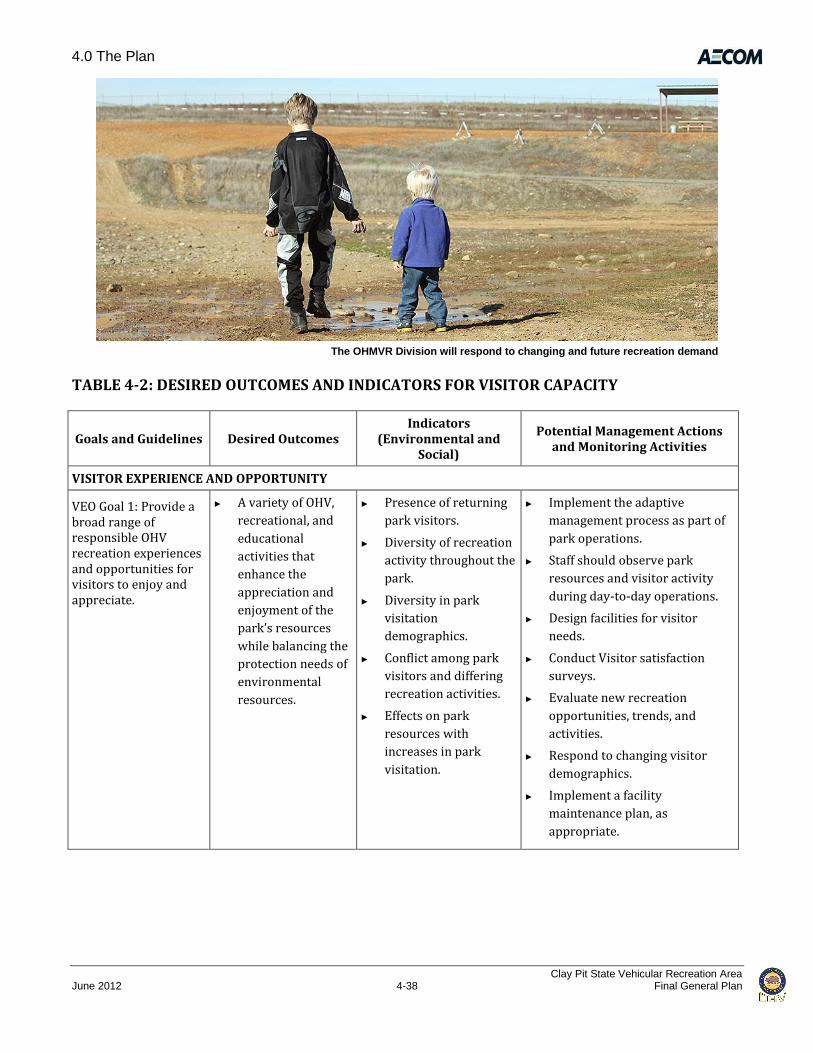
4.0 The Plan
Clay Pit State Vehicular Recreation Area June 2012 4-38 Final General Plan
The OHMVR Division will respond to changing and future recreation demand
TABLE 4-2: DESIRED OUTCOMES AND INDICATORS FOR VISITOR CAPACITY
Goals and Guidelines Desired Outcomes Indicators
(Environmental and Social)
Potential Management Actions and Monitoring Activities
VISITOR EXPERIENCE AND OPPORTUNITY
VEO Goal 1: Provide a broad range of responsible OHV recreation experiences and opportunities for visitors to enjoy and appreciate.
► A variety of OHV,
recreational, and
educational
activities that
enhance the
appreciation and
enjoyment of the
park’s resources
while balancing the
protection needs of
environmental
resources.
► Presence of returning
park visitors.
► Diversity of recreation
activity throughout the
park.
► Diversity in park
visitation
demographics.
► Conflict among park
visitors and differing
recreation activities.
► Effects on park
resources with
increases in park
visitation.
► Implement the adaptive
management process as part of
park operations.
► Staff should observe park
resources and visitor activity
during day-to-day operations.
► Design facilities for visitor
needs.
► Conduct Visitor satisfaction
surveys.
► Evaluate new recreation
opportunities, trends, and
activities.
► Respond to changing visitor
demographics.
► Implement a facility
maintenance plan, as
appropriate.
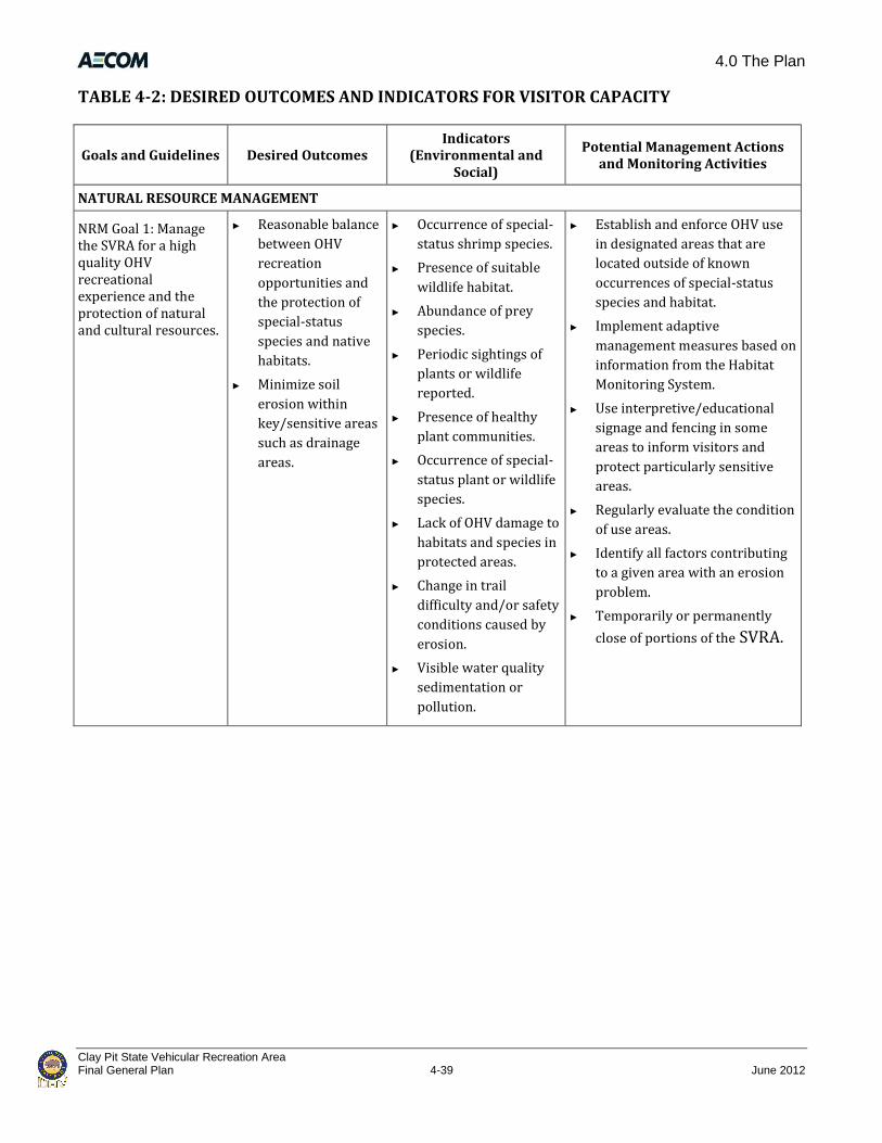
4.0 The Plan
Clay Pit State Vehicular Recreation Area Final General Plan 4-39 June 2012
TABLE 4-2: DESIRED OUTCOMES AND INDICATORS FOR VISITOR CAPACITY
Goals and Guidelines Desired Outcomes Indicators
(Environmental and Social)
Potential Management Actions and Monitoring Activities
NATURAL RESOURCE MANAGEMENT
NRM Goal 1: Manage the SVRA for a high quality OHV recreational experience and the protection of natural and cultural resources.
► Reasonable balance
between OHV
recreation
opportunities and
the protection of
special-status
species and native
habitats.
► Minimize soil
erosion within
key/sensitive areas
such as drainage
areas.
► Occurrence of special-
status shrimp species.
► Presence of suitable
wildlife habitat.
► Abundance of prey
species.
► Periodic sightings of
plants or wildlife
reported.
► Presence of healthy
plant communities.
► Occurrence of special-
status plant or wildlife
species.
► Lack of OHV damage to
habitats and species in
protected areas.
► Change in trail
difficulty and/or safety
conditions caused by
erosion.
► Visible water quality
sedimentation or
pollution.
► Establish and enforce OHV use
in designated areas that are
located outside of known
occurrences of special-status
species and habitat.
► Implement adaptive
management measures based on
information from the Habitat
Monitoring System.
► Use interpretive/educational
signage and fencing in some
areas to inform visitors and
protect particularly sensitive
areas.
► Regularly evaluate the condition
of use areas.
► Identify all factors contributing
to a given area with an erosion
problem.
► Temporarily or permanently
close of portions of the SVRA.

4.0 The Plan
Clay Pit State Vehicular Recreation Area June 2012 4-40 Final General Plan
TABLE 4-2: DESIRED OUTCOMES AND INDICATORS FOR VISITOR CAPACITY
Goals and Guidelines Desired Outcomes Indicators
(Environmental and Social)
Potential Management Actions and Monitoring Activities
CULTURAL RESOURCES
CR Goal 1: Preserve and protect significant cultural sites and features.
► Integrity and value
of cultural
resources retained.
► Disturbance to known
cultural resources
sites.
► Discovery of and
disturbance to
previously
undiscovered cultural
resource sites.
► Survey, record, and evaluate
areas of high probability for
prehistoric archaeological sites.
► Establish criteria of significance
for each class of resource.
► Investigate the record and
evaluate the known historic
sites and areas of historic-
period activity.
► Staff should observe park
resources and visitor activity
during day-to-day operations.
► Use fencing and signage to
prevent damage or loss of
cultural resources.
► Use adaptive management to
ensure preservation and
protection of sites.
VISITOR MANAGEMENT
VM Goal 1: Establish and implement an adaptive management process for managing visitor capacity at Clay Pit SVRA in support of the SVRA’s purpose and vision.
► Management
actions reflect
current conditions
and management
lessons learned.
► Updated indicators
and actions for
adaptive management
process.
► Create checklist of actions
required for a successful
adaptive management process.
► Review SVRA monitoring data
and associated management
recommendations before
making management and
improvement decisions.

5.0 References
Clay Pit State Vehicular Recreation Area Final General Plan 5-1 June 2012
Chapter 5.0 – References
Chapter 1.0, “Introduction”
California Department of Finance. 2010 (May). E-5 Population and Housing Estimates for Cities and Counties and the State, 2001 to 2010, with 2000 benchmark. Available: http://www.dof.ca.gov/research/demographic/reports/view.php#objCollapsiblePanelEstimatesAnchor. Accessed November 3, 2010.
DOF. See California Department of Finance.
Chapter 2.0, “Existing Conditions”
Adachi, K. and Y. Tainosho. 2004. Characterization of heavy metal particles embedded in tire dust. Environment International 30:1009–1017.
AECOM. 2010 (July). Draft – Preliminary Delineation of Waters of the United States, Including Wetlands, Clay Pit State Vehicular Recreation Area Project, Oroville, CA. Sacramento, CA. Prepared for California State Parks, Rancho Cordova, CA.
ARB. See California Air Resource Board.
Beardsley, R. 1948. Cultural Sequences in Central California Archaeology. American Antiquity 14(1):1-28.
BCAG. See Butte County Association of Governments.
BCAQMD. See Butte County Air Quality Management District.
Buckingham Garcia, Jennifer. District Services Manager. CA State Parks OHMVR Division, Twin Cities District, Rancho Cordova, CA. November 17, 2010—telephone conversation with Kim Fettke of AECOM regarding fire history of the Clay Pit SVRA.
Butte County. 2000 (December). Butte County Airport Land Use Compatibility Plan. Oroville, CA. Prepared by Shutt Moen Associates.
———. 2001 (March 30). Butte County Water Inventory and Analysis. Oroville, CA. Prepared by Camp Dresser & McKee, Cambridge, MA.
———. 2005. Butte County Groundwater Management Plan, Thermalito Sub-Area. Oroville, CA.
———. 2007. Butte County General Plan 2030 Setting and Trends, Public Services. Oroville, CA.
———. 2010a. Operational Plan 2009–2010, Butte County Department of Water and Resource Conservation. Oroville, CA.
———. 2010b (April 8). Butte County General Plan Draft Environmental Impact Report. Oroville, CA.
———. 2010c (September 1). Draft Butte County General Plan 2030. Oroville, CA.
5.0 References
Clay Pit State Vehicular Recreation Area June 2012 5-2 Final General Plan
Butte County Air Quality Management District. 2008 (January). CEQA Air Quality Handbook; Guidelines for Assessing Air Quality Impacts for Projects Subject to CEQA Review. Chico, CA.
Butte County Association of Governments. 2008 (December). Butte County Regional Transportation Plan 2008–2035. Adopted December 11, 2008. Chico, CA.
Butte County GIS Division. 2008. Butte County Parks and Recreational Districts. Available: http://www.buttecounty.net/Geographic%20Information%20System/Maps/~/media/County%20Files/GIS/County%20Intranet/District%20Maps/parks_rec_district.ashx. Last updated May 15, 2008. Accessed July 23, 2010.
California Air Resource Board. 1994 (June). California Surface Wind Climatology. Sacramento, CA.
California Department of Conservation. 2010. Watershed Browser, Lower Feather River (ha) and Marysville (hu). Available: http://www.consrv.ca.gov/dlrp/watershedportal/ watershedbrowser/pages/watershedbrowser.aspx. Accessed June 1, 2011.
California Department of Finance. 2010 (May). E-5 Population and Housing Estimates for Cities and Counties and the State, 2001 to 2010, with 2000 benchmark. Available: http://www.dof.ca.gov/ research/demographic/reports/view.php#objCollapsiblePanelEstimatesAnchor. Accessed November 3, 2010.
California Department of Fish and Game. 2003. Vegetation Classification and Mapping Program. List of California Terrestrial Natural Communities Recognized by the California Natural Diversity Database. Sacramento: California Department of Fish and Game, Biogeographic Data Branch.
California Department of Parks and Recreation.
———. 2007. Vegetation Classification and Mapping Program. List of California Vegetation Alliances. Sacramento: California Department of Fish and Game, Biogeographic Data Branch.
———. 2009a. Complete Findings of the Survey on Public Opinions and Attitudes on Outdoor Recreation in California. Respondents to a 2008 recreation survey. Sacramento, CA.
———. 2009b. California State Parks, Our Mission. Available: http://www.parks.ca.gov/?page_id=91. Accessed August 10, 2010.
———. 2009c. The California State Parks Off Highway Motor Vehicle Recreation Division Strategic Plan. Available: http://ohv.parks.ca.gov/pages/25010/files/ohmvr%20strategic%20plan.pdf. Accessed July 7, 2011.
——— 2010a. The Seventh Generation, The Strategic Vision of California State Parks. Available: http://www.parks.ca.gov/pages/23071/files/seven01.pdf. Accessed March 4, 2011.
———. 2010b (August). California State Park System Statistical Report: 2008/09 Fiscal Year. Planning Division: Sacramento, CA.

5.0 References
Clay Pit State Vehicular Recreation Area Final General Plan 5-3 June 2012
———. 2011a. Clay Pit SVRA Watershed Analysis and Action Plan. Oakland, CA. In process.
———. 2011b. Event Summary - Clay Pit, 2009 and 2010. Oroville, CA.
California Department of Water Resources. 2010. California State Water Project, Oroville Complex, Thermalito Facilities. Available: http://www.water.ca.gov/swp/facilities/Oroville/ thermalito.cfm. Accessed May 13, 2011.
California Native Plant Society. 2010. Electronic Inventory of Rare and Endangered Vascular Plants of California. Available: http://www.cnps.org/inventory. Accessed October 4, 2010.
California Natural Diversity Database. 2010 (January). Results of electronic records search for sensitive biological resources. Sacramento: California Department of Fish and Game, Biogeographic Data Branch.
CalRecycle. 2010. Facility/Site Summary Details: Neal Road Recycling and Waste Facility (04-AA-0002). Available: http://www.calrecycle.ca.gov/SWFacilities/Directory/04-AA-0002/Detail/. Accessed December 29, 2010.
Central Valley Regional Water Quality Control Board. 2009. The Water Quality Control Plan (Basin Plan) for the California Regional Water Quality Control Board, Central Valley Region, The Sacramento River Basin and the San Joaquin River Basin. Fourth Edition. Revised September 2009 with approved amendments. Revised September 2009 with approved amendments.
Central Valley RWQCB. See Central Valley Regional Water Quality Control Board.
City of Oroville. 2009 (June 2). Oroville 2030 General Plan. Land Use Element. Oroville, CA. Prepared by Design, Community, & Environment.
CNDDB. See California Natural Diversity Database.
CNPS. See California Native Plant Society.
Cycleland Speedway. 2010. Home. Available: http://www.cyclelandspeedway.com/. Accessed July 23, 2010.
DOC. See California Department of Conservation.
DOF. See California Department of Finance.
DWR. See California Department of Water Resources.
E-Street MX. 2010. Welcome to E Street MX. Available: http://www.estreetmx.com/. Accessed July 23, 2010
EcoAnalysts, Inc. 2010. Special Status Shrimp Reconnaissance Surveys at Clay Pit OHV Park. Moscow, ID. Prepared for California Department of Parks and Recreation, Davis, CA.
EPA. See U.S. Environmental Protection Agency.

5.0 References
Clay Pit State Vehicular Recreation Area June 2012 5-4 Final General Plan
Fredrickson, D. 1974. Cultural Diversity in Early Central California: A View from the North Coast Ranges. In Journal of California Anthropology. Malki Museum. Banning.
Geocon. See Geocon Consultants, Inc.
Geocon Consultants, Inc. 2010 (April). Geotechnical Investigation, Clay Pit SVRA, Oroville, Butte County, California. Rancho Cordova, CA. Prepared for California Department of Parks and Recreation, Sacramento, CA.
Intergovernmental Panel on Climate Change. 2007. Climate Change 2007: Synthesis Report. Available: http://www.ipcc.ch/publications_and_data/ar4/syr/en/contents.html. Accessed June 2010.
IPCC. See Intergovernmental Panel on Climate Change.
Martin, R. W. 2005. Clay Pit State Vehicular Recreation Area Sensitive Plant Species Survey. Prepared for the California Department of Parks and Recreation Northern Service Center, Sacramento, CA.
Moratto, M. 1984. California Archaeology. Orlando, FL.: Academic Press.
MMX Racing. 2010. FAQs. Available: http://mmxracing.com/. Accessed July 23, 2010.
National Oceanic and Atmospheric Administration. 1992. Monthly Station Normals of Temperature, Precipitation, and Heating and Cooling Degree Days 1961–1990. Asheville, NC.
NCWA. See Northern California Water Association.
NOAA. See National Oceanic and Atmospheric Administration.
Northern California Water Association. 2010. Oroville Reservoir and Thermalito Facilities, Northern California Water Association. Available: http://www.norcalwater.org/watermap/oroville.shtml. Accessed October 12, 2010.
OHMVR Division. See Off-Highway Motor Vehicle Recreation Division.
Off-Highway Motor Vehicle Recreation Division. 2010. Quick Facts. February 2011. Available: http://www.parks.ca.gov/pages/23509/files/OHV_1_10.pdf. Last updated January 6, 2010. Accessed February 21, 2011.
Perez, A., and K. Long. 2009. Cultural Resource Inventory of the Clay Pit State Vehicular Recreation Area. Prepared for the California Department of Parks and Recreation, Sacramento, CA.
Rolls Anderson & Rolls, Civil Engineers. 2008 (November). Drainage Study for Oroville Municipal Airport. Prepared for City of Oroville, CA. Cited in Geosyntec 2010.
Rolls Anderson & Rolls. See Rolls Anderson & Rolls, Civil Engineers.
Sawyer, J. O., and T. Keeler-Wolf. 1995. A Manual of California Vegetation. California Native Plant Society, Sacramento, CA.

5.0 References
Clay Pit State Vehicular Recreation Area Final General Plan 5-5 June 2012
SCRCD. See Sutter County Resource Conservation District.
Seinfeld, J. H., and S. N. Pandis. 1998. Atmospheric Chemistry and Physics. New York, NY: John Wiley & Sons, Inc.
State Parks. See California Department of Parks and Recreation.
State Water Resources Control Board. 2008 (August 12). Resolution No. 2008-0013, Sacramento and Feather River Diazinon and Chlorpyrifos TMDL, State Water Resources Control Board. Available: http://www.epa.gov/waters/tmdldocs/rs2008_0013-sbrb-sacfeatherdiazchlor.pdf. Accessed October 4, 2010.
Sutter County Resource Conservation District. 2010a (February 19). The Lower Feather River HUC/Honcut Creek Watershed Existing Conditions Assessment. Yuba City, CA. Prepared by Foothill Associates, Chico, CA.
———. 2010b (February). Implementation of Feather River Total Maximum Daily Load for Orchards. Yuba City, CA.
SWRCB. See State Water Resources Control Board.
Thermalito Water and Sewer District. 2010. Basin Management Objective, Butte County, Sub-Inventory Unit – Thermalito. Oroville, CA.
U.S. Forest Service. 2005 (June). Off-Highway Vehicle Recreation in the United States, Regions and States: A National Report from the National Survey on Recreation and the Environment. Athens, GA: Southern Research Station.
USFS. See U.S. Forest Service.
U.S. Environmental Protection Agency. 2009. Criteria Air Pollutant Information and Attainment Designations. Available at http://www.epa.gov. Accessed July 2010.
———. 2011. Surf Your Watershed, Lower Feather Watershed – 18020106, Lower Feather Watershed Profile. Available: http://cfpub.epa.gov/surf/huc.cfm?huc_code=18020106. Last updated June 7, 2011. Accessed June 7, 2011.
United States Fish and Wildlife Service. 2005. Recovery Plan for Vernal Pool Ecosystems of California and Southern Oregon. Region 1. Portland, OR.
USFWS. See U.S. Fish and Wildlife Service.
Wells, H. L., W. L. Chambers, and F. T. Gilbert. 1882. History of Butte County. 2 vols. San Francisco, CA: Harry L. Wells.
Zwierschke, K. H. 2009. Impact of Turfgrass Systems on the Nutrient Status of Surface Water, and Ground Water. Columbus: Ohio State University.

5.0 References
Clay Pit State Vehicular Recreation Area June 2012 5-6 Final General Plan
Chapter 3, “Issues and Analysis”
California Department of Parks and Recreation. 2008. 2008 Soil Conservation Standard and Guidelines. Rancho Cordova: Off-Highway Motor Vehicle Recreation Division.
Chapter 4, “Goals and Guidelines”
Butte County. 2000 (December). Butte County Airport Land Use Compatibility Plan. Oroville, CA. Prepared by Shutt Moen Associates.
California Department of Parks and Recreation. 2007 (November). OHV BMP Manual for Erosion and Sediment Control. Off-Highway Motor Vehicle Recreation Division. Prepared by Salix Applied Earthcare, Redding, CA, and Geosyntec Consultants, San Diego, CA.
———. 2009. Complete Findings of the Survey on Public Opinions and Attitudes on Outdoor Recreation in California. Respondents to a 2008 recreation survey. Sacramento, CA.
———. 2011. Clay Pit SVRA Watershed Analysis and Action Plan. Oakland, CA.
Geocon. See Geocon Consultants, Inc.
Geocon Consultants, Inc. 2010 (April). Geotechnical Investigation, Clay Pit SVRA, Oroville, Butte County, California. Rancho Cordova, CA. Prepared for California Department of Parks and Recreation, Sacramento, CA.
SCRCD. See Sutter County Resource Conservation District.
State Parks. See California Department of Parks and Recreation.
State Water Resources Control Board. 2008 (August 12). Resolution No. 2008-0013, Sacramento and Feather River Diazinon and Chlorpyrifos TMDL, State Water Resources Control Board. Available: http://www.epa.gov/waters/tmdldocs/rs2008_0013-sbrb-sacfeatherdiazchlor.pdf. Accessed October 4, 2010.
Sutter County Resource Conservation District. 2010 (February 19). The Lower Feather River HUC/Honcut Creek Watershed Existing Conditions Assessment. Yuba City, CA. Prepared by Foothill Associates, Chico, CA.
———. 2010 (February). Implementation of Feather River Total Maximum Daily Load for Orchards. Yuba City, CA.
SWRCB. See State Water Resources Control Board.
USFWS. See U.S. Fish and Wildlife Service.