state planning policy – state interest guideline – water ... · state interest guideline -...
TRANSCRIPT
Great state. Great opportunity.
State Planning Policy—state interest guideline
Water quality
April 2016
Department of Infrastructure, Local Government and Planning
2State interest guideline - Water quality - April 2016
Preface
Using this state interest guidelineThe Queensland Government established the State Planning Policy (SPP) to define the specific matters of state interest in land use planning and development. To support the implementation of the SPP, each state interest in the SPP is supported by a state interest guideline such as this one.
This state interest guideline must be read in conjunction with the SPP.
The SPP does not prioritise one state interest over another and thus provides flexibility for local governments to respond to specific regional and local contexts. This allows for the state interests to be considered as an entirety rather than as individual competing or conflicting priorities.
The SPP guiding principles carry equal weight with the state interests and must be considered by local government as part of the integration of state interests as an entirety rather than as individual policies. This supports decision making which integrates and balances the economic, environmental and social needs of current and future generations, promotes innovative approaches to design and development where consistent with the strategic intent of a planning scheme and enables flexible and performance-based decisions as part of the assessment process.
Where text in this guideline is in a coloured text box, it is an excerpt from the SPP and is the state’s policy about a matter of state interest.
In relation to making or amending a planning scheme, the SPP quoted text defines what a local government should do in preparing or amending a planning scheme (ie. the state prefers this policy but will consider alternative approaches based on specific local context or issues).
Where interim development assessment requirements apply for a state interest (because the relevant planning scheme has not yet integrated the state interest or an amendment to the SPP has occurred subsequent to the scheme), the SPP quoted text defines requirements that must be applied in the assessment of applicable development applications.
Content within this state interest guideline that is not an excerpt from the SPP provides further context and explains how the SPP policies can be applied. It does not introduce or define any new policies which do not exist in the SPP itself. The use of such guidance material is optional—it does not form a statutory component of the SPP and hence is not a mandatory requirement of the state.
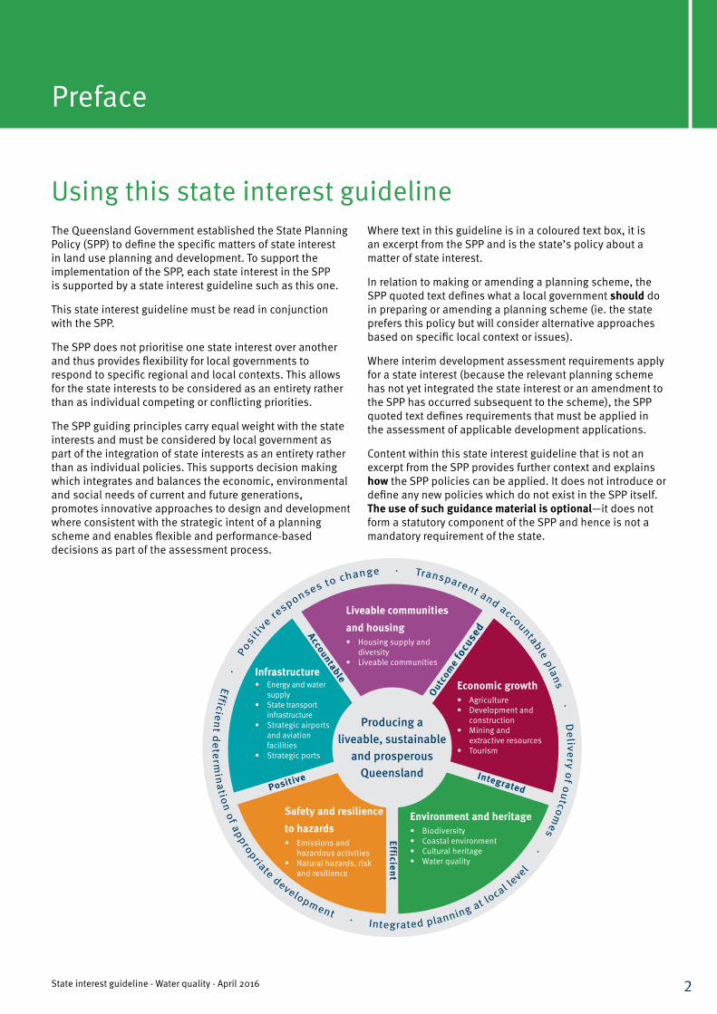
Producing a liveable, sustainable
and prosperous Queensland
Outcom
e fo
cuse
dAccountable
Integrated
Efficient
Positive
Economic growth• Agriculture• Development and
construction• Mining and
extractive resources• Tourism
Infrastructure• Energy and water
supply• State transport
infrastructure• Strategic airports
and aviation facilities
• Strategic ports
Environment and heritage• Biodiversity• Coastal environment• Cultural heritage• Water quality
Safety and resilience to hazards• Emissions and
hazardous activities• Natural hazards, risk
and resilience
Liveable communities and housing• Housing supply and
diversity• Liveable communities
3State interest guideline - Water quality - April 2016
Contents
PART A Background and core concepts . . . . . . . . . . . . . . . . . . . . . . . . . . . . 4
PART B Integrating the state interest into planning schemes . . . . . . . . . . . 7
PART C Application of interim development assessment requirements . . . . .17
PART D Model code provisions . . . . . . . . . . . . . . . . . . . . . . . . . . . . . . . . . . 21
PART E Supporting information . . . . . . . . . . . . . . . . . . . . . . . . . . . . . . . . . . 24
Department of Infrastructure, Local Government and Planning
4State interest guideline - Water quality - April 2016
PART A: Background and core concepts
PART
A
Background Water underpins our quality of life and our economy. Sustained urban population growth rates in Queensland have led to increasing impacts on urban stormwater quality that is a potential threat to maintaining water quality and achieving water quality objectives in many catchment areas.
Planning and development decision making impacts the quality and functioning of water supply catchments and the cost, operational efficiency and safety of bulk water supply. The state interest in water quality informs land use planning, development assessment and provision of infrastructure requirements for urban stormwater management, the protection of water supply catchments and the protection of the natural and built environment from the adverse impacts of acid sulfate soils.
Core conceptsEnvironmental Values and Water Quality Objectives Environmental Values (EVs) for tidal and non-tidal waters are those referred to in the Environmental Protection (Water) Policy 2009 (EPP Water) and relate to the water’s aquatic ecosystems, including its biota, physical form, riparian vegetation, flow and physico-chemical water quality. Environmental values also include primary industry, farm use, stock watering, aquaculture, human consumption, primary recreation, secondary recreation, visual appreciation, raw drinking water, industrial use and cultural and spiritual values.
Water Quality Objectives (WQOs) are quantitative long term objectives for receiving waters that protect the environmental values. WQOs are long-term goals for water quality management. They are measures, levels or narrative statements of particular indicators of water quality that protect EVs. They define what the water quality should be to protect the EVs—after consideration of the socio-economic assessment of protecting the water quality. They are not end-of-pipe or emission objectives.
Development, particularly commercial and industrial developments and those not connected to municipal
State interest—water qualityThe environmental values and quality of Queensland waters are protected and enhanced.
sewerage systems, that discharge waste water to waterways can mobilise contaminants that affect water environmental values. Development that results in the disturbance of acid sulfate soils can result in the mobilisation and transport of acidic runoff, nutrients and metals, potentially impacting the natural and built environment.
High Ecological Value watersHigh Ecological Value (HEV) waters are waters where the biological integrity is effectively unmodified or highly valued and the management intent is to maintain the biological integrity.
Total Water Cycle ManagementDecisions affecting the natural water cycle should be based on total water cycle management (TWCM) principles. These are:
• recognising all potential sources of water, including waste water and stormwater;
• using all water sources sustainably;
• allocating and using water equitably for residential, industrial, agricultural and environmental uses; and
• integrating water use and natural water processes, including maintaining environmental flows and water quality.
TWCM principles operate at both a regional or catchment scale, where it informs regional water quality and quantity management planning, and local scale where it informs local government stormwater and waste water management planning. Additional information about TWCM can be found at www.waterbydesign.com.au/twcm/.
Urban stormwater managementUrban stormwater run-off potentially contributes to adverse water quality in waterways, which impact aquatic ecosystems health and limit human water uses. Unless well managed, urban stormwater can release contaminants such as nutrients, sediment and solid waste to waterways. Waterway erosion can result from stormwater flows and also impact ecosystem health, both potentially impacting on environmental values.
5State interest guideline - Water quality - April 2016
PART
A
1 Australian Runoff Quality: A Guide to Water Sensitive Urban Design. Wong, THF (Ed). 2006 Engineers Australia.
The Queensland Urban Drainage Manual (QUDM) provides further information for urban developers, catchment managers and government decision makers to manage urban stormwater quantity and quality to protect the environmental values of waterways. The QUDM summarises planning and technical reference material on best practice urban stormwater quality management, and is published at www.dews.qld.gov.au/water/supply/urban-drainage-manual.
Water Sensitive Urban Design Water Sensitive Urban Design (WSUD) is the planning and design of urban environments that is sensitive to the issues of water sustainability and environmental protection (Wong, 2006).1
The principles of WSUD include:
• protecting existing natural features of the natural drainage system including waterways and water bodies and ecological processes;
• integrating public open space with stormwater drainage corridors to maximise public access, recreation activities and visual amenity while preserving waterway habitats and wildlife corridors;
• maintaining natural hydrologic behaviour of catchments and preserving the natural water cycle via minimising changes to the natural frequency, duration, volume and peak discharge of urban stormwater;
• protecting water quality environmental values of surface and ground waters;
• minimising demand on the reticulated water supply system and utilising stormwater as a valued resource;
• minimising capital and maintenance costs of stormwater infrastructure and minimising sewage discharges to the natural environment; and
• integrating water into the landscape to enhance visual, social, cultural and ecological values.
Non-tidal artificial waterwayNon-tidal artificial waterways include access channels, constructed urban lakes or other bodies of water that are designed to be:
• permanent bodies of open water;
• fringed with hard edges or emergent macrophytes;
• indirectly connected to tidal water (by a lock or weir or other system); or
• artificial lakes (generally land locked without a direct connection to tidal waterways).
To avoid ongoing management problems stormwater quality treatment should be undertaken through appropriately designed treatment devices (swales, bio-retention basins or constructed wetlands) prior to entering the artificial waterway.
Acid Sulfate SoilsAcid Sulfate Soils (ASS) cover approximately 2.3 million hectares of land and occur naturally along the coast, usually where land elevation is less than 5 metres Australian Height Datum (AHD). Soil or sediment containing highly acidic soil horizons (or layers) affected by the oxidation of iron sulphides is known as actual ASS. Soil or sediment containing iron sulphides or other sulphide material, that has not been exposed to air and oxidised, are known as potential acid sulfate soils (PASS). The term ‘acid sulfate soils’ includes both actual and potential ASS.
The exposure of PASS to oxygen (e.g. by drainage of groundwater, excavation or filling), if not properly managed, may result in acidification, mobilisation and release of metals (iron, aluminium, arsenic), increased levels of nutrients (e.g. iron, aluminium), in forms that can be commonly released into receiving waters. As surface water and groundwater interactions are linked, groundwater impacts can result in risks to surface water bodies.
The acid corrodes concrete and steel infrastructure and, together with the metal contaminants, can kill fish, other aquatic organisms, native vegetation and crops, or impact on human health particularly if it impacts on groundwater supplies used for urban and domestic drinking water.
Department of Infrastructure, Local Government and Planning
6State interest guideline - Water quality - April 2016
PART
A
Nutrients of concern for coastal and harmful algal blooms Land-based development and management activities that disturb soils and sediments or alter the natural hydrological regime (including groundwater levels and composition and surface-water run-off) can result in the mobilisation and transport of increased loads of sediments and nutrients into coastal waters.
These contaminants include nitrogen, phosphorus, iron or organic matter and can enhance the growth of algae. These contaminants may initiate or increase the severity of Lyngbya majuscula (cyanobacterium) blooms in coastal waters.
Nutrients of concern that may contribute to increased occurrence, frequency or intensity of coastal algal blooms (particularly nitrogen, phosphorus, iron and organic matter) may be released during development in coastal areas.
Nutrient hazardous areas can include the following:
• Areas involving particular activities such as effluent disposal and waste water treatment; activities involving organic wastes/manures such as feedlots, poultry farms, etc; fertiliser inputs such as horticulture, cropping, forestry and golf courses.
• Areas involving activities where substantial disturbance of soil and/or groundwater that may mobilise nutrient(s) of concern such as dredging, canals and marinas, tunnels, maritime infrastructure, ports, extractive industries, mining, major pipelines and other major projects including those deemed as ‘state significant’.
• Areas involving activities generating airborne/volatile particles containing nutrients of concern, such as commercial poultry sheds or where such activities are proposed to begin or intensify.
Department of Infrastructure, Local Government and Planning
7State interest guideline - Water quality - April 2016
PART
B
Policy 1For receiving waters:Facilitating the protection of environmental values and the achievement of water quality objectives for Queensland waters.
Effective land use planning can limit, and reduce over time the impacts of development on environmental values. The state interest—water quality is intended to inform land use planning and development decisions to create settlement designs and patterns that reduce the risk of adversely impacting environmental values across Queensland.
The SPP state interest—water quality requires EVs and WQOs for receiving waters to be considered by planners and assessment managers in decision making.
How to appropriately integrate the policy1.1 When making or amending a planning scheme, the
local government should confirm if waters in their area have EVs and WQOs. EVs, WQOs and associated mapping, including information on waters of HEV2, are available on the Department of Environment and Heritage Protection’s website.
1.2 Within the strategic framework, the following policy statements are recommended:
• The quality of surface-water and groundwater within the local planning area is maintained and is enhanced where appropriate;
• The principles of total water cycle management and water sensitive urban design are incorporated into development; and
• Strategic framework mapping should identify areas of HEV waters as environmental protection and conservation areas.
PART B: Integrating the state interest into planning schemes
1.3 The following environmental matters should be considered when allocating land for appropriate zoning:
• Areas that drain directly into waters mapped as being of HEV should only be allocated or zoned for urban or future urban purposes where it can support the achievement of WQOs and the HEV of the waters maintained;
• HEV waters should be included in an Environmental Management and Conservation zone or similar. If located in alternative zones, the overall outcomes and performance outcomes/acceptable solutions should support the protection of receiving waters within catchment areas; and
• HEV areas should be included in the Environmental Management and Conservation zone where appropriate. Alternative zones should support the protection of receiving waters through appropriate provisions within a waterway corridor and/or wetlands overlay.
1.4 Overlays can be used to identify areas of ecological significance, waterway corridors or areas that may constrain development or which require management to avoid or minimise erosion. Some examples which could be incorporated into a local planning scheme include:
• Waterway corridors and/or wetlands overlay—the accompanying overlay code should include provisions to the effect that stormwater treatment is located outside waterway corridors and wetlands; or rehabilitation plans are required to improve the functioning of riparian buffers. Relevant layers of MSES can be included in this overlay to be avoided or impacts mitigated through application of additional urban stormwater quality management plans and/or erosion and sediment control (ESC) plans.
2 HEV waters are included as a contributing layer to Matters of State Environmental Significance (MSES) mapping within the SPP interactive mapping system.
8State interest guideline - Water quality - April 2016
PART
B
• Water resource catchment overlay — buffer areas used for waters that have a human use value for ‘human consumption’.
• Erosion management overlay— addresses areas prone to erosion, landslide or other land degradation processes. This layer can be used to identify areas with soil types that are more susceptible to erosion hazard or dispersive soils that will require additional erosion and sediment management.
How to appropriately integrate the policy2.1 Within the strategic framework, policy statements
for urban areas should identify the need to avoid or minimise disturbance to natural drainage, landscape features, erosion risk, impacts upon groundwater and disturbance to acid sulfate soils.
2.2 The following environmental considerations should be taken into account when allocating land for urban purposes and when drafting applicable zone code provisions:
• Development is responsive to the environmental constraints of the land.
• Natural features and environmental corridors such as creeks, gullies, waterways, wetlands, habitats and vegetation are retained and enhanced through buffers that minimise the impact of existing and future land uses.
• Areas of potential dry-land salinity are avoided so that saline discharge is not mobilised to impact on downstream waterways (e.g. salinity mapping and provisions in the Laidley Shire Council Planning Scheme 2002, Lockyer Valley Regional Council).
1.5 Consider the inclusion of the SPP Code: Water quality (SPP - Appendix 3) within the planning scheme, or similar development assessment requirements. Alternatively implement a water quality code that includes performance outcomes which are consistent with the Environmental Protection (Water) Policy 2009 and apply best practice management outcomes in relation to the protection of water quality for receiving waters.
REFER TO PART E: Supporting Information 1. References, industry guidelines and technical resources for a link to the Queensland Urban Drainage Manual (QUDM).
Policy 2Identifying land for urban or future urban purposes in areas which avoid or minimise the disturbance to natural drainage and acid sulfate soils, erosion risk, impact on groundwater and landscape features
• Areas zoned for future urban purposes should include provisions which support the retention and enhancement of significant natural aquatic feature and buffering from the impacts of adjacent uses. Any unavoidable impacts should be minimised through location, design, operation and management requirements.
• Development in industrial zones should ensure that potential adverse impacts on natural features and processes, both on-site and from adjoining areas, are minimised through location, design, operation and management of development. Higher risk development, such as special industry, and utility installation (sewage treatment plant or waste management facility) should be located away from areas with high groundwater tables and areas with highly permeable soils.
Department of Infrastructure, Local Government and Planning
9State interest guideline - Water quality - April 2016
PART
B
Development requirements within planning schemes should be informed by any applicable water quality improvement plans, waste management plans or local urban stormwater quality management plans so that:
(a) mapping of stormwater and waste water infrastructure and catchments will assist in determining the preferred pattern of settlement;
(b) planning scheme provisions support development which can contribute to the achievement of water quality objectives; and
(c) water quality objectives can be used to guide the conditions on development approvals, planning scheme policies and codes based on options for stormwater management or waste water management developed in waterway action plans (for example requiring use of water sensitive urban design, grassed swales, porous paving etc.).
Water by Design has developed a number of technical design manuals and guidelines for local government and developers to use in implementing best practice for urban stormwater quality and flow management. Information is available at www.waterbydesign.com.au.
How to appropriately integrate the policy
3.1 Include policy statements within the strategic framework, that ensure:
• the quality of surface water and groundwater is maintained; and
• the principles of total water cycle management and water sensitive urban design are incorporated into development.
3.2 When determining future urban areas, or areas for increased density that will result in increased impervious areas, consider the recommendations from the Queensland Water Quality Guidelines and Queensland Urban Drainage Manual while identifying waterways of significant conservation value, or areas suffering erosion or have soils that are known to be prone to erosion. Failure to adequately consider the potential risk may challenge the local governments’ ability to protect existing EV and hamper achievement of WQOs in downstream receiving waters.
3.3 Consider within the planning scheme (or through planning scheme policies as appropriate):
• the design guidelines and standard drawings for water quality and flow management from existing best practice sources appropriate for the climatic region or provide preferred detailed design guidelines and standard drawings appropriate for the climatic region. The use of standard drawings and designs may reduce potential ongoing maintenance concerns;
• standard requirements to ensure constructed non-tidal waterways (urban lakes) are designed and operated as long term sustainable assets;
• investigation requirements for the risk of mobilisation of nutrients of concern on a proposed development site; and
• measures to prevent or reduce incidences of algal blooms.
Policy 3Including requirements that development for an urban purpose is located, designed, constructed and/or managed to avoid or minimise:(a) impacts arising from:
i. altered stormwater quality or flow, and
ii. waste water (other than contaminated stormwater and sewage), and
iii. the creation or expansion of non-tidal artificial waterways, such as urban lakes, and
(b) the release and mobilisation of nutrients that increase the risk of algal blooms.
Department of Infrastructure, Local Government and Planning
10State interest guideline - Water quality - April 2016
PART
B
The stormwater impacts from both the construction and post construction (or operational) phases of land development need to be considered in development assessment as the issues and impact assessment methodology are different. Critical impact factors include soil erosion hazard of the landscapes being developed and increased rainfall run-off coefficients which occur when land is cleared and topsoil removed.
Methods for assessing stormwater impact on receiving waters include:
• Monitoring—actual stormwater quality can be compared with receiving water quality to establish the level of treatment necessary to protect EVs, where sufficient monitoring data is available from the same development type in similar landscape conditions of the same region.
• Modelling—stormwater quality and its potential impact on receiving waters can be mathematically modelled to determine treatment requirements (design objectives). Some monitoring data are usually required to validate such models.
• Best management practices—best available data on the performance efficiency of current best practice treatment technologies can be used to establish minimum standards of performance that respond to specific regional, local and site specific contexts when managing stormwater impacts from development.
• Maintenance—the performance of stormwater treatment technologies is highly dependant on appropriate asset management and maintenance to ensure that optimal operation is achieved
Policy 4Adopting the applicable stormwater management design objectives relevant to the climatic region3, outlined in Tables A and B (Appendix 3 of the SPP), or demonstrate current best practice environmental management for development that is for an urban purpose.
The Water By Design Deemed to Comply Solutions—Stormwater Quality Management (South East Queensland) (2010) published by Water by Design outlines a series of off-the-shelf stormwater solutions for meeting the post construction stormwater management design objectives for small-scale development without the need for a site based stormwater quality management plan in South East Queensland (SEQ) (note that an erosion and sediment control plan may still be required).
Reducing imperviousness may assist in minimising the stormwater runoff and reduce stormwater management requirements. In order to encourage low impact design that minimises stormwater runoff, development with less than 25% imperviousness should be excluded from achieving the post construction design objectives (Table B Appendix 3 of SPP).
If imperviousness is greater than 25%, and in lieu of using modelling to demonstrate compliance with post construction stormwater management design objectives, the default bioretention treatment area to comply with load reduction targets for all Queensland regions is 1.5% of the development site.
It should be noted that erosion and sediment controls for the construction phase (Table A Appendix 3 of SPP) may still be required.
Department of Infrastructure, Local Government and Planning
3 Mapping of climatic regions for stormwater management design objectives is available on the SPP Interactive Mapping System.
11State interest guideline - Water quality - April 2016
How to appropriately integrate the policyThe SPP guiding principles enable outcome-focused performance-based decisions in both plan-making and development assessment. This provides flexibility to respond to specific regional, local and site specific contexts when managing stormwater impacts from development. This allows for economic, environmental and social requirements to be balanced when determining the appropriate stormwater management solutions.
It is considered that an integrated approach to stormwater management may provide greater benefits than the load-based stormwater management design objectives addressed in isolation. This promotes solutions that can demonstrate greater hydrologic effectiveness for a similar cost, such as high efficiency sediment basins, or can achieve a more integrated development outcome for the community, in addition to load-based pollutant reductions.
4.1 This can be achieved through the use of code provisions, or technical design planning scheme policies, reflecting the following measures:
• Table A (in Appendix 3 of the SPP)—construction phase stormwater management design objectives.
• Table B (in Appendix 3 of the SPP)—post construction phase stormwater management design objectives for the appropriate climatic region.
• Establish minimum standards of performance developed from best available data on the performance efficiency of current best practice treatment technologies (typically expressed as minimum average annual pollutant load reductions, or minimum average percentage reductions in pollutant loads).
• Reference relevant section of the Best Practice Erosion and Sediment Control (IECA, 2008).
• Nominate preferred design standards (e.g. erosion risk ratings and design storms events).
• Reference applicable sections of the Queensland Urban Drainage Manual.
• Consider Water by Design guidelines and manuals.
• Reference Environmental Protection (Water) Policy 2009
12State interest guideline - Water quality - April 2016
PART
B
There is no single state-wide response for addressing drainage solutions, particularly stormwater management, as the topography and environmental values of Queensland's population centres varies significantly. The SPP supports local governments to develop innovative and locally appropriate stormwater management solutions that provide sufficient flexibility to respond to local and site specific conditions. To assist developers address these varying local needs, several councils have developed local Water Sensitive Urban Design solutions to suit local circumstances and reduce unnecessary research and design costs borne by developers.
Policy 5Facilitating innovative and locally appropriate solutions for urban stormwater management that achieve the relevant urban stormwater management design objectives.
How to appropriately integrate the policy5.1 A local government may decide to reflect this policy by:
• including performance criteria for the use of water quality treatment measures for a sub-catchment rather than general development measures;
• including performance criteria for stormwater quality treatments elsewhere in the catchment to offset local impacts from stormwater;
• using alternative technologies or proprietary solutions. These alternative solutions are recommended to be:
1. included within a local government infrastructure plan;
2. provided with detailed cost estimates so that infrastructures for the device can be transparently allocated across the benefitting sub-catchment; and
3. secured by legally binding mechanism to secure the protection of the alternate site.
Examples of where local governments have invested in developing locally appropriate post construction phase stormwater management design objectives include Townsville City Council and Mackay Regional Council.
Department of Infrastructure, Local Government and Planning
13State interest guideline - Water quality - April 2016
The location of existing and approved future water resource catchments and water supply sources (such as groundwater, reservoirs and rivers) are recommended to be recognised in local planning schemes and protected from development that would compromise the ability to supply water safely and efficiently.
It is important to ensure development in water resource catchments is undertaken in a manner which contributes to the improvement (where possible) and ongoing maintenance of water quality discharged in those catchments that would otherwise compromise the ability to supply water safely and efficiently.
How to appropriately integrate the policy6/7.1 Within the strategic framework, include policy
statements that ensure development is planned and designed to manage stormwater and waste water in ways that avoid or minimise impacts on water quality (for example, with the provision of stormwater quality improvement devices and bio-retention systems).
Include policy outcomes that recognise the importance and maintenance of water quality for the water supply sources within the local government area. When identifying these water sources, where considered appropriate also map these sources on strategic framework mapping.
PART
B
Policy 7Including requirements that development in water resource catchments is undertaken in a manner which contributes to the maintenance and enhancement (where possible) of water quality to protect the drinking water and aquatic ecosystem environmental values in those catchments.
6.2 Consider the following provisions when determining appropriate land use zones:
• Existing and approved future water resource buffer areas are maintained within non-urban zones where possible.
• Existing water resource buffer areas in existing or proposed urban zones are protected through supporting zone, development and overlay codes where appropriate.
6.3 When drafting overlays for water quality management, watercourses draining to water resource catchments are identified and protected in waterway corridor and/or water resource catchment overlay maps and protected through supporting overlay codes where appropriate.
6/7.4 Include planning and engineering measures to ensure development in identified water supply buffer areas and water resource buffer areas is planned and designed to manage stormwater and waste water in ways that minimise impacts on water quality. For example an SEQ local government may reference the Seqwater Development Guidelines: Development guidelines for water quality management in drinking water catchments or include similar provision within relevant assessment codes or planning scheme policies.
REFER TO PART E: Queensland Water Quality Guidelines
Policy 6Planning for safe, secure and efficient water supply.
Department of Infrastructure, Local Government and Planning
14State interest guideline - Water quality - April 2016
This policy item is prescribed for SEQ local government areas. These councils are recommended to include the provisions of the Seqwater guideline within the planning scheme to ensure the ongoing security and quality of water supply is maintained in these regions.
How to appropriately integrate the policy8.1 Development codes, or specific water supply codes,
should reference or reflect specific outcomes and measures contained in the Seqwater Development Guidelines: Development Guidelines for Water Quality Management in Drinking Water Catchments 2012.
8.2 When determining appropriate land use zones, ensure that:
• existing and approved future water supply buffer areas are maintained within non-urban zones;
• existing water supply buffer areas with existing or proposed urban zones are protected through supporting zone, development and overlay codes; and
• advice from the Queensland Bulk Water Supply Authority is sought where a reduced separation distance is proposed.
8.3 Consider the use of an overlay code such as a Regional Infrastructure Corridors and Substations overlay to include land that is wholly or partly within a water supply buffer area.
Policy 8For development in a water supply buffer area:
Including requirements that development complies with the specific outcomes and measures contained in the Seqwater Development Guidelines: Development Guidelines for Water Quality Management in Drinking Water Catchments 2012 or similar development assessment requirements.
REFER TO: The SPP Interactive Mapping System
PART
B
Department of Infrastructure, Local Government and Planning
15State interest guideline - Water quality - April 2016
How to appropriately integrate the policy(a) Identifying areas with high probability of
containing acid sulfate soilsA list of coastal local government areas identified as having a high probability of containing ASS is identified in the Part G Glossary (of SPP), under the 'acid sulfate soil affected area' definition. The identification is necessary to help devise appropriate planning strategies to avoid or minimise the disturbance of ASS.
9.1 Planning schemes for coastal local government areas that have a high probability of containing ASS, should identify in overlay form, areas within which assessable development applies, using the following where appropriate:
(a) Gather ASS data available from the Department of Natural Resources and Mines website located at data.qld.gov.au www.qld.gov.au/environment/land/soil/soil-data/mapping/ or through the QSpatial catalogue at http://qldspatial.information.qld.gov.au/catalogue; and
(b) Prepare mapping to identify areas with high probability ASS areas using the following criteria:
• Land with elevation less than 5 metres AHD;
• Soil and sediment of recent geological age (Holocene);
• Marine or estuarine sediments and tidal lakes;
• Low-lying coastal wetlands or back swamp areas, waterlogged or scalded areas, interdune swales or coastal sand dunes;
• Coastal alluvial valleys;
• Areas where the dominant vegetation is tolerant of salt, acid and/or water logging conditions e.g. mangroves, salt couch, swamp-tolerant reeds, rushes, grasses (e.g. Phragmites australis), paperbarks (Melaleuca spp.) and swamp oak (Casuarina spp.);
• Areas identified in geological descriptions or in maps as bearing sulphide minerals, coal deposits or marine shales/sediments and deep older estuarine sediments below ground surface; and
• The use of default overlay identifying areas below 5 metres AHD where the natural ground level is below 20 metres AHD.
Policy 9Acid sulfate soils:
In an acid sulphate soil affected area, protecting the natural and built environment (including infrastructure) and human health from the potential adverse impacts of acid sulfate soils by:
(a) identifying areas with high probability of containing acid sulfate soils, and
(b) providing preference to land uses that will avoid or minimise the disturbance of acid sulfate soils, and
(c) including requirements for managing the disturbance of acid sulfate soils to avoid or minimise the mobilisation and release of contaminants.
PART
B
Department of Infrastructure, Local Government and Planning
16State interest guideline - Water quality - April 2016
(b) Providing preference to land uses that will avoid or minimise the disturbance of acid sulfate soils
9.2 Management of ASS disturbance can prove costly for the built and natural environment. Even minor disturbances may disturb ASS, warranting management to protect the assets from corrosion. Land uses that should be directed away from ASS where possible include but are not limited to:
• marinas and canal estates;
• urban construction involving deep basements;
• agricultural systems involving extensive drainage and/or retention systems (e.g. rice farming, aquaculture); and
• extractive industries (e.g. sand and gravel mining).
(c) Managing the disturbance of acid sulfate soils
Activities that disturb land in a manner likely to oxidise ASS include open excavation, permanent or temporary groundwater extraction and filling. Groundwater extraction in particular carries a high risk of aerating ASS in situ, which is extremely difficult to remediate. Planning codes and policies may choose to specify that particular construction methods and materials should be used where ASS disturbance cannot be avoided. Examples of such methods and materials include:
• locating ASS and depth to ASS using an investigation that conforms with the Queensland Sampling Guidelines and soil analyses according to the Laboratory Methods Guidelines or Australian Standard 4969;
• neutralising existing acidity and preventing the generation of acid and metal contaminants;
• preventing the release of acid or metal contaminants into surface or groundwater;
• preventing in situ oxidation of ASS through ground water management; and
• documenting management strategies and reporting requirements in an ASS environmental management plan.
9.3 Land identified as having high probability of ASS should be appropriately zoned to minimise the impacts from disturbance of ASS soils. Alternatively, for development in ASS areas, local government should consider the use of an ASS overlay code that contains provisions reflecting the local government development assessment provisions and assessment requirements for ASS, in the SPP Part E Interim development assessment requirements for State interest—water quality.
Meeting Best Practice Environmental Management and complying with General Environmental Duty also requires documentation of management activities, generally through an Environmental Management Plan (EMP) and associated record keeping. This includes disturbances exempt from planning legislation, such as infrastructure works.
REFER TO: PART E 3. Preparing an Acid Sulfate Soils Environmental Management Plan
PART
B
Department of Infrastructure, Local Government and Planning
17State interest guideline - Water quality - April 2016
PART C: Application of interim development assessment requirements
PART
C
Local government development assessment
Development assessment requirement 1For a development application mentioned under the heading 'receiving waters'Development:(1) avoids or otherwise minimises adverse
impacts on the environmental values of receiving waters, arising from:
(a) altered stormwater quality or flows; (b) waste water (other than contaminated
stormwater and sewage); and (c) the creation or expansion of non-tidal
artificial waterways.(2) by demonstrating it complies with the SPP __ code: Water Quality (Appendix 3).
The purpose of the SPP code: Water Quality (SPP - Appendix 3) is to ensure development is planned, designed, constructed and operated to manage stormwater and waste water in ways that support the protection of receiving waters and environmental values that are identified in the Environmental Protection (Water) Policy 2009.
The stormwater impacts from both the construction and post construction (or operational) phase of land development need to be considered in development assessment as the issues and impact assessment methodology are different.
Critical impact factors include soil erosion hazard of the landscapes being developed, and increased rainfall run-off that occurs when land is cleared and topsoil removed. The impacts of construction phase erosion and sediment loss can greatly outweigh any water quality improvements in the post-construction (operational) phase of the development if not managed appropriately.
It is recommended that urban stormwater management solutions are resolved at the earliest opportunity in the development assessment process to ensure that the most appropriate location and solution can be determined.
Therefore development should, as far as possible, be fitted to the landscape rather than attempting to fit the landscape to the development.
How a development application may demonstrate compliance with the assessment requirementAssessment
Eroded dispersive soils and litter are major pollutant sources during construction activity. There is also potential for the modification of the hydrology of streams due to increased run-off coefficients when subsoils are exposed during longer term major developments. WSUD principles and reducing erosion potential during construction are fundamental to achieving water quality objectives in relevant waterways.
Significant reductions in pollutants can be achieved by using a combination of improved construction practices, structural and vegetation measures and soil stabilisation techniques. A site management plan should be prepared, incorporating a range of control measures. Table A and Table B in Appendix 3 of the SPP detail source controls in the two development phases:
Table A: Construction phase stormwater management design objectivesBest Practice Erosion and Sediment Control (IECA 2008) provides comprehensive guidance on industry accepted best practice for erosion and sediment control on building and construction sites. It should be adopted for addressing the requirements of the State Interest - Water Quality provisions for receiving waters, unless local alternatives have been adopted by the relevant local government planning scheme (Development codes or planning scheme Policies).
18State interest guideline - Water quality - April 2016
Key matters for erosion and sediment control to be addressed are:
Drainage control
• from IECA 2008.
Erosion Control
• IECA 2008 provides tables with potential soil, rainfall loss, erosivity, for centres across Queensland.
– Several local governments have erosion hazard assessment tools to streamline the assessment of erosion risks and categorise the level of erosion control required. For example Brisbane City Council Erosion Hazard assessment system requires an Erosion Hazard assessment form accompany all development applications and specify additional requirements for high erosion hazard sites.
Sediment control
• IECA Chapter 4
– Sediment basins are recommended on sites determined to have a potential soil loss rate of >150 tonnes of soil per hectare per year, and sites greater than 1 hectare.
– The correct sediment basin type should be selected for the predominant soils type. Basing types include:
• Less than 33% of soil finer than 0.02 mm - Type C basin.
• More than 33% of soil finer than 0.02 mm - Type F basin.
• More than 10% of soil dispersible - Type D basin.
Waterway stability and flood flow management
• See the Queensland Urban Drainage Manual (2013) for additional guidance on flood flow management.
Procedural guide
The Department of Environment and Heritage Protection's (EHP) Procedural guide: Standard work method for the assessment of the lawfulness of releases to waters from construction sites in South East Queensland (2013) (EM1135) provides an assessment tool for undertaking ESC compliance inspections at construction sites. The associated Summary Sheet (EM1137) provides a reference for audit use.
REFER TO PART E - References, industry guidelines and technical resources:
Table B: Post construction phase stormwater management design objectivesThe assessment manager will need certain information when assessing development applications against the policy. Information may include those matters addressed in the Queensland Urban Drainage Manual.
Relevant development applications will need to contain information on how stormwater and waste water treatments are selected to incorporate design objectives for helping achieve relevant WQOs.
A number of tools are available to assist in demonstrating compliance.
The Concept Design Guidelines for Water Sensitive Urban Design (Water by Design, 2009) will assist in demonstrating that the proposed solution can be accommodated within the development design.
The Water By Design Deemed to Comply Solutions - Stormwater Quality Management (South East Queensland) (2010) outline a series of ‘off the shelf’ stormwater solutions for meeting the post construction stormwater management design objectives in SEQ. The solutions are intended to reduce the reporting and assessment requirements for developments, and reduce or avoid the need for water quality modelling and stormwater management plan reporting requirements, while still ensuring appropriate stormwater quality treatment trains are employed.
For developments with higher levels of imperviousness, numerical modelling of pollutant export and stormwater treatment performance may be required to demonstrate compliance. The Model for Urban Stormwater Improvement Conceptualisation (MUSIC) is widely adopted for this purpose.
Examples of where local governments have invested in developing locally appropriate post construction phase stormwater management design objectives include Townsville City Council and Mackay Regional Council.
Waste water• Development should avoid releasing contaminated
stormwater and other waste water discharges to a waterway or ensure that adverse impacts of such releases are minimised in accordance with the EHP Technical Guideline (Licensing) for Waste water Release to Queensland Waters EM112.
REFER TO: PART E 1. EHP Technical Guideline (Licensing) for Waste water Release to Queensland Waters EM112.
PART
C
Department of Infrastructure, Local Government and Planning
19State interest guideline - Water quality - April 2016
• Deemed to comply provisions in some planning schemes or documents supporting planning schemes are aimed at simplifying stormwater management requirements for the smaller development types (for examples see planning schemes for Gold Coast City Council, Brisbane City Council, Sunshine Coast Regional Council).
Non-tidal artificial water bodies (urban lakes)Performance outcomes in Appendix 3 of the SPP: Water Quality (PO3) specify the acceptable purposes for developing a non-tidal artificial waterway. There may be developments with fill requirements that provide for an artificial waterway to be established as part of the development. The waters that are established as part of fill requirements will need to be designed for one of the acceptable purposes outlined in PO5.
RetrofittingThe design objectives can also be used to design stormwater management infrastructure in existing urban areas (commonly referred to as ‘retrofitting’), though full compliance may not be feasible in some circumstances, since retrofitting is often constrained by space limitations, resource constraints and existing infrastructure.
Management plansWhere a management plan is required, the preparation of the management plan is not intended to be an acceptable outcome itself, but a means to develop and implement actions, to achieve the relevant performance outcome.
Plans should be prepared by relevant suitably qualified persons, including for example:
• a certified practising soil scientist (CPSS) or Certified professional in erosion and sediment control (CPESC); or
• a registered practising engineer of Queensland (RPEQ) (civil engineering, environmental engineering).
Development assessment requirement 2For a development application mentioned under the heading 'Water supply catchment in South East Queensland' Development: (1) complies with the specific outcomes and
measures contained in the Seqwater Development Guidelines: Development Guidelines for Water Quality Management in Drinking Water Catchments 2012, as if:
(a) the specific outcomes are the performance outcomes, and
(b) the measures are the acceptable outcomes.
How a development application may demonstrate compliance with the assessment requirementA development application will need to demonstrate compliance with the performance criteria of the Seqwater Development Guidelines: Development Guidelines for Water Quality Management in Drinking Water Catchments 2012. Review of the supporting information under Part E of this guideline may assist with meeting these requirements.
PART
C
Department of Infrastructure, Local Government and Planning
20State interest guideline - Water quality - April 2016
Development assessment requirement 3For a development application mentioned under the heading 'Acid sulfate soils'Development:(1) avoids the disturbance of acid sulfate soil by: (a) not excavating or otherwise removing soil
or sediment that contains acid sulfate soils (ASS), and
(b) not permanently or temporarily extracting groundwater that results in aeration of previously saturated ASS, and
(c) not undertaking filling that results in moving ASS below the water table, or
(2) ensures that the disturbance of ASS avoids or minimises the mobilisation release of acid and metal contaminants by:
(a) neutralising existing acidity and preventing the generation of acid and metal contaminants, and
(b) preventing the release of surface or groundwater flows containing acid and metal contaminants into the environment
How a development application may demonstrate compliance with the assessment requirementThe assessment requirements for acid sulfate soils are clear. A development application will either avoid or minimise disturbances to ASS. These actions are supported through an ASS investigation report and the use of an environmental management plan as outlined under Part E, 3. Preparing an Acid Sulfate Soils Environmental Management Plan.
PART
C
Department of Infrastructure, Local Government and Planning
21State interest guideline - Water quality - April 2016
PART
D
To assist with the reflection of policy items 1 through 8, the SPP Appendix 3 Water Quality code may be included within the planning scheme. In doing so, a local government should ensure the suitability of provisions to local circumstances prior to adoption.
Example model code provisions relating to the protection of the built and natural environment against the disturbance of ASS have been prepared below that may be adapted by a local government when making or amending a planning scheme. Where a local government seeks to adopt model code provisions, it should ensure the provision's suitability to local circumstances prior to adoption. It is not intended that a local government would use all of these provisions without considering the provision's suitability to local circumstances, as local context and tailoring is an essential part of adopting the SPP.
Example of local planning scheme provisions
PART D: Model code provisions
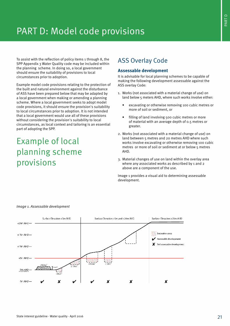
ASS Overlay CodeAssessable developmentIt is advisable for local planning schemes to be capable of making the following development assessable against the ASS overlay Code:
1. Works (not associated with a material change of use) on land below 5 meters AHD, where such works involve either:
• excavating or otherwise removing 100 cubic metres or more of soil or sediment, or
• filling of land involving 500 cubic metres or more of material with an average depth of 0.5 metres or greater.
2. Works (not associated with a material change of use) on land between 5 metres and 20 metres AHD where such works involve excavating or otherwise removing 100 cubic metres or more of soil or sediment at or below 5 metres AHD.
3. Material changes of use on land within the overlay area where any associated works as described by 1 and 2 above are a component of the use.
Image 1 provides a visual aid to determining assessable development.
Image 1. Assessable development
22State interest guideline - Water quality - April 2016
Purpose of codeThe purpose of the code is to ensure that activities with the potential to disturb ASS are undertaken so that disturbance of ASS is avoided, or where unavoidable, the generation or release of acid and metal contaminants from disturbed ASS do not have adverse impacts on the natural and built environment or human health.
Information that may be requestedWhere this code applies, council may request the following information:
• the lowest elevation of the site in metres AHD;
• the greatest depth in metres AHD of any proposed excavation, together with the maximum volume of excavation below 5 metres AHD;
• the height in metres AHD of any land to be filled, together with the volume and thickness of the fill to be placed on land below 5 metres AHD; and
• site specific information confirming that the site does not contain ASS.
PART
D
Achieving the acceptable outcomes requires the applicant to provide an ASS investigation to determine:
• whether ASS are present in the area to be disturbed by the development;
• if present, the location, depth and maximum existing and potential acidity of ASS relative to the proposed disturbance; and
• if ASS are to be disturbed, an Environmental Management Plan (EMP), outlining how the proposed development will ensure that the release of acid and associated metal contaminants into the environment is prevented.
Department of Infrastructure, Local Government and Planning
23State interest guideline - Water quality - April 2016
PART
D
Assessable developmentPerformance outcomes Acceptable outcomesPO1 Areas within the development site containing ASS are accurately identified.
AO1.1 ASS within the development site are identified by undertaking an ASS investigation confirming to the Queensland Sampling Guidelines and soil analyses according to the Laboratory Methods Guidelines or Australian Standard 4969.
PO2 Development avoids disturbing ASS or are managed to prevent the release of acid and metal contaminants.
AO2.1(a) The disturbance of ASS is avoided by: • not excavating or otherwise removing soil or
sediment identified as containing ASS; • not permanently or temporarily extracting
groundwater that results in the oxygenation of previously saturated ASS;
• not undertaking filling that results in: i. actual ASS being moved below the water table, ii. previously saturated ASS being aerated; OR
(b) The disturbance of ASS prevents the release of acid and metal contaminants by:
• neutralising existing acidity and preventing the generation of acid and metal contaminants;
• preventing the release of surface or groundwater flows containing acid and metal contaminants into the environment;
• preventing the in-situ oxidation of ASS through groundwater level management; and
• documenting management strategies and reporting requirements in an ASS environmental management plan.
AO2.2Undertake appropriate treatment before disposal whether or not that disposal occurs offsite.
Department of Infrastructure, Local Government and Planning
24
PART
E
State interest guideline - Water quality - April 2016
PART E: Supporting information
1. References, industry guidelines and technical resources
Urban stormwater and catchment management• CRC for Water Sensitive Cities
http://watersensitivecities.org.au/resource-library/
o Biofilters and wetlands for stormwater treatment and harvesting (2014)
o Adoption Guidelines for Stormwater Biofiltration Systems - Summary Report (2015)
• MUSIC Modelling by eWater www.ewater.com.au
• Queensland Urban Drainage Manual (2013) Department of Energy and Water Supply. https://www.dews.qld.gov.au/water/supply/urban-drainage-manual
• Water by Design - Guide to the Cost of Maintaining Bioretention Systems (2015)
• Water Sensitive Urban Design for the Coastal Dry Tropics (Townsville) (2011). Townsville City Council. www.townsville.qld.gov.au/business/planning/planningscheme/wsud/Pages/default.aspx
• Brisbane City Council City Plan 2014
o Chapter 7 Stormwater Drainage (SC6.16 Infrastructure Design Planning Scheme Policy)
o Erosion Hazard Assessment form (CA2085) (2010)
o Erosion Hazard Assessment - Supporting Technical Notes (CA10157) (2014)
• Gold Coast City Council
o Planning Scheme Policy 11 – Land development Guidelines - Volume 3 Water Sensitive Urban Design Guidelines
Algal blooms• Queensland Harmful Algal Bloom (2014) Department of
Natural Resources and Mines. www.qld.gov.au/environment/water/quality/algae/ o Response Plan
o Operation Procedure
Documents that may provide assistance in achieving the various policy element outcomes for making and amending a planning scheme and/or development assessment include, but are not limited to:
Erosion and Sediment Control• Best Practice Soil and Erosion Control (2008) IECA
www.austieca.com.au/publications/best-practice-erosion-and-sediment-control-bpesc-document
• Procedural Guide Compliance Notes: Standard work method for the assessment of the lawfulness of releases to waters from construction sites - South East Queensland (2013) Department of Environment and Heritage Protection. EM1135 http://www.ehp.qld.gov.au/licences-permits/business-industry/pdf/lawful-water-release-construction-sites-em1135.pdf
• Procedural guide Summary Sheet: Standard work method for the assessment of the lawfulness of releases to waters from construction sites in South East Queensland (2013) Department of Environment and Heritage Protection. EM1137 http://www.ehp.qld.gov.au/licences-permits/business-industry/pdf/lawful-water-release-construction-sites-summary-sheet-em1137.pdf
Water Quality and Waste Water Guidelines• Australian and New Zealand Guidelines for Fresh and
Marine Water Quality (2000) Australian and New Zealand Environment and Conservation Council. Agriculture and Resource Management Council of Australia and New Zealand. www.environment.gov.au/water/quality/publications/australian-and-new-zealand-guidelines-fresh-marine-water-quality-volume-1
• Queensland Water Quality Guidelines (2009) Department of Environment and Heritage Protection. Version 3 Revised 2013. www.ehp.qld.gov.au/water/pdf/water-quality-guidelines.pdf
• Technical Guideline: Wastewater Release to Queensland Waters (2012) Department of Environment and Heritage Protection. EM112 www.ehp.qld.gov.au/assets/documents/regulation/pr-gl-wastewater-to-waters.pdf
25
PART
E
State interest guideline - Water quality - April 2016
Constructed waterways and lakes Several local governments have guidance documents aimed at ensuring that proposed constructed waterways and lakes in non-tidal areas are designed and operated as long term sustainable assets:
o Gold Coast City Council 2007 ‘Planning Scheme Part 7 Codes—Changes to ground level and creation of new waterbodies’
o Mackay City Council 2008 ‘Engineering Design Guidelines Constructed Lakes—Planning Scheme Policy No.15.15’
2. Mapping information
Water supply catchmentsWithin South East Queensland:
The SPP interactive mapping system includes layers provided by Seqwater, identifying water supply buffer areas in South East Queensland.
Outside South East Queensland:
Local governments will need to identify water supply sources (such as reservoirs) and buffers within their local government area.
Acid sulfate soils (ASS)All ASS mapping produced by the Queensland Government is available for download in spatial information format from the Queensland Government Information System (www.information.qld.gov.au) as per the LiDAR elevation-based hazard dataset. Other listed datasets are gradually being made available online. For assistance accessing data, please contact [email protected].
The Queensland Sampling Guideline 2013 contains a detailed discussion of appropriate information sources for determining ASS hazard and how to interpret them. Briefly, these are:
• ASS mapping produced by the Queensland Government;
• LiDAR elevation-based hazard dataset for ASS, produced by the Queensland Government (this contains 0 metre, 5 metre and 20 metre contours);
• other elevation data with a contour interval of 1 metre or better;
• surface geology and regolith mapping;
• satellite imagery and aerial photography, including historical imagery;
• vegetation mapping; and
• field investigations carried out by suitably qualified persons.
Map scale for data sources listed above should be 1:100 000 or better (1:50 000 or better for imagery).
3. Preparing an Acid Sulfate Soils Environmental Management PlanBackgroundAn Environmental Management Plan (EMP) provides ‘life of development’ management strategies in accordance with agreed performance criteria. An EMP specifies environmental impacts, performance criteria and mitigation strategies together with relevant monitoring, reporting and, in the case of unforeseen impacts, appropriate corrective actions.
EMPs for ASS may comprise a standalone document or be part of a larger EMP for a project. An EMP is most effective when it is clearly structured, auditable and easy to implement on site. It gives assessing authorities a framework within which to confirm compliance with policies and conditions and is often used by project management staff.
An EMP may require periodic reviews and updates as management practices evolve, or as the success or failure of management methods become apparent well before a project is complete. This is especially true when trialling new management and mitigation technologies — a certain amount of learning on the job is sometimes inevitable, and unexpected issues should be documented for future benefit. It is recommended that strategies and contingency plans be built-in to the EMP to detect and act upon breaches of performance criteria. EMPs are auditable and should contain clear reporting arrangements. Any change or amendment of an EMP for ASS should be carried out in consultation with assessing authorities.
Department of Infrastructure, Local Government and Planning
26
PART
E
State interest guideline - Water quality - April 2016
Specifics for ASSThe Soil Management Guidelines contain advice on avoidance, minimisation, neutralisation, hydraulic separation, strategic reburial and high risk management strategies for ASS. Any EMP for ASS needs to be specific enough to address these management issues and accommodate the features of each development site. An EMP for ASS is implemented prior to soil drainage or disturbance and includes the following:
• Spatial representation of ASS occurrence on site, maps, cross-sections, and even 3D representations, especially with planned disturbances superimposed.
• Discussion of the nature of the planned disturbance (e.g. marina, canal, basement excavation), volumes to be disturbed (including soils and groundwater), and the treatment category.
• Details of potential on-site and off-site effects of the disturbance of the soil and/or the groundwater levels, including a discussion of any higher risk management strategies proposed on site, and measures to reduce the risks to acceptable levels.
• Strategies to prevent the oxidation of iron sulphides. If previous plans have been revised as a result of the site investigation report recommendations, the changes made may be briefly discussed. It is assumed at this point that site knowledge will have informed the project design process.
• Proposed management strategies and measures to mitigate any risks associated with the disturbance:
o If neutralisation is proposed, the EMP will account for issues such as neutralising application rates, treatment pad design and location, the use of guard layers.
o If hydraulic separation is proposed, the EMP will account for issues such as reducing oxygen exposure of the fines, guard layers and management of the process waters and sulfidic fines.
o If strategic reburial is proposed, the EMP will account for risks such as ensuring long term reducing conditions for the buried material.
• Details of any ASS that are to be removed off site, including the location of any offsite treatment facilities and agencies responsible for ASS treatment.
• Performance criteria to be used to assess the effectiveness of the ASS management and monitoring measures. For example, neutralisation, hydraulic separation and strategic reburial.
• Where groundwater disturbance is not avoidable, the results of the groundwater investigation are used to formulate management strategies for water table management, including measures to contain the size of dewatered areas minimise the duration of dewatering.
• Monitoring strategies (manual, automated, and laboratory procedures) detailing requirements for surface water and groundwater monitoring for key parameters such as pH, electrical conductivity, dissolved oxygen, chloride, sulfate, total iron, dissolved iron, filtered aluminium, bicarbonate, and calcium. Monitoring biological indicators may be required in some cases.
• Details of verification testing including sampling rates that are required to establish:
o whether sufficient neutralising material has been added to the batch of soil on the treatment pad and whether it has been sufficiently mixed—for neutralised soils.
o whether sluiced/washed soil has been effectively separated—for hydraulic separation.
o whether ASS will be maintained in a permanent state of reduction—for strategic reburial.
• Details of the handling and storage of neutralising agents.
• Containment strategies including bunding, diversion drains, lime dosing or silt curtains to ensure that contaminated stormwater, acid and leachate associated with the oxidation of ASS is prevented from entering the receiving environment.
• Description of contingency procedures to be implemented on and off the site if the management procedures prove to be unsuccessful, acid is generated, leachate problems occur, and/or if performance criteria are breached, including designated personnel responsible for the contingency plans. Consideration should be given to the financial impost of contingency procedures at the time of risk assessment and decision making. It is recommended contingency plans identify if problems are related to ineffective operation of the EMP and/or ineffective management strategies.
• An auditing and reporting system to demonstrate compliance with the performance criteria. It is recommended monitoring results are reported and retained for auditing purposes.
Department of Infrastructure, Local Government and Planning
27
PART
E
State interest guideline - Water quality - April 2016
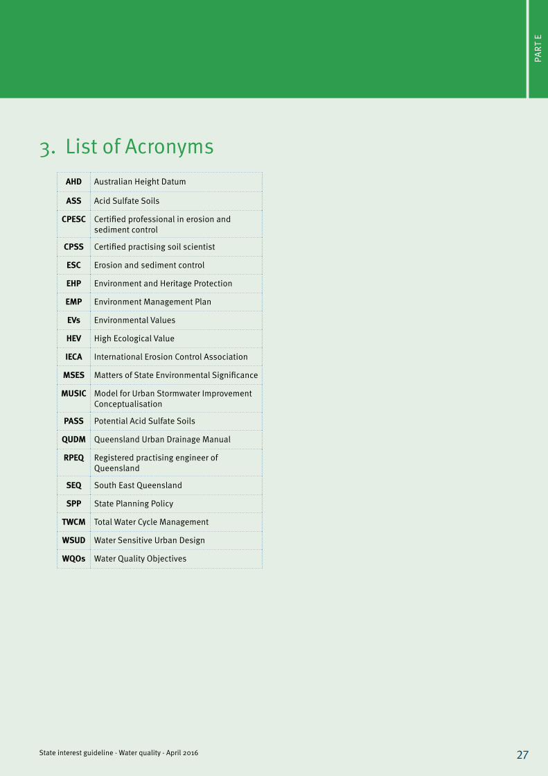
AHD Australian Height Datum
ASS Acid Sulfate Soils
CPESC Certified professional in erosion and sediment control
CPSS Certified practising soil scientist
ESC Erosion and sediment control
EHP Environment and Heritage Protection
EMP Environment Management Plan
EVs Environmental Values
HEV High Ecological Value
IECA International Erosion Control Association
MSES Matters of State Environmental Significance
MUSIC Model for Urban Stormwater Improvement Conceptualisation
PASS Potential Acid Sulfate Soils
QUDM Queensland Urban Drainage Manual
RPEQ Registered practising engineer of Queensland
SEQ South East Queensland
SPP State Planning Policy
TWCM Total Water Cycle Management
WSUD Water Sensitive Urban Design
WQOs Water Quality Objectives
3. List of Acronyms

© The State of Queensland, April 2016. Published by the Department of Infrastructure, Local Government and Planning, 100 George Street, Brisbane Qld 4000, Australia.
Licence: This work is licensed under the Creative Commons CC BY 4.0 Licence. To view a copy of the licence, visit http://creativecommons.org/licenses/by/4.0/deed.en.
Attribution: The State of Queensland, Department of Infrastructure, Local Government and Planning.
The Queensland Government supports and encourages the dissemination and exchange of information. However, copyright protects this publication. The State of Queensland has no objection to this material being reproduced, made available online or electronically but only if it is recognised as the owner of the copyright and this material remains unaltered.
The Queensland Government is committed to providing accessible services to Queenslanders of all cultural and linguistic backgrounds. If you have difficulty understanding this publication and need a translator, please call the Translating and Interpreting Service (TIS National) on 131 450 and ask them to telephone the Queensland Department of Infrastructure, Local Government, and Planning on 13 QGOV (13 74 68).
Disclaimer: While every care has been taken in preparing this publication, the State of Queensland accepts no responsibility for decisions or actions taken as a result of any data, information, statement or advice, expressed or implied, contained within. To the best of our knowledge, the content was correct at the time of publishing. Any references to legislation are not an interpretation of the law. They are to be used as a guide only. The information in this publication is general and does not account for individual circumstances or situations. Where appropriate, independent legal advice should be sought.’
For the most up to date version of the State Planning Policy, please refer to the Department of Infrastructure, Local Government and Planning website www.dilgp.qld.gov.au/spp. To obtain a printed copy of this guideline, please contact us via the contact details provided at the end of this guideline.
State Planning Policy Department of Infrastructure, Local Government and PlanningPO Box 15009, City East, Queensland 4002 tel: 13 QGOV email: [email protected]