standard - usda€¦ · standard geospatial dataset file naming draft ... (usda) customers at their...
TRANSCRIPT
United States Department of Agriculture Service Center Modernization Initiative (SCMI)
STANDARD
Geospatial Dataset File Naming
DRAFT
March 31, 2008 Prepared by: Randy Frosh, Data Management Team Member

SCI Std 004-04 STANDARD FOR GEOSPATIAL DATASET FILE NAMING
Draft i March 31, 2008
Introduction As directed by the Secretary of Agriculture’s March 16, 1998 memorandum, the Natural Resources Conservation Service (NRCS), Farm Service Agency (FSA), and Rural Development (RD) agencies are co-locating offices, modernizing business processes, and partnering to achieve a “one-stop service” for United States Department of Agriculture (USDA) customers at their county-based field offices (Service Centers). One of the major components of the modernization initiative involves the implementation of a Geographic Information System (GIS) across each of the Partner Agencies and in all 2,550 Service Center offices. A Service Center Data Team has been chartered with the overall responsibility for implementing an infrastructure for management of data resources for the Partner Agencies. The GIS Standards Team 5 was formed to address specific data management issues regarding geospatial data. The individuals who contributed to the development of this standard are:
David Anderson, (NRCS) Service Center Data Team Leader Dennis Crow (RD) David Davis (FSA) Larry Davis (NRCS) Carol Ernst (FSA) Randy Frosh (Synergetics) Kathy Green (NRCS) Shirley Hall (FSA) Steve Nechero (NRCS) Kent Williams (FSA)
Figure 1 — Working group list
RECORD OF CHANGE
Revision/ Change Number
Update Number
Change Date Description/Reason for Change Sections Affected
2 1 25-Jan-01 Revision of 30-Aug-99. SCI Std 004-01 All
3 1 15-Oct-03 Use IO Lab template All
4 1 20-Feb-04
elevation/ned*, hydrography/nhd*, soils, imagery/naip*,ortho/*,Remove USGS 24k DLG names, Add ortho/highres.
Table 1
5 1 24-Jun-04 Add Tele Atlas layers, clu_public, clu_copy Table 1
6 1 04-Aug-04 Add soils/cra_a_us Table 1
7 1 17-Sep-04 Description for soil_d_<stssaid> Table 1
8 1 18-Oct-04 Note that clu_public_a is for public only-not loaded at Service Center.
Table 1
9 1 06-Apr-05 Add census statistics. Modify GNIS, CRA Table 1
10 1 03-May-05 Add TeleAtlas geocode Table 1
11 1 25-Jan-06 Add temperature, contours, ADS40 Table 1
12 1 08-May-06 Add one meter ortho Table 1

SCI Std 004-04 STANDARD FOR GEOSPATIAL DATASET FILE NAMING
Draft ii March 31, 2008
13 1 25-May-06 Add high-res and high-res proprietary ortho Table 1
14 1 24-Jan-07 Add IFSAR elevation Table 1
15 1 20-Feb-07 NT > windows wording 3,4,5
16 1 05-Mar-07 Remove <v> from one meter ortho Table 1
17 1 02-May-07 Replace Elevation & TeleAtlas. Add section 10.3 Deprecated file Names
10.2, 0.3 Table 1-3
18 1 03-May-07 In disaster_events\fsa_facilities remove ffl_p_<stnnn> rename ffsfl_p_<stnnn> to ffsf_p_<stnnn>_<yyyymmdd>
Table 1
19 1 04-May-07 Add NASS cropland data layer & area sampling framework Table 1
20 ` 17-Jul-07 Beginning with 2007, all one meter NAIP is named ortho* in the ‘ortho’ folder. Two meter NAIP is still in imagery\compliance_fsa
Table 1
21 1 4-Jan-08 Add Major Land Resource Areas (MLRA) by state Table 1
22 1 31-Mar-08 Add huc250k_a_<st>, wbdhu8_a_<st>, wbdhu8_l_<st> Table 1
23 1 31-Mar-08 Add nhd24kli_l_######## and nhd24kpt_p_########
Table 1
23 1 31-Mar-08 Add ned03m<nnnnnqd> Table 1
ARC/INFO is a registered trademark of Environmental Systems Research Institute, Inc. Microsoft Access 2000 is a registered trademark of Microsoft Corporation. MrSid is a registered trademark of LizardTech, Inc.
SCI Std 004-04 STANDARD FOR GEOSPATIAL DATASET FILE NAMING
Draft iii March 31, 2008
Table of Contents 1. Overview .............................................................................................................................. 1
1.1. Scope................................................................................................................................. 1 1.2. Purpose.............................................................................................................................. 1 1.3. Acronyms and abbreviations............................................................................................. 2
2. Background........................................................................................................................... 3 3. Geospatial Dataset Collection .............................................................................................. 4 4. Geospatial Dataset Category ................................................................................................ 4
4.1. Geospatial dataset category naming.................................................................................. 5 5. Geospatial Dataset ................................................................................................................ 5
5.1. Geospatial dataset naming ................................................................................................ 5 6. Standard Characters.............................................................................................................. 7
6.1. Special characters.............................................................................................................. 8 6.2. Case sensitivity ................................................................................................................. 8 6.3. Allowable standard characters .......................................................................................... 8
7. Name Length ........................................................................................................................ 9 8. Area of Interest ..................................................................................................................... 9 9. Local Data .......................................................................................................................... 10
9.1. Existing "geospatial dataset category" ............................................................................ 10 9.2. project_data directory ..................................................................................................... 10
9.2.1. Local data naming.................................................................................................... 10 10. Geospatial Data Directory Structure: "geodata"................................................................. 10
10.1. Overview ..................................................................................................................... 11 10.2. Table notations ............................................................................................................ 11 10.3. Deprecated datasets ..................................................................................................... 23
Appendix A − Bibliography .......................................................................................................... 26 Table of Figures and Tables Figure 1 — Working group list ........................................................................................................ i Figure 3.1 — Geospatial Dataset Collection ................................................................................... 4 Figure 4.1 — Geospatial Dataset Categories................................................................................... 5 Figure 5.1 — Geospatial File Naming ............................................................................................ 7 Figure 6.1 — Directory/Folder and File Allowable Characters ...................................................... 8 Table 1—Geospatial directory structure and naming conventions................................................ 13 Table 2— Deprecated Tele Atlas Datasets.................................................................................... 23 Table 3— Deprecated Elevation Datasets ..................................................................................... 25
SCI Std 004-04 STANDARD FOR GEOSPATIAL DATASET FILE NAMING
Draft iv March 31, 2008
This page is intentionally left blank

SCI Std 004-04 STANDARD FOR GEOSPATIAL DATASET FILE NAMING
Draft 1 March 31, 2008
STANDARD FOR GEOSPATIAL DATASET FILE NAMING 1. Overview The objectives of this standard are to help in managing United States Department of Agriculture (USDA) Service Center Modernization Initiative (SCMI) geospatial data by establishing directory (folder) and file naming conventions; support the concurrent USDA Service Center Modernization Strategy to develop a basic nationally consistent set of core geospatial data that will provide a foundation on which to base business applications; and to relate to other SCMI geospatial standards including SCMI Std 003, Standard for Geospatial Data Set Metadata [A2]1, SCMI Std 005, Standard for Geospatial Feature Metadata [A3], SCMI Std 007, Standard for Geospatial Data [A4], and the USDA Service Center Initiative Directory Structure and File Naming Convention Change Control Policy [A6]. Appendix A of this standard provides bibliography references to the documents listed above. 1.1. Scope
The scope of this standard is to define the directory and file naming conventions for the geospatial dataset collection (physical repository of data) that resides at a Service Center. This standard shall apply to the set of nationally consistent core geospatial data layers first defined in the USDA Service Center Geographic Information System (GIS) Strategy [A5]. It also provides standards on the directory structure and file naming for locally acquired and derived geospatial data. The Manual for Managing Geospatial Datasets in Service Centers [A7] had also provided directory/folder and file naming conventions. However, the manual is a temporary document provided to assist with geodata migration at service centers. The Standard for Geospatial Dataset File Naming will be the official document outlining geodata file naming conventions. Future revisions to the file naming standard will not be reflected in the Manual for Managing Geospatial Datasets in Service Centers. 1.2. Purpose
GIS for the Service Center is expected to comprise nationwide coverage of more than 20 common geospatial datasets (a group of similar spatial phenomena) that are collected and distributed at the county level of geography. To organize this data at the Service Center so that it is accessible, maintainable and updateable requires a standard scheme for categorizing the data into directories and establishing names and conventions for the files in the directories. This document identifies the directories and file names for existing common geospatial dataset categories. It will continue to evolve as nationally consistent datasets are provided to the Service Centers. This standard will be placed under configuration management and maintained through a structured change control process because the impact of changing this standard can be great on those applications that use the data and those who provide the data. The change control process will allow proposed changes to be reviewed and discussed by those affected by the changes.
1 The number in brackets corresponds to those of the bibliography in Appendix A.

SCI Std 004-04 STANDARD FOR GEOSPATIAL DATASET FILE NAMING
Draft 2 March 31, 2008
Nationally fielded applications will be developed that rely on the nationally consistent set of geospatial data. These applications will rely on the integrity of the data in meeting the specifications in this standard. Applications that are built locally for a Service Center or for data that is acquired locally shall adhere to these standards. 1.3. Acronyms and abbreviations
BPR Business Process Reengineering CCE Common Computing Environment CD-ROM Compact Disc Read Only Memory CDL Cropland Data Layer CLU Common Land Unit CRA Common Resource Areas DMF Digital Map Finishing DOQ Digital Ortho Quadrangle DOQQ Digital Ortho Quarter Quadrangle DRG Digital Raster Graphs EPA Environmental Protection Agency FEMA Federal Emergency Management Agency FIPS Federal Information Processing Standard FSA Farm Service Agency FWS Fish and Wildlife Service GIS Geographic Information System GNIS Geographic Names Information System IFSAR InterFerometric Synthetic Aperture Radar ISO International Standards Organization MDOQ Mosaicked Digital Ortho Quadrangles MLRA Major Land Resource Areas MrSID Multi-resolution Seamless Image Database NAIP National Agricultural Imagery Program NAPP National Aerial Photography Program NASIS National Soil Information System NASS National Agricultural Statistics Service NCGC National Cartography and Geospatial Center NHD National Hydrography Dataset NRCS Natural Resources Conservation Service NWI National Wetland Inventory OIP Office Information Profile RD Rural Development SSA Soil Survey Area SCMI Service Center Modernization Initiative SSURGO Soil Survey Geographic Database STSSAID State Soil Survey Area ID TIF Tagged Image File US United States USDA United States Department of Agriculture USGS United States Geological Survey UTM Universal Transverse Mercator WBD Water Boundary Data WRP Wetland Reserve Program

SCI Std 004-04 STANDARD FOR GEOSPATIAL DATASET FILE NAMING
Draft 3 March 31, 2008
2. Background The USDA Service Center Geographic Information System (GIS) Strategy [A5] first defined a list of geospatial datasets required to provide a foundation on which to base business applications. The Geospatial Data Acquisition, Integration, and Delivery National Implementation Strategy Plan [A1] further refined and expanded this list. This list was organized into logical categories based on business names. It is these logical categories that form the basis for the organization of the physical directory structure defined in this standard. The SCMI Std 007, Standard for Geospatial Data [A4] includes a geospatial data model that details a hierarchical classification that shall be used to categorize, or provide taxonomy for, geospatial data. These categories are referred to as geospatial dataset categories. This model and classification shall be used to identify and describe geospatial data in a consistent way. The geospatial dataset categories in the model are used as the basis for the directory structure in this document. The top level of the geospatial data model is referred to as a geospatial dataset collection. A geospatial dataset collection is a catalog and physical repository of geospatial datasets. For example, an USDA data mart that serves geospatial data to only one Service Center or an USDA national data warehouse that serves geospatial data to all Service Centers is a geospatial dataset collection. This standard is based on the lessons learned during the initial fielding of geospatial datasets at the BPR pilot sites. This document replaces the initial directory and naming conventions established for BPR pilot sites known as version 5. In addition to creating a flatter directory structure, each dataset name within each geospatial dataset category will provide a consistent naming convention that will offer a standard method of dataset identification including name, data type and location. The directory structure and naming conventions follow in the subsequent sections. The geospatial data model is used as the basis for the directory structure in this document.

SCI Std 004-04 STANDARD FOR GEOSPATIAL DATASET FILE NAMING
Draft 4 March 31, 2008
3. Geospatial Dataset Collection The entire geospatial dataset collection at the top level of the directory shall be located on a designated drive and named "geodata". There shall be only one “geodata” occurrence in any given Service Center on the shared network server. The standard directory structure for the geospatial dataset collection is as follows: <disk drive>:
geodata <geospatial dataset collection>
<geospatial dataset category (directory/folder)>
transportation <geospatial dataset category (directory/folder)>
roads24k_l_ca067.shp <geospatial dataset>
<geospatial dataset>
Figure 3.1 — Geospatial Dataset Collection An example of the physical path to a road map using this standard on Windows would be
C:\geodata\transportation\roads24k_l_ca067.shp On the Service Center server the physical path would be F:\…
For UNIX it would be /geodata/transportation/roads24k_l_ca067.shp
4. Geospatial Dataset Category The next level in the geospatial data model is a geospatial dataset category, which is a logical group or division of a geospatial dataset collection. A geospatial dataset category is analogous to a computer directory or folder. There can be multiple occurrences of geospatial dataset categories under the geospatial dataset collection (“geodata”) level. A geospatial dataset category may include at least one geospatial dataset complete with all metadata and feature data including geometry, attributes, labels and symbology. However, an empty directory can exist as a 'place holder' for future data. Additionally, geospatial dataset categories are allowed to have sub-directories as in the case of climate. However, this is generally discouraged.

SCI Std 004-04 STANDARD FOR GEOSPATIAL DATASET FILE NAMING
Draft 5 March 31, 2008
<disk drive>:
geodetic
<geospatial dataset category (directory/folder)>
climate <geospatial dataset category (directory/folder)>
precipitation <geospatial dataset category (directory/folder)>
<geospatial dataset>
<geospatial dataset>
temperature <geospatial dataset category (directory/folder)>
Figure 4.1 — Geospatial Dataset Categories 4.1. Geospatial dataset category naming
In this second level data hierarchy, the physical directory name previously used upper case characters and spaces. In practical applications these two practices cause problems migrating datasets between UNIX and Windows platforms. As a result, this standard requires that the physical implementation of the category directory names shall consist of only lower case characters "a-z". Additionally, the underscore character "_" shall be used in place of a space in a directory name. Allowable characters are covered in detail in section 6. The SCMI Std 007, Standard for Geospatial Data [A4] identifies the geospatial dataset categories used in this standard. These standard category or directory names are also shown in Table 1. The standard name used for each directory hopefully shall reflect a name that is commonly used and understood by Service Center personnel when referring to the geospatial dataset category. For example, geospatial dataset categories include common_land_unit, ortho_imagery and soils (see Table 1). 5. Geospatial Dataset A geospatial dataset is a group of similar spatial phenomena in a geospatial dataset category and is related to one metadata set. A geospatial dataset is often referred to as a layer, theme, coverage, or simply a map. For example, the geospatial dataset category hydrography could contain the geospatial datasets surface water, water control infrastructure and flood hazard maps. The surface water geospatial dataset contains streams represented as lines, ponds represented as polygons and wells represented as points. 5.1. Geospatial dataset naming
Table 1 shows the standard file name for each dataset. Table 1 also provides a description of the dataset. Naming standards apply to all nationally distributed datasets. It is recommended that file naming similar to the standards in this document be used for state-defined and locally defined datasets. The names are designed to be unique within the entire geodata directory. They maintain their uniqueness even if the category or directory names are eliminated from the structure. Moving

SCI Std 004-04 STANDARD FOR GEOSPATIAL DATASET FILE NAMING
Draft 6 March 31, 2008
files between computers, and between offices, makes unique file names a necessity. Non-unique file names often result in the loss of data when a file is unintentionally overwritten during the moving of data. The standard file names convey as much information as possible and reflect encoding into the name of:
⎯ dataset theme ⎯ type of map features in the dataset ⎯ spatial location or extent of the dataset ⎯ files extension (as applicable)
As a result, the dataset name contains
⎯ a short version or acronym used to represent the business name of the dataset ⎯ feature type designation p-point, l-line, a-area, d-database/spreadsheet, etc. ⎯ location or extent information such as a Federal Information Processing Standard (FIPS)
code, State Soil Survey Area ID (STSSAID) number, or state abbreviation. ⎯ an extension
SCI Std 004-04 STANDARD FOR GEOSPATIAL DATASET FILE NAMING
Draft 7 March 31, 2008
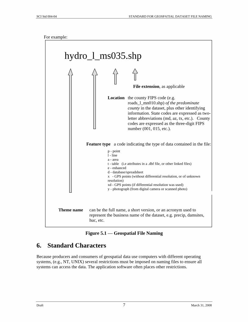
For example:
hydro_l_ms035.shp
File extension, as applicable Location the county FIPS code (e.g.
roads_l_mn010.shp) of the predominate county in the dataset, plus other identifying information. State codes are expressed as two-letter abbreviations (md, az, tx, etc.). County codes are expressed as the three-digit FIPS number (001, 015, etc.).
Feature type a code indicating the type of data contained in the file: p - point l - line a - area t - table (i.e attributes in a .dbf file, or other linked files) e - enhanced d - database/spreadsheet x - GPS points (without differential resolution, or of unknown resolution) xd - GPS points (if differential resolution was used) y - photograph (from digital camera or scanned photo)
Theme name can be the full name, a short version, or an acronym used to represent the business name of the dataset, e.g. precip, damsites, huc, etc.
Figure 5.1 — Geospatial File Naming
6. Standard Characters Because producers and consumers of geospatial data use computers with different operating systems, (e.g., NT, UNIX) several restrictions must be imposed on naming files to ensure all systems can access the data. The application software often places other restrictions.
SCI Std 004-04 STANDARD FOR GEOSPATIAL DATASET FILE NAMING
Draft 8 March 31, 2008
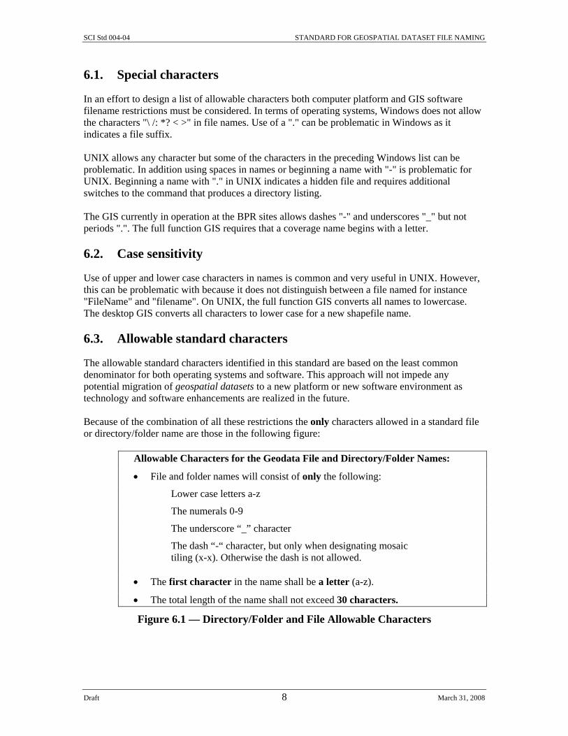
6.1. Special characters
In an effort to design a list of allowable characters both computer platform and GIS software filename restrictions must be considered. In terms of operating systems, Windows does not allow the characters "\ /: *? < >" in file names. Use of a "." can be problematic in Windows as it indicates a file suffix. UNIX allows any character but some of the characters in the preceding Windows list can be problematic. In addition using spaces in names or beginning a name with "-" is problematic for UNIX. Beginning a name with "." in UNIX indicates a hidden file and requires additional switches to the command that produces a directory listing. The GIS currently in operation at the BPR sites allows dashes "-" and underscores "_" but not periods ".". The full function GIS requires that a coverage name begins with a letter. 6.2. Case sensitivity
Use of upper and lower case characters in names is common and very useful in UNIX. However, this can be problematic with because it does not distinguish between a file named for instance "FileName" and "filename". On UNIX, the full function GIS converts all names to lowercase. The desktop GIS converts all characters to lower case for a new shapefile name. 6.3. Allowable standard characters
The allowable standard characters identified in this standard are based on the least common denominator for both operating systems and software. This approach will not impede any potential migration of geospatial datasets to a new platform or new software environment as technology and software enhancements are realized in the future. Because of the combination of all these restrictions the only characters allowed in a standard file or directory/folder name are those in the following figure:
Allowable Characters for the Geodata File and Directory/Folder Names:
• File and folder names will consist of only the following:
Lower case letters a-z
The numerals 0-9
The underscore “_” character
The dash “-“ character, but only when designating mosaic tiling (x-x). Otherwise the dash is not allowed.
• The first character in the name shall be a letter (a-z).
• The total length of the name shall not exceed 30 characters.
Figure 6.1 — Directory/Folder and File Allowable Characters

SCI Std 004-04 STANDARD FOR GEOSPATIAL DATASET FILE NAMING
Draft 9 March 31, 2008
These restrictions also shall apply to geospatial dataset category or directory naming. These standards are very restrictive and shall not change unless the GIS platform changes with further definition from the Common Computing Environment (CCE) Team. 7. Name Length The total length of the dataset filename shall not exceed 30 characters. This limit has been identified during Compact Disc Read Only Memory (CD-ROM) production at National Cartography and Geospatial Center (NCGC). The only CD-ROM writing format that is universally readable throughout Natural Resources Conservation Service (NRCS) is the International Standards Organization (ISO) 9660, Level 2, Mode 1 format. Exceeding this 30-character maximum for filenames becomes a problem when datasets are sent via CD-ROM to multiple computer platforms. However, no attempt is made to adhere to the so-called 8.3 format required by older DOS operating systems (maximum of eight character name with a maximum of a three character suffix). This will cause problems for Microsoft Access 97® and Access 2000® because they can not import or link to .dbf files (such as those in a shapefile set) whose names are longer than 8.3 until they are renamed with an 8.3 compliant name. (Note: Access requires 8.3 for imported and exported dbf files even though it will handle the longer names.) There is a 13 character maximum for coverages in the ARC/INFO® GIS. This was exceeded in this standard since it is designed to organize shapefiles and would prove to be easier to use in the Service Centers because it will lessen the need for cryptic names unfamiliar to many Service Center users. However, conversion of data either to or from coverages will require different names and additional processing. 8. Area of Interest As mentioned previously the spatial location or extent is encoded into the name. In the current scheme most maps will be clipped or tiled to the county boundary for delivery and use unless the map is a state or national coverage. This clipped extent shall be appended to the theme name and feature type as a FIPS code or STSSAID number (e.g., roads24k_l_ca048.shp). Tiling of digital geospatial data significantly impacts overall data management and system performance. In general, it is preferred that tiling is seamless, or transparent, to the user. Clipping map extents at the county boundary is not optimal for users if they for instance wish to look at a farm or an area that crosses a county boundary. Users would prefer to be able to zoom to some arbitrary area of interest and remain unaware of the underlying database structure or tiling scheme. However, this is not possible given the current state of technology. As a result, clipping the map data to the county boundary is the best available option for delivery and maintenance of map data. This standard's encoded file naming scheme and directory structure ensures that maps of like datasets in adjacent counties will appear next to each other in a pick list to facilitate user selection of maps. In some cases, such as Digital Raster Graphs (DRG) and Digital Ortho Quadrangles (DOQ), an image catalog serves as an index map to 7.5-minute quad tiles for a county. This index is used to display images and conceals the underlying tiling scheme and image filenames from the user.

SCI Std 004-04 STANDARD FOR GEOSPATIAL DATASET FILE NAMING
Draft 10 March 31, 2008
9. Local Data Any GIS data that is acquired or developed locally at the Service Center shall be placed in the geodata directory along with its completed metadata. A few guidelines are offered to assist in the incorporation of this data in a logical and consistent manner. 9.1. Existing "geospatial dataset category"
If the data corresponds to one of the existing categories or directories, the map and metadata should be placed in that directory so that it appears adjacent to any nationally provided data when the user is selecting from a pick list. There are several circumstances where various types of local Service Center data should be incorporated into the existing "geospatial dataset category" structure. They are:
When there is no national data and only locally developed data, such as in the case of Wetland Reserve Program (WRP) easements data. These maps along with the Metadata should be placed in the environmental_easements directory or other relevant "geospatial dataset category" directories.
When there are more accurate data from local sources the locally acquired data should be placed in the appropriate "geospatial dataset category" directories. For instance, there is locally obtained road data that are known to be more accurate than the nationally provided data named roads24k_l_<stnnn>. The locally acquired data and its metadata should be placed in the transportation directory and uniquely named according to the standard. One approach is to encode the datasets scale into the filename. For instance, roads12k_l_<stnnn>, indicates that the road map is locally acquired 1:12,000 scale data.
When data are created locally as the result of analysis it should be placed under the appropriate "geospatial dataset category" directory if the data would be useful to others at a Service Center. The data should be named according to the standard and placed in the appropriate geodata directory. Otherwise, the results should be left on a personal disk drive where it is probably inaccessible to others.
9.2. project_data directory
When the geospatial dataset category of the locally acquired data does not fit in any of the existing categories, the data should be placed in the project_data directory for the appropriate agency. 9.2.1. Local data naming
Any locally acquired data should be named in accordance with this standard and only lower case a-z, 0-9, “-“ and "_" characters used in names as described in 6.3. Also, the theme, feature type and spatial location or extent should be encoded into the name as described in 5.1. Additionally, the name must not exceed 30 characters as described in Clause 7. 10. Geospatial Data Directory Structure: "geodata" This section and table describes map layers common to all Service Centers.

SCI Std 004-04 STANDARD FOR GEOSPATIAL DATASET FILE NAMING
Draft 11 March 31, 2008
10.1. Overview
The physical implementation of directories and file names supports the USDA Service Center Modernization Strategy to develop a basic nationally consistent set of core geospatial data that will provide a foundation on which to base business applications. 10.2. Table notations
Table 1 identifies the specific categories and geospatial files within each category and the standard naming conventions for the file. The table applies the naming guidelines set forth in 5.1 of this standard where each file name encodes: the dataset theme, feature type, and location for which the dataset applies.

SCI Std 004-04 STANDARD FOR GEOSPATIAL DATASET FILE NAMING
Draft 12 March 31, 2008
Table Notations: The following notations apply to the file naming conventions used in Table 1:
⎯ < > indicates a substitution notation ⎯ <f> is the compression format s-MrSID w-ECW j-JP2 ⎯ <mmm> is the three-letter abbreviation for the applicable month (e.g.,
precip<mmm>_a_<st>, precipjun_a_co is the file name for Colorado June precipitation)
⎯ <n> is the film type/bandwidth designator o-black and white c-color infrared n-natural color
⎯ <nn> is the UTM Zone number 01-60 ⎯ <nnnnn> is a 2-digit latitude and 3 digit longitude for a one degree block ⎯ <nnnnnqd> is a 2-digit latitude, 3 digit longitude, and quadrant (nw-north west ne – north
east sw-south west se-south east) Applies to 30 minute by 30 minute NED 10 meter block. ⎯ <nnnnnnn>_<qd> is a 2-digit latitude, 3 digit longitude, quadrangle 1-64. <qd> is quarter
quadrant. Very similar to the USGS standard for DOQQ and NED. Applies to NAIP quarter quads.
⎯ <nnnnnn> is the NRCS office number in the Office Information Profile. ⎯ <ppprrr> is landsat path and row. ⎯ <qd> identifies the quarter quadrant (nw-north west ne – north east sw-south west se-south
east, xx) within the full quad. ⎯ <r > is the resolution 1 or 2 ⎯ <st> is the two character state postal abbreviation (e.g., precip_a_<st>; precip_a_co is
the filename for Colorado annual precipitation). ⎯ <stnnn> is the 2-character state postal abbreviation and 3-digit County FIPS codes
(e.g., drg_<stnnn>, drg_md047 is the filename for Worcester County, Maryland DRG ) ⎯ <stssaid> is the state soil survey area ID (e.g., soils_l_<stssaid>; soils_l_md047 is the
filename for Worcester County, Maryland Soil Survey Geographic Database (SSURGO) Lines)
⎯ us indicates a dataset covering the entire United States, its protectorates and territories. ⎯ us48 indicates the conterminous or contiguous United States ⎯ <usgs standard> is the standard naming convention used by the United States
Geological Survey (USGS) The USGS naming standard for topographic images (DRGs) is available at http://topomaps.usgs.gov/drg/drg_name.html. The USGS naming standard for digital elevation models and digital orthoimagery is very similar except that 1-64 is used instead of a-h for a row and 1-8 for a column.
⎯ <v> is the revision 1, 2, 3, … ⎯ <x-x> is number - total tiles in an APFO or ERMapper county ortho mosaic. Tiles are
numbered west to east and north to south. These are county subsets because the county as one map exceeds the maximum file sizes (2GB for Solaris 2.5), maximum space on CD media (650MB), and Maximum compression ratio: Lizardtech recommends a maximum of 12:1 for B/W and 20:1 for color.
⎯ <xx> is the two digit hydrologic unit code (region) ⎯ <xxxxxxxx> is the 8-digit hydrologic unit code ⎯ <yyyy> is the calendar year. ⎯ <yyyymm> is the calendar year and month. ⎯ <yyyymmdd> is the date expressed as year,month, day. When entire date is not
available, use at least year <yyyy>.

SCI Std 004-04 STANDARD FOR GEOSPATIAL DATASET FILE NAMING
Draft 13 March 31, 2008
For the APFO Digital Ortho Quadrangles Mosaic imagery ⎯ <a> is a substitution for the leading character that describes the Digital Ortho
Quadrangles Mosaic imagery as follows: • m indicates DOQQs (Digitial Ortho Quarter Quadrangles) are present and
reside in native Universal Transverse Mercator (UTM) zone • x indicates there is a missing DOQQ in the DOQ • z represents re-projected Digital Ortho Quadrangle (DOQ) into dominant
county UTM zone • o for black and white (DOQQ) • c for color infra red (DOQQ) • n for natural color (NAIPQQ)
The feature-type portion of a file name is one of the following: a - area d - database/spreadsheet e - enhanced l - line
p - point t - table x - GPS points (without differential resolution, or of unknown resolution) xd - GPS points (if differential resolution was used) y - photograph (from digital camera or scanned photo)
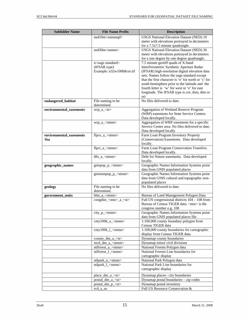
Table 1—Geospatial directory structure and naming conventions
Subfolder Name File Name Prefix Description F:\geodata\ Top folder in the directory structure. The
following are subfolders for major theme categories under the primary geodata folder:
air_quality File naming to be determined.
No files delivered to date.
cadastral plss_a_<stnnn> Public Land Survey System polygon data plss_l_<stnnn> Public Land Survey System boundaries
(township/range/section) for cartographic display.
census block_group_dm_a_ <stnnn>
Dynamap census block groups.
block_groups_a_<stnnn> Demographic block group data tabulated by census geography from Bureau of Census. Other base map TIGER features such as road, hydro etc are in appropriate theme folders.
blocks_a_<stnnn> Demographic block data tabulated by census geography from Bureau of Census.
census_demographic_a_<st> Census county demographic statistics by state census_economic _a_<st> Census county economic statistics by state census_housing _a_<st> Census county housing statistics by state census_social _a_<st> Census county social statistics by state tract_dm_a_<stnnn> Dynamap census tracts. tracts_a_<stnnn> Demographic tract data tabulated by census
geography from Bureau of Census. climate\precipitation precip_a_<st> 'precipitation' is a subfolder of 'climate'.

SCI Std 004-04 STANDARD FOR GEOSPATIAL DATASET FILE NAMING
Draft 14 March 31, 2008
Subfolder Name File Name Prefix Description Annual precipitation (sum of 12 monthly maps) for the entire state. <st> is equal to the state two character postal abbreviation
precip_l_<st> Annual precipitation boundaries for cartographic display for the entire state
precip<mmm>_a_<st> Mean (1961-1990) Monthly precipitation data for the entire state. <mmm> is equal to the three-letter abbreviation for the applicable month
precip<mmm>_l_<st> Monthly precipitation boundaries for the entire state. <mmm> is equal to the three-letter abbreviation for the applicable month
climate\temperature tempmin_a_<st> ‘temperature ‘ is a subfolder of ‘climate’. Minimum average January temperature.
tempmax_a_<st> Maximum average July temperature. tempave_a_<st> Average annual temperature. common_land_unit dlu_a_<stnnn> District Land Unit (DLU) – Farm field
boundary layer. clu_public_a_<stnnn> Common Land Unit (CLU) Farm Field
Boundary with most all attributes removed. For public-not loaded at Service Center.
clu_copy_a _<stnnn> Common Land Unit (CLU) Farm Field Boundary NRCS read-only copy.
common_land_unit\fsa_clu crp_t_<stnnn> CRP data linked to CLU. (May be in the form of converted .dbf files. Would include compliance and crop reporting.)
clu_a_<stnnn> Common Land Unit (CLU) Farm Field Boundary
wet_p_<stnnn> FSA wetland point data conservation_practices File naming to be
determined. Planned and applied conservation practice data aggregated for the Service Center.
cultural_resources File naming to be determined.
Archeology, state historic sites, Native American settlements and burial grounds, National Park Service National Register of Historic Places, National Historic Landmarks and National Natural Landmarks. A general category and no files delivered to date.
disaster_events <disaster type>_a_<stnnn> _ <identifier>
Describes the area (or points if feature type is a ‘p’) affected by a natural disaster, with a unique name or identifier for the event. Disaster type describes whether the event was a flood, storm, etc. The unique event identifier is a date, unless some other identifying code is assigned, such as a version number. State and county can be included depending on the scope of the disaster area.
disaster_events\ fsa_facilities
ffsf_p_<stnnn>_ <yyyymmdd>
Point locations within the county of Food, Feed, and Seed Facilities
ecological File naming to be determined.
No files delivered to date.
elevation contour_l_<stnnn> 1:24,000 USGS hypsography line data contour10_l_<usgsStandard> 10 foot contour lines (without 50, 250 foot) contour50_l_<nnnnnqd> 50 foot contour lines (without 250 foot) contour250_l_<nnnnnqd>
250 foot contour lines
ngs_p_<stnnn>
Point location and description of National Geodetic Survey Monuments
ned03m<nnnnnqd> USGS National Elevation Dataset (NED) 3 meter with elevations portrayed in decimeters for a 7.5x7.5 minute quadrangle
SCI Std 004-04 STANDARD FOR GEOSPATIAL DATASET FILE NAMING
Draft 15 March 31, 2008
Subfolder Name File Name Prefix Description ned10m<nnnnnqd>
USGS National Elevation Dataset (NED) 10 meter with elevations portrayed in decimeters for a 7.5x7.5 minute quadrangle.
ned30m<nnnnn>
USGS National Elevation Dataset (NED) 30 meter with elevations portrayed in decimeters for a one degree by one degree quadrangle.
n<usgs standard> (IFSAR type) Example: n32w100h8cor.tif
7.5 minute geotiff quads of X-band InterFerometric Synthetic Aperture Radar (IFSAR) high-resolution digital elevation data sets. Names follow the usgs standard except that the first character is ‘n’ for north or ‘s’ for south hemisphere prior to the latitude and the fourth letter is ‘w’ for west or ‘e’ for east longitude. The IFSAR type is cor, dsm, dtm or ori
endangered_habitat File naming to be determined.
No files delivered to date.
environmental_easements wrp_a_<st> Aggregation of Wetland Reserve Program (WRP) easements for State Service Centers. Data developed locally.
wrp_a_<stnnn> Aggregation of WRP easements for a specific Service Center area. No files delivered to date. Data developed locally
environmental_easements \fsa
flpce_a_<stnnn> Farm Loan Program Inventory Property (Conservation) Easements. Data developed locally.
flpct_a_<stnnn> Farm Loan Program Conservation Transfers. Data developed locally.
dfn_a_<stnnn> Debt for Nature easements. Data developed locally.
geographic_names gnispop_p_<stnnn> Geographic Names Information Systems point data from GNIS populated places
gnisnonpop_p_<stnnn> Geographic Names Information Systems point data from GNIS cultural and topographic non-populated places
geology File naming to be determined.
No files delivered to date.
government_units blm_a_<stnnn> Bureau of Land Management Polygon Data congdist_<nnn>_a_<st> Full US congressional districts 104 – 108 from
Bureau of Census TIGER data. <nnn> is the congress number e.g. 108
city_p_<stnnn> Geographic Names Information Systems point data from GNIS populated places file
cnty100k_a_<stnnn> 1:100,000 county boundary polygon from Census TIGER data
cnty100k_l_<stnnn> 1:100,000 county boundaries for cartographic display from Census TIGER data.
county_dm_a_<st> Dynamap county boundaries mcd_dm_a_<stnnn> Dynamap minor civil divisions ntlforest_a_<stnnn> National Forests Polygon data ntlforest_l_<stnnn> National Forests Line boundaries for
cartographic display ntlpark_a_<stnnn> National Park Polygon data ntlpark_l_<stnnn> National Park Line boundaries for
cartographic display
place_dm_a_<st> Dynamap places– city boundaries postal_dm_a_<st> Dynamap postal boundaries – zip codes postal_dm_p_<st> Dynamap postal inventory rcd_a_us Full US Resource Conservation &
SCI Std 004-04 STANDARD FOR GEOSPATIAL DATASET FILE NAMING
Draft 16 March 31, 2008
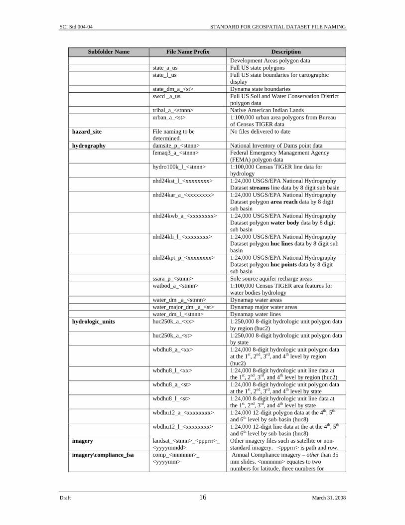
Subfolder Name File Name Prefix Description Development Areas polygon data
state_a_us Full US state polygons state_l_us Full US state boundaries for cartographic
display state_dm_a_<st> Dynama state boundaries swcd _a_us Full US Soil and Water Conservation District
polygon data tribal_a_<stnnn> Native American Indian Lands urban_a_<st> 1:100,000 urban area polygons from Bureau
of Census TIGER data hazard_site File naming to be
determined. No files delivered to date
hydrography damsite_p_<stnnn> National Inventory of Dams point data femaq3_a_<stnnn> Federal Emergency Management Agency
(FEMA) polygon data hydro100k_l_<stnnn> 1:100,000 Census TIGER line data for
hydrology nhd24kst_l_<xxxxxxxx> 1:24,000 USGS/EPA National Hydrography
Dataset streams line data by 8 digit sub basin nhd24kar_a_<xxxxxxxx> 1:24,000 USGS/EPA National Hydrography
Dataset polygon area reach data by 8 digit sub basin
nhd24kwb_a_<xxxxxxxx> 1:24,000 USGS/EPA National Hydrography Dataset polygon water body data by 8 digit sub basin
nhd24kli_l_<xxxxxxxx> 1:24,000 USGS/EPA National Hydrography Dataset polygon huc lines data by 8 digit sub basin
nhd24kpt_p_<xxxxxxxx> 1:24,000 USGS/EPA National Hydrography Dataset polygon huc points data by 8 digit sub basin
ssara_p_<stnnn> Sole source aquifer recharge areas watbod_a_<stnnn> 1:100,000 Census TIGER area features for
water bodies hydrology water_dm _a_<stnnn> Dynamap water areas water_major_dm _a_<st> Dynamap major water areas water_dm_l_<stnnn> Dynamap water lines hydrologic_units huc250k_a_<xx> 1:250,000 8-digit hydrologic unit polygon data
by region (huc2) huc250k_a_<st> 1:250,000 8-digit hydrologic unit polygon data
by state wbdhu8_a_<xx> 1:24,000 8-digit hydrologic unit polygon data
at the 1st, 2nd, 3rd, and 4th level by region (huc2)
wbdhu8_l_<xx> 1:24,000 8-digit hydrologic unit line data at the 1st, 2nd, 3rd, and 4th level by region (huc2)
wbdhu8_a_<st> 1:24,000 8-digit hydrologic unit polygon data at the 1st, 2nd, 3rd, and 4th level by state
wbdhu8_l_<st> 1:24,000 8-digit hydrologic unit line data at the 1st, 2nd, 3rd, and 4th level by state
wbdhu12_a_<xxxxxxxx>
1:24,000 12-digit polygon data at the 4th, 5th and 6th level by sub-basin (huc8)
wbdhu12_l_<xxxxxxxx> 1:24,000 12-digit line data at the at the 4th, 5th and 6th level by sub-basin (huc8)
imagery landsat_<stnnn>_<ppprrr>_ <yyyymmdd>
Other imagery files such as satellite or non-standard imagery. <ppprrr> is path and row.
imagery\compliance_fsa comp_<nnnnnnn>_ <yyyymm>
Annual Compliance imagery – other than 35 mm slides. <nnnnnnn> equates to two numbers for latitude, three numbers for

SCI Std 004-04 STANDARD FOR GEOSPATIAL DATASET FILE NAMING
Draft 17 March 31, 2008
Subfolder Name File Name Prefix Description longitude and two numbers for the 01 to 64 quadrangle numbers in the one degree block
<a><nnnnnnn>_<qd>_<r>_ <yyyymmdd>
USDA National Agricultural Imagery Program two meter (<r>=2) quarter quads in GeoTIFF format (.tif). <a> is leading character set to ‘n’ for natural color. <nnnnnnn>, is two numbers for latitude, three numbers for longitude and two numbers for the 01 to 64 quadrangle number in the one degree block. <qd> is quarter quadrant. <yyyymmdd> is image date.
naip_<x-x>_2<n>_<f>_ <stnnn>_<yyyy>_<v>
USDA National Agricultural Imagery Program county mosaic of quarter quads. Two meter inspected and approved. <x-x> is number-total tiles in county mosaic. File extension of MrSID image is .sid. One meter maps are named ortho in the ‘ortho’ folder
slides_<stnnn>_<fffeee> _<yyyymm>
Scanned 35mm or digital slides. <fffeee> is the flight and exposure number. Example: slides_va013_048009_200207.tif
slides_<stnnn>_t<nn>_ r<nn>_ s<nn>_<yyyymm>
Scanned 35mm or digital slides. t<nn> is township, r<nn> is range, s<nn> is section. Example: slides_mn013_t34_r26_s15_200207.tif
landmarks airport_dm_a_<st> Dynamap airports institution_dm_p_<stnnn> Dynamap institutions landmark_dm_a_<stnnn> Dynamap area landmarks park_dm_a_<stnnn> Dynamap parks recarea_dm_p_<stnnn> Dynamap recreation areas retail_dm_p_<stnnn> Dynamap retail locations transterm_dm_p_<st> Dynamap transportation terminals land_site aboveground_storage_p
_<stnnn> County coverage of the location points of aboveground storage facilities. Any kind of storage or particular types of storage
housing_p_<stnnn> Location points for instances of housing developments and/or foreclosures, within a county
lagoon_p_<stnnn> Location points for lagoons and similar areas in a county
livestock_facility_p_ <stnnn>
Location points of feedlots, poultry facilities, etc. within a county
stackyd_a_<stnnn> Polygons of stackyards for hay/silage storage in a county
storage_p_<stnnn> Location points for grain bins and similar facilities in a county
underground_storage_p _<stnnn>
County coverage of the location points of underground storage facilities
well_p_<stnnn> Point data for locating well heads within a county
land_use_land_cover cdl_awifs_r_<st>_<yyyy> cdl_tm_r_<st>_<yyyy>
NASS cropland data layer classified image from either the awifs or tm platform.
cdlinfo_awifs_j_<st>_<yyyy> cdlinfo_tm_j_<st>_<yyyy>
NASS cropland data layer analysis areas raw image from either the awifs or tm platform.
lulc_a_<stnnn> Polygon data of the USGS Land Use Land Cover
nonveg_a_<stnnn> 1:24,000 USGS non-vegetative polygon data (sand area, beach, gravel beach, etc.)
nlcd_<st>_utm<nn> 30 meter USGS/EPA National Land Cover Dataset raster data. The dataset is available in multiple UTM zones for states in more than

SCI Std 004-04 STANDARD FOR GEOSPATIAL DATASET FILE NAMING
Draft 18 March 31, 2008
Subfolder Name File Name Prefix Description one zone
surfcvr_a_<stnnn> 1:24,000 USGS surface cover polygon data (woods, brush, orchard, etc.)
strata_a_<st> NASS area sampling frame aggregate breakdown of land use
File naming to be determined.
Vegetation distribution, etc.
land_use_land_cover\ fsa_compliance
crl_a_<stnnn>_<yyyy> Acreage reporting data created by FSA’s Crop Reporting Tool (an R&D tool). Data is created locally for each farm, then merged into one county file. Is used in SC with CLU
land_use_a_<stnnn> Commodity (acreage) reporting data created by the FSA Land Use pilot application. Will be run in only three counties in 2002 using SQL Server. Up to ten years of data is kept in one file – not an annual file.
land_use_d_<stnnn> Commodity (acreage) reporting data created by the FSA Land Use pilot application. Will be run in only three counties in 2002 using SQL Server. All polygon data is kept in one file – not an annual file
map_indexes napp_p_<stnnn> National Aerial Photography Program (NAPP) point data
quads12k_a_<stnnn> 1:12,000 quarter quad polygon data quads20k_a_<stnnn> 1:20,000 7.5x7.5 quad polygons quads24k_a_<stnnn> 1:24,000 7.5x7.5 quad polygons quads25k_a_<stnnn> 1:25,000 7.5x7.5 and 7.5x15 quad polygons quads63k_a_<stnnn> 1:63,360 15x15 quad polygons quads100k_a_<st> 1:100,000 30x60 quad polygons quads30m_a_<st> 30 minute NED quad polygons for ned10m quads1deg_a_<st> One degree NED quad polygons for ned30m quads250k_a_<st> 1:250,000 one degree by two degree quad
polygons measurement_services meas_service_a_
<stnnn>_<yyyy>
Yearly file for all area measurement services
ortho_imagery highres<x-x>_<f>_<stnnn> NRCS or NCGC county ortho mosaic from high resolution (less than one meter) imagery of mixed film type. <x-x> is number-total tiles in county mosaic. File extension of .sid depicts a MrSID image, while file extension of .ecw depicts an ERMapper image.
highres<x-x>_<n>_<f>_ <stnnn>_<yyyy>
NRCS or NCGC county ortho mosaic from high resolution imagery (less than one meter). <x-x> is number-total tiles in county mosaic. File extension of .sid depicts a MrSID image, while file extension of .ecw depicts an ERMapper image.
highres_p<x-x>_<n>_<f>_ <stnnn>_<yyyy>
high resolution proprietary imagery (less than one meter). <x-x> is number-total tiles in county mosaic. File extension of .sid depicts a MrSID image.
ortho_<x-x>_<r><n>_<f>_ <stnnn>_<yyyy><v>
USDA National Agricultural Imagery Program compressed county mosaic of quarter quads. One meter (<r>=1) inspected and approved. <x-x> is number-total tiles in county mosaic. File extension of MrSID image is .sid.
ortho_e<x-x>_<f>_ <stnnn>
APFO MrSID county ortho mosaic of enhanced MDOQ. <x-x> is number-total tiles

SCI Std 004-04 STANDARD FOR GEOSPATIAL DATASET FILE NAMING
Draft 19 March 31, 2008
Subfolder Name File Name Prefix Description in county mosaic. File extension of MrSID image is .sid.
ortho<x-x>_1<n>_<f>_ <stnnn>_<yyyy>
One meter ortho imagery with .06 meter to two foot resolution.
ortho<x-x>_<f>_<stnnn> NCGC or NRCS county ortho mosaic of DOQQ. <x-x> is the number of total tiles in county mosaic. File extension of .sid depicts a MrSID image, while file extension of .ecw depicts an ERMapper image.
ortho_<st>_<f>_<nnnnnn> NRCS field office multi-county service area (defined in Office Information Profile database as the NRCS OIP office ID) ortho mosaic. File extension of MrSID image is .sid.
<a><nnnnnnn>_<qd>_ <yyyymmdd>
USGS DOQQ –Raster format (.bil, .bsq, .bip). <a> is leading character either ‘o’ for black and white or ‘c’ for color infra red. <nnnnnnn>, two numbers for latitude, three numbers for longitude and two numbers for the 01 to 64 quadrangle number in the one degree block. <qd> is quarter quadrant. <yyyymmdd> is image date.
<a><nnnnnnn>_ <yyyymmdd>
APFO DOQ .tif image. <a><nnnnnnn> is leading character, two numbers for latitude, three numbers for longitude and two numbers for the 01 to 64 quadrangle number in the one degree block. <yyyymmdd> date is optional. Leading character <a> can be: m – all DOQQs present and reside in native UTM zone x – there is a missing DOQQ in the DOQ z – re-projected DOQ into dominant county UTM zone.
<a><nnnnnnn>_<qd>_<r>_ <yyyymmdd>
USDA National Agricultural Imagery Program one meter (<r>=1) quarter quads in GeoTIFF format (.tif). <a> is leading character set to ‘n’ for natural color. <nnnnnnn>, is two numbers for latitude, three numbers for longitude and two numbers for the 01 to 64 quadrangle number in the one degree block. <qd> is quarter quadrant. <yyyymmdd> is image date.
<a><nnnnn> <-A#> ADS40 Huricane 7.5’ quad MrSid mosaic. Note name is inconsistent with standard upper case and dashes. <a> K_ R_ W_ Katrina, Rita, Wilma <nnnnn> two numbers for latitude, three numbers for longitude <-A#> upper case A-H row and # 1-8 column in one degree
project_data Subfolders for agency-specific data that does not fit under the major geodata theme subfolders. Subfolders for each agency or organization may be created as needed.
project_data\fsa File naming to be determined project_data\nrcs File naming to be determined project_data\rd chattel_p_ <stnnn> Known location points for customer-owned,
moveable property, in a county. Multiple assets may be linked to a point
chattel_y_<stnnn> <sequence_number>
Photographs associated with the customer chattel points file. If multiple photos, they can

SCI Std 004-04 STANDARD FOR GEOSPATIAL DATASET FILE NAMING
Draft 20 March 31, 2008
Subfolder Name File Name Prefix Description be distinguished with a sequence number, or other identifying information.
project_data\rcd File naming to be determined Resource Conservation District project_data\swcd File naming to be determined Soil and Water Conservation District public_utilities File naming to be
determined.
soils crpdata_d_<stssaid> NOT A MAP-Excel spreadsheet with 1990 frozen soils data used for Conservation Reserve Program (CRP) eligibility determinations. <stssaid> State Soil Survey Area ID number (e.g., crpdata_d_ca048.xls)
cra_a_<st> Full US Polygon data of Common Resource Areas (CRA) inside, crossing or touching state
mlra_a_<st> Polygon data of Major Land Resource Areas (MLRA)
ssa_a_<stssaid> Polygon data limit of Soil Survey Area (SSA) /soil__<stssaid>/tabular soil_d_ <stssaid> Suggested name for a SSURGO template
database when the database contains only one survey area.
/soil__<stssaid>/spatial soilsa_a_<stssaid> Soil survey area boundary polygons /soil__<stssaid>/spatial soilmu_a_<stssaid> Soil map unit boundary polygons /soil__<stssaid>/spatial soilmu_l_<stssaid> Soil line map units /soil__<stssaid>/spatial soilmu_p_<stssaid> Soil point map units /soil__<stssaid>/spatial soilsf_l_<stssaid> Soil line spot features /soil__<stssaid>/spatial soilsf_p_<stssaid> Soil point spot features /soil__<stssaid>/spatial soilsf_t_<stssaid> Soil spot features description /soil__< nnnnnn>/tabular soilmosaic_d_<nnnnnn> Merged attribute data for more than one soil
survey area to support service center area of service. <nnnnnn > is the OIP office ID not OIP site ID
/soil__< nnnnnn>/spatial soilmosaicsa_a_<nnnnnn> Merged soil survey area boundary polygons for more than one soil survey area to support service center area of service. <nnnnnn > is the NRCS OIP office ID not OIP site ID
/soil__< nnnnnn>/spatial soilmosaicmu_a_<nnnnnn> Merged soil map unit boundary polygons for more than one soil survey area to support service center area of service. <nnnnnn > is the NRCS OIP office ID not OIP site ID
/soil__< nnnnnn>/spatial soilmosaicmu_l_<nnnnnn> Merged line map units for more than one soil survey area to support service center area of service. <nnnnnn > is the NRCS OIP office ID not OIP site ID
/soil__< nnnnnn>/spatial soilmosaicmu_p_<nnnnnn> Merged point map units for more than one soil survey area to support service center area of service. <nnnnnn > is the NRCS OIP Office ID not OIP site ID
/soil__< nnnnnn>/spatial soilmosaicsf_l_<nnnnnn> Merged line spot features for more than one soil survey area to support service center area of service. <nnnnnn > is the NRCS OIP Office ID not OIP site ID
/soil__< nnnnnn>/spatial soilmosaicsf_p_<nnnnnn> Merged point spot features for more than one soil survey area to support service center area of service. <nnnnnn > is the NRCS OIP Office ID not OIP site ID
/soil__< nnnnnn>/spatial soilmosaicsf_t_<nnnnnn> Merged spot feature descriptions for more than one soil survey area to support service center area of service. <nnnnnn > is the NRCS OIP Office ID not OIP site ID
topographic_images drg_<stnnn> County mosaic MrSID of 1:20K, 1:24K, 1:25K Digital Raster Graphs without map

SCI Std 004-04 STANDARD FOR GEOSPATIAL DATASET FILE NAMING
Draft 21 March 31, 2008
Subfolder Name File Name Prefix Description collar. File extension of MrSID image is .sid.
drg_<st><nnnnnn> NRCS field office multi-county service area (defined in Office Information Profile database as the NRCS Office ID) DRG mosaic. File extension of MrSID image is .sid.
<usgs standard>_<yyyy> Enhanced DRG image with map collar removed. Map content date <yyyy> is optional for more than one set. The following characters are used in the usgs standard: r – 1:20,000, 7.5’ x 7.5’ topographic map image o – 1:24,000, 7.5’ x 7.5’ topographic map image p – 1:24,000, 7.5’ x 7.5’ provisional/orthophoto map image l – 1:25,000 7.5’ x 7.5’ topographic map image j – 1:30,000, 7.5’ x 7.5’ topographic map image k – 1:25,000, 7.5’ x 15’ topographic map image i – 1:63,360, Alaska topographic map image g – 1:100,000, 30’ x 60’ planimetric map image f – 1:100,000, 30’ x 60’ topographic map image c – 1:250,000, 1 x 2 degree topographic map image
transportation highway_dm_l_<stnnn> Dynamap highways misctrans100k_l_<stnnn> 1:100,000 Census TIGER line data for
pipelines, power transmission lines, etc. railroad_dm_l_<stnnn> Dynamap railroads railroads100k_l_<stnnn> 1:100,000 Census TIGER line data for
railroad layer roads100k_l_<stnnn> 1:100,000 Census TIGER roads line data street_dm_l_<stnnn> Dynamap streets wetlands nwi_a_<stnnn> Polygon data of the National Wetland
Inventory (NWI) Fish and Wildlife Service (FWS)
nwilfetr_l_<stnnn> Linear Features line data of the NWI nwi_l_<stnnn> Outlines of the NWI polygon data for
cartographic display nwi_p_<stnnn> Point data of the NW I
wetland_l_<stnnn> Boundaries of natural or constructed wetlands, by county.
wildlife File naming to be determined.
No files delivered to date.
zoning File naming to be determined.
No files delivered to date.
As needed, the following subfolders can be added as an additional layer of subfolders under each of the major geodata theme folders: gps_data
<subject>_xd_<stnnn>_ <yyyymmdd>
A file of GPS points downloaded from a GPS instrument. The data in this file is kept in its original GPS-specific format. The subject describes what the data represents, i.e.

SCI Std 004-04 STANDARD FOR GEOSPATIAL DATASET FILE NAMING
Draft 22 March 31, 2008
“Grain Bins”. If this GPS data is imported into a GIS system, the resulting file would have a different feature type, i.e. ‘p’ if it is saved as a point data GIS file.
photographs
<identifier>_y_<yyyymmdd>_ <sequence number>
<Identifier> = the basic content of the photo, i.e. “Grain Bins on Smith Farm”. Date indicates when the photo was taken. If multiple pictures were taken, a sequence number (i.e. 1, 2, 3) can be added to give each photo a unique name.
year identifier>_<yyyy> To identify data from different years?
SCI Std 004-04 STANDARD FOR GEOSPATIAL DATASET FILE NAMING
Draft 23 March 31, 2008
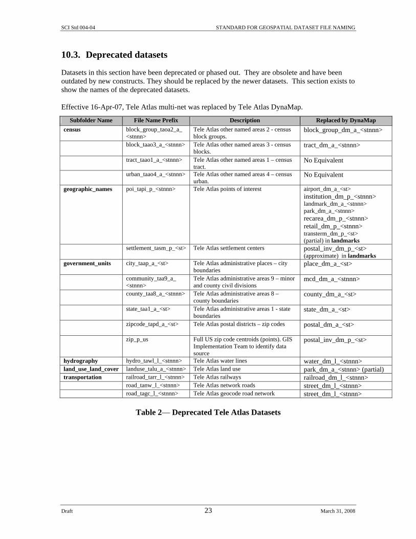
10.3. Deprecated datasets
Datasets in this section have been deprecated or phased out. They are obsolete and have been outdated by new constructs. They should be replaced by the newer datasets. This section exists to show the names of the deprecated datasets. Effective 16-Apr-07, Tele Atlas multi-net was replaced by Tele Atlas DynaMap.
Table 2— Deprecated Tele Atlas Datasets
Subfolder Name File Name Prefix Description Replaced by DynaMap census block_group_taoa2_a_
<stnnn> Tele Atlas other named areas 2 - census block groups.
block_group_dm_a_<stnnn>
block_taao3_a_<stnnn> Tele Atlas other named areas 3 - census blocks.
tract_dm_a_<stnnn>
tract_taao1_a_<stnnn> Tele Atlas other named areas 1 – census tract.
No Equivalent
urban_taao4_a_<stnnn> Tele Atlas other named areas 4 – census urban.
No Equivalent
geographic_names poi_tapi_p_<stnnn> Tele Atlas points of interest airport_dm_a_<st> institution_dm_p_<stnnn> landmark_dm_a_<stnnn> park_dm_a_<stnnn> recarea_dm_p_<stnnn> retail_dm_p_<stnnn> transterm_dm_p_<st> (partial) in landmarks
settlement_tasm_p_<st> Tele Atlas settlement centers postal_inv_dm_p_<st> (approximate) in landmarks
government_units city_taap_a_<st> Tele Atlas administrative places – city boundaries
place_dm_a_<st>
community_taa9_a_ <stnnn>
Tele Atlas administrative areas 9 – minor and county civil divisions
mcd_dm_a_<stnnn>
county_taa8_a_<stnnn> Tele Atlas administrative areas 8 – county boundaries
county_dm_a_<st>
state_taa1_a_<st> Tele Atlas administrative areas 1 - state boundaries
state_dm_a_<st>
zipcode_tapd_a_<st> Tele Atlas postal districts – zip codes postal_dm_a_<st>
zip_p_us Full US zip code centroids (points). GIS Implementation Team to identify data source
postal_inv_dm_p_<st>
hydrography hydro_tawl_l_<stnnn> Tele Atlas water lines water_dm_l_<stnnn> land_use_land_cover landuse_talu_a_<stnnn> Tele Atlas land use park_dm_a_<stnnn> (partial) transportation railroad_tarr_l_<stnnn> Tele Atlas railways railroad_dm_l_<stnnn> road_tanw_l_<stnnn> Tele Atlas network roads street_dm_l_<stnnn> road_tagc_l_<stnnn> Tele Atlas geocode road network street_dm_l_<stnnn>

SCI Std 004-04 STANDARD FOR GEOSPATIAL DATASET FILE NAMING
Draft 24 March 31, 2008
Effective 16-Apr-07, ESRI grid format National Elevation data was replaced by NED geoTIFF. In addition, ASCII DEM format datasets are no longer used because the quality of NED is far superior. As previously available in the Gateway, the dataset is provided in essentially two resolutions. The first is the 10 meter or better database that is 10 meters, 5 meters, 1/3 arc-second, 1/9 arc-second. The second is the 30 meter ~1 arc-second data that is updated over large areas by integrating 10 meter source data (where available) , re-sampled to ~1 arc-second. The http://seamless.usgs.gov/ allows you to select 10 meter NED that is re-sampled from 30 meter. Available here is only true 10 meter NED or better. There are some important changes from what was previously distributed:
• The datasets are in GeoTIFF format instead of ESRI Grid • The NED 10 datasets are now 7.5 x 7.5 minute quadrangles instead of 30x60. • The datasets have pyramids generated and statistics calculated. • There is no longer a need to distribute “nedshd10m _<nnnnnqd>” or “nedshd30m
_<nnnnn>“shaded relief datasets since they can be easily generated from the GeoTIFF with Spatial Analyst.
• There is no longer a need to distribute “nez30m _<nnnnn>“or “nezshd30m _<nnnnn>” datasets for the one degree overlap at the UTM zone boundary because of “re-projecting on the fly”.
• There is no longer a need to distribute the “nedmeta10m_<nnnnnqd>“ shape files of 10 meter individual quadrangles that compose the 10 Meter NED because the 10 meter NED is a 7.5x7.5 minute quad with 10 meters, 5 meters, 1/3 arc-second, 1/9 arc-second resolution.
• The new datasets are “ned10m<nnnnnqd>” and “ned30m<nnnnnqd>” instead of “ned10m_<nnnnnqd>” and “ned30m_<nnnnnqd>” to allow you to recognize the older version of NED datasets.
Subfolder Name File Name Prefix Description Replaced by elevation ned10m_<nnnnnqd>
1:24,000 USGS National Elevation Dataset (NED) 10 meter with elevations portrayed in decimeters. Sixteen 7.5 minute quadrangles packaged into a 30 minute by 30 minute block archive. Where each block is an ArcInfo workspace containing 7.5 minute data.
ned10m<nnnnnqd>
ned30m_<nnnnn>
1:24,000 USGS National Elevation Dataset (NED) 30 meter merged into a one-degree seamless raster format with elevations portrayed in decimeters.
ned30m<nnnnn>
nez30m _<nnnnn>
Reprojected 1:24,000 USGS National Elevation Dataset (NED) 30 meter from adjacent UTM zone merged into one-degree block
ned30m<nnnnn>

SCI Std 004-04 STANDARD FOR GEOSPATIAL DATASET FILE NAMING
Draft 25 March 31, 2008
Table 3— Deprecated Elevation Datasets
nedshd10m
_<nnnnnqd>
1:24,000 USGS National Elevation Dataset (NED) 10 meter merged into a 30 minute by 30 minute seamless shaded relief TIFF format.
ned10m<nnnnnqd>
nedshd30m _<nnnnn>
1:24,000 USGS National Elevation Dataset (NED) 30 meter merged into a one-degree seamless shaded relief TIFF format.
ned30m<nnnnn>
nezshd30m _<nnnnn> Reprojected 1:24,000 USGS National Elevation Dataset (NED) 30 meter from adjacent UTM zone merged into a one-degree seamless shaded relief TIFF format.
ned30m<nnnnn>
nedmeta10m_<nnnnnqd>
1:24,000 USGS National Elevation Dataset (NED) 10 meter metadata shape files for the individual quadrangles that compose the ned.
ned10m<nnnnnqd>
nedmeta30m_<nnnnn>
1:24,000 USGS National Elevation Dataset (NED) 30 meter metadata shape files for the individual quadrangles that compose the ned.
ned30m<nnnnn>
nezmeta30m_<nnnnn> Reprojected 1:24,000 USGS National Elevation Dataset (NED) 30 meter metadata shape files from adjacent UTM zone for the individual quadrangles that compose the ned.
ned30m<nnnnn>
<usgs standard> USGS Digital Elevation Model (DEM) ASCII file. USGS standard lat/long name with a “d” leading character. File extension is .dem
ned10m<nnnnnqd>

SCI Std 004-04 STANDARD FOR GEOSPATIAL DATASET FILE NAMING
Draft 26 March 31, 2008
Appendix A − Bibliography When the following standards are superseded by an approved revision, the revision shall apply. [A1] Geospatial Data Acquisition, Integration, and Delivery National Implementation Strategy
Plan, Draft #4 Service Center Business Process Reengineering Data AID Team, September 22, 1999
http://www.itc.nrcs.usda.gov/scdm/docs/SPG-GeospatialDataAIDNationalStrategyPlan.pdf [A2] SCMI Std 003, Standard for Geospatial Data Set Metadata
http://www.itc.nrcs.usda.gov/scdm/docs/SPG-GeospatialDatasetFileMetadata.pdf [A3] SCMI Std 005, Standard for Geospatial Feature Metadata [A4] SCMI Std 007, Standard for Geospatial Data
http://www.itc.nrcs.usda.gov/scdm/docs/SPG-GeospatialDataStandard.pdf [A5] USDA Service Center Geographic Information System (GIS) Strategy,
Interagency Team, August 18, 1998 [A6] USDA Service Center Initiative Directory Structure and File Naming Convention Change
Control Policy, Initial Draft, IO Lab, October 8, 1999 http://www.itc.nrcs.usda.gov/scdm/docs/SPG-
DirectoryStructureand%20FileNamingConventionChangeControlPolicy.pdf [A7] Manual for Managing Geospatial Datasets in Service Centers, AFY00.60000-00.UA0-
SCM, February 2003 http://www.itc.nrcs.usda.gov/scdm/docs/SPG-ManualforManagingGeospatialDataSetsinServiceCenters.pdf