standard template for evaluation of all...
TRANSCRIPT

STANDARD TEMPLATE FOR EVALUATION OF ALL PROJECTS/ ACTIVITIESS.No Information required Information to be furnished by the
proponents1 Name of the project or activity Sri K. Devarajulu Reddy – Colour
Granite Quarry2 Name of the organization/owner. Sri K. Devarajulu Reddy3 Address for communication Sri K. Devarajulu Reddy
Door No. 2-1118,Lakshmi Nagar Colony,ChittoorMobile No: +91 81063 19759.
4 Telephone numbers Phone: +91 81063 197595 Email ID of the organization or contact person6 Location of the Proposed project or activity Survey No. 53, Devalampeta Village,
Vedurukuppam Mandal,Chittoor District, Andhra Pradesh
7 Appraisal Category (B2 or B1) B2
8 Nearest habitation and distance from theproject or activity
Tellagundlapalli Village – 1.7km –SW direction
9 Installed capacity / Production Capacities Semi mechanized open castquarrying for color graniteproduction of 724 m3/annum.
10 Specify the Fuel (Coal / CNG /biomass/Others) and quantity required
NA
11 Details of Land use/Land Cover Small mound raising to a height ofabout 20m with boulders fromground level. The granite sheet rockis well exposed without any overburden
12 Occupancy, ownership of the land in whichthe activity is proposed:(Government land / Private land / Forest land/Revenue land /Temple land /leased land/land belongs to other Department)
Government land, Quarry leasegranted orders from The AssistantDirector of Mines and Geology,Chittoor, Government of AndhraPradesh vide Proceedings No.5717/Q/2002 dated 12-08-2004.
13 If it is a Forest land, the following details shallbe furnished:(Whether it is a Reserved forest / Protectedforest/Demarcated forest/ NationalParks/Sanctuaries/any land in possession ofForest Department.)(The village map with Sy. No. indicatingnearest forest boundary line from the siteshall be enclosed)
NA, the applied area is a Govt. Land.
14 Total investment of the project/activity. Rs. 12 Lakhsa. Funds allocated for EMP (capital cost and Capital Cost - Rs. 3.36 Lakhs/year

recurring cost per annum) Recurring cost - Rs. 1.34 Lakhs/year15 Brief description of the project with special
reference to specific pollution and its controlmeasures.
Semi mechanized open castquarrying by using compressoroperated jack hammer drills,excavators and wedge cutting etc.
16 Compliance report on the following :Status of compliance of the conditions andenvironmental safeguards stipulated in theearlier clearance letters.
NA. QL area is 1.0 Ha, applying forenvironmental clearance as perHon’ble supreme court judgmentand MoE&F office memorandum.
Details of the court cases, if any, pending inany Court of Law against the project as well asany directions passed by the Court relating tothe project directly or indirectly.
No court case is pending.
Details of the notices, if any, given to theproject under Section 5 of the Environmental(Protection) Act, 1986 and Section 18 of theAir (Prevention & Control of Pollution) Act,1981.
There is no notice received (QL areais 1.0 Ha).
17 Whether the project attracts the provisionslaid under the OM dt. 16.11.2010 issued bythe MoE&F, GOI, w.r.t. violation of EIANotification, 2006 and its amendments thereof? (Yes / No)
No, QL area is 1.0 ha (<5ha).
Present stage and status of the Project: 724 m3 of granite blocks recoveredfrom 2004 to 2011 and it is non-working now.
18 Name of the Consultant: M/s. Team Labs and Consultants,B115, 116, 117 & 509, AdityaEnclave, Ameerpet, Hyderabad -500 038


K. DEVARAJULU REDDYSURVEY NO. 53, DEVALAMPETA VILLAGE,
VEDURUKUPPAM MANDAL, CHITTOOR DISTRICT,ANDHRA PRADESH
SEMI MECHANISED OPEN CAST COLOR GRANITE QUARRY
I FORM 1II ENVIRONMENT MANAGEMENT PLANIII APPROVED MINING PLAN
SUBMITTED BYSri K. Devarajulu ReddyDoor No. 2-1118,Lakshmi Nagar Colony,ChittoorMobile No: +91 81063 19759
STUDIES AND DOCUMENTATION BYTEAM Labs and ConsultantsB-115,116,117 & 509, Annapurna Block,Aditya Enclave, Ameerpet,Hyderabad-500 038Phone: 040-23748 555/616,Tele fax: 040-23748666Email: [email protected]
SUBMITTED TOSTATE LEVEL ENVIRONMENTAL IMPACT ASSESSMENT AUTHORITY
ANDHRA PRADESHGOVERNMENT OF INDIA

K. DEVARAJULU REDDYSURVEY NO. 53, DEVALAMPETA VILLAGE,
VEDURUKUPPAM MANDAL, CHITTOOR DISTRICT,ANDHRA PRADESH
FORM I(SEMI MECHANISED OPEN CAST COLOUR GRANITE QUARRY)
SUBMITTED BYSri K. Devarajulu ReddyDoor No. 2-1118,Lakshmi Nagar Colony,ChittoorMobile No: +91 81063 19759
STUDIES AND DOCUMENTATION BYTEAM Labs and ConsultantsB-115,116,117 & 509, Annapurna Block,Aditya Enclave, Ameerpet,Hyderabad-500 038Phone: 040-23748 555/616,Tele fax: 040-23748666Email: [email protected]
SUBMITTED TOSTATE LEVEL ENVIRONMENTAL IMPACT ASSESSMENT AUTHORITY
ANDHRA PRADESHGOVERNMENT OF INDIA

K. Devarajulu Reddy Form-1
F-1
APPENDIX I(See paragraph – 6)
FORM 1(I) Basic InformationS. No Item Details
1 Name of the Project/s Sri K. Devarajulu Reddy2 S. No in the Schedule 1(a)3 Proposed capacity/area/length/tonnage to be
handled/command area/lease area/number of wells tobe drilled
Quarry lease area is 1.0ha (Semimechanized open cast method forcolour granite production of 724m3/annum).
Capital cost estimated for the project Rs. 12 Lakhs.4 New/Expansion/Modernization Existing quarry (<5Ha), lease
granted in the year 2004.5 Existing Capacity/Area etc. 713.22 m3 of granite blocks
recovered during 2004-2011.6 Category of Project i.e 'A' or 'B' B (Quarry lease area: 1.0 Ha)7 Does it attract the general condition? If yes, please
specifyNo
8 Does it attract the Specific condition? If yes, pleasespecify.
No
9 LocationPlot/Survey/Khasra No. 53Village DevalampetaTehsil VedurukuppamDistrict ChittoorState Andhra Pradesh
10 Nearest railway station/airport along with distance inkms.
Railway Station: Chittoor – 22.5km-Southwest,Airport: Renigunta – 42.5km-NE
11 Nearest Town, City, District Headquarters along withdistance in kms.
Chittoor – 22.5Km-SW.
12 Village Panchayats, Zilla Parishad, MunicipalCorporation, Local body (complete postal address withtelephone nos. to be given)
Village Panchayat: Devalampeta -517167, Zilla Parishad: Chittoor
13 Name of the Applicant Sri K. Devarajulu Reddy14 Registered Address Sri K. Devarajulu Reddy
Door No. 2-1118,Lakshmi Nagar Colony,ChittoorMobile No: +91 81063 19759
15 Address for Correspondence:Name Sri K. Devarajulu ReddyDesignation(Owner/Partner/CEO) Lessee

K. Devarajulu Reddy Form-1
F-2
Address Sri K. Devarajulu ReddyDoor No. 2-1118,Lakshmi Nagar Colony,ChittoorMobile No: +91 81063 19759
Pin Code 517 001E-mailTelephone Number +91 81063 19759Fax No. +91 40-23748 666
16 Details of alternative Sites examined, if any. Location ofthese sites should be shown on a topo sheet.
Village-District-State –-NA –Site specific project i.e. quarrying.
17 Interlinked Projects No.18 Whether separate application of interlinked project has
been submitted?No.
19 If yes, date of submission NA.20 If no, reason NA.21 Whether the proposal involves approval/clearance
under: if yes, details of the same and their status to begiven.(a) The Forest (Conservation) Act, 1980?(b) The Wildlife (Protection) Act, 1972?(c) The C.R.Z Notification, 1991?
No
22 Whether there is any Government Order/Policyrelevant/relating to the site?
Yes – Quarry lease granted ordersfrom The Assistant Director ofMines and Geology, Chittoor,Government of Andhra Pradeshvide Proceedings No.5717/Q/2002 dated 12-08-2004
23 Forest land involved (hectares) No24 Whether there is any location pending against the
project and /or land in which the project is propose tobe set up?(a) Name of the Court(b) Case No(c) Orders/directions of the Court, if any and itsrelevance with the proposed project.
No

K. Devarajulu Reddy Form-1
F-3
(II) Activity1. Construction, operation or decommissioning of the Project involving actions, which
will cause physical changes in the locality (topography, land use, changes in waterbodies, etc.)
S. No. Information/Checklistconfirmation
Yes/No Details thereof (with approximatequantities /rates, wherever possible) withsource of information data
1.1 Permanent or temporarychange in land use, land coveror topography includingincrease in intensity of landuse (with respect to localland use plan)
NO The quarry lease area is 1.0ha and it is asmall mound raising to a height of about20m with boulders from ground level. Theproposed activity is semi mechanized opencast colour granite quarrying. The activequarrying area is 0.2625 ha.
1.2 Clearance of existing land,vegetation and buildings?
YES Small mound rising to a height of about 20mwith boulders from ground level, leaseobtained from Government of AP in theyear 2004. No major construction is done.
1.3 Creation of new land uses? NO1.4 Pre-construction investigations
e.g. bore houses, soil testing?YES Survey completed, based on the soil quality
office cum rest shelter, toilets and first aidroom will be constructed.
1.5 Construction works? YES Construction activity involves office cumrest shelter, toilets and first aid room.
1.6 Demolition works? NO1.7 Temporary sites used for
construction works or housingof construction workers?
NO Local villagers shall be employed.
1.8 Above ground buildings,structures or earthworksincluding linear structures, cutand fill or excavations
YES Above ground building for the mine officeonly. No major excavation activity involved.
1.9 Underground works includingmining or tunneling?
YES The present method of mining is semimechanized open cast method for colourgranite.
1.10 Reclamation works? YES Waste consisting of top soil will be utilizedfor backfilling, soil amelioration andafforestation.
1.11 Dredging? NO1.12 Offshore structures? NO1.13 Production and manufacturing
processes?YES Semi mechanized open cast quarrying by
using compressor operated jack hammerdrills, excavators and dumper etc.(Annexure I)
1.14 Facilities for storage of goodsor materials?
NO

K. Devarajulu Reddy Form-1
F-4
1.15 Facilities for treatment ordisposal of solid waste orliquid effluents?
YES During the five years plan period about26530 m3 of waste material will begenerated. This waste will be dumped inNorthwestern side in an area of 0.354 toheight of 30m and dumps will be stabilizedby the retaining wall. (Annexure IV)
1.16 Facilities for long term housingof operational workers?
NO Local villagers shall be employed.
1.17 New road, rail or sea trafficduring construction oroperation?
NO No major construction involves, the numberof truck trips during operation is 1 in tendays.
1.18 New road, rail, air waterborneor other transportinfrastructure including new oraltered routes and stations,ports, airports etc?
NO
1.19 Closure or diversion of existingtransport routes orinfrastructure leading tochanges in traffic movements?
NO
1.20 New or diverted transmissionlines or pipelines?
NO
1.21 Impoundment, damming,culverting, realignment orother changes to thehydrology of watercourses oraquifers?
NO The proposed mining activity is semi-mechanised open cast method. The averageheight of the hill is 20m from ground leveland the depth of quarrying is 12m from topof the hill. Hence the mining operations willnot cause any impact on water courses.
1.22 Stream crossings? NO1.23 Abstraction or transfers of
water form ground or surfacewaters?
NO Water shall be drawn from local villages forthe purpose of drinking purpose.
1.24 Changes in water bodies or theland surface affecting drainageor run-off?
NO
1.25 Transport of personnel ormaterials for construction,operation ordecommissioning?
YES Local villagers shall be employed. Colourgranite is sent away from the site, thenumbers of trips are 1 in ten days.
1.26 Long-term dismantling ordecommissioning orrestoration works?
NO
1.27 Ongoing activity duringdecommissioning which couldhave an impact on the
NO

K. Devarajulu Reddy Form-1
F-5
environment?1.28 Influx of people to an area in
either temporarily orpermanently?
NO
1.29 Introduction of alien species? NO1.30 Loss of native species or
genetic diversity?NO
1.31 Any other actions? NO
2. Use of Natural resources for construction or operation of the Project (such as land, water,
materials or energy, especially any resources which are non-renewable or in short supply):
S. No. Information/checklist
Confirmation
Yes/No Details thereof (with approximatequantities /rates, wherever possible)with source of information data
2.1 Land especially undevelopedor agricultural land (ha)
YES The mine lease area of 1.0ha is a smallmound raising to a height of about20m with boulders from ground level.It is southern slope of the hill range.
2.2 Water (expected source &competing users) unit: KLD
YES 2.7 KLD, through tankers from thenearby village. Annexure-III.
2.3 Minerals (MT) YES The present proposal is for colourgranite mining and it is a mineral.
2.4 Construction material– stone,aggregates, sand/soil(expectedsource- MT)
NA Mine office and temporary restshelters will be constructed, no majorconstruction involves.
2.5 Forests and timber (source – MT) NO
2.6 Energy including electricity and fuels(source, competing users) Unit: fuel(MT), energy (MW)
YES Semi mechanized open cast mining;power shall be drawn from nearbyvillages.
2.7 Any other natural resources (useappropriate standard units)
NO
3.Use, storage, transport handling or production of substances or materials, which could beharmful to human health or the environment or raise concerns about actual or perceived risks tohuman health.

K. Devarajulu Reddy Form-1
F-6
S.No. Information/Checklist.confirmation
Yes/No Details thereof (with approximatequantities/rates, wherever possible)with source of information data
3.1 Use of substances or materials,which are hazardous (as perMSIHC rules) to human health orthe environment (flora, fauna,and water supplies)
NO There are no Hazardous substances ormaterials to human health or theenvironment. However drilling andsmooth blasting will be carried out formining and the same is enclosed inAnnexure II.
3.2 Changes in occurrence of diseaseor affect disease vectors (e.g.insect or water borne diseases)
NO
3.3 Affect the welfare of people e.g.by changing living conditions?
YES The proposed project shall enhance theprospects of employment. Recruitmentfor the unskilled and semiskilledworkers for the proposed project will befrom the nearby villages
3.4 Vulnerable groups of people whocould be affected by the projecte.g. hospital patients, children,the elderly etc.,
NO The nearest village is Tellagundlapalliwhich is at a distance of 1.7 km in SWdirection. The project shall not have anysignificant impact on vulnerable groupsof people.
3.5 Any other causes NO

K. Devarajulu Reddy Form-1
F-7
4. Production of solid wastes during construction or operation or decommissioning
(MT/month)
S.No. Information/Checklistconfirmation
Yes/No Details thereof (with approximatequantities/rates, wherever possible) withsource of information data
4.1 Soil, overburden or minewastes
YES There is no overburden on the granitesheet rock. Waste generated will bedumped in Northwestern side of the areain an area of 0.354ha.
4.2 Municipal waste (domesticand or commercialwastes)
NO
4.3 Hazardous wastes (as perHazardous WasteManagement Rules)
NO Waste oil from equipment shall be sent toauthorized recyclers.
4.4 Other industrial processwastes
NO
4.5 Surplus product NO4.6 Sewage sludge or other
sludge from effluenttreatment
NO
4.7 Construction or demolitionwastes
NO
4.8 Redundant machinery orequipment
NO
4.9 Contaminated soils or othermaterials
NO
4.10 Agricultural wastes NO4.11 Other solid wastes NO

K. Devarajulu Reddy Form-1
F-8
5. Release of pollutants or any hazardous, toxic or noxious substances to air (Kg/hr)
S.No. Information/ChecklistConfirmation
Yes/No Details thereof (withapproximate quantities/rates,wherever possible) withsource of information data
5.1 Emissions from combustion offossil fuels from stationary ormobile sources
NO
5.2 Emissions from productionprocesses
YES Emissions are anticipated frommining, and transport activity.
5.3 Emissions from materials handlingincluding storage or transport
YES Dust may rise during mining,and transport.
5.4 Emissions from constructionactivities including plant andequipment
YES Dust may rise during transportof material and mining activity.The dust emissions shall bemitigated by water spraying.
5.5 Dust or odours from handling ofmaterials including constructionmaterials, sewage and waste
NO
5.6 Emissions from incineration ofwaste
NO
5.7 Emissions from burning of wastein open air (e.g. slash materials,construction debris)
NO
5.8 Emissions from any other sources NO

K. Devarajulu Reddy Form-1
F-9
6. Generation of Noise and Vibration, and Emissions of Light and Heat:S.No. Information/Checklist
confirmationYes/No Details thereof (with approximate
quantities/rates, whereverpossible) with source ofinformation data with source ofinformation data
6.1 From operation of equipmente.g. engines, ventilation plant,crushers
YES Noise is anticipated during miningactivity from blastings, drillingequipment, transport vehicles. Wetdrilling and water sprinkling systemis provided to reduce the dustemissions. Personal protectiveequipments are provided to theworkers to reduce the noise levels.
6.2 From industrial or similarprocesses
NO
6.3 From construction or demolition YES Safety equipments shall beprovided to the workers.
6.4 From blasting or piling YES Dust and noise may rise duringblasting. Water sprinkling system isprovided to control the dustemissions. PPE’s are provided to theworkers.
6.5 From construction or operationaltraffic
YES The increased traffic shall not haveany significant impact.
6.6 From lighting or cooling systems NO6.7 From any other sources NO

K. Devarajulu Reddy Form-1
F-10
7. Risks of contamination of land or water from releases of pollutants into the ground or intosewers, surface waters, groundwater, coastal waters or the sea:
S.No. Information/Checklist confirmation Yes/No Details thereof (withapproximatequantities/rates, whereverpossible) with source ofinformation data
7.1 From handling, storage, use or spillage ofhazardous materials
NO The material excavated isColour Granite and is mineral.
7.2 From discharge of sewage or othereffluents to water or the land (expectedmode and place of discharge)
NO Septic Tank followed by soakpit shall be provided fortemporary toilets.
7.3 By deposition of pollutants emitted to airinto the land or into water
NO
7.4 From any other sources NO7.5 Is there a risk of long term build up of
pollutants in the environment from thesesources?
NO
8. Risk of accidents during construction or operation of the Project, which could affect
human health or the environment
S.No. Information/Checklistconfirmation
Yes/No Details thereof (with approximatequantities/rates, wherever possible)with source of information data
8.1 From explosions, spillages, fires etcfrom storage, handling, use orproduction of hazardoussubstances
NO
8.2 From any other causes NO8.3 Could the project be affected by
natural disasters causingEnvironmental damage (e.g.floods, earthquakes, landslides,Cloudburst etc)?
NO

K. Devarajulu Reddy Form-1
F-11
9. Factors which should be considered (such as consequential development) which couldlead to environmental effects or the potential for cumulative impacts with otherexisting or planned activities in the locality
S. No. Information/Checklist confirmation Yes/No Details thereof (withapproximate quantities/rates,wherever possible) withsource of information data
9.1 Lead to development of supporting.facilities, ancillary development ordevelopment stimulated by the projectwhich could have impact on theenvironment e.g.:•Supporting infrastructure (roads,power supply, waste or waste watertreatment, etc.)•Housing development•Extractive industries• Supply industries• Other
YES The proposed project shallenhance the prospects ofemployment. Recruitment forthe unskilled and semiskilledworkers for the proposedproject will be from the nearbyvillages.
9.2 Lead to after-use of the site, whichcould have an impact on theenvironment
NO
9.3 Set a precedent for later developments NO9.4 Have cumulative effects due to
proximity to other existing or plannedprojects with similar effects
NO The baseline environmentalstatus of the surrounding areasis within the prescribed limitsas observed from thesecondary data.

K. Devarajulu Reddy Form-1
F-12
(III) Environmental Sensitivity
S.No. Areas Name/Identity
Aerial distance (within 15 km.)Proposed project locationboundary
1 Areas protected under internationalconventions, national or local legislationfor their ecological, landscape, cultural orother related value
NO
2 Areas which are important or sensitivefor ecological reasons - Wetlands,watercourses or other water bodies,coastal zone, biospheres, mountains,forests
YES Seasonal Kundeti Vanka isflowing at a distance of 6.7kmfrom the QL area in NEdirection. Mangunta eastreserve forest is at a distance of4.0km in SE direction.Mangunta west reserve forestis at a distance of 1.2km in SEdirection. Allamadugu reserveforest is at a distance of 0.5kmin north direction. Marripallereserve forest is at a distance of5.0km in SE direction. Penumurextension reserve forest is at adistance of 3.7km in NWdirection. Verrikonda reserveforest is at a distance of 7.6kmin SE direction. Seasonal SmallTank is at a distance of 0.2km inNorth direction.
3 Areas used by protected, important orsensitive species of flora or fauna forbreeding, nesting, foraging, resting, overwintering, migration
NO
4 Inland, coastal, marine or undergroundwaters
NO
5 State, National boundaries NO6 Routes or facilities used by the public for
access to recreation or other tourist,pilgrim areas
NO
7 Defence installations NO
8 Densely populated or built-up area NO The project impact area has nourban or semi-urban area. ThePIA consists of rural area withlow agricultural activity.

K. Devarajulu Reddy Form-1
F-13
9 Areas occupied by sensitive man-madeland uses (hospitals, schools, places ofworship, community facilities)
NO The PIA consists of communityfacilities in various villages,however no major impact isanticipated, as the mine is 1.7Km away from the residentialarea.
10 Areas containing important, high qualityor scarce resources(ground water resources, surfaceresources, forestry, agriculture, fisheries,tourism, minerals)
NO
11 Areas already subjected to pollution orenvironmental damage. (those whereexisting legal environmental standardsare exceeded)
NO The area is undeveloped andconsists of very few industries.
12 Areas susceptible to natural hazard whichcould cause the project to presentenvironmental problems (earthquakes,subsidence, landslides, erosion, floodingor extreme or adverse climatic conditions)
NO There is no natural hazardoccurred in the area. The areais categorized as Zone II: Lowdamage risk zone.

K. Devarajulu Reddy Form-1
F-14
ANNEXURE

K. Devarajulu Reddy Annexure of Form-1
A-1
ANNEXURE ISite location map of Sri K. Devarajulu Reddy
K. Devarajulu Reddy Annexure of Form-1
A-2
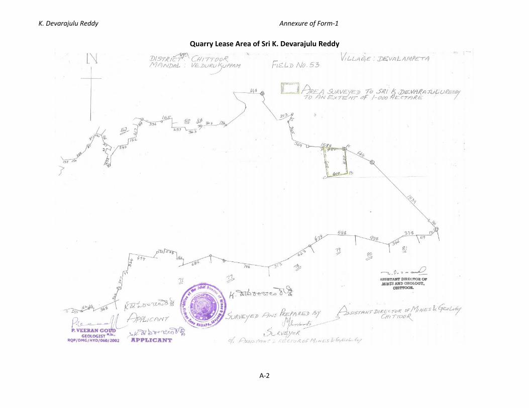
Quarry Lease Area of Sri K. Devarajulu Reddy

K. Devarajulu Reddy Annexure of Form-1
A-3
Introduction
Sri K. Devarajulu Reddy has obtained quarry lease granted orders from The Assistant
Director of Mines and Geology, Chittoor, Government of Andhra Pradesh for Colour Granite
over an extent of 1.0ha in Survey No. 53, Devalampeta Village, Vedurukuppam Mandal,
Chittoor District, Andhra Pradesh vide Proceedings No. 5717/Q/2002 dated 12-08-2004.
Mining plan is approved by the Joint Director of Mines and Geology, Government of Andhra
Pradesh vide Letter No. 1005/MP-CTR/2013 dated 06-12-2014. The quarry is under
operation from 2004 to 2011 and recovered about 713.22 m3 of dimensional blocks. It is
proposes to conduct semi mechanized open cast method quarrying for color granite
production of 724 m3/annum from the lease area. Capital proposed for the quarrying is Rs.
12 Lakhs.
Mine Location
Sri K. Devarajulu Reddy proposes to conduct semi mechanized open cast quarrying for
colour granite average production of 724m3/Annum. The proposed Quarry lease area of
1.0ha is located at Survey No. 53, Devalampeta Village, Vedurukuppam Mandal, Chittoor
District, Andhra Pradesh. The quarry lease area falls in the Survey of India topo sheet no.
57O/7 on Latitude 13O21’10.98”N and Longitude 79O16’11.94”E with an elevation of 280m.
The nearest village is Tellagundlapalli at a distance of 1.7km from the QL area in SW
direction and the nearest habitation at a distance of 1.0km in SE direction. Nearest town
and railway station is Chittoor at a distance of 22.5km in SW direction. Tellagundlapalli to
Allamadugu village road is passing at a distance of 0.5km from the QL area in SE direction
and also cart road is available upto QL area. Chittoor to Pallipattu main road is at a distance
of 5.2km from the QL area in SE direction. Seasonal Kundeti Vanka is flowing at a distance of
6.7km from the QL area in NE direction. Mangunta east reserve forest is at a distance of
4.0km in SE direction. Mangunta west reserve forest is at a distance of 1.2km in SE
direction. Allamadugu reserve forest is at a distance of 0.5km in north direction. Marripalle
reserve forest is at a distance of 5.0km in SE direction. Penumur extension reserve forest is
at a distance of 3.7km in NW direction. Verrikonda reserve forest is at a distance of 7.6km in
SE direction. Seasonal Small Tank is at a distance of 0.2km in North direction. There are no
state/national boundaries, national parks, wildlife sanctuaries and critically polluted areas

K. Devarajulu Reddy Annexure of Form-1
A-4
observed in 10km radius from the quarry lease area. The details of the quarry lease area are
presented in Table A-1.
Table A-1 Details of the Lease Area
State & District Mandal Village Sy. No. Area inhectares
Ownership ofoccupancy
Andhra Pradesh &Chittoor
Vedurukuppam Devalampeta 53 1.0 Ha Govt. Land(Barren)
GPS CoordinatesLatitude N Longitude E
13°21'11.35" 79°16'10.33"13°21'07.26" 79°16'11.09"13°21'07.83" 79°16'13.78"13°21'11.19" 79°16'13.29"
A) Mining Method
Open Cast method of mining is carried out in this mine by manually and semi mechanization
by using compressor operated jack hammer drills, excavators and dumper etc.
Transportation will be made by trucks to dispatching points. Hydraulic excavator and
compressor jack hammers were used for cutting the rock. Close shed drilling of 0.2m was
adopted along the strike line and charged with low explosive to avoid feather cracks.
Exploration
There is a pit on South-Eastern side of the Q. L. area Prospecting operation takes place in
these pit area during the past few years. The pit dimensions are 8m Length and 5m Width
with a depth of 2.9m. The marketable blocks recovered from the pits are 713.22 m3 during
the year of 2004 - 11.
Mineable reserves and life of the Quarry
Total color granite reserves = 161300 m3.
The color granite reserves blocked under buffer zone = 35550 m3
Length of boundary x average width x height = 237 X 7.5 X 20
Mineable color granite reserves = 125750 m3
Salable color granite reserves as 12% R. F = 15090 m3
Colour granite recovered during prospecting period = 713.22 m3
Net Colour Granite reserves available=15090-713.22 = 14377 m3
Life of the quarry: Mineable reserves/annual production = 14377/724 = 20 years.

K. Devarajulu Reddy Annexure of Form-1
A-5
Scheme development and production
The scheme of development and production for the first five years has been planned taking
into consideration the nature of the deposit within the lease area. It is observed from field
survey that the sheet rock is exposed on Southern side (Near pit) of the Q.L. area without
any overburden and therefore the development of the quarry is confined towards Southern
side (Near pit) of the Q.L. area. The proposed year wise working area is as follows.
Production plan for five years
There is a vertical and free face is available on southern side of the QL area. So the southern
side of the QL area is selected to work for the five years production. It is envisaged to
produce 724m3 of salable granite blocks in each year. To raise this target production about
6030 m3 of rock mass had to be mined. Most of the area is covered by sheet rock from top
to bottom. During five years operations a total rock mass of 30150m3 will be excavated and
3620m3 of granite blocks will be recoverable from this rock mass and remaining material of
about 26530m3 will go as waste mineral. Year wise production and waste generation details
are presented in table A-2.
Table A-2 Year wise Granite Production and Waste generationYear Working area
(A) m2Bench
height (H)Volume
(A x H) m3 RFProduction m3
Granite@12%
Waste@88%
1st Year 35x15=525 6 3150 0.12 378 277232x15=480 6 2880 0.12 346 2534
Sub-Total 6030 724 53062nd Year 35x15=525 6 3150 0.12 378 2772
32x15=480 6 2880 0.12 346 2534Sub-Total 6030 724 5306
3rd Year 35x15=525 6 3150 0.12 378 277232x15=480 6 2880 0.12 346 2534
Sub-Total 6030 724 53064th Year 35x15=525 6 3150 0.12 378 2772
32x15=480 6 2880 0.12 346 2534Sub-Total 6030 724 5306
5th Year 35x15=525 6 3150 0.12 378 277232x15=480 6 2880 0.12 346 2534
Sub-Total 6030 724 5306Grand Total 30150 3618 26532

K. Devarajulu Reddy Annexure of Form-1
A-6
SEPARATION OF LARGE PRIMARY BLOCKS FROM THE MOTHER ROCK BY PRE-SPLITTING
The mining will be followed in the form of linear cut method. This involves losing of the
primary block from mother rock. Hence primary cutting will be done by line drilling method
where close spaced parallel holes along straight line will be made. Line drilling method is
used for separation of primary blocks.
1) Once the free face is developed in working place, the primary cut is taken up over a
maximum length of 10 mtrs with a width of 3mtrs and to a depth of 6 mtrs. Depends
upon the joints availability. These dimensions are confirmed as for field studies. Primary
block will be cut into secondary blocks by jackhammer drilling and wedge cutting and
this block will be dislodged from in-situe position by an excavator.
2) Line drilling method will be used for cutting the primary blocks which involve drilling and
blasting.
3) The holes are charged with low explosive cartridge like gunpowder and non-delay
detonators for smooth blasting.
4) The use of delay detonators causes fragmentation and cracks in rocks. The non-
detonating cords are inserted into the holes and the holes are stemmed with muck and
plugged at the mouth and fired.
5) Thus the block will separate from the mother rock, which is pulled off from the face with
cranes or shovels.
SUB DIVISION OF LARGE PRIMARY BLOCKS INTO SECONDARY BLOCK
This will be done during close spaced holes (along a line) down to the depth and the
secondary block will be removed easily by just pulling it with the help of proclain. Close
spaced holes will be drilled to the half the length of the block on either side of it by using
wedges blocks can be separated.
Production of commercial blocks
After primary separation, the rock mass will be carefully examined to avoid hair line cracks,
mineral segregations and veins etc. The dressing of the rough blocks will be made by
chipping the edges and geometrically equating the edges of the block at the dressing yard.
The rough blocks obtained after primary cut it will be dressed for obtained good geometric
shape of granite. Thus the commercial blocks are produced.

K. Devarajulu Reddy Annexure of Form-1
A-7
LIST OF MACHINERY
a) Since it has been decided to undertake semi-mechanized mining operations, the below
mentioned mine machinery will be deployed.
i. Excavator – One (Bucket capacity: 1m3, Boom length: 7m, Model: Tata Hitachi 300Lc)
ii. 300 CFM – AIR compressors – One
iii. Jack Hammers – 3 units
iv. 17 tonnes Tippers – 2 No’s
b) Minor Tools: Chisels, Crow bars, pick of axes spades and hammers of different sizes.
c)Taking 25 working days in a month, there will be 300 working days in a year. The expected
output of raw material per day is about 3 to 4 CBM on an average. Based on the
demands from the purchasers, labour force will be increased.
Employment Potential
Taking 25 working days in a month, there will be 300 working days in a year. The expected
output of raw material per day is about 3 to 4 CBM on an average. Based on the demands
from the purchasers, labour force will be increased.
Loading Equipment
Loading of the blocks will be made by chain pulley with the help of crane or proclaim by the
skilled labours to the hired trucks to transport the material to the destination of customer.
Employment Potential
S. No Description Quantity1 Mine Manager 12 Blaster cum Mate 13 Excavator operator 14 Compressor operator 15 Tipper operator 26 Drillers 27 Helpers 98 Cutters 89 Watchman 1
Total 26

K. Devarajulu Reddy Annexure of Form-1
A-8
ANNEXURE II
DRILLING & BLASTING
Drilling and blasting plays vital role in determining the size and shape of rough blocks.
Drilling Pattern is important in developing a working face and also preparing the rough
blocks suitable for their use in appropriate processing units. There are no important places
in and around the area, blasting will be carried with precautionary measures.
a. Broad Blasting Parameters
Drill-Hole patterns for primary and secondary smooth blasting. Uniform single line
equidistant holes (line drilling) will be deployed for separation of blocks from mother rock.
In the case of sheet rock the primary drilling will be in the form of equidistant vertical holes
to take out blocks of Gang Saw.
1. Drilling Parameters
i. Drill holes diameter: 74/Pmm
ii. Depth and inclination of the blast holes: 3 meter in case of separation primary
blocks depending on the block size. Then the drill-hole will be vertical.
iii. Spacing and Burden: 1.5m X 3 m
iv. Stemming and charging of the blast hole: The blast hole will be charged with 100
grams of explosives and filled with clan pills subsequently; the shot hole will be
stemmed using brass stemming rods.
v. Explosive type: (1) Slurry based explosives or Gun Powder.

K. Devarajulu Reddy Annexure of Form-1
A-9
ANNEXURE - III
Water Requirement
Water requirement for the project is mainly for Domestic source, maintaining the green belt
and also for sprinkling on the haulage roads to mitigate dust emissions. The drinking water
shall be drawn from nearby villages. The water requirement of the project is presented in
Table A-3.
Table A-3 Water RequirementS. No Water Usage Quantity KLD
1 Wet drilling operation (On production basis @ 100 Ltr/1 m3) 0.22 Water sprinkling on haul roads @ 1Ltr/Sq.Mt (180m2)+1/4th for waste dump 1.13 Domestic @ 45 Ltr/Head (26No’s) 1.24 Green Belt @ 0.2 KL for 0.04 ha – 2 times a day 0.2
Total 2.7
Wastewater generation
The generation of wastewater from the quarry shall be 0.8KLD from domestic source. This
will be sent to septic tank followed by soak pit.
Site services
It is proposed to provide the site services like mine office and other statutory constructions
like rest shelter, first aid, work shed and drinking water as required near the quarry lease
area. Drinking water will be supplied to the workers from the bore well opened in the
adjacent agricultural field or from nearby village.

K. Devarajulu Reddy Annexure of Form-1
A-10
ANNEXURE – IV
Solid Waste Management plan
During five years operations a total rock mass of 30150m3 will be excavated and 3620m3 of
granite blocks will be recoverable from this rock mass and remaining material of about
26530m3 will go as waste mineral.
S. No. Year Total Waste Generated m3
1 1st Year 53062 2nd Year 53063 3rd Year 53064 4th Year 53065 5th Year 5306
Total Waste generated for 5 Years 26530
Dumping site particulars
Waste will be dumped in the area 3540 m2 and to a height of 30mtrs in the Northwestern
side of the area at non mineral zone. During the first five years about 26530 m3 of waste
material will be generated. Step dumping will be resorted. This material can be utilized to
fill the pits after quarry operations are over. When the dumps reach their optimum height
suitable greenery will be grown on these dumps to stabilize them.
Estimated waste quantity over the entire period
Total color granite reserves = 125750 m3
Total mineral waste in the area = 88%
Color granite reserves = 125750 x 0.88 = 110660 m3

K. DEVARAJULU REDDYSURVEY NO. 53, DEVALAMPETA VILLAGE,
VEDURUKUPPAM MANDAL, CHITTOOR DISTRICT,ANDHRA PRADESH
FORM I(SEMI MECHANISED OPEN CAST COLOUR GRANITE QUARRY)
SUBMITTED BYSri K. Devarajulu ReddyDoor No. 2-1118,Lakshmi Nagar Colony,ChittoorMobile No: +91 81063 19759
STUDIES AND DOCUMENTATION BYTEAM Labs and ConsultantsB-115,116,117 & 509, Annapurna Block,Aditya Enclave, Ameerpet,Hyderabad-500 038Phone: 040-23748 555/616,Tele fax: 040-23748666Email: [email protected]
SUBMITTED TOSTATE LEVEL ENVIRONMENTAL IMPACT ASSESSMENT AUTHORITY
ANDHRA PRADESHGOVERNMENT OF INDIA

K. DEVARAJULU REDDYSURVEY NO. 53, DEVALAMPETA VILLAGE,
VEDURUKUPPAM MANDAL, CHITTOOR DISTRICT,ANDHRA PRADESH
ENVIRONMENT MANAGEMENT PLAN(SEMI MECHANISED OPEN CAST COLOUR GRANITE QUARRY)
SUBMITTED BYSri K. Devarajulu ReddyDoor No. 2-1118,Lakshmi Nagar Colony,ChittoorMobile No: +91 81063 19759
STUDIES AND DOCUMENTATION BYTEAM Labs and ConsultantsB-115,116,117 & 509, Annapurna Block,Aditya Enclave, Ameerpet,Hyderabad-500 038Phone: 040-23748 555/616,Tele fax: 040-23748666Email: [email protected]
SUBMITTED TOSTATE LEVEL ENVIRONMENTAL IMPACT ASSESSMENT AUTHORITY
ANDHRA PRADESHGOVERNMENT OF INDIA

K. DEVARAJULU REDDYSURVEY NO. 53, DEVALAMPETA VILLAGE,
VEDURUKUPPAM MANDAL, CHITTOOR DISTRICT,ANDHRA PRADESH
Studies and Documentation byTeam Labs and Consultants(An ISO 9001:2008 Certified Company)B-115,116,117 & 509, Annapurna Block,Aditya Enclave, Ameerpet, Hyderabad-500 038Tel: 91-040-23748555, 23748616Fax: 91-040-23748666.Email: [email protected]
K. DEVARAJULU REDDYSURVEY NO. 53, DEVALAMPETA VILLAGE,
VEDURUKUPPAM MANDAL, CHITTOOR DISTRICT,ANDHRA PRADESH
SEMI MECHANISED OPEN CAST COLOR GRANITE QUARRY
I FORM 1II ENVIRONMENT MANAGEMENT PLANIII APPROVED MINING PLAN
SUBMITTED BYSri K. Devarajulu ReddyDoor No. 2-1118,Lakshmi Nagar Colony,ChittoorMobile No: +91 81063 19759
STUDIES AND DOCUMENTATION BYTEAM Labs and ConsultantsB-115,116,117 & 509, Annapurna Block,Aditya Enclave, Ameerpet,Hyderabad-500 038Phone: 040-23748 555/616,Tele fax: 040-23748666Email: [email protected]
SUBMITTED TOSTATE LEVEL ENVIRONMENTAL IMPACT ASSESSMENT AUTHORITY
ANDHRA PRADESHGOVERNMENT OF INDIA

ANNEXURE

MINE PLAN

CONTENTSSection Chapter Page No.
1.0 Introduction 1-11.1 Granites and its uses 1-21.2 Mining Method 1-21.3 Mine Location 1-21.4 Land use pattern of the lease area 1-32.0 Topography 1-63.0 Regional Geology 1-63.1 Local Geology 1-63.2 Brief description of litho units 1-74.0 Exploration 1-75.0 Estimation and Calculation of Geological Reserves 1-75.1 Mineable Reserves and Life of the quarry 1-86.0 Mining 1-86.1 Removal/Excavation of O.B. and other quarry waste 1-86.2 Separation of Large Primary Blocks From mother Rock by Pre-
Splitting(Primary Cut)1-8
6.3 Sub Division of Large Primary Block Into Secondary Block 1-97.0 Production of Commercial Blocks 1-98.0 List of Machinery 1-99.0 Loading Equipment 1-10
10.0 Employment Potential 1-1011.0 Scheme development and production 1-1011.1 Production plan for five years 1-1012.0 Drilling & Blasting 1-1112.1 Blasting Parameters 1-1112.2 Drilling Parameters 1-1112.3 Site Services 1-1213.0 Water Requirement 1-1214.0 Environment Management Plan 1-1214.1 Sources of Pollution and Control Measures 1-13
14.1.1 Air pollution and its control 1-1314.1.2 Noise pollution and its control 1-1415.0 Occupational Safety and Health 1-1415.1 Occupational Safety and Health to control exposure to noise 1-1515.2 Control of Ground Vibrations & Fly Rocks Boulder 1-1616.0 Peak Particle Velocity 1-1617.0 Water Quality Management 1-18

17.1 Water Resources 1-1817.2 Water Management 1-1817.3 Catchment Area Treatment Plan 1-1918.0 Waste Management plan 1-1919.0 Dump Area 1-2020.0 Land Management 1-2020.1 Land Reclamation 1-20
20.1.1 Soil Conservation Measures 1-2021.0 House Keeping 1-2322.0 Transport Systems 1-2323.0 Environmental Greening Program 1-2424.0 Socio-economic Environment 1-2525.0 Disaster Planning 1-2626.0 Environment Management Cell 1-2726.1 Post Project Monitoring 1-2726.2 Other Management Aspects 1-2827.0 Cost proposed for Environmental Protection Measures 1-28

List of Tables
Section Description Page No1.1 Details of the lease area 1-31.2 Land use in the lease area 1-31.3 Reserves Estimation 1-71.4 Employment Potential 1-101.5 Year wise Granite Production and Waste generation 1-111.6 Water Requirement 1-121.7 Peak Particle Velocity (V) 1-171.8 Impacts identified and mitigation measures proposed 1-211.9 Plant species identified for greenbelt development 1-24
1.10 Environment Management - Cost Estimate 1-28
List of FiguresSection Description Page No
1.1 Quarry lease Location Map of Sri K. Devarajulu Reddy 1-41.2 Quarry lease area of Sri K. Devarajulu Reddy 1-5
K. Devarajulu Reddy Environment Management Plan
Team Labs and Consultants1-1
ENVIRONMENT MANAGEMENT PLAN
1.0 Introduction
This report discusses the management plan for mitigation/abatement of adverse
environmental impacts and enhancement of beneficial impacts due to mining. The EMP has
been designed within the framework of various legislative and regulatory requirements on
environmental and socio-economic aspects.
Sri K. Devarajulu Reddy has obtained quarry lease granted orders from The Assistant Director
of Mines and Geology, Chittoor, Government of Andhra Pradesh for Colour Granite over an
extent of 1.0ha in Survey No. 53, Devalampeta Village, Vedurukuppam Mandal, Chittoor
District, Andhra Pradesh vide Proceedings No. 5717/Q/2002 dated 12-08-2004. Mining plan is
approved by the Joint Director of Mines and Geology, Government of Andhra Pradesh vide
Letter No. 1005/MP-CTR/2013 dated 06-12-2014. The quarry is under operation from 2004 to
2011 and recovered about 713.22 m3 of dimensional blocks. It is proposes to conduct semi
mechanized open cast method quarrying for color granite production of 724 m3/annum from
the lease area. Capital proposed for the quarrying is Rs. 12 Lakhs.
Sri K. Devarajulu Reddy is conscious of its environmental responsibility towards the society in
minimizing the pollution load due to this project and accordingly decided to carry out the
Environment Management Plan. The objective of preparing environment management plan
is to delineate effective measures to control and to mitigate the environmental pollution.
This report presents the environment management plan, detailing the environmentally sound
technology and the measures needed to contain and mitigate the anticipated environmental
impacts due to the project.
1.1 Granite and its uses
Granite is a very common intrusive igneous rock. It is light-colored granulose plutonic rock
composed of the minerals feldspar, quartz and biotite & muscovite mica. These minerals
make granite white, pink, or light grey. Granite also contains small amounts of dark brown,
dark-green, or black minerals, such as hornblende and biotite mica. Granite is very hard and
dense. It can be readily cut into very large blocks and it takes an extremely high polish. The
name granite is derived from the Latin word granum, which means grain, an obvious

K. Devarajulu Reddy Environment Management Plan
Team Labs and Consultants1-2
reference to the granular texture of granite. The average density of granite is between
2.65 and 2.75 g/cm3, with a compressive strength of above 200 Mega Pascal (MPa).
Uses
Granite has been extensively used as a dimension stone and as flooring tiles in public and
commercial buildings and monuments. With increasing amounts of acid rain in parts of the
world, granite has begun to supplant marble as a monument material, since it is much more
durable. Engineers have traditionally used polished granite surfaces to establish a plane of
reference, since they are relatively impervious and inflexible. Granite tables are used
extensively as a base for optical instruments due to granite's rigidity, high dimensional
stability and excellent vibration characteristics. Rough-cut and polished granite is used in
buildings, bridges, paving, monuments and many other exterior projects. Indoors, polished
granite slabs and tiles are used in countertops, tile floors, stair treads and many other
practical and decorative features. Presently, cut and polished granite slabs of 20 mm
thickness are preferred for flooring, while tiles of 10 or 12 mm thickness are used for
cladding.
1.2 Mining Method
The mining operations are carried out by semi mechanization as open cast mining. Hydraulic
excavator and compressor jack hammers were used for cutting the rock. Close spaced drilling
of 0.2m was adopted along a straight line and charged with low explosive to avoid feather
cracks. Transportation will be made by trucks to dispatching points.
1.3 Mine Location
Sri K. Devarajulu Reddy proposes to conduct semi mechanized open cast quarrying for colour
granite average production of 724m3/Annum. The proposed Quarry lease area of 1.0ha is
located at Survey No. 53, Devalampeta Village, Vedurukuppam Mandal, Chittoor District,
Andhra Pradesh. The quarry lease area falls in the Survey of India topo sheet no. 57O/7 on
Latitude 13O21’10.98”N and Longitude 79O16’11.94”E with an elevation of 280m. The nearest
village is Tellagundlapalli at a distance of 1.7km from the QL area in SW direction. Nearest
town and railway station is Chittoor at a distance of 22.5km in SW direction. Tellagundlapalli
to Allamadugu village road is passing at a distance of 0.5km from the QL area in SE direction
and also cart road is available upto QL area. Chittoor to Pallipattu main road is at a distance
of 5.2km from the QL area in SE direction. Seasonal Kundeti Vanka is flowing at a distance of

K. Devarajulu Reddy Environment Management Plan
Team Labs and Consultants1-3
6.7km from the QL area in NE direction. Mangunta east reserve forest is at a distance of
4.0km in SE direction. Mangunta west reserve forest is at a distance of 1.2km in SE direction.
Allamadugu reserve forest is at a distance of 0.5km in north direction. Marripalle reserve
forest is at a distance of 5.0km in SE direction. Penumur extension reserve forest is at a
distance of 3.7km in NW direction. Verrikonda reserve forest is at a distance of 7.6km in SE
direction. Seasonal Small Tank is at a distance of 0.2km in North direction. There are no
state/national boundaries, national parks, wildlife sanctuaries and critically polluted areas
observed in 10km radius from the quarry lease area. Quarry lease location map is presented
in figure 1.1. Details of the quarry lease area are presented in table 1.1.
Table 1.1 Details of the Lease area
State & District Mandal Village Sy. No. Area inhectares
Ownership ofoccupancy
Andhra Pradesh &Chittoor
Vedurukuppam Devalampeta 53 1.0 Ha Govt. Land(Barren)
GPS CoordinatesLatitude N Longitude E
13°21'11.35" 79°16'10.33"13°21'07.26" 79°16'11.09"13°21'07.83" 79°16'13.78"13°21'11.19" 79°16'13.29"
1.4 Land use pattern of the lease area
The Quarry lease area is a small mound raising to a height of about 20m with boulders from
ground level. It is southern slope of the hill range.
Table 1.2 Land use in Lease AreaS. No Purpose Extent (Ha)
1 Area under quarrying 0.26252 Waste dump area 0.35403 Road 0.0254 Infrastructure(Office, rest shelter) 0.0185 Green belt 0.046 Vacant 0.3005
Total 1.0

K. Devarajulu Reddy Environment Management Plan
Team Labs and Consultants1-4
Fig 1.1 Quarry Lease Location map of Sri K. Devarajulu Reddy

K. Devarajulu Reddy Environment Management Plan
Team Labs and Consultants1-5
Fig 1.2 Quarry Lease Area of Sri K. Devarajulu Reddy

K. Devarajulu Reddy Environment Management Plan
Team Labs and Consultants1-6
2.0 Topography
The Lease area is a mound raising to a height of 20m. The area is devoid of any forest or tree
cover. It comprises shurbs only. There are no prominent natural drainage channels in the
area. In general the area is plain studded with isolating hillocks. Sometimes they may raise
gently as continuous hills, presenting a rugged topography.
3.0 Regional Geology
The oldest rocks in the area belong to migmatite complex, represented by migmatised
quartzo-feldspathic gneiss and are exposed in the district. Regionally the area represents part
of the Archaean Granite – Greenstone terrain of the Dharwar Craton. It has schistose rocks of
Greenstone Belts. These are referred to as Archaean Greenstone belts. This has been
intruded by the rocks of Peninsular Gneissic Complex which has gneisses, migamatite and
migmatized granite suit of rocks. Gneisses and migamatites include porphyroblastic
hornblende gneiss, hornblende biotite gneiss, nebulitic to homophenus hornblende gneiss,
pink and green colored migamatitic gneiss closepet granite and its equivalents, namely
dolerite porphyritic alkali feldspar granite and granodiorite, belong to the Proterozoic age
have intruded the above set up. The greenstone belts, gneisses, migamatites and younger
granitoids are intruded by the mafic dyke swarms.
The stratigraphy of the region is given below.
Epidote veins,Quartz Veins & Reefs.Veins of Alkali Feldspar
Younger Intrusive Dolerite/Bassalt/Gabbro DykesBiotite granite
ArcheanHornblende granite
Peninsular gneissic complex Biotite granite gneiss,Hornblende granite gneissPorphyritic hornblende granite
Dharwar Super Group Amphibolite, Hornblend schist
3.1 Local Geology
The subject area belongs to small mound raising to a height of about 20m with boulders from
ground level. It is southern slope of the hill range. However the granite sheet rock is well
exposed without any over burden. It represents late magmatic injection of closepet granite.

K. Devarajulu Reddy Environment Management Plan
Team Labs and Consultants1-7
3.2 Brief description of litho units
Texturally the rock in the lease area is porphyritic and Migmatitic Texture with fine to
medium grained. The rock is pink colour with light black shade. The rock is asthatically good
looking. Minerologically the granite consists of Quartz, Orthoclase feldspar as essential
mineral and other mafics Biotite, Mica, hornblend, etc., as accessory mineral with fine to
medium grained. The granite available in the demarcated area is useful for Granite cutting
and polishing purpose.
4.0 Exploration
There is a pit on South-Eastern side of the Q. L. area Prospecting operation takes place in
these pit area during the past few years. The pit dimensions are 8m Length and 5m Width
with a depth of 2.9m. The marketable blocks recovered from the pits are 713.22 m3 during
the year of 2004 - 11.
5.0 ESTIMATION AND CALCULATION OF GEOLOGICAL RESERVES
Based on the prospecting work carried out and the present exposure of the rock, the reserves
of the area have been estimated by the following parameters. We have taken 14m as proved
zone and 3m as probable and possible zones in this area, the recovery factor is taken only
12% as the joints and cracks are present in the rock. The reserves available in the lease are
complied as stated below table 1.3.
Table 1.3 Reserves Estimation
Category SectionInfluenceDistance
in m
SectionArea in
m2
Volumein m3
RecoveryFactor@12%
Reserves@12% in
m3
Rockwastage@88% in m3
A B (A x B) 0.12 (A*B) 0.12 (A*B) 0.88Proved A – A’ 40 1078 43120 0.12 5174 37946
B – B’ 27 1050 28350 0.12 3402 24948C – C’ 40 1036 41440 0.12 4973 36467
Sub-Total 112910 13549 99361A – A’ 40 231 9240 0.12 1109 8131
Probable B – B’ 27 225 6075 0.12 729 5346C – C’ 40 222 8880 0.12 1066 7814
Sub-Total 24195 2903 21292A – A’ 40 231 9240 0.12 1109 8131
Possible B – B’ 27 225 6075 0.12 729 5346C – C’ 40 222 8880 0.12 1066 7814
Sub-Total 24195 2903 21292Grand-Total 161300 19356 141944

K. Devarajulu Reddy Environment Management Plan
Team Labs and Consultants1-8
Total color granite reserves = 161300 m3.
The color granite reserves blocked under buffer zone = 35550 m3
Length of boundary x average width x height = 237 X 7.5 X 20
Mineable color granite reserves = 125750 m3
Salable color granite reserves as 12% R. F = 15090 m3
Colour granite recovered during prospecting period = 713.22 m3
Net Colour Granite reserves available=15090-713.22 = 14377 m3
5.1 MINEABLE RESERVES AND LIFE OF THE QUARRY
Initially, the total quantity of mineable reserves is considered as (economic) marketable
reserves. In this way a total mineable reserves of 14377 m3 are available in the Q.L. area. The
production is proposed to obtain 724m3 per year. At this rate of production, the expected life
of the mine is calculated as follows:
Life of the quarry: Mineable reserves/annual production = 14377/724 = 20 years.
6.0 Mining
Open Cast method of mining is carried out in this mine by manually and semi mechanization
by using compressor operated jack hammer drills, excavators and dumper etc. Transportation
will be made by trucks to dispatching points. Hydraulic excavator and compressor jack
hammers were used for cutting the rock. Close shed drilling of 0.2m was adopted along the
strike line and charged with low explosive to avoid feather cracks.
6.1 Removal/Excavation of O.B. and other quarry waste:
The North-Western side of the area is selected for dump yard for next five years and the waste
will be stocked over a length of 40m, width of 40m and to a height of 9m. Step dumping will be
resorted. This material can be utilised to fill the pits after quarry operations are over. When the
dumps reach their optimum height suitable greenery will be grown on these dumps to stabilize
them.
6.2 SEPARATION OF LARGE PRIMARY BLOCKS FROM MOTHER ROCK BY PRE-SPLITTING
The mining will be followed in the form of linear cut method. This involves losing of the primary
block from mother rock. Hence primary cutting will be done by line drilling method where close
spaced parallel holes along straight line will be made. Line drilling method is used for separation
of primary blocks.

K. Devarajulu Reddy Environment Management Plan
Team Labs and Consultants1-9
1) Once the free face is developed in working place, the primary cut is taken up over a maximum
length of 10 mtrs with a width of 3mtrs and to a depth of 6 mtrs. Depends upon the joints
availability. These dimensions are confirmed as for field studies. Primary block will be cut into
secondary blocks by jackhammer drilling and wedge cutting and this block will be dislodged
from in-situe position by an excavator.
2) Line drilling method will be used for cutting the primary blocks which involve drilling and
blasting.
3) The holes are charged with low explosive cartridge like gunpowder and non-delay detonators
for smooth blasting.
4) The use of delay detonators causes fragmentation and cracks in rocks. The non-detonating
cords are inserted into the holes and the holes are stemmed with muck and plugged at the
mouth and fired.
5) Thus the block will separate from the mother rock, which is pulled off from the face with
cranes or shovels.
6.3 Sub Division of Large Primary Block Into Secondary Block
This will be done during close spaced holes (along a line) down to the depth and the
secondary block will be removed easily by just pulling it with the help of proclain. Close
spaced holes will be drilled to the half the length of the block on either side of it by using
wedges blocks can be separated.
7.0 Production of commercial blocks
After primary separation, the rock mass will be carefully examined to avoid hair line cracks,
mineral segregations and veins etc. The dressing of the rough blocks will be made by chipping
the edges and geometrically equating the edges of the block at the dressing yard. The rough
blocks obtained after primary cut it will be dressed for obtained good geometric shape of
granite. Thus the commercial blocks are produced.
8.0 LIST OF MACHINERY
a) Since it has been decided to undertake semi-mechanized mining operations, the below
mentioned mine machinery will be deployed.
i. Excavator – One (Bucket capacity: 1m3, Boom length: 7m, Model: Tata Hitachi 300Lc)
ii. 300 CFM – AIR compressors – One
iii. Jack Hammers – 3 units

K. Devarajulu Reddy Environment Management Plan
Team Labs and Consultants1-10
iv. 17 tonnes Tippers – 2 No’s
b) Minor Tools: Chisels, Crow bars, pick of axes spades and hammers of different sizes.
Taking 25 working days in a month, there will be 300 working days in a year. The expected
output of raw material per day is about 3 to 4 CBM on an average. Based on the demands
from the purchasers, labour force will be increased.
9.0 Loading Equipment
Loading of the blocks will be made by chain pulley with the help of crane or proclaim by the
skilled labours to the hired trucks to transport the material to the destination of customer.
10.0 Employment Potential
Table 1.4 Employment potentialS. No Description Quantity
1 Mine Manager/ Supervisor 12 Blaster cum Mate 13 Excavator operator 14 Compressor operator 15 Tipper operator 26 Drillers 27 Helpers 98 Cutters 89 Watchman 1
Total 26
11.0 Scheme development and production
The scheme of development and production for the first five years has been planned taking
into consideration the nature of the deposit within the lease area. It is observed from field
survey that the sheet rock is exposed on Southern side (Near pit) of the Q.L. area without any
overburden and therefore the development of the quarry is confined towards Southern side
(Near pit) of the Q.L. area. The proposed year wise working area is as follows.
11.1 Production plan for five years
There is a vertical and free face is available on southern side of the QL area. So the southern
side of the QL area is selected to work for the five years production. It is envisaged to
produce 724m3 of salable granite blocks in each year. To raise this target production about
6030 m3 of rock mass had to be mined. Most of the area is covered by sheet rock from top to
bottom. During five years operations a total rock mass of 30150m3 will be excavated and

K. Devarajulu Reddy Environment Management Plan
Team Labs and Consultants1-11
3620m3 of granite blocks will be recoverable from this rock mass and remaining material of
about 26530m3 will go as waste mineral. Year wise production and waste generation details
are presented in table 1.5.
Table 1.5 Year wise Granite Production and Waste generationYear Working area
(A) m2Bench
height (H)Volume
(A x H) m3 RFProduction m3
Granite@12%
Waste@88%
1st Year 35x15=525 6 3150 0.12 378 277232x15=480 6 2880 0.12 346 2534
Sub-Total 6030 724 53062nd Year 35x15=525 6 3150 0.12 378 2772
32x15=480 6 2880 0.12 346 2534Sub-Total 6030 724 5306
3rd Year 35x15=525 6 3150 0.12 378 277232x15=480 6 2880 0.12 346 2534
Sub-Total 6030 724 53064th Year 35x15=525 6 3150 0.12 378 2772
32x15=480 6 2880 0.12 346 2534Sub-Total 6030 724 5306
5th Year 35x15=525 6 3150 0.12 378 277232x15=480 6 2880 0.12 346 2534
Sub-Total 6030 724 5306Grand Total 30150 3618 26532
12.0 DRILLING & BLASTING
Drilling and blasting plays vital role in determining the size and shape of rough blocks. Drilling
Pattern is important in developing a working face and also preparing the rough blocks
suitable for their use in appropriate processing units. There are no important places in and
around the area, blasting will be carried with precautionary measures.
12.1 Blasting Parameters
Drill-Hole patterns for primary and secondary smooth blasting. Uniform single line
equidistant holes (line drilling) will be deployed for separation of blocks from mother rock. In
the case of sheet rock the primary drilling will be in the form of equidistant vertical holes to
take out blocks of Gang Saw.
12.2 Drilling Parameters
i. Drill holes diameter: 74/Pmm

K. Devarajulu Reddy Environment Management Plan
Team Labs and Consultants1-12
ii. Depth and inclination of the blast holes: 3 meter in case of separation primary blocks
depending on the block size. Then the drill-hole will be vertical.
iii. Spacing and Burden: 1.5m X 3 m
iv. Stemming and charging of the blast hole: The blast hole will be charged with 100
grams of explosives and filled with clan pills subsequently; the shot hole will be
stemmed using brass stemming rods.
v. Explosive type: (1) Slurry based explosives or Gun Powder.
12.3 Site services
It is proposed to provide the site services like mine office and other statutory constructions
like rest shelter, first aid, work shed and drinking water as required near the quarry lease
area. Drinking water will be supplied to the workers from the bore well opened in the
adjacent agricultural field or from nearby village.
13.0 Water requirement
Water requirement is mainly for drinking purpose, domestic purpose, green belt maintaining
and for sprinkling on Mine haulage roads the water shall be drawn from nearby village. The
domestic waste water shall be sent to septic tank followed by soak pit. Rainwater Catch Pond
of 20 KL capacity will be provided to collect the storm water for reuse. This will ensure that
the rainwater is effectively used and minimizes the drawl of ground water resources. The
water requirement is presented in table 1.6.
Table 1.6 Water RequirementS. No Water Usage Quantity KLD
1 Wet drilling operation (On production basis @ 100 Ltr/1 m3) 0.22 Water sprinkling on haul roads @ 1Ltr/Sq.Mt (180m2)+1/4th for waste dump 1.13 Domestic @ 45 Ltr/Head (26No’s) 1.24 Green Belt @ 0.2 KL for 0.04 ha – 2 times a day 0.2
Total 2.7
14.0 Environment Management Plan
Environmental protection is an issue that no organization can neglect and hope to survive.
The products of civilization are being dumped upon the environment to a degree that the
environment finds difficult to assimilate. The key to the success of the integrated approach
to pollution prevention and control is the management and operation of the organization.
Effective committed management delivers a successful operation. As total commitment to

K. Devarajulu Reddy Environment Management Plan
Team Labs and Consultants1-13
the environment, not just for compliance with legal or regulatory compliance will be the
essence of environment management. Many companies have recognized the benefits of
implementing an effective environmental management system.
Environmental management plan can be effectively implemented to mitigate the pollution
levels by observing the following:
a. Pollution will be prevented or reduced at the source
b. Pollution that cannot be prevented will be recycled in an environmentally safe manner.
c. Pollution that cannot be prevented or recycled will be treated in environmentally safe
manner and
d. Disposal and other releases into the environment will be used only as a last resort and
will be conducted in an environmentally safe manner.
The proposed project is granite mine. The mine owners are aware of the adverse impacts
due to the mining activity and propose to initiate a number of measures for the environment
protection within the mine area and in the surrounding areas. The company has a stated
environmental policy of ensuring regulatory compliance with respect to the statutory laws
and regulations and those periodically issued by the Ministry of Environment, GOI, New
Delhi, CPCB, New Delhi and State Pollution Control Board.
14.1 Sources of Pollution and Control Measures
The sources of pollution are air and noise from the proposed activity mainly from Mining,
drilling and transportation of mineral. Waste material generation, dumping and restoration.
14.1.1 Air pollution and its control
The granite quarrying does not involve much dust formation. The dust would be generated
during drilling, smooth blasting, quarrying and also during handling and transportation of the
material. The dust anticipated at drilling place will be suppressed by putting cloth around the
hole. Use of sharp drill pits for drilling holes and drills with water flushing systems (wet
drilling) to reduce dust generation. Water spraying to be adopted at Faces/sites before and
after blasting, Faces/sites while loading. Over charging of blast holes should be avoided.
Personal protective equipments like nose mask and goggles etc will be provided to the
workers. Regular water spraying on haul roads during transportation of mineral and waste by
water sprinklers. Over loading of transport equipments should be avoided to prevent spillage.
Also, measures such as covering tarpaulin over the loaded material will prevent spreading of

K. Devarajulu Reddy Environment Management Plan
Team Labs and Consultants1-14
dust particles from the trucks. Speed controls on vehicle movements to limited speed. Wind
reduction control by plantation. Over burden dump has reached the optimum size, it will
covered with top soil and water will spread on top soil and grass will be developed on the
dump. Limiting the height and slope of the stockpiles can also reduce wind speed. Regular
checking and maintenance of vehicles should be conducted and pollution under control
certificate be obtained. Periodical monitoring of ambient air quality will helps to take steps to
control the pollutants.
14.1.2 Noise pollution and its control
The major source of noise pollution is due to drilling of drill holes, machinery, smooth
blasting and vehicular movement. Blasting operations will be carried out only during daytime
so as to avoid high noise intensity in night time. Noise barriers in the form of trees are
provided to attenuate the noise levels and green belt of 5 m width shall be developed to
mitigate propagation of noise. Protective equipment to reduce the noise levels like ear muffs
and other protective devices will be provided to the staff working near noise generating
sources like drill machine operators and dumper drivers. Training would be imparted to mine
personnel to generate awareness about the damaging effects of noise. The transport activity
shall be restricted to day time to reduce impact on habitation. The engines of the tractors
shall be switched off during loading operation, and shall be periodically maintained to ensure
low noise levels. Proper maintenance of the equipment will also reduce the noise.
15.0 Occupational Safety and Health
Health and safety aspects of the mine will be taken care off as per the World Bank (WB)
guidelines on open pit mining. The guidelines provide the detailed information on the aspects
that are required to be taken into account for maintaining proper health and safety issues.
The workers continuously exposed to dust will be provided with protective devices like dust
mask to prevent respiratory disorders. The workers continuously exposed to a high noise will
be provided with ear muffs/ earplugs. Green belt in and around the mining area will be
developed to attenuate noise and dust impact. The blasting carried out in the mine area will
be carefully planned and executed under the supervision of a responsible officer, to avoid any
accidents. Provisions of rest shelter for mine workers with facility of drinking water supply for
the employees will be provided by the project authority. The standard of the drinking water
will be per WHO guidelines. Periodical training programme to inform the employees about

K. Devarajulu Reddy Environment Management Plan
Team Labs and Consultants1-15
their task, associated risk, and safe working practices will be undertaken. Conduct of mock
drill, Safe storage & handling of explosives. Training will also include information on accident
prevention, proper control and maintenance of equipment and safe material handling
practices. Awareness on safety and ensure using of personal protective equipments (PPE) by
workers. Regular maintenance and testing of equipments will be done. A regular monitoring
of the Occupational Health and Safety will reduce the chances of accidents in the mine.
Records of job related accidents and illness should be maintained. This information will be
reviewed and evaluated to improve the effectiveness of Environmental Health and Safety
programme.
Occupational Safety and Health to Control Dust Inhalation
Very little dust is expected to be generated during mining and does not affect the
environment. However while drilling, wet drilling will be practiced. It is a small scale mining
activity and not much vehicular movement is expected.
All the above precautions would be adopted to prevent dust generation at site and to be
dispersed in the outside environment. However, for the safety of workers at site, engaged at
the strategic locations/dust generation points like drills, loading & unloading points dust
masks would be provided. Dust masks would prevent inhalation of RSPM thereby reducing
the risk of lung diseases and other respiratory disorders. Regular health monitoring of
workers will be carried out.
15.1 Occupational Safety and Health to Control Exposure to Noise
Blasting will be done using non delay detonators to reduce vibrations, and the amount of
explosive used will also be less at a time. There will not be heavy earth moving machinery
which may create some noise pollution. Thus the vibration and noise will be well controlled
within permissible limits.
To protect the workers from exposure to high levels of noise, following measures would be
adopted:
Provision of protective devices like ear muffs/ear plugs to workers who cannot be
isolated from the source of high intensity noise, e.g. blasting;
Reducing the exposure time of workers to the higher noise levels by shift management.
Smooth blasting techniques, special explosives and silent non-explosive demolishing
agent will be used.

K. Devarajulu Reddy Environment Management Plan
Team Labs and Consultants1-16
Muffed blasting and use of Milli-second detonators will help in reducing the noise
pollution.
15.2 Control of Ground Vibration & Fly Rock generation
In this area the applicant proposes to deploy blasting with less quantity of non-explosives.
There will not be any impact on surroundings, as there are less blasting and intended to use
low power explosives in this mine. It is a small scale mine and only limited No. of holes are
blasted. Ground vibrations due to blasting and its impact on various mine structures, should
be studied in details when the mine becomes operational, especially the charge per delay
factor. General measures to reduce ground vibration & fly rocks resulting from blasting are
given below:
Blasting should be carried out in the daytime, as during the night time the sound intensity
becomes higher;
Blasting should not be carried out when strong winds are blowing towards the inhabited
areas;
Maximum permissible charge per delay should be decided on the basis of the distance of
structure to be protected from the blasting.
The number of rows in a blast should not be more than four so that fly rock generation
and ground vibration is reduced.
Peak particle velocity or ground vibrations for safety of nearby structures and
residential buildings should be well within 12.5 mm/sec;
To contain fly rocks, stemming column should not be less than the burden of the hole,
and the blasting area should be muffled;
Each blast should be carefully planned, checked, and executed under the supervision of a
responsible officer. Blasting data/observations should be recorded; and
As per the mining plan, in order to ensure slope stabilization, controlled production blasting
shall be adopted to avoid tension cracks and back breaks. Such cracks may get filled with
water, which reduces the stability of excavated slopes and the angle of slopes.
16.0 Peak Particle Velocity
The vibrations are measured as per the assessment criteria given under Bureau of Indian
Standard, “IS: 6922-1973 (Reaffirmed 2003) - Criteria for Safety and Design of Structures
Subject to Underground Blasts”.

K. Devarajulu Reddy Environment Management Plan
Team Labs and Consultants1-17
Per the assessment criteria, the value of ground particle velocity may be computed from the
following expression:
V = K1 [Q2/3/R] 1.25
Where
V = Particle velocity in mm/sec
K1 = Constant which may be normally taken as 880 for soil, weathered or soft rock and
1400 for hard rock.
Q = Charge per delay (kg), and
R = Distance (m) from blast point
Based on the above equation, the ground particle velocities at different distances (3 m, 5 m,
10 m, 20 m, 50 m, 70 m, 100 m, 150 m and 200 m) are calculated considering K1 as 880 for
soft rocks and 1400 for hard rocks. As per the Standard, for safety of structures from
threshold damage, the ground particle velocity should not exceed the following:
Soil, Weathered or Soft rock 70 mm/sec
Hard Rock 100 mm/sec
The results are presented in the Table 1.7 below for the maximum charge
Table 1.7 Peak Particle Velocity (V)S. No Constant
(K1)Charge Per
DelayPeak Particle Velocity (V) mm/second
Distance from the Blasting (R in meters)3 5 10 20 50 70 100 150 200
1 880 Q= 0.2Kg 58.29 30.78 12.94 5.44 1.73 1.14 0.73 0.44 0.312 1400 Q= 0.2Kg 92.74 48.97 20.59 8.66 2.75 1.81 1.16 0.70 0.49
It is clear that with Q = 0.2 kg charge per delay shall result in particle velocity of 1.14 mm/sec
in soft rock within a distance of 70 m, while in the hard rock the particle velocity is 1.16
mm/sec shall be within 100 m. There shall not be any structure with in 70 m of the quarry
area, and it may be, concluded that the ground vibrations generated by blasting during the
mining operations will not likely to effect the structures proposed in the vicinity of > 70 m
from the point of blast. Concrete structures like office, store etc should not be proposed
within the core mine area. These structures otherwise will be affected by the ground
vibrations.

K. Devarajulu Reddy Environment Management Plan
Team Labs and Consultants1-18
17.0 Water Quality Management
The operation of the mine will not generate any appreciable quantity of liquid waste. The
ground water table in this belt is 25m below form the surface and the quarrying will be done
on above the surface. Maximum depth of the quarry will be 12m from top of the hill which is
about 25m height from ground level, flooding by ground water is not anticipated. However
during rainy months, there is a possibility of wet conditions developing in the working pit this
will be minimized, if not altogether eliminated, by adopting simple techniques like digging
trenches all round to drain off rainwater and preventing surface run off from entering and
flooding working pit. The water from the pits will be pumped by deploying suitable pumps, if
and when required, the mine drainage can be effectively managed and the pit kept dry to
keep up the production schedule.
17.1 Water Resources
In this area water table is at greater depth of 25m BGL. There are no wells or springs in the
area. Hence there will not be adverse effect on ground water due to quarrying. The daily
water requirement for the mine operations would be approximately 2.7 KLD. Water
sprinkling on mine haulage roads etc shall consume 1.1 KLD. Wet drilling operations consume
about 0.2 KLD. For green belt development water consumption is about 0.2 KLD. Domestic
purpose is about 1.2 KLD. The drinking water is to be sourced from nearby village through
tankers and rainwater collected will be used for sprinkling, green belt development and etc.
The generation of wastewater from domestic sources is expected to be approximately 0.8
KLD, which will be sent to septic tank followed by soak pit.
17.2 Water Management
Following measures will be adopted to mitigate the impact on the water resources:
The blasting activities will have to take care on the sinkholes, cracks and fissures in the
site activities.
During excavation and drilling activities effort must be taken to avoid face collapse at
these cracks and fissures.
To prevent surface water contamination by oil/grease, leak proof containers shall be used
for storage and transportation of oil/grease. The floors of oil/grease handling area will be
kept effectively impervious.
To prevent degradation and maintain the water quality during rainy season, adequate
K. Devarajulu Reddy Environment Management Plan
Team Labs and Consultants1-19
control measures should be adopted to check the mine run-off into the natural streams.
17.3 Catchment Area Treatment Plan
A catchment area treatment plan has been developed keeping in mind the results of the
hydrology/ hydrogeology of the area and the climate data. As there are no perennial water
sources running on or through the site, the mine water discharge is limited to the monsoon
season only. To keep water from entering the mine during this period, a garland drain will be
developed along the mine’s top bench, which will bend to guide the water to the nearest
natural surface drain. In terms of water quality, good mining practices are planned,
additionally the natural state of surrounding areas, should ensure that rain water run-off
from the mine does not contain any toxic elements. As the site has no overburden, potential
discharge of sediments is quite limited and any residual particles which are washed down will
be captured by a sump located at the lowest bench. The sump will be cleaned regularly and
discharge water monitored consistently. If required, based on monitoring, an additional catch
pit can be located at the main garland drain. The sump proposed in the bottom bench will be
designed based on the peak discharge and will be expanded over a period of time to
accommodate the increasing quantum of water discharge. Presently, the capacity of the
sump is designed to hold the entire quantum of peak discharge water for more than 10
minutes. The garland drain shall be provided surrounding the mine area.
Garland drain and siltation pond need to be constructed of appropriate size to arrest silt and
sediment flows from soil and mineral dumps. The water so collected will be utilised for
watering the mine area, roads, green belt development etc. The drain should be regularly
desilted and maintained. The garland drain (size, gradient and length) and sump capacity will
be designed keeping 50% safety margin over and above the peak sudden rainfall and
maximum discharge in the area adjoining the mine site. Sump capacity should also provide
adequate retention period to provide proper settling of silt material. The surface water
around the mine, and infrastructure will be regularly tested and appropriate control
measures adopted in case of any pollutant is detected above the prescribed limits.
18.0 Waste Management plan
During five years operations a total rock mass 30150m3 will be excavated and 3618m3 of
granite blocks will be recoverable from this rock mass and remaining material of about 26532

K. Devarajulu Reddy Environment Management Plan
Team Labs and Consultants1-20
m3 will go as waste. The estimated waste quantity over the entire period is approximately
106128 m3.
19.0 Dump Area
Waste will be dumped in the area 3540 m2 and to a height of 30mtrs in the Northwestern
side of the area at non mineral zone. During the first five years about 26530 m3 of waste
material will be generated. Step dumping will be resorted. This material can be utilized to fill
the pits after quarry operations are over. When the dumps reach their optimum height
suitable greenery will be grown on these dumps to stabilize them.
20.0 Land Management
Land degradation is one of the major adverse impacts of opencast mining in the form of
excavated voids and also in the form of waste dumps. Land reclamation plan must be
implemented simultaneously with the mining activities.
20.1 Land Reclamation
No reclamation is proposed in the five years period because, the mining will be continued to
further depths and reclamation could be possible only after completion of mining up to the
proposed depth. Reclamation and rehabilitation of the lands affected by quarrying will be
done by back filling, soil anelioration and afforestation. The back filling of the mine starts
from the Eastern end proceeds towards West side. Drainage will be developed along the
slopes of the mound. Reclamation of the effected land includes back filling, Drainage
development, spreading and fertilization of soil, leveling and revegetation etc., Care will be
taken to implement the said factors.
20.1.1 Soil Conservation Measures
The waste consisting of topsoil in this area is dumped in the stock yard. Top soil, if any will be
properly stacked at earmarked dump site with adequate measures and the same will be used
for reclamation and rehabilitation of the mined out areas. Topsoil will not used for refilling,
but may be sparingly used for plantation purpose. To prevent soil erosion and wash-off of
dump-fines from freshly excavated benches and dumps following measures shall be adopted:
Garland drains will be provided around the mine wherever required to arrest any soil
from the mine area being carried away by the rain water;
Toe drains with suitable baffles will be provided all along the toe of the soil dumps to
arrest any soil from the dump slopes being carried away by the rain water;

K. Devarajulu Reddy Environment Management Plan
Team Labs and Consultants1-21
Loose material slopes will be covered by mineation by making contour trenches at 5
m interval to check soil erosion both due to wind and rain;
Retaining walls (concrete or local stone) will be provided, around the stockpile or wherever
required, to support the benches or any loose material as well as to arrest sliding of loose
debris. The impacts identified from quarrying, transportation, dumping etc and mitigation
measures proposed are compiled in the table 1.8.
Table 1.8 Impacts identified and mitigation measures proposed
Project Stage ProjectActivity
Potential EnvironmentalImpacts Proposed Mitigation Measure
Pre miningStage/Constructionstage
Site clearing,Line cutting,RoadFormation
Habitat disturbance NAErosion andsedimentation
Water sprinkling using tractortanker, provision of sediment pondat the drain outlet and Periodicrepairs to drains
Any Change in land use(Disturb active mine area,and dump area)
Worked out pits are backfilled withmine waste after completion ofworking and waste dumps will bestabilised by developing plants
Modification of drainagepattern
No major drain in the active minearea, provision of garland drain.
Emissions fromequipment and fugitivedust
Proactive maintenance of vehiclesand PUC Certification.Clearing of bushes is manual.
Noise from equipment Activity is during day time only.Periodical maintenance ofequipment.
Production stage Top soilremoval
Loss of productive soil,fugitive dust
No top soil is observed. The areahas sheet rock on top of the ridge.
Overburdenremoval
Habitat disturbance Nil
Erosion andSedimentation fromdumps and duringremoval
Terracing of waste dump,construction of garland drain andretaining wall.Water sprinkling on dumps withsprinklers.
Emissions fromequipment and fugitivedust
Proactive maintenance ofequipments and PUC for vehicles
Noise and vibration fromequipment
Proactive maintenance ofequipment and PPE will beprovided to the workers.
Drilling and Noise due to drilling will Required PPE will be provided.

K. Devarajulu Reddy Environment Management Plan
Team Labs and Consultants1-22
Blasting affect the operating crew Blasting if any being with low-explosive, the Velocity ofDetonation (VOD) is low and thesubsequent noise and vibration arelow.
Drilling andBlasting
Vibration and Noise Peak particle velocity is restrictedwith in 0.65 m of blasting point.
Fugitive dust No fugitive dust of suspendednature.Water sprinkling will arrest lowrising dust clouds. Wet drilling willbe conducted and the dust will besuppressed by putting cloths/gunnybags around the hole.
Production stage Dozing,Loading andUnloading
Dust generation Negligible. Operator’s cabins airtight with ventilation circulation.Water sprinkling on surface beforeloading and unloading.
Noise Provision of PPE and activity duringday time
TransportationDust generation Water sprinkling on haulage roadsusing tractor mounted tanker.Transportation through coveredtrucks and avoidance of over load.
Noise Proactive maintenance of vehicles,and engine idling. Provision of PPEto operators.
Any other factors NilDrilling andBlasting
Vibration and Noise Peak particle velocity is restrictedwith in 1.14 m of blasting point.
Production stage
Fugitive dust No fugitive dust of suspendednature.Water sprinkling will arrest lowrising dust clouds. Wet drilling willbe conducted and the dust will besuppressed by putting cloths/gunnybags around the hole.
Dozing,Loading andUnloading
Dust generation Negligible. Operator’s cabins airtight with ventilation circulation.Water sprinkling on surface beforeloading and unloading.
Noise Proactive maintenance of vehicles,and engine idling. Provision of PPEto operators.
Any other factors Nil

K. Devarajulu Reddy Environment Management Plan
Team Labs and Consultants1-23
Waste Dumps Erosion andsedimentation of dumpsDust can harm health ofworkers
Water sprinkling.Only contingency(spot/unexpected) measurespossible, retaining wall will beconstructed.Workers on waste dump will beprovided with nose-masks.
ProductDressing
Solid waste generation,and workers will beexposed to dust
Water sprinklingSmall waste chips will be stored indump yard and reused for backfilling. Dust masks to employees.
SiteInfrastructure:Office,Sanitation,Domestic Water
Generation of wastewaterand solid waste.
Provision of septic tank followed bysoak pit.
Removal, Backfilling andsealing
Contamination of groundand surface water,Emissions fromequipment and transport
No contamination of groundwateris envisaged as the bottom isimpervious. Water gets stored andreused for dust suppression.
Removal ofstructures
Spills, Visual impact,Health and safety ofworkers
Spreading soil cover andplantation, provision of PPE.
Danger due toinadvertententry
Animals or person mayaccidentally enter theclosed pit and fell down
Signage and Fencing will beprovided.A guard will be posted all the time.
21.0 House Keeping
Proper housekeeping and cleanliness will be maintained in the infrastructure facilities. Wet
mopping will be adopted to conserve water. Sign boards will be provided in the work areas
and the road and building highlighting the safety and occupational aspects.
22.0 Transport Systems
Tellagundlapalli to Allamadugu village road is passing at a distance of 0.5km from the QL area
in SE direction and also cart road is available upto QL area. Chittoor to Pallipattu main road is
at a distance of 5.2km from the QL area in SE direction. The finished product and waste
material is transported by road using trucks of 17 Tons capacity. The number of trips will be
approximately 1 in ten days for transportation of mineral and the trucks are covered with
tarpaulin. The lessee will deploy two (2) tippers to transport the finished product, waste
blocks, unfinished and finished blocks from quarry site to yard and trucks to transport sized

K. Devarajulu Reddy Environment Management Plan
Team Labs and Consultants1-24
dimensional blocks from yard to destination. Cranes will do the loading of blocks. The
materials while transporting do not pose any hazard. Sufficient parking facilities will be
provided for vehicles loading and unloading of material. Safety signs will be displayed inside
and outside the mine to avoid road accidents.
23.0 Environmental Greening Program
Environmental greening program is an important component of the Environment
Management Plan and is an imperative requirement for sink of air pollutants including noise
as per the guidelines issued by the Ministry of Environment and forests, Govt. of India.
Conceptualization, design and implementation of the proposed activity, taking into account
the specific requirement of the proposed mining activity and the site conditions are
presented. Green cover in mining area not only help in reducing pollution level, but also
improves the ecological conditions and prevent soil erosion to great extent. It further
improves the aesthetics and beneficially influences the microclimate of the surrounding.
In every year about 50m length of buffer zone will be planted along the boundary on
Northern, Eastern, Western and Southern side of the area. About 50 saplings consisting of
Neem, Teak will be planted per year over an area of 400m2 at 3m interval.
The environmental greening program as designed comprises the location and development
of a shelterbelt and Afforestation in about 0.04 Hectares. The shelterbelt will contain species,
which act as windbreakers so that the environment within the mine is contained; the planting
of different species in rows is envisaged in general in the greenbelt. A dedicated cell in the
mine should be established for post plantation care, which include, regular watering,
manuring, protective measures etc. Diseased and dead plants should be uprooted and
replaced by fresh saplings. Regular monitoring on survival rate and remedial action should be
done in an organized and planned manner. The list of plant species identified for greenbelt
development is as follows:
Table 1.9 Plant species identified for greenbelt developmentBotanical Name Local Name ImportanceAcacia auriculiformis Australian wattle FuelwoodAcacia catechu Khadiramu Ayurvedic herbAcacia ferruginea Ansandra Ayurvedic herbAlbizia odoratissima Chinduga folk medicinesAzadirachta indica Neem or Vepa Neem oil and Neem Products

K. Devarajulu Reddy Environment Management Plan
Team Labs and Consultants1-25
Bambusa vulgaris Bamboo Nutrient addition to the soil, tourism, food, building, andraw material in Paper
Bauhinia racemosa Ari Fuel and heavy packing casesFicus Religiosa Raavi chettu Shade and a source of food for birdsSyzygium Cumini Neeredu Ayurvedic herbTerminalia Chebula Karakkaya Ayurvedic herbAilanthus excelsa padamanu Tree borne oilBased on Central Pollution Control Board (CPCB) – “Guidelines for developing greenbelts”
24.0 Socio-economic Environment
The project provides an opportunity for the local people to get employment directly or
indirectly and helps in the upliftment of the socioeconomic status of the area. The proposed
project would generate an employment of 26. The local inhabitants of the area live in the
villages surrounding the mine area and their main occupation is Agriculture. In a small way
they rear cattle and sheep for sustenance. The mining activity in this belt will benefit the
locals both directly and indirectly. The direct beneficiaries will be those who get employed in
the mines as skilled and un-skilled workers. The indirect beneficiaries will be those who open
small business to sell goods required by the residents whose “Per Capita” income will be
enhanced by the mining activity, and thereby their purchasing power. In the long run a lot of
social good is expected in the comparatively backward area when the inhabitants will be able
to send their children to school. The change, though slow, is bound to be perceptible.
The management will involve in social activities of stakeholders/surrounding community by
planning the betterment of neighboring social conditions through awareness and welfare
programs to ensure an improved relation, useful in the long run. Many of the beneficiaries of
such programs will include own employees as well. The goodwill of the local populace can
never be ignored. It is proposed to supply drinking water and medical facilities to the
villagers. The management will also support for vocational training and assistance in utilizing
government programs. The channels employed may vary either through direct contact or by
means of local organizations. Another important facet of social environment identified by the
project proponents is a green appearance; hence the management will develop a green belt
towards aesthetic beautification as the same is necessary to be considered as a responsible,
social neighbour.

K. Devarajulu Reddy Environment Management Plan
Team Labs and Consultants1-26
25.0 Disaster Planning
The mining operation shall be carried out under the management control and direction of a
qualified mines manager holding a Second class manager’s certificate of competency to
manage a metalliferous mine granted by Director General of mines safety (DGMS). DGMS
have been issuing a number of standing orders and circulars to be followed by the mine
management in case of disaster, if any. Moreover mining staff would be sent to refresher
courses from time to time to keep them abreast of the regulations. However following
natural/ quarrying hazards may occur during normal operation
Slope failure at the mine faces;
Accident due to explosives;
Accident due to heavy equipment/machinery;
Sabotage in case of magazine; and
Accidents due to fly rocks and boulders.
In order to take care of above hazards/disasters, the following control shall be adopted:
All safety precautions and provisions of Metalliferous Mine regulation 1961 are strictly
followed during all mining operations;
Checking and regular maintenance of garland drains and earthen bunds to avoid any
inflow of surface water into mining area;
Entry of unauthorized persons shall be prohibited;
Fire fighting and first aid provisions in the mines office and mining Area;
Provision of all the safety appliances such as safety boots, helmets, dust masks, ear
mufflers, goggles etc. would be made available to the employees and regular check to
ensure the use;
Training and refresher courses for all the employees working in the hazardous premises;
Working of mine as per approved plan, related amendments and other regulatory
provisions;
Cleaning of mine faces shall be done regularly;
Handling of explosives, charging and blasting shall be carried out by competent persons
only;
Provision of magazine at safe place with fencing and necessary security arrangement;
Suppression of dust on the haulage roads by providing water sprinkling.

K. Devarajulu Reddy Environment Management Plan
Team Labs and Consultants1-27
26.0 Environment Management Cell
A Cell for Environmental Management within Mine lease area at the project level, will take
the overall responsibility for co-ordination of the actions required for environmental
management and mitigation, and for monitoring the progress of the proposed management
plans and actions to be taken for the project. The Cell will be under the overall supervision of
the Mine Manager, and responsible for monitoring of the implementation of the various
actions which are to be executed by the agencies specified in the EMP. The Cell will be
headed by Mine Manager and the other members of the cell that will include a Horticulturist.
The EMC will prepare a formal report on environmental management and mitigation for the
Environmental issues at the Mine, at six-monthly intervals. Reports on any urgent or
significant issues may be prepared at shorter intervals. Apart from responsibilities listed
above, the EMC will have the responsibility of the following:
Collection of water and air samples within and outside the work zone;
Analyzing the water and air samples;
Implementation of the control and protective measures;
Land reclamation and vegetation;
Co-ordination of the environment related activities;
Collection of the statistics of health of workers;
Green belt development;
Awareness and implementing safety programmes; and
Monitor the progress of implementation of EMP.
26.1 Post Project Monitoring
The survey of post project monitoring comprises of the following monitoring aspects;
a. Ambient air quality monitoring
b. Noise Level monitoring
c. Water quality monitoring
Ambient air quality and noise level Monitoring will be carried out at minimum four stations,
two stations within mine site and two stations nearby residential areas outside the mine.
Parameters like particulate matter, sulphur dioxide, oxides of nitrogen carbon monoxide and
lead will be monitored in case of ambient air quality. Water quality monitoring will be carried
out in the mine working area, sump and nearby village. The frequency of monitoring is

K. Devarajulu Reddy Environment Management Plan
Team Labs and Consultants1-28
preferably once in three months on 24 hour basis. The samples will be collected in
accordance with the procedures given by CPCB.
26.2 Other Management Aspects
Records will be maintained for the analysis of ambient air quality, noise levels and water
quality. These records are not only required for the perusal of the Pollution Control Board
authorities to take preventive action against the environmental pollution. The management
will maintain the records as per the hazardous waste regulations and EPA regulations and
apply for the annual consents for air and water, and renewal of authorization for the storage
of hazardous waste as per the Hazardous Waste (Handling & Management) Rules, 1989. The
records of hazardous waste manifest will be maintained.
The mine will obtain the consent for establishment (CFE) and consent for operation (CFO)
from State Pollution Control Board as required under section 25/26 of the Water act, 1974
and under section 21/22 of Air Act, 1981, before commissioning and production as directed
by the Hon’ble Supreme Court of India. The CFO will be renewed each year by the
management in consultation with SPCB. The mine will submit environmental statement every
year before September 30. The management ensures that it will comply with all the
directions and regulations issued by the Ministry of Environment and Forests, New Delhi,
State and Central Pollution Control Boards. The Consent for Establishment, Consent for
Operation will be displayed in a conspicuous location for the information of the inspecting
authorities of different departments.
27.0 Cost proposed for Environmental Protection Measures
The cost estimate of environment management is presented in table 1.10.Table 1.10 Environment Management - Cost Estimate
S.No.
Description Item Capitalcost (Rs.)
Recurringcost (Rs.)
Remarks
1 Air pollution Nose masks 26 No's 24960 2496 Once a week. Replaceable, and costmay increase with time
Cloth for drillers 20no's 1.0m each. 2400 640 Issued quarterlyGunny bags for covering the surface ofjackhammer holes 8000 2400 As and when needed, Lump sum.
Road wetting @ 1 Ltr/600 Sq. m and wastedump settling (1/4 of wetting) -5000 Ltr tank 13620 4086 Water tanker cost @ one tankers
per day for 300 daysPlantation on road side - 3m interval andbuffer zone - 3m interval plus maintenance 17500 8167
Re-plant the non-surviving plants,watering and protection fromanimals
Sub Total 66480 17789

K. Devarajulu Reddy Environment Management Plan
Team Labs and Consultants1-29
2 Waterpollution
Construction of garland drains - Rs.5000 per25m 19200 1344 Once only for the lease period/life
of mineDe-silting operations - Rs. 350per 25m 13300 380 Yearly and manual operationsConstruction of check dams - Rs. 600 per 25m
54720 13680 Once in year, cost incurred is to buysand bags and filling sand
Construction of retaining wall for waste dumpin slope side - Rs. 1300 per 25m 29120 3136 Cost of construction of wall around
the dip side of the dump.Sub Total 116340 18540
3 Noisepollution
Maintenance of machinery suitably - Rs.4000 per 3 months 68000 37400 Included in main cost
PPE's like Ear muffs - Rs. 15 each 780 520 Once in six monthsSub Total 68780 37920
4 OccupationalSafety andHealth
First aid kits - 2 No's Fire extinguishers - 2 No's 6000 2000 Once in year, replace by conductingperiodical checkup
PPE's to all employees (hand gloves @ Rs. 30,safety shoe @ Rs. 1500 and helmet @ Rs. 100) 58220 24452
Safety shoe twice in a year, helmetsonce in three years and hand glovesthrice in a year
Training and awareness programs on riskfactors during emergencies by the experts 5000 2500
Once in six months and create signboards about the risk and safetyprecautions regularly
Periodical medical checkup and supply ofmedicines - Rs. 600 per head 15600 2704 Once in a year and supply of medicines
for every three monthsSub Total 84820 31656
5 Environmentalmonitoring
Ambient air quality studies - Once in six months- 2 locations - 13600
Will be done throughMoEF&CC/NABL recognised
laboratoriesWater quality studies - Once a year - 2 Locations - 3000Noise studies - Once in six months - 2 Locations - 4400Vibration studies - Once in year - 1 locations - 7800
Sub Total - 28800Grand Total 336420 134705
MINE PLAN


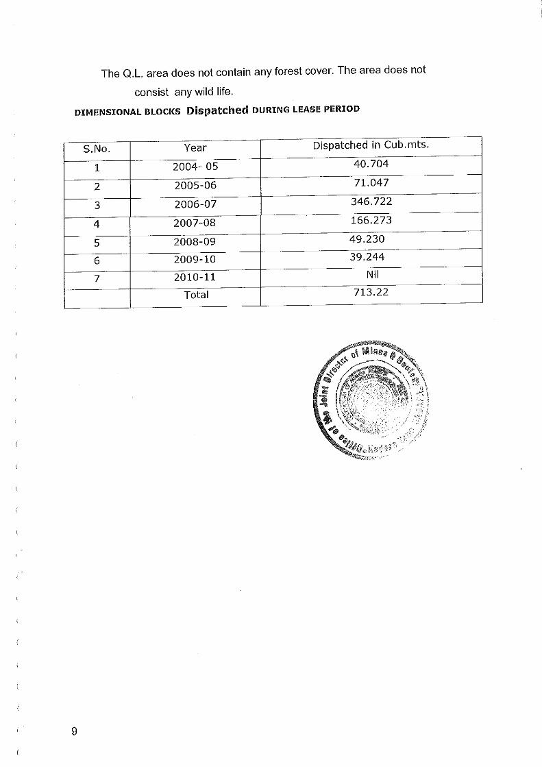


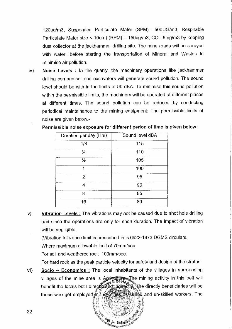


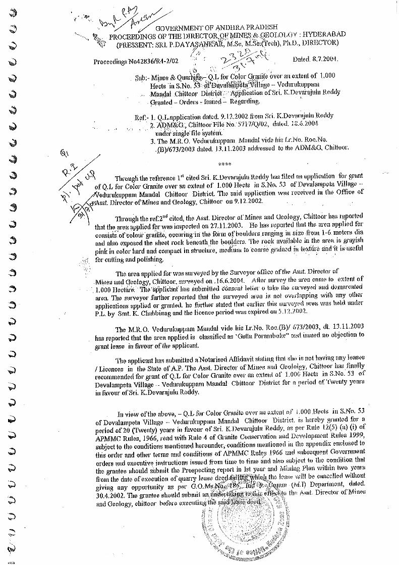


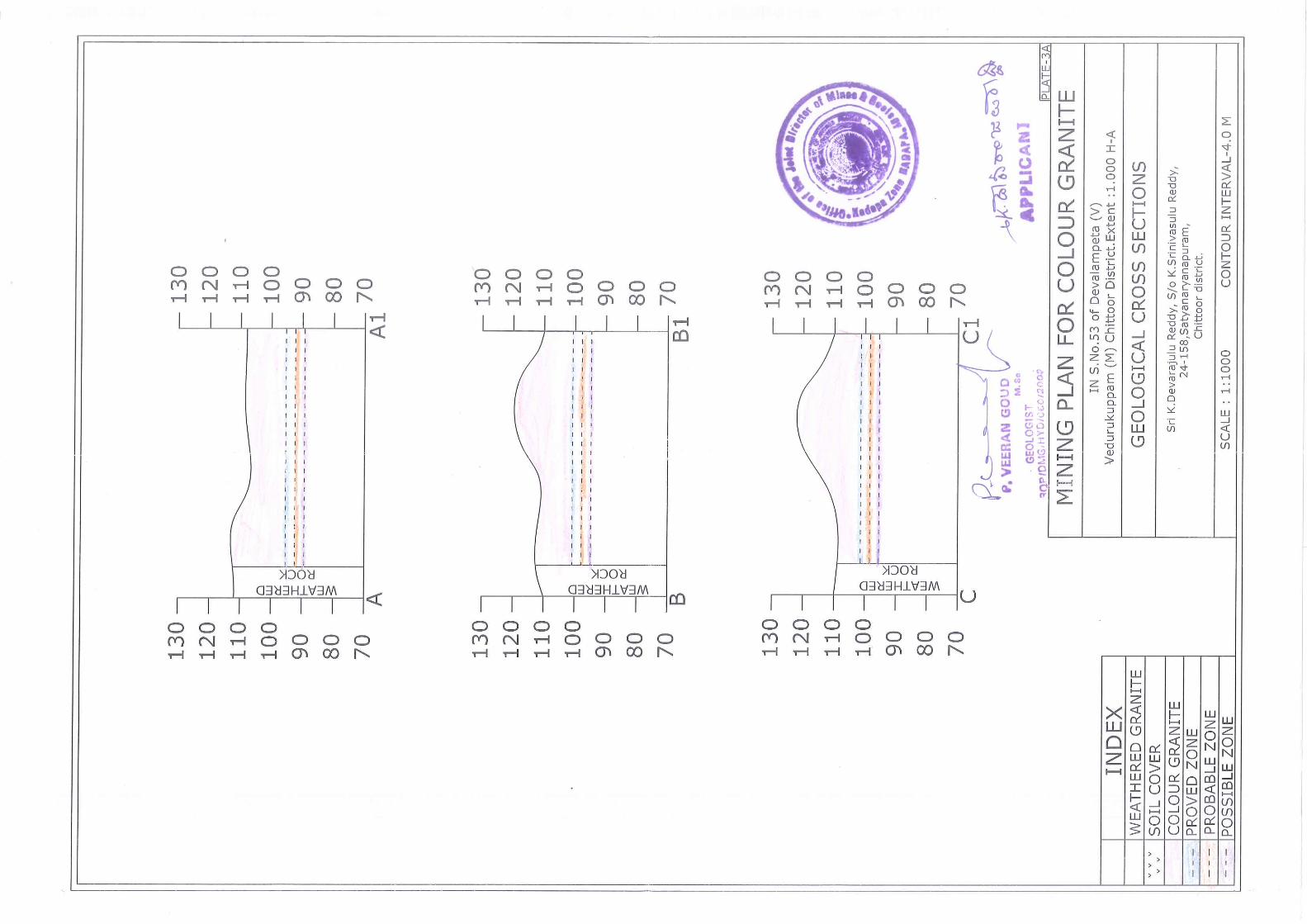


K. DEVARAJULU REDDYSURVEY NO. 53, DEVALAMPETA VILLAGE,
VEDURUKUPPAM MANDAL, CHITTOOR DISTRICT,ANDHRA PRADESH
Studies and Documentation byTeam Labs and Consultants(An ISO 9001:2008 Certified Company)B-115,116,117 & 509, Annapurna Block,Aditya Enclave, Ameerpet, Hyderabad-500 038Tel: 91-040-23748555, 23748616Fax: 91-040-23748666.Email: [email protected]