stage 1 – planning the assessment - south ribble … version... · web viewseptember 2010...
TRANSCRIPT

CENTRAL LANCASHIRE STRATEGIC HOUSING LAND AVAILABILITY
ASSESSMENT
September 2010

Although not published until later the main work on the Central Lancashire SHLAA was carried out prior to the revocation of the North West Regional Spatial Strategy (RSS) and therefore refers to RSS policies and housing targets. The Central Lancashire authorities are currently in the process of proposing local housing targets. The SHLAA will therefore be updated to remove references to the RSS and reflect local housing targets when these have been approved for publication within the joint Central Lancashire LDF Core Strategy.
2

CONTENTS
Introduction
Planning Policy Context
Methodology
Stage 1: Planning the assessment
Stage 2: Determining which sources of sites will be included in the assessment
Stage 3: Desktop review of existing information
Stage 4: Determining which sites and areas will be surveyed
Stage 5: Carrying out the survey
Stage 6: Estimating the housing potential of each site
Stage 7: Assessing when and whether sites are likely to be developed
Stage 8: Review of the assessment
Stage 9: Identifying and assessing the housing potential of broad locations
Stage 10: Determining the housing potential of windfall
APPENDIX 1 – Sites under 5 dwelling capacity included within the 5 year supply figures
APPENDIX 2 A & B – GVA Grimley Stage 7c Report & Addendum
List of TablesTable 1: Central Lancashire authority RSS housing targetsTable 2: Chorley sites considered unsuitableTable 3: Preston sites considered unsuitableTable 4: South Ribble sites considered unsuitableTable 5: Chorley sites Reporting Year and April 2010 – March 2015Table 6: Chorley 5 Year Supply 2010/11 – 2014/15Table 7: Preston sites Reporting Year and April 2010 – March 2015Table 8: Preston 5 year supply summary table (201/11 – 2014/15)Table 9: Preston City Council Housing supply requirement in the RSSTable 10: South Ribble sites Reporting Year and April 2010 – March 2015Table 11: Chorley sites April 2015 – March 2020 and April 2020 to March 2024Table 12: Preston sites April 2015 – March 2020 and April 2020 to March 2024Table 13: South Ribble sites April 2015 – March 2020 and April 2020 to March 2024
3

CENTRAL LANCASHIRE STRATEGIC HOUSING LAND AVAILABILITY ASSESSMENT September 2010
INTRODUCTION
National Planning Policy Statement 3 (PPS3: Housing) stresses the need for a thorough evidence-based policy approach to achieve strategic housing objectives. In particular it stipulates the need for the assessment of housing land availability, through the use of Strategic Housing Land Availability Assessments (SHLAA).
The Central Lancashire Authorities of Chorley, Preston and South Ribble are collaborating on development planning documents that are part of the Local Development Framework. National and regional policy advocates joint working between authorities whose housing markets cross administrative boundaries and therefore Chorley, Preston and South Ribble Councils are producing a joint SHLAA for the Central Lancashire Housing Market Area.
The North West Regional Spatial Strategy sets a housing provision target for the period 2003-2021 of a total of 24,120 for the three Central Lancashire authorities and the SHLAA‘s primary aim is to identify potential land supplies for meeting at least this need. This document has been produced for the period April 2009 to March 2024 (whereby the year April 2009 – March 2010 is considered as the ‘reporting year’ in terms of AMR guidance) with a forward looking 5 year supply period from 2010/11 – 2014/15. The document therefore supersedes the previous SHLAA which was published in March 2009.
The SHLAA provides an evidence base on the potential housing land supply across Central Lancashire. This document does not allocate specific sites for housing development but will be used as a key piece of evidence to inform the Core Strategy and Site Allocations Development Plan Document work.
4

PLANNING POLICY CONTEXT
National Policy Context
Planning Policy Statement 12: Local Spatial Planning
Planning Policy Statement 12 (PPS12) highlights the need for a robust and credible evidence base to inform development documents that make up the Local Development Framework. The Strategic Housing Land Availability Assessment will form an important component of that evidence base.
Planning Policy Statement 3: Housing
Planning Policy Statement 3 (PPS3) sets out the national planning policy framework for achieving the government’s strategic housing objectives, and emerged as a response to the Barker Review of Housing Supply (2004). PPS3 sets out the framework needed to achieve a new, more responsive approach to land supply at the local level.
PPS3 requires local authorities to assess housing need and demand through Strategic Housing Market Assessments (SHMA), and land supply and availability through a SHLAA. It states that where two or more Local Planning Authorities form a housing market area, they should work together by preparing joint assessments or by ensuring consistency in methodology. Chorley, Preston and South Ribble constitute the Central Lancashire housing market area and therefore have produced this joint Strategic Housing Land Availability Assessment. The three councils have also collaborated on a joint Strategic Housing Market Assessment which has been reported on separately.
Strategic Housing Land Availability Assessments Practice Guidance
The Strategic Housing Land Availability Assessments Practice Guidance (The Practice Guidance), produced by the government department of Communities and Local Government in 2007, provides practical guidance for local authorities on how to carry out an assessment to identify land for housing and to assess the deliverability of sites. The Practice Guidance stresses the importance of Strategic Housing Land Availability Assessments as a key component of the evidence base needed to support the delivery of sufficient land for housing to meet local communities’ needs. It states that the primary role of a SHLAA is to:
identify sites with potential for housing assess their housing potential, and assess when and whether they are likely to be developed.
A SHLAA should:
identify specific, deliverable sites for the next five years that are ready for development, and to keep this updated in response to market conditions;
identify specific, developable sites for 6-10 years into the future, and ideally for years 11-15, to enable the five year supply to be continuously topped up in the years to come;
where it is not possible to identify specific sites for years 11-15 of the plan, indicate broad locations for future growth.
This SHLAA follows the approach set out in PPS3 and the Practice Guidance which outlines the minimum requirements of a SHLAA. These are to:
Provide a list of sites, cross referenced to maps showing locations and boundaries of specific sites
5

Assess the deliverability/developability of each identified site (in terms of suitability, availability and achievability) to determine when an identified site is realistically expected to be developed
Assess the potential quantity of housing that could be delivered on each identified site or within each identified broad location (where necessary) or on windfall sites (where justified)
Identify constraints on the delivery of identified sites Make recommendations on how these constraints could be overcome and when
Regional Policy Context
The North West Regional Spatial Strategy was published in September 2008 and provides housing provision target figures for each local authority area in the region. Table 1 below shows the targets for the Central Lancashire authorities.
Table 1: Central Lancashire authority RSS housing targets
Local Authority Area
Total Housing Provision 2003-2021 (net of clearance
replacement)
Annual Average rates of Housing Provision (net of clearance
replacement)Chorley 7,500 417Preston 9,120 507
South Ribble 7,500 417
Policy L4 of the Regional Spatial Strategy states that local planning authorities should monitor and manage the availability of land for housing and that they should use the results of up-to-date Strategic Housing Land Availability Assessments to inform the allocation of, and development control decisions upon specific sites. It also echoes national policy in that it advocates joint working between local authorities where housing markets extend across administrative boundaries.
Policy L4 states that in the Central Lancashire housing market area, at least 70% of new housing development should be located on brownfield land, which will inevitably influence which sites are allocated for residential use.
Policy L4 also states that for the purpose of producing LDFs, local planning authorities should assume that the average annual requirement will continue for a limited period beyond 2021. The RSS annual targets have therefore been rolled forward until the end of the SHLAA period.
Local Policy Context
Local Development Frameworks
Existing Local Plans are being replaced by Local Development Frameworks (LDFs) which comprise a series of documents that cover up to 15 years into the future. The main overarching document is a Core Strategy which sets the broad policy approach that other more detailed and site specific Development Plan Documents (DPDs) need to conform with.
For the combined Central Lancashire area, Chorley, Preston and South Ribble Councils are producing a joint Core Strategy which will be finalised and adopted in 2011. The Publication Draft which is due to be made available in autumn 2010, sets out the preferred spatial development strategy for Central Lancashire and is therefore of relevance to the SHLAA. Firstly Policy 1 (Locating Growth ) states that growth and investment should be focussed on brownfield sites and key regeneration areas in Preston, the key service centres of Chorley
6

and Leyland as well as Longridge in Ribble Valley, Strategic sites, and the other main urban areas in South Ribble, whilst protecting the character of suburban areas. Some growth and investment is also encouraged at the Urban Local Service Centres of Adlington, Clayton Brook/Green, Clayton-le-Woods (Lancaster Lane), Coppull, Euxton and Whittle-le-Woods, with limited growth and investment encouraged at identified Rural Local Service Centres. The policy also recognises that there may be a need for some greenfield development on the fringes of main urban areas and also in specified local service centres.
Policy 4 is also of relevance to the SHLAA as it states that Chorley, Preston and South Ribble Councils should aim to provide for and manage the delivery of new housing by ensuring that there is enough deliverable land suitable for house building.
The Strategic Housing Land Availability Assessment will be an important evidence base for the Site Allocations work (DPD issues and options stage planned for Autumn 2010) which will set out site specific allocations to meet the Borough’s development needs and protect areas from inappropriate development.
Local Plans & Interim Planning Statements on Housing
Whilst work is well advanced on the Core Strategy and other Local Development Framework Documents (Chorley Council has already adopted a Sustainable Resources DPD), the three Central Lancashire authorities each have adopted Local Plans that currently remain in force. Preston and South Ribble Councils also have interim planning policies that relate to housing.
Housing Policies
Key Housing policies from each authority that are of relevance to the SHLAA are highlighted below:
Chorley Local Plan
Policy HS1 of the Chorley Local Plan provides a list of allocated sites for housing development for the period 1991-2006, and this policy was saved and extended beyond 2007 whilst Local Development Framework documents are being prepared. Many of these housing sites are now completed, but there are still a significant number of units that remain to be built on a number of the sites. Policy HS2 was also saved and this policy refers to the former Royal Ordnance Site at Euxton, which is now known as Buckshaw Village. A major urban village is developing here and a substantial number of housing units remain to be built.
Preston Local Plan
Policy DS1: Housing Land Requirement and Policy H1: Housing Development outside Allocated Areas both addressed the allocation of land for housing development in the Preston Local Plan but neither of these policies were saved beyond 2007.
Interim Planning Statement 5: Housing Provision in Preston
Preston's Interim Planning Statement (IPS) on Housing Provision was adopted in December 2008 and was produced in response to the updated housing provision targets in the Regional Spatial Strategy. It replaces the previous draft Supplementary Planning Guidance 9 – Housing Provision in Preston: The Monitoring and Managed Release of New Sites for Development produced by the council in 2004. IPS 5 states that where the council can demonstrate a 5-year supply of housing sites, planning applications for additional development will only be approved if it can be demonstrated that they are deliverable in the next 5 years. The policy gives priority to sites on previously developed land, and exceptionally, greenfield sites allocated in the Local Plan. The policy states that development will not be permitted on other greenfield sites unless exceptional circumstances can be
7

shown, for example sites in accordance with Local Plan Policy H3 – Affordable Housing in Rural Areas. IPS 5 also states that applications for housing on sites that are existing employment sites, or that were last used for employment, will normally be resisted unless the applicant can justify the change from employment use. IPS 5 will remain a material consideration in planning applications until it is superseded by the Local Development Framework Core Strategy.
South Ribble: Local Plan
The saved policies of the South Ribble Local Plan provide the current policy framework for decision-making on the use of land and buildings within the Borough. Policy HP1 lists sites that were identified to meet housing needs in the borough up until 2006, and since the Local Plan was adopted, 10 of the 15 sites have been fully developed.
South Ribble: Interim Planning Policy: Housing
South Ribble Borough Council adopted this interim planning policy in September 2008 in order to reflect updated national and regional planning policy. It will apply until the council adopts the Central Lancashire Local Development Framework documents. The policy promotes a flexible approach to managing housing land, informed by regular monitoring of the Borough’s supply of housing land. If the council can demonstrate an oversupply of housing of up to 20% over RSS targets, the council will restrict the release of further housing land to sites which make an essential contribution, for example affordable or special needs housing.
Other Relevant Policy Designations
There are a number of other key local policy designations that are of relevance to the SHLAA.
Both Chorley and South Ribble boroughs have extensive areas of Green Belt land, whilst Green Belt land is far more limited in extent in Preston. Most types of development including nearly all forms of housing development are not appropriate in the Green Belt.
In both South Ribble and Chorley there are large areas of designated Safeguarded Land on the edge of towns and villages. This land could be used for development including housing if there is a need and it is otherwise appropriate to allocate the land for residential development.
To the east of Chorley town and around the west, north and east of Preston City the open countryside is protected from most forms of development including most types of housing, although land adjoining the urban areas could be suitable subject to its policy status being changed.
In all three districts public and privately owned open space used for amenity, sport and other recreational purposes is protected from development and not normally allowed for housing
The Central Lancashire and Blackpool Growth Point
The aim of Growth Points is to improve the availability of housing by increasing new construction. This national initiative was conceived prior to the 2008 recession when it was hoped that public pump priming monies for infrastructure provision and advance planning would stimulate the house building industry. However the recession, with its associated reductions on loan finance availability severely restricted both potential home buyer purchasing power and developers’ ability to pre-fund schemes. In response to the wide scale effects of the recession the government reduced Growth Point funding by redistributing some
8

of the monies to other housing associated incentives across the country. Growth Point funding has yet to be announced for 2011/12 onwards.
Across Central Lancashire and Blackpool the aim in the Growth Point bid submitted by the participating councils was to increase the numbers of new home built by 2017 by more than 30% above the provision levels in the Regional Spatial Strategy (RSS). The RSS annual housing provision levels for the three Central Lancashire Districts add up to approximately 1340 dwellings. However instead of this annual figure being exceeded house building rates fell substantially with the onset of the recession. This is especially so in Preston with the high number of City Centre apartment schemes dependent on buy to let mortgages which were withdrawn by lenders.
The amount of Growth Point related finance so far available has not convinced the local house building industry that rates of residential development can be significantly increased in the near future. Industry representatives predict that no overall excess of house building completions above SHLAA provision levels will be achieved during the Growth Point period to 2017.
Within the Central Lancashire Draft Core Strategy the authorities consider that the developers’ view of future house building activity is too pessimistic by being overly influenced by the short term problems of restricted loan availability. The Growth Point uplift in housing delivery remains an aspiration of the authorities but may not now be achievable.
9

METHODOLOGY
STAGE 1 – PLANNING THE ASSESSMENT
The approach taken to the SHLAA follows that set out in the Practice Guidance. This advocates carrying out the assessment with other local planning authorities in a housing market area. The three authorities of Chorley, Preston City and South Ribble form a single housing market area, so have worked together to produce a joint SHLAA for Central Lancashire. However, each district has its own housing targets in the Regional Spatial Strategy and the SHLAA Report has been structured to enable the housing land availability situation in each district to be clearly identified.
The Assessment has been produced in partnership, with the lead taken by officers at the three Central Lancashire Authorities. Central Lancashire has a Strategic Housing Market Partnership that meets on a regular basis. The Housing Market Partnership includes key stakeholders such as house builders, social landlords and property agencies. The Partnership has been kept informed of progress on the SHLAA and partners' comments have helped to influence the approach taken and the assumptions made.
Drawn from the Partnership, and supplemented by additional developers a Panel has been established to directly inform the SHLAA work. Three Panel meetings were held in January, February and March 2009 to assist with the production of the first SHLAA. At these meetings, both local and regional housebuilders, gave their views on the deliverability and developability of sites and other assumptions made, which were reflected in the SHLAA Report published in March 2009. In order to further review the SHLAA assumptions and to incorporate opinions on the deliverability and developability of new sites added into the SHLAA a further Developer Panel meeting was held in October 2009.
In order to provide further expertise on the achievability of housing development GVA Grimley were commissioned to undertake stage 7c of the SHLAA process for the first SHLAA in 2009 (see Appendix 2). This information informs the SHLAA review and has been supplemented by any new information received from the Developer Panel and landowners/ developers. Any new sites that have come forward within this SHLAA review have been assessed by the Developer Panel and internally based on GVA Grimleys assessment of market areas, any known cost factors (flood risk, contamination etc) and delivery factors, taking account of developers own phasing proposals where known.
10
STAGE 2 – DETERMINING WHICH SOURCES OF SITES WILL BE INCLUDED IN THE ASSESSMENT
The Guidance indicates the sources and types of sites that should be included in the SHLAA. The following types of site have all been included in the Central Lancashire SHLAA.
Sites in the planning process Existing housing allocations and sites with development briefs Unimplemented/outstanding planning permissions for housing Planning permissions for housing that are under construction Land allocated (or with permission) for employment or other land uses which are no
longer required for those uses Land identified in current Local Plans as Safeguarded
Sites not currently in the planning process
Vacant and derelict land and buildings Surplus public sector land Land in non-residential use which may be suitable for re-development for housing,
including as part of a mixed use development Additional housing opportunities in established residential areas, such as under-used
garage blocks Sites in rural settlements, and rural 'exception' sites (such as for local needs
affordable housing) Urban extensions (larger sites adjoining built up areas such as Safeguarded Land)
There are no current plans for the large scale redevelopment and re-design of existing residential areas in Central Lancashire and no free standing new settlements have been identified by the Regional Spatial Strategy, so the SHLAA does not include these types of sites, which are listed in the Practice Guidance.
Given the large number of sites that are included in the SHLAA, a threshold has been applied and sites that have a capacity of less than 5 dwellings are not included and assessed in the study. Sites under 5 dwellings do however contribute towards the 5 year supply. A figure has therefore been included within the study which takes into account all sites under 5 dwellings that have planning permission. It is acknowledged that not all these sites will be built out in 0-5 years and therefore the overall figure allows for 10% of these sites not being developed.
Policy Exclusions
The SHLAA must enable the three authorities to be in the best possible position for deciding their strategies for delivering housing targets and objectives. The Guidance recommends that the scope of the assessment should not be narrowed down by existing policies designed to constrain development. The joint working on Local Development Framework Documents will mean that new policies are adopted relating to the use and development of land. Therefore, at the initial stage, very few types of land that might have potential for housing were excluded from the study. This will help to ensure that the assessment is as thorough as possible. However, the following types of land have been excluded from the assessment and the reason for these exclusions are set out below.
The following land types were excluded:
Nature Conservation Designations
Sites that are designated as Sites of Special Scientific Interest (SSSIs), Special Protection Areas (SPAs) and Special Areas of Conservation (SACs) have been excluded from the study, due to their importance for nature and conservation.
Flood Zones 3a and 3b Parts of Central Lancashire are vulnerable to flooding. PPS25
11

states that more vulnerable uses, such as residential dwellings, are only appropriate in Flood Zone 3a if the exception test is passed. Therefore, sites that are predominantly located in this zone have generally been excluded from the study, unless they already have planning permission for housing, or form part of an existing housing or mixed-use allocation. Occasionally parts of larger housing sites fall within Flood Zone 3a. In these circumstances, the net developable area of these sites has normally been reduced to reflect this designation. Residential dwellings are not permitted in Flood Zone 3b.
Policy Inclusions
The following land types were all included within the scope of the assessment at the initial stage. However, some of these land types were excluded later on in the process. These issues are considered in Stage 7a of this report.
Brownfield Land Brownfield land is generally preferred for development, although the SHLAA will take into account current planning policies, locational circumstances, and the need for other land uses, when brownfield sites are assessed for their suitability for housing.
Greenfield sites Planning policies recognise that the priority is to develop brownfield sites. However, some greenfield sites will be appropriate for development. The SHLAA therefore assesses greenfield sites to determine their suitability.
Green Belt Land The importance of Green Belt is recognised both nationally and locally in maintaining the openness between built up areas. There is no intention at the present time to review Green Belt boundaries, but Green Belt sites were initially included in the assessment in case a review should take place.
Safeguarded Land Safeguarded Land, identified in Chorley and South Ribble's Local Plans, is to be kept safeguarded from development in order to help meet long term development needs without encroaching onto Green Belt land. It is therefore appropriate to assess this land for development suitability.
Public Open Space Some sites that predominantly comprise public open space were initially included in the assessment.
Flood zones 1 & 2 Sites within Floodzones 1 & 2 have not been excluded from the assessment as measures can be taken in a development to mitigate the risk of flooding. The flood risk element and the cost of mitigation would be considered at the viability stage of the assessment.
Nature Conservation Areas
Locally designated conservation sites have a lower status than national designations and some sites were initially included in this assessment.
Open Countryside (Preston) & The Area of Other Open Countryside (Chorley)
As with Green Belt land, the designated Open Countryside in Preston and designated Area of Other Open Countryside in Chorley is currently strictly protected. However some land adjoining built up areas may be suitable housing so these sites were initially included in the assessment.
12

STAGE 3 – DESKTOP REVIEW OF EXISTING INFORMATION
A desktop review was undertaken of sites in the planning process and sites from other sources to identify sites with potential for housing. The table below identifies sources from which sites have been identified for inclusion in the Central Lancashire SHLAA.
Sites in the planning process PurposeSite allocations not yet the subject of planning permission
To identify sites
Planning permission/sites under construction (particularly those being developed in phases)
To identify sites
Site specific development briefs To identify sites and constraints to deliveryPlanning application refusals To identify sites – particularly those
applications rejected on grounds of prematurity
Dwelling starts and completion records To identify the current development progress on sites with planning permission
Site suggestions submitted by landowners/developers as part of a call for sites to inform the Site Allocations DPD
To identify sites
Other information sources that were used to identify sitesUrban Potential Studies To identify buildings and land, and any
constraints to deliveryNational Land use Database (NLUD) To identify buildings and land, and any
constraints to deliveryRegister of Surplus Public Sector Land To identify buildings and landJoint Employment Land Review To identify surplus employment buildings and
landOrdnance survey maps To identify landAerial photography To identify land
Sites within the Central Lancashire SHLAA therefore include:
Existing allocations for residential development or mixed use development from the existing Local Plans for each area.
Large and small sites with planning permission in Preston, South Ribble and Chorley. This includes sites on which development has commenced, and sites that have planning permission for residential development, that has not yet commenced.
Urban Potential Studies – All three authorities have undertaken and completed Urban Potential Studies for their areas. Sites identified in these studies where development on the site has not been completed have been included in the SHLAA. Sites with a capacity for 5 or more dwellings have been included.
Joint Employment Land Review (Summer 2008) – The three Councils have recently published a comprehensive Employment Land Review which was completed by consultants. The study split the employment sites in the three boroughs into six categories. The lowest quality sites were identified as “Other” in the review and have been included in the SHLAA along with those classed as ‘Mixed Use’. Sites in the Employment Land Review classified as “Other” are sites that are moderate to poor quality, with significant constraints, and often in inappropriate locations. Such sites may have potential for (partial) de-allocation or release to other forms of development.
13

These sites have therefore been included in the SHLAA to assess their suitability for residential development. Sites which were classified as ‘Mixed Use’ are sites that were identified as having potential for mixed use development as a means of enhancing their current contribution to townscape quality as well as the quality of the local employment offer.
Sites identified in suggestions submitted by landowners/developers as part of a call for sites to inform the Site Allocations DPD which closed at the end of January 2010. The three Councils have asked any interested parties to suggest sites to be considered as part of the LDF process. There were over 500 suggestions across the three areas, with the majority being for residential development or mixed use development. Sites that were suggested that have a capacity of more than 5 dwellings have been included in the SHLAA.
National Land Use Database (NLUD) Sites – Vacant and derelict land as identified in the annual NLUD returns has also been included in the study.
STAGE 4 – DETERMINING WHICH SITES AND AREAS WILL BE SURVEYED
All sites identified by the desk top review have been visited. This is to ensure that there are no inconsistencies and to get an up to date view of all the sites. The Practice Guidance states that the site survey should also be used to identify further sites with potential for housing, and a number of additional sites have been indentified as a result.
STAGE 5 – CARRYING OUT THE SURVEY
Site visits were carried out for all of the sites included in the SHLAA. While on site, the following characteristics were either recorded or checked if they had been previously identified:
Site size Site boundaries Current use(s) Surrounding land use(s) Character of surrounding area Physical constraints e.g. access, steep slopes, potential for flooding, natural features
of significance and location of pylons Development progress, e.g. ground works completed, number of homes started and
number of homes completed Initial assessment of whether the site is suitable for housing or housing as part of a
mixed use development
A database was created to record all the information collected on the sites during the survey process, and during the desktop review of all the sites.
STAGE 6 – ESTIMATING THE HOUSING POTENTIAL OF EACH SITE
The Guidance states that the estimation of the housing potential of each site should be guided by existing or emerging plan policies, particularly the approach to housing densities at the local level. However, it is not considered that existing or emerging policies provide a sufficient basis to make a local judgement, so a range of density classifications with associated density ranges were developed at the start of the SHLAA process for different types of locations in Central Lancashire. These ranges reflect typical densities that can be expected in these types of locations, with an emphasis on higher densities in more sustainable locations.
14

The density classifications/ranges have been amended over time as a result of Developer Panel consultation to reflect changing market conditions. The following table shows the various changes that have been applied to the density classifications/ ranges:
Initial ranges applied in 2008
Ranges applied in March 09 SHLAA
Ranges applied in updated May 2010 SHLAA
Preston City Centre 120 - 150 dph 50 – 100 dph 50 – 100 dphPreston Docks 60 - 120 dph 50 – 100 dph 50 – 100 dphInner Urban 50 - 120 dph 50 – 100 dph 30 – 50 dphSuburban 30 - 60 dph 30 – 60 dph 30 – 40 dphRural Settlements 30 - 60 dph 30 – 60 dph 30 – 40 dphOther Rural 30 - 40 dph 30 – 40 dph 30 – 40 dph
Each site in the assessment has been given a density classification and a site specific density multiplier, which has been used to calculate the housing potential of the site. Density multipliers are based on an assessment of the area immediately surrounding the site. The only exceptions relate to sites that already have planning permission for housing. On these sites the number of housing units submitted with the planning application has been used, except in circumstances where evidence suggests that re-planning of the site may be necessary due to changes in market conditions.
Not all of the total site area will be developed for housing. Therefore, we have made the following assumptions about the net developable area on sites of different sizes.
On sites of:
less than 0.4 hectares: 90% of site developed for housing0.4 – 4.9 hectares: 80% of site developed for housing 5 – 10 hectares 60% of site developed for housingOver 10 hectares 50% of site developed for housing
Each site has then been assessed to reflect any individual site characteristics and physical constraints and the net developable area adjusted accordingly.
Therefore, the potential capacity of a housing site has been calculated as:
Site size x net developable area x density multiplier
Each site in the assessment has been given a housing capacity figure. However, other than when a site already has planning permission, the capacities are not based on detailed designs for each site and are purely indicative.
Through developer consultation, GVA Grimley produced a set of build-out rates in 2008 for the SHLAA. However due to changes in market conditions since the initial work by GVA Grimley in 2008 the issue of build-out rates has been reviewed by the Developer Panel. The developers voiced concerns that the build out rates were set too high from 2010 onwards and that a more realistic build-out rate figure for 2010 onwards would be 30 units per site per developer.
The amended build-out rates were confirmed as an accurate reflection of the present circumstances at the Developer Panel meeting in October 2009 and are as follows (except where there is site-specific recent information to the contrary):
2009-2010 – anticipated build out rates of 24 units per site per developer
15

2010-2011 – anticipated build out rates of 30 units per site per developer 2011-2012 and years beyond – return to build out rate of 30 units per site per developer
STAGE 7 – ASSESSING WHEN AND WHETHER SITES ARE LIKELY TO BE DEVELOPED
The Guidance splits stage 7 into 4 steps, which relate to assessing when and whether sites are likely to be developed.
Assessing the suitability, availability and achievability of a site allows judgements to be made as to whether a site can be considered deliverable, developable or not currently developable for housing development.
To be considered deliverable: A site should be available now, offer a suitable location for housing development now and there should be a reasonable prospect that housing will be delivered on the site.
To be considered developable:A site should be in a suitable location for housing development, and there should be a reasonable prospect that it will be available for and could be developed at a specific point in time.
Stage 7a: Assessing suitability for housing
The Guidance states that a site is suitable for housing development if it offers a suitable location for development and would contribute to the creation of sustainable mixed communities.
The Guidance advises that factors such as policy restrictions, physical problems or limitations, potential impacts and the environmental conditions which would be experienced by prospective residents should be considered when assessing a site’s suitability for housing.
The sites have been spilt into three categories and the maps which accompany this document show these sites using the following colours:
Green – Suitable Orange – Suitable with policy restrictions Red – Unsuitable
The suitability of the sites for housing does not mean that a decision has been taken to identify these for actual housing development. This is a matter for the Site Allocations and Development Management Policies Development Plan Documents to determine.
Policy Restrictions
At the initial stage of the assessment very few types of land that might have potential for housing were excluded from the study, to help to ensure that the assessment was as thorough as possible. However, a number of sites were considered unsuitable at Stage 7a in terms of policy restrictions.
When assessing suitability of sites, those in the Green Belt were considered unsuitable for housing purposes. This accords with policy in the Regional Spatial Strategy, which states that there is no need for any exceptional strategic change to the Green Belt in Lancashire before 2011 and a presumption against substantial strategic change to the Green Belt in Lancashire after this period. The Publication Draft Core Strategy also has a presumption against development in the Green Belt, although it does state that it may be necessary to alter Green Belt boundaries locally and on a small scale to accommodate appropriate local
16

developments. Many of the Green Belt sites also score badly in terms of sustainability largely due to their location away from most services.
Some sites that predominantly comprise public open space were initially included in the assessment. However, public open space is very important for local communities and the three Councils aim to protect it. Therefore, when assessing the suitability of these sites they were generally excluded from the assessment. Occasionally public open space forms part of a larger housing site that is included in the assessment. In these circumstances, the net developable area of these sites was generally reduced to allow the retention of the public open space.
Locally designated conservation sites, such as Biological Heritage Sites, have a lower status than national designations and some sites were initially included in this assessment. However, they are still of importance for nature and conservation purposes and were generally considered unsuitable when assessing the suitability of sites for housing.
When assessing suitability, sites in Open Countryside separate from existing settlements were mainly considered unsuitable for housing purposes unless they already have planning permission. This approach accords with national policy PPS7: Sustainable Development in Rural Areas which states that new development in the open countryside, away from existing settlements, or outside areas allocated for development in development plans, should be strictly controlled. Sites on the edge of the Preston urban area and Longridge as a key service centre, which could provide potential sustainable urban extensions in the future were considered suitable as these fit with the Publication Draft Central Lancashire Core Strategy. Any other ‘Open Countryside’ sites on the edge of existing settlements within Preston City Council area were included as ‘suitable but with policy restrictions’ as they go against the policies within the current Preston Local Plan and Draft Core Strategy.
Employment sites included within the study as a result of the Joint Employment Land Review (ELR) have been assessed on a site by site basis. The ELR identified only a small number of “Other" sites which were generally moderate to poor quality. The ELR did however identify a number of potential ‘Mixed Use’ sites as well.
The following tables set out those sites in each of the three authorities that were assessed as being unsuitable for residential development:
17

Table 2: Chorley sites considered unsuitable
Site Ref Site Name Ward/Settlement Site Size
(ha)Site Suitable for
Housing? Reasons
ADL02 Land off Railway Road Adlington 0.66 No Site is a residential garden
ADL04 Railway Road Adlington 2.5 NoApplication submitted for 75 units in 2009 but withdrawn. Policy preference to retain for employment purposes. Rated ‘Other Urban’ in ELR
ADL06 Westhoughton Road Adlington 0.5 NoPolicy preference to retain for employment purposes. Rated ‘Other Urban’ in ELR. Operational but site suggested for housing redevelopment
ADL13 The Common Adlington 0.5 No Site is located in Green Belt. Not adjacent to designated settlement
ADL14Allanson Hall Farm Westhoughton Road Adlington 15.6 No Site is located in Green Belt
ADL15 Woodward House Fields Bolton Rd Adlington 17.71 No Site is located in Green Belt. Not adjacent to designated settlementADL16 Back Lane, Heath Charnock Adlington 0.78 No Site is located in Green Belt. Not adjacent to designated settlementADL17 Hole House Farm Heath Charnock Adlington 4.2 No Site is located in Green Belt
ADL18Bramblewood Nursery & Garden Centre Adlington 3.2 No Site is located in Green Belt. Not adjacent to designated settlement
ADL19 Weldbank Plastics Westhoughton Rd Adlington 0.77 No Policy preference to retain for employment purposes. Not assessed in ELR. Operational but site suggested for housing redevelopmentADL20 Remainder of Land off Bolton Road Adlington 6.37 No Site is located in Green Belt. Requires development of ADL09ADL21 120 Rawlinson Lane Adlington 2.7 No Site is located in Green Belt. Not adjacent to designated settlementADL22 Acresfield Adlington - No Site is protected Open Space
ADL23 Fairport, Railway Road Adlington 3.58 NoPolicy preference to retain for employment purposes. Rated ‘Good Urban’ in ELR. Operational but site suggested for housing redevelopment
ADL25Land North of Lower Hale Drive, Heath Charnock Adlington 4.39 No Site is located in Green Belt
BRW02 Land off Heather Lea Drive Brinscall 2.83 No Majority of site is allocated as a proposed playing fieldBRW03 Withnell Mill Withnell 0.36 No Policy preference to retain for employment purposes. Rated Good Urban in ELR. Predominantly industrial/commercial area.BRW04 Land off Fellstone Vale Brinscall 4.6 No Green BeltBRW05 Boardman's Heights, Bury Lane Withnell 11.2 No Green Belt
BRW06 Abbey Village Mill Abbey Village 3 NoOperational employment site. Landowners intentions currently unknown so would need to agree to make land available. Abbey Village not identified as a location for growth in draft Core Strategy
BRW08 Bolton Road Abbey Village 0.87 No Green Belt
CHO14 Saville Street & Adjoining Land Chorley 0.55 No
Site allocated for housing redevelopment in Local Plan but large section of site now redeveloped for this purpose. Remaining section of site is a busy operational garage and a school. Landowners intentions currently unknown so would need to agree to make site available
CHO15 Yarrow Mill, Yarrow Road Chorley 1.5 NoPolicy preference to retain for employment purposes. Rated ‘Other Urban’ in ELR. Operational but site suggested for housing redevelopment. Demolition required
CHO17 Cowling Mill, Cowling Brow Chorley 2.41 NoPolicy preference to retain for employment purposes. Rated ‘Other Urban’ in ELR. Operational but site suggested for housing redevelopment. Demolition required
CHO18 William Lawrence Site, Townley Street Chorley 1.32 NoPolicy preference to retain for employment purposes. Rated ‘Other Urban’ in ELR. Operational but site suggested for housing redevelopment. Demolition required
CHO22 Chorley Social Club, Friday Street Chorley 0.76 No Demolition needed. Policy preference to retain majority of site for employment purposes. Rated ‘Good Urban’ in ELR
CHO24 Botany/Great Knowley Chorley 15.7 NoPolicy preference to retain for employment purposes. Allocated Employment Site. Rated ‘Good Urban’ in ELR. Small part Green Belt. Mixed Use Site suggestion
CHO31FDC (Holdings) Ltd & Ferax Premises, Moorland Gate, Cowling Brow Chorley 6 No
Policy preference to retain for employment purposes. Rated ‘Owner Specific’ in ELR. Site suggested for mixed uses. Demolition required
CHO41 Land south of Crosse Hall Lane Chorley 2.72 NoSteep slope of site makes development for housing unlikely and site is very close to motorway. Landowners intentions unknown so would need to agree to make site available. Chorley is identified Key Service Centre in draft Core Strategy
CHO42South of Lower Healey Farm, Froom Street Chorley 3.5 No Site is located in Area of Other Open Countryside detached from settlement. Access Issues
CHO43 Lower Healey, Froom Street Chorley 2.02 No Site is located in Area of Other Open Countryside detached from settlement. Access Issues
CHO44Former Rover Dealership, Bengal Street Chorley 0.5 No Policy preference to retain for employment purposes. Not rated in the ELR.
CHO46 Froom Street Chorley 2.48 No Site is located in Area of Other Open Countryside detached from settlement. Access IssuesCHO47 Land at Botany Bay, Bagganley Lane Chorley 0.4 No Site is located in Area of Other Open Countryside detached from settlement. Water based leisure allocationCHO48 Land at Bagganley Lane Chorley 15.92 No Site is located in Area of Other Open Countryside detached from settlement. Access Issues
CHO49Land adjacent to Bagganley Lane & Lower Healey Business Park Chorley 14.42 No Site is located in Area of Other Open Countryside detached from settlement. Water based leisure allocation
18

CHO51 Land off Preston Road Chorley 3.23 No Site is located in Green Belt & Structural Landscaping Belt
CHO52 Euxton Park Golf Centre, Euxton Lane Chorley 8 No Site is located in Green Belt
CHO53Lower Healey Farm, Bagganley Lane North Chorley 23.33 No Site is located in Area of Other Open Countryside detached from settlement.
CHO61 St Georges Institute, Trinity Road Chorley 0.54 NoPart of site is protected open space (bowling green) with associated club and car parking so unsuitable. Housing site very restricted if bowling green, club and parking is retained. There would also be access issues to remainder of site
CHO62 Former Long Row, Bagganley Lane Chorley 0.21 No Site is located in Area of Other Open Countryside CHO63 Yarrow Farm Chorley 18.9 No Site is located in Green Belt and Valley Park. Not adjacent to designated settlementCHR03 Pole Green Nursery, Church Lane Charnock Richard 1.73 No Development would require nursery relocation to Green Belt & protected open space CHR04 Coppull Road Charnock Richard 1.4 No Site is located in Green Belt. Not adjacent to designated settlementCHR05 Park Hall Charnock Richard 51.5 No Major Developed Site in the Green Belt. Not adjacent to designated settlement CHR06 Land to east of Chorley Lane Charnock Richard 3.8 No Site is located in Green Belt & Part Biological Heritage SiteCHR07 Hindle's Town Lane Charnock Richard 19.8 No Site is located in Green Belt. Not adjacent to designated settlementCHR08 Hunters Lodge Hotel, Preston Road Charnock Richard 0.5 No Site is located in Green Belt. Not adjacent to designated settlement CHR09 Land at Chorley Lane Charnock Richard 4 No Site is located in Green Belt
CLB05 Westwood RoadClayton Brook/Green 1.25 No Site would need to be accessed via protected open space
CLB06 Preston RoadClayton Brook/Green 0.4 No Site is protected open space
CLW08Land south of Thorntree House, Wigan Road Clayton-le-Woods 1 No Site is located in Green Belt
CLW09Land at the corner of Wigan Road/Lydiate lane Clayton-le-Woods 7 No Site is located in Green Belt. Not adjacent to designated settlement. Site has proposed playspace allocation
CLW10 Land between Wigan Road & A6 Clayton-le-Woods 4 No Site is located in Green Belt. Not adjacent to designated settlement
CLW14Thorntrees Service Station, Wigan Road Clayton-le-Woods 1.03 No Site is located in Green Belt. Not adjacent to designated settlement
COP04 Blainscough Works Coppull 2.99 No Policy preference to retain for employment purposes. Rated ‘Other Urban’ in ELR COP05 Land adjacent to Blainscough Works Coppull 1.24 No Site is located in Green Belt. Not adjacent to designated settlement
COP10 263 Spendmore LaneCoppull
0.6 NoPolicy preference to retain for employment purposes. Site not in ELR. Operational but site suggested for housing redevelopment. Requires demolition of existing buildings. May be needed to provide access to COP07
COP11 Coppull Enterprise Centre, Mill Lane Coppull 1.5 No Policy preference to retain for employment purposes. Rated ‘Good Urban’ in ELR. Lake restricts area of siteCOP12 Land adjacent to Glover Road Coppull 0.4 No Site is located in Green Belt. Not adjacent to designated settlementCOP13 Land at Green Lane/Chapel Lane Coppull 2.1 No Site is located in Green Belt. Not adjacent to designated settlementCOP14 Land off Coppull Hall Lane Coppull 8.3 No Site is located in Green Belt. COP15 Clancutt House, Clancutt Lane Coppull 1 No Site is located in Green Belt (Majority of Site)COP16 Orchard Heys Farm, Park Road Coppull 14.2 No Green Belt & part Biological Heritage SiteCOP17 1 Jolly Tar Lane Coppull 1.25 No Site is located in Green Belt. Not adjacent to designated settlementCOP18 Green Lane Farm, Green Lane Coppull 0.78 No Site is located in Green Belt - Demolition of farm buildings required. Not adjacent to designated settlement COP19 Land at Green Lane Farm, Green Lane Coppull 3.31 No Site is located in Green Belt. Not adjacent to designated settlement COP20 Land opposite 35 Preston Road Coppull 0.55 No Site is located in Green Belt. Not adjacent to designated settlement COP21 Discover Leisure, Chapel Lane Coppull 1.2 No Policy preference to retain for employment purposes. Rated ‘Good Urban’ in ELR
COP22 Regent StreetCoppull
0.49 NoPolicy preference to retain for employment purposes. Site not in ELR. Operational but site suggested for housing redevelopment. Requires demolition of existing buildings
COP24Chisnall Hall Reclamation Site, Preston Road
Coppull1.01 No Site is located in Green Belt. Not adjacent to designated settlement
CRO04 Land to North of Brickcroft Lane Croston 6.8 No Site is located in Green Belt. Not adjacent to designated settlement. Partly located in floodzones 2 & 3CRO05 Land to the east of Out Lane Croston 1.9 No Site is located in Green BeltCRO06 Land off Westhead Road Croston 3.1 No Site is at risk of flooding. It is located in floodzones 2 & 3. CRO07 289 Moor Road Croston 0.5 No Site is located in Green Belt and is not adjacent to designated settlement
ECC08Grove Mill (Bygone Times) Langton Brow Eccleston 2.4 No
Policy preference to retain for employment purposes. Rated ‘Other Urban’ in ELR. Operational but site suggested for housing redevelopment. Demolition required.
ECC09 Parr Hall Farm, Parr Lane Eccleston 4.5 No Site is located in Green Belt. ECC10 Nursery House Farm, Parr Lane Eccleston 1.22 No Site is located in Green BeltECC11 Shelley Drive Eccleston 1.51 No Site is located in Green BeltECC12 Land to the north of Wrennalls Lane Eccleston 32.3 No Site is located in Green Belt. Not adjacent to designated settlementECC13 Land between Lydiate Lane and New Eccleston 7.85 No Site is located in Green Belt. Not adjacent to designated settlement
19

LaneECC15 Land known as the Croft, Bradley Lane Eccleston 0.84 No Site is located in Green BeltECC16 Glassman House, Bradley Lane Eccleston 1.57 No Site is located in Green Belt. Not adjacent to designated settlement EUX03 The Railway Tavern, Wigan Road Euxton 0.6 No Most of site is located in Green Belt. Section of site in settlement is too small for 5+ unitsEUX05 Land at Balshaw Lane & Wigan Rd Euxton 0.4 No Policy Preference to retain as amenity open space.
EUX06 Euxton Mill, Dawbers Lane Euxton 1 NoSite is located in Green Belt. Not adjacent to designated settlement. Rated ‘Other Urban in Employment Land Review’. Policy preference to retain for employment purposes. Site restricted by BHS & is partly in floodzone 2
EUX07 Land to rear of Euxton Hospital Euxton 0.4 No Site is located in Green Belt. Not adjacent to designated settlement
EUX08Lancashire Fire and Rescue Training Establishment, Southport Road Euxton 11 No
Major Developed Site in the Green Belt. Not immediately adjacent to designated settlement. In employment use and preference to retain for employment use.
EUX11Land south of Runshaw Lane & West of the Croft Euxton 8.5 No Site is located in Green Belt
EUX12 Land west of Wigan Road Euxton 8.3 No Site is located in Green Belt
EUX13Land north of Runshaw Lane and west of Cedar Avenue Euxton 7.8 No Site is located in Green Belt
OTV02Sidegate Cottage & land, Pompian Brow Bretherton 0.52 No Much of site is loacted in Green Belt
OTV03Land to rear of Gregson Lane Primary School Gregson Lane 7.5 No Site is located in Green Belt
OTV04 Heskin Green Heskin 14.4 No Sit e is located in Green Belt. Not adjacent to designated settlement.
OTV05Old Sand Quarry, Kenyon Lane & Copthurst Lane Wheelton 7.7 No Site is located in Green Belt & is also proposed playspace
OTV06Balderstone Farm & Low Moss Farm, Nixon Lane Ulnes Walton 1.26 No Site is located in Green Belt. Not adjacent to designated settlement
OTV07 Denizes Farm, Southport Road Ulnes Walton 8.37 No Site is located in Green Belt. Not adjacent to designated settlement
OTV08Land at Clemonson's Farm, Ulnes Walton Lane Ulnes Walton 5.1 No Site is located in Green Belt. Not adjacent to designated settlement
OTV10 Flash Green Acre, Jenny Lane Higher Wheelton 0.33 No Site is located in Green Belt OTV11 Land off High Street, Four Lane Ends Mawdesley 0.6 No Site is located in Green Belt. Not adjacent to designated settlement
WLW02 Kem Mill, Kem Mill Lane Whittle-le-Woods 1 NoPolicy preference to retain for employment purposes. Rated Other Urban in ELR. Part of site floodzone 2 & 3. Access is in floodzone 2. Requires demolition of existing buildings.
WLW03Little Quarries, Whittle Hill Quarries, Hill Top Lane Whittle-le-Woods 19.3 No
Part of large area of land that is safeguarded for future development needs. LDF review of land required. Site currently in use as a quarry. Majority of site unlikely to be suitable due to quarrying activity, slopes, ponds and trees
WLW08 Town Lane Whittle-le-Woods 0.74 No Site is WoodedWLW15 Swansey Mill, Mill Lane Whittle-le-Woods 1.67 No In floodzones 2 & 3. Employment Policy preference to retain for employment purposes. Rated ‘Other Urban’ in ELRWLW16 Lisieux Hall Whittle-le-Woods 55.7 No Site is located in Green BeltWLW17 Land off Parkside Drive Whittle-le-Woods 0.8 No Site is located in Green Belt & wooded siteWLW18 Land at Back Lane Whittle-le-Woods 1.5 No Site is located in Green Belt & Valley ParkWLW19 Land at Town Lane/Dark Lane Whittle-le-Woods 1.8 No Site is located in Green Belt. Not adjacent to designated settlement
WLW20Land behind Doorway to Value, off Preston Road Whittle-le-Woods 5 No Site is located in Green Belt
WLW21 Land off Lea Road Whittle-le-Woods 4.8 No Site is located in Green Belt
Table 3: Preston sites considered unsuitable
Site Ref Site Name Ward/Settlement Site Size (ha)
Site Suitable for Housing? Reasons
NLUD05 Land Off Carlton Street University 0.23 No The developable area is restricted by the need for a buffer strip for adjacent railway line. Site also has contamination issues
NLUD07 Land Off Hardwicke Street St Georges 0.23 No Part of ELR 'Other Urban' site considered for retention and redevelopment for employmentNLUD13 The Birches, Ribbleton Lane St Matthews 0.24 No Site has already been redeveloped as a Homeless ShelterP009 Broughton Vicarage, Garstang Road, Broughton Preston Rural East 2.05 No Site in 'Open Countryside' and not adjacent to the existing settlement boundaryP015 Site of Ingol Lodge, Cottam Lane, Ashton Ashton/ Ingol 5.26 No Site has major access issues and the majority of the site is within Flood zone 2 and 3.P018 Land south of Stoney Butts Larches/Lea 4.80 No Site is policy protected for Amenity Greenspace
20

Site Ref Site Name Ward/Settlement Site Size (ha)
Site Suitable for Housing? Reasons
P023 Lea Gate Garage, Blackpool Road Lea 0.85 No Site in 'Open Countryside' and not adjacent to the existing settlement boundaryP028 Land to east and west of Sandy Lane, Bartle Preston Rural North 13.60 No Site in 'Open Countryside' and not adjacent to the existing settlement boundaryP029 Land to the west of Garstang Road, Broughton Preston Rural East 25.50 No Site in 'Open Countryside' and not adjacent to the existing settlement boundary. The site is also
subject to Flood risk and identified as an area of separation in the Draft Core StrategyP032 Land and premises at School Street Riversway 0.56 No Site Suggestion put forward in 2007. The site has consequently moved forward and has
permission for other uses.P036 Grimsargh Reservoir and adjoining land, Preston Road, Grimsargh Preston Rural East 16.06 No Site Suggestion put forward in 2007. The sites has consequently moved forward and is now a
nature reserveP037 Queens Retail Park Town Centre 4.10 No Site Suggestion for mixed use including residential was put forward in 2007. Since 2007 there has
been a more recent site suggestion that has removed the residential element of the proposed use.P040 Tetrad, New Hall Lane St Matthews 2.19 No Part of site is duplicated in PEN1 (considered suitable). The rest is ELR 'Good Urban' site to be
retained for employmentP043 Land off Tudor Avenue, Lea Lea 3.01 No Site is policy protected for Amenity GreenspaceP048 Grimsargh House Rest Home, Preston Road, Grimsargh Preston Rural East 1.30 No Site in use as community facilityP066 Parkinson House Farm, Whittingham Lane, Goosnargh Preston Rural North 4.98 No Site in 'Open Countryside' and not adjacent to the existing settlement boundaryP071 Ingol Golf Course Greyfriars/ Ingol 35.00 No Site is policy protected as a Golf courseP074 Eastway Nurseries, Eastway, Fulwood Garrison 1.44 No Technical difficulties due to access off Eastway, levels, and it borders a landfill site. Developer
Panel comments indicate that it is not considered to be buildable.P078 Oak Nureries, Pudding Pie Nook Lane, Goosnargh (1) Preston Rural North 0.65 No Site in 'Open Countryside' and not adjacent to the existing settlement boundaryP079 Oak Nureries, Pudding Pie Nook Lane, Goosnargh (2) Preston Rural North 2.00 No Site in 'Open Countryside' and not adjacent to the existing settlement boundaryP083 Land to North of Lightfoot Lane, Preston Greyfriars 2.70 No Site is policy protected for Amenity GreenspaceP084 Haris Park, 253 Garstang Road, preston Greyfriars 3.50 No Policy Protected as Recreational GreenspacePR/CS001 Preston Jaguar, Portway, Ashton Riversway 0.86 No ELR considered as 'Good Urban'. Developer Panel comments indicate that this site is not
attractive for residential developmentPR/CS002 271-273 Brook Street Tulketh 0.33 No Part of ELR 'Other Urban' site considered for retention.PR/CS003 Land in between Dorest and Saunders Rake, Cumeragh Lane,
LongridgePreston Rural North 0.27 No Site in 'Open Countryside' and not adjacent to the existing settlement boundary
SE01 Avenham Street (56) Town Centre 1.19 No ELR 'Mixed Use' site currently in useSE02 Laurel Street/Blelock Street (64) Town Centre 0.89 No ELR 'Mixed Use' site considered for retentionSE03 Sharoe Green Hospital (29) College 10.36 No Listed Building not appropriate for residential developmentSE04 Ormskirk Road (50) Town Centre 0.71 No ELR 'Mixed Use' site currently in useSE05 Church Street/ Pole Street (61) Town Centre 0.18 No Site has had recent residential led redevelopedSE06 25-109 Garstang Road (14) Moor Park 5.18 No ELR 'Mixed Urban' site not appropriate as a residential only siteSE07 Land at New Hall Lane/ St Mary’s Street (39) St Matthews 1.54 No ELR 'Mixed Use' site currently in useSE08 The Brick House (6) Fishwick 0.98 No Although this is an ELR 'Other' site which could be considered for release from employment there
are major access and contamination issues which restrict the potential for its redevelopmentUPS07 Langcliffe Road Brookfield 0.23 No Not appropriate location due to close proximity to local shopping paradeUPS21 Oyston Mill Riversway 0.79 No Site is Flood Zone 3. Also identified in the ELR as 'GU'.UPS39 130-138 Manchester Rd, Factory on Arno St Town Centre 0.16 No Landowner intentions unknown - site is currently in useUPS48 Peel Street University 0.15 No Developable area restricted by the need for a buffer strip for adjacent railway line and adjacent
employment sites. Developer Panel comments indicate structural ground conditions and contamination costs to be excessive making the site unsuitable
UPS50 East Cliff Town Centre 0.16 No Steep embankment to the rear of site and slope stability issues. Developer Panel comments indicate that the site is not considered buildable due to severe technical constraints
21

Table 4: South Ribble sites considered unsuitable
SHLAA Ref Site Name Ward/Settlement Site Size Suitable CommentBBN1 Charnley Fold House Cottage Lane Bamber Bridge North 0.69 No Employment use. Access issues.BBN4 Land at Brindle Road Bamber Bridge North 4.48 No policy restricted - open spaceBBW1 Land off Cuerden Way Bamber Bridge West 2.90 No office development completedBBW3 Land off London Way/Dewhurst Row/Lostock lane Bamber Bridge West 4.73 No policy restrictedBBW6 Cuerden Way Bamber Bridge West 1.52 No Employment use.BO3 Land at Lower Valley Lodge, Valley Road Broad Oak 1.41 No policy restrictedCG1 Land adjoining 141 Gregson Lane Coupe Green & Gregson Lane 1.00 No GreenbeltCG2 Gregson Lane Cricket Club, Gregson Lane Coupe Green & Gregson Lane 1.50 No policy constrained.CG3 Olive Farm, Hoghton Lane Coupe Green & Gregson Lane 11.00 No GreenbeltEB1 78 Longmeanygate Earnshaw Bridge 2.00 No GreenbeltFE1 Farington Estate, Farington Road Farington East 22.47 No GreenbeltFE2 Wigan Road Farington East 5.00 No GreenbeltFE4 Land to rear of Farington Lodge, Centurion Way Farington East 2.10 No Policy restricted. Green wedge and open spaceLHU3 Site A, Back lane Longton & Hutton West 4.20 No GreenbeltLHU4 Collingwood Farm, Ratten Lane Longton & Hutton West 2.70 No GreenbeltLHU5 Back lane Longton & Hutton West 15.50 No GreenbeltLHU6 Dobson's Farm, Liverpool Road Longton & Hutton West 10.37 No GreenbeltLHU7 Land rear of 132 Chapel Lane Longton & Hutton West 1.50 No Policy restrictedLMH1 Land off Smithy Lane Little Hoole & Much Hoole 2.00 No GreenbeltLMH6 Lane Ends Farm, Liverpool Road Little Hoole & Much Hoole 11.37 No GreenbeltLMH7 Land at Brook Lane Little Hoole & Much Hoole 5.00 No GreenbeltLMH8 Land to the North of Goose Green Farm, Moss House Lane Little Hoole & Much Hoole 2.54 No GreenbeltLOH1 Lostock Hall engine sheds site Watkin Lane Lostock Hall 1.88 No Policy restricted (open space) and access issuesLOH2 St Catherines Hospice, Lostock Lane Lostock Hall 2.00 No policy constrained, physical problemsLOH3 Land to east of watkin Lane adjacent to Lostock Hall Station Lostock Hall 0.88 No policy constrainedLSA1 West of Wigan Road and North of Pack Saddle Bridge Leyland St Ambrose 2.50 No GreenbeltLSA5 Land fronting Heald House Lane Leyland St Ambrose 2.11 No Greenbelt. Very close to MotorwayLSA6 Land at Avant garden Centre, Wigan Road Leyland St Ambrose 5.13 No GreenbeltLSM2 Runshaw College, Langdale Road Leyland St Marys 10.60 No current established sixth form college.LSM3 Land fronting to Langdale Road Leyland St Marys 1.77 No Policy restricted.MF3 Land at Factory Lane Middleforth 2.40 No current employment useMS1 Bamfords Mill, Midge Hall Moss Side 2.34 No GreenbeltNLH3 Land off Brownhill Lane and Moss Lane New Longton & Hutton East 2.90 No GreenbeltNLH5 Land off Wham Lane New Longton & Hutton East 9.00 No GreenbeltNLH7 End of Spinney Close New Longton & Hutton East 0.68 No garden siteNLH8 Land at Orchard Avenue New Longton & Hutton East 1.15 No GreenbeltSS6 Rear of 251 Leyland Lane Seven Stars 0.68 No access problems.SW1 Land at Knot Lane/Higher Walton Road Samlesbury and Walton 1.40 No GreenbeltSW11 Matherfold farm, Higher Walton Samlesbury and Walton 5.25 No GreenbeltSW12 Houghton Cottage, Preston New Road Samlesbury and Walton 1.26 No GreenbeltSW15 Opposite the Half way House, Preston New Road Samlesbury and Walton 0.60 No GreenbeltSW18 Rear of the Halfway House, Preston New Road Samlesbury and Walton 1.21 No GreenbeltSW19 Land off Rosewood Avenue Samlesbury and Walton 4.04 No GreenbeltSW2 Stanley Mount, Gib Lane Samlesbury and Walton 0.40 No Greenbelt. Unsustainable location.SW4 Land south of London Way and North of the River Darwen Samlesbury and Walton 7.50 No Policy constrainedSW6 Bannister Hall Works Samlesbury and Walton 2.21 No GreenbeltSW8 Darwenside Nursery, Higher Walton Samlesbury and Walton 0.60 No Greenbelt
22

SHLAA Ref Site Name Ward/Settlement Site Size Suitable CommentWLD3 85 Hennel Lane Walton Le Dale 0.64 No policy constrainedWLD4 Land to rear of 123 Duddle Lane Walton Le Dale 1.05 No protected as open space and green wedge.
23

These tables highlight that after careful consideration over 190 sites have been 'removed' from the SHLAA on the basis of them being unsuitable for residential development. As mentioned previously the majority of sites have been removed due to policy restrictions such as Greenbelt, Green wedge, Open Space and Open Countryside. There are no plans in the LDF to review these allocations, and as such, they are not being taken forward. The only possible exceptions in terms of Open Countryside were sites on the edge of the Preston urban area and Longridge as a key service centre, which could provide potential sustainable urban extensions in the future therefore sites in these locations have been kept in the SHLAA process. Sites in the ‘Open Countryside’ adjacent to existing settlements do not accord with the current Local Plan or Preferred Options Core Strategy however have been included to ensure that the SHLAA is not making policy decisions on sites prior to the adoption of the Core Strategy and have therefore been included as ‘suitable but with policy restrictions’.
A number of sites have also been removed due to them having an established employment use, or potential to provide locally based employment, which the Councils would prefer to retain.
After the initial assessment of suitability of sites there were a number of sites within the Preston City Council area that were grouped together to form larger sites for ease of assessment. These sites are listed below:
Site Ref Site Name Ward/Settlement Comments
P010 Land to the north of Hoyles Lane and to the west of Tabley Lane Preston Rural North P010 - grouped in
Lightfoot1
P012Land at Higher Bartle - bounded by Sandy Lane, Hoyles Lane, Lightfoot Lane and M55
Preston Rural North P012 - grouped in Lightfoot1/2
P013 Land west of Tabley Lane, Cottam Preston Rural North P013 - grouped in Lightfoot1
P017 Haydock Grange, Nog Tow Preston Rural North P017 - grouped in Lightfoot1
P027 Land off Lightfoot Lane, Fulwood Preston Rural North P027 - grouped in Lightfoot1
P030 Land off Lightfoot Lane, Fulwood Preston Rural North P030 - grouped in Lightfoot1
P042 Land north of Hoyles Lane, near Higher Bartle Preston Rural North P042 - grouped in
Lightfoot1
P034 Land at 'Connemara', Lighfoot Green Lane, Fulwood Preston Rural North P034 - grouped in
Lightfoot2
P056 Preston Grasshoppers, Lightfoot Green Lane, Fulwood Preston Rural North P056 - grouped in
Lightfoot2
P062 Land to the north of 248 Lightfoot Lane, Higher Bartle Preston Rural North P062 - grouped in
Lightfoot1
Stage 7b: Assessing availability for housing
The Guidance states that when there are no legal ownership problems such as multiple ownerships, ransom strips, tenancies or operational requirements of landowners, then a site may be considered available for development.
Sites with planning permission for housing and sites allocated for housing are considered available. Sites that have been put forward by landowners/developers for residential development as part of the site suggestions process for the proposed Site Allocations DPD have also been considered available.
Stage 7c: Assessing achievability for housing24

GVA Grimley have produced a detailed report and an update addendum thereto on Stage 7c – Appendix 2. The Guidance states that a site may be considered achievable when there is a reasonable prospect that housing will be developed on the site at a particular point in time. GVA Grimley produced a report which assesses the economic viability of sites, and the capacity of developers to complete and sell the housing over a certain period of time. Achievability is affected by market, cost and delivery factors and therefore a number of key tasks were undertaken by GVA Grimley in order to complete this stage of the assessment. These included assessing policy context, housing market performance, comparable development review, soft market testing and developing a site typology for assessing achievability. The likely rate of development on sites was also considered at this point.
The Developer Panel (October 2009) provided further information about the achievability of sites and realistic delivery rates. Landowners and developers have also provided new information about the achievability of specific sites. This information has been used to supplement the information provided by GVA Grimley and inform the assessment of sites in the SHLAA review. The Developer Panel assessed new sites that came forward and these sites have also been assessed internally utilising any known information available about market, cost and delivery factors, taking account of developers own phasing proposals where known. This achievability work is reflected in the SHLAA assessment of when sites are likely to be developed.
Stage 7d: Overcoming constraints
Some sites are recognised as having constraints on development such as contaminated land. These constraints can normally be overcome at a cost and this was a factor taken account of when assessing the achievability of otherwise suitable sites. No sites considered suitable for housing development have insurmountable constraints.
A number of sites are subject to policy constraints such as being located in land that is safeguarded for future development needs. This land would need to be reviewed and re-allocated as part of the LDF process for residential development to be acceptable. Any identified constraints are indicated in the relevant site tables.
There are a number of sites that were assessed as suitable however do not feature in the tables in stage 8 of this report as they were not considered available or achievable or not considered suitable within the SHLAA timeframe.
Preston:
SHLAA Ref Site Name Ward/Settlement Site
SizeSite Suitable for Housing? Comments
UPS06 Ingleton Road Brookfield 0.19 Yes Although technically suitable - Developer Panel does not consider it viable
P045 Land to the north of Hoyles Lane and to the east of Lea Lane, Cottam
Larches/Lea 40.00 Yes Potential sustainable urban extension post SHLAA period
P054 Maxy House Farm, Sandy Lane, Cottam
Preston Rural North
22.57 Yes Potential sustainable urban extension post SHLAA period
P069 Land to rear of 154 Hoyles Lane
Preston Rural North
0.50 Yes Potential sustainable urban extension post SHLAA period
NLUD17 Land Off Boltons Court Town Centre 0.17 Yes Although technically suitable - Developer Panel does not consider
25

SHLAA Ref Site Name Ward/Settlement Site
SizeSite Suitable for Housing? Comments
it viableNLUD20 Adjacent To Warehouse
At 36 Christian RoadRiversway 0.14 Yes Although technically suitable -
Developer Panel does not consider it viable
26

STAGE 8 – REVIEW OF THE ASSESSMENT
Table 5: Chorley sites Reporting Year and April 2010 – March 2015
SHLAA Ref Site Name Ward/Settlement
Site Size (ha)
Site TypeNet
Completions 2009/10
Net Housing Capacity at April
2010
Site Suitable for Housing?
Site Available
for housing?
Site Achievable
for housing?
Overcoming Identified
ConstraintsDeliverable Units
2010/11 to 2014/15Brownfield
UnitsGreenfield
Units Comments
ADL01 Fairview Farm Adlington 6.5 (Total Site)
Unimplemented Permissions
0 37 Yes Yes Yes None identified 37 0 37 Affordable Housing Parcel. Funding secured and scheduled to be delivered within 5 years.
BUV01 Buckshaw Village
Buckshaw Village 44.33 (Total Site)
Under Construction
110 1119 Yes Yes Yes None identified 886 886 0 At April 2010 6 housebuilders active on site and 86 units under construction.
Parcels F1, F, J (West), H4, I+H6, VCS, J1, F (West) & H8 are all under construction and considered likely to be completed within 5 years.
Parcel WF has reserved matters permission and is considered likely to start within 5 year period. A Reserved Matters application has been received for 38 units at Parcel J (East) and scheme is considered deliverable within 5 years.
Completions also expected on Parcels F (East) and L (North & South) & M within 5 years.
233 further units considered developable during 2015/16 to 2019/20
BUV02 Buckshaw Village Group 1
Buckshaw Village N/A Unimplemented Permissions
0 769 Yes Yes Yes Biological Heritage Site on part of site requiring ecological work. Demolition & remediation work required.
90 90 0 Site has outline permission & detailed application expected in near future. Clearance work started.
BUV03 Buckshaw Village Group 4N
Buckshaw Village 6.64 Unimplemented Permissions
0 110 Yes Yes Yes None identified 110 110 0 Site under construction and considered deliverable within 5 years.
CHO01 Gillibrand Chorley 22.2 (Total Site)
Unimplemented Permissions
24 47 Yes Yes Yes None identified 47 0 47 Site expected to be complete within 5 years.
CHO03 Crosse Hall Farm
Chorley 8.3 (Total Site)
Under Construction
12 128 Yes Yes Yes None identified 128 0 128 Site under construction and expected to be complete within 5 years.
CHO04 Eaves Green Chorley 5 (Total Site)
Under Construction
22 118 Yes Yes Yes None identified 118 0 118 Site under construction and expected to be complete within 5 years.
CHO07 Red Bank Chorley 1.29 Under 22 10 Yes Yes Yes None identified 10 0 10 Site under construction and expected to
27

SHLAA Ref Site Name Ward/Settlement
Site Size (ha)
Site TypeNet
Completions 2009/10
Net Housing Capacity at April
2010
Site Suitable for Housing?
Site Available
for housing?
Site Achievable
for housing?
Overcoming Identified
ConstraintsDeliverable Units
2010/11 to 2014/15Brownfield
UnitsGreenfield
Units Comments
Construction be complete within 5 years.CHO08 Talbot Mill Chorley 4.41 Unimplemented
Permissions0 149 Yes Yes Yes None identified 30 30 0 Major structures on sites have been
cleared. No completions assumed until end of 5 year period.
CHO09 21 - 23 Southport Road
Chorley N/A Under Construction
2 9 Yes Yes Yes None identified 9 9 0 Units under construction and expected to be complete within 5 years.
CHO10 Former Lex Auto Logistics Site, Pilling Lane
Chorley 10.1 Under Construction
32 365 Yes Yes Yes None identified 296 296 0 Site under construction. 3 housebuilders on site and 54 units under construction at April 2010.
CHO11 Land adjacent to Botany Brow
Chorley 0.41 Under Construction
0 19 Yes Yes Yes None identified 19 19 0 Site under construction and expected to be complete within 5 years.
CHO21 Chorley Motor Auctions, Cottam Street
Chorley 0.25 Unimplemented Permissions
0 15 Yes Yes Yes Demolition required
15 15 0 Site considered deliverable within 5 years.
CHO25 Quarry Road Chorley 1.48 Awaiting S106 0 76 Yes Yes Yes None identified 76 76 0 Site preparation underway and site considered deliverable within 5 years.
CHO34 Vertex Training and Conference Centre
Chorley 3.8 Unimplemented Permissions
0 130 Yes Yes Yes None identified 90 90 0 Site has permission for 200 units Reserved Matters application expected in 2010 for fewer units. Application expected in 2010. Site cleared and completions expected within 5 years.
CHO36 Rydal House, Chorley Hall Road
Chorley 0.49 Unimplemented Permissions
0 19 Yes Yes Yes Demolition required
19 19 0 Site considered deliverable within 5 years.
CHO45 Land off Duke Street
Chorley 1.4 Awaiting S106 0 71 Yes Yes Yes None identified 60 60 0 Construction expected within 5 years.
CHO56 Stuart’s Training Centre, Devonport Way
Chorley 0.23 Unimplemented Permissions
0 9 Yes Yes Yes None identified 9 9 0 Site has permission for housing and RSL intend to build affordable units.
CHO57 Pennines, 2 Crosse Hall Lane
Chorley 0.11 Unimplemented Permissions
0 7 Yes Yes Yes None identified 7 0 7 Site considered deliverable within 5 years.
CHO58 Alker Street Chorley 0.04 Unimplemented Permissions
0 5 Yes Yes Yes None identified 5 5 0 Site considered deliverable within 5 years.
CHO60 15 Southport Road
Chorley 0.06 Under Construction
0 5 Yes Yes Yes None identified 5 5 0 Units under construction and expected to be complete within 5 years.
CHO64 4 Ewell Close Chorley 0.2 Unimplemented Permissions
0 6 Yes Yes Yes None identified 6 0 6 Site considered deliverable within 5 years.
CHO66 Garside & Son Plumbers, 5 – 9 Queens Road
Chorley 0.04 Awaiting S106 0 10 Yes Yes Yes Demolition required
10 10 0 Site considered deliverable within 5 years.
CLB01Rodger Bank, Gough Lane
Clayton Brook/Green 0.15
Unimplemented Permissions
0 8 Yes Yes Yes Demolition required
8 0 8 Site considered deliverable within 5 years.
CLB02
Radburn Works, Radburn Brow
Clayton Brook/Green
2.87Unimplemented Permissions
0 62 Yes Yes Yes None identified 62 62 0 Site cleared and considered deliverable within 5 years.
28
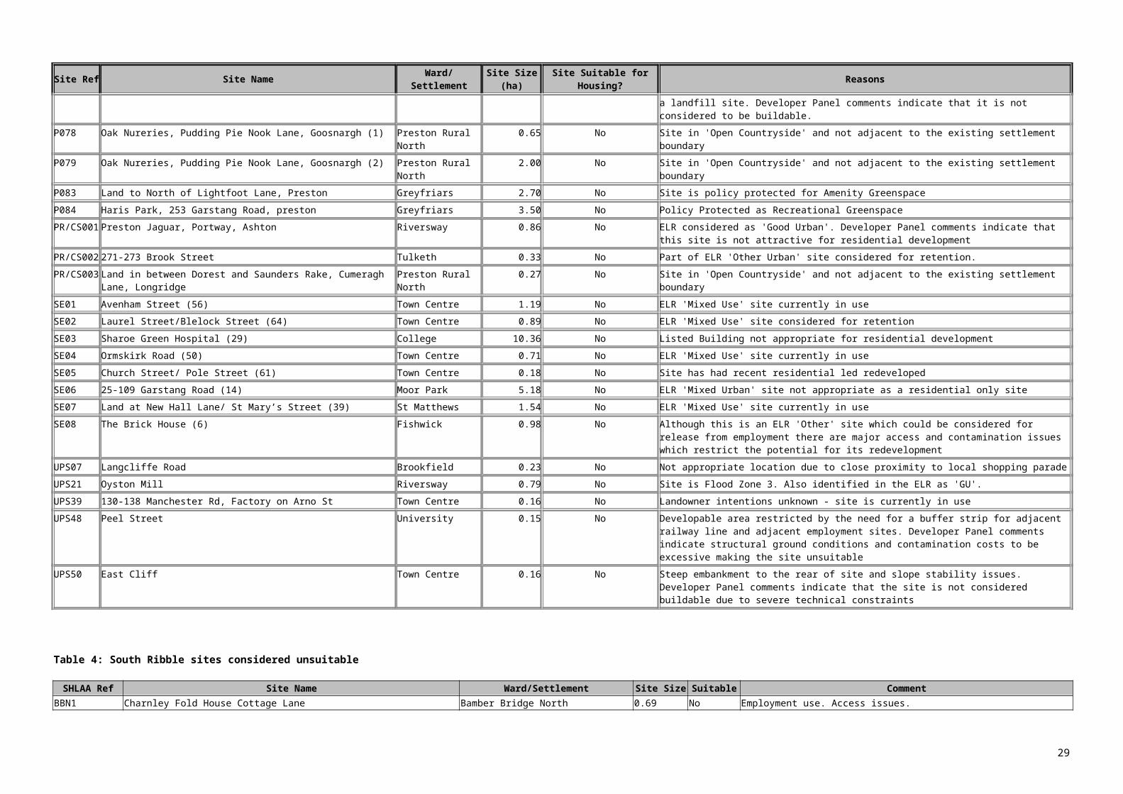
SHLAA Ref Site Name Ward/Settlement
Site Size (ha)
Site TypeNet
Completions 2009/10
Net Housing Capacity at April
2010
Site Suitable for Housing?
Site Available
for housing?
Site Achievable
for housing?
Overcoming Identified
ConstraintsDeliverable Units
2010/11 to 2014/15Brownfield
UnitsGreenfield
Units Comments
CLB07 605 Preston Road
Clayton Brook/Green
- Under Construction
12 18 Yes Yes Yes None identified 18 0 18 Site under construction and expected to be complete within 5 years.
CLW12Lingmell, Lancaster Lane Clayton-le-Woods
N/A Unimplemented Permissions
0 12 Yes Yes Yes None identified 12 0 12 Site considered deliverable within 5 years.
CLW1354 Lancaster Lane Clayton-le-Woods
N/A Under Construction
1 9 Yes Yes Yes None identified 9 0 9 Site under construction and expected to be complete within 5 years.
COP08 Land at Waggon & Horses Public House
Coppull 1.1 Under Construction
0 40 Yes Yes Yes None identified 40 6 34 Site under construction and expected to be complete within 5 years.
CRO01 Former Woodyard, Station Road
Croston 0.75 Unimplemented Permissions
0 45 Yes Yes Yes None identified 45 45 0 Site considered deliverable within 5 years.
CRO08 Rectory Farm, Town Road
Croston 0.4 Unimplemented Permissions
0 9 Yes Yes Yes Demolition required
9 0 9 Site considered deliverable within 5 years.
ECC01 Sagar House, Langton Brow
Eccleston 2.73 Awaiting S106 0 70 Yes Yes Yes None identified 70 45 25 Site cleared and considered deliverable within 5 years
ECC14 St Marys Church Hall, Lawrence Lane
Eccleston 0.38 Unimplemented Permissions
0 10 Yes Yes Yes None identified 10 10 0 Site considered deliverable within 5 years.
EUX01 Land to rear of 37 - 41 Wigan Road
Euxton 0.62 Unimplemented Permissions
0 10 Yes Yes Yes None identified 10 10 0 Site considered deliverable within 5 years.
OTV09Crow Nest Cottage, Tarnbeck Drive
Mawdesley 0.3 Unimplemented Permissions
0 9 Yes Yes Yes None identified 9 0 9 Site considered deliverable within 5 years.
WLW01Land to rear of 243 – 289 Preston Road
Whittle-le-Woods 0.7 Unimplemented Permissions
0 14 Yes Yes Yes None identified 14 14 0 Site considered deliverable within 5 years.
WLW22
Land south west of 1 Swallow Court
Whittle-le-Woods 0.37 Unimplemented Permissions
0 9 Yes Yes Yes None identified 9 0 9 Site considered deliverable within 5 years.
Total 2407 1921 486
29

The above figures in Table 5 does not take into account sites under 5 dwellings. Sites under 5 dwellings do however contribute towards the 5 year supply of housing land and therefore sites that have planning permission for residential development under 5 units are listed in Appendix 1 and included in the table below. It is acknowledged that not all sites with permission will be built out within the period April 2010 to March 2015 and therefore the figure for small sites with planning permission included below allows for 10% of sites not being developed.
Table 6: 5 Year Supply Summary Table for Chorley 2010/11 – 2014/15Site source Units
Sites listed in Table 5 2407Sites with extant permission under 5 dwelling threshold (168 discounted by 10%)
151
Total Deliverable Units 2558
The housing plan requirements set out in the RSS run from April 2003. The RSS housing supply requirement to 31st March 2021 is the cumulative requirement for 2003-2021 (7500 dwellings or 417 dwellings per year) minus the cumulative net completions from 2003-2009/10 (2,757) as indicated in the table below. This gives a requirement for 4,743 dwellings over the 11 year period up until 2020/21.
The annual target from 2010/11 to 2020/21 is therefore 4,743/11 = 431 units.
This results in Chorley having a (2,558/431) 5.94 year deliverable housing supply.
1921 of the units on sites of 5 units or more are on Brownfield land and 486 are on Greenfield land. 54% of the units on small sites are on Brownfield land, which equates to 82 units. Therefore, 78% of the five-year supply is on brownfield land.
Housing supply requirement in the RSS
RS
S P
lan
perio
d (1
st
Apr
il-31
st
Mar
ch)
Mea
n an
nual
ised
re
quire
men
t
Cum
ulat
ive
requ
irem
ent
Net
C
ompl
etio
ns
Cum
ulat
ive
net
com
plet
ions
Ove
r or u
nder
su
pply
to
date
2003/04 417 417 585 585 1682004/05 417 834 479 1064 2302005/06 417 1251 489 1553 3022006/07 417 1668 121 1674 62007/08 417 2085 288 1962 -1232008/09 417 2502 355 2317 -1852009/10 417 2919 440 2757 -1622010/11 417 33362011/12 417 37532012/13 417 41702013/14 417 45872014/15 417 50042015/16 417 54212016/17 417 58382017/18 417 62552018/19 417 66722019/20 417 70892020/21 417 7506
30

Table 7: Preston sites - Reporting Year and April 2010 – March 2015
SHLAA Ref Site Name Ward/Settlement Site
Size Site TypeNet
Completions 2009/10
Net Housing
Capacity at April 2010
Site Suitable for Housing?
Site Available
for housing?
Site Achievable
for housing?
Overcoming Identified
Constraints
Deliverable Units 2010/11
to 2014/15Brownfield
UnitsGreenfield
Units Comments
UC01 Sharoe Green Hospital, Sharoe Green Lane
College 6.49 Under Construction
9 58 Yes Yes Yes N/A 58 58 Site under construction. Expected to be completed within 0-5yrs
UC02 Sharoe Green Hospital, Sharoe Green Lane
College 0.58 Under Construction
0 26 Yes Yes Yes N/A 26 26 Site under construction. Expected to be completed within 0-5yrs
UC03 Sharoe Green Hospital, Sharoe Green Lane
College 0.06 Under Construction
0 18 Yes Yes Yes N/A 18 18 Site under construction. Expected to be completed within 0-5yrs
UC04 Middleton Hall Farm, Goosnargh Lane, Goosnargh
Preston Rural North
0.74 Under Construction
0 5 Yes Yes Yes N/A 5 5 Site under construction. Expected to be completed within 0-5yrs
UC05 22-23 Fishergate Hill, Preston
Riversway 0.04 Under Construction
3 3 Yes Yes Yes N/A 3 3 Site under construction. Expected to be completed within 0-5yrs
UC06 Land at Corner of Garstang Road / Symonds Road, Fulwood, Preston
Moor Park 0.15 Under Construction
0 6 Yes Yes Yes N/A 6 6 Site under construction. Expected to be completed within 0-5yrs
UC08 Land to the rear of Library Field, Maple Drive, Ribbleton
Ribbleton 0.15 Under Construction
5 2 Yes Yes Yes N/A 2 2 Site under construction. Expected to be completed within 0-5yrs
UP02 Whittingham Hospital Grounds
Preston Rural East
51.59 Unimplemented Permissions
0 650 Yes Yes Yes N/A 170 170 Assumed multiple developers. Figures based on Developer Proforma
UP04 Land to rear of Ryelands Crescent and Thurnham Road
Larches/ Riversway
5.27 Unimplemented Permissions
-1 137 Yes Yes Yes Potential remediation work required
137 137 New permission granted 1st March 2010 with Developer achieving kickstart funding round 2.
UP08 Former DJ Ryan Depot, Inglewhite Road
Preston Rural North
0.52 Unimplemented Permissions
0 21 Yes Yes Yes N/A 21 21 Single developer. Expected to be delivered late within the 5 year period
UP14 Former Brookfield Arms, Croasdale Avenue
Brookfield 0.27 Unimplemented Permissions
0 10 Yes Yes Yes Site has already been cleared
10 10 Due to market conditions it is assumed a new application for family housing would be negotiated on site for around 10 units. Assumed start date towards the end of the 0-5 year period
UP18 Land adjacent Deepdale Shopping Park
Deepdale 0.28 Unimplemented Permissions
0 6 Yes No Yes Existing building needs demolishing
6 6 Assumed site will become available and be completed within 0-5yrs.
UP22 St Pauls Hall, St Pauls Road, Preston
St Georges 0.05 Unimplemented Permissions
0 5 Yes Yes Yes Site has already been cleared
5 5 Assumed site will be completed within 0-5yrs
UP23 Harris Knowledge Park, Garstang Road, Fulwood,
Greyfriars 2.6 Unimplemented Permissions
0 11 Yes Not all units are vacant
Yes N/A 11 11 Assumed units will be vacated and site will be completed within 0-5yrs
31

SHLAA Ref Site Name Ward/Settlement Site
Size Site TypeNet
Completions 2009/10
Net Housing
Capacity at April 2010
Site Suitable for Housing?
Site Available
for housing?
Site Achievable
for housing?
Overcoming Identified
Constraints
Deliverable Units 2010/11
to 2014/15Brownfield
UnitsGreenfield
Units Comments
PrestonUP25 73 & 75
Ribblesdale Drive, Grimsargh
Preston Rural East
0.24 Unimplemented Permissions
0 5 Yes Yes Yes N/A 5 5 IPS 5 statement states that the site will be delivered within 5 yrs
UP26 Site at Corporation Street/ Marsh Lane and Edward Street
Town Centre 0.17 Unimplemented Permissions
0 36 Yes Yes Yes Site has already been cleared
36 36 Site has been cleared and given permission as a temporary car park for 12 months - however still expected that development will be delivered within 5yrs
UP27 Former County Arms Hotel, 2 Deepdale Road, Preston
St Matthews 0.06 Unimplemented Permissions
0 5 Yes Yes Yes Site has already been cleared
5 5 Site has been cleared - expected completion late in 0-5yr period
UP28 Jubilee Trading Estate, 157-159 Fylde Road, Preston
University 0.38 Unimplemented Permissions
0 64 Yes Yes Yes Site has already been cleared
64 64 Assumed site will be completed within 0-5yrs
UP30 VIP Cabs, 106-110 Friargate and Great Shaw Street
Town Centre 0.13 Unimplemented Permissions
0 42 Yes No - small part is still in
use
Yes Some existing buildings need cleared
42 42 Current outline permission - expected to be delivered late within the 5 year period
UP31 170 Corporation Street, Preston
Town Centre 0.03 Unimplemented Permissions
0 12 Yes Yes/No Yes Some existing buildings need cleared
12 12 Assumed site will be delivered in 0-5yrs
UP32 70-74 Friargate Town Centre 0.11 Unimplemented Permissions
0 9 Yes Yes Yes Site has already been cleared
9 9 Assumed late start within 0-5yr period
UP33 Site of Former Canterbury Hall, Garstang Road
St Georges 0.28 Unimplemented Permissions
0 49 Yes Yes Yes Site has already been cleared
49 49 Assumed site will be delivered in 0-5yrs
UP34 Land at corner of London Road and James Street
Town Centre 0.18 Unimplemented Permissions
0 12 Yes Yes Yes Site has already been cleared
12 12 Assumed late start within 0-5yr period
UP35 The Croft, Croft Street, Preston
University 0.19 Unimplemented Permissions
0 5 Yes Yes Yes N/A 5 5 Site is currently under construction
UP36 88 Gordon Street, Preston
University 0.04 Unimplemented Permissions
0 15 Yes Yes Yes Existing building needs demolishing
15 15 Assumed site will be delivered in 0-5yrs
UP37 69 Bow Lane, Preston
Riversway 0.03 Unimplemented Permissions
0 6 Yes Yes Yes N/A 6 6 IPS5 statement states that development will commence within 12 months of permission being granted
UP38 2 Blackbull Lane, Fulwood
Cadley 0.13 Unimplemented Permissions
0 8 Yes Yes Yes Existing building needs demolishing
8 8 Assumed site will be delivered in 0-5yrs
UP39 Greenlands Labour Club, Chatburn Road, Ribbleton, Preston
Brookfield 0.32 Unimplemented Permissions
0 12 Yes No Yes Existing building needs demolishing
12 12 IPS5 statement states completion within 5yrs
UP41 55A Trafford Street, Preston
Tulketh 0.19 Unimplemented Permissions
0 6 Yes Yes Yes N/A 6 6 Site Visits April 2010 have highlighted that this site is under construction
UP42 Land to the Rear of St Georges 0.03 Unimplemented 0 6 Yes Yes Yes N/A 6 6 Site Visits April 2010 have
32

SHLAA Ref Site Name Ward/Settlement Site
Size Site TypeNet
Completions 2009/10
Net Housing
Capacity at April 2010
Site Suitable for Housing?
Site Available
for housing?
Site Achievable
for housing?
Overcoming Identified
Constraints
Deliverable Units 2010/11
to 2014/15Brownfield
UnitsGreenfield
Units Comments
Church, Adelphi Place and 16 Adelphi Street, Preston
Permissions highlighted that this site is under construction
UP43 Crummock Road Ribbleton approx 0.7
Unimplemented Permissions
0 25 Yes Yes Yes N/A 25 25 Proposed start on site Spring 2010, proposed completion Spring 2011 according to developer info
UP44 19 Moor Park Avenue
Moor Park 0.06 Unimplemented Permissions
0 6 Yes Yes N/A 6 6 Site Visits April 2010 have highlighted that this site is under construction
PEN01 Alliance Works, Goodier Street and part of Manchester Mill
St Matthews 2.81 Other 0 100 Yes Yes Yes Demolition of existing buildings Potential remediation works required
90 90 Current outline application for 90 houses and 80 apartments. Developer Panel suggested more realistic 100 units completed in 3+ years
PEN02 Alstoms, Channel Way
Riversway 6.26 Other 0 169 Yes Yes Yes Demolition of existing buildings Appropriate flood protection / mitigation required
60 60 Developer Panel considered 45 dph more appropriate for site and therefore assumed a further application would come in - assumed start towards end of 0-5 yr period
PEN03 GOSS Graphics University 3.8 Other 0 358 Yes Yes Yes Demolition of existing buildings
62 62 Scheme involves 208 apartments, 88 family homes and 370 student rooms. Assumed student accommodation will come first late in 0-5yr period. 370 student bed spaces assumed 6bed flats approx 62 units
PEN05 Cottam Hall Brickworks
Ingol 3.39 Other 0 205 Yes Yes Yes Potential remediation works required
60 60 Assumed single developer with start on site towards the end of the 0-5 yr period
PEN06 161-171 Fylde Road, Preston
University 0.25 Other 0 35 Yes No still in use
Yes Demolition of existing buildings
35 35 Assumed site will be delivered in 0-5yrs
PEN07 44-62 Corporation Street, Preston
Town Centre 0.09 Other 0 55 Yes No till in use Yes Demolition of existing building
55 55 Assumed site will be delivered in 0-5yrs
MRS1 Tithebarn Regeneration Area
Town Centre 22.89 Other 0 500 Yes Yes Yes Demolition of existing buildings
145 145 Developer committed to residential element of scheme - assumed start towards end of the 0-5 year period
OTHER1 Howarth Road Tulketh Approx 0.3
Other Suggestion (RSL)
0 15 Yes Yes Yes N/A 15 15 Application is pending. Expected completion within 5 years
OTHER2 Adelphi House University 0.27 Other Suggestion (RSL)
0 13 Yes Yes Yes Site has already been cleared
13 13 Application expected soon
OTHER3 Meadow House St Georges 0.27 Other Suggestion (RSL)
0 12 Yes Yes Yes Site has already been cleared
12 12 Application expected soon
OTHER4 Deepdale House St Matthews 0.25 Other Suggestion (RSL)
0 12 Yes Yes Yes Site has already been cleared
12 12 Application expected soon
33

SHLAA Ref Site Name Ward/Settlement Site
Size Site TypeNet
Completions 2009/10
Net Housing
Capacity at April 2010
Site Suitable for Housing?
Site Available
for housing?
Site Achievable
for housing?
Overcoming Identified
Constraints
Deliverable Units 2010/11
to 2014/15Brownfield
UnitsGreenfield
Units Comments
P001 Cottam Hall, off Tom Benson Way, Preston
Lea 56.04 Site Suggestions 0 1321 Yes Yes Yes N/A 295 295 Multiple developers assumed on 3-4 parcels of land 0-5 years. Based on HCA development proforma
P019 Parker Street, Preston
Tulketh 1.3 Site Suggestions 0 52 Yes Yes Yes Potential remediation works required
52 52 Assumed single developer with start date on site towards end of 0-5year period. Site suggestion highlights desire to develop site
P021 Land west of Lightfoot House, Lightfoot Lane
Greyfriars 0.5 Site Suggestions 0 6 Yes Yes Yes N/A 6 6 Site has outline planning permission. Assumed start on site towards the end of the 0-5 year period
P022 Land adjacent to Ashton Basin (off Tulketh Brow)
Tulketh 0.37 Site Suggestions 0 12 Yes Yes Yes Highways improvements and potential remediation works required
12 12 Site has outline planning permissions. Delivery proforma highlighted completion within the 0-5 year period
Total 1725 1417 308
34

The figures in table 7 does not take into account sites under 5 dwellings. Sites under 5 dwellings do however contribute towards the 5 year supply of housing land and therefore sites that have planning permission for residential development under 5 units are listed in Appendix 1 and included in the table below. It is acknowledged that not all sites with permission will be built out within the period April 2010 to March 2015 and therefore the overall figure included below allows for 10% of sites not being developed.
Table 8: 5 year supply summary table for Preston City Council
Site source UnitsSites listed in table 7 1725Sites with extant permission under 10 dwelling threshold (discounted by 10%)
107
Total 1832
The housing plan requirements set out in the RSS run from April 2003. The housing supply requirement to 31st March 2014 is a cumulative requirement for 2003-2014 (5577 dwellings) minus the cumulative net completions from 2003-2009/10 (3126) as indicated below in table 9:
At the start of the 5 year supply period (April 2010) there is an undersupply of 423 units. When this is spread over the length of the RSS period (up to 2020/21) it results in a further 39 units being required per year on top of the RSS target of 507 units. The annual target from 2010/11 to 2020/21 is therefore 546 units. This means that Preston has a (1832/546) 3.36year supply.
Table 9: Housing supply requirement in the RSS*
RS
S P
lan
perio
d (1
st
Apr
il-31
st
Mar
ch)
Mea
n an
nual
ised
re
quire
men
t
Cum
ulat
ive
requ
irem
ent
Dw
ellin
gs
com
plet
ed
Dem
oliti
ons
Net
C
ompl
etio
ns
Cum
ulat
ive
net
com
plet
ions
Ove
r or u
nder
su
pply
to
date
2003/04 507 507 521 213 308 308 -1992004/05 507 1014 703 159 544 852 -1622005/06 507 1521 634 7 627 1479 -422006/07 507 2028 586 21 565 2044 -162007/08 507 2535 673 64 609 2653 +1182008/09 507 3042 485 17 468 3121 +792009/10 507 3549 86 81 5** 3126 -4232010/11 507 40562011/12 507 45632012/13 507 50702013/14 507 55772014/15 507 60842015/16 507 65912016/17 507 70982017/18 507 76052018/19 507 81122019/20 507 86192020/21 507 9126
* The figures provided in table 9 above have been updated from the March 2009 SHLAA to take into account a number of self contained student flat developments completed since April 2003 following the alteration of the definition of general housing by CLG. **The figures provided for 2009/10 ‘Reporting Year’ are from site visits carried out in April 2010. The figure of 5 has been reached by taking into account the completions listed in Table
35

7 and the Appendix for sites under 5 dwellings and taking into account a number of demolitions
1725 of the units on sites of 5 units or more are on Brownfield land and 308 are on Greenfield land. 79% of the units on small sites are on Brownfield land, which equates to 85 units. Therefore, 85% of the land in the supply period of April 2010 to March 2015 is on brownfield land.
36

Table 10: South Ribble sites Reporting Year and April 2010 to March 2015
SHLAA Ref Site Name Ward/Settlement
Site Size Site Type
Total Completions
2009/10
Housing Capacity at April 2010 Suitable
Availability of site for housing? achievable
How to overcome identified
constraints
Deliverable Units
2010/11 to 2014/15 Brownfield Greenfield Site comments
BBE1 Wesley Street MillsBamber Bridge East 1.90 Urban Potential 0 107 Yes Yes Yes
demolition of existing mill 107 107 0
planning permission for 22 dwelings on part of site
BBE12 51 Station RoadBamber Bridge East 0.07
Unimplemented Permissions 0 6 Yes Yes Yes n/a 6 6 0
has planning permission
BBE13Land adjacent to 20, Ladyacre
Bamber Bridge East 0.23
Unimplemented Permissions 0 6 Yes Yes Yes n/a 6 0 6
has planning permission
BBE14Play area site, Fourfields
Bamber Bridge East 0.13
Unimplemented Permissions 0 8 Yes Yes Yes n/a 8 0 8
has planning permission
BBE15Land to Rear of Pine Direct Station Road
Bamber Bridge East 0.2
Under Construction 0 10 Yes Yes Yes n/a 10 10 0
under construction
BBE5Kellet Lane (Site k), Kellet Lane
Bamber Bridge East 2.65
Allocated Housing Site 0 40 Yes Yes Yes n/a 40 0 40
allocated site. Developer filled in proforma
BBE6Brindle Road (Site m), Brindle Road
Bamber Bridge East 1.93
Allocated Housing Site 0 40 Yes Yes Yes n/a 40 0 40
allocated site. Developer filled in proforma
BBN2Arla Dairies, School Lane
Bamber Bridge North 5.48 Urban Potential 0 0 Yes Yes Yes
demolition of dairy buildings 145 145 0
has permission, agent filed in proforma
BBN6Land off Water Street,
Bamber Bridge North 0.5 Site Suggestions 0 18 Yes Yes Yes
demolition of existing building 18 18 0
agent expressed intention for site redevelopment withinn 5 years
BBW2 Brownedge RoadBamber Bridge West 2.09 Site Suggestions 0 60 Yes yes Yes none 60 60 0
owners completed proforma
BBW4
Priding House Hostel, Co-Operative Street
Bamber Bridge West 0.85 Urban Potential 0 32 Yes Yes Yes
demolition of existing building 32 32 0
owners expressed interest to redevelop site
BBW7
Land at Riverside/Lostock Lane
Bamber Bridge West 0.92 Site Suggestions 0 56 Yes yes Yes n/a 30 30 0
owner expressed intention to redevelop
BBW8Land at St Marys Rd, Bamber Bridge
Bamber Bridge West 0.14
Unimplemented Permissions 0 8 Yes Yes Yes n/a 8 8 0
has planning permission
BO1
land to rear of Cornwood, Broad Oak Lane Broad Oak 0.70
Unimplemented Permissions 0 10 Yes Yes Yes
demolition required 10 0 10
has planning permission
CH1 Rear 1 Giller Drive Charnock 0.30Unimplemented Permissions 0 11 Yes Yes Yes n/a 11 0 11
has planning permission
FE5Farington Saw Mills, Stanifield Lane Farington East 0.34 Site Suggestions 0 19 Yes yes Yes
demolition of existing buildings 19 19 0
owner expressed intention to redevelop
FW11Rear 214 Croston Road Farington West 0.54
Under Construction 0 15 Yes Yes Yes
demolition required 15 0 15
has planning permission
FW12 Roadferry Farington West 1.88Unimplemented Permissions 0 80 Yes Yes Yes
demolition work required 80 80 0
has planning permission
FW7 West of Grasmere Farington West 3.22 Site Allocations 0 200 Yes Yes Yes n/a 150 0 150 developer
37

Avenue (Site c), Grasmere Avenue
expressed intention to submit application imminently
FW9Farington Park, east of Wheelton Lane Farington West 13.00
Unimplemented Permissions 0 470 Yes Yes Yes
demolition needed (work underway) 145 145 0
has planning permission
GH1Rear 42-54, Hall Lane Golden Hill 0.94
Under Construction 0 21 Yes Yes Yes N/A 21 0 21
has planning permission
GH2
Leyland & Birmingham Rubber Works & Adjacent Land, Golden Hill Lane Golden Hill 13.40
Under Construction 10 122 Yes Yes Yes n/a 122 122 0
under construction
GH3
Golden Hill Garage, 208 - 216 Golden Hill Lane Golden Hill
Unimplemented Permissions 0 12 Yes Yes Yes
demolition of garage 12 12 0
has planning permission
GH4
Former Prestolite premises, Golden Hill Lane Golden Hill 2.26
Unimplemented Permissions 0 99 Yes Yes Yes
demolition (well underway) 99 99 0
has planning permission
HP1Pollards Farm, Howick Cross Lane Howick and Priory 1.40
Unimplemented Permissions 0 11 Yes yes Yes
demolition of farm buildings 11 11 0
has planning permission
HP2
Former Rydall Motors, Liverpool Road Howick and Priory 0.23 NLUD 0 13 Yes yes Yes
demolition of garage buildings 13 13 0
active interest in redeveloping site
LHU1Land to rear of Chapel Lane
Longton & Hutton West 0.44 NLUD 0 10 Yes yes Yes n/a 10 10 0
owner expressed intention to redevelop
LHU13 Land at The MaltingsLongton & Hutton West 0.32
Under Construction 0 7 Yes Yes Yes
demolition of dwelling 7 0 7
has planning permission
LHU8Rear of 28-50 Marsh Lane, Longton
Longton & Hutton West 0.47
Unimplemented Permissions 0 8 Yes Yes Yes
demolition of dwelling 8 0 8
has planning permission
LMH9Orchard House, Gill Lane
Little Hoole & Much Hoole 0.084
Unimplemented Permissions 0 8 Yes Yes Yes n/a 8 8 0
has planning permission
LSA2Parcel A1, Buckshaw Village
Leyland St Ambrose
Under Construction 40 0 Yes Yes Yes n/a 0 0 0
has planning permission
LSA3Parcel B, Dawson Lane
Leyland St Ambrose 4.13
Under Construction 40 0 Yes Yes Yes n/a 0 0 0
has planning permission
LSA4Group One, Buckshaw
Leyland St Ambrose 14.90
Unimplemented Permissions 0 256 Yes Yes Yes
conservation work - BHS. Demolition work. Possible remediation work due to contamination 256 256 0
has outline permission, detailed application expected in near future, clearance work started
LSA7Parcel A3, Buckshaw Village
Leyland St Ambrose
Unimplemented Permissions 0 115 Yes Yes Yes n/a 115 115 0
has planning permission
LSA8
Land of Ambrose Avenue, Buckshaw Village
Leyland St Ambrose 1.03
Unimplemented Permissions 0 40 Yes Yes Yes n/a 40 40 0
has planning permission
LSA9Land to West of Central Avenue
Leyland St Ambrose
Unimplemented Permissions 32 32 Yes Yes Yes n/a 0 0 0
Has planning permission
LSM1Former Hulmes Mill site, St Andrews Way Leyland St Marys 0.39
Unimplemented Permissions 0 17 Yes Yes Yes n/a 17 17 0
has planning permission
LSM4 land at Eden Street Leyland St Marys 0.15Unimplemented Permissions 0 11 Yes Yes Yes
demolition of buildings 11 11 0
has planning permission
LSM5 Land adjacent to 102 Leyland St Marys 0.02 Under 6 0 Yes Yes Yes none 0 0 0 has planning
38
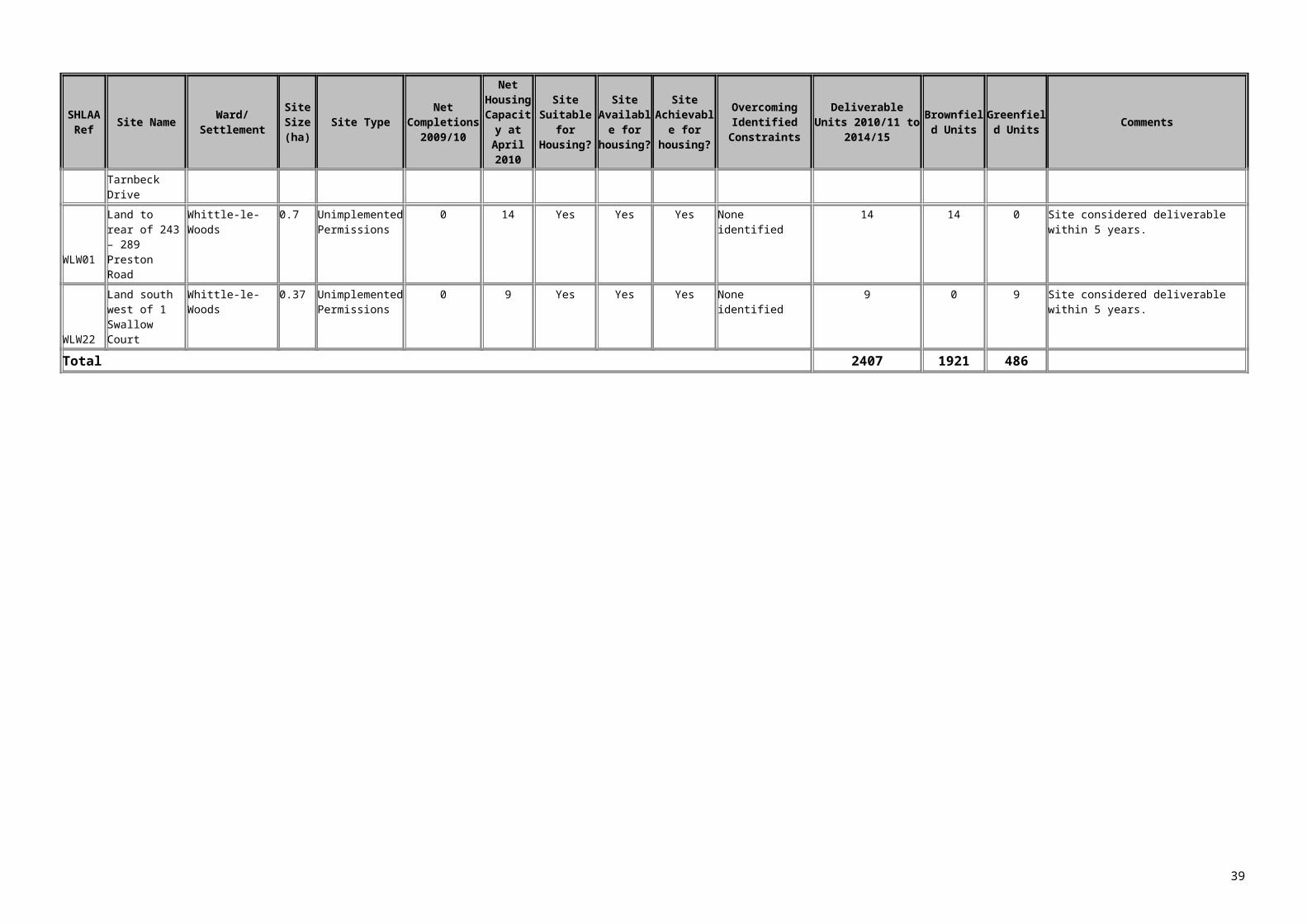
Towngate Construction permission
LYC2
Land at Dorothy Avenue/Bretherton Terrace Leyland Central 0.40 Site Suggestions 0 11 Yes yes Yes
demolition required 11 0 11
application recently refused, another expected
MF2Vernon Carus Site, Factory Lane Middleforth 4.14 Urban Potential 0 450 Yes Yes Yes
flood mitigation works required prior to development 75 75 0
current planning application, developer filled in proforma
MS2Moss Side Test Track, Aston Way Moss Side 43.29 Site Allocations 0 850 Yes Yes Yes
New access built, removal of existing buildings and test track 125 125 0
agents filled in proforma
MS3 238 Slater Lane Moss Side 0.22Unimplemented Permissions 0 8 Yes Yes Yes n/a 8 0 8
has planning permission
NLH10Land adjacent to Greenacres, Hutton
New Longton & Hutton East 0.34
Unimplemented Permissions 0 8 Yes Yes Yes n/a 8 0 8
under construction
NLH921 Hugh Barn Lane, New Longton
New Longton & Hutton East
Unimplemented Permissions 0 20 Yes Yes Yes n/a 20 0 20
under construction
SS2 land at Mill Lane Seven Stars 0.38Unimplemented Permissions 0 15 Yes Yes
flood mitigation work to be completed prior to development 15 15 0
under construction
SS5Dunkirk Mill, Dunkirk Lane Seven Stars 0.67 Urban Potential 0 35 Yes Yes Yes n/a 35 35 0
has planning permission
SS7 148 Slater Lane Seven Stars 0.21Unimplemented Permissions 0 9 Yes Yes Yes n/a 9 0 9
has planning permission
SS8105 Slater Lane, Leyland Seven Stars 0.3
Unimplemented Permissions 0 8 Yes Yes Yes n/a 8 0 8
has planning permission
SS9Lostock Grove Rest Home, Slater Lane Seven Stars 0.39
Unimplemented Permissions 0 8 Yes Yes Yes n/a 8 8 0
has planning permission
SW13The Foundry, Kittlingborne Brow
Samlesbury and Walton 2.30 Urban Potential 0 80 Yes Yes Yes
flood mitigation and possible contamination remediation works 80 80 0
current application
SW597 Higher Walton Road
Samlesbury and Walton 0.11
Unimplemented Permissions 0 11 Yes Yes Yes
Flood mitigation measures to be implemented prior to development 11 11 0
has planning permission
TG3
Lostock Hall Gas Works, Leyland Road Tardy Gate 12.36 Site Allocations 0 200 Yes Yes Yes
demolition work, possible remediation, improvements to access 110 110 0
awaiting signature of S106, agents completed proforma
TG6Lime Kiln Farm (Site h), Todd Lane North
Tardy Gate/Charnock 6.57 Site Allocations 0 190 Yes Yes Yes n/a 90 0 90
owner completed proforma
TG7
South Part of allocation f, east of Leyland Road
Tardy Gate/Charnock 4.94 Site Allocations 0 50 Yes Yes Yes
remediation work to address any contamination 50 0 50
pre-app discussions, developer expressed intention
WLD2 121 Duddle Lane Walton Le Dale 0.13Unimplemented Permissions 0 10 Yes Yes Yes n/a 10 10 0
has planning permission
total 2363 1843 520
39

40

South Ribble Council can identify a 5 year supply of 2,363 dwellings. The current RSS requirement is 417 dwellings per annum, or 2,085 dwellings over the 5 year period. South Ribble can therefore identify a realistic oversupply of 278 dwellings.
In addition to this, in the 5 years since the RSS base date of 2003, completions rates in the Borough were as follows:
April 2003 – March 2004 538 dwellingsApril 2004 – March 2005 657 dwellingsApril 2005 – March 2006 520 dwellingsApril 2006 – March 2007 284 dwellingsApril 2007 – March 2008 320 dwellingsApril 2008 – March 2009 312 dwellingsApril 2009 – March 2010 171 dwellingsTotal 2802
The strategic requirement for this period was 2919. This has resulted in South Ribble having an undersupply in this period of 117 dwellings. This undersupply will therefore have to be spread over later years in the RSS timeframe, to ensure that the Borough meets its strategic requirement set out in the RSS.. However, given current market conditions and the low build out rates over the last few years, it is unrealistic to expect that this undersupply can be met within the 5 year supply. The undersupply will therefore need to be added to each year until the end of the RSS in 2020/2021. Therefore, from 2010/11, the Council will need enough land to accommodate an additional 11 dwellings per year, meaning the strategic requirement will be 428 dwellings per annum.
This will result in the Borough having a 5 year supply requirement of 2140 dwellings.
Sites within the South Ribble 5 year supply are comprised of:
Sites with planning permission; Allocated sites; Sites with current applications; Sites where discussions with developers are at a sufficiently advanced stage for it to
be reasonable to expect the site to be at least partially developed within 5 years; Small sites where the developer has expressed an intention to develop within 5 years.
South Ribble also has capacity for 146 dwellings on small sites that have not been included in the SHLAA. We have assumed that 10% of these dwellings will not be built, meaning that there is a realistic capacity for 131 dwellings. These dwellings realistically form part of the 5 year supply in the Borough, meaning the Council has a 5 year supply of 2494 dwellings, 354 over the strategic requirement.
41
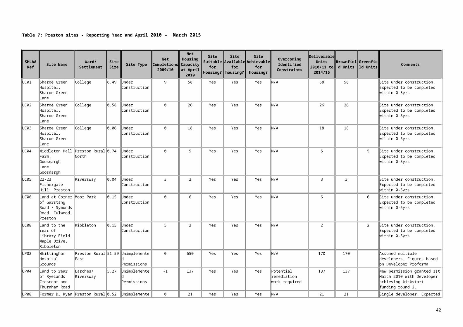
Table 11 : Chorley sites April 2015 – March 2020 and April 2020 – March 2024
2015/16 - 2023/24 sites
SHLAA Ref Site Name Ward /
SettlementSite Size Site Type
Density
Multiplier
Estimated Net Developable
Area
Estimated N
et H
ousing C
apacity at A
pril 2015
Site Suitable for H
ousing?
Site Available
for Housing?
Site Achievable
for Housing?
Overcoming Identified Constraints
Developable
Units 2015/16 to
2019/20
Developable
Units 2020/21 to
2023/24
Brow
nfield U
nits
Greenfield U
nits
Comments
ADL03
Land off Westhoughton
Road Adlington 0.51Urban Potential
& NLUD 35 80% 14 Yes No
Yes if site becomes available
Could be developable if land becomes
available. Demolition required. Remediation
works likely to be required 0 0 0 0
Landowner intentions currently unknown so would need to agree to make site available. Site may have development potential over period but 0 units recorded in table due to
uncertainty. Adlington identified as an Urban Local Service Centre in draft Core
Strategy.
ADL05Brook Mill,
Brook Street Adlington 0.8 Site Suggestions 35 60% due to brook 17 Yes Yes Yes
Demolition required. Remediation works likely to be required 17 0 17 0
Rated ‘Other’ in ELR so potential for release. Demolition required. Adlington
identified as an Urban Local Service Centre in draft Core Strategy
ADL07Land at
Babylon Lane Adlington 1.16 Site Suggestions 35 80% 32 Yes Yes YesLDF Review of land
required 32 0 0 32
Land safeguarded for future development needs. LDF Review of land needed to
permit housing development. Adlington identified as an Urban Local Service Centre
in draft Core Strategy.
ADL08Land at
Babylon Lane Adlington 0.65 Site Suggestions 35 80% 18 Yes Yes YesLDF Review of land
required 18 0 0 18
Land safeguarded for future development needs. LDF Review of land needed to
permit housing development. Development would be linked to development of ADL07.
Adlington identified as an Urban Local Service Centre in draft Core Strategy.
ADL09
Land off Bolton Rd Baly Place
Farm Adlington 11.9 Site Suggestions 35 50% 208 Yes Yes YesLDF Review of land
required 90 118 0 208
Land safeguarded for future development needs. LDF Review of land needed to
permit housing development. Adlington identified as an Urban Local Service Centre
in draft Core Strategy. Site also has potential for mixed uses/employment uses.
ADL10Land off 1 the
Common Adlington 1.3 Site Suggestions 35
50% as part of larger area of
safeguarded land 23 Yes YesYes if ADL11
also developed
Could be developable if ADL11 becomes available, but road
access to this area of Adlington is poor. LDF
Review of land required 0 23 0 23
Land safeguarded for future development needs. LDF Review of land needed to permit housing development. Requires
development of ADL11. Adlington identified as an Urban Local Service Centre in draft
Core Strategy.
ADL11Land off the
Common Adlington 10.1 Other Sites 35 50% 177 Yes No
Yes if site becomes available
Could be developable if land becomes
available but road access to this area of Adlington is poor. LDF
Review of land required 30 120 0 150
Landowner intentions currently unknown so would need to agree to make land available.
Land safeguarded for future development needs. LDF Review of land needed to
permit housing development. Surrounds ADL10. Adlington identified as an Urban
Local Service Centre in draft Core Strategy.
42

2015/16 - 2023/24 sites
SHLAA Ref Site Name Ward /
SettlementSite Size Site Type
Density
Multiplier
Estimated Net Developable
Area
Estimated N
et H
ousing C
apacity at A
pril 2015
Site Suitable for H
ousing?
Site Available
for Housing?
Site Achievable
for Housing?
Overcoming Identified Constraints
Developable
Units 2015/16 to
2019/20
Developable
Units 2020/21 to
2023/24
Brow
nfield U
nits
Greenfield U
nits
Comments
ADL12Land off Park
Road Adlington 4.13 Other Sites 35 80% 116 Yes No
Yes if site becomes available
Could be developable if land becomes
available but road access to this area of Adlington is poor. LDF
Review of land required 30 86 0 116
Landowner intentions currently unknown so would need to agree to make land available.
Land safeguarded for future development needs. LDF Review of land needed to
permit housing development. Adlington identified as an Urban Local Service Centre
in draft Core Strategy.
ADL26
Land at/adjacent to White Bear
Marina, Park Road Adlington 2.24 Site Suggestions 45
30% as mixed use site
suggestion 30 Yes Yes Yes
Demolition potentially required on part of site.
Remediation works may be required 30 0 30 0
Policy preference to retain part of site for employment purposes. Rated ‘Mixed Use’ in
ELR. Operational but site suggested for mixed use redevelopment, including housing
ADL27Garage Land, Acresfield Adlington - Other Sites - 90% 5 Yes Yes Yes
Demolition required on part of site. 5 0 5 0
Pre-application discussions taken place regarding affordable housing. Adlington
identified as an Urban Local Service Centre in draft Core Strategy.
BRW01
Land at Drinkwater Farm, Windsor Drive Brinscall 0.45 Site Suggestions 30 80% 11 Yes Yes Yes Demolition required 11 0 0 11
Greenfield Site. Brinscall identified as a Rural Local Service Centre in draft Core
Strategy
BRW07Land off Miller Avenue Abbey Village 0.47 Site Suggestions 30 80% 11
Yes but is subject to
policy restrictions. Draft Core Strategy
restricts to local needs Yes
If policy requirements can be met
Significant proportion of affordable housing / housing to meet local
needs required 11 0 0 11
Policy requirement for significant proportion of affordable housing. Abbey Village not identified as a location for growth in draft
Core Strategy, which restricts development to local needs.
BUV01 Buckshaw Village
Buckshaw Village
44.33 (Total Site)
Under Construction
N/A N/A 233 Yes Yes Yes None identified 233 0 233 0
Remainder of Parcels WF, L (South), N & Q considered developable during 2015/16 to
2019/20BUV02 Buckshaw
Village Group 1
Buckshaw Village
N/A Unimplemented Permissions
N/A N/A 709 Yes Yes Yes None identified 570 109 679 0Remaining sections considered developable
during timeframe.
CHO02Cabbage Hall Fields Chorley
3.4 (Total site) Site Allocations N/A N/A 13 Yes Yes Yes None identified 13 0 0 13
Some pre-application discussions have taken place. Site slopes down to large
industrial units. Vacant site with no buildings/structures. Chorley is identified
Key Service Centre in draft Core Strategy.
CHO06
Park Mills/Oakwood Road Chorley 1.44
Unimplemented Permissions N/A N/A 68 Yes Yes Yes Demolition required 68 0 68 0
Units considered developable during 2015/16 to 2019/20. Chorley is identified
Key Service Centre in draft Core Strategy.CHO08 Talbot Mill Chorley 4.41 Unimplemented
PermissionsN/A N/A 119 Yes Yes Yes None identified 119 0 119 0 Remaining units considered developable
during 2015/16 to 2019/20. Chorley is identified Key Service Centre in draft Core
43

2015/16 - 2023/24 sites
SHLAA Ref Site Name Ward /
SettlementSite Size Site Type
Density
Multiplier
Estimated Net Developable
Area
Estimated N
et H
ousing C
apacity at A
pril 2015
Site Suitable for H
ousing?
Site Available
for Housing?
Site Achievable
for Housing?
Overcoming Identified Constraints
Developable
Units 2015/16 to
2019/20
Developable
Units 2020/21 to
2023/24
Brow
nfield U
nits
Greenfield U
nits
Comments
Strategy.
CHO10
Former Lex Auto Logistics Site, Pilling Lane Chorley 10.1
Under Construction N/A N/A 69 Yes Yes Yes None identified 69 0 69 0
Remainder of site considered developable during timeframe.
CHO12
Eagle & Child Hotel, Pall Mall Chorley 0.1 Awaiting S106 130 N/A 13 Yes Yes Yes
Demolition required. Mixed Use scheme currently proposed 13 0 13 0
Chorley is identified Key Service Centre in draft Core Strategy.
CHO16 Cowling Farm Chorley 8.5 Other Sites 35 60% 179 Yes No
Yes if site becomes available
LDF Review of land required 60 119 0 179
LDF Review of land needed to permit housing development. Chorley is identified Key Service Centre in draft Core Strategy.
CHO19
Former Laundry, Harpers Lane Chorley 1.21 Other Sites 40
50% to enable mixed uses 24 Yes Yes Yes
Remediation works likely to be required 24 0 24 0
Pre-application discussions have taken place. Site vacant with demolition taking place. Chorley is identified Key Service
Centre in draft Core Strategy.
CHO20Chancery Way/Westway Chorley 6.04 Site Suggestions 35 60% 127 Yes Yes Yes
LDF Review of land required. Large part of
site is playing fields and much of remainder
of site is wooded 30 97 0 127
Land safeguarded for future development needs so has potential for development.
LDF Review of land needed to permit housing development. Large part of site is playing fields with recreational open space protection and much of remainder of site is wooded. Chorley is identified Key Service Centre in draft Core Strategy. Site may
have potential for mixed uses/employment uses
CHO23Northolme, Preston Road Chorley 0.22
Unimplemented Permissions 127 N/A 28 Yes Yes Yes None identified 28 0 28 0
Application permitted for apartments. Developer Panel suggest completions in 6 –
10 year period
CHO27
Land adjacent to and adjoining 135/139 Blackburn Road Chorley 1.6 Site Suggestions 35
60% as part of larger
safeguarded site 34 Yes Yes YesLDF Review of land
required 0 34 0 34
Land safeguarded for future development needs. LDF Review of land needed to
permit housing development. Logical to develop with CHO28. Chorley is identified Key Service Centre in draft Core Strategy
CHO28
West of Blackburn Road Chorley 4.76 Other Sites 35
60% as part of larger
safeguarded land site 100 Yes Yes
Yes if site becomes available
Landowners intentions currently unknown so
would need to agree to make site available 0 90 0 90
Landowners intentions currently unknown so would need to agree to make site available. Land safeguarded for future development
needs. LDF Review of land needed to permit housing development. Logical to
develop with CHO27. Some units considered developable after 2023/24.
Chorley is identified Key Service Centre in draft Core Strategy.
CHO30 Railway Road Chorley 0.5 Site Suggestions 40 40% due to open space
8 Yes Yes Yes Protected open space restricts site area.
Access may be
8 0 8 0 Protected open space restricts site area. Planning application for housing submitted
but withdrawn on site. Access may be
44

2015/16 - 2023/24 sites
SHLAA Ref Site Name Ward /
SettlementSite Size Site Type
Density
Multiplier
Estimated Net Developable
Area
Estimated N
et H
ousing C
apacity at A
pril 2015
Site Suitable for H
ousing?
Site Available
for Housing?
Site Achievable
for Housing?
Overcoming Identified Constraints
Developable
Units 2015/16 to
2019/20
Developable
Units 2020/21 to
2023/24
Brow
nfield U
nits
Greenfield U
nits
Comments
restricted by open space restricted by open space.
CHO32Land at Eaves Green 1 Chorley 3.77 Site Suggestions 35
50% as part of much larger
safeguarded land site 66 Yes Yes Yes
LDF Review of land required. 66 0 0 66
Land safeguarded for future development needs. LDF Review of land needed to
permit housing development. Site adjoins CHO33 & CHO04. Chorley is identified Key
Service Centre in draft Core Strategy.
CHO33Land at Eaves Green 2 Chorley 10.03 Site Suggestions 35
50% as part of much larger
safeguarded land site 176 Yes In Part Yes
LDF Review of land required 60 116 0 176
Land safeguarded for future development needs. LDF review of land needed to permit
housing development. Landowners intentions unknown on part of site. Chorley
is identified Key Service Centre in draft Core Strategy.
CHO34
Former Vertex Training and Conference Centre, Little Carr Lane Chorley 3.8
Unimplemented Permissions 52 N/A 40 Yes Yes Yes None identified 40 0 40 0
Remaining units considered developable during 2015/16 to 2019/20. Chorley is
identified Key Service Centre in draft Core Strategy.
CHO35
Land behind and west of Blackburn Brow Chorley 2.19 Site Suggestions 35
50% due to topography 38 Yes Yes Yes Sloping site 38 0 0 38
Part of designated Chorley settlement. Chorley is identified Key Service Centre in
draft Core Strategy.
CH037North of Euxton Lane 1 Chorley 10 Site Suggestions 35 50% 175 Yes Yes Yes
LDF Review of land required 90 85 0 175
Land safeguarded for future development needs. LDF review of land needed to permit housing development. Adjoins CHO38. Site
also has potential for mixed uses/employment uses. Chorley is identified Key Service Centre in draft Core Strategy.
Sloping Site.
CHO38North of Euxton Lane 2 Chorley 2.97 Site Suggestions 35
50% as part of larger
safeguarded land site 52 Yes Yes Yes
LDF Review of land required 0 52 0 52
Land safeguarded for future development needs. LDF review of land needed to permit
housing development. Logical to develop with or after CHO37. Site also has potential for mixed uses/employment uses. Chorley is identified Key Service Centre in draft Core
Strategy.
CHO39Hodder Avenue Chorley 0.35 Other Sites 40 80% 11 Yes No
Yes if site becomes available
Landowners intentions currently unknown so
would need to agree to make site available 0 11 11 0
Landowners intentions currently unknown so would need to agree to make site available Site has been cleared. Chorley is identified Key Service Centre in draft Core Strategy.
CHO40Buckingham Street Yard Chorley 0.4 Other Sites 50 80% 16 Yes No
Yes if site becomes available
Landowners intentions currently unknown so
would need to agree to make site available 0 16 16 0
Landowners intentions currently unknown so would need to agree to make site available. Site allocated for housing redevelopment . Chorley is identified Key Service Centre in draft Core Strategy.
CHO45 Land off Duke Street
Chorley 1.4 Awaiting S106 51 N/A 71 Yes Yes Yes None identified 11 0 0 11 Remaining of units considered developable during 2015/16 to 2019/20. Chorley is
45

2015/16 - 2023/24 sites
SHLAA Ref Site Name Ward /
SettlementSite Size Site Type
Density
Multiplier
Estimated Net Developable
Area
Estimated N
et H
ousing C
apacity at A
pril 2015
Site Suitable for H
ousing?
Site Available
for Housing?
Site Achievable
for Housing?
Overcoming Identified Constraints
Developable
Units 2015/16 to
2019/20
Developable
Units 2020/21 to
2023/24
Brow
nfield U
nits
Greenfield U
nits
Comments
identified Key Service Centre in draft Core Strategy.
CHO50Land off Froom Street Chorley 2.24 Site Suggestions 35 80% 39 Yes Yes -
Part of site in Flood Zones 2 & 3 0 0 0 0
Part of site in Flood Zones 2 & 3. Proximity of motorway reduces attractiveness of the
site for housing development raising doubts as to whether it is developable. Site may
have development potential over period but 0 units recorded in table due to uncertainty.
CHO54
Former Mcdonalds Restaurant, Market Street Chorley 0.26 Other Sites 60 80% 12 Yes Yes Yes Demolition required 12 0 12 0
Housing would need to be part of a mixed use scheme including retail at ground level.
Apartments would be appropriate on this town centre site. Chorley is identified Key
Service Centre in draft Core Strategy.
CHO55
Former DTC Cars Site, Westminster Road Chorley 0.07
Unimplemented Permissions N/A N/A 16 Yes Yes Yes None identified 16 0 16 0
Site has planning permission for apartments. Developer Panel suggest
completions in 6 – 10 year period. Chorley is identified Key Service Centre in draft Core
Strategy.
CHO65
Land at Worthy Street/Buchanan Street Chorley 0.53 Site Suggestions 45
50% due to protected open
space 12 Yes Yes Yes Demolition required 12 0 12 0Chorley is identified Key Service Centre in
draft Core Strategy.
CHR01
Land to the rear of the Dog & Partridge Public House, Chorley Lane
Charnock Richard 0.75 Site Suggestions 35 80% 21
Yes but is subject to
policy restrictions. Draft Core Strategy
restricts to local needs Yes
If policy requirements can be met
Significant proportion of affordable housing / housing to meet local
needs required 21 0 0 21
Application submitted for 30 units on this site. Current policy requirement for
significant proportion of affordable housing. Charnock Richard not identified as a
location for growth in draft Core Strategy, which restricts development to local needs.
CHR02
Land to the rear of Charter Lane
Charnock Richard 3.6 Site Suggestions 30 80% 86
Yes but is subject to
policy restrictions. Draft Core Strategy
restricts to local needs. Size of site means it is unlikely to
be considered small-scale Yes
If policy requirement s
can be met
Significant proportion of affordable housing / housing to meet local
needs required but site likely to be of a larger
scale than that envisaged for
Charnock Richard in draft Core Strategy 0 0 0 0
Current policy requirement for significant proportion of affordable housing. Charnock
Richard not identified as a location for growth in draft Core Strategy, which restricts
development to local needs. Size of site means it is unlikely to be considered small-
scale. 0 units recorded in table due to uncertainty.
CLB03
Land to rear of Ley Inn Pub, Back Lane
Clayton Brook/Green 0.6 Site Suggestions 30 50% 9 Yes Yes Yes
Rear of site is bowling green 9 0 9 0
Rear of site is a bowling green so this part is unsuitable, which restricts the site area.
Clayton Brook/Green identified as an Urban Local Service Centre in draft Core Strategy.
46

2015/16 - 2023/24 sites
SHLAA Ref Site Name Ward /
SettlementSite Size Site Type
Density
Multiplier
Estimated Net Developable
Area
Estimated N
et H
ousing C
apacity at A
pril 2015
Site Suitable for H
ousing?
Site Available
for Housing?
Site Achievable
for Housing?
Overcoming Identified Constraints
Developable
Units 2015/16 to
2019/20
Developable
Units 2020/21 to
2023/24
Brow
nfield U
nits
Greenfield U
nits
Comments
CLB04Reservoir, Back Lane
Clayton Brook/Green 0.43 Site Suggestions 30 80% 10 Yes Yes Yes
Reservoir requires filling in 10 0 10 0
Reservoir requires filling in. Clayton Brook/Green identified as an Urban Local
Service Centre in draft Core Strategy.
CLW01
Land east of Wigan Road (north)
Clayton-le-Woods 0.86 Site Suggestions 35
50% as part of larger
safeguarded land site 15 Yes Yes Yes
LDF Review of land required 0 0 0 0
Part of large area of land that is safeguarded for future development needs,
which also has potential for employment/mixed uses. LDF Review of
land needed to permit housing development. If developed likely to be part of later phase
due to distance from settlement and consequently 0 units are recorded in the table over the time-frame. Likely to be
multiple builders on whole site. Clayton-le-Woods identified as an Urban Local Service
Centre in draft Core Strategy.
CLW02Land off Cypress Close
Clayton-le-Woods 1.49 Site Suggestions 35
50% as part of larger
safeguarded land site 26 Yes Yes Yes
LDF Review of land required 0 26 0 26
Part of large area of land that is safeguarded for future development needs,
which also has potential for employment/mixed uses. LDF Review of
land needed to permit housing development. If developed likely to be part of early/middle
phase as next to settlement. Likely to be multiple builders on whole site. Clayton-le-
Woods identified as an Urban Local Service Centre in draft Core Strategy.
CLW03
Woodcocks Farm, Wigan Road
Clayton-le-Woods 11.3 Site Suggestions 35
50% as part of larger
safeguarded land site 198 Yes Yes Yes
LDF Review of land required 60 120 0 180
Part of large area of land that is safeguarded for future development needs,
which also has potential for employment/mixed uses. LDF Review of
land needed to permit housing development. If developed likely to be part of early/middle phase. Farm buildings on part of site. Likely
to be multiple builders on whole site. Clayton-le-Woods identified as an Urban
Local Service Centre in draft Core Strategy.
CLW04Land at Shady Lane (1)
Clayton-le-Woods 18 Site Suggestions 35
50% as part of larger
safeguarded land site 315 Yes Yes Yes
LDF Review of land required 60 210 0 270
Part of large area of land that is safeguarded for future development needs,
which also has potential for employment/mixed uses. LDF Review of
land needed to permit housing development. If developed likely to be part of middle/later
phases. Farm buildings on part of site. Likely to be multiple builders on whole site. Clayton-le-Woods identified as an Urban
Local Service Centre in draft Core Strategy. CLW05 Land east of
Wigan Road (south)
Clayton-le-Woods
13.8 Site Suggestions 35 50% as part of larger
safeguarded land site
242 Yes Yes Yes LDF Review of land required
90 120 0 210 Part of large area of land that is safeguarded for future development needs,
which also has potential for employment/mixed uses. LDF review of land
47

2015/16 - 2023/24 sites
SHLAA Ref Site Name Ward /
SettlementSite Size Site Type
Density
Multiplier
Estimated Net Developable
Area
Estimated N
et H
ousing C
apacity at A
pril 2015
Site Suitable for H
ousing?
Site Available
for Housing?
Site Achievable
for Housing?
Overcoming Identified Constraints
Developable
Units 2015/16 to
2019/20
Developable
Units 2020/21 to
2023/24
Brow
nfield U
nits
Greenfield U
nits
Comments
needed to permit housing development. If developed likely to be part of early phase as
access to the wider site is likely to come from this parcel. Likely to be multiple
builders on whole site. Clayton-le-Woods identified as an Urban Local Service Centre
in draft Core Strategy.
CLW06Land off Wigan Road
Clayton-le-Woods 1.93 Site Suggestions 35
50% as part of larger
sa/feguarded land site 34 Yes Yes Yes
LDF Review of land required 0 0 0 0
Part of large area of land that is safeguarded for future development needs,
which also has potential for employment/mixed uses. LDF Review of
land needed to permit housing development. If developed likely to be part of later phase
due to distance from settlement and consequently 0 units are recorded in the table over the time-frame. Likely to be
multiple builders on whole site. Clayton-le-Woods identified as an Urban Local Service
Centre in draft Core Strategy.
CLW07Land at Shady Lane (2)
Clayton-le-Woods 3.33 Site Suggestions 35
50% as part of larger
safeguarded land site 58 Yes Yes Yes
LDF Review of land required 0 0 0 0
Part of large area of land that is safeguarded for future development needs,
which also has potential for employment/mixed uses. LDF Review of
land needed to permit housing development. If developed likely to be part of later phase
due to distance from settlement and consequently 0 units are recorded in the
table over the time-frame. Part of site has proposed playspace allocation. Likely to be multiple builders on whole site. Clayton-le-
Woods identified as an Urban Local Service Centre in draft Core Strategy.
CLW11Burrows (GM) Premises
Clayton-le-Woods 0.82 Site Suggestions 30 80% 20 Yes Yes Yes Demolition required 20 0 20 0
Demolition Required. Clayton-le-Woods identified as an Urban Local Service Centre
in draft Core Strategy.
COP01 Off Moss Lane Coppull 1.2 Site Allocations 30
60% due to Biological
Heritage Site 22 Yes Yes Yes
Development needs to take account of
biological heritage site 22 0 0 22
Housebuilder expressed intention to develop site, but no application has been submitted. Coppull identified as an Urban Local Service
Centre in draft Core Strategy.
COP02
Land NW of Blainscough Works, Blainscough Lane Coppull 2.51 Site Suggestions 35
60% as part of larger
development site 53 Yes Yes Yes
LDF Review of land required
53 0 0 53
Land safeguarded for future development needs. LDF Review of land needed to
permit housing development. Development could provide access to COP03. Coppull
identified as an Urban Local Service Centre in draft Core Strategy.
COP03 Land off Blainscough
Coppull 2.57 Site Suggestions 35 60% - part of larger site
54 Yes Yes Yes LDF Review of land required
30 24 0 54 Land safeguarded for future development needs. LDF Review of land needed to
48

2015/16 - 2023/24 sites
SHLAA Ref Site Name Ward /
SettlementSite Size Site Type
Density
Multiplier
Estimated Net Developable
Area
Estimated N
et H
ousing C
apacity at A
pril 2015
Site Suitable for H
ousing?
Site Available
for Housing?
Site Achievable
for Housing?
Overcoming Identified Constraints
Developable
Units 2015/16 to
2019/20
Developable
Units 2020/21 to
2023/24
Brow
nfield U
nits
Greenfield U
nits
Comments
Lane
permit housing development. Requires development of COP02 or COP04 for
access. Coppull identified as an Urban Local Service Centre in draft Core Strategy.
COP06Blainscough Hall Coppull 0.73 Other Sites 35
60% - part of larger site 15
Yes if site becomes available No Yes
LDF of Review of land required. Landowners
intentions currently unknown so would
need to agree to make site available 0 0 0 0
Landowner intentions unknown. Site may have development potential over period but 0 units recorded in table due to uncertainty. Land safeguarded for future development
needs. LDF Review of land needed to permit housing development. Coppull
identified as an Urban Local Service Centre in draft Core Strategy.
COP07
Land at Mountain Road Coppull 1.19 Site Suggestions 35
30% - due to open space 13
Yes (on land that is not Open Space) Yes Yes
Access to the site needs to be established 0 0 0 0
Significant part of land is protected Open Space. May require redevelopment of
COP10, which is an employment site, for access if Open Space is not developed. 0 units recorded in table due to uncertainty.
Coppull identified as an Urban Local Service Centre in draft Core Strategy.
COP09 Clancutt Lane Coppull 0.75 Site Suggestions 35 80% 21 Yes Yes YesLDF Review of land
required 21 0 0 21
Land safeguarded for future development needs. LDF Review of land needed to permit housing development. Coppull
identified as an Urban Local Service Centre in draft Core Strategy.
COP23
North of 246 - 248 Spendmore Lane Coppull 0.02
Unimplemented Permissions N/A N/A 5 Yes Yes Yes None identified 5 0 5 0
Apartment Development - Developer Panel suggest developable over 6 - 10 year
period. Coppull identified as an Urban Local Service Centre in draft Core Strategy.
COP25
Land off Hewlett Avenue Coppull 2.56 Site Suggestions 35 80% 72 Yes Yes Yes
LDF Review of land required 72 0 0 72
Land safeguarded for future development needs. LDF Review of land needed to
permit housing development.
CRO02Land off Moor Road Croston 0.8 Site Suggestions 40 80% 24
Yes but is subject to
policy restrictions. Draft Core Strategy
restricts to local needs. Yes
If policy requirement s
can be met
Significant proportion of affordable housing / housing to meet local
needs required 24 0 0 24
Current policy requirement for significant proportion of affordable housing. Croston
not identified as a location for growth in draft Core Strategy, which restricts development
to local needs. CRO03 Land to the
east of Station Road
Croston 1.1 Site Suggestions 35 40% as mixed use site
suggestion
12 Yes but is subject to
policy restrictions. Draft Core
Yes If policy requirements can be met
Significant proportion of affordable housing / housing to meet local needs required but sites may be larger
0 0 0 0 Current policy requirement for significant proportion of affordable housing. Croston
not identified as a location for growth in draft Core Strategy, which restricts development to local needs. Size of site means it may not
49

2015/16 - 2023/24 sites
SHLAA Ref Site Name Ward /
SettlementSite Size Site Type
Density
Multiplier
Estimated Net Developable
Area
Estimated N
et H
ousing C
apacity at A
pril 2015
Site Suitable for H
ousing?
Site Available
for Housing?
Site Achievable
for Housing?
Overcoming Identified Constraints
Developable
Units 2015/16 to
2019/20
Developable
Units 2020/21 to
2023/24
Brow
nfield U
nits
Greenfield U
nits
Comments
Strategy restricts to
local needs. Size of site means it
may not be considered small-scale.
than that envisaged for Croston in draft Core
Strategybe considered small-scale. 0 units recorded
in table due to uncertainty.
ECC02Land off Parr Lane Eccleston 1.4 Site Suggestions 35 80% 39 Yes Yes Yes
LDF Review of land required 30 9 0 39
Land safeguarded for future development needs. LDF Review of land needed to
permit housing development. Eccleston identified as a Rural Local Service Centre in
draft Core Strategy.
ECC03Land north of Bradley Lane
Eccleston
1.2 Site Suggestions 35
30% as Biological Heritage Site
pond on site and protected playing
fields 13 Yes Yes YesLDF Review of land
required 13 0 0 13
Land safeguarded for future development needs. LDF review of land needed to permit
housing development. Playing fields and pond that is a biological heritage site restrict
site area. Eccleston identified as a Rural Local Service Centre in draft Core Strategy.
ECC04
The Carrington Centre
Eccleston
3.2 Site Suggestions 4020% as mixed
use site 26 Yes Yes Yes Demolition required 26 0 26 0
Housing development would need to be part of wider mixed use development including
retail & employment uses. Eccleston identified as a Rural Local Service Centre in
draft Core Strategy.
ECC05Land off Bradley Lane
Eccleston
0.79 Other Sites 35 80% 22 Yes No
Yes if site becomes available
LDF of Review of land required. Landowners
intentions currently unknown so would
need to agree to make site available 0 0 0 0
Land safeguarded for future development needs. LDF review of land needed to permit
housing development. Landowners intentions unknown. 0 units recorded in
table due to uncertainty. Eccleston identified as a Rural Local Service Centre in draft
Core Strategy.
ECC06Land at Tincklers Lane
Eccleston
5.6 Site Suggestions 35 60% 118 Yes Yes YesLDF Review of land
required 30 88 0 118
Land safeguarded for future development needs. LDF review of land needed to permit housing development. Eccleston identified
as a Rural Local Service Centre in draft Core Strategy.
ECC07Land behind 75 Towngate
Eccleston
0.45 Site Suggestions 35 80% 11
Yes – but Local Plan requires
significant proportion
of affordable housing/housing to meet local needs Yes Yes
Significant proportion of affordable housing / housing to meet local
needs required 11 0 0 11
Current policy requirement for significant proportion of affordable housing. Eccleston identified as a Rural Local Service Centre in
draft Core Strategy.EUX02 Land to South
of Euxton Lane
Euxton 23 Site Suggestions 35 50% 403 Yes Yes Yes LDF Review of land required
180 223 0 403 Land safeguarded for future development needs, which also has potential for mixed
uses/employment uses. LDF Review of land
50
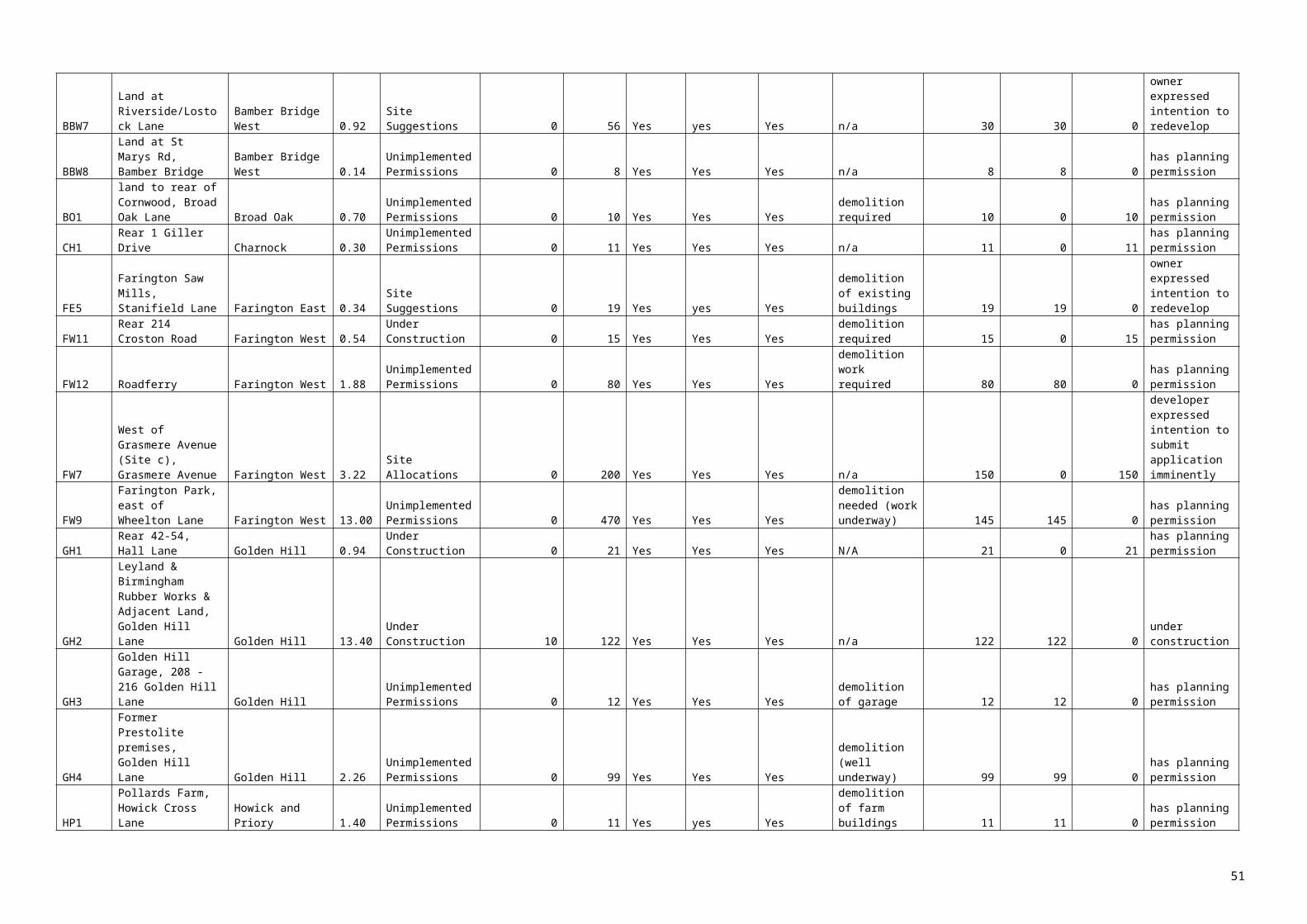
2015/16 - 2023/24 sites
SHLAA Ref Site Name Ward /
SettlementSite Size Site Type
Density
Multiplier
Estimated Net Developable
Area
Estimated N
et H
ousing C
apacity at A
pril 2015
Site Suitable for H
ousing?
Site Available
for Housing?
Site Achievable
for Housing?
Overcoming Identified Constraints
Developable
Units 2015/16 to
2019/20
Developable
Units 2020/21 to
2023/24
Brow
nfield U
nits
Greenfield U
nits
Comments
needed to permit housing development. Euxton identified as an Urban Local Service
Centre in draft Core Strategy.
EUX04
Land at End of Dunrobin Drive Euxton 3.2 Site Suggestions 35
50% as part Green Belt 55 Yes Yes Yes
LDF Review of land required 55 0 0 55
Land safeguarded for future development needs. LDF Review of land needed to
permit housing development. Land within Green Belt unsuitable so site area restricted to 50%. Euxton identified as an Urban Local
Service Centre in draft Core Strategy.
EUX09
Concrete Works, Wigan Road Euxton 0.3 Site Allocations 35 90% 7 Yes No
Yes if site becomes available
Could be developable if land becomes
available. Remediation works likely to be
required 0 7 7 0
Landowner intentions currently unknown so would need to agree to make land available.
Site allocated for housing redevelopment. Requires demolition of existing buildings.
Euxton identified as an Urban Local Service Centre in draft Core Strategy.
EUX10 Balshaw Lane Euxton 0.1 Site Allocations 50 90% 5 Yes Yes Yes None identified 5 0 5 0
Remaining section of allocated housing site. Euxton identified as an Urban Local Service
Centre in draft Core Strategy.
OTV01Withnell Fold Mill Withnell Fold 1.5 Site Suggestions 40
30% as mixed use site
suggestion 18Yes -
Conversion Yes Yes
Sit e is on Green Belt, but potential for mixed
uses 18 0 18 0
Site is in Green Belt but there could be potential for some residential re-use of
existing mill building as part of a mixed-use scheme
OTV012
Finnington Industrial Estate, Finnington Lane Finnington 0.89
Unimplemented Permissions N/A N/A 15 Yes Yes Yes
Demolition required. Remediation works likely to be required 15 0 15 0
Site has planning permission for live-work units. Site remains in operational industrial use. Demolition and remediation required.
OTV13Land off New Street Mawdesley 1.5 Site Suggestions 30 80% 36
Yes but is subject to policy restrictions. Draft Core Strategy restricts to local needs. Size of site means it may not be considered small-scale Yes
If policy requirements can be met
Significant proportion of affordable housing / housing to meet local
needs required but site likely to be of a larger
scale than that envisaged for
Mawdesley in draft Core Strategy 0 0 0 0
Current policy requirement for significant proportion of affordable housing. Mawdesley not identified as a location for growth in draft Core Strategy, which restricts development to local needs. Size of site means it may not be considered small-scale. 0 units recorded
in table due to uncertainty.WLW04 Land off
Birchin LaneWhittle-le-Woods
31.9 Other Sites 35 50% 558 Yes No Yes if site becomes available
LDF Review of land required. Landowners
intentions currently unknown so would
need to agree to make site available
0 0 0 0 Land safeguarded for future development needs. LDF review of land needed to permit housing development. Site would need to be
developed as part of a comprehensive scheme for the area including site WLW05. Landowner intentions unknown. Whittle-le-
Woods identified as an Urban Local Service Centre in draft Core Strategy. Considered
51

2015/16 - 2023/24 sites
SHLAA Ref Site Name Ward /
SettlementSite Size Site Type
Density
Multiplier
Estimated Net Developable
Area
Estimated N
et H
ousing C
apacity at A
pril 2015
Site Suitable for H
ousing?
Site Available
for Housing?
Site Achievable
for Housing?
Overcoming Identified Constraints
Developable
Units 2015/16 to
2019/20
Developable
Units 2020/21 to
2023/24
Brow
nfield U
nits
Greenfield U
nits
Comments
more likely to be developable after 2023/24 and consequently 0 units are recorded in the
table.
WLW05Land North of Town Lane (1)
Whittle-le-Woods 15 Site Suggestions 35 50% 263 Yes Yes Yes
LDF Review of land required 30 233 0 263
Land safeguarded for future development needs. LDF review of land needed to permit housing development. Site would need to be
developed as part of a comprehensive scheme for the area and would be linked to
WLW04 & WLW06. Whittle-le-Woods identified as an Urban Local Service Centre
in draft Core Strategy
WLW06Land North of Town Lane (2)
Whittle-le-Woods 1.5 Other Sites 35 50% 26 Yes No
Yes if site becomes available
LDF Review of land required. Landowners
intentions currently unknown so would
need to agree to make site available 0 0 0 0
Land safeguarded for future development needs. LDF review of land needed to permit housing development. Site would need to be
developed as part of a comprehensive scheme for the area and would be linked to
WLW04 & WLW05. Whittle-le-Woods identified as an Urban Local Service Centre
in draft Core Strategy. Considered more likely to be developable after 2023/24 and consequently 0 units are recorded in the
table.
WLW07
Land to the west of Lucas Lane
Whittle-le-Woods 9.3 Site Suggestions
35
40% due to site constraints 130 Yes Yes Yes
LDF Review of land required
90 40 0 130 Land safeguarded for future development needs. LDF review of land needed to permit housing development. Site would need to be
developed as part of a comprehensive scheme for the area. Whittle-le-Woods
identified as an Urban Local Service Centre in draft Core Strategy.
WLW09
Croston's Farm, Lucas Lane
Whittle-le-Woods 0.4 Site Suggestions
35
50% 7 Yes Yes Yes
LDF Review of land required
0 7 0 7 Land safeguarded for future development needs. LDF review of land needed to permit housing development. Site would need to be
developed as part of a comprehensive scheme for the area. Whittle-le-Woods
identified as an Urban Local Service Centre in draft Core Strategy.
WLW10
Land at Croston's Farm, Lucas Lane
Whittle-le-Woods 6.2 Site Suggestions
35
50% 109 Yes Yes Yes
LDF Review of land required
0 109 0 109 Land safeguarded for future development needs. LDF review of land needed to permit housing development. Site would need to be
developed as part of a comprehensive scheme for the area and would be linked to
WLW07 & WLW11. Whittle-le-Woods identified as an Urban Local Service Centre
in draft Core Strategy.WLW11 Land south of
Town LaneWhittle-le-Woods
1.13 Other Sites 35 50% 20 Yes No Yes if site becomes available
LDF Review of land required
0 0 0 0 Land safeguarded for future development needs. LDF review of land needed to permit housing development. Site would need to be
developed as part of a comprehensive
52

2015/16 - 2023/24 sites
SHLAA Ref Site Name Ward /
SettlementSite Size Site Type
Density
Multiplier
Estimated Net Developable
Area
Estimated N
et H
ousing C
apacity at A
pril 2015
Site Suitable for H
ousing?
Site Available
for Housing?
Site Achievable
for Housing?
Overcoming Identified Constraints
Developable
Units 2015/16 to
2019/20
Developable
Units 2020/21 to
2023/24
Brow
nfield U
nits
Greenfield U
nits
Comments
scheme for the area and would be linked to WLW07 & WLW10. Whittle-le-Woods
identified as an Urban Local Service Centre in draft Core Strategy. Considered more
likely to be developable after 2023/24 and consequently 0 units are recorded in the
table.
WLW12Land off Moss Lane (1)
Whittle-le-Woods 1.26 Site Suggestions
35
50% 22 Yes Yes Yes
LDF Review of land required
22 0 0 22 Land safeguarded for future development needs. LDF review of land needed to permit
housing development. Site would need to provide access to WLW13. Whittle-le-
Woods identified as an Urban Local Service Centre in draft Core Strategy.
WLW13Land off Moss Lane (2)
Whittle-le-Woods 4.17 Other Sites
35
30% due to playing field &
farm 44 Yes No
Yes if site becomes available
LDF Review of land required
0 0 0 0 Land safeguarded for future development needs. LDF review of land needed to permit
housing development. Site would need access from WLW12. Whittle-le-Woods
identified as an Urban Local Service Centre in draft Core Strategy. Considered more
likely to be developable after 2023/24 and consequently 0 units are recorded in the
table. WLW14 Land off
Watkin RoadWhittle-le-Woods
0.41
Other Sites 35 Access Issues
11 Yes No
Yes if site becomes
available & access can be
achieved
Access issues need to be addressed
0 0 0 0 Access Issues need addressing. Landowner intentions unknown. Site may have
development potential over period but 0 units recorded in table due to uncertainty. Whittle-le-Woods identified as an Urban
Local Service Centre in draft Core Strategy
Totals 2876 2292 1515 3653
There are 68 sites outlined in Table 11 that are considered developable in the 6 – 15 year supply period. There are also a further 16 sites listed in this table that may have some housing potential over the time period, but are subject to constraints that mean that there is little certainty that they will be developed. On these 16 sites no units are recorded as developable during the 6 – 15 year supply period. The constraints cover a range of factors including:
policy restrictions such as conflict with the draft Core Strategy development growth locations policy, which may make site development unlikely or necessitate the provision of a significant proportion of affordable housing
Sites where landowner intentions are unknown and that are not allocated specifically for development purposes The peripheral location of some of these sites, which means that although they could be developed, this may happen after the 6 – 15 year supply period
Sites included in Table 11 include
Sites where housing is under construction or is expected to start within the 0 – 5 year supply period , but are not considered likely to be completed within 5 years Sites that have permission for housing, or are allocated for housing, but where there is uncertainty that completions will take place during the 0 – 5 year supply period Sites that have been put forward by developers/landowners as potentially suitable for housing development as part of the site suggestions process for the proposed Site Allocations DPD Sites where pre-application discussions have taken place regarding potential development for housing
53

Sites on land that is safeguarded for future development needs in the Chorley Local Plan – development of these sites would require them to be reviewed as part of the LDF process and re-allocated for development
It should be noted that as well as having potential for housing, some of these sites will also have potential to be developed for other purposes, such as for employment development or for community uses and that this document does not allocate them for housing purposes. Some of them are also unlikely to be fully developed by 2023/24 and have potential for development after the SHLAA period.
Table 11 identifies land with potential for 2,876 dwellings over the period 2015/16 – 2019/20 and for 2,292 dwellings over the period 2020/21 – 2023/24. 1,515 of these units are on Brownfield land and 3,653 are on Greenfield land. This reflects the high proportion of Greenfield Safeguarded Land that is potentially available for future development in the Borough.
54

Table 12: Preston sites April 2015 – March 2020 and April 2020 – March 2024
2015/16 - 2023/24 sites
SHLAA Ref Site Name Ward Site
Size Site Type Density Multiplier
Estimated Net
Developable Area
Estimated Net
Housing Capacity at April 2015
Site Suitable
for Housing?
Site Available
for Housing?
Site Achievable
for Housing?
Overcoming Identified
Constraints
Developable Units
2015/16 to 2019/20
Developable Units
2020/21 to 2023/24
Brownfield Units
Greenfield Units Comments
UP01 Queen Street - Countryside Properties
Town Centre
3.211 Unimplemented Permissions
N/A N/A 350 Yes Yes Yes Existing building needs demolishing.
Medium risk of remediation
works required
250 100 350 Developer committed to residential on site. Assumed part of the scheme will be built as to current plans and a new scheme for family housing negotiated on the rest. Multiple developers. Indicative figure 350 units
UP02 Whittingham Hospital Grounds
Preston Rural East
51.591 Unimplemented Permissions
N/A N/A 480 Yes Yes Yes Existing building needs demolishing.
Medium risk of remediation
works required
480 0 480 Assumed multiple developers. Figures based Developer Proforma
UP03 Avenham Car Park, Avenham Street
Town Centre
0.591 Unimplemented Permissions
N/A N/A 210 Yes Yes Yes Remediation works likely to
be required
210 0 210 Developer committed to scheme. Assumed single developer starting on site in 6 - 10 year period
UP05 Whittingham Lane (Hudson and Walling)
Preston Rural East
2.281 Unimplemented Permissions
N/A N/A 61 Yes Yes Yes Existing building needs demolishing.
Medium risk of remediation
works required
61 0 61 Due to market conditions it is not envisaged that this development will take place within 0-5years
UP06 Mount Street/Garden Street
Town Centre
0.061 Unimplemented Permissions
N/A N/A 47 Yes Yes Yes Existing building needs demolishing
47 0 47 Due to market conditions it is not envisaged that this development will take place within 0-5years
UP07 Former Byron Hotel, 25-35 Grimshaw Street
Town Centre
0.088 Unimplemented Permissions
N/A N/A 25 Yes Yes Yes N/A 25 0 25 Due to market conditions it is not envisaged that this development will take place within 0-5years
UP09 21 & 21A Cannon Street
Town Centre
0.025 Unimplemented Permissions
N/A N/A 14 Yes Yes Yes Existing building needs demolishing
14 0 14 Due to market conditions it is not envisaged that this development will take place within 0-5years. MU scheme involving apartments
55

2015/16 - 2023/24 sites
SHLAA Ref Site Name Ward Site
Size Site Type Density Multiplier
Estimated Net
Developable Area
Estimated Net
Housing Capacity at April 2015
Site Suitable
for Housing?
Site Available
for Housing?
Site Achievable
for Housing?
Overcoming Identified
Constraints
Developable Units
2015/16 to 2019/20
Developable Units
2020/21 to 2023/24
Brownfield Units
Greenfield Units Comments
UP10 33 Manchester Road
Town Centre
0.101 Unimplemented Permissions
N/A N/A 14 Yes Yes Yes Existing building needs demolishing. High risk of remediation
works required
14 0 14 Due to market conditions it is not envisaged that this development will take place within 0-5years. MU scheme involving apartments
UP11 13 Manchester Road
Town Centre
0.042 Unimplemented Permissions
N/A N/A 14 Yes Yes Yes Existing building needs demolishing
14 0 14 Due to market conditions it is not envisaged that this development will take place within 0-5years. MU scheme involving apartments
UP12 Former St. Joseph's Orphanage, Theatre Street
Town Centre
0.394 Unimplemented Permissions
N/A N/A 81 Yes Yes Yes N/A 81 0 81 Planning permission has been implemented however further progress is not expected until market improves.
UP13 Miller Arcade, Church Street
Town Centre
0.207 Unimplemented Permissions
N/A N/A 25 Yes Yes Yes N/A 25 0 25 Due to market conditions it is not envisaged that this conversion will take place within 0-5years
UP15 6 & 7 Ribblesdale Place
Town Centre
0.067 Unimplemented Permissions
N/A N/A 14 Yes Yes Yes N/A 14 0 14 Due to market conditions it is not envisaged that this change of use will take place within 0-5years
UP16 37/38 Cannon Street Preston
Town Centre
0.022 Unimplemented Permissions
N/A N/A 7 Yes Yes Yes Existing building needs demolishing
7 0 7 Due to market conditions it is not envisaged that this development will take place until 6-10yrs
UP20 6-16 Marsh Lane, Preston
Town Centre
0.4ha Unimplemented Permissions
N/A N/A 18 Yes Yes Existing building needs demolishing
18 0 18 Due to market conditions it is not envisaged that this development will take place until 6-10yrs
UP21 Lancashire House, Winckley Square, Preston
Town Centre
Unimplemented Permissions
N/A N/A 35 Yes No Yes N/A 35 0 35 Due to market conditions it is not envisaged that this change of use will take place within 0-5years
56

2015/16 - 2023/24 sites
SHLAA Ref Site Name Ward Site
Size Site Type Density Multiplier
Estimated Net
Developable Area
Estimated Net
Housing Capacity at April 2015
Site Suitable
for Housing?
Site Available
for Housing?
Site Achievable
for Housing?
Overcoming Identified
Constraints
Developable Units
2015/16 to 2019/20
Developable Units
2020/21 to 2023/24
Brownfield Units
Greenfield Units Comments
UP24 5-13 Market Street, Preston
Town Centre
0.057ha Unimplemented Permissions
N/A N/A 14 Yes Yes Yes N/A 14 0 14 Due to market conditions it is not envisaged that this conversion will take place until 6-10yrs
UP29 10-18 Walker Street, Preston
Town Centre
0.11ha Unimplemented Permissions
N/A N/A 36 Yes No Yes Existing building needs demolishing. Remediation works may be
require
36 0 36 Site still in use - assumed start on site 6-10 years, single developer
PEN01 Alliance Works, Goodier Street and part of Manchester Mill
St Matthews
2.806 Other N/A N/A 10 Yes Yes Yes Demolition of existing
buildings Potential
remediation works required
10 0 10 Remaining 10 units of the expected 100 units on site
PEN02 Alstoms, Channel Way
Riversway 6.257 Other 45 60% 109 Yes Yes Yes Demolition of existing
buildings Appropriate
flood protection / mitigation required
109 0 109 Developer Panel considered 45 dph more appropriate for site and therefore assumed a further application would come in - assumed start towards end of 0-5 yr period
PEN03 GOSS Graphics University 3.8ha Other N/A N/A 296 Yes Yes Yes Demolition of existing
buildings. Medium risk of
remediation works required
250 46 296 Scheme involves 208 apartments, 88 family homes and 370 student rooms. Assumed student accommodation will come first late in 0-5yr period. 370 student bedspaces assumed 6bed flats approx 62 units
PEN04 Hemmings Mill, New Hall Lane
St Matthews
Other N/A N/A 45 Yes Yes Yes Potential remediation
works required
45 0 45 Due to market conditions it is not envisaged that this development will take place within 0-5years
PEN05 Cottam Hall Brickworks
Ingol 3.39 Other N/A N/A 145 Yes Yes Yes Potential remediation
works required
145 0 145 Assumed single developer with start on site towards the end of the 0-5 yr period
MRS1 Tithebarn Regeneration Area
Town Centre
22.886 Other n/a n/a 355 Yes Yes Yes Demolition of existing
buildings
355 0 355 Developer committed to residential element of scheme
57

2015/16 - 2023/24 sites
SHLAA Ref Site Name Ward Site
Size Site Type Density Multiplier
Estimated Net
Developable Area
Estimated Net
Housing Capacity at April 2015
Site Suitable
for Housing?
Site Available
for Housing?
Site Achievable
for Housing?
Overcoming Identified
Constraints
Developable Units
2015/16 to 2019/20
Developable Units
2020/21 to 2023/24
Brownfield Units
Greenfield Units Comments
assumed start towards end of the 0-5 year period and completed within the 6-10yr period.
LP1 Brockholes/Birley Bank
Fishwick 1.74ha Other (Local Plan Allocated)
50 50% due to buffer needed
to adjacent employment
site
43 Yes No Yes Existing building needs demolishing
43 0 43 Expected to become available 6 - 10 yrs
P001 Cottam Hall, off Tom Benson Way, Preston
Lea 56.04 Site Suggestions
40 50% 1026 Yes Yes Yes N/A 593 433 1026 Multiple developers assumed on 3-4 parcels of land 0-5 years. 6-15 yrs multiple developers. Based on HCA development proforma
P002 Whittingham Hospital (Gotfield Front Field), Goosnargh
Preston Rural North
10.05 Site Suggestions
30 50% 151 Suitable but with policy
restrictions
Yes Yes N/A 0 120 120 Contrary to Core Strategy Policy. A further potential 31 units post 2023/24
P003 Broughton Business Park, Eastway
Preston Rural East/ Sharoe Green
28.00 Site Suggestions
N/A N/A 100 Yes Yes Yes N/A 100 0 100 Based on figures provided by HCA assumed work starts towards middle of the 6-10 yr period
P008 Ainsdale House Larches 0.28 Site Suggestions
40 85% 10 Yes Yes Yes Site has already been
cleared
10 0 10 Site has been cleared however no development expected until 6-10yrs
P014 Land fronting the east side of Garstang Road, Broughton
Preston Rural East
7.6 Site Suggestions
30 60% 137 Suitable but with policy
restrictions
Yes Yes N/A 0 120 120 Open Countryside, Edge of Settlement. Contrary to Core Strategy Policy. A further potential 17 units post 2023/24
P016 421 Garstang Road, Broughton
Greyfriars 1.20 Site Suggestions
30 80% 29 Yes Yes Yes N/A 29 0 29 Assumed single developer
P020 Land off Preston Road, Grimsargh
Preston Rural East
5.0 Site Suggestions
30 60% 90 Suitable but with policy
restrictions
Yes Yes N/A 0 90 90 Open Countryside, Edge of Settlement. Contrary to Core Strategy Policy
P024 Brethren's Meeting Room, Egerton Road, Ashton
Ashton 0.403 Site Suggestions
30 80% 10 Yes Yes Yes Existing building needs demolishing
10 0 10 Assumed site becomes available within 6-10 yr period with a single developer
58

2015/16 - 2023/24 sites
SHLAA Ref Site Name Ward Site
Size Site Type Density Multiplier
Estimated Net
Developable Area
Estimated Net
Housing Capacity at April 2015
Site Suitable
for Housing?
Site Available
for Housing?
Site Achievable
for Housing?
Overcoming Identified
Constraints
Developable Units
2015/16 to 2019/20
Developable Units
2020/21 to 2023/24
Brownfield Units
Greenfield Units Comments
P031 Depot, Land east of Longridge Road, Ribbleton
Ribbleton 0.71 Site Suggestions
50 80% 28 Yes Yes Yes Potential remediation works and
access improvements
required
28 0 28 Assumed single developer with start on site tin 6-10yr period once access issues have been resolved. Density set at 50dph based on Developer Panel comments
P035 Land to the rear of Preston Road/Ribblesdale Drive, Grimsargh
Preston Rural East
0.67 Site Suggestions
30 80% 16 Suitable but with policy
restrictions
Yes Yes N/A 0 16 16 Open Countryside, Edge of Settlement. Contrary to Core Strategy Policy
P038 Land on the south side of Lea Road
Lea 3.4 Site Suggestions
30 80% 82 Suitable but with policy
restrictions
Yes Yes N/A 0 82 82 Open Countryside, Edge of Settlement. Contrary to Core Strategy Policy
P039 Bellway land to the east of Goosnargh
Preston Rural North
19.6 Site Suggestions
30 50% 294 Suitable but with policy
restrictions
Yes Yes N/A 0 120 120 Open Countryside, Edge of Settlement. Contrary to Core Strategy Policy. A further potential 174 units post 2023/24
P041 Land at Church House Farm, Grimsargh
Preston Rural East
13.86 Site Suggestions
30 50% 208 Suitable but with policy
restrictions
Yes Yes N/A 0 120 120 Open Countryside, Edge of Settlement. Contrary to Core Strategy Policy. A potential further 88 units post 2023/24
P044 Land off Blackpool Road/Dodney Drive, Lea
Lea 12.04 Site Suggestions
30 50% 181 Suitable but with policy
restrictions
Yes Yes N/A 0 120 120 Open Countryside, Edge of Settlement. Contrary to Core Strategy Policy. A further potential 61 units post 2023/34
P047 Land off Whittingham Lane, Longridge
Preston Rural North
18.93 Site Suggestions
30 50% 284 Yes Yes Yes N/A 0 284 284 Potential urban extension for the key service centre of Longridge from year 11 onwards. Assumed multiple developers
P053 Land to rear of The Laund, Whittingham Lane, Grimsargh
Preston Rural East
0.70 Site Suggestions
30 80% 17 Suitable but with policy
restrictions
Yes Yes N/A 0 17 17 Open Countryside, Edge of Settlement. Contrary to Core Strategy Policy
P055 Corporation Street University 1.75 Site Suggestions
100 80% 140 Yes Yes Yes Medium risk of remediation
140 0 140 Density set at 100dph as it is a city centre site and therefore assumes
59

2015/16 - 2023/24 sites
SHLAA Ref Site Name Ward Site
Size Site Type Density Multiplier
Estimated Net
Developable Area
Estimated Net
Housing Capacity at April 2015
Site Suitable
for Housing?
Site Available
for Housing?
Site Achievable
for Housing?
Overcoming Identified
Constraints
Developable Units
2015/16 to 2019/20
Developable Units
2020/21 to 2023/24
Brownfield Units
Greenfield Units Comments
apartments 6-10yrs!P057 Oak Street, City
CentreTown Centre
0.14 Site Suggestions
100 85% 12 Yes Yes Yes Existing buildings need demolishing
12 0 12 Density lowered due to current market conditions. The site is only considered suitable as part of a mixed use scheme including apartments so has been included in years 6-10 when market conditions are hoped to be more favourable
P058 Land behind Barton Church and The Boars Head Public House, off Garstang Road, Barton
Preston Rural North
2.743 Site Suggestions
30 80% 66 Suitable but with policy
restrictions
Yes Yes N/A 0 66 66 Open Countryside, Edge of Settlement. Contrary to Core Strategy Policy
P059 Bellway land to the west of Goosnargh
Preston Rural North
8.9 Site Suggestions
30 60% 160 Suitable but with policy
restrictions
Yes Yes N/A 0 120 120 Open Countryside, Edge of Settlement. Contrary to Core Strategy Policy. A further potential 40 units post 2023/24
P063 Land at Bank Hall Farm, Broughton
Preston Rural East
17.086 Site Suggestions
30 50% 256 Suitable but with policy
restrictions
Yes Yes N/A 0 120 120 Open Countryside, Edge of Settlement. Contrary to Core Strategy Policy. A further potential 136 units post 2023/24
P067 Rydal Mount, 42 Woodplumpton Road, Woodplumpton
Preston Rural North
0.375 Site Suggestions
30 85% 10 Suitable but with policy
restrictions
Yes Yes N/A 0 10 10 Open Countryside, Edge of Settlement. Contrary to Core Strategy Policy.
P068 West View Farm, Woodplumpton Road, Woodplumpton
Preston Rural North
0.673 Site Suggestions
30 80% 16 Suitable but with policy
restrictions
Yes Yes N/A 0 16 16 Open Countryside, Edge of Settlement. Contrary to Core Strategy Policy.
P070 Preston College, Park Campus, Moor Park Avenue
Moor Park 0.9 Site Suggestions
50 80% 36 Yes No Yes Existing buildings need demolishing
36 0 36 Campus to become redundant under Preston College Fulwood redevelopment plans. Assumed single developer
P073 Land at Boyes farm, Fulwood
Preston Rural East
24.28 Site Suggestions
30 50% 365 Yes Developer negotiating options on
land
Yes N/A 150 120 270 Assumed single developer. Potential additional 95 units post 2023/24
Lightfoot1 Lightfoot1 Preston 95.476 Site 30 50% 1432 Yes Yes Yes Highways 0 240 240 Potential sustainable
60

2015/16 - 2023/24 sites
SHLAA Ref Site Name Ward Site
Size Site Type Density Multiplier
Estimated Net
Developable Area
Estimated Net
Housing Capacity at April 2015
Site Suitable
for Housing?
Site Available
for Housing?
Site Achievable
for Housing?
Overcoming Identified
Constraints
Developable Units
2015/16 to 2019/20
Developable Units
2020/21 to 2023/24
Brownfield Units
Greenfield Units Comments
Rural North
Suggestions improvements required
urban extension following development of Lightfoot 2. Assumed multiple developers starting in the 10-15yr period with development taking place over 15+ years. A potential further 1192 units post 2023/24
Lightfoot2 Lightfoot2 Greyfriars/ Preston Rural North
22.81 Site Suggestions
30 50% 342 Yes Yes Yes Highways improvements
required
200 142 342 Potential sustainable urban extension. Assumed multiple developers.
UPS10 Land adjacent to 68 Chapman Road
College 0.39 Urban Potential 30 85% 10 Yes No Yes N/A 10 0 10 Expected to become available within 6-10yrs. Assumed single developer.
UPS18 Land at Browsholme Ave/Fair Oak Close
Ribbleton 0.28 Urban Potential 40 85% 10 Yes No Yes N/A 10 0 10 Expected to become available within 6-10 years. Assumed single developer
UPS22 Former Spindlemaker's Arms, Lancaster Road North
St Georges 0.11 Urban Potential 50 85% 6 Yes Yes Yes Ownership constraints
would have to be overcome
6 0 6 Expected to be developable within 6-10yrs
UPS23 The Limes, Peel Hall St
St Matthews
0.26 Urban Potential 50 85% 11 Yes No Yes Demolition of existing
buildings
11 0 11 Expected to become available within 6-10 years. Assumed single developer
UPS26 Truro Place St Matthews
0.51 Urban Potential 40 80% 16 Yes No Yes N/A 16 0 16 Density set at 40dph based on Developer Panel comments - Expected to become available within 6-10yrs. Assumed single developer
UPS30 Glover's Court/Park Place
Town Centre
0.08 Urban Potential 100 85% 7 Yes as part of mixed
use scheme
No Yes Demolition of existing
buildings
7 0 7 Density lowered due to current market conditions. The site is only considered suitable as part of a mixed use scheme including apartments
UPS41 Eldon Street/Railway
Tulketh 0.24 Urban Potential 50 85% 10 Yes No Yes Potential remediation
works required
10 0 10 Expected to become available within 6-10years. Assumed single developer
61

2015/16 - 2023/24 sites
SHLAA Ref Site Name Ward Site
Size Site Type Density Multiplier
Estimated Net
Developable Area
Estimated Net
Housing Capacity at April 2015
Site Suitable
for Housing?
Site Available
for Housing?
Site Achievable
for Housing?
Overcoming Identified
Constraints
Developable Units
2015/16 to 2019/20
Developable Units
2020/21 to 2023/24
Brownfield Units
Greenfield Units Comments
UPS49 Rear of St. Mary's, Friargate
Town Centre
0.27 Urban Potential 100 85% 23 Yes No Yes Potential remediation
works required
23 0 23 Density lowered due to current market conditions. The site is only considered suitable as part of a mixed use scheme including apartments so has been included in years 6-10 when market conditions are hoped to be more favourable
UPS51 Heatley Street/Corporation Street
Town Centre
0.08 Urban Potential 100 85% 7 Yes No No N/A 7 0 7 Site potentially suited to student accommodation
NLUD12 42 West Cliff Riversway 0.197 NLUD 50 85% 8 Yes Yes Flood risk assessment and possible subsequent mitigation
8 0 8 Density set at 50dph based on Developer Panel comments
NLUD21 Site Between Grimshaw Street And Manchester Road
Town Centre
0.873 NLUD 50 80% 35 Yes No Yes Potential remediation
works required
35 0 35 Density set at 50dph based on Developer Panel comments. Expected to become available within 6-10yrs. Assumed single developer
SE09 Spar Depot, Blackpool Road (47)
St Matthews
4.609 Employment land & buildings
40 50% Due to mixed use
92 Yes No Yes Existing buildings to be
demolished and potential
remediation works required
92 0 92 Expected to become available within 6-10yrs. Based on mixed use scheme for sites 36a & b with around 50% given over to residential
SE10 Perry's Car Showroom, Blackpool Road (47)
St Matthews
1.255 Employment land & buildings
40 50% Due to mixed use
25 Yes No Yes Access improvements
required
25 0 25 Expected to become available within 6-10 years. Based on mixed use scheme for sites 36a & b with around 50% given over to residential
Totals 3870 2502 2963 3409
There are 64 sites identified in the 6-15 year supply for Preston City. A number of these sites are City Centre sites with planning permission for mixed use/apartments schemes which due to the current market conditions are not expected to come forward within the 0-5 year period. It is assumed that developers will wait until the market is more favourable for apartment schemes before developments such as these are built out which is expected to be in the 6-10 year period. The sites included within the 10-15 year supply include Lightfoot 1 and Lightfoot 2 which have been identified as potential areas for sustainable extensions to the Preston Urban area. A number of the sites included within the 6-15 year period are large sites and will therefore take a considerable number of years to build with some having development potential post SHLAA period.
Table 13 : South Ribble sites April 2013 – March 2018 and April 2018 – March 2023
62

March 2018 and April 2018 – March 2023
SHLAA Ref Site Name Ward/Settlement Site Type
Net developable
area
Estimated Net Housing
Capacity at April 2015
SuitableAvailability of
site for housing?
achievable How to overcome identified constraints
Developable Units 2015/16
to 2019/20
Developable Units 2020/21
to 2023/24Brownfield Greenfield Comments
CH2 safeguarded site A, Southern Part
Charnock Urban Potential
3.9 156 Yes Yes Yes 120 36 0 156 would require policy change through LDF
BBN5 Charnley Fold Bamber Bridge North
Site Suggestions
1.12 45 Yes No Yes demolition required 45 0 45 0 no active discussions
LMH3 Land at Orchard Gardens
Little Hoole & Much Hoole
Other 0.99 30 Suitable with policy restriction
Yes Yes 0 30 0 30 Currently safeguarded against development for village needs
LMH2 Land off Marlfield Little Hoole & Much Hoole
Other 0.55 16 Suitable with policy restriction
Yes Yes 0 16 0 16 Currently safeguarded against development for village needs
NLH6 Land at Sheephill Lane/Long Moss Lane
New Longton & Hutton East
Other 0.95 29 Suitable with policy restriction
Yes Yes 0 29 0 29 Currently safeguarded against development for village needs
SW10 Land adjacent to and rear of Barnflatt Close
Samlesbury and Walton
Other 1.44 43 Suitable with policy restriction
Yes Yes 0 43 0 43 Currently safeguarded against development for village needs
SW17 Land at Daub Hall Lane
Samlesbury and Walton
Other 3.12 94 Suitable with policy restriction
Yes Yes 0 94 0 94 Currently safeguarded against development for village needs
SW3 Land at Branch Road, Mellor Brook
Samlesbury and Walton
Other 3.48 104 Suitable with policy restriction
Yes Yes 0 104 0 104 Currently safeguarded against development for village needs
LMH4 Land at end of Northern Avenue
Little Hoole and Much Hoole
Other 1.99 60 Suitable with policy restriction
Yes Yes 0 60 0 60 Currently safeguarded against development for village needs
FW7 West of Grasmere Avenue (Site c), Grasmere Avenue
Farington West Site Allocations
2.42 50 Yes Yes Yes None 50 0 0 50 Developed as part of mixed use Fact Focus scheme. Application expected imminently. Allocated for residential in LP. Figures based on developer proforma
TG6 Lime Kiln Farm (Site h), Todd Lane North
Tardy Gate/Charnock
Site Allocations
3.94 100 Yes Yes Yes None 100 0 0 100 HCA have expressed intention to submit application ASAP. ALLOCATED RESIDENTIAL SITE. HCA indicate there will be 190 dwellings on the site
MS2 Moss Side Test Track, Aston Way
Moss Side Site Allocations
21.65 625 Yes Yes Yes New access built, removal of existing buildings and test track
425 200 625 0 active developer interest - seeking to begin ASAP. Figures taken from proforma completed by agents
TG3 Lostock Hall Gas Works, Leyland Road
Tardy Gate Site Allocations
6.18 90 Yes Yes Yes demolition work, possible remediation, improvements to access
90 0 90 0 No. of dwellings based on application. Application awaiting finalisation of S106.
LHU10 Land adjoining Longton Hall Farm, South of Chapel Lane
Longton and Hutton West
Urban Potential
1.60 48 Suitable with policy restriction
Yes Yes 0 48 0 48 Currently safeguarded against development for village needs
LHU11 Land to rear of Longton Hall, rear of
Longton and Hutton West
Urban Potential
2.67 80 Suitable with policy
Yes Yes 0 80 0 80 Currently safeguarded against development for village needs
63

March 2018 and April 2018 – March 2023
SHLAA Ref Site Name Ward/Settlement Site Type
Net developable
area
Estimated Net Housing
Capacity at April 2015
SuitableAvailability of
site for housing?
achievable How to overcome identified constraints
Developable Units 2015/16
to 2019/20
Developable Units 2020/21
to 2023/24Brownfield Greenfield Comments
Chapel Lane restrictionFW8 Safeguarded land f
(eastern part) Church Lane
Farington West Urban Potential
4.52 227 Yes Yes Yes Demolition required. Requires policy change through LDF
150 77 0 227 would require policy change through LDF
TG4 Land off Wateringpool Lane
Tardy Gate Urban Potential
3.47 139 Yes Yes Yes remediation work to address any contamination issues
0 0 0 139
FE3 Land at rear of 24-56, Stanifield Lane
Farington East Urban Potential
0.50 40 Yes Yes Yes potential access issues would need resolving
40 0 40 0 not in 5 year supply because of access issues
SS1 Rear Burscough House, Leyland Lane
Seven Stars Urban Potential
0.41 12 Yes Yes Yes n/a 12 0 0 12 small site - no additional cost factors, completed within a year of development commencing
SS4 Rear 102-118, Slater Lane
Seven Stars Urban Potential
0.93 47 Yes Yes Yes potential access problems
47 0 47 0 assumed that permission will not be sought until adjacent Expac factory is redeveloped to provide access
EB2 Land Rear of Pasturefield Close
Earnshaw Bridge Urban Potential
0.55 28 Yes Yes Yes N/A 28 0 0 28 access issues would need to be overcome -
NLH7 End of Spinney Close New Longton & Hutton East
Urban Potential
0.51 15 No Yes Yes n/a 15 0 0 15 greenfield, not allocated residential site
BBW5 Baxi new offices, Brownedge Road
Bamber Bridge West
Urban Potential
0.46 28 Yes Yes Yes demolition of current building.
28 0 28 0 owner expressed interest. Would form part of larger residential estate. No planning app and still in use - assumed complete in 1 year in year 6+
TG5 Lostock Hall Primary School, Avondale Drive
Tardy Gate Urban Potential
1.13 68 Yes Yes Yes closure and demolition of existing school
0 0 68 0 school currently in use - LCC expressed intention to redevelop - assumed complete in 2 years in years 6-10.
BO2 Government offices, Cop Lane
Broad Oak Urban Potential
1.64 65 Yes Yes Yes demolition of offices. Current use on site although expressed intention to redevelop
65 0 65 0 owners/agents expressed interest. Likely to come forward in year 6 onwards
BBN2 Arla Dairies, School Lane
Bamber Bridge North
Urban Potential
3.29 49 Yes Yes Yes demolition of dairy buildings
49 0 49 0 application expected imminently - discussions with developer at advanced stage
SW14 Higher Walton Mills, Blackburn Road
Samlesbury and Walton
Urban Potential
3.60 144 Yes Yes Yes flood mitigation work required prior to development
90 54 144 0
BBN3 LCC Social Services Offices, Brindle Road
Bamber Bridge North
Urban Potential
0.44 22 Yes Yes Yes demolition works required
22 0 22 0 no discussion with developers at this stage.
MF2 Vernon Carus Site, Factory Lane
Middleforth Urban Potential
8.38 375 Yes Yes Yes flood mitigation works required prior to development
250 125 375 0 current planning application
64
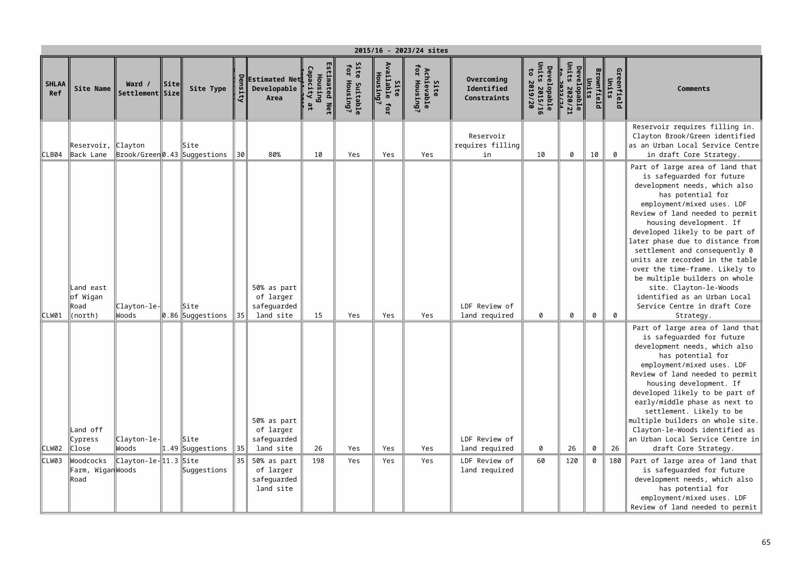
March 2018 and April 2018 – March 2023
SHLAA Ref Site Name Ward/Settlement Site Type
Net developable
area
Estimated Net Housing
Capacity at April 2015
SuitableAvailability of
site for housing?
achievable How to overcome identified constraints
Developable Units 2015/16
to 2019/20
Developable Units 2020/21
to 2023/24Brownfield Greenfield Comments
FW9 Farington Park, east of Wheelton Lane
Farington West Urban Potential
6.50 325 Yes Yes Yes demolition work underway. Current planning application.
200 45 245 0 Application minded to approve subject to S106.
WLD1 Haulage Yard, Chorley Road
Walton Le Dale Urban Potential
0.41 15 Yes Yes Yes flood mitigation work required prior to development. Demolition work required
15 0 15 0 owner expressed intention, no application hence included in years 6-10
MF1 safeguarded site a north part, South of Factory Lane
Middleforth Urban Potential
5.35 150 Yes Yes Yes Requires policy change through LDF
118 118 0 118 Would require policy change through LDF
FW10 Safeguarded site h, Church Lane
Farington West Urban Potential
5.28 211 Yes Yes Yes Requires policy change through LDF
150 61 0 211 Would require policy change through LDF
FW2 Safeguarded site d, Flensburg Way
Farington West Urban Potential
20.29 800 Yes Yes Yes Requires policy change through LDF
410 360 0 770 Would require policy change through LDF
FW3 Safeguarded site b, Pickerings Farm
Farington West Urban Potential
59.50 1800 Yes Yes Yes Requires policy change through LDF
510 480 0 990 remaining will be built in following years. Dwelling estimates based on figures from developers own Masterplan. Assumed 3 developers
SS3 Safeguarded site I, Leyland Lane
Seven Stars Urban Potential
11.81 590 Yes Yes Yes Requires policy change through LDF
130 240 0 370 Would require policy change through LDF
LOW1 Safeguarded site e, Wade Hall
Lowerhouse Urban Potential
15.21 760 Yes Yes Yes Requires policy change through LDF
120 300 0 420 Would require policy change through LDF
BBE2 Safeguarded site c, Brindle Road
Bamber Bridge East
Urban Potential
11.23 449 Yes Yes Yes Requires policy change through LDF
150 240 0 390 Would require policy change through LDF
LHU2 Land off School Lane Longton & Hutton West
Site Suggestions
2.76 83 Suitable with policy restriction
N/A Yes 0 83 0 83 Currently safeguarded against development for village needs
65

March 2018 and April 2018 – March 2023
SHLAA Ref Site Name Ward/Settlement Site Type
Net developable
area
Estimated Net Housing
Capacity at April 2015
SuitableAvailability of
site for housing?
achievable How to overcome identified constraints
Developable Units 2015/16
to 2019/20
Developable Units 2020/21
to 2023/24Brownfield Greenfield Comments
SW9 St Leonards Vicarage, Church Brow
Samlesbury and Walton
Site Suggestions
0.64 32 Yes yes Yes demolition of existing building
32 0 32 0 no planning application or discussions - owner submitted site suggestions form
LMH5 Land West of Liverpool Road
Little Hoole & Much Hoole
Site Suggestions
0.68 20 Suitable with policy restriction
yes Yes Requires policy change through LDF
0 20 0 20 Currently safeguarded against development for village needs
NLH2 Land adjacent to The Fields, Long Moss Lane
New Longton & Hutton East
Site Suggestions
0.75 23 Suitable with policy restriction
yes Yes Requires policy change through LDF
0 23 0 23 Currently safeguarded against development for village needs
NLH1 Schoolhouse Farm Development, Liverpool Road
New Longton & Hutton East
Site Suggestions
5.06 50 Yes yes Yes requires policy change through LDF
50 0 0 50 site to big for settlement. Assumed that only part of site will be built
BBW2 Brownedge Road Bamber Bridge West
Site Suggestions
1.57 19 Yes yes Yes 19 0 19 0 no major constraints, likely to come forward within 5 years, assumed year 5.
TG2 Cartmell & Barlow Ltd, Todd Lane North
Tardy Gate Site Suggestions
0.29 15 Yes yes Yes demolition required 15 0 15 0 small site, residential area, owner has intentions to redevelop
BBW7 Land at Riverside/Lostock Lane
Bamber Bridge West
Site Suggestions
1.88 26 Yes yes Yes 26 0 0 26
FW1 Safeguarded Site f (Western Part)
Farington West Site Suggestions
4.38 175 Yes yes Yes requires policy change through LDF
150 25 0 175 Would require policy change through LDF
8372 3721 2991
66

There are 47 sites identified in the 6-15 year supply for South Ribble. The majority of these are large sites that will take a considerable number of years to build. Sites included in the 6 – 15 year supply include:
Safeguarded land Land allocated for Local Needs in villages Large sites that commenced in years 1-5 but are not expected to be completed within
that time Sites that have constraints that prevent them from realistically coming forward within
the first 5 years Sites that are considered suitable for development but, at this stage, there are no
discussions ongoing with developers or planning applications. Sites that are currently policy restricted by a policy that may change through the LDF
process or by a policy that does permit development, such as the Countryside policy or the Local Needs in Villages Policy.
Safeguarded land and sites allocated under policy D9 of the adopted South Ribble Local Plan have been included as they have been saved in the Local Plan to allow them to come forward for development at a later date, without the need for development of any greenbelt, green wedge, or Open Space sites. It is therefore extremely likely that there will be development on many of these sites within the 15 year period. Development on these safeguarded sites would require a policy change through the Local Development Framework, meaning that they are not likely to come forward for development for a number of years.
Sites that are allocated for open space, greenbelt, green wedge in the current adopted South Ribble Local Plan have not been considered suitable – the Council can identify sufficient land to meet the RSS targets over the 15 year period without having to consider the release of any of this land.
67

STAGE 9 – IDENTIFYING AND ASSESSING THE HOUSING POTENTIAL OF BROAD LOCATIONS
Broad locations are not considered necessary for identification and assessment purposes in Central Lancashire as it has been possible to consider actual potential specific sites.
STAGE 10 – DETERMINING THE HOUSING POTENTIAL OF WINDFALL
PPS 3 says that “Allowances for windfalls should not be included in the first 10 years of land supply unless Local Planning Authorities can provide robust evidence of genuine local circumstances that prevent specific sites being identified. In these circumstances, an allowance should be included but should be realistic having regard to the Strategic Housing Land Availability Assessment, historic windfall rates and expected future trends”.
No windfall allowance has been included within the SHLAA.
68

APPENDIX 1 – SITES UNDER 5 DWELLING CAPACITY INCLUDED WITHIN THE 5 YEAR SUPPLY FIGURES
Chorley
Five-Year Supply Table Chorley Borough Five-Year Supply 2009 – 2015: Site List for Windfall Sites with
Planning Permission for 4 or less Housing Units
Site Ref: Address Total Net Units80 65/67 Bolton Road, Chorley 3 Greenfield
1231 Land East of 68 Froom Street, Chorley 1 Greenfield1606 Bank Hall Coach House 21607 Adj 110 Preston Road 1 Greenfield1626 R/O 209 – 213 Preston Road, Whittle-
le-Woods1
1640 Hill Crest, Wigan Road, Clayton-le-Woods
2 Greenfield
1682 R/O 42 – 44 Mill Lane 11716 Croston Hall Stables, Grape Lane 1 Greenfield1752 Crawshaw Hall Farm Cottage, The
Common2 Greenfield
1782 Tan Pits Farm, New Road, Anderton 1 Greenfield1783 Holly Bank, Gough Lane, Clayton-le-
Woods1
1800 Croston Farm, Lucas Lane, Whittle-le-Woods
3 Greenfield
1911 The Cottage, Back Lane, Bretherton 11914 Iddon House Farm, Church Lane,
Charnock Richard2 Greenfield
2015 The George, 3 St Thomas Road 42018 81 & 83 Market Street & 8 St Georges
Street3
2202 Drinkwater Farm, Dike Lane, Wheelton 3 Greenfield2211 Eagles Nest, Mill House Lane, Brindle 12216 Buckshaw Hall, Central Avenue 12220 Lathom House, Church Lane,
Charnock Richard1 Greenfield
2316 240 – 242 Spendmore Lane, Coppull 22319 33 Pear Tree Road, Clayton-le-Woods 12321 Land to Rear of 31 to 39 Park Avenue,
Euxton2
2323 Land South of 1 Springs Road, Chorley
1 Greenfield
2330 Land North East of 21 Gorsey Lane, Mawdesley
1
2340 80 Station Road, Croston 12341 Sandons Farm, Sandy Lane, Adlington 12343 Daisy Hill Lodge, Daisy Hill Drive 1 Greenfield2348 69 Charter Lane, Charnock Richard 3 Greenfield2351 1 Bolton Road, Chorley 22354 1 – 3 Park Road, Chorley 42358 Hoghton Methodist Chapel, Chapel
Lane, Hoghton1
2359 Former Sunday School, Chapel Lane, Hoghton
1
2360 Dolphin Farm, 2 Chorley Old Road 1 Greenfield2361 43 – 45 Ashfield Road, Chorley 1
69
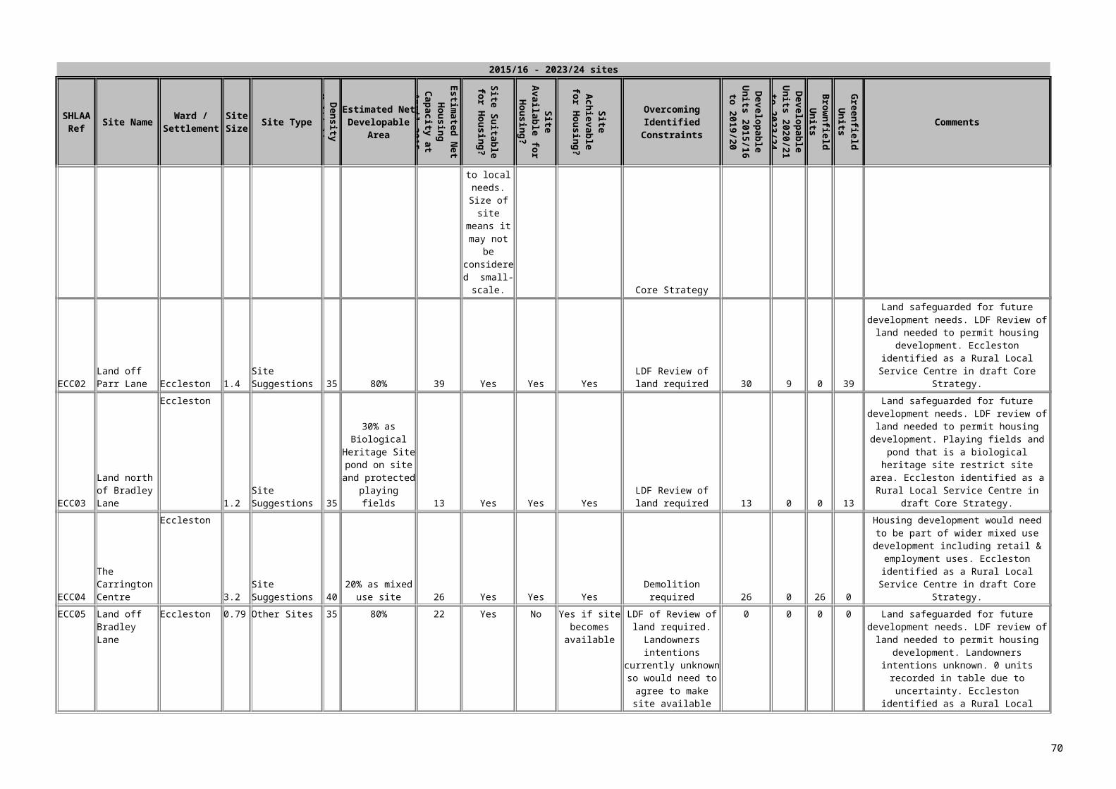
2362 13 Railway Road, Adlington 32364 Miry Fold Farm, Briers Brow, Wheelton 1 Greenfield2366 Avondale, Towngate, Eccleston 1 Greenfield2367 Land South of 3 Mercer Court, Heath
Charnock2
2369 Land East of 7 Glamis Drive, Chorley 1 Greenfield2403 Land North East of 35 – 37 Chorley
Road, Heath Charnock1
2404 Land South West of 320 Spendmore Lane, Coppull
1 Greenfield
2407 Land North West of 79 Railway Road, Withnell
4 Greenfield
2410 Cedar Lodge, 48 Runshaw Lane, Euxton
1
2413 Hardacre Barn, Hardacre Lane, Whittle-le-Woods
1 Greenfield
2415 Land North of 170 Preston Road, Chorley
1
2416 9 Trafalgar Street, Chorley 12418 Agricultural Buildings at Howe Brook
Farm, Bannister Green, Heskin3 Greenfield
2424 Former Victoria Mill Building south west of 23 Millbrook Close, Wheelton
2
2427 Barn North of Willowgarth, Lodge Bank, Wheelton
1
2430 Crostons Farm Barn, Lucas Lane, Whittle-le-Woods
1 Greenfield
2437 53 Pear Tree Avenue, Coppull 1 Greenfield2439 Land East of Beechcroft, Brook Lane 12442 Land North of 107 Countess Way,
Euxton1
2444 Crosse Hall Barn, Crosse Hall Fold, Chorley
1
2446 Land North of 2 Clover Road, Chorley 1 Greenfield2447 Greenlands, Parkside Drive, Whittle-le-
Woods1 Greenfield
2449 Store and Premises, 19 Grange Drive, Euxton
2
2452 210 Spendmore Lane, Coppull 12454 Land East of 15 St Peters Street 12455 69 Charter Lane, Charnock Richard 1 Greenfield2461 28A Moor Road, Chorley 12465 Jones Farmhouse, Dawson Lane,
Whittle-le-Woods1
2471 Land South of the Hollins, Northenden Road, Coppull
2 Greenfield
2472 236 & 238 Eaves Lane, Chorley 12474 Building North East of Hillandale,
Crosse Hall Lane, Chorley1
2477 West Dene, Wigan Road, Clayton-le-Woods
1
2478 Fisher House Farm, Back Lane, Charnock Richard
1
2480 South Miry Fold Farm, Briers Brow, Wheelton
2
2483 Land North East of Sunnyside, Common Bank Lane, Chorley
1 Greenfield
2490 Land South East of 91 Chorley Road, Adlington
2
2492 Land South West of 14 Saville Street 32493 Land East of 6 Woodside Avenue 2 Greenfield
70

2496 57 Railway Road 22497 Whitegates, 75 Gorsey Lane 1 Greenfield2499 Land North East of Four Leaves,
Clover Road, Chorley2 Greenfield
2501 Land West of Knowleswood, Wrennalls Lane, Heskin
1 Greenfield
2503 Land North West of 383 Langton Brow, Eccleston
1 Greenfield
2504 Land East of 4 Norse Cottages, Pompian Brow, Bretherton
1
2506 Annbray, 29 Charter Lane, Charnock Richard
1 Greenfield
2507 18 Church Street, Adlington 22509 Hoole Cottage, Wigan Lane, Chorley 12511 South of Little Hanging Bridge Farm,
Meadow Lane, Croston1 Greenfield
2512 267 Southport Road, Ulnes Walton 12516 Ollerton Hall, Ollerton Lane, Withnell 12518 Plot 2, Land South of Crosse Hall
Lodge, Crosse Hall Fold1 Greenfield
2520 105 Preston Road, Whittle-le-Woods 1 Greenfield2521 West View, Runshaw Lane, Euxton 1 Greenfield2523 Longacre, The Common, Adlington 1 Greenfield2524 4 Rectory Close, Chorley 2 Greenfield2530 71 Station Road, Croston 2 Greenfield2531 Barn North West of Rigby House
Farm, The Common1 Greenfield
2532 Land South of Crosse Hall Lodge, Crosse Hall Fold, Plot 1
1 Greenfield
2533 Dolphin Farm, 2 Chorley Old Road 22534 Moorhouse Farm Barn, Coppull Moor
Lane1 Greenfield
2535 Gouldings Farm Barn, Hall Lane, Mawdesley
1
2536 Land to the East of Blacksmith Barn, Hall Lane, Mawdesley
2 Greenfield
2538 88 Brooke Street, Chorley 12539 Land North West of 57 Gorsey Lane,
Mawdesley1 Greenfield
2540 Spring Cottage, Crosse Hall Fold, Chorley
1
2541 194 – 196 Eaves Lane, Chorley 12542 Hyland, Bolton Road, Anderton 12543 1 Washington Lane, Euxton 12547 Plot 3, Land South of Crosse Hall
Lodge1 Greenfield
2552 Rear of 8 – 10 Market Street, Adlington 12555 The Railway Inn, 84 Market Street,
Adlington1
2556 106 Railway Road, Adlington 12557 53 Wigan Road, Euxton 2 Greenfield2558 Lilac Mount, 704 Preston Road 32560 The Barn, Moorfield, Slacks Lane,
Heath Charnock1 Greenfield
2561 Norris Farm, North Road, Bretherton 1 Greenfield2562 Highfield House Farm, Buckholes Lane 12563 Pippin Street Farm, Pippin Street,
Brindle1 Greenfield
2565 1 St Peters Cottages, Ridley Lane, Mawdesley
1
2566 22 Chorley Road, Adlington 1
71

2567 89 Wigan Road, Euxton 1 Greenfield2568 SE of Windmill Farm, Windmill Lane,
Brindle2 Greenfield
2571 Methodist Church, Blackburn Road, Wheelton
1
Total 168 units78 Greenfield & 90 Brownfield
Preston City Council Small sites (under 5 units)
Ref Planning App Address Description Net change in units
Completed in reporting
yr?
GF/ BF
512 06/2002/0721 Land rear of 28 Cottam Avenue, Ingol, Preston
Erection of 1 two-storey block containing 2 apartments
2 Complete 09/10
BF
760 06/2003/1179 Land Between 25 and 29 Garden Walk, Ashton-On-Ribble, Preston
Erection of 1no two storey terraced dwelling house
1 Complete 09/10
BF
922 06/2004/0791 39 St Peters Square, Preston
COU from 1no dwelling to Class B1 offices.
-1 Complete09/10
BF
973 06/2004/1211 Flat 1, 74 Black Bull LaneFulwood, Preston
COU use from residential to office
-1 Complete 09/10
BF
1773 06/2008/0808 58 and 59 Marlfield Close, Ingol, Preston
COU from offices to 2no. dwellings
2 Complete 09/10
BF
1556 06/2008/0884 Bowran House, 4th Floor, 51 Marsh Lane, Preston
COU from office to student accommodation
1 Complete 09/10
BF
1016 06/2009/0268 265 Tag Lane, Preston
Change of use from offices to residential (Class C3)
1 Complete 09/10
BF
1034 06/2009/0538 24 Fishergate Hill, Preston
COU of HMO to 2no self contained flats
1 Complete 09/10
BF
920 06/2004/0774 125 London Road, Preston
COU from student accommodation to 2no self-contained flats.
2 Complete 09/10
BF
1411 06/2006/0459 65 Fishergate, Preston
COU from offices to 1no dwelling
1 Complete 09/10
BF
06/2007/0256 313 Garstang Road, Preston
COU from first floor self-contained flat
-1 Complete 09/10
BF
72

to offices (Class A2)
1573 06/2007/0352 6A Starkie Street, Preston
COU from house in multi-occupancy to 3no. self-contained flats
2 Complete 09/10
BF
1629 06/2007/0857 267, 269 Brook Street and 84 Eldon Street, Preston
COU of shop with living accommodation to 1no. dwelling, erection of attached single, two and three storey building to provide barbers shop and 1no. maisonette
1 Complete 09/10
BF
1654 06/2007/1071 2 Albert Road, Fulwood, Preston
Erection of one pair of semi-detached dwellings
2 Complete 09/10
BF
1633 06/2007/0922 Southworth House, Longridge Road, Grimsargh, Preston
Erection of 1no. detached dwelling (revised scheme to planning approval 06/2004/0931)
1 Complete 09/10
BF
06/2008/0416 78 Waterloo Road, Ashton, Preston
COU from dwelling house to offices
-1 Complete 09/10
BF
06/2008/0467 33,34,35 &36 ST Peters Square, Preston
Change of use from residential and offices to multi faith religious centre (Class D1)
-1 Complete 09/10
BF
06/2008/0553 131-133 Friargate, Preston
COU of office/storage space two student flats
2 Complete 09/10
BF
1743 06/2008/0620 12 Sandy Croft, Ribbleton, Preston
Erection of 1no. detached dwelling and detached garage to side of 12 Sandy Croft
1 Complete 09/10
BF
06/2008/0806 Cliff House Nursery School, 19 Lambert Road, Preston
COU from dwelling to day nursery for up to 48 children (Class D1).
-1 Complete 09/10
BF
73

1770 06/2008/0916 815 Whittingham Lane, Whittingham, Preston
Erection of 2no. detached dwellings, (resubmission of planning application 06/2008/0122)
2 Complete 09/10
BF
0349 06/2008/0969 28-32 Guildhall Street
COU of 2nd floor and attic space from office (Class A2) to 2no self contained flats
2 Complete 09/10
BF
06/2009/0226 Royal Oak, 36 Plungington, Preston
COU from public house to mixed use restaurant & hot food takeaway with self-contained flat at first floor
1 Complete 09/10
BF
1057 06/2009/0482 1 Church Lane, Goosnargh
COU from residential dwelling to 2no one bedroomed flats
1 Complete 09/10
BF
06/2009/0593 188 New Hall Lane, Preston
COU of dwelling (Class C3) to retail shop (Class A1
-1 Complete 09/10
BF
1045 06/2009/0637 28 Garstang Road, Preston
COU from retail (Class A1) to 1no dwelling
1 Complete 09/10
BF
0383 06/2009/0895 The Smithy, Inglewhite Road, Inglewhite
COU from former café to dwelling including alterations
1 Complete 09/10
BF
593 06/2002/1256 Fishers Farm, Green Lane, Bilsborrow, Preston
Conversion of redundant agricultural barns to form three detached dwellings.
3 U/C GF
941 06/2004/0975 39-41 Wellington Road, Ashton, Preston
COU from retail shop to 2no dwellings
2 U/C BF
1525 06/2007/0133 The Bunker, Whittingham Lane, Goosnargh, Preston
COU from bunker to single residential dwelling
1 U/C BF
1594 06/2007/0542 Land adjacent 2 Christ Church Street, Preston
Erection of two storey end terraced
2 U/C BF
74

building to provide 2no. self contained apartments
06/2007/0846 38 Dallas Street, Preston
Erection of 2no. terraced dwellings (following demolition of existing property)
1 U/C BF
1631 06/2007/0863 12 Beech Grove, AshtonPreston
COU from residential care home to 2no. dwellings (resubmission of 06/2007/0218)
2 U/C BF
1632 06/2007/0872 31 Nimes Street, Preston
Erection of 1no. two storey end terraced dwelling
1 U/C BF
1662 06/2007/1155 175 Friargate, Preston
COU to 4no. residential apartments
4 U/C BF
1676 06/2008/0020 263 Ribbleton Lane, Preston
COU of ground floor of dwelling to hairdressers (Class A1)
-1 U/C BF
1755 06/2008/0779 28 Maitland Street, Preston
COU from tyre fitting workshop to 4no. flats, (resubmission of planning application 06/2008/0360)
4 U/C BF
1013 06/2009/0221 Beesley House Farm, Haighton Green Lane
Erection of 1no two storey detached dwelling (following demolition of existing 2no dwellings)
-1 U/C BF
1003 06/2009/0290 137 Tulketh Road, Preston
Change of use from house in multiply occupation to 4no self-contained apartments
3 U/C BF
1019 06/2009/0321 The Castle, 1 Good Street, Preston
Change of use from public house with living accommodation to 4no 2
4 U/C BF
75

bedroom dwellings
0346 06/2009/0350 Land adjacent 53 Grizedale Crescent
Erection of two storey building to form 2no self contained flats with accommodation in roof space,
2 U/C GF
1035 06/2009/0542 38-40 Parker Street, Preston
Erection of 2no terraced dwellings (following partial demoltion of existing building)
2 U/C BF
1038 06/2009/0558 Ashton Institute, 8-12 Wellington Road, Preston
Erection of 3no two storey dwellings (following demolition of former social club)
3 U/C BF
1063 06/2009/0795 100 Fishergate, Preston
Conversion of shop to 3 apartments & 1 studio apartment
4 U/C BF
0102 06/2009/0892 2&4 Bowland Road, Ribbleton, Preston
Conversion to 2no semi-detached dwellings
2 U/C BF
06/2009/0900 86 Mount Street, Preston
Conversion of dwelling to 2no. flats
1 U/C BF
887 06/2004/0403 St Michaels Cottage, Black Bull Lane, Fulwood, Preston
Erection of 1no dwelling with integral double garage, 1no dwelling with detached single garage
2 U/C GF
784 06/2003/1272 Blackleach House Farm, Blackleach Lane, Woodplumpton, Preston
Conversion of agricultural building to 1no private dwelling
1 GF
1459 06/2006/0958 20 Cannon Street, Preston
COU from 1no dwelling to ground floor commercial unit (Class A1) and 1no apartment at first floor and 1no maisonette
1 BF
76

at second and third floors
1513 06/2007/0002 3 Hazel Grove, Ribbleton, Preston
COU from shop and adjacent dwelling to offices/training and support facility, and external alterations.
-1 BF
1495 06/2006/1207 88 Raglan Street, Preston
Conversion of workshop to create 1no. dwelling.
1 BF
0865 06/2007/0249 130 St George’s Street
Erection of 1no end terraced building
1 BF
1583 06/2007/0361 3 Camden Place, Preston
COU from office premises to 1no. private dwelling
1 BF
1640 06/2007/0974 22 Bairstow Street, Preston
Conversion of existing dwelling to form 5no. self contained apartments
4 BF
1648 06/2007/0988 Barton Old Hall Farm, Jepps Lane, Barton, Preston
Conversion of barn and outbuildings to 1no. dwelling (resubmission of planning application 06/2005/0839)
1 GF
1658 06/2007/1140 22 Ribblesdale Place, Preston
COU from offices to 1no. dwelling house (Class C3)
1 BF
1636 06/2007/0898 Format PhotographySchool StreetPreston
COU of building at rear part of site to mixed use including erection of 1no. dwelling
1 BF
1538 06/2007/0991 Lodge Bank, 4 Moor Lane
Erection of 4 student flats
4 BF
1666 06/2007/1200 38A Brieryfield Road, Preston
Erection of 1no. terraced
1 BF
1703 06/2008/0202 Critchley Farm, Darkinson Lane, Lea, Preston
Erection of 2no. detached dwellings
2 GF
1712 06/2008/0327 9 Starkie Street, Preston
Change of use from office to residential dwelling
1 BF
77

1714 06/2008/0356 Craggs Mill, Craggs Row, Preston
Conversion of mill to form 2no. apartments
2 BF
1723 06/2008/0440 18-20 Skeffington Road, Preston
Erection of terraced property to provide 2no. self-contained apartments
2 BF
1720 06/2008/0405 Land between 61 & 71Egerton Road, Ashton On Ribble, Preston
Erection of 4no. detached three storey dwellings with integral garages
4 BF
1722 06/2008/0424 14 Winckley Square, Preston
COU from offices to mixed use as offices and self contained apartment
1 BF
1732 06/2008/0524 96 Meadow Street, Preston
Erection extension with self-contained flat on first floor
1 BF
1734 06/2008/0554 Park House, 472 Garstang Road, Broughton, Preston
Erection of 5no. dwellings (following demolition of existing dwelling)
4 BF
0976 06/2008/0783 Lewth Hall Barn, Lewth Lane
Conversion of barn to 1no dwelling
1 GF
1757 06/2008/0785 16/18 Downing Street, Preston
COU of local housing office to 1no. dwelling and local housing office
1 BF
1752 06/2008/0725 Land adjacent 5 Duchy Avenue, Fulwood, Preston
Erection of 1no. 2 storey detached dwelling
1 BF
1758 06/2008/0792 11-19 Manchester Road, Preston
COU from self-contained flat to additional gym accommodation
-1 BF
1751 06/2008/0720 162 Manchester Road, Preston
Erection of 1no. end terrace dwelling
1 BF
1780 06/2008/0949 Land Adjacent 104 Waterloo Road, Ashton On Ribble,
Erection of 1no. detached dwelling
1 GF
78
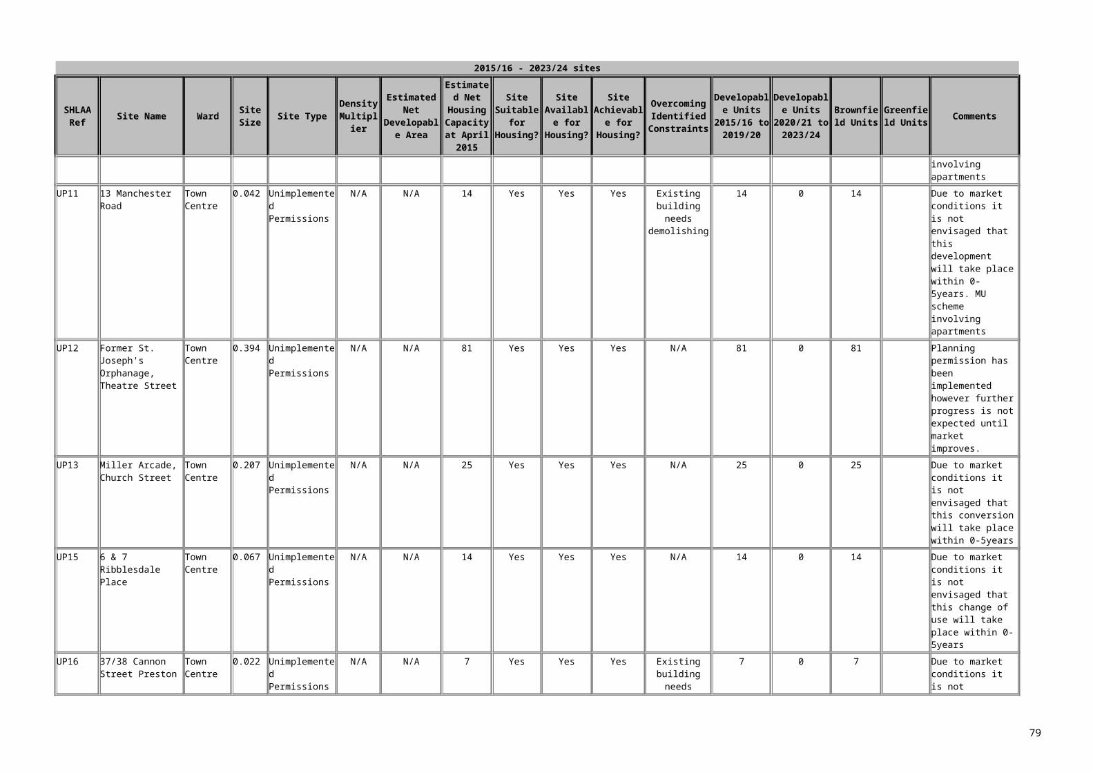
Preston0690 06/2009/0081 The Old
Smithy, Tabley Lane
COU from offices to 1no dwelling
1 BF
1007 06/2009/0088 Silver Birches, Whittingham Lane
Erection of 5 dwellings (following demolition of existing dwelling)
4 BF
0815 06/2009/0161 57 Woodplumpton Road, Preston
Erection of 1no detached dwelling with intergral garage
1 GF
0787 06/2009/0167 843 Whittingham Lane, Preston
Erection of detached bungalow (following demoliton of former telephone exhange)
1 BF
0880 06/2009/0253 4 Charnock Fold, Preston
Erection of one paIr if semi-detached dwellings (following demolition of existing buildings)
2 BF
1017 06/2009/0286 Land between 296 Sharoe Green Lane and 69 Green Drive
Erection of 1no detached single storey dwelling
1 GF
1011 06/2009/0341 15a Fishergate Hill, Preston
Change of use of storage basement for existing ground floor retail shop to 1no self-contained flat
1 BF
1027 06/2009/0411 42 Eldon Street, Preston
Change of use from joiners workshop to 2no self contained flats
2 BF
1564 06/2009/0469 The Guild Tavern, Tithebarn Street, Preston
COU of vacant public house to retail and 4 student flats
4 BF
0753 06/2009/0493 43-45 Watling Street Road, Preston
Conversion of 2no semi-detached dwellings to 6no self contained flats
4 BF
79

1040 06/2009/0575 57-59 Longridge Road, Preston
COU of first floor from storage to 1no self contained flat
1 BF
1043 06/2009/0598 Garden of 16 Ribblesdale Drive, Grimsargh
Erection of 1no detached bungalow
1 GF
1046 06/2009/0684 19 Bairstow Street, Preston
COU from HMO to 3no self contained flats
2 BF
0970 06/2009/0732 Rational House, 32 Winckley Square, Preston
COU from offices and former clinic to offices and 1no self-contained apartment
1 BF
1064 06/2009/0796 Garden Area to South of Woodfield, Lea Lane
Erection of 2no one and a half storey detached dwellings
2 GF
1067 06/2009/0886 Bell Fold Farm, 708 Garstang Road, Barton
Conversion of 2no barns to total of 3no dwellings
3 GF
1047 06/2010/0026 Land to rear of 16 Hamilton Road, Ribbleton, Preston
Erection of detached two storey dwelling
1 GF
1933 06/2010/0206 Tenterhill Farm, Ashley Lane, Goosnargh
COU from 1no residential dwelling to 3no residential dwellings
2 BF
1937 06/2010/0267 1 Ribblesdale Place, Preston
COU from offices (Class B1) to residential (Class C3)
1 BF
1908 06/2009/0915 Pear Tree Cottage, Ambrose Hall Lane
Erection of 1no dwelling following demolition of garage)
1 BF
1864 06/2009/0562 Land to the rear of 815 Whittingham Lane
Erection of 2no semi-detached dwellings, 1no detached dwelling
3 GF
1929 06/2010/0165 1 East View, Preston
COU from sports bar to residential dwelling
1 BF
80

1936 06/2010/0258 15 Cannon Hill, Ashton on Ribble
COU from retail with living accommodation to 2no self contained flats,
1 BF
119 yet to be completed minus 10% = 107 units to go in 5 yr supply
South Ribble – Small Sites (under 5 dwellings) Completed 2009/10
SITE NO LOCATION ADDRESS LOCALITY
NEW COMPLETIONS
NET GAIN
1517 185Liverpool Road Penwortham 1 1
1524 49Cuerdale Lane
Walton Le Dale 1 1
1616 1Cranbourne Street
Bamber Bridge 2 1
1446Holme Farm Dairy Moss Lane Penwortham 1 1
1469Daub Hall Farm
Daub Hall Lane Hoghton 1 3
1536The Sheiling
Off the Vinery
New Longton 1 1
1574Buckshaw Evolution phase 6
Buckshaw Village 4 0
1577Coppice Farm
Goosefoot Lane Samlesbury 1 1
1584 97Liverpool Old Road Much Hoole 1 1
1599
Building to the rear of Guild Farm
Grange Lane Hutton 1 1
1600 71Hough Lane Leyland 2 2
1609 16aDuddle Lane
Walton Le Dale 1 0
1304Brookside Works
Stanifield Lane Farington 2 2
1339Former Bakery,
258 Gregson Lane Hoghton 1 3
15073 Manor Cottages
Greenbank Road Penwortham 2 1
1639 Plot 11Croston Road
Farington Moss 1 1
1490 77Victoria Road
Walton Le Dale 2 1
1418 329
Higher Walton Road
Higher Walton 2 1
81

1425 26Studholme Crescent Penwortham 2 1
1435Simpsons Farm
Dark Wood Lane Samlesbury 2 2
1539First Floor 51-55
Canberra Road Leyland 1 1
1546 BeyondPotters Lane Samlesbury 1 0
1568 33Kingsfold Drive Penwortham 1 1
1588 BridgendChurch Lane Whitestake 1 0
1594 307-311Gregson Lane Hoghton 2 2
South Ribble - Small Sites Included in 5 year Supply
outstanding sites totalSITE NO ADDRESS LOCALITY NET GAIN
1463 Alder Drive Hoghton 11513 Cleveland Road Leyland 11604 Fir Trees Avenue Lostock Hall 21607 Yewlands Avenue 1
1608 Towngate Leyland 11621 Woodside Farington 11398 Gregson Lane Hoghton 11641 Towngate Leyland 21527 Greenbank Road Penwortham 11535 medway close lostock hall 11595 Stanley Fold Lostock Hall 01656 Croston Road Leyland 11252 Canberra Road Leyland 11053 Station Road New Longton 11653 Sod Hall Lane Midge Hall 11184 Stanley Avenue Hutton 1965 Fox Lane Coupe Green 1
1417 Roach Road Samlesbury 21462 Brindle Road Bamber Bridge 11479 Sheep Hill Lane New Longton 11499 Sycamore Grove Penwortham 11501 Havelock Road Penwortham 11558 Kingsfold Drive Penwortham 11654 Church Road Leyland 11648 New Land Penwortham 11371 Buckingham Avenue Penwortham 11526 Masefield Place Walton le Dale 1
82

outstanding sites totalSITE NO ADDRESS LOCALITY NET GAIN
1649 Higher Walton Road Walton Le Dale 21603 Liverpool Road Hutton 11532 Hall Carr Lane Walmer Bridge 11383 Stanifield Lane Lostock Hall 11459 Cuerdale Lane Walton Le Dale 31638 West Paddock Leyland 11651 Tristan Avenue Walmer Bridge 11391 Regent Road Walton Le Dale 21470 Chapel Lane Longton 01493 Riverside Avenue Farington Moss 11635 Reedfield Place Walton Summit Ind Estate 11644 Higher Walton Road Walton Le Dale 11614 Broad Oak Lane Penwortham 11302 Gregson Lane Hoghton 11565 Marsh Lane Longton 11439 Greystones Moss Side 11536 Off the Vinery New Longton 11637 Ellen Street Bamber Bridge 31618 Further Lane Samlesbury 11624 Newgate Lane Whitestake 01521 Leyland Lane Leyland 41278 Alcester Avenue Penwortham 31593 off Bank Head Lane Hoghton 11583 liverpool road longton 1791 St Paul's Close/Church Lane Lostock Hall 1
1401 Flag Lane Lostock Hall 11519 Dunkirk Lane Leyland 11538 Greaves Meadow Penwortham 11634 Church Lane Farington Moss 11566 knoll Lane Little Hoole 01192 Wigan Road, Cuerden Bamber Bridge 21579 Hall Carr Lane Longton 11452 Todd Lane South Lostock Hall 11475 Flag Lane Lostock Hall 11505 Park Lane Mellor Brook 21525 Hennel Lane Walton Le Dale 11617 Bank Head Lane Hoghton 11630 Liverpool Road Much Hoole 11627 Studholme Close Penwortham 21646 Mosney Fold Walton Le Dale 1297 Stanley Grove Penwortham 3662 Liverpool Road Longton 1
1534 Cocker Lane Leyland 0
83

outstanding sites totalSITE NO ADDRESS LOCALITY NET GAIN
1632 Brownedge Road Lostock Hall 11586 Gill Lane Longton 01645 Carr Lane Much Hoole 11458 Chapel Lane New Longton 31620 Cuerdale Lane Walton Le Dale 11288 off Leyland Road Lostock Hall 31344 Hall Carr Lane Longton 11588 Church Lane Whitestake 01628 Sheephill Lane New Longton 21339 258 Gregson Lane Hoghton 31611 363 Brindle Road Bamber Bridge 11266 Liverpool Road Hutton 31264 Cuerdale Lane Samlesbury 11393 Preston New Road Mellor Brook 01561 Grange Lane Longton 11477 Hall Carr Lane Walmer Bridge 21477 Hall Carr Lane Walmer Bridge 21571 The Close New Longton 11556 Croston Road Farington Moss 11591 Braid Close Penwortham 31449 Princes Road Walton Le Dale 01572 Grange Lane Hutton 01587 Brindle Road Bamber Bridge 11642 Hennel Lane Walton-le-dale 01361 Potter Lane Samlesbury 01541 Bank Head Lane Hoghton 11551 Alma Row Gregson Lane 21473 Hall Carr Lane Longton 31257 Marshalls Brow Penwortham 41631 Hugh Barn Lane New Longton 31570 Hall Carr Lane Walmer Bridge 31502 Roach Road Samlesbury 11640 Hugh Barn Lane New Longton 31625 Hill Road Penwortham 21625 Hill Road Penwortham 21619 Green Lane Samlesbury Bottoms 01470 Liverpool Road Longton 21564 Daub Hall Lane Hoghton 11598 Drumacre Lane East Longton 01562 Langdale Road Leyland 11643 Cuerdale Lane Walton-Le-Dale 21636 Howick Cross Lane Penwortham 1
84