stag brewery, mortlake · page 1 eia scoping report - stag brewery, mortlake 1. introduction 1.1...
TRANSCRIPT
Stag Brewery, Mortlake
Environmental Impact Assessment Scoping Report
se March 2017
Waterman Infrastructure & Environment Limited Pickfords Wharf, Clink Street, London, SE1 9DG www.watermangroup.com
Client Name: Reselton Properties Limited Document Reference: WIE10667-101-1-3-4-RB Project Number: WIE10667
Quality Assurance – Approval Status This document has been prepared and checked in accordance with Waterman Group’s IMS (BS EN ISO 9001: 2008, BS EN ISO 14001: 2004 and BS OHSAS 18001:2007)
Issue Date Prepared by Checked by Approved by 1.1.6 Aug 2016 Sophia Edmead Ros Boalch Hannah Fiszpan
Graduate Consultant Principal Consultant Technical Director
Comments
1.2.1 Aug 2016 Ros Boalch Ros Boalch Hannah Fiszpan
Principal Consultant Principal Consultant Technical Director
Comments
1.3.4 March 2017 Ros Boalch Ros Boalch Hannah Fiszpan
Principal Consultant Principal Consultant Technical Director
Comments
Disclaimer This report has been prepared by Waterman Infrastructure & Environment Limited, with all reasonable skill, care and diligence within the terms of the Contract with the client, incorporation of our General Terms and Condition of Business and taking account of the resources devoted to us by agreement with the client.
We disclaim any responsibility to the client and others in respect of any matters outside the scope of the above.
This report is confidential to the client and we accept no responsibility of whatsoever nature to third parties to whom this report, or any part thereof, is made known. Any such party relies on the report at its own risk.

Contents EIA Scoping Report - Stag Brewery, Mortlake
Contents 1. Introduction ................................................................................................................................. 1
1.1 Background ...................................................................................................................... 1
1.2 Environmental Impact Assessment .................................................................................. 1
2. The Site and Proposals .............................................................................................................. 3
2.1 Site Location and Setting ................................................................................................. 3
2.2 The Surrounding Area ...................................................................................................... 4
2.3 The Development Proposals ............................................................................................ 5
2.4 Potentially Sensitive Receptors ....................................................................................... 6
3. Consultations .............................................................................................................................. 7
4. Key Issues to Be Addressed by the EIA .................................................................................. 8
4.1 Introduction ...................................................................................................................... 8
4.2 Alternatives ...................................................................................................................... 8
4.3 The Proposed Development ............................................................................................ 8
4.4 Development Programme, Demolition, Alteration, Refurbishment and Construction ...... 9
4.5 Socio-Economics ............................................................................................................. 9
4.6 Transport and Access .................................................................................................... 11
4.7 Noise and Vibration ........................................................................................................ 12
4.8 Air Quality ....................................................................................................................... 14
4.9 Ground Conditions and Contamination .......................................................................... 16
4.10 Surface Water Drainage and Flood Risk ....................................................................... 17
4.11 Ecology .......................................................................................................................... 18
4.12 Archaeology (Buried Heritage) ....................................................................................... 19
4.13 Above Ground Built Heritage ......................................................................................... 20
4.14 Townscape and Visual Effects ....................................................................................... 21
4.15 Wind Microclimate .......................................................................................................... 22
4.16 Daylight, Sunlight, Overshadowing and Light Pollution ................................................. 23
4.17 Cumulative Effects ......................................................................................................... 24
5. Insignificant Issues .................................................................................................................. 26
5.1 Waste ............................................................................................................................. 26
5.2 Solar Glare ..................................................................................................................... 26
5.3 Vibration (Associated with the Completed and Operational Development) ................... 27
5.4 Archaeology (Buried Heritage) (Associated with the Completed and Operational Development) ................................................................................................................. 27
5.5 Odour ............................................................................................................................. 27
5.6 Type 2 Cumulative Effects ............................................................................................. 27
6. Proposed Structure of the Environmental Statement .......................................................... 28

Contents EIA Scoping Report - Stag Brewery, Mortlake
Appendices Appendix A Figures
Appendix B Consultation with London Borough of Richmond upon Thames
Appendix C Consultation with the Environment Agency

Page 1 EIA Scoping Report - Stag Brewery, Mortlake
1. Introduction
1.1 Background Reselton Properties Limited (the ‘Applicant’) is seeking to obtain planning permission for a mixed use redevelopment (hereafter referred to as the ‘Development’) located in Mortlake, southwest London. The location of the Development comprises the site of the former Stag Brewery, an approximately 8.6 hectare (ha) parcel of land, together with an approximately 1.4 ha area of highway referred to as Chalker’s Corner Junction. Together, the site of the former Stag Brewery and Chalkers Corner Junction comprise the ‘Site’. The Site has an area of approximately 10 ha and falls within the administrative boundary of the London Borough of Richmond upon Thames (LBRuT). The general location of the Site is shown on Figure 1.
The indicative planning application boundary is shown by Figure 2. This indicates the part of the Site which occupies the site of the former Stag Brewery is bound by:
The River Thames and residential houses along Thames Bank to the north;
Bulls Alley to the east;
Williams Lane to the west; and
Lower Richmond Road and Mortlake High Street (both comprising the A3003) to the southwest.
Figure 2 also indicates that the part of the Site comprising Chalker’s Corner Junction includes the junction with the A316 (Clifford Avenue), A3003 (Lower Richmond Road) and A205 (South Circular).
This Environmental Impact Assessment (‘EIA’) Scoping Report, prepared by Waterman Infrastructure & Environment Limited (’ ‘Waterman IE’) provides background information to assist LBRuT in providing a Scoping Opinion under Regulation 13 of the Town and Country Planning (Environmental Impact Assessment) (England and Wales) Regulations, 2011 (as amended)1 (the ‘EIA Regulations’).
1.2 Environmental Impact Assessment The EIA process is a systematic means of understanding and assessing the likely significant environmental effects arising from a development. The process enables developers to respond iteratively to the prevailing environmental conditions and constraints in relation to their proposals. This allows for the evolution of most practicable environmentally sustainable design and ensures that, if deemed necessary, all feasible measures are taken to prevent, reduce and where possible, offset any potentially adverse significant environmental effects. Consequently, the EIA process aims to ensure that potentially beneficial effects of redevelopment are maximised.
EIA also assists the relevant Local Planning Authority (LPA) in reaching a decision on the planning application. Where an EIA is required, all relevant assessment information must be provided by the applicant in a document referred to as an Environmental Statement (ES). The ES must accompany the submission of the subject planning application.
In accordance with Schedule 2, Categories 10(b) (urban development projects) of the EIA Regulations and owing to the location, scale and nature and of the Development, the Applicant recognises the need for EIA.
‘Scoping’ is an early and important component of the EIA process. Scoping enables the identification of the key issues to be addressed as part of the EIA processes and the scope of the various technical
1 The Secretary of State (2015). The Town and Country Planning (Environmental Impact Assessment) (Amendment) Regulations
2015. HMSO: London.

Page 2 EIA Scoping Report - Stag Brewery, Mortlake
studies to be undertaken to inform the EIA process. This helps to ensure the resulting ES focusses on only the likely significant effects of a development.
This EIA Scoping Report provides an indication of the nature of the Site and a summary of the emerging Development. In addition, an outline of the likely significant effects of the emerging Development upon the prevailing environment and the proposed assessment methodologies that will be employed to assess these likely effects is provided. All have been established via:
A review of relevant baseline surveys and environmental studies that have been undertaken to date;
A review of the emerging design of the Development; and
Professional and expert experience.
This EIA Scoping Report is structured as follows:
Section 2 provides a brief summary of the existing environmental conditions of the Site and its immediate surroundings, together with a brief description of the nature of the Development;
Section 3 describes the consultations that will be undertaken as part of the EIA;
Section 4 provides a description of the potentially significant environmental effects that have been identified. The overall approach and methodology for the assessment of each topic in the EIA is described;
Section 5 summarises insignificant environmental issues that are proposed to be scoped out of the EIA; and
Section 6 provides a draft outline of the structure of the ES which will accompany the planning application.
Page 3 EIA Scoping Report - Stag Brewery, Mortlake
2. The Site and Proposals
2.1 Site Location and Setting As previously noted, the Site is located in southwest London, to the south of the River Thames within the administrative boundary of the LBRuT. The indicative planning application boundary is shown by Figure 2. This illustrates the former Stag Brewery site is bound by:
The River Thames and residential houses along Thames Bank to the north;
Bulls Alley to the east;
Williams Lane to the west; and
Lower Richmond Road and Mortlake High Street to the south;
The former Stag Brewery component of the Site comprises the former Stag Brewery estate which includes 16 industrial buildings surrounded largely by hard-standing. The Stag Brewery ceased to operate in late 2015 and decommissioning of brewery infrastructure completed in July 2016. The majority of the Site’s perimeter is surrounded by a brick wall approximately 3m Above Ground Level (AGL). Buildings within the Site vary in height, and range from approximately 2 to 8 storeys. Three buildings located within the former Stag Brewery, component of the Site (the Maltings, the (former) Hotel and the (former) Bottling Hall) are non-statutorily designated Buildings of Local Townscape Merit. An area of approximately 2.1 ha within the west of the Site is occupied by the Watney’s Sports Ground playing fields. Access to the former Stag Brewery component of the Site is from Lower Richmond Road and Mortlake High Street via gates at West Gatehouse and East Gatehouse respectively. Raised walkways above Ship Lane formerly provided pedestrian links between the western and eastern areas of the former Stag Brewery.
The Chalker’s Corner Junction component of the Site includes:
The highways junction with the A316 (Clifford Avenue), A3003 (Lower Richmond Road) and A205 (South Circular);
Footways including cycle paths adjacent to the highways junction;
An area of informal car parking adjacent to the Lower Richmond Road; and
A grassed area adjacent to the Lower Richmond Road and Chertsey Court.
The Site’s current layout is presented in Figure 3.
The Mortlake Conservation Area covers an area within the east of the Site which includes the Maltings, the (former) Hotel and (former) Bottling Hall. The Site is located within an Archaeological Priority Area (APA) designated by LBRuT.
According to the Environment Agency’s (EA) Flood Map for Planning the majority of the Site is located within defended Flood Zones 2 and 3.
The Site is located within a borough wide Air Quality Management Area (AQMA) designated by LBRuT owing to high levels of nitrogen dioxide (NO2) and fine particulate matter (PM10).

Page 4 EIA Scoping Report - Stag Brewery, Mortlake
2.2 The Surrounding Area With reference to Figure 3, land uses surrounding the Site are varied and include:
Residential properties located immediately north and west of the Site at Thames View and Williams Lane, and those to the south and east of the Site at Lower Richmond Road and Mortlake High Street;
Retail uses located to the east of the Site along Mortlake High Street and to the south and west of the Site along the Lower Richmond Road. A number of public houses are in proximity to the Site, including the Ship Inn at Thames Bank adjacent to the Site’s northern boundary, the Jolly Gardeners adjacent to the Site’s southern boundary, and the Tapestry to the south of the Site beyond the Lower Richmond Road;
Office premises located adjacent to the Site’s southern boundary and to the east of the Site along Mortlake High Street. A scrap metal merchant is located to the south of the Site, to the south of Lower Richmond Road;
The Richmond Training and Development Centre at the Old Bakery is located approximately 25m southwest of the Site to the south of the Lower Richmond Road. The centre provides community facilities including those for the Mortlake Community Association and pre-school child day care. Little Paradise Nursery is located to the south of the Lower Richmond Road directly opposite the Site’s southern boundary;
The nearest school is Thomson House Primary School located approximately 130m to the south of the Site on Sheen Lane;
Mortlake Cemetery is located to the north of the Site boundary beyond the A316;
Open and amenity space, including the River Thames towpath located immediately adjacent to the Site’s northern boundary, and Mortlake Green located beyond the Lower Richmond Road / Mortlake High Street to the south of the Site; and
Railway infrastructure including Mortlake Train Station located to the south of the Site beyond Mortlake Green.
The Mortlake Conservation Area which encompasses the Maltings, the (former) Hotel and the (former) Bottling Hall buildings, and extends north of the Site. In addition, the Mortlake Green Conservation Area lies adjacent to the south of the Site.
There are a number of listed buildings and structure in proximity to the Site, notably:
Gateway, formally to Cromwell House (Grade II) approximately 15m to the west of the Site;
Thames Cottage (Grade II) approximately 30m north of the Site;
Leyden House (Grade II) approximately 40m north of the Site;
Thames Bank House (Grade II) approximately 40m north of the Site;
Tudor Lodge (Grade II) approximately 40m north of the Site;
Riverside House (Grade II) approximately 50m to the north of the Site, together with associated garden wall to east of numbers 1 to 8 Riverside House and extending behind numbers 1 to 24 Reid Court (Grade II) to the north of the Site;
Chiswick Bridge and attached balustrades (Grade II), approximately 100m northwest of the Site;
44 and 46 Victoria Road (Grade II) approximately 80m south east of the Site;
Parish Church of St Mary (Grade II*) approximately 190m east of the Site;
Mausoleum of Sir Richard and Lady Burton (Grade II*) approximately 280m south east of the Site;
Acacia House (Grade II) approximately 220m east of the Site;
Page 5 EIA Scoping Report - Stag Brewery, Mortlake
117 The High Street (Grade II) approximately 230m east of the Site
Suthrey House and Railings (Grade II) approximately 260m east of the Site; and
Limes House (Grade II*) approximately 470m east of the Site
Buildings of Townscape Merit within proximity to the Site include:
The Ship Inn at Thames Bank adjacent to the Site’s northern boundary;
The Jolly Gardeners adjacent to the Site’s southern boundary;
The Tapestry public house to the south of the Site beyond the Lower Richmond Road;
Numbers 3, 5, 7, 9, 33, 36, 37, 39, 41 and 51 Lower Richmond Road and at Waldeck Terrace to the south of the Site;
Numbers 1 to 10 Cromwell Place to the south of the Site;
Numbers 11, 13, 15 -17, 19, 21, 25 and 27 Sheen Lane to the south of the Site;
Boatrace House to the east of the Site on Mortlake High Street; and
Parliament Mews to the north of the Site at Thames Bank.
The non-statutory River Thames and Tidal Tributaries Site of Metropolitan Importance (SMI) for Nature Conservation is located directly adjacent to the northern boundary of the Site.
2.3 The Development Proposals Although the design of the Development is still evolving, the key parameters of the Development set out in this EIA Scoping Report are considered sufficiently detailed to robustly determine an appropriate scope for the EIA.
In line with the LBRuT Stag Brewery Supplementary Planning Document (SPD)2, the Development would provide a mix of uses. To facilitate the Development, the majority of buildings and structures within the Site would be demolished. However, façade of the (former) Bottling Plant would be retained whilst the the Maltings and the (former) Hotel, would be retained, altered and refurbished.
The Development would comprise new buildings, ranging in height from 3 to 8 storeys and would be built over the majority of the Site.
The Development would accommodate approximately 1,000 residential units located throughout the Site and ranging from 1-bed to 4-bed units. The Development would also provide retail, office, hotel, leisure, community, education and healthcare uses.
The retail and office uses, together with the leisure uses which may include a gym and cinema, would define a new high street within the east of the Site which would be arranged broadly in parallel with the existing Mortlake High Street. In addition to the new high street, the new and retained buildings adjacent to Mortlake High Street would provide active frontages. The Development would provide approximately 7,700m2 Gross Internal Area (GIA) of retail uses, approximately 5,500m2 GIA of hotel uses, approximately 2,000m2 GIA of leisure uses and approximately 3,400m2 GIA of office space.
Approximately 900m2 GIA of community uses would be provided by the Development and could include a museum or boat house which would be situated adjacent to the River Thames and towpath. Approximately 900m2 of healthcare provision would be provided by the Development.
A new secondary school is proposed within the west of the Site. An area for a playing field would be provided for the school which would also provide community use.
2 London Borough of Richmond upon Thames (2011). Stag Brewery, Mortlake, SW14 Planning Brief, Supplementary Planning
Document. LBRuT: Richmond
Page 6 EIA Scoping Report - Stag Brewery, Mortlake
Significant areas of public and private open space are proposed together with playspace. Public open space would include public squares between buildings. In addition to the new high street, other pedestrian and cycle routes would be provided within the Development creating permeability through the Site from the south towards the River Thames and the towpath.
New vehicular routes, together with car, motorcycle and cycle parking would be provided within the Development. It is envisaged the majority of parking would be provided within basement areas.
The Development proposes the inclusion of heating / energy plant.
2.4 Potentially Sensitive Receptors A number of receptors have been identified that could be potentially sensitive to effects resulting from the Development, including:
Existing residential properties surrounding the Site, including those located along Thames Bank, Williams Lane, the Lower Richmond Road and Mortlake High Street;
Existing commercial properties surrounding the Site including the Jolly Gardeners public house, the Ship public house, and those on the Lower Richmond Road and Mortlake High Street;
Future occupants and visitors, including residents, employees and students, to the Site.
Construction site workers;
The River Thames and Tidal Tributaries SMI and other ecological resources within and adjacent to the Site;
Groundwater present within the Chalk Group Aquifer at depth;
Possible archaeological remains beneath the Site;
Buildings of Townscape Merit to be retained within the Site as part of the Development;
The aforementioned Grade II listed buildings and structures in proximity to the Site;
The aforementioned Buildings of Townscape Merit in proximity to the Site;
Mortlake Green and Mortlake Conservation Areas;
Non-statutorily designated locally important vistas to and from the Site;
Users of the Watney’s Playing Fields;
Existing and future public transport services, car users, pedestrians and cyclists in and around the Site, including users of the River Thames towpath; and
Users of the River Thames such as rowers. Early consideration of the above sensitive receptors has, and will continue to be considered within the evolving design.

Page 7 EIA Scoping Report - Stag Brewery, Mortlake
3. Consultations Consultation with relevant bodies assists in ensuring that all relevant environmental issues are identified, together with the likely significant environmental effects of the Development. This enables the EIA to operate as part of an iterative process whereby environmental issues are identified and considered as part of the design process. In this way, the Development design can be refined through the incorporation of mitigation measures serving to limit its adverse effects and enhance its beneficial effects. Consultations have been and will continue to be undertaken as part of the design and EIA process, and will include (but not necessarily limited to) the following organisations:
LBRuT;
London Borough of Hounslow (LBH);
London Borough of Wandsworth (LBW);
London Borough of Hammersmith and Fulham (LBHF);
Greater London Authority (GLA);
Environment Agency (EA);
Natural England (NE);
Historic England (HE);
Southwest Trains;
Transport for London (TfL);
Port of London Authority (PLA);
Sport England;
Thames Water; and
Community groups.

Page 8 EIA Scoping Report - Stag Brewery, Mortlake
4. Key Issues to Be Addressed by the EIA
4.1 Introduction The EIA will be undertaken in accordance with the requirements of the EIA Regulations and current good practice guidance. The legal minimum requirements for the content of an ES are set out in Regulation 2(1) and Schedule 4 of the EIA Regulations. It is recognised that for the ES to fulfil its primary objective of enabling environmental considerations to be incorporated into the decision-making process, it must be focused on the likely significant environmental issues.
The following sections of this EIA Scoping Report therefore sets out the likely significant environmental issues to be considered in the ES and defines the focus, or scope, of the EIA.
4.2 Alternatives In accordance with the EIA Regulations, the ES will present a description of the main alternatives to the Development that were reasonably considered by the Applicant prior to selection of the final scheme. A summary will be provided of the reasons for selection of the final Development design, taking into account environmental considerations and which may include a description of the following:
‘Do nothing’ scenario: The consequences of no development taking place; and
Alternative designs and uses: A summary of the main alternatives considered, such as alternative layouts.
Since the Site is in the ownership of the Applicant and is currently vacant, the Applicant has and will not considered any alternative sites for the Development. Accordingly, ‘alternative sites’ will not be considered in the ES.
4.3 The Proposed Development Concurrent with the EIA Regulations, the ES will include a comprehensive description of the Development as described by the planning application drawings and other documents submitted for approval, in a level of detail appropriate to the respective outline and detailed components of the planning application. Accordingly, the description of the Development in the ES will include a factual description of:
Building layout and siting;
Building height and massing;
Building façade treatments and finishes;
The quantum and distribution of proposed land uses, including the tenure of residential units;
Location and nature of public spaces and pedestrian routes;
Proposals for soft and hard landscaping (including proposals for ecological enhancements);
Highway works, access, servicing, and vehicular and cycle parking arrangements;
Flood defence infrastructure and surface water drainage strategies;
Waste management proposals for the completed and operational Development;
Building services plant with an indication of emissions; and
Sustainability measures.
The description of the Development, together with the planning application drawings (including parameter plans and design principles for the outline elements of the planning application) and accompanying area

Page 9 EIA Scoping Report - Stag Brewery, Mortlake
schedule, comprise the design information that will be assessed as part of the EIA process and reported in the ES.
4.4 Development Programme, Demolition, Alteration, Refurbishment and Construction
The ES will include a description of the following aspects in relation to the demolition, the alteration and refurbishment of retained buildings, structures and features, and construction of the Development:
Programme and sequencing of works;
Types of piling and foundations likely to be employed;
Methods of construction;
Construction traffic routing; and
Working hours.
The ES will also consider the likely environmental effects associated with demolition, alteration, refurbishment and construction works (the ‘Works’) such as dust, noise, traffic generation and waste removal. Where appropriate, mitigation measures will be outlined to offset, reduce and eliminate any significant adverse effects. It is intended that such measures will be included in a Site specific Environmental Management Plan to be agreed with LBRuT prior to the commencement of any permitted works.
It should be noted that each technical chapter within the ES will also give detailed consideration to effects generated by the Works specific to the topic area being assessed. Such assessments will be based on available information pertaining to the construction timetable and description of works as outlined above.
4.5 Socio-Economics
4.5.1 Key Issues
As noted previously, the Site currently comprises the buildings and structures of the former Stag Brewery estate, hard standing and Watney’s Sports Ground playing fields. As the brewery is no longer operational, the existing Site does not provide any significant employment. It therefore follows that the Development will generate employment and local spend associated with the Works. In addition, the provision of commercial and education land uses as part of the completed and operational Development will give rise to longer-term employment opportunities.
The introduction of residential units at the Site will contribute to the housing targets of LBRuT and accord with the vision of the LBRuT Stag Brewery SPD3 to provide a new living quarter at the Site. Although the additional Site population may place an additional demand upon existing local primary schools, healthcare facilities and amenity spaces, the provision of a new school and healthcare facilities are anticipated to serve the local community.
Employment and residents within the Development, together with users of and visitors to the Site, will contribute to local spend in the local economy.
3 London Borough of Richmond upon Thames (2011). Stag Brewery, Mortlake, SW14 Planning Brief, Supplementary Planning
Document. LBRuT: Richmond.
Page 10 EIA Scoping Report - Stag Brewery, Mortlake
4.5.2 Likely Effects
In accordance with the key issues outlined above, the socio-economic assessment will examine the following likely effects:
The generation of temporary employment opportunities during the Works;
The creation of net new long-term employment opportunities from the proposed commercial uses of the Development;
Net effects of additional expenditure resulting from additional Site employees and residents;
The provision of new homes and the contribution of the new homes, including affordable homes, to local policy housing targets;
Implications of the Site’s new residential population for early years and primary school places, and for secondary school places, giving due consideration to the provision of a new school as part of the Development; and
Implications of the Site’s new residential population upon primary healthcare facilities, open space including children’s play space in consideration of the open, public and children’s play space provided as part of the Development which will also include a playing field.
4.5.3 Approach and Methodology
The socio-economic assessment will be undertaken by Regeneris. The proposed methodology will include:
Consultation with LBRuT;
A review of relevant social and economic policies at national, regional and local levels;
Establishing the relevant socio-economic baseline conditions of the Site and surrounds (including aspects such as population, housing, employment and economy, schools, primary healthcare facilities, open space provision) using established statistical sources such as the 2011 Census, official labour market statistics, National Health Service (NHS) data and information from the Applicant;
Identification and assessment of likely effects, using appropriate modelling techniques where necessary. This will include:
- An estimation and quantification of the Full Time Equivalent (FTE) jobs generated during the Works. This will use information on annual construction spend estimates and use Communities and Local Government (CLG) / Offpat Labour co-efficient ratios4 to derive estimates of both on and off-Site jobs;
- An estimation and quantification of the FTE jobs created by the completed and operational Development. On-Site jobs will be estimated using established employment density ratios. Off-site jobs will be estimated using standard Homes and Communities Agency (HCA) Additionality Guide5 multipliers;
- An estimation of the new residential Site population and child yield arising from the Development. Child yields will be calculated using the GLA Population Yield Calculator6 and LBRuT SPD on Planning Obligations7;
4 Communities and Local Government /Offpat (n.d.) Construction Employment Guidance (OSG 07 12 09 Item 4b). 5 Homes and Communities Agency (2014). Additionality Guide, Fourth Edition 2014. HCA: London. 6 London Data Store, GLA Population Yield Calculator. [Online] Available at: http://data.london.gov.uk/dataset/population-yield-
calculator [accessed: 03.08.16]. 7 London Borough of Richmond upon Thames (2014). Supplementary Planning Document: Planning Obligations, July 2014.
LBRuT: Richmond.

Page 11 EIA Scoping Report - Stag Brewery, Mortlake
- An estimation and quantification of the additional expenditure created by the completed and operational Development. This will use data on the socio-economic profile of the new community associated with the Development and the Family Expenditure Survey (FES) as well as local retail assessments;
- An appraisal of the likely effects of the Development’s additional population (in consideration of the Development’s school, open and play space, including the playing field provision) on existing early years provision, local primary and secondary schools, primary healthcare facilities, open space and children’s playspace; and
Identification of appropriate mitigation measures should any significant adverse effects be identified.
It should be noted that an assessment of the proposed Development upon the commercial units and town centres of East Sheen, Mortlake and Barnes will be presented within a stand-alone Retail Impact Assessment Report and is therefore not dealt with as part of the EIA. Similarly, a stand-alone Health Impact Assessment will also be prepared for the purposes of the planning application.
4.6 Transport and Access
4.6.1 Key Issues
Transport for London’s (TfL) online Public Transport Accessibility Level (PTAL) calculation tool8 has been used to calculate the PTAL of the Site, which is rated as 2, representing a poor level of accessibility to public transport services. This reflects the relatively low frequency of the rail services that serve Mortlake Station, despite being located within 400m from the Site, together with the low frequency of bus services operating along Lower Richmond Road, Mortlake High Street and Clifford Avenue (the A316).
The change in land use brought about by the Development may bring about changes to traffic flows on the local highway network and demands for public transport.
4.6.2 Likely Effects
The assessment of transport and access will consider the following likely effects:
Temporary traffic flows associated with the Works upon the local road network;
Temporary disruption to pedestrians, cyclists and road vehicle users arising from the Works;
Effects of the completed and operational Development upon the local road network and associated effects on driver journey times through key junctions;
Effects of the completed and operational Development upon public transport; and
Effects of the completed and operational Development upon pedestrian and cycle facilities.
4.6.3 Approach and Methodology
A Transport Assessment (TA) will be undertaken by Peter Brett Associates LLP (PBA). The TA will be appended to the ES and will inform the Transport and Access ES Chapter. This will include a full multi-modal impact assessment which will consider the impact of the Development on all transport infrastructures surrounding the Site. The TA will be fully scoped with TfL and LBRuT.
The assessment of individual environmental elements will be carried out in accordance with the ‘Guidelines for the Environmental Assessment of Road Traffic’ (1993) published by the Institute of Environmental Assessment (IEA), Transport for London (TfL) ‘Transport Assessment Best Practice Guidance’ (2010) and where appropriate, Volume 11 of the ‘Design Manual for Roads and Bridges’
8 Transport of London (TfL). Public Transport Accessibility Rating. [Online] Available: www.webptals.org.uk [accessed: 22.07.16].
Page 12 EIA Scoping Report - Stag Brewery, Mortlake
(DMRB) ‘Environmental Assessment’ (2008) published by the former Department of Environment, Transport and the Regions (DETR), now Department for Transport (DfT).
The Guidelines for the Environmental Assessment of Road Traffic9 will provide the assessment criteria for this study. The main impacts which could arise as a result of the construction or operation of the Development would relate to the following:
Severance;
Driver delay;
Pedestrian delay and amenity;
Fear and intimidation;
Accidents and safety;
Hazardous loads; and
Dust and dirt.
It is currently not anticipated that the construction or operation of the Development will result in the transportation of hazardous loads. Thus, this criterion will not form part of the ES assessment. However, if during the ongoing design and planning process of the Development it is identified that hazardous loads will need to be transported, an assessment of this criterion will be included within the Transport and Access ES chapter.
It should be noted that the assessment of temporary traffic flows associated with the Works upon the local road network will account for traffic arising from the movement of demolition and construction waste. Furthermore, the assessment of the completed and operational Development upon the local road network and associated effects on driver journey times through key junctions would account for traffic arising from the movement of waste from the completed and operational Development.
4.7 Noise and Vibration
4.7.1 Key Issues
A comprehensive noise survey was undertaken at locations representative of both the Development (i.e. within the Site) and at off-Site existing sensitive receptors. The results of the monitoring concluded the noise climate at the Site is dominated by vehicular movements on Lower Richmond Road, Mortlake High Street (A3003) and Clifford Avenue (A316). However, intermittent noise from low flying aircraft movements into Heathrow Airport (located approximately 12km to the west) is significant, with approximately one plane every minute passing over the Site. In addition, noise from domestic and commercial services in the area influence the local noise climate.
Noise and vibration resulting from Works has the potential to cause temporary disturbance to surrounding sensitive receptors during the course of the Works.
Once the Development is completed and operational, noise associated with new building services plant, changes in road traffic, any proposed commercial uses, educational uses, areas of public space and ancillary servicing areas all have the potential to change existing noise levels, which could affect existing occupants at neighbouring properties.
9 Institute of Environmental Assessment (1993) Guidelines for the Environmental Assessment of Road Traffic. IEA.
Page 13 EIA Scoping Report - Stag Brewery, Mortlake
4.7.2 Likely Effects
Likely noise and vibration effects to be addressed in the ES include:
Temporary noise and vibration effects to existing sensitive receptors surrounding the Site as a result of noise generated by the physical processes, such as piling, necessary to implement the Works;
Temporary vibration effects to retained Buildings of Townscape Merit within the Site as a result of vibration generated by the physical processes necessary to implement the Works;
Temporary noise effects arising from changes in traffic flows associated with the Works;
Change in road traffic noise levels at existing sensitive receptors as a result of the Development once completed and operational; and
Noise generated from new proposed building services plant, any commercial, sports and educational operations and proposed public space forming a part of the completed and operational Development on existing noise sensitive receptors surrounding the Site.
It should be noted that the determination of the acceptability of internal noise levels within the Development itself is considered a design issue. In addition, as the residential units and proposed school do not currently exist, there is no baseline situation against which to undertake a true ‘impact assessment’. On this basis, such issues will not be dealt with as part of the EIA process. However, the planning application will be accompanied by a separate stand-alone report dealing with such issues.
4.7.3 Approach and Methodology
The noise and vibration assessment will be undertaken by Waterman IE and include the following:
Identification of potentially sensitive noise and vibration receptors surrounding the Site via a Site walkover, desk-based research, and consultation with LBRuT;
Further consultation with LBRuT to agree appropriate assessment methodologies, assessment criteria and effects to be addressed in connection with the Development (refer to Appendix B);
Estimation of noise and vibration levels generated from key activities associated with the Works and an assessment of the likely significant effects using the methodology set out in BS 5228-110+211;
An assessment of the likely effect of changes in road traffic noise levels as a result of traffic generated by the completed and operational Development upon noise sensitive receptors surrounding the Site. This will be based on the Calculation of Road Traffic Noise (CRTN) memorandum12 with additional given to the advice in the Design Manual for Roads and Bridges (DMRB)13. The draft Institute of Acoustics and the Institute of Environmental Management and Assessment Guidelines for Noise Impact Assessment14 will be used to establish a category of noise effect, which is considered to represent the best available criteria for assessing overall changes in noise levels;
Specification of appropriate noise limits to which future on-Site plant installations or specific commercial and educational operations, should not exceed. These limits will be based on surveyed ambient (LAeq) and background (LA90) noise levels at local noise sensitive receptors, the guidance contained in BS4142: 201415 and the requirements of LBRuT; and
10 BSI (2014). BS 5228-1:2009+A1:2014 ‘Code of practice for noise and vibration control on construction and open sites – Part 1:
Noise’. BSI. 11 BSI (2009). BS 5228-2:2009 ‘Code of practice for noise and vibration control on construction and open site – Part 2: Vibration’.
BSI. 12 Department of Transport/Welsh Office (1988). Calculation of Road Traffic Noise. HMSO: London. 13 Highways Agency (HA) (2014). Design Manual for Roads and Bridges, Volume 11, Section 3, Part 7 ‘Traffic Noise and Vibration.
HA. 14 Institute of Environmental Management and Assessment / Institute of Acoustics (IEMA/IOA) (2002). Draft Guideline for Noise
Impact Assessment. IEMA/IOA. 15 BSI (2014). BS4142: 2014 Methods for rating and assessing industrial and commercial sound. BSI.

Page 14 EIA Scoping Report - Stag Brewery, Mortlake
Where significant noise and vibration effects are identified, consideration will be given to appropriate mitigation measures to safeguard amenity.
As with Transport and Access, the noise and vibration assessment will consider noise effects arising a change in traffic flows associated with the Works, and once the Development is completed and operational which includes traffic flows associated with waste.
All relevant technical noise and vibration data and information used to inform the assessment will be appended to the ES.
4.8 Air Quality
4.8.1 Key Issues
In accordance with the UK Air Quality Strategy16 and Part IV of the ‘Environment Act17, LBRuT has and will continue to review the ambient air quality within its administrative boundary. Work to date has concluded that the Borough-wide levels of nitrogen dioxide (NO2) and fine particulate matter (PM10) are not expected to meet the Air Quality Strategy Objectives. As such, LBRuT have declared the entire Borough an AQMA. Accordingly, an Air Quality Action Plan has been produced setting out policies and measures to be implemented to improve air quality in the LBRuT. It is considered that concentrations of PM10 and N02 in the area surrounding the Site are highly influenced by vehicle emissions.
It is anticipated that there could be the potential for the Works to affect local air quality mainly as a result of associated Heavy Goods Vehicle (HGV) traffic and plant emissions, together with dust generation arising from physical processes.
The completed and operational Development also has potential to change traffic flows in the area surrounding the Site, resulting in changes to traffic related emissions and the local air quality. In addition, the completed and operational Development could also have the potential to emit NOx to the air via the operation of heating / energy plant.
It is considered that any ventilation extracts associated with the café and restaurant uses within the Development would be designed in accordance with best practice design guidance and appropriate regulations. This would be secured by a suitably worded planning condition. As such, it is not anticipated that odours generated by café and restaurant uses within the Development would give rise to significant environmental effects. Further details are presented within Section 5 of this Report.
4.8.2 Likely Effects
The likely effects on local air quality to be addressed in the ES are as follows:
Temporary generation of dust arising from the Works leading to potential dust nuisance to surrounding sensitive receptors;
Short-term localised increases in traffic-related emissions during the Works and as a result of any temporary related plant and vehicles operating on the Site, and / or local road network and construction car park arrangements;
Long-term changes in local air quality particularly in relation to NO2 and PM10 levels, due to emissions from vehicles associated with the operation of the completed Development; and
Effects on local air quality from heating / energy plant emissions.
16 Department of the Environment, Food and Rural Affairs (DEFRA) (2007). The Air Quality Strategy for England, Scotland, Wales
& Northern Ireland. DEFRA. 17 Office of the Deputy Prime Minister (ODPM), 1995, ‘The Environment Act’ 1995. OPA.

Page 15 EIA Scoping Report - Stag Brewery, Mortlake
4.8.3 Approach and Methodology
Specific consultation with the Environmental Health Officer (EHO) at LBRuT has been undertaken to agree the proposed approach of the air quality assessment (refer to Appendix B). The assessment will comprise the following:
Identification of potentially sensitive existing and future receptor locations which could be affected by changes in air quality resulting from the Works, as well as the operation of the completed Development;
A review of relevant air quality baseline conditions via a review of relevant LBRuT air quality review documents and data from the LBRuT monitoring network. As LBRuT undertakes air quality monitoring across the Borough, some of which is in proximity to the Site, additional monitoring is deemed unnecessary and will not be undertaken;
A qualitative assessment of air quality effects resulting from the Works;
Application of the ADMS-Roads and AMDS 5 air quality dispersion models, using data from the project Transport Consultant (PBA) and the project Building Services Consultant (Hoare Lee), to assess the likely effects of emissions from traffic and the heating and / or energy plant generated by the completed and operational Development on local air quality. In particular, this will assess the likely effects of NO2 and PM10 at existing and future sensitive receptors in proximity to the road network affected by the Development, and to assess the likely air quality conditions that would be experienced at the proposed residential units and school to be introduced as part of the Development;
Model verification using adjusted LBRuT monitoring data;
Comparison of the predicted pollutant concentration with the Air Quality Strategy Objectives; and
Formulation of appropriate mitigation measures, where necessary. In particular, consideration will be given to measures for controlling dust as set out in the Building Research Establishment (BRE) guidance Controlling Particles, Vapour and Noise Pollution from Construction Sites18. Furthermore, where significant adverse air quality effects are identified as a result of the completed and operational Development, consideration will be given to appropriate mitigation measures to safeguard sensitive receptors.
As with Transport and Access, the noise and vibration assessment will consider air quality effects arising a change in traffic flows associated with the Works, and once the Development is completed and operational which includes traffic flows associated with waste.
Guidance on Sustainable Design and Construction Supplementary Planning Guidance (SPG)19 requires new developments within London are ‘air quality neutral’. To demonstrate this, building and transport emissions likely to be generated by the Development will be assessed against the Emission Benchmarks as set out within the SPG. The findings will be reported in an Air Quality Neutral Assessment. The Air Quality Neutral Assessment will be appended to the ES and referenced in the air quality assessment. Any additional technical appendices will also be appended to the ES.
18 Kukadia, V., Upton, S., Grimwood, C. and Yu, C. (2003); Controlling Particles, Vapour and Noise Pollution from Construction
Sites. BRE: Watford. 19 Greater London Authority (GLA) (2014). Sustainable Design and Construction - Supplementary Planning Guidance. GLA:
London.

Page 16 EIA Scoping Report - Stag Brewery, Mortlake
4.9 Ground Conditions and Contamination
4.9.1 Key Issues
A desk-based approach has been undertaken to document the history of the Site, the prevailing ground conditions and the potential for ground contamination to be present at the Site.
It is understood the majority of the Site is underlain by Made Ground, beneath which superficial deposits of Alluvium and River Terrace Gravels are found. The London Clay Formation underlies these strata, followed by the Lambeth Group, Thanet Sands Formation and the Chalk Group at depth. The superficial deposits are classified as Secondary A Aquifers, whereas the Chalk is classified as a Principal Aquifer.
Potential existing and historical sources of contamination on the Site are associated with the operation of the brewery which has been present in some form since the 16th Century. The existing and historical sources of contamination include an engine room, pump room, paint shop, garages, silos and large storage tanks. Historically, the area surrounding the Site has primarily been residential, however some industrial uses including a coal wharf, smithy, works and garages, incinerator and electrical substations have also been noted.
There are two recorded historical groundwater abstractions within the Site . These abstracted water from the Chalk Group Aquifer.
Post-World War Two (WW2) mapping20 indicates the potential for unexploded ordnance (UXO) to be present on-Site.
The Development presents a potential risk of disturbing and releasing contaminated materials to various on and off-Site receptors via the Works, particularly where intrusive ground works are required.
4.9.2 Likely Effects
The likely effects of the Development upon ground conditions and contamination to be addressed in the ES will include:
Health and safety risks to workers during Works resulting from exposure to any contaminated soils, groundwater, airborne dust, ground gases, vapours and UXO;
Potential contamination of groundwater (including the Chalk Group aquifer via points of historical abstraction) during the Works;
Potential contamination of the River Thames during the Works;
Risks to future Site users and occupants from residual contamination on the Site;
Risks to vegetation in landscaped areas from residual contamination on the Site; and
Effects upon buried concrete and underground infrastructure.
4.9.3 Approach and Methodology
Based on a review of historical Ordnance Survey (OS) extracts, geological maps and a data search, together with a Site walkover, the PERA sets out the relevant baseline conditions of the Site and includes a Site Conceptual Model (SCM) based on a source - pathway - receptor approach.
A Preliminary Environmental Risk Assessment (PERA) will be used to inform the ground conditions and contamination assessment to be undertaken by Waterman IE and presented in the ES. The ES will describe the relevant baseline conditions of the Site with reference to the likely pollution sources, and present an assessment of the likely significant effects of the Development relating to ground conditions 20 British Library (1948) Historical Aerial Photography.

Page 17 EIA Scoping Report - Stag Brewery, Mortlake
and contamination. Should significant adverse effects be identified, reference will be made to appropriate mitigation measures.
The PERA will be appended to the ES.
4.10 Surface Water Drainage and Flood Risk
4.10.1 Key Issues
According to the EA’s Flood Map for Planning the majority of the Site is located within defended Flood Zones 2 and 3. This indicates that despite being located within an area at a medium to high probability of tidal flooding, the majority of the Site will be protected up to the 1 in 1000 year standard by the River Thames defences. The existing formal River Thames flood infrastructure within the vicinity of the Site are made up of a combination of walls, existing buildings, flood gates and raised ground levels. The Thames Estuary 2100 Plan21 (TE2100) will ensure the existing defences are not overtopped for the lifetime of any redevelopment on the Site.
The EA’s mapping (refer to Appendix C) indicates that a small area in the east of the Site is not shown as benefiting from defences. Initial correspondence received from the EA (refer to Appendix C) indicates this could be due to a risk of fluvial flooding. However, further correspondence (refer to Appendix C) and outputs from the 2009 Teddington Fluvial Flood Risk model22 indicated that the 1 in 1000 year plus climate change flood level is 5.46m Above Ordnance Datum (AOD), which is below the current defence level of 5.94m AOD. Therefore, the Site is protected by the River Thames defences from both tidal and fluvial flooding.
Despite the Site being defended from tidal flooding, the EA require assessment of the residual risk of flooding to the Site should the defences fail (breach). The EA have provided their breach modelling maps and levels (refer to Appendix C) which show that some parts of the Site could be affected if the defences were to fail. EA modelling indicates that in this scenario, the Site could be subject to a future peak flood level of 6.02m AOD by the year 2100.
Review of the EA’s Risk of Flooding from Surface Water map indicates that the majority of the Site is at a ‘very low’ risk of surface water flooding. However, there are some areas, generally in the south of the Site, that are shown to be at a ‘low’ to ‘high’ risk of flooding.
Foul flows and surface water from the Site drain to separate Thames Water sewers present within the highway network surrounding the Site. As such, the proposed intensification of the Site will bring about an additional demand for potable water and demands on foul water infrastructure.
4.10.2 Likely Effects The following likely effects will be assessed and presented in the ES: Changes to groundwater flow during the construction of the basement;
Temporary changes to the surface water drainage regime during the Works;
Changes to the surface water drainage regime and the potential risks of surface water flooding associated with the completed and operational Development;
Implications of changes to the formal River Thames flood infrastructure as a result of the completed and operational Development and potential tidal / fluvial flooding;
21 Environment Agency (2012). Thames Estuary 2100 Plan: Managing flood risk through London and the Thames estuary. EA:
London. 22 Data acquired from the Environment Agency.

Page 18 EIA Scoping Report - Stag Brewery, Mortlake
Effects associated with providing / maintaining adequate access to existing and, if necessary, and new flood defence infrastructure;
Potential flooding from pluvial sources (sewers surcharging and overland flows), and groundwater sources;
Implications of the completed and operational Development upon potable water demand; and
Implications of the completed and operational Development upon foul water infrastructure.
It should be noted that contamination risks to surface water resources arising from the Development will be dealt with in the assessment of ‘ground conditions and contamination’ (refer to Section 4.9 of this EIA Scoping Report).
4.10.3 Approach and Methodology
A National Planning Policy Framework23 (NPPF) compliant Flood Risk Assessment (FRA) will be undertaken by Hydrologic and appended to the ES. The FRA will consider the risk of flooding from all sources, as noted above, together with relevant flood defence infrastructure issues including:
Demonstration that any flood defence infrastructure retained as part of the Development is structurally sound;
Demonstration that any modified and / or new flood defence infrastructure will last the lifetime of the Development (100 years) and can be raised as part of the TE2100 Plan; and
Demonstration that adequate access to the existing / modified / new flood defence infrastructure (including the river wall) is provided for statutory maintenance purposes.
Furthermore, the feasibility of the inclusion of Sustainable Urban Drainage Systems (SuDS) will be set out in the FRA. A Drainage Management Plan (DMP) will also be prepared.
The FRA will be informed by detailed consultation with the Environment Agency, Thames Water, the PLA and LBRuT.
The findings of the FRA will be summarised in the ES, together with information from the project services engineer (Hoare Lee) in respect of potable water and foul water infrastructure.
4.11 Ecology
4.11.1 Key Issues
The Site does not comprise any statutory or non-statutory sites designated for their nature conservation value. However, the non-statutory River Thames and Tidal Tributaries Site of Metropolitan Importance (SMI) for Nature Conservation is located adjacent to northern of the Site.
A Preliminary Ecological Appraisal (PEA) comprising an ecological desk study, an ‘Extended’ Phase 1 Habitat Survey, a search for common invasive floral species and preliminary roost inspection at buildings (external) and trees (ground based) was undertaken by Waterman IE. This indicated the Site currently comprises a large brewery complex which is dominated by buildings and hard standing. Other habitats present at the Site include Watney’s Sports Ground playing fields, amenity grassland, trees, ornamental planting, a hedge, scattered trees and ephemeral vegetation. Although these habitats are not considered to be of particular value to wildlife, the PEA identified there may be potential for some of the buildings and trees to provide suitable habitat for support notable and legally protected bats and / or nesting birds including black redstarts (Phoenicurus ochruros). Accordingly, a suite of specific black redstart and bat activity, emergence and re-entry surveys were undertaken between May and July 2016. These surveys
23 Department for Communities and Local Government (2012); National Planning Policy Framework. HMSO: London.
Page 19 EIA Scoping Report - Stag Brewery, Mortlake
confirmed the Site and the adjacent Jolly Gardeners Public House do not provide any existing habitat for black redstarts or roosting bats.
Owing to the above, it is anticipated that the Development will have limited (if any) significant adverse effects upon on-Site ecological resources. However, the Development does offer an opportunity for on-Site ecological enhancement and therefore significant beneficial ecological effects. In addition, the proximity of the River Thames and Tidal SMI may be affected by both the Works and the completed and operational Development.
4.11.2 Likely Effects
Likely ecological effects of the Development to be addressed in the ES include:
The loss and / or disturbance of on-Site habitats during the Works;
Disturbance to the River Thames and Tidal SMI and off-Site habitats during the Works;
The long-term change in habitat type and ecological value on-Site as a result of any ecological enhancements associated with the completed and operational Development; and
Disturbance to the River Thames and Tidal SMI through light spill, noise and pedestrian use of the towpath following completion and operation of the Development.
4.11.3 Approach and Methodology
The findings of the PEA and specifies specific surveys will inform a qualitative assessment of likely effects resulting from the Works and the completed and operational Development. The qualitative assessment will be determined by professional judgement and in accordance with objective EIA criteria. Reference will also be made to the light pollution assessment proposed as part of the EIA (refer to Section 4.16 of this EIA Scoping Report). If necessary, a strategy for the mitigation of significantly adverse ecological effects will be developed.
The full results of the PEA and species specific surveys will be appended to the ES.
A standalone Arboriculture Survey and Arboricultural Impact Assessment will be prepared for the purposes of the planning application and is therefore not dealt with as part of the EIA.
4.12 Archaeology (Buried Heritage)
4.12.1 Key Issues
As noted earlier in this EIA Scoping Report, the Site and its surrounding area is located in an APA. The Stag Brewery SPD indicates the Site is likely to be of archaeological significance on account of location of the Bishops Palace, Cromwell House and various earlier brewery buildings, together with a potential for the prehistoric periods. Previous phases of intrusive archaeological works within the site have revealed extensive nineteenth and twentieth century truncation.
Since the Development will necessitate intrusive groundworks via basement excavation, foundation works and piling, there is a potential for such works to disturb, truncate and / or destroy valued archaeological remains.
4.12.2 Likely Effects
As noted above, the likely effects of the Development upon archaeological assets relate to the possibility for the potential disturbance, truncation and / or destruction of assets during the Works, particularly in the area of the proposed basement and / or where piling is proposed.

Page 20 EIA Scoping Report - Stag Brewery, Mortlake
It is unlikely that archaeology would be affected once the construction of the Development is completed and operational. Effects from the completed and operational Development upon archaeology will therefore not be considered within the ES.
4.12.3 Approach and Methodology
The archaeology assessment will be completed by RPS CgMs. This will be based upon a desk-based archaeological assessment that will be prepared in accordance with the National Planning Policy Framework24 (NPPF), the Chartered Institute for Archaeologists (CIfA)25 and Historic England26 guidance. The desk-based assessment will establish the significance and value of known archaeological assets relevant to the Site and its surrounds, and the potential for the presence of unknown buried heritage assets.
The Greater London Historic Environment Record (GLHER) will be consulted as to known archaeology and heritage. Other sources of information will also be consulted including LBRuT, historical maps and other available documentary sources.
A qualitative assessment will be undertaken to assess the significance of likely effects resulting from the Development on the known and potential archaeological deposits within the Site. The significance of the effects will be determined by professional judgement and in accordance with objective criteria.
Consultation with LBRuT and their archaeology advisors will be undertaken and, if necessary, an archaeological mitigation strategy developed.
4.13 Above Ground Built Heritage
4.13.1 Key Issues
As indicated previously, there are no listed buildings or structures within the Site. However, there seven listed buildings and structures in proximity to the Site and twenty listed buildings within 500m of the Site. Three buildings within the Site are locally designated as Buildings of Townscape Merit; the Maltings, the (former) Bottling Hall, and the (former) Hotel. The majority of the other buildings and structures within the Site are of no heritage significance.
Mortlake Conservation Area which covers an area within the east of the Site encompasses the Maltings, the (former) Hotel and the (former) Bottling Hall buildings. In addition, the Mortlake Green Conservation Area is located adjacent to the south of the Site. The character of these Conservation Areas is contributed to by the various statutorily listed and non-statutorily listed built heritage buildings and structures.
The Development would likely bring about a change to the extent, scale, massing and character of the Site and therefore have the potential to affect the settings of the Buildings of Townscape Merit, listed buildings and structures and Mortlake and Mortlake Green Conservation Areas.
The Development proposes the retention, alteration and refurbishment of the existing Buildings of Townscape Merit within the Site.
4.13.2 Likely Effects
The following likely significant effects have been identified and will be addressed within the ES:
24 Department for Communities and Local Government (2014); Online Planning Practice Guidance. 25 Chartered Institute for Archaeologists (2014); Standard and guidance for historic environment desk-based assessment. The
Chartered Institute for Archaeologists: Reading. 26 Historic England & Greater London Archaeological Advisory (2015). Guidelines for Archaeological Projects in Greater London.

Page 21 EIA Scoping Report - Stag Brewery, Mortlake
Temporary changes to the setting of listed buildings and locally designated as Buildings of Townscape Merit during the Works;
Long-term change to the setting of listed buildings, Buildings of Townscape Merit and the character of Conversation Areas as a result of the Development once completed and operational; and
Long-term physical change to the fabric of locally designated as Buildings of Townscape Merit within the Site as a result of the Development once completed.
4.13.3 Approach and Methodology
The built heritage assessment will be completed by Waterman IE. This will be based upon a desk-based built heritage assessment that will be prepared in accordance with the NPPF. The assessment will:
Describe the significance of the above identified heritage assets that may be affected by the Development, including the contribution of the Site to this significance; and
Provide an assessment of the likely effects of the Development upon the significance and setting of the heritage assets.
Consultation with LBRuT will be undertaken and, if necessary, a mitigation strategy developed.
4.14 Townscape and Visual Effects
4.14.1 Key Issues The Mortlake Conservation Area covers an area within the east of the Site encompasses the Maltings, the (former) Hotel and the (former) Bottling Hall buildings. The Mortlake Green Conservation Area bounds the Site to the south.
The context and quality of the Site and the local townscape comprises a broad combination of buildings and uses, reflecting the range of eras of the area’s development. As indicated previously, the Site comprises Buildings of Townscape Merit, and is set amongst a number of Listed Buildings and other Buildings of Townscape Merit. As such, the existing large modern structures of the Stag Brewery estate within the Site appear incongruous within the wider vernacular aesthetic and close urban grain.
In terms of views, the Site is not affected by any statutorily protected viewing corridors outlined in the London View Management Framework27. Nevertheless, as indicated within the Mortlake Village Planning Guidance Supplementary SPD28 there are locally important vistas to and from the Site, and the Maltings is identified as a landmark. As such, the Development offers an opportunity to provide substantial townscape and urban design enhancements at the local level.
In townscape and visual terms, key issues related to the redevelopment of the Site would include:
The visual relationship of the Site to the surrounding area, including views up and down stream and across the River Thames, together with key views towards and into the Site;
The backdrop to the annual University Boat Race;
The existing urban grain and building heights;
The opportunity to significantly enhance the character and appearance of the area via the provision of high quality buildings and open spaces; and
Permeability and the opportunity to visually and functionally link the Site with surrounding areas and with the substantial riverside frontage.
27 Mayor of London (2012); London View Management Framework (Supplementary Planning Guidance). Greater London
Authority: London. 28 London Borough of Richmond upon Thames (2015); Mortlake Village Planning Guidance Supplementary Planning Document.
LBRuT: Richmond.

Page 22 EIA Scoping Report - Stag Brewery, Mortlake
4.14.2 Likely Effects
The change in height and massing proposed by the Development, together with the provision of new high quality buildings and public spaces, has the potential to alter the existing townscape character and quality in addition to views to, through and from the Site. As such, the ES will address the following likely effects:
The changes associated with the removal of the existing large modern industrial buildings;
Temporary visual intrusion during the Works;
The magnitude and nature of the changes to the character, context and quality of the Site and the local townscape;
Effects to long range views; and
Effects upon important but non-statutory vistas and local views.
4.14.3 Approach and Methodology
A full townscape and visual assessment will be undertaken by Waterman IE. The methodology for the assessment will follow the Guidelines for Landscape and Visual Impact Assessment29 adapted for townscape analysis.
A desk-based study will be undertaken which would include a review of planning policies relating to townscape and visual issues, including locally valued view corridors where appropriate. A three-dimensional model would be created to test the theoretical visibility of the Site and inform the visual assessment. Field survey would be carried out to verify the desk based work and establish the visual envelope of the Site.
Consultation is currently underway with LBRuT to agree the views to be assessed. A combination of verified wireline and rendered photomontages would be produced to demonstrate and assess the likely effect of the Development upon townscape and key views.
Key townscape features (including trees) would be evaluated and a classification made of their sensitivity to change. A qualitative assessment of the Development proposals and their effects on the existing townscape character and visual context will be undertaken. The nature, extent and significance of the effects will be determined by professional judgement and in accordance with relevant policy and guidelines, and where necessary, mitigation measures would be identified.
4.15 Wind Microclimate
4.15.1 Key Issues
The significant change in on-Site massing associated with the Development has the potential to influence the speed and direction of the wind as it moves around the new buildings within, around and, adjacent to the Site. Accordingly, the prevailing ground level wind environment can affect the relative ‘comfort’ and safety for pedestrians utilising the Site and surrounds. This is of particular importance to the need to create pedestrian environments of the highest quality, particularly in respect of proposed public open space, pedestrian routes and the play and amenity space associated with the proposed school.
29 Landscape Institute & IEMA (2013) Guidelines for Landscape and Visual Impact Assessment (3rd ed.). Routledge.

Page 23 EIA Scoping Report - Stag Brewery, Mortlake
4.15.2 Likely Effects
The wind assessment will focus on the relative comfort and safety of Site users and users of the areas surrounding the Site on completion of the Development. The following specific likely significant effects have been identified:
Temporary changes in the local wind environment during Works;
A change in the wind conditions immediately adjacent to the Site once the Development is completed, including the River Thames; and
The safety and comfort of pedestrians using the Site, notably within new areas of public space, play space and at building entrances.
4.15.3 Approach and Methodology
A desk-based review of the wind conditions for the evolving Development design will be undertaken by RWDI. The intention is for the review to avoid and minimise significant adverse wind effects as far as practically possible by good design.
Once the Development design has been fixed, quantitative wind tunnel testing will be undertaken by RWDI. The likely wind conditions at, and surrounding the Site will be determined via wind tunnel testing both with the Development and without the Development (the baseline situation). The assessment will comprise a comparison of the likely wind conditions following Development with the desired wind conditions as set out by the Lawson Comfort Criteria. This will indicate whether the wind conditions are suitable to the pedestrian activities at the relevant locations as identified above. Should the wind tunnel testing reveal significant adverse effects (either in terms of pedestrian comfort and / or safety), then the intention will be to further refine the design of the Development and quantify the effectiveness of the ‘mitigation by design’ with further wind tunnel testing.
A qualitative assessment of wind conditions during construction will be undertaken using professional judgement.
The conclusions of the wind tunnel testing will be summarised within the ES, with all technical details pertaining to the wind tunnel testing appended to the ES.
4.16 Daylight, Sunlight, Overshadowing and Light Pollution
4.16.1 Key Issues
Despite the retention of various existing buildings on-Site as part of the Development, overall, the Development will give rise to a significance change to the built form of the Site. This is anticipated to result in localised changes to the quantity and quality of daylight and sunlight experienced by occupants of residential buildings surrounding the Site. The new form and massing of the Site may also give rise to the overshadowing of public and private amenity spaces adjacent to the Site, including those associated with the River Thames and towpath.
In addition to the above, the completed and operational Development will likely give rise to increases in levels of artificial light emitted from the Site.

Page 24 EIA Scoping Report - Stag Brewery, Mortlake
4.16.2 Likely Effects
In consideration of the above, likely effects to be considered within the ES are set out as follows:
Changes to the duration, quantum and quality of daylight and sunlight to existing residential properties surrounding the Site;
Changes to the amount of sunlight amenity to public and private amenity spaces surrounding the Site; and
Changes to night-time light conditions attributable to the completed and operational Development, including light spill to the River Thames.
It should be noted that the determination of the acceptability of daylight, sunlight and overshadowing within the Development itself is considered a design issue. In addition, as the residential units do not currently exist, there is no baseline situation against which to undertake a true ‘impact assessment’. On this basis, such issues will not be dealt with as part of the EIA process. However, the detailed planning application will be accompanied by separate stand-alone reports in relation to ‘internal’ daylight, sunlight and overshadowing issues.
4.16.3 Approach and Methodology EB7 will undertake daylight, sunlight, overshadowing and light pollution assessments in respect of the evolving Development design. This work is based upon the British Research Establishment (BRE) guidance ‘Site Layout Planning for Daylight and Sunlight: A Guide to Good Practice’30 and BRE Guide Digest 350: ‘Climate and Site Development Part 3: Improving Microclimate through Design’31.
Once the Development design has been fixed, further testing will be undertaken to ensure that the results are applicable to the details of the planning application. The findings of the assessment will be summarised in the ES. Full technical data will be appended to the ES.
4.17 Cumulative Effects
4.17.1 Key Issues
The EIA Regulations require that, in assessing the effects of a particular development proposal, consideration is also given to the cumulative effects that may arise from the proposal in conjunction with other reasonably foreseeable development proposals in the vicinity.
4.17.2 Likely Effects
Potential cumulative effects can be categorised into two types:
Type 1 Effects: The combined effects of individual effects resultant from the Development upon a set of defined sensitive receptors, for example noise, dust and visual effects; and
Type 2 Effects: The combined effects arising from the Development together with other reasonably foreseeable schemes.
30 Littlefair, P. J. (2011) Site Layout Planning for Daylight and Sunlight: A Guide to Good Practise. BRE: Bracknell 31 BRE (1990) Climate and Site Development. Part 3: Improving microclimate through design. BRE Electronic Publications

Page 25 EIA Scoping Report - Stag Brewery, Mortlake
4.17.3 Approach and Methodology
Likely type 1 cumulative effects will be qualitatively assessed in line with Works programme and taking account of all assessments scoped into the ES.
In respect of likely type 2 cumulative effects, a set of specific criteria have been set in order to determine the ‘other’ schemes to be included within the type 2 cumulative effects assessment. The criteria commonly used for such EIA projects are as follows:
Schemes within 1km of the Site which have been granted planning permission where there is a net change in floorspace above 10,000m2 Gross External Area (GEA) and which are considered likely to result in some type 2 cumulative effect; and
Schemes close to the Site which have been granted planning permission which fall below the floorspace threshold stated above. These schemes will be considered where their proximity to the Site is such that the potential for cumulative effects with the Development cannot be ruled out.
From an information search of publically available sources and based on the above criteria, there are no schemes which fall within the above criteria and therefore the likely type 2 cumulative effects are to be ‘scoped out of the EIA. Further details are presented within Section 5.
A separate chapter within the ES will assess all relevant type 1 cumulative effects for all topic areas scoped into the ES.

Page 26 EIA Scoping Report - Stag Brewery, Mortlake
5. Insignificant Issues The aim of this EIA Scoping Report is to focus the EIA on those environmental issues that are likely to be significantly affected by the Development. In doing so, issues may be ‘scoped out’, in that the potential for significant effects has been deemed unlikely. The following section provides details of the issues that are intended to be ‘scoped out’ of the EIA and ES.
5.1 Waste It is inevitable that waste would be generated during the Works required to facilitate and implement the Development. This would be the case for any redevelopment project and the critical aspect is how waste is managed. For this reason, a Site Waste Management Plan (SWMP) will be prepared for the Development prior to commencement of the Works commencing. The implementation of a SWMP will ensure that good Site management practice will lead to a minimisation of waste creation and enable the reuse or recycling of waste materials that arise from the Works where practicable.
As set out within Section 4.6 of this EIA Scoping Report, the number of vehicular trips generated by the Works will be quantified, taking into account of the likely volumes of waste to be generated by the Works. As such, the assessment of likely effects arising from the transportation of waste materials will be considered within the transport and access component of the ES (refer to Section 4.6 of this EIA Scoping Report). Furthermore, the noise and vibration, and air quality assessments presented within the ES will inherently consider the likely indirect effects of these vehicular trips on noise levels and ambient air quality (refer to Section 4.7 and 4.8 of this EIA Scoping Report).
In addition to the above, a framework for the management of waste arising from the Site as a result of the Works will be set out in Chapter 6: Development Programme, Demolition, Refurbishment and Construction of the ES. It is envisaged (as per standard planning practice) this framework will inform a Construction Environmental Management Plan (CEMP) for the Works.
Once operational, a quantity of domestic and commercial waste would result from the Development. However, again, the critical aspect is how the waste is managed. Designing the Development to optimise good waste management practices, such as facilitating the segregation of waste, would minimise effects from waste disposal. One of the aims of the planning application will be to demonstrate the sustainability credentials of the Development, including good waste management. In this respect, a Sustainability Statement will be prepared and submitted as a standalone document to accompany the planning application. This will cover waste management during the Works, and once the Development is completed and operational. In addition, all waste management proposals of the Development will be described within Chapter 5: The Proposed Development of the ES
In conclusion and considering all the points above, it is considered that the topic area of waste can be scoped out of the EIA and the ES.
5.2 Solar Glare A number of buildings present on the Site would be retained, altered and refurbished, which are of brick construction. The common material of the new buildings would be brick also to reflect the retained buildings, although other materials such as stone and metal cladding would be incorporated into the design of the new buildings it is anticipated that these would be orientated in such a way to fracture any reflected solar light. Given the proposed palette of materials, there is unlikely to be significant instances of solar glare from the building façades and therefore it is considered that solar glare can be scoped out of the EIA.
Page 27 EIA Scoping Report - Stag Brewery, Mortlake
5.3 Vibration (Associated with the Completed and Operational Development) Following a Site walkover survey and desk-based appraisal of the immediate vicinity of the Site it can be confirmed there are no significant vibration generating sources (e.g. London Underground Limited, or Mainline Rail Lines) within approximately 195m of the Site. Furthermore, no significant sources of vibration would be introduced as part of the Development. Accordingly, the assessment of vibration in relation to the completed and operational Development can be scoped out of the EIA and the ES.
5.4 Archaeology (Buried Heritage) (Associated with the Completed and Operational Development)
As noted in Section 4.12 of this Report, any likely effects to archaeology would result from intrusive ground works only. These would be limited to the Works only. Accordingly, it is proposed that archaeological effects associated with the completed and operational Development be scoped out of the EIA and the ES.
5.5 Odour As noted within Section 4.8 of this Report, any ventilation extracts associated with the café and restaurant uses within the Development would be designed in accordance with best practice design and appropriate regulations. This would be secured by a suitably worded planning condition. As such, it is not anticipated that odours generated by café and restaurant uses within the Development would give rise to significant environmental effects. Accordingly, it is proposed that odour effects associated with the Development be scoped out of the EIA and the ES.
5.6 Type 2 Cumulative Effects As indicated within Section 4.17 of this Report, a search of publicly available sources did not indicate any schemes which would give rise to likely type 2 cumulative effects. As such, it is proposed that type 2 cumulative effects associated with the Development and other schemes are to be scoped out of the EIA and the ES.

Page 28 EIA Scoping Report - Stag Brewery, Mortlake
6. Proposed Structure of the Environmental Statement The proposed structure of the ES is set out below, based on the EIA Regulations, current best practice and the scoping analysis described in the preceding sections of this EIA Scoping Report:
Non-Technical Summary
This will provide an accurate and balanced account of the key information in the EIA in non-technical language. The Non-Technical Summary will be produced as a stand-alone document in a format suitable for public dissemination.
Environmental Statement: Volume 1: Main Text
This will contain the full text of the ES. The proposed chapter headings are set out below:
Chapter 1: Introduction;
Chapter 2: EIA Methodology;
Chapter 3: Existing Land Uses and Activities;
Chapter 4: Alternatives;
Chapter 5: The Proposed Development;
Chapter 6: The Development Programme, Demolition, Alteration, Refurbishment and Construction (the ‘Works’);
Chapter 7: Socio-Economics;
Chapter 8: Transportation and Access;
Chapter 9: Noise and Vibration;
Chapter 10: Air Quality;
Chapter 11: Ground Conditions and Contamination;
Chapter 12: Surface Water Drainage and Flood Risk;
Chapter 13: Ecology;
Chapter 14: Archaeology (Buried Heritage);
Chapter 15: Above Ground Built Heritage;
Chapter 16: Townscape and Visual Effects;
Chapter 17: Wind Microclimate;
Chapter 18: Daylight, Sunlight, Overshadowing and Light Pollution; and
Chapter 19: Cumulative Effects.
Environmental Statement: Volume 2: Figures
Environmental Statement: Volume 3: Technical Appendices
This will provide detailed supporting data and the full text of the technical assessments undertaken as part of the EIA.

Appendices EIA Scoping Report - Stag Brewery, Mortlake
Appendices

Appendices EIA Scoping Report - Stag Brewery, Mortlake
Appendix A Figures Figure 1: Site Location Plan
Figure 2: Indicative Planning Application Boundary
Figure 3: Existing On and Off-Site Land Uses
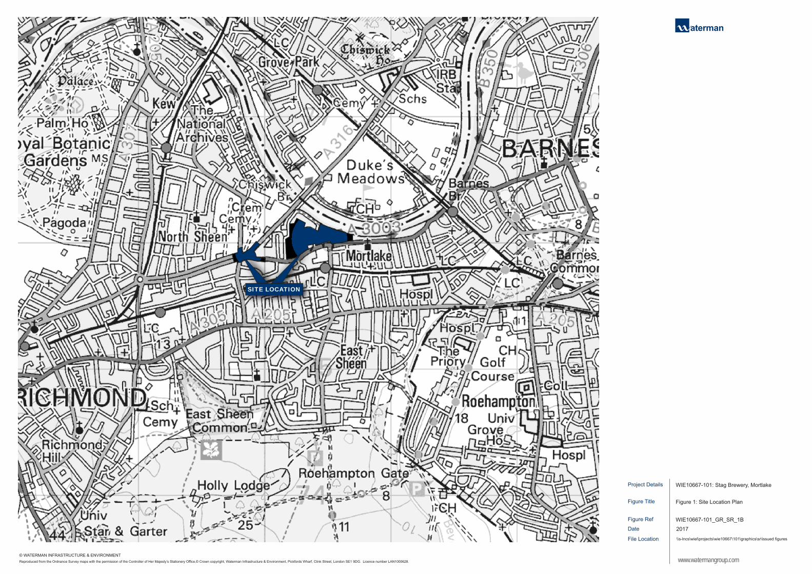
Project Details
Figure Ref
Date
Figure Title
File Location
Figure 1: Site Location Plan
\\s-lncs\wiel\projects\wie10667\101\graphics\sr\issued figures
WIE10667-101_GR_SR_1B
2017
WIE10667-101: Stag Brewery, Mortlake
www.watermangroup.comReproduced from the Ordnance Survey maps with the permission of the Controller of Her Majesty’s Stationery Office,© Crown copyright, Waterman Infrastructure & Environment, Pickfords Wharf, Clink Street, London SE1 9DG. Licence number LAN1000628.
© WATERMAN INFRASTRUCTURE & ENVIRONMENT
SITE LOCATION
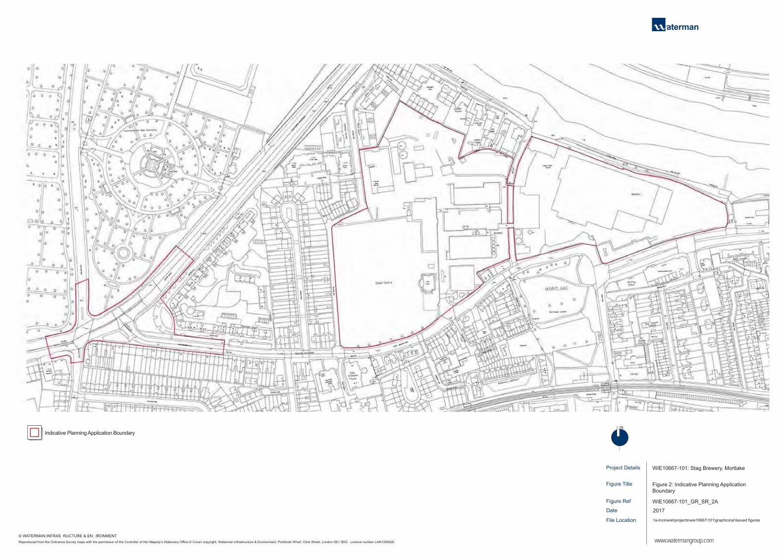
Project Details
Figure Ref
Date
Figure Title
File Location
Figure 2: Indicative Planning Application Boundary
\\s-lncs\wiel\projects\wie10667\101\graphics\sr\issued figures
WIE10667-101_GR_SR_2A
2017
WIE10667-101: Stag Brewery, Mortlake
www.watermangroup.com
N
Reproduced from the Ordnance Survey maps with the permission of the Controller of Her Majesty’s Stationery Office,© Crown copyright, Waterman Infrastructure & Environment, Pickfords Wharf, Clink Street, London SE1 9DG. Licence number LAN1000628.
© WATERMAN INFRASTRUCTURE & ENVIRONMENT
Indicative Planning Application Boundary

Project Details
Figure Ref
Date
Figure Title
File Location
Figure 3: Existing On and Off-Site Land Uses
\\s-lncs\wiel\projects\wie10667\101\graphics\sr\issued figures
WIE10667-101_GR_SR_3A
2017
WIE10667-101: Stag Brewery, Mortlake
www.watermangroup.com
N
Reproduced from the Ordnance Survey maps with the permission of the Controller of Her Majesty’s Stationery Office,© Crown copyright, Waterman Infrastructure & Environment, Pickfords Wharf, Clink Street, London SE1 9DG. Licence number LAN1000628.
© WATERMAN INFRASTRUCTURE & ENVIRONMENT
1
2
3 4
5
6
7
MORTLAKE HIGHSTREET
A316
Indicative Planning Application Boundary
Residential
Open/ Amenity Space
Railway Infrastructure (Including Stations)
Community
Office
SOUT
H CI
RCUL
AR (A
205)
CLIFFO
RD AVEN
UE (A31
6)
LOWER RICHMOND ROAD (A3003)
SHEE
N LA
NE
WIL
LIAM
S LA
NE
SHIP
LAN
E
Education
Light Industrial
Retail / Food and Drink
Retail with Residential above
Brewery Buildings and Structures
River / Watercourse
Watney’s Sports Ground
Maltings
Former Hotel
Former Bottling Hall
East Entrance
West Entrance
Mortlake Rail Station
Cemetry
1
2
3
4
5
6
7


Appendices EIA Scoping Report - Stag Brewery, Mortlake
Appendix B Consultation with London Borough of Richmond upon Thames Air Quality
Noise and Vibration


1
Edmead, Sophia
From: Fowler, AndrewSent: 04 July 2016 14:33To: Carol LeeCc: Boalch, RosSubject: RE: Air Quality Assessment - Stag Brewery, MortlakeAttachments: StagBrewerySiteandDT.JPG
Hi Carol, Many thanks for getting back to me and the 2015 data. Apologies for not attaching the Site boundary (now attached for completeness). I will pass the information on school distance onto the Developers and the consideration of transporting materials by river. I will also use Site 52 (Clifford Ave) in the verification process and will also consider using the urban background site at the Wetland Centre. Kind regards Andy
From: Carol Lee [mailto:[email protected]] Sent: 04 July 2016 14:03 To: Fowler, Andrew <[email protected]> Subject: RE: Air Quality Assessment ‐ Stag Brewery, Mortlake Hello Andrew Sincere apologies for the delay in responding – I have been away on annual leave. I have pleasure in attaching 2015 NO2 diffusion tube data. 2015 appears to be a lower than average year, so please proceed with caution. Site 52 (Clifford Ave) is also close by. Since the site is close to both the South Circular and the A316, this would give some balance to the air quality readings. I agree that Air Quality needs to be a consideration in this development. There is concern on the impact of the development, its location and the nature of the development. I see the development includes a school. We have a recommendation to not site new school buildings within 150m of a main road, so please advise the developers to try and ensure the school buildings are not sited on the side of the site next to the road. Your methodology is good. We do have our own automatic urban background site at the Wetland Centre. Feel free to use data from this site for background readings. This site also boarders on the river, which may be the least polluting way of delivering/removing construction materials and should be considered. I am familiar with this site but you refer to attachments, which I have not received. For completeness, please forward. Thank you. If you require any further information, please do not hesitate to get in touch.

2
Kind regards Carol Carol Lee Environmental Health Senior Pollution Practitioner (Air Quality) Regulatory Services Partnership London Boroughs of Merton and Richmond upon Thames 2nd Floor Civic Centre, 44 York Street, Twickenham TW1 3BZ
Tel 020 8891 7729
e‐mail [email protected]
From: Fowler, Andrew [mailto:[email protected]] Sent: 17 June 2016 16:36 To: Carol Lee; Jason Andrews Subject: Air Quality Assessment - Stag Brewery, Mortlake Good morning Carol and Jason, Waterman IE have been instructed to undertake an air quality assessment to accompany the planning application for a proposed mix use development at the Stag Brewery in Mortlake (please see attached an indicative planning application boundary), and would like to inform the London Borough of Richmond Upon Thames (LBRuT) of the scope and methodology for this assessment. The description of the Development has yet to be finalised but it is envisaged to include;
Residential
Retail / restaurant
School
Hotel
Museum
Office
Health facility
Cinema/Gym
Assisted Living
Car parking We have identified the following potential impacts on air quality as a result of the proposed development:

3
temporary generation of dust arising from the construction works leading to potential dust nuisance to surrounding sensitive receptors;
temporary changes in traffic‐related emissions during the construction works as a result of changes in traffic generated by such works / activities and emissions from construction plant; and
long‐term effects from the completed Development on local air quality particularly in relation to NO2 and PM10 levels, due to emissions from traffic generated by the completed Development; and
the potential air quality conditions future residential occupants of the Development would be subject to. We understand that LBRuT have designated the whole Borough an Air Quality Management Area (AQMA) for the NO2 and PM10 in 2000. The Site is therefore located within an AQMA. It is therefore proposed to undertake an air quality assessment to assess the exposure of future occupants to poor air quality from as well as the effect of any energy plant (if proposed within the Development) using the detailed dispersion model ADMS Roads (and ADMS 5 if any energy plant is proposed). As traffic flows follow a diurnal variation throughout the day and week, the ADMS‐Roads model will therefore include a diurnal traffic profile. Diffusion tubes at Site Codes 21(Lower Richmond Road, Mortlake (Nr. Kingsway)) and 51 (Sheen Lane, (railway crossing)), are located approximately 80m and 155m respectively from the Sites southern boundary and it is therefore proposed to use these diffusion tubes to verify the air quality model. please see the attached for their location in relation to the Site. To take into account the trend that NOx and NO2 concentrations are not declining as expected, the results will include an uncertainty section which will assess the future traffic on the basis of no future reductions (i.e. considering the potential effect of the Development against the current baseline conditions of 2014), subject to the availability of 2015 data. Would you be able to provide 2015 data? The nearest urban background monitoring is at Holly Lodge, Richmond (2.3km away) and the Wetlands Centre, Barnes (2.5km away), on this basis we propose to use the background concentrations obtained from the Defra Maps, unless you advise otherwise. Further to the operational assessment, a qualitative assessment of the potential impacts of the development on local air quality during construction would be undertaken. This would use the IAQM guidance to assess dust nuisance and construction plant/ vehicles, detailing any mitigation measures required. We are not aware of any other sources of pollution in the area, other than road traffic that may affect air quality at the site (and should therefore be considered in the assessment). If you have any queries in relation to our proposed methodology please do let me know. However, it would be helpful if you could confirm that our proposed approach is acceptable. Kind regards, Andy Andy Fowler Consultant Waterman Infrastructure & Environment Ltd Pickfords Wharf | Clink Street | London SE1 9DG t +44 207 928 7888 | dd 0330 060 2408 www.watermangroup.com | LinkedIn | Twitter
Please note our new company name from 1st July 2015 Please consider the environment before printing this e‐mail. Thank you!

4
Waterman Group is a multidisciplinary consultancy providing sustainable solutions to meet the planning, engineering design and project delivery needs of the property, infrastructure, environment and energy markets.
This message contains confidential information and is intended only for the individual named. If you are not the named addressee you should not disseminate, distribute or copy this email. Please notify the sender immediately if you have received this email by mistake and delete it from your system. Email transmission cannot be guaranteed to be secure or error-free as information could be intercepted, corrupted, delayed, lost, destroyed, incomplete, or contain viruses. The sender does not accept liability for any errors or omissions in the contents of this message, which arise as a result of email transmission. All reasonable precautions have been taken to see that no viruses are present in this email. Waterman Group cannot accept liability for loss, disruption or damage however caused, arising from the use of this email or attachments and recommend that you subject these to virus checking procedures prior to use. Email messages may be monitored and by replying to this message the recipient gives their consent to such monitoring.
Waterman Group Plc., Pickfords Wharf, Clink Street, London SE1 9DG, is a company registered in England and Wales with company registration number 2188844.
If you have received this message in error you must not print, copy, use or disclose the contents, but must delete it from your system and inform the sender of the error. You should be aware that all emails received and sent by the London Borough of Richmond upon Thames may be stored or monitored, or disclosed to authorised third parties, in accordance with relevant legislation.
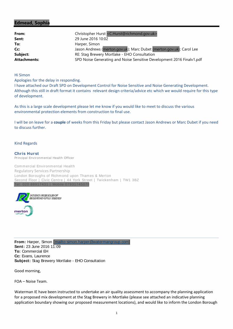
1
Edmead, Sophia
From: Christopher Hurst <[email protected]>Sent: 29 June 2016 10:02To: Harper, SimonCc: Jason Andrews (merton.gov.uk); Marc Dubet (merton.gov.uk); Carol LeeSubject: RE: Stag Brewery Mortlake - EHO ConsultationAttachments: SPD Noise Generating and Noise Sensitive Development 2016 Finalv1.pdf
Hi Simon Apologies for the delay in responding. I have attached our Draft SPD on Development Control for Noise Sensitive and Noise Generating Development. Although this still in draft format it contains relevant design criteria/advice etc which we would require for this type of development. As this is a large scale development please let me know if you would like to meet to discuss the various environmental protection elements from construction to final use. I will be on leave for a couple of weeks from this Friday but please contact Jason Andrews or Marc Dubet if you need to discuss further. Kind Regards Chris Hurst Principal Environmental Health Officer Commercial Environmental Health Regulatory Services Partnership London Boroughs of Richmond upon Thames & Merton Second Floor | Civic Centre | 44 York Street | Twickenham | TW1 3BZ Tel: 020 88917431 | Mobile 07931745078
From: Harper, Simon [mailto:[email protected]] Sent: 23 June 2016 11:09 To: Commercial EH Cc: Evans, Laurence Subject: Stag Brewery Mortlake - EHO Consultation Good morning, FOA – Noise Team. Waterman IE have been instructed to undertake an air quality assessment to accompany the planning application for a proposed mix development at the Stag Brewery in Mortlake (please see attached an indicative planning application boundary showing our proposed measurement locations), and would like to inform the London Borough
2
of Richmond upon Thames (LBRuT) of the scope and methodology for this assessment (please see attached method statement). The description of the Development has yet to be finalised but it is envisaged to include;
Residential
Retail / restaurant
School
Hotel
Museum
Office
Health facility
Cinema/Gym
Assisted Living
Car parking” Could you advise us on LBRuT internal noise policy criteria (and plant noise limits) to be met in respect of a proposed development? In assessing the suitability of the site for new residential development, we intend to reference relevant policy and guidance on noise (NPPF, BS 8233: 2014 and WHO, 1999), specifying the sound insulation performance requirements for the external building fabric glazing around the different façades of the development, as to achieve the relevant internal noise criteria. WHO Guidelines for Community Noise 1999 and BS 8233:2014 – Guidance on sound insulation and noise reduction for buildings, stipulate:
35 dB LAeq‐16hr noise limit during Day and Evening periods for internal living areas,
30 dB LAeq‐8hr noise limit during Night time period (23:00 – 7:00) in bedroom areas,
45 dB LAFmax should not be exceeded on more than 15 occasions over the 8hr (23:00 – 7:00)
night time period in bedroom areas, and
55 dB LAeq should not be exceeded within outdoor amenity/living spaces, within the spirit of
WHO.
Please can you confirm whether the LBRuT are in agreement with the above bulleted internal criteria to which design control measures should achieve. Could you also confirm LBRuT Plant Noise Limiting Criteria (i.e. Plant rating level should be controlled at least X dB below the minimum/representitive external background levels at the nearest noise sensitive properties). Kind Regards Simon Harper BEng (Hons), Pg Dip, AMIOA Acoustic Consultant Waterman Infrastructure & Environment Ltd Pickfords Wharf | Clink Street | London SE1 9DG t +44 207 928 7888 www.watermangroup.com | LinkedIn | Twitter Please note our new company name from 1 July 2015 Please consider the environment before printing this e-mail. Thank you!

3
Waterman Group is a multidisciplinary consultancy providing sustainable solutions to meet the planning, engineering design and project delivery needs of the property, infrastructure, environment and energy markets.
This message contains confidential information and is intended only for the individual named. If you are not the named addressee you should not disseminate, distribute or copy this email. Please notify the sender immediately if you have received this email by mistake and delete it from your system. Email transmission cannot be guaranteed to be secure or error-free as information could be intercepted, corrupted, delayed, lost, destroyed, incomplete, or contain viruses. The sender does not accept liability for any errors or omissions in the contents of this message, which arise as a result of email transmission. All reasonable precautions have been taken to see that no viruses are present in this email. Waterman Group cannot accept liability for loss, disruption or damage however caused, arising from the use of this email or attachments and recommend that you subject these to virus checking procedures prior to use. Email messages may be monitored and by replying to this message the recipient gives their consent to such monitoring.
Waterman Group Plc., Pickfords Wharf, Clink Street, London SE1 9DG, is a company registered in England and Wales with company registration number 2188844.
If you have received this message in error you must not print, copy, use or disclose the contents, but must delete it from your system and inform the sender of the error. You should be aware that all emails received and sent by the London Borough of Richmond upon Thames may be stored or monitored, or disclosed to authorised third parties, in accordance with relevant legislation.

METHOD STATEMENT
TO: Environmental Health Richmond
Borough Council FROM: Simon Harper
CC: Mark Maclagan, Laurence Evans, Ben Dymock, Dawit Abraham REF: WIE10667-101-Noise
DATE: 22 June 2016
SUBJECT: Noise Monitoring – Stag Brewery Mortlake, London
Reason for the works:
A comprehensive noise survey is required across the site to establish and quantify existing conditions on site, whilst also providing a good representation of the noise environment experienced at nearby noise sensitive locations likely to be affected by the development and its construction. The baseline survey comprises three components: 1. Long term unattended noise monitoring (minimum 5 day period, covering both the
weekday and weekend period, at three locations); 2. Short term attended noise measurements at various locations across the site to
establish the spatial variation in noise; and 3. Short-term attended 3hr CRTN noise measurements on the main road network
surrounding site to establish the spatial variation in noise. The purpose of the noise surveys are to establish: 1. Prevailing noise levels across the site to inform the acoustic design of the site in
controlling the intrusion of external environmental noise (e.g. from commercial/leisure activities and road/aircraft traffic) to meet advocated outdoor and indoor design criteria levels within different elements of the development;
2. Typical minimum background (L90) noise levels to set appropriate plant noise limits that future building services plant would need to be designed (collectively) to achieve;
3. Typical minimum ambient (Leq) noise levels to set appropriate acoustic performance standards for wider on-site activities that may be associated with the scheme (e.g. commercial/entertainment uses), with the intention of avoiding disturbance at the nearest noise-sensitive receptors.
4. BB93:2014 The Acoustic Design of Schools will be used to show the acoustic design complies with requirement E4 of the Building Regulations.
Description of the Works:
The proposed noise monitoring locations are presented in Figure 1 (attached). The exact measurement positions will be determined onsite based on personnel safety, equipment security and the developments layout and position relative to key local noise sources, subject to the agreement of the client. Initially long term noise monitors will be set up at four locations on the site (outlined in red in Figure 1). Supplementary short-term attended noise measurements with handheld SLMs mounted on tripods will be taken at various locations across the site (outlined in blue in Figure 1). A supplementary short-term attended 3hr CRTN measurements will be taken on the main road network (outlined in purple in Figure 1).

2
All noise measurements will be taken with calibrated precision grade (Class 1) frequency (one-third-octave band) sound level meters in order to provide a detailed description of the prevailing environmental noise characteristics. The sound level meters will be set-up to record over consecutive 5-minute periods the Leq, Lmax, Lmin, and Percentile (L1, L10, L90) noise indices in the A-weighting network over 125ms-1 fast response time constant intervals for the duration of each representative survey. The acoustic surveys carried out in conformity with appropriate standards, notably, BS 7445-1:2003, BS 7445-2:1991 and ISO 1996-2:2007. It is proposed to undertake short term monitoring on the day that the long term equipment is deployed and recovered to complete this element of work.
Working Area(s): Stag Brewery, Mortlake, London and the surrounding area. See Figure 1 (attached).
Proposed Dates/Times:
Equipment deployment and attended noise monitoring: 10:00-17:30 hours during W/C 24/06/16. Equipment collection: during W/C 29/06/16.
Equipment to be Employed:
12V sealed lead-acid battery powered SLMs, comprising a windshield and microphone on a 1.2m pole, with the SLM and batteries housed in a padlocked and chained environmental case.
Personnel Involved: Simon Harper (07762 759 175); Dawit Abraham (07540 447 485)
Overview of Activity:
1. To sign in on arrival and made aware of site procedures by Security/Facilities, as appropriate.

3
2. Access across site to be carried out vigilantly, avoiding all hazardous areas, with appropriate PPE to be worn at all times during site work, e.g. safety footwear.
3. 4no. long term SLM’s to be deployed across the site. Each long term environmental monitor will be padlocked shut and chained to a secure anchor point.
4. Short term attended noise measurements at ground level across the site. 5. A buddy system is to be adopted with works undertaken in tandem by appropriately
qualified, trained and experienced staff familiar with the works described above. 6. All work will be undertaken in full accordance with safety procedures specified in the
company’s Health and Safety Policy and the attached risk assessment. Safety Measures Employed:
Supporting Risk Assessment, under separate attachment.
We trust the above proposed survey strategy is met with approval and thank you in advance for your assistance.
For and On Behalf of Waterman Infrastructure & Environment

Figure 1: Proposed Baseline Noise Measurement Locations


Appendices EIA Scoping Report - Stag Brewery, Mortlake
Appendix C Consultation with the Environment Agency

Orchard House, Endeavour Park, London Road, Addington, West Malling, Kent, ME19 5SH. Customer services line: 01732 223 202 Email: [email protected] Website: https://www.gov.uk/government/organisations/environment-agency
Product 4 (Detailed Flood Risk) for: Stag Brewery, SW14 7ET Requested by: C. Donal O’Donovan, Waterman Infrastructure & Environment Ltd Reference: KSL2030 TT Date: 08 February 2016 (updated 25 February 2016) Contents
• Flood Map for Planning (Rivers and Sea) • Flood Map Extract • Thames Estuary 2100 (TE2100) • Thames Tidal Breach Modelling • Thames Tidal Breach Modelling Map • Thames Tidal Upstream Inundation Modelling • Thames Tidal Upstream Inundation Modelling Map • Site Node Locations Map • Defence Details • Recorded Flood Events Data • Additional Information • Environment Agency Standard Notice
The information provided is based on the best data available as of the date of this letter.
You may feel it is appropriate to contact our office at regular intervals, to check whether any amendments/ improvements to the data for this location have been made. Should you re-contact us after a period of time, please quote the above reference in order to help us deal with your query.
This information is provided subject to the enclosed notice which you should read.

Orchard House, Endeavour Park, London Road, Addington, West Malling, Kent, ME19 5SH. Customer services line: 01732 223 202 Email: [email protected] Website: https://www.gov.uk/government/organisations/environment-agency
Flood Map for Planning (Rivers and Sea) The Flood Map: Our Flood Map shows the natural floodplain for areas at risk from river and tidal flooding. The floodplain is specifically mapped ignoring the presence and effect of defences. Although flood defences reduce the risk of flooding they cannot completely remove that risk as they may be over topped or breached during a flood event.
The Flood Map indicates areas with a 1% (0.5% in tidal areas), Annual Exceedance Probability (AEP) - the probability of a flood of a particular magnitude, or greater, occurring in any given year, and a 0.1% AEP of flooding from rivers and/or the sea in any given year. In addition, the map also shows the location of some flood defences and the areas that benefit from them.
The Flood Map is intended to act as a guide to indicate the potential risk of flooding. When producing it we use the best data available to us at the time and also take into account historic flooding and local knowledge. The Flood Map is updated on a quarterly basis to account for any amendments required. These amendments are then displayed on the internet at
https://www.gov.uk/government/organisations/environment-agency.
At this Site: The Flood Map shows that this site lies within the outline of Flood Zone 3. This zone comprises land assessed as having a 0.5% (1 in 200) or greater annual probability of tidal flooding.
Enclosed is an extract of our Flood Map which shows this information for your area.
Method of production The Flood Map at this location has been derived using detailed modelling of the tidal River Thames through the Thames Tidal Defences Study completed in 2006 by Halcrow Ltd.

2.16
2.17d
®Scale 1: 10,000
© Environment Agency copyright and / or database rights 2015. All rights reserved. © Crown Copyright and database right. All rights reserved. Environment Agency, 100026380, 2015.Contact Us: National Customer Contact Centre, PO Box 544, Rotherham, S60 1BY. Tel: 03708 506 506 (Mon-Fri 8-6). Email: [email protected]
FRA Map centred on SW14 7ET created 08 February 2016 [Ref: KSL 2030 TT]
Flood Map for Planning(assuming no defences)
Flood Zone 3 shows the area that could be affected by flooding:- from the sea with a 0.5% or greater chance of occuring each year - or from a river with a 1% or greater chance of occuring each year
Flood Zone 2 shows the extent of an extreme flood from rivers or the sea with up to a 0.1%chance of occuring each year.
LegendMain Rivers
Site
TE2100 Model Nodes! ! ! ! ! ! ! ! ! ! ! ! ! Flood Map - Defences
Areas Benefitting from Flood Defences
!!
!
! ! ! ! !
!!
!!!!!!
Flood Storage Areas
Flood Map - Flood Zone 3
Flood Map - Flood Zone 2

Orchard House, Endeavour Park, London Road, Addington, West Malling, Kent, ME19 5SH. Customer services line: 01732 223 202 Email: [email protected] Website: https://www.gov.uk/government/organisations/environment-agency
Thames Estuary 2100 (TE2100) You have requested in-channel flood levels for the tidal river Thames. These have been taken from the Thames Estuary 2100 study completed by HR Wallingford in 2008. The modelled node closest to your site is 2.16; the locations of nearby nodes are also shown on the enclosed map.
Details about the TE2100 plan The TE2100 plan is now live and within it are a set of levels on which the flood risk management strategy is based. The plan is the overarching flood management strategy for the Thames Estuary and therefore any development planning should be based on the same underlying data.
Details about the TE2100 in-channel levels The TE2100 in-channel levels take into account operation of the Thames Barrier when considering future levels. The Thames Barrier requires regular maintenance and with additional closures the opportunity for maintenance will be reduced. When this happens, river levels – for which the Barrier would normally shut for the 2008 epoch – will have to be allowed through to ensure that the barrier is not shut too often. For this reason, levels upriver of the barrier will increase and the tidal walls will need to be heightened to match.
Why is there no return period for levels upriver of the barrier? The levels upriver of the barrier are the highest levels permitted by the operation of the Thames Barrier. If levels and flows are forecast to be any higher, the Thames Barrier would shut, ensuring that the tide is blocked and the river maintained to a low level. For this reason the probability of any given water level upriver of the Barrier is controlled and therefore any associated return period becomes irrelevant. The Thames Barrier and associated defence system has a 1 in 1000 year standard which means it ensures that flood risk is managed up to an event that has a 0.1% annual probability. The probability of water levels upriver is ultimately controlled by the staff at the Thames Barrier.
For further information about the Thames Barrier please visit our website at:
https://www.gov.uk/the-thames-barrier
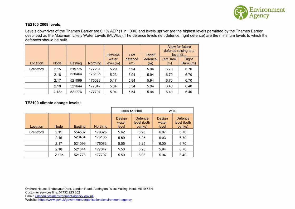
Orchard House, Endeavour Park, London Road, Addington, West Malling, Kent, ME19 5SH. Customer services line: 01732 223 202 Email: [email protected] Website: https://www.gov.uk/government/organisations/environment-agency
TE2100 2008 levels: Levels downriver of the Thames Barrier are 0.1% AEP (1 in 1000) and levels upriver are the highest levels permitted by the Thames Barrier, described as the Maximum Likely Water Levels (MLWLs). The defence levels (left defence, right defence) are the minimum levels to which the defences should be built.
Location Node Easting Northing
Extreme water
level (m)
Left defence
(m)
Right defence
(m)
Allow for future defence raising to a
level of... Left Bank
(m) Right
Bank (m)
Brentford 2.15 519775 177281 5.29 5.94 5.94 6.70 6.70
2.16 520464 176185 5.23 5.94 5.94 6.70 6.70
2.17 521099 176083 5.17 5.94 5.94 6.70 6.70
2.18 521644 177047 5.04 5.54 5.94 6.40 6.40
2.18a 521776 177707 5.04 5.54 5.94 6.40 6.40
TE2100 climate change levels:
2065 to 2100 2100
Location Node Easting Northing
Design water level
Defence level (both
banks)
Design water level
Defence level (both
banks) Brentford 2.15 554507 178325 5.62 6.25 6.07 6.70
2.16 520464 176185 5.59 6.25 6.03 6.70
2.17 521099 176083 5.55 6.25 6.00 6.70
2.18 521644 177047 5.50 6.25 5.94 6.70
2.18a 521776 177707 5.50 5.95 5.94 6.40

Orchard House, Endeavour Park, London Road, Addington, West Malling, Kent, ME19 5SH. Customer services line: 01732 223 202 Email: [email protected] Website: https://www.gov.uk/government/organisations/environment-agency
Thames Tidal Breach Modelling The table below displays site-specific modelled flood levels at your site. These have been taken from the Thames Tidal Breach Modelling Study 2015 completed by CH2M HILL in March 2015. The exact location of the given site-specific levels and the extent of the breach are shown on the enclosed map.
This modelling simulates tidal breaches along the Thames from Teddington to the Mar Dyke and River Darent. A series of 113 tidal models were developed for the Environment Agency at pre-determined breach locations. These were chosen using a risk-based approach by examining critical locations based on low floodplain topography. For hard and composite defences breaches are set at 20 m wide; for soft defences, breaches are 50 m wide. In both cases, the defence breach scour distance was assumed to extend into the floodplain by the same distance as the breach width.
Based on the 2008 TE2100 in-channel levels, the 0.5% (1 in 200 year) and 0.1% (1 in 1000 year) annual probability of exceedance tidal events were modelled for all breach locations downriver of the Thames Barrier. These were modelled for the 2014 year epoch, as well as a 2065 and 2100 epoch which include allowances for climate change.
For breaches upriver of the Thames Barrier, there is no return period for modelled levels as the levels are controlled by barrier closures. The levels used are referred to as Maximum Likely Water Levels (MLWLs). Therefore 2014, 2065 and 2100 epochs were modelled on that basis.
The modelled levels shown assume that the Thames defences have been breached at location ‘Kew01’ (NGR TQ2063976015).
KEW01 National Grid Reference Modelled levels in mAODN
Node Easting Northing 2014 2065 2100 1 520639 176008 5.24 5.77 6.02 2 520641 175963 5.23 5.77 6.02 3 520564 175979 5.23 5.77 6.02 4 520568 175953 5.23 5.77 6.02 5 520486 175926 Nil Return 5.76 6.00 6 520458 175977 Nil Return 5.76 6.00 7 520384 175940 Nil Return 5.76 6.00 8 520215 175854 Nil Return 5.29 5.63 9 520134 175828 Nil Return 5.28 5.63
10 520197 175928 Nil Return 5.29 5.63 11 520415 176058 Nil Return Nil Return 6.02 12 520548 176060 5.23 5.77 6.02

Orchard House, Endeavour Park, London Road, Addington, West Malling, Kent, ME19 5SH. Customer services line: 01732 223 202 Email: [email protected] Website: https://www.gov.uk/government/organisations/environment-agency
Thames Tidal Upstream Inundation Modelling The enclosed map shows results for the Thames Tidal Upstream Inundation Modelling Study 2015 completed by CH2M HILL in March 2015.
Upriver of the Thames Barrier, there is no return period for modelled levels as the levels are controlled by barrier closures. Therefore 2014, 2065 and 2100 epochs were modelled on that basis.
Using the domains updated as part of the Thames Tidal Breach Modelling Study 2015 completed by CH2M HILL in March 2015, the project generated outputs for water depths, velocity, levels and hazard. However the scenario modelled is that the Thames Barrier is operational but all linear defences have been removed. It uses the TE2100 in-channel levels calculated in 2008 and only provides data for embayments upriver of the Thames Barrier.
National Grid Reference Modelled levels in mAODN
Point Easting Northing 2014 2065 2100
1 520639 176008 5.17 5.74 6.00 2 520641 175963 5.18 5.75 6.01 3 520564 175979 5.19 5.74 6.01 4 520568 175953 5.19 5.74 6.01 5 520486 175926 5.01 5.72 5.97 6 520458 175977 Nil Return 5.72 5.97 7 520384 175940 Nil Return 5.72 5.97 8 520215 175854 Nil Return 5.33 5.63 9 520134 175828 Nil Return 5.31 5.60
10 520197 175928 Nil Return 5.33 5.63 11 520415 176058 Nil Return Nil Return 6.03 12 520548 176060 5.23 5.78 6.03

!!
!!
!!
!!
!!
!!
!!
!!
!
!!
!!
!
!
!!
!!
!!
!!
!!
!
!
!!
!!
!!
!!
!!
!!
!!
! !
!
!!!!
!!
!!
!!
!!
!!
!!
!!
!
!!!
!
!!!
!!
!!
!!
!
!!
!!
!!
!!
!!
!!
!!
!!
!!
!!
!
!!
!!
!
!
!
!!
!!
!
!
!!
!!
!!
!!
!!
!!
!!
!!
!!!
!
!
!!
!!!
!!
!
!
!!
! !
!!
!!
!!
!!
!!
!!
!!
!!
!!
!!
!!
!
!!
!!
!!
!!
!!
!
!!
! ! ! !!
!!
!!
!!
!!
!!
!
!!
!!
!!
!!
!!!!!
! !! !
!
!!
!!
!!
!!
!
!!
!!
!!
!!
!!
!!
!
!
! !!
!!
!!
!!!
!!
!!!
!!!
!!
!
!!
!!
!!!!!
!!!!
!!
!
!!
! !!!
!!
!! !
!!
!!
!!
!!
!!
!!
!!
!!
!!
!!
!!
!!!
!!
!!
!!
!!
!!
!!
!!
!
!
!
!
!
!!
!
! !
!
!!
!!
!!!
!!
!!
!!
!!
!
!!
!
!!
!!
! !!
!!
!!
!!
!!
!!!
!!
!!
!!
!!
!!
!!
!!
! !!!
! !
!
!!
! !!
!!
!!
!!
!!
!
!! ! ! !!
!
!!
!!
!!
!!
!!
!!
!!
!
!
!!
!!
!!
!!
!!
!!!
!!
!!!!!!!
!!
!!
!
!!!!!!
!!
!!
!!
!!
!!
!
! ! ! ! ! ! ! ! ! !
!
! ! ! ! ! ! ! ! !
!
!! !
! !
!
! !!!
!!!!!!!!!
!
! ! ! ! ! ! !
!!
!!
! !
!!
!
!!!
!!
!
!!
!
!!
!!
!!
!!!!
!!!!!!!!
!!!!!!
!!!!
!!!!
!!
!!
!!
!!!!!!!!
!!!!
!!!!!
!!!!
!!!
!!!
!!!!!!!!!!!!!!!!!!!!!
!!!
!!
!!
!!
!!
!
!!!
!!
!!
!!!!!!!!!!!!!!!!!!!!
!!!
!!
!!
!!
!
!!
!!
!!
!!
!!
!!
!!
!!
!!
!!
!!
!!
!!
!!
! !
!!
!!
!!!
!!
!!
!!
!
!
!
!!
!!
!!
!!
!!
!
!
!!
!!
!!
!
!!
!!
!
! !
!
!
!!
!!
!
!!!
!! ! !!
!
!!!
!!
!
! !
!!
!!
!!
!
! !!
!!
!!
!
!
!!
!
! !
!!
!!!
!!
!!
!
!! !
!!!
!!
!!
!
!!
!
!!
!!
!!
!
!!
!!
!
!!
!
! !!
!!
!!
!!
!! !
!!
!
!
!!
!!
!!! !
!!
!!
! !! !
!
!
!
! ! !! !
! !! !
! !
!
!
!
!!!!!
!!!!!!!
!
!!!
!!
!!
!
!
!
!
!
!!
! !! !
!
!
!
!!
!
!!
!!
!!!
!!
!
!
!
!!
!
! !!
!
!!
!
!!
!!! !
!
!
!
!!
!!!
!
!!
!!
!
!!
!!
!
!!
!!
!!
!!!
!!!
!!
!
!!
!
!!!
!
!!
!!
!!
!!
!!
!!
!!
!!
!!
!!
!!
!!
!!!
!!
!!
!
!!
!!
!!
!!
!!
!!
!!
!! ! !
!!
!!
!!
!
!!
!!
!!
!!
!!
!!
!!
! !
!!
!
!!
!!
!!
!!
!!!
! !!
!!
!
! !
!
!! !
! ! ! ! ! ! ! ! ! ! !!
!! ! !
!
!!
!!
!
!!!
!!
!!
!
! ! ! ! !! ! ! !
! ! ! ! ! !
!
!!
!!
!
! ! ! ! !
!
!
!!
! ! !
!!
!
!!
!!
!!
! ! !!
!!
!!
!
!!
!!
!
!!
!!
!! !
! ! ! ! !! !
!!
!!
!!
!! !
!! ! ! ! ! ! ! ! !
! !
!
!!!
!!
! !! !
!!
!!!
!!
!! !
!!!
!!
!!! !
!!
!!!
!! !
!!
!
!
!!
!!
!!
!!!
!! !!
!
!
!
!!
!!
!!
!
!!! !
!
!!
!
!
!!
!
!!
!!
!!!!
!!!!
!
!!
!
!
! !
! !! !
!
!
!!!!
!
!!
!! !
!!
!!
!!
!!
!!
!!
!!
!!!
!! ! !
!
!!
!!
!!
!!!
!!
!!
!!
!!
!!!!
!!
!!!
!!!
! !!
!!!
!
!
!!
!!!
!
!!
!
!!
!!
!!
!!
!!
!!
!
!!
!
!!
!!
! !!!
!
!!
!!
!!
!!
!!
!!
!!
!!
!
!!
!!
!!
!!
!!
!!
!!
!!
!!
!!
!!
!!
!!
!!
!!
!!
!!
!!
!!
!!
!!
!!
!!
!!
!!
!!
!!
!!
!!
!!
!!
!!
!!
!!
!!
!!
!!
!!
!!
!!
!!
!!
!!
!!
!!
!!
!!
!!
!!
!!
!!
!!
!!
!!
!!
!!
!!
!!
!!
!!
!!!
!!!
!!
!!!
!!!
!!!
!!!
!!!
!!
!!!
!!
!!
!!
!!
!!
!!
!!
!!
!!
!!
!!
!!
!!
!!
!!
!!
!!
!!
!!
! !!
!! ! ! ! ! ! ! ! ! ! ! ! ! ! ! ! !
! ! ! ! ! !!
!!
!!
!!
!!!
!!!
!!
!!
!!
!!
!!!
!!
!!
!!
!!!
!!
!!
!!
!!
!!
!
!!
!
!!
!!
!!
!!
!!
!!
!!
!!
!!
!!
!!
!!
!!
!!
!!
!! ! ! !
! ! ! !! !
!!
!!
!!
!!
!!
!!
!!
! ! ! !! !
! !! !
! ! !! ! ! ! ! ! ! ! ! ! ! ! ! ! ! ! ! !
! ! ! !!
!!
!!
!!
!!
!!
!!
!!
!!
!!
!!
!!
!!
!
!!
!!
!!
!!
!!
!!
!
!!
!!
!!
!!
!!
!!
!!
!!
!!
!!
!!
!
!!!!!!!!!!
!!!
!!
!!
!!
!!
!!
!!
!
!!
!!
!
!!
!!!
!!
!!
!!
!!!!!!
!!
!!
!!
!!
!!
!!
!!
!!
!!!
!!
!!
!!
!!
!!
!!
!!
!!
!!
!!
!!!
!!
!!!!!!!!!!!!!!!!!!!!!!!!!!!!
!!
!!
!!
!!
!!
!!
!!
!!
!!
!!
!!
!!
!!
!!
!!
!!
!!
!!
!!
!!
!!
!!
!!
!!
!!
!!!
!!
!!
!
!!
!!
!!
!!
!!
!!!
!!
!!!!!!
!!!!!!!!!!!!!!!!!!!!!!!!
!!
!!
!!
!
!!
!!!!
!!
!!
!!
!
!!
!!!
!!
!!
!!
!!
!!
!!
!!
!!
!!
!!
!!
!!
!!
!!!
!!
!!
!!
!!
!!
!!
!!
!!
!!
!!
!!
!!
!
!!
!!
!!
!!
!!
!!
!!
!!
!!
!!
!!
!!
!!
!!
!!
!
!!!!!!
!!
!!
!!
!!
!!
!!
!!
!!
!!
!!
!!
!!
!!
!!
!!
!!
!!
!!
!!
!!
!!
!!
!!
!!
!
!!
!!
!!
!
!!
!!
!!
!!
!!
!!
!!
!!
!!
!!
!!
!!
!!
!!
!!
!!
!!
!!
!!
!!
!!
!!
!!
!!
!!
!!
! !!
! !!
! ! ! ! ! ! ! ! ! ! ! ! ! ! !! ! ! ! ! ! ! ! ! !
! ! ! !
! ! ! ! ! ! ! ! ! ! ! ! ! ! ! !!
! !!
!!
!!
!!
!!
!!
!!!
!
!!
!!
!!
!!
!!
!!
!!
!!
!!
!!
!!
!!
!!
!!
!!
!!
!!
!!
!!
!!
!!
!!!
!!
!!
!!
!!!
!!
!
!!!!
!!!
!!!
!!!
!!!
!!
!!
!!
!!!
!!
!!
!!
!!
!!
!!
!!
!!
!!
!!
!!
!!
!!
!!
!!
!!
!!
!!
!!
!!
!!
!!
!!
!!
!!
!!
!!
!!
!!
!!
!!
!!
!!
!!
!!
!!
!!
!!
!!
!!
!!
!!
!!
!!
!!
!!
!!
!!
!!
!!
!!
!!
!!
!!
!!
!!
!!
!!
!!
!!
!!
!!
!!
!!
!!
!!
!!
!
!!
!!
!!
!!
!!
!!
!!!
!!
!!
!!
!!
!!
!!
!
!!
!
! !!
!!
!!
!
!!
!!
!! !
!!
!!!!
!
!
! !!
!!
!!
!!
!!!
!!
! !!
!!
! !
! !
!!
!!
!!!
!!
!!
! !!
!!
!!
!!
!!
! !
!!
!
!
!!
!!
!!
!!
!!
! !!
!!
!!
!!
!
!! !
!!
!!
!!
!!
!!
!!
!!
!
! ! !! ! ! ! ! ! !
!!
!!
!!
!!
!!
! ! !!
!
!!
! ! ! ! ! ! ! !
! ! ! ! ! ! ! ! ! ! ! !
! ! ! ! ! ! ! ! ! ! ! ! ! ! ! ! ! ! ! ! !
!
! ! ! ! ! ! ! ! ! ! ! ! ! ! ! ! ! !!
!! !
!! !
! !! !
! ! !!
!!
!!
!!
!!
!!
!!!
!
!!
!!
!!
!!
!!
!!
!!
!!
!!
!!!
!!
!!
!!
!!
!!
!
!!!
!
!!
!!
!
!!
!!!
!!!
!!!
!!
!!
!!!
!!
!!
!
!!
!!
!!
!!
!!
!!
!!
!!
!!
!!
!!
!!
!!
!!
!!
!!
!!
!!
!!
!!
!!
!!
!!
!!!
!!
!!
!!
!!
!!
!
!
!!
!!
!!
!!
!!
!!
!!
!!
!!
!!
!!
!!
!!
!!
! !
!!
!!
!!
!!
!!
!!
!!
!!
!!
!!
!!
!!
!!
!!
!!
!!
!!
!!
!!
!!
!!
!!
!!
!!
!!
!!
!!
!!
!!
!!
!!
!!
!!
!!
!!
!!
!!
!!!
!!
!!
!!
!!
!!
!!
!!
!!
!!
!!
!!
!!
!
!!
!!
!!
!!
!!
!! ! !
!!
!!
!!
!!
!!
!!
!!
!!
!!
!!
!!
!!
!!
!!
!!!
!!
!!!!!
!!
!!
!!!
!!
!!
!!
!!
!
!!
!!
!!
!!
!!
!!
!!
!!
!!
!!
!!
! !!
!!
!! !
! !! ! ! ! ! ! ! ! ! ! ! ! ! ! ! ! ! ! ! ! ! ! ! ! ! ! ! ! ! ! !
!!
!!
! ! ! ! ! ! !
! !!
!! ! ! ! ! ! ! ! ! ! ! ! ! !! !
! !!
!!
!!
!!
!!
!!
!!
!!
!!
!!
!!
!!
!!
!! !
!!
!!
!!
!
! !!!
!!
!!
!!
!!
!!!
!!
!!
!!!
!!
!!
!!
!!
!!
!!
!!
!!
!!
!!
!!
!!
!!
!!
!!
!!
!!
!!
!!
!!
!!
!!
!!
!!
!!
!!
!!!
!!
!!
!!
!!
!!
!!
!!
!!
!!
!!
!!
!!
!!
!!
!!
!!
!!
!!
!!
!!
!!
!!
!!
!!
!!
!!
!!
!!
!!
!!
!!
!!
!!
!!
!!
!!
!!
!!
!!
!!
!!
!!
!!
!!
!!
!!
!!
!!
!!
!!
!!
!!
!!
!!
!!
!!
!!
!!
!!
!!
!!
!!
!!
!!
!!
!!
!!
!!
!!
!!
!!
!!
!
!!
!!
!!
!!
!!
!!
!!
!!
!
!!
!!
!
!!
!!
!!
!!
!!
!
!!
!! !
!!
!!
!!
!!
!!
!!
!!
!!
!!
!!
!!
!!
!
!!
!!
!! !
!!
! !
!!
! !!
!!
!!
!!
!!
!!
!!
!
!!
!!
! ! !! ! !
!!
!!!
!!!
!
!! !
!!
!!!
!
!!
!!!
!!
!!
!!
!!
!!
!!
!!
!!
!!
!!
!!
!!
!!
!!
!!
!!
!!
!!
!!
!! ! ! ! ! ! !
!!
!!
!!
! ! ! ! ! ! ! ! ! ! ! ! ! ! ! ! ! ! ! ! ! ! ! ! ! ! ! ! ! ! ! ! ! ! ! ! ! ! ! ! ! ! ! ! ! ! !! !
! ! !! ! !
! !!
!!
!!
!!
!!
!!
!!
!!
!!
!!
!!
!!
!!
!!
!!
!
!!
!
!
!!
!!
!!
!!
!!
!!
!!
!!
!!
!!
!!
! !!
!!!
!!
!!
!!
!!
!!
!
!!
!
!
!!! ! !
!!
!!
!!
!!
!!
!!
!!
!!
!!
!!
!!
!!
!!
!!
!!
!!
!!
!!
!!!!
!!
!!
!!
!!
!
!!
! !!
!!
!!
!!
!!
!!
!!
!!
!!
!!
!!
!!
!!
!!
!!
!!
!!
!!
!!
!!
!!
!!
!!
!!
!!
!!
!!
!!
!!
!!
!!
!!
!!
!!
!!
!!
!!
!!
!!
!!
!!
!!
!!
!!
!!
!!
!
! !
!!
!!
!!
!!
!!
!!
!!
!!
!!
!!
!!
!!
!!
!!
!!
!!
!!
!!
!!
!!
!!
!!
!!
!!
!
!!
!!!
!!
!
!
!!!
!!
!!
!!
!
!
!
! !
!
!!
!!
! !!
!!
!! !
!!
!!
! !
!
!!
!!
!!
!!
!!!!
!!!!
!
!
!!
!
!
!!
!!
!!
!!
!!
!!!
!! !!
!
!!
!!
!
!
!
!!
!!!
!!
! !!
!!
!!
!!
!
!!
!!! !
! !
!
!
!
! !! !!
! !!
!!
!
!
!!!
!
!!
!!
!! !
!!!
!!
!!
!
!!!! !
!
! !!!
!!
!! ! !
!!
!! !
!!
!
!!!
!!
!!
!
!!
!!
!!
!!
!!
!!
!
! !
!! !!
!!
!!
!! ! ! !
!
!
! !! ! ! ! ! !!
! ! ! ! ! ! ! ! ! ! ! ! !
!
!
!
! ! ! ! ! ! ! ! ! ! ! ! ! ! ! ! ! ! !! ! !
!! ! ! !
!! !
! ! !!
! ! ! ! ! ! ! ! ! ! ! ! ! ! ! ! !! !
!!
!!
!!
!!
! !!
!!
!!
!! ! !
!!
!!
!!
!!
!!
! !!
!!
! !!
! !!
!!
!!
!! !
!
!!
!!
!
!
!
!
!!
!!
!!
!!
!!
!!
!!
!!
!!!
!!
!!
!!
!!
!!
!!!
!! !
!!
!!
!
!
!!
!!
!!
!!
!!
!!
!!
!!
!!
!!
!!
!!
!!
!!
!!
!!
!!
!!
!!
!!
!!
!!
!!
!!
!!
!!
!!
!!
!!
!!
!!
!!
!!
!!
!!
!!
!!
!!
!!
!!
! !!
!
!!
!!
!!
!!
!!
!!
!!
!!
!!
!!
!!
!!
!!
!!
!!
!!
!!
!!
!!
!!
!!
!!
!!
!!
!!
!!
!!
!!
!!
!!
!!
!!
!!
!!
!!
!!
!!
!!
!!
!!
!!
!!
!!
!!
!!
!!
!!
!!
!!
!!
!!
!! !
!!
!!
!!
!!
!!
!!
!!
!!
!!
!!
!!
!!
!!
!
!
!!
!!
!!
!!
!!
!!
!!
!!
!!
!!
!!
!!
!!
!!
!!
!!
!!
!!
!!
!!
!!
!!
!!
!
! !!
!
!!
!!
!!
!!
!!
!!
!!
!!
!!
!!
!!
!!
!!
!!
!!
!
!!
!!
!!!!
!!!
!!
!!
!!
!!
!!
!!
!!
!!
!!
!!
!!
!!
!!
!!
!!!
!
!
!!
!!
!!
!!
!!
!!
!!
!!
!!
! ! !!
!!
!!
!!
!! !
!!
!
!!
!!
!
! !!
!!
!
! !!
!
!!
!!
!! !
!! !
! !! !
! !! ! ! ! !
! ! ! ! ! ! !! ! !
! ! !! ! !
! ! !! ! !
! !! ! !
! !!
!!
!!
!!
!
! ! !!
!!
!!
!!
!!
!!
!!
! !! !
! !! !
!!
!!
!!
!! !
! ! ! ! ! ! ! ! ! ! ! ! ! ! ! ! !!
!!
!!
!! ! ! ! ! ! ! ! ! ! ! ! !
"
"
"
"
"
"Kew06
Kew01
Kew01a
Chis01
Barn02
Barn01
2.16
2.17d
Thames Tidal Breach Modelling 2015
A modelled representation of tidal breaches along the Thames from Teddington to the Mar Dyke and River Darent, based on low floodplain topography. For hard and composite defences breaches are set at 20 m wide; for soft defences, breaches are 50 m wide. In both cases, the defence breach scour distance was assumed to extend into the floodplain by the same distance as the breach width.The modelling is based on the 2008 TE2100in-channel levels, with an allowance for climatechange for epochs 2065 and 2100.
®Scale 1: 10,000
© Environment Agency copyright and / or database rights 2015. All rights reserved. © Crown Copyright and database right. All rights reserved. Environment Agency, 100026380, 2015.Contact Us: National Customer Contact Centre, PO Box 544, Rotherham, S60 1BY. Tel: 03708 506 506 (Mon-Fri 8-6). Email: [email protected]
Breach Modelling Map centred on SW14 7ET created 08 February 2016 [Ref: KSL 2030 TT]
LegendMain Rivers
Site
" Breach Locations
TE2100 Model Nodes! ! ! ! ! ! ! ! ! ! ! ! ! Flood Map - Defences
Upriver MLWL OutlinesEpoch
2014
2065
2100

!!
!!
!!
!!
!!
!!
!!
!!
!
!!
!!
!
!
!!
!!
!!
!!
!!
!
!
!!
!!
!!
!!
!!
!!
!!
! !
!
!!!!
!!
!!
!!
!!
!!
!!
!!
!
!!!
!
!!!
!!
!!
!!
!
!!
!!
!!
!!
!!
!!
!!
!!
!!
!!
!
!!
!!
!
!
!
!!
!!
!
!
!!
!!
!!
!!
!!
!!
!!
!!
!!!
!
!
!!
!!!
!!
!
!
!!
! !
!!
!!
!!
!!
!!
!!
!!
!!
!!
!!
!!
!
!!
!!
!!
!!
!!
!
!!
! ! ! !!
!!
!!
!!
!!
!!
!
!!
!!
!!
!!
!!!!!
! !! !
!
!!
!!
!!
!!
!
!!
!!
!!
!!
!!
!!
!
!
! !!
!!
!!
!!!
!!
!!!
!!!
!!
!
!!
!!
!!!!!
!!!!
!!
!
!!
! !!!
!!
!! !
!!
!!
!!
!!
!!
!!
!!
!!
!!
!!
!!
!!!
!!
!!
!!
!!
!!
!!
!!
!
!
!
!
!
!!
!
! !
!
!!
!!
!!!
!!
!!
!!
!!
!
!!
!
!!
!!
! !!
!!
!!
!!
!!
!!!
!!
!!
!!
!!
!!
!!
!!
! !!!
! !
!
!!
! !!
!!
!!
!!
!!
!
!! ! ! !!
!
!!
!!
!!
!!
!!
!!
!!
!
!
!!
!!
!!
!!
!!
!!!
!!
!!!!!!!
!!
!!
!
!!!!!!
!!
!!
!!
!!
!!
!
! ! ! ! ! ! ! ! ! !
!
! ! ! ! ! ! ! ! !
!
!! !
! !
!
! !!!
!!!!!!!!!
!
! ! ! ! ! ! !
!!
!!
! !
!!
!
!!!
!!
!
!!
!
!!
!!
!!
!!!!
!!!!!!!!
!!!!!!
!!!!
!!!!
!!
!!
!!
!!!!!!!!
!!!!
!!!!!
!!!!
!!!
!!!
!!!!!!!!!!!!!!!!!!!!!
!!!
!!
!!
!!
!!
!
!!!
!!
!!
!!!!!!!!!!!!!!!!!!!!
!!!
!!
!!
!!
!
!!
!!
!!
!!
!!
!!
!!
!!
!!
!!
!!
!!
!!
!!
! !
!!
!!
!!!
!!
!!
!!
!
!
!
!!
!!
!!
!!
!!
!
!
!!
!!
!!
!
!!
!!
!
! !
!
!
!!
!!
!
!!!
!! ! !!
!
!!!
!!
!
! !
!!
!!
!!
!
! !!
!!
!!
!
!
!!
!
! !
!!
!!!
!!
!!
!
!! !
!!!
!!
!!
!
!!
!
!!
!!
!!
!
!!
!!
!
!!
!
! !!
!!
!!
!!
!! !
!!
!
!
!!
!!
!!! !
!!
!!
! !! !
!
!
!
! ! !! !
! !! !
! !
!
!
!
!!!!!
!!!!!!!
!
!!!
!!
!!
!
!
!
!
!
!!
! !! !
!
!
!
!!
!
!!
!!
!!!
!!
!
!
!
!!
!
! !!
!
!!
!
!!
!!! !
!
!
!
!!
!!!
!
!!
!!
!
!!
!!
!
!!
!!
!!
!!!
!!!
!!
!
!!
!
!!!
!
!!
!!
!!
!!
!!
!!
!!
!!
!!
!!
!!
!!
!!!
!!
!!
!
!!
!!
!!
!!
!!
!!
!!
!! ! !
!!
!!
!!
!
!!
!!
!!
!!
!!
!!
!!
! !
!!
!
!!
!!
!!
!!
!!!
! !!
!!
!
! !
!
!! !
! ! ! ! ! ! ! ! ! ! !!
!! ! !
!
!!
!!
!
!!!
!!
!!
!
! ! ! ! !! ! ! !
! ! ! ! ! !
!
!!
!!
!
! ! ! ! !
!
!
!!
! ! !
!!
!
!!
!!
!!
! ! !!
!!
!!
!
!!
!!
!
!!
!!
!! !
! ! ! ! !! !
!!
!!
!!
!! !
!! ! ! ! ! ! ! ! !
! !
!
!!!
!!
! !! !
!!
!!!
!!
!! !
!!!
!!
!!! !
!!
!!!
!! !
!!
!
!
!!
!!
!!
!!!
!! !!
!
!
!
!!
!!
!!
!
!!! !
!
!!
!
!
!!
!
!!
!!
!!!!
!!!!
!
!!
!
!
! !
! !! !
!
!
!!!!
!
!!
!! !
!!
!!
!!
!!
!!
!!
!!
!!!
!! ! !
!
!!
!!
!!
!!!
!!
!!
!!
!!
!!!!
!!
!!!
!!!
! !!
!!!
!
!
!!
!!!
!
!!
!
!!
!!
!!
!!
!!
!!
!
!!
!
!!
!!
! !!!
!
!!
!!
!!
!!
!!
!!
!!
!!
!
!!
!!
!!
!!
!!
!!
!!
!!
!!
!!
!!
!!
!!
!!
!!
!!
!!
!!
!!
!!
!!
!!
!!
!!
!!
!!
!!
!!
!!
!!
!!
!!
!!
!!
!!
!!
!!
!!
!!
!!
!!
!!
!!
!!
!!
!!
!!
!!
!!
!!
!!
!!
!!
!!
!!
!!
!!
!!
!!
!!
!!!
!!!
!!
!!!
!!!
!!!
!!!
!!!
!!
!!!
!!
!!
!!
!!
!!
!!
!!
!!
!!
!!
!!
!!
!!
!!
!!
!!
!!
!!
!!
! !!
!! ! ! ! ! ! ! ! ! ! ! ! ! ! ! ! !
! ! ! ! ! !!
!!
!!
!!
!!!
!!!
!!
!!
!!
!!
!!!
!!
!!
!!
!!!
!!
!!
!!
!!
!!
!
!!
!
!!
!!
!!
!!
!!
!!
!!
!!
!!
!!
!!
!!
!!
!!
!!
!! ! ! !
! ! ! !! !
!!
!!
!!
!!
!!
!!
!!
! ! ! !! !
! !! !
! ! !! ! ! ! ! ! ! ! ! ! ! ! ! ! ! ! ! !
! ! ! !!
!!
!!
!!
!!
!!
!!
!!
!!
!!
!!
!!
!!
!
!!
!!
!!
!!
!!
!!
!
!!
!!
!!
!!
!!
!!
!!
!!
!!
!!
!!
!
!!!!!!!!!!
!!!
!!
!!
!!
!!
!!
!!
!
!!
!!
!
!!
!!!
!!
!!
!!
!!!!!!
!!
!!
!!
!!
!!
!!
!!
!!
!!!
!!
!!
!!
!!
!!
!!
!!
!!
!!
!!
!!!
!!
!!!!!!!!!!!!!!!!!!!!!!!!!!!!
!!
!!
!!
!!
!!
!!
!!
!!
!!
!!
!!
!!
!!
!!
!!
!!
!!
!!
!!
!!
!!
!!
!!
!!
!!
!!!
!!
!!
!
!!
!!
!!
!!
!!
!!!
!!
!!!!!!
!!!!!!!!!!!!!!!!!!!!!!!!
!!
!!
!!
!
!!
!!!!
!!
!!
!!
!
!!
!!!
!!
!!
!!
!!
!!
!!
!!
!!
!!
!!
!!
!!
!!
!!!
!!
!!
!!
!!
!!
!!
!!
!!
!!
!!
!!
!!
!
!!
!!
!!
!!
!!
!!
!!
!!
!!
!!
!!
!!
!!
!!
!!
!
!!!!!!
!!
!!
!!
!!
!!
!!
!!
!!
!!
!!
!!
!!
!!
!!
!!
!!
!!
!!
!!
!!
!!
!!
!!
!!
!
!!
!!
!!
!
!!
!!
!!
!!
!!
!!
!!
!!
!!
!!
!!
!!
!!
!!
!!
!!
!!
!!
!!
!!
!!
!!
!!
!!
!!
!!
! !!
! !!
! ! ! ! ! ! ! ! ! ! ! ! ! ! !! ! ! ! ! ! ! ! ! !
! ! ! !
! ! ! ! ! ! ! ! ! ! ! ! ! ! ! !!
! !!
!!
!!
!!
!!
!!
!!!
!
!!
!!
!!
!!
!!
!!
!!
!!
!!
!!
!!
!!
!!
!!
!!
!!
!!
!!
!!
!!
!!
!!!
!!
!!
!!
!!!
!!
!
!!!!
!!!
!!!
!!!
!!!
!!
!!
!!
!!!
!!
!!
!!
!!
!!
!!
!!
!!
!!
!!
!!
!!
!!
!!
!!
!!
!!
!!
!!
!!
!!
!!
!!
!!
!!
!!
!!
!!
!!
!!
!!
!!
!!
!!
!!
!!
!!
!!
!!
!!
!!
!!
!!
!!
!!
!!
!!
!!
!!
!!
!!
!!
!!
!!
!!
!!
!!
!!
!!
!!
!!
!!
!!
!!
!!
!!
!!
!
!!
!!
!!
!!
!!
!!
!!!
!!
!!
!!
!!
!!
!!
!
!!
!
! !!
!!
!!
!
!!
!!
!! !
!!
!!!!
!
!
! !!
!!
!!
!!
!!!
!!
! !!
!!
! !
! !
!!
!!
!!!
!!
!!
! !!
!!
!!
!!
!!
! !
!!
!
!
!!
!!
!!
!!
!!
! !!
!!
!!
!!
!
!! !
!!
!!
!!
!!
!!
!!
!!
!
! ! !! ! ! ! ! ! !
!!
!!
!!
!!
!!
! ! !!
!
!!
! ! ! ! ! ! ! !
! ! ! ! ! ! ! ! ! ! ! !
! ! ! ! ! ! ! ! ! ! ! ! ! ! ! ! ! ! ! ! !
!
! ! ! ! ! ! ! ! ! ! ! ! ! ! ! ! ! !!
!! !
!! !
! !! !
! ! !!
!!
!!
!!
!!
!!
!!!
!
!!
!!
!!
!!
!!
!!
!!
!!
!!
!!!
!!
!!
!!
!!
!!
!
!!!
!
!!
!!
!
!!
!!!
!!!
!!!
!!
!!
!!!
!!
!!
!
!!
!!
!!
!!
!!
!!
!!
!!
!!
!!
!!
!!
!!
!!
!!
!!
!!
!!
!!
!!
!!
!!
!!
!!!
!!
!!
!!
!!
!!
!
!
!!
!!
!!
!!
!!
!!
!!
!!
!!
!!
!!
!!
!!
!!
! !
!!
!!
!!
!!
!!
!!
!!
!!
!!
!!
!!
!!
!!
!!
!!
!!
!!
!!
!!
!!
!!
!!
!!
!!
!!
!!
!!
!!
!!
!!
!!
!!
!!
!!
!!
!!
!!
!!!
!!
!!
!!
!!
!!
!!
!!
!!
!!
!!
!!
!!
!
!!
!!
!!
!!
!!
!! ! !
!!
!!
!!
!!
!!
!!
!!
!!
!!
!!
!!
!!
!!
!!
!!!
!!
!!!!!
!!
!!
!!!
!!
!!
!!
!!
!
!!
!!
!!
!!
!!
!!
!!
!!
!!
!!
!!
! !!
!!
!! !
! !! ! ! ! ! ! ! ! ! ! ! ! ! ! ! ! ! ! ! ! ! ! ! ! ! ! ! ! ! ! !
!!
!!
! ! ! ! ! ! !
! !!
!! ! ! ! ! ! ! ! ! ! ! ! ! !! !
! !!
!!
!!
!!
!!
!!
!!
!!
!!
!!
!!
!!
!!
!! !
!!
!!
!!
!
! !!!
!!
!!
!!
!!
!!!
!!
!!
!!!
!!
!!
!!
!!
!!
!!
!!
!!
!!
!!
!!
!!
!!
!!
!!
!!
!!
!!
!!
!!
!!
!!
!!
!!
!!
!!
!!!
!!
!!
!!
!!
!!
!!
!!
!!
!!
!!
!!
!!
!!
!!
!!
!!
!!
!!
!!
!!
!!
!!
!!
!!
!!
!!
!!
!!
!!
!!
!!
!!
!!
!!
!!
!!
!!
!!
!!
!!
!!
!!
!!
!!
!!
!!
!!
!!
!!
!!
!!
!!
!!
!!
!!
!!
!!
!!
!!
!!
!!
!!
!!
!!
!!
!!
!!
!!
!!
!!
!!
!!
!
!!
!!
!!
!!
!!
!!
!!
!!
!
!!
!!
!
!!
!!
!!
!!
!!
!
!!
!! !
!!
!!
!!
!!
!!
!!
!!
!!
!!
!!
!!
!!
!
!!
!!
!! !
!!
! !
!!
! !!
!!
!!
!!
!!
!!
!!
!
!!
!!
! ! !! ! !
!!
!!!
!!!
!
!! !
!!
!!!
!
!!
!!!
!!
!!
!!
!!
!!
!!
!!
!!
!!
!!
!!
!!
!!
!!
!!
!!
!!
!!
!!
!! ! ! ! ! ! !
!!
!!
!!
! ! ! ! ! ! ! ! ! ! ! ! ! ! ! ! ! ! ! ! ! ! ! ! ! ! ! ! ! ! ! ! ! ! ! ! ! ! ! ! ! ! ! ! ! ! !! !
! ! !! ! !
! !!
!!
!!
!!
!!
!!
!!
!!
!!
!!
!!
!!
!!
!!
!!
!
!!
!
!
!!
!!
!!
!!
!!
!!
!!
!!
!!
!!
!!
! !!
!!!
!!
!!
!!
!!
!!
!
!!
!
!
!!! ! !
!!
!!
!!
!!
!!
!!
!!
!!
!!
!!
!!
!!
!!
!!
!!
!!
!!
!!
!!!!
!!
!!
!!
!!
!
!!
! !!
!!
!!
!!
!!
!!
!!
!!
!!
!!
!!
!!
!!
!!
!!
!!
!!
!!
!!
!!
!!
!!
!!
!!
!!
!!
!!
!!
!!
!!
!!
!!
!!
!!
!!
!!
!!
!!
!!
!!
!!
!!
!!
!!
!!
!!
!
! !
!!
!!
!!
!!
!!
!!
!!
!!
!!
!!
!!
!!
!!
!!
!!
!!
!!
!!
!!
!!
!!
!!
!!
!!
!
!!
!!!
!!
!
!
!!!
!!
!!
!!
!
!
!
! !
!
!!
!!
! !!
!!
!! !
!!
!!
! !
!
!!
!!
!!
!!
!!!!
!!!!
!
!
!!
!
!
!!
!!
!!
!!
!!
!!!
!! !!
!
!!
!!
!
!
!
!!
!!!
!!
! !!
!!
!!
!!
!
!!
!!! !
! !
!
!
!
! !! !!
! !!
!!
!
!
!!!
!
!!
!!
!! !
!!!
!!
!!
!
!!!! !
!
! !!!
!!
!! ! !
!!
!! !
!!
!
!!!
!!
!!
!
!!
!!
!!
!!
!!
!!
!
! !
!! !!
!!
!!
!! ! ! !
!
!
! !! ! ! ! ! !!
! ! ! ! ! ! ! ! ! ! ! ! !
!
!
!
! ! ! ! ! ! ! ! ! ! ! ! ! ! ! ! ! ! !! ! !
!! ! ! !
!! !
! ! !!
! ! ! ! ! ! ! ! ! ! ! ! ! ! ! ! !! !
!!
!!
!!
!!
! !!
!!
!!
!! ! !
!!
!!
!!
!!
!!
! !!
!!
! !!
! !!
!!
!!
!! !
!
!!
!!
!
!
!
!
!!
!!
!!
!!
!!
!!
!!
!!
!!!
!!
!!
!!
!!
!!
!!!
!! !
!!
!!
!
!
!!
!!
!!
!!
!!
!!
!!
!!
!!
!!
!!
!!
!!
!!
!!
!!
!!
!!
!!
!!
!!
!!
!!
!!
!!
!!
!!
!!
!!
!!
!!
!!
!!
!!
!!
!!
!!
!!
!!
!!
! !!
!
!!
!!
!!
!!
!!
!!
!!
!!
!!
!!
!!
!!
!!
!!
!!
!!
!!
!!
!!
!!
!!
!!
!!
!!
!!
!!
!!
!!
!!
!!
!!
!!
!!
!!
!!
!!
!!
!!
!!
!!
!!
!!
!!
!!
!!
!!
!!
!!
!!
!!
!!
!! !
!!
!!
!!
!!
!!
!!
!!
!!
!!
!!
!!
!!
!!
!
!
!!
!!
!!
!!
!!
!!
!!
!!
!!
!!
!!
!!
!!
!!
!!
!!
!!
!!
!!
!!
!!
!!
!!
!
! !!
!
!!
!!
!!
!!
!!
!!
!!
!!
!!
!!
!!
!!
!!
!!
!!
!
!!
!!
!!!!
!!!
!!
!!
!!
!!
!!
!!
!!
!!
!!
!!
!!
!!
!!
!!
!!!
!
!
!!
!!
!!
!!
!!
!!
!!
!!
!!
! ! !!
!!
!!
!!
!! !
!!
!
!!
!!
!
! !!
!!
!
! !!
!
!!
!!
!! !
!! !
! !! !
! !! ! ! ! !
! ! ! ! ! ! !! ! !
! ! !! ! !
! ! !! ! !
! !! ! !
! !!
!!
!!
!!
!
! ! !!
!!
!!
!!
!!
!!
!!
! !! !
! !! !
!!
!!
!!
!! !
! ! ! ! ! ! ! ! ! ! ! ! ! ! ! ! !!
!!
!!
!! ! ! ! ! ! ! ! ! ! ! ! !
2.16
2.17d
®Scale 1: 10,000
© Environment Agency copyright and / or database rights 2015. All rights reserved. © Crown Copyright and database right. All rights reserved. Environment Agency, 100026380, 2015.Contact Us: National Customer Contact Centre, PO Box 544, Rotherham, S60 1BY. Tel: 03708 506 506 (Mon-Fri 8-6). Email: [email protected]
Upstream Inundation Modelling Map centred on SW14 7ET created 08 February 2016 [Ref: KSL 2030 TT]
Upstream Inundation Modelling 2015
The modelled scenario is that the ThamesBarrier is operational but all linear defenceshave been removed. The modelling is basedon the 2008 TE2100 in-channel levelsincluding an allowance for climate change.
Upstream of the Thames Barrier, there is noreturn period for modelled levels as the levelsare controlled by barrier closeres. Therefore2014, 2065 and 2100 epochs were modelledusing Maximum Likley Water Levels (MLWLs).
LegendMain Rivers
Site
TE2100 Model Nodes! ! ! ! ! ! ! ! ! ! ! ! ! Flood Map - Defences
Upriver MLWL OutlinesEpoch
2014
2065
2100

9
8
7
6
54
3
2
1
1211
10
®Scale 1: 5,000
© Environment Agency copyright and / or database rights 2015. All rights reserved. © Crown Copyright and database right. All rights reserved. Environment Agency, 100026380, 2015.Contact Us: National Customer Contact Centre, PO Box 544, Rotherham, S60 1BY. Tel: 03708 506 506 (Mon-Fri 8-6). Email: [email protected]
2D Node Location Map centred on SW14 7ET created 08 February 2016 [Ref: KSL 2030 TT]
LegendMain Rivers
Nodes

Orchard House, Endeavour Park, London Road, Addington, West Malling, Kent, ME19 5SH. Customer services line: 01732 223 202 Email: [email protected] Website: https://www.gov.uk/government/organisations/environment-agency
Defence Details The design standard of protection of the flood defences in this area of the Thames is 0.1% AEP; they are designed to defend London up to a 1 in 1000 year tidal flood event. The defences are all raised, man-made and privately owned. It is the riparian owners’ responsibility to ensure that they are maintained to a crest level of 5.94 m AODN (the Statutory Flood Defence Level in this reach of the Thames). We inspect them twice a year to ensure that they remain fit for purpose. The current condition grade for defences in the area is 2 (good), on a scale of 1 (very good) to 5 (very poor). For more information on your rights and responsibilities as a riparian owner, please see our document ‘Living on the edge’ found on our website at:
https://www.gov.uk/government/publications/riverside-ownership-rights-and-responsibilities
There are no planned improvements in this area. Please see the ‘Thames Estuary 2100’ document on our website for the short, medium and long term Flood Risk Management strategy for London:
https://www.gov.uk/government/publications/flooding-thames-estuary-2100-te2100-plan
Areas not Benefiting from Flood Defences This area is covered by fluvial flood zones derived from the 2009 Teddington fluvial model which overlap the Thames Tidal flood zones in places. Areas Benefiting from Defences (ABDs) are classified as areas that benefit from defences during a 1.0% fluvial or a 0.5% tidal event. Therefore, if a fluvial flood zone overlaps a tidal ABD and only has defences with a design standard of less than 1.0% fluvial event the areas covered by the fluvial flood zones from that river, cannot be considered to be benefiting from defences.

Orchard House, Endeavour Park, London Road, Addington, West Malling, Kent, ME19 5SH. Customer services line: 01732 223 202 Email: [email protected] Website: https://www.gov.uk/government/organisations/environment-agency
Recorded Flood Events Data We hold records of historic flood events from rivers and the sea. Information on the floods that may have affected the area local to your site is provided below and in the enclosed map (if relevant).
Flood Event Data We do not hold records of historic flood events from rivers and/or the sea affecting the area local to this site. However, please be aware that this does not necessarily mean that flooding has not occurred here in the past, as our records are not comprehensive.
Due to the fact that our records are not comprehensive, we would advise that you make further enquiries locally with specific reference to flooding at this location. You should consider contacting the relevant Local Planning Authority and/or water/sewerage undertaker for the area.
We map flooding to land, not individual properties. Our historic flood event record outlines are an indication of the geographical extent of an observed flood event. Our historic flood event outlines do not give any indication of flood levels for individual properties. They also do not imply that any property within the outline has flooded internally.
Please be aware that flooding can come from different sources. Examples of these are:
• from rivers or the sea; • surface water (i.e. rainwater flowing over or accumulating on the ground before it is able to enter rivers or the drainage system); • overflowing or backing up of sewer or drainage systems which have been overwhelmed, • groundwater rising up from underground aquifers
Currently the Environment Agency can only supply flood risk data relating to the chance of flooding from rivers or the sea. However you should be aware that in recent years, there has been an increase in flood damage caused by surface water flooding and drainage systems that have been overwhelmed.

Orchard House, Endeavour Park, London Road, Addington, West Malling, Kent, ME19 5SH. Customer services line: 01732 223 202 Email: [email protected] Website: https://www.gov.uk/government/organisations/environment-agency
Additional Information Use of Environment Agency Information for Flood Risk / Flood Consequence Assessments Important If you have requested this information to help inform a development proposal, then we recommend that you undertake a formal pre-application enquiry using the form available from our website:-
https://www.gov.uk/government/publications/pre-planning-application-enquiry-form-preliminary-opinion
Depending on the enquiry, we may also provide advice on other issues related to our responsibilities including flooding, waste, land contamination, water quality, biodiversity, navigation, pollution, water resources, foul drainage or Environmental Impact Assessment.
In England, you should refer to the Environment Agency’s Flood Risk Standing Advice, the technical guidance to the National Planning Policy Framework and the existing PPS25 Practice Guide for information about what flood risk assessment is needed for new development in the different Flood Zones. These documents can be accessed via:
https://www.gov.uk/flood-risk-standing-advice-frsa-for-local-planning-authorities
https://www.gov.uk/government/publications/national-planning-policy-framework-technical-guidance
https://www.gov.uk/government/publications/development-and-flood-risk-practice-guide-planning-policy-statement-25
You should also consult the Strategic Flood Risk Assessment produced by your local planning authority.
You should note that:
1. Information supplied by the Environment Agency may be used to assist in producing a Flood Risk / Consequence Assessment (FRA / FCA) where one is required, but does not constitute such an assessment on its own.
2. This information covers flood risk from main rivers and the sea, and you will need to consider other potential sources of flooding, such as groundwater or overland runoff. The information produced by the local planning authority referred to above may assist here.
3. Where a planning application requires a FRA / FCA and this is not submitted or deficient, the Environment Agency may well raise an objection.
4. For more significant proposals in higher flood risk areas, we would be pleased to discuss details with you ahead of making any planning application, and you should also discuss the matter with your local planning authority.

Orchard House, Endeavour Park, London Road, Addington, West Malling, Kent, ME19 5SH. Customer services line: 01732 223 202 Email: [email protected] Website: https://www.gov.uk/government/organisations/environment-agency
Surface Water We have provided two national Surface Water maps, under our Strategic Overview for flooding, to your Lead Local Flood Authority – London Borough of Richmond Upon Thames – who are responsible for local flood risk (i.e. surface runoff, ground water and ordinary watercourse), which alongside their existing local information will help them in determining what best represents surface water flood risk in your area.
The London Borough of Richmond Upon Thames have reviewed these and determined what it believes best represents surface water flood risk. You should therefore contact this authority so they can provide you with the most up to date information about surface water flood risk in your area.
You may also wish to consider contacting the appropriate relevant Local Planning Authority and/or water/sewerage undertaker for the area. They may be able to provide some knowledge on the risk of flooding from other sources. We are working with these organisations to improve knowledge and understanding of surface water flooding.

Orchard House, Endeavour Park, London Road, Addington, West Malling, Kent, ME19 5SH. Customer services line: 01732 223 202 Email: [email protected] Website: https://www.gov.uk/government/organisations/environment-agency
Standard Notice [not for use with Special Data, Personal Data or unlicensed 3rd
party rights]
Information warning We (The Environment Agency) do not promise that the Information supplied to You will always be accurate, free from viruses and other malicious or damaging code (if electronic), complete or up to date or that the Information will provide any particular facilities or functions or be suitable for any particular purpose. You must ensure that the Information meets your needs and are entirely responsible for the consequences of using the Information. Please also note any specific information warning or guidance supplied to you.
Permitted use The Information is protected by intellectual property rights and whilst you have certain statutory rights which include the right to read the Information, you are granted no additional use rights whatsoever unless you agree to the licence set out below. Commercial use is subject to payment of a £50 licence fee (+VAT) for each person seeking the benefit of the licence, except for use as an Environment Agency contractor or for approved media use. To activate this licence you do not need to contact us (unless you need to pay us a Commercial licence fee) but if you make any use in excess of your statutory rights you are deemed to accept the terms below.
Licence We grant you a worldwide, royalty-free, perpetual, non-exclusive licence to use the Information subject to the conditions below.
You are free to:
You must (where you do any of the above):
These are important conditions and if you fail to comply with them the rights granted to you under this licence, or any similar licence granted by us will end automatically.
No warranty The Information is licensed ‘as is’ and We exclude all representations, warranties, obligations and liabilities in relation to the Information to the maximum extent permitted by law. We are not liable for any errors or omissions in the Information and shall not be liable for any loss, injury or damage of any kind caused by its use. We do not guarantee the continued supply of the Information.
Governing Law This licence is governed by the laws of England and Wales.
Definitions + “Information” means: the information that is protected by copyright or by database right (for example, literary and artistic works, content, data and source code) offered for use under the terms of this licence. + “Commercial” means:
- offering a product or service containing the Information, or any adaptation of it, for a charge, or - Internal Use for any purpose, or offering a product or service based on the Information for indirect
commercial advantage, by an organisation that is primarily engaged in trade, commerce or a profession
acknowledge the source of the Information by including the following attribution statement: “Contains Environment Agency information © Environment Agency and database right” ensure that you do not use the Information in a way that suggests any official status or that We endorse you or your use of the Information ensure that you do not mislead others or misrepresent the Information or its source or use the Information in a way that is detrimental to the environment, including the risk of reduced future enhancement ensure that your use of the Information does not breach the Data Protection Act 1998 or the Privacy and Electronic Communications (EC Directive) Regulations 2003
copy, publish, distribute and transmit the Information adapt the Information exploit the Information commercially, for example, by combining it with other Information, or by including it in your own product or application

Doc No WHR971 Rev: 0 Date: April 2009 98
Defended Scenario Undefended Scenario
Node_label Chainage (m) 2yr 5yr 10yr 20yr 20yr
+20% 20yr
+40% 50yr 100yr 100yr +20%
100yr +40% 200yr 1000yr 1000yr
+20% 1000yr +40% 100yr 100yr
+20% 100yr +40% 1000yr 1000yr
+20% 1000yr +40%
2.3 10672 3.28 3.96 4.36 4.75 5.25 5.69 5.21 5.53 6.09 6.62 5.88 6.77 7.37 7.80 5.76 6.16 6.56 6.78 7.07 7.47 2.3a 11097 3.17 3.85 4.25 4.64 5.16 5.61 5.12 5.45 6.02 6.56 5.81 6.71 7.31 7.76 5.70 6.10 6.49 6.72 7.00 7.43 2.4 11522 3.11 3.79 4.21 4.60 5.13 5.59 5.09 5.43 6.00 6.55 5.79 6.70 7.29 7.71 5.68 6.08 6.47 6.70 6.97 7.37 2.5au 12562 2.81 3.47 3.87 4.26 4.76 5.19 4.72 5.04 5.57 6.09 5.38 6.24 6.93 7.43 5.46 5.84 6.24 6.36 6.85 7.27 2.5ad 12562 2.72 3.35 3.74 4.09 4.55 4.91 4.51 4.79 5.21 5.61 5.06 5.74 6.42 6.90 5.29 5.62 5.96 5.97 6.59 7.00 2.6 13242 2.62 3.26 3.66 4.02 4.50 4.87 4.46 4.75 5.16 5.55 5.02 5.67 6.26 6.56 5.24 5.53 5.82 5.86 6.28 6.54 a2.6 13522 2.59 3.23 3.62 3.99 4.46 4.85 4.42 4.71 5.18 5.60 5.02 5.73 6.38 6.79 5.26 5.58 5.89 5.97 6.44 6.79 a2.7 13522 2.55 3.17 3.50 3.83 4.26 4.67 4.23 4.51 5.02 5.46 4.85 5.58 6.25 6.66 5.20 5.49 5.80 5.87 6.36 6.71 2.8 13792 2.48 3.09 3.42 3.74 4.16 4.56 4.13 4.41 4.91 5.36 4.74 5.49 6.21 6.64 5.14 5.42 5.72 5.78 6.28 6.63 2.81 13792 2.48 3.09 3.42 3.74 4.16 4.56 4.13 4.41 4.91 5.36 4.74 5.49 6.21 6.64 5.14 5.42 5.72 5.78 6.28 6.63 2.9u 14042 2.45 3.07 3.40 3.72 4.15 4.54 4.11 4.40 4.88 5.31 4.71 5.44 6.15 6.56 5.12 5.39 5.67 5.73 6.20 6.55 2.9d 14042 2.45 3.07 3.40 3.72 4.15 4.54 4.11 4.40 4.88 5.31 4.71 5.44 6.15 6.56 5.12 5.39 5.67 5.73 6.20 6.55 2.10 14372 2.39 2.99 3.32 3.64 4.06 4.45 4.03 4.31 4.80 5.24 4.63 5.37 6.10 6.51 5.09 5.35 5.63 5.69 6.16 6.50 2.101 14372 2.39 2.99 3.32 3.64 4.06 4.45 4.03 4.31 4.80 5.24 4.63 5.37 6.10 6.51 5.09 5.35 5.63 5.69 6.16 6.50 2.11 14692 2.32 2.92 3.24 3.56 3.99 4.38 3.95 4.24 4.74 5.19 4.56 5.32 6.07 6.49 5.06 5.32 5.60 5.66 6.12 6.46 2.111 15022 2.22 2.82 3.14 3.46 3.88 4.27 3.84 4.12 4.63 5.10 4.45 5.24 6.03 6.44 5.02 5.27 5.55 5.61 6.08 6.42 2.12 15512 2.10 2.70 3.02 3.33 3.75 4.14 3.72 4.00 4.49 4.95 4.32 5.08 5.91 6.35 4.97 5.19 5.45 5.51 5.96 6.32 2.121 15512 2.10 2.70 3.02 3.33 3.75 4.14 3.72 4.00 4.49 4.95 4.32 5.08 5.91 6.35 4.97 5.19 5.45 5.51 5.96 6.32 2.122 15842 2.04 2.62 2.94 3.26 3.67 4.05 3.64 3.91 4.40 4.85 4.23 4.98 5.81 6.22 4.93 5.14 5.37 5.43 5.85 6.19 2.13u 16512 1.95 2.53 2.84 3.15 3.57 3.95 3.53 3.81 4.29 4.73 4.12 4.86 5.69 6.07 4.89 5.07 5.29 5.34 5.73 6.04 2.13d 16512 1.95 2.53 2.84 3.15 3.57 3.95 3.53 3.81 4.29 4.73 4.12 4.86 5.69 6.07 4.89 5.07 5.29 5.34 5.73 6.04 2.14 17532 1.79 2.36 2.67 2.97 3.38 3.75 3.35 3.61 4.08 4.52 3.92 4.65 5.51 5.85 4.81 4.97 5.17 5.21 5.56 5.85 2.15 18512 1.58 2.13 2.43 2.73 3.12 3.48 3.09 3.34 3.80 4.23 3.64 4.35 5.27 5.59 4.73 4.85 5.01 5.05 5.33 5.56 2.16 19532 1.43 1.96 2.26 2.56 2.95 3.31 2.92 3.17 3.63 4.06 3.47 4.18 5.17 5.46 4.69 4.79 4.93 4.96 5.21 5.42 2.17u 20552 1.25 1.77 2.05 2.33 2.71 3.05 2.68 2.93 3.37 3.78 3.21 3.90 5.01 5.23 4.64 4.71 4.80 4.83 5.02 5.19 2.17d 20552 1.25 1.77 2.05 2.33 2.71 3.05 2.68 2.93 3.37 3.78 3.21 3.90 5.01 5.23 4.64 4.71 4.80 4.83 5.02 5.19 2.18 21552 1.09 1.60 1.88 2.16 2.53 2.87 2.50 2.74 3.19 3.60 3.03 3.71 4.90 5.10 4.61 4.67 4.74 4.77 4.93 5.08 2.18a 22252 0.97 1.47 1.75 2.03 2.39 2.73 2.36 2.60 3.04 3.45 2.88 3.56 4.83 5.00 4.58 4.63 4.69 4.71 4.84 4.97 2.19 22592 0.91 1.42 1.70 1.99 2.36 2.70 2.33 2.57 3.02 3.44 2.86 3.55 4.83 5.00 4.57 4.63 4.69 4.71 4.85 4.99 2.20 23592 0.75 1.26 1.53 1.82 2.18 2.52 2.15 2.40 2.84 3.25 2.68 3.37 4.75 4.87 4.55 4.59 4.64 4.65 4.75 4.85
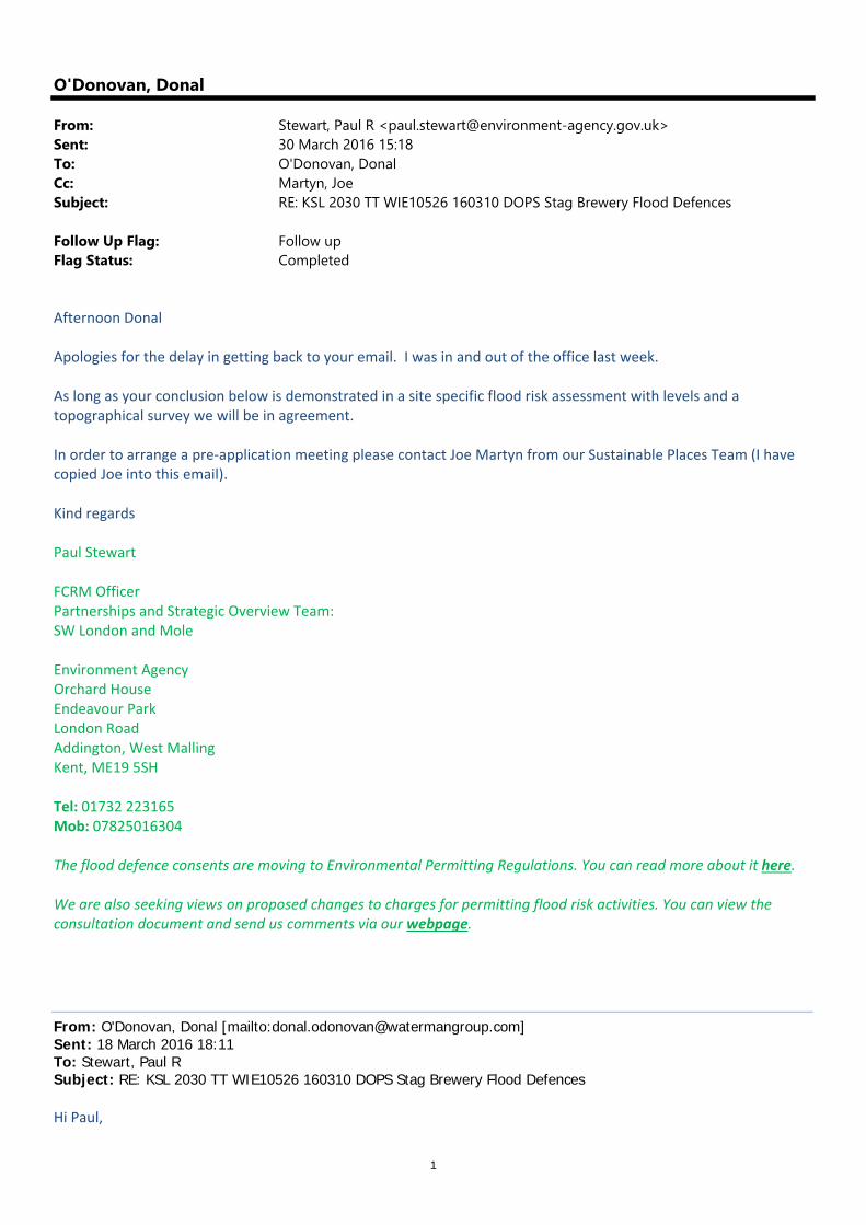
1
O'Donovan, Donal
From: Stewart, Paul R <[email protected]>Sent: 30 March 2016 15:18To: O'Donovan, DonalCc: Martyn, JoeSubject: RE: KSL 2030 TT WIE10526 160310 DOPS Stag Brewery Flood Defences
Follow Up Flag: Follow upFlag Status: Completed
Afternoon Donal Apologies for the delay in getting back to your email. I was in and out of the office last week. As long as your conclusion below is demonstrated in a site specific flood risk assessment with levels and a topographical survey we will be in agreement. In order to arrange a pre‐application meeting please contact Joe Martyn from our Sustainable Places Team (I have copied Joe into this email). Kind regards Paul Stewart FCRM Officer Partnerships and Strategic Overview Team: SW London and Mole Environment Agency Orchard House Endeavour Park London Road Addington, West Malling Kent, ME19 5SH Tel: 01732 223165 Mob: 07825016304 The flood defence consents are moving to Environmental Permitting Regulations. You can read more about it here. We are also seeking views on proposed changes to charges for permitting flood risk activities. You can view the consultation document and send us comments via our webpage.
From: O'Donovan, Donal [mailto:[email protected]] Sent: 18 March 2016 18:11 To: Stewart, Paul R Subject: RE: KSL 2030 TT WIE10526 160310 DOPS Stag Brewery Flood Defences Hi Paul,
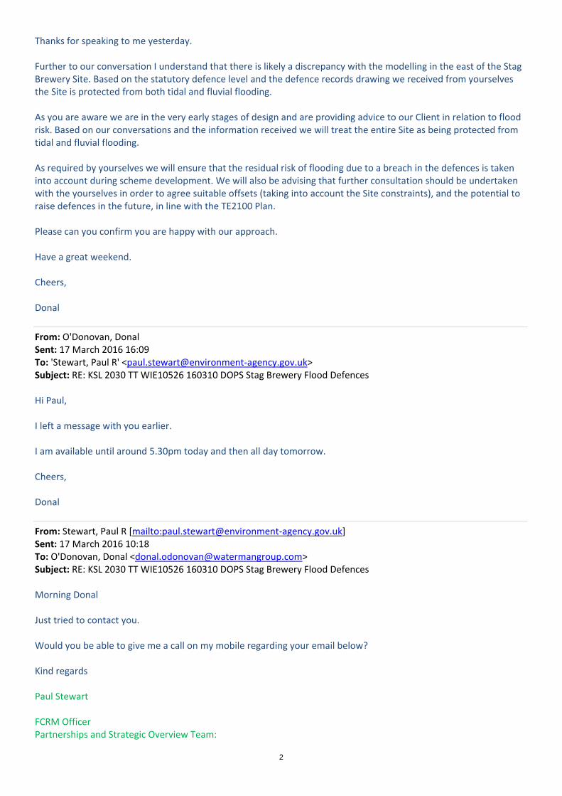
2
Thanks for speaking to me yesterday. Further to our conversation I understand that there is likely a discrepancy with the modelling in the east of the Stag Brewery Site. Based on the statutory defence level and the defence records drawing we received from yourselves the Site is protected from both tidal and fluvial flooding. As you are aware we are in the very early stages of design and are providing advice to our Client in relation to flood risk. Based on our conversations and the information received we will treat the entire Site as being protected from tidal and fluvial flooding. As required by yourselves we will ensure that the residual risk of flooding due to a breach in the defences is taken into account during scheme development. We will also be advising that further consultation should be undertaken with the yourselves in order to agree suitable offsets (taking into account the Site constraints), and the potential to raise defences in the future, in line with the TE2100 Plan. Please can you confirm you are happy with our approach. Have a great weekend. Cheers, Donal
From: O'Donovan, Donal Sent: 17 March 2016 16:09 To: 'Stewart, Paul R' <paul.stewart@environment‐agency.gov.uk> Subject: RE: KSL 2030 TT WIE10526 160310 DOPS Stag Brewery Flood Defences Hi Paul, I left a message with you earlier. I am available until around 5.30pm today and then all day tomorrow. Cheers, Donal
From: Stewart, Paul R [mailto:paul.stewart@environment‐agency.gov.uk] Sent: 17 March 2016 10:18 To: O'Donovan, Donal <[email protected]> Subject: RE: KSL 2030 TT WIE10526 160310 DOPS Stag Brewery Flood Defences Morning Donal Just tried to contact you. Would you be able to give me a call on my mobile regarding your email below? Kind regards Paul Stewart FCRM Officer Partnerships and Strategic Overview Team:

3
SW London and Mole Environment Agency Orchard House Endeavour Park London Road Addington, West Malling Kent, ME19 5SH Tel: 01732 223165 Mob: 07825016304 The flood defence consents are moving to Environmental Permitting Regulations. You can read more about it here. We are also seeking views on proposed changes to charges for permitting flood risk activities. You can view the consultation document and send us comments via our webpage.
From: O'Donovan, Donal [mailto:[email protected]] Sent: 10 March 2016 10:09 To: Stewart, Paul R Cc: Thorogood, Tony; Martyn, Joe; McCabe, Sophie G T Subject: KSL 2030 TT WIE10526 160310 DOPS Stag Brewery Flood Defences Hi Paul, Thanks for speaking to me yesterday. As discussed, having reviewed the 2009 Teddington Fluvial Flood Risk modelling report you kindly sent over, it appears that the fluvial flood levels at node 2.16 (adjacent to the Stag Brewery Site) are lower than the existing flood defences. In the defended scenario the model report states that the 1 in 100 year flood level at node 2.16 is 3.17m AOD. The results also show that the 1 in 1000 year plus climate change (40%) level is 5.46m AOD. According to the Product 4 we received for the Site and the defence record drawings, the defences in this location are set at 5.94m AOD and the Site would therefore be protected from fluvial flooding. Please can you confirm this. I understand that this may be due to the defences being identified as tidal defences and therefore they may not have been modelled as part of the fluvial model. However, in reality they would provide protection from both tidal and fluvial flooding. You also mentioned that Kent and South London would be issuing a statement regarding the new climate changes allowances. Will this be published online or will we need to contact yourselves to obtain a copy of this? If you have any questions please feel free to give me a call. Cheers, Donal C. Donal O’Donovan Engineer Waterman Infrastructure & Environment Ltd Pickfords Wharf | Clink Street | London SE1 9DG t +44 207 928 7888 | d +44 3300 602 316 www.watermangroup.com | LinkedIn | Twitter Please consider the environment before printing this e‐mail. Thank you!
4
From: Stewart, Paul R [mailto:paul.stewart@environment‐agency.gov.uk] Sent: 08 March 2016 15:10 To: O'Donovan, Donal <[email protected]> Cc: Thorogood, Tony <tony.thorogood@environment‐agency.gov.uk>; Martyn, Joe <joseph.martyn@environment‐agency.gov.uk> Subject: KSL 2030 TT Stag Brewery Flood Risk Enquiry Afternoon Donal Please find attached the 2009 Teddington Fluvial Flood Risk modelling report and a copy of our Standard Notice. Flood levels can be found in Appendix E. Information regarding the new climate change allowances can be found at: https://www.gov.uk/guidance/flood‐risk‐assessments‐climate‐change‐allowances We strongly recommend you discuss the proposals for the site with us prior to submitting any planning application. Any works in, under, over or within 16m of the Tidal Thames Flood defences will also require prior written consent from us under the terms of the Water Resources Act 1991 and Thames Region Land Drainage Byelaws 1981. If you have any further questions please do not hesitate to contact myself on the details below. Kind regards Paul Stewart FCRM Officer Partnerships and Strategic Overview Team: SW London and Mole Environment Agency Orchard House Endeavour Park London Road Addington, West Malling Kent, ME19 5SH Tel: 01732 223165 Mob: 07825016304 The flood defence consents are moving to Environmental Permitting Regulations. You can read more about it here. We are also seeking views on proposed changes to charges for permitting flood risk activities. You can view the consultation document and send us comments via our webpage.
From: KSL Enquiries Sent: 03 March 2016 13:46 To: Stewart, Paul R Subject: FW: FAO Tony Thorogood KSL 2030 TT Stag Brewery Flood Risk Enquiry
Hi Paul, Thanks for your help with this one, cheers Tony

5
Kind Regards, Tony Thorogood Tony Thorogood | Customers and Engagement Officer | Kent and South London Environment Agency | Orchard House | Endeavour Park | London Road | West Malling | Kent | ME19 5SH Internal: 723-3109 External: 01732 223109 [email protected] We would be really grateful if you could spare five minutes to help us improve our service. Please click on the link below and fill in our survey – we use every piece of feedback we receive: http://www.smartsurvey.co.uk/s/EnvironmentAgencyCustomerSurvey/?a=KSL
From: O'Donovan, Donal [mailto:[email protected]] Sent: 03 March 2016 11:21 To: KSL Enquiries Subject: FAO Tony Thorogood KSL 2030 TT Stag Brewery Flood Risk Enquiry Hi Tony, I just tried to call but you were away from your desk, I spoke to one of your colleagues instead. I have been looking in more detail at the area in the east of the Stag Brewery Site that is shown to be in an area not benefiting from defences. The updated response indicates that whilst this area is defended from tidal flooding, it is not defended up to the 1 in 100 year fluvial standard, and can therefore not be shown to be benefiting from defences. Can you please provide further information about the fluvial flooding mechanism. I would like to understand where the flooding is from. As I cannot see any other watercourses in the area, would I be right in saying that the fluvial flooding comes from the Thames. If this is the case then I assume the fluvial flood levels are higher than the tidal flood levels and therefore overtop the defences in this location. Any further information you can provide to clarify the situation would be much appreciated. It might be easier if I speak to either you or the mapping team on the phone to chat through. Cheers, Donal C. Donal O’Donovan Engineer Waterman Infrastructure & Environment Ltd Pickfords Wharf | Clink Street | London SE1 9DG t +44 207 928 7888 | d +44 3300 602 316 www.watermangroup.com | LinkedIn | Twitter Please consider the environment before printing this e‐mail. Thank you!
6
From: KSL Enquiries [mailto:KSLE@environment‐agency.gov.uk] Sent: 29 February 2016 15:19 To: O'Donovan, Donal <[email protected]> Subject: SUPPLEMENTARY QUERY KSL 2030 TT Stag Brewery Flood Risk Enquiry
Hi Donal, Please find amended product 4 for your site, apologies for the error in the original. Subject to the conditions in the attached standard notice. Kind Regards, Tony Thorogood Tony Thorogood | Customers and Engagement Officer | Kent and South London Environment Agency | Orchard House | Endeavour Park | London Road | West Malling | Kent | ME19 5SH Internal: 723-3109 External: 01732 223109 [email protected] We would be really grateful if you could spare five minutes to help us improve our service. Please click on the link below and fill in our survey – we use every piece of feedback we receive: http://www.smartsurvey.co.uk/s/EnvironmentAgencyCustomerSurvey/?a=KSL
From: O'Donovan, Donal [mailto:[email protected]] Sent: 18 February 2016 16:04 To: KSL Enquiries Subject: FAO Toby WIE10667 160218 DOEA Stag Brewery Flood Risk Enquiry Hi Toby, Further to our conversation a moment ago please can you query why the TE2100 flood levels for node 2.16 are missing from the Product 4 supplied to me. Cheers, Donal
From: KSL Enquiries [mailto:KSLE@environment‐agency.gov.uk] Sent: 17 February 2016 15:44 To: O'Donovan, Donal <[email protected]> Subject: RE: 2030 TT Stag Brewery Flood Risk Enquiry

7
Dear Donal,
RE: 2030 TT Stag Brewery Flood Risk Enquiry Thank you for your enquiry which was received on 22 January 2016 and subsequent payment received on 02 February 2016. (VAT receipt attached.) We respond to requests under the Freedom of Information Act 2000 and Environmental Information Regulations 2004. Responses are in red after questions.
1. The Environment Agency mapping shows that the Site lies within Flood Zones 2 and 3, and is generally shown as being defended The River Thames defences are identified as being continuous in this location, please could you confirm that the Site is fully defended from tidal and fluvial flooding. Could you please provide a more detailed Flood Zone map? Please see attached product 4
2. Interrogation of the online flood maps show that despite the Site lying within Flood Zone 3, there is a ‘low’ likelihood of flooding occurring. Please could you confirm this. Please see attached product 4
3. The Stag Brewery SPD sets out the planning brief for potential development at the
Site. Please could you confirm that the Sequential Test has therefore been passed. You will need to discuss this with the Local Authority
4. Please could you provide the EA breach modelling results (including the map, flood levels
and flood hazard mapping) and modelled flood levels at/in the vicinity of the Site. Please provide all flood levels, with and without climate change, for the River Thames at this location. Please see attached product 4
5. As it is very early in the decision process it is currently unknown where development would be located. However, the design would ensure that appropriate mitigation steps would be incorporated. In line with other Sites within London we currently assume that commercial and retail (‘less vulnerable’) uses would be acceptable on the ground floor. We also assume that duplex residential uses would be acceptable on the ground and first floor (bedrooms location on the first floor), as a means of egress would be available to ensure safety. Please could you confirm this. We will further consul once the scheme plans have evolved. You will need to assess the risks of this approach in your FRA and check if there’s any specific local policies.
6. Please could you confirm the statutory defence level and condition of the flood defences for
this reach of the River? Please see attached product 4
7. Please could you confirm your maintenance regime for the River Thames defences, including how often these are inspected and how this is undertaken. Please see attached product 4
8. Please could you provide the flood defence technical drawings (sections/plans/elevations) for this stretch of the River. Documents we hold are attached
9. Could you please provide a map showing the location of any Main River channels or Ordinary Watercourses near the Site, and note any development restrictions that would therefore apply. Please could you also provide your ‘lost rivers’ mapping in the vicinity. Available information in the attached product 4
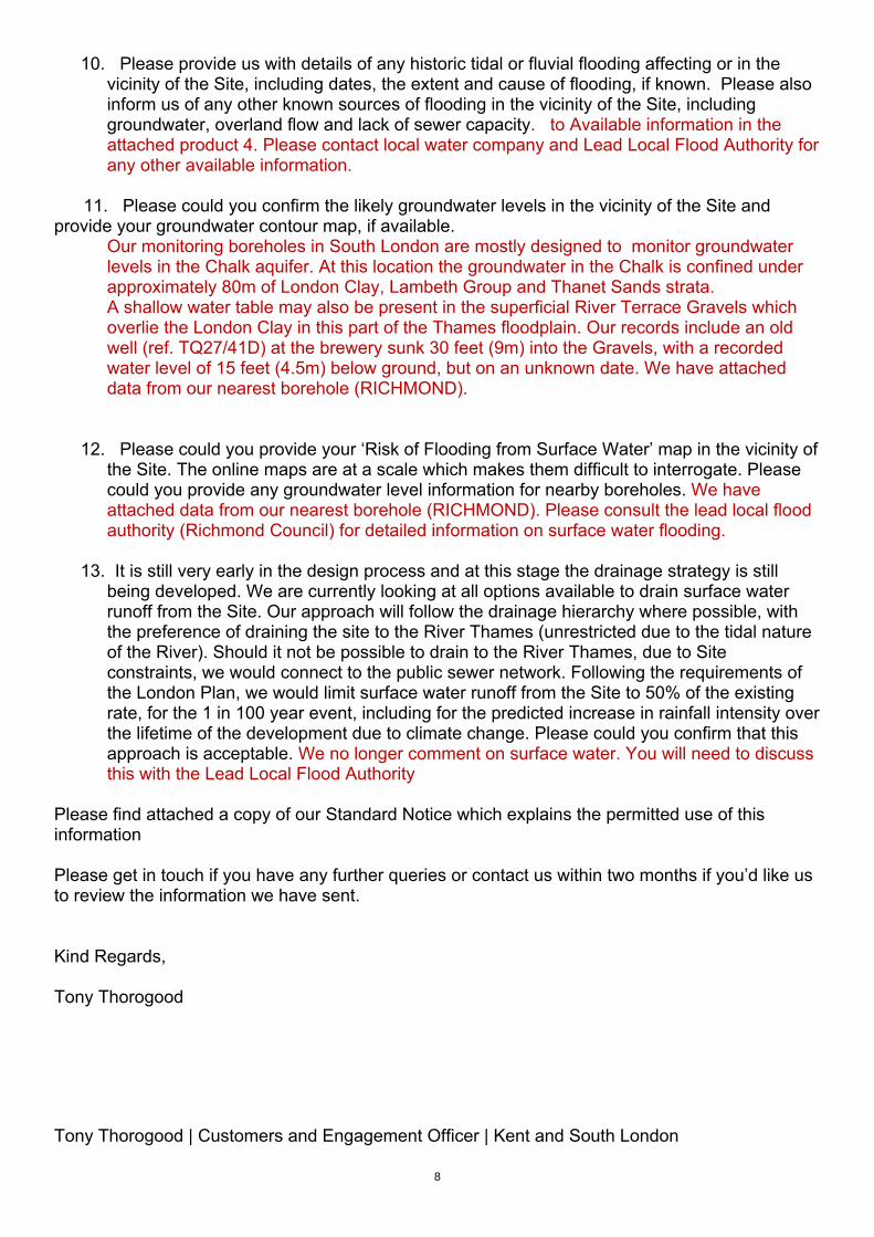
8
10. Please provide us with details of any historic tidal or fluvial flooding affecting or in the vicinity of the Site, including dates, the extent and cause of flooding, if known. Please also inform us of any other known sources of flooding in the vicinity of the Site, including groundwater, overland flow and lack of sewer capacity. to Available information in the attached product 4. Please contact local water company and Lead Local Flood Authority for any other available information.
11. Please could you confirm the likely groundwater levels in the vicinity of the Site and provide your groundwater contour map, if available.
Our monitoring boreholes in South London are mostly designed to monitor groundwater levels in the Chalk aquifer. At this location the groundwater in the Chalk is confined under approximately 80m of London Clay, Lambeth Group and Thanet Sands strata. A shallow water table may also be present in the superficial River Terrace Gravels which overlie the London Clay in this part of the Thames floodplain. Our records include an old well (ref. TQ27/41D) at the brewery sunk 30 feet (9m) into the Gravels, with a recorded water level of 15 feet (4.5m) below ground, but on an unknown date. We have attached data from our nearest borehole (RICHMOND).
12. Please could you provide your ‘Risk of Flooding from Surface Water’ map in the vicinity of the Site. The online maps are at a scale which makes them difficult to interrogate. Please could you provide any groundwater level information for nearby boreholes. We have attached data from our nearest borehole (RICHMOND). Please consult the lead local flood authority (Richmond Council) for detailed information on surface water flooding.
13. It is still very early in the design process and at this stage the drainage strategy is still being developed. We are currently looking at all options available to drain surface water runoff from the Site. Our approach will follow the drainage hierarchy where possible, with the preference of draining the site to the River Thames (unrestricted due to the tidal nature of the River). Should it not be possible to drain to the River Thames, due to Site constraints, we would connect to the public sewer network. Following the requirements of the London Plan, we would limit surface water runoff from the Site to 50% of the existing rate, for the 1 in 100 year event, including for the predicted increase in rainfall intensity over the lifetime of the development due to climate change. Please could you confirm that this approach is acceptable. We no longer comment on surface water. You will need to discuss this with the Lead Local Flood Authority
Please find attached a copy of our Standard Notice which explains the permitted use of this information Please get in touch if you have any further queries or contact us within two months if you’d like us to review the information we have sent. Kind Regards, Tony Thorogood Tony Thorogood | Customers and Engagement Officer | Kent and South London

9
Environment Agency | Orchard House | Endeavour Park | London Road | West Malling | Kent | ME19 5SH Internal: 723-3109 External: 01732 223109 [email protected] We would be really grateful if you could spare five minutes to help us improve our service. Please click on the link below and fill in our survey – we use every piece of feedback we receive: http://www.smartsurvey.co.uk/s/EnvironmentAgencyCustomerSurvey/?a=KSL
Information in this message may be confidential and may be legally privileged. If you have received this message by mistake, please notify the sender immediately, delete it and do not copy it to anyone else. We have checked this email and its attachments for viruses. But you should still check any attachment before opening it. We may have to make this message and any reply to it public if asked to under the Freedom of Information Act, Data Protection Act or for litigation. Email messages and attachments sent to or from any Environment Agency address may also be accessed by someone other than the sender or recipient, for business purposes. Click here to report this email as spam
Waterman Group is a multidisciplinary consultancy providing sustainable solutions to meet the planning, engineering design and project delivery needs of the property, infrastructure, environment and energy markets.
This message contains confidential information and is intended only for the individual named. If you are not the named addressee you should not disseminate, distribute or copy this email. Please notify the sender immediately if you have received this email by mistake and delete it from your system. Email transmission cannot be guaranteed to be secure or error-free as information could be intercepted, corrupted, delayed, lost, destroyed, incomplete, or contain viruses. The sender does not accept liability for any errors or omissions in the contents of this message, which arise as a result of email transmission. All reasonable precautions have been taken to see that no viruses are present in this email. Waterman Group cannot accept liability for loss, disruption or damage however caused, arising from the use of this email or attachments and recommend that you subject these to virus checking procedures prior to use. Email messages may be monitored and by replying to this message the recipient gives their consent to such monitoring.
Waterman Group Plc., Pickfords Wharf, Clink Street, London SE1 9DG, is a company registered in England and Wales with company registration number 2188844. This message has been scanned and no issues discovered. Click here to report this email as spam Information in this message may be confidential and may be legally privileged. If you have received this message by mistake, please notify the sender immediately, delete it and do not copy it to anyone else. We have checked this email and its attachments for viruses. But you should still check any attachment before opening it. We may have to make this message and any reply to it public if asked to under the Freedom of Information Act, Data Protection Act or for litigation. Email messages and attachments sent to or from any Environment Agency address may also be accessed by someone other than the sender or recipient, for business purposes. Click here to report this email as spam

10
This message has been scanned and no issues discovered. Click here to report this email as spam Information in this message may be confidential and may be legally privileged. If you have received this message by mistake, please notify the sender immediately, delete it and do not copy it to anyone else. We have checked this email and its attachments for viruses. But you should still check any attachment before opening it. We may have to make this message and any reply to it public if asked to under the Freedom of Information Act, Data Protection Act or for litigation. Email messages and attachments sent to or from any Environment Agency address may also be accessed by someone other than the sender or recipient, for business purposes. Click here to report this email as spam This message has been scanned and no issues discovered. Click here to report this email as spam Information in this message may be confidential and may be legally privileged. If you have received this message by mistake, please notify the sender immediately, delete it and do not copy it to anyone else. We have checked this email and its attachments for viruses. But you should still check any attachment before opening it. We may have to make this message and any reply to it public if asked to under the Freedom of Information Act, Data Protection Act or for litigation. Email messages and attachments sent to or from any Environment Agency address may also be accessed by someone other than the sender or recipient, for business purposes. Click here to report this email as spam This message has been scanned and no issues discovered. Click here to report this email as spam Information in this message may be confidential and may be legally privileged. If you have received this message by mistake, please notify the sender immediately, delete it and do not copy it to anyone else. We have checked this email and its attachments for viruses. But you should still check any attachment before opening it. We may have to make this message and any reply to it public if asked to under the Freedom of Information Act, Data Protection Act or for litigation. Email messages and attachments sent to or from any Environment Agency address may also be accessed by someone other than the sender or recipient, for business purposes. Click here to report this email as spam