staff report - cabq.gov€¦ · agenda number: 05 project number: 1008444 case #s: 13epc-40159...
TRANSCRIPT

Agenda Number: 05 Project Number: 1008444
Case #s: 13EPC-40159 February 13, 2014
Environmental Planning Commission
Staff Report
Agent COA, Planning Department Staff Recommendation Applicant City of Albuquerque Recommendation of APPROVAL of 13EPC-
40159, text amendments to the West Side Strategic Plan for the Volcano Mesa community, be forwarded to the City Council based on the Findings beginning on Page 16 and subject to the Conditions of Approval beginning on Page 18.
Staff Planner
Request(s) Recommend Adoption of a text amendment to West Side Strategic Plan for Volcano Mesa community.
Legal Description See attached map
Location Area boundaries are the Petroglyph National Monument on the east, south and west and Paseo del Norte and the Atrisco Grant line on the north.
Size Approximately 3,532 acres
Existing Zoning Various Mikaela Renz-Whitmore, Planner
CITY OF ALBUQUERQUE ENVIRONMENTAL PLANNING COMMISSION PLANNING DEPARTMENT Project #: 1008444 Case #: 13EPC-40159 URBAN DESIGN AND DEVELOPMENT DIVISION February 13th, 2014 Page 1
Summary of Analysis The Planning Department requests an Environmental Planning Commission (EPC) recommendation to City Council to approve text amendments to the West Side Strategic Plan (WSSP) for the Volcano Mesa community. Volcano Mesa covers approximately 3,532 acres and is surrounded on three sides by more than 7,000 acres of open space under City, State and Federal jurisdictions, including land the U.S. Congress set aside as Petroglyph National Monument in 1990. Volcano Mesa was first identified in an amendment to the West Side Strategic Plan in February 2011, which provided guidance for future development in this unique context, with rich cultural, geological, and historical significance. Subsequently, three sector development plans have been adopted for the area, each with similar policy underpinnings: Volcano Cliffs (May 2011), Volcano Trails (August 2011), and Volcano Heights (August 2013). The amendment’s purpose is to update the transportation network map based on changes and refinements adopted with the Volcano Heights Sector Development Plan in August 2013 and update policies related to Activity Centers based on an update to the Albuquerque-Bernalillo County Comprehensive Plan in August 2013.
City Departments and other interested agencies reviewed this application from 12/30/2013 to 01/10/2014. Agency comments used in the preparation of this report begin on Page 20.
I. INTRODUCTION Request
The City of Albuquerque Planning Department requests amendments to the Rank 2 West Side Strategic Plan (WSSP) for Volcano Mesa to update the road network map and associated language, as well as language related to Volcano Heights Major Activity Center and Volcano Cliffs Neighborhood Activity Center.
Purpose/Intent
This request is a Planning Department-led initiative to update the document based on planning efforts subsequent to the last update to the WSSP adopting policies for the Volcano Mesa community planning area.
Environmental Planning Commission (EPC) Role
The EPC’s role in this case is quasi-judicial, as the EPC is a recommending body for text amendments to Rank 2 Plans, which are officially adopted by the City Council.

CITY OF ALBUQUERQUE ENVIRONMENTAL PLANNING COMMISSION PLANNING DEPARTMENT Project #: 1008444 Case #: 13EPC-40159 URBAN DESIGN AND DEVELOPMENT DIVISION February 13th, 2014 Page 2
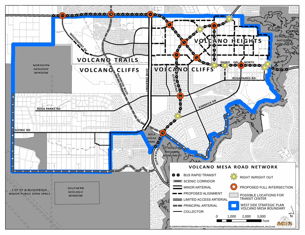
II. PROPOSED TEXT AMENDMENTS 1) Exhibit 10: Update road network map with Primary Streets and intersections as adopted in
the Volcano Heights SDP.
Following the original intent of the Volcano plans, this change provides a consistent road network for Volcano Mesa, incorporating streets in the Volcano Heights SDP as well as updates made to access points on the limited-access Paseo del Norte and Unser Boulevard through the Metropolitan Planning Organization. [NOTE: Please see agency comments and Conditions of Approval for additional change.]
2) Policy 3.95: Edit language as follows to reflect the recent update of the Centers and Corridors map in the Albuquerque-Bernalillo County Comprehensive Plan, which designated Volcano Heights as a Major Activity Center: “Volcano Heights Major Activity Center. Volcano Heights should develop as a Major Activity Center. Volcano Heights provides an opportunity to address the jobs/housing imbalance in the area and will serve the region with employment, commercial, service, and retail opportunities. Development should prioritize employment and non-residential land uses to serve the predominantly residential areas nearby.”
Since the adoption of this Rank 2 amendment to the WSSP, the Volcano Heights Sector Development Plan was adopted, changing zoning to support a mixed-use, walkable district that can support employment, commercial, service, and retail opportunities, as well as higher-density residential areas. In addition, the most recent update of the Comprehensive Plan edited the Centers and Corridors map to include all but the Transition Zones within Volcano Heights as a Major Activity Center. The VHSDP does not have a mechanism to ensure that the area does not develop exclusively for residential uses; therefore, this policy would provide more guidance to emphasize employment and non-residential opportunities. [NOTE: This is an additional amendment added post-EPC submittal. See also Conditions of Approval.]
3) Policy 3.97: Edit the language as follows to designate the Village Center in Volcano Cliffs as a Neighborhood Activity Center: “Volcano Cliffs Neighborhood Activity Center. The Volcano Cliffs Village Center shall be designated as a Neighborhood Activity Center.”
Now that Volcano Cliffs SDP has been adopted and changed the zoning to create a Village Center, it is appropriate for this Rank 2 plan to designate it as a Neighborhood Activity Center. The Comprehensive Plan’s Centers and Corridors map only pertains to Community Activity Centers and Major Activity Centers. The policy justification for this Neighborhood Activity Center is still valid: “The Volcano Cliffs Village Center provides an opportunity to provide daily services, convenience goods and personal services to the residential area that surrounds it. It is centrally located to the Volcano Cliffs area, is located at the junction of a minor arterial (Universe) and a collector (Rosa Parks) and is therefore well placed to serve the community. The proximity of the area to the Volcano Vista High School and the Tony Hillerman Middle School also make

CITY OF ALBUQUERQUE ENVIRONMENTAL PLANNING COMMISSION PLANNING DEPARTMENT Project #: 1008444 Case #: 13EPC-40159 URBAN DESIGN AND DEVELOPMENT DIVISION February 13th, 2014 Page 3
this a logical location.” [NOTE: This is an additional amendment added post-EPC submittal. See also Conditions of Approval.]
4) Policy 1.110: Edit the language as follows to reflect the approved access points on the limited-access Paseo del Norte and Unser Boulevards:
“Access points on Paseo del Norte and Unser Boulevard should be limited to those shown in Exhibit 10, Road Network Map. When constructed, intersections should be carefully designed with multimodal accommodations to ensure safe access for pedestrians and cyclists to enhance the connectivity and walkability of this Major Activity Center, balanced with minimizing delay for regional through traffic.”
In the narrative justification below the policy, replace “proposed” with “approved” wherever it appears.
Add the following sentences at the end:
“When constructed, these intersections will need to provide safe accommodations for all modes of traffic. Because the Major Activity Center is to some extent divided into quadrants by these limited-access roadways, the intersections provide critical connection points to unite these quadrants into a district. Safe intersection crossings for pedestrians and cyclists, together with other possible enhancements such as shuttles or circulators, will be key to supporting the area’s success as a Major Activity Center, with employment, retail, and entertainment uses in a walkable, urban district. Balancing these considerations with the need to minimize travel delays for significant levels of regional through-traffic will be vital.”
The requested language reflects the more recent approval of access points by the Transportation Coordination Committee of the Metropolitan Planning Board (see TCC R-13-02). Additional language on multimodal intersection design matches the policy language in the TCC resolution regarding the intersection at Paseo del Norte and Unser Boulevard as well as policy language about intersection design in the Volcano Heights Sector Development Plan (see Section 10.5.4(i) on page 170). [NOTE: This is an additional amendment added post-EPC submittal. See also Conditions of Approval.]

CITY OF ALBUQUERQUE ENVIRONMENTAL PLANNING COMMISSION PLANNING DEPARTMENT Project #: 1008444 Case #: 13EPC-40159 URBAN DESIGN AND DEVELOPMENT DIVISION February 13th, 2014 Page 4
III. Background and History In 2004, the Albuquerque City Council initiated a planning process for the Volcano Mesa area of the city, located along the volcanic escarpment of the city’s Northwest Mesa. This area’s unique features and special characteristics and conditions warranted special analysis and policies to ensure its protection. Development on private property surrounded by the Petroglyph National Monument and other Major Public Open Space needed to respect the sensitive nature of this context.
A sector plan was adopted in 2006, but it was challenged in court by the Volcano Cliffs Property Owners Association and was remanded to the City in 2008/9. In February 2011, the City amended the West Side Strategic Plan (WSSP) to include policies to guide development within Volcano Mesa, which was divided into three distinct but related sector development plan (SDP) areas: Volcano Cliffs to the south, Volcano Trails to the west, and Volcano Heights to the east. Volcano Cliffs SDP was adopted next in May 2011 with widespread support. Volcano Trails SDP contained many of the same regulations, which were further analyzed and refined prior to its adoption in August 2011. Volcano Heights SDP, which also started with many of the same regulations in its initial 2010 draft, was significantly revised by a new consultant and adopted in August 2013. Because Volcano Heights surrounds the intersection of the limited-access Paseo del Norte and Unser Boulevard – two vital regional arterials – it was expected that the transportation network originally proposed for Volcano Mesa in the WSSP amendment would need to be revised subsequent to further analysis and planning efforts for the Volcano Heights SDP. As part of those efforts, the City requested and received access modifications to allow additional intersections within the Volcano Mesa area, many to provide the high level of access and connectivity to support the Major Activity Center proposed in Volcano Heights. In addition, the cross sections first developed in conjunction with the WSSP Volcano Mesa amendment were analyzed, refined, and included in a traffic study for the Volcano Heights area. These revisions need to be incorporated and adopted into the WSSP Volcano Mesa amendment and the Volcano Cliffs SDP.
Context The Volcano Mesa community covers approximately 3,532 acres. The area is surrounded on three sides by more than 7,000 acres of open space under City, State and Federal jurisdictions. The shape of the open space holdings includes large tracts and long, narrow bands of escarpment. The Volcano Mesa area includes portions of the land the U.S. Congress set aside as Petroglyph National Monument in 1990. From east to west, the Volcano Mesa area extends from the volcanic escarpment to the Major Public Open Space surrounding five dormant volcanoes. From north to south, the Volcano Mesa area extends from south of the Atrisco Grant line and Paseo del Norte to the Petroglyph National

CITY OF ALBUQUERQUE ENVIRONMENTAL PLANNING COMMISSION PLANNING DEPARTMENT Project #: 1008444 Case #: 13EPC-40159 URBAN DESIGN AND DEVELOPMENT DIVISION February 13th, 2014 Page 5
Monument. The Volcano Mesa area’s boundary also includes a small area of unincorporated Bernalillo County land, in the Petroglyph National Monument’s North Geological Window. The Volcano Mesa area’s cultural, natural and built conditions were used to inform the planning process and to guide the development of policies that are sensitive and responsive to the area’s unique needs, challenges and opportunities.
Surrounding zoning, plan designations, and land uses:
Zoning Comprehensive Plan Area; Applicable Rank II & III Plans
Land Use
Site Various Developing Urban, Established Urban, Reserve
West Side Strategic Plan (WSSP)
Northwest Mesa Escarpment Plan (NWMEP)
Vacant, residential, City Major Public Open Space, State land and APS school sites.
North RLT, SU-1 C2, R2, SU-1 PRD, A1 (County)
Established and Developing Urban, WSSP, NWMEP
Residential, APS school site
South R1, RO-20 Reserve, WSSP, NWMEP City Major Public Open Space
East RO-20, SU-1 PRD, SU-1 C1, R1
Established Urban, WSSP, NWMEP
Petroglyph National Monument- Federal
West RO-20, A-1 (County) Reserve, WSSP, NWMEP City Major Public Open Space
Transportation System The Long Range Roadway System (LRRS) map, produced by the Mid-Region Council of Governments (MRCOG), identifies the functional classifications of roadways.
The LRRS designates Unser and Paseo del Norte as a Limited-Access Principal Arterials, with rights-of-way of 156 feet.
The Long Range Roadway System designates Universe as a Minor Arterial, with a right-of-way of 86 feet.
The Long Range Roadway System designates Rainbow as a Principal Arterial, with a right-of-way of 124' (Established & Developing Urban) or 156' (elsewhere).
CITY OF ALBUQUERQUE ENVIRONMENTAL PLANNING COMMISSION PLANNING DEPARTMENT Project #: 1008444 Case #: 13EPC-40159 URBAN DESIGN AND DEVELOPMENT DIVISION February 13th, 2014 Page 6
Comprehensive Plan Corridor Designation The Albuquerque/Bernalillo Comprehensive Plan designates Paseo del Norte and Unser Boulevard as Proposed Express Corridors.
Trails/Bikeways A bike trail and or lane are proposed for Paseo del Norte and Unser. A bike trail is shown on Gila Road on the MRCOG Long Range Bikeway map.
Transit The MRCOG High Capacity Transit map shows Paseo del Norte and Unser as Potential High Capacity Transit Corridors.
CITY OF ALBUQUERQUE ENVIRONMENTAL PLANNING COMMISSION PLANNING DEPARTMENT Project #: 1008444 Case #: 13EPC-40159 URBAN DESIGN AND DEVELOPMENT DIVISION February 13th, 2014 Page 7
IV. ANALYIS OF APPLICABLE ORDINANCES, PLANS, AND POLICIES Note: Policy citations are in regular text; staff analysis is in Bold Italics.
Charter of the City of Albuquerque
The Citizens of Albuquerque adopted the City Charter in 1971. Applicable articles include: Article I, Incorporation and Powers
“The municipal corporation now existing and known as the City of Albuquerque shall remain and continue to be a body corporate and may exercise all legislative powers and perform all functions not expressly denied by general law or charter. Unless otherwise provided in this Charter, the power of the city to legislate is permissive and not mandatory. If the city does not legislate, it may nevertheless act in the manner provided by law. The purpose of this Charter is to provide for maximum local self government. A liberal construction shall be given to the powers granted by this Charter.” (emphasis added)
Article IX, Environmental Protection
“The Council (City Commission) in the interest of the public in general shall protect and preserve environmental features such as water, air and other natural endowments, ensure the proper use and development of land, and promote and maintain an aesthetic and humane urban environment. To affect these ends the Council shall take whatever action is necessary and shall enact ordinances and shall establish appropriate Commissions, Boards or Committees with jurisdiction, authority and staff sufficient to effectively administer city policy in this area.”
Clarification of a Rank 2 land use policy plan is an exercise in local self-government and falls within the City’s powers (City Charter, Article I). The text amendments of the WSSP “ensure the proper use and development of land, and promote and maintain an aesthetic and humane urban environment.” (City Charter, Article IX).
Staff finds that the request is consistent with the City Charter.
Rank 1 Albuquerque / Bernalillo County Comprehensive Plan The Comprehensive Plan, the Rank 1 planning document for the City, contains goals and policies that provide a framework for development and service provision. The Plan’s goals and policies serve as a means to evaluate development proposals and requests for text amendments.
Volcano Mesa includes areas designated as Developing and Established Urban by the Comprehensive Plan. Applicable goals and policies include:
II.B.5 DEVELOPING AND ESTABLISHED URBAN AREAS: The goal is to create a
quality urban environment, which perpetuates the tradition of identifiable, individual but integrated communities within the metropolitan area and which offers variety and maximum choice in housing, transportation, work areas, and life styles, while creating a visually pleasing built environment.

CITY OF ALBUQUERQUE ENVIRONMENTAL PLANNING COMMISSION PLANNING DEPARTMENT Project #: 1008444 Case #: 13EPC-40159 URBAN DESIGN AND DEVELOPMENT DIVISION February 13th, 2014 Page 8
II B 5 Developing and Established Urban Areas, Policy c: Where needed to guide more detailed
planning, major portions of the Established Urban Area and Developing Urban Area and adjacent Plan map areas shall be formed into districts for rank two area planning which should use the following process (excerpted): • Determine activity center appropriateness and character for each area in coordination
with the area wide Activity Centers implementation planning program.
The proposed amendment to the WSSP would designate a Neighborhood Activity Center in Volcano Cliffs. Currently, the language recommends a designation. The sector plan mentions the neighborhood activity center for the area zoned SU-2/VCVC (Volcano Cliffs Village Center). This change would activate the intended designation, which could help implement the vision. The proposed amendment would also be updated to reflect the recent designation of Volcano Heights as a Major Activity Center by the Comprehensive Plan.
II B 5 Developing and Established Urban Areas, Policy k: Land adjacent to arterial streets shall
be planned to minimize harmful effects of traffic; livability and safety of established residential neighborhoods shall be protected in transportation planning and operation.
The Volcano Mesa amendment to the WSSP contains policy 3.110, calling for the adoption of a road network map to plan for adequate connections between residential areas and surrounding non-residential development. The proposed amendments seek to update the road network map to reflect changes in Volcano Heights. Further, proposed amendments update the series of cross sections showing how different roads should be planned within that road network. The cross sections are carefully assigned to street designations so that the streets and proposed land uses are compatible. The majority of streets include planting strips and wide sidewalks and trails to create a safe and attractive pedestrian, bicycling and driving environment.
II.B.7 ACTIVITY CENTERS: The goal is to expand and strengthen concentrations of
moderate and high-density mixed land use and social/economic activities that reduce urban sprawl, auto travel needs, and service costs, and which enhance the identity of Albuquerque and its communities.
The proposed amendments to the transportation network help to coordinate land use and transportation in order to support the zoning schemes within Volcano Cliffs and Volcano Heights, which include zones with varying residential densities surrounding the Activity Centers as well as other mixed-use areas. Amendments to the transportation standards include a map designating streets in coordination with the proposed land uses abutting them and cross sections that include elements to provide appropriate amenities based on their intended use, either primarily serving auto traffic or providing multi-modal amenities for pedestrians and cyclists, as well as drivers.

CITY OF ALBUQUERQUE ENVIRONMENTAL PLANNING COMMISSION PLANNING DEPARTMENT Project #: 1008444 Case #: 13EPC-40159 URBAN DESIGN AND DEVELOPMENT DIVISION February 13th, 2014 Page 9
These transportation amendments, in conjunction with the land uses entitled by the zoning, provide opportunities to reduce sprawl, auto travel needs and provide retail, service and office needs closer to residences.
II B 7 Activity Centers Policy e: New Activity Centers may be designated and added to the Comprehensive Plan through local government review and approval based upon the following criteria:
• The proposed Activity Center’s potential for shaping the built environment, consistent with policies of the Comprehensive Plan.
• Market potential for concentrating activities to higher than average intensities, and potential for promoting infill of vacant land inside the existing urban services boundary.
• Appropriateness of the proposed Activity Center, including location relative to the market area and access/connections including transit service potential.
• Fiscal impact of the proposed Activity Center on City government and the private sector. • Compatibility of the proposed Activity Center with surrounding neighborhoods. • Capacity and availability of public services such as transportation, water, and sewer
systems to support the Activity Center as proposed. • Environmental impact of the proposed Activity Center.
The Major Activity Center first proposed as part of the Volcano Mesa amendment to the WSSP and recommended in the Volcano Heights SDP is consistent with policies in the Comprehensive Plan, has the potential to address the imbalance of jobs to housing on the Westside, has a wide market area and includes transit potential. A transit center is proposed to be the hub of the Town Center, serving not only Bus Rapid Transit on Paseo del Norte and Unser but also a local transit network. The proposed Major Activity Center is compatible with the surrounding neighborhoods, as it has the most intense land use and density located in the center, with the less intense land use and density radiating out from that point. The Neighborhood Activity Center is also consistent with the Comprehensive Plan and is intended to serve as a central location for higher intensity activities and commercial and service uses. Located at the confluence of three major roadways – Unser, Rainbow, and Universe Boulevards – the Village Center is well situated to be served by transit and accessed by foot and bicycle, as well as by car.
II C 9 COMMUNITY IDENTITY AND URBAN DESIGN: The goal is to preserve and enhance the natural and built characteristics, social, cultural and historical features that identify Albuquerque and Bernalillo County sub-areas as distinct communities and collections of neighborhoods.
II C 9 Community Identity and Urban Design, Policy b: (excerpted)

CITY OF ALBUQUERQUE ENVIRONMENTAL PLANNING COMMISSION PLANNING DEPARTMENT Project #: 1008444 Case #: 13EPC-40159 URBAN DESIGN AND DEVELOPMENT DIVISION February 13th, 2014 Page 10
In each Community Area, strategic planning, neighborhood planning, development and redevelopment shall be evaluated in light of its relationship to and effect upon the following: 2) Built environment
- Road widths, sidewalks, curb cuts, medians - Grain of streets/size of parcels - Patterns of movement (e.g. pedestrian connections, access to transportation/transit)
Amendments to the transportation network together with proposed amendments to transportation standards in the Volcano Cliffs and Volcano Heights SDPs ensure road widths and street configuration appropriate to context and proposed land uses and densities. The roadway network is planned in coordination with the Major Activity Center in Volcano Heights and Neighborhood Activity Center in Volcano Cliffs as transit-supportive developments that offer mixed-use development opportunities in walkable districts.
II C 9 Community Identity and Urban Design, Policy c: The identity and cohesiveness of each
community shall be strengthened through identification and enhancement of community Activity Centers that have a scale, mix of uses, design character, and location appropriate to the unique character of the community. (See also policies under “Activity Centers.”)
The Major Activity Center in Volcano Heights and the Neighborhood Activity Center in Volcano Cliffs will provide areas for the community to gather, to strengthen the community as well providing an opportunity for retail, service and office uses and to positively address the imbalance of jobs and housing on the West Side.
II C 9 Community Identity and Urban Design, Policy e: Roadway corridors (collectors, arterials,
Enhanced Transit and Major Transit) within each community and that connect the community’s Activity Centers shall be designed and developed to reinforce the community’s unique identity; streetscape improvements to these roadways shall be designed to: • minimize water use • screen parking areas • create useful and attractive signage and building facades • facilitate walking safety and convenience
Proposed transportation amendments help to ensure street designations and cross sections appropriate to proposed land use throughout Volcano Mesa. Cross sections include parking, medians, and sidewalks and trails. These amendments are planned in coordination with amendments to the Activity Centers in the Volcano Heights and Volcano Cliffs Sector Development Plans.
II D 6 ECONOMIC DEVELOPMENT: The goal is to achieve steady and diversified
economic development balanced with other important social, cultural, and environmental goals.

CITY OF ALBUQUERQUE ENVIRONMENTAL PLANNING COMMISSION PLANNING DEPARTMENT Project #: 1008444 Case #: 13EPC-40159 URBAN DESIGN AND DEVELOPMENT DIVISION February 13th, 2014 Page 11
II D 6 Economic Development, Policy a: New employment opportunities which will
accommodate a wide range of occupational skills and salary levels shall be encouraged and new jobs located convenient to areas of most need.
The Major Activity Center in Volcano Heights provides new employment opportunities for a wide range of occupations and skill levels. The Town Center is envisioned to include offices, services, and retail opportunities. The Neighborhood Activity Center in Volcano Cliffs will also provide new employment opportunities and possible locations for new small businesses.
II D 6 Economic Development, Policy g: Concentrations of employment in Activity Centers
should be promoted in an effort to balance jobs with housing and population and reduce the need to travel.
The Major Activity Center in Volcano Heights will create a concentration of employment opportunities on the West Side. This will help to alleviate some of the jobs/ housing imbalance in the area. While some future employees may live elsewhere in the Albuquerque Metropolitan area with commutes opposite of the norm, it is logical to expect that many will be West Side residents, thereby reducing their need to travel. The Volcano Cliffs Neighborhood Activity Center includes a smaller cluster of mixed use zoning in order to address neighborhood retail and service needs, as well as provide employment opportunities.
Rank 2 West Side Strategic Plan (WSSP) The West Side Strategic Plan (WSSP) was first adopted in 1997 and amended in 2002, 2009, and 2011. The WSSP area is bounded by the Sandoval County line on the north, the Rio Puerco Escarpment on the west, a line south of Gun Club Road (the Atrisco Grant line) on the south, and the Rio Grande on the east for areas north of Central, and Coors Boulevard on the east for areas south of Central. It encompasses over 96,000 acres of land, or approximately 150 square miles. Specific boundaries are shown on the Plan Boundary map on p.2 in the WSSP.
The WSSP identifies fourteen communities in established areas of the West Side that are partially developed and describes how community concepts can be applied. A Community is comprised of a Neighborhood Center(s) and Community Center(s), and the Plan outlines uses that should occur within the centers, as well as uses that should occur in areas adjacent to the centers. The WSSP emphasizes throughout its text the concept of commercial development in cluster configurations in contrast to the traditionally evolved strip commercial development. Applicable policies include:
Policy 1.1: Thirteen distinct communities, as shown on the Community Plan Map and described
individually in this Plan, shall constitute the existing and future urban form of the West Side.

CITY OF ALBUQUERQUE ENVIRONMENTAL PLANNING COMMISSION PLANNING DEPARTMENT Project #: 1008444 Case #: 13EPC-40159 URBAN DESIGN AND DEVELOPMENT DIVISION February 13th, 2014 Page 12
Communities shall develop with areas of higher density (in Community and Neighborhood Centers), surrounded by areas of lower density. Bernalillo County and the City of Albuquerque Planning Commissions shall require that high density and non-residential development occur within Community and Neighborhood Centers. Low density residential development (typical 3-5 du/acre subdivisions, or large lot rural subdivisions) shall not be approved within the Centers.
Volcano Mesa was the fourteenth community added to the WSSP in the 2011 amendment. The proposed edits are consistent with this policy, as they designate appropriate Activity Centers within Volcano Heights and Volcano Cliffs for high density residential uses and higher-intensity non-residential uses. These nodes are surrounded by lower density residential uses in both plans. (See also Comprehensive Plan Policy II.B.7.e).
Policy 1.9: In the Established and Developing Urban areas mapped by the
Albuquerque/Bernalillo County Comprehensive Plan, future neighborhood and community centers may be designated and developed at appropriate locations, determined as follows:
o Market Area – Community Centers should be located to serve a primary service area of about 30,000 people within approximately a three mile radius of the center; neighborhood centers should be located to serve approximately 15,000 population within about one mile radius of the center. Uses typical of community centers would likely be accessed on a weekly basis, whereas those in a neighborhood center might be used almost daily.
o Access/Connections – Community Centers shall be easily accessible by automobile, located at the intersections of at least one major and one minor arterial street, and connected to public transit service as well as the community-wide trail/bikeway network. Neighborhood Centers should be less automobile oriented, located on minor arterial and/or collector streets, and connected to public transit service as well as informal pedestrian and bicycle ways. Both community and neighborhood centers shall be very accommodating to the pedestrian even within predominately off-street parking areas.
o Scale – Community Centers shall be composed of blocks with buildings well connected by sidewalks and public spaces like plazas. Shared parking, through mainly off-street, should be encouraged, and larger parking areas may be divided into smaller ones or used for structured parking and/or additional active land uses. Neighborhood centers should also have small blocks, but with small clusters of shared parking as well as on-street parking. Both community and neighborhood centers shall have outdoor areas that encourage gathering; both shall include bicycle parking and both shall provide safe pedestrian connection among buildings and between buildings and parking areas. In the Reserve Area mapped by the Comprehensive Plan, neighborhood and center Plans for new Planned

CITY OF ALBUQUERQUE ENVIRONMENTAL PLANNING COMMISSION PLANNING DEPARTMENT Project #: 1008444 Case #: 13EPC-40159 URBAN DESIGN AND DEVELOPMENT DIVISION February 13th, 2014 Page 13
Communities must be provided by the developer/owner according to the Planned Community Guideline requirement.
o Location – A major facility or employer located in a manner which creates a focus and stimulus to economic and social activity may also be a reason for designating a new center.
The amendment to the WSSP for the Volcano Mesa community supports the Comprehensive Plan policies with regards to the location of a Major Activity Center in the Volcano Heights SDP area and a Village Center in the Volcano Cliffs SDP. Each center is appropriately located with regards to market area, access, scale, and location.
Policy 1.14 The typical Community Activity Center shall be accessible by a major street or
parkway, provide a hub for transit service, and be accessible by pedestrians and bicyclists.
The Major Activity Center in Volcano Heights SDP will be accessed from two Principal arterials- Paseo del Norte and Unser. A transit center is proposed to anchor the Town Center and could be the catalyst for development of the Town Center. The transit center is proposed to handle bus rapid transit as well as local transit connections. Although the Major Activity Center will be bounded on two sided by Paseo del Norte and Unser, both limited access Principal Arterials, pedestrian and bicycle connections from the surrounding residential areas will be available via the approved intersections shown on the updated Road Network map that accompanies the WSSP amendment and the three SDPs.
Policy 1.16 Neighborhood Centers shall be located on local collector and sometimes arterial
streets. While their primary access may be by auto, pedestrian and bicycle connections shall be provided to all adjacent neighborhoods, parks and to the larger open space system. Convenient transit services shall be connected with community-wide and regional transit development.
The Neighborhood Activity Center proposed in Volcano Cliffs is located on a minor arterial- Universe Boulevard. The Village Center is located centrally to the Volcano Cliffs SDP and will be accessible to automobiles, as well as pedestrians and cyclists with bike lanes proposed on all arterials and 10 foot wide sidewalks proposed throughout.
Policy 1.18 Community Activity Centers shall contain mixed-use buildings and/or mixed use
developments that combine commercial, residential, and/or civic land uses in one accessible location. Clustered buildings and formation of meaningful plazas and sheltering forms to promote pedestrian-friendly environments are encouraged.
The zoning within the Volcano Heights Major Activity Center and Volcano Cliffs Neighborhood Activity Center allow and encourage mixed-use development and

CITY OF ALBUQUERQUE ENVIRONMENTAL PLANNING COMMISSION PLANNING DEPARTMENT Project #: 1008444 Case #: 13EPC-40159 URBAN DESIGN AND DEVELOPMENT DIVISION February 13th, 2014 Page 14
pedestrian-friendly districts. The built form of the area is proposed to be dense, and the multimodal street cross sections provide connections to surrounding open space for pedestrians and cyclists. Street cross sections include wide sidewalks with street trees between the pedestrian and traffic.
V. AGENCY & NEIGHBORHOOD CONCERNS Reviewing Agencies/Pre-Hearing Discussion/ Neighborhood/Public Staff has received letters from property owners in Volcano Cliffs, Volcano Trails, and Volcano Heights, but most pertain to the specific amendments in each sector plan. The letters are included as Attachment B. Related concerns include the proper street designation for Woodmont Avenue within Volcano Trails and transportation plans for Volcano Heights.
The Department of Municipal Development included several comments related to the roadway network, and PNM requested new language to be added to the Volcano Mesa Amendment. See agency comments below. Where appropriate, agency comments have been addressed in the conditions of approval to revise the draft and/or language of the proposed amendments.
VI. CONCLUSION
The Planning Department requests an Environmental Planning Commission (EPC) recommendation to City Council to approve text amendments to the West Side Strategic Plan Volcano Mesa amendment, based on the Findings starting on page 16 and subject to the Conditions of Approval starting on page 18. Adopted in February 2011, the amendment to the WSSP for the Volcano Mesa community provides policy guidance to address trends in development, the environment and open space, and transportation and transit. These policies provide the framework and guiding policies on land use, the environment and open space and transportation for the Volcano Cliffs SDP, Volcano Heights SDP, and the Volcano Trails SDP.
The proposed amendments include:
1) Updating transportation standards to be consistent with Volcano Heights SDP, including access modifications affecting the road network.
2) Updating language about the Volcano Heights Major Activity Center to reflect its recent designation by the Centers and Corridors map in the Comprehensive Plan.
3) Editing the language about the Volcano Cliffs Neighborhood Activity Center to go from a proposal to an actual designation as an Activity Center, since the Comprehensive Plan only designates Community Activity Centers and Major Activity Centers.
CITY OF ALBUQUERQUE ENVIRONMENTAL PLANNING COMMISSION PLANNING DEPARTMENT Project #: 1008444 Case #: 13EPC-40159 URBAN DESIGN AND DEVELOPMENT DIVISION February 13th, 2014 Page 15
The most substantial amendment involves updating the transportation network map for Volcano Mesa and coordinating street designations with the Long Range Roadway System map, currently being updated by the Mid-Region Council of Governments. The correct designation of streets within Volcano Mesa will continue to be a significant point of discussion, and the transportation network map can be expected to change based on collaboration among MRCOG, Transportation Planning staff, and DMD.
PNM is also requesting language be inserted as an additional amendment. See agency comments below.
There is no known opposition to the proposed amendments.
CITY OF ALBUQUERQUE ENVIRONMENTAL PLANNING COMMISSION PLANNING DEPARTMENT Project #: 1008444 Case #: 13EPC-40159 URBAN DESIGN AND DEVELOPMENT DIVISION February 13th, 2014 Page 16
FINDINGS – 10EPC 40043, September 2nd 2010. Recommendation of adoption of an amendment to the West Side Strategic Plan.
1. The Volcano Mesa amendment to the West Side Strategic Plan covers an area of approximately 3,532 acres. The plan boundaries are the Petroglyph National Monument on the east, south, and west and Paseo del Norte and the Atrisco Grant line on the north.
2. As a Rank 2 plan, the West Side Strategic Plan amendment for Volcano Mesa does not include
zoning. The three accompanying sector development plans – Volcano Cliffs, Volcano Trails, and Volcano Heights – have adopted zoning ranging from low-density residential areas to high-density and high-intensity mixed-use areas. The Major Activity Center in Volcano Heights and the proposed Neighborhood Activity Center in Volcano Cliffs are surrounded by medium-intensity zones that provide a transition to lower-intensity residential areas.
3. The Albuquerque/Bernalillo County Comprehensive Plan, West Side Strategic Plan, Volcano Cliffs Sector Development Plan, Volcano Heights Sector Development Plan, Volcano Trails Sector Development Plan, Northwest Mesa Escarpment Plan, etc. and the City of Albuquerque Zoning Code are incorporated herein by reference and made part of the record for all purposes.
4. The proposed text amendments are consistent with the City Charter, which empowers the City to ensure proper land use and development (City Charter, Article I and support a high-quality urban environment (City Charter, Article IX).
5. Amendments to the transportation network map and associated language support the following goals and policies in the Rank 1 Albuquerque/Bernalillo County Comprehensive Plan:
a. II.B. 5 Developing and Established Urban Areas Goals and Policy k: protecting livability and safety of residential neighborhoods and
b. II C 9 Community Identity and Urban Design Goals and Policy b: protecting natural environment and improving built environment and Policy e: matching street design to community identity.
6. Amendments to the language associated with the Major Activity Center in Volcano Heights and Neighborhood Activity Center in Volcano Cliffs support the following goals and policies in the Rank 1 Albuquerque/Bernalillo County Comprehensive Plan:
a. II.B. 5 Developing and Established Urban Areas Goals and Policies c: determining activity center appropriateness and character;

CITY OF ALBUQUERQUE ENVIRONMENTAL PLANNING COMMISSION PLANNING DEPARTMENT Project #: 1008444 Case #: 13EPC-40159 URBAN DESIGN AND DEVELOPMENT DIVISION February 13th, 2014 Page 17
b. II.B.7 Activity Centers Policy e: encouraging matching activity center designations with appropriate land uses, building design, and transportation systems; and
c. II.C.9 Community Identity and Urban Design Goals and Policies c and e: matching road design and activity center designations to enhance community identity and character.
7. Amendments to the language associated with Major Activity Center in Volcano Heights and Neighborhood Activity Center in Volcano Cliffs support the following policies in the West Side Strategic Plan encouraging the designation of activity centers with appropriate land uses, building design, and transportation systems: Policies 1.1, 1.9, 1.14, 1.16, and 1.18.
8. Additional time is necessary to allow staff to coordinate review and comments with Transportation Planning, and to address comments received from other agencies and the public. A continuance is warranted to allow for these interactions.
9. There is no known opposition to these amendments.
10. Comments received from the City Department of Municipal Development and Public Service Company of New Mexico request changes to the road network map and Policy 3.98 regarding electric utilities.
RECOMMENDATION - 13EPC 40159 February 13th, 2014
Recommendation of APPROVAL of 13EPC 40159, an amendment to the West Side Strategic Plan, be forwarded to the City Council based on the preceding Findings and subject to the following Conditions.
Mikaela Renz-Whitmore Planner

CITY OF ALBUQUERQUE ENVIRONMENTAL PLANNING COMMISSION PLANNING DEPARTMENT Project #: 1008444 Case #: 13EPC-40159 URBAN DESIGN AND DEVELOPMENT DIVISION February 13th, 2014 Page 18
CONDITIONS FOR RECOMMENDATION OF APPROVAL – Project # 1008444 13EPC-40159 [Note: Numbers in brackets refer to the spreadsheet of comments.]
1. Edit language in Policy 3.95 as follows to reflect the recent update of the Centers and Corridors
map in the Albuquerque-Bernalillo County Comprehensive Plan, which designated Volcano Heights as a Major Activity Center [9]:
Volcano Heights Major Activity Center. Volcano Heights should develop as a Major Activity Center. Volcano Heights provides an opportunity to address the jobs/housing imbalance in the area and will serve the region with employment, commercial, service, and retail opportunities. Development should prioritize employment and non-residential land uses to serve the predominantly residential areas nearby.
2. Edit the language in Policy 3.97 as follows to designate the Village Center in Volcano Cliffs as a Neighborhood Activity Center [10]:
Volcano Cliffs Neighborhood Activity Center. The Volcano Cliffs Village Center shall be designated as a Neighborhood Activity Center.
3. Add a section to Policy 3.98 with the heading "Electric" and followed by this text [11]:
Electric infrastructure is planned and constructed in response to new development. New electric transmission lines and multiple substations will be needed within the Volcano Mesa area to provide electric service once regional employment center development occurs. Substations typically require two-acre parcels of land. It may be necessary for substations to be located near the electric load in the Plan area. Transmission lines should be located along arterial streets, major drainage channels, non-residential collector streets and other potential corridors as directed by the Facility Plan: Electric System Transmission and Generation (2010-2020).
4. Edit the language in Policy 3.110 as follows to reflect the approved access points on the limited-access Paseo del Norte and Unser Boulevards [12]:
Access points on Paseo del Norte and Unser Boulevard should be limited to those shown in Exhibit 10, Road Network Map. When constructed, intersections should be carefully designed with multimodal accommodations to ensure safe access for pedestrians and cyclists to enhance the connectivity and walkability of this Major Activity Center, balanced with minimizing delay for regional through traffic.
5. In Exhibit 10, the Volcano Mesa roadway network map, change the symbol at the southern terminus of Transit Boulevard to indicate a full-access, signalized intersection. [1]
6. In Exhibit 10, the Volcano Mesa roadway network map, change the designation of Woodmont Avenue to a minor arterial. [2]
7. In Exhibit 10, the Volcano Mesa roadway network map, delete “proposed” in the legend where it appears. [3]

CITY OF ALBUQUERQUE ENVIRONMENTAL PLANNING COMMISSION PLANNING DEPARTMENT Project #: 1008444 Case #: 13EPC-40159 URBAN DESIGN AND DEVELOPMENT DIVISION February 13th, 2014 Page 19
Attachments
A – Redline Draft of Proposed Amendment to the Road Network Map

CITY OF ALBUQUERQUE ENVIRONMENTAL PLANNING COMMISSION PLANNING DEPARTMENT Project #: 1008444 Case #: 13EPC-40159 URBAN DESIGN AND DEVELOPMENT DIVISION February 13th, 2014 Page 20
CITY OF ALBUQUERQUE AGENCY COMMENTS PLANNING DEPARTMENT
Zoning Enforcement No comment.
Office of Neighborhood Coordination Alameda North Valley, Alamosa, Alban Hills, Alvarado Gardens Andulcia, Anderson Hills, Anderson Hills HOA, Avalon, Blossom Ridge, Crestview Bluff, Encanto Village, Grande Heights, La Luz Del Sol, La Luz Landowners, Ladera Heights, Ladera West, Las Casitas Del Rio, Las Casitas Del Rio Unit 2 Subdivision, Las Lomitas, Las Terrazas, Laurelwood, Los Altos Civic, Los Duranes, Los Volcanes, Molten Rock, Orchards at Anderson Heights Subdivision, Oxbow Park, Oxbow Village, Paloma Del Sol, Paradise Hills, Parkway, Pat Hurley, Petroglyph Estates, Piedras Marcadas, Quaker Heights, Rancho Encantado, Rancho Sereno, Richland Hills, Rio Grande Blvd., Rio Grande Compound, Rio Oeste, Riverfronte Estates, Riverview Heights, S.R. Marmon, San Blas, Santa Fe Village, Skyview West, St. Joseph Townhomes, Stinson Tower, Stonebridge, Story Rock, Sunrise, Sunstar, Taylor Ranch, The Courtyards, The Enclave at Oxbow, Thomas Village, Thomas Village Patio, Torretta Oeste/Este, Tres Volcanes, Tuscany, Valley Gardens, Vecinos Del Bosque, Ventana Ranch, Villa De Paz, Vista Grande, Vista Magnifica, Vista Montecito, Vista Sandia, Vista West, Volcano Cliffs, West Bluff, West Old Town, West Park, Western Trails Estates, Westgate Heights, Windmill Manor, North Valley Coalition, South West Alliance of Neighbors (SWAN), South Valley Coalition of NA’s, Westside Coalition of NA’s
1/9/14– Staff Planner to provide ONC with a NL article for the January/February 2014 issue.
Long Range Planning The proposed changes help to clarify the regulations in the plans and to correct or add information. These changes will make the administration of the plans more efficient, because the requirements will be more clear.
CITY ENGINEER Transportation Development Services (Planning Department):
Street sections including on-street parking show the parking stalls at widths of 6-7 feet. When added to the proposed 9-11 foot wide travel lanes, this may cause a conflict between parking vehicles and the through movement of traffic.
Traffic Engineering Operations (Department of Municipal Development):
No comments received.

CITY OF ALBUQUERQUE ENVIRONMENTAL PLANNING COMMISSION PLANNING DEPARTMENT Project #: 1008444 Case #: 13EPC-40159 URBAN DESIGN AND DEVELOPMENT DIVISION February 13th, 2014 Page 21
Hydrology (Planning Department): No comments.
DEPARTMENT of MUNICIPAL DEVELOPMENT Transportation Planning
The TCC’s R-13-03 calls for a “High-T” at the intersection of Transit Blvd. and Paseo del Norte, which appears to be inconsistent with the right-in, right-out designated on the amendment’s Exhibit 10, Volcano Mesa Road Network map.
Street Maintenance No comments received.
WATER UTILITY AUTHORITY Utility Services No comments received.
ENVIRONMENTAL HEALTH DEPARTMENT Air Quality Division No comments received.
Environmental Services Division No comments received.
PARKS AND RECREATION Planning and Design No comments received.
Open Space Division No comments received.
City Forester No comments received.

CITY OF ALBUQUERQUE ENVIRONMENTAL PLANNING COMMISSION PLANNING DEPARTMENT Project #: 1008444 Case #: 13EPC-40159 URBAN DESIGN AND DEVELOPMENT DIVISION February 13th, 2014 Page 22
POLICE DEPARTMENT/Planning No comments received.
SOLID WASTE MANAGEMENT DEPARTMENT
Refuse Division Approved as long as it complies with the SWMD Ordinance and our requirements.
FIRE DEPARTMENT/Planning No comments received.
TRANSIT DEPARTMENT None.
COMMENTS FROM OTHER AGENCIES BERNALILLO COUNTY
No comments received.
ALBUQUERQUE METROPOLITAN ARROYO FLOOD CONTROL AUTHORITY Reviewed, no comment.
ALBUQUERQUE PUBLIC SCHOOLS The City of Albuquerque proposes an amendment to the Rank 2 West Side Strategic Plan to
update a transportation network map for Volcano Mesa, the area that includes the Volcano Cliffs, Volcano Heights and Volcano Trails Sector Development Plan areas. This amendment is intended to update the Road Network Map to incorporate the following revisions; (1) final street network and street type designations within Volcano Heights, (2) additional intersections on Paseo del Norte and Unse Blvd within Volcano Heights (3) revised street designations within Volcano Cliffs to be consistent with final engineering drawings and construction by Special Assessment District.
APS schools that serve the plan area include; Tierra Antigua Elementary, Sunset View Elementary, Tony Hillerman Middle School, James Monroe Middle School, Cibola High School, and Volcano Vista High School. Currently, Tierra Antigua Elementary is exceeding capacity, Sunset View Elementary and James Monroe Middle School are nearing capacity, and Volcano Vista High School is at
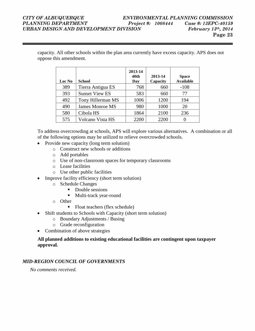
CITY OF ALBUQUERQUE ENVIRONMENTAL PLANNING COMMISSION PLANNING DEPARTMENT Project #: 1008444 Case #: 13EPC-40159 URBAN DESIGN AND DEVELOPMENT DIVISION February 13th, 2014 Page 23
capacity. All other schools within the plan area currently have excess capacity. APS does not oppose this amendment.
Loc No School
2013-14 40th Day
2013-14 Capacity
Space Available
389 Tierra Antigua ES 768 660 -108 393 Sunset View ES 583 660 77 492 Tony Hillerman MS 1006 1200 194 490 James Monroe MS 980 1000 20 580 Cibola HS 1864 2100 236 575 Volcano Vista HS 2200 2200 0
To address overcrowding at schools, APS will explore various alternatives. A combination or all of the following options may be utilized to relieve overcrowded schools. • Provide new capacity (long term solution)
o Construct new schools or additions o Add portables o Use of non-classroom spaces for temporary classrooms o Lease facilities o Use other public facilities
• Improve facility efficiency (short term solution) o Schedule Changes
Double sessions Multi-track year-round
o Other Float teachers (flex schedule)
• Shift students to Schools with Capacity (short term solution) o Boundary Adjustments / Busing o Grade reconfiguration
• Combination of above strategies
All planned additions to existing educational facilities are contingent upon taxpayer approval.
MID-REGION COUNCIL OF GOVERNMENTS No comments received.

CITY OF ALBUQUERQUE ENVIRONMENTAL PLANNING COMMISSION PLANNING DEPARTMENT Project #: 1008444 Case #: 13EPC-40159 URBAN DESIGN AND DEVELOPMENT DIVISION February 13th, 2014 Page 24
MIDDLE RIO GRANDE CONSERVANCY DISTRICT No comments received.
PUBLIC SERVICE COMPANY OF NEW MEXICO Underlined text indicates added language and strike-through text indicates deleted language. 1. Add a section to Policy 3.98. Implementation Strategies… at the top of page 4 of the Volcano Mesa
Amendment, “Electric” with the following language:
Electric. Electric infrastructure is planned and constructed in response to new development. New electric transmission lines and multiple substations will be needed within the Volcano Mesa area to provide electric service once regional employment center development occurs. Substations typically require two-acre parcels of land. It may be necessary for substations to be located near the electric load in the Plan area. Transmission lines should be located along arterial streets, major drainage channels, non-residential collector streets and other potential corridors as directed by the Facility Plan: Electric System Transmission and Generation (2010-2020).
NEW MEXICO DEPARTMENT OF TRANSPORTATION The NMDOT has no objections to the coordination among the plans which resulted in amendments to the West Side Strategic Plan, Volcano Trails Sector Development Plan, and the Volcano Cliffs Sector Development Plan.

Attachment A – Redline Draft of Proposed Amendments
!.!.!.!.!.!.
!.!.
!.!.!.
!.!.!.
!.!.!.!.!.!.!.!.
!.!.!.!.!.!.!.!.!.!.
!.!.!.!.!.!.!.!.!.!.!.
!.!.!.!.!.!.!.!.!.!.!.!.!.!.!.!.!.!.!.!.!.!.!.!.!.
!.!.!.!.!.!.!.!.!.!.
!.
!.!.!.
!.!.!.!.!.!.!. !. !. !. !.
!.
!.
!.!.!.!.!.!.!.!.!.
,,/ ,,/,,/
,,/
,,/
,,/ ,,/,,/
,,/
kj
kjkj
kj
kj
,,/
,,/
kjkj
ROSA PARKS RD
SCENIC RD
KIMMICK DR
RAINBOW BLVD UNIVE
RSE B
LVD
UNSERBLVD
PASEO DEL NORTE
WOODMONT AV
ROSA PARKS RD
PETROGLYPHNATIONAL
MONUMENT
NORTHERNGEOLOGICWINDOW
BOCANEGRAPARK
SOUTHERNGEOLOGICWINDOW
´0 1,000 2,000 3,000Feet
VOLCANO MESA ROAD NETWORK
VOLCANO HEIGHTS
VOLCANO CLIFFS VOLCANO CLIFFSVOLCANO TRAILS
TRANSIT CENTER
CITY OF ALBUQUERQUEMAJOR PUBLIC OPEN SPACE
PETROGLYPHNATIONAL
MONUMENT
N:\AGISFILE\PROJECTS\PetraMorris\THG-Nov11-VolcanoHeights\VolcanoMesa\VolcanoMesaRoadNetwork_Dec13.mxd
!. !. BUS RAPID TRANSITSCENIC CORRIDORMINOR ARTERIALPROPOSED ALIGNMENTLIMITED ACCESS ARTERIALPRINCIPAL ARTERIALCOLLECTOR
kj RIGHT IN/RIGHT OUT
,,/ PROPOSED FULL INTERSECTION
POSSIBLE LOCATIONS FOR
WEST SIDE STRATEGIC PLANVOLCANO MESA BOUNDARY
UNSE
R BLV
D

Attachment B – Public Comments

1
Volcano Cliffs Property Owners Association, Inc. P.O. Box 27666, Albuquerque, New Mexico 87125
January 29, 2014
Mikaela J. Renz-Whitmore Planning Department City of Albuquerque sent by email Subject: Volcano Cliffs SDP Amendment Dear Mikaela:
As a follow to up to our discussion about the amendments to VCSDP we request that one item be added. You probably have to use different wording but here’s our thoughts on the amendment.
In the VCRR zone the current amendment allows open view fencing which is appropriate for perimeter, yard or corrals.
Please add text that would allow Patio-Pool-Courtyard walls that meet these standards:
a.)Must be attached to a dwelling
b.)Must not infringe on any of the front, side or rear setbacks
c.)Must be made of materials similar to or complementary to the dwelling
d.)The total enclosed wall area (any combination of a Patio, Pool, Courtyard) per dwelling unit may be 1000 sq.ft. or 50% of the dwelling square footage whichever is greater. (If a home owner wanted a small walled area in front this would then be deducted from the remaining space allowed in the side or rear.)
Purpose:
Protect and provide privacy for patio and pool areas adjacent to dwellings in a zone that could have significant distances between houses and otherwise requires open view fencing.

2
Provide security for the home and a secure area for children to play. The Rural Residential area with its low density and openness encourages the roaming of wildlife including coyotes.
Protect areas close to homes from dust and tumbleweeds.
We studied several house plans and discussed with realtors to come up with a size recommendation. A Pool or grass area of 20’X40’ would be 800 sq.ft. A homeowner would then need some space for bar-b-que and patio furniture. In this example an area of 1200-1400 sq.ft. would seem reasonable.
This is what the Patio area to home size would look like.
1600 sq.ft. (smallest per some covenants) home could have 1000 sq.ft. walled Patio area
2000 sq.ft. home could have 1000 sq.ft. walled Patio area
2500 sq.ft. home could have 1250 sq.ft. walled Patio area
3000 sq.ft. home could have 1500 sq.ft. walled Patio area
4000 sq.ft. home could have 2000 sq.ft. walled Patio area
Contact information for the VCPOA includes email: [email protected] or free phone message line 1-877-793-8173, or board member phone numbers are listed below.
Sincerely Volcano Cliffs Property Owners Association Board
Dave Heil Board of Directors: Joe Archbold (505) 328-1331, Blake Thompson (Sec.) (505) 328-3117, Patrick Chapman (505) 897-0337, Ralph Davis (Treas) (505) 899-1705, Dave Heil (Pres.) (505)228-7189, Barbara Mueller (505) 898-7755, Bill Wright (505) 872-0523, Kyle Falls (V.P.) (505) 459-3638, Ivan Santestivan (505) 350-3324, Markku Koskelo (505)898-7875, Jim Wiegmann (505) 881-4597, Keith Perry (505) 298-2547

1
Renz-Whitmore, Mikaela J.
From: Hoffman, Jim <[email protected]>Sent: Thursday, January 30, 2014 2:06 PMTo: Renz-Whitmore, Mikaela J.; Webb, AndrewSubject: Public Comment - Volcano Mesa Plan Amendments for EPC 2/13/14
Attached are my comments regarding the three Volcano Mesa sector plan updates to be heard at EPC on 2/13/14. Volcano Trails
1. Page 7 ‐ The legend Volcano Mesa Road Network map should reflect that intersections are approved, not proposed. A reference to TCC resolution 13‐03 should also be included either on the map of the sector plan text.
Volcano Cliffs
2. Page 29 ‐ The legend Volcano Mesa Road Network map should reflect that intersections are approved, not proposed. A reference to TCC resolution 13‐03 should also be included either on the map of the sector plan text.
3. Page 34 ‐ The legend Volcano Mesa Road Network map should reflect that intersections are approved, not proposed. Cross section 7.1 does not make sense for Paseo del Norte. Specifically, why would BRT lanes on Paseo del Norte transition from being outside lanes in cross section 7.4, to median lanes in cross section 7.1, and then back to outside lanes in cross section 6?
4. Page 48 ‐ Which side of the road is the multi‐use trail on in cross section 7.4 for Paseo del Norte?
5. Page 84 – Align terminology for “significant rock outcropping” in the VCSDP with “rock outcropping” in the VHSDP
Volcano Heights
6. Page 49 ‐ Align terminology for “rock outcropping” in the VHSDP with “significant rock outcropping” in the VCSDP
7. Other definitions – Add definitions for “Leapfrog Development” and “Urban Infill”. Leapfrog Development – Development that does not occur contiguously to existing development Urban Infill – New development within an existing community that is enclosed by other types of development The plan should reference that Volcano Heights is urban infill due to previous leapfrog development that occurred in the past 15 years.
8. Pages 163 / 164 ‐ Cross section ST7.1 does not make sense for Paseo del Norte. Specifically, why would BRT lanes on Paseo del Norte transition from being outside lanes in cross section 7.4, to median lanes in cross section 7.1, and then back to outside lanes in cross section 6?
9. Page 187 / 188 ‐ Which side of the road is the multi‐use trail on in cross section ST7.3 for Unser Blvd. and ST7.4 for Paseo del Norte? What is the purpose of the multi‐use trails as they are not part of the other cross‐sections for Unser Blvd. and Paseo del Norte.

2
10. Page 197 – I do not agree with section 10.7.2 and table 10.2. Please refer to the figure below that shows four different square ~10 acre parcels (~660’ x 660’). Two parcels contain regional center zoning that is supposed to allow more auto oriented use, one parcel is mixed use, and one parcel is town center. If one looks at the two parcels with regional center zoning the corner adjacent to the two “B” streets (Unser Blvd and transit Rd / Loop Rd) would be the most desirable corner for auto oriented uses. However, one is to access this corner via an internal “B” street, then any other internal street within the regional center would need to be an “A” street with the associated “A” streetscape to meet the requirements of table 10.2. Conversely, if one looks at the mixed use or town center parcel which are completely surrounded by “A’ streets, internal auto oriented “B” streets can divide these parcels into four smaller parcels (each ~330’ x 330’) while meeting the requirements of table 10.2. It is counter‐intuitive that the more pedestrian oriented town center can be built out with more auto‐oriented “B” street flexibility than the regional center zones which are supposed to be more auto‐oriented. This situation arises because Unser Blvd. and Paseo del Norte are classified as “B” streets. White these two regional highways are definitely auto‐oriented, they are limited access roadways that do not provide direct site access. Both Unser Blvd. and Paseo del Norte also have “A” street characteristics such as bike lanes and multi‐use trails. I fully support that the entire plan area should incorporate features to create a walkable environment; however, in order to avoid the problems cited above, Unser Blvd. and Paseo del Norte should be classified as “A” streets for determining the percentages in table 10.2.
11. Page 225 ‐ The legend Volcano Mesa Road Network map should reflect that intersections are approved, not proposed.
Additional Comment I would also like to comment that I fully support Policy 13.3.1 / 13.3.1 i on page 216 regarding Regionally Significant Roads, section 14.1 regarding Priority Capital Improvement Projects on page 234, and the inclusion of the Fiscal Impact Analysis (Appendix E), in the adopted VHSDP. Policy 13.3.1 originated from condition 96 in the previous EPC notice of decision dated December 10, 2012 following public comment regarding regional infrastructure needs. I would like to ask for EPC’s re‐affirmation of this policy as there is a continued need for constructive dialogue between the City and landowners to plan both the build out of the regional transportation infrastructure of the two regional highways (Unser Blvd. and Paseo del Norte), along with associated “backbone” utility infrastructure to be located along the right‐of‐way of these highways, while landowners concurrently plan for the secondary roadway and utility infrastructure in the VHSDP plan area.

3
Respectfully, James Hoffman 817‐551‐4335 (work) 817‐568‐6971 (fax) 817‐689‐4897 (cell)