st. andrew sound and satilla river · st. andrew sound and satilla river . ... was reported to...
TRANSCRIPT

BookletChart™ St. Andrew Sound and Satilla River NOAA Chart 11504
A reduced-scale NOAA nautical chart for small boaters When possible, use the full-size NOAA chart for navigation.
2
Published by the National Oceanic and Atmospheric Administration
National Ocean Service Office of Coast Survey
www.NauticalCharts.NOAA.gov 888-990-NOAA
What are Nautical Charts?
Nautical charts are a fundamental tool of marine navigation. They show water depths, obstructions, buoys, other aids to navigation, and much more. The information is shown in a way that promotes safe and efficient navigation. Chart carriage is mandatory on the commercial ships that carry America’s commerce. They are also used on every Navy and Coast Guard ship, fishing and passenger vessels, and are widely carried by recreational boaters.
What is a BookletChart?
This BookletChart is made to help recreational boaters locate themselves on the water. It has been reduced in scale for convenience, but otherwise contains all the information of the full-scale nautical chart. The bar scales have also been reduced, and are accurate when used to measure distances in this BookletChart. See the Note at the bottom of page 5 for the reduction in scale applied to this chart.
Whenever possible, use the official, full scale NOAA nautical chart for navigation. Nautical chart sales agents are listed on the Internet at http://www.NauticalCharts.NOAA.gov.
This BookletChart does NOT fulfill chart carriage requirements for regulated commercial vessels under Titles 33 and 44 of the Code of Federal Regulations.
Notice to Mariners Correction Status
This BookletChart has been updated for chart corrections published in the U.S. Coast Guard Local Notice to Mariners, the National Geospatial Intelligence Agency Weekly Notice to Mariners, and, where applicable, the Canadian Coast Guard Notice to Mariners. Additional chart corrections have been made by NOAA in advance of their publication in a Notice to Mariners. The last Notices to Mariners applied to this chart are listed in the Note at the bottom of page 7. Coast Pilot excerpts are not being corrected.
For latest Coast Pilot excerpt visit the Office of Coast Survey website at http://www.nauticalcharts.noaa.gov/nsd/searchbychart.php?chart=11504
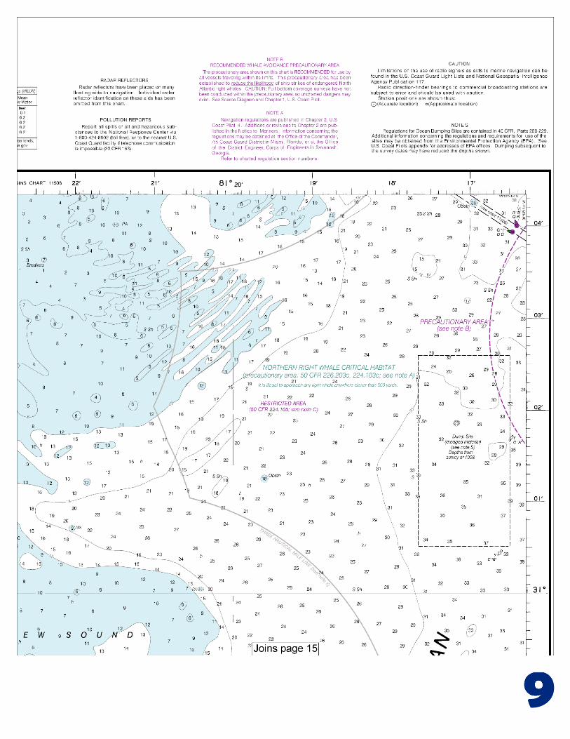
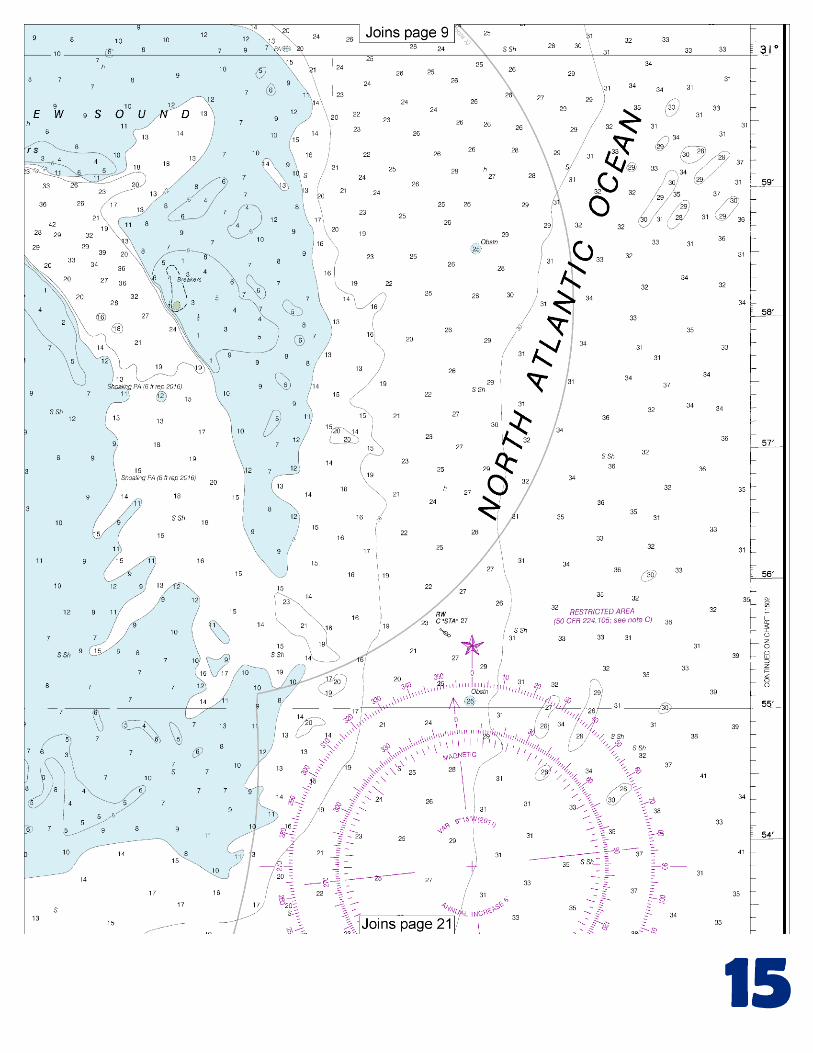
(Selected Excerpts from Coast Pilot) Jekyll Island is a State Park; several large park buildings, formerly private homes, are on the west side of the island, and on the east side are large motels and recreational buildings, bath houses, and the large prominent Aquarama (a large indoor swimming pool and auditorium). Several fishhavens are within 13 miles east and southeast of Jekyll Island. Shoals extend 3 to 5 miles offshore. St. Andrew. The entrance to the sound is
over a shifting bar that extends 5 miles offshore. Vessels should stay in 5 fathoms or more until the outer buoy is sighted. The channel into the sound is marked by buoys. Vessels with a draft of 10 feet should have
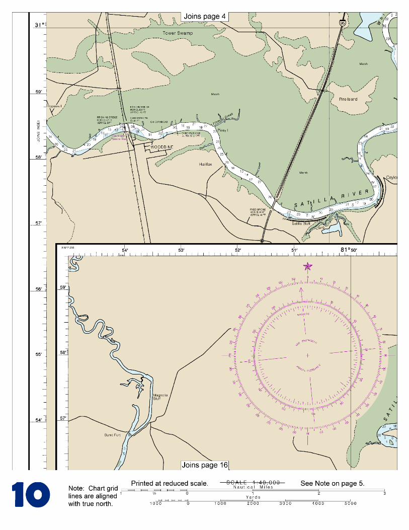
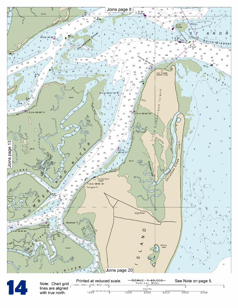
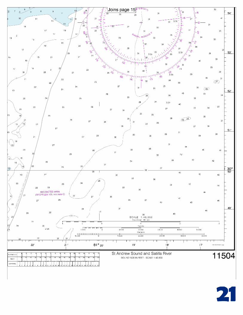
little difficulty entering the sound. The depth was 12 feet in the buoyed entrance channel. The entrance is used only by local shrimp boats. A sunken wreck was reported 1.9 miles east of the abandoned lighthouse in about 30°58'32"N., 81°22'37"W. In the sound are extensive shoals, between which channels lead to the principal tributaries: Jekyll Sound on the north, Satilla River on the west, and Cumberland River on the south. Little Satilla River with local knowledge about 10 feet could be taken from the entrance to Fancy Bluff Creek. Small craft going to landings on the river enter from South Brunswick River through Fancy Bluff Creek. St. Andrew Sound, between Jekyll Island and Little Cumberland Island, is about 7 miles southward of St. Simons Sound and 17 miles northward of St. Marys Entrance. The entrance to the sound is over a shifting bar which extends about 5 miles offshore. Vessels should stay in 5 fathoms or more until the outer buoy is sighted. The channel into the sound is marked by buoys. Vessels with a draft of about 10 feet should have little difficulty entering the sound. In May 1983, the reported controlling depth was 12 feet in the buoyed entrance channel. In the sound are extensive shoals, between which channels lead to the principal tributaries: Jekyll Sound on the north, Satilla River on the west, and Cumberland River on the south. Currents.–The current velocity is about 2 knots in the entrance; predictions are given in the Tidal Current Tables. The best anchorage in the sound is in the channel on the western side of Little Cumberland Island. The anchorage has depths of 17 to 27 feet with good holding ground. Good anchorage is also found in the entrance of Jekyll Point. Satilla River enters St. Andrew Sound from the westward through a narrow channel in the shoals. In 1963 and May 1975, shoaling to 1 foot was reported to exist just below the bend 9 miles above the entrance. Satilla River Marsh Island Natural Area, a Marine Protected Area (MPA), is about 1.5 miles upstream of St. Andrews Sound on the S bank of the Satilla River. (See Appendix C for additional information.) Shrimp boats going to Woodbine, 22 miles above the mouth, use Bailey Cut, which was reported to have a controlling depth of about 4 feet, in May 1983, at its eastern entrance. The river is crossed by twin fixed highway bridges with clearances of 44 feet about 19.2 miles above the mouth. U.S. Route 17 highway bridge at Woodbine has a fixed span with a clearance of 43 feet. The Seaboard System Railroad (SCL) bridge adjacent to the westward has a swing span with a clearance of 5 feet. (See 117.1 through 117.59 and 117.369, chapter 2, for drawbridge regulations.) Overhead power cables are 0.8 mile and 0.5 mile east of the bridges. The easternmost cable has a clearance of 57 feet, and clearance for the other cable is not known. The overhead power cable between the bridges has a clearance of 61 feet. The mean range of tide is 6.7 feet about 5 miles above the mouth and 3.2 feet at Burnt Fort. The freshet variation at Waycross, 142 miles above the mouth, is about 12 feet. There is reported to be no appreciable rise at Woodbine during freshets.
U.S. Coast Guard Rescue Coordination Center 24 hour Regional Contact for Emergencies
RCC Miami Commander
7th CG District (305) 415-6800 Miami, FL

G
NOAA’s navigation managers serve as ambassadors to the maritime community. They help identify navigational challenges facing professional and recreational mariners, and provide NOAA resources and information for safe navigation. For additional information, please visit nauticalcharts.noaa.gov/service/navmanagers
To make suggestions or ask questions online, go to nauticalcharts.noaa.gov/inquiry. To report a chart discrepancy, please use ocsdata.ncd.noaa.gov/idrs/discrepancy.aspx.
Lateral System As Seen Entering From Seaward on navigable waters except Western Rivers
PORT SIDE
ODD NUMBERED AIDS
GREEN LIGHT ONLY
FLASHING (2)
PREFERRED CHANNEL
NO NUMBERS – MAY BE LETTERED
PREFERRED CHANNEL TO
STARBOARD
TOPMOST BAND GREEN
PREFERRED CHANNEL
NO NUMBERS – MAY BE LETTERED
PREFERRED CHANNEL
TO PORT
TOPMOST BAND RED
STARBOARD SIDE
EVEN NUMBERED AIDS
RED LIGHT ONLY
FLASHING (2)
FLASHING FLASHING
OCCULTING GREEN LIGHT ONLY RED LIGHT ONLY OCCULTING QUICK FLASHING QUICK FLASHING
ISO COMPOSITE GROUP FLASHING (2+1) COMPOSITE GROUP FLASHING (2+1) ISO
"1"
Fl G 6s
G "9"
Fl G 4s
GR "A"
Fl (2+1) G 6s
RG "B"
Fl (2+1) R 6s
"2"
Fl R 6s
8
R "8"
Fl R 4s
LIGHT
G
C "1"
LIGHTED BUOY
G
"5"
GR
"U"
GR
C "S"
RG
N "C"
RG
"G"
LIGHT
6
R
N "6"
LIGHTED BUOY
R
"2
"
CAN DAYBEACON
CAN NUN NUN
DAYBEACON
For more information on aids to navigation, including those on Western Rivers, please consult the latest USCG Light List for your area.
These volumes are available online at http://www.navcen.uscg.gov
Navigation Managers Area of Responsibility
Northeast
Lt. Meghan McGovern
Northwest and
Pacific Islands
Crescent Moegling
Great Lakes Region
Tom Loeper
Chesapeake and
Delaware Bay
Steve Soherr
California
Jeff Ferguson
[email protected] Mid-Atlantic
Lt. Ryan Wartick
Alaska
Lt. Timothy M. Smith
Western Gulf Coast
Alan Bunn
Central Gulf Coast
Tim Osborn
[email protected] South Florida
Puerto Rico
U.S. Virgin Islands
Michael Henderson
Southeast
Kyle Ward
2
2 C U 5
1


VHF Marine Radio channels for use on the waterways:Channel 6 – Inter-ship safety communications.Channel 9 – Communications between boats and ship-to-coast.Channel 13 – Navigation purposes at bridges, locks, and harbors.Channel 16 – Emergency, distress and safety calls to Coast Guard and others, and to initiate calls to other
vessels. Contact the other vessel, agree to another channel, and then switch.Channel 22A – Calls between the Coast Guard and the public. Severe weather warnings, hazards to navigation and safety warnings are broadcast here.Channels 68, 69, 71, 72 and 78A – Recreational boat channels.
Getting and Giving Help — Signal other boaters using visual distress signals (flares, orange flag, lights, arm signals); whistles; horns; and on your VHF radio. You are required by law to help boaters in trouble. Respond to distress signals, but do not endanger yourself.
EMERGENCY INFORMATION
Distress Call Procedures
• Make sure radio is on.• Select Channel 16.• Press/Hold the transmit button.• Clearly say: “MAYDAY, MAYDAY, MAYDAY.”• Also give: Vessel Name and/or Description;Position and/or Location; Nature of Emergency; Number of People on Board.• Release transmit button.• Wait for 10 seconds — If no responseRepeat MAYDAY call.
HAVE ALL PERSONS PUT ON LIFE JACKETS!
This Booklet chart has been designed for duplex printing (printed on front and back of one sheet). If a duplex option is not available on your printer, you may print each sheet and arrange them back-to-back to allow for the proper layout when viewing.
QR
Quick ReferencesNautical chart related products and information - http://www.nauticalcharts.noaa.gov
Interactive chart catalog - http://www.charts.noaa.gov/InteractiveCatalog/nrnc.shtmlReport a chart discrepancy - http://ocsdata.ncd.noaa.gov/idrs/discrepancy.aspx
Chart and chart related inquiries and comments - http://ocsdata.ncd.noaa.gov/idrs/inquiry.aspx?frompage=ContactUs
Chart updates (LNM and NM corrections) - http://www.nauticalcharts.noaa.gov/mcd/updates/LNM_NM.html
Coast Pilot online - http://www.nauticalcharts.noaa.gov/nsd/cpdownload.htm
Tides and Currents - http://tidesandcurrents.noaa.gov
Marine Forecasts - http://www.nws.noaa.gov/om/marine/home.htm
National Data Buoy Center - http://www.ndbc.noaa.gov/
NowCoast web portal for coastal conditions - http://www.nowcoast.noaa.gov/
National Weather Service - http://www.weather.gov/
National Hurrican Center - http://www.nhc.noaa.gov/
Pacific Tsunami Warning Center - http://ptwc.weather.gov/
Contact Us - http://www.nauticalcharts.noaa.gov/staff/contact.htm
NOAA’s Office of Coast Survey The Nation’s Chartmaker
For the latest news from Coast Survey, follow @NOAAcharts
NOAA Weather Radio All Hazards (NWR) is a nationwide network of radio stations broadcasting continuous weather information directly from the nearest National Weather Service office. NWR broadcasts official Weather Service warnings, watches, forecasts and other hazard information 24 hours a day, 7 days a week. http://www.nws.noaa.gov/nwr/