sqs - amazon s3...notice: after 4 sep 2015 0901z, this chart may no longer be valid. disc 17-2015...
TRANSCRIPT

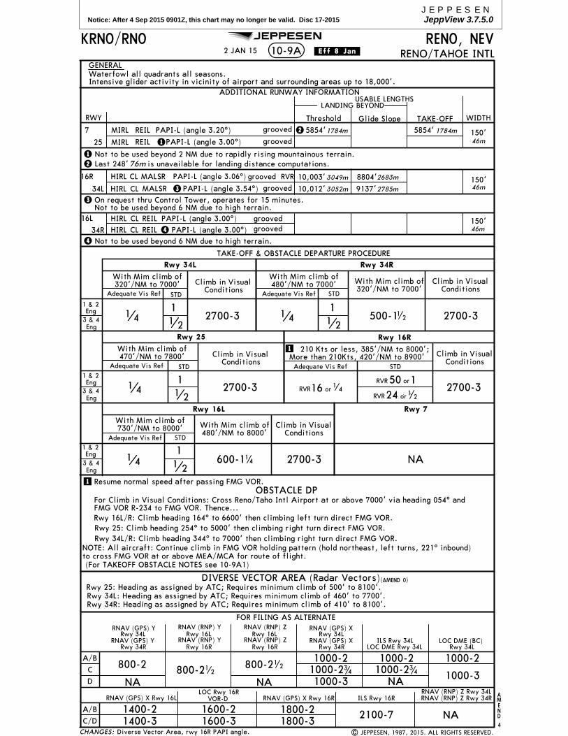
Notice: After 4 Sep 2015 0901Z, this chart may no longer be valid. Disc 17-2015JEPPESENJeppView 3.7.5.0
D
D
D
D
DD
D64.8
D59.0
D44.0
D39.0
D28.7 D1
9.0
BARFF
FAYEE
328^
360^
GREENVIL
LE(GLH
.UJM
5)
CHANGES:
Apt Elev
341'
ROUTING
KMEM/MEMMEMPHIS INTL
MEMPHIS, TENN.STAR.
D-ATIS
127.75
TURBOJETS/TURBOPROPS
LANDING NORTH
TURBOJETS/TURBOPROPS
LANDING SOUTH
NON-TURBINEALL RUNWAYS
10-2G
FL210
MARVELL FIVE ARRIVAL (UJM.UJM5)
4000
JAMEA
| JEPPESEN, 2006, 2014. ALL RIGHTS RESERVED.
JEPPESEN
EL DORADO115.5 ELDELD
N33 15.4 W092 44.6
D(H)
8 NM
FL18
0
TEXARKANA
116.3 TXKTXKN33 30.8 W094 04.4
D(H)
FL1
80
GREENVILLE110.2 GLHGLH
N33 31.4 W090 59.0
D(L)
4000
SIDON114.7 SQSSQS
N33 27.8 W090 16.6
D(H)
FENUR
At or aboveFL210
290 KTAt
N33 58.4W090 56.6
10 N
M
ELLIN
8 NM
8 NM
ALTITUDE
MAINTAIN last assignedaltitude until cleared to"DESCEND VIA THE
comply with altitude restrictions as
published.
Alt Set: INCHES Trans level: FL180 Trans alt: 18000'1. DME and RADAR required.
MARVELL FIVE", then
LANDINGNORTH
N33 55.1W090 34.5
N34 34.5 W090 40.5
109.6 UJMUJMMARVELL
D(L)
LANDIN
GSO
UTH
From over UJM on MEM R-232 to TAMMY, thenon heading 055^. EXPECT RADAR vectors tofinal approach course.
From over UJM on MEM R-232 to TAMMY, MADDN, JAMEA, then TWIKL, then on heading 355^.EXPECT RADAR vectors to final approach course.
RADAR vectors to final approach course afterFrom over UJM on MEM R-232 to MEM. EXPECT
passing TAMMY.
2. Procedure not available forRNAV capable turbojets. 3. RNAV capable turbojets must file the HOBRK RNAV STAR.
4000
MADDNN34 43.3
W090 26.7
OGONYN34 05.7
W091 20.6
23 MAY 14 .Eff.29.May.
final approach courseafter passing TAMMY
LANDING NORTH
10000'
LANDING SOUTH
At 230 KTand at
Between16000' & 14000'
TURBOJET/TURBOPROP:
ALL RWYS:EXPECT RADAR vectors to
NON-TURBINE AIRCRAFT,
71.3
15.0
128
29.0
26.3 33.8
15.0
31.027.0
10.3
9.7
11.0
4.1
From over UJM on MEM R-232 to TAMMY, MADDN,
Procedure revised.
TWIKL
AA
A
MEMPHIS117.5 MEMMEM
N35 00.9 W089 59.0
D(H)
ALL RWYS
3000'
Cross ator above
NON-TURBINEAIRCRAFT,
At290 KT
At or aboveFL210
(GLH R-360/D53.3)
280 KTAt
LANDING SOUTH
Between
At 210 KT
11000' & 8000'
TURBOJET/TURBOPROP
LANDING SOUTH
Between12000' & 10000'
At 250 KT
TURBOJET/TURBOPROP
ANON-TURBINE AIRCRAFT,
ALL RWYS
MEA 3000'
052^
At or aboveFL210
290 KTAt
4000
7000
048^
EL D
ORA
DO
071 T̂EXARKANA
N33 55.8W091 34.2
N34 24.7W090 54.2
SIDON(TXK.UJM
5)
(ELD.UJM5)
(SQS.UJM5)
4000
228^
NOT TO SCALE
R232^
hdg
355^
232^
4000
3000
TAMMYN34 37.1 W090 36.5
4000
R228^
232^
FL18
0
228^
FL180
hdg055^
8.0
N34 49.3 W090 17.3
N34 56.0 W090 06.7

Notice: After 4 Sep 2015 0901Z, this chart may no longer be valid. Disc 17-2015JEPPESENJeppView 3.7.5.0
FOR INITIAL CLIMBSEE INSETS BELOW
010^
217^
030^
045^
071^
088^
098^
116^
153^
232^
355^
259^
270^
283^
319^
337^
303^
D39.8
D42.8
D41.8
D41.8
D43.8
D44.8
D43.8
D43.8
D43.8
D39.
8
D36.0
D38
.8
D38.8
188^
D42.8
D43.8
D40.8
D41.8
D40.8
CHANGES:
ROUTING
INITIAL CLIMB
Trans level: FL180Trans alt: 18000'
RWY
18L
18C
18R
36L
9
27
75 100 150 200 250 300Gnd speed-KT
340' per NM 425 567 850 1133 1417 1700
1. DME and RADAR required.
341'
AptElev
All aircraft:
Climbing LEFT turn heading 140^, or as assigned by ATC.
Climbing LEFT turn heading 140^, or as assigned by ATC.
Climbing LEFT turn heading 315^, or as assigned by ATC.
All aircraft:
Climb heading 165^, or as assigned by ATC.
Climb heading 180^, or as assigned by ATC.
Climb heading 350^, or as assigned by ATC.
Climb heading 010^, or as assigned by ATC.
Climbing RIGHT turn heading 220^, or as assigned by ATC.
Climb heading 271^, or as assigned by ATC.
Climb heading 091^, or as assigned by ATC.
Climbing RIGHT turn heading 045^, or as assigned by ATC.
EXPECT vectors to join assigned transition radial. Crossing the transition fix, continue on current heading,
091^271^hdg hdg
045^
hdg
045^
hdg
140^hdg
140^hdg
315^hdg
091^271^hdg hdg
010^
hdg
010^
hdg
350^hdg
hdg 160^hdg
178^hdg
MEMPHIS117.5 MEMMEM
N35 00.9 W089 59.0
D(H)
MEMPHIS117.5 MEMMEM
N35 00.9 W089 59.0
D(H)
MEMPHIS117.5 MEMMEM
N35 00.9 W089 59.0
D(H)
NTREE
(ELV
IS3.NTR
EE)
3000 2
400T
(ELVIS3.STREE)
STRE
E30
00 2
100T
NFO
UR
(ELVIS3.NFOU
R)
3000 2
500T
NFIV
E
(ELVIS3.NFIVE)
3000
250
0T
EONEE
(ELVIS3.E
ONEE)
3000 2200T
3000 2000T
ETWOO(ELVIS3.ETWOO)
3000 2100T
ETREE(ELVIS3.ETREE)
3000 2100T
EFOUR(ELVIS3.EFOUR)
3000 2
000T
SONEI
(ELVIS3.SONEI)
(ELVIS3.SF
OUR)
SFOUR
3000
170
0T
(ELVIS3.N
TWOO)
NTW
OO
3000 1
900T
(ELVIS3.WONEE)WONEE
3000 1700T
(ELVIS3.WTWOO)WTWOO
3000 1900T
(ELVIS3.WTREE)
WTREE3000 2100T
(ELVIS3.WFIVE)
WFIV
E
3000 2300T
(ELVIS3.NRO
NE)NRONE
3000 2
500T
MEM1.0 DME
Turbojet aircraft:
Turbojet aircraft:
Turbojet aircraft:
Turbojet aircraft:
Turbojet aircraft:
Non-Turbojet aircraft:
Non-Turbojet aircraft:
Non-Turbojet aircraft:
Non-Turbojet aircraft:
Non-Turbojet aircraft:36C/R
(ELVIS3.WFOUR)
WFOUR
3000 2100T
(ELV
IS3.ST
WOO)
STW
OO
3000 2
000T
DEPARTUREMEMPHIS
124.65CONTROL (R)
DEPARTUREMEMPHIS
124.15CONTROL (R)
TURBOJET AIRCRAFTINITIAL CLIMB INSET
NON-TURBOJET AIRCRAFTINITIAL CLIMB INSET
KMEM/MEM.SID.MEMPHIS INTL 10-3G
MEMPHIS, TENN
(ELVIS3.MEM)
OBSTACLES
NTREE
NFOURN35 39.3 W089 30.7
NFIVEN35 31.2 W089 20.4
EONEEN35 14.0 W089 09.4
ETWOON35 01.5 W089 08.2
ETREEN34 54.2 W089 08.9
EFOURN34 42.7 W089 16.0
SONEIN34 28.5 W089 39.9
STWOON34 22.6 W090 06.3
STREEN34 30.3 W090 27.9
SFOURN34 36.8 W090 37.5
WONEE
WTWOON35 01.5 W090 48.6
WTREEN35 10.9 W090 48.4
WFOURN35 25.3 W090 43.4
WFIVEN35 33.6 W090 32.7
NRONEN35 41.5 W090 19.1
NTWOON35 43.9W089 48.7
N35 44.6W090 02.7
LEFT heading 160^, or as assigned by ATC. Climb heading 178^ to MEM 1.0 DME SOUTH of MEM, then turn
local only. 6. ETWOO and WTREE transitions restricted to aircraft requesting 9000' or below, sunrise-sunset, Monday-Friday. Restrictions do not apply on weekday
JEPPESEN
==================
N34 53.7W090 47.8
=FIX NAME PRONUNCIATIONEONEE EAST ONEETWOO EAST TWOETREE EAST THREEEFOUR EAST FOURSONEI SOUTH ONESTWOO SOUTH TWOSTREE SOUTH THREESFOUR SOUTH FOURWONEE WEST ONEWTWOO WEST TWOWTREE WEST THREEWFOUR WEST FOURWFIVE WEST FIVENRONE NORTH ONENTWOO NORTH TWONTREE NORTH THREENFOUR NORTH FOURNFIVE NORTH FIVE
2. Make no turns below 800'. 3. Turbojet aircraft accelerate to 250 KIAS immediately until reaching 10000', if unable advise ATC.4. Transponder code will be issued via PDC or MEMPHIS clearance delivery. 5. NFIVE, EFOUR, STREE, SFOUR, WFOUR and WFIVE transitions authorized 0200 - 0600
nights, weekends or holidays. 7. NRONE transition restricted to prop/turboprop aircraft requesting 14000' or below. Restriction does not apply 0200-0600 local.8. SONEI transition restricted to aircraft requesting 7000' or below, sunrise to sunset, Monday-Friday. Restrictions do not apply on weekday nights, weekends, orholidays. 9. Aircraft filing flight plans that do not meet the authorized time, altitude or aircraft type restrictions may experience delays.
.Eff.30.Apr.
| JEPPESEN, 2012, 2015. ALL RIGHTS RESERVED.
climb of 340' per NM to 800'.
Procedure renumbered, top altitude.
24 APR 15
ELVIS THREE DEPARTURE
TOP ALTITUDE
PROP3000'
JET5000'
EXPECT vectors from MEMPHIS Center to join filed route. Jet aircraft MAINTAIN 5000' (or requested altitude if lower). Prop aircraft MAINTAIN 3000'. EXPECT clearance to filed altitude within 10 minutes after departure.
220^
hdg
165^
180^
hdg
This SID requires take-off minimums(for standard minimums, refer to airport chart):
NOT TO SCALE
(NOT TO SCALE)(NOT TO SCALE)
Rwys 9, 18C/R, 27, 36L/C/R: Standard (or lower than standard, if authorized).Rwy 18L: Props: Standard (or lower than
FOR DEPARTURECONTROL FREQ.SEE GRAPHIC
Rwy 18R: VORTAC and rod on pole beginning
Rwy 27: Trees 4145' from DER, 1382' LEFT of
Rwy 36C: Light pole 1948' from DER, 928' RIGHT of centerline, 77' AGL/336' MSL.
standard, if authorized). Turbojets: Standard (or lower than standard, if authorized) with minimum
Rwy 9: Light pole 1497' from DER, 799' LEFTof centerline, 43' AGL/342' MSL.
3209' from DER, 1019' LEFT of centerline, upto 43' AGL/412' MSL. Trees 3231' from DER, 1038' RIGHT of centerline, up to 87' AGL/406'MSL.
centerline, up to 112' AGL/361' MSL.

Notice: After 4 Sep 2015 0901Z, this chart may no longer be valid. Disc 17-2015JEPPESENJeppView 3.7.5.0
341'Apt Elev
(PIEPE3.PIEPE)
.Eff.30.Apr.
124.65
MEMPHISDeparture (R)
CHANGES:
Trans level: FL180 Trans alt: 18000'
4. Take-off Rwys 18L/C/R, 36L/C/R: RADAR required for non-GPSequipped aircraft. 5. Take-off Rwys 9, 27: RADAR required.
KMEM/MEM JEPPESEN
6. Transponder code will be issued via PDC or MEMPHIS clearance
10-3SMEMPHIS INTLMEMPHIS, TENN
.RNAV.SID.
For Procedure Text, Take-off Minimums and Obstacles see 10-3S-1
3. Turbojets only.1. DME/DME/IRU or GPS required. 2. RNAV 1.
| JEPPESEN, 2012, 2015. ALL RIGHTS RESERVED.
Direct distance from Memphis Intl
358^
hdg
271^hdg
178^
358^
hdg
091^hdg
178^
323^330^
271^5.1
4.7
220^
4.5
173^
GADECN34 59.2 W089 58.5
BEEALN35 08.6 W090 02.3
PRYMDN35 08.8 W090 08.5
EMAXE
860'Climb to
860'Climb to
860'Climb to
860'Climb to
17.3
182^
(Rwys 9, 27) to: BEBIE 35 NM(Rwys 18L/C) to: GADEC 3 NM
(Rwys 36L/C/R) to: BEEAL 7 NM(Rwys 18R) to: EMIIT 21 NM
HOOSE
N34 41.9 W089 59.4EMIIT
N35 05.2W090 12.3
N35 00.8W090 11.7170^
33.1
BEBIEN34 28.0 W090 05.6
PIEPEN34 22.3 W090 06.4
IBUFYN34 05.5 W090 08.7
16.9
185^
9000 1
700T
5.7
12100 1
600T
14.8
199^
delivery. 7. Accelerate to 250 KT, if unable advise ATC.8. If unable to accept climb rates, advise ATC on initial contact.
24 APR 15
Procedure renumbered.
PIEPE THREE RNAV DEPARTURE
hdg
hdg
IBUFY
(PIEPE
3.IBUFY
)
NOT TO SCALE

Notice: After 4 Sep 2015 0901Z, this chart may no longer be valid. Disc 17-2015JEPPESENJeppView 3.7.5.0
CHANGES:
JEPPESEN
(PIEPE3.PIEPE)
KMEM/MEMMEMPHIS INTL .Eff.30.Apr.
MEMPHIS, TENN.RNAV.SID.
For Procedure Graphic see 10-3S
PROCEDURE TEXT
10-3S-1
| JEPPESEN, 2012, 2015. ALL RIGHTS RESERVED.
ROUTING
INITIAL CLIMBRWY
18R
36L
9
27
75 100 150 200 250 300Gnd speed-KT
500' per NM 625 833 1250 1667 2083 2500
36C/R
18L/C
MAINTAIN 5000'. EXPECT clearance to filed altitude within 10 minutes after departure.
OBSTACLES
24 APR 15
Procedure renumbered, top altitude.
PIEPE THREE RNAV DEPARTURE
Climb heading 091^ to 860', then continue climb on heading 091^, EXPECT vectors to BEBIE, then on depicted route to PIEPE.
Climb heading 178^ to 860', then direct GADEC, then on depicted route to PIEPE.
Climb heading 178^ to 860', then direct EMIIT, then on depicted route to PIEPE.
Climb heading 271^ to 860', then continue climb on heading 271^. EXPECT vectors to BEBIE, then on depicted route to PIEPE.
Climb heading 358^ to intercept course 330^ to BEEAL, then on depicted route to PIEPE.
Climb heading 358^ to intercept course 323^ to BEEAL, then on depicted route to PIEPE.
5000'
TOP ALTITUDE
This SID requires take-off minimums(for standard minimums, refer to airport chart):
Rwy 36C: Light pole 1948' from DER, 928' RIGHT of centerline, 77' AGL/336' MSL.
lower than standard, if authorized) with a Rwys 9, 18L/C/R, 27, 36L/C/R: Standard (or
minimum climb of 500' per NM to 860'.
of centerline, 43' AGL/342' MSL.Rwy 18R: VORTAC and rod on pole beginning 3209' from DER, 1019' LEFT of centerline, up to 43' AGL/412' MSL. Trees 3231' from DER, 1038' RIGHT of centerline, up to 87'
Rwy 27: Trees 4145' from DER, 1382' LEFT of centerline, up to 112' AGL/361' MSL.
Rwy 9: Light pole 1497' from DER, 799' LEFT
AGL/406' MSL.

Notice: After 4 Sep 2015 0901Z, this chart may no longer be valid. Disc 17-2015JEPPESENJeppView 3.7.5.0
Dei
ce P
ad
S2
Apt ElevMEMPHIS, TENN
MEMPHIS INTL341'N35 02.5 W089 58.6
127.75125.2
Ground
Tower
Rwys 9-27 Rwys 18C-36C, 18L-36R
118.3 119.7 128.42
MEMPHIS Departure (R)356^-175^ 176^-355^
124.15 124.65
VOT 111.0
D-ATIS ACARS:D-ATISPDCTWIP
MEMPHIS Clearance (Cpt)
Y2
Y
Y1
UPS R
AM
P
Dei
cePa
d
121.65
KMEM/MEM
Rwys 18R-36L
Rwys 18R-36L
121.9Rwys 18C-36C, 18L-36R
121.0Rwys 9-27
LEG
END
Non
-mov
emen
t ar
ea
35-01
35-01
35-02
35-02
35-03
35-04
89-57
89-57
89-58
89-58
89-59
89-59
35-03
35-04
Y
358^
10-9
| JEPPESEN, 2000, 2015. ALL RIGHTS RESERVED.
Non
-mov
emen
t ar
eano
rth
of T
wy
V.
JEPPESEN
4E
5E5W
5WEN
TRY/E
XIT
SPO
T
Twy
J no
rth
of T
wy
C3.
CA
RG
OCENTRA
LRA
MP
LAHSO
Larg
e an
d he
avy
east
boun
d ai
rcra
ft o
n Tw
y V f
or R
wy
27,
hold
sho
rt a
t m
inim
um t
hrus
t ar
ea s
ign.
Twy
V b
etw
een
Twy
S an
d Tw
y Y r
estr
icte
d to
air
craf
t w
ith
tail
hei
ghts
les
s th
an 6
5' 1
0" (
20m
).
Read
bac
k al
l ho
ld s
hort
ins
truc
tion
s re
quir
ed.
6W7E
8E8W
9
1013
1415
20
1
2E2W
3
4W
01^E
7W6E
Air
craf
t w
ith
win
gspa
ns g
reat
er t
han
171'
(52
m)
shou
ldno
t ta
xi o
n Tw
y N
bet
wee
n Tw
y M
7 an
d Tw
y T
nor
on
to a
ircr
aft
wit
h w
ings
pans
of
171'
6" (
52m
) or
les
s.Tw
y V b
etw
een
Twy
B a
nd A
ppro
ach
End
Rwy
27 r
estr
icte
d
Noi
se a
bate
men
t pr
oced
ures
in
effe
ct.
Succ
essi
ve a
nd/o
rsi
mul
tane
ous
depa
rtur
es a
ppro
ved
on R
wy
36L-
18R
and
Rwy
36C-1
8C o
r Rw
y 36
L-18
R an
d Rw
y 36
R-18
L w
ith
cour
se
dive
rgen
ce n
o la
ter
than
2.2
7 N
M f
rom
run
way
end
.Pr
ior
perm
issi
on r
equi
red
for
taxi
cle
aran
ce f
rom
Car
go
Cen
tral
Ram
p pa
rkin
g on
fre
quen
cy 1
21.9
.
Con
stru
ctio
n A
rea
14 AUG 15.Eff.20.Aug.
None.
27 271^
18R
178^ 36L
358^
18C
CCC5
KK
C
C
AA
B
BA
1
TERM
INA
L
8946
'
Con
trol
Tow
er
Elev
341
'
Elev
292
'
Elev
253
'
620'
332'
C
VV
TENNESSEE
271'
Elev
178^
N N N
N
N
M4
M2
M1
E
C7
C8
A2
VV
S
2727
m
3389m
2841m9320'
P
T
RA
MP
S D S6
E
S4 S3 S1
R
JJ
36R
358^
18L
178^
9000'2743m
Elev
335
'
P
SS
YV1
CHANGES:
V
A
P
H
ANG
RA
MP
D
Y
RD H
11,120'
C6
S7
B
KD S5
C4 C2 C1
S
S
V
V3
N
M9
N
Elev
278'
J
LJ ARP
P1
C3
T P
N
LL
M6
Elev
321
'
Elev
288
'
M M M M
M3
M5
M8
M7M
P2
H Q
R
36C
500
2000
2500 80
060
020
0
Feet
Meters
0 010
00
3000
1000
1500
400
9 091^
V2
P
B
New
T P
FEDEX
FEDEX
RA
MP
FEDEX R
AM
P
RA
MP
FEDEX
N
EMA
S
RUN
WA
Y I
NCURS
ION
HO
T SP
OTS
For
info
rmat
ion
only
, no
t to
be
cons
true
d as
ATC
ins
truc
tion
s
Two
hold
lin
es o
n Tw
y B:
East
of
Twy
S is
Rw
y 18
C A
PCH
hold
; W
est
of T
wy
S is
run
way
hol
d.
Taxi
way
dep
artu
re r
isk:
mis
taki
ng T
wy
M f
or R
wy
36L.
HS1
HS2
HS1
HS1
HS2

Notice: After 4 Sep 2015 0901Z, this chart may no longer be valid. Disc 17-2015JEPPESENJeppView 3.7.5.0
MEMPHIS, TENNMEMPHIS INTL10-9A
KMEM/MEM
| JEPPESEN, 2000, 2015. ALL RIGHTS RESERVED.
4
AMEND
Vis Ref
STDAdequate
Rwys 36R, 36C
2 operating RVRs are requiredAll operating RVRs are controlling
Rwys 18R, 18C, 18L, 36L
2 operating RVRs are required
3 & 4 Eng 1 & 2 Eng
All operating RVRs are controlling
STD
STD
3 & 4 Eng 1 & 2 EngVis Ref
Adequate
Both RVRs arerequired & controlling
3 & 4 Eng 1 & 2 Eng
JEPPESEN
LAHSODistance
1
1
2
1
2
21
1 2
Rwys 9, 27
2
Rwy 36C, climb heading 358^ to 700' before turning LEFT.
Vis RefAdequate
TAKE-OFF & OBSTACLE DEPARTURE PROCEDURE
14 AUG 15 .Eff.20.Aug.
ASDE-X notes.
A
B
C
D
FOR FILING AS ALTERNATE
RWY
ADDITIONAL RUNWAY INFORMATION
ThresholdLANDING BEYOND
USABLE LENGTHS
WIDTHGlide Slope
GENERAL
600-2 800-2
9 RVR 7901'
7698'150'2408m
2346m 46m
CHANGES:
555
CL & HIRL
RVR
TDZ RVR
Mid RVR
Rollout RVR
18R
36L
RVR
RVR
8370'2551m
8020'2444m
150'46m
18C
36C HIRL CL ALSF-II TDZ
RVR
RVR
3115m
9950'3033m
150'46m
18L
36R
RVR
RVR
8086'2465m
7869'2398m
150'46m
10,220'
27
HIRL CL MALSR TDZ
MALSR
MALSR
ILS Rwy 27
ILS Rwy 9ILS Rwy 18LILS Rwy 18CILS Rwy 18RILS Rwy 36LILS Rwy 36CILS Rwy 36R
LOC Rwy 9LOC Rwy 18LLOC Rwy 18CLOC Rwy 18R
LOC Rwy 27LOC Rwy 36LLOC Rwy 36CLOC Rwy 36R
RNAV (GPS) Rwy 9
RNAV (GPS) Rwy 27
RNAV (GPS) Rwy 36LRNAV (GPS) Rwy 36C
333
TDZ RVR
Mid RVR
Rollout RVR
4or116RVR orRVR 150RVR 24 or1 2
HUD & CL & HIRL CL & HIRL CL, or RCLM & HIRL
TDZ RVR 555Rollout RVR
Mid RVR
TDZ RVR 101010Rollout RVR
Mid RVR
TDZ RVR
Mid RVR
Rollout RVR101010
RVR 24 or1
2 orRVR 15016 or14RVR
RVR
or
241 2
RVR
or
501
RVR
or1164
CL, or RCLM & HIRL
RCLM & HIRL
HIRL CL MALSR TDZ
RNAV (GPS) Z Rwy 18LRNAV (GPS) Z Rwy 18CRNAV (GPS) Z Rwy 18R
RNAV (GPS) Rwy 36R
RNAV (RNP) X Rwy 18LRNAV (RNP) Y Rwy 18LRNAV (RNP) Y Rwy 18CRNAV (RNP) X Rwy 18R
HIRL CL
HIRL CL
CL, or
OFFTAKE-
PAPI-L 8450'Twy N 2576m
PAPI-LHIRL CL ALSF-II TDZ
HIRL CL MALSR TDZ PAPI-L
HIRL CL ALSF-II TDZ PAPI-R
Angle 3.0^
RNAV (RNP) Y Rwy 18R
Grooved.
to/from terminal building.
TDZ RVR
Rollout RVR
1010
OBSTACLE DP
800-2
800-214
700-2
700-21 4
Terminal Doppler Weather Radar. All transient aircraft require 'Follow me' assistance when enteringANG ramp. Prior permission required for use of ANG ramp. Helicopter operations prohibited
ASDE-X in use. Operate transponders with altitude reporting mode and ADS-B (if equipped) enabledwhile on all Taxiways and Runways. Birds in vicinity of airport.

Notice: After 4 Sep 2015 0901Z, this chart may no longer be valid. Disc 17-2015JEPPESENJeppView 3.7.5.0
JEPPESEN
AREA SENSITIVE TO
JET BLAST
AREA SENSITIVE TO
JET BLAST
MEMPHIS INTLMEMPHIS, TENN
J
C3
K
J
L
TERMINAL
U.S.CUSTOMS
COORDINATES COORDINATES
W089-58.8
W089-58.8
N35-02.7
N35-02.5 N35-02.5
N35-02.7
W089-59.0
W089-59.0
PARKING GATE COORDINATES
GATE No. GATE No.
A B C
B1
B10
B12
B14B16
B18
B11
B15B17
B19
B2
B27
B29
B20
B22
B24B25B23
B3
B30
B31
B33B35
B37
B39
B38
B36
B34
B32
B28
B4
B41
B43
B42B40
B5
B6
B7 B8
B9
B26
C1 C2C3
C4C5
C7 C8
C9 C10
C11
C12
C14
C16
C18
C20
C22
C24
A1A2
A3
A5A6
A7A8
A9A10
A13
A17
A21
A23
A25
N
N
M6
P2 P1
3 1
2E2W
A27
A29
A33
A12
A14
A16
A18
A20
10-9B
NJ
| JEPPESEN, 2000, 2009. ALL RIGHTS RESERVED.
KMEM/MEM
W089-58.9
W089-58.9
N35-02.6 N35-02.6
N35-02.4 N35-02.4
24 JUL 09
Parking spots revised.
B13
B44
N35 02.5 W089 59.0A1, A2, A6, A8N35 02.5 W089 59.1A3, A5N35 02.6 W089 59.0N35 02.7 W089 59.0N35 02.8 W089 59.0A33
N35 02.4 W089 59.0B40 thru B44B36, B38,
N35 02.5 W089 58.8B29, B31 thru B35B37, B39
N35 02.5 W089 58.9B7 thru B9, B11B27, B28, B30
N35 02.6 W089 58.9B1 thru B6
N35 02.5 W089 58.8B10, B12 thru B18
N35 02.4 W089 58.8
N35 02.6 W089 58.8N35 02.7 W089 58.8N35 02.8 W089 58.8C22, C24N35 02.5 W089 58.9
N35 02.5 W089 58.8
N35 02.4 W089 59.0
A7, A9 thru A21A23 thru A29
B19 thru B26
C1 thru C12C14 thru C20
CHANGES:

Notice: After 4 Sep 2015 0901Z, this chart may no longer be valid. Disc 17-2015JEPPESENJeppView 3.7.5.0
.SMGCS.
.LESS.THAN.RVR.600.
H
MEMPHIS, TENNMEMPHIS INTL
127.75 125.2Tower
Rwys 9-27 Rwys 18C-36C, 18L-36R
118.3 119.7 128.42
VOT 111.0
D-ATIS MEMPHIS Clearance (Cpt)
MOVEMENT/NON-
BOUNDARYMOVEMENT AREA
LOW VISIBILITY TAXI ROUTES
TWIPPDCD-ATIS
ACARS:
Deice Pad
10-9D
Deice Pad
356^-175^124.15
MEMPHIS Departure (R)176^-355^
124.65
RAMP
ARFF
Ground
121.65Rwys 18R-36L
121.9
KMEM/MEM
Rwys 18R-36L
Rwys 18C-36C, 18L-36R
121.0Rwys 9-27
Q
H
| JEPPESEN, 1999, 2014. ALL RIGHTS RESERVED.
JEPPESEN
5W
5E5W
4E
ENTRY/EXIT SPOT
S2
STOP BAR
UPS RAMP
(20m).
Twy V between Twy S and Twy Yrestricted to aircraft with tail heights less than 65' 10"
ARRIVAL Rwys 36L/36CFor less than RVR 1200 to 600, see 10-9C
GEOGRAPHIC POSITION MARKING
H
4W
20
3 1
2W 2E
Twys P1 and P2 may be non-movementareas due to construction.
19 DEC 14
Ramp near Control Tower.
Military aircraft with wingspans greater (52m)
taxiway N between taxiway M7 and taxiway T nor on taxiway J north of taxiway C3.
than 171' should not taxi on
RUNWAY INCURSION HOT SPOTS(See 10-9 fordescription)
15 14 13 10
9 8W 8E 7W 7E 6W6E
CHANGES:
C
L
C2
L
C
C5
K
J
D
C
AB
A1
B
8946' C
V
N
N
N
N
M9
M
M
M6
T
M4
M2
M1
N P2 P1
P
C7
V
2727m
2841m
9320 '
P
TC3
S
A
D
S6
E
S4
S3
S1
R
J
J
90 00' 2743m
P
S
Y V2
E
LEGEND
CENTERLINE LIGHTS
LOW VISIBILITYTAXI ROUTE
S
S
18C178^
36C358^
D
Y2
Y1
Y
Y
3389m
R
A2
S5
K
C1
C8
C6
C4
S7
N
L
M
M3
M5
M7
27271^
18R178^ 18L
178^
36L358^ 36R
358^
Y
V1
K
P
11, 120'
M
A
TENNESSEEANG RAMP
DIRECTIONAL LOWVISIBILITY TAXI ROUTE
TAXIWAY AND APRON
9091^
B
S
A
CLEARANCE BARTAXIWAY
B
TERMINAL
ControlTower
FEDEX
FEDEX RAMP
FEDEX RAMP
S
SN
VV
V3
FEDEXRAMP
VV
EMAS
C
1S
4N
6N
8N8M
8S6C
6S
4S4C
2C 2S
8A
4B
6A 4A 2A
3Y
10A
HS1
HS2
HS1

Notice: After 4 Sep 2015 0901Z, this chart may no longer be valid. Disc 17-2015JEPPESENJeppView 3.7.5.0
Olive Branch
MEM
117.5
109.
6
UJMujm
029^
GQE113.0
Gqe121^
5000' GQE
R-121113.0
MISSED APCH:
05
510
MEMPHIS, TENNMEMPHIS INTL 11-6
LOC
108.9IOHN
FinalApch Crs360^
GSCADUS
2000'
ILSDA(H)
521'(200')
Apt Elev 341'TDZE 321'
ALSF-II
KALIE
MISSED APCH FIX
1000'via
BRIE
FIN
G S
TRIP
TM
34-50
35-00
89-5090-10
LT
D15.0 GQE
1.1
372 478 531 637 743 849
Rwys 18R-36L
121.65
KMEM/MEM
Trans alt: 18000'Alt Set: INCHES Trans level: FL 180
Rwys 18C-36C,18L-36R
121.0Rwys 9-27
PAPI
(1679')
112
ILS or LOC Rwy 36L
Climb to 1000' then climbing LEFT turn to 5000' via 330^heading and GQE VOR R-121 to KALIE INT/D15.0 GQE and hold,continue climb-in-hold to 5000'.
143^
MREOND18.0 MEM
ALTERNATEHOLDING FIX
(IAF)
358^40007.6
301^
121^
D2.8
CADUS to MAP 5.0 4:17 3:20 3:00 2:30 2:09 1:53
and330^
hdg
| JEPPESEN, 1998, 2013. ALL RIGHTS RESERVED.
360^
WSTON/D21.6 IOHN
(IF)
JEPPESEN
810' 769'
834'
942'
742'
949'
492'
881'
12 APR 13
TERP
S A
MEN
D 1
4D
31 M
AY 2
012
Marker beacon decommissioned.
323^
36LSTRAIGHT-IN LANDING RWY CIRCLE-TO-LAND
A
B
C
D
MDA(H)
165
140
120
90
MaxKts
Gnd speed-KtsGS 3.00^
70 90 100 120 140 160
FULL orTDZ CL outDA(H) 521'
ILS(200')
ALS outMDA(H)
LOC (GS out)760'(439')
ALS out
135^
315^
2500'
2100'
940'(599')-1
940'(599')-2
940'(599')-1
360^
D1.7
CADUS
(H)D117.5 MEMMEMPHIS
M E M
360^ 108.9 IOHNILS DME
I O H N
FREAZ
D6.7 IOHN
IOHN
D14.0 IOHN
RADAR FIX
RADAR FIX
RVR
or
403
4
RVR
or 12
18 RVR
or
241
21
2
CHANGES:
MAP at D1.7 IOHN or
MSA MEM VOR
TDZE 321'
TCH 59'
3.9
D1.7IOHN
2000'
2000'
4.2
CADUSD6.7 IOHN 4000'
FREAZD14.0 IOHN
360^
D-ATIS MEMPHIS Approach (R) MEMPHIS Tower Ground
127.75 125.8356^-175^
119.1176^-355^
119.7 121.9128.42 118.3Rwys 9-27Rwys 18R-36L
GS
18L-36RRwys 18C-36C,
RVR 24 or12 orRVR 150
60 11 4RVR or
orRVR 150
RVR 40 or 34
1. DME or Radar required. 2. Simultaneous approach authorized with Rwy 36C/R.
MACEED9.9 IOHNRADAR FIX
IOHN
3.1
MACEED9.9 IOHN
3000'
3. VGSI and ILS glidepath not coincident.

Notice: After 4 Sep 2015 0901Z, this chart may no longer be valid. Disc 17-2015JEPPESENJeppView 3.7.5.0
Olive Branch
277^ HLI112.4
GQE113.0
gqe100^
MEM
117.
536
0^
HLI112.4li
317^ h
MEM
R-360117.5
MISSED APCH:
MEMPHIS, TENNMEMPHIS INTL 11-7
LOC
110.5ITSE
FinalApch Crs360^
GSGINIE
2000'
ILSDA(H)
541'(200')
Apt Elev 341'TDZE 341'
3000'
NESBT
GINIE
LAURI
360^
GINIE to MAP 5.0MAP at D1.9 ITSE or
ITSE
ITSE
05
510
ALSF-II
via
BRIE
FIN
G S
TRIP
TM
Climb to 3000' outbound via MEM VOR R-360 to
360 ^
4:17 3:20 3:00 2:30 2:09 1:53
34-50
35-00
89-5090-00
90-10
KMEM/MEM
Rwys 18R-36L
121.65
Trans alt: 18000'Alt Set: INCHES Trans level: FL 180
Rwys 18C-36C,18L-36R
121.0Rwys 9-27
(1659')
RVR or1218
ILS or LOC Rwy 36C
LAURI INT/D13.7 MEM and hold.
LAURI
GOBLE
| JEPPESEN, 2000, 2013. ALL RIGHTS RESERVED.
D13.7 MEM
178^ 111.95 ISDUisdu
360^
180^
MISSED APCH FIX
D37.2 HLI
317^137^
ALTERNATE HOLDING FIX
1.1
D3.0
(IF)
1
1
RADAR or DME required.
JEPPESEN
TERP
S A
MEN
D 3
C
31 M
AY 2
012
810' 769'
834'
942'
742'
949'
483'
881'
12 APR 13
372 478 531 637 743 849GS 3.00^
ITSE
Marker beacons decommissioned.
36CSTRAIGHT-IN LANDING RWY CIRCLE-TO-LAND
A
B
C
D
MDA(H)
165
140
120
90
MaxKts
Gnd speed-Kts 70 90 100 120 140 160
FULL orTDZ CL outDA(H) 541'
ILS(200')
ALS outMDA(H)
LOC (GS out)740'(399')
ALS out
135^
315^
2500'
2100'
940'(599')-1
940'(599')-2
940'(599')-1
360^
D6.9 ITSE
D13.2 ITSE
RADAR FIX
RADAR FIX
CHANGES:
MSA MEM VOR
TDZE 341'
TCH 60'
6.3
GINIE
2000'
D6.9 ITSE2000'
360^
NESBTD13.2 ITSE
3000'
D1.9
D1.9
RVR 24or1
2 orRVR 1501
2
60 1RVR or 1 4
(H)D117.5 MEMMEMPHIS
M E M
D-ATIS MEMPHIS Approach (R) MEMPHIS Tower Ground
127.75 125.8356^-175^
119.1176^-355^
119.7 121.9128.42118.3Rwys 9-27 Rwys 18R-36L
GS
Rwys 18C-36C,18L-36R
RVR 24 or1
2 RVR 40 or3
4
RADAR FIX
3.9
ITSE
RVR 40 or 34
D23.8 HLI
D23.8 HLI
2. Simultaneous approach authorized with Rwy 36L.
360^ 110.5 ITSEILS DME
1. DME or Radar required.

Notice: After 4 Sep 2015 0901Z, this chart may no longer be valid. Disc 17-2015JEPPESENJeppView 3.7.5.0
Olive Branch
MISSED APCH:
MEMPHIS, TENNMEMPHIS INTL 12-6
FinalApch Crs358^ 2000'
DA(H)673'(352')
Apt Elev 341'TDZE 321'
WAAS Minimum AltCADUS
2500'
MAP at RW36L
5000'SUNRE
2000' 4000'358^ 4 NM178^ 358^
1.2 NMto RW36L
Gnd speed-Kts 70 90 100 120 140 160372 478 531 637 743 849
3
3LNAV only.
RNAV (GPS) Rwy 36L
ALSF-II
FREAZ
CADUS
SUNRE358^
1 78 ^
061^
279^268^088^
4000
4000 40004000
30.9
6.9 7.6 16.7
NoPTNoPT
RW36Lto FREA
Z179^ 11.8
4000
IHTEMOWAFO
(IAF)(IAF)
(IF/IAF)
34-55
35-00
89-5090-10
MA
RVEL
L VO
R
HO
LLY S
PRIN
GS
VO
R
Rwys 18R-36L
121.65
KMEM/MEM
Rwys 18C-36C,18L-36R
121.0Rwys 9-27
PAPI
(1679')
BRIE
FIN
G S
TRIP
TM
Ch 65907W-36A
LPV
Climb to 5000' direct SUNRE and via 300^ track to KALIEand hold, continue climb-in-hold to 5000'.
WAAS
Ch 65907 W-36A
MACEE
1 2
12
Procedure not authorized for arrivals onUJM VOR via V9 southbound.
Glide Path Angle 3.00^
TCH 59'
KALIE 304^300^
MISSEDAPCH FIX
3000'
D
| JEPPESEN, 2001, 2014. ALL RIGHTS RESERVED.
165
140
120
90
940'(599')-2
DA(H) 760'(439') MDA(H) 780'(459')
-1(599')940'A
B
C
D
MaxKts MDA(H)ALS out
LNAV/VNAV LNAVLPVCIRCLE-TO-LANDSTRAIGHT-IN LANDING RWY
-1(599')940' 12
36L
DA(H) 673'(352')
RVR
or
501 11
2
RVR
or
241
2
RVRor34
40
RVRor
501
60 11 4RVR or
112
ALS out ALS out
JEPPESEN
MEMPHIS117.5 MEMMEMD
(H)
TERP
S A
MEN
D 1
B 5
APR
201
2
810' 769'
834'
942'
742'
949'
881'
554'452'
None.
124^ 5 NM
05
510
Procedure not authorized for
R-222 clockwise R-303.arrivals on HLI VOR airway
Alt Set: INCHES Trans level: FL 180 Trans alt: 18000'1. For uncompensated Baro-VNAV systems, LNAV/VNAV not authorized below -15^C (5^F) or above 48^C(118^F). 2. DME/DME RNP-0.30 not authorized. 3. Simultaneous approach authorized with Rwy 36R/C.4. LNAV procedure not authorized during simultaneous operations. 5. Use of Flight Director or Autopilotproviding RNAV track guidance required during simultaneous operations. 6. VGSI and RNAV glidepath notcoincident.
18 JUL 14
CHANGES:
3.8TDZE 4.2
CADUS
321' 0.30 5.0 12.3
MSA RW36L
0.9
RW36L
D-ATIS MEMPHIS Approach (R) MEMPHIS Tower Ground
127.75 125.8356^-175^
119.1176^-355^
119.7 121.9128.42 118.3Rwys 9-27Rwys 18R-36L
Rwys 18C-36C,18L-36R
8.13.1
60 11 4RVR orRVR 40or 34
orRVR 150
FREAZMACEE

Notice: After 4 Sep 2015 0901Z, this chart may no longer be valid. Disc 17-2015JEPPESENJeppView 3.7.5.0
MSA FMG VOR
KRNO/RNO10-3G
EPOSE
ZEFFR
DARBI
MRLET
ODLEE
BLKJK
DATTT
164^ 6.6
MRLE
T
DA
RBI
PESKE
14.9
61.2
(ZEFFR4.MRLET)
(ZEFFR4.D
ARB I) (ZEFFR4.PESKE)
116^
162^177^
75 100 150 200 250 300
550 733 1100 1467 1833 2200440' per NM
Gnd speed-KT
FMGMUSTANG
400' per NM 500 667 1000 1333 1667 2000
WITTT
103^039^
027^
5.9
8.6
11.9
BLK
JK(ZEFFR4.BLKJK)
15000 1
3600T
JEPPESEN
At or above13000'
PESKE
120^
At or above14000'
MAINTAIN FL190
164^hdg
At or above4920'
9900T 1500
0
11100T
15000
11.9
11300T
250 KT
At or below
MAX
FL190
Direct distance from ZEFFR to:
(RWYS 16L/R)MAX 250 KT UNTIL WITTT
31.7
or assigned altitude
Reno/Tahoe Intl 4 NM
31 JAN 14 .Eff.6.Feb.
SPEED:
INITIAL CLIMB
CHANGES:
070^310^
9600'
12,000'
170^
RENO, NEV
NOT TO SCALE
ALTITUDE
ROUTING
This SID requires take-off minimums
Rwy 16R: 500-2 1/8 or standard (or lower than
(for standard minimums, refer to airport chart):
.RNAV.SID.
Apt Elev
119.2 4415'Departure (R)
Trans level: FL180 Trans alt: 18000'1. DME/DME/IRU or GPS required.
OBSTACLES
RENO/TAHOE INTL
10,000'
Rwys 7, 25, 34L/R: Not authorized - ATC.
2. RNAV 1.
| JEPPESEN, 2002, 2011. ALL RIGHTS RESERVED.
NORCAL3. RADAR required for non-GPS equipped aircraft.
operational for BLKJK and PESKE transitions.5. For non-GPS equipped aircraft, FMG, MOD, SAC, and
ZEFFR FOUR RNAV DEPARTURE (ZEFFR4.ZEFFR)SWR must be operational for DARBI transition.
Rwy 16L: 700-1 1/8 with minimum climb of 440'
Rwy 16L: Light poles beginning 1108' from DER,
MSL. Tree 719' from DER, 554' LEFT of centerline, 26' AGL/4434' MSL. Tree 1055' from
228' LEFT of centerline, up to 41' AGL/4449'
DER, 131' LEFT of centerline, 27' AGL/4435' MSL. Terrain beginning 5145' from DER, 821'
Rwy 16R: Trees beginning 745' from DER, 380'LEFT of centerline, up to 64' AGL/4478' MSL.
centerline, up to 96' AGL/4510' MSL. TerrainTrees beginning 2783' from DER, 171' RIGHT of
beginning 1.1 NM from DER, 1573' LEFT of
1.8 NM from DER, 776' LEFT of centerline,4702' MSL.
centerline, 36' AGL/4444' MSL.
LEFT of centerline, up to 4783' MSL. Cameraon building 1354' from DER, 680' LEFT of
4. For non-GPS equipped aircraft, FMG must be
centerline, 4703' MSL. Terrain beginning
standard, if authorized) with minimum climb of
EXPECT filed altitude 5 minutes after departure.
None.
Climb heading 164^ to 4920', then direct ZEFFR, then on depicted route.
per NM to 13000'.per NM to 9400', then minimum climb of 400'
400' per NM to 13000'.440' per NM to 9400', then minimum climb of

Notice: After 4 Sep 2015 0901Z, this chart may no longer be valid. Disc 17-2015JEPPESENJeppView 3.7.5.0
Apt Elev 4415' 10-9RENO, NEV
RENO/TAHOE INTLN39 29.9 W119 46.1RENO Clearance Ground Tower
135.8 124.9 121.9 118.7North South
126.3 119.2
119-47 119-46 119-45
119-47 119-46
39-28
39-29
39-30
39-31
39-28
39-29
39-30
16^E
KRNO/RNO
(45m).
D-ATIS ACARS:D-ATISPDC
| JEPPESEN, 1998, 2015. ALL RIGHTS RESERVED.
JEPPESEN
119-45
39-31
RUNWAY INCURSION HOT SPOT
Runway information only, not to be construed as ATC instructions.
Pilots departing the southwest ramp and instructed to hold short of Runway 7/25
Pilots northbound on Taxiway C sometimes proceed straight ahead into the ramp by mistake.
Full length departures for Runway 16L sometimes turn left at Taxiway D by mistake.
sometimes fail to comply.
NORCAL Departure (R)
2 JAN 15 .Eff.8.Jan.
Rwy 16R overrun removed, notes.
Elev 4400'
4503'
4490'
4474'
4523'
4545'
25254^
4499'
4545'
4510'
4482'
4501'
4478'
4456'
Air Cargo
General Aviation
074^
4469'
4478'
4501'4495'
4503'
4479'
4479'
4767'
General Aviation
Twy C between Twy Land Twy D restricted toaircraft 60,000 lbs or less.
CHANGES:
ARP
16R164^
Elev4409'
4506'
J
J
7
D
9000
'2743m
16L164^
FD
A
A
C
C
B
B
G
H
K
A AB CA
A
QA
B
Elev 4415'
4482'
34L344^
11,002
'
1860m
344^34R
PP
B
M
GeneralAviation
N
B
3353m
6102'
LL
C
N
C
WARNINGUse caution while taxiing north
Do not cross Runway 7/25without ATC clearance.
5000
1500
1000
1000500
0
0
Feet
Meters
2000 3000 4000
All commercial aircraft contactground control for advisories priorto pushback on terminal ramp.
Tanks
A B
or south on Taxiways A, B and C.
C
Elev 4415'
Elev 4408'
Elev 4415'
Terminal
wingspan greater than 149'Twy D closed to aircraft withTwy A between North Twy B &
4488'
Hazard Beacon5027'
DecommissionedControlTower
ControlTower
closed to air carrier aircraft.and Twy J east of rwy 16/34R Twy C between Twy L and Twy D
Twy M closed to air carrier aircraft.
HS1
HS2
HS3
HS
HS1
HS2
HS3
Notice: After 4 Sep 2015 0901Z, this chart may no longer be valid. Disc 17-2015JEPPESENJeppView 3.7.5.0
FOR FILING AS ALTERNATE
Rwy 16L
RWY
ADDITIONAL RUNWAY INFORMATION
Threshold
LANDING BEYONDUSABLE LENGTHS
WIDTH
GENERAL
46m150'
Eng3 & 4Eng
1 & 2Adequate Vis Ref STD
Rwy 16R
3 & 4Eng
1 & 2Eng
Adequate Vis Ref STD
Rwy 25
Eng3 & 4Eng
1 & 2
7
150'46m
3
3052m150'46m
1
16R
16L
4 Not to be used beyond 6 NM due to high terrain.
10,003'
10,012'
3049m 2683m
Not to be used beyond 2 NM due to rapidly rising mountainous terrain.
25 1
34L HIRL
HIRL CL MALSR PAPI-L (angle 3.06^)
grooved
grooved RVR
PAPI-L (angle 3.54^)3CL
34R HIRL
HIRL
REILCL
CL REIL PAPI-L (angle 3.00^) groovedgrooved PAPI-L (angle 3.00^)4
411
21
OBSTACLE DP
TAKE-OFF & OBSTACLE DEPARTURE PROCEDURE
MIRL
MIRL
Glide Slope TAKE-OFF
Rwy 7
NA
KRNO/RNO
With Mim climb of470'/NM to 7800'
Adequate Vis Ref
41
With Mim climb of730'/NM to 8000'
STD
211
REIL PAPI-L (angle 3.20^)
9137'2785m
8804'
With Mim climb of480'/NM to 8000'
600-1
Climb in Visual Conditions
2700-3
Climb in Visual Conditions
2700-3
Climb in Visual Conditions
2700-3
Rwy 34L Rwy 34R
With Mim climb of320'/NM to 7000'
Adequate Vis Ref
41
STD
211
Climb in Visual Conditions
2700-3
Adequate Vis Ref STD
411
21
With Mim climb of480'/NM to 7000' With Mim climb of
320'/NM to 7000'
500-1
Climb in Visual Conditions
2700-3
1
1 Resume normal speed after passing FMG VOR.
1400-21400-3
1800-21800-3
1000-21000-21000-3
VOR-D
NA
C
D
ILS Rwy 16R
2100-7
1000-2
1000-3
1000-21000-2
NA
LOC DME Rwy 34L
A/B
C/D
A/B
| JEPPESEN, 1987, 2015. ALL RIGHTS RESERVED.
MALSR
Not to be used beyond 6 NM due to high terrain.On request thru Control Tower, operates for 15 minutes.
NOTE: All aircraft: Continue climb in FMG VOR holding pattern (hold northeast, left turns, 221^ inbound)to cross FMG VOR at or above MEA/MCA for route of flight.
JEPPESEN
LOC Rwy 16RNA
Waterfowl all quadrants all seasons.Intensive glider activity in vicinity of airport and surrounding areas up to 18,000'.
1784m 1784m5854' 5854'2
2 Last 248' 76m is unavailable for landing distance computations.
ILS Rwy 34L
1600-31600-2
RNAV (RNP) Z Rwy 34LRNAV (RNP) Z Rwy 34RRNAV (GPS) X Rwy 16R
REIL PAPI-L (angle 3.00^)
800-2
NA
RNAV (GPS) YRwy 34L
RNAV (GPS) X Rwy 34L
RNAV (GPS) X Rwy 34R
RNAV (GPS) Y Rwy 34R
LOC DME (BC) Rwy 34L
800-2
RVR16 or50RVR or
RVR24 or
RNAV (GPS) X Rwy 16L
grooved
grooved
210 Kts or less, 385'/NM to 8000';More than 210Kts, 420'/NM to 8900'
2 JAN 15
800-2
RNAV (RNP) ZRwy 16L
RNAV (RNP) ZRwy 16R
RNAV (RNP) YRwy 16L
RNAV (RNP) YRwy 16R
.Eff.8.Jan.
Rwy 25: Heading as assigned by ATC; Requires minimum climb of 500' to 8100'.
Rwy 34R: Heading as assigned by ATC; Requires minimum climb of 410' to 8100'.
DIVERSE VECTOR AREA (Radar Vectors)
For Climb in Visual Conditions: Cross Reno/Taho Intl Airport at or above 7000' via heading 054^ and
Rwy 34L/R: Climb heading 344^ to 7000' then climbing right turn direct FMG VOR.Rwy 25: Climb heading 254^ to 5000' then climbing right turn direct FMG VOR. Rwy 16L/R: Climb heading 164^ to 6600' then climbing left turn direct FMG VOR. FMG VOR R-234 to FMG VOR. Thence...
Rwy 34L: Heading as assigned by ATC; Requires minimum climb of 460' to 7700'.
Diverse Vector Area, rwy 16R PAPI angle.
10-9A RENO/TAHOE INTLRENO, NEV
CHANGES:
EMA
N
4
D
14
12
34 341 2
1 41
1 2
12
(AMEND 0)
(For TAKEOFF OBSTACLE NOTES see 10-9A1)

Notice: After 4 Sep 2015 0901Z, this chart may no longer be valid. Disc 17-2015JEPPESENJeppView 3.7.5.0
KRNO/RNO JEPPESEN
RWY 16R:
CHANGES: New obstacle page. | JEPPESEN, 2015. ALL RIGHTS RESERVED.
10-9A1
RWY 16L:
ODP TAKEOFF OBSTACLE NOTES
RENO, NEVRENO/TAHOE INTL
RWY 34L:
RWY 25:
MULITPLE POLES, TREES, BUSHES AND TERRAIN BEGINNING 618' FROM DER, 133' LEFT OF CENTERLINE, UP TO 20' AGL/4961' MSL.
MULTIPLE TREES 2784' FROM DER, 171' RIGHT OF CENTERLINE, UP TO 20' AGL/4510' MSL. MULTIPLE TREES AND TERRAIN BEGINNING 746' FROM DER, 380' LEFT OF CENTERLINE, UP TO 20' AGL/4703' MSL.
MULITPLE TREES AND POLES BEGINNING 829' FROM DER, 201' RIGHT OF CENTERLINE, UP TO 103' AGL/4523' MSL. BULDING 6023' FROM DER, 456' RIGHT OF CENTERLINE,
AGL/4415' MSL. MULTIPLE TREES AND POLES BEGINNING 500' FROM DER, 31' LEFT OF CENTERLINE, UP TO 20' AGL/4506' MSL.
MULTIPLE TREES AND POLE BEGINNING 1229' FROM DER, 180' RIGHT OF CENTERLINE,
OF CENTERLINE, UP TO 20' AGL/4489' MSL.
RWY 34R:MULTIPLE TREES AND POLES BEGINNING 1067' FROM DER, 172' RIGHT OF CENTERLINE, UP TO 20' AGL/4497' MSL. MULTIPLE TREES AND POLES BEGINNING 1230' FROM DER, 350 LEFT OF CENTERLINE, UP TO 20' AGL/4498' MSL. BUILDING 1.2 NM FROM DER, 1730' RIGHT OF CENTERLINE, 363' AGL/4780' MSL.
2 JAN 15 .Eff.8.Jan.
UP TO 20' AGL/4498' MSL. MULTIPLE TREES BEGINNING 1193' FROM DER, 331' LEFT
152' AGL/4608' MSL. FENCE 222' FROM DER, 270' RIGHT OF CENTERLINE, UP TO 5'