spatial variation in exhumation rates across ladakh and...
TRANSCRIPT

Spatial variation in exhumation rates across Ladakhand the Karakoram: New apatite fission track datafrom the Eastern Karakoram, NW IndiaDavid Wallis1, Andrew Carter2, Richard J. Phillips1, Andrew J. Parsons1, and Michael P. Searle3
1School of Earth and Environment, University of Leeds, Leeds, UK, 2Department of Earth and Planetary Sciences, Birkbeck,University of London, London, UK, 3Department of Earth Sciences, University of Oxford, Oxford, UK
Abstract Characterization of low-temperature cooling histories and associated exhumation rates is criticalfor deciphering the recent evolution of orogenic regions. However, these may vary significantly overrelatively short distances within orogens. It is pertinent therefore to constrain cooling histories and henceexhumation rates across major tectonic boundaries. We report the first apatite fission track ages from theKarakoram Fault Zone in the Eastern Karakoram range, which forms part of the western margin of the TibetanPlateau. Ten samples, from elevations of 3477–4875m, have apatite fission track dates from 3.3 ± 0.3Ma to7.4± 1.1Ma. The ages correspond to modeled average erosional exhumation rates of 0.67+ 0.27/�0.18mm/yracross the Eastern Karakoram. The results are consistent with a trend northward from the Indus suture zone,across the Ladakh terrane and into the Karakoram, in which tectonic uplift associated with crustal thickeningincreases toward the north, raising elevation and promoting glaciation and generation of extreme relief. As aresult, erosion and exhumation rates increase south to north. Present-day precipitation on the other hand varieslittle within the study area and on a larger scale decreases southwest to northeast across this portion of theorogen. The Eastern Karakoram results highlight the diverse patterns of exhumation driven by regionalvariations in tectonic response to collision along the western margin of Tibet.
1. Introduction
The Himalaya has been studied extensively to understand the links between tectonic and surface processesduring mountain range evolution [e.g., Godard et al., 2014; Lavé and Avouac, 2001; Molnar et al., 1993; Thiedeand Ehlers, 2013;Wang et al., 2014], and it has been suggested that coupling between high precipitation andtectonic strain may be necessary to facilitate exhumation of high-grade metamorphic units along the GreaterHimalaya (Figure 1) [e.g., Beaumont et al., 2001; Thiede et al., 2004; Zeitler et al., 2001]. However, not all parts ofthe orogen appear to behave in this way. The Karakoram, bordering the western margin of the TibetanPlateau, has extreme relief, variable topography (numerous peaks exceeding 7000–8000m elevation,Figure 1), and has undergone exhumation of high-grade metamorphic rocks but is located in a relatively arid(present-day) climate (Figure 2). Unlike the adjacent Tibetan Plateau (Figure 1), which has low-relief and low-grade Paleozoic-Mesozoic sediments exposed at the surface [Sinha et al., 1999], the Karakoram is the mosthighly deformed and highest metamorphic grade portion of the former South Asian margin. This is reflectedby youngmetamorphic, magmatic, and cooling ages [Fraser et al., 2001; Searle et al., 2010]. This portion of theorogen also has the thickest crust, reaching 75–80 km depth beneath the Karakoram Fault Zone (KFZ)[Hazarika et al., 2014; Rai et al., 2006] and 90 km depth beneath NW Tibet [Wittlinger et al., 2004]. However,the relationships between tectonic and surface processes in and around the Karakoram remain less exten-sively explored than in the Himalaya [Bishop et al., 2010; Brozović et al., 1997; Korinkova et al., 2014].
The Eastern Karakoram terrane occupies a key location at the junction of the Tibetan Plateau, the centralKarakoram terrane, and the Ladakh terrane (Figure 1). Yet its exhumation history and morphological evolutionremain comparatively enigmatic. The exposed rock types consist of medium- to high-grade metamorphic unitsand granitoids closely comparable to those exposed in the central Karakoram [Phillips et al., 2013; Wallis et al.,2014b] which has undergone recent and rapid exhumation [Cerveny et al., 1989; Foster et al., 1994] sufficient toexpose sillimanite orthogneiss metamorphosed under conditions of 689±48°C and 570±190MPa at only 5.4± 0.1Ma [Fraser et al., 2001; Searle et al., 2010]. Farther southwest, the Ladakh arc terrane has experienced onlyan intermediate amount of exhumation (approximately 7–14km) and shows a trend of decreasing apatitefission track (AFT) dates from approximately 30Ma in the SW to approximately 6Ma in the NE near theKarakoram Fault and the adjacent Eastern Karakoram terrane [Kirstein, 2011].
WALLIS ET AL. EXHUMATION OF THE EASTERN KARAKORAM 1
PUBLICATIONSTectonics
RESEARCH ARTICLE10.1002/2015TC003943
Key Points:• The Eastern Karakoram has youngapatite fission track dates andexhumes rapidly
• Exhumation rates increase from theIndus suture into the Karakoram
• Tectonic uplift increases surfaceelevation, glaciation, and rapidexhumation
Correspondence to:D. Wallis,[email protected]
Citation:Wallis, D., A. Carter, R. J. Phillips,A. J. Parsons, and M. P. Searle (2016),Spatial variation in exhumation ratesacross Ladakh and the Karakoram: Newapatite fission track data from theEastern Karakoram, NW India, Tectonics,35, doi:10.1002/2015TC003943.
Received 8 JUN 2015Accepted 23 FEB 2016Accepted article online 27 FEB 2016
©2016. The Authors.This is an open access article under theterms of the Creative CommonsAttribution License, which permits use,distribution and reproduction in anymedium, provided the original work isproperly cited.

Figure 1. Simplified tectonic map of the Karakoram and western Himalaya and Tibet after Searle et al. [2011], overlaid onGlobal Multi-Resolution Topography data [Ryan et al., 2009]. Dashed black box marks the location of Figure 3.
Figure 2. Mean annual precipitation data (1998–2009) from the Tropical Rainfall Measuring Mission [Bookhagen andBurbank, 2006] covering the same geographic area as Figure 1, with the exception of the northern edge for which thereare no data. Dashed black box marks the location of Figure 3.
Tectonics 10.1002/2015TC003943
WALLIS ET AL. EXHUMATION OF THE EASTERN KARAKORAM 2

Despite these varied patterns of exhumation across Ladakh and the Karakoram, few studies have investigatedthe relative influence of underlying factors such as regional tectonics, climatic gradients, or more localizeddeformation associatedwith specific geological structures [Dortch et al., 2011b; Kirstein et al., 2009]. In particular,it is yet to be established whether variations in exhumation rate follow long-range trends that cross geologicalboundaries or whether significant discontinuities exist at major faults. As such, it remains unclear whetherpatterns of uplift, erosion, cooling, and exhumation are internal to individual tectonic blocks or are character-ized by longer-wavelength gradients that may instead reflect wider tectonic processes or climatic variation.
Current understanding of the Karakoram terrane is hindered by the lack of low-temperature thermochrono-logical data, especially from the Eastern Karakoram. As a result, it is unknown whether exhumation of theEastern Karakoram terrane was as rapid and as recent as that of the central Karakoram or whether it wassomewhat more protracted and similar to the Ladakh terrane. A further complication is the potential influ-ence of the KFZ, which dissects the Eastern Karakoram terrane and separates it from the central Karakoramand Ladakh terranes. Transpression within the KFZ may have locally uplifted portions of the EasternKarakoram terrane during the mid-Miocene, potentially accelerating their exhumation [Boutonnet et al.,2012; Dunlap et al., 1998; Searle and Phillips, 2007; Searle et al., 1998; Wallis et al., 2014b]. This interpretationis based on ductile deformation fabrics, medium-temperature thermochronology, and juxtaposition ofhigh-grade metamorphic rocks with different histories, but the lack of low-temperature thermochronologicaldata from different portions of the Eastern Karakoram terrane, representing different fault blocks, prevents amore detailed understanding.
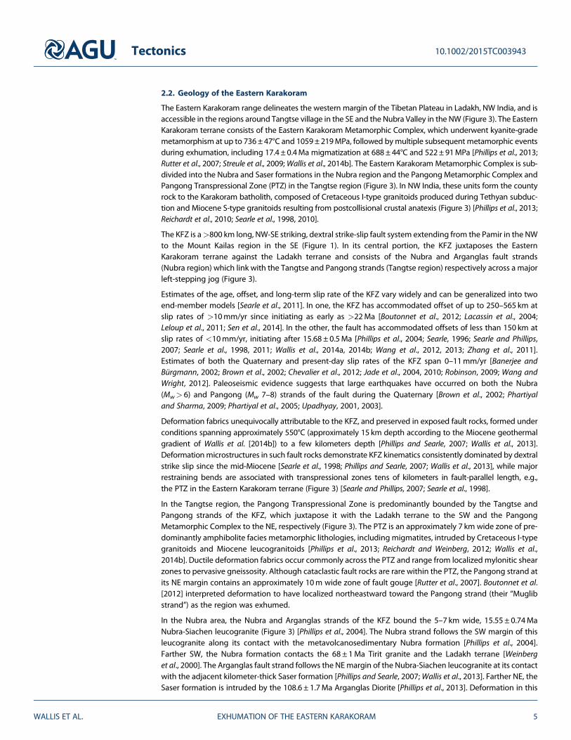
Figure 3. Simplified map of Ladakh, NW India, with Landsat 8, band 8 underlay showing December 2014 snow and ice cover(white). Apatite fission track sample locations from the present study (squares) and previous studies (circles) [Clift et al., 2002;Kirstein et al., 2006, 2009; Kumar et al., 2007; Sinclair and Jaffey, 2001] are marked and color coded by fission track date. Thesample groups of the southern, central, and northern Ladakh terrane (LT) of Kirstein et al. [2009] are indicated. A-A′ and B-B′indicate the transects plotted in Figure 4. The Pangong Transpressional Zone includes (not differentiated) metamorphiccountry rocks of the Eastern KarakoramMetamorphic Complex, migmatites, and Cretaceous and Oligo-Miocene granitoids ofthe Karakoram batholith. KFZ = Karakoram Fault Zone, NF =Nubra formation, PMC= Pangong Metamorphic Complex,MD=Muglib Dome, and STG = South Tangtse granite.
Tectonics 10.1002/2015TC003943
WALLIS ET AL. EXHUMATION OF THE EASTERN KARAKORAM 3

To address the lack of data from the Eastern Karakoram terrane, this paper presents new AFT dates from theNubra and Tangtse areas in two transects across different fault blocks of the KFZ (Figure 3). The data allow usto test (1) the extent to which the KFZ has influenced the low-temperature cooling history of surroundingrock units in different fault blocks; (2) whether the Eastern Karakoram terrane follows the low-temperaturecooling trend defined by the Ladakh terrane [Kirstein et al., 2009], whether it has undergone exhumationas rapid as the central Karakoram, or whether a significant discontinuity occurs across the KFZ; and (3) therelative significance of climatic gradients, regional tectonics, and/or localized deformation in producingthe pattern of exhumation defined by the Ladakh, Eastern Karakoram, and central Karakoram terranes.
2. Geological Setting2.1. Geology and Low-Temperature Cooling History of Ladakh and the Karakoram
In the regions bordering western Tibet (Figure 1), existing low-temperature thermochronological data areavailable from the Ladakh batholith, NW India [Choubey, 1987; Clift et al., 2002; Kirstein et al., 2006, 2009;Kumar et al., 2007; Schulp et al., 2003; Sinclair and Jaffey, 2001; Sorkhabi et al., 1994], and from the K2 gneissand Gasherbrum Diorite in the central Karakoram, NE Pakistan [Cerveny et al., 1989; Foster et al., 1994].
The majority of the presently exposed intrusive lithologies of the Ladakh terrane were emplaced in an arcsetting at 7–15 km depth between approximately 47 and 70Ma, with emplacement ending soon after theIndia-Asia collision at approximately 50.5Ma [Kirstein, 2011; Najman et al., 2010; St-Onge et al., 2010].Synthesis of results from multiple thermochronometers (40Ar/39Ar hornblende and biotite, fission track oftitanite, zircon and apatite, and zircon and apatite (U-Th)/He) suggests that different portions of theLadakh batholith have experienced variable and rather complex cooling histories [Kirstein, 2011]. However,AFT data from a transect across the batholith between the Indus suture in the south and the Shyok suture(Figure 3) in the north show a northward decreasing trend in cooling ages from 35–30Ma to approximately6Ma [Kirstein et al., 2009]. Kirstein et al. [2009] proposed that Oligocene-Miocene southward tilting of thebatholith resulted in asymmetrical topography, with greater elevation and stronger erosion in the north,whereas the southern margin was mantled by back thrusting of the Indus Molasse (Figure 3).
To the north, the central Karakoram terrane in Pakistan consists of the Paleozoic-Mesozoic KarakoramMetamorphic Complex intruded by the Karakoram batholith (Figure 1) [Fraser et al., 2001; Searle, 1991;Searle et al., 2010]. These include the amphibolite grade K2 gneiss and the Cretaceous Gasherbrum Diorite(Figure 1) [Cerveny et al., 1989; Foster et al., 1994; Searle et al., 1990]. Zircons from samples collected atelevations of 4880m to 7165m on Gasherbrum IV have fission track cooling ages of 125.0–31.4Ma, theyounger ages resulting from resetting by hydrothermal fluids [Cerveny et al., 1989]. These results demonstratethat the Gasherbrum Diorite has never been buried to depths of >6 km and, along with the extreme relief,suggest rapid and recent incision and exhumation [Cerveny et al., 1989]. This is borne out by apatite fromsamples collected at elevations of 5300m to 8611m on K2, which have fission track cooling ages of 2.1± 0.6Ma to 4.3 ± 1.4Ma, with one result of 31.5 ± 5.6Ma [Foster et al., 1994]. Again, these data suggest rapidapparent denudation (approximately 3–6mm/yr) commencing after 5Ma [Foster et al., 1994] and demon-strate that the central Karakoram has experienced a markedly different low-temperature cooling history fromthe Ladakh batholith to the south. Searle and Phillips [2007] noted that while the Cretaceous-Paleogenecooling/exhumation history of the K2-Broad Peak-Gasherbrum region of the central Karakoram was unre-lated to activity on the adjacent KFZ, local transpressional motion on this structure may have contributedto rapid exhumation in the K2-Gasherbrum range since 4.3 ± 1.4Ma.
The Eastern Karakoram range in northern India is separated from both the Ladakh terrane and the centralKarakoram by the NW-SE striking dextral KFZ (Figure 1). Several studies have examined the medium-hightemperature cooling history of the Eastern Karakoram terrane using hornblende, biotite, muscovite, andK-feldspar 40Ar/39Ar thermochronology [Bhutani et al., 2003; Boutonnet et al., 2012; Dunlap et al., 1998;Mukherjee et al., 2012; Searle et al., 1998] as well as geothermobarometry and U/Pb zircon dating [Phillipset al., 2013; Wallis et al., 2014b]. These studies indicate cooling of the Eastern Karakoram from ~700 to 300°Cduring the Miocene and are discussed in detail below. However, there are currently no low-temperaturethermochronological data available to constrain the latter stages of cooling and exhumation of the EasternKarakoram terrane.
Tectonics 10.1002/2015TC003943
WALLIS ET AL. EXHUMATION OF THE EASTERN KARAKORAM 4
2.2. Geology of the Eastern Karakoram
The Eastern Karakoram range delineates the western margin of the Tibetan Plateau in Ladakh, NW India, and isaccessible in the regions around Tangtse village in the SE and the Nubra Valley in the NW (Figure 3). The EasternKarakoram terrane consists of the Eastern Karakoram Metamorphic Complex, which underwent kyanite-grademetamorphism at up to 736±47°C and 1059±219MPa, followed bymultiple subsequent metamorphic eventsduring exhumation, including 17.4± 0.4Ma migmatization at 688±44°C and 522±91MPa [Phillips et al., 2013;Rutter et al., 2007; Streule et al., 2009;Wallis et al., 2014b]. The Eastern Karakoram Metamorphic Complex is sub-divided into the Nubra and Saser formations in the Nubra region and the Pangong Metamorphic Complex andPangong Transpressional Zone (PTZ) in the Tangtse region (Figure 3). In NW India, these units form the countyrock to the Karakoram batholith, composed of Cretaceous I-type granitoids produced during Tethyan subduc-tion and Miocene S-type granitoids resulting from postcollisional crustal anatexis (Figure 3) [Phillips et al., 2013;Reichardt et al., 2010; Searle et al., 1998, 2010].
The KFZ is a>800 km long, NW-SE striking, dextral strike-slip fault system extending from the Pamir in the NWto the Mount Kailas region in the SE (Figure 1). In its central portion, the KFZ juxtaposes the EasternKarakoram terrane against the Ladakh terrane and consists of the Nubra and Arganglas fault strands(Nubra region) which link with the Tangtse and Pangong strands (Tangtse region) respectively across a majorleft-stepping jog (Figure 3).
Estimates of the age, offset, and long-term slip rate of the KFZ vary widely and can be generalized into twoend-member models [Searle et al., 2011]. In one, the KFZ has accommodated offset of up to 250–565 km atslip rates of >10mm/yr since initiating as early as >22Ma [Boutonnet et al., 2012; Lacassin et al., 2004;Leloup et al., 2011; Sen et al., 2014]. In the other, the fault has accommodated offsets of less than 150 km atslip rates of <10mm/yr, initiating after 15.68 ± 0.5Ma [Phillips et al., 2004; Searle, 1996; Searle and Phillips,2007; Searle et al., 1998, 2011; Wallis et al., 2014a, 2014b; Wang et al., 2012, 2013; Zhang et al., 2011].Estimates of both the Quaternary and present-day slip rates of the KFZ span 0–11mm/yr [Banerjee andBürgmann, 2002; Brown et al., 2002; Chevalier et al., 2012; Jade et al., 2004, 2010; Robinson, 2009; Wang andWright, 2012]. Paleoseismic evidence suggests that large earthquakes have occurred on both the Nubra(Mw> 6) and Pangong (Mw 7–8) strands of the fault during the Quaternary [Brown et al., 2002; Phartiyaland Sharma, 2009; Phartiyal et al., 2005; Upadhyay, 2001, 2003].
Deformation fabrics unequivocally attributable to the KFZ, and preserved in exposed fault rocks, formed underconditions spanning approximately 550°C (approximately 15 km depth according to the Miocene geothermalgradient of Wallis et al. [2014b]) to a few kilometers depth [Phillips and Searle, 2007; Wallis et al., 2013].Deformationmicrostructures in such fault rocks demonstrate KFZ kinematics consistently dominated by dextralstrike slip since the mid-Miocene [Searle et al., 1998; Phillips and Searle, 2007; Wallis et al., 2013], while majorrestraining bends are associated with transpressional zones tens of kilometers in fault-parallel length, e.g.,the PTZ in the Eastern Karakoram terrane (Figure 3) [Searle and Phillips, 2007; Searle et al., 1998].
In the Tangtse region, the Pangong Transpressional Zone is predominantly bounded by the Tangtse andPangong strands of the KFZ, which juxtapose it with the Ladakh terrane to the SW and the PangongMetamorphic Complex to the NE, respectively (Figure 3). The PTZ is an approximately 7 km wide zone of pre-dominantly amphibolite facies metamorphic lithologies, including migmatites, intruded by Cretaceous I-typegranitoids and Miocene leucogranitoids [Phillips et al., 2013; Reichardt and Weinberg, 2012; Wallis et al.,2014b]. Ductile deformation fabrics occur commonly across the PTZ and range from localized mylonitic shearzones to pervasive gneissosity. Although cataclastic fault rocks are rare within the PTZ, the Pangong strand atits NE margin contains an approximately 10m wide zone of fault gouge [Rutter et al., 2007]. Boutonnet et al.[2012] interpreted deformation to have localized northeastward toward the Pangong strand (their “Muglibstrand”) as the region was exhumed.
In the Nubra area, the Nubra and Arganglas strands of the KFZ bound the 5–7 km wide, 15.55 ± 0.74MaNubra-Siachen leucogranite (Figure 3) [Phillips et al., 2004]. The Nubra strand follows the SW margin of thisleucogranite along its contact with the metavolcanosedimentary Nubra formation [Phillips et al., 2004].Farther SW, the Nubra formation contacts the 68 ± 1Ma Tirit granite and the Ladakh terrane [Weinberget al., 2000]. The Arganglas fault strand follows the NEmargin of the Nubra-Siachen leucogranite at its contactwith the adjacent kilometer-thick Saser formation [Phillips and Searle, 2007;Wallis et al., 2013]. Farther NE, theSaser formation is intruded by the 108.6 ± 1.7Ma Arganglas Diorite [Phillips et al., 2013]. Deformation in this
Tectonics 10.1002/2015TC003943
WALLIS ET AL. EXHUMATION OF THE EASTERN KARAKORAM 5

area is confined to the Nubra and Arganglas fault strands, while the Tirit granite, interior of the Nubra-Siachenleucogranite, and the Arganglas Diorite are relatively undeformed.
2.3. Geomorphological Overview
Both elevation and relief generally increase from the Ladakh terrane to the Eastern Karakoram terrane andincrease further again in the central Karakoram terrane. The Ladakh terrane forms an orogen-parallel rangebetween approximately 3300m and 6000m elevation (Figure 1). The adjacent Eastern Karakoram range con-sists of a NW-SE trending range (Figure 1) with maximum relief of approximately 4300m between the highestsummits (up to 7672m elevation) and the valley bottoms (approximately 3300m elevation). Farther north,the central Karakoram range has extreme relief of up to 4700m from the summit of K2 (8611m elevation)to adjacent valley bottoms (~3900m elevation).
Present-day precipitation across the Ladakh and Karakoram ranges is low (<300mm/yr) with relatively littlespatial variation, but the larger-scale trend is one of precipitation decreasing from SW to NE from the frontalHimalaya (>1000mm/yr) into the Asian interior (<100mm/yr, Figure 2) [Bookhagen and Burbank, 2006, 2010;Dortch et al., 2013; Palazzi et al., 2013]. Drainage is typically dominated by snow and glacial meltwater,although rare local convective storm events occur [Hobley et al., 2012].
The highest elevations of the Ladakh Range host small cirque glaciers which are more numerous on the northside of the range and all of which originate on north facing slopes [Dortch et al., 2011b]. Dortch et al. [2011b]found that glacial equilibrium line altitudes closely mimic the distribution of highest elevation across theLadakh Range, consistent with the “glacial buzzsaw hypothesis” in which efficient glacial erosion exerts astrong influence on topographic elevation [Egholm et al., 2009; Thomson et al., 2010]. The EasternKarakoram range has more extensive glacial cover, with glaciers originating on slopes facing all directionsand individual glaciers commonly reaching >10 km length. The central Karakoram range has the greatestglacial cover, hosting several of the world’s longest glaciers outside the polar regions, including the>70 km long Siachen glacier which divides the central and Eastern Karakoram ranges.
3. Methodology
Samples were collected from two transects across the central KFZ in the Tangtse and Nubra areas (Figure 3).Additional samples from SW of the Nubra strand (i.e., similar to the location of sample Tiri 3240 of Kirstein et al.[2009]) were considered for AFT dating but did not contain suitable apatites. The Nubra transect forms anortheastern continuation of the Ladakh batholith transect (Figure 3) of Kirstein et al. [2006, 2009] andKirstein [2011] and extends these previous results across the KFZ within the Eastern Karakoram terrane.Sample W11/12 was collected 20 km northwest from the other three samples of the main Nubra transect.The Tangtse transect contains the major Pangong Transpressional Zone of the KFZ [Phillips, 2008; Searleet al., 1998], allowing its low-temperature cooling history to be constrained and compared to that of theNubra area where evidence for transpressional fault motion is more limited [Wallis et al., 2015].
One sample (W11/47) was collected from the NE of the KFZ in the Nubra transect. However, it was not pos-sible to obtain samples from NE of the KFZ in the Tangtse transect due to a lack of suitable lithologies in thePangong Metamorphic Complex to the NE of the Pangong fault strand. Due to limited access, it was not pos-sible to obtain samples from the region farther NE of the KFZ.
Sample details are given in Table 1. Samples were collected from valley bottoms and low elevations on valleysides. Samples from the Tangtse transect are from a narrow range of elevations between 4000m and 4189m.Samples from the Nubra transect span a greater range of elevations, increasing from 3477m in the Nubra val-ley to 4875m in the Eastern Karakoram range. All samples consist of either Cretaceous or Miocene granitoidsof the Karakoram batholith.
For this study we used AFT thermochronometry to constrain rates of rock cooling. The effective closuretemperature (for steady cooling through the AFT partial retention zone) is around 110–130°C, the exact valuedepending on the cooling rate to the surface [e.g., Reiners and Brandon [2006]]. Apatite grains were extractedfrom the rock samples using conventional magnetic and heavy liquid separation techniques thenmounted inepoxy resin on glass slides and polished for etching to reveal the natural spontaneous fission tracks. Theapatites were etched using 5N HNO3 at 20°C for 20 s. Etched grain mounts were then packed with mica
Tectonics 10.1002/2015TC003943
WALLIS ET AL. EXHUMATION OF THE EASTERN KARAKORAM 6

external detectors and corning glass (CN5) dosimeters and irradiated in the FRM 11 thermal neutron facility atthe University of Munich in Germany. Following irradiation, the external detectors were etched using 48% HFat 20°C for 25min. Sample ages were determined using the zeta calibration method and International Unionof Geological Sciences-recommended age, standards [Hurford, 1990]. As the samples were characterized bylow spontaneous track densities due to their young age, as many grains were counted as possible in order tosuitably capture the natural Poisson distribution and obtain good counting statistics. Table 2 summarizes theAFT results.
Erosional exhumation rates were estimated from AFT ages using the nonsteady state, eroding half-spacemodel ofWillett and Brandon [2013]. This approach is suitable for regions where exhumation results from ero-sional denudation with negligible tectonic removal of overlyingmaterial (i.e., by normal faulting). This is a rea-sonable approximation for the central KFZ which, unlike the southern KFZ, lacks a significant extensionalcomponent and is dominated by strike-slip kinematics [e.g., Wallis et al. [2013]]. While Miocene transpres-sional motion resulted in enhanced uplift of the PTZ relative to the adjacent Ladakh terrane and PangongMetamorphic Complex [Phillips and Searle, 2007; Searle et al., 1998; Wallis et al., 2014b], recent deformationin the region is dominated by strike-slip kinematics [Brown et al., 2002].
Erosion rates were calculated for the 10 Eastern Karakoram terrane samples and also, for comparison, the 12AFT dates from the Ladakh batholith reported by Kirstein et al. [2009]. The Ladakh batholith data set was con-sidered in three portions, the southern, central, and northern batholith, as defined by Kirstein et al. [2009]. TheWillett and Brandon [2013] approach incorporates both the cooling rate dependence of closure temperature(i.e., partial annealing zone) and thermal advection by rock motion toward the Earth’s surface. The model
Table 1. Sample Detailsa
Sample Lithology Unit Distance From Nubra/Tangtse Strand (m, NE Positive) Elevation (±25m) UTM Grid Reference
Tangtse transect 44 NW11/113 Hbl + Bt granite STG -900 4189 0238345 3767930W11/80 Bt leucogranite PTZ 2100 4000 0241552 3768594W11/63 Bt leucogranite PTZ 3500 4037 0242490 3769683W11/60 Diorite PTZ 4050 4012 0242976 3769954W11/74 Gr. leucosome PTZ 5100 4072 0243761 3770691W10/23 Bt leucogranite PTZ 6600 4090 0244380 3772336
Nubra transect 43 NW11/26 Bt leucogranite NSL 15 3477 0742019 3835401W11/12 Bt leucogranite NSL 1050 3637 0733308 3853035W11/41 Bt leucogranite NSL 1900 4012 0743591 3836486W11/47 Diorite AD 6250 4875 0747605 3838179
aNSL = Nubra-Siachen leucogranite, AD = Arganglas Diorite, STG = south Tangtse granite, and PTZ = Pangong Transpressional Zone.
Table 2. Apatite Fission Track Resultsa
Sample Number Elevation (±25m) N
Dosimeter Spontaneous Induced Age Dispersion Central Age (Ma)
ρd Nd ρs Ns ρi Ni Pχ2 RE% ±1 s
Tangtse TransectW11/113 4189 30 1.579 4378 0.046 154 2.430 8389 0.02 45.3 5.1 ± 0.6W11/80 4000 34 1.579 4378 0.036 115 1.972 6688 1.9 36.8 4.7 ± 0.5W11/63 4037 30 1.579 4378 0.094 228 4.473 11300 86.5 0.6 5.4 ± 0.4W11/60 4012 40 1.579 4378 0.044 131 2.70 8589 14.2 20.4 4.1 ± 0.4W11/74 4072 40 1.579 4378 0.032 119 1.663 6479 18.9 0.7 4.9 ± 0.5W10/23 4090 30 1.579 4378 0.086 206 4.022 10278 84.7 0.4 5.3 ± 0.4
Nubra TransectW11/26 3477 23 1.579 4378 0.070 91 3.556 5183 3.4 35.3 4.8 ± 0.6W11/12 3637 30 1.579 4378 0.096 169 7.175 13548 28.7 14.5 3.3 ± 0.3W11/41 4012 35 1.579 4378 0.096 281 4.549 13861 23.8 15.7 5.4 ± 0.4W11/47 4875 23 1.579 4378 0.141 133 4.922 4773 63.1 1.1 7.4 ± 1.1
aN = number of grain analyzed, ρ(d, s, i) = track density, N(d, s, i) = number of tracks, Pχ2 = probability of obtaining χ2 value for v degrees of freedom, wherev =N� 1, and RE% = age dispersion around central age.
Tectonics 10.1002/2015TC003943
WALLIS ET AL. EXHUMATION OF THE EASTERN KARAKORAM 7

inputs are the duration of erosion, mean surface temperature, deviation of sample elevation from mean ele-vation, thermochronometric age, and geothermal gradient. The duration of erosion was set to 20Myr for theEastern Karakoram samples and 50Myr for Ladakh batholith samples, broadly consistent with existing geo-logical and thermochronological constraints [Boutonnet et al., 2012; Kirstein, 2011]. Mean surface temperaturewas set to 0°C based on the mean temperature in Ladakh during the twentieth century [Bhutiyani et al., 2007].The mean elevation in the vicinity of each sample (Table 3) was calculated from Advanced SpaceborneThermal Emission and Reflection Radiometer Global Digital Elevation Model (ASTER GDEM) data for a circulararea of 10 km radius centered on each sample, followingWillett and Brandon [2013].Wallis et al. [2014b] esti-mated the geothermal gradient in the Eastern Karakoram to have been 36± 7°C/km during the Miocene;therefore, estimates of erosion rate were calculated for geothermal gradients of 30, 35, and 40°C/km. The ero-sion rate estimates reported herein are based on the 35°C/km geothermal gradient and central fission trackage. Upper bound erosion rate uncertainties were derived from a 30°C/km geothermal gradient and lowerbound ages. Lower bound erosion rate uncertainties were derived from a 40°C/km geothermal gradientand upper bound ages.
4. Results
AFT dates for the Tangtse area samples (Table 2) range from 4.1 ± 0.4Ma (W11/60) to 5.3 ± 0.4Ma (W10/23).Several samples have greater than 20% dispersion in grain ages about the central age due to the low (0 or 1)
Table 3. Modeled Erosional Exhumation Rates and Estimated Local Mean Elevations Used in the Erosion Rate Calculationa
SampleDistance FromIndus River (km)
Mean elevation in10 km Radius (m)
Maximum Age,40°C/km (mm/yr)
Central Age,35°C/km (mm/yr)
Minimum Age,30°C/km (mm/yr)
Tangtse Transect, Eastern KarakoramW11/113 39 4640 0.49 0.67 0.95W11/80 42 4646 0.50 0.68 0.97W11/63 43.2 4689 0.44 0.58 0.79W11/60 43.7 4755 0.56 0.77 1.09W11/74 44.8 4759 0.47 0.64 0.91W10/23 46.3 4783 0.44 0.58 0.80Mean 0.48 0.65 0.92
Nubra Transect, Eastern KarakoramW11/26 56.5 4123 0.48 0.67 0.97W11/12 69.7 4328 0.74 1.01 1.43W11/41 58.2 4477 0.48 0.62 0.84W11/47 62.1 5110 0.35 0.48 0.69Mean 0.51 0.70 0.98
Northern Ladakh BatholithDisk 3220 44.7 3956 0.24 0.41 0.85Dok 3525 41.7 4091 0.31 0.55 1.27Hund 3250 45.1 3945 0.31 0.46 0.73Tiri 3240 49.1 3791 0.29 0.45 0.78Mean 0.29 0.47 0.91
Central Ladakh BatholithKhar 3975 36.8 4375 0.10 0.14 0.22Khar 4918 24.1 5066 0.13 0.18 0.24Nang 3555 9.9 3951 0.10 0.14 0.18Nang 4300 10.0 4708 0.11 0.15 0.19Mean 0.11 0.15 0.21
Southern Ladakh BatholithBAS1 7.5 4039 0.06 0.08 0.10BAS 4001 12.2 4370 0.06 0.08 0.12LEH 3295 1.1 3703 0.07 0.09 0.12Karu 3400 2.7 3836 0.07 0.09 0.12Mean 0.07 0.09 0.12
aErosion rates modeled using age2edot [Willett and Brandon, 2013]. Data for Ladakh batholith samples are taken from Kirstein et al. [2009]. Exhumation ratesestimated for central apatite fission track ages and upper and lower age error bounds, combined with geothermal gradients of 35°C/km, 40°C/km, and 30°C/km, respectively, to gauge uncertainty.
Tectonics 10.1002/2015TC003943
WALLIS ET AL. EXHUMATION OF THE EASTERN KARAKORAM 8

spontaneous track counts in some grains. Examination of grain age distributions (radial plots) confirms thatthere are no spurious grain ages nor distinct populations that might alternatively explain the overdispersion.The dates show no systematic trend along the transect, and sample W11/113 from SW of the Tangtse faultstrand shows no significant difference from the samples within the PTZ to the NE of the Tangtse strand(Figure 4). The Tangtse area samples do not show a systematic age-elevation relationship (Figure 5), due totheir limited range of sample elevations (4000–4189m).
Dates for the Nubra area samples (Table 2) rangefrom 3.3±0.3Ma (W11/12) to 7.4±1.1Ma (W11/47), generally increasing along transect, from theNubra valley in the SW to the Arganglas Dioritein the NE (Figure 4). The three samples whichlie on the main B-B′ transect, obtained from ele-vations between 3477m and 4875m, show apositive age-elevation relationship (Figure 5).Sample W11/12, collected 20 km NW from themain transect, shows a younger age for its eleva-tion than the other samples.
Erosion rates estimated for the Tangtse areasamples range between 0.58+0.21/�0.14 mm/yr (W11/63) and 0.77+0.32/�0.21mm/yr (W11/60) and average 0.65+0.27/�0.17mm/yr(Table 3 and Figure 6). Erosion rates estimatedfor the Nubra area samples range between0.48+0.21/�0.13mm/yr (W11/47) and 1.01+0.42/�0.27mm/yr (W11/12) and average0.70+0.29/�0.18mm/yr (Table 3). The average
Figure 4. Apatite fission track ages in the (a) Tangtse (A-A′) and (b) Nubra (B-B′) transects across the Karakoram Fault Zone.Sample apatite fission track ages and elevations are projected onto linear transects (A-A′ and B-B′) marked in Figure 3.Sample W11/12, which lies off the main B-B′ transect, is circled. Grey region marks the range of elevation in a 6 km wideswath along the transects from ASTER GDEM data. ASTER GDEM is a product of The Ministry of Economy, Trade, andIndustry of Japan and NASA. Also shown are the positions of major fault strands and simplified lithological unit divisions.
Figure 5. Age-elevation relationship for the Eastern Karakoram sam-ples. Dashed line shows linear best fit through the data from thethree Nubra samples that line on themain B-B′ transect. SampleW11/12, which lies off the main B-B′ transect, is circled. Data for thenorthern Ladakh batholith from Kirstein et al. [2009] are included forcomparison with the Nubra results.
Tectonics 10.1002/2015TC003943
WALLIS ET AL. EXHUMATION OF THE EASTERN KARAKORAM 9

erosion rate estimate for the northernLadakh batholith is 0.47+0.44/�0.18mm/yr (Table 3). That of the central portion ofthe batholith is 0.15+0.06/�0.04mm/yr,while that of the southern margin is 0.09+0.03/�0.02mm/yr (Table 3 and Figure 6).The uncertainties in exhumation rate,apparent in Figure 6, are larger for youngersamples because the uncertainties in bothage and geothermal gradient have a pro-portionally greater impact for samples withyounger central ages.
5. Discussion5.1. Cooling and Exhumation of theEastern Karakoram Terrane Within andAcross the Karakoram Fault Zone
The Tangtse transect crosses the Tangtsestrand of the KFZ, while the Nubra trans-ect crosses the Arganglas strand and alsoprovides a continuation of the results of
Kirstein et al. [2009] across the Nubra strand. This allows us to look for differences in cooling histories acrossthese strands. The lack of significant age differences between sample W11/113 and those across the Tangtsestrand (Figure 4) suggests that no significant differential exhumation has occurred across this fault strand orthe PTZ since approximately 4–5Ma. This is consistent with the limited structural evidence for low-temperature deformation on the Tangtse strand and within the PTZ [Rutter et al., 2007; Wallis et al., 2013].
The AFT date of the Arganglas Diorite (7.4 ± 1.1Ma), NE of the Arganglas strand, differs from samples of theNubra-Siachen leucogranite to the SW of the fault strand (<5.4 ± 0.4Ma, W11/41; Figure 4). However, samplesin this transect span an elevation range of 1398m and show a positive age-elevation relationship (Figure 5).Also, the Arganglas strand displays only minor low-temperature deformation structures, such as centimeter-thick cataclasite-filled faults [Wallis et al., 2013]. Therefore, we interpret the age variation within the Nubratransect and across the Arganglas strand to result from erosional exhumation of samples at differentstructural levels (i.e., paleodepths), rather than differential exhumation across the Arganglas strand.
The Nubra transect samples from the Eastern Karakoram terrane have younger AFT dates than samplesfrom similar elevations in the northern Ladakh batholith [Kirstein et al., 2009] across the Nubra strand ofthe KFZ (Figure 3 and 5). This continues the SW-NE trend of decreasing AFT dates across the Ladakh batholith,across the Nubra strand of the KFZ and into the Eastern Karakoram terrane. The results also permit differentialuplift and erosional exhumation of the Eastern Karakoram relative to the Ladakh terrane due to a verticalcomponent of motion on the Nubra strand. However, since the age groups overlap within uncertainty,localized vertical motion on the Nubra strand cannot be detected with confidence and is not required.
The AFT results from the Tangtse transect are within uncertainty of Nubra sample W11/41 from similarelevation (Figure 5). This suggests that the two subregions of the Eastern Karakoram terrane have followeda broadly similar low-temperature cooling history since at least approximately 5Ma and that differentialexhumation between them has been negligible since that time. This similarity in recent cooling historiesis highlighted by the close similarity in modeled exhumation rates for the two regions (Table 3).Based on this similarity, the modeled exhumation rate data from the two regions can be combined toestimate an average exhumation rate of 0.67 + 0.27/�0.18mm/yr across the Eastern Karakoram terranesince approximately 7Ma. For comparison, the apparent exhumation rate defined by the age-elevationrelationship of the three Nubra samples lying on the main B-B′ transect is 0.51mm/yr, with rates of0.45–0.67mm/yr being permissible within age uncertainty. Therefore, the two approaches give the sameexhumation rates within uncertainty.
Figure 6. Variation in modeled erosional exhumation rates across theLadakh batholith and Eastern Karakoram with distance from the IndusRiver. Exhumation rates were estimated using the eroding half-spacemodel of Willett and Brandon [2013] for apatite fission track data fromthe Ladakh batholith (n = 12, AFT data from Kirstein et al. [2009]) andNubra area of the Eastern Karakoram (n = 4, this study).
Tectonics 10.1002/2015TC003943
WALLIS ET AL. EXHUMATION OF THE EASTERN KARAKORAM 10

While few studies have investigated the temperature-time history of the Nubra area using geothermometry orthermochronology [Bhutani et al., 2003;Wallis et al., 2014b, 2015], the medium-high temperature cooling historyof the Tangtse area is relatively well constrained [Boutonnet et al., 2012; Dunlap et al., 1998;Mukherjee et al., 2012;Searle et al., 1998;Wallis et al., 2014b]. The new AFT data reveal the low-temperature cooling history of the Tangtsearea. Available temperature-time data for the Tangtse area are compiled in Figure 7. These consist primarily of40Ar/39Ar biotite, muscovite, and amphibole results [Boutonnet et al., 2012; Dunlap et al., 1998; Mukherjee et al.,2012; Searle et al., 1998] along with amphibole-plagioclase geothermometry [Wallis et al., 2014b] of the approxi-mately 17Ma migmatite unit [Phillips et al., 2013] and the fission track results of the present study. We have notincluded high-temperature systems (e.g., zircon U/Pb) that record local and transient temperatures of emplace-ment of individual igneous intrusions, in order to focus on the longer-term cooling history of the widercountry rocks.
It should be noted that the 41 data points represent a compilation from 32 samples across the approximately8 km transect and that Boutonnet et al. [2012] recognized some variation in medium-temperature cooling his-tories between different portions of the transect. For instance, 40Ar/39Ar biotite and muscovite dates ofapproximately 7–11Ma from the PTZ and Pangong strand (i.e., the NE portion of the transect) are somewhatyounger than approximately 9–14Ma dates from the Tangtse strand and South Tangtse granite (i.e., the SWportion of the transect). This contributes to the spread of 40Ar/39Ar biotite and muscovite dates evident inFigure 7. Boutonnet et al. [2012], who contributed the majority of the 40Ar/39Ar data, considered both plateauages and inverse isochron ages to assess and minimize potential excess 40Ar problems.
The new AFT data indicate cooling rates in the range 11–29°C/Ma between approximately 5Ma and the pre-sent. However, the maximum cooling rate of 29°C/Ma is insufficient to explain the majority of the higher-temperature cooling ages. While the data from the south Tangtse granite can be explained by an
Figure 7. Compilation of temperature-time data from the Tangtse area, consisting of 40Ar/39Ar biotite, muscovite, andamphibole results [Boutonnet et al., 2012; Dunlap et al., 1998; Mukherjee et al., 2012; Searle et al., 1998] along with amphi-bole-plagioclase geothermometry [Wallis et al., 2014b] of the approximately 17Ma migmatite unit [Phillips et al., 2013] andthe fission track results of the present study. Data are divided into different portions of the Tangtse transect followingBoutonnet et al. [2012]. An envelope of cooling rates is provided to aid interpretation, but note that these are not maximumand minimum permissible rates.
Tectonics 10.1002/2015TC003943
WALLIS ET AL. EXHUMATION OF THE EASTERN KARAKORAM 11

approximately constant cooling rate, all the other regions require higher cooling rates at some time interval(s) prior to cooling through the AFT partial annealing zone. In particular, the data from the PTZ require highercooling rates between the approximately 5Ma fission track ages and the approximately 7–11Ma 40Ar/39Armica ages. These findings are broadly consistent with the interpretations of Dunlap et al. [1998] who sug-gested that transpressional fault motion since approximately 8Ma caused an increase in uplift, exhumation,and cooling rates. The fission track results indicate that this phase of rapid cooling did not continue to thepresent day and that cooling rates reduced again some time since 7Ma.
An important caveat to this analysis is that the geothermal gradient may not have remained constant over thetimescales in question, in which case an increased cooling rate could occur at constant exhumation rate under adecreasing geothermal gradient. However, tectonic histories based on previous geothermobarometric andthermochronological studies of the region [e.g., Kirstein, 2011; Wallis et al., 2014b] provide no indication of,nor potential cause for, a temporary late Miocene to early Pliocene reduction in geothermal gradient.
In summary we find evidence that cooling of the PTZ was more rapid between the 7–8Ma 40Ar/39Ar micaages and the 5Ma AFT ages than it was from 5Ma to the present. The decrease in cooling rate suggests aswitch to dominantly strike-slip fault motion along the PTZ and a concomitant reduction in its uplift relativeto surrounding units. This is consistent with the geomorphology of the Pangong strand which has accommo-dated the majority of the recent deformation along the PTZ. Offset debris flows and alluvial fans along thisstrand indicate an average strike-slip slip rate of 4 ± 1mm/yr since 14 ka and lack evidence for significant dif-ferential vertical motion on this strand [Brown et al., 2002]. Since this is the most geomorphologically promi-nent strand of the central KFZ, it is likely that the local surface expression of deformation continues to bedominantly strike slip at the present day.5.1.1. Spatial Variation in Exhumation Rates Across Ladakh and the KarakoramLow-temperature thermochronological data have delineated significant cooling age variations and trendsacross and between different portions of the western Himalaya-Karakoram. Extremely young AFT dates(<2Ma) in the high Himalaya generally increase northward toward the Zanskar shear zone, a portion ofthe South Tibetan Detachment (approximately 15–19Ma, Figure 1) [Schulp et al., 2011]. Farther NW, AFT datesdecrease again across the Tso Morari dome (Figure 1) from approximately 30–40Ma to approximately 7Ma atthe Indus suture [Schulp et al., 2003]. Across the Indus suture, a repeat of this trend is observed, with AFT datesdecreasing systematically from 35–30Ma to approximately 6Ma across the Ladakh batholith [Kirstein et al.,2009]. Farther north in the central Karakoram, AFT dates are again very young, i.e., 2.1 ± 0.6Ma to 4.3± 1.4Ma (with one result of 31.5 ± 5.6Ma) at extreme elevations of 5300m to 8611m on K2 [Foster et al.,1994]. This study fills an important gap in this transect across the Himalaya-Karakoram by providing AFTresults from the Eastern Karakoram terrane, which is geographically and topographically intermediatebetween the Ladakh terrane and the central Karakoram.
The Eastern Karakoram terrane AFT dates, ranging between 3.3±0.3Ma and 7.4±1.1Ma (Table 2 and Figure 4), liebetween the older ages from the Ladakh batholith to the SW and the younger ages from the central Karakoram tothe NW, completing the trend across this region. This trend in cooling ages is reflected in a corresponding trend inmodeled erosional exhumation rateswhich increase approximately sevenfold, from 0.09+0.03/�0.02mm/yr nearthe Indus suture to 0.67+0.27/�0.18mm/yr in the Eastern Karakoram terrane (Table 3 and Figure 6). As with theage data, the exhumation rate trend is continuouswithin uncertainty between the Ladakh terrane and the EasternKarakoram terrane, suggesting that localized deformation along the Nubra strand of KFZ has had little or noimpact on the erosional exhumation rates of the adjacent areas. A discontinuity in the exhumation rate trendappears to occur between the central and northern portions of the Ladakh terrane and may be associated withmotion of the Khalsar thrust which separates these sample locations (Figure 3). However, targeted high spatialresolution sampling across the thrust trace would be required to test this hypothesis.
Kumar et al. [2007] analyzed AFT ages in more spatially restricted transects in the southern central portion ofthe Ladakh Range (including the younger ages near the bottom of Figure 3). They obtained exhumation ratesof 0.09 and 0.11mm/yr from age-elevation plots, in good agreement with our results. However, their shorterprofiles do not record the long-range exhumation rate gradient across the Ladakh terrane and instead reflectmore local erosional details (e.g., age-elevation relationships in individual valleys). It is possible that theyounger ages on the southern slopes of the Ladakh terrane indicate some along-strike deviation from theexhumation rate trend in Figure 6, although more data along strike are required to test this hypothesis.
Tectonics 10.1002/2015TC003943
WALLIS ET AL. EXHUMATION OF THE EASTERN KARAKORAM 12

Foster et al. [1994] used AFT data from K2 to suggest exhumation rates of 3–6mm/yr beginning at approxi-mately 5–3Ma followed by 0.5–1mm/yr since approximately 2Ma in this portion of the central Karakoram.These rates are similar to and somewhat higher than those from the Eastern Karakoram demonstrating thatthe trend of increasing exhumation rate continues north into the central Karakoram.5.1.2. Causes of Regional Variation in Exhumation RatesThe combined data sets offer an opportunity to assess potential causes of the variation in exhumation ratesacross the different terranes. In particular, we consider the potential influences of climatic gradients and localand regional tectonic processes. The above synthesis of cooling age data and inferred exhumation ratesdemonstrates a long-range trend spanning the Ladakh and Karakoram terranes in which localized deformationassociated with individual structures appears to have a relatively minor, second-order effect. For example, theKFZ strands have produced no discontinuity in the AFT age and exhumation rate trends that is clearly distin-guishable from the longer-range trends. Similarly, the increase in exhumation rate across the Khalsar thrust,althoughmore pronounced, is superimposed on thewider trend. Therefore, we suggest that the underlying dri-ver of the exhumation rate trend acts over longer characteristic length scales of tens to hundreds of kilometers.
Present-day mean annual precipitation does vary over 100 km length scales across the region (Figure 2)[Bookhagen and Burbank, 2006, 2010; Dortch et al., 2013; Palazzi et al., 2013]. However, three considerationsindicate that spatial variation in precipitation is not the cause of the exhumation rate trend. First, meanannual precipitation decreases from SW to NE, whereas exhumation rate increases (Figure 2). Second, unlikein the Himalaya to the south, precipitation varies little over the (tens of kilometers) length scales across whichwe observe strong exhumation rate gradients in our study area (Figure 2). Lastly, overall, precipitation is verylow (<300mm/yr) across eastern Ladakh and the Karakoram (Figure 2). Although these arguments are basedon the present-day climate, it is unlikely that the direction of climatic gradients has typically been opposite(also with shorter wavelengths) over the past 7Myrs.
Instead, we suggest that the trend in exhumation rates is a result of the long-wavelength gradient in crustalshortening and thickening from the Indus suture into the Karakoram. Crustal thickness increases from approxi-mately 60 km beneath the Tethyan Himalaya to approximately 80 km beneath the central KFZ [Hazarika et al.,2014; Rai et al., 2006]. This thickening is associated with intense crustal shortening in the Karakoram, whilethe Ladakh batholith remains relatively undeformed [Kirstein, 2011; Searle et al., 2010]. In the centralKarakoram, the surface expressions of this shortening and thickening are the extensive thrust systems, whereasmajor dome structures such as the Bullah and Dassu domes indicate more pervasive deformation at depth[Searle et al., 2010]. Although the Karakoram had a thickened Andean-type crust since the Cretaceous (M1,D1), geological relationships indicate multiple phases of postcollisional metamorphism and deformation (M2,D2 to M4, D4) [Phillips et al., 2013; Searle et al., 2010]. In particular, the M4-D4 Dassu dome contains sillimaniteorthogneiss metamorphosed under conditions of 689±48°C and 570±190MPa at 5.4±0.1Ma [Fraser et al.,2001; Searle et al., 2010]. This demonstrates crustal shortening and thickening associated with extremely rapidexhumation from approximately 20 km depth since the Pliocene, i.e., during the time span under consideration.
Since the India-Asia collision, rock uplift must have occurred at greater rates in the Karakoram than in sur-rounding regions such as the Ladakh terrane and Tibet. More material (>20 km) has been removed fromparts of the Karakoram during the Neogene [Fraser et al., 2001; Searle et al., 2010; Wallis et al., 2014b] thanfrom Ladakh since the Paleogene (7–14 km) [Kirstein, 2011]. Therefore, differential rock uplift must haveoccurred during the Neogene and/or Quaternary to avoid unfeasible paleotopography of the Karakoram ori-ginally having surface elevations 6–13 km higher than the Ladakh terrane.
As a result of their great elevation, the eastern and central Karakoram support extensive glacial systemsthroughout the glacial cycle, despite low levels of precipitation. In contrast, the lower elevations of theLadakh terrane support less extensive glaciers and, for example, host only small cirque glaciers at thepresent day. We suggest that glacial erosion provides an effective mechanism for the removal of increas-ingly large amounts of material from south to north and results in the observed increase in exhumationrate. In other words, large-scale deformation, in the form of crustal shortening and thickening, providesthe underlying driving force for rock and surface uplift, which ultimately results in glaciation despite thearid climate. Localized upper crustal deformation in fault zones is only the surface expression of thiscrustal shortening and thickening and appears to result in only second-order effects on patterns ofexhumation. Although it is difficult to assess the roles of surface elevation and glaciation over million
Tectonics 10.1002/2015TC003943
WALLIS ET AL. EXHUMATION OF THE EASTERN KARAKORAM 13

year timescales, support for these interpretations is provided by studies of the late Pleistocene-Holoceneglacial history and landscape evolution of the region [Dortch et al., 2010, 2011a, 2011b, 2013; Munacket al., 2014]. These provide a case study for how the system has behaved over the most recent glacialcycles and are summarized below.
5.2. Glaciation and Erosion in Ladakh and the Karakoram
Evidence for 19 glacial stages extending back to 311± 32 ka is preserved across the Ladakh-Karakoram region[Dortch et al., 2013], although older (now erased) glacial stages may have occurred earlier as the global cli-mate cooled during the Pleistocene and late Neogene [Raymo and Ruddiman, 1992; Zachos et al., 2001].Mapping of preserved glacial landforms has demonstrated that during the Deshkit 2 (81 ± 6 ka) andDeshkit 1 (45 ± 3 ka) glacial stages, glaciers in the Karakoram advanced such that the Siachen glacierextended approximately 100 km beyond its present limit, while those in the Ladakh Range extended only9.2 ± 1.6 km and 2.7 ± 0.6 km respectively beyond their present limits [Dortch et al., 2010]. This suggests thatalthough the absolute glacial cover may vary through time, the present-day trend of increasing glaciationfrom SW to NE is likely also typical of previous glacial cycles.
Support for the interpretation that tectonically generated high topography results in increased glacial cover and,in turn, increased erosion/exhumation rates is also provided by studies of the late Pleistocene history of glaciationand landscape evolution across the Ladakh-Karakoram regions. Dortch et al. [2011b] reached similar conclusionsbased on drainage morphometric analysis, mapping of present-day glaciers, and 10Be dating of fluvial samplesfrom the topographically asymmetrical Ladakh Range. They used the 10Be inventories of fluvial sediments inactive river channels draining catchments with varying extents of glaciation to determine catchment-wideerosion rates averaged over long (105 years) geomorphological timescales. They found that the topographicallyhigher northern side of the range is associated with increased present-day glacial cover and higher erosion rates(between 0.056±0.012mm/yr and 0.074±0.011mm/yr since approximately 100 ka) than the southern side ofthe range (between 0.020±0.003mm/yr and 0.039±0.008mm/yr since approximately 300 ka).
Kirstein et al. [2009] and Kirstein [2011] suggested, based on AFT data, that the Ladakh batholith was tiltedsouthward during the late Paleogene due to the ongoing collision, resulting in increased elevation andyounger cooling ages in the north. Similarly, Dortch et al. [2011b] used published fluvial incision rates[Dortch et al., 2011a] to estimate a rock uplift rate of 0.6mm/yr for the northern side of the Ladakh Rangeduring the Quaternary. As this uplift is an order of magnitude faster than the erosion rate over similartimescales, they argued that denudational unloading was not a significant driver for tilting of the range.Rather, they concluded that ongoing tectonic uplift is raising the elevation of the northern side of the range,a process that could continue until sufficiently limited by the glacial equilibrium line altitude.
Munack et al. [2014] found that 10Be data from the Indus valley, along the southern margin of the Ladakh Range,spanning postglacial timescales of 103–104 years, indicate denudation rates of only 0.01–0.11mmyr�1. As theserates are lower than those derived from low-temperature thermochronological data spanning greater timescalesof >106 years (approximately 0.1–0.4mmyr�1) [Clift et al., 2002; Kirstein et al., 2006, 2009; Kirstein, 2011; Kumaret al., 2007; Sinclair and Jaffey, 2001, this study], the authors concluded that glacial processes during previous gla-cial cycles must have made a significant contribution to erosional denudation and rock exhumation and cooling.
Our findings are comparable to several recent studies documenting the tectonic processes of the India-Asia colli-sion as the underlying driving forces for mountain range growth and rock exhumation along much of theHimalaya [e.g., Adams et al., 2015; Burbank et al., 2003; Godard et al., 2014; Robert et al., 2011; Thiede and Ehlers,2013; Wang et al., 2014]. For instance, the recent review of Thiede and Ehlers [2013], based on thermal-kinematicerosion modeling of 1126 Himalayan bedrock cooling ages, emphasized the importance of both tectonic defor-mation and glacial processes in controlling spatial and temporal variations in erosional denudation. We find thatthese processes are also key controls onmountain range evolution behind the Himalayan front in Ladakh and theKarakoramwhere climatic influences such as the monsoon are suppressed [Bookhagen and Burbank, 2010; Palazziet al., 2013] and the impacts of tectonic deformation and rock uplift are highlighted.
6. Conclusions
Apatite fission track analysis of 10 samples from two transects across the central KFZ in the Eastern Karakoramrange gives cooling ages between 3.3 ± 0.3Ma and 7.4 ± 1.1Ma, providing the first constraints on the
Tectonics 10.1002/2015TC003943
WALLIS ET AL. EXHUMATION OF THE EASTERN KARAKORAM 14

low-temperature cooling history of the Eastern Karakoram terrane. The data allow modeling of erosionalexhumation rates which average 0.67 + 0.27/�0.18mm/yr across the Eastern Karakoram terrane sinceapproximately 7.4Ma. The new results elucidate significant variations in AFT ages and exhumation ratesbetween different tectonic domains across Ladakh and the Karakoram. In particular, the Eastern Karakoramresults show that the trend of increasing exhumation rate across the Ladakh batholith (from 0.09 + 0.03/�0.02mm/yr to 0.47 + 0.44/�0.18mm/yr), apparent in the data of Kirstein et al. [2009], continues northeastinto the Karakoram terrane. Farther to the northwest within the central Karakoram terrane, cooling agesare younger still [Foster et al., 1994]. Overall, the results complete a south-north trend of increasing exhumationrate from the Indus suture, across the Ladakh batholith and into the Karakoram.
Across the region where we have detected the trend in exhumation rates there is little variation in present-day mean annual precipitation and, at the broader scale, precipitation decreases SW-NE, making spatialvariation in climate an unlikely cause of the exhumation rate trends. However, the extent of glaciationincreases SW-NE across the study area and geomorphological evidence suggest that this has been the casesince at least the late Pleistocene [Dortch et al., 2010]. Therefore, we advocate a model in which spatialvariations in exhumation rates in this portion of the orogen are primarily driven by spatial variations in thevertical component of rock motion. This in turn is driven by regional tectonics of crustal thickening. Theassociated surface uplift promotes glaciation and generation of extreme relief, even where mean precipita-tion is relatively low, facilitating high erosion rates which contribute to rapid exhumation.
ReferencesAdams, B. A., K. V. Hodges, K. X. Whipple, T. A. Ehlers, M. C. van Soest, and J. Wartho (2015), Constraints on the tectonic and landscape
evolution of the/Bhutan Himalaya from thermochronometry, Tectonics, 34, 1329–1347, doi:10.1002/2015TC003853.Banerjee, P., and R. Bürgmann (2002), Convergence across the northwest Himalaya from GPSmeasurements, Geophys. Res. Lett., 29(13, 1652),
doi:10.1029/2002GL015184.Beaumont, C., R. A. Jamieson, M. H. Nguyen, and B. Lee (2001), Himalayan tectonics explained by extrusion of a low-viscosity crustal channel
coupled to focused surface denudation, Nature, 414, 738–742, doi:10.1038/414738a.Bhutani, R., K. Pande, and N. Desai (2003), Age of the Karakoram fault activation:
40Ar-
39Ar geochronological study of Shyok suture zone in
northern Ladakh, India, Curr. Sci., 84, 1454–1458, doi:10.1016/j.jseaes.2008.03.013.Bhutiyani, M. R., V. S. Kale, and N. J. Pawar (2007), Long-term trends in maximum, minimum and mean annual air temperatures across the
Northwestern Himalaya during the twentieth century, Clim. Change, 85, 159–177, doi:10.1007/s10584-006-9196-1.Bishop, M. P., A. B. G. Bush, L. Copland, K. Ulrich, L. A. Owen, Y. B. Seong, and J. F. Schroder Jr. (2010), Climate change and mountain topo-
graphic evolution in the central Karakoram, Pakistan, Ann. Assoc. Am. Geogr., 100, 772–793, doi:10.1080/00045608.2010.500521.Bookhagen, B., and D. W. Burbank (2006), Topography, relief, and TRMM-derived rainfall variations along the Himalaya, Geophys. Res. Lett., 33,
L08405, doi:10.1029/2006GL026037.Bookhagen, B., and D. W. Burbank (2010), Toward a complete Himalayan hydrological budget: Spatiotemporal distribution of snowmelt and
rainfall and their impact on river discharge, J. Geophys. Res., 115, F03019, doi:10.1029/2009JF001426.Boutonnet, E., P. H. Leloup, N. Arnaud, J.-L. Paquette, W. J. Davis, and K. Hattori (2012), Synkinematic magmatism, heterogeneous defor-
mation, and progressive strain localization in a strike-slip shear zone: The case of the right-lateral Karakorum fault, Tectonics, 31, TC4012,doi:10.1029/2011TC003049.
Brown, E. T., R. Bendick, D. L. Bourlès, V. Gaur, P. Molnar, G. M. Raisbeck, and F. Yiou (2002), Slip rates of the Karakorum fault, Ladakh,India, determined using cosmic ray exposure dating of debris flows andmoraines, J. Geophys. Res., 107(B9), 2192, doi:10.1029/2000JB000100.
Brozović, N., D. W. Burbank, and A. J. Meigs (1997), Climatic limits on landscape development in the northwestern Himalaya, Science, 276,571–574, doi:10.1126/science.276.5312.571.
Burbank, D. W., A. E. Blythe, J. Putkonen, B. Pratt-Sitaula, E. Gabet, M. Oskin, A. Barros, and T. P. Ojha (2003), Decoupling of erosion andprecipitation in the Himalayas, Nature, 426, 652–655, doi:10.1038/nature02187.
Cerveny, P. F., C. W. Naeser, P. B. Keleman, J. E. Lieberman, and P. K. Zeitler (1989), Zircon fission-track ages from the Gasherbrum Diorite,Karakoram Range, northern Pakistan, Geology, 17, 1044–1048, doi:10.1130/0091-7613(1989)017<1044:ZFTAFT>2.3.CO;2.
Chevalier, M.-L., P. Tapponnier, J. Van der Woerd, F. J. Ryerson, R. C. Finkel, and H. Li (2012), Spatially constant slip rate along the southernsegment of the Karakorum fault since 200 ka, Tectonophysics, 530, 152–179, doi:10.1016/j.tecto.2011.12.014.
Choubey, V.M. (1987), Fission track geochronology of the southern part of the Ladakh batholith, Ladakh, northwest Himalaya,Geosci. J., 8, 73–80.Clift, P. D., A. Carter, M. Krol, and E. Kirby (2002), Constraints on India-Eurasia collision in the Arabian Sea region taken from the Indus Group,
Ladakh Himalaya, India, in The Tectonic and Climatic Evolution of the Arabian Sea Region, Geol. Soc. London, Spec. Publ., vol. 195, edited byP. D. Clift et al., pp. 97–116, Geological Society, London, doi:10.1144/GSL.SP.2002.195.01.07.
Dortch, J. M., L. A. Owen, and M. W. Caffee (2010), Quaternary glaciation in the Nubra and Shyok valley confluence, northernmost Ladakh,India, Quat. Res., 74, 132–144, doi:10.1016/j.yqres.2010.04.013.
Dortch, J. M., C. Dietsch, L. A. Owen, M. W. Caffee, and K. Ruppert (2011a), Episodic fluvial incision of rivers and rock uplift in the Himalaya andTranshimalaya, J. Geol. Soc. Lond., 168, 783–804, doi:10.1144/0016-76492009-158.
Dortch, J. M., L. A. Owen, L. M. Schoenbohm, and M. W. Caffee (2011b), Asymmetrical erosion and morphological development of the centralLadakh Range, northern India, Geomorphology, 135, 167–180, doi:10.1016/j.geomorph.2011.08.014.
Dortch, J. M., L. A. Owen, and M. W. Caffee (2013), Timing and climatic drivers for glaciation across semi-arid western Himalayan-Tibetanorogen, Quat. Sci. Rev., 78, 188–208, doi:10.1016/j.quascirev.2013.07.025.
Dunlap, W. J., R. F. Weinberg, and M. P. Searle (1998), Karakoram fault zone rocks cool in two phases, J. Geol. Soc., 155, 903–912, doi:10.1144/gsjgs.155.6.0903.
Tectonics 10.1002/2015TC003943
WALLIS ET AL. EXHUMATION OF THE EASTERN KARAKORAM 15
AcknowledgmentsThe data reported in this paper are alsoavailable on request from the corre-sponding author. D.W. acknowledgessupport from NERC (training grantNE/I528750/1). Hannah Watkins andFida Hussain Mitoo are thanked for theirassistance during fieldwork. We thankLindsay Schoenbohm, Pierre Valla, andan anonymous reviewer for their con-structive comments which helped toimprove the paper.

Egholm, D. L., S. B. Nielsen, V. K. Pedersen, and J.-E. Lesemann (2009), Glacial effects limiting mountain height, Nature, 460, 884–887, doi:10.1038/nature08263.
Foster, D. A., A. J. W. Gleadow, and G. Mortimer (1994), Rapid Pliocene exhumation in the Karakoram (Pakistan), revealed by fission-trackthermochronology of the K2 gneiss, Geology, 22, 19–22, doi:10.1130/0091-7613(1994)022<0019:RPEITK>2.3.CO;2.
Fraser, J. E., M. P. Searle, R. R. Parrish, and S. R. Nobel (2001), Chronology of deformation, metamorphism, and magmatism in the southernKarakoram Mountains, Geol. Soc. Am. Bull., 113, 1443–1455, doi:10.1130/0016-7606.
Godard, V., D. L. Bourles, F. Spinabella, D. W. Burbank, B. Bookhagen, G. B. Fisher, A. Moulin, and L. Leanni (2014), Dominance of tectonics overclimate in Himalayan denudation, Geology, 42, 243–246, doi:10.1130/G35342.1.
Hazarika, D., K. Sen, and N. Kumar (2014), Characterizing the intracrustal low velocity zone beneath northwest India-Asia collision zone,Geophys. J. Int., 199, 1338–1353, doi:10.1093/gji/ggu328.
Hobley, D. E. J., H. D. Sinclair, and S. M. Mudd (2012), Reconstruction of a major storm even from its geomorphic signature: The Ladakh floods,6 August 2010, Geology, 40, 483–486, doi:10.1130/G32935.1.
Hurford, A. J. (1990), Standardization of fission track dating calibration: Recommendation by the Fission Track Working Group of the IUGSsubcommission on geochronology, Chem. Geol., 80, 177–178, doi:10.1016/0168-9622(90)90025-8.
Jade, S., B. C. Bhatt, Z. Yang, R. Bendick, V. K. Gaur, P. Molnar, M. B. Anand, and D. Kumar (2004), GPS measurements from the Ladakh Himalaya,India: Preliminary tests of plate-like or continuous deformation in Tibet, Geol. Soc. Am. Bull., 116, 1385–1391, doi:10.1130/B25357.1.
Jade, S., H. J. Raghavendra Rao, M. S. M. Vijayan, V. K. Gaur, B. C. Bhatt, K. Kumar, S. Jaganathan, M. B. Ananda, and P. Dileep Kumar (2010), GPS-derived deformation rates in northwestern Himalaya and Ladakh, Int. J. Earth Sci., 100, 1293–1301, doi:10.1007/s00531-010-0532-3.
Kirstein, L., H. Sinclair, F. M. Stuart, and K. Dobson (2006), Rapid early Miocene exhumation of the Ladakh batholith, western Himalaya,Geology, 34, 1049–1052, doi:10.1130/G22857A.1.
Kirstein, L. A. (2011), Thermal evolution and exhumation of the Ladakh Batholith, northwest Himalaya, India, Tectonophysics, 503, 222–233,doi:10.1016/j.tecto.2011.03.005.
Kirstein, L. A., J. P. T. Foeken, P. van der Beek, F. M. Stuart, and R. J. Phillips (2009), Cenozoic unroofing history of the Ladakh Batholith, westernHimalaya, constrained by thermochronology and numerical modelling, J. Geol. Soc., 166, 667–678, doi:10.1144/0016-76492008-107.
Korinkova, D., M. Svojtka, and J. Kalvoda (2014), Rate of erosion and exhumation of crystalline rocks in the Hunza Karakoram defined byapatite fission track analysis, Acta Geodyn. Geomater., 11, 235–253, doi:10.13168/AGG.2014.0010.
Kumar, R., N. Lai, S. Singh, and A. K. Jain (2007), Cooling and exhumation of the Transhimalayan Ladakh batholith as constrained by fissiontrack apatite and zircon ages, Curr. Sci., 92, 490–496.
Lacassin, R., et al. (2004), Large-scale geometry, offset and kinematic evolution of the Karakorum fault, Tibet, Earth Planet. Sci. Lett., 219,255–269, doi:10.1016/S0012-821X(04)00006-8.
Lavé, J., and J. P. Avouac (2001), Fluvial incision and tectonic uplift across the Himalayas of central Nepal, J. Geophys. Res., 106, 26,561–26,591,doi:10.1029/2001JB000359.
Leloup, P. H., E. Boutonnet, J. D. William, and K. Hattori (2011), Long-lasting intracontinental strike-slip faulting: New evidence from theKarakorum shear zone in the Himalayas, Terra Nova, 23, 92–99, doi:10.1111/j.1365-3121.2011.00988.x.
Molnar, P., P. England, and J. Martinod (1993), Mantle dynamics, uplift of the Tibetan Plateau, and the Indian monsoon, Rev. Geophys., 31,357–396, doi:10.1029/93RG02030.
Mukherjee, B. K., K. Sen, H. K. Sachan, and S. K. Paul (2012), Exhumation history of the Karakoram fault zone mylonites: New constraints frommicrostructures, fluid inclusions and
40Ar-
39Ar analyses, Lithosphere, 4, 230–241, doi:10.1130/L163.1.
Munack, H., O. Korup, A. Resentini, M. Limonta, E. Garzanti, J. H. Blöthe, D. Scherler, H. Wittmann, and P. W. Kubik (2014), Postglacialdenudation of western Tibetan Plateau margin outpaced by long-term exhumation, Geol. Soc. Am. Bull., 126, 1580–1594, doi:10.1130/B30979.1.
Najman, Y., et al. (2010), Timing of India-Asia collision: Geological, biostratigraphic, and palaeomagnetic constraints, J. Geophys. Res., 115,B12416, doi:10.1029/2010JB007673.
Palazzi, E., J. von Hardenberg, and A. Provenzale (2013), Precipitation in the Hindu-Kush Karakoram Himalaya: Observations and futurescenarios, J. Geophys. Res. Atmos., 118, 85–100, doi:10.1029/2012JD018697.
Phartiyal, B., and A. Sharma (2009), Soft-sediment deformation structures in the Late Quaternary sediments of Ladakh: Evidence for multiplephases of seismic tremors in the North western Himalayan Region, J. Asian Earth Sci., 34, 761–770, doi:10.1016/j.jseaes.2008.11.008.
Phartiyal, B., A. Sharma, R. Upadhyaya, R. Awatar, and A. K. Sinha (2005), Quaternary geology, tectonics and distribution of palaeo- andpresent fluvio/glacio lacustrine deposits in Ladakh, NW Indian Himalaya—A study based on field observations, Geomorphology, 65,214–256, doi:10.1016/j.geomorph.2004.09.004.
Phillips, R. J. (2008), Geological map of the Karakoram Fault zone, Eastern Karakoram, Ladakh, NW Himalaya, J. Maps, 2008, 38–49,doi:10.4113/jom.2008.93.
Phillips, R. J., and M. P. Searle (2007), Macrostructural and microstructural architecture of the Karakoram fault: Relationship between mag-matism and strike-slip faulting, Tectonics, 26, TC3017, doi:10.1029/2006TC001946.
Phillips, R. J., R. R. Parrish, and M. P. Searle (2004), Age constraints on ductile deformation and long-term slip rates along the Karakoram faultzone, Ladakh, Earth Planet. Sci. Lett., 226, 305–319, doi:10.1016/j.epsl.2004.07.037.
Phillips, R. J., M. P. Searle, and R. R. Parrish (2013), The geochemical and temporal evolution of the continental lithosphere and its relationshipto continental-scale faulting: The Karakoram Fault, Eastern Karakoram, NW Himalayas, Geochem. Geophys. Geosyst., 14, 583–603,doi:10.1002/ggge.20061.
Rai, S. S., K. Priestly, V. K. Guar, S. Mitra, M. P. Singh, and M. P. Searle (2006), Configuration of the Indian Moho beneath the NW Himalaya andLadakh, Geophys. Res. Lett., 33, L15308, doi:10.1029/2006GL026076.
Raymo, M. E., and W. F. Ruddiman (1992), Tectonic forcing of late Cenozoic climate, Nature, 359, 117–122.Reichardt, H., and R. F. Weinberg (2012), Hornblende chemistry in meta- and diatexites and its retention in the source of leucogranites: An
example from the Karakoram Shear Zone, NW India, J. Petrol., 53, 1287–1318, doi:10.1093/petrology/egs017.Reichardt, H., R. F. Weinberg, U. B. Andersson, and C. M. Fanning (2010), Hybridization of granitic magmas in the source: The origin of the
Karakoram Batholith, Ladakh, NW India, Lithos, 116, 249–272, doi:10.1016/j.lithos.2009.11.013.Reiners, P. W., and M. T. Brandon (2006), Using thermochronology to understand orogenic erosion, Annu. Rev. Earth Planet. Sci., 34, 419–66,
doi:10.1146/annurev.earth.34.031405.125202.Robert, X., P. van der Beek, J. Braun, C. Perry, and J.-L. Mugnier (2011), Control of detachment geometry on lateral variations in exhumation
rates in the Himalaya: Insights from low-temperature thermochronology and numerical modelling, J. Geophys. Res., 116, B05202,doi:10.1029/2010JB007893.
Robinson, A. C. (2009), Evidence against Quaternary slip on the northern Karakorum Fault suggests kinematic reorganisation at the westernend of the Himalayan-Tibetan orogen, Earth Planet. Sci. Lett., 286, 158–170, doi:10.1016/j.epsl.2009.06.025.
Tectonics 10.1002/2015TC003943
WALLIS ET AL. EXHUMATION OF THE EASTERN KARAKORAM 16

Rutter, E. H., D. R. Faulkner, K. H. Brodie, R. J. Phillips, andM. P. Searle (2007), Rock deformation processes in the Karakoram fault zone, Ladakh,NW India, J. Struct. Geol., 29, 1315–1326, doi:10.1016/j.jsg.2007.05.001.
Ryan, W. B. F., et al. (2009), Global multi-resolution topography synthesis, Geochem. Geophys. Geosyst., 10, Q03014, doi:10.1029/2008GC002332.Schulp, M., A. Carter, M. Cosca, and A. Steck (2003), Exhumation history of eastern Ladakh revealed by
40Ar-
39Ar and fission track ages: The
Indus River-Tso Morari transect, NW Himalaya, J. Geol. Soc., 160, 385–399, doi:10.1144/0016-764902-084.Schulp, M., A. Steck, A. Carter, M. Cosca, J.-L. Epard, and J. Hunziker (2011), Exhumation history of the NW Indian Himalaya revealed by fission
track and40Ar/
39Ar ages, J. Asian Earth Sci., 40, 334–350, doi:10.1016/j.jseaes.2010.06.008.
Searle, M. P. (1991), Geology and Tectonics of the Karakoram Mountains, pp. 376, John Wiley, Chichester.Searle, M. P. (1996), Geological evidence against large-scale pre-Holocene offsets along the Karakoram Fault: Implications for the limited
extrusion of the Tibetan Plateau, Tectonics, 15, 171–186, doi:10.1029/95TC01693.Searle, M. P., and R. J. Phillips (2007), Relationships between right-lateral shear along the Karakoram fault and metamorphism, magmatism,
exhumation and uplift: Evidence from the K2-Gasherbrum-Pangong ranges, north Pakistan and Ladakh, J. Geol. Soc., 164, 439–450,doi:10.1144/0016-76492006-072.
Searle, M. P., R. R. Parrish, R. Tirrul, and D. C. Rex (1990), Age of crystallisation and cooling of the K2 gneiss and the Baltoro Karakoram, J. Geol.Soc. Lond., 147, 603–606, doi:10.1144/gsjgs.147.4.0603.
Searle, M. P., R. F. Weinberg, and W. J. Dunlap (1998), Transpressional tectonics along the Karakoram fault zone, northern Ladakh: Constraints onTibetan extrusion, in Continental Transpressional and Transtensional Tectonics, edited by R. E. Holdsworth et al., Geol. Soc. London, Spec. Publ.,135, 307–326, doi:10.1144/GSL.SP.1998.135.01.20.
Searle, M. P., R. R. Parrish, A. V. Thow, S. R. Noble, R. J. Phillips, and D. J. Waters (2010), Anatomy, age and evolution of a collisional mountainbelt: The Baltoro batholith and Karakoram Metamorphic Complex, Pakistani Karakoram, J. Geol. Soc., 167, 183–202, doi:10.1144/0016-76492009-043.
Searle, M. P., J. R. Elliott, R. J. Phillips, and S.-L. Chung (2011), Crustal-lithospheric structure and continental extrusion of Tibet, J. Geol. Soc., 168,633–672, doi:10.1144/0016-76492010-139.
Sen, K., B. K. Mukherjee, and A. S. Collins (2014), Interplay of deformation and magmatism in the Pangong Transpressional Zone, EasternLadakh, India: Implications for remobilization of the trans-Himalayan magmatic arc and initiation of the Karakoram Fault, J. Struct. Geol.,62, 13–24, doi:10.1016/j.jsg.2014.01.009.
Sinclair, H. D., and N. Jaffey (2001), Sedimentology of the Indus Group, Ladakh, northern India: Implications for the timing of initiation of thepalaeo-Indus River, J. Geol. Soc., 158, 151–162, doi:10.1144/jgs.158.1.151.
Sinha, A. K., H. Rai, R. Uphadhyay, and R. Chandra (1999), Contribution to the geology of the Eastern Karakoram, India, in Himalaya and Tibet:Mountain Roots to Mountain Tops, vol. 328, edited by A. Macfarlane, R. B. Sorkhabi, and J. Quade, pp. 33–46, Geol. Soc. Am. Spec. Pap.,Boulder, Colo.
Sorkhabi, R. B., A. K. Jain, S. Nishimura, T. Itaya, N. Lai, R. M. Manickavasagam, and T. Tagami (1994), New age constraints on the cooling andunroofing history of the Trans-Himalayan Ladakh Batholith (Kargil area), N.W. India, Proc. Indian Acad. Sci., 103, 83–97, doi:10.1007/BF02880810.
St-Onge, M. R., N. Rayner, and M. P. Searle (2010), Zircon age determinations for the Ladakh batholith at Chumatang (Northwest India):Implications for the age of the India-Asia collision in the Ladakh Himalaya, Tectonophysics, 495, 171–183, doi:10.1016/j.tecto.2010.09.010.
Streule, M. J., R. J. Phillips, M. P. Searle, D. J. Waters, and M. S. A. Horstwood (2009), Evolution and chronology of the Pangong MetamorphicComplex adjacent to the Karakoram Fault, Ladakh: Constraints from thermobarometry metamorphic modelling and U-Pb geochronology,J. Geol. Soc., 166, 919–932, doi:10.1144/0016-76492008-117.
Thiede, R. C., and T. A. Ehlers (2013), Large spatial and temporal variations in Himalayan denudation, Earth Planet. Sci. Lett., 371, 278–293,doi:10.1016/j.epsl.2013.03.004.
Thiede, R. C., B. Bookhagen, J. R. Arrowsmith, E. R. Sobel, and M. R. Strecker (2004), Climatic control on rapid exhumation along the SouthernHimalayan Front, Earth Planet. Sci. Lett., 222, 791–806, doi:10.1016/j.epsl.2004.03.015.
Thomson, S. N., M. T. Brandon, J. H. Tomkin, P. W. Reiners, C. Vásquez, and N. J. Wilson (2010), Glaciation as a destructive and constructivecontrol on mountain building, Nature, 467, 313–317, doi:10.1038/nature09365.
Upadhyay, R. (2001), Seismically-induced soft-sediment deformational structures around Khalsar in the Shyok Valley, northern Ladakh andEastern Karakoram, India, Curr. Sci., 81, 600–604.
Upadhyay, R. (2003), Earthquake-induced soft-sediment deformation in the lower Shyok river valley, northern Ladakh, India, J. Asian EarthSci., 21, 413–421, doi:10.1016/S1367-9120(02)00033-0.
Wallis, D., R. J. Phillips, and G. E. Lloyd (2013), Fault weakening across the frictional-viscous transition zone, Karakoram Fault Zone, NWHimalaya, Tectonics, 32, 1227–1246, doi:10.1002/tect.20076.
Wallis, D., A. J. Parsons, R. J. Phillips, M. P. Searle, and E. C. Ferré (2014a), Comment on “Interplay of deformation and magmatism in thePangong Transpressional Zone, eastern Ladakh, India: Implications for remobilization of the trans-Himalayan magmatic arc and initiationof the Karakoram Fault” by K. Sen, B.K. Mukherjee and A.S. Collins, Journal of Structural Geology 62 (2014) 13-24, J. Struct. Geol., 65,117–119, doi:10.1016/j.jsg.2014.03.008.
Wallis, D., R. J. Phillips, and G. E. Lloyd (2014b), Evolution of the Eastern Karakoram Metamorphic Complex, Ladakh, NW India, and itsrelationship to magmatism and regional tectonics, Tectonophysics, 626, 41–52, doi:10.1016/j.tecto.2014.03.023.
Wallis, D., G. E. Lloyd, R. J. Phillips, A. J. Parsons, and R. D. Walshaw (2015), Low effective fault strength due to frictional-viscous flow inphyllonites, Karakoram Fault Zone, NW India, J. Struct. Geol., 77, 45–61, doi:10.1016/j.jsg.2015.05.010.
Wang, H., and T. J. Wright (2012), Satellite geodetic imaging reveals internal deformation of western Tibet, Geophys. Res. Lett., 39, L07303,doi:10.1029/2012GL051222.
Wang, P., D. Scherler, J. Liu-Zeng, J. Mey, J.-P. Avouac, Y. Zhang, and D. Shi (2014), Tectonic control of Yarlung Tsangpo Gorge revealed by aburied canyon in Southern Tibet, Science, 346, 978–981, doi:10.1126/science.1259041.
Wang, S., C. Wang, R. J. Phillips, M. A. Murphy, X. Fang, and Y. Yue (2012), Displacement along the Karakoram fault, NW Himalaya,estimated from LA-ICP-MS U-Pb dating of offset geologic markers, Earth Planet. Sci. Lett., 337, 156–163, doi:10.1016/j.epsl.2012.05.037.
Wang, S., Y. Mo, R. J. Phillips, and C. Wang (2013), Karakoram fault activity defined by temporal constraints on the Ayi Shan detachment, SWTibet, Int. Geol. Rev., 56, 15–28, doi:10.1080/00206814.2013.818750.
Weinberg, R. F., W. J. Dunlap, and M. Whitehouse (2000), New field, structural and geochronological data from the Shyok and Nubra valleys,northern Ladakh: Linking Kohistan to Tibet, in Tectonics of the Nanga Parbat Syntaxis and the Western Himalaya, edited by M. A. Khan et al.,Geol. Soc. London, Spec. Publ., 170, 253–275, doi:10.1144/GSL.SP.2000.170.01.14.
Tectonics 10.1002/2015TC003943
WALLIS ET AL. EXHUMATION OF THE EASTERN KARAKORAM 17

Willett, S. D., and M. T. Brandon (2013), Some analytical methods for converting thermochronometric age to erosion rate, Geochem. Geophys.Geosyst., 14, 209–222, doi:10.1029/2012GC004279.
Wittlinger, G., J. Vergne, P. Tapponnier, V. Farra, G. Poupinet, M. Jiang, H. Su, G. Herquel, and A. Paul (2004), Teleseismic imaging of subductinglithosphere and Moho offsets beneath western Tibet, Earth Planet. Sci. Lett., 221, 117–130, doi:10.1016/S0012-821X(03)00723-4.
Zachos, J., M. Pagini, L. Sloan, E. Thomas, and K. Billups (2001), Trends, rhythms, and aberrations in global climate 65 Ma to present, Science,292, 686–693.
Zeitler, P. K., et al. (2001), Erosion, Himalayan geodynamics, and the geomorphology of metamorphism, GSA Today, 11, 4–9, doi:10.1130/1052-5173(2001)011<0004:EHGATG>2.0.CO;2.
Zhang, R., M. A. Murphy, T. Lapen, V. Sanchez, and M. Heizler (2011), Late Eocene crustal thickening followed by Early-Late Oligocene extensionalong the India-Asia suture zone: Evidence for cyclicity in the Himalayan orogen, Geosphere, 7, 1249–1268, doi:10.1130/GES00643.1.
Tectonics 10.1002/2015TC003943
WALLIS ET AL. EXHUMATION OF THE EASTERN KARAKORAM 18