spatial and moving objects databases: st t f th a t d f t ...jef/schneider-tutorial-sbbd2012.pdf ·...
TRANSCRIPT

Spatial and Moving Objects Databases:St t f th A t d F t R h Ch llState of the Art and Future Research Challenges
Markus SchneiderfUniversity of Florida
Department of Computer & InformationScience &Engineering

Abstract
Abstract
Abstract
Spatial databases are full-fledged databases that, in addition, enable the storage, retrieval, manipulation, querying, and analysis of geometries like points, lines, andretrieval, manipulation, querying, and analysis of geometries like points, lines, and regions representing, for example, the geometries of cities, roads, and states respectively. More complex examples are spatial partitions representing spatial subdivisions like the counties in Florida and the election districts in Gainesville, and spatial graphs representing spatial networks like transportation networks andspatial graphs representing spatial networks like transportation networks and pipeline systems. Moving objects databases also deal with geometries but focus on the change of their location and/or shape and/or extent over time. Examples are moving points representing cell phone users, moving lines representing traffic congestions, and moving regions representing hurricanes. The objective of this tutorial is to highlight the state of the art of spatial and moving objects databases, and indicate their future research challenges. The focus is on data models, querying, data structures algorithms and system architectures The tutorial will show thatdata structures, algorithms, and system architectures. The tutorial will show that spatial data types and spatiotemporal data types provide a fundamental abstraction for modeling the geometric structure of objects in space, the temporally evolving structure of objects in space and time, their relationships, properties, and operations. Th d t t d l th i f ll i if th i t t d
Spatial and Moving Objects Databases: State of the Art and Future Research Challenges 2
These data types develop their full expressive power if they are integrated as abstract data types into databases and their query languages.
Outline
Outline
Outline
1. Introduction2 S ti l D t M d li2. Spatial Data Modeling3. Spatiotemporal Data Modeling4. Open Research Topics
Spatial and Moving Objects Databases: State of the Art and Future Research Challenges 3
Outline
Outline
Outline
1. Introduction2 S ti l D t M d li2. Spatial Data Modeling3. Spatiotemporal Data Modeling4. Open Research Topics
Spatial and Moving Objects Databases: State of the Art and Future Research Challenges 4

Outline - Introduction
Outline
Outline - Introduction
Spatial and spatiotemporal data are ubiquitousA li ti lApplication examplesSpatial and moving objects databases as interdisciplinary research fieldsColloquial example queriesDefinition of spatial and spatiotemporal database systems
Spatial and Moving Objects Databases: State of the Art and Future Research Challenges 5

Spatial and Spatiotemporal Data are Ubiquitous (I)
Introduction
Spatial and Spatiotemporal Data are Ubiquitous (I)
80% of all available data have either an explicit or an implicit geographical referencereference
Explicit geographical references Actual geometries (spatial structures) of geographical objects Examples: city boundaries, lakes, railroads, landmarks, school districts
Implicit geographical references Textual references to the names and descriptions of geographic objects E l i d t t it l d l b Examples: zip codes, street names, city names, land parcel numbers Geocoding: Google Map, MapQuest, Bing Maps, etc.
Spatial and Moving Objects Databases: State of the Art and Future Research Challenges 6

Spatial and Spatiotemporal Data are Ubiquitous (II)
Introduction
Spatial and Spatiotemporal Data are Ubiquitous (II)
Adding time lets spatial objects move C ti l ti f t i ti t ti Continuous evolution of geometries over time: movement, motion Examples: hurricanes, traffic, whales, glaciers
Conclusions Efficient and user friendly handling of large spatial data volumes is an
important task of database technologyp gy Understanding of spatial and spatiotemporal data is needed
Spatial and Moving Objects Databases: State of the Art and Future Research Challenges 7

Applications for Spatial Databases (I)
Introduction
Applications for Spatial Databases (I)
DNA helix Spatial analysisData management foundation for
Geographical Information Systems (GIS)
Spatial and Moving Objects Databases: State of the Art and Future Research Challenges 8
y ( )

Applications for Spatial Databases (II)
Introduction
Applications for Spatial Databases (II)
The brain's complex network of 70 billion neurons and thousands
of kilometers of circuits
The Bubble complex (the Hodge object), a star cluster,
in NGC 6946
A street map
Spatial and Moving Objects Databases: State of the Art and Future Research Challenges 9
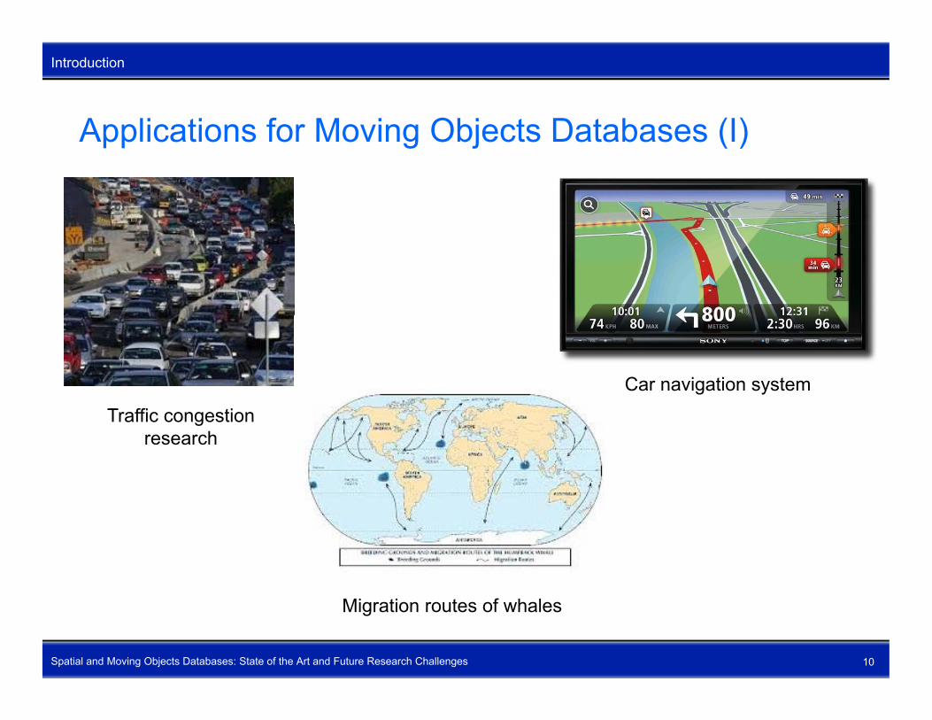
Applications for Moving Objects Databases (I)
Introduction
Applications for Moving Objects Databases (I)
Car navigation systemTraffic congestion
research
Spatial and Moving Objects Databases: State of the Art and Future Research Challenges 10
Migration routes of whales

Applications for Moving Objects Databases (II)
Introduction
Applications for Moving Objects Databases (II)
Hurricane research M t i l fl i t t tiHurricane research Material flow in transportation pipelines (electricity, water, oil)
Spatial and Moving Objects Databases: State of the Art and Future Research Challenges 11
Movement of planets

Spatial and Moving Objects Databases as Introduction
Interdisciplinary Research FieldsSpatial and Spatial and
DatabaseSystems
SpatiotemporalData Warehousing
pSpatiotemporal
Data Mining
C t ti l
Spatial andMoving Objects
ComputationalGeometryGeographical
InformationSystems (GIS) Moving Objects
Database Systems ArtificialIntelligence
Systems (GIS)
Mathematics
LinguisticsCognitiveS i
Geosciences
Spatial and Moving Objects Databases: State of the Art and Future Research Challenges 12
LinguisticsScience

User Groups and Spatial Queries of Interest (I)
Introduction
User Groups and Spatial Queries of Interest (I)
Spatial and Moving Objects Databases: State of the Art and Future Research Challenges 13

User Groups and Spatial Queries of Interest (II)
Introduction
User Groups and Spatial Queries of Interest (II)
Spatial and Moving Objects Databases: State of the Art and Future Research Challenges 14

User Groups and Spatiotemporal Queries of Interest (I)
Introduction
User Groups and Spatiotemporal Queries of Interest (I)
Spatial and Moving Objects Databases: State of the Art and Future Research Challenges 15

User Groups and Spatiotemporal Queries of Interest (II)
Introduction
User Groups and Spatiotemporal Queries of Interest (II)
Spatial and Moving Objects Databases: State of the Art and Future Research Challenges 16
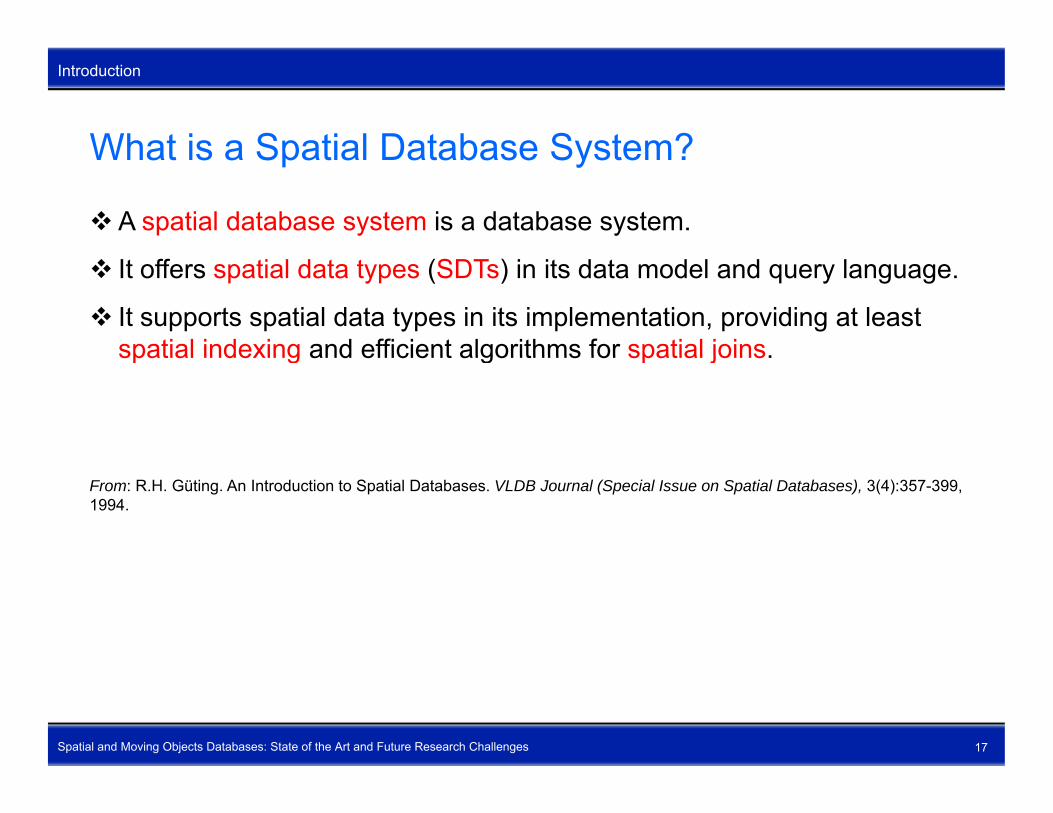
What is a Spatial Database System?
Introduction
What is a Spatial Database System?
A spatial database system is a database system.
It offers spatial data types (SDTs) in its data model and query language.
It supports spatial data types in its implementation, providing at least spatial indexing and efficient algorithms for spatial joins.spatial indexing and efficient algorithms for spatial joins.
From: R.H. Güting. An Introduction to Spatial Databases. VLDB Journal (Special Issue on Spatial Databases), 3(4):357-399, 1994.
Spatial and Moving Objects Databases: State of the Art and Future Research Challenges 17
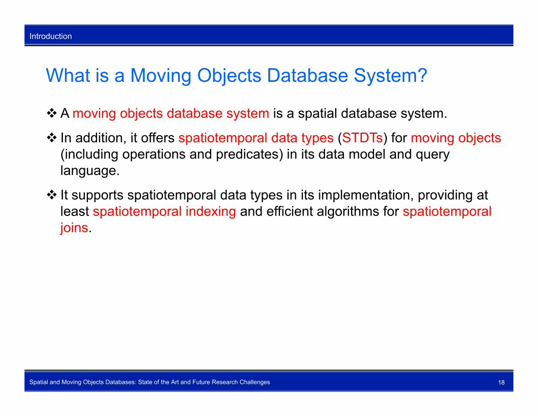
What is a Moving Objects Database System?
Introduction
What is a Moving Objects Database System?
A moving objects database system is a spatial database system.
In addition, it offers spatiotemporal data types (STDTs) for moving objects(including operations and predicates) in its data model and query language.
It supports spatiotemporal data types in its implementation, providing at least spatiotemporal indexing and efficient algorithms for spatiotemporal joins.j
Spatial and Moving Objects Databases: State of the Art and Future Research Challenges 18
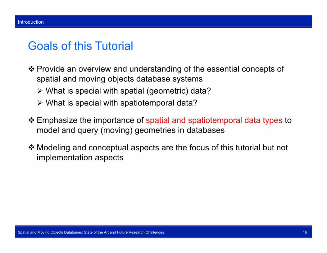
Goals of this Tutorial
Introduction
Goals of this Tutorial
Provide an overview and understanding of the essential concepts of spatial and moving objects database systemsspatial and moving objects database systems What is special with spatial (geometric) data? What is special with spatiotemporal data?
Emphasize the importance of spatial and spatiotemporal data types to model and query (moving) geometries in databases
Modeling and conceptual aspects are the focus of this tutorial but not implementation aspects
Spatial and Moving Objects Databases: State of the Art and Future Research Challenges 19

Outline
Outline
Outline
1. Introduction2 S ti l D t M d li2. Spatial Data Modeling3. Spatiotemporal Data Modeling4. Open Research Topics
Spatial and Moving Objects Databases: State of the Art and Future Research Challenges 20
Outline – Spatial Data Modeling
Outline
Outline – Spatial Data Modeling
How spatial data should not be representedS ti l d t tSpatial data typesGeometric set operationsMetric operations Topological relationshipsDirectional relationshipsSpatial queryingSpatial querying
Spatial and Moving Objects Databases: State of the Art and Future Research Challenges 21

How Spatial Data should NOT Be Represented (I)
Spatial Data Modeling
How Spatial Data should NOT Be Represented (I)
Example: Census block, and how we would perhaps like to store it in a tabletable
Spatial and Moving Objects Databases: State of the Art and Future Research Challenges 22
Problem: Polyline is not a built-in data type

How Spatial Data should NOT Be Represented (II)
Spatial Data Modeling
How Spatial Data should NOT Be Represented (II)
First solution ever proposed: Create a set of tables with shared attributes
Spatial and Moving Objects Databases: State of the Art and Future Research Challenges 23
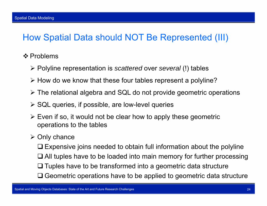
How Spatial Data should NOT Be Represented (III)
Spatial Data Modeling
How Spatial Data should NOT Be Represented (III)
Problems
Polyline representation is scattered over several (!) tables
How do we know that these four tables represent a polyline?
Th l ti l l b d SQL d t id t i ti The relational algebra and SQL do not provide geometric operations
SQL queries, if possible, are low-level queries
Even if so it would not be clear how to apply these geometric Even if so, it would not be clear how to apply these geometric operations to the tables
Only chanceExpensive joins needed to obtain full information about the polylineAll tuples have to be loaded into main memory for further processing Tuples have to be transformed into a geometric data structure
Spatial and Moving Objects Databases: State of the Art and Future Research Challenges 24
Tuples have to be transformed into a geometric data structureGeometric operations have to be applied to geometric data structure

How Spatial Data should NOT Be Represented (IV)
Spatial Data Modeling
How Spatial Data should NOT Be Represented (IV)
Conclusions Thi l ti i hi hl i ffi i t This solution is highly inefficient
Table representation does not allow the application of geometric operations.
Whole approach is unusable
An object concept is needed
Spatial and spatiotemporal data are/form complex application objectsand are not an accumulation of their constituent parts
The relational data model and relational database systems cannot and The relational data model and relational database systems cannot and should not be used to represent complex application objects like spatial and spatiotemporal data
Spatial and Moving Objects Databases: State of the Art and Future Research Challenges 25

What are Spatial Data Types? (I)
Spatial Data Modeling
What are Spatial Data Types? (I)
Spatial data types are special data types needed to model geometry and to suitably are special data types needed to model geometry and to suitably
represent geometric data in database systems Examples: point, line, region; partition (map), graph (network) provide a fundamental abstraction for modeling the geometric structure provide a fundamental abstraction for modeling the geometric structure
of objects in space, their relationships, properties, and operations are an important part of the data model and the implementation of a
spatial DBMSp
The definition of SDTs is to a large degree responsible for a successful design of spatial data
modelsmodels decisively affects the performance of spatial database systems exerts a great influence on the expressiveness of spatial query
languages
Spatial and Moving Objects Databases: State of the Art and Future Research Challenges 26
languages should be independent from the data model used by a DBMS

What are Spatial Data Types? (II)
Spatial Data Modeling
What are Spatial Data Types? (II)
Conclusions A d t di f SDT i i it An understanding of SDTs is a prerequisite for an effective construction of important components of a spatial
database system like spatial index structures, optimizers for spatial d t ti l l t t hi ldata, spatial query languages, storage management, graphical user interfaces
for a cooperation with extensible DBMS providing spatial type t i k lik ti l d t bl d t idextension packages like spatial data blades, cartridges
The definition and implementation of spatial data types is probably the most fundamental issue in the development of spatial databasemost fundamental issue in the development of spatial database systems
Spatial and Moving Objects Databases: State of the Art and Future Research Challenges 27

Which Spatial Data Need to Be Represented? (I)
Spatial Data Modeling
Which Spatial Data Need to Be Represented? (I)
Two kinds of representations of spatial phenomena (vector/raster debate) bj t i ( tit i t d / f t b d i ) objects in space (entity-oriented / feature-based view) vector data, boundary representation spatial database systems
it lf ( i t d / iti b d i ) space itself (space-oriented / position-based view) raster data, bitmap data, pixel data image database systems
We consider modeling single self-contained spatial objects
Spatial and Moving Objects Databases: State of the Art and Future Research Challenges 28
modeling single, self contained spatial objects modeling spatially related collections of spatial objects

Which Spatial Data Need to Be Represented? (II)
Spatial Data Modeling
Which Spatial Data Need to Be Represented? (II)
Spatial and Moving Objects Databases: State of the Art and Future Research Challenges 29
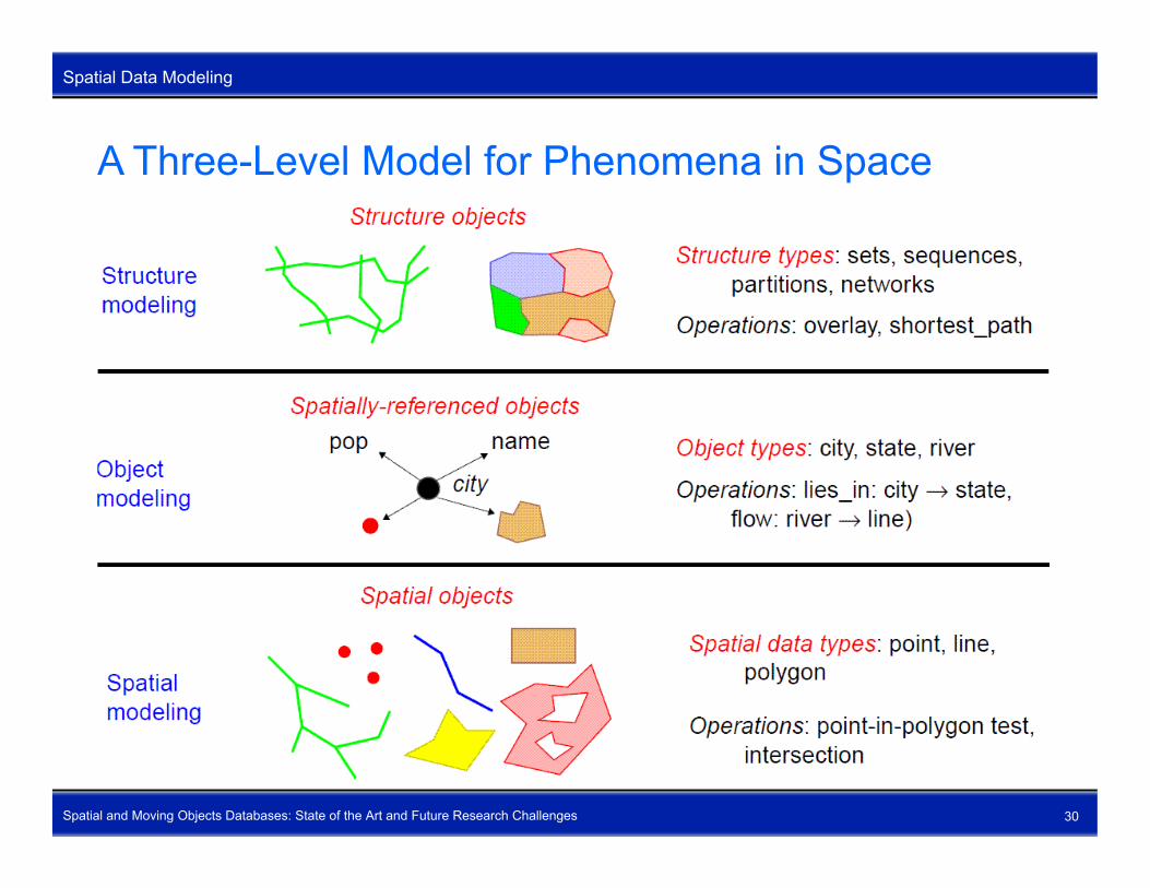
A Three-Level Model for Phenomena in Space
Spatial Data Modeling
A Three-Level Model for Phenomena in Space
Spatial and Moving Objects Databases: State of the Art and Future Research Challenges 30
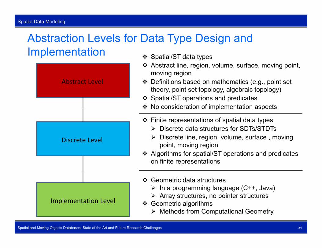
Abstraction Levels for Data Type Design and Spatial Data Modeling
Implementation Spatial/ST data types Abstract line, region, volume, surface, moving point,
moving regionAbstract Level Definitions based on mathematics (e.g., point set
theory, point set topology, algebraic topology) Spatial/ST operations and predicates No consideration of implementation aspects
Discrete Level
No consideration of implementation aspects
Finite representations of spatial data types Discrete data structures for SDTs/STDTs Discrete line, region, volume, surface , moving Discrete Level , g , , , g
point, moving region Algorithms for spatial/ST operations and predicates
on finite representations
Implementation Level
Geometric data structures In a programming language (C++, Java) Array structures, no pointer structures
G t i l ith
Spatial and Moving Objects Databases: State of the Art and Future Research Challenges 31
Implementation Level Geometric algorithms Methods from Computational Geometry

Design Criteria for Modeling Spatial Data Types
Spatial Data Modeling
Design Criteria for Modeling Spatial Data Types
General Formaldefinition FormaldefinitionData model
independence
Design ofS ti l
TopologicalcorrectnessEfficiency
SpatialData Types
ExtensibilityNumericalrobustness
GeometricClosure
propertiesEnabling finite
representations
Spatial and Moving Objects Databases: State of the Art and Future Research Challenges 32
consistencyproperties representations
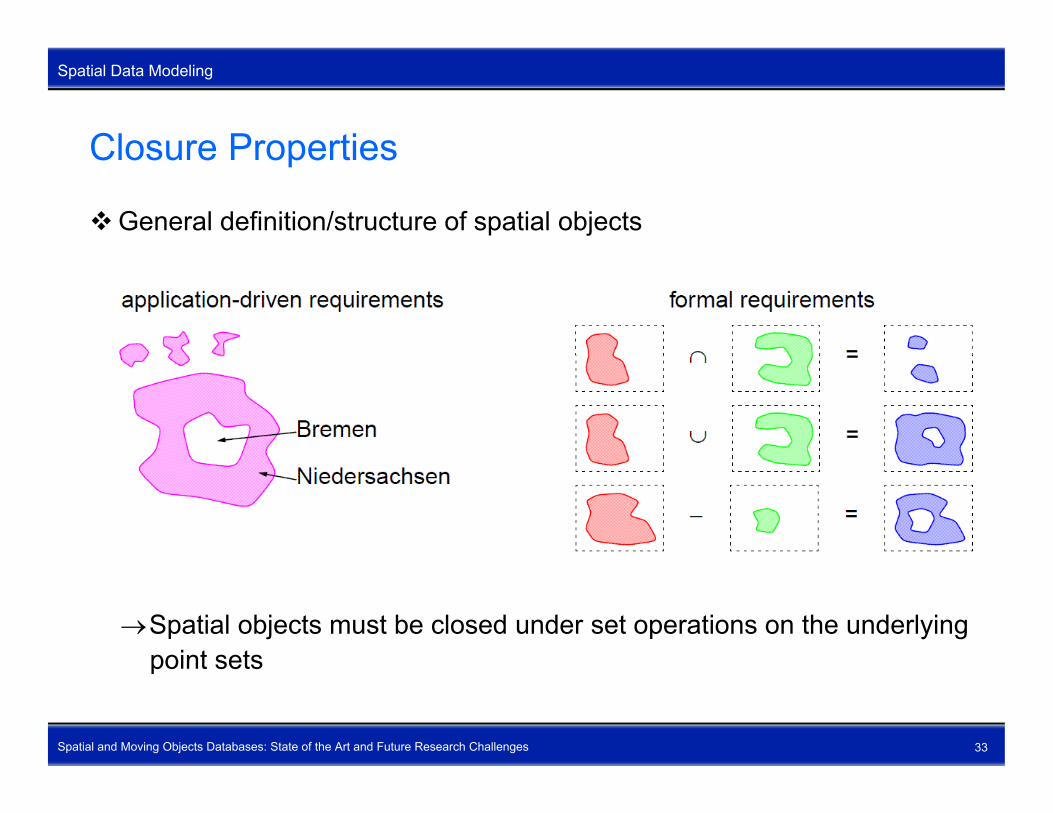
Closure Properties
Spatial Data Modeling
Closure Properties
General definition/structure of spatial objects
Spatial objects must be closed under set operations on the underlyingpoint sets
Spatial and Moving Objects Databases: State of the Art and Future Research Challenges 33
point sets

Geometric Consistency
Spatial Data Modeling
Geometric Consistency
Support of geometric consistency constraints for spatially related objects
SDT definition must offer facilities to enforce topological consistency constraints
Spatial and Moving Objects Databases: State of the Art and Future Research Challenges 34

Spatial Data Types – Intuitive Definition (I)
Spatial Data Modeling
Spatial Data Types – Intuitive Definition (I)
Data type point: A (complex) point object consists of a finite number of single pointssingle points.
Data type line: A (complex) line object consists of a finite number of blocks (connected components). Each block consists of a finite number of disjoint or meeting continuous curvesdisjoint or meeting continuous curves.
Data type region: A (complex) region object consists of a finite number of disjoint or 0-meet faces (sub-regions). Each face consists of an outer cycle and a finite (zero one or more) number of disjoint or 0 meet holecycle and a finite (zero, one, or more) number of disjoint or 0-meet hole cycles (holes).
Spatial and Moving Objects Databases: State of the Art and Future Research Challenges 35
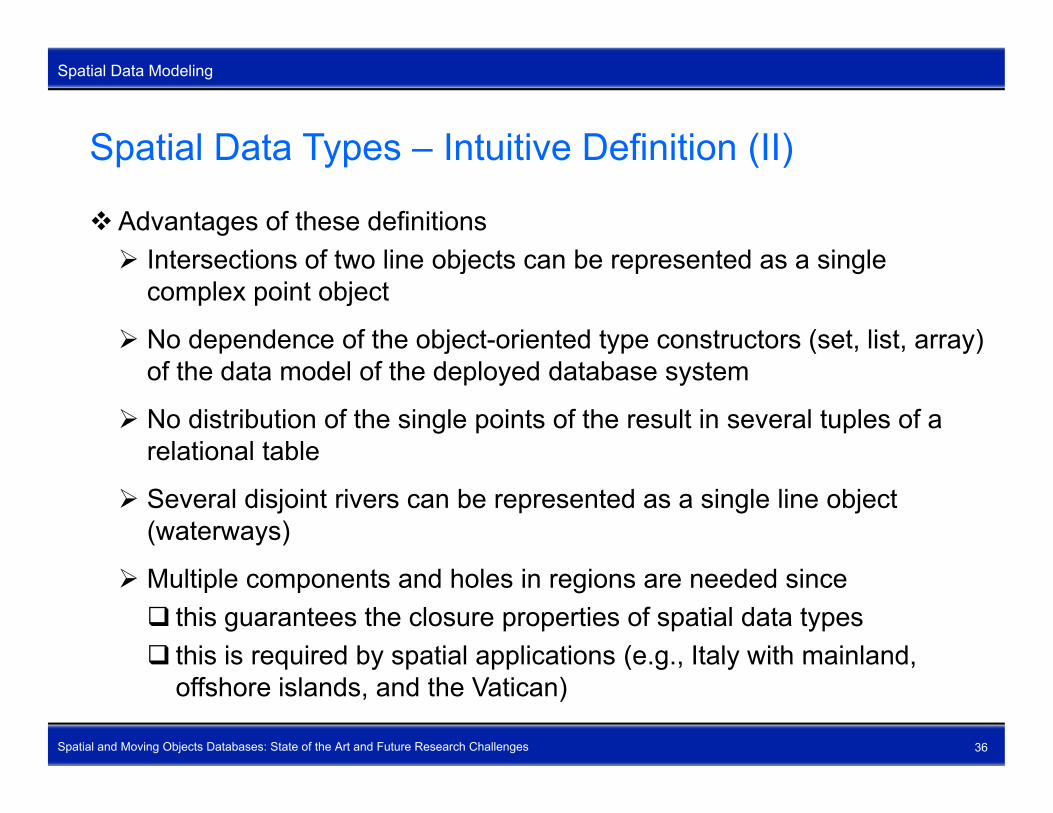
Spatial Data Types – Intuitive Definition (II)
Spatial Data Modeling
Spatial Data Types – Intuitive Definition (II)
Advantages of these definitions I t ti f t li bj t b t d i l Intersections of two line objects can be represented as a single
complex point object
No dependence of the object-oriented type constructors (set, list, array) of the data model of the deployed database system
No distribution of the single points of the result in several tuples of a relational tablerelational table
Several disjoint rivers can be represented as a single line object (waterways)
Multiple components and holes in regions are needed since this guarantees the closure properties of spatial data types this is required by spatial applications (e.g., Italy with mainland,
Spatial and Moving Objects Databases: State of the Art and Future Research Challenges 36
this is required by spatial applications (e.g., Italy with mainland, offshore islands, and the Vatican)

Why Do We Need a Formal Definition of SDTs?
Spatial Data Modeling
Why Do We Need a Formal Definition of SDTs?
Better understanding of the complex semantics of spatial objects and operations at the discrete leveloperations at the discrete level
Formal definition of SDTs should be directly usable for a formal definition of corresponding spatial operations and predicatesg
Clarity and consistency of the conceptual user view of SDTs
A first step towards a standardization of spatial data types (achieved)A first step towards a standardization of spatial data types (achieved)
Formal specification of SDTs for a possible implementation at the implementation level
Spatial and Moving Objects Databases: State of the Art and Future Research Challenges 37

Point Set Theory (I)
Spatial Data Modeling
Point Set Theory (I)
Basic assumption: space is composed of infinitely many points (Euclidean plane IR2) and contains a set of spatial objectsplane IR2) and contains a set of spatial objects
Each spatial object Y can be regarded as the point set occupied by that object (Y IR2)
U f t ti f t ti ti l bj tUse of set operations , , − for constructing new spatial objectsPossible anomalies
Spatial and Moving Objects Databases: State of the Art and Future Research Challenges 38

Point Set Theory (II)
Spatial Data Modeling
Point Set Theory (II)
Possible anomalies (continued)
Ambiguities when defining topological relationships Let A and B two spatial objects, and let points be a function that
provides the point set of a spatial object A = B := points(A) = points(B)
A inside B := points(A) points(B)A intersects B := points(A) points(B)
The definitions of = and inside are both covered by the definition of
Spatial and Moving Objects Databases: State of the Art and Future Research Challenges 39
The definitions of = and inside are both covered by the definition of intersects

Point Set Topology (I)
Spatial Data Modeling
Point Set Topology (I)
Same basic assumptions as point set theory but investigates topological structures of a point setstructures of a point set
boundary (Y), interior ( ), closure ( ), exterior ( )YoY Y
YoY
YY
= Y Y = Y = = 2
Y oY oY Y oY Y
IR2 = Y oY Y
Point set topology investigates properties that are independent of an underlying distance or coordinate measure (metric) and that are
Spatial and Moving Objects Databases: State of the Art and Future Research Challenges 40
underlying distance or coordinate measure (metric) and that are preserved under continuous topological transformations
Point Set Topology (II)
Spatial Data Modeling
Point Set Topology (II)
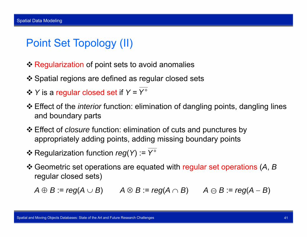
Regularization of point sets to avoid anomalies
Spatial regions are defined as regular closed sets
Y is a regular closed set if Y =
Eff t f th i t i f ti li i ti f d li i t d li li
oY
Effect of the interior function: elimination of dangling points, dangling lines and boundary parts
Effect of closure function: elimination of cuts and punctures by p yappropriately adding points, adding missing boundary points
Regularization function reg(Y) := oY
Geometric set operations are equated with regular set operations (A, Bregular closed sets)
A B := reg(A B) A B := reg(A B) A B := reg(A B)
Spatial and Moving Objects Databases: State of the Art and Future Research Challenges 41
g( ) g( ) g( )
Formal Definition of Spatial Data Types
Spatial Data Modeling
Formal Definition of Spatial Data Types
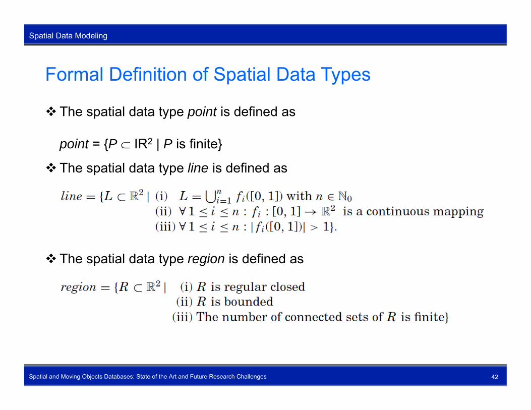
The spatial data type point is defined as
point = {P IR2 | P is finite}
The spatial data type line is defined as
The spatial data type region is defined as
Spatial and Moving Objects Databases: State of the Art and Future Research Challenges 42

Geometric Operations (I)
Spatial Data Modeling
Geometric Operations (I)
Geometric union, geometric intersection, and geometric difference(geometric set operations) of two spatial objects of the same spatial type(geometric set operations) of two spatial objects of the same spatial typeunion, intersection, difference : for all {point, line, region}
Formal definition the geometric set operations for = region union(A, B) := A B intersection(A B) := A B
Spatial and Moving Objects Databases: State of the Art and Future Research Challenges 43
intersection(A, B) : A B difference(A, B) := A B

Geometric Operations (II)
Spatial Data Modeling
Geometric Operations (II)
Geometric intersection of two spatial objects of different spatial data typesintersection: for all {point line region} and intersection: for all , {point, line, region} and
Computation of the common boundary of two spatial objectscommonBorder: line for all , {line, region} and
Computation of the boundary of a spatial object boundary: region line
Spatial and Moving Objects Databases: State of the Art and Future Research Challenges 44
y g boundary: line point

Geometric Operations (III)
Spatial Data Modeling
Geometric Operations (III)
Computation of the common boundary points of two spatial objectscommonPoints: point for all {line region} and commonPoints: point for all , {line, region} and
Computation of the center of a spatial objectcenter: point for all {point, line, region}
Spatial and Moving Objects Databases: State of the Art and Future Research Challenges 45

Geometric Operations (IV)
Spatial Data Modeling
Geometric Operations (IV)
Computation of the convex hull of a point objectconvexHull: point regionconvexHull: point region
Computation of the minimum bounding box (rectangle) of a spatial object, that is, its smallest enclosing and axis-parallel rectangle
box: region for all {point, line, region}
Spatial and Moving Objects Databases: State of the Art and Future Research Challenges 46

Geometric Operations (V)
Spatial Data Modeling
Geometric Operations (V)
Zooming a spatial object by a factorscale : float for all {point line region}scale : float for all {point, line, region}
Rotation of a spatial object around a point by a given anglerotate : point float for all {point, line, region}
Moving a spatial object by a defined vectortranslate : point for all {point, line, region}
Creation of a region object (a buffer) that contains all points in a certainCreation of a region object (a buffer) that contains all points in a certain distance from a spatial input object (a negative distance lets the input object shrink)bufferZone : float region for all {point line region}bufferZone : float region for all {point, line, region}
r
Spatial and Moving Objects Databases: State of the Art and Future Research Challenges 47

Geometric Operations (VI)
Spatial Data Modeling
Geometric Operations (VI)
Voronoi operation: For a given set S of points in the plane, the Voronoidiagram associates with each point p from S the region consisting ofdiagram associates with each point p from S the region consisting of those points of the plane that are closer to p than to any other point in S
The closest operation yields a point object whose point components are nearest to a given single reference pointclosest : point point pointclosest : point point point
Spatial and Moving Objects Databases: State of the Art and Future Research Challenges 48
closest point

Metric Operations (I)
Spatial Data Modeling
Metric Operations (I)
Computation of the area of a region objectarea: region floatarea: region float
Computation of the length of a region boundaryperimeter: region floatg
Computation of the length of a line objectlength: line float
Computation of the largest Euclidean distance between any of two points of a spatial object diameter: region float diameter: region float diameter: line float diameter: point float I di t fl t f ll { i t li i }
Spatial and Moving Objects Databases: State of the Art and Future Research Challenges 49
In summary: diameter: float for all {point, line, region}

Metric Operations (II)
Spatial Data Modeling
Metric Operations (II)
Ideas for new unary distance operationsminIntraDistminIntraDist,maxIntraDist,minInterDist,maxInterDist: float for all {point, line, region}maxInterDist: float for all {point, line, region}
Minimum/maximum Euclidean distance computation between two spatial objectsdist, maxDist : float for all , {point, line, region}
Computation of the direction between two single points as the angle 0 < 360 between them< 360 between themdirection : point point float
Number of components (points, blocks, faces) of a spatial object
Spatial and Moving Objects Databases: State of the Art and Future Research Challenges 50
noOfComps: integer

Spatial Partitions and Their Operations (I)
Spatial Data Modeling
Spatial Partitions and Their Operations (I)
Spatial partition: subdivision of the plane into pairwise disjoint regions where each region is associated with an attribute (label) having a simplewhere each region is associated with an attribute (label) having a simple or even complex structure
Partition constraints maintain topological relationships between regions Interiors of different region objects
must be disjoint Different region objects are adjacent
(they meet) or they are disjoint
I t t l f ti l Important example of a spatial connectivity structure
Spatial and Moving Objects Databases: State of the Art and Future Research Challenges 51

Spatial Partitions and Their Operations (II)
Spatial Data Modeling
Spatial Partitions and Their Operations (II)
The overlay operation transparently lays two partitions of different themes on top of each other and combines them into a new spatial partitionon top of each other and combines them into a new spatial partition.
Spatial and Moving Objects Databases: State of the Art and Future Research Challenges 52
Spatial Partitions and Their Operations (III)
Spatial Data Modeling
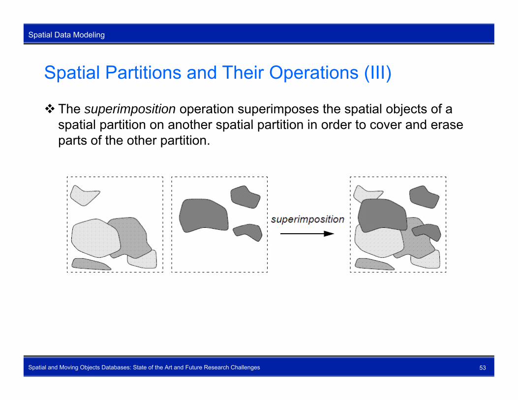
Spatial Partitions and Their Operations (III)
The superimposition operation superimposes the spatial objects of a spatial partition on another spatial partition in order to cover and erasespatial partition on another spatial partition in order to cover and erase parts of the other partition.
Spatial and Moving Objects Databases: State of the Art and Future Research Challenges 53

Spatial Partitions and Their Operations (IV)
Spatial Data Modeling
Spatial Partitions and Their Operations (IV)
The fusion operation merges the region objects of a spatial partition on the basis of the equality of a non-spatial attribute For each group of equal non-basis of the equality of a non-spatial attribute. For each group of equal non-spatial objects, a spatial object is created as the geometric union of the set of spatial objects of each group.
Example: Compute the spatial partition with the regions of the same land use Example: Compute the spatial partition with the regions of the same land use
Spatial and Moving Objects Databases: State of the Art and Future Research Challenges 54
Spatial Partitions and Their Operations (V)
Spatial Data Modeling
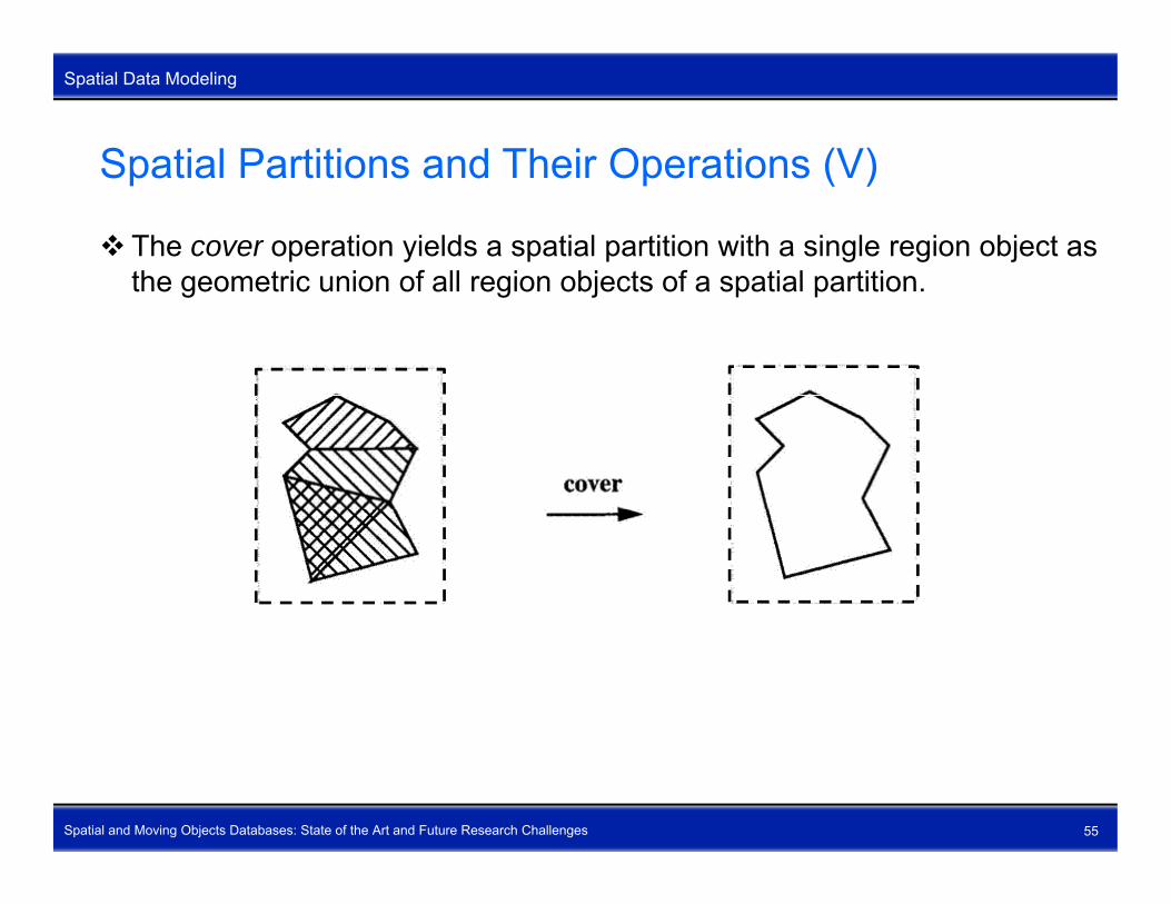
Spatial Partitions and Their Operations (V)
The cover operation yields a spatial partition with a single region object as the geometric union of all region objects of a spatial partitionthe geometric union of all region objects of a spatial partition.
Spatial and Moving Objects Databases: State of the Art and Future Research Challenges 55

Spatial Partitions and Their Operations (VI)
Spatial Data Modeling
Spatial Partitions and Their Operations (VI)
The windowing operation retrieves those regions of a spatial partition whose intersection with a given window (rectangle circle polygon) is notwhose intersection with a given window (rectangle, circle, polygon) is not empty.
Spatial and Moving Objects Databases: State of the Art and Future Research Challenges 56

Spatial Partitions and Their Operations (VII)
Spatial Data Modeling
Spatial Partitions and Their Operations (VII)
The clipping operation selects those parts of a spatial partition which lie inside a given window (rectangle circle polygon)inside a given window (rectangle, circle, polygon).
Observation: The formal definition of all application-specific operations onObservation: The formal definition of all application specific operations on spatial partitions can be derived from three fundamental operations intersection relabel
Spatial and Moving Objects Databases: State of the Art and Future Research Challenges 57
relabel refine

Spatial Networks and Their Operations (I)
Spatial Data Modeling
Spatial Networks and Their Operations (I)
Spatial network: spatially embedded graph in the plane consisting of pairwise disjoint continous lines where each line is associated with anpairwise disjoint, continous lines where each line is associated with an attribute (label) having a simple or even complex structure
The shortest path (shortest route) operation The shortest path (shortest route) operation determines the shortest path between any two network points with respect to network distance network distance time slope any weight on which a distance metric can be
defined a combination of weights
Spatial and Moving Objects Databases: State of the Art and Future Research Challenges 58

Spatial Networks and Their Operations (II)
Spatial Data Modeling
Spatial Networks and Their Operations (II)
Windowing and clipping again, but now applied to spatial networks (Euclidean range query)(Euclidean range query)
Spatial and Moving Objects Databases: State of the Art and Future Research Challenges 59

Spatial Networks and Their Operations (III)
Spatial Data Modeling
Spatial Networks and Their Operations (III)
The operations spatial network union, spatial network intersection, and spatial network difference compute the union intersection and differencespatial network difference compute the union, intersection, and difference of two spatial networks of the same label type or different label types. Spatial network intersection: Given a bus route network and a taxi
network Which roads do they share?network. Which roads do they share? Spatial network union: Given a bus route network and a metro network.
Which locations can a passenger reach? S ti l t k diff Gi b t t k d t i Spatial network difference: Given a bus route network and a taxi
network. Which locations can taxis but not buses reach?
The operation spatial network buffer considers a spatial network as a line The operation spatial network buffer considers a spatial network as a line object and computes a buffer around it. Example: Given a bus route network. Compute the region that
represents its “zone of attraction”
Spatial and Moving Objects Databases: State of the Art and Future Research Challenges 60
represents its zone of attraction .

Spatial Networks and Their Operations (IV)
Spatial Data Modeling
Spatial Networks and Their Operations (IV)
The operation get graph extracts the graph structure of a spatial network. Th ti t k di t d t i th di t b t t The operation network distance determines the distance between two
points in a network. Important for network range queries: Determine the spatial network that
h di t d f t k i thas a distance d from a network point s The operation length sums up the length of all edges of a spatial network What is the overall length of the bus network in Gainesville?
The operation maxDist determines the maximum distance within a spatial network What is the farthest distance in the bus network? What is the farthest distance in the bus network?
The operation get transfer points determines the common points of two different spatial networks where one can transfer from one network into the other.
Spatial and Moving Objects Databases: State of the Art and Future Research Challenges 61
the other.Many more operations …

Spatial Networks and Their Operations (V)
Spatial Data Modeling
Spatial Networks and Their Operations (V)
Spatial network modeling in a database context Very few interesting models exist but they are incomplete Very few interesting models exist but they are incomplete Still a lot of effort needed
Spatial network representation in a database context Poor: network data are spread over a large collection of tables Expensive joins needed to bring data together Network operations cannot be applied to these representations
Spatial network querying in a database context Formulation of network queries is difficult No spatial network queries possible since network operations are missingp q p p g High-level spatial network query language is missing
Spatial network algorithms in a database context A number of efficient spatial network algorithms is available
Spatial and Moving Objects Databases: State of the Art and Future Research Challenges 62
A number of efficient spatial network algorithms is available However: they depend on a particular spatial network database system

Spatial Databases cannot Store Spatial Partitions Spatial Data Modeling
and Spatial NetworksBoth are highly complicated connectivity structures
Both have complex operations involving large volumes of data
Both are not first-class citizens in spatial databases
Spatial and Moving Objects Databases: State of the Art and Future Research Challenges 63

Topological Relationships (I)
Spatial Data Modeling
Topological Relationships (I)
Topological relationships characterize the relative position of two spatial objects towards each otherobjects towards each other
Examples:
meet disjoint inside
Needed for spatial joins and spatial selections
SELECT cname, snameFROM cities, states
Spatial and Moving Objects Databases: State of the Art and Future Research Challenges 64
WHERE loc inside territory

Topological Relationships (II)
Spatial Data Modeling
Topological Relationships (II)
Requirements of a model for topological relationships All t l i l l ti hi t b t ll l i All topological relationships must be mutually exclusive The set of topological relationships must be complete
P d d lProposed models: 9-Intersection Matrix model (9IM) based on point set theory and point set topology takes into account the topological invariants of the intersections of
the boundary, interior, and exterior of one spatial object with the corresponding components of another spatial object
Region Connection Calculus (RCC) based on spatial logic, “pointless” approach axiomatic approach to formulating topological relationships and
Spatial and Moving Objects Databases: State of the Art and Future Research Challenges 65
axiomatic approach to formulating topological relationships and reasoning about spatial data

Topological Relationships (III)
Spatial Data Modeling
Topological Relationships (III)
9-intersection matrix (A, B {point, line, region})
Spatial and Moving Objects Databases: State of the Art and Future Research Challenges 66

Topological Relationships (IV)
Spatial Data Modeling
Topological Relationships (IV)
Finding topological relationships: proof-by-constraint-and-drawing
Phase 1 Starting point: 29 = 512 possible matrices Find constraint rules that must hold for valid topological relationshipsd co s a u es a us o d o a d opo og ca e a o s psExample: the intersection of the exteriors of two spatial objects is
always non-empty (eliminates 256 matrices immediately)Constraints are type-combination specificConstraints are type-combination specific
Apply constraint rules one after the other and remove matrices that do not fulfill them
Phase 2 For the remaining matrices, draw prototypical spatial configurations in
the Euclidean plane to verify the existence of the corresponding
Spatial and Moving Objects Databases: State of the Art and Future Research Challenges 67
topological relationships
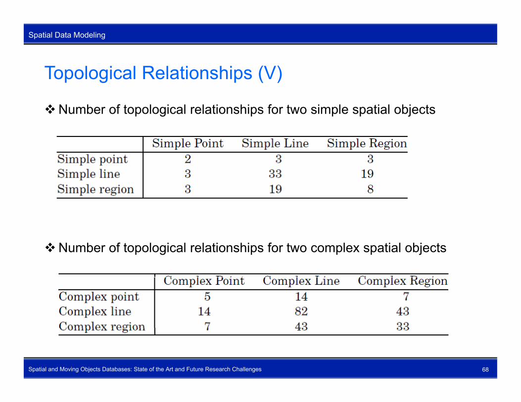
Topological Relationships (V)
Spatial Data Modeling
Topological Relationships (V)
Number of topological relationships for two simple spatial objects
Number of topological relationships for two complex spatial objects
Spatial and Moving Objects Databases: State of the Art and Future Research Challenges 68
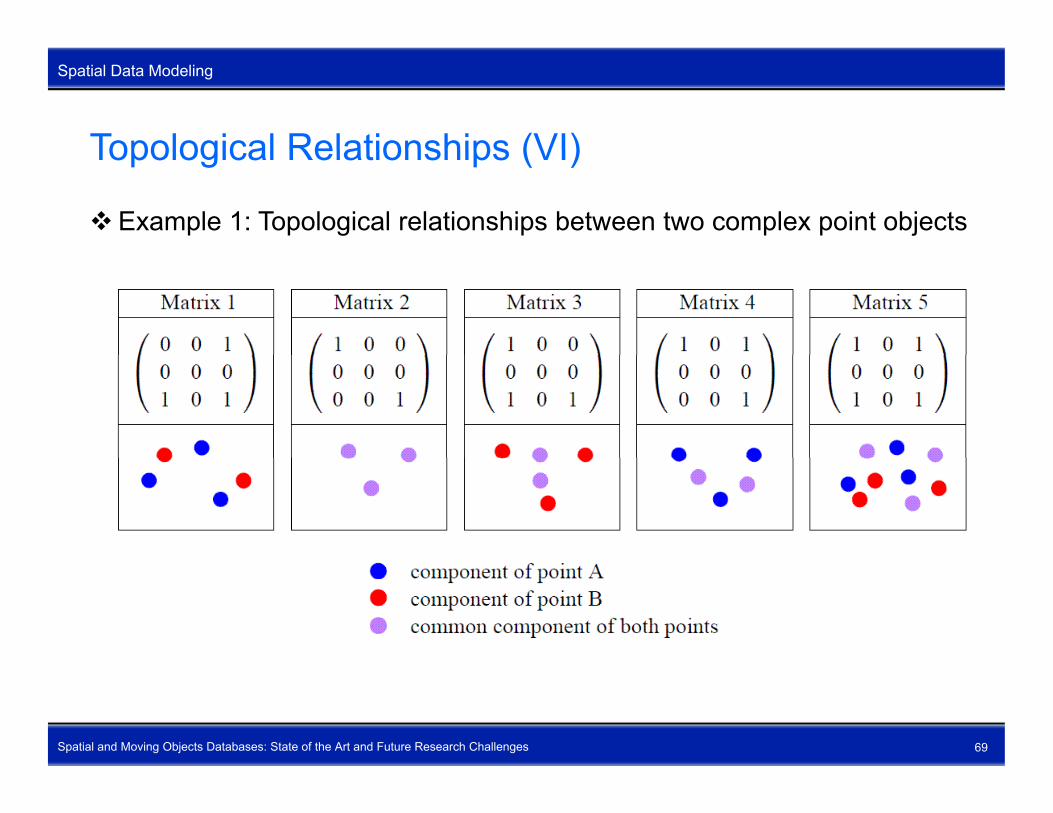
Topological Relationships (VI)
Spatial Data Modeling
Topological Relationships (VI)
Example 1: Topological relationships between two complex point objects
Spatial and Moving Objects Databases: State of the Art and Future Research Challenges 69

Topological Relationships (VII)
Spatial Data Modeling
Topological Relationships (VII)
Example 2: Topological relationships between two complex region objects
Spatial and Moving Objects Databases: State of the Art and Future Research Challenges 70
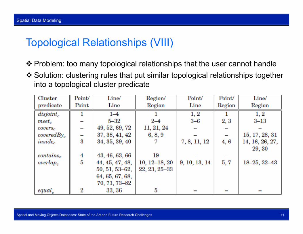
Topological Relationships (VIII)
Spatial Data Modeling
Topological Relationships (VIII)
Problem: too many topological relationships that the user cannot handleS l ti l t i l th t t i il t l i l l ti hi t thSolution: clustering rules that put similar topological relationships together
into a topological cluster predicate
Spatial and Moving Objects Databases: State of the Art and Future Research Challenges 71

Directional Relationships (I)
Spatial Data Modeling
Directional Relationships (I)
Directional relationships characterize the directional orientation of two spatial objects towards each otherspatial objects towards each other absolute directional relationships (cardinal directions): north_of and
southwest_of with respect to a given reference or coordinate system l ti di ti l l ti hi i f t d l ft ith t t relative directional relationships: in_front and left with respect to an
observer position
Needed for spatial joins and spatial selectionsp j pstates(sname: varchar(50), territory: region)SELECT s.snameFROM states sFROM states s,
( SELECT territoryFROM statesWHERE sname = ‘Italy’) t
Spatial and Moving Objects Databases: State of the Art and Future Research Challenges 72
y )WHERE s.territory northwest_of t.territory

Directional Relationships (II)
Spatial Data Modeling
Directional Relationships (II)
Objects Interaction Matrix (OIM) model C t ti l d l f di l di ti Computational model for cardinal directions Cognitive, subjective models can be built on top
T h Two phases Tiling Phase Interpretation Phase
Spatial and Moving Objects Databases: State of the Art and Future Research Challenges 73
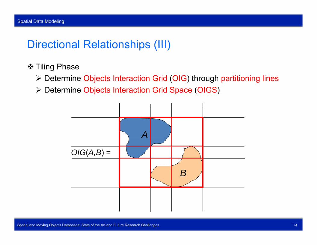
Directional Relationships (III)
Spatial Data Modeling
Directional Relationships (III)
Tiling Phase D t i Obj t I t ti G id (OIG) th h titi i li Determine Objects Interaction Grid (OIG) through partitioning lines Determine Objects Interaction Grid Space (OIGS)
A
OIG(A,B) =
B
Spatial and Moving Objects Databases: State of the Art and Future Research Challenges 74

Directional Relationships (IV)
Spatial Data Modeling
Directional Relationships (IV)
Tiling Phase (continued) 9 ibl i f OIG 9 possible sizes of OIGs m × n-OIG for m, n {1, 2, 3}
Spatial and Moving Objects Databases: State of the Art and Future Research Challenges 75
Directional Relationships (V)
Spatial Data Modeling
Directional Relationships (V)
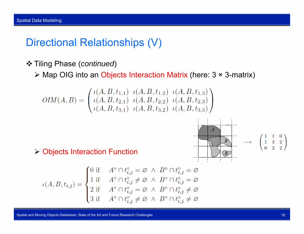
Tiling Phase (continued) M OIG i t Obj t I t ti M t i (h 3 3 t i ) Map OIG into an Objects Interaction Matrix (here: 3 × 3-matrix)
Objects Interaction Function
Spatial and Moving Objects Databases: State of the Art and Future Research Challenges 76

Directional Relationships (VI)
Spatial Data Modeling
Directional Relationships (VI)
Tiling Phase (continued) N b f ibl t i Numbers of possible m × n-matrices
Numbers of valid OIMs for two complex/simple region objects
Spatial and Moving Objects Databases: State of the Art and Future Research Challenges 77

Directional Relationships (VII)
Spatial Data Modeling
Directional Relationships (VII)
Interpretation Phase D t i th l ti f h t f A d B i OIM(A B) Determine the location of each part of A and B in OIM(A, B) Example
A 1 1 01 0 2
B
1 0 20 2 2
loc(A, OIM(A, B)) = {(1, 1), (1, 2), (2, 1)} loc(B, OIM(A, B)) = {(2, 3), (3, 2), (3, 3)}
Spatial and Moving Objects Databases: State of the Art and Future Research Challenges 78
( , ( , )) {( , ), ( , ), ( , )}

Directional Relationships (VIII)
Spatial Data Modeling
Directional Relationships (VIII)
Interpretation Phase (continued) S t f b i di l di ti CD {N NW W SW S SE E NE O} Set of basic cardinal directions CD = {N, NW, W, SW, S, SE, E, NE, O} Determine the cardinal directions between the parts of A and B by an
interpretation function
Spatial and Moving Objects Databases: State of the Art and Future Research Challenges 79

Directional Relationships (IX)
Spatial Data Modeling
Directional Relationships (IX)
Interpretation Phase (continued) I t t ti t bl f th i t t ti f ti Interpretation table for the interpretation function
Spatial and Moving Objects Databases: State of the Art and Future Research Challenges 80

Directional Relationships (X)
Spatial Data Modeling
Directional Relationships (X)
Interpretation Phase (continued) E l ( ti d) Example (continued)
A 1 1 0 A
B
1 1 01 0 20 2 2
((1, 1), (2, 3)) = NW((1, 2), (3, 2)) = N…B
Determine the cardinal directions dir(A B) between A and B Determine the cardinal directions dir(A, B) between A and Bdir(A, B) = (loc(A, OIM(A, B)), loc(B, OIM(A, B)))
Spatial and Moving Objects Databases: State of the Art and Future Research Challenges 81

Directional Relationships (XI)
Spatial Data Modeling
Directional Relationships (XI)
Interpretation Phase (continued) E l ( ti d) Example (continued)
Adir(A, B) = (loc(A, OIM(A, B)), loc(B, OIM(A, B)))
= ({(1, 1), (1, 2), (2, 1)},A
B
{(2, 3), (3, 2), (3, 3)})= {((1, 1), (2, 3)), ((1, 1), (3, 2)),
((1, 1), (3, 3)), …, ((2, 1), (3, 3))}{ }B
1 1 0
= {NW, N, W}
dir(B, A) = (loc(B, OIM(A, B)), loc(A, OIM(A, B)))= ({(2 3) (3 2) (3 3)}1 1 0
1 0 20 2 2
= ({(2, 3), (3, 2), (3, 3)},= {(1, 1), (1, 2), (2, 1)})= {((2, 3), (1, 1)), ((2, 3), (1, 2)),
((2 3) (2 1)) ((3 3) (2 1))}
Spatial and Moving Objects Databases: State of the Art and Future Research Challenges 82
((2, 3), (2, 1)), …, ((3, 3), (2, 1))}= {SE, S, E}

Directional Relationships (XII)
Spatial Data Modeling
Directional Relationships (XII)
Existential predicates
dir(A, B) = {NW, N, W} means
Spatial and Moving Objects Databases: State of the Art and Future Research Challenges 83

Directional Relationships (XIII)
Spatial Data Modeling
Directional Relationships (XIII)
Similarly-oriented directional predicates
Strict directional predicatesStrict directional predicates
Surround directional predicates
Spatial and Moving Objects Databases: State of the Art and Future Research Challenges 84

Spatial Querying (I)
Spatial Data Modeling
Spatial Querying (I)
Tables CREATE TABLE Country(name varchar(30) pop int shape region); CREATE TABLE Country(name varchar(30), pop int, shape region); CREATE TABLE River(name varchar(30), shape line); CREATE TABLE City(name varchar(30), pop int, shape point);
Q1: Find the names of all countries that are neighbors of the USA.
SELECT C1.name AS neighborsFROM Country C1, Country C2FROM Country C1, Country C2WHERE C1.shape meets C2.shape AND C2.name = ‘USA’
Q2: The St. Lawrence River can supply water to cities that are within 300 km Determine those cities and compute their distance from the riverkm. Determine those cities and compute their distance from the river.
SELECT C.name, dist(C.shape, R.shape) AS distanceFROM City C, River RWHERE C1 shape inside bufferZone(R shape 300) AND
Spatial and Moving Objects Databases: State of the Art and Future Research Challenges 85
WHERE C1.shape inside bufferZone(R.shape, 300) ANDR.name = ‘St. Lawrence River’

Spatial Querying (II)
Spatial Data Modeling
Spatial Querying (II)
Q3: List the length of the rivers in each of the countries they pass through together with the river name and the country nametogether with the river name and the country name.
SELECT R.name, C.name,length(intersection(R.shape, C.shape)) AS rLength
FROM River R, Country CWHERE R.shape intersects C.shape
Q4: List all countries, ordered by the number of adjacent countries.
SELECT C.name, COUNT(C1.name) AS noOfNeighbors, ( ) gFROM Country C, Country C1WHERE C.shape meets C1.shapeGROUP BY C.name
Spatial and Moving Objects Databases: State of the Art and Future Research Challenges 86
ORDER BY noOfNeighbors DESC
Spatial Querying (III)
Spatial Data Modeling
Spatial Querying (III)
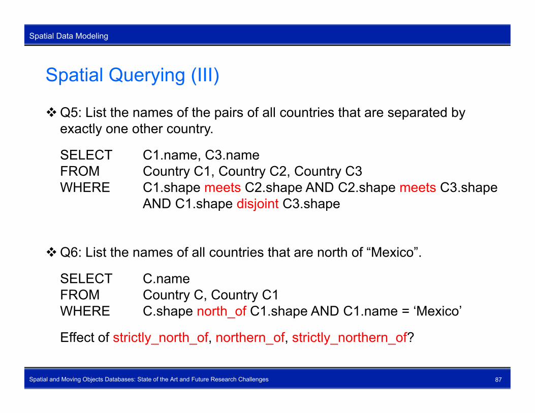
Q5: List the names of the pairs of all countries that are separated by exactly one other countryexactly one other country.
SELECT C1.name, C3.nameFROM Country C1, Country C2, Country C3WHERE C1.shape meets C2.shape AND C2.shape meets C3.shape
AND C1.shape disjoint C3.shape
Q6: List the names of all countries that are north of “Mexico”.
SELECT C.nameFROM Country C, Country C1WHERE C.shape north_of C1.shape AND C1.name = ‘Mexico’
Effect of strictly north of northern of strictly northern of?
Spatial and Moving Objects Databases: State of the Art and Future Research Challenges 87
Effect of strictly_north_of, northern_of, strictly_northern_of?

Spatial Querying (IV)
Spatial Data Modeling
Spatial Querying (IV)
Spatial data types ifi d b t t d t t (ADT ) are specified as abstract data types (ADTs) ADTs are used as attribute types in relational (or other) schemas Internals of ADTs are invisible to the user ADT implementations can be exchanged without the need to redefine
database schemas and reformulate queries
Spatial operations and predicates are high-level methods are embedded into an extension of the SQL query language are embedded into an extension of the SQL query language Algorithms for the operations and predicates are invisible to the user Algorithms for the operations and predicates can be exchanged without
the need to reformulate queries since the interfaces (signatures) stay
Spatial and Moving Objects Databases: State of the Art and Future Research Challenges 88
the need to reformulate queries since the interfaces (signatures) stay the same

Outline
Outline
Outline
1. Introduction2 S ti l D t M d li2. Spatial Data Modeling3. Spatiotemporal Data Modeling4. Open Research Topics
Spatial and Moving Objects Databases: State of the Art and Future Research Challenges 89

Outline – Spatiotemporal Data Modeling
Outline
Outline – Spatiotemporal Data Modeling
What are Spatiotemporal Data Types?U t i M i Obj tUncertain Moving ObjectsPredictive Moving ObjectsSpatiotemporal Partitions and Moving Objects in Spatial NetworksSpatiotemporal OperationsSpatiotemporal PredicatesSpatiotemporal QueryingSpatiotemporal Querying
Spatial and Moving Objects Databases: State of the Art and Future Research Challenges 90

What are Spatiotemporal Data Types? (I)
Spatiotemporal Data Modeling
What are Spatiotemporal Data Types? (I)
Spatiotemporal data types are data types to represent moving objects.
A moving object represents the continuous evolution of a spatial object over time.
Moving pointMoving point Only time-dependent location is of interest Examples: eyes of tropical cyclones, cell phone users, terrorists,
whaleswhales
Moving region Also the time-dependent shape and/or areal extent is of interest Examples: hurricanes, forest fires, oil spills, diseases, glaciers
Moving line The time-dependent shape and/or linear extent is of interest
Spatial and Moving Objects Databases: State of the Art and Future Research Challenges 91
The time-dependent shape and/or linear extent is of interest Examples: traffic jams, front of an army; boundary of any moving region
What are Spatiotemporal Data Types? (II)
Spatiotemporal Data Modeling
What are Spatiotemporal Data Types? (II)
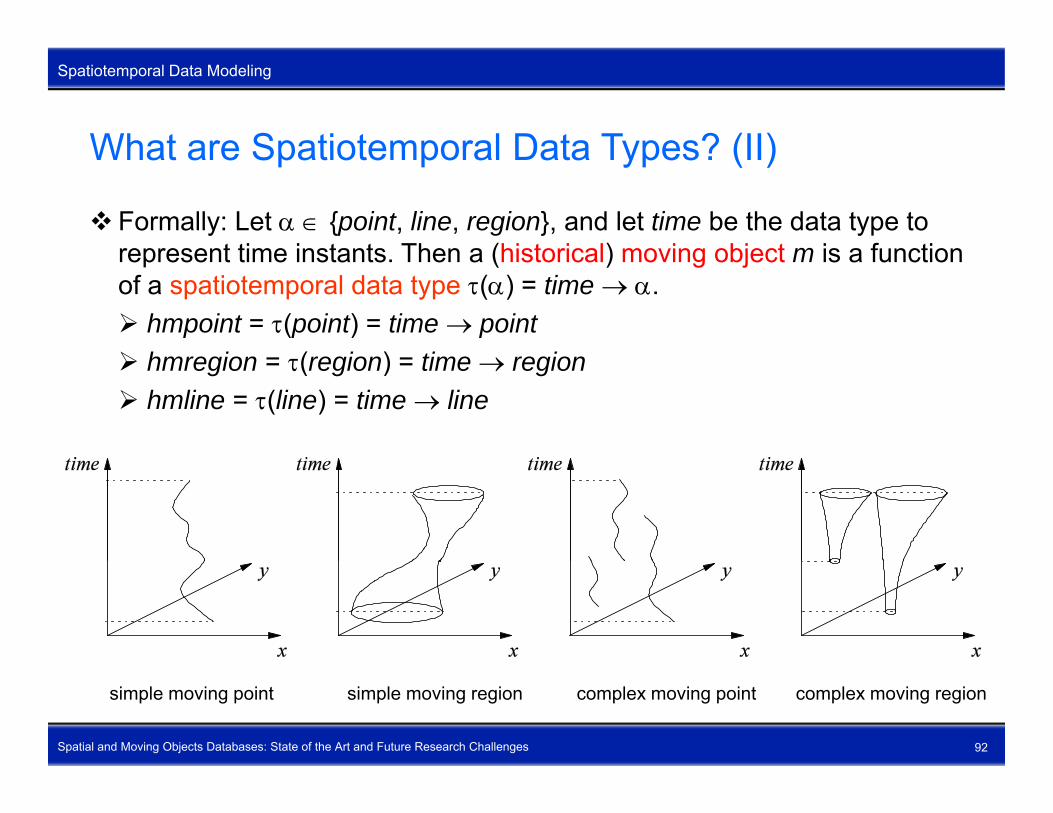
Formally: Let {point, line, region}, and let time be the data type to represent time instants Then a (historical) moving object m is a functionrepresent time instants. Then a (historical) moving object m is a function of a spatiotemporal data type () = time . hmpoint = (point) = time point h i ( i ) ti i hmregion = (region) = time region hmline = (line) = time line
Spatial and Moving Objects Databases: State of the Art and Future Research Challenges 92
simple moving point simple moving region complex moving point complex moving region
Uncertain Moving Objects
Spatiotemporal Data Modeling
Uncertain Moving Objects
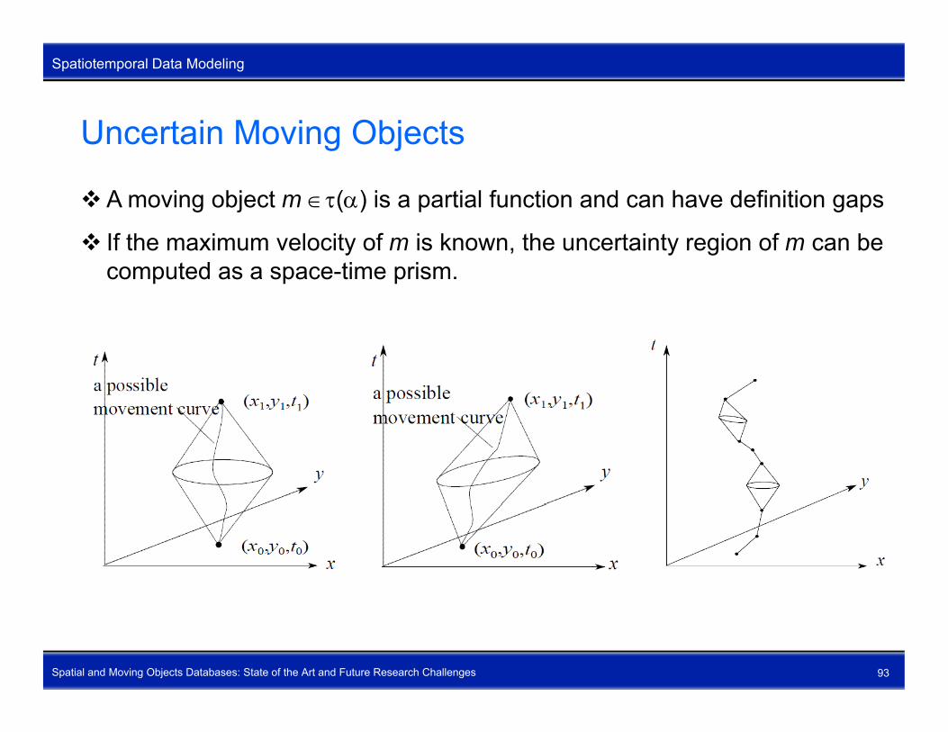
A moving object m () is a partial function and can have definition gaps
If the maximum velocity of m is known, the uncertainty region of m can be computed as a space-time prism.
Spatial and Moving Objects Databases: State of the Art and Future Research Challenges 93
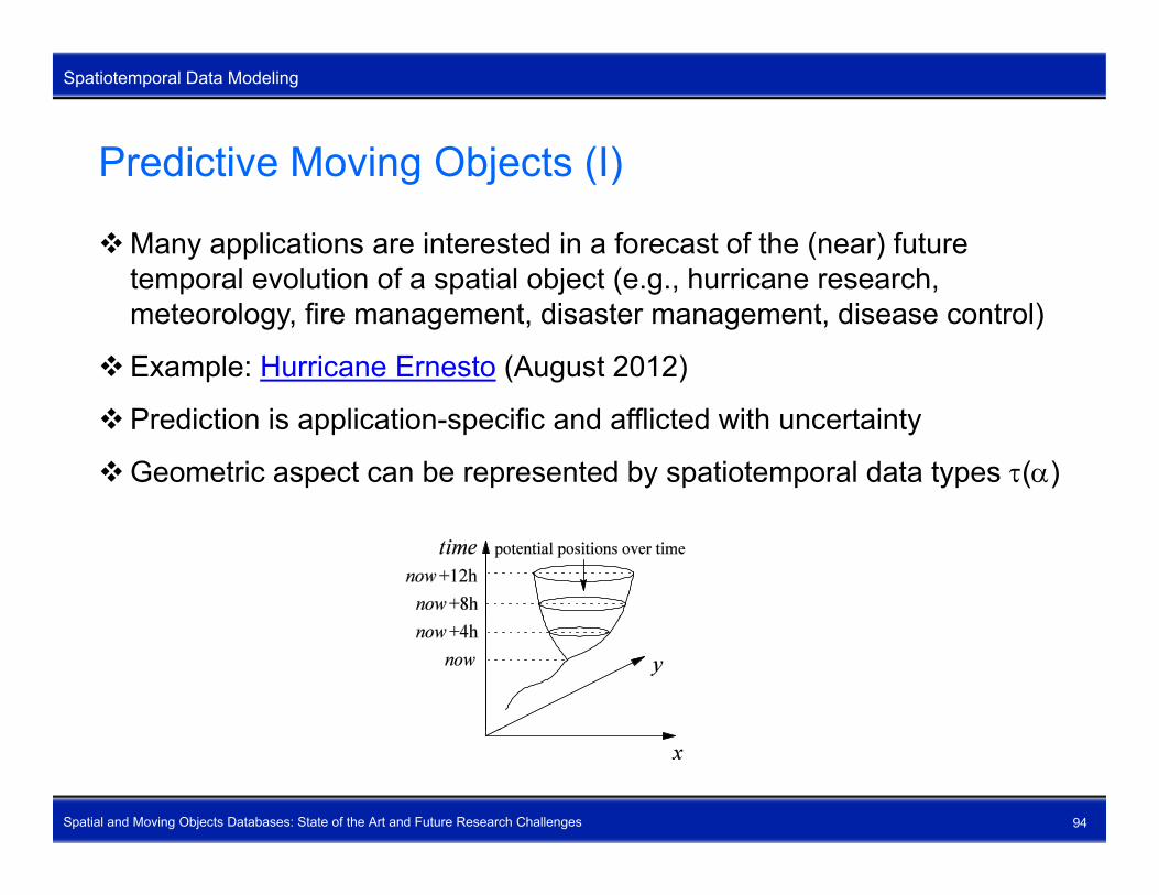
Predictive Moving Objects (I)
Spatiotemporal Data Modeling
Predictive Moving Objects (I)
Many applications are interested in a forecast of the (near) future temporal evolution of a spatial object (e g hurricane researchtemporal evolution of a spatial object (e.g., hurricane research, meteorology, fire management, disaster management, disease control)
Example: Hurricane Ernesto (August 2012)
Prediction is application-specific and afflicted with uncertainty
Geometric aspect can be represented by spatiotemporal data types ()
Spatial and Moving Objects Databases: State of the Art and Future Research Challenges 94

Predictive Moving Objects (II)
Spatiotemporal Data Modeling
Predictive Moving Objects (II)
Uncertainty aspect represented by a confidence distribution function that is assigned an domain/application specific distribution functionis assigned an domain/application-specific distribution function
Nature of these functions: probabilistic, fuzzy, possibilistic, rough, …
Balloon metaphor taken from hurricane researchBalloon metaphor taken from hurricane research Past movement of a hurricane resembles the string of a balloon Future prediction of a hurricane resembles the body of a balloon
Balloon object = historical moving object + predictive moving object (spatiotemporal snapshot)
Ob ti di (hi t i l i bj t)Observation: dim(historical moving object) ≤ dim(predictive moving object)
Spatial and Moving Objects Databases: State of the Art and Future Research Challenges 95

Predictive Moving Objects (III)
Spatiotemporal Data Modeling
Predictive Moving Objects (III)
Moving balloon objects represent the dynamics of moving objects as a continuous sequence of balloon objectscontinuous sequence of balloon objects
Past movement is updated (historical accumulation)
New predictions and employed prediction models are possible due to new p p y p pinsights and input factors
Quality of predictions can be checked
Spatial and Moving Objects Databases: State of the Art and Future Research Challenges 96

Spatiotemporal Partitions and Moving Objects in Spatiotemporal Data Modeling
Spatial NetworksSpatiotemporal partitions (ongoing research) represent the temporal evolution of spatial partitions represent the temporal evolution of spatial partitions Maintain partition constraints over time Examples: change of temperature zones (weather maps on TV),
t l l ti f i i d l t f l t ttemporal evolution of icing, development of unemployment rate
Moving objects in spatial networks (ongoing research) Moving objects are spatially constrained Moving objects are spatially constrained Movement of spatial objects depends on speed, slope, number of
lanes, other moving objects, and so on Examples: car navigation location based services mobile computing Examples: car navigation, location-based services, mobile computing,
traffic jams, pipelines (water, oil, power), Internet Continuous range queries interesting for car navigation
Example: Permanently report the three nearest restaurants while
Spatial and Moving Objects Databases: State of the Art and Future Research Challenges 97
Example: Permanently report the three nearest restaurants while driving
Spatiotemporal Operations (I)
Spatiotemporal Data Modeling
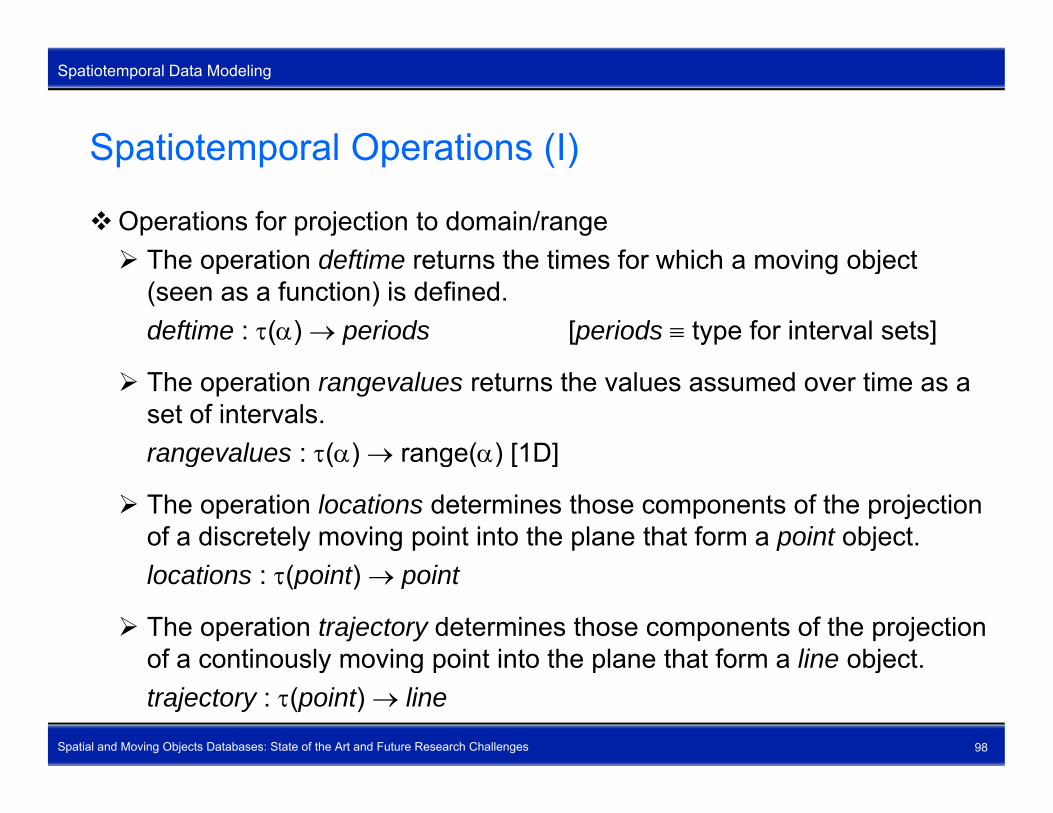
Spatiotemporal Operations (I)
Operations for projection to domain/range Th ti d fti t th ti f hi h i bj t The operation deftime returns the times for which a moving object
(seen as a function) is defined.deftime : () periods [periods type for interval sets]
The operation rangevalues returns the values assumed over time as a set of intervals.rangevalues : () range() [1D]rangevalues : () range() [1D]
The operation locations determines those components of the projection of a discretely moving point into the plane that form a point object.locations : (point) point
The operation trajectory determines those components of the projection of a continously moving point into the plane that form a line object
Spatial and Moving Objects Databases: State of the Art and Future Research Challenges 98
of a continously moving point into the plane that form a line object.trajectory : (point) line

Spatiotemporal Operations (II)
Spatiotemporal Data Modeling
Spatiotemporal Operations (II)
Operations for projection to domain/range (continued) Th ti t t th j ti f di t l i li The operation routes returns the projection of a discretely moving line
object.routes : (line) line
The operation traversed returns the projection of a continuously moving line object.t d ( ) i f {li i }traversed : () region for {line, region}
The operation inst yields the time component of a (time, value) pair.i t i ti ( ) tiinst : intime() time
The operation val yields the value component of a (time, value) pair.l i ti ( ) [i ti ti ]
Spatial and Moving Objects Databases: State of the Art and Future Research Challenges 99
val : intime () [intime = time × ]

Spatiotemporal Operations (III)
Spatiotemporal Data Modeling
Spatiotemporal Operations (III)
Operations for interaction with domain/range Th ti ti t t t i t i bj t t i ti i t t The operation atinstant restricts a moving object to a given time instant,
resulting in a (time, value) pair (time slice operator).atinstant : () × time intime()
The operation atperiods restricts a moving object to a given set of time intervals.atperiods : () × periods ()
The operations initial and final return the first and last (time, value) pair, respectively.initial, final : () intime(), ( ) ( )
The operation present checks whether a moving object exists at a given time instant, or is ever present during a given set of time intervals, respectively.
Spatial and Moving Objects Databases: State of the Art and Future Research Challenges 100
, p ypresent : () × time bool present : () × periods bool

Spatiotemporal Operations (IV)
Spatiotemporal Data Modeling
Spatiotemporal Operations (IV)
Operations for interaction with domain/range (continued) Th ti t t i t i bj t t l i th The operation at restricts a moving object to a value in the range.
at : () × () [1D] at : () × range() () [1D]at : () × point (point) [2D]at : () × () [2D] with = if dim() dim() then else
The operations atmin and atmax restrict a moving object to the times when it is minimal or maximal with respect to the total order on this space.atmin, atmax : () () [1D]
The operation passes checks whether a moving object ever assumed (one of) the value(s) given as a second argument.
Spatial and Moving Objects Databases: State of the Art and Future Research Challenges 101
passes : () × bool with = if dim() dim() then else

Spatiotemporal Operations (V)
Spatiotemporal Data Modeling
Spatiotemporal Operations (V)
Derivable spatiotemporal operations by temporal lifting: automatically derive spatiotemporal operations from spatial operations based on a clearderive spatiotemporal operations from spatial operations based on a clear semantics
Examples
dist: point region realDist: (point) (region) (real)Dist: hmpoint hmregion hmrealDist: hmpoint hmregion hmreal
intersection: line region lineIntersection: (line) (region) (line)Intersection: hmline hmregion hmlineIntersection: hmline hmregion hmline
area: region realArea: (region) (real)Area hmregion hmreal
Spatial and Moving Objects Databases: State of the Art and Future Research Challenges 102
Area: hmregion hmreal

Spatiotemporal Operations (VI)
Spatiotemporal Data Modeling
Spatiotemporal Operations (VI)
Let f : 1 … n be a spatial operation with i {point, line, region} and {point line region int real bool} Its corresponding temporallyand {point, line, region, int, real, bool}. Its corresponding temporally lifted version, that is, its corresponding spatiotemporal operation is defined by
f ( ) ( ) ()f : (1) … (n) ()
with
f(S1 S ) := {(t f(S1(t) S (t))) | t time}f(S1, …, Sn) : {(t, f(S1(t), …, Sn(t))) | t time}
Examples
Dist = dist
Intersection = intersection
Area area
Spatial and Moving Objects Databases: State of the Art and Future Research Challenges 103
Area = area

Spatiotemporal Predicates (I)
Spatiotemporal Data Modeling
Spatiotemporal Predicates (I)
Problem: Temporal lifting of spatial predicates does not lead to predicates
Example: Spatial predicate: inside : region region bool Temporally lifted spatial predicate:
inside : (region) (region) (bool)
A lifted spatial predicate yields a defined value only on the intersection of the domains of two moving objects.
A spatiotemporal predicate is a function of type () () bool for , {point, line, region}.
Spatial and Moving Objects Databases: State of the Art and Future Research Challenges 104

Spatiotemporal Predicates (II)
Spatiotemporal Data Modeling
Spatiotemporal Predicates (II)
Basic spatiotemporal predicates d fi d b t l lifti d t l ti defined by temporal lifting and temporal aggregation each predicate has an own “preferred” temporal aggregation Examples
disjoint: disjointedness required only on the common lifetime
inside: containment required only with q yrespect to the lifetime of the first operand object
Define default expected aggregation p gg gbehavior
A spatiotemporal predicate describes the continuous development of the
Spatial and Moving Objects Databases: State of the Art and Future Research Challenges 105
p p p ptopological relationships of two moving objects over time.

Spatiotemporal Predicates (III)
Spatiotemporal Data Modeling
Spatiotemporal Predicates (III)
Example: air plane (red) crosses a hurricane (blue)
time
t4 disjoint at t4
t3 meet at t3
Inside during ]t2 t3[
Disjoint during ]t3, t4[
yt2 meet at t2
Di j i t d i ]t t [
Inside during ]t2, t3[
x
t1 disjoint at t1
Disjoint during ]t1, t2[
Spatial and Moving Objects Databases: State of the Art and Future Research Challenges 106
Spatiotemporal Predicates (IV)
Spatiotemporal Data Modeling
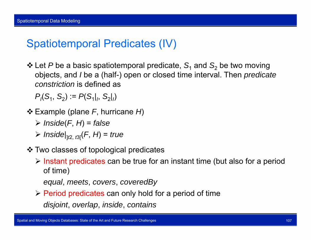
Spatiotemporal Predicates (IV)
Let P be a basic spatiotemporal predicate, S1 and S2 be two moving objects and I be a (half ) open or closed time interval Then predicateobjects, and I be a (half-) open or closed time interval. Then predicate constriction is defined asPI(S1, S2) := P(S1|I, S2|I)
Example (plane F, hurricane H) Inside(F, H) = false Inside| (F H) = true Inside|]t2, t3[(F, H) = true
Two classes of topological predicates Instant predicates can be true for an instant time (but also for a period
of time)equal, meets, covers, coveredBy
Period predicates can only hold for a period of time
Spatial and Moving Objects Databases: State of the Art and Future Research Challenges 107
Period predicates can only hold for a period of timedisjoint, overlap, inside, contains

Spatiotemporal Predicates (V)
Spatiotemporal Data Modeling
Spatiotemporal Predicates (V)
A spatiotemporal predicate is an alternating temporal sequence of topological relationships that hold over time intervals or at time pointstopological relationships that hold over time intervals or at time points.
A spatiotemporal predicate is an alternating temporal sequence of topological relationships and basic spatiotemporal predicates.opo og ca e a o s ps a d bas c spa o e po a p ed ca es
Symbol “>>” is temporal composition operator
Examples of spatiotemporal predicates for a moving point object and a moving region object Enter : = Disjoint >> meet >> Inside Cross : = Disjoint >> meet >> Inside >> meet >> Disjoint Leave : = rev(Enter) Cross := Enter >> Leave
Spatial and Moving Objects Databases: State of the Art and Future Research Challenges 108
Cross : Enter Leave TempLeave := (Meet >> Disjoint)* >> Meet

Spatiotemporal Predicates (VI)
Spatiotemporal Data Modeling
Spatiotemporal Predicates (VI)
Examples of spatiotemporal predicates for two moving region objects
Touch : = Disjoint >> meet >> Disjoint
Snap : = Disjoint >> Meet
Release : = Meet >> Disjoint
Bypass : = Snap >> Releaseyp p
Excurse := Meet >> Disjoint >> Meet
Into := meet >> Overlap >> coveredBy Into : meet >> Overlap >> coveredBy
OutOf := rev(Into)
Spatial and Moving Objects Databases: State of the Art and Future Research Challenges 109

Spatiotemporal Predicates (VII)
Spatiotemporal Data Modeling
Spatiotemporal Predicates (VII)
Examples of spatiotemporal predicates for two moving region objects (continued)(continued)
Enter := Disjoint >> Into >> Inside
L (E t ) Leave := rev(Enter)
Cross := Enter >> Leave
Melt := Disjoint >> meet >> Overlap >> Equal
Separate := rev(Melt)
Spring := equal >> Overlap >> meet >> Disjoint
Graze := Disjoint >> meet >> Overlap >> (CoveredBy >> Overlap)* >>
Spatial and Moving Objects Databases: State of the Art and Future Research Challenges 110
meet >> Disjoint

Spatiotemporal Querying (I)
Spatiotemporal Data Modeling
Spatiotemporal Querying (I)
Tables CREATE TABLE Fli ht(id h (30) t h i t) CREATE TABLE Flight(id varchar(30), route hmpoint); CREATE TABLE Weather(name varchar(30), kind varchar(50),
extent hmregion);
Q1: What are the departure and arrival times of flight LH 257, and how long is the part of the route of this flight that lies within France?CREATE TABLE France AS
(SELECT * FROM States WHERE sname = ‘France’);
SELECT min(deftime(route)) AS departureTime,SELECT min(deftime(route)) AS departureTime,max(deftime(route)) AS arrivalTime,length(trajectory(Intersection(route, ^territory))) AS lenInFr
FROM Flight, France
Spatial and Moving Objects Databases: State of the Art and Future Research Challenges 111
WHERE id = ‘LH 257’;

Spatiotemporal Querying (II)
Spatiotemporal Data Modeling
Spatiotemporal Querying (II)
Q2: When and where did flight LH 257 enter the territory of France?SELECT i iti l( t( t t it )) AS tSELECT initial(at(route, territory)) AS entry,
inst(entry) AS entryTime,val(entry) AS entryLocation,
FROM Flight FranceFROM Flight, FranceWHERE id = ‘LH 257’;
Q3: Determine the time periods when snow storm ‘Lizzy’ consisted ofQ3: Determine the time periods when snow storm Lizzy consisted of exactly three separate areas.CREATE TABLE Lizzy AS
(SELECT extent(SELECT extentFROM weatherWHERE name = “Lizzy” and kind = “snow storm”);
SELECT deftime(at(noOfComps(extent) = 3 TRUE))
Spatial and Moving Objects Databases: State of the Art and Future Research Challenges 112
SELECT deftime(at(noOfComps(extent) = 3, TRUE))FROM Lizzy;

Spatiotemporal Querying (III)
Spatiotemporal Data Modeling
Spatiotemporal Querying (III)
Q4: Where was United Airlines flight 207 at time 8:00 am?SELECT l( ti t t( t 8 00)) AS l AtEi htSELECT val(atinstant(route, 8:00)) AS locAtEightFROM FlightWHERE id = ‘UA 207’;
Q5: Where was United Airlines flight 207 between 7:00 am and 9:00 am?SELECT trajectory(atperiods(route, 7:00..9:00)) AS locFROM FlightFROM FlightWHERE id = ‘UA 207’;
Q6: Which planes ran into a hurricane?Q6: Which planes ran into a hurricane?SELECT idFROM Flight, WeatherWHERE kind = ‘hurricane’ AND
Spatial and Moving Objects Databases: State of the Art and Future Research Challenges 113
WHERE kind hurricane ANDroute Disjoint >> meet >> Inside extent;

Spatiotemporal Querying (IV)
Spatiotemporal Data Modeling
Spatiotemporal Querying (IV)
DEFINE Enters AS Disjoint >> meet >> Inside;
Q7: Which planes ran into a hurricane (reformulation)?SELECT idFROM Flight WeatherFROM Flight, WeatherWHERE kind = ‘hurricane’ AND
route Enters extent;
Other definitions of complex spatiotemporal predicatesDEFINE Leaves AS rev(Enters);DEFINE Crosses AS Enters >> Leaves;DEFINE Crosses AS Enters >> Leaves;DEFINE Bypass AS Disjoint >> Meet >> Disjoint;
Spatial and Moving Objects Databases: State of the Art and Future Research Challenges 114

Spatiotemporal Querying (V)
Spatiotemporal Data Modeling
Spatiotemporal Querying (V)
Q8: What is the number of planes that were entering snow storms or fog areas?areas?SELECT count(*) as numFROM Flight, WeatherWHERE kind = ‘snow storm’ OR kind = ‘fog’GROUP BY route Enters extent;
CREATE TABLE Bird(swarm varchar(40), movement hmpoint);( ( ) p )
Q9: Which swarms fly together, then take different routes for some time, and finally meet again?y g
DEFINE Remeets AS _ >> Meet >> Disjoint >> Meet >> _;
SELECT A.swarm, B.swarmFROM Bi d AS A Bi d AS B
Spatial and Moving Objects Databases: State of the Art and Future Research Challenges 115
FROM Bird AS A, Bird AS BWHERE A.movement Remeets B.movement;

Outline
Outline
Outline
1. Introduction2 S ti l D t M d li2. Spatial Data Modeling3. Spatiotemporal Data Modeling4. Open Research Topics
Spatial and Moving Objects Databases: State of the Art and Future Research Challenges 116

Outline – Open Research Topics
Outline
Outline – Open Research Topics
Topics not covered in this tutorialR h h llResearch challenges
Spatial and Moving Objects Databases: State of the Art and Future Research Challenges 117

Topics Not Covered in this Tutorial
Open Research Topics
Topics Not Covered in this Tutorial
Goal of the tutorial: Learn concepts first
Data structure design for spatial and spatiotemporal data types
Geometric algorithm design for spatial and spatiotemporal operations and predicates (require methods from Computational Geometry)predicates (require methods from Computational Geometry)
Efficient implementation techniques for spatial and spatiotemporal joins
Spatial and spatiotemporal query processingp p p q y p g
Spatial and spatiotemporal indexing
Spatial and Moving Objects Databases: State of the Art and Future Research Challenges 118
Research Challenges (I)
Open Research Topics
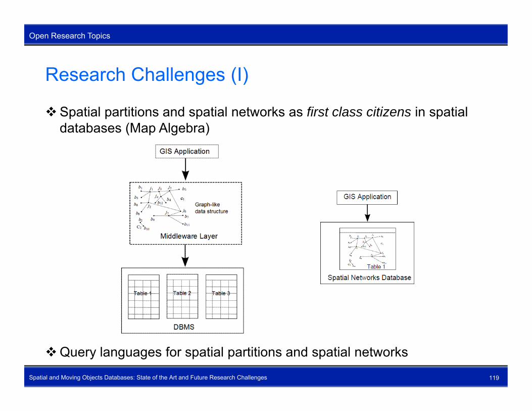
Research Challenges (I)
Spatial partitions and spatial networks as first class citizens in spatial databases (Map Algebra)databases (Map Algebra)
Spatial and Moving Objects Databases: State of the Art and Future Research Challenges 119
Query languages for spatial partitions and spatial networks

Research Challenges (II)
Open Research Topics
Research Challenges (II)
Vague and fuzzy spatial objects
Some models for fuzzy spatial objects available (especially from GIS field)
Spatial and Moving Objects Databases: State of the Art and Future Research Challenges 120
Problem: Implementation of fuzzy spatial objects

Research Challenges (III)
Open Research Topics
Research Challenges (III)
Three-dimensional spatial objects
Applications: Meteorology, GIS, soil science, earth science
Problem: Computational Geometry is immature with respect to three-
Spatial and Moving Objects Databases: State of the Art and Future Research Challenges 121
Problem: Computational Geometry is immature with respect to three-dimensional data handling

Research Challenges (IV)
Open Research Topics
Research Challenges (IV)
Moving objects (3D + time)
Applications: Meteorology, hurricane research, tsunami research, earthquake research, volcano research
Spatial and Moving Objects Databases: State of the Art and Future Research Challenges 122
Construction of moving objects from gridded sensor data (icing problem)

Research Challenges (V)
Open Research Topics
Research Challenges (V)
STU objects (Space + Time + Uncertainty)
Applications: Modeling of natural phenomena in general, geosciences,
Spatial and Moving Objects Databases: State of the Art and Future Research Challenges 123
hurricane research, meteorology

Thank YouThank Youfor Your Attentionfor Your Attention
and Interest!and Interest!
Spatial and Moving Objects Databases: State of the Art and Future Research Challenges 124