space for civil protection workshop - artes · pdf fileo essential for command and control o...
TRANSCRIPT
6th May 2011, Vienna
SPACE FOR CIVIL PROTECTION WORKSHOP
Kinga PERGEMinistry of Interior
National Directorate General for Disaster ManagementDepartment of GIS and Telecommunication
Ministry of InteriorNational Directorate General for Disaster ManagementDepartment of GIS and Telecommunication
o recently formed department
o there was a department for telecommunication but not for GIS
o on stakeholders’ demand our GIS needs to be updated and developed, jointly with Telecommunications
o specialized national focal point of international programs and projects (ex. GMES ERS)
o the participation in data service and support for the counties’ directorates
o decision-making support
o trainings

TOC
• What do we have?
• What do we wish for?
ExperienceLessons learnt
Indications
Objectives

Our Telecommunication system I.
i. EDR / TETRA system (Promobil):
o Coherent system
o due to unobstructed communication between the users
o crucial to have a stable, effectivetelecommunication system
o essential for command and control
o Users: (first) responders & law enforcement units
o diasaster management, police, emergencyservices etc.
o Platform
o common infrastructural background
o terrestrial, digital
o Centralized governmental management
o enables effective joint response

Users of the TETRA system
Police Finance Guard
Ambulance
JOINT EFFORTS
FirefightersCivil Protection
Disaster Management
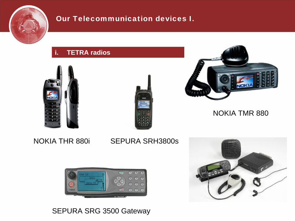
Our Telecommunication devices I.
i. TETRA radios
NOKIA THR 880i
NOKIA TMR 880
SEPURA SRH3800s
SEPURA SRG 3500 Gateway

Our Telecommunication system II.
ii. Space based system
o Service is expensive, not affordable
o Therefore:
• complementary solution
• lack of experience in using the system
• a very few owned devices (used mainly for international missions)
• the community of law enforcement units and responders uses the same system defined by the government, which is a terrestrial system (less costly)

Our Telecommunication system II.
ii. Space based system
o Iridium satellite phone sevices
• for sound transfer (phones)
o Inmarsat BGAN
• for data transfer (modems)
Iridium
Inmarsat BGAN

Our Telecommunication devices II.
i. Satellite devices

Our GIS system I.
i. GIS solutions
o mainly vector data
o system’s development is under progress
o satellite based services are expensive
o GMES ERS
o UN-SPIDER
o The Emergency Management Geographical Information System (KATIR) is operated by NDGDM
• the goal of establishing KATIR was the creation and operation of GIS, which facilitates the accurate and automatic flow of geographical data
• capable of providing information for decision-making in a short time for emergency management
• KATIR is not a separated IT system
• ArcGIS platform

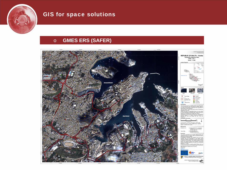
GIS for space solutions
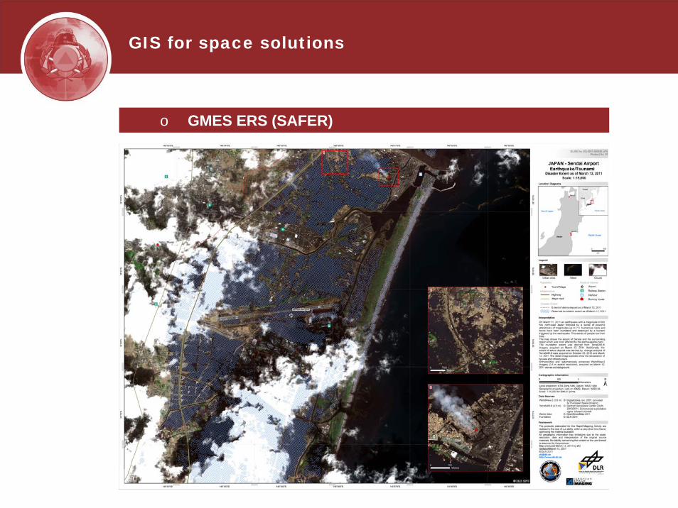
o GMES ERS
• useful services
• supports decision making and all phases of disaster management (from prevention to recovery)
• ready-to-go products (analysis is included, not justraw data)
• coherent system, available for the MSs
• great information source in case of an international mission

GIS for space solutions
o GMES ERS (SAFER)

GIS for space solutions
o GMES ERS (SAFER)

GIS for space solutions
o GMES ERS (SAFER)
GIS for space solutions
o GMES ERS (SAFER)
GIS for space solutions
o GMES ERS (SAFER)

GIS for space solutions
o UN-SPIDER
• support for Civil Protection Community
• Knowledge Portal http://www.un-spider.org

GIS & Telecommunication
i. GPS tracking system based on TETRA system
o Closed system – security
o Data compatibility issues
o Difficulties with data import and export
o Unutilized capacity of the system
o Command&Control
o Poor GIS solutions – only display functions, no option for analysis

Exercises and case studies I.
i. Promobil vehicle positioning system in command and controlSomogy County – Exercise for firefighters (2010)
o orthophoto – visual identification of objects
o search for address, coordinate and POI
o archive functions: route check, site check
o displaying other vehicles
o map-caching
o creating operational groups
o personalization – displaying only chosen data
o exporting real-time or archived data
o creating unique filters and colour schemes
o mobile Promobil: overview on site
o position sending – every 30 seconds per radio

Exercises and case studies I.
i. Promobil vehicle positioning system in command and controlSomogy County – Exercise for firefighters (2010)
o What can the system do? – Control Options
• assign the site,
• direct the unit to the site,
• control several units,
• redirection,
• circumscribe areas,
• area calculation,
• defining fire spread estimations,
• defining expected deployment points,
• displaying tactical situation

i. Promobil vehicle positioning system in command and control in Somogy County – Exercise for firefighters (2010)
Sim
Tsz
Zselic-p.
Detection of the extent of the fire by exploration

i. Promobil vehicle positioning system in command and control in Somogy County – Exercise for firefighters (2010)
Sim
Tsz
Zselic-p.
The extent of the explored fire

i. Promobil vehicle positioning system in command and controlin Somogy County – Exercise for firefighters (2010)
Sim
Tsz
Zselic-p.
The expected extent of the explored fire in 1 hour
Sim
Tsz
Zselic-p.
i. Promobil vehicle positioning system in command and controlin Somogy County – Exercise for firefighters (2010)
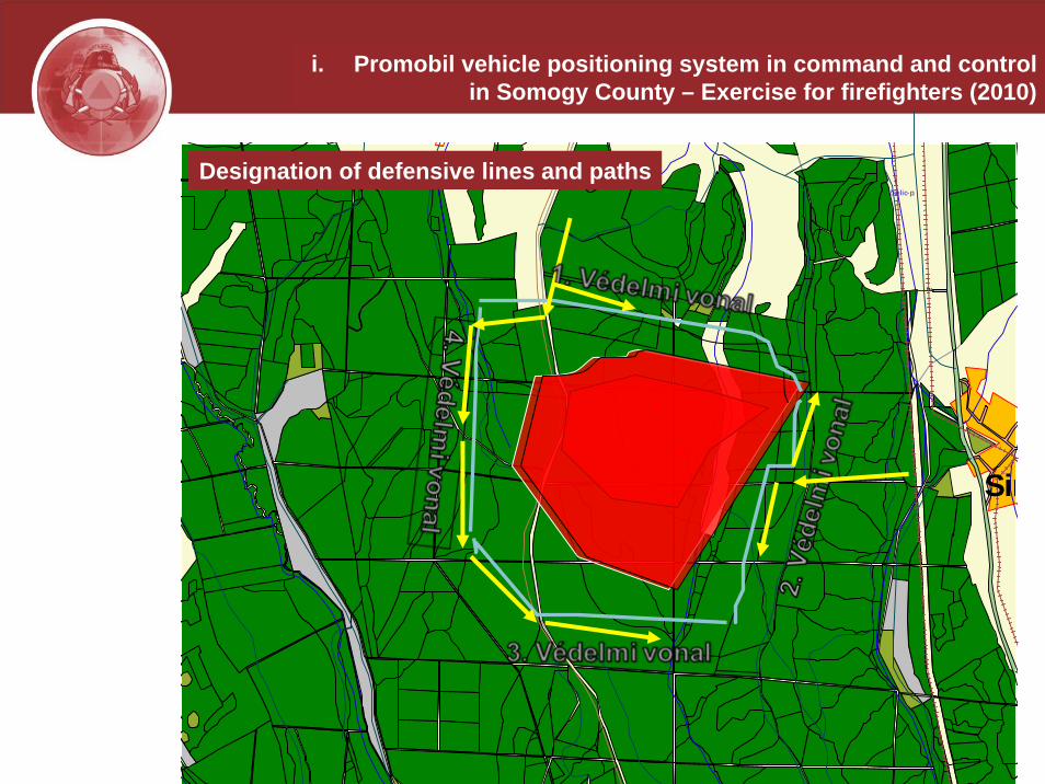
Designation of defensive lines and paths
i. Promobil vehicle positioning system in command and controlin Somogy County – Exercise for firefighters (2010)
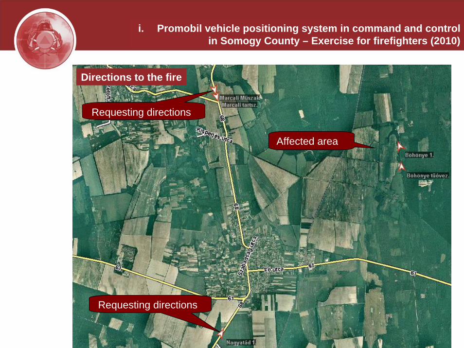
Designation of defensive lines and pathsDirections to the fire
Affected area
Requesting directions
Requesting directions

i. Promobil vehicle positioning system in command and controlin Somogy County – Exercise for firefighters (2010)
Mobile - Promobil
Exercises and case studies II.
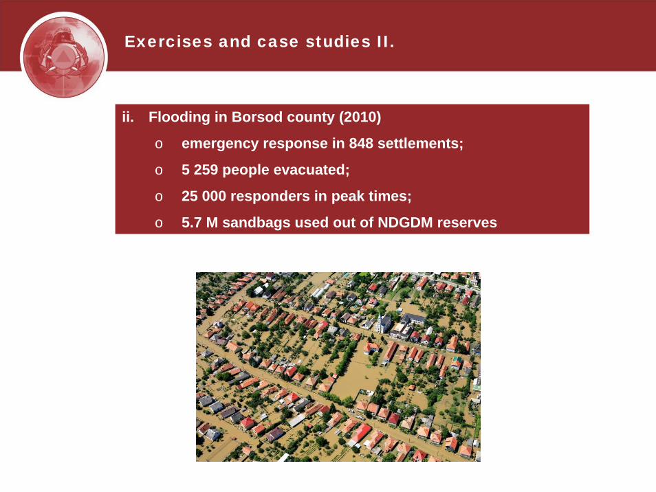
ii. Flooding in Borsod county (2010)
o emergency response in 848 settlements;
o 5 259 people evacuated;
o 25 000 responders in peak times;
o 5.7 M sandbags used out of NDGDM reserves

Exercises and case studies II.
ii. Flooding in Borsod county (2010)
o Satellite services were used during the crisis
o Live video connection was set to provide up-to-datestatus report, so supporting command&control
Exercises and case studies III.
iii. HUROMEX Exercise (2008)
o In the framework of the Civil Protection Mechanism of the European Union and with the support of the European Commission, a civil protection EU project “EU-HUROMEX-2008” was implemented, with the topic “Preparation, performance and evaluation of a full scale civil protection simulation exercise on the interventions in case of major floods and consequent reconstruction of the damages to the critical infrastructure“.
o Hungary and Romania + 8 countries at the exercise(Austria, Bulgaria, Croatia, Lithuania, Poland, Slovakia,Slovenia and Moldova; teams of 20 persons each )

Exercises and case studies III.
iii. HUROMEX Exercise (2008)
o Due to successful implementation of the exercise, the certain conditions had to be established within KATIR
• compiling a digital map containing the exercise locations,
• input and storage of the ID and position data of the teams by time,
• displaying the position data and the exerciselocations on digital map for the decision-making bodies (e.g. LEMA)
• tracking of team movements during the evaluation of the exercise.

Exercises and case studies III.
iii. HUROMEX Exercise (2008)
Flag
Unit name
Nation
Type
Action
Date
Different nations, different flags
Digital map with the units
Information window

Exercises and case studies III.
iii. HUROMEX Exercise (2008)
Displaying the status of the units in KATIR
Units
Basic information aboutthe units

Exercises and case studies III.
iii. HUROMEX Exercise (2008)
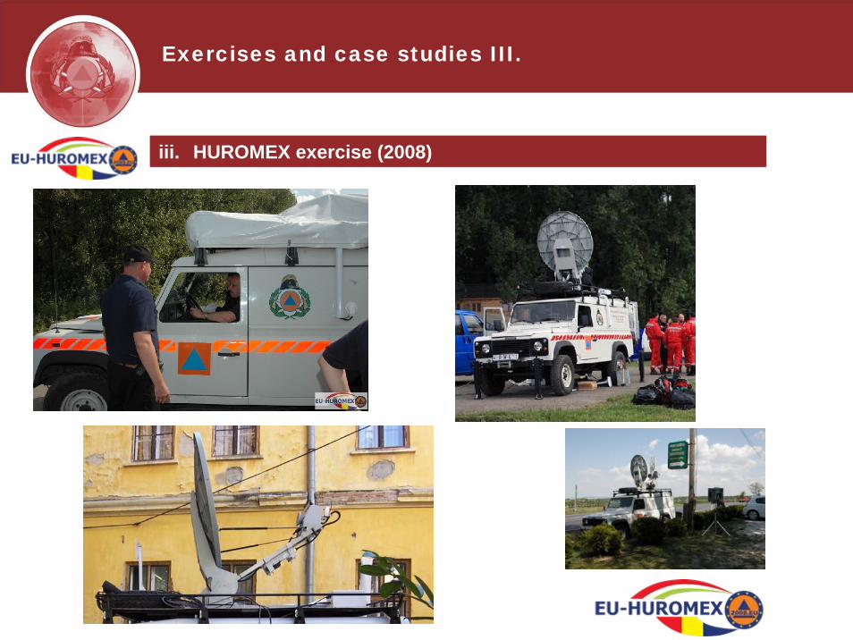
o Connection methods of international communicationduring the exercise
• Between LEMA – EU MIC: Internet (CECIS)
• Between EU MIC – OSOCC: Internet (e-mail)
• Between OSOCC – Teams: radio
• Between main OSOCC – sub OSOCC: telephone,e-mail (satellite phone)
• Within teams: own radio communication equipment (frequency setting)
• In Hungary almost 60 TETRA radios were distributed

Exercises and case studies III.
Scheme of theCommunicationNetwork

Exercises and case studies III.
Satellite Scheme
Exercises and case studies III.
iii. HUROMEX exercise (2008)

Indications&Objectives
i. Close the gap between GIS & Telecommunication with
o eliminating compatibility issues;
o developing extensions for the control software in order to improve analysis capability;
o establishing training material and advisory group to support disaster management;
o joint, orientated trainings and courses.
ii. Increase the availability by
o decreasing the expenses of the services;
o trainings in handling the devices and the system;
o technical support system.
iii. Support disaster management with
o implementation of effective systems and best practices;
o common system: application- and data-harmonization;
o user-friendly platform for commanders and responders.

Thank you for your kind attention!
Kinga PERGEMinistry of Interior
National Directorate General for Disaster ManagementDepartment of GIS and Telecommunication