southern california edison’s lakeview substation … · 2012-01-18 · 2-3 proposed lakeview...
TRANSCRIPT

SOUTHERN CALIFORNIA EDISON’S LAKEVIEW SUBSTATION PROJECT CPUC A.10-09-016 SCH #: 2010121032
Draft Environmental Impact Report
Prepared for January 2012 California Public Utilities Commission

SOUTHERN CALIFORNIA EDISON’S LAKEVIEW SUBSTATION PROJECT CPUC A.10-09-016 SCH #: 2010121032
Draft Environmental Impact Report
Prepared for January 2012 California Public Utilities Commission
225 Bush Street Suite 1700 San Francisco, CA 94104 415.896.5900 www.esassoc.com
Los Angeles
Oakland
Olympia
Palm Springs
Petaluma
Portland
Sacramento
San Diego
Seattle
Tampa
Woodland Hills
207584.08

OUR COMMITMENT TO SUSTAINABILITY | ESA helps a variety of public and private sector clients plan and prepare for climate change and emerging regulations that limit GHG emissions. ESA is a registered assessor with the California Climate Action Registry, a Climate Leader, and founding reporter for the Climate Registry. ESA is also a corporate member of the U.S. Green Building Council and the Business Council on Climate Change (BC3). Internally, ESA has adopted a Sustainability Vision and Policy Statement and a plan to reduce waste and energy within our operations. This document was produced using recycled paper.

Lakeview Substation Project i ESA / 207584.08 (A.10-09-016) Draft Environmental Impact Report January 2012
TABLE OF CONTENTS Southern California Edison Lakeview Substation Project (A.10-09-016) Draft Environmental Impact Report
Page
Acronyms and Abbreviations v
Executive Summary ES-1 ES.1 Introduction .................................................................................................. ES-1 ES.2 Project Objectives ........................................................................................ ES-1 ES.3 Project Description ....................................................................................... ES-2 ES.4 Alternatives .................................................................................................. ES-7 ES.5 Environmentally Superior Alternative ........................................................... ES-8 ES.6 Areas of Controversy and Issues to be Resolved ........................................ ES-8 ES.7 Summary of Impacts and Mitigation Measures ............................................ ES-9 1. Introduction 1-1 1.1 Purpose of This Document ............................................................................. 1-1 1.2 Project Overview ............................................................................................. 1-1 1.3 Use of This Document by Agencies ................................................................ 1-2 1.4 Public Review and Comment .......................................................................... 1-4 1.5 Reader’s Guide to This EIR ............................................................................ 1-5 1.6 Electric and Magnetic Fields ........................................................................... 1-6 2. Project Description 2-1 2.1 Introduction ..................................................................................................... 2-1 2.2 Project Location .............................................................................................. 2-2 2.3 Existing System .............................................................................................. 2-2 2.4 Project Objectives ........................................................................................... 2-2 2.5 Overview of the Project ................................................................................... 2-2 2.6 Project Components ....................................................................................... 2-4 2.7 Preconstruction Activities .............................................................................. 2-14 2.8 Construction ................................................................................................. 2-17 2.9 Decommissioning the Nuevo Substation and Model Pole Top Transformer ... 2-30 2.10 Project Operation and Maintenance ............................................................. 2-32 2.11 Water and Wastewater ................................................................................. 2-33 2.12 Workforce and Equipment ............................................................................ 2-33 2.13 Applicant Proposed Measures ...................................................................... 2-38 3. Alternatives Analysis 3-1 3.1 CEQA Context for the Consideration of Alternatives ...................................... 3-1 3.2 Alternatives Development and Screening Process ........................................ 3-2 3.3 Summary of Screening Results ...................................................................... 3-5

Table of Contents
Page
Lakeview Substation Project ii ESA / 207584.08 (A.10-09-016) Draft Environmental Impact Report January 2012
3. Alternatives Analysis (continued) 3.4 Alternatives Evaluated in this EIR ................................................................... 3-8 3.5 Alternatives Eliminated from Full EIR Evaluation .......................................... 3-11 4. Environmental Analysis 4-1 Introduction to Environmental Analysis .................................................................... 4-1 4.1 Aesthetics .................................................................................................... 4.1-1 4.2 Agriculture and Forestry Resources ............................................................ 4.2-1 4.3 Air Quality .................................................................................................... 4.3-1 4.4 Biological Resources ................................................................................... 4.4-1 4.5 Cultural Resources ...................................................................................... 4.5-1 4.6 Energy Conservation ................................................................................... 4.6-1 4.7 Geology and Soils ........................................................................................ 4.7-1 4.8 Greenhouse Gas Emissions ........................................................................ 4.8-1 4.9 Hazards and Hazardous Materials ............................................................... 4.9-1 4.10 Hydrology and Water Quality ..................................................................... 4.10-1 4.11 Land Use and Planning ............................................................................. 4.11-1 4.12 Mineral Resources ..................................................................................... 4.12-1 4.13 Noise ......................................................................................................... 4.13-1 4.14 Population and Housing ............................................................................. 4.14-1 4.15 Public Services .......................................................................................... 4.15-1 4.16 Recreation ................................................................................................. 4.16-1 4.17 Transportation and Traffic .......................................................................... 4.17-1 4.18 Utilities and Services Systems ................................................................... 4.18-1 5. Comparison of Alternatives 5-1 5.1 Comparison Methodology ............................................................................... 5-1 5.2 Evaluation of Project Alternatives ................................................................... 5-2 5.3 Environmentally Superior Alternative .............................................................. 5-3 5.4 No Project Alternative vs. the Environmentally Superior Alternative ............... 5-5 6. Cumulative Effects 6-1 6.1 Projects Considered in the Cumulative Analysis............................................. 6-1 6.2 Cumulative Effects Analysis ........................................................................... 6-7 7. Other CEQA Considerations 7-1 7.1 Significant Unavoidable Environmental Effects .............................................. 7-1 7.2 Significant Irreversible Changes ..................................................................... 7-1 7.3 Growth-Inducing Effects ................................................................................. 7-2 8. Report Preparation 8-1 9. Mitigation Monitoring, Reporting, and Compliance Program 9-1
Appendices
A. Scoping Report ....................................................................................................... A-1 B. SCE’s EMF Field Management Plan ....................................................................... B-1 C. Air Quality ............................................................................................................... C-1 D. Hazards and Hazardous Materials .......................................................................... D-1 E. Certificate of Service and Mailing List ..................................................................... E-1

Table of Contents
Page
Lakeview Substation Project iii ESA / 207584.08 (A.10-09-016) Draft Environmental Impact Report January 2012
List of Figures
ES-1 Electrical Needs Area ........................................................................................ ES-3 2-1 Electrical Needs Area ........................................................................................... 2-3 2-2 Project ................................................................................................................... 2-5 2-3 Proposed Lakeview Substation Layout ................................................................. 2-6 2-4 Existing Facilities ................................................................................................ 2-10 2-5 Subtransmission Structures ................................................................................ 2-12 2-6 Potential Marshalling Yards ................................................................................ 2-19 3-1 Alternative 2 ........................................................................................................ 3-10 4.1-1 Visual Study Area and Viewshed ....................................................................... 4.1-3 4.1-2 Location of Key Observation Points (KOPs) and Context Photographs ............. 4.1-5 4.1-3 Context Photos A, B, C and D ........................................................................... 4.1-6 4.1-4 Context Photos E, F, G and H ........................................................................... 4.1-7 4.1-5 Existing and Simulated View of Project from KOP – 1 ..................................... 4.1-12 4.1-6 Existing and Simulated View of Project from KOP – 2 ..................................... 4.1-13 4.1-7 Existing and Simulated View of Project from KOP – 3 ..................................... 4.1-14 4.1-8 Existing and Simulated View of Project from KOP – 4 ..................................... 4.1-15 4.1-9 Existing and Simulated View of Project from KOP – 5 ..................................... 4.1-16 4.1-10 Existing and Simulated View of Project from KOP – 6 ..................................... 4.1-17 4.1-11 Existing and Simulated View of Project from KOP – 7 ..................................... 4.1-18 4.1-12 Existing and Simulated View of Project from KOP – 8 ..................................... 4.1-19 4.2-1 Important Farmland and Williamson Act Contracted Land in the Project
Vicinity ............................................................................................................ 4.2-3 4.7-1 Geologic Map ..................................................................................................... 4.7-2 4.7-2 Soil Map ............................................................................................................. 4.7-4 4.10-1 Flood Zones in the Project Vicinity ................................................................... 4.10-2 4.11-1 Riverside County General Plan Land Use Designations .................................. 4.11-3 4.11-2 City of Moreno Valley General Plan Land Use Designations ........................... 4.11-6 4.13-1 Ambient Noise Monitoring Location ................................................................. 4.13-5 4.16-1 Parks and Recreation Areas in the Project Vicinity .......................................... 4.16-2 6-1 Cumulative Projects .............................................................................................. 6-5
List of Tables
ES-1 Summary of Impacts and Mitigation Measures for the Project ......................... ES-11 ES-2 Comparison of Environmental Impacts of the Project and Alternatives ........... ES-21 1-1 Summary of Potential Permit Requirements ......................................................... 1-3 1-2 EMF Design Guidelines Low- and No-Cost Measures Proposed for the
Project ............................................................................................................... 1-7 2-1 Approximate Subtransmission Structure Dimensions ......................................... 2-13 2-2 Estimated Land Disturbance for Access Roads and Staging Areas ................... 2-18 2-3 Potential Marshalling Yard Locations .................................................................. 2-20 2-4 Estimated Land Disturbance for Below-Grade Construction ............................... 2-22 2-5 Substation Below-Ground Improvement Materials and Volumes ........................ 2-22 2-6 Estimated Land Disturbance for Above-Grade Construction .............................. 2-23 2-7 Substation Ground Surface Improvement Materials, Areas, and Volumes ......... 2-24 2-8 Estimated Land Disturbance for 115 kV Subtransmission Source Lines
and Telecommunication Lines ......................................................................... 2-25 2-9 Construction Equipment and Workforce Estimates. ............................................ 2-34

Table of Contents
Page
Lakeview Substation Project iv ESA / 207584.08 (A.10-09-016) Draft Environmental Impact Report January 2012
List of Tables (continued)
3-1 Summary of Preliminary Significant Environmental Impacts of the Lakeview Substation Project .............................................................................................. 3-5
3-2 Summary of Alternatives Screening Analysis – Lakeview Substation Project ....... 3-6 3-3 Estimated Duration of Alternative 1 Construction Activities .................................. 3-8 4.1-1 Summary of Visual Sensitivity Findings: Viewer Types, Visual Exposures,
and Visual Quality ......................................................................................... 4.1-11 4.1-2 Guidelines for Determining Aesthetic Impact Significance ............................... 4.1-24 4.2-1 Farmland Conversion from 2006-2008 in Riverside County .............................. 4.2-2 4.2-2 Estimated Temporary Disturbance of Farmland ................................................ 4.2-7 4.2-3 Estimated Permanent Disturbance of Farmland ................................................ 4.2-8 4.3-1 Air Quality Data Summary (2006–2010) for the Study Area .............................. 4.3-4 4.3-2 State and National Criteria Air Pollutant Standards, Effects, and Sources ........ 4.3-8 4.3-3 SCAQMD Fugitive Dust BACM for All Construction Activity Sources .............. 4.3-10 4.3-4 SCAQMD Air Quality Significance Thresholds ................................................. 4.3-13 4.3-5 SCAQMD Localized Significance Thresholds .................................................. 4.3-14 4.3-6 Peak Daily Construction Emissions ................................................................. 4.3-16 4.3-7 Peak Daily Operational Emission Estimates .................................................... 4.3-17 4.3-8 Construction Localized Significance Threshold Analysis ................................. 4.3-20 4.3-9 Phased Construction Alternative Peak Daily Construction Emissions ............. 4.3-22 4.3-10 Relocated Substation Alternative Peak Daily Construction Emissions ............ 4.3-23 4.4-1 Vegetation Communities in the Project Area ..................................................... 4.4-4 4.4-2 Special-Status Species Reported or Potentially Occurring in the
Study Area for the Project and Alternatives .................................................... 4.4-9 4.4-3 MSHCP Criteria Cells in the Project Area ........................................................ 4.4-25 4.5-1 Paleontological Potential Criteria ..................................................................... 4.5-17 4.7-1 Soil Types Underlying the Project Area ............................................................. 4.7-5 4.7-2 Major Active Faults within a 20 Mile Radius of the Substation Site .................... 4.7-8 4.8-1 Recommended Actions of Climate Change Scoping Plan ................................. 4.8-4 4.10-1 Beneficial Uses of Waters within the Study Area ............................................. 4.10-4 4.10-2 Definitions of Beneficial Uses of Surface Waters ............................................. 4.10-4 4.13-1 Summary of Monitored Short-Term Daytime Ambient Noise Levels ................ 4.13-4 4.13-2 Stationary Source Residential Land Use Noise Standards .............................. 4.13-8 4.13-3 Maximum Continuous Sound Levels ............................................................... 4.13-9 4.13-4 Maximum Impulsive Sound Levels ................................................................ 4.13-10 4.13-5 Typical Noise Levels Generated by Construction Equipment ........................ 4.13-16 4.14-1 Historic and Estimated Future Population, 1990–2035 .................................... 4.14-2 4.14-2 Historic and Estimated Future Population Growth Rates, 1990–2035 ............. 4.14-2 4.14-3 2010 Housing Data .......................................................................................... 4.14-2 4.14-4 Historic and Projected Households: 2003–2035 .............................................. 4.14-3 4.18-1 County Landfill Remaining Estimated Capacity ............................................... 4.18-2 4.18-2 2008-2009 Per Capita Disposal Rates ............................................................. 4.18-4 5-1 Summary of Significant Unavoidable (Class I) Environmental Impacts
of the Project and Alternatives ........................................................................... 5-3 5-2 Proposed Project vs. Alternatives Summary of Environmental Impact
Conclusions ....................................................................................................... 5-7 6-1 Cumulative Projects List for the Lakeview Substation Project .............................. 6-2 9-1 Mitigation Monitoring, Reporting, and Compliance program for the Lakeview
Substation Project ............................................................................................ 9-11

Lakeview Substation Project v ESA / 207584.08 (A.10-09-016) Draft Environmental Impact Report January 2012
ACRONYMS AND ABBREVIATIONS
AB Assembly Bill AC alternating current ACSR Aluminum Conductor Steel Reinforced ADT Average Daily Traffic AFB Air Force Base AFY acre-feet per year ags above ground surface ALJ Administrative Law Judge amsl above mean sea level ANSI American National Standards Institute AP Alquist-Priolo APLIC Avian Power Line Interaction Committee APM Applicant Proposed Measure APN Assessor’s Parcel Number APSA Aboveground Petroleum Storage Act AQMP Air Quality Management Plan ASCE American Society of Civil Engineers AST Aboveground Storage Tank ASTM American Society for Testing and Materials BACM Best Available Control Measures Basin Plan Santa Ana River Basin Water Quality Control Plan BAT Best Available Technology BCT Best Conventional Technology bgs Below Ground Surface BMP Best Management Practice B.P. Before Present CA DOF California Department of Finance CAA Clean Air Act CAAQS California Ambient Air Quality Standards CAL FIRE California Department of Forestry and Fire Protection Cal OSHA California Occupational Safety and Health Administration CalARP California Accidental Release Program CalRecycle California Department of Resources Recycling and Recovery Caltrans California Department of Transportation
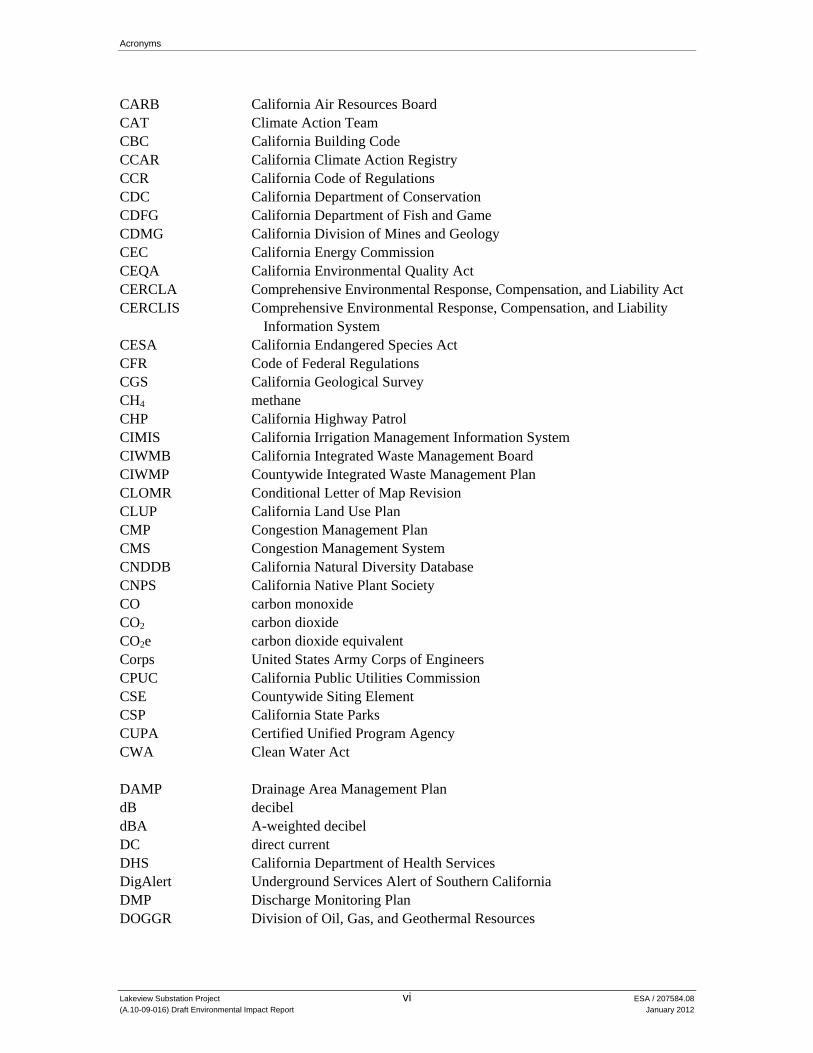
Acronyms
Lakeview Substation Project vi ESA / 207584.08 (A.10-09-016) Draft Environmental Impact Report January 2012
CARB California Air Resources Board CAT Climate Action Team CBC California Building Code CCAR California Climate Action Registry CCR California Code of Regulations CDC California Department of Conservation CDFG California Department of Fish and Game CDMG California Division of Mines and Geology CEC California Energy Commission CEQA California Environmental Quality Act CERCLA Comprehensive Environmental Response, Compensation, and Liability Act CERCLIS Comprehensive Environmental Response, Compensation, and Liability
Information System CESA California Endangered Species Act CFR Code of Federal Regulations CGS California Geological Survey CH4 methane CHP California Highway Patrol CIMIS California Irrigation Management Information System CIWMB California Integrated Waste Management Board CIWMP Countywide Integrated Waste Management Plan CLOMR Conditional Letter of Map Revision CLUP California Land Use Plan CMP Congestion Management Plan CMS Congestion Management System CNDDB California Natural Diversity Database CNPS California Native Plant Society CO carbon monoxide CO2 carbon dioxide CO2e carbon dioxide equivalent Corps United States Army Corps of Engineers CPUC California Public Utilities Commission CSE Countywide Siting Element CSP California State Parks CUPA Certified Unified Program Agency CWA Clean Water Act DAMP Drainage Area Management Plan dB decibel dBA A-weighted decibel DC direct current DHS California Department of Health Services DigAlert Underground Services Alert of Southern California DMP Discharge Monitoring Plan DOGGR Division of Oil, Gas, and Geothermal Resources

Acronyms
Lakeview Substation Project vii ESA / 207584.08 (A.10-09-016) Draft Environmental Impact Report January 2012
DPM diesel particulate matter DPW Department of Public Works DSOD California Division of Safety of Dams DTSC Department of Toxic Substance Control DWR Department of Water Resources EIR Environmental Impact Report ELF Extremely Low Frequency EMF Electric and Magnetic Fields EMWD Eastern Municipal Water District ENA Electrical Needs Area EPRI Electric Power Research Institute ESA Environmentally Sensitive Area FAA Federal Aviation Administration FEMA Federal Emergency Management Agency FERC Federal Energy Regulatory Commission FESA Federal Endangered Species Act FGC Fish and Game Code FMMP Farmland Mapping and Monitoring Program FMP Field Management Plan ft foot FTA Federal Transit Administration g gravity GHG greenhouse gas GIS Geographic Information System GWh gigawatt-hour GWP global warming potential HFC hydrofluorocarbon HMI/PLC Human Machine Interface/Programmable Logic Controller HMMD Hazardous Materials Management Division HVAC heating ventilation and air-conditioning HWCL Hazardous Waste Control Law Hz hertz I Interstate IARC International Agency for Research on Cancer IBC International Building Code IEEE Institute of Electrical and Electronic Engineers IPCC Intergovernmental Panel on Climate Change KOP Key Observation Point kV kilovolt

Acronyms
Lakeview Substation Project viii ESA / 207584.08 (A.10-09-016) Draft Environmental Impact Report January 2012
lb pound LDL Larson Davis Laboratories Ldn day-night average level Leq equivalent sound level LID Low-Impact Development Lmax maximum sound level Lmin minimum sound level Ln percentile-exceeded sound level LNAP Lakeview/Nuevo Area Plan LOMR Letter of Map Revision LOS Level of Service Lp average sound pressure level LUP linear underground/overhead project LST Localized Significance Thresholds LUST Leaking Underground Storage Tank Lw sound power level LWS Light Weight Steel MBTA Migratory Bird Treaty Act MEER Mechanical and Electrical Equipment Room MGD million gallons per day MMRCP Mitigation Monitoring, Reporting, and Compliance Program MPO Metropolitan Planning Organization MRZ Mineral Resource Zone MS4 Municipal Separate Storm Sewer System MSDS Material Safety Data Sheet MSHCP Multiple Species Habitat Conservation Plan MVA megavolt-ampere MVAR megavolt-amperes reactive MVFD Moreno Valley Fire Department MVUSD Moreno Valley Unified School District MWD Metropolitan Water District of Southern California N2O nitrous oxide NAAQS National Ambient Air Quality Standards NAHC Native American Heritage Commission NERC North American Electric Reliability Corporation NFPA National Fire Protection Association NHPA National Historic Preservation Act NO nitric oxide NO2 nitrogen dioxide NOAA National Oceanic and Atmospheric Administration NOI Notice of Intent NOP Notice of Preparation NOx nitrogen oxides

Acronyms
Lakeview Substation Project ix ESA / 207584.08 (A.10-09-016) Draft Environmental Impact Report January 2012
NPDES National Pollutant Discharge Elimination System NPL National Priorities List NPS National Park Service NRCS Natural Resources Conservation Service NUSD Nuview Union School District OA Operational Area OEHHA Office of Environmental Health Hazard Assessment OES Office of Emergency Services OHGW overhead ground wire OHP Office of Historic Preservation OSHA Occupational Safety and Health Administration PCB polychlorinated biphenyl PCE Primary Constituent Element PEA Proponent’s Environmental Assessment PFC perfluorocarbon PGA peak ground acceleration PM10 particulate matter less than 10 microns in diameter PM2.5 particulate matter less than 2.5 microns in diameter Porter-Cologne Porter-Cologne Water Quality Control Act ppb parts per billion PPD pounds per person per day PPV peak particle velocity Project Lakeview Substation Project PSHA Probabilistic Seismic Hazard Assessment PTC Permit to Construct PVC polyvinyl chloride RCDEH Riverside County Department of Environmental Health RCFCWCD Riverside Flood Control and Water Conservation District RCFD Riverside County Fire Department RCSD Riverside County Sherriff’s Department RCRA Resource Conservation and Recovery Act RCTC Riverside County Transportation Commission RCWMD Riverside County Waste Management Department RHNA Regional Housing Needs Assessment RMS root mean square ROC reactive organic compounds ROW right-of-way ROWD Report of Waste Discharge RPLI Regional Paleontological Locality Inventory RPZ Runway Protection Zone RTA Riverside Transit Agency RWQCB Regional Water Quality Control Board

Acronyms
Lakeview Substation Project x ESA / 207584.08 (A.10-09-016) Draft Environmental Impact Report January 2012
SAA Streambed Alteration Agreement SAC Standard Aluminum Conductor SAFZ San Andreas Fault Zone SARWQCB Santa Ana Regional Water Quality Control Board SAWPP Santa Ana Watershed Protection Program SB Senate Bill SBCM San Bernardino County Museum SCAB South Coast Air Basin SCAG Southern California Association of Governments SCAQMD South Coast Air Quality Management District SCE Southern California Edison SCGC Southern California Gas Company SCHWMA Southern California Hazardous Waste Management Authority SDC Seismic Design Category SF6 sulfur hexafluoride SHPO State Historic Preservation Officer SIP State Implementation Plan SJWA San Jacinto Wildlife Area SMARA Surface Mining and Reclamation Act SMGB State Mining Geological Board SO2 sulfur dioxide SOx sulfur oxides SPCC Spill Prevention and Control Countermeasures SR State Route SRA Source Receptor Area SRRE Source Reduction and Recycling Element SVP Society of Vertebrate Paleontology SWAPA Santa Ana Watershed Project Authority SWP State Water Project SWPPP Storm Water Pollution Prevention Plan SWRCB State Water Resources Control Board TAC Toxic Air Contaminant TCE trichloroethene TDM Transportation Demand Management TDS Total Dissolved Solids TMDL Total Maximum Daily Load TPH Total Petroleum Hydrocarbons TPZ Timberland Production Zone TSDF Treatment, Storage, and Disposal Facility TSP Tubular Steel Pole UBC Uniform Building Code USACOE United States Army Corps of Engineers USDA United States Department of Agriculture

Acronyms
Lakeview Substation Project xi ESA / 207584.08 (A.10-09-016) Draft Environmental Impact Report January 2012
USDOT United States Department of Transportation USEIA United States Energy Information Administration USEPA United States Environmental Protection Agency USFS United States Forest Service USFWS United States Fish and Wildlife Service USGS United States Geological Survey UST Underground Storage Tank VdB decibel notation VMT Vehicle Miles Traveled VOC volatile organic compound WDR Waste Discharge Requirement WEAP Worker Environmental Awareness Program WECC Western Electricity Coordinating Council Williamson Act California Land Conservation Act of 1965 WQMP Water Quality Management Plan WRCC Western Regional Climate Center WQO Water Quality Order yd yard

Lakeview Substation Project ES-1 ESA / 207584.08 (A.10-09-016) Draft Environmental Impact Report January 2012
EXECUTIVE SUMMARY
ES.1 Introduction
This Environmental Impact Report (EIR) is an informational document intended to disclose to the public and decision-makers the environmental consequences of the Lakeview Substation Project (Project) proposed by Southern California Edison (SCE) in its application to the California Public Utilities Commission (CPUC) for a Permit to Construct (PTC), to construct, operate and maintain electrical facilities pursuant to CPUC General Order 131-D. The application includes a Proponent’s Environmental Assessment (PEA) (SCE, 2010a) prepared by SCE pursuant to Rule 2.4 of CPUC’s Rules of Practice and Procedure.
This Executive Summary includes the following sections:
Introduction (ES.1) Project Objectives (ES.2) Project Description (ES.3) Alternatives (ES.4) Environmentally Superior Alternative (ES.5) Areas of Controversy and Issues to be Resolved (ES.6) Summary of Impacts and Mitigation Measures (ES.7)
The EIR assesses the direct, indirect, and cumulative environmental impacts that could occur as a result of the construction, operation, and maintenance of the Project and alternatives to the Project. A comparative summary of the impacts of the Project and alternatives is provided in Table ES-1. Based on this evaluation and the documentation which follows, this Draft EIR identifies the Project as the Environmentally Superior Alternative.
ES.2 Project Objectives
Under the rules, regulations, and guidelines of the Federal Energy Regulatory Commission (FERC), the North American Electric Reliability Corporation (NERC), the Western Electricity Coordinating Council (WECC), and the CPUC, electrical systems must have sufficient capacity to maintain safe, reliable, and adequate service to customers. System safety and reliability must be maintained under normal conditions, when all facilities are in service, and also under abnormal conditions. Abnormal conditions result from equipment or line failures, maintenance outages, or outages that cannot be predicted or controlled due to weather, earthquakes, traffic accidents, and other unforeseeable events.

Executive Summary
Lakeview Substation Project ES-2 ESA / 207584.08 (A.10-09-016) Draft Environmental Impact Report January 2012
In light of these requirements, SCE identified the following objectives for the Lakeview Substation Project (SCE, 2010a):
Serve existing and long-term projected electrical demand requirements in the Electrical Needs Area beginning in mid-2013;
Improve the reliability and system operational flexibility within the Electrical Needs Area; and
Accomplish the above objectives while minimizing environmental impacts.
The Electrical Needs Area consists of that part of unincorporated western Riverside County (including the developing areas of Nuevo and Lakeview) now served by SCE’s 33/12 kV Nuevo Substation and Model Pole Top, which provide electrical service to approximately 1,800 metered customers and presently are at or near capacity: The energy demand of the growing communities in this area is expected to exceed the combined energy capacity of the existing substations in the 2013-2014 timeframe. If approved, the Project would serve forecasted electrical demand in the Electrical Needs Area beyond 2032. The Electrical Needs Area is shown in Figure ES-1.
ES.3 Project Description
Project components and Applicant Proposed Measures (APMs) identified by SCE to avoid or reduce environmental impacts of the Project are described below.
Project Components SCE proposes to construct, operate, and maintain a 115/12 kV unattended, automated, 56 MVA low-profile substation (the Lakeview Substation) on an approximately 5.4 acres located at the southwest corner of Reservoir Avenue and 10th Street, in the community of Lakeview, within unincorporated Riverside County, California. SCE would establish vehicular access to the proposed Lakeview Substation site from 10th Street. In addition to the proposed Lakeview Substation, the Project would include the installation of two subtransmission source line segments; construction of two underground vaults, which also are referred to as 12 kV distribution getaways; telecommunications (fiber-optic) infrastructure work; and the decommissioning of two existing substations.
Two 115 kV subtransmission source line segments would connect the proposed Lakeview Substation to the existing Valley-Moval 115 kV subtransmission line. One segment would be approximately 1.8 miles in length to form the new Valley-Lakeview 115 kV subtransmission line; the other would be approximately 1.5 miles in length to form the new Lakeview-Moval 115 kV subtransmission line.
Two underground 12 kV distribution “getaways” would exit the substation site via two vaults proposed to be installed underground, outside the substation walls either on the substation site, on private property, or in franchise on 10th Street and Reservoir Street. Getaway 1 would exit the substation site to the northeast, toward 10th Street, approximately 50-75 feet into a new vault.

!!
!!
!!
!!
!!
!!
!!
!!!
!
!!
!!
!!
!!
!!
!!
!!
!!
!!
!!
!!
!!
!!
!!
!!
!!
!!
!!
!!
!!
!!
!!
!!
!!
!!
!!
!!
!!
!!
!!
!!
!!
!!
!!
!!
!!
!!
!!
!!
!!
!!
!!
!!
!!
!!
!!
!!
!!
!!
!!
!!
!!
!
!!!
!!
!!
!!
!!
!!
!!
!!
!!
!!
!!
!!
!!
!!
!!
!!
!!
!!
!!
!!
!!
!!
!!!
!!
!!
!!
!!
!!
!!
!!
!!
!!
!!
!!
!!
!!
!!
!!
!!
!!
!!!!!!!!!!!!!!!!!!!!!!!!!!!!!!!!
!!
!!
!!
!!
!!
!!
!!
!!
!!
!!
!!!!
!!
!!
!!
!!
!!!
!!!!
!!!!!!!
!
!!
!!
!!!!
!!!
!!
!!
!!
!!
!!
!
!!
!!
!!
!!
!!
!!
!!
!
!!!!!!!!!!!!!!!!!!!!!!!!!!!!!!
!!
!!
!!
!!!
!!
!!
!!
!!!
!!
!!
!!
!!!
!!
!!
!!
!!!
!!
!!
!!!
!!
!!!
!!
!!!
!!
!!
!!!
!!!
!!
!!!
!!
!!
!!
!!
!!
!!
!!
!!
!!
!!
!!!
!!
!!
!!
!!
!!
!!
!!!
!!
!!
!!
!!
!
!! ! !
! ! ! !! ! !
! ! ! !! ! !
! ! ! !! ! !
! ! ! !! ! !
! ! ! !! ! !
! ! ! !! ! ! ! ! ! ! ! ! ! ! ! ! ! ! ! ! ! ! ! ! ! ! ! ! ! ! ! ! ! ! ! ! ! ! ! ! ! ! ! ! ! ! ! ! ! ! ! ! ! ! ! ! ! ! ! ! !
!!
!!
! ! ! !! ! ! ! ! !
! ! ! ! !! ! ! ! !
! ! ! !! ! ! ! ! ! ! ! ! ! ! ! ! ! ! ! !
!!
!!
!!
!!
!!
! ! ! ! ! ! ! ! ! ! ! ! ! ! ! ! ! ! ! ! ! ! ! ! ! ! ! ! ! ! ! ! ! ! ! ! ! ! ! ! ! ! ! ! ! ! ! ! ! ! ! ! ! ! ! ! ! ! ! ! ! ! ! ! ! !!
!!
!
! ! ! ! ! ! ! ! ! ! ! ! !!
!!
!!
!!
!!
!!
!!
!!
!!
!!
!
! ! ! ! ! ! ! ! ! ! ! ! ! ! ! ! ! !
!!!
!!
!!
!!
!!
!!
!!
!
!!
!!
!!
!!
!!
!!
!!
!!
!!
!!
!!
!!
!!
!!
!!
!!
!!
!
! ! ! ! ! ! ! ! ! ! ! ! ! ! ! ! ! ! ! ! ! ! ! ! ! ! ! ! ! !!
!!
!!
!
!!
!!!!!!!!!!!!!!!!!!!!!!!!!!!!!
!!
!!
!!
!!
!!
!!
!!
!!
!!
!!
!!
!!
!!
#*
#*
#*
#*
Lake Perris
UV215
San Jacinto RiverVa
lley-
Mov
al 1
15 k
V S
ubtra
nsm
issi
on L
ine
Devers
-Valley
500 k
V Transm
ission
Line
Colorado River Aqueduct
10 th St
11 th St
Ramona Expressway
Nuevo
Lakeview
Ramona Expressway
Nuevo Substation/Model Pole Top(to be decommissioned)
Segment 1Segment 2
UV60
MovalSubstation
BunkerSubstation
AlessandroSubstation
Lakeview Substation Project. 207584.08Figure ES-1
Electrical Needs Area
SOURCE: SCE, 2010
0 2
Miles
Project Components115 kV SubtransmissionSource LineProposed Lakeview Substation
Fiber-Optic Cable RoutesRoute 1Route 2
Route 3Electrical Needs Area
Existing Facilities#* Substation
! ! ! ! ! ! Subtransmission Line! ! ! ! ! ! Transmission Line
"ProjectLocation
UV215UV15
UVI-10
Riverside County
San BernardinoCounty
OrangeCounty
AnaheimRiverside
SanBernardino
HuntingtonBeach
ES-3

Executive Summary
Lakeview Substation Project ES-4 ESA / 207584.08 (A.10-09-016) Draft Environmental Impact Report January 2012
Getaway 2 would exit the substation site to the southeast, toward Reservoir Street, approximately 50-75 feet into a new vault. The two vaults would be connected by a duct bank that would be up to approximately 900 feet in length.
Telecommunications infrastructure work (variously overhead and underground) would be completed to connect the proposed Lakeview Substation to nearby substations as follows:
Two new diverse fiber-optic cable routes would connect the Lakeview Substation to the existing Bunker-Nelson fiber-optic cable and a third new fiber-optic cable route would connect the Moval Substation to the existing Bunker-Nelson fiber-optic cable. The connection points with the Bunker-Nelson fiber-optic cable are each located approximately 1 mile north of the proposed Lakeview Substation.
New fiber-optical equipment would be installed at the proposed Lakeview Substation as well as at the following existing substations: Valley Substation, Cajalco Substation, Alessandro Substation, Moval Substation, and Bunker Substation. Upgrades to existing fiber-optical communications equipment would occur at the following existing substations: Valley Substation, Eastside Substation, Stetson Substation, Mayberry Substation, and Nelson Substation. All communications equipment installations and upgrades would occur within existing structures: no ground disturbance would be required for this telecommunications work.
Access road rehabilitation is proposed in case it becomes necessary to conduct Project work along the existing Valley-Moval Subtransmission Line during installation of Fiber-Optic Cable Line Route 3.
The Nuevo Substation and Model Pole Top Substation would also be decommissioned. The Nuevo Substation is located near the corner of Lakeview Avenue and Palm Drive. The Model Pole Top Substation is a temporary facility located at the corner of Lakeview Avenue and East Lakeview Avenue. Each would be retired and underground and overhead facilities removed from the site, once the proposed Lakeview Substation becomes operational.
Applicant Proposed Measures As noted above, SCE has identified a number of APMs to address potential impacts of the Project. These measures relate to Aesthetics, Biological Resources, and Paleontological Resources. All APMs would be implemented as part of the Project, and are not considered “mitigation measures” in this EIR. If the EIR is certified and the Project is approved, SCE’s implementation of and compliance with these APMs would be monitored and enforced by the CPUC. APMs are as follows:
APM Aesthetics 1, Landscape Plan: SCE will prepare a landscaping plan consistent with Riverside County standards, as well as SCE standards, to filter views of the substation for the surrounding community and other potential sensitive receptors.
APM Bio-1, Preconstruction surveys for Nesting Birds/Raptors: To minimize potential impacts to selected nesting special-status birds, raptors, or other [Migratory Bird Treaty Act] bird species, planned vegetation clearing will take place during the non-breeding season (between

Executive Summary
Lakeview Substation Project ES-5 ESA / 207584.08 (A.10-09-016) Draft Environmental Impact Report January 2012
September 1 and January 31) to the extent feasible. This will discourage the species from nesting within the work area. Existing trees, shrubs, or other vegetation that would provide suitable structure for nesting would be removed. If vegetation clearing must take place during nesting season (February 1–August 31), a biologist shall conduct pre-construction nesting bird surveys prior to clearing for the sites that have potential to support nesting birds/raptors. If the biologist finds an active nest within or adjacent to the construction area and determines that there may be impacts to the nest, s/he will delineate an appropriate buffer zone around the nest depending on the sensitivity of the species and the type of construction activity. Only construction activities (if any) approved by the biologist will take place within the buffer zone until the nest is vacated. If nests are found and cannot be avoided by the project activities, or if work is scheduled to take place near an active nest, SCE shall coordinate with the [California Department of Fish and Game (CDFG)] and [U.S. Fish and Wildlife Service (USFWS)] and obtain written concurrence prior to moving the nest.
APM Bio-2, Pre-Construction Surveys and Construction Monitoring: Pre-construction biological clearance surveys shall be performed at the Project site to minimize impacts on special status wildlife. If special status species are present, biological monitors would be on site, as needed during project implementation in suitable habitat areas and shall aid crews in implementing avoidance measures during project construction. If adequate avoidance cannot be established, SCE shall consider enrollment in the [Riverside County Multiple Species Habitat Conservation Plan (MSHCP)] as a Participating Special Entity or shall coordinate with the USFWS and the CDFG for further guidance as appropriate. Any significant findings during pre-construction surveys would be added to the [Worker Environmental Awareness Plan (WEAP)] training described in Section 2.7.3 [of the PEA].
APM Bio-3, Stephen’s Kangaroo Rat: A habitat assessment for Stephens’ kangaroo rat shall be conducted by a biologist qualified to conduct Stephens’ kangaroo rat Surveys along Segments One, Two and Three and the Proposed Telecommunications Route. If no potential occupied habitat is found during this assessment, then no further action is necessary. If potential for occupied habitat is found, protocol trapping surveys shall be conducted. The Proposed Telecommunications Route is within a Stephens’ kangaroo rat fee area; therefore, if suitable habitat for this species is found, a fee shall be paid in lieu of further surveys (County of Riverside 1996).
APM Bio-4, Riverside Fairy Shrimp: If Riverside fairy shrimp are found, SCE shall consider (1) avoidance measures, (2) enrollment in the MSHCP as a Participating Special Entity, or (3) approvals through the USFWS. Appropriate avoidance, minimization, and compensation measures may be required. Impacts to Riverside fairy shrimp habitat will be avoided to the extent feasible in the final Project Design. Habitat areas will be marked as “off limits” in construction plans and specifications. If significant impacts to habitat are unavoidable, focused surveys will need to be conducted prior to construction activities. Riverside fairy shrimp surveys require either a wet season survey, followed by a consecutive dry season survey, or two wet season surveys done within a five-year period (USFWS, 1996). If no Riverside fairy shrimp are found in this area during the focused surveys, no additional action is warranted.

Executive Summary
Lakeview Substation Project ES-6 ESA / 207584.08 (A.10-09-016) Draft Environmental Impact Report January 2012
APM Bio-5, Burrowing Owl: Any active burrow found during survey efforts shall be mapped. If no active burrows are found, no further mitigation would be required. If nesting activity is present at an active burrow, the burrow shall be protected until nesting activity has ended. Nesting activity for burrowing owl in the region normally occurs between March and August. To protect the active burrow, the following restrictions to construction activities shall be required until the burrow is no longer active as determined by a biologist: (1) clearing limits shall be established within a 500-foot buffer around any active burrow, unless otherwise determined by a biologist and (2) access and surveying shall be restricted within 300 feet of any active burrow, unless otherwise determined by a biologist. Any encroachment into the buffer area around the active burrow shall only be allowed if the biologist determines that the proposed activity will not disturb the nest occupants. Construction can proceed when the biologist has determined that fledglings have left the nest. If an active burrow is observed during the non-nesting season, the nest site will be monitored by a biologist and, when the owl is away from the nest, the biologist will either actively or passively relocate the burrowing owl. The biologist will then remove the burrow so the burrowing owl cannot return to the burrow.
APM Bio-6, Native or Special Status Vegetation and Special Status Plant Populations Avoidance: Potential impacts to native vegetation types, vegetation that may support special status species, and known populations of Special Status Plants will be avoided to the extent feasible in the final project design. Native vegetation and Special Status Plant populations will be marked as “off limits” in construction plans and specifications. If significant impacts to native vegetation and/or Special Status Plants are unavoidable, a biologist will be selected to prepare and implement a mitigation plan, which will include detailed descriptions of maintenance appropriate for the mitigation site, monitoring requirements, and annual report requirements, and will have the full authority to suspend any operation which is, in the biologist’s opinion, not consistent with the mitigation plan. This plan will be submitted for review to the appropriate agencies.
APM Bio-7, Avoidance of San Jacinto Valley Crownscale Populations: In order to avoid potential impacts to known populations of San Jacinto Valley crownscale populations, an Environmentally Sensitive Area (ESA) will be developed prior to construction to the extent feasible in the final Project Design ([see PEA] Figure 4.4-5). If significant impacts to San Jacinto Valley crownscale are unavoidable, a biologist will be selected to prepare and implement a mitigation plan, which will include detailed descriptions of maintenance appropriate for the mitigation site, monitoring requirements, and annual report requirements, and will have the full authority to suspend any operation which is, in the biologist’s opinion, not consistent with the mitigation plan. This plan will be submitted for review to the appropriate agencies.
APM PA-1, Develop and Implement a Paleontological Monitoring Plan: SCE would monitor excavation of rock units having high potential to contain significant nonrenewable paleontological resources. SCE would develop a paleontological monitoring plan describing paleontological monitoring activities.

Executive Summary
Lakeview Substation Project ES-7 ESA / 207584.08 (A.10-09-016) Draft Environmental Impact Report January 2012
ES.4 Alternatives
Alternative 1: Phased Construction Alternative All aspects of the Project would remain as described in Chapter 2, Project Description, except for the construction schedule, which would be extended by approximately 10 months to a total of approximately 22 months to reduce the overlap in construction of four Project components (i.e., the proposed Lakeview Substation, distribution getaways, subtransmission source lines, and telecommunication facilities) and approximately 2-3 miles of new 12 kV distribution line would be constructed from the Bunker Substation to the Nuevo Substation.
Alternative 2: Relocated Substation Alternative Alternative 2, Relocated Substation Alternative, would construct the proposed Lakeview Substation on the parcel located adjacent to and immediately northwest of the proposed Lakeview Substation site, at the corner of the continuation of 10th Street and future Avenue “A.” For the Project, the subtransmission source line segment would proceed along Reservoir Avenue. By contrast, under Alternative 2, it would proceed southwesterly along “Avenue A” to the juncture with 11th Street. This segment would parallel and be the same approximate distance as the segment proposed for the Project. Approximately seven or eight wood poles would be installed along “Avenue A”, as well as two TSPs (one each at the north and northwest corners of APN 426-180-004).The subtransmission source line segments along 10th and 11th streets would proceed as proposed for the Project but would not run between “Avenue A” and Reservoir Avenue. Approximately 68 to 73 wood poles would be required for the Project. Alternative 2 would require 0.27 fewer mile of road rehabilitation work along 11th Street, 0.54 fewer road mile overall, no road construction or rehabilitation along the extension of Reservoir Avenue, a new access road from 10th Street at the existing corner of Reservoir Avenue, and 0.54 mile of new/upgraded road work along “Avenue A”.
No Project Alternative Under the No Project Alternative, no action would be taken. The proposed Lakeview Substation site would continue to be used for agriculture unless and until some other use was approved (consistent with applicable land use regulations and in accordance with available infrastructure and community services). The existing electric power infrastructure (including the Nuevo Substation, temporary Model Pole Top Substation, subtransmission and telecommunications facilities) would remain in place, serving the Electrical Needs Area with decreasing reliability as the electrical demands of growing area communities’ increase. The projected energy demand in this area is expected to exceed the combined energy capacity of the existing substations in the 2013-2014 timeframe.
The analysis of the No Project Alternative in this document focuses on a no-development/no Project scenario where the existing agricultural use is continued. With a no-development scenario, the proposed Lakeview Substation site would continue in agricultural use and the existing environmental setting would be maintained. Changes to that setting, including changes to the landscape (aesthetics, habitat, and land use/agriculture); construction-related noise, traffic, and air

Executive Summary
Lakeview Substation Project ES-8 ESA / 207584.08 (A.10-09-016) Draft Environmental Impact Report January 2012
and greenhouse gas emissions would not occur. Available irrigation infrastructure would remain in place, and public services and utilities would continue to be provided or available to the site as currently available.
ES.5 Environmentally Superior Alternative
CEQA Guidelines §15126.6(e)(2) requires an EIR to identify an environmentally superior alternative. If the environmentally superior alternative is the No Project Alternative, the EIR also must identify an environmentally superior alternative from among the other alternatives. In general, the environmentally superior alternative is defined as that alternative with the least adverse impacts to the project area and its surrounding environment.
The No Project Alternative would avoid all impacts of the Project and would not create any new significant impacts of its own. Therefore, the No Project Alternative is considered the environmentally superior alternative for CEQA purposes. However, the No Project Alternative would fail to meet the basic Project Objectives relating to service of existing and projected electrical demand requirements and enhancement of system reliability in the Electrical Needs Area. As noted above, the projected energy demand in the Electrical Needs Area is expected to exceed the combined energy capacity of the existing facilities in the 2013-2014 timeframe.
Among the remaining alternatives, the Project would be the Environmentally Superior Alternative. Although Alternative 1 would provide a reduction in short-term construction related impacts, specifically a reduction in daily emissions, while avoiding placement of the relocated substation (Alternative 2) in a 100-year flood hazard zone, the overall air quality impacts would be greater than the Project because of the additional construction activities associated with the installation of the 12 kV distribution line. The CPUC has determined that the importance of reducing overall Project impacts outweighs the reduction of air quality daily emission associated with Alternative 1. Therefore, the Project would be the Environmentally Superior Alternative, followed by Alternative 1, then Alternative 2.
ES.6 Areas of Controversy and Issues to be Resolved
Areas of controversy known to the Lead Agency, including issues raised by agencies and the public, must be identified in the Executive Summary of an EIR (14 Cal. Code Regs. §15123). The scoping period for this Project began on Thursday, December 9, 2010, and would have closed at 5:00 p.m. on Monday, January 10, 2011. However, in light of winter holidays, the CPUC elected to extend the scoping period for the Project to 45 days.
A Scoping Report prepared for the Project is provided in Appendix A. It includes all of the comments received during the scoping period and describes how each was addressed. The overarching themes in the comments received relate to the following:
Biological resources and land use, including consistency with the Multispecies Habitat Conservation Plan (MSHCP) and potential impacts to wildlife movement.

Executive Summary
Lakeview Substation Project ES-9 ESA / 207584.08 (A.10-09-016) Draft Environmental Impact Report January 2012
Cultural resources, including potential impacts related to historical and archeological resources, Native American religious expression, items of religious and other cultural significance, and human remains.
Hydrology and water quality, including potential impacts related to flood control, drainage, and surface water.
Public safety, including compliance with fire protection requirements and mitigation of electrical and other hazards.
Transportation and traffic impacts related to state highway facilities.
Alternatives, including the installation of Project components underground.
ES.7 Summary of Impacts and Mitigation Measures
Table ES-1 summarizes each of the environmental impacts of the Project and mitigation measures recommended to avoid or substantially reduce them. Impacts of the Project are analyzed in detail in Chapter 4, Environmental Analysis. Resource areas evaluated include:
4.1 Aesthetics 4.10 Hydrology and Water Quality 4.2 Agriculture and Forestry Resources 4.11 Land Use and Planning 4.3 Air Quality 4.12 Mineral Resources 4.4 Biological Resources 4.13 Noise 4.5 Cultural Resources 4.14 Population and Housing 4.6 Energy Conservation 4.15 Public Services 4.7 Geology and Soils 4.16 Recreation 4.8 Greenhouse Gas Emissions 4.17 Transportation/Traffic 4.9 Hazards and Hazardous Materials 4.18 Utilities and Service Systems
For each impact, the following information is presented: impact number and title, impact class (Class I, II, III, or IV), mitigation measure(s) if applicable, and residual impact following the implementation of recommended mitigation measures (i.e., significant and unavoidable or less than significant). Impact classes include Class I, signifying a significant, unavoidable impact; Class II, signifying less than significant with mitigation incorporated; Class III, signifying a less-than-significant impact; and Class IV, signifying no adverse impact.
Impacts were found to be less than significant (Class III) for:
Energy Conservation Population and Housing Geology and Soils Public Services Greenhouse Gas Emissions Recreation Hydrology and Water Quality Utilities and Service Systems Mineral Resources
Implementing the Project could result in the potential for significant impacts to occur if mitigation measures were not implemented (Class II) for:

Executive Summary
Lakeview Substation Project ES-10 ESA / 207584.08 (A.10-09-016) Draft Environmental Impact Report January 2012
Aesthetics Hazards and Hazardous Materials Agriculture and Forestry Resources Land Use and Planning Biological Resources Noise Cultural Resources Transportation/Traffic
Where potentially significant impacts are identified, mitigation measures are proposed that would reduce the extent of the impacts to a less-than-significant level with the exception of the following, which were found to be significant and unavoidable (Class I):
Air Quality Table ES-2 compares the conclusions of the environmental analysis of the Project with impact conclusions for each of the Alternatives that would meet most of the basic objectives of the Project. For each resource area, the impacts of the Project are summarized, and a preference is expressed where one is documented, for alternative(s) that would cause less environmental harm. Impacts of Alternatives are analyzed in detail in Section 5.2, Evaluation of Project Alternatives.

Executive Summary
Lakeview Substation Project ES-11 ESA / 207584.08 (A.10-09-016) Draft Environmental Impact Report January 2012
TABLE ES-1 SUMMARY OF IMPACTS OF AND MITIGATION MEASURES FOR THE PROJECT
Impact Impact Class Mitigation Measure(s) Residual Impact
1. Aesthetics
Less than Significant Class III None Required Less than Significant
2. Agriculture and Forestry Resources
Impact 4.2-1: Construction activities would result in temporary impacts to designated Farmland.
Class II Mitigation Measure 4.2-1a: SCE and/or its contractors shall ensure that the following measures are taken, during construction of the Project: Replace soils in a manner that shall minimize any negative impacts
on crop productivity. The surface and subsurface layers shall be stockpiled separately and returned to their appropriate locations in the soil profile; alternately, SCE may work with individual property owners to develop a different method for the disposition of any soils that are impacted on private property, assuming a mutual agreement may be reached.
To avoid over-compaction of the top layers of soil, monitor pre-construction soil densities and return the surface soil (approximately the top 3 feet) to within 5 percent of original density, except where higher soil density is necessary to meet engineering requirements for tower foundations within the tower buffer zone.
Where necessary, the top soil layers shall be ripped to achieve the appropriate soil density. Ripping may also be used in areas where vehicle and equipment traffic have compacted the top soil layers.
Avoid working or traveling on wet soil to minimize compaction and loss of soil structure.
Remove all construction-related debris from the soil surface. This shall prevent rock, gravel, and construction debris from interfering with agricultural activities.
Remove topsoil before excavating in fields. Return it to top of fields to avoid detrimental inversion of soil profiles.
Mitigation Measure 4.2-1b: SCE and/or its contractors shall incorporate the following measures into the Project construction plans and specifications specific to lands designated as Farmland: Coordinate construction scheduling as practicable so as to minimize disruption of agricultural operations by scheduling excavation to occur before or after the growing season. Supply replacement crops and trees at a mitigation ratio of one to one
(1:1), upon completion of construction. Coordinate planting of replacement crops and trees with landowners.
Less than Significant

Executive Summary
TABLE ES-1 (Continued) SUMMARY OF IMPACTS OF AND MITIGATION MEASURES FOR THE PROJECT
Lakeview Substation Project ES-12 ESA / 207584.08 (A.10-09-016) Draft Environmental Impact Report January 2012
Impact Impact Class Mitigation Measure(s) Residual Impact
2. Agriculture and Forestry Resources (cont.)
Impact 4.2-2: The Project would permanently convert Farmland to non-agricultural use.
Class II Mitigation Measure 4.2-2: SCE shall obtain permanent agricultural conservation easements at a one to one (1:1) ratio for each acre of Prime Farmland, Unique Farmland, and Farmland of Statewide Importance that is permanently converted by the Project. Conservation easements shall be on land of at least equal quality and size as land disturbed by the Project. Preference shall be given to easements within Riverside County, though comparable or better arrangements may be made if Riverside County easements are unavailable. Mitigation via agricultural conservation easement shall be satisfied under the following conditions: 1. SCE shall grant a farmland easement for the portion of the land that
will no longer be used for agricultural land equal to the acreage converted (i.e., 7.9 acres). This land shall be in an area designated for long-term future agricultural use; or
2. SCE shall pay a fee equal to or greater than the value of a previous farmland conversion transaction in the planning area plus the estimated cost of legal appraisal and other costs, including staff time, to acquire property for agricultural mitigation. The fee shall be used for farmland mitigation purposes, with priority given to lands with prime agricultural soils and habitat value.
Less than Significant
3. Air Quality
Impact 4.3-1: Project construction activities would generate NOx and PM10 emissions that could contribute substantially to violations of ozone and PM air quality standards.
Class I Mitigation Measure 4.3-1a: For off-road construction equipment of more than 50 horsepower and on-road diesel fueled vehicles, SCE shall ensure achievement of a Project-wide fleet-average 20 percent NOx reduction and 45 percent PM10 exhaust reduction compared to the most recent CARB fleet average. An Exhaust Emissions Control Plan, to achieve these reductions, shall be submitted to CPUC for review and approval prior to commencement of construction activities. Construction activities cannot commence until the plan has been approved. Acceptable options for reducing emissions include the use of late model engines, low-emission diesel products, alternative fuels, engine retrofit technology, after-treatment products, and/or other options as such become available. Mitigation Measure 4.3-1b: SCE shall develop a Fugitive Dust Control Plan that specifically describes how compliance with each of SCAQMD Rule 403 Best Available Control Measures (BACMs) shall be achieved. If it is determined that any of the BACMs are not applicable to construction of the Project, the plan shall present rational as to why the BACMs are not applicable and would not be implemented. This plan shall be
Significant Unavoidable
Executive Summary
TABLE ES-1 (Continued) SUMMARY OF IMPACTS OF AND MITIGATION MEASURES FOR THE PROJECT
Lakeview Substation Project ES-13 ESA / 207584.08 (A.10-09-016) Draft Environmental Impact Report January 2012
Impact Impact Class Mitigation Measure(s) Residual Impact
3. Air Quality (cont.)
Impact 4.3-1 (cont.) submitted to the CPUC for review and approval and the approved plan shall be distributed to all employees and construction contractors prior to commencement of construction activities.
Impact 4.3-3: Construction activities would generate emissions of criteria pollutants that would be considered cumulatively considerable.
Class I Mitigation Measure 4.3-3: Implement Mitigation Measures 4.3-1a (Exhaust Emissions Control Plan) and 4.3-1b (Fugitive Dust Control Plan).
Significant Unavoidable
Impact 4.3-4: The Project would generate emissions of PM10, potentially exposing sensitive receptors to harmful pollutant concentrations.
Class I Mitigation Measure 4.3-4: Implement Mitigation Measures 4.3-1a (Exhaust Emissions Control Plan) and 4.3-1b (Fugitive Dust Control Plan).
Significant Unavoidable
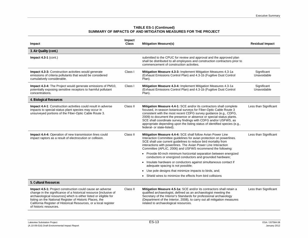
4. Biological Resources
Impact 4.4-1: Construction activities could result in adverse impacts to special-status plant species may occur in unsurveyed portions of the Fiber-Optic Cable Route 3.
Class II Mitigation Measure 4.4-1: SCE and/or its contractors shall complete focused, in-season botanical surveys for Fiber-Optic Cable Route 3 consistent with the most recent CDFG survey guidance (e.g., CDFG, 2009) to document the presence or absence or special-status plants. SCE shall coordinate survey findings with CDFG and/or USFWS, as appropriate depending upon the listing status of identified species (e.g., federal- or state-listed).
Less than Significant
Impact 4.4-4: Operation of new transmission lines could impact raptors as a result of electrocution or collision.
Class II Mitigation Measure 4.4-4: SCE shall follow Avian Power Line Interaction Committee guidelines for avian protection on powerlines. SCE shall use current guidelines to reduce bird mortality from interactions with powerlines. The Avian Power Line Interaction Committee (APLIC, 2006) and USFWS recommend the following: Provide 60-inch minimum horizontal separation between energized
conductors or energized conductors and grounded hardware; Insulate hardware or conductors against simultaneous contact if
adequate spacing is not possible; Use pole designs that minimize impacts to birds, and; Shield wires to minimize the effects from bird collisions
Less than Significant
5. Cultural Resources
Impact 4.5-1: Project construction could cause an adverse change in the significance of a historical resource [inclusive of archaeological resources] which is either listed or eligible for listing on the National Register of Historic Places, the California Register of Historical Resources, or a local register of historic resources.
Class II Mitigation Measure 4.5-1a: SCE and/or its contractors shall retain a qualified archaeologist, defined as an archaeologist meeting the Secretary of the Interior’s Standards for professional archaeology (Department of the Interior, 2008), to carry out all mitigation measures related to archaeological resources.
Less than Significant

Executive Summary
TABLE ES-1 (Continued) SUMMARY OF IMPACTS OF AND MITIGATION MEASURES FOR THE PROJECT
Lakeview Substation Project ES-14 ESA / 207584.08 (A.10-09-016) Draft Environmental Impact Report January 2012
Impact Impact Class Mitigation Measure(s) Residual Impact
5. Cultural Resources (cont.)
Impact 4.5-1 (cont.) Mitigation Measure 4.5-1b: SCE and/or its contractors shall avoid all impacts to archaeological resources P-33-00525, P-33-00526, P-33-00608, P-33-02951, CWA63-4, CWA63-5, and CWA63-6. If any Project-related construction activity would occur within 50 feet of these archaeological sites, the sites shall be designated as Environmentally Sensitive Areas to ensure avoidance. Environmentally Sensitive Areas shall be established in coordination with the qualified archaeologist and shall follow the recorded site boundaries of each significant historical resource. Protective fencing or other markers shall be erected around Environmentally Sensitive Areas prior to any ground disturbing activities; however, such Environmentally Sensitive Areas shall not be identified specifically as cultural resources, in order to protect sensitive information and to discourage unauthorized disturbance or collection of artifacts. Mitigation Measure 4.5-1c: If archaeological resources are encountered during Project-related activity, SCE and/or its contractors shall cease all activity within 100 feet of the find until the find can be evaluated by a qualified archaeologist. If the archaeologist determines that the resources are significant, the archaeologist shall notify the CPUC and the resource shall be avoided if feasible. If avoidance is infeasible, a Treatment Plan that documents the research approach and methods for data recovery shall be prepared and implemented in consultation with CPUC and with appropriate Native American representatives (if the resources are prehistoric or Native American in nature). Work may proceed on other parts of the Project area while treatment is being carried out.
Impact 4.5-2: Project construction could adversely impact a unique archaeological resource.
Class II Mitigation Measure 4.5-2a: Prior to issuance of a grading permit, an archaeological monitor shall be retained by SCE and/or its contractors to monitor all ground-disturbing activities, including brush clearance and grubbing. In addition, the archaeological monitor shall carry out monitoring in the vicinity of designated ESAs as specified in Mitigation Measure 4.5-1c. The monitor shall work under the supervision of the qualified archaeologist. The duration and timing of monitoring shall be determined by the qualified archaeologist in consultation with the lead agency and based on the grading plans. Initially, all ground-disturbing activities shall be monitored. However, the qualified archaeologist, based on observations of soil stratigraphy or other factors, and in consultation with the lead agency, may reduce the level of monitoring as warranted. In the event that cultural resources are unearthed during ground-disturbing activities, the archaeological monitor shall be empowered to halt or redirect ground-disturbing activities away from the vicinity of the
Less than Significant

Executive Summary
TABLE ES-1 (Continued) SUMMARY OF IMPACTS OF AND MITIGATION MEASURES FOR THE PROJECT
Lakeview Substation Project ES-15 ESA / 207584.08 (A.10-09-016) Draft Environmental Impact Report January 2012
Impact Impact Class Mitigation Measure(s) Residual Impact
5. Cultural Resources (cont.)
Impact 4.5-2 (cont.) find so that the find can be evaluated and appropriate treatment determined. Contingency funding and time in the construction schedule should be made available to appropriately manage the unanticipated discovery of cultural resources. Mitigation Measure 4.5-2b: If archaeological resources are encountered at any point during Project implementation, SCE and/or its contractors shall cease all activity within 50 feet of the find until the find can be evaluated by a qualified archaeologist. If the archaeologist determines that the resources may be significant, and if avoidance is determined to be infeasible, the archaeologist shall notify the lead agency and shall prepare a treatment plan, in consultation with the lead agency and with appropriate Native American representatives (if the resources are prehistoric or Native American in nature).
Impact 4.5-3: Project implementation would have a potentially significant impact on a unique paleontological resource or site or unique geological feature.
Class II Mitigation Measure 4.5-3: Prior to the initiation of any site preparation or start of construction, SCE and/or its contractors shall contract with a qualified professional paleontologist or a California Registered Professional Geologist (California RPG) with appropriate paleontological expertise, as defined by the Society of Vertebrate Paleontology’s Conformable Impact Mitigation Guidelines Committee (SVP 1995 Guidelines) to carry out a paleontological resources training program for construction workers and implement a paleontological monitoring program. The qualified paleontologist shall be available “on-call” to SCE and/or its contractors throughout the duration of ground-disturbing activities. At a minimum, the scope of services shall include: Preparation of a preconstruction paleontological assessment based
on final project design. The preconstruction assessment shall include a review of information presented in this EIR, existing fossil localities in the region, Project grading plans and all geological/geotechnical reports developed to date to determine with greater precision the depth and extent of geologic units of high paleontological potential (e.g. older alluvial fan deposits) within the areas to be excavated. The results will be documented in a report along with recommendations for appropriate and feasible measures to avoid or minimize damage to any paleontological resources present. Based on the volume, depth and extent of soil excavations and the professional judgment of the paleontologist, he or she shall make recommendations regarding the locations/phases of project construction activity where paleontological monitoring of ground-disturbing activities would be needed. The county geologist shall review and approve the report in consultation with SCE and/or its contractors.
Less than Significant

Executive Summary
TABLE ES-1 (Continued) SUMMARY OF IMPACTS OF AND MITIGATION MEASURES FOR THE PROJECT
Lakeview Substation Project ES-16 ESA / 207584.08 (A.10-09-016) Draft Environmental Impact Report January 2012
Impact Impact Class Mitigation Measure(s) Residual Impact
5. Cultural Resources (cont.)
Impact 4.5-3 (cont.) Paleontological resources training. All construction forepersons and field supervisors shall be trained in the recognition of potential fossil materials prior to the initiation of any site preparation or start of construction. Training on paleontological resources shall also be provided to all other construction workers, but may include videotape of the initial training and/or the use of written materials rather than in-person training by the qualified paleontologist. In addition to fossil recognition, the training shall convey procedures to follow if potential fossil materials are encountered by construction crews in the course of earthwork, excavation, or grading, as described below.
Assessment and salvage of potential fossil finds. If potential fossils are discovered by construction crews, all earthwork or other types of ground disturbance within 50 feet of the find shall stop immediately until the qualified professional paleontologist can assess the nature and importance of the find. Based on the scientific value or uniqueness of the find, the monitor may record the find and allow work to continue, or recommend salvage and recovery of the fossil. The monitor may also propose modifications to the stop-work radius based on the nature of the find, site geology, and the activities occurring on the site. If treatment and salvage is required, recommendations will be consistent with SVP guidelines (SVP, 1995; SVP, 1996) and currently accepted scientific practice, and shall be subject to review and approval by the county geologist or designee. If required, treatment for fossil remains may include preparation and recovery of fossil materials so that they can be housed in an appropriate museum or university collection, and may also include preparation of a report for publication describing the finds. SCE and/or its contractors will be responsible for ensuring that treatment is implemented and report to Riverside County. If no report is required, SCE and/or its contractors will nonetheless ensure that information on the nature, location, and depth of all finds is readily available to the scientific community through university curation or other appropriate means.
Active monitoring of construction sites for paleontological resources within geologic units of high paleontological potential. Paleontological monitoring will consist of periodically inspecting disturbed, graded, and excavated surfaces, as well as soil stockpiles and disposal sites. The monitor (which will be the professional paleontologist or a designee) will have authority to divert grading or excavation away from exposed surfaces temporarily in order to examine disturbed areas more closely, and/or recover fossils. The monitor will coordinate
Executive Summary
TABLE ES-1 (Continued) SUMMARY OF IMPACTS OF AND MITIGATION MEASURES FOR THE PROJECT
Lakeview Substation Project ES-17 ESA / 207584.08 (A.10-09-016) Draft Environmental Impact Report January 2012
Impact Impact Class Mitigation Measure(s) Residual Impact
5. Cultural Resources (cont.)
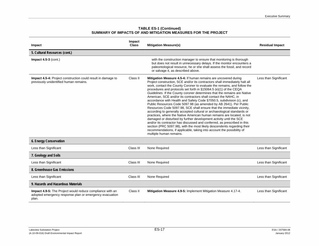
Impact 4.5-3 (cont.) with the construction manager to ensure that monitoring is thorough but does not result in unnecessary delays. If the monitor encounters a paleontological resource, he or she shall assess the fossil, and record or salvage it, as described above.
Impact 4.5-4: Project construction could result in damage to previously unidentified human remains.
Class II Mitigation Measure 4.5-4: If human remains are uncovered during Project construction, SCE and/or its contractors shall immediately halt all work, contact the County Coroner to evaluate the remains, and follow the procedures and protocols set forth in §15064.5 (e)(1) of the CEQA Guidelines. If the County coroner determines that the remains are Native American, SCE and/or its contractors shall contact the NAHC, in accordance with Health and Safety Code §7050.5, subdivision (c), and Public Resources Code 5097.98 (as amended by AB 2641). Per Public Resources Code 5097.98, SCE shall ensure that the immediate vicinity, according to generally accepted cultural or archaeological standards or practices, where the Native American human remains are located, is not damaged or disturbed by further development activity until the SCE and/or its contractor has discussed and conferred, as prescribed in this section (PRC 5097.98), with the most likely descendents regarding their recommendations, if applicable, taking into account the possibility of multiple human remains.
Less than Significant
6. Energy Conservation
Less than Significant Class III None Required Less than Significant
7. Geology and Soils
Less than Significant Class III None Required Less than Significant
8. Greenhouse Gas Emissions
Less than Significant Class III None Required Less than Significant
9. Hazards and Hazardous Materials
Impact 4.9-5: The Project would reduce compliance with an adopted emergency response plan or emergency evacuation plan.
Class II Mitigation Measure 4.9-5: Implement Mitigation Measure 4.17-4. Less than Significant

Executive Summary
TABLE ES-1 (Continued) SUMMARY OF IMPACTS OF AND MITIGATION MEASURES FOR THE PROJECT
Lakeview Substation Project ES-18 ESA / 207584.08 (A.10-09-016) Draft Environmental Impact Report January 2012
Impact Impact Class Mitigation Measure(s) Residual Impact
9. Hazards and Hazardous Materials (cont.)
Impact 4.9-6: Construction and maintenance-related activities related to the Fiber-Optic Cable Route 3 could ignite dry vegetation and start a fire.
Class II Mitigation Measure 4.9-6: SCE and/or its contractors shall prepare and implement a Health and Safety/Fire Safety Plan to ensure the health and safety of construction workers and the public during construction. The RCFD and MVFD shall be consulted during plan preparation and health and safety/fire safety measures recommended by these agencies included. The plan shall list fire prevention procedures and specific emergency response and evacuation measures that would be required to be followed during emergency situations. The plan shall include, but not be limited to, the following: Two water trucks each of 4,000-gallon capacity, equipped with 50 feet
of fast response hose with fog nozzles, be onsite during construction for immediate response to fire incidents, unless this provision is amended by the fire jurisdictions.
All construction workers shall receive training on the proper use of fire-fighting equipment and procedures to be followed in the event of a fire.
As construction may occur simultaneously at several locations, each project construction site shall be equipped with fire extinguishers and fire-fighting equipment sufficient to extinguish small fires.
The plan shall be submitted to CPUC staff for approval prior to commencement of construction activities and shall be distributed to all construction crew members prior to construction and operation of the Project.
Less than Significant
10. Hydrology and Water Quality
Less than Significant Class III None Required Less than Significant
11. Land Use and Planning
Impact 4.11-1: The Project construction could conflict with the Western Riverside County MSHCP.
Class II Mitigation Measure 4.11-1: If through the permitting process CDFG and/or USFWS determine that participation in the MSHCP is appropriate, SCE shall participate in the Western Riverside County MSHCP for the Project. SCE shall hire a biological consultant who holds a Memorandum of Understanding (MOU) with the County of Riverside to prepare a consistency analysis to determine the Project’s consistency with the applicable criteria in the Western Riverside County MSHCP. If the consistency analysis determines that the Project would not be consistent with the criteria, SCE shall implement the necessary measures to bring the Project into compliance, as determined by the consistency analysis and review by the Riverside County Environmental Programs Department.
Less than Significant

Executive Summary
TABLE ES-1 (Continued) SUMMARY OF IMPACTS OF AND MITIGATION MEASURES FOR THE PROJECT
Lakeview Substation Project ES-19 ESA / 207584.08 (A.10-09-016) Draft Environmental Impact Report January 2012
Impact Impact Class Mitigation Measure(s) Residual Impact
12. Mineral Resources
Less than Significant Class III None Required Less than Significant
13. Noise
Impact 4.13-1: Construction activities could violate local municipal code construction time-of-day restrictions.
Class II Mitigation Measure 4.13-1: SCE and/or its construction contractors shall require that (a) all construction activities, including material deliveries, that occur within unincorporated Riverside County within 0.25 mile of an inhabited dwelling, be restricted to between 6:00 a.m. and 6:00 p.m. during the months of June through September and between 7:00 a.m. and 6:00 p.m. during the months of October through May, and (b) all construction activities that occur within the City of Moreno Valley be restricted to between the hours of 7:00 a.m. and 8:00 p.m.
Less than Significant
Impact 4.13-4: Construction-related noise levels would increase ambient noise levels in the vicinity of the Project.
Class II Mitigation Measure 4.13-4: Implement Mitigation Measure 4.13-1. Less than Significant
14. Population and Housing
Less than Significant Class III None Required Less than Significant
15. Public Services
Less than Significant Class III None Required Less than Significant
16. Recreation
Less than Significant Class III None Required Less than Significant
17. Transportation/Traffic
Impact 4.17-1: Project construction would substantially increase traffic in relation to the existing traffic load and capacity of the street system (i.e., result in a substantial increase in either the number of vehicle trips, the volume to capacity ratio on roads, or congestion at intersections).
Class II Mitigation Measure 4.17-1: SCE shall prepare and implement a Traffic Management Plan subject to approval of the appropriate state agency and/or local government(s). The approved Traffic Management Plan and documentation of agency approvals shall be submitted to the CPUC prior to the commencement of construction activities. The plan shall: Include a discussion of work hours, haul routes, work area
delineation, traffic control and flagging; Identify all access and parking restriction and signage requirements; Require workers to park personal vehicles at the approved staging
area and take only necessary Project vehicles to the work sites; Lay out plans for notifications and a process for communication with
affected residents and landowners prior to the start of construction. Advance public notification shall include posting of notices and
Less than Significant

Executive Summary
TABLE ES-1 (Continued) SUMMARY OF IMPACTS OF AND MITIGATION MEASURES FOR THE PROJECT
Lakeview Substation Project ES-20 ESA / 207584.08 (A.10-09-016) Draft Environmental Impact Report January 2012
Impact Impact Class Mitigation Measure(s) Residual Impact
17. Transportation/Traffic (cont.)
Impact 4.17-1 (cont.) appropriate signage of construction activities. The written notification shall include the construction schedule, the exact location and duration of activities within each street (i.e., which road/lanes and access point/driveways would be blocked on which days and for how long), and a toll-free telephone number for receiving questions or complaints;
Include plans to coordinate all construction activities with emergency service providers in the area. Emergency service providers would be notified of the timing, location, and duration of construction activities. All roads would remain passable to emergency service vehicles at all times; and
Identify all roadway locations where special construction techniques (e.g., night construction) would be used to minimize impacts to traffic flow.
Impact 4.17-2: Project operation and maintenance would impact pedestrian and bicycle traffic on the existing informal trail along the San Jacinto River.
Class II Mitigation Measure 4.17-2: SCE and/or its contractor shall ensure that appropriate warning signs are posted alerting bicycle riders and pedestrians to trail and bike lane closures.
Less than Significant
18. Utilities and Service Systems
Less than Significant Class III None Required Less than Significant

Executive Summary
Lakeview Substation Project ES-21 ESA / 207584.08 (A.10-09-016) Draft Environmental Impact Report January 2012
TABLE ES-2 COMPARISON OF ENVIRONMENTAL IMPACTS OF THE PROJECT AND ALTERNATIVES
Resource Area Project Alternative 1: Phased Construction Alternative Alternative 2: Relocated Substation Alternative
1. Aesthetics Class III
No Preference
Class III
No Preference
Class III
Slightly Preferred
2. Agriculture and Forestry Resources
Class II
No Preference
Class II
No Preference
Class II
Slightly Preferred
3. Air Quality Total construction NOx and PM10 emissions would result in significant unavoidable impacts to regional air quality, and local emissions of PM10 associated with construction of Subtransmission Source Line Segment 2 would result in a significant unavoidable impact.
Least Preferable
NOx emissions would result in a regional impact that would be reduced to a less-than-significant level with mitigation (compared to significant unavoidable under the Project), emissions of PM10 would continue to result in significant and unavoidable impacts to regional air quality and local sensitive receptors, similar to the Project.
Preferred
Total construction NOx and PM10 emissions would result in significant unavoidable impacts to regional air quality; however, local emissions of PM10 associated with construction of Subtransmission Source Line Segment 2 would be less than significant.
Less Preferable
4. Biological Resources Class II
No Preference
Class II
No Preference
Class II
No Preference
5. Cultural Resources Class II
No Preference
Class II
No Preference
Class II
No Preference
6. Energy Conservation Class III
No Preference
Class III
No Preference
Class III
Slightly Preferred
7. Geology and Soils Class III
No Preference
Class III
Slightly Preferred
Class III
No Preference
8. Green House Gas Emissions
Class III
No Preference
Class III
No Preference
Class III
Slightly Preferred
9. Hazards and Hazardous Materials
Class II
No Preference
Class II
No Preference
Class II
No Preference
10. Hydrology and Water Quality
Class III
No Preference
Class III
No Preference
Class II
Not Preferred
11. Land Use and Planning Class II
No Preference
Class II
No Preference
Class II
No Preference

Executive Summary
TABLE ES-2 (Continued) COMPARISON OF ENVIRONMENTAL IMPACTS OF THE PROJECT AND ALTERNATIVES
Lakeview Substation Project ES-22 ESA / 207584.08 (A.10-09-016) Draft Environmental Impact Report January 2012
Resource Area Project Alternative 1: Phased Construction Alternative Alternative 2: Relocated Substation Alternative
12. Mineral Resources Class III
No Preference
Class III
No Preference
Class III
No Preference
13. Noise Class II
No Preference
Class II
No Preference
Class II
Slightly Preferred
14. Population and Housing Class III
No Preference
Class III
No Preference
Class III
No Preference
15. Public Services Class III
No Preference
Class III
No Preference
Class III
No Preference
16. Recreation Class III
No Preference
Class III
No Preference
Class III
No Preference
17. Transportation/Traffic Class II
No Preference
Class II
No Preference
Class II
Slightly Preferred
18. Utilities and Service Systems
Class III
No Preference
Class III
No Preference
Class III
Slightly Preferred

Lakeview Substation Project 1-1 ESA / 207584.08 (A.10-09-016) Draft Environmental Impact Report January 2012
CHAPTER 1 Introduction
1.1 Purpose of This Document
This Environmental Impact Report (EIR) is an informational document intended to disclose to the public and decision-makers the potential environmental impacts of the Lakeview Substation Project (Project) proposed by Southern California Edison (SCE). This document assesses the direct, indirect, and cumulative environmental impacts that could occur as a result of the construction, operation, and maintenance of the Project and alternatives to the Project. The analysis in this document is based upon information submitted to the lead agency, the California Public Utilities Commission (CPUC), as part of SCE’s application for a permit to construct, operate, and maintain electrical facilities pursuant to CPUC General Order No. 131-D, SCE’s Proponent’s Environmental Assessment (PEA), SCE’s responses to the CPUC’s requests for additional information, and from independent studies and research conducted by and on behalf of the CPUC.
This EIR examines the potential impacts of the Project and alternatives to the Project. All of the resource areas in the California Environmental Quality Act (CEQA) Guidelines Appendix G Checklist and Appendix F were studied: Aesthetics, Agriculture and Forestry Resources, Air Quality, Biological Resources, Cultural Resources, Energy Conservation, Geology and Soils, Greenhouse Gas Emissions, Hazards and Hazardous Materials, Hydrology and Water Quality, Land Use and Planning, Mineral Resources, Noise, Population and Housing, Public Services, Recreation, Transportation/Traffic, and Utilities and Service Systems.
1.2 Project Overview
SCE proposes to construct, operate, and maintain a project known as the Lakeview Substation Project. The Project consists of: (1) a new 115/12 kilovolt (kV) substation; (2) two new 115 kV subtransmission line segments to serve the new substation; (3) two new underground 12 kV distribution getaways; (4) facilities to connect the substation to SCE’s existing fiber-optic telecommunications system, and upgrades to an existing access road as well as the telecommunications equipment at various existing substations; and (5) the decommissioning of Nuevo Substation and Model Pole Top.
The proposed substation would be constructed on an approximately 5.4 acres located at the southwest corner of Reservoir Avenue and 10th Street, in the community of Lakeview, within unincorporated Riverside County, California. SCE would establish vehicular access to the proposed substation site from 10th Street. SCE owns and controls the proposed substation site,

1. Introduction
Lakeview Substation Project 1-2 ESA / 207584.08 (A.10-09-016) Draft Environmental Impact Report January 2012
but would need to obtain rights to approximately 20.6 acres of new ROW to construct, operate, and maintain the subtransmission source line segments. If approved, construction of the Project would take approximately 12 months. Operation of the Project would serve forecasted electrical demand in the Electrical Needs Area at least until 2032.
1.3 Use of This Document by Agencies
CEQA Guidelines §15124(d) requires that an EIR contain a statement briefly describing the intended uses of the EIR. The CEQA Guidelines indicate that the EIR should identify the ways in which the Lead Agency and any responsible agencies would use this document in their approval or permitting processes. The following discussion summarizes the roles of the agencies and the intended uses of the EIR.
1.3.1 CPUC The CPUC is serving as the CEQA “Lead Agency” for this Project. A lead agency is the public agency that has the primary responsibility for approving a proposed project and the one responsible for preparing the appropriate CEQA document. The CPUC is considering whether to approve SCE’s application for a Permit to Construct Electrical Facilities with Voltages between 50 kV and 200 kV: Lakeview Substation Project. SCE filed the application (A.10-09-016) and PEA on September 17, 2010.
The CPUC’s response to such applications is two-fold. First, it involves consideration of the application as part of what’s known as the General Proceeding, which is governed by the CPUC’s General Order No. 131-D and its Rules of Practice and Procedure. The CPUC's general proceeding is a formal review process that considers how projects could benefit or harm the public, including its potential effects on utility ratepayers. A CPUC Commissioner and Administrative Law Judge (ALJ) are in charge of the general proceeding, which may occur while the environmental review is underway.
Second, the CPUC considers the environmental effects of the proposed project under CEQA. The environmental review process for this Project, including the preparation of this EIR, is conducted in accordance with the California Environmental Quality Act (CEQA) (Pub. Res. Code §21000 et seq.), the statute’s implementing guidelines (CEQA Guidelines) (14 Cal. Code Regs. §15000 et seq.), and the CPUC’s own environmental rules.
When both the environmental evaluation and general proceeding are complete, the Administrative Law Judge (ALJ) assigned to the Project will prepare a proposed decision for consideration by the five CPUC Commissioners. The ALJ will base the proposed decision on evidence provided as part of the general proceeding, conclusions of the environmental analysis, and the public comments received. Each Commissioner may draft an alternative proposed decision for CPUC review. All five Commissioners then will vote on the proposed decision and any alternates at a meeting of the full Commission.

1. Introduction
Lakeview Substation Project 1-3 ESA / 207584.08 (A.10-09-016) Draft Environmental Impact Report January 2012
1.3.2 Other Agencies Several other agencies will rely on information in this EIR to inform their decisions regarding the issuance of specific permits related to Project construction or operation. SCE would obtain permits, approvals, licenses, or other authorizations as needed from, and would participate in reviews and consultation as needed with, federal, state and local agencies. Potential required permits and other approvals include, but are not limited to, those summarized in Table 1-1.
TABLE 1-1 SUMMARY OF POTENTIAL PERMIT REQUIREMENTS
Permits and Other Requirements Agency Jurisdiction/Purpose
Federal Nationwide or Individual Permit (Section 404 of the Clean Water Act)
Army Corps of Engineers (Corps) Construction impacting Waters of the United States, including wetlands
State Permit to Construct (PTC) CPUC Overall permit to construct the project
(project approval) and certification of EIR under CEQA
Overload Permit California Department of Transportation (Caltrans)
For vehicles exceeding the legal weight
Lake and Streambed Alteration Agreement (Section 1602)
California Department of Fish and Game (CDFG)
Construction and operation that may have an impact on a river, stream, or lake
Regional and Local National Pollutant Discharge Elimination System (NPDES) Permit
Santa Ana Regional Water Quality Control Board (RWQCB)
Storm water discharges associated with construction activities disturbing more than 1 acre of land
Section 401 of the Clean Water Act, Water Quality Certification (or waiver)
RWQCB Certifies that project is consistent with State water quality standards
Letter of Inclusion for Regional Conservation Authority
Regional Conservation Authority Implements the Riverside County Multiple Species Habitat Conservation Plan (MSHCP)
Encroachment Permit Riverside County Flood Control District
An encroachment permit is required whenever work is proposed within the public rights-of-way or easement, e.g., to trench across public ROW for installation of cable or other underground utilities, and to construct curb, gutter, sidewalk, driveway, and roadway pavement.
Grading Permit Riverside County Department of Public Works (DPW)
For construction grading
Landscape Permit Riverside County DPW For landscape plan
Lane Closure Permit Riverside County DPW For traffic control
Encroachment Permit Riverside County Transportation Department
Construction, operation, and maintenance within, under, or over County road ROW or easement
After Hours Permit or Variance Riverside County or other local agency
For after-hours work per individual applicable local agency standards
SOURCES: ESA, 2011; SCE, 2011; Riverside County Flood Control District, 2011

1. Introduction
Lakeview Substation Project 1-4 ESA / 207584.08 (A.10-09-016) Draft Environmental Impact Report January 2012
1.4 Public Review and Comment
1.4.1 Notification On Thursday, December 9, 2010, the CPUC published and distributed a Notice of Preparation (NOP) to solicit guidance from federal, state, and local agencies on the scope and content of information to be considered in an EIR for the Project. A copy of the NOP was sent to the State Clearinghouse of the Office of Planning and Research. The NOP described the Project, included a map showing the location of proposed components of the Project and identified potential environmental impacts.
In addition to soliciting agency input, the CPUC invited public participation in a workshop and scoping meeting for the Project by publishing multiple notices in local newspapers and on the CPUC’s website. The CPUC published two notices in the Press-Enterprise: one on December 29, 2010, the other on January 2, 2011. An electronic copy of the NOP also was posted on the CPUC’s website at: http://www.cpuc.ca.gov/Environment/info/esa/lakeview/index.html.
1.4.2 Education Outreach The CPUC conducted a public workshop and scoping meeting on Thursday, January 13, 2011, at Mountain Shadows Middle School, located at 30401 Reservoir Avenue, Nuevo, California. The workshop was held from 6:30 p.m. to 7:00 p.m. Agency and Applicant representatives and one member of the public attended. Meeting attendees were provided with materials including presentation slides, written comment forms, and speaker cards. Copies of the NOP were available upon request. Topics covered during the workshop included participants in the process and their roles, the CPUC’s decision and review processes, and opportunities for public involvement.
1.4.3 Scoping The Scoping Report included in Appendix A provides an overview and a summary of the written and oral comments provided by agencies and individuals during the scoping period for this Project, which began on Thursday, December 9, 2010, and closed on January 24, 2011. Comments were accepted through January 27, 2011. CEQA provides for a 30-day scoping period (Pub. Res. Code § 21080.4(a)); however, the CPUC elected to extend it in light of the winter holidays. Consequently, from the date of the NOP until January 27, 2011, the scoping period for the Project lasted 49 days.
The CPUC conducted a public scoping meeting from 7:00 p.m. until 8:30 p.m. on Thursday, January 13, 2011, immediately following the educational workshop described above. During the scoping meeting, a Project overview was provided, alternatives identified by SCE were presented, ideas about other possible alternatives were solicited, next steps were outlined, and public comments were accepted. A court reporter’s transcript documented public comments.
The Scoping Report includes all of the comments received during the scoping period, and describes how each was addressed. Ideas and concerns raised related to the following:
1. Introduction
Lakeview Substation Project 1-5 ESA / 207584.08 (A.10-09-016) Draft Environmental Impact Report January 2012
Biological resources and land use, including consistency with the Multispecies Habitat Conservation Plan (MSHCP) and potential impacts to wildlife movement.
Cultural resources, including potential impacts related to historical and archeological resources, Native American religious expression, items of religious and other cultural significance, and human remains.
Hydrology and water quality, including potential impacts related to flood control, drainage, and surface water.
Public safety, including compliance with fire protection requirements and mitigation of electrical and other hazards.
Transportation and traffic impacts related to State Highway facilities.
Alternatives, including the installation of Project components underground.
1.4.4 Public Comment on the Draft EIR This Draft EIR is being circulated to state and local agencies and to interested individuals who may wish to review and comment on the report. Written comments may be submitted to the CPUC during the 45-day public review period. Written comments on this Draft EIR will be accepted via regular mail, fax, and e-mail and at a public meeting that will be noticed under separate cover. All comments received will be addressed in a Response to Comments document, which, together with this Draft EIR, will constitute the Final EIR for the Project.
1.5 Reader’s Guide to This EIR
This EIR is organized as follows:
Executive Summary. Provides a summary description of the Project, the alternatives, their respective environmental impacts, and the Environmentally Superior Alternative. Also provides a summary table of the impacts and mitigation measures of the Project and alternatives.
Chapter 1, Introduction. Provides a discussion of the background and project objectives, briefly describes the Project, and outlines the public agency use of the EIR.
Chapter 2, Project Description. Provides a detailed description of the Project.
Chapter 3, Alternatives Analysis. Provides a description of the alternatives screening and evaluation process, describes the alternatives considered but eliminated from further analysis and the rationale therefore, and describes the alternatives analyzed in Chapter 4.
Chapter 4, Environmental Analysis. Provides a comprehensive analysis and assessment of impacts and mitigation measures for the Project and alternatives, including the No Project Alternative. This chapter is divided into sections for each environmental issue area (e.g., Air Quality, Biological Resources, etc.) that contain the environmental and regulatory settings, and impacts and mitigation measures for the Project and each alternative.

1. Introduction
Lakeview Substation Project 1-6 ESA / 207584.08 (A.10-09-016) Draft Environmental Impact Report January 2012
Chapter 5, Comparison of Alternatives. Provides a discussion of the relative advantages and disadvantages of the Project and the alternatives that were evaluated, and identifies the CEQA Environmentally Superior Alternative.
Chapter 6, Cumulative Effects. Identifies the cumulative projects considered in the analysis of cumulative impacts. Provides a discussion of the cumulative impacts of the Project in combination with reasonable foreseeable past, present and future projects.
Chapter 7, Other CEQA Considerations. Provides a discussion of growth-inducing impacts, significant environmental effect that cannot be avoided, irreversible environmental changes, and cumulative impacts.
Chapter 8, Report Preparers. Identifies the primary authors of this Draft EIR
Chapter 9, Mitigation Monitoring, Reporting, and Compliance Plan. Provides a discussion of the CPUC’s mitigation monitoring, reporting and compliance program requirements for the project as approved by the CPUC.
Appendix A. Contains the Scoping Report which includes the NOP, the Supplemental Scoping Report, copies of notifications and scoping materials, and copies of comments received.
Appendix B. Provides SCE’s Electric and Magnetic Fields (EMF) Field Management Plan (FMP) summary.
Appendix C. Contains calculations pertaining to Section 4.3, Air Quality, and Section 4.7, Greenhouse Gas Emissions.
Appendix D. Contains the Phase I Environmental Site Assessment, as referenced in Section 4.9, Hazards and Hazardous Materials.
Appendix E. Provides a copy of the mailing list to whom the Draft EIR and/or Notice of Availability were sent.
1.6 Electric and Magnetic Fields
Extremely low frequency (ELF) electric and magnetic fields (EMF) include alternating current (AC) fields and other electromagnetic, non-ionizing radiation from 1 Hz to 300 Hz. Power lines, like electrical wiring and electrical equipment, produce ELF fields at 60 Hz (Occupational Safety and Health Administration, 2011). This EIR does not consider EMF in the context of the CEQA analysis of potential environmental impacts because (1) there is no agreement among scientists that EMF creates a potential health risk, and (2) there are no defined or adopted CEQA standards for defining health risk from EMF. For example, on behalf of the CPUC, three scientists who work for the California Department of Health Services (DHS) were asked to review studies by the National Institutes of Environmental Health Sciences Working Group, the International Agency for Research on Cancer, and the British National Radiological Protection Board about possible health problems from electric and magnetic fields from power lines, wiring in buildings, some jobs, and

1. Introduction
Lakeview Substation Project 1-7 ESA / 207584.08 (A.10-09-016) Draft Environmental Impact Report January 2012
appliances (Neutra et al., 2002). The results of their evaluation noted “important differences between the three DHS reviewers’ conclusions” and made no recommendations about actions to be taken to address potential health risks (Id.).
However, recognizing that there is a great deal of public interest and concern regarding potential health effects from human exposure to EMF from transmission lines, this document does provide information regarding EMF associated with electric utility facilities and human health and safety. Thus, the EMF information in this EIR is presented for the benefit of the public and decision makers.
Potential health effects from exposure to electric fields from transmission lines (i.e., the effect produced by the existence of an electric charge, such as an electron, ion, or proton, in the volume of space or medium that surrounds it) typically do not present a human health risk since electric fields are effectively shielded by materials such as trees, walls, etc. Therefore, the majority of the following information related to EMF focuses primarily on exposure to magnetic fields (i.e., the invisible fields created by moving charges) from transmission lines.
After several decades of study regarding potential public health risks from exposure to power line EMF, research results remain inconclusive. Several national and international panels have conducted reviews of data from multiple studies and state that there is not sufficient evidence to conclude that EMF causes cancer. For example, the International Agency for Research on Cancer (IARC) and the California DHS both have classified EMF as a possible carcinogen.
Presently, there are no applicable federal, state, or local regulations related to EMF levels from power lines or related facilities, such as substations. However, the CPUC has implemented a decision (D.06-01-042) requiring utilities to incorporate “low-cost” or “no-cost” measures for managing EMF from power lines up to approximately four percent of total project cost.
Using the four percent benchmark and otherwise in accordance with “EMF Design Guidelines” filed with the CPUC in compliance with CPUC Decisions 93-11-013 and 06- 01-042, SCE would implement low- and no-cost measures for the Project as described in the Field Management Plan submitted by SCE with its application (SCE, 2010b). A copy of the Field Management Plan is included in the EIR as Appendix B. Its measures relate to the proposed Lakeview Substation and 115 kV subtransmission source line segments 1 and 2, and are summarized in Table 1-2.
TABLE 1-2 EMF DESIGN GUIDELINES LOW- AND NO-COST MEASURES PROPOSED FOR THE PROJECT
Project Component Proposed Low- and No-Cost Measures
Lakeview Substation Placing major substation electrical equipment (such as transformers, switchracks, buses, and underground duct banks) away from the substation property lines.
Configuring the transfer and operating buses with the transfer bus closest to the nearest property line.
Subtransmission Source Line Segments Utilizing subtransmission structure heights that meet or exceed SCE’s preferred EMF design criteria
Utilizing subtransmission line construction that reduces the space between conductors compared with other designs
1. Introduction
Lakeview Substation Project 1-8 ESA / 207584.08 (A.10-09-016) Draft Environmental Impact Report January 2012
References – Introduction Raymond Richard Neutra, M.D. Dr. P.H.; Vincent DelPizzo, Ph.D. GDE; and Geraldine M. Lee,
Ph.D. (Neutra et al.), 2002. An Evaluation of the Possible Risks from Electric and Magnetic Fields (EMFs) from Power Lines, Internal Wiring, Electrical Occupations, and Appliances (June 2002).
Riverside County Flood Control District, 2011. Encroachment Permits. Available at http://www.floodcontrol.co.riverside.ca.us/content/encroachment.htm. Accessed July 13, 2011.
Southern California Edison (SCE), 2011. Lakeview Substation - Preliminary Permit List (Feb. 18, 2011).
U.S. Department of Labor, Occupational Safety and Health Administration (OSHA), 2011. Extremely Low Frequency (ELF) Radiation. Available at http://www.osha.gov/SLTC/elfradiation/index.html. Accessed July 7, 2011.

Lakeview Substation Project 2-1 ESA / 207584.08 (A.10-09-016) Draft Environmental Impact Report January 2012
CHAPTER 2 Project Description
2.1 Introduction
Southern California Edison (SCE), in its California Public Utilities Commission (CPUC) application (A.10-09-016), filed on September 17, 2010, requests to construct a new 115/12 kV substation (Lakeview Substation) and associated 115 kV subtransmission source line segments, 12 kV distribution getaways, and telecommunications facilities in unincorporated Riverside County. SCE also proposes to decommission its existing Nuevo and temporary Model Pole Top Substations. Power to the Lakeview Substation would be supplied by connecting to the existing Valley-Moval 115 kV subtransmission line. New right-of-way (ROW) and easement rights would be required for the proposed subtransmission facilities and access roads. Existing wooden distribution poles would be removed and a combination of new wood poles and tubular steel poles (TSPs) would be constructed. SCE’s application for a permit to construct (PTC) includes the Proponent’s Environmental Assessment (PEA), which SCE prepared pursuant to Rule 2.4 of the CPUC’s Rules of Practice and Procedure. Under CPUC General Order 131-D, approval of this project (Project) must comply with the California Environmental Quality Act (CEQA).1
The proposed location of the Project is described in Section 2.2 in the context of the existing system, which is described in Section 2.3. An overview of the Project (including the schedule) is provided in Section 2.4, with more detailed descriptions of Project components provided in Section 2.5 and of ROW requirements in Section 2.6. Discussions of project activities at each phase follow: preconstruction is described in Section 2.7, construction is described in Section 2.8, decommissioning of the Nuevo and temporary Model Pole Top Substations is described in Section 2.9, and Project operation and maintenance activities are described in Section 2.10. Workforce and equipment requirements are identified in Section 2.11. Finally, measures proposed by SCE as part of the Project to avoid or reduce some of its potential impacts are provided in Section 2.12.
1 CEQA is codified at California Public Resources Code Section 21000 et seq.; implementing regulations (the CEQA
Guidelines) are found in Title 14 of the California Code of Regulations Section 15000 et seq.
2. Project Description
Lakeview Substation Project 2-2 ESA / 207584.08 (A.10-09-016) Draft Environmental Impact Report January 2012
2.2 Project Location
The Project site is located in unincorporated western Riverside County, near the communities of Lakeview and Nuevo (see Figure 2-1, Electrical Needs Area). The Lakeview Substation would be in the western portion of Riverside County approximately three miles east of the jurisdictional boundary of the City of Perris. Two subtransmission source line segments are proposed. Segment One would extend east from the Valley-Moval 115 kV subtransmission line paralleling the Colorado River Aqueduct until it spans the San Jacinto River and intersects and follows the planned 10th Street route. It then would extend southeast along the planned 10th Street route until entering the substation property near the corner of the planned 10th Street route and Reservoir Avenue. Segment Two would extend southeast from the Valley-Moval 115 kV subtransmission line, spanning the San Jacinto River, before reaching 11th Street. The new facilities then would follow 11th Street to the intersection of Reservoir Avenue, extending north before entering the proposed substation property. Both subtransmission source line alignments would traverse open space (for water and conservation habitat) and medium density residential areas.
2.3 Existing System
The Electrical Needs Area (ENA) is shown in Figure 2-1. It presently is served by the existing Nuevo and temporary Model Pole Top Substations, which are described in Section 2.9. These substations provide electrical service to approximately 1,800 metered customers.
2.4 Project Objectives
2.4.1 Objectives SCE has established the following objectives for the Project (SCE, 2010a):
Serve existing and long-term projected electrical demand requirements in the Electrical Needs Area beginning in mid-2013;
Improve the reliability and system operational flexibility within the Electrical Needs Area; and
Accomplish the above objectives while minimizing environmental impacts.
2.5 Overview of the Project
The Project includes the following components. A more detailed description of the individual components is provided in Section 2.5.
Construction of an unattended, automated 56 megavolt ampere (MVA) 115/12 kilovolt (kV) low-profile substation (Lakeview Substation)
Installation of two 115 kV subtransmission source line segments to connect the Lakeview Substation to the existing Valley-Moval 115 kV subtransmission line
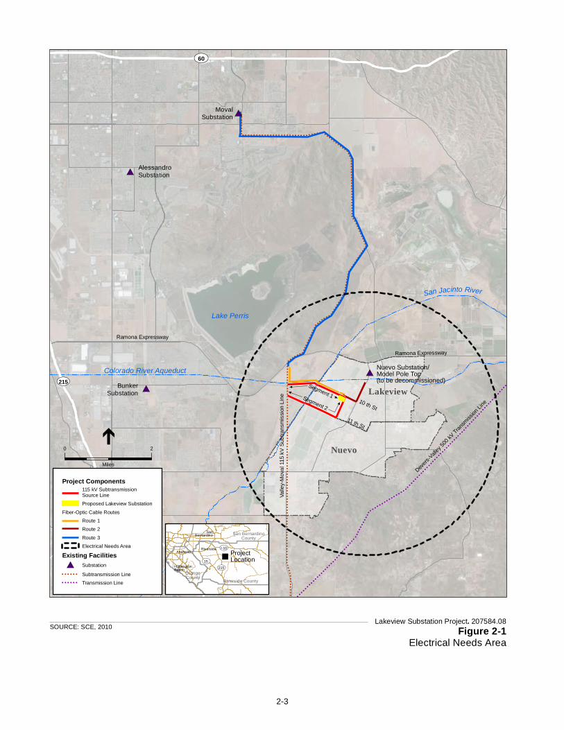
!!
!!
!!
!!
!!
!!
!!
!!!
!
!!
!!
!!
!!
!!
!!
!!
!!
!!
!!
!!
!!
!!
!!
!!
!!
!!
!!
!!
!!
!!
!!
!!
!!
!!
!!
!!
!!
!!
!!
!!
!!
!!
!!
!!
!!
!!
!!
!!
!!
!!
!!
!!
!!
!!
!!
!!
!!
!!
!!
!!
!!
!
!!!
!!
!!
!!
!!
!!
!!
!!
!!
!!
!!
!!
!!
!!
!!
!!
!!
!!
!!
!!
!!
!!
!!!
!!
!!
!!
!!
!!
!!
!!
!!
!!
!!
!!
!!
!!
!!
!!
!!
!!
!!!!!!!!!!!!!!!!!!!!!!!!!!!!!!!!
!!
!!
!!
!!
!!
!!
!!
!!
!!
!!
!!!!
!!
!!
!!
!!
!!!
!!!!
!!!!!!!
!
!!
!!
!!!!
!!!
!!
!!
!!
!!
!!
!
!!
!!
!!
!!
!!
!!
!!
!
!!!!!!!!!!!!!!!!!!!!!!!!!!!!!!
!!
!!
!!
!!!
!!
!!
!!
!!!
!!
!!
!!
!!!
!!
!!
!!
!!!
!!
!!
!!!
!!
!!!
!!
!!!
!!
!!
!!!
!!!
!!
!!!
!!
!!
!!
!!
!!
!!
!!
!!
!!
!!
!!!
!!
!!
!!
!!
!!
!!
!!!
!!
!!
!!
!!
!
!! ! !
! ! ! !! ! !
! ! ! !! ! !
! ! ! !! ! !
! ! ! !! ! !
! ! ! !! ! !
! ! ! !! ! ! ! ! ! ! ! ! ! ! ! ! ! ! ! ! ! ! ! ! ! ! ! ! ! ! ! ! ! ! ! ! ! ! ! ! ! ! ! ! ! ! ! ! ! ! ! ! ! ! ! ! ! ! ! ! !
!!
!!
! ! ! !! ! ! ! ! !
! ! ! ! !! ! ! ! !
! ! ! !! ! ! ! ! ! ! ! ! ! ! ! ! ! ! ! !
!!
!!
!!
!!
!!
! ! ! ! ! ! ! ! ! ! ! ! ! ! ! ! ! ! ! ! ! ! ! ! ! ! ! ! ! ! ! ! ! ! ! ! ! ! ! ! ! ! ! ! ! ! ! ! ! ! ! ! ! ! ! ! ! ! ! ! ! ! ! ! ! !!
!!
!
! ! ! ! ! ! ! ! ! ! ! ! !!
!!
!!
!!
!!
!!
!!
!!
!!
!!
!
! ! ! ! ! ! ! ! ! ! ! ! ! ! ! ! ! !
!!!
!!
!!
!!
!!
!!
!!
!
!!
!!
!!
!!
!!
!!
!!
!!
!!
!!
!!
!!
!!
!!
!!
!!
!!
!
! ! ! ! ! ! ! ! ! ! ! ! ! ! ! ! ! ! ! ! ! ! ! ! ! ! ! ! ! !!
!!
!!
!
!!
!!!!!!!!!!!!!!!!!!!!!!!!!!!!!
!!
!!
!!
!!
!!
!!
!!
!!
!!
!!
!!
!!
!!
#*
#*
#*
#*
Lake Perris
UV215
San Jacinto RiverVa
lley-
Mov
al 1
15 k
V S
ubtra
nsm
issi
on L
ine
Devers
-Valley
500 k
V Transm
ission
Line
Colorado River Aqueduct
10 th St
11 th St
Ramona Expressway
Nuevo
Lakeview
Ramona Expressway
Nuevo Substation/Model Pole Top(to be decommissioned)
Segment 1Segment 2
UV60
MovalSubstation
BunkerSubstation
AlessandroSubstation
Lakeview Substation Project. 207584.08Figure 2-1
Electrical Needs Area
SOURCE: SCE, 2010
0 2
Miles
Project Components115 kV SubtransmissionSource LineProposed Lakeview Substation
Fiber-Optic Cable RoutesRoute 1Route 2
Route 3Electrical Needs Area
Existing Facilities#* Substation
! ! ! ! ! ! Subtransmission Line! ! ! ! ! ! Transmission Line
"ProjectLocation
UV215UV15
UVI-10
Riverside County
San BernardinoCounty
OrangeCounty
AnaheimRiverside
SanBernardino
HuntingtonBeach
2-3
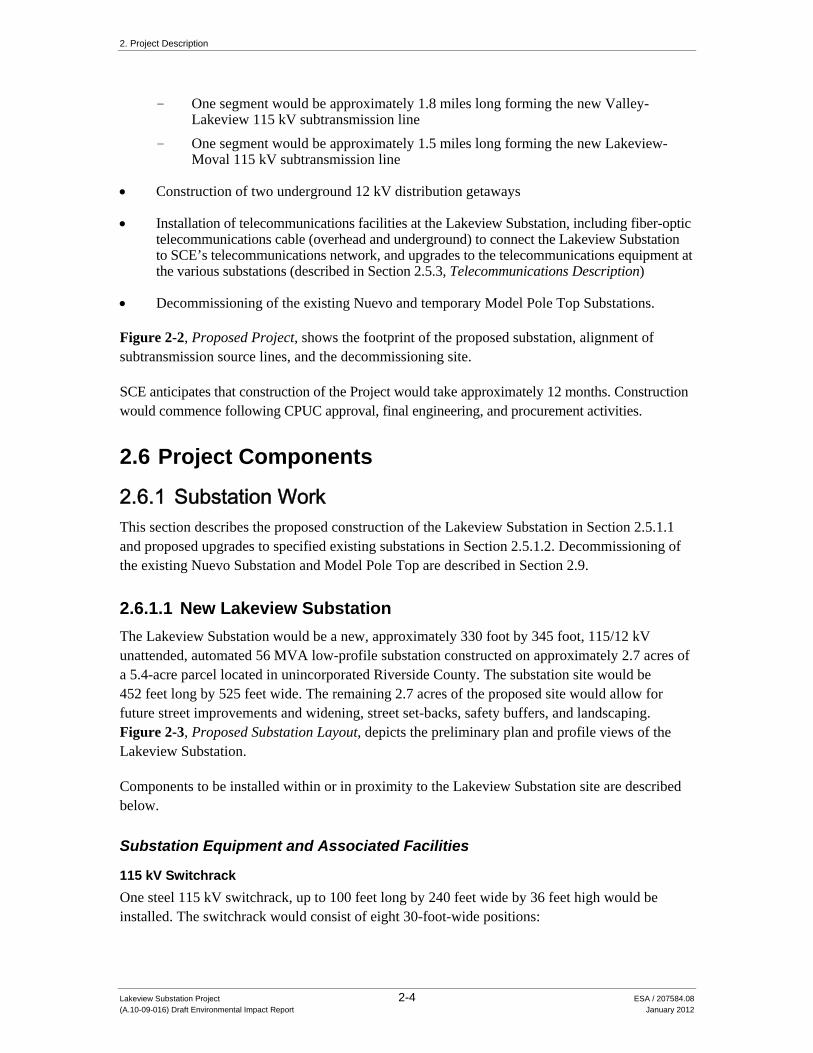
2. Project Description
Lakeview Substation Project 2-4 ESA / 207584.08 (A.10-09-016) Draft Environmental Impact Report January 2012
- One segment would be approximately 1.8 miles long forming the new Valley-Lakeview 115 kV subtransmission line
- One segment would be approximately 1.5 miles long forming the new Lakeview-Moval 115 kV subtransmission line
Construction of two underground 12 kV distribution getaways
Installation of telecommunications facilities at the Lakeview Substation, including fiber-optic telecommunications cable (overhead and underground) to connect the Lakeview Substation to SCE’s telecommunications network, and upgrades to the telecommunications equipment at the various substations (described in Section 2.5.3, Telecommunications Description)
Decommissioning of the existing Nuevo and temporary Model Pole Top Substations.
Figure 2-2, Proposed Project, shows the footprint of the proposed substation, alignment of subtransmission source lines, and the decommissioning site.
SCE anticipates that construction of the Project would take approximately 12 months. Construction would commence following CPUC approval, final engineering, and procurement activities.
2.6 Project Components
2.6.1 Substation Work This section describes the proposed construction of the Lakeview Substation in Section 2.5.1.1 and proposed upgrades to specified existing substations in Section 2.5.1.2. Decommissioning of the existing Nuevo Substation and Model Pole Top are described in Section 2.9.
2.6.1.1 New Lakeview Substation
The Lakeview Substation would be a new, approximately 330 foot by 345 foot, 115/12 kV unattended, automated 56 MVA low-profile substation constructed on approximately 2.7 acres of a 5.4-acre parcel located in unincorporated Riverside County. The substation site would be 452 feet long by 525 feet wide. The remaining 2.7 acres of the proposed site would allow for future street improvements and widening, street set-backs, safety buffers, and landscaping. Figure 2-3, Proposed Substation Layout, depicts the preliminary plan and profile views of the Lakeview Substation.
Components to be installed within or in proximity to the Lakeview Substation site are described below.
Substation Equipment and Associated Facilities
115 kV Switchrack
One steel 115 kV switchrack, up to 100 feet long by 240 feet wide by 36 feet high would be installed. The switchrack would consist of eight 30-foot-wide positions:

!!
!!
!!
!!
!!
!!
!!
!!
!!
!!
!!
!!!
!!
!
!
!!!
!!
!!
!!
!!
!!
!!
!!
!!
!!
!!
!!
!!
!!
!!
!!
!!
!!
!!
!!
!!
!!
!!
!!
!!
!!
!!
!!
!!
!!
!!
!!
!!
!!
!!
!!
!!
!!
!!
!!
!!
!!
!!
!!
!!
!!
!!
!!
!!
!!
!!
!!
!!
!!
!!
!!
!!
!!
!!
!!
!!
!!
!!
!!
!!
!!
!!
!!
!!
!!
!!
!
!!
!!
!!
!!
!!
!!
!!
!!
!!
!!
!!
!!
!!
!!
!!
!!!
!!
!!
!!
!!
!!
!!
!!
!!
!!
!!
!!
!!
!!
!!
!!
!!
!!
!!
!!
!!
!!
!!
!!
!!
!!
!!
!!
!!
!!
!!
!!
!!
!!
!!
!!
!!!
!!
!!
!!
!!
!!
!!
!!
!!
!!
!!
!!
!!
!!
!!
!!
!!
!!
!!
!!
!!
!!
!!
!!
!!
!!
!!
!!
!!
!!!!!!!!!!!!!!!!!!!!!!!!!!!!!!!!!!!!!!!!!!!!!!!!
!!
!!
!!
!!
!!
!!
!!#*
#*
")
")
")")
")
")
")
")
")")
")
")
")
") ") ")
")
")
")
")
")
")
")
")
")")
")")
")
")
")
")!>
!>
!>
Lake Perris
10th St
11th St
10 th St
11 th St
See Detail
Ramona Expressway
Davis R
d
Segment 2
Segment 1
Moval Substation
San Jacinto River
Colorado River Aqueduct9th St
Lake
view
Ave
Yucca Ave
Hansen Ave
Marvin Rd
Bay AveM
oren
o B
each
Dr
Nuevo Substation/Model Pole Top(to be decommissioned)
Lakeview Substation Project. 207584.08Figure 2-2
Project
SOURCE: SCE, 2010
Project Components!> Manhole (Telecom)") Pull Box (Telecom)
")Pull and Tension Site(Subtransmission and Telecom)Proposed Lakeview SubstationAccess RoadPotential RehabilitatedAccess Road115 kV SubtransmissionSource Line
Fiber-Optic Cable RoutesRoute 1 (overhead)Route 1 (underground)Route 2 (overhead)Route 2 (underground)Route 3 (overhead)Route 3 (underground)
Existing Facilities#* Substation
! ! ! ! ! ! Subtransmission Line
!!
!!
!!
!!
!!
!!
!!
!!
!!
!!
!!
!!
!!
!!
!!
!!
!!
!!
!!
!!
!!
!!
!!
!!
!!
!!
!!
!!
!!
!!
!!
!!
!!
!!
!!
!!
!!
!!
!!
!!
!!
!!
!!
!!
!!
!!
!!
!!
!!
!!
!!
!!
!!
!!
!!
!!
!!
!!
!!
!!
!!
!!
!
!!
!!
!!
!!
!!
!!
!!
!!
!!
!!
!!
!
!!
!!
!!
!!
!!
!!
!!
!!
!!
!!
")
")
")
")
")
")
")
")")
")")
")")
")
")")
11 th St
10th St
11th St
Rese
rvoi
r Ave
nue
San J
acinto
River
Detail
!!
!!
!!
!!
!!
!!
!!
!!
!!
!!
!!
!!
!!
!!
25-27 newwood poles
!!
!!
!!
!!
!!
!!
!!
!!
!!
!!
!!
9-10 n
ewwo
od po
les
!!
!!
!
!!
!!
!!
!!
!!
!!
25-27 newwood poles !!
!!
!!
!!
!!
!!
!!
!!
!!
!!
!!
!!
!!
!!
!!!!!!!!!!!!!!!!!!!!!!!!!!!!!!!
2 newTSPs
1 newTSPs
1 newTSPs
2 newTSPs
3-5 newTSPs
3-5 newTSPs
1 newTSPs
Replace 10 wood poleswith 8 wood poles
!!
!!
!!
!!
!!
!
ProposedAccess Road
0 1
MilesValle
y-Mov
al 1
15 k
V S
ubtra
nsm
ission
Line
2-5

Figure 3.1 Proposed Project Substation Layout
Figure 2-3Proposed Lakeview Substation Layout
SOURCE: SCE, 2010 Lakeview Substation Project. 207584.08
Figure 3.1 Proposed Project Substation Layout
2-6

2. Project Description
Lakeview Substation Project 2-7 ESA / 207584.08 (A.10-09-016) Draft Environmental Impact Report January 2012
Two for source lines; Two for transformer banks; One for a bus tie between the operating and transfer buses; One for a 115 kV capacitor bank; and Two would be vacant.
The operating and transfer buses would each be 240 feet long, and consist of one 1590 thousand circular mils (kcmil) Aluminum Conductor Steel Reinforced (ACSR) for each of the three electrical phases.
115 kV Circuit Breakers and Disconnect Switches
The two line positions and two transformer bank positions each would be equipped with a circuit breaker and three group-operated disconnect switches. The bus tie position would be equipped with a circuit breaker and two group-operated disconnect switches, and the capacitor bank would be equipped with a circuit breaker and one group-operated disconnect switch.
Two 28 MVA, 115/12 kV Transformers
Transformation would consist of two 28 MVA 115/12 kV transformers each equipped with group-operated isolating disconnect switches on the high voltage and low voltage side, surge arrestors, and neutral current transformers. The transformer area would be approximately 80 feet long by 52 feet wide by 34.5 feet high.
Two 12 kV, 4.8 MVAR Capacitor Banks and One 115 kV, 46.8 MVAR Capacitor Bank
There would be a total of three capacitor banks installed at the substation. Two would be 12 kV, 4.8 megavolts ampere reactive (MVAR) capacitor banks. Each of these capacitor bank enclosures would be approximately 17 feet long, 13 feet wide, and 17 feet high. The third would be a 115 kV, 46.8 MVAR capacitor bank with an enclosure that would be approximately 73 feet long by 50 feet wide by 35 feet high.
One 12 kV Switchrack
The 12 kV low-profile steel switchrack would be approximately 34 feet long by 108 feet wide by 15 feet high. The 12 kV switchrack would initially consist of 12 positions with the potential to expand to 20 positions in a wrap-around arrangement. The initial steel structure installation would include 12 positions consisting of:
six for feed lines, two for transformer banks, one for a bus tie between the operating bus and transfer bus, and three would be vacant.
Mechanical and Electrical Equipment Room (MEER)
A MEER is a prefabricated, typically steel, structure with a light tan or beige roof and side walls. The roofline, wall joints, and doorway may have brown trim. A MEER would be erected and

2. Project Description
Lakeview Substation Project 2-8 ESA / 207584.08 (A.10-09-016) Draft Environmental Impact Report January 2012
equipped with two air-conditioning (HVAC) units, a temperature and humidity sensor, a direct current (DC) paralleling box and distribution panel, a single-phase alternating current (AC) panel, two 19-inch telecom racks, a battery charger and associated batteries, nine Station Automation 2 Systems (SA-2) 19-inch racks, and Human Machine Interface/Programmable Logic Controller (HMI/PLC). Control cable trenches would be installed to connect the MEER to the 115 kV and the 12 kV switchracks. The MEER dimensions would be approximately 36 feet long by 20 feet wide by 11 feet tall.
Lakeview Substation Access
Access to the substation would be provided via the existing, unimproved 10th Street. SCE would pave the southerly portion of the 10th Street ROW up to approximately 24 feet in width and approximately 400 feet in length beginning at the intersection of 10th Street and Reservoir Avenue to a connection with the substation entrance driveway. The substation entrance would have a 24-foot wide asphalt cement paved driveway that would extend approximately 70 feet from 10th Street to the substation entry gate. The automated substation entry gate would be approximately 24 feet wide by 8 feet high In addition, a four-foot-wide walk gate would be installed within the substation wall for personnel access into the site.
Lighting
Lighting at the Lakeview Substation would consist of high-pressure sodium, low intensity lights located in the switchyards, around the transformer banks, and in areas of the yard where operation and maintenance activities may take place during evening hours for emergency/scheduled work. Maintenance lights would be controlled by a manual switch and would normally be in the “off” position. The lights would be directed downward and shielded to reduce glare outside the facility. A beacon light, indicating the operation of the rolling gate, would automatically turn on once the gate opens and turn off when the gate is closed.
Lakeview Substation Perimeter
The Lakeview Substation would be enclosed on four sides by an eight-foot-high perimeter wall typically constructed of light colored decorative blocks. A band of at least three strands of barbed wire would be affixed near the top of the perimeter wall inside of the substation, not visible from the outside.
Landscaping and irrigation would be established around the full perimeter of the Lakeview Substation after the perimeter wall is constructed and water service is established. Prior to substation construction, SCE would develop an appropriate landscaping plan consistent with Riverside County standards. A landscaping and wall-design plan would be submitted for review by the local jurisdiction. Water service would likely be established after approval of the landscaping plan and completion of the proposed Lakeview Substation.

2. Project Description
Lakeview Substation Project 2-9 ESA / 207584.08 (A.10-09-016) Draft Environmental Impact Report January 2012
Distribution Getaway
The initial distribution getaways would consist of two new 7 feet by 18 feet by 8 feet underground vaults that would likely be installed underground outside the substation walls on either the SCE substation property, private property, or in franchise on 10th Street and Reservoir Street. The first getaway would exit the substation property boundary to the north-east, towards 10th Street, approximately 50-75 feet into a new vault. The second getaway would exit the substation property boundary to the south-east, towards Reservoir Street, approximately 50-75 feet into a new vault. Precise vault locations will be determined based on underground utility look-ups and final engineering. The two vaults would be connected by an approximately 900-foot long duct bank.
Within the substation site, distribution circuits would be placed in an underground conduit system. At full build out, the Lakeview Substation could accommodate 16-12 kV distribution circuits. Additional electrical distribution circuits would be constructed from the Lakeview Substation to areas of demand on an as-needed basis and with consideration of the following guidelines:
The location of the current load growth Existing electrical distribution facilities in the area The location of roads and existing SCE rights-of-way
Detailed design of the initial 12 kV distribution circuits would be completed approximately 12 months prior to the operating date of the Project.
The exact location, routing and timing of construction of the remaining distribution circuits have yet to be determined. Whether they would be installed aboveground or below, the sites and types of supporting infrastructure (including the soil sensitivity, mineral availability, or habitat present in the areas affected by such infrastructure), and other details essential to environmental analysis of impacts associated with these distribution circuits is unknown. Without this information, analysis of potential impacts related to these distribution circuits would be premature and speculative. Consequently, this EIR does not evaluate impacts related to construction, operation and maintenance of the remaining distribution circuits. Under CPUC General Order 131-D, the future 12 kV distribution circuits would not be subject to additional CEQA analysis or CPUC review.
2.6.1.2 Upgrades to Existing Substations
New fiber-optic communications equipment would be installed at the Lakeview Substation and within the MEER at each of the following existing substations: Valley Substation, Cajalco Substation, Alessandro Substation, Moval Substation and Bunker Substation. Upgrades to existing communications equipment would occur within the MEER at each of at the following existing substations: Valley Substation, Eastside Substation, Stetson Substation, Mayberry Substation and Nelson Substation. These existing substations are shown in Figure 2-4, Existing Facilities. This proposed fiber-optic work would occur within structures. It is estimated that six gasoline-powered vans and 2 hours of work per facility would be required for 12 days. No ground disturbance would occur in connection with this work.

!!
!!
!!
!
! !!
!!
!!
!!
!!
!!
!!
!!
!!
!!
!!
!!
!!
!!
!!
!!
!!
!!
!
!!
!
!!
!!
!!!
!!
!!
!!
!!
!!
!!
!!
!!
!!
!!
!!
!!
!!
!
!!!
!!
!!!!!!!!!!!!!
!!
!
!
!!
!!
!
!!!
!!
!!!!!
!!
!!!
!
!!
!!
!
!!
!!
!!
!!!!!!!!!!!!!!!
!!
!!!
!!
!!
!!
!!!
!!
!!
!!!
!!
!!!
!!
!!!
!!
!!
!!!
!!
!!
!!
!!
!! ! ! !
! ! !! ! ! !
! ! !! ! ! ! ! ! ! ! ! ! ! ! ! ! ! ! ! ! ! ! ! ! ! ! ! ! ! ! !
!! ! !
! ! ! ! !! ! ! ! ! ! ! ! !
!!
!!
!
! ! ! ! ! ! ! ! ! ! ! ! ! ! ! ! ! ! ! ! ! ! ! ! ! ! ! !!
! ! ! ! ! !!
!!
!!
!!
!
! ! ! ! ! ! ! !
!!!
!!
!
!!
!!
!!
!
!!
!!
!!
!!
! ! ! ! ! ! ! ! ! ! ! ! !!
!
!
!!!!!!!!!!!!!!
!!
!!
!!
!!
!!
#
#
#
#
#
#
# #
#
#
#
"
"
"
"
"
"
"
"
"
"
" "
""
"
"
"
"
"
"
Nuevo Substation\Model Pole Top
MovalSubstation
ValleySubstation
BunkerSubstation
AlessandroSubstation
Inland EmpireSubstation MayberrySubstation
NelsonSubstation
StetsonSubstation
EastsideSubstation
CajalcoSubstation
Valle
y-M
oval
115
kV S
ubtra
nsm
issi
on L
ine
Devers
-Vall
ey 50
0 kV Tran
smiss
ion Li
ne
Lake Perris
Colorado River Aqueduct
UV60
UV215
UV74
UV10
Hemet
Nuevo
Perris
Moreno
Sun City
HomelandRomoland
Lakeview
BeaumontEdgemont
El Casco
Calimesa
Sunnymead
Winchester
East Hemet
Sedco Hills
Canyon Lake
San Jacinto
Quail Valley
Moreno Valley
Cherry Valley
San Jacinto RiverWarm Sprin
gs Creek
Little S
an G
o rgonio
Creek
Bautista Wash
Lakeview Substation Project. 207584.08Figure 2-4
Existing Facilities
SOURCE: SCE, 2010
0 4
Miles
" Community
Existing Facilities# Substation
! ! ! ! ! ! Subtransmission Line! ! ! ! ! ! Transmission Line
2-10

2. Project Description
Lakeview Substation Project 2-11 ESA / 207584.08 (A.10-09-016) Draft Environmental Impact Report January 2012
2.6.2 Subtransmission Source Lines The new 115 kV subtransmission source line routes consist of two independent source line segments (Segment One and Segment Two) that would connect to the existing Valley-Moval 115 kV transmission line, which would supply power to the Lakeview Substation. Approximately 20.6 acres of new ROW would be required for these subtransmission source lines. The easement would be 30 feet wide. New access roads also would be required to construct and maintain these routes.
The approximately 1.5 mile long Segment One would connect to the existing Valley-Moval 115 kV subtransmission line south of the Colorado River Aqueduct. The line then would extend east paralleling the Colorado River Aqueduct until it spans the San Jacinto River and intersects and follows the planned 10th Street route. The line would extend southeast along the planned 10th Street route and enter the Lakeview Substation site near the corner of 10th Street and Reservoir Avenue.
The approximately 1.8 mile long Segment Two would connect to the existing Valley-Moval 115 kV subtransmission line south of Segment One. The line then would extend southeast, spanning the San Jacinto River, before reaching 11th Street where it would follow 11th Street to the intersection with Reservoir Avenue, extending north before entering the proposed substation property.
New ROW and easement rights would be required for the new subtransmission segments and new access roads.
2.6.3 Poles The Project would require the installation of approximately 90 new subtransmission poles, consisting of wood poles and TSPs. Each pole would support, at least three 60- inch polymer post insulators and six 48 inch-suspension insulators and 954 kcmil Stranded Aluminum Conductor (SAC).
All poles would be designed to be consistent with the Suggested Practices for Raptor Protection on Power Lines: the State of the Art in 2006 (APLIC, 2006). These design features could include one or more of the following: conductor and insulator covers, increased conductor spacing, suspending phase conductors, insulated jumper wires, horizontal jumper supports, and perch deterrents on crossarms. Figure 2-5, Subtransmission Structures, depicts typical subtransmission pole configurations. Table 2-1, Approximate Subtransmission Structure Dimensions, shows approximate subtransmission structure dimensions.
The Project would install approximately 73 wood poles. Wood poles would extend approximately 61 to 84 feet above ground surface (ags) with a base diameter of 1 to 3 feet. Wood poles would be direct-buried to a depth of approximately 9 to 11 feet below ground surface (bgs), with an approximate auger diameter of 2 to 3 feet. Locations of new wood poles are shown in Figure 2-2, Proposed Project.

3.0 PROJECT DESCRIPTION
Proponent’s Environmental Assessment Page 3-11 Lakeview Substation Project
Figure 3.3 Subtransmission Structures
Figure 2-5Subtransmission Structures
SOURCE: SCE, 2010 Lakeview Substation Project. 207584.08
2-12

2. Project Description
Lakeview Substation Project 2-13 ESA / 207584.08 (A.10-09-016) Draft Environmental Impact Report January 2012
TABLE 2-1 APPROXIMATE SUBTRANSMISSION STRUCTURE DIMENSIONS
Pole Type Diameter (feet) Height Above Ground (feet)
Auger Hole Depth (feet)
Auger Diameter (feet)
Wood 1-3 61-84 9-11 2-3 Tubular Steel Pole (TSP) 2-4 70-85 N/A N/A TSP Concrete Foundation 5-8 Up to 2 20-40 5-8
SOURCE: SCE, 2010a
TSPs may be used in areas such as uneven terrain, turning points, long conductor spans, and other locations where extra structure strength is needed. The Project would install approximately 17 TSPs. The TSPs would range from 70 to 85 feet ags with an approximate diameter of two to four feet. TSPs are installed on a concrete base 5 to 8 feet in diameter that may extend up to 2 feet ags, and approximately 20 to 40 feet bgs.
2.6.4 Telecommunications Facilities Electrical equipment at the Lakeview Substation would be monitored through SCE’s existing telecommunications system. New telecommunications infrastructure would connect the Lakeview Substation to nearby substations. The new telecommunication infrastructure would provide protective relaying, data transmission, and telephone services for the Lakeview Substation and associated facilities.
The new telecommunications infrastructure would include additions and modifications to the existing system. Two new diverse fiber optic cable routes would connect the Lakeview Substation to the existing Bunker-Nelson fiber-optic cable and the third fiber optic cable would connect Moval Substation to the existing Bunker-Nelson fiber optic cable. The connection points with the Bunker-Nelson fiber-optic cable are each located approximately 1 mile north of the proposed substation. Figure 2-2, Proposed Project, details the proposed fiber optic cable routes. The fiber optic cable is approximately 5/8-inch in diameter and made of fiberglass and polyvinyl chloride (PVC) jacket. Cable would be located within both overhead and underground facilities.
The proposed fiber-optic cable routes are described as follows:
The first fiber-optic cable route would exit the Lakeview Substation to the west. From inside the substation, originating at the MEER to a pull box in the northwest corner of the substation, cable would be placed in a new underground duct bank for approximately 100 feet to the substation perimeter. The cable would continue outside the substation in new underground duct bank for approximately 250 feet within the proposed utility ROW along the future extension of 10th Street. The cable would rise on the first wood subtransmission line pole. In an overhead position, the fiber-optic cable would continue approximately 7,300 feet on the new Subtransmission Source Line Segment One along 10th Street and across the San Jacinto River until meeting with the existing Valley-Moval Subtransmission Line ROW. The cable would continue north approximately 2,000 feet along the existing 115 kV Valley-Moval Subtransmission Line until reaching the Ramona

2. Project Description
Lakeview Substation Project 2-14 ESA / 207584.08 (A.10-09-016) Draft Environmental Impact Report January 2012
Expressway, approximately 0.25 miles west of Bernasconi Road where it connects to the Bunker-Nelson fiber optic cable. The entire route would be approximately 9,600 feet.
The second fiber optic cable route would exit the Lakeview Substation to the east. From inside the substation, cable would be placed in a new underground duct bank for approximately 150 feet to the substation perimeter. The cable would continue outside the substation in new underground duct banks and extend for approximately 1,450 feet along 10th Street to Lakeview Avenue. The cable would rise up a wood distribution pole on the corner of 10th and Lakeview. In an overhead position, the fiber-optic cable would continue on existing distribution poles north along Lakeview Avenue for approximately 2,700 feet to the existing Bunker Nelson fiber cable. The entire route would be approximately 4,700 feet.
The third fiber optic cable would exit the Moval Substation to the south. From inside the substation, cable would be placed in new underground duct banks for approximately 100 feet to the substation perimeter. The cable would continue underground outside the substation for approximately 2,400 feet south on the east side of Moreno Beach Drive. The cable would rise up on a pole approximately 200 feet south of Alessandro Boulevard on the west side of Moreno Beach Drive. In an overhead position, the cable would continue south to south-east on the existing structures of the 115 kV Valley-Moval Subtransmission Line for approximately 45,300 feet, until crossing Ramona Expressway, approximately 0.25 miles west of Bernasconi Road where it would connect to the existing Bunker Nelson fiber cable. The entire route would be approximately 47,800 feet.
SCE proposes to rehabilitate the existing access road, if necessary, for the portions of the proposed telecommunications route that travel along the existing structures of the 115 kV Valley- Moval Subtransmission Line (see Figure 2-2). Activities associated with access road rehabilitation are described in Section 2.8.1, Access Roads.
2.7 Preconstruction Activities
The following activities would occur prior to the start of construction.
2.7.1 Well Abandonment For safety and liability purposes, a water well located on the proposed Lakeview Substation site was abandoned in August 2010. The Riverside County Community Health Agency Department of Environmental Health issued a well drilling permit for well abandonment (SCE, 2011).
2.7.2 Geotechnical Investigations SCE conducted an initial geotechnical investigation report for the Project to determine the nature and engineering properties of the subsurface soils and to provide preliminary recommendations for site grading, foundation design, and construction. All site preparation and structural design recommendations provided in the initial geotechnical investigation would be implemented as part of the Project. SCE would contract with a professional geotechnical engineer or engineering geologist to monitor site-preparation and earthwork activities, to ensure structural fills are adequately placed and compacted, and to ensure footings are founded on satisfactory materials.

2. Project Description
Lakeview Substation Project 2-15 ESA / 207584.08 (A.10-09-016) Draft Environmental Impact Report January 2012
Geotechnical investigation of the subtransmission source line segment will be completed before construction begins. The geotechnical investigation of the Lakeview Substation site would be reviewed, and revised if appropriate, based on the final site grading and engineering plans. Further geotechnical studies would similarly determine the nature and engineering properties of the subsurface soils and provide preliminary recommendations for site grading, foundation design, and construction. The geotechnical studies would include an evaluation of the water table depth, evidence of faulting, liquefaction potential, physical properties of subsurface soils, soil resistivity, slope stability, and the presence of hazardous materials. All site preparation and structural design recommendations provided in preconstruction geotechnical investigations would be implemented as part of the Project.
2.7.3 Environmental Surveys SCE has conducted an initial biological evaluation and would conduct further focused environmental surveys after project approval, but prior to the start of construction. Surveys would identify and/or address any potential sensitive biological and cultural resources in the vicinity of the Project, including the subtransmission source line routes, telecommunications routes, wire stringing locations, access roads, and marshalling yard(s). The locations of these Project components are described below. Where feasible, the information gathered from these surveys would be used to finalize Project design in order to avoid or to minimize the potential impact to sensitive resources from Project-related activities.
The following environmental surveys would occur prior to construction:
Burrowing Owl: Protocol level surveys for burrowing owls would be conducted at the Lakeview Substation site as well as along the subtransmission line routes. In addition to protocol level surveys, preconstruction clearance surveys for this species would be conducted 2 weeks prior to construction.
Nesting Bird: If Project construction activities would occur during the nesting season (February 15 – September 15), a qualified biologist would survey construction areas for active nests. If active nests are identified, construction activities would not occur within 200 feet of the active nest.
Additionally, SCE would perform preconstruction surveys prior to ground disturbing activities.
2.7.4 Worker Environmental Awareness Training A Worker Environmental Awareness Plan would be developed based on the final engineering design, the results of preconstruction surveys, and a list of mitigation measures developed in this EIR to mitigate potentially significant environmental effects from construction, operation and maintenance of the Project, including decommissioning of the two existing substations. SCE would prepare a presentation to be shown to all site workers prior to their start of work. The construction foreman would keep a record of all trained personnel.

2. Project Description
Lakeview Substation Project 2-16 ESA / 207584.08 (A.10-09-016) Draft Environmental Impact Report January 2012
In addition to the instruction for compliance with any additional site-specific biological or cultural resource protective measures and project mitigation measures that are developed after the preconstruction surveys, all construction personnel would receive the following:
A list of phone numbers of SCE environmental specialist personnel associated with the Project (archaeologist, biologist, environmental compliance coordinator, and regional spill response coordinator);
Instruction on the South Coast Air Quality Management District Fugitive Dust and Ozone Precursor Control Measures;
Direction that site vehicles must be properly muffled;
Instruction on what typical cultural resources look like, and instruction that if discovered during construction, work is to be suspended in the vicinity of any find and the site foreman and archaeologist or environmental compliance coordinator is to be contacted for further direction;
Instruction on what typical biological resources look like, and instruction that if discovered during construction, work is to be suspended in the vicinity of any find and the site foreman and biologist or environmental compliance coordinator is to be contacted for further direction;
Instruction on the individual responsibilities under the Clean Water Act as well as the Storm Water Pollution Prevention Plan (SWPPP) prepared for the Project,2 site-specific Best Management Practices (BMPs), and the location of Material Safety Data Sheets (MSDSs) for hazardous materials on the site;
Instructions to notify the foreman and regional spill response coordinator in case of a hazardous materials spill or leaks from equipment, or upon the discovery of soil or groundwater contamination (see Section 2.8.9.2, Use, Storage, and Disposal or Hazardous Materials, for details);
A copy of the truck routes to be used for material delivery; and
Instruction that noncompliance with any laws, rules, regulations, or mitigation measures could result in being barred from participating in any remaining construction activities associated with the Project.
2 Because Project construction would disturb a surface area greater than one acre, SCE would be subject to Statewide
Construction General Permit requirements (Order No. 2009-0009-DWQ) and could be subject to a National Pollution Discharge Elimination System (NPDES) permit from the Santa Ana Regional Water Quality Resources Control Board. To acquire this permit, SCE would prepare a SWPPP inclusive of project information, design features, monitoring and reporting procedures, as well as BMPs such as stormwater runoff quality control measures (boundary protection), spill reporting, and concrete waste management. The SWPPP would be based on final engineering design and would include all Project components.

2. Project Description
Lakeview Substation Project 2-17 ESA / 207584.08 (A.10-09-016) Draft Environmental Impact Report January 2012
2.8 Construction
This section describes construction methods that would be used to complete the various components of the Project. The Project would require the establishment of one or more marshalling yards, pull and tension sites, and access roads extending to construction areas. Equipment and workforce needs are identified in Section 2.11, Workforce and Equipment.
Project construction generally would consist of the following elements:
Construction of the Lakeview Substation.
Installation of new and upgrade of existing fiber-optic telecommunications infrastructure at existing substations.
Installation of subtransmission and telecommunication lines. This work would include the installation of TSPs, wood poles, associated access roads, and guard structures as well as stringing conductor and telecommunication line. Fiber-optic telecommunications equipment would be installed, and existing wood poles would be removed.
Energizing the proposed subtransmission source line segments.
2.8.1 Access Roads Access to the substation would be provided via the existing, unimproved 10th Street. SCE would pave the southerly portion of the 10th Street ROW up to approximately 400 feet in length by 24 feet in width beginning at the intersection of 10th Street and Reservoir Avenue to a connection with the substation entrance driveway. The substation entrance would have a 24-foot wide asphalt cement-paved driveway that would extend approximately 70 feet from 10th Street to the substation entry gate. The automated substation entry gate would be approximately 8 feet high and 24 feet wide. A 4-foot wide pedestrian gate also would be installed within the substation wall.
For the subtransmission source line segments, access roads would parallel the poles and existing roads would be used where available. If rehabilitation is required to accommodate construction activities, related activities could include: grading and repair, vegetation clearance and grubbing, blade-grading to remove surface irregularities, re-compaction of the surface, and ensuring a minimum drivable width of 14 feet (preferably with an additional 2 feet of shoulder on each side, depending upon field construction).
New roads (up to 3.5 miles) would be needed to access the new subtransmission source line segments, resulting in a disturbance of approximately 8.0 acres. Construction of new access roads would include clearing the road alignments and grubbing them of vegetation, blade-grading to remove surface irregularities, and re-compaction. Like existing roads, new roads would be constructed to provide a minimum width of 14 feet, preferably with an additional 2 feet of shoulder on each side. Road gradients would be leveled so that any sustained grade would not exceed 12 percent. A 14 percent gradient would be permitted if grades do not exceed 40 feet in length and are located more than 50 feet from other excessive grades or any curves. Excess excavated material from grading the access roads would be properly disposed of off-site (see Section 2.8.9.3).

2. Project Description
Lakeview Substation Project 2-18 ESA / 207584.08 (A.10-09-016) Draft Environmental Impact Report January 2012
Approximately 6,100 feet of new access road along 10th Street and approximately 4,700 feet of new access road along 11th Street would require an aggregate road base. Approximately 4,000 cubic yards of aggregate base would be needed. At the time of construction, the aggregate base would be imported from a commercial supplier within a 30 mile radius of the Project site. Approximately 400 truck trips would be necessary to deliver all aggregate base necessary for the Project (SCE, 2011). Typical construction for an aggregate road base would start with excavating the road at least 18 inches. 10-inches of soil would be restored and compacted to 95 percent density establishing the subgrade. Then, an 8-inch aggregate road base would be placed and compacted to at least 95 percent relative density over the subgrade.
Table 2-2, Estimated Land Disturbance for Access Roads, shows the acreage of land disturbed and restored for access roads. Figure 2-2, Proposed Project, provides proposed pull-and-tension sites and access road locations for the subtransmission source line routes and the proposed telecommunication system route.
TABLE 2-2 ESTIMATED LAND DISTRUBANCE FOR ACCESS ROADS AND STAGING AREAS
Project Component Number of
Sites
Disturbed Acreage
Calculation (L x W)
Acreage Disturbed
during Construction
Acres to be Restored
Acres Permanently
Disturbed
New Access Roads 3 Linear miles x 14' wide 5.1 0 5.1
Rehabilitation of Existing Access Roads for Subtransmission Lines 1.2 Linear miles x
14' wide Up to 2.0 0 Up to 2.0
Material and Equipment Staging Area for Subtransmission Lines 1 2.00 to
5.00 acres 2.0-5.0 2.0-5.0 0
Material and Equipment Staging area for Telecommunications 1 1 acre 1 1 0
Rehabilitation of Existing Access Roads for Telecommunications 8 Linear Miles x
14’ 7.75 0 7.75
SOURCE: SCE, 2010a Table 3.4
2.8.2 Marshalling Yards Construction staging for the Project would require temporary marshalling yards. The following locations are expected to be used as marshalling yards for the Project: the Lakeview Substation site; a portion of the parcel adjacent to the Lakeview Substation site; Valley Substation and/or a portion of the adjacent transmission material yard; and the SCE Menifee Service Center (see Figure 2-6, Potential Marshalling Yards). As summarized in Table 2-3, Potential Marshalling Yard Locations, each location offers up to 5 acres of space and previously has been disturbed. These marshalling yards may be used as a carpool meeting location for work crews. Preparation of these areas would include the application of road base or crushed rock, depending on existing ground conditions, and installation of perimeter fencing. Land disturbed at the marshalling yard would be restored to preconstruction conditions or the landowner’s requirements following completion of Project construction.

!!
!!
!!
!!
!!
!!
!!
!!
!!
!!
!!
!!
!!!!!
!!
!!
!!
!!
!!
!!
!!
!!
!!
!!
!!
!!
!!
!!
!!
!!
!!
!!
!!
!!
!!
!!
!!
!!
!!
!!
!!
!!
!!
!!
!!
!!
!!
!!
!!
!!
!!
!!
!!
!!
!!
!!
!!
!!
!!
!!
!!
!!
!!
!!
!!
!!
!!
!!
!!
!!
!!
!!
!!
!!
!!
!!
!!
!!
!!
!!
!!
!!
!!
!!
!!
!!
!!
!!
!!
!!
!!
!!
!!
!!
!!
!!
!!
!!
!
!!
!!
!!
!!
!!
!!
!!
!!
!!
!!
!!
!!
!!
!!
!!
!!
!!!
!!
!!!
!!
!!
!!
!!
!!
!!
!!
!!
!!
!!
!!
!!
!!
!!
!!
!!
!!
!!
!!
!!
!!
!!
!!
!!
!!
!!
!!
!!
!
!!
!!
!!
!!
!!
!!
!!
!!
!!
!!
!!!
!!
!!
!!
!!
!!
!!
!!
!!
!!
!!
!!
!!
!!
!!
!!
!!
!!
!!
!!
!!
!!
!!
!
!!
!!
!!
!!
!!
!!
!!
!!
!!
!!
!!!!!!!!!!!!!!!!!!!!!!!!!!!!!!!!!!!!!!!!!!!!!!!!!!!!!!!!!
!!
!!
!!
!!
!!
!!
!
!!
!
!!
!!
!!
!!
!!
!!
!!
!!
!!
!!
!!
!!
!!!!!!
!!!
!!
!!
!!
!!
!!
!!
!!!
!!!!!
!!!!
!!!
!!!!
!!!
!!!!
!!
!!!
!!!
!!!
!!!
!!!!
!!!
!!!
!!
!!
!!
!!
!!
!!
!!
!!
!!
!
!!
!!
!!
!!
!!
!!
!!
!!
!!
!!
!!
!!
!!
!!
!
!!!!!!!!!!!!!!!!!!!!!!!!!!!!!!!!!!!!!!!!!!!!!!!!!!!!!!!
!!!
!!!
!!
!!
!!
!!!
!!
!!
!!
!!!
!!
!!
!!
!!!
!!
!!
!!
!!!
!!
!!
!!
!!!
!!
!!
!!!
!!
!!
!!
!!!
!!
!!
!!
!!!
!!
!!
!!
!!!!
!!
!!
!!!
!!!
!!
!!!
!!
!!
!!!!
!!
!!
!!!
!!!
!!
!!!
!!
!!
!!!
!!!
!!
!!
!!!
!!
!!
!!
!!
!!
!!
!!!
!!
!!
!!
!!
!!
!!
!!!
!!
!!
!!
!!
!!
!!
!!!
!!
!!
!!
!!
!!
!!
!!
!!!
!!
!!
!!
!!
!!
!
!! ! ! !
! ! !! ! ! !
! ! !! ! ! !
! ! !! ! ! !
! ! !! ! ! !
! ! !! ! ! !
! ! !! ! ! !
! ! !! ! ! !
! ! !! ! ! !
! ! !! ! ! !
! ! !! ! ! !
! ! !! ! ! ! ! ! ! ! ! ! ! ! ! ! ! ! ! ! ! ! ! ! ! ! ! ! ! ! ! ! ! ! ! ! ! ! ! ! ! ! ! ! ! ! ! ! ! ! ! ! ! ! ! ! ! ! ! ! ! ! ! ! ! ! ! ! ! ! ! ! ! ! ! ! ! ! ! ! ! ! ! ! ! ! ! ! ! ! ! ! ! ! ! ! ! ! ! ! ! ! ! ! ! ! ! ! ! ! ! !
!!
!!
!!
!!
!! ! ! ! !
! ! ! ! ! !! ! ! ! !
! ! ! ! ! !! ! ! ! !
! ! ! ! !! ! ! ! !
! ! ! ! !! ! ! ! ! ! ! ! ! ! ! ! ! ! ! ! ! ! ! ! ! ! ! ! ! ! ! ! ! ! ! ! !
!!
!!
!!
!!
!!
!!
!!
!!
!!
!!
! ! ! ! ! ! ! ! ! ! ! ! ! ! ! ! ! ! ! ! ! ! ! ! ! ! ! ! ! ! ! ! ! ! ! ! ! ! ! ! ! ! ! ! ! ! ! ! ! ! ! ! ! ! ! ! ! ! ! ! ! ! ! ! ! ! ! ! ! ! ! ! ! ! ! ! ! ! ! ! ! ! ! ! ! ! ! ! ! ! ! ! ! ! ! ! ! ! ! ! ! ! ! ! ! ! ! ! ! ! ! ! ! ! ! ! ! ! ! ! !!
!!
!!
!!
!
! ! ! ! ! ! ! ! ! ! ! ! ! ! ! ! ! ! ! ! ! ! ! !!
!!
!!
!!
!!
!!
!!
!!
!!
!!
!!
!!
!!
!!
!!
!!
!!
!!
!!
!! ! ! ! ! ! ! ! ! ! ! ! ! ! ! ! ! ! ! ! ! ! ! ! ! ! ! ! ! ! ! ! ! ! !
!!
!!
!!
!!!
!!
!!
!!
!!
!!
!!
!!
!!!
!!
!
!!
!!
!!
!!
!!
!!
!!
!!
!!
!!
!!
!!
!!
!!
!!
!
!!
!!
!!
!!
!!!
!!
!!
!!
!!
!!
!!
!!
!!
!!
!!
!!
!
! ! ! ! ! ! ! ! ! ! ! ! ! ! ! ! ! ! ! ! ! ! ! ! ! ! ! ! ! ! ! ! ! ! ! ! ! ! ! ! ! ! ! ! ! ! ! ! ! ! ! ! ! ! !!
!!
!!
!!
!!
!!
!
!!
!!
!!!!!!!!!!!!!!!!!!!!!!!!!!!!!!
!!!!!!!!!!!!!!!!!!!!!!!!
!!
!!
!!
!!
!!
!!
!!
!!
!!
!!
!!
!!
!!
!!
!!
!!
!!
!!
!!
!!
!!
!!
!!
!!
#*
#*
")")
")")
10 th St
11 th St
Ramona Expressway
Segment 2
Segment 1
Valle
y-M
oval
115
kV
Sub
trans
mis
sion
Lin
e
Devers
-Vall
ey 50
0 kV Tr
ansm
ission
Line
¬«4¬«1
¬«3¬«2Valley
Substation
Marshalling Yards
#1 - Proposed Lakeview Substation#2 - Menifee Service Center#3 - Valley Substation and/or aportion of the adjacentt Transmissionmaterial yard.#4 - Adjacent to Proposed LakeviewSubstation
Menifee R
dSan Jacinto Ave
Nuevo Rd
Juniper Flats Rd
San J
acinto River
Colorado River Aqueduct
Nuevo Substation/Model Pole Top(to be decommissioned)
§̈¦74
§̈¦215
Lakeview Substation Project. 207584.08Figure 2-6
Potential Marshalling Yards
SOURCE: SCE, 2010
Project Components") Marshalling Yard
Proposed Lakeview Substation115 kV SubtransmissionSource Line
Existing Facilities#* Substation
! ! ! ! ! ! Subtransmission Line! ! ! ! ! ! Transmission Line
0 1
Miles
2-19

2. Project Description
Lakeview Substation Project 2-20 ESA / 207584.08 (A.10-09-016) Draft Environmental Impact Report January 2012
TABLE 2-3 POTENTIAL MARSHALLING YARD LOCATIONS
Name Location Condition Approximate Area (acres)
No. 1 Lakeview Substation Previously Disturbed 2-5
No. 2 SCE-Menifee Service Center Previously Disturbed 2-5
No. 3 Valley Substation and/or a portion of the adjacent Transmission material yard
Previously Disturbed 1
No. 4 Adjacent to Lakeview Substation Previously Disturbed 2-5 SOURCE: SCE, 2010a
Materials and equipment typically staged at the substation marshalling yard could include, but not be limited to, construction trailers, portable sanitation facilities, electrical equipment such as circuit breakers, disconnect switches, lightning arrestors, transformers, capacitor banks, reactor banks and vacuum switches, steel beams, rebar, foundation cages, conduit and grounding, insulators, conductor and cable reels, pull boxes, and hardware. Materials commonly staged at the subtransmission marshalling yards would include, but not be limited to, construction trailers, portable sanitation facilities, steel/wood poles, conductor/wire reels, signage, consumables (e.g., fuel and joint compound), and BMP materials (e.g., straw wattles, gravel, sandbags, and silt fences). Potential fuel storage at the marshalling yards would consist of small quantities (approximately 5-gallon containers, not to exceed three containers) to power generators and/or small power tools.
Materials associated with construction efforts would be delivered by truck to the established marshalling yards. Although TSPs and wood subtransmission poles could be transported to marshalling yards by flatbed truck, it is expected that they would be transported directly to their prospective surveyed location for installation. Delivery activities requiring major street use would be scheduled to occur during off-peak traffic hours to the extent feasible. Off-peak hours are generally considered to be times outside primary commute times, i.e., 7:00 a.m. to 9:00 a.m., and 4:00 p.m. to 6:00 p.m. Some deliveries, such as concrete, would occur during peak hours when footing work is being performed.
2.8.3 Staging Area/Laydown Area Laydown areas serve as temporary staging locations for subtransmission equipment and materials. Laydown areas would be located along the proposed subtransmission source line segments within SCE ROW or franchise. Once materials leave the marshalling yard, they would be delivered to pole or wire stringing locations along the proposed routes. Common materials temporarily stored in laydown areas include, but are not limited to: TSPs, wood poles, rebar cages, wire stringing equipment, and conductor reels. Up to 90 laydown areas would be required, each no larger than 20,000 square feet (typically 200 feet by 100 feet). The laydown areas would be prepared by clearing existing vegetation and grading (SCE, 2011). Soils in the laydown areas

2. Project Description
Lakeview Substation Project 2-21 ESA / 207584.08 (A.10-09-016) Draft Environmental Impact Report January 2012
would be stabilized as soon as practical after soil disturbing activities have occurred or one day prior to the onset of precipitation.
2.8.4 Lakeview Substation Site Preparation and Grading The Lakeview Substation site and access roads, would be prepared by clearing existing vegetation within its boundaries. Once vegetation clearance is completed, the site would be graded in accordance with approved grading plans and geotechnical recommendations. As discussed above, a drainage plan would be completed prior to construction and could include a detention basin within the substation perimeter to accommodate on-site stormwater filtration prior to discharge.
2.8.4.1 Below-grade Construction
After the substation site is graded, proposed below-grade facilities would be installed. Below-grade facilities include a ground grid, distribution getaways, cable trenches, equipment foundations, conduits, duct banks, the footings for the substation perimeter wall, and, for purposes of this analysis, also would include a detention basin. Excavated materials (sometimes called “spoils”) would be dispersed on-site during the below-ground construction phase, and would not be disposed of off-site. Below-grade construction would include trenching and installing the ground grid, which connects to power cable trenches, and utilities. Additional grading and excavation would be necessary to install equipment foundations. The estimated land disturbance is shown in Table 2-4, Estimated Land Disturbance for Below-Grade Construction. The approximate surface areas and volumes for below-grade components of the Lakeview Substation are shown in Table 2-5, Substation Below-Ground Improvement Materials and Volumes.
Ground Grid
The ground grid consists of a series of trenches within the substation perimeter to connect the various components of the substation. A backhoe would be used to dig the trenches, which would be lined with concrete to house the conduit. Where below grade construction would occur (not in fill soil) the design of the ground grid would be based on soil resistivity measurements collected during the geotechnical investigation.
Cable Trenches
Standard cable trench elements are factory-fabricated, delivered to the site, and installed by crane. Intersections are cast-in-place concrete. The trenches will have a combined surface area of approximately 1,900 ft2 and would use approximately 15 yd3 concrete.
Equipment Foundations
Installation of substation equipment (including switchracks, the MEER, transformer banks, capacitor banks and two TSPs) would require the construction of concrete foundations. The equipment foundations, perimeter wall foundation, duct banks, and cable trench excavations would have a combined surface area of approximately 85,000 ft2.
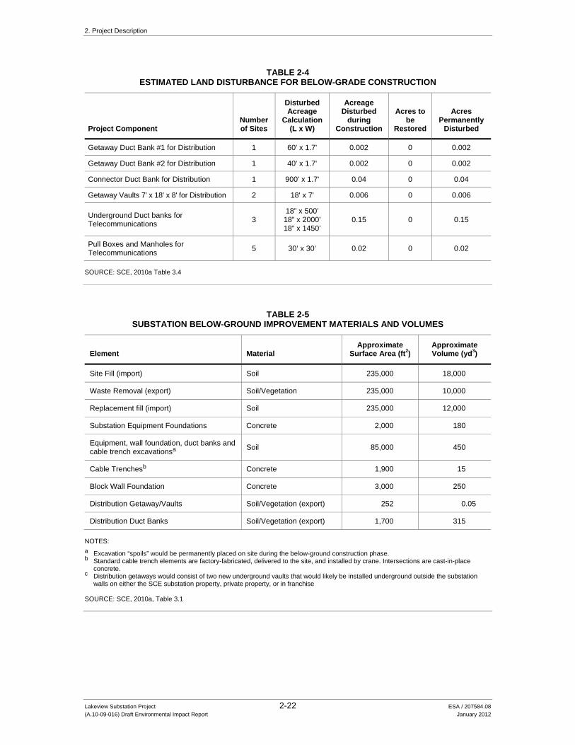
2. Project Description
Lakeview Substation Project 2-22 ESA / 207584.08 (A.10-09-016) Draft Environmental Impact Report January 2012
TABLE 2-4 ESTIMATED LAND DISTURBANCE FOR BELOW-GRADE CONSTRUCTION
Project Component Number of Sites
Disturbed Acreage
Calculation (L x W)
Acreage Disturbed
during Construction
Acres to be
Restored
Acres Permanently
Disturbed
Getaway Duct Bank #1 for Distribution 1 60' x 1.7' 0.002 0 0.002
Getaway Duct Bank #2 for Distribution 1 40' x 1.7' 0.002 0 0.002
Connector Duct Bank for Distribution 1 900' x 1.7' 0.04 0 0.04
Getaway Vaults 7' x 18' x 8' for Distribution 2 18' x 7' 0.006 0 0.006
Underground Duct banks for Telecommunications 3
18” x 500’ 18” x 2000’ 18” x 1450’
0.15 0 0.15
Pull Boxes and Manholes for Telecommunications 5 30’ x 30’ 0.02 0 0.02
SOURCE: SCE, 2010a Table 3.4
TABLE 2-5 SUBSTATION BELOW-GROUND IMPROVEMENT MATERIALS AND VOLUMES
Element Material Approximate
Surface Area (ft2) Approximate Volume (yd3)
Site Fill (import) Soil 235,000 18,000
Waste Removal (export) Soil/Vegetation 235,000 10,000
Replacement fill (import) Soil 235,000 12,000
Substation Equipment Foundations Concrete 2,000 180
Equipment, wall foundation, duct banks and cable trench excavationsa Soil 85,000 450
Cable Trenchesb Concrete 1,900 15
Block Wall Foundation Concrete 3,000 250
Distribution Getaway/Vaults Soil/Vegetation (export) 252 0.05
Distribution Duct Banks Soil/Vegetation (export) 1,700 315 NOTES: a Excavation “spoils” would be permanently placed on site during the below-ground construction phase. b Standard cable trench elements are factory-fabricated, delivered to the site, and installed by crane. Intersections are cast-in-place
concrete. c Distribution getaways would consist of two new underground vaults that would likely be installed underground outside the substation
walls on either the SCE substation property, private property, or in franchise SOURCE: SCE, 2010a, Table 3.1

2. Project Description
Lakeview Substation Project 2-23 ESA / 207584.08 (A.10-09-016) Draft Environmental Impact Report January 2012
Duct Banks and Conduits
Duct banks would be installed in a backhoe-excavated trench approximately 18 inches wide by 36 inches deep. Five-inch PVC conduit would be placed in the open trench, covered with slurry, and then covered with back-filled material and compacted. A 3 foot by 5 foot by 3 foot concrete pull box would be installed near the northwest corner of substation site approximately 20 feet south of the north perimeter wall of the Lakeview Substation and near the southeast section of Moval Substation, approximately 40 feet west of the east perimeter wall. A concrete manhole, approximately 4 feet by 4 feet by 5 feet, would be installed at the following locations: outside Moval Substation near the east side of Moreno Beach Drive, approximately 465 feet south of Cottonwood Avenue; near the east side of Moreno Beach Drive, approximately 368 feet south of Bay Street; and near the east side of Moreno Beach Drive, approximately 205 feet south of Allessandro Boulevard.
Distribution Getaways
Distribution getaways would consist of two new underground 7 feet by 18 feet by 8 feet vaults that would likely be installed underground outside the substation walls on either the SCE substation property, private property, or in franchise on 10th Street and Reservoir Street. The distribution getaways are described in Section 2.5.1.1, New Lakeview Substation.
Detention Basin
This analysis assumes that the County of Riverside would require, as part of the final drainage plan, a detention basin to be constructed within the substation perimeter for on-site stormwater filtration prior to discharge. Prior to substation construction, SCE would obtain a grading permit from the County of Riverside, at which time a final site drainage plan would be determined.
2.8.4.2 Above-Grade Construction
After the below-grade structures are installed, above-grade equipment (e.g., buses, capacitors, switchracks, disconnect switches, circuit breakers, transformers, steel support structures, perimeter wall, restroom facilities, and the MEER) would be installed. The estimated amount of land disturbed and restored is shown in Table 2-6, Estimated Land Disturbance for Above-Grade Construction.
TABLE 2-6 ESTIMATED LAND DISTURBANCE FOR ABOVE-GRADE CONSTRUCTION
Project Component
Number of Sites
Disturbed Acreage Calculation
(L x W)
Acreage Disturbed during
Construction Acres to be Restored
Acres Permanently
Disturbed
Substation 1 450' X 525' 5.4 0 5.4 SOURCE: SCE, 2010a Table 3.4

2. Project Description
Lakeview Substation Project 2-24 ESA / 207584.08 (A.10-09-016) Draft Environmental Impact Report January 2012
In preparation for above-grade construction, the ground surface of the substation site would be finished with materials imported to the site and materials excavated and used on the site. These materials, and their approximate surface area and volumes are listed below in Table 2-7, Substation Above-Ground Improvement Materials and Volumes. Concrete would be delivered to the site from a commercial supplier within a 30 mile radius of the Project site. It would be delivered by trucks approximately 9 times per day for a duration of 5 days for Lakeview Substation construction (SCE, 2011).
TABLE 2-7 SUBSTATION GROUND SURFACE IMPROVEMENT MATERIALS, AREAS, AND VOLUMES
Element Material Approximate
Surface Area (ft2) Approximate Volume (yd3)
115 kV Bus Enclosures Asphalt concrete 5,200 63
Internal Driveway Asphalt concrete Class II aggregate base
8,600 8,600
105 160
External Driveway Asphalt concrete Class II aggregate base
11,200 11,200
140 210
Substation Rock Surfacing Rock, nominal 1 to 1-1/2 inch per SCE Standard
85,000 1,050
SOURCE: SCE, 2010a Table 3.1
2.8.5 Subtransmission and Telecommunication Line Installation The following section describes the construction methodology for installing the new subtransmission and telecommunication lines. This would include the following activities: pole installation, guard structure installation, conductor and telecommunication line stringing, removal of 10 existing wood poles, and subtransmission source line energizing. The estimated acreage of land disturbed and restored for this portion of the Project is shown in Table 2-8, Estimated Land Disturbance for 115 kV Subtransmission Source Lines and Telecommunication Lines.
2.8.5.1 Wood Pole Installation
The Project would require the installation of approximately 73 wood poles. Wood poles would be installed directly into the soil within bored holes that are approximately 1 to 3 feet in diameter and 9 to 11 feet deep. These holes may be excavated with backhoe equipment in lieu of an auger to expedite installation. Wood pole installation typically requires the use of a line truck with a boom. Wood poles that are set into place are backfilled using bore spoils (excavated material from hole drilling). In the event that bore spoils are not suitable for backfill, imported clean fill material would be used. Excavated material would be distributed at each structure site to backfill excavations of removed poles or in the rehabilitation of existing access roads, or disposed of offsite in accordance with applicable laws.

2. Project Description
Lakeview Substation Project 2-25 ESA / 207584.08 (A.10-09-016) Draft Environmental Impact Report January 2012
TABLE 2-8 ESTIMATED LAND DISTURBANCE FOR 115 KV SUBTRANSMISSION SOURCE LINES
AND TELECOMMUNICATION LINES
Project Component Number of
Sites
Disturbed Acreage
Calculation (L x W)
Acreage Disturbed
during Construction
Acres to be Restored
Acres Permanently
Disturbed
Guard Structure 8 50' x 75' 0.7 0.7 0
Removal of Existing Wood Poles 10 50' x 50' 0.6 0.6 0
Construction of New TSPs 17 200' x 100' 7.8 6.8 1
Construction of New Subtransmission Wood Poles 73 150' x 75' 18.9 15.2 3.7
115 kV Conductor Stringing Setup Area-Puller 4 200' x 100' 1.8 1.8 0
115 kV Conductor Stringing Setup Area-Tensioner 4 200' x 100' 1.8 1.8 0
115 kV Conductor Stringing Splicing Setup Area 4 150' x 100' 1.4 1.4 0
SOURCE: SCE, 2010a Table 3-4
Installation of new poles to replace existing poles would occur within existing line ROW areas and would be installed as close as possible to the existing poles’ locations. The replacement poles would require excavations that would result in surface disturbance to set the poles as described above.
2.8.5.2 Tubular Steel Pole Installation
The Project would require the construction of approximately 17 TSPs. The location of the TSPs would be graded and/or cleared to provide a reasonably level surface free of vegetation for footing construction.
Construction of each TSP would require a single-drilled, poured-in-place concrete footing that would form the structure foundation. The drilling of the hole is accomplished using truck-or track-mounted excavators with various diameter augers to match the diameter requirements of the structure. Prior to drilling for foundations, SCE or the Contractor would contact Underground Service Alert to identify any underground utilities in the construction zone. TSPs typically require an excavated hole of 5 to 8 feet in diameter with an average depth of 20 to 40 feet (approximately 50 cubic yards of soil removal). Excavated material would be distributed at each structure site to backfill excavations of removed poles or in the rehabilitation of existing access roads or disposed of offsite in accordance with applicable laws. Alternatively, excavated material may be disposed of at one or more of the three authorized Riverside County disposal facilities located within 30 miles of the site: the El Sobrante Landfill in Corona, the Badlands Sanitary Landfill in Moreno Valley, or the Lamb Canyon Sanitary Landfill in Beaumont.

2. Project Description
Lakeview Substation Project 2-26 ESA / 207584.08 (A.10-09-016) Draft Environmental Impact Report January 2012
Following excavation of the foundation footings, steel-reinforced cages would be set and survey positioning would be verified. Steel-reinforced cages would be pre-assembled by the manufacturer and delivered to the TSP locations by flatbed truck.
For ease of construction, TSPs may consist of a separate base and top section. Each section would be transported to the pole location, where it would be placed on the ground within a laydown area. Depending on what structures already exist in the field, the top section of the TSP may be framed by the construction crew with pre-fabricated components (such as steel arms and mounting plates) prior to assemblage to the base section. If there are clearance concerns, the TSP would be set and the insulators and hardware attached after installation. A crane would be used to place the base section of the TSP onto the concrete foundation where it would be bolted to the foundation. Concrete would be delivered to the Project site by trucks approximately 7.5 times per day for TSP construction (SCE, 2011).
2.8.5.3 Guard Structures
Guard structures are temporary facilities that typically would be installed at transportation, flood control and utility crossings. These structures are designed to stop the movement of a conductor should it momentarily drop below a conventional stringing height. Typical guard structures are standard wood poles 60 to 80 feet tall, however temporary netting could be installed to protect some types of under-built infrastructure or specifically equipped boom type trucks with heavy outriggers may be used. Typically two to four guard poles are installed on either side of a crossing to prevent the conductor from dropping. Approximately eight guard structures would be required to construct the Project.
2.8.5.4 Conductor/Wire Stringing
Conductor stringing activities would be in accordance with SCE specifications, which are similar to process methods detailed in the IEEE Standard 524-2003 (Guide to the Installation of Overhead Transmission Line Conductors).
Safety devices such as traveling grounds, guard structures, and radio-equipped public safety vehicles would be utilized during conductor stringing activities.
Conductor stringing includes all activities associated with the installation of the wire onto the wood poles and TSPs. Conductors would be installed on the 115kV polymer insulator assemblies attached directly to the pole or attached to each cross arm. These activities typically include the installation of primary conductors, vibration dampeners, weights, and post, suspension and dead-end hardware assemblies for the entire length of the subtransmission line routes. Insulators and stringing sheaves (rollers or travelers) are also attached as part of the conductor installation efforts during conductor stringing activities.
Each stringing operation would include one puller positioned at one end and one tensioner and wire reel stand truck positioned at the other end. Splicing sites would be strategically located to support the stringing operations and would include specialized support equipment such as

2. Project Description
Lakeview Substation Project 2-27 ESA / 207584.08 (A.10-09-016) Draft Environmental Impact Report January 2012
skidders and wire crimping equipment. Permanent splices are formed once the conductor is strung through the rollers located on each structure. For stringing equipment that cannot be positioned at either side of a dead-end subtransmission structure, field snubs (i.e., anchoring and dead-end hardware) would be temporarily installed to sag conductor wire to the correct tension.
The puller, tensioner, and splicing set-up locations associated with the Project would be temporary and the land would be restored to its previous condition following completion of pulling and splicing activities. Figure 2-2 illustrates the anticipated pull and tension sites based on preliminary design. The following five steps describe typical wire-stringing activities:
Step 1: Determine the locations of wire pulls and wire-pull equipment set-up positions.
Step 2: Sock Line, Threading: A bucket truck/manlift would be used to install a lightweight sock line. The sock line would be threaded through the wire rollers in order to engage a camlock device that would secure the pulling sock in the roller. This threading process would continue between all structures through the rollers of a particular set of spans selected for a wire pull.
Step 3: Pulling: The sock line would be used to pull in the wire-pulling rope. The wire-pulling rope would be attached to the conductor using a swivel joint to prevent damage to the conductor and to allow the conductor to rotate freely to prevent complications from twisting as the conductor unwinds off the reel.
Step 4: Splicing, Sagging, and Dead-ending: After the conductor is pulled in, any required mid-span splicing would be performed. Once the splicing has been completed, the conductor would be sagged to proper tension and dead-ended to structures.
Step 5: Clipping-in: After the wire is dead-ended, the wire would be attached to all tangent structures.
Wire pulls are the length of any given continuous wire installation between two selected points along the line. Wire pull locations are selected, where possible, based on availability of dead-end structures at the ends of each pull and the geometry of the line as affected by points of inflection, terrain, and suitability of stringing and splicing equipment setups. Typically, wire pulls are located approximately every 6,000 feet on flat terrain or less in rugged terrain. Generally, pulling locations and equipment set-ups would be in direct line with the direction of the overhead conductors and established a distance approximately three times the pole height away from the adjacent structure. Final pulling sites would be determined during final engineering. The dimensions of the area needed for the wire stringing set-ups associated with wire installation are variable and depend upon terrain. These activities generally require an area of approximately 50 feet wide by 100 feet long.
2.8.5.5 Telecommunications System Installation and Upgrades
Fiber optic system construction would include the installation of overhead facilities, underground facilities, and new or upgraded telecommunications equipment. The fiber optic system facilities and equipment would be installed within the Lakeview Substation site, the existing substations identified in Section 2.5.1.2, and along existing and new subtransmission and distribution lines.

2. Project Description
Lakeview Substation Project 2-28 ESA / 207584.08 (A.10-09-016) Draft Environmental Impact Report January 2012
Communications equipment installation and upgrade activities would occur within a MEER, and would not cause ground disturbance.
Overhead telecommunications facilities would be installed by attaching cable to structures in a manner similar to that described for subtransmission wire stringing (Section 2.8.8.4). Figure 2-2 provides locations for proposed pull and tension sites for the overhead portions of the telecommunications route. Final pulling sites would be determined during final engineering.
Underground telecommunications facilities would be installed in new duct banks which include pull boxes and manholes, in the substation site, on 10th Street outside of the substation site, in the Moval Substation site and on Moreno Beach Drive outside of the Moval Substation site. Concrete would be delivered to the Project site by trucks approximately four times per day for telecommunications construction for a duration of 7.5 days (SCE, 2011).
2.8.5.6 Removal of Existing Poles
Prior to removal of existing poles, the existing subtransmission lines, distribution lines and telecommunication lines (where applicable) would be transferred to the new poles; all remaining subtransmission, distribution and telecommunication lines that are not reused by SCE would be removed (above- and below-ground) and delivered to a facility for recycling. The holes left from removing the poles would be backfilled with fill that may be available as a result of the excavation for new poles or imported fill would be used as needed.
Depending on the type, condition, and original chemical treatment, wood poles removed could be reused by SCE for other purposes or properly disposed of (see 2.8.9.3 Waste Management).
2.8.5.7 Energizing 115 kV Subtransmission Source Lines
Energizing the new subtransmission source lines would be the final step in completing the 115 kV subtransmission construction. The existing Valley-Moval 115 kV subtransmission line would be de-energized in order to connect the new 115 kV subtransmission source line segments. To reduce the need for electric service outages, de-energizing and reconnecting the existing subtransmission lines to the new poles may occur at night when electrical demand is low. Once the connection is complete, the existing subtransmission line would be returned to service (re-energized).
2.8.6 Site Cleanup and Management
2.8.6.1 Site Cleanup and Restoration
SCE would restore all areas that are temporarily disturbed by Project activities once construction is complete. Restoration areas could include, but not be limited to, portions of existing access roads, material staging yards, pull and tension sites, splicing sites, and pull box locations. Activities associated with restoration of these areas would include restoring original contours and

2. Project Description
Lakeview Substation Project 2-29 ESA / 207584.08 (A.10-09-016) Draft Environmental Impact Report January 2012
reseeding with an appropriate seed mix, to the extent feasible. All construction materials and debris would be removed from the area and recycled or properly disposed of offsite.
2.8.6.2 Hazardous Materials Use, Storage, and Disposal
Project construction would require limited use of hazardous materials, such as fuels, lubricants, and cleaning solvents. All hazardous materials would be stored, handled, and used in accordance with applicable regulations. Material Safety Data Sheets would be made available at the construction site for all crew workers. The SWPPP prepared for the Project (see Section 2.7.3) would provide the locations for storage of hazardous materials during construction, as well as protective measures, notifications, and cleanup requirements for any incidental spills or other potential releases of hazardous materials.
Depending on the type, condition and original chemical treatment, wood poles removed from the site could be reused by SCE for other purposes, disposed of in a Class I hazardous waste landfill, or disposed of in the lined portion of a RWQCB-certified municipal landfill. There are two major permitted Class I hazardous waste landfills located in California: Chemical Waste Management Kettleman Hills Landfill, located in Kettleman City; and Clean Harbors Buttonwillow Landfill, located in Buttonwillow. The Kettleman Hills facility has approximately 6,000,000 cubic yards of remaining capacity and is not expected to close until 2037-2038. The Buttonwillow facility has approximately 9,500,000 cubic yards of remaining capacity and is not expected to close until 2040.
Decommissioning of the existing Nuevo and temporary Model Pole Top Substations would require the removal of transformers and associated equipment that contain approximately 17,500 gallons of mineral oil (see Section 2.9). SCE would test the mineral oil at the time of decommissioning to determine whether polychlorinated biphenyls (PCBs) are present. If PCBs are detected, SCE would handle and dispose of the material as required by all applicable laws, regulations, and other rules to avoid their release into the environment. Such rules govern the acquisition of shipping papers, package marking, labeling, transport vehicle placarding, training, and registration.
2.8.6.3 Solid Waste Management
Development of the Project would result in the identification of equipment and other materials that could be recycled and salvaged. SCE would determine whether to refurbish/rebuild a piece of equipment or process it for disposal based upon the condition of the equipment and/or the need to retain it for future use. Existing items and materials removed from the Project site, including the site of the existing Nuevo and temporary Model Pole Top Substations, would be collected by construction crews and separated into roll off boxes at the materials staging area.
All materials that are not salvaged or recycled would be categorized by SCE to assure appropriate final disposal. Hazardous waste, potentially including wood poles, is described above. Non-hazardous waste, including soil, would be transported to one of the three Riverside County solid waste management facilities located within 30 miles of the substation site: The El Sobrante

2. Project Description
Lakeview Substation Project 2-30 ESA / 207584.08 (A.10-09-016) Draft Environmental Impact Report January 2012
Landfill in Corona, the Badlands Sanitary Landfill in Moreno Valley, or the Lamb Canyon Sanitary Landfill in Beaumont all have sufficient capacity to accommodate Project-related solid waste (CIWMB, 2011).
2.8.6.4 Stormwater Management
The proposed substation site is relatively flat with minor sloping toward the west. It is at an approximate elevation of 1,460 feet above mean sea level (amsl). If required by the County of Riverside as part of the final drainage plan, SCE would include a detention basin within the Lakeview Substation site to accommodate on-site stormwater filtration prior to discharge. For purposes of identifying all potential impacts of the Project, this EIR assumes that a detention basin would be required. Prior to substation construction, SCE would obtain a grading permit from the County of Riverside, at which time a final site drainage plan would be determined.
Based on the anticipated volume of hazardous liquid materials, such as mineral oil, in use at the site being in excess of 1,320 gallons, a Spill Prevention and Control Countermeasures (SPCC) Plan would be required (40 C.F.R. Parts 112.1-112.7). Typical SPCC secondary containment features include curbs and berms designed and installed to contain spills, should they occur. These features would be part of SCE’s final engineering design for the Project.
2.8.6.5 Site Security
Construction of the Project is unlikely to require the use of local law enforcement agencies. If necessary, SCE would hire a local security company to provide 24-hour attendance at the marshalling yards, material staging yards, and laydown yard during construction, minimizing the involvement of local law enforcement. A construction trailer would also be situated at the proposed substation site.
2.9 Decommissioning the Nuevo Substation and Model Pole Top Transformer
An existing substation (the Nuevo 33/12 kV Substation) and an existing temporary pole-top substation (the Model Pole Top Substation) would be decommissioned as part of the Project. Nuevo Substation has been located near the corner of Lakeview Avenue and Palm Drive since January 1950. A photograph of it is provided as context photo F in Figure 4.1-4, Context Photos E, F, G and H. The temporary Model Pole Top Substation was installed at the corner of Lakeview Avenue and East Lakeview Avenue in 2007 to supplement capacity at the Nuevo Substation until a new substation project could be constructed to provide electrical service in the Electrical Needs Area. The sites of the existing Nuevo and temporary Model Pole Top Substations are relatively flat, covered with gravel, and slopes gently to the west.
The existing Nuevo and temporary Model Pole Top Substations would be retired and the affected area restored once the proposed Lakeview Substation becomes operational. Demolition would take approximately one and one-half months, beginning after construction of the Project is completed:
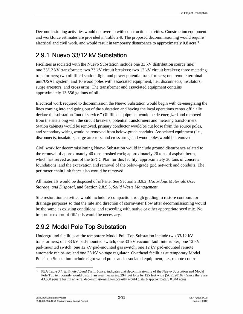
2. Project Description
Lakeview Substation Project 2-31 ESA / 207584.08 (A.10-09-016) Draft Environmental Impact Report January 2012
Decommissioning activities would not overlap with construction activities. Construction equipment and workforce estimates are provided in Table 2-9. The proposed decommissioning would require electrical and civil work, and would result in temporary disturbance to approximately 0.8 acre.3
2.9.1 Nuevo 33/12 kV Substation Facilities associated with the Nuevo Substation include one 33 kV distribution source line; one 33/12 kV transformer; two 33 kV circuit breakers; two 12 kV circuit breakers; three metering transformers; two oil filled station, light and power potential transformers; one remote terminal unit/USAT system; and 10 wood poles with associated equipment, i.e., disconnects, insulators, surge arrestors, and cross arms. The transformer and associated equipment contains approximately 13,556 gallons of oil.
Electrical work required to decommission the Nuevo Substation would begin with de-energizing the lines coming into and going out of the substation and having the local operations center officially declare the substation “out of service.” Oil filled equipment would be de-energized and removed from the site along with the circuit breakers, potential transformers and metering transformers. Station cabinets would be removed, primary conductor would be cut loose from the source poles, and secondary wiring would be removed from below-grade conduits. Associated equipment (i.e., disconnects, insulators, surge arrestors, and cross arms) and wood poles would be removed.
Civil work for decommissioning Nuevo Substation would include ground disturbance related to the removal of approximately 40 tons crushed rock; approximately 20 tons of asphalt berm, which has served as part of the SPCC Plan for this facility; approximately 30 tons of concrete foundations; and the excavation and removal of the below-grade grid network and conduits. The perimeter chain link fence also would be removed.
All materials would be disposed of off-site. See Section 2.8.9.2, Hazardous Materials Use, Storage, and Disposal, and Section 2.8.9.3, Solid Waste Management.
Site restoration activities would include re-compaction, rough grading to restore contours for drainage purposes so that the rate and direction of stormwater flow after decommissioning would be the same as existing conditions, and reseeding with native or other appropriate seed mix. No import or export of fill/soils would be necessary.
2.9.2 Model Pole Top Substation Underground facilities at the temporary Model Pole Top Substation include two 33/12 kV transformers; one 33 kV pad-mounted switch; one 33 kV vacuum fault interrupter; one 12 kV pad-mounted switch; one 12 kV pad-mounted gas switch; one 12 kV pad-mounted remote automatic reclosure; and one 33 kV voltage regulator. Overhead facilities at temporary Model Pole Top Substation include eight wood poles and associated equipment, i.e., remote control
3 PEA Table 3.4, Estimated Land Disturbance, indicates that decommissioning of the Nuevo Substation and Modal
Pole Top temporarily would disturb an area measuring 294 feet long by 125 feet wide (SCE, 2010a). Since there are 43,560 square feet in an acre, decommissioning temporarily would disturb approximately 0.844 acres.

2. Project Description
Lakeview Substation Project 2-32 ESA / 207584.08 (A.10-09-016) Draft Environmental Impact Report January 2012
switches, transformers, cross arms, lightening arrestors, control cabinets, insulators, riser, pin and glass, disconnects, and down guys. The switches contain approximately 85 pounds of SF6 gas. The transformer, regulator and associated equipment contain approximately 3,929 gallons of oil. In addition to the underground and overhead facilities at the temporary Model Pole Top Substation, additional existing materials include: one 6 foot by 12 foot by 7 foot manhole, one 7 foot by 8 foot concrete pad with a 4 foot by 7 foot slab box, two 10 foot by 12 foot slab boxes, two 8 foot by 10 foot slab boxes, two 6 foot by 8 foot (6 inch) slab boxes, ground rods, eight railroad ties, perimeter chain link fence, gravel, asphalt, and concrete.
Electrical work required to decommission the temporary Model Pole Top Substation would begin with opening two pole-mounted circuit breakers to de-energize the Oliver 33 kV distribution line and the Brinkley 12 kV distribution line. The voltage regulator, transformers switches, and automated reclosures would be removed from the site and returned to surplus for potential reconditioning and reuse by SCE. Underground cable and overhead conductor would be removed. Associated equipment (i.e., remote control switches, transformers, cross arms, lightening arrestors, control cabinets, insulators, riser, pin and glass, disconnects, and down guys) and wood poles would be removed.
Civil work would include ground disturbance related to the removal of all gravel and asphalt, and the excavation and removal of the concrete pad, slab boxes and man hole. The chain link perimeter fence also would be removed. Approximately 260 cubic yards of dirt would be excavated to remove the underground facilities and then used to backfill excavated portions of the site. Up to 340 cubic yards of dirt may need to be imported to the site. This transport would take approximately 24 truck trips with each truck capable of transporting 14 cubic yards (SCE, 2011).
All materials would be disposed of off-site. See Section 2.8.9.2, Hazardous Materials Use, Storage, and Disposal, and Section 2.8.9.3, Solid Waste Management.
Site restoration activities associated with the Model Pole Top would include re-compaction, rough grading to restore contours for drainage purposes so that the rate and direction of stormwater flow after decommissioning would be the same as existing conditions, and reseeding with native or other appropriate seed mix. No import or export of fill/soils would be necessary.
2.10 Project Operation and Maintenance
The Lakeview Substation would be unattended. Electrical equipment within the substation would be remotely monitored and controlled by an automated system from SCE’s Valley Switching Center. SCE personnel would visit for electrical switching and routine maintenance purposes. Routine maintenance would include equipment testing, monitoring, and repair. Emergency maintenance also could be required. SCE personnel would visit the substation three to four times per month.
The new 115 kV subtransmission lines would be maintained in a manner consistent with CPUC General Order 165 which established minimum requirements for electric distribution facilities,

2. Project Description
Lakeview Substation Project 2-33 ESA / 207584.08 (A.10-09-016) Draft Environmental Impact Report January 2012
regarding inspections, record-keeping, and reporting. Normal operation of the 115 kV subtransmission lines would be controlled remotely through SCE control systems. SCE maintains an inspection frequency of the energized subtransmission overhead facilities a minimum of once per year via ground and/or aerial observation. Maintenance would occur as needed and would include activities such as repairing conductors, replacing insulators, replacing poles, and access road maintenance.
2.11 Water and Wastewater
Construction- and decommissioning-related use of water would include dust suppression activities conducted in accordance with South Coast Air Quality Management District Rule 403-Fugitive Dust, site clean-up, and domestic uses such as drinking and hand washing. Approximately 32,000 gallons per day would be necessary, and would be delivered to the site by water trucks eight times a day (SCE, 2011).
During operation and maintenance of the Project, water use would be limited to irrigation of landscaping along the Lakeview Substation perimeter. Landscaping would not be installed until all Lakeview Substation related construction has been completed. There is domestic water available at the intersection of Reservoir Avenue and 10th Street that should allow for the connection of the Lakeview Substation irrigation system pending approval of a landscaping plan by the County of Riverside. The volume of water necessary for landscaping will not be known until a formal landscaping plan has been adopted in consultation with Riverside County (SCE, 2011).
The Lakeview Substation would be equipped with a portable chemical toilet within the substation perimeter wall. It would be maintained as needed by an outside service company. No municipal sewer service is available at the site, and none would be required for the Project.
2.12 Workforce and Equipment
The estimated elements, materials and number of personnel and equipment required for construction of the Project are summarized in Table 2-9, Construction Equipment and Workforce Estimates.
Construction would be performed by either SCE construction crews or contractors. If SCE transmission and telecommunications construction crews are used, they would be based at one of the SCE local facilities, such as the Menifee Service Center. Contractor construction personnel would be managed by SCE construction management personnel. SCE anticipates a total of approximately 40 construction personnel working on any given day. SCE anticipates that crews would work concurrently whenever possible; however, the estimated deployment and number of crew members would be dependent upon local jurisdiction permitting, material availability, and construction scheduling.

2. Project Description
Lakeview Substation Project 2-34 ESA / 207584.08 (A.10-09-016) Draft Environmental Impact Report January 2012
TABLE 2-9 CONSTRUCTION EQUIPMENT AND WORKFORCE ESTIMATES
Activity and Number of Personnel
Number of Work Days Equipment and Quantity
Duration of Use (Hours/Day) Fuel Type
Substation Construction Survey (2 people) 10 2-Survey Trucks 8 Gasoline
Grading (15 people) 90
1 Dozer 4 Diesel 2 Loader 4 Diesel 1 Scraper 3 Diesel 1 Grader 3 Diesel 1 Water Truck 2 Diesel 2 4X4 Backhoe 2 Diesel 1 4X4 Tamper 2 Diesel 1 Tool Truck 2 Gasoline 1 Pickup 4X4 2 Gasoline
Civil Work (10 people) 60
1 Excavator 4 Diesel 1 Foundation Auger 5 Diesel 2 Backhoe 3 Diesel 1 Dump truck 2 Diesel 1 Skip Loader 3 Diesel 1 Water Truck 3 Diesel 2 Bobcat Skid Steer 3 Diesel 1 Forklift 4 Propane
1 17 ton Crane 2 hours/ day for 45 days
Diesel
1 Tool Truck 3 Gasoline
MEER (4 people) 20 1 Carry-all Truck 3 Gasoline 1 Stake Truck 2 Gasoline
Electrical (10 people) 70
2 Scissor Lifts 3 Propane 2 Manlifts 3 Propane 1 Reach Manlift 4 Propane 1 15-ton Crane 3 Diesel 1 Tool Trailer 3 N/A 2 Crew Trucks 2 Gasoline
Wiring (5 people) 25 1 Manlift 4 Propane 1 Tool Trailer 3 N/A
Transformers (6 people) 30
1 Crane 6 Diesel 1 Forklift 6 Propane 2 Crew Trucks 2 Gasoline 1 Low Bed Truck 4 Gasoline
Maintenance Crew Equipment Check (2 people)
30 2 Maintenance Trucks 4 Gasoline
Testing (2 people) 80 1 Crew Truck 3 Gasoline
Fencing (4 people) 10 1 Bobcat 8 Diesel 1 Flatbed Truck 2 Gasoline 1 Crewcab Truck 4 Gasoline
Asphalting (6 people) 15 2 Paving Roller 4 Diesel 1 Asphalt Paver 4 Diesel 1 Stake Truck 4 Gasoline

2. Project Description
TABLE 2-9 (Continued) CONSTRUCTION EQUIPMENT AND WORKFORCE ESTIMATES
Lakeview Substation Project 2-35 ESA / 207584.08 (A.10-09-016) Draft Environmental Impact Report January 2012
Activity and Number of Personnel
Number of Work Days Equipment and Quantity
Duration of Use (Hours/Day) Fuel Type
Substation Construction (cont.)
Asphalting (6 people) (cont.)
1 Tractor 3 Diesel 1 Dump Truck 3 Diesel 2 Crew Trucks 2 Gasoline 1 Asphalt Curb Machine 3 Diesel
Landscaping (6 people) 15 1 Tractor 1 Dump Truck
6 3
Diesel Diesel
Irrigation – On-site (7 people) 20
1 Bobcat 1 Power Trencher 1 Crew Truck
8 8 8
Diesel Diesel Gasoline
Distribution Construction
Civil 18
1 Backhoe 1 Dump Truck 1 Roller 1 Delivery Truck (vault & pull box) 1 Cement Truck
8 8 8 8 8
Diesel Diesel Diesel Diesel Diesel
Electrical 42
1 Rodder Truck 1 Cable Dolly 1 Reel Truck 1 Linetruck 1 Troubleman Truck 1 Boom Truck 1 Foreman Truck
8 8 8 8 8 8 8
Diesel Diesel Diesel Diesel Diesel Diesel Gasoline
Nuevo Substation Decommissioning
Civil (5 people) 5
1 Backhoe 40 Diesel 2 Dump Trucks 20 Diesel 1 Water Truck 20 Diesel 1 Bobcat Skid Steer 30 Diesel 1 Tool Truck 10 Gasoline
Electrical (5 people) 7
2 Manlifts 60 Gasoline 1 15 ton Crane 40 Diesel 1 Tool Trailer 2 Crew Trucks
5 2
Gasoline Gasoline
Maintenance Crew Equipment Check (2 people)
2 1 Maintenance Truck 4 Gasoline
Testing (2 people) 2 1 Crew Truck 4 Gasoline
Model Pole Top Decommissioning
Civil (5 people) 4
1 Backhoe 1 Dump Truck 1 Flat bed Truck 1 Foreman Truck
8 8 8 8
Gasoline Diesel Diesel Diesel
Electrical (5 people) 22
1 Wire Dolly 8 Gasoline 1 Linetruck 8 Diesel 1 Troubleman Truck 8 Diesel 1 Boom Truck 1 Foreman Truck 1 Crane 1 Flatbed 1 Pumper/tanker truck
8 8 8 8 8
Diesel Gasoline Diesel Diesel Diesel

2. Project Description
TABLE 2-9 (Continued) CONSTRUCTION EQUIPMENT AND WORKFORCE ESTIMATES
Lakeview Substation Project 2-36 ESA / 207584.08 (A.10-09-016) Draft Environmental Impact Report January 2012
Activity and Number of Personnel
Number of Work Days Equipment and Quantity
Duration of Use (Hours/Day) Fuel Type
115 kV Subtransmission Line Construction Survey (2 people) 5 1/2-ton Pick-up Truck, 4x4 8 Gasoline
Marshalling Yard (4 people)
Duration of Project
1 Ton Crew Cab, 4x4 2 Diesel 30 Ton Crane Truck 2 Diesel 10,000lb Rough Terrain 5 Diesel Fork Lift Truck, Semi, Tractor 1 Diesel
Right of Way Clearing (5 people) 14
1-ton Crew Cab Flat Bed, 4x4 8 Diesel 1 Road Grader 6 Diesel 1 Water Truck 8 Diesel 1 Backhoe/Front Loader 6 Diesel 1 Track Type Dozer 6 Diesel 1 Lowboy Truck/Trailer 4 Diesel
Roads & Landing Work (5 people) 20
1-ton Crew Cab Flat Bed, 4x4 2 Diesel 1 Road Grader 4 Diesel 1 Water Truck 8 Diesel 1 Backhoe/Front Loader 6 Diesel Drum Type Compactor 4 Diesel 1 Track Type Dozer 6 Diesel Excavator 6 Diesel 1 Lowboy Truck/Trailer 2 Diesel
Guard Structure Installation (6 People) 2
¾ Ton Pick Up Truck 4x4 1 Ton Crew Cab Flat Bed, 4x4 Compressor Truck Auger Truck Extendable Flat Bed Pole Truck 30 Ton Crane Truck 80 foot Hydraulic Manlift/Bucket Truck Backhoe/Front Loader
6 6 6 6 6 8 4 6
Diesel Diesel Diesel Diesel Diesel Diesel Diesel Diesel
Remove Existing Wood Poles (6 People) 1
1 Ton Crew Cab, 4x4 10,000 lb Rough Terrain Forklift 30 Ton Crane Truck Compressor Trailer Flat Bed Truck/Trailer Backhoe/Front Loader
5 4 6 6 8 6
Diesel Diesel Diesel Diesel Diesel Diesel
Install TSP Foundation (7 people) 34
1 Ton Crew Cab Flat Bed, 4x4 30 Ton Crane Truck Backhoe/Front Loader Auger Truck 4,000 Gallon Water Truck 10 cu. Yd. Dump Truck 10 cu. Yd. Concrete Mixer Truck
2 5 8 8 8 8 5
Diesel Diesel Diesel Diesel Diesel Diesel Diesel
Install Subtransmission Wood Poles (8 people) 19
¾ Ton Pick Up Truck, 4x4 1 Ton Crew Cab Flat Bed, 4x4 Compressor Trailer 80 Ton Rough Terrain Crane Backhoe/Front Loader
5 5 5 6 6
Diesel Diesel Diesel Diesel Diesel
Steep Pole Haul (4 people) 5 ¾ Ton Pick Up Truck, 4x4 80 Ton Rough Terrain Crane 40’ Flat Bed Truck/Trailer
5 6 8
Diesel Diesel Diesel
Steel Pole Assembly 6
¾ Ton Pick Up Truck, 4x4 1 Ton Crew Cab Flat Bed, 4x4 Compressor Trailer 80 Ton Rough Terrain Crane
5 5 5 6
Diesel Diesel Diesel Diesel

2. Project Description
TABLE 2-9 (Continued) CONSTRUCTION EQUIPMENT AND WORKFORCE ESTIMATES
Lakeview Substation Project 2-37 ESA / 207584.08 (A.10-09-016) Draft Environmental Impact Report January 2012
Activity and Number of Personnel
Number of Work Days Equipment and Quantity
Duration of Use (Hours/Day) Fuel Type
115 kV Subtransmission Line Construction (cont.)
Steel Pole Erection (8 people) 6
¾ Ton Pick Up Truck, 4x4 1 Ton Crew Cab Flat Bed, 4x4 Compressor Trailer 80 Ton Rough Terrain Crane
5 5 5 6
Diesel Diesel Diesel Diesel
Install Conductor (16 people) 10
¾ Ton Pick Up Truck, 4x4 1 Ton Crew Cab Flat Bed, 4x4 Wire Truck/Trailer Dump Truck (trash) Bucket Truck 22 Ton Manitex Splicing Rig Splicing Lab 3 Drum Straw Line Puller Static Truck/Tensioner
8 8 2 2 8 8 2 2 6 6
Diesel Diesel Diesel Diesel Diesel Diesel Diesel Diesel Diesel Diesel
Guard Structure Removal (6 people) 2
¾ Ton Pick Up Truck, 4x4 1 Ton Crew Cab Flat Bed, 4x4 Compressor Trailer Extendable Flat Bed Pole Truck 30 Ton Crane Truck 80 Ft. Hydraulic Manlift/Bucket Truck Backhoe/Front Loader
6 6 6 6 8 4 6
Diesel Diesel Diesel Diesel Diesel Diesel Diesel
Restoration (7 people) 4
1 Ton Crew Cab, 4x4 Road Grader Water Truck Backhoe/Front Loader Drum Type Compactor Truck Type Dozer Lowboy Truck/Trailer
2 6 8 6 6 6 3
Diesel Diesel Diesel Diesel Diesel Diesel Diesel
Telecommunications Construction Control Building Communications Room (7 people)
10 1
2 Vans 1 Crew Truck
1 1
Gasoline Diesel
Overhead Cable Installation (8 people) 44
2 Bucket Truck 8 Diesel 1 Splice Lab Truck 1 Crew Truck
8 8
Diesel Diesel
Underground Facility Installation (6 people)
20
2 Crew Trucks 8 Diesel 1 Backhoe 8 Diesel 1 Flat Bed Truck 2 Diesel 1 Stake Bed Truck Concrete Mixer
8 8
Diesel Diesel
Underground Cable Installation (6 people) 6
2 Reel Trucks 8 Diesel 1 Splice Lab Truck 1 Crew Truck
8 8
Diesel Diesel
Optical Systems at Other Locations (6 people)
12 6 Vans 2 Gasoline
Roads & Landing Work (5 people)
16 1 Ton Crew Cab, 4x4 Road Grader Water Truck Backhoe/Front Loader Drum Type Compactor Track Type Dozer Excavator Lowboy Truck/Trailer
2 4 8 6 4 6 6 2
Diesel Diesel Diesel Diesel Diesel Diesel Diesel Diesel
SOURCE: SCE, 2010a

2. Project Description
Lakeview Substation Project 2-38 ESA / 207584.08 (A.10-09-016) Draft Environmental Impact Report January 2012
2.13 Applicant Proposed Measures
SCE identified a number of applicant proposed measures (APMs) that would avoid or reduce potential impacts of the Project related to aesthetics, biological resources and paleontological resources. All APMs would be implemented as part of the Project, and are not considered “mitigation measures” in this EIR. If the EIR is certified and the Project is approved, SCE’s implementation of and compliance with these APMs would be monitored and enforced by the CPUC.
2.13.1 Aesthetics APM-Aesthetics-1: Prepare a Landscaping Plan. SCE will prepare a landscaping plan consistent with Riverside County standards, as well as SCE standards to filter views of the substation for the surrounding community and other potential sensitive receptors.
2.13.2 Biological Resources APM-Bio-1: Preconstruction surveys for Nesting Birds/Raptors. To minimize potential impacts to selected nesting special-status birds, raptors, or other [Migratory Bird Treaty Act] MBTA bird species, planned vegetation clearing will take place during the non-breeding season (between September 1 and January 31) to the extent feasible. This will discourage the species from nesting within the work area. Existing trees, shrubs, or other vegetation that would provide suitable structure for nesting would be removed. If vegetation clearing must take place during nesting season (February 1–August 31), a biologist shall conduct pre-construction nesting bird surveys prior to clearing for the sites that have potential to support nesting birds/raptors. If the biologist finds an active nest within or adjacent to the construction area and determines that there may be impacts to the nest, s/he will delineate an appropriate buffer zone around the nest depending on the sensitivity of the species and the type of construction activity. Only construction activities (if any) approved by the biologist will take place within the buffer zone until the nest is vacated. If nests are found and cannot be avoided by the project activities, or if work is scheduled to take place near an active nest, SCE shall coordinate with the CDFG and USFWS and obtain written concurrence prior to moving the nest.
APM-Bio-2: Pre-Construction Surveys and Construction Monitoring. Pre-construction biological clearance surveys shall be performed at the Project site to minimize impacts on special status wildlife. If special status species are present, biological monitors would be on site, as needed during project implementation in suitable habitat areas and shall aid crews in implementing avoidance measures during project construction. If adequate avoidance cannot be established, SCE shall consider enrollment in the MSHCP as a Participating Special Entity or shall coordinate with the USFWS and the CDFG for further guidance as appropriate. Any significant findings during pre-construction surveys would be added to the WEAP training described in Section 2.7.3.
APM-Bio-3: Stephen’s Kangaroo Rat. A habitat assessment for Stephens’ kangaroo rat shall be conducted by a biologist qualified to conduct Stephens’ kangaroo rat Surveys along Segments

2. Project Description
Lakeview Substation Project 2-39 ESA / 207584.08 (A.10-09-016) Draft Environmental Impact Report January 2012
One and Two, as well as the telecommunications route. If no potential occupied habitat is found during this assessment, then no further action is necessary. If potential for occupied habitat is found, protocol trapping surveys shall be conducted. The Proposed Telecommunications Route is within a Stephens’ kangaroo rat fee area; therefore, if suitable habitat for this species is found, a fee shall be paid in lieu of further surveys (County of Riverside 1996).
APM-Bio-4: Riverside Fairy Shrimp. If Riverside fairy shrimp are found, SCE shall consider (1) avoidance measures, (2) enrollment in the MSHCP as a Participating Special Entity, or (3) approvals through the USFWS. Appropriate avoidance, minimization, and compensation measures may be required. Impacts to Riverside fairy shrimp habitat will be avoided to the extent feasible in the final Project Design. Habitat areas will be marked as “off limits” in construction plans and specifications. If significant impacts to habitat are unavoidable, focused surveys will need to be conducted prior to construction activities. Riverside fairy shrimp surveys require either a wet season survey, followed by a consecutive dry season survey, or two wet season surveys done within a five-year period (USFWS, 1996). If no Riverside fairy shrimp are found in this area during the focused surveys, no additional action is warranted.
APM-Bio-5: Burrowing Owl. Any active burrow found during survey efforts shall be mapped. If no active burrows are found, no further mitigation would be required. If nesting activity is present at an active burrow, the burrow shall be protected until nesting activity has ended. Nesting activity for burrowing owl in the region normally occurs between March and August. To protect the active burrow, the following restrictions to construction activities shall be required until the burrow is no longer active as determined by a biologist: (1) clearing limits shall be established within a 500-foot buffer around any active burrow, unless otherwise determined by a biologist and (2) access and surveying shall be restricted within 300 feet of any active burrow, unless otherwise determined by a biologist. Any encroachment into the buffer area around the active burrow shall only be allowed if the biologist determines that the proposed activity will not disturb the nest occupants. Construction can proceed when the biologist has determined that fledglings have left the nest. If an active burrow is observed during the non-nesting season, the nest site will be monitored by a biologist and, when the owl is away from the nest, the biologist will either actively or passively relocate the burrowing owl. The biologist will then remove the burrow so the burrowing owl cannot return to the burrow.
APM-Bio-6: Native or Special Status Vegetation and Special Status Plant Populations Avoidance. Potential impacts to native vegetation types, vegetation that may support special status species, and known populations of Special Status Plants will be avoided to the extent feasible in the final project design. Native vegetation and Special Status Plant populations will be marked as “off limits” in construction plans and specifications. If significant impacts to native vegetation and/or Special Status Plants are unavoidable, a biologist will be selected to prepare and implement a mitigation plan, which will include detailed descriptions of maintenance appropriate for the mitigation site, monitoring requirements, and annual report requirements, and will have the full authority to suspend any operation which is, in the biologist’s opinion, not consistent with the mitigation plan. This plan will be submitted for review to the appropriate agencies.

2. Project Description
Lakeview Substation Project 2-40 ESA / 207584.08 (A.10-09-016) Draft Environmental Impact Report January 2012
APM-Bio-7: Avoidance of San Jacinto Valley Crownscale Populations. In order to avoid potential impacts to known populations of San Jacinto Valley crownscale populations, an Environmentally Sensitive Area (ESA) will be developed prior to construction to the extent feasible in the final Project Design (Figure 4.4-5). If significant impacts to San Jacinto Valley crownscale are unavoidable, a biologist will be selected to prepare and implement a mitigation plan, which will include detailed descriptions of maintenance appropriate for the mitigation site, monitoring requirements, and annual report requirements, and will have the full authority to suspend any operation which is, in the biologist’s opinion, not consistent with the mitigation plan. This plan will be submitted for review to the appropriate agencies.
2.13.3 Paleontological Resources APM-PA-1: Develop and Implement a Paleontological Monitoring Plan. SCE would monitor excavation of rock units having high potential to contain significant nonrenewable paleontological resources. SCE would develop a paleontological monitoring plan describing paleontological monitoring activities.
_________________________
References – Project Description Avian Powerline Interaction Committee (APLIC), 2006. Suggested Practices for Avian
Protection on Power Lines: the State of the Art in 2006. Edison Electric Institute, APLIC, and the California Energy Commission. Washington, DC and Sacramento, CA.
California Integrated Waste Management Board (CIWMB), 2011. Solid Waste Information System (SWIS): Facility/Site Search. http://www.ciwmb.ca.gov/SWIS/Search.aspx. Site accessed July 25, 2011.
SCE. 2010a. Proponents Environmental Assessment. Lakeview Substation Project, Volume 1. September 17, 2010.
SCE. 2010b. Application of Southern California Edison Company (U 338-E) for a Permit to Construct Electrical Facilities with Voltages between 50 KV and 200 KV. Lakeview Substation Project. September 17, 2010.
SCE, 2011. Data Request Set Lakeview ED-02. July 26, 2011.

Lakeview Substation Project 3-1 ESA / 207584.08 (A.10-09-016) Draft Environmental Impact Report January 2012
CHAPTER 3 Alternatives Analysis
CEQA requires a lead agency to analyze a reasonable range of alternatives to a proposed project that feasibly could attain most of the basic objectives of the project while substantially reducing or eliminating its significant environmental effects. CEQA also requires an EIR to evaluate a “no project” alternative. This chapter describes the process that was used to identify and screen alternatives for consideration, provides the rationale for why some alternatives were eliminated from further consideration, and describes those alternatives that were carried forward for analysis in this EIR. The potential environmental impacts of the alternatives carried forward are analyzed relative to the impacts of the proposed Project in Chapter 4. The results of the comparative analysis are summarized in Chapter 5, which compares the conclusions of the impact analyses for each of the alternatives against the conclusions for the Project.
3.1 CEQA Context for the Consideration of Alternatives
CEQA requires that the lead agency adopt mitigation measures or alternatives, where feasible, to substantially lessen or avoid significant environmental impacts that otherwise would occur. Where a lead agency has determined that, even after adoption of all feasible mitigation measures, a project as proposed still would cause significant environmental effects that cannot be substantially lessened or avoided, the agency, prior to approving the project as mitigated, first must determine whether, with respect to such impacts, there remain any project alternatives that are both environmentally superior and feasible within the meaning of CEQA.
The CEQA Guidelines provide the following guidance for discussing project alternatives:
An EIR need not consider every conceivable alternative to a project. Rather, it must consider a reasonable range of potentially feasible alternatives that will foster informed decision-making and public participation (CEQA Guidelines §15126.6(a)).
An EIR is not required to consider alternatives that are infeasible (§15126.6(a)).
The discussion shall focus on alternatives to the project or its location that are capable of avoiding or substantially lessening any significant effects of the project, even if these alternatives would impede to some degree the attainment of the project objectives, or would be more costly (§15126.6(b)).
The range of alternatives shall include those that could feasibly accomplish most of the basic objectives of the project and could avoid or substantially lessen one or more of the significant effects (§15126.6(c)).

3. Alternatives Analysis
Lakeview Substation Project 3-2 ESA / 207584.08 (A.10-09-016) Draft Environmental Impact Report January 2012
The EIR shall include sufficient information about each alternative to allow meaningful evaluation, analysis and comparison with the proposed project (§15126.6(d)).
CEQA Guidelines §15364 defines “feasible” as “capable of being accomplished in a successful manner within a reasonable period of time, taking into account economic, environmental, legal, social, and technological factors.” Factors considered in addressing the feasibility of potential alternatives for this Project included site suitability; economic viability; availability of infrastructure; statutory, regulatory, and other legal limitations; jurisdictional boundaries (e.g., the Applicant’s service territory), and whether the Applicant has or could obtain access to potential alternative sites. None of these factors alone established a fixed limit on the scope of alternatives (CEQA Guidelines §15126.6(f)).
CEQA requires an EIR to evaluate a “no project” alternative to allow decision-makers to compare the impacts of approving a proposed project with the impacts of not approving it (CEQA Guidelines §15126.6(e)). The “no project” analysis evaluates the existing conditions at the time the Notice of Preparation was published as well as what reasonably would be expected to occur in the foreseeable future if the proposed project were not approved, based on current plans, permits and available infrastructure and services. The No Project Alternative for the Project is described in Section 3.4.3.
3.2 Alternatives Development and Screening Process
To develop a range of alternatives for analysis, the following methodology was used:
1. Develop an understanding of the Project, identify the need for and basic objectives of the Project, and consider the significant adverse impacts that the Project may have;
2. Consider input received during the scoping process that relates to alternatives to the Project;
3. Identify and evaluate reasonable feasible alternative locations to the proposed site, if any;
4. Identify and evaluate other solar generation technology alternatives, if any, that have the potential to avoid or substantially lessen any of the significant effects of the Project;
5. Identify and evaluate whether alternative approaches, such as conservation and demand side management or distributed generation solar, could provide a reasonable feasible alternative to the Project; and
6. Consider the scenario of not constructing the Project, i.e., the No Project Alternative.
The proposed Project is described in Chapter 2, the statement of Project Purpose and Need is provided in Section 2.4.1, and Project Objectives are presented in Section 2.4.2. The scoping report is provided in Appendix A. The process used to identify and screen alternatives to the proposed Project is described in the following sections.
3. Alternatives Analysis
Lakeview Substation Project 3-3 ESA / 207584.08 (A.10-09-016) Draft Environmental Impact Report January 2012
3.2.1 Alternatives Screening Methodology The screening of alternatives to the proposed Project was completed using a process that consisted of three steps:
Step 1: Clarify the description of each alternative to allow comparative evaluation.
Step 2: Evaluate each alternative using CEQA criteria (defined below).
Step 3: Determine the suitability of each alternative for full analysis in the EIR. Infeasible alternatives and alternatives that clearly offered no potential for overall environmental advantage were removed from further analysis.
Following the three-step screening process, the advantages and disadvantages of the remaining alternatives were carefully weighed with respect to CEQA’s criteria for consideration of alternatives:
Does the alternative meet most of the basic objectives of the proposed project?
Is the alternative feasible economically, environmentally, legally, socially, and technically?
Does the alternative avoid or substantially lessen any significant effects of the proposed project (including consideration of whether the alternative could create significant effects potentially greater than those of the proposed project)?
3.2.2 Consistency with Project Objectives The CEQA Guidelines require the consideration of alternatives capable of eliminating or reducing significant environmental effects even though they may “impede to some degree the attainment of project objectives” (§15126.6(b)). Therefore, it is not required that each alternative meet all of the Applicant’s objectives. The Applicant’s objectives for the Project are to:
Serve existing and long-term projected electrical demand requirements in the Electrical Needs Area beginning in mid-2013;
Improve the reliability and system operational flexibility within the Electrical Needs Area; and
Accomplish the above objectives while minimizing environmental impacts.
(SCE, 2010).
The CEQA Team has determined that the following are the ‘basic’ CEQA objectives.
Serve existing and long-term projected electrical demand requirements in the Electrical Needs Area; and
Improve the reliability and system operational flexibility within the Electrical Needs Area
3. Alternatives Analysis
Lakeview Substation Project 3-4 ESA / 207584.08 (A.10-09-016) Draft Environmental Impact Report January 2012
3.2.3 Feasibility CEQA Guidelines §15364 defines “feasible” as:
. . . capable of being accomplished in a successful manner within a reasonable period of time, taking into account economic, environmental, legal, social, and technological factors.
In addition, CEQA requires that the Lead Agency consider site suitability, economic viability, availability of infrastructure, general plan consistency, other regulatory limitations, jurisdictional boundaries, and proponent’s control over alternative sites in determining the range of alternatives to be evaluated in the EIR (CEQA Guidelines §15126.6(f)).
In assessing the reasonableness and feasibility of alternatives to the Lakeview Substation Project, the CPUC consulted with the Applicant in considering the relevant issues. If an alternative was found not to meet any one of the primary feasibility criteria, it was deemed infeasible without reviewing whether it met the other feasibility criteria. This screening analysis does not focus on relative economic factors or costs of the alternatives (as long as they are found to be potentially economically viable) because CEQA Guidelines require consideration of alternatives capable of eliminating or reducing significant environmental effects even though they may be more costly (CEQA Guidelines §15126.6(b)).
3.2.4 Potential to Eliminate Significant Environmental Effects CEQA requires that, to be analyzed fully in an EIR, an alternative must have the potential to “avoid or substantially lessen any of the significant effects of the project” (CEQA Guidelines §15126.6(a)). At the screening stage, it is neither possible, nor legally required, to evaluate all of the impacts of the alternatives in comparison to the proposed Project with absolute certainty, nor is it possible to quantify impacts. However, it is possible to identify elements of an alternative that are likely to be the sources of impact and to relate them, to the extent possible, to general conditions in the Project area.
The potential significant environmental effects of the Project are summarized in Table 3-1. This impact summary was prepared using a liberal definition of “potentially significant” so as to avoid excluding alternatives that may provide some overall environmental benefit. Also, because this screening-level impact summary was developed prior to completion of the EIR analysis, it may identify more “potentially significant” impacts than subsequently were identified in the detailed analysis presented in Chapter 4 of this EIR.
Based on this methodology, each potential alternative was evaluated for its ability to meet most of the basic Project objectives, its feasibility, and its ability to avoid or substantially lessen one or more of the potential significant effects of the Project without creating significant unmitigable impacts of its own.

3. Alternatives Analysis
Lakeview Substation Project 3-5 ESA / 207584.08 (A.10-09-016) Draft Environmental Impact Report January 2012
TABLE 3-1 SUMMARY OF PRELIMINARY SIGNIFICANT ENVIRONMENTAL IMPACTS
OF THE LAKEVIEW SUBSTATION PROJECT
Issue Area Impact
Aesthetics Degradation of the existing viewshed resulting from the new substation and subtransmission source line poles and line and fiber-optic cable
Agricultural and Forestry Resources
Potential for conversion of Prime Farmland to non-agricultural use
Air Quality Construction dust and/or equipment exhaust emissions exceeding local air district significance thresholds for daily emissions.
Noise Construction-related short-term noise impacts on sensitive land uses
3.3 Summary of Screening Results
Table 3-2 provides a composite list of the alternatives considered, and the results of the screening analysis with respect to the criteria findings for consistency with Project objectives, feasibility, and environmental effectiveness. Alternatives carried forward for analysis in the EIR are listed below in Section 3.3.1. Alternatives eliminated from further consideration follow in Section 3.3.2.
3.3.1 Alternatives Evaluated in Detail in this EIR The alternatives listed below are those that have been selected through the alternative screening process for detailed analysis; the No Project alternative also is included as required by CEQA. Each of the identified alternatives would meet most of the basic Project objectives, would be feasible, and would avoid or substantially reduce potential environmental effects of the proposed Project. The alternatives are summarized in Table 3-2 and described in detail in Section 3.4.
Alternative 1: Phased Construction Alternative Alternative 2: Relocated Substation Alternative No Project Alternative
3.3.2 Alternatives Eliminated from EIR Consideration The alternatives listed below are those that have been eliminated from detailed analysis. These alternatives were not included for EIR consideration because they would not meet the basic Project objectives, would not be feasible, or would not avoid or substantially reduce potential environmental effects of the proposed Project. The rationale for elimination of each alternative is summarized in Table 3-2 and is described in greater detail in Section 3.5.
Alternative 3: Partial Underground Subtransmission Line Route Alternative 4: Non-Wires Alternative – Conservation and Demand Management Alternative 5: Non-Wires Alternative – New Renewable or Conventional Distributed
Generation Energy Resources

3. Alternatives Analysis
Lakeview Substation Project 3-6 ESA / 207584.08 (A.10-09-016) Draft Environmental Impact Report January 2012
TABLE 3-2 SUMMARY OF ALTERNATIVES SCREENING ANALYSIS – LAKEVIEW SUBSTATION PROJECT
Alternative Project Objectives Criteria Feasibility Criteria Environmental Criteria
Passes Screening
Alternative 1: Phased Construction Revises the proposed construction schedule to preclude overlapping
activities as necessary for construction-related air emissions to remain below SCAQMD-established significance thresholds for NOx (100 lbs/day) and PM10 (150 lbs/day).
Approximately 2-3 miles of new 12 kV distribution line would be constructed from the Bunker Substation to the Nuevo Substation. For purposes of this analysis, it is assumed that this distribution line would be strung or undergrounded on/within existing facilities. Addition of this distribution line would allow for up to 6 MVA of electrical demand to be transferred from the Nuevo Substation to provide enough capacity for the Electrical Needs Area through 2015 (SCE, 2011a).
Meets most Project objectives.
Meets feasibility criteria.
Meets these criteria. Aesthetics: no change anticipated. Noise: construction noise impacts would be similar and operational noise impacts would be the same as under the Project. Air Quality: would reduce daily construction air emissions. Noise: construction and operational noise impacts would be the same as under the Project. New Impacts: Placement of the temporary distribution line could result in new impacts related to air quality, noise, and transportation and traffic.
Alternative 2: Relocated Substation The alternative substation site would be:
- Adjacent to (and northwest of) the proposed substation site. - Like the proposed site, the alternative substation site would be adjacent
to the planned extension of 10th Street along the existing parcel boundary.
- The alternative substation site also would be adjacent to planned “Avenue A” shown on the Assessor’s parcel map and delineated between fields on Project figures.
- SCE does not own, control access to, or have an existing right to construct and operate a substation on the alternative substation site. Rights would have to be obtained.
The alternative subtransmission line route would: - Run adjacent to Avenue “A” instead of Reservoir Avenue - Not change the location of the proposed alignment running southwest-
southeast down 10th and 11th Streets, but would reduce the distance of the run by approximately 2,900 feet.
- Substantially maintain the contiguity of existing single ownership by separating seven parcels from one parcel rather than bisecting four parcels from four parcels.
- Require 3-5 fewer TSPs to be constructed at the proposed substation site - Require 3-5 fewer wood poles along 11th Street between Reservoir
Avenue and the existing Valley-Moval 115 kV subtransmission line - Require new ROW along “Avenue A” between 10th and 11th Streets - Be installed aboveground
Meets most Project objectives.
Meets feasibility criteria.
Meets environmental criteria, although some impacts may be similar to the Project but would merely occur in a different location. Aesthetics: would decrease visual impacts for local motorists and residents along the western edge of Lakeview, but would increase visual impacts for San Jacinto River trail users and motorists on Ramona Expressway. Agricultural: would disturb less Farmland than the Project during both construction and operation Air Quality: daily construction air emissions would be approximately the same; however, local impacts to a residence along 11th Street would be reduced. Noise: would lessen construction and operational noise impacts New Impacts: The relocated Substation would be constructed in a flood zone.

3. Alternatives Analysis
Lakeview Substation Project 3-7 ESA / 207584.08 (A.10-09-016) Draft Environmental Impact Report January 2012
TABLE 3-2 (Continued) SUMMARY OF ALTERNATIVES SCREENING ANALYSIS – LAKEVIEW SUBSTATION PROJECT
Alternative Project Objectives Criteria Feasibility Criteria Environmental Criteria
Fails Screening
Alternative 3: Partial Underground Subtransmission Line Route The portion of the subtransmission line route between 10th and 11th Streets, which was proposed along the future extension of Reservoir Avenue, would be installed underground rather than overhead.
Meets most Project objectives.
Meets feasibility criteria. Fails environmental criteria. Aesthetics: would lessen potential visual impacts between 10th and 11th streets. Agriculture and Forest Resources: would slightly lessen land conversion. Air Quality: would increase construction air emissions.
Alternative 4: Non-Wires Alternative – Conservation and Demand Management This alternative would involve replacing the need for a substation and subtransmission lines through implementation of energy conservation programs.
Fails. Would not provide the capacity or reliability needs in the ENA, as stated in the basic objectives for the Project.
Fails. These programs are not feasible on a scale that would be suitable to replace the Project within a reasonable period of time.
Meets environmental criteria. Complete avoidance of the Project would eliminate the potential impacts of the construction, operation and maintenance of the transmission line and substation upgrade, and no new significant impacts would be created.
Alternative 5: Non-Wires Alternative – New Renewable or Conventional Distributed Generation Energy Resources This alternative would involve replacing the need for a substation and subtransmission lines through the construction of new distributed energy resources.
Fails. Would not provide the capacity or reliability needs in the ENA, as stated in the basic objectives for the Project.
Fails. These measures are not implementable by SCE and are not feasible on a scale that would be suitable to replace the Project within a reasonable period of time.
Meets environmental criteria. Complete avoidance of the Project would eliminate the potential impacts of the construction, operation and maintenance of the transmission line and substation upgrade. Some new impacts would be associated with construction, operation and maintenance of distributed generation sources.

3. Alternatives Analysis
Lakeview Substation Project 3-8 ESA / 207584.08 (A.10-09-016) Draft Environmental Impact Report January 2012
3.4 Alternatives Evaluated in this EIR
3.4.1 Alternative 1: Phased Construction Alternative
Description Under Alternative 1, Phased Construction Alternative, all aspects of the Project would remain as described in Chapter 2, Project Description, except for the construction schedule, which would be extended by approximately 10 months to a total of approximately 22 months to reduce the overlap in construction of four Project components (i.e., the proposed Lakeview Substation, distribution getaways, subtransmission source lines, and telecommunication facilities). Table 3-3 describes the construction phases and their durations.
TABLE 3-3 ESTIMATED DURATION OF ALTERNATIVE 1 CONSTRUCTION ACTIVITIES
Project Component Days (months)
Lakeview Substation1 220 days (11.0 months) Distribution2 52days (2.6 months) Subtransmission Lines3 77 days (3.9 months) Telecommunication Facilities4 60 days (3.0 months) Nuevo Substation and Model Pole Top Demolition5 26 days (1.3 months)
Total 21.8 months
NOTES: 1 Assumed grading, civil, and electrical work would occur sequentially with no overlap, all other activities would overlap. 2 Assumes two weeks civil work would occur prior to the electrical work and all other activities would overlap, all other
activities would overlap. 3 Assumes road work, ROW clearing, installation of TSP foundations, and conductor installation would occur
sequentially with no overlap, all other activities would overlap. 4 Assumes overhead cable installation and road and landing work would occur sequentially with no overlap, all other
activities would overlap. 5 Note that the PEA indicates that the substation demolition components would not overlap with any of the other four
proposed Project components. Demolition construction duration assumes that activities associated the Nuevo Substation and Model Pole Top Substation would overlap; therefore days represent demolition of Model Pole Top Substation.
SOURCE: SCE, 2011a
Rationale for Full Analysis
Project Objectives
This alternative would meet the basic Project objectives, but could result in service to the Electrical Needs Area not beginning by mid-2013.
Feasibility
This alternative would meet all legal, regulatory, and technical feasibility criteria.

3. Alternatives Analysis
Lakeview Substation Project 3-9 ESA / 207584.08 (A.10-09-016) Draft Environmental Impact Report January 2012
Lessen Significant Environmental Impacts
Alternative 1 would reduce peak daily emissions of NOx to levels below the SCAQMD significance threshold. It would also reduce peak daily emissions of PM10, but not to levels below the SCAQMD significance threshold.
Potential New Impacts Created
Placement of the temporary distribution line between the Nuevo and Bunker Substations under Alternative 1 would result in an increase in vehicle trips and potential new temporary lane closures, resulting in increased air pollutant emissions, noise effects near sensitive land uses, and transportation and traffic impacts.
3.4.2 Alternative 2: Relocated Substation Alternative
Description
Alternative 2, Relocated Substation Alternative, would construct the proposed Lakeview Substation on the parcel located adjacent to and immediately northwest of the proposed site, at the corner of the continuation of 10th Street and future Avenue “A.” The Alternative 2 substation site, as well as other Alternative 2 components, is shown in Figure 3-1. For the Project, the subtransmission line segment would proceed along Reservoir Avenue. By contrast, under Alternative 2, it would proceed southwesterly along “Avenue A” to the juncture with 11th Street. This segment would parallel and be the same approximate distance as the segment proposed for the Project. Approximately seven or eight wood poles would be installed along “Avenue A”, as well as two TSPs (one each at the north and northwest corners of APN 426-180-004), instead of the nine to 10 wood poles proposed for the Project. The subtransmission line segments along 10th and 11th streets would proceed as proposed for the Project but would not run between “Avenue A” and Reservoir Avenue, and as a result the subtransmission line route for this alternative would be approximately 2,900 feet shorter overall than for the Project. Approximately three to five fewer wood poles would be required for this segment than for the Project. Alternative 2 would require 0.27 fewer mile of road rehabilitation work along 11th Street, 0.54 fewer road mile overall, no road construction or rehabilitation along the extension of Reservoir Avenue, a new access road from 10th Street at the existing corner of Reservoir Avenue, and 0.54 mile of new/upgraded road work along “Avenue A” (see Figure 3-1).
Rationale for Full Analysis
Project Objectives
This alternative would meet the basic Project objectives.
Feasibility
This alternative would meet all legal, regulatory, and technical feasibility criteria. Additional ROW easements would have to be negotiated with property owners to gain easements for the new ROW along “Avenue A” between 10th and 11th Streets. SCE does not own, control access to, or have an existing right to construct and operate a substation on the alternative substation site, and

!!
!!
!!
!!
!!
!!
!!
!!
!!
!!
!!
!!!
!!
!
!
!!!!
!!
!!
!!
!!
!!
!!
!!
!!
!!
!!
!!
!!
!!
!!
!!
!!
!!
!!
!!
!!
!!
!!
!!
!!
!!
!!
!!
!!
!!
!!
!!
!!
!!
!!
!!
!!
!!
!!
!!
!!
!!
!!
!!
!!
!!
!!
!!
!!
!!
!!
!!
!!
!!
!!
!!
!!
!!
!!
!!
!!
!!
!!
!!
!!
!!
!!
!!
!!
!!
!!
!!
!!
!!
!!
!!
!!
!!
!!
!!
!!
!!
!!
!!
!!
!!!
!!!!
!!
!!
!!
!!
!!
!!
!!
!!
!!
!!
!!
!!
!!
!!
!!
!!
!!
!!
!!
!!
!!
!!
!!
!!
!!
!!
!!
!!
!!
!!
!!
!!
!!
!!
!!!
!!
!!
!!
!!
!!
!!
!!
!!
!!
!!
!!
!!
!!
!!
!!
!!
!!
!!
!!
!!
!!
!!
!!
!!
!!
!!
!!
!!
!!!!!!!!!!!!!!!!!!!!!!!!!!!!!!!!!!!!!!!!!!!!!!!!
!!
!!
!!
!!
!!
!!
!!#*
#*
")
")
")
")")
")
")")
")
")!>!>
!>
")")
")
")
")
") ") ")
")
")
")
")
")
")
")
")
")")
")")
")
")
")
Lake Perris
10 th St
11 th St
10 th St
11 th St
See Detail
Ramona Expressway
Moval Substation
San Jacinto River
Davis R
d
Lake
view
Ave
Yucca Ave
Hansen Ave
Marvin Rd
Bay AveM
oren
o B
each
Dr
Colorado River Aqueduct
Aven
ue A
Nuevo / ModelPole Top Substations(to be decommissioned)
Lakeview Substation Project. 207584.08Figure 3-1
Alternative 2
SOURCE: SCE, 2011
Project Components!> Manhole
") Marshalling Yard
") Pull Box
") Pull and Tension Site
Alternative 2 Relocated Substation
Access RoadPotential RehabilitatedAccess Road
Segment 1
Segment 2
Segment 3
Fiber-Optic Cable RoutesRoute 1
Route 2
Route 3
Existing Facilities#* Substation
! ! ! ! ! ! Subtransmission Line
")
")
")
")
")
")
")")
")
")")
")")
")
")")
")
11 th St
10th St
11th St
San J
acinto
River
Detail
!!
!!
!!
!!
!!
!!
!!
!!
25-27 newwood poles
!!
!!
!!
!!
!!
!!
!!
!!
!!
!!
!!
9-10 n
ewwo
od po
les
!!
!!
!
!!
!!
!!
!!
25-27 newwood poles !!
!!
!!
!!
!!
!!
!!
!!
!!
!!!!!!!!!!!!!!!!!!!!!!!!!!!!!!!
2 newTSPs
1 newTSPs
1 newTSPs
2 newTSPs
3-5 newTSPs
3-5 newTSPs
1 newTSPs
Replace 10 wood poleswith 8 wood poles
!!
!!
!!
!!
!!
!
ProposedAccess Road
Aven
ue A
0 1
MilesValle
y-Mov
al 1
15 k
V S
ubtra
nsm
ission
Line
115 kV SubtransmissionSource Line Alternative 2 Route
3-10

3. Alternatives Analysis
Lakeview Substation Project 3-11 ESA / 207584.08 (A.10-09-016) Draft Environmental Impact Report January 2012
these rights would have to be obtained. However, SCE could pursue legal condemnation should negotiations fail to result in equitable agreements.
Lessen Significant Environmental Impacts
The purpose of Alternative 2 is to reduce the significant environmental impacts of the Project related to air quality by requiring less construction due to the shorter length of the subtransmission line routes. This would reduce construction-related emissions of NOx and PM10.
Potential New Impacts Created
The relocated substation would be constructed in a flood zone under Alternative 2.
3.4.3 No Project Alternative CEQA requires an evaluation of the No Project Alternative so that decision makers can compare the impacts of approving the project with the impacts of not approving the project. According to CEQA Guidelines (§15126.6[e]), the No Project Alternative must include:
(a) the assumption that conditions at the time of the Notice of Preparation (i.e., baseline environmental conditions) would not be changed since the Proposed Project would not be installed, and
(b) the events or actions that would be reasonably expected to occur in the foreseeable future if the project were not approved.
The first condition is described in the EIR for each environmental discipline as the “environmental baseline,” since no impacts of the Project would be created. This section defines the second condition of reasonably foreseeable actions or events. The impacts of these actions are evaluated in each issue area’s analysis in Chapter 4, Environmental Analysis.
The No Project Alternative proposes no new 115/12 kV substation in the proposed location; neither of the two new 115 kV subtransmission line segments; neither of the two new underground 12 kV distribution getaways; none of the new facilities to connect the substation to SCE’s existing telecommunications system; no upgrades to existing fiber-optic equipment at the specified existing substations; and the Nuevo Substation and Model Pole Top Substation would remain in operation. None of the Project objectives would be met.
3.5 Alternatives Eliminated from Full EIR Evaluation
3.5.1 Alternative 3: Partial Underground Subtransmission Line Route Alternative
Description
Alternative 3, Partial Underground Subtransmission Line Route Alternative, would install the portion of the proposed subtransmission line route between 10th and 11th Streets along the future

3. Alternatives Analysis
Lakeview Substation Project 3-12 ESA / 207584.08 (A.10-09-016) Draft Environmental Impact Report January 2012
extension of Reservoir Avenue underground, rather than overhead as would occur under the Project. The purpose of Alternative 3 is to address input received during the Project scoping period and to reduce environmental impacts of the Project associated with aesthetics.
Rationale for Elimination
Although Alternative 3 would achieve the Project objectives and be technically feasible, it would not substantially lessen environmental impacts compared to the Project, and could result in more environmental impacts than the Project.
This alternative would lessen but not eliminate aesthetic impacts because it would require installation of aboveground markers and protective bollards along the underground portion of the alignment. It would not substantially lessen the less-than-significant impact of the Project on aesthetics.
This alternative would not substantially lessen the impacts associated with agriculture and forestry resources. The alternative would permanently affect 13.23 acres of farmland and restrict an additional 0.10 acre from the use of heavy equipment and deep-rooted plants, whereas the Project would permanently affect 13.50 acres.
Underground construction of the subtransmission line would result in slightly increased VOC (+3.9 lbs/day), CO (+27 lbs/day), and NOx (+14.8 lbs/day) peak daily emissions, as well as slight increases to CO (+3 lbs/day) and NOx (+11 lbs/day) on-site emissions during construction. Total greenhouse gas emissions would increase 57 metric tons. The sum total of greenhouse gas emissions during construction amortized over 30 years and annual operation greenhouse gas emissions would increase by approximately 2 metric tons/year. Although this would not result in a significant impact, these emissions are greater than the Project.
3.5.2 Alternative 4: Non-Wires Alternative – Conservation and Demand Management
Description
Conservation and demand management programs are designed to reduce customer energy consumption. CPUC regulatory requirements dictate that supply-side and demand-side resource options should be considered on an equal basis in a utility’s plan to acquire lowest-cost resources. These programs are designed to either reduce the overall use of energy or to shift the consumption of energy to off-peak times. This would also reduce the demand for capacity in the transmission system.
SCE offers a number of energy efficiency programs in California under the umbrella of its Rebate and Savings program. The specific programs are divided into residential, business, builders and buyers, and energy management assistance programs.

3. Alternatives Analysis
Lakeview Substation Project 3-13 ESA / 207584.08 (A.10-09-016) Draft Environmental Impact Report January 2012
Rationale for Elimination
Reductions in demand through energy conservation and demand management programs are part of SCE’s future operations and are incorporated into its long-term peak load forecasts. Existing conservation and demand management programs run by SCE include rebates on energy-efficient appliances, incentives for customer-owned solar generation, a metering system that allows SCE customers with smart thermostats and appliances to automatically respond during critical peak pricing and reliability events, and more (SCE, 2011b). However, these programs require voluntary participation. As separate and stand-alone programs, SCE cannot guarantee that such voluntary programs would provide either the capacity or reliability needs in the ENA, as stated in the project objectives. For these reasons, this alternative was eliminated from further consideration.
3.5.3 Alternative 5: Non-Wires Alternative – New Renewable or Conventional Distributed Generation Energy Resources
Description
Distributed generation is electricity production that is on-site or close to the load center that could be interconnected at 16 kV distribution, subtransmission, or transmission system voltages. Distributed generation is generally limited to systems less than 20 MW. Distributed generation does not included hydroelectricity, geothermal, non-combined heat and power related digester gas, landfill gas, and municipal solid waste.
In March 2007 the CEC released the staff report Distributed Generation and Cogeneration Policy Roadmap for California (CEC, 2007). The report included a vision for distributed generation and cogeneration becoming significant components of California’s electrical system, meeting over 25 percent of the total peak demand. To achieve its vision, California will support incentives in the near term, transition to new market mechanisms, and reduce remaining institutional barriers.
Rationale for Elimination
Under this alternative, local sources of electrical generation such as rooftop solar, small thermal generation, fuel cells, and micro turbines would be provided that would not require transmission or substation upgrades. Although this alternative could also meet several of the basic objectives of the project, it is considered infeasible because it is not under SCE’s control to implement. Additionally, there exist economic, social, and technological reasons that inhibit the application of this alternative on a scale sufficient to meet forecasted load growth, and no mechanism to implement the broad-based and decentralized application of the technologies on a scale sufficient to meet project objectives.
The distributed generation industry is still a nascent industry that survives despite some difficult market conditions. There are numerous institutional, industry, and market barriers that have impeded the growth and adoption of the industry to date. Although the potential is recognized,

3. Alternatives Analysis
Lakeview Substation Project 3-14 ESA / 207584.08 (A.10-09-016) Draft Environmental Impact Report January 2012
distributed generation is not currently a significant energy resource. As of 2005, existing distributed generation represents 2.5 percent of total peak demand in California (CEC, 2007). Because the potential for and timing of distributed generation within the ENA is uncertain and additional substation capacity would likely still be required, this alternative was not carried forward for analysis.
_________________________
References – Alternatives SCE, 2010. Proponent’s Environmental Assessment, Lakeview Substation Project. September 17,
2010.
SCE, 2011a. Discussion Draft: Potential Alternatives, Southern California Edison’s Proposed Lakeview Substation Project. September 2, 2011.
SCE, 2011b. Southern California Edison, Environment: Committed to Environmental Protection, www.sce.com/PowerandEnvironment/default.htm, accessed November 21, 2011.
CEC, 2007. Distributed Generation And Cogeneration Policy Roadmap For California. http://www.energy.ca.gov/2007publications/CEC-500-2007-021/CEC-500-2007-021.PDF, accessed November 16, 2011.

Lakeview Substation Project 4-1 ESA / 207584.08 (A.10-09-016) Draft Environmental Impact Report January 2012
CHAPTER 4 Environmental Analysis
Introduction to Environmental Analysis
This chapter provides discussion and full public disclosure of the significant environmental impacts of the Project and alternatives, including the No Project Alternative. This chapter examines the potential environmental impacts associated with the Project and alternatives as they relate to the following 18 areas of environmental analysis:
4.1 Aesthetics 4.10 Hydrology and Water Quality 4.2 Agriculture and Forestry Resources 4.11 Land Use and Planning 4.3 Air Quality 4.12 Minerals4.4 Biological Resources 4.13 Noise4.5 Cultural Resources 4.14 Population and Housing 4.6 Energy Conservation 4.15 Public Services4.7 Geology and Soils 4.16 Recreation4.8 Greenhouse Gas Emissions 4.17 Transportation/Traffic 4.9 Hazards and Hazardous Materials 4.18 Utilities and Service Systems
Analysis within each issue area includes consideration of the following Project components:
A 115/12 kV unattended, automated, 56 MVA low-profile substation (the Lakeview Substation).
Two 115 kV subtransmission source line segments that would connect the proposed Lakeview Substation to the existing Valley-Moval 115 kV subtransmission line. One segment would form the new Valley-Lakeview 115 kV subtransmission line; the other would form the new Lakeview-Moval 115 kV subtransmission line.
Two underground 12 kV distribution “getaways” that would exit the substation site via two vaults proposed to be installed underground, outside the substation walls either on the substation site, on private property, or in franchise on 10th Street and Reservoir Street.
Telecommunications infrastructure work (variously overhead and underground) that would be completed to connect the proposed substation to nearby substations1.
1 Because the majority of the work would be done within the footprint to the existing substation or within its vicinity;
implementation would result in no impacts to a majority of resource area in this EIR and therefore will not be considered further. Air Quality, Cultural Resources, Hazards and Hazardous Materials, Noise, and Traffic and Transportation will evaluate potential impacts from these activities.
4. Environmental Analysis
Lakeview Substation Project 4-2 ESA / 207584.08 (A.10-09-016) Draft Environmental Impact Report January 2012
Potential telecommunications line access road rehabilitation in case it becomes necessary to conduct Project work along the existing Valley-Moval Subtransmission Line.
Decommissioning of the Nuevo Substation and Model Pole Top.
Within each of the environmental areas listed above, the discussion of Project impacts is provided in the following format:
Environmental Setting Regulatory Context (i.e., applicable regulations, plans, and standards) Significance Criteria Applicant Proposed Measures Impacts and Mitigation Measures Cumulative Impacts Alternatives
In addition to the No Project Alternative, the following alternatives are fully analyzed in this EIR (refer to Chapter 3 for a description of each alternative):
Alternative 1: Phased Construction Alternative Alternative 2: Relocated Substation Alternative
Each environmental issue area analyzed in this document provides background information and describes the environmental setting (baseline conditions) to help the reader understand the conditions that would cause an impact to occur. In addition, each section describes how an impact is determined to be “significant” or “less than significant.” Finally, the individual sections recommend mitigation measures to reduce significant impacts. Throughout Chapter 4, both impacts and the corresponding mitigation measures are identified by a bold letter-number designation (e.g., Impact 4.1-1 and Mitigation Measure 4.1-1).
In performing the analysis for this EIR, the EIR preparers relied on available published studies and reports and conducted independent investigations as needed. Information provided by SCE in its application, accompanying environmental documentation, and responses to data requests were also considered in the EIR analysis after independent review and assessment by the EIR preparers. The specific documents considered and relied upon are cited for each issue area in Sections 4.1 through 4.18.
Environmental Assessment Methodology
Environmental Baseline The analysis of each issue area begins with an examination of the existing physical setting (baseline conditions as determined pursuant to CEQA Guidelines §15125[a]) that may be affected by the Project and alternatives. The effects of the Project and alternatives are defined as changes

4. Environmental Analysis
Lakeview Substation Project 4-3 ESA / 207584.08 (A.10-09-016) Draft Environmental Impact Report January 2012
to the environmental setting that are attributable to project components or operation. Pursuant to CEQA Guidelines §15125(a), the environmental setting used to determine the impacts associated with the Project and alternatives is based on the environmental conditions that existed in the study area in December 2010 at the time the NOP was published.
Impact Significance Criteria
Significance criteria are identified for each environmental issue area. The significance criteria serve as benchmarks for determining if a component action would result in a significant adverse environmental impact when evaluated against the baseline. According to the CEQA Guidelines §15382, a significant effect on the environment means “a substantial, or potentially substantial, adverse change in any of the physical conditions within the area affected by the project.”
Applicant Proposed Measures
In the Proponent’s Environmental Assessment (SCE, 2010), SCE identified the following APMs that would be implemented to avoid or reduce Project impacts.
APM Aesthetics 1, Landscape Plan: SCE will prepare a landscaping plan consistent with Riverside County standards, as well as SCE standards, to filter views of the substation for the surrounding community and other potential sensitive receptors.
APM Bio-1, Preconstruction surveys for Nesting Birds/Raptors: To minimize potential impacts to selected nesting special-status birds, raptors, or other [Migratory Bird Treaty Act] bird species, planned vegetation clearing will take place during the non-breeding season (between September 1 and January 31) to the extent feasible. This will discourage the species from nesting within the work area. Existing trees, shrubs, or other vegetation that would provide suitable structure for nesting would be removed. If vegetation clearing must take place during nesting season (February 1–August 31), a biologist shall conduct pre-construction nesting bird surveys prior to clearing for the sites that have potential to support nesting birds/raptors. If the biologist finds an active nest within or adjacent to the construction area and determines that there may be impacts to the nest, s/he will delineate an appropriate buffer zone around the nest depending on the sensitivity of the species and the type of construction activity. Only construction activities (if any) approved by the biologist will take place within the buffer zone until the nest is vacated. If nests are found and cannot be avoided by the project activities, or if work is scheduled to take place near an active nest, SCE shall coordinate with the [California Department of Fish and Game (CDFG)] and [U.S. Fish and Wildlife Service (USFWS)] and obtain written concurrence prior to moving the nest.
APM Bio-2, Pre-Construction Surveys and Construction Monitoring: Pre-construction biological clearance surveys shall be performed at the Project site to minimize impacts on special status wildlife. If special status species are present, biological monitors would be on site, as needed during project implementation in suitable habitat areas and shall aid crews in implementing avoidance measures during project construction. If adequate avoidance cannot be established, SCE shall consider enrollment in the [Riverside County Multiple Species Habitat

4. Environmental Analysis
Lakeview Substation Project 4-4 ESA / 207584.08 (A.10-09-016) Draft Environmental Impact Report January 2012
Conservation Plan (MSHCP)] as a Participating Special Entity or shall coordinate with the USFWS and the CDFG for further guidance as appropriate. Any significant findings during pre-construction surveys would be added to the [Worker Environmental Awareness Plan (WEAP)] training described in Section 2.7.3 [of the PEA].
APM Bio-3, Stephen’s Kangaroo Rat: A habitat assessment for Stephens’ kangaroo rat shall be conducted by a biologist qualified to conduct Stephens’ kangaroo rat Surveys along Segments One, Two and Three and the Proposed Telecommunications Route. If no potential occupied habitat is found during this assessment, then no further action is necessary. If potential for occupied habitat is found, protocol trapping surveys shall be conducted. The Proposed Telecommunications Route is within a Stephens’ kangaroo rat fee area; therefore, if suitable habitat for this species is found, a fee shall be paid in lieu of further surveys (County of Riverside 1996).
APM Bio-4, Riverside Fairy Shrimp: If Riverside fairy shrimp are found, SCE shall consider (1) avoidance measures, (2) enrollment in the MSHCP as a Participating Special Entity, or (3) approvals through the USFWS. Appropriate avoidance, minimization, and compensation measures may be required. Impacts to Riverside fairy shrimp habitat will be avoided to the extent feasible in the final Project Design. Habitat areas will be marked as “off limits” in construction plans and specifications. If significant impacts to habitat are unavoidable, focused surveys will need to be conducted prior to construction activities. Riverside fairy shrimp surveys require either a wet season survey, followed by a consecutive dry season survey, or two wet season surveys done within a five-year period (USFWS, 1996). If no Riverside fairy shrimp are found in this area during the focused surveys, no additional action is warranted.
APM Bio-5, Burrowing Owl: Any active burrow found during survey efforts shall be mapped. If no active burrows are found, no further mitigation would be required. If nesting activity is present at an active burrow, the burrow shall be protected until nesting activity has ended. Nesting activity for burrowing owl in the region normally occurs between March and August. To protect the active burrow, the following restrictions to construction activities shall be required until the burrow is no longer active as determined by a biologist: (1) clearing limits shall be established within a 500-foot buffer around any active burrow, unless otherwise determined by a biologist and (2) access and surveying shall be restricted within 300 feet of any active burrow, unless otherwise determined by a biologist. Any encroachment into the buffer area around the active burrow shall only be allowed if the biologist determines that the proposed activity will not disturb the nest occupants. Construction can proceed when the biologist has determined that fledglings have left the nest. If an active burrow is observed during the non-nesting season, the nest site will be monitored by a biologist and, when the owl is away from the nest, the biologist will either actively or passively relocate the burrowing owl. The biologist will then remove the burrow so the burrowing owl cannot return to the burrow.
APM Bio-6, Native or Special Status Vegetation and Special Status Plant Populations Avoidance: Potential impacts to native vegetation types, vegetation that may support special status species, and known populations of Special Status Plants will be avoided to the extent feasible in the final project design. Native vegetation and Special Status Plant populations will be marked as “off limits” in construction plans and specifications. If significant impacts to native vegetation and/or

4. Environmental Analysis
Lakeview Substation Project 4-5 ESA / 207584.08 (A.10-09-016) Draft Environmental Impact Report January 2012
Special Status Plants are unavoidable, a biologist will be selected to prepare and implement a mitigation plan, which will include detailed descriptions of maintenance appropriate for the mitigation site, monitoring requirements, and annual report requirements, and will have the full authority to suspend any operation which is, in the biologist’s opinion, not consistent with the mitigation plan. This plan will be submitted for review to the appropriate agencies.
APM Bio-7, Avoidance of San Jacinto Valley Crownscale Populations: In order to avoid potential impacts to known populations of San Jacinto Valley crownscale populations, an Environmentally Sensitive Area (ESA) will be developed prior to construction to the extent feasible in the final Project Design ([see PEA] Figure 4.4-5). If significant impacts to San Jacinto Valley crownscale are unavoidable, a biologist will be selected to prepare and implement a mitigation plan, which will include detailed descriptions of maintenance appropriate for the mitigation site, monitoring requirements, and annual report requirements, and will have the full authority to suspend any operation which is, in the biologist’s opinion, not consistent with the mitigation plan. This plan will be submitted for review to the appropriate agencies.
APM PA-1, Develop and Implement a Paleontological Monitoring Plan: SCE would monitor excavation of rock units having high potential to contain significant nonrenewable paleontological resources. SCE would develop a paleontological monitoring plan describing paleontological monitoring activities.
Moreover, the Project Description incorporates procedures or protocols which directly relate to how the Project would be constructed, and which were considered as part of the project during preparation of this EIR. The Project Description, therefore, upon adoption of the Final EIR, becomes part of the Mitigation Monitoring, Reporting and Compliance Program (MMRCP), and the construction components and methods therein would be monitored by the CPUC.
Environmental Consequences The EIR evaluates the environmental consequences and potential impacts that the Project and the alternatives would create. The impacts identified were compared with predetermined, specific significance criteria, and were classified according to significance categories listed in each issue area. The same methodology was applied systematically to each alternative. The cumulative impacts of the Project taken together with the related cumulative projects (listed in Section 6.1) were assessed, and mitigation measures for each impact were identified, if applicable. The focus in the cumulative impact analyses was to identify those Project impacts that might not be significant when considered alone, but contribute to a significant impact when viewed in conjunction with past, current, and reasonably foreseeable future projects. A comparative analysis of the Project and the alternatives is provided in Chapter 5 of this document.
Impact Analysis
The EIR evaluates the potential environmental impacts that the Project and alternatives would create. Impacts are classified as:

4. Environmental Analysis
Lakeview Substation Project 4-6 ESA / 207584.08 (A.10-09-016) Draft Environmental Impact Report January 2012
Class I: Significant; cannot be mitigated to a level that is less than significant Class II: Significant; can be mitigated to a level that is less than significant Class III: Less than significant, no mitigation required Class IV: No impact identified.
When significant impacts are identified, feasible mitigation measures are formulated to eliminate or reduce the intensity of the impacts and focus on the protection of sensitive resources. The effectiveness of a mitigation measure is subsequently determined by evaluating the impact remaining after its application. Those impacts meeting or exceeding the impact significance criteria after mitigation are considered residual impacts that remain significant (Class I). Implementation of more than one mitigation measure may be needed to reduce an impact below a level of significance. The mitigation measures recommended in this document are identified within each issue area section (Sections 4.1 through 4.18) and are presented in the Mitigation Monitoring, Reporting and Compliance Program in Chapter 9 of this document.
Cumulative Projects Impact Analysis Section 6.4 presents the cumulative impact scenario. The focus in the cumulative impact analysis was to identify those Project impacts that might not be significant when considered alone, but may contribute to a significant impact when viewed in conjunction with past, current, and reasonably foreseeable future projects.
Impacts of Alternatives Chapter 3 provides a list, description, and map that identify alternatives to the Project. Each issue area section (Sections 4.1 through 4.18) presents the impact analysis for each alternative, while Chapter 5 provides a summary of the collective impacts of each alternative in comparison with the impacts of the Project.
_________________________
References – Environmental Analysis SCE. 2010a. Proponents Environmental Assessment. Lakeview Substation Project. September 17,
2010.

4. Environmental Analysis
Lakeview Substation Project 4.1-1 ESA / 207584.08 (A.10-09-016) Draft Environmental Impact Report January 2012
4.1 Aesthetics
This section describes the visual resources in the vicinity of the Project and alternatives, and the associated regulatory framework. The impact analysis presents the significance criteria used to evaluate impacts on identified resources as a consequence of implementing the Project or alternatives, the methods used in evaluating these impacts, and the results of the impact assessment based on the applied significance criteria.
4.1.1 Setting
Concepts and Terminology
Visual or aesthetic resources are generally defined as both the natural and built features of the landscape that contribute to the public’s experience and appreciation of the environment. Depending on the extent to which a project’s presence would alter the perceived visual character and quality of the environment, a visual or aesthetic impact may occur. Familiarity with the following terms and concepts will aid the reader in understanding the content of this chapter.
Visual Character is a general description of the visual attributes of a particular land use setting. The purpose of defining the visual character of an area is to provide the context within which the visual quality of a particular site or locale is most likely to be perceived by the viewing public. For urban areas, visual character is typically described on the neighborhood level or in terms of areas with common land use; intensity of development; socioeconomic conditions; and/or landscaping and urban design features. For natural and open space settings, visual character is most commonly described in terms of areas with common landscape attributes (such as landform, vegetation, water features, etc.).
Visual Quality is defined as the overall visual impression or attractiveness of a site or locale as determined by its aesthetic qualities (such as color, variety, vividness, coherence, uniqueness, harmony, and pattern). For this analysis, the visual quality of a site or locale is defined according to three levels:
Low/indistinctive. The location is lacking in natural or cultural visual resource amenities typical of the region. A site with low visual quality will have aesthetic elements that are relatively unappealing and perceptibly uncharacteristic of the surrounding area.
Moderate/representative. The location is typical or characteristic of the region’s natural or cultural visual amenities. A site with moderate visual quality maintains the visual character of the surrounding area, with aesthetic elements that do not stand out as either contributing to or detracting from the visual character of an area.
High/unique and exemplary. The location has visual resources that are unique or exemplary of the region’s natural or cultural scenic amenities. A site with high visual quality is likely to stand out as particularly appealing and makes a notable positive contribution to the visual character of an area.

4. Environmental Analysis 4.1 Aesthetics
Lakeview Substation Project 4.1-2 ESA / 207584.08 (A.10-09-016) Draft Environmental Impact Report January 2012
The identification of viewer types and volumes describes the type and quantity of potentially affected viewers within the visual study area (defined below). Land uses that derive value from the quality of their settings are considered potentially sensitive to changes in visual conditions. Sensitive viewers are those who have a strong stake or interest in the quality of the landscape and have a greater sensitivity to changes that degrade or detract from the visual character of an area. Examples of sensitive viewers might include travelers on designated scenic routes, park visitors, bikers, joggers, or tourists. For motorists on regional or scenic travel routes, traffic volumes are classified as low (less than 10,000 vehicle trips per day), moderate (10,000 to 20,000) and high (over 20,000 vehicle trips per day). Because local roadways in the study area generally experience low traffic volumes, they are not evaluated individually, unless formally designated as “scenic” by a city or county.
Viewer Exposure addresses the variables that affect the viewing conditions of a site. Viewer exposure considers some or all of the following factors: landscape visibility (the ability to see the landscape); viewing distance (i.e., the proximity of viewers to the project); viewing angle (whether the project would be viewed from a superior, inferior, or level line of sight); extent of visibility (whether the line of sight is open and panoramic to the project area or restricted by terrain, vegetation, and/or structures); and duration of view.
Visual Sensitivity is the overall measure of a site’s susceptibility to adverse visual changes. Visual sensitivity is rated as high, moderate, or low, and is determined based on the combined factors of visual quality, viewer types and volumes, and visual exposure to the Project.
Scenic Vista: A scenic vista is generally considered to be a location from which the public can experience unique and exemplary high-quality views—typically from elevated vantage points that offer panoramic views of great breadth and depth.
Visual Study Area
The visual study area for the Project is the area from which SCE facilities would come into view. Using facility heights and the topography of the surrounding landscape, a viewshed1 analysis was performed out to 10 miles from the project site to determine the locations from which the project site would be potentially visible (Figure 4.1-1). Ten miles is considered an appropriate distance for the outer boundary of the viewshed because from this distance, SCE facilities would either be out of view or indistinguishable from other background elements, even from the most favorable viewing conditions (i.e. direct line of sight from an elevated position on a clear day). The calculated viewshed shown in Figure 4.1-1 considers facility heights and landscape elevation only, and does not account for view blockage by intervening vegetation and structures, or the diminished visibility caused by low view angle. The color ramp in the viewshed figure, however, does present an estimate of the degree of visibility based on distance and the number/extent of proposed facilities that are visible (i.e. only a portion of the subtransmission line versus all
1 A viewshed is an area of land, water, or other urban or environmental element that is visible to the human eye from
a fixed vantage point.

!!
!!
!!
!!
!!
!!
!!
!!
!!
!!
!!
!!
!!
!!
!
!!!
!!
!
!!
!!
!!
!!
!!
!!
!!
!!
!!
!!
!!
!!
!!
!!
!!
!!
!!
!!
!!
!!
!!
!!
!!
!!
!!
!!
!!
!!
!!
!!
!!
!!
!!
!!
!!
!!
!!
!!
!!
!!
!!
!!
!!
!!
!!
!!
!!
!!
!!
!!
!!
!!
!!
!!
!!
!!
!!
!!
!!
!!
!!
!!
!!
!!
!!
!!
!!
!!
!!
!!
!!
!!
!!
!!
!!
!!
!!
!!
!!
!!
!!
!!
!!
!!
!!
!!
!!
!!
!!
!!
!!
!!
!!
!
!!
!!
!!
!!
!!
!!
!!
!!
!!
!!
!!
!!
!!
!!
!!
!!
!!
!!
!
!!
!!
!!
!!!
!!
!!
!
!!
!!
!!
!!
!!
!!
!!
!!
!!
!!
!!
!!
!!
!!
!!
!!
!!
!!
!!
!!
!!
!!
!!
!!
!!
!!
!!
!!
!!
!!
!!
!!
!!
!!
!!
!!
!!
!!
!!
!!
!!
!!!
!!
!!
!!
!!
!!
!!
!!
!!
!!
!!
!!
!!
!!
!!
!!
!!
!!
!!
!!
!!
!!
!!
!!
!!
!!
!!
!!
!!
!!
!!
!!
!!
!!
!!
!!
!!
!!
!!!!!!!!!!!!!!!!!!!!!!!!!!!!!!!!!!!!!!!!!!!!!!!!!!!!!!!!!!!!!
!!
!!
!!
!!
!!
!!
!!
!!
!
#*
Lake Perris
San Jacinto River
10 th St
11 th St
Ramona Expressway
Davis R
oad
Segment 2
Segment 1
Nuevo Road
Lake
view
Roa
d
Han
sen
Aven
ue
Men
ifee
Roa
d
San Jacinto
River
Colorado River Aqueduct
Nuevo Substation/Model Pole Top(to be decommissioned)
Lakeview Substation Project. 207584.08Figure 4.1-1
Visual Study Area and Viewshed
Project ComponentsProposed Lakeview Substation115 kV SubtransmissionSource Line
Fiber-Optic Cable RoutesRoute 1Route 2Route 3
Existing Facilities#* Substation
! ! ! ! ! ! Subtransmission Line
Project ViewshedHigh Visibility (Foreground Views)
Low Visibility (Background Views)
Lake Perris StateRecreation Area
0 1
Miles
Valle
y-M
oval
115
kV
Sub
trans
miss
ion L
ine
SOURCE: SCE, 2010; ESA, 2011
4.1-3
4. Environmental Analysis 4.1 Aesthetics
Lakeview Substation Project 4.1-4 ESA / 207584.08 (A.10-09-016) Draft Environmental Impact Report January 2012
Project elements). The viewshed presents a conservative estimate of the visual study area, and location-specific viewing conditions are discussed later in this section. Fiber-Optic Cable Route 3 along the existing Valley-Moval 115kV Subtransmission Line is not included as part of the visual study area because it involves the addition of one cable to an existing transmission line corridor and this does not represent a readily perceivable visual change for public viewers.
Visual Character
Photo documentation of the visual study area was carried out in order to help convey an understanding of its existing visual character (SCE, 2010). Context photographs were taken from a variety of publicly accessible locations throughout the Project area, displaying a representative cross-section of Lakeview/Nuevo’s existing visual character. Figure 4.1-2 documents the locations from which the context photographs were taken. The photographs include images of residential streets, agricultural and recreational areas, and can be seen in Figure 4.1-3 and Figure 4.1-4.
The dominant topographic features in the vicinity of the Project include the Bernasconi Hills southeast of Lake Perris and Mt. Russell to the north. The San Jacinto River corridor and adjacent agricultural lands are also prominent features in the landscape. The Lakeview/Nuevo area contains a wide variety of geographic features, from low-lying valley floors to rolling hills and rocky, mountainous terrain, including large prominent rock outcroppings. Development to the east of the Project area is primarily large-lot rural residential (0.5 to 2 acres), along with a small number of public facilities and limited commercial development, typically clustered around important intersections. The rural and agricultural lands adjacent and west of the Project area support low-lying crops and is predominantly characterized by open views of the surrounding landscape. However, in some locations, particularly along rural roads, existing power lines and property fences present some degree of visual obstruction within existing views.
Scenic Resources
State Scenic Highways
No portion of the Project would be visible from a state-designated scenic highway; however, State Highway 74, a state eligible scenic highway, is within the visual study area (Caltrans, 2011). The closest portion of State Highway 74 is located approximately 6.5 miles southwest of the Project area. Because it is at a similar elevation and removed in distance, the Project area is unlikely to be distinguishable in views from State Highway 74 due to low view angle and intervening vegetation and structures.
County Scenic Highways
The closest highway to the Project area is the Ramona Expressway, which is a county eligible scenic highway. Starting from Interstate 215 in the Perris Valley area, west of Lakeview/Nuevo, the Ramona Expressway runs in an east-west direction through the northern portion of the area, traveling eastward through the City of San Jacinto and terminating at Highway 74 in East Hemet.

!!
!!
!!
!!
!!
!!
!!
!!
!!
!!
!!
!!
!!
!!
!!
!!
!
!!!!
!!
!!
!!
!!
!
!
!!
!!
!!
!!
!!
!!
!!
!!
!!
!!
!!
!!
!!
!!
!!
!!
!!
!!
!!
!!
!!
!!
!!
!!
!!
!!
!!
!!
!!
!!
!!
!!
!!
!!
!!
!!
!!
!!
!!
!!
!!
!!
!!
!!
!!
!!
!!
!!
!!
!!
!!
!!
!!
!!
!!
!!
!!
!!
!!
!!
!!
!!
!!
!!
!!
!!
!!
!!
!!
!!
!!
!!
!!
!!
!!
!!
!!
!!
!!
!!
!!
!!
!!
!!
!!
!!
!!
!!
!!
!!
!!
!!
!!
!!
!!
!!
!!
!!
!!
!!
!!
!!
!!
!!
!
!!
!!
!
!!
!!
!!
!!
!!
!
!!
!!
!!
!!
!!
!!
!!
!!
!!
!!
!!
!!
!!
!
!
!
!
!
!
!
!
!
!!
!!
!!
!
!!
!!
!!
!!
!!
!!
!!
!!
!!
!!
!!
!!
!!
!!
!!
!!
!!
!!
!!
!!
!!
!!
!!
!!
!!
!!
!!
!!
!!
!!
!!
!!
!!
!!
!
!!
!!
!!
!!
!!
!!
!!
!!
!!
!!
!!
!!
!!
!!
!!
!!
!!
!!
!!
!!
!!
!!
!!
!!
!!
!!
!!
!!
!!
!!
!!
!!
!!
!!
!!
!!
!!
!!
!!
!!
!!
!!
!!
!
!!
!!
!!
!!
!!
!
!!
!!
!!
!!
!!
!!
!
!!
!
!!!!!!!!!!!!!!!!!!!!!!!!!!!!!!!!!!!!!!!!!!!!!!!!!!!!!!!!!!!!!!!!!!!!!!!
!!
!!
!!
!!
!!
!!
!!
!!
!!
!!
#*
ii
i
i
i
i
i
i
i
i
i
i
ii
i
i
Nuevo Substation/Model Pole Top
(to be decommissioned)
10th St
11th St
9th St
Nuevo
Ramona Expressway
Lake
view
Ave
F
D
H
A
E
BG
4
8
2
1
6
3
7
5
C
0 1,000
Feet
Valle
y-M
oval
115
kV
Sub
trans
mis
sion
Lin
e
SAN J
ACINT
O RIVE
R
COLORADO RIVER AQUEDUCT
Segment 2
Segment 1
Project Components115 kV SubtransmissionSource Line
Proposed Lakeview Substation
Fiber-Optic Cable Routes
Route 1
Route 2
Route 3
Existing Facilities#* Substation
! ! ! ! Existing Subtransmission Line
i Key Observation Point (KOP)
i Context Photograph
Lakeview Substation Project. 207584.08Figure 4.1-2
Location of Key Observation Points (KOPs)and Context Photographs
SOURCE: SCE, 2010; Riverside County, 2008
4.1-5
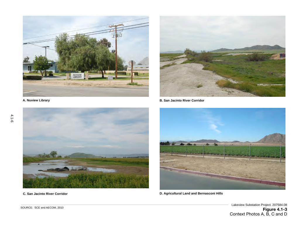
Figure 4.1-3Context Photos A, B, C and D
SOURCE: SCE and AECOM, 2010 Lakeview Substation Project. 207584.08
A. Nuview Library
B: San Jacinto River Corridor
Fiure 4.1-2 Context Photos A and B
Proponent’s Environmental Assessment Page 4.1-5 Lakeview Substation Project
A: Nuview Library
B. San Jacinto River Corridor
Figure 4.1-2 Context Photos A and B
Proponent’s Environmental Assessment Page 4.1-5 Lakeview Substation Project
C: San Jacinto River Corridor
D. Agricultural Land and Bernasconi Hills
Figure 4.1-3 Context Photos C and D
Page 4.1-6 Southern California Edison
4.1 AESTHETICS
C. San Jacinto River Corridor
4.1-6

Figure 4.1-4Context Photos E, F, G and H
SOURCE: SCE and AECOM, 2010 Lakeview Substation Project. 207584.08
E. Reservoir Avenue and 10th Street Residences
F: Nuevo Substation
Figure 4.1-4 Context Photos E and F
Proponent’s Environmental Assessment Page 4.1-7 Lakeview Substation Project
E: Reservoir Avenue and 10th Street Residences
F. Nuevo Substation
Figure 4.1-4 Context Photos E and F
Proponent’s Environmental Assessment Page 4.1-7 Lakeview Substation Project
G: Subtransmission Line along Pozos Road
H. Lakeview Avenue near Nuview Elementary School
Figure 4.1-5 Context Photos G and H
Page 4.1-8 Southern California Edison
4.1 AESTHETICS
G. Subtransmission Line along Pozos Road
4.1-7
4. Environmental Analysis 4.1 Aesthetics
Lakeview Substation Project 4.1-8 ESA / 207584.08 (A.10-09-016) Draft Environmental Impact Report January 2012
This highway serves as a major entrance to Lake Perris, one of the county's most important recreation areas. It passes the Bernasconi Hills, the San Jacinto River, the Mystic Lake corridor, the San Jacinto Wildlife area, and agricultural land, and provides a link with the Pines-to-Palms Highway, which is a state-designated scenic highway. It is also part of the auto tour route for the Juan Bautista de Anza National Historic Trail (NPS, undated). Due to its position at the base of the Bernasconi Hills, it offers panoramic views of the landscape and thus is considered to a location from which the public can experience and access scenic vistas.
Important Views and Visual Features
The Lakeview/Nuevo area affords views of various scenic vistas of the natural and human-modified landscape. In the visual study area, views of surrounding mountains and rock outcroppings are backdrops to visually unobstructed areas of flat, expansive agricultural lands and groupings of mature trees. The color, texture and form of these natural and human-modified landscape features visually contrast in a complimentary way, offering visual variety and form in the scene. The brown tones of the dry rock outcroppings and steep mountain ranges contrast with the flat, green, irrigated valley floor. Important visual elements and features identified in the Lakeview/Nuevo area plan are described below (Riverside County, 2008).
Lakeview Mountains: The Lakeview Mountains define the bulk of the central and southeastern portion of the Lakeview/Nuevo area and create a scenic backdrop in the visual study area. The mountains, which are dotted with picturesque rock outcroppings, gently slope west to the valley that contains the San Jacinto River. Juniper Flats, a small rural area, is located close to the Lakeview Mountains.
Bernasconi Hills: The Bernasconi Hills are located within the Lake Perris State Recreation Area. The southeastern face of the mountain range is within the visual study area and is characterized by barren, steep, and rugged peaks that are in stark contrast to the agricultural plain located along the San Jacinto River corridor. The hills offer opportunities for such outdoor recreational activities as camping, hunting, water sports, fishing, picnicking, and biking, and are an important scenic resource in the area.
San Jacinto River: The San Jacinto River flows westward from Lake Hemet in the Santa Rosa Mountains, through Canyon Lake, and then to Lake Elsinore. It flows through the central portion of the visual study area and has a profound influence over its land use patterns. Currently, the river is a semi-natural watercourse that is normally dry. In the vicinity of the Project area, the river is partially channelized with earthen levees. The lands adjacent to the river are currently vacant or agricultural in nature.
San Jacinto Wildlife Area: The San Jacinto Wildlife Area is nestled at the base of the Bernasconi Hills to the north of the project area. The San Jacinto Wildlife Area is comprised of over 5,945 acres of restored natural lands, including wetlands, and available activities include hiking, nature study, wildlife photography, in-season hunting, bird watching, horseback riding, and cycling. The access gate, office, and parking area are located approximately 3 miles north of the substation site along Davis Road (CDFG, 2011). The access area east of Davis Road is within the Project’s

4. Environmental Analysis 4.1 Aesthetics
Lakeview Substation Project 4.1-9 ESA / 207584.08 (A.10-09-016) Draft Environmental Impact Report January 2012
viewshed, but a large portion of the wildlife area, wetlands, and visitor facilities are behind a pair of hills that screens the Project area from view (California Waterfowl Association, 2007).
Visual Quality
Lakeview Substation Site
The Lakeview Substation Site is located in an agricultural field northwest of the intersection of 10th Street and Reservoir Avenue. The site itself is representative of the rural agricultural region and therefore has a moderate visual quality.
Subtransmission Source Line Route
The subtransmission source line route is located across agricultural land, the San Jacinto River corridor, and undeveloped open space areas between the San Jacinto River and the existing Valley-Moval 115 kV Subtransmission Line. The visual quality of the subtransmission source line route varies somewhat, and is representative of the rural/agricultural character of the region. Where it crosses the San Jacinto River corridor, the corridor is modified with earthen berms and is also representative of the appearance of the river corridor in the vicinity (see Figure 4.1-3, Photos B and C). In the context of the area’s visual character, the subtransmission source line route has a moderate visual quality.
Nuevo Substation and Model Pole Top Sites
The Nuevo Substation and Model Pole Top site are located at an existing substation (see Figure 4.1-4, Photo F). The site is indistinctive/industrial in appearance, and contrasts negatively with the predominantly rural/agricultural character of the area, and therefore has a low visual quality.
Affected Viewers and Exposure Conditions
The substation site and subtransmission source lines are located on the boundary between developed areas to the east and south (the communities of Lakeview and Nuevo) and an open space setting to the north and west (the San Jacinto River corridor, agricultural fields, and the Bernasconi Hills). Therefore, vantage points to the north and west offers mostly unobstructed views of the Project area; whereas vantage points to the south and east are generally screened by trees, buildings, and other structures in the communities of Lakeview and Nuevo. While Lakeview and Nuevo are within the Project’s viewshed, views of the substation and subtransmission source lines are restricted to streets and residences on the western fringe of these communities. Potentially affected viewers and the Project area’s visual exposure are described below.
Motorists
The only relevant scenic roadway in the visual study area is the Ramona Expressway, which is designated as a scenic corridor by Riverside County due to its open and unobstructed views of the surrounding hills, the San Jacinto River, and surrounding agricultural land. Ramona Expressway is a major two-lane undivided road that carries 12,000 to 18,000 vehicles per day, which is

4. Environmental Analysis 4.1 Aesthetics
Lakeview Substation Project 4.1-10 ESA / 207584.08 (A.10-09-016) Draft Environmental Impact Report January 2012
considered a moderate viewer volume. The Project area is expected to be visible in the middleground and background for approximately 3.5 miles as the road follows the base of the Bernasconi Hills. This translates to a view duration of approximately 4 minutes, assuming a vehicle travel speed of 50 miles per hour. Motorists on Ramona Expressway would not experience close-range views of the subtransmission source line because it would tie into the existing Valley-Moval 115kV Subtransmission Line, located over 0.5 mile south of the expressway. Other roads from which the Project area would be visible are local roads on the west side of Lakeview and Nuevo, such as Reservoir Avenue and the western end of 9th through 13th streets.
Recreational Facility Users
There are several trails within the visual study area that are accessible to the public. An existing trail runs along the San Jacinto River, which would be crossed by the subtransmission source line route. Current recreational use of the river corridor is informal, as legal access points and easements have not yet been secured by the County (SCE, 2010). During site visits in October 2009 and March 2010, no visitors were observed along the river corridor or in the general area, suggesting only infrequent use of this trail (SCE, 2010). While use of the trail appears to be low, the San Jacinto River corridor is identified in the Lakeview/Nuevo area plan as an important scenic resource, and therefore users of the trail are likely to be sensitive to visual changes within the corridor. Based on the average human walking speed and the distance along the trail where views of the substation or subtransmission source line route would be available, it is estimated that a typical trail user would experience views of the project for about a half an hour, although foreground views would be experience for a much briefer period.
Nearby state recreational areas, such as the Lake Perris State Recreational Area and the San Jacinto Wildlife Area, may currently serve the recreation needs of most residents, given their close proximity. The Lake Perris State Recreational Area is largely outside the visual study area of the Project due to screening provided by the Bernasconi Hills. However, visitors to the lake would have brief background views of the Project area as they exit the recreational area on Bernasconi Road. A large portion of the San Jacinto Wildlife Area is within the Project’s viewshed, but all of the wildlife area’s main attraction (the wetlands and associated wildlife) and visitor-serving facilities (trails, restrooms, etc.) are behind a pair of hills that screens the Project area from view (California Waterfowl Association, 2007). The only area from which the Project would be visible would be the entrance gate and parking area along Davis Road. Therefore, similar to the Lake Perris State Recreational Area, visitors to the San Jacinto Wildlife Area could have brief background or middleground views of the Project area as they exit the recreational area in their vehicles.
Visual Sensitivity
KOPs were established to provide a representative cross section of the how the public perceives the affected landscape. KOPs were selected based on the Project’s viewshed, visual exposure and important viewer groups (as described above). The locations of the KOPs are shown in Figure 4.1-2. Side- by-side photographs from the KOPs of the existing view and of the Project

4. Environmental Analysis 4.1 Aesthetics
Lakeview Substation Project 4.1-11 ESA / 207584.08 (A.10-09-016) Draft Environmental Impact Report January 2012
simulated in the view are provided in Figures 4.1-5 through 4.1-12. These KOPs provide the basis for showing the visual character and quality of views towards the Project site (analysis of the visual changes introduced by the Project is provided in impact analysis, Section 4.1-4).
As defined above, visual sensitivity is a composite measurement of the overall susceptibility of an area or viewer group to adverse visual or aesthetic impacts given the combined factors of landscape visual quality, viewer types, and exposure conditions. Table 4.1-1 summarizes the visual sensitivity of the major viewer types that would be affected by the Project. The visual sensitivity of the elements from the motorist’s perspective ranges from low to moderate, although primarily on the low side. However, the visual sensitivity of the Project as viewed from parks and trails is generally in the moderate-to-high range due to the change
TABLE 4.1-1 SUMMARY OF VISUAL SENSITIVITY FINDINGS:
VIEWER TYPES, VISUAL EXPOSURES, AND VISUAL QUALITY
Primary Viewer Type Visual Quality View Exposure
Visual Sensitivity Visible Elements
Motorists on Riverside County Scenic Corridor (Ramona Expressway) KOP 1 Representative Middleground to Background Distance
Slightly Obstructed View Moderate Number of Viewers Short View Duration
Low to Moderate
Subtransmission Source Line and Substation Site
KOP 2 Representative Middleground to Background Distance Slightly Obstructed View Moderate Number of Viewers Short View Duration
Low to Moderate
Subtransmission Source Line and Substation Site
KOP 3 Representative Middleground Distance Unobstructed View Moderate Number of Viewers Short View Duration
Low to Moderate
Subtransmission Source Line
San Jacinto Informal Trail Users KOP 4 Representative Foreground or Middleground Distance
Unobstructed View Low Number of Viewers Moderate View Duration
Moderate Subtransmission Source Line and Substation Site
Local Motorists KOP 5 Representative Middleground Distance
Partially-Obstructed View Low/Moderate Number of Viewers Long View Duration
Moderate Subtransmission Source Line
KOP 6 Representative Middleground Distance Partially-Obstructed View Low Number of Viewers Long View Duration
Moderate Subtransmission Source Line and Substation Site
KOP 7 Representative Foreground Distance Unobstructed View Low Number of Viewers Long View Duration
Moderate to High
Subtransmission Source Line and Substation Site
KOP 8 Representative Foreground Distance Unobstructed View Low Number of Viewers Long View Duration
Moderate to High
Subtransmission Source Line and Substation Site
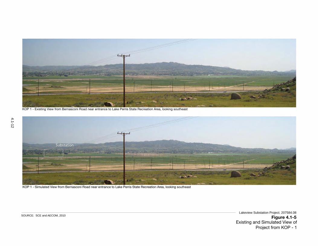
Proponent’s Environmental Assessment Lakeview Substation Project
Figure 4.1-6a KOP 1 – Existing View from Bernasconi Hills
Figure 4.1-6b KOP 1 – Simulated View from Bernasconi Hills
Figure 4.1-5Existing and Simulated View of Project from KOP - 1
SOURCE: SCE and AECOM, 2010 Lakeview Substation Project. 207584.08
KOP 1 - Existing View from Bernasconi Road near entrance to Lake Perris State Recreation Area, looking southeast
KOP 1 - Simulated View from Bernasconi Road near entrance to Lake Perris State Recreation Area, looking southeast
4.1-12

Proponent’s Environmental Assessment Lakeview Substation Project
Figure 4.1-7b KOP 2 – Simulated Eastward View from Ramona Expressway
Figure 4.1-7a KOP 2 – Existing Eastward View from Ramona Expressway
Figure 4.1-6Existing and Simulated View of Project from KOP - 2
SOURCE: SCE and AECOM, 2010 Lakeview Substation Project. 207584.08
KOP 2 - Existing View from Ramona Expressway, looking east
KOP 2 - Simulated View from Ramona Expressway, looking east
4.1-13

Proponent’s Environmental Assessment Lakeview Substation Project
Figure 4.1-8b KOP 3 – Simulated Southeastward View from Ramona Expressway
Figure 4.1-8a KOP 3 – Existing Southeastward View from Ramona Expressway
Figure 4.1-7Existing and Simulated View of Project from KOP - 3
SOURCE: SCE and AECOM, 2010 Lakeview Substation Project. 207584.08
KOP 3 - Existing View from Ramona Expressway (at intersection of Bernasconi Road), looking southeast
KOP 3 - Simulated View from Ramona Expressway (at intersection of Bernasconi Road), looking southeast
4.1-14

Figure 4.1-8Existing and Simulated View of Project from KOP - 4
SOURCE: SCE and AECOM, 2010 Lakeview Substation Project. 207584.08
KOP 4 - Existing View from informal recreational trail along San Jacinto River, facing east
KOP 4 - Simulated View from informal recreational trail along San Jacinto River, facing east
4.1-15
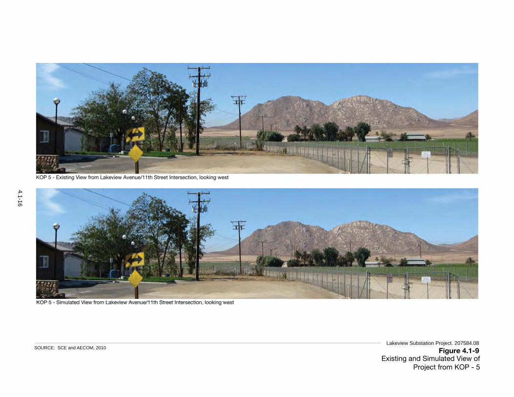
Proponent’s Environmental Assessment Lakeview Substation Project
Figure 4.1-10a KOP 5 – Existing View from Lakeview Avenue/11th Street Intersection
Figure 4.1-10b KOP 5 – Simulated View from Lakeview Avenue/11th Street Intersection
Figure 4.1-9Existing and Simulated View of Project from KOP - 5
SOURCE: SCE and AECOM, 2010 Lakeview Substation Project. 207584.08
KOP 5 - Existing View from Lakeview Avenue/11th Street Intersection, looking west
KOP 5 - Simulated View from Lakeview Avenue/11th Street Intersection, looking west
4.1-16

Proponent’s Environmental Assessment Lakeview Substation Project
Figure 4.1-11a KOP 6 – Existing View from Nuview Elementary School
Figure 4.1-11b KOP 6 – Simulated View from Nuview Elementary School
Figure 4.1-10Existing and Simulated View of Project from KOP - 6
SOURCE: SCE and AECOM, 2010 Lakeview Substation Project. 207584.08
KOP 6 - Existing View from Nuview Elementary School, looking northwest
KOP 6 - Simulated View from Nuview Elementary School, looking northwest
4.1-17
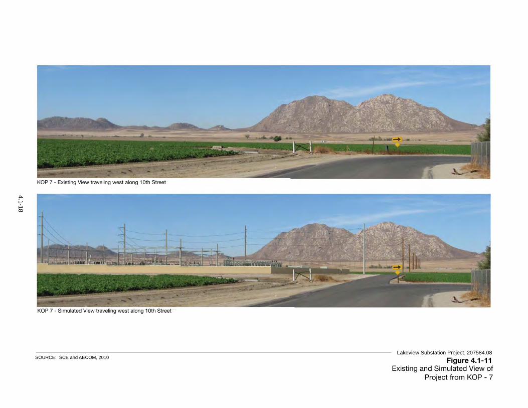
Proponent’s Environmental Assessment Lakeview Substation Project
Figure 4.1-12b KOP 7 – Simulated Northwestward View from 10th Street
Figure 4.1-12a KOP 7 – Existing Northwestward View from 10th Street
Figure 4.1-11Existing and Simulated View of Project from KOP - 7
SOURCE: SCE and AECOM, 2010 Lakeview Substation Project. 207584.08
KOP 7 - Existing View traveling west along 10th Street
KOP 7 - Simulated View traveling west along 10th Street
4.1-18

Proponent’s Environmental Assessment Lakeview Substation Project
Figure 4.1-13b KOP 8 – Simulated Southwestward View from Reservoir Avenue
Figure 4.1-13a KOP 8: Existing Southwestward View from Reservoir Avenue
Figure 4.1-12Existing and Simulated View of Project from KOP - 8
SOURCE: SCE and AECOM, 2010 Lakeview Substation Project. 207584.08
KOP 8 - Existing View traveling south on Reservoir Avenue
KOP 8 - Simulated View traveling south on Reservoir Avenue
4.1-19

4. Environmental Analysis 4.1 Aesthetics
Lakeview Substation Project 4.1-20 ESA / 207584.08 (A.10-09-016) Draft Environmental Impact Report January 2012
Regulatory Setting
California Scenic Highway Program
In 1963, the California legislature created the Scenic Highway Program to protect scenic highway corridors from changes that would diminish the visual value of lands adjacent to the highways. The State regulations and guidelines governing the Scenic Highway Program are found in the Streets and Highways Code, §260 et seq. A highway may be designated as “scenic” depending on how much of the natural landscape can be seen by travelers, the scenic quality of the landscape, and the extent to which development intrudes upon the travelers’ enjoyment of the view. No portion of the Project would be visible from a state-designated scenic highway.
Riverside County General Plan
CPUC General Order No. 131-D explains that local land use regulations would not apply to the Project. However, CPUC staff considered the following policies identified in the General Plan to identify visual resources and inform the determination of significance thresholds in the study area:
Multipurpose Open Space Element
Scenic Resources. Scenic resources are an important quality of life component for residents of Riverside County (Riverside County, 2003a). In general, scenic resources include areas that are visible to the general public and are considered visually attractive. In addition to scenic corridors described below, scenic resources include natural landmarks and prominent or unusual features of the landscape. For example, Santa Rosa National Monument includes mountains or other natural features with high scenic value. Scenic backdrops include hillsides and ridges that rise above urban or rural areas or highways. Scenic vistas are points, accessible to the general public, that provide a view of the countryside. The following policies intend to protect these resources and ensure that future development enhances them.
Policy OS 21.1: Identify and conserve the skylines, view corridors, and outstanding scenic vistas within Riverside County.
Scenic Corridors. Many roadway corridors in Riverside County traverse its scenic resources. Enhancing aesthetic experiences for residents and visitors to the county promotes tourism, which is important to the county's overall economic future. Enhancement and preservation of the county's scenic resources will require careful application of scenic highway standards along Official Scenic Routes. State and county eligible and designated scenic highways are included and mapped in the General Plan, as well as in the area plans where scenic corridors are located.
The following Multipurpose Open Space Element policies aim to protect and maintain resources in corridors along scenic highways:
Policy OS 22.1: Design developments within designated scenic highway corridors to balance the objectives of maintaining scenic resources with accommodating compatible land uses.

4. Environmental Analysis 4.1 Aesthetics
Lakeview Substation Project 4.1-21 ESA / 207584.08 (A.10-09-016) Draft Environmental Impact Report January 2012
Policy OS 22.3: Encourage joint efforts among federal, state, and county agencies, and citizen groups to ensure compatible development within scenic corridors.
Policy OS 22.4: Impose conditions on development within scenic highway corridors requiring dedication of scenic easements consistent with the Scenic Highways Plan, when it is necessary to preserve unique or special visual features.
Land Use Element
Riverside County contains abundant natural visual resources, including low-lying valleys, mountain ranges, rock formations, rivers, and lakes (Riverside County, 2003b). These features are often enjoyed via the county's many roadways. Due to the visual significance of many of these areas, several roadways have been officially recognized as either state or county eligible or designated scenic highways. These roadways are depicted in the Circulation Element as well as within each of the 19 area plans, where applicable. The intent of the Land Use Element policies is to conserve significant scenic resources along designated scenic highways for future generations and to manage development along scenic highways and corridors so as not to detract from the area's scenic quality. Relevant Land Use Element policies include:
Policy LU 13.1: Preserve and protect outstanding scenic vistas and visual features for the enjoyment of the traveling public.
Policy LU 13.3: Ensure that the design and appearance of new landscaping, structures, equipment, signs, or grading within Designated and Eligible State and County Scenic Highway corridors are compatible with the surrounding scenic setting or environment.
Policy LU 13.5: Require new or relocated electric or communication distribution lines, which would be visible from Designated and Eligible State and County Scenic Highways, to be placed underground.
Policy LU 13.8: Avoid the blocking of public views by solid walls.
Circulation Element
Many corridors in Riverside County traverse its scenic resources (Riverside County, 2003c). Enhancing aesthetic experiences for residents and visitors to the county has a significant role in promoting tourism, which is important to the county's overall economic future. Due to the visual significance of some of these areas within the county, several roadways have been officially recognized as either state or county eligible or designated scenic highways. Enhancement and preservation of the county's scenic resources will require careful application of scenic highway standards along Official Scenic Routes. Relevant Circulation Element policies include:
Policy C 19.1: Preserve scenic routes that have exceptional or unique visual features in accordance with Caltrans' Scenic Highways Plan.
Policy C 25.2: Locate new and relocated utilities underground when possible. All remaining utilities shall be located or screened in a manner that minimizes their visibility by the public.

4. Environmental Analysis 4.1 Aesthetics
Lakeview Substation Project 4.1-22 ESA / 207584.08 (A.10-09-016) Draft Environmental Impact Report January 2012
Lakeview/Nuevo Area Plan
The Ramona Expressway is identified as a county eligible scenic highway in the Lakeview/Nuevo Area Plan (Riverside County, 2008). The Ramona Expressway serves as a major entrance to Lake Perris, one of the county's most important recreation areas. It passes the Bernasconi Hills, San Jacinto River, Mystic Lake corridor, San Jacinto Wildlife Area, and agricultural land, and provides a link with the Pines-to-Palms Highway, which is a state designated scenic highway. A relevant Lakeview/Nuevo Area Plan policy includes the following:
Policy LNAP 10.1: Protect the scenic highways in the Lakeview/Nuevo planning area from change that would diminish the aesthetic value of views of the Bernasconi Hills, the San Jacinto River, the Mystic Lake Corridor, and the San Jacinto Wildlife Area in accordance with the Scenic Highways section of the General Plan Land Use, Multipurpose Open Space, and Circulation Elements.
County of Riverside Code of Ordinances
Regulating Light Pollution (Riverside County Ordinance No. 655)
The Project area falls within the Mount Palomar Nighttime Lighting Policy Area. The Mount Palomar Observatory is located in San Diego County approximately 34 miles from the Project (SEC, 2010). The observatory requires unique nighttime lighting standards in order to allow the night sky to be viewed clearly. All areas within a 15 to 45 mile “Ring Analysis” area of the observatory must conform with the nighttime lighting regulations that apply to Zone B in the County of Riverside General Plan. The Project must adhere to the lighting requirements of Riverside County Ordinance No. 655 for standards that are intended to limit light leakage and spillage that may interfere with the operations of the Mount Palomar Observatory. The ordinance lists permitted lighting fixtures and uses. The ordinance also requires that temporary uses of lights for construction obtain approval from the county.
Abatement of Graffiti (Riverside County Ordinance No. 704)
Whenever the Director of Building and Safety or his/her designated representative, determines that graffiti is so located on public or private property within the unincorporated areas of Riverside County so as to be capable of being viewed by persons utilizing any public right-of-way in the county, the Director of Building and Safety or his/her designated representative is authorized to provide for the removal of the graffiti at the county's expense, provided the consent of the property owner, public or private, is obtained.
4.1.2 Significance Criteria According to Appendix G of the CEQA Guidelines, significant aesthetic effects on the environment would occur if implementation of the Project or alternatives would:
a) Have a substantial adverse effect on a scenic vista;
b) Substantially damage scenic resources, including, but not limited to, trees, rock outcroppings, and historic buildings within a state scenic highway;

4. Environmental Analysis 4.1 Aesthetics
Lakeview Substation Project 4.1-23 ESA / 207584.08 (A.10-09-016) Draft Environmental Impact Report January 2012
c) Substantially degrade the existing visual character or quality of the site and its surroundings; or
d) Create a new source of substantial light or glare that would adversely affect day or nighttime views in the area.
Definition and Use of Significance Criteria
The aesthetic impact analysis is based on the Project PEA (SCE, 2010); review of a variety of data, including Project maps and drawings; aerial and ground-level photographs of the Project area; simulations of the Project within photographs; and a variety of data in the record, such as local planning documents. The analysis identifies potential temporary (short-term) and permanent (long-term) Project impacts on scenic vistas or the visual character and quality of a site as seen from KOPs. The definition and use of each significance criterion is briefly clarified below:
Have a substantial adverse effect on a scenic vista: This criterion is applicable only to projects that would be located on or disrupt access to a scenic vista, or result in visual changes within its viewshed. Scenic vistas may be officially recognized or designated (e.g., within local planning documents or the Caltrans scenic highway program), or they may be informal in nature (e.g., mountain peaks or coastal bluffs). The Project’s effect would be considered substantial if it would appreciably damage or remove the visual qualities that make the view unique, unobstructed and/or exemplary.
Substantially damage scenic resources, including, but not limited to, trees, rock outcroppings, and historic buildings within a state scenic highway: Damage to a scenic resource within a state scenic highway is substantial when it is reasonably perceptible to affected viewers; and when it appreciably degrades one or more of the aesthetic qualities or features that make views from a state scenic highway particularly unique and distinctive.
Substantially degrade the existing visual character or quality of the site and its surroundings: Table 4.1-2 provides guidelines to assist in evaluating effects of the Project on the visual character or quality of an area, and is based on the visual sensitivity of an area and the degree of overall visual change introduced by the Project. The key factors in determining the overall visual change are visual contrast, dominance, and view blockage. Specifically, an adverse visual impact may occur when: (1) an action perceptibly and substantially changes the existing physical features of the landscape that are characteristic of the region or locale; (2) an action introduces new features to the physical landscape that are perceptibly uncharacteristic of the region or locale, or become visually dominant from common viewpoints; or (3) an action blocks or totally obscures aesthetic features of the landscape. The degree of visual impact depends on how noticeable the adverse change is and the related visual sensitivity (established in the setting).
Create a new source of substantial light or glare which would adversely affect day or nighttime views in the area: This criterion is applicable to projects that require nighttime lighting (either during construction or operation), or that involve structures or finishes that could create substantial glare.

4. Environmental Analysis 4.1 Aesthetics
Lakeview Substation Project 4.1-24 ESA / 207584.08 (A.10-09-016) Draft Environmental Impact Report January 2012
TABLE 4.1-2 GUIDELINES FOR DETERMINING AESTHETIC IMPACT SIGNIFICANCE
Overall Visual Sensitivity
Overall Visual Changea
Low Low to
Moderate Moderate Moderate to
High High
Low Not Significant Not Significant Adverse, but Not Significant
Adverse, but Not Significant
Adverse, but Not Significant
Low to Moderate Not Significant Adverse, but Not Significant
Adverse, but Not Significant
Adverse, but Not Significant
Adverse, but Not Significant
Moderate Adverse, but Not Significant
Adverse, but Not Significant
Adverse, but Not Significant
Adverse and Potentially Significant
Adverse and Potentially Significant
Moderate to High Adverse, but Not Significant
Adverse, but Not Significant
Adverse and Potentially Significant
Adverse and Potentially Significant
Significant
High Adverse, but Not Significant
Adverse and Potentially Significant
Adverse and Potentially Significant
Significant Significant
a Aesthetic impact significance is defined as:
Not Significant impacts may or may not be perceptible but are considered minor in the context of existing landscape characteristics and view opportunity. Adverse but Not Significant Impacts are perceived as negative but the perceived change is not substantial. Adverse and Potentially Significant Impacts are perceived as negative and may be considered substantial depending on project- and site-specific circumstances. Significant impacts would be substantial.
No Impact Significance Determinations
Due to the nature of the Project, there would be no impact related to the following criterion for the reason stated below:
Substantially damage scenic resources, including, but not limited to, trees, rock outcroppings, and historic buildings within a state scenic highway: As discussed in the setting, there are no designated state scenic highways within the visual study area. Therefore there would be no impact to scenic resources, including, but not limited to, trees, rock outcroppings, and historic buildings within a state scenic highway.
Further, the telecommunications facilities are not discussed in the impact analysis because they would either be placed underground or would following existing or proposed Subtransmission line routes. Because the fiber optic cables would not be visible or would follow existing utility lines, the telecommunications facilities would have a less-than-significant impact with respect to all visual resources significance criteria.

4. Environmental Analysis 4.1 Aesthetics
Lakeview Substation Project 4.1-25 ESA / 207584.08 (A.10-09-016) Draft Environmental Impact Report January 2012
4.1.3 Applicant Proposed Measures SCE identified the following APM to avoid or reduce potential impacts of the Project related to aesthetics:
APM Aesthetics-1 (Prepare a Landscaping Plan): SCE will prepare a landscaping plan consistent with Riverside County standards, as well as SCE standards to filter views of the substation for the surrounding community and other potential sensitive receptors.
4.1.4 Impacts and Mitigation Measures
a) Have a substantial adverse effect on a scenic vista.
Impact 4.1-1: The Project would have a less than significant adverse effect on a scenic vista. Less than Significant (Class III)
While there are no officially designated scenic vista points in the Project area, the Ramona Expressway is designated as a local scenic highway by Riverside County. The Ramona Expressway is slightly elevated relative to the valley floor and offers southeast views of the Lakeview Mountains in the background and the San Jacinto River corridor and adjacent agricultural lands in the foreground and middleground. To the northwest, motorists have foreground views of the steeply-rising Bernasconi Hills. This impact discussion is based on KOPs 1 through 3, which show views towards the Project area from several vantage points along and near the expressway (see Figures 4.1-5 through 4.1-7).
KOPs 1 though 3
For the purpose of this analysis, views from the Ramona Expressway as well as for hikers along the southeastern face of the Bernasconi Hills are considered as informal scenic vistas. This is because these represent high-quality panoramic views of large breadth and depth from elevated vantage points. The visual impacts of construction and operation of the Project on these scenic vistas are described below.
Construction
Visual disturbances associated with construction activity would include the presence of vehicles, heavy equipment, and workers at facility construction/decommissioning sites, staging/laydown areas, and marshalling yards (see Table 2-4 for a list of construction-related equipment). Site preparation and grading during Project construction would also cause visual disturbance through the removal of existing vegetation and the creation of a visual contrast with the surrounding area. As stated in the Chapter 2, Project Description, water trucks would be used to minimize the quantity of airborne dust created by construction activities, which would avoid or minimize the presence of visible dust plumes. Project construction would last approximately 12 months.
It is unlikely that a casual observer on Ramona Expressway would notice the visual disturbances associated with construction of the Lakeview Substation (Figures 4.1-5 through 4.1-7). Construction activities associated with the substation would be located in background views and

4. Environmental Analysis 4.1 Aesthetics
Lakeview Substation Project 4.1-26 ESA / 207584.08 (A.10-09-016) Draft Environmental Impact Report January 2012
would constitute a minor element in views of the valley. Aside from the substation site’s small scale (as seen from Ramona Expressway), it is located on the edge of the developed Lakeview/Nuevo area, reducing its contrast with the surrounding landscape. Views would remain dominated by other visually appealing elements such as the San Jacinto River corridor and adjacent agriculture, the sky, and the distant mountains. For these reasons, visual disturbances due to construction activity at the Lakeview Substation site would have little to no adverse impact on scenic vistas available from Ramona Expressway.
Visual disturbances associated with construction of the subtransmission source line, however, would be more apparent because it would cross the flat valley floor, would involve visual elements uncharacteristic of the agricultural character of the region, and would be located a shorter distance away from the expressway. As shown in Figures 4.1-5 through 4.1-7, portions of the subtransmission source line would be located close enough to the expressway that construction activities (e.g., installation of equipment, movement of supplies, presence of trucks and work crews) are likely to be visible and potentially perceived negatively by passing motorists and/or visitors. However, construction activity and associated visual disturbances would not occur along the entire subtransmission source line route at the same time, but instead would proceed incrementally along the route as wood poles and TSPs are installed. Aside from construction activities being temporary, the extent of visual disturbance at any one time would be minor. For these reasons, visual disturbances due to construction activity along the subtransmission source line route would have a minor adverse impact on scenic vistas available from Ramona Expressway and the Bernasconi Hills.
Decommissioning of the Nuevo Substation and Model Pole Top would also involve visual disturbances due to the presence of heavy equipment, vehicles, workers, and dismantling of existing structures. These visual disturbances may be visible for motorists looking south on Ramona Expressway near Lakeview Avenue. However, the existing substation site is indistinctive and industrial in appearance with a low visual quality. Decommissioning activities are unlikely to be perceived negatively by the motorists because it is an exiting site with low visual quality and similar construction activities are not uncharacteristic of developed areas. Decommissioning activities for the Nuevo Substation and Model Pole Top would not be visible or would be indistinguishable from other background elements as viewed from other places along Ramona Expressway and the Bernasconi Hills.
For the above reasons, Project construction would have a less-than-significant impact on scenic vistas.
Operation and Maintenance
For similar reasons discussed for construction of the Project, the long-term presence of the substation and transmission source line would have less than significant impacts on the informal scenic vistas. The visibility of the Lakeview Substation would be low and would therefore constitute a minor element in views from scenic vistas.
4. Environmental Analysis 4.1 Aesthetics
Lakeview Substation Project 4.1-27 ESA / 207584.08 (A.10-09-016) Draft Environmental Impact Report January 2012
As shown in Figure 4.1-5 through 4.1-7, the presence of the subtransmission source line would be perceptible and would slightly detract from the view quality available from the scenic vista points. The TSP and wood poles would add some degree of visual clutter in views of the valley floor and would have a slightly negative effect on the simplicity, coherence and intactness of the valley floor and the San Jacinto River corridor. However, the existing presence of transmission lines already slightly detracts from the scene, and the visual change associated with the subtransmission source line route is not substantial enough to appreciably damage or remove the visual qualities that make the view pleasing. Further, motorists along the expressway would only be exposed to the view for about 4 minutes. Views would remain dominated by other visually appealing elements such as the San Jacinto River corridor and adjacent agriculture, the sky, and the distant mountain ranges.
Decommissioning of the Nuevo Substation and Model Pole Top would have a beneficial visual impact because it would remove industrial elements that are currently out of character with the rural/agricultural character of the region.
For the above reasons, operation and maintenance of the Project would have a less-than-significant impact on scenic vistas.
Mitigation: None required.
c) Substantially degrade the existing visual character or quality of the site and its surroundings.
Impact 4.1-3: The Project could substantially degrade the existing visual character or quality of the site and its surroundings. Less than Significant (Class III)
The effect of Project construction and operation on views from Ramona Expressway and the southeast side of the Bernasconi Hills have been addressed in Impact 4.1-1, which concludes that adverse visual effects due to the Project would be less than significant. The type of visual disturbances due to construction activities were also described under Impact 4.1-1, although the scale and dominance of construction-related visual disturbances would vary depending on the affected viewer and their perspective. This impact discussion focuses on KOPs 4 through 8 (Figures 4.1-8 through 4.1-12), which provides simulations of the Project’s appearance during operation from vantage points that represent views for motorists and recreationalists. Because construction activity would be temporary, and because the finished Project would involve visual changes that are equal or greater in magnitude than during construction, this analysis focuses on potential adverse visual effects of Project operation on the existing visual character or quality of the site and its surroundings.
As discussed in the setting, the viewers affected by visual changes introduced by the Project would be motorists on local roads in proximity to the substation and users of the informal recreational trail along the San Jacinto River. The following five KOPs, presented in Figures 4.1-8 through 4.1-12,
4. Environmental Analysis 4.1 Aesthetics
Lakeview Substation Project 4.1-28 ESA / 207584.08 (A.10-09-016) Draft Environmental Impact Report January 2012
were chosen as representative of how the Project would appear for these viewers. Each KOP is analyzed in the context of the site’s visual sensitivity and the visual changes caused by the Project (i.e., the visual contrast with the area’s predominant landscape elements and features, the dominance in views relative to other existing features, and the degree to which Project features could block or obscure views of aesthetically pleasing landscape elements).
KOP 4, View from Informal Recreational Trail along San Jacinto River
Figure 4.1-8 presents an existing and simulated view of the Project from the informal recreational trail along the San Jacinto River. From this vantage point and others along the trail, the Lakeview Substation would be low profile and located along with other developed areas of Lakeview. While the substation may represent a noticeable visual change for particularly observant users of the trail, it is unlikely to be perceived negatively because it does not block or obscure views of attractive landscape elements, and its width is approximately coincident with the existing horizon between the river plain and the distant mountains. Furthermore, the portion of the view affected would be minor due to the substation’s small scale from this vantage point. APM Aesthetics-1 would reduce the color contrast of the substation perimeter wall with the surrounding area by landscaping the outer perimeter with green shrubs and trees that would be more compatible with the rural residential and agricultural surroundings.
The subtransmission source line, however, is more noticeable and would cross the trail at two locations. Because the substransmission source line has little mass, it would not block or obscure views of scenic resources, such as the distant mountains, sky, and the river corridor. However, the vertical and horizontal lines introduced by the wood poles, TSPs, and the conductors would introduce visual elements that would slightly diminish the integrity and coherence of the existing view. Although there are several existing subtransmission and distribution lines visible from the San Jacinto River corridor, the new subtransmission source line would be located in an area that currently features minimal visual clutter (i.e., straight, geometric and complex forms and lines). The subtransmission source line would represent a low to moderate degree of visual change to the existing character and visual quality of the site. Although the visual clutter introduced by the subtransmission source line represents a moderate visual contrast with other landscape elements, the degree of view blockage and the dominance of the feature in the landscape are low.
Per Table 4.1-2, the effect of the Project on the visual character and quality of the site is adverse, but not significant from KOP 4 because the visual sensitivity is moderate and the degree of visual change is low to moderate.
KOP 5, View from Lakeview Avenue / 11th Street Intersection
Figure 4.1-9 presents an existing and simulated view of the subtransmission source line from Lakeview Avenue and 11th Street. KOP 5 represents views from the street for local motorists and pedestrians. The wood poles, TSPs, and conductors would have a similar visual effect as described above for KOP 4. However, in the context of this KOP, the adverse effect is less pronounced due to the presence of existing distribution lines and other visual clutter associated with the rural residential development. Existing trees, irrigated agricultural land, and the Bernasconi Hills remain the dominant visual elements from this viewpoint. The subtransmission

4. Environmental Analysis 4.1 Aesthetics
Lakeview Substation Project 4.1-29 ESA / 207584.08 (A.10-09-016) Draft Environmental Impact Report January 2012
source line would represent a low degree of visual change to the existing character and visual quality of the site because it does not block, obscure, or substantially diminish the aesthetic value of the scenic elements of the view, and it has a low visual contrast within the existing view.
Per Table 4.1-2, the effect of the Project on the visual character and quality of the site is adverse, but not significant from KOP 5 because the visual sensitivity is moderate and the degree of visual change is low.
KOP 6, View from Nuview Elementary School
Figure 4.1-10 presents an existing and simulated view of the Lakeview Substation and subtransmission source line from Lakeview Elementary School. KOP 6 represents views for users of the elementary school, and approximates views that might be experienced by nearby motorists. The view from this elementary school, located at the edge of town, is dominated and characterized by the wide open agricultural lands in the foreground and the Bernasconi Hills in the background. The bus parking yard, chain link fence, and bare earth are existing visual elements that minimally detract from the quality and coherence of the view. The Project elements would have the effect of adding visual clutter in the landscape, further detracting from the integrity, simplicity, and coherence of the view. The proximity of the Lakeview Substation from this vantage point increases its apparent mass compared to more distant KOPs; however, it is still approximately coincident with the horizon line between the valley floor and the Bernasconi Hills, which diminishes its visual contrast in the landscape. The Project would represent a moderate degree of visual change to the existing character and visual quality of the site because both the subtransmission line and the substation have moderate visual contrast within the existing view, the scale and dominance of the substation is moderate, and the Project results in an incremental increase in the degree and extent of existing visual obstructions.
Per Table 4.1-2, the effect of the Project on the visual character and quality of the site is adverse, but not significant from KOP 6 because the visual sensitivity is moderate and the degree of visual change is also moderate. APM Aesthetics-1 would reduce the color contrast of the substation perimeter wall with the surrounding area by landscaping the outer perimeter, thereby placing green shrubs and trees that would be more compatible with the rural residential and agricultural surroundings and discouraging graffiti.
KOPs 7 and 8, Views from 10th Street and Reservoir Avenue
Figure 4.1-11 and Figure 4.1-12 present an existing and simulated view of the substation and subtransmission source line from 10th Street and Reservoir Avenue, respectively. KOPs 7 and 8 represent views for users of the local roadways, and approximate views that might be experienced by users of these local roads. These KOPs are closest to the Lakeview Substation and the combination of vertical forms introduced by wood poles, TSPs, switchracks, and transformer banks; and the mass and color contrast introduced by the perimeter wall result in substantial blockage and screening of views of the San Jacinto River corridor, adjacent agricultural fields and the mountainous backdrop created by the Bernasconi Hills. The visual clutter as seen from close range is substantial enough that the visually appealing elements of the scene no longer dominate in the view, and the visual features of the Project would be negatively perceived by affected

4. Environmental Analysis 4.1 Aesthetics
Lakeview Substation Project 4.1-30 ESA / 207584.08 (A.10-09-016) Draft Environmental Impact Report January 2012
viewers. For these reasons, the degree of visual change introduced by the Project would be high because of the Project’s dominance, degree of view blockage, and high visual contrast.
Per Table 4.1-2, the effect of the Project on the visual character and quality of the site would be significant from KOPs 7 and 8 because the visual sensitivity is moderate to high and the degree of visual change is high. However, KOPs 7 and 8 do not include simulation of the landscape plan (APM Aesthics-1) which includes installation of a perimeter landscape on the outside of the substation’s block wall. This would improve the appearance of the proposed Lakeview Substation by reducing the color contrast of the block wall, introducing natural features that would aid in blending the substation wall in with the surroundings, and discouraging graffiti. Further, the landscape and wall plans would be submitted for review by the local jurisdiction, which could add further conditions and stipulations with respect to aesthetics. A well-designed perimeter wall and landscape would improve the appearance of the site and noticeably reduce its visual contrast with the surrounding area, but it would not reduce the project’s degree of view blockage or its dominance. This is because the substation’s perimeter and the dense collection of industrial forms (such as the wood poles, TSPs, switchracks, and transformer banks) would continue to block views of scenic resources that are normally visible in the middleground and background, and the landscape perimeter would not successfully conceal the industrial character of the site, due to the extent to which the TSPs and substation structures would extend above the top of the perimeter wall and landscape.
For the above reasons, the Project’s degree of visual change would be moderate-to-high level. Per Table 4.1-2, the effect of the Project on the visual character and quality of the site would be adverse and potentially significant (i.e., it may be considered significant depending on Project- and site-specific circumstances). The intersection of Reservoir Avenue and 10th Street is not highly traveled, and most motorists passing through the area experience these views only briefly as they pass the site. Based on these site specific circumstances, it is concluded that the Project would have a less-than-significant impact on the visual character and quality of the site for local motorists.
Nuevo Substation and Model Pole Top
Decommissioning of the Nuevo Substation and Model Pole Top would result in removal of existing electrical equipment/infrastructure that would no longer be needed once the Project is implemented. Removal of this material would leave the Nuevo Substation site in a less developed state, thereby rendering it more visually compatible with its immediate surroundings. This would be a beneficial impact of the Project.
Mitigation: None required.

4. Environmental Analysis 4.1 Aesthetics
Lakeview Substation Project 4.1-31 ESA / 207584.08 (A.10-09-016) Draft Environmental Impact Report January 2012
d) The Project could create a new source of light and glare that could adversely affect views in the area.
Impact 4.1-4: The Project would introduce new sources of substantial light or glare that would adversely affect day or nighttime views in the area. Less than Significant (Class III)
Construction
Under normal circumstances, Project construction would occur during daylight hours over the course of approximately 12 months. However, there is a possibility that construction would occur at night, and temporary artificial illumination would be required. Lighting would be used to protect the safety of the construction workers, but lights would be oriented to minimize their effect on any nearby receptors and the Mount Palomar Observatory. Although the Project area is located within the 45-mile “Ring Analysis” area for impacts to Mount Palomar Observatory, extensive nighttime lighting is not anticipated or proposed during construction, and impacts would be less than significant.
Operation and Maintenance
The subtransmission source lines would not require lighting, and therefore, would not cause impacts from light or glare. Lighting at the Lakeview Substation would consist of shielded, down-directed high-pressure sodium lights located in the switchyards, around the transformer banks, and in areas of the yard where operating and maintenance activities may take place during evening hours for emergency and scheduled work. Maintenance lights would be controlled by a manual switch and would normally be in the “off” position. A beacon light, indicating the operation of the rolling gate, would automatically turn on once the gate opens and turn off when the gate is closed. Given that the Lakeview Substation would be an unstaffed facility (i.e., no permanent on-site personnel), lighting at the site during operation would be minimal, if any, and would be directed downward and shielded to reduce glare outside the facility. During occasional maintenance or emergencies at night, maintenance lights would manually be turned on, but would be used only temporarily.
Thus, Project operation would not create a new source of substantial light or glare, nor would it adversely affect use of the Mount Palomar Observatory, which is located approximately 34 miles away. Impacts would be less than significant.
Mitigation: None required.
4.1.5 Alternatives
Alternative 1: Phased Construction Alternative
The visual impacts of construction activity would be extended by an additional 10 months, which nearly doubles the construction period. Construction related activities including site preparation, materials laydown, and assembly of facilities would be visible during a longer period of time, but

4. Environmental Analysis 4.1 Aesthetics
Lakeview Substation Project 4.1-32 ESA / 207584.08 (A.10-09-016) Draft Environmental Impact Report January 2012
would be somewhat reduced in intensity because the same number of facilities would be built. At the proposed Lakeview Substation site, this is likely to reduce the number of personnel, vehicles, and machinery operating at any one time, thereby reducing the visual clutter and activity of an active construction site, but is not likely to reduce the general visual presence of cleared ground, fencing, material stockpiles or construction-related equipment. For the subtransmission source line route, although this alternative extends the period of construction, similar to the Project, the visible area of disturbance associated with construction would be limited at any one time, because construction would proceed incrementally along the route as wood poles and TSPs are installed. The extended period of construction does not generally affect the significance conclusions reached in the impact analysis of the Project because construction-related impacts would still be temporary, and result in only minor changes in the visual disturbance and contrast experienced by the public. Because Alternative 1 would not change the ultimate location and appearance of the proposed SCE facilities once built; there would be no changes in the visual impacts during operation and maintenance of this alternative. For these reasons, Alternative 1 would result in similar impacts (i.e., less than significant impacts) to the Project.
Alternative 2: Relocated Substation Alternative
Under Alternative 2, the proposed Lakeview Substation would be moved further away from the edge of the Lakeview/Nuevo area to an area surrounded by agricultural fields. The most intense visual impact of the Project is from local public roads on the west side of the Lakeview/Nuevo area, due to the Project’s dominance and degree of view blockage for both motorists and residences. Under Alternative 2, the proposed Lakeview Substation would be located approximately 0.25 mile further away from the affected local roads and residences, thereby significantly reducing the level of visual impact from KOPs 5, 6, 7 and 8. The substation would no longer block views of the Bernasconi Hills or be dominant in the northerly and westerly views from local roads on the western edge of Lakeview. It is unlikely that the Project would even be visible from KOPs 5 and 6. However, the substation would be relocated much closer to the San Jacinto River corridor, increasing the degree to which it would be visible for users of the informal recreational trail. For these users, the substation would stand in contrast to the predominantly agricultural character of the trail corridor. The degree of visual impact would increase from KOP 4, but the proposed Lakeview Substation would remain sufficiently removed in distance from the trail to avoid substantial dominance or view blockage. The substation would also be slightly closer to the Ramona Expressway, which is a county eligible scenic highway. However, it would not be moved close enough to result in a substantial impact on views from KOPs 1, 2, and 3, since it would remain barely noticeable and subordinate in views.
In summary, Alternative 2 would result in decreased visual impacts for local motorists and residents along the western edge of Lakeview, which are to some degree counterbalanced by increased visual impacts for San Jacinto River trail users and motorists on Ramona Expressway. However, this alternative results in 1) fewer structures overall due to the decreased length of the subtransmission source line, and 2) decreased visual impacts from KOPs 5, 6, 7, and 8 that are more pronounced than the increased visual impacts from KOPs 1, 2, 3, and 4. For these reasons,

4. Environmental Analysis 4.1 Aesthetics
Lakeview Substation Project 4.1-33 ESA / 207584.08 (A.10-09-016) Draft Environmental Impact Report January 2012
while Alternative 2 would result in reduced impacts compared to the Project, impacts would remain less than significant.
No Project Alternative
Under the no Project alternative, there would be no impacts to aesthetics because the Project area would remain in its current condition. As such, while the No Project Alternative would result in reduced impacts compared to the Project, impacts would remain less than significant.
References – Aesthetics California Department of Fish and Game (CDFG), 2011. San Jacinto Wildlife Area - Riverside
County. Available at (http://www.dfg.ca.gov/lands/wa/region6/sanjacinto/index.html), accessed June 13, 2011.
California Department of Transportation (Caltrans), 2011. Officially Designated and Eligible State Scenic Highways in Riverside County. Available at (http://www.dot.ca.gov/hq/LandArch/scenic_highways/river.htm), accessed June 7, 2011.
California Waterfowl Association, 2007. San Jacinto Wildlife Area Map. Available at (http://www.dfg.ca.gov/lands/wa/region6/sanjacinto/images/maps/SJWA-WaterfowlMap-full.jpg), accessed June 13, 2011.
County of Riverside, 2008. County of Riverside General Plan Lakeview/Nuevo Area Plan. (http://www.tlma.co.riverside.ca.us/genplan/general_plan_2008/area_plan_vol_2/Lakeview_Nuevo_Area_Plan_2008.pdf), accessed September 21, 2011.
National Park Service (NPS), undated. The Anza Trail Guide for the Juan Bautista De Anza National Historic Trail. Available at (http://www.solideas.com/DeAnza/TrailGuide/), accessed June 7, 2011.
Southern California Edison (SCE), 2010a. Proponent’s Environmental Assessment Lakeview Substation Project, Volume 1, September 17, 2010.

4. Environmental Analysis
Lakeview Substation Project 4.2-1 ESA / 207584.08 (A.10-09-016) Draft Environmental Impact Report January 2012
4.2 Agriculture and Forestry Resources
This section identifies and evaluates issues related to agriculture and forestry resources in the context of the Project and alternatives. It includes a description of existing land use conditions in relation to farmland designations, Williamson Act contracts, forest and timberland zoning, and related uses. This section further provides a discussion of applicable state, regional, and local plans and programs, and an evaluation of potential impacts associated with implementation of the Project and alternatives.
4.2.1 Setting
Regional and Local Setting
Agriculture remains a strong component in Riverside County’s economy and competes successfully in the global agricultural market. According to the annual Riverside County Crop Report, agricultural production was valued at an estimated $1,268,589,900 in 2008. The primary agricultural products produced in Riverside County include nursery stock, milk, eggs, table grapes, and hay. Nursery stock was the leading crop in terms of valuation produced in Riverside County in 2009 and 2010 (Riverside County, 2008a). In addition to cultivated areas, there are an estimated 111,695 acres used as grazing lands (CDC, 2006). The Project site is located in the western portion of Riverside County, where agriculture is a prominent land use. The majority of the lands within the Project site are located within the Lakeview/Nuevo Planning Area, while portions of the telecommunication system extend into the MSHCP area and the City of Moreno Valley.
As discussed in Section 4.11, Land Use and Planning, the Project would be located primarily on land used for residential and agricultural purposes. The proposed Lakeview Substation site is located on a 5.4-acre portion of a 36.2-acre parcel that was previously used for agricultural activities, although it is designated by the Riverside County General Plan as Medium Density Residential (MDR). The proposed subtransmission source lines would cross agricultural lands, but would not cross lands in agricultural preserve status. The Project site contains no designated areas of forest land or timberland and very few trees exist relative to the site’s acreage. The surrounding areas also are sparsely populated with trees. The existing Nuevo Substation and Model Pole Top are not located on agricultural lands.
Regulatory Setting
State
California Farmland Mapping and Monitoring Program
The California Department of Conservation (CDC), under the Division of Land Resource Protection, has set up the Farmland Mapping and Monitoring Program (FMMP), which provides a classification system based on technical soil ratings and current land use (CDC, 2007). The FMMP is an informational service only and does not have regulatory jurisdiction over local land use decisions. The minimum land use mapping unit is 10 acres unless specified; smaller units of land are incorporated into the surrounding map classifications (CDC, 2007).
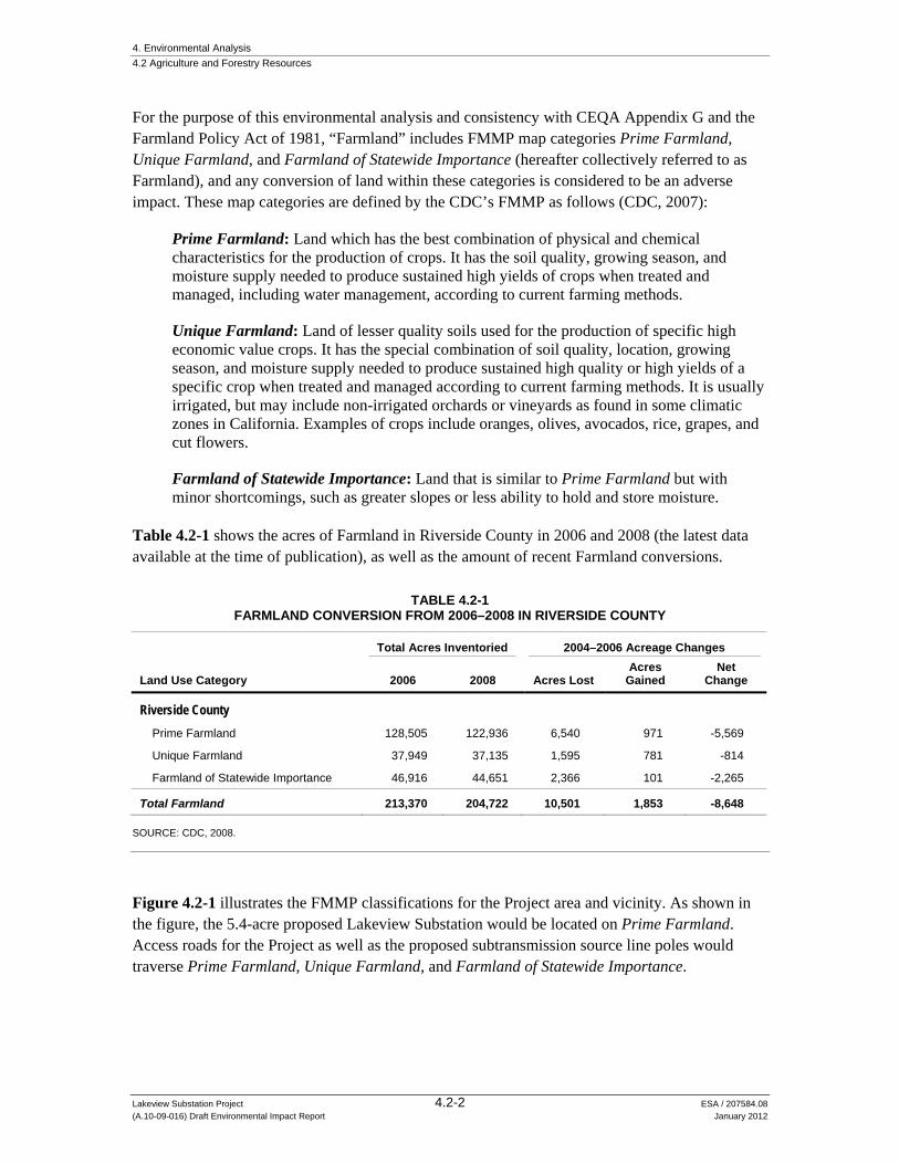
4. Environmental Analysis 4.2 Agriculture and Forestry Resources
Lakeview Substation Project 4.2-2 ESA / 207584.08 (A.10-09-016) Draft Environmental Impact Report January 2012
For the purpose of this environmental analysis and consistency with CEQA Appendix G and the Farmland Policy Act of 1981, “Farmland” includes FMMP map categories Prime Farmland, Unique Farmland, and Farmland of Statewide Importance (hereafter collectively referred to as Farmland), and any conversion of land within these categories is considered to be an adverse impact. These map categories are defined by the CDC’s FMMP as follows (CDC, 2007):
Prime Farmland: Land which has the best combination of physical and chemical characteristics for the production of crops. It has the soil quality, growing season, and moisture supply needed to produce sustained high yields of crops when treated and managed, including water management, according to current farming methods.
Unique Farmland: Land of lesser quality soils used for the production of specific high economic value crops. It has the special combination of soil quality, location, growing season, and moisture supply needed to produce sustained high quality or high yields of a specific crop when treated and managed according to current farming methods. It is usually irrigated, but may include non-irrigated orchards or vineyards as found in some climatic zones in California. Examples of crops include oranges, olives, avocados, rice, grapes, and cut flowers.
Farmland of Statewide Importance: Land that is similar to Prime Farmland but with minor shortcomings, such as greater slopes or less ability to hold and store moisture.
Table 4.2-1 shows the acres of Farmland in Riverside County in 2006 and 2008 (the latest data available at the time of publication), as well as the amount of recent Farmland conversions.
TABLE 4.2-1 FARMLAND CONVERSION FROM 2006–2008 IN RIVERSIDE COUNTY
Land Use Category
Total Acres Inventoried 2004–2006 Acreage Changes
2006 2008 Acres Lost Acres
Gained Net
Change
Riverside County Prime Farmland 128,505 122,936 6,540 971 -5,569
Unique Farmland 37,949 37,135 1,595 781 -814
Farmland of Statewide Importance 46,916 44,651 2,366 101 -2,265
Total Farmland 213,370 204,722 10,501 1,853 -8,648
SOURCE: CDC, 2008.
Figure 4.2-1 illustrates the FMMP classifications for the Project area and vicinity. As shown in the figure, the 5.4-acre proposed Lakeview Substation would be located on Prime Farmland. Access roads for the Project as well as the proposed subtransmission source line poles would traverse Prime Farmland, Unique Farmland, and Farmland of Statewide Importance.

!!
!!
!!
!!
!!
!!
!!
!!
!!
!!
!!
!!!
!!
!
!
!!!!
!!
!!
!!
!!
!!
!!
!!
!!
!!
!!
!!
!!
!!
!!
!!
!!
!!
!!
!!
!!
!!
!!
!!
!!
!!
!!
!!
!!
!!
!!
!!
!!
!!
!!
!!
!!
!!
!!
!!
!!
!!
!!
!!
!!
!!
!!
!!
!!
!!
!!
!!
!!
!!
!!
!!
!!
!!
!!
!!
!!
!!
!!
!!
!!
!!
!!
!!
!!
!!
!!
!!
!!
!!
!!
!!
!!
!!
!!
!!
!!
!!
!!
!!
!!
!!!
!!!!
!!
!!
!!
!!
!!
!!
!!
!!
!!
!!
!!
!!
!!
!!
!!
!!
!!
!!
!!
!!
!!
!!
!!
!!
!!
!!
!!
!!
!!
!!
!!
!!
!!
!!
!!!
!!
!!
!!
!!
!!
!!
!!
!!
!!
!!
!!
!!
!!
!!
!!
!!
!!
!!
!!
!!
!!
!!
!!
!!
!!
!!
!!
!!
!!!!!!!!!!!!!!!!!!!!!!!!!!!!!!!!!!!!!!!!!!!!!!!!
!!
!!
!!
!!
!!
!!
!!#*
#*
Lake Perris
San Jacinto River
10 th St
11 th St
Davis R
oad
Segment 2
Segment 1
Ramona Expressway
Moval Substation
Nuevo Substation/Model Pole Top(to be decommissioned)Colorado River Aqueduct
Lakeview Substation Project. 207584.08Figure 4.2-1
Important Farmland andWilliamson Act Contracted Land
in the Project Vicinity
SOURCE: FMMP, 2008; DOC, 2009; SCE, 2010
Project Components115 kV SubtransmissionSource LineProposed Lakeview Substation
Fiber-Optic Cable RoutesRoute 1Route 2Route 3
Existing Facilities#* Substation
! ! ! ! ! ! Subtransmission Line
Important FarmlandPrime FarmlandFarmland of Statewide ImportanceUnique FarmlandWilliamson Act Contracted Land
0 1
Miles
Vall
ey-M
oval
115
kV
Subt
rans
miss
ion L
ine
4.2-3

4. Environmental Analysis 4.2 Agriculture and Forestry Resources
Lakeview Substation Project 4.2-4 ESA / 207584.08 (A.10-09-016) Draft Environmental Impact Report January 2012
California Public Resource Code
The California Public Resources Code governs forestry, forests, and forest resources, as well as range and forage lands, within the state. “Forest land” is defined by Public Resources Code §12220(g) as “land that can support 10-percent native tree cover of any species, including hardwoods, under natural conditions, and that allows for management of one or more forest resources, including timber, aesthetics, fish and wildlife, biodiversity, water quality, recreation, and other public benefits.” “Timberland” is defined by Public Resources Code §4526 as, “land, other than land owned by the federal government..., which is available for, and capable of, growing a crop of trees of any commercial species used to produce lumber and other forest products, including Christmas trees.”
California Government Code
Chapter 6.7 of the California Government Code (§§51100-51155) regulates timberlands within the state. “Timberland production zone” is defined in §51104(g) as an area that has been zoned pursuant to Government Code §51112 or 51113 and is devoted to and used for growing and harvesting timber, or for growing and harvesting timber and compatible uses. In this context, “compatible uses” include any use that “does not significantly detract from the use of the property for, or inhibit, growing and harvesting timber” (Government Code §51104(h)). Watershed management, grazing and the erection, construction, alteration, or maintenance of electric transmission facilities are examples of compatible uses. With respect to the general plans of cities and counties, ‘timberland preserve zone’ means ‘timberland production zone.’”
California Land Conservation Act of 1965 (Williamson Act)
The California Land Conservation Act of 1965 (Williamson Act) preserves open spaces and agricultural land in exchange for property tax breaks (Government Code §51200 et seq.). It discourages urban sprawl and prevents landowners from developing their property for the greater land value of commercial and/or residential uses. The Williamson Act is a state program implemented at the county level that allows agricultural landowners to contractually agree to retain land included in an agricultural preserve1 in agricultural or and open space uses for a period of 10 years and, in return, to pay reduced property taxes. The term of the contract automatically renews each year unless not renewed or cancelled, so that the contract always has a 10 year period left. As portrayed in Figure 4.2-1, the Project would not be located on lands subject to a Williamson Act contract (SCE, 2010).
Local
Riverside County General Plan
CPUC General Order No. 131-D explains that local land use regulations would not apply to the Project. However, for information purposes, the following policies identified in the General Plan Land Use Element (Riverside County, 2008b) would otherwise be relevant to the Project and alternatives: 1 An agricultural preserve defines the boundary of an area within which a city or county will enter into Williamson
Act contracts with landowners: The boundary is designated by resolution of the board or city council having jurisdiction. Agricultural preserves must generally be at least 100 acres in size.

4. Environmental Analysis 4.2 Agriculture and Forestry Resources
Lakeview Substation Project 4.2-5 ESA / 207584.08 (A.10-09-016) Draft Environmental Impact Report January 2012
Policy LU 16.1: Encourage retaining agriculturally designated lands where agricultural activity can be sustained at an operational scale, where it accommodates lifestyle choice, and in locations where impacts to and from potentially incompatible uses, such as residential uses, are minimized, through incentives such as tax credits.
Policy LU 16.2: Protect agricultural uses, including those with industrial characteristics (dairies, poultry, hog farms, etc.) by discouraging inappropriate land division in the immediate proximity and allowing only uses and intensities that are compatible with agricultural uses.
Policy LU 16.4: Encourage conservation of productive agricultural lands. Preserve prime agricultural lands for high-value crop production.
Policy LU 16.5: Continue to participate in the California Land Conservation Act (the Williamson Act) of 1965.
Policy LU 5.4: Ensure that development and conservation land uses do not infringe upon existing public utility corridors, including fee owned rights-of-way and permanent easements, whose true land use is that of “public facilities.” This policy will ensure that the “public facilities” designation governs over what otherwise may be inferred by the large scale general plan maps.
Riverside County Zoning Ordinance
The Project would be located on three agricultural zoning designations per the Riverside County Zoning Ordinance: Residential-Agriculture (R-A), Rural-Residential (R-R), and Specific Plan (S-P). In the R-A and R-R zones, public utility facilities are conditionally permitted uses, and allowable uses include “structures and the pertinent facilities necessary and incidental to the development and transmission of electrical power and gas such as hydroelectric power plants, booster or conversion plants, transmission lines, pipelines and the like.” S-P uses include transmission facilities for electricity which are subject to the jurisdiction of the CPUC (Riverside County, 2008c).
4.2.2 Significance Criteria The significance criteria for this analysis were developed from criteria presented in Appendix G of the CEQA Guidelines. The Project would result in a significant impact to agricultural resources if it would:
a) Convert Prime Farmland, Unique Farmland, or Farmland of Statewide Importance (Farmland), as shown on the maps prepared pursuant to the Farmland Mapping and Monitoring Program of the California Resources Agency, to non-agricultural use;
b) Conflict with existing zoning for agricultural use, or a Williamson Act contract;
c) Conflict with existing zoning for, or cause rezoning of, forest land (as defined in Public Resources Code §12220(g)), timberland (as defined in Public Resources Code §4526) or timberland zoned Timberland Production (as defined by Government Code §51104(g));

4. Environmental Analysis 4.2 Agriculture and Forestry Resources
Lakeview Substation Project 4.2-6 ESA / 207584.08 (A.10-09-016) Draft Environmental Impact Report January 2012
d) Result in the loss of forest land or conversion of forest land to non-forest use; or
e) Involve other changes in the existing environment which, due to their location or nature, could result in conversion of Farmland to non-agricultural use or conversion of forest land to non-forest use.
4.2.3 Applicant Proposed Measures There are no APM included to address issues related to agriculture and forestry impacts.
4.2.4 Impacts and Mitigation Measures
a) Convert Prime Farmland, Unique Farmland, or Farmland of Statewide Importance (Farmland), as shown on the maps prepared pursuant to the Farmland Mapping and Monitoring Program of the California Resources Agency, to non-agricultural use.
Impact 4.2-1: Construction activities would result in temporary impacts to designated Farmland. Less than Significant with Mitigation (Class II)
The Project would cause temporary disturbance to Farmland due to site preparation associated with construction activities. Specifically, temporary impacts would occur from construction methods that would be used to complete the various Project components, including access roads, 115 kV subtransmission lines, and telecommunications-related facilities (i.e., duct banks, pull boxes and manholes). Temporary impacts to Farmland could also occur at construction sites including temporary material staging areas, pole lay-down areas, guard structure sites, and access routes to poles along the subtransmission source line routes. Activities associated with Project maintenance would not affect Farmland.
As shown in Table 4.2-2, the Project would temporarily disturb approximately 24.3 acres of Farmland by using it for non-agricultural use, consisting of 17.4 acres of Prime Farmland, 2.4 acres of Unique Farmland, and 4.4 acres of Farmland of Statewide Importance.
After the completion of construction, temporarily disturbed acres would be returned to agricultural use. Implementation of the following mitigation measures would support the continued productive use of Farmland in the Project area once construction is complete; reducing temporary construction impacts to less than significant.
Mitigation Measure 4.2-1a: SCE and/or its contractors shall ensure that the following measures are taken, during construction of the Project:
Replace soils in a manner that shall minimize any negative impacts on crop productivity. The surface and subsurface layers shall be stockpiled separately and returned to their appropriate locations in the soil profile; alternately, SCE may work with individual property owners to develop a different method for the disposition of any soils that are impacted on private property, assuming a mutual agreement may be reached.

4. Environmental Analysis 4.2 Agriculture and Forestry Resources
Lakeview Substation Project 4.2-7 ESA / 207584.08 (A.10-09-016) Draft Environmental Impact Report January 2012
TABLE 4.2-2 ESTIMATED TEMPORARY DISTURBANCE OF FARMLAND
Project Features
Acresa Temporarily Disturbed by Project
Prime Farmland
Unique Farmland
Farmland of Statewide
Importance
Distributionb 0.0 0.0 0.0
Subtransmission Source Lineb Guard Structures 0.2 0.2 0.2
New Tubular Steel Polesc 5.1 0.0 0.0
New Wood Polesc 2.3 2.1 2.8
Puller/Tensioner/Splicing Sites 1.4 0.0 0.5
Material Stagingd 5.0 0.0 0.0
Access Road Rehabilitatione 0.9 0.1 0.5
Telecommunicationb
Telecommunication Route Underground Ducts 0.0 0.0 0.0
Pull Boxes and Man Holes 0.0 0.0 0.0
Material Stagingd 1.0 0.0 0.0
Access Road Rehabilitatione 0.4 0.0 0.0
Total 16.3 2.3 4.0
NOTES: a All numbers are approximate, and rounded to one decimal point. b The exact locations of distribution components, guard structures, TSPs, wood poles, and material staging areas are unknown. Locations
were estimated based on descriptions in the PEA. c This analysis assumes that the distribution of subtransmission line poles would be evenly placed along the entire transmission corridor,
since exact pole placement will not be determined until final engineering. Temporarily disturbed land includes construction lay-down areas.
d Because the locations of the material staging areas were not discussed in the PEA, this analysis takes a conservative approach and assumes they would be located on Prime Farmland, and would be the maximum size discussed in the PEA.
e Access Road Rehabilitation includes modifications to existing access roads to enable roads to handle construction. SOURCE: SCE, 2010
To avoid over-compaction of the top layers of soil, monitor pre-construction soil densities and return the surface soil (approximately the top 3 feet) to within 5 percent of original density, except where higher soil density is necessary to meet engineering requirements for tower foundations within the tower buffer zone.
Where necessary, the top soil layers shall be ripped to achieve the appropriate soil density. Ripping may also be used in areas where vehicle and equipment traffic have compacted the top soil layers.
Avoid working or traveling on wet soil to minimize compaction and loss of soil structure.
Remove all construction-related debris from the soil surface. This shall prevent rock, gravel, and construction debris from interfering with agricultural activities.
Remove topsoil before excavating in fields. Return it to top of fields to avoid detrimental inversion of soil profiles.

4. Environmental Analysis 4.2 Agriculture and Forestry Resources
Lakeview Substation Project 4.2-8 ESA / 207584.08 (A.10-09-016) Draft Environmental Impact Report January 2012
Mitigation Measure 4.2-1b: SCE and/or its contractors shall incorporate the following measures into the Project construction plans and specifications specific to lands designated as Farmland:
Coordinate construction scheduling as practicable so as to minimize disruption of agricultural operations by scheduling excavation to occur before or after the growing season.
Supply replacement crops and trees at a mitigation ratio of one to one (1:1), upon completion of construction. Coordinate planting of replacement crops and trees with landowners.
Significance after Mitigation: Less than Significant.
Impact 4.2-2: The Project would permanently convert Farmland to non-agricultural use. Less than Significant with Mitigation (Class II)
In addition to temporary impacts, the Project would cause permanent disturbance to Farmland due to construction of the proposed Lakeview Substation, new permanent access roads, and placement of new TSPs and wooden poles. A 25-foot maintenance buffer would surround each TSP, and a 10-foot maintenance buffer would surround each wooden pole (SCE, 2010).
As shown in Table 4.2-3, the Project would permanently convert approximately 7.9 acres of Farmland to non-agricultural use, consisting of 7.1 acres of Prime Farmland, 0.2 acre of Unique Farmland, and 0.5 acre of Farmland of Statewide Importance.
TABLE 4.2-3 ESTIMATED PERMANENT DISTURBANCE OF FARMLAND
Project Feature
Acresa Permanently Disturbed by the Project
Prime Farmland
Unique Farmland
Farmland of Statewide
Importance
Proposed Lakeview Substation 5.4 0 0
Access Roadsb 1.1 0.1 0.5
Subtransmission Source Line and Polesc 0.7 0.1 0.1
Totald 7.1 0.2 0.5
NOTES: a All numbers are approximate, and rounded to one decimal point. b The access road calculation includes new and potentially rehabilitated access roads. The three segments of new access roads total
approximately 11,572.4 feet (2.2 miles). Based on an assumed 14-foot road width, these three segments total approximately 1.7 acres. c This analysis assumes that the distribution of subtransmission line poles would be evenly placed along the entire transmission corridor,
since exact pole placement will not be determined until final engineering. SOURCE: SCE, 2010

4. Environmental Analysis 4.2 Agriculture and Forestry Resources
Lakeview Substation Project 4.2-9 ESA / 207584.08 (A.10-09-016) Draft Environmental Impact Report January 2012
The loss of agricultural land represents a permanent reduction in the state’s agricultural resources. Neither CEQA, its implementing regulations, nor case law interpreting its requirements establishes a threshold to determine whether a proposed conversion of Farmland would constitute a significant impact. In the absence of an applicable threshold, this analysis considers any conversion of Farmland to be a significant impact. Therefore, the permanent conversion of approximately 7.9 acres Farmland to non-agricultural by the Project would be significant. Mitigation Measure 4.2-2 would compensate for the direct loss of agricultural land and lessen Project impacts to less than significant in accordance with CEQA Guidelines §15370 and CDC recommendations (CDC, 2011).
Mitigation Measure 4.2-2: SCE shall obtain permanent agricultural conservation easements at a one to one (1:1) ratio for each acre of Prime Farmland, Unique Farmland, and Farmland of Statewide Importance that is permanently converted by the Project. Conservation easements shall be on land of at least equal quality and size as land disturbed by the Project. Preference shall be given to easements within Riverside County, though comparable or better arrangements may be made if Riverside County easements are unavailable. Mitigation via agricultural conservation easement shall be satisfied under the following conditions:
1) SCE shall grant a farmland easement for the portion of the land that will no longer be used for agricultural land equal to the acreage converted (i.e., 7.9 acres). This land shall be in an area designated for long-term future agricultural use; or
2) SCE shall pay a fee equal to or greater than the value of a previous farmland conversion transaction in the planning area plus the estimated cost of legal appraisal and other costs, including staff time, to acquire property for agricultural mitigation. The fee shall be used for farmland mitigation purposes, with priority given to lands with prime agricultural soils and habitat value.
Significance after Mitigation: Less than Significant.
b) Conflict with existing zoning for agricultural use, or a Williamson Act contract.
As discussed in Section 4.11, Land Use and Planning, the Project would not conflict with any Riverside County zoning designations. Furthermore, although the Project would be located on three agricultural zoning designations (R-A, R-R, and S-P), R-A and R-R uses include “structures and the pertinent facilities necessary and incidental to the development and transmission of electrical power and gas such as hydroelectric power plants, booster or conversion plants, transmission lines, pipelines and the like” (Riverside County, 2008c). S-P uses include transmission facilities for electricity which are subject to the jurisdiction of the CPUC (Riverside County, 2008c). In addition, agriculture is generally considered to be a compatible land use with utility corridors. Therefore, there would be no impact (No Impact).
As discussed above in Section 4.2-1, Regulatory Setting, the Project would not be located on lands subject to a Williamson Act contract. There would be no impact (No impact).
4. Environmental Analysis 4.2 Agriculture and Forestry Resources
Lakeview Substation Project 4.2-10 ESA / 207584.08 (A.10-09-016) Draft Environmental Impact Report January 2012
c) Conflict with existing zoning for, or cause rezoning of, forest land (as defined in Public Resources Code §12220(g)), timberland (as defined in Public Resources Code §4526) or timberland zoned Timberland Production (as defined by Government Code §51104(g).
The Project would not be located on land zoned specifically as either forest land or timberland. As discussed in Section 4.11, Land Use and Planning, the Project would be located primarily on land zoned for residential use, agricultural production, and Specific Plans. Although timber production is an allowable activity within an agricultural zone, no portion of land in the vicinity of the Project is used for timber production, or is forested. Furthermore, crops grown in the Project area are irrigated because of the arid climate. It is unlikely that the land could support 10 percent native tree cover, under natural (i.e., non-irrigated) conditions. Therefore, this analysis assumes that Project lands do not meet the definition of “forest land.” The same land is not considered timberland because the land is not zoned Timberland Production Zone (TPZ) (CAL FIRE, 2002).
Consequently, the Project would not cause rezoning of forest land, nor would it conflict with any of these types of zoning as discussed above under criterion (b). Accordingly, there would be no impact from the Project on forest land or timberland zoning (No Impact).
d) Result in the loss of forest land or conversion of forest land to non-forest use.
Because none of the land within the Project area meets the definition of forest land, the Project would neither result in the loss nor convert any forest land to non-forest use and no impact would occur (No Impact).
e) Involve other changes in the existing environment which, due to their location or nature, could result in conversion of Farmland to non-agricultural use or conversion of forest land to non-forest use.
Impact 4.2-3 The Project could involve other changes in the existing environment which could result in the conversion of farmland to non-agricultural land. Less than Significant with Mitigation (Class II)
Beyond the permanent conversion discussed under criterion a), other changes in the existing environment could, due to their location or nature, result in conversion of Farmland to non-agricultural use. Specifically, impacts to existing water pumps and irrigation pipelines could remove a landowner’s ability to irrigate crops, which could effectively render previously productive agricultural land unusable. Implementation of Mitigation Measure 4.2-3 would ensure that construction does not impact irrigation and/or other ancillary farming systems in a manner that would result in conversion of Farmland to non-agricultural use.
4. Environmental Analysis 4.2 Agriculture and Forestry Resources
Lakeview Substation Project 4.2-11 ESA / 207584.08 (A.10-09-016) Draft Environmental Impact Report January 2012
In addition, there would be a less-than-significant impact related to the conversion of Farmland from induced growth caused by the Project. The Project is proposed to ensure the availability of reliable electric service to meet customer electrical demand in the Electrical Needs Area because existing facilities would not meet forecasted, long-term electrical demand. Therefore, the Project would not induce growth but instead is designed to respond to existing growth and demand trends, and therefore would not be expected to substantially induce or exacerbate conversion of agricultural land. Impacts would be less than significant.
Mitigation Measure 4.2-3: SCE and/or its contractors shall incorporate the following measures into project construction plans and specifications specific to lands designated as Farmland:
Ensure that existing drainage systems at Project sites that are needed for farming activities function as necessary per coordination with the landowner, so that agricultural uses are not disrupted.
Coordinate with landowners to ensure that construction does not impact irrigation and/or other ancillary farming systems to a degree that farming practices cannot be maintained.
Maintain existing levels of water available to farmers via the current irrigation system including, but not be limited to, implementing re-routing and/or temporary irrigation systems.
In lieu of implementing the above requirements, SCE shall have the option of negotiating agreements with any affected landowner(s) that shall enable the landowner(s) to effect their own irrigation and/or drainage system changes in a manner consistent with the landowner’s farming practices and plans.
Significant after Mitigation: Less than Significant.
4.2.5 Alternatives
Alternative 1: Phased Construction Alternative
Alternative 1 would cause the same acreage of temporary disturbance as the Project to Farmland due to site preparation associated with construction activities as the Project, but temporary impacts would occur over a longer period of time (22 months) due to the construction phasing schedule. After the completion of construction, temporarily disturbed acres would be returned to agricultural use. Implementation of Mitigation Measures 4.2-1a and 4.2-1b would support the continued productive use of Farmland in the Project area once construction is complete. This impact would be less than significant with mitigation incorporated. Impacts related to permanent conversion of Farmland would be the same as for the Project. Implementation of Mitigation Measure 4.2-2 would compensate for the direct loss of agricultural land and lessen this alternative’s impacts in accordance with CEQA Guidelines §15370 and CDC guidance.

4. Environmental Analysis 4.2 Agriculture and Forestry Resources
Lakeview Substation Project 4.2-12 ESA / 207584.08 (A.10-09-016) Draft Environmental Impact Report January 2012
Similar to the Project, Alternative 1 would have no impact related to loss conversion of forest land to non-forest use.
Similar to the Project, Alternative 1 could result other changes in the existing environment, such as impacts to existing water pumps and irrigation pipelines, which could result in conversion of Farmland to non-agricultural use. Implementation of Mitigation Measure 4.2-3 would ensure that construction does not impact irrigation and/or other ancillary farming systems in a manner that would result in conversion of Farmland to non-agricultural use.
In addition, Alternative 1 would have a less-than-significant impact related to the conversion of Farmland from induced growth, because the provision of electricity would be the same as for the Project.
Alternative 2: Relocated Substation Alternative
Alternative 2 would disturb less Farmland than the Project during both construction and operation. Construction of Alternative 2 would cause temporary disturbance to Farmland similar to the Project, but because the subtransmission source line routes would be shorter by approximately 2,900 feet and Alternative 2 would require 3 to 5 fewer wood poles and 0.54 less mile of new access roads, the total temporary disturbance of Prime Farmland, Farmland of Statewide Importance, and Unique Farmland would be slightly less than the Project. Implementation of Mitigation Measures 4.2-1a and 4.2-1b would support the continued productive use of Farmland in the Project area once construction is complete. This impact would be less than significant with mitigation incorporated.
The proposed Lakeview Substation would be constructed on Prime Farmland and, like the Project, would permanently disturb 5.4 acres of Prime Farmland. However, because the subtransmission source line routes would be shorter by approximately 2,900 feet and Alternative 2 would require 3 to 5 fewer wood poles and 0.54 fewer mile of new access roads, the total permanent disturbance of Prime Farmland, Unique Farmland, and Farmland of Statewide Importance would be slightly less than the Project. Implementation of Mitigation Measure 4.2-2 would compensate for the direct loss of agricultural land and lessen this alternative’s impacts in accordance with CEQA Guidelines §15370 and CDC guidance (CDC, 2011). This impact would be less than significant with mitigation incorporated.
Similar to the Project, Alternative 2 would have no impact related to loss conversion of forest land to non-forest use.
Similar to the Project, Alternative 2 could result in other changes in the existing environment, such as impacts to existing water pumps and irrigation pipelines, which could result in conversion of Farmland to non-agricultural use. Implementation of Mitigation Measure 4.2-3 would ensure that construction does not impact irrigation and/or other ancillary farming systems in a manner that would result in conversion of Farmland to non-agricultural use.

4. Environmental Analysis 4.2 Agriculture and Forestry Resources
Lakeview Substation Project 4.2-13 ESA / 207584.08 (A.10-09-016) Draft Environmental Impact Report January 2012
In addition, Alternative 2 would have a less-than-significant impact related to the conversion of Farmland from induced growth, because the provision of electricity would be the same as for the Project.
No Project Alternative
Under the No Project Alternative, there would be no impacts related to agriculture or forestry resources because the lands in the Project area would remain in their current uses.
References – Agriculture and Forestry Resources California Department of Conservation (CDC). 2006. Table A-25, Riverside County Land Use
Conversion, 2004-2006 California Farmland Conversion Report. Available at (http://www.conservation.ca.gov/dlrp/fmmp/pubs/2004-2006/Documents/Appendices%202004-06%20FCR.pdf), accessed June 9, 2011.
California Department of Conservation (CDC), 2007. Important Farmland Map Categories. Available at (http://www.conservation.ca.gov/dlrp/fmmp/mccu/Pages/map_categories.aspx), accessed June 9, 2011.
California Department of Conservation (CDC), 2008. 2006-2008 Land Use Conversion. Available at ( http://redirect.conservation.ca.gov/DLRP/fmmp/county_info_results.asp), accessed on August 10, 2011.
California Department of Conservation (CDC), 2011. Communication between Jacquelyn Ramsey (CDC) and Janna Scott (ESA), July 11, 2011.
California Department of Forestry and Fire Protection (CAL FIRE), 2002. Timberland Conversion in California from 1969 to 1998. (http://frap.cdf.ca.gov/publications/ timberland_conversion.pdf), accessed October 11, 2011.
Riverside County. 2008a. Agricultural Commissioner’s Office. 2010 Crop Report. Available at (http://www.rivcoag.org/opencms/system/galleries/download/publications/2010_Annual_Crop_Report_web.pdf), accessed June 9, 2011.
Riverside County. 2008b. Riverside County General Plan. Available at (http://www.rctlma.org/genplan/content/gp.aspx), accessed June 9, 2011.
Riverside County, 2008c. Riverside County Zoning Ordinance. Available at (http://www.rctlma.org/planning/content/zoning/ordnance/ord348a.html#article_vib), accessed June 1, 2011.
Southern California Edison (SCE), 2010. Proponent’s Environmental Assessment Lakeview Substation Project, Volume 1. September 17, 2010.

4. Environmental Analysis
Lakeview Substation Project 4.3-1 ESA / 207584.08 (A.10-09-016) Draft Environmental Impact Report January 2012
4.3 Air Quality
4.3.1 Setting Air quality is a function of both the rate and location of pollutant emissions under the influence of meteorological conditions and topographic features that influence pollutant movement and dispersal. Atmospheric conditions such as wind speed, wind direction, atmospheric stability, and air temperature gradients interact with the physical features of the landscape to determine the movement and dispersal of air pollutants, which affects air quality.
Regional Topography, Meteorology, and Climate
The study area, which includes the Project and alternatives areas, is located in western Riverside County within the South Coast Air Basin (SCAB), which includes all of Orange County and the non-desert portions of Los Angeles, Riverside and San Bernardino Counties. Air quality conditions in the SCAB are under the jurisdiction of the South Coast Air Quality Management District (SCAQMD).
According to the SCAQMD, the worst air quality problem in the nation occurs in the SCAB. With very light average wind speeds, the basin atmosphere has a limited capability to disperse air contaminants horizontally. The dominant daily wind pattern is a daytime sea breeze (on-shore breeze) and a nighttime land breeze (off-shore breeze), broken only occasionally by winter storms and infrequent strong Santa Ana winds from the Great Basin, and Mojave deserts to the north. On virtually all spring and early summer days, most of the pollution produced during an individual day is moved out of the basin through mountain passes, or is lifted by the warm, vertical currents produced by the heating of mountain slopes. In those seasons, the basin can be “flushed” of pollutants by a transport of ocean air during the afternoon. From late summer through the winter months, the flushing is less pronounced because of lower wind speeds and the earlier appearance of off-shore winds. With extremely stagnant wind flows, the drainage winds may begin near the mountains by late afternoon. Remaining pollutants are trapped and begin to accumulate during the night and the following morning. A low average morning wind speed in pollution source areas is an important indicator of air stagnation potential.
The vertical dispersion of air pollutants in the SCAB is hampered by the presence of a temperature inversion in the layers of the atmosphere near the surface of the Earth. In a normal situation, as temperatures decrease with altitude, air continues to rise as it remains warmer than the surrounding air. With an inversion layer, air cannot continue to expand upwards, as it is trapped by the warmer air above. However, as the day progresses and the sun warms the ground, the surface layer of air approaches a temperature equal to that of the inversion layer. When these temperatures become equal, the inversion layer begins to erode at its lower edge. If enough warming takes place, the inversion layer becomes weaker and weaker and finally “breaks.” The surface air layers can then mix upward without limit. This phenomenon is frequently observed in the middle of late afternoon on hot summer days when the smog appears to clear up suddenly. Winter inversions frequently break by mid-morning, thereby preventing contaminant build-up. The combination of low wind speeds and low level inversions produces the greatest concentration

4. Environmental Analysis 4.3 Air Quality
Lakeview Substation Project 4.3-2 ESA / 207584.08 (A.10-09-016) Draft Environmental Impact Report January 2012
of pollutants. On high wind days other air pollutants including particulate matter such as dust and soil are swept and carried in the air. On days of no inversion or on days of winds averaging over 15 miles per hour, there will be no important smog effects, during either summer or winter.
In the winter, the greatest pollution problems are carbon monoxide and oxides of nitrogen because of extremely low level inversions and air stagnation during the night and early morning hours. Smog levels are much lower during this season due to the lack of strong inversion during the daylight hours and the lack of intense sunlight which is needed to produce photochemical reactions. In the summer, the longer daylight hours and the brighter sunshine combine to cause a reaction between hydrocarbons and oxides of nitrogen to form more smog. Carbon monoxide is not as great a problem in summer because inversions are not as low and intense in the surface boundary layer (within 100 feet of the ground) as in winter and because horizontal ventilation is better in summer. The basin-wide average occurrence of inversion at the ground surface is 11 days per month; the averages vary from 2 days in June to 22 days in December and January. The potential for high concentration varies seasonally for many contaminants. During late spring, summer, and early fall, light winds, low mixing heights, and brilliant sunshine combine to produce conditions favorable for the maximum production of photochemical oxidants, mainly ozone (Riverside County, 2008).
The study area typically has average maximum and minimum winter (i.e., January) temperatures of 66 and 36 ºF, respectively, while average summer (i.e., July) maximum and minimum temperatures are 97 and 59 ºF, respectively. Precipitation in the study area averages approximately 11 inches per year (WRCC, 2011).
Criteria Air Pollutants
The U.S. Environmental Protection Agency (USEPA) has identified criteria air pollutants that are a threat to public health and welfare. These pollutants are called “criteria” air pollutants because standards have been established for each of them to meet specific public health and welfare criteria (see Regulatory Context discussion below). The following criteria pollutants are a concern in the study area.
Ozone
Ozone is a respiratory irritant and an oxidant that increases susceptibility to respiratory infections and that can cause substantial damage to vegetation and other materials. Ozone is not emitted directly into the atmosphere, but is a secondary air pollutant produced in the atmosphere through a complex series of photochemical reactions involving reactive organic compounds (ROC) and nitrogen oxides (NOx). ROC and NOx are known as precursor compounds for ozone. Significant ozone production generally requires ozone precursors to be present in a stable atmosphere with strong sunlight for approximately 3 hours.
Ozone is a regional air pollutant because it is not emitted directly by sources, but is formed downwind of sources of ROC and NOx under the influence of wind and sunlight. Ozone concentrations tend to be higher in the late spring, summer, and fall, when the long sunny days

4. Environmental Analysis 4.3 Air Quality
Lakeview Substation Project 4.3-3 ESA / 207584.08 (A.10-09-016) Draft Environmental Impact Report January 2012
combine with regional subsidence inversions to create conditions conducive to the formation and accumulation of secondary photochemical compounds, like ozone.
Nitrogen Dioxide
Nitrogen dioxide (NO2) is an air quality pollutant of concern because it acts as a respiratory irritant. NO2 is a major component of the group of gaseous nitrogen compounds commonly referred to as NOx. A precursor to ozone formation, NOx is produced by fuel combustion in motor vehicles, industrial stationary sources (such as industrial activities), ships, aircraft, and rail transit. Typically, NOx emitted from fuel combustion is in the form of nitric oxide (NO) and NO2. NO is often converted to NO2 when it reacts with ozone or undergoes photochemical reactions in the atmosphere.
Carbon Monoxide
Carbon monoxide (CO) is a non-reactive pollutant that is a product of incomplete combustion and is mostly associated with motor vehicle traffic. High CO concentrations develop primarily during winter when periods of light winds combine with the formation of ground-level temperature inversions (typically from the evening through early morning). These conditions result in reduced dispersion of vehicle emissions. Motor vehicles also exhibit increased CO emission rates at low air temperatures. When inhaled at high concentrations, CO combines with hemoglobin in the blood and reduces the oxygen-carrying capacity of the blood. This results in reduced oxygen reaching the brain, heart, and other body tissues. This condition is especially critical for people with cardiovascular diseases, chronic lung disease, or anemia.
Particulate Matter
Particulate matter less than 10 microns in diameter (PM10) and particulate matter less than 2.5 microns in diameter (PM2.5) represent fractions of particulate matter that can be inhaled into air passages and the lungs and can cause adverse health effects. Particulate matter in the atmosphere results from many kinds of dust- and fume-producing industrial and agricultural operations, fuel combustion, and atmospheric photochemical reactions. Some sources of particulate matter, such as demolition and construction activities, are more local in nature, while others, such as vehicular traffic, have a more regional effect. Very small particles of certain substances (e.g., sulfates and nitrates) can cause lung damage directly, or can contain adsorbed gases (e.g., chlorides or ammonium) that may be injurious to health. According to a study prepared by the California Air Resources Board (CARB), exposure to ambient PM2.5, particularly diesel particulate matter (DPM), can be associated with approximately 14,000 to 24,000 premature annual deaths statewide (CARB, 2009). Particulates also can damage materials and reduce visibility.
Toxic Air Contaminants
Toxic Air Contaminants (TACs) are airborne substances that are capable of causing short-term (acute) and/or long-term (chronic or carcinogenic, i.e., cancer-causing) adverse human health effects (i.e., injury or illness). TACs include both organic and inorganic chemical substances. They may be emitted from a variety of common sources including gasoline stations, automobiles,

4. Environmental Analysis 4.3 Air Quality
Lakeview Substation Project 4.3-4 ESA / 207584.08 (A.10-09-016) Draft Environmental Impact Report January 2012
dry cleaners, industrial operations, and painting operations. The current California list of TACs includes approximately 200 compounds, including DPM emissions from diesel-fueled engines (CARB, 2011a).
Existing Air Quality
The SCAQMD’s regional monitoring network measures the ambient concentrations of criteria pollutants. Existing levels of air quality in the study area can be inferred from ambient air quality measurements conducted by SCAQMD at its closest stations to the Project. The closest air quality monitoring stations are the Perris D Street Monitoring Station and Riverside Magnolia Monitoring Station, located approximately 5 miles southwest and 16 miles northwest of the proposed Lakeview Substation site, respectively. The Perris station monitors ozone and PM10 and the Riverside station monitors PM2.5 and NO2. Table 4.3-1 shows a 5-year (2006 through 2010) summary of ozone, PM10, PM2.5, and NO2 data monitored at the Perris and Riverside stations. The data are compared to the California Ambient Air Quality Standards (CAAQS) and National Ambient Air Quality Standards (NAAQS).
TABLE 4.3-1 AIR QUALITY DATA SUMMARY (2006–2010) FOR THE STUDY AREA
Pollutant Standard
Monitoring Data by Year
2006 2007 2008 2009 2010
Ozone Highest 1-Hour Average (ppm) 0.169 0.138 0.142 0.125 0.122
Days over State Standard 0.09 77 66 65 53 46
Highest 8-Hour Average (ppm) 0.122 0.116 0.114 0.108 0.107
Days over State Standard 0.070 98 88 94 88 77
Days over National Standard 0.075 83 73 77 67 50
Respirable Particulate Matter (PM10) Highest 24-Hour Average (µg/m3) 119.0 1,155.0 87.0 76.0 48.0
Measured Days over State Standard 50 18 25 8 6 0
Days over National Standard 150 0 2 0 0 0
State Annual Average (µg/m3) 20 --- --- --- 33.7 26.6
Fine Particulate Matter (PM2.5) Highest 24-Hour Average (µg/m3) 55.3 68.5 42.9 42.1 43.7
Measured Days over National Standard 35 9 8 4 2 2
State Annual Average (µg/m3) 12 --- --- 13.3 --- ---
Nitrogen Dioxide (NO2) Highest Hourly Average (ppm) --- --- 0.086 0.080 0.061
Measured Days over State Standard 0.18 --- --- 0 0 0 NOTES: -- = data not available; ppm = parts per million; µg/m3 = micrograms per cubic meter. Ozone and PM10 data are from the Perris D Street Monitoring Station and PM2.5 and NO2 data are from the Riverside Magnolia Street Monitoring Station. SOURCE: CARB, 2011b.

4. Environmental Analysis 4.3 Air Quality
Lakeview Substation Project 4.3-5 ESA / 207584.08 (A.10-09-016) Draft Environmental Impact Report January 2012
As shown in Table 4.3-1, the state 1-hour ozone standard was exceeded between 46 and 77 times per year from 2006 to 2010, and the state and national 8-hour ozone standards were exceeded between 77 and 98 times and 50 and 83 times, respectively, between 2006 and 2010. The 24-hour state PM10 standard was exceeded between 0 and 25 times each year from 2006 to 2010, while there were only two exceedances of the national 24-hour PM10 standard during that same time period. The PM10 annual average concentration exceeded the state standard in 2009 and 2010, which were the only years with available annual average PM10 data. The PM2.5 annual average concentration exceeded the state standard in 2008, which was the only year with available PM2.5 data. There are no NO2 data available for 2006 and 2007, and there were no recorded exceedances of the state NO2 standard between 2008 and 2010.
Sensitive Receptors
For the purposes of this air quality analysis, sensitive receptors are defined as facilities and land uses that include members of the population that are particularly sensitive to the effects of air pollutants, such as children, the elderly, and people with illnesses. Examples include schools, hospitals, and daycare centers. The reasons for greater than average sensitivity include pre-existing health problems, proximity to emissions sources, and/or duration of exposure to air pollutants. Schools, hospitals, and convalescent homes are considered to be relatively sensitive to poor air quality because children, elderly people, and the infirm are more susceptible to respiratory distress and other air quality-related health problems than the general public. Residential areas are considered sensitive to poor air quality because people usually stay home for extended periods of time, which results in greater exposure to ambient air quality.
Project
Sensitive receptors to air pollution in the vicinity of the Project site including the proposed Lakeview Substation, subtransmission source lines, and fiber-optic cable routes, are identified below.
Proposed Lakeview Substation Site and Subtransmission Source Lines
There are at least five residences along 10th Street and Reservoir Avenue, the closest of which is approximately 150 feet east of the northeast corner of the proposed Lakeview Substation site. The proposed Lakeview Substation site is also approximately 0.25 mile south-southwest of Mountain Shadows Middle School and Nuview Bridge Early College High School. The proposed Lakeview Substation and Subtransmission Source Line Segment Two would be as close as approximately 0.25 mile north-northwest, and 1,000 feet west of Nuview Elementary School and Nuview Special School, respectively. One residence along 11th Street would be approximately 50 feet east of Segment Two and there are also residential properties along Lakeview Avenue that would be as close as 1,000 feet from Segment Two.
Fiber-Optic Cable Routes
The underground portion of Fiber-Optic Cable Route 2 would be constructed within 50 to 100 feet of three residences along 10th Street and within approximately 100 feet of the Nuview

4. Environmental Analysis 4.3 Air Quality
Lakeview Substation Project 4.3-6 ESA / 207584.08 (A.10-09-016) Draft Environmental Impact Report January 2012
Fire Department. The overhead portion of Fiber-Optic Cable Route 2 would be installed within 50 to 150 feet of 16 residences along Lakeview Avenue and approximately 700 feet east-southeast of Mountain Shadows Middle School and Nuview Bridge Early College High School. The underground portion of Fiber-Optic Cable Route 3 would be within approximately 50 feet of the backyards of at least three residences along Swaps Street and would be within approximately 200 feet of a Riverside County Fire Department Moreno Beach Fire Station that is along Bay Avenue. The overhead portion of Fiber-Optic Cable Route 3 would be within approximately 500 feet of at least one residence along Alessandro Boulevard, approximately 50 to 100 feet of 28 residences along Broadiaea Avenue, and approximately 150 feet and 200 feet from a residential trailer park and a horse ranch along Davis Road, respectively.
Nuevo Substation and Model Pole Top Transformer
The Nuevo Substation is approximately 200 feet from a residence along Palm Avenue and the Model Pole Top Transformer is between 100 and 200 feet of three residences along Lakeview Avenue East.
Alternative 2: Relocated Substation Alternative
The closest residences to the relocated substation site are along 10th Street and Reservoir Avenue at a distance of approximately 1,400 feet to the east-southeast. The relocated substation site is also approximately 0.4 mile southwest of Mountain Shadows Middle School and Nuview Bridge Early College High School. The relocated substation site and Subtransmission Source Line Segment Two would be as close as approximately 0.5 mile northwest, and 0.4 mile west-northwest of Nuview Elementary School and Nuview Special School, respectively. One residence would be approximately 0.3 mile southeast of the alternative Segment Two and there are also residential properties along Lakeview Avenue that would be as close as 0.4 mile from the alternative Segment Two.
Regulatory Context
Air quality within the SCAB is addressed through the efforts of various federal, state, and local government agencies. These agencies work jointly, as well as individually, to improve air quality through legislation, regulations, planning, policy-making, education, and a variety of programs. The air pollutants of concern and agencies primarily responsible for improving the air quality within the SCAB and the pertinent regulations are discussed below.
Criteria Air Pollutants
Regulation of air pollution is achieved through both national and state ambient air quality standards and emission limits for individual sources of air pollutants. As required by the federal Clean Air Act, the USEPA has identified criteria pollutants and has established NAAQS to protect public health and welfare. NAAQS have been established for ozone, CO, NO2, sulfur dioxide (SO2), particulate matter (i.e., PM10, PM2.5), and lead. These pollutants are called “criteria” air pollutants because standards have been established for each of them to meet specific public health and welfare criteria.

4. Environmental Analysis 4.3 Air Quality
Lakeview Substation Project 4.3-7 ESA / 207584.08 (A.10-09-016) Draft Environmental Impact Report January 2012
To protect human health and the environment, the USEPA has set “primary” and “secondary” maximum ambient thresholds for the criteria pollutants. Primary thresholds were set to protect human health, particularly sensitive receptors such as children, the elderly, and individuals suffering from chronic lung conditions such as asthma and emphysema. Secondary standards were set to protect the natural environment and prevent further deterioration of animals, crops, vegetation, and buildings.
The NAAQS are defined as the maximum acceptable concentration that may be reached, but not exceeded more than once per year. California has adopted more stringent ambient air quality standards (i.e., CAAQS) for most of the criteria air pollutants. Table 4.3-2 presents both sets of ambient air quality standards (i.e., national and state) and provides a brief discussion of the related health effects and principal sources for each pollutant. California has also established CAAQS for sulfates, hydrogen sulfide, and vinyl chloride; however, air emissions of these pollutants are not expected to be generated by the Project or its alternatives; thus, they are not mentioned further in this EIR. The SCAB is classified as nonattainment of state and federal air quality standards for ozone, PM10, and PM2.5, and classified as nonattainment of the CAAQS for NO2 (CARB, 2010a).
Federal
The USEPA is responsible for implementing the myriad programs established under the federal Clean Air Act, such as establishing and reviewing the NAAQS and judging the adequacy of State Implementation Plans (SIPs), but has delegated the authority to implement many of the federal programs to the states while retaining an oversight role to ensure that the programs continue to be implemented.
State
CARB is responsible for establishing and reviewing the state standards, compiling the California SIP and securing approval of that plan from USEPA, conducting research and planning, and identifying toxic air contaminants. CARB also regulates mobile sources of emissions in California, such as construction equipment, trucks, and automobiles, and oversees the activities of California’s air districts, which are organized at the regional or county level. Regional or county air districts are primarily responsible for regulating stationary sources at industrial and commercial facilities within their geographic areas and for preparing the air quality plans that are required under the federal Clean Air Act and California Clean Air Act.
California’s Diesel Risk Reduction Plan and Diesel Fuel Regulations
As part of California’s Diesel Risk Reduction Plan, CARB has passed numerous regulations to reduce diesel emissions from vehicles and equipment that are already in use. Combining these retrofit regulations with new engine standards for diesel-fueled vehicles and equipment, CARB intends to reduce DPM emissions by 85 percent from year 2000 levels by 2020. California Diesel Fuel Regulations (13 Cal. Code Regs. §§2281-2285; 17 Cal. Code Regs. §93114) provide standards for motor vehicle fuels and diesel fuel.

4. Environmental Analysis 4.3 Air Quality
Lakeview Substation Project 4.3-8 ESA / 207584.08 (A.10-09-016) Draft Environmental Impact Report January 2012
TABLE 4.3-2 STATE AND NATIONAL CRITERIA AIR POLLUTANT STANDARDS, EFFECTS, AND SOURCES
Pollutant Averaging
Time State
Standard National Standard Pollutant Health and Atmospheric Effects Major Pollutant Sources
Ozone 1 Hour 8 Hour
0.09 ppm 0.070 ppm
– 0.075 ppm
High concentrations can directly affect lungs, causing irritation. Long-term exposure may cause damage to lung tissue.
Formed when ROC and NOx react in the presence of sunlight. Major sources include on-road motor vehicles, solvent evaporation, and commercial / industrial mobile equipment.
Carbon Monoxide
1 Hour 8 Hour
20 ppm 9.0 ppm
35 ppm 9 ppm
Classified as a chemical asphyxiant, CO interferes with the transfer of fresh oxygen to the blood and deprives sensitive tissues of oxygen.
Incomplete combustion of fuels; primarily from internal combustion engines, primarily gasoline-powered motor vehicles.
Nitrogen Dioxide
1 Hour Annual
0.18 ppm 0.030 ppm
0.100 ppm 0.053 ppm
Irritating to eyes and respiratory tract. Colors atmosphere reddish-brown.
Motor vehicles, petroleum-refining operations, industrial sources, aircraft, ships, and railroads.
Sulfur Dioxide 1 Hour 3 Hour
24 Hour
0.25 ppm –
0.04 ppm
0.075 ppm 0.5 ppm
–
Irritates upper respiratory tract; injurious to lung tissue. Can yellow the leaves of plants, destructive to marble, iron, and steel. Limits visibility and reduces sunlight.
Fuel combustion, chemical plants, sulfur recovery plants, and metal processing.
Respirable Particulate Matter (PM10)
24 Hour Annual
50 µg/m3 20 µg/m3
150 µg/m3 –
May irritate eyes and respiratory tract, decreases in lung capacity, cancer and increased mortality. Produces haze and limits visibility.
Dust and fume-producing industrial and agricultural operations, combustion, atmospheric photochemical reactions, and natural activities (e.g., wind-raised dust and ocean sprays).
Fine Particulate Matter (PM2.5)
24 Hour Annual
– 12 µg/m3
35 µg/m3 15.0 µg/m3
Increases respiratory disease, lung damage, cancer, and premature death. Reduces visibility and results in surface soiling.
Fuel combustion in motor vehicles, equipment, and industrial sources; residential and agricultural burning; Also, formed from photochemical reactions of other pollutants, including NOx, SO2, and organics.
Lead Monthly Rolling 3-month Average Quarterly
1.5 µg/m3 – –
– 0.15 µg/m3 1.5 µg/m3
Disturbs gastrointestinal system, and causes anemia, kidney disease, and neuromuscular and neurological dysfunction.
Present source: lead smelters, battery manufacturing & recycling facilities. Past source: combustion of leaded gasoline.
ppm = parts per million µg/m3 = micrograms per cubic meter SOURCE: CARB 2010b, SCAQMD, 2000.

4. Environmental Analysis 4.3 Air Quality
Lakeview Substation Project 4.3-9 ESA / 207584.08 (A.10-09-016) Draft Environmental Impact Report January 2012
CARB has also adopted a regulation for in-use off-road diesel vehicles that is designed to reduce emissions from diesel-powered construction and mining vehicles by imposing idling limitations on owners, operators, renters, or lessees of off-road diesel vehicles. The regulation requires an operator of applicable off-road vehicles (self-propelled diesel-fueled vehicles 25 horsepower and up that were not designed to be driven on-road) to limit idling to no more than 5 minutes.
South Coast Air Quality Management District
The study area is within the jurisdiction of the SCAQMD. The SCAQMD regulates air pollutant emissions for all sources throughout western Riverside County other than motor vehicles. The SCAQMD enforces regulations and administers permits governing stationary sources. The following rules and plan would apply to the Project:
Regulation IV – Prohibitions, Rule 402 – Nuisance
This rule prohibits the discharge of air contaminants or other material in quantities that cause injury, detriment, nuisance, or annoyance to any considerable number of persons or to the public.
Regulation IV – Prohibitions, Rule 403 – Fugitive Dust
This rule limits the emissions of fugitive dust or particulate matter from a variety of activities and sources such as construction sites, bulk material hauling, unpaved parking lots, and disturbed soil in open areas and vacant lots. It includes a visible emissions property line standard, requirement to implement Best Available Control Measures (BACM), upwind/downwind PM10 concentrations standards, prevention of track-out on to paved public roads, and special control requirements for large operations.
Pursuant to Rule 403 §(d)(2), no person shall conduct active operations without utilizing the applicable best available control measures included in Table 1 (identified here as Table 4.3-3) to minimize fugitive dust emissions from each fugitive dust source type within the active operation.
2007 Air Quality Management Plan
As required by the federal Clean Air Act and the California Clean Air Act, air basins or portions thereof have been classified as in either “attainment” or “nonattainment” of each criteria air pollutant, based on whether or not the standards have been achieved. Jurisdictions of nonattainment areas are also required to prepare an air quality management plan (AQMP) that includes strategies for achieving attainment. The SCAQMD’s most recent AQMP was adopted on June 1, 2007. The purpose of the 2007 AQMP is to set forth a comprehensive program that will lead the region into compliance with federal 8-hour ozone and PM2.5 air quality standards.
Local
CPUC General Order No. 131-D explains that local land use regulations would not apply to the Project. However, for information purposes, the following policies identified in the Air Quality Element of the Riverside County General Plan and the Moreno Valley General Plan would otherwise be relevant to the Project (County of Riverside, 2008; City of Moreno Valley, 2006), respectively.

4. Environmental Analysis 4.3 Air Quality
Lakeview Substation Project 4.3-10 ESA / 207584.08 (A.10-09-016) Draft Environmental Impact Report January 2012
TABLE 4.3-3 SCAQMD FUGITIVE DUST BACM FOR ALL CONSTRUCTION ACTIVITY SOURCES
Source Category No. Control Measure
Backfilling
01-1 Stabilize backfill material when not actively handling.
01-2 Stabilize backfill material during handling.
01-3 Stabilize soil at completion of activity.
Clearing and Grubbing
02-1 Maintain stability of soil through pre-watering of site prior to clearing and grubbing.
02-2 Stabilize soil during clearing and grubbing activities.
02-3 Stabilize soil immediately after clearing and grubbing activities.
Clearing forms
03-1 Use water spray to clear forms.
03-2 Use sweeping and water spray to clear forms
03-3 Use vacuum system to clear forms.
Crushing 04-1 Stabilize surface soils prior to operation of support equipment.
04-2 Stabilize material after crushing
Cut and fill 05-1 Pre-water soils prior to cut and fill activities.
05-2 Stabilize soil during and after cut and fill activities.
Demolition – mechanical/manual
06-1 Stabilize wind erodible surfaces to reduce dust.
06-2 Stabilize surface soil where support equipment and vehicles will operate.
06-3 Stabilize loose soil and demolition debris.
06-4 Comply with AQMD Rule 1403.
Disturbed soil 07-1 Stabilize disturbed soil throughout the construction.
07-2 Stabilize disturbed soil between structures.
Earth-moving Activities
08-1 Pre-apply water to depth of proposed cuts.
08-2 Re-apply water as necessary to maintain soils in a damp condition and to ensure that visible emissions do not exceed 100 feet in any direction
08-3 Stabilize soils once earth-moving activities are complete
Importing/ exporting of bulk materials
09-1 Stabilize material while loading to reduce fugitive dust emissions. 09-2 Maintain at least six inches of freeboard on haul vehicles. 09-3 Stabilize material while transporting to reduce fugitive dust emissions. 09-4 Stabilize material while unloading to reduce fugitive dust emissions.
09-5 Comply with Vehicle Code Section 23114.
Landscaping 10-1 Stabilize soils, materials, slopes.
Road Shoulder Maintenance
11-1 Apply water to unpaved shoulders prior to clearing.
11-2 Apply chemical dust suppressants and/or washed gravel to maintain a stabilized surface after completing road shoulder maintenance.
Screening
12-1 Pre-water material prior to screening.
12-2 Limit fugitive dust emissions to opacity and plume length standards.
12-3 Stabilize material immediately after screening.
Staging Areas 13-1 Stabilize staging areas during use.
13-2 Stabilize staging area soils at project completion.
Stockpiles/ Bulk Material Handling
14-1 Stabilize stockpiled materials.
14-2 Stockpiles within 100 yards of off-site occupied buildings must not be greater than eight feet in height; or must have a road bladed to the top to allow water truck access or must have an operational water irrigation system that is capable of complete stockpile coverage.

4. Environmental Analysis 4.3 Air Quality
Lakeview Substation Project 4.3-11 ESA / 207584.08 (A.10-09-016) Draft Environmental Impact Report January 2012
TABLE 4.3-3 (Continued) SCAQMD FUGITIVE DUST BACM FOR ALL CONSTRUCTION ACTIVITY SOURCES
Source Category No. Control Measure
Traffic areas for construction activities
15-1 Stabilize all off-road traffic and parking areas.
15-2 Stabilize all haul routes.
15-3 Direct construction traffic over established haul routes.
Trenching 16-1 Stabilize surface soils where trencher or excavator and support equipment will operate.
16-2 Stabilize soils at the completion of trenching activities.
Truck loading 17-1 Pre-water material prior to loading.
17-2 Ensure that freeboard exceeds six inches (CVC 23114)
Turf overseeding 18-1 Apply sufficient water immediately prior to conducting turf vacuuming activities to meet
opacity and plume length standards.
18-2 Cover haul vehicles prior to exiting the site.
Unpaved road/parking lots
19-1 Stabilize soils to meet the applicable performance Standards.
19-2 Limit vehicular travel to established unpaved roads (haul routes) and unpaved parking lots.
Vacant Land
20-1 In instances where vacant lots are 0.10 acre or larger and have a cumulative area of 500 square feet or more that are driven over and/or used by motor vehicles and/or off-road vehicles, prevent motor vehicle and/or off-road vehicle trespassing, parking and/or access by installing barriers, curbs, fences, gates, posts, signs, shrubs, trees or other effective control measures.
SOURCE: SCAQMD, 2005.
Riverside County General Plan
Policy AQ 2.2: Require site plan designs to protect people and land uses sensitive to air pollution through the use of barriers and/or distance from emissions sources when possible.
Policy AQ 4.7: To the greatest extent possible, require every project to mitigate its anticipated emissions which exceed allowable emissions as established by the SCAQMD, MDAQMD, SOCAB, the Environmental Protection Agency, and the California Air Resources Board.
Policy AQ 4.9: Require compliance with SCAQMD Rules 403 and 403.1, and support appropriate future measures to reduce fugitive dust emanating from construction sites.
Policy AQ 17.1: Reduce particulate matter from agriculture, construction, demolition, debris hauling, street cleaning, utility maintenance, railroad rights-of-way, and off-road vehicles to the extent possible.
City of Moreno Valley General Plan
Objective 6.7: Reduce mobile and stationary source air pollutant emissions.
Policy 6.7.5: Require grading activities to comply with South Coast Air Quality Management District’s Rule 403 regarding the control of fugitive dust.

4. Environmental Analysis 4.3 Air Quality
Lakeview Substation Project 4.3-12 ESA / 207584.08 (A.10-09-016) Draft Environmental Impact Report January 2012
4.3.2 Significance Criteria According to Appendix G of the CEQA Guidelines, a project would result in a significant impact if it would:
a) Conflict with or obstruct implementation of the applicable air quality plan;
b) Violate any air quality standard or contribute substantially to an existing or projected air quality violation;
c) Result in a cumulatively considerable net increase of any criteria pollutant for which the project region is non-attainment under an applicable federal or state ambient air quality standard (including releasing emissions which exceed quantitative thresholds for ozone precursors);
d) Expose sensitive receptors to substantial pollutant concentrations; or
e) Create objectionable odors affecting a substantial number of people.
CEQA allows for the significance criteria established by the applicable air district to be used to assess the impact of a project on air quality. Therefore, the SCAQMD air pollution significance thresholds are used in this analysis to determine the significance of Project-related construction and operational impacts (see Table 4.3-4).
To assist agencies in determining whether a project may generate significant adverse localized air quality impacts at sensitive receptor locations, the SCAQMD has developed mass rate look-up tables by source receptor areas (SRAs). These tables are intended to be used as screening tables to determine if construction or operation of a project may result in a violation of an applicable air quality standard. Mass rate thresholds for 1-acre and 5-acre sites in the Perris Valley (SRA #24) are shown in Table 4.3-5. These thresholds are expressed in pounds per day and are intended for on-site emissions only.
4.3.3 Applicant Proposed Measures There are no APMs included to address issues related to air quality impacts.
4.3.4 Impacts and Mitigation Measures
Approach to Analysis
This section presents an analysis of the potential air quality impacts associated with Project construction, operation and maintenance. Criteria pollutant emissions from construction equipment exhaust and generation of particulate matter (fugitive dust) are the primary concerns in evaluating short-term air quality impacts. Long-term impacts associated with criteria pollutants, however, would be negligible since emission-related activities associated with Project operation and maintenance would be limited to periodic maintenance and inspection trips.

4. Environmental Analysis 4.3 Air Quality
Lakeview Substation Project 4.3-13 ESA / 207584.08 (A.10-09-016) Draft Environmental Impact Report January 2012
TABLE 4.3-4 SCAQMD AIR QUALITY SIGNIFICANCE THRESHOLDS
Mass Daily Thresholds
Pollutant Construction Operation
NOx 100 lbs/day 55 lbs/day VOCa 75 lbs/day 55 lbs/day PM10 150 lbs/day 150 lbs/day PM2.5 55 lbs/day 55 lbs/day
SOx 150 lbs/day 150 lbs/day CO 550 lbs/day 550 lbs/day
Lead 3 lbs/day 3 lbs/day
Toxic Air Contaminants (TACs) and Odor Thresholds TACs
(including carcinogens and non-carcinogens)
Maximum Incremental Cancer Risk ≥ 10 in 1 million Cancer Burden > 0.5 excess cancer cases (in areas ≥ 1 in 1 million)
Chronic and Acute Hazard Index ≥ 1.0 (project increment)
Odor Project creates an odor nuisance pursuant to SCAQMD Rule 402
Ambient Air Quality for Criteria Pollutantsb
Nitrogen Dioxide
1-hour average
SCAQMD is in attainment; project is significant if it causes or contributes to an exceedance of the following attainment standards:
0.18 ppm (state)
PM10 24-hour average
10.4 g/m3 (recommended for construction)c 2.5 g/m3 (operation)
PM2.5 24-hour average
10.4 g/m3 (recommended for construction)c 2.5 g/m3 (operation)
CO
1-hour average 8-hour average
SCAQMD is in attainment; project is significant if it causes or contributes to an exceedance of the following attainment standards:
20 ppm (state) 9.0 ppm (state/federal)
lbs/day = pounds per day g/m3 = micrograms per cubic meter ppm = parts per million ≥ = greater than or equal to a For purposes of this analysis, VOC is equivalent to ROG. b Ambient air quality thresholds for criteria pollutants based on SCAQMD Rule 1303, Table A-2 unless otherwise stated. c Ambient air quality threshold based SCAQMD Rule 403. SOURCE: SCAQMD, 2011.
Project construction would require a variety of construction and earth moving equipment. Pollutant exhaust emissions would be generated during construction activities from motor-driven construction equipment, haul trucks, and workers’ vehicles, and fugitive dust would be generated by ground disturbing activities as well as from vehicle travel on paved and unpaved roads.
As part of the CPUC’s permit application process, SCE provided air pollutant emissions estimates for construction and operational activities that would be associated with the Project (SCE, 2010). The emission estimates were independently reviewed by the CPUC’s consultant, Environmental Science Associates (ESA), and are summarized below. Emissions from construction of Project components that would be expected to occur simultaneously were combined to determine the “worst-case” scenario for daily emissions. Off-road and on-road mobile source emission factors
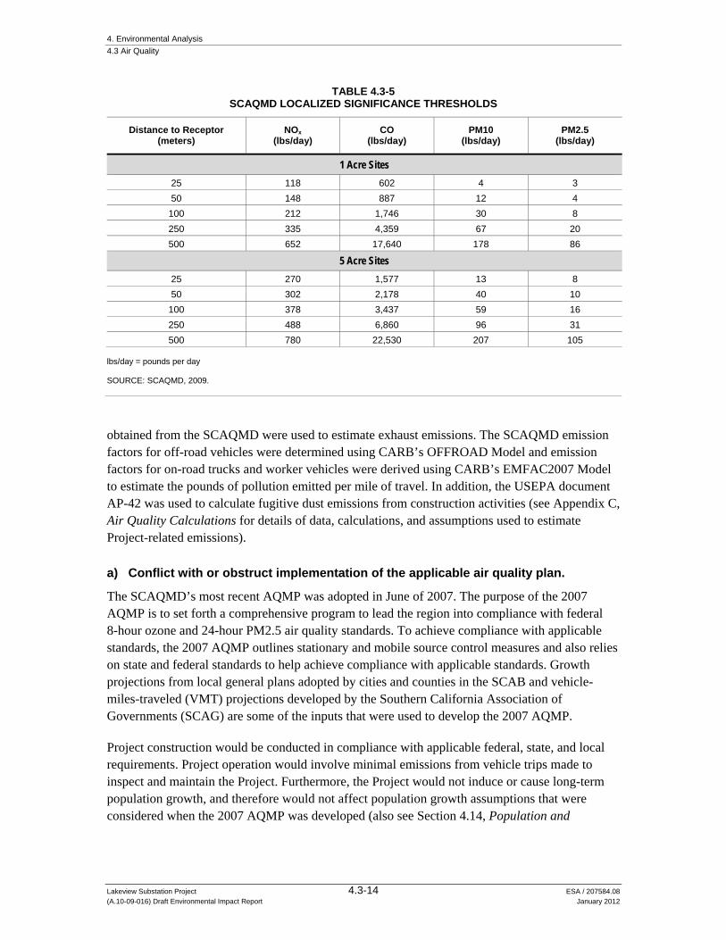
4. Environmental Analysis 4.3 Air Quality
Lakeview Substation Project 4.3-14 ESA / 207584.08 (A.10-09-016) Draft Environmental Impact Report January 2012
TABLE 4.3-5 SCAQMD LOCALIZED SIGNIFICANCE THRESHOLDS
Distance to Receptor (meters)
NOx (lbs/day)
CO (lbs/day)
PM10 (lbs/day)
PM2.5 (lbs/day)
1 Acre Sites 25 118 602 4 3 50 148 887 12 4
100 212 1,746 30 8 250 335 4,359 67 20 500 652 17,640 178 86
5 Acre Sites 25 270 1,577 13 8 50 302 2,178 40 10
100 378 3,437 59 16 250 488 6,860 96 31 500 780 22,530 207 105
lbs/day = pounds per day SOURCE: SCAQMD, 2009.
obtained from the SCAQMD were used to estimate exhaust emissions. The SCAQMD emission factors for off-road vehicles were determined using CARB’s OFFROAD Model and emission factors for on-road trucks and worker vehicles were derived using CARB’s EMFAC2007 Model to estimate the pounds of pollution emitted per mile of travel. In addition, the USEPA document AP-42 was used to calculate fugitive dust emissions from construction activities (see Appendix C, Air Quality Calculations for details of data, calculations, and assumptions used to estimate Project-related emissions).
a) Conflict with or obstruct implementation of the applicable air quality plan.
The SCAQMD’s most recent AQMP was adopted in June of 2007. The purpose of the 2007 AQMP is to set forth a comprehensive program to lead the region into compliance with federal 8-hour ozone and 24-hour PM2.5 air quality standards. To achieve compliance with applicable standards, the 2007 AQMP outlines stationary and mobile source control measures and also relies on state and federal standards to help achieve compliance with applicable standards. Growth projections from local general plans adopted by cities and counties in the SCAB and vehicle-miles-traveled (VMT) projections developed by the Southern California Association of Governments (SCAG) are some of the inputs that were used to develop the 2007 AQMP.
Project construction would be conducted in compliance with applicable federal, state, and local requirements. Project operation would involve minimal emissions from vehicle trips made to inspect and maintain the Project. Furthermore, the Project would not induce or cause long-term population growth, and therefore would not affect population growth assumptions that were considered when the 2007 AQMP was developed (also see Section 4.14, Population and

4. Environmental Analysis 4.3 Air Quality
Lakeview Substation Project 4.3-15 ESA / 207584.08 (A.10-09-016) Draft Environmental Impact Report January 2012
Housing). Therefore, the Project would not obstruct the implementation of the currently approved AQMP (No Impact).
b) Violate any air quality standard or contribute substantially to an existing or projected air quality violation.
Impact 4.3-1: Project construction activities would generate NOx and PM10 emissions that could contribute substantially to violations of ozone and PM air quality standards. Significant Unavoidable (Class I)
Peak daily emissions from on-site and off-site construction sources were calculated for comparison with the SCAQMD’s mass daily emissions CEQA significance thresholds to evaluate whether construction activities could cause or contribute to regional violations of air quality standards. The calculations applied pollutant emission factors developed for the SCAQMD with Project construction activity information presented in Chapter 2, Project Description (see Appendix C, Air Quality Calculations, for emission estimate details and assumptions).
The maximum daily emissions that would be generated during construction of each of the Project components (i.e., proposed Lakeview Substation, distribution getaways, subtransmission source lines, and telecommunication system), as well as during demolition of the Nuevo Substation and Model Pole Top, were calculated taking into account the overlap of construction phases. Since construction of all of the components could occur at the same time, the maximum daily emissions during construction of the Lakeview Substation, distribution getaways, subtransmission source lines, and telecommunication system were added together to calculate maximum daily emissions during construction of these components. Demolition of the Nuevo Substation and Model Pole Top would occur after construction of the Project components is complete, so demolition activities would not occur on the same day as the construction activities. Therefore, peak daily emissions would be the higher of (a) the maximum daily emissions during construction of the Project components, or (b) during demolition of the Nuevo Substation and Model Pole Top.
Table 4.3-6 compares peak daily construction emissions with the SCAQMD’s mass daily emissions CEQA significance thresholds. As described above, the emissions estimates are based on a worst-case construction schedule scenario.
As shown in Table 4.3-6, estimated peak daily construction emissions of NOx and PM10 would exceed corresponding SCAQMD mass daily significance thresholds, indicating that the emissions of these pollutants could contribute to regional air quality violations during Project construction, which would result in a significant impact. The majority of NOx and PM10 emissions would be associated with the installation of the proposed subtransmission source lines. The NOx emissions would primarily be associated with on-site diesel construction equipment and the majority of PM10 emissions would be associated with fugitive dust from vehicle travel on unpaved roads and surfaces.

4. Environmental Analysis 4.3 Air Quality
Lakeview Substation Project 4.3-16 ESA / 207584.08 (A.10-09-016) Draft Environmental Impact Report January 2012
TABLE 4.3-6 PEAK DAILY CONSTRUCTION EMISSIONS
Project Component
Maximum Daily Emissions (lbs/day)
VOC CO NOx SOx PM10 PM2.5
Proposed Lakeview Substation 11.6 97.2 117.6 0.2 33.3 9.5
Distribution Getaways 7.7 30.5 68.5 0.1 3.8 2.5
Subtransmission Source Lines 16.2 64.5 159.1 0.2 218.5 31.9
Telecommunication System 7.4 36.8 63.8 0.1 69.1 8.7
Construction Total 42.9 229.0 409.0 0.6 324.7 52.6
Nuevo Substation and Model Top Demolitiona 3.47 30.96 30.57 <0.1 1.53 1.42
Highest Peak Daily 42.9 229.0 409.0 0.6 324.7 52.6
SCAQMD CEQA Significance Threshold
75 550 100 150 150 55
Significant? No No Yes No Yes No a Maximum daily emissions during Nuevo Substation and Model Pole Top are less than maximum daily emissions during construction of
the Project components. Since demolition activities would occur after the other Project construction activities have been completed, they would not contribute to the peak daily emissions.
SOURCE: SCE, 2010
To reduce construction-related equipment exhaust emissions, implementation of Mitigation Measure 4.3-1a shall be required, which would result in a 20 percent reduction in NOx emission levels and a 45 percent reduction in PM10 exhaust emissions compared to the most recent CARB fleet average. Regarding PM10 in the form of fugitive dust, SCE and its construction contractor(s) would be required to implement SCAQMD Rule 403 fugitive dust BACMs (see Table 4.3-3). It should be noted that the PM10 emissions estimates presented in Table 4.3-6 factor in emission reductions that would be achieved by implementing the BACMs, which are general in nature to offer flexibility in implementation. To ensure that the applicable SCAQMD Rule 403 fugitive dust BACMs are properly implemented during Project construction activities in a manner that reduces fugitive dust emissions to the extent feasible, SCE shall implement Mitigation Measure 4.3-1b, which would require SCE to develop a Fugitive Dust Control Plan that would specifically describe how implementation of each of the applicable SCAQMD Rule 403 fugitive dust BACMs would be successfully achieved in the field.
Mitigation Measure 4.3-1a: For off-road construction equipment of more than 50 horsepower and on-road diesel fueled vehicles, SCE shall ensure achievement of a Project-wide fleet-average 20 percent NOx reduction and 45 percent PM10 exhaust reduction compared to the most recent CARB fleet average. An Exhaust Emissions Control Plan, to achieve these reductions, shall be submitted to CPUC for review and approval prior to commencement of construction activities. Construction activities cannot commence until the plan has been approved. Acceptable options for reducing emissions include the use of

4. Environmental Analysis 4.3 Air Quality
Lakeview Substation Project 4.3-17 ESA / 207584.08 (A.10-09-016) Draft Environmental Impact Report January 2012
late model engines, low-emission diesel products, alternative fuels, engine retrofit technology, after-treatment products, and/or other options as such become available.
Mitigation Measure 4.3-1b: SCE shall develop a Fugitive Dust Control Plan that specifically describes how compliance with each of SCAQMD Rule 403 Best Available Control Measures (BACMs) shall be achieved. If it is determined that any of the BACMs are not applicable to construction of the Project, the plan shall present rational as to why the BACMs are not applicable and would not be implemented. This plan shall be submitted to the CPUC for review and approval and the approved plan shall be distributed to all employees and construction contractors prior to commencement of construction activities.
Significance after Mitigation: While Mitigation Measure 4.3-1a (Exhaust Emissions Control Plan) would reduce emissions of NOx and PM10 during construction, it would not reduce emissions to a level that would be considered less than significant. As noted above, implementation of the BAAQMD fugitive dust BACMs have been factored into the emission estimates presented in Table 4.3-6; therefore, further reductions in PM10 emissions through implementation of Mitigation Measure 4.3-1b (Fugitive Dust Control Plan) cannot be substantiated. Impacts from Project construction would cause a temporary significant and unavoidable impact to regional air quality (Class I).
Impact 4.3-2: Operational activities would generate emissions of criteria pollutants. Less than Significant (Class III)
Peak daily emissions that would be generated during Project operation were calculated for comparison with the SCAQMD’s mass daily emissions CEQA significance thresholds to evaluate whether the operational activities could cause or contribute to regional violations of air quality standards. Table 4.3-7 compares peak daily operational emissions with the SCAQMD’s mass daily CEQA significance thresholds (see Appendix C, Air Quality Calculations, for emission estimate details and assumptions).
TABLE 4.3-7 PEAK DAILY OPERATIONAL EMISSION ESTIMATES
Emission Source
Maximum Daily Emissions (lbs/day)
VOC CO NOx SOx PM10 PM2.5
Motor Vehicle Exhaust 0.1 0.9 0.1 < 0.05 < 0.05 < 0.05
Particulate Matter from Paved and Unpaved Roads -- -- -- -- 3.1 0.3
Totala 0.1 0.9 0.1 < 0.05 3.2 0.3
SCAQMD CEQA Significance Threshold 55 550 55 150 150 55
Significant? No No No No No No a Totals may not match sums of individual values because of rounding. SOURCE: SCE, 2010.

4. Environmental Analysis 4.3 Air Quality
Lakeview Substation Project 4.3-18 ESA / 207584.08 (A.10-09-016) Draft Environmental Impact Report January 2012
As shown in Table 4.3-7, the estimated peak daily emissions during Project operation would be much less than the corresponding SCAQMD mass daily significance thresholds. Emissions of these pollutants during operations would not contribute to regional air quality violations. Impacts would be less than significant (Class III).
Mitigation: None required.
c) Result in a cumulatively considerable net increase of any criteria pollutant for which the project region is non-attainment under an applicable federal or State ambient air quality standard (including releasing emissions which exceed quantitative thresholds for ozone precursors).
Impact 4.3-3: Construction activities would generate emissions of criteria pollutants that would be considered cumulatively considerable. Significant Unavoidable (Class I)
Riverside County is designated as in non-attainment of ozone, PM10, and PM2.5 standards. Long-term Project operation and maintenance would result in negligible emissions, which would not be cumulatively considerable. Construction activities associated with the Project, as described in this section, could have a temporary impact on regional and localized air quality through short-term increases in criteria pollutant exhaust emissions and fugitive dust, which could be cumulatively significant when combined with other projects described in Section 6.1, Projects Considered in the Cumulative Analysis. Mitigation Measures 4.3-1a (Exhaust Emissions Control Plan) and 4.3-1b (Fugitive Dust Control Plan) would reduce emissions of criteria pollutants during construction activities, but impacts would remain significant and unavoidable. Therefore, the Project would be cumulatively considerable and cumulative impacts on regional and localized air quality from overlapping activities during construction the Project and other projects would be significant and unavoidable.
Mitigation Measure 4.3-3: Implement Mitigation Measures 4.3-1a (Exhaust Emissions Control Plan) and 4.3-1b (Fugitive Dust Control Plan).
Significance after Mitigation: Implementation of Mitigation Measures 4.3-3 would reduce emissions of criteria pollutants to the maximum extent feasible; however, not all potential impacts from construction emissions would be mitigated. Therefore, when considered with other projects, Project construction would result in a cumulatively considerable net increase in criteria pollutants. Impacts would be significant and unavoidable (Class I).
4. Environmental Analysis 4.3 Air Quality
Lakeview Substation Project 4.3-19 ESA / 207584.08 (A.10-09-016) Draft Environmental Impact Report January 2012
d) Expose sensitive receptors to substantial pollutant concentrations.
Impact 4.3-4: The Project would generate emissions of PM10, potentially exposing sensitive receptors to harmful pollutant concentrations. Significant Unavoidable (Class I)
The SCAQMD has developed look-up tables that can be used to evaluate the potential for emissions during construction to cause localized exceedances of the ambient air quality standards at sensitive receptor locations (see Table 4.3-5). This localized significance thresholds (LST) analysis consists of comparing maximum daily on-site CO, NOx, PM10, and PM2.5 emissions at individual locations with maximum allowable emissions based on the location within the SCAB, the area of the construction site, and the distance to the nearest sensitive receptor locations. It should be noted that SCE’s LST emission estimates for construction of the subtransmission source line do not include emissions associated with road or right-of-way clearing because these activities would not be at fixed locations. However, given that the roadwork activities would result in emissions of PM10, it is appropriate for this LST analysis to account for a portion of the road work emissions near the sensitive receptor. Therefore, SCE’s LST emission estimates for the subtransmission source line have been revised to include emissions associated with road or right-of-way clearing (see Appendix C, Air Quality Calculations, for details on how this adjustment was calculated).
As indicated in Table 4.3-8, the maximum daily on-site emissions for construction of the subtransmission source line would temporarily exceed the maximum allowable emissions for PM10. The local PM10 exceedance would occur at the residence along 11th Street and would be associated with rehabilitated access road construction. Therefore, the Project would generate emissions of PM10 that could expose sensitive receptors to harmful pollutant concentrations.
Mitigation Measure 4.3-4: Implement Mitigation Measures 4.3-1a (Exhaust Emissions Control Plan) and 4.3-1b (Fugitive Dust Control Plan).
Significance after Mitigation: Implementation of Mitigation Measure 4.3-4would reduce emissions of PM10 to the maximum extent feasible; however, road construction activities that would be associated with the subtransmission source line would continue to generate emissions that would exceed the applicable LST. Therefore, the impact would be significant and unavoidable (Class I).
Impact 4.3-5: The Project would generate emissions of TACs, potentially exposing sensitive receptors to harmful pollutant concentrations. Less than Significant (Class III)
Project construction would result in temporary and short-term diesel exhaust emissions from on-site heavy duty equipment and from material deliveries and debris removal. Particulate exhaust emissions from diesel-fueled engines (i.e., DPM) were identified as a TAC by CARB in 1998. Project construction would result in the short-term generation of DPM emissions from the use of off-road diesel equipment required for site grading and excavation and other construction and

4. Environmental Analysis 4.3 Air Quality
Lakeview Substation Project 4.3-20 ESA / 207584.08 (A.10-09-016) Draft Environmental Impact Report January 2012
TABLE 4.3-8 CONSTRUCTION LOCALIZED SIGNIFICANCE THRESHOLD ANALYSIS
Project Component CO NOx PM10 PM2.5
Substation Construction Emissions (lbs/day) 72 33 26 6
Maximum Allowable Emissions (lbs/day)a 1,938 289 29 9
Exceedance? No No No No
Distribution Getaways Construction Emissions (lbs/day) 10 29 1 1
Maximum Allowable Emissions (lbs/day)b 773 136 9 4
Exceedance? No No No No
Subtransmission Source Line Construction Emissions (lbs/day) 10 28 5* 1*
Maximum Allowable Emissions (lbs/day)c 602 118 4 3
Exceedance? No No Yes No
Telecommunications Construction Emissions (lbs/day) 9 28 1 1
Maximum Allowable Emissions (lbs/day)c 602 118 4 3
Exceedance? No No No No
Nuevo Substation Demolition Emissions (lbs/day) 28 6 1 <0.5
Maximum Allowable Emissions (lbs/day)b 1,059 201 16 5
Exceedance? No No No No
Model Pole Top Substation Demolition Emissions (lbs/day) 11 29 1 1
Maximum Allowable Emissions (lbs/day)b 1,059 201 16 5
Exceedance? No No No No * SCE’s LST emission estimates for construction of the subtransmission source line do not include emissions associated with road or
right-of-way clearing because they would not be at fixed locations. These PM10 and PM2.5 emission estimates that include road and right-of-way clearing assumptions are revisions to SCE’s emission estimates (see Appendix C, Air Quality Calculations).
a Maximum allowable emissions based on 5-acre site and linear interpolation to actual receptor distance using values for Perris Valley source/receptor area.
b Maximum allowable emissions based on 1-acre site and linear interpolation to actual receptor distance using values for Perris Valley source/receptor area.
c Maximum allowable emissions based on 1-acre site and linear interpolation to actual receptor distance using values for Perris Valley source/receptor area. Note that the distances from receptors listed in the PEA air quality analysis was 25 meters for the subtransmission source line construction and 40 meters for the telecommunication construction; however, the closest sensitive receptor to these activities would be at a distance of approximately 15 meters (approximately 50 feet). Because SCAQMD does not have LSTs for distances less than 25 meters, it is impossible to estimate an LST level for 15 meters using linear interpolation, Therefore, LST levels at 25 meters where used for the maximum allowable emissions for these construction activities.
SOURCE: SCE, 2010.
demolition activities, and from construction material deliveries and demolition debris removal using on-road heavy-duty trucks. There would be no long-term mobile or stationary sources of DPM emissions associated with operation and maintenance of the Project.
The dose to which receptors are exposed is the primary factor affecting health risk from TACs. Dose is a function of the concentration of a substance or substances in the environment and the duration of exposure to the substance. According to the Office of Environmental Health Hazard Assessment (OEHHA), health risk assessments, which determine the exposure of sensitive receptors to TAC emissions, should be based on a 70-year exposure period when assessing TACs (such as DPM) that have only cancer or chronic non-cancer health effects (OEHHA, 2003).

4. Environmental Analysis 4.3 Air Quality
Lakeview Substation Project 4.3-21 ESA / 207584.08 (A.10-09-016) Draft Environmental Impact Report January 2012
However, such health risk assessments should be limited to the duration of the emission-producing activities associated with the project. For the Project, DPM emissions would occur only over the 12-month construction period.
Table 4.3-8 (above) shows that the maximum PM2.5 emissions from on-site equipment would be up to 6 pounds per day associated with construction of proposed Lakeview Substation.1 Because these daily emissions are miniscule and would occur for a total of only 12 months compared to the 70-year exposure used in health risk assessments, DPM emissions would not result in an exceedance of SCAQMD TAC significance thresholds (i.e., the Maximum Incremental Cancer Risk would be less than 10 in 1 million; the Cancer Burden would be less than 0.5 excess cancer cases, and the Chronic and Acute Hazard Index would be less than 1.0). Therefore, the health risk from short-term Project DPM emissions would be negligible and this impact would be less than significant.
Mitigation: None required.
e) Create objectionable odors affecting a substantial number of people.
Impact 4.3-6: Construction and operation of the Proposed Project would not create objectionable odors. Less than Significant (Class III)
Project operation would not create odorous emissions. However, Project construction would include sources, such as diesel equipment, which could result in the creation of objectionable odors. Since the construction activities would be temporary and spatially dispersed, and generally take place in rural areas, these activities would not affect a substantial number of people. Therefore, impacts from odors generated by Project construction would be less than significant.
Mitigation: None required.
4.2.5 Alternatives
Alternative 1: Phased Construction Alternative
Peak daily emissions that would be generated during construction of Alternative 1 were estimated based on the phasing of Project components described in Section 3.4.1. Table 4.3-9 compares peak daily operational emissions with the SCAQMD’s mass daily CEQA significance thresholds (see Appendix C, Air Quality Calculations, for emission estimate details and assumptions).
1 PM2.5 exhaust emissions are conservatively used here as a surrogate for DPM.

4. Environmental Analysis 4.3 Air Quality
Lakeview Substation Project 4.3-22 ESA / 207584.08 (A.10-09-016) Draft Environmental Impact Report January 2012
TABLE 4.3-9 PHASED CONSTRUCTION ALTERNATIVE PEAK DAILY CONSTRUCTION EMISSIONS
Project Component
Maximum Daily Emissions (lbs/day)
NOx PM10
Proposed Lakeview Substationa 117.6 33.3
Distribution Getawaysb 68.5 3.8
Subtransmission Source Linesc 111.1 177.5
Telecommunication Systemd 63.8 69.1
Nuevo Substation and Model Pole Top Demolitione 30.57 1.53
SCAQMD CEQA Significance Threshold 100 150
Significant? Yes Yes Notes: bold numbers indicate significant impacts. a Assumed grading, civil, and electrical work would occur sequentially with no overlap, all other activities would overlap. b Assumes two weeks civil work would occur prior to the electrical work and all other activities would overlap, all other activities would
overlap. c Assumes road work, ROW clearing, installation of TSP foundations, and conductor installation would occur sequentially with no overlap,
all other activities would overlap. d Assumes overhead cable installation and road and landing work would occur sequentially with no overlap, all other activities would
overlap. e Assumes activities associated with Nuevo Substation and Model Pole Top would not overlap. SOURCE: SCE, 2010
As shown in Table 4.3-9, estimated peak daily construction emissions of NOx associated with the substation and subtransmission source line construction activities exceed the daily significance threshold and the estimated peak daily construction emissions of PM10 associated with the substation construction exceed the daily significance threshold. Implementation of Mitigation Measure 4.3-1a would reduce the significant and unavoidable NOx-related impact to a less-than-significant level (Class II); however, because approximately 97 percent of the maximum PM10 emissions would be fugitive dust (the mitigation controls of which are already accounted for in the emission estimates), implementation of Mitigation Measures 4.3-1a and 4.3-1b would not reduce PM10 emissions to less than significant; therefore, PM10 impacts would be significant and unavoidable (Class I).
In summary, maximum daily NOx and PM10 emissions associated with Alternative 1 would be substantially reduced compared to the Project, and although emissions of NOx would be reduced to less-than-significant levels (compared to significant under the Project), emissions of PM10 would continue to be significant and unavoidable, similar to the Project.
Alternative 2: Relocated Substation Alternative
Table 4.3-10 compares daily emissions for the worst-case construction schedule scenario under Alternative 2 with the SCAQMD’s mass daily emissions CEQA significance thresholds (see Appendix C, Air Quality Calculations, for emission estimate details and assumptions). Construction related daily emissions of NOx and PM10 under Alternative 2 would be similar to those of the Project; daily NOx construction emissions would be approximately 3 percent higher
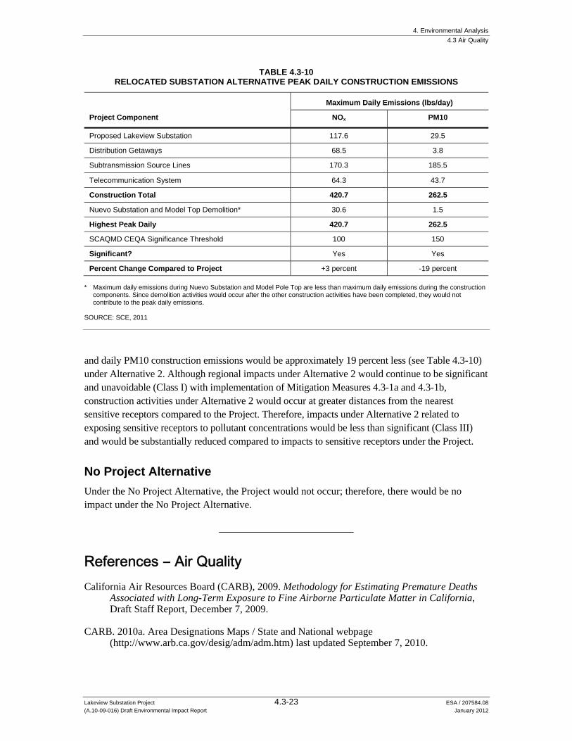
4. Environmental Analysis 4.3 Air Quality
Lakeview Substation Project 4.3-23 ESA / 207584.08 (A.10-09-016) Draft Environmental Impact Report January 2012
TABLE 4.3-10 RELOCATED SUBSTATION ALTERNATIVE PEAK DAILY CONSTRUCTION EMISSIONS
Project Component
Maximum Daily Emissions (lbs/day)
NOx PM10
Proposed Lakeview Substation 117.6 29.5
Distribution Getaways 68.5 3.8
Subtransmission Source Lines 170.3 185.5
Telecommunication System 64.3 43.7
Construction Total 420.7 262.5
Nuevo Substation and Model Top Demolition* 30.6 1.5
Highest Peak Daily 420.7 262.5
SCAQMD CEQA Significance Threshold 100 150
Significant? Yes Yes
Percent Change Compared to Project +3 percent -19 percent * Maximum daily emissions during Nuevo Substation and Model Pole Top are less than maximum daily emissions during the construction
components. Since demolition activities would occur after the other construction activities have been completed, they would not contribute to the peak daily emissions.
SOURCE: SCE, 2011
and daily PM10 construction emissions would be approximately 19 percent less (see Table 4.3-10) under Alternative 2. Although regional impacts under Alternative 2 would continue to be significant and unavoidable (Class I) with implementation of Mitigation Measures 4.3-1a and 4.3-1b, construction activities under Alternative 2 would occur at greater distances from the nearest sensitive receptors compared to the Project. Therefore, impacts under Alternative 2 related to exposing sensitive receptors to pollutant concentrations would be less than significant (Class III) and would be substantially reduced compared to impacts to sensitive receptors under the Project.
No Project Alternative
Under the No Project Alternative, the Project would not occur; therefore, there would be no impact under the No Project Alternative.
References – Air Quality California Air Resources Board (CARB), 2009. Methodology for Estimating Premature Deaths
Associated with Long-Term Exposure to Fine Airborne Particulate Matter in California, Draft Staff Report, December 7, 2009.
CARB. 2010a. Area Designations Maps / State and National webpage (http://www.arb.ca.gov/desig/adm/adm.htm) last updated September 7, 2010.
4. Environmental Analysis 4.3 Air Quality
Lakeview Substation Project 4.3-24 ESA / 207584.08 (A.10-09-016) Draft Environmental Impact Report January 2012
CARB, 2010b. Ambient Air Quality Standards, last updated September 8, 2010.
CARB. 2011a, Toxic Air Contaminant Identification List. Available at: (http://www.arb.ca.gov/ toxics/id/taclist.htm) Accessed April 22, 2011.
CARB, 2011b. iADAM Air Quality Data Statistics, http://www.arb.ca.gov/adam/index.html, obtained online on June 23 and September 27, 2011.
County of Riverside, 2008. Riverside County General Plan 2008, Chapter 9: Air Quality Element, 2008.
City of Moreno Valley, 2006. Moreno Valley General Plan, July 11, 2006.
Office of Environmental Health Hazard Assessment (OEHHA). 2003. Air Toxics Hot Spots Program Risk Assessment Guidelines: The Air Toxics Hot Spots Program Guidance Manual for Preparation of Health Risk Assessments. August, 2003.
Southern California Edison (SCE), 2010. Proponent’s Environmental Assessment, Lakeview Substation Project Volume 1, Appendix C, Air Quality Calculations. September 17, 2010.
SCE, 2010. Air Quality Emissions Analysis for Alternative 2, submitted to CPUC on September 2, 2011
South Coast Air Quality Management District (SCAQMD), 2000. The Health Effects of Air Pollution on Children, Fall 2000.
SCAQMD, 2005. Rule 302, Fugitive Dust, Amended June 3, 2005.
SCAQMD, 2009. Localized Significance Threshold Methodology, Appendix C – Mass Rate LST Look-up Table, last revised October 2009.
SCAQMD, 2011. SCAQMD Air Quality Significance Thresholds, accessed online (http://www.aqmd.gov/ceqa/handbook/signthres.pdf) September 19, 2011, last revised March 2011.
Western Regional Climate Center (WRCC), 2011. Period of Record Monthly Climate Summaries for Sun City, California, website (http://www.wrcc.dri.edu/summary) accessed on June 22, 2011.

4. Environmental Analysis
Lakeview Substation Project 4.4-1 ESA / 207584.08 (A.10-09-016) Draft Environmental Impact Report January 2012
4.4 Biological Resources
4.4.1 Setting
Introduction
This section describes the existing environment for wildlife, botanical, and wetland resources for the Project and alternatives. In addition to the alignments, the setting considers Project marshalling areas, access roads, and ancillary facilities (the Project area), as well as the larger area, including adjacent habitat, that could reasonably be affected by Project activities (the study area). The Project area is shown in Figure 2.2-2, Project Description. This section identifies potential impacts to sensitive wetland and biological resources and proposes mitigation measures to reduce potential Project impacts.
The setting information presented herein was compiled from available scientific literature and database searches, coordination with resource experts, in-house staff expertise, and multi-year field surveys. Sources used to analyze the distribution of biological resources and assess potential impacts of the Project are cited below and include, for example, the following:
California Department of Fish and Game (CDFG) California Natural Diversity Database (CNDDB) (CDFG, 2011);
Western Riverside County Multiple Species Habitat Conservation Plan (MSCHP) (Dudek, 2003);
Proponent’s Environmental Assessment (PEA) (Southern California Edison [SCE], 2010);
BonTerra’s (2010a) Biological Technical Report that was prepared for the Project, and;
Focused biological reports that considered the potential presence or absence, and distribution of sensitive resources in the study area, including:
- special-status plants (BonTerra, 2010b); - burrowing owl (BonTerra, 2010c); - sensitive mammals (BonTerra, 2010d; SJM Biological Consultants, 2011); - coastal California gnatcatcher (BonTerra, 2010e); - Riverside fairy shrimp (BonTerra, 2010f), and; - Quino checkerspot butterfly (BonTerra, 2010g) - Small mammal habitat assessment and trapping survey (BonTerra, 2011)
The study area is located within the Western Riverside County MSHCP boundary. Within this area, the Project would be constructed, operated, and maintained within the Riverside Lowlands Bioregion. This bioregion is characterized by a dry climate that supports Riversidean sage scrub and annual grasslands.
4. Environmental Analysis 4.4 Biological Resources
Lakeview Substation Project 4.4-2 ESA / 207584.08 (A.10-09-016) Draft Environmental Impact Report January 2012
A field reconnaissance survey was conducted for the Project and alternatives on March 22, 2010, by ESA wildlife biologist N. Dvorak to review biological conditions. This survey was in addition to biological resource surveys performed by SCE and their contractors.
Regional
The study area is generally located in the Moreno Valley and San Jacinto Valley in western Riverside County. The study area is within the California Floristic Province, Southwestern California Region and the South Coast subregion1, which extends from coastal areas to the Inland Empire (Hickman, 1993).
The Project is proposed within a land use matrix of agricultural and residential areas. Topography is mostly flat in the northern portion of the study area and varied in the southern portion with an approximate range of elevation from approximately 1,400 feet to 2,200 feet above mean sea level (msl). Open space occurs around Lake Perris State Recreation Area with the Bernasconi Mountains to the west. Two subtransmission source lines would cross overhead of the San Jacinto River near the community of Lakeview. Portions of SCE’s existing Lakeview-Moval 155 kV Subtransmission Line are adjacent to or within the San Jacinto Wildlife Area, which is principally located east of the subtransmission line (CDFG, 2011b). As discussed in more detail in Section 4.11, Land Use, existing uses in the study area are generally agricultural, residential and open space.
Soils vary in the study area, where the general soil classification includes relatively flat, moderately well-drained, moderately deep loam and sandy loam soils (USDA NRCS, 1978; SCE, 2010, pg. 4.4-5; see also Section 4.7, Geology and Soils). Annual rainfall totals average about 11.4 to 16.3 inches per year in the regional area, with precipitation mainly occurring during the months of November to April.
Natural Communities and Wildlife Habitat
Natural communities in the study area were characterized and mapped by SCE’s consultant, BonTerra Consulting (BonTerra, 2010a), and were generally field-verified on behalf of the CPUC by ESA biologist N. Dvorak on March 22, 2010. The types and distribution of vegetation communities in the study area were accurately described and mapped in the PEA (SCE, 2010, pp. 4.4-37 to 4.4-65) and are summarized below.
The vegetation classification system used in this EIR is based on the CDFG’s (2003) Vegetation Classification and Mapping Program List of California Terrestrial Natural Communities Recognized by the California Natural Diversity Database. This system is based on the classification put forth in A Manual of California Vegetation (Sawyer and Keeler-Wolf, 1995) and is structured to be compatible with earlier database lists.
1 Geographic subdivisions are used to describe and predict features of the natural landscape. The system of
geographic units is four-tiered: provinces, regions, subregions, and districts. The State of California is covered by three floristic provinces: California Floristic Province, Great Basin, and Desert. The California Floristic Province is the largest, includes most of the State and small portions of Oregon, Nevada and Baja California, Mexico and is made up of six regions.

4. Environmental Analysis 4.4 Biological Resources
Lakeview Substation Project 4.4-3 ESA / 207584.08 (A.10-09-016) Draft Environmental Impact Report January 2012
For purposes of mapping vegetation types for the Project, the study area included the footprint of Project facilities plus a 50-foot buffer on either side of proposed linear subtransmission source line segments and fiber optic cable routes. For purposes of mapping vegetation types for the alternatives, the study area focused on the immediate footprint of proposed facilities.
The study area supports a mix of habitats common to the Moreno Valley and San Jacinto Valley of Riverside County. In general, the proposed subtransmission source line segments and fiber-optic cable routes are dominated by agricultural lands, annual grassland, ornamental, ruderal, and disturbed lands, with limited areas that support alkali grassland, alkali scrub playa, disturbed alkali scrub playa, alkali wetland, Riversidean sage scrub, disturbed Riversidean sage scrub, southern willow scrub, detention basin, and irrigation ditch. Fifteen vegetation communities and other habitat types occur in the Project area, as characterized by BonTerra (2010a) and presented in the PEA (SCE, 2010) (Table 4.4-1). A brief description of each natural community in the study area is provided below.
Common Plant Communities
Agriculture
Agricultural lands occur throughout the study area for the Project and the alternatives. Common crops include alfalfa, sod and turfgrass, and dry-farmed barley (SCE, 2010a).
Developed/Disturbed/Ruderal/Ornamental
Developed, disturbed, and ruderal habitat are present in nearly every portion of the study area and are associated with developed areas that lack habitat, roads and road shoulders, and similar areas of heavy disturbance. In non-developed areas, this community type is dominated by non-native grasses and forbs including ripgut grass (Bromus diandrus), foxtail chess (Bromus madritensis ssp. rubens), black mustard (Brassica nigra), wild radish (Raphanus sativus), field charlock (Sinapsis arvensis), and London rocket (Sisymbrium irio) (SCE, 2010a).
Ornamental vegetation occurs along Subtransmission Source Line Segment 1 and on the Fiber-Optic Cable Routes and is often associated with developed areas. Ornamental species in the study area include oleander (Nerium oleander), gum tree (Eucalyptus sp.), Canary Island date palm (Phoenix canariensis), and Mexican fan palm (Washingtonia robusta) (SCE, 2010a).
Alkali Grassland
Alkali grassland occurs along Subtransmission Source Line Segment 1 and Fiber-Optic Cable Route 1. This vegetation type is dominated by non-native grasses including Mediterranean barley (Hordeum murinum var. gussoneanum) and foxtail barley (Hordeum murinum var. leporinum); however, the native component of this vegetation type includes salt grass (Distichlis spicata), vernal barley (Hordeum intercedens), and alkali weed (Cressa truxillensis). Identified alkali grassland areas are fairly disturbed but maintain at least 10 percent cover by native grasses and forbs (SCE, 2010a).

4. Environmental Analysis 4.4 Biological Resources
Lakeview Substation Project 4.4-4 ESA / 207584.08 (A.10-09-016) Draft Environmental Impact Report January 2012
TABLE 4.4-1 VEGETATION COMMUNITIES IN THE PROJECT AREA
Project Component Vegetation Type Area (acres)a
Proposed Lakeview Substation
Agriculture Disturbed Subtotal Area
7.09 0.98 8.07
Proposed Subtransmission Source Line Segments 1 & 2
Alkali Grassland Annual Grassland Alkali Scrub Playa Disturbed Alkali Scrub Playa Southern Willow Scrub Ruderal Agriculture Ornamental Detention Basin Disturbed Developed Subtotal Area
0.77 0.22 0.29 0.03 0.06 1.03
26.60 0.21 0.19 8.40 0.84
38.35
Proposed Fiber-Optic Cable Routes Annual Grassland Alkali Grassland Riversidean Sage Scrub Disturbed Riversidean Sage Scrub Ruderal Agriculture Ornamental Irrigation Ditch Disturbed Developed Subtotal Area
50.88 0.77 3.68 5.42
13.85 23.97 1.16 1.22
30.15 12.08
143.18
Total Area: 189.60
Alternative 2: Relocated Substation
Agriculture Disturbed Developed Subtotal Area
10.60 1.13 0.01
11.74
Alternative Subtransmission Segment 2 Developed Ruderal Agriculture Disturbed Ornamental Subtotal Area
0.57 1.71 0.79 4.11 0.07 7.25
Alternative Project Total Area: 18.99
a Acreage figures presented in Figure 4.4-1 include a 50-foot study buffer on linear facilities such as proposed subtransmission source line
segments and fiber optic cable routes. The acreage figures for the proposed and alternative substation sites correspond to the footprint of proposed facilities.
SOURCE: SCE, 2010, pp. 4.4-87, 4.4-89, 4.4-93, 4.4-98, and 4.4-101

4. Environmental Analysis 4.4 Biological Resources
Lakeview Substation Project 4.4-5 ESA / 207584.08 (A.10-09-016) Draft Environmental Impact Report January 2012
Annual Grassland
Annual grassland occurs along Subtransmission Source Line Segment 1 and Fiber-Optic Cable Routes 2 and 3. This vegetation type is dominated by non-native grasses and forbs including ripgut grass, Mediterranean barley, foxtail barley, perennial ryegrass (Lolium perenne), little-seed canary grass (Phalaris minor), small saltbush (Atriplex suberecta), five-hook bassia (Bassia hyssopifolia), and Russian thistle (Salsola tragus). Native components include Mojave silver scale (Atriplex argentea ssp. mohavensis), alkali weed, summer cypress (Kochia scoparia), and bush seepweed (Suaeda moquinii) (SCE, 2010a).
Special-Status Plant Communities
The CDFG recognizes several plant communities that are of limited distribution statewide and are often vulnerable to environmental effects of projects. These special-status plant communities may or may not contain special-status species or their habitat. Impacts to special-status plant communities identified in local or regional plans, policies, regulations, or by the CDFG or USFWS, must be considered and evaluated under CEQA. Special-status plant communities that have been identified in the study area include alkali scrub playa, disturbed alkali scrub playa, alkali wetland, Riversidean sage scrub, disturbed Riversidean sage scrub, and southern willow scrub (SCE, 2010a; CDFG, 2011), as discussed below. The distribution of these plant communities in the study area is presented in the PEA (SCE, 2010, pp. 4.4-37 to 4.4-65) and summarized below.
Alkali Scrub Playa
Alkali scrub playa occurs in flat alkali clay soils along Subtransmission Source Line Segments 2. This vegetation type is dominated by native, alkali-tolerant shrubs including Mojave silver scale, alkali weed, summer cypress, Nuttall’s monolepis (Monolepis nutalliana), and bush seepweed. Non-native components include five-hook bassia, garden beet (Beta vulgaris), and Russian thistle.
Disturbed alkali scrub playa occurs along Subtransmission Source Line Segment 2. Species composition in this community is similar to alkali scrub playa community described above; however, these areas have been subject to disturbance from off-road activity and have much higher non-native cover than the alkali scrub playa and include Mediterranean barley and foxtail barley (SCE, 2010a).
Alkali Wetland
Alkali wetland occurs along Subtransmission Source Line Segment 3. This vegetation type is associated with the San Jacinto River and is dominated by native species including mulefat (Baccharis salicifolia), alkali heliotrope (Heliotropium curassavicum), alkali heath (Frankenia salina), California bulrush (Scirpus californica), and bush seepweed. Non-native components include black mustard (Brassica nigra) and bull thistle (Cirsium vulgare) (SCE, 2010a).

4. Environmental Analysis 4.4 Biological Resources
Lakeview Substation Project 4.4-6 ESA / 207584.08 (A.10-09-016) Draft Environmental Impact Report January 2012
Riversidian Sage Scrub
Riversidean sage scrub occurs along the Fiber-Optic Cable Route 3. This vegetation type is dominated by native shrubs including California sagebrush (Artemisia californica), brittlebush (Encelia farinosa), interior flat-topped buckwheat, deerweed, and white sage (Salvia apiana).
Disturbed Riversidean sage scrub occurs along the Fiber-Optic Cable Route 3. This vegetation type has identical dominant shrubs to Riversidean sage scrub above; however, these areas have been disturbed to varying degrees by off-road vehicle use and are now dominated by non-native grasses including ripgut grass, Mediterranean barley, and shortpod mustard (Hirschfeldia incana) (SCE, 2010a).
Southern Willow Scrub
Southern willow scrub occurs along Subtransmission Source Line Segment 2. This vegetation type is dominated by native trees and shrubs including black willow (Salix gooddingii) and mulefat. The understory consists of native herbs including southern cattail (Typha domingensis) and California bulrush and non-native herbs including black mustard and Italian thistle (Carduus pycnocephalus) (SCE, 2010a).
Jurisdictional Waters, Including Wetlands
Wetlands are ecologically productive habitats that support a rich variety of both plant and animal life. They are recognized as important natural systems because of their value to fish and wildlife, and their functions as storage areas for flood flows, groundwater recharge, nutrient recycling, and water quality improvement. Wetlands are defined as areas that are periodically or permanently inundated by surface or ground water and support vegetation adapted to saturated soils.
A formal wetland delineation was not prepared for the Project or alternatives; however, the PEA (SCE, 2010) and biological reconnaissance surveys conducted on behalf of the CPUC provide sufficient detail to estimate the number and type of wetland features that would be encountered or affected by the development of the Project or alternatives.
Waters of the U.S.
Wetland features are naturally uncommon in the region, and potentially jurisdictional wetlands are limited to the San Jacinto River, a detention basin, an irrigation ditch that is tributary to the river, and alkali wetlands that occur in association with Segment 2. For purposes of this analysis, the San Jacinto River and certain alkali wetlands in the Project area are assumed to be Waters of the U.S. The San Jacinto River is spanned by each of the proposed subtransmission source line segments, the new alternative subtransmission source line alignment associated with Alternative 2, and by Fiber-Optic Cable Route 2, which would connect the proposed Lakeview Substation to the Bunker-Nelson fiber-optic cable. Alkali wetlands occur in association with new subtransmission source line alignment associated with Alternative 2 (SCE, 2010). Waters of the U.S. are regulated by the U.S. Army Corps of Engineers (Corps). This agency’s jurisdiction is discussed in the Regulatory Context, below.

4. Environmental Analysis 4.4 Biological Resources
Lakeview Substation Project 4.4-7 ESA / 207584.08 (A.10-09-016) Draft Environmental Impact Report January 2012
Waters of the State
The San Jacinto River is also considered Waters of the State in this EIR, and therefore subject to regulation by the Corps, CDFG, and the Santa Ana Regional Water Quality Control Board (SARWQCB). The respective jurisdictions of these resource agencies are discussed in the Regulatory Context, below.
21BWildlife Movement and Urban/Wildlands Interface
The concept of wildlife corridors addresses the linkage between large blocks of habitat that allow safe movement of wildlife species from one habitat area to another. Definitions of a wildlife corridor vary but corridors may include large elements such as refuge systems or natural parks as well as small elements such as underpasses, or greenbelts within otherwise urbanized areas. In general, a wildlife corridor is described as a linear habitat, embedded in a dissimilar matrix that connects two or more large blocks of habitat (Beier and Noss, 1998). Such corridors are critical for the survivorship of ecological systems for several reasons. They can connect water, food, and cover sources, spatially linking these three resources with wildlife in different areas. In addition, wildlife movement between habitat areas provides for the potential of genetic exchange between wildlife species populations, thereby maintaining genetic variability and adaptability to maximize the success of wildlife responses to changing environmental conditions. This is especially critical for small populations subject to loss of variability from genetic drift and effects of inbreeding. The nature of corridor use and wildlife movement patterns varies greatly among species and geographic regions.
A key objective of the Riverside County General Plan for the Lakeview/Nuevo area is to maintain and enhance linkage values of the San Jacinto River for wildlife movement and resident wildlife habitat (County of Riverside, 2008). The Project is proposed within an area that has features conducive to wildlife corridor functions. This area occurs within the Western Riverside County MSHCP Existing Core H (Dudek, 2003) and may provide a connection to core areas in the Badlands and the middle reach of the San Jacinto River. Open space also occurs in the Lakeview Mountains to the southeast. This area is Proposed Noncontiguous Habitat Block 5 in the MSHCP (Dudek, 2003). It is connected to other MSHCP conservation lands via Proposed Constrained Linkage 20, which connects Lake Perris in the north and the Lakeview Mountains to the south.
Special-Status Species
Several species that occur in the study area are accorded “special-status” because of their recognized rarity or vulnerability to various causes of habitat loss or population decline. Some of these receive specific protection defined in federal or State endangered species legislation. Others have been designated as “sensitive” on the basis of adopted policies and expertise of state resource agencies or organizations with acknowledged expertise, or policies adopted by local governmental agencies such as counties, cities, and special districts to meet local conservation objectives. These species are referred to collectively as “special-status species” in this EIR. The various categories encompassed by the term, and the legal status of each, are discussed in the Regulatory Context below.

4. Environmental Analysis 4.4 Biological Resources
Lakeview Substation Project 4.4-8 ESA / 207584.08 (A.10-09-016) Draft Environmental Impact Report January 2012
Special-status wildlife and plant species that are known to or have potential to occur in the study area are discussed below. A list of special-status species reported or expected to occur within the study area as well as information pertaining to natural communities of special concern was compiled on the basis of data in the CNDDB (CDFG, 2011), California Native Plant Society (CNPS) online database, the PEA (SCE, 2010), and BonTerra’s (2010a) biological study. The list is intended to be comprehensive. The “Potential for Occurrence” designations apply to species and habitats in the study area that would not necessarily be affected by the Project or alternatives. Data gathered during focused surveys was used to assess the potential presence of conditions that could support special-status species and/or natural communities of special concern.
Special-Status Wildlife
The analysis of special-status species in the region produced an inventory of special-status wildlife species that have a moderate to high potential for occurrence within the study area and could be exposed to Project-related impacts (i.e., species or habitat that either is known to occur in the study area or has a high potential to occur there). The following federally and/or state-listed endangered or threatened species have the potential to occur in or near the study area for the Project and alternatives based on documented occurrence or the presence of suitable habitat: Riverside fairy shrimp (Streptocephalus woottoni) and Stephen’s kangaroo rat (Dipodomys stephensi) (Table 4.4-2). The Quino checkerspot butterfly (Euphydryas editha quino) and coastal California gnatcatcher (Polioptila californica californica) are considered unlikely within the project area due to unsuitable habitat conditions, known species distribution, or documented absence during focused surveys (BonTerra, 2010g; 2010e). In addition to species formally listed by the resource agencies, multiple species reported in the study area are granted protection as “special-status species” under Section 15380 of the CEQA Guidelines (see the Regulatory Context section).
Table 4.4-2 lists the special-status species that have been reported or potentially occur in the study area for the Project and alternatives based on known species distribution and/or the presence of suitable habitat. The potential for occurrence for each species is characterized in Table 4.4-2 as low, moderate, high, or present. In this context, these terms mean the following:
Low means the species was not observed or there was no suitable habitat;
Moderate means the species was not observed, marginal habitat was observed, or occurrences were documented nearby;
High means the species was detected during one or more surveys or is likely to occur based on known distribution or presence of suitable habitat; and
Present means the species was documented in the study area, either as a resident or migrant.
This analysis evaluates potential impacts of the Project on listed and other species determined to have moderate or high potential and species known to be present in the study area. These species are described below. Non-listed special-status wildlife species, species determined to have a low potential to occur in the study area, and birds that may forage (but not nest) in the area are identified, but related impacts are not analyzed under CEQA.

4. Environmental Analysis 4.4 Biological Resources
Lakeview Substation Project 4.4-9 ESA / 207584.08 (A.10-09-016) Draft Environmental Impact Report January 2012
TABLE 4.4-2 SPECIAL-STATUS SPECIES REPORTED OR POTENTIALLY OCCURRING IN THE STUDY AREA FOR THE PROJECT AND ALTERNATIVES
Scientific Name Common Name
Listing Status:
Fed/State/ CNPS General Habitat
Occurrence Reported in Area/ Potential for Occurrence
Proposed Lakeview
Substation
Alternative 2: Relocated Substation
Subtransmission Source Line Segment 1
Subtransmission Source Line Segment 2
Fiber-Optic Cable Route 1
Fiber-Optic Cable Route 2
Fiber-Optic Cable Route 3
Invertebrates
FEDERAL OR STATE THREATENED AND ENDANGERED SPECIES
Quino checkerspot butterfly Euphydryas editha quino
FE/--
Meadow habitats or clearings in scrub or chaparral vegetation types
Absent. No habitat present
Absent. No habitat present
Absent. No habitat present
Absent. No habitat present
Absent. No habitat present
Absent. No habitat present
Low potential. Habitat present; not found during focused surveys
Riverside fairy shrimp Streptocephalus woottoni
FE/-- Vernal pools and ephemeral ponds in coastal Southern California
Absent. No habitat present
Absent. No habitat present
Absent. No habitat present
Absent. No habitat present
Absent. No habitat present
Absent. No habitat present
Absent. No habitat present
Amphibians
SPECIES OF SPECIAL CONCERN
Western spadefoot Spea hammondii
--/CSC Breeds in quiet streams, vernal pools and temporary ponds
Absent. No habitat present
Absent. No habitat present
Absent. No habitat present
Moderate potential. Habitat present near the San Jacinto River
Moderate potential. Suitable
breeding habitat near alignment
Moderate potential. Suitable breeding
habitat near alignment
Moderate potential. Suitable breeding habitat near alignment
Reptiles
SPECIES OF SPECIAL CONCERN
Silvery legless lizard Anniella pulchra pulchra
--/CSC Sandy areas within chaparral, pine-oak woodland, beach, and riparian habitat
Absent. No habitat present
Absent. No habitat present
Absent. No habitat present
Absent. No habitat present
Moderate potential.
Suitable habitat occurs on alignment
Absent. No habitat present
Moderate potential. Suitable habitat occurs on
alignment
Orange-throated whiptail Aspidoscelis hyperytha
--/CSC Open areas of sage scrub and chaparral with gravelly soils, often with rocks
Absent. No habitat present
Absent. No habitat present
Absent. No habitat present
Absent. No habitat present
Moderate potential.
Suitable habitat occurs on alignment
Absent. No habitat present
Moderate potential. Suitable habitat occurs on
alignment

4. Environmental Analysis 4.4 Biological Resources
TABLE 4.4-2 (Continued) SPECIAL-STATUS SPECIES REPORTED OR POTENTIALLY OCCURRING IN THE STUDY AREA FOR THE PROJECT AND ALTERNATIVES
Lakeview Substation Project 4.4-10 ESA / 207584.08 (A.10-09-016) Draft Environmental Impact Report January 2012
Scientific Name Common Name
Listing Status:
Fed/State/ CNPS General Habitat
Occurrence Reported in Area/ Potential for Occurrence
Proposed Lakeview
Substation
Alternative 2: Relocated Substation
Subtransmission Source Line Segment 1
Subtransmission Source Line Segment 2
Fiber-Optic Cable Route 1
Fiber-Optic Cable Route 2
Fiber-Optic Cable Route 3
Reptiles (cont.)
SPECIES OF SPECIAL CONCERN (cont.)
Northern red-diamond rattlesnake Crotalus ruber ruber
--/CSC Open scrub, chaparral, woodland, and grassland
Absent. No habitat present
Absent. No habitat present
Absent. No habitat present
Absent. No habitat present
Absent. No habitat present
Absent. No habitat present
Moderate potential. Suitable habitat occurs on
alignment
Coast horned lizard Phrynosoma coronatum [blainvillii population]
--/CSC Scrubland, grassland, coniferous forests, and broadleaf woodland vegetation types with loose soil and available invertebrate forage
Absent. No habitat present
Absent. No habitat present
Absent. No habitat present
Absent. No habitat present
Absent. No habitat present
Absent. No habitat present
Moderate potential. Suitable habitat occurs on
alignment
Coast patch-nosed snake Salvadora hexalepis virgultea
--/CSC Open sandy areas and rocky outcrops in scrub, chaparral, grassland, and woodland
Absent. No habitat present
Absent. No habitat present
Absent. No habitat present
Absent. No habitat present
Absent. No habitat present
Absent. No habitat present
Moderate potential. Suitable habitat occurs on
alignment
Birds
FEDERAL OR STATE THREATENED AND ENDANGERED SPECIES
Coastal California gnatcatcher Polioptila californica californica
FT/CSC Coastal sage scrub habitat
Absent. No habitat present
Absent. No habitat present
Absent. No habitat present
Absent. No habitat present
Low. Limited suitable habitat
Absent. No habitat present
Low. Habitat present, not
observed during focused surveys
SPECIES OF SPECIAL CONCERN
Cooper’s hawk Accipiter cooperii
--/WL Nests in oak and riparian woodlands dominated by sycamores (Platanus sp.) and willows (Salix sp.)
Absent (breeding);
some foraging potential
Absent (breeding);
some foraging potential
Absent (breeding); some foraging potential
Absent (breeding); some foraging
potential
Absent (breeding);
some foraging potential
Moderate breeding &
foraging potential
Moderate breeding &
foraging potential
Tricolored blackbird Agelaius tricolor
--/CSC Breeds in marsh vegetation of bulrushes and cattails and have also been recorded nesting in willows, blackberries, and mustard
Absent (breeding);
some foraging potential
Absent (breeding);
some foraging potential
Absent (breeding); some foraging potential
Absent (breeding); some foraging
potential
Absent (breeding);
some foraging potential
Absent. No habitat present
Absent (breeding); some foraging potential

4. Environmental Analysis 4.4 Biological Resources
TABLE 4.4-2 (Continued) SPECIAL-STATUS SPECIES REPORTED OR POTENTIALLY OCCURRING IN THE STUDY AREA FOR THE PROJECT AND ALTERNATIVES
Lakeview Substation Project 4.4-11 ESA / 207584.08 (A.10-09-016) Draft Environmental Impact Report January 2012
Scientific Name Common Name
Listing Status:
Fed/State/ CNPS General Habitat
Occurrence Reported in Area/ Potential for Occurrence
Proposed Lakeview
Substation
Alternative 2: Relocated Substation
Subtransmission Source Line Segment 1
Subtransmission Source Line Segment 2
Fiber-Optic Cable Route 1
Fiber-Optic Cable Route 2
Fiber-Optic Cable Route 3
Birds (cont.)
SPECIES OF SPECIAL CONCERN (cont.)
Southern California rufous-crowned sparrow Aimophila ruficeps canescens
--/WL Scrub vegetation and other habitats with grasses and widely spaced, low shrubs
Absent. No habitat present
Absent. No habitat present
Low. Limited suitable habitat
Absent. No habitat present
Low. Limited suitable habitat
Absent. No habitat present
High. Suitable habitat present
and recent species
observations
Grasshopper sparrow Ammodramus savannarum
--/CSC Open grasslands and prairies with patchy, bare ground
Absent. No habitat present
Absent. No habitat present
Moderate potential. Suitable
habitat present
Absent. No habitat present
Moderate potential.
Suitable habitat present
Absent. No habitat present
Moderate potential. Suitable
habitat present
Bell’s sage sparrow Amphispiza belli belli
--/WL Breeds in low, dense chamise chaparral and in dry scrub vegetation types, often with stands of cactus
Absent. No habitat present
Absent. No habitat present
Absent. No habitat present
Absent. No habitat present
Absent. No habitat present
Absent. No habitat present
High. Suitable habitat present
and recent nearby observations
Golden eagle Aquila chrysaetos
BEPA/ WL & FP
Open grasslands, deserts, savannas, and early successional stages of forest and shrub habitats
Absent (nesting); may forage on site
Absent (nesting); may forage on site
Low (nesting). Foraging habitat
present
Absent (nesting); may forage on site
Low (nesting). Foraging habitat
present
Low (nesting). Foraging
habitat present
High. Suitable habitat present
and recent nearby observations
Burrowing owl Athene cunicularia
--/CSC Breed and forage in grasslands and prefer flat to low, rolling hills in treeless terrain
Low potential. Not found
during focused surveys
Low potential. Not found during focused surveys
Low potential. Not found during
focused surveys
Low potential. Not found during
focused surveys
Low potential. Not found during focused surveys
Moderate breeding &
foraging potential
Moderate breeding &
foraging potential
Northern harrier Circus cyaneus
--/CSC Breeding habitat includes prairie, savannah, slough, wet meadow, and marsh vegetation types
High. Breeding habitat
available
High. Breeding habitat available
Low potential (breeding); may forage on site
Low potential (breeding); may forage on site
Low potential (breeding); may forage on site
High. Suitable habitat present
and recent nearby
observations
High. Suitable habitat present
and recent nearby observations
Mountain plover Charadrius montanus
--/CSC Winters in shortgrass plains, plowed fields, open sagebrush areas, and sandy deserts
Low (breeding). Area within wintering
range; suitable foraging habitat
present
Low (breeding). Area within
wintering range; suitable foraging habitat present
Low (breeding). Area within
wintering range; suitable foraging habitat present
Low (breeding). Area within
wintering range; suitable foraging habitat present
Low (breeding). Area within
wintering range; suitable foraging habitat present
Low (breeding). Area within wintering
range; suitable foraging habitat
present
Absent. No habitat present

4. Environmental Analysis 4.4 Biological Resources
TABLE 4.4-2 (Continued) SPECIAL-STATUS SPECIES REPORTED OR POTENTIALLY OCCURRING IN THE STUDY AREA FOR THE PROJECT AND ALTERNATIVES
Lakeview Substation Project 4.4-12 ESA / 207584.08 (A.10-09-016) Draft Environmental Impact Report January 2012
Scientific Name Common Name
Listing Status:
Fed/State/ CNPS General Habitat
Occurrence Reported in Area/ Potential for Occurrence
Proposed Lakeview
Substation
Alternative 2: Relocated Substation
Subtransmission Source Line Segment 1
Subtransmission Source Line Segment 2
Fiber-Optic Cable Route 1
Fiber-Optic Cable Route 2
Fiber-Optic Cable Route 3
Birds (cont.)
SPECIES OF SPECIAL CONCERN (cont.)
White-tailed kite Elanus leucurus
--/FP Nests primarily in oaks, willows, and sycamores; they forage in grassland and scrub vegetation types
High. Suitable foraging habitat
available on site
High. Suitable foraging habitat available on site
Low potential (breeding); may forage on site
Moderate potential (breeding); may
also forage in area
Low potential (breeding); may forage on site
High. Suitable habitat present
and recent nearby
observations
High. Suitable habitat present
and recent nearby observations
California horned lark Eremophila alpestris
--/WL Breeds and forages in grasslands or agricultural fields that support little to no vegetation or short vegetation
High potential. Expected based on
suitable habitat
High potential. Expected based
on suitable habitat
High potential. Expected based
on suitable habitat
High potential. Expected based on
suitable habitat
High potential. Expected based
on suitable habitat
Low potential. Suitable habitat
absent
Low potential. Suitable habitat
absent
Merlin Falco columbarius
--/WL Breeds in open country and winters in open woodland, grasslands, cultivated fields, marshes, estuaries, and sea coasts
High. Suitable foraging habitat
available on site
High. Suitable foraging habitat available on site
High. Suitable foraging habitat available on site
High. Suitable foraging habitat available on site
High. Suitable foraging habitat available on site
Absent. No habitat present
High. Suitable habitat present
and recent nearby observations
Prairie falcon Falco mexicanus
--/WL Nest almost exclusively on cliffs
High. Suitable foraging habitat
available on site
High. Suitable foraging habitat available on site
High. Suitable foraging habitat available on site
High. Suitable foraging habitat available on site
High. Suitable foraging habitat available on site
Absent. No habitat present
High. Suitable habitat present
and recent nearby observations
American peregrine falcon Falco peregrinus anatum\
FD/FP Nests on cliffs, high building ledges, bridges, or other such structures
High. Suitable foraging habitat
available on site
High. Suitable foraging habitat available on site
High. Suitable foraging habitat available on site
High. Suitable foraging habitat available on site
High. Suitable foraging habitat available on site
Absent. No habitat present
High. Suitable habitat present
and recent nearby observations
Loggerhead shrike Lanius ludovicianus
--/CSC Open habitats with short vegetation such as pastures, agricultural fields, riparian areas, and open woodlands
Moderate breeding &
foraging potential
Moderate breeding &
foraging potential
Observed. Moderate
breeding & foraging potential
Moderate breeding & foraging potential
Moderate breeding &
foraging potential
Moderate breeding &
foraging potential
Moderate breeding &
foraging potential

4. Environmental Analysis 4.4 Biological Resources
TABLE 4.4-2 (Continued) SPECIAL-STATUS SPECIES REPORTED OR POTENTIALLY OCCURRING IN THE STUDY AREA FOR THE PROJECT AND ALTERNATIVES
Lakeview Substation Project 4.4-13 ESA / 207584.08 (A.10-09-016) Draft Environmental Impact Report January 2012
Scientific Name Common Name
Listing Status:
Fed/State/ CNPS General Habitat
Occurrence Reported in Area/ Potential for Occurrence
Proposed Lakeview
Substation
Alternative 2: Relocated Substation
Subtransmission Source Line Segment 1
Subtransmission Source Line Segment 2
Fiber-Optic Cable Route 1
Fiber-Optic Cable Route 2
Fiber-Optic Cable Route 3
Mammals
FEDERAL OR STATE THREATENED AND ENDANGERED SPECIES
Stephen’s kangaroo rat Dipodomys stephensi
FE/ST Annual and perennial grasslands, but also occurs in coastal sage scrub habitats with sparse canopy cover
Absent. No habitat present
Absent. No habitat present
Present. Suitable habitat present; detected within
alignment
Low. Limited suitable habitat
available
Present. Same as Proposed
Subtransmission Source Line Segment 1
Absent. No habitat present
Present. Suitable habitat present; documented in
alignment
SPECIES OF SPECIAL CONCERN
San Diego black-tailed jackrabbit Lepus californicus bennettii
--/CSC Shrub habitats as well as within open shrub, herbaceous tree habitats
High. Suitable habitat present on alignment
High. Suitable habitat present on alignment
High. Suitable habitat present on
alignment
High. Suitable habitat present on
alignment
High. Suitable habitat present on alignment
Low. Limited suitable habitat
available
High. Suitable habitat present on
alignment
Northwestern San Diego pocket mouse Chaetodipus fallax fallax
--/CSC Chaparral, coastal sage scrub, and grassland
Absent. No habitat present
Absent. No habitat present
Present. Identified in portions of
alignment near San Jacinto River
Present. Identified in portions of
alignment near San Jacinto River
Present. Identified in portions of
alignment near San Jacinto
River
Absent. No habitat present
High. Suitable habitat present on
alignment
Los Angeles pocket mouse Perognathus longimembris brevinasus
--/CSC Lower elevation grasslands and coastal sage scrub vegetation with open ground and fine sandy soils
Absent. No habitat present
Absent. No habitat present
Present. Suitable habitat present;
detected in surveys near
alignment
Low. Limited suitable habitat
available
Present. Same as Proposed
Subtransmission Source Line Segment 1
Absent. No habitat present
High. Suitable habitat present on
alignment
San Diego desert woodrat Neotoma lepida intermedia
--/CSC Areas with sparse vegetation, especially in association with cactus and other thorny plants
Absent. No habitat present
Absent. No habitat present
Low. Limited suitable habitat
available
Absent. No habitat present
Low. Limited suitable habitat
available
Absent. No habitat present
High. Suitable habitat present on
alignment
American badger Taxidea taxus
--/CSC Dry, open grasslands Low. Limited suitable habitat
available
Low. Limited suitable habitat
available
Low. Limited suitable habitat
available
Absent. No habitat present
Low. Limited suitable habitat
available
Absent. No habitat present
High. Suitable habitat present on
alignment

4. Environmental Analysis 4.4 Biological Resources
TABLE 4.4-2 (Continued) SPECIAL-STATUS SPECIES REPORTED OR POTENTIALLY OCCURRING IN THE STUDY AREA FOR THE PROJECT AND ALTERNATIVES
Lakeview Substation Project 4.4-14 ESA / 207584.08 (A.10-09-016) Draft Environmental Impact Report January 2012
Scientific Name Common Name
Listing Status:
Fed/State/ CNPS General Habitat
Occurrence Reported in Area/ Potential for Occurrence
Proposed Lakeview
Substation
Alternative 2: Relocated Substation
Subtransmission Source Line Segment 1
Subtransmission Source Line Segment 2
Fiber-Optic Cable Route 1
Fiber-Optic Cable Route 2
Fiber-Optic Cable Route 3
Plants
FEDERAL OR STATE THREATENED AND ENDANGERED SPECIES
Munz’s Onion Allium munzii
FE/ST/1B Chaparral, cismontane woodland, coastal scrub, pinyon and juniper woodland and grasslands
Absent. No suitable habitat
Absent. No suitable habitat
Absent. No suitable habitat
Absent. No suitable habitat
Absent. No suitable habitat
Absent. No suitable habitat
Low Potential. Not found during
surveys
San Jacinto Valley crownscale Atriplex coronata var. notatior
FE/--/1B Playas, mesic valley and foothill grasslands, and alkaline vernal pools
Absent. No suitable habitat
Absent. No suitable habitat
Present. Occurs in the alignment
near the San Jacinto River
Present. Occurs in the alignment near
the San Jacinto River
Present. Same as Proposed
Subtransmission Source Line Segment 1
Absent. No suitable habitat
Low Potential. Not found during
surveys
Thread-leaved brodiaea Brodiaea filifolia
FT/SE/1B Chenopod scrub, meadows and seeps, playas, riparian woodland, and valley and foothill grasslands
Absent. No suitable habitat
Absent. No suitable habitat
Low Potential. Not found during
surveys
Absent. No suitable habitat
Low Potential. Not found during
surveys
Absent. No suitable habitat
Low Potential. Not found during
surveys
Moran’s navarretia Navarretia fossalis
FT/--/1B Chenopod scrub, marshes and swamps, playas and vernal pools
Absent. No suitable habitat
Absent. No suitable habitat
Low Potential. Not found during
surveys
Low Potential. Not found during
surveys
Low Potential. Not found during
surveys
Absent. No suitable habitat
Absent. No suitable habitat
SPECIES OF SPECIAL CONCERN
Chaparral sand verbena Abronia villosa var. aurita
--/--/1B Chaparral, coastal scrub, and desert dunes
Absent. No suitable habitat
Absent. No suitable habitat
Absent. No suitable habitat
Absent. No suitable habitat
Absent. No suitable habitat
Absent. No suitable habitat
Low Potential. Not found during
surveys
South coast saltscale Atriplex pacifica
--/--/1B Coastal bluff scrub, coastal dunes, coastal scrub, and playas
Absent. No suitable habitat
Absent. No suitable habitat
Low Potential. Not found during
surveys
Low Potential. Not found during
surveys
Low Potential. Not found during
surveys
Absent. No suitable habitat
Low Potential. Not found during
surveys
Parish’s brittlescale Atriplex parishii
--/--/1B Chenopod scrub, playas, and alkaline vernal pools
Absent. No suitable habitat
Absent. No suitable habitat
Low Potential. Not found during
surveys
Absent. No suitable habitat
Low Potential. Not found during
surveys
Absent. No suitable habitat
Low Potential. Not found during
surveys
Davidson’s saltscale Atriplex serenana var. davidsonii
--/--/1B Coastal bluff scrub and alkaline coastal scrub
Absent. No suitable habitat
Absent. No suitable habitat
Low Potential. Not found during
surveys
Low Potential. Not found during
surveys
Low Potential. Not found during
surveys
Absent. No suitable habitat
Low Potential. Not found during
surveys

4. Environmental Analysis 4.4 Biological Resources
TABLE 4.4-2 (Continued) SPECIAL-STATUS SPECIES REPORTED OR POTENTIALLY OCCURRING IN THE STUDY AREA FOR THE PROJECT AND ALTERNATIVES
Lakeview Substation Project 4.4-15 ESA / 207584.08 (A.10-09-016) Draft Environmental Impact Report January 2012
Scientific Name Common Name
Listing Status:
Fed/State/ CNPS General Habitat
Occurrence Reported in Area/ Potential for Occurrence
Proposed Lakeview
Substation
Alternative 2: Relocated Substation
Subtransmission Source Line Segment 1
Subtransmission Source Line Segment 2
Fiber-Optic Cable Route 1
Fiber-Optic Cable Route 2
Fiber-Optic Cable Route 3
Plants (cont.)
SPECIES OF SPECIAL CONCERN (cont.)
Intermediate mariposa lily Calochortus weedii var. intermedius
--/--/1B Chaparral, coastal scrub, and calcareous valley and foothill grasslands
Absent. No suitable habitat
Absent. No suitable habitat
Absent. No suitable habitat
Absent. No suitable habitat
Absent. No suitable habitat
Absent. No suitable habitat
Low Potential. Not found during
surveys
Smooth tarplant Centromadia pungens ssp. laevis
--/--/1B Chenopod scrub, meadows and seeps, playas, riparian woodland, and alkaline valley and foothill grasslands
Absent. No suitable habitat
Absent. No suitable habitat
Present. Six colonies totaling 239 plants occur within 100 feet of
alignment
Present. One colony of 65 plants occurs within 100 feet of alignment
Present. Same as Proposed
Subtransmission Source Line Segment 1
Absent. No suitable habitat
Low Potential. Not found during
surveys
Parry’s spineflower Chorizanthe parryi var. parryi
--/--/1B Chaparral, cismontane woodland, coastal scrub, and valley and foothill grasslands in sandy or rocky openings
Absent. No suitable habitat
Absent. No suitable habitat
Low Potential. Not found during
surveys
Low Potential. Not found during
surveys
Low Potential. Not found during
surveys
Absent. No suitable habitat
Low Potential. Not found during
surveys
Long-spined spineflower Chorizanthe polygonoides var. longispina
--/--/1B Chaparral, coastal scrub, meadows and seeps, valley and foothill grasslands, and vernal pools
Absent. No suitable habitat
Absent. No suitable habitat
Low Potential. Not found during
surveys
Absent. No suitable habitat
Low Potential. Not found during
surveys
Absent. No suitable habitat
Low Potential. Not found during
surveys
Vernal barley Hordeum intercedens
--/--/3.2 Coastal dunes, coastal scrub, saline flats and depressions in valley and foothill grasslands, and vernal pools
Absent. No suitable habitat
Absent. No suitable habitat
Present. Colony of 4,000 plants
Present. Colony of 4,000 plants
Present. Same as Proposed
Subtransmission Source Line Segment 1
Absent. No suitable habitat
Low Potential. Not found during
surveys
Coulter’s goldfields Lasthenia glabrata ssp. coulteri
--/--/1B Marshes and swamps, playas, and vernal pools
Absent. No suitable habitat
Absent. No suitable habitat
Low Potential. Not found during
surveys
Present. One plant was detected
within 100 feet of alignment
Low Potential. Not found during
surveys
Absent. No suitable habitat
Low Potential. Not found during
surveys
Robinson’s pepper grass Lepidium virginicum var. robinsonii
--/--/1B Chaparral and coastal scrub
Absent. Not found during
surveys
Absent. Not found during
surveys
Absent. Not found during surveys
Absent. Not found during surveys
Absent. Not found during
surveys
Absent. Not found during
surveys
Low Potential. Not found during
surveys

4. Environmental Analysis 4.4 Biological Resources
TABLE 4.4-2 (Continued) SPECIAL-STATUS SPECIES REPORTED OR POTENTIALLY OCCURRING IN THE STUDY AREA FOR THE PROJECT AND ALTERNATIVES
Lakeview Substation Project 4.4-16 ESA / 207584.08 (A.10-09-016) Draft Environmental Impact Report January 2012
Scientific Name Common Name
Listing Status:
Fed/State/ CNPS General Habitat
Occurrence Reported in Area/ Potential for Occurrence
Proposed Lakeview
Substation
Alternative 2: Relocated Substation
Subtransmission Source Line Segment 1
Subtransmission Source Line Segment 2
Fiber-Optic Cable Route 1
Fiber-Optic Cable Route 2
Fiber-Optic Cable Route 3
Plants (cont.)
SPECIES OF SPECIAL CONCERN (cont.)
Salt Spring checkerbloom Sidalcea neomexicana
--/--/2 Chaparral, coastal scrub, lower montane coniferous forest, Mojavean desert scrub, and alkaline playas
Absent. No suitable habitat
Absent. No suitable habitat
Low Potential. Not found during
surveys
Low Potential. Not found during
surveys
Low Potential. Not found during
surveys
Absent. No suitable habitat
Absent. No suitable habitat
Wright’s trichocoronis Trichocoronis wrightii var. wrightii
--/--/2 Meadows and seeps, marshes and swamps, riparian forest, and alkaline vernal pools
Absent. No suitable habitat
Absent. No suitable habitat
Low Potential. Not found during
surveys
Low Potential. Not found during
surveys
Low Potential. Not found during
surveys
Absent. No suitable habitat
Low Potential. Not found during
surveys
STATUS CODES:
Federal (U.S. Fish and Wildlife Service): BEPA = Bald and Golden Eagle Protection Act FE = Listed as Endangered by the Federal Government FT = Listed as Threatened by the Federal Government FD = Federal delisted species
State (California Department of Fish and Game): SE = Listed as Endangered by the State of California ST = Listed as Threatened by the State of California SR = Considered Rare by the State of California (plants only) SC = Candidate for listing as threatened or endangered by the State of California CSC = California species of special concern CFP = California fully protected species WL = CDFG Watch List species
California Native Plant Society (CNPS): List 1A = Plants believed extinct List 1B = Plants rare, threatened, or endangered in California and elsewhere List 2 = Plants rare, threatened, or endangered in California but more
common elsewhere List 3 = A “review” list of plants for which more information is needed; plants
included in analysis if identified by the MSHCP (i.e., vernal barley)
SOURCES: CDFG, 2011 ; SCE, 2010 ; SJM Biological, 2011 ; BonTerra, 2010a ; BonTerra 2010b; Bonterra, 2011

4. Environmental Analysis 4.4 Biological Resources
Lakeview Substation Project 4.4-17 ESA / 207584.08 (A.10-09-016) Draft Environmental Impact Report January 2012
Non-listed special-status wildlife species include: silvery legless lizard (Anniella pulchra pulchra), orange-throated whiptail (Aspidoscelis hyperytha), northern red-diamond rattlesnake (Crotalus ruber ruber), coast [San Diego] horned lizard (Phrynosoma coronatum [blainvillii population], coast patch-nosed snake (Salvadora hexalepis virgultea), Cooper’s hawk (Accipiter cooperii), Southern California rufous-crowned sparrow (Aimophila ruficeps canescens), grasshopper sparrow (Ammodramus savannarum), Bell’s sage sparrow (Amphispiza belli belli), golden eagle (Aquila chrysaetos), burrowing owl (Athene cunicularia), northern harrier (Circus cyaneus), white-tailed kite (Elanus leucurus), California horned lark (Aquila chrysaetos), merlin (Falco columbarius), prairie falcon (Falco mexicanus), American peregrine falcon (Falco peregrinus anatum), loggerhead shrike (Lanius ludovicianus), San Diego black-tailed jackrabbit (Lepus californicus bennettii), northwestern San Diego pocket mouse (Chaetodipus fallax fallax), Los Angeles pocket mouse (Perognathus longimembris brevinasus), San Diego desert woodrat (Neotoma lepida intermedi), and American badger (Taxidea taxus).
Species determined to have a low potential to occur in the study area include: Quino checkerspot butterfly (Euphydryas editha quino), Coastal California gnatcatcher (Polioptila californica), mountain plover (Charadrius montanus), Moran’s navarretia (Navarretia fossalis), and salt spring checkerbloom (Sidalcea neomexicana). The Tri-colored blackbird may forage (but not nest) in the study area. All of the other species listed in Table 4.4-2 are described below in the order in which they appear in the table, i.e., invertebrates, amphibians, birds, mammals, and then plants.
Riverside fairy shrimp. The Riverside fairy shrimp is a federal endangered species that is associated with vernal pools and ephemeral ponds in coastal Southern California from Ventura County south to northwestern Baja California, Mexico. This species inhabits deep, long-lived pools in seasonal grasslands, some of which are interspersed among chaparral or coastal sage scrub vegetation (Eriksen and Belk, 1999). Near the study area, Riverside fairy shrimp are reported from the Santa Rosa Plateau, Skunk Hollow, Murrieta, Wildomar, Lake Elsinore, and Alberhill areas (Dudek, 2003). Suitable habitat for this species occurs in seasonal pools near the San Jacinto River; however, these areas are not in the study area for the proposed project or alternatives (SCE, 2010, pg. 4.4-100). Designated critical habitat for this species does not occur in the study area for the Project or alternatives (USFWS, 2001; 2004b).
Coastal California gnatcatcher. The coastal California gnatcatcher is a federal-listed threatened species and California species of special concern. This subspecies is an obligate resident of coastal sage scrub vegetation types and has been reported approximately 4.5 miles east of the study area (CDFG, 2011). Focused surveys performed in 2009 and 2010 did not detect this species in the study area (BonTerra, 2010e).
Designated critical habitat for this species does not occur in the study area for the Project or alternatives.
Stephen’s kangaroo rat. The Stephen’s kangaroo rat is a federal threatened and California endangered species. This species occurs primarily in annual and perennial grassland habitats, but may occur in coastal scrub or sagebrush with sparse canopy cover, or in disturbed areas (Zeiner et

4. Environmental Analysis 4.4 Biological Resources
Lakeview Substation Project 4.4-18 ESA / 207584.08 (A.10-09-016) Draft Environmental Impact Report January 2012
al., 1990). Numerous occurrences are reported in the study area (CDFG, 2011) and this species was detected during focused surveys for the Project (BonTerra, 2010d; 2011). The CNDDB reports numerous sightings and suitable habitat on the Subtransmission Source Line Segment 1, and Fiber-Optic Cable Route 2 and 3 (CDFG, 2011). Limited potentially suitable habitat is present along Segment 2 (SCE, 2010, pg. 4.4-88).
Critical habitat has not been designated for this species.
Special-Status Plants
Surveys performed in the study area considered the potential for the following special-status plants: chaparral sand verbena (Abronia villosa var. aurita), south coast saltscale (Atriplex pacifica), Parish’s brittlescale (Atriplex parishii), Davidson’s saltscale (Atriplex serenana davidsonii), intermediate Mariposa lily (Calochortus weedii var. intermedius), smooth tarplant (Hemizonia pungens), Parry’s spineflower (Chorizanthe parryi var. parryi), long-spined spineflower (Chorizanthe polygonoides var. longispina), vernal barley (Hordeum intercedens), Coulter’s goldfields (Lasthenia glabrata ssp. coulteri), Robinson’s peppergrass (Lepidium virginicum var. robinsonii), salt spring checkerbloom (Sidalcea neomexicana), and Wright’s trichoronis (Trichoronis wrightii) (See BonTerra, 2010, Section 3.3.3, Special-status Plants).
Following comprehensive surveys, special-status plants that were identified in the study area for the Project and alternatives during focused botanical surveys include: San Jacinto Valley crownscale (Atriplex coronata var. notatior), Coulter’s goldfields (Lasthenia glabrata ssp. coulteri), Smooth tarplant (Centromadia pungens ssp. laevis), and vernal barley (Hordeum intercedens) (BonTerra, 2010b). Of the identified species, San Jacinto Valley crownscale is a federal-listed species that was identified on the proposed subtransmission source line route and on the proposed fiber-optic cable routes, and is discussed below.
San Jacinto Valley crownscale. San Jacinto Valley crownscale is a federal endangered species. This annual herb occurs in playas, mesic valley and foothill grasslands, and alkaline vernal pools. This species is documented by CDFG in the San Jacinto River corridor within Subtransmission Source Line Segments 1 and 2 (CDFG, 2011; BonTerra, 2010b). Fiber-Optic Cable Route 2 alignment also traverses potentially occupied habitat in the San Jacinto River.
Critical habitat has not been designated for this species.
Regulatory Context
Biological resources in California are protected and regulated by a variety of laws and policies administered by federal, state, and local agencies. This section summarizes the biological resource-related agencies, regulations, and policies relevant to the Project and alternatives.

4. Environmental Analysis 4.4 Biological Resources
Lakeview Substation Project 4.4-19 ESA / 207584.08 (A.10-09-016) Draft Environmental Impact Report January 2012
Federal
U.S. Fish and Wildlife Service
The USFWS administers the Federal Endangered Species Act (FESA) (16 U.S. Code [USC] 153 et seq.), the Migratory Bird Treaty Act (MBTA) (16 USC 703–711), and the Bald Eagle Protection Act (16 USC 668).
Federal Endangered Species Act
Listing and Critical Habitat – FESA §4. Under FESA §4, the Secretary of the Interior and the Secretary of Commerce have joint authority to list a species as threatened or endangered. Two federal agencies oversee FESA: the USFWS has jurisdiction over plants, wildlife, and resident fish, and the National Oceanic and Atmospheric Administration’s Fisheries Service (NOAA Fisheries Service or NMFS) has jurisdiction over anadromous fish, marine fish and mammals. Section 4 requires USFWS and/or NMFS to designate critical habitat for any species listed under FESA. Critical habitat designations indicate specific geographic areas that are determined to be essential for the conservation of a listed species and that may require special management and protection. Critical habitat may include areas that are not currently occupied by the species but that will be needed for its recovery.
Portions of the Subtransmission Source Line Segments 1 and 2, as well as Fiber-Optic Cable Route 2 traverse designated critical habitat for thread-leaved brodiaea. Within designated critical habitat, the USFWS protects areas that provide the primary constituent elements (PCEs) for the survival and conservation of the subject listed species. PCEs are the physical and biological functions considered essential to species conservation that require special management considerations or protection.
The stated PCEs for thread-leaved brodiaea include areas that contain the appropriate soils and associated vegetation at suitable elevations, and adjacent areas necessary to maintain associated physical processes such as a suitable hydrological regime. Also required are suitable habitat, water, minerals, and other physiological needs for reproduction and growth of thread-leaved brodiaea, as well as habitat that supports pollinators of thread-leaved brodiaea (USFWS, 2011). Portions of the San Jacinto River corridor may provide PCEs for thread-leaved brodiaea, even though this species is not present in the area of the Project or alternatives.
Consultation and Incidental Take Authorization – FESA §§7 and 10. FESA Section 7 requires all federal agencies to consult with USFWS and/or NMFS (as appropriate) to ensure that the actions they authorize, fund, or carry out are not likely to jeopardize the continued existence of a threatened or endangered species or result in the destruction or adverse modification of critical habitat for these species. Under FESA §7(b)(3), the appropriate wildlife agency provides a written statement setting forth the agency’s opinion, and a summary of the information on which the opinion is based detailing how the proposed action affects the species or its critical habitat. If jeopardy or adverse modification is found, the agency suggests reasonable and prudent alternatives that can be taken in implementing the agency action. This written statement is called a Biological Opinion.
4. Environmental Analysis 4.4 Biological Resources
Lakeview Substation Project 4.4-20 ESA / 207584.08 (A.10-09-016) Draft Environmental Impact Report January 2012
FESA §9 lists actions that are prohibited under the Act. The “take” of a listed species without prior authorization is prohibited. “Take” is defined as “to harass, harm, pursue, hunt, shoot, wound, kill, trap, capture, or collect, or to attempt to engage in any such conduct of any listed species.” Take that is incidental to an otherwise lawful activity may be allowed in either of two ways: Section 7 provides for the issuance of an incidental take statement for federal agency actions and, for non-federal actions, Section 10 provides for the incidental take of a listed species pursuant to an incidental take permit.
FESA §10 requires the issuance of an incidental take permit before any non-federal public or private action may be undertaken that would potentially result in the take of an endangered or threatened species. FESA §10(a)(2)(A) requires an applicant for an incidental take permit to submit a habitat conservation plan that specifies, among other things, the impact that is likely to result from the taking and what steps the applicant will take to minimize and mitigate such impacts.
The MSHCP, approved by the Riverside County Board of Supervisors on June 17, 2003, was created pursuant to §10 to conserve specified sensitive species and associated habitats by addressing biological and ecological diversity conservation needs in an approximately 1,966-square-mile area of western Riverside County, including the Project area. If the Project would cause take of any federal listed threatened or endangered species, the requirements of FESA may be satisfied though compliance with the MSHCP.
Migratory Bird Treaty Act. Among other things, the MBTA (16 United States Code § 703 Supp. I, 1989) makes it “unlawful at any time, by any means or in any manner, to pursue, hunt, take, capture, kill, attempt to take, capture, or kill” migratory birds, bird parts, eggs, or nests, except in accordance with regulations prescribed by the Secretary of the Interior (50 CFR Part 21). The MBTA prohibits direct and indirect acts, though harassment and habitat modification are not included unless they result in direct loss of birds, eggs, or nests. The list of birds covered by MBTA essentially includes all native birds.
Bald and Golden Eagle Protection Act. Under the Bald and Golden Eagle Protection Act, it is illegal to import, export, take (which includes molest or disturb), sell, purchase, or barter any bald eagle or golden eagle or part thereof. The USFWS oversees enforcement of this act. The Secretary of the Interior is authorized to permit the take of golden eagle nests that interfere with resource development or recovery operations subject to new regulations that became effective November 10, 2009 (50 CFR 22.26, 22.27). Although the permit program is under development, interim guidelines suggest using the best available information and risk analysis tools to assess project impacts; at the earliest opportunity collecting data on home ranges, nesting locations, and foraging and migration behavior; full disclosure of risks to eagles; full disclosure of data and analysis limitations; and maximum consideration of impact-reduction measures and mitigation to reduce take (USFWS, 2010a).

4. Environmental Analysis 4.4 Biological Resources
Lakeview Substation Project 4.4-21 ESA / 207584.08 (A.10-09-016) Draft Environmental Impact Report January 2012
U.S. Army Corps of Engineers
Clean Water Act, §404. The Corps administers §404 of the Clean Water Act (CWA). Section 404 regulates activities in wetlands and “other waters of the United States.” Wetlands are a subset of “waters of the United States” that are defined in the Code of Federal Regulations (CFR) (33 CFR 328.3[a]; 40 CFR 230.3[s]) as:
1. All waters that are currently used, were used in the past, or may be susceptible to use in interstate or foreign commerce, including all waters that are subject to the ebb and flow of the tide.
2. All interstate waters including interstate wetlands. (Wetlands are defined by the federal government [33 CFR 328.3(b), 1991] as those areas that are inundated or saturated by surface or groundwater at a frequency and duration sufficient to support, and that under normal circumstances support, a prevalence of vegetation typically adapted for life in saturated soil conditions.)
3. All other waters—such as intrastate lakes, rivers, streams (including intermittent streams), mudflats, sandflats, wetlands, sloughs, prairie potholes, wet meadows, playa lakes, or natural ponds—the use, degradation, or destruction of which could affect interstate or foreign commerce. This includes any waters with the following current or potential uses:
That are or could be used by interstate or foreign travelers for recreational or other purposes,
From which fish or shellfish are or could be taken and sold in interstate or foreign commerce, or
That are used or could be used for industrial purposes by industries in interstate commerce.
4. All impoundments of waters otherwise defined as waters of the United States under the definition.
5. Tributaries of waters identified in paragraphs (1) through (4).
6. Territorial seas.
7. Wetlands next to waters identified in paragraphs (1) through (6).
8. Waters of the United States do not include prior converted cropland. Notwithstanding the determination of an area’s status as prior converted cropland by any other federal agency, for the purposes of the Clean Water Act, the final authority regarding the Clean Water Act jurisdiction remains with the U. S. Environmental Protection Agency (328.3[a][8] added 58 CFR 45035, August 25, 1993).
State
California Department of Fish and Game
The CDFG administers a number of laws and programs designed to protect fish and wildlife resources under the Fish and Game Code (FGC), such as the California Endangered Species Act (FGC §2050, et seq.), Fully Protected Species (FGC §3511), Native Plant Protection Act (FGC §§1900 to 1913) and Lake or Streambed Alteration Agreement Program (FGC §§1600 to 1616).

4. Environmental Analysis 4.4 Biological Resources
Lakeview Substation Project 4.4-22 ESA / 207584.08 (A.10-09-016) Draft Environmental Impact Report January 2012
California Endangered Species Act. In 1984, the State of California implemented the California Endangered Species Act (CESA) which prohibits the take of state-listed endangered and threatened species; although habitat destruction is not included in the state’s definition of take. Section 2090 requires state agencies to comply with endangered species protection and recovery and to promote conservation of these species. The CDFG administers the act and authorizes take through California Fish and Game Code §2081 agreements (except for designated “fully protected species,” see below). Unlike its federal counterpart, CESA protections apply to candidate species that have been petitioned for listing.
Regarding listed rare and endangered plant species, CESA defers to the California Native Plant Protection Act (see below).
Fish and Game Code §3503. California Fish and Game Code §3503.5 provides that it is unlawful to take, possess, or destroy any birds in the orders Falconiformes or Strigiformes (birds-of-prey) or to take, possess, or destroy the nest or eggs of any such bird except as otherwise provided by this code or any regulation adopted pursuant thereto. Construction activities that result in the incidental loss of fertile eggs or nestlings, or otherwise lead to nest abandonment and/or reproductive failure are considered a “take” by CDFG. Any loss of eggs, nests, or young or any activities resulting in nest abandonment would constitute a significant project impact.
Native Plant Protection Act. California Fish and Game Code §§1900–1913, also known as the Native Plant Protection Act, is intended to preserve, protect, and enhance endangered or rare native plants in California. The act directs CDFG to establish criteria for determining what native plants are rare or endangered. Under §1901, a species is endangered when its prospects for survival and reproduction are in immediate jeopardy from one or more cause. A species is rare when, although not threatened with immediate extinction, it is in such small numbers throughout its range that it may become endangered. The act also directs the California Fish and Game Commission to adopt regulations governing the taking, possessing, propagation, or sale of any endangered or rare native plant.
Vascular plants that are identified as rare by the CNPS, but which may have no designated status or protection under federal or state endangered species legislation, are defined as follows:
List 1A: Plants Presumed Extinct.
List 1B: Plants Rare, Threatened, or Endangered in California and elsewhere.
List 2: Plants Rare, Threatened, or Endangered in California, but more numerous elsewhere.
List 3: Plants about Which More Information is Needed – A Review List.
List 4: Plants of Limited Distribution – A Watch List.
In general, plants appearing on CNPS List 1A, 1B, or 2 are considered to meet the criteria of CEQA Guidelines §15380 and effects to these species are considered “significant” in this EIR. For the purposes of this EIR, impacts to other MSHCP Planning Species, specifically the CNPS List 3 species “vernal barley” would also be considered potentially significant. Additionally, plants listed on CNPS List 1A, 1B or 2 meet the definition of §1901, Chapter 10 (Native Plant
4. Environmental Analysis 4.4 Biological Resources
Lakeview Substation Project 4.4-23 ESA / 207584.08 (A.10-09-016) Draft Environmental Impact Report January 2012
Protection Act) and §§2062 and 2067 (California Endangered Species Act) of the California Fish and Game Code.
Lake or Streambed Alteration Agreement Program. The CDFG regulates activities that would interfere with the natural flow of, or substantially alter, the channel, bed, or bank of a lake, river, or stream. Section 1602 of the California Fish and Game Code requires notification of the CDFG for lake or stream alteration activities. If, after notification is complete, the CDFG determines that the activity may substantially adversely affect an existing fish and wildlife resource, the CDFG has authority to issue a Streambed Alteration Agreement under §1603 of the California Fish and Game Code. Requirements to protect the integrity of biological resources and water quality are often conditions of Streambed Alteration Agreements. These may include avoidance or minimization of heavy equipment use within stream zones, limitations on work periods to avoid impacts to wildlife and fisheries resources, and measures to restore degraded sites or compensate for permanent habitat losses.
Species of Special Concern. CDFG maintains lists for candidate-endangered species and candidate-threatened species. California candidate species are afforded the same level of protection as listed species. California also designates species of special concern, which are species of limited distribution, declining populations, diminishing habitat, or unusual scientific, recreational, or educational value. These species do not have the same legal protection as listed species or fully protected species, but may be added to official lists in the future. CDFG intends the species of special concern list to be a management tool for consideration in future land use decisions.
State Water Resources Control Board
Porter-Cologne Water Quality Act. The State Water Resources Control Board (SWRCB), through its nine Regional Water Quality Control Boards (RWQCB), regulates waters of the State through the California Clean Water Act (i.e., Porter-Cologne Act). If the Corps determines wetlands or other waters to be isolated waters and not subject to regulation under the federal CWA, the RWQCB may choose to exert jurisdiction over these waters under the Porter-Cologne Act as waters of the state.
CEQA Guidelines §15380
Although threatened and endangered species are protected by specific federal and State statutes, CEQA Guidelines §15380(b) provides that a species not listed on the federal or State list of protected species may be considered rare or endangered if the species can be shown to meet certain specific criteria. These criteria have been modeled after the definition of FESA and the section of Fish and Game Code discussing rare or endangered plants or animals. This section was included in the CEQA Guidelines primarily for situations in which a public agency is reviewing a project that may have a significant effect on a candidate species that has not yet been listed by CDFG or USFWS. CEQA provides the ability to protect species from potential project impacts until the respective agencies have the opportunity to designate the species protection.
CEQA also specifies the protection of other locally or regionally significant resources, including natural communities or habitats. Although natural communities do not presently have legal

4. Environmental Analysis 4.4 Biological Resources
Lakeview Substation Project 4.4-24 ESA / 207584.08 (A.10-09-016) Draft Environmental Impact Report January 2012
protection, CEQA requires an assessment of such communities and potential project impacts. Natural communities that are identified as sensitive in the CNDDB are considered by CDFG to be significant resources and fall under the CEQA Guidelines for addressing impacts. Local planning documents such as general and area plans often identify natural communities.
Local
Riverside County General Plan
CPUC General Order No. 131-D explains that local land use regulations would not apply to the Project. However, CPUC staff considered local plans and policies to inform the significance determination related to the protection of biological resources in the study area. There are no local policies or ordinances protecting biological resources that may exist within the Project site.
Western Riverside County Multiple Species Habitat Conservation Plan
As identified in the PEA (SCE, 2010, pg. 4.4-75), the Western Riverside MSHCP is a comprehensive, multi-jurisdictional plan that focuses on conservation of species and their associated habitats in western Riverside County. The MSHCP allows Riverside County and its cities to better control local land-use decisions and to maintain a strong economic climate in the region while addressing the requirements of the state and federal Endangered Species Acts. The MSHCP Plan Area encompasses 1.26 million acres in western Riverside County.
The MSHCP requires that project sites be evaluated for a number of factors to assess how they meet the criteria identified in the MSHCP. As part of this evaluation, the project site has been assessed for riparian/riverine resources, vernal pools, areas under the jurisdiction of the Corps and/or CDFG, urban/wildlands interface issues, and potential for special-status species. If it is determined that there is potential for one of these resources and/or if the site is located within a Criteria Area that indicates potential for particular wildlife species or narrow endemic plant species, focused surveys may be required. Focused surveys must follow MSHCP protocol guidelines which typically limit surveys to certain seasonal time periods and require a set number of surveys to be conducted. In addition, Criteria Area requirements may restrict the level of development allowable within the site (SCE, 2010, pg. 4.4-75).
The Project occurs within a total of 12 MSHCP Criteria Cells, which are described in the PEA (SCE, 2010, pg. 4.4-76). Table 4.4-3 identifies the Criteria Cells and the planning species included in each designation.
Five narrow endemic plant species are known to occur within the Project area including, Munz’s onion, slender-horned spineflower (Dodecahema leptoceras), Moran’s navarretia, California Orcutt grass (Orcuttia californica), and Wright’s trichocoronis (SCE, 2010, pg. 4.4-79). MSHCP-covered plant species with potential to occur in the Project area include Munz’s onion, San Jacinto Valley crownscale, Parish’s brittlescale, Davidson’s saltscale, thread-leaved brodiaea, intermediate mariposa lily, smooth tarplant, Parry’s spineflower, long-spined spineflower, vernal barley, Coulter’s goldfields, Moran’s navarretia, California Orcutt grass, and Wright’s trichocoronis (SCE, 2010, pg. 4.4-79).

4. Environmental Analysis 4.4 Biological Resources
Lakeview Substation Project 4.4-25 ESA / 207584.08 (A.10-09-016) Draft Environmental Impact Report January 2012
TABLE 4.4-3 MSHCP CRITERIA CELLS IN THE PROJECT AREA
Criteria Cells Planning Species Project Elements
1364, 1483, 1577 Bell’s sage sparrow coastal California gnatcatcher least Bell’s vireo loggerhead shrike southern California rufous-crowned sparrow southwestern willow flycatcher Quino checkerspot butterfly bobcat Stephens’ kangaroo rat
Fiber-Optic Cable Route 3
2251, 2548, 2549 arroyo toad mountain plover tricolored blackbird white-faced ibis Riverside fairy shrimp vernal pool fairy shrimp Los Angeles pocket mouse western pond turtle Coulter’s goldfields Davidson’s saltscale San Jacinto Valley crownscale Moran’s navarretia thread-leaved brodiaea vernal barley Wright’s trichocoronis
Fiber-Optic Cable Route 3
2347, 2348, 2444, 2445, 2652 Bell’s sage sparrow Quino checkerspot butterfly bobcat Stephens’ kangaroo rat
Proposed Lakeview Substation; Alternative Substation Site; Subtransmission Source Line Segments 1 and 2 Fiber-Optic Cable Routes
2443 loggerhead shrike mountain plover white-faced ibis vernal pool fairy shrimp Los Angeles pocket mouse Coulter’s goldfields Davidson’s saltscale San Jacinto Valley crownscale Moran’s navarretia thread-leaved brodiaea vernal barley Wright’s trichocoronis
Subtransmission Source Line Segments 1 and 2
SOURCE: Dudek, 2003
MSHCP-covered wildlife species with potential to occur in the Project area include Riverside fairy shrimp, Quino checkerspot butterfly, western spadefoot, coast horned lizard, northern red-diamond rattlesnake, Cooper’s hawk, golden eagle, northern harrier, white-tailed kite, merlin, prairie falcon, mountain plover, burrowing owl, loggerhead shrike, California horned lark, coastal California gnatcatcher, southern California rufous-crowned sparrow, grasshopper sparrow, Bell’s sage sparrow, tricolored blackbird, San Diego black-tailed jackrabbit, northwestern San Diego pocket mouse, Stephens’ kangaroo rat, Los Angeles pocket mouse, and San Diego desert woodrat (SCE, 2010, pg. 4.4-79).

4. Environmental Analysis 4.4 Biological Resources
Lakeview Substation Project 4.4-26 ESA / 207584.08 (A.10-09-016) Draft Environmental Impact Report January 2012
4.4.2 Significance Criteria Based on §15065 and Appendix G of the CEQA Guidelines, a project would result in a significant impact on the environment if it would:
a) Have a substantial adverse effect, either directly or through habitat modifications, on any species identified as a candidate, sensitive, or special-status species in local or regional plans, policies, or regulations, or by the CDFG or USFWS (including List 1A, 1B, and 2 plant species of the CNPS Inventory);
b) Have a substantial adverse impact on any riparian habitat or other sensitive natural community identified in local or regional plans, policies, or regulations or by the CDFG or USFWS;
c) Have a substantial adverse effect on federally protected wetlands as defined by Section 404 of the Clean Water Act (including, but not limited to, marsh, vernal pool, coastal, etc.) through direct removal, filling, hydrological interruption, or other means;
d) Interfere substantially with the movement of any native resident or migratory fish or wildlife species or with established native resident or migratory wildlife corridors, or impede the use of native wildlife nursery sites;
e) Conflict with any local policies or ordinances protecting biological resources, such as a tree preservation policy or ordinance; or
f) Conflict with the provisions of an adopted Habitat Conservation Plan, Natural Communities Conservation Plan, other approved local, regional, or state habitat conservation plan.
CEQA §15380 provides that a plant or animal species may be treated as “Rare or Endangered” even if not on one of the official lists if, for example, it is likely to become endangered in the foreseeable future. As species of plants and animals become restricted in range and limited in population numbers, species may become listed or candidates for listing as Endangered or Threatened and become recognized under CEQA as a significant resource. Examples of such species are vernal pool fairy shrimp and burrowing owl; the former is listed by the federal government and the latter is considered a California species of special concern.
In conducting the following impact analysis, three principal components of the CEQA Guidelines outlined above were considered:
Magnitude of the impact (e.g., substantial/not substantial); Uniqueness of the affected resource (i.e., rarity of the resource); and Susceptibility of the affected resource to perturbation (i.e., sensitivity of the resource).
The evaluation of the significance of the following impacts considered the interrelationship of these three components. For example, a relatively small magnitude impact to a federal or State- listed species would be considered significant because the species is very rare and is believed to be very susceptible to disturbance. Conversely, a plant community such as California annual grassland is not necessarily rare or sensitive to disturbance. Therefore, a much larger magnitude of impact would be required to result in a significant impact.

4. Environmental Analysis 4.4 Biological Resources
Lakeview Substation Project 4.4-27 ESA / 207584.08 (A.10-09-016) Draft Environmental Impact Report January 2012
4.4.3 Applicant Proposed Measures SCE has proposed the following Applicant Proposed Measures (APMs) to minimize impacts on biological resources from the Project. The impact analysis assumes that the applicable APM would be implemented (i.e., part of the Project) to reduce biological impacts as discussed below.
APM-BIO-1: Preconstruction Surveys for Nesting Birds/Raptors. To minimize potential impacts to selected nesting special-status birds, raptors, or other MBTA bird species, planned vegetation clearing will take place during the non-breeding season (between September 1 and January 31) to the extent feasible. This will discourage the species from nesting within the work area. Existing trees, shrubs, or other vegetation that would provide suitable structure for nesting would be removed. If vegetation clearing must take place during nesting season (February 1–August 31), a biologist shall conduct pre-construction nesting bird surveys prior to clearing for the sites that have potential to support nesting birds/raptors. If the biologist finds an active nest within or adjacent to the construction area and determines that there may be impacts to the nest, s/he will delineate an appropriate buffer zone around the nest depending on the sensitivity of the species and the type of construction activity. Only construction activities (if any) approved by the biologist will take place within the buffer zone until the nest is vacated. If nests are found and cannot be avoided by the project activities, or if work is scheduled to take place near an active nest, SCE shall coordinate with the CDFG and USFWS and obtain written concurrence prior to moving the nest.
APM-BIO-2: Preconstruction Surveys and Construction Monitoring. Pre-construction biological clearance surveys shall be performed at the Project Site to minimize impacts on special-status wildlife. If special-status species are present, biological monitors would be on site, as needed during project implementation in suitable habitat areas and shall aid crews in implementing avoidance measures during project construction. If adequate avoidance cannot be established, SCE shall consider enrollment in the MSHCP as a Participating Special Entity or shall coordinate with the USFWS and the CDFG for further guidance as appropriate. Any significant findings during pre-construction surveys would be added to the WEAP training described in Section 3.9 of Chapter 3 (of the SCE, 2010 PEA).
APM-BIO-3: Stephen’s Kangaroo Rat. A habitat assessment for Stephens’ kangaroo rat shall be conducted by a biologist qualified to conduct Stephens’ kangaroo rat surveys along Segments 1, 2 and 3 and the Proposed Telecommunications Route. If no potential occupied habitat is found during this assessment, then no further action is necessary. If potential for occupied habitat is found, protocol trapping surveys shall be conducted. The Proposed Telecommunications Route is within a Stephens’ kangaroo rat fee area; therefore, if suitable habitat for this species is found, a fee shall be paid in lieu of further surveys (County of Riverside, 1996).
APM-BIO-4: Riverside Fairy Shrimp. If Riverside fairy shrimp are found, SCE shall consider (1) avoidance measures, (2) enrollment in the MSHCP as a Participating Special Entity, or (3) approvals through the USFWS. Appropriate avoidance, minimization, and compensation measures may be required. Impacts to Riverside fairy shrimp habitat will be avoided to the extent feasible in the final Project Design. Habitat areas will be marked as “off limits” in construction plans and specifications. If significant impacts to habitat are unavoidable, focused surveys will need to be conducted prior to construction activities. Riverside fairy shrimp surveys require either a wet season survey, followed by a consecutive dry season survey, or two wet season surveys done within a five-year period

4. Environmental Analysis 4.4 Biological Resources
Lakeview Substation Project 4.4-28 ESA / 207584.08 (A.10-09-016) Draft Environmental Impact Report January 2012
(USFWS, 1996). If no Riverside fairy shrimp are found in this area during the focused surveys, no additional action is warranted.
APM-BIO-5: Burrowing Owl. Any active burrow found during survey efforts shall be mapped. If no active burrows are found, no further mitigation would be required. If nesting activity is present at an active burrow, the burrow shall be protected until nesting activity has ended. Nesting activity for burrowing owl in the region normally occurs between March and August. To protect the active burrow, the following restrictions to construction activities shall be required until the burrow is no longer active as determined by a biologist: (1) clearing limits shall be established within a 500-foot buffer around any active burrow, unless otherwise determined by a biologist and (2) access and surveying shall be restricted within 300 feet of any active burrow, unless otherwise determined by a biologist. Any encroachment into the buffer area around the active burrow shall only be allowed if the biologist determines that the proposed activity will not disturb the nest occupants. Construction can proceed when the biologist has determined that fledglings have left the nest. If an active burrow is observed during the non-nesting season, the nest site will be monitored by a biologist and, when the owl is away from the nest, the biologist will either actively or passively relocate the burrowing owl. The biologist will then remove the burrow so the burrowing owl cannot return to the burrow.
APM-BIO-6: Native or Special-Status Vegetation and Special-Status Plant Populations Avoidance. Potential impacts to native vegetation types, vegetation that may support special-status species, and known populations of Special-status Plants will be avoided to the extent feasible in the final project design. Native vegetation and Special-status Plant populations will be marked as “off limits” in construction plans and specifications. If significant impacts to native vegetation and/or Special-status Plants are unavoidable, a biologist will be selected to prepare and implement a mitigation plan, which will include detailed descriptions of maintenance appropriate for the mitigation site, monitoring requirements, and annual report requirements, and will have the full authority to suspend any operation which is, in the biologist’s opinion, not consistent with the mitigation plan. This plan will be submitted for review to the appropriate agencies.
APM-BIO-7: Avoidance of San Jacinto Valley Crownscale Populations. In order to avoid potential impacts to known populations of San Jacinto Valley crownscale populations, an Environmentally Sensitive Area (ESA) will be developed prior to construction to the extent feasible in the final Project Design (Figure 4.4-5). If significant impacts to San Jacinto Valley crownscale are unavoidable, a biologist will be selected to prepare and implement a mitigation plan, which will include detailed descriptions of maintenance appropriate for the mitigation site, monitoring requirements, and annual report requirements, and will have the full authority to suspend any operation which is, in the biologist’s opinion, not consistent with the mitigation plan. This plan will be submitted for review to the appropriate agencies.
4.4.4 Impacts and Mitigation Measures
Approach to Analysis
This section identifies potential impacts to the biological resources in the vicinity of the Project while Section 4.4.5, below, identifies potential impacts within the vicinity of the alternatives. For both sections, the impact analysis focuses on foreseeable changes to baseline conditions in the context of the significance criteria presented herein. This analysis includes an evaluation of the

4. Environmental Analysis 4.4 Biological Resources
Lakeview Substation Project 4.4-29 ESA / 207584.08 (A.10-09-016) Draft Environmental Impact Report January 2012
potential direct and indirect effects of the Project and alternatives. Definitions and examples of these effects within the context of biological resources are provided below.
Direct Effects. Direct or primary effects are those effects that are caused by the project and occur at the same time and place (CEQA Guidelines §15358). Examples of these types of effects to biological resources include incidental take during construction or the loss of occupied habitat.
Indirect Effects. Indirect or secondary effects are those effects which are caused by the project and are later in time or farther removed in distance, but are still reasonably foreseeable (CEQA Guidelines §15358). Examples of these types of effects to biological resources include the discharge of sediment or chemicals that adversely affect water quality downstream of the project site, an increase in human activity during project operations, and potential growth-inducement effects.
Cumulative Impacts. Cumulative impacts refer to two or more individual effects which, when considered together, are considerable or which compound or increase other environmental impacts (CEQA Guidelines §15355). These include the effects of future projects that are reasonably certain to occur within the area of the Project, and which may cumulatively increase the magnitude of effects described previously. Examples of these types of effects to biological resources include the effects of a cumulative loss of habitat for a special-status species due to other planned projects in the area.
The Project has the potential to have direct and indirect effects on biological resources. These potential effects include disturbance of natural habitats and impacts to special-status plant and wildlife species and their habitat. Mitigation measures are presented to reduce the level of significance of potential impacts. These measures focused first on minimization and avoidance of biological resources where possible. Where impacts could not be avoided, compensation for potential impacts was proposed.
a) Have a substantial adverse effect, either directly or through habitat modifications, on any species identified as a candidate, sensitive, or special-status species in local or regional plans, policies, or regulations, or by the CDFG or USFWS (including List 1A, 1B, 2 and 3 plant species of the CNPS Inventory).
Impact 4.4-1: Construction activities could result in adverse impacts to special-status plant species may occur in unsurveyed portions of the Fiber-Optic Cable Route 3. Less than Significant with Mitigation (Class II)
Construction
Fiber-Optic Cable Route 3 provides potentially suitable habitat for several special-status plants, including the federal and/or State-listed Munz’s onion, San Jacinto Valley crownscale, and thread-leaved brodiaea (SCE, 2010). SCE would avoid known special-status plant populations through general plant protection measure (APM-BIO-6), and avoidance of San Jacinto Valley crownscale populations (APM-BIO-7). While the APMs would protect known special-status plant populations there is no allowance for providing completion of outstanding botanical surveys for Fiber-Optic Cable Route 3. Following implementation of Mitigation Measure 4.4-1, impacts to special-status plants would be less than significant.

4. Environmental Analysis 4.4 Biological Resources
Lakeview Substation Project 4.4-30 ESA / 207584.08 (A.10-09-016) Draft Environmental Impact Report January 2012
Mitigation Measure 4.4-1: SCE and/or its contractors shall complete focused, in-season botanical surveys for Fiber-Optic Cable Route 3 consistent with the most recent CDFG survey guidance (e.g., CDFG, 2009) to document the presence or absence or special-status plants. SCE shall coordinate survey findings with CDFG and/or USFWS, as appropriate depending upon the listing status of identified species (e.g., federal- or state-listed).
Significance after Mitigation: Less than Significant.
Designated critical habitat for thread-leaved brodiaea occurs on the Subtransmission Source Line Segments 1 and 2. SCE would avoid known special-status plant populations through general plant protection measure (APM-BIO-6), and avoidance of San Jacinto Valley crownscale populations (APM-BIO-7); therefore, impacts to critical habitat to less than significant.
Impact 4.4-2: Construction activities associated with the Project could result in adverse impacts to Stephen’s kangaroo rat as well as non-listed special-status wildlife species. Less than Significant (Class III)
In addition to known occurrences of Stephen’s kangaroo rat in the Project area, potential habitat for this species was identified in portions of Subtransmission Source Line Segment 1 and 2, Fiber-Optic Cable Route 2 and 3. Habitat for this species does not occur at the proposed Lakeview Substation site. SCE would have a qualified biologist perform a habitat assessment for Stephen’s kangaroo rat along Subtransmission Source Line Segment 1 and 2 and Fiber-Optic Cable Route 1, 2 and 3 (APM-BIO-3). If potential habitat for Stephen’s kangaroo rat were to be identified, SCE would perform protocol-level trapping surveys. All the fiber-optic cable routes are within a Stephens’ kangaroo rat fee area; therefore, if suitable habitat for this species were found, a fee would be paid to the County of Riverside in lieu of performing additional surveys. Additionally, a qualified biological monitor would supervise and assist construction crews to minimize impacts within potential habitat for Stephen’s kangaroo rat. Therefore, impacts to Stephen’s kangaroo rat would be less-than-significant level.
Habitat for several special-status wildlife species that were identified in the regional Project area does not occur in or near the footprint of the Project. Species that were not identified near the Project include Quino checkerspot butterfly (BonTerra, 2010g), Riverside fairy shrimp (BonTerra, 2010f), and coastal California gnatcatcher (BonTerra, 2010e) (Table 4.4-2). No direct or indirect impacts to these species are anticipated from the Project.
Numerous non-listed special-status species may be encountered in portions of the Project area due to the presence of suitable habitat and known species distribution including: silvery legless lizard, orange-throated whiptail, northern red-diamond rattlesnake, coast horned lizard, coast patch-nosed snake, Cooper’s hawk, Southern California rufous-crowned sparrow, grasshopper sparrow, Bell’s sage sparrow, golden eagle, burrowing owl, northern harrier, white-tailed kite, California horned lark, merlin, prairie falcon, American peregrine falcon, loggerhead shrike,

4. Environmental Analysis 4.4 Biological Resources
Lakeview Substation Project 4.4-31 ESA / 207584.08 (A.10-09-016) Draft Environmental Impact Report January 2012
San Diego black-tailed jackrabbit, northwestern San Diego pocket mouse, Los Angeles pocket mouse, San Diego desert woodrat, and American badger. SCE would apply APM-BIO-1 to minimize impacts to breeding birds, APM-BIO-2 to identify the distribution of wildlife species prior to construction and monitor populations during construction, and APM-BIO-5 to provide specific burrowing owl protection measures. Therefore, impacts of the Project upon the above-named species would be less than significant.
Impact 4.4-3: Construction activities may impact common or protected nesting migratory birds. Less than Significant (Class III)
Project construction activities, such as grading, preparation of temporary work areas, pull and tension sites, and access roads; operation of heavy equipment; installation and removal of poles; and conductor installation, could disturb nesting birds and cause nest site abandonment and/or reproductive failure through an increase in noise, human presence, and/or removal of habitat. Special-status birds that may nest in the Project area include Southern California rufous-crowned sparrow, grasshopper sparrow, burrowing owl, and northern harrier, among other bird species, though the protective provisions of the Migratory Bird Treaty Act also apply to common bird species.
Indirect impacts from human disturbances and construction noise could cause nest abandonment, death of young, or loss of reproductive potential at active nests located near Project sites. SCE would conduct preconstruction surveys for nesting birds and raptors, and implement avoidance requirements for active nests to reduce the potential for impacts to nesting birds (APM-BIO-1); therefore, this impact would be less than significant.
Impact 4.4-4: Operation of new transmission lines could impact raptors as a result of electrocution or collision. Less than Significant with Mitigation (Class II)
Operation
Poles and powerlines pose a danger to raptors as a result of electrocution and collision hazards, and are a recognized source of raptor mortality. Powerline electrocution is the result of two interacting factors: raptor behavior and pole design. Raptors are opportunistically attracted to powerlines because they provide perch sites for hunting, resting, feeding, and territorial defense, or are used as nesting structures. Many standard designs of electrical industry hardware place conductors and groundwires close enough together that raptors can touch them simultaneously with their wings or other body parts, causing electrocution. Raptors and other birds may also collide with powerlines, which can be difficult for birds to detect for various reasons such as during night flight or during inclement weather conditions. The type and magnitude of such impacts, and strategies to avoid conflicts between birds and new transmission lines have been well described by the Edison Electric Institute’s Avian Power Line Interaction Committee (APLIC). The APLIC (2005) characterizes potential impacts as follows:

4. Environmental Analysis 4.4 Biological Resources
Lakeview Substation Project 4.4-32 ESA / 207584.08 (A.10-09-016) Draft Environmental Impact Report January 2012
“Birds are generally electrocuted by transmission lines by due to environmental factors such as topography, vegetation, available prey and other, behavioral or biological factors influence avian use of power poles and inadequate separation between energized conductors or energized conductors and grounded hardware can provide two points of contact.
Raptors and other large birds are opportunistic and may use power poles for a number of purposes, such as nest sites, high points from which to defend territories, and perches from which to hunt. Some structures are preferred by birds because they provide considerable elevation above the surrounding terrain, thereby offering a wide field of view. Electrocution can occur when a bird completes an electric circuit by simultaneously touching two energized parts or an energized part and a grounded part of electrical equipment. Most electrocutions occur on medium-voltage distribution lines (4-34.5 kV), in which the spacing between conductors may be small enough to be bridged by birds. Poles with energized hardware, such as transformers, can be especially hazardous, even to small birds, as they contain numerous, closely-spaced energized parts.
“Avian-safe” structures are those that provide adequate clearances to accommodate a large bird between energized and/or grounded parts. Consequently, 60 inches of horizontal separation, which can accommodate the wrist-to-wrist distance of an eagle (which is approximately 54 inches), is used as the standard for raptor protection Likewise, vertical separation of at least 48 inches can accommodate the height of an eagle from its feet to the top of its head (which is approximately 31 inches). Because dry feathers act as insulation, contact must be made between fleshy parts, such as the wrists, feet, or other skin, for electrocution to occur. In spite of the best efforts to minimize avian electrocutions, some degree of mortality may always occur due to influences that cannot be controlled, e.g. weather.”
The implementation of Mitigation Measure 4.4-4 would reduce potential impacts to a less-than-significant level.
Mitigation Measure 4.4-4: SCE shall follow Avian Power Line Interaction Committee guidelines for avian protection on powerlines. SCE shall use current guidelines to reduce bird mortality from interactions with powerlines. The Avian Power Line Interaction Committee (APLIC, 2006) and USFWS recommend the following:
Provide 60-inch minimum horizontal separation between energized conductors or energized conductors and grounded hardware;
Insulate hardware or conductors against simultaneous contact if adequate spacing is not possible;
Use pole designs that minimize impacts to birds, and;
Shield wires to minimize the effects from bird collisions
Significance after Mitigation: Less than Significant.

4. Environmental Analysis 4.4 Biological Resources
Lakeview Substation Project 4.4-33 ESA / 207584.08 (A.10-09-016) Draft Environmental Impact Report January 2012
b) Have a substantial adverse impact on any riparian habitat or other sensitive natural community identified in local or regional plans, policies, or regulations or by the CDFG or USFWS.
Impact 4.4-5: Construction of the proposed Fiber-Optic Cable Route 3 could impact sensitive natural communities that are regulated by CDFG. Less than Significant (Class III)
Construction
One CDFG sensitive natural communities occurs in the Project area and would be impacted by the Project. Less than 0.01 acre of Riversidean sage scrub and disturbed Riversidian sage scrub occur on the Fiber-Optic Cable Route 3 and would be impacted (SCE, 2010; pg. 4.4-89 and 4.4-93). Sensitive natural communities associated with the San Jacinto River would be avoided by spanning sensitive habitat. Direct impacts to sensitive natural communities shall be minimized because SCE would identify, mark, and avoid areas that support sensitive vegetation (APM-BIO-6). If avoidance is not feasible, SCE would prepare a mitigation plan and submit the plan for review to the appropriate agencies detailing allowable activities for the mitigation site, and monitoring and reporting requirements (APM-BIO-6). Therefore, impacts to CDFG sensitive natural communities would be less than significant.
Mitigation: None required.
c) Effect on federally protected wetlands as defined by Section 404 of the Clean Water Act (including, but not limited to, marsh, vernal pool, coastal, etc.) through direct removal, filling, hydrological interruption, or other means.
Project activities would not affect jurisdictional waters of the United States or waters of the state, including drainages and seasonal wetlands, because these features do not occur in the Project area. Portions of the San Jacinto River would be spanned by Subtransmission Source Line Segments 1 and 2, and Fiber-Optic Cable Route 2. Therefore, since Project activities would not affect regulated wetlands under the jurisdiction of the Corps, RWQCB, or CDFG, no impact would occur to protected wetlands (No Impact).
d) Interference with the movement of any native resident or migratory fish or wildlife species or with established native resident or migratory wildlife corridors, or impede the use of native wildlife nursery sites.
Impact 4.4-6: The Project would not interfere with the movement of any native resident or migratory fish or wildlife species or with established native resident or migratory wildlife corridors, or impede the use of native wildlife nursery sites common or protected nesting migratory birds. Less than Significant (Class III)
As identified in the PEA (SCE, 2010, pg. 4.4-68), the alignments for Subtransmission Source Line Segments 1 and 2, and Fiber-Optic Cable Route 2 traverse the San Jacinto River. The river functions as a wildlife movement corridor and “live-in habitat for wildlife species,” as defined in

4. Environmental Analysis 4.4 Biological Resources
Lakeview Substation Project 4.4-34 ESA / 207584.08 (A.10-09-016) Draft Environmental Impact Report January 2012
the MSHCP. The river is identified in the MSHCP as an example of a landscape linkage that serves as a movement corridor across the central portion of the MSHCP Plan Area for species such as the bobcat (Lynx rufus) (Dudek, 2003). The construction of these facilities may temporarily impact wildlife movement along the San Jacinto River. SCE would perform pre-construction biological clearance surveys at the Project site. If special-status species are present, biological monitors would be on-site, as needed during project implementation in suitable habitat areas to aid crews in implementing avoidance measures during Project construction. If adequate avoidance cannot be established, SCE would consider enrollment in the MSHCP as a Participating Special Entity for this Project or would coordinate with the USFWS and the CDFG for further guidance as appropriate. Therefore, any construction-related impacts would be short-term, and less than significant.
e) Conflict with any local policies or ordinances protecting biological resources, such as a tree preservation policy or ordinance.
Project construction, operation and maintenance would not conflict with any local policies or ordinances protecting biological resources. Furthermore, the proposed Lakeview Substation site does not contain any native trees; therefore, construction, operation and maintenance of the proposed Lakeview Substation would result in no impact under this criterion. There are no applicable tree preservation policies or other ordinances protecting biological resources for the Proposed Subtransmission Source Line Routes or Proposed Fiber-Optic Cable Routes (No Impact).
f) Conflict with the provisions of an adopted Habitat Conservation Plan, Natural Communities Conservation Plan, or other approved local, regional, or state habitat conservation plan.
Impact 4.4-7: The Project would not conflict with the provisions of an adopted Habitat Conservation Plan, Natural Communities Conservation Plan, or other approved local, regional, or state habitat conservation plan. Less than Significant (Class III)
The Project would be located within the established Western Riverside County MSHCP boundary and within several of its identified Criteria Areas (Table 4.4-3). The Project is within several Criteria Area Cells (proposed Lakeview Substation: Cell 2445; subtransmission source line segments: Cells 2347, 2348, 2443, 2444, 2445, and 2652; fiber-optic cable routes: Cells 1364, 1370, 1483, 1577, 2347, 2348, 2349, 2443, 2444, and 2445) of the Western Riverside County MSHCP (Dudek, 2003). The proposed Lakeview Substation site currently supports agriculture and does not provide habitat for Criteria Area Species (see SCE, 2010, PEA Table 4.4-2, pg. 4.4-76). SCE would conduct surveys and additional activities as described in APM-BIO-1, APM-BIO-2, and APM-BIO-6 for nesting birds, special-status wildlife and native or special-status vegetation and special-status plant populations. Therefore, impacts to Criteria Area Species associated with construction of Subtransmission Source Line Segments 1 and 2 and the fiber-optic cable routes would also be less than significant.
4. Environmental Analysis 4.4 Biological Resources
Lakeview Substation Project 4.4-35 ESA / 207584.08 (A.10-09-016) Draft Environmental Impact Report January 2012
SCE has the option to be a Participating Entity in the MSHCP, and as such would be entitled to have its “future facilities,” including electrical utilities, considered Covered Activities under the plan provided that they comply with the criteria outlined in the MSHCP. A consistency analysis to determine the Project’s consistency with the MSHCP criteria has not yet been prepared because SCE has not yet determined whether it would participate in the MSHCP for this Project; however, SCE has performed focused studies and developed protection measures that are consistent with MSCHP guidelines. Focused biological studies were performed to determine the locations of sensitive biological resources relative to proposed facilities, and studies also assessed the potential for wildlife movement and urban/wildlands interface issues, presence of riparian/riverine areas and vernal pools, and special-status plants and wildlife. Based on these focused studies, the Project would not impact any drainage features or other protected habitats listed in Section 6.1.2 of the MSHCP, nor would it impact any narrowly endemic plant species (Section 6.1.3 of the MSHCP). The Project would comply with the MSHCP Urban/Wildlands Interface Guidelines (MSHCP Section 6.1.4.) which relate to issues of drainage, toxics, lighting, noise, invasive plant species, wildlife barriers, and grading and land development.
Maintenance of the Project would consist of minor maintenance and emergency repairs and would result in either less than significant or no impacts to biological resources.
While it is uncertain as to whether or not SCE will participate in the MSHCP; by performing focused biological resource survey and carrying out APMs SCE has committed to protect sensitive and protected species and habitats in a manner that is consistent with the MSHCP (SCE, 2010; pg. 4.4-82). Therefore, the Project would not conflict with the provisions of the MSHCP.
There are no Natural Community Conservation Plan, or other approved local, regional, or state habitat conservation plan that would be applicable to this Project (No Impact).
4.4.5 Alternatives
Alternative 1: Phased Construction Alternative
Alternative 1 would lengthen the duration of the construction period, but would not change the location of any project elements. Suitable habitat for burrowing owls is present throughout the study area (BonTerra, 2010c) and while this species was not detected during focused surveys, one or more burrowing owls could colonize the area prior to construction and this risk may increase due to the phased construction schedule. Also, phased construction schedule may overlap two nesting seasons under Alternative 1 (compared with one season under the Project). APMs for the Project would be applicable to this alternative; (APM BIO-2, Preconstruction Surveys and Construction Monitoring, and APM BIO-5, Burrowing Owl) to protect burrowing owls on Alternative 1. Similarly, the application of APMs to identify and reduce effects to nesting birds (APM BIO-1, Preconstruction Surveys for Nesting Birds/Raptors) would minimize impacts to breeding birds. Impacts on biological resources resulting from Alternative 1 would be similar to the Project.

4. Environmental Analysis 4.4 Biological Resources
Lakeview Substation Project 4.4-36 ESA / 207584.08 (A.10-09-016) Draft Environmental Impact Report January 2012
Alternative 2: Relocated Substation Alternative
Alternative 2 would change the location of the substation to approximately 0.5 mile northwest of the Project’s proposed substation location. This alternative location was not evaluated in focused special-status species surveys, but it is located in agricultural lands adjacent to the linear corridor that was evaluated for the Project as Proposed Subtransmission Source Line Route 1. The relocated substation site supports actively cultivated fields that are considered poor habitat for special-status plant and wildlife species. Focused surveys would be required to determine the potential presence of sensitive biological resources within agricultural lands. A preliminary review of the site based on remote photos suggests that sensitive biological resources such as wetlands and sensitive habitats (e.g., vernal pools, Riversidean sage scrub, alkali scrub playa, southern willow scrub) do not occur on the site. Special-status plant and wildlife species that have specific habitat requirements (e.g., Quino checkerspot butterfly, Riverside fairy shrimp, coastal California gnatcatcher, and sensitive mammals) are absent from the alternative location due to the absence of suitable habitat and recurring site disturbance.
Wildlife species such as burrow owl and other birds may nest on the fringe of the agricultural lands. APMs applicable to this alternative include APM BIO-2, Preconstruction Surveys and Construction Monitoring, and APM BIO-5, Burrowing Owl, to protect burrowing owls. Impacts on biological resources under Alternative 2 would be similar to the Project.
No Project Alternative
The No Project Alternative would have no potential impacts on biological resources because no elements of the Project would be constructed. By comparison, impacts potentially resulting from the Project would be greater.
References – Biological Resources Avian Power Line Interaction Committee (APLIC), 2006. Suggested Practices for Avian
Protection on Power Lines: The State of the Art in 2006, Edison Electric Institute and the Raptor Research Foundation, Washington, D.C., 2006.
Beier, P., and R.F. Noss, 1998. Do habitat corridors provide connectivity? Conservation Biology 12:1241–1252.
BonTerra Consulting (BonTerra), 2011. Results of a habitat assessment and trapping survey for three target sensitive small mammals, including: the federally endangered San Bernardino kangaroo rat (Dipodomys merriami parvus) (SBKR); the federally endangered Stephens’ kangaroo rat (Dipodomys stephensi) (SKR); and the California sensitive (CSC) Los Angeles pocket mouse (Perognathus longimembris brevinasus)(LAPM), along the proposed alignments for the SCE Lakeview Substation and Transmission Line Project, in the Lakeview area of Riverside County, California. Prepared for Southern California Edison, October 2011.

4. Environmental Analysis 4.4 Biological Resources
Lakeview Substation Project 4.4-37 ESA / 207584.08 (A.10-09-016) Draft Environmental Impact Report January 2012
_____, 2010a. Biological Technical Report, Lakeview Substation and Transmission Line Project, Riverside County, California. Prepared for Southern California Edison, June 2010.
_____, 2010b. Results of the Special-Status Plant Surveys for the Lakeview Substation Project, Prepared for Southern California Edison, October 2010.
_____, 2010c. Results of Western Burrowing Owl Surveys for the Lakeview Substation in the Cities of Lakeview and Nuevo and Unincorporated Riverside County, California. Prepared for Southern California Edison, October 2010.
_____, 2010d. Results of a Habitat Assessment for the Stephens’ Kangaroo Rat and the Los Angeles Pocket Mouse on the Lakeview Substation and Transmission Line Project, Riverside County, California. Prepared for Southern California Edison, October 2010.
_____, 2010e. Results of Focused Presence/Absence Surveys for the Coastal California Gnatcatcher for the Lakeview Substation and Transmission Line Project in Riverside County, California. Prepared for Southern California Edison, September 2010.
_____, 2010f. Results of a Fairy Shrimp Habitat Assessment for the Lakeview Substation and Transmission Line Project, Riverside County, California. Prepared for Southern California Edison, September 2010.
_____, 2010g. Results of Quino Checkerspot Butterfly Surveys for the Lakeview Substation and Transmission Line Project, Riverside County, California. Prepared for Southern California Edison, September 2010.
California Department of Fish and Game (CDFG), 2011a. Rarefind 4 California Natural Diversity Database, Online Version, 4.0. Accessed June 2011.
_____, 2011b. California Department of Fish and Game Owned and Operated Lands. Downloadable Data, dated April 29, 2011.
_____, 2010. Natural Communities List Arranged Alphabetically by Life Form, Sept. 2010. Accessed online at: http://www.dfg.ca.gov/biogeodata/vegcamp/natural_comm_list.asp
_____, 2009. Protocols for Surveying and Evaluating Impacts to Special-Status Native Plant Populations and Natural Communities. California Natural Resources Agency, Department of Fish and Game, November 24, 2009.
_____, 2003. The Vegetation Classification and Mapping Program List of California Terrestrial Natural Communities Recognized by the California Natural Diversity Database. Wildlife and Habitat Data Analysis Branch, September 2003.
California Native Plant Society (CNPS). 2010. Electronic Inventory of Rare and Endangered Vascular Plants of California. Nine quad search centered on the Sunnymead, 7.5-minute quadrangle map. Sacramento, CA: Online at: http://www.cnps.org/inventory
County of Riverside, 2008. County of Riverside General Plan Lakeview/Nuevo Area Plan. October 2003 (Revised in 2008).

4. Environmental Analysis 4.4 Biological Resources
Lakeview Substation Project 4.4-38 ESA / 207584.08 (A.10-09-016) Draft Environmental Impact Report January 2012
Dudek and Associates, Inc. (Dudek). 2003. Western Riverside County Multiple Species Habitat Conservation Plan (Prepared for the Riverside County Integrated Project). Encinitas, CA. Accessed online at: http://www.wrc-rca.org/Permit_Docs/mshcp_vol1.html
Eriksen, C. and D. Belk, 1999. Fairy shrimps of California’s pools, puddles, and playas. Mad River Press, Eureka, California.
Jennings, M. R., and M. P. Hayes, 1994. Amphibian and reptile species of special concern in California. California Department of Fish and Game, Inland Fisheries Division, Rancho Cordova, California.
Riverside, County of, 1996. Ordinance No. 663.10: An Ordinance of the County of Riverside Amending Ordinance No. 633 Establishing the Riverside County Stephens’ Kangaroo Rat Habitat Conservation Plan Fee Assessment Area and Setting Mitigation Fees. Riverside, CA: the County. Accessed online at: http://rivcocob.com/ords/600/663.htm
SCE, 2010. Proponents Environmental Assessment. Lakeview Substation Project. September 17, 2010.
SJM Biological Consultants, 2011. Results of a habitat assessment and trapping survey for three target sensitive mammals, including the federally endangered San Bernardino kangaroo rat; the federally endangered Stephen’s kangaroo rat; and the California sensitive (CSC) Los Angeles pocket mouse, along the proposed alignments for the SCE Lakeview Substation and Transmission Line Project, in the Lakeview area of Riverside County, California. Letter report to Jeff Crain, Bonterra Consulting, October 13, 2011.
Stebbins, R. C., 2003. A Field Guide to Western Reptiles and Amphibians. Third Edition. Houghton Mifflin Company, Boston. 533 pp.
U.S. Department of Agriculture, Natural Resources Conservation Service (USDA NRCS), 1978 Soil Survey Geographic Database for Orange and Western Part of Riverside Counties, California. Fort Worth, TX.
U.S. Fish and Wildlife Service. 2011. Endangered and Threatened Wildlife and Plants; Final Revised Critical Habitat for Brodiaea filifolia (Thread-Leaved Brodiaea); Final Rule Federal Register / Vol. 76, No. 26 / Tuesday, February 8, 2011
_____, 2005a. Endangered and Threatened Wildlife and Plants; Designation of Critical Habitat for the Riverside Fairy Shrimp (Streptocephalus woottoni); Final Rule. Fed. Reg., Vol. 70, No. 69 / April 12, 2005.
_____, 2005b. Endangered and Threatened Wildlife and Plants; Designation of Critical Habitat for Atriplex coronata var. notatior (San Jacinto Valley crownscale), Fed. Reg., Vol. 69, No. 108 / June 4, 2004.
_____, 2004a. Endangered and Threatened Wildlife and Plants; Proposed Designation of Critical Habitat for Allium munzii (Munz’s onion), Fed. Reg., Vol. 69, No. 108 / June 4, 2004.
_____, 2004b. Endangered and Threatened Wildlife and Plants; Designation of Critical Habitat for the Riverside Fairy Shrimp (Streptocephalus woottoni); Final Rule. Federal Register 70(69): 19153–19204. Washington, D.C.: USFWS.

4. Environmental Analysis 4.4 Biological Resources
Lakeview Substation Project 4.4-39 ESA / 207584.08 (A.10-09-016) Draft Environmental Impact Report January 2012
_____, 2001. Endangered and Threatened Wildlife and Plants; Final Designation of Critical Habitat for the Riverside Fairy Shrimp; Final Rule. Federal Register 66(104): 29383–29414. Washington, D.C.: USFWS.
_____, 1996. Interim Survey Guidelines to Permittees for Recovery Permits under Section 10(a)(1)(A) of the Endangered Species Act for the Listed Vernal Pool Branchiopods. Washington, D.C.: USFWS.
Zeiner, D.C., W.F. Laudenslayer, Jr., K.E. Mayer, and M. White, eds., 1990. California's Wildlife. Vol. II: Birds. California Department of Fish and Game, Sacramento, California (updated by CDFG, February 2005).

4. Environmental Analysis
Lakeview Substation Project 4.5-1 ESA / 207584.08 (A.10-09-016) Draft Environmental Impact Report January 2012
4.5 Cultural Resources
This section is based on the following cultural resources studies conducted for the Project: Cultural Resources Inventory and Evaluation for the Proposed Lakeview Substation, Source Lines, and Telecom Fiber Optic Cable Route, Lakeview Vicinity, Riverside County, California (Cotterman and Mason, 2010).
This section presents the environmental setting and impact assessment for cultural and paleontological resources. Cultural resources are defined as prehistoric and historic sites, structures, and districts, or any other physical evidence associated with human activity considered important to a culture, a subculture, or a community for scientific, traditional, religious or any other reason. For analysis purposes, cultural resources may be categorized into three groups: archaeological resources, historic resources, and contemporary Native American resources.
Archaeological resources are places where human activity has measurably altered the earth or left deposits of physical remains. Archaeological resources may be either prehistoric-era (before the introduction of writing in a particular area) or historic-era (after the introduction of writing). The majority of such places in California are associated with either Native American or Euro-American occupation of the area. The most frequently encountered prehistoric or historic Native American archaeological sites are village settlements with residential areas and sometimes cemeteries; temporary camps where food and raw materials were collected; smaller, briefly occupied sites where tools were manufactured or repaired; and special-use areas like caves, rock shelters, and sites of rock art. Historic-era archeological sites may include foundations or features such as privies, corrals, and trash dumps.
Historic architectural resources are standing structures of historic or aesthetic significance that are generally 50 years of age or older. In California, historic resources considered for protection tend to focus on architectural sites dating from the Spanish Period (1529-1822) through the early years of the Depression (1929-1930), although there has been recent attention paid to WWII and Cold War era facilities. Earlier historic resources are often associated with archaeological deposits of the same age.
Contemporary Native American resources, also called ethnographic resources, can include archaeological resources, rock art, and the prominent topographical areas, features, habitats, plants, animals, and minerals that contemporary Native Americans value and consider essential for the preservation of their traditional values. These locations are sometimes hard to define and traditional culture often prohibits Native Americans from sharing these locations with the public.
Paleontology is a branch of geology that studies the life forms of the past, especially prehistoric life forms, through the study of plant and animal fossils. Paleontological resources represent a limited, non-renewable, and impact-sensitive scientific and educational resource. As defined in this section, paleontological resources are the fossilized remains or traces of multi-cellular invertebrate and vertebrate animals and multi-cellular plants, including their imprints from a previous geologic period. Fossil remains such as bones, teeth, shells, and leaves are found in the geologic deposits (rock formations) where they were originally buried. Paleontological resources

4. Environmental Analysis 4.5 Cultural Resources
Lakeview Substation Project 4.5-2 ESA / 207584.08 (A.10-09-016) Draft Environmental Impact Report January 2012
include not only the actual fossil remains, but also the collecting localities, and the geologic formations containing those localities.
4.5.1 Setting
Cultural Resources
The Project area is located within a wide northeast-southwest trending branch of Perris valley, within an alluvial plain formed by the San Jacinto River. The San Jacinto River has been realigned and channelized in modern times. The proposed fiber optic cable line runs along the base of the Bernasconi Hills and Mount Russell, ending in Moreno Valley. Elevation ranges from 1,410 to 1,630 feet above mean sea level. Soil in the area consists of decomposed granitic silt, corals sand, and gravel. Hill slopes in the Bernasconi Hills are characterized by granitic bedrock outcrops. Originally, vegetation within the Project area would have consisted of grasslands and coastal sage scrub; however, this has been replaced by non-native grass, weeds, and agricultural fields (Cotterman and Mason, 2010).
Prehistoric Setting
The chronology of Southern California is typically divided into three general time periods: the Early Holocene (11,000 to 7,600 Before Present [B.P.]), the Middle Holocene (7,600 to 3,600 B.P.), and the Late Holocene (3,600 B.P. to A.D. 1769). Within this timeframe, the archaeology of southern California is generally described in terms of cultural “complexes.” A complex is a specific archaeological manifestation of a general mode of life, characterized archaeologically by technology, particular artifacts, economic systems, trade, burial practices, and other aspects of culture.
Early Holocene (11,000 to 7,600 B.P.)
While it is not certain when humans first came to California, their presence in southern California by about 11,000 B.P. has been well documented. At Daisy Cave, on San Miguel Island, cultural remains have been radiocarbon dated to between 11,100 and 10,950 B.P. (Byrd and Raab, 2007). On the mainland, radiocarbon evidence confirms occupation of the Orange County and San Diego County coast by about 9,000 B.P. During the Early Holocene, the climate of southern California became warmer and more arid and the human population, residing mainly in coastal or inland desert areas, began exploiting a wider range of plant and animal resources (Byrd and Raab, 2007).
The primary Early Holocene cultural complex in southern California was the San Dieguito Complex, which occurred between approximately 10,000 and 8,000 B.P. The people of the San Dieguito Complex inhabited the chaparral zones of southwestern California, exploiting the plant and animal resources of these ecological zones (Warren, 1984). Leaf-shaped and large-stemmed projectile points, scraping tools, and crescentics are typical of San Dieguito Complex material culture.

4. Environmental Analysis 4.5 Cultural Resources
Lakeview Substation Project 4.5-3 ESA / 207584.08 (A.10-09-016) Draft Environmental Impact Report January 2012
Middle Holocene (7,600 to 3,600 B.P.)
During the Middle Holocene, there is evidence for the processing of acorns for food and a shift toward a more generalized economy. The processing of plant foods, particularly acorns, increased, a wider variety of animals were hunted, and trade with neighboring regions intensified (Byrd and Raab, 2007).
The Middle Holocene La Jolla Complex (approximately 8,000–4,000 B.P.) is essentially a continuation of the San Dieguito Complex. La Jolla groups lived in chaparral zones or along the coast, often migrating between the two. Coastal settlement focused around the bays and estuaries of coastal Orange and San Diego Counties. La Jolla peoples produced large, coarse stone tools, but also produced well-made projectile points, and milling slabs. The La Jolla Complex represents a period of population growth and increasing social complexity, and it was also during this time period that the first evidence of the grinding of seeds for flour, as indicated by the abundance of millingstones in the archaeological record, appears (Byrd and Raab, 2007).
Contemporary with the La Jolla Complex, the Pauma Complex has been defined at inland sites in San Diego (True, 1958). The Pauma Complex is similar in technology to the La Jolla Complex; however, evidence of coastal subsistence is absent from Pauma Complex sites. The Pauma and La Jolla Complexes may either be indicative of separate inland and coastal groups with similar subsistence and technological adaptations, or, alternatively, may represent inland and coastal phases of one group’s seasonal rounds. The latter hypothesis is supported by the lack of midden and deeply buried artifacts at Pauma sites, indicating that these sites may have been temporary camps for resource gathering and processing.
Late Holocene (3,600 B.P. to A.D. 1769)
During the Late Holocene, native populations of southern California were becoming less mobile and populations began to gather in small sedentary villages with satellite resource-gathering camps. Evidence indicates that the overexploitation of larger, high-ranked food resources may have led to a shift in subsistence, towards a focus on acquiring greater amounts of smaller resources, such as shellfish and small-seeded plants (Byrd and Raab, 2007). Around 1,000 B.P., an episode of sustained drought, known as the Medieval Climatic Anomaly, occurred. While this climatic event did not appear to reduce the human population, it did lead to a change in subsistence strategies in order to deal with the substantial stress on resources. The processing of plant foods, particularly acorns, increased, a wider variety of animals were hunted, and trade with neighboring regions intensified (Horne and McDougall, 2003).
Although the intensity of trade had already been increasing, it now reached its zenith, with asphaltum (tar), seashells, and steatite being traded from southern California to the Great Basin. Major technological changes appeared as well, particularly with the advent of the bow and arrow, which largely replaced the use of the dart and atlatl. Small projectile points, ceramics, including Tizon brownware pottery, and obsidian from Obsidian Butte (Imperial County), are all representative artifacts of the Late Holocene.
4. Environmental Analysis 4.5 Cultural Resources
Lakeview Substation Project 4.5-4 ESA / 207584.08 (A.10-09-016) Draft Environmental Impact Report January 2012
Ethnographic Setting
At the time of Spanish contact, the Project area was located near the boundary between the territories of the Luiseño and the Cahuilla.
The Luiseño were so called after the Mission San Luis Rey to which many of them were relocated. The language of the Luiseño people has been identified as belonging to the Cupan group of the Takic subfamily, which is part of the larger Uto-Aztecan language family (Bean and Shipek, 1978). Luiseño territory was comprised of approximately 1500 square miles along the coast of southern California, bordered by Agua Hedionda Creek on the south and Aliso Creek on the northwest, and encompassing most of the drainage of the San Luis Rey River and the Santa Margarita River (Bean and Shipek, 1978).
The Luiseño subsided on small game, coastal marine resources, and plant foods such as grass seeds and acorns. Luiseño houses were conical thatched reed, brush, or bark structures. Little is known of the Luiseño political structure, but it appears that villages were centered on clans, and that each village was headed by a chief (Bean and Shipek, 1978). It is estimated that there may have been around 50 Luiseño villages with a population of about 200 each at the time of the first Spanish contact (Bean and Shipek, 1978).
The Cahuilla, like the Luiseno, spoke a language belonging to the Cupan group of the subfamily (Bean, 1978). The Cahuilla are generally divided into three groups based on their geographic setting: the Pass Cahuilla of the Beaumont/Banning area; the Mountain Cahuilla of the San Jacinto and Santa Rosa Mountains; and the Desert Cahuilla from the Coachella Valley, as far south as the Salton Sea. The Cahuilla occupied territories that ranged from low or moderately low desert to the mountain regions of the Transverse and Peninsular ranges.
Villages were placed near canyons that received substantial precipitation or were adjacent to streams and springs (Bean, 1978). House structures of the Cahuilla ranged from “brush shelters to dome-shaped or rectangular structures 15-20 feet long” (Bean, 1978). The Cahuilla social structure revolved around clans and exogamous moieties (components connected through inter-marriage). Hunting, in conjunction with the exploitation of a variety of available resources, governed the Cahuilla subsistence strategy. The material culture of the Cahuilla was extensive and varied, and included pottery, ornamental items, and a number of knapped stone tools.
Prior to European contact, population estimates for the Cahuilla range from 3,600 to as high as 10,000 persons. Due to European diseases, such as smallpox, the Cahuilla population was decimated during the 19th century. However, unlike other Native American populations in Southern California, the Cahuilla were able to retain their autonomy even after the arrival and increasing control of European explorers and the settling governments that followed. It was not until 1891 that the Cahuilla culture and its population began to succumb to the pressure of European and, later, United States governing bodies (Bean, 1978).
4. Environmental Analysis 4.5 Cultural Resources
Lakeview Substation Project 4.5-5 ESA / 207584.08 (A.10-09-016) Draft Environmental Impact Report January 2012
Historic Setting
The first European presence in what is now Southern California came in 1542, when Juan Rodriguez Cabrillo led an expedition along the coast. Europeans did not return until 1769, when the expedition of Gaspar de Portola traveled overland from San Diego to San Francisco. Western Riverside County was first visited in 1772 by Captain Pedro Fages and a small military contingent who crossed the San Jacinto River and either skirted or crossed over the San Jacinto Mountains. Captain Juan Bautista de Anza, guided by Father Francisco Garcés, passed through the region in 1774 and 1775-76 attempting to establish a route from Sonora, Mexico to the Missions of the California coast (Greene, 1983).
In the late 18th century, the Spanish began establishing missions along the California coast and forcibly relocating and converting native peoples (Horne and McDougall, 2003). The nearest mission to the Project area was Mission San Luis Rey. Throughout California, disease and hard labor took a toll on the native populations; by 1900, the Native Californian population had declined by as much as 95 percent (Chartkoff and Chartkoff, 1984). In addition, native economies were disrupted, trade routes were interrupted, and native ways of life were significantly altered.
In 1821, Mexico, which included much of present-day California, became independent from Spain, and during the 1820s and 1830s the California Missions were secularized. Mission property, although it was supposed to have been held in trust for the Native Californians, was handed over to civil administrators and then into private ownership. After secularization, many former Mission Indians were forced to leave the Missions and seek employment as laborers, ranch hands, or domestic servants (Horne and McDougall, 2003). The Project area was a part of the Rancho San Jacinto, which was established by Mission San Luis Rey as grazing lands for mission livestock, and later a part of Rancho San Jacinto Nuevo y Potrero, granted to Miguel Pedrorena in 1846. The rancho totaled 48,861 acres and was bounded by Temecula on the southwest, Haupa and Jurupa on the northwest, San Bernardino on the north, and San Gorgonio on the northeast (Cotterman and Mason, 2010).
In 1848 gold was discovered in California, leading to a huge influx of people from other parts of the globe, and in 1850 California became part of the United States of America. A rush of American and European settlers to the region and increased demand for transportation and supplies led to the establishment of the California Southern Railroad’s San Diego to Colton line in 1882. The town of Pinacate, the first town in what later became known as the Perris Valley, was established along the railroad line. However, within a few years disputes concerning land rights led to the townsite and railroad being moved several miles north to the town of Perris, named for Fred T. Perris, the California Southern Chief Engineer who assisted in moving the town and rerouting the railroad.
The Project area is located in the vicinity of the unincorporated communities of Lakeview, Nuevo, and Moreno Valley. Lakeview was founded in 1893 by Frank E. Brown, who established the Lake View Water Company and sold agricultural plots (Cotterman and Mason, 2010). The California Southern Railway extended its line from San Jacinto to Lakeview in 1898, but this line was discontinued in 1937. Nuevo was established in 1913 by the Nuevo Land Company as

4. Environmental Analysis 4.5 Cultural Resources
Lakeview Substation Project 4.5-6 ESA / 207584.08 (A.10-09-016) Draft Environmental Impact Report January 2012
“Nuevo Ranch” (after Rancho San Jacinto Nuevo y Potrero), but the name was reduced to “Nuevo” by 1915.
Development in Moreno Valley, originally called Alessandro Valley, first began when the California Southern Railway finished its line from National City to San Bernardino in 1883. The towns of Alessandro and Moreno were established in 1890 by the Bear Valley and Alessandro Development Company. Water was brought in from the Bear Valley Reservoir to the north; however, most water was used by the town of Redlands before reaching the two communities. Because of this lack of water, most residents left within the decade (Cotterman and Mason, 2010). The original townsite of Alessandro was acquired by the U.S. Army in 1918 and eventually became the March Air Force Base (AFB), which covers nearly 7,000 acres in the northern Perris Valley (Cotterman and Mason, 2010).
Paleontology
The Perris Plain consists of active valley deposits (late Holocene1) along the San Jacinto River, young alluvial-fan deposits (Holocene and late Pleistocene2) north of the substation site in Lakeview, old alluvial-fan deposits (late to middle Pleistocene) underlying the substation site and the City of Nuevo, and granitic outcrops (Cretaceous3) that form the surrounding mountain ranges (Morton and Miller, 2006).
Figure 4.7-1 (see Section 4.7, Geology and Soils) illustrates the local geology of the Project area. Areas underlain by geologic units Qof (old alluvial fan deposits) and Qvof (very old alluvial fan deposits) have a greater likelihood of containing paleontological resources close to the ground surface. Older Pleistocene sediments throughout Riverside and San Bernardino Counties and the Inland Empire have been previously reported to yield significant fossils of plants and extinct animals from the Ice Age. Fossils recovered from these Pleistocene sediments represent extinct taxa including mammoths, mastodons, ground sloths, dire wolves, short-faced bears, sabre-toothed cats, large and small horses, large and small camels, and bison (SCE, 2010). A Riverside County paleontological sensitivity map indicates the entire Project area is within the “High B” category, which indicates that at fossils are likely to be encountered at or below 4 feet in depth, and may be impacted during excavation by construction activities (LSA, 2000). The younger geologic units (identified as Qv and Qyf) are unlikely to contain significant paleontological resources because they are too young, unconsolidated, and are subject to active fluvial transport and deposition. However, sensitive Pliestocene sediments may underlie the Qy and Qyf units at variable, but potentially shallow depths.
Based on the regional context, the location and nature of existing paleontological resource sites, and the local geology of the Project area, the proposed Lakeview Substation site, portions of the subtransmission source line segments located outside of the San Jacinto River’s active floodplain (i.e. geological unit Qv), and portions of the fiber-optic cable route are within areas of high
1 The Holocene refers to a geological epoch dating from the present to about 10,000 years ago. 2 The Pleistocene refers to a geological epoch dating from about 10,000 years ago to about 1.8 million years ago. 3 The Cretaceous refers to a geological period dating from about 65 to 144 million years ago.
4. Environmental Analysis 4.5 Cultural Resources
Lakeview Substation Project 4.5-7 ESA / 207584.08 (A.10-09-016) Draft Environmental Impact Report January 2012
paleontological sensitivity. The fiber-optic cable route near the Moval Substation is underlain by young alluvial fan deposits (Qyf) of low sensitivity.
Methods and Results
Cultural Resources
Archival Research. The cultural resources studies included a records search, Native American contact program, and survey of the Project area (Cotterman and Mason, 2010).
A records search was completed at the Eastern Information Center for the Project and alternatives and a 0.5-mile radius. The records search included a review of existing site records and literature, historic maps, and listings of resources on the National Register of Historic Places (National Register), California Register of Historical Resources (California Register), California Points of Historical Interest, and California Historical Landmarks. For convenience purposes, the records search was divided into two areas: 1) the proposed Lakeview Substation site, subtransmission source line segments, and Fiber Optic Cable Routes 1 and 2; and 2) Fiber Optic Cable Route 3.
The records search indicated that 21 cultural resources investigations have been previously conducted within 0.5 mile of the proposed Lakeview Substation site, subtransmission source line segments, and Fiber Optic Cable Routes 1 and 2, of which eight included portions of the Project area. Twenty-eight cultural resources investigations have been conducted within 0.5 mile of Fiber Optic Cable Route 3, of which eight covered portions of the Project area.
Twenty cultural resources have been previously recorded within 0.5 mile of the proposed Lakeview Substation site, subtransmission source line segments, and Fiber Optic Cable Routes 1 and 2. These include 12 prehistoric archaeological sites, 1 prehistoric isolated artifact, 2 historic-era irrigation features, 1 historic-era isolated find, 3 historic-era buildings or groups of buildings, and 1 multi-component archaeological site. All of the prehistoric sites and the prehistoric component of the multi-component site consist of or include bedrock milling features.
An additional 67 cultural resources have been recorded within 0.5 mile of Fiber Optic Cable Route 3, including 57 prehistoric archaeological sites, 2 prehistoric isolated artifacts, 2 historic-era archaeological sites, 1 historic-era irrigation ditch, 1 historic-era cistern, 1 historic-era building, 1 historic-era human burial, and 2 multi-component archaeological sites. Fifty-one of the prehistoric sites and the prehistoric components of both of the multi-component sites consist of or include bedrock milling features.
Two of the previously recorded resources, P-33-09030 and P-33-05130, lie within the Project area. Resource P-33-09030, located within the proposed Lakeview Substation site, was recorded as an irrigation pump and engine mounted on concrete footings. The pump and engine are now gone. Resource P-33-05130 is located within a subtransmission source line segment and consists of structures associated with the early 20th century Stalder Farm. The farm was evaluated in 1993 as potentially eligible for listing on the National Register (Cotterman and Mason, 2010).

4. Environmental Analysis 4.5 Cultural Resources
Lakeview Substation Project 4.5-8 ESA / 207584.08 (A.10-09-016) Draft Environmental Impact Report January 2012
Four of the previously recorded resources, although not located within the Project area, were recorded within 100 feet of the Fiber Optic Cable Route 3. These resources, P-33-00525, P-33-00526, P-33-00608, and P-33-02951, are all prehistoric archaeological sites consisting of bedrock milling features.
Native American Contact. Contact with the Native American Heritage Commission (NAHC) and local Native American contacts also was performed by SCE. The NAHC responded that a check of their Sacred Lands File did not reveal the presence of Native American resources within the Project area. No responses were received from any of the Native American contacts recommended by the NAHC as of the filing of SCE’s application for a PTC.
Archaeological Survey. A pedestrian archaeological survey of the Project area was conducted in 2009 and 2010 (Cotterman and Mason, 2010). The entire Project area was surveyed in parallel 20-meter (66-foot) transects. Where not restricted by private property, a 60-meter (197-foot) wide corridor was surveyed for linear project components (subtransmission source line segments, fiber optic cable routes).
As a result of the archaeological surveys, five resources (P-33-05130, P-33-09030, CWA63-1, CWA63-2, and CWA63-3), two previously recorded and three newly recorded, were identified within the Project area. All five resources are historic-period agriculture-related archaeological resources. An additional seven archaeological resources (P-33-00525, P-33-00526, P-33-00608, P-33-02951, CWA63-4, CWA63-5, and CWA63-6), four previously recorded and three newly recorded, are located outside of, but adjacent to (within 100 feet of), the Project area. These adjacent resources consist of four prehistoric archaeological resources and three historic-period agriculture-related archaeological resources. An additional three built historic resources were identified adjacent to the Project area. All resources are described in detail below.
Cultural Resources Located within the Project Area
The following five archaeological resources are located within the Project area.
P-33-05130: This resource, located near a subtransmission source line, is the location of the 20th century Stalder Farm. The resource, originally recorded in 1993, consists of four agriculture-related structures, a corral, historic refuse, farm equipment, and a modern farmhouse. The resource was relocated in 2010 (Cotterman and Mason, 2010). As a result of the 2010 survey, the resource was found to be largely as it was originally recorded, with the exception of some damage that had occurred at some of the structures and refuse deposit. The milk house and blacksmith shop were noted to be in advanced stages of deterioration. The surveyors noted that the historic refuse deposit, which partially overlaps with a dirt road, had been cut by a mechanical road blade and largely destroyed. This road cut was carefully inspected but no intact subsurface deposit was visible.
The resource was recommended in 1993 as potentially eligible for listing in the National Register under Criterion C, for its architectural significance, and Criterion D, for its information potential. However, the resource was not formally evaluated at that time. Additional archival research was

4. Environmental Analysis 4.5 Cultural Resources
Lakeview Substation Project 4.5-9 ESA / 207584.08 (A.10-09-016) Draft Environmental Impact Report January 2012
performed and the site was reevaluated in 2010 by ECORP based on the results of this research and the resource’s current conditions (Cotterman and Mason, 2010).
As a result of the evaluation, resource P-33-05130 is not eligible for listing in the National Register or California Register. The resource is not associated with people or events important in history (Criteria A/1 and B/2). The farm was established by the Stalder family in about 1917 and was purchased by the Ybarrola family in 1949 (Cotterman and Mason, 2010). Frederick Stalder was a successful local businessman and is known as the founder of the community of Stalder, now Mira Loma. However, the farm itself was not associated with the founding of what is today Mira Loma. The structures on the farm are of conventional design and lack architectural distinctions, and do not embody the distinctive characteristics of any period, type, or method of construction (Criterion C/3). Finally, because of the deterioration and damage to the archaeological deposit recorded at the site (the historic refuse deposit), further study of the deposit or any other features at the site would yield little or no additional information on the history of the farm (Criterion D/4).
Therefore, resource P-33-05130 is not eligible for listing in the National Register or California Register and is not considered a historical resource or unique archaeological resource under CEQA (Cotterman and Mason, 2010).
P-33-09030: This resource is a historic-period feature originally recorded in 1993 and is located within the proposed Lakeview Substation site. The feature consisted of a six-cylinder diesel engine mounted on a concrete platform, and associated water pump on a concrete platform. The resource was relocated in 2010 and it was found that the engine and water pump are now missing, and only the concrete platforms remain.
CWA63-1: This newly recorded resource is a historic-period irrigation feature consisting of a concrete irrigation standpipe, located along a subtransmission source line segment. The standpipe is made of a prefabricated pipe segment mounted vertically in the ground.
CWA63-2: This newly recorded historic-period resource consists of a sparse scatter of glass and ceramic sherds, located along a subtransmission source line segment. The site measures 150 by 40 meters (492 by 131 feet). Artifacts include clear glass bottle and bottle fragments, brown glass bottle fragments, one cobalt blue bottle fragment, and about a dozen white ceramic fragments. No identifiable maker’s marks were found on any of the artifacts; however, all artifacts appear to be machine-made, indicating that the resource dates to the 20th century.
CWA63-3: This newly recorded resource consists of a historic-period concrete irrigation standpipe, made from a prefabricated concrete pipe segment set vertically in the ground. The feature is located along the subtransmission source line segment.
Based on ESA’s evaluation, historic-period sites P-33-09030, CWA63-1, CWA63-2, and CWA63-3 are not eligible for listing in the National Register or California Register and do not otherwise meet CEQA’s definitions for historical resources and unique archaeological resources. They are not known to be directly associated with events or people that have had a broad-

4. Environmental Analysis 4.5 Cultural Resources
Lakeview Substation Project 4.5-10 ESA / 207584.08 (A.10-09-016) Draft Environmental Impact Report January 2012
reaching impact on the community at the local, state, or national level (Criteria A/1 and B/2). Furthermore, the sites do not embody the characteristics of a distinctive type, period, or method of construction, or represent the work of a master (Criterion C/3). In particular, sites P-33-09030, CWA63-1, and CWA63-2 are examples of agriculture-related features that are ubiquitous throughout California.
Finally, based on examination of the site surface and historic documentation, these sites do not appear to have the potential to yield information important to an understanding of the history of the local area, the state, or the nation (Criterion D/4). Therefore, none of these resources appear to be eligible for the National Register or California Register and all lack overall historical significance.
Cultural Resources Located Adjacent to the Project Area
The following seven archaeological resources and three built historic resources are located outside of, but within 100 feet of, the Project area. They have not been evaluated for significance.
P-33-00525: This prehistoric archaeological resource is located approximately 65 feet west of the fiber optic cable route. The resource consists of three bedrock milling slicks and one bedrock mortar. The site was originally recorded in 1972 and was relocated in 2010.
P-33-00526: This prehistoric archaeological resource is located approximately 65 feet northwest of the fiber optic cable route. The resource consists of a single bedrock milling slick. The site was originally recorded in 1972 and was relocated in 2010.
P-33-02951: This prehistoric archaeological resource is located approximately 16 feet southwest of the fiber optic cable route. The resource consists of a single bedrock milling slick. The site was originally recorded in 1983 and was relocated in 2010.
P-33-00608: This prehistoric archaeological resource is located approximately 100 feet southwest of the fiber optic cable route. The resource consists of two bedrock milling slicks on separate granitic bedrock outcroppings. The site was originally recorded in 1973 and was relocated in 2010.
CWA63-4: This newly recorded historic-period archaeological resource consists of a partially collapsed structure with a concrete foundation and lumber walls covered in corrugated galvanized steel. The structure may have been a well house. The resource is located about 25 feet southeast of the fiber optic cable route.
CWA63-5: This newly recorded historic-period archaeological resource consists of a 6-foot-high, 60-foot diameter dirt mound surrounding the base of a cylindrical water reservoir. The reservoir is composed of granite boulders and cobbles bound by mortar and lined with cement plaster. Several historic-era artifacts were recorded in the reservoir, including a cylindrical “Prince Albert” tobacco can, a rectangular can, an aluminum-top beverage can with a pull-tab opening, and several lumber fragments. The resource is located about 65 feet east of the fiber optic cable route.

4. Environmental Analysis 4.5 Cultural Resources
Lakeview Substation Project 4.5-11 ESA / 207584.08 (A.10-09-016) Draft Environmental Impact Report January 2012
CWA63-6: This newly recorded historic-period archaeological resource consists of the remains of an irrigation pumping feature and a capped well. The pumping feature consists of a concrete slab with protruding steel pipes, but no pumping equipment, and is flanked by two concrete standpipes. The capped well is a steel pipe set in concrete and projecting to a height of 42 inches above the ground surface. The top of the pipe is capped with a flat steel plate. The resource is located about 30 feet west of the fiber optic cable route.
Three historic-age houses were also identified along the fiber optic cable route, along Lakeview Avenue. These houses were identified by ECORP (Cotterman and Mason, 2010) based on field observations and Riverside County Assessor’s data; the houses were not formally recorded. The houses are within fenced yards, set back 30 to 50 feet from the pole line along which the fiber optic cable would be strung.
Paleontological Resources
A search of the Regional Paleontological Locality Inventory (RPLI) was performed by staff at the San Bernardino County Museum (SBCM) (SCE, 2010). Search of the RPLI yielded no paleontological resource localities within the Project boundaries, but identified two previously-known paleontological resource localities within 0.25 to 0.5 mile of portions of the Project area (SCE, 2010). These localities have yielded fossils of late Pleistocene vertebrates including mammoths, horses, and bison from Pleistocene older alluvium. Because the Project area is on flat land where paleontologically sensitive units are mantled by a thin layer topsoil and vegetation, potential for fossils to be found at the ground surface is negligible. Therefore, a surface survey of the Project area was not performed.
Regulatory Setting
Federal
National Historic Preservation Act §106
Archaeological resources are protected through the National Historic Preservation Act (NHPA) of 1966, as amended (16 USC 470f), and its implementing regulation, Protection of Historic Properties (36 Code of Federal Regulations [CFR] Part 800), the Archaeological and Historic Preservation Act of 1974, and the Archaeological Resources Protection Act of 1979. Prior to implementing an “undertaking” (e.g., issuing a federal permit), §106 of the NHPA requires federal agencies to consider the effects of the undertaking on historic properties and to afford the Advisory Council on Historic Preservation and the State Historic Preservation Officer a reasonable opportunity to comment on any undertaking that would adversely affect properties eligible for listing in the National Register. As indicated in §101(d)(6)(A) of the NHPA, properties of traditional religious and cultural importance to a tribe are eligible for inclusion in the National Register. Under the NHPA, a resource is considered significant if it meets the National Register listing criteria at 36 CFR 60.4. The Project may require a permit from the U.S. Army Corps of Engineers under Section 404 of the Clean Water Act, and if so must be in compliance with §106 of the National Historic Preservation Act (NHPA).

4. Environmental Analysis 4.5 Cultural Resources
Lakeview Substation Project 4.5-12 ESA / 207584.08 (A.10-09-016) Draft Environmental Impact Report January 2012
National Register of Historic Places
The National Register was established by the NHPA of 1966, as “an authoritative guide to be used by federal, State, and local governments, private groups and citizens to identify the Nation’s historic resources and to indicate what properties should be considered for protection from destruction or impairment” (36 CFR 60.2). The National Register recognizes both historical-period and prehistoric archaeological properties that are significant at the national, state, and local levels.
To be eligible for listing in the National Register, a resource must be significant in American history, architecture, archaeology, engineering, or culture. Districts, sites, buildings, structures, and objects of potential significance must meet one or more of the following four established criteria (U.S. Department of the Interior, 1995):
A. Are associated with events that have made a significant contribution to the broad patterns of our history;
B. Are associated with the lives of persons significant in our past;
C. Embody the distinctive characteristics of a type, period, or method of construction or that represent the work of a master, or that possess high artistic values, or that represent a significant and distinguishable entity whose components may lack individual distinction; or
D. Have yielded, or may be likely to yield, information important in prehistory or history.
Unless the property possesses exceptional significance, it must be at least 50 years old to be eligible for National Register listing (U.S. Department of the Interior 1995).
In addition to meeting the criteria of significance, a property must have integrity. Integrity is defined as “the ability of a property to convey its significance” (U.S. Department of the Interior 1995). The National Register recognizes seven qualities that, in various combinations, define integrity. To retain historic integrity a property must possess several, and usually most, of these seven aspects. Thus, the retention of the specific aspects of integrity is paramount for a property to convey its significance. The seven factors that define integrity are location, design, setting, materials, workmanship, feeling, and association.
State
The State of California implements the NHPA through its statewide comprehensive cultural resources surveys and preservation programs. The California Office of Historic Preservation (OHP), as an office of the California Department of Parks and Recreation, implements the policies of the NHPA on a statewide level. The OHP also maintains the California Historic Resources Inventory. The State Historic Preservation Officer (SHPO) is an appointed official who implements historic preservation programs within the state’s jurisdictions.

4. Environmental Analysis 4.5 Cultural Resources
Lakeview Substation Project 4.5-13 ESA / 207584.08 (A.10-09-016) Draft Environmental Impact Report January 2012
California Register of Historical Resources
The California Register is “an authoritative listing and guide to be used by state and local agencies, private groups, and citizens in identifying the existing historical resources of the State and to indicate which resources deserve to be protected, to the extent prudent and feasible, from substantial adverse change” (California PRC §5024.1[a]). The criteria for eligibility for the California Register are based upon National Register criteria (California PRC §5024.1[b]). Certain resources are determined by the statute to be automatically included in the California Register, including California properties formally determined eligible for, or listed in, the National Register.
To be eligible for the California Register, a prehistoric or historic-period property must be significant at the local, state, and/or federal level under one or more of the following four criteria:
1. Is associated with events that have made a significant contribution to the broad patterns of California’s history and cultural heritage;
2. Is associated with the lives of persons important in our past;
3. Embodies the distinctive characteristics of a type, period, region, or method of construction, or represents the work of an important creative individual, or possesses high artistic values; or
4. Has yielded, or may be likely to yield, information important in prehistory or history.
A resource eligible for the California Register must meet one of the criteria of significance described above, and retain enough of its historic character or appearance (integrity) to be recognizable as a historical resource and to convey the reason for its significance. It is possible that a historic resource may not retain sufficient integrity to meet the criteria for listing in the National Register, but it may still be eligible for listing in the California Register.
Additionally, the California Register consists of resources that are listed automatically and those that must be nominated through an application and public hearing process. The California Register automatically includes the following:
California properties listed on the National Register and those formally Determined Eligible for the National Register;
California Registered Historical Landmarks from No. 770 onward; and,
Those California Points of Historical Interest that have been evaluated by the OHP and have been recommended to the State Historical Commission for inclusion on the California Register.
Other resources that may be nominated to the California Register include:
Historical resources with a significance rating of Category 3 through 5 (those properties identified as eligible for listing in the National Register, the California Register, and/or a local jurisdiction register);

4. Environmental Analysis 4.5 Cultural Resources
Lakeview Substation Project 4.5-14 ESA / 207584.08 (A.10-09-016) Draft Environmental Impact Report January 2012
Individual historical resources;
Historical resources contributing to historic districts; and,
Historical resources designated or listed as local landmarks, or designated under any local ordinance, such as an historic preservation overlay zone.
California Environmental Quality Act
CEQA is the principal statute governing environmental review of projects occurring in the State and is codified at PRC §21000 et seq. CEQA requires lead agencies to determine if a project would have a significant effect on the environment, including significant effects on historical or archaeological resources.
Under CEQA (§21084.1), a project that may cause a substantial adverse change in the significance of an historical resource is a project that may have a significant effect on the environment. The CEQA Guidelines (Title 14 California Code of Regulations [CCR] §15064.5) recognize that an historical resource includes: (1) a resource listed in, or determined to be eligible by the State Historical Resources Commission, for listing in the California Register; (2) a resource included in a local register of historical resources, as defined in PRC §5020.1(k) or identified as significant in a historical resource survey meeting the requirements of PRC §5024.1(g); and (3) any object, building, structure, site, area, place, record, or manuscript which a lead agency determines to be historically significant or significant in the architectural, engineering, scientific, economic, agricultural, educational, social, political, military, or cultural annals of California by the lead agency, provided the lead agency’s determination is supported by substantial evidence in light of the whole record. The fact that a resource does not meet the three criteria outlined above does not preclude the lead agency from determining that the resource may be an historical resource as defined in PRC §5020.1(j) or 5024.1.
If a lead agency determines that an archaeological site is a historical resource, the provisions of §21084.1 of CEQA and §15064.5 of the CEQA Guidelines apply. If a project may cause a substantial adverse change (defined as physical demolition, destruction, relocation, or alteration of the resource or its immediate surroundings such that the significance of an historical resource would be materially impaired) in the significance of an historical resource, the lead agency must identify potentially feasible measures to mitigate these effects (CEQA Guidelines §15064.5(b)(1), 15064.5(b)(4)).
If an archaeological site does not meet the criteria for a historical resource contained in the CEQA Guidelines, then the site may be treated in accordance with the provisions of §21083, which is a unique archaeological resource. As defined in §21083.2 of CEQA a “unique” archaeological resource is an archaeological artifact, object, or site, about which it can be clearly demonstrated that without merely adding to the current body of knowledge, there is a high probability that it meets any of the following criteria:
Contains information needed to answer important scientific research questions and there is a demonstrable public interest in that information;

4. Environmental Analysis 4.5 Cultural Resources
Lakeview Substation Project 4.5-15 ESA / 207584.08 (A.10-09-016) Draft Environmental Impact Report January 2012
Has a special and particular quality such as being the oldest of its type or the best available example of its type; or,
Is directly associated with a scientifically recognized important prehistoric or historic event or person.
If an archaeological site meets the criteria for a unique archaeological resource as defined in §21083.2, then the site is to be treated in accordance with the provisions of §21083.2, which state that if the lead agency determines that a project would have a significant effect on unique archaeological resources, the lead agency may require reasonable efforts be made to permit any or all of these resources to be preserved in place (§21083.1(a)). If preservation in place is not feasible, mitigation measures shall be required.
The CEQA Guidelines note that if an archaeological resource is neither a unique archaeological nor a historical resource, the effects of the project on those resources shall not be considered a significant effect on the environment (CEQA Guidelines §15064.5(c)(4)).
Local
Segments of the Project cross the jurisdiction of Riverside County and the City of Moreno Valley, which has ordinances and other requirements promoting the protection and preservation of cultural and paleontological resources. CPUC General Order No. 131-D explains that local land use regulations would not apply to the Project. However, for information purposes, the following policies identified in local general plans (City of Moreno Valley, 2006; Riverside County, 2008) would otherwise be relevant to the Project and alternatives:
The County of Riverside requires that cultural resources reports for development projects that need county approval be prepared by an archaeologist listed on the Riverside County List of Qualified Archaeological Consultants, and who has signed the county’s Memorandum of Understanding (MOU) for the preparation of archaeological reports. Reports must be prepared following the county’s Archaeological Report standards. All reports for projects requiring permits from the county must be reviewed and approved by the County Archaeologist. The County of Riverside also requires that paleontological resources reports for development projects requiring county approval be prepared by a paleontologist on the Riverside County List of Qualified Paleontological Consultants who has signed the county’s MOU for the preparation of paleontological reports. All reports for projects requiring permits from the county must be reviewed and approved by the County Geologist.
Riverside County General Plan
OS 19.2: Review all proposed development for the possibility of archaeological sensitivity.
OS 19.3: Employ procedures to protect the confidentiality and prevent inappropriate public exposure of sensitive archaeological resources when soliciting the assistance of public and volunteer organizations.
OS 19.4: Require a Native American Statement as part of the environmental review process on development projects with identified cultural resources.

4. Environmental Analysis 4.5 Cultural Resources
Lakeview Substation Project 4.5-16 ESA / 207584.08 (A.10-09-016) Draft Environmental Impact Report January 2012
OS 19.5: Transmit significant development proposals to the History Division of the Riverside County Regional Park and Open-Space District for evaluation in relation to the destruction/preservation of potential historical sites. Prior to approval of any development proposal, feasible mitigation shall be incorporated into the design of the project and its conditions of approval.
OS 19.8: When existing information indicates that a site proposed for development might contain biological, paleontological, or other scientific resources, a report shall be filed stating the extent and potential significance of the resources that may exist within the proposed development and appropriate measures through which the impacts of development may be mitigated.
OS 19.9: When existing information indicates that a site proposed for development might contain paleontological resources, a paleontologist shall monitor onsite grading activities, with the authority to halt grading to collect uncovered paleontological resources, curate any resources collected with an appropriate repository, and file a report with the planning department documenting any paleontological resources that are found during onsite grading.
OS 19.10: Transmit significant development applications subject to CEQA to the San Bernardino County Museum for review, comment, and/or preparation of recommended conditions of approval with regard to paleontological resources.
City of Moreno Valley General Plan
The main objective identified in the City of Moreno Valley with respect to cultural resources is to identify and preserve Moreno Valley's unique historical and archaeological resources for future generations. Specific policies are listed as follows:
7.6.1: Historical, cultural and archaeological resources shall be located and preserved, or mitigated consistent with their intrinsic value.
7.6.2: Implement appropriate mitigation measures to conserve cultural resources that are uncovered during excavation and construction activities.
7.6.3: Minimize damage to the integrity of historic structures when they are altered.
7.6.4: Encourage restoration and adaptive reuse of historical buildings worthy of preservation.
7.6.5: Encourage documentation of historic buildings when such buildings must be demolished.
There are no City of Moreno general plan policies specific to paleontological resources.
Paleontological Professional Standards
The Society of Vertebrate Paleontology (SVP) has established guidelines for the identification, assessment, and mitigation of adverse impacts on nonrenewable paleontological resources (SVP, 1995; 1996). Practicing paleontologists in the nation adhere to the SVP’s assessment, mitigation, and monitoring requirements as outlined in these guidelines, which were approved through a

4. Environmental Analysis 4.5 Cultural Resources
Lakeview Substation Project 4.5-17 ESA / 207584.08 (A.10-09-016) Draft Environmental Impact Report January 2012
consensus of professional paleontologists. The SVP has helped define the value of paleontological resources and in particular, states the following:
Vertebrate fossils and fossiliferous deposits are considered significant nonrenewable paleontological resources, and are afforded protection by federal, state, and local environmental laws and guidelines.
A paleontological resource is considered to be older than recorded history or 5,000 years before present and should not be confused with archaeological resource sites.
Invertebrate fossils are not significant paleontological resources, unless they are present with an assemblage of vertebrate fossils or they provide undiscovered information on the origin and character of the plant species, past climatic conditions or the age of the rock unit itself.
Certain plant or invertebrate fossils may be designated as significant by a project paleontologist, special interest group, lead agency or local government.
With these principles, the SVP (1995) has outlined criteria for screening the paleontological potential4 of rock units and established assessment and mitigation procedures tailored to such potential. Table 4.5-1 lists the criteria for high-potential, undetermined, and low-potential rock units.
TABLE 4.5-1 PALEONTOLOGICAL POTENTIAL CRITERIA
Paleontological Potential Description
High Geologic units from which vertebrate or significant invertebrate or plant fossils have been recovered in the past, or rock formations that would be lithologically and temporally suitable for the preservation of fossils. Only invertebrate fossils that provide new information on existing flora or fauna or on the age of a rock unit would be considered significant.
Undetermined Geologic units for which little to no information is available.
Low Geologic units that are not known to have produced a substantial body of significant paleontological material, as demonstrated by paleontological literature and prior field surveys, and which are poorly represented in institutional collections.
SOURCE: SVP, 1995.
It is important to note that while paleontological potential as defined above can provide a rough idea of whether subsurface fossils may exist, it prescribes a very low threshold for identifying a rock unit as high potential. It would include most sedimentary rock units older than recent, and any other rock type (i.e., igneous or metamorphic) that have yielded a vertebrate or significant invertebrate or plant fossils anywhere within their geographic extents. This low threshold is reasonable; however, because as largely buried resources, the uniqueness or significance of a
4 Paleontological potential refers to the likelihood that a rock unit will yield a unique or significant paleontological
resource.

4. Environmental Analysis 4.5 Cultural Resources
Lakeview Substation Project 4.5-18 ESA / 207584.08 (A.10-09-016) Draft Environmental Impact Report January 2012
fossil locality is unknown until it is identified to a reasonably precise level (Scott and Springer, 2003; p. 5). As such, any fossil discovery should be treated as potentially unique or significant until determined otherwise by a professional paleontologist.
4.5.2 Significance Criteria According to Appendix G of the CEQA Guidelines, an impact resulting from the Project would be considered significant if it would cause:
a) A substantial adverse change in the significance of a historical resource that is either listed or eligible for listing in the National Register of Historic Places, the California Register of Historical Resources, or a local register of historic resources;
b) A substantial adverse change in the significance of a unique archaeological resource;
c) Disturbance or destruction of a unique paleontological resource or site or unique geologic feature; or
d) Disturbance of any human remains, including those interred outside of formal cemeteries.
CEQA provides that a project may cause a significant environmental effect where the project could result in a substantial adverse change in the significance of a historical resource (PRC §21084.1). CEQA Guidelines §15064.5 defines a “substantial adverse change” in the significance of a historical resource to mean physical demolition, destruction, relocation, or alteration of the resource or its immediate surroundings such that the significance of a historical resource would be “materially impaired” (CEQA Guidelines §15064.5[b][1]).
CEQA Guidelines §15064.5(b)(2), defines that the significance of a historic resources is “materially impaired” when a project:
(A) Demolishes or materially alters in an adverse manner those physical characteristics of an historical resource that convey its historical significance and that justify its inclusion in, or eligibility for, inclusion in the California Register of Historical Resources; or
(B) Demolishes or materially alters in an adverse manner those physical characteristics that account for its inclusion in a local register of historical resources pursuant to §5020.1(k) of the Public Resources Code or its identification in an historical resources survey meeting the requirements of §5024.1(g) of the Public Resources Code, unless the public agency reviewing the effects of the project establishes by a preponderance of evidence that the resource is not historically or culturally significant; or
(C) Demolishes or materially alters in an adverse manner those physical characteristics of a historical resource that convey its historical significance and that justify its eligibility for inclusion in the California Register of Historical Resources as determined by a lead agency for purposes of CEQA.

4. Environmental Analysis 4.5 Cultural Resources
Lakeview Substation Project 4.5-19 ESA / 207584.08 (A.10-09-016) Draft Environmental Impact Report January 2012
4.5.3 Applicant Proposed Measures The following APM is included to address issues related to cultural resources:
Applicant Proposed Measure PA-1: SCE would monitor excavation of rock units having high potential to contain significant nonrenewable paleontological resources. SCE would develop a paleontological monitoring plan describing paleontological monitoring activities.
4.5.4 Impacts and Mitigation Measures
Analysis Approach
Impacts to cultural resources could result from ground-disturbing activities and/or damage, destruction, or alteration of historic structures. Ground-disturbing activities include Project-related excavation, grading, trenching, vegetation clearance, the operation of heavy equipment, or other surface and sub-surface disturbance that could damage or destroy surficial or buried archaeological resources including prehistoric and historic remains or human burials.
a) Would project implementation result in change in the significance of a historical resource as defined in §15064.5?
Impact 4.5-1: Project construction could cause an adverse change in the significance of a historical resource [inclusive of archaeological resources] which is either listed or eligible for listing on the National Register of Historic Places, the California Register of Historical Resources, or a local register of historic resources. Less than Significant with Mitigation (Class II)
As a result of the archaeological surveys, five resources (P-33-05130, P-33-09030, CWA63-1, CWA63-2, and CWA63-3) were identified within the Project area. All five resources are historic-period agriculture-related archaeological resources. An additional seven archaeological resources (P-33-00525, P-33-00526, P-33-00608, P-33-02951, CWA63-4, CWA63-5, and CWA63-6) are located outside of, but adjacent to (within 100 feet of), the Project area. These adjacent resources consist of four prehistoric archaeological resources and three historic-period agriculture-related archaeological resources.
None of the archaeological resources (P-33-05130, P-33-09030, CWA63-1, CWA63-2, and CWA63-3) located within the Project area were evaluated as eligible for listing in the National Register, California Register, or local register, or otherwise qualify as an historical resource under CEQA. Therefore, impacts to these resources would not be considered significant.
Three historic-age houses were also identified along the fiber optic cable route, along Lakeview Avenue. The houses have not been formally recorded or evaluated for significance. The houses are within fenced yards, set back 30 to 50 feet from the pole line along which the fiber optic cable would be strung. These houses would not be directly impacted by the Project. Fiber optic cable would be strung along existing transmission line poles and once installed, would have no

4. Environmental Analysis 4.5 Cultural Resources
Lakeview Substation Project 4.5-20 ESA / 207584.08 (A.10-09-016) Draft Environmental Impact Report January 2012
additional visual impact; therefore, the setting of the houses would not be changed by the Project and no indirect impacts would occur.
The seven archaeological resources (P-33-00525, P-33-00526, P-33-00608, P-33-02951, CWA63-4, CWA63-5, and CWA63-6) that are located adjacent to the Project area were not evaluated for significance. The sites are located adjacent to the proposed fiber optic cable route and are located between 5 and 100 feet from the Project area. Installation of fiber optic cable above-ground on the existing subtransmission line would be restricted to existing SCE access roads and thus would not impact these sites. However, the set-up and use of pull and tension sites, which generally measure approximately 50 by 100 feet, could impact these sites. No pull and tension sites are currently proposed near these resources. However, final pulling sites would be determined during final engineering. The final location of pull and tension sites should avoid all impacts to these resources.
To avoid significant impacts to resources P-33-00525, P-33-00526, P-33-00608, P-33-02951, CWA63-4, CWA63-5, and CWA63-6, Mitigation Measures 4.5-1 through 4.5-3 should be implemented. Mitigation Measure 4.5-1 would require the retention of a qualified archaeologist. Mitigation Measure 4.5-2 would require that the resources listed above be avoided during Project-related construction. Mitigation Measure 4.5-3 would require full-time archaeological monitoring of Project construction activity within 50 feet of the sites. With these mitigation measures, impacts to historical resources would be less than significant.
Operation and Maintenance
Operation and maintenance of the Project would not involve the disturbance of subsurface soils or impacts to known significant historical resources. Therefore, operation and maintenance of the Project would have no impact to historical resources.
Mitigation Measure 4.5-1a: SCE and/or its contractors shall retain a qualified archaeologist, defined as an archaeologist meeting the Secretary of the Interior’s Standards for professional archaeology (Department of the Interior, 2008), to carry out all mitigation measures related to archaeological resources.
Mitigation Measure 4.5-1b: SCE and/or its contractors shall avoid all impacts to archaeological resources P-33-00525, P-33-00526, P-33-00608, P-33-02951, CWA63-4, CWA63-5, and CWA63-6. If any Project-related construction activity would occur within 50 feet of these archaeological sites, the sites shall be designated as Environmentally Sensitive Areas to ensure avoidance. Environmentally Sensitive Areas shall be established in coordination with the qualified archaeologist and shall follow the recorded site boundaries of each significant historical resource. Protective fencing or other markers shall be erected around Environmentally Sensitive Areas prior to any ground disturbing activities; however, such Environmentally Sensitive Areas shall not be identified specifically as cultural resources, in order to protect sensitive information and to discourage unauthorized disturbance or collection of artifacts.
Mitigation Measure 4.5-1c: If archaeological resources are encountered during Project-related activity, SCE and/or its contractors shall cease all activity within 100 feet of the find until the find can be evaluated by a qualified archaeologist. If the archaeologist determines

4. Environmental Analysis 4.5 Cultural Resources
Lakeview Substation Project 4.5-21 ESA / 207584.08 (A.10-09-016) Draft Environmental Impact Report January 2012
that the resources are significant, the archaeologist shall notify the CPUC and the resource shall be avoided if feasible. If avoidance is infeasible, a Treatment Plan that documents the research approach and methods for data recovery shall be prepared and implemented in consultation with CPUC and with appropriate Native American representatives (if the resources are prehistoric or Native American in nature). Work may proceed on other parts of the Project area while treatment is being carried out.
Significance after Mitigation: Less than Significant.
b) Would project implementation result in change in the significance of a unique archaeological resource pursuant to §15064.5?
Impact 4.5-2: Project construction could adversely impact a unique archaeological resource. Less than Significant with Mitigation (Class II)
None of the known resources located within the Project area have been identified as meeting the criteria for unique archaeological resources. The archaeological resources located adjacent to the Project area (P-33-00525, P-33-00526, P-33-00608, P-33-02951, CWA63-4, CWA63-5, and CWA63-6) have not been evaluated against the criteria. However, Mitigation Measures 4.5-1a through 4.5-1c would require that these resources be avoided during construction and that they not be impacted.
The Project is located in an area of elevated sensitivity for prehistoric archaeological resources, as evidenced by the large number of prehistoric sites in close proximity to the Project. Eighty-seven cultural resources have been previously recorded within 0.5 mile of the Project area, 75 of which are either prehistoric in age or contain prehistoric components. In addition, soil conditions in portions of the Project area, specifically in those areas where younger (Holocene age) alluvium is present, are favorable for buried cultural resources. Given that the Holocene alluvium has been deposited over the course of known human occupation in the region, there is a possibility that the deposition of alluvium has buried prehistoric archaeological sites that once existed on the surface. Therefore, there exists some possibility that buried archaeological deposits may be encountered during Project-related excavation.
Since the nature of the Project will involve ground-disturbing activities that may extend into undisturbed soil, it is possible that such actions could unearth, expose, or disturb subsurface archaeological resources that were not immediately observable on the surface.
Project construction could impact buried or otherwise obscured archaeological resources. Implementation of Mitigation Measures 4.5-2a, which would require archaeological monitoring of ground-disturbing activities, and 4.5-2b, which would provide for measures in the event of inadvertent discovery of archaeological resources, would reduce the impact to currently unknown archaeological resources to less than significant.
4. Environmental Analysis 4.5 Cultural Resources
Lakeview Substation Project 4.5-22 ESA / 207584.08 (A.10-09-016) Draft Environmental Impact Report January 2012
Operations and Maintenance
Operations and maintenance of the Project would not involve the disturbance of subsurface soils or therefore, no impact on archaeological resources would occur.
Mitigation Measure 4.5-2a: Prior to issuance of a grading permit, an archaeological monitor shall be retained by SCE and/or its contractors to monitor all ground-disturbing activities, including brush clearance and grubbing. In addition, the archaeological monitor shall carry out monitoring in the vicinity of designated ESAs as specified in Mitigation Measure 4.5-1c. The monitor shall work under the supervision of the qualified archaeologist. The duration and timing of monitoring shall be determined by the qualified archaeologist in consultation with the lead agency and based on the grading plans. Initially, all ground-disturbing activities shall be monitored. However, the qualified archaeologist, based on observations of soil stratigraphy or other factors, and in consultation with the lead agency, may reduce the level of monitoring as warranted. In the event that cultural resources are unearthed during ground-disturbing activities, the archaeological monitor shall be empowered to halt or redirect ground-disturbing activities away from the vicinity of the find so that the find can be evaluated and appropriate treatment determined. Contingency funding and time in the construction schedule should be made available to appropriately manage the unanticipated discovery of cultural resources.
Mitigation Measure 4.5-2b: If archaeological resources are encountered at any point during Project implementation, SCE and/or its contractors shall cease all activity within 50 feet of the find until the find can be evaluated by a qualified archaeologist. If the archaeologist determines that the resources may be significant, and if avoidance is determined to be infeasible, the archaeologist shall notify the lead agency and shall prepare a treatment plan, in consultation with the lead agency and with appropriate Native American representatives (if the resources are prehistoric or Native American in nature).
Significance after Mitigation: Less than Significant.
c) Would project implementation directly or indirectly destroy a unique paleontological resource or site or unique geologic feature?
Impact 4.5-3: Project implementation would have a potentially significant impact on a unique paleontological resource or site or unique geological feature. Less than Significant with Mitigation (Class II)
The Project area consists of generally flat-lying alluvium that support crops in agricultural areas and developed, disturbed, and ruderal habitat in other areas. Due to the flat-lying nature of the project area, the geologic rock units underlying the area are not visible at the surface and therefore no unique geological features would be affected by the Project. The Project could have potential construction related impacts to buried paleontological resources, however, which are described below.
4. Environmental Analysis 4.5 Cultural Resources
Lakeview Substation Project 4.5-23 ESA / 207584.08 (A.10-09-016) Draft Environmental Impact Report January 2012
Construction
Any construction activity involving subsurface soil excavation has the potential to disturb or destroy paleontological resources. As largely buried resources, the exact location or presence of fossils within undisturbed geologic units cannot be determined, but the relative likelihood of encountering fossils can be estimated based on the paleontological potential of the rock unit (see Table 4.5-1). As discussed in the setting, the Lakeview Substation site and portions of the subtransmission source line segment are underlain by older Pleistocene alluvium with a high paleontological potential. Construction excavations within these units, including site preparation and grading, foundation excavations, utility trenches, duct bank installation, and auger holes for wood poles and TSPs would have the potential to disturb or destroy buried fossils of unknown significance. Construction activities not involving ground excavations, including the aboveground installation of the fiber-optic cable along the Valley-Moval 115kV Subtransmission Line, and decommissioning of the Nuevo Substation and Model Pole Top, would not disturb or destroy a paleontological resource. Some below-ground work would be required within the City of Moreno Valley associated with the installation of underground duct banks within the Moval Substation and extending for 2,400 feet to the south. The Moval Substation site, however, is underlain by young Holocene alluvium with a low paleontological potential. Because the uniqueness or significance of a fossil locality is unknown until it is identified to a reasonably precise level, any fossil discovery should be treated as potentially unique or significant until determined otherwise by a professional paleontologist.
Generally, construction excavations involving near-surface soils in areas of historic agricultural disturbance, or within active floodplain sediments, are less likely to yield unique or significant fossils. The substation site and portions of the subtransmission source line segment have a history of agricultural use, which means that the natural soil profiles within these areas have been disturbed, reworked, or amended by plowing and discing for at least the first 2 feet of soil below the ground surface. As such any paleontological resources that may be associated with approximately the upper 2 feet of soil are likely to have been severely disturbed and their original context damaged. Further, excavations for wood poles, TSPs within the San Jacinto River floodplain (represented by geologic unit Qv shown in Figure 4.7-1), and underground duct bank installation at the Moval Substation are also less likely to the yield fossils due to the young age of the sediments.
While the relative likelihood of uncovering fossil resources across the Project area varies with location and depth, any subsurface excavation into undisturbed geologic units would be considered a potentially significant impact of the Project. To address the impact, SCE has identified APM PA-1, which would require that a paleontologist monitor the excavation into rock units having high potential to contain significant nonrenewable paleontological resources and would require SCE to develop a paleontological monitoring plan describing paleontological monitoring activities. This measure is appropriate to address potential impacts on paleontological resources within units of high potential, but is not detailed enough to be adequate under CEQA, and does not address excavations into units of low paleontological sensitivity—where fossils are unlikely, but could nevertheless be present.

4. Environmental Analysis 4.5 Cultural Resources
Lakeview Substation Project 4.5-24 ESA / 207584.08 (A.10-09-016) Draft Environmental Impact Report January 2012
Mitigation Measure 4.5-3 would ensure that 1) adequate information on the presence and extent of sensitive units is known prior to construction, 2) a professional paleontologist monitor excavations into units of high paleontological potential, 3) construction workers are aware of procedures to follow in the event they make an unanticipated discovery of a fossil in areas of low potential, and 4) fossils deemed unique or significant by the professional paleontologist are treated in the appropriate manner. Mitigation Measure 4.5-3 would reduce the impact on paleontological resources to a less-than-significant level.
Operations and Maintenance
Operations and maintenance of the Project would not involve the disturbance of subsurface soils or geologic formations; therefore, no impact to paleontological resources would occur.
Mitigation Measure 4.5-3: Prior to the initiation of any site preparation or start of construction, SCE and/or its contractors shall contract with a qualified professional paleontologist or a California Registered Professional Geologist (California RPG) with appropriate paleontological expertise, as defined by the Society of Vertebrate Paleontology’s Conformable Impact Mitigation Guidelines Committee (SVP 1995 Guidelines) to carry out a paleontological resources training program for construction workers and implement a paleontological monitoring program. The qualified paleontologist shall be available “on-call” to SCE and/or its contractors throughout the duration of ground-disturbing activities. At a minimum, the scope of services shall include:
Preparation of a preconstruction paleontological assessment based on final project design. The preconstruction assessment shall include a review of information presented in this EIR, existing fossil localities in the region, Project grading plans and all geological/geotechnical reports developed to date to determine with greater precision the depth and extent of geologic units of high paleontological potential (e.g. older alluvial fan deposits) within the areas to be excavated. The results will be documented in a report along with recommendations for appropriate and feasible measures to avoid or minimize damage to any paleontological resources present. Based on the volume, depth and extent of soil excavations and the professional judgment of the paleontologist, he or she shall make recommendations regarding the locations/phases of project construction activity where paleontological monitoring of ground-disturbing activities would be needed. The county geologist shall review and approve the report in consultation with SCE and/or its contractors.
Paleontological resources training. All construction forepersons and field supervisors shall be trained in the recognition of potential fossil materials prior to the initiation of any site preparation or start of construction. Training on paleontological resources shall also be provided to all other construction workers, but may include videotape of the initial training and/or the use of written materials rather than in-person training by the qualified paleontologist. In addition to fossil recognition, the training shall convey procedures to follow if potential fossil materials are encountered by construction crews in the course of earthwork, excavation, or grading, as described below.
Assessment and salvage of potential fossil finds. If potential fossils are discovered by construction crews, all earthwork or other types of ground disturbance within 50 feet of the find shall stop immediately until the qualified professional paleontologist can assess the nature and importance of the find. Based on the scientific value or

4. Environmental Analysis 4.5 Cultural Resources
Lakeview Substation Project 4.5-25 ESA / 207584.08 (A.10-09-016) Draft Environmental Impact Report January 2012
uniqueness of the find, the monitor may record the find and allow work to continue, or recommend salvage and recovery of the fossil. The monitor may also propose modifications to the stop-work radius based on the nature of the find, site geology, and the activities occurring on the site. If treatment and salvage is required, recommendations will be consistent with SVP guidelines (SVP, 1995; SVP, 1996) and currently accepted scientific practice, and shall be subject to review and approval by the county geologist or designee. If required, treatment for fossil remains may include preparation and recovery of fossil materials so that they can be housed in an appropriate museum or university collection, and may also include preparation of a report for publication describing the finds. SCE and/or its contractors will be responsible for ensuring that treatment is implemented and report to Riverside County. If no report is required, SCE and/or its contractors will nonetheless ensure that information on the nature, location, and depth of all finds is readily available to the scientific community through university curation or other appropriate means.
Active monitoring of construction sites for paleontological resources within geologic units of high paleontological potential. Paleontological monitoring will consist of periodically inspecting disturbed, graded, and excavated surfaces, as well as soil stockpiles and disposal sites. The monitor (which will be the professional paleontologist or a designee) will have authority to divert grading or excavation away from exposed surfaces temporarily in order to examine disturbed areas more closely, and/or recover fossils. The monitor will coordinate with the construction manager to ensure that monitoring is thorough but does not result in unnecessary delays. If the monitor encounters a paleontological resource, he or she shall assess the fossil, and record or salvage it, as described above.
Significance after Mitigation: Less than Significant.
d) Would project implementation disturb any human remains, including those interred outside of formal cemeteries?
Impact 4.5-4: Project construction could result in damage to previously unidentified human remains. Less than Significant with Mitigation (Class II)
The Project would not disturb known human remains. The land use designations for the Project components do not include cemetery uses, and no known human remains exist within the Project area. However, since the nature of the Project would involve ground-disturbing activities, it is possible that such actions could unearth, expose, or disturb previously unknown human remains. In the event that human remains are discovered during Project construction activities, the human remains could be inadvertently damaged, which could be a significant impact. However, with implementation of Mitigation Measure 4.5-4, in conjunction with Mitigation Measures 4.5-1a through 4.5-2b this impact would be reduced to less than significant. Operation and maintenance of the Project would have no impact on human remains.
Mitigation Measure 4.5-4: If human remains are uncovered during Project construction, SCE and/or its contractors shall immediately halt all work, contact the County Coroner to evaluate the remains, and follow the procedures and protocols set forth in §15064.5 (e)(1)

4. Environmental Analysis 4.5 Cultural Resources
Lakeview Substation Project 4.5-26 ESA / 207584.08 (A.10-09-016) Draft Environmental Impact Report January 2012
of the CEQA Guidelines. If the County coroner determines that the remains are Native American, SCE and/or its contractors shall contact the NAHC, in accordance with Health and Safety Code §7050.5, subdivision (c), and Public Resources Code 5097.98 (as amended by AB 2641). Per Public Resources Code 5097.98, SCE shall ensure that the immediate vicinity, according to generally accepted cultural or archaeological standards or practices, where the Native American human remains are located, is not damaged or disturbed by further development activity until the SCE and/or its contractor has discussed and conferred, as prescribed in this section (PRC 5097.98), with the most likely descendents regarding their recommendations, if applicable, taking into account the possibility of multiple human remains.
Significance after Mitigation: Less than Significant.
4.5.5 Alternatives
Alternative 1: Phased Construction Alternative
Alternative 1 would extend the period of construction by 10 months, but would not change the location and type of facilities to be constructed. The extended period of construction under this alternative does not affect the significance conclusions reached in the impact analysis of the Project because the location and quantity of construction-related ground disturbance would be the same as the Project. The mitigation measures for the Project (Mitigation Measures 4.5-1a through 4.5-4) would be applicable to this alternative would reduce potential impacts to less than significant. Similar to the Project, there would be no impacts to cultural or paleontological resources during operation and maintenance of this alternative. For these reasons, construction of Alternative 1 would result in the same impacts to cultural and paleontological resources as the Project.
Alternative 2: Relocated Substation Alternative
Impact Alternative 2-CUL-1: Project construction could cause an adverse change in the significance of a historical resource [inclusive of archaeological resources] which is either listed or eligible for listing on the National Register of Historic Places, the California Register of Historical Resources, or a local register of historic resources, or a unique archaeological resource. Less than Significant with Mitigation (Class II)
Alternative 2 would relocate the proposed Lakeview Substation site approximately 0.25 mile to the northwest, closer to the San Jacinto River corridor, resulting in a shorter subtransmission source line compared to the Project. On a general level, this would slightly reduce the total area of disturbance for the project, resulting in a slightly lesser potential to encounter previously undocumented cultural resources. The general location, number and type of facilities, and construction activities under Alternative 2 are the same as the Project. Therefore, the facts, analysis and significance conclusions presented for the Project generally hold true for Alternative 2, with one exception. Because the relocated substation site and 0.5 mile of the Alternative 2 subtransmission line have not been subject to archaeological survey, it is possible that there are previously undocumented cultural

4. Environmental Analysis 4.5 Cultural Resources
Lakeview Substation Project 4.5-27 ESA / 207584.08 (A.10-09-016) Draft Environmental Impact Report January 2012
resources within these unsurveyed areas. However, implementation of Mitigation Measure Alternative 2-CUL-1, which would require an additional archaeological survey of the unsurveyed area, and Project Mitigation Measures 4.5-2a, 4.5-2b and 4.5-4, would reduce impacts to unknown archaeological resources and human remains to a less-than-significant level (Class II).
With respect to paleontological resources, because the relocated substation site and alternative transmission line route are a short distance away from the proposed Lakeview Substation site, and because they are underlain by the same geologic units (old alluvial fan deposits), Alternative 2 would result in similar impacts and require the same mitigation measure for paleontological resources as the Project.
Similar to the Project, there would be no impacts to cultural or paleontological resources during operation and maintenance of Alternative 2.
Mitigation Measure Alternative 2-CUL-1: SCE and/or its contractors shall retain a qualified archaeologist (defined as an archaeologist meeting the Secretary of the Interior’s Standards for professional archaeology) to survey those portions of the final selected Project footprint that have not been previously subjected to systematic pedestrian cultural resources survey. After additional archaeological survey is carried out, the archaeologist shall prepare a report, for approval by the CPUC, that summarizes the survey efforts, and evaluates any identified cultural resources for their eligibility for listing in the National Register, California Register, or local register, or as a unique archaeological resource pursuant to §15064.5. Any resources determined to be significant shall be avoided if feasible. If avoidance is infeasible, a Treatment Plan that documents the research approach and methods for data recovery shall be prepared and implemented in consultation with CPUC and with appropriate Native American representatives (if the resources are prehistoric or Native American in nature).
No Project Alternative
Under the No Project Alternative, the Project would not be implemented; therefore there would be no impacts related to Cultural Resources.
References – Cultural Resources Bean, Lowell John, and Florence C. Shipek, “Luiseño”, In California, edited by Robert F. Heizer,
pp. 550-563, Handbook of North American Indians, Vol. 8, W. C. Sturtevant, general editor, Smithsonian Institution, Washington, D.C. 1978.
Bean, Lowell, “Cahuilla”, in California, edited by R. F. Heizer, pp. 575-587, Handbook of North American Indians, Vol. 8, W. C. Sturtevant, general editor, Smithsonian Institution, Washington, D.C. 1978.
Byrd, Brian F., and L. Mark Raab, “Prehistory of the Southern Bight: Models for a New Millennium”, in California Prehistory: Colonization, Culture, and Complexity, edited by Terry L. Jones and Kathryn A. Klar, pp 215-227, 2007.

4. Environmental Analysis 4.5 Cultural Resources
Lakeview Substation Project 4.5-28 ESA / 207584.08 (A.10-09-016) Draft Environmental Impact Report January 2012
Chartkoff, Joseph L., and Kerry Kona Chartkoff, The Archaeology of California, Stanford University Press, Stanford, California, 1984.
Cotterman, Cary D., and Roger D. Mason, 2010. Cultural Resources Inventory and Evaluation for the Proposed Lakeview Substation, Source Lines, and Telecom Fiber Optic Cable Route, Lakeview Vicinity, Riverside County, California. Prepared by ECORP Consulting, Inc., for Southern California Edison, June 2010.
Riverside County, 2008, County of Riverside General Plan – Chapter 5, Multipurpose Open Space Element, 2003 as amended through 2008.
Greene, Linda W., Historic Resource Study: A History of Land Use In Joshua Tree National Monument. Performed for Branch of Cultural Resources Alaska/Pacific Northwest/Western Team, U.S. Department of the Interior National Park Service, 1983
Horne, Melinda C., and Dennis P. McDougall, Cultural Resources study for the City of Riverside General Plan 2025 Update Program EIR, Prepared for Cotton Bridges and Associates Urban and Environmental Consultants, on behalf of the City of Riverside Planning Department, Prepared by Applied Earthworks, Inc., 2003
LSA Associates, Inc. (LSA), March, 2000, Existing Setting Report: Riverside County Integrated Project, available online at http://www.rctlma.org/genplan/content/documents/RCIP_Existing_Setting_Report.pdf, accessed June 21, 2011.
Morton, D.M., and Miller, F.K., 2006. Geologic Map of the San Bernardino and Santa Ana 30’ X 60’ Quadrangles, California, United States Geological Survey Open File Report 2006-1217.
Scott and Springer, 2004, CEQA and Fossil Preservation in California, AEP Spring 2004 CEQA Workshop Series, The Environmental Monitor, Fall 2004.
Society of Vertebrate Paleontology (SVP). Assessment and mitigation of adverse impacts to nonrenewable paleontologic resources: standard guidelines, Society of Vertebrate Paleontology News Bulletin, Vol. 163, p. 22-27. 1995.
Society of Vertebrate Paleontology (SVP). Conditions of Receivership for Paleontologic Salvage Collections, Society of Vertebrate Paleontology News Bulletin, Vol. 166, p. 31-323. February 1996.
Southern California Edison (SCE), 2010. Proponents Environmental Assessment, Lakeview Substation Project, September 17.
True, Delbert L. An Early Complex in San Diego County, California, American Antiquity, 23(3):225-63, 1958.
US Department of the Interior, National Park Service. National Register Bulletin: How to Apply the National Register Criteria for Evaluation. National Park Service, Washington, D.C., 1995.
Warren, Claude N., “The Desert Region”, In California Archaeology, Coyote Press, Salinas, California, 1984.

4. Environmental Analysis
Lakeview Substation Project 4.6-1 ESA / 207584.08 (A.10-09-016) Draft Environmental Impact Report January 2012
4.6 Energy Conservation
This section identifies and evaluates issues related to energy conservation in the context of the Project and alternatives. Discussed are the physical and regulatory setting; the criteria used for determining the significance of environmental impacts; potential impacts associated with construction, operation, and maintenance of the Project; and mitigation measures to reduce or avoid environmental impacts determined to be potentially significant.
4.6.1 Setting
Regional and Local Setting
California’s energy system includes electricity, natural gas, and crude oil. California provides 69 percent of the electricity used within the state as well as 13 percent of the natural gas and 38 percent of the petroleum. The rest of the state’s energy is imported. Electricity imported into California comes from the Pacific Northwest (7 percent) and the Southwestern states (24 percent). Natural gas comes from the Southwest (46 percent), the Rocky Mountain states (22 percent), and Canada (19 percent). Crude oil is imported into the state from foreign sources (48 percent) and Alaska (14 percent) (CEC, 2011a).
The production of electricity requires the consumption or conversion of energy resources, including water, wind, oil, gas, coal, solar, geothermal, and nuclear sources. The electricity generated is distributed via a network of transmission and distribution lines commonly called the power grid.
Electricity
The production of electricity requires the consumption or conversion of energy resources, including water, wind, oil, gas, coal, solar, geothermal, and nuclear. Of the electricity generated in-state, 53.4 percent is generated by natural gas-fired power plants, 1.7 percent is generated by coal-fired power plants, 14.6 percent comes from large hydroelectric facilities, and 15.7 percent comes from nuclear power plants. The remaining 14.6 percent of the in-state total electricity production is supplied by renewable sources, including small hydroelectric generation stations (2.2 percent), biomass (2.8 percent), geothermal (6.2 percent), solar (0.4 percent), and wind (3.0 percent) (CEC, 2011b).
Southern California Edison (SCE), the local public utility and energy supplier in the Project area, produces and purchases electricity from both renewable and nonrenewable resources, with power derived from fossil fuels, nuclear sources, and hydroelectric sources. SCE serves nearly 14 million people in 180 cities including residential, commercial, and industrial users. Their service infrastructure includes 16 utility interconnections and 4,990 transmission and distribution circuits (SCE, 2011).
There are currently 1,800 metered customers in the portion of unincorporated western Riverside County that would be served by the Project. These customers compose the Electrical Needs Area. As described in Section 4.14, Population and Housing, population growth in the Electrical Needs

4. Environmental Analysis 4.6 Energy Conservation
Lakeview Substation Project 4.6-2 ESA / 207584.08 (A.10-09-016) Draft Environmental Impact Report January 2012
Area and surrounding communities has increased the demand for electricity in this region. In accordance with the Energy Action Plan, described below under Regulatory Setting, SCE has implemented several programs designed to encourage energy conservation and distributed generation and to reduce peak demand through demand response technologies. The results of these programs are described in SCE’s Annual Energy Efficiency Reports, and in 2009 included approximately 300 MW of peak demand reduction (SCE, 2010).
The California Solar Initiative (CSI) is a distributed generation incentive program overseen by the CPUC that offers rebates for home solar installations to customers in SCE and other major electrical utilities’ service areas. The program has a goal to install nearly 2,000 MW of distributed solar electricity generation throughout the areas served by 2016 (CSI, 2011). Similarly, the CPUC’s Self-Generation Incentive Program provides rebates for other types of distributed generation, including wind turbines, waste heat-to-power technologies, pressure reduction turbines, internal combustion engines, microturbines, gas turbines, fuel cells, and advanced energy storage systems (CPUC, 2007). Each of these programs contributes to reductions in the demand for transmission and distribution system capacity. However, due to population growth, the demand for capacity continues to grow.
Currently, SCE serves the Electrical Needs Area through two 33/12 kV Substations – the Nuevo Substation and the temporary Model Pole Top transformer. In 2007, SCE projected that the capacity at Nuevo Substation would be exceeded in 2009, and the Model Pole Top transformer was constructed to provide an interim means to serve the electrical demand in the area until a new substation could be constructed to provide for the long-term capacity, reliability, and system operational flexibility needs of the Electrical Needs Area. The Project is designed to meet this projected need and has a planned operating date of June 2013.
Petroleum
Approximately 38.1 percent of California’s petroleum supply comes from in-state sources while 47.7 percent is imported from foreign sources and 14.2 percent is imported from Alaska (CEC, 2011a). In 2009, California consumed approximately 657.2 million barrels (27.6 billion gallons) of petroleum (USEIA, 2011a). California’s oil fields comprise the fourth-largest petroleum producing area in the United States, behind federal off-shore production, Texas, and Alaska. Crude oil is moved within California through a network of pipelines that carry it from both on-shore and off-shore oil wells to the refineries that are located in the San Francisco Bay Area, the Los Angeles area, and the Central Valley (USEIA, 2009).
Most petroleum fuel, or crude oil, produced in California is used in on-road motor vehicles and is refined within California to meet state-specific formulations required by the CARB. The major categories of petroleum fuels are gasoline and diesel for passenger vehicles, transit, rail vehicles, and construction equipment; and fuel oil for industry and electrical power generation. Other liquid petroleum fuels include kerosene, jet fuel, and residual fuel oil for marine vessels.

4. Environmental Analysis 4.6 Energy Conservation
Lakeview Substation Project 4.6-3 ESA / 207584.08 (A.10-09-016) Draft Environmental Impact Report January 2012
Energy Demand
Electricity
Electricity is transported to Riverside County through a regional transmission system and within the county by local distribution lines. SCE currently provides electricity to the Project area via overhead and underground transmission and distribution lines. The Project area is surrounded by a combination of open space and agricultural uses. Land uses adjacent to the Project are primarily agricultural and residential and are served by existing transmission and distribution lines. The estimated electricity consumption for Riverside County was 13,765 gigawatt-hours (GWh) in 2010 (CEC, 2011c).
Petroleum
Currently, 18 petroleum refineries operate in California (USEIA, 2011b). To meet transportation-related energy demand, the state relies almost exclusively on petroleum products. The majority of the petroleum produced is refined into gasoline or diesel for use in on-road vehicles. The CEC estimates that an additional 20 million to 48 million barrels of transportation fuels (840 and 2016 million gallons, respectively) per year will be produced by California refineries for use in the transportation sector over by 2015 (CEC, 2008, p. 14). Petroleum supplies used for fueling the Project’s construction, operation, and maintenance vehicles would be purchased by the individual users at nearby fueling stations.
Regulatory Setting
Federal Regulations
Energy Policy Act of 2005
The Energy Policy Act of 2005 seeks to reduce reliance on non-renewable energy resources and provide incentives to reduce current demand on these resources. For example, pursuant to the Act, consumers and businesses can attain federal tax credits for purchasing fuel-efficient appliances and products, buying hybrid vehicles, building energy-efficient buildings, and improving the energy efficiency of commercial buildings. Additionally, tax credits are available for the installation of qualified fuel cells, stationary microturbine power plants, and solar power equipment.
State of California
State of California Integrated Energy Policy Report
In 2002, the California State Legislature passed Senate Bill (SB) 1389 which requires the California Energy Commission (CEC) biannually to prepare an integrated energy policy report that assesses trends in electricity, natural gas, and transportation fuels and recommends policies “to conserve resources; protect the environment; ensure reliable, secure, and diverse energy supplies; enhance the state's economy; and protect public health and safety” (CEC 2009). The report calls for the state to assist in the transformation of the transportation system to improve air quality, reduce congestion, and increase the efficient use of fuel supplies with the least environmental and energy costs. To further this policy, the report identifies several strategies,

4. Environmental Analysis 4.6 Energy Conservation
Lakeview Substation Project 4.6-4 ESA / 207584.08 (A.10-09-016) Draft Environmental Impact Report January 2012
including assistance to public agencies and fleet operators in implementing incentive programs for Zero Emission Vehicles and their infrastructure needs, and encouragement of urban designs that reduce vehicle miles traveled and accommodate pedestrian and bicycle access.
The 2009 Integrated Energy Policy Report was adopted by the CEC on December 16, 2009. This update focuses on anticipated operational and physical changes to California’s electric system through 2020, how the state’s energy efficiency goals interact with electrical and natural gas demand forecasting methods, recommended changes to electricity procurement, vulnerability of the state’s nuclear plants to major seismic events, and other energy issues. On January 12, 2011, the CEC adopted the 2010 Integrated Energy Policy Report Update. This update describes the CEC’s economic stimulus funding programs and the goals behind their design, summarizes the various projects that have been awarded funding, and discusses expected results in terms of jobs, energy savings, and greenhouse gas emission reductions as well as the contribution to California’s energy and environmental policy goals. The report also describes unique issues associated with renewable power plants under the CEC’s power plant siting jurisdiction that must meet specific permitting deadlines to apply for and receive federal stimulus funding. The legislature is currently preparing the 2011 Integrated Energy Policy Report, and is due to finish by the end of 2011.
State of California Energy Action Plan
The CPUC and CEC adopted the Energy Action Plan I in 2003 and the Energy Action Plan II in 2005 and published a status update for the 2005 plan in 2008 (CPUC and CEC, 2003, 2005, 2008). The agencies’ goals in adopting these plans are to “ensure that adequate, reliable, and reasonably-priced electrical power and natural gas supplies, including prudent reserves, are achieved and provided through policies, strategies, and actions that are cost-effective and environmentally sound for California’s consumers and taxpayers.” The plans propose to achieve this goal in part by: 1) optimizing energy conservation and resource efficiency, 2) building new generation, 3) upgrading and expanding the electricity transmission and distribution infrastructure and reducing the time to bring facilities on-line, and 4) promoting customer- and utility-owned distributed generation. The plan also establishes a “loading order” prioritizing preferred resources for managing both supply and demand. In order of both environmental and cost preference, these are: energy efficiency, demand response, renewable energy sources, and distributed generation.
Energy efficiency includes programs that require buildings and appliances to be constructed in a manner that uses less energy, that provide incentives for purchasing energy efficient equipment, and that provide information and education to encourage people to save energy. Demand response is a rate-based strategy that varies electricity prices throughout the day to encourage lower consumption during peak hours of use, when demand is high and reserves are low. Renewable energy sources include electricity generation using wind, solar, small hydroelectric, geothermal, and biomass technologies. Distributed generation is electricity that is produced by the customer or utility very near the point of use, reducing the demand on the transmission and distribution system. This may include fuel cells, rooftop solar systems, or cogeneration systems that simultaneously produce both electricity and heat or steam for on-site use.
By prioritizing these load management strategies, the Energy Action Plan seeks to implement the lowest-cost and lowest-impact measures first, followed by less cost-effective and less

4. Environmental Analysis 4.6 Energy Conservation
Lakeview Substation Project 4.6-5 ESA / 207584.08 (A.10-09-016) Draft Environmental Impact Report January 2012
environmentally beneficial or neutral measures, in order to reduce and meet growing energy demand in the state. Of these four preferred electricity resources, all but new renewable energy generation would also reduce the demand for transmission and distribution system capacity.
California Renewables Portfolio Standard Program
California’s Renewables Portfolio Standard program requires retail sellers of electricity, including investor-owned utilities, electric service providers, and community choice aggregators, to procure electricity from renewable sources of energy. SB 1078 established the program in 2002 and required that 20 percent of each retailer’s electricity source portfolio come from renewable sources by 2017. In 2006, SB 107 accelerated this deadline to 2010, and in 2011, SB 2 expanded the portfolio requirement to 33 percent by 2020, codifying the goals set forth in Executive Order S-14-08. Municipal utilities are also subject to some of the Renewables Portfolio Standard requirements, but have more flexibility to implement and enforce their own such programs.
California’s Diesel Risk Reduction Plan and Diesel Fuel Regulations
As part of California’s Diesel Risk Reduction Plan, CARB passed numerous regulations to reduce diesel emissions from vehicles and equipment that are already in use. Combining these retrofit regulations with new engine standards for diesel fueled vehicles and equipment, CARB intends to reduce DPM emissions by 85 percent from year 2000 levels by 2020.
California Diesel Fuel Regulations, promulgated in Title 13, California Code of Regulations, §§2281-2285 and Title 17, California Code of Regulations, §93114, provide standards for motor vehicle fuels and diesel fuel.
Title 24 Building Energy Efficiency Standards
Title 24, Part 6, of the California Code of Regulations is the California Building Code governing all aspects of building construction. Included in Part 6 of the Code are standards mandating energy efficiency measures in new construction. Since its establishment in 1977, the building efficiency standards (along with standards for energy efficiency in appliances) have contributed to a reduction in electricity and natural gas usage and costs in California. The standards are updated every 3 years to incorporate new energy efficiency technologies. The latest update to the Title 24 standards became effective on August 1, 2009, and reflect the California Building Standards Commission approved 2008 Building Energy Efficiency Standards. The standards regulate energy consumed in buildings for heating, cooling, ventilation, water heating, and lighting. Title 24 is implemented through the local planning and permit process.
Local
Riverside County General Plan
CPUC General Order No. 131-D explains that local land use regulations would not apply to the Project. However, for information purposes, the following policies identified in the Air Quality Element (Riverside County, 2008) would otherwise be applicable to the Project and alternatives:
AQ 5.2. Adopt incentives and/or regulations to enact energy conservation requirements for private and public developments.

4. Environmental Analysis 4.6 Energy Conservation
Lakeview Substation Project 4.6-6 ESA / 207584.08 (A.10-09-016) Draft Environmental Impact Report January 2012
AQ 5.3. Update, when necessary, the County’s Policy Manual for Energy Conservation to reflect revisions to the County Energy Conservation Program.
AQ 5.4. Encourage the incorporation of energy-efficient design elements, including appropriate site orientation and the use of shade and windbreak trees to reduce fuel consumption for heating and cooling.
4.6.2 Significance Criteria Appendix F of the CEQA Guidelines provides guidance for assessing energy impacts of projects. The appendix provides three goals:
Decreasing overall per capita energy consumption Decreasing reliance on natural gas and oil Increasing reliance on renewable energy sources
Consistent with Appendix F, environmental impacts evaluated in this analysis include:
a) The Project’s energy requirements by amount and fuel type for each stage of the Project including construction, operation and maintenance;
b) The effects of the Project on local and regional energy supplies and on requirements for additional capacity;
c) The effects of the Project on peak and base period demands for electricity and other forms of energy;
d) The degree to which the Project complies with existing energy standards;
e) The effects of the Project on energy resources; and
f) The Project’s projected transportation energy use requirements and its overall use of efficient transportation alternatives.
4.6.3 Applicant Proposed Measures There are no APM included to address issues related to energy conservation impacts.
4.6.4 Impacts and Mitigation Measures
a) Evaluate the Project’s energy requirements by amount and fuel type for each stage of the Project including construction, operation and maintenance.
Impact 4.6-1: Construction and operation of the Project would result in consumption of energy. Less than Significant (Class III)
Although construction-related energy consumption would occur only during the construction period (which includes the decommissioning of the existing substations, construction of the new substation and transmission lines, and the installation of the telecommunication lines), it would represent irreversible consumption of finite natural energy resources. Construction-related energy

4. Environmental Analysis 4.6 Energy Conservation
Lakeview Substation Project 4.6-7 ESA / 207584.08 (A.10-09-016) Draft Environmental Impact Report January 2012
expenditures would include both direct and indirect uses of energy in the form of fuel (typically diesel fuel) and electricity. Direct energy use would include the consumption of petroleum for operation of construction vehicles and the use of electricity for construction equipment, such as welding machines and power tools. Energy consumed by power equipment used during construction would be relatively minimal, as would be the energy required for lighting and operation of ancillary electrical equipment. Indirect energy use includes the energy required to make the materials and components used in Project construction. This includes energy used for extraction of raw materials, manufacturing, and transportation associated with manufacturing.
The precise amount of construction-related energy demand is uncertain. Even so, construction activities would not result in long-term depletion of non-renewable energy resources and would not permanently increase reliance on energy resources that are not renewable. Construction activities would not reduce or interrupt existing electrical or natural gas services due to insufficient supply. Because construction would not interrupt existing local SCE service and because Project-specific construction-related energy demands are not expected to have a significant adverse effect on energy resources, energy consumption by construction activities would be less than significant. Additionally, implementation of Mitigation Measure 4.3-1b, which is described and analyzed in Section 4.3, Air Quality, would further ensure that fuel energy consumed in the construction phase would not be wasted through unnecessary idling or through the operation of poorly maintained equipment.
Energy consumption required for operation and maintenance of the Project would be minimal and slightly less than the energy consumption required for the existing Nuevo Substation and Model Pole Top. Energy would be required for occasional use of electricity from the SCE grid for maintenance activities and fuel usage for periodic visits by inspection and maintenance vehicles on-site would be required. Impacts from operation and maintenance of the Project on the consumption of energy would be less than significant.
Mitigation: None required.
b) Evaluate the effects of the Project on local and regional energy supplies and on requirements for additional capacity.
The Project would be located within SCE’s service territory and would transmit energy to the regional power grid. By replacing an older, less efficient substation with a new, more efficient one, the Project would contribute approximately 74 percent more power to the grid than the existing Nuevo Substation and Model Pole Top, meeting both existing and projected local energy needs. Consequently, the Project would have a beneficial impact on local and regional energy supplies because it would ensure that current energy needs are met and that there is capacity to met projected future energy needs in the Electrical Needs Area. No adverse impact on local or regional energy supplies or capacity would result (No Impact).

4. Environmental Analysis 4.6 Energy Conservation
Lakeview Substation Project 4.6-8 ESA / 207584.08 (A.10-09-016) Draft Environmental Impact Report January 2012
c) Evaluate the effects of the Project on peak and base period demands for electricity and other forms of energy.
The Project would transmit electrical energy to the grid during peak and base periods. Impacts to electricity demands would occur if significant amounts of electricity were required for construction or operation of the Project such that SCE would be required to increase their available supply or production capacity. There would be a temporary increase in use of electricity resources during construction. However, there would be a long-term decrease during operation due to the Project replacing the existing Nuevo Substation and Model Pole Top with a single, more efficient substation. However, given the negligible amount of electricity required for the Project, neither construction nor operation would impact peak or base power demands. Additionally, the Project would not impact electricity generation facilities’ ability to provide and maintain existing levels of service during peak and base period demands. Consequently, the Project would cause no adverse impact related to the demand for electricity or other forms of energy (No Impact).
d) Evaluate the degree to which the Project complies with existing energy standards.
Impact 4.6-2: Construction and operation of the Project would conflict with existing energy standards. Less than Significant (Class III)
Energy standards such as the Energy Policy Act of 2005 and Title 24 promote strategic planning and building standards that reduce consumption of fossil fuels, increase use of renewable resource, and enhance energy efficiency. Additionally, the Riverside County General Plan calls for integration of energy efficient elements into structural design. In general, these regulations and policies specify strategies to reduce fuel consumption and increase fuel efficiencies and energy conservation. If the Project were to use energy resources in a wasteful manner, it would conflict with state and local energy standards.
Project construction would be short-term and would not result in the permanent, increased use of non-renewable energy resources. As described in Chapter 2, Project Description, the Project would reduce fuel use by locating staging and storage areas near the Project area, using a local labor force, and using local landfills for construction and demolition debris. Project construction would be consistent with the goals and strategies of local and state energy standards.
Project operation would include on-going maintenance activities which require the use of trucks and equipment which use nonrenewable fuels and electricity resources. The Lakeview Substation would be unattended and fewer trips anticipated during than are currently occurring for the Nuevo Substation and Model Pole Top. Operational activities that could also require use of electricity for lighting and operation of ancillary electrical equipment would be negligible and would only occur periodically. Energy use for Project operation would be minimal, requiring a negligible percentage of the overall energy supplied to Riverside County. Operation and maintenance of the Project are not anticipated to result in an increased use of fuel or electricity. Therefore, neither

4. Environmental Analysis 4.6 Energy Conservation
Lakeview Substation Project 4.6-9 ESA / 207584.08 (A.10-09-016) Draft Environmental Impact Report January 2012
construction nor operation would conflict with current energy conservation standards, and impacts would be less than significant.
Mitigation: None required.
e) Evaluate the effects of the Project on energy resources.
As discussed above, the Project would increase the efficiency of the site’s existing contribution of energy to the grid by approximately 74 percent above the existing Nuevo Substation and Model Pole Top. Consequently, the Project would not result in adverse impacts on energy resources (No Impact).
f) Evaluate the Project’s projected transportation energy use requirements and its overall use of efficient transportation alternatives.
Impact 4.6-3: Project construction and operation would require use of transportation energy. Less than Significant (Class III)
As discussed in Impact 4.6-1 above, Project construction and operation would consume energy (primarily though fuel usage) during transportation of labor and materials to and from the Project site. This transportation-related energy usage would be greatest during construction activities. During Project operation and maintenance, transportation-related energy usage is expected to be similar to or slightly less than baseline conditions given that a single facility would replace two existing facilities. For the reasons discussed above, construction-related transportation energy use would be less than significant.
Mitigation: None required.
Impact 4.6-4: The Project’s overall use of efficient transportation alternatives would be limited. Less than Significant (Class III)
The Project would be located in a rural area that is not supported by alternative means of transportation, such as public transit. Because of the Project’s location and the specific needs during construction to transport labor, materials, and large pieces of equipment to and from the site, use of transportation alternatives would be limited to labor force car pooling and minimizing unnecessary trips. While opportunities for utilizing efficient transportation alternatives would be limited, the Project also would not impede use of efficient transportation alternatives. When the relatively short duration of the construction period (12 months) and the relatively small size of the

4. Environmental Analysis 4.6 Energy Conservation
Lakeview Substation Project 4.6-10 ESA / 207584.08 (A.10-09-016) Draft Environmental Impact Report January 2012
construction workforce (an average of 40 persons per day) are considered, the impact would be less than significant.
Mitigation: None required.
4.6.5 Alternatives
Alternative 1: Phased Construction Alternative
Alternative 1 would result in impacts similar to the Project with respect to energy conservation, as the only real difference would be a longer period over which the same construction would be performed.
Alternative 2: Relocated Substation Alternative
Alternative 2 would result in either about the same or slightly less energy spent during construction by virtue of fewer TSPs and a slightly shorter subtransmission line. With respect to energy conservation, Alternative 2 would have a reduced level of construction-related impacts compared to Project, but these differences would most likely be minimal.
No Project Alternative
The No Project Alternative would have reduced impacts compared to the Project because no energy would be consumed by Project construction activities. However, if the Project is not built, the modest energy savings resulting from the installation of more efficient equipment would not result and SCE would have to operate older, less efficient equipment, and with potential increasing load growth, the reliability of the electrical supply could be compromised. Although the lack of energy loss from construction would be beneficial, the loss of energy conservation with continued operation of the older equipment could offset this benefit. Therefore, the No Project Alternative would likely have greater operational impacts than the Project.
References – Energy Conservation Bamberger, Robert, 2002. Automobile and Light Truck Fuel Economy: The CAFE Standards.
Congressional Research Service, Updated September 25, 2002
California Energy Commission (CEC), 2007. California’s Petroleum Infrastructure Overview and Import Projections. February 2007.
CEC, 2008. Best Permitting Practices Guidelines for Liquid Transportation Fuels Infrastructure, Publication no. CEC-700-2008-002SF, May 2008.

4. Environmental Analysis 4.6 Energy Conservation
Lakeview Substation Project 4.6-11 ESA / 207584.08 (A.10-09-016) Draft Environmental Impact Report January 2012
CEC, 2009. 2009 Integrated Energy Policy Report, Final Commission Report, December 2009, CEC -100-2009-003-CMF. http://www.energy.ca.gov/2009publications/CEC-100-2009-003/CEC-100-2009-003-CMF.pdf, accessed October 25, 2011.
CEC, 2011a. California’s Major Sources of Energy, updated April 7, 2011, http://energyalmanac.ca.gov/overview/energy_sources.html, accessed October 8, 2011.
CEC, 2011b. Total Electricity System Power, http://energyalmanac.ca.gov/electricity/ total_system_power.html, accessed October 8, 2011.
CEC, 2011c. California Electricity & Natural Gas Consumption Data, http://www.ecdms.energy.ca.gov, accessed October 8, 2011.
California Public Utilities Commission (CPUC), 2007. Self-Generation Incentive Program. http://www.cpuc.ca.gov/PUC/energy/DistGen/sgip/, accessed November 30, 2011.
CPUC and CEC, 2003. Energy Action Plan. http://www.energy.ca.gov/energy_action_plan/2003-05-08_ACTION_PLAN.PDF, accessed November 30, 2011.
CPUC and CEC, 2005.Energy Action Plan II. http://www.energy.ca.gov/energy_action_plan/ 2005-09-21_EAP2_FINAL.PDF, accessed November 30, 2011.
CPUC and CEC, 2008. Energy Action Plan 2008 Update. http://www.energy.ca.gov/2008publications/CEC-100-2008-001/CEC-100-2008-001.PDF, accessed November 30, 2011.
California Solar Initiative (CSI), 2011. About the California Solar Initiative. http://www.gosolarcalifornia.ca.gov/about/csi.php, accessed November 30, 2011.
Joskow, Paul L., 2003. Energy Policies and Their Consequences After 25 Years, The Energy Journal, Vol. 24, No. 4. Copyright © 2003 by the IAEE. All rights reserved.
Riverside County. 2008b. County of Riverside General Plan. Available at (http://www.rctlma.org/genplan/content/gp.aspx), accessed October 8, 2011.
Southern California Edison (SCE), 2010. Southern California Edison Company's (U 338-E) 2010 Annual Report for 2009 Energy Efficiency Programs. http://asset.sce.com/Regulatory/ Energy%20Efficiency%20Filings/2010_SCE_AnnualReport.pdf, accessed December 14, 2011.
SCE, 2011. Company Overview. http://www.sce.com/AboutSCE/ CompanyOverview/default.htm, accessed September 23, 2011.
U.S Energy Information Administration (USEIA), 2009. California State Energy Profile, http://tonto.eia.doe.gov/state/state_energy_profiles.cfm?sid=CA, accessed October 8, 2011.
U.S. Energy Information Administration (USEIA), 2011a. Form EIA-820, “Annual Refinery Report”. http://www.eia.gov/pub/oil_gas/petroleum/data_publications/refinery_ capacity_data/current/table1.pdf, accessed October 8, 2011.
U.S. Energy Information Administration (USEIA), 2011b. California Data. http://www.eia.gov/state/state-energy-profiles-data.cfm?sid=CA, accessed October 8, 2011.

4. Environmental Analysis
Lakeview Substation Project 4.7-1 ESA / 207584.08 (A.10-09-016) Draft Environmental Impact Report January 2012
4.7 Geology and Soils
This section evaluates whether construction, operation, and maintenance of the Project and alternatives would result in potential adverse impacts related to local geology, existing soil conditions, or seismicity. The evaluation and analysis of geology, soils, faulting, and seismicity are based, in part, on review of various geologic maps and reports. The primary sources include available resources from the United States Geological Survey (USGS) and the California Geological Survey (CGS). Both short-term and long-term Project effects are analyzed to determine their significance under CEQA. When Project impacts are determined to be significant or potentially significant, mitigation measures to avoid or reduce those impacts are identified. Also described here are the existing conditions in the Project area and the regulations relevant to the Project.
4.7.1 Setting The Project area is located in the north-central portion of the greater Peninsular Ranges Geomorphic Province. The Peninsular Ranges Geomorphic Province is characterized by a series of ranges separated by northwest trending valleys and faults. The valleys are alluvium-filled basins of Cenozoic sedimentary and Mesozoic1 granitic rocks (SCE, 2010). The structural geology of the area is dominated by faults. Major faults in the province are the San Jacinto and the Elsinore faults. The study area relevant to geology and soils includes the proposed Lakeview Substation site, the subtransmission source line route, and the telecommunications system where new facilities are proposed. The Nuevo Substation and Model Pole Top would be removed as part of the Project and would no longer be subject to geologic or seismic hazards. For this reason, these components are not included as part of the geology/soils study area.
Local Geology
The Project is located on the Perris Plain, between the San Jacinto Valley and the Perris Valley, and is bounded by the Bernasconi Hills to the northwest and the Lakeview Mountains to the southeast. The Perris Plain consists of active valley deposits (late Holocene2) along the San Jacinto River, young alluvial-fan deposits (Holocene and late Pleistocene3) north of the proposed Lakeview Substation site in Lakeview and along much of the fiber-optic route, old alluvial-fan deposits (late to middle Pleistocene) underlying the proposed Lakeview Substation site the City of Nuevo and much of the fiber-optic route, and granitic outcrops (Cretaceous4) that form the surrounding mountain ranges (Morton and Miller, 2006). Figure 4.7-1 shows the distribution of geologic units in the Project area. Regionally, the ground surface slopes gently downward in a southwest direction. Topography at the Project site is relatively flat and slopes gently to the northwest toward the San Jacinto River, located approximately 0.6 mile northwest of the
1 The Cenozoic and Mesozoic are geological eras that date from the present to 248 million years ago. 2 The Holocene refers to a geological epoch dating from the present to about 10,000 years ago. 3 The Pleistocene refers to a geological epoch dating from about 10,000 years ago to about 1.8 million years ago. 4 The Cretaceous refers to a geological period dating from about 65 to 144 million years ago.

!!
!!
!!
!!
!!
!!
!!
!!
!!
!!
!!
!!!
!!
!
!
!!!!
!!
!!
!!
!!
!!
!!
!!
!!
!!
!!
!!
!!
!!
!!
!!
!!
!!
!!
!!
!!
!!
!!
!!
!!
!!
!!
!!
!!
!!
!!
!!
!!
!!
!!
!!
!!
!!
!!
!!
!!
!!
!!
!!
!!
!!
!!
!!
!!
!!
!!
!!
!!
!!
!!
!!
!!
!!
!!
!!
!!
!!
!!
!!
!!
!!
!!
!!
!!
!!
!!
!!
!!
!!
!!
!!
!!
!!
!!
!!
!!
!!
!!
!!
!!
!!!
!!!!
!!
!!
!!
!!
!!
!!
!!
!!
!!
!!
!!
!!
!!
!!
!!
!!
!!
!!
!!
!!
!!
!!
!!
!!
!!
!!
!!
!!
!!
!!
!!
!!
!!
!!
!!!
!!
!!
!!
!!
!!
!!
!!
!!
!!
!!
!!
!!
!!
!!
!!
!!
!!
!!
!!
!!
!!
!!
!!
!!
!!
!!
!!
!!
!!!!!!!!!!!!!!!!!!!!!!!!!!!!!!!!!!!!!!!!!!!!!!!!
!!
!!
!!
!!
!!
!!
!!#*
#*
Lake Perris
San Jacinto River
10 th St
11 th St
Ramona Expressway
Davis R
oad
Segment 2
Segment 1
Moval Substation
Nuevo Substation/Model Pole Top(to be decommissioned)Colorado River Aqueduct
Lakeview Substation Project. 207584.08Figure 4.7-1
Geologic Map
Project ComponentsProposed Lakeview Substation115 kV SubtransmissionSource Line
Fiber-Optic Cable RoutesRoute 1Route 2Route 3
Existing Facilities#* Substation
! ! ! ! ! ! Subtransmission Line
Symbol, Rock Unit NameQv, Very young alluvial-valley depositsQyf, Young alluvial-fan depositsQyv, Young alluvial-valley depositsQof, Old alluvial-fan depositsQvof, Very old alluvial-fan depositsGranite Bedrock Units
0 1
Miles
Valle
y-Mov
al 1
15 k
V S
ubtra
nsm
ission
Line
SOURCE: SCE, 2010; Morton and Miller, 2006
4.7-2

4. Environmental Analysis 4.7 Geology and Soils
Lakeview Substation Project 4.7-3 ESA / 207584.08 (A.10-09-016) Draft Environmental Impact Report January 2012
proposed Lakeview Substation site. The ground surface elevation at the Project site is approximately 1,440 feet above mean sea level (USGS, 1979).
Soils
Overlying the geologic units described above (aside from rock outcrops and portions of active floodplains) is a mantle of soil that varies in thickness and character. In general, soil characteristics are strongly governed by slope, relief, climate, vegetation, and the geologic unit upon which they form. Soil types are important in describing engineering constrains such as erosion and runoff potential, corrosion risks, and various behaviors that affect structures, such as expansion and settlement. Soil types in the Project area are shown in Figure 4.7-2.
Table 4.7-1 lists the soil units mapped on the proposed Lakeview Substation site and the subtransmission source line route, and their key physical characteristics. Soils at the proposed Lakeview Substation site range from coarse to fine sandy loam5, which is well-drained soil and has low liquid limits6. While Figure 4.7-2 does not show the fiber-optic line route, the soils underlying the length of the route are the same or similar as the Hanford coarse sandy loam (NRCS, 2008). Soil types along the subtransmission source line route range from silty loam to coarse sandy loam. In the areas where the subtransmission source line route crosses the San Jacinto River, soils range from silty clay to Riverwash. Generally, soils that are or have been in agricultural use have been disturbed, reworked, or amended within several feet of the surface. As such, naturally developed soil horizons have likely been removed and the whole soil has likely been altered to some degree through application of fertilizer and repeated plowing and irrigation. Common soil issues and their relevance to the Project area are briefly discussed below.
Accelerated Erosion
Erosion is the displacement of solids (soil, mud, rock, and other particles) by wind, water, or ice and by downward or down-slope movement in response to gravity. Generally, the Project area is underlain by well-drained soils on a flat to low-gradient land surface. As a result, the potential for substantial and accelerated erosion is low. Soils in hydrologic group D (see Table 4.7-1) have high runoff potential when thoroughly wet, usually because some restricting layer (e.g., bedrock or impermeable soil horizon) impedes the downward movement of water within the soil profile. In addition, if the soil has a high erosion factor, runoff could remove substantial quantities of soil and lead to the formation of rills or gullies in the landscape. Areas along the subtransmission source line underlain by the Domino silt loam and the Willows silty clay may have a higher potential for soil loss from erosion relative to other soils in the Project area due to their high erosion factor and/or runoff potential. While runoff and erosion behavior can be estimated from the mapped soil series, actual susceptibility to erosion would vary by location and is based on
5 Loam is soil composed of sand, silt, and clay in relatively even concentration (about 40-40-20% concentration
respectively). The term is often qualified to indicate a relative abundance of one constituent over others (e.g., a “sandy loam” is a loam, but where sand is more abundant than silt and clay).
6 The liquid limit of a soil is an index corresponding to the moisture content at which the soil passes from a plastic to a liquid state.

")
")
")
")
")
")
")
")
")")
")
")
")
")
")
")
")
")
")")
")SAN J
ACINT
O RIVER
COLORADO RIVER AQUEDUCT
Segment 2
Segment 1
10 th St
11 th St
HcC
Wg
Wf
Du
RaA
Dv
HcC
Wn
Wh
Wn
EpAWn
Wg
PaA
PaC2
Wf
EpC2
Wg
RsC
Ramona Expressway
Lake
view
Aven
ue
0 800
Feet
Project Components") Marshalling Yard
") Pull Box
") Pull and Tension Site
115 kV SubtransmissionSource Line
Fiber-Optic Cable Routes
Route 1
Route 2
Route 3
New Access RoadPotential RehabilitatedAccess Road
Proposed Lakeview Substation
Soil Unit (Symbols)Domino silt loam (Du; Dv)
Exeter sandy loam (EpA; EpC2)
Hanford Coarse Sandy Loam (HcC)
Pachappa fine sandy loam (PaA; PaC2)
Ramona Sandy Loam (RaA)
Riverwash (RsC)
Willows silty clay (Wf; Wg; Wh; Wn)
Lakeview Substation Project. 207584.08Figure 4.7-2
Soil Map
SOURCE: SCE, 2010; NRCS, 2008
4.7-4

4. Environmental Analysis 4.7 Geology and Soils
Lakeview Substation Project 4.7-5 ESA / 207584.08 (A.10-09-016) Draft Environmental Impact Report January 2012
TABLE 4.7-1 SOIL TYPES UNDERLYING THE PROJECT AREA
Location Soil Type Drainage
Class Liquid Limita
Shrink/ Swell
Potential
Risk of Corrosionb (concrete /
uncoated steel)
Hydrologic Soil Groupc /
Erosion Factor (Kf)d
Proposed Lakeview Substation Site
Hanford Coarse Sandy Loam Well Drained Low Low to
Moderate Low / Low B / 0.28
Pachappa Fine Sandy Loam Well Drained Low Low to
Moderate Low / Low B / 0.24
Subtransmission Source Line Route
Domino silt loam Moderately Well Drained Low Low to
Moderate Low/ High C / 0.55
Exeter sandy loam Well Drained Low Low to Moderate Moderate / High B / 0.24
Hanford coarse sandy loam Well Drained Low Low Low / Low B / 0.28
Pachappa fine sandy loam Well Drained Low Low to
Moderate Low / Low B / 0.24
Ramona sandy loam Well Drained Low Low Low / Moderate B / 0.20
Riverwash Excessively Drained Low -- -- --
Willows silty clay Poorly Drained Moderate High Low / High D / 0.20
a Soils with an average reported liquid limit between 40 and 60 percent were considered moderate. b “Risk of corrosion” pertains to potential soil-induced electrochemical or chemical action that corrodes or weakens uncoated steel or
concrete. c Hydrologic soil groups are based on estimates of runoff potential. Soils are assigned to one of four groups (A through D) according to
the rate of water infiltration when the soils are not protected by vegetation, are thoroughly wet, and receive precipitation from long-duration storms. Soils in Group B have a moderate infiltration rate and a moderate rate of water transmission. Soils in Group C have a slow infiltration and transmission rates and consist chiefly of soils having a layer that impedes the downward movement of water or soils of moderately fine texture or fine texture. Soils in Group D have high runoff potential when thoroughly wet. Water movement through the soil is restricted or very restricted.
d Erosion factor K indicates the susceptibility of a soil to sheet and rill erosion by water. Values of K range from 0.02 to 0.69. Other factors being equal, the higher the value, the more susceptible the soil is to sheet and rill erosion by water.
SOURCE: NRCS, 2008
factors other than the soil unit, including slope, vegetation, and human disturbances (such as agricultural practices). The possibility of substantial and accelerated erosion is further discussed in Section 4.7.4, Impacts and Mitigation Measures.
Expansive Soils
Expansive soils contain significant amounts of clay particles that have the ability to give up water (shrink) or take on water (swell). They are generally found in areas that were historically a flood plain or lake area, but they can also occur in hillside areas. When these soils swell, the change in volume can exert significant pressures on loads that are placed on them, such as buildings or underground utilities, and can result in structural distress and/or damage. If dried out, the soil will contract, often leaving fissures or cracks. Excessive drying and wetting of the soil can progressively deteriorate structures over the years by leading to differential settlement beneath or

4. Environmental Analysis 4.7 Geology and Soils
Lakeview Substation Project 4.7-6 ESA / 207584.08 (A.10-09-016) Draft Environmental Impact Report January 2012
within buildings and other improvements. Table 4.7-1 provides an estimate of the shrink/swell potential of soils within the Project area. While no soils were identified as having the highest shrink/swell category (“very high”), the Willows silty clay, which underlies portions of the subtransmission source line route, is estimated to have a high shrink/swell potential (see Figure 4.7-2). Structures within soils with a moderate to high shrink/swell potential may require special design.
While the shrink/swell behavior of soils can be estimated from the mapped soil series, the actual presence or absence of expansive soils can only be determined by field exploration of the Project site and laboratory testing of soils. Based on the preliminary geotechnical investigation at the substation site, the upper 5 feet of the underlying soils were found to have a very low expansion potential (TDBU, 2009). The expansion potential of soils along the subtransmission source line route was not evaluated in the geotechnical investigation. The possibility of expansive soils is further discussed in Section 4.7.4, Impacts and Mitigation Measures.
Corrosive Soils
The corrosivity of soils is commonly related to several key parameters, including soil resistivity, the presence of chlorides and sulfates, oxygen content, and pH. Typically, the most corrosive soils are those with the lowest pH and highest concentration of chlorides and sulfates. Wet/dry conditions can result in a concentration of chlorides and sulfates as well as movement in the soil, both of which tend to break down the protective corrosion films and coatings on the surfaces of building materials. High-sulfate soils are corrosive to concrete and may prevent complete curing, reducing its strength considerably. Low-pH and/or low-resistivity soils can corrode buried or partially buried metal structures. Depending on the degree of corrosivity of the subsurface soils, concrete, reinforcing steel, and bare metal structures exposed to these soils can deteriorate, eventually leading to structural failures. As shown in Table 4.7-1, both uncoated steel and concrete are susceptible to corrosion in a number of the soils present in the disturbance areas.
While the corrosion potential of soils can be estimated from the mapped soil series, the actual presence or absence of corrosive soils can only be determined by field exploration of the Project site and laboratory testing of soils. Based on the preliminary geotechnical investigation at the proposed substation site, soils are not expected to be corrosive to concrete, but could be moderately corrosive to untreated ferrous metals (TDBU, 2009). The corrosion potential of soils along the subtransmission source line route was not evaluated in the geotechnical investigation. The potential for and effects of corrosive soils is further discussed in Section 4.7.4, Impacts and Mitigation Measures.
Collapsible Soils
Soil collapse, or hydro-consolidation, occurs when soils undergo a rearrangement of their grains and a loss of cementation, resulting in substantial and rapid settlement under relatively low loads. This phenomenon typically occurs in recently deposited Holocene soils in a dry or semiarid environment, including eolian (wind blown) sands and alluvial fan and mudflow sediments deposited during flash floods. The combination of weight from a building or other structures, and

4. Environmental Analysis 4.7 Geology and Soils
Lakeview Substation Project 4.7-7 ESA / 207584.08 (A.10-09-016) Draft Environmental Impact Report January 2012
an increase in surface water infiltration (such as from irrigation or a rise in the groundwater table) can initiate settlement and cause structural foundations and walls to crack. Collapsible soils—should they be present in the study area—have a higher potential of occurring in recently deposited floodplain sediments along the San Jacinto River. The Project is located in a geologic environment where some potential exists for the occurrence of collapsible soils, particularly within recently deposited soils, shown as geologic unit Qv on Figure 4.7-1 (Morton and Miller, 2006). However, the potential for collapse as a result of rising groundwater levels is considered low, because groundwater beneath the proposed facilities is approximately 160 feet below ground surface (bgs) (MWD, 2007).
Ground Subsidence and Fissures
Ground subsidence is a regional or basin-wide phenomenon characterized by a gradual settling or sinking of the ground surface, often with little or no horizontal movement. Groundwater withdrawals for municipal and agricultural purposes can locally or regionally increase the effective unit weight of the soil profile, which in turn increases the effective stress on the deeper soils. This results in consolidation or settlement of the underlying soils. In some cases, ground subsidence can be accompanied by ground fissures. Two types of fissures are associated with subsidence. The first are generally straight and correspond to the traces of faults, while the second are more curvilinear on the surface and appear to correspond to the alluvium-bedrock contact at valley margins. Such ground fissures typically develop slowly as long-term groundwater withdrawals and associated ground subsidence occurs.
Ground subsidence and associated fissures have been documented in basin fill sediments of the San Jacinto Valley and the Perris Plain. Although groundwater levels since 1995 have been rising in the Lakeview subbasin, historically significant groundwater level declines and water quality degradation have occurred (MWD, 2007). In the early 1960s, excessive pumping in the Lakeview subbasin resulted in substantial groundwater level declines and local reversals of groundwater flow patterns, which allowed the intrusion of poorer quality groundwater from neighboring basins. Due to these groundwater quality problems, many production wells ceased pumping and groundwater levels have recovered above their historic lows, particularly since 1997 (MWD, 2007). Fissures which are thought to be a result of ground subsidence have been reported in Riverside County along active faults that bound the San Jacinto Valley and closer to the Project area, near Lakeview Hot Springs south of the Ramona Expressway (Morton and Miller, 2006). While the Project area is not in the San Jacinto Valley where subsidence has been documented, it does lie in an area known to be susceptible to subsidence (Riverside County, 2000). However, due to constraints posed by poor-quality groundwater, it is unlikely that further ground subsidence or associated fissures will occur as a result of groundwater production for municipal or agricultural uses. Further, past fissures due to historic groundwater lows have not been documented at the Project site. This is evidence that fissures are unlikely to occur in the event that further ground subsidence occurs in the future. For these reasons, the risk of fissures due to basin-wide subsidence at the Project site is considered to be low (SCE, 2010).
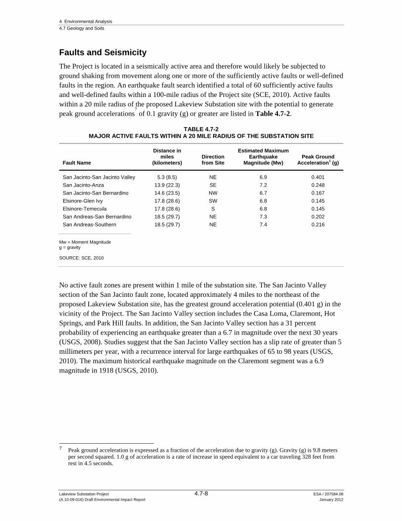
4. Environmental Analysis 4.7 Geology and Soils
Lakeview Substation Project 4.7-8 ESA / 207584.08 (A.10-09-016) Draft Environmental Impact Report January 2012
Faults and Seismicity
The Project is located in a seismically active area and therefore would likely be subjected to ground shaking from movement along one or more of the sufficiently active faults or well-defined faults in the region. An earthquake fault search identified a total of 60 sufficiently active faults and well-defined faults within a 100-mile radius of the Project site (SCE, 2010). Active faults within a 20 mile radius of the proposed Lakeview Substation site with the potential to generate peak ground accelerations
7 of 0.1 gravity (g) or greater are listed in Table 4.7-2.
TABLE 4.7-2 MAJOR ACTIVE FAULTS WITHIN A 20 MILE RADIUS OF THE SUBSTATION SITE
Fault Name
Distance in miles
(kilometers) Direction from Site
Estimated Maximum Earthquake
Magnitude (Mw) Peak Ground
Acceleration1 (g)
San Jacinto-San Jacinto Valley 5.3 (8.5) NE 6.9 0.401 San Jacinto-Anza 13.9 (22.3) SE 7.2 0.248 San Jacinto-San Bernardino 14.6 (23.5) NW 6.7 0.167 Elsinore-Glen Ivy 17.8 (28.6) SW 6.8 0.145 Elsinore-Temecula 17.8 (28.6) S 6.8 0.145 San Andreas-San Bernardino 18.5 (29.7) NE 7.3 0.202 San Andreas-Southern 18.5 (29.7) NE 7.4 0.216
Mw = Moment Magnitude g = gravity SOURCE: SCE, 2010
No active fault zones are present within 1 mile of the substation site. The San Jacinto Valley section of the San Jacinto fault zone, located approximately 4 miles to the northeast of the proposed Lakeview Substation site, has the greatest ground acceleration potential (0.401 g) in the vicinity of the Project. The San Jacinto Valley section includes the Casa Loma, Claremont, Hot Springs, and Park Hill faults. In addition, the San Jacinto Valley section has a 31 percent probability of experiencing an earthquake greater than a 6.7 in magnitude over the next 30 years (USGS, 2008). Studies suggest that the San Jacinto Valley section has a slip rate of greater than 5 millimeters per year, with a recurrence interval for large earthquakes of 65 to 98 years (USGS, 2010). The maximum historical earthquake magnitude on the Claremont segment was a 6.9 magnitude in 1918 (USGS, 2010).
7 Peak ground acceleration is expressed as a fraction of the acceleration due to gravity (g). Gravity (g) is 9.8 meters
per second squared. 1.0 g of acceleration is a rate of increase in speed equivalent to a car traveling 328 feet from rest in 4.5 seconds.

4. Environmental Analysis 4.7 Geology and Soils
Lakeview Substation Project 4.7-9 ESA / 207584.08 (A.10-09-016) Draft Environmental Impact Report January 2012
Geologic and Seismic Hazards
Fault Rupture
The Alquist-Priolo Earthquake Fault Zoning Act was passed in 1972 to mitigate the hazard of surface faulting to structures for human occupancy. In accordance with this act, the state geologist established regulatory zones, called “earthquake fault zones,” around the surface traces of active faults and published maps showing these zones. Each earthquake fault zone extends approximately 200 to 500 feet on either side of the mapped fault trace, because many active faults are complex and consist of more than one branch. A review of the Alquist-Priolo (AP) Earthquake Fault maps (CDMG, 2000) and the Riverside County AP Earthquake Hazard Zone Map (Riverside County, 2000) shows that no element of the Project would be located within a currently established AP fault zone. The closest AP fault zone is the San Jacinto Fault Zone, located approximately 4 miles northeast of the proposed Lakeview Substation site. There is little to no likelihood for fault rupture at the Project site because neither the proposed Lakeview Substation site nor the subtransmission source line route would cross an AP fault zone or other active or potentially active fault line (Riverside County, 2000; TBDU, 2009).
Seismic Ground Shaking
As discussed above, numerous earthquakes of moderate to strong magnitude have occurred in the Lakeview area in historic time. Earthquakes ranging in magnitude from 6.0 to 6.8 have occurred on the San Jacinto and Lake Elsinore faults, located approximately 4 miles northeast and 15 miles southwest of the proposed Lakeview Substation site, respectively. In the future, earthquakes of varying magnitude could occur from a number of different faults in the region.
The primary tool that seismologists use to evaluate ground shaking hazard and characterize statewide earthquake risks is a probabilistic seismic hazard assessment (PSHA). The PSHA for the State of California takes into consideration the range of possible earthquake sources and estimates their characteristic magnitudes to generate a probability map for ground shaking. The PSHA maps depict values of peak ground acceleration (PGA) that have a 10 percent probability of being exceeded in 50 years (or a 1 in 475 chance). This probability level allows engineers to design structures for ground motions that have a 90 percent chance of not occurring in the next 50 years, making structures safer than if they were simply designed for the most likely events.
Based on the California Geological Survey’s Probabilistic Seismic Hazards Mapping Ground Motion Page, there is a 10 percent probability (1 in 475 chance) of earthquake ground motion exceeding 0.612 g at the proposed Lakeview Substation site over a 50-year period (CGS, 2003). This value is consistent with the seismic coefficients used to estimate ground motion parameters in the geotechnical investigation report for the proposed Lakeview Substation site (TBDU, 2009). The subtransmission source line route is located in an area with the same or similar potential for ground acceleration as the proposed Lakeview Substation site. However, the central portion of the telecommunications route is within 1.5 miles of the Casa Loma Fault of the San Jacinto fault zone and potential peak ground acceleration in this area increases to between 0.5 and 0.8 g.
4. Environmental Analysis 4.7 Geology and Soils
Lakeview Substation Project 4.7-10 ESA / 207584.08 (A.10-09-016) Draft Environmental Impact Report January 2012
Generally, these ground accelerations correspond to very strong to violent ground shaking levels that would be widely felt and could destroy or considerably damage masonry and wood frame structures not built according to modern seismic building codes. This level of ground shaking is also sufficient to produce secondary ground failures such as liquefaction and lateral spread (in susceptible soils), landslides (in weak soils on sloped ground), and/or fissures and ground cracks. However, soils within the Project area, as described below, have a low potential for liquefaction or seismically induced landslides. Substantial damage would be reduced or avoided in buildings designed and constructed according to current engineering standards of care and the California Building Code (described in the regulatory setting below).
Landslides
Earthquake-induced slope instability maps in the Riverside County General Plan (Riverside County, 2000) shows areas in the vicinity of the Project that have been mapped by Riverside County as being susceptible to earthquake-induced landslides. Based on this information, the proposed Lakeview Substation site and the subtransmission source line route are not located in an area susceptible to earthquake-induced landslides. These areas are flat and relatively distant from nearby slopes. Since the telecommunications line route would be attached above the ground surface to the existing Valley-Moval Subtransmission Line and the existing line is also in a topographically flat area with no mapped landsides, the potential for earthquake-induced landslides to affect the telecommunication facilities is considered low.
Liquefaction
Liquefaction is a soil condition in which earthquake-induced ground motion causes an increase in soil water pressure in saturated, loose, sandy soils, resulting in loss of soil shear strength. Liquefaction can lead to near-surface ground failure, which may result in loss of foundation support and/or differential ground settlement. Sandy deposits deeper than 50 feet bgs are not usually prone to causing surface damage. In addition, soils above the groundwater table (soils that are not saturated) will not liquefy.
The CGS has mapped the potential for earthquake-induced liquefaction in portions of the state. However, the Project is located in an area that has not been mapped by the CGS. The potential liquefaction susceptibility in the vicinity of the Project, based on the existing setting report for the Riverside County General Plan (Riverside County, 2000) indicates that the Project is located in an area with deep groundwater and with a low susceptibility to liquefaction. Further, groundwater contour maps for the Lakeview basin indicate that groundwater is approximately 160 feet bgs (TDBU, 2009). Finally, on-site borings drilled for preliminary geotechnical investigation of the proposed Lakeview Substation site confirm the absence of groundwater to a depth of at least 51 feet bgs (TDBU, 2009). Therefore, due to the absence of a shallow groundwater table, soils underlying the Project area are not considered susceptible to liquefaction.
Seismic Settlement
Seismically induced settlement can occur in areas where earthquake shaking causes densification of relatively loose sediments. Settlement can result in damage to surface and near-surface

4. Environmental Analysis 4.7 Geology and Soils
Lakeview Substation Project 4.7-11 ESA / 207584.08 (A.10-09-016) Draft Environmental Impact Report January 2012
structures. Due to its proximity to an active fault zone, the Project could experience moderate to high levels of earthquake-induced ground shaking. The initial geotechnical investigation conducted at the proposed Lakeview Substation site did not identify unstable geologic units and did not provide an estimate of the magnitude of seismic settlement based on geotechnical borings (TDBU, 2009).
Regulatory Framework
Federal
Occupational Safety and Health Administration (OSHA) Regulations
Excavation and trenching are among the most hazardous construction activities. The Occupational Safety and Health Administration's (OSHA) Excavation and Trenching standard, Title 29 of the Code of Federal Regulations (CFR), Part 1926.650, covers requirements for excavation and trenching operations. OSHA requires that all excavations in which employees could potentially be exposed to cave-ins be protected by sloping or benching the sides of the excavation, supporting the sides of the excavation, or placing a shield between the side of the excavation and the work area.
State
The statewide minimum public safety standard for mitigation of earthquake hazards (as established through the California Building Code (CBC), Alquist-Priolo Earthquake Fault Zoning Act, and the Seismic Hazards Mapping Act) is that the minimum level of mitigation for a project should reduce the risk of ground failure during an earthquake to a level that does not cause the collapse of buildings for human occupancy, but in most cases, is not required to prevent or avoid the ground failure itself. It is not feasible to design all structures to completely avoid damage in worst-case earthquake scenarios. Accordingly, regulatory agencies have generally defined an "acceptable level" of risk as that which provides reasonable protection of the public safety; although it does not necessarily ensure continued structural integrity and functionality of a project (Title 14 California Code of Regulations (CCR), §3721(a)). Nothing in these acts, however, precludes lead agencies from enacting more stringent requirements, requiring a higher level of performance, or applying these requirements to developments other than those that meet the acts’ definitions of a “project.”
Alquist-Priolo Earthquake Fault Zoning Act
Surface rupture is the most easily avoided seismic hazard. The Alquist-Priolo Earthquake Fault Zoning Act was passed in 1972 to mitigate the hazard of surface faulting to structures for human occupancy. In accordance with this act, the state geologist established regulatory zones, called “earthquake fault zones,” around the surface traces of active faults and published maps showing these zones. Within these zones, buildings for human occupancy cannot be constructed across the surface trace of active faults. Each earthquake fault zone extends approximately 200 to 500 feet on either side of the mapped fault trace, because many active faults are complex and consist of more than one branch. There is the potential for ground surface rupture along any of the branches.

4. Environmental Analysis 4.7 Geology and Soils
Lakeview Substation Project 4.7-12 ESA / 207584.08 (A.10-09-016) Draft Environmental Impact Report January 2012
The Project is not subject to this act because it is not within an earthquake fault zone and it does not involve structures for human occupancy.
California Building Code
The CBC has been codified in the CCR as Title 24, Part 2. Title 24 is administered by the California Building Standards Commission, which, by law, is responsible for coordinating all building standards. Under state law, all building standards must be centralized in Title 24 to be enforceable. The purpose of the CBC is to establish minimum standards to safeguard the public health, safety, and general welfare through structural strength, means of egress facilities, and general stability by regulating and controlling the design, construction, quality of materials, use and occupancy, location, and maintenance of all building and structures within its jurisdiction. The 2010 edition of the CBC is based on the 2009 International Building Code (IBC) published by the International Code Conference. The 2010 CBC contains California amendments based on the American Society of Civil Engineers (ASCE) Minimum Design Standards 7-05. ASCE 7-05 provides requirements for general structural design and includes means for determining earthquake loads as well as other loads (such as wind loads) for inclusion into building codes. The provisions of the CBC apply to the construction, alteration, movement, replacement, and demolition of every building or structure or any appurtenances connected or attached to such buildings or structures throughout California.
The earthquake design requirements take into account the occupancy category of the structure, site class, soil classifications, and various seismic coefficients, which are used to determine a Seismic Design Category (SDC) for a project. The SDC is a classification system that combines the occupancy categories with the level of expected ground motions at the site and ranges from SDC A (very small seismic vulnerability) to SDC E/F (very high seismic vulnerability and near a major fault). Design specifications are then determined according to the SDC.
Seismic Hazards Mapping Act
The State Department of Conservation, CGS, provides guidance with regard to seismic hazards. Under the CGS Seismic Hazards Mapping Act, seismic hazard zones are to be identified and mapped to assist local governments for planning and development purposes. The intent of the act is to protect the public from the effects of strong ground shaking, liquefaction, landslides, or other types of ground failure, and other hazards caused by earthquakes. CGS Special Publication 117, Guidelines for Evaluating and Mitigating Seismic Hazards in California, provides guidance for evaluation and mitigation of earthquake-related hazards for projects within designated zones of required investigations (CGS, 2008). This act would not apply to the Project because seismic hazard zones have not yet been established in the Project area.
Local
Riverside County Department of Building and Safety Requirements
The Project is subject to the Riverside County Department of Building and Safety requirements for building and grading. The Riverside County Grading Code requires a grading permit for earth-moving activities exceeding 50 cubic yards of material.

4. Environmental Analysis 4.7 Geology and Soils
Lakeview Substation Project 4.7-13 ESA / 207584.08 (A.10-09-016) Draft Environmental Impact Report January 2012
Engineering and Construction Codes and Standards
Design and construction of SCE facilities are governed by a variety of building codes and standards. Such standards must be either consistent with or more stringent than the requirements of the CBC. A number of these specifically regulate topics relevant to geology and geotechnical engineering, such as earthwork standards and seismic safety, including the following:
CPUC General Order 95 provides general standards for design and construction of overhead electric transmission and distribution lines.
“IEEE 693” Recommended Practices for Seismic Design of Substations contains guidelines for earthquake-resistant substation design and construction. The IEEE (Institute of Electrical and Electronics Engineers, Inc.) is an international professional organization and a widely recognized authority in the development of industry standards for electrical engineering and electric power generation and transmission.
The International Building Code (IBC) is voluntarily adopted by jurisdictions and agencies. SCE adheres to the IBC’s earthwork standards where they are not superseded by CPUC regulations.
4.7.2 Significance Criteria The following significance criteria are adapted from and are consistent with the CEQA Guidelines, Appendix G, Environmental Checklist. In accordance with the CEQA Guidelines, the Project would result in a significant impact to geology and soil resources if it would:
a) Expose people or structures to potential substantial adverse effects, including the risk of loss, injury, or death involving:
i. Rupture of a known earthquake fault, as delineated on the most recent Alquist-Priolo Earthquake Fault Zoning Map issued by the State Geologist for the area or based on other substantial evidence of a known fault (Refer to Division of Mines and Geology Special Publication 42.)
ii. Strong seismic ground shaking iii. Seismic-related ground failure, including liquefaction iv. Landslides;
b) Result in substantial soil erosion or the loss of topsoil;
c) Be located on geologic unit or soil that is unstable, or that would become unstable as a result of the project, and potentially result in on- or off-site landslide, lateral spreading, subsidence, liquefaction, or collapse;
d) Be located on expansive soil, as defined in Table 18 1 B of the Uniform Building Code (1994), creating substantial risks to life or property; or
e) Have soils incapable of adequately supporting the use of septic tanks or alternative wastewater disposal systems where sewers are not available for the disposal of wastewater.

4. Environmental Analysis 4.7 Geology and Soils
Lakeview Substation Project 4.7-14 ESA / 207584.08 (A.10-09-016) Draft Environmental Impact Report January 2012
4.7.3 Applicant Proposed Measures There are no APMs included to address issues related to geology and soils.
4.7.4 Impacts and Mitigation Measures
Approach to Analysis
This impact analysis considers the potential geology, soils, and seismicity impacts associated with the construction, operation, and maintenance of the Project. Due to the nature of the Project, there would be no impacts related to the following criterion; therefore, no impact discussion is provided for these topics for the reasons described below:
a) Expose people or structures to potential substantial adverse effects, including the risk of loss, injury, or death involving:
a)i. Rupture of a known earthquake fault.
The Project is not within a known earthquake fault zone as mapped by the Alquist Priolo Earthquake Fault Zoning Act. Further, there is no other substantial evidence of a known fault. Therefore there would be no impact related to fault rupture at the Project site.
a)iv. Landslides.
The Project site is flat or very low-gradient, and the potential for downslope movement of materials triggered by gravity or by earthquake ground shaking is negligible. In addition, surface grading for placement of Project structures would be minimal and there would be no substantial fill slopes that could be subject to failure. Therefore, there would be no impact involving landslides.
e) Have soils incapable of adequately supporting the use of septic tanks or alternative wastewater disposal systems where sewers are not available for the disposal of wastewater.
The proposed Lakeview Substation site is currently not connected to sewer and potable water service; therefore, the site would be equipped with a restroom consisting of a portable chemical unit maintained by an outside service company. No septic or alternative wastewater disposal systems requiring soils capable of supporting these systems would be installed at the proposed Lakeview Substation site. As a result, there would be no impact related to soils unable to support a septic system or alternative wastewater disposal systems.
Impact Analysis
a) Expose people or structures to potential substantial adverse effects, including the risk of loss, injury, or death involving:
a)ii. Strong seismic ground shaking.
See a)iii, below.
4. Environmental Analysis 4.7 Geology and Soils
Lakeview Substation Project 4.7-15 ESA / 207584.08 (A.10-09-016) Draft Environmental Impact Report January 2012
a)iii. Seismic-related ground failure, including liquefaction.
Impact 4.7-1: The Project could expose people or structures to potential adverse effects, including the risk of loss, injury, or death involving strong seismic ground shaking and earthquake-induced ground failure (such as liquefaction and lateral spreading). Less than Significant (Class III)
In the event of a large earthquake on the San Jacinto Fault, San Andreas Fault, or other nearby active faults, seismic ground-shaking and related ground failures could affect the Project. However, all structures in California are subject to the standards in the CBC, which requires engineers to develop seismic design criteria that reflect the nature and magnitude of maximum ground motions that can be reasonably expected. These seismic design criteria allow engineers to apply appropriate building codes and to design foundations and structures to withstand the effects of earthquakes. Even though the Project is located in an area that may experience very strong seismic shaking during its lifetime, the structures would not be utilized for human occupancy and would be unmanned with the exception of routine maintenance activities. Structures would also be designed according to the IEEE 693, Recommended Practices for Seismic Design of Substations, which is consistent with, and in many cases, more stringent than the CBC. Similarly, the subtransmission source line route would be designed consistent with CPUC General Order 95 to withstand seismic loading.
SCE completed a geotechnical investigation of the proposed Lakeview Substation site to determine the nature and engineering properties of the subsurface soils and to provide preliminary recommendations for site grading, foundation design, and construction. The geotechnical investigation found that although the site could be subject to strong ground shaking during an earthquake, the effects could be adequately addressed with proper engineering design and construction in conformance with the CBC, current building codes, and engineering practices. Further, consistent with the information presented in the setting, it was determined that the potential for secondary effects of seismic activity, such as liquefaction, differential settlement, landslides and earthquake-induced flooding and seiches was low or non-existent (TBDU, 2009).
While SCE has not yet prepared a geotechnical investigation of the subtransmission source line route, associated facilities, or telecommunications system, it would be prepared as part of pre-construction activities described in Chapter 2, Project Description. Similar to the proposed Lakeview Substation site, the geotechnical investigation of the subtransmission source line route would perform site soil characterization and testing, determine seismic design coefficients, and would provide recommendations for installation of wood poles and TSPs, consistent with the CBC and CPUC General Order 95, which would adequately address potential damage to SCE facilities in the event of an earthquake.
Application of modern building codes and generally accepted professional engineering geologic principles and practice reduces the potential for damage to SCE facilities in the event of an earthquake to acceptable levels, but cannot feasibly eliminate all possible earthquake hazards. Even in the unlikely event that the Project facilities, which would be constructed according to modern building codes and appropriate standards, are damaged during an earthquake, it would

4. Environmental Analysis 4.7 Geology and Soils
Lakeview Substation Project 4.7-16 ESA / 207584.08 (A.10-09-016) Draft Environmental Impact Report January 2012
not represent a significant impact because 1) the facilities would be unmanned; 2) they would not present a hazard to life or off-site property; and 3) the damage would be temporary, and could be assessed and repaired following facility inspection.
For the above reasons, the Project would have a less-than-significant impact with respect to strong seismic ground shaking and earthquake-induced ground failure.
Mitigation: None required.
b) Result in substantial soil erosion or the loss of topsoil.
Impact 4.7-2: The Project could result in substantial soil erosion or the loss of topsoil. Less than Significant (Class III)
Some soil erosion occurs naturally in the environment; however, the preliminary stage of construction, especially initial site grubbing, grading, and soil stockpiles, leaves loose soil exposed to the erosive forces of rainfall and high winds. Generally, excessive soil erosion can cause sedimentation problems in storm drain systems; rapid stormwater runoff can initiate or increase the size of shallow channels and/or gullies, and potentially undermine engineered soils beneath foundations and paved surfaces. Portions of the Project area are underlain by soils that could be susceptible to erosion, particularly when cleared of vegetation and during intense storms. As discussed in the setting (see Table 4.7-1), these include portions of the subtransmission source line route underlain by the Domino silt loam and the Willows silty clay.
However, the Project is not expected to created or worsen issues related to soil erosion. Section 4.10, Hydrology and Water Quality concludes that soil erosion from a water quality perspective would be less than significant, based largely on the fact that: 1) the site is flat and well drained and the Project would result in minimal changes with respect to stormwater flow and percolation, 2) a SWPPP would be implemented during Project construction to control potential erosion of temporarily disturbed areas, and 3) site design BMPs and, if required by Riverside County, a detention basin would be installed to control stormwater flows during Project operations. For these reasons, impacts related to soil erosion would be less than significant. Note that loss of topsoil with respect to important farmlands or soils of statewide importance are addressed in Section 4.2, Agriculture and Forestry Resources.
Mitigation: None required.

4. Environmental Analysis 4.7 Geology and Soils
Lakeview Substation Project 4.7-17 ESA / 207584.08 (A.10-09-016) Draft Environmental Impact Report January 2012
c) Be located on geologic unit or soil that is unstable, or that would become unstable as a result of the project, and potentially result in on- or off-site landslide, lateral spreading, subsidence, liquefaction, or collapse.
Impact 4.7-3: The Project may be located on geologic unit or soil that is unstable, or that would become unstable as a result of the Project, and potentially result in subsidence or collapse. Less than Significant (Class III)
As discussed in the Approach to Analysis above, the potential risk from on- or off-site landslides is negligible because the topography of the Project site is relatively flat. In addition, the impact of the Project with respect to earthquake-induced instabilities (including landslides, lateral spreading, and liquefaction) are discussed under Impact 4.7-1. This impact addresses the potential for soil subsidence, fissures and collapsible soils (i.e., hydro-consolidations) to adversely affect the Project or otherwise present a public safety issue.
As discussed in the setting, the San Jacinto Valley, located a few miles east of the Project area has historically experienced land subsidence as well as associated ground fissures, the closest one being near Lakeview Hot Springs south of the Ramona Expressway. However, subsidence and associated fissures are responses to excessive groundwater withdrawals, and present groundwater levels have been recovering from their historic lows. The Project is unlikely to experience adverse effects from soil subsidence and fissures because groundwater levels have been recovering and no ground fissures have been documented within the substation site or along the sub transmission line route. Groundwater use for irrigation of the proposed Lakeview Substation perimeter landscape would be minimal and would be water-efficient, thus avoiding groundwater level declines due to the Project-related water needs (see Section 4.10, Hydrology and Water Quality). In addition, while the Project is located in a geologic environment where some potential exists for collapsible soils, the depth of groundwater in the Project area makes it very unlikely that groundwater will rise to levels that may cause soils to collapse, and the Project requires minimal irrigation. The site is located in a region with relatively low precipitation, so collapse occurring as a result of minimal infiltrating surface waters is also considered unlikely (SCE, 2010).
The geotechnical investigation performed for the proposed Lakeview Substation site recommends standard engineering practices, such as over-excavating existing soils and placing structural foundations on a mat of artificial fill compacted to appropriate design specifications (TBDU, 2009). Other recommendations which are typical of similar engineering designs include moisture conditioning of the soil to achieve maximum stability, and ensuring deleterious materials are removed from soil prior to being placed or moved on site. These types of measures, which are standard in the engineering practice and required through building and construction codes, ensure that small ground movements such as long-term soil consolidation or movements due to subsidence or collapsible soils do not damage or deteriorate foundations and/or structural components of the Project.
For the above reasons, the Project would have a less-than-significant impact related to unstable soils.
4. Environmental Analysis 4.7 Geology and Soils
Lakeview Substation Project 4.7-18 ESA / 207584.08 (A.10-09-016) Draft Environmental Impact Report January 2012
Mitigation: None required.
d) Be located on expansive soil, creating substantial risks to life or property.
Impact: The Project could be located on expansive soil, creating substantial risks to life or property. Less than Significant (Class III)
As discussed in the setting, expansive soils were not encountered during the initial geotechnical investigation conducted for the proposed Lakeview Substation site; however, based on the regional soil survey, there are soils along the subtransmission source line route that could be subject to shrink/swell behavior (TDBU, 2009). Expansive soils along the source line route are unlikely to pose a geotechnical problem because subtransmission source line poles would be direct buried to depths of 9 to 40 feet (depending on pole type and location) using augured holes. Expansive soils are more typically a problem for underground linear appurtenances or flat rigid foundations where greater surface areas are in contact with expansive soils. The initial geotechnical report also provides site-specific Project design and construction recommendations, such as over-excavation of soil for earthwork at the proposed Lakeview Substation site. For the above reasons, impacts from expansive soils are considered to be less than significant.
Mitigation: None required.
4.7.5 Alternatives
Alternative 1: Phased Construction Alternative
While Alternative 1 would extend the period of construction by 10 months, it would not change the location and type of facilities to be constructed. As such, the susceptibility of the Project to long-term geologic and seismic impacts remains the same. The only impact that would be different than the Project under Alternative 1 would be with respect to erosion and soil loss. Due to the longer construction period, cleared areas may be exposed to erosive forces (e.g., wind and rain) for a longer period of time, thereby increasing the potential for erosion during the construction phase compared to the Project. However, measures designed to control erosion and soil loss during construction would be still be implemented in accordance with a Project-specific SWPPP (described in further detail in Section 4.10, Hydrology and Water Quality). Because a SWPPP would be implemented as part of the Project regardless of the length of the construction phase, Alternative 1 would result in similar impacts as the Project.
Alternative 2: Relocated Substation Alternative
Alternative 2 would relocate the proposed Lakeview Substation site approximately 0.25 mile to the northwest, closer to the San Jacinto River corridor, resulting in a shorter subtransmission

4. Environmental Analysis 4.7 Geology and Soils
Lakeview Substation Project 4.7-19 ESA / 207584.08 (A.10-09-016) Draft Environmental Impact Report January 2012
source line compared to the Project. The geotechnical report prepared for the Project was specific to the proposed Lakeview Substation site and does not cover this site. However, because the Alternative 2 site is a relatively short distance away from the proposed Lakeview Substation site, and because it is underlain by the same geologic unit (old alluvial fan deposits) and a similar soil type, conclusions regarding geologic and seismic hazards are likely to be similar or the same as the Project. A geotechnical investigation of Alternative 2 would be required prior to final design and construction, and would involve site soil characterization and testing, determination of seismic design coefficients, and recommendations for installation of wood poles and TSPs, consistent with the CBC and CPUC General Order 95. Similar to the Project, these measures would adequately address potential damage to SCE facilities in the event of an earthquake. For these reasons, Alternative 2 would results in similar impacts as the Project.
No Project Alternative
Because the Project area would remain in its current condition under the No Project Alternative, there would be no impacts with respect to geology and soil resources.
References – Geology and Soils California Division of Mines and Geology (CDMG), 2000. Digital Images of Official Maps of
Alquist-Priolo Earthquake Fault Zones of California, Southern Region, Lakeview Quadrangle revised official map from 1988, DMG CD 2000-003.
California Geological Survey (CGS), 2003. Seismic Hazard Shaking in California, Available online at http://www.consrv.ca.gov/cgs/rghm/pshamap/pshamain.html, accessed on June 16, 2011.
Riverside County, 2000. Existing Setting Report: Riverside County Integrated Project, available online at http://www.rctlma.org/genplan/content/documents/RCIP_Existing_Setting_Report.pdf, accessed June 21, 2011.
Metropolitan Water District (MWD) of Southern California, 2007. Groundwater Assessment Study, Report Number 1308, September.
Morton, D.M., and Miller, F.K., 2006. Geologic Map of the San Bernardino and Santa Ana 30’ X 60’ Quadrangles, California, United States Geological Survey Open File Report 2006-1217.
Natural Resources Conservation Service (NRCS), 2008. U.S. Department of Agriculture, Soil Survey Geographic (SSURGO) database for Western Riverside Area, California (ca679), available at http://SoilDataMart.nrcs.usda.gov/, Version 5, 1/3/2008, accessed June 17, 2011.
Southern California Edison (SCE), 2010. Proponent’s Environmental Assessment Lakeview Substation Project, Volume 1 (Sept. 17, 2010).

4. Environmental Analysis 4.7 Geology and Soils
Lakeview Substation Project 4.7-20 ESA / 207584.08 (A.10-09-016) Draft Environmental Impact Report January 2012
TDBU Civil/Structural & Geotechnical Engineering Group (TDBU). 2009. Southern California Edison Geotechnical Investigation Report, Lakeview Substation, Nuevo, Riverside County, California, December 14.
United States Geological Survey (USGS), 1979. Perris Quadrangle, Riverside County, California, 7.5-Minute Quadrangle, 1:24,000, 1967 (Photo revised 1979).
United States Geological Survey (USGS), 2008. Forecasting California's earthquakes; what can we expect in the next 30 years?, prepared by Field, Edward H., Milner, Kevin R., and the 2007 Working Group on California Earthquake Probabilities, USGS Fact Sheet 2008-3027, 4 p.
United States Geological Survey (USGS), 2010. Earthquake Hazards Program, Quaternary Faults, Complete Report for San Jacinto fault, San Jacinto Valley section (Class A) No. 125b, available at http://gldims.cr.usgs.gov/webapps/cfusion/sites/qfault/ qf_web_disp.cfm?disp_cd=C&qfault_or=2505&ims_cf_cd=cf, accessed June 17, 2011.

4. Environmental Analysis
Lakeview Substation Project 4.8-1 ESA / 207584.08 (A.10-09-016) Draft Environmental Impact Report January 2012
4.8 Greenhouse Gas Emissions
This section evaluates the potential for the Project, as well as the alternatives, to result in impacts associated with greenhouse gas (GHG) emissions during construction, operation, and maintenance activities.
4.8.1 Environmental Setting
Background on Greenhouse Gases and Climate Change
Gases that trap heat in the atmosphere are called GHGs. The major concern with GHGs is that increases in their concentrations are causing global climate change, a change in the average weather on Earth that can be measured by wind patterns, storms, precipitation, and temperature. Although there is disagreement as to the rate of global climate change and the extent of the impacts attributable to human activities, most in the scientific community agree that there is a direct link between increased emissions of GHGs and long-term global temperature increases. There are several gases that act as GHGs; their common attribute is that they allow sunlight to enter the atmosphere, but trap a portion of the outward-bound infrared radiation, which warms the air. The process is similar to the effect greenhouses have in raising the air temperature inside the greenhouse, hence the name GHGs. Both natural processes and human activities emit GHGs. The presence of GHGs in the atmosphere regulates the Earth’s temperature; however, emissions from human activities such as fossil fuel-based electricity production and the use of motor vehicles have elevated the concentration of GHGs in the atmosphere. It generally is believed that this accumulation of GHGs is contributing to global climate change.
The principal GHGs are carbon dioxide (CO2), methane (CH4), nitrous oxide (N2O), sulfur hexafluoride (SF6), perfluorocarbons (PFCs), and hydrofluorocarbons (HFCs). Because these different GHGs have different warming potential (the amount of heat trapped by a certain mass of a GHG), and CO2 is the most common reference gas for climate change, GHG emissions often are quantified and reported as CO2 equivalents (CO2e). For example, SF6 is commonly used in the utility industry as an insulating gas in circuit breakers and other electronic equipment. SF6, while comprising a small fraction of the total GHGs emitted annually worldwide, is a very potent GHG with 23,900 times the global warming potential of CO2. Therefore, an emission of one metric ton of SF6 could be reported as an emission of 23,900 metric tons CO2e. Large emission sources are reported in million metric tons1 of CO2e.
Some of the potential effects of global warming in California may include loss in snow pack, sea level rise, more extreme heat days per year, more high ozone days, more large forest fires, and more drought years (CARB, 2009). Globally, climate change has the potential to impact numerous environmental resources through potential, though uncertain, impacts related to future air temperatures and precipitation patterns. The projected effects of global warming on weather and climate are likely to vary regionally, but are expected to include the following direct effects (IPCC, 2007):
1 A metric ton is 1,000 kilograms; it is equal to approximately 1.1 U.S. tons and approximately 2,204.6 pounds.

4. Environmental Analysis 4.8 Greenhouse Gas Emissions
Lakeview Substation Project 4.8-2 ESA / 207584.08 (A.10-09-016) Draft Environmental Impact Report January 2012
Higher maximum temperatures and more hot days over nearly all land areas; Higher minimum temperatures, fewer cold days and frost days over nearly all land areas; Reduced diurnal temperature range over most land areas; Increase of heat index over land areas; and More intense precipitation events.
Also, there are many secondary effects that are projected to result from global warming, including global rise in sea level, impacts to agriculture, changes in disease vectors, and changes in habitat and biodiversity. While the possible outcomes and the feedback mechanisms involved are not fully understood and much research remains to be done, the potential for substantial environmental, social, and economic consequences over the long term may be great.
The California Air Resources Board (CARB) estimated that in 2008, California produced 478 million gross metric tons of CO2e emissions. CARB found that transportation was the source of 37 percent of the state’s GHG emissions; followed by electricity generation at 24 percent, and industrial sources at 19 percent (CARB, 2010).
Regulatory Context
Federal
The CAA requires the USEPA to define national standards to protect U.S. public health and welfare. The federal CAA does not specifically regulate GHG emissions; however, GHGs are pollutants that can be regulated under the federal CAA. There are currently no federal regulations that set ambient air quality standards for GHGs.
State
Executive Order S-3-05
In 2005, in recognition of California’s vulnerability to the effects of climate change, Governor Schwarzenegger established Executive Order S-3-05, which set forth a series of target dates by which statewide emissions of GHGs would be progressively reduced, as follows:
By 2010, reduce GHG emissions to 2000 levels; By 2020, reduce GHG emissions to 1990 levels; and By 2050, reduce GHG emissions to 80 percent below 1990 levels.
Assembly Bill 32 – California Global Warming Solutions Act
California Assembly Bill (AB) 32, the Global Warming Solutions Act of 2006, requires CARB to establish a statewide GHG emissions cap for 2020 based on 1990 emission levels. AB 32 required CARB to adopt regulations by January 1, 2008, that identify and require selected sectors or categories of emitters of GHGs to report and verify their statewide GHG emissions, and CARB is authorized to enforce compliance with the program. Under AB 32, CARB also was required to adopt, by January 1, 2008, a statewide GHG emissions limit equivalent to the statewide GHG emissions levels in 1990, which must be achieved by 2020. CARB established this limit in
4. Environmental Analysis 4.8 Greenhouse Gas Emissions
Lakeview Substation Project 4.8-3 ESA / 207584.08 (A.10-09-016) Draft Environmental Impact Report January 2012
December 2007 at 427 million metric tons of CO2e. This is approximately 30 percent below forecasted “business-as-usual” emissions of 596 million metric tons of CO2e in 2020, and about 10 percent below average annual GHG emissions during the period of 2002 through 2004 (CARB, 2009).
By January 1, 2011, CARB was required to adopt rules and regulations (to be implemented by January 1, 2012), to achieve the maximum technologically feasible and cost-effective GHG emission reductions. AB 32 permits the use of market-based compliance mechanisms to achieve those reductions. AB 32 also requires CARB to monitor compliance with and enforce any rule, regulation, order, emission limitation, emissions reduction measure, or market-based compliance mechanism that it adopts.
In June 2007, CARB directed staff to pursue 37 early strategies for reducing GHG emissions under AB 32. The broad spectrum of strategies that were developed, including a Low Carbon Fuel Standard, regulations for refrigerants with high global warming potentials, guidance and protocols for local governments to facilitate GHG reductions, and green ports, reflects that the serious threat of climate change requires action as soon as possible.
In addition to approving the 37 GHG reduction strategies, CARB directed staff to further evaluate early action recommendations made at its June 2007 meeting, and to report back to CARB within 6 months. The general sentiment of CARB suggested a desire to try to pursue greater GHG emissions reductions in California in the near-term. Since the June 2007 CARB hearing, CARB staff has evaluated all 48 recommendations submitted by stakeholders and several internally-generated staff ideas and published the Expanded List of Early Action Measures To Reduce Greenhouse Gas Emissions In California Recommended For Board Consideration in September 2007 (CARB, 2007). CARB adopted nine Early Action Measures for implementation, including Ship Electrification at Ports, Reduction of High Global-Warming-Potential Gases in Consumer Products, Heavy-Duty Vehicle Greenhouse Gas Emission Reduction (Aerodynamic Efficiency), Reduction of Perfluorocarbons from Semiconductor Manufacturing, Improved Landfill Gas Capture, Reduction of Hydroflourocarbon-134a from Do-It-Yourself Motor Vehicle Servicing, Sulfur Hexaflouride Reductions from the Non-Electric Sector, a Tire Inflation Program, and a Low Carbon Fuel Standard.
Climate Change Scoping Plan
In December 2008, CARB approved the AB 32 Scoping Plan outlining the state’s strategy to achieve the 2020 GHG emissions limit (CARB, 2009). This Scoping Plan, developed by CARB in coordination with the Climate Action Team (CAT), proposes a comprehensive set of actions designed to reduce overall GHG emissions in California, improve the environment, reduce dependence on oil, diversify California’s energy sources, save energy, create new jobs, and enhance public health. The measures in the Scoping Plan will continue to be developed over the next year and are scheduled to be in place by 2012. The Scoping Plan expands the list of the nine Early Action Measures into a list of 39 Recommended Actions contained in Appendices C and E of the Scoping Plan. These measures are presented in Table 4.8-1.

4. Environmental Analysis 4.8 Greenhouse Gas Emissions
Lakeview Substation Project 4.8-4 ESA / 207584.08 (A.10-09-016) Draft Environmental Impact Report January 2012
TABLE 4.8-1 RECOMMENDED ACTIONS OF CLIMATE CHANGE SCOPING PLAN
ID # Sector Strategy Name
T-1 Transportation Pavley I and II – Light-Duty Vehicle GHG Standards T-2 Transportation Low Carbon Fuel Standard (Discrete Earl Action) T-3 Transportation Regional Transportation-Related GHG Targets T-4 Transportation Vehicle Efficiency Measures T-5 Transportation Ship Electrification at Ports (Discrete Early Action) T-6 Transportation Goods-movement Efficiency Measures
T-7 Transportation Heavy Duty Vehicle Greenhouse Gas Emission Reduction Measure – Aerodynamic Efficiency (Discrete Early Action)
T-8 Transportation Medium and Heavy-Duty Vehicle Hybridization T-9 Transportation High Speed Rail
E-1 Electricity and Natural Gas Increased Utility Energy efficiency programs ; More stringent Building and Appliance Standards
E-2 Electricity and Natural Gas Increase Combined Heat and Power Use by 30,000 gigawatt-hours (GWh)
E-3 Electricity and Natural Gas Renewables Portfolio Standard E-4 Electricity and Natural Gas Million Solar Roofs
CR-1 Electricity and Natural Gas Energy Efficiency CR-2 Electricity and Natural Gas Solar Water Heating GB-1 Green Buildings Green Buildings W-1 Water Water Use Efficiency W-2 Water Water Recycling W-3 Water Water System Energy Efficiency W-4 Water Reuse Urban Runoff W-5 Water Increase Renewable Energy Production W-6 Water Public Goods Charge (Water) I-1 Industry Energy Efficiency and Co-benefits Audits for Large Industrial Sources I-2 Industry Oil and Gas Extraction GHG Emission Reduction I-3 Industry GHG Leak Reduction from Oil and Gas Transmission I-4 Industry Refinery Flare Recovery Process Improvements I-5 Industry Removal of Methane Exemption from Existing Refinery Regulations
RW-1 Recycling and Waste Management Landfill Methane Control (Discrete Early Action) RW-2 Recycling and Waste Management Additional Reductions in Landfill Methane – Capture Improvements RW-3 Recycling and Waste Management High Recycling/Zero Waste F-1 Forestry Sustainable Forest Target H-1 High Global Warming Potential Gases Motor Vehicle Air Conditioning Systems (Discrete Early Action)
H-2 High Global Warming Potential Gases SF6 Limits in Non-Utility and Non-Semiconductor Applications (Discrete Early Action)
H-3 High Global Warming Potential Gases Reduction in Perfluorocarbons in Semiconductor Manufacturing (Discrete Early Action)
H-4 High Global Warming Potential Gases Limit High GWP Use in Consumer Products (Discrete Early Action, Adopted June 2008)
H-5 High Global Warming Potential Gases High GWP Reductions from Mobile Sources H-6 High Global Warming Potential Gases High GWP Reductions from Stationary Sources H-7 High Global Warming Potential Gases Mitigation Fee on High GWP Gases A-1 Agriculture Methane Capture at Large Dairies
SOURCE: CARB, 2009

4. Environmental Analysis 4.8 Greenhouse Gas Emissions
Lakeview Substation Project 4.8-5 ESA / 207584.08 (A.10-09-016) Draft Environmental Impact Report January 2012
In addition, the Scoping Plan identifies challenges to meeting future electrical demand, including building transmission lines for renewable energy sources and modernizing electricity infrastructure.
CEQA Guidelines Revisions
In 2007, the California State Legislature passed SB 97, which required amendment of the CEQA Guidelines to incorporate analysis of, and mitigation for, GHG emissions from projects subject to CEQA. The California Natural Resources Agency adopted these amendments on December 30, 2009, and they took effect March 18, 2010.
The amendments add §15064.4 to the CEQA Guidelines. This new section specifically addresses the potential significance of GHG emissions. §15064.4 calls for a “good-faith effort” to “describe, calculate or estimate” GHG emissions; §15064.4 further states that the analysis of the significance of any GHG impacts should include consideration of the extent to which the project would increase or reduce GHG emissions; exceed a locally applicable threshold of significance; and comply with “regulations or requirements adopted to implement a statewide, regional, or local plan for the reduction or mitigation of greenhouse gas emissions.” The new Guidelines also state that a project may be found to have a less-than-significant impact on GHG emissions if it complies with an adopted plan that includes specific measures to sufficiently reduce GHG emissions (§15064(h)(3)). Importantly, however, the CEQA Guidelines do not require or recommend a specific analytical methodology or provide quantitative criteria for determining the significance of GHG emissions.
Local
CPUC General Order No. 131-D explains that local land use regulations would not apply to the Project. However, for information purposes, the Riverside County and City of Moreno Valley General Plans were reviewed. No policies would be relevant to the Project and alternatives.
4.8.2 Significance Criteria Based on CEQA Guidelines §15064.4 and §15064.7(c), as well as Appendix G, a project would cause adverse impacts associated with GHG emissions if it would:
a) Generate greenhouse gas emissions, either directly or indirectly, that may have a significant impact on the environment; or
b) Conflict with an applicable plan, policy, or regulation adopted for the purpose of reducing the emissions of greenhouse gases.
4.8.3 Applicant Proposed Measures There are no APMs included to address issues related to GHGs.
4. Environmental Analysis 4.8 Greenhouse Gas Emissions
Lakeview Substation Project 4.8-6 ESA / 207584.08 (A.10-09-016) Draft Environmental Impact Report January 2012
4.8.4 Impacts and Mitigation Measures
Approach to Analysis
This analysis uses an approach for the determination of significance of GHG emissions based on the GHG significance thresholds adopted by the South Coast Air Quality Management District (SCAQMD). The SCAQMD has adopted an operational significance threshold of 10,000 metric tons CO2e per year for stationary/industrial sources (SCAQMD, 2008). The SCAQMD’s adopted GHG significance threshold is intended for long-term operational GHG emissions. However, the SCAQMD has developed guidance for the determination of significance of GHG construction emissions that recommends that total emissions from construction be amortized over 30 years and added to operational emissions and then compared to the applicable significance threshold (SCAQMD, 2008). This analysis of the Project applies SCAQMD’s guidance with regard to the assessment of construction-related GHG emissions.
As part of the CPUC’s permit application process, SCE provided GHG emissions estimates for construction and operational activities that would be associated with the Project (SCE, 2010). The emission estimates were independently reviewed by the CPUC’s consultant, Environmental Science Associates (ESA), and are summarized below. Off-road and on-road mobile source emission factors obtained from the SCAQMD were used to estimate exhaust emissions. The SCAQMD emission factors for off-road vehicles were determined using CARB’s OFFROAD Model and emission factors for on-road trucks and worker vehicles were derived using CARB’s EMFAC2007 Model to estimate the pounds of GHG emitted per mile of travel.
It should be noted that the short-term construction emissions estimates provided by SCE do not include indirect emissions that would be associated with water use for dust suppression and that long-term SF6 emissions estimates were calculated using an unsupported circuit breaker leak rate of 0.5 percent of the total SF6 capacity of the proposed circuit breakers. Therefore, for a more conservative analysis, SCE’s emissions estimates have been supplemented. Specifically, indirect short-term electricity usage-related GHG emissions associated with water use for dust control activities were estimated for the Project using emission and use factors established by the California Energy Commission (CEC) and the California Climate Action Registry (CCAR) (CEC, 2005; CCAR, 2009) and long-term SF6 operational emissions were revised using a USEPA SF6 published leak rate of up to 1.0 percent for electrical circuit breakers manufactured in and after 1999 (USEPA, 2006).
There are no Riverside County or City of Moreno Valley climate action plans, policies, or regulations that would be applicable to the Project. However, the Project’s potential to conflict with an applicable plan, policy, or regulation adopted for the purpose of reducing GHG emissions is assessed by examining any potential conflicts with the GHG reduction goals set forth in AB 32, including the potential for the Project to conflict with the 39 Recommended Actions identified by CARB in its Climate Change Scoping Plan and/or any associated adopted regulations.
4. Environmental Analysis 4.8 Greenhouse Gas Emissions
Lakeview Substation Project 4.8-7 ESA / 207584.08 (A.10-09-016) Draft Environmental Impact Report January 2012
a) Generate greenhouse gas emissions, either directly or indirectly, that may have a significant impact on the environment.
Impact 4.8-1: The Project would result in emissions of greenhouse gases that could contribute to global climate change. Less than Significant (Class III)
The Project would result in both short-term construction emissions of GHGs and long-term emissions of GHGs associated with operation and maintenance. Project construction would occur over an approximately 12-month period. Project emissions would primarily be associated with exhaust from on-road vehicular traffic and off-road construction equipment; however, indirect emissions related to energy consumption associated with the daily use of approximately 32,000 gallons of water would also be generated during construction of the Project. The estimated total emission of GHGs that would be generated by Project construction activities is 1,713 metric tons CO2e. See Appendix C for details of data, calculations, and assumptions used to estimate Project construction-related GHG emissions.
Operation and maintenance GHG emissions that would be associated with the Project would include vehicular exhaust related to periodic maintenance and inspection activities and SF6 leakage from circuit breakers at the proposed Lakeview Substation. SCE has estimated that long-term vehicle GHG exhaust emissions that would be associated with the Project would be approximately 1 metric ton CO2e per year (see Appendix C for details associated with the Project operation emission estimate). Regarding SF6 circuit breaker leakage that would occur at the proposed Lakeview Substation, SCE estimates that the proposed two new circuit breakers would have a total capacity of approximately 378 pounds of SF6. The USEPA estimates that leaking circuit breakers manufactured in 1999 and later emit less than 1 percent of the SF6 nameplate capacity (USEPA, 2006). The SF6 leak rate for the Project would therefore be up to approximately 3.8 pounds per year, which would equal approximately 41 metric tons CO2e per year. Therefore, the total operational emissions that would be generated by the Project would be approximately 42 metric tons CO2e per year.
As indicated above, total GHG construction emissions in the form of CO2e would be approximately 1,713 metric tons. These emissions amortized over a 30-year project lifetime equal approximately 57 metric tons per year. Adding 57 metric tons CO2e to the operational emissions of 42 metric tons CO2e per year gives the total Project annual GHG emissions amount of approximately 99 metric tons CO2e per year, which would be substantially less than the SCAQMD’s significance threshold of 10,000 metric tons CO2e per year for industrial sources. Therefore, the GHG emissions that would be generated by the Project would not significantly contribute to global climate change and impacts would be less than significant (Class III).
Mitigation: None required.
_________________________

4. Environmental Analysis 4.8 Greenhouse Gas Emissions
Lakeview Substation Project 4.8-8 ESA / 207584.08 (A.10-09-016) Draft Environmental Impact Report January 2012
b) Conflict with an applicable plan, policy or regulation adopted for the purpose of reducing the emissions of greenhouse gases.
Impact 4.8-2: The Project could conflict with CARB’s Climate Change Scoping Plan and/or Associated Regulations. Less than Significant (Class III)
The Project could conflict with certain GHG reduction goals set forth in AB 32, including the 39 Recommended Actions identified by CARB in its Climate Change Scoping Plan. Table 4.8-1 presents the 39 Recommended Actions identified to date by CARB in its Climate Change Scoping Plan. Of the 39 measures identified, those that would be considered to be applicable to the Project would primarily be those actions related to transportation and high global warming potential gases. Consistency of the Project with these measures has been evaluated by each source-type measure below:
Scoping Plan Measure T-7: Heavy-Duty Vehicle GHG Emission Reduction (Aerodynamic Efficiency). This measure will require existing trucks/trailers to be retrofitted with the best available technology and/or CARB approved technology. This measure has been identified as a Discrete Early Action, which means that it began to be enforceable starting in 2010. Technologies that reduce GHG emissions and improve the fuel efficiency of trucks may include devices that reduce aerodynamic drag and rolling resistance. The requirements apply to California and out-of-state registered trucks that travel to California. This measure requires fleet owners of in-use trucks and trailers to comply through a phase-in schedule starting in 2010 and achieve 100 percent compliance by 2014. Heavy-duty vehicles used for hauling during construction of the Project would be required to be compliant with the regulations associated with Scoping Plan Measure T-7; therefore, the potential for the Project to conflict with compliance of this recommended action would be negligible and associated impacts would be less than significant (Class III).
Scoping Plan Measure H-6: High Global Warming Potential Gas Reductions from Stationary Sources – SF6 Leak Reduction and Recycling in Electrical Applications. This measure will reduce emissions of SF6 within the electric utility sector and at particle accelerators by requiring the use of best achievable control technology for the detection and repair of leaks and the recycling of SF6. On June 17, 2011, the approved Final Regulation Order associated with Scoping Plan Measure H-6 for reducing SF6 emissions from gas insulated switchgear became effective. The regulation establishes maximum annual SF6 emission rates for gas insulated switchgear, starting in 2011 at 10 percent of the owners’ total equipment capacity. The emission rates will steadily decline by one percent per year until 2020, at which time the maximum annual SF6 emission rate would be set at 1 percent. The regulation also requires gas insulated switchgear owners to annually report their SF6 emissions and emission rate to CARB (CARB, 2011).
Prior to the SF6 regulation being effective, SCE adhered to its SF6 Gas Management Guidelines designed to facilitate the rapid location and repair of equipment leaking SF6 gas. SCE’s SF6 Gas Management Guidelines necessitate proper documentation and control of SCE’s SF6 gas inventories, whether in equipment or in cylinders. SCE currently documents and inventories its SF6 supplies on both a quarterly and annual basis. In addition, in 2001, SCE’s parent

4. Environmental Analysis 4.8 Greenhouse Gas Emissions
Lakeview Substation Project 4.8-9 ESA / 207584.08 (A.10-09-016) Draft Environmental Impact Report January 2012
organization, Edison International, joined the USEPA’s voluntary SF6 gas management program, committing SCE to join the national effort to minimize emissions of this GHG. SCE has reported that its SF6 emissions in 2006 were 41 percent less than in 1999, while the inventory of equipment containing SF6 gas actually increased by 27 percent during the same time period (SCE, 2010).
SCE addresses SF6 leakage on older equipment by performing repairs and replacing antiquated equipment through its infrastructure replacement program (SCE, 2010). The Project would include installation of new circuit breakers at the Lakeview Substation and installation of gas switches at the proposed distribution getaways that would contain SF6. However, based on its existing practices, SCE appears to be poised for successful implementation of CARB’s new SF6 regulation for gas insulated switchgear. Therefore, the potential for the Project to conflict with compliance of this regulation would be negligible and associated impacts would be less than significant (Class III).
Mitigation: None required.
_________________________
4.8.5 Alternatives
Alternative 1: Phased Construction Alternative
Although daily GHG construction emissions would be reduced under Alternative 1, total construction-related GHG emissions would be essentially the same as the Project; therefore, the construction emissions under Alternative 1 amortized over a 30-year period would essentially be the same as those under the Project.
Alternative 2: Relocated Substation Alternative
Total construction-related GHG emissions under Alternative 2 would be slightly less than those of the Project, due to the shorter length of the alternative subtransmission source lines, which would require less construction activities/produce less construction emissions.
No Project Alternative
Under the No Project Alternative, the construction, operation, and maintenance related impacts that would result under the Project would not occur. There would be no impact under the No Project Alternative relative to GHG emissions.

4. Environmental Analysis 4.8 Greenhouse Gas Emissions
Lakeview Substation Project 4.8-10 ESA / 207584.08 (A.10-09-016) Draft Environmental Impact Report January 2012
References – Greenhouse Gas Emissions California Air Resources Board (CARB), 2007. Expanded List of Early Action Measures To
Reduce Greenhouse Gas Emissions In California Recommended For Board Consideration, September 2007.
CARB, 2009. Climate Change Scoping Plan: A Framework for Change, available online: http://www.arb.ca.gov/cc/scopingplan/document/adopted_scoping_plan.pdf; published December 2008, amended version included errata and Board requested modifications posted May 11, 2009.
CARB, 2010. California Greenhouse Gas Inventory for 2002-2008 – by Category as defined in the Scoping Plan, last updated May 12, 2010.
CARB, 2011, Sulfur Hexafluoride (SF6) Emission Reductions from Gas Insulated Switchgear, webpage (http://www.arb.ca.gov/cc/sf6elec/sf6elec.htm) last updated August 8, 2011.
California Climate Action Registry (CCAR), 2009. General Reporting Protocol, Reporting Entity-Wide Greenhouse Gas Emissions, Version 3.1, January 2009.Tables C.4 and C.7.
California Energy Commission (CEC), 2005. California's Water – Energy Relationship Prepared in Support of the 2005 Integrated Energy Policy Report Proceeding, Final Staff Report, November 2005 (CEC-700-2005-011-SF) Table C-6, page 118.
Intergovernmental Panel on Climate Change (IPCC), 2007. Climate Change 2007: Working Group II: The Scientific Basis.
South Coast Air Quality Management District (SCAQMD), 2008. Interim CEQA GHG Significance Threshold for Stationary Sources, Rules and Plans, accessed online (http://www.aqmd.gov/hb/2008/December/081231a.htm), last updated November 26, 2008.
Southern California Edison (SCE), 2010. Proponent’s Environmental Assessment, Lakeview Substation Project. Filed September 17, 2010.
U.S. Environmental Protection Agency (USEPA), 2006. SF6 Leak Rates from High Voltage Circuit Breakers – U.S. EPA Investigates Potential Greenhouse Gas Emissions Source. IEEE Power Engineering Society General Meeting, Montreal, Quebec, Canada, June 2006.

4. Environmental Analysis
Lakeview Substation Project 4.9-1 ESA / 207584.08 (A.10-09-016) Draft Environmental Impact Report January 2012
4.9 Hazards and Hazardous Materials
This section evaluates the potential hazardous materials and public health impacts of the Project and alternatives. This analysis includes a review of SCE’s Phase I Environmental Site Assessment Report that was prepared for the Project by Rubicon Engineering Corporation (Appendix D). This Phase 1 Environmental Site Assessment Report was prepared in conformance with requirements outlined in American Society for Testing and Materials (ASTM) Standard Practice E 1527-05 and 40 CFR. The CPUC also reviewed the State Water Resources Control Board (SWRCB) GeoTracker (SWRCB, 2011) and Department of Toxic Substances Control (DTSC) EnviroStor (DTSC, 2011) databases. In addition to toxic substances, this section also addresses potential safety hazards associate with the Project and alternatives related to public use airports and private airstrips, as well as the risk associated with exposing people or structures to wildland fires, and the potential to interfere with emergency response or emergency evacuation plans. The CPUC generally provides information about electric and magnetic fields (EMF) in its environmental documents, including this Draft EIR, to inform the public and decision makers. However, the CPUC does not consider EMF, in the context of CEQA, as an environmental impact because there is no agreement among scientists that EMF creates a potential health risk and because CEQA does not define or adopt standards for defining any potential risk from EMF. Information about EMF generated by transmission lines is provided in Appendix B.
4.9.1 Setting This section provides setting information specific to hazards and hazardous materials in the Project area. It discusses the potential presence of hazardous materials in soil, groundwater, and building materials based on past and current operations, wildfire hazards in the Project area, and airports and schools in the Project vicinity.
Definition of Hazardous Materials
The term “hazardous materials” refers to both hazardous substances and hazardous wastes. Under federal and state laws, any material, including wastes, may be considered hazardous if it is specifically listed by statute as such or if it is toxic (causes adverse human health effects), ignitable (has the ability to burn), corrosive (causes severe burns or damage to materials), or reactive (causes explosions or generates toxic gases). The term “hazardous material” is defined as any material that, because of quantity, concentration, or physical or chemical characteristics, poses a significant present or potential hazard to human health and safety or to the environment if released into the workplace or the environment.1
In some cases, past industrial or commercial activities on a site may have resulted in spills or leaks of hazardous materials to the ground, resulting in soil and/or groundwater contamination. Hazardous materials may also be present in building materials and released during building demolition activities. If improperly handled, hazardous materials and wastes can cause public health hazards when released to the soil, groundwater, or air. The four basic exposure pathways
1 State of California, Health and Safety Code, Chapter 6.95, §25501(o).

4. Environmental Analysis 4.9 Hazards and Hazardous Materials
Lakeview Substation Project 4.9-2 ESA / 207584.08 (A.10-09-016) Draft Environmental Impact Report January 2012
through which an individual can be exposed to a chemical agent include: inhalation, ingestion, bodily contact, and injection. Exposure can come as a result of an accidental release during transportation, storage, or handling of hazardous materials. Disturbance of subsurface soil during construction can also lead to exposure of workers or the public from stockpiling, handling, or transportation of soils contaminated by hazardous materials from previous spills or leaks.
In addition to toxic substances, the CPUC generally provides information about EMF in its environmental documents, including this EIR, to inform the public and decision makers; however, it does not consider EMF, in the context of CEQA, as an environmental impact because there is no agreement among scientists that EMF creates a potential health risk and because CEQA does not define or adopt standards for defining any potential risk from EMF.
Existing Environment
Land use in the Project area is primarily undeveloped open space and agricultural use. Based on past and present activities associated with these land uses, existing hazardous materials in the Project area could include those hazardous materials common to agriculture, such as pesticides, herbicides, and fuels for farming equipment.
Potential Presence of Hazardous Materials in Soil and Groundwater
To evaluate the potential presence of hazardous materials in soil and groundwater, Rubicon Engineering Corporation performed a Phase I Environmental Site Assessment of the proposed Lakeview Substation Project site (Appendix D; Rubicon, 2009). As part of the Phase I investigation, Rubicon reviewed information regarding site history, performed a site reconnaissance to observe existing site conditions, and reviewed a regulatory agency database search report prepared by Environmental Data Resources to identify hazardous materials sites located within the vicinity of the proposed Lakeview Substation site. Historical research indicated that the proposed Lakeview Substation site has been used for farming since at least 1938 and was currently used for growing potatoes. According to the property owner, use of an existing water well had been discontinued due to high selenium concentrations in groundwater throughout the valley that were not acceptable for agricultural purposes. This assessment revealed no evidence of recognized environmental conditions2 at the proposed Lakeview Substation site (Rubicon, 2009).
The database search of hazardous materials sites was updated and supplemented for this EIR to include a review of areas within 0.25 mile of all Project facilities using the online SWRCB GeoTracker (SWRCB, 2011) and DTSC EnviroStor (DTSC, 2011) databases. GeoTracker identifies the following types of environmental cases: leaking underground storage tank (LUST) sites; land disposal sites; military sites; DTSC cleanup sites; other cleanup sites; permitted underground storage tank (UST) facilities; and permitted hazardous waste generators. EnvirStor identifies federal Superfund sites, state response sites, voluntary cleanup sites, school cleanup
2 Recognized environmental conditions are defined by the ASTM standard E-1527-00 as the presence or likely
presence of any hazardous substances or petroleum products on a property under conditions that indicate an existing release, a past release, or a material threat of a release of any hazardous substances or petroleum products into structures on the property or into the ground, groundwater, or surface water of the property.

4. Environmental Analysis 4.9 Hazards and Hazardous Materials
Lakeview Substation Project 4.9-3 ESA / 207584.08 (A.10-09-016) Draft Environmental Impact Report January 2012
sites, corrective action sites, and tiered permit sites. The database search did not identify any hazardous materials sites located within the Project area. Several environmental cases were identified in the site vicinity. Information regarding these environmental cases available in GeoTracker is presented below:
Nuview Union School District – 29780 Lakeview Avenue, Nuevo, California. This facility is located approximately 1,500 feet south of the proposed Lakeview Substation site. On February 24, 1999, one (1) 1,000-gallon diesel tank and one (1) 4,000-gallon gasoline tank were removed from the facility. Subsequently, site characterization was completed for the facility. On October 27, 1999, Riverside County Department of Environmental Health (RCDEH) issued a closure letter indicating that no further action related to the underground tank release was required at the facility.
Mountain Shadows Middle School – 9th Street/Reservoir Avenue, Nuevo, California. The site is located approximately 2,500 feet northeast of the proposed Lakeview Substation site. The school site was investigated by DTSC for potential pesticide contamination in soil; however, the DTSC determined no further action was required on March 9, 2001.
Proposed Cactus Avenue & Wilmot Street Elementary School – Wilmot Street and Cactus Avenue in Moreno, California. This approximately 10-acre undeveloped site located east of I-215 and south of SR-60 was evaluated for a proposed elementary school. There are no potential contaminants of concern, and as of November, 28, 2006, the DTSC determined that no further action was required.
Easter Market – 29010 Alesandro Boulevard in Moreno, California. In 2005, this facility, located approximately 1,500 feet north of the fiber-optic cable route, reported an LUST. Following additional site investigation and corrective action, the RCDEH issued a case closure letter on October 5, 2005.
Proposed High School No. 5 – The site is approximately 66 acres bounded by Lakeview Avenue on the west, 10th Street on the north, 11th Street on the south, and Yucca Avenue on the east. This site is adjacent to the proposed Lakeview Substation site and is a proposed school site that was investigated for the potential presence of hazardous materials. The area contains a metal storage building, two storage sheds, and a small wooden shed. A PEA for the site concluded that neither a release of hazardous materials nor the presence of naturally-occurring hazardous materials poses a threat to public health or the environment. As of June 20, 2011, the DTSC reviewed and approved the PEA and determined that no further action is necessary.
Potential Presence of Hazardous Building Materials
Demolition or renovation of older structures that contain hazardous building materials could present a public health risk if such materials were released during construction activities. The Nuevo Station and Model Pole Top include transformers, circuit breakers, wood poles, and associated equipment (e.g., disconnects, insulators, surge arrestors, cross arms) that would need to be removed and disposed as part of demolition. The transformers and associated equipment for the two sites contain approximately 17,500 gallons of mineral oil. Although substation transformers now almost exclusively use mineral oil as an insulating agent, transformer oil historically used at substations contained several constituents of concern, including lead, petroleum hydrocarbons, and polychlorinated biphenyls (PCBs).

4. Environmental Analysis 4.9 Hazards and Hazardous Materials
Lakeview Substation Project 4.9-4 ESA / 207584.08 (A.10-09-016) Draft Environmental Impact Report January 2012
Wood Treatment Products
The Project would remove 18 existing wood poles from the Nuevo Substation and Model Pole Top. The wood poles could be treated with chemicals such as pentachlorophenol, creosote, and chromated copper arsenate. Typically, these chemicals are applied to utility wood poles during manufacturing to protect wood from rotting due to insects and microbial agents. These chemicals, for certain uses and quantities, can be considered to be hazardous materials, which require specific handling procedures and disposal prescribed by state and federal regulations. Additionally, the base of some of the treated wood poles may be wrapped with copper naphthenate paper, also known as CuNap wrap.3 This paper has been accepted as a wood preservative for several decades and has been employed in non-pressure treatments of wood and other products. Copper naphthenate is a common preservative and its use has increased recently in response to environmental concerns associated with other wood treatment products.
Wildfire Hazards
The California Department of Forestry and Fire Protection (CAL FIRE) has mapped fire hazard severity zones in Riverside County. The Project area is mostly located in areas mapped as moderate fire hazard zones, however, the northern portion of the fiber-optic cable route along the Valley-Moval 115 kV Subtransmission Line traverses some areas of very high fire hazard risk (CAL FIRE, 2007; CAL FIRE 2008). Responsibility for responding to wildfires in the Project area is assigned to the State of California, except for small portions of the Project located within urbanized areas of the City of Moreno Valley and the communities of Lakeview and Nuevo, which are local responsibility areas. Mountainous parts of the Lake Perris Recreation Area and surrounding open space have been mapped as a high or very high fire hazard severity.
Airports
There are no public airports or private airstrips within 2 miles of the Project. The closest public airports to the Project are the Hemet-Ryan Airport, located 6.5 miles southwest, and the Ontario International Airport, located approximately 29 miles west of the Project area. A number of additional small airfields in the general area at the following distances from the Project: an airstrip located on the March Airforce Base (6.5 miles northwest); Perris Valley Airport (6.5 miles southwest); March Global Port (8.8 miles northwest); Skylark Field (16 miles southwest); Pines Airpark (12 miles southeast); and, French Valley Airport (17 miles south). There is also a helipad located 1.2 miles east at the Riverside County Hospital (SCE, 2010).
Schools
There are no schools located within the Project area. Four existing schools and one proposed school are located within 0.25 mile of the Project:
Nuview Bridge Early College High School, located at 30401 Reservoir Avenue, Nuevo, approximately 0.25 mile northeast of the Project.
3 CuNap wrap is a self contained delivery system for copper napthenate, the internationally recognized wood
preservative that fights the damaging effects of moisture, decay, and insect attack.

4. Environmental Analysis 4.9 Hazards and Hazardous Materials
Lakeview Substation Project 4.9-5 ESA / 207584.08 (A.10-09-016) Draft Environmental Impact Report January 2012
Mountain Shadows Middle School, located at 30401 Reservoir Avenue, Nuevo, approximately 0.25 mile northeast of the Project.
Nuview Elementary School, located at 29680 Lakeview Avenue, Nuevo, approximately 0.17 mile east of the Subtransmission Source Line Route Segment 2, but more than 0.25 mile from the proposed Lakeview Substation site.
New View Special School (California Online School), located at 29760 Lakeview Avenue, Nuevo, approximately 0.17 mile southeast of the Subtransmission Source Line Route, Segment 2, but more than 0.25 mile from the proposed Lakeview Substation site.
The proposed Wilmot Elementary School, located at Wilmot Avenue and Cactus Avenue, Moreno, approximately 0.3 mile south of the northern portion of the Fiber-Optic Cable Route 3.
No other public or private preschool/day-care centers or K-12 schools were identified within 0.25 mile of the Project (Riverside County Office of Education, 2011; Nuview Unified School District, 2011).
Regulatory Framework
Federal
Occupational Safety and Health Administration
The federal OSHA enforces regulations covering the handling of hazardous materials in the workplace. The regulations established in the Code of Federal Regulations (CFR) Title 29 are designed to protect workers from hazards associated with encountering hazardous materials at the work site. The regulations require certain training, operating procedures, and protective equipment to be used at work sites that could encounter hazardous materials.
Resource Conservation and Recovery Act
Under the federal Resource Conservation and Recovery Act (RCRA), individual states may implement their own hazardous waste programs in lieu of RCRA as long as the state program is at least as stringent as federal RCRA requirements and is approved by the USEPA. The USEPA approved California’s RCRA program, referred to as the Hazardous Waste Control Law (HWCL) in 1992.
Toxic Substance Control Act
The Toxic Substances Control Act of 1976 was enacted by Congress to give the USEPA the ability to track the 75,000 industrial chemicals currently produced or imported into the United States. The USEPA repeatedly screens these chemicals and can require reporting or testing of those that may pose an environmental or human-health hazard. The USEPA can ban the manufacture and import of those chemicals that pose an unreasonable risk.

4. Environmental Analysis 4.9 Hazards and Hazardous Materials
Lakeview Substation Project 4.9-6 ESA / 207584.08 (A.10-09-016) Draft Environmental Impact Report January 2012
CERCLA
The Comprehensive Environmental Response, Compensation, and Liability Act of 1980 (CERCLA) was developed to protect the water, air, and land resources from the risk created by past chemical disposal practices. This act is also referred to as the Superfund Act, and the sites listed under it are referred to as Superfund sites. Under CERCLA, the USEPA maintains a list, known as the Comprehensive Environmental Response, Compensation, and Liability Information System (CERCLIS), of all contaminated sites in the nation that have in part or are currently undergoing clean-up activities. CERCLIS contains information on current hazardous waste sites, potential hazardous waste sites, and remediation activities. This includes sites that are on the National Priorities List (NPL) or being considered for the NPL.
State
California Code of Regulations
The California Code of Regulations (CCR), Title 22, §66261.20-24, contains technical descriptions of characteristics that would classify wasted material, including soil, as hazardous waste. When excavated, soils with concentrations of contaminants higher than certain acceptable levels must be handled and disposed as hazardous waste.
State Water Resources Control Board
The SWRCB and the Regional Water Quality Control Boards (RWQCBs) administer the requirements of the Clean Water Act that regulate pollutant discharges into waterways of the U.S. The Santa Ana RWQCB (SARWQCB) enforces site cleanup regulations for illicit discharges that have resulted in contamination of groundwater in the Project area.
California Hazardous Materials Release Response Plans and Inventory Law
The California Hazardous Materials Release Response Plan and Inventory Law of 1985 (Business Plan Act) requires that businesses that store hazardous materials on-site prepare a business plan and submit it to local health and fire departments. The business plan must include details of the facility and business conducted at the site, an inventory of hazardous materials that are handled and stored on-site, an emergency response plan, and a safety and emergency response training program for new employees with an annual refresher course.
California Occupational Safety and Health Administration
In California, the California Occupational Safety and Health Administration (Cal OSHA) regulates worker safety similar to the federal OSHA. Cal OSHA has developed worker safety regulations for the safe abatement of lead-based paint and primers (Lead in Construction Standard, Title 8 CCR §1532.1).
Unified Hazardous Waste and Hazardous Materials Management Regulatory Program
In January 1996, Cal EPA adopted regulations, which implemented a Unified Hazardous Waste and Hazardous Materials Management Regulatory Program (Unified Program). The program has six elements, including: (1) hazardous waste generators and hazardous waste on-site treatment;

4. Environmental Analysis 4.9 Hazards and Hazardous Materials
Lakeview Substation Project 4.9-7 ESA / 207584.08 (A.10-09-016) Draft Environmental Impact Report January 2012
(2) USTs; (3) aboveground storage tanks (ASTs); (4) hazardous materials release response plans and inventories; (5) risk management and prevention programs; and (6) Unified Fire Code hazardous materials management plans and inventories. The plan is implemented at the local level and the agency responsible for implementation of the Unified Program is called the Certified Unified Program Agency (CUPA). In Riverside County, the Hazardous Materials Management Division of the Department of Environmental Health is the designated CUPA.
Department of Toxic Substance Control
The DTSC is responsible for regulating the use, storage, transport, and disposal of hazardous substances in the State. DTSC maintains a Hazardous Waste and Substances Site List for site cleanup. This list is commonly referred to as the Cortese List. Government Code §65962.5 requires the Cal EPA to update the Cortese List at least annually. DTSC is responsible for a portion of the information contained in the Cortese List. Other state and local government agencies are required to provide additional hazardous material release information for the Cortese List.
Hazardous Waste Management and Handling
Under RCRA, individual states may implement their own hazardous waste programs in lieu of RCRA as long as the state program is at least as stringent as federal RCRA requirements. The USEPA must approve state programs intended to implement federal regulations. In California, Cal EPA and DTSC, a department within Cal EPA, regulate the generation, transportation, treatment, storage, and disposal of hazardous waste. The USEPA approved California’s RCRA program, called the Hazardous Waste Control Law (HWCL), in 1992. DTSC has primary hazardous material regulatory responsibility, but can delegate enforcement responsibilities to local jurisdictions that enter into agreements with DTSC for the generation, transport, and disposal of hazardous materials under the authority of the HWCL.
The hazardous waste regulations establish criteria for identifying, packaging, and labeling hazardous wastes; prescribe the management of hazardous wastes; establish permit requirements for hazardous waste treatment, storage, disposal, and transportation; and identify hazardous wastes that cannot be disposed of in ordinary landfills. Hazardous waste manifests must be retained by the generator for a minimum of 3 years. Hazardous waste manifests provide a description of the waste, its intended destination, and regulatory information about the waste. A copy of each manifest must be filed with the State. The generator must match copies of hazardous waste manifests with receipts from treatment, storage, and disposal facilities.
Aboveground Storage of Petroleum Products
The Aboveground Petroleum Storage Act of 1990 requires facilities storing petroleum products in a single tank greater than 1,320 gallons, or facilities storing petroleum in aboveground tanks or containers with a cumulative storage capacity of greater than 1,320 gallons, to file a storage statement with the SWRCB and prepare a spill prevention, control, and countermeasure (SPCC) plan. The plan must identify appropriate spill containment or equipment for diverting spills from sensitive areas, as well as discuss facility-specific requirements for the storage system, inspections, recordkeeping, security, and personnel training.

4. Environmental Analysis 4.9 Hazards and Hazardous Materials
Lakeview Substation Project 4.9-8 ESA / 207584.08 (A.10-09-016) Draft Environmental Impact Report January 2012
The SWRCB requires registration of an aboveground fuel storage tank at a construction site only if the tank is 20,000 gallons or larger, or if the aggregate volume of aboveground petroleum storage is over 100,000 gallons, which would not be applicable to the Project. For smaller temporary tanks used during construction, methods for controlling a release and measures to clean up an accidental release and prevent degradation of water quality are addressed in the construction SWPPP prepared for the Project, as described in Section 4.11, Hydrology and Water Quality.
Underground Storage Tanks
State laws governing USTs specify requirements for permitting, monitoring, closure, and cleanup these facilities. Regulations set forth construction and monitoring standards for existing tanks, release reporting requirements, and closure requirements. In the Project area, the Riverside County Environmental Health Division has regulatory authority for permitting, inspection, and removal of USTs. Any entity proposing to remove a UST must submit a closure plan to the county prior to tank removal. Upon approval of the UST closure plan, the county would issue a permit, oversee removal of the UST, require additional subsurface sampling if necessary, and issue a site closure letter when the appropriate removal and/or remediation has been completed.
Hazardous Materials Transportation
The State of California has adopted U.S. Department of Transportation (USDOT) regulations for the intrastate movement of hazardous materials; state regulations are contained in 26 CCR. In addition, the State of California regulates the transportation of hazardous waste originating in the state and passing through the state (26 CCR). Both regulatory programs apply in California.
The two state agencies with primary responsibility for enforcing federal and state regulations and responding to hazardous materials transportation emergencies are the California Highway Patrol (CHP) and the California Department of Transportation (Caltrans). The CHP enforces hazardous materials and hazardous waste labeling and packing regulations to prevent leakage and spills of material in transit and to provide detailed information to cleanup crews in the event of an accident. Vehicle and equipment inspection, shipment preparation, container identification, and shipping documentation are the responsibility of the CHP, which conducts regular inspections of licensed transporters to assure regulatory compliance. Caltrans has emergency chemical spill identification teams at as many as 72 locations throughout the state that can respond quickly in the event of a spill.
Common carriers are licensed by the CHP, pursuant to California Vehicle Code §32000. This section requires the licensing of every motor (common) carrier who transports, for a fee, in excess of 500 pounds of hazardous materials at one time, and every carrier, if not for hire, who carries more than 1,000 pounds of hazardous material of the type requiring placards.
Every hazardous waste package type used by a hazardous materials shipper must undergo tests that imitate some of the possible rigors of travel. Every package is not put through every test. However, most packages must be able to be kept under running water for a time without leaking, dropped fully loaded onto a concrete floor, compressed from both sides for a period of time, subjected to low and high pressure, and frozen and heated alternately.
4. Environmental Analysis 4.9 Hazards and Hazardous Materials
Lakeview Substation Project 4.9-9 ESA / 207584.08 (A.10-09-016) Draft Environmental Impact Report January 2012
Hazardous Materials Emergency Response
Pursuant to the Emergency Services Act, California has developed an Emergency Response Plan to coordinate emergency services provided by federal, State, and local governmental agencies and private persons. Response to hazardous materials incidents is one part of this plan. The plan is administered by the State Office of Emergency Services (OES). The OES coordinates the responses of other agencies, including the USEPA, CHP, CDFG, the RWQCBs, the local air districts (in this case, the SCAQMD), and local agencies.
Pursuant to the Business Plan Law, local agencies are required to develop “area plans” for the response to releases of hazardous materials and wastes. These emergency response plans depend to a large extent on the Business Plans submitted by people who handle hazardous materials. An area plan must include pre-emergency planning and procedures for emergency response, notification, and coordination of affected governmental agencies and responsible parties, training, and follow up.
Utility Notification Requirements
Title 8, §1541 of the California Code of Regulations requires excavators to determine the approximate locations of subsurface installations such as sewer, telephone, fuel, electric, and water lines (or any other subsurface installations that may reasonably be encountered during excavation work) prior to opening an excavation. The California Government Code (§4216 et seq.) requires owners and operators of underground utilities to become members of and participate in a regional notification center. According to §4216.1, operators of subsurface installations who are members of, participate in, and share in the costs of a regional notification center are in compliance with this section of the code. Underground Services Alert of Southern California (known as DigAlert) receives planned excavation reports from public and private excavators and transmits those reports to all participating members of DigAlert that may have underground facilities at the location of excavation. Members will mark or stake their facilities, provide information, or give clearance to dig (DigAlert, 2011).
Fire Protection
The California Public Resources Code includes fire safety regulations that apply to state responsibility areas during the time of year designated as having hazardous fire conditions. During the fire hazard season, these regulations restrict the use of equipment that may produce a spark, flame, or fire; require the use of spark arrestors4 on equipment that has an internal combustion engine; specify requirements for the safe use of gasoline-powered tools in fire hazard areas; and specify fire-suppression equipment that must be provided on-site for various types of work in fire-prone areas.
Additional codes require that any person who owns, controls, operates, or maintains any electrical transmission or distribution line shall maintain a firebreak clearing around and adjacent to any pole, tower, and conductors which are carrying electric current as specified in the section (§§4292 and 4293). 4 A spark arrestor is a device that prohibits exhaust gases from an internal combustion engine from passing through
the impeller blades where they could cause a spark. A carbon trap commonly is used to retain carbon particles from the exhaust.
4. Environmental Analysis 4.9 Hazards and Hazardous Materials
Lakeview Substation Project 4.9-10 ESA / 207584.08 (A.10-09-016) Draft Environmental Impact Report January 2012
Local
Riverside County
Hazardous Materials Management Division. The Hazardous Materials Management Division (HMMD) is one of the three divisions of RCDEH. HMMD is the CUPA for Riverside County responsible for regulating hazardous materials business plans and chemical inventory, hazardous waste and tiered permitting, underground storage tanks, and risk management plans. The goal of the HMMD is to protect human health and the environment by ensuring that hazardous materials, hazardous waste, and underground storage tanks are properly managed. To accomplish this goal, the HMMD has several programs that work with the regulated community and the public.
Riverside County General Plan. CPUC General Order No. 131-D explains that local land use regulations would not apply to the Project. However, for information purposes, the following policies identified in the Safety Element (Riverside County, 2003) would otherwise be applicable to the Project and alternatives:
Policy S 4.13: Require that facilities storing substantial quantities of hazardous materials within inundation zones shall be adequately flood-proofed and hazardous materials containers shall be anchored and secured to prevent flotation and contamination.
Policy S 5.5: Conduct and implement long-range fire safety planning, including stringent building, fire, subdivision, and municipal code standards, improved infrastructure, and improved mutual aid agreements with the private and public sector.
Policy S 6.1: Enforce the policies and siting criteria and implement the programs identified in the County of Riverside Hazardous Waste Management plan, which includes the following:
a. Comply with federal and state laws pertaining to the management of hazardous wastes and materials.
b. Ensure active public participation in hazardous waste and hazardous materials management decisions in Riverside County.
c. Coordinate hazardous waste facility responsibilities on a regional basis through the Southern California Hazardous Waste Management Authority (SCHWMA).
d. Encourage and promote the programs, practices, and recommendations contained in the County Hazardous Waste Management Plan, giving the highest waste management priority to the reduction of hazardous waste at its source.
4.9.2 Significance Criteria According to Appendix G of the CEQA Guidelines and a review of other similar transmission line project review documents, a significant impact would occur if implementation of the Project would:
a) Create a significant hazard to the public or the environment through the routine transport, use, or disposal of hazardous materials?

4. Environmental Analysis 4.9 Hazards and Hazardous Materials
Lakeview Substation Project 4.9-11 ESA / 207584.08 (A.10-09-016) Draft Environmental Impact Report January 2012
b) Create a significant hazard to the public or the environment through reasonably foreseeable upset and accident conditions involving the release of hazardous materials into the environment?
c) Emit hazardous emissions or handle hazardous or acutely hazardous materials, substances, or waste within 0.25 mile of an existing or proposed school?
d) Be located on a site which is included on a list of hazardous materials sites compiled pursuant to Government Code §65962.5 and, as a result, would it create a significant hazard to the public or the environment?
e) For a project located within an airport land use plan or, where such a plan has not been adopted, within 2 miles of a public airport or public use airport, would the project result in a safety hazard for people residing or working in the project area?
f) For a project within the vicinity of a private airstrip, would the project result in a safety hazard for people residing or working in the project area?
g) Impair implementation of or physically interfere with an adopted emergency response plan or emergency evacuation plan?
h) Expose people or structures to a significant risk of loss, injury or death involving wildland fires, including where wildlands are adjacent to urbanized areas or where residences are intermixed with wildlands?
4.9.3 Applicant Proposed Measures There are no APMs included to address issues related to Hazards and Hazardous Materials.
4.9.4 Impacts and Mitigation Measures
Approach to Analysis
a) Create a significant hazard to the public or the environment through the routine transport, use, or disposal of hazardous materials.
Impact 4.9-1: Project construction, operation and maintenance would require the use of certain materials such as fuels, oils, solvents, and other chemical products that could pose a potential hazard to the public or the environment during routine transport, use or disposal. Less than Significant (Class III)
Construction
Project construction would require the transportation and use of fuels, lubricants, and solvents for construction vehicles and equipment. Small quantities of these materials could be stored at the marshalling yards. Any hazardous materials needed for construction would be stored and used in accordance with the product specifications and applicable regulations. Product specifications are described in detail on Material Safety Data Sheets (MSDS), which accompany every batch of materials considered to be hazardous. Information in the MSDS includes instructions on proper use and application of the material, accidental release measures and handling and storage

4. Environmental Analysis 4.9 Hazards and Hazardous Materials
Lakeview Substation Project 4.9-12 ESA / 207584.08 (A.10-09-016) Draft Environmental Impact Report January 2012
requirements. Applicable regulations specify storage and handling requirements such as proper container types and usage methods. Prior to construction, all construction workers would receive training according to the WEAP. Among other things, the WEAP would provide instructions for implementation of the Project SWPPP, including site-specific BMPs required by the RWQCB through its review and approval of the SWPPP, the location of the MSDS, and notification procedures in the event of a spill, leak, or discovery of soil contamination. Examples of hazardous materials BMPs to protect surface and groundwater from possible sources of contamination include placing drip pans underneath parked vehicles, implementing tracking controls for vehicles entering and exiting the construction site, and protecting the ground surface with tarps in equipment and material storage areas. For further information regarding the SWPPP, please refer to Section 4.10, Hydrology and Water Quality.
Decommissioning of the Nuevo Substation and Model Pole Top would require the removal of transformers and equipment containing mineral oil. At the Nuevo Substation, the equipment contains approximately 13,556 gallons of oil; at the Model Pole Top, approximately 3,929 gallons. Equipment containing mineral oil would be evaluated at the time of decommissioning to determine whether it would be refurbished for future use or processed for disposal. This would include sampling to determine if the equipment is contaminated with polychlorinated biphenyls (PCBs). Equipment may be shipped intact to an SCE facility or to an authorized disposal facility, or mineral oil may be drained from equipment prior to shipment. All materials would be disposed of at appropriate facilities in accordance with applicable regulations.
Regulatory agency database searches did not identify any hazardous materials sites within the Project area and five closed environmental cases within the vicinity of the Project. Based on the status of investigations at the identified facilities and their distance to the Project area, there is a low potential to encounter subsurface contamination from the identified off-site sources at the Project area. While historical agricultural uses of the Project area and vicinity could have resulted in residual pesticide contamination in soil, the investigations discussed above in the Section 4.9.1, Setting for the proposed schools indicate that residual pesticides in soil, if any, would not pose a threat to public health or the environment.
Although there is a low potential for contaminated soil to be encountered during construction excavation and grading, soil samples would be analyzed for hazardous materials prior to construction during the geotechnical investigation. If chemicals are detected in the soil samples at concentrations above regulatory action levels, SCE would decide whether to remove the contaminated soil, or modify the design of the Project to the extent necessary to avoid contaminated soil. During WEAP training, construction workers would be instructed on the procedures to follow in the event unanticipated soil contamination is encountered.
Prior to removal of existing poles, the existing subtransmission source lines, distribution getaways and telecommunication lines (where applicable) would be transferred to the new poles. All remaining subtransmission, distribution and telecommunication lines that would not be reused by SCE would be removed and delivered to a suitable facility for recycling. Depending on the

4. Environmental Analysis 4.9 Hazards and Hazardous Materials
Lakeview Substation Project 4.9-13 ESA / 207584.08 (A.10-09-016) Draft Environmental Impact Report January 2012
type, condition and original chemical treatment, the wood poles removed could be reused by SCE for other purposes or disposed of in an appropriate disposal facility.
Routine transport of hazardous materials to and from Project site could indirectly result in an incremental increase in the potential for accidents. However, applicable regulations under Caltrans and the CHP regulate the transportation of hazardous materials and wastes, including container types and packaging requirements as well as licensing and training for truck operators, chemical handlers, and hazardous waste haulers. All transport of hazardous materials would be in compliance with applicable laws, rules and regulations, including the acquisition of required shipping papers, package marking, labeling, transport vehicle placarding, training, and registrations.
Because SCE would be required to comply with all hazardous materials laws and regulations for the transport, use and disposal of hazardous materials, as well as construction stormwater regulations, the potential hazard to the public or the environment from hazardous materials use during construction would be less than significant.
Operation and Maintenance
During operation and maintenance of the Project, vehicles and equipment used for routine inspections and emergency repair would require the use of fuel and lubricants. The proposed Lakeview Substation site would be equipped with transformer banks that would contain mineral oil. Because the quantity of oil stored would exceed 1,320 gallons, a SPCC Plan describing spill prevention measures would be required. This plan would be prepared and stamped by a Professional Engineer and a copy submitted to CPUC staff. Typical SPCC measures include secondary containment features such as curbs and berms designed to contain spills should they occur. These features would be part of SCE’s final engineering design for the Project. As discussed above, with compliance with hazardous materials laws and regulations, operation and maintenance impacts due to the routine transport, use, or disposal of hazardous materials would be less than significant.
Mitigation: None required.
_________________________
b) Create a significant hazard to the public or the environment through reasonably foreseeable upset and accident conditions involving the release of hazardous materials into the environment.
Impact 4.9-2: Project construction, operations and maintenance could create a significant hazard to the public or environment through release of hazardous materials into the environment. Less than Significant (Class III)
Construction
As discussed above in Impact 4.9-1, Project construction would require the limited use of hazardous materials, such as fuels, lubricants, and solvents. Storage and use of hazardous materials during
4. Environmental Analysis 4.9 Hazards and Hazardous Materials
Lakeview Substation Project 4.9-14 ESA / 207584.08 (A.10-09-016) Draft Environmental Impact Report January 2012
construction could result the accidental release of small quantities of hazardous materials, typically associated with minor spills or leaks. Decommissioning of transformers and equipment containing mineral oil could also result in spills or leaks, whether equipment is removed intact or drained of mineral oil prior to transport off-site. Spills and leaks could degrade soil and groundwater quality, and/or surface water quality in nearby creeks or downstream water bodies.
Although spills and leaks during construction could occur, implementation of construction BMPs required by the RWQCB through its review and approval of the SWPPP would reduce the potential for accidental releases and ensure quick response to any spills to minimize impacts to the environment. As discussed in Impact 4.9-1 above, hazardous materials would be stored, handled, and used in accordance with applicable regulations. All equipment and materials storage would need to be routinely inspected for leaks, and records would need to be maintained for documenting compliance with the storage and handling of hazardous materials. Construction worker training under the WEAP would provide site personnel with instruction on the SWPPP, site-specific BMPs, and notification procedures in the event of a release of hazardous materials or upon the discovery of soil contamination.
During construction and decommissioning activities for the Project, the potential exists that subsurface utilities (e.g., a natural gas line) or structures (e.g., an UST) might be encountered and damaged, resulting in a release of a hazardous material. The potential for such incidents would be reduced by thoroughly screening for subsurface structures in areas prior to commencement of any subsurface work. Screening activities would include use of DigAlert (Underground Services Alert of Southern California), visual observations, hand digging, and use of buried line locating equipment.
With compliance with existing hazardous materials, stormwater, and utility regulations, the potential hazard to the public or the environment from an accidental release of hazardous materials would be less than significant.
Operation and Maintenance
The proposed Lakeview Substation would be equipped with transformer banks containing mineral oil that could leak or spill if the transformers were damaged from a seismic event, fire, or other accident scenario. To minimize potential impacts in the event a transformer is damaged, the proposed Lakeview Substation design would provide secondary containment to prevent off-site releases of oil. As required, an SPCC Plan would be prepared and implemented by SCE before any oil-containing equipment is brought to the Project site. All equipment would need to be routinely inspected for leaks, and records maintained for documenting compliance with the storage and handling of hazardous materials. Therefore, impacts would be less than significant.
Mitigation: None required.
_________________________
4. Environmental Analysis 4.9 Hazards and Hazardous Materials
Lakeview Substation Project 4.9-15 ESA / 207584.08 (A.10-09-016) Draft Environmental Impact Report January 2012
c) Produce hazardous emissions or handle hazardous or acutely hazardous materials, substances, or waste within 0.25 mile of an existing or proposed school.
Impact 4.9-3: Project construction, operation and maintenance would handle hazardous materials within 0.25 mile of schools. Less than Significant (Class III)
Construction
There are five existing or proposed schools located within 0.25 mile of the Project: two schools within 0.25 mile of the Subtransmission Source Line Segment 2; two schools within 0.25 mile of the proposed Lakeview Substation site; and one proposed school located 0.3 mile from the northern portion of the Fiber-Optic Cable Route 3. As discussed above under Impact 4.9-1, small quantities of hazardous materials would be used during construction. Although construction activities could result in the inadvertent release of small quantities of hazardous materials, a spill or release at a construction site would not result in an emission with the potential to result in exposures to individuals at nearby schools. Standard construction water quality BMPs required by the RWQCB through its review and approval of the SWPPP include measures for the safe handling and storage of hazardous materials used during construction to prevent a release and methods to contain any such release if it should occur. Because the potential for a release resulting from the handling of hazardous materials at a construction site or staging area to affect individuals at nearby schools would be low, the potential impact related to use of hazardous materials within 0.25 mile of a school would be less than significant.
Operation and Maintenance
Project operation and maintenance would require use and storage of mineral oil for the transformer banks at the proposed Lakeview Substation, as well as fuel and lubricants for vehicles and equipment used during routine maintenance and emergency repair. Storage and handling of mineral oil within the substation would be performed in accordance with the SPCC Plan, which would require measures to prevent releases and contain them if they do occur. Mineral oil has a low volatility and would be unlikely to vaporize into air causing hazardous emissions. Fuels and lubricants for vehicles and equipment would be used in such small quantities, that a spill or leak would be unlikely to affect individuals at nearby schools. Therefore, operational impacts related to existing or proposed schools within 0.25 mile of the Project would be less than significant.
Mitigation: None required.
_________________________
d) Be located on a site which is included on a list of hazardous materials sites compiled pursuant to Government Code §65962.5 and, as a result, would create a significant hazard to the public or the environment.
Based on the database search performed for the SCE Lakeview Substation Property Phase I ESA (Rubicon, 2009) and recent database searches performed for the Project area (SWRCB, 2011; DTSC, 2011) the Project area is not included on any lists of hazardous materials sites compiled pursuant to Government Code §65962.5, and therefore, would not create a significant hazard to the public or the environment (No Impact).

4. Environmental Analysis 4.9 Hazards and Hazardous Materials
Lakeview Substation Project 4.9-16 ESA / 207584.08 (A.10-09-016) Draft Environmental Impact Report January 2012
e) For a project located within an airport land use plan or, where such a plan has not been adopted, within 2 miles of a public airport or public use airport, would the project result in a safety hazard for people residing or working in the project area.
See f) below.
_________________________
f) For a project within the vicinity of a private airstrip, would the project result in a safety hazard for people residing or working in the project area.
Impact 4.9-4: The Project would result in a safety hazard because of its proximity to a public airport, private air strip or helipad. Less than Significant (Class III)
There are no public airports, public use airports, or private airstrips within 2 miles of the Project area. Therefore, there would be no safety hazards for substation personnel during construction, operation or maintenance of the Project, and no impact to people residing or working in the Project area from airports or airstrips.
Riverside County Regional Medical Center operates a helipad approximately 1.2 miles west of Fiber-Optic Cable Route 3 along the northern portion of the Valley-Moval 115 kV Subtransmission Line and 1.4 miles southwest of the existing Moval Substation. Similar to the existing transmission line, the proposed fiber-optic cable would be underground along Moreno Beach Drive, and above ground to the east along Broadiaea Avenue. Thus, the addition of the fiber-optic cable to the transmission line poles would not result in a new safety hazard. Personnel would only be present intermittently along the route during construction and operation for installation and routine maintenance and emergency repair, respectively. Therefore, safety hazards resulting from the proximity of this helipad to personnel associated with Fiber-Optic Cable Route 3 during construction, operation, and maintenance would be less than significant.
Mitigation: None required.
_________________________
g) Impair implementation of or physically interfere with an adopted emergency response plan or emergency evacuation plan?
Impact 4.9-5: The Project would reduce compliance with an adopted emergency response plan or emergency evacuation plan. Less than Significant with Mitigation (Class II)
Construction
As discussed in Section 4.17, Transportation and Traffic, Project construction would have temporary effects on traffic flow, and in places where components of the Project span a road or may require a lane closure, construction activities would need to be coordinated with the local jurisdiction to avoid the closure of any emergency access route. Implementation of Mitigation

4. Environmental Analysis 4.9 Hazards and Hazardous Materials
Lakeview Substation Project 4.9-17 ESA / 207584.08 (A.10-09-016) Draft Environmental Impact Report January 2012
Measure 4.17-4 requires SCE and/or its contractors to coordinate all construction activities with emergency service providers in and along the subtransmission source line route to minimize disruption to emergency vehicle access (see Section 4.17, Transportation and Traffic). Implementation of this measure would ensure that potential impacts associated with an interference with an emergency response or evacuation would be mitigated to less-than-significant levels.
Operation and Maintenance
Project operation and maintenance would not obstruct roadways or interfere with the flow of traffic. As a result, operation and maintenance would have no impact on emergency response or evacuation plans (No Impact).
Mitigation Measure 4.9-5: Implement Mitigation Measure 4.17-4.
Significance after Mitigation: Less than Significant.
_________________________
h) Expose people or structures to a significant risk of loss, injury or death involving wildland fires, including where wildlands are adjacent to urbanized areas or where residences are intermixed with wildlands?
Impact 4.9-6: Construction and maintenance-related activities related to the Fiber-Optic Cable Route 3 could ignite dry vegetation and start a fire. Less than Significant with Mitigation (Class II)
Portions of the Fiber-Optic Cable Route 3 are located in and near high fire hazard zones. Heat or sparks from construction and/or maintenance vehicles and equipment have the potential to ignite dry vegetation and cause a fire, particularly during the dry season. Therefore, depending on the time of year and location of construction activities, this could be a significant impact.
SCE has standard protocols that are implemented when the National Weather Service issues a “Red Flag Warning,” which is a warning that conditions (e.g., strong wind, low humidity, warm temperatures) favor explosive fire growth potential. These protocols include measures to address worker smoking and fire rules, storage and parking areas, use of gasoline-powered tools, use of spark arresters on construction equipment, road closures, use of a fire guard, fire suppression tools, fire suppression equipment, and training requirements. Trained fire suppression personnel and fire suppression equipment would be established at key locations, and the personnel and equipment would be capable of responding to a fire within 15 minutes of notification. Portable communication devices (i.e., radio or mobile telephones) would be available to construction personnel. In addition, SCE participates with the California Department of Forestry and Fire Protection, California Office of Emergency Services, U.S. Forest Service, and various city and county fire agencies in the Red Flag Fire Prevention Program and complies with California Public Resources Code §§4292 and 4293 related to vegetation management in transmission line corridors (SCE, 2010).
4. Environmental Analysis 4.9 Hazards and Hazardous Materials
Lakeview Substation Project 4.9-18 ESA / 207584.08 (A.10-09-016) Draft Environmental Impact Report January 2012
In addition to SCE standard protocols, implementation of Mitigation Measures 4.9-6 would require the preparation of a Health and Safety/Fire Safety Plan and appropriate fire protection equipment to reduce the potentially significant wildland fire impact associated with the construction and maintenance of the Project to less than significant.
Mitigation Measure 4.9-6: SCE and/or its contractors shall prepare and implement a Health and Safety/Fire Safety Plan to ensure the health and safety of construction workers and the public during construction. The RCFD and MVFD shall be consulted during plan preparation and health and safety/fire safety measures recommended by these agencies included. The plan shall list fire prevention procedures and specific emergency response and evacuation measures that would be required to be followed during emergency situations. The plan shall include, but not be limited to, the following:
Two water trucks each of 4,000-gallon capacity, equipped with 50 feet of fast response hose with fog nozzles, be onsite during construction for immediate response to fire incidents, unless this provision is amended by the fire jurisdictions.
All construction workers shall receive training on the proper use of fire-fighting equipment and procedures to be followed in the event of a fire.
As construction may occur simultaneously at several locations, each project construction site shall be equipped with fire extinguishers and fire-fighting equipment sufficient to extinguish small fires.
The plan shall be submitted to CPUC staff for approval prior to commencement of construction activities and shall be distributed to all construction crew members prior to construction and operation of the Project.
Significance after Mitigation: Less than Significant.
_________________________
4.9.5 Alternatives
Alternative 1: Phased Construction Alternative
Alternative 1 would extend the period of construction by 10 months, but would not change the location and type of facilities to be constructed. Methods of construction, material use and presence and potential for hazardous material releases would be the same and would likewise be controlled within the framework of existing regulations and SCE standard practices. Therefore, Alternative 1 would result in similar impacts as the Project.
Alternative 2: Relocated Substation Alternative
Alternative 2 would relocate the proposed Lakeview Substation site approximately 0.25 mile to the northwest, closer to the San Jacinto River corridor, resulting in a shorter subtransmission source line route compared to the Project. However, because there are no hazardous materials
4. Environmental Analysis 4.9 Hazards and Hazardous Materials
Lakeview Substation Project 4.9-19 ESA / 207584.08 (A.10-09-016) Draft Environmental Impact Report January 2012
sites identified at this location, and it would be located further from the hazardous materials sites in the Project vicinity, the impacts related to hazards and hazardous materials would be similar to the Project.
No Project Alternative
Because the Project area would remain in its current condition under the No Project Alternative, there would be no impacts with respect to hazards and hazardous materials.
_________________________
References – Hazards and Hazardous Materials California Department of Forestry and Fire Protection (CalFire). 2007. Draft Fire Hazard Severity
Zones in the LRAState Responsibility Area, Western Riverside County, available online at http://frap.cdf.ca.gov/data/frapgismaps/download.asphttp://frap.cdf.ca.gov/webdata/maps/riverside_west/fhszl06_1_map.60.pdf, accessed June 15, 2011. Adopted November 7, 2007.
California Department of Forestry and Fire Protection (CalFire), 2008.Very High Fire Hazard Severity Zones in Local Responsibility Areas, Western Riverside County, available online at http://frap.cdf.ca.gov/data/frapgismaps/download.asp, recommended by Calfire in May 2008.
County of Riverside, 2003, County of Riverside General Plan, Safety Element, http://www.rctlma.org/genplan/content/gp/chapter06.html, October 7, 2003.
Department of Toxic Substances Control (DTSC), Envirostor database of cleanup sites and hazardous waste permitted sites, available online at http://www.envirostor.dtsc.ca.gov/ public/, accessed September 29, 2011.
DigAlert, 2011. Information available online at http://www.digalert.org accessed October 6, 2011.
Nuview School District, 2011. Information available online at http://nuview.schoolwires.net/domain/352 accessed October 12, 2011.
Riverside County Office of Education, available online at http://www.rcoe.k12.ca.us/ aboutRCOE/districts.html, accessed June 16, 2011.
Rubicon Engineering Corporation, 2009. Proposed SCE Lakeview Substation Property Phase I Environmental Site Assessment (ESA). Prepared for Southern California Edison Company. October 26, 2010.
Southern California Edison (SCE), 2010. Proponent’s Environmental Assessment Lakeview Substation Project, Volume 1, pp. 4.8-11, 4.8-12, September 17, 2010.
State Water Resources Control Board (SWRCB), Geotracker database of cleanup sites, available online at http://geotracker.swrcb.ca.gov/default.asp, accessed September 29, 2011.

4. Environmental Analysis
Lakeview Substation Project 4.10-1 ESA / 207584.08 (A.10-09-016) Draft Environmental Impact Report January 2012
4.10 Hydrology and Water Quality
This section discusses the existing environmental and regulatory setting of the Project and alternatives, identifies potential impacts related to construction, operation, and maintenance of the Project and alternatives, and proposes mitigation measures for those impacts determined to be significant. Setting information presented in this section was compiled from the PEA (SCE, 2011), resource agency websites and databases, and Geographic Information System (GIS) data.
4.10.1 Setting
Regional Setting
The Project is located in the South Coast Hydrologic Region, Santa Ana Hydrologic Basin Planning Area, and Lakeview Subarea in the San Jacinto Watershed. The area has a typical Mediterranean climate with wet, cool winters, and warm, dry summers. Most of the rainfall occurs between November and April, with an average annual rainfall in Nuevo of 11.4 inches (IDcide, 2011). The San Jacinto Watershed is 765 square miles in size, draining the northwestern corner of Riverside County. Urbanization in the lower part of the watershed has contributed to the degradation of sensitive aquatic and riparian habitats, water quality, and groundwater recharge. Despite this, the San Jacinto Valley Watershed still has important areas of riparian, wetland, and other critical wildlife habitat (DWR, 2010a).
Surface Water Hydrology and Drainage
The proposed Lakeview Substation site is relatively flat with minor sloping to the west. The site comprises approximately 5 acres of farmland (some fallow and some in use) at an approximate elevation of 1,460 feet above mean sea level (amsl). The site drains primarily to the west towards the San Jacinto River. The Project is located to the southeast of the San Jacinto River and Lake Perris and northeast of Canyon Lake and Lake Elsinore. These are the main hydrologic features in the Project vicinity. The locations of these water bodies are shown in Figure 4.10-1, Hydrology and Floodplain Boundaries.
San Jacinto River
The San Jacinto River headwaters originate in the San Bernardino National Forest before flowing northwest towards the City of San Jacinto. From there, it veers southwest and passes through several artificial lakes and reservoirs before emptying into Lake Elsinore (DWR, 2010a). In the vicinity of the Project the San Jacinto River is ephemeral, primarily flowing only in response to winter storm events and generally remaining dry in the summer months.
Lake Perris
Lake Perris is approximately 2.75 miles northwest of the Project and has a retained elevation of 1,588 feet. It is a man-made lake that was constructed by the California Department of Water Resources (DWR) in 1972; it is the last reservoir in the California State Water Project (SWP) that provides drinking water to Southern California residents (DWR, 2010b). Water from the lake is

!!
!!
!!
!!
!!
!!
!!
!!
!!
!!
!!
!!!
!!
!
!
!!!!
!!
!!
!!
!!
!!
!!
!!
!!
!!
!!
!!
!!
!!
!!
!!
!!
!!
!!
!!
!!
!!
!!
!!
!!
!!
!!
!!
!!
!!
!!
!!
!!
!!
!!
!!
!!
!!
!!
!!
!!
!!
!!
!!
!!
!!
!!
!!
!!
!!
!!
!!
!!
!!
!!
!!
!!
!!
!!
!!
!!
!!
!!
!!
!!
!!
!!
!!
!!
!!
!!
!!
!!
!!
!!
!!
!!
!!
!!
!!
!!
!!
!!
!!
!!
!!!
!!!!
!!
!!
!!
!!
!!
!!
!!
!!
!!
!!
!!
!!
!!
!!
!!
!!
!!
!!
!!
!!
!!
!!
!!
!!
!!
!!
!!
!!
!!
!!
!!
!!
!!
!!
!!!
!!
!!
!!
!!
!!
!!
!!
!!
!!
!!
!!
!!
!!
!!
!!
!!
!!
!!
!!
!!
!!
!!
!!
!!
!!
!!
!!
!!
!!!!!!!!!!!!!!!!!!!!!!!!!!!!!!!!!!!!!!!!!!!!!!!!
!!
!!
!!
!!
!!
!!
!!#*
#*
Lake Perris
San Jacinto River
10 th St
11 th St
Ramona Expressway
Davis R
oad
Segment 2
Segment 1
Moval Substation
Colorado River Aqueduct
Nuevo Substation/Model Pole Top(to be decommissioned)
Lakeview Substation Project. 207584.08Figure 4.10-1
Flood Zones inthe Project Vicinity
SOURCE: FEMA, 2008; SCE, 2010
Project Components115 kV SubtransmissionSource LineProposed Lakeview Substation
Fiber-Optic Cable Routes
Route 1
Route 2
Route 3
Existing Facilities#* Substation
! ! ! ! ! ! Subtransmission Line
FEMA Flood Zones500 Year Flood Zone
100 Year Flood Zone
0 1
Miles
Valle
y-Mov
al 1
15 k
V S
ubtra
nsm
ission
Line
4.10-2

4. Environmental Analysis 4.10 Hydrology and Water Quality
Lakeview Substation Project 4.10-3 ESA / 207584.08 (A.10-09-016) Draft Environmental Impact Report January 2012
discharged through a 12.5-foot-diameter horizontal tunnel and conveyed to the Metropolitan Water District of Southern California’s delivery facility, which is just southwest of the eastern dam abutment.
Lake Elsinore
Lake Elsinore is located at the terminus of the San Jacinto River watershed. Lake Elsinore is one of the few natural lakes in southern California. Lake level fluctuations in Lake Elsinore have been extreme, with alternate periods of a dry lakebed and extreme flooding. These drought and flood cycles have a great impact on lake water quality. Fish kills and excessive algal blooms have been reported in Lake Elsinore since the early 20th century (Riverside County, 2007).
Canyon Lake
Canyon Lake was formed by the construction of Railroad Canyon dam in 1928. Almost 95 percent of the San Jacinto River watershed drains to Canyon Lake. Only during wet or moderately wet years does Canyon Lake overflow to Lake Elsinore; during most years, runoff from the watershed terminates at Canyon Lake without reaching Lake Elsinore, resulting in the buildup of nutrients in Canyon Lake (Riverside County, 2007).
Surface Water Quality
Beneficial Use and Water Quality Objectives (CWA Section 303)
The SARWQCB is responsible for the protection of the beneficial uses of waters within Riverside County and the Project area. The SARWQCB uses its planning, permitting, and enforcement authority to meet this responsibility and has adopted the Water Quality Control Plan for the Santa Ana River Basin (Basin Plan) to implement plans, policies, and provisions for water quality management. The SARWQCB published the most recent version of the Basin Plan in February 2008 (SARWQCB, 2008).
In accordance with state policy for water quality control, the SARWQCB employs a range of beneficial use definitions for surface waters, groundwater basins, marshes, and mudflats that serve as the basis for establishing water quality objectives and discharge conditions and prohibitions. The Basin Plan has identified beneficial uses supported by the key surface water drainages throughout its jurisdiction (SARWQCB, 2008). Table 4.10-1 identifies beneficial uses designated in the Basin Plan for the surface water and groundwater bodies relevant to the study area; Table 4.10-2 defines the applicable beneficial use categories.
Reach 4 of the San Jacinto River (Nuevo Road to North-South Mid-Section Line, T4S/R1W-S8) traverses the Project site. The Basin Plan identifies the following intermittent beneficial uses for this reach: agricultural supply, groundwater recharge, water contact recreation, non-contact water recreation, warm freshwater habitat, and wildlife habitat. The Basin Plan also indicates that Reach 4 of the San Jacinto River has been specifically removed from the municipal and domestic supply beneficial use in accordance with the criteria specified in the SARWQCB’s Sources of Drinking Water Policy. The Basin Plan identifies the following beneficial uses for Canyon Lake: municipal supply, agricultural supply, groundwater recharge, water contact recreation, non-contact water

4. Environmental Analysis 4.10 Hydrology and Water Quality
Lakeview Substation Project 4.10-4 ESA / 207584.08 (A.10-09-016) Draft Environmental Impact Report January 2012
TABLE 4.10-1 BENEFICIAL USES OF WATERS WITHIN THE STUDY AREA
MU
Na
AG
R
IND
PR
O
GW
R
FR
SH
NA
V
PO
W
RE
C 1
RE
C 2
CO
MM
WA
RM
CO
LD
WIL
D
RA
RE
MIG
R
SP
WN
AQ
UA
Surface Water
San Jacinto River – Reach 4 + | | | | | |
Canyon Lake X X X X X X X
Lake Elsinor + X X X X
Groundwater
Lakeview-Hemet North X X X x a Refer to Table 4.10-2, below, for definition of abbreviations
X = Present or Potential Beneficial Use I = Intermittent Beneficial Use + = Removed from the municipal and domestic supply beneficial use in accordance with SARWQCB’s Sources of Drinking Water Policy
SOURCE: SARWQCB, 2008.
TABLE 4.10-2 DEFINITIONS OF BENEFICIAL USES OF SURFACE WATERS
Beneficial Use Description
Municipal and Domestic Supply (MUN)
Uses of water for community, military, or individual water supply systems including, but not limited to, drinking water supply.
Agricultural Supply (AGR) Uses of water for farming, horticulture, or ranching including, but not limited to, irrigation, stock watering, or support of vegetation for range grazing.
Industrial Service Supply (IND)
Uses of water for industrial activities that do not depend primarily on water quality including, but not limited to, mining, cooling water supply, hydraulic conveyance, gravel washing, fire protection, or oil well repressurization.
Industrial Process Supply (PRO)
Uses of water for industrial activities that depend primarily on water quality.
Groundwater Recharge (GWR)
Uses of water for natural or artificial recharge or groundwater for purposes of future extraction, maintenance of water quality, or halting of saltwater intrusion into freshwater aquifers.
Water Contact Recreation (REC 1)
Uses of water for recreational activities involving body contact with water, where ingestion of water is reasonably possible. These uses include, but are not limited to, swimming, wading, water-skiing, skin and scuba diving, surfing, white-water activities, fishing, or use of natural hot springs.
Non-Contact Water Recreation (REC 2)
Uses of water for recreational activities involving proximity to water, but not normally involving body contact with water, where ingestion of water is reasonably possible. These uses include, but are not limited to, picnicking, sunbathing, hiking, beachcombing, camping, boating, tidepool and marine life study, hunting, sightseeing, or aesthetic enjoyment in conjunction with the above activities.
Warm Freshwater Habitat (WARM)
Uses of water that support warm water ecosystems including, but not limited to, preservation or enhancement of aquatic habitats, vegetation, fish, or wildlife, including invertebrates.
Wildlife Habitat (WILD) Uses of water that support terrestrial ecosystems including, but not limited to, preservation and enhancement of terrestrial habitats, vegetation, wildlife (e.g., mammals, birds, reptiles, amphibians, invertebrates), or wildlife water and food sources.
SOURCE: SARWQCB, 2008.

4. Environmental Analysis 4.10 Hydrology and Water Quality
Lakeview Substation Project 4.10-5 ESA / 207584.08 (A.10-09-016) Draft Environmental Impact Report January 2012
recreation, warm freshwater habitat, and wildlife habitat. The Basin Plan identifies the following beneficial uses for Lake Elsinore: water contact recreation, non-contact water recreation, warm freshwater habitat, and wildlife habitat. The Basin Plan also indicates that Lake Elsinore has been specifically removed from the municipal and domestic supply beneficial use in accordance with the criteria specified in the SARWQCB’s Sources of Drinking Water Policy (SARWQCB, 2008).
List of Water Quality Limited Segments (CWA §303 [d])
The objective of the federal CWA is “to restore and maintain the chemical, physical, and biological integrity of the nation’s waters.” Under CWA §303(d), the State of California is required to develop a list of impaired water bodies that do not meet water quality standards and objectives. For those water bodies failing to meet standards, states are required to establish total maximum daily loads (TMDLs). A TMDL defines how much of a specific pollutant a given water body can tolerate and still meet relevant water quality standards.
Lake Elsinore and Canyon Lake, which are the closest down-gradient water bodies to the Project site, are both included on the 2006 Clean Water Act §303(d) list of impaired water bodies. Impairments identified for these water bodies include polychlorinated biphenyls (PCBs) and unknown toxicity in Lake Elsinore, and pathogens in Canyon Lake (SARWQCB, 2006).
Groundwater Hydrology
For management purposes, the DWR has delineated groundwater basins within the Project area on the basis of aerial extent of alluvial deposits, subsurface features such as faults, and selected groundwater-flow divides. The Project lies entirely within the San Jacinto Groundwater Basin as defined by DWR (DWR, 2003).
The San Jacinto Groundwater Basin is approximately 293 square miles in extent and underlies alluvial deposits which have filled valleys and canyons. The Casa Loma and Claremont fault zones make up the bounding features of this basin. The primary water-bearing materials are both young, coarse alluvial deposits and Pleistocene age, fine alluvial deposits (DWR, 2003). The basin is primarily recharged by runoff from the San Jacinto River and its tributary streams. Natural recharge is enhanced by infiltration ponds in the upper reaches of the San Jacinto River that are filled with reclaimed water as well as water from the SWP.
Groundwater in the basin is of good quality for domestic, irrigation, and industrial purposes. The groundwater is sodium chloride, sodium-calcium chloride, calcium-sodium chloride, or calcium-sodium chloride-bicarbonate in character. In 2002, groundwater exceeding a nitrate-nitrogen concentration of 10 milligrams per liter (mg/L) was found in wells throughout most of the basin and concentrations as high as 28 mg/L were recorded in the southern part of the basin. Groundwater in the basin has an average Total Dissolved Solids (TDS) content of about 463 mg/L. In 2002, TDS content was measured as high as 12,580 mg/L in the basin, and some wells with TDS content exceeding 1,000 mg/L were found throughout most of the basin. Pumping is causing groundwater of high TDS content to move from the western part of the basin into groundwater of lower TDS content in the central part of the basin. Remediation efforts have helped slow the migration of this plume.

4. Environmental Analysis 4.10 Hydrology and Water Quality
Lakeview Substation Project 4.10-6 ESA / 207584.08 (A.10-09-016) Draft Environmental Impact Report January 2012
Prior to the extraction of groundwater from the basin, groundwater flow was generally toward the course of the San Jacinto River and westward out of the basin. High extraction rates have produced groundwater depressions and locally reversed the historical flow pattern. During the 1960s, groundwater levels in the western and central parts of the basin declined, while other areas remained stable. During the 1970s through the 1990s, groundwater levels declined about 20 to 40 feet in the northern and southeastern parts of the basin and were relatively stable in the southern part of the basin. Due to infiltration from Lake Perris, groundwater levels rose in the western part of the basin during the 1970s and 1980s. During 2001 and 2002, groundwater levels generally rose in the central part of the basin and declined in the northeastern and southern parts of the basin. Groundwater levels underlying the Project site are at least 51 feet bgs based on available geotechnical borings and probably 160 feet bgs based on available data (TDBU, 2009).
A water well occurs near the northeast corner of the proposed Lakeview Substation site. For safety and liability purposes, it was abandoned in August 2010 under a well drilling permit for well abandonment issued by the Riverside County Community Health Agency Department of Environmental Health (SCE, 2011).
Flood Hazards
Flooding
Flood zones for the 100-year and 500-year floods are mapped in the Federal Emergency Management Agency’s (FEMA) Flood Insurance Rate Maps (FIRM). Based on the Riverside County flood zone maps, which incorporate FEMA data, the major floodplains in the vicinity of the Project are those associated with the San Jacinto River (see Figure 4.10-1, Hydrology and Floodplain Boundaries). Levees along the San Jacinto River reduce the extent of the 100-year flood zone; these areas are included in the 500-year flood zone shown in Figure 4.10-1, Hydrology and Floodplain Boundaries (SCE, 2010). FEMA has mapped portions of the Project area being in the 100-year flood zone (FEMA, 2008). The proposed Lakeview Substation site is not located within the 100-year or 500-year flood zones. However, the proposed transmission lines are located in the 100-year flood zone. Regional flood control planning and facility construction are conducted by the Riverside County Flood Control District and Water Conservation District (RCFCWCD). RCFCWCD is also responsible for the maintenance and operation of flood control facilities, which include debris dams, storm channels, and storm drains.
Dam Failure
Flooding can also occur from dam failure, referred to as dam inundation. The State of California requires that dam inundation maps, which depict a best estimate of the extent of water flow in the event of dam failure, must be approved and maintained by the Office of Emergency Services. These maps have been compiled by Riverside County. As presented in the Multi-Jurisdictional Local Hazard Mitigation Plan (Riverside County, 2005), failure of the Hemet Reservoir Dam could result in dam inundation in an area roughly equivalent to the limits of the 100-year flood zone along the San Jacinto River.

4. Environmental Analysis 4.10 Hydrology and Water Quality
Lakeview Substation Project 4.10-7 ESA / 207584.08 (A.10-09-016) Draft Environmental Impact Report January 2012
Seiche
A seiche is a rhythmic motion of water in a partially or completely landlocked water body caused by landslides, earthquake-induced ground accelerations, or ground offset. A seiche within an enclosed reservoir could cause water to overtop the banks of the reservoir, or could cause stresses on the dam that could threaten its structural integrity. Although Lake Perris is located in the vicinity of the Project area, an earthquake-induced seiche would affect areas downstream of the dam, located well to the west of the Project site. An earthquake-induced seiche within the Hemet Reservoir could, however, cause some water to overtop the dam, potentially resulting in floods along the San Jacinto River.
Regulatory Framework
Federal and State Water Quality Policies
The statutes that govern the activities that affect water quality are the federal Clean Water Act (CWA) (33 U.S.C. §1251) and the Porter-Cologne Water Quality Control Act (California Water Code §13000 et seq.). These acts provide the basis for water quality regulation in the Project area.
The California Legislature has assigned the primary responsibility to administer and enforce statutes for the protection and enhancement of water quality to the State Water Resources Control Board (SWRCB) and its nine Regional Water Quality Control Boards (RWQCBs). The SWRCB provides state-level coordination of the water quality control program by establishing statewide policies and plans for the implementation of state and federal regulations. The nine RWQCBs throughout California adopt and implement water quality control plans that recognize the unique characteristics of each region with regard to natural water quality, actual and potential beneficial uses, and water quality problems. The RWQCB adopts and implements a Water Quality Control Plan (hereinafter Basin Plan) that designates beneficial uses, establishes water quality objectives, and contains implementation programs and policies to achieve those objectives for all waters addressed through the plan (California Water Code §§13240-13247).
NPDES Program (CWA Section 402)
The CWA was amended in 1972 to provide that the discharge of pollutants to waters of the United States from any point source is unlawful unless the discharge is in compliance with a NPDES permit. The 1987 amendments to the CWA added §402(p), which establishes a framework for regulating municipal and industrial stormwater discharges under the NPDES Program. In November 1990, the USEPA published final regulations that establish stormwater permit application requirements for discharges of stormwater to waters of the United States from construction projects that encompass 5 or more acres of soil disturbance.
Construction Stormwater NPDES Permit
The CWA prohibits discharges of stormwater from construction projects unless the discharge is in compliance with an NPDES permit. The SWRCB, the permitting authority in California, adopted a Statewide General Permit for Stormwater Discharges Associated with Construction Activity (Order No. 99-08) that encompasses construction sites that include 1 or more acres of soil disturbance.

4. Environmental Analysis 4.10 Hydrology and Water Quality
Lakeview Substation Project 4.10-8 ESA / 207584.08 (A.10-09-016) Draft Environmental Impact Report January 2012
Construction activity includes clearing, grading, grubbing, excavation, stockpiling, and reconstruction of existing facilities involving removal or replacement. On September 2, 2009, the SWRCB adopted the NPDES General Permit for Stormwater Discharges Associated with Construction and Land Disturbance Activities (Construction General Permit, Order No. 2009-0009). Order No. 2009-0009 became effective July 1, 2010, superseding Order No. 99-08; it applies to construction sites that include 1 or more acre of soil disturbance.
The Construction General Permit requires that the landowner and/or contractor file permit registration documents prior to commencing construction and pay an annual fee. These documents include a notice of intent, risk assessment, site map, SWPPP, and signed certification statement. The permit specifies a risk-based permitting approach that includes requirements specific to three overall levels of risk, determined based on the potential for the project to cause sedimentation as well as the sensitivity of the receiving water to sedimentation. The three risk levels are used to determine specific numeric action levels and effluent limitations for pH and turbidity, as well as requirements for a rain event action plan, BMP implementation, monitoring, and reporting.
The SWPPP must include measures to ensure that all pollutants and their sources are controlled; non-stormwater discharges are identified and either eliminated, controlled, or treated; site BMPs are effective and result in the reduction or elimination of pollutants in stormwater discharges and authorized non-stormwater discharges; and BMPs are installed to reduce or eliminate pollutants after construction are completed and maintained. The SWPPP must demonstrate that calculations and design details as well as BMP controls for site runoff are complete and correct. Non-stormwater discharges include those from improper dumping, accidental spills, and leakage from storage tanks or transfer areas. The General Construction Permit specifies minimum BMP requirements for stormwater control based on the risk level of the site. Post-construction stormwater performance standards must be included for sites not covered by a municipal stormwater permit. The standards address water quality, runoff reduction, drainage density, and channel protection requirements for the receiving water.
The permit requires effluent and receiving water monitoring to demonstrate compliance with permit requirements, and corrective action must be taken if these limitations are exceeded. The results of the monitoring and corrective actions must be reported annually to the SWRCB. The Construction General Permit specifies minimum qualifications for a qualified SWPPP developer and qualified SWPPP practitioner.
Porter-Cologne Water Quality Control Act
The Porter-Cologne Act (California Water Code §13000 et seq.) is the primary water quality control law for California. As mentioned above, it is implemented by the SWRCB and the nine RWQCBs. The SWRCB establishes statewide policy for water quality control and provides oversight of the RWQCBs’ operations. The RWQCBs have jurisdiction over specific geographic areas that are defined by watersheds. Riverside County is under the jurisdiction of the SARWQCB. In addition to other regulatory responsibilities, the RWQCBs have the authority to conduct, order, and oversee investigation and cleanup where discharges or threatened discharges

4. Environmental Analysis 4.10 Hydrology and Water Quality
Lakeview Substation Project 4.10-9 ESA / 207584.08 (A.10-09-016) Draft Environmental Impact Report January 2012
of waste to waters of the state1 could cause pollution or nuisance, including impacts to public health and the environment.
Waste Discharge Requirements. Actions that involve or are expected to involve discharge of waste are subject to water quality certification under CWA §401 and/or waste discharge requirements under the Porter-Cologne Act. The SWRCB’s Division of Water Rights processes §401 water quality certifications on projects that involve water diversions (California Code of Regulations, Title 23, §3855). Chapter 4, Article 4 of the Porter-Cologne Act (California Water Code §§13260-13274), states that persons discharging or proposing to discharge waste that could affect the quality of waters of the state (other than into a community sewer system) shall file a Report of Waste Discharge with the applicable RWQCB. For discharges directly to surface water (waters of the United States) an NPDES permit is required, which is issued under both state and federal law; for other types of discharges, such as waste discharges to land (e.g., spoils disposal and storage), erosion from soil disturbance, or discharges to waters of the state (such as isolated wetlands), Waste Discharge Requirements (WDRs) are required and are issued exclusively under state law. SCE would contact the SARWQCB and file a Report of Waste Discharge; the SARWQCB then would determine whether an issuance or a waiver of WDRs is required.
Statewide General Waste Discharge Requirements for Discharges to Land with a Low Threat to Water Quality. In Water Quality Order (WQO) 2003-0003, the SWRCB adopted General WDRs for discharges to land that are considered to be a low threat to water quality and are low volume with minimal pollutant concentrations. The General WDRs establish minimum standards and monitoring requirements specific to specified categories of discharge, including: 1) wells/boring waste (well development discharge, monitoring well purge water discharge, boring waste discharge), 2) clear water discharges (water main/water storage tank/water hydrant flushing, pipelines/tank hydrostatic testing discharge, commercial and public swimming pools), 3) small dewatering projects (small /temporary dewatering projects, such as excavations during construction), and 4) miscellaneous (small inert solid waste disposal operations, cooling discharge).
If the Project would require any of the above covered discharges, SCE or its contractor would be required to file with the SARWQCB: (a) a Notice of Intent (NOI) to comply with the terms and conditions of the General WDRs or a Report of Waste Discharge (ROWD) pursuant to California Water Code §13260, (b) a fee, (c) a Project map, (d) evidence of CEQA compliance, and (e) a monitoring plan. SARWQCB staff would determine whether or not coverage under the General WDRs is appropriate and, if so, would notify SCE by letter of coverage. In the event of any conflict between the provisions of the General WDRs and the Basin Plan, the more stringent provision would prevail.
The California Department of Fish and Game requires a project applicant to obtain a Streambed Alteration Agreement (SAA) pursuant to Fish and Game Code Section 1602 if a project will: 1) substantially obstruct or divert the natural flow of a river, stream, or lake; 2) substantially
1 “waters of the state” are defined in the Porter-Cologne Act as “any surface water or groundwater, including saline
waters, within the boundaries of the state.” (California Water Code §13050 (e)).

4. Environmental Analysis 4.10 Hydrology and Water Quality
Lakeview Substation Project 4.10-10 ESA / 207584.08 (A.10-09-016) Draft Environmental Impact Report January 2012
change or use any material from the bed, channel, or bank of a river, stream, or lake; or 3) deposit or dispose of debris, waste, or other material containing crumbled, flaked, or ground pavement where it can pass into a river, stream, or lake.
Local
CPUC General Order No. 131-D explains that local land use regulations would not apply to the Project. However, for information purposes, the following policies identified in the Riverside County General Plan and Lakeview-Nuevo Area Specific Plan (Riverside County, 2008a, 2008b, 2008c) would otherwise be relevant to the Project and alternatives:
Riverside County General Plan
S 4.1: For new construction and proposals for substantial improvements to residential and nonresidential development within 100-year floodplains as mapped by FEMA or as determined by site specific hydrologic studies for areas not mapped by FEMA, the County shall apply a minimum level of acceptable risk; and disapprove projects that cannot mitigate the hazard to the satisfaction of the Building Official or other responsible agency. (AI 25)
S 4.2: Enforce provisions of the Building Code in conjunction with the following guidelines: (AI 25)
a. All residential, commercial and industrial structures shall be flood-proofed from the 100-year storm flow, and the finished floor elevation shall be constructed at such a height as to meet this requirement. Critical facilities should be constructed above grade to the satisfaction of the Building Official, based on federal, state, or other reliable hydrologic studies.
b. Critical facilities shall not be permitted in floodplains unless the project design ensures that there are two routes for emergency egress and regress, and minimizes the potential for debris or flooding to block emergency routes, either through the construction of dikes, bridges, or large-diameter storm drains under roads used for primary access.
c. Development using, storing, or otherwise involved with substantial quantities of onsite hazardous materials shall not be permitted, unless all standards for evaluation, anchoring, and flood-proofing have been satisfied; and hazardous materials are stored in watertight containers, not capable of floating, to the extent required by state and federal laws and regulations.
d. Specific flood-proofing measures may require: use of paints, membranes, or mortar to reduce water seepage through walls; installation of water tight doors, bulkheads, and shutters; installation of flood water pumps in structures; and proper modification and protection of all electrical equipment, circuits, and appliances so that the risk of electrocution or fire is eliminated. However, fully enclosed areas that are below finished floors shall require openings to equalize the forces on both sides of the walls.
S 4.4: Prohibit alteration of floodways and channelization unless alternative methods of flood control are not technically feasible or unless alternative methods are utilized to the maximum extent practicable. The intent is to balance the need for protection with prudent

4. Environmental Analysis 4.10 Hydrology and Water Quality
Lakeview Substation Project 4.10-11 ESA / 207584.08 (A.10-09-016) Draft Environmental Impact Report January 2012
land use solutions, recreation needs, and habitat requirements, and as applicable to provide incentives for natural watercourse preservation, including density transfer programs as may be adopted. (AI 25, 60)
a. Prohibit the construction, location, or substantial improvement of structures in areas designated as floodways, except upon approval of a plan which provides that the proposed development will not result in any significant increase in flood levels during the occurrence of a 100-year flood discharge.
b. Prohibit the filling or grading of land for nonagricultural purposes and for non-authorized flood control purposes in areas designated as floodways, except upon approval of a plan which provides that the proposed development will not result in any significant increase in flood levels during the occurrence of a 100-year flood discharge.
S 4.8: Allow development within the floodway fringe, if the proposed structures can be adequately flood-proofed and will not contribute to property damage or risks to public safety. (AI 25, 60)
S 4.9: Within the floodway fringe of a floodplain as mapped by FEMA or as determined by site specific hydrologic studies for areas not mapped by FEMA, require development to be capable of withstanding flooding and to minimize use of fill. However, some development may be compatible within flood plains and floodways, as may some other land uses. In such cases, flood proofing would not be required. Compatible uses shall not, however, obstruct flows or adversely affect upstream or downstream properties with increased velocities, erosion backwater effects, or concentrations of flows. (AI 60)
S 4.10: Require all proposed projects anywhere in the County to address and mitigate any adverse impacts that it may have on the carrying capacity of local and regional storm drain systems.
OS 2.2: Where feasible, decrease stormwater runoff by reducing pavement in development areas, and by design practices such as permeable parking bays and porous parking lots with bermed storage areas for rainwater detention. (AI 57, 62)
OS 2.3: Encourage native, drought-resistant landscape planting. (AI 3, 57, 62)
Lakeview-Nuevo Area Specific Plan
LNAP 14.1: Protect life and property from the hazards of flood events through adherence to the Flood and Inundation section of the General Plan Safety Element.
LNAP 14.2: Adhere to the flood proofing, flood protection requirements, and Flood Management Review requirements of Riverside County Ordinance No. 458 Regulating Flood Hazard Areas.
LNAP 14.3: Require that proposed development projects that are subject to flood hazards, surface ponding, high erosion potential or sheet flow be submitted to the Riverside County Flood Control and Water Conservation District for review.

4. Environmental Analysis 4.10 Hydrology and Water Quality
Lakeview Substation Project 4.10-12 ESA / 207584.08 (A.10-09-016) Draft Environmental Impact Report January 2012
Riverside County Drainage Area Management Plan (DAMP)/ Santa Ana Watershed Protection Program (SAWPP)
The DAMP/SAWPP includes 15 co-permittees that work together to protect the waterways within the Riverside County portion of the Santa Ana River Watershed. The Riverside Flood Control and Water Conservation District (RCFCWCD) is the primary permittee for the NPDES permit under which the DAMP and SAWPP are implemented. The member agencies have developed performance standards to clarify the requirements of the stormwater pollution prevention program, adopted stormwater management ordinances, conducted extensive education and training programs, and reduced stormwater pollutants from industrial areas and construction sites. In the Project area, the RCFCWCD administers the stormwater program to meet CWA requirements by controlling pollution in the local storm drain sewer systems.
The RCFCWCD is part of the Municipal Regional Stormwater NPDES Permit that was adopted by the SARWQCB on January 29, 2010. The new NPDES permit (Order R2-2010-0033 Permit No. 618033) issued by the SARWQCB is designed to enable the RCFCWCD to meet CWA requirements. The permit addresses the following major program areas: regulatory compliance, focused watershed management, public information/participation, municipal maintenance activities, new development and construction controls, illicit discharge controls, industrial and commercial discharge controls, monitoring and special studies, control of specific pollutants of concern, and performance standards. The permit also includes the Provision C.3 performance standards for new development and construction activities (commonly referred to as the C.3 requirements). The C.3 requirements include measures for permittees to use in planning appropriate source controls in site designs to include stormwater treatment measures in new development stormwater runoff pollutant discharges. Additionally, the DAMP, which is administered under the NPDES permit, also includes General Permit specifications for stormwater discharges associated with construction activity from small linear underground/overhead projects (LUPs), which include any cable line or wire for the transmission of electrical energy, any cable line or wire communications and associated ancillary facilities including towers, poles, and substations. The Project has linear components and therefore the LUP provisions would apply.
According to the provisions in the RCFCWCD NPDES permit, the potential actions for the Project qualify as both new development and development as a LUP. Since the Project constitutes a new development that creates over 5,000 square feet of new impervious surface, the Low Impact Development (LID) provisions of the NPDES Permit would apply. The provisions require that new developments implement a Water Quality Management Plan, which would include BMPs to control the volume, rate, and quality of stormwater flows. The permit also requires implementation of site design BMPs with the goal of maintaining or replicating the pre-development hydrologic regime through the use of design techniques that create a functionally equivalent post-development hydrologic regime through site preservation techniques and the use of infiltration, retention, detention, evapotranspiration, filtration, and/or treatment systems. The Project would be required to comply with the provisions of the NPDES Permit. The RCFCWCD requires development projects to demonstrate compliance with the NPDES permit prior to issuance of a county grading permit.

4. Environmental Analysis 4.10 Hydrology and Water Quality
Lakeview Substation Project 4.10-13 ESA / 207584.08 (A.10-09-016) Draft Environmental Impact Report January 2012
LUPs can be categorized into three risk types depending on the location, sediment risk, and receiving water risk. A LUP has a low receiving water risk if the Project is not located within a Sediment Sensitive Watershed. A Sediment Sensitive Watershed is defined as a watershed draining into a receiving water body listed on EPA’s approved CWA §303(d) list for sediment/siltation turbidity or a water body designated with beneficial uses of spawning, reproduction and development habitat, migratory habitat, and cold freshwater habitat. Type 1 LUPs include those for which the risk assessment finds either: (1) both sediment risk and receiving water risk to be low; or (2) that either sediment risk or receiving water risk to be a medium risk where the other risk is low (SRWQCB, 2009). A risk assessment was performed for the Project and concluded that the location is a Type 1 LUP. Type 1 LUPs are not subject to numeric effluent standards nor required to develop Rain Event Action Plans but are required to implement good site management (housekeeping) measures for construction materials that could be a threat to water quality if discharged (SCE, 2011).
Riverside County Water Well Ordinance
The Riverside County Code requires that any alterations to existing wells or construction of new wells be permitted. This includes the destruction or abandonment of wells. If a well is abandoned and after 30 days, the owner has provided the DWR a proposed reuse of the well in accordance with their regulations, and the well has been found by the department to be a hazard, DWR will direct the owner to destroy the well in accordance with their regulations. Upon removal of the pump, the casing will be provided with a secured watertight cap. The well will be maintained so that it will not be a hazard to public health and safety until such time as it is properly destroyed.
Riverside County Landscaping Ordinance
The Riverside County Landscaping Ordinance implements the requirements of the California Water Conservation in Landscaping Act 2006 and the California Code of Regulations Title 23, Division 2, Chapter 2.7, by establishing provisions for water management practices and water waste prevention as well as a structure for planning, designing, installing, maintaining, and managing water-efficient landscapes in new and rehabilitated projects. The purpose of the ordinance is to reduce the water demands from landscapes in the county and to assure the attainment of water efficient landscape goals. The ordinance requires that landscapes use water-efficient vegetation and reduce the volume of water wasted from overspray and/or runoff.
Riverside County Flood Control Ordinance
Ordinance No. 458 is intended to regulate flood hazard areas and implement the National Flood Insurance Program. The purpose of the ordinance is to protect the public health, safety, and welfare and minimize public and private costs caused by flooding by regulating development within flood hazard areas. The ordinance applies to structures requiring a grading or building permit that are proposed in areas shown on Flood Insurance Rate Maps and Flood Hazard Boundary Maps within Riverside County. When such structures are proposed, project applicants must submit project plans and drawing, including flood protection, control, and flow-through designs that demonstrate compliance with the flood standards contained in the ordinance. These are reviewed by the RCFCWCD, which may approve, with conditions or modifications, or deny
4. Environmental Analysis 4.10 Hydrology and Water Quality
Lakeview Substation Project 4.10-14 ESA / 207584.08 (A.10-09-016) Draft Environmental Impact Report January 2012
the proposed plan. If the proposed plan would result in any alteration, relocation or a change in the carrying capacity of a watercourse or mapped floodplain, adjacent communities and the Federal Insurance Administration shall be notified of any such alteration or relocation by means of a request for a Letter of Map Revision (LOMR) for floodplains.
4.10.2 Significance Criteria The significance criteria for this analysis were developed from criteria presented in Appendix G of the CEQA Guidelines. The Project would result in a significant impact to hydrology and water quality resources if it would:
a) Violate any water quality standards or waste discharge requirements;
b) Substantially deplete groundwater supplies or interfere substantially with groundwater recharge such that there would be a net deficit in aquifer volume or a lowering of the local groundwater table level (e.g., the production rate of pre-existing nearby wells would drop to a level which would not support existing land uses or planned uses for which permits have been granted);
c) Substantially alter the existing drainage pattern of a site or area, including through the alteration of the course of a stream or river, in a manner which would result in substantial erosion or sedimentation on- or off-site;
d) Substantially alter the existing drainage pattern of a site or area, including through the alteration of the course of a stream or river, or substantially increase the rate or amount of surface runoff in a manner which would result in flooding on- or off-site;
e) Create or contribute runoff water which would exceed the capacity of existing or planned stormwater drainage systems or provide substantial additional sources of polluted runoff;
f) Otherwise substantially degrade water quality;
g) Place housing within a 100-year flood hazard area as mapped on a federal Flood Hazard Boundary or Flood Insurance Rate Map or other flood hazard delineation map;
h) Place within a 100-year flood hazard area structures which would impede or redirect flood flows;
i) Expose people or structures to a significant risk of loss, injury, or death involving flooding, including flooding as a result of the failure of a levee or dam; or
j) Expose people or structures to a significant risk of loss, injury or death involving inundation by seiche, tsunami, or mudflow.
4.10.3 Applicant Proposed Measures There are no APMs included to address issues related to hydrology and water quality.
4. Environmental Analysis 4.10 Hydrology and Water Quality
Lakeview Substation Project 4.10-15 ESA / 207584.08 (A.10-09-016) Draft Environmental Impact Report January 2012
4.10.4 Impacts and Mitigation Measures
Approach to Analysis
This impact analysis considers the potential hydrology and water quality impacts associated with the construction, operation, and maintenance of the Project. Due to the nature of the Project, there would be no impacts related to the following criteria; therefore, no impact discussion is provided for these topics for the reasons described below:
f) Otherwise substantially degrade water quality?
Construction, maintenance, and operation of the Project and alternatives would not involve the potential to degrade water quality with respect to processes or pollutants not already addressed under existing state and federal water quality regulations. The effects of the Project on stormwater flows, its potential effects on sediment loads and hazardous materials releases, and the manner in which these potential problems are regulated under existing laws is discussed under criterion a) (Impact 4.10-1). Because there is no foreseeable way the Project would otherwise degrade water quality, there would be no impact with respect to this criterion.
g) Place housing within a 100-year flood hazard area as mapped on a federal Flood Hazard Boundary or Flood Insurance Rate Map or other flood hazard delineation map.
While portions of the Project are located within the 100-year flood hazard area, the Project does not propose to construct housing or habitable structures. Therefore, there would be no impact related to this criterion.
Impact Analysis
a) Violate any water quality standards or waste discharge requirements?
Impact 4.10-1: Project construction, operation and maintenance could result in the degradation of water quality or violate water quality standards. Less than Significant (Class III)
Construction
Construction of the proposed Lakeview Substation and the associated subtransmission source line segments, fiber-optic routes, and access roads would involve earthmoving activities such as vegetation removal, excavation, trenching, grading, soil stockpiling, and backfilling. The total disturbance area associated with Project implementation would be approximately 80 acres. Construction activities would occur at several locations near the San Jacinto River as they would include subtransmission source lines that traverse the river. Therefore, Project construction could adversely affect water quality in the San Jacinto River and downstream water bodies including Canyon Lake and Lake Elsinore.

4. Environmental Analysis 4.10 Hydrology and Water Quality
Lakeview Substation Project 4.10-16 ESA / 207584.08 (A.10-09-016) Draft Environmental Impact Report January 2012
During construction, exposed soil from stockpiles and excavated areas could be transported by wind or water and, if not properly managed, could accumulate in storm drains and receiving water bodies, resulting in increased sediment load in receiving water bodies and adverse impacts on water quality. Stormwater runoff from construction areas into nearby waterways could degrade water quality for beneficial uses by increasing channel sedimentation and suspended sediment levels (turbidity). In addition, construction activities would also use hazardous materials, such as petroleum-based oils, adhesives, solvents, paints, and drilling and petroleum lubricants that, if not managed appropriately, could become mobilized by runoff and contribute to non-point source pollution (see also Section 4.9, Hazards and Hazardous Materials, for a discussion of Project impacts regarding hazardous materials and contaminated soil and groundwater). Temporary storage of construction materials and equipment in work areas and staging areas also creates the potential for release of hazardous materials or sediment to nearby water bodies.
Overall, these activities could result in erosion and sedimentation or a hazardous materials release during construction which would impact downstream water quality, which would result in a significant impact. The specific activities for each Project component that could result in increased erosion and sedimentation or contribute to hazardous materials releases are described below.
Nuevo Substation and Model Pole Top Decommissioning. Decommissioning of the Nuevo Substation and Model Pole Top would require substantial ground disturbing activities as well as removal and transportation of hazardous materials. On-site equipment containing oil would be drained and removed along with electrical wiring. Any wooden poles removed would be evaluated for potential to contain hazardous materials and would be disposed of or reused accordingly. Decommissioning would also require removal of a crushed-rock and asphalt berm and excavation of the below-ground grid network and the chain link fence. Excavated areas would be resurfaced and returned to rough grade for drainage purposes.
Proposed Lakeview Substation Construction. Construction of the proposed Lakeview Substation would require significant ground disturbing activities over an area of approximately 235,000 square feet. Site preparation, below-grade construction, and above-grade construction at the proposed Lakeview Substation would require significant ground disturbance including vegetation clearing; trenching to install a ground grid, cable, foundations, utilities, and wall footings; construction of the substation building; and equipment installation for circuit breakers, transformers, support structures, and the perimeter wall. In order to prepare for the construction of the proposed Lakeview Substation’s above-ground components, there would also be excavation of waste as well as import and replacement of fills.
Wood Pole and TSP Installation. Installation of wooden poles would require boring to a depth of 9 to 11 feet. TSP installation would require vegetation removal, grading, and drilling of a depth of 20 to 40 feet.
Telecommunication System. Installation of the fiber-optic cable lines would require ground disturbing activities. Underground installation would require trench excavation of up to 36 inches and installation of three concrete manholes.
4. Environmental Analysis 4.10 Hydrology and Water Quality
Lakeview Substation Project 4.10-17 ESA / 207584.08 (A.10-09-016) Draft Environmental Impact Report January 2012
Access Roads. Approximately 3.5 miles of access roads would be created as part of the Project. These roads would be unpaved and compacted. During construction, grading activities could result in significant soil disturbance. Access roads could also reduce infiltration of stormwater on the Project site.
Marshalling Yards, Staging Areas and Laydown Areas. Ground disturbance would occur at the marshalling yards, staging areas, and laydown areas as a result significant movement of vehicles and transport of construction materials. The Project would use four separate locations as marshalling yards, each of which would occupy up to 5 acres and would be located on previously disturbed sites. They could be used as carpool meeting locations, for materials delivery and storage, and for equipment staging. Once materials leave the marshalling yards, they would be delivered to laydown and staging areas, each no larger than 20,000 square feet.
General construction activities, such as storage of excavation material and imported fill as well as use of water trucks for dust management, would occur throughout the Project site and could also have an impact on surface water quality. The Project does not propose waste discharges to receiving water bodies. Water trucks would be used to minimize the quantity of airborne dust created by construction activities, per SCAQMD Rule 403-Fugitive Dust. The use of water for dust suppression during construction would be minimal.
The temporary storage of excavation material and imported fill would likely require issuance of WDRs or a wavier thereof issued by the SARWQCB. SCE and/or its contractors would be required to comply with the WDRs should they apply to the Project, and any storage or excavation materials and fill would be required to be consistent with the water quality objectives defined in the Basin Plan (SARWQCB, 2010). Prior to discharges of waste to the land surface, the Applicant would contact the SARWQCB and file a ROWD; the SARWQCB would then determine whether an issuance or a waiver of WDRs would be required. SCE and/or its contractors would be required to comply with all provisions of the WDRs.
As discussed in the Regulatory Setting, construction projects in Riverside County involving 1 or more acres of land disturbance would be required to obtain coverage under the NPDES General Construction Permit. In accordance with these requirements SCE or its contractor(s) would submit a Notice of Intent (NOI) to the SWRCB’s Division of Water Quality, develop a SWPPP, and implement site-specific BMPs in accordance with the SWPPP to control and reduce discharges of sediments and pollutants associated with construction and stormwater runoff into downstream storm drains and water bodies, including the San Jacinto River, Canyon Lake, and Lake Elsinore.
The Project is considered a LUP by the SARWQCB and has been evaluated as a Type 1 LUP. The Project would not discharge into receiving water bodies that are §303(d)-listed as impaired by sediment/siltation or turbidity, nor does the Project propose to discharge to a waterbody with a designated beneficial use of spawning, reproduction and development, migration, or cold freshwater habitat. Therefore, the receiving water risk factor is low, and the Project would be required to implement good site management measures for construction materials that could be a threat to water quality if discharged.

4. Environmental Analysis 4.10 Hydrology and Water Quality
Lakeview Substation Project 4.10-18 ESA / 207584.08 (A.10-09-016) Draft Environmental Impact Report January 2012
Temporary drainage structures could be required for access road construction, in which case an evaluation of jurisdictional waters would be conducted and §401 certification from the SARWQCB and a §404 permit from the Corps would be required. All proposed drainage structures would be temporary in nature, and access road construction would occur only on areas of the flat valley floor where erosion risks would be minimal. If temporary drainage crossings are required, they will be removed when construction activities cease, and ground disturbances related to their installation would be subject to the BMPs prescribed in the Project-specific SWPPP and would be restored following construction activities. Installation of these temporary drainage improvements and compliance with existing regulations would ensure less-than-significant impacts to drainage patterns as a result of access road installation.
The existing measures required of the Applicant (e.g., the General Construction Permit/SWPPP implementation, WDRs, and LUP standards) are sufficient to reduce construction-related water quality impacts to a less-than-significant level.
Operation
The Project would permanently increase the amount of impervious surface within the Project site by 17,700 square feet (or approximately 7.5 percent of the total Project site). The Project would also permanently place TSPs within the 100-year flood plain of the San Jacinto River. Both of these actions could result in increased sedimentation and erosion during Project operation and maintenance. As described above, SCE would need to comply with the Municipal Regional Stormwater NPDES Permit, the provisions of which include, but are not limited to, the requirement that new developments implement a Water Quality Management Plan, which would include BMPs to control the volume, rate and quality of stormwater flows.
Additionally, Project operation would require the storage and periodic use of transformer oil on-site. Transformer oil is considered a hazardous material and if not properly managed, could leak or spill and contaminate stormwater runoff, resulting in degradation of water quality. However, impacts due to increased erosion and sedimentation during operation would be made less than significant through site design BMPs and compliance with existing regulations. Site design BMPs could include maximizing the permeable area; constructing pathways with open-joined or permeable paving materials; and installing natural drainage and swale systems. Potential for erosion and applicable BMPs are discussed in greater detail below (see Impact 4.10-3). Additionally, impacts resulting from hazardous materials contamination during Project operation would be made less than significant through compliance with stringent regulations for the use and storage of these chemicals, and are discussed in greater detail in Section 4.9, Hazards and Hazardous Materials. Therefore, impacts to water quality during operation and maintenance would be less than significant.
Mitigation: None required.

4. Environmental Analysis 4.10 Hydrology and Water Quality
Lakeview Substation Project 4.10-19 ESA / 207584.08 (A.10-09-016) Draft Environmental Impact Report January 2012
b) Substantially deplete groundwater supplies or interfere substantially with groundwater recharge such that there would be a net deficit in aquifer volume or a lowering of the local groundwater table level (e.g., the production rate of pre-existing nearby wells would drop to a level which would not support existing land uses or planned uses for which permits have been granted)?
Impact 4.10-2: Project construction, operation and maintenance could result in impacts due to the depletion of groundwater supplies or substantially interference with groundwater recharge. Less than Significant (Class III)
The Project is located over the Lakeview-Hemet groundwater basin. Beneficial uses within this groundwater basin include municipal agricultural and industrial uses. If activities required for Project construction, operation, or maintenance resulted in depletion of existing groundwater resources or prevented groundwater recharge such that the aquifer volume or groundwater level decreases, there would be a significant impact.
Construction
If ground-disturbing construction activities, such as grading, excavation, and trenching were to occur at a depth equal to or greater than the groundwater table, construction dewatering would be required. Dewatering would result in the temporary depletion of groundwater resources. As discussed above in Section 4.10.1, Environmental Setting, groundwater resources in the Project area are located at least 51 feet bgs and are most likely 160 feet bgs. The greatest depth of excavation required for the Project is 3 feet, while borings could occur to depths of up to 40 feet. As a result, groundwater is not likely to be encountered during construction, and dewatering would not be required. Therefore, construction impacts to groundwater supplies would be less than significant.
Operation
Operation of the proposed Lakeview Substation would require water for landscape irrigation around the proposed Lakeview Substation site perimeter. Water would be supplied to the Project by EMWD. EMWD acquires their water supplies from Colorado River Aqueduct (i.e., SWP) and Lakeview-Hemet Groundwater Basin (EMWD, 2011). As discussed in the Chapter 2, Project Description, SCE would develop an appropriate landscaping plan consistent with Riverside County standards, including Ordinance 859: Establishing Water Efficient Landscape Requirements. Given that the Project would be adequately served by water supplies already designated for use by EMWD and would not require additional water supply entitlements, which could increase the use of groundwater resources, impacts would be less than significant.
Mitigation: None required.

4. Environmental Analysis 4.10 Hydrology and Water Quality
Lakeview Substation Project 4.10-20 ESA / 207584.08 (A.10-09-016) Draft Environmental Impact Report January 2012
c) Substantially alter the existing drainage pattern of a site or area, including through the alteration of the course of a stream or river, in a manner which would result in substantial erosion or sedimentation on- or off-site;
See e) below.
d) Substantially alter the existing drainage pattern of the site or area, including through the alteration of the course of a stream or river, or substantially increase the rate or amount of surface runoff in a manner which would result in flooding on- or off-site?
See e) below.
e) Create or contribute runoff water which would exceed the capacity of existing or planned stormwater drainage systems or provide substantial additional sources of polluted runoff?
Impact 4.10-3: Project construction, operation and maintenance could result in permanent alteration of drainage patterns that could degrade water quality due to increased off-site erosion or increased flooding potential. Less than Significant (Class III)
Currently, stormwater flows to the west over the Project site. Project Construction would involve grading and the installation of surface improvements that would alter the natural flow of runoff in the area. The Project components would add a total of 17,700 square feet of impervious surface within the Project area (approximately 7.5 percent of the total Project site). Project components that could substantially alter the existing drainage pattern within the Project area are described below.
Nuevo Substation and Model Pole Top Decommissioning. Decommissioning of the Nuevo Substations and Model Pole Top would remove the existing structures and rough grade the ground structure to allow for drainage. Any existing impediments to the natural drainage patterns would be removed, resulting in an overall beneficial impact to local drainage patterns and a decreased potential for off-site erosion.
Lakeview Substation. Construction of the proposed Lakeview Substation would increase the area of impervious surface within the Project area. Increases in impervious surface would alter on-site drainage patterns and could result in increased erosion and sedimentation off-site. The proposed Lakeview Substation site is currently covered by approximately 7 acres agricultural crops with 1 acre of fallow, disturbed agricultural lands. The completed substation would be surfaced with gravel and include an on-site detention basin to collect stormwater prior to discharge. Additionally, the completed substation would be surrounded by landscaped area, which would decrease the potential for on-site erosion as well as off-site sediment delivery.
Subtransmission Lines, Wood Poles, and TSPs. Construction of the subtransmission source lines would span drainages, including the San Jacinto River, but would not place any structures within drainages. The wood poles and TSPs would each result in minor

4. Environmental Analysis 4.10 Hydrology and Water Quality
Lakeview Substation Project 4.10-21 ESA / 207584.08 (A.10-09-016) Draft Environmental Impact Report January 2012
alterations to the drainage patterns. Each TSP would have a footprint of up to 4 feet in diameter and would be spaced approximately every 200 feet. If located in a flood area, these structures would comprise less than 2 percent of the total available area.
Telecommunication System. The telecommunication system would not add any new aboveground structures. Therefore, there would not be any significant changes to the existing drainage patterns of the area or to any stream or watercourse due to the telecommunication system.
Access Roads. Approximately 3.5 miles of access roads would be created as part of the Project. These roads would be unpaved and compacted. The access roads could cross ephemeral drainages or man-made drainage ditches and could require temporary drainage structures such as wet crossings or pipe culverts to maintain the natural flow of surface stormwater runoff in the area. Permanent new or rehabilitated access roads would not need to cross the San Jacinto River channel because the roads would provide access to the subtransmission source line from either side of its banks (see Figure 2-2).
As discussed above, the Project would increase the amount of impervious surface within the Project area and would permanently place TSPs within the 100-year flood plain of the San Jacinto River. Both of these actions could result in increased sedimentation and erosion during Project operation. Prior to the proposed Lakeview Substation construction, SCE and/or its contractors would obtain a grading permit from Riverside County, at which time a final site drainage plan would be developed. In the grading plan submitted as part of the permit application, SCE and/or its contractors would be required to show the effects the proposed grading would have on adjacent properties and details of any proposed on-site drainage structures. Due to the generally disconnected nature of the impervious surfaces (e.g., concrete pads, transformer bases, O&M areas, and walkways) on the Lakeview Substation site and the use of gravel surfacing, post-construction runoff patterns are unlikely to be substantially different than existing conditions, since impervious surfaces would constitute only 7.5 percent of the Project site. If SCE and/or its contractors cannot demonstrate through site drainage plans that the site would generally match the volume, rate, and quality of pre-existing off-site flows, any combination of methods necessary to restore the hydrologic regime to pre-development levels would be required as a condition of issuance of the grading plan (see the regulatory setting section). Such methods may include infiltration, retention, detention, evapotranspiration, filtration, and/or treatment systems, in any combination necessary to achieve the performance standard. Additionally, the Riverside County NPDES Permit requires implementation of site design BMPs for all projects creating 5,000 square feet or more of impervious surface as part of the Permit’s LID provisions in order to prevent changes to the volume, rate, and quality of stormwater flows for linear projects such as access roads and transmission lines.
Because existing measures required of SCE (e.g., NPDES permit and grading plan) in conjunction with proposed site design features are sufficient, potential impacts to drainage patterns that could result in increased erosion or flooding would be less than significant.
Mitigation: None required.

4. Environmental Analysis 4.10 Hydrology and Water Quality
Lakeview Substation Project 4.10-22 ESA / 207584.08 (A.10-09-016) Draft Environmental Impact Report January 2012
h) Place within a 100-year flood hazard area structures which would impede or redirect flood flows.
Impact 4.10-4: The Project operation could place structures within a 100-year flood hazard zone that could impede or redirect flood flows. Less than Significant (Class III)
The a majority of the Project site is located outside of the 100-year flood zone, as shown in Figure 4.10-1. However, several of the TSPs that would be installed along the subtransmission source line segments transverse the San Jacinto River and are located within the 100-year floodplain. Given that the proposed Lakeview Substation would be constructed outside of the 100-year flood hazard zone, it would not expose people or structures to risks of loss of property and life from flooding. Placement of the TSPs within the floodplain would not impede or substantially redirect flood flow. Therefore, impacts related to placing structures within flood hazard zones would be less than significant.
Mitigation: None required.
i) Expose people or structures to a significant risk of loss, injury or death involving flooding, including flooding as a result of the failure of a levee or dam.
Impact 4.10-5: Project operation could expose people or structures to impacts resulting from flooding caused by failure of a levee or dam. Less than Significant with Mitigation (Class II)
The Project is located approximately 2.75 miles south east of the Perris Dam and 27 miles northeast of the Hemet Dam. The water elevation within Lake Perris can be as high as 1,588 feet amsl, approximately 148 feet above the Project site. DWR has identified potential seismic safety risks in a portion of the dam’s foundation that could make it more susceptible to failure during a seismic event. However, the Project site is not located downstream of the dam. Should a dam failure occur, water flow would be to the southwest, away from the Project site. Therefore, the impacts related to exposing people or structures to flooding caused by failure of Perris Dam would be less than significant.
As presented in the Multi-Jurisdictional Local Hazard Mitigation Plan (Riverside County, 2005), failure of the Hemet Reservoir Dam could result in dam inundation over an area roughly equivalent to the 100-year flood zone along the San Jacinto River. This would result in flooding of portions of the subtransmission source line route. The presence of the subtransmission source line route within the dam inundation zone would not increase risks of loss injury or death to the public and would have a minor effect with respect to structural damage of TSPs and wood poles. The TSPs and wood poles, due to their narrow shape and deep foundations, would not likely suffer damage as a result of inundation due to dam failure. In addition, the California Division of Safety of Dams (DSOD) requires all dam operators to comply with annual inspections and seismic standards that minimize the potential for a catastrophic failure of the dam. Dam

4. Environmental Analysis 4.10 Hydrology and Water Quality
Lakeview Substation Project 4.10-23 ESA / 207584.08 (A.10-09-016) Draft Environmental Impact Report January 2012
inundation mapping is done under the assumption of a total catastrophic collapse in a matter of minutes, which is not how dams typically fail, but is mapped in this way to simulate a worst-case scenario. Because dam failure is unlikely, and because the effects to the Project under a worst-case scenario would be minor, the Project would have a less than significant impact with respect to flooding from failure of a dam.
Mitigation: None required.
j) Inundation by seiche, tsunami, or mudflow.
Impact 4.10-6: The Project site could be subject to impacts resulting from flooding caused by seiche, tsunami or mudflow. Less than Significant (Class III)
The Project area is located approximately 55 miles east of the Pacific Ocean and would not be subject to risk of inundation by tsunami.
The Project site could be susceptible to impacts resulting from mudflow, which generally results from thick accumulations of soil losing cohesion and flowing down-slope, typically during intense and long-lasting rain events. However, for the reasons discussed in Chapter 4.7, Geology and Soils, the Project site is unlikely to be affected by mudflow (which is a type of landslide) due to its distance from steep slopes and relatively flat topography. Additionally, because the region is arid and underlain by relatively coarse sandy soils without substantial organic horizons, mudflows are relatively uncommon even in areas that are steeply sloped. Therefore, the Project site is not likely to experience impacts related to mudflow.
Seiches are large waves generated in enclosed bodies of water in response to ground shaking. In the event of an earthquake, a seiche generated within the Hemet Reservoir could overtop the dam. However, based on the distance from the reservoir and for the same reason discussed above under Impact 4.10-5, it is considered unlikely that a seiche would pose a hazard to the site (TDBU, 2009). Therefore, the Project’s impact with respect to risk of inundation by sieche would be less than significant.
Mitigation: None required.
4.10.5 Alternatives
Alternative 1: Phased Construction Alternative
Alternative 1 would extend the period of construction by 10 months, but would not change the location and type of facilities to be constructed. As such, the potential for erosion and water quality impacts during construction could increase because construction sites would be exposed

4. Environmental Analysis 4.10 Hydrology and Water Quality
Lakeview Substation Project 4.10-24 ESA / 207584.08 (A.10-09-016) Draft Environmental Impact Report January 2012
to erosive forces (e.g., wind and rain) for a longer period of time. The analysis of the Project concluded that the existing regulatory framework addressing construction-related erosion and water quality issues adequately address the potential impacts. Because this alternative would trigger the same regulatory controls, including the Construction Stormwater NPDES Permit and the Municipal Regional Stormwater NPDES Permit, preparation of a SWPPP and implementation of associated BMPs, construction-related impacts would be similar to the Project. For these reasons, Alternative 1 would result in similar impacts to the Project.
Alternative 2: Relocated Substation Alternative
Alternative 2 would relocate the proposed Lakeview Substation site approximately 0.25 mile to the northwest, closer to the San Jacinto River corridor, resulting in a shorter subtransmission source line route compared to the Project. As such, the potential for erosion and water quality impacts during construction would decrease because the area of construction disturbance would be reduced and the relocated substation site would remain outside of the bed and banks of the San Jacinto River. Further, the disturbance area would not be sufficiently reduced to avoid having to comply with the regulatory controls described above (i.e., SWPPP).
In contrast to the Project, which is outside of the 100-year FEMA flood hazard zone, half of the relocated substation site would be located within 100-year flood zone. In the event of a 100-year flood, the Lakeview Substation could be damaged, possibly resulting in the interruption of electrical service until such time the substation could be repaired. This would be a significant impact under CEQA criteria h) and j). However, implementation of Mitigation Measure Alternative 2 HYD-1, which would require SCE to protect the site from a 100-year flood using earthen berms, by grading the site to above the flood elevation, or by other means, would reduce the impact to less than significant. to provide studies, calculations, plans and other information required to meet FEMA requirements, and obtain a Conditional Letter of Map Revision (CLOMR) prior to grading, recordation or other final approval of this alternative, and a LOMR prior to occupancy.
Mitigation Measure Alternative 2-HYD-1: SCE and/or its contractor shall design the Lakeview Substation site to be protected against a 100-year flood along the San Jacinto River. SCE and/or its contractor shall include in its drainage plan and grading plans any combination of engineered features, such as earthen berms, elevated building pads, or other measures necessary to protect vital substation components from 100-year flood flows. Such measures shall be designed by a qualified professional engineer (P.E.), and include flood flow modeling necessary to determine the depth and extent of flooding expected in a 100-year flood. These studies, calculations, and plans shall be required to meet FEMA requirements and shall comply with Riverside County flood control ordinance (Ordinance No. 458). If necessary, SCE and/or its subcontractor shall obtain from FEMA a Conditional Letter of Map Revision (CLOMR) prior to grading, recordation or other final approval of this alternative, and a Letter of Map Revision (LOMR) prior to occupancy.
While the decreased disturbance area results in slightly lesser impacts from construction activities and associated water quality impacts, Alternative 2 could result in a potentially significant impact
4. Environmental Analysis 4.10 Hydrology and Water Quality
Lakeview Substation Project 4.10-25 ESA / 207584.08 (A.10-09-016) Draft Environmental Impact Report January 2012
with respect the FEMA 100-year flood hazard zone that does not exist under the Project. For this reason, Alternative 2 results in greater impacts than the Project.
No Project Alternative
Under the No Project Alternative, the Project area would remain in its existing condition and thus would have no impacts to hydrology and water quality.
References – Hydrology and Water Quality California Department of Water Resources (DWR), 2006. California’s Groundwater Bulletin 118 –
San Jacinto Groundwater Basin, January 2006.
DWR, 2010a. California Water Plan Update 2009 – South Coast, available online at http://www.waterplan.water.ca.gov/ accessed on June 14, 2011.
DWR, 2010b. Perris Dam Remediation Program, Draft Environmental Impact Report. SCH Number: 2007061004, January, 2010.
Eastern Municipal Water District (EMWD), 2011. Where the Water Comes From, available online at http://www.emwd.org/water_service/where_water.html, accessed June 14, 2011.
Federal Emergency Management Agency (FEMA), 2008. Flood Insurance Rate Map, Community Panel Number 06065C1435G, August 2008.
IDcide, 2011. Nuevo, CA Weather. http://www.idcide.com/weather/ca/nuevo.htm, accessed October 12, 2011.
Riverside County, 2005. Riverside Operational Area, Multi-Jurisdictional Local Hazard Mitigation Plan, Final Approved by FEMA, March, 2005.
Riverside County, 2007, Riverside County Drainage Area Management Plan – Santa Ana and Santa Margarita Regions, Stormwater Clean Water Protection Program, April, 2007.
Riverside County, 2008a. County of Riverside General Plan – Chapter 6, Safety Element, 2003 as amended through 2008.
Riverside County, 2008b. County of Riverside General Plan – Chapter 5, Multipurpose Open Space Element, 2003 as amended through 2008.
Riverside County, 2008c. County of Riverside General Plan – Lakeview/Nuevo Area Plan, 2003 as amended through 2008.
State Water Resources Control Board (SWRCB), 2006. CWA Section 303(d) List of Water Quality Limited Segements Requiring TMDLs, available online at http://www.waterboards.ca.gov/water_issues/programs/tmdl/303d_lists2006_approved.shtml, accessed on June 8, 2011.

4. Environmental Analysis 4.10 Hydrology and Water Quality
Lakeview Substation Project 4.10-26 ESA / 207584.08 (A.10-09-016) Draft Environmental Impact Report January 2012
Santa Ana Regional Water Quality Control Board (SARWQCB), 2008. Water Quality Control Plan (Basin Plan) for the Santa Ana River Basin (Region 8). January 24, 1995, updated in February 2008.
Santa Ana Region Water Quality Control Board (SARWQCB), 2010. National Pollutant Discharge Elimination System Permit and Waste Discharge Requirements for the Riverside County Flood Control District, ORDER NO. R8-2010-0033, NPDES NO. CAS 618033, January 29, 2010.
TDBU Civil/Structural & Geotechnical Engineering Group (TDBU), 2009. Southern California Edison Geotechnical Investigation Report, Lakeview Substation, Nuevo, Riverside County, California, December 14.

4. Environmental Analysis
Lakeview Substation Project 4.11-1 ESA / 207584.08 (A.10-09-016) Draft Environmental Impact Report January 2012
4.11 Land Use and Planning
This section addresses potential impacts on land uses in the study area, which encompasses the cities and communities in which the Project would be located. This includes Riverside County’s Lakeview/Nuevo planning area (County of Riverside, 2008b) and the City of Moreno Valley. The analysis considers potential impacts resulting from the construction, operation, and maintenance of the Project and alternatives. Land use issues include the division of established communities and consistency with applicable land use plans and policies and habitat conservation plans or natural community conservation plans. This evaluation is based on site visits and review of regional and local plans and policies.
4.11.1 Setting
Environmental Setting
The Project would primarily be located within Riverside County’s Lakeview/Nuevo Planning Area, in the valley formed by the Bernasconi Hills to the northwest and the Lakeview Mountains to the southeast. The San Jacinto River flows through this valley. The planning area includes three small rural communities: Lakeview, Nuevo, and Juniper Flats. It is bordered to the west and east by the incorporated cities of Perris and San Jacinto, respectively. Existing land uses in the planning area consist primarily of rural and low-density residential uses, agricultural uses and open fields. The Colorado River Aqueduct crosses the northern portion of the planning area underground in an east-to-west orientation. The Project also is proposed within the existing boundary of the MSHCP area. The Applicant’s existing 33/12 kV Nuevo Substation, Model Pole Top, and ancillary power poles, telecommunications lines, and other equipment currently provide electrical service to approximately 1,800 metered customers in the planning area.
The proposed Lakeview Substation site is located at the southwest corner of Reservoir Avenue and 10th Street in the community of Lakeview. The site consists of approximately 5.4 acres owned by SCE. Formerly in agricultural use, the proposed Lakeview Substation site is now fenced and fallow. Existing land uses in the immediate vicinity of the proposed Lakeview Substation site are agricultural and rural residential. The area that would be traversed by the approximately 1.5-mile-long Subtransmission Source Line Route Segment One and the approximately 1.8-mile-long Subtransmission Source Line Route Segment Two is characterized by flat residential areas and open space. A portion of the fiber-optic cable route would exit southeast from the proposed Lakeview Substation site and then traverse northeast into residential areas. A different portion would follow Subtransmission Source Line Route Segment One, crossing residential areas and open space. Once reaching the Valley-Moval Subtransmission Line, the fiber-optic cable route would follow the existing subtransmission source line alignment north over the San Jacinto Wilderness Area into the City of Moreno Valley.
New telecommunication equipment and/or upgrades to existing communications equipment would be installed within the MEER at each of the following existing substations: Alessandro and Moval substations (City of Moreno Valley); Bunker Substation (City of Perris); Stetson Substation (City of Hemet); and Cajalco, Eastside, Mayberry, Nelson, and Valley substations

4. Environmental Analysis 4.11 Land Use and Planning
Lakeview Substation Project 4.11-2 ESA / 207584.08 (A.10-09-016) Draft Environmental Impact Report January 2012
(unincorporated Riverside County). All Project activities would occur within structures inside the existing substation fenceline, on land currently used by SCE for industrial purposes. These Project components would not affect land uses and are not considered within the study area for land use.
Regulatory Context
State
California Public Utilities Commission General Order No. 131-D
The CPUC has sole and exclusive jurisdiction over the siting and design of the Project and alternatives because it authorizes the construction, operation, and maintenance of investor-owned public utility facilities. Although such projects are exempt from local land use and zoning regulations and discretionary permitting (i.e., they would not require any land use approval that would involve a discretionary decision to be made by a local agency such as a planning commission, city council or county board of supervisors), General Order No. 131-D, Section XIV.B requires that in locating a project, “the public utility shall consult with local agencies regarding land use matter.” The public utility is required to obtain any required non-discretionary local permit.
The following discussion of the Riverside County General Plan is included for informational purposes.
Local
Riverside County General Plan
The Riverside County General Plan, adopted in 2003 and amended in 2008, is the county’s long-range planning document. It consists of eight elements: Land Use, Circulation, Multipurpose Open Space, Safety, Noise, Housing, Air Quality, and Administration. The General Plan consists of two levels of policies that direct land use and development in the county. The first, countywide policies, are applicable to the entire unincorporated area, and are contained in the General Plan and reflected on the General Plan Land Use Map. The second, more focused set of policies found in the 19 individual area plans address specific regional or local issues (County of Riverside, 2009). The Project would be located within the Lakeview/Nuevo Area Plan. The General Plan adopts the land use designations from the Lakeview/Nuevo Area Plan for those areas that fall within the plan’s boundary.
As portrayed in Figure 4.11-1, Riverside County General Plan Land Use Designations, the proposed Lakeview Substation site is designated by the County of Riverside General Plan for Medium Density Residential (MDR) use. The proposed subtransmission source line routes would travel through land designated for MDR, Open Space Conservation (OS-C), Open Space Conservation Habitat (OS-CH), and Open Space Water (OS-W). The Project’s three fiber-optic cable routes would traverse MDR, Rural Community Low Density Residential (RC-LDR), OS-CH, OS-W, and OS-C land use designations. The Nuevo Substation and Model Pole Top site is designated by the County of Riverside General Plan for Very Low Density Residential (VLDR) (County of Riverside, 2009).

!!
!!
!!
!!
!!
!!
!!
!!
!!
!!
!!
!!!
!!
!
!
!!!!
!!
!!
!!
!!
!!
!!
!!
!!
!!
!!
!!
!!
!!
!!
!!
!!
!!
!!
!!
!!
!!
!!
!!
!!
!!
!!
!!
!!
!!
!!
!!
!!
!!
!!
!!
!!
!!
!!
!!
!!
!!
!!
!!
!!
!!
!!
!!
!!
!!
!!
!!
!!
!!
!!
!!
!!
!!
!!
!!
!!
!!
!!
!!
!!
!!
!!
!!
!!
!!
!!
!!
!!
!!
!!
!!
!!
!!
!!
!!
!!
!!
!!
!!
!!
!!!
!!!!
!!
!!
!!
!!
!!
!!
!!
!!
!!
!!
!!
!!
!!
!!
!!
!!
!!
!!
!!
!!
!!
!!
!!
!!
!!
!!
!!
!!
!!
!!
!!
!!
!!
!!
!!!
!!
!!
!!
!!
!!
!!
!!
!!
!!
!!
!!
!!
!!
!!
!!
!!
!!
!!
!!
!!
!!
!!
!!
!!
!!
!!
!!
!!
!!!!!!!!!!!!!!!!!!!!!!!!!!!!!!!!!!!!!!!!!!!!!!!!
!!
!!
!!
!!
!!
!!
!!#*
#*
Lake PerrisSan Jacinto River
10 th St
11 th St
Davis R
oad
Segment 2
Segment 1
Ramona Expressway
S e e F i g u r e 4 . 1 1 - 2 f o rM o r e n o V a l l e y L a n d U s e
D e s i g n a t i o n s
Moval Substation
Colorado River Aqueduct
Nuevo Substation/Model Pole Top(to be decommissioned)
Lakeview Substation Project. 207584.08Figure 4.11-1
Riverside County General PlanLand Use Designations
SOURCE: Riverside County TLMA, 2009; SCE, 2010
Project ComponentsProposed Lakeview Substation
115 kV SubtransmissionSource Line
Fiber-Optic Cable Routes
Route 1
Route 2
Route 3Existing Facilities#* Substation
! ! ! ! ! ! ! Subtransmission Line
Riverside County General Plan Land Use DesignationsAgriculture
Open Space Conservation
Open Space Consveration Habitat
Open Space Water
Light Industrial
Public Facilities
Medium Density Residential
Medium High Density Residential
Low Density Residential
Rural Residential
0 1
Miles
Valle
y-Mov
al 1
15 k
V S
ubtra
nsm
ission
Line
4.11-3

4. Environmental Analysis 4.11 Land Use and Planning
Lakeview Substation Project 4.11-4 ESA / 207584.08 (A.10-09-016) Draft Environmental Impact Report January 2012
In the Riverside County General Plan, the MDR designation provides for conventional single-family detached homes, suburban subdivisions, limited agriculture, and animal-keeping uses. The VLDR designation provides for detached single-family residential dwelling units and ancillary structures on large parcels (minimum lot size of 1 acre). The OS-C designation provides for preservation of non-MSHCP habitat lands, protection from natural hazards, and preservation of scenic and other natural resources. The OS-CH designation provides for public and private lands conserved and managed in accordance with adopted MSHCPs. OS-W designated areas include bodies of water and major floodplains and natural drainage corridors. The RC-LDR designation identifies communities and neighborhoods having a rural lifestyle, where animal-keeping uses and limited infrastructure (compared with Community Development areas) are prevalent, and provides for the development of detached single family residential dwelling units and ancillary structures on large parcels (County of Riverside, 2009).
Relevant goals and policies listed in the Riverside County General Plan include the following:
LU 5.4: Ensure that development and conservation land uses do not infringe upon existing public utility corridors, including fee owned rights-of-way and permanent easements, whose true land use is that of “public facilities”. This policy will ensure that the “public facilities” designation governs over what otherwise may be inferred by the large scale general plan maps.
LU 13.5: Require new or relocated electric or communication distribution lines, which would be visible from Designated and Eligible State and County Scenic Highways, to be placed underground.
LU 25.1: Accommodate the development of public facilities in areas appropriately designated by the General Plan and area plan land use maps.
OS 20.2: Prevent unnecessary extension of public facilities, services, and utilities, for urban uses, into Open Space-Conservation designated areas.
Riverside County Zoning Ordinance
The Project would traverse parcels zoned as Rural Residential (R-R), Residential Agriculture (R-A), and Specific Plan (S-P) in the Lakeview Area Zoning District of Riverside County. In these zones, public utility facilities are conditionally permitted uses. R-R and R-A uses include the following:
B. Public Utility Uses.
(1) Structures and installations necessary to the conservation and development of water such as dams, pipelines, water conduits, tanks, canals, reservoirs, wells and the necessary pumping and water production facilities.
(2) Structures and the pertinent facilities necessary and incidental to the development and transmission of electrical power and gas such as hydroelectric power plants, booster or conversion plants, transmission lines, pipelines and the like.
(3) Radio broadcasting stations. (4) Telephone transmission lines, telephone exchanges and offices.
4. Environmental Analysis 4.11 Land Use and Planning
Lakeview Substation Project 4.11-5 ESA / 207584.08 (A.10-09-016) Draft Environmental Impact Report January 2012
(5) Railroads, including the necessary facilities in connection therewith. (6) Television broadcasting stations, antennas, and cable installations, and microwave
relay stations.
S-P uses include transmission facilities for electricity which are subject to the jurisdiction of the CPUC (Riverside County, 2008c).
Lakeview/Nuevo Area Plan
The Lakeview/Nuevo Area Plan contains specific policies that guide the physical development of this particular part of the County to be used in conjunction with Riverside County General Plan and Vision Statement. The land use designations for the Lakeview/Nuevo Area Plan are consistent with the General Plan and are described above.
Additionally, the subtransmission source line routes would traverse the San Jacinto River Policy Area, which surrounds the San Jacinto River and is designed to allow for future land use changes that may occur as a part of the proposed river channelization project (Riverside County, 2008b). The plan’s policy pertaining to the Project area is as follows:
LNAP 1.1: Allow the land use designations within the San Jacinto River Policy Area to change by a technical amendment to the General Plan to reflect the habitat areas resulting from the adopted San Jacinto River Channelization Project.
Moreno Valley General Plan
The proposed telecommunications route traverses north into the City of Moreno Valley. Therefore, the Moreno Valley General Plan was reviewed for applicable land use goals and policies. As portrayed in Figure 4.11-2, City of Moreno Valley General Plan Land Use Designations, the Project would traverse parcels with designated land uses of Rural Residential (RR), Open Space (OS), Residential: Maximum 2 du/ac (R2), Residential: Maximum 3 du/ac (R3), Residential: Maximum 5 du/ac (R5), Residential: Maximum 10 du/ac (R10), and Commercial (C) (City of Moreno Valley, 2006). The following policy was found applicable to the Project:
Policy 7.7.2: Require new electrical and communication lines to be placed underground.
Moreno Valley Zoning Ordinance
The Moreno Valley Zoning Ordinance zoning designations are consistent with the city’s General Plan land use designations. In these zones, public utility facilities are conditionally permitted uses (City of Moreno Valley, 2009).
Western Riverside County Multiple Species Habitat Conservation Plan
The MSHCP is a comprehensive, multi-jurisdictional plan focusing on conservation of species and their associated habitats in Western Riverside County. This plan is one of several large, multi- jurisdictional habitat-planning efforts in Southern California with the overall goal of maintaining biological and ecological diversity within a rapidly urbanizing region (County of Riverside, 2004).

FP
RR
OS
C
OS
OS
HR
R2
RR
PRR
BP
R5/15
C
OS
R3
BP
R1
R5
R5
R5
BP
BP
R5
RR
BP
BP
C
R2
R2
R5
R5
RR
P
R5
C
R2
R5
R2
OS
R2
BP
R5
OS
P
LILI
HR
R5/15
C
R5
R5 OS
R5
P
R5
R2
C
BP
R1
R1
R1
R2
R1
R5
R1
OS
R2
R1
R1
R5
P
R5
R2
R5
R5
BP
R1
R5
MUR3
R5
OS
C
R5
R5
R1
R3
P
R5
OS
R5
R5
R3
R2
R2
P
BP
R10
R5 P
R5
R/O R/O
R10
OS
O
C
O
P
P
O
R10
R5
R5
R3
PR5
R2
R2O
R5
RR
R3
OS
R2
C
R5
R5
RR
OS
R5
OS
R5
FP
R2
R3
R2
OS
P
R2
P
R5
OS
R5
R5
R3
C
R5
R1
R5
R1
R5
R5
R5
R5
R2
OS
R1
R3
R3
R3
R5
C
C
R3
P
R5
R10
R5
C
OS
R2
P
R2
P
P
C
HR
R5
R2
C
BP
OS
R5
R5
BP
R5
R10
MU
R10
R2
R5
OS
R5/15
R5
R5
RR
R10
PC
C
R2
R5
R2
R5
R5
O
R3
OS
C
CC
R5
R1R2
C
C C
R5
P
R20R5
R5
OS
R15
R15
O
C
R15
R15
P
R10
R15
HR
R5 R5
R2
R2
C
P
C
P
R5
R2
C
P
O
R5
P
R5
R5
P
R2
R2
R5
P
R15
P
BP
P
OS
P
C
P
R2
R1
R1
R3
R15
C
C
C
C
R10
P
P
C
R15
C
P
COS
C
C
P
C
R5
C
C
C
C
C
R5
C
R15
R15
R5
P
P
R5
R20
R15
R10
R/O
R10
R/O
P
C
R10
C
FP
R15
OS
R5
R15
R5
R10
R5
R15
R5
C
BPR5
R5
C
R5
R/O
OS
±
San JacintoWildlife Preserve
Lake Perris State Recreation Area
·|}þ60
0.5 0 0.5 1 Miles�
Figure 4.11-2City of Moreno Valley General Plan
Land Use Designations
SOURCE: City of Moreno Valley, 2010 Lakeview Substation Project. 207584.08
Highways
City Boundary
Sphere of Influence
Land Use
Residential: Max. 1 du/ac
Mixed Use
Residential: Max. 2 du/ac
Rural Residential: Max 2.5 du/ac
Residential: Max. 3 du/ac
Residential: Max. 5 du/ac
Residential: Max. 5 or 15 du/ac
Residential: Max. 10 du/ac
Residential: Max.15 du/ac
Residential: Max. 20 du/ac
Hillside Residential
Planned Residential
Residential/Office
Office
Commercial
Business Park/Light Industrial
Open Space
Public Facilities
Floodplain
Waterbodies
Fiber - Optic Cable Route 3
Existing Subtransmission Line
Existing Moval Substation
4.11-6

4. Environmental Analysis 4.11 Land Use and Planning
Lakeview Substation Project 4.11-7 ESA / 207584.08 (A.10-09-016) Draft Environmental Impact Report January 2012
4.11.2 Significance Criteria According to Appendix G of the CEQA Guidelines, the Project would have a significant impact with respect to land use and planning if it would:
a) Physically divide an established community;
b) Conflict with any applicable land use plan, policy or regulation of an agency with jurisdiction over the project (including, but not limited to, the general plan, specific plan, or zoning ordinance) adopted for the purpose of avoiding or mitigating an environmental effect; or
c) Conflict with any applicable habitat conservation plan or natural community conservation plan.
4.11.3 Applicant Proposed Measures There are no APMs included to address issues related to land use and planning.
4.11.4 Impacts and Mitigation Measures
Approach to Analysis
a) Physical division of an established community.
Construction and operation of the Project would have a less-than-significant impact on the division of an established community. The proposed Lakeview Substation site would be located near the edge of the community of Lakeview. The proposed subtransmission source line routes and access roads would cross undeveloped agricultural lands and open space. The telecommunications infrastructure would include additions and modifications to the existing system. Although a portion of the Fiber-Optic Cable Route 3 would traverse a community, it would be an addition to existing infrastructure. The Project components would not restrict access within a community or create a physical barrier. Therefore, the Project would have no impact with respect to dividing an established community (No Impact).
b) Conflict with any applicable land use plan, policy, or regulation of an agency with jurisdiction over the project adopted for the purpose of avoiding or mitigating an environmental effect.
The CPUC has sole and exclusive jurisdiction over the siting and design of the Project. General Order 131-D states that local jurisdictions acting pursuant to local authority are preempted from regulating electric power line projects, distribution lines, substations, or electric facilities constructed by public utilities subject to the CPUC’s jurisdiction. Consequently, the Project would not conflict with any applicable land use plan, policy, or regulation of an agency with jurisdiction over the Project (No Impact).

4. Environmental Analysis 4.11 Land Use and Planning
Lakeview Substation Project 4.11-8 ESA / 207584.08 (A.10-09-016) Draft Environmental Impact Report January 2012
However, in locating such projects, General Order 131-D requires the public utility to consult with local agencies regarding land use matters. Therefore, a local land use consistency analysis is provided below for informational purposes only.
Riverside County General Plan
Construction, operation, and maintenance of the Project would be inconsistent with goals and policies of the Riverside County General Plan. The proposed Lakeview Substation would be constructed and operated on a parcel owned by SCE that was previously used for agriculture and designated by Riverside County for residential land use. The subtransmission source line route and fiber-optic cable routes would be constructed over residential and open space areas. The Project would be inconsistent with General Plan Policy LU 13.5, which requires new or relocated electric or communication distribution lines potentially visible from designated and eligible state and county scenic highways to be placed underground. Ramona Expressway is an eligible county scenic highway and would be in the vicinity of the Project. The Project would also be inconsistent with Policy LU 25.1 which accommodates the development of public facilities in areas appropriately designated by the General Plan and area plan land use maps. The Open Space Conservation, Open Space Conservation Habitat, and Open Space Water areas that would be traversed by the subtransmission source lines and fiber-optic cable routes are not designated for this purpose. The Project would also be inconsistent with Policy OS 20.2, which is meant to prevent extension of public facilities, services, and utilities for urban uses into Open Space-Conservation designated areas because it would extend utilities into an Open Space-Conservation designated area.
Riverside County Zoning Ordinance
Construction, operation, and maintenance of the Project would be consistent with the Riverside County Zoning Ordinance. As stated above, the Project would traverse parcels zoned as Rural Residential (R-R), Residential Agriculture (R-A), and Specific Plan (S-P) in the Lakeview Area Zoning District of Riverside County. Facilities necessary to the development and transmission of electrical power as well as telephone lines are permitted within the R-R and R-A zones. S-P uses include transmission facilities for electricity which are subject to the jurisdiction of the CPUC.
Lakeview/Nuevo Area Plan
Construction, operation, and maintenance of the Project would be consistent with LNAP 1.1 because it would not preclude future changes in land use designations within the San Jacinto River Policy Area.
Moreno Valley General Plan
Construction, operation, and maintenance of the Project would be inconsistent with Policy 7.7.2, which requires new electrical and communication lines to be placed underground because all electrical and a majority of the telecommunication lines are proposed above ground.
Moreno Valley Zoning Ordinance
Construction, operation, and maintenance of the Project would be consistent with the Moreno Valley Zoning Ordinance, which identifies public utility infrastructure as a conditionally

4. Environmental Analysis 4.11 Land Use and Planning
Lakeview Substation Project 4.11-9 ESA / 207584.08 (A.10-09-016) Draft Environmental Impact Report January 2012
permitted use within the zoning designations along the Project alignment within the City of Moreno Valley.
c) Conflict with any applicable habitat conservation plan or natural community conservation plan.
Impact 4.11-1: The Project construction could conflict with the Western Riverside County MSHCP. Less than Significant with Mitigation (Class II)
The Project would be located within the established Western Riverside County MSHCP boundary and within several of its identified Criteria Areas, as described in Section 4.4, Biological Resources. If the Project would cause take of any federal listed threatened or endangered species, the requirements of FESA may be satisfied though compliance with the MSHCP. SCE has the option to be a Participating Entity in the MSHCP, and as such would be entitled to have its “future facilities,” including electrical utilities, considered Covered Activities under the plan provided that they comply with the criteria outlined in the MSHCP. A consistency analysis for the Project’s consistency with the MSHCP criteria has not yet been prepared because SCE has not yet determined whether it would participate in the MSHCP for this Project. Section 4.4, Biological Resources concluded that the Project would not conflict with the provisions the MSHCP because SCE would conduct preconstruction surveys for nesting birds and raptors, preconstruction surveys and construction monitoring, and avoidance of native or special status vegetation and special status plant populations, along with CDFG and USFWS coordination, to ensure that impacts to MSHCP-covered Criteria Area species associated with Project construction would be less than significant. However, if through the permitting process CDFG and/or USFWS determine that participation in the MSHCP would be appropriate to offset potential Project impacts to biological resources, the Project could conflict with the MSHCP if SCE would not be a Participating Entity. This would be a potentially significant impact.
Mitigation Measure 4.11-1: If through the permitting process CDFG and/or USFWS determine that participation in the MSHCP is appropriate, SCE shall participate in the Western Riverside County MSHCP for the Project. SCE shall hire a biological consultant who holds a Memorandum of Understanding (MOU) with the County of Riverside to prepare a consistency analysis to determine the Project’s consistency with the applicable criteria in the Western Riverside County MSHCP. If the consistency analysis determines that the Project would not be consistent with the criteria, SCE shall implement the necessary measures to bring the Project into compliance, as determined by the consistency analysis and review by the Riverside County Environmental Programs Department.
Significance after Mitigation: Less than Significant.

4. Environmental Analysis 4.11 Land Use and Planning
Lakeview Substation Project 4.11-10 ESA / 207584.08 (A.10-09-016) Draft Environmental Impact Report January 2012
4.11.5 Alternatives
Alternative 1: Phased Construction Alternative
Because the locations of the Project components would not change under Alternative 1, impacts on land use and planning would be the same as the Project.
Alternative 2: Relocated Substation Alternative
Under Alternative 2, the relocated substation and the subtransmission source line routes would be within the same land use and zoning designations as the Project. However, the relocated substation would also be within the San Jacinto River Policy Area. This alternative could be inconsistent with LNAP 1.1 because it could preclude future changes in land use designations within the San Jacinto River Policy Area at the relocated substation site. However, pursuant to General Order No. 131-D, the CPUC has sole and exclusive jurisdiction over the siting and design of the Project. Therefore, this policy would not apply to Alternative 2. Alternative 2 could also conflict with the Western Riverside MSHCP because it would construct the Project components that are within Criteria Areas in the same locations. Implementation of Mitigation Measure 4.11-1 would reduce this impact to less-than-significant. The impacts of Alternative 2 on land use and planning would be the same as the Project.
No Project Alternative
Under the No Project Alternative, the Project would not be implemented; therefore there would be no impact related to land use and planning.
References – Land Use and Planning City of Moreno Valley, 2006. City of Moreno Valley General Plan. (http://www.moreno-
valley.ca.us/city_hall/general_plan.shtml), accessed September 26, 2011.
City of Moreno Valley, 2009. Moreno Valley Municipal Code Title 9, Planning and Zoning. (http://qcode.us/codes/morenovalley/view.php?topic=9), accessed September 26, 2011.
Riverside County, 2003b. Lakeview/Nuevo Area Land Use Plan. (http://www.rctlma.org/genplan/ content/maps/Fig3_10lakeview.pdf), accessed October 12, 2011.
Riverside County, 2004. Western Riverside County Multiple Species Habitat Conservation Plan. (http://www.tlma.co.riverside.ca.us/mshcp/volume1/index.html), accessed September 26, 2011.
Riverside County, 2008b. County of Riverside General Plan Lakeview/Nuevo Area Plan. (http://www.tlma.co.riverside.ca.us/genplan/general_plan_2008/area_plan_vol_2/Lakeview_Nuevo_Area_Plan_2008.pdf), accessed September 21, 2011.

4. Environmental Analysis 4.11 Land Use and Planning
Lakeview Substation Project 4.11-11 ESA / 207584.08 (A.10-09-016) Draft Environmental Impact Report January 2012
Riverside County, 2008c. Riverside County Zoning Ordinance. (http://www.rctlma.org/planning/ content/zoning/ordnance/ord348a.htmlhttp://www.rctlma.org/planning/content/zoning/ordnance/ord348a.html#article_vib), accessed September 26, 2011.
Riverside County, 2009. Riverside General Plan Amendments 2003-2008, Land Use Element (http://www.rctlma.org/genplan/general_plan_2008/general_plan/Chapter_3_Land_Use_ Element_2008.pdf), accessed September 26, 2011.
Southern California Edison (SCE), 2010. Proponent’s Environmental Assessment, Lakeview Substation Project. (Sep. 17, 2010)

4. Environmental Analysis
Lakeview Substation Project 4.12-1 ESA / 207584.08 (A.10-09-016) Draft Environmental Impact Report January 2012
4.12 Mineral Resources
This section describes the existing sources of mineral and energy resources in the Project area and evaluates the potential for construction, operation, and maintenance of the Project and alternatives to result in the loss of availability of known or locally important mineral resources.
4.12.1 Setting
Environmental Setting
Mineral resources include oil, natural gas, and metallic and non-metallic deposits. No mineral deposits have been identified within the boundaries of the Project (USGS, 2005). In addition, there are no oil, natural gas, or geothermal fields located in or near the Project area (DOGGR, 2007).
Non-metallic deposits have been identified near the Project area. There is one closed mine and one mineral prospect within 2 miles of the Project site. The closest mine is the Bernasconi Quarry (USGS record number 1064677), located approximately 1.8 miles to the northwest of the Project site. This mine is not currently active, but in the past, it produced stone from surface operations (USGS, 2005). A mineral prospect, Wier Feldspar (USGS record number 10237265), located approximately 2 miles south of the Project site, is listed as a prospect for feldspar (USGS, 2005). Other mineral deposit locations listed near the Project area are found in the Lakeview Mountains and in the Bernasconi Hills and consist of beryllium, mica, tantalum, and silica deposits (Riverside County, 2008).
The mineral resources in Riverside County include extensive deposits of clay, limestone, iron, sand, and aggregates (LSA, 2000). These deposits are an important part of the economic well-being of the county and industries outside of the county. The Riverside County General Plan (2008) recognizes the importance of these resources and has developed policies to reduce or minimize conflicts between urban growth and development and mineral resources and their future extraction potential (LSA, 2000).
Mineral Resources Zones (MRZ), as classified by the State Mining and Geology Board, were established to designate lands that contain mineral deposits. The Project is located in an area mapped as MRZ-3, which is an area where the available geologic information indicates that materials suitable for use as construction aggregate (i.e. sand and gravel) exist or are likely to exist; however, the significance of the deposit is undetermined (LSA, 2000).
Regulatory Setting
CPUC General Order No. 131-D explains that local land use regulations would not apply to the Project. However, CPUC staff considered local plans and policies to identify locally important mineral resources in the study area. There are no local laws, ordinances, rules, or regulations that apply to the mineral resources that may exist within the Project site. For information purposes, the general plan policies related to mineral resources are described below:

4. Environmental Analysis 4.12 Mineral Resources
Lakeview Substation Project 4.12-2 ESA / 207584.08 (A.10-09-016) Draft Environmental Impact Report January 2012
Riverside County General Plan
The Riverside County General Plan policies associated with mineral resources apply to development or land use decisions in or adjacent to existing mineral resource extraction operations, or for areas designated as Open Space-Mineral Resource zones (Riverside County, 2008). Neither of these conditions is relevant to the Project. Further, Riverside County has not identified any mineral resource protection zones beyond those identified by the State of California Division of Mines and Geology, and no applicable specific plan or other land use plan identifies a locally important mineral resource recovery site in the Project area.
4.12.2 Significance Criteria According to Appendix G of the CEQA Guidelines, a project impact would be considered significant if it would:
a) Result in the loss of availability of a known mineral resource that would be of value to the region and the residents of the state; or
b) Result in the loss of availability of a locally important mineral resource recovery site delineated on a local general plan, specific plan or other land use plan.
4.12.3 Applicant Proposed Measures There are no APM included to address issues related to mineral resources.
4.12.4 Impacts and Mitigation Measures
Approach to Analysis
This impact analysis considers the potential mineral resource impacts associated with the construction, operation, and maintenance of the Project. Due to the nature of the Project, there would be no impacts related to the following criterion; therefore, no impact discussion is provided for these topics for the reason described below:
b) Result in the loss of availability of a locally important mineral resource recovery site delineated on a local general plan, specific plan or other land use plan.
The Riverside County General Plan does not designate areas outside those already designated by the State of California as having important mineral resources. As a result, there would be no impact to a locally important mineral resource recovery site delineated on a local general plan, specific plan, or other land use plan due to construction, operation, and maintenance of the Project.

4. Environmental Analysis 4.12 Mineral Resources
Lakeview Substation Project 4.12-3 ESA / 207584.08 (A.10-09-016) Draft Environmental Impact Report January 2012
Impact Analysis
a) Result in the loss of availability of a known mineral resource that would be of value to the region and the residents of the state.
Impact 4.12-1: The Project could result in the loss of availability of a known mineral resource that would be of value to the region and the residents of the state. Less than Significant (Class III)
The Project is located in an area designated by the State of California as an area where the available geologic information indicates that mineral deposits are likely to exist, but the significance of the deposits is undetermined (MRZ-3). This area is relatively undeveloped and could be considered available for mineral resource exploration and extraction. However, because the MRZ-3 zone in Riverside County has been mapped over most of western Riverside County, encompassing both developed and undeveloped areas, the land required for construction, operation, and maintenance of the Project would represent a negligible and insignificant area that would be unavailable for exploration and extraction of mineral resources. As a result, construction, operation, and maintenance of the Project would not result in the loss of availability of a known mineral resource that would be of value to the region and the state. This impact would be less than significant.
Mitigation: None required.
4.12.5 Alternatives
Alternative 1: Phased Construction Alternative
Alternative 1 would extend the construction period by 10 months; however, the location and type of facilities proposed would remain the same. Therefore, the impacts of Alternative 1 would be the same as the Project.
Alternative 2: Relocated Substation Alternative
Alternative 2 would relocate the proposed Lakeview Substation site approximately 0.25 mile to the northwest, closer to the San Jacinto River corridor, resulting in a shorter subtransmission source line route compared to the Project. This alternative would slightly reduce the area to be occupied by SCE facilities in an area of undetermined but potentially significant mineral resource deposits (i.e., sand and gravel). Therefore, impacts of this alternative would be slightly less than the Project and would be less than significant.
No Project Alternative
Under the No Project alternative, the Project area would remain in its existing condition, and would theoretically remain available for future mineral exploration and extraction, although such

4. Environmental Analysis 4.12 Mineral Resources
Lakeview Substation Project 4.12-4 ESA / 207584.08 (A.10-09-016) Draft Environmental Impact Report January 2012
an activity would require a conditional use permit from the county. Therefore, the No Project Alternative would have no impact with respect to mineral resources.
References – Mineral Resources California Department of Conservation, Department of Oil, Gas, and Geothermal Resources
(DOGGR). 2007. District 1 Wildcat Maps, Map W1-7 Available online at ftp://ftp.consrv.ca.gov/pub/oil/maps/dist1/w1-7/Mapw1-7.pdf, accessed June 23, 2011, map dated December 18, 2007.
United States Geological Survey (USGS). 2005. Mineral Resources Data System: U.S. Geological Survey, Reston, Virginia, available online at http://mrdata.usgs.gov/website/ MRData-US/viewer.htm, accessed June 21, 2011.
Riverside County, 2008. County of Riverside General Plan, Multipurpose Open Space Element, 2008.
LSA Associates, Inc. (LSA), March, 2000, Existing Setting Report: Riverside County Integrated Project, available online at http://www.rctlma.org/genplan/content/documents/ RCIP_Existing_Setting_Report.pdf, accessed June 21, 2011.

4. Environmental Analysis
Lakeview Substation Project 4.13-1 ESA / 207584.08 (A.10-09-016) Draft Environmental Impact Report January 2012
4.13 Noise
This section evaluates potential impacts associated with noise levels from construction, operation, and maintenance of the Project and alternatives. The analysis presented below is based on review of SCE’s PEA for the Project (SCE, 2010a), ambient noise measurements collected near the Project site, and local noise ordinances and regulations set by Riverside County and the City of Moreno Valley.
4.13.1 Setting
Noise Background
Sound is mechanical energy transmitted by pressure waves through a medium such as air. Noise can be defined as unwanted sound. Sound is characterized by various parameters that include the rate of oscillation of sound waves (frequency), the speed of propagation, and the pressure level or energy content (amplitude). In particular, the sound pressure level has become the most common descriptor used to characterize the loudness of an ambient sound level. Sound pressure level is measured in decibels (dB), with 0 dB corresponding roughly to the threshold of human hearing, and 120 to 140 dB corresponding to the threshold of pain.
Sound pressure fluctuations can be measured in units of hertz (Hz), which correspond to the frequency of a particular sound. Typically, sound does not consist of a single frequency, but rather a broad band of frequencies varying in levels of magnitude (sound power). When all the audible frequencies of a sound are measured, a sound spectrum is plotted consisting of a range of frequency spanning 20 to 20,000 Hz. The sound pressure level, therefore, constitutes the additive force exerted by a sound corresponding to the sound frequency/sound power level spectrum.
The typical human ear is not equally sensitive to all frequencies of the audible sound spectrum. As a consequence, when assessing potential noise impacts, sound is measured using an electronic filter that de-emphasizes the frequencies below 1,000 Hz and above 5,000 Hz in a manner corresponding to the human ear’s decreased sensitivity to low and extremely high frequencies instead of the frequency mid-range. This method of frequency weighting is referred to as A-weighting and is expressed in units of A-weighted decibels (dBA). All sound pressure levels and sound power levels reported below are A-weighted.
Noise Exposure and Community Noise
An individual’s noise exposure is a measure of the noise experienced by the individual over a period of time. A noise level is a measure of noise at a given instant in time. However, noise levels rarely persist consistently over a long period of time. In fact, community noise varies continuously with time with respect to the contributing sound sources of the community noise environment. Community noise is primarily the product of many distant noise sources, which constitute a relatively stable background noise exposure, with the individual contributors unidentifiable. Background noise levels change throughout a typical day, but do so gradually, corresponding with the addition and subtraction of distant noise sources and atmospheric
4. Environmental Analysis 4.13 Noise
Lakeview Substation Project 4.13-2 ESA / 207584.08 (A.10-09-016) Draft Environmental Impact Report January 2012
conditions. The addition of short duration single event noise sources (e.g., aircraft flyovers, motor vehicles, sirens) makes community noise constantly variable throughout a day.
These successive additions of sound to the community noise environment vary the community noise level from instant to instant requiring the measurement of noise exposure over a period of time to legitimately characterize a community noise environment and evaluate cumulative noise impacts. This time-varying characteristic of environmental noise is described using statistical noise descriptors. The noise descriptors used in this analysis are summarized below:
Leq: The equivalent sound level is used to describe noise over a specified period of time, in terms of a single numerical value. The Leq is the constant sound level which would contain the same acoustic energy as the varying sound level, during the same time period (i.e., the average noise exposure level for the given time period).
Lmax: The instantaneous maximum noise level measured during the measurement period of interest.
Ln: The sound level that is equaled or exceeded ”n” percent of a specified time period. The L50 represents the median sound level. L90 tends to represent the background noise level.
Effects of Noise on People
The effects of noise on people can be placed into three categories:
subjective effects of annoyance, nuisance, dissatisfaction; interference with activities such as speech, sleep, learning; and physiological effects such as hearing loss or sudden startling.
Environmental noise typically produces effects in the first two categories. Workers at industrial plants often experience noise in the last category. There is no completely satisfactory way to measure the subjective effects of noise, or the corresponding reactions of annoyance and dissatisfaction. A wide variation exists in the individual thresholds of annoyance, and different tolerances to noise tend to develop based on an individual’s past experiences with noise.
Thus, an important way of predicting a human reaction to a new noise environment is the way the new noise compares to the existing noise levels that one has adapted, which is referred to as the “ambient noise” level. In general, the more a new noise exceeds the previously existing ambient noise level, the less acceptable the new noise will be judged by those hearing it. With regard to increases in A-weighted noise level, the following relationships occur:
Except in carefully controlled laboratory experiments, a change of 1 dBA cannot be perceived;
Outside of the laboratory, a 3-dBA change is considered a just-perceivable difference when the change in noise is perceived but does not cause a human response;
A change in level of at least 5 dBA is required before any noticeable change in human response would be expected; and
A 10-dBA change is subjectively heard as approximately a doubling in loudness, and can cause an adverse response.

4. Environmental Analysis 4.13 Noise
Lakeview Substation Project 4.13-3 ESA / 207584.08 (A.10-09-016) Draft Environmental Impact Report January 2012
These relationships occur in part because of the logarithmic nature of sound and the decibel system. A ruler is a linear scale; it has marks on it corresponding to equal quantities of distance. One way of expressing this is to say that the ratio of successive intervals is equal to one. A logarithmic scale is different in that the ratio of successive intervals is not equal to one. Each interval on a logarithmic scale is some common factor larger than the previous interval. A typical ratio is 10, so that the marks on the scale read: 1; 10; 100; 1,000; 10,000; etc., doubling the variable plotted on the x-axis. The human ear perceives sound in a non-linear fashion; hence, the decibel scale was developed. Because the decibel scale is based on logarithms, two noise sources do not combine in a simple additive fashion, rather they combine logarithmically. For example, if two identical noise sources produce noise levels of 50 dBA, the combined sound level would be 53 dBA, not 100 dBA.
Noise Attenuation
Sound level naturally decreases with more distance from the source. This basic attenuation rate is referred to as the geometric spreading loss. The basic rate of geometric spreading loss depends on whether a given noise source can be characterized as a point source or a line source. Point sources of noise, including stationary mobile sources such as idling vehicles or on-site construction equipment, attenuate (lessen) at a rate of 6.0 dBA per doubling of distance from the source. In many cases, noise attenuation from a point source increases by 1.5 dBA from 6.0 dBA to 7.5 dBA for each doubling of distance due to ground absorption and reflective wave canceling. These factors are collectively referred to as excess ground attenuation. The basic geometric spreading loss rate is used where the ground surface between a noise source and a receiver is reflective, such as parking lots or a smooth body of water. The excess ground attenuation rate (7.5 dBA per doubling of distance) is used where the ground surface is absorptive, such as soft dirt, grass, or scattered bushes and trees.
Widely distributed noises such as a street with moving vehicles (a “line” source) would typically attenuate at a lower rate of approximately 3.0 dBA for each doubling of distance between the source and the receiver. If the ground surface between source and receiver is absorptive rather than reflective, the nominal rate increases by 1.5 dBA to 4.5 dBA for each doubling of distance. Atmospheric effects, such as wind and temperature gradients, can also influence noise attenuation rates from both line and point sources of noise. However, unlike ground attenuation, atmospheric effects are constantly changing and difficult to predict.
Trees and vegetation, buildings, and barriers reduce the noise level that would otherwise occur at a given receptor distance. However, for a vegetative strip to have a noticeable effect on noise levels, it must be dense and wide. For example, a stand of trees must be at least 100 feet wide and dense enough to completely obstruct a visual path to the roadway to attenuate traffic noise by 5 dBA (Caltrans, 1998). A row of structures can shield more distant receivers depending upon the size and spacing of the intervening structures and site geometry. Similar to vegetative strips discussed above, noise barriers, which include natural topography and soundwalls, reduce noise by blocking the line of sight between the source and receiver. Generally, a noise barrier that breaks the line of sight between source and receiver will provide at least a 5-dBA reduction in noise.

4. Environmental Analysis 4.13 Noise
Lakeview Substation Project 4.13-4 ESA / 207584.08 (A.10-09-016) Draft Environmental Impact Report January 2012
Vibration
Vibration is an oscillatory motion through a solid medium in which the motion’s amplitude can be described in terms of displacement, velocity, or acceleration. There are several different methods that are used to quantify vibration. The peak particle velocity (PPV) is defined as the maximum instantaneous peak of the vibration signal and is typically expressed in units of inches per second (in/sec). The PPV is most frequently used to describe vibration impacts to buildings. The root mean square (RMS) amplitude is most frequently used to describe the affect of vibration on the human body. The RMS amplitude is defined as the average of the squared amplitude of the signal. Decibel notation (VdB) is commonly used to measure RMS. The decibel notation acts to compress the range of numbers required to describe vibration (FTA, 2006). Typically, ground-borne vibration generated by man-made activities attenuates rapidly with distance from the source of the vibration.
Existing Ambient Noise Environment
The main contributor to the existing noise environment in the study area is vehicle traffic on major roadways in the study area, including Lakeview Avenue, 10th Street, Ramona Expressway, and Moreno Beach Drive. To a lesser extent, aircraft overflights also contribute to the ambient noise environment. March Air Reserve Base is approximately 4 miles west-southwest of Fiber-Optic Cable Route 3, and Perris Valley Airport is approximately 7 miles southwest of the proposed Lakeview Substation site.
A community noise survey was conducted at the intersection of Reservoir Avenue and 10th Street on March 3, 2010 to document the existing noise environment at noise-sensitive receptors in the vicinity of the proposed Lakeview Substation site (see Figure 4.13-1 for the noise monitoring location). The dominant noise source identified during the ambient noise survey was traffic from the local area roadway network. Short-term, 15-minute monitoring of noise levels was conducted in accordance with the American National Standards Institute (ANSI) standards using a Larson-Davis Laboratories (LDL) Model 820 sound level meter. The sound level meter was calibrated before and after use with an LDL Model CAL200 acoustical calibrator to ensure that the meter was measuring accurately. The Leq, Lmax, L10, L50, and L90 collected at the short-term ambient noise measurement location are presented in Table 4.13-1. Maximum noise levels were documented to be attributable to automobile traffic and a garbage truck picking up garbage at a distance of approximately 180 feet (SCE, 2010a).
TABLE 4.13-1 SUMMARY OF MONITORED SHORT-TERM DAYTIME AMBIENT NOISE LEVELS
Location Date/Time Noise Source
A-Weighted Sound Level (dBA)
Leq Lmax L10 L50 L90
Adjacent to the Lakeview Substation Site at the Intersection of Reservoir Avenue and 10th Street
March 3, 2010 9:21–9:36 a.m.
Traffic, birds, tractor
51.0 67.1 54.9 42.7 39.1
SOURCE: SCE, 2010a.

")
")
")
")
")
")
")
")
")")
")
")
")
")
")
")
")
")
")")
") IN
SAN J
ACINT
O RIVER
COLORADO RIVER AQUEDUCT
Segment 2
Segment 1
10th St
11th St
Ramona Expressway
Lake
view
Ave
0 800
Feet
Project Components115 kV SubtransmissionSource Line
Proposed Lakeview Substation
") Marshalling Yard
") Pull Box
") Pull and Tension Site
New Access RoadPotential RehabilitatedAccess Road
Fiber-Optic Cable Routes
Route 1
Route 2
Route 3
IN Noise Monitoring Location
Lakeview Substation Project. 207584.08Figure 4.13-1
Ambient Noise Monitoring Location
SOURCE: SCE, 2010
4.13-5

4. Environmental Analysis 4.13 Noise
Lakeview Substation Project 4.13-6 ESA / 207584.08 (A.10-09-016) Draft Environmental Impact Report January 2012
Sensitive Receptors
Human response to noise varies considerably from one individual to another. Effects of noise at various levels can include interference with sleep, concentration, and communication, and can cause physiological and psychological stress and hearing loss. Given these effects, some land uses are considered more sensitive to ambient noise levels than others. In general, residences, schools, hotels, hospitals, and nursing homes are considered to be the most sensitive to noise. Places such as churches, libraries, and cemeteries, where people tend to pray, study, and/or contemplate are also sensitive to noise. Commercial and industrial uses are considered the least noise-sensitive.
Project
Sensitive receptors to noise in the vicinity of the Project site are identified below.
Proposed Lakeview Substation Site and Subtransmission Source Line Segments
There are at least five residences along 10th Street and Reservoir Avenue, the closest of which is approximately 150 feet east of the northeast corner of the proposed Lakeview Substation site. The proposed Lakeview Substation site is also approximately 0.25 mile south-southwest of Mountain Shadows Middle School and Nuview Bridge Early College High School. The proposed Lakeview Substation site and Subtransmission Source Line Segment 2 would be as close as approximately 0.25 mile north-northwest, and 1,000 feet west of Nuview Elementary School and Nuview Special School, respectively. One residence would be approximately 50 feet east of Segment 2 and there are also residential properties along Lakeview Avenue that would be as close as 1,000 feet from Segment 2.
Fiber-Optic Cable Routes
The underground portion of Fiber-Optic Cable Route 2 would be constructed within 50 to 100 feet of three residences along 10th Street and within approximately 100 feet of the Nuview Fire Department and Lakeview Library. The overhead portion of Fiber-Optic Cable Route 2 would be installed within 50 to 150 feet of 16 residences along Lakeview Avenue and approximately 700 feet east-southeast of Mountain Shadows Middle School and Nuview Bridge Early College High School. The underground portion of Fiber-Optic Cable Route 3 would be within approximately 50 feet of the backsides of at least three residences along Swaps Street and would be within approximately 200 feet of the Riverside County Fire Department Moreno Beach Fire Station that is located on Bay Avenue. The overhead portion of Fiber-Optic Cable Route 3 would be within approximately 500 feet of at least one residence along Alessandro Boulevard, approximately 50 to 100 feet of 28 residences along Broadiaea Avenue, and approximately 150 feet and 200 feet from a residential trailer park and a horse ranch along Davis Road, respectively. In addition, the overhead portion of Fiber-Optic Cable Route 3 would be constructed either on or immediately adjacent to Lake Perris State Recreation Area from the Moreno Valley City limit to the existing Bunker Nelson fiber-optic cable line.

4. Environmental Analysis 4.13 Noise
Lakeview Substation Project 4.13-7 ESA / 207584.08 (A.10-09-016) Draft Environmental Impact Report January 2012
Nuevo Substation and Model Pole Top
The Nuevo Substation is approximately 200 feet from a residence along Palm Avenue and the Model Pole Top is between 100 and 200 feet of three residences along Lakeview Avenue East.
Relocated Substation Alternative
The closest residences to the Alternative 2 Relocated Substation site are along 10th Street and Reservoir Avenue at a distance of approximately 1,400 feet to the east-southeast. The Alternative 2 Relocated Substation site is also approximately 0.4 mile southwest of Mountain Shadows Middle School and Nuview Bridge Early College High School. The relocated substation site and subtransmission source line Segment 2 would be as close as approximately 0.5 mile northwest, and 0.4 mile west-northwest of Nuview Elementary School and Nuview Special School, respectively. One residence would be approximately 0.3 mile southeast of the alternative Segment 2 and there are also residential properties along Lakeview Avenue that would be as close as 0.4 mile from the alternative Segment 2.
Regulatory Context
Federal, state, and local agencies regulate different aspects of environmental noise. Federal and state agencies generally set noise standards for mobile sources such as aircraft and motor vehicles, while regulation of stationary sources is left to local agencies. Local regulation of noise involves implementation of general plan policies and noise ordinance standards. Local general plans tend to identify general principles intended to guide and influence development plans; local noise ordinances establish standards and procedures for addressing specific noise sources and activities.
Riverside County General Plan
CPUC General Order No. 131-D explains that local land use regulations would not apply to the Project. However, CPUC staff considered the following policies identified in the General Plan Noise Element (Riverside County, 2008) to inform the determination of significance thresholds for the study area:
Policy N 1.1: Protect noise-sensitive land uses from high levels of noise by restricting noise-producing land uses from these areas. If the noise-producing land use cannot be relocated, then noise buffers such as setbacks, landscaping, or block walls shall be used.
Policy N 1.5: Prevent and mitigate the adverse impacts of excessive noise exposure on the residents, employees, visitors, and noise-sensitive uses of Riverside County.
Policy N 1.6: Minimize noise spillover or encroachment from commercial and industrial land uses into adjoining residential neighborhoods or noise-sensitive uses.
Policy N 1.4: Determine if existing land uses will present noise compatibility issues with proposed projects by undertaking site surveys.
Policy N 2.3: Mitigate exterior and interior noises to the levels listed in the table below to the extent feasible, for stationary sources:

4. Environmental Analysis 4.13 Noise
Lakeview Substation Project 4.13-8 ESA / 207584.08 (A.10-09-016) Draft Environmental Impact Report January 2012
TABLE 4.13-2 STATIONARY SOURCE RESIDENTIAL LAND USE NOISE STANDARDS
Land Use Interior Standards Exterior Standards 10:00 p.m. to 7:00 a.m. 40 leq (10 minute) 45 leq (10 minute)
7:00 a.m. to 10:00 p.m. 55 leq (10 minute) 65 leq (10 minute) SOURCE: Riverside County, 2008
Policy N 4.1: Prohibit facility-related noise, received by any sensitive use, from exceeding the following worst-case noise levels (see the exterior standards in Table 4.13-2 above):
- 45 dBA-10-minute Leq between 10:00 p.m. and 7:00 a.m. - 65 dBA-10-minute Leq between 7:00 a.m. and 10:00 p.m.
Policy N 4.2: Develop measures to control non-transportation noise impacts.
Policy N 4.3: Ensure any use determined to be a potential generator of significant stationary noise impacts be properly analyzed, and ensure that the recommended mitigation measures are implemented.
Policy N 4.4: Require that detailed and independent acoustical studies be conducted for any new or renovated land uses or structures determined to be potential major stationary noise sources.
Policy N 12.1: Minimize the impacts of construction noise on adjacent uses within acceptable practices.
Policy N 12.2: Ensure that construction activities are regulated to establish hours of operation in order to prevent and/or mitigate the generation of excessive or adverse noise impacts on surrounding areas.
Policy N 12.4: Require that all construction equipment utilizes noise reduction features (e.g. mufflers and engine shrouds) that are no less effective than those originally installed by the manufacturer.
Riverside County Code
Riverside County regulates noise in the County Code Chapter 9.52, Noise Regulations. The Riverside County Code defines a sensitive receptor as a land use that is sensitive to noise, including, but not limited to, residences, schools, hospitals, churches, rest homes, cemeteries, or public libraries (§9.52.030). Maximum noise levels on any property shall not cause exterior noise levels on any adjacent residential property to exceed 45 dBA during nighttime hours (10:00 p.m. to 7:00 a.m.) or 55 dBA during daytime hours (7:00 a.m. to 10:00 p.m.). These criteria are consistent with the standards presented in the County’s General Plan. Construction activities are exempt from the provisions of County Code Chapter 9.52 as long as construction does not occur within 0.25 mile of an inhabited dwelling. Construction activities that occur within one-quarter mile of an inhabited dwelling are also exempt as long as construction activities do not occur between the hours of 6:00 p.m. and 6:00 a.m. during the months of June through September, or

4. Environmental Analysis 4.13 Noise
Lakeview Substation Project 4.13-9 ESA / 207584.08 (A.10-09-016) Draft Environmental Impact Report January 2012
between the hours of 6:00 p.m. and 7:00 a.m. during the months of October through May (Riverside County, 2006).
City of Moreno Valley General Plan
CPUC General Order No. 131-D explains that local land use regulations would not apply to the Project. However, for information purposes, the following policies identified in the General Plan (Moreno Valley, 2006) would otherwise be relevant to the Project and alternatives:
Objective 6.5: Minimize noise impacts from significant noise generators such as, but not limited to, motor vehicles, trains, aircraft, commercial, industrial, construction, and other activities.
Policy 6.5.2: Construction activities shall be operated in a manner that limits noise impacts on surrounding uses.
City of Moreno Valley Municipal Code
The City of Moreno Valley regulates noise with Municipal Code Chapter 11.80, Noise Regulations. §11.80.030, Prohibited Acts (Moreno Valley, 2007), identifies the following sound limits that would be applicable to construction of the underground, and a portion of the overhead, Fiber-Optic Cable Route 3:
Subsection (B)(1). Sound level limits: Based on statistics from the Center for Disease Control and Prevention and the National Institute for Occupational Safety and Health, Table 1 and Table 1-A specify sound level limits which, if exceeded, will have a high probability of producing permanent hearing loss in anyone in the area where the sound levels are being exceeded. No sound shall be permitted within the city which exceeds the parameters set forth in Tables 11.80.030-1 [presented here as Table 4.13-3] and 11.80.030-1-A [presented here as Table 4.13-4] of this chapter:
TABLE 4.13-3 MAXIMUM CONTINUOUS SOUND LEVELS*
Duration per Day (Continuous Hours) Sound Level [db(A)]
8 90 6 92 4 95 3 97 2 100
1.5 102 1 105
0.5 110 0.25 115
* When the daily sound exposure is composed of two or more periods of sound
exposure at different levels, the combined effect of all such periods shall constitute a violation of this section if the sum of the percent of allowed period of sound exposure at each level exceeds 100 percent
SOURCE: Moreno Valley, 2007.

4. Environmental Analysis 4.13 Noise
Lakeview Substation Project 4.13-10 ESA / 207584.08 (A.10-09-016) Draft Environmental Impact Report January 2012
TABLE 4.13-4 MAXIMUM IMPULSIVE SOUND LEVELS
Number of Repetitions per 24-Hour Period Sound Level [db(A)]
1 145 10 135
100 125 SOURCE: Moreno Valley, 2007.
Subsection (D)(7). Construction and Demolition: No person shall operate or cause the operation of any tools or equipment used in construction, drilling, repair, alteration or demolition work between the hours of 8:00 p.m. and 7:00 a.m. the following day such that the sound there from creates a noise disturbance, except for emergency work by public service utilities or for other work approved by the city manager or designee. This section shall not apply to the use of power tools as provided in subsection (D)(9) of this section.
Subsection (D)(9). Power Tools: No person shall operate or permit the operation of any mechanically, electrically or gasoline motor-driven tool during nighttime hours so as to cause a noise disturbance across a residential real property boundary.
4.13.2 Significance Criteria According to Appendix G of the CEQA Guidelines, a project impact would be considered significant if it would:
a) Expose people to or generate noise levels in excess of standards established in the local General Plan or noise ordinance, or applicable standards of other agencies;
b) Expose people to or generate excessive groundborne vibration or groundborne noise levels;
c) Cause a substantial permanent increase in ambient noise levels in the project vicinity above levels existing without the project;
d) Cause a substantial temporary or periodic increase in ambient noise levels in the project vicinity above levels existing without the project;
e) For a project located within an airport land use plan area, or, where such a plan has not been adopted, in an area within two miles of a public airport or public use airport, would the project expose people residing or working in the area to excessive noise levels; or
f) For a project located in the vicinity of a private airstrip, would the project expose people residing or working in the project area to excessive noise levels.
4.13.3 Applicant Proposed Measures There are no APMs included to address issues related to noise.

4. Environmental Analysis 4.13 Noise
Lakeview Substation Project 4.13-11 ESA / 207584.08 (A.10-09-016) Draft Environmental Impact Report January 2012
4.13.4 Impacts and Mitigation Measures
Approach to Analysis
Equipment noise during Project construction is the primary concern in evaluating short-term noise impacts. During operation, noise from corona discharge along subtransmission lines in wet conditions, substation transformer noise, and general maintenance activities would be the primary concerns associated with long-term noise impacts.
Evaluation of potential noise impacts from construction, operation, and maintenance of the Project included a review of relevant Riverside County and City of Moreno Valley noise standards and policies, as well as a comparison of the existing noise environment with estimated Project construction, operation, and maintenance noise levels. Impacts were assessed by comparing the modeled noise levels of construction equipment and operational/maintenance activities to applicable noise regulations and/or the ambient noise environment.
a) Exposure of persons to or generation of noise levels in excess of standards established in the local general plan or noise ordinance, or applicable standards of other agencies.
Impact 4.13-1: Construction activities could violate local municipal code construction time-of-day restrictions. Less than Significant with Mitigation (Class II)
Construction activities in unincorporated Riverside County are exempt from the noise regulation provisions in the Riverside County Code if the construction activities occur 0.25 mile or more from an inhabited dwelling or if the activities occur between 6:00 a.m. and 6:00 p.m. during the months of June through September or between 7:00 a.m. and 6:00 p.m. during the months of October through May. Construction activities in the City of Moreno Valley are prohibited between the hours of 8:00 p.m. and 7:00 a.m. regardless of the time of year.
Chapter 2, Project Description, does not identify a daily construction schedule for the Project; however, Section 2.7.2, Marshalling Yards, indicates that construction-related deliveries would be scheduled to occur during off-peak traffic hours, which are generally considered to be outside the primary commute times of 7:00 a.m. to 9:00 a.m., and 4:00 p.m. to 6:00 p.m. Delivery of Project-related materials during off-peak traffic hours could violate Riverside County Code and City of Moreno Valley municipal code construction time-of-day restrictions. To ensure that Project construction activities, including material deliveries, do not violate Riverside County Code and City of Moreno Valley municipal code, Mitigation Measure 4.13-1 shall be implemented.
Mitigation Measure 4.13-1: SCE and/or its construction contractors shall require that (a) all construction activities, including material deliveries, that occur within unincorporated Riverside County within 0.25 mile of an inhabited dwelling, be restricted to between 6:00 a.m. and 6:00 p.m. during the months of June through September and between 7:00 a.m. and 6:00 p.m. during the months of October through May, and (b) all construction activities that occur within the City of Moreno Valley be restricted to between the hours of 7:00 a.m. and 8:00 p.m.

4. Environmental Analysis 4.13 Noise
Lakeview Substation Project 4.13-12 ESA / 207584.08 (A.10-09-016) Draft Environmental Impact Report January 2012
Significance after Mitigation: Less than Significant.
_________________________
City of Moreno Valley Maximum Noise Level Limits
Construction
The majority of Fiber-Optic Cable Route 3, including the underground cable and most of the overhead cable, would be constructed within the City of Moreno Valley. As stated in Table 4.13-3, the City of Moreno Valley has adopted municipal code maximum continuous sound level limits, including 90 dBA for sounds that occur continuously for 8 hours. Construction activities related to installation of the underground fiber-optic cable within the east side of Moreno Beach Drive would be the closest activities to occur near existing sensitive receptors. Underground construction activities along Moreno Beach Drive would occur approximately 50 feet from residences along Swaps Street.
Heavy construction equipment that would be required for underground fiber-optic cable installation would include one backhoe and one concrete mixer. Backhoes and concrete mixers can be expected to generate maximum sound levels of approximately 80 dBA and 85 dBA, respectively (FTA, 2006). In the unlikely event that a backhoe and concrete mixer would operate at one location continuously for 8 hours, the maximum combined continuous sound level at 50 feet would be approximately 86 dBA, which would not exceed the City’s maximum continuous sound level limits. It is unlikely that Project construction activities would result in noise levels that would exceed City of Moreno Valley maximum continuous sound level limits; therefore, no impact related to a violation of the City of Moreno Valley’s maximum noise level limits would occur (No Impact).
Operation
As explained in more detail under the Impact 4.13-3 discussion, there would be no operational or maintenance-related impact in this regard because the Project’s operational and maintenance noise levels would be within the acceptable noise level standards for residential uses as identified by the Riverside County General Plan and County Code and there are no City of Moreno Valley General Plan or municipal code standards or policies that would be applicable to operation and maintenance of the Project (No Impact).
_________________________
b) Expose people to or generate excessive groundborne vibration or groundborne noise levels.
Impact 4.13-2: Project activities could expose people and/or structures to excessive vibration levels. Less than Significant (Class III)
Construction
Temporary sources of groundborne vibration and noise during construction would result from operation of conventional heavy construction equipment such as drill rigs, bulldozers, and loaded
4. Environmental Analysis 4.13 Noise
Lakeview Substation Project 4.13-13 ESA / 207584.08 (A.10-09-016) Draft Environmental Impact Report January 2012
haul trucks. These pieces of equipment can generate vibration levels of up to 0.09 in/sec at a distance of 25 feet. However, vibration levels attenuate rapidly from the source. At a distance of 50 feet, which is the approximate distance that the closest residences to the Subtransmission Source Line Segment 2 and Fiber-Optic Cable Routes 1 and 2 would be to active heavy construction equipment, vibration would be up to 0.04 in./sec.
The PPV threshold of 0.20 in/sec identified by Caltrans (2004) is used in this analysis to determine the significance of vibration impacts related to adverse human reaction, and the Federal Transit Administration (FTA) PPV threshold of 0.12 in/sec for buildings extremely susceptible to vibration damage is used to determine the significance of vibration impacts related to risk of architectural damage to buildings (FTA, 2006). Vibration levels at the closest residence locations would be well below these PPV thresholds. Therefore, construction-related vibration impacts would be less than significant. These vibration levels would not have the potential to cause structural damage to nearby buildings; and would be unlikely to cause an adverse human reaction at residences or other sensitive uses in the immediate vicinity of construction activities.
Construction activities associated with the subtransmission source line and fiber-optic cable installation would not be concentrated at the same location for an extended period of time; rather, they would progress in a linear fashion along the proposed corridors. Therefore, it is expected that an individual receptor would not be exposed to groundborne vibration for longer than a few days. Impacts from subtransmission source line and fiber-optic cable installation would be less than significant (Class III).
Construction activities associated with the proposed Lakeview Substation and associated distribution getaways would be localized in one location for approximately 11 months; however, since the nearest sensitive receptor would be located 150 feet from perimeter of the proposed Lakeview Substation site, it is expected that construction-related groundbourne vibration would not be perceptible and no impact would occur (No Impact).
Operation and Maintenance
Operation and maintenance of the Project would not introduce any new sources of perceivable groundborne vibration to the study area. Therefore, there would be no operation-related vibration impacts. Groundborne noise is the rumbling sound of structure surfaces caused by high vibration levels. Because implementation of the Project would not result in exposure of persons to or generation of excessive groundborne vibration, it also would not expose them to or generate excessive groundborne noise levels. Consequently, there would be no groundborne noise-related impact associated with operation and maintenance of the Project (No Impact).
Mitigation: None required.

4. Environmental Analysis 4.13 Noise
Lakeview Substation Project 4.13-14 ESA / 207584.08 (A.10-09-016) Draft Environmental Impact Report January 2012
c) Cause a substantial permanent increase in ambient noise levels in the project vicinity above levels existing without the project.
Impact 4.13-3: Operation and maintenance-related noise levels could increase ambient noise levels in the vicinity of the Project. Less than significant (Class III)
The primary noise sources from operation and maintenance of the Project would be associated with corona discharge, substation transformers, and general maintenance-related activities.
Corona Noise
The term corona is used to describe the breakdown of air into charged particles caused by the electrical field at the surface of a conductor. Audible noise levels generated by corona discharge vary depending on weather conditions as well as on the voltage of the line. Wet weather conditions often increase corona discharge due to accumulation of raindrops, fog, frost, or condensation on the conductor surface, which causes surface irregularities thereby promoting corona discharge.
According to the Electric Power Research Institute (EPRI), corona noise levels 25 feet directly below 138 kV transmission lines (conductors) under wet conditions would be up to 37 dBA and 50 feet from the centerline would be 33 dBA (EPRI, 1978). Noise levels under the Project conductors would be expected to be slightly lower as the voltage would be 115 kV rather than 138 kV; nevertheless, for the purpose of this analysis the noise level of 37 dBA is used to represent worst-case corona noise levels that would occur directly below the subtransmission source line conductors. This noise level would be below the Riverside County nighttime exterior Leq standard of 45 dBA. In addition, given that the existing Leq and L90 ambient noise levels measured in the vicinity of the proposed Lakeview Substation site were approximately 51 dBA and 39 dBA, respectively (see Existing Ambient Noise Environment discussion in Section 4.13.1), corona noise from the subtransmission source lines would not likely increase ambient noise levels at sensitive receptor locations. Therefore, corona noise that could be associated with the Project would be less than significant (Class III).
Substation Transformers
The proposed Lakeview Substation would include installation two 115/12 kV transformers. Operation of the new transformers would increase noise levels in the immediate vicinity of the transformers. Transformer noise is caused, in part, by a phenomenon called magnetostriction, which causes the transformer to be magnetically excited and vibrate, producing a “humming” type sound.
SCE has measured the average sound pressure level (Lp) for two 115/12 kV transformers to be approximately 63 dBA at a distance of 3 feet between the two transformers (SCE, 2010b). Assuming that this level represents the average sound pressure level (Lp) from the proposed transformer noise sources, the sound power level (Lw) was calculated from the following equation [Institute of Electrical and Electronics Engineers Std. C57.12.90-2010 (IEEE, 2010)].
10 Log 10.3
4. Environmental Analysis 4.13 Noise
Lakeview Substation Project 4.13-15 ESA / 207584.08 (A.10-09-016) Draft Environmental Impact Report January 2012
In this case, Lp is 63 dBA and S (radiating surface area of the transformers) is estimated to be approximately 1,158 sq. ft., producing a sound power level (Lw) of approximately 83 dBA for the combined transformer sources. At a distance of 350 feet from these sources, which accounts for an internal approximately 200-foot setback from the nearest transformer to the substation perimeter wall and approximately 150 feet from the substation perimeter to the nearest residence, the estimated sound pressure level is calculated from the following equation.
10Log 2 10.3
In this case, Lw is 83 dBA and d is 350 feet, producing a sound pressure level of approximately 34 dBA at the closest residential properties. When accounting for the additional attenuation that would be achieved from the proposed 8-foot high perimeter wall, the sound pressure level at the closest residential properties would be approximately 29 dBA. This noise exposure would not be expected to add significantly to the ambient noise environment. Therefore, noise impacts related to the proposed Lakeview Substation transformers would be less than significant (Class III).
Maintenance
Maintenance activities would include inspection, maintenance, and repair of Project components. SCE personnel would visit the proposed Lakeview Substation three to four times per month to test and repair equipment. New subtransmission source lines would be inspected on an annual basis. Worker vehicles used to transport maintenance staff would create a negligible amount of noise and would not be expected to conflict with applicable noise ordinances and plans. Impacts would be less than significant (Class III).
Mitigation: None required.
d) Cause a substantial temporary or periodic increase in ambient noise levels in the project vicinity above levels existing without the project.
Impact 4.13-4: Construction-related noise levels would increase ambient noise levels in the vicinity of the Project. Less than Significant with Mitigation (Class II)
Construction of the Project would require a variety of equipment. Typical noise levels for construction equipment at 50 feet from the source are shown in Table 4.13-5, Typical Noise Levels Generated by Construction Equipment. Various types of trucks, including crew trucks, flat bed trucks, etc., would also be required for Project construction; however, these trucks would not be continuous sources of noise at the construction sites.
As shown in Table 4.13-5, the maximum intermittent noise levels for individual pieces of construction equipment are expected to range between 74 and 89 dBA at approximately 50 feet. When taking into account the actual usage of the construction equipment over the period of a workday, SCE has estimated that the highest combined predicted Leq noise level for construction equipment associated with the Project at 50 feet would be approximately 86 dBA during
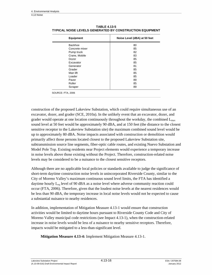
4. Environmental Analysis 4.13 Noise
Lakeview Substation Project 4.13-16 ESA / 207584.08 (A.10-09-016) Draft Environmental Impact Report January 2012
TABLE 4.13-5 TYPICAL NOISE LEVELS GENERATED BY CONSTRUCTION EQUIPMENT
Equipment Noise Level (dBA) at 50 feet
Backhoe 80 Concrete mixer 85 Pump truck 82 Crane, Mobile 83 Dozer 85 Excavator 85 Generator 81 Grader 85 Man lift 85 Loader 85 Paver 89 Roller 85 Scraper 89
SOURCE: FTA, 2006
construction of the proposed Lakeview Substation, which could require simultaneous use of an excavator, dozer, and grader (SCE, 2010a). In the unlikely event that an excavator, dozer, and grader would operate at one location continuously throughout the workday, the combined Lmax sound level at 50 feet would be approximately 90 dBA, and at 150 feet (the distance to the closest sensitive receptor to the Lakeview Substation site) the maximum combined sound level would be up to approximately 80 dBA. Noise impacts associated with construction or demolition would primarily affect those persons located closest to the proposed Lakeview Substation site, subtransmission source line segments, fiber-optic cable routes, and existing Nuevo Substation and Model Pole Top. Existing residents near Project elements would experience a temporary increase in noise levels above those existing without the Project. Therefore, construction-related noise levels may be considered to be a nuisance to the closest sensitive receptors.
Although there are no applicable local policies or standards available to judge the significance of short-term daytime construction noise levels in unincorporated Riverside County, similar to the City of Moreno Valley’s maximum continuous sound level limits, the FTA has identified a daytime hourly Leq level of 90 dBA as a noise level where adverse community reaction could occur (FTA, 2006). Therefore, given that the loudest noise levels at the nearest residences would be less than 90 dBA, the temporary increase in local noise levels would not be expected to cause a substantial nuisance to nearby residences.
In addition, implementation of Mitigation Measure 4.13-1 would ensure that construction activities would be limited to daytime hours pursuant to Riverside County Code and City of Moreno Valley municipal code restrictions (see Impact 4.13-1), when the construction-related increase in noise levels would be less of a nuisance to nearby sensitive receptors. Therefore, impacts would be mitigated to a less-than-significant level.
Mitigation Measure 4.13-4: Implement Mitigation Measure 4.13-1.

4. Environmental Analysis 4.13 Noise
Lakeview Substation Project 4.13-17 ESA / 207584.08 (A.10-09-016) Draft Environmental Impact Report January 2012
Significance after Mitigation: Less than Significant.
e) For a project located within an airport land use plan area, or, where such a plan has not been adopted, in an area within two miles of a public airport or public use airport, would the project expose people residing or working in the area to excessive noise levels.
The Project would not be located within an airport land use plan area nor would it be located within 2 miles of any public airport; therefore, no impact would occur (No Impact).
f) For a project located in the vicinity of a private airstrip, would the project expose people residing or working in the project area to excessive noise levels.
The Project would not be located in the vicinity of a private airstrip; therefore, no impact would occur (No Impact).
4.13.5 Alternatives
Alternative 1: Phased Construction Alternative
Implementation of Alternative 1 would result in the phased construction of the various Project components to reduce combined daily regional air quality emissions. From a noise impact perspective, which is assessed at the local level for each component of the Project, impacts under this alternative would be the same as the Project.
Alternative 2: Relocated Substation Alternative
Construction activities under Alternative 2 associated with the alternative substation and Subtransmission Source Line Segment 2 would occur at greater distances from the nearest sensitive receptors compared to under the Project. Therefore, construction and operation noise levels at sensitive receptor locations in the vicinity of the relocated substation site and Subtransmission Source Line Segment 2 would be less than for the Project. Maintenance noise impacts would be the same for this alternative as for the Project.
No Project Alternative
Under the No Project Alternative, the Project would not be implemented; therefore, no noise or vibration impacts would occur.

4. Environmental Analysis 4.13 Noise
Lakeview Substation Project 4.13-18 ESA / 207584.08 (A.10-09-016) Draft Environmental Impact Report January 2012
References – Noise California Department of Transportation (Caltrans), 1998. Technical Noise Supplement, 1998.
Caltrans, 2004, Noise, Vibration, and Hazardous Waste Management Office, 2004, Transportation- and Construction-Induced Vibration Guidance Manual, June 2004.
City of Moreno Valley, 2006. Moreno Valley General Plan, July 11, 2006.
Electrical Power Research Institute (EPRI), 1978. Transmission line Reference Book, 115-138 kV Compact Line Design.
Federal Transit Administration (FTA), 2006. Transit Noise and Vibration Impact Assessment (FTA-VA-90-1003-06), May 2006.
Institute of Electrical and Electronics Engineers (IEEE), 2010, IEEE Standard Test Code for Liquid-Immersed Distribution, Power, and Regulating Transformers, IEEE STD C57.12.90-2010.
Moreno Valley, 2007. Moreno Valley Municipal Code, Chapter 11.80, Noise Regulation, §11.80.030, Prohibited Acts, 2007.
Riverside County, 2006. Riverside County Municipal Code, Chapter 9.52, Noise Regulation, adopted in 2006.
Riverside County, 2008. Riverside County General Plan 2008 – Chapter 7: Noise Element, 2008.
Southern California Edison (SCE), 2010a. Proponent’s Environmental Assessment. Lakeview Substation Project. September 17, 2010.
SCE, 2010b. 115/12 kV Transformer Banks Noise Levels Monitored at Concho Substation, October 2010.

4. Environmental Analysis
Lakeview Substation Project 4.14-1 ESA / 207584.08 (A.10-09-016) Draft Environmental Impact Report January 2012
4.14 Population and Housing
This section provides a description of population and housing for the Project area, and evaluates potential impacts associated with implementation of the Project and alternatives. A discussion of population growth or displacement of human population and housing is also included. The Project and alternatives would be constructed in unincorporated western Riverside County, in the communities of Lakeview and Nuevo. A portion of the proposed telecommunication route would traverse north into the City of Moreno Valley. Project construction would also involve minor upgrades to existing substations in the cities of Perris and Hemet; however, the portions of the Project proposed within these cities would occur entirely within existing structures in an existing SCE ROW and would be minimal. These cities are therefore not included in the study area for population and housing.
4.14.1 Setting
Population
Riverside County is located in southern California, just north of San Diego County. Over the past three decades, the county has experienced rapid growth. According to the California Department of Finance (CA DOF), the county’s population increased by about 75 percent in the 1980s, from 669,800 in 1980 to 1,170,413 in 1990 (CA DOF, 1990; CA DOF, 2000). The 2000 population estimate was 1,545,387 persons, an increase of about 32 percent since 1990 (CA DOF, 2000). The county grew an additional 41 percent between 2000 and 2010, reaching an estimated 2,179,692 residents (CA DOF, 2011). Of this population, 501,968 residents were located in unincorporated areas, representing 23 percent of the total county population (CA DOF, 2011a).
The communities of Lakeview and Nuevo grew by about 30 and 56 percent, respectively, between 2000 and 2010, and the City of Moreno Valley also experienced steady population growth between 2000 and 2010 (CA DOF, 2000; U.S. Census Bureau, 2011). As demonstrated in Tables 4.14-1 and 4.14-2, which shows historic and estimated future population growth from 1990 to 2035, the populations in Riverside County and the unincorporated portion of the county are expected to substantially increase over the next 25 years.
Housing
According to the CA DOF, as of 2010, Riverside County had 800,707 total housing units, with 14.3 percent of these dwelling units being vacant (CA DOF, 2011b). Table 4.14-3 shows housing data for Riverside County and the City of Moreno Valley for 2010 (CA DOF, 2011b), and the communities of Lakeview and Nuevo from 2009 (U.S. Census Bureau, 2011).
As demonstrated in Table 4.14-4, the number of households in Riverside County, unincorporated Riverside County, and the City of Moreno Valley is expected to substantially increase through 2035 (SCAG, 2008).

4. Environmental Analysis 4.14 Population and Housing
Lakeview Substation Project 4.14-2 ESA / 207584.08 (A.10-09-016) Draft Environmental Impact Report January 2012
TABLE 4.14-1 HISTORIC AND ESTIMATED FUTURE POPULATION, 1990–2035
Year Riverside County Unincorporated
Riverside County Moreno Valley Lakeview Nuevo
1990 1,170,413a 385,384a 118,779a 1,448d 3,010d
2000 1,545,387a 420,721a 142,379a 1,619d 4,135d
2010 2,179,692b 501,968b 192,654b 2,104d 6,447d
2015 2,509,330c 710,478c 206,657 c N.D. N.D.
2020 2,809,006c 854,662c 220,390 c N.D. N.D.
2025 3,090,001c 988,192c 234,410c N.D. N.D.
2030 3,343,778c 1,104,572c 246,804c N.D. N.D.
2035 3,596,680c 1,243,634c 258,350c N.D. N.D. N.D. = No Data Available SOURCE: (a) CA DOF, 2000; (b) CA DOF, 2011a; (c) SCAG, 2008; (d) U.S. Census Bureau, 2011
TABLE 4.14-2 HISTORIC AND ESTIMATED FUTURE POPULATION GROWTH RATES, 1990-2035
Period Riverside County
Unincorporated Riverside County Moreno Valley Lakeview Nuevo
1990 - 2000 32% 9% 20% 12% 37%
2000 - 2010 41% 19% 35% 30% 56%
2010 - 2015 15% 42% 7% N.D. N.D.
2015 - 2020 12% 20% 7% N.D. N.D.
2020 - 2025 10% 16% 6% N.D. N.D.
2025 - 2030 8% 12% 5% N.D. N.D.
2030 - 2035 8% 13% 5% N.D. N.D. N.D. = No Data Available
TABLE 4.14-3 2010 HOUSING DATA
Area Total Housing Units Vacant Units Vacancy Rate
Riverside County 800,707 114,447 14.3%
Unincorporated Riverside County 173,143 23,491 13.6%
Moreno Valley 55,559 3,967 7.1%
Lakeview 438 98 22.4%
Nuevo 1,733 203 11.7% SOURCE: CA DOF, 2011b; U.S. Census Bureau, 2011

4. Environmental Analysis 4.14 Population and Housing
Lakeview Substation Project 4.14-3 ESA / 207584.08 (A.10-09-016) Draft Environmental Impact Report January 2012
TABLE 4.14-4 HISTORIC AND PROJECTED HOUSEHOLDS: 2003-2035
Year Riverside County
Unincorporated Riverside County Moreno Valley
2003 560,731 150,263 41,410
2005 612,341 160,997 45,877
2010 720,531 195,391 50,432
2015 811,486 225,127 55,407
2020 913,207 274,912 60,025
2025 1,008,909 318,088 64,699
2030 1,097,950 357,579 69,353
2035 1,183,097 401,356 72,977 SOURCE: SCAG, 2008
Regulatory Context
Regional
Southern California Association of Governments
Southern California Association of Governments (SCAG) is a Joint Powers Agency established under California Government Code §6502 et seq. SCAG is designated as a Council of Governments, a Regional Transportation Planning Agency, and a Metropolitan Planning Organization for a six-county region that includes Riverside County. SCAG prepares a Regional Housing Needs Assessment (RHNA) for the region, which quantifies the need for housing within each jurisdiction during a specified planning period. The RHNA is a key tool for SCAG and its member governments to plan for growth. The most recently published RHNA covered the planning period from January 1, 2006 to June 30, 2014. Because of the requirements of Senate Bill (SB) 375, SCAG is preparing the next RHNA which will cover January 1, 2011 to September 30, 2021 (SCAG, 2011).
Local
Riverside County General Plan
CPUC General Order No. 131-D explains that local land use regulations would not apply to the Project. However, for information purposes, the following policies identified in the Land Use Element of the Riverside County General Plan would otherwise be relevant to the Project (Riverside County, 2009):
Policy LU 5.2: Monitor the capacities of infrastructure and services in coordination with service providers, utilities, and outside agencies and jurisdictions to ensure that growth does not exceed acceptable levels of service.

4. Environmental Analysis 4.14 Population and Housing
Lakeview Substation Project 4.14-4 ESA / 207584.08 (A.10-09-016) Draft Environmental Impact Report January 2012
Policy LU 6.2: Direct public, educational, religious, and utility uses established to serve the surrounding community toward those areas designated for Community Development and Rural Community uses on the applicable Area Plan land use maps. These uses may be found consistent with any of the Community Development, Rural Community, or Rural foundation designations, including the Rural Village Overlay, as well as the Open Space B Rural and Agriculture designations, under the following conditions:
a. The facility is compatible in scale and design with surrounding land uses, and does not generate excessive noise, traffic, light, fumes, or odors that might have a negative impact on adjacent neighborhoods.
b. The location of the proposed use will not jeopardize public health, safety, and welfare, or the facility is necessary to ensure the continual public safety and welfare.
Lakeview/Nuevo Area Plan
The Project area is also covered by the Lakeview/Nuevo Area Plan, one of the 19 area plans described in the Riverside County General Plan. The Lakeview/Nuevo Area Plan does not include any applicable goals, objectives, and policies related to population or housing that would be relevant to the Project (Riverside County, 2007).
Moreno Valley General Plan
The Moreno Valley General Plan does not include any applicable goals, objectives, and policies related to population or housing that would be relevant to the Project (City of Moreno Valley, 2006).
4.14.2 Significance Criteria According to Appendix G of the CEQA Guidelines, an impact resulting from the Project would be considered significant if it would:
a) Induce substantial population growth in an area, either directly (for example, by proposing new homes and businesses) or indirectly (for example, through extension of roads or other infrastructure);
b) Displace substantial numbers of existing housing, necessitating the construction of replacement housing elsewhere; or
c) Displace substantial numbers of people, necessitating the construction of replacement housing elsewhere.
4.14.3 Applicant Proposed Measures There are no APM included to address issues related to population and housing impacts.

4. Environmental Analysis 4.14 Population and Housing
Lakeview Substation Project 4.14-5 ESA / 207584.08 (A.10-09-016) Draft Environmental Impact Report January 2012
4.14.4 Impact Analysis
a) Induce substantial population growth in an area, either directly or indirectly.
Impact 4.14-1: The Project could directly or indirectly induce substantial population growth. Less than Significant (Class III)
The Project proposes no new homes and no new businesses. The proposed Lakeview Substation site is currently undeveloped and, when operational, would be unmanned. The proposed subtransmission source line segments and telecommunication routes would include installation of subtransmission poles, subtransmission conductor cables, and fiber-optic telecommunication cables in new and existing utility ROWs, and operation of these components would be performed periodically by current SCE personnel. Therefore, the Project would not directly induce population growth.
The Project would provide temporary employment opportunities during construction, but this would not result in substantial population growth. The construction period would last approximately 12 months, and SCE anticipates a total of approximately 40 construction personnel working on any given day. It is anticipated that all temporary positions would be filled from the local labor pool available in Riverside County, with workers expected to commute to the site rather than move into the Project vicinity. However, even if each of the construction personnel required temporary accommodations, an adequate number of units exist in the area to serve this demand. There are at least 10 hotels and motels and at least 10 campgrounds and recreational vehicle (RV) opportunities in the community of Lakeview and surrounding cities (GoogleMaps, 2011). In addition, as shown in Table 4.14-3, the existing housing vacancy rates in Riverside County would provide additional options for workers needing accommodations.
Project operation and maintenance would require minimal staffing, which would be handled by current SCE employees. No new permanent jobs would be created. Therefore, the Project would have a less-than-significant impact on population growth because any short-term housing demand created during construction could be accommodated by existing units, and no long-term growth would result from Project operation and maintenance.
Project construction also would not indirectly induce substantial population growth by creating new opportunities for local industry or commerce. The Project is designed to allow SCE to continue to provide safe and reliable electrical service in its Electrical Needs Area (see Figure 2-1 in Chapter 2, Project Description), and to meet forecasted demand projections. Some growth is anticipated in the Project area, as described above in Tables 4.14-1 and 4.14-2. Applicable local planning policies and zoning ordinances are required to plan for accommodating this growth, and the Project’s provision of electrical service is consistent with development anticipated by plans and zoning in the jurisdictions that the Project would serve. Additionally, the availability of electrical capacity by itself does not normally ensure or encourage growth within a particular area. Other factors such as economic conditions, land availability, population trends, availability of water supply or sewer services, and local planning policies have a more direct effect on

4. Environmental Analysis 4.14 Population and Housing
Lakeview Substation Project 4.14-6 ESA / 207584.08 (A.10-09-016) Draft Environmental Impact Report January 2012
growth. Therefore, implementation of the Project would not directly or indirectly encourage new development or induce substantial population growth. Impacts would be less than significant.
Mitigation: None required.
b) Displacement of existing housing units, necessitating the construction of replacement housing elsewhere.
The Project would not displace any residential housing units. The proposed Lakeview Substation would be constructed on vacant agricultural land with no existing buildings or structures. The proposed subtransmission source lines would be constructed within approximately 3.3 miles of new ROW through open space and agricultural areas. The telecommunication system would traverse open space, wilderness areas, commercial areas in the City of Moreno Valley, and residential areas in the community of Lakeview, but would not displace existing housing units. Therefore, the Project would have no impact with regard to the displacement of existing housing units, nor would it necessitate the construction of replacement housing elsewhere (No Impact).
c) Displacement of people, necessitating the construction of replacement housing elsewhere.
As noted above, the Project would not eliminate housing or any other structures that are currently used by people. Therefore, it would have no impact with regard to the displacement of people, and would not necessitate the construction of replacement housing elsewhere (No Impact).
4.14.5 Alternatives
Alternative 1: Phased Construction Alternative
Alternative 1would extend the construction period by 10 months. This would increase the duration of potential increased demand for temporary accommodations in the study area for construction personnel. However, no new permanent jobs would be created, and short-term housing demand created during construction could be accommodated by existing units. Alternative 1 would result in the provision of the same amount of electricity to the Electrical Needs Area as the Project, and would serve the same existing and planned electrical load growth. Therefore, because it would not directly or indirectly induce substantial long-term population growth, this impact would be less than significant. Alternative 1would have no impact with respect to displacing people or existing housing, necessitating the construction of replacement housing elsewhere.

4. Environmental Analysis 4.14 Population and Housing
Lakeview Substation Project 4.14-7 ESA / 207584.08 (A.10-09-016) Draft Environmental Impact Report January 2012
Alternative 2: Relocated Substation Alternative
The impacts of Alternative 2 on population and housing would be the same as for the Project because it would construct a substation of the same size and capacity, and require the same temporary construction crew and operation and maintenance personnel. Therefore, because it would not directly or indirectly induce substantial long-term population growth, this impact would be less than significant. Additionally, the substation would be located such that it would also not displace people or existing housing, and would result in no impact with respect to these criteria.
No Project Alternative
Under the No Project Alternative, the Project would not be implemented; therefore, there would be no impact related to population and housing.
References – Population and Housing California Department of Finance (CA DOF), 1990. Report E-6: County Population Estimates
and Components of Change—July 1, 1970–1990. (http://www.dof.ca.gov/research/ demographic/reports/estimates/e-6/1970-90/documents/E-6_70-90final.xls) accessed August 19, 2011.
California Department of Finance (CA DOF), 2000. Report E-8: Historical Population and Housing Estimates for Cities, Counties and the State, 1990-2000. (http://www.dof.ca.gov/research/demographic/reports/estimates/e-8/) accessed August 19, 2011.
California Department of Finance (CA DOF), 2011a. Report E-1: City / County Population Estimates with Annual Percent Change—January 1, 2010 and 2011, with 2010 Census Benchmark. (http://www.dof.ca.gov/research/demographic/reports/estimates/e-1/view.php) accessed August 19, 2011.
California Department of Finance (CA DOF), 2011b. Report E-5: Population and Housing Estimates for Cities, Counties and the State, 2010-2011, with 2010 Census Benchmark, (http://www.dof.ca.gov/research/demographic/reports/estimates/e-5/2011-20/view.php) accessed August 19, 2011.
City of Moreno Valley, 2006. City of Moreno Valley General Plan (July 11, 2006).
GoogleMaps, 2011. Search for “hotel” and “campground” near Lakeview, CA, (www.maps.google.com) accessed August 22, 2011.
Riverside County, 2003. Riverside County General Plan Final Program Environmental Impact Report, Volume I. (http://www.rctlma.org/genplan/content/eir/volume1.html) accessed September 27, 2011.
Riverside County, 2007. Lakeview/Nuevo Area Plan (rev. Dec. 18, 2007).

4. Environmental Analysis 4.14 Population and Housing
Lakeview Substation Project 4.14-8 ESA / 207584.08 (A.10-09-016) Draft Environmental Impact Report January 2012
Riverside County, 2009. Riverside County General Plan Amendments 2003-2008 (rev. March 11, 2009).
Southern California Association of Governments (SCAG), 2008. Regional Transportation Plan, adopted 2008 Growth Forecast by City. (www.scag.ca.gov/forecast/downloads/excel/ RTP07_CityLevel.xls) accessed August 19, 2011.
Southern California Association of Governments (SCAG), 2011. Regional Housing Needs Assessment, (www.scag.ca.gov/housing/rhna/index.htm) accessed August 22, 2011.
U.S. Census Bureau, 2011. American FactFinder. (http://factfinder.census.gov) accessed August 19 and September 27, 2011.

4. Environmental Analysis
Lakeview Substation Project 4.15-1 ESA / 207584.08 (A.10-09-016) Draft Environmental Impact Report January 2012
4.15 Public Services
This section analyzes the impact of the Project and alternatives on the provision of public services within the study area, which includes the communities of Lakeview and Nuevo in unincorporated Riverside County, and the City of Moreno Valley. Project construction would also involve minor upgrades to existing substations in the cities of Perris and Hemet. However, these components would be constructed within existing structures within SCE’s right of way and would have no effect on public services. Therefore, they were not used to define the study area. This section also identifies adverse physical impacts on the environment that could result from a need to provide new or physically altered public facilities, resulting from the Project and alternatives. This analysis reviews fire protection and emergency medical response, police services, schools, and other public services. Parks and recreational resources are discussed in Section 4.16, Recreation.
4.15.1 Setting
Fire Protection and Emergency Medical Services
Riverside County Fire Department
The Riverside County Fire Department (RCFD) is one of the largest regional fire service organizations in California, with 95 fire stations and 17 battalions. Of these stations, 51 are located in the unincorporated portion of the county. The fire station closest to the proposed substation site is Nuview Fire Station, which is located at 30515 10th Street in Nuevo (RCFD, 2011a). The RCFD’s standard for fire station coverage is one station per 2,000 dwelling units or 3.5 million square feet of commercial or industrial uses, and an EIR prepared for the county’s General Plan projects that to maintain this standard, the RCFD will need to have over 460 fire stations at maximum build-out (Riverside County, 2003).
Services provided by the RCFD include fire suppression, emergency medical, rescue, and fire prevention services. The RCFD is staffed with approximately 952 career and 1,100 volunteer personnel, and currently serves approximately two million residents in an area of 7,000 square miles. This service area consists of all unincorporated areas in Riverside County, 18 contract cities, and one Community Service District. Under contract with the California Department of Forestry and Fire Protection (CAL FIRE), the RCFD is the Operational Area Coordinator for the California Fire and Rescue Mutual Aid System for all fire service jurisdictions in Riverside County. As such, RCFD has also been given the authority to enter into several automatic aid agreements with other city jurisdictions, including the cities of Perris and Moreno Valley, as well as with adjacent National Forests (RCFD, 2011b).
The Department’s service area is organized into six divisions, and the equipment used by each division has the versatility to respond to both urban and wildland emergency conditions. The RCFD’s fire suppression inventory includes structural engines, rural engines, brush engines, telesquirts, trucks, paramedic units, a helicopter, a hazardous materials unit, incident command units, water tenders, fire crew vehicles, mobile communications centers, breathing support units,

4. Environmental Analysis 4.15 Public Services
Lakeview Substation Project 4.15-2 ESA / 207584.08 (A.10-09-016) Draft Environmental Impact Report January 2012
lighting units, power supply units, fire dozers, mobile training vans, and mobile emergency feeding units (RCFD, 2011b).
Moreno Valley Fire Department
The Moreno Valley Fire Department (MVFD) operates six fire stations with six paramedic engine companies and three aerial truck companies. The MVFD provides fire suppression, emergency medical rescue, hazardous materials response, planning and inspections for businesses, and hazard reduction abatement within the City of Moreno Valley. Through a Cooperative Fire Services Agreement with the RCFD, the MVFD has access to additional emergency equipment such as brush engines, aircraft, hazardous materials unit, fire crews, and breathing support units. The fire station closest to the telecommunication line route would be Station 58 Moreno Beach, which is located at 28040 Eucalyptus Avenue and serves the eastern end of the city (MVFD, 2011). The MVFD considers the maximum acceptable response time to be 5 minutes for calls for emergency services to both urban and suburban areas. To maintain this response time, the city’s General Plan anticipates the addition of five new fire stations at maximum build-out (City of Moreno Valley, 2006).
Police Protection
Riverside County Sheriff’s Department
The Riverside County Sheriff’s Department (RCSD) provides law enforcement services to areas within its jurisdiction, including general community policing as well as the operation and maintenance of several correctional facilities. The RCSD has over 3,000 employees, including 1,330 sworn personnel, and operates nine sheriff sub-stations located throughout Riverside County to provide area-level community service to the unincorporated county and its 18 contract agencies, including the City of Moreno Valley (RCSD, 2011a; Riverside County, 2003). The Hemet Station provides services within the Lakeview and Nuevo communities (RCSD, 2011b).
The RCSD has established criteria for its staffing requirements in unincorporated areas of the county: one sworn officer per 1,000 persons in the service population (Riverside County, 2003). The current unincorporated service population is 501,968, giving the department a current service ratio of one sworn officer per 380 persons (CA DOF, 2011a).
Schools
Riverside County is home to 23 school districts and several community college districts. The Nuview Union School District (NUSD) and the Moreno Valley Unified School District (MVUSD) serve the study area.
The NUSD presently operates two elementary schools, one middle school, and one charter high school (NUSD, 2011a). The NUSD’s goals do not include a service or class size goal (NUSD, 2011b). However, California Education Code §41376 establishes a goal of districtwide average class sizes of 30 students and a maximum class size of 32 students. For the 2010-2011 school year (the most recent data available at the time of publication), the total districtwide enrollment
4. Environmental Analysis 4.15 Public Services
Lakeview Substation Project 4.15-3 ESA / 207584.08 (A.10-09-016) Draft Environmental Impact Report January 2012
for the NUSD was 2,103 students. However, because districtwide average class size information is not available for this school year, for comparison purposes the total enrollment in 2009-2010 was 2,051 students. The districtwide average student-to-teacher ratios were 21.7 to 1 for elementary school students, 24.2 to 1 for middle school students, and 21.9 to 1 for high school students (Yearry, 2011).1 Therefore, the NUSD met the California Education Code goals for average class sizes in 2009-2010.
The MVUSD operates 23 elementary schools, 6 middle schools, 4 high schools, and 7 alternative schools (MVUSD, 2011). The MVUSD School Board Policies state that “the administration shall undertake its best efforts to ensure the District is in compliance with provisions of Education Code 41376,” (MVUSD, 2008). For the 2009-2010 school year (the most recent data available at the time of publication), the total districtwide enrollment for the MVUSD was 36,809 students. However, because districtwide average class size information is not available for this school year, for comparison purposes the total enrollment in 2008-2009 was 36,092 students (Ed-Data, 2011a). The districtwide average class size for that year was 26.2 students per class (Ed-Data, 2011b). Therefore, the MVUSD met the California Education Code goals for average class sizes in 2008-2009. Data from previous years also demonstrates that when districtwide enrollment was over 37,000 students, the MVUSD still met these goals (Ed-Data, 2011b).
The following schools are located near the Project site:
Mountain Shadows Middle School, 30401 Reservoir Avenue, Nuevo (NUSD) Nuview Bridge Early College High School, 30401 Reservoir Avenue, Nuevo (NUSD) Nuview Elementary School, 29680 Lakeview Avenue, Nuevo (NUSD) La Jolla Elementary School, 147450 Willowgrove Drive, Moreno Valley (MVUSD) Landmark Middle School, 15261 Legendary Drive, Moreno Valley (MVUSD) Ridge Crest Elementary School, 28500 J.F. Kennedy Drive, Moreno Valley (MVUSD)
The closest school, Nuview Elementary, is located approximately 800 feet away from the proposed Subtransmission Source Line Segment Two.
Parks
See Section 4.16, Recreation, for a discussion of recreational facilities, including parks, in the vicinity of the Project.
Other Public Facilities
Riverside County operates a system of 33 branch libraries and two bookmobiles to serve the unincorporated communities in the county. The closest, Nuview Branch Library, is located at 29990 Lakeview Avenue in Nuevo, approximately 0.3 mile southeast of the proposed Lakeview Substation site (Riverside County Library System, 2011). According to the Existing Setting Report for the Riverside County Integrated Plan, this system “did not indicate that it maintained a specific numerical factor to analyze the needs created by new development. However, the 1 In the absence of available average class size data, student-to-teacher ratios were used as an approximate substitute.

4. Environmental Analysis 4.15 Public Services
Lakeview Substation Project 4.15-4 ESA / 207584.08 (A.10-09-016) Draft Environmental Impact Report January 2012
American Library Association suggests that an appropriate service criteria would be availability of convenient library facilities and book reserves at a rate of 0.5 square foot of library space and 2.5 volumes per capita” (Riverside County, 2000, p. 9-17).
Riverside County operates the Riverside County Regional Medical Center and 10 clinics (Riverside County Department of Public Health, 2011). Additional medical facilities and services, such as private/for-profit and municipal facilities, also exist within Riverside County. The closest hospital facility to the Project is Kaiser Moreno Valley Community Hospital, at 27300 Iris Avenue, Moreno Valley, located southwest of the existing Alessandro Substation and west of the proposed telecommunications route (Kaiser Permanente, 2011). According to the Existing Setting Report for the Riverside County Integrated Plan, “No specific criteria are maintained for determining future needs for public hospital or medical clinics” (Riverside County, 2000, p. 9-19).
Regulatory Setting
Riverside County General Plan
CPUC General Order No. 131-D explains that local land use regulations would not apply to the Project. However, CPUC staff considered local plans and policies to determine the service ratios and/or response time goals for local agencies and services, informing the determination of significance thresholds for the study area. For information purposes, the following policies identified in the Land Use and Safety Elements of the Riverside County General Plan would otherwise be relevant to the Project (Riverside County, 2009):
Policy LU 5.1: Ensure that development does not exceed the ability to adequately provide supporting infrastructure and services, such as libraries, recreational facilities, transportation systems, and fire/police/medical services.
Policy LU 5.2: Monitor the capacities of infrastructure and services in coordination with service providers, utilities, and outside agencies and jurisdictions to ensure that growth does not exceed acceptable levels of service.
Policy LU 9.1: Require that new development contribute their fair share to fund infrastructure and public facilities such as police and fire facilities.
Policy S 5.10: Continue to utilize the Riverside County Fire Protection Master Plan as the base document to implement the goals and objectives of the Safety Element.
Moreno Valley General Plan
The Moreno Valley General Plan includes the following policies that may be relevant to the Project:
Policy 2.14.3: Review development projects for their impacts on public services and facilities including, but not necessarily limited to, roadways, water, sewer, fire, police, parks, and libraries and require public services or facilities to be provided at the standards outlined in the Moreno Valley General Plan and the standards of applicable service agencies.
Program 6-1: Request that public utility companies inspect their facilities and distribution networks to determine the potential impact of earthquake damage.

4. Environmental Analysis 4.15 Public Services
Lakeview Substation Project 4.15-5 ESA / 207584.08 (A.10-09-016) Draft Environmental Impact Report January 2012
Policy 6.2.1: Permit only that development in 100-year floodplain that represents an acceptable use of the land in relation to the hazards involved and the costs of providing flood control facilities. Locate critical facilities, such as hospitals, fire stations, police stations, public administration buildings, and schools outside of flood hazard areas (City of Moreno Valley, 2006).
4.15.2 Significance Criteria According to Appendix G of the CEQA Guidelines, a project impact would be considered significant if it would:
a) Result in substantial adverse physical impacts associated with the provision of, or the need for, new or physically altered governmental facilities, the construction of which could cause significant environmental impacts, in order to maintain acceptable service ratios, response times, or other performance objectives for any of the following public services:
i. Fire protection; ii. Police protection; iii. Schools; iv. Parks; or v. Other public facilities.
4.15.3 Applicant Proposed Measures There are no APM included to address issues related to public services.
4.15.4 Impacts and Mitigation Measures
a.i) Fire Protection
Impact 4.15-1: Project construction, operation, and maintenance activities could temporarily increase the demand for fire protection and emergency medical services. Less than Significant (Class III)
Increases in long-term demand for fire protection services are typically associated with substantial increases in population. The Project would not result in a population increase, nor introduce any new uses to the Project area, that would generate increased long-term demand for fire protection services (see Section 4.14, Population and Housing, for more information related to potential population increase). The construction period would last approximately 12 months, and SCE anticipates a total of approximately 40 construction personnel working on any given day. Although it is anticipated that all temporary positions would be filled from the local labor pool available in Riverside County, if any temporary workers should move into the service area of the RCFD and/or MVFD from elsewhere, there are currently enough vacant housing units and hotels to accommodate them (see Section 4.14, Population and Housing). Because the Project would not result in a need for new housing units, it would not affect the RCFD’s cover standards for the number of fire
4. Environmental Analysis 4.15 Public Services
Lakeview Substation Project 4.15-6 ESA / 207584.08 (A.10-09-016) Draft Environmental Impact Report January 2012
stations serving the county, nor would it affect the MVFD’s response time goal. Therefore, Project construction would not result in the need for new or physically altered fire protection facilities in order to maintain acceptable service ratios, response times, or other performance objectives.
During operation and maintenance, the Project would require routine maintenance, inspection, and vegetation management activities. Operational staffing levels would not increase above existing levels that are required to maintain the existing subtransmission and transmission systems. The Project would not add new structures or uses within the service area of MVFD that would affect its response time goal. Additionally, the Project would add 2.7 acres or approximately 120,000 square feet of new industrial uses within the RCFD’s service area, which would be well below the threshold of 3.5 million square feet that would result in the need for a new fire station. Therefore, the Project would not result in the need for new or physically altered fire protection facilities. Project operation and maintenance would have a less than significant impact with respect to fire protection services in unincorporated Riverside County and no impact in Moreno Valley. See Section 4.9, Hazards and Hazardous Materials, for discussion of potential Project-related impacts associated with risk of fire hazards.
Mitigation: None required.
a.ii) Police Protection
Increases in the demand for police protection services are typically associated with substantial increases in population. The Project would not result in a population increase, nor introduce any new uses to the Project area, that would generate increased long-term demand for police protection services (see Section 4.14, Population and Housing, for more information related to potential population increase). The construction period would last approximately 12 months, and SCE anticipates a total of approximately 40 construction personnel working on any given day. Although it is anticipated that all temporary positions would be filled from the local labor pool available in Riverside County, if any temporary workers should move into the service area of the RCSD from elsewhere, the RCSD’s current staff of sworn officers could accommodate this increase in population while maintaining an acceptable service ratio because an addition of 40 construction personnel would not measurably alter the current service ratio of one sworn officer per 380 persons and therefore would not exceed the RCSD’s service ratio goal of one sworn officer per 1,000 persons. Therefore, Project construction would have no impact with respect the need for new or physically altered police protection facilities.
During operation and maintenance, operational staffing levels would not increase above existing levels that are required to maintain the existing subtransmission and transmission systems. Therefore, the Project would not affect RCSD’s ability to maintain an acceptable service ratio or result in the need for new or physically altered police protection facilities. Project construction, operation, and maintenance would have no impact with respect to police protection services (No Impact).

4. Environmental Analysis 4.15 Public Services
Lakeview Substation Project 4.15-7 ESA / 207584.08 (A.10-09-016) Draft Environmental Impact Report January 2012
a.iii) Schools
Increased demand for public school services are typically associated with increases in the local population or demand for housing. The construction crew for the Project is estimated to be up to 40 people, including SCE and contracted construction personnel. The construction period is expected to last for 12 months. Although it is anticipated that all temporary positions would be filled from the local labor pool available in Riverside County, temporary workers could move into the area from elsewhere and bring school-aged children into the NUSD or MVUSD school districts’ service areas. A conservative approach to estimating the number of children that could move into the area during the construction period gives an estimate of 96 children.2 Based on the assumption that these children would be approximately equally divided among grade levels, existing schools could accommodate this increase in enrollment. An increase of 96 students in the NUSD would result in a total enrollment of up to approximately 2,200 students. This would be an increase of less than 5 percent of current enrollment. Average student-to-teacher ratios would be maintained at fewer than 30 to 1. An increase of 96 students in the MVUSD would result in a total enrollment of up to approximately 36,900 students. This would be an increase of less than 1 percent of current enrollment. Average class sizes would be maintained at fewer than 30 students. The potential Project-related increase in students would not result in the need for new or expanded schools.
During operation and maintenance, operational staffing levels would not increase above existing levels that are required to maintain the existing subtransmission and transmission systems. Therefore, the Project would not result in a substantial increase in demand for school facilities and would not require the construction of a new or modification of an existing school, the construction of which could cause significant environmental effects. Therefore, the Project would have no impact with respect to schools (No Impact).
a.iv) Parks
For potential impacts on recreational facilities, including parks, see Chapter 4.16, Recreation. Impacts on recreational facilities were found to be less than significant or to have no impact.
a.v) Other Public Facilities
The Project would not result in substantial adverse impacts related to other types of public facilities (e.g., public libraries, hospitals, or other civic uses) because, as discussed above, the Project would not result in a significant increase of local population or housing, which is typically associated with increased demand for public facilities. Project construction would require a 2 In Riverside County in 2010, 257,077 households had children under the age of 18, and the total county
population of children under the age of 18 was 620,108 (U.S. Census Bureau, 2010). This gives a rough average of 2.4 children per household with children present. Assuming each of the 40 temporary construction workers represented one average household with children, this could result in an increase of 96 children in the service areas of either NUSD or MVUSD.

4. Environmental Analysis 4.15 Public Services
Lakeview Substation Project 4.15-8 ESA / 207584.08 (A.10-09-016) Draft Environmental Impact Report January 2012
limited number of people as a temporary work crew, and Project operation and maintenance would require no new staff. Therefore, the Project would not have an effect on the service goals of other public services and would have a no impact associated with the provision of new or physically altered facilities for libraries, hospitals or other civic uses (No Impact).
4.15.5 Alternatives
Alternative 1: Phased Construction Alternative
Alternative 1 would extend the construction period by 10 months. This would increase the duration of potential increased demand on public services in the study area due to construction activities, but would result in the same number of personnel needed during construction, operation, and maintenance, and would not change the size or type of facilities to be constructed. Therefore, Alternative 1 impacts to Public Services would be the same as the Project.
Alternative 2: Relocated Substation Alternative
Alternative 2 would construct the proposed Lakeview Substation on a different but adjacent site, but it would not change the size or type of facilities to be constructed and would require the same temporary construction crew and operation and maintenance personnel. Therefore, Alternative 2 impacts to Public Services would be the same as the Project.
No Project Alternative
Under the No Project Alternative, the Project would not be implemented; therefore there would be no impact related to the provision of public services.
References – Public Services California Department of Finance (CA DOF), 2011a. Report E-1: City / County Population
Estimates with Annual Percent Change—January 1, 2010 and 2011, with 2010 Census Benchmark. (http://www.dof.ca.gov/research/demographic/reports/estimates/e-1/view.php) accessed August 19, 2011.
City of Moreno Valley, 2006. City of Moreno Valley General Plan Safety Element (July 11, 2006)
Ed-Data, 2011a. Enrollment by Grade Moreno Valley Unified School District, 2009-10 (http://www.ed-data.k12.ca.us/App_Resx/EdDataClassic/fsTwoPanel.aspx?#!bottom=/ _layouts/EdDataClassic/profile.asp?fyr=1011&county=33&district=67124&Level=06&reportNumber=16#enrollmentbygrade), accessed October 13, 2011.

4. Environmental Analysis 4.15 Public Services
Lakeview Substation Project 4.15-9 ESA / 207584.08 (A.10-09-016) Draft Environmental Impact Report January 2012
Ed-Data, 2011b. Average Class Size Moreno Valley Unified School District, 2009-10. (http://www.ed-data.k12.ca.us/App_Resx/EdDataClassic/fsTwoPanel.aspx?#!bottom=/ _layouts/EdDataClassic/profile.asp?fyr=1011&county=33&district=67124&Level=06&reportNumber=16#averageclasssize), accessed October 13, 2011.
Riverside County, 2000. Riverside County Existing Setting Report. (http://www.rctlma.org/ genplan/content/documents/RCIP_Existing_Setting_Report.pdf) accessed October 11, 2011.
Riverside County, 2003. Riverside County General Plan Final Program Environmental Impact Report, Volume I. (http://www.rctlma.org/genplan/content/eir/volume1.html) accessed September 27, 2011.
Riverside County, 2009. Riverside County General Plan Amendments 2003-2008 (rev. March 11, 2009).
Kaiser Permanente, 2011. Riverside Area & Coachella Valley Medical Facilities (http://xnet.kp.org/scal/virtualtour/riverside/?kp_shortcut_referrer=kp.org/riverside) accessed September 26, 2011.
Moreno Valley Fire Department (MVFD), 2011a. Moreno Valley Fire Department. (http://www.moreno-valley.ca.us/resident_services/fire/index_fire.shtml) accessed September 26, 2011.
Moreno Valley Fire Department (MVFD), 2011b. Fire Station Locations. (http://www.moreno-valley.ca.us/resident_services/fire/locations.shtml) accessed September 26, 2011.
Moreno Valley Unified School District (MVUSD), 2011. Moreno Valley Unified School District 2011-2012 School and Admin Offices Locator Map. (http://www.mvusd.net/ourpages/auto/2010/8/27/54475299/MVUSD%20List%20of%20ALL%20Schools%20with%20address%20_%20phone%20dbl%20sided%206%2015%201.pdf) accessed September 26, 2011.
MVUSD, 2008. School Board Policies §5116.3, Students. (http://www.gamutonline.net/district/morenovalley/DisplayPolicy/376221/5) accessed October 11, 2011.
Nuview Union School District (NUSD), 2011a. About the District, (http://www.nuview.k12.ca.us/domain/352) accessed September 26, 2011
NUSD, 2011b. District Goals 2010-2011. (http://www.nuview.k12.ca.us/cms/lib2/CA01001595/Centricity/ModuleInstance/1571/2010-2011%20Goals.pdf) accessed October 11, 2011.
Riverside County Department of Public Health, 2011. Department of Public Health List of Services. (http://www.rivcoph.org/phsvcs.html) accessed September 26, 2011.
Riverside County Fire Department (RCFD), 2011a. Fire Stations. (http://www.rvcfire.org/ opencms/facilities/FireStations/index.html) accessed September 27, 2011.
Riverside County Fire Department (RCFD), 2011b. About Us. (http://www.rvcfire.org/opencms/ about_us/) accessed September 26, 2011.

4. Environmental Analysis 4.15 Public Services
Lakeview Substation Project 4.15-10 ESA / 207584.08 (A.10-09-016) Draft Environmental Impact Report January 2012
Riverside County Library System, 2011. Hours and Locations. (http://rivlib.info/riverside-county-library-system/content/hours-and-locations) accessed September 26, 2011.
Riverside County Sheriff’s Department (RCSD), 2011a. About the Sheriff’s Department. (http://www.riversidesheriff.org/department/) accessed September 26, 2011.
Riverside County Sheriff’s Department (RCSD), 2011b. Hemet Station. (http://www.riversidesheriff.org/stations/hemet.asp) accessed September 26, 2011.
U.S. Census Bureau, 2010. 2010 Demographic Profile – Riverside County, CA. (http://www.census.gov/popfinder/), accessed October 13, 2011.
Yearry, Terri, 2011. Telephone conversation between Terri Yearry, Data Services, NUSD, and Alexandra Kostalas, Senior Associate, Environmental Science Associates. October 13.

4. Environmental Analysis
Lakeview Substation Project 4.16-1 ESA / 207584.08 (A.10-09-016) Draft Environmental Impact Report January 2012
4.16 Recreation
This section presents the potential impacts on parks, open space, and recreational resources that could result from implementation of the Project and alternatives. The purpose of this section is to assess the impacts of the Project and alternatives on parks, other recreational facilities, and recreational values.
4.16.1 Environmental Setting The Project would be constructed, maintained, and operated in the in the communities of Lakeview and Nuevo in unincorporated Riverside County, as well as in the City of Moreno Valley. Riverside County provides a wide range of open space, parks, and recreational areas. The study area for recreational resources encompasses the recreational facilities potentially affected by implementation of Project or alternatives within the communities of Lakeview and Nuevo, as portrayed in Figure 4.16-1, Parks and Recreation Areas. The portion of the Project that would be located in the City of Moreno Valley would be constructed inside the existing substation fenceline, on land currently used by SCE for industrial purposes. Therefore, this portion would not affect recreation in this area and the City of Moreno Valley is not included in the study area.
Recreational Areas
National Parks
The study area contains no designated national parks, recreational facilities, or open space lands. The closest national recreational resource is the San Bernardino National Forest, approximately 18 miles northeast and southeast of the proposed Lakeview Substation site (National Parks Service, 2011; U.S. Forest Service, 2011a, b).
State Parks
Lake Perris State Recreation Area is located approximately 1 mile northwest of the Project site and offers recreational opportunities such as picnicking and camping areas; hiking, bicycling, and horse trails; and swimming, fishing, windsurfing, and boating access (California State Parks, 2011a). This park’s key features are Lake Perris, the reservoir impounded by Perris Dam, and the Bernasconi Hills (California State Parks, 2011b). The park can accommodate 2,500 people and 250 water craft daily. Peak usage occurs between Memorial Day and Labor Day (Riverside County, 2009a, p. 5.13-7 and -8). The average attendance to the park was 1.1 million visitors per year until 2005, when the water level at the lake was lowered to accommodate seismic upgrades to Perris Dam. Since that time, attendance levels have dropped, to fewer than 700,000 visitors per year (McKinnon, 2011).
San Jacinto Wildlife Area (SJWA) is a California Department of Fish and Game (CDFG) facility located at the base of the Bernasconi Hills and east of Lake Perris State Recreation Area (CDFG, 2010). It is located partially within and immediately adjacent to the Project area. SJWA offers opportunities for wildlife viewing, nature walks, auto tours, and hunting and is a California

!!
!!
!!
!!
!!
!!
!!
!!
!!
!!
!!
!!!
!!
!
!
!!!!
!!
!!
!!
!!
!!
!!
!!
!!
!!
!!
!!
!!
!!
!!
!!
!!
!!
!!
!!
!!
!!
!!
!!
!!
!!
!!
!!
!!
!!
!!
!!
!!
!!
!!
!!
!!
!!
!!
!!
!!
!!
!!
!!
!!
!!
!!
!!
!!
!!
!!
!!
!!
!!
!!
!!
!!
!!
!!
!!
!!
!!
!!
!!
!!
!!
!!
!!
!!
!!
!!
!!
!!
!!
!!
!!
!!
!!
!!
!!
!!
!!
!!
!!
!!
!!!
!!!!
!!
!!
!!
!!
!!
!!
!!
!!
!!
!!
!!
!!
!!
!!
!!
!!
!!
!!
!!
!!
!!
!!
!!
!!
!!
!!
!!
!!
!!
!!
!!
!!
!!
!!
!!!
!!
!!
!!
!!
!!
!!
!!
!!
!!
!!
!!
!!
!!
!!
!!
!!
!!
!!
!!
!!
!!
!!
!!
!!
!!
!!
!!
!!
!!!!!!!!!!!!!!!!!!!!!!!!!!!!!!!!!!!!!!!!!!!!!!!!
!!
!!
!!
!!
!!
!!
!!#*
#*
Lake Perris San Jacinto River
10 th St
11 th St
Davis R
oad
Segment 2
Segment 1
Ramona Expressway
Lake PerrisState Recreation Area
San JacintoWildlife Area
Mystic Field
!!!
!!
!!
!!!
Moval Substation
Juan Bautista de Anza National Trail
Nuevo Substation/Model Pole Top(to be decommissioned)Colorado River Aqueduct
Lakeview Substation Project. 207584.08Figure 4.16-1
Parks and Recreation Areasin the Project Vicinity
SOURCE: Riverside County TLMA, 2009; SCE, 2010
Project ComponentsProposed Lakeview Substation115 kV SubtransmissionSource Line
Fiber-Optic Cable Routes
Route 1Route 2Route 3
Existing Facilities#* Substation
! ! ! ! ! ! ! Subtransmission Line
Parks and Recreation AreasNeighborhood ParkCity ParkState Wildlife AreaState Recreation AreaHistoric TrailRegional Equestrian TrailClass 1 Bike Path/Regional River Trail
0 1
MilesVa
lley-M
oval
115
kV
Sub
trans
miss
ion L
ine
4.16-2
4. Environmental Analysis 4.16 Recreation
Lakeview Substation Project 4.16-3 ESA / 207584.08 (A.10-09-016) Draft Environmental Impact Report January 2012
Type “A” Wildlife Area, representing the highest level of recreational use designated for CDFG lands and a heightened commitment by CDFG to increase the quantity and quality of public recreational opportunities found there (CDFG, 2011a). The reserve includes Mystic Lake and other wetland areas that provide habitat to many species of birds and plants owing to CDFG’s wetland restoration efforts (CDFG, 2011b).
Local Recreational Resources
Mystic Field is approximately 1 mile northeast of the Project area at the corner of Ramona Expressway and Hansen Avenue. This 17-acre neighborhood sports park was built through a public/private partnership of the Nuview Union School District, the Nuview Youth Sports non-profit, and the Lewis Group of Companies, a private developer (Lewis Operating Corporation, 2010). The park hosts sport uses such as American Youth Soccer, Pony Baseball, and Nuview School District sports and provides a professional-sized baseball diamond, an intermediate-sized diamond, two softball diamonds, and an open area that is being developed for soccer and open play fields (Riverside County, 2009a, p. 5.13-4).
Trails
An existing informal trail runs along the San Jacinto River within the path of the proposed subtransmission source line routes. Although a Class I Bike Path/Regional Multi-Use River Trail is being proposed along this corridor, this trail is not currently formally maintained for recreational use (Riverside County, 2008b). The proposed Fiber-Optic Cable Route 3 would cross the historic corridor of the Juan Bautista de Anza National Trail; however, the portion of this trail that is within the Project vicinity is not currently maintained as a recreational trail. Rather, the modern trail route follows Interstate 215 near Lakeview (National Parks Service, 2005). The state parks described above provide additional recreational trails within the vicinity of the Project that are not within the recreation study area.
Regulatory Setting
Riverside County General Plan
CPUC General Order No. 131-D explains that local land use regulations would not apply to the Project. However, for information purposes, the following policies identified in the Land Use Element of the Riverside County General Plan would otherwise be relevant to the Project (Riverside County, 2008a):
Policy OS 20.2: Prevent unnecessary extension of public facilities, services, and utilities, for urban uses, into Open Space-Conservation designated areas.
Policy OS 20.3: Discourage the absorption of dedicated park lands by non-recreational uses, public or private. Where absorption is unavoidable, replace park lands that are absorbed by other uses with similar or improved facilities and programs.
Policy OS 20.6: Require new development to provide implementation strategies for the funding of both active and passive parks and recreational sites.

4. Environmental Analysis 4.16 Recreation
Lakeview Substation Project 4.16-4 ESA / 207584.08 (A.10-09-016) Draft Environmental Impact Report January 2012
Policy LU 19.5: Require that new development meet the parkland requirements as established in the Quimby Act and County enabling ordinances.
Policy LU 5.1: Ensure that development does not exceed the ability to adequately provide supporting infrastructure and services, such as libraries, recreational facilities, transportation systems, and fire/police/medical services.
Policy LU 8.1: Provide for permanent preservation of open space lands that contain important natural resources, hazards, water features, watercourses, and scenic and recreational values.
Policy C 16.4: Identify all existing rights-of-way which have been obtained for trail purposes though the land development process.
4.16.2 Significance Criteria According to Appendix G of the CEQA Guidelines, a project would be considered to have a significant impact related to recreation if it would:
a) Increase the use of existing neighborhood and regional parks or other recreational facilities such that substantial physical deterioration of the facility would occur or be accelerated; or
b) Include recreational facilities or require the construction or expansion of recreational facilities which might have an adverse physical effect on the environment.
4.16.3 Applicant Proposed Measures There are no APM included to address issues related to recreational impacts.
4.16.4 Impacts and Mitigation Measures
Approach to Analysis
The potential for adverse impacts on recreational services has been evaluated against the significance criteria, considering current recreational service information and taking into account the goals, policies, and regulations adopted by the various jurisdictions in which the components of the Project fall.
a) Increase the use of existing neighborhood and regional parks or other recreational facilities such that substantial physical deterioration of the facility would occur or be accelerated.
Impact 4.16-1: The Project would increase the use of existing neighborhood and regional parks or other recreational facilities in the Project area or contribute to or accelerate their substantial physical deterioration. Less than Significant (Class III)
Increases in demand for recreational facilities are typically associated with substantial increases in population. The Project would not involve a residential component that would result in increased usage of existing recreational facilities once operational. The construction period would last

4. Environmental Analysis 4.16 Recreation
Lakeview Substation Project 4.16-5 ESA / 207584.08 (A.10-09-016) Draft Environmental Impact Report January 2012
approximately 12 months, and SCE anticipates a total of approximately 40 construction personnel working on any given day. Although it is anticipated that all temporary positions would be filled from the local labor pool available in Riverside County, if any temporary workers should move into the region from elsewhere, the existing parks and recreational facilities described above have adequate remaining capacity to accommodate the associate increase in use. The proposed Lakeview Substation would be an automated facility requiring only occasional visits for routine maintenance and emergency repair. Operational staffing levels would not increase above existing levels that are required to maintain the existing subtransmission and transmission systems. Therefore, the Project would not result in an increased use of existing recreational facilities and would result in a less-than-significant impact with respect to increasing the demand for recreational facilities.
The Project could contribute to or accelerate the substantial physical deterioration of existing facilities by constructing within and adjacent to these facilities. The proposed Fiber-Optic Cable Route 3 would traverse SJWA and the Juan Bautista de Anza National Trail. The fiber-optic cable would be strung along existing poles, and access roads at the base of the poles may need rehabilitation. Because these access roads are already present and construction would be temporary, Project construction would not cause substantial deterioration of this facility and this impact would be less than significant.
Both segments of the subtransmission source line routes would cross the existing informal trail along the San Jacinto River (see Figure 4.16-2). At least six pull and tension sites would be located in proximity to the San Jacinto River (see Figure 2-2), which could require the trail to be closed during construction activities (up to 12 months). Project operation would not interrupt the current or future use of this trail or contribute to its substantial physical deterioration because recreational users would be able to pass between the poles and under the circuits. Because any trail closures would be temporary, Project construction would not cause substantial deterioration of this facility. Additionally, there are other opportunities for trail use within the Lake Perris State Recreational Area and SJWA, and recreational users could choose to use these trails as a nearby alternative during Project construction. This impact would be less than significant. Furthermore, implementation of Mitigation Measure 4.17-2, described in Section 4.17, Traffic and Transportation, would further reduce impacts related to the San Jacinto River trail by alerting bicycle riders and pedestrians to trail and bike lane closures.
Mitigation: None required.
_________________________
b) Include recreational facilities or require the construction or expansion of recreational facilities which might have an adverse physical effect on the environment.
The Project does not include any plans for the addition of any recreational facilities, nor, as explained under criterion a), would it require the construction or expansion of existing recreational facilities. Therefore, the Project would not result in any adverse physical effects on the environment from construction or expansion of additional recreational facilities (No Impact).

4. Environmental Analysis 4.16 Recreation
Lakeview Substation Project 4.16-6 ESA / 207584.08 (A.10-09-016) Draft Environmental Impact Report January 2012
4.16.5 Alternatives
Alternative 1: Phased Construction Alternative
Alternative 1 could result in a longer-term (i.e., an additional 10 months) closure of the informal trail along the San Jacinto River than the Project. However, this impact would remain less than significant because the closure would still be temporary. Furthermore, under this alternative, implementation of Mitigation Measure 4.17-2 would further reduce temporary less-than-significant recreational impacts. Alternative 1 would have no impact related to new or expanded recreational facilities because like the Project, it would not include recreational facilities, nor would it result in population increases that would require the construction or expansion of existing recreational facilities due to an increase in use. Impacts from Alternative 1 to recreation would be similar to the Project.
Alternative 2: Relocated Substation Alternative
Alternative 2 would have the same impacts to recreation as the Project. Although the proposed Lakeview Substation site would be relocated to the northwest, this site also does not have existing recreational facilities. The subtransmission source line routes would traverse the San Jacinto River trail in the same place and for the same duration of construction as the Project, and implementation of Mitigation Measure 4.17-2 would further reduce temporary less-than-significant recreational impacts. Alternative 2 would have no impact related to new or expanded recreational facilities because like the Project, it would not include recreational facilities, nor would it result in population increases that would require the construction or expansion of existing recreational facilities due to an increase in use. Impacts from Alternative 2 to recreation would be the same as the Project.
No Project Alternative
Under the No Project Alternative, the Project would not be implemented; therefore there would be no impact related to recreation.
_________________________
References – Recreation California Department of Fish and Game (CDFG), 2010. San Jacinto Wildlife Area.
(http://www.dfg.ca.gov/lands/wa/region6/sanjacinto/docs/SanJacintoWA.pdf) accessed September 21, 2011.
California Department of Fish and Game (CDFG), 2011a. San Jacinto Wildlife Area – About Us. (http://www.dfg.ca.gov/lands/wa/region6/sanjacinto/aboutus.html) accessed September 21, 2011.
California Department of Fish and Game (CDFG), 2011b. San Jacinto Wildlife Area – Habitat and Species. (http://www.dfg.ca.gov/lands/wa/region6/sanjacinto/species.html) accessed September 21, 2011.

4. Environmental Analysis 4.16 Recreation
Lakeview Substation Project 4.16-7 ESA / 207584.08 (A.10-09-016) Draft Environmental Impact Report January 2012
California State Parks, 2011a. Lake Perris State Recreation Area. (http://www.parks.ca.gov/?page_id=651) accessed September 21, 2011.
California State Parks, 2011b. Lake Perris SRA: The Land. (http://www.parks.ca.gov/?page_id=22108) accessed September 21, 2011.
Riverside County, 2008a. Riverside County General Plan. (http://www.rctlma.org/genplan/ general_plan_2008/general_plan_2008.aspx) accessed September 21, 2011.
Riverside County, 2008b. Riverside County General Plan Lakeview/Nuevo Area Plan. (http://www.tlma.co.riverside.ca.us/genplan/general_plan_2008/area_plan_vol_2/Lakeview_Nuevo_Area_Plan_2008.pdf) accessed September 21, 2011.
Riverside County, 2009a. The Villages of Lakeview Draft EIR No. 471, Chapter 5.13, Recreation, Available at: (http://www.tlma.co.riverside.ca.us/planning/content/temp/villages_of_lakeview/vol_2_ann_deir.pdf) Accessed May 26, 2011.
Lewis Operating Corporation, 2010. Reaching Out to the Community. (http://www.lewisop.com/ Recognition/tabid/69/Default.aspx) accessed September 21, 2011.
McKinnon, Julia, 2011. Lake Perris strives to boost attendance. The Press-Enterprise, April 29, 2011. (http://www.pe.com/localnews/perris/stories/PE_News_Local_D_scamp30.260d648.html) accessed September 21, 2011.
National Parks Service, 2011. Find a Park zip code and state search. (http://www.nps.gov/state/ca/index.htm?program=parks) accessed September 21, 2011.
National Parks Service, 2005. Anza Trail Riverside County map. (http://www.nps.gov/juba/ planyourvisit/loader.cfm?csModule=security/getfile&PageID=108613) accessed September 21, 2011.
Southern California Edison (SCE), 2010. Proponent’s Environmental Assessment, Lakeview Substation Project. (Sep. 17, 2010)
U.S. Forest Service, 2011a. National Forests and Grasslands: Recreational Opportunities & Distances Map. (http://www.fs.usda.gov/Internet/FSE_DOCUMENTS/ stelprdb5274609.html) accessed September 21, 2011.
U.S. Forest Service, 2011b. San Bernardino National Forest. (http://www.fs.usda.gov/ Internet/FSE_DOCUMENTS/stelprdb5291093.pdf) accessed September 21, 2011.

4. Environmental Analysis
Lakeview Substation Project 4.17-1 ESA / 207584.08 (A.10-09-016) Draft Environmental Impact Report January 2012
4.17 Transportation and Traffic
This section evaluates the potential for the Project and alternatives, to result in impacts related to transportation and traffic during construction, operation, and maintenance activities.
4.17.1 Setting The local transportation system consists primarily of semi-rural roadways bordered by large-lot residential/equestrian-type properties and some newer tract-type homes. Below are descriptions of the regional and local roadway networks, traffic volumes and levels of service, public transportation, bicycle and pedestrian transportation, and the regulatory context for the Project area.
Regional Roadway Network
Interstate 215
Interstate 215 (I-215) is a north-south freeway that connects the Project area to Moreno Valley to the north and Temecula to the south. At the Nuevo Road off ramp, which is approximately six miles west of the proposed Lakeview Substation site, I-215 is a six-lane, controlled-access highway. Commuters travelling between the Lakeview/Nuevo area and Riverside, San Bernardino, Los Angeles, and San Diego counties use I-215. The 2010 annual Average Daily Traffic (ADT) level on I-215 between Nuevo Road and Ramona Expressway was 103,000 vehicles (Caltrans, 2011).
Ramona Expressway
Ramona Expressway is an east-west Riverside County highway that connects the Project site to San Jacinto to the east and I-215 to the west. In the vicinity of the Project site, it is a two-lane, divided highway. To the east, Ramona Expressway turns into Mountain Avenue until it ends at Florida Avenue in Valle Vista. To the west, Ramona Expressway becomes Cajalco Road once it reaches I-215 until it ends at Interstate 15 (I-15). People traveling between the Lakeview/Nuevo area and the San Jacinto, Woodcrest, or Corona regions would use Ramona Expressway. The ADT on Ramona Expressway west of Lakeview Avenue was 6,885 vehicles in June 2010, and east of Lakeview Avenue was 7,269 vehicles in June 2010 (County of Riverside Transportation Department, 2010).
Nuevo Road
Several arterials within the vicinity of the Project site serve regional and local needs. In addition to Ramona Expressway, Nuevo Road is a two-lane Riverside County road that provides access to Lakeview Avenue and the proposed Lakeview Substation site from I-215. In May 2009, Nuevo Road west of Menifee Road near I-215 had an ADT level of 8,882 vehicles and east of Menifee Road Nuevo Road had an ADT level of 7,483 vehicles (County of Riverside Transportation Department, 2010).

4. Environmental Analysis 4.17 Transportation and Traffic
Lakeview Substation Project 4.17-2 ESA / 207584.08 (A.10-09-016) Draft Environmental Impact Report January 2012
Local Roadway Network
Lakeview Avenue
Lakeview Avenue is one of the principal through roads in the Lakeview/Nuevo community, extending from Ramona Expressway in the northeast to Nuevo Road in the southwest, a distance of approximately 3 miles. Lakeview Avenue would be used to access the proposed Lakeview Substation site whether travelling from Ramona Expressway or Nuevo Road. Lakeview Avenue connects to Reservoir Avenue, 10th Street, and 11th Street (north to south), which contain access points to the proposed Lakeview Substation site and/or the subtransmission source line segments. In addition, the overhead installation of Fiber-Optic Cable Route Two would occur along Lakeview Avenue. In June 2010, Lakeview Avenue had an ADT level of 1,924 vehicles south of Ramona Expressway and 3,754 vehicles north of 10th Street (County of Riverside Transportation Department, 2010).
Reservoir Avenue, 10th Street, and 11th Street
Reservoir Avenue, 10th Street, and 11th Street are two-lane Riverside County roads in the community of Lakeview. The proposed Lakeview Substation site is adjacent to the intersection of Reservoir Avenue and 10th Street. The intersection of Lakeview Avenue and 10th Street would be the primary access point for construction traffic that would access the proposed Lakeview Substation site. At that intersection, both streets are two-lane, undivided paved roads. Access to Subtransmission Source Line Segment Two and corresponding access roads would be achieved via 11th Street or Lakeview Avenue. Fiber-Optic Cable Route Two would be constructed within 10th Street to Lakeview Avenue, where the cable would rise above ground and be installed on existing distribution wood poles along Lakeview Avenue. In August of 2010, 11th Street east of Lakeview Avenue had an ADT level of 1,120 vehicles. In September 2005, Reservoir Avenue had an ADT level of 352 vehicles north of Nuevo Road (County of Riverside Transportation Department, 2010).
Moreno Beach Drive
Moreno Beach Drive is a north-south road that extends from Locust Avenue to Via Del Lago in the City of Moreno Valley. It would be used to access the Fiber-Optic Cable Route 3. Between Via Del Lago and Brodiaea Avenue, Moreno Beach Drive is a six-lane divided road with bicycle lanes and sidewalks on both sides of the road. Between Brodiaea Avenue and Alessandro Boulevard, the road narrows to two lanes with no sidewalks. The east side of this portion of the road has a narrow shoulder and in some places a soft shoulder only. Fiber-Optic Cable Route Three would be installed within the east side of Moreno Beach Drive from a location near the existing Moval Substation to a location approximately 200 feet south of Alessandro Boulevard. In 2006, Moreno Beach Drive south of Alessandro Boulevard had an ADT level of 14,000 vehicles (City of Moreno Valley, 2006b).

4. Environmental Analysis 4.17 Transportation and Traffic
Lakeview Substation Project 4.17-3 ESA / 207584.08 (A.10-09-016) Draft Environmental Impact Report January 2012
Davis Road and Brodiaea Avenue
Davis Road and Brodiaea Avenue would also be used to access the Fiber-Optic Cable Route Three construction sites within Moreno Valley. In 2006, Davis Road had an ADT level of 200 vehicles south of Alessandro Boulevard. Traffic counts for the section of Brodiaea Avenue in the vicinity of Moreno Beach Drive are not available (City of Moreno Valley, 2006b).
Public Transportation
Airports
No airports are in the immediate vicinity of the Project area. Perris Valley Airport, a commercial airstrip, is located approximately 6 miles southwest of the proposed Lakeview Substation site and March AFB is approximately 7 miles southwest of the Fiber-Optic Cable Route Three in Moreno Valley.
Rail Service
No railroads traverse the Lakeview/Nuevo community. However, passenger rail service is planned for the area and will run south along the I-215 corridor to the City of Perris (near the intersection of I-215 and State Route 74), approximately 4 miles west of the Lakeview/Nuevo community (SCE, 2010). The Riverside County Transportation Commission (RCTC) anticipates the Perris Valley Line will become operational in 2012 (FTA and RCTC, 2010).
Bus Service
There are no bus stations or bus stops in the vicinity of the Lakeview Avenue and 10th Street intersection. The nearest Riverside Transit Agency (RTA) bus route is located at Nuevo Road and Redlands Avenue, approximately 4 miles west of the Lakeview/Nuevo community (RTA, 2011). No subtransmission source lines or fiber-optic cable routes would cross a bus route.
Bicycle and Pedestrian Transportation
No bikeway or trail signage was observed in the vicinity of the intersection of Lakeview Avenue and 10th Street for a distance of 1 mile on any side of that intersection. No County-designated bikeways or trails currently exist in the Project area; however, there is an informal trail along the San Jacinto River that would be crossed by both subtransmission source line segments (see Section 4.16, Recreation).
Regulatory Context
The development and regulation of the study area transportation network involves state and local jurisdictions. All roads within the study area are under the jurisdiction of state or local agencies. State jurisdiction includes permitting and regulation of the use of state roads, while local jurisdiction includes implementation of local permitting, policies, and regulations, as well as management of local roads. Construction work that would occur within or over a public roadway would require encroachment permits prior to commencing work in the public right-of-way (ROW)

4. Environmental Analysis 4.17 Transportation and Traffic
Lakeview Substation Project 4.17-4 ESA / 207584.08 (A.10-09-016) Draft Environmental Impact Report January 2012
from all jurisdictions that manage or maintain the applicable roadway(s). Applicable state and local laws and regulations related to traffic and transportation issues are discussed below.
State
California Department of Transportation
Caltrans manages interregional transportation, including management and construction of the California highway system. In addition, Caltrans is responsible for permitting and regulation of the use of State roadways. The Project area includes one roadway that falls under Caltrans’ jurisdiction (i.e., I-215).
Caltrans’ construction practices require temporary traffic control planning “during any time the normal function of a roadway is suspended” (Caltrans, 2010). In addition, Caltrans has the discretionary authority to issue special permits for the movement of vehicles/loads exceeding statutory limitations on the size, weight, and loading of vehicles contained in Division 15 of the California Vehicle Code. Requests for such special permits require the completion of an application for a Transportation Permit.
California Inter-Utility Coordinating Committee
For any construction activities within a local public ROW, the use of a traffic control service and any lane closures would be conducted in accordance with local ordinances and permit conditions. These traffic control measures are typically consistent with those published in the California Joint Utility Traffic Control Manual (California Inter-Utility Coordinating Committee, 2010).
Local
Riverside County Ordinance No. 499
Ordinance No. 499 gives the County of Riverside Transportation Department the authority to require permits to be obtained for any type of work conducted within a County road ROW, which in many cases extends beyond the paved road to the adjacent private property boundary. This requirement extends to excavation, placement of structures, and any other work within the County road ROW (County of Riverside Transportation Department, 2011).
Riverside County Congestion Management Plan
The passage of Proposition 111 in June 1990 established a process for each metropolitan county in California, including Riverside County, to prepare a Congestion Management Plan (CMP). The CMP, which was prepared by the Riverside County Transportation Commission (RCTC) in consultation with the County and the cities in the county, is an effort to more directly align land use, transportation, and air quality management efforts, to promote reasonable growth management programs that effectively use statewide transportation funds, while ensuring that new development pays its fair share of needed transportation improvements.
The focus of the CMP is the development of an Enhanced Traffic Monitoring System in which real-time traffic count data can be accessed by RCTC to evaluate the condition of the Congestion

4. Environmental Analysis 4.17 Transportation and Traffic
Lakeview Substation Project 4.17-5 ESA / 207584.08 (A.10-09-016) Draft Environmental Impact Report January 2012
Management System (CMS) as well as meet other monitoring requirements at the State and federal levels. Per the adopted Level of Service (LOS) standard of “E,” when a CMS segment falls to “F,” a deficiency plan is required. Preparation of a deficiency plan is the responsibility of the local agency where the deficiency is located. Other agencies identified as contributors to the deficiency will also be required to coordinate with the development of the plan. The plan must contain mitigation measures, including Transportation Demand Management (TDM) strategies and transit alternatives, and a schedule for mitigating the deficiency. To ensure that the CMS is appropriately monitored to reduce the occurrence of CMP deficiencies, it is the responsibility of local agencies, when reviewing and approving development proposals, to consider the traffic impacts on the CMS (RCTC, 2010).
Riverside General Plan
CPUC General Order No. 131-D explains that local land use regulations would not apply to the Project. However, CPUC staff considered the following policies identified in the General Plan (Riverside County, 2009) to identify the adopted LOS standards for roadways potentially affected by the Project:
Policy C 2.1: Maintain the following countywide target Levels of Service:
- LOS “C” along all County maintained roads and conventional state highways. As an exception, LOS “D” may be allowed in Community Development areas, only at intersections of any combination of Secondary Highways, Major Highways, Urban Arterials, Expressways, conventional state highways or freeway ramp intersections.
- LOS “E” may be allowed in designated community centers to the extent that it would support transit-oriented development and walkable communities.
Moreno Valley General Plan
CPUC General Order No. 131-D explains that local land use regulations would not apply to the Project. However, for information purposes, the following policies identified in the General Plan (Moreno Valley, 2006a) would otherwise be relevant to the Project and alternatives:
Objective 5.3: Maintain Level of Service (LOS) “C” on roadway links, wherever possible, and LOS “D” in the vicinity of SR 60 and high employment centers. [General Plan] Figure 9-2 depicts the LOS standards that are applicable to all segments of the General Plan Circulation Element Map.
4.17.2 Significance Criteria Based on criteria in Appendix G of the CEQA Guidelines, a project would be considered to have a significant effect on the environment if it would:
a) Conflict with an applicable plan, ordinance or policy establishing measures of effectiveness for the performance of the circulation system, taking into account all modes of transportation including mass transit and non-motorized travel and relevant components of the circulation system, including but not limited to intersections, streets, highways and freeways, pedestrian and bicycle paths, and mass transit;

4. Environmental Analysis 4.17 Transportation and Traffic
Lakeview Substation Project 4.17-6 ESA / 207584.08 (A.10-09-016) Draft Environmental Impact Report January 2012
b) Conflict with an applicable congestion management program, including, but not limited to level of service standards and travel demand measures, or other standards established by the county congestion management agency for designated roads or highways;
c) Result in a change in air traffic patterns, including either an increase in traffic levels or a change in location that would result in substantial safety risks;
d) Substantially increase hazards due to a design feature (e.g., sharp curves or dangerous intersections) or incompatible uses (e.g., farm equipment);
e) Result in inadequate emergency access; or
f) Conflict with adopted policies, plans, or programs regarding public transit, bicycle, or pedestrian facilities, or otherwise decrease the performance or safety of such facilities.
4.17.3 Applicant Proposed Measures There are no APMs included to address issues related to transportation and traffic.
4.17.4 Impacts and Mitigation Measures
Approach to Analysis
Impacts to transportation and traffic resulting from implementation of the Project are provided in the following discussion. The impacts are considered for all Project components, including both short-term construction and long-term operational phases. The Project would not introduce any new land uses or activities to the area that would generate long-term increases in traffic volume. Potential traffic increases would be limited to temporary construction-related activities associated with installation of the Project facilities.
This analysis relies upon available information and roadway characteristics. Impacts to traffic and circulation that would result from increases in traffic volumes, loss of travel lanes and/or parking areas, and potential safety effects associated with construction were considered. Construction characteristics, including estimated crew size and equipment requirements, location of construction, and rate of construction were developed to reasonably determine the potential number of vehicle trips required for Project implementation.
Construction Easement Requirements
Existing paved public roads and unpaved access roads would be used to provide necessary construction access. It is expected that access to the Lakeview Substation would be provided via Lakeview Avenue and 10th Street (both paved public roadways). However, access to the proposed substation site could also be achieved via Lakeview Avenue and Reservoir Avenue, which are also paved public roadways. The portions of the proposed subtransmission source line segments along 10th and 11th streets would be constructed within planned or existing unpaved County road ROWs and would require easement rights and encroachment permits from the county. Portions of the fiber-optic cable routes would be installed underground within 10th Street and Moreno Beach Drive, which are county and City of Moreno Valley paved roadways,

4. Environmental Analysis 4.17 Transportation and Traffic
Lakeview Substation Project 4.17-7 ESA / 207584.08 (A.10-09-016) Draft Environmental Impact Report January 2012
respectively. The overhead portions of the fiber-optic cable routes would be strung on existing poles along Lakeview Avenue, Davis Road, Brodiaea Avenue, and Moreno Beach Drive. All of the fiber-optic cable work, including underground and overhead, within existing or planned public road ROWs, would require easement rights and/or encroachment permits from Riverside County or City of Moreno Valley.
Construction Trip Distribution
A number of construction material sources and excess soil re-use options are located in the surrounding area. The nearest recycling center that accepts excavated dirt is Asphalt & Concrete Recycling Inc. at 25630 Trumble Road in Romoland, about 9 miles from the proposed substation site. Based on the existing roadway network serving the Project area, it is assumed that Project trucks and construction workers traveling to and from the various Project component sites and alignments would primarily use I-215, and arterials in the Project vicinity.
Temporary marshalling yards would be required to store materials, construction equipment, and other construction related items. Marshalling yards would be established in areas near construction zones that are open and easily accessed. SCE anticipates using the following locations as marshalling yards for the Project: the proposed Lakeview Substation site; a portion of the parcel adjacent to the proposed Lakeview Substation site; Valley Substation and/or a portion of the adjacent transmission material yard; and the SCE Menifee Service Center. TSPs and wood poles would likely be transported by flatbed truck to their prospective surveyed location for installation. They may also be delivered to a marshalling yard.
a) Conflict with an applicable plan, ordinance or policy establishing measures of effectiveness for the performance of the circulation system, taking into account all modes of transportation including mass transit and non-motorized travel and relevant components of the circulation system, including but not limited to intersections, streets, highways and freeways, pedestrian and bicycle paths, and mass transit.
Impact 4.17-1: Project construction would substantially increase traffic in relation to the existing traffic load and capacity of the street system (i.e., result in a substantial increase in either the number of vehicle trips, the volume to capacity ratio on roads, or congestion at intersections). Less than Significant with Mitigation (Class II)
Construction
Construction-generated traffic would be temporary and therefore would not result in any long-term degradation of roadway operating conditions or level of service. The primary impact from the movement of construction trucks and equipment would include short-term and intermittent lessening of available roadway capacities because of slower vehicle movements and larger turning radii when compared to passenger vehicles. Such equipment would move similar to existing farm and agricultural equipment commonly found in the area.
With an anticipated maximum of 40 workers on-site on any given day during construction, construction traffic is estimated at approximately 100 ADT, representing an increase of

4. Environmental Analysis 4.17 Transportation and Traffic
Lakeview Substation Project 4.17-8 ESA / 207584.08 (A.10-09-016) Draft Environmental Impact Report January 2012
approximately 3 to 5 percent from existing recorded traffic volumes along Lakeview Avenue between Ramona Expressway and 10th Street. If workers accessed the proposed Lakeview Substation site via Reservoir Avenue, the Project-related 100 ADT would represent an increase of approximately 28 percent from existing recorded traffic volumes. Construction personnel could use additional local paved roads, such as 11th Street to access the subtransmission source line Segment Two. If construction personnel were to access Segment Two via 11th Street, an estimated 100 ADT would represent an increase of 9 percent from recorded existing traffic volumes. Construction traffic would be confined primarily to early morning and late afternoon periods, with some material deliveries occurring during the day. This increase could represent a substantial increase in either the number of vehicle trips, the volume-to-capacity ratio on the affected roads, or congestion at the intersections most affected by Project-related construction. Additionally, if workers drove to the Project site individually, this could result in parking congestion near construction areas.
During installation of the duct banks for the fiber-optic cable in 10th Street from the Lakeview Substation site to Lakeview Avenue, and in Moreno Beach Drive between Brodiaea Avenue and the Moval Substation, travel corridors would be restricted during trenching, installation, and backfilling. Trenching and backfilling may also temporarily remove and/or block access to some on-street parking spaces. Although trenching and backfilling of the duct bank would only take a few days, travel in this area during this activity may be subject to short delays during lane closures and use of flagging or other control methods to conduct traffic safely through the construction area. Additionally, during line stringing for aboveground portions of the fiber-optic routes, the Project may result in similar temporary traffic delays along Brodiaea Avenue, Davis Road, Lakeview Avenue, 9th Street, and Reservoir Avenue. Work within roadways would be subject to an encroachment permit from the county or the City of Moreno Valley, and SCE and/or its construction contractors would be required to comply with the permit requirements for traffic control. However, the Project would still result in short-term impacts related to increased traffic congestion during construction.
During deliveries of large equipment or materials, temporary traffic controls would be used if warranted. Generally, materials associated with construction would be delivered by truck to the established marshalling yard(s). However, poles and other materials may be delivered directly to the job site. Delivery activities requiring major street use would be scheduled to occur during off-peak traffic hours whenever possible. Some deliveries, such as concrete, would occur during peak hours when footing work would be performed.
The existing informal trail along the San Jacinto River would be crossed by both of the subtransmission source line segments (see Figure 4.16-1). Current recreational use of the river corridor is informal and unconstrained, as legal access points and easements have not yet been secured by the county (County of Riverside, 2003). At least six pull and tension sites would be located in proximity to the San Jacinto River (see Figure 2-2), which could require the informal trail to be closed during construction activities resulting in a potential significant impact to trail users lasting approximately 1 week.

4. Environmental Analysis 4.17 Transportation and Traffic
Lakeview Substation Project 4.17-9 ESA / 207584.08 (A.10-09-016) Draft Environmental Impact Report January 2012
Mitigation Measure 4.17-1: SCE shall prepare and implement a Traffic Management Plan subject to approval of the appropriate state agency and/or local government(s). The approved Traffic Management Plan and documentation of agency approvals shall be submitted to the CPUC prior to the commencement of construction activities. The plan shall:
Include a discussion of work hours, haul routes, work area delineation, traffic control and flagging;
Identify all access and parking restriction and signage requirements;
Require workers to park personal vehicles at the approved staging area and take only necessary Project vehicles to the work sites;
Lay out plans for notifications and a process for communication with affected residents and landowners prior to the start of construction. Advance public notification shall include posting of notices and appropriate signage of construction activities. The written notification shall include the construction schedule, the exact location and duration of activities within each street (i.e., which road/lanes and access point/driveways would be blocked on which days and for how long), and a toll-free telephone number for receiving questions or complaints;
Include plans to coordinate all construction activities with emergency service providers in the area. Emergency service providers would be notified of the timing, location, and duration of construction activities. All roads would remain passable to emergency service vehicles at all times; and
Identify all roadway locations where special construction techniques (e.g., night construction) would be used to minimize impacts to traffic flow.
Significance after Mitigation: Less than Significant.
_________________________
Impact 4.17-2: Project operation and maintenance would impact pedestrian and bicycle traffic on the existing informal trail along the San Jacinto River. Less than Significant with Mitigation (Class II)
Operation
Project operation and maintenance would not result in a substantial increase in traffic in relation to existing traffic load and capacity of the street system. The proposed Lakeview Substation would be unattended, and electrical equipment within the substation would be remotely monitored and controlled by an automated system from SCE’s Valley Switching Center. SCE personnel would generally visit the substation for routine maintenance three to four times per month. Normal operation of the 115 kV subtransmission source lines would be controlled remotely through SCE control systems. SCE maintains an inspection frequency of its overhead energized subtransmission lines of a minimum of once per year via ground and/or aerial observation. Project-related maintenance would occur as needed and would include activities such as repairing conductors, replacing insulators, replacing poles, and maintaining access roads. As a result, impacts related to an increase in traffic during operation would be less than significant.

4. Environmental Analysis 4.17 Transportation and Traffic
Lakeview Substation Project 4.17-10 ESA / 207584.08 (A.10-09-016) Draft Environmental Impact Report January 2012
Project operation and maintenance could impact pedestrian and bicycle traffic on the existing informal trail along the San Jacinto River. Transmission lines are generally compatible with trails, and maintenance activities would be infrequent; however, Mitigation Measure 4.17-2 would ensure that recreationalists are aware of any possible trail closures during Project maintenance activities and would safely share the road with motorists.
Mitigation Measure 4.17-2: SCE and/or its contractor shall ensure that appropriate warning signs are posted alerting bicycle riders and pedestrians to trail and bike lane closures.
Significance after Mitigation: Less than Significant.
b) Conflict with an applicable congestion management program, including, but not limited to level of service standards and travel demand measures, or other standards established by the county congestion management agency for designated roads or highways.
Impact 4.17-3: The Project could conflict with an applicable congestion management program, including, but not limited to, level of service standards and travel demand measures, or other standards established by the county. Less than Significant (Class III)
The Riverside County CMP administered by the RCTC would not be applicable to the Project because the Project components would not introduce any new uses to the study area that would generate long-term changes in traffic. Project construction would create a source of temporary increases in traffic volumes on local roadways in the immediate Project vicinity (e.g., 10th Street, 11th Street, Lakeview Avenue, and Reservoir Avenue). Construction activities in roadways would temporarily increase traffic congestion by reducing the number of traffic lanes through construction sites, which would limit passage to controlled escort, or imposing detours around construction areas. It is estimated that short-term construction impacts would add 100 vehicle ADTs, which would not cause levels of service on local roadways to decline below acceptable thresholds. Therefore, impacts related to construction would be less than significant.
Mitigation: None required.
c) Result in a change in air traffic patterns, including either an increase in traffic levels or a change in location that would result in substantial safety risks.
The Project would not change air traffic patterns and would not require the use of helicopters or other aircraft. No impacts would occur because the Project is not in the vicinity of an airport. Therefore, no impacts would occur related to air traffic patterns (No Impact). For a discussion of general aviation safety hazards associated with the Project, refer to Section 4.9, Hazards and Hazardous Materials.
4. Environmental Analysis 4.17 Transportation and Traffic
Lakeview Substation Project 4.17-11 ESA / 207584.08 (A.10-09-016) Draft Environmental Impact Report January 2012
d) Substantially increase hazards due to a design feature (e.g., sharp curves or dangerous intersections) or incompatible uses (e.g., farm equipment).
There are no design features of the Project that would increase hazards or create an incompatible use with transportation or traffic (No impact).
e) Result in inadequate emergency access.
Impact 4.17-4: The Project would result in inadequate emergency access. Less than Significant with Mitigation (Class II)
Project construction would have temporary effects on traffic flow. The 10th Street access serves as an access route from Lakeview Avenue to the Mountain Shadows Middle School and an estimated 12 residences in that vicinity. In Moreno Valley, Moreno Beach Drive and Brodiaea Avenue serve as access routes to residences located along both roads. Also, in places where components of the Project span a road or may require a lane closure, construction activities would be coordinated with the local jurisdiction to avoid the closure of any emergency access route.
Implementation of Mitigation Measure 4.17-4 would require the construction contractor to coordinate all construction activities with emergency service providers in and along the Project to minimize disruption to emergency vehicle access to land uses along the corridors. Implementation of these measures would ensure potential impacts associated with temporary effects on emergency access would be mitigated to a less than significant level.
Mitigation Measure 4.17-4: SCE shall coordinate with the Riverside County and the City of Moreno Valley emergency service providers prior to construction to ensure that construction activities and associated road and lane closures would not significantly affect emergency response vehicles. SCE shall submit verification of its consultation with emergency service providers to the CPUC prior to the commencement of construction activities.
Significance after Mitigation: Less than Significant.
f) Conflict with adopted policies, plans, or programs regarding public transit, bicycle, or pedestrian facilities, or otherwise decrease the performance or safety of such facilities.
The Project would not conflict with adopted policies, plans, or programs regarding alternative transportation in the Project area. As discussed under criterion a), one existing informal trail would be crossed by the proposed subtransmission source line segments. However, the possible temporary, construction-related trail closure would not conflict with any applicable policies, plans, or programs because the trail would be returned to its current use and condition after Project construction (No Impact).

4. Environmental Analysis 4.17 Transportation and Traffic
Lakeview Substation Project 4.17-12 ESA / 207584.08 (A.10-09-016) Draft Environmental Impact Report January 2012
4.17.5 Alternatives
Alternative 1: Phased Construction Alternative
Alternative 1 would extend the construction period by 10 months. This would increase the duration of construction-related traffic impacts in the study area. With implementation of Mitigation Measures 4.17-1, 4.17-2, and 4.17-4, the impacts of Alternative 1 on transportation and traffic would be less than significant and similar to the Project.
Alternative 2: Relocated Substation Alternative
Alternative 2 would reduce the length of roadway affected by construction activities on 11th Street by approximately 1,450 feet. Additionally, construction activities for the proposed Project that would occur along Reservoir Avenue would instead occur along Avenue “A” under this alternative. Due to the shorter lengths of the subtransmission source line route, this alternative would likely reduce the number of vehicle trips required to bring materials and personnel to the construction site by an amount proportionate to the reduction in subtransmission line lengths. Therefore, with implementation of Mitigation Measures 4.17-1, 4.17-2, and 4.17-4, the impacts of Alternative 2 on transportation and traffic would be less than significant and would be approximately the same as or somewhat less than the Project.
No Project Alternative
Under the No Project Alternative, the Project would not be implemented; therefore, there would be no impact related to transportation and traffic.
References – Transportation and Traffic California Department of Transportation (Caltrans), 2010. California Manual on Uniform Traffic
Control Devices for Streets and Highways Temporary Traffic Control, January 21, 2010.
California Department of Transportation (Caltrans), 2011. Traffic and Vehicle Data Systems Unit, 2010 All Traffic Volumes on California State Highway System, webpage accessed (http://www.traffic-counts.dot.ca.gov/2010all/index.html) accessed September 22, 2011.
California Inter-Utility Coordinating Committee, 2010. California Joint Utility Traffic Control Manual. Fifth Addition, April 2010.
City of Moreno Valley, 2006a. City of Moreno Valley General Plan, July 11, 2006.
City of Moreno Valley, 2006b. City of Moreno Valley 2006 Traffic Counts. (http://www.moval.org/city_hall/departments/pub-works/transportation/pdfs/traffic-count2006.pdf) accessed September 27, 2011.
County of Riverside Transportation Department, 2010. County of Riverside Transportation Department Traffic Counts – 2010. October 18, 2010.

4. Environmental Analysis 4.17 Transportation and Traffic
Lakeview Substation Project 4.17-13 ESA / 207584.08 (A.10-09-016) Draft Environmental Impact Report January 2012
County of Riverside Transportation Department, 2011. Encroachment Permits. (http://www.rctlma.org/trans/cus_pam_encroach_permit.html), accessed September 29, 2011.
County of Riverside, 2003. Nuevo/Lakeview Area Plan, October 7, 2003.
County of Riverside, 2009. Riverside County General Plan.
FTA and RCTC, 2010. Supplemental Environmental Assessment and Section 4(f) Evaluation Perris Valley Line Riverside County, California. (http://perrisvalleyline.info/pdf/pvl_sea-s4fe_201011.pdf), accessed July 6, 2011.
Riverside County Transportation Commission (RCTC), 2010. Congestion Management Program. (http://www.rctc.org/downloads/congestionmanagementprogram.pdf), accessed September 29, 2011.
Riverside Transit Agency (RTA), 2011. September 11, 2011 Riverside Transit Agency Ride Guide. (http://www.riversidetransit.com/home/images/stories/DOWNLOADS/PREVIEW_RIDE_GUIDES/RideGuide_11-09_vWeb.pdf) accessed September 27, 2011.
Southern California Edison (SCE), 2010. Proponent’s Environmental Assessment, Lakeview Substation Project. (Sep. 17, 2010).

4. Environmental Analysis
Lakeview Substation Project 4.18-1 ESA / 207584.08 (A.10-09-016) Draft Environmental Impact Report January 2012
4.18 Utilities and Service Systems
This section addresses the potential impacts on water, wastewater, solid waste disposal systems, and energy systems that could result from construction, operations and maintenance of the Project and alternatives. The study area includes public utility and service systems that serve unincorporated western Riverside County, in the communities of Lakeview and Nuevo. Various entities operate these systems and provide services to residents, businesses and other land uses in the vicinity of the study area.
4.18.1 Setting The study area is served by numerous public utility and service systems, including water, sewer, electric, natural gas, and telecommunication lines. Various entities operate these systems and provide services to residents, businesses, and other land uses in the study area.
Water and Wastewater Service
Eastern Municipal Water District (EMWD) is the primary water service provider in northwestern Riverside County. EMWD’s service area comprises 542 square miles and nearly 700,000 customers and includes seven incorporated cities and portions of unincorporated Riverside County, including the Project. Nuevo Water Company provides water service to the community of Lakeview/Nuevo, including the proposed Lakeview Substation site. It is a mutual water company located within the EMWD service area that buys water from EMWD for blending (EMWD, 2010). A small area of the Project site that was previously improved with three residential units and is located north of Ramona Expressway received water service from the Nuevo Water Company.
There is currently no sewer service to the proposed Lakeview Substation site. However, EMWD provides wastewater service to the Project area and would provide service to the site if connected in the future. EMWD’s wastewater collection system includes over 1,727 miles of gravity sewer lines, 46 active sewage lift stations, and five regional water reclamation facilities, which have a combined total capacity of 63 million gallons per day (MGD) (EMWD, 2010).
Solid Waste and Recycling Service
Three landfills are located within 30 miles of the Project: the El Sobrante Landfill, the Badlands Sanitary Landfill, and the Lamb Canyon Sanitary Landfill. These facilities are operated by Waste Management of the Inland Empire, a division of Waste Management Inc., which provides waste and recycling services to western Riverside County (SCE, 2010 p. 4.17-1). Table 4.18-1 lists the total and remaining capacities and estimated year of closure for each of these landfills as reported by the California Department of Resources Recycling and Recovery (CalRecycle).
There are two major permitted Class I hazardous waste landfills located in California: Chemical Waste Management Kettleman Hills Landfill, located in Kettleman City; and Clean Harbors Buttonwillow Landfill, located in Buttonwillow. The Kettleman Hills facility has approximately

4. Environmental Analysis 4.18 Utilities and Service Systems
Lakeview Substation Project 4.18-2 ESA / 207584.08 (A.10-09-016) Draft Environmental Impact Report January 2012
TABLE 4.18-1 COUNTY LANDFILL REMAINING ESTIMATED CAPACITY
Landfill City
Total Estimated Permitted
Capacity (cubic yards)
Total Estimated
Capacity Used (cubic yards)
Remaining Estimated Capacity
(cubic yards)
Estimated Year to Close
El Sobrante Landfill Corona 184,930,000 39,400,000 (21.3%)
145,530,000 (78.7%) 2045
Badlands Sanitary Landfill Moreno Valley 33,560,993 18,830,968
(56.1%) 14,730,025
(43.9%) 2024
Lamb Canyon Sanitary Landfill Beaumont 34,292,000 15,337,000
(44.7%) 18,955,000
(55.3%) 2021
SOURCE: CalRecycle, 2011a.
6,000,000 cubic yards of remaining capacity and is not expected to close until 2037 - 2038 (CalRecycle, 2011a). The Buttonwillow facility has over 10 million cubic yards of permitted capacity 950,000 cubic yards of current constructed capacity, and is not expected to close until 2040 (Clean Harbors Environmental Services, 2008; CalRecycle, 2011a).
Flood Control and Storm Water Management
The Riverside County Flood Control and Water Conservation District (RCFCD) provides regional flood control planning and storm water management infrastructure in western Riverside County. RCFCD regulates development with respect to floodplain management and drainage and constructs and maintains flood control structures and facilities (RCFCD, 2011a). The Project site is located within the Santa Ana Watershed, for which the RCFCD manages the Santa Ana Watershed Protection Program, consisting of local member agencies and the county (RCFCD, 2011b).
The RCFCD is the principal permittee under the Santa Ana MS4 NPDES permit issued by the State of California through the Santa Ana Regional Water Quality Control Board (SARWQCB) and is responsible for overseeing the development and implementation of the area-wide storm water program, including development and maintenance of a model Water Quality Management Plan (WQMP) for new development and significant redevelopment programs under local agency jurisdiction.
Electricity and Natural Gas
SCE is the primary electricity provider in the Project area. SCE serves nearly 14 million people within 15 counties in central, coastal, and Southern California, including Riverside County (SCE, 2011b).
Southern California Gas Company (SCGC) is the primary natural gas provider in the Project area. SCGC is a gas-only utility and, in addition to serving residential, commercial, and industrial customers, it also provides gas for enhanced oil recovery and electricity production. SCGC serves

4. Environmental Analysis 4.18 Utilities and Service Systems
Lakeview Substation Project 4.18-3 ESA / 207584.08 (A.10-09-016) Draft Environmental Impact Report January 2012
12 counties: Fresno, Imperial, Kern, King, Los Angeles, Orange, Santa Barbara, San Bernardino, San Luis Obispo, Tulare, Ventura, and Riverside (County of Riverside, 2009a).
Regulatory Context
State
Protection of Underground Infrastructure
California Government Code Section 4216.2 requires excavators, including utility operators, to contact a regional notification center at least two working days before beginning the excavation work. The notification center for southern California is Underground Service Alert. Any utility provider seeking to begin an excavation project must call Underground Service Alert’s toll-free hotline. In turn, Underground Service Alert will notify the utilities that may have buried lines within 1,000 feet of the excavation. Representatives of the utilities are required to mark the specific location of their facilities within the work area prior to the start of excavation. The excavator is required to probe and expose the underground facilities by hand prior to using power equipment.
Assembly Bill 939
AB 939, enacted in 1989 and known as the Integrated Waste Management Act, requires each city and/or county to prepare a Source Reduction and Recycling Element (SRRE) to demonstrate reduction in the amount of waste being disposed to landfills, with diversion goals of 50 percent by the year 2000. SB 2202 made a number of changes to the municipal solid waste diversion requirements under the Integrated Waste Management Act. These changes included revision of the statutory requirements to state that local governments shall divert 50 percent of all solid waste on and after January 1, 2000. Diversion includes waste prevention, reuse, and recycling. Other related bills have addressed particular aspects of diversion, requiring programs or methodologies to address such issues as bottle recycling, re-chargeable battery recycling, plastic bag disposal, and others.
Since 2007, the CalRecycle has measured solid waste diversion rates by comparing reported disposal tons to population to calculate per capita disposal, expressed in pounds per person per day (PPD). The per capita disposal rate is a jurisdiction-specific index used as one of several factors in determining a jurisdiction’s compliance with AB 939 that allows jurisdictions, as well as CalRecycle, to set their primary focus on successful implementation of diversion programs (CalRecycle, 2011b). CalRecycle measures per capita disposal rates for two measures of population, the total number of residents of a local jurisdiction (“population”) and the estimate of the annual average number of people employed at businesses within the jurisdiction (“employment”). For most jurisdictions, CalRecycle uses population disposal rates to set diversion goals. For jurisdictions whose primary source of solid waste is business, CalRecycle may use the employment disposal rates. Table 4.18-2 provides the 2009 per capita disposal rates in PPD for both population and employment disposal for local jurisdictions in the Project area. An annual reported PPD that is lower than the target PPD indicates that the jurisdiction met its target for that year.

4. Environmental Analysis 4.18 Utilities and Service Systems
Lakeview Substation Project 4.18-4 ESA / 207584.08 (A.10-09-016) Draft Environmental Impact Report January 2012
TABLE 4.18-2 2008-2009 PER CAPITA DISPOSAL RATES
Jurisdiction Year
Population Disposal (PPD)
Employment Disposal (PPD)
Target Annual Target Annual
Perris 2008 6.3 5.9 20.6 21.4
2009 6.3 5.3 20.6 24.3
Riverside County (Unincorporated)
2008 6.2 5.1 32.5 26.8
2009 6.2 5.0 32.5 27.3 SOURCE: CalRecycle, 2011b
As shown in Table 4.18-2, local jurisdictions in the Project area are for the most part meeting their disposal rate targets, and although annual disposal PPD by population decreased from 2008 to 2009, annual disposal PPD by employment increased during the same period.
Local
Riverside County Water Efficient Landscape Requirements Ordinance
Riverside County Ordinance 859 establishes water efficient landscape requirements for unincorporated areas of Riverside County. The ordinance requires that landscaping not exceed a maximum water demand of 70 percent of its reference evapotranspiration or any lower percentage as may be required by state legislation, whichever is stricter. Reference evapotranspiration numbers shall be taken from the most current EvapoTranspiration Zones Map developed by the California Department of Water Resources (County of Riverside, 2009b; California Irrigation Management Information System [CIMIS], 1999).
Riverside Countywide Integrated Waste Management Plan
The Riverside Countywide Integrated Waste Management Plan (CIWMP) outlines the goals, policies, and programs that the county and its cities will implement to create an integrated and cost effective waste management system that complies with the provisions and diversion mandates of AB 939. The Riverside County Waste Management Department (RCWMD) is specifically charged with the responsibilities of (Riverside County, 2008):
1) Implementing programs that adhere to the goals, policies, and objectives outlined in the county’s SRRE that enable the unincorporated portion of Riverside County to achieve 50 percent diversion of solid waste from landfill disposal;
2) Implementing programs that adhere to the goals, policies and objectives outlined in the county’s Household Hazardous Waste Element to reduce the amount of household hazardous waste that is disposed within landfills;
3) Meeting the solid waste disposal needs of all Riverside County residents; and
4. Environmental Analysis 4.18 Utilities and Service Systems
Lakeview Substation Project 4.18-5 ESA / 207584.08 (A.10-09-016) Draft Environmental Impact Report January 2012
4) Maintaining and updating the CIWMP and reporting CalRecycle on the county’s progress in complying with AB 939.
4.18.2 Significance Criteria Based on criteria in Appendix G of the CEQA Guidelines, a project would be considered to have a significant effect on the environment if it would:
a) Exceed wastewater treatment requirements of the applicable Regional Water Quality Control Board;
b) Require or result in the construction of new water or wastewater treatment facilities or expansion of existing facilities, the construction of which could cause significant environmental effects;
c) Require or result in the construction of new storm water drainage facilities, or expansion of existing facilities, the construction of which could cause significant environmental effects;
d) Not have sufficient water supplies available to serve the project from existing entitlements and resources, or are new or expanded entitlements needed;
e) Result in a determination by the wastewater treatment provider that would serve the project that it does not have adequate capacity to serve the project’s projected demand in addition to the provider’s existing commitments;
f) Be served by a landfill without sufficient permitted capacity to accommodate the project’s solid waste disposal needs; or
g) Not comply with federal, state, and local statutes and regulations related to solid waste.
4.18.3 Applicant Proposed Measures No applicant proposed measures have been identified to reduce utility and service system impacts associated with the Project.
4.18.4 Impacts and Mitigation Measures
a) Exceed wastewater treatment requirements of the applicable Regional Water Quality Control Board.
No sewer service is currently available at the Project site. During Project construction, portable chemical toilet units would be provided at the Project site to serve the construction crew of about 40 workers per day. These portable toilets would be maintained by an outside service company in compliance with applicable wastewater treatment requirements of the SARWQCB. During Project operation, a portable chemical toilet would be placed within the proposed Lakeview Substation site perimeter wall for use by SCE personnel and maintenance contractors, and would be regularly maintained by an outside service company. Because the proposed Lakeview Substation would be unstaffed and remotely operated, visits to the proposed Lakeview Substation site would be limited to three to four times per month. The use of portable chemical toilets during

4. Environmental Analysis 4.18 Utilities and Service Systems
Lakeview Substation Project 4.18-6 ESA / 207584.08 (A.10-09-016) Draft Environmental Impact Report January 2012
Project construction, operation and maintenance would not result in wastewater discharge on-site, and their maintenance would not exceed applicable wastewater treatment requirements of the SARWQCB. Additionally, no other aspect of Project construction, operation and maintenance would discharge concentrated wastewater or large volumes of wastewater to a wastewater treatment facility that would exceed treatment requirements set forth by the SARWQCB. As a result, construction, operation and maintenance of the Project would have no impact on the treatment requirements of wastewater treatment plants serving the area (No Impact).
_________________________
b) Require or result in the construction of new water or wastewater treatment facilities or expansion of existing facilities, the construction of which could cause significant environmental effects.
Impact 4.18-1: The Project could require new or expanded water or wastewater treatment facilities, the construction of which could cause significant environmental effects. Less than Significant (Class III)
During construction, dust suppression, site clean-up, drinking, and hand washing would require 32,000 gallons of water per day. Project operation would require water use for landscaping irrigation. SCE would develop an appropriate landscaping plan consistent with Riverside County standards, including Ordinance 859: Establishing Water Efficient Landscape Requirements. The water used for irrigation would be absorbed by the soil and therefore would not create any demand for wastewater treatment or disposal. Water use during construction and operation would not exceed the existing capacities of water treatment plants serving the Project area. In addition, as described in a), Project construction, operation and maintenance would not discharge large volumes of wastewater that would exceed the existing capacities of wastewater treatment plants serving the Project area. Therefore, Project construction, operation and maintenance would not require the expansion or construction of water or wastewater treatment facilities. This impact would be less than significant.
Mitigation: None required.
_________________________
c) Require or result in the construction of new storm water drainage facilities, or expansion of existing facilities, the construction of which could cause significant environmental effects.
The Project would introduce new impervious surfaces in the Nuevo/Lakeview area through the construction of new access roads, a substation driveway, new pole foundations, and new foundations at substations to support new electrical components. These Project components would require soil compaction and installation of concrete foundations. As described in Section 4.10, Hydrology and Water Quality, the Project would result in a total of 17,700 square feet of new impervious surface that would be would be dispersed throughout the Project site in small portions. In compliance with the Riverside County NPDES Permit, the storm water

4. Environmental Analysis 4.18 Utilities and Service Systems
Lakeview Substation Project 4.18-7 ESA / 207584.08 (A.10-09-016) Draft Environmental Impact Report January 2012
improvement portion of the grading plan would be designed to control the discharge of storm water runoff from the Project site through the use of site design Best Management Practices (BMPs) and may include construction of a detention basin within the enclosed substation to control the rate of off-site discharge of storm water.
Because the Project would not substantially increase the amount of impervious surfaces and would comply with the stormwater discharge requirements of the Riverside County NPDES Permit, it would not create a significant change in the amount or location of additional storm runoff water. Therefore, the Project would not require or result in the construction of new or expanded storm water drainage facilities (No Impact).
_________________________
d) Require new or expanded water supply resources or entitlements.
Impact 4.18-2: Water use for the construction, operation and maintenance of the Project would impact water supply in the area: Less than Significant (Class III)
Project construction would use approximately 32,000 gallons of water per day for dust suppression, site clean-up, drinking, and hand washing. This water would be delivered to the site by water trucks eight times per day (SCE, 2011a). During operation and maintenance of the Project, water use would be limited to irrigation of landscaping along the proposed Lakeview Substation site perimeter. The volume of water necessary for landscaping will not be known until a formal landscaping plan has been adopted in consultation with Riverside County (SCE, 2011a). However, the landscaping plan would be consistent with Riverside County standards, including Ordinance 859: Establishing Water Efficient Landscape Requirements, to minimize the volume of water required for landscape irrigation. Restroom facilities for the Project, both during construction and operation, would be portable and would not require connection to the local water supply system. Water use during Project construction, operation and maintenance would not result in a need for new or expanded water entitlements or resources and would have a less than significant impact on the water supply in the area.
Mitigation: None required.
_________________________
e) Result in a determination by the wastewater treatment provider that would serve the project that it does not have adequate capacity to serve the project’s projected demand in addition to the provider’s existing commitments.
As described in b), Project construction, operation and maintenance would not result in discharges of wastewater to a wastewater treatment facility that would exceed its capacity. Project operation and maintenance would create negligible long-term demand for wastewater treatment services through the use of a portable chemical toilet on-site and would not affect the capacity of existing wastewater treatment plants to serve its existing commitments in addition to the Project. Construction, operation and maintenance of the Project would have no impact on wastewater treatment providers in the area (No impact).

4. Environmental Analysis 4.18 Utilities and Service Systems
Lakeview Substation Project 4.18-8 ESA / 207584.08 (A.10-09-016) Draft Environmental Impact Report January 2012
f) Be served by a landfill without sufficient permitted capacity to accommodate the project’s solid waste disposal needs.
Impact 4.18-3: Construction, operation and maintenance of the Project would not be served by a landfill with insufficient capacity to accommodate the Project’s solid waste disposal needs: Less than Significant (Class III)
Project construction would generate various waste materials, including approximately 10,000 cubic yards of soil and vegetation, wood poles removed from the Project site, and other materials. Construction crews would collect and separate waste items and materials into roll-off boxes at the materials staging area. Many of these materials could be recycled or salvaged for re-use. All waste materials that are not recyclable would be categorized by SCE in order to assure appropriate final disposal. Non-hazardous waste would be transported to one of the local landfills listed in Section 4.18.1. If SCE identifies any hazardous waste, potentially including the removed wood poles, it would dispose of all hazardous materials at one of the Class I hazardous waste landfills described in Section 4.18.1 or in the lined portion of a RWQCB-certified municipal landfill, as appropriate. Soil and vegetation removed from the Project site due to Project construction would either be used as fill or disposed of off-site at an appropriately licensed facility. Although there would be waste from construction activities that would be sent to one or more landfills in the area, the amount is not anticipated to be enough to affect the permitted capacity of a landfill. Currently, each of the three landfills within 30 miles of the Project site have more than adequate available remaining capacities to accommodate the solid wastes generated by the Project (see Table 4.18-1). Therefore, Project construction would not be served by a landfill with insufficient capacity to accommodate the Project’s solid waste disposal needs and would result in a less than significant impact.
Project operation and maintenance activities would consist of routine maintenance and emergency repair of the facilities. These activities would not generate sufficient waste to exceed the permitted capacity of landfills in the area. During operation and maintenance activities, the Project would not be served by a landfill with insufficient capacity to accommodate the Project’s solid waste disposal needs and would result in a less than significant impact.
Mitigation: None required.
_________________________
g) Comply with federal, state, and local statutes and regulations related to solid waste.
Project construction would comply with federal, state, and local statutes and regulations related to solid waste. The Project includes the removal and disposal of treated wood poles that would be inspected by SCE to determine whether they would require disposal as hazardous waste. Depending on their conditions, the poles would be reused, disposed of in a Class I hazardous waste landfill, or disposed of in the lined portion of a RWQCB-certified municipal landfill. As a result, Project construction would have no impact with respect to the applicable federal, state, and local statutes and regulations related to solid waste.

4. Environmental Analysis 4.18 Utilities and Service Systems
Lakeview Substation Project 4.18-9 ESA / 207584.08 (A.10-09-016) Draft Environmental Impact Report January 2012
Project operation and maintenance activities would consist of routine maintenance and emergency repair. These activities are not expected to generate solid waste subject to federal, state, or local statutes or regulations related to solid waste. Project operation and maintenance activities would have no impact with respect to the applicable federal, state, and local statutes and regulations related to solid waste (No impact).
_________________________
4.18.5 Alternatives
Alternative 1: Phased Construction Alternative
The effects of Alternative 1 on utilities and service systems would be the same as for the Project because although it would increase the construction period by 10 months, it would not change the location and type of facilities to be constructed. The increased length of time during which construction would occur does not change any of the facts or conclusions drawn under each of the criteria discussed for the proposed Project. Therefore, the same impacts to utility and service systems would occur.
Alternative 2: Relocated Substation Alternative
The effects of Alternative 2 on utilities and service systems would be the same as or slightly less than the Project. Alternative 2 would have the same impacts with respect to the SARWQCB wastewater treatment requirements, storm water drainage facilities, wastewater treatment capacity, or federal, state, and local statutes and regulations related to solid waste. Because it would result in several thousand fewer feet of subtransmission source line construction and road work, and would therefore use less water, generate less wastewater, and generate less solid waste, Alternative 2 would have slightly less, but still less-than-significant impacts with respect to water and wastewater treatment facilities, water supply, and landfill capacity. No mitigation would be required.
No Project Alternative
Under the No Project Alternative, the construction, operation, and maintenance related impacts that would result under the Project would not occur. There would be no impact under the No Project Alternative on utilities and service systems.
_________________________

4. Environmental Analysis 4.18 Utilities and Service Systems
Lakeview Substation Project 4.18-10 ESA / 207584.08 (A.10-09-016) Draft Environmental Impact Report January 2012
References – Utilities and Service Systems County of Riverside, 2009a. The Villages of Lakeview Draft EIR No. 471, Chapter 5.15, Utilities.
(http://www.tlma.co.riverside.ca.us/planning/content/temp/villages_of_lakeview/vol_2_ann_deir.pdf) accessed May 26, 2011.
California Irrigation Management Information System (CIMIS), 1999. Reference Evapotranspiration. (http://wwwcimis.water.ca.gov/cimis/images/etomap.jpg) accessed September 19, 2011.
California Department of Resources Recycling and Recovery (CalRecycle), 2011a. Jurisdiction Landfill Overview: California Waste Stream Profiles. (http://www1.calrecycle.ca.gov/ profiles/Facility/Landfill/default.asp) accessed May 27, 2011.
California Department of Resources Recycling and Recovery (CalRecycle), 2011b. Countywide, Regionwide, and Statewide Jurisdiction Diversion/Disposal Progress Report. (http://www.calrecycle.ca.gov/LGCentral/Tools/MARS/JurDrSta.asp) accessed September 19, 2011.
Clean Harbors Environmental Services, 2008. Buttonwillow, California Facility Facts. (http://clark.cleanharbors.com/ttServerRoot/Download/12381_FINAL_Buttonwillow_CA_Facility_FS_030108.pdf) accessed September 16, 2011.
County of Riverside, 2003. Riverside County General Plan, Land Use Element, (http://www.rctlma.org/genplan/content/gp/chapter03.html) accessed September 19, 2011.
County of Riverside, 2009b. Ordinance No. 859 (As Amended Through 859.2) An Ordinance of The County of Riverside Amending Ordinance No. 859 The Water Efficient Landscape Requirements. Available at: (http://rivcocob.com/ords/800/859.pdf) accessed September 7, 2011.
Eastern Municipal Water District (EMWD), 2010. Comprehensive Annual Financial Report for the Fiscal Year Ended June 30, 2010. (http://www.emwd.org/emwd/pdf/EMWD_2010_CAFR.pdf) accessed September 7, 2011.
Riverside County Flood Control and Water Conservation District (RCFCD), 2011a. District Overview. (http://www.floodcontrol.co.riverside.ca.us/DistrictOverview.aspx) accessed September 16, 2011.
Riverside County Flood Control and Water Conservation District (RCFCD), 2011b. Santa Ana Watershed Protection Program. (http://rcflood.org/NPDES/SantaAnaWS.aspx) accessed September 16, 2011.
Southern California Edison (SCE), 2011a. Data Request Set Lakeview ED-02. September 26, 2011.
Southern California Edison (SCE), 2011b. Southern California Edison Company Profile. (http://edison.com/files/SCE_PROFILE.pdf) accessed September 19, 2011.
Southern California Edison (SCE), 2010. Proponent’s Environmental Assessment, Lakeview Substation Project. (Sep. 17, 2010)

Lakeview Substation Project 5-1 ESA / 207584.08 (A.10-09-016) Draft Environmental Impact Report January 2012
CHAPTER 5 Comparison of Alternatives
This section summarizes and compares the environmental advantages and disadvantages of the Project and the alternatives evaluated in this EIR. This comparison is based on the assessment of environmental impacts of the Project and each alternative, as identified in Sections 4.1, Aesthetics, through 4.18, Utilities and Service Systems. Chapter 2, Project Description, introduces and describes the Project. Chapter 3, Description of Alternatives, introduces and describes the alternatives considered in this EIR.
Section 5.1 describes the methodology used for comparing alternatives. Section 5.2 summarizes the environmental impacts of the Project and alternatives. Section 5.3 defines the Environmentally Superior Alternative, based on comparison of each alternative with the Project. Section 5.4 presents a comparison of the No Project Alternative with the alternative that is determined in Section 5.3 to be environmentally superior.
5.1 Comparison Methodology
CEQA does not provide specific direction regarding the methodology of alternatives comparison. Each project must be evaluated for the issues and impacts that are most important; this will vary depending on the project type and the environmental setting. Issue areas that are generally given more weight in comparing alternatives are those with long-term impacts (e.g., visual impacts and permanent loss of habitat or land use conflicts). Impacts associated with construction (i.e., temporary or short-term) or those that are easily mitigable to less-than-significant levels are generally considered to be less important.
This comparison is designed to satisfy the requirements of CEQA Guidelines §15126.6(d), Evaluation of Alternatives, which states that:
“The EIR shall include sufficient information about each alternative to allow meaningful evaluation, analysis, and comparison with the proposed project. A matrix displaying the major characteristics and significant environmental effects of each alternative may be used to summarize the comparison. If an alternative would cause one or more significant effects in addition to those that would be caused by the project as proposed, the significant effects of the alternative shall be discussed, but in less detail than the significant effects of the proposed project as proposed.”
If the Environmentally Superior Alternative is the No Project Alternative, CEQA requires identification of an Environmentally Superior Alternative among the other alternatives (CEQA Guidelines §15126.6[e][2]).

5. Comparison of Alternatives
Lakeview Substation Project 5-2 ESA / 207584.08 (A.10-09-016) Draft Environmental Impact Report January 2012
The following methodology was used to compare alternatives in this EIR:
Step 1: Identification of Alternatives. An alternatives screening process (described in Chapter 3, Alternatives Analysis) was used to identify three alternatives to the Project. That screening process identified two alternatives for detailed EIR analysis. A No Project Alternative was also identified. No other feasible alternatives were identified that would lessen or alleviate significant environmental impacts while meeting the basic project objectives.
Step 2: Determination of Environmental Impacts. The environmental impacts of the Project and alternatives were identified in Sections 4.1, Aesthetics through 4.18, Utilities and Service Systems, including the potential impacts of construction, operation, and maintenance.
Step 3: Comparison of Project with Alternatives. The environmental impacts of the Project were compared to those of each alternative to determine the Environmentally Superior Alternative. The Environmentally Superior Alternative was then compared to the No Project Alternative.
Although this comparison focuses on the 18 issue areas (described in Sections 4.1 through 4.18), determining an Environmentally Superior Alternative is difficult because of the many factors that must be balanced. Although this EIR identifies an Environmentally Superior Alternative, it is possible that the CPUC could choose to balance the importance of each impact area differently and reach a different conclusion during the project approval process. Therefore, the CPUC may approve a project that is not the Environmentally Superior Alternative.
5.2 Evaluation of Project Alternatives
Two alternatives in addition to the No Project Alternative were identified for evaluation in this EIR. This section compares the potential environmental impacts for the Project and two alternatives. A detailed analysis of environmental impacts and mitigation for all Project alternatives is provided in Sections 4.1, Aesthetics, through 4.18, Utilities and Service Systems. The following discussion is organized based on level of impacts as defined by CEQA, first by significant unmitigible (Class I) impacts, and secondly less than significant with mitigation (Class II) and less than significant with no mitigation required (Class III) impacts.
There would be significant unavoidable (Class I) air quality impacts under the Project, Alternative 1, and Alternative 2 (Table 5-1).
Significant unavoidable impacts on regional air quality during construction activities of the Project and Alternative 2 would generate ozone precursor (i.e., NOx) emissions that could contribute substantially to a violation of ozone air quality standards and would be cumulatively considerable. Similarly, construction activities associated with the Project and both alternatives would generate PM10 emissions that could contribute substantially to a violation of PM10 air quality standards and would be cumulatively considerable. In addition, construction activities in the vicinity of 11th Street associated with the Project and Alternative 1 would generate emissions of PM10 that could expose a sensitive receptor to harmful pollutant concentrations.

5. Comparison of Alternatives
Lakeview Substation Project 5-3 ESA / 207584.08 (A.10-09-016) Draft Environmental Impact Report January 2012
TABLE 5-1 SUMMARY OF SIGNIFICANT UNAVOIDABLE (CLASS I) ENVIRONMENTAL IMPACTS
OF THE PROJECT AND ALTERNATIVES
Alternative Significant (Class I) Impacts
Project Regional Air Quality (NOx and PM10) – Significant Unavoidable: The Project construction activities would generate ozone precursor (i.e., NOx) and PM10 emissions that could contribute substantially to a violation of ozone and PM10 air quality standards and would be cumulatively considerable. Significant unavoidable impacts would result from the combined emissions associated with all components of the Project.
Local Air Quality (PM10) – Significant Unavoidable: Project construction activities in the vicinity of 11th Street would generate emissions of PM10 that could expose a sensitive receptor to harmful pollutant concentrations.
Alternative 1: Phased Construction
Regional Air Quality (PM10) – Significant Unavoidable: Alternative 1 construction activities would generate PM10 emissions that could contribute substantially to a violation of PM10 air quality standards and would be cumulatively considerable. Significant unavoidable impacts would result from the combined emissions associated with the subtransmission source lines component of the alternative. Under this alternative regional impacts associated with NOx would be mitigated to a less-than-significant level.
Local Air Quality (PM10) – Significant Unavoidable: As under the Project, Alternative 1 construction activities in the vicinity of 11th Street would generate emissions of PM10 that could expose a sensitive receptor to harmful pollutant concentrations.
Alternative 2: Relocated Substation
Regional Air Quality (NOx and PM10) – Significant Unavoidable: As under the Project, Alternative 2 construction activities would generate ozone precursor (i.e., NOx) and PM10 emissions that could contribute substantially to a violation of ozone and PM10 air quality standards and would be cumulatively considerable. Significant unavoidable impacts would result from the combined emissions associated with all components of the Project.
Local Air Quality (PM10) – Less Than Significant: Alternative 2 construction activities would not expose sensitive receptors to harmful pollutant concentrations.
In addition to the significant and unavoidable impacts described above, there is one differentiating impact in regards to hydrology and water quality, which, with mitigation would be less than significant. Table 5-2 provides a comparison of potential impacts by alternative for each resource category. The identification of an alternative as Preferred or No Preference refers to its relation to the Project.
5.3 Environmentally Superior Alternative
As discussed in the previous section, the Project and the alternatives would have significant and unavoidable impacts on air quality. The selection of an Environmentally Superior Alternative is based on differences in intensity and duration of significant impacts (Table 5-2) and the ability of the alternative to meet most of the basic Project objectives. Based on these differences, the identified Environmentally Superior Alternative is the Project.
There are no material differences between environmental impacts of the Project and alternatives for a number of resources including: aesthetics, agricultural and forestry resources, biological resources, cultural resources, energy conservation, geology and soils, greenhouse gas emissions, hazards and hazardous materials, land use and planning, mineral resources, population and housing, public services, recreation, transportation and traffic, and utilities and service systems.

5. Comparison of Alternatives
Lakeview Substation Project 5-4 ESA / 207584.08 (A.10-09-016) Draft Environmental Impact Report January 2012
Resource categories where environmental impacts would either be materially lessened or increased by implementing an alternative to the Project are discussed below.
Air Quality – Alternative 1 would result in only a significant regional PM10 impact during a 4-month period and the Project and Alternative 2 would result in significant regional NOx and PM10 impacts during a 12-month period. Short-term construction impacts would be significant and unmitigable for all alternatives.
Hydrology and Water Quality – Under Alternative 2, the relocated substation would be located within a 100-year flood hazard zone. This long-term impacts can be mitigated to less than significant with mitigation with engineering controls.
While Alternative 2 would result in a potentially significant impact by constructing the Lakeview Substation in the 100-year flood hazard zone, this impact could be mitigated to less than significant. However, maintaining a substation in a floodplain would have long-term implications. Therefore, due to these long-term effects of Alternative 2 when compared to short-term construction-related effects of the Project and Alternative 1, Alternative 2 is the least preferred alternative in regards to hydrology and water quality. There would be no material environmental impact differences between impacts of the Project and Alternative 1 for hydrology and water quality; therefore either could be the preferred alternative for hydrology and water quality.
Therefore, the comparison of alternatives for the purpose of determining the Environmentally Superior Alternative is based on short-term construction-related impacts to air quality. These air quality impacts cannot be reduced to a less-than-significant level under any alternative; however, the most significant reduction in impacts to air quality is seen under Alternative 1. Alternative 1 would reduce the peak daily emissions of NOx to below the SCAQMD significance thresholds, reducing this local effect to less than significant. However, due to the very short exposure period (i.e., less than 1 day) and small geographic area (i.e., one residence) that would occur relative to the significant local PM10 impact, this impact is weighted less compared to the regional air quality impacts, which would essentially occur during the entire 12-month construction period for the Project and Alternative 2, and during the approximately 4-month subtransmission source lines construction period under Alternative 1. Therefore, Alternative 1 would result in a significant regional PM10 impact during a 4-month period and the Project and Alternative 2 would result in significant regional NOx and PM10 impacts during a 12-month period. While Alternative 2 would result in somewhat reduced air quality impacts compared to the Project (i.e., because less infrastructure would be constructed), the CPUC has determined that severity of the long-term impacts in regards to hydrology and water quality outweigh the short-term construction-related impacts to air quality.
Additionally, although Alternative 1 would result in reduced air quality impacts compared to the Project, these impacts would remain significant and unavoidable. While Alternative 1 would meet the project objective of serving the Electrical Needs Area by mid-2013, it would require an additional component of stringing a temporary 12 kV distribution line on existing facilities between Nuevo and Bunker substations. This additional component would result in the need for more vehicle trips and possibly new temporary lane closures. Moreover, it would result in additional short-term construction-related impacts to air quality, noise, and traffic and

5. Comparison of Alternatives
Lakeview Substation Project 5-5 ESA / 207584.08 (A.10-09-016) Draft Environmental Impact Report January 2012
transportation. Although Alternative 1 would be preferred compared to the Project on the basis of air quality impacts, specifically daily thresholds, the overall air quality impacts would be greater than the Project since additional construction activities would be required to install a 12 kV distribution line. The CPUC has determined that the importance of reducing overall Project impacts outweighs the reduction of daily air quality emissions associated with Alternative 1. Therefore, the Project would be the Environmentally Superior Alternative, followed by Alternative 1, then Alternative 2.
5.4 No Project Alternative vs. the Environmentally Superior Alternative
5.4.1 Summary of the No Project Alternative and Its Impacts The No Project Alternative is described in Section 3.4.3. Under the No Project Alternative, the Project would not be built and would therefore have no environmental impacts related to Project construction and maintenance. However, from an operational perspective, projected demand for electricity in the ENA would not be adequately met. Under the rules, guidelines, and regulations of the CPUC, Federal Energy Regulatory Commission (FERC), the North American Electric Reliability Corporation (NERC), and the Western Electricity Coordinating Council (WECC), electrical systems must have sufficient capacity to maintain safe, reliable, and adequate service to customers under normal conditions (i.e., when all facilities are in service) as well as abnormal conditions (e.g., conditions resulting from line or equipment failures, scheduled or unscheduled (emergency) maintenance events). SCE’s stated purpose for the Project “is to ensure the availability of safe and reliable electric service to meet customer electrical demand in the Electrical Needs Area” (SCE, 2010a). Without the Project, SCE could not provide for the long-term capacity, reliability, and system operational flexibility needs of the ENA in accordance with applicable law, creating the potential for increased incidence of brown-outs and black-outs in the future. Such disruptions to electric service could result in indirect impacts to the provision of public services.
5.4.2 Summary of the Environmentally Superior Alternative and Its Impacts
The Environmentally Superior Alternative is defined in Section 5.3 as the Project. Impacts of the Project are defined in each resource area’s impact analysis in Sections 4.1, Aesthetics, through 4.18, Utilities and Service Systems, and are also summarized in Table 5-2. The Environmentally Superior Alternative would have significant and unavoidable impacts to air quality and meet all of the project objectives.
5. Comparison of Alternatives
Lakeview Substation Project 5-6 ESA / 207584.08 (A.10-09-016) Draft Environmental Impact Report January 2012
5.4.3 Conclusion: Comparison of the Environmentally Superior Alternative with the No Project Alternative
The Environmentally Superior Alternative (Project) would result in significant and unavoidable impacts to air quality. The most significant impact of the No Project Alternative is that SCE’s ability to provide safe and reliable electric service to customers within the ENA would be jeopardized, creating the potential for increased incidence of brown-outs and black-outs in the future which could in turn result in indirect impacts to the provision of public services. Overall, the Environmentally Superior Alternative is preferred over the No Project Alternative, as the No Project Alternative would not meet the basic project objectives.
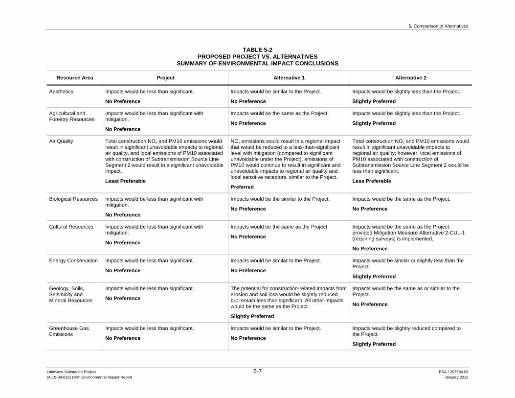
5. Comparison of Alternatives
Lakeview Substation Project 5-7 ESA / 207584.08 (A.10-09-016) Draft Environmental Impact Report January 2012
TABLE 5-2 PROPOSED PROJECT VS. ALTERNATIVES
SUMMARY OF ENVIRONMENTAL IMPACT CONCLUSIONS
Resource Area Project Alternative 1 Alternative 2
Aesthetics Impacts would be less than significant.
No Preference
Impacts would be similar to the Project.
No Preference
Impacts would be slightly less than the Project.
Slightly Preferred
Agricultural and Forestry Resources
Impacts would be less than significant with mitigation.
No Preference
Impacts would be the same as the Project.
No Preference
Impacts would be slightly less than the Project.
Slightly Preferred
Air Quality Total construction NOx and PM10 emissions would result in significant unavoidable impacts to regional air quality, and local emissions of PM10 associated with construction of Subtransmission Source Line Segment 2 would result in a significant unavoidable impact.
Least Preferable
NOx emissions would result in a regional impact that would be reduced to a less-than-significant level with mitigation (compared to significant unavoidable under the Project), emissions of PM10 would continue to result in significant and unavoidable impacts to regional air quality and local sensitive receptors, similar to the Project.
Preferred
Total construction NOx and PM10 emissions would result in significant unavoidable impacts to regional air quality; however, local emissions of PM10 associated with construction of Subtransmission Source Line Segment 2 would be less than significant.
Less Preferable
Biological Resources Impacts would be less than significant with mitigation.
No Preference
Impacts would be the similar to the Project.
No Preference
Impacts would be the same as the Project.
No Preference
Cultural Resources Impacts would be less than significant with mitigation.
No Preference
Impacts would be the same as the Project.
No Preference
Impacts would be the same as the Project provided Mitigation Measure Alternative 2-CUL-1 (requiring surveys) is implemented.
No Preference
Energy Conservation Impacts would be less than significant.
No Preference
Impacts would be similar to the Project.
No Preference
Impacts would be similar or slightly less than the Project.
Slightly Preferred
Geology, Soils, Seismicity and Mineral Resources
Impacts would be less than significant.
No Preference
The potential for construction-related impacts from erosion and soil loss would be slightly reduced, but remain less than significant. All other impacts would be the same as the Project.
Slightly Preferred
Impacts would be the same as or similar to the Project.
No Preference
Greenhouse Gas Emissions
Impacts would be less than significant.
No Preference
Impacts would be similar to the Project.
No Preference
Impacts would be slightly reduced compared to the Project.
Slightly Preferred

5. Comparison of Alternatives
Lakeview Substation Project 5-8 ESA / 207584.08 (A.10-09-016) Draft Environmental Impact Report January 2012
TABLE 5-2 (Continued) PROPOSED PROJECT VS. ALTERNATIVES
SUMMARY OF ENVIRONMENTAL IMPACT CONCLUSIONS
Resource Area Project Alternative 1 Alternative 2
Hazards and Hazardous Materials
Impacts would be less than significant with mitigation.
No Preference
Impacts would be similar to the Project.
No Preference
Impacts would be similar to the Project.
No Preference
Hydrology and Water Quality
Impacts would be less than significant.
No Preference
The potential for construction-related water quality impacts from silt and sediment would be slightly greater, but remain less than significant. All other impacts would be the same as the Project.
No Preference
Impacts would be substantially greater than the Project. The Lakeview Substation site would be placed in a 100-year flood hazard zone, resulting in a new potentially significant impact. All other impacts are the same or similar.
Not Preferred
Land Use and Planning
Impacts would be less than significant with mitigation.
No Preference
Impacts would be the same as the Project.
No Preference
Impacts would be the same as the Project.
No Preference
Mineral Resources Impacts would be less than significant.
No Preference
Impacts would be the same as the Project.
No Preference
Impacts would be the same as the Project.
No Preference
Noise Impacts would be less than significant with mitigation.
No Preference
Impacts would be the same as the Project.
No Preference
Impacts would be slightly less than the Project.
Slightly Preferred
Population and Housing
Impacts would be less than significant.
No Preference
Impacts would be the same as the Project.
No Preference
Impacts would be the same as the Project.
No Preference
Public Services Impacts would be less than significant.
No Preference
Impacts would be the same as the Project.
No Preference
Impacts would be the same as the Project.
No Preference
Recreation Impacts would be less than significant.
No Preference
Impacts would be similar to the Project.
No Preference
Impacts would be the same as the Project.
No Preference
Transportation/Traffic Impacts would be less than significant with mitigation.
No Preference
Impacts would be similar to the Project.
No Preference
Impacts would be slightly less than the Project.
Slightly Preferred
Utilities and Service Systems
Impacts would be less than significant.
No Preference
Impacts would be the same as or similar to the Project
No Preference
Impacts would be slightly less than the Project
Slightly Preferred
Lakeview Substation Project 6-1 ESA / 207584.08 (A.10-09-016) Draft Environmental Impact Report January 2012
CHAPTER 6 Cumulative Effects
As defined in CEQA Guidelines §15355, the term “cumulative impacts” refers to two or more individual effects, which, when considered together, are considerable or that compound or increase other environmental impacts. “The cumulative impact from several projects is the change in the environment which results from the incremental impact of the project when added to other closely related past, present, and reasonably foreseeable probable future projects. Cumulative impacts can result from individually minor but collectively significant projects taking place over a period of time.” CEQA Guidelines §15355(b); see also, CEQA Guidelines §15130(a)(1).
Section 6.1 identifies past, present, and reasonably foreseeable future projects that have been considered as part of the cumulative scenario. Section 6.2 analyzes whether the Project’s incremental effects, combined with the effects of other projects, would cause a significant cumulative impact. The Project’s incremental contribution to any significant cumulative impact also is evaluated in Section 6.2 to determine whether it is cumulatively considerable. An incremental Project-specific impact would be cumulatively considerable if it is “significant when viewed in connection with the effects of past projects, the effects of other current projects, and the effects of probable future projects” (CEQA Guidelines § 15065(a)(3)).
6.1 Projects Considered in the Cumulative Analysis
Section 6.1 uses a blend of two approaches to analyze cumulative effects: the “list-of-projects” approach and the “summary of projections” approach (CEQA Guidelines §15130(b)).
The list-of-projects approach considers the incremental effects of a proposed project viewed in combination with the effects of past, present, and reasonably foreseeable probable future projects that could cause environmental impacts that are closely related to those of the project proposed. Factors considered in determining whether to include a project on the list include whether it would cause impacts of the same nature as the proposed project, its location, the timing of its impacts, and the type of project. SCE is not planning any other projects over 50-kV within 1 mile of any of the Project components (SCE, 2010a, p. 6-1). A list of projects, the impacts of which could interact with those of the Project, is provided in Table 6-1. The location of these projects is shown in Figure 6-1.
The summary of projections approach evaluates the impacts of a proposed project in the context of projections made in one or more local, regional, or statewide planning documents or environmental analysis that has been adopted or certified. The following adopted plans and analyses are considered

6. Cumulative Effects
Lakeview Substation Project 6-2 ESA / 207584.08 (A.10-09-016) Draft Environmental Impact Report January 2012
TABLE 6-1 CUMULATIVE PROJECTS LIST FOR THE LAKEVIEW SUBSTATION PROJECT
Map Key
Project Name Location
Approximate Distance from
Project Site Description Status/Schedule
1 Tentative Parcel Map No. 33510
Assessor’s Parcel Number (APN) 306-070-006. The project site is located northerly of Walnut Avenue, southerly of Rider Street, easterly of Evans Road, and westerly of El Nido Avenue.
2.5 miles Subdivide 4.84 gross acres into four 1-acre parcels for single-family residential development (Riverside County, 2007).
Environmental Assessment No. 40222 identified the following potentially significant impacts: a. Aesthetics, b. Biological Resources, c. Hydrology/Water Quality, and d. Utilities/Service Systems. The Riverside County determined that these impacts would be fully mitigated by measures indicated in the environmental analysis, conditions of project approval, etc. No other significant impacts were identified. (Riverside County, 2011c).
Project approved April 17, 2007. Not yet complete.
2 Plot Plan 24691 APN 307-240-018. Site is located north of Sunset, south of Lemon, east of Dunlap, and west of Foothill.
2.1 miles Two 1,200 square foot chicken coops with 480 sq ft storage.
Application date: September 2, 2010. Not yet approved.
3 Plot Plan 20202S1 APN 309-070-004. Site is located north of Central Ave., south of Reservoir Ave., east of Menifee, and west of Ramona Ave.
1.5 miles Request for approval of a modification to an approved plot plan to replace three antennas and add one equipment cabinet.
Application date: May 10, 2010. Not yet approved.
4 Plot Plan 05117S1 APN 309-090-055. Site is located north of Lakeview Ave., south of Nuevo Rd., east of Ramona Ave., and west of Rosary Ave.
1.4 miles Request for approval of a modification to an approved plot plan for a beauty salon.
Application date: May 13, 2010. Not yet approved.
5 Plot Plan 24934 APN 309-210-049. Site is located north of Ellis, south of San Jacinto, east of Pico, and west of Menifee.
3 miles Request for approval of a plot plan for a 2,070 sq ft detached garage for a recreational vehicle (RV)
Application date: April 28, 2011. Not yet approved.
6 Plot Plan 24612 APN 422-020-010. Site is located east of Theodore St., south of Ironwood Ave., and north of CAL-60.
2 miles An agricultural dwelling to farm approximately 19 acres of grapes and trees.
Application date: June 21, 2010. Not yet approved.
7 Specific Plan 00342 APN 425-140-007. The specific plan area is located west of the City San Jacinto, north and south of Ramona, and east of the City of Perris. The site is located in the Lakeview area along the Ramona Expressway between the Lakeview Mountains to the south and the San Jacinto River to the north.
0.5 miles General Plan amendment, rezoning and specific plan approval for a mixed use master-planned community known as the Villages of Lakeview, consisting of a maximum of 11,350 dwelling units, 500,000 square feet of commercial uses, 155 acres of parks, 998 acres of open space and other uses to be developed on 2,786 gross acres (Riverside County, 2009). Five development phases are planned (1A, 1B, 2, 3A, and 3B) each consisting of several planning areas. (Riverside County, 2011d).
Approved February 23, 2010. Not yet completed.

6. Cumulative Effects
TABLE 6-1 (Continued) CUMULATIVE PROJECTS LIST FOR THE LAKEVIEW SUBSTATION PROJECT
Lakeview Substation Project 6-3 ESA / 207584.08 (A.10-09-016) Draft Environmental Impact Report January 2012
Map Key
Project Name Location
Approximate Distance from
Project Site Description Status/Schedule
7 (cont.)
Environmental Impact Report No. 471 was certified for the project. Because the project is a specific plan, essentially a zoning designation, potential direct and indirect project impacts may not occur for several years (Riverside County, 2011d). Nonetheless, the EIR determined that that the project would have a cumulative adverse impact on the Fire Department's ability to provide an acceptable level of service related to an increased number of emergency and public service calls due to the increased presence of structures and population. Project proponent participation in the development impact fee program will mitigate a portion of these impacts by providing funding for the construction of fire department-related capital improvements. (Riverside County, 2011d; see also, Riverside County, 2006).
8 Zone Change 07705 APN 426-360-003. The affected property is located north of Water, south of Brown, east of 6th, and west of 5th.
1 mile Change zoning designation from RA-1 to A-2 Application date: March 18, 2009. Not yet approved.
9 BRS091088 APN 426-340-001. The site is located on Wolfskill Avenue.
.8 miles Building permit for a new 2,064 square foot single family detached residence and an attached 564 square foot garage.
As of June 22, 2011, conditions of permit approval have not been satisfied completely. The permit will expire on July 10, 2011.
10 BRS100382 APN 427270053. The site is located on Eckman Court.
.35 miles Building permit for a new 3,032 square foot single family detached residence with a 682 square foot garage and patio.
The building permit will expire October 30, 2011.
11 BRS100741 APN 966-342-007. The site is located on San Simeon Street.
2.9 miles Repeat tract home permit for a 2,395 square foot dwelling with a 551 square foot garage and 171 square foot courtyard.
The building permit will expire October 21, 2011.
12 BRS110010 APN 429-340-008. The site is located on Sky Mesa Road.
2.8 miles Renewal of a building permit for a new single family detached residence with garage.
The building permit will expire October 24, 2011.
13 BNR110013 APN 307-270-020. The site is located on Nuevo Road.
2.4 miles Permit to install four new equipment cabinets for Royal Street Communications.
Application date: February 28, 2011
14 BTW110003 APN 307-270-020. The site is located on Nuevo Road.
2.4 miles Permit for the installation of a 70' monopole tower and six panel antennas.
Application date: February 28, 2011

6. Cumulative Effects
TABLE 6-1 (Continued) CUMULATIVE PROJECTS LIST FOR THE LAKEVIEW SUBSTATION PROJECT
Lakeview Substation Project 6-4 ESA / 207584.08 (A.10-09-016) Draft Environmental Impact Report January 2012
Map Key
Project Name Location
Approximate Distance from
Project Site Description Status/Schedule
15 BRS110087 APN 427-310-018. The site is located on Electric Avenue.
1.1 miles Renewal of building permit for a single family detached residence with attached garage.
The building permit will expire October 11, 2011.
16 BRS110121 APN 429-310-027. The site is located on Via Del Senor.
2. 8 miles Renewal of a building permit for a single story, single family detached residence with an attached garage and guest suite.
The building permit will expire November 12, 2011.
SOURCES: ESA, 2011; Riverside County 2011a and 2011b, others as noted above.

!!
!!
!!
!!
!!
!!!
!
! !!
!!
!!
!!
!!
!!
!!
!!
!!
!!
!!
!!
!!
!!
!!
!!
!!
!!
!!
!!
!!
!!
!!
!!
!!
!!
!!
!!
!!
!!
!!
!!
!!
!!
!!
!!
!!
!!!
!!
!!
!!
!!
!!
!
!!
!!
!!
!!
!!
!!
!!
!!
!!
!!
!!
!!
!!
!!
!!
!!
!!
!!
!!
!!
!!
!!
!!
!!
!!
!!
!!
!!
!!
!!
!!
!!
!!
!!
!!!!!!!!!!!!!!!!!!!!!!!!!
!!
!!
!!
!
!!
!!
!!
!!
!!
!!
!!!!!
!!
!!
!!
!!!!
!!!
!!!!
!!!!
!!!
!!!
!!
!!
!!
!!
!
!!
!!
!!
!!
!!
!!
!!!!!!!!!!!!!!!!!!!!!!!!!!
!!!
!!
!!
!!
!!!
!!
!!
!!
!!!
!!
!!
!!
!!!
!!
!!
!!
!!!!
!!!
!!
!!!
!!
!!
!!!
!!!
!!
!!!
!!
!!
!!
!!
!!!
!!
!!
!!
!!
!!
!!
!!!
!!
!!
!!
!! ! !
! ! ! !! ! !
! ! ! !! ! !
! ! ! !! ! !
! ! ! !! ! !
! ! ! !! ! ! ! ! ! ! ! ! ! ! ! ! ! ! ! ! ! ! ! ! ! ! ! ! ! ! ! ! ! ! ! ! ! ! ! ! ! ! ! ! ! ! ! ! ! ! ! !
!!
!!
! ! ! ! ! !! ! ! ! !
! ! ! ! !! ! !
! ! ! ! ! ! ! ! ! ! ! ! ! !
!!
!!
!!
!!
!
! ! ! ! ! ! ! ! ! ! ! ! ! ! ! ! ! ! ! ! ! ! ! ! ! ! ! ! ! ! ! ! ! ! ! ! ! ! ! ! ! ! ! ! ! ! ! ! ! ! ! ! ! ! !!
!!
! ! ! ! ! ! ! ! ! ! !!
!!
!!
!!
!!
!!
!!
!!
!!
! ! ! ! ! ! ! ! ! ! ! ! ! ! !
!!!
!!
!!
!!!
!!
!
!!
!!
!!
!!
!!
!!
!!
!!
!!
!!
!!
!!
!!
!!
!
! ! ! ! ! ! ! ! ! ! ! ! ! ! ! ! ! ! ! ! ! ! ! ! ! !!
!!
!
!!
!!!!!!!!!!!!!!!!!!!!!!!!!
!!
!!
!!
!!
!!
!!!
!!
!!
!!
!!
!>
!>
!> !>
!>
!>
!>#*
#*#*
#*
#*
#*
!>!>
!>
!>
!>
!>
!>
!>
Lake Perris
UV215 7
San Jacinto River
Valle
y-M
oval
115
kV
Sub
trans
mis
sion
Lin
e
Devers
-Valley
500 k
V Transm
ission
Line
Colorado River Aqueduct
10 th St
11 th St
Ramona Expressway
Nuevo Substation/Model Pole Top(to be decommissioned)
UV60
1
6
8
43
2
5
9
11
10
12 16
15
14 13
MovalSubstation
BunkerSubstation
AlessandroSubstation
Lakeview Substation Project. 207584.08Figure 6-1
Cumulative Projects
SOURCE: Riverside County, 2011
0 2
Miles
Project ComponentsProposed Lakeview Substation
115 kV SubtransmissionSource Line
Fiber-Optic Cable Routes
Route 1
Route 2
Route 3
Existing Facilities#* Substation
! ! ! ! ! ! Subtransmission Line! ! ! ! ! ! Transmission Line
!> Cumulative Project
6-5

6. Cumulative Effects
Lakeview Substation Project 6-6 ESA / 207584.08 (A.10-09-016) Draft Environmental Impact Report January 2012
in combination with the Project for assessing cumulative impacts. In most cases these plans have been prepared by local agencies to meet the requirements of state law (certain plans, such as the Western Riverside Multiple Species Habitat Conservation Plan, have been prepared voluntarily), and comprise the preparing agencies’ comprehensive, long-term visions for physical development or resources conservation within the region.
Riverside County General Plan (including the 2008 update)
Lakeview-Nuevo Area Plan
Moreno Valley General Plan
Western Riverside Multiple Species Habitat Conservation Plan
Planning documents of the Southern California Association of Governments (SCAG). SCAG is the metropolitan planning organization (MPO) of a six-county, approximately 38,000 square mile area in Southern California that includes Riverside County (SCAG, 2011). SCAG conducts regional planning for transportation, growth management, hazardous waste management, air quality, and greenhouse gas emission (GHG) reductions, among other things. Relevant plans include:
- SCAG, 2008a. 2008 Regional Transportation Plan (2008 RTP): Making the Connections (May 8, 2008). http://www.scag.ca.gov/rtp2008/final.htm. Visited May 27, 2011. Supplemental materials related to the 2008 RTP relied upon in this analysis include the associated project list (SCAG, 2008b), growth forecast report (SCAG, 2008c), highways and arterials report (SCAG, 2008d), goods movement report (SCAG, 2008e), aviation and airport ground access report (SCAG, 2008f), transportation safety report (SCAG, 2008g), and environmental justice report (SCAG, 2008h).1 Supplemental materials also include Amendment Nos. 1, 2, 3, and 4 to the 2008 RTP, including projections such as the updated comprehensive listing of projects modeled and included in Amendment No. 4 to the 2008 RTP (SCAG, 2010).
- SCAG, 2007. The State of the Region 2007, Measuring Regional Progress (Dec. 2007). http://www.compassblueprint.org/files/sotr2007.pdf. Visited May 27, 2011.
- SCAG, 2004. Southern California Compass Growth Vision Report (June 2004). http://www.compassblueprint.org/files/scag-growthvision2004.pdf. Visited May 27, 2011.
- SCAG, 2002. Regional Comprehensive Plan and Guide, Energy Chapter Update 2002 (2002). http://www.scag.ca.gov/environment/pdfs/2002energychapter.pdf. Visited May 27, 2011.
Planning documents of the Santa Ana Regional Water Quality Control Board, including the 1995 Water Quality Control Plan for the Santa Ana River Basin (Region 8), which was updated in February 2008 (SARWQCB, 2008).
1 Each of these associated reports is available on SCAG’s website: http://www.scag.ca.gov/rtp2008/final.htm. Visited
May 27, 2011.

6. Cumulative Effects
Lakeview Substation Project 6-7 ESA / 207584.08 (A.10-09-016) Draft Environmental Impact Report January 2012
6.2 Cumulative Effects Analysis
6.2.1 Aesthetics Impacts resulting from construction, operation, and maintenance of the Project could result in a cumulative effect on visual resources with other past, present, or reasonably foreseeable future actions. The geographic scope of the cumulative effects analysis for visual resources consists of the Ramona Expressway view corridor, and locations from which a viewer could see the Project along with views of other projects in the cumulative scenario. This geographic scope of cumulative impacts analysis was established based on the natural boundaries of the affected resource, i.e., potential shared viewsheds, and not on jurisdictional boundaries. Potential cumulative effects on visual resources could occur during the construction period (e.g., from cumulative construction disturbances), or during Project operation (e.g., cumulative visual disturbances within the landscape, glint and glare).
The visual impacts of the Project alone are analyzed in Section 4.1.4, Impacts and Mitigation Measures. The analysis concluded that impacts on scenic vistas, the visual character and quality of the site and its surroundings, and light and glare would be less than significant. The only potentially significant adverse impact of the Project was from KOPs 7 and 8, due primarily to the high dominance of the Project from close-range, and its potential to block or obscure scenic elements for local motorists. However, due to the low number of affected viewers, the resulting impact is considered less than significant. Past, present, and reasonably foreseeable future actions making up the cumulative scenario are identified in above in Section 6.1, Projects Considered in the Cumulative Analysis. Cumulative projects in Table 6.1 that are both within the viewshed of the Project and would result in substantial visual change may potentially produce cumulative visual impacts. These projects include:
Project 5: Request for approval of a plot plan for a 2,070 square-foot detached garage for a recreational vehicle (RV).
Project 7: General Plan amendment, rezoning, and specific plan approval for a mixed use master-planned community known as the Villages of Lakeview, consisting of a maximum of 11,350 dwelling units, 500,000 square feet of commercial uses, 155 acres of parks, 998 acres of open space and other uses to be developed on 2,786 gross acres (Riverside County, 2009).
Project 9: Building permit for a new 2,064 square-foot single family detached residence and an attached 564 square-foot garage.
Project 10: Building permit for a new 3,032 square-foot single family detached residence with a 682 square-foot garage and patio.
Project 12: Renewal of a building permit for a new single-family detached residence with garage.
Project 15: Renewal of building permit for a single-family detached residence with attached garage.

6. Cumulative Effects
Lakeview Substation Project 6-8 ESA / 207584.08 (A.10-09-016) Draft Environmental Impact Report January 2012
Project 16: Renewal of a building permit for a single-story, single-family detached residence with an attached garage and guest suite.
Other potential cumulative projects were outside the viewshed of the Project and the Ramona Expressway corridor. All of the above projects, with the exception of the General Plan amendment, rezoning, and specific plan (Project 7), involve minor incremental visual changes to areas that are already developed and are not likely to produce substantial visual impacts. Project 7 would develop a large area on either side of the Ramona Expressway east of the Project area and Lakeview and is likely to produce substantial visual changes, especially where development is proposed in formerly agricultural land.
Based on the location of these cumulative projects shown in Figure 6-1, none of the projects would be visible within views from any of the KOPs analyzed. Therefore, additive cumulative visual effects from the KOPs would not occur. However, should full build-out of the proposed master-planned community (Project 7) occur, there could be a cumulative impact on views experienced by motorists on the Ramona Expressway, which is a county eligible scenic highway. The master-planned community would develop a large portion of the view corridor available from the expressway and would result in a close-range, high degree of visual change from an approximately 4-mile-long stretch of Ramona Expressway. The impact analysis concluded that the impact of the Project on scenic vistas and views from the Ramona Expressway was less than significant. Due to the distance and low degree of visual change as viewed from Ramona Expressway, the Project would contribute a minor, less than cumulatively considerable portion of the visual impact caused by the cumulative scenario.
In summary, when considered in combination with the impacts of other projects in the cumulative scenario, the Project’s incremental contribution to visual resources would not be cumulatively considerable because none of the cumulative projects would be located within views of the Project from the KOPs, and the Project’s effect on the view corridor of the Ramona Expressway would be minor. Because the incremental, Project-specific contribution to the potential significant cumulative impact would not be cumulatively considerable, no mitigation is required (CEQA Guidelines §15130(a)(3)).
6.2.2 Agriculture and Forestry Resources The geographic scope of cumulative impacts on agriculture and forestry resources includes Prime Farmland, Unique Farmland, and Farmland of Statewide Importance in Riverside County. The temporal scope of impacts would include the construction, operation, and maintenance of the Project.
As discussed in Section 4.2, Agriculture and Forestry Resources, the Project would not conflict with existing zoning for agricultural land, land under a Williamson Act contract, forest land, or land zoned for timberland production. The Project would also not result in the loss or conversion of forest land to non-forest use. Therefore, the Project would not cause or contribute to any cumulative impact with respect to these issues. The Project would, however, result in less-than-significant temporary and permanent impacts related to the conversion of Farmland to

6. Cumulative Effects
Lakeview Substation Project 6-9 ESA / 207584.08 (A.10-09-016) Draft Environmental Impact Report January 2012
non-agricultural use, due to construction of the proposed Lakeview Substation, access roads, and subtransmission source line poles.
Approved projects in Riverside County, such as the Villages of Lakeview Specific Plan, could cause impacts to Farmland adjacent to those of the Project. Table 6-1 also shows a number of projects not yet in the environmental planning stage; therefore, the acreage of Prime Farmland, Unique Farmland, and Farmland of Statewide Importance that could be converted by these projects is not known at this time. Also, between 2006 and 2008, Riverside County saw a reduction in agricultural land (see Table 4.2-1 in Section 4.2, Agriculture and Forestry Resources). In 2008, the total acreage of Farmland in Riverside County was 204,722 acres, which represents a net loss of 8,648 acres from 2006 (CDC, 2008). Land use conversion trends indicate that the acreage of Farmland in California and in Riverside County is expected to decline with or without the Project. For purposes of this analysis, the historic decline and trend is considered evidence of an existing significant cumulative impact.
The Project would contribute incrementally (approximately 9.9 acres) to Riverside County’s overall decline in Farmland. However, based on CDC’s recommendations, implementation of Mitigation Measure 4.2-2 would compensate for the direct loss of agricultural land and reduce the Project impacts to less than significant by requiring SCE to obtain permanent agricultural conservation easements at a 1:1 ratio for Farmland converted to non-agricultural use (CDC, 2011). With implementation of Mitigation Measure 4.2-2, the Project’s incremental contribution to the existing significant cumulative impact would not be cumulatively considerable because the mitigation would offset the number of acres of Farmland removed from agricultural production.
6.2.3 Air Quality The geographic scope considered for potential cumulative impacts to air quality is the SCAB. If a project would result in an increase in a criteria pollutant of more than the respective daily mass thresholds, then it also would be considered to contribute considerably to a significant cumulative impact. In developing thresholds of significance for air pollutants, SCAQMD considered the emission levels for which a project’s individual emissions would be cumulatively considerable. Therefore, if a project would exceed the identified significance thresholds, its emissions would be cumulatively considerable, and if a project would not exceed the significance thresholds, its emissions would not be cumulatively considerable.
Long-term Project operation and maintenance would not cause emissions that would exceed the SCAQMD significance thresholds (see Impact 4.3-2 discussion). Therefore, long-term emissions of the Project would not be cumulatively considerable.
Project-related construction activities, as described in the Impact 4.3-1 discussion, would result in short-term emissions of NOx and PM10 that would exceed the SCAQMD thresholds. Therefore, short-term construction-related NOx and PM10 emissions would be cumulatively considerable and associated cumulative impacts would be significant when combined with the emissions-related impacts of the cumulative projects described in Section 6.1, Projects Considered in the Cumulative Analysis, to the extent such projects would be constructed concurrently with the

6. Cumulative Effects
Lakeview Substation Project 6-10 ESA / 207584.08 (A.10-09-016) Draft Environmental Impact Report January 2012
Project. Mitigation Measures 4.3-1a and 4.3-1b would reduce emissions of criteria pollutants (specifically NOx and PM10) during construction activities, but the short-term impacts would remain significant and unavoidable, and would therefore be considered cumulatively considerable. The implementation of Mitigation Measures 4.3-1a and 4.3-1b would reduce emissions of criteria pollutants; however, the Project’s construction-related NOx and PM10 emissions would not be mitigated to less-than-significant levels. Therefore, when considered with the NOx and PM10 emissions of other projects, the Project-specific impact would be cumulatively considerable and the cumulative impact would be significant and unavoidable (Class I). All other criteria pollutant emissions would not be cumulatively considerable and would result in less-than-significant cumulative impacts (Class III).
With regard to impacts on sensitive receptors, the Project-related local concentrations of PM10 that would be generated during construction of the subtransmission source lines would be significant and unavoidable (see Impact 4.3-4) at one residence along 11th Street. Given that PM10 is a non-attainment status criteria pollutant, the local concentrations of PM10 at this residence would be considered cumulatively considerable and the cumulative impact would be significant and unavoidable (Class I). With regard to TACs, the total DPM emissions from on-site equipment that would be required to construct the Project would be limited to the 12-month construction period (see Impact 4.3-5 discussion). Because these emissions would occur over 12 months compared to the 70-year exposure used in health risk assessments, the health risk from the short-term DPM emissions would not be cumulatively considerable and the associated cumulative impact would be less than significant (Class III).
There is no existing adverse cumulative condition related to odors to which the Project could contribute. Even if there were, construction of the Project would cause a less-than-significant impact related to the generation of odors from diesel equipment emissions because construction activities would be intermittent and spatially dispersed, and associated odors would dissipate quickly. Projects in the cumulative scenario are not expected to cause diesel-related odors that would intermingle with those of the Project and, thereby, cause a significant cumulative effect. The incremental odor-related impact of the Project would not be cumulatively considerable.
6.2.4 Biological Resources Regional projects within a 10-mile radius from the Project site are evaluated in concert with the Project to determine the Project’s cumulative impact on biological resources. This is appropriate relative to the type of impacts that would result from the Project (predominantly localized temporary and permanent land disturbance) and the ranges of the Project area’s land-based, special-status species (e.g., the range of Stephen’s kangaroo rat encompasses the San Jacinto Valley from Riverside to San Diego counties).
Most of the Project’s impacts would occur during construction, either as a temporary disturbance associated with construction such as noise, lighting, and human activity, or as a permanent disturbance associated with the conversion of agricultural or natural land. The Project has the potential to permanently impact special-status plants and animals through habitat loss or the direct loss of known populations/individuals along the Fiber-Optic Cable Route 3 and the

6. Cumulative Effects
Lakeview Substation Project 6-11 ESA / 207584.08 (A.10-09-016) Draft Environmental Impact Report January 2012
Subtransmission Source Line Segments 1. A total of 0.02 acre of vegetation designated as Sensitive Natural Communities would be permanently impacted. Construction activities may result in temporary impacts on nesting birds and special-status wildlife species at the proposed Lakeview Substation site and along subtransmission source line segments and fiber-optic cable route; construction at or near San Jacinto River crossings could also cause temporary animal avoidance of work sites. Additionally, temporary and localized wildlife disturbance may happen during maintenance activities. In addition to construction-related impacts and brief wildlife disturbances during maintenance activities, the Project could electrocute raptors during operation of subtransmission source lines; however, compliance with Mitigation Measure 4.4-4 would substantially reduce this likelihood through the design and construction of “avian-safe” structures.
In addition to the Project, other development projects in the area could cause similar impacts on special-status plant and animal species and on sensitive natural communities, such as permanent loss of habitat and loss of individuals resulting from land conversion and construction activities. Routine use of wildlife corridors could be temporarily disrupted during construction, and if activities are performed during the avian nesting season, construction disturbance could upset nesting birds and cause area avoidance, nest site abandonment, or reproductive failure at active nests located near project sites.
Small-scale projects in the region, such as building permits for 3,000 square-foot single-family residences (e.g., Projects 2, 4, 5, 9, 10, 11, 12, and 16 from Table 6-1, Cumulative Projects List) would make no contribution, or an imperceptible cumulative contribution, to impacts on biological resources. Larger projects in the region that would develop tens to thousands of acres of land (e.g., Projects 6 and 7 from Table 6-1) could contribute significantly to cumulative impacts on biological resources. Project 7 is the largest development project in the region, affecting 2,786 acres of land that is potentially occupied by special-status plant and animal species and sensitive natural communities, potentially contains wetlands, may serve as a wildlife corridor or nursery site, is likely to provide habitat for nesting birds, or any combination of these. By comparison, the Project’s permanent impacts on presently undeveloped land would be small, directly affecting only the land required for the proposed Lakeview Substation and subtransmission source line poles. The Project would potentially impact only 0.02 acre of sensitive natural communities. SCE would avoid or prepare a mitigation plan to be reviewed by appropriate agencies for native or special-status vegetation and special-status plant populations (APM-BIO-6); avoidance would be likely. Impacts to wildlife corridors at San Jacinto River crossings would be localized and temporary, and construction hours and adjacent habitat would likely provide alternative travel routes. No other transmission line projects are planned in the area, and compliance with Mitigation Measure 4.4-4 would significantly reduce the potential for raptor electrocutions. SEC would identify nesting birds and raptors, and implement avoidance measures for active nest (APM-BIO-1). Accordingly, the Project would not cause a cumulatively considerable impact related to raptors at risk of electrocution, sensitive natural communities, wildlife corridors, or nesting birds from the cumulative scenario.
Although Project-specific impacts on special-status plant and animal species are less than significant or less than significant with mitigation incorporated, a significant cumulative impact

6. Cumulative Effects
Lakeview Substation Project 6-12 ESA / 207584.08 (A.10-09-016) Draft Environmental Impact Report January 2012
could result if other projects in the region are also impacting these species. For example, APM-BIO-5 requires protection of active burrowing owl burrows during the nesting season but allows for burrow closure and passive relocation after the nesting season has concluded. If a substantial percentage of the regional burrowing owl population resided on lands approved for conversion under various projects, and burrow closure and passive relocation were approved as adequate impact avoidance, burrowing owls may eventually suffer from exposure due to loss of habitat and have nowhere left to go after being passively relocated. The same argument can be made for transplanted populations of special-status plants. The presence of special-status plants and animals on other project sites, and the resulting project impacts, is unknown. However, the region supports large areas of undeveloped land in the form of grasslands and foothills, and rotating fallow agricultural fields provide suitable habitat for some species. When considered in combination with the impacts of other projects in the cumulative scenario, the Project’s incremental contribution to impacts on special-status plant and animal species would not be cumulatively considerable because the number and size of projects in the region are (1) few and small relative to the overall amount of remaining undeveloped land; and (2) western Riverside County is subject to the comprehensive, multi-jurisdictional Western Riverside MSHCP that focuses on the conservation of species and their habitats.
6.2.5 Cultural Resources The geographic scope for cumulative impacts to historic and archeological resources includes a 1-mile radius from the Project site. This geographic scope of analysis is appropriate because the archaeological and historical resources within this radius are expected to be similar to those in the Project site because of their proximity; similar environments, landforms, and hydrology would result in similar land-use—and thus, site types. The geographic scope for cumulative impacts to paleontological resources would be all areas in the Perris and San Jacinto Valleys underlain by the same geologic units, which would yield fossils representative of a similar time period and geographic range. This would include all areas underlain by Pleistocene alluvium in the region, including all projects in the cumulative scenario that involve ground excavations on the valley floor, irrespective of their timing. The temporal scope of impacts would include Project construction.
The Project area vicinity contains a significant archaeological and historical record that, in many cases, has not been well documented or recorded. Thus, there is the potential for ongoing and future development projects in the vicinity to disturb landscapes that may contain known or unknown cultural resources. Environmental analysis is either underway or completed for many of these projects.
The potential construction impacts of the Project are mitigated such that historical or archaeological resources are either avoided completely, or if they cannot be avoided, that a treatment plan be prepared and the resources be subject to data recovery excavations (Mitigation Measures 4.5-1a through 4.5-2b and 4.5-4). There would be no impact from maintenance or operation of the Project. Because mitigation is designed to avoid a change in the significance of any known or potential cultural resources, there is no residual impact after mitigation. Should other projects in the

6. Cumulative Effects
Lakeview Substation Project 6-13 ESA / 207584.08 (A.10-09-016) Draft Environmental Impact Report January 2012
cumulative scenario not implement similar measures, the cumulative scenario could result in a significant cumulative impact; however, the Project, with mitigation, would not contribute to the cumulative impact.
Excavation activities associated with the Project in conjunction with other projects in the area could contribute to the progressive loss of fossil remains, as-yet unrecorded fossil sites, associated geological and geographic data, and fossil bearing strata. However, with incorporation of Mitigation Measures 4.5-3, the Project would either avoid impacts to fossil resources altogether, or result in the recovery of scientific data should previously unrecorded fossils of significance be uncovered. Fossils are valued as a resource for the potential scientific data they provide and hence with mitigation, the Project would either have no impact or a positive impact on paleontological resources through the recovery of scientific knowledge. Should other projects in the cumulative scenario not implement similar measures, the cumulative scenario could result in a significant cumulative impact through progressive damage or loss of potentially significant fossils; however, the Project, with mitigation, would not contribute to the cumulative impact.
6.2.6 Energy Conservation The geographic scope of potential cumulative effects with respect to energy conservation includes the electric grid to which Project power would contribute and areas from which transportation fuels would be provided (for this EIR, publicly available fuel sources in the vicinity of the Project site). The Project would cause less-than-significant incremental impacts relating to the consumption of energy, use of transportation energy, and use of transportation alternatives. The operational electricity requirements would be negligible. Additionally, the Project would increase energy production by about 74 percent relative to the existing Nuevo Substation and Model Pole Top. The Project’s less-than-significant incremental impact relating to the consumption of energy would not be cumulatively considerable.
The Project’s less-than-significant incremental impact relating to the use of transportation energy and efficient use of transportation alternatives is not expected to combine with the incremental impacts of other projects to cause an adverse cumulative impact on energy conservation. Project-related transportation impacts would be limited to the construction phase, which could overlap with the transportation needs (including fuel needs) of previously approved past projects, as well as other present or future projects that occur during the Project’s construction activities. Regardless, there is no significant cumulative condition to which the Project could contribute, and given the Project’s less-than-significant incremental impact, the Project itself would not cause a significant cumulative impact. Therefore, the Project’s less-than-significant incremental usage of transportation energy would not be cumulatively considerable.
Cumulative projects in the region, including those listed in Table 6-1, could require increased peak and base energy demands and, therefore, could cause or contribute to a significant adverse cumulative conditions. The objectives of the Project are to serve existing and long-term projected electrical demand requirements and to improve the reliability and system operational flexibility within in the Electrical Needs Area beginning in mid-2013. Adverse Project-related impacts to electricity demand would be negligible, would not significantly impact peak or base power

6. Cumulative Effects
Lakeview Substation Project 6-14 ESA / 207584.08 (A.10-09-016) Draft Environmental Impact Report January 2012
demands during Project construction, operation, or maintenance, and would be offset by Project-related benefits in this regard. Accordingly, the Project’s less-than-significant incremental contribution to cumulative peak and base demands would not be cumulatively considerable.
The Project, in combination with the projects listed in Table 6-1, would require the use of nonrenewable, fossil fuel-based energy resources during construction. If the cumulative projects and the proposed Project were to use energy resources in a wasteful manner, it would conflict with state and local energy standards. Project construction would be short-term and all aspects of Project construction, operation, and maintenance would be consistent with the goals and strategies of local and state energy standards. Therefore, the Project would cause a less than cumulatively considerable contribution to cumulative conditions related to conflicts with energy conservation standards.
6.2.7 Geology and Soils The greater Peninsular Ranges Geomorphic Province lies between two seismically active regions with a wide range of geologic and soil conditions that can vary widely within a short distance. Therefore, the geographic extent considered for potential cumulative impacts to people and structures related to geologic and seismic hazards is more localized or site-specific. As analyzed in Section 4.7, Geology and Soils, the Project could cause less-than-significant impacts related to strong seismic groundshaking, seismically induced ground failure, erosion or loss of topsoil, soil subsidence, collapsible soils, and expansive soils. Aside from regional subsidence, all of these issues relate to local, site-specific soil conditions. None of the potential impacts of any of the projects in the cumulative scenario could interact with impacts of the Project on the Project site because none are adjacent to the Project. As discussed under Impact 4.7-3 in Section 4.7, Geology and Soils, and in Section 4.10, Hydrology and Water Quality, the Project’s groundwater use would be negligible and its impact related to regional subsidence would be less than significant. Regional subsidence is unlikely to occur in the future because Eastern Municipal Water District (EMWD) groundwater management policies are aimed at conservation, recharge, and avoidance of overdraft. EMWD calculates the natural safe yield of groundwater within the West San Jacinto Basins to be approximately 36,200 acre-feet per year, and current production rates are well below the safe yield (MWD, 2007). While unlikely, even in the event that regional subsidence occurs in the future, the Project’s incremental contribution to the cumulative impact via groundwater withdrawal would not be cumulatively considerable. This is because the water required to support draught-tolerant landscaping would be negligible compared to the total amount of groundwater that would need to be extracted from the basin to initiate regional land subsidence.
6.2.8 Greenhouse Gas Emissions GHG emissions are inherently a cumulative concern, in that the significance of GHG emissions is determined based on whether such emissions would have a cumulatively considerable impact on global climate change. Although the geographic scope of cumulative impacts related to GHG emissions is global, this analysis focuses on impacts associated with potential conflicts with California’s reduction goals set forth in AB 32 and this Project’s direct and/or indirect generation of GHG emissions. The Project would result in less than significant emissions of GHG and would

6. Cumulative Effects
Lakeview Substation Project 6-15 ESA / 207584.08 (A.10-09-016) Draft Environmental Impact Report January 2012
not conflict with the state’s GHG reduction goals. Therefore, the Project-specific incremental impact on GHG emissions would not be cumulatively considerable and the cumulative impact would be less than significant.
6.2.9 Hazards and Hazardous Materials Depending on the pathway of exposure, the geographic scope for cumulative effects relating to hazards and hazardous materials would be the air basin, watershed boundary, groundwater basin, or extent of affected soils. Materials delivery routes also would be included in the event of a traffic accident-related spill. For this Project, most Project-specific hazards and hazardous materials-related effects would occur during the construction phase, although some effects could also occur during operation and maintenance activities.
Construction, operation, and maintenance of the Project would result in less-than-significant impacts related to the routine use of hazardous materials, including within 0.25 miles of existing and proposed schools, and the potential for accidents to release hazardous materials into the environment. The Project impact on aviation safety would also be less than significant. With mitigation incorporated, Project construction would have a less-than-significant impact on emergency access, in particular along the subtransmission source line routes. Mitigation measures would reduce Project impacts related to wildland fires in the high fire areas located along Fiber-Optic Cable Route 3.
There is no existing significant adverse cumulative condition relating to hazards and hazardous materials in the vicinity of the Project and, alone, the incremental impacts of the Project would not cause a significant adverse cumulative impact. The cumulative projects in the Project area listed in Table 6-1, are primarily residential developments that are either under construction or not yet approved. Impacts caused by the cumulative projects, combined with the Project, would not result in a significant cumulative impact even if all of the projects were to be constructed simultaneously because the Project and all cumulative projects would be required to adhere to the robust body of regulations that govern hazardous materials storage and handling, water quality best management practices, construction work, and fire prevention and management. Together, these measures would ensure that impacts related to exposure to hazardous materials would be minimized and/or avoided. Therefore, the Project’s incremental contribution to any hazards and hazardous material-related cumulative impact would not be cumulatively considerable.
6.2.10 Hydrology and Water Quality The geographic context for the cumulative impacts associated with hydrology and water quality is San Jacinto River watershed. There are 16 proposed, approved, and in-progress projects within 1 mile of the Project. This Project, along with other projects occurring in the area, would be required to comply with applicable federal, state, and local water quality regulations. The Project, along with other projects over 1 acre in size, would be required to obtain coverage under the NPDES Construction General Permit. Identification and implementation of stormwater management measures that would effectively control erosion and sedimentation and other construction-related pollutants would be required during construction. Other management

6. Cumulative Effects
Lakeview Substation Project 6-16 ESA / 207584.08 (A.10-09-016) Draft Environmental Impact Report January 2012
measures, such as construction of infiltration and detention basins, would be required to be identified and implemented that would effectively treat pollutants that would be expected for the post-construction land use for certain projects.
During construction, operation, and maintenance, stormwater runoff from the Project site would be controlled by the requirements of the NPDES permit. Other new development in the area also would be required to control construction and operational stormwater runoff by implementing state and local requirements regarding hydrology and water quality. Furthermore, compliance with the regulations and implementation of the design measures described in Section 4.10, Hydrology and Water Quality, would ensure that the Project impacts to hydrologic resources and water quality would be less than cumulatively considerable.
6.2.11 Land Use and Planning The Project would have no impact on Land Use and Planning; therefore, it would not cause or contribute to any cumulative impact in this regard.
6.2.12 Mineral Resources The Project would have no impact related to the loss of availability of a locally important mineral resource recovery site delineated on a local general plan, specific plan or other land use plan. Therefore, it would not cause or contribute to any cumulative impact in this regard.
The Project would cause a less than significant impact related to the loss of availability of a known mineral resource that would be of value to the region and the residents of the state. The geographic scope of potential cumulative impacts related to this issue includes all areas in the region that are mapped as MRZ-3, which is an area where the available geologic information indicates that mineral deposits are likely to exist, but the significance of the deposits is undetermined. Cumulative impacts could occur during construction (i.e., if excavated material is considered a valuable mineral resource), or during operation and maintenance of the Project (whereby the Project’s presence makes the site unavailable for future mineral resource extraction). Nearly all projects in the cumulative scenario also are located in MRZ-3. However, none is located in state-designated aggregate resource area, or an area otherwise known to be a source of mineral resources (LSA, 2000). All the projects in the cumulative scenario could involve some degree of excavation or could make certain sites unavailable for future mineral resource extraction; however, because the MRZ-3 zone in Riverside County has been mapped over most of western Riverside County, encompassing both developed and undeveloped areas, the area in the cumulative scenario that would be made unavailable for exploration and extraction of mineral resources is negligible compared to the total area mapped as MRZ-3. Accordingly, no significant cumulative impact would result from the cumulative scenario to which the Project’s incremental impact could contribute.
6. Cumulative Effects
Lakeview Substation Project 6-17 ESA / 207584.08 (A.10-09-016) Draft Environmental Impact Report January 2012
6.2.13 Noise Construction of the Project would result in less-than-significant impacts from construction activities with implementation of proposed Mitigation Measure 4.13-1. Project vibration-related impacts would be less than significant and long-term operation and maintenance-related impacts associated with the Project would result in permanent increases to existing noise levels that would be considered to be less than significant. This incremental noise-related impact could combine with noise generated by projects in the cumulative scenario to cause or contribute to a significant cumulative effect.
Noise levels tend to diminish quickly with distance from a source; therefore, the geographic scope for cumulative impacts associated with noise would be limited to projects located within approximately 0.5 mile of the Project. As discussed in Section 6.1, Projects Considered in the Cumulative Analysis, there are two projects located within 0.5 mile of the Project that are reasonably foreseeable and could be constructed simultaneously with the Project. These projects include a specific plan that would be approximately 0.5 mile from the Project site and a residential building permit project that would be approximately 0.4 mile from the Project site. At these distances, even if construction of these projects were to occur simultaneously with construction of the Project, the potential for the combined noise levels at nearby receptors to increase to the point where they would exceed established thresholds would not occur. Therefore, no adverse cumulative effect would occur, and the Project-specific incremental contribution to cumulative conditions during construction is not cumulatively considerable.
During the operation of the Project, the main sources of noise would be corona discharge and substation equipment. During maintenance, the main noise sources would be worker vehicles. However, these sources would not substantially increase ambient noise levels at the nearest sensitive receptor locations, and would not cause a cumulatively considerable contribution to noise generated by other projects in the affected area.
6.2.14 Population and Housing The Project would cause no impact related to the displacement of existing housing units or people, necessitating the construction of replacement housing elsewhere. Therefore, it would not cause or contribute to any cumulative impact in this regard. However, the Project would cause a less than significant impact related to the direct or indirect inducement of substantial population growth in an area. The geographic context for the cumulative impacts associated with this consideration includes the communities of Lakeview and Nuevo, the City of Moreno Valley, and the surrounding cities and unincorporated communities of southwestern Riverside County. The temporal scope of potential cumulative effects would include the timeframe within which the Project would be constructed, operated, and maintained.
Riverside County is expected to undergo rapid growth over the next two decades. By 2035, the population of Riverside County is expected increase by approximately 65 percent from 2010 levels to 3,596,680 persons (CA DOF, 2011a; SCAG, 2008). The projects listed in Table 6-1, include the Villages of Lakeview Specific Plan, which could construct up to 11,350 new housing units, as well

6. Cumulative Effects
Lakeview Substation Project 6-18 ESA / 207584.08 (A.10-09-016) Draft Environmental Impact Report January 2012
as several new several single-family homes. These projects would increase the amount of housing available in Riverside County, and could accommodate increases in population. State law requires each city and county to adopt a general plan to govern its physical development. The role of the general plan is to act as a comprehensive plan for development, the foundation upon which all land use decisions are made and with which all land use decisions must be consistent. Consequently, build-out of the projects listed in Table 6-1, would not induce substantial direct or indirect population growth in the area beyond what is planned or beyond which impacts have been analyzed See, for example, the EIR evaluating impacts related to growth levels anticipated in the Riverside County General Plan (Riverside County, 2003). Furthermore, the Project is designed to increase electric system reliability and to accommodate existing and expected electrical load growth, rather than to induce growth. Therefore, the incremental impact of the Project related to population and housing, whether direct (employment-related) or indirect (by creating new opportunities for local industry or commerce), would not be cumulatively considerable.
6.2.15 Public Services Implementation of the Project would cause no impact related to police protection, schools, parks, or other public facilities that would result in the provision of, or the need for new or physically altered governmental facilities, the construction of which could cause significant environmental impacts. Therefore, it would not cause or contribute to any cumulative impact in this regard.
The Project would cause a less than significant impact related to a temporary increase in the demand for fire protection and emergency medical services, which could contribute to a need to provide a new or expand an existing fire station in unincorporated Riverside County, due to an increase of approximately 120,000 square feet of new industrial use. The geographic scope of cumulative impacts related to this consideration is the service area of the RCFD, which provides fire and emergency response services in the Project area. All of the projects identified in Table 6-1 are within this service area, including several development projects that would increase the number of dwelling units and the square footage of commercial and industrial uses within the RCFD’s service area. The temporal scope of cumulative impacts related to fire/medical services is the construction, operation, and maintenance of the Project because the demand for related public services could arise during any phase of the Project.
It is likely that cumulative development would require the construction of one or more new fire stations to support the planned population growth. However, the Project, in combination with other projects in the cumulative scenario, would not increase the need for a new or expanded fire station beyond what is anticipated and planned for in the General Plan. See, for example, the EIR prepared for the Riverside County General Plan (Riverside County, 2003). Therefore, the Project-specific incremental effect of the Project on fire and medical services provided by RCFD would not be cumulatively considerable.
6.2.16 Recreation Implementation of the Project would cause no impact related to the inclusion of recreational facilities or a requirement for the construction or expansion of recreational facilities. Therefore, it

6. Cumulative Effects
Lakeview Substation Project 6-19 ESA / 207584.08 (A.10-09-016) Draft Environmental Impact Report January 2012
would not cause or contribute to any cumulative impact in this regard. However, the Project would cause a less than significant impact related to a potential increase in the use of existing neighborhood and regional parks or other recreational facilities in the Project area in such a way that could contribute to or accelerate their substantial physical deterioration. The geographic scope of potential cumulative impacts for this recreation-related consideration includes the trails and recreation-related facilities and values within 1 mile of the Project site and alternatives in the communities of Lakeview and Nuevo. The temporal scope of cumulative impacts related to recreation is the Project construction period because the Project would have no impact on recreation after construction is completed.
The past, present, and reasonably foreseeable future projects described in Table 6-1 include several residential development projects in the communities of Lakeview and Nuevo that could increase the demand on existing and/or result in the need for new recreational facilities within the Project vicinity by increasing the population in the Project area. These projects include several single-family dwellings, projects with building permits that expire in 2011, or projects pending or approved for construction. These projects would increase the demands on recreational areas or facilities.
Only one project listed in Table 6-1, the Villages of Lakeview Specific Plan, is approved and would be within 1 mile of the Project. Other proposed recreational facilities within the geographic scope for cumulative impacts are not yet approved and would not be in operation during Project construction, therefore, they would not combine with the less-than-significant effects of the Project. Construction personnel for the Villages of Lakeview development could use parks or recreational facilities, which use could lead to a temporary increase in the use of recreational facilities that would combine with the less-than-significant construction-phase impacts of the Project. After construction, the Specific Plan would have a less-than-significant environmental impact related to the increased use of existing parks and recreation areas because it would construct approximately 200 acres of park and recreational areas to serve the demand generated by its residents (Riverside County, 2009b). The combined effects of these two projects on recreational use would not result in significant and adverse recreation-related conditions, and the incremental impact of the Project would not be cumulatively considerable.
6.2.17 Transportation and Traffic Implementation of the Project would cause no impact related to changes in air traffic patterns; design feature-related hazards; or conflicts with adopted policies, plans, or programs regarding public transit, bicycle, or pedestrian facilities. Therefore, it would not cause or contribute to any cumulative impact in this regard.
As analyzed in Section 4.17.4, the Project would cause a less than significant impact related to other transportation and traffic-related considerations. The geographic area within which cumulative traffic-related impacts could occur consists of the circulation system that would be affected by the Project due to increased congestion or lane closure (e.g., 10th Street, 11th Street, Lakeview Avenue, Reservoir Avenue, Moreno Beach Drive). There would be a temporary construction-related impact on the flow of local traffic and non-vehicular travelers in the study

6. Cumulative Effects
Lakeview Substation Project 6-20 ESA / 207584.08 (A.10-09-016) Draft Environmental Impact Report January 2012
area due to the congestion or closure of lanes or trails. Although operation and maintenance activities would be infrequent, they could have impacts on traffic and transportation similar to those caused by Project construction.
Most of the projects identified in Table 6-1 would not be developed in the immediate vicinity of the Project, and so would cause impacts that would combine with the Project’s incremental impacts to traffic. Travelers en route to projects listed in Table 6-1 would likely use other local roads, such as Hansen Avenue and Nuevo Road, to reach their destinations, rather than roads that may be congested due to the Project. Project BRS100382, which would be located on Eckman Court, would not conflict with Project traffic because it is south of 11th Street and because the building permit for that project expires on October 30, 2011, so the potential construction-related traffic impacts of both projects would not overlap. Therefore, the Project’s incremental contribution to cumulative impacts related to traffic and transportation would not be cumulatively considerable and cumulative impacts would be less than significant.
In addition to the projects listed in Table 6-1, a Riverside County Assessor’s parcel map showing the proposed Lakeview Substation site depicts a roadway extending 10th Street from its current terminus at Lakeview Avenue northwest to the San Jacinto River and the future Avenue “C” (Riverside County, 2010). Because 10th Street does not currently extend along this route, it is assumed that this is a planned future project. The Project could affect the county’s ability to extend 10th Street along this alignment in accordance with county road construction standards by occupying a portion of the available future ROW for 10th Street. The Project could therefore make a cumulatively considerable contribution to a significant cumulative impact on the county road network. Implementation of Mitigation Measure 6-1 would reduce this potentially significant cumulative impact to less than significant.
Mitigation Measure 6-1: SCE shall coordinate with the Riverside County Transportation Department to ensure that Project construction would not conflict with or preclude the possibility of extending 10th Street between Reservoir Avenue and the San Jacinto River/future Avenue “C” in accordance with county road construction standards.
Significance after Mitigation: Less than Significant.
6.2.18 Utilities and Services Systems Implementation of the Project would cause no impact related to an exceedance of the wastewater treatment requirements of the applicable Regional Water Quality Control Board; the construction of new storm or expansion of existing water drainage facilities; wastewater treatment capacity; or compliance with federal, state, and local statutes and regulations related to solid waste. Therefore, it would not cause or contribute to any cumulative impact in this regard.
As analyzed in Section 4.18.4, the Project would cause a less than significant impact related to other utilities and service systems-related considerations. The geographic scope of cumulative impacts related to utilities and service systems is Riverside County, which encompasses the service areas of the providers that would serve the Project. All of the projects identified in Table 6-1 are within this area.

6. Cumulative Effects
Lakeview Substation Project 6-21 ESA / 207584.08 (A.10-09-016) Draft Environmental Impact Report January 2012
The temporal scope of cumulative impacts related to utilities and service systems includes the construction, operation, and maintenance of the Project because utilities and service systems would be necessary for the duration of the Project. SCE expects that Project construction would commence in July 2012 and take approximately 12 months to complete. Therefore, not all of the projects listed in Table 6-1 are relevant to this cumulative analysis because six of them have building permits that will expire in 2011. Impacts caused by these projects (BRS091088, BRS100382, BRS100741, BRS110010, BRS110087, BRS110121) would not combine with those of the Project to cause or contribute to cumulative impacts. However, impacts from the other projects listed in Table 6-1 could combine with the incremental impacts of the Project.
Project construction, operation and maintenance would result in less-than-significant impacts on the construction or expansion of new water or wastewater treatment facilities, and water supply and landfill capacity. Among the projects in the cumulative scenario that would cause impacts that could combine with those caused by the Project, the Villages of Lakeview Specific Plan development would cause the largest impact on landfill capacity and water supply in the affected area. The Villages of Lakeview Environmental Impact Report (Albert A. Webb Associates, 2099) indicates that that project’s waste disposal needs would also be served by the El Sobrante, Badlands, and Lamb Canyon Landfill. As shown in Table 4.18-1 in Section 4.18, Utilities and Public Services, the remaining estimated capacity of the El Sobrante Landfill is 145,530,000 cubic yards (78.7 percent total capacity), the remaining estimated capacity of the Badlands Landfill is 14,730,025 cubic yards (43.9 percent total capacity), and the remaining estimated capacity of the Lamb Canyon Landfill is 18,955,000 cubic yards (55.3 percent total capacity). The Villages of Lakeview Specific Plan impacts on landfill capacity from construction and demolition debris were found to be less than significant with an annual contribution over 15 years of 3,703 tons (Riverside County, 2009a). Due to the substantial remaining capacity of these landfills to serve the Lakeview Substation Project, the Project-specific, incremental impacts on landfill capacity are not cumulatively considerable.
The principal water agencies in northwestern Riverside County are Western Municipal Water District EMWD, and West San Bernardino County Water District. Potable water will be provided to the Villages of Lakeview Specific Plan by the Eastern Municipal Water District. The Project would primarily be served by the Nuevo Water Company. Therefore, the Project-specific, incremental impact on water supply would not be cumulatively considerable.
________________________
References – Cumulative Effects Riverside County, 2011a. [planning permit list]
Riverside County, 2011b. [building permit list]
Riverside County, 2011c. Conditions of Approval for PM33510. Available at: http://www.rctlma.org/online/content/conditions_of_approval.aspx?PERMITNO=pm33510. Visited June 16, 2011.

6. Cumulative Effects
Lakeview Substation Project 6-22 ESA / 207584.08 (A.10-09-016) Draft Environmental Impact Report January 2012
Riverside County, 2011d. Conditions of Approval for SP00342. Available at: http://www.rctlma.org/online/content/conditions_of_approval.aspx?PERMITNO=sp00342. Visited June 16, 2011.
Riverside County, 2010. Assessor’s Parcel Map 426-18. (http://pic.asrclkrec.com/Kview_ParcelMaps.aspx?ParcelNumber=426180032-8), accessed October 13, 2011.
Riverside County, 2009. Riverside County Planning Commission Agenda (Oct. 21, 2009).
Riverside County, 2009b. The Villages of Lakeview Draft EIR No. 471, Chapter 5.13, Recreation, Available at: (http://www.tlma.co.riverside.ca.us/planning/content/temp/villages_of_lakeview/vol_2_ann_deir.pdf) Accessed May 26, 2011.
Riverside County, 2007. Riverside County Planning Department Staff Report Agenda Item No. 4.1 [for Planning Commission: January 10, 2006] (Jan. 3, 2007).
Riverside County, 2006. Environmental Assessment Form: Initial Study [for Specific Plan No. 342, the Villages of Lakeview] (July 18, 2006).
Riverside County, 2003. Riverside County General Plan Final Program Environmental Impact Report, Volume I. (http://www.rctlma.org/genplan/content/eir/volume1.html) accessed September 27, 2011.
Southern California Association of Governments (SCAG), 2011. SCAG General Fact Sheet (Feb. 24, 2011). http://www.scag.ca.gov/factsheets/pdf/2011/scagGeneral2011.pdf. Visited May 27, 2011.
SCAG, 2010a. Comprehensive Modeling Listing As of Draft 2008 RTP Amendment #4 (Nov. 2010). http://www.scag.ca.gov/rtp2008/pdfs/amendrtp/ModelingList_2008RTPA4.pdf. Visited May 27, 2011. (Supplemental materials also include Amendment Nos. 1, 2, 3, and 4 to the 2008 RTP, including projections such as the updated comprehensive listing of projects modeled and included in Amendment No. 4 to the 2008 RTP.)
SCAG, 2008a. 2008 Regional Transportation Plan (2008 RTP): Making the Connections (May 8, 2008). http://www.scag.ca.gov/rtp2008/final.htm. Visited May 27, 2011.
SCAG, 2008b. Project List.
SCAG, 2008c. Growth Forecast Report.
SCAG, 2008d. Highways and Arterials Report.
SCAG, 2008e. Goods Movement Report.
SCAG, 2008f. Aviation And Airport Ground Access Report.
SCAG, 2008g. Transportation Safety Report.
SCAG, 2008h. Environmental Justice Report.

6. Cumulative Effects
Lakeview Substation Project 6-23 ESA / 207584.08 (A.10-09-016) Draft Environmental Impact Report January 2012
SCAG, 2007. The State of the Region 2007, Measuring Regional Progress (Dec. 2007). http://www.compassblueprint.org/files/sotr2007.pdf. Visited May 27, 2011.
SCAG, 2004. Southern California Compass Growth Vision Report (June 2004). http://www.compassblueprint.org/files/scag-growthvision2004.pdf. Visited May 27, 2011.
SCAG, 2002. Regional Comprehensive Plan and Guide, Energy Chapter Update 2002 (2002). http://www.scag.ca.gov/environment/pdfs/2002energychapter.pdf. Visited May 27, 2011.
Southern California Edison (SCE), 2010a. Proponent’s Environmental Assessment Lakeview Substation Project, Volume 1 (Sept. 17, 2010).

Lakeview Substation Project 7-1 ESA / 207584.08 (A.10-09-016) Draft Environmental Impact Report January 2012
CHAPTER 7 Other CEQA Considerations
7.1 Significant Unavoidable Environmental Effects
Sections 15126.2(b) of the CEQA Guidelines requires that an EIR identify significant environmental effects that cannot be avoided by the Project, including those that can be mitigated, but not to a less-than-significant level. The Project would result in impacts on Air Quality that, even with implementation of mitigation measures, would remain significant and unavoidable. Project construction activities would generate fugitive dust and criteria pollutant exhaust emissions that could contribute substantially to a violation of air quality standards.
7.2 Significant Irreversible Changes
Section 15126.2(c) of the CEQA Guidelines requires that an EIR identify significant irreversible environmental changes that would be caused by a proposed project. These changes may include, for example, uses of nonrenewable resources, or provision of access to previously inaccessible areas, as well as project accidents that could change the environment in the long-term. Development of the Project would require a permanent commitment of natural resources resulting from the direct consumption of fossil fuels, construction materials, the manufacture of new equipment that largely cannot be recycled at the end of the project’s useful lifetime, and energy required for the production of materials. Furthermore, Project construction would necessitate the permanent removal or disturbance of 7.9 acres of Farmland due to substation construction, access road construction and rehabilitation, and subtransmission source line and pole installation.
Project operation would allow for the transport of additional electrical power generated from renewable and non-renewable resources, although the Project itself would not require the future use of specific amounts of non-renewable resources. While the Project would facilitate the delivery of electrical power generated from non-renewable resources (e.g., natural gas and coal), these resources would be exploited and expended now and in the near future regardless of Project development, as the production and use of the carbon-based products that would become electricity transported by the Project has been, or will be, approved by permitting agencies. Therefore, the primary and secondary impacts resulting from the Project would be less than significant.
Accidents, such as the release of hazardous materials, could trigger irreversible environmental damage. As discussed in Section 4.9, Hazards and Hazards Materials, construction of the Project would involve limited quantities of miscellaneous hazardous substances, such as gasoline, diesel

7. Other CEQA Considerations
Lakeview Substation Project 7-2 ESA / 207584.08 (A.10-09-016) Draft Environmental Impact Report January 2012
fuel, solvents, paints, etc. An accidental spill of any of these substances could affect water and/or groundwater quality and, if a spill were to occur of significant quantity, the release could pose a hazard to construction workers, the public, and the environment. Limited quantities of similar hazardous materials also would be used to operate and maintain the electric subtransmission infrastructure at the Lakeview Substation and along the subtransmission and telecommunications alignments. Improper storage, use, handling, or accidental spilling of such materials could result in a hazard to the public or the environment. Due to the types and minimal quantities of hazardous materials that would be used for the Project, and the emergency response plans and other procedures that would be required by the recommended mitigation measures, accidental release is unlikely. State and federal regulations and safety requirements, as described in the regulatory setting in Section 4.9, Hazards and Hazardous Materials, would ensure that public health and safety risks are maintained at acceptable levels. Therefore, significant irreversible changes from accidental releases are not anticipated.
7.3 Growth-Inducing Effects
An EIR must describe any growth-inducing impacts of a proposed project (Pub. Res. Code §21100(b)(5); CEQA Guidelines §15126(d)), including “the ways in which the proposed project could foster economic or population growth, or the construction of additional housing, either directly or indirectly, in the surrounding environment” (CEQA Guidelines §15126.2(d)). New employees hired for proposed commercial and industrial development projects and population growth resulting from residential development projects represent direct forms of growth. Other examples of projects that are growth-inducing are the expansion of urban services into a previously unserved or under-served area, the creation or extension of transportation links, or the removal of major obstacles to growth. It is important to note that these direct forms of growth have secondary effects of expanding the size of local markets and attracting additional economic activity to the area.
Typically, the growth-inducing potential of a project would be considered significant if it fosters growth or a concentration of population above what is assumed in local and regional land use plans, or in projections made by regional planning authorities. Significant growth impacts could also occur if the project provides infrastructure or service capacity to accommodate growth levels beyond those permitted by local or regional plans and policies.
7.3.1 Growth Caused by Direct and Indirect Employment The number of workers required to construct the Project would be approximately 40 construction personnel working on any given day, and would consist of SCE construction crews or contractors. Project construction activities would be temporary, estimated to be approximately 12 months. As discussed in Chapter 2, Project Description, construction crews would likely be based at one of SCE’s local facilities such as the Menifee Service Center. It is anticipated that all temporary positions would be filled from the local labor pool available in Riverside County, with workers expected to commute to the site rather than move. However, even if the 40 construction personnel needed temporary accommodations, an adequate number of units exist in the area to serve the

7. Other CEQA Considerations
Lakeview Substation Project 7-3 ESA / 207584.08 (A.10-09-016) Draft Environmental Impact Report January 2012
demand. There are at least 10 hotels and motels and at least 10 campgrounds and recreational vehicle (RV) opportunities in the community of Lakeview and surrounding cities (GoogleMaps, 2011). In addition, the 7 to 22 percent housing vacancy rates in Lakeview/Nuevo and Moreno Valley would provide additional options for workers needing accommodations (CA DOF, 2011b; U.S. Census Bureau, 2011). Additional accommodations would be available in the nearby cities of Perris and Hemet. Therefore, Project construction is not expected to result in any significant increase to the local population or adverse effects on the housing market, and would not indirectly induce growth by creating new opportunities for local industry or commerce. As such, there would be less-than-significant impacts related to short-term population growth in the Project area.
Project operation and maintenance would require minimal staffing, which would be handled by current SCE employees. No new permanent jobs would be created. Therefore, overall, employment generated by the Project would have no impact on population growth because any short-term housing demand created during construction could be accommodated by existing units and no long-term growth would result from Project operation and maintenance.
7.3.2 Growth Related to Provision of Additional Electric Power The Project is needed to ensure the availability of reliable electric service to meet customer electrical demand in the Electrical Needs Area. Therefore, the Project is designed to increase reliability and accommodate existing and planned electrical load growth, rather than to induce growth.
Growth in the Lakeview/Nuevo area and in Moreno Valley is planned and regulated by applicable general plans and planning and zoning ordinances, as described in Section 4.14, Population and Housing. The provision of electricity is generally not considered to remove an obstacle to growth, nor does the availability of electrical capacity by itself normally ensure or encourage growth within a particular area. Other factors such as economic conditions, land availability, population trends, availability of water supply or sewer services and local planning policies have a more direct effect on growth. Therefore, the Project would not indirectly induce growth by creating new opportunities for local industry or commerce.
_________________________
References – Other CEQA Considerations California Department of Finance (CA DOF), 2011b. Report E-5: Population and Housing
Estimates for Cities, Counties and the State, 2010-2011, with 2010 Census Benchmark, (http://www.dof.ca.gov/research/demographic/reports/estimates/e-5/2011-20/view.php) accessed August 19, 2011.
GoogleMaps, 2011. Search for “hotel” and “campground” near Lakeview, CA, (www.maps.google.com) accessed August 22, 2011.
U.S. Census Bureau, 2011. American FactFinder. (http://factfinder.census.gov) accessed August 19 and September 27, 2011.

Lakeview Substation Project 8-1 ESA / 207584.08 (A.10-09-016) Draft Environmental Impact Report January 2012
SECTION 8 Report Preparation
8.1 Report Authors
8.1.1 Lead Agency California Public Utilities Commission Energy Division 505 Van Ness Avenue, 4th Floor San Francisco, California 94102
Mr. Michael Rosauer CPUC Project Manager
8.1.2 Consultants
Prime Consultant
ESA 225 Bush Street, Suite 1700 San Francisco, California 94104
Jennifer Johnson, JD Project Director, QA/QC, Alternatives Analysis, Aesthetics Janna Scott, JD Project Manager, Project Description, Alternatives Analysis,
Introduction, Executive Summary, Cumulative Effects Madeline Bray Cultural Resources Kirsten Conti Energy Conservation, Hazards and Hazardous Materials,
Hydrology and Water Quality Dylan Duverge Aesthetics, Geology and Soils, Mineral Resources Natasha Dvorak Biological Resources Matt Fagundes Air Quality, Energy Conservation, Greenhouse Gas Emissions,
Noise, Transportation and Traffic Justin Gragg Geology and Soils, Hydrology and Water Quality, Mineral
Resources Julie Holst Project Description, Transportation/Traffic, Cumulative Scenario Alexandra Kostalas Alternatives Analysis, Land Use and Planning, Population and
Housing, Public Services, Recreation, Utilities and Service Systems
Julie Moore Hazards and Hazardous Materials Claire Myers Agriculture and Forestry, Population and Housing Brian Pittman Biological Resources Monica Strauss Cultural Resources

8. Report Preparation
Lakeview Substation Project 8-2 ESA / 207584.08 (A.10-09-016) Draft Environmental Impact Report January 2012
Subconsultants
Scheuerman Consulting 3915 Rawhide Road Rocklin Ca. 95677 Paul G. Scheuerman, P.E.
Lakeview Substation Project 9-1 ESA / 207584.08 (A.10-09-016) Draft Environmental Impact Report January 2012
CHAPTER 9 Mitigation Monitoring, Reporting and Compliance Program

9. Mitigation Monitoring, Reporting and Compliance Program
Lakeview Substation Project 9-2 ESA / 207584.08 (A.10-09-016) Draft Environmental Impact Report January 2012
This page intentionally left blank

Lakeview Substation Project 9-3 ESA / 207584.08 (A.10-09-016) Draft Environmental Impact Report January 2012
STATE OF CALIFORNIA Edmund G. Brown Jr., Governor
PUBLIC UTILITIES COMMISSION 505 VAN NESS AVENUE SAN FRANCISCO, CA 94102-3298
MITIGATION MONITORING, REPORTING AND COMPLIANCE PROGRAM SOUTHERN CALIFORNIA EDISON’S LAKEVIEW SUBSTATION PROJECT (APPLICATION NO. A.10-09-016)
INTRODUCTION
This document describes the mitigation monitoring, reporting, and compliance program (MMRCP) for ensuring the effective implementation of the mitigation measures required for the California Public Utilities Commission (CPUC, or Commission) approval of the Southern California Edison’s (SCE) application to construct, operate and maintain the Project. All mitigation measures are presented in Table 9-1 provided at the end of this MMRCP.
If the Project is approved, this MMRCP would serve as a self-contained general reference for the Mitigation Monitoring, Reporting and Compliance Program adopted by the Commission for the Project. If and when the Project is approved by the Commission, the CPUC will compile the Final Plan from the Mitigation Monitoring Program in the Final Environmental Impact Report (EIR), as adopted.
California Public Utilities Commission – MMRCP Authority
The California Public Utilities Code in numerous places confers authority upon the CPUC to regulate the terms of service and the safety, practices and equipment of utilities subject to its jurisdiction. It is the standard practice of the CPUC, pursuant to its statutory responsibility to protect the environment, to require that mitigation measures stipulated as conditions of approval be implemented properly, monitored, and reported on. In 1989, this requirement was codified statewide as Section 21081.6 of the Public Resources Code. Section 21081.6 requires a public agency to adopt a MMRCP when it approves a project that is subject to preparation of an EIR and where the EIR for the project identifies potentially significant environmental effects. California Environmental Quality Act (CEQA) Guidelines §15097 was added in 1999 to further clarify agency requirements for mitigation monitoring and reporting.
The purpose of a MMRCP is to ensure that measures adopted to mitigate or avoid significant impacts of a project are implemented. The CPUC views the MMRCP as a working guide to facilitate not only the implementation of mitigation measures by the project proponent, but also the monitoring, compliance, and reporting activities of the CPUC and any monitors it may designate.

9. Mitigation Monitoring, Reporting and Compliance Program
Lakeview Substation Project 9-4 ESA / 207584.08 (A.10-09-016) Draft Environmental Impact Report January 2012
The Commission will address its responsibility under Public Resources Code §21081.6 when it takes action on SCE’s applications. If the Commission approves the applications, it will also adopt a Mitigation Monitoring, Compliance, and Reporting Program that includes the mitigation measures ultimately made a condition of approval by the Commission.
Because the CPUC must decide whether or not to approve the SCE application and because the application may cause either direct or reasonably foreseeable indirect effects on the environment, CEQA requires the CPUC to consider the potential environmental impacts that could occur as the result of its decisions and to consider mitigation for any identified significant environmental impacts.
If the CPUC approves SCE’s application for authority to construct and operate the substation, subtransmission source lines, distribution getaways, and telecommunications facilities and to decommission the existing Nuevo Substation and Model Pole Top, SCE would be responsible for implementation of any mitigation measures governing both construction and future operation of the Project. Though other state and local agencies would have permit and approval authority over construction of the transmission line, the CPUC would continue to act as the lead agency for monitoring compliance with all mitigation measures required by this EIR. All approvals and permits obtained by SCE would be submitted to the CPUC for mitigation compliance prior to commencing the activity for which the permits and approvals were obtained.
In accordance with CEQA, the CPUC reviewed the impacts that would result from approval of the application. The activities considered include the construction and operation of the new Lakeview Substations, subtransmission source line segments distribution getaways, telecommunications facilities, and the decommissioning of the existing Nuevo Substation and Model Pole Top. The CPUC review concluded that Project implementation could result in significant unmitigable impacts on Air Quality. All other potential impacts could be mitigated to less-than-significant levels. SCE has agreed to incorporate all the proposed mitigation measures into the Project. The CPUC has included the stipulated mitigation measures as conditions of approval of the applications and has circulated a Draft EIR.
The attached EIR presents and analyzes potential environmental impacts that would result from construction, operation, and maintenance of the Project, and proposes mitigation measures as appropriate. Based on the EIR, approval of the application would have no impact or less-than-significant impacts in the following areas:
Energy Conservation Population and Housing Geology and Soils Public Services Greenhouse Gas Emissions Recreation Hydrology and Water Quality Utilities and Service Systems Mineral Resources
The EIR indicates that approval of the application would result in potentially significant impacts in the areas of:

9. Mitigation Monitoring, Reporting and Compliance Program
Lakeview Substation Project 9-5 ESA / 207584.08 (A.10-09-016) Draft Environmental Impact Report January 2012
Aesthetics Hazards and Hazardous Materials Agriculture and Forestry Resources Land Use and Planning Biological Resources Noise Cultural Resources Transportation/Traffic
The EIR indicates that approval of the application would result in significant unmitigable impacts in the in the areas of:
Air Quality
Roles and Responsibilities
As the lead agency under CEQA, the CPUC is required to monitor this project to ensure that the required mitigation measures and any Applicant Proposed Measures are implemented. The CPUC will be responsible for ensuring full compliance with the provisions of this MMRCP and has primary responsibility for implementation of the monitoring program. The purpose of the monitoring program is to document that the mitigation measures required by the CPUC are implemented and that mitigated environmental impacts are reduced to the level identified in the Program. The CPUC has the authority to halt any activity associated with the Project if the activity is determined to be a deviation from the approved project or the adopted mitigation measures.
The CPUC may delegate duties and responsibilities for monitoring to other mitigation monitors or consultants as deemed necessary. The CPUC will ensure that the person(s) delegated any duties or responsibilities are qualified to monitor compliance.
The CPUC, along with its mitigation monitor, will ensure that any variance process, which will be designed specifically for the Project, or deviation from the procedures identified under the monitoring program is consistent with CEQA requirements; no Project variance will be approved by the CPUC if it creates new significant environmental impacts. As defined in this MMRCP, a variance should be strictly limited to minor Project changes that will not trigger other permit requirements, that does not increase the severity of an impact or create a new impact, and that clearly and strictly complies with the intent of the mitigation measure. A proposed Project change that has the potential for creating significant environmental effects will be evaluated to determine whether supplemental CEQA review is required. Any proposed deviation from the approved Project and adopted mitigation measures, including correction of such deviation, shall be reported immediately to the CPUC and the mitigation monitor assigned to the construction for their review and approval. In some cases, a variance may also require approval by a CEQA responsible agency.
Enforcement and Responsibility
The CPUC is responsible for enforcing the procedures for monitoring through the environmental monitor. The environmental monitor shall note problems with monitoring, notify appropriate agencies or individuals about any problems, and report the problems to the CPUC. The CPUC has

9. Mitigation Monitoring, Reporting and Compliance Program
Lakeview Substation Project 9-6 ESA / 207584.08 (A.10-09-016) Draft Environmental Impact Report January 2012
the authority to halt any construction, operation, or maintenance activity associated with the Project if the activity is determined to be a deviation from the approved Project or adopted mitigation measures. The CPUC may assign its authority to their environmental monitor.
Mitigation Compliance Responsibility
SCE is responsible for successfully implementing all the adopted mitigation measures in this MMRCP. The MMRCP contains criteria that define whether mitigation is successful. Standards for successful mitigation also are implicit in many mitigation measures that include such requirements as obtaining permits or avoiding a specific impact entirely. Additional mitigation success thresholds will be established by applicable agencies with jurisdiction through the permit process and through the review and approval of specific plans for the implementation of mitigation measures.
SCE shall inform the CPUC and its mitigation monitor in writing of any mitigation measures that are not or cannot be successfully implemented. The CPUC in coordination with its mitigation monitor will assess whether alternative mitigation is appropriate and specify to SCE the subsequent actions required.
Dispute Resolution Process
This MMRCP is expected to reduce or eliminate many of the potential disputes concerning the implementation of the adopted measures. However, in the event that a dispute occurs, the following procedure will be observed:
Step 1. Disputes and complaints (including those of the public) should be directed first to the CPUC’s designated Project Manager for resolution. The Project Manager will attempt to resolve the dispute.
Step 2. Should this informal process fail, the CPUC Project Manager may initiate enforcement or compliance action to address deviations from the Proposed Project or adopted Mitigation Monitoring Program.
Step 3. If a dispute or complaint regarding the implementation or evaluation of the MMRCP or the mitigation measures cannot be resolved informally or through enforcement or compliance action by the CPUC, any affected participant in the dispute or complaint may file a written “notice of dispute” with the CPUC’s Executive Director. This notice should be filed in order to resolve the dispute in a timely manner, with copies concurrently served on other affected participants. Within 10 days of receipt, the Executive Director or designee(s) shall meet or confer with the filer and other affected participants for purposes of resolving the dispute. The Executive Director shall issue an Executive Resolution describing his/her decision, and serve it on the filer and other affected participants.
Step 4. If one or more of the affected parties is not satisfied with the decision as described in the Resolution, such party(ies) may appeal it to the Commission via a procedure to be specified by the Commission.

9. Mitigation Monitoring, Reporting and Compliance Program
Lakeview Substation Project 9-7 ESA / 207584.08 (A.10-09-016) Draft Environmental Impact Report January 2012
Parties may also seek review by the Commission through existing procedures specified in the Commission’s Rules of Practice and Procedure for formal and expedited relief.
General Monitoring Procedures
Mitigation Monitor
Many of the monitoring procedures will be conducted during the construction phase of the Project. The CPUC and the mitigation monitor are responsible for integrating the mitigation monitoring procedures into the construction process in coordination with SCE. To oversee the monitoring procedures and to ensure success, the mitigation monitor assigned to the construction must be on site during that portion of construction that has the potential to create a significant environmental impact or other impact for which mitigation is required. The mitigation monitor is responsible for ensuring that all procedures specified in the monitoring program are followed.
Construction Personnel
A key feature contributing to the success of mitigation monitoring will be obtaining the full cooperation of construction personnel and supervisors. Many of the mitigation measures require action on the part of the construction supervisors or crews for successful implementation. To ensure success, the following actions, detailed in specific mitigation measures included in the MMRCP, will be taken:
Procedures to be followed by construction companies hired to do the work will be written into contracts between SCE and any construction contractors. Procedures to be followed by construction crews will be written into a separate agreement that all construction personnel will be asked to sign, denoting agreement.
One or more pre-construction meetings will be held to inform all and train construction personnel about the requirements of the MMRCP.
A written summary of mitigation monitoring procedures will be provided to construction supervisors for all mitigation measures requiring their attention.
General Reporting Procedures
Site visits and specified monitoring procedures performed by other individuals will be reported to the mitigation monitor assigned to the construction. A monitoring record form will be submitted to the mitigation monitor by the individual conducting the visit or procedure so that details of the visit can be recorded and progress tracked by the mitigation monitor. A checklist will be developed and maintained by the mitigation monitor to track all procedures required for each mitigation measure and to ensure that the timing specified for the procedures is adhered to. The mitigation monitor will note any problems that may occur and take appropriate action to rectify the problems. SCE shall provide the CPUC with written quarterly reports of the Project, which shall include progress of construction, resulting impacts, mitigation implemented, and all other

9. Mitigation Monitoring, Reporting and Compliance Program
Lakeview Substation Project 9-8 ESA / 207584.08 (A.10-09-016) Draft Environmental Impact Report January 2012
noteworthy elements of the Project. Quarterly reports shall be required as long as mitigation measures are applicable.
Public Access to Records
The public is allowed access to records and reports used to track the monitoring program. Monitoring records and reports will be made available for public inspection by the CPUC on request. The CPUC and SCE will develop a filing and tracking system.
Condition Effectiveness Review
In order to fulfill its statutory mandates to mitigate or avoid significant effects on the environment and to design a MMRCP to ensure compliance during Project implementation (CEQA Guidelines §21081.6):
The CPUC may conduct a comprehensive review of conditions which are not effectively mitigating impacts at any time it deems appropriate, including as a result of the Dispute Resolution procedure outlined above; and
If in either review, the CPUC determines that any conditions are not adequately mitigating significant environmental impacts caused by the project, or that recent proven technological advances could provide more effective mitigation, then the CPUC may impose additional reasonable conditions to effectively mitigate these impacts.
These reviews will be conducted in a manner consistent with the CPUC’s rules and practices.
Mitigation Monitoring, Reporting and Compliance Program
The table attached to this program presents a compilation of Applicant Proposed Measures (APMs) and the mitigation measures in the EIR. The purpose of the table is to provide a single comprehensive list of impacts, mitigation measures, monitoring and reporting requirements, and timing.
SCE proposed the following APMs to minimize impacts on aesthetic resources, biological resources, and paleontological resources from Project implementation. The impact analysis in this EIR assumed that these APMs would be implemented as part of the Project.
APM-Aesthetics-1: Prepare a Landscaping Plan. SCE will prepare a landscaping plan consistent with Riverside County standards, as well as SCE standards to filter views of the substation for the surrounding community and other potential sensitive receptors.
APM-BIO-1: Preconstruction Surveys for Nesting Birds/Raptors. To minimize potential impacts to selected nesting special-status birds, raptors, or other MBTA bird species, planned vegetation clearing will take place during the non-breeding season (between September 1 and January 31) to the extent feasible. This will discourage the species from nesting within the work area. Existing trees, shrubs, or other vegetation that would provide suitable structure for nesting would be removed. If vegetation clearing must take place during nesting season (February 1–August 31), a biologist shall conduct pre-construction

9. Mitigation Monitoring, Reporting and Compliance Program
Lakeview Substation Project 9-9 ESA / 207584.08 (A.10-09-016) Draft Environmental Impact Report January 2012
nesting bird surveys prior to clearing for the sites that have potential to support nesting birds/raptors. If the biologist finds an active nest within or adjacent to the construction area and determines that there may be impacts to the nest, s/he will delineate an appropriate buffer zone around the nest depending on the sensitivity of the species and the type of construction activity. Only construction activities (if any) approved by the biologist will take place within the buffer zone until the nest is vacated. If nests are found and cannot be avoided by the project activities, or if work is scheduled to take place near an active nest, SCE shall coordinate with the CDFG and USFWS and obtain written concurrence prior to moving the nest.
APM-BIO-2: Preconstruction Surveys and Construction Monitoring. Pre-construction biological clearance surveys shall be performed at the Project Site to minimize impacts on special-status wildlife. If special-status species are present, biological monitors would be on site, as needed during project implementation in suitable habitat areas and shall aid crews in implementing avoidance measures during project construction. If adequate avoidance cannot be established, SCE shall consider enrollment in the MSHCP as a Participating Special Entity or shall coordinate with the USFWS and the CDFG for further guidance as appropriate. Any significant findings during pre-construction surveys would be added to the WEAP training described in Section 3.9 of Chapter 3 (of the SCE, 2010 PEA).
APM-BIO-3: Stephen’s Kangaroo Rat. A habitat assessment for Stephens’ kangaroo rat shall be conducted by a biologist qualified to conduct Stephens’ kangaroo rat surveys along Segments 1, 2 and 3 and the Proposed Telecommunications Route. If no potential occupied habitat is found during this assessment, then no further action is necessary. If potential for occupied habitat is found, protocol trapping surveys shall be conducted. The Proposed Telecommunications Route is within a Stephens’ kangaroo rat fee area; therefore, if suitable habitat for this species is found, a fee shall be paid in lieu of further surveys (County of Riverside, 1996).
APM-BIO-4: Riverside Fairy Shrimp. If Riverside fairy shrimp are found, SCE shall consider (1) avoidance measures, (2) enrollment in the MSHCP as a Participating Special Entity, or (3) approvals through the USFWS. Appropriate avoidance, minimization, and compensation measures may be required. Impacts to Riverside fairy shrimp habitat will be avoided to the extent feasible in the final Project Design. Habitat areas will be marked as “off limits” in construction plans and specifications. If significant impacts to habitat are unavoidable, focused surveys will need to be conducted prior to construction activities. Riverside fairy shrimp surveys require either a wet season survey, followed by a consecutive dry season survey, or two wet season surveys done within a five-year period (USFWS, 1996). If no Riverside fairy shrimp are found in this area during the focused surveys, no additional action is warranted.
APM-BIO-5: Burrowing Owl. Any active burrow found during survey efforts shall be mapped. If no active burrows are found, no further mitigation would be required. If nesting activity is present at an active burrow, the burrow shall be protected until nesting activity has ended. Nesting activity for burrowing owl in the region normally occurs between March and August. To protect the active burrow, the following restrictions to construction activities shall be required until the burrow is no longer active as determined by a biologist: (1) clearing limits shall be established within a 500-foot buffer around any active burrow, unless otherwise determined by a biologist and (2) access and surveying shall be restricted within 300 feet of any active burrow, unless otherwise determined by a biologist. Any

9. Mitigation Monitoring, Reporting and Compliance Program
Lakeview Substation Project 9-10 ESA / 207584.08 (A.10-09-016) Draft Environmental Impact Report January 2012
encroachment into the buffer area around the active burrow shall only be allowed if the biologist determines that the proposed activity will not disturb the nest occupants. Construction can proceed when the biologist has determined that fledglings have left the nest. If an active burrow is observed during the non-nesting season, the nest site will be monitored by a biologist and, when the owl is away from the nest, the biologist will either actively or passively relocate the burrowing owl. The biologist will then remove the burrow so the burrowing owl cannot return to the burrow.
APM-BIO-6: Native or Special Status Vegetation and Special Status Plant Populations Avoidance. Potential impacts to native vegetation types, vegetation that may support special-status species, and known populations of Special Status Plants will be avoided to the extent feasible in the final project design. Native vegetation and Special Status Plant populations will be marked as “off limits” in construction plans and specifications. If significant impacts to native vegetation and/or Special Status Plants are unavoidable, a biologist will be selected to prepare and implement a mitigation plan, which will include detailed descriptions of maintenance appropriate for the mitigation site, monitoring requirements, and annual report requirements, and will have the full authority to suspend any operation which is, in the biologist’s opinion, not consistent with the mitigation plan. This plan will be submitted for review to the appropriate agencies.
APM-BIO-7: Avoidance of San Jacinto Valley Crownscale Populations. In order to avoid potential impacts to known populations of San Jacinto Valley crownscale populations, an Environmentally Sensitive Area (ESA) will be developed prior to construction to the extent feasible in the final Project Design (Figure 4.4-5). If significant impacts to San Jacinto Valley crownscale are unavoidable, a biologist will be selected to prepare and implement a mitigation plan, which will include detailed descriptions of maintenance appropriate for the mitigation site, monitoring requirements, and annual report requirements, and will have the full authority to suspend any operation which is, in the biologist’s opinion, not consistent with the mitigation plan. This plan will be submitted for review to the appropriate agencies.
APM PA-1: Paleontological Monitoring Plan. SCE would monitor excavation of rock units having high potential to contain significant nonrenewable paleontological resources. SCE would develop a paleontological monitoring plan describing paleontological monitoring activities.

9. Mitigation Monitoring, Reporting and Compliance Program
Lakeview Substation Project 9-11 ESA / 207584.08 (A.10-09-016) Draft Environmental Impact Report January 2012
TABLE 9-1 MITIGATION MONITORING, REPORTING, AND COMPLIANCE PROGRAM FOR THE LAKEVIEW SUBSTATION PROJECT
Environmental Impact Mitigation Measures Proposed in this EIR Implementing Actions
Monitoring/Reporting Requirements Timing
Aesthetics
Less than Significant None Required -- -- --
Agriculture and Forestry Resources
Impact 4.2-1: Construction activities would result in temporary impacts to designated Farmland.
Mitigation Measure 4.2-1a: SCE and/or its contractors shall ensure that the following measures are taken, during construction of the Project: Replace soils in a manner that shall minimize any
negative impacts on crop productivity. The surface and subsurface layers shall be stockpiled separately and returned to their appropriate locations in the soil profile; alternately, SCE may work with individual property owners to develop a different method for the disposition of any soils that are impacted on private property, assuming a mutual agreement may be reached.
To avoid over-compaction of the top layers of soil, monitor pre-construction soil densities and return the surface soil (approximately the top 3 feet) to within 5 percent of original density, except where higher soil density is necessary to meet engineering requirements for tower foundations within the tower buffer zone.
Where necessary, the top soil layers shall be ripped to achieve the appropriate soil density. Ripping may also be used in areas where vehicle and equipment traffic have compacted the top soil layers.
Avoid working or traveling on wet soil to minimize compaction and loss of soil structure.
Remove all construction-related debris from the soil surface. This shall prevent rock, gravel, and construction debris from interfering with agricultural activities.
Remove topsoil before excavating in fields. Return it to top of fields to avoid detrimental inversion of soil profiles.
SCE and its contractors to implement measure as defined.
CPUC mitigation monitor to inspect compliance.
Prior to commencement of and during construction activities.
9. Mitigation Monitoring, Reporting and Compliance Program
TABLE 9-1 (continued) MITIGATION MONITORING, REPORTING AND COMPLIANCE PROGRAM FOR THE LAKEVIEW SUBSTATION PROJECT
Lakeview Substation Project 9-12 ESA / 207584.08 (A.10-09-016) Draft Environmental Impact Report January 2012
Environmental Impact Mitigation Measures Proposed in this EIR Implementing Actions
Monitoring/Reporting Requirements Timing
Agriculture and Forestry Resources (cont.)
Impact 4.2-1 (cont.) Mitigation Measure 4.2-1b: SCE and/or its contractors shall incorporate the following measures into the Project construction plans and specifications specific to lands designated as Farmland: Coordinate construction scheduling as practicable so as to minimize disruption of agricultural operations by scheduling excavation to occur before or after the growing season. Supply replacement crops and trees at a mitigation
ratio of one to one (1:1), upon completion of construction. Coordinate planting of replacement crops and trees with landowners.
SCE and its contractors to implement measure as defined.
CPUC mitigation monitor to inspect compliance.
Prior to commencement and upon completion of construction.
Impact 4.2-2: The Project would permanently convert Farmland to non-agricultural use.
Mitigation Measure 4.2-2: SCE shall obtain permanent agricultural conservation easements at a one to one (1:1) ratio for each acre of Prime Farmland, Unique Farmland, and Farmland of Statewide Importance that is permanently converted by the Project. Conservation easements shall be on land of at least equal quality and size as land disturbed by the Project. Preference shall be given to easements within Riverside County, though comparable or better arrangements may be made if Riverside County easements are unavailable. Mitigation via agricultural conservation easement shall be satisfied under the following conditions: 1. SCE shall grant a farmland easement for the portion of
the land that will no longer be used for agricultural land equal to the acreage converted (i.e., 7.9 acres). This land shall be in an area designated for long-term future agricultural use; or
SCE shall pay a fee equal to or greater than the value of a previous farmland conversion transaction in the planning area plus the estimated cost of legal appraisal and other costs, including staff time, to acquire property for agricultural mitigation. The fee shall be used for farmland mitigation purposes, with priority given to lands with prime agricultural soils and habitat value.
SCE and its contractors to implement measure as defined.
SCE to provide evidence of easement and fee payment to CPUC.
Prior to commencement of construction activities.

9. Mitigation Monitoring, Reporting and Compliance Program
TABLE 9-1 (continued) MITIGATION MONITORING, REPORTING AND COMPLIANCE PROGRAM FOR THE LAKEVIEW SUBSTATION PROJECT
Lakeview Substation Project 9-13 ESA / 207584.08 (A.10-09-016) Draft Environmental Impact Report January 2012
Environmental Impact Mitigation Measures Proposed in this EIR Implementing Actions
Monitoring/Reporting Requirements Timing
Air Quality
Impact 4.3-1: Project construction activities would generate NOx and PM10 emissions that could contribute substantially to violations of ozone and PM air quality standards.
Mitigation Measure 4.3-1a: For off-road construction equipment of more than 50 horsepower and on-road diesel fueled vehicles, SCE shall ensure achievement of a Project-wide fleet-average 20 percent NOx reduction and 45 percent PM10 exhaust reduction compared to the most recent CARB fleet average. An Exhaust Emissions Control Plan, to achieve these reductions, shall be submitted to CPUC for review and approval prior to commencement of construction activities. Construction activities cannot commence until the plan has been approved. Acceptable options for reducing emissions include the use of late model engines, low-emission diesel products, alternative fuels, engine retrofit technology, after-treatment products, and/or other options as such become available.
SCE and its contractors to implement measure as defined.
SCE to submit Exhaust Emissions Control Plan to CPUC for review and approval. CPUC mitigation monitor to inspect compliance.
Submit plan to CPUC and obtain CPUC approval prior to commencement of construction activities. Implement plan during construction activities.
Mitigation Measure 4.3-1b: SCE shall develop a Fugitive Dust Control Plan that specifically describes how compliance with each of SCAQMD Rule 403 Best Available Control Measures (BACMs) shall be achieved. If it is determined that any of the BACMs are not applicable to construction of the Project, the plan shall present rational as to why the BACMs are not applicable and would not be implemented. This plan shall be submitted to the CPUC for review and approval and the approved plan shall be distributed to all employees and construction contractors prior to commencement of construction activities.
SCE and its contractors to implement measure as defined.
SCE to submit Fugitive Dust Control Plan to CPUC for review and approval. CPUC mitigation monitor to inspect compliance.
Submit plan to CPUC and obtain CPUC approval prior to commencement of construction activities. Implement plan during construction activities.
Impact 4.3-3: Construction activities would generate emissions of criteria pollutants that would be considered cumulatively considerable.
Mitigation Measure 4.3-3: Implement Mitigation Measures 4.3-1a (Exhaust Emissions Control Plan) and 4.3-1b (Fugitive Dust Control Plan).
See Mitigation Measures 4.3-1a and 1b.
See Mitigation Measures 4.3-1a and 1b.
See Mitigation Measures 4.3-1a and 1b.
Impact 4.3-4: The Project would generate emissions of PM10, potentially exposing sensitive receptors to harmful pollutant concentrations.
Mitigation Measure 4.3-4: Implement Mitigation Measures 4.3-1a (Exhaust Emissions Control Plan) and 4.3-1b (Fugitive Dust Control Plan).
See Mitigation Measures 4.3-1a and 1b.
See Mitigation Measures 4.3-1a and 1b.
See Mitigation Measures 4.3-1a and 1b.

9. Mitigation Monitoring, Reporting and Compliance Program
TABLE 9-1 (continued) MITIGATION MONITORING, REPORTING AND COMPLIANCE PROGRAM FOR THE LAKEVIEW SUBSTATION PROJECT
Lakeview Substation Project 9-14 ESA / 207584.08 (A.10-09-016) Draft Environmental Impact Report January 2012
Environmental Impact Mitigation Measures Proposed in this EIR Implementing Actions
Monitoring/Reporting Requirements Timing
Biological Resources
Impact 4.4-1: Construction activities could result in adverse impacts to special-status plant species may occur in unsurveyed portions of the Fiber-Optic Cable Route 3.
Mitigation Measure 4.4-1: SCE and/or its contractors shall complete focused, in-season botanical surveys for Fiber-Optic Cable Route 3 consistent with the most recent CDFG survey guidance (e.g., CDFG, 2009) to document the presence or absence or special-status plants. SCE shall coordinate survey findings with CDFG and/or USFWS, as appropriate depending upon the listing status of identified species (e.g., federal- or state-listed).
SCE and its contractors to implement measure as defined.
SCE to submit survey results and documentation demonstrating how final project design shall minimize impacts on known special-status plant populations to CPUC for review. CPUC mitigation monitor to monitor compliance at least once per week.
Prior to commencement of construction activities. During all phases of construction activities.
Impact 4.4-4: Operation of new transmission lines could impact raptors as a result of electrocution or collision.
Mitigation Measure 4.4-4: SCE shall follow Avian Power Line Interaction Committee guidelines for avian protection on powerlines. SCE shall use current guidelines to reduce bird mortality from interactions with powerlines. The Avian Power Line Interaction Committee (APLIC, 2006) and USFWS recommend the following: Provide 60-inch minimum horizontal separation
between energized conductors or energized conductors and grounded hardware;
Insulate hardware or conductors against simultaneous contact if adequate spacing is not possible;
Use pole designs that minimize impacts to birds, and; Shield wires to minimize the effects from bird collisions
SCE and its contractors to implement measure as defined.
CPUC mitigation monitor to monitor compliance.
During all phases of construction activities.
Cultural Resources
Impact 4.5-1: Project construction could cause an adverse change in the significance of a historical resource [inclusive of archaeological resources] which is either listed or eligible for listing on the National Register of Historic Places, the California Register of Historical Resources, or a local register of historic resources.
Mitigation Measure 4.5-1a: SCE and/or its contractors shall retain a qualified archaeologist, defined as an archaeologist meeting the Secretary of the Interior’s Standards for professional archaeology (Department of the Interior, 2008), to carry out all mitigation measures related to archaeological resources.
SCE and its contractors to implement measure as defined.
SCE to submit resume of qualified archaeologist to CPUC. CPUC mitigation monitor to inspect compliance.
Prior to commencement of construction activities. During all phases of construction activities.
Mitigation Measure 4.5-1b: SCE and/or its contractors shall avoid all impacts to archaeological resources P-33-00525, P-33-00526, P-33-00608, P-33-02951, CWA63-4, CWA63-5, and CWA63-6. If any Project-related construction activity would occur within 50 feet of these
SCE and its contractors to implement measure as defined.
CPUC mitigation monitor to monitor compliance.
During all phases of construction activities.

9. Mitigation Monitoring, Reporting and Compliance Program
TABLE 9-1 (continued) MITIGATION MONITORING, REPORTING AND COMPLIANCE PROGRAM FOR THE LAKEVIEW SUBSTATION PROJECT
Lakeview Substation Project 9-15 ESA / 207584.08 (A.10-09-016) Draft Environmental Impact Report January 2012
Environmental Impact Mitigation Measures Proposed in this EIR Implementing Actions
Monitoring/Reporting Requirements Timing
Cultural Resources (cont.)
Impact 4.5-1 (cont.) archaeological sites, the sites shall be designated as Environmentally Sensitive Areas to ensure avoidance. Environmentally Sensitive Areas shall be established in coordination with the qualified archaeologist and shall follow the recorded site boundaries of each significant historical resource. Protective fencing or other markers shall be erected around Environmentally Sensitive Areas prior to any ground disturbing activities; however, such Environmentally Sensitive Areas shall not be identified specifically as cultural resources, in order to protect sensitive information and to discourage unauthorized disturbance or collection of artifacts.
Mitigation Measure 4.5-1c: If archaeological resources are encountered during Project-related activity, SCE and/or its contractors shall cease all activity within 100 feet of the find until the find can be evaluated by a qualified archaeologist. If the archaeologist determines that the resources are significant, the archaeologist shall notify the CPUC and the resource shall be avoided if feasible. If avoidance is infeasible, a Treatment Plan that documents the research approach and methods for data recovery shall be prepared and implemented in consultation with CPUC and with appropriate Native American representatives (if the resources are prehistoric or Native American in nature). Work may proceed on other parts of the Project area while treatment is being carried out.
SCE and its contractors to implement measure as defined.
SCE to submit site Treatment Plan to CPUC. CPUC mitigation monitor to inspect compliance.
Submit plan to CPUC and obtain CPUC approval prior to commencement of construction activities. Implement plan during construction activities.
Impact 4.5-2: Project construction could adversely impact a unique archaeological resource.
Mitigation Measure 4.5-2a: Prior to issuance of a grading permit, an archaeological monitor shall be retained by SCE and/or its contractors to monitor all ground-disturbing activities, including brush clearance and grubbing. In addition, the archaeological monitor shall carry out monitoring in the vicinity of designated ESAs as specified in Mitigation Measure 4.5-1c. The monitor shall work under the supervision of the qualified archaeologist. The duration and timing of monitoring shall be determined by the qualified archaeologist in consultation with the lead agency and based on the
SCE and its contractors to implement measure as defined.
SCE to submit resume of archaeological monitor to CPUC. CPUC mitigation monitor to inspect compliance.
Prior to commencement and during all phases of construction activities.
9. Mitigation Monitoring, Reporting and Compliance Program
TABLE 9-1 (continued) MITIGATION MONITORING, REPORTING AND COMPLIANCE PROGRAM FOR THE LAKEVIEW SUBSTATION PROJECT
Lakeview Substation Project 9-16 ESA / 207584.08 (A.10-09-016) Draft Environmental Impact Report January 2012
Environmental Impact Mitigation Measures Proposed in this EIR Implementing Actions
Monitoring/Reporting Requirements Timing
Cultural Resources (cont.)
Impact 4.5-2 (cont.) grading plans. Initially, all ground-disturbing activities shall be monitored. However, the qualified archaeologist, based on observations of soil stratigraphy or other factors, and in consultation with the lead agency, may reduce the level of monitoring as warranted. In the event that cultural resources are unearthed during ground-disturbing activities, the archaeological monitor shall be empowered to halt or redirect ground-disturbing activities away from the vicinity of the find so that the find can be evaluated and appropriate treatment determined. Contingency funding and time in the construction schedule should be made available to appropriately manage the unanticipated discovery of cultural resources.
Mitigation Measure 4.5-2b: If archaeological resources are encountered at any point during Project implementation, SCE and/or its contractors shall cease all activity within 50 feet of the find until the find can be evaluated by a qualified archaeologist. If the archaeologist determines that the resources may be significant, and if avoidance is determined to be infeasible, the archaeologist shall notify the lead agency and shall prepare a treatment plan, in consultation with the lead agency and with appropriate Native American representatives (if the resources are prehistoric or Native American in nature).
SCE and its contractors to implement measure as defined.
If necessary, SCE to submit treatment plan to CPUC. CPUC mitigation monitor to inspect compliance.
During all phases of construction activities.
Impact 4.5-3: Project implementation would have a potentially significant impact on a unique paleontological resource or site or unique geological feature.
Mitigation Measure 4.5-3: Prior to the initiation of any site preparation or start of construction, SCE and/or its contractors shall contract with a qualified professional paleontologist or a California Registered Professional Geologist (California RPG) with appropriate paleontological expertise, as defined by the Society of Vertebrate Paleontology’s Conformable Impact Mitigation Guidelines Committee (SVP 1995 Guidelines) to carry out a paleontological resources training program for construction workers and implement a paleontological monitoring program. The qualified paleontologist shall be available “on-call” to SCE and/or its contractors throughout the duration of ground-disturbing activities. At a minimum, the scope of services shall include:
SCE and its contractors to implement measure as defined.
SCE to submit resume of paleontologist and copy of paleontological assessment to CPUC. SCE to submit Paleontological Resources Treatment and Monitoring Plan to CPUC (if applicable). CPUC mitigation monitor to inspect compliance.
Prior to commencement of and during construction activities.

9. Mitigation Monitoring, Reporting and Compliance Program
TABLE 9-1 (continued) MITIGATION MONITORING, REPORTING AND COMPLIANCE PROGRAM FOR THE LAKEVIEW SUBSTATION PROJECT
Lakeview Substation Project 9-17 ESA / 207584.08 (A.10-09-016) Draft Environmental Impact Report January 2012
Environmental Impact Mitigation Measures Proposed in this EIR Implementing Actions
Monitoring/Reporting Requirements Timing
Cultural Resources (cont.)
Impact 4.5-3 (cont.) Preparation of a preconstruction paleontological assessment based on final project design. The preconstruction assessment shall include a review of information presented in this EIR, existing fossil localities in the region, Project grading plans and all geological/geotechnical reports developed to date to determine with greater precision the depth and extent of geologic units of high paleontological potential (e.g. older alluvial fan deposits) within the areas to be excavated. The results will be documented in a report along with recommendations for appropriate and feasible measures to avoid or minimize damage to any paleontological resources present. Based on the volume, depth and extent of soil excavations and the professional judgment of the paleontologist, he or she shall make recommendations regarding the locations/phases of project construction activity where paleontological monitoring of ground-disturbing activities would be needed. The county geologist shall review and approve the report in consultation with SCE and/or its contractors.
Paleontological resources training. All construction forepersons and field supervisors shall be trained in the recognition of potential fossil materials prior to the initiation of any site preparation or start of construction. Training on paleontological resources shall also be provided to all other construction workers, but may include videotape of the initial training and/or the use of written materials rather than in-person training by the qualified paleontologist. In addition to fossil recognition, the training shall convey procedures to follow if potential fossil materials are encountered by construction crews in the course of earthwork, excavation, or grading, as described below.
Assessment and salvage of potential fossil finds. If potential fossils are discovered by construction crews, all earthwork or other types of ground disturbance within 50 feet of the find shall stop immediately until the qualified professional paleontologist can assess the nature and importance of the find. Based on the

9. Mitigation Monitoring, Reporting and Compliance Program
TABLE 9-1 (continued) MITIGATION MONITORING, REPORTING AND COMPLIANCE PROGRAM FOR THE LAKEVIEW SUBSTATION PROJECT
Lakeview Substation Project 9-18 ESA / 207584.08 (A.10-09-016) Draft Environmental Impact Report January 2012
Environmental Impact Mitigation Measures Proposed in this EIR Implementing Actions
Monitoring/Reporting Requirements Timing
Cultural Resources (cont.)
Impact 4.5-3 (cont.) scientific value or uniqueness of the find, the monitor may record the find and allow work to continue, or recommend salvage and recovery of the fossil. The monitor may also propose modifications to the stop-work radius based on the nature of the find, site geology, and the activities occurring on the site. If treatment and salvage is required, recommendations will be consistent with SVP guidelines (SVP, 1995; SVP, 1996) and currently accepted scientific practice, and shall be subject to review and approval by the county geologist or designee. If required, treatment for fossil remains may include preparation and recovery of fossil materials so that they can be housed in an appropriate museum or university collection, and may also include preparation of a report for publication describing the finds. SCE and/or its contractors will be responsible for ensuring that treatment is implemented and report to Riverside County. If no report is required, SCE and/or its contractors will nonetheless ensure that information on the nature, location, and depth of all finds is readily available to the scientific community through university curation or other appropriate means.
Active monitoring of construction sites for paleontological resources within geologic units of high paleontological potential. Paleontological monitoring will consist of periodically inspecting disturbed, graded, and excavated surfaces, as well as soil stockpiles and disposal sites. The monitor (which will be the professional paleontologist or a designee) will have authority to divert grading or excavation away from exposed surfaces temporarily in order to examine disturbed areas more closely, and/or recover fossils. The monitor will coordinate with the construction manager to ensure that monitoring is thorough but does not result in unnecessary delays. If the monitor encounters a paleontological resource, he or she shall assess the fossil, and record or salvage it, as described above.

9. Mitigation Monitoring, Reporting and Compliance Program
TABLE 9-1 (continued) MITIGATION MONITORING, REPORTING AND COMPLIANCE PROGRAM FOR THE LAKEVIEW SUBSTATION PROJECT
Lakeview Substation Project 9-19 ESA / 207584.08 (A.10-09-016) Draft Environmental Impact Report January 2012
Environmental Impact Mitigation Measures Proposed in this EIR Implementing Actions
Monitoring/Reporting Requirements Timing
Cultural Resources (cont.)
Impact 4.5-4: Project construction could result in damage to previously unidentified human remains.
Mitigation Measure 4.5-4: If human remains are uncovered during Project construction, SCE and/or its contractors shall immediately halt all work, contact the County Coroner to evaluate the remains, and follow the procedures and protocols set forth in §15064.5 (e)(1) of the CEQA Guidelines. If the County coroner determines that the remains are Native American, SCE and/or its contractors shall contact the NAHC, in accordance with Health and Safety Code §7050.5, subdivision (c), and Public Resources Code 5097.98 (as amended by AB 2641). Per Public Resources Code 5097.98, SCE shall ensure that the immediate vicinity, according to generally accepted cultural or archaeological standards or practices, where the Native American human remains are located, is not damaged or disturbed by further development activity until the SCE and/or its contractor has discussed and conferred, as prescribed in this section (PRC 5097.98), with the most likely descendents regarding their recommendations, if applicable, taking into account the possibility of multiple human remains.
SCE and its contractors to implement measure as defined.
SCE to contact County Coroner if necessary as soon as human remains are discovered. CPUC mitigation monitor to inspect compliance.
During all phases of construction activities.
Energy Conservation
Less than Significant None required -- -- --
Geology and Soils
Less than Significant None required -- -- --
Greenhouse Gas Emissions
Less than Significant None required -- -- --
Hazards and Hazardous Materials
Impact 4.9-5: The Project would reduce compliance with an adopted emergency response plan or emergency evacuation plan.
Mitigation Measure 4.9-5: Implement Mitigation Measure 4.17-4.
See Mitigation Measure 4.17-4.
See Mitigation Measure 4.17-4. See Mitigation Measure 4.17-4.

9. Mitigation Monitoring, Reporting and Compliance Program
TABLE 9-1 (continued) MITIGATION MONITORING, REPORTING AND COMPLIANCE PROGRAM FOR THE LAKEVIEW SUBSTATION PROJECT
Lakeview Substation Project 9-20 ESA / 207584.08 (A.10-09-016) Draft Environmental Impact Report January 2012
Environmental Impact Mitigation Measures Proposed in this EIR Implementing Actions
Monitoring/Reporting Requirements Timing
Hazards and Hazardous Materials (cont.)
Impact 4.9-6: Construction and maintenance-related activities related to the Fiber-Optic Cable Route 3 could ignite dry vegetation and start a fire.
Mitigation Measure 4.9-6: SCE and/or its contractors shall prepare and implement a Health and Safety/Fire Safety Plan to ensure the health and safety of construction workers and the public during construction. The RCFD and MVFD shall be consulted during plan preparation and health and safety/fire safety measures recommended by these agencies included. The plan shall list fire prevention procedures and specific emergency response and evacuation measures that would be required to be followed during emergency situations. The plan shall include, but not be limited to, the following:
Two water trucks each of 4,000-gallon capacity, equipped with 50 feet of fast response hose with fog nozzles, be onsite during construction for immediate response to fire incidents, unless this provision is amended by the fire jurisdictions.
All construction workers shall receive training on the proper use of fire-fighting equipment and procedures to be followed in the event of a fire.
As construction may occur simultaneously at several locations, each project construction site shall be equipped with fire extinguishers and fire-fighting equipment sufficient to extinguish small fires.
The plan shall be submitted to CPUC staff for approval prior to commencement of construction activities and shall be distributed to all construction crew members prior to construction and operation of the Project.
SCE and its contractors to implement measure as defined.
SCE to submit Health and Safety/Fire Safety Plan to CPUC for review and approval. CPUC mitigation monitor to inspect compliance.
Prior to commencement of construction activities. During all phases of construction activities.
Hydrology and Water Quality
Less than Significant None required -- -- --

9. Mitigation Monitoring, Reporting and Compliance Program
TABLE 9-1 (continued) MITIGATION MONITORING, REPORTING AND COMPLIANCE PROGRAM FOR THE LAKEVIEW SUBSTATION PROJECT
Lakeview Substation Project 9-21 ESA / 207584.08 (A.10-09-016) Draft Environmental Impact Report January 2012
Environmental Impact Mitigation Measures Proposed in this EIR Implementing Actions
Monitoring/Reporting Requirements Timing
Land Use
Impact 4.11-1: The Project construction could conflict with the Western Riverside County MSHCP.
Mitigation Measure 4.11-1: If through the permitting process CDFG and/or USFWS determine that participation in the MSHCP is appropriate, SCE shall participate in the Western Riverside County MSHCP for the Project. SCE shall hire a biological consultant who holds a Memorandum of Understanding (MOU) with the County of Riverside to prepare a consistency analysis to determine the Project’s consistency with the applicable criteria in the Western Riverside County MSHCP. If the consistency analysis determines that the Project would not be consistent with the criteria, SCE shall implement the necessary measures to bring the Project into compliance, as determined by the consistency analysis and review by the Riverside County Environmental Programs Department.
SCE and its contractors to implement measure as defined.
If necessary, SCE to submit consistency analysis with MSHCP to Riverside County Environmental Programs Department for review and approval. CPUC mitigation monitor to inspect compliance.
Prior to commencement of construction activities. During all phases of construction activities.
Mineral Resources
Less than Significant None required
Noise
Impact 4.13-1: Construction activities could violate local municipal code construction time-of-day restrictions.
Mitigation Measure 4.13-1: SCE and/or its construction contractors shall require that (a) all construction activities, including material deliveries, that occur within unincorporated Riverside County within 0.25 mile of an inhabited dwelling, be restricted to between 6:00 a.m. and 6:00 p.m. during the months of June through September and between 7:00 a.m. and 6:00 p.m. during the months of October through May, and (b) all construction activities that occur within the City of Moreno Valley be restricted to between the hours of 7:00 a.m. and 8:00 p.m.
SCE and its contractors to implement measure as defined.
CPUC mitigation monitor to monitor compliance.
During all phases of construction activities.
Impact 4.13-4: Construction-related noise levels would increase ambient noise levels in the vicinity of the Project.
Mitigation Measure 4.13-4: Implement Mitigation Measure 4.13-1.
See Mitigation Measure 4.13-1.
See Mitigation Measure 4.13-1. See Mitigation Measure 4.13-1.
Population and Housing
Less than Significant None required -- -- --

9. Mitigation Monitoring, Reporting and Compliance Program
TABLE 9-1 (continued) MITIGATION MONITORING, REPORTING AND COMPLIANCE PROGRAM FOR THE LAKEVIEW SUBSTATION PROJECT
Lakeview Substation Project 9-22 ESA / 207584.08 (A.10-09-016) Draft Environmental Impact Report January 2012
Environmental Impact Mitigation Measures Proposed in this EIR Implementing Actions
Monitoring/Reporting Requirements Timing
Public Services
Less than Significant None required -- -- --
Recreation
Less than Significant None required -- -- --
Transportation and Traffic
Impact 4.17-1: Project construction would substantially increase traffic in relation to the existing traffic load and capacity of the street system (i.e., result in a substantial increase in either the number of vehicle trips, the volume to capacity ratio on roads, or congestion at intersections).
Mitigation Measure 4.17-1: SCE shall prepare and implement a Traffic Management Plan subject to approval of the appropriate state agency and/or local government(s). The approved Traffic Management Plan and documentation of agency approvals shall be submitted to the CPUC prior to the commencement of construction activities. The plan shall: Include a discussion of work hours, haul routes, work
area delineation, traffic control and flagging; Identify all access and parking restriction and signage
requirements; Require workers to park personal vehicles at the
approved staging area and take only necessary Project vehicles to the work sites;
Lay out plans for notifications and a process for communication with affected residents and landowners prior to the start of construction. Advance public notification shall include posting of notices and appropriate signage of construction activities. The written notification shall include the construction schedule, the exact location and duration of activities within each street (i.e., which road/lanes and access point/driveways would be blocked on which days and for how long), and a toll-free telephone number for receiving questions or complaints;
Include plans to coordinate all construction activities with emergency service providers in the area. Emergency service providers would be notified of the timing, location, and duration of construction activities. All roads would remain passable to emergency service vehicles at all times; and
SCE and its contractors to implement measure as defined.
SCE to submit Traffic Management Plan to CPUC for review and approval. CPUC mitigation monitor to monitor compliance.
Prior to commencement of construction activities. During all phases of construction activities.

9. Mitigation Monitoring, Reporting and Compliance Program
TABLE 9-1 (continued) MITIGATION MONITORING, REPORTING AND COMPLIANCE PROGRAM FOR THE LAKEVIEW SUBSTATION PROJECT
Lakeview Substation Project 9-23 ESA / 207584.08 (A.10-09-016) Draft Environmental Impact Report January 2012
Environmental Impact Mitigation Measures Proposed in this EIR Implementing Actions
Monitoring/Reporting Requirements Timing
Transportation and Traffic (cont.)
Impact 4.17-1 (cont.) Identify all roadway locations where special construction techniques (e.g., night construction) would be used to minimize impacts to traffic flow.
Impact 4.17-2: Project operation and maintenance would impact pedestrian and bicycle traffic on the existing informal trail along the San Jacinto River.
Mitigation Measure 4.17-2: SCE and/or its contractor shall ensure that appropriate warning signs are posted alerting bicycle riders and pedestrians to trail and bike lane closures.
SCE and its contractors to implement measure as defined.
CPUC mitigation monitor to monitor compliance.
Prior to commencement of and during all phases of construction activities.
Utilities and Service Systems
Less than Significant None required -- -- --