south fork tolt river hydroelectric...
TRANSCRIPT
South Fork Tolt River Hydroelectric Project
Environrnental Impact Stater11ent
Attachrnent
Bonnevine-POWER ADMINISTRATION
DOE/EIS-0184
july 1992


.......---------------------- - l
SOU111 FORK TOLT RIVER HYDROELECfRIC PROJEcr
· Environmental Impact Statement Attachment
•
DOE/EIS-0184
July 1992
U.S. Department of Energy
Bonnevill-e--�--------@-
POWER ADMINISTRATION
I

•

FINAL ENVIRONMENTAL IMPACT STATEMENT - ATTACHMENT <FERC/EIS-004)
RESPONSIBLE AGENCY: U.S. Department of Energy <DOE>, Bonneville Power Administration < BPA>.
TITLE OF PROPOSED PROJECT: South Fork Tolt River Hydroelectric Project FERC No. 2959
COOPERATING AGENCIES: None.
STATES INVOLVED: Washington
ABSTRACT: Seattle City Light, a Department of the City of Seattle with headquarters in Seattle, Washington, proposes to construct a hydroelectric project with an installed capacity of 15 MH on the South Fork Tolt River near the town of Carnation located. in King County in the State of Washington. The South Fork Tolt River Hydroelectric Project consists of the addition of turbine generator facilities and electrical transmission lines to the existing South Fork Tolt River Reservoir, which provides a significant percentage of the water supply needs of the City of Seattle. New facilities required by the hydroelectric project include: {1) a penstock from the existing dam to the powerhouse; <2> a powerhouse containing the turbine generator and associated piping and valves; <3> a pipe from the powerhouse to the existing regulating basin; <4> a pipe from the powerhouse to the South Fork Tolt River to return excess water flow to the river; <5> an energy dissipation structure at the river to reduce return water velocity such as to not be attractive to anadromous fish; <6> electrical transmission equipment located adjacent to the powerhouse and a transmission line connecting with the existing Hater Department transmission line at the water supply headworks; and <7> an electrical transmission line from the existing Hater Department transmission l_ine on Kelly Road at Harris Creek to a new Puget Sound Power and Light terminal switching station to be located near the Tolt pipeline right-of-way south of Duvall.
In 1980, the City of Seattle <City> completed a State Environmental Policy Act <SEPA> Final Environmental Impact Statement <F EIS> for construction and operation of the South Fork Tolt River Hydroelectric Project. In 1984·, the Federal Energy Regulatory Commission <FERC> completed a National Environmental Policy Act < NEPA> environmental assessment and, on March 29, issued license No. 2959 to the City for the project.
As a result of concerns expressed by certain Agencies regarding long-term conditions for flows and habitat restoration and City application for a rehearing relative to instream flow conditions, FERC issued a stay order on July 5, 1984, pending further environmental review. In 1987, further environmental review was completed as part of a FERC FEIS which evaluated the cumulative and individual impacts of seven small hydroelectric projects in the Snohomish River basin. Resolution agreement between the City and the Agencies regarding instream flows and habitat restoration was reached in October of 1988 with the signing of .the South Fork Tolt River Settlement Agreement. As a result, FERC lifted the stay order on July· 20, 1989 and incorporated the provisions of the Settlement Agreement into the project license.

BPA is adopting portions of the FERC FE IS <FERC 1987> that relate to individual and cumulative impacts of the South Fork Tolt Project as a final E IS for its proposed action to grant a billing credit to Seattle City Light for the South Fork Tolt River Hydroelectric Project in accordance with the Council on Environmental Quality <CEQ> procedures set forth 1n 40 CFR 1506.3 (b).
In accordance with DOE's Federal Register notice of April 24, 1992, Amendments to the DOE NEPA Guidelines and CEQ Regulations for Implementing the Procedural Provisions of NEPA, 40 CFR 1500 et seg. BPA has determined that the environmental effects of the proposed Project are substantially the same as those described in the 1987 FE IS for the Project.
The Adopted Portions of 1987 FE IS and this Attachment are being mailed to agencies, groups and individuals.
For additional information :
Charles Alton, Environmental Coordinator for Energy Resources Bonneville Power Admin1strat1on PO Box 3621 - RAE Portland, OR 97208 Phone 503-230-5878
•

SOUTH FORK TOLT RIVER HYDROELECTRIC PROJECT
FINAL ENVIRONMENTAL IMPACT STATEMENT - ATTACHMENT
Bonneville Power Administration
July 1992


BACKGROUND AND NEED FOR ACT ION
SUMMARY
PROJECT DESCR IPT ION
ENVIRONME NTAL POL ICY
TABLE OF CONTENTS
1.0
2.0 THREATENED AND E NDANGERED SPEC IES AND CR IT ICAL HAB I TAT 2.1 Crftfcal Habftat 2. 2 Bald Eagles 2.3 Frfnged Pfnesap and Other Flora 2.4 Spotted Owl 2.5 Marbled Murrelet
3
3
5
5 6 6 7 7 8
3.0 FISH AND W ILDL IFE CONSERVA T ION 8 3.1 Anadromous Fish 8
3.1.1 Tolt River Ffsherfes Advisory Committee <TFAC> 8 3. 1.2 Settlement Agreement 9 3. 1.3 Erosion and Sedfment Control Plan 10 3. 1.4 Status of ESCP and other Settlement Agreement Actfvftfes 10 3. 1.5 Additional Anadromous Fish Enhancement Activity 11 3. 1.6 Status of Anadromous Ffsh Protection 11 3.1.7 Northwest Conservatfon and Electrfc Power Plan 12
3. 2 Black-Tafled Deer 12
4.0 HER ITAGE CONSERVAT ION
5.0 STATE, AREA-H IDE, LOCAL PLAN, AND PROGRAM CONSISTENCY
6.0 COASTAL MANAGEMENT PROGRAM CONS ISTENCY
7.0 FLOODPLA I NS
8.0 WETLANDS
9.0 FARMLANDS
10.0 RECREAT IONAL RESOURCES
11.0 GLOBAL HARMING
12.0 PERM IT FOR STRUCTURES ON NAV IGABLE HATERS
13.0 PERM IT FOR DISCHARGES INTO T HE HATERS OF T HE UNITED STATES
14.0 PERM IT FOR R IGHT-OF-HAY ON PUBL IC LANDS
15.0 E NERGY CONSERVAT IO N AT FEDERAL FAC IL IT IES
16.0 POLLUTION CONTROL
12
12
14
15
15
15
15
16
16
16
16
16
17


REFERENCES
F IGURE 1 BPA LOAD/RESOURCE BALANCE FORECAST
F IGURE 2 SOUTH FORK TOLT R IVER HYDROELECTR IC PROJECT V IC IN ITY MAP
ATTACHMENT A PROJECT CHRONOLOGY
ATTACHMENT B PERSONAL COMMUN ICATIONS SOUTH FORK TOLT R IVER HYDROELECTRIC PROJECT
'ATTACHMENT C W I NTER ING BALD EAGLE STUDY
ATTACHMENT D STATUS OF EXIST I NG AND PROPOSED HYDRO PROJECTS IN THE SNOHOM ISH R IVER BASIN
ATTACHME NT E LETTERS FROM DNR AND USFS; NO OLD GROWTH IN PROJECT AREA
ATTACHMENT F LETTER FROM NORTHWEST POWER PLANNING COUNC IL PROJECT CONS ISTENT W ITH PROTECTED AREAS
ATTACHEMNT G PUBL IC INVOLVEMENT ACT IV I T IES FOR THE SOUTH FORK TOLT PROJECT


..
ACOE BPA CEQ DOE EIS ESCP FEIS FERC KCBALD MOA MSL NEPA NMFS NPPC PSAPCA RM SAIC SCL SEPA SSDP SWD TFAC USFWS WDF WDOE wow
WT
ACRONYMS
U.S. Army Corps of Engineers Bonneville Power Administration Council on Environmental Quality Department of Energy Environmental Impact Statement Erosion and Sediment Control Plan Final Environmental Impact Statement Federal Energy Regulatory Commission King County Building and Land Division Memorandum of Agreement mean sea level National Environmental Policy Act National Marine Fisheries Service Northwest Power Planning Council Puget Sound Air Pollution Control Agency river mile Science Applications International Corporation Seattle City Light State Environmental Policy Act Shoreline Substantial Development Permit Seattle Water Department Tolt River Fisheries Advisory Committee U.S. Fish and Wildlife Service Washington State Department of Fisheries Washington State Department of Ecology Washington Department of Wildlife Washington Trout

•

BACKGROUND AND NEED FOR ACTION
The large surplus of electrical power that the Pacific Northwest region <Region) relied upon during the 1980s is gone and the Region is now in what utility planners refer to as "load/resource balance". This means that the power supplied by the existing system is approximately equal to the regional electricity needs at the present level. BPA•s latest load/resource balance forecast, shown in Figure 1, projects the capability of existing resources to satisfy projected Federal system loads. The forecast indicates a potential resource deficit.
Consistent with the 1991 Northwest Conservation and. Electric Power Plan and the 1980 Northwest Electric Power Planning and Conservation Act <Power Act>. Bonneville Power Administration <BPA> has initiated a dynamic resource acquisition effort. BPA plans to acquire new resources through billing creditsl, all-sources competitive bidding, and contingency options.
One small renewable resource available to BPA through its billing credits program is the Seattle City Light <SCL> proposed South Fork Tolt River
· Hydroelectric Project. Power generated by the project would be used by SCL to accommodate a small percentage of its projected load growth. By granting a billing credit to SCL, BPA would assure the development of this resource.
The project has undergone extensive environmental reviews at both the state and Federal levels. SCL completed a State Environmental Policy Act <SEPA> Final Environmental Impact Statement <FEIS> in 1980. In 1984, the Federal Energy Regulatory Commission <FERC> completed a National Environmental Policy Act < NEPA> Environmental Assessment and, on March 29, issued license No. 2959 to SCL for a duration of 40 years beginning the first day of the month in which the license was issued. The license established interim minimum flow requirements and required SCL to consult with the Fish and Hildlife Service, National Marine Fisheries Services, Washington Department of Fisheries, Washington Department of Wildlife, and the Tulalip Tribes to determine instream flows needed to ensure the protection and enhancement of fishery and wildlife resources, and to submit the recommended flow regime to FERC for approval.
As a result of concerns expressed by the Agenchs re.garding long-term conditions for flows and habitat restoration and SCL application· for a rehearing relative to instream flow conditions, FERC issued a stay order on July 5, 1984 pending further environmental ·review. In June 1987, FERC completed further environmental review of the South Fork Tolt River Hydroelectric Project as part of a FERC FEIS which evaluated the individual and cumulative impacts of seven small hydroelectric projects in the Snohomish River basin. Action on the South Fork Tolt River Project was deferred pending resolution agreement between SCL and the Agencies regarding instream flows and habitat restoration. Resolution
lone method that BPA uses to acquire energy resources is billing credits. Hith this mechanism, authorized by the Regional Power Act, BPA provides a credit to an eligible customer <utility, industries, and others> for load reduction actions and resource developments. The billing credit policy provides for a site-specific National Environmental Policy Act < NEPA> review for each proposal after it is received.

was reached in October of 1988 with the signing of the South Fork Tolt River Settlement Agreement. As a result, FERC lifted the stay order on July 20, 1989 and incorporated the provisions of the Settlement Agreement into the project license. Attachment A provides a chronology of significant project events. Of the other six projects in the 1987 FERC FE IS, only two received a FERC license <FERC No. 6221 Black Creek and and FERC No. 6310 Barclay Creek>. The other four projects either had their FERC license denied or revoked <see attachment D>.
2

SUMMARY
The environmental analysis presented herein for the South Fork Tolt River Project neither identifies substantial changes in the proposed action relevant to environmental concerns, nor identifies significant new circumstances or information relevant to environmental concerns over and above that described in the FERC EIS. Rather, the environmental effects of BPA's proposed action to grant a Billing Credit to SCL are substantially the same as FERC's action to grant SCL a license for the project as those described in the FERC FEIS.
PROJECT DESCRIPTION
The South Fork Tolt River Hydroelectric Project consists of the addition of electrical generating facilities to the existing South Fork Tolt River Reservoir, which provides a significant percentage of the water supply needs of the City of Seattle. Equipment to be added include a turbine generator and facilities, penstock, river return piping and energy dissipation structure, switchyard, electrical transmission lines, and a new substation. The project would generate 6. 55 average megawatts of firm power.
The South Fork Tolt River Hydroelectric Project is located in the Snohomish River basin near the town of Carnation located in King County in the State of Washington. Figure 2 provides a map of the project.
Existing Facilities
Dam and Reservoir- The existing South Fork Tolt Dam, located at river mile <RM> 10 of the South Fork Tolt River, is an earthfill structure 200 feet high, with a gross storage capacity of 57,900 acre-feet and surface area of 1,030 acres at the normal maximum water surface elevation of 1, 765. 0 feet.2 The dam has a crest length of 980 feet and a.crest elevation of 1, 775.0 feet. The dam has a morning-glory-type spillway with a ring gate, sluiceways, and a multiple-level water supply intake. Hater from the South Fork Tolt Reservoir flows through a pressure pipeline and is discharged to an existing regulating basin approximately 5 miles downstream. The regulating basin holds approximately 882 acre-feet at a normal water surface elevation of 766. 05 feet. The · regulating basin is created by two earthfill dams . . The south dam is 35 feet high with a crest length of 320 feet. The west dam is 30 feet high with a crest length of 250 feet. Both dams have a crest elevation of 7 7 1. 1 feet. Overflow from the regulating basin is discharged by a spillway through the west dam.
New Facilities
New facilities required by the hydroelectric project include a penstock from the existing dam to the powerhouse, a powerhOU$e containing the turbine generator and associated piping and valves, a pipe from the powerhouse to the
2All elevations refer to mean sea level <msl>, unless otherwise indicated.
3

existing regulating basin, a pipe from the powerhouse to the South Fork Tolt River to return excess water flow to the river, an energy dissipation structure at the river to reduce return water velocity so as not to attract anadromous fish, electrical transmission equipment located adjacent to the powerhouse and a transmission line connecting with the existing Hater Department transmission line at the water supply headworks, and an electrical transmission line from the existing Hater Department transmission line on Kelly Road at Harris Creek to a new Puget Power terminal switching station to be located near the Tolt pipeline right-of-way south of Duvall.
Penstock - A 4 ft. dia. steel pipe, approximately 4. 7 miles long, would tap the existing 54 in. dia. stub at the dam and would.be installed, over most of its length, parallel to and within the right-of-way for the existing water supply pipeline. The pipeline would extend from the 54 in. dia. stub to the powerhouse and would be buried over most of its length. Approximately 900 feet of new pipeline right-of-way and widening of approximately 300 feet of existing pipeline right-of-way would be required for routing of the penstock to the powerhouse and the discharge pipe to the regulating basin.
Powerhouse - The powerhouse, which would be located southeast of the existing regulating basin, would be an indoor structure housing a 15,030-kilowatt (kH> generator connected to a vertical shaft impulse turbine, rated at 23,000 horsepower <hp> at a net head of 930 feet. The turbine would be equipped with a 4.5-foot-diameter turbine shutoff valve. The turbine would discharge into an enclosed tailrace, where a weir and motor-operated gate system would divert Seattle's water requirements to the regulating basin and return releases directly to the river.
River Return line and Energy Dissipation Structure- A 4 ft. dia. steel pipe would extend from the powerhouse along the base of a natural drainage channel some 870 feet to a stilling well structure, which would discharge to an energy dissipation structure located along the edge of the South Fork Tolt River.
This structure required as a result of the Settlement Agreement executed by the Tolt River Advisory Committee <see sections 3. 1.1 and 3. 1.2>. It will require breaking ground next to the river. SCl has had an observer from King County Permitting Office view the .site and a substantial development permit is required. The site does not require any other petmit <p.c. SCl3 ).
Transmission Facilities - A switchyard would be located adjacent to the powerhouse and contain a 115-kV, three-phase circuit breaker; a 115-kV, three-phase, gang-operated disconnect switch; current and potential transformers for metering and protection; and buswork and a step-up transformer rated at 13.8/115-kV.
Power generated by the project would be transm,tted 8.4 miles along the Tolt pipeline right-of-way via a 115-kV transmission line to the point of interconnection with the existing 115-kV Puget Power Snoqualmie Falls to Cottage lake transmission line. The power would then be wheeled into the Seattle grid through interties located at the Talbot Hills and Bothell Substations.
3Personal Communication (p.c.) notes are provided in Appendix B. 4

The 8.4 mile transmission line consists of four miles of existing transmission line and 4. 4 miles of new transmission line. Approximately 0.4 miles of new 115-kV transmission line would be installed from the powerhouse along the access road to the existing Hater Department transmission- line. The existing transmission line extends four miles from the water supply headworks along the Seattle Hater Department pipeline right-of-way to Kelly Road and, although currently operating at 12.5-kV, is designed to accommodate 115-kV. Four miles of new 115-kV transmission line would be installed from Kelly Road along the Seattle Hater Department pipeline right-of-way to the point of interconnection w1th the Puget Power and light <Puget> transmission line and existing substation located near the Seattle Hater Department pipeline south of Duvall.
The new transmission line would utilize single wood or metal poles SO to 60 feet in height. Pole spacing would be between 225 to 3 10 feet depending on topography or other considerations. The placement of the new transmission line will be within the existing 100' of road and two shoulders built 1.5 years ago to service the Seattle Hater Department pipeline. Therefore, no new vegetation will be disturbed <p.c. SCL>. This route crosses only one location of environmental concern and that is a wetlands at Stossel Creek. This wetland will not be disturbed by the new transmission line, as this area will be spanned. <p.c. SCL>
Access Facilities- Access to the existing South Fork Tolt Dam and regulating basin would be by existing roads. To gain access to the powerhouse, one 300-foot-long road would be constructed between the access road for the regulating basin and the powerhouse site.
CHECKLIST REVIEH
1.0 ENVIRONMENTAL POLICY
Subject to the discussion provided in Sections 2 through 16 of this Attachment, development of the proposed South Fork Tolt River Hydroelectric Project would be consistent with environmental policies established by NEPA <FERC 1987>, SEPA <SCL 1980) and the 1980 Northwest Electric Power Planning and Conservation Act and would be consistent with resource acquisition plans and requirements of The 1991 Northwest Conservation ·and Electric Power Plan < NPPC 1991).
.
2.0 THREATENED AND ENDANGERED SPECIES AND CRITICAL HABITAT
The FERC FEIS < 1987> addressed State and Federally listed threatened and endangered plant and animal species in the Snohomish River Basin <FEIS 3.1.3.6, Adopted Portions 2.3.6). Of these eight animal and four plant species, only the bald eagle and fringed pinesap were listed as being potentially impacted by the project. The lack of impact on other listed species was due either to very low probability'of occurrence <grizzly bear, gray wolf, etc.> or lack of habitat <northern spotted owl, few flowered sedge, choriso bog orchid, etc.>. The FERC FEIS adequately addresses the low probability of impact on these species.
5

2. 1 Critical Habitat
The FERC FE IS (1987)stated that there was little potential habitat, i.e., old-growth forest, for spotted owls and fringed pinesap and other flora due to previous logging activity near the reservoir. <FE IS 4. 2.1. 1.4, Adopted Portions 3.2.4) The FE IS projected, however, a loss of 2 acres of old-growth forest along the pipeline right-of-way. Subsequent survey of the South Fork Tolt area <Pasin 1991, Thompson 1991, Attachment E> found that none of the stands requiring clearing for right-of-way were old-growth. Working from aerial photographs, Thompson <Thompson 1991) identified a few trees near tne river return flow conduit which could be old-growth trees.· While these trees might be valuable as cavity nesting sites, he found them to be too few in number to be used by species requiring large contiguous areas of old-growth. Subsequent site survey, in January 1992, by Science Applications International Corporation <SA IC>, revealed that no old-growth trees would be impacted by construction of the river return line or the energy dissipation structure. Thus, there is sufficient evidence of no impact on old-growth forest.
Construction of the South Fork Tolt River Project is estimated to require a total contractor work area of 66.8 acres, of which 18. 4 acres would involve clearing of second growth coniferous forest, some mixed forest and alder shrubs (p.c. SCL 1992). Approximately 3. 0 acres would be permanently occupied by new surface project features. All other disturbed acreage would be revegetated for erosion control <22. 7 acres>, wildlife habitat <31.1 acres>, or timber production <4. 5 acres>. Approximately 5. 5 acres consists of existing roads within the contractor work area and would not be disturbed.
The stands of timber within and adjacent to the existing pipeline right-of-way and the proposed powerhouse are all second growth and of fairly uniform size <Pasin 1991, Attachment E>. Those trees which require removal to allow installation of the new pipeline, powerhouse and transmission lines are not uniquely different from and represent only a very small percentage of the surrounding forest. Thus, construction of the project would result in very little impact to wildlife habitat, of which none would be considered to be critical habitat as defined by the U. S. Fish and Wildlife Service.
2.2 Bald ·Eagles
The FERC FE IS addressed the impact on bald eagles, stating that the use of the Tolt River and Reservoir by bald eagles was very low <FEIS 4.2. 1. 1.4, Adopted Portions 3. 2. 4, 3.2. 5). Li�ited information from the Washington Natural Heritage Data System data base (1982-1985) and other regional bald eagle surveys formed the basis for assessing this impact. The FE IS addressed need for mitigation, including preservation of food supply <spawning salmon> by establtshed minimum stream flows and using electrocution protection measures for transmission lines. Other mitigation recommended by U.S. Fish and Wildlife Service in its response to the 1987 FERC FE IS, including a construction ban during the winter months, analysis of impact on perching habitat and a site-specific survey for wintering and nesting bald eagles, was not addressed.
Subsequent to the FERC FE IS, SCL conducted a site�specific wintering bald eagle survey <Attachment C>. The survey was conducted from November, 1987 to March, 1988. Three aerial surveys were made from the mouth of the Tolt River
6
to the Tolt Reservoir, along the North Fork Tolt, Stossel and Harris Creek tributaries. Biweekly ground surveys in November and weekly surveys from December through March were conducted with potential South Tolt construction areas as key points of the survey.
The surveys found up to nine adult and subadult bald eagles present in the Tolt area. A survey of nesting activity was not done since previous aerial photo-interpretation surveys indicated a lack of potential nesting habitat.
The survey's recommended mitigation consisted of avoiding construction at . Harris Creek Crossing during winter months and addressing collision safety of transmission lines at the Harris Creek crossing. The report recommended either burying the transmission lines at this location or wrapping them with special material and decreasing their height within the limits of public safety. Environmental impact from loss of roosting habitat and construction activities at the transmission line and associated structures would not be significant.
A letter from the U.S. Fish and Hildlife Service <USFHS 1988> commented on the findings of the wintering bald eagle study. The letter concurred with findings about Harris Creek and transmission lines but also recommended scheduling construction at the return structure only from March 15 through December 1. Seattle City Light confirms that project construction on the return structure will remain greater than 300 feet from the South Fork Tolt River during the December 1 to March 15 wintering period <p.c. SCL 1992>.
Based on recommended mitigation described in the FERC FEIS (4.2.1.1.4, Adopted Portions 3.2.4>. the wintering bald eagle study, the response letter from the U. S. Fish and Hildlife Service, and requirements for enhancement of anadromous fish addressed by paragraph 3.1.1 of the Settlement Agreement, adequate protection of .bald eagles is achieved for the South Fork Tolt Project through commitment that any impact will be mitigated. The actual impact on bald eagles is substantially the same as identified in the 1987 FERC FEIS.
2.3 Fr1nged P1nesap and Other Flora
Surveys of mature forests <Pasin 1991, Thompson· 199 1", Attachment E> and the FERC FEIS (4. 2. 1. 1.5, Adopted Portions 3.2.5) indicated no significant habitat for threatened or endangered plants exists in the construction area. SCL indicates that they intend to identify all such recommendations of the FERC FEIS, and incorporate their specific considerations into the SCL construction plans and procedures as appropriate (p.c. SCL 1992). Therefore, adequate protection of endangered or threatened flora is achieved as discussed in the FERC FEIS.
2.4 Spotted Owl
The 1987 FERC FEIS discussed the spotted owl as a Washington State-listed threatened species. The species is now federally listed as endangered. Because of the lack of old-growth forest in· the Tolt River area. as discussed in Paragraph 2.1. no impact on the spotted owl <FEIS 4.2. 1.1.4, Adopted Portions 3.2.4) is expected from this project.
7

-------------------,---------=---------------------- � ----�-
2.5 Marbled Murrelet
The U. S. Fish and Wildlife Service states that the Marbled Murrelet <Brachyramphus marmoratus> is a possible candidate for lfsting as threatened or endangered <p.c. USFWS 1992). This sea bird ranges from Alaska to California and feeds mainly in coastal waterways. It breeds in coastal mountains up to 50 miles inland and prefers limbs of large conifers including old-growth remnants for nesting. It is possible that the South Fork Tolt River, located 30 miles inland, is a suitable habitat for this bird. Protocol Standards for searching the Marbled Murrelet have been developed by Washington Department of Wildlife, but the protocol has not yet been endorsed by USFWS.
Although no specifi·c evaluation has been performed for the Marbled Murrelet at this time, the discussion of project impacts to wildlife habitat provided in Section 2.1 above identifies no reason to expect there would be a significant adverse impact to Marbled Murrelet habitat.
3.0 FISH AND WILDLIFE CONSERVATION
The FERC FEIS (3.1.2.1, 3.1.2.2, 4. 2.1.1. 3, 4.2.1.1. 4, Adopted Portions 2.2.2, 2. 2. 3, 3.2. 3, 3. 2.4) discussed impacts to aquatic and terrestrial resources. Potential environmental impacts to anadromous fish and black-tailed deer were also addressed.
3. 1 Anadromous F1sh
A large slide approximately one mile downstream from the dam has had, and may continue to have, adverse impacts on aquatic resources in the river. Concern has been expressed that the slide activity may have been increased as a result of filling of the reservoir. SCL has been monitoring the slide area to determine if there is a hydraulic connection between seepage from the reservoir and the slide area. Although continued monitoring of the slide and annual reporting was established as a requirement of the project license, construction and operation of the South Fork Tolt River Hydroelectric Project would be mitigated by FEIS <2. 1. 1.2, Adopted Portions 1.1.2).
Populations of winter-run and sunmer-run steelhead trout, Coho, chinook, pink and c·hum salmon are present in the Tolt River .system. ·substantfal· dec.line in these species has occurred in the last 25 years due to effects of sedimentation from water diversion, logging activity, and local landslides, com bined with effects of overfishing, poaching, and competition with hatchery fish production <FERC FEIS 3. 1.2.2, Nehlson et al. 1991). The American Fisheries Society has listed the summer-run steelhead trout in the South Fork Tolt as being "at high risk of extinction" <Nehlson et al. 199 1). This listing is an indication that this race may be a candidate for threatened or endangered status. As of May 1992, no petitions for listing of Tolt anadromous fish as threatened or endangered have been filed with the National Marine Fisheries Service <p.c. NMFS 1992).
3.1.1 To 1t River Fisheries Advisory Committee <TFAC>
The FERC license for construction and oper·ation of the South Fork Tol t River Hydroelectric Project as granted in March 1984, established interim minimum stream flows and required SCL to consult w1th the National Marine Fisheries
8

service, U.S. Fish and Wildlife Service, the Tulalip Tribes, and Washington Departments of Fisheries and Wildlife to determine minimum stream flows· required to ensure protection and enhancement of fishery and wildlife resources. Representatives of these agencies and Seattle City Departments of Water and Light established the Tolt River Fisheries Advisory Committee <TFAC> for this purpose. TFAC developed the South Fork Tolt Settlement Agreement which establishes instream flow requirements as discussed in Section 3.1 .2 below.
3. 1.2 Settlement Agreement
The South Fork Tolt Settlement Agreement was signed by the TFAC agencies in 1988. The Agencies agreed to not continue to challenge the issuance of a FERC license on the basis of fishery issues, provided that the license was conditioned on compliance with the Agreement.
Funding of all fish restoration activities by the City of Seattle was specified in the Agreement. It was agreed that flow rates and other fish restoration activities except those contingent upon the building of the hydroelectric facility would be funded and completed even if the facility were not bu11 t.
The Agreement established a minimum stream flow schedule in lieu of Article 25 of the FERC License with normal and critical flows based on a one-in-ten year frequency of occurrence. The Agreement further established stream flow schedules for utilization of a future water filtration system when draw-down of the Tolt Reservoir would be permitted with maintenance of domestic water quality. The Agreement also established guidelines for reduction in critical flow rates for drought conditions based on the Seattle Water Department Water Shortage Response Plan and mandated Seattle to adopt stricter water conservation legislation.
The Settlement Agreement established requirements for downramping rates to minimize stranding of anadromous fish, mandated that an energy dissipating structure be built at the river return line and provided for critical flow maintenance during project shutdown.
·
The Settlement Agreement further required pre- and post-construction monitoring of stream temperature, salmon and steelhead spawning, spawning gravel, erosion and sedimentation. The results of these studies will be used to direct enhancement activities such as improving spawning or rearing habitat. The Agreement also required enlargement of a sediment catch basin on the north slope of the dam area and development of an Erosion and Sediment Control Plan <ESCP>. The ESCP is currently being developed.
Washington Trout <HT 199 1, p.c. WT 1992> raised questions regarding anadromous fish barriers at the flow regimes set down in the Settlement Agreement. Their concern is that natural variation of seasonal flows at falls or chutes may allow the passage of salmonids at low flows and create barriers during high flows. Instream flows allowed by the Settlement Agreement could reduce/eliminate natural flow regime barriers such that isolation or commingling of possibly genetically distinct populations could result.
9

3. 1.3 Erosion and Sediment Control Plan
The ESCP will define procedures for control of erosion during construction, including construction materials and methods, revegetation of areas damaged during construction, control of pipeline stream-crossings, road-use limitations, constraints during the winter rainy season, and emergency response to occurrences of major erosion. The ESCP will also address secondary environmental concerns including dust control, hazardous and non-hazardous materials handling and disposal, and machine wash-down (p.c. SCL 1992).
A letter from the Washington State Department of Fisheries to SCL <HDF 1990> requested site-specific information concerning geology and erosion control programs at South Fork Tolt stream crossings, potential slide areas, and powerhouse construction areas. HDF stated that it would probably oppose construction at the Tolt River crossing and at the energy dissipation structure at the river outside of a July 1 to September 15 period.
3. 1.4 Status of ESCP and other Settlement Agreement Activities
The FERC Order Lifting Stay of the License for the Tolt Project <FERC 1989> affirmed Settlement Agreement flow rates, ramping rates, survey activities and requirements for an ESCP. The Lifting of the Stay required SCL to submit two Erosion and Sediment Control Plans prior to commencement of any erosion-producing construction activities: a Draft ESCP to the Tolt River Fisheries Commission and a Final ESCP to FERC within 90 days. The Draft ESCP is expected to be finished by mid-year 1992, pending final construction planning <p. c. SCL 1992>.
10

The status of monitoring activities mandated by the Settlement Agreement is as follows <p.c. SCL 1992>:
Status of South Fork Tolt Monitoring
Hater Temperature near Project Outfall
Sediment at Slide Near Spring 8
Instream Flow, Reservoir Inflow and
1
Chinook and Coho Salmon Spawning
v
Steelhead Trout Spawning Surveys
Spawning Gravel Depletion Survey
·Settlement Agreement T r
Monitoring to start following completion of
i
Survey to start "as soon as conditions permit"
3. 1.5 Additional Anadroaous Fish Enhancement Activity
A series of workshops i nvol vi ng enhancement of the anadromous fish env·i ronment in the South Fork Tolt River are currently being held. The workshops are sponsored by the Weyerhaeuser Company with participation from Washington Trout, Tulalip Tribe, Seattle Hater Department, Washington Department of Hildlife, Washington Department of Fisheries, Washington Department of Ecology, Washington Department on Natural Resources, National Marine Fisheries Service, U.S. Forest Service, and SCL. The purpose of the workshop is enhancement of the South Fork Tolt environment through coordination of efforts of these agencies with emphasis on the effects of mining, farming, fish harvesting, sports fishing, and ocean management, as well as construction activities.
3. 1.6 Status of Anadroaous Fish Protection
Major fishery issues, including stream flows and ramping rates, erosion and sedimentation control, and spawning gravel remediation and monitoring programs have been addressed 1n the 1988 Settlement Agreement and amendments to Sections
1 1

25 and 27 have been incorporated in the FERC License <FERC 1989). Development of an ESCP with review and input from Agencies and Tribes and monitoring activities will continue. Issues of the Washington Department of Fisheries and Washington Trout, noted in paragraphs 3.1 .2 and 3.1.3, should be addressed and included with Settlement Agreement-mandated monitoring activities. These anadromous fish enhancement activities are in accord with staff-recommended mitigation discussed in 4.2.1.1.2 and 4.2. 1 .1.3 of the FERC FEIS and 3.2.2 and 3.2.3 of Adopted Portions.
3. 1. 7 Northwest Conservation and Electr.1c Power Plan
The South Fork Tolt Project is in compliance with the Northwest Conservation and Electric Power Plan. A stretch of 7.5 miles of the South Fork Tolt, from the river's mouth to the existing dam, is listed as protected for Fall Chinook and Coho Salmon and Steelhead Trout as of January 1992. The Tolt Project was, however, licensed prior to August 10, 1988, and is also a modification to an existing water diversion dam. Therefore, protected status does not apply to the South Fork Tolt Project. The Northwest Power Planning Council has issued a letter confirming the Tolt Project status <see Attachment F>.
3.2 Black-Ta11ed Deer
The FERC FEIS identifies the loss of 5.2 acres of wintering range and permanent habitat of the black-tailed deer <FEIS 3. 1.2. 3, 4.2. 1. 1.4, Adopted Portions 2.2.3, 3.2.4). The FEIS states that overall impacts would be low because most project features already exist, disturbed areas would be revegetated, and there would be no blockage to animal movement. Adequate protection for black-tailed deer is provided for in the FERC FEIS.
4.0 HERITAGE CONSERVATION
No adverse impacts to cultural resources were identified in the FERC FEIS {4.2. 1.1.6>. Requests for concerns over impact on religious, ceremonial, and traditional culture were made to the Tribes (p.c., Tulalip 1992� p.c. Snoqualmie 1992). No new and significant concerns have been identified by the Tribes.
The FERC FEIS identifies procedures in 36 CFR 800. 7 for preservation of potentially significant artifacts discovered during project construction and requests contact with the Washington State H1storic Preservation Office.
5.0 STATE, AREA-HIDE, LOCAL PLAN, AND PROGRAM CONSISTENCY
The FERC FEIS identified permits or procedures associated with siting of the South Fork Tolt Project. Most of the permits have been addressed by SCL. Several additional permits <PSAPCA Air Quality, WDOE Coastal Zone Program> not indicated in the FERC FEIS are now identified by and will be completed. by SCL prior to construction <p.c. SCL 1992>.
12

South Fork Tolt Permit/License Status
Project L1 cense FERC
HDOE
Change of Hater HDOE Rights
Short-Term HDOE Exemption for Hater Quality
Air Pollution PSAPCA Control Section 9
Rights-of-way on D NR p
Forest Practices DNR
Burning D NR
Dumping D NR
Hydraulic Project HDH Approval
Active 1/14/83
Due prior to construction
Due prior to construction
Compliance throughout
Due prior to
Oue prior to construction
Public Hater 1
HA Health Due prior to
Sensitive Areas Ordinance Exemption
Shoreline Substantial
King County
King County
r n
Due prior to construction
Due prior to construction
13
Stayed 7/5/84. Stay I
See Section 16.0
Includes review of Settlement Agreement activities-Per FERC Order on Rehearing. flQi a pre-requisite for
Requires concurrent application for Hydraulic Project
See Section 16.0
Co-requ1si te for Short-Term Hater
Pre-requisite for Grading Permit and Shoreline Substantial
See Section 6 . D

South For� Tolt Permtt/Ltcense Status
Grading King Due prior to Requires review of County Construction Sensitive Areas
Ordinance Exemption and is concurrent with Shoreline Substantial
w
Building King Due prior to n
Sewage Disposal
Discharge into Army Corps Due prior to See Section 13 Public Haters - of Engrs. construction P r i 4
Ut111ty HA Dept. Due prior to of Trans. construction of
transmission
Conversations with agencies <p.c. PSAPCA 1992, p.c. KCBALD 1992, p.c. SHD 1992, p.c. HDOE 1992, p.c. NMFS 1992, p.c. HDF · 1992, p.c. FERC 1992, p.c. ACOE 1992) indicates no substantial difficulty is anticipated in obtaining the above listed permits or compliance with local ordinances except for the Shoreline Substantial Development Permit and those permits which require its completion, especially the Clean Hater Act, Section 404 Permit to Discharge into Public Haters. SCL has developed a table for completion of the permit process. which is included in the above table. Additional information concerning specific permi·ts follows in Sections 13, 14, and 16.
·
6.0 COASTAL MANAGEMENT PROGRAM CONSISTENCY
The Tolt Project will require review and permitting for compliance with the Coastal Zone Management Program. King County's Shoreline Substantial Development Permit <SSDP> is the lead document in this process. HDOE will issue its Coastal Zone Certification based on the findings of the King County SSDP (p.c. HDOE 1992).
King County is currently revising the review process for the Shoreline Permit. The Draft SSDP process has been completed and is out for public review and comment until the end of May 1992. The Draft is expected to be more· aligned with requirements in FERC licensing procedures. Specifically, limitations on building below the high water mark are expected to be relaxed. Construction of Energy Dissipator and pipeline below the high water mar� may be prohibtted by current SSDP ltmitattons.
14

7.0 FLOODPLAINS
The proposed South Fork Tolt Project will have no significant impact on floodplains. The project penstock will be installed adjacent to and within the right-of-way of the existing water diversion pipeline. Project elements including the powerhouse are above the 100 year floodplain. Portions of the return flow conduit and energy dissipating structure are within the 100 year floodplain. Erosion and sediment control procedures mandated by the Settlement Agreement will address landslides in the construction areas. No other impact from construction at this location should impact the floodplains.
8.0 WETLANDS
The proposed South Fork Tolt Project would have no significant impact on wetlands. The new penstock would cross the South Fork Tolt River and a number of creeks and the energy dissipation structure would be located along the edge of the South Fork Tolt River. Potential environmental impacts and mitigation measures, discussed in Sections 3. 1. 3 and 3.1.4, are consistent with those identified in the FERC FEIS (4.2.1. 1.4, Adopted Portions 3.2.4).
There are no wetlands located near the new transmission line from the powerhouse to the water supply headworks. Additionally, there would be no project activity associated with the existing transmission line. Therefore, these sections of the transmission line would have no adverse environmental impacts to wetlands. This was confirmed by SAIC field survey in January 1992.
The new transmission line between Kelly Road and the new Puget Power substation would cross Harris Creek and Stossel Creek. Stossel Creek is a designated wetland and this area will not be disturbed because SCL intends to span the wetlands <p.c. SCL>.
9.0 FARMLANDS
No farmlands exist within the construction areas for this project.
10.0 RECREATIONAL RESOURCES
Since areas within the hydrogr�phic boundary of the watershed area and water diversion areas will continue to be closed to the public, recreational resources will not be affected by the proposed Tolt Project. In developing an alternative mitigation plan for recreation, SCL consulted with the U.S. Forest Service, National Park Service, Washington State Parks and Recreation Commission, Washington Department of Wildlife, the King County Parks Division and Weyerhaeuser. The proposed mitigation recreational plan included the following items:
1. SCL will provide financial support of $220,000 for development of the 275 acre Moss Lake wetlands, located about 3 miles west of the Tolt Dam project in conjunction with King County Parks.
15
2. SCL will provide financial �upport of $110, 000 for development of a trailhead and parking lot on the Middle Fork of the Snoqualmie River. The trailhead will eventually provide access to a 35 mile USFS trail system.
A Memorandum of Agreement <MOA> for mitigating recreational activities must be signed by SCL, King County Parks, and the USFS and submitted to FERC upon completion. This MOA when completed should provide adequate mitigation for impacts of recreational resources of the Tolt Project.
11.0 GLOBAL HARMING
The Tolt Project will utilize only non-fossil fuel .sources in the generation of electricity and would not contribute to global warming.
12.0 PERMIT FOR STRUCTURES ON NAVIGABLE HATERS
The U.S. Army Corps of Engineers <ACOE 1991> considers that the South Fork Tolt River is non-navigable. Permits required under Section 10 of the Rivers and Harbors Act, 33 USC 403 do not apply to this project.
13.0 PERMIT FOR DISCHARGES INTO THE HATERS OF THE UNITED STATES
The permit process under Section 404 of the Clean Hater Act, 33 USC, is likely to be required for the South Fork Tolt Project. The determination as to the need for a permit and the type of 404 Permit cannot be made until final project design addresses the amount of fill material expected to enter the Tolt River during construction.
Washington Department of Ecology, Shorelines and Coastal Zone Management office states that. should a 404 Permit be required, then the licensee should pay strict attention to the pre-requisite permits for the 404 Permit process <HDOE 1992>. Review for the 404 Permit by the Corps of Engineers requires that the Shoreline Substantial Development Permit, the HDOE Coastal Zone Management Permit, and the 401 Clean Hater Permit all be previously prepared. Ecology states that typical times to obtain Shoreline permits are 9 months to 2 years depending upon the need for public participation. Ecology also states that HDOE Coastal Zone Management Permits take only · several ·days, since HDOE uses the county process as the basis of their decision making.
14.0 PERMIT FOR RIGHT-OF-NAY ON PUBLIC LANDS
The South Fork Tolt Project includes the use of State Forest lands at river crossings. A Lease of State Lands Permit is identified in Table 4-4 of the FERC FEIS with the Hashington Department of Natural Resources as the responsible agency. Obtaining this permit is not expected to be difficult.
15.0 ENERGY CONSERVATION AT FEDERAL FACILITIES
The South Fork Tolt Project includes no Federal facilities or buildings.
16

16.0 POLLUTION CONTROL
SCL is aware of requirements for compliance with federal, state and local regulations and ordinances relating to procurement of goods and services from EPA listed facilities. clean air standards, water quality standards, solid waste disposal, hazardous waste handling and disposal, drinking water standards, noise abatement. pesticide control. asbestos. TSCA, CERCLA, and radon. SCL has identified current procedures to be used during the Tolt Dam construction to achieve compliance with these regulations <SCL 1992).
17


REFERENCES
Beck, R. w. & Associates. 1984. South Fork Tolt River Hydroelectric Project Erosion and Sediment Control Report, Terminal Sales Blvd., Suite 711, 1932 First Avenue, Seattle, WA, 98 101, June 1984.
BPA. 1992. Draft 1992 Resource Program, Summary Report, Bonneville Power Administration, Portland, OR, January 1992.
COEQ. Other Requirements of NEPA. 40 CFR 1506, Council on Environmental Quality.
CONVERSE. 1982. Geotechnical Investigation for Design South Fork Tolt River Hydroelectric Project, Converse Consultants, Inc., 300 Elliott Avenue West, Suite 350, Seattle, HA, 98119.
EBASCO. 1991. South Fork Tolt Hydroelectric Project Environmental Project Review, 10900 N.E. 8th Street, Bellevue, WA, 98004-4405.
FERC. 1984. South Fork Tolt River Project 2959 License.
FERC. 1987. Final Environmental Impact Statement, Snohomish River Basin, Washington, Seven Hydroelectric Projects, FERC/EIS-004, Federal Energy Regulatory Commission, Hydropower Licensing, June 1987.
FERC. 1989. Order on Rehearing Requests, Approving Settlement Agreement, and Lifting Stay, The City of Seattle, Washington, Project No. 2959-0 19, Federal Energy Regulatory Commission, July 20, 1989.
NEHLSEN, ET AL. 199 1. Abstract, Pacific Salmon At the Crossroads: Stocks at Risk From California, Oregon, Idaho and Washington, Willa Nehlsen, Jack E. Williams, James A. Lichatowich, Members of AFS Endangered Species Committee, February 1, 199 1.
NPPC. 1988. Northwest Power Planning Council Final Protected Area Designations, 851 S. H. Sixth Avenue, Suite· 1100, Portland, OR, 97204.
NPPC. 1991. Northwest Conservation and Electric Power Plan, Volume I, 9 1-04, Northwest Power Planning Council, 85 1 S. H. Sixth Avenue, Suite 1 100, Portland, OR, April 1991.
NPPC. 1992. Letter to Ed Benson, SAIC from Peter Paquet, Ph.D., Northwest Power Planning Council, 85 1 S. H. Sixth Avenue, Suite 1 100, Portland, OR, February, 1992.
PARAMETRIX, I NC. 1988. Wintering Bald Eagle Study, South Fork Tolt River Hydroelectric Project <FERC No. 2959), Parametrix, Inc., 13020 Northup Hay. Be 1 1 evue. HA. September 1.988.
PASIN. 199 1. Letter to Dave Pflug, Se.attle City Light, Stan Pasin, Supervisory Forester, U. S. Forest Service, 42404 SE North Bend Hay, North Bend, HA, May 10, 199 1.
18


6000
4000
2000 en .oJ .oJ 0 CD X CD Cl -2000 G.l
::1: G.l -4000 Cl CD c.. -6000 CIJ >
< -8000
- 10. 000
-12.000 • -14.000
FIGURE 1 SPA LOAD/RESOURCE BALANCE FORECAST
·--REGIONAL FIRM ENERGY SURPLUSES/DEFICITS
Assuming No Resource Acquisitions
� � � � � � � � � ' � � � h � � � � � ' ������·�������������� ' ' ' ' ' ' ' ' � �. � � � � � � � � � � Operating Year
Low Loacs 1990 Stucv
Heotuc:-Lo .. Lc; 1990 StUO)
HeOiu� Loac� 1989 Stuo;
Kedtuo Loaos
1990 Stuoy
HeOlum-Htgn Lc. 1990 Stuor
HtQn Loaos 1990 Stuor
1


FIGURE 2


1; • .r:.· , . t '
... f�r. \ \ : . . '
.� t / , .tr.: I '/, �·
§ Oili / r:
f ! i i
i I , 11' /i
··\··� I \ I , t,
I , . I
I
\_; ... � . . --�\.. .• _ . . (·,. �·. -· ,��. . \.
..
J
...


ATTACHMENT A

ATTACHMENT A
PROJECT CHRONOLOGY
1957 The City wu gram.d a IUrface water and atorage permit and a rnervoir permit which defined minimum flow ,.quiNmenta for the South Forte Toft River.
1963 The City constructed the dam and l'eleNOir on the South Forte Toft Riwr for municipal and induatrial ...., supply.
1978 The City applied for a �!nary permit for � development at .,._existing dam and �r. The WahingiDn Depattment of FIMeriea, Wuhing1on Depanment of Yt'lldllfe, the Tua.ilp Trlbee. and the NatioMI MMne Fi1MriM SeMce imMvened In the
proCMdlng. 1980 The Fedetal Energy Regulatory Commiuion (FEFIC) luued a preliminary permit for the
South Forte Toft River HydroeleCtric Project No. 2951.
1980 The City iUued a final Environmental Impact Statement (EIS) In accordanCe with the requirements of the State Environmental Policy Act (SEPA).
1981 The City Council pUMd a reDution directing that fiWriea reeouroe studies be cones� on the Toft River ayatem to Identify limiting taetora to fish production. The rnolutlon ailo NqUiqd formation of a r.preeeclt&tiw 8dvlloly group of Federal, State and Tribal tilhery tnteresta.
1981·1i83 The UniYer8ity of Wuhin;ton Filheriee AeeNrctt lnltitute conduce.ct ltudin of the Toft FliYer filheriea.
1981 The City filed a lioenle application for the project with FEAC prior tD completion of the filherin ttudiel. The Agenciel intefvened.
1984 FEAC � an environmental .......-nent and luued a major licen• tD the City for the project. The lioenle contained epecific inetream flow conditions for which the City filed an application for a rehearing. The Agencin �aled illuanoe of the licenee.
1984 FERC luued an order ltaying the lioenu tD allow the City and AgenciM lix monlhl tD enter Into negotiation� tD determine mutually agreeable iMirNtn flow conditione.
1984-1888 SeYelal utenlione were ;ram.a tD -'low continuing negotiationa to reach completion. 1987 FERC luued a Final Environmental Impact Statement (FERCIEJS.004) for ....,.,
�hydroelectric projecta in the Snohomilh FliYer .Balin. The South Folk Toft River project wu included in thil EIS.
1988 The City ligned a Settlement Agreement with the National Marine Fisheriel Service. Wuhin;ton Department� of Filheriel and Wildlife, U.S. Filh and Wildlife Service, and the Tulalip Tribel, which ntablilhecl conditione for promcting the Toft FliYer filhery.
1989 FEAC lifted the licen• etay order.

ATIACHMENT 8

ATTACHMENT B
PERSONAL COMMUNICAnONS
SOUTH FORK TOL T RIVER HYDROELECTRIC PROJECT
Agency/Org..Uatlon lndlvlduel Contacted Phcine Number Date Com mente
Washington De.,.,tment of Wildlife Oary EngmM (206� n4-8812 1/3/92 Requested and received oopy of Summer F\ln Aalesament
(WOW) by Pfeiffer.
Puget Sound Nr Pollution Control Claude Williams 1/9/92 Requested and received PSAPCA air quality regulations. Authority (PSAPCA 199�
King County Parks Department Sharon Clauuen (206� 298-4135 1/13/92 Recreation Aleourcet MOU not yet written. Meetings planned for February 1·15 with SCL Expect no Impact on recreational reeourcet.
Nor1hwest Power Planning Council Jeff King (503) 222-5181 1/13/92 Sent list of T o1t protected areu. (NPPC)
Peter Paquet (503) 222-5181 1/21/92 Status of ToltJNor1hwest ConMrvallon & Electric Power Plan. Letter confirming Tolt exemption received.
Jeff King (503) 222-5181 1/13/92 1991 Hydropower PIM Mnt and received. Comments concerned mainly with powtlr ._,.. (surplus, need, etc.).
Seattle Water Department Deve Parkinson (206) 884-5932 1/13/92 Pilot testing of Filtration lkllt approximately November. Filtration effectt on stream flow.
King County BALD (KCBALD 1992) Mark Mitchell (206) 298-8840 1/18/92 Draft changes Shoreline Substantial Development Permit -Public review March with finish by July 1992. Directors might "relax" regulation to prevent prHmptlon by FERC.
Anna Nelson (206� 296-8840 1/2!/92 Status of shoreline substantial development permit process.
Seattle City Ught (SCL) Ron Bates · Tolt ProJect (206� 684-3060 1/17/92 Flparian zone with Mtbacks from river · Weyerhseu .. r, Manager Turbine construction delays may give extra time for
development of ESCP. ESCP due mld-1992. Procedures for machine washdown, humat, etc., Included In ESCP. Vt111 check PSAPCA requlre�ents and Include In ESCP.
� 4 !.-..,.-..,.�

ATTACHMENT B Ccont.J
PERSONAL COMMUNICATIONS
SOUTH FORK TOL T RIVER HYDROELECTRIC PROJECT
Agenoy/Org.,.adon .......... ContacMcl Phone Numller o ... Commente
oav. Pflug (208) 388-4574 1/D/12 Slatua of Toll moultDf'•ID lludlet. Slatua of anedf� ..... ectlvltln.
oav. Pflug (208t 388-4574 2/7/12 Information on lranamlalon llnee end auiMtatlon, commitment regarding FERC FEIS recommendations, and permit acquisition tD IUppOft at111t of construction by July 20, 1193.
Washington Department of Ecology Bonnie Shorln (208t 298-9015 1/17/12 Corpe of Engineers t. hlttory of denying 404 Permit (WDOEt (Shorelines Program) unlea Shoreline Pennlt end 401 Watef Quality Pwmlt
completed. Pf...,.. from c:tev.lopment In .,ea causing people to adhefe llrlally to enwlronmenbll proceu. Expect minimum t monthe naw to get Shoreline Pennlt.
Rod Salcrlaon (208t 45NUI8 1/21/12 I No new Information. Aloommended converaatlon with
people who have � .... oontact.d .
Nder Forie Contultlng .lm Uchatowlch (208t 883-0748 1/22/12 No Endangered SpeciH petltlona lied aa of lhla date for · MlldforncM fllh, bul tllhlng clube ... Ina Information
*"" PfOOHS· Nationlll Marine Raherlea SeMce Merritt Tuttle (!J03t 231).5400 1/22/12 No Endangered SpeciH petltlona flied • better 11ow (NMFSt, Portland program should Improve Madromous fish recovery •
Washington Trout showed eome Interest In Endangered
Species PfOOHS·
Seattle Jon Unvog (208t 1528-8120 They thought the ofd growth material In lhe EIS was Inaccurate. Olherwl18 1hought the Settlement 1.greement l8tlled al laaues. Slated� would be Involved In final design of energy dlaalpa g unit.
Patricia Montonlo (3C}1t 713-2322 1/22/12 No Endangered Spedes petitions flied as of this date for
Washington, D.C. anadromous fish.
W.v-rftaeuaer JeH Ught (208t 124-e705 1/15/12 Knew of Information stating that lhe summer ateelhead Ia a candidate for listing as an Endangered Species. Report stating that lhls sent and received.

ATTACHMENT B lcont.l
PERSONAL COMMUNICATIONS SOUTH FORK TOL T RIVER HYDROELECTRIC PROJECT
Agencyloftanlzedon Individual ·eontected Ph- Number Date Commente
Washington Natural Heritage Program Sandy Norwood C208) 753-2449 1/17/82 PosuSI lnformallon on Hgh Quality Native Pin Communltln. DIICUIIIon of pl111ta In mile and quar1ermlle eectlona. Cost II $30/hr fat da• retrieval of Information.
King County Department of Planning Julie Shlbuya (206) 296-8813 Unable to oont.ct. and Community Development
Washington Energy Office Kevin Kozak C208) 956-2149 1/13/82 Sections of the Wuhlngton Staa. Hydropower Plan concerned with the South Fork Toll Flv.r Mre aent and received. Thle II the edlnt of their work.
Washington Trout (WT) Kurt Beard .. C208) 788-1 167 1/23/82 They have done three v-ara of enorkel counta and have da• on one v-ar of thermographic lludln. Report being written. Received oopr of ,.port. Q)ncemed with flow banters, eapedally during high llow tlrnea. Sent oommenta made on fltrdon .,.....,. ,...... are concerned with flow banters.
Wuhlngton Trout Kurt Beardslee C208) 788-1 167 1/24/82 Dlscusaed flow banlera and memo ffom Washington Trout. Potential fat eepardng ESU..
Washington Department of Fisheries Mark Hunter C208) 588-2146 1/8/82 They ..re only lntlrellld In IMina the Sediment Control
(WDF) P1111. Also would .. to ... a spawning survey done. Otherwise, no new lnfonnatlon, rudy to ... project proceed.
Snoqualmie Tribe Ron Lauzon C208) 885-7464 1/'JJJ/82 Request fat lilY new lnformallon about cultural reeouroas In Toll area. YM fax ...._ prevloully aent to FERC.
Tulallp Trtbee of Washington Dave Somers (208) IJ53.0220 1/8/82 Only new lnfotmdon they hlld was some spawner surveys. Kurt Nelson Report currently being written, out at end of month.
Tulallp Trtbn of Washington Kathy Fendt C208) 653-4585 1/27/82 1
Request for 111y new Information about cuHural reeouroas In Tolt area. Will caH back.
EPA Larry Broclcrrilll C208) 553-1750 1/17/82 No concerns.
FERC Peter l.Jcllmlll (202) 21�2856 1/'l8/82 s•tus of FERC 11oenee.
•

-------------------------------------------��- - --- -
ATTACHMENT B lcont.l
PERSONAL COMMUNICA nONS BOUTH FORK TOL T RIVER HYDROELECTRIC PROJECT
AgencyiOrgenlzedon lndlvlduel Contacted Phone Number Dete Com mente
U.S. Forast Service s.m Hegel (206) 744-3440 1/28/92 Surveys for andangered epeclaa out of tha Juriadictlon of USFS In the Toft hH. Poalble andangared Uating for -marbled murralat and unidentified aalamander.
U.S. Flah and Wlldllfa Service (USFWS) lynn ChllderafWIII Gina (206) 753-� 1/28/92 Information on lpOttld owl protocol aurvey received.
Kim William• (206) 753:� 1/28/92 Possible listing of marbled murralat protocol for aurveylng for endangered apeclea.
hmy Corpa of EnginHrl Mia Winther (206) 764-3495 1/27/92 Aequirementl for procealng 404 permit.

ATTACHMENT C

..
vnmmiNG BALD EAGLE STUDY
SOU'l'B FORK TOLT RIVER HYDROELECTRIC PROJBC! (PERC NO . 295 9 ) HOVBMBBR 1987-HARCB 1988
.: 5 - 1656 - 29
FINAL REPORT
Prepared for
SEATTLE CITY UGB'l' Environmental Affairs Division
1 0 15 Third Avenue Seat tle, VA 98 1 04
Prepared by
PARAMETRIX, INC . 1 3020 Northup Vay
Bellevue , VA 98005
Sep tember 1988

AtrrBORS
S t even J . Sveeney ( Parame t r i x , Inc . ) Ronald A . Vanbianchi ( Parame trix , Inc . ) Amy Schoener ( Schoener and Associates )
Field s tudies were carried ou t by the au thors . 'lle especially thank Lon S t i ckney of Aero -Cop ters Inc . for the -fine j ob of pilo ting the-heli copter and observing eagles during the aerial surveys . 'lle thank the Sea t t le · 'llater Department and David Bays of BEAK Consul tants Inc . for coordinat ing wi th us on aerial surveys and cont ributing bald eagle census data from preliminary s tudies on the North Fork Tol t River .
Jim Mi chaels of the U . S . Fish and 'llildlife Service Endangered Species Program vis i ted the s tudy area wi th us and provided helpful ideas on s tudy des ign and mi tigation . Bo th he and Jim 'llatson , Threatened and Endangered Species Biologis t wi th the 'llashington Department of 'llildlife , reviewed our techni cal report .
Ve also thank the following persons for assis tance during ground and aerial surveys : Rocky Spencer , Jim Vatson , and Bob Lantiegne of the Vashington Department of Vildli fe ; Kei th Kurka , Terry Marceron, Bolly Cocolli , Debbie Dole , and David Pflug of Seat tle City Light Environmental Affairs Divis ion ; Paul Olson and Jim Erckmann o f the Seattle Vater Department ; and Paul Smi th of Ves ts ide Presbyterian Church .
T im Flint and Chuck Baranski of the 'llashington Departmen t of F isheries provided data on salmon spawning in the Tolt River sys tem . Sonny Paz of the u . s . Fores t Servi ce North Bend Ranger District contributed informat ion on wintering eagles in the Skykomish River drainage . Paul George of the Seat tle Vater Department recorded eagle sightings in the vicinity of the Tolt River regulat ing bas in . Ve gratefully acknowledge these and other people who contrib�ted to this s tudy .
·
55- 1656-29 i 9/30/88


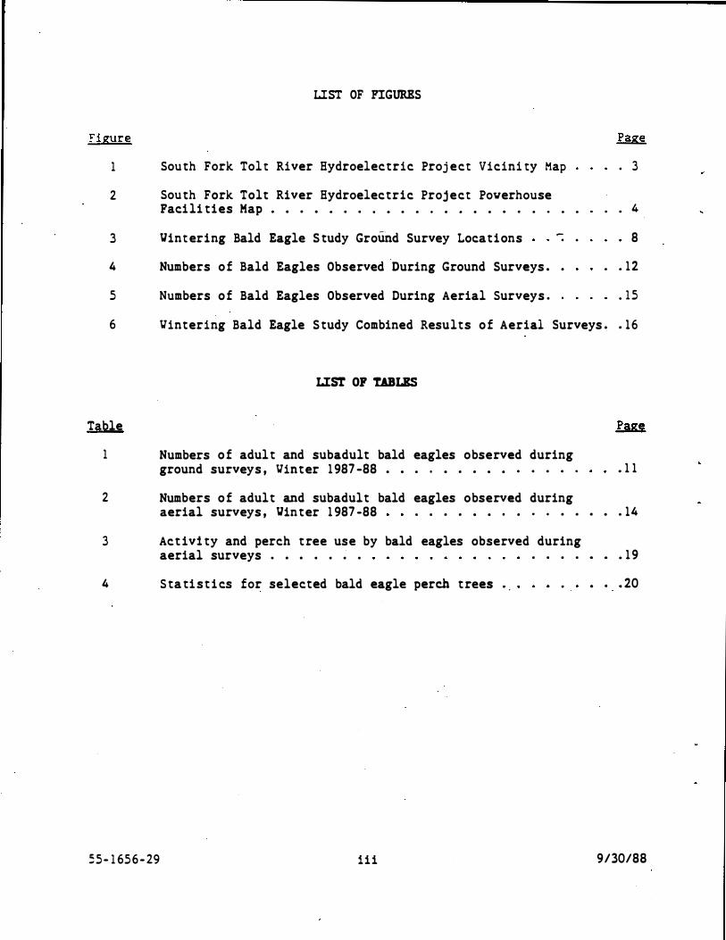
Au thors . . . . . . Acknovledgemen ts . Table of Cont en t s . Lis t of Figures . . Lis t of Tables . . .
TABLE OF CONTENTS
SUMMARY . . . . • . . . . . . . INTRODUCTION. . . . • . . . . • METHODS . . . . . . . . . . • . . RESULTS AND DISCUSSION. . . • . •
INTRODUCTION . . . .
PROJECT DESCRIPTION. .
STUDY AREA . . .
METHODS . . . . . . . . . • . . • . • • . FIELD VORK. . • . • • • • • • ASSESSMENT OF IMPACTS AND MITIGATION . •
RESULTS . . . . . . . . . . . . . . . VINTERING PERIOD AND POPULATION FOOD SOURCES . • . . • . . . . . . • . . DISTRIBUTION ·AND DENSITY • . . . . • • . . . • • . • BEHAVIOR AND HABITAT USE . • . . . • . . . . . . . .
DISCUSSION . . . • • . • • • • • • • • • . • • . • VINTERING PERIOD AND POPULATION . . FOOD �OURCES • . • . . . • . • . . DISTRIBUTION AND DENSITY . . . . . . BEHAVIOR AND HABITAT USE . . . • .
. . . . . . . . . . .
EFFECTS OF THE PROJECT AND RECOMMENDED MITIGATION
REFERENCES . .
CONSULTATIONS .
APPENDIX A
55 - 1 656-29
. .
U . S . FISH AND VILDLIFE SERVICE RESPONSE LETTER
i i
' . . . i . i i
. i i i
. i i i
. iv
. iv
. iv
. iv
1
. . • . 2
. . . . 5
6 . 6 . 10
. 10
. 10
. 13 . . . . . 1 3
• . . 18
. 21 . . . . . • 2 1
. • • 2 1 . . • . ,. 22
• . 22 . . . 24
. . . 26
. 28
9/30/88
:igure
1
2
3
4
5
LIST OF FIGURES
Sou th Fork Tol t River Hydroelectric Proj ect Vicini ty Map
Sou th Fork Tolt River Hydroelectric Proj ect Powerhouse Paci li ties Map • • . • . . . . • . . . . • . . • · · · · ·
Vint ering Bald Eagle S tudy Ground Survey Locations -. .
Numbers o f Bald Eagles Observed During Ground Surveys • .
Numbers o f Bald Eagles Observed During Aerial Surveys .
. 3
• • 4
8
. . 1 2
. 1 5
6 Vintering Bald Eagle S tudy Combined Results o f Aerial Surveys • . 1 6
LIST OF TABLES
Table
1 Numbers o f adul t and subadult bald eagles observed during ground surveys , Vin ter 1 987 -88 • • . . • . . • • . . . . . • 1 1
2 Numbers o f adult and subadult bald eagles observed during aerial surveys , Vin ter 1 987 -88 . . . . • • . . . . . . • • . 14
3 Act ivi ty and perch t ree use by bald eagles observed during aerial surveys . • • . . . . . . . . • • • 1 9
4 S ta ti s t i cs for selected bald eagle perch t rees • • • 20
5 5 - 1 65 6 - 29 i i i 9/30/88

SUKHARY
INTRODUCTION
The vintering bald eagle population on the Tol t River and Barris Creek , King Coun ty , Yashington , vas s tudied from November 1 987 through March 1 988 . The purpose of the s tudy vas to assess potential impac ts on bald eagles resul ting from cons truction and operation of the proposed South Fork Tolt River Hydroelectric Proj ect ( PERC No . 2959 ) , and to recommend mi ti gat ion vhere needed to pro tect vintering eagles . The Ci tY- of Seat tle complet ed the s tudy as a condi tion of proj ect li cens ing .
Coordination vi th the U. S . Fish and Yildli fe Service , Endangered Species Program , iden tified cons t ruct ion of the folloving proj ect features as potentially affecting baid eagles and their hab i ta t .
1 ) . A proposed powerhouse and electric t ransmission line near the exis ting South Fork Tol t River regulating bas i n .
2) A proposed flov return s tructure between the powerhouse and the South Fork Tol t River .
3 ) A proposed transmission line crossing Barris Creek .
O ther proj ect features vere considered unlikely to affect bald eagles . These included the cons t ruct ion of 5 miles of buried vater pipeline on the exis ting righ t -of -vay between the South Fork Tol t reservoi r and the proposed powerhouse, and 4 miles of t ransmission line ves t of Barris Creek .
METHODS
Bald eagles vere s tudied us ing a combination of ground surveys and aerial surveys . Ground surveys focused on si tes that had pot en tial bald eagle habi tat , and would be d irectly affected by the proj ect . Aerial surveys covered maj or creeks. and rivers in the proj ect vicin-i ty know t o ·contain spawning salmon, a key food of wintering bald eagles in the Pacific Northves t .
Bald eagle perch t rees vere characterized , and salmon presence vas monitored in a small s tream to examine the habi tat use and food supply of wintering bald eagles . Proj ect impacts and mi tigation vere assessed from the resul ts of field vork , literature research , and agency consul tat ions .
RESULTS AND DISCUSSION
EAGLE BIOLOGY
Aerial and ground surveys shoved that bald eagles vere present in the study area from late November through March . Their arrival coincided vi th the usual arrival of spawning coho salmon , which appear to be the main food of bald eagles wintering in �he s tudy area.
55 - 1 656-29 iv 9/30/88

;. peak coun t of 2 9 eagles vas reco rded in early February , and their numbers remained qui te high through early March . The la te vin ter influx o f eagles i nt o the Tolt River sys tem probably s t emmed from birds moving in after food supplies vere depleted elsevhere .
The rat i o of subadult eagles in the popula t ion vas qui te lov, sugges t ing that salmon carrion vas relat ively scarce . This is suppor ted by Depar tmen t of
· F isheries index coun ts vhich shoved a poor coho return into the Tol t River sys tem . Eagle populations in the study area during o ther winters are unknovn , but probably vary vi th local -and regional salmon abundance and avai labili ty .
Mos t of the bald eagles vintering in the s tudy area vere concentrated along the mains tem Tol t River . A smaller , but s ignificant , percentage o f eagles used the North Fork Tol t River . Relat ively fev eagles �ere observed on the Sou th Fork Tol t River , S tossel Creek, and Barris Creek , al though 1 - 2 eagles used the lat ter area cons i s ten tly .
Black co t tonwood vas the primary perch tree species used by eagles on the mains tem Tolt River and Barris Creek. Dead- topped conifers were more heavily u t il ized on the North Fork and South Fork of the Tol t . Measuremen ts of several perch t rees used by bald eagles confi rmed their preference for tall , large-diame ter t rees , affording good visibili ty of nearby rivers and creeks . Eagles perched on s tou t , lateral branches in the upper third of the t rees .
TJe made one observation o f a roost ing bald eagle . The bes t potential roos t ing habi tat is along the mains tem Tolt River , between the mouth o f S tossel Creek and the end of the Tolt River Road . The North and South Forks of the Tolt River may also provide some roos ting habi tat , as sugges ted by observations o f s ingle eagles flying up these s treams at dusk.
PROJECT IMPACTS AND MITIGATION
Of the s i tes direct ly affected by the proj ect , Barris Creek vas used mos t often by bald eagles·. One or two adult eagles occupied the creek area from mid :December through mid-February . Eagles frequent ly perched near and flev over t he right-of -vay , and appeared to feed in the creek. Special construc� ion prac ti ces are recommended at this loca tion to minimi ze impacts on �int ering bald eagles .
Eagles vere occas ionally seen perched near the proposed flov return s tructure on the Sou th Fork Tol t River . Eagles are unlikely to use this part of the river for feeding , due to the lack of salmon and the confined nature of the s tream channel . The U . S . Fish and TJildlife Servi
.ce recommends that con
s t ruc t ion at this loca t ion be scheduled out side the vin tering period to avoid dis turbing the eagles .
'Je did no t see any bald eagles perching or roos t ing in the vi cini ty o f the proposed powerhouse or t ransmiss ion line near the regulat ing bas in , al though eagles 01ere occas ionally observed flying over the area . Tree s i zes are generally inadequate t o support eagles , and the s i te is approximately 1 mile
5 5 - 1 65 6 - 2 9 v 9/30/88

� rom the neares t po t en t ial feed i ng areas . Cons t ruc t i on o f the powerhouse , t ransmis s i on line , and associa ted s t ruc tures a t this loca t ion would no t remove any s i gn i f i cant bald eagle habi t a t .
A poten t i al bene fi t o f the proj ect to bald eagles is that i t could resul t in a sligh t improvement in food supplies ( anadromous f i sh runs ) when a new flow regime is es tablished on the South Fork Tolt River . Resolu t ion o f f i sheries issues wi th . the tri bes and resource agencies vi ll s a t i s fy a li cens i ng requirement to minimize impacts on the food supply o f wintering bald eagles .
55- 1 656 -29 vi 9130188


:mrRODUC'l'ION
The Ci ty of Seat tle is comple t ing nego t iat ions for the proposed Sou th Fork Tol t River Hydroelectric Proj ec t ( FERC No . 2959 ) . Concurren tly , the Federal Energy Regulatory Commission ( FERC) has been examining cumulat ive impac ts of 7 hydroelectric proj ects in the Snohomi sh River Basin . The Sou th Fork Tol t proj ect vas included in this analysis . FERC issued a Draf t Environmental Impact Statement on the proj ects in June 1 98 6 . Issues of concern included potential impacts on bald eagles , a federally-lis ted threatened species in Vashington S tate .
In March 1 987 the U . S . Fish and Vildlife Service ( FVS ) submi t ted i ts biologi cal opinion to FERC in response to the Draf t EIS . FVS iden t i fied the folloving po ten t ial contribut ions of the South Fork Tol t proj ect tovard the harassment or harm of bald eagles .
1 ) Dis turbance from cons truction act ivi t ies during vin ter months .
2 ) Loss of food supply by direct impacts on anadromous fish.
3 ) Loss o f perching and roos t ing habi tat .
To minimize the impact on bald eagles , FVS es tablished the folloving measures to be undertaken as proj ect features .
1 ) A ban on all cons truct ion act ivi t ies from November 1 through March 3 1 .
2 ) Elimina tion of cons truction and operation impac ts on anadromous fish to the satisfact ion of the State and Federal resource agencies .
3 ) Site-speci fic habi tat surveys for vintering and nes t ing bald eagles .
In AugUs t 1 987 , FERC asked the Ci ty to comment . on these requirement s . The Ci ty met vi th and visi ted the site vi �h FVS , resul t ing in a clarification of the biological opinion . The folloving amendments vere made to the licens ing requi rements pertaining to bald eagles .
The November 1 -March 3 1 cons truct ion ban vas lif ted for the pipeline route because cons truction vould occur in the exi s t ing pipel ine right of -vay , and vould be far enough avay from river that the act ivi ty vould no t affec t bald eagles . FVS continued to be concerned about the impacts of cons truct ion in the vicini ty of the poverhouse and flov · return s i tes , and along tvo proposed sections of transmiss ion line . The C i ty agreed to conduct si te-speci fic vintering bald eagle surveys to determine vhe ther cons truct ion res trict ions should be applied to these areas .
The requirement to conduct bald eagle nes t ing surveys vas also dropped . A si te vis i t and aerial pho toin terpre tat ion revealed a lack o f potent ial
55- 1 656-29 1 9/30/88
nes t ing hab i tat a t proposed cons truc t i on s i t es . Conversa t i ons vi th b i ologis ts f rom the Veyerhaeuser Co . and washing ton Depar tment of Vildli fe also indicated tha t bald eagle nes t ing had no t been observed in the Tol t River sys tem . FVS agreed that the requi remen t · to resolve anadromous f isheries issues vi th the agenc ies �as being adequa tely addressed through nego t ia t ions vi th the Tol t River Fisheries Adv i sory Commi t tee .
· A scope of vork for the bald eagle s tudy vas prepared folloving the mee tings vi th FVS . The goals of the s tudy vere to :
1 ) Documen t bald eagle use of areas tha t vould be affec ted by con- · s t ruct i on and operat ion of the proj ect .
2 ) Es timate the impor tance of these si tes in rela tion t o the s tream drainages as a vhole .
3) Recommend vays to minimize impac ts o f the proj ec t on vintering bald eagles .
PROJECT DESCRIPTION
The C i ty of Sea t t le applied for a license to bui ld and operate the South Pork Tol t River Hydroelectric Proj ec t in 1 98 1 . The proj ect vould use vater from the exis t ing va ter supply reservoir on the Sou th Fork Tolt River to generate electrici ty . Principal features are as follovs ( Figures 1 and 2 ) .
1 ) A nev 6 6 - inch-diame ter buried pipeline ( parallel to and replacing the vat er supply pipeline ) from the reservoir on the South Fork Tol t River to a poverhouse in the vicini ty of an exis t ing regulat ing basin.
2 ) A poverhouse containing one 15-megava t � (MV) generat ing uni t .
3 ) A 90- inch-diameter pipe from the poverhouse t o an outlet on the regulat ing ba� in .
4 ) A 6 6 - inch-diame ter flov return pipe from the poverhouse to an energy dissipat ing s t ructure on the South Fork Tol t River .
5 ) Approximately 300 ft of access road .
6 ) A 0 . 4-mile sect ion o f 1 15 kilovolt (KV) transmission line from the poverhouse to an exis t ing transmiss ion line at the vat er treatment center .
7 ) Approxima tely 4 miles of transmission line along the vater supply pipeline right -of-vay from Kelly Road , crossing Barris Creek , to an exis t ing transmission line ovned by Puge t Sound Pover and Light Co .
55- 1 65 6 - 29 2 9/30/88

•••••r.••· UfAtt!ilw.t�··
....
,::·...:·;:.:,·:o::;·::,:,·-.:.:.;:·:;:;,·=·l·=·.:.::o·=·=·==·-·
t
�� \{:!,.,
~ SCAlE IN MilES
r -l_r·--· ·1 n • �
...... .. :il •• ,, .. , , ..
SfOI(USII COliN IV ' ttl'«t cn••n v
� �
o'
Figure 1 .
. .,
''\
� ... . ,� ·""" ....... ... __ _
\ /' .,
. ....,. _,., _,�,� /' · .,,, .. , , ,.-.... �- \. '-""
,. - "'-" � ��'"•• . . . ' . / . ........ , , .. \ . ""
\'-�.i-::� ··.=�---
\ 41 .... . c
\_,_,_ _;·
South Fork Toll River Hydroelectric ProJect Vicinity Mar

--- - --.. \fP
�
<> /l'fl· y / T����N
/_""__{; . '"'
----- 11110 -------
.. �-- _.....- -------- 1!10----�
scAtE IN FEET n__r----, 0 275 550
\;
TOLT RIVER REGULATING BASit-1
Figure 2. South Fork Toll River Hydroelectric Project .Powet:house Facilities Map

..
?roj ec t Roughly alder . 1 acre
cons truc t i on vould require clear ing approxima tely 23 acres o: lane . hal f thi s area is second -grovth fores t , primarily Douglas - f i r and red The res t of the area is disturbed and sparsely vege t a t ed . Less than of ri parian broadleaf fores t vould be removed for the flov return
s t ruc ture .
The proj ec t vould operate as a baseload , run-of- river faci l i ty , producing an average o f 6 . 1 Mtl of energy . The powerhouse would use flovs presen t ly diverted for the water supply , as well as any available excess flows . ( Excess flows are above those needed for the water supply and the maintenance of minimum s tream flows in the S-mile- section of river be tween the dam and powerhouse ) . Excess flows vould be returned to the river via an energy diss ipating s t ruc ture des igned to prevent the at t raction and delay of migra t ing fish .
FERC grant ed the City a maj or li cense for the proj ect in 1 984 . The li cense vas appealed by the S tate and Federal fisheries agencies , and the Tulalip Indi an Tribes , on the grounds that i t contained inadequa te measures to pro tec t , mi t igate , and enhance anadromous fishery resources . FERC then ordered a s tay of the li cense , allowing the Ci ty and pet i tioners to nego t iate a mutually acceptable long- term program for instream flows and habi tat res toration . Nego tiat ions and s tudies are s till undervay , in cooperation vi th the member tribes and agencies of the Tol t River Fisheries Advisory Commi t tee . Resolution of f isheries issues will satisfy a licensing requirement to minimize impacts on the food supply of wintering bald eagles .
The bald eagle s tudy area is located in King County , Vashington , nor theas t of Carnation and southeas t of Duvall . I t includes portions of the Tol t River and Barris Creek drainages ( Figure 1 ) . Second-growth coniferous fores t is the dominant vegetat ion , wi th commercial timber harvesting and water supply the primary land uses . Low dens i ty housing and agricul ture occur along the lower reach of the Tolt River and Barris Creek. Vehi cle access to the upper Tolt watershed is res tricted by locked gates to pro tect vater quality . Mos t o f this area therefore receives lit tle public use .
The Tolt River drains the wes t slope of the Cascades , entering the Snoqualmie River near the town of Carnation . The mains tem Tol t is approxima tely 9 miles long , wi th the North and South Forks approximately 17 miles each . Stossel Creek, which enters the Tolt at river mile (RM) 8 . 3 , is a maj or tributary . Mean annual flow of the Tolt River is 599 cfs , measured at the USGS gage near RM 8 . 8 ( unpublished data, U . S . Geologi cal Survey , Tacoma , VA) . Elevations in the Tol t •.1a tershed range from 60 f t at the confluence vi th the Snoqualmie River to over 5 , 900 ft at Mt . Index .
The Tol t River sys tem contains populations of anadromous fish , including s igni fican t numbers of coho salmon and s teelhead trout . Coho spawn in the tributaries , s ide channels , upper mains tem , and lower sect ions of the Nor th and South Forks o f the Tolt . Stossel Creek con tains the larges t coho run in
55 - 1 656 - 29 5 9130188

the Tol t River sys tem ( personal communicat ion , Tim Flint , �ashington Depar t �ent of F i sheries ) .
Small numbers o f chinook, chum , and pink salmon also spavn in the Tolt River ( Villiams et al . 1 9 75 ) . Chinook have been reported primari ly in the lover 2 mi les o f the mains tem Tol t , al though foo t surveys have shovn a fev chinook spawning in the lover sect ions of the North and Sou th Forks ( personal com_municati on , David Bays , BEAK Consultants Inc . ; personal communicati on , Kei th Kurko , Seat tle Ci ty Ligh t ) . Pink and chum salmon s pavning is res tric ted to the lover 4 mi les of the mains tem Tol t River (Villiams et al . 1 9 75 ) . - �
The Tolt River sys tem is managed principally for s t eelhead , vi th annual spavning es capemen ts averaging about 400 fish ( Stober e t al . 1 983 ) . Salmon are managed for vild s tocks , al though hatchery fry have been planted in some tribu taries . No es timates o f salmon spavning escapements have been made ( personal communication , Chuck Baranski , Vashington Depar tmen t o f Fisheri es ) .
Anadromous fish passage is blocked by falls on the South Fork Tolt River at RM 8 . 2 , and on the North Fork Tolt at RH 1 2 . 3 ( Figure 1 ) . Fish passage is furt her res tric ted on the South Fork Tol t by a series of cascades vi thin a narrov canyon beginning at RM 2 . 5 . This is the proposed s i t e o f the paverhouse flov return s tructure . Spavning s teelhead pass through the canyon , but salmon apparently do no t ( person�l communication , Kei th Kurko , Seat tle Ci ty Ligh t ) .
Harris Creek drains into the Snoqualmi e River about 3 mi les north of the Tol t River . The creek originates from groundva ter drainages in several large ve t lands , one o f vhich is adj acent to the proposed transmiss ion line cross · ing . The Harris Creek sys tem contains about 9 mi les of s t ream , including tributaries . Coho salmon s pavn throughout Barris Creek, vi th chum spavning in the lover 1 . 5 miles (Vi lliams et al . 1 975 ) .
KBTBODS
FIELD VORK
:Sald eagle surveys vere carried ou t f rom November 1 l , 1 987 through March 3 1 , 1 988 . Surveys concen trated on rnaj or creeks and rivers in the proj ec t area knovn to contain s pavning salmon , a key food o f wintering bald eagles in the ?aci fic Northwes t ( S talmas ter 1 987 ) . Ve used a combinat ion of ground surveys and aerial surveys to ge t an accura te picture of bald eagle use .
GROUND SURVEYS
Ground surveys vere made biweekly during November , and veekly ( except vhen aerial surveys vere done ) from December through March . Surveys focused on s i tes tha t had po tent ial bald eagle habi tat , and vould be direc tly affected by the proj ect •
.: 5 - 1 65 6 - 2 9 6 9/30/88

Key ground survey lo ca t i ons ( Figure 3 ) �ere :
1 ) The proposed poverhouse s i te and t ::-ansmi s s i on �ine nex t to the regula ting bas i n .
2 ) The proposed flov return s i te betveen the poverhouse anc the South Fork Tol t River .
3 ) The proposed transmission line cross ing of Harris Creek .
Ve also surveyed several locations along the mains tem To.l t Ri.Yer , No rth and South Forks of the Tolt River , and S tossel Creek to ge t an overviev of bald eagle use ( Figure 3 ) . These areas vere no t direc tly affected by the proj ect , and vere surveyed as often as t ime permi t ted .
Ground surveys generally began at about 0900 hrs and las ted unt i l dusk. Ve usually s t arted at one end of the survey route , and vorked ups tream or downs tream . The direction of the survey vas reversed in al ternate veeks to observe any si te-specific differences in the timing of eagle use . Surveys las ted 45-60 minutes at key locations , 15-30 minutes at viewpoints , and 5 - 10 minutes at other loca t ions .
At each s i te ve recorded the age class , location , and behavior of any bald eagles observed . Eagles vere classi fied as adul ts ( all vhi te head and tai l ) or subadul t s ( brown plumage , v i t h o r v i thout vhi te mo t tling) . Juveni les ( less than 1 year old ) vere grouped vi th subadul ts ( 1 -3 years old ) , due to the l imi ted abi l i ty to dist inguish plumage pat terns o f young birds in the field .
Fourteen perch trees used by eagles vere characterized . Trees vere selected for s tudy based on their general accessibil i ty , vi th emphas is on trees close· to proj ect features . Species , diameter (dbh ) , height , perch height , condi tion , and dis tance to the neares t creek or river vere recorded . Heights vere es timated using a clinometer and 100- ft tape . Diameters o f several trees at the pro.posed powerhouse s i te vere also measured and compared vi th those of perch _trees .
Salmon presence vas moni tored in a small s t ream near the mouth of S tossel Creek . Incidental sightings of anadromous fish vere also recorded on the mainstem and South Fork Tolt River . These observat ions vere used to supplement existing data on anadromous fish in the Tolt River sys tem , and to examine the local food supply of vintering bald eagles .
AERIAL SURVEYS
Ve conduc ted 3 aerial surveys of bald eagles . Surveys vere done on January 6 , February 2 , and March 2 , 1988 , using a helicopter (Aero -Cop ters Inc . ) , pilo t , and 3 observers . The survey route began at the mouth of the Tolt River , and proceeded ups tream to the South Fork Tolt Reservo ir ( Figure 1) . we then flev across to the North Fork Tol t River and surveyed downs tream to the mains tem Tol t . The las t leg of the survey vas up S tossel Creek and down Harris Creek to the Snoqualmie River . Aerial surveys vere done in mid-
55- 1 656 -29 7 9/30/88
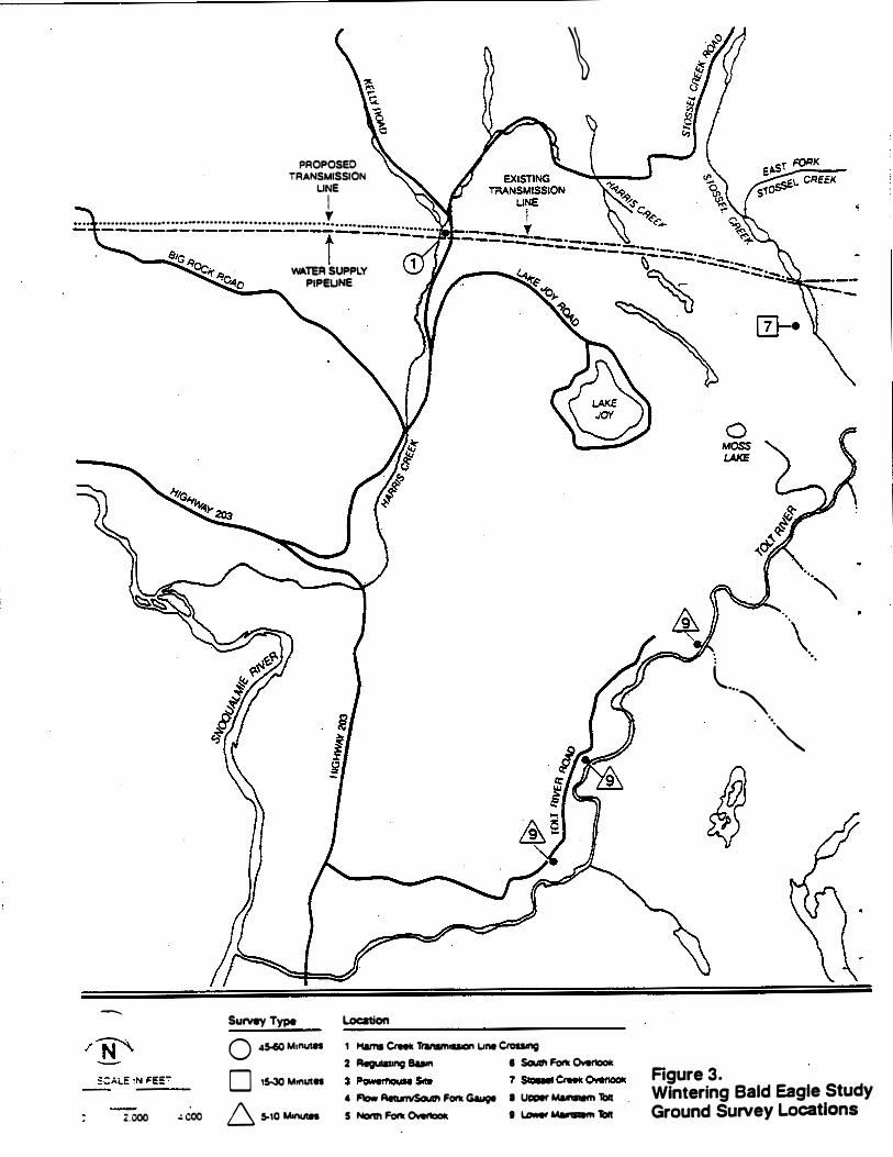
PROPOSED TRANSMISSION
UNE
I
\
·········· ······ · ·· · ·-·· · · · · · · ..................... ! ....... _. - --- ------------- t-- ��==�
.-..
z.ooo � coo
WATER SUPPLY PIPEUNE
Survey Type 0 4� Mtnut1S
D 15-30 MtnUIII
6 5-10 M111U111
Location 1 Haml Crftk Trat11111- une Ctoalng 2 Regulating Bum • Soulrl Forti Overtoolc
4 Flow AttunvSoulrl Fork Gay;e I Ucoer Malnslem 1:111 5 Norm Forti Ovenook I � � 1:111
( ... ""-· . . ""'
Figure 3. Wintering Bald Eagle Study Ground Survey Locations
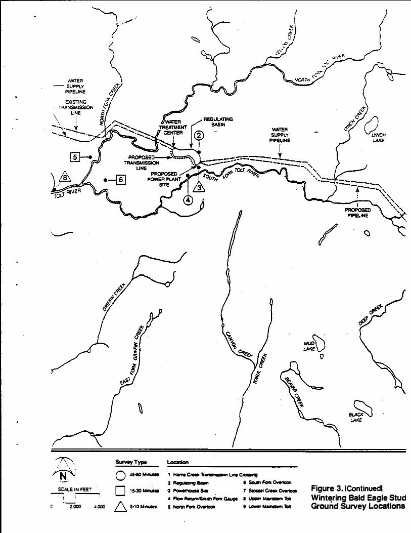
•
WATER - SUFIFILY
PIPELINE
�-�-N . SC.\LE IN FEE'!'
__.,
0 2.000 .a.ooo
Surwy Type Q .a5«)Minulft 0 15-30 Minulll
t Ham1 Creeic 1i'anlmoulon Line � 2 AegulatJng 8aln • Soull'l Fork Overtook
• Flow AelumiSoultl Fork Gauot • uooer � 1blr 5 Nonn Fork Overtook I ...,.., Malnltem 1blr
Figure 3. 1Continuedl Wintering Bald Eagle Stud Ground Survey Locations

mo rning , betveen 0930 and 1 1 00 hrs , vhen eagle feed ing ac t ivi ty is no rmally at i ts peak ( S talmas ter 1987 ) . Surveys las ted 65 -80 mi�ut es , and covered approxima tely 36 river mi les .
Speed and al ti tude of the helicop ter varied vi th terrain and eagle presence . S ixty to seven ty kno ts vas the maximum airspeed , and ve o f ten flev con siderably slover . Vhen ve sighted an eagle ve generally s loved the helicopter and de toured around the bird , circling or hovering at a safe dis tance unt i l ve could map i ts location . A dis tance o f 1 00- 200m vas generally adequate to avoid flushing a perched eagle. By moving pas t the bird ve mini mized the chance that i t vould fly ahead of us , subj ect ing i t ..... to repeated count ing and dis turbance . Ve also recorded the eagle ' s age clas s , ac tivi ty , and perch tree s pecies .
Ve coordinated our aerial surveys for Seat tle C i ty Light vi th 3 add i t ional helicop ter surveys completed by BEAK Consul tan ts Inc . for the Sea t t le Va ter Department . Surveys vere repeated at 2 - 4 veek intervals to obtain the maximum amoun t of information on vintering bald eagle popula t ions . Bo th s tudy groups surveyed the same route on the mains t em and forks of the Tolt River , but the Vater Depar tment surveys - di d no t include S tossel and Barris Creeks . Aerial survey results vere combined for the 2 s tud ies .
ASSESSMENT OF IMPAcrS AND MITIGATION
Potential impac ts of the proj ect on bald eagles vere analyzed from the resul ts o f field vork, li terature research , and consul tat i ons vith agency and other vildlife biologis ts . Literature research focused on the behavior , habi tat use , and response to dis turbance of vin tering bald eagles on the Nooksack , Skagi t , and Skykomish rivers . Ve also examined project plans , aerial pho tography , and da ta on anadromous fish use o f the Tolt River and Harris Creek. Mi tigat ion vas recommended vhere needed to reduce impac ts on vintering bald eagles .
REStn.TS
YINTERING PERIOD AND POPULATION
'!'he firs t reported s ight ing of bald eagles during the s tudy per iod �·as on November 22 , vhen a Department of Vildlife employee sav 2 eagles perched near the confluence o f the North and South Forks of the Tolt River ( personal communication , Rocky Spencer , Vashington Department of Vildlife ) . On November 25 , an adul t eagle vas observed feeding on a coho salmon carcass in the same area ( personal communica t ion, David Bays , BEAK Consultants Inc ) .
Eagles �ere firs t sighted by the authors during ground surveys on December 9 . Numbers of eagles seen from the ground shoved a no t i ceable peak in mid-December , folloved by a larger peak in early February (Table 1 and Figure 4 ) . The :naximum number o f eagles seen from the gro·und vas 9 . The eagle populat ion appeared to drop sharply around the middle of February , and eagles vere las t seen during ground surveys on February 24 .
55- 1 656 - 29 10 9/30/88
•

' l 'ilb l e I . Numbers of adult and sulYldul t bald eagles observed duri ng ground sur vey�; , W i nte t· 1 987-0U .
I OCA'I'ION AGE CLASS NOV NOV DEC DEC DEC DEC DEC JAN JAN .lAN FEB FEB FEB M/\H ] ] 25 2 9 1 6 2 3 3 0 1 3 20 27 lO 17 24 1 0
l larris creek adult 0 0 0 0 1 0 . o 1 1 2 1 0 0 0 Crossin) stibadult 0 0 0 0 0 0 0 0 0 0 0 0 0 0
Hequlatinq Basi n adult 0 0 0 0 0 0 0 0 0 0 0 0 0 0 subadul t 0 0 0 0 0 1 0 0 0 0 0 0 0 0
Powerhouse Site adult 0 0 0 0 0 0 0 0 0 0 0 0 0 0 subadult 0 0 0 0 0 0 0 0 0 0 0 0 0 0
F' l.ow netum/South adult 0 0 0 0 1 0 0 1 0 0 0 0 0 0 Fork Gage subadult 0 0 0 0 0 0 0 0 0 0 0 0 0 0
ul'lknarm 1 I
North Fork adul t 0 0 0 1 0 0 2 ) 0 1 0 0 - -OVerlook subadu l t 0 0 0 0 0 0 0 0 1 1 0 0 - -
South l''ork udult - - - - 2 - 0 - 1 0 - 0 - -OVerlook subadult - - - - 1 - 0 - 1 0 - 0 - -
Stossel Ct·eek adult 0 0 0 1 0 0 0 0 2 0 0 - 0 -overlook subadult 0 0 0 0 1 0 0 0 0 0 0 - 0 -
Upper Mainstem adult - - - - - - - 0. 0 - 0 - 1 -'l'olt subadul t - - - - - - - 0 0 - 0 - 0 -
l lONer Mainstem adult - - - - - - - - - - 4 2 0 -'l'olt subadult - - - - - - - - - - .., 0 0 -
StnNEY 'IUrALS adult 0 0 0 2 4 0 2 5 4 ) 5 2 1 0 subadult 0 0 0 0 2 1 0 0 2 1 4 0 0 0 ul'lknarm 1
total 0 0 0 2 7 1 2 5 6 4 9 2 l 0
(-) im icates site not surveved .
MAR MI\H M/\U '101'/\ L . 1 6 2 ] J .l
0 0 () 6
0 0 0 0
() 0 0 0
0 0 0 1
0 0 0 0
0 0 0 0
0 0 () 2
0 0 0 () 1
0 0 () 7 . 0 () 0 2
() - () J 0 - 0 2
0 0 0 ) 0 0 0 1
0 0 0 1
0 0 0 0
0 - - 6 () - - ,
0 0 () 2B 0 0 0 1 0
1
0 () () )�)

Numbers
Adulls
Sul)ltltl .. !'l
10
9
8
7
6
5
4
3
2
Q I I I I I i I I , . . . . I
Date
Figure 4. Numbers of Bald Eagles Observed During r-"'"Jnd �. •ryey""

S i x aerial surveys vere macie be ttJeen December 2 1 and March 28 ( Table 2 anci Figure 5 ) . Numbers of eagles increased from 3 in la t e December , to a peak o f 29 birds i n early February . Six teen eagles tJere s t i ll presen t at the begi nning of March , but numbers had cropped t o 2 by the end o f March .
Subadul t eagles made up 28 percen t of eagle s ight ings for bo th ground surveys and aerial surveys (Tables 1 and 2 ) . This ra tio vas af fec t ed by the rela tively late arrival and early depar ture of younger birds ( F igures 4 and 5 ) .
FOOD SOURCES .-
The arrival of bald eagles in the s tudy area during late November vas vi thin the range of the usual arrival t ime of adult coho salmon in the Tol t River sys tem . Spavner surveys on the North Fork Tolt River sugges ted that the 1 988 coho run peaked in early January { personal communicat ion , David Hays , BEAK Consultants Inc . ) . This vas borne out by our observat ions at the mouth of S t ossel Creek . Many live fish vere seen on January 7 and 1 6 , vi th a no t iceable decline by January 20 . Fish carcasses vere mos t numerous through February 10 .
The s ize of the coho run appears to have been vell belov average , based on Department of Fisheries index counts on Langlois Creek, near the mouth of the Tolt River { unpublished data, Yashington Department of Fisheries , Olympia , VA) . Lov flovs apparently prevented coho from entering the upper reaches of S tossel Creek, as Department of Fisheries index count s on the Eas t Fork o f the creek recorded no fish . A part ial barrier at RH 0 . 4 blocks fish passage during lov vater { personal communication , Tim Flin t , Yashington Department of Fisheries ) .
DISTRIBUTION AND DENSITY
AERIAL SURVEYS
Aerial surveys shoved that nearly 80 percent of bald eagle use took place on the mains tem Tolt River (Table 2 and Figure 6 ) . . Eagles vere especially concentrated .near the mouth of Stossel Creek , and in the 2 river miles immediately downs tream . The North Fork Tolt River , betveen ·RM 10 . 0 and 10 . 8 , received about 10 percent of bald eagle use . Only 3 eagles ( 4 percent ) vere seen on the South Fork Tol t River , 2 of vhich vere ups tream o f the proposed powerhouse s i t e .
The maximum eleva tion o f any bald eagle observat ion vas 1 100 f t , v i t h 94 percent of observations belov 600 ft elevation . A peak dens i ty of 2 . 6 eagles per river mi le vas recorded on the mains tem Tol t River during the aerial survey on February 2 .
GROUND SURVEYS
Ground surveys recorded bald eagles at all loca t ions excep t the proposed poverhouse s i te (Table 1 ) . Ye sa� a greater percentage of eagles on the Nor th and South Forks of the Tol t River than during the aerial surveys . This
55 - 1 656 - 29 1 3 9/30/88

- - �- � --- ����---�--------------------------.
'I'< ab I (� I. . t·h m�:ers o t adu l t and subildl l 1 t bald eagles observed duril¥} aerial surveys , \'li nter 1 987-BU .
I lX:J\'I'fON AGE Cl ASS DEC 21 ( 1 ) JAN 6 JAN 19 ( 1 ) FEU 2 MAR 2 Ml\H 2o C l ) 'IUI'AI , M. l i nstem ' l 'o l t Rive•· adu l t 3 4 5 1 6 1 1 1 40
subadul t 0 5 4 7 1 0 17
South l"ork 'l'olt Hiver adult 0 0 1 1 1 0 ) subadult 0 0 0 0 0 0 0
North Fork 'J'ol t Hi ver adult 0 0 1 2 1 1 5
subadu l t 0 0 2 0 0 0 2
Stosse 1 CL·eek adult - 0 - 1 0 - 1 subadul t - 0 - 0 1 - 1
l larris Creek adul t - 0 - 2 1 - ) subadul t ... 0 - 0 0 - 0
SURVEY 'lUI'AIB adul t 3 ' 4 7 22 14 2 52
suhadu l t 0 5 6 7 2 0 20
tota 1 3 9 13 29 16 2 72
( 1 ) Aerial survey corrlucted by BFAK Consultants Inc. for Seattle Water �partrnent , North Fork Tolt River Prel imi m1 1 Stud i es . stossel Creek arrl Harris Creek not surveyed .
..
• !
I z

F'F!OPOSEO TFIANSMISSION
UNE
-·· ··········-···········-···-·········-··········-·t. - ----- - - - - - -- - --1--.:.::::.:=::·=· .
SCALE IN FEET � I � 0 2.000 4 000
WATER SUPPLY PIPEUNE
\
Figure 6.
MOSS LAKE
o:
l ... �
."
Wintering Bald Eagle Study Combined Results of Aerial Surveys

SCALE IN FEET I
� 0 2.000 4.000
/
Figure 6. 1Continuedl Wintering Bald Eagle Study Combined Results of Aerial Surveys

�as large ly due to the focus of ground surveys in these areas and lack of access to mos t of the mains tem Tol t .
Of the si tes that vould be d i rectly af fected by the proj ect , Harris Creek vas used mos t o f t en by bald eagles . From mid- December through mid-February , 1 - 2 adult eagles occupied the creek area . Favored perches vere on both s ides o f the pi peline and t ransmission line right - o f -vay , 1 00 - 650 f t from the proposed cons truc tion s i t e . Eagles vere observed flying across the righ t -of-vay , and
_ once ve sav an eagle fly dovn from i ts perch into a ve tland adj acen t to the creek. Al though ve could no t see the bird , ve believe that i t vas feed ing .
Eagles vere seen 3 t imes near the proposed flov re turn s truc ture on the Sou th Fork Tolt River . The south bank o f the river , across from the proj ect s i te , i s very s t eep and dominated by old -grovth coni fer fores t . One parti cularly large dead - topped Douglas - f ir vas used as a perch t ree by bald eagles . The t ree is approxima tely 250 ft downs t ream from the s i te o f the proposed energy dissipat ing s t ruc ture . 'We also observed an eagle f lying ups tream at this locat ion , j us t before dark .
Employees at the vater treatment center reported bald eagles flying over the regulating bas in area on 3 occas ions . 'We also observed an eagle flying over the area during one of the ground surveys . Eagles appeared to be travelling be tveen the North and South Forks of the Tol t River . Several ducks vere present on the regulat ing basin, put eagles vere never seen hunt i ng them . 'We did no t see any bald eagles perching in the vi cini ty o f the proposed paverhouse or t ransmis s ion line near the regulating bas i n .
BEHAVIOR AND HABITAT USB
Eagle ac tivi ty and perch tree use during aerial surveys is summarized in Table 3 . Approxima tely 3 /4 o f the birds vere ei ther perched in trees , or s tand ing on the ground , in or next to the rive r . 'We sus pect that mos t of the birds that vere flying vere frightened f rom the ground or t ree perches by the hel i copter . Interes t ingly , a much higher percentage of subadul t birds ( 57 percent ) vas seen flying than adult birds ( 18 f.ercen t ) . Thi s di fference is significant at the 1 percent level - (G-7 . 2 1 7 > X ; df· 1 ) .
Black co t tonvood vas the primary perch tree species used by eagles duri ng the aerial surveys (Table 3 ) . Other broadleaf trees and con i fers vere used to a lesser ex tent . 'We did no t determine the avai labili ty of d i f ferent species of t :-ees , bu t our impress ion is that black co t tonvood is the dominan t tree species , bo th in frequency and height , along the mains tem Tol t River. Douglas - f ir and o ther coni fers become dominant on the North and Sou th Forks o f the Tol t .
�easuremen ts o f several perch trees used by bald eagles are shovn in Table 4 . ;;.11 the t rees , ;;i th the except ion o f the alders , are locally dominant in �erms of height and diame ter. The Douglas - fi rs along the North and South Forks of the Tol t River , and the cot t onvoods along the mains tem Tol t are par ti cularly impress ive . Perch trees are vi thin 650 f t of vater ( mos t are �-Ti thin 1 00 f t ) , and each affords a good viev o f nearby rivers or creeks . · All the coni fers have dead or broken tops ( one is comple tely dead ) , and the
5 5 - 1 656-29 1 8 9/ 30/88

..
'!'able 3 . Ac t i v i ty and perch t ree use by bald eagles observed dur i ng ae r i a: su rveys .
Activi ty/Perch Type Date of Survey Tota� 1 /6 2/2 3/2
Perched Black Co t tonwood 4 !3 1 0 �27
Red Alder 1 1
Big- Leaf Maple 1 1
Uniden t i f ied Broadleaf 1 1 2
Yes tern Redcedar 3 3
Yes tern Hemlock. 1 1 2
Dead Coni fer 1 1
Unrecorded Perch 1 1
On Gravel Bar/River 1 1 2
Fli::i ng 3 7 4 1 4
To tals 9 . 29 1 6 54

Tabl e : . Sta t i St i C S fer sei ected bal d e!gl e �ercn trees .
Spec 1 es Locat i on D 1 arreter ( dbh)
Black Cottonwood Harri s Creek 31 --
Bl ack Cottonwood Harri s Creek 34
Bl ack Cottonwood Mai nstem Tcl t R i ver 39 Bl ack Cottonwood Ma i nstem Tcl t R i ver so Bl ack Ccttcnwccd Hai nstem Tcl t R i ver 36
Red Al der Harri s Creek 16
Red Al der Harri s Creek 20
Dougl as-Fi r ( Dead) Harri s Creek 27 Dougl as-F i r S . F . Tcl t Ri ver 64 Dougl as-F i r S . F . Tcl t R i ver 76 Doug l as - F i r N . F . Tcl t Ri ver 65 Dougl as-F i r N . F . Tcl t Ri ver 59
Western Reocedar S . F . icl t River 83
S i tka Soruce Stcssel Creek 58
Total 1-1e1 ;nt
97 105 135 150 145
80 87
112 226 220 196 189
154
l l 9
i �ee c1 ameters measureo 1 n 1 ncnes : al l ether measurements \ n ft .
Percr: �e1 gnt D i s tance to Water
85 185
89 . 74- 53 125 0 --- 25 - - - 21
c-... o 14 70 36
90 17
220 70 205 53 157 650
132 600
133 102
119 21

c o t tonvoods have open crowns , allowing good vis i b ili ty and easy access . 2agles vere pe rched on s tout , lateral branches , in the upper third o f t he trees .
One observat ion o f an eagle roos t vas made· during the s tudy . On January 7 , a s ingle subadul t eagle entered and remained in a dead- topped Douglas - fi r a t abou t 1 600 hrs . The roos t tree vas surrounded by coni fer fores t on an eas t facing slope next to the mains tem Tol t River . This i s j us t downs t ream from the mouth of S tossel Creek, in the same area where eagles vere mos t frequently o bserved during the aerial surveys . Twice ve observed single bald eagles flying up the North and South Forks of the Tolt River at dusk, sugges ting that some birds roos ted in these areas .
DISCUSSION
YINTERING PERIOD AND POPULATION
Aerial and ground surveys shoved that bald eagles in the Tol t River sys tem reached peak numbers during the firs t tvo veeks of February . This is later than typically observed on the Nooksack River ( Stalmas ter 1 987 ) , but wi thin the range of populat ion peaks occurring on the Skagi t ( Servheen 1 97 5 , Bunt and Johnson 1 98 1 ) . Radio telemetry s tudies have shovn that eagles wintering in wes tern Vashington are highly mobile, and are adept at exploi t ing widelyspaced food concent rat ions ( Bunt and Johnson 1 98 1 ) . The late win ter influx of eagles on the Tolt River probably s temmed from birds moving in af ter food supplies vere depleted elsewhere .
One likely source of eagles entering the s tudy area is the Skykomish River, 1 5 -20 mi les northeast of the Tolt River . Vinter surveys in the upper Skykomish sys tem shoved a rapid decline in eagles around the end of January ( Paz 1 988 ) . This decline coincided vi th the large increase in eagle numbers on the Tolt River .
I t is also possible · that many of Hie eagles were breeding birds · moving northvard through Vashington to nes t ing terri tories in Bri t i sh Columbia and Alaska . The high proportion of adul ts in late vin ter supports this hypothes is ( personal communi cation , Jim Vatson , Vashington Departmen t of Vildl i fe ) . The departure of mos t of the eagles in the s tudy area by the end of March vas cons is tent wi th the behavior of eagles on the Nooksack and Skagi t Rivers ( Servheen 1 975 , Hun t and Johnson 1 98 1 , S talmas ter. 1 987 ) .
Ue recorded a maximum populat ion of 29 bald eagles in the s tudy area during early February . The ratio of subadult eagles ( 28 percent ) vas somewhat less than ratios found on o ther rivers in the Pacific Northwest ( Stalmas ter 1 987 ) . Subadult proportions tend to be greater where food is more plenti ful ( Stalmas ter 1976 ) , sugges ting that salmon carrion may have been relat ively scarce during the s tudy .
55- 1 656-29 2 1 9 /30/88

FOOD SOURCES
Ve believe that coho salmon are the main food source o f bald eagles vintering in the s tudy area . Coho are far mo re abundan t than o ther salmon species in the Tolt River sys tem , and the arrival t i me o f eagles during lat e November co incided vith the usual arrival of adul t coho . Thi s differs from many other Nor thwes t rivers , vhere coho salmon play a secondary role to chum salmon in the eagles ' win ter diet ( S talmas ter et al . 1 979 , Hun t and Johnson 1 98 1 , S tal mas ter 1 987 ) . Coho are also videly dis tributed in Harris Creek, and probably supply mos t of the winter food of eagles �here .
Bald eagles usually do no t take live salmon , but scavenge the carcasses after they vash up onto shore or into shallow water ( Servheen 1 975 , Stalmas ter 1 987 ) . Eagles may also utilize s teelhead , al though no t to a great extent s ince few of the fish die immediately after spavning . Live s teelhead are seldom taken ( Servheen 1 975 ) . Small groups o f vaterfovl ( mos tly mallards ) occupy the ve tlands on Harris Creek , and may be an al terna te food source of eagles wintering in that area .
DISTBIBUTION AND DENSITY
Aerial surveys shoved that a large maj ori ty of the bald eagles wintering in the s tudy area during 1987 -88 were concentrated along the mains tem Tolt River . A smaller , but s igni ficant , percentage of eagles used the North Fork Tolt River , wi th relatively few eagles on the South �ork Tol t , S tossel Creek, and Harris Creek.
The concentration of bald eagles along the mains tem and North Fork Tolt River undoubtedly relat ed to the presence of salmon carcasses . The avai labili ty of carcasses in these areas is enhanced for eagles by a number of factors , including the presence o f good s�avning habi tat , vide s tream reaches , slowmoving water , and large perch trees . The dis tribution and availabili ty o f salmon carcasses is also influenced by annual an d weekly changes i n flow cond i tions and the s ize and t iming of fish runs . Ve expect corresponding changes in the dis tribution of eagles , wi thin limi ts of habi tat .
An example of the annual variation in salmon and eagle dis tribut ion is · upper Stossel Creek , vhere ve sav very fev eagles during the s tudy . Drought cond i t i ons blocked salmon access to mos t of the creek , contributing to the lack of eagle use . During the preceding vinter there vas a very s trong run of coho , and as many as 1 2 eagles vere cons istently seen along the upper par t of Stossel Creek ( unpublished data, Yashington Department of Fisheries , Olymp ia, YA ; personal communicat ion , Bob Lanti egne , Yashington Depar tment of Vildl i fe ; personal communication , George Meier , Kirkland , VA) .
?eak dens i ty of eagles recorded during the stud:! vas 2 . 6 birds per river mile on the mains tem Tolt Ri ver . Stalmas ter et al . ( 1 979 ) observed peak dens i t ies of 7 eagles per river mile along a sect ion of the Nooksack River . Eagle populations in the s tudy area during other years are unknovn , but undoub tedly ''ary vi th local and regional salmon abundance and avai labili ty .
S S - 1 656 - 29 22 9/30/88
•
..

•
BEHAVIOR AND HABITAT USE
�pp roximately 70 percent of the bald eagles observed during aerial surveys �ere perched in trees along va tervays . Tventy - s ix percen t -�ere flying , and 4 percen t were s tanding in or nex t to the river . The prevalence of eagles perched in trees is not surprising , given that vintering eagles spend abou t 30 percent of their 24-hour day loafing on perches , and ano ther 68 percent roos ting in trees at night . This leaves only 2 percent of the day for flying , foraging , and feeding ( S talmas ter 1 987 ) .
Our impression is that eagles vere us ing tree perches no t only for lqafing , but for hunting . Several of the percned eagles observed during the aerial surveys appeared to · be vatching the river intently , poss ibly vai ting for salmon carcass es to dri f t near shore . During _ a ground survey at Barris Creek ·Je sav an eagle fly dovn from i ts perch into an adjacent marsh, vhere i t remained for approximately 20 minutes . Al though ve couldn ' t see the bird , ve suspect that i t vas feeding .
Mos t of the eagles that ve sav flying during the aerial surveys vere probably frightened by the helicop ter . Subadul ts appeared to fly more of ten than adul t bi rds . There are several possible explanations for this dif ference . One is that adul t eagles may be more habi tuated to aerial dis turbances . This i dea is somevhat cont radicted by several s tudies shoving that adul t eagles are far more eas ily dis turbed by human act ivi t ies on the ground than are subadult birds ( Stalmas ter and Nevman 1 978 , Knight and Knight 1 984 , Knight and Knight 1 986 ) .
Ano ther hypothesis is that since subadult eagles ar� less conspi cuous than adul ts , they are more likely to be seen vhen flying than vhen perched . This Jould result in some subadult birds being overlooked , particularly on aerial surveys vhere the abili ty to search for eagles is qui te limi ted . The fact that ve sav the same percentage of subadult eagles during ground surveys and aerial surveys veakens this argument .
A third poss ibility is that many o f the subadult eagles vere s tanding or feeding on the ground during the aerial surveys , vhere they vere less secure and more likely to · fly in response to the helicop ter . Knight and Knight ( 1 984) reported that eagles on the ground are less toleran t -of dis turbances than eagles perched in trees . More field vork vould be needed to verify this or o ther possible reasons for the different responses of adul t and subadul t eagles during aerial surveys .
Black co t tonvood vas the primary perch tree species used by eagles during the aerial surveys . Stalmas ter and Nevman ( 1 979) found that co t tonvood vas heavily uti lized by eagles vintering on the Nooksack River , although snags and big- leaf maple vere even more s trongly preferred . Yintering eagles usually select day t ime perches near clearings or river channels that are close to salmon s pawning areas . Tall trees vith strong lateral branches high :.n the crow are preferred ( S talmas ter and Nevman 1979 , Stalmas t�r et al . 1 985 ) . Measurements of several perch trees used by bald eagles in our s tudy confirmed the general preference for tall , large-diame ter t rees , vi th good visibili ty and access to rivers and creeks .
55- 1 656-29 23 9/30/88

we do no t knov vhe ther mos t o f the bald eagles i n the Tol t River sys tem roos t s i ngly or communally , bu t there appears to be p lenty o f good roos t ing habi tat along much o f the river . The area on the mains tem Tol t , f rom the mou th o f S tossel Creek , dovns t ream abou t 2 mi les to the end o f t he To l t River Road , appears to have the bes t po ten t ial for roos t ing . This area is isolated f rom development , has a variety of large trees , and supported the larges t con cen trat ion o f vintering · eagles during t he s tudy . \le observed one eagle
· roos t ing in this area . The North and Sout h Forks o f the Tol t River may also provide some roos ting habi tat , as sugges ted by observa t i ons of s ingle eagles flying ups tream in .these areas at dusk. -
EFFECTS OF THE PROJECT AND RECOMMBNDBD MITIGATION
Bald eagles used 2 of the 4 s tudy s i tes tha t vould be di rec t ly affected by the proposed hydroelec tric proj ec t . Probable impacts and recommended m i t igat ion measures are discussed belov.
HARRIS CREEK CROSSING
Harris Creek vas occup ied by 1 -2 adul t eagles from the middle o f December through mid-February. Eagles used perch trees on bo th s ides of the pipeline right-of -vay , wi thin clear viev of the proposed transmiss ion line cross ing . Eagles vere observed flying across the right -of-vay , and apparently fed in the creek and we t lands adj acent to the s i te . Ve vould expect more eagles to use the area , perhaps over a longer t ime period , during years of strong coho returns .
Given the attrac tion of the Harris Creek s i te to eagles , i t is likely that cons truc t ion act ivi ty during winter vould dis turb the birds , causing them to avoid the immediate vicini ty of cons truc t ion . Human dis turbance can s tress eagles , increasing their energy losses and reducing their chances of surviving through the winter ( S talmas ter 1 983 ) . Vintering eagles s pend only about 2 percent o f the day act ively foraging and flying . The res t of the t ime is spent in a quiet s tate, alloving them to conserve precious energy ( S talmas ter 1 987 ) . Although eagles can habi tuate to rout ine human behavior, they are relat ively intolerant of unfami liar act ivi ties , particularly those vhich are highly vis ible ( S talmas ter and Nevman 1 978 ) .
I f vin ter cons true tion could be completed vi thin a fev days , the imp.ac t on
eagles vould probably be minor . I t vould be preferable , hovever , to schedule the vork outs ide the vintering period ( approximat ely December 1 -March 1 5 ) .
Cons t ruct ion of aerial transmiss ion lines across Harris Creek poses some risk that eagles vould collide vi th the lines during periods of poor light or fog . r.;e recommend alternat ive cons truct ion methods that vould reduce or eliminate this risk. · One solut ion vould be to bury the transmission line betveen Kelly Road and the base of the s lope on the ves t side of Harris Creek . A les s cos t ly me thod vould be t o vrap the transmission lines vi th a special material des igned to increase their vis ibility to rap tors (U . s . F ish and Vildli fe Service , Appendix A) . If the la t ter method is chosen , ve recommend that the
S S - 1 656 - 29 24 9/ 30/88
•

heigh t o f the t ransm i s s i on l ines be ::1inimi zec ·.:i thin .the limi t s o f pub l i c s a f e ty .
SOUTH FORK TOLT RIVER FLOY RETURN STRUCTURE
Bald eagles occas ionally perched in a large Douglas - fir tree near the s i te of the proposed flov re turn s t ructure on the South Fork Tolt River . Eagles vere observed in the tree tvice dur ing 1 7 hours of surveys , sugges ting that the tree vas used infrequently . On both occasions , the birds left the perch vi thin a short t ime of landing , and vere apparently · frightened by our presence . The perch tree is
· across the river and approximately 250 ft
dovns tream from the s i te of the proposed flov re turn s tructure . The height of the perch is about 300 ft above river level , vi th a clear viev of the proposed cons truction s i te .
Bald eagles are unlikely t o use this part o f the river for feeding , due to the scarci ty of salmon and the confined nature of the s tream channel . Eagles typi cally forage " in more open areas that give them a sense of security and room for unobs t ructed flight ( S talmas ter et al . 1 985 ) . The neares t po tent ial feeding areas on the South Fork Tol t River appear to be about 1 mi le dovns tream and 1 . 5 miles ups tream of the proposed flov return s i t e .
Based on the response of eagles during the s tudy , ve feel that they vould avoid the perch tree during periods of construct ion act ivi ty . Since the tree is no t used heavily , this temporary disturbance should no t harm the local eagle populat ion . Nevertheless , as a precaution the U. S . F i sh and Vildli fe Service recommends that cons truction at this locat ion be scheduled outside the wintering period to avoid dis turbing the eagles (Appendix A) . Ve expect that operat ion of the flov return sys tem vould have no effect whatever on bald eagle use of the area .
POVERHOUSE SITE AND TRANSMISSION LINE
Ye did not see any bald eagles perching or roosting in the vicini ty of the proposed powerhouse or transmission line near .the regulat ing basin. Fores t habi tat at the s i te cons ists of pole-s tage to mature coni fer and broadleaf s tands . · Much of the area vas logged wi thin the las t 45 years . Diame ters of several coni fers at the powerhouse s i te range from 1 4 to 24 inches , vell belov the s izes of mos t conifers used as bald eagle perches in the s tudy area . Trees along the proposed transmission line corridor are even smaller .
As the trees mature they may at tain a size and s t ructure more sui ted to bald · eagle use . Bovever , given that sui table · habi tat cont inues to exi s t near
feeding areas on the Tolt River , it is unlikely that eagles vould use the area near the regulat ing bas in more than occas ionally . Ye conclude that cons truction of the powerhouse , transmission line , and associated s t ructures vould not remove any significant bald eagle hab i tat .
5 5 - 1656 - 29 25 9/ 30/88


REFRRENCES
�un t . � . G . and B . S . Johnson . 1 98 1 . Impac ts o f a proposed Co pper Creek Dam on bald eagles : second vinter s tudy . Unpubli shed report t o Seat tle Ci ty Light , Office o f Envi ronmental Af fai rs . Seat t le , wA . Prep�red by Biosys tems Analys i s , Inc . San Francisco , CA .
Knight , R. L . , and S . K . Knight . 1 984 . Responses of vintering bald eagles to boating act ivi ty . Journal of Yildli fe Management 48 : 999- 1004 .
Knight , S . K . , and R . L . Knight . feeding in groups . Auk 103 :
1 986 . Vigilance ·patterns of�
bald eagles 263-27 2 .
?az , s . 1 988 . Report o f Yinter 1 987 -88 bald eagle survey . Skykomish Ranger Di strict , Mt . Baker- Snoqualmie Na t ional Fores t . USDA Fores t Service Unpublished Report .
Servheen , C . Y . 1 975 . River , washington .
Ecology of the vin tering bald eagles on the Sk.agi t Mas ter ' s Thes is . University of Yashington , Seattle .
S talmas ter , M . V . 1 976 . Yinter ecology and effects o f human ac t ivi ty on bald eagles in the Nooksack River Valley , Vashington . Mas ter ' s Thesis . wes tern washington Universi ty , Bellingham.
S talmas ter , M . V . ing bald eagles .
1 98 3 . An energetics s imulation model for managing vinterJournal of Vildli fe Management 47 : 349 - 59 .
S talmas ter , M . V . 1 987 . The bald eagle . Universe Books , Nev York.
S talmas ter , M . V . , R . L . Knight , B . L . Bolder , and R . J . Anderson . 1 985 . Bald eagles . Pages 269-90 in Management of Yildl i fe and Fish Habi tats in Fores ts of Ves tern Oregon and Vashington . USDA Fores t Service Publication No . R6- P&VL- 192- 1 985 . Vashington , D . C .
S talmas ter , M . V . , and J . R . Nevman . 1 978 . Behavioral responses o f wintering bald eagles to human ac tivi ty . · Journal of Vildlife Managemen t 42 : 506 -5 1 3 .
S talmas ter , H . V . , J . R . Nevman , and A . J . Hansen . 1 979 . Population dynami cs of vinter ing bald eagles on the Nooksack River, washington. Northwes t Science 53 : 1 26 - 3 1 .
S t ober , Q . J . , C . R . Steward , and F . Yinchell . 1 98 3 . Tolt River fisheries and ins tream flov analys is . Final Report for Ci ty of Seat tle , Department of Light ing , Office of Environmental Affairs , and Department · o f Yater . Univers i ty of Yashington School of Fi sheries , Fisheries Research Ins t i tute, FRI -UV-8 2 1 3 . Seattle , VA .
r: . s . Geological Survey . Unpublished data. Carnation . Yater Resources Divis ion .
55 - 1 656 - 29 26
Mean discharge , Tolt River near Taco.ma , VA .
9 /30/88

washing ton Depar tmen t of Fisher ies . Unpubl ished da t a . Salmon spavning ground data re t r i eval , Langlois Creek and Eas t Fork S t ossel Creek . Olymp ia , VA .
�illiams , R . V . , R . M . Laramie , and J . J . Ames . 1 9 7 5 . A catalog o f Vashington s t reams and salmon ut i liza t ion . Volume I , Puge t Sound Regi on . Vashington Depar t ment o f Fisheries . Olympia , YA .
5 5 - 1 656-29 27 9 /30/88

"
CONSULTATIONS
Anderson , Ro bert J . Vi ldli fe Biologis t , weyerhaeuser Company . �acoma , VA .
Baranski , Chuck . F isheries Bi ologis t , washington Depar tmen t of Fi sheries . Olympia, VA .
Flint , Tim. Fisheries Biologis t , Vashington Departmen t of Fisheries . Olympia , VA.
Green , Brady . Fish and Vildlife Biologis t , u . s . Fores t Service , M t . BakerSnoqualmie Nat i onal Fores t , Mt . Baker Ranger Dis trict . Sedro Voolley , VA .
Hays , Davi d . Vildli fe Biologist , BEAK Consultants !nc . Ki rkland , VA .
Kurko , Kei th . Senior Environmental Analys t , Seat tle Ci ty Ligh t , Environmental Af fairs Division . Seattle , VA .
Lant iegne , Bob . Vildli fe Agent , Vashington Department of Vildli fe . Bothell , VA .
MCAllis ter , Kelly . Vildlife Biologist , Vashington Department of Vildlife , Nongame Program . Olympia , VA .
Meier , George . Res iden t , Kirkland , VA.
Mi chaels , James L. Endangered Species Coordinator , U . S . Fish and Vildlife Servi ce, Endangered Species Program. Olympia, VA .
Olson , Paul . Senior Environmental Analys t , Seat tle Vater Department . Seat tle , VA .
Paz , Sonny . Biological Technician , U. S . Forest Service , Kt . Baker- Snoqualmie Nat ional Fores t , North Bend Ranger Dis trict . North Bend , VA.
·
Pflug , David . Environmental Analys t , Seattle Ci ty Light , Envi ronmental Af fairs Division . Seat tle , VA .
Spencer, Rocky . Area Vildlife Biologist , Vashington Department of Vildlife . Bo thell , VA.
Taylor , Ri chard H . Midvinter Bald Eagle Survey Coordinator , Vashington Department of Vi ldlife , Nongame Program. Olympia, VA .
Va tson , James . Threatened and Endangered Species Biologis t , Vashington Department of Vildlife. Bo thell , VA .
�harton , Pat . B iologi cal Technician , U . S . Fores t Service , H t . Baker- Snoqual mie Nat ional Fores t , M t . Baker Ranger District . Sedro Voolley 1 VA .
55- 1 656 - 29 28 9 /30/88

APPBRDIX A
U.S. FISB ARD lliLDLIFE SERVICE RESPONSE LE'.l"rElt

•

..
United States Department of the Interior FlSH A�'iD wn.DLIFE SER\1CE
Ecological Services 2525 Parkmont lane SW, B ldg B
Olympia , Washington 98502 206/i53-944o rrs 434-9440
Mr . Dave Pflug Envi:-onmental Affai:-s Divis ion Seat t le C i ty light 1 0 15 Third Avenue Seat t l e , Washington 98104
FWS Reference: 1-3-88-I-208
Dear Mr . Pflug :
September 13 , 1988
This is in response t o your letter dated July 12, 1988, and received in this office on July 13 , requesting COIIIIleDts on the ag�ncy draft , Ft'inter Bald Eagle Study for the Proposed South Forlr Tolt Ri ver Hydroelectric ProJect (FERC No. 2959) in King County , Washington. Tour consultant did an e."�Ccel lent job gathering and presenting · infor=ation on bald eagle use of the project area.
Based on the informat ion in the report •. cons truction and/or operation of two project features present potential conflicts with bald eagles . We believe prob lems would be avoided if the following recommendations were imp lemented.
The Harris Creek transmission crossing site received consistent use by wintering eagles ( December 1 through March 15) . We agr� with the consultant that const ruction of this l ine within the vicinity of Barris Creek should only occur outs ide �he major win tering period from March 15 though December 1 .
The pl acement of ove:-head transmission lines on Harris Creek could impact b ald eagles because o f the poss ib i lity of eagles s triking the wires . The fact that Har:-is Creek , in the vicinity of the crossing, is an area used by foraging eagles increases the chance of this occurring . Th' prefer:-ed alternat ive to an aerial cross ing would be to bury the lines in the vicinity of Harris C reek . A less preferred al t�rnative would be to wrap the l ines with a product such as "Spiral Damper" to make them more vis ib l e . This p roduct can be manufactured in high vis ib i l ity colors and, more important ly , individually wrapp ing the lines would inc:-ease their appar��t diameter , rendering them more vis ib l e to b i:-ds in fl itht .
The South Fork Tol t River returu structure is the other project feature that would be p laced in an area used by bald eagles . Al though the s tudy indicated that use of this area by eagles is low , construction · occurring dur ing the eagle winter per iod could dis turb and disp lace eagles . Our recommendat ion is to schedule const:-uction on the return structure outside the

eagle winte� pe�iod from March 15 through Decembe� l . S ince the use of thls a�ea by eagles was l ow , o the� options �i ght be ava i lab le if. schedul ing res tricti ons are not poss ib l e .
As you are aware , the Federal Energy Regulate� Commiss ion has spec i fic respons ib i l i t ies to pro tect and enhance l is ted species under the Endange�ed Species Act of 1973 , as amended. In o�der to comply with the Act , the
· Commiss ion consults with this Service and endeavors to eliminate impacts to l is t ed species . Conservation measures recommended by this Serv ice for eliminating impacts to l is ted species are often imp lemented by bhe Commiss ion as conditions to l icens ing . We are availab le to work wi th you on an informal bas is to resolve endangered species issues prior to Commiss ion involvement . Please contact Jim Michaels of my staff at the above phone/ letterhead if you would l ike to have further discuss ion on this proj ect or if you have any quest ions .
Thank you for the opport�� i t y to review and comment on your draft study .
c : WDW ( Nongame) WNHP Sweeney
S incerely ,
c!z.�le � Acting Field Supe rv isor
.•
•

ATTACHMENT D


Proposed hydroelectric projects located within the Snohomish River Balin
Neme of Project FERC No. Applicant/licensee Status
South Fork Tolt River 2959 Seattle City Ught licensed: stay lifted - July 1 989 Storm Ridge 5305 . Westem Power, Inc. license denied - July 1 988 Excelsior Mountain 5338 Westem Power, Inc. license rejected - January 1 986 Olney Creek Falls 5853 Westem Hydro Electric license denied - July 1 988 Tokul Creek 6220 Weyerhauser Co. license revoked - July 1 988 Black Creek 6221 Weyerhauser Co. license granted - July 1 988 Barclay Creek 631 0 SDS Hydropower license granted - October 1 990
Cformerly Gull lndustrlest
Exlstfna projects located within the Snohomish River Basin
Name of Project . FERC No. Licensee Status
Snoqualmie Falls 2493 Puget Sound Power a Ught on line - 1 898 Henry M. Jackson 2 1 57 Snohomish PUD on line - June 1 984 Cformerly Sultan Rivert
Twins Falls 4885 Twin Falls Hydro Association on line - January 1 990 Weeks Falls 7563 South Fork II Association _ on line - Matl!)IJ7


ATIACHMENT E
•

•

Un i ted States Department of Agr i cul ture
Mr . Dave Pfl ug Envi ronmental Affa i rs D i v i s i on Seattl e C i ty L i ght 1015 Th i rd Avenue Seattl e , Wa . 98104
Dear Dave :
· ·- · · ;, - · ., , .. tri ct 42404 SE North Bend Way North Bend WA 98045
206/888 - 1421
Repl y To : 2770( 2470 )
Date : May 1 0 , 1991
O n May 10 , 1 99 1 I accompan i ed J ane Wentworth , Paul Ol son , Ron Bates and y o u on a tour of the proposed S . Fork Tol t Ri ver Hydro project . We beg an at the poi nt where the new p i p e 1 i ne wi l l l eave the exi s t i ng concrete encasement near the foot of the Tol t dam and fol l owed al ong the l ocati on of the new p i pel i ne to the s i te of the proposed powerhouse and then down to where the energy d i s s i pater enters i nto the S. Fork Tol t Ri ver . We al so l ooked at the proposed temporary fi el d offi ce s i te west of the proposed powerhouse . Al ong the way I measured di ameters and ages of trees that general l y represented l arger and ol der trees i n the stands .
I n mY professi onal j udgement. none of the stands that wi 1 1 requi re cl earing meet the defi nition of old-growth as defined 1n the Paci fi c NW Research Station' s research note IPNW-447 . I based thi s deci s i on on the fol l owi ng i tems us i ng the cri teri a l i sted for Dougl as-fi r/western heml ock s i tes :
The ol d growth defi ni t i on requi res • two or more spec i es ·wi th a wide range of ages and tree s i zes . • The stands have two or more spec i es ( predomi natel y western heml ock and Dougl as - fi r wi th some mi nor amounts of western redcedar and red al der) but ages are fai rl y uni form within each stand , usual l y vary i ng l ess than 30 or 40 years between the ol dest and younger tree i n each stand . S i zes al so are fai rly uni form, rang i ng from 13• to 26• in dbh (di ameter breast height) in one stand to 13• and under in another younger stand , and · about 16•20• in sti l l another stand .
·
The ol d-growth defi n U i on al so requi res • at l east 8 Dougl as � fi r trees/acre greater than 32• i n dbh or greater than 200 years ol d• . W i th i n the cl eari ng l i mi ts I observed no Dougl as - fi r l arger than 26• dbh and al l trees were J ess than about 80 years ol d . It appears to me that the ol der stands ori g i nated fol l owi ng extens i ve harvest of the ol d growth wh i ch occured duri ng the rai l road l ogg i ng era .
The defi n i t i on al so req u i res a • deep , mul ti l ayered canopy• . The canop i e s that I observed are shal l ow , even l ayered canop i es . Mo st trees are l ess than 100 feet i n total hei ght .

The def i n i t i on al so requ i re s " at l east 1 5 tons/acre of downed l ogs i ncl ud i ng 4 p i eces ;acre at l east 24" i n dbh and >50 feet l ong . " At the powerhouse s i te I saw some 1 arge ol d growth stump s {probabl y cut about 60 years ago ) and two downed l ogs wh i ch meet the s i ze requ i rement , but general l y the stands are mi s s i ng any s i gn of downed l og s of the requ i red s i ze .
To bri efl y summari ze my profe s s i onal qual i fi cat i ons ; I have a Bachel or of Sci ence Degree in Forestry from the Un i vers i ty o f Washi ngton and have compl eted 2/3 of the course requi rements towards a Master of Sci ence Degree i n Forest Ecol ogy at the Uni vers i ty o f Washi ngton through the S ; l vi cu l ture I n sti tute ' s graduate s tudent program . I have 34 years work experi ence wi th the USDA Forest Servi ce , most o f wh i ch has been in the fiel d of t i mber management . I have been a Paci fi c Northwest Reg i on certi fi ed s i l vi cul turi st s i nce 1 980 , shortl y after the cert i fi cati on program began . I am currentl y empl oyed as a supervi sory forester/di stri ct s i l v i cul turi s t at the North Bend Ranger Stat i on .
I enj oyed meeti ng al l o f you and enjoyed the opportun i ty to see the project are a . I was pl eased to see the concern for the envi ronment that you al l seem to share . I wi sh you the bes t i n carry i ng out the proj ect . . �P� Stan Pas i n Supervi sory Forester/R6 Cert i fi ed S i l vi cul turi st
2

•
M E M O R A N D U M WASH INGTON STATE
DEPARTMENT OF NATURAL RESOURCES SOUTH PUGET SOUND REGION
PO BOX 68: ENUMCLAW, WA 98022
TO: .. Paul H. Wilson Environmental Affairs Division
Seattle City Ught , 01 5 Third Avenue Seattle, WA 98104-1 1 98
FROM: Rex Thompson, Resource Protection Forester
SUaJECT: South Fork Tolt Project - (FERC No. 2959)
DATE: April 22, 1 991
As you requested, I completed a review of your project as it relates to the occurrence of old growth timber within the project area. I did this review based on a reconnaissance of aerial photos. The following is the results of the review:
o The term •old growth timber" can have many definitions. For the purpose of this review, old growth will be defined as trees older than 1 00 years. It appears that no trees older than 1 00 years exist within the project area with the' possible exception of_ the •nver return flow conduit" area. This area may contain a few old growth trees. While these type of trees may remain valuable for cavity nesting wildlife, the limited numbers of these trees would tend to restrict use of this area by those wildl�e species which require large contiguous areas of Qld grOWth as habitat.
·
o If a more in-depth analysis of this issue is required for your· purposes, I recommend that you contact the Washington Department of Wildlife tor �ssistance in determining the relative value of old growth trees which may be within the project area.
If you have any further questions. please feel free to contact me through our Enumdaw office at 825-1 631 .


ATTACHMENT F

•

. .
..
TED HALLOCK CHAIRMAS
Or.gon
Angus Duncon Or.gon
J�mn A. Goller ld�ho
Robert (6obl Suvilr. ld�ho
Mr. Ed Benson
NORTHWEST POWER PLANNING COUNCIL 85 1 S.W. SIXTH AVENUE. SUITE 1 100
PORTLAND. OREGON 97204 Phone: 503-222-5 161
Toll Free: 1-800-222-3355 fAU(: 503-795-3370
February 7, 1992
Science Applications International 1845 Tenninal Drive Richland. Washington 99352
RE: FERC Project # 02959-33 (South Fork Tolt River)
Dear Mr. Benson:
51 A' GRACE \'ICE CHAIR:-.IA'
�1ont.ano�
lohn C. Brenden �1ont£nJ
R. led 8oUt<:er \\uhtnttton
Tom TNiovt h�•hinttton
You have requested infonnation on your project's consistency with the protected areas aspect of the Northwest Power Planning Council's Columbia Basin Fish and Wlldlife Program and Power Plan. Based on staff review of the infonnation you have provided. it appears that the above referenced project was
·licensed in 1984, before the adoption of the Council's protected areas rule.
Because this project was licensed prior to the rule, it is not subject to the Council's protectecl area rule.
If you have any questions concerning this matter, please call me at (503) 222-5 161 .

c.

,.....------------------------------------- -
ATTACHMENT G
•

•
•
. . . . .
SOUTH FORK ·rroLT PROJEcr AGENCY CONSULTATION AND PUBUC INVOLVEMENT
Fc:�br��lll)' 4, 13, 19 aDd M111cl1 11, 1980
A Ui\IJII: 6, 1990
May 1.1 1981
C)dr:ber 1981
Oct; 1984- Oct 1988
Public MeodDp .. ·Cnatioa
Public Meetila • ClrUlioD
Public H--11.• Sol&t1c
Public q·.&�lition�o . com'IIU:tl.tl un SEPA p:�oceu.
SEPA t•raft EJS. publl!b:;d. !itll1 to aver :LOO apncic.s. orgaDWIUOU aDd bs4i\ictuall.
Public commCDll on SE!l1A Draft ElS.
bsued !iEPA Pillll ElS CommiiD&I Ud replloa OIL D1-d m m�orpor•t4. �; ltl!:en. rocei\tell from apzd��t iDdMcluala. aad printt orpmzatiou. Project mecliDG to diiacuttl rUDpiDI rue and diaaipltiDjJ: strUCtUre de&ip. A.tteac!ilol1: WDF, WDG, WDOE. tJSf'WS, NMPS, Scatcle Warer Dept (SWD), SteeJheaQen Dilcualld Exhibit ! � licciM applicl•tion. Dilcuaaed Rcaervoir/Pfojlcltca,..run. rllllpU• fill, ad. 6ti&Md:•1 IUUCt\n. AU�:-..: WDf1 .• usnrs, NMJIS, sWD, TUI.U, Tribcl.
SbottliDe Subttubal Devel.op�HDt Penait (XIDn Cowlty) be�Ji.Da, l>iactlald Toll River Aaborica aDd llmlaiJIS P1ow �
-TPAC (Toll !'iaho1.'y A�IOI1 Com IDittcc) mtetia&l panll)' took place OA a moatkly tU.. Aft11· Mardi 1984 UCMIO 11&1,.cl by Fl!RC lD July 84, COilducaecl aeaoclalioaa willa .11cie I aad tribe& to rcac:b apeeiNIIll oa now rc;ime IIUl ttudy pr�FIJD·

Asency Coaauludou
Publlt Nodcl
TFAC rllemb�rG: SCl� 5 'Nt•, WDF, WOG (btGr 'tllllV"), USPW�i, NMPS., TuL&lit1 Tribctt, WDOE
Settlemoat Apoe�� lt�Sf'tut.rt SCL. SWD, �pac:ic& t.��d. tribu. aubmitted to FSRC. Periodic TPAC meet�. to dilc:uu piYel lludielo, ·�ll\lt:.WU; auneya, etc:.
Notice of appliA:atiDEI fot• cbs�q,� lD Watrar JJr,bJ: Jnlbllabc.cl t•ri�D ill Seattle Time&. N" cc:aun•t�t� rccelwd by WI>OE.
..
•
4