south fork dam failed - · pdf filesouth fork dam failed stacey j. haseleu chatham...
TRANSCRIPT

Stacey J. Haseleu
Chatham University June 25, 2012
Professor Rachael Post
Understanding Why the South Fork Dam Failed
Th
e Joh
nsto
wn
Flo
od

2 | P a g e
Contents
Introduction ....................................................................................................................................................... 3
A Deadly Disaster ................................................................................................................. 3
History of the South Fork Dam ..................................................................................................................... 5
Building an Embankment Dam ............................................................................................... 5
Early Signs of Trouble ............................................................................................................ 7
Changes in Ownership ........................................................................................................... 8
Modifications ...................................................................................................................... 9
The Dam’s Demise ......................................................................................................................................... 11
Neglect Compounded by Wear and Tear ................................................................................. 11
Rising Waters ..................................................................................................................... 12
Conclusion ........................................................................................................................................................ 15
Official Investigation............................................................................................................ 15
Why the Dam Failed ............................................................................................................ 16
Appendix .......................................................................................................................................................... 18
Facts about the Johnstown Flood ........................................................................................... 18
Frequently Asked Questions .................................................................................................. 18
Newspaper Articles .............................................................................................................. 19
Survivor Stories ................................................................................................................... 19
Remembering the Johnstown Flood ....................................................................................... 20
References ....................................................................................................................................................... 21

3 | P a g e
Introduction
A Deadly Disaster
On Memorial Day, May 31, 1889 at approximately 4:07 p.m., a three-story high, half-mile-wide
wall of water swept through the small town of Johnstown, Pennsylvania. At 40 miles per hour, the 20-
million-ton, rolling wave collected the debris of houses, barns, and human bodies (dead and alive) for 14
miles before slamming into the heart of the town with a force equal to that of Niagara Falls. According
to the Johnstown Area Heritage Association:
Approximately 2,209 people died.
99 entire families lost their lives.
396 children perished.
More than 750 victims were never identified.
124 women and 198 men were widowed.
Bodies were discovered as far west as Cincinnati, Ohio, up to 22 years later in 1911.
At least 1,600 homes were destroyed.
$17 million dollars in damage was reported.
The disaster prompted the first-ever peacetime relief efforts from The American Red Cross, led by Clara
Barton. Donations from U.S. charities and 18 foreign countries totaled $3,742,818.78. In a report
published in the journal Civil Engineering, Walter Smoter Frank called the Johnstown Flood the “…worst
civil disaster the United States has ever suffered.”
The undisputed cause of this historical tragedy was the failure of the South Fork Dam. The
enormity of the disaster prompted a full investigation that ultimately found “the failure was due to the
flow of water over the top of the earthen embankment caused by the insufficiency of the waste-way
[spillway] to discharge the flood water" (Frank 2004). Although the report credits the failed dam for the
disaster, surprisingly, the South Fork Hunting and Fishing Club, the owners of the dam at the time of its

4 | P a g e
failure, were acquitted of all responsibility for the flood. Instead, investigators placed the blame solely
on the original builder, the posthumous William E. Morris. The investigation concluded, “that the
original dam had been designed and constructed poorly” (Frank, 2004).
The results of the investigation sparked controversy in a newly industrialized society where
relations between social classes were already tense. Many believed the wealthy country club owners
should be held responsible for not maintaining the integrity of the dam. Others believed the results of
the investigation and claimed the dam was doomed from the start. I believe there were a number of
contributing factors, which ultimately led to the failure of the South Fork Dam causing the tragic and
notorious Johnstown flood.
According to Engineering Geologist Richard Woodward, “the failure of a large dam has the
potential to cause more death and destruction than the failure of any other man-made structure. This is
because of the destructive power of the flood wave that would be released by the sudden collapse of a
large dam.” In American history, we have seen two prime examples of catastrophes made worse by
dam failures: The Johnstown Flood in 1889 and the dam failures directly resulting from Hurricane
Katrina in 2004. My purpose for writing this essay is to recount the history of the South Fork Dam in
particular, from its creation to its demise, pointing out the small insufficiencies and oversights
throughout its lifespan that built up and led to its failure. I will explore how the dam was built, changes
in its ownership, modifications made to its structure, and the technical aspects of how the dam failed
that 31st day of May in 1889.
Although it is important to understand and respect the individual stories of the victims in this
tragedy, this essay will not focus on the aftermath and destruction caused by the Johnstown Flood. I
encourage you to use the appendix at the end of this paper to further research some of the victims’

5 | P a g e
stories. This essay will focus on the prevention of such tragedies in the future by studying how the
South Fork dam failed and what was not done to prevent its failure.
Although today’s engineering technology is more advanced than over a century ago,
government budget cuts to bridges, dams, and waterways could lead to similar disasters. It is important
to study the mistakes of both old and new dam failures. By understanding these deficiencies, we can
take steps in the right direction to preventing future tragedies related to dam failures.
History of the South Fork Dam
Building an Embankment Dam
According to Engineering Geologist Richard Woodward, there are two kinds of dams built:
concrete dams and fill/embankment dams. Within these two classifications, there are three sub-sects of
dams (See Figure 1). The South Fork Dam was a fill/embankment dam made out of earth and rock fill.
CONCRETE DAMS FILL/EMBANKMENT DAMS
Gravity Dams Rely on the weight of the concrete to resist forces
Earth Dams Built entirely of earth, these dams rely on packed earth to create an impermeable membrane to hold the water
Arch Dams More cost effective than gravity dams because they are built using less concrete, these dams transfer some of the forces onto the foundation of the dam instead of the walls
Earth and Rock Fill Dams Have an earth or clay core inside the dam which makes it impermeable, but the outside is mostly made up of heavy stones/rock fill which by themselves would not retain water
Buttress Dams Same as arch dams above
Concrete Faced Rock Fill Dams Becoming increasingly popular over the last 25 years, these dams are constructed of rock fill but have an concrete slab upstream wall
Figure 1 Source: http://members.optusnet.com.au/~engineeringgeologist/page6.html

6 | P a g e
Designed by William E. Morse, principle engineer of dams in Pennsylvania, the dam was
considered “a mature example of earth and rock dams” at the time (Frank). According to Frank,
considerable planning went into the dam’s construction. As illustrated in Figure 2, the upstream part of
the dam was built from successive layers of two-foot-thick clay and rock, which was made watertight by
allowing the clay and rock to sit immersed in water for a few days; a process called “puddling.” The
upstream dam walls were covered in shale and rock so that the water would not rub against the clay
and weaken the integrity of the dam. The center of the dam was built from a combination of shale,
small stones, and earth, while the downstream section of the dam was built the strongest – out of rocks,
which weighed an average of 10 tons each.
Under the middle of the dam, as seen in Figure 2, Morse designed a huge culvert made up of
cast iron pipes two feet in diameter. These pipes allowed water from the South Fork Creek to flow into
the canal through the Little Conemaugh River. To prepare for times when the culvert would be
Figure 2 Source: http://smoter.com/flooddam/johnstow.htm

7 | P a g e
overwhelmed with water-flow, such as during a heavy rainfall or rapidly melting snow, Morse designed a
spillway 85 feet wide. The spillway cut through solid rock on the east hillside of the dam.
In 1852, over a decade later, the earth and rock of the dam was 10 feet thick at the top and up
to 220 feet thick at the base. The dam stretched 918 feet across the valley and was over 72 feet high.
“At a time when canals were well on their way into the history books,” the dam officially referred to as
the Western Reservoir and locally known as The South Fork Dam was complete (National Park Service
2012).
Note: Unless otherwise indicated, the information in the section above was obtained from Walter Smoter Frank’s article in Civil
Engineering
Early Signs of Trouble
In June of 1852, the same year the dam was completed, a glimmer of problems-to-come
immerged. According to Frank, the valves controlling the flow of water into the 85-foot culvert (built to
drain any excessive water in times of flooding) were closed. This caused the dam to back up
substantially and by August of 1852, the reservoir was 40 feet deep.
At the time, engineers closely monitored the depth of the reservoir, but ultimately decided that
as long as it did not get any deeper, there was no substantial threat to its integrity. A drought the next
year did help the water levels deplete; however, shortly thereafter, two small leaks in the dam were
discovered and the water needed to be released to allow for repairs. However, after the water was
released, there was no funding to complete the repairs.
Railroad service between Pittsburgh and Johnstown made the need for the canal to transport
goods obsolete. All of the funding previously set aside for maintenance when the canal was the major
source for transporting goods was now directed towards the railroad, which was quicker, cheaper, more

8 | P a g e
reliable, and more efficient. With no funding available, the state of Pennsylvania had no choice but to
put the whole system up for sale, small leaks and all.
Changes in Ownership
In 1857 the Railroad purchased the entire system, which included the South Fork Dam. The
Railroad owned the dam for 23 years. In those years, the dam suffered one large break. In June of
1862, an up-stream portion of the large culvert running under the dam collapsed. Luckily, little damage
was suffered downstream; however, this break left a large chunk of the culvert washed away. The dam
remained damaged and abandoned for the next 13 years until, eventually, the railroad sold the dam to a
new owner who sold the remaining cast iron pipes in the already destroyed culvert for scrap metal.
What remained, essentially, was a dam without a proper culvert system to filter water into the
spillway in times of flooding. If an embankment dam does not have a proper spillway system to divert
an abundance of water, the water will continue to build up and eventually spill over the embankment
causing weaknesses in the dam’s structure. The dam no longer contained the 2-foot wide cast iron
pipes in a center running culvert with an 85-foot spillway. It was simply a wall of earth, clay, and rock
with no irrigation or plumbing.
In 1879 the property switched ownership once more. This time the buyer was Benjamin Ruff,
designer and owner of the dam at the time of its failure. Ruff’s plan was to complete minimal
restoration to the dam to create a summer resort on a lake held up by The South Fork Dam. He
convinced affluent Pittsburgh businessmen that the resort would be among the best in country and with
their support, on November 15, 1879, a charter was granted under the name of “The South Fork Hunting
and Fishing Club.”
9 | P a g e
Modifications
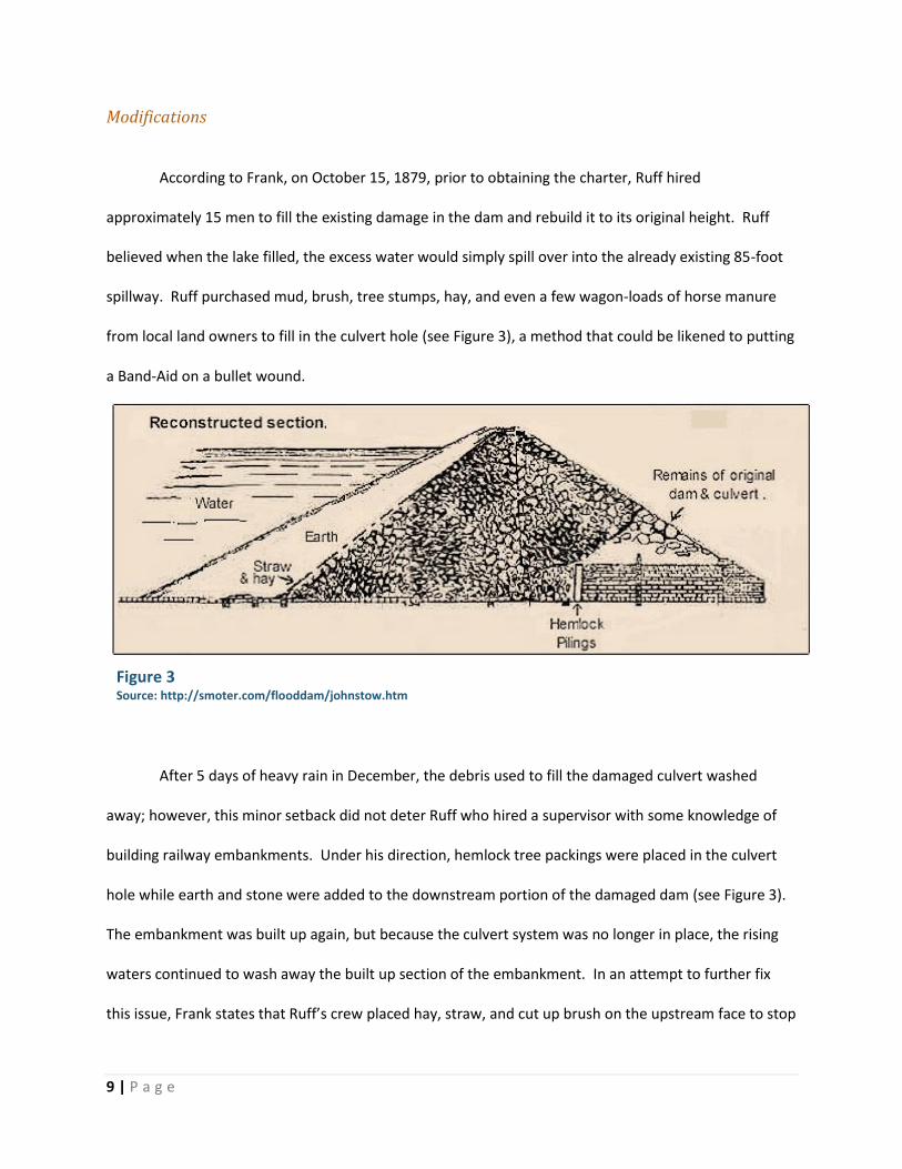
According to Frank, on October 15, 1879, prior to obtaining the charter, Ruff hired
approximately 15 men to fill the existing damage in the dam and rebuild it to its original height. Ruff
believed when the lake filled, the excess water would simply spill over into the already existing 85-foot
spillway. Ruff purchased mud, brush, tree stumps, hay, and even a few wagon-loads of horse manure
from local land owners to fill in the culvert hole (see Figure 3), a method that could be likened to putting
a Band-Aid on a bullet wound.
After 5 days of heavy rain in December, the debris used to fill the damaged culvert washed
away; however, this minor setback did not deter Ruff who hired a supervisor with some knowledge of
building railway embankments. Under his direction, hemlock tree packings were placed in the culvert
hole while earth and stone were added to the downstream portion of the damaged dam (see Figure 3).
The embankment was built up again, but because the culvert system was no longer in place, the rising
waters continued to wash away the built up section of the embankment. In an attempt to further fix
this issue, Frank states that Ruff’s crew placed hay, straw, and cut up brush on the upstream face to stop
Figure 3 Source: http://smoter.com/flooddam/johnstow.htm

10 | P a g e
the seepage of water. Earth and clay were then patched over the straw, hay, and brush to make the
repair “water tight.”
When the repairs and patches to the dam were complete, Ruff’s team set to work on another
project. Because the 85-foot spillway (now working again) blocked access, visitors were unable to reach
the eastern shore of the lake. Ruff’s team built a bridge. The bridge’s foundation was constructed of 14
wooden supports, which were 10 feet high at the entrance to the spillway. Although the spillway had an
average width of 85 feet, one area of it, directly below the bridge supports, was now only 69 feet across.
Ruff assumed that given these
large measurements, the bridge
supports would not affect the
discharge of water (Frank).
The bridge was mostly
flat and approximately 10 feet
wide. Since two carriages could
not pass on the bridge at the same
time, the builders cut the top of
the original dam down by two feet. Although this made the top of the bridge seven feet wider, the two
feet cut from the top of the dam would prove detrimental to the dam’s integrity in the future.
To maximize the fishing potential of the new club, attached to the bridge supports, Ruff’s team
also added iron screens to the spillway. The screens would prevent the escape of any expensive game
fish from the lake (Frank). Although Ruff’s team took time to make modifications to the dam to suit the
new club, they never replaced the two-foot, cast-iron pipes in the dam’s culvert. These pipes were
necessary to drain the reservoir to make future repairs on the dam.
Figure 4 Source: http://smoter.com/flooddam/johnstow.htm

11 | P a g e
With a large, well-stocked lake and beautiful scenery, The South Fork Hunting and Fishing Club
soon became one of the most exceptional summer clubs in Pennsylvania. According to the National
Park Service, Ruff was the chief stockholder and served as the president of the club until he passed away
from cancer in March of 1887. During his tenure, Ruff saw the club grow from 16 to 61 members.
The Dam’s Demise
Neglect Compounded by Wear and Tear
The lake behind the dam filled a seven-mile perimeter and held 20 million tons of water.
Logistically speaking, the repairs Ruff’s team made to the dam should have been able to hold four times
the amount of force the current amount of water placed on the dam; however, this didn’t take into
consideration the wearing away of the dam and lack of repairs going forward. In the years to come, a
few small leaks appeared, but since Ruff’s team never replaced the discharge system, the lake could not
be drained to make the proper repairs. Additionally, during the heavy rain season in the spring, Frank
indicates, “the lake covered over 400 acres and was over seventy feet deep in places.” The increase in
force due to greater water pressure began to weaken the dam, especially in the areas that were already
leaking.
The bridge supports and iron screens put in place to keep the expensive game fish in the lake
and provide a two-carriage bridge took a greater toll on the dam then Ruff’s team originally estimated.
The screens reduced the flow of discharge water by up to 40% and were easily clogged with twigs and
other debris. In addition to the large screens placed on the bridge supports, further screens were later
placed at both ends of the bridge. The bridge itself also obstructed the spillway. The original plans for
the dam by William Morse indicated a spillway depth of at least 10 feet below the crest of the dam;

12 | P a g e
however, Ruff lowered the crest of the dam by 2 feet to allow for a wider bridge. When this was done,
the capacity of the spillway was reduced by 20 percent.
The two feet removed from the top of the dam, the settling of the earth, and the traffic
travelling over the top of the dam caused the center section of the dam to be at least six inches lower
than the edges of the dam. Frank states, “it is not uncommon for the best earth dams to settle,
especially in their centers, the weakest point where the water pressure is the greatest, but with proper
maintenance, they can be built back up.” However, the owners of The South Fork Hunting and Fishing
Club did not take the time or spend the money to make the necessary repairs. Even if they wanted to,
as indicated previously, the absence of a discharge system prevented them from lowering the water
level to make the proper repairs. The slowly decaying inches of the center of the dam and the
increasing force of rising waters were a recipe for disaster.
Rising Waters
The small town of Johnstown and surrounding areas were no strangers to flooding. The Little
Conemaugh and Stoney Creek Rivers ran along the peripheral of town. These two rivers merged to form
the Conemaugh River at the western end of Johnstown. According to the Johnstown Area Heritage
Association, “at least once a year, one or both of the rivers overflowed into the streets sending the
town's residents into a scurry to protect what they could of their homes and belongings.” The majority
of flooding in the area was caused by heavy snows melting too quickly and causing the Stoney Creek or
Conemaugh River to rise. Other flooding was attributed to heavy rainfall throughout the year. On May
28, 1889, 3 days prior to the infamous Johnstown Flood, a storm starting out of Nebraska headed
eastward.

13 | P a g e
On May 30, 1889, the storm hit the Johnstown and South Fork areas. According to Frank, “it
was the worst downpour that had ever been recorded in that section of the country.” An estimated 6 to
10 inches of rain fell within a 24-hour time-span. Throughout the night small creeks overfilled,
becoming raging torrents of water. The Conemaugh River filled well above flood levels. Upstream,
water entered the lake behind the dam at 10,000 cubic feet per minute. Because iron fish screens and
bridge supports obstructed the spillway, only 6,600 cubic feet per minute was carried away from the
dam into the spillway.
Fourteen miles south in Johnstown, residents accustomed to the flooding of the Stoney Creek
and Conemaugh Rivers, were moving their belongings up to higher levels in their homes and bracing
themselves for some flooding. Little did they know the real problem was 14 miles upstream at The
South Fork Hunting and Fishing Club. The situation at the dam was beyond serious. The lake rose over
two feet overnight and, according to Frank, by 7:00 a.m., water was only two and a half feet from the
top of the dam.
Every minute 4,000 cubic feet of water built up in the lake. The lake, which was once 407 acres,
grew to cover 450 acres. Caretakers on the club’s grounds worked frantically to rid the iron screens of
debris to no avail. By 9:00 a.m., the water in the lake was still rising at the rate of one inch every ten
minutes. By 10:00 a.m., the water rose to less than a foot from the top of the dam. On the western side

14 | P a g e
of the dam, workers tried to cut a trench so the water would pool making the channel wider so the
water wouldn’t topple over the dam. The hillside, however, was 175 feet across and the workman were
ill equipped in such a short period of time. They were only able to create a 2-foot wide, 14-inch deep
trench before hitting solid rock.
This rising waters continued to lap onto the center of the dam where reconstruction had
occurred over eight years ago. According to Frank, some of the workers could see where the dam was
“dished a little.” In a last ditch effort, those who dug the trench on the western shore transported the
earth that was dug up and attempted to build up a ridge on the sagging portion of the dam, but it was
too little too late.
At 11:00 a.m., the water level was even with the sagging center of the dam and the earth
workers were throwing on top was being lapped away by waves of water. With the increased volume of
water in the lake, new, smaller leaks on the outside face of the dam sprung. By 11:30 a.m. all of the
newly placed earth was moved away from the water. Water started to spill over the center 50 feet of
the dam.
At 12:30 p.m., the water ran at least six inches over the dam and 300 feet across. The trench
built by the workers widened 25 feet and rose 20 inches in one hour. One hundred and twenty three

15 | P a g e
tons of water per second were spilling over the top of the dam causing further damage to an already
worn embankment. With each spill, more of the earth and rock eroded away and worked itself back
into the lake floor causing the waters to rise even higher.
By 2:00 p.m. the water eroded a large trench into the center of the dam and water flowed freely
from the newly formed hole. At approximately 3:10 p.m. the entire section of the dam repaired by Ruff
and his men “simply moved away” (Frank). Roaring waters rushed through the opening and tore into
the sides of the unprotected original embankment. The gap on both sides was now 100 feet in
diameter. Over 20 million tons of water emptied in 45 minutes (Frank).
According the the Johnstown Area Heritage Association, engineers estimated that the water
“moved into the valley with the force of Niagara Falls, [and] rolled into Johnstown with 14 miles of
accumulated debris, which included houses, barns, animals and people, dead and alive.” Those who saw
the wave coming later described it as a 40 foot, half-mile wide, rolling wall of water.
Conclusion
Official Investigation
In the aftermath of the devastating tragedy, an official investigation was launched. According to
Frank, investigators concluded "the failure was due to the flow of water over the top of the earthen
embankment caused by the insufficiency of the waste-way [spillway] to discharge the flood water."
However, the club members/owners, to the dismay of many, were not held responsible for the
crumbling of the dam. The investigators concluded that all the changes made throughout the lifespan of
the dam did not contribute to its demise. They claimed that even if the dam had not sagged or been cut
down to build the bridge, even if iron screens had not obstructed the spillway, even if the cast-iron pipes
in the culvert had not been removed, water still would have spilled over the top of the dam causing its

16 | P a g e
failure. In saying this, the investigators were placing the blame solely on the original designer, William E.
Morris. They indicated that the original plans for the dam did not take into account the heavy rainfall
levels in the area; therefore, the water would have fallen over the embankment, weakened the dam,
and the flood would have occurred.
Why the Dam Failed
Frank states, “the original specifications and construction of the dam were not as the
investigators believed. The original dam had been designed and constructed in a way that the most
extensive rainfall of the century would not have caused water to cross over the dam.” I cannot speak to
the integrity of the original plans of the dam and whether or not a large rainfall would have caused
water to spill over the embankment; however, given all of the information above, I do not believe the
dam would have failed if it was properly refurbished and maintained throughout the years.
According to Woodward, the over-topping of embankment dams due to inadequate spillway is
one of the most common reasons embankment dams fail. Woodward adds that the failure “…has
nothing to do with the geology of the dam site. Any embankment dam will fail if the spillway is too small
and flood waters rise high enough…” In other words, regardless of how well the dam was built, if an
adequate spillway is not maintained to control flooding, even the best built dams are doomed for
failure.
Specifically, I believe the actions and failures of Benjamin Ruff are squarely to blame for the
failed dam. In both the actions taken, and the actions he failed to take (see Figure 4 below), Ruff did not
maintain the integrity of the original plans for the dam. He lowered the embankment of the dam by at
least two feet and added a bridge, which allowed traffic to pack the earth tighter than if it settled on its
own. He added iron screens causing less water to filter to the spillway. He failed to replace the cast-

17 | P a g e
iron pipes in the culvert, which was the main “plumbing” system of the entire dam. If the cast-iron pipes
were replaced, not only could the water level be lowered throughout the dam’s life to mend and repair
weaknesses, but on the day of the tragedy, workers could have siphoned more water into the spillway.
This could have prevented the water from rising high enough to spill over and weaken the center of the
embankment. If the center of the embankment did not wash away, then the flood would not have
occurred.
Ruff should have:
Replaced the cast-iron pipes in the culvert
Made the center, sagging section of the
dam stronger
Ruff shouldn't have:
Trimmed the center of the dam down by 2
feet to add a bridge
Added iron screens to prevent the escape of
game fish
Figure 5

18 | P a g e
Appendix
Facts about the Johnstown Flood
Frequently Asked Questions
For answers to some of the most frequently
asked questions regarding the flood, visit
http://www.nps.gov/jofl/faqs.htm
To find out more information about the
Johnstown flood and the impact it had on
the citizens of Johnstown, PA, please visit
http://www.jaha.org/FloodMuseum/facts.htm
l

19 | P a g e
Newspaper Articles
Johnstown, PA June 1889 Main Street, Looking west. The New York Times Photo Archine.
Survivor Stories
To view articles written in newspapers all over
the country after the tragedy visit:
http://www.johnstownpa.com/History/hist30.html
To read stories about the amazing survivors of
the flood you can visit:
http://www.jaha.org/FloodMuseum/survivors.html

20 | P a g e
Remembering the Johnstown Flood
To see how the Johnstown Flood was
memorialized then and now click on the link
below:
http://www.jaha.org/FloodMuseum/survivors.html

21 | P a g e
References
Frank, Walter Smoter. The Cause of the Johnstown Flood: A New Look at the Historic Johnstown Flood.
2004. http://smoter.com/flooddam/johnstow.htm (accessed June 2012).
Johnstown Area Heritage Association. 2012. http://www.jaha.org/FloodMuseum/facts.html (accessed
June 2012).
National Park Service. April 2012. http://www.nps.gov/jofl/faqs.htm (accessed June 2012).
Woodward, Richard. The Dam Site. 2004-2005.
http://members.optusnet.com.au/~engineeringgeologist/page18.html (accessed June 2012).