south carolina water planning…. planning for which...
TRANSCRIPT

South Carolina Water Planning….Planning for Which Drought?
Scott HarderLand, Water and Conservation DivisionS.C. Department of Natural Resources
Climate Connections WorkshopGreenville, South Carolina
December 12, 2017
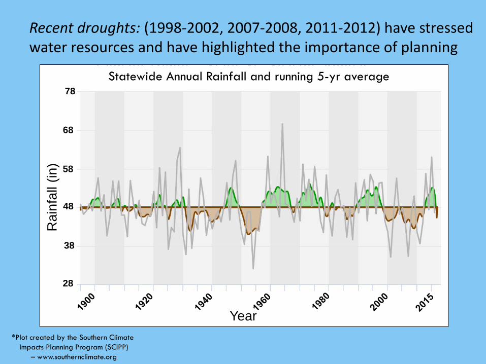
Statewide Annual Rainfall and running 5-yr average
Rai
nfal
l (in
)
78
68
38
48
58
28
Year*Plot created by the Southern Climate
Impacts Planning Program (SCIPP)– www.southernclimate.org
Recent droughts: (1998-2002, 2007-2008, 2011-2012) have stressed water resources and have highlighted the importance of planning

Why Water Planning?• Population Growth – State population forecasted to increase
by approximately 18% by 2030• Increased water demand
Historic
Projected
Source: U.S. Census Data, SC Department of Revenue and Fiscal Affairs
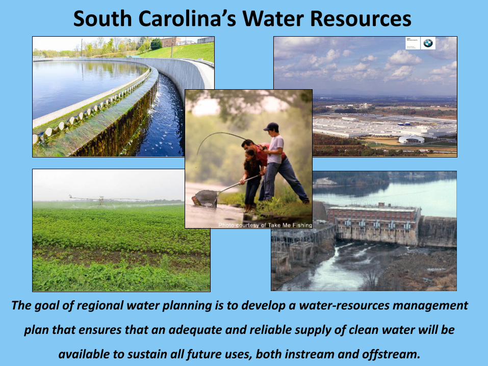
South Carolina’s Water Resources
The goal of regional water planning is to develop a water-resources management
plan that ensures that an adequate and reliable supply of clean water will be
available to sustain all future uses, both instream and offstream.

2004
• First Edition published in 1998
• In 2004, DNR published the second edition of the South Carolina Water Plan incorporating lessons learned from the drought of 1998-2002.
• One recommendation was for the development of regional water plans for each major river basin in the State.
• 10 years later – SCDNR and SCDHEC initiated the first step towards these regional water plans.
A Brief History of Water Planning…

Regional Planning for South Carolina’s eight major river basins…
Models will be developed for each of these basins, the
same basins used by DHEC for water-quality assessments
and for managing interbasin transfers of water.

Surface Water
Availability Assessment
Ground Water
Availability Assessment
Water Demand Forecasts
RegionalWaterPlans
State WaterPlan
Steps involved in developing regional water plans and updating the State Water Plan…
“The effective management of South Carolina’s water resources is beyond the scope of any one agency or organization and will require cooperation and shared
responsibility among federal, state, and local agencies, as well
as public and private parties.”
South Carolina Water Plan (2004)
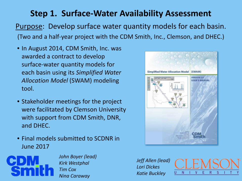
• In August 2014, CDM Smith, Inc. was awarded a contract to develop surface-water quantity models for each basin using its Simplified Water Allocation Model (SWAM) modeling tool.
• Stakeholder meetings for the project were facilitated by Clemson University with support from CDM Smith, DNR, and DHEC.
• Final models submitted to SCDNR in June 2017
Step 1. Surface-Water Availability Assessment
Jeff Allen (lead)Lori Dickes Katie Buckley
John Boyer (lead)Kirk WestphalTim CoxNina Caraway
Purpose: Develop surface water quantity models for each basin.(Two and a half-year project with the CDM Smith, Inc., Clemson, and DHEC.)

Technical Advisory Committee
Ruth Albright Synterra CorporationEd Bruce Duke EnergyAndy Fairey Charleston Water SystemEric Krueger The Nature ConservancyJulie Metts Santee CooperHeather Nix Upstate ForeverK.C. Price Spartanburg WaterMullen Taylor Mullen Taylor, LLCEddie Twilley Twilley, Fondren & AssociatesHarrison Watson WestRockCharles Wingard Walter P. Rawls and Sons, Inc.
Industry • Public Supply • Agriculture• Energy • Environment • Legal
Stakeholder Meetings• Two stakeholder meetings per basin• Facilitated by Clemson University
www.scwatermodels.com
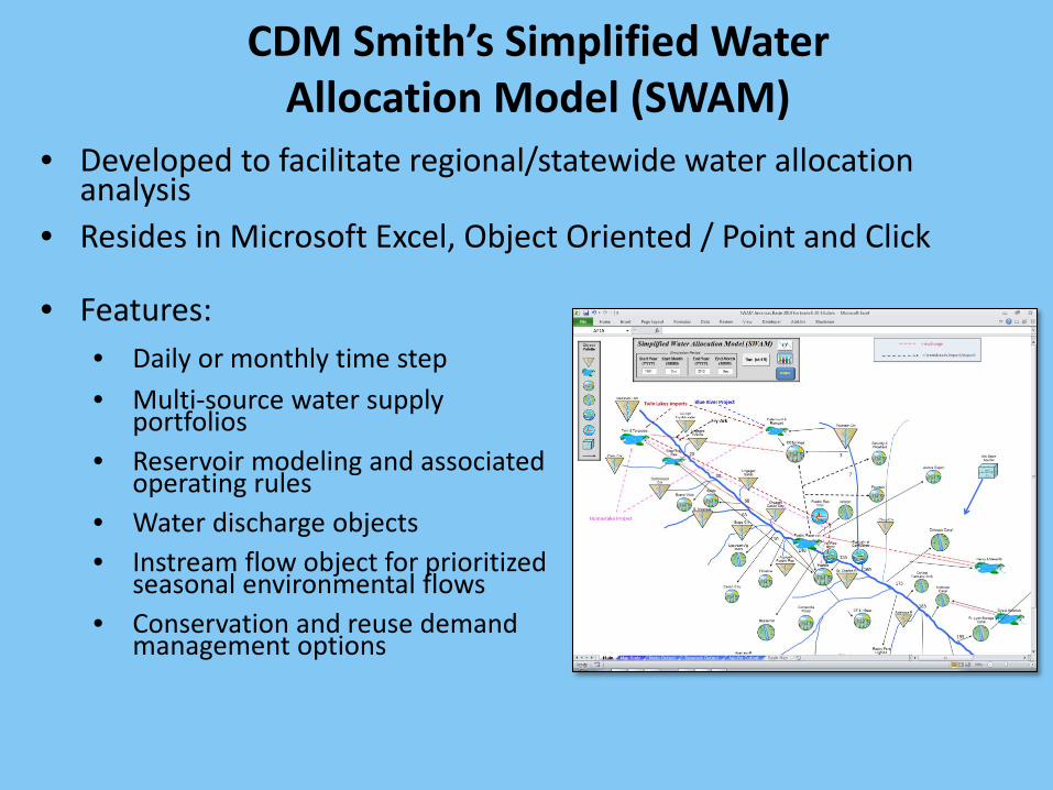
CDM Smith’s Simplified WaterAllocation Model (SWAM)
• Developed to facilitate regional/statewide water allocation analysis
• Resides in Microsoft Excel, Object Oriented / Point and Click
• Features: • Daily or monthly time step• Multi-source water supply
portfolios • Reservoir modeling and associated
operating rules• Water discharge objects• Instream flow object for prioritized
seasonal environmental flows• Conservation and reuse demand
management options

Types of Water Quantity Models
Precipitation-Runoff ModelsConvert rainfall volume into runoff• Example: HEC-HMS
Hydraulic ModelsCharacterize the flow and routing of water in the river system• Example: HEC-RAS
Water Allocation ModelsCalculate legally and/or physically available water in a river system• Examples: OASIS, CHEOPS, RiverWare and SWAM
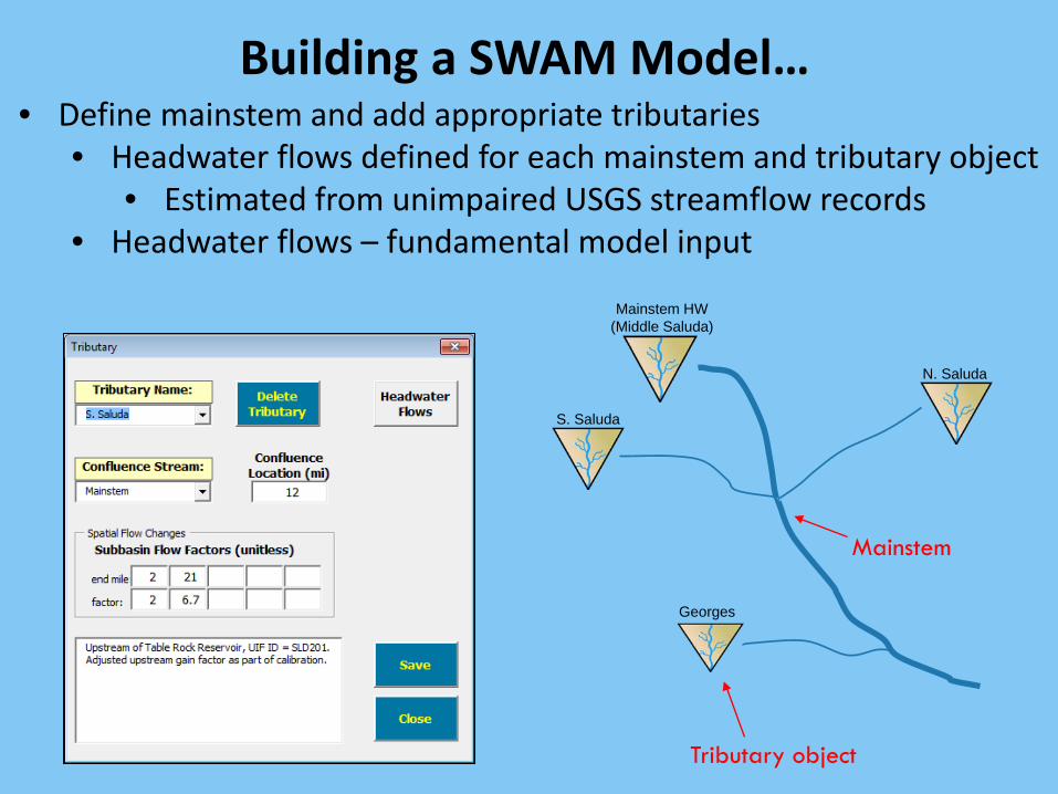
Building a SWAM Model…• Define mainstem and add appropriate tributaries
• Headwater flows defined for each mainstem and tributary object• Estimated from unimpaired USGS streamflow records
• Headwater flows – fundamental model input
Mainstem
Mainstem HW (Middle Saluda)
N. Saluda
S. Saluda
Georges Crk
Tributary object
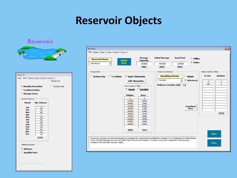
Reservoir
Reservoir Objects

Water Use Objects – Water Supply, Industry, Irrigation, Golf Course, and Energy
PT:SCE&G
WS:Greenville
GC:Cliffs Club
MI: Vulcan
IR:Titan

Discharge ObjectsIng Rand
Instream Flow ObjectsInstream Flow

Model Schematic – Saluda Basin
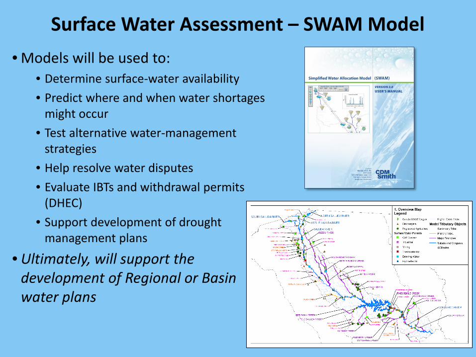
Surface Water Assessment – SWAM Model• Models will be used to:
• Determine surface-water availability• Predict where and when water shortages
might occur• Test alternative water-management
strategies• Help resolve water disputes• Evaluate IBTs and withdrawal permits
(DHEC)• Support development of drought
management plans
• Ultimately, will support the development of Regional or Basin water plans

On the Web at DNRhttp://www.dnr.sc.gov/water/waterplan/surfacewater.html
Monthly Progress Reports
Legislative Quarterly Reports
Technical Reports
Technical Memorandums
Meeting Notes
Presentations
Videos
River BasinsBroadEdistoSalkehatchie SalSantee
Challenges of SC Basin-Scale Modeling• Each basin has a unique set of hydrologic characteristics
• Reservoir dominated (Catawba, Savannah) versus “freely flowing” (Edisto, Salkehatchie)
• Differences in runoff and baseflow characteristics between basins and within a basin
“One size fits all” modeling approach may not be appropriate for SC – May need to explore other models or tools in some basins to supplement the SWAM model
• Share four basins with other two other States (GA, NC)
• Lack of streamflow gaging stations and/or lack of stations with long periods of record also poses challenges
• Very aggressive schedule for completion of the SWAM models.• SCDNR and SCDHEC Hydrologists are reviewing and “fine-tuning” several of
the models
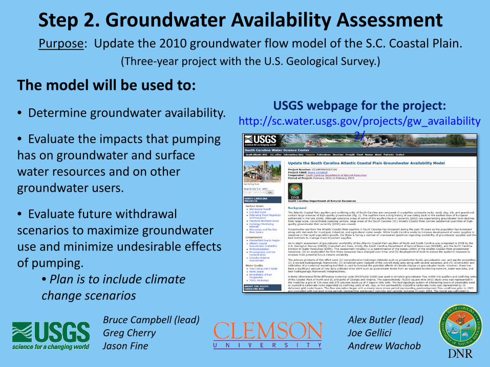
Bruce Campbell (lead) Alex Butler (lead)Greg Cherry Joe GelliciJason Fine Andrew Wachob
USGS webpage for the project:http://sc.water.usgs.gov/projects/gw_availability
2/
Step 2. Groundwater Availability AssessmentPurpose: Update the 2010 groundwater flow model of the S.C. Coastal Plain.
(Three-year project with the U.S. Geological Survey.)
The model will be used to:
• Determine groundwater availability.
• Evaluate the impacts that pumping has on groundwater and surface water resources and on other groundwater users.
• Evaluate future withdrawal scenarios to maximize groundwater use and minimize undesirable effects of pumping.
• Plan is to include climate change scenarios
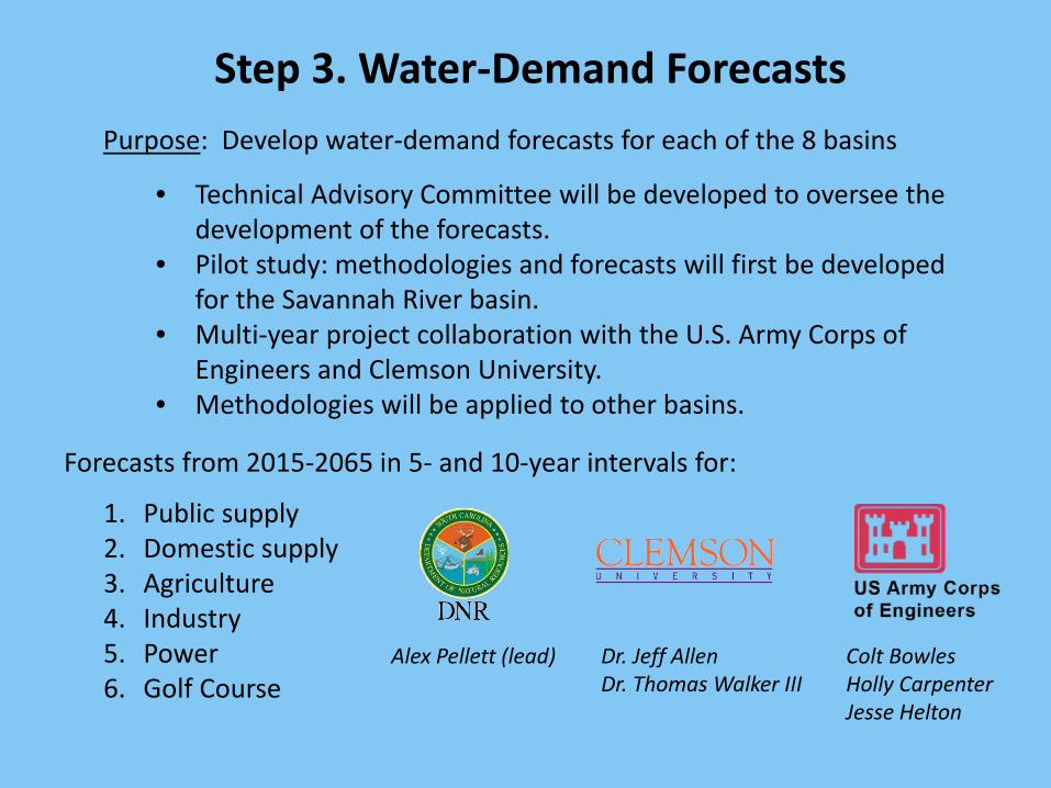
Forecasts from 2015-2065 in 5- and 10-year intervals for:
1. Public supply2. Domestic supply3. Agriculture4. Industry5. Power6. Golf Course
Alex Pellett (lead)
Step 3. Water-Demand ForecastsPurpose: Develop water-demand forecasts for each of the 8 basins
• Technical Advisory Committee will be developed to oversee the development of the forecasts.
• Pilot study: methodologies and forecasts will first be developed for the Savannah River basin.
• Multi-year project collaboration with the U.S. Army Corps of Engineers and Clemson University.
• Methodologies will be applied to other basins.
Dr. Jeff AllenDr. Thomas Walker III
Colt BowlesHolly CarpenterJesse Helton
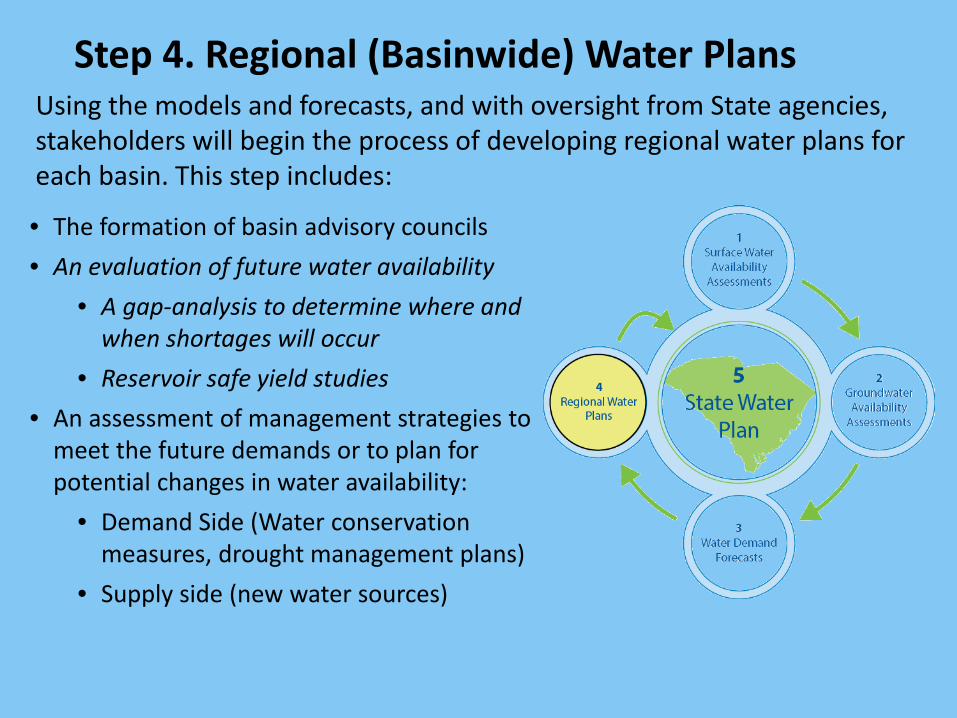
Step 4. Regional (Basinwide) Water PlansUsing the models and forecasts, and with oversight from State agencies, stakeholders will begin the process of developing regional water plans for each basin. This step includes:
• The formation of basin advisory councils• An evaluation of future water availability
• A gap-analysis to determine where and when shortages will occur
• Reservoir safe yield studies• An assessment of management strategies to
meet the future demands or to plan for potential changes in water availability:
• Demand Side (Water conservation measures, drought management plans)
• Supply side (new water sources)

Upon completion of the regional water plans, the State water plan will be updated by DNR.
• Assess the overall condition of water resources in the State
• Evaluate statewide trends in water use and availability
• Offer water-resource policy and program recommendations
• Introduce innovative practices
Step 5. Update the State Water Plan
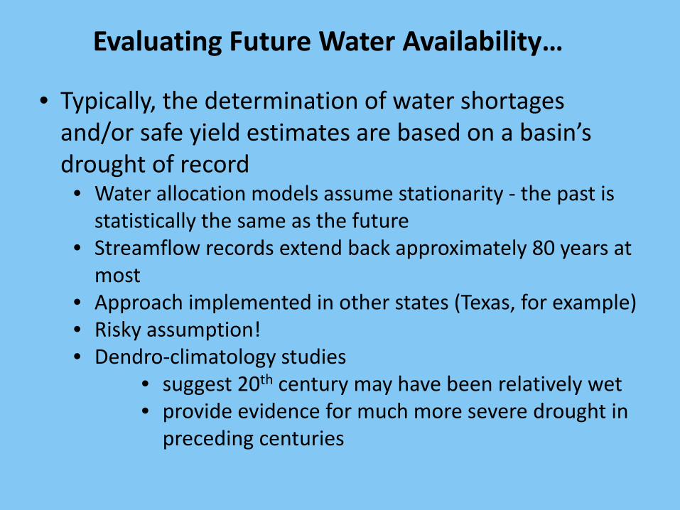
Evaluating Future Water Availability…
• Typically, the determination of water shortages and/or safe yield estimates are based on a basin’s drought of record
• Water allocation models assume stationarity - the past is statistically the same as the future
• Streamflow records extend back approximately 80 years at most
• Approach implemented in other states (Texas, for example)• Risky assumption!• Dendro-climatology studies
• suggest 20th century may have been relatively wet• provide evidence for much more severe drought in
preceding centuries
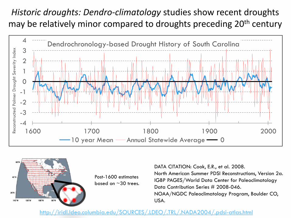
DATA CITATION: Cook, E.R., et al. 2008.North American Summer PDSI Reconstructions, Version 2a. IGBP PAGES/World Data Center for Paleoclimatology Data Contribution Series # 2008-046.NOAA/NGDC Paleoclimatology Program, Boulder CO, USA.
http://iridl.ldeo.columbia.edu/SOURCES/.LDEO/.TRL/.NADA2004/.pdsi-atlas.html
Post-1600 estimatesbased on ~30 trees.
NW
NE
S
-4-3-2-101234
1600 1700 1800 1900 2000Reco
nstr
ucte
d Pa
lmer
Dro
ught
Sev
erity
Inde
x
Dendrochronology-based Drought History of South Carolina
10 year Mean Annual Statewide Average 0
Historic droughts: Dendro-climatology studies show recent droughts may be relatively minor compared to droughts preceding 20th century
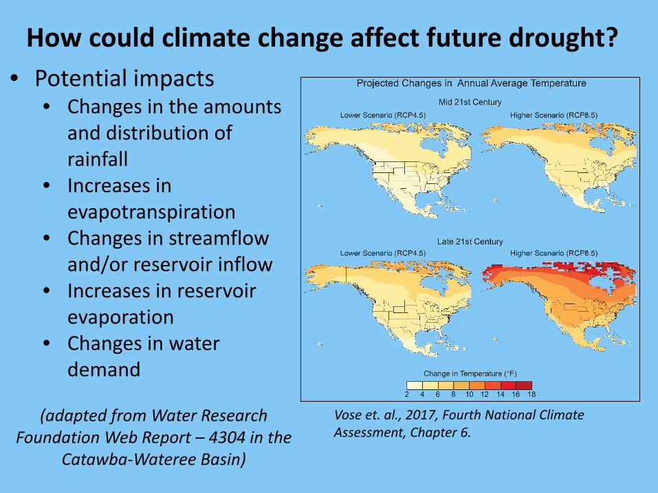
• Potential impacts• Changes in the amounts
and distribution of rainfall
• Increases in evapotranspiration
• Changes in streamflow and/or reservoir inflow
• Increases in reservoir evaporation
• Changes in water demand
(adapted from Water Research Foundation Web Report – 4304 in the
Catawba-Wateree Basin)
How could climate change affect future drought?
Vose et. al., 2017, Fourth National Climate Assessment, Chapter 6.
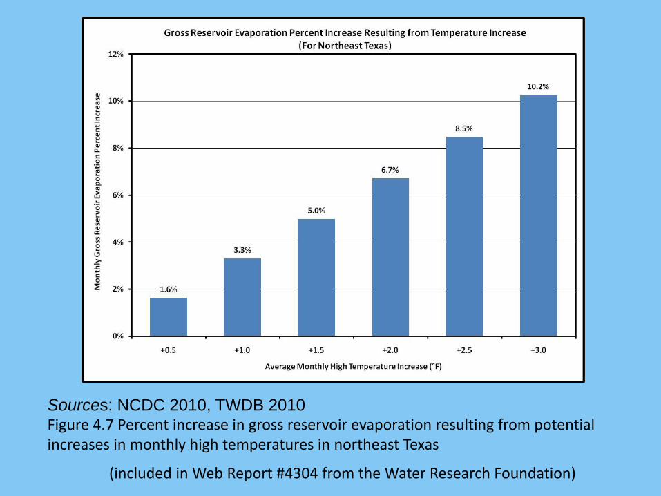
Sources: NCDC 2010, TWDB 2010Figure 4.7 Percent increase in gross reservoir evaporation resulting from potential increases in monthly high temperatures in northeast Texas
(included in Web Report #4304 from the Water Research Foundation)

Considerations for incorporating potential drought scenarios into South Carolina water planning ….
• Should climate change scenarios be included in the water planning process?
• Downscaled global climate models provide temperature and rainfall information:
• SW Models • Require evaporation and streamflow inputs - what are appropriate
methods to convert changes in temperature and rainfall into changes in evaporation and streamflows?
• Application may more applicable to basins with reservoirs• GW Models
• Recharge module uses direct inputs of rainfall and temperature,• USGS has plans to incorporate some climate change scenarios
• Which climate models and emission scenarios are appropriate?
• Alternatively, can dendro-climatology information be used in our existing assessments to simulate historic droughts?
• Are there existing studies in the State that address these questions?
• Water Research Foundation Web Report #4304, 2013, “Defining and Enhancing the Safe Yield of a Multi-Use , Multi-Reservoir Water Supply” – Catawba-Wateree River Basin
• Other Studies?
Addressing these questions is beyond the scope of one agency/institution and will require a collaborative
effort among multiple organizations!
Considerations for incorporating potential drought scenarios into South Carolina Water planning ….

References:
Pederson N. et. Al., 2012, A long-term perspective on a modern drought in the American Southeast, Environ. Res. Lett. 7 (2012), 8 p.
Cook, E.R., Meko, D.M., Stahle, D.W. and Cleaveland, M.K. 1999. Drought reconstructions for the continental United States.Journal of Climate, 12:1145-1162See also - http://www.ncdc.noaa.gov/paleo/pdsi.html