south bay salt ponds restoration project, phase 2 … 1... · south bay salt pond restoration...
TRANSCRIPT
South Bay Salt Pond Restoration Project Phase 2 July 2015
Draft Environmental Impact Statement/Report 3.11-1
Traffic 3.11
This section of the Draft Environmental Impact Statement/Report (referred to throughout as the Draft EIS/R) describes the existing regional transportation network within the Phase 2 project area and analyzes whether implementation of the project would cause a substantial adverse effect on transportation resources. The information presented is based on a review of the existing regional transportation network within the area and other pertinent federal, state and local regulations, which are presented in the regulatory framework setting section. Using this information as context, an analysis of transportation-related environmental impacts of the project is presented for each alternative. The program-level mitigation measures described in Chapter 2, Alternatives, would be implemented with the project. Therefore, this section only includes additional, project-level mitigation measures as needed.
3.11.1 Physical Setting
Methodology
The development of the baseline conditions, significance criteria, and impact analysis in this section is commensurate to and reliant on the analysis conducted in the 2007 South Bay Salt Pond Restoration EIS/R (2007 EIS/R) for the SBSP Restoration Project. The project traffic impact analysis is based on the traffic volumes identified by the California Department of Transportation (Caltrans) and local jurisdictions. Construction period project traffic impact analysis is based on the traffic volumes and significance criteria identified in the Traffic Impact Study for South Bay Salt Pond Restoration - Phase 2 Project (URS 2014), which is presented as Appendix G to this Draft EIS/R.
Regional Setting
The area of Phase 2 of the SBSP Restoration Project consists of ponds on the southern shores of San Francisco Bay in the vicinity of Fremont in Alameda County, in the vicinity of San Jose and Mountain View in Santa Clara County, and in the vicinity of Menlo Park in San Mateo County (Figure 3.11-1). The transportation network in and around the southern end of San Francisco Bay consists of highways, surface streets, bicycle routes, public transit, railways, and air transportation facilities.
Highways
The major north-south trending highways in the South Bay include U.S. Highway 101 (U.S. 101), Interstate (I-) 280, I-680, and I-880, as described below.
U.S. 101 extends south from Washington, Oregon, and Northern California through the San Francisco Bay Area and further south to Los Angeles. U.S. 101 is located on the western side of San Francisco Bay, immediately west of the Ravenswood and Alviso-Mountain View pond clusters, and extends through the cities of Redwood City, Menlo Park, Palo Alto, Mountain View, Sunnyvale, and San Jose, among many others.
I-280 originates in San Francisco and extends south through the city of San Jose, where it connects to I-680. I-280 is located on the western side of San Francisco Bay, west of the Phase 2 project area. The highway and travels through the cities of Menlo Park, Palo Alto, and Los Altos, among many others.
3.11 Traffic
South Bay Salt Pond Restoration Project Phase 2 July 2015
Draft Environmental Impact Statement/Report 3.11-2
I-680 originates in the North Bay, north of the city of Vallejo, and extends south until it connects with I-280 in San Jose. I-680 is located on the eastern side of San Francisco Bay, east of the , Phase 2 project area, and travels through the cities of Fremont and Milpitas, among many others.
I-880 extends along the eastern side of the Bay and connects I-80 in Oakland to State Route (SR) 17 in San Jose. I-880 is located east of the Alviso-Island Ponds, which are in the Phase 2 area of the SBSP Restoration Project, and travels through the cities of Fremont and Milpitas, among many others.
The major east-west trending highways in the South Bay include State Route (SR) 84 and SR 237, as described below.
SR 84, which originates in the East Bay and crosses the San Francisco Bay via the Dumbarton Bridge, is located directly south of the Ravenswood pond cluster (also referred to as the Ravenswood Ponds) in the Phase 2 area of the SBSP Restoration Project.
SR 237, which originates from I-680 in Milpitas and extends south of San Francisco Bay until it connects with SR 85 in Sunnyvale, is immediately south of the Alviso-A8 Ponds (also referred to as the A8 Ponds) in the Phase 2 area of the SBSP Restoration Project.
Streets and Bicycle Routes
Within each individual jurisdiction in Phase 2, the street network consists of arterial streets, collector streets, and local streets. Typically, arterial streets are high-capacity roads that accommodate through traffic between highways and urban centers. Collector streets supplement the arterial streets and provide access within residential neighborhoods and commercial and industrial areas. Local streets offer the lowest level of mobility and primarily provide access to bordering properties. Local streets are designed such that ease of access, pedestrian safety, and parking have priority over traffic movement. The street network in the vicinity of the project area is shown on Figure 3.11-1.
Many designated trails and bicycle routes are present nearby or adjacent to the project area. Bicycle routes are classified as separated off-street paths for the exclusive use of bicycles and pedestrians (Class I), striped bike lanes on a street or highway (Class II), or designated signed routes without a marked lane operating in mixed flow with motor vehicles (Class III). Bicycles may also operate legally on any roadway, regardless of whether a bike route class designation exists. Trails include the Bay Trail, which travels the entire perimeter of the San Francisco Bay; and trails at Bedwell Bayfront Park, Mountain View Shoreline Park, Sunnyvale Baylands Park, and Don Edwards San Francisco Bay National Wildlife Refuge (Refuge). See Section 3.6, Recreation for more detailed information.
Public Transit
The public transit network in the region consists of rail and bus systems. Bay Area Rapid Transit (BART) provides service to the East Bay city of Fremont, east of the Alviso-Island Ponds. BART does not currently provide service to the area of Phase 2 in the South Bay or San Francisco Peninsula; however, a BART extension from Fremont to San Jose has been approved. The Union Pacific Railroad (UPRR) network extends through the region on both sides of the Bay and provides both freight and passenger service. Amtrak's Capitol Corridor route provides intercity rail passenger service between Sacramento and San Jose. Caltrain provides commuter rail service between San Francisco and San Jose.

3.11 Traffic
South Bay Salt Pond Restoration Project Phase 2 July 2015
Draft Environmental Impact Statement/Report 3.11-3
Figure 3.11-1. Transportation Network

3.11 Traffic
South Bay Salt Pond Restoration Project Phase 2 July 2015
Draft Environmental Impact Statement/Report 3.11-4
Santa Clara Valley Transportation Authority (VTA) operates buses and light rail that serve the urbanized portions of Santa Clara County. Alameda-Contra Costa Transit District (AC Transit) provides service throughout the East Bay as well as express service across the Dumbarton Bridge and Bay Bridge to San Francisco. San Mateo County Transit District (SamTrans) provides bus service throughout San Mateo County and into parts of San Francisco and Palo Alto. Caltrain provides shuttle service between Caltrain stations and various locations in the South Bay.
Water Transportation
San Francisco Bay is a major navigational and recreational waterbody that connects the Phase 2 ponds via watercraft. Currently, there are no public ferry routes in the South San Francisco Bay. A new ferry route is proposed between San Francisco and Redwood City; however, the project is currently in preliminary stages and is not considered a high priority for the Water Emergency Transportation Authority (City of Redwood City 2013).
Public Parking Facilities
As described in the 2007 EIS/R, public parking is available near the publicly accessible portions of the project area. Table 3.11-1 presents an inventory of the off-street parking, including handicapped parking.
Table 3.11-1 Off-Street Parking near the Phase 2 Areas of the SBSP Restoration Project LOCATION* NUMBER OF SPACES OWNER
Bedwell Bayfront Park 30 (4h) City of Menlo Park
Dumbarton Bridge, western approach, north side Approx. 35 (2h) Caltrans
Dumbarton Bridge, western approach, south side Approx. 35 (2h) Caltrans
Mountain View Shoreline Park 166 (4h) City of Mountain View
Shoreline Amphitheater Overflow > 200 City of Mountain View
Sunnyvale Water Pollution Control Plant, Carl Road Approx. 15 City of Sunnyvale
Sunnyvale Baylands Park > 200 City of Sunnyvale
Alviso Marina County Park 107 (at least 2h) Santa Clara County Parks and Recreation
Refuge Environmental Education Center 42 (4h) United States Fish and Wildlife Service (USFWS)
Notes: h = handicapped parking spaces; > = greater than *There is no land-based public access to the Alviso-Island Ponds; therefore, there are no parking facilities.
Project Setting
Alviso – Island Ponds
The Alviso-Island Ponds, also referred to as the Island Ponds (Ponds A19, A20, and A21), are located between Coyote Creek and Mud Slough near the eastern end of the Alviso pond complex, in the city of Fremont. Interstate 880 is located approximately 1 mile to the east of the Island Ponds. According to the
3.11 Traffic
South Bay Salt Pond Restoration Project Phase 2 July 2015
Draft Environmental Impact Statement/Report 3.11-5
Caltrans Traffic Data Branch, traffic volumes in 2013 for I-880 between SR 262 and Dixon Landing Road were 15,600 peak hour trips (Caltrans 2014).
The northeastern tip of Pond A19 has very limited service access via a service road along the eastern edge of the levee on Pond A23, from Landing Road via Fremont Boulevard or Warren Avenue. Fremont Boulevard and Warren Avenue are accessed from I-880. There is no public access to the Island Ponds beyond this point, and there is no public transit to the Island Ponds. AC Transit bus route 215 travels along Fremont Boulevard, the closest roadway to the Island Ponds (AC Transit 2012). The Fremont BART station is approximately 6 miles to the northeast, and the UPRR crosses the Island Ponds between Ponds A20 and A21 past the historic town of Drawbridge, but does not provide direct access to Refuge lands.
The closest airport to the Island Ponds is San Jose International Airport located approximately 6 miles to the southwest.
Alviso – Mountain View Ponds
The Alviso – Mountain View pond cluster (Ponds A1 and A2W and Charleston Slough) are on the western edge of the Alviso pond complex. The City of Mountain View lies immediately to the south, and the Palo Alto Flood Control Basin lie to the west. U.S. 101 is approximately 0.5 miles southwest of the Mountain View Ponds. In 2013, traffic volumes for U.S. 101 between Embarcadero Road/Oregon Expressway and San Antonio Road were 16,600 peak hour trips (Caltrans 2014).
There is no public vehicle access at Ponds A1 and A2W. Levee roads at the perimeter of the ponds are accessible by USFWS service vehicles for operations and maintenance activities on the levees and by Pacific Gas and Electric Company (PG&E) for its access to the power lines and towers in and around Pond A2W. Bicycle and pedestrian access to the southern perimeter of Ponds A1 and A2W is available from public trails (including the Bay Trail) at Mountain View Shoreline Park, accessed either from San Antonio Road or Shoreline Boulevard from U.S. 101.
There is no public transit directly to the Mountain View Ponds; however, VTA bus routes 40 and 120 travel along Charleston Road at the southernmost extent of Mountain View Shoreline Park (VTA 2013).
The closest airport to the Mountain View Ponds is San Jose International Airport located approximately 10 miles to the southeast.
Alviso – A8 Ponds
The A8 Ponds (Ponds A8 and A8S) are located in the southern central portion of the Alviso pond complex. They are west of the community of Alviso and north of Sunnyvale. SR 237 is approximately 0.5 mile south of Pond A8S. In 2013, traffic volumes for SR 237 between North First Street and Great America Parkway were 11,000 peak hour trips (Caltrans 2014).
Vehicle access to the western and southern perimeter of the A8 Ponds is available from an access road via Gold Street, though there are no public parking facilities or recreation-based amenities there. Gold Street is accessed from Great America Parkway from SR 237. There is no public vehicle access allowed along the levees surrounding these ponds. Bicycle and pedestrian access to trails near the south perimeter of the A8 Ponds (including parts of the Bay Trail) is available from Sunnyvale Baylands Community Park via East Caribbean Drive.
3.11 Traffic
South Bay Salt Pond Restoration Project Phase 2 July 2015
Draft Environmental Impact Statement/Report 3.11-6
Several VTA bus routes travel near the A8 Ponds. Routes 120, 122, 321, and 328 travel along East Caribbean Drive, and Route 58 travels to the town of Alviso. In addition, there are two VTA light rail stations – Crossman Station and Borregas Station – less than 1.5 miles southwest of the ponds (VTA 2013).
The closest airport to the A8 Ponds is San Jose International Airport, which is located approximately 12 miles to the south.
Ravenswood Ponds
The Ravenswood Ponds (Ponds R3, R4, R5 and S5) are on the Peninsula side of the Bay, west of the Dumbarton Bridge, and adjacent to the City of Menlo Park in San Mateo County. Bedwell Bayfront Park in Menlo Park is directly west of the Ravenswood Ponds, and a portion of SR 84 is along its southern border. U.S. 101 is approximately 0.5 miles southwest of the Ravenswood Ponds. In 2013, the traffic volume for SR 84 between University Avenue (SR 109) and Willow Road (SR 114) was 56,000 peak hour trips. The traffic volume for U.S. 101 between Willow Road (SR 114) and Marsh Road (SR 84 junction) was 15,600 peak hour trips (Caltrans 2014).
There is no public vehicle access at the Ravenswood Ponds, and there are no public trails within the Refuge itself. However, bicycle and pedestrian access to the western perimeter of the Ravenswood Ponds is available from public trails at the adjacent Bedwell Bayfront Park, and to the southern perimeter from the Bay Trail. Both the Bay Trail and Bedwell Bayfront Park are accessible from U.S. 101 and SR 84 via Marsh Road. Levee roads around the ponds themselves are accessible only to service vehicles for operations and maintenance activities.
There is limited public transit to the Ravenswood Ponds. The Caltrain Marsh Road shuttle travels from the Menlo Park Caltrain Station to the intersection of SR 84 and Marsh Road (Caltrain 2013). The Dumbarton Express, run by a consortium of transit agencies and administered by AC Transit, runs in both directions across the Dumbarton Bridge and passes just south of the Ravenswood Ponds on SR 84. The Menlo Park Caltrain Station is approximately 2 miles to the southwest.
The closest airport to the Ravenswood Ponds is the San Francisco International Airport, which is located approximately 21 miles to the northwest.
3.11.2 Regulatory Setting
State, regional, and local agencies have jurisdiction over the transportation network and over circulation in and around the project area. Caltrans has authority over the state highway system, including mainline facilities and interchanges. Caltrans is responsible for the planning, design, and construction of highway improvements, as well as for operations and maintenance.
San Mateo County Transportation Authority (SMCTA), VTA, and Alameda County Transportation Commission (Alameda CTC) are responsible for county-wide transportation planning. This includes highway and roadway improvements and the operation of public transit systems, shuttles, and carpool, bicycling and pedestrian programs. In addition, these agencies are responsible for long-range regional transportation planning in coordination with the Metropolitan Transportation Commission (MTC).
3.11 Traffic
South Bay Salt Pond Restoration Project Phase 2 July 2015
Draft Environmental Impact Statement/Report 3.11-7
San Mateo County, Santa Clara County, and Alameda County are responsible for the maintenance of roadways in unincorporated areas of the counties as well as for coordination with SMCTA, VTA, and Alameda CTC, respectively, for regional transportation planning projects.
Individual cities and towns in the project area have jurisdiction over their respective city streets, bike paths, public trails, and parking facilities.
Several counties and cities near the pond clusters have adopted General Plans that include strategies and policies regarding the operation of the transportation network. The General Plans and applicable goals and policies are included below.
Santa Clara County
The Santa Clara County General Plan (1994) identifies four strategies to improve the adequacy of the overall transportation system. The four strategies are: 1) Develop Urban Land Use Patterns that Support Travel Alternatives; 2) Manage Travel Demand, System Efficiency, and Congestion; 3) Expand System Capacity and Improve System Integration; and 4) Support New Transportation Technologies. The plan includes the following goals that are relevant to Phase 2 of the SBSP Restoration Project:
Policy C-TR 12: It is the goal of this plan to achieve a level-of-service (LOS) no lower than D at peak travel periods on city streets, county roads, expressways and state highways. However, in certain instances, a lower level-of-service may be acceptable when LOS D cannot practically be achieved.
Policy C-TR 34: Bicycling and walking should be encouraged and facilitated as energy conserving, non-polluting alternatives to automobile travel.
Policy C-TR 35: A bicycle transit system should be provided that is safe and convenient for the user and which will provide for the travel needs of bicyclists.
San Mateo County
The San Mateo County General Plan (1986) includes the following transportation goals and objectives that are relevant to the SBSP Restoration Project, Phase 2:
12.18 Recreational Traffic to the Coastside: Seek methods to mitigate the impact of peak recreational traffic to and along the Coastside.
12.19 Circulation East of Highway 101: Encourage the cities and CalTrans to develop an adequate circulation system, including bikeways, and other context-sensitive design features to serve all transportation users and new development east of Highway 101 and which, to the maximum extent feasible, does not adversely affect baylands or wetlands.
12.21 Local Circulation Policies: In unincorporated communities, plan for providing: routes for truck traffic that avoid residential areas and are structurally designed to accommodate trucks.
Fremont
The City of Fremont General Plan (2011) includes the following policies that are relevant to the SBSP Restoration Project, Phase 2:
3.11 Traffic
South Bay Salt Pond Restoration Project Phase 2 July 2015
Draft Environmental Impact Statement/Report 3.11-8
Policy 3-3.4 Transportation Systems Management: Implement transportation systems management measures to reduce peak hour congestion and make the most efficient use of the city’s transportation infrastructure.
Policy 3-3.5 Transportation Infrastructure Maintenance: Provide adequate funding to maintain roads, bridges, sidewalks, bike paths, and other transportation facilities in good operating condition.
Policy 3-4.1 Relating Vehicle Speed to Reflect Land Use and Community Character: Manage traffic on arterials and collectors to reduce unnecessary travel delays and maintain efficient vehicle flow. However, auto speed and convenience may be diminished in some locations in order to achieve a more livable, walkable, and attractive community. In general, lower vehicle speeds will be encouraged in pedestrian-oriented areas such as the Town Centers and city center. Roadway design and operation in these areas should emphasize community character, access to adjacent commercial and mixed land uses, and the accommodation of multiple travel modes, rather than vehicle speed.
Policy 3-4.4 Mitigating Development Impacts: Require new development to mitigate its impacts on mobility conditions through traffic impact fees, street and intersection improvements, transportation demand management programs, and other measures.
Policy 3-5.2 Regional Trail Development: Promote and coordinate the planning of pedestrian and bicycle trail systems with Alameda County, Newark, Milpitas, Union City, Santa Clara County, Association of Bay Area Governments, Bay Conservation and Development Commission, East Bay Regional Parks District, San Francisco Public Utilities Commission, Alameda County Flood Control, and other jurisdictions and organizations.
Policy 3-6.2 Truck Routes: Protect residential neighborhoods from intrusion by truck traffic by maintaining and enforcing an efficient system of designated truck routes.
Policy 3-7.1 Parking Management: Manage on-street parking to ensure the efficient use of curbside space, avoid conflicts with residents and neighborhoods, and provide adequate customer parking for local businesses.
San Jose
The City of San Jose General Plan (2011) includes the following policies that are relevant to the SBSP Restoration Project, Phase 2:
Policy TR-1.2: Consider impacts on overall mobility and all travel modes when evaluating transportation impacts of new developments or infrastructure projects.
Policy TR-1.8: Actively coordinate with regional transportation, land use planning, and transit agencies to develop a transportation network with complementary land uses that encourage travel by bicycling, walking, and transit, and ensure that regional greenhouse gas emission standards are met.
Policy TR-5.3: The minimum overall roadway performance during peak travel periods should be level of service “D” except for designated areas.
3.11 Traffic
South Bay Salt Pond Restoration Project Phase 2 July 2015
Draft Environmental Impact Statement/Report 3.11-9
Policy TR-5.4: Maintain and enhance the interconnected network of streets and short blocks that support all modes of travel, provide direct access, calm neighborhood traffic, reduce vehicle speeds, and enhance safety.
Policy TR-6.1: Minimize potential conflicts between trucks and pedestrian, bicycle, transit, and vehicle access and circulation on streets with truck travel.
Policy TR-6.3: Encourage through truck traffic to use freeways, highways, and County Expressway and encourage trucks having an origin or destination in San José to use Primary Truck Routes.
Policy TR-8.9: Consider adjacent on-street and City-owned off-street parking spaces in assessing need for additional parking required for a given land use or new development.
Policy TN-2.2: Provide direct, safe and convenient bicycle and pedestrian connections between the trail system and adjacent neighborhoods, schools, employment areas and shopping areas.
Sunnyvale
The City of Sunnyvale General Plan (2011) includes the following policies that are relevant to the SBSP Restoration Project, Phase 2:
Policy LT-5.1: Achieve an operating Level-of-Service (LOS) of “D” or better on the city-wide roadways and intersections, as defined by the functional classification of the street system.
Policy LT-5.4: Maintain roadways and traffic control devices in good operating condition.
Policy LT-5.5: Support a variety of transportation modes.
Policy LT-5.8: Provide a safe and comfortable system of pedestrian and bicycle pathways.
City of Santa Clara
The City of Santa Clara General Plan (2010) includes the following transportation goals and policies that are relevant to the SBSP Restoration Project, Phase 2:
5.8.7-P6: Discourage through truck and freight traffic on local and collector streets, except for deliveries to destinations only accessible from those streets.
Mountain View
The City of Mountain View General Plan (2012) includes the following policies that are relevant to the SBSP Restoration Project, Phase 2:
MOB 4.1: Bicycle network. Improve facilities and eliminate gaps along the bicycle network to connect destinations across the city.
MOB 7.2: Off-street parking. Ensure new off-street parking is properly designed and efficiently used.
MOB 7.3: Public parking management. Manage parking so that adequate parking is available for surrounding uses.
3.11 Traffic
South Bay Salt Pond Restoration Project Phase 2 July 2015
Draft Environmental Impact Statement/Report 3.11-10
MOB 10.1: Efficient automobile infrastructure. Strive to maximize the efficiency of existing automobile infrastructure and manage major streets to discourage cut-through traffic on neighborhood streets.
MOB 11.3: Facility Types. Maintain and enhance walking, bicycling and transit-related facilities to address community needs.
Palo Alto
The City of Palo Alto General Plan (2007) includes the following policies that are relevant to the SBSP Restoration Project, Phase 2:
POLICY T-29: Regulate truck movements in a manner that balances the efficient movement of goods with the residential character of Palo Alto’s arterial street system.
Menlo Park
The City of Menlo Park General Plan (1994; amended 2013) includes the following policies that are relevant to the SBSP Restoration Project, Phase 2:
Policy II-A-1: Level of Service D (40 seconds average stopped delay per vehicle) or better shall be maintained at all city-controlled signalized intersections during peak hours, except at the intersection of Ravenswood Avenue and Middlefield Road and at intersections along Willow Road from Middlefield Road to U.S. 101.
3.11.3 Environmental Impacts and Mitigation Measures
Overview
This section includes an analysis of potential short-term (construction) and long-term (operation) traffic impacts of the SBSP Restoration Project, Phase 2. Impact evaluations for the action alternatives are assessed based on the existing conditions described in Section 3.11.2 above; they are not assessed based on the proposed conditions that would occur under the No Action Alternative. This approach mimics what was done for the 2007 EIS/R. In this case, the No Action Alternative represents no change from the current management direction or level of management intensity provided in the Adaptive Management Plan (AMP) and in USFWS Refuge management guidance documents. In addition, mitigation measures are recommended, as necessary, to reduce significant traffic impacts.
The result of the analysis process was a set of alternatives, including the No Action Alternative, a NEPA term (also referred to as the “Project Alternative” under CEQA, but the NEPA term will be used throughout this DRAFT EIS/R for each of the pond complexes.
Significance Criteria
For the purposes of the Draft EIS/R, a significant traffic impact would occur if the project would result in the following:
Conflict with an applicable plan, ordinance, or policy establishing measures of effectiveness for the performance of the circulation system, taking into account all modes of transportation, including mass transit and non-motorized travel and relevant components of the circulation
3.11 Traffic
South Bay Salt Pond Restoration Project Phase 2 July 2015
Draft Environmental Impact Statement/Report 3.11-11
system, and including but not limited to intersections, streets, highways and freeways, pedestrian and bicycle paths, and mass transit;
Conflict with an applicable congestion management program, including but not limited to level of service standards and travel demand measures or other standards established by the county congestion management agency for designated roads or highways;
Result in a change in air traffic patterns, including either an increase in traffic levels or a change in location that results in substantial safety risks;
Substantially increase hazards due to a design feature (e.g., sharp curves or dangerous intersections) or incompatible uses (e.g., farm equipment);
Result in inadequate emergency access; or
Conflict with adopted policies, plans, or programs regarding public transit, bicycle, or pedestrian facilities, or otherwise decrease the performance or safety of such facilities.
Phase 2 of the SBSP Restoration Project would not result in an increase in air traffic or require a change to existing air traffic patterns. The project would not increase hazards due to design features or incompatible uses, as the project would involve only restoration of tidal marsh wetlands or other habitat improvements and inclusion of recreational facilities within open space areas away from public roads. Recreational facilities proposed along levees within the boundaries of the SBSP Restoration Project would be designed in accordance with relevant guidelines and regulations, and would not constitute a hazard for those who use the facilities. The project would not result in inadequate access to local streets, including for emergency access, as road closures are not expected during construction or operation. The project would not result in lengthy delays for transit riders and would not conflict with adopted policies, plans, or programs regarding public transit, bicycle, or pedestrian facilities, or decrease the performance or safety of such facilities.
As explained in Section 3.1.2, while both Council on Environmental Quality (CEQ) Regulations for Implementing the Procedural Provisions of the National Environmental Policy Act (NEPA) and the CEQA Guidelines (AEP 2014) were considered during the impact analysis, impacts identified in this Draft EIS/R are generally characterized using California Environmental Quality Act (CEQA) terminology; NEPA terms are used for potentially beneficial impacts, if any. Please refer to Section 3.1.2 for a description of the terminology used to explain the severity of the impacts.
Approach to Analysis
Construction
Construction activities under Phase 2 of the SBSP Restoration Project would include the transport of equipment, material, and workers to and from the Phase 2 pond clusters.
Access routes to the Phase 2 area would include the major highways surrounding the pond clusters and local roadways. Specifically, access routes to the pond clusters are as follows:
Island Ponds: The primary access route would be from the adjacent levees at Ponds A22 and A23. Vehicle and heavy equipment access to these ponds is available from levee roads as shown on Figure 2-6 in Chapter 2. An amphibious excavator would then be offloaded and floated across
3.11 Traffic
South Bay Salt Pond Restoration Project Phase 2 July 2015
Draft Environmental Impact Statement/Report 3.11-12
Mud Slough. Secondary access for construction crews on very light vehicles is available through the city of Fremont. From I-880, the route is from the Fremont Boulevard exit extending west on Landing Road, which includes the intersections of I-880 off- and on-ramps with Fremont Boulevard and the intersection of Fremont Boulevard and Cushing Parkway in Fremont.
Mountain View Ponds: The primary access route is U.S. 101 to the San Antonio Road exit and north on San Antonio Road, which includes the intersections of U.S. 101 NB off- and on-ramps/San Antonio Road and Bay Shore Parkway/San Antonio Road in the City of Mountain View. The secondary access route is U.S. 101 to the Shoreline Boulevard exit and north on Shoreline Boulevard, which includes the intersections of U.S. 101 off- and on-ramps/Shoreline Boulevard in the city of Mountain View. (Figure 2-10) These routes can each support a total of 200 delivery trips per day, but would not be used in conjunction with one another.
A8 Ponds: The primary access route is SR 237 to the Great America Parkway exit, and northwest on Gold Street, which includes the intersections of SR 237 off- and on-ramps/Great America Parkway and Bay Shore Parkway/San Antonio Road in the City of Santa Clara and the intersections of Gold Street Connector/Great America Parkway and Gold Street Connector/Lafayette Street in San Jose. (Figure 2-13) This route can support a total of 180 delivery trips per day.
Ravenswood Ponds: The primary access route is SR 84 to the Marsh Road exit to a road in Bedwell Bayfront Park north of Pond S5, which includes the intersections of U.S. 101 off- and on-ramps/Marsh Road and SR 84/Marsh Road in Menlo Park. (Figure 2-18) This route can support a total of 150 delivery trips per day.
Staging areas would be established for equipment and material storage for three of the Phase 2 pond clusters. It is unlikely any staging area would be needed for work at the Island Ponds. Plans for staging areas at the other three pond clusters are as follows:
Mountain View Ponds: The City of Mountain View has designated areas in Shoreline Park for material staging and stockpiling (Figure 2-10).
A8 Ponds: The landfill access road adjacent to the southern end of Pond A8S has room for temporary storage of upland fill material, if such storage is necessary for placement in the pond.
Ravenswood Ponds: Staging will either be on one of the wider levees within the Refuge’s boundaries or within Bedwell Bayfront Park, by agreement with the City of Menlo Park.
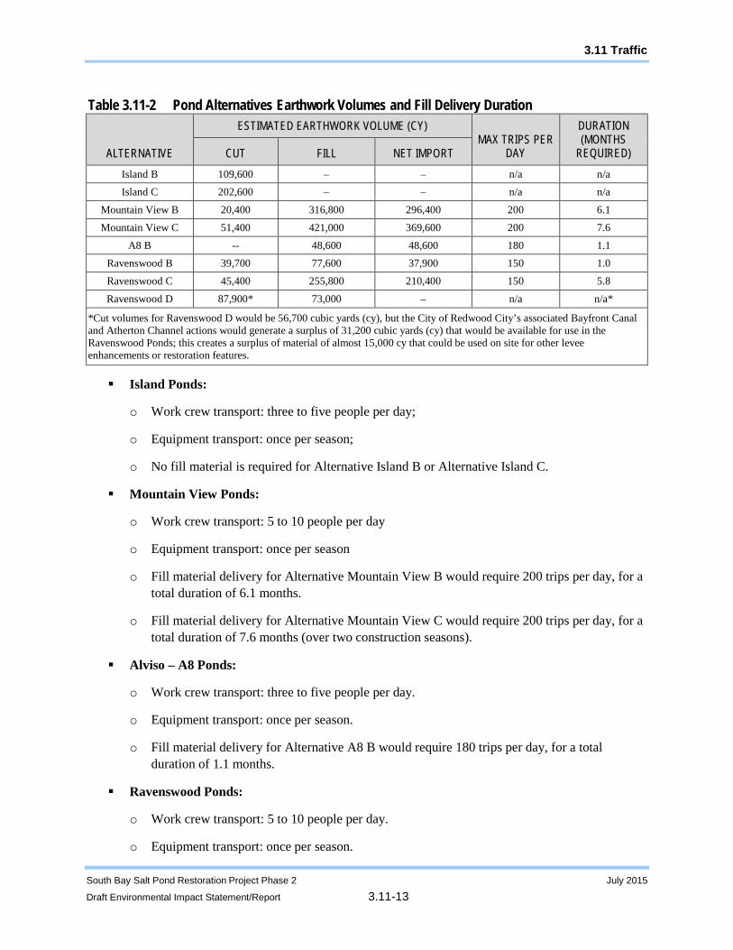
Construction-related traffic estimates are provided below. The alternatives for each pond cluster differ with respect to the duration (or months1 required) for net importing of fill based on the volumes required for construction activities, as shown in Table 3.11-2:
1 For this analysis, a typical month has 22 work days.
3.11 Traffic
South Bay Salt Pond Restoration Project Phase 2 July 2015
Draft Environmental Impact Statement/Report 3.11-13
Table 3.11-2 Pond Alternatives Earthwork Volumes and Fill Delivery Duration
ALTERNATIVE
ESTIMATED EARTHWORK VOLUME (CY) MAX TRIPS PER
DAY
DURATION (MONTHS
REQUIRED) CUT FILL NET IMPORT Island B 109,600 – – n/a n/a Island C 202,600 – – n/a n/a
Mountain View B 20,400 316,800 296,400 200 6.1
Mountain View C 51,400 421,000 369,600 200 7.6
A8 B -- 48,600 48,600 180 1.1 Ravenswood B 39,700 77,600 37,900 150 1.0
Ravenswood C 45,400 255,800 210,400 150 5.8
Ravenswood D 87,900* 73,000 – n/a n/a*
*Cut volumes for Ravenswood D would be 56,700 cubic yards (cy), but the City of Redwood City’s associated Bayfront Canal and Atherton Channel actions would generate a surplus of 31,200 cubic yards (cy) that would be available for use in the Ravenswood Ponds; this creates a surplus of material of almost 15,000 cy that could be used on site for other levee enhancements or restoration features.
Island Ponds:
o Work crew transport: three to five people per day;
o Equipment transport: once per season;
o No fill material is required for Alternative Island B or Alternative Island C.
Mountain View Ponds:
o Work crew transport: 5 to 10 people per day
o Equipment transport: once per season
o Fill material delivery for Alternative Mountain View B would require 200 trips per day, for a total duration of 6.1 months.
o Fill material delivery for Alternative Mountain View C would require 200 trips per day, for a total duration of 7.6 months (over two construction seasons).
Alviso – A8 Ponds:
o Work crew transport: three to five people per day.
o Equipment transport: once per season.
o Fill material delivery for Alternative A8 B would require 180 trips per day, for a total duration of 1.1 months.
Ravenswood Ponds:
o Work crew transport: 5 to 10 people per day.
o Equipment transport: once per season.
3.11 Traffic
South Bay Salt Pond Restoration Project Phase 2 July 2015
Draft Environmental Impact Statement/Report 3.11-14
o Fill material delivery for Alternative Ravenswood B would require 200 trips per day, for a total duration of 1.0 months.
o Fill material delivery for Alternative Ravenswood C would require 200 trips per day, for a total duration of 5.8 months.
o Fill material delivery for Alternative Ravenswood D would not be required due to a surplus of material of almost 15,000 that could be used on site for other levee enhancements or restoration features.
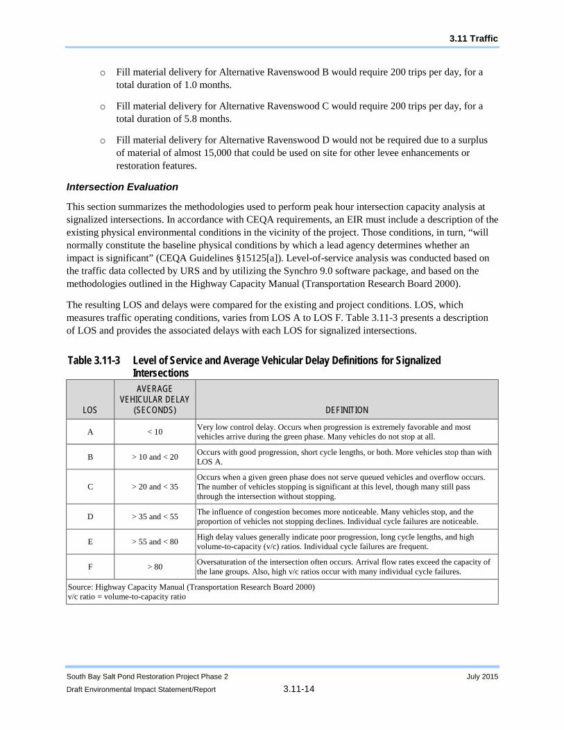
Intersection Evaluation
This section summarizes the methodologies used to perform peak hour intersection capacity analysis at signalized intersections. In accordance with CEQA requirements, an EIR must include a description of the existing physical environmental conditions in the vicinity of the project. Those conditions, in turn, “will normally constitute the baseline physical conditions by which a lead agency determines whether an impact is significant” (CEQA Guidelines §15125[a]). Level-of-service analysis was conducted based on the traffic data collected by URS and by utilizing the Synchro 9.0 software package, and based on the methodologies outlined in the Highway Capacity Manual (Transportation Research Board 2000).
The resulting LOS and delays were compared for the existing and project conditions. LOS, which measures traffic operating conditions, varies from LOS A to LOS F. Table 3.11-3 presents a description of LOS and provides the associated delays with each LOS for signalized intersections.
Table 3.11-3 Level of Service and Average Vehicular Delay Definitions for Signalized Intersections
LOS
AVERAGE VEHICULAR DELAY
(SECONDS) DEFINITION
A < 10 Very low control delay. Occurs when progression is extremely favorable and most vehicles arrive during the green phase. Many vehicles do not stop at all.
B > 10 and < 20 Occurs with good progression, short cycle lengths, or both. More vehicles stop than with LOS A.
C > 20 and < 35 Occurs when a given green phase does not serve queued vehicles and overflow occurs. The number of vehicles stopping is significant at this level, though many still pass through the intersection without stopping.
D > 35 and < 55 The influence of congestion becomes more noticeable. Many vehicles stop, and the proportion of vehicles not stopping declines. Individual cycle failures are noticeable.
E > 55 and < 80 High delay values generally indicate poor progression, long cycle lengths, and high volume-to-capacity (v/c) ratios. Individual cycle failures are frequent.
F > 80 Oversaturation of the intersection often occurs. Arrival flow rates exceed the capacity of the lane groups. Also, high v/c ratios occur with many individual cycle failures.
Source: Highway Capacity Manual (Transportation Research Board 2000) v/c ratio = volume-to-capacity ratio
3.11 Traffic
South Bay Salt Pond Restoration Project Phase 2 July 2015
Draft Environmental Impact Statement/Report 3.11-15
Operation
Operation and maintenance activities for the pond clusters in the Refuge would continue to follow and be dictated by the 1995 Corps Permit #19009S98, applicable County operations, and the AMP.
The long-term operation and maintenance of the alternatives would require approximately one maintenance staff person to travel to the pond cluster one or two times a week to perform activities such as predator control, general vegetation control, and vandalism repairs. Operation of the water control structures could be more variable in terms of the number of staff visits. In addition, AMP monitoring activities would occur, which could require additional workers (e.g., staff, consultants) to access the pond clusters. The frequency of visits to the pond cluster to conduct AMP monitoring activities would depend on the actual activities and would vary by season (e.g., during the bird breeding season there could be more trips to the site than during the non-breeding season). For the purposes of analysis, it is estimated that 10 one-way trips associated with AMP monitoring activities would occur per week.
Implementation of Alternatives Mountain View B and C, and Ravenswood B, C, and D are expected to result in an increase in vehicle trips associated with visitors of the new recreational facilities in the pond clusters. Section 3.6, Recreation, and its associated Appendix F explain the method and data used to develop estimates for the numbers of increased recreational visitors to these two pond clusters.
Program-Level Evaluation Summary
The Programmatic EIS/R evaluated the potential impacts to the transportation network, including nearby roadways, as a result of three programmatic alternatives. The Programmatic EIS/R found that with the implementation of Programmatic Alternative C, the preferred alternative, there would be less-than-significant impacts to long-term operations-related traffic, and potentially significant impacts associated with short-term construction-related traffic, construction-related wear and tear to haul routes, and parking capacity at regional facilities. Mitigation measures were developed to reduce these impacts to a less-than-significant level. These mitigation measures have been incorporated into the design of each action alternative and are summarized below:
Recreation facilities will be designed with sufficient parking spaces to accommodate the projected increase in vehicles that access the site unless adequate off-site parking is available to offset the demand for parking spaces.
If residential streets are included as part of the designated haul routes, videos of the pre-construction and post-construction roadways will be prepared for the purposes of comparison. Prior to construction, the pre-construction conditions and post-construction requirements of the roadway rehabilitation program will be documented. No residential streets are planned for construction-related use during these Phase 2 actions.
Mitigation measure SBSP Mitigation Measure 3.12-1: Timing of construction-related truck trips was also included in the Programmatic EIS/R. This mitigation measure required the landowner (USFWS) to include in construction plans and specifications the requirement that construction-related truck trips, specifically deliveries of fill and equipment, shall occur outside the weekday a.m. and p.m. peak commute traffic hours. This mitigation measure is not feasible to implement in the Phase 2 actions because of the large amount of upland material that needs to be imported by truck to three of the pond clusters in relatively condensed periods of time.

3.11 Traffic
South Bay Salt Pond Restoration Project Phase 2 July 2015
Draft Environmental Impact Statement/Report 3.11-16
Finding source projects with sufficient quantities of upland fill material is difficult for several reasons. The excavation must occur in a year and season when the SBSP Restoration Project can accept it. Stockpiling material or moving it more than once is prohibitive and would increase environmental impacts. In addition, to be used in a restoration project, the material must pass a screening to demonstrate its lack of contamination. The source project should also be located close enough to the restoration project that bringing it to the project’s location would both have fewer environmental impacts and be less expensive than bringing to a landfill or other destination. The number of suitable source projects is likely to be limited by the difficulty of successfully meeting all these criteria. It would not therefore be feasible to further constrain the source projects and dirt brokers/haulers by limiting the hours of material delivery to the non-peak commute periods. Assuming these entities would be willing to comply, their own costs would increase, and they would pass that on to the SBSP Restoration Project, raising associated costs by an estimated 30 percent at a minimum. Collectively, these barriers make the implementation of the restricted hours under SBSP MM 3.12-1 infeasible.
For these reasons, the analysis for Chapter 3.11 will not uniformly be implementing this mitigation measure and instead conducted a full analysis of the number of truck trips and the impacts associated with them within the Traffic Impact Study for South Bay Salt Ponds Restoration - Phase 2 Project (URS 2014).
Project-Level Evaluation
Phase 2 Impact 3.11-1: Potential short-term degradation of traffic operations at intersections and streets due to construction
The Traffic Impact Study for South Bay Salt Ponds Restoration - Phase 2 Project (URS 2014) was prepared to analyze the impact of construction-related traffic on each of the project alternatives. The most intensive construction activity in terms of added traffic would result from the delivery of fill material for the construction of levees and transition zone habitat. Specific quantities (cubic yards) are provided in Table 3.11-2. Therefore, the analysis performed focuses on the hourly trips required to deliver the required materials in the shortest time and number of days possible. Construction routes were analyzed to determine the maximum amount of trucks that could feasibly deliver fill within a single 10-hour work day, and therefore the analysis may use a different number of maximum trips per hour for each pond cluster. For the traffic analysis, it was assumed that the Mountain View Action Alternatives would have 20 Peak Hour truck trips, the A8 Action Alternatives would have 18 peak hour truck trips, and the Ravenswood Action Alternatives would have 15 peak hour truck trips.
The traffic impact criteria used in evaluating traffic LOS for signalized intersections during the project construction phase are based on an increase in delay based on LOS, as follows:
An impact is considered to be significant if the addition of project construction-related traffic results in a reduction in LOS below LOS D.
For intersections that are projected to operate at LOS E or F under baseline conditions, an impact is considered to be significant if the addition of project-related traffic increases average delay at an intersection by 4 seconds or more within the city of Santa Clara and the city of Mountain View. Within the city of Menlo Park, for intersections that are projected to operate at LOS E or F under baseline conditions, an impact is considered to be significant if the addition of project-related traffic increases average delay at an intersection by 0.8 seconds or more (URS 2014).

3.11 Traffic
South Bay Salt Pond Restoration Project Phase 2 July 2015
Draft Environmental Impact Statement/Report 3.11-17
Alviso – Island Ponds
Alternative Island A (No Action). Under this alternative, no construction activities would take place at the Alviso-Island Ponds as part of Phase 2. The pond cluster would continue to be monitored and managed through the activities described in the AMP; however, this would be considered part of project operation, not construction. As such, no construction-generated traffic would occur, and there would be no impact.
Alternative Island A Level of Significance: No Impact
Alternative Island B. Implementation of this alternative would remove, breach, or lower the levees between Ponds A19 and A20. Construction activities would generate traffic associated with the transport of materials and equipment. A preliminary estimate shows that construction would likely be completed in approximately 16 months over two construction seasons. No material would need to be moved on or off site for the construction of this alternative. Thus, vehicle trips would only be required for workers commuting on a daily basis (three to five people). The transport of equipment at the beginning and end of construction seasons would occur by accessing the ponds on barges from the bay water side, either through Mud Slough or Coyote Creek. Therefore, temporary traffic increases associated with construction activities would be less than significant.
Alternative Island B Level of Significance: Less than Significant
Alternative Island C. Implementation of this alternative would include all of the components of Alternative Island B as well as three additional components: levee breaches on the north sides of ponds A20 and A21, pilot channels in Pond A19, and widening of the existing breaches on the southern levee of Pond A19. Construction activities would generate traffic associated with the transport of materials and equipment. A preliminary estimate shows that construction would likely be completed in approximately 19 months over two or three construction seasons. No material would need to be moved off site for the construction of this alternative. Truck trips would be required for the transport of equipment at the beginning and end of construction, and for workers commuting on a daily basis (three to five people).
This alternative would generate construction crew trips over more months than Alternative Island B, but the daily increases would be similar. However, any increase would not noticeably contribute to local traffic delays, and therefore temporary traffic increases associated with the construction activities would be less than significant.
Alternative Island C Level of Significance: Less than Significant
Alviso – Mountain View Ponds
Alternative Mountain View A (No Action). Under this alternative, no construction activities would be implemented as part of Phase 2. The pond cluster would continue to be managed through the activities described in the AMP; however, this would be considered part of project operation, not construction. As such, no construction-generated traffic would occur, and there would be no impact.
Alternative Mountain View A Level of Significance: No Impact
Alternative Mountain View B. Implementation of this alternative would introduce tidal flows to Ponds A1 and A2W by breaching levees at several points. The west levee of Pond A1 would be raised. Habitat transition zones and islands would be constructed to increase habitat complexity and quality in the ponds for special-status species. A new trail, viewing platform, and interpretative platform would be installed to improve recreation and public access at these ponds. The construction traffic associated with this
3.11 Traffic
South Bay Salt Pond Restoration Project Phase 2 July 2015
Draft Environmental Impact Statement/Report 3.11-18
alternative would be temporary in nature, lasting the duration of the construction phase. Construction activities would generate traffic associated with the transport of materials and equipment and the delivery of fill material. A preliminary estimate shows that construction would likely be completed in approximately 27 months over three construction seasons. Truck trips would be required for the transport of equipment at the beginning and end of construction and for workers commuting on a daily basis (5 to 10 people). The trips resulting from the delivery of equipment and workers would not noticeably contribute to local traffic delays; therefore, temporary traffic increases would be less than significant.
As discussed in Chapter 3.6, Recreation Resources, the Construction Contractor will be required as part of the Construction Bid Documents to provide alternative temporary parking areas and a temporary alternate route to access public facilities, wherever feasible.
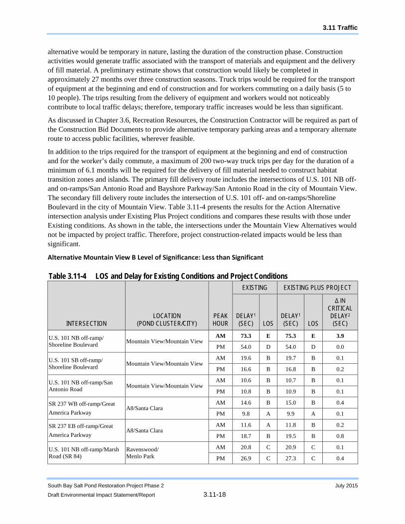
In addition to the trips required for the transport of equipment at the beginning and end of construction and for the worker’s daily commute, a maximum of 200 two-way truck trips per day for the duration of a minimum of 6.1 months will be required for the delivery of fill material needed to construct habitat transition zones and islands. The primary fill delivery route includes the intersections of U.S. 101 NB off- and on-ramps/San Antonio Road and Bayshore Parkway/San Antonio Road in the city of Mountain View. The secondary fill delivery route includes the intersection of U.S. 101 off- and on-ramps/Shoreline Boulevard in the city of Mountain View. Table 3.11-4 presents the results for the Action Alternative intersection analysis under Existing Plus Project conditions and compares these results with those under Existing conditions. As shown in the table, the intersections under the Mountain View Alternatives would not be impacted by project traffic. Therefore, project construction-related impacts would be less than significant.
Alternative Mountain View B Level of Significance: Less than Significant
Table 3.11-4 LOS and Delay for Existing Conditions and Project Conditions
INTERSECTION LOCATION
(POND CLUSTER/CITY) PEAK HOUR
EXISTING EXISTING PLUS PROJECT
DELAY1 (SEC) LOS
DELAY1 (SEC) LOS
Δ IN CRITICAL DELAY2 (SEC)
U.S. 101 NB off-ramp/ Shoreline Boulevard Mountain View/Mountain View
AM 73.3 E 75.3 E 3.9
PM 54.0 D 54.0 D 0.0
U.S. 101 SB off-ramp/ Shoreline Boulevard Mountain View/Mountain View
AM 19.6 B 19.7 B 0.1
PM 16.6 B 16.8 B 0.2
U.S. 101 NB off-ramp/San Antonio Road Mountain View/Mountain View
AM 10.6 B 10.7 B 0.1
PM 10.8 B 10.9 B 0.1
SR 237 WB off-ramp/Great America Parkway
A8/Santa Clara AM 14.6 B 15.0 B 0.4
PM 9.8 A 9.9 A 0.1
SR 237 EB off-ramp/Great America Parkway
A8/Santa Clara AM 11.6 A 11.8 B 0.2
PM 18.7 B 19.5 B 0.8
U.S. 101 NB off-ramp/Marsh Road (SR 84)
Ravenswood/ Menlo Park
AM 20.8 C 20.9 C 0.1
PM 26.9 C 27.3 C 0.4
3.11 Traffic
South Bay Salt Pond Restoration Project Phase 2 July 2015
Draft Environmental Impact Statement/Report 3.11-19
Table 3.11-4 LOS and Delay for Existing Conditions and Project Conditions
INTERSECTION LOCATION
(POND CLUSTER/CITY) PEAK HOUR
EXISTING EXISTING PLUS PROJECT
DELAY1 (SEC) LOS
DELAY1 (SEC) LOS
Δ IN CRITICAL DELAY2 (SEC)
U.S. 101 SB off-ramp/Marsh Road (SR 84)
Ravenswood/ Menlo Park
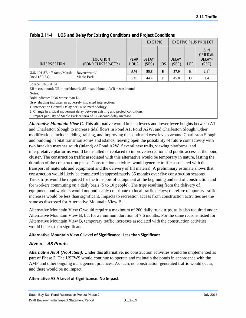
AM 55.8 E 57.0 E 2.93
PM 44.4 D 45.8 D 1.4
Source: URS 2014 EB = eastbound; NB = northbound; SB = southbound; WB = westbound Notes: Bold indicates LOS worse than D. Gray shading indicates an adversely impacted intersection. 1. Intersection Control Delay per HCM methodology 2. Change in critical movement delay between existing and project conditions. 3. Impact per City of Menlo Park criteria of 0.8-second delay increase.
Alternative Mountain View C. This alternative would breach levees and lower levee heights between A1 and Charleston Slough to increase tidal flows in Pond A1, Pond A2W, and Charleston Slough. Other modifications include adding, raising, and improving the south and west levees around Charleston Slough and building habitat transition zones and islands, leaving open the possibility of future connectivity with two brackish marshes south (inland) of Pond A2W. Several new trails, viewing platforms, and interpretative platforms would be installed or replaced to improve recreation and public access at the pond cluster. The construction traffic associated with this alternative would be temporary in nature, lasting the duration of the construction phase. Construction activities would generate traffic associated with the transport of materials and equipment and the delivery of fill material. A preliminary estimate shows that construction would likely be completed in approximately 35 months over five construction seasons. Truck trips would be required for the transport of equipment at the beginning and end of construction and for workers commuting on a daily basis (5 to 10 people). The trips resulting from the delivery of equipment and workers would not noticeably contribute to local traffic delays; therefore temporary traffic increases would be less than significant. Impacts to recreation access from construction activities are the same as discussed for Alternative Mountain View B.
Alternative Mountain View C would require a maximum of 200 daily truck trips, as is also required under Alternative Mountain View B, but for a minimum duration of 7.6 months. For the same reasons listed for Alternative Mountain View B, temporary traffic increases associated with the construction activities would be less than significant.
Alternative Mountain View C Level of Significance: Less than Significant
Alviso – A8 Ponds
Alternative A8 A (No Action). Under this alternative, no construction activities would be implemented as part of Phase 2. The USFWS would continue to operate and maintain the ponds in accordance with the AMP and other ongoing management practices. As such, no construction-generated traffic would occur, and there would be no impact.
Alternative A8 A Level of Significance: No Impact
3.11 Traffic
South Bay Salt Pond Restoration Project Phase 2 July 2015
Draft Environmental Impact Statement/Report 3.11-20
Alternative A8 B. Alternative A8 B is the only action alternative for this pond cluster. In this alternative, habitat transition zones would be constructed in the southwest and southeast corners of Pond A8S. The construction traffic associated with this alternative would be temporary in nature, lasting the duration of the construction phase. Construction activities would generate traffic associated with the transport of materials and equipment and the delivery of fill material. A preliminary estimate shows that construction would likely be completed in approximately 9 weeks over one construction season. Truck trips would be required for the transport of equipment at the beginning and end of construction and for workers commuting on a daily basis (three to five people). The trips resulting from the delivery of equipment and workers would not noticeably contribute to local traffic delays; therefore temporary traffic increases would be less than significant.
In addition to the trips required for the transport of equipment at the beginning and end of construction and for the worker’s daily commute, a maximum of 180 two-way truck trips per day for a minimum of 1.1 months will be required for the delivery of fill material needed to construct habitat transition zones. The primary fill delivery route includes the intersections of 237 WB off-ramp/Great America Parkway and SR 237 EB off-ramp/Great America Parkway in the city of Santa Clara. Table 3.11-4 presents the results for the Action Alternative intersection analysis under Existing Plus Project conditions and compares these results with those under Existing conditions. As shown in the table, the A8 Alternative intersections would not be impacted by project traffic; therefore project construction-related impacts would be less than significant.
Alternative A8 B Level of Significance: Less than Significant
Ravenswood Ponds
Alternative Ravenswood A (No Action). Under this alternative, no construction activities would be implemented as part of Phase 2. The USFWS is maintaining the ponds as part of the Don Edwards San Francisco Bay National Wildlife Refuge System and the AMP. The outboard levees along Ponds R4 and R3 provide inland flood protection and would continue to be maintained or repaired as a component of the 1995 Corps Permit #19009S98. The adjacent Bedwell Bayfront Park, owned by the City of Menlo Park, has trails that would continue to be used and maintained separately. As such, no construction-generated traffic would occur, and there would be no impact.
Alternative Ravenswood A Level of Significance: No impact
Alternative Ravenswood B. Alternative Ravenswood B would open Pond R4 to tidal flows, improve levees to provide additional flood protection, create a habitat transition zone along the western edge of R4, establish enhanced managed ponds in Ponds R5 and S5 to improve habitat for diving and dabbling birds, establish enhanced managed ponds in Pond R3 to improve habitat for western snowy plover, increase pond connectivity, and improve recreation and public access. The construction traffic associated with this alternative would be temporary in nature, lasting the duration of the construction phase. Construction activities would generate traffic associated with the transport of materials and equipment and the delivery of fill material. A preliminary estimate shows that construction would likely be completed in approximately 5 months over one construction season. Truck trips would be required for the transport of equipment at the beginning and end of construction and for workers commuting on a daily basis (5 to 10 people). The trips resulting from the delivery of equipment and workers would not noticeably contribute to local traffic delays; therefore temporary traffic increases would be less than significant.

3.11 Traffic
South Bay Salt Pond Restoration Project Phase 2 July 2015
Draft Environmental Impact Statement/Report 3.11-21
Because the only land vehicle access to the Ravenswood Ponds is through the entrance to Bedwell Bayfront Park, any construction activities in these ponds would have some effect on recreational use of the park. During the start and end of a construction season, heavy construction equipment would be brought in and out of the Refuge through the park, which could lead to delays for park visitors. This could also occur during each day’s commute as the work crews arrive. This daily commute would happen in smaller and faster passenger vehicles, and the work crews are typically small (approximately 10 people). Finally, the trucks that would deliver upland fill material to the ponds for use in levee raising or improvement or habitat transition zone construction would likely cause delays in the entry and exit from the park and parking lot by recreational park visitors. Note that the USFWS Refuge managers have an easement with the City of Menlo Park for entry and exit of operations and maintenance vehicles through the entry gate of Bedwell Bayfront Park and its roads.
In addition to the trips required for the transport of equipment at the beginning and end of construction and for the worker’s daily commute, a maximum of 150 two-way truck trips per day for a duration of a minimum of 1 month will be required for the delivery of fill material needed to construct the habitat transition zone . The primary fill delivery route includes the intersections of U.S. 101 NB off-ramp/Marsh Road (SR 84) and U.S. 101 SB off-ramp/Marsh Road (SR 84) in the city of Menlo Park. Table 3.11-4 presents the results for the Action Alternative intersection analysis under Existing Plus Project conditions and compares these results with those under Existing conditions. As shown in the Table 3.11-4, project related traffic required to implement the Ravenswood Alternative B would result in an increase in delay greater than 0.8 seconds at the intersection of U.S. 101 SB off-ramp/Marsh Road (SR 84), which is an intersection operating at an existing unacceptable LOS E; therefore, project construction-related impacts would be potentially significant. To ensure that degradation of average delay at an intersection would not occur, a project-level mitigation measure, SBSP Phase 2 Mitigation Measure 3.11-1, would be required. As shown in Table 3.11-5, intersection delay increase does not result in an impact under the mitigated project condition; therefore identified impacts are reduced to a less-than-significant level.
Table 3.11-5 LOS and Delay for Existing Conditions and Mitigated Project Conditions
INTERSECTION
LOCATION (POND
CLUSTER/CITY) PEAK HOUR
EXISTING MITIGATED PROJECT
DELAY1 (SEC) LOS
DELAY1 (SEC) LOS
Δ IN CRITICAL DELAY2 (SEC)
U.S. 101 SB off-ramp/Marsh Road (SR 84)
Ravenswood/ Menlo Park
AM 55.8 E 55.8 E 0.0
PM 44.4 D 45.8 D 1.4
Source: URS 2014 Notes: Bold indicates LOS worse than D. Gray shading indicates an impacted intersection. 1 Intersection Control Delay per HCM methodology. 2 Change in critical movement delay between existing and project conditions.

3.11 Traffic
South Bay Salt Pond Restoration Project Phase 2 July 2015
Draft Environmental Impact Statement/Report 3.11-22
Phase 2 Mitigation Measure 3.11-1: Modify Signal Timing
The landowner (USFWS) shall coordinate with Caltrans and/or the City of Menlo Park to modify the intersection signal timing in the a.m. to reduce project-related delay to a level that the City does not deem significant.
Alternative Ravenswood B Level of Significance: Less than Significant with Mitigation
Alternative Ravenswood C. This alternative would be similar to Alternative Ravenswood B with the following exceptions: Ponds R5 and S5 would be converted to a particular type of managed pond that is maintained at mud flat elevation for shore birds; a second water control structure would be installed on Pond R3 to improve the habitat for the snowy plover; an additional habitat transition zone would be constructed in Pond R4; and additional recreational and public access components would be constructed. The construction traffic associated with this alternative would be temporary in nature, lasting the duration of the construction phase. A preliminary estimate shows that construction would likely be completed in approximately 7 months over one construction season. Truck trips would be required for the transport of equipment at the beginning and end of construction and for workers commuting on a daily basis (5 to 10 people). The trips resulting from the delivery of equipment and workers would not noticeably contribute to local traffic delays; temporary traffic increases would therefore be less than significant. Impacts to recreation access from construction activities are the same as discussed for Alternative Ravenswood B.
Alternative Ravenswood C would also require a maximum of 150 daily truck trips, but for a minimum duration of 5.8 months. For the same reasons discussed for Alternative Ravenswood B, temporary traffic increases associated with the delivery of fill material would be significant. To ensure that degradation of the average delay at an intersection would not occur, SBSP Phase 2 Mitigation Measure 3.11-1 would be required. As shown in Table 3.11-5, intersection delay increase does not result in an impact under the mitigated project condition; therefore the identified impacts are reduced to a less-than-significant level.
Alternative Ravenswood C Level of Significance: Less than Significant with Mitigation
Alternative Ravenswood D. This alternative would open Pond R4 to tidal flows, improve levees to provide additional flood protection, create two habitat transition zones in Pond R4, establish enhanced managed ponds in Ponds R5 and S5 to improve the habitat for diving and dabbling birds, increase pond connectivity, enhance Pond R3 for snowy plover habitat, allow stormwater outflow from Redwood City to Ponds R5 and S5, remove the levees within and between Ponds R5 and S5, and improve recreation and public access The construction traffic associated with this alternative would be temporary in nature, lasting the duration of the construction phases. A preliminary estimate shows that construction would likely be completed in approximately 15 months over two construction seasons. Truck trips would be required for the transport of equipment at the beginning and end of construction and for workers commuting on a daily basis (5 to 10 people). The trips resulting from the delivery of equipment and workers would not noticeably contribute to local traffic delays; therefore temporary traffic increases would be less than significant.
In addition to the impacts to recreation access from the construction activities discussed in Alternative Ravenswood B, during construction of the proposed inlet headwall for the Bayfront Canal culvert and during channel excavation, public vehicle access to Bedwell Bayfront Park would be maintained. After completion of the inlet headwall, excavation would continue eastward and public vehicle access to the park would be prohibited. Public foot traffic would be allowed around the fenced construction site to Bedwell Bayfront Park until excavation of the culvert outlet begins, at which point public access would
3.11 Traffic
South Bay Salt Pond Restoration Project Phase 2 July 2015
Draft Environmental Impact Statement/Report 3.11-23
be prohibited until the completion of the project (approximately 1.5 months). The contractor would provide traffic safety control for the duration of the project.
Alternative Ravenswood D, like Alternative Ravenswood B, would also allow for a maximum of 150 daily truck trips, but would require no imported fill due to a surplus of material provided by Alternative Ravenswood D and the Bayfront Canal and Atherton Channel construction activities. Because there would be no import of fill material, the construction-related traffic would be greatly reduced and would not need to take place during peak construction hours. There would be no degradation of average delay at an intersection. For these reasons, unlike Alternatives Ravenswood B and C, SBSP Phase 2 Mitigation Measure 3.11-1 would not be required.
Alternative Ravenswood D Level of Significance: Less than Significant
Phase 2 Impact 3.11-2: Potential long-term degradation of traffic operations at intersections and streets during operation
Alviso – Island Ponds
Alternative Island A (No Action). Under this alternative, no new activities would take place under Phase 2, and the pond cluster would continue to be monitored and managed through the activities described in the AMP. This alternative would not result in an increase in long-term traffic volumes in the area, and therefore there would be no impact.
Alternative Island A Level of Significance: No Impact
Alternatives Island B and C (Action Alternatives). Under both of these alternatives, aside from the monitoring and management activities of the AMP and continued maintenance of the existing railroad tracks, no other operation and maintenance activities would occur. Ongoing monitoring and studies to track the progress of these ponds toward restoration as tidal marsh habitat are a component of the continued implementation of the AMP. No recreational or flood control facilities would be constructed as part of either alternative.
Due to the periodic nature of the operations and maintenance traffic, the limited number of trips generated by workers visiting the ponds, and the lack of new recreation facilities, the implementation of either of these alternatives would not result in a substantial increase in traffic volumes compared to the current traffic levels in the area. Therefore, impacts would be less than significant.
Island Action Alternatives Level of Significance: Less than Significant
Alviso – Mountain View Ponds
Alternative Mountain View A (No Action). Under this alternative, no new activities would take place under Phase 2. The USFWS would maintain the ponds as part of the Don Edwards San Francisco Bay National Wildlife Refuge System and the AMP. The pond cluster would continue to be managed through the activities described in the AMP. This alternative would not result in an increase in long-term traffic volumes in the area. Therefore, there would be no impact.
Alternative Mountain View A Level of Significance: No Impact
Alternatives Mountain View B and Mountain View C. Operation and maintenance activities for components of the pond cluster within the Refuge would continue to follow and be dictated by the 1995 Corps Permit #19009S98, applicable County operations, and the AMP. These activities would include pond maintenance, levee maintenance, nesting island maintenance, habitat transition zone maintenance,

3.11 Traffic
South Bay Salt Pond Restoration Project Phase 2 July 2015
Draft Environmental Impact Statement/Report 3.11-24
and maintenance of public access and recreational features. In addition, PG&E would continue to operate and maintain its infrastructure, and the City of Mountain View would continue to operate and maintain its properties that are included and analyzed as part of the action alternatives at this pond cluster. The increase in traffic volumes associated with the routine maintenance and monitoring activities would be minimal.
Under Alternative Mountain View B, a new trail, a viewing platform, and an interpretive platform would be installed to improve recreation and public access to these ponds. Under Alternative Mountain View C, several new trails, viewing platforms, and interpretative platforms would be installed or replaced to improve recreation and public access at the pond cluster. Operation of the new recreational facilities is anticipated to result in minimal increases in visitors to the Mountain View Ponds. However, the increased number of visitors is not anticipated to result in a substantial increase in vehicle traffic relative to the traffic volumes of the local network.
Due to the periodic nature of the operations and maintenance traffic, the limited number of trips generated by workers visiting the ponds, and the minimal increase in recreation visitors, the implementation of either of these alternatives would not result in a substantial increase in traffic volumes compared to the current traffic levels in the area. Therefore, impacts would be less than significant.
Mountain View Action Alternatives Level of Significance: Less than Significant
Alviso – A8 Ponds
Alternative A8 A (No Action). Under this alternative, no new activities would occur under Phase 2. The USFWS would continue to operate and maintain the ponds in accordance with the AMP and other ongoing management practices. This alternative would not result in an increase in long-term traffic volumes in the area. Therefore, there would be no impact.
Alternative A8 A Level of Significance: No Impact
Alternative A8 B. The USFWS would continue to operate and maintain the ponds in accordance with the AMP and other ongoing management practices that have been in place since the implementation of Phase 1 actions. The Santa Clara Valley Water District would also be involved in maintaining these ponds. These ongoing management practices would not change during or after the construction activities described above. The increase in traffic volumes associated with the routine maintenance and monitoring activities would be minimal. No new recreational facilities would be constructed as part of this alternative.
Due to the periodic nature of the operations and maintenance traffic, the limited number of trips generated by workers visiting the ponds, and the lack of new recreation facilities, the implementation of this alternative would not result in a substantial increase in traffic volumes compared to the current traffic levels in the area. Therefore, impacts would be less than significant.
Alternative A8 B Level of Significance: Less than Significant
Ravenswood Ponds
Alternative Ravenswood A (No Action). Under this alternative, no new activities would be implemented as part of Phase 2. The USFWS would continue to maintain the ponds as part of the Don Edwards San Francisco Bay National Wildlife Refuge System and the AMP. The pond cluster would continue to be

3.11 Traffic
South Bay Salt Pond Restoration Project Phase 2 July 2015
Draft Environmental Impact Statement/Report 3.11-25
managed through the activities described in the AMP. This alternative would not result in an increase in long-term traffic volumes in the area. Therefore, there would be no impact.
Alternative Ravenswood A Level of Significance: No Impact
Alternatives Ravenswood B, Ravenswood C, and Ravenswood D (Action Alternatives). Operation and maintenance activities for components of the pond cluster within the Refuge would continue to follow and be dictated by the 1995 Corps Permit #19009S98, applicable County operations, and the AMP. These activities would include pond maintenance, levee maintenance, monitoring of water control structures, habitat transition zone maintenance, interpretive station maintenance, and management of water levels. In addition, Redwood City would continue to operate and maintain its properties that are a part of the pond cluster. The increase in traffic volumes associated with the routine maintenance and monitoring activities would be minimal.
Alternative Ravenswood B would improve levees, and add an interpretive platform or educational exhibit to improve recreation and access. Alternatives Ravenswood C and Ravenswood D would construct new trails along the levee tops and construct an interpretive platform or an educational exhibit to improve recreation and access. However, operation of the new recreational facilities under all of the Ravenswood Action Alternatives is anticipated to result in minimal increases in visitors to the Ravenswood Ponds. The increased number of visitors is not anticipated to result in a substantial increase in vehicle traffic relative to the traffic volumes of the local network.
Due to the periodic nature of the operations and maintenance traffic, the limited number of trips generated by workers visiting the ponds, and the minimal increase in pond visitors, the implementation of either of these alternatives would not result in a substantial increase in traffic volumes compared to the current traffic levels in the area. Therefore, impacts would be less than significant.
Ravenswood Action Alternatives Level of Significance: Less than Significant
Phase 2 Impact 3.11-3: Potential increase in parking demand
Alviso – Island Ponds
Alternative Island A (No Action). Under this alternative, no new activities would take place under Phase 2. There would be no increase in visitors or parking demand. Therefore, there would be no impact.
Alternative Island A Level of Significance: No Impact
Alternatives Island B and Island C (Action Alternatives). Under these alternatives, construction staging is not expected to be necessary at the Island Ponds, but would be established on one of the off-road levee roads used for access to the Island Ponds themselves. As such, this alternative would not generate demand for parking outside the boundary of the pond cluster.
There are no existing recreational facilities at the Island Ponds. In addition, no new recreational facilities would be constructed as part of either action alternative. The implementation of either alternative would not result in an increase in visitors or parking demand. Therefore, there would be no impact.
Island Action Alternatives Level of Significance: No Impact

3.11 Traffic
South Bay Salt Pond Restoration Project Phase 2 July 2015
Draft Environmental Impact Statement/Report 3.11-26
Alviso – Mountain View Ponds
Alternative Mountain View A (No Action). Under this alternative, no new activities would take place under Phase 2. There would be no increase in visitors or parking demand. Therefore, there would be no impact.
Alternative Mountain View A Level of Significance: No Impact
Alternatives Mountain View B and Mountain View C (Action Alternatives). Under these alternatives, construction staging may be established within the boundaries of Mountain View Shoreline Park, outside of the pond cluster. Construction vehicles and equipment may need to be staged in existing parking areas, and may therefore increase the parking demand. Under Alternative Mountain View B, a new trail, a viewing platform, and an interpretive platform would be installed to improve recreation and public access to these ponds. Under Alternative Mountain View C, several new trails, viewing platforms, and interpretative platforms would be installed or replaced to improve recreation and public access at the pond cluster. Operation of the new recreational facilities is anticipated to result in an increase in visitors to the Mountain View Ponds. The increased number of visitors is anticipated to result in a corresponding increase in parking demand.
As shown in Table 3.11-1, Mountain View Shoreline Park has 166 parking spaces, and there are approximately 200 parking spaces at the Shoreline Amphitheater Overflow Parking Lot. In addition, on-street parking is available along several nearby streets. These spaces are anticipated to provide sufficient capacity for the parking demand resulting from construction and the increase in visitors to the Mountain View Ponds. As a result, this impact is less than significant.
Alternative Mountain View B Level of Significance: Less than Significant
Alviso – A8 Ponds
Alternative A8 A (No Action). Under this alternative, no new activities would take place under Phase 2. There would not be an increase in visitors or parking demand. Therefore, there would be no impact.
Alternative A8 A Level of Significance: No Impact
Alternative A8 B. Under this alternative, construction staging, if needed, would be accommodated off of public roads or public areas on the landfill access road immediately adjacent to the pond cluster. As such, this alternative would not generate demand for parking outside the boundary of the pond cluster.
No new recreational facilities would be constructed. The implementation of this alternative would not result in an increase in visitors or parking demand. Therefore, there would be no impact.
Alternative A8 B Level of Significance: No Impact
Ravenswood Ponds
Alternative Ravenswood A (No Action). Under this alternative, no new activities would occur under Phase 2. There would not be an increase in visitors or parking demand. Therefore, there would be no impact.
Alternative Ravenswood A Level of Significance: No Impact

3.11 Traffic
South Bay Salt Pond Restoration Project Phase 2 July 2015
Draft Environmental Impact Statement/Report 3.11-27
Alternatives Ravenswood B, Ravenswood C, and Ravenswood D. Under these alternatives, construction staging may be established within the boundaries of Mountain View Shoreline Park, outside of the pond cluster. Construction vehicles and equipment may need to be staged in existing parking areas, thereby increasing the parking demand.
Alternative Ravenswood B would improve levees and would add an interpretive platform or educational exhibit to improve recreation and access. Alternatives Ravenswood C and Ravenswood D would construct new trails along the levee tops and construct an interpretive platform or an educational exhibit to improve recreation and access. Operation of the new recreational facilities is anticipated to result in minimal increases in visitors to the Ravenswood Ponds. The increase in visitors is anticipated in result in a corresponding increase in parking demand.
As shown in Table 3.11-1, 30 parking spaces are available at Bayfront Park, and 70 parking spaces are available on the northern and southern sides of the western approach to Dumbarton Bridge. In addition, on-street parking is available along several nearby streets. These spaces are anticipated to provide sufficient capacity for the parking demand resulting from construction and the increase in visitors to the Ravenswood Ponds. As a result, this impact is less than significant.
Ravenswood Action Alternatives Level of Significance: Less than Significant
Phase 2 Impact 3.11-4: Potential increase in wear and tear on the designated haul routes during construction
The use of large trucks to transport equipment and material to and from the construction areas may affect the road conditions of the designated haul routes. Arterial and collector streets are designed to accommodate a variety of vehicle types, including heavy trucks. However, residential streets are not designed with a pavement thickness to withstand substantial truck traffic.
Alviso – Island Ponds
Alternative Island A (No Action). As discussed above, under this alternative, no construction activities would take place at the Alviso-Island Ponds. As such, no construction trips would take place and there would be no impact.
Alternative Island A Level of Significance: No Impact
Alternatives Island B and Island C (Action Alternatives). Implementation of Alternative Island B would remove, breach, or lower the levees between Ponds A19 and A20. Implementation of Alternative Island C would include all of the components of Alternative Island B as well as three additional components: levee breaches on the north sides of ponds A20 and A21, pilot channels in Pond A19, and widening of the existing breaches on the southern levee of Pond A19.
The designated access routes for the construction truck trips at the Island Ponds would include Fremont Avenue, Warren Avenue, and Landing Road. Per the City of Fremont General Plan (Fremont 2011), Fremont Avenue and Warren Avenue are classified as minor arterial streets. Landing Road is classified as a local road; however, it is zoned for industrial/tech, not residential. As such, these roads were designed to withstand substantial truck traffic. Under the action alternatives for the Island Ponds, there would be no hauling of material into or out of these ponds. Passenger trucks would enter and exit daily, and there would be seasonal delivery of large construction equipment at the beginning and end of each construction
3.11 Traffic
South Bay Salt Pond Restoration Project Phase 2 July 2015
Draft Environmental Impact Statement/Report 3.11-28
season. Therefore, construction truck trips would not increase wear and tear on these roads, and the impact would be less than significant.
Island Action Alternatives Level of Significance: Less than Significant
Alviso – Mountain View Ponds
Alternative Mountain View A (No Action). As discussed above, under this alternative, no construction activities would take place at the Mountain View pond cluster. As such, no construction trips would take place and there would be no impact.
Alternative Mountain View A Level of Significance: No Impact
Alternatives Mountain View B and Mountain View C (Action Alternatives). Alternative Mountain View B would introduce tidal flows to Ponds A1 and A2W by breaching levees at several points. Alternative Mountain View C would breach levees and lower levee heights to increase tidal flows in Pond A1, Pond A2W, and Charleston Slough.
The designated access routes for the construction truck trips at the Mountain View Ponds would include San Antonio Road and Shoreline Boulevard. Both of these roads are classified as major arterial streets. As such, these roads were designed to withstand substantial truck traffic. Therefore, construction truck trips would not increase wear and tear on these roads, and the impact would be less than significant.
Mountain View Action Alternatives Level of Significance: Less than Significant
Alviso – A8 Ponds
Alternative A8 A (No Action). As discussed above, under this alternative, no construction activities would take place at the A8 Ponds. As such, no construction trips would take place and there would be no impact.
Alternative A8 A Level of Significance: No Impact
Alternative A8 B. Under this alternative, habitat transition zones could be constructed in Pond A8S’s southwest corner, southeast corner, or both.
The designated access routes for the construction truck trips at the A8 Ponds would include Great America Parkway and Gold Street. Per the City of San Jose General Plan (2011), Great America Parkway is classified as a major arterial street. Gold Street is classified as a local street; however, it is zoned for commercial/industrial, not residential. As such, these roads were designed to withstand substantial truck traffic. Therefore, construction truck trips would not increase wear and tear on these roads, and the impact would be less than significant.
Alternative A8 B Level of Significance: Less than Significant
Ravenswood Ponds
Alternative Ravenswood A (No Action). As discussed above, under this alternative, no construction activities would take place at the Ravenswood Ponds. As such, no construction trips would take place and there would be no impact.
Alternative Ravenswood A Level of Significance: No Impact

3.11 Traffic
South Bay Salt Pond Restoration Project Phase 2 July 2015
Draft Environmental Impact Statement/Report 3.11-29
Alternatives Ravenswood B, Ravenswood C, and Ravenswood D (Action Alternatives). All three Ravenswood Action Alternatives would introduce tidal flows to Pond R4 to and improve levees to provide additional flood protection. Alternative Ravenswood C would include several improvements beyond what would be done for Alternative Ravenswood B, and Ravenswood D would include improvements beyond what would be implemented for Alternatives Ravenswood B and C.
The designated access route for construction truck trips at the Ravenswood Ponds would include Marsh Road and a levee road. Marsh Road is classified as a primary arterial street in the Menlo Park General Plan (Menlo Park 1994). As such, it is designed to withstand substantial truck traffic. Therefore, construction truck trips would not increase wear and tear on these roads, and the impact would be less than significant.
Ravenswood Action Alternatives Level of Significance: Less than Significant
Impact Summary
Phase 2 impacts and levels of significance are summarized in Table 3.11-6. The levels of significance are those remaining after implementation of program-level mitigation measures, project-level design features, the AMP and other Refuge management practices and documents. The traffic analysis required project-level mitigation measure SBSP Phase 2 Mitigation Measure 3.11-1 in order to reduce SBSP Phase 2 Impact 3.11-1 to a level that was less than significant.
Table 3.11-6 Phase 2 Summary of Impacts – Traffic
IMPACT
ALTERNATIVE
ISLAND MOUNTAIN VIEW A8 RAVENSWOOD
A B C A B C A B A B C D
Phase 2 Impact 3.11-1: Potential short-term degradation of traffic operations at intersections and streets due to construction.
NI LTS LTS NI LTS LTS NI LTS NI LTSM LTSM LTS
Phase 2 Impact 3.11-2: Potential long-term degradation of traffic operations at intersections and streets during operation.
NI LTS LTS NI LTS LTS NI LTS NI LTS LTS LTS
Phase 2 Impact 3.11-3: Potential increase in parking demand. NI NI NI NI LTS LTS NI NI NI LTS LTS LTS
Phase 2 Impact 3.11-4: Potential increase in wear and tear on the designated haul routes during construction.
NI LTS LTS NI LTS LTS NI LTS NI LTS LTS LTS
Notes: Alternative A at each pond cluster is the No Action (No Project Alternative under CEQA). LTS = Less than Significant LTSM = Less than Significant with Mitigation NI = No Impact

3.11 Traffic
South Bay Salt Pond Restoration Project Phase 2 July 2015
Draft Environmental Impact Statement/Report 3.11-30
This page intentionally left blank