south bay salt pond restoration project, phase 2 draft ... landing deis-r/2... · south bay salt...
TRANSCRIPT
South Bay Salt Pond Restoration Project, Eden Landing Phase 2 August 2017 Draft Environmental Impact Statement/Report 2-1
ALTERNATIVES 2.
This chapter describes the Phase 2 project alternatives proposed at the Eden Landing Ecological Reserve (ELER, or Reserve). The alternatives described herein represent project-level actions that could be implemented as part of the phased restoration efforts associated with the South Bay Salt Pond (SBSP) Restoration Project at the ELER. Section 2.1, Alternative Development Process, describes the process of developing project alternatives proposed to meet the purpose and need and project objectives. Section 2.2, Eden Landing Phase 2 Project Alternatives, describes the Phase 2 alternatives proposed within the Phase 2 project area of the ELER and that are evaluated in this SBSP Restoration Project, Eden Landing Phase 2 Draft Environmental Impact Statement/Report (EIS/R). See Appendix B for the Eden Landing Preliminary Alternatives Analysis Report containing the full description of the initial alternatives, the screening criteria, the selection of alternatives carried over into this Draft EIS/R, and the alternatives considered but eliminated from detailed study. The details of the preliminary design are presented in Appendices C and D which provide the Southern Eden Landing Restoration Preliminary Design Memorandum and the Preliminary Design Memorandum of Dredged Material Placement at Southern Eden Landing, respectively. Section 2.3, General Mitigation Measures Adapted from the 2007 SBSP Restoration Project Final EIS/R (2007 Final EIS/R), describes the mitigation measures from the 2007 Final EIS/R that are relevant to the Eden Landing Phase 2 alternatives and that would be incorporated into the project design of all Action Alternatives or would be important factors for this Draft EIS/R impact analysis. By incorporating program-level mitigation measures into project-level designs, they become part of that project and are no longer “mitigation.” For that reason, they are included here in the project descriptions for the various alternatives.
2.1 Alternative Development Process
Previously, as part of the National Environmental Policy Act (NEPA) and California Environmental Quality Act (CEQA) review process, the United States Fish and Wildlife Service (USFWS), the California Department of Fish and Wildlife (CDFW), and other agencies had completed the 2007 Final EIS/R for the SBSP Restoration Project. The 2007 Final EIS/R developed long-term, end-project “target” habitat designations for each pond complex under two different programmatic action scenarios:
Programmatic Alternative B: a split of 50 percent (by total acreage) restoration to tidal marsh and 50 percent restoration to managed ponds; or
Programmatic Alternative C: a split of 90 percent restoration to tidal marsh and 10 percent restoration to managed ponds.
As discussed in the 2007 Final EIS/R, these program-level alternatives were chosen to be bookends, between which the final balance of restored habitat will ultimately lie. Within that context, Programmatic Alternative C was selected for implementation. Phase 2 project alternatives at ELER present a range of project components, each of which is intended to advance the overall programmatic goals and the mission of the SBSP Restoration Project.
A broad range of alternatives for the Phase 2-level project was considered and developed to meet the Phase 2 purpose and need and project objectives at ELER. NEPA requires development and consideration of a range of “reasonable alternatives.” CEQA requires alternatives that would “minimize significant
2 Alternatives
South Bay Salt Pond Restoration Project, Eden Landing Phase 2 August 2017 Draft Environmental Impact Statement/Report 2-2
impacts.” A set of screening criteria was developed to assist in decision-making and to elaborate a reasonable range of alternatives for analysis in this Draft EIS/R that would minimize significant impacts. After this set of screening criteria was applied, three Action Alternatives were selected for detailed evaluation, and several alternatives and individual components were eliminated.
The Action Alternatives initially selected for detailed evaluation in Phase 2 at ELER are presented in Appendix B, which is the Alternatives Analysis Report. This report contains the full description of the initial alternatives, the screening criteria, the selection methodology applied to carry forward those alternatives, and the alternatives and components considered but removed from further detailed study. Since that process, more modeling on the combined effect of tidal flows and fluvial runoff on high-water elevations was conducted. The results indicated that, while the same general kinds of restoration and flood risk management1 concepts would be feasible, the details of the necessary flood protection features and the specifics of where and how tidal flows could be introduced into Eden Landing would need to be changed. That modeling report is presented as Attachment 1, Southern Eden Landing Restoration Preliminary Design: 1D and 2D Hydrodynamic Modeling, of Appendix D, Southern Eden Landing Preliminary Design Memorandum. That modeling effort drove changes to the details of where levee improvements, breaches, levee lowering, channel excavations, and other design details would be made. The Action Alternatives were modified accordingly and new design details were generated Those changes are part of the alternatives analyzed and discussed in this Draft EIS/R.
The actions considered for the Eden Landing Phase 2 project are akin to a stand-alone project under NEPA and CEQA. The actions and the components of the actions themselves could be implemented individually; they are not dependent on other phases of the SBSP Restoration Project. Each of the alternatives herein would accomplish slightly different goals and achieve differing levels and types of habitat restoration, recreation, or flood risk management. These actions are each incremental steps toward the larger programmatic goals.
2.1.1 Eden Landing Pond Complex: Programmatic Context of Phase 2 Alternatives
As discussed in Chapter 1, Introduction, the Phase 2 alternatives proposed at the Eden Landing pond complex are intended to tier from the analysis conducted for the programmatic portion of the 2007 Final EIS/R by advancing additional restoration activities within the southern half of Eden Landing. Larger, program-level alternatives for the SBSP Restoration Project as a whole, and for the pond complexes within it, were analyzed in the 2007 Final EIS/R. Chapter 2 of the 2007 Final EIS/R explained the long-term project goals and the process of developing and selecting the program-level alternatives, and the Adaptive Management Plan (AMP) that will track progress toward those goals from project-level actions and ongoing research and monitoring. The 2007 Final EIS/R covered a 50-year long-range plan for the SBSP Restoration Project at the programmatic level. The 2007 Final EIS/R also covered the Phase 1 projects at the project-level.
The 2007 Final EIS/R assessed the potential environmental consequences associated with two long-term restoration alternatives that applied to the greater SBSP Restoration Program. In consideration of the 1 The terminology used by the SBSP Restoration Project to describe its goals has since changed from “flood protection” to “flood risk management.” This document generally uses the latter term for forward-looking documents.
2 Alternatives
South Bay Salt Pond Restoration Project, Eden Landing Phase 2 August 2017 Draft Environmental Impact Statement/Report 2-3
potential environmental consequences discussed in the 2007 Final EIS/R, the USFWS Record of Decision (ROD) and the CDFW Notice of Determination (NOD) state that the USFWS and CDFW will implement Programmatic Alternative C, the “Tidal Emphasis Alternative.” The USFWS and CDFW will retain the option of stopping tidal marsh restoration before restoring 90 percent of total acreage as tidal marsh if, for example, monitoring shows that pond-dependent species appear to be adversely affected by the loss of pond habitats. In this case, the SBSP Restoration Project may shift future project phases toward enhanced managed pond habitat and achieve an end result of tidal marsh restored habitat that is somewhere between the amounts described in Programmatic Alternative B and Programmatic Alternative C. The Action Alternatives proposed as part of Phase 2 at southern Eden Landing represent the second phase of this long-term restoration project, and are intended to advance the SBSP Restoration Project toward its end goals described in Programmatic Alternative C.
Construction, operation, and maintenance of Phase 2 activities at southern Eden Landing would be independent of activities at Phase 2 ponds within the USFWS-owned Don Edwards San Francisco Bay National Wildlife Refuge (or Refuge) ponds and independent of the previously implemented Phase 1 actions in the ELER as a whole.
The SBSP Restoration Project has an open and lengthy history of public processes to develop alternatives that was initiated with stakeholder forums in 2003. Public input from scoping meetings and public comment periods for the 2007 Final EIS/R, and from the annual stakeholder forums since then, was used to help develop these alternatives. Further, the entire NEPA/CEQA process for the Phase 2 projects at the Refuge informed the design and analysis of the Phase 2 actions at Eden Landing. The Phase 2 NEPA/CEQA process also included a public scoping meeting and a public comment period, which shaped the development of the Action Alternatives presented herein. The most notable change as a result of public comment was the decision to study beneficial reuse of dredged material as part of the design effort for Eden Landing Phase 2.
In developing a broad range of alternatives for the Eden Landing Phase 2 project area, target habitat goals, major recreation and public access goals, and flood risk management issues were considered. Individual components, their variations, and what they were intended to achieve were developed, and these components were bundled as complete alternatives for consideration.
2.1.2 Alternatives Considered But Eliminated from Further Review
A number of alternatives were initially developed and included in the screening process to refine a set of alternatives for inclusion in this Draft EIS/R and in the conceptual designs. The Alternatives Analysis Report presented as Appendix B explains these initial alternatives, the components that constitute each alternative, and the intentions or purposes of each. The report also explains the screening criteria and processes by which these alternatives were considered but eliminated from further review.
2.1.3 Adaptive Management Plan
The AMP was developed by the Project Management Team (PMT) to be an integral component of the SBSP Restoration Project. The AMP allows for lessons learned during the multiple phases of implementing the SBSP Restoration Project to be incorporated in subsequent phases as management plans and designs for future actions are updated. The AMP has created a framework for adjusting management decisions as the cause-and-effect linkages between management actions and the physical and biological
2 Alternatives
South Bay Salt Pond Restoration Project, Eden Landing Phase 2 August 2017 Draft Environmental Impact Statement/Report 2-4
responses of the system are more fully understood. The AMP creates a management framework for the SBSP Restoration Project area to avoid irreversible adverse environmental impacts during implementation of the SBSP Restoration Project.
The AMP identifies management triggers that indicate when restoration actions may cause significant adverse environmental impacts. If a management trigger is tripped, further restoration would not occur until a focused evaluation is conducted to assess if a potentially significant impact would result from the SBSP Restoration Project or other factors. Management actions would be implemented to avoid or lessen a significant adverse environmental impact. The AMP also provides a mechanism to adjust, modify, or extend restoration actions implemented in a previous phase to better achieve the project’s goals. The findings from ongoing monitoring are used to plan further restoration actions.
The framework of the AMP has been used during the development of the Refuge Phase 2 project alternatives, as evidenced by the inclusion of some ponds that were part of previous restoration actions. For example, Ponds A8 and A8S (part of the Alviso pond complex) were part of Phase 1 actions but were included again in the Phase 2 EIS/R evaluation to assess design actions intended to improve habitat connectivity, quality, and potentially their eventual restoration to full tidal marsh. The AMP and its findings were used to guide the inclusion of these ponds in planning Phase 2 implementation at the Refuge.
Continual implementation of the AMP is an integral component of each alternative considered in the Phase 2 project alternatives. Under all alternatives, monitoring and applied studies will occur, and the AMP will be an integral component in the operations and management decisions at all ponds under all alternatives and for restoration decisions in future project phases. More detail on how the AMP is used to make significance determinations is provided in Section 3.1, Introduction. The full AMP is provided in Appendix D of the 2007 Final EIS/R.
2.1.4 Eden Landing Land Management Plan
The mission of CDFW is to manage California’s diverse fish, wildlife, and plant resources, and the habitats on which they depend, for their ecological values and for their use and enjoyment by the public. This management includes habitat protection and maintenance in a sufficient amount and of a sufficient quality to ensure the survival of all species and natural communities. Section 1019 of the California Fish and Game Code requires CDFW to draft and adopt Land Management Plans for any property wholly under its jurisdiction and that was purchased after January 1, 2002. Land Management Plans document management goals and objectives and other necessary information for consistent and effective management of CDFW Wildlife Areas and Ecological Reserves. Land Management Plans describe future conditions and contain long-range guidance to accomplish the purposes for which a refuge or reserve was established. CDFW manages the ELER according to the Eden Landing Ecological Reserve (Baumberg Tract) Restoration and Management Plan (CDFG 1999). The Eden Landing Ecological Reserve System E2 and E2C Operation Plan (Operations Plan) implemented the Initial Stewardship Plan and describes the current pond management activities that are carried out to meet the goals and objectives for managed ponds within the ELER Phase 2 project area (CDFW 2016).
2 Alternatives
South Bay Salt Pond Restoration Project, Eden Landing Phase 2 August 2017 Draft Environmental Impact Statement/Report 2-5
The broad objectives of the Operations Plan for the Phase 2 ponds at southern Eden Landing include the following:
Maintain year-round open water habitat of various depths in Ponds E1, E2, E7, E4, E5, and E2C and open water habitat in winter in the other ponds. Muted tidal circulation is provided through culverted connections into Pond E2 and Pond E2C.
Maintain discharge salinity into San Francisco Bay (or Bay) (via Pond E2) and Alameda Creek Flood Control Channel (ACFCC) (via Pond E2C) at less than 44 parts per thousand (ppt) via muted tidal circulation in Ponds E2 and E2C.
Cargill Inc. (Cargill) Pond 3C (CP3C) is not owned by CDFW; rather, it is part of the Southern Ponds water management system. Contingent on continuing approval from Cargill, operate CP3C as part of the Southern Ponds system as year-round open water.
Manage for different waterbird guilds in summer and winter by varying the depths and salinities of the ponds.
Maintain the prey base for overwintering ducks, migratory shorebirds, and resident waterbirds.
CDFW meets these overarching objectives through the control of tidal flow into and discharge out of the ponds. Tidal flows into and discharge out of the ponds are primarily influenced by (1) pond bottom elevations and (2) existing water control structures’ access to tidal flux. These basic parameters are further influenced by seasonal changes in weather and diurnal and annual fluctuations in the tides. As per the Operations Plan, the management of tidal flux primarily affects water surface elevation and salinity and the resulting effects on species use and water quality. The Operations Plan ensures that CDFW is accountable for the management objectives described above, and these objectives are achieved at a pond-specific level.
Finally, although not a formal part of the Operations Plan, CDFW operates portions of Eden Landing to include public access for recreational use of hiking trails, interpretive facilities, human-powered craft launching, and waterfowl hunting areas.
2.2 Eden Landing Phase 2 Project Alternatives
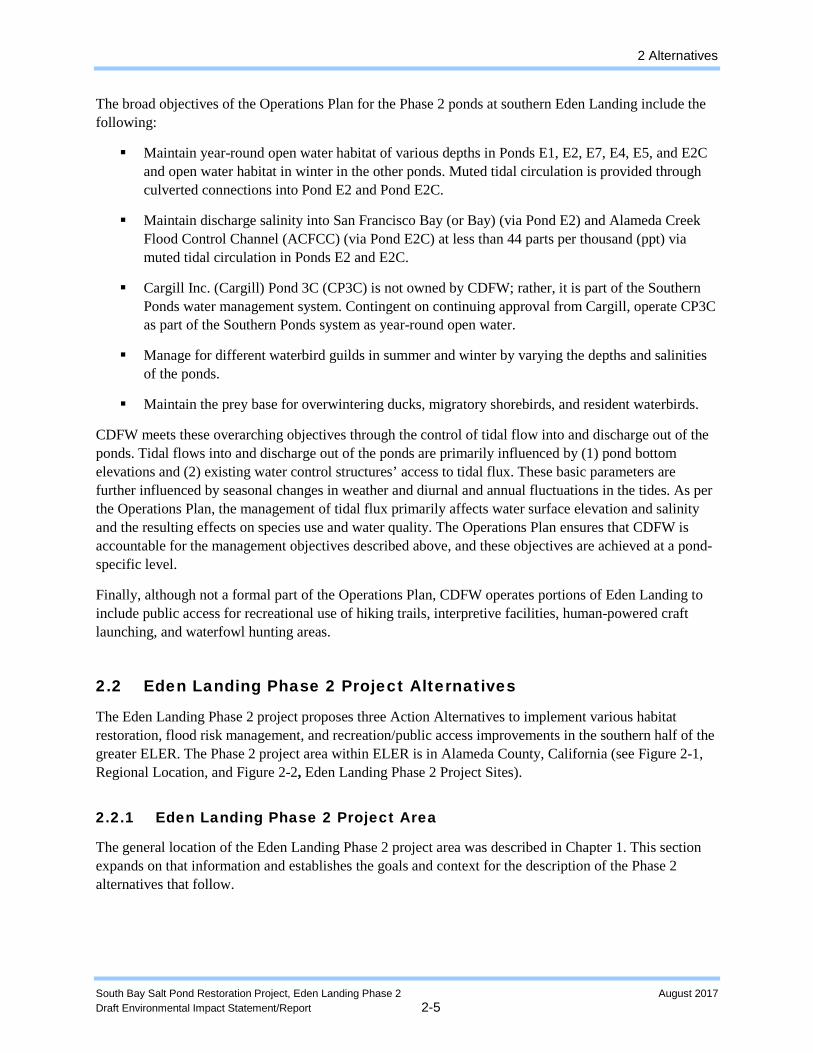
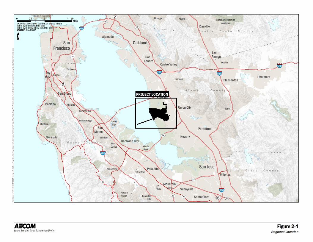
The Eden Landing Phase 2 project proposes three Action Alternatives to implement various habitat restoration, flood risk management, and recreation/public access improvements in the southern half of the greater ELER. The Phase 2 project area within ELER is in Alameda County, California (see Figure 2-1, Regional Location, and Figure 2-2, Eden Landing Phase 2 Project Sites).
2.2.1 Eden Landing Phase 2 Project Area
The general location of the Eden Landing Phase 2 project area was described in Chapter 1. This section expands on that information and establishes the goals and context for the description of the Phase 2 alternatives that follow.
2 Alternatives
South Bay Salt Pond Restoration Project, Eden Landing Phase 2 August 2017 Draft Environmental Impact Statement/Report 2-6
Figure 2-1. Regional Location
2 Alternatives
South Bay Salt Pond Restoration Project, Eden Landing Phase 2 August 2017 Draft Environmental Impact Statement/Report 2-7
Figure 2-2. Eden Landing Phase 2 Project Sites
2 Alternatives
South Bay Salt Pond Restoration Project, Eden Landing Phase 2 August 2017 Draft Environmental Impact Statement/Report 2-8
The Phase 2 project area in the southern portion of Eden Landing is made up of 11 ponds that are described according to three groups.
The groups of ponds within the Phase 2 Eden Landing project area are named according to their location within the overall pond complex and their proximity and similarity to each other. The sub-groups of ponds are intended to simplify the discussion of the ponds and the restoration alternatives that apply to them rather than repeating names of individual ponds. The sub-groups are as follows:
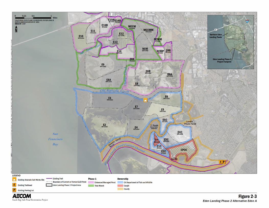
The Bay Ponds: Ponds E1, E2, E4, and E7 are the four large ponds closest to San Francisco Bay. The Phase 2 actions proposed at these ponds are intended to restore these ponds to tidal marsh. The Bay Ponds are bounded to the south by an Alameda County–owned strip of tidal wetland marsh.
The Inland Ponds: Ponds E5, E6, and E6C are somewhat smaller ponds in the northeast portion of the complex. These ponds could be restored to tidal marsh or to enhanced managed ponds, depending on which of the Phase 2 Action Alternatives is selected.
The Southern Ponds: Also called the “C-Ponds,” Ponds E1C, E2C, E4C, and E5C are in the southeastern portion of the complex. They are separated from the Bay Ponds and the Inland Ponds by an Alameda County–owned freshwater outflow channel and diked marsh areas known collectively as the “J-Ponds.” The Southern Ponds surround a natural hill known as Turk Island and abut another small hill commonly called “Cal Hill” that are private inholdings excluded from the Phase 2 project area. The Southern Ponds could be restored to tidal marsh or to enhanced managed ponds, depending on which of the Phase 2 Action Alternatives is selected.
These pond groups are addressed in the restoration actions, public access improvements, and flood risk management measures considered in the Phase 2 Action Alternatives. The Phase 2 project area incorporates temporary-construction-related disturbance areas and the long-term operational footprint of the project. Each of the alternatives would have slightly different short- and long-term disturbance areas, which are accounted for in the description and impact assessment for each technical resource topic discussed in this Draft EIS/R.
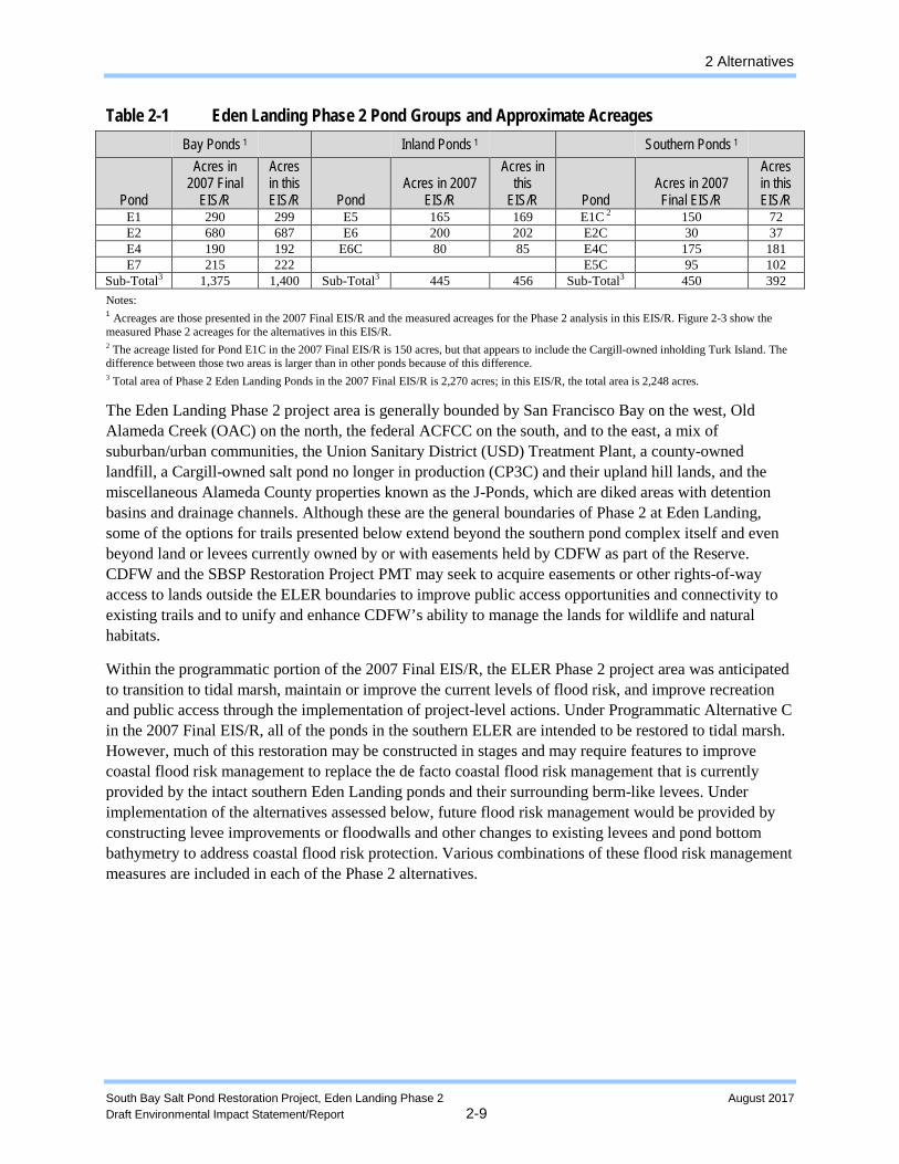
Table 2-1 summarizes the Phase 2 project area and pond groups at Eden Landing, along with the acreages of each as they were presented in the 2007 Final EIS/R. Different estimates of the areas of individual ponds may appear in other documents, and these estimates may differ because they may include the external levees and/or the internal levees or they may have been sampled during different seasons or tidal cycles. Total areas of ponds or pond groups might include uplands adjacent to them or to waterways or marshes between them. To reduce confusion, Table 2-1 presents those values for consistency with those prior documents, but also relates those values to the Phase 2-specific acreages that were developed for and used in the environmental impact analysis in this document. These are the acreages shown on the maps of the alternatives (Figures 2-3 through 2-6).
2 Alternatives
South Bay Salt Pond Restoration Project, Eden Landing Phase 2 August 2017 Draft Environmental Impact Statement/Report 2-9
Table 2-1 Eden Landing Phase 2 Pond Groups and Approximate Acreages Bay Ponds 1 Inland Ponds 1 Southern Ponds 1
Pond
Acres in 2007 Final
EIS/R
Acres in this EIS/R Pond
Acres in 2007 EIS/R
Acres in this
EIS/R Pond Acres in 2007 Final EIS/R
Acres in this EIS/R
E1 290 299 E5 165 169 E1C 2 150 72 E2 680 687 E6 200 202 E2C 30 37 E4 190 192 E6C 80 85 E4C 175 181 E7 215 222 E5C 95 102
Sub-Total3 1,375 1,400 Sub-Total3 445 456 Sub-Total3 450 392 Notes: 1 Acreages are those presented in the 2007 Final EIS/R and the measured acreages for the Phase 2 analysis in this EIS/R. Figure 2-3 show the measured Phase 2 acreages for the alternatives in this EIS/R. 2 The acreage listed for Pond E1C in the 2007 Final EIS/R is 150 acres, but that appears to include the Cargill-owned inholding Turk Island. The difference between those two areas is larger than in other ponds because of this difference. 3 Total area of Phase 2 Eden Landing Ponds in the 2007 Final EIS/R is 2,270 acres; in this EIS/R, the total area is 2,248 acres.
The Eden Landing Phase 2 project area is generally bounded by San Francisco Bay on the west, Old Alameda Creek (OAC) on the north, the federal ACFCC on the south, and to the east, a mix of suburban/urban communities, the Union Sanitary District (USD) Treatment Plant, a county-owned landfill, a Cargill-owned salt pond no longer in production (CP3C) and their upland hill lands, and the miscellaneous Alameda County properties known as the J-Ponds, which are diked areas with detention basins and drainage channels. Although these are the general boundaries of Phase 2 at Eden Landing, some of the options for trails presented below extend beyond the southern pond complex itself and even beyond land or levees currently owned by or with easements held by CDFW as part of the Reserve. CDFW and the SBSP Restoration Project PMT may seek to acquire easements or other rights-of-way access to lands outside the ELER boundaries to improve public access opportunities and connectivity to existing trails and to unify and enhance CDFW’s ability to manage the lands for wildlife and natural habitats.
Within the programmatic portion of the 2007 Final EIS/R, the ELER Phase 2 project area was anticipated to transition to tidal marsh, maintain or improve the current levels of flood risk, and improve recreation and public access through the implementation of project-level actions. Under Programmatic Alternative C in the 2007 Final EIS/R, all of the ponds in the southern ELER are intended to be restored to tidal marsh. However, much of this restoration may be constructed in stages and may require features to improve coastal flood risk management to replace the de facto coastal flood risk management that is currently provided by the intact southern Eden Landing ponds and their surrounding berm-like levees. Under implementation of the alternatives assessed below, future flood risk management would be provided by constructing levee improvements or floodwalls and other changes to existing levees and pond bottom bathymetry to address coastal flood risk protection. Various combinations of these flood risk management measures are included in each of the Phase 2 alternatives.
2 Alternatives
South Bay Salt Pond Restoration Project, Eden Landing Phase 2 August 2017 Draft Environmental Impact Statement/Report 2-10
Figure 2-3. Eden Landing Phase 2 Alternative Eden A
2 Alternatives
South Bay Salt Pond Restoration Project, Eden Landing Phase 2 January 2017 Draft Environmental Impact Statement/Report 2-11
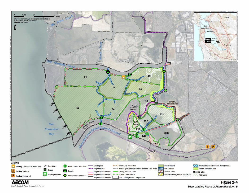
Figure 2-4. Eden Landing Phase 2 Alternative Eden B
2 Alternatives
South Bay Salt Pond Restoration Project, Eden Landing Phase 2 January 2017 Draft Environmental Impact Statement/Report 2-12
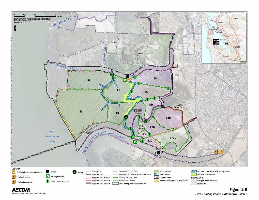
Figure 2-5. Eden Landing Phase 2 Alternative Eden C
2 Alternatives
South Bay Salt Pond Restoration Project, Eden Landing Phase 2 January 2017 Draft Environmental Impact Statement/Report 2-13
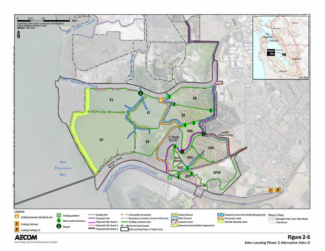
Figure 2-6. Eden Landing Phase 2 Alternative Eden D
2 Alternatives
South Bay Salt Pond Restoration Project, Eden Landing Phase 2 August 2017 Draft Environmental Impact Statement/Report 2-14
The 2007 Final EIS/R also laid out several goals for the major recreation and public access facilities within the ELER Phase 2 project area. The 2007 Final EIS/R selected Programmatic Alternative C for implementation, but because there is currently some uncertainty as to the extent of tidal restoration that will actually take place, the exact list of program-level public access goals addressed in the Phase 2 Action Alternatives varies. However, they are generally drawn from the options in the 2007 Final EIS/R or are reconfigured and designed to achieve similar purposes.
Public access options from the 2007 Final EIS/R that are included in the ELER Phase 2 alternatives include (but are not limited to) the following goals, all of which are assessed in this Draft EIS/R:
Maintain the existing trail that runs along the top of the large federal flood protection levee that forms the southern edge of the complex (i.e., the northern edge of the ACFCC). This effort would involve constructing bridge(s) over any breaches that are opened in that levee or using culverts or other water control structures to eliminate the need for open breaches.
Complete the San Francisco Bay Trail (Bay Trail) spine along the eastern edge of southern Eden Landing to the maximum extent feasible.
Add a spur trail along the northern edge of Pond E6 from the Bay Trail spine to the site of the former Alvarado Salt Works.
Convert the above spur trail into a loop by building a footbridge over OAC and a trail back to the Bay Trail spine.
Add other spur or loop trails and/or viewing platforms as feasible and wildlife-compatible opportunities allow.
2.2.2 Overview of Eden Landing Phase 2 Project Alternatives
This Draft EIS/R assesses the potential impacts associated with a No Action Alternative (Alternative Eden A) and three Action Alternatives (Alternative Eden B, C, and D). Under the No Action Alternative (Alternative Eden A), no new activities would occur in the project area, but ongoing operation and maintenance (O&M) would continue. Under the Action Alternatives, construction measures would be taken to transition the Bay Ponds to tidal marsh and to transition the Inland Ponds and/or the Southern Ponds to tidal marsh or enhanced managed ponds. The long-term decision to operate the Inland Ponds and/or the Southern Ponds in either manner will depend on the wildlife response. In all the Action Alternatives, flood risk management for the communities and infrastructure to the east of the project area would be provided through improvements to existing levees. As noted above, the flood risk management could be provided by some combination of an engineered levee on the eastern edge of the ponds or a mid-complex levee and improvements to existing levees on the western, Bay-facing edge of the ponds. In addition, recreational trails, bridges, viewing platforms and signage, and areas for sport fishing would be established to enhance public access to the area. Access for waterfowl hunting would continue.
2 Alternatives
South Bay Salt Pond Restoration Project, Eden Landing Phase 2 August 2017 Draft Environmental Impact Statement/Report 2-15
In each of the Action Alternatives, upland fill and/or dredged material may be used to enhance existing levees, build engineered levees, or to create habitat transition zones,2 which would serve as a transition zone between the ecosystems of the ponds and the uplands at the top of pond levees. Depending on the volume of material available, the constructed slope could be steeper to reduce the footprint area of impact on the current landscape. Upland fill material could also be used to improve levees. All imported upland material would be screened in accordance with an approved Quality Assurance Project Plan (QAPP) developed for the SBSP Restoration Project. That QAPP includes protocols for off-site imported material testing, classification, and tracking. Dredged material may also be placed into the ponds to raise the bottom elevations to accelerate marsh formation at these ponds and/or to build habitat features.
Each of the Action Alternatives contains similar project components designed and sited in different places within the project area to achieve slightly different goals. These goals include an emphasis on achieving different ratios of restored tidal marsh and enhanced managed ponds. Components common to each Action Alternative include levee breaches, levee lowering, installation of water control structures, excavation of pilot channels, connectivity for anadromous fish habitat, construction of habitat islands, habitat transition zones, beneficial reuse of dredged material and/or import of upland fill material, water control structures for managed ponds, and fish habitat connectivity. There are also public access and recreation components such as extension of the Bay Trail and improvement of existing trails within and surrounding the ELER Phase 2 project area. The numbers and locations of these features are different in each Action Alternative. These components are included in different combinations and at different locations in each of the Action Alternatives; the components are intended to improve habitat complexity and allow appropriate reserve management. The common components are illustrated on the maps of the components of Alternatives Eden B, C, and D (Figures 2-3 through 2-6). The details (number, dimensions, elevations) of these components in each alternative are presented below.
Alternative Eden B would restore the entirety of southern Eden Landing to tidal marsh in a single project implementation stage by providing sufficient improvements to the eastern, backside levees to provide the necessary degree of flood risk management. There would also be habitat enhancements, including transition zones, islands made from remnant levees, channel excavation, and levee lowering. Two sections of internal levee improvements would also be made along the J-Ponds and other Alameda County Flood Control and Water Conservation District (ACFCWCD)-owned channels. This alternative also features the inclusion of treated water from USD, inclusion of brackish groundwater from Alameda County Water District’s (ACWD) Aquifer Reclamation Program (ARP) wells, and placement of root wads and logs outside of Pond E2 to help trap sediment and form beach-like areas while providing some erosion protection. The Southern ponds would be connected to the ACFCC through a pair of water control structures and an additional structure within them. The Bay Trail spine would be completed through southern Eden Landing on one of a number of routes. There would be one viewing platform added along the Alameda Creek Regional Trail on the ACFCC levee.
Alternative Eden C would retain the Inland Ponds and the Southern Ponds as managed ponds and add a number of water control structures to allow the depth and salinity of these ponds to be actively managed for a range of different pond-dependent wildlife. The Bay Ponds would be
2 A habitat transition zone is a constructed feature with a relatively gentle slope (up to 30:1 [horizontal:vertical]) intended to provide a natural and ecologically beneficial connection between uplands or levees and the adjacent pond bottom.
2 Alternatives
South Bay Salt Pond Restoration Project, Eden Landing Phase 2 August 2017 Draft Environmental Impact Statement/Report 2-16
restored to tidal marsh as in Alternative Eden B through the use of a mid-complex levee that would largely be built on top of the existing internal levees. This alternative would feature a similar range of habitat enhancements at Eden B but in different locations. The same Bay Trail routes through the area would be assessed, but so too would a set of trails on either side of the OAC and a bridge over the OAC to connect them. These trails would form a spur trail to the site of the Alvarado Salt Works and a second viewing platform at that site. Another large bridge could be built over the ACFCC to extend the Bay Trail spine beyond the ELER boundary itself, connecting to existing Bay Trail spine south of the ACFCC in Coyote Hills Regional Park.
Alternative Eden D is a staged implementation of the tidal marsh restoration outlined in Alternative Eden B. Eden D would make use of a mid-complex levee, as in Alternative Eden C, but that levee function would be temporary and eventually be used for habitat enhancement, including habitat transition zones. This separation of the Bay Ponds from the others would allow those large outer ponds to first be restored to tidal marsh, after which the mid-complex levee would be modified, and the Inland and Southern Ponds would be restored to tidal marsh. Water control structures would be added to the Inland and Southern Ponds for use during the years in which they would be operated as managed ponds and then removed to allow tidal flows. The trail and associated viewing platform would be similar to those in Alternative Eden B.
2.2.3 Alternative Eden A (No Action)
Under Alternative Eden A, the No Action (No-Project) Alternative, no new activities would be implemented as part of the Phase 2 project. The CDFW would continue to maintain and operate the ponds as part of the ELER in accordance with the Operations Plan, the AMP, and current CDFW practices. The levees around the ponds are high-priority levees to be maintained for wildlife habitat purposes and to retain the current, de facto levels of coastal flood risk management provided to the adjacent inland communities. Outboard levees would be expected to be maintained as necessary (or repaired on failure). ACFCWCD would be expected to continue to direct stormwater runoff flows into and out of the J-Ponds and associated channels as needed. The existing Pacific Gas and Electric Company (PG&E) power distribution lines (running along the north side of Ponds E1, E7, and E6, along with the distribution line bisecting Pond E2C and running along the south side of Ponds E5C and E4C, would remain active and be unaffected by long-term operation of the Reserve.
No new recreation or public access features would be added in Alternative Eden A. However, the existing trail along the ACFCC would continue to be maintained, as would the trails and other access features in northern Eden Landing. Alternative Eden A is shown on Figure 2-3.
2.2.4 Alternative Eden B
Alternative Eden B is intended to provide full tidal marsh restoration in a single stage of construction and project implementation. It achieves this habitat restoration objective while providing a primary means of flood risk management by raising and otherwise improving the existing backside levees along the eastern edge of the Inland and Southern Ponds (in particular on Ponds E6, E5, E6C, E4C, E5C, and E2C, as shown on Figure 2-4). This alternative also provides flood storage capacity and some tidal damping within the ponds themselves. The provision of improved flood risk management on these backside levees would enable restoration of all Phase 2 project area ponds (the Bay Ponds, the Inland Ponds, and the Southern Ponds) without the use of an improved mid-complex (see Sections 2.2.5, Alternative Eden C,
2 Alternatives
South Bay Salt Pond Restoration Project, Eden Landing Phase 2 August 2017 Draft Environmental Impact Statement/Report 2-17
and 2.2.6, Alternative Eden D; ), Bay-facing levee enhancements, or the stepwise approach of allowing the Bay Ponds to become tidal marsh while the Inland and Southern Ponds stay as managed ponds in the short term, eventually transitioning to tidal marsh in the long term (see Section 2.2.6, Alternative Eden D). Details of the proposed improvements and the project features associated with Alternative Eden B are described below. These are organized into common categories of features and improvements that are often shared among all Action Alternatives; however, some are unique only to Alternative Eden B.
Levee Improvements
For Flood Risk Management. The backside levee improvements would be raised to an elevation of 12 feet North American Vertical Datum of 1988 (NAVD88), for a total of approximately 16,500 linear feet. From the hydrodynamic flood modeling summarized in Attachment 1 of Appendix D, a levee raised to this height would provide equal or better de facto flood risk management than the existing conditions, thereby meeting the flood-related objectives of the project. The top width of the raised levees would be 12 feet, and the side slopes would be at 4:1 (h:v). 3
For Habitat Separation and Enhancement. In Alternative Eden B, the fill material placed on the eastern border of the Inland and Southern Ponds against the backside levee would enhance the current levee and create a habitat transition zone. No other habitat transition zones are proposed as part of Alternative Eden B.
For Recreational Trails. Two levees would be raised to 12 feet NAVD88 to allow construction of a part of the Bay Trail spine along them (the trail routes are discussed below). These non-engineered levee improvements, which are shown in yellow on Figure 2-4, would have the same height and width as other levee improvements for habitat restoration. They would also continue to provide the same level of de facto flood risk management as the existing conditions. These improvements would total approximately 7,500 linear feet.
Levee Breaches and Pilot Channel Excavation
As part of Alternative Eden B, the levees along the northern margins of the Bay Ponds would be breached to introduce tidal flows to Ponds E1 and E6. Two pilot channels would be excavated to connect those proposed breaches to the rest of the Bay Ponds and Inland Ponds. An additional pilot channel would be constructed where a breach is proposed into the south side of Pond E2. A spur of this channel would extend into Pond E4. As shown on Figure 2-4, these channels would be constructed adjacent to the borrow ditches used to construct the interior levees. These channels would be deepened to improve drainage at low tides. This deepening would also improve constructability because the excavators would work from those interior levees. It would also make use of existing channels for better drainage. The northern end of these two pilot channels would extend into the northern channel of the OAC. The southern end of the pilot channel that extends from Pond E1 into Ponds E2 and E4 would facilitate filling and draining these ponds. The planned dimensions of the pilot channel into Pond E1 would be 15 feet wide and 2,500 feet long at an invert elevation of -4 feet NAVD88. The pilot channel in Pond E6 would be 30 feet wide and 2,000 feet long at an invert elevation of -4 feet NAVD88. The pilot channel into Pond E2 would be 30 feet wide and 2,600 feet long at an invert elevation of -4 feet NAVD88.
3 (h:v) horizontal / vertical
2 Alternatives
South Bay Salt Pond Restoration Project, Eden Landing Phase 2 August 2017 Draft Environmental Impact Statement/Report 2-18
Levee Lowering
Portions of the outer levees around the Bay Ponds would be lowered to mean higher high water (MHHW) (7 feet NAVD88) to provide more frequent levee overtopping, help provide an equal or improved level of de facto flood risk management relative to existing conditions, and increase the hydraulic connectivity between channels and marshes. The approximate locations of these lowered sections are shown on Figure 2-4; the total combined length of lowered levees in this alternative is 12,800 linear feet. The details of the modeling underlying this design concept are in Attachment 1 of Appendix D, and the potential impacts are explained in the appropriate sections of Chapter 3, Environmental Setting, Impacts, and Mitigation Measures.
Water Control Structures
Alternative Eden B emphasizes reestablishment of tidal marsh instead of enhanced managed ponds. As such, fewer water control structures would be necessary to manage tidal exchange and flows between the project area and its connection points to OAC and ACFCC. Alternative Eden B includes construction of four water control structures to manage and allow entry of flows from ACFCC into the Bay Ponds and Southern Ponds. The design details of the proposed water control structures (new structures and modifications to existing structures) are shown in a table in Appendix D, the Southern Eden Landing Preliminary Design Memorandum. Here, it is sufficient to note that most would be circular high-density polyethylene (HDPE) or corrugated metal pipe (CMP) culverts with typical diameters of 36 or 48 inches. At the connections between the ACFCC and the Alameda County–owned wetlands, these structures could instead be 6-foot x 6-foot concrete box culverts.
Fish Habitat Enhancements
One pilot channel would be excavated to provide enhanced fish habitat. This channel would be paired with a water control structure to allow controlled hydraulic connectivity between the ACFCC and Ponds E2 and E4. This channel and its connections are not intended to be necessary for draining and filling the Bay Ponds. Rather, it would be sized, placed, and oriented to allow passage of anadromous steelhead and other native fish from the ACFCC into the large Bay Ponds, which is expected to be beneficial nursery habitat for anadromous and estuarine fish as restored tidal marsh.
This pilot channel would be excavated near the levee between Ponds E2 and E4, across the County-owned high marsh south of the Bay Ponds, and to a culverted connection with the ACFCC. The channel would be approximately 3,100 feet long, 15 feet wide at the top, and set at an invert elevation of 0 feet NAVD88. The water control structure to connect the ACFCC with the channel across the County marsh to Pond E2 could be either a concrete box culvert or an HDPE or CMP culvert; the former may be preferable because it could be a natural-bottom culvert to encourage fish passage.
Habitat Transition Zones
Habitat transition zones would be constructed to increase habitat complexity and quality in the ponds for special-status species. The transition zones in Alternative Eden B would be built on the eastern border of the Inland and Southern Ponds, against the backside levee, one projecting into Inland Ponds E5, E6, and E6C and the other projecting into Pond E4C. The linear extent of these habitat transition zones, which would run in a primarily north-south orientation but be contoured to match the existing pond borders and the above-described constructed levee/floodwall, are approximately 6,000 linear feet and 4,500 linear feet, respectively. The backside habitat transition zones would have a slope as shallow as 30:1 (h:v), but
2 Alternatives
South Bay Salt Pond Restoration Project, Eden Landing Phase 2 August 2017 Draft Environmental Impact Statement/Report 2-19
they could be designed and built to be steeper, and thus smaller, depending on the amount of fill material available. The top elevation would be 9 feet NAVD88. A small gap must be maintained between these ponds and their habitat transition zones to accommodate the existing ACFCWCD channel that runs between them to the J-Ponds. Native vegetation would be planted on the habitat transition zones and may require control of invasive, exotic vegetation. The exact types of planted vegetation would be chosen to be appropriate to the elevation of the habitat transition zones along their slope into the ponds themselves. The plant mix would be developed as part of a future project phase. The maintenance of the habitat transition zones is generally limited to removal of invasive plants and mosquito abatement activities, as discussed in Section 2.2.10, Operation and Maintenance.
Habitat Islands
Habitat islands, primarily for nesting birds and upland refugia for other species, would be created from retained segments of levees around either the perimeter or internal levees of southern Eden Landing. Up to two dozen habitat islands could be formed in this way. The material excavated from the levee breaches and nearby pilot channels would be used to increase the remnant levee islands in both footprint and height. The islands would be built to an elevation above MHHW (9 feet NAVD88, not including any topping) to minimize exposure to tidal waters. As shown on Figure 2-4, the islands, because they would be constructed from remnant levees and adjacent pilot channels, would be linear in nature, and the majority of the islands would be located significant distances from recreational trails to avoid habitat disturbance. The proposed island in Ponds E5C and E4C would be located in the middle of the pond adjacent to the pilot channel, because those ponds are relatively higher than others in the pond complex, and the pond bottoms may be accessible with heavy equipment. All other islands would be constructed from existing levees only. Typical island side slopes would be at least 5:1 for stability, but variation based on the existing levee side slopes is expected.
Although most of the islands would be allowed to self-colonize (i.e., vegetation would establish itself on the islands) or be planted with native vegetation, some would be treated to provide unvegetated nesting habitat for western snowy plover, California least tern, or other bird species. Different surface treatments may be employed, depending on the wildlife management needs. For example, the top surface of the islands could be treated to minimize weed establishment and then topped with gravel, oyster shells, and/or sand to prevent vegetation, which is a landscape that is preferred by some species of nesting birds. This minor management decision would depend on the nesting requirements of the target species and may vary between years.
Upland Fill Import and Placement
As noted above, upland fill material would be brought in for levee improvements, habitat transition zones, and/or construction of islands (where needed) to fill any gap between the volumes needed for Alternative Eden B and the volumes that can be generated from the levee modifications, channel excavations, and the import of dredge material that are planned under this alternative. Table 2-6 in Section 2.2.9, Tables of Design Details, lists the cut and fill volumes of wet and dry material, as well as the net volume of required imported fill material, in all three Action Alternatives. These volumes represent a worst-case scenario where habitat transition zones would need to be built entirely with upland fill material and no imported dredge material. For Alternative Eden B, the potential impacts associated with traffic, air quality, and noise associated with delivery of upland fill material from offsite is based on the import of up to 92,000 cubic yards (CY) of fill. The assessment of these impacts includes excavation, loading, and delivery of the fill to a disposal site and to the Phase 2 project area via truck. Locally-specific impacts
2 Alternatives
South Bay Salt Pond Restoration Project, Eden Landing Phase 2 August 2017 Draft Environmental Impact Statement/Report 2-20
associated with delivery of fill material (such as traffic, noise, and air quality emissions) are evaluated in those chapters of this document.
Dredge Material Import and Placement
Alternative Eden B has the capacity to support beneficial reuse of up to 6 million cubic yards (MCY) of dredged material to create approximately 1,848 acres of tidal habitat in the Bay and Inland Ponds. Placement of the dredged material would allow for a target pond bottom elevation of 6.5 feet NAVD88 prior to breaching the ponds, the same elevation as mean higher water (MHW). Dredged material placement would also require minor levee improvements in some locations to provide adequate freeboard for the dredge material placement process. An additional 83,000 cubic yards of dredged material could also be used to create habitat transition zones. Dredge material would not be placed in the Southern Ponds because the already relatively high pond bottom elevations in those ponds make it unnecessary there and because of the long distance from the offloading facility.
The average annual rate of dredged sediment delivery to the Bay and Inland Ponds is expected to range from 0.9 to 1.8 MCY per year. Dredged material would be sourced from dredging projects around the Bay, which typically provide a range of fine and coarse material, although fines would likely be predominant. Dredging projects wishing to dispose of material at the southern Eden Landing ponds would obtain separate environmental review and permits to dredge and to transport their material to a deep-water transfer point located in the Bay. Only material meeting the San Francisco Bay Regional Water Quality Control Board’s (RWQCB) wetland cover suitability criteria would be accepted.
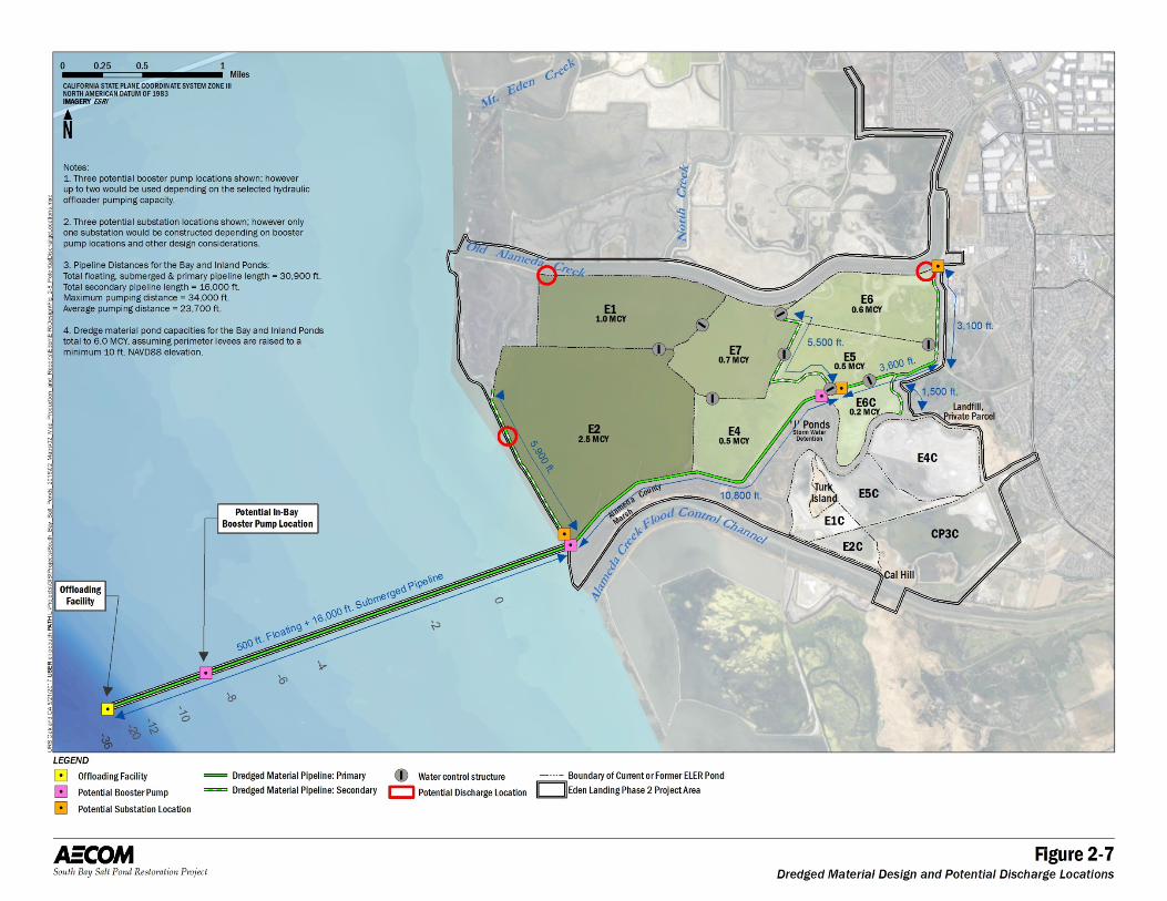
As part of Alternative Eden B, an offloading facility would be stationed in the Bay for a number of years during the start of construction. Dredge material would be offloaded at this facility, mixed with seawater, and the resulting slurry would be pumped from the offloader via pipelines to the Bay and Inland Ponds. The offloading facility would be located in the deep water channel approximately 3 miles offshore of Pond E2 (see Figure 2-7). The offloading facility would be comprised of a hydraulic offloader, landing barges, temporary mooring piles, delivery vessels, a feed water system, and slurry pipeline. The feed water system would be comprised of an intake pump and fish screen, and would supply water into the delivery vessel (scow or hopper) to create a slurry that the hydraulic offloader (i.e. transfer pump) would pump shoreward via pipeline. The offloading facility would be less than 30,000 square feet in size and approximately 30 temporary mooring piles, 18 to 36 inch in diameter, would be driven to secure the offloader, landing barges, delivery vessels, and supporting equipment.
2 Alternatives
South Bay Salt Pond Restoration Project, Eden Landing Phase 2 August 2017 Draft Environmental Impact Statement/Report 2-21
Figure 2-7. Dredged Material Design Components
2 Alternatives
South Bay Salt Pond Restoration Project, Eden Landing Phase 2 August 2017 Draft Environmental Impact Statement/Report 2-22
The pipeline transporting the slurry from the offloading facility to the Bay and Inland Ponds would be 24 to 36 inches in diameter and manufactured of steel or high density polyethylene (HDPE). The pipeline would be submerged from the offloading facility to shore during higher portions of the tidal cycle and exposed on the surface of exposed mudflat during the lower range. It would be identified with appropriate signage and lighting according to United States Coast Guard requirements. The pipeline would consist of the following approximate lengths from the offloading facility to the ponds: 500 feet floating, 16,000 feet submerged, 14,400 feet primary onshore, and 16,000 feet secondary onshore. Secondary onshore pipeline lengths include diversions from the primary pipeline to prevent material mounding and support habitat transition zone construction. The minimum, maximum, and average pumping distance would be approximately 16,500 feet, 34,000 feet, and 23,700 feet, respectively, depending on the pond discharge location. Up to two booster pumps would be located along the pipeline route, with potentially one in the Bay, depending on the hydraulic offloader’s pumping capacity. The offloading facility and booster pumps could be powered by diesel fuel or by electricity.
Existing water control structures would be used where possible to manage the slurry placed within the ponds; however, up to eight water control structures could be modified or added to maximize the residence time in the ponds and promote settling of solids. After the solids have settled in the ponds, excess water would be decanted and discharged into the Bay. The Bay and Inland Ponds have the capacity to receive the 0.9 to 1.8 MCY of dredged sediment in 1 year without discharging decant water back to the Bay. When discharge does become necessary, water would be returned to the Bay at either the Bay-front levee of Pond E2, or into OAC from one of the northern ponds (Ponds E1, E7, or E6). The infrastructure used for the import and placement of dredge material would be decommissioned prior to construction of other restoration, flood risk management, and recreational features.
Other details of the pumps, the slurry pipe, and other features are discussed in Section 2.2.7, Construction Methods, and in Appendix E, the Preliminary Design Memorandum of Dredged Material Placement at Southern Eden Landing.
Union Sanitary District Treated Water Reuse
The USD provides wastewater collection, treatment, and disposal services to Fremont, Newark, and Union City. USD’s wastewater treatment plant is immediately east of Pond E6. Given the close proximity to that plant and the desire of USD to occasionally supplement its discharge systems and capacity, further habitat enhancements could be realized by the beneficial reuse of treated water from USD. The treated water could be used to water the vegetation in the habitat transition zones, provide occasional decreases in salinity, and allow the Inland Ponds to experience periods of brackish water conditions.
There are existing subterranean pipes that function as a treated wastewater force main for the East Bay Dischargers Authority. These pipes run in a southeast-to-northwest direction just to the east of the ELER Phase 2 project area. The treated water currently flows through these pipes, which cut across the northeastern corner of ELER, and the treated water is eventually released into San Francisco Bay through a deep water discharge just south of the Oakland airport. Extensions from the existing outflow infrastructure at the USD location would be constructed and equipped with directional control systems to provide USD, in consultation with CDFW, with appropriate management capacity over the quantity and timing of diversion and delivery of treated wastewater to the Inland Ponds.
The USD has also inquired with regard to the SBSP Restoration Project about the potential to incorporate a system of pumps and pipes to allow two-way flows of treated wastewater from its neighboring facility
2 Alternatives
South Bay Salt Pond Restoration Project, Eden Landing Phase 2 August 2017 Draft Environmental Impact Statement/Report 2-23
into Pond E6. There are occasions when the USD has a need to store or buffer treated water from its facility to free up capacity for incoming stormwater. Thus, USD had the idea to create temporary detention capacity for 25 million to 50 million gallons of treated waste water in a hydraulically separated portion of Pond E6 and to implement an infrastructure in which USD could then pump that water back out for treatment before discharging it to the Bay. After consideration of this additional component as part of Phase 2 of the SBSP Restoration Project at southern Eden Landing, the project has removed it from further inclusion as part of Phase 2. However, the idea may be implemented in a future phase. At that time, the necessary NEPA and CEQA notifications, analyses, and review processes would be followed before a decision about implementation.
Beneficial Reuse of Groundwater from ACWD’s ARP Wells
Another alternative water supply for the habitat transition zone is brackish groundwater from ACWD’s ARP wells. ACWD manages groundwater in the Niles Cone groundwater basin (Niles Cone) through programs that protect and improve water supplies for groundwater users and the environment. Since 1962, when supplemental water was first purchased from the State Water Project, ACWD has been engaged in a continuous water replenishment/recharge program in order to sustainably manage the quality and quantity of water in the Niles Cone while balancing and protecting environmental resources. Although there has been substantial improvement in the basin, a considerable volume of saline water still remains in the groundwater aquifers. As a result, ACWD initiated its ARP to restore water quality in the groundwater basin by removing the saline water trapped in the aquifer system.
ACWD has two ARP wells near southern Eden Landing; one immediately adjacent to Ponds E5 and one near E4C. These ARP wells are used to remove trapped saline water from degraded portions of the aquifers in the Niles Cone in order to increase usable groundwater basin storage, to improve overall groundwater quality, and to prevent the movement of the saline water toward production wells. The brackish water from these wells could be used to water the vegetation in the habitat transition zones.
ACFCWCD Infrastructure
Alternative Eden B would continue to allow stormwater to pass from ACFCWCD’s detention basin east of the ponds through a water control structure into the J-Ponds to the west. A footbridge would be constructed over the water control structure to allow connectivity with the proposed Bay Trail additions.
Public Access and Recreation Features
For public access and recreation, several features would be included in Alternative Eden B to enhance public access within the Phase 2 project area.
First, the existing trail along the north side of the ACFCC would be retained by using water control structures to connect the Southern Ponds to the ACFCC. In all Action Alternatives, including Alternative Eden B, water control structures (instead of open breaches) would be constructed in the northern ACFCC levee. The SBSP Restoration Project does not plan to affect the existing trail at that location, and the levee would be reconstructed following whatever modifications are made to connect the ACFCC with the Eden Landing ponds. This trail , which is operated by the East Bay Regional Parks District (EBRPD), would thus be retained to allow for full use by pedestrians, bicyclists, and equestrians. All modifications would be sized and rated relative to the existing trail so that access by emergency vehicles and maintenance equipment would not be reduced from the current levels.
2 Alternatives
South Bay Salt Pond Restoration Project, Eden Landing Phase 2 August 2017 Draft Environmental Impact Statement/Report 2-24
Second, the SBSP Restoration Project’s goal of completing portions of the Bay Trail spine would be advanced by adding one of several new trail alignments as part of the project. The alignment to complete the Bay Trail spine through the general vicinity of southern Eden Landing is dependent on the availability of levees and other lands not owned by CDFW. The various trail options differ significantly in their routes through the Phase 2 project area, as shown on the Figures 2-4 through 2-6 The trail routes in this alternative would be on a combination of CDFW land and Alameda County land, depending on landowner agreements. Solely on CDFW-owned land, the Bay Trail would extend approximately 16,000 feet from the existing terminus in northern Eden Landing at the junction of NCMP and Pond 20B. The trail would then run south from that point along the eastern border of northern ELER, across the 20-tide-gate structure, over the OAC channel, into southern ELER, and then continue on CDFW levees to the southeast corner of Pond E6C. From there, three routes are proposed to connect the trail to the ACFCC levee. These routes are as follows:
Route 1: CDFW property only; 7,400 linear feet, to be placed on the levees improved for trails.
Route 2: CDFW and Cargill property; 10,500 linear feet, to be placed on the eastern and southern levees of the Southern Ponds, where they wrap around CP3C; Cargill owns the levees bordering this pond, and such an alignment would only be completed if Cargill agrees to sell and/or donate its holdings.
Route 3: CDFW and Alameda County property; 5,300 linear feet, to be placed on the CDFW-owned levee on the eastern side of Pond E4C and then routed onto Alameda County land to the east to the end of Westport Way, where no further trails or road improvements would be added as part of Phase 2. This route would not fully complete the Bay Trail spine through the entirety of southern Eden Landing. This route is not the preference of the SBSP Restoration Project, and it is intended to provide an interim “fall-back” option if either Route 1 or Route 2 cannot be fully completed as part of Phase 2.
In addition to these three routes, two “community connections” would be provided to enhance local public access onto the Bay Trail network. These two new access points to the Bay Trail would be through improvements that would be made to the construction access routes at Westport Way and Vesey Road. Following construction, the driveways, levees, and ramps from the local streets onto the levees would be enhanced, graded, sloped, and surfaced as needed to convert them into entry points for pedestrians and bicycles. These added access points would enhance the ability of local residents to use the trails without needing motor vehicles to get there.
Some of these trails would necessitate various pedestrian or bicycle bridges, as shown in Figures 2-4 through 2-6 Some would be placed on improved levees. However, in all of these cases the portions of the Phase 2 trails that would constitute part of the Bay Trail spine would be in compliance with the Americans with Disabilities Act (ADA) and would meet the Association of Bay Area Governments (ABAG) guidelines for Bay Trail spine segments wherever feasible. Levees with trails would be expected to be a minimum of 12 feet wide with a 3-foot shoulders on either side, totaling 18 feet. Trails not designated as part of the Bay Trail spine would be a minimum of 10 feet wide with a 1-foot shoulder on either side, totaling 12 feet. Some of the trail options shown on the figures would require acquisition of either ownership from Cargill or an easement or other right-of-way provision through lands or properties currently owned by the ACFCWCD. The SBSP Restoration Project intends to coordinate with these other landowners or agencies (such as EBRPD) to develop and implement a trail network through southern
2 Alternatives
South Bay Salt Pond Restoration Project, Eden Landing Phase 2 August 2017 Draft Environmental Impact Statement/Report 2-25
Eden Landing; however, the project cannot do so on its own, and all trail routes discussed in this Draft EIS/R must be considered to be contingent on these external landowners.
The discussion and analysis of Alternative Eden B includes the potential impacts of all of these routes so that maximum flexibility for implementing one or more of them would be retained as ownership and other access agreements are being determined. Other notable design details are in Section 2.2.2, Overview of Eden Landing Phase 2 Project Alternatives, above.
A viewing platform featuring benches, interpretive panels, and/or recreational information would be installed along the ACFCC trail near the southern boundary of the J-Ponds. The location of the platform would be near a trail junction or an interesting habitat feature. The content would include maps of trail routes, restoration actions, habitats, and other features or it may contain environmental education or other interpretive details.
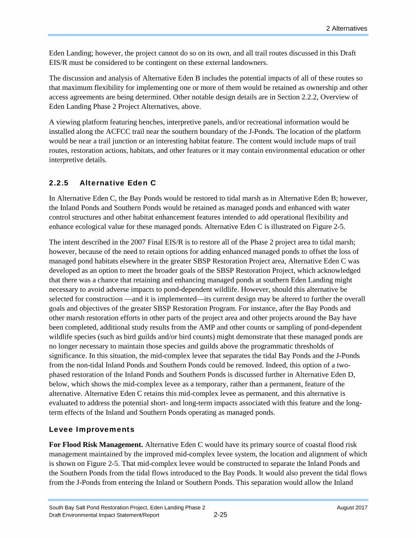
2.2.5 Alternative Eden C
In Alternative Eden C, the Bay Ponds would be restored to tidal marsh as in Alternative Eden B; however, the Inland Ponds and Southern Ponds would be retained as managed ponds and enhanced with water control structures and other habitat enhancement features intended to add operational flexibility and enhance ecological value for these managed ponds. Alternative Eden C is illustrated on Figure 2-5.
The intent described in the 2007 Final EIS/R is to restore all of the Phase 2 project area to tidal marsh; however, because of the need to retain options for adding enhanced managed ponds to offset the loss of managed pond habitats elsewhere in the greater SBSP Restoration Project area, Alternative Eden C was developed as an option to meet the broader goals of the SBSP Restoration Project, which acknowledged that there was a chance that retaining and enhancing managed ponds at southern Eden Landing might necessary to avoid adverse impacts to pond-dependent wildlife. However, should this alternative be selected for construction —and it is implemented—its current design may be altered to further the overall goals and objectives of the greater SBSP Restoration Program. For instance, after the Bay Ponds and other marsh restoration efforts in other parts of the project area and other projects around the Bay have been completed, additional study results from the AMP and other counts or sampling of pond-dependent wildlife species (such as bird guilds and/or bird counts) might demonstrate that these managed ponds are no longer necessary to maintain those species and guilds above the programmatic thresholds of significance. In this situation, the mid-complex levee that separates the tidal Bay Ponds and the J-Ponds from the non-tidal Inland Ponds and Southern Ponds could be removed. Indeed, this option of a two-phased restoration of the Inland Ponds and Southern Ponds is discussed further in Alternative Eden D, below, which shows the mid-complex levee as a temporary, rather than a permanent, feature of the alternative. Alternative Eden C retains this mid-complex levee as permanent, and this alternative is evaluated to address the potential short- and long-term impacts associated with this feature and the long-term effects of the Inland and Southern Ponds operating as managed ponds.
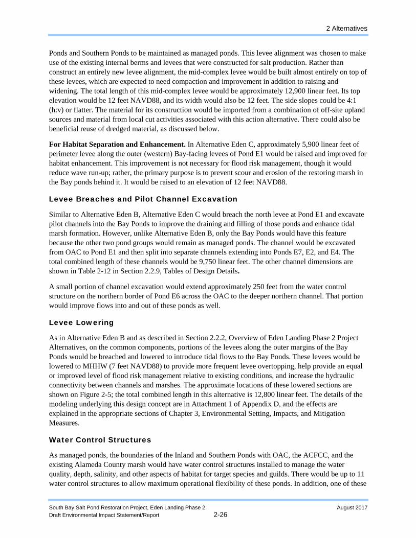
Levee Improvements
For Flood Risk Management. Alternative Eden C would have its primary source of coastal flood risk management maintained by the improved mid-complex levee system, the location and alignment of which is shown on Figure 2-5. That mid-complex levee would be constructed to separate the Inland Ponds and the Southern Ponds from the tidal flows introduced to the Bay Ponds. It would also prevent the tidal flows from the J-Ponds from entering the Inland or Southern Ponds. This separation would allow the Inland
2 Alternatives
South Bay Salt Pond Restoration Project, Eden Landing Phase 2 August 2017 Draft Environmental Impact Statement/Report 2-26
Ponds and Southern Ponds to be maintained as managed ponds. This levee alignment was chosen to make use of the existing internal berms and levees that were constructed for salt production. Rather than construct an entirely new levee alignment, the mid-complex levee would be built almost entirely on top of these levees, which are expected to need compaction and improvement in addition to raising and widening. The total length of this mid-complex levee would be approximately 12,900 linear feet. Its top elevation would be 12 feet NAVD88, and its width would also be 12 feet. The side slopes could be 4:1 (h:v) or flatter. The material for its construction would be imported from a combination of off-site upland sources and material from local cut activities associated with this action alternative. There could also be beneficial reuse of dredged material, as discussed below.
For Habitat Separation and Enhancement. In Alternative Eden C, approximately 5,900 linear feet of perimeter levee along the outer (western) Bay-facing levees of Pond E1 would be raised and improved for habitat enhancement. This improvement is not necessary for flood risk management, though it would reduce wave run-up; rather, the primary purpose is to prevent scour and erosion of the restoring marsh in the Bay ponds behind it. It would be raised to an elevation of 12 feet NAVD88.
Levee Breaches and Pilot Channel Excavation
Similar to Alternative Eden B, Alternative Eden C would breach the north levee at Pond E1 and excavate pilot channels into the Bay Ponds to improve the draining and filling of those ponds and enhance tidal marsh formation. However, unlike Alternative Eden B, only the Bay Ponds would have this feature because the other two pond groups would remain as managed ponds. The channel would be excavated from OAC to Pond E1 and then split into separate channels extending into Ponds E7, E2, and E4. The total combined length of these channels would be 9,750 linear feet. The other channel dimensions are shown in Table 2-12 in Section 2.2.9, Tables of Design Details.
A small portion of channel excavation would extend approximately 250 feet from the water control structure on the northern border of Pond E6 across the OAC to the deeper northern channel. That portion would improve flows into and out of these ponds as well.
Levee Lowering
As in Alternative Eden B and as described in Section 2.2.2, Overview of Eden Landing Phase 2 Project Alternatives, on the common components, portions of the levees along the outer margins of the Bay Ponds would be breached and lowered to introduce tidal flows to the Bay Ponds. These levees would be lowered to MHHW (7 feet NAVD88) to provide more frequent levee overtopping, help provide an equal or improved level of flood risk management relative to existing conditions, and increase the hydraulic connectivity between channels and marshes. The approximate locations of these lowered sections are shown on Figure 2-5; the total combined length in this alternative is 12,800 linear feet. The details of the modeling underlying this design concept are in Attachment 1 of Appendix D, and the effects are explained in the appropriate sections of Chapter 3, Environmental Setting, Impacts, and Mitigation Measures.
Water Control Structures
As managed ponds, the boundaries of the Inland and Southern Ponds with OAC, the ACFCC, and the existing Alameda County marsh would have water control structures installed to manage the water quality, depth, salinity, and other aspects of habitat for target species and guilds. There would be up to 11 water control structures to allow maximum operational flexibility of these ponds. In addition, one of these
2 Alternatives
South Bay Salt Pond Restoration Project, Eden Landing Phase 2 August 2017 Draft Environmental Impact Statement/Report 2-27
water control structures would be placed into the mid-complex levee between the J-Ponds and the planned pilot channel; this placement would allow the ACFCWCD to rapidly empty detained stormwater in the J-Ponds, if needed.
The water control structures would have combination gates at both the inlets and outlets for maximum operational flexibility in water level and salinity control. A combination gate can be operated as a slide gate to allow flow in both directions or may act as a tide gate for flow in either direction when one is closed. The design details of the proposed water control structures (new structures and modifications to existing structures) are shown in a table in Appendix D, the Southern Eden Landing Preliminary Design Memorandum. Here, it is sufficient to note that most would be circular HDPE or CMP culverts with typical diameters of 36 or 48 inches. At the connections between the ACFCC and the Alameda County–owned wetlands, these structures could instead be 6-foot by 6-foot concrete box culverts.
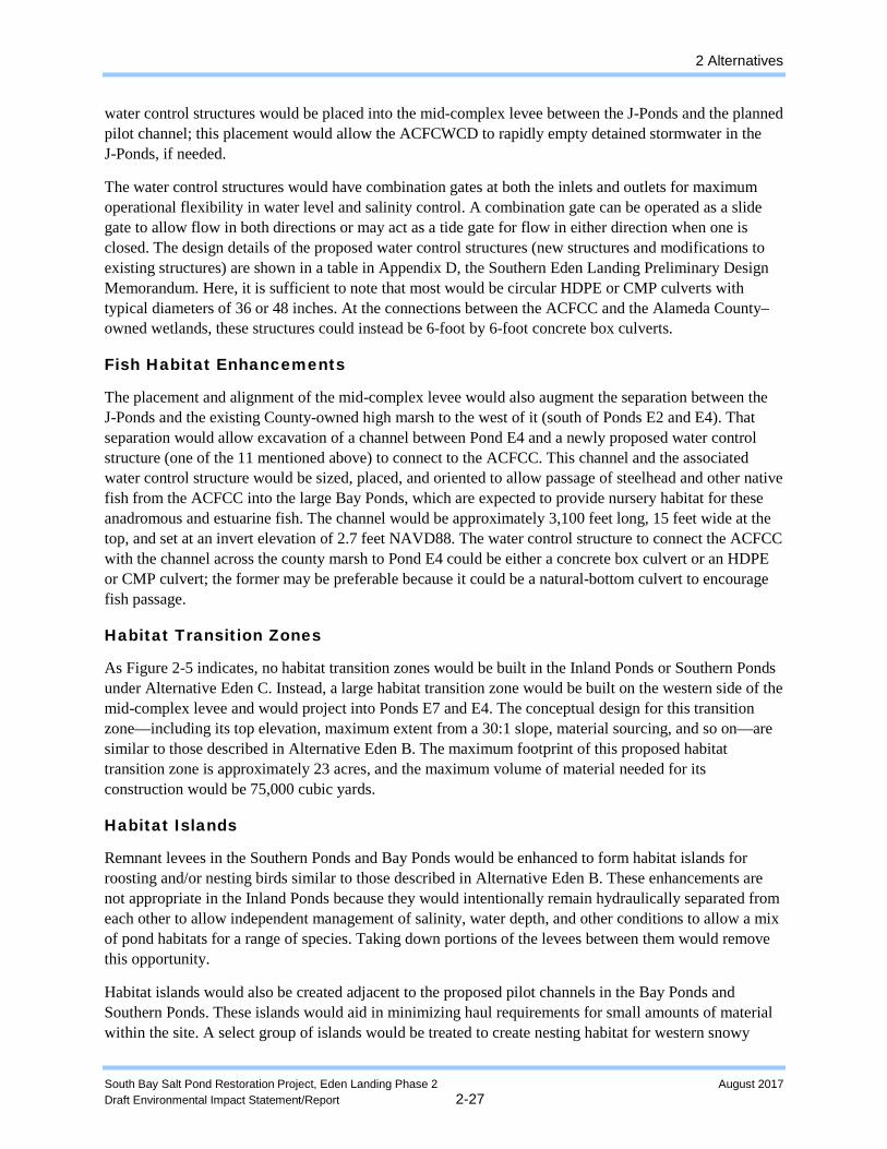
Fish Habitat Enhancements
The placement and alignment of the mid-complex levee would also augment the separation between the J-Ponds and the existing County-owned high marsh to the west of it (south of Ponds E2 and E4). That separation would allow excavation of a channel between Pond E4 and a newly proposed water control structure (one of the 11 mentioned above) to connect to the ACFCC. This channel and the associated water control structure would be sized, placed, and oriented to allow passage of steelhead and other native fish from the ACFCC into the large Bay Ponds, which are expected to provide nursery habitat for these anadromous and estuarine fish. The channel would be approximately 3,100 feet long, 15 feet wide at the top, and set at an invert elevation of 2.7 feet NAVD88. The water control structure to connect the ACFCC with the channel across the county marsh to Pond E4 could be either a concrete box culvert or an HDPE or CMP culvert; the former may be preferable because it could be a natural-bottom culvert to encourage fish passage.
Habitat Transition Zones
As Figure 2-5 indicates, no habitat transition zones would be built in the Inland Ponds or Southern Ponds under Alternative Eden C. Instead, a large habitat transition zone would be built on the western side of the mid-complex levee and would project into Ponds E7 and E4. The conceptual design for this transition zone—including its top elevation, maximum extent from a 30:1 slope, material sourcing, and so on—are similar to those described in Alternative Eden B. The maximum footprint of this proposed habitat transition zone is approximately 23 acres, and the maximum volume of material needed for its construction would be 75,000 cubic yards.
Habitat Islands
Remnant levees in the Southern Ponds and Bay Ponds would be enhanced to form habitat islands for roosting and/or nesting birds similar to those described in Alternative Eden B. These enhancements are not appropriate in the Inland Ponds because they would intentionally remain hydraulically separated from each other to allow independent management of salinity, water depth, and other conditions to allow a mix of pond habitats for a range of species. Taking down portions of the levees between them would remove this opportunity.
Habitat islands would also be created adjacent to the proposed pilot channels in the Bay Ponds and Southern Ponds. These islands would aid in minimizing haul requirements for small amounts of material within the site. A select group of islands would be treated to create nesting habitat for western snowy
2 Alternatives
South Bay Salt Pond Restoration Project, Eden Landing Phase 2 August 2017 Draft Environmental Impact Statement/Report 2-28
plover, California least tern, or other bird species. The top surface of the islands could be treated as described in Alternative Eden B or in some other way to allow management flexibility.
Upland Fill Import and Placement
As with Alternative Eden B, upland fill material would be brought in for levee improvements, habitat transition zones, and/or islands, as needed, to fill any gap between the volumes needed for Alternative Eden B and the volumes that can be generated from the levee modifications, channel excavations, and the import of dredge material that are planned under this alternative. Table 2-6 in Section 2.2.9, Tables of Design Details, lists the cut and fill volumes and the net volume of imported material of all three Action Alternatives. These volumes represent a worst-case scenario where habitat transition zones would need to be built entirely with upland fill material and no imported dredge material. Therefore, the potential impacts associated with the traffic, air quality, and noise for the delivery of up to 59,000 cubic yards of fill are assessed in this document. The assessment of these impacts includes excavation, loading, and delivery of the fill to a disposal site and to the Phase 2 project area by truck. Locally specific impacts associated with the delivery of fill material (such as traffic, noise, and air quality emissions) are evaluated in those sections of Chapter 3, Environmental Setting, Impacts, and Mitigation Measures.
Dredge Material Import and Placement
Alternative Eden C has the capacity to support beneficial reuse of up to 5.0 MCY of dredged material in the Bay Ponds. Placement of this dredged material would allow for a target pond bottom elevation of 6.5 feet NAVD88, the same elevation as MHW, prior to breaching the Bay Ponds and would require minor levee improvements in some locations to provide adequate freeboard for dredged material placement. An additional 46,000 cubic yards of dredged material could also be used to create habitat transition zones. Dredge material would not be placed in the permanent managed ponds (Inland and Southern Ponds). The average annual rate of dredged sediment delivery to the Bay Ponds is expected to range from 0.9 to 1.8 MCY per year.
Dredging projects wishing to dispose of material at Eden Landing would obtain separate environmental review and permits to dredge and to transport their material to a deep-water transfer point located in the Bay. Only material meeting the RWQCB wetland cover suitability criteria would be accepted.
As part of Alternative Eden C, an offloading facility would be stationed in the Bay during the start of construction. Dredge material would be offloaded at this facility, mixed with seawater, and the resulting slurry would be pumped from the offloader via pipelines to the Bay Ponds. The offloading facility would be comprised of a hydraulic offloader, landing barges, temporary mooring piles, delivery vessels, a feed water system, and slurry pipeline. The feed water system would supply water into the delivery vessel (scow or hopper) to create a slurry that the hydraulic offloader would pump shoreward via pipeline. The pipeline transporting the slurry from the offloading facility to the Bay Ponds would be submerged from the offloading facility to shore during higher portions of the tidal cycle and exposed on the surface of exposed mudflat during the lower range. The pipeline would consist of the following approximate lengths from the offloading facility to the ponds: 500 feet floating, 16,000 feet submerged, 10,800 feet primary onshore, and 11,400 feet secondary onshore. Secondary onshore pipeline lengths include diversions from the primary pipeline to prevent material mounding and support habitat transition zone construction. Up to two booster pumps would be located along the pipeline route, with potentially one in the Bay. The offloading facility and booster pumps could be powered by diesel fuel or by electricity.
2 Alternatives
South Bay Salt Pond Restoration Project, Eden Landing Phase 2 August 2017 Draft Environmental Impact Statement/Report 2-29
Existing water control structures would be used where possible to manage the slurry placed within the ponds; however, up to eight water control structures could be modified or added to maximize the residence time in the ponds and promote settling of solids. Once solids have settled in the ponds, excess water would be decanted and discharged into the Bay. Water would be returned to the Bay at either the Bay-front levee of Pond E2, or into OAC from one of the northern ponds (Ponds E1 or E7). The infrastructure used for the import and placement of dredge material would be demolished prior to construction of other restoration, flood risk management, and recreational features.
Other details of the pumps, the slurry pipe, and other features are discussed in Section 2.2.7, Construction Methods, and in Appendix E, the Preliminary Design Memorandum of Dredged Material Placement at Southern Eden Landing.
ACFCWCD Infrastructure
Alternative Eden C would continue to allow stormwater flows to pass from ACFCWCD’s detention basin east of the ponds through a water control structure into the J-Ponds to the west. A footbridge would be constructed over the water control structure to allow connectivity with the proposed Bay Trail additions.
Public Access and Recreation
For public access and recreation in Alternative Eden C, the features described above for Alternative Eden B would also be included to retain and enhance the public access experience within the Phase 2 project area. As under Alternative Eden B, the existing trail along the north side of the ACFCC would be retained by using water control structures to connect the Southern Ponds to the ACFCC. Also, the same trail route would be used to extend the Bay Trail from its current end partway through northern Eden Landing to the southeastern corner of Pond E6C. After that, the same three routes through most of southern Eden Landing would be analyzed for possible inclusion. These routes would require a 250-foot-long bridge over eastern end of the Alameda County–owned channel that connects to the J-Ponds and/or a 300–foot–long bridge over the western portion of this channel. All of these trail and bridge options are shown on Figure 2-5, as is the same viewing platform with benches and panels described in Alternative Eden B.
However, Alternative Eden C also includes several additional features for improved recreation and public access. Alternative Eden C proposes to build a bridge over the armored levee breach near Pond E2C across the ACFCC to connect with the existing Bay Trail, which continues to the south. This bridge would have to span at least 600 feet to cross the ACFCC, be high enough in the center to allow for periodic channel dredging, and be high enough over its entire length to allow for 100–year floods. The Bay Trail bridge over the ACFCC is intended to be accessible to pedestrians and bicycles, but not necessarily to maintenance or emergency vehicles, which have sufficient access to and from either side now.
A new Bay Trail spur trail to the former site of the Alvarado Salt Works is also proposed. This spur trail would run 5,900 feet along the northern edge of Pond E6 to a viewing platform and interpretive feature that would be included there to explain the history and the remnant structures at that location. The mid-complex levee would be built to the west of the former salt works site so that its degradation would not be accelerated. From this point, the OAC channel could be bridged for pedestrian and bicycle access, and a parallel trail would run eastward, back to the Bay Trail spine, along the southern levees of
2 Alternatives
South Bay Salt Pond Restoration Project, Eden Landing Phase 2 August 2017 Draft Environmental Impact Statement/Report 2-30
Ponds E6A and A8. The total length of this trail loop is approximately 13,500 feet, and the bridge would be approximately 500 feet.
All of these added trails and viewing platforms would comply with Bay Trail, EBRPD, and San Francisco Bay Conservation and Development Commission (BCDC) guidelines to the maximum extent feasible within the space available on the existing or improved levees and the Bay Trail guidelines for trail width and surfacing.
2.2.6 Alternative Eden D
Alternative Eden D is intended to provide a two-staged approach to tidal marsh restoration in the Eden Landing Phase 2 project area. Alternative Eden D recognizes there is uncertainty in the timing and successful outcomes of the Phase 1 projects that have recently been implemented and the Phase 2 projects at the Refuge ponds. Therefore, Alternative Eden D would allow operation of enhanced managed ponds in the Inland and Southern Ponds until conditions elsewhere within the greater SBSP Restoration Project demonstrated that the goals for managed pond habitat were being achieved and the needs of pond-associated wildlife were being met. Alternative Eden D is illustrated on Figure 2-6.
Selection of Alternative Eden D would provide a means to implement the AMP’s system of delaying the choice of whether to retain and improve some managed ponds or convert everything to tidal marsh until uncertainty has been reduced regarding how much of each habitat type (i.e., managed pond vs. tidal marsh) is necessary to support and enhance the overall ecology and species diversity of the South Bay.
Under Alternative Eden D, the Bay Ponds would be restored to tidal marsh immediately, while the Inland Ponds and Southern Ponds would be at least temporarily retained as enhanced managed ponds. Specific actions to achieve this mix of restored tidal marsh and enhanced managed ponds—and measures to provide flood risk management and recreation opportunities within the ELER Phase 2 project area—are described below.
Levee Improvements
Alternative Eden D includes three primary actions to improve existing levees. Some levee improvements are primarily intended to provide habitat, and others are primarily intended to maintain or improve the de facto levels of flood risk management. Figure 2-6 shows the location of each of the levee improvements described below, and Attachment 1 of Appendix D contains the details of the modeling underlying these design concepts, along with cross sections demonstrating the proposed design of each.
For Flood Risk Management. The existing levees on the east side of the Inland and Southern Ponds would be improved by increasing their top elevation to 12 feet NAVD88. Within the Inland Ponds, approximately 6,000 feet of existing perimeter levee would be raised, spanning from the northeast corner of Pond E6 to the south and west along Ponds E5 and E6C and ending at the eastern corner of Pond E6C. Also, approximately 10,500 feet of perimeter levee along the landside portion of the Southern Ponds, spanning from the northern corner of Pond E4C to the south and east around Pond E4C and then west and south along CP3C and ending at Cal Hill. The existing Cargill access levee to Turk Island would also be raised.
Alternative Eden D would also construct a temporary mid-complex levee separating the Bay Ponds from the Inland Ponds and extending across the J-Ponds and the western end of the Southern Ponds to connect
2 Alternatives
South Bay Salt Pond Restoration Project, Eden Landing Phase 2 August 2017 Draft Environmental Impact Statement/Report 2-31
to the ACFCC levee. This route is the same route as the permanent mid-complex levee in Alternative Eden C. It would be approximately 12,900 feet long and would be raised to an elevation of 12 feet NAVD88. Its primary purpose would be to act as a temporary feature separating restored tidal marsh within the Bay Ponds and enhanced managed ponds within the Inland and Southern Ponds; this feature would allow them to be separately restored and managed.
The combined effect of the improved backside levee and the mid-complex levee would provide equal or better flood risk management relative to existing conditions. The planned height of 12 feet NAVD88 is 5 feet above MHHW and would provide a freeboard of about 1.5 to 2.5 feet above the maximum water surface elevation within the ponds during the design hydrologic events.
The temporary mid-complex levee would remain in place until the following two conditions were demonstrated:
1. The Bay Ponds become established as tidal marsh to provide for adequate risk management to inland developed areas for coastal flooding.
2. Wildlife species that make use of managed ponds around southern San Francisco Bay are not adversely affected by the tidal marsh restoration associated with Phase 1 and Phase 2 project actions within the greater South Bay.
Accomplishing the goal of the second condition would indicate that the habitat for species that utilize managed ponds is not being impacted to a degree that it is negatively affecting the species. As such, the creation of additional tidal marsh would not detract from their habitat needs. Therefore, this condition would “free up” the Southern Ponds and Inland Ponds for conversion to tidal marsh. The plan for eventual conversion of all three pond groups to tidal marsh would fit with the intent of the 2007 Final EIS/R for all of southern Eden Landing.
For Habitat Separation and Enhancement. The existing far western bayward levee of Ponds E1 and E2 would be improved with an emphasis on creating upland and transitional habitat, not flood risk management purposes. The internal, pond-facing side of those levees would have an associated habitat transition zone that is discussed in detail below. The side slopes would be constructed at a ratio of 4:1 (H:V) and an elevation of 12 ft NAVD88. This top elevation would extend to a width of at least 12 feet (west to east) for the entire length of approximately 10,900 linear feet.
Levee Breaches and Pilot Channel Excavation
Alternative Eden D proposes a levee breach and pilot channel on the north side of Pond E1 to provide the Bay Ponds with hydrologic connectivity with OAC. The breach would not be armored but would be expected to evolve naturally with erosion or deposition from incoming and outgoing tidal flows from the Bay Ponds as facilitated by the associated pilot channel. The proposed pilot channel is intended to improve the draining and filling of the Bay Ponds and to enhance their tidal marsh restoration progress. Material from breach and pilot channel excavation would be used for levee raising, island or mound creation, or construction of habitat transition zones proposed as part of the project.
Alternative Eden D would also construct a pilot channel from OAC on the east side of the temporary mid-complex levee to allow increased flow between Ponds E6, E5 and E6C via proposed water control structures within the Inland Ponds. Another pilot channel would extend from ACFCC through the Southern Ponds, establishing greater hydrologic connectivity between Ponds E2C, E1C, E5C, and E4C.
2 Alternatives
South Bay Salt Pond Restoration Project, Eden Landing Phase 2 August 2017 Draft Environmental Impact Statement/Report 2-32
The total combined length of all pilot channels associated with Alternative Eden D would be 21,700 linear feet. The individual lengths and dimensions of the proposed pilot channel and its tributaries are provided in Appendix D, the Southern Eden Landing Preliminary Design Memorandum, and are shown on Table 2-12 in Section 2.2.9, Tables of Design Details.
Levee Lowering
As with Alternatives Eden B and Eden C, portions of the levees along the outer margins of the Bay Ponds would be breached and lowered to introduce tidal flows to the Bay Ponds. However, unlike Alternatives Eden B and Eden C, the western levee along Pond E2 would not be lowered, because Alternative Eden D would construct a habitat transition zone (described below) along the east side of that levee that would face into the pond.
Levee lowering on the north side of Pond E1 and south side of Pond E2 is planned to facilitate frequent levee overtopping by tides, but would still provide an equal or improved level of flood risk management relative to existing conditions. The levee-lowering locations would also increase the hydraulic connectivity between channels and marshes. The approximate locations of these lowered sections is shown on Figure 2-6; the total combined length of lowered levees in Alternative Eden D is 9,000 linear feet. The details of the modeling underlying this design concept are in Attachment 1 of Appendix D and the effects are explained in the appropriate sections of Chapter 3, Environmental Setting, Impacts, and Mitigation Measures.
Water Control Structures
Similar to Alternative Eden C, the Inland and Southern Ponds would have water control structures installed at their boundaries with OAC and the ACFCC. These installations would enable these ponds to function as enhanced managed ponds in the short term by facilitating their ability to manage water quality, depth, salinity, and other aspects of the habitat for certain species within these ponds. In total, Alternative Eden D would construct nine water control structures. One water control structure would be constructed at the boundary with OAC, and another at the boundary with the ACFCC. The remaining seven water control structures would be internal to the Inland and Southern Ponds.
Unlike Alternative Eden C, Alternative Eden D does not propose water control structures on the temporary mid-complex levee and therefore would not provide hydrologic connectivity with the Bay Ponds, at least until the mid-complex levee is breached or altered to allow an exchange of flows.
Each of the nine proposed water control structures will have combination gates at both the inlets and outlets for maximum flexibility in water level control. A combination gate can be operated as a slide gate to allow flow in both directions or may act as a tide gate in both directions when closed. The design details of the proposed water control structures (new structures and modifications to existing structures) are shown in a table in Appendix D, the Southern Eden Landing Preliminary Design Memorandum. Here, it is sufficient to note that most structures would be circular HDPE or CMP culverts with typical diameters of 36 or 48 inches. At the connections between the ACFCC and the Alameda County–owned wetlands, these could instead be 6-foot by 6-foot concrete box culverts.
2 Alternatives
South Bay Salt Pond Restoration Project, Eden Landing Phase 2 August 2017 Draft Environmental Impact Statement/Report 2-33
Fish Habitat Enhancement
Unlike Alternatives B and C, Alternative Eden D would not add components specifically for fish passage enhancements. As enhanced managed ponds, the proposed water control structures at the Inland and Southern Ponds may not be designed specifically to allow fish passage.
Habitat Transition Zones
A habitat transition zone is proposed on the east (internal) side of the westernmost Bay-facing levee of Pond E2. The habitat transition would be larger than—but constructed similarly to—those described in Alternatives Eden B and Eden C. However, it would not have the treated water from USD delivered to it. The total footprint of this habitat transition zone would be approximately 32 acres and consist of 96,000 cubic yards of fill material. Some of this material could come from the channel excavations and breaches that are also part of Alternative Eden D, but these are relatively small sources compared with the total quantity of material needed. Thus, most of the material for this habitat transition zone would be imported from off-site upland sources and/or from dredging projects.
Levee Enhancement for Habitat Separation
Approximately 10,900 linear feet of perimeter levee along the outer (western) Bay-facing levees of Ponds E1 and E2 would be raised and improved for habitat separation and enhancement. This improvement is not necessary to retain the current levels of de facto flood risk management, though it would reduce wave run-up. The primary purpose of this improvement is to provide a base for the habitat transition zone described above and to prevent periodic wave overtopping and subsequent scour and erosion of the restoring marsh in the Bay Ponds behind it. The levee would be raised to an elevation of 12 feet NAVD88.
Habitat Islands
Remnant levees in the Bay Ponds and Southern Ponds would be enhanced to form habitat islands for birds similar to those described in Alternative Eden C. These enhancements are not appropriate in the Inland Ponds because they would intentionally remain hydraulically separated from each other to allow independent management of salinity, water depth, and other conditions to allow a mix of pond habitats for a range of species. Taking down portions of the levees between them would remove this opportunity.
Habitat islands would also be created adjacent to the proposed pilot channels in the Bay Ponds and Southern Ponds. These locations would aid in minimizing haul requirements for small amounts of material within the site. A select group of islands would be treated to create nesting habitat for western snowy plover, California least tern, or other bird species. The top surface of the islands could be treated as described in Alternative Eden B or in some other way to allow management flexibility.
Upland Fill Import and Placement
Upland fill material would be brought in for levee improvements, habitat transition zones, and/or islands as needed to fill any gap between the volumes needed for Alternative Eden D and the volumes that can be generated from the levee modifications, channel excavations, and the import of dredge material that are planned under this alternative.
2 Alternatives
South Bay Salt Pond Restoration Project, Eden Landing Phase 2 August 2017 Draft Environmental Impact Statement/Report 2-34
Table 2-6 in Section 2.2.9, Tables of Design Details, lists the cut and fill volumes and the net volume of imported material of all three Action Alternatives. These volumes represent a worst-case scenario where habitat transition zones would need to be built with upland fill material instead of imported dredge material. Therefore, the potential impacts associated with traffic, air quality, and noise for the delivery of up to 154,000 cubic yards of fill are assessed in this document. The assessment of these impacts considers excavation, loading, and delivery of the fill to a disposal site and to the Phase 2 project area by truck. Locally specific impacts associated with delivery of fill material (such as traffic, noise, and air quality emissions) are evaluated in those sections in Chapter 3, Environmental Setting, Impacts, and Mitigation Measures.
Dredge Material Import and Placement
Alternative Eden D has the capacity to support beneficial reuse of up to 6 MCY of dredged material in the Bay and Inland Ponds. Placement of this dredged material would allow for a target pond bottom elevation of 6.5 feet NAVD88, the same elevation as MHW, prior to breaching the Bay Ponds and would require minor levee improvements in some locations to provide adequate freeboard for dredged material placement. An additional 96,000 cubic yards of dredged material could also be used to create habitat transition zones. Dredge materials would likely be placed in the Bay Ponds prior to the Inland Ponds. Dredge material would not be placed in the Southern Ponds because of the relatively high pond bottom elevations in those ponds and due to distance from the offloading facility.
Dredging projects wishing to dispose of material at Eden Landing would obtain separate environmental review and permits to dredge and to transport their material to a deep-water transfer point located in the Bay. Only material meeting the RWQCB wetland cover suitability criteria would be accepted.
As part of Alternative Eden D, an offloading facility would be stationed in the Bay during the start of construction (see Figure 2-7). Dredge material would be offloaded at this facility, mixed with seawater, and the resulting slurry would be pumped from the offloader via pipelines to the Bay and Inland Ponds. The offloading facility would be comprised of a hydraulic offloader, landing barges, temporary mooring piles, delivery vessels, a feed water system, and slurry pipeline. The feed water system would supply water into the delivery vessel (scow or hopper) to create a slurry that the hydraulic offloader would pump shoreward via pipeline. The pipeline transporting the slurry from the offloading facility to the Bay and Inland Ponds would be submerged from the offloading facility to shore during higher portions of the tidal cycle and exposed on the surface of exposed mudflat during the lower range. The pipeline would consist of the following approximate lengths from the offloading facility to the ponds: 500 feet floating, 16,000 feet submerged, 14,400 feet primary onshore, and 16,000 feet secondary onshore. Secondary onshore pipeline lengths include diversions from the primary pipeline to prevent material mounding and support habitat transition zone construction. Up to two booster pumps would be located along the pipeline route, with potentially one in the Bay. The offloading facility and booster pumps could be powered by diesel fuel or by electricity.
Existing water control structures would be used where possible to manage the slurry placed within the ponds; however, up to eight water control structures could be modified or added to maximize the residence time in the ponds and promote settling of solids. Once solids have settled in the ponds, excess water would be decanted and discharged into the Bay. Water would be returned to the Bay at either the Bay-front levee of Pond E2, or into OAC from one of the northern ponds (Ponds E1, E7, or E6). The infrastructure used for the import and placement of dredge material would be demolished prior to construction of other restoration, flood risk management, and recreational features.
2 Alternatives
South Bay Salt Pond Restoration Project, Eden Landing Phase 2 August 2017 Draft Environmental Impact Statement/Report 2-35
Other details of the pumps, the slurry pipe, and other features are discussed in Section 2.2.7, Construction Methods, and in Appendix E, the Preliminary Design Memorandum of Dredged Material Placement at Southern Eden Landing.
ACFCWCD Infrastructure
Alternative Eden D would continue to allow stormwater flows to pass from the ACFCWCD’s detention basin east of the ponds. Due to the temporary mid-complex levee, stormwater flows would be contained within the J-Ponds until they could be pumped back to OAC, as is the current practice.
Public Access and Recreation
The public access and recreation features in Alternative Eden D are the same as those in Alternative Eden B. Existing trails and access points would be retained. The Bay Trail spine would be completed through southern Eden Landing, using the same route to the corner of Pond E6 and then using one of the three optional routes described above. The viewing platform would be installed as described above.
2.2.7 Construction Methods
This section summarizes the construction methods that are presented in more detail in the design memorandums included as Appendix D. This section describes the planned access routes to the ponds, the construction sequence, the implementation of each component of the project, and the construction equipment.
Access
The ponds would likely be accessed by construction crews from Interstate 880, from which various arterials, collectors, and local streets provide access through Union City to two main gated entrances to southern Eden Landing. The gated entrances are inaccessible to the public. The primary access is near the USD headquarters, at the end of Horner Street. Access to the Southern Ponds is at the end of Westport Way via Carmel Way (near Sea Breeze Park) off Union City Boulevard. These access routes are shown on Figure 2-8. Access within the pond complex is via former salt pond levee maintenance roads. Public foot and road access is currently permitted at some locations within the pond complex.
Construction crews would typically consist of fewer than a dozen people, but there could be multiple crews at the Phase 2 project area on any given day because of its large size. Heavy vehicles would avoid crossing structures in the levees if the vehicle exceeds the weight-bearing capacity. If such avoidance is not possible, engineer-approved precautions would be taken to avoid damaging the structures.
Construction staging areas would be established as needed on existing levee-top roads within Eden Landing.
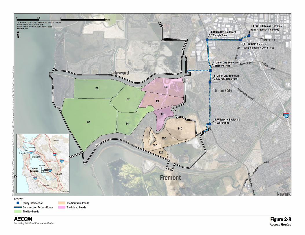
2 Alternatives
South Bay Salt Pond Restoration Project, Eden Landing Phase 2 January 2017 Draft Environmental Impact Statement/Report 2-36
Figure 2-8. Access Routes
2 Alternatives
South Bay Salt Pond Restoration Project, Eden Landing Phase 2 August 2017 Draft Environmental Impact Statement/Report 2-37
Dredge Material Placement
Construction Sequencing
Construction will be implemented by procuring the services of a general contractor with experience in performing dredged material offloading activities, marine pile driving, levee improvements, and working within and near tidal waters and Bay mud.
The sequence of construction tasks for dredge material placement may include the following:
Pre-construction pond management: Lower pond water levels to lowest possible levels for improved site access.
Mobilization: Develop staging areas and other facilities. Mobilize equipment to the site using ground transportation.
Site preparation:
o Temporary mooring piles would be driven in the deep water channel to secure the offloader, landing barges, delivery vessels, and supporting equipment; the submerged pipeline would be installed; and in-water equipment would be installed (i.e., the offloader, landing barges, floating pipeline, support equipment, and booster pump). The offloading facility, in-Bay booster pump, and floating and submerged pipeline would be floated into position at high tides.
o Where necessary, levees would be cleared and grubbed; raised (requiring cut, haul, and fill); and various water control structures would be installed to facilitate distribution of the dredge sediments.
o Onshore equipment would be installed (i.e., booster pumps and onshore pipelines). If the offloading facility and booster pumps are powered by electricity, the electrical infrastructure would also be installed (i.e., a substation, overhead transmission line, and submarine power cables).
Dredged material placement: Dredge material would be offloaded at the deep-water transfer point in the Bay; slurry material would be pumped and placed in the ponds; habitat transition zones would be constructed using dredge material. As needed, offseason demobilization, equipment storage, and re-mobilization could also occur.
Decommissioning:
o In-water equipment would be demobilized (i.e., offloader, barges, floating pipeline, support equipment, and booster pump) and the offshore piles and submerged pipeline and support structure would be demolished.
o Onshore equipment would be demolished (shore booster pump; shore pipeline; water control structures). If powered by electricity, the onshore substation, overhead transmission line, submarine power cables would also be demolished.
Demobilization: Construction materials would be removed via ground transportation.
2 Alternatives
South Bay Salt Pond Restoration Project, Eden Landing Phase 2 August 2017 Draft Environmental Impact Statement/Report 2-38
Other restoration, flood risk management, and recreational features would be constructed following demobilization of the dredged material placement equipment. These restoration features includes channel excavation, levee lowering and raising, habitat island creation, internal and external levee breaching, water control structure removal/ modification, habitat transition zone construction (if needed), and recreational trail and bridge construction.
Individual Components
Construction features used for dredge material placement are shown on Figure 2-7. Dredge material placement components would be constructed, used, and then demolished prior to the construction of other restoration, flood risk management, and recreational features.
Offloading Facility. The offloading facility would offload material from barges and scows and transport the material via pipeline to the Bay and Inland Ponds for placement.4 The offloading facility would be comprised of an hydraulic offloader, temporary mooring dolphins, landing barges, an auxiliary feed water pump, pipelines, delivery vessels, and support equipment. Support equipment would include barges, tug boats, crew boats, and site security. The hydraulic offloader would be held in position with 10 to 30 steel pipe piles securing the offloading facility. All materials and equipment would contain the appropriate signage and navigation lighting in accordance with U.S. Coast Guard requirements. Material barges or scows (delivery vessels) would range in capacity from 800 to 6,000 cubic yards and would draft up to 18 feet. Given the required water depth for the delivery vessels and offloading equipment, the offloading facility would be positioned approximately 3 miles offshore, past the mudflats and shallow depths bordering Pond E2.
Depending on the material type and selected equipment, an offloading facility and booster pump system could be sized to pump material a range of distances, ranging from within the inner pond levee nearest the bay (Pond E2), approximately 3 miles, to the farthest inland extent of the ponds (Pond E6), approximately 6 miles. Most likely a 120-foot-long by 50-foot-wide hydraulic offloader, with an approximate 24 inch suction and discharge pipe, would provide the main pumping capacity to place material in the Bay and Inland Ponds. An auxiliary feed water system would slurry the dredged material in scows by agitation with water jets, allowing the hydraulic offloader to suction the slurry through the snorkel and transport the material via pipeline to shore. The slurry would contain approximately 10 to 40 percent solids by volume. Feed water would be sourced from a screened intake located at the offloader in the deep water channel. Fish screens would comply with NMFS and CDFW design guidelines to protect species of concern.
Pipelines. A network of approximately 46,900 feet of pipeline would be installed to transport sediment slurry from the hydraulic offloader to and around the Bay and Inland Ponds. The pipeline would be comprised of approximately 500 feet of floating pipeline, 16,000 feet of submerged pipeline, 14,400 feet of primary shore pipeline, and 16,000 feet of secondary shore pipeline.5 Secondary shore pipeline could support the spread of material throughout the ponds and allow for sand mounding along the proposed habitat transition zone locations.
The floating, submerged and shore pipelines would range in size from 24 to 36 inches in diameter and would be comprised of steel and/or HDPE. Submerged pipeline would be anchored on the Bay bottom 4 Alternative Eden C would receive dredged material in only the Bay Ponds. 5 In Alternative Eden C, only the Bay Ponds would receive dredge material and therefore the primary onshore pipeline length would be reduced to 10,800 feet and the secondary onshore pipeline length would be 11,400 feet.
2 Alternatives
South Bay Salt Pond Restoration Project, Eden Landing Phase 2 August 2017 Draft Environmental Impact Statement/Report 2-39
with precast concrete pipe weights to reduce navigation hazards and vulnerability to wind and wave action, and they would be identified with signs and lights per United States Coast Guard guidelines. Portions of the submerged pipeline may be floated above the shallow mudflats if there is a concern of water flow around the pipeline during low tide. The outboard levee would be minimally graded to transition the pipeline from the mudflats to the levee. The onshore pipeline would be secured with stakes on existing levees currently used for maintenance access, or on levee shoulders as necessary to sustain equipment access. Existing vegetation on levees would be avoided where possible. Abrupt pipeline turns would be supported with concrete blocks as necessary. The pipeline would undergo repair and replacement due to typical wear and tear during the dredge material placement component of the construction. The type of pumped material (sand and gravel versus silt and clay) would influence the frequency of repair and replacement.
Booster Pumps. Given the distance from the offloading facility to the point of discharge in the Bay and Inland Ponds, one or more in-line booster pumps would be required and would be located along the discharge line to increase the pumping production rate and facilitate delivery of the slurry to the ponds. Typically boosters are needed every 2 to 5 miles and allow for an additional pumping distance of about 2 miles. The specific locations of the booster pumps would depend on the pumping capacity of the selected offloader and desired discharge location. For instance, two boosters may be required if slurry is pumped to the northeast corner of the Inland Ponds (approximately 6.1 miles). Booster pumps may be located along the pipeline in the Bay and/or on pond levees. If located within the Bay, a floating or jack-up booster pump barge may be pile-secured depending on water depth and wind/wave action. A jack-up booster pump may be held in place with up to four spuds, while a floating booster pump barge would be secured with approximately 4 piles (each 24 to 36 inches in diameter). Both booster pumps require at least 8 feet of water depth for crew changes with a skiff and to provision it with fuel, and typically range in size from 3,500 to 7,200 square feet. If located on land, a booster pump may be used at multiple locations depending on pumping distance and material type. A booster pump station would be approximately 5,000 square feet in size and would likely require temporary placement of material within the ponds for adequate space and access around the equipment.
Levee improvements. Levees would be improved to an elevation of 10 feet NAVD88 in the Bay and Inland Ponds during the dredge material placement component of the construction to provide sufficient slurry capacity to reach the target pond bottom elevation of 6.5 feet NAVD88, the same elevation as MHW. The 2 feet of freeboard between the maximum slurry elevation and levee crest would provide allowances for wind waves generated within the ponds and captured precipitation. Up to 10,000 cubic yards of material would be sourced from onsite existing levees that are currently above elevation of 10 feet NAVD88. The southern levee of Pond E2 and northern levees of Ponds E1 and E7 are proposed for levee lowering. Material would not be sourced from levees proposed for improvement in the restoration component, so as to avoid lowering and raising the same levees in different phases of the construction. Material would be sourced from approximately 5,500 linear feet of relatively high levees, and be used to improve 20,400 linear feet of levees identified for improvement.
Water Control Structures. Existing water control structures are believed to be sufficient to manage the dredged material slurry. However, depending on their invert elevation, location within the ponds, and the selected slurry discharge point within the ponds, additional water control structures may temporarily be installed to manage the dredged material slurry. Up to eight new or replaced water control structures, likely no larger than approximately two 48 inch HDPE pipes per structure, would allow for controlled
2 Alternatives
South Bay Salt Pond Restoration Project, Eden Landing Phase 2 August 2017 Draft Environmental Impact Statement/Report 2-40
exchange between the Bay and Inland Pond levees. The structures would be temporary, designed to span the approximated time period anticipated for dredge material placement (less than 10 years).
Discharge Structures. Decant discharge structures would be used to return decant water to the Bay or sloughs after solids settlement in the ponds. Because the location of the slurry pipe outlet would change with material type and volume placed, multiple discharge locations are considered along the levees between Pond E2 and the Bay, and Ponds E1, E6 and OAC. Likely no more than two locations would be used during different phases of dredged material placement.
Decant discharge structures typically have stop logs or variable height weirs on the upstream side to allow for the controlled decant of the ponded water on the downstream side; therefore, existing water control structures would likely have to be modified to discharge decant water.
Power. The offloading facility and booster pumps may be powered by diesel fuel or electricity. If diesel were to power the construction equipment during dredge material placement, a large diesel generator barge would be moored near the offloading facility in the deep-water channel. Booster pumps and onshore equipment would have individual diesel generators that would be maintained by land- and water-based crews.
If electricity were used to power construction equipment during dredge material placement, the electrical infrastructure necessary to bring power to the offloading facility and booster pumps would include a substation, overhead transmission line, and submarine power cables (described below).
Electric Substation: Construction of an electric substation would be required to interface with the PG&E power system and transform the voltage from 138 kilovolts (kV) to 12.47 kV, and to provide distribution power to construction equipment including booster pumps, the offloading facility, and other plant loads. Additional transformers and electrical equipment would be required at pump locations to transform the voltage to a useable voltage, likely 2300 volts (V) or 4140 V. The substation site would also include a small unmanned control building/enclosure to house auxiliary controls and protective relay systems. The substation would be supported by a large concrete pad (with foundation piles) and would encompass an area approximately 12,000 square feet in size. The substation would likely be located on a Bay front levee, which would require temporary placement of material within the ponds for adequate space and access around the equipment. Alternatively, the substation could be located on a perimeter levee (potentially near a shore booster pump), or near the high voltage line on USD’s property.
Overhead transmission line: The project interconnection would consist of a 138 kV line segment extending from the existing PG&E transmission line located east of the southern Eden Landing ponds to the proposed 138 kV substation. Tubular steel pole structures approximately 70 to 100 feet in height would be required to support overhead transmission conductors and shield wires. The PG&E line would be looped into the substation where the voltage would be transformed to a lower voltage that is suitable for the proposed distribution system. From the high voltage line near the USD property, approximately 17,700 feet (3.4 miles) of overhead power cables would be installed to reach the shore’s edge at the southwest corner of Pond E2.
Submarine power cables: Submarine power cables would carry electric power from the shore’s edge to the potential in-Bay booster pump and offloading facility. The submerged power cables would be laid on the Bay bottom and would extend approximately 16,000 feet (3 miles) offshore to the offloading facility.
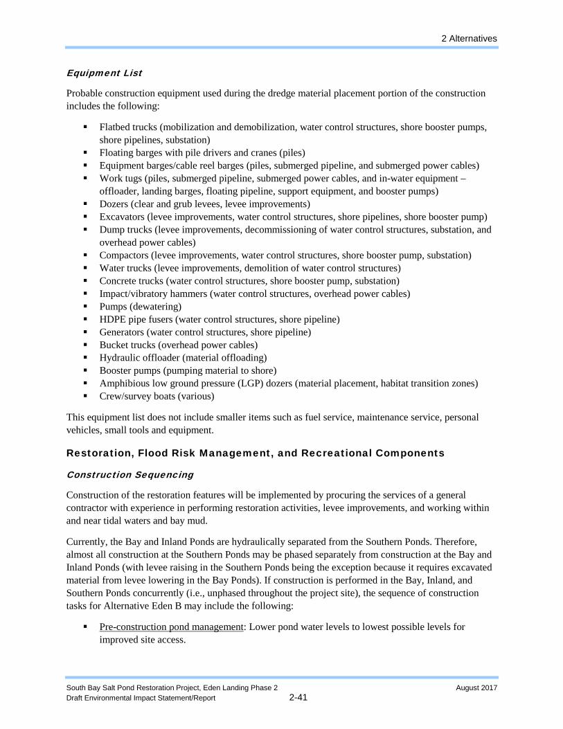
2 Alternatives
South Bay Salt Pond Restoration Project, Eden Landing Phase 2 August 2017 Draft Environmental Impact Statement/Report 2-41
Equipment List
Probable construction equipment used during the dredge material placement portion of the construction includes the following:
Flatbed trucks (mobilization and demobilization, water control structures, shore booster pumps, shore pipelines, substation)
Floating barges with pile drivers and cranes (piles) Equipment barges/cable reel barges (piles, submerged pipeline, and submerged power cables) Work tugs (piles, submerged pipeline, submerged power cables, and in-water equipment –
offloader, landing barges, floating pipeline, support equipment, and booster pumps) Dozers (clear and grub levees, levee improvements) Excavators (levee improvements, water control structures, shore pipelines, shore booster pump) Dump trucks (levee improvements, decommissioning of water control structures, substation, and
overhead power cables) Compactors (levee improvements, water control structures, shore booster pump, substation) Water trucks (levee improvements, demolition of water control structures) Concrete trucks (water control structures, shore booster pump, substation) Impact/vibratory hammers (water control structures, overhead power cables) Pumps (dewatering) HDPE pipe fusers (water control structures, shore pipeline) Generators (water control structures, shore pipeline) Bucket trucks (overhead power cables) Hydraulic offloader (material offloading) Booster pumps (pumping material to shore) Amphibious low ground pressure (LGP) dozers (material placement, habitat transition zones) Crew/survey boats (various)
This equipment list does not include smaller items such as fuel service, maintenance service, personal vehicles, small tools and equipment.
Restoration, Flood Risk Management, and Recreational Components
Construction Sequencing
Construction of the restoration features will be implemented by procuring the services of a general contractor with experience in performing restoration activities, levee improvements, and working within and near tidal waters and bay mud.
Currently, the Bay and Inland Ponds are hydraulically separated from the Southern Ponds. Therefore, almost all construction at the Southern Ponds may be phased separately from construction at the Bay and Inland Ponds (with levee raising in the Southern Ponds being the exception because it requires excavated material from levee lowering in the Bay Ponds). If construction is performed in the Bay, Inland, and Southern Ponds concurrently (i.e., unphased throughout the project site), the sequence of construction tasks for Alternative Eden B may include the following:
Pre-construction pond management: Lower pond water levels to lowest possible levels for improved site access.
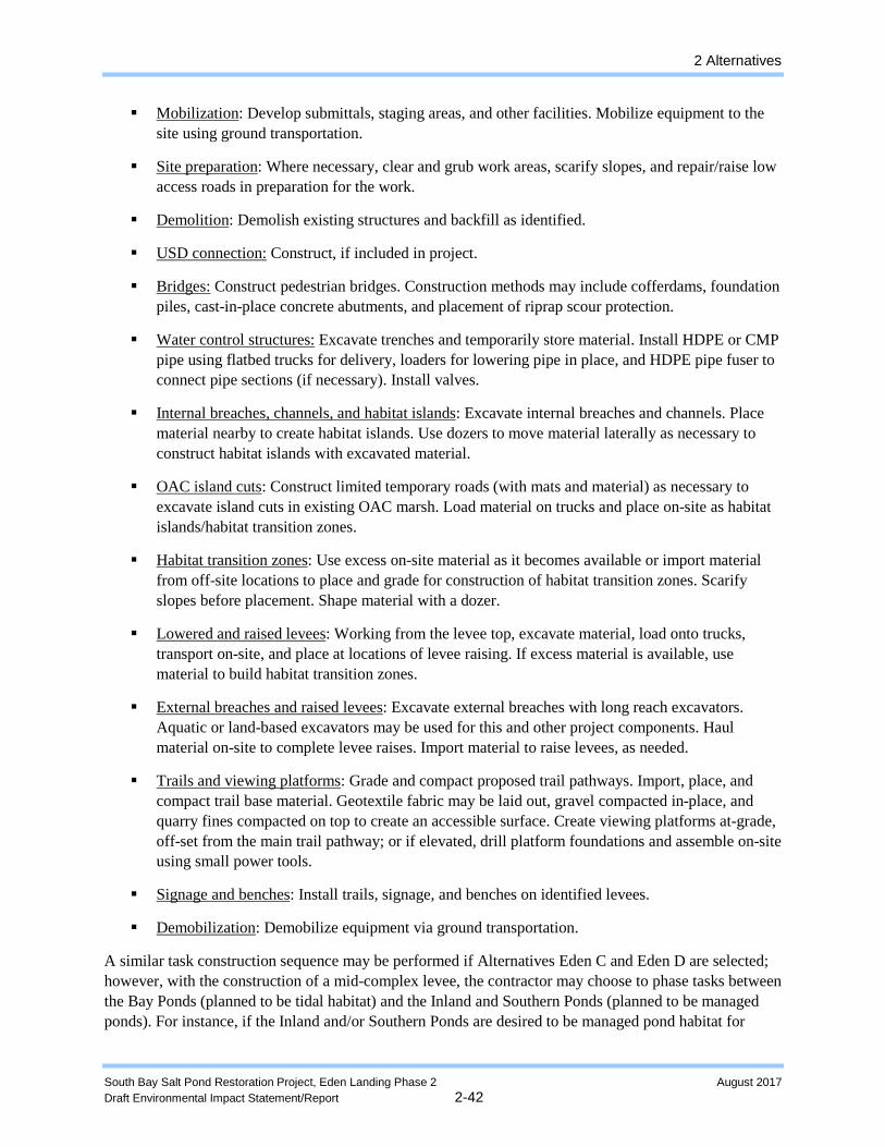
2 Alternatives
South Bay Salt Pond Restoration Project, Eden Landing Phase 2 August 2017 Draft Environmental Impact Statement/Report 2-42
Mobilization: Develop submittals, staging areas, and other facilities. Mobilize equipment to the site using ground transportation.
Site preparation: Where necessary, clear and grub work areas, scarify slopes, and repair/raise low access roads in preparation for the work.
Demolition: Demolish existing structures and backfill as identified.
USD connection: Construct, if included in project.
Bridges: Construct pedestrian bridges. Construction methods may include cofferdams, foundation piles, cast-in-place concrete abutments, and placement of riprap scour protection.
Water control structures: Excavate trenches and temporarily store material. Install HDPE or CMP pipe using flatbed trucks for delivery, loaders for lowering pipe in place, and HDPE pipe fuser to connect pipe sections (if necessary). Install valves.
Internal breaches, channels, and habitat islands: Excavate internal breaches and channels. Place material nearby to create habitat islands. Use dozers to move material laterally as necessary to construct habitat islands with excavated material.
OAC island cuts: Construct limited temporary roads (with mats and material) as necessary to excavate island cuts in existing OAC marsh. Load material on trucks and place on-site as habitat islands/habitat transition zones.
Habitat transition zones: Use excess on-site material as it becomes available or import material from off-site locations to place and grade for construction of habitat transition zones. Scarify slopes before placement. Shape material with a dozer.
Lowered and raised levees: Working from the levee top, excavate material, load onto trucks, transport on-site, and place at locations of levee raising. If excess material is available, use material to build habitat transition zones.
External breaches and raised levees: Excavate external breaches with long reach excavators. Aquatic or land-based excavators may be used for this and other project components. Haul material on-site to complete levee raises. Import material to raise levees, as needed.
Trails and viewing platforms: Grade and compact proposed trail pathways. Import, place, and compact trail base material. Geotextile fabric may be laid out, gravel compacted in-place, and quarry fines compacted on top to create an accessible surface. Create viewing platforms at-grade, off-set from the main trail pathway; or if elevated, drill platform foundations and assemble on-site using small power tools.
Signage and benches: Install trails, signage, and benches on identified levees.
Demobilization: Demobilize equipment via ground transportation.
A similar task construction sequence may be performed if Alternatives Eden C and Eden D are selected; however, with the construction of a mid-complex levee, the contractor may choose to phase tasks between the Bay Ponds (planned to be tidal habitat) and the Inland and Southern Ponds (planned to be managed ponds). For instance, if the Inland and/or Southern Ponds are desired to be managed pond habitat for
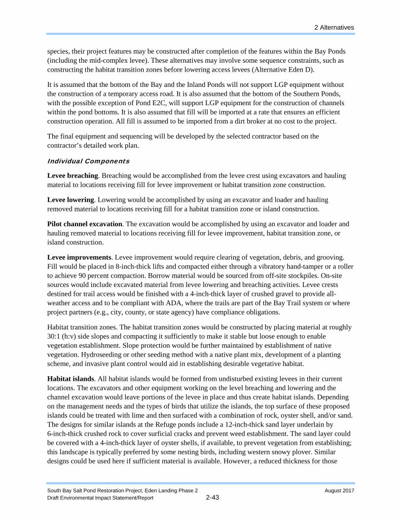
2 Alternatives
South Bay Salt Pond Restoration Project, Eden Landing Phase 2 August 2017 Draft Environmental Impact Statement/Report 2-43
species, their project features may be constructed after completion of the features within the Bay Ponds (including the mid-complex levee). These alternatives may involve some sequence constraints, such as constructing the habitat transition zones before lowering access levees (Alternative Eden D).
It is assumed that the bottom of the Bay and the Inland Ponds will not support LGP equipment without the construction of a temporary access road. It is also assumed that the bottom of the Southern Ponds, with the possible exception of Pond E2C, will support LGP equipment for the construction of channels within the pond bottoms. It is also assumed that fill will be imported at a rate that ensures an efficient construction operation. All fill is assumed to be imported from a dirt broker at no cost to the project.
The final equipment and sequencing will be developed by the selected contractor based on the contractor’s detailed work plan.
Individual Components
Levee breaching. Breaching would be accomplished from the levee crest using excavators and hauling material to locations receiving fill for levee improvement or habitat transition zone construction.
Levee lowering. Lowering would be accomplished by using an excavator and loader and hauling removed material to locations receiving fill for a habitat transition zone or island construction.
Pilot channel excavation. The excavation would be accomplished by using an excavator and loader and hauling removed material to locations receiving fill for levee improvement, habitat transition zone, or island construction.
Levee improvements. Levee improvement would require clearing of vegetation, debris, and grooving. Fill would be placed in 8-inch-thick lifts and compacted either through a vibratory hand-tamper or a roller to achieve 90 percent compaction. Borrow material would be sourced from off-site stockpiles. On-site sources would include excavated material from levee lowering and breaching activities. Levee crests destined for trail access would be finished with a 4-inch-thick layer of crushed gravel to provide all-weather access and to be compliant with ADA, where the trails are part of the Bay Trail system or where project partners (e.g., city, county, or state agency) have compliance obligations.
Habitat transition zones. The habitat transition zones would be constructed by placing material at roughly 30:1 (h:v) side slopes and compacting it sufficiently to make it stable but loose enough to enable vegetation establishment. Slope protection would be further maintained by establishment of native vegetation. Hydroseeding or other seeding method with a native plant mix, development of a planting scheme, and invasive plant control would aid in establishing desirable vegetative habitat.
Habitat islands. All habitat islands would be formed from undisturbed existing levees in their current locations. The excavators and other equipment working on the level breaching and lowering and the channel excavation would leave portions of the levee in place and thus create habitat islands. Depending on the management needs and the types of birds that utilize the islands, the top surface of these proposed islands could be treated with lime and then surfaced with a combination of rock, oyster shell, and/or sand. The designs for similar islands at the Refuge ponds include a 12-inch-thick sand layer underlain by 6-inch-thick crushed rock to cover surficial cracks and prevent weed establishment. The sand layer could be covered with a 4-inch-thick layer of oyster shells, if available, to prevent vegetation from establishing; this landscape is typically preferred by some nesting birds, including western snowy plover. Similar designs could be used here if sufficient material is available. However, a reduced thickness for those
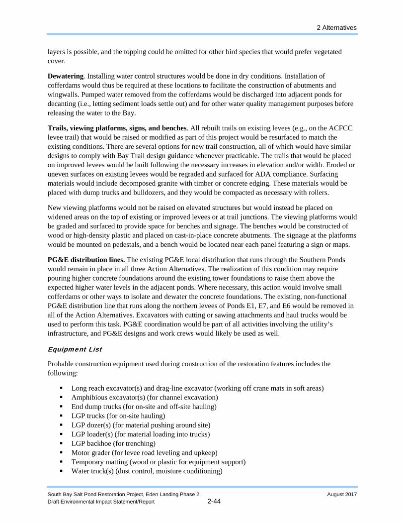
2 Alternatives
South Bay Salt Pond Restoration Project, Eden Landing Phase 2 August 2017 Draft Environmental Impact Statement/Report 2-44
layers is possible, and the topping could be omitted for other bird species that would prefer vegetated cover.
Dewatering. Installing water control structures would be done in dry conditions. Installation of cofferdams would thus be required at these locations to facilitate the construction of abutments and wingwalls. Pumped water removed from the cofferdams would be discharged into adjacent ponds for decanting (i.e., letting sediment loads settle out) and for other water quality management purposes before releasing the water to the Bay.
Trails, viewing platforms, signs, and benches. All rebuilt trails on existing levees (e.g., on the ACFCC levee trail) that would be raised or modified as part of this project would be resurfaced to match the existing conditions. There are several options for new trail construction, all of which would have similar designs to comply with Bay Trail design guidance whenever practicable. The trails that would be placed on improved levees would be built following the necessary increases in elevation and/or width. Eroded or uneven surfaces on existing levees would be regraded and surfaced for ADA compliance. Surfacing materials would include decomposed granite with timber or concrete edging. These materials would be placed with dump trucks and bulldozers, and they would be compacted as necessary with rollers.
New viewing platforms would not be raised on elevated structures but would instead be placed on widened areas on the top of existing or improved levees or at trail junctions. The viewing platforms would be graded and surfaced to provide space for benches and signage. The benches would be constructed of wood or high-density plastic and placed on cast-in-place concrete abutments. The signage at the platforms would be mounted on pedestals, and a bench would be located near each panel featuring a sign or maps.
PG&E distribution lines. The existing PG&E local distribution that runs through the Southern Ponds would remain in place in all three Action Alternatives. The realization of this condition may require pouring higher concrete foundations around the existing tower foundations to raise them above the expected higher water levels in the adjacent ponds. Where necessary, this action would involve small cofferdams or other ways to isolate and dewater the concrete foundations. The existing, non-functional PG&E distribution line that runs along the northern levees of Ponds E1, E7, and E6 would be removed in all of the Action Alternatives. Excavators with cutting or sawing attachments and haul trucks would be used to perform this task. PG&E coordination would be part of all activities involving the utility’s infrastructure, and PG&E designs and work crews would likely be used as well.
Equipment List
Probable construction equipment used during construction of the restoration features includes the following:
Long reach excavator(s) and drag-line excavator (working off crane mats in soft areas) Amphibious excavator(s) (for channel excavation) End dump trucks (for on-site and off-site hauling) LGP trucks (for on-site hauling) LGP dozer(s) (for material pushing around site) LGP loader(s) (for material loading into trucks) LGP backhoe (for trenching) Motor grader (for levee road leveling and upkeep) Temporary matting (wood or plastic for equipment support) Water truck(s) (dust control, moisture conditioning)
2 Alternatives
South Bay Salt Pond Restoration Project, Eden Landing Phase 2 August 2017 Draft Environmental Impact Statement/Report 2-45
Compactor(s) (material compaction) HDPE pipe fuser (culvert construction) Crane(s) (equipment/material loading/unloading) Auger drill (bridge and/or water control structure foundation piles)
This equipment list does not include smaller items such as fuel service, maintenance service, personal vehicles, and small tools and equipment.
2.2.8 Preliminary Schedule
The construction schedule will be driven by construction work windows, the volume of earthwork (see next section), weather conditions, and contractor means and methods.
Work Windows and Regulatory Considerations
Certain special-status species may be affected by construction activities. The presence of these species may limit construction activities or require certain avoidance and minimization measures. The limits and requirements for each special-status species and their habitats will be addressed during the permitting phase of the project. However, the timing considerations below will be incorporated into detailed designs and project planning to reduce the overall potential for adverse impacts and the need for mitigation. In general, construction activities will occur within permitted work windows to avoid impacts to special-status and other sensitive species.
In-water construction work for the dredge material component (e.g., pile driving) would be restricted by dredging work windows, which span from June 1 through November 30 to protect steelhead and other protected species in the deep water portions of the South Bay.
In-channel construction for the restoration features will likely be limited to the period April 15 to October 15. Considerations include:
Steelhead could be present from December 15 to April 30. In-channel work between April 15 and April 30 within sloughs should have an approved biological monitor present and should be done at low tides whenever possible.
Longfin smelt and sturgeon could be present year-round. In-channel work should be conducted at low tide whenever possible.
Onshore construction activities in bird-nesting areas could be limited during the periods listed for each species:
March 1 to September 15 for western snowy plover
March 1 to September 1 for terns, avocets, and stilts
February 1 to September 1 or earlier (as allowed) for California Ridgway’s rail
Negative results for pre-construction surveys and monitoring efforts could lengthen the permitted construction periods. Work in the spring and summer (March to August) is not prohibited, but approved buffer zones could be implemented to allow work to continue during nesting seasons.
2 Alternatives
South Bay Salt Pond Restoration Project, Eden Landing Phase 2 August 2017 Draft Environmental Impact Statement/Report 2-46
Timing and Duration
Construction is expected to begin in 2018. Total construction duration is expected to range from 6 to 10 years.
Dredge Material Placement
Most dredging projects occur during the dredging work window, between June 1 and November 30; however, material could potentially be received year-around as the offloading and placement of dredged material is not constrained by this dredging work window.
Mobilization and site preparation to receive dredged material would span approximately 9 months. The Bay and Inland Ponds may receive dredged material for 3 to 7 years, depending on the rate of the dredged material delivery to the southern Eden Landing ponds. Decommissioning and demobilization would occur over approximately 4.5 months after dredged material placement is complete. Table 2-2 shows the expected duration for the dredge material component of the construction period.
Table 2-2 Preliminary Construction Duration for Dredge Material Placement Alternative Duration (months)
Alternative Eden B 53 to 93 Alternative Eden C 42 to 74 Alternative Eden D 53 to 93
Notes: Duration is from mobilization to final demobilization for the dredge material component and includes sequential, seasonal down time.
Restoration, Flood Risk Management, and Recreational Components
Assuming a construction window of September 1 through March 1, a preliminary estimate of the restoration, flood risk management, and recreational components of the construction is shown in Table 2-3. These durations would spread out over multiple construction seasons to comply with seasonal avoidance of wildlife impacts and/or because of material availability constraints. Construction work would generally proceed for 5 to 7 months a year and then cease until the next construction season.
Table 2-3 Preliminary Construction Duration for the Restoration, Flood Risk Management, and Recreational Components
Alternative Duration (months) Alternative Eden B 18 to 29 Alternative Eden C 26 to 27 Alternative Eden D 25 to 27
Notes: Duration is from initiation of mobilization to final demobilization for the restoration component and includes sequential, seasonal down time. The lower range assumes that habitat transition zones are built during dredge material placement. The upper range assumes that habitat transition zones are built with upland fill material.
If habitat transition zones are constructed using upland fill material, the construction durations will be primarily controlled by the availability of upland fill material that can be imported to the project site. Durations shown in Table 2-3 assume that sufficient fill material is available to allow for continuous construction during the construction windows but that the quantity available only allows for one habitat transition zone construction crew at a time. Habitat transition zone construction durations are estimated to be 7, 3.5, and 4.5 months (five 8-hour working days per week, with 4.35 weeks per month) for Alternatives Eden B, Eden C, and Eden D respectively (assuming single crews), which is a significant portion of the construction duration. From experience at Inner Bair Island at Don Edwards San Francisco

2 Alternatives
South Bay Salt Pond Restoration Project, Eden Landing Phase 2 August 2017 Draft Environmental Impact Statement/Report 2-47
Bay National Wildlife Refuge, if fill material will be provided by an independent dirt broker at no cost to the project, it is recommended that these durations be increased if they are used for permitting or scheduling.
Other construction elements were allowed to occur concurrently with multiple crews provided that they made reasonable sense. The estimate is based on the assumption that some heavy construction activities may be permitted to occur during the nesting habitat window under the watch of a biological monitor.
2.2.9 Tables of Design Details
This section presents summary tables of the design information excerpted from the design memorandums in Appendices C and D.
Material Placement Volumes for Dredge Material
The estimated volumes of dredge material placement and levee earthwork associated with the dredge material component of the Eden Landing alternatives are detailed in Table 2-4. These estimates are based on the preliminary design. In order to improve portions of the existing levees for dredge material placement, up to 10,000 cubic yards of material would be sourced from onsite levees.
Table 2-4 Dredged Material Placement and Levee Earthwork Volumes
Feature Pond Alternative Eden B Alternative Eden C Alternative Eden D
Dredge Material (CY)
Onsite Material (CY)
Dredge Material (CY)
Onsite Material (CY)
Dredge Material (CY)
Onsite Material (CY)
Bay Ponds
E1 1,052,000 800 1,052,000 800 1,052,000 800
E2 2,449,000 0 2,449,000 0 2,449,000 0
E7 723,000 0 723,000 2,900 723,000 2,900
E4 501,000 0 501,000 1,900 501,000 1,900
Inland Ponds
E6 571,000 0 0 0 571,000 0
E5 477,000 0 0 0 477,000 0
E6C 217,000 4,400 0 0 217,000 4,400
Habitat Transition Zones 83,000 0 46,000 0 96,000 0
Total 6,073,000 5,200 4,771,000 5,600 6,086,000 10,000 Note: 1 Dredge material placement volume when levees are improved to 10 feet. 2 Earthwork volume needed to improve perimeter levees to 10 feet NAVD88. Volumes to raise Pond E7 and E4 levees to 10 feet NAVD88 are for raising the eastern internal levees if the Bay Pond were to receive phased placement of dredged material. If the Bay and Inland Ponds were to receive dredged material in the same phase, the internal Pond E7 and E4 levees would not need to be improved. CY = cubic yards
Dredged material placed within the ponds will increase the amount of excavation required during the restoration component of the construction period. This additional excavation volume is listed in Table 2-5 for the Action Alternatives. The dredge material that is excavated for the channels would be used to create additional island habitats, similar to other excavated channel material.
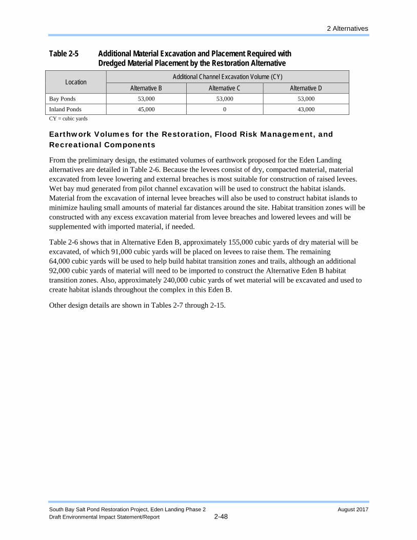
2 Alternatives
South Bay Salt Pond Restoration Project, Eden Landing Phase 2 August 2017 Draft Environmental Impact Statement/Report 2-48
Table 2-5 Additional Material Excavation and Placement Required with Dredged Material Placement by the Restoration Alternative
Location Additional Channel Excavation Volume (CY)
Alternative B Alternative C Alternative D Bay Ponds 53,000 53,000 53,000
Inland Ponds 45,000 0 43,000 CY = cubic yards
Earthwork Volumes for the Restoration, Flood Risk Management, and Recreational Components
From the preliminary design, the estimated volumes of earthwork proposed for the Eden Landing alternatives are detailed in Table 2-6. Because the levees consist of dry, compacted material, material excavated from levee lowering and external breaches is most suitable for construction of raised levees. Wet bay mud generated from pilot channel excavation will be used to construct the habitat islands. Material from the excavation of internal levee breaches will also be used to construct habitat islands to minimize hauling small amounts of material far distances around the site. Habitat transition zones will be constructed with any excess excavation material from levee breaches and lowered levees and will be supplemented with imported material, if needed.
Table 2-6 shows that in Alternative Eden B, approximately 155,000 cubic yards of dry material will be excavated, of which 91,000 cubic yards will be placed on levees to raise them. The remaining 64,000 cubic yards will be used to help build habitat transition zones and trails, although an additional 92,000 cubic yards of material will need to be imported to construct the Alternative Eden B habitat transition zones. Also, approximately 240,000 cubic yards of wet material will be excavated and used to create habitat islands throughout the complex in this Eden B.
Other design details are shown in Tables 2-7 through 2-15.
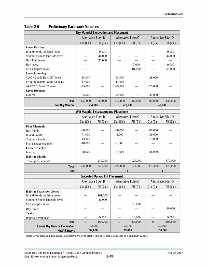
2 Alternatives
South Bay Salt Pond Restoration Project, Eden Landing Phase 2 August 2017 Draft Environmental Impact Statement/Report 2-49
Table 2-6 Preliminary Earthwork Volumes Dry Material
Excavation and Placement
Alternative Eden B Cut (CY) Fill (CY)
Alternative Eden C Cut (CY) Fill (CY)
Alternative Eden D Cut (CY) Fill (CY)
Levee Raising Inland Ponds landside levee Southern Ponds landside levee Bay Trail levee Bay levee Mid-complex levee Levee Lowering OAC / Ponds E1 & E7 levee Fringing marsh/Ponds E1 & E2 ACFCC / Pond E2 levee Levee Breaches External
— — — — —
-28,000 -17,000 -25,000
-85,000
9,000
44,000 38,000
— —
— — —
—
— — — — —
-28,000 -17,000 -25,000
-42,000
— — —
2,000 81,000
— — —
—
— — — — —
-28,000
- -25,000
-41,000
9,000 44,000
— 9,000 81,000
— — —
—
Net Dry Total
Material -155,000
-64,000 91,000 -112,000
-29,00083,000
-94,000 143,000 49,000
Wet Material Excavation and Placement
Alternative Eden B Cut (CY) Fill (CY)
Alternative Eden C Cut (CY) Fill (CY)
Alternative Eden D Cut (CY) Fill (CY)
Pilot Channels Bay Ponds Inland Ponds Southern Ponds Fish passage channel Levee Breaches Internal Habitat Islands Throughout complex
-80,000 -71,000 -13,000 -18,000
-58,000
—
— — — —
—
240,000
-80,000 -2,000
— -1,000
-37,000
—
— — — —
—
120,000
-80,000 -39,000 -13,000
—
-38,000
—
— — — —
—
170,000
Total Net
-240,000 0
240,000 -120,000 0
120,000 -170,000 0
170,000
Imported Upland Fill Placement
Alternative Eden B Cut (CY) Fill (CY)
Alternative Eden C Cut (CY) Fill (CY)
Alternative Eden D Cut (CY) Fill (CY)
Habitat Transition Zones Inland Ponds landside levee Southern Ponds landside levee Mid-complex levee Bay levee Trails Imported trail base
— — — —
—
101,000 46,000
— —
9,000
— — — —
—
— —
75,000 —
13,000
— — — —
—
— — —
96,000
9,000
Total Excess Dry Material Excavation
Net Fill Import
0 156,000 -64,000 92,000
0 88,000 -29,000 59,000
0 105,000 49,000
154,000
Note: Levee raise volumes assume a conservative levee crest width of 16 feet, as opposed to a minimum 12 feet.
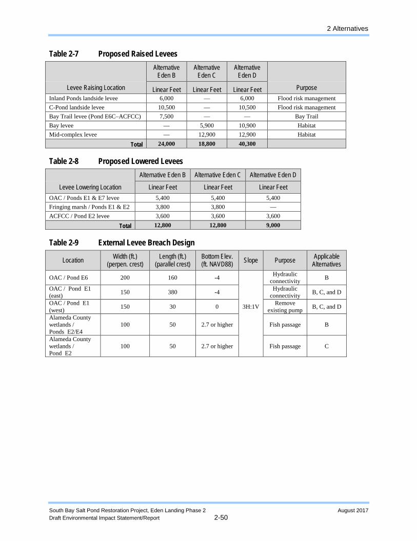
2 Alternatives
South Bay Salt Pond Restoration Project, Eden Landing Phase 2 August 2017 Draft Environmental Impact Statement/Report 2-50
Table 2-7 Proposed Raised Levees
Alternative
Eden B Alternative
Eden C Alternative
Eden D
Levee Raising Location Linear Feet Linear Feet Linear Feet Purpose Inland Ponds landside levee 6,000 — 6,000 Flood risk management C-Pond landside levee 10,500 — 10,500 Flood risk management Bay Trail levee (Pond E6C–ACFCC) 7,500 — — Bay Trail Bay levee — 5,900 10,900 Habitat Mid-complex levee — 12,900 12,900 Habitat
Total 24,000 18,800 40,300
Table 2-8 Proposed Lowered Levees Alternative Eden B Alternative Eden C Alternative Eden D
Levee Lowering Location Linear Feet Linear Feet Linear Feet OAC / Ponds E1 & E7 levee 5,400 5,400 5,400 Fringing marsh / Ponds E1 & E2 3,800 3,800 — ACFCC / Pond E2 levee 3,600 3,600 3,600
Total 12,800 12,800 9,000
Table 2-9 External Levee Breach Design
Location Width (ft.) (perpen. crest)
Length (ft.) (parallel crest)
Bottom Elev. (ft. NAVD88) Slope Purpose Applicable
Alternatives
OAC / Pond E6 200 160 -4 Hydraulic
connectivity B
OAC / Pond E1 (east) 150 380 -4
Hydraulic connectivity B, C, and D
OAC / Pond E1 (west) 150 30 0 3H:1V Remove
existing pump B, C, and D
Alameda County wetlands / Ponds E2/E4
100 50 2.7 or higher Fish passage B
Alameda County wetlands / Pond E2
100 50 2.7 or higher Fish passage C
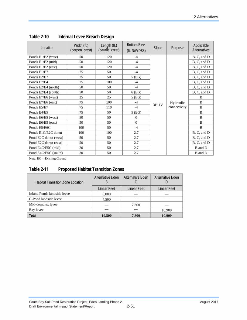
2 Alternatives
South Bay Salt Pond Restoration Project, Eden Landing Phase 2 August 2017 Draft Environmental Impact Statement/Report 2-51
Table 2-10 Internal Levee Breach Design
Location Width (ft.) (perpen. crest)
Length (ft.) (parallel crest)
Bottom Elev. (ft. NAVD88)
Slope Purpose Applicable Alternatives
Ponds E1/E2 (west) 50 120 -4
3H:1V
Hydraulic connectivity
B, C, and D Ponds E1/E2 (mid) 50 120 -4 B, C, and D Ponds E1/E2 (east) 50 120 -4 B, C, and D Ponds E1/E7 75 50 -4 B, C, and D Ponds E2/E7 75 50 5 (EG) B, C, and D Ponds E7/E4 75 100 -4 B, C, and D Ponds E2/E4 (north) 50 50 -4 B, C, and D Ponds E2/E4 (south) 50 50 6 (EG) B, C, and D Ponds E7/E6 (west) 25 25 5 (EG) B Ponds E7/E6 (east) 75 100 -4 B Ponds E5/E7 75 110 -4 B Ponds E4/E5 75 50 5 (EG) B Ponds E6/E5 (west) 50 50 0 B Ponds E6/E5 (east) 50 50 0 B Ponds E5/E6C 100 50 -4 B Ponds E1C/E2C donut 100 100 2.7 B, C, and D Pond E2C donut (west) 50 50 2.7 B, C, and D Pond E2C donut (east) 50 50 2.7 B, C, and D Pond E4C/E5C (mid) 20 50 2.7 B and D Pond E4C/E5C (south) 20 50 2.7 B and D Note: EG = Existing Ground
Table 2-11 Proposed Habitat Transition Zones
Habitat Transition Zone Location Alternative Eden
B Alternative Eden
C Alternative Eden
D Linear Feet Linear Feet Linear Feet
Inland Ponds landside levee 6,000 — — C-Pond landside levee 4,500 — — Mid-complex levee — 7,800 — Bay levee — — 10,900 Total 10,500 7,800 10,900
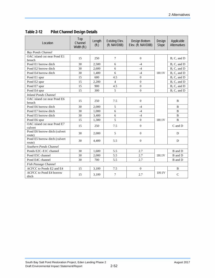
2 Alternatives
South Bay Salt Pond Restoration Project, Eden Landing Phase 2 August 2017 Draft Environmental Impact Statement/Report 2-52
Table 2-12 Pilot Channel Design Details
Location Top
Channel Width (ft.)
Length (ft.)
Existing Elev. (ft. NAVD88)
Design Bottom Elev. (ft. NAVD88)
Design Slope
Applicable Alternatives
Bay Ponds Channel OAC island cut near Pond E1 breach 15 250 7 0 B, C, and D
Pond E1 borrow ditch 30 2,500 6 -4 B, C, and D Pond E2 borrow ditch 30 2,600 6 -4 B, C, and D Pond E4 borrow ditch 30 1,400 6 -4 1H:1V B, C, and D Pond E1 spur 15 600 4.5 0 B, C, and D Pond E2 spur 15 2,200 4 0 B, C, and D Pond E7 spur 15 900 4.5 0 B, C, and D Pond E4 spur 15 300 5 0 B, C, and D Inland Ponds Channel OAC island cut near Pond E6 breach 15 250 7.5 0 B
Pond E6 borrow ditch 30 2,000 5 -4 B Pond E7 borrow ditch 30 1,000 6 -4 B Pond E5 borrow ditch 30 3,400 6 -4 B Pond E6 spur 15 1,300 5 0 1H:1V B OAC island cut near Pond E7 culvert 15 250 7.5 0 C and D
Pond E6 borrow ditch (culvert route) 30 2,000 5 0 D
Pond E5 borrow ditch (culvert route) 30 4,400 5.5 0 D
Southern Ponds Channel Ponds E2C–E1C channel 30 1,600 5.5 2.7 B and D Pond E5C channel 30 2,000 5.5 2.7 1H:1V B and D Pond E4C channel 30 700 5.5 2.7 B and D Fish Passage Channel ACFCC to Ponds E2 and E4 15 3,100 7.5 0 B ACFCC to Pond E4 borrow ditch 15 3,100 7 2.7 1H:1V C
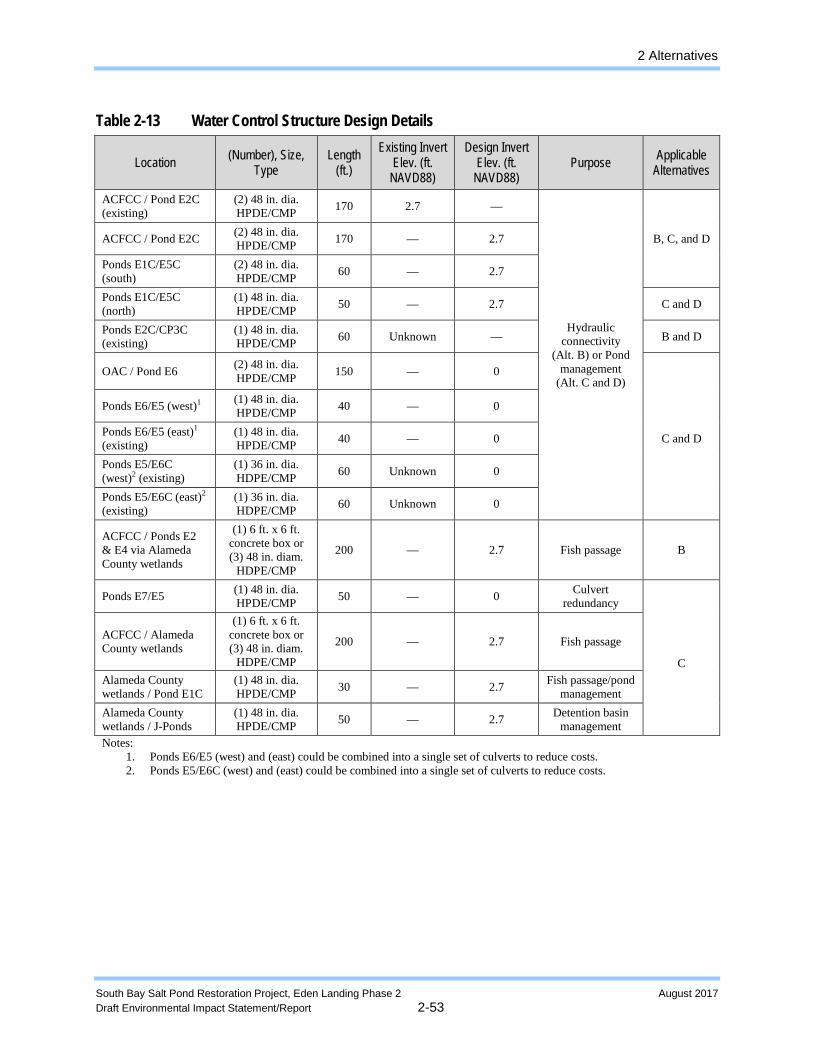
2 Alternatives
South Bay Salt Pond Restoration Project, Eden Landing Phase 2 August 2017 Draft Environmental Impact Statement/Report 2-53
Table 2-13 Water Control Structure Design Details
Location (Number), Size, Type
Length (ft.)
Existing Invert Elev. (ft.
NAVD88)
Design Invert Elev. (ft.
NAVD88) Purpose Applicable
Alternatives
ACFCC / Pond (existing)
E2C (2) 48 in. dia. HPDE/CMP 170 2.7 —
Hydraulic
connectivity (Alt. B) or Pond
management (Alt. C and D)
B, C,
and D
ACFCC / Pond E2C (2) 48 in. dia. HPDE/CMP 170 — 2.7
Ponds E1C/E5C (south)
(2) 48 in. dia. HPDE/CMP 60 — 2.7
Ponds E1C/E5C (north)
(1) 48 in. dia. HPDE/CMP 50 — 2.7 C and D
Ponds E2C/CP3C (existing)
(1) 48 in. dia. HPDE/CMP 60 Unknown — B and D
OAC / Pond E6 (2) 48 in. dia. HPDE/CMP 150 — 0
C and D
Ponds E6/E5 (west)1 (1) 48 in. dia. HPDE/CMP 40 — 0
Ponds (existing)
E6/E5 (east)1
(1) 48 in. dia. HPDE/CMP 40 — 0
Ponds E5/E6C (west)2 (existing)
(1) 36 in. dia. HDPE/CMP 60 Unknown 0
Ponds E5/E6C (east)2 (existing)
(1) 36 in. dia. HDPE/CMP 60 Unknown 0
ACFCC / Ponds E2 & E4 via Alameda County wetlands
(1) 6 ft. x 6 ft. concrete box or (3) 48 in. diam.
HDPE/CMP
200 — 2.7 Fish passage B
Ponds E7/E5 (1) 48 in. dia. HPDE/CMP 50 — 0 Culvert
redundancy
C
ACFCC / Alameda County wetlands
(1) 6 ft. x 6 ft. concrete box or (3) 48 in. diam.
HDPE/CMP
200 — 2.7 Fish passage
Alameda County wetlands / Pond E1C
(1) 48 in. dia. HPDE/CMP 30 — 2.7 Fish passage/pond
management Alameda County wetlands / J-Ponds
(1) 48 in. dia. HPDE/CMP 50 — 2.7 Detention basin
management Notes:
1. 2.
Ponds Ponds
E6/E5 (west) and (east) could be combined into a single set of culverts to reduce costs. E5/E6C (west) and (east) could be combined into a single set of culverts to reduce costs.
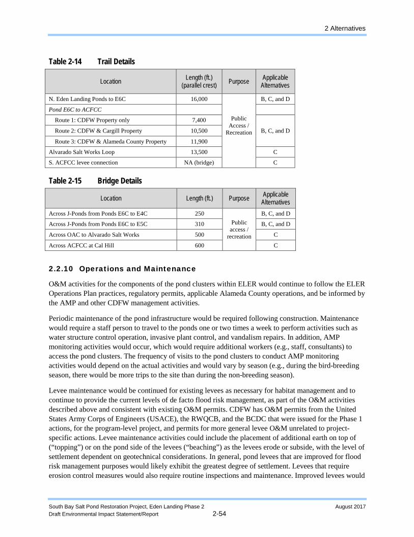
2 Alternatives
South Bay Salt Pond Restoration Project, Eden Landing Phase 2 August 2017 Draft Environmental Impact Statement/Report 2-54
Table 2-14 Trail Details
Location Length (ft.) (parallel crest) Purpose Applicable
Alternatives
N. Eden Landing Ponds to E6C 16,000
Public
Access / Recreation
B, C, and D
Pond E6C to ACFCC
Route 1: CDFW Property only 7,400
B, C, and D
Route 2: CDFW & Cargill Property 10,500
Route 3: CDFW & Alameda County Property 11,900
Alvarado Salt Works Loop 13,500 C
S. ACFCC levee connection NA (bridge) C
Table 2-15 Bridge Details
Location Length (ft.) Purpose Applicable Alternatives
Across J-Ponds from Ponds E6C to E4C 250 B, C, and D
Across J-Ponds from Ponds E6C to E5C 310 Public access /
recreation
B, C, and D
Across OAC to Alvarado Salt Works 500 C
Across ACFCC at Cal Hill 600 C
2.2.10 Operations and Maintenance
O&M activities for the components of the pond clusters within ELER would continue to follow the ELER Operations Plan practices, regulatory permits, applicable Alameda County operations, and be informed by the AMP and other CDFW management activities.
Periodic maintenance of the pond infrastructure would be required following construction. Maintenance would require a staff person to travel to the ponds one or two times a week to perform activities such as water structure control operation, invasive plant control, and vandalism repairs. In addition, AMP monitoring activities would occur, which would require additional workers (e.g., staff, consultants) to access the pond clusters. The frequency of visits to the pond clusters to conduct AMP monitoring activities would depend on the actual activities and would vary by season (e.g., during the bird-breeding season, there would be more trips to the site than during the non-breeding season).
Levee maintenance would be continued for existing levees as necessary for habitat management and to continue to provide the current levels of de facto flood risk management, as part of the O&M activities described above and consistent with existing O&M permits. CDFW has O&M permits from the United States Army Corps of Engineers (USACE), the RWQCB, and the BCDC that were issued for the Phase 1 actions, for the program-level project, and permits for more general levee O&M unrelated to project-specific actions. Levee maintenance activities could include the placement of additional earth on top of (“topping”) or on the pond side of the levees (“beaching”) as the levees erode or subside, with the level of settlement dependent on geotechnical considerations. In general, pond levees that are improved for flood risk management purposes would likely exhibit the greatest degree of settlement. Levees that require erosion control measures would also require routine inspections and maintenance. Improved levees would
2 Alternatives
South Bay Salt Pond Restoration Project, Eden Landing Phase 2 August 2017 Draft Environmental Impact Statement/Report 2-55
be inspected and maintained for slope stability, erosion control, seepage, slides, and settlement on an annual basis. Maintenance is expected at approximately 5- to 10-year intervals to add additional fill material in areas where erosion or settlement occurs. Most of the maintenance work along areas subject to tidal flows can be accomplished from the levee crests by ground-based equipment or from water by dredge equipment. Levees between ponds could be maintained according to season and best practices, conditions or requirements for the protection of sensitive resources. If the levees that provide de facto flood risk management are improved to provide an equivalent to or certification of Federal Emergency Management Agency (FEMA) 100-year flood protection, a detailed levee maintenance plan would be required for certification to comply with FEMA standards.
The internal levees within the Bay Ponds would not be maintained and would be allowed to erode naturally over time. The same would be true for most internal levees in the Inland Ponds and Southern Ponds in Alternative Eden B. In Alternatives Eden C and D, however, the Inland Ponds and Southern Ponds would be enhanced managed ponds, so their internal levees would be maintained.
Around ponds being restored to tidal marsh (i.e., the Bay Ponds in all three alternatives, and all ponds in Alternative Eden B), the external perimeter levees along the northern, southern, and western borders would only be maintained in those cases where they supported a public access trail or were part of hydraulically separating one pond from another. In enhanced managed ponds, the external levees would be maintained. In other cases, notably near sections of levees that were lowered, they would not be maintained; the plan and expectation is that they would degrade over time as part of marsh restoration.
Water control structures would require inspection of the structural integrity of gates, pipes, and approach way; removal of obstructions to flow passage; and preventative maintenance such as visual checks of the functionality of gates and seals and removal of debris. Inspection would occur approximately every month for the first year and semi-annually thereafter. Maintenance would be required on an annual basis. O&M would be accomplished during low tides in tidal ponds and sloughs and under appropriate conditions in the managed ponds, depending on the method and means used (floating dredge or land-based equipment).
Maintenance of habitat transition zones would include inspections and maintenance for slope stability, vegetation establishment, erosion control, seepage, slides, and settlement on an annual basis. As necessary, vegetation removal would occur to prevent colonization of invasive species. Fill material would be placed, when needed, to respond to areas where erosion has been observed. Maintenance activities would also be informed by the AMP if an AMP management trigger is reached, especially a trigger related to a biological resource (e.g., salt marsh harvest mouse) that would utilize habitat transition zone as habitat.
Maintenance of the nesting islands may require weed/vegetation removal as often as quarterly and the placing of fill material (sand, gravel, and/or oyster shells) before the onset of the nesting period in some years. Nesting islands would also be periodically examined for erosion.
Ponds opened to full tidal flows need little to no operations or maintenance beyond the control of invasive plants discussed above. In managed ponds, however, operations and maintenance of water levels would be more actively performed. The managed ponds in Alternative Eden C and Alternative Eden D could differ across the three Action Alternatives, depending on the species or guild of birds for which they were managed. Generally, however, the following principles would apply:
2 Alternatives
South Bay Salt Pond Restoration Project, Eden Landing Phase 2 August 2017 Draft Environmental Impact Statement/Report 2-56
CDFW staff would operate the water control structures and provide additional maintenance and cleaning as needed.
The water levels in ponds managed for western snowy plover or other species using dry salt pannes would be actively drawn down and dried out in advance of the nesting season for those species.
The water levels in ponds managed for small shorebirds and dabbling ducks would be actively managed year-round by opening and closing the water control structures as needed to maintain seasonally appropriate desired surface elevations, flows, and water quality in the different ponds. Generally, these ponds would be shallower than those managed for diving ducks. The salinity of these ponds would also be somewhat controlled through the use of the water control structures.
The water levels in ponds managed for diving ducks, larger piscivorous species, or other pond-dependent species or guilds would be similarly managed, but would be deeper and the pond water would be recirculated more frequently than in the ponds managed for small shorebirds.
Maintenance of public access and recreation features is similar across the Action Alternatives. The viewing platforms would be designed to minimize maintenance utilizing durable and sustainable materials as much as possible to prevent degradation and the need for frequent maintenance. All features would need to be checked periodically for defacement of interpretive boards and other forms of vandalism. All Action Alternatives would also include occasional trail maintenance to keep them safe and accessible. There would be a need for trash removal along trails, and more intensive efforts would be needed at staging areas and trailheads.
Bridges placed in publicly accessible areas must be visually inspected every 2 years and a report on their condition may be required every 5 years. There is at least one bridge in each Action Alternative, and Alternative Eden C has three bridges. A safety railing would be installed on both sides of the bridge deck(s). These railings would be simplified steel-tube railings for walking or cyclist protection or similar.
2.3 General Mitigation Measures Adapted from the 2007 Final EIS/R
In developing the 2007 Final EIS/R for the SBSP Restoration Project, the USFWS, CDFW, and other lead and partner agencies developed program-wide comprehensive mitigation measures that could be expanded into actions when designing the project-level phases to implement the SBSP Restoration Project or direct the environmental analyses for the future phases. The intent of these mitigation measures was to avoid or reduce the environmental effects of any project alternative through the project design or focus the impact analysis on key impact issues recognized in the 2007 Final EIS/R. When mitigation measures are developed in program-level NEPA and CEQA documents and adopted by the lead agencies and other project partners, the expectation is that those measures will be included as part of the project-level designs whenever it is feasible to do so. With few exceptions, this project-level Draft EIS/R has followed this practice and will implement those measures as standard parts of the project designs; therefore, these measures need not be repeated in each of the alternatives described above.
The notable exception, a program-level mitigation measure that is not feasible to implement, is Mitigation Measure 3.12-1: Timing of construction-related truck trips. That measure is discussed at length below.
2 Alternatives
South Bay Salt Pond Restoration Project, Eden Landing Phase 2 August 2017 Draft Environmental Impact Statement/Report 2-57
This section presents the mitigation measures from the 2007 Final EIS/R that are common to and relevant to the Phase 2 alternatives included in this project-level Draft EIS/R. These measures are incorporated into the project design of all Action Alternatives; they are thus part of the Phase 2 projects and not actually “mitigation measures.” For this reason, they are included in this chapter. These measures have been edited for relevancy with Phase 2 actions.
2.3.1 Surface Water, Sediment, and Groundwater Quality
SBSP Mitigation Measure 3.4-5c: Actions to Minimize Illegal Discharge and Dumping
The SBSP Restoration Project will undertake the following activities to ensure that existing programs and practices avoid impacts due to illegal discharge and dumping:
Plans for recreational access in the SBSP Restoration Project area will include appropriate trash collection receptacles and a plan for ensuring regular collection and servicing.
“No Littering” or similar signs will be posted in public access areas.
SBSP Mitigation Measure 3.4-5d: Monitoring Sediments to Follow Existing Guidance and Comply with Emerging Regulations
Sediment monitoring data will be used to determine appropriate disposal or beneficial re-use practices for sediments. If sediment monitoring data indicate that tidal scour outside a levee breach could remobilize sediments that are significantly more contaminated than Bay ambient conditions, the SBSP Restoration Project will consult with the appropriate regulatory agencies regarding other potentially required actions.
SBSP Mitigation Measure 3.4-5e: Urban Runoff Management
The project proponents will notify the appropriate Urban Runoff Program of any physical changes (such as breaches) that will introduce urban discharges into the project area and request that the Urban Runoff Program consider those changes when developing annual monitoring plans.
SBSP Mitigation Measure 3.4-6: CDFW and USFWS (Project Proponents) Will Coordinate with Alameda County Water District to Ensure That the Following Activities Take Place
If any abandoned wells are found before or during construction they will be properly destroyed by the project as per local and state regulations by coordinating such activities with the local water district. If abandoned wells are located during restoration or other future activities within ACWD boundaries, a well destruction work plan will be prepared in consultation with ACWD (as appropriate) to ensure conformance to ACWD specifications. The work plan will include consulting the databases of well locations already provided by ACWD. The project will properly destroy both improperly abandoned wells and existing wells within the project area that are subject to inundation by breaching levees. Well destruction methods will meet local, county, and state regulations.
2 Alternatives
South Bay Salt Pond Restoration Project, Eden Landing Phase 2 August 2017 Draft Environmental Impact Statement/Report 2-58
The project proponents will also lend support and cooperation with any well identification and destruction program that may be undertaken as part of the Shoreline Study or other projects.6
2.3.2 Cultural Resources
SBSP Mitigation Measure 3.8-1: Discovery of Unknown Resources
Background
Restoration actions planned for the SBSP Restoration Project area shall be treated as individual archaeological projects. The overall record search for this EIS/R was performed in June 2006. A new record search shall be performed for any projects within the SBSP Restoration Project area where the previous record search is more than 5 years old.
Site Survey
Prior to the beginning of any project construction activity that could affect the previously un-surveyed portions of the project area, qualified professional archaeologists shall be retained to inventory all portions of the restoration site that have not been examined previously or have not been examined within the last 15 years. The survey(s) shall be conducted during a time when the ground surfaces of potential project sites are visible so the natural ground surface can be examined for traces of prehistoric and/or historic-era cultural resources. If the survey(s) reveal(s) the presence of cultural resources on the project site (e.g., unusual amounts of shell, animal bone, bottle glass, ceramics, and structure/building remains), and those resources have not been dealt with sufficiently in any Cultural Landscape documentation, the resources shall be documented according to current professional standards. The resources shall be evaluated for potential eligibility to the National Register of Historic Places (NRHP) or the California Register of Historical Resources (CRHR). Depending on the evaluation, additional mitigation measures may be required, including avoidance of the resource through changes in construction methods or project design or implementation of a program of testing and data recovery, in accordance with all applicable federal and state requirements.
Pre-Construction Contractor Education
Prior to any project-related construction, a professional archaeologist shall be retained to address machinery operators and their supervisors, preferably by giving an on-site talk to the people who will perform the actual earth-moving activities. This will alert the operators to the potential for finding historic or prehistoric cultural resources.
Construction Monitoring
Any project-related construction that occurs within 100 feet (30 meters) of a known prehistoric resource shall be monitored by a qualified professional archaeologist and a Native American monitor. If elements of the known resource or previously unknown cultural resources are encountered during project construction, all ground-disturbing activities shall halt within a 100-foot radius of the find. The
6 It is worth noting that, as part of the Initial Stewardship Plan, Cargill was required to seal or otherwise close abandoned wells at the time the ponds were transferred to the CDFW and USFWS. Unsealed wells are thus unlikely to be found on the Eden Landing property.
2 Alternatives
South Bay Salt Pond Restoration Project, Eden Landing Phase 2 August 2017 Draft Environmental Impact Statement/Report 2-59
archaeologist shall identify the materials, determine their possible significance, and formulate appropriate measures for their treatment in consultation with the Native American monitor, Most Likely Descendant (MLD), or appropriate Native American representative and the appropriate Lead Agency. Potential treatment methods for significant and potentially significant resources may include, but would not be limited to, no action (i.e., resources determined not to be significant), avoidance of the resource through changes in construction methods or project design, or implementation of a program of testing and data recovery, in accordance with all applicable federal and state requirements. These measures shall be implemented prior to resumption of project construction.
Unanticipated Finds
If contractors identify possible cultural resources, such as unusual amounts of bone, stone, or shell, they shall be instructed to halt operation in the vicinity of the find and follow the appropriate contact procedures. Work shall not resume in the vicinity of the find until a qualified professional archaeologist has had the opportunity to examine the finds. The archaeologist shall identify the materials, determine their possible significance, if the finds are prehistoric, formulate appropriate measures for their treatment in consultation with the Native American monitor, MLD, or appropriate Native American representative and the appropriate Lead Agency. Potential treatment methods for significant and potentially significant resources may include, but would not be limited to, no action (i.e., resources determined not to be significant), avoidance of the resource through changes in construction methods or project design, or implementation of a program of testing and data recovery, in accordance with all applicable federal and state requirements. These measures shall be implemented prior to resumption of project construction.
Human Remains
California law recognizes the need to protect interred human remains, particularly Native American burials and associated items of patrimony, from vandalism and inadvertent destruction. The procedures for the treatment of discovered human remains are contained in California Health and Safety Code Section 7050.5 and Section 7052 and California Public Resources Code Section 5097. The California Health and Safety Code require that if human remains are found in any location other than a dedicated cemetery, work is to be halted in the immediate area.
The appropriate agency or the agency’s designated representative shall be notified. The agency shall immediately notify the county coroner and a qualified professional archaeologist. The coroner is required to examine all discoveries of human remains within 48 hours of receiving notice of a discovery on private or state lands (Health and Safety Code Section 7050.5[b]). If the coroner determines that the remains are those of a Native American interment, then coroner shall contact the Native American Heritage Commission within 24 hours.
The Native American Heritage Commission shall identify the person or persons it believes to be the most likely descended from the deceased Native American. The MLD may make recommendations to the landowner or the person responsible for the excavation work for means of treating or disposing of, with appropriate dignity, the human remains and any associated grave goods, as provided in Public Resources Code Section 5097.98. The landowner or his authorized representative shall rebury the Native American human remains and associated grave goods with appropriate dignity on the property in a location not subject to further subsurface disturbance if: (1) the Native American Heritage Commission is unable to identify an MLD or (2) the MLD fails to make a recommendation within 24 hours after being notified by the commission or (3) if the landowner or his authorized representative rejects the recommendation of the
2 Alternatives
South Bay Salt Pond Restoration Project, Eden Landing Phase 2 August 2017 Draft Environmental Impact Statement/Report 2-60
descendant, and the mediation by the Native American Heritage Commission fails to provide measures acceptable to the landowner.
SBSP Mitigation Measure 3.8-2: Cultural Landscape, Inventory of Resources, Treatment of Finds
In June 2012 the USFWS and California State Historic Preservation Officer (SHPO) signed a Memorandum of Agreement (FWS0407121A) that established a set of stipulations and a treatment plan that would allow the USFWS to carry out the project while satisfying the requirements of Sections 106 and 110(b) of the National Historic Preservation Act (NHPA). On consultation with the SHPO, the USFWS developed a historic properties treatment plan that will be implemented prior to and during the project. This historic properties treatment plan and the mitigation measures established within this treatment plan are hereby incorporated by reference. Appendix F contains a copy of the Memorandum of Agreement (MOA) and historic properties treatment plan.
2.3.3 Traffic
SBSP Mitigation Measure 3.12-1: Timing of Construction-Related Truck Trips
This mitigation measure required the landowner (CDFW) to include in construction plans and specifications the requirement that construction-related truck trips, specifically deliveries of fill and equipment, shall occur outside the weekday am and pm peak commute traffic hours. This mitigation measure is not feasible to implement in the Phase 2 actions because of the large amount of upland material that needs to be imported by truck to the ponds in relatively condensed periods of time.
Finding source projects with sufficient quantities of upland fill material is difficult for several reasons. The excavation must occur in a year and season when the SBSP Restoration Project can accept it. Stockpiling material or moving it more than once is cost prohibitive and would increase environmental impacts. Then, to be used in a restoration project, the material must pass a screening to demonstrate its lack of contamination. The source project should also be located close enough to the restoration project that bringing it there would both have fewer environmental impacts and be less expensive than bringing to a landfill or other destination. Successfully meeting all of those criteria is likely to limit the number of suitable source projects. It would not, then, be feasible to further constrain the source project and dirt broker/haulers by limiting the hours of material delivery to the non-peak commute periods. Assuming these entities would be willing to comply, their own costs would increase, and they would pass that on to the SBSP Restoration Project, raising associated costs by an estimated 30 percent at a minimum.
Collectively, these barriers make the implementation of the restricted hours from MM 3.12-1 infeasible. However, importantly, the nearest likely disposal site for upland fill material generated at projects in Alameda County or Contra Costa County is at a former quarry in Fremont, just north of the eastern landing of the Dumbarton Bridge. This location means that, in the absence of the SBSP Restoration Project, the likely haul route for transporting the material would go past one or more of the Phase 2 pond clusters. The traffic, air quality, and noise impacts are expected to be equal to or worse than the impacts if the material cannot be used at the Phase 2 project locations and has to go to the default disposal site.
For these reasons, the SBSP Restoration Project will not uniformly be implementing this mitigation measure and instead conducted a full analysis of the number of truck trips and the impacts associated with them. These are presented in Chapter 3, Environmental Setting, Impacts, and Mitigation Measures.
2 Alternatives
South Bay Salt Pond Restoration Project, Eden Landing Phase 2 August 2017 Draft Environmental Impact Statement/Report 2-61
SBSP Mitigation Measure 3.12-3: Parking at Recreational Facilities
The landowner (CDFW), in coordination with the cities with jurisdiction over the proposed recreation improvements (where applicable), shall design recreational facilities with sufficient parking spaces to accommodate the projected increase in vehicles that access the site, unless adequate off-site parking is available to meet the demand for parking spaces.
SBSP Mitigation Measure 3.12-4: Video Record of Road Conditions
If residential streets are part of the designated haul route for any future phases of the SBSP Restoration Project, the landowners shall prepare a video record of road conditions prior to the start-up of construction for the residential streets affected by the project. The landowner (CDFW) or its contractors shall prepare a similar video of road conditions after project construction is completed. The pre- and post-construction conditions of haul routes shall be reviewed by staff of the local Public Works Department. An agreement shall be entered into prior to construction that will detail the pre-construction conditions and post-construction requirements of the roadway rehabilitation program.
2.3.4 Noise
SBSP Mitigation Measure 3.13-1: Short-Term Noise Effects
The landowners shall include in construction plans and specifications the following requirements:
Locate all construction equipment staging areas at the farthest distance possible from nearby noise-sensitive land uses.
Construction equipment shall be properly maintained and equipped with noise control, such as mufflers, in accordance with manufacturers’ specifications.
All construction activities shall be limited to the days and hours or noise levels designated for each jurisdiction where work activities occur, as specified below:
City of Hayward: Construction activities shall occur between 7 a.m. and 7 p.m. Monday through Saturday and 10 a.m. to 6 p.m. on Sundays and holidays only.
City of Union City: Construction activities shall occur between 8 a.m. and 8 p.m. Monday through Friday, 9 a.m. and 8 p.m. on Saturdays, and 10 a.m. to 6 p.m. on Sundays and holidays.
City of Fremont: There are no restrictions for temporary construction activities.
Alameda County: Construction activities shall occur between 7 a.m. and 7 p.m. Monday through Friday and 9 a.m. to 8 p.m. on Saturdays and Sundays.
SBSP Mitigation Measure 3.13-2: Traffic-Related Noise
The landowners shall include in construction plans and specifications the following requirements:
Contractors shall use haul routes that minimizes traffic through residential areas.
2 Alternatives
South Bay Salt Pond Restoration Project, Eden Landing Phase 2 August 2017 Draft Environmental Impact Statement/Report 2-62
SBSP Mitigation Measure 3.13-4: Operation of Portable Pumps
Where portable pumps would be operated in the vicinity of sensitive receptors such that noise levels would exceed noise standards established by affected jurisdictions, the landowners shall enclose the portable pump to ensure that a reduction of up to 10 decibels (dB) at 50 feet (15 meters) is achieved and the noise levels of affected jurisdictions are met, as necessary and appropriate.
2.3.5 Air Quality
The project design features would include a number of fugitive dust control measures, as discussed in the 2007 Final EIS/R for the SBSP Restoration Project. The control measures described in the 2007 Final EIS/R reflect the Bay Area Air Quality Management District (BAAQMD) Basic Control Measures, as outlined in the BAAQMD 1999 CEQA Guidelines. BAAQMD has since revised this guidance and has updated this list of best management practices with additional control measures. Therefore, mitigation is required to meet the BAAQMD’s updated Basic Construction Mitigation Measures Recommended for All Proposed Projects (BAAQMD 2010, 2011). Mitigation Measure 3.13-1 would require the implementation of these additional control measures.
Mitigation Measure 3.13-1: Basic Construction Mitigation Measures
The following Basic Construction Mitigation Measures shall be implemented for all construction sites within the project area:
Idling times shall be minimized either by shutting equipment off when not in use or reducing the maximum idling time to 5 minutes (as required by the California airborne toxics control measure Title 13, Section 2485 of California Code of Regulations [CCR]). Clear signage shall be provided for construction workers at all access points.
All construction equipment shall be maintained and properly tuned in accordance with manufacturer’s specifications. All equipment shall be checked by a certified visible emissions evaluator.
Post a publicly visible sign with the telephone number and person to contact at the lead agency regarding dust complaints. This person shall respond and take corrective action within 48 hours. The BAAQMD’s phone number shall also be visible to ensure compliance with applicable regulations.
These control measures, in addition to those included in the project design features, would meet BAAQMD Basic Construction Mitigation Measures Recommended for All Proposed Projects (BAAQMD 2010, 2011).
SBSP Mitigation Measure 3.14-1: Short-Term Construction-Generated Emissions
The following Basic Control Measures shall be implemented at all construction sites within the project area, regardless of size:
Water all active construction areas at least twice daily, and more often during times of high wind.
Cover all trucks hauling soil, sand, and other loose materials or require all trucks to maintain at least 2 feet (0.6 meter) of freeboard.
2 Alternatives
South Bay Salt Pond Restoration Project, Eden Landing Phase 2 August 2017 Draft Environmental Impact Statement/Report 2-63
Pave, gravel, apply water three times daily, or apply (non-toxic) soil stabilizers on all unpaved access roads, parking areas, and staging areas at construction sites.
Sweep daily (with water sweepers) all paved access roads, parking areas, and staging areas at construction sites and public access trails and staging areas, as necessary.
Sweep streets daily (with water sweepers) if visible soil material is carried onto adjacent public streets.
The following Enhanced Measures shall be implemented at construction sites larger than 4 acres:
Hydroseed or apply (non-toxic) soil stabilizers to inactive construction areas (previously graded areas inactive for 10 days or more).
Enclose, cover, water twice daily, or apply (non-toxic) soil binders to exposed stockpiles (e.g., dirt, sand).
To the extent practicable, limit traffic speeds on unpaved roads to 15 miles per hour (mph).
Install sandbags or other erosion control measures to prevent silt runoff to public roadways.
Replant vegetation in disturbed areas as quickly as possible.
Install wheel washers or cleaners (large cobble rock, etc.) for all exiting trucks, or wash off the tires or tracks of all trucks and equipment leaving the site.
These additional Optional Measures shall be implemented if further emission reductions are necessary to meet a BAAQMD requirement or address other concerns:
Suspend excavation and grading activity when winds (instantaneous gusts) exceed 25 mph.
Limit the area subject to excavation, grading, and other construction activity at any one time.
SBSP Mitigation Measure 3.14-3a: TAC emissions
Toxic air contaminant (TAC) emissions from construction within 500 feet (152 meters) of sensitive receptors will require the following:
Pursuant to BAAQMD Rule 6, the project shall ensure that emissions from all off-road diesel-powered equipment used on the project site do not exceed 40 percent opacity for more than 3 minutes in any one hour. Any equipment found to exceed 40 percent opacity (or Ringelmann 2.0) shall be repaired immediately, and the USFWS, CDFW, and BAAQMD shall be notified within 48 hours of identification of noncompliant equipment. A visual survey of all in-operation equipment shall be made at least weekly, and a monthly summary of the visual survey results shall be submitted throughout the duration of the project, except that the monthly summary shall not be required for any 30-day period in which no construction activity occurs. The monthly summary shall include the quantity and type of vehicles surveyed as well as the dates of each survey. BAAQMD and/or other officials may conduct periodic site inspections to determine compliance.
USFWS and CDFW shall provide a plan for approval by BAAQMD demonstrating that the heavy-duty (more than 50 horsepower) off-road vehicles to be used in the construction project,
2 Alternatives
South Bay Salt Pond Restoration Project, Eden Landing Phase 2 August 2017 Draft Environmental Impact Statement/Report 2-64
including owned, leased, and subcontractor vehicles, would achieve a project-wide fleet average 45 percent particulate reduction compared to the most recent California Air Resources Board (CARB) fleet average. Acceptable options for reducing emissions may include use of late-model engines, low-emission diesel products, alternative fuels (e.g., Lubrizol, Puri NOx, biodiesel fuel) in all heavy-duty off-road equipment.
USFWS and CDFW shall require in construction plans and specifications that the model year of all off-road construction moving equipment shall not be older than 1996.
USFWS and CDFW shall require in construction plans and specifications a provision that prohibits contractors from operating pre-1996 heavy-duty diesel equipment on forecast Spare-the-Air Days or on days when air quality advisories are issued because of special circumstances (e.g., wildfires, industrial fires).
USFWS and CDFW shall minimize idling time to 5 minutes for all heavy-duty equipment when not engaged in work activities, including on-road haul trucks while being loaded or unloaded on-site.
Staging areas and equipment maintenance activities shall be located as far from sensitive receptors as possible.
In addition, where feasible and applicable, USFWS and CDFW shall do the following:
Establish an activity schedule designed to minimize traffic congestion around the construction site.
Periodically inspect construction sites to ensure construction equipment is properly maintained at all times.
Require the use of low-sulfur fuel (diesel with 15 parts per million or less).
Utilize United States Environmental Protection Agency (USEPA)-registered particulate traps and other appropriate controls to reduce emissions of diesel particulate matter and other pollutants at the construction site.
SBSP Mitigation Measure 3.14-3b: Health and Safety Plan
The landowners and/or their contractors shall prepare a Health and Safety Plan that includes project-specific monitoring procedures and action levels for dust. The portion of the plan that relates to the control of toxic contaminants contained in fugitive dust shall be prepared in coordination with BAAQMD. The recommendations of BAAQMD to prevent the exposure of sensitive receptors to levels above applicable thresholds (probability of contracting cancer for the Maximally Exposed Individual [MEI] that exceeds 10 in one million or if ground level concentrations of non-carcinogenic contaminants result in hazard index greater than one for the MEI) shall be implemented. The Health and Safety Plan, applicable to all excavation activities, shall establish policies and procedures to protect workers and the public from potential hazards posed by hazardous materials (including notification procedures to nearby sensitive receptors within 1,000 feet informing them of construction activities that may generate dust containing toxic contaminants). The plan shall be prepared according to federal and California Occupational Safety and Health Administration (OSHA) regulations. The landowners and/or its contractors shall maintain a copy of the plan on-site during construction activities.