south bay administrative and maintenance facilities · 2015-10-27 · south bay administrative and...
TRANSCRIPT

United States Department of the Interior Bureau of Reclamation, Great Plains Region October 2015
South Bay Administrative and Maintenance Facilities Project No. 2015-033, Horsetooth Reservoir, Colorado-Big Thompson Project
Final Environmental Assessment

Mission Statements
The mission of the Department of the Interior is to protect and provide access to our Nation’s natural and cultural heritage and honor
our trust responsibilities to Indian Tribes and our commitments to island communities.
The mission of the Bureau of Reclamation is to manage, develop, and
protect water and related resources in an environmentally and economically sound manner in the interest of the American public.

i
Table of Contents PURPOSE AND NEED ................................................................................................................................ 1
BACKGROUND .......................................................................................................................................... 1
Colorado Big-Thompson Project .............................................................................................................. 1
Larimer County Parks ............................................................................................................................... 1
PROPOSED ACTION .................................................................................................................................. 3
AFFECTED ENVIRONMENT AND ENVIRONMENTAL CONSEQUENCES ...................................... 6
Hydrology and Water Quality ................................................................................................................... 6
Vegetation and Wetland Resources .......................................................................................................... 7
Threatened, Endangered and Sensitive Species ........................................................................................ 8
Fish and Wildlife....................................................................................................................................... 8
Recreation ................................................................................................................................................. 9
Visual Resources ....................................................................................................................................... 9
Social Resources and Historic Properties ............................................................................................... 10
Paleontological Resources ...................................................................................................................... 12
Indian Trust Assets and Environmental Justice ...................................................................................... 12
Other Resources ...................................................................................................................................... 13
Cumulative Impacts ................................................................................................................................ 14
Consultation and Coordination ................................................................................................................... 14
Environmental Commitments ..................................................................................................................... 15
References ................................................................................................................................................... 18
Attachment A-Colorado-Big Thompson Project Map Attachment B-Horsetooth Reservoir Map Attachment C-Approved Reseeding Mixture Attachment D-Colorado Historic Preservation Officer Section 106 Consultation

ii
(Blank Page)
South Bay Administrative and Maintenance Facilities Environmental Assessment-Project No. 2015-33
1
PURPOSE AND NEED This environmental assessment (EA) has been prepared to evaluate environmental impacts associated with the Bureau of Reclamation’s (Reclamation) approval of Larimer County’s proposed construction and maintenance of new administrative and maintenance facilities at Horsetooth Reservoir. The primary purpose is to replace existing facilities at Horsetooth Reservoir-South Bay to meet current and future needs as previously identified in the 2007 Resource Management Plan (RMP) (Reclamation 2007) (Figures 1 and 2). This EA has been prepared in compliance with the National Environmental Policy Act (NEPA) or 1969 (Public Law 91-190) and under current regulations established by the Council on Environmental Quality, and guidelines published by the U.S. Department of the Interior, Bureau of Reclamation.
BACKGROUND
Colorado Big-Thompson Project Reclamation constructed the Colorado-Big Thompson (C-BT) Project as a multipurpose water supply project. The Project is one of the largest and most complex natural resource developments undertaken by Reclamation consisting of over 100 structures integrated into a trans-mountain water diversion system. The Project is spread over approximately 250 square miles in the State of Colorado and stores, regulates and diverts water from the Colorado River on the western slope to the eastern slope of the Rocky Mountains (see Attachment A). Authorized Project purposes include supplemental irrigation, municipal and industrial (M&I) uses, and hydroelectric power. The C-BT Project water is moved through a series of reservoirs and power plants to Horsetooth and Carter reservoirs. Below Horsetooth and Carter reservoirs, the Northern Colorado Water Conservancy District (Northern Water) owns and operates the C-BT distribution system which delivers the water to agricultural and M&I users. More information on the C-BT Project can be found at: http://www.usbr.gov/projects/Project.jsp?proj_Name=Colorado-Big+Thompson+Project Larimer County Parks In 1954, the Larimer County Parks District was formed and Larimer County assumed responsibility for administering recreation at Horsetooth, Carter, Flatiron and Pinewood reservoirs. In 1965, the Federal Water Project Recreation Act (P.L. 89-72) provided for the planning, land acquisition and development of recreational potential at existing water development projects. Federal cost-sharing of up to one-half of the cost of planning, operations, maintenance and replacement is allowed. These funds depend on implementation of a current RMP and satisfaction of NEPA requirements.

South Bay Administrative and Maintenance Facilities Environmental Assessment-Project No. 2015-33
2
Figure 1- Conceptual Drawing of Horsetooth Administrative Facility
Figures 2-Conceptual Drawing of Horsetooth Maintenance Facility.

South Bay Administrative and Maintenance Facilities Environmental Assessment-Project No. 2015-33
3
In 2007, Larimer County Parks and Open Lands Department (Larimer County Parks) and Reclamation updated the existing RMP (Reclamation 2007). The purpose of the RMP is to provide formal program and policy guidelines enabling the orderly use, enhancement, and management of the four reservoirs and surrounding lands. The RMP promotes four management objectives and priorities:
• Balance natural resource protection with recreational opportunities • Provide a diversity of recreational experiences • Ensure financial sustainability • Account for future growth and demand
PROPOSED ACTION Under the proposed action, Reclamation would authorize Larimer County Parks to construct and maintain administrative and maintenance facilities at Horsetooth Reservoir-South Bay Campground (See Attachment B). The proposed facilities would replace existing structures at South Bay described in the 2007 RMP/EA (Reclamation 2007) with some modifications. Proposed changes at each location are shown in Figures 3 and 4. The Finding of No Significant Impact dated June 29, 2007 stated that:
Detailed designs for facility development have not been completed since the EA has to be prepared in advance of any development activities. Therefore, analysis within the EA analysis is based on preliminary site plans. Reclamation is committed to additional environmental evaluations, as needed, when specific facility development or other actions approach implementation. All necessary resource clearances and permits (i.e. Clean Water Act Section 401 and 404) would be obtained prior to any construction activities.
The 2007 RMP had planned to reconfigure the maintenance yard to include about 2.0 acres of additional parking, one new 3,000 square-foot (SF) office building, and one new 3,000 SF maintenance building. The proposed action (see Figures 3&4) moves the new administrative building to an approximate 1.5 acre site containing two existing tent campsites and associated parking area. This site was identified in the 2007 RMP/EA as potentially being developed for a group use area. Proposed facilities include:
• Construction of an 8,532 SF two-story administrative building with offices, reception, lobby, and meeting space.
• Removal of the existing modular office and construction of a 3,400 SF two-story maintenance building with vehicle bays, lockers, storage and break area.
• Construction of a 1,920 square-foot five-bay storage building, and • Demolition and removal of the existing garage.

South Bay Administrative and Maintenance Facilities Environmental Assessment-Project No. 2015-33
4
Figure 3- Administrative Facility Site Plan.

South Bay Administrative and Maintenance Facilities Environmental Assessment-Project No. 2015-33
5
Figure 4-Maintenance Facility Site Plan

South Bay Administrative and Maintenance Facilities Environmental Assessment-Project No. 2015-33
6
This EA discusses the changes in locations and evaluates potential impacts on the human environment. Elements and management actions previously included in the 2007 RMP would continue, and are listed as follows:
• Adhering to existing and future Federal, State, and county laws and regulations (in particular, P.L. 105-277). Operating the Larimer County reservoirs for their authorized purposes
• Continuing operation and maintenance (O&M) of Reclamation lands and facilities contingent on the appropriation of funds
• Continuing existing permitted uses with evaluation of continued use when permits expire
• Allowing no unauthorized private exclusive use of Reclamation lands and waters
• Reissuing concession contracts pursuant to Reclamation Policy • Continuing to follow the Federal Wildland Fire Management Policy and the
Secretary of the Interior’s fire policy letter of January 18, 2001, and preparation of Fire Management Plan
• Working with Colorado Parks and Wildlife to cooperatively manage the reservoir lands for fish and wildlife species
• Continuing to cooperate with local law enforcement agencies pursuant to signed agreements.
• Continuing to operate the Bison Visitor Center • Repairing and replacing deteriorated signs and facilities • Continuing the warning system established by the Coast Guard Auxiliary • Continuing the long-term water quality program for the reservoirs • Closing some areas near the dams and other related infrastructure for security
purposes
AFFECTED ENVIRONMENT AND ENVIRONMENTAL CONSEQUENCES This environmental analysis relies on information previously included in Reclamation’s 2007 EA. Reclamation has followed Department of the Interior, Office of Environmental Policy and Compliance guidance as described in Environmental Statement Memorandum No. ESM 10-17, Procedures for Implementing Tiered and Transference of Analysis. The affected environment and environmental consequences, related to implementing the proposed action, are described for each resource below. This analysis supplements the 2007 RMP/EA where appropriate. Hydrology and Water Quality The Horsetooth Reservoir-South Bay Campground is located along the eastern slope of the Rocky Mountains within a semi-arid climatic zone. Annual precipitation averages 15 inches

South Bay Administrative and Maintenance Facilities Environmental Assessment-Project No. 2015-33
7
with a majority occurring between April and September. Horsetooth Reservoir has a surface area of 2,040 acres at maximum water surface elevation of 5,430 feet and the reservoir’s storage is about 156,735 acre-feet (Horsetooth 2005). Water from Horsetooth Reservoir goes directly into treatment plants and has been the subject of concerns related to aquatic life and drinking water treatment. Tri-Districts, along with the cities of Fort Collins and Greeley treat Horsetooth Reservoir water for drinking and supply for more than 300,000 people (Northern 2015). Dissolved oxygen levels in the thermocline1 decrease during the summer and can drop below 6 milligrams, adversely affecting several fish species. Magnesium and total organic carbon levels are influenced by dissolved oxygen and have been the subject of water quality studies at Horsetooth Reservoir (Northern 2013). Low dissolved oxygen in the thermocline results from degrading organic matter flowing into the reservoir from the Hansen Feeder Canal consuming oxygen. Because Horsetooth Reservoir is deep, low dissolved oxygen levels at bottom are also the result of degradation of settled organic matter. When the reservoir stratifies during the summer and fall, the isolated and colder bottom layer has no opportunity to replenish oxygen until the reservoir mixes. Additional information on water quality at Horsetooth is documented in a 2013 Horsetooth Reservoir modeling report (Hydros 2013). Location and design modifications associated with the proposed action are not anticipated to result in additional change in water quality. Environmental commitments incorporate best management practices (BMP) to protect and maintain existing water quality during construction activities. Larimer County would obtain required stormwater construction permits for construction activities from the Colorado Department of Public Health and Environment (CDPHE). Additional guidance can be found at: https://www.colorado.gov/pacific/sites/default/files/STORMWATER%20MANAGEMENT%20PLAN%20PREPARATION%20GUIDANCE.pdf. The maintenance area would be surfaced with recycled asphalt or natural permeable surfacing products to minimize stormwater runoff. Larimer County would utilize vegetated swales to detain and treat runoff from building and parking lots designed to meet County, State and Federal stormwater control standards. Vegetation and Wetland Resources The project area is located where the Central Shortgrass Ecoregion meets the Southern Rocky Mountain Ecoregion. The Southwest Gap Analysis Program (Lowry et al 2005) identified two land cover types within the project area. Land cover type descriptions are as follows: Rocky Mountain Ponderosa Pine Woodlands-This land cover type is dominated by Ponderosa pine, with some Douglas fir, pinyon pine, and juniper present in the tree canopy. Shrubs include sagebrush, manzanita, mountain-mahogany, cliffrose, antelope bitterbrush, Gambel oak,
1 The Thermocline is the transition layer between the mixed layer at the surface and the deep water layer.

South Bay Administrative and Maintenance Facilities Environmental Assessment-Project No. 2015-33
8
mountain snowberry, western chokecherry, serviceberry, and rose. Bluebunch wheatgrass, needle-and-thread, fescue, muhly, and grama grasses are also common (NatureServe 2004). Rocky Mountain Lower Montane-Foothill Shrubland-This land cover type is usually associated with exposed sites, rocky substrates, and dry conditions, which limit tree growth. Scattered trees and steppes or grassland patches may be present, but this cover type is typically dominated by serviceberry, mountain-mahogany, antelope bitterbrush, sumac, currant, and yucca. Common grasses include muhly, grama, needle-and-thread, and bluebunch wheatgrass (NatureServe 2004). Previously disturbed/developed areas within the project area include existing buildings, parking and storage areas, campsites, and other associated infrastructure. No wetlands occur within the project area. At the 1.5 acre administrative facility site, about half of the site has been previously disturbed during development of two camp sites and associated parking. Under the proposed action, up to 25 ponderosa pine trees, ranging from 20- to 30-feet in height, would be affected or removed during construction of the administrative building and parking area. Where possible, trees would be left in place and incorporated into final landscape designs. About 1.0 acre of native shrubs and grasses would also be removed during site leveling and construction of the administrative building and parking area. At the maintenance facility site, about 2.0 acres would be reconfigured to meet current site plans. The maintenance area is already surfaced with recycled asphalt and vegetation disturbance during construction is expected to be minimal. All vegetation disturbance associated with the proposed action were included in the 28.9 acres of new development at Horsetooth Reservoir previously identified in the 2007 RMP/EA. Landscaping would incorporate existing vegetation where possible, use native seed and plant stock, and comply with the 2007 RMP/EA environmental commitments. Threatened, Endangered and Sensitive Species A review of federal and state listed threatened, endangered, and sensitive species (Service 2015) identify one federal candidate species not previously discussed in 2007 RMP/EA. Greater sage-grouse primarily inhabit large treeless landscapes with sagebrush, native bunchgrasses, wildflowers and wet meadow. The project area lacks suitable habitat for greater sage-grouse and the closest known populations are 60 miles west in the Walden and Granby areas (CPW 2014). The proposed action will have no effect on listed or sensitive species. Fish and Wildlife In general, the foothills region is important to many species, especially during the fall, winter and the nesting season. Fish and Wildlife species included in the 2007 RMP/EA for Horsetooth Reservoir and the project area include the following: Fish black crappie bluegill common carp emerald shiner gizzard shad brown trout rainbow trout russ

South Bay Administrative and Maintenance Facilities Environmental Assessment-Project No. 2015-33
9
small mouth bass splake spottail shiner wiper walleye white bass white sucker yellow perch Birds burrowing owl ferruginous hawk peregrine falcon Mammals black-tailed prairie dog mule deer black bear Townsend’s big-eared bat Amphibians northern leopard frog The Spring Creek outlet below Horsetooth Reservoir is an important resource, encompassing riparian forests, wetlands, rock outcrops, and mixed shrub habitat that supports large numbers of migratory birds, large and small mammal species, and a diverse invertebrate community. The 2007 RMP/EA predicted growth in visitation which could lead to increased fishing pressure and increased harvests. Construction adjacent to Horsetooth Reservoir may affect sedimentation if erosion control measures are not adequately implemented. However, any short-term sedimentation changes would be minor and short-term in duration. A majority of the project area has been previously disturbed and provides low habitat value. Potential impacts to wildlife from increased human use and presence would likely continue as predicted in the 2007 RMP/EA. No new impacts to fish and wildlife have been identified for the proposed action. Recreation The primary activity at Horsetooth Reservoir is motorized boating, including water-skiing, fishing, and personal watercraft. Hiking, mountain biking, swimming, and picnicking are popular day-use activities. The South Bay portion of the reservoir is designated a wakeless area. Nearby recreation facilities include the South Bay Campground and cabins, and the South Bay Day Use Area which includes a boat ramp and swim beach. During construction, two tent campsites would be lost to accommodate the administrative facilities. Public access at active construction sites would be limited for public safety. In addition, about 200 feet of shoreline would be temporarily closed during construction of the administrative building. All major construction activities would be timed to coincide with periods of lower park visitation. Visual Resources Neither Reclamation nor Larimer County has specific policies to protect or enhance visual quality within the park boundaries. However, structural facilities are evaluated for appropriate architectural style and materials on a case-by-case basis. Horsetooth Reservoir and surrounding
South Bay Administrative and Maintenance Facilities Environmental Assessment-Project No. 2015-33
10
lands are characterized by a sense of enclosure created by geographic placement between two parallel ridges. The influence of human activity is evident in many areas at Horsetooth Reservoir including the project area within South Bay. Elevated view points on the surrounding lands, such as Centennial Drive on the east shoreline provide exceptional views of the foothills, Horsetooth Rock, Lory State Park’s Arthur’s Rock, and the eastern plains (Reclamation 2007). Visual changes within South Bay would be negligible, as the proposed action includes previously developed or disturbed lands. The changes would increase development intensity within the area, further diminishing the visual quality of the view shed as described in the 2007 RMP/EA. During Larimer County Parks Open House on March 12, 2015, a local resident expressed concerns with the maintenance yard views from County Road 38E and adjacent properties. They recommended planting additional trees to conceal the maintenance building and ensuring buoys and miscellaneous equipment should be stored “out of sight” for winter storage. The 5-bay storage building is designed to reduce the need for outside storage to house buoys and other seasonal equipment. Planting additional trees to provide additional view screening of the maintenance yard has also been incorporated in project designs and is included as an environmental commitment. Social Resources and Historic Properties Social Resources The 2007 RMP estimated over $7.5 million associated with Horsetooth recreation facilities improvements, signage and parking expansion completed in phases over a 10 year period. The estimate included $1,178,000 to rebuild administrative buildings and the maintenance yard. The cost of the proposed action evaluated in this EA is estimated at approximately $3 million. To date, Reclamation has cost shared $198,462.00 for the administrative and maintenance facilities. Historic Properties Section 106 of the National Historic Preservation Act of 1966 (NHPA) mandates that Reclamation take into account the potential effects of a proposed federal undertaking (Proposed Action) on historic properties. Historic properties are defined as any prehistoric or historic district, site, building, structure, or object included in, or eligible for, inclusion in the National Register of Historic Places (NRHP). Potential effects of the described alternatives on historic properties are the primary focus of this analysis. The affected environment for historic properties corresponds to the area of potential effects (APE), as defined in the regulations implementing Section 106 of the NHPA (36 CFR Part 800). The APE is the geographic area or areas within which an undertaking may directly or indirectly cause alterations in the character or use of historic properties, if any such properties exist (36

South Bay Administrative and Maintenance Facilities Environmental Assessment-Project No. 2015-33
11
CFR Part 800.16(d)). The APE for direct effects for the Proposed Action includes the total area of potential ground disturbance, including construction areas, staging areas, and access associated with the Proposed Action. The APE for indirect effects includes the total area where new visual impacts to historic properties may occur as a result of the Proposed Action. Reclamation completed a Class I file search of the APE for direct effects through the Colorado Office of Archaeology and Historic Preservation on June 25, 2015. The file search revealed that the entire APE for direct effects was previously inventoried at a Class III level in 1990. As a result of the inventory, no cultural resource sites, site segments, or isolated finds were identified within the APE for direct effects. On July 15, 2015 Reclamation’s archaeologist conducted a field visit to the proposed undertaking APE for direct effects to confirm the results of the 1990 inventory. No cultural resources were identified. The entire APE for direct effects lies within an area previously disturbed by the construction of existing recreation and maintenance facilities. One cultural resource site has been identified near the proposed undertaking APE for direct effects. The site represents the Horsetooth Dams and Reservoir. The proposed administrative and maintenance facilities will introduce a new visible element to the setting of these resources and, as such, would be included in the APE for indirect effects associated with the proposed undertaking. Existing roads, transmission lines, recreational facilities, and residential development along the Horsetooth Reservoir shoreline has already impacted the visual integrity of the site and, as a result, indirect visual impacts to this cultural resource resulting from the proposed undertaking would be negligible. In compliance with 36 CFR Part 800.4(d)(1), a determination of no historic properties affected was submitted to the Colorado State Historic Preservation Office, the Arapaho Tribe of the Wind River Reservation, the Assiniboine and Sioux Tribes of the Fort Peck Indian Reservation, the Cheyenne and Arapaho Tribes, the Comanche Nation, and the Northern Cheyenne Tribe of the Northern Cheyenne Indian Reservation in August 2015. These consultations are ongoing. Results of the consultations will be incorporated into the Final EA. No Action Alternative: Under the No Action Alternative, there would be no foreseeable impacts to historic properties. There are no known historic properties within the APE. Proposed Action: Under the Proposed Action, there would be no foreseeable impacts to historic properties, because there are no known historic properties within the APE. There is, however, a limited potential for impacts to previously unidentified subsurface cultural resources in previously undisturbed locations. The Colorado State Historic Preservation Officer concurred with Reclamation’s finding of no historic properties affected on September 1, 2015 (see Attachment D). The environmental commitments include stop work clauses in the event resources are discovered during ground-disturbing activities associated with the Proposed Action.

South Bay Administrative and Maintenance Facilities Environmental Assessment-Project No. 2015-33
12
Paleontological Resources Paleontological resources are defined as any fossilized remains, traces, or imprints of organisms, preserved in or on the earth’s crust, that are of paleontological interests and that provide information about the history of life on earth except those associated with an archaeological resource, as defined in the Archaeological Resources Protection Act of 1979, or cultural items, as defined in the Native American Graves Protection and Repatriation Act of 1990 (Paleontological Resources Preservation Act (PRPA) of 2009 (Public Law 111-011)). The PRPA mandates that Reclamation manage and protect paleontological resources on Federal land using scientific principles and expertise. Potential effects of the described alternatives on paleontological resources are the primary focus of this analysis. The affected environment for paleontological resources corresponds to the APE for direct effects for historic properties. Existing Conditions: Reclamation contacted the Bureau of Land Management (BLM) to obtain information concerning the Potential Fossil Yield Classification (PFYC) for paleontological resources within the APE. The PFYC is a system used by the BLM to assess the potential for discovery of significant paleontological resources or the impact of surface disturbing activities on these resources. According to the BLM, the entire APE has a Class 3, or Moderate, PFYC classification. The geologic formations within the APE are generally known to contain vertebrate fossils or scientifically significant non-vertebrate fossils, but these occurrences are widely scattered. The potential for the proposed action to impact a significant fossil locality is low, but is somewhat higher for common fossils. No Action Alternative: Under the No Action Alternative, there would be no foreseeable impacts to paleontological resources. Further, there are no known significant paleontological resources within the APE. Proposed Action: Under the Proposed Action, there would be potential impacts to paleontological resources. The potential for impacts to significant paleontological resources as a result of the Proposed Action, however, is low. The environmental commitments include stop work clauses in the event resources are discovered during ground-disturbing activities associated with the Proposed Action. Indian Trust Assets and Environmental Justice Indian Trust Assets Indian Trust Assets (ITAs) are legal interests in property held by the United States for Indian Tribes or individuals. ITAs include, but are not limited to, lands, minerals, hunting and fishing rights, traditional gathering grounds, and water rights. The Department of the Interior’s policy is to recognize and fulfill its legal obligation to identify, protect, and conserve the trust resources of federally recognized Indian tribes and tribal members, and to consult with the tribes on a

South Bay Administrative and Maintenance Facilities Environmental Assessment-Project No. 2015-33
13
government-to-government basis whenever plans or actions affect tribal trust resources, trust assets, or tribal health and safety (512 DM2). Under the Department of the Interior’s policy, Reclamation is responsible for identifying any potential effects to ITAs as part of the planning process for the Proposed Action. Further, any effect to ITAs as a result of the Proposed Action must be addressed within this EA. When an effect to ITAs cannot be avoided, Reclamation will provide appropriate mitigation or compensation to the federally recognized Indian tribes or individuals. The affected environment for ITAs corresponds to the APE for direct effects for historic properties. Reclamation contacted the Bureau of Indian Affairs (BIA), Anadarko, Concho, Fort Peck, Northern Cheyenne, and Wind River Agencies in August 2015 to identify any potential impacts to ITAs within the APE. No Action Alternative: Under the No Action Alternative, there would be no foreseeable impacts to ITAs. No ITAs have been identified within the APE. Proposed Action: Under the Proposed Action, there would be no foreseeable impacts to ITAs. No ITAs have been identified within the APE. Reclamation’s consultations with the Tribes listed above also identified no ITAs. Environmental Justice Executive Order 12898 on Environmental Justice requires Federal agencies to analyze programs to assure that they do not disproportionately adversely affect minority or low income populations or Indian Tribes. No minority populations exist in the general project area and implementation of the Action Alternative would not disproportionately affect low-income or minority populations. The proposed action will not involve population relocation, health hazards, hazardous waste, property takings, or substantial economic impacts. The Action Alternative would therefore have no adverse effects to human health or the environment and would not disproportionately affect minority and low-income populations. Other Resources The proposed action will have no effect on other resources that include natural resources and unique geographical characteristics such as wilderness, wild and scenic rivers, national landmarks, and prime farmlands. Best management practices would be implemented during construction to ensure protection of air quality, noise, and soils. Based on the existing develop in the area and the size of the construction footprint, any impacts associated with construction would be temporary and are predicted not to be significant.

South Bay Administrative and Maintenance Facilities Environmental Assessment-Project No. 2015-33
14
Cumulative Impacts The proposed action was included in the cumulative effects analysis conducted for the 2007 RMP/EA. Potential cumulative impacts associated with implementation of 2007 RMP/EA included vegetation resources and public facilities and transportation. The 2007 RMP/EA identified mitigation measures and environmental commitments which include:
• Minimize the area disturbed during construction • Control runoff from disturbed areas during construction • Re-vegetate areas as soon as possible after construction • Minimize construction disturbance in areas where soils are thin • Construct trails to have the minimal possible widths • Construct trails to follow topographic contours or to have low slope angles • Use designated footpaths and sidewalks to ensure the safety of pedestrian
traffic. When considering the environmental commitments above, implementing the proposed action would not result in additional cumulative impacts.
Consultation and Coordination Larimer County hosted an open house on March 12, 2015 and invited the public to comment on the proposed action. Public comments were solicited using press releases, newspapers, and direct mailings to neighbors during the comment period ending April 15, 2015. A total of 12 individuals attended the open house. Eight written comments were received that ranged from requesting more control on dogs without a leash to requesting additional bike racks and alleviating cars lining up on the county road when the South Bay area is busy. Substantive comments regarding the proposed action included support for new facilities and a request for additional view screening of the maintenance yard and building. Copies of written comments are available through Reclamation or Larimer County. On September 18, 2015, Reclamation also issued a new release announcing the availability of draft EA for public review and comment. The draft EA was available at www.usbr.gov/gp/ecao/nepa/horsetooth_reservoir.html and the comment period closed on October 2, 2015. Reclamation received no written or verbal comments. Reclamation consulted with the Colorado State Historic Preservation Office, the Arapaho Tribe of the Wind River Reservation, the Assiniboine and Sioux Tribes of the Fort Peck Indian Reservation, the Cheyenne and Arapaho Tribes, the Comanche Nation, and the Northern Cheyenne Tribe of the Northern Cheyenne Indian Reservation in August 2015. These consultations were completed pursuant to Section 106 of the NHPA. The Colorado State Historic Preservation Officer concurred with Reclamation’s finding of no historic properties affected on September 1, 2015 (Attachment D). Results of other consultations will be incorporated into the Final EA.

South Bay Administrative and Maintenance Facilities Environmental Assessment-Project No. 2015-33
15
Reclamation consulted with the BIA, Anadarko, Concho, Fort Peck, Northern Cheyenne, and Wind River tribes in August 2015. This consultation was completed pursuant to the Department of the Interior Departmental Manual (512 DM 2). Reclamation consulted with the BLM to determine the PFYC for paleontological resources within the APE in August 2015. This consultation was completed pursuant to the PRPA of 2009. Reclamation and Larimer County conducted extensive consultation and coordination during the development of the 2007 RMP/EA. Federal, state and local agencies and other interested parties included (see 2007 RMP/EA for complete list): -Colorado Parks and Wildlife -Colorado Natural Heritage Program -Colorado State Forest Service -Colorado State University -City of Fort Collins Lands Conservation and Stewardship Board -Larimer County -U.S. Geological Survey
-Audubon Society -Boy Scouts of America -Centennial Bass -Citizen Planners -Colorado Mountain Club -Colorado Walleye Association -Inlet Bay Marina -Poudre Canyon Sierra Club
Environmental Commitments All environmental commitments included in the 2007 RMP/EA continue to be implemented as previously described. The following environmental commitments are directly applicable to the proposed action.
• Erosion control structures, such as waterbars, drain dips, checkdams, culverts, or French drains will be installed, where appropriate, to control water movement and protect soils and vegetation.
• Proper regulatory and informational signing will be posted throughout the reservoir areas informing the public of rules and regulations governing the uses and activities.
• During selection of facilities or trails location, all efforts will be made to avoid wetlands, riparian areas, cliffs, and steep and/or rocky slopes.
• Temporary recreation closures may be necessary when construction poses a risk to visitor safety or resource damage.
• Minimize the area disturbed during construction. • As much as possible, onsite material will be used for construction. • Recreation facility development will complement the surrounding landscape as much as
practical and will follow: 1) site-specific recreation master plans; 2) design and construction criteria, and 3) development criteria to protect the visual quality of the reservoir area.
• Consult the Reclamation manuals and guidelines for signs and recreation facility design. More information can be found at: http://www.usbr.gov/recreation/publications/RecreationFacilitiesDesignGuidelines.pdf
• Maintain compliance with the State and local noxious weed laws.
South Bay Administrative and Maintenance Facilities Environmental Assessment-Project No. 2015-33
16
• Reduce competition of undesirable plants with native and/or planted vegetation. • Clean all heavy equipment before entering and exiting construction sites to minimize
transporting weeds. • Reseed after construction, heavy maintenance, and other soil disturbing activities. The
Reclamation approved seed mix is included as Attachment C. Use clean fill material from weed-free sources. If straw if used for stabilization and erosion control, it must be certified weed-free or weed-seed free.
• Re-vegetate areas within 10-days of final grading after construction based on suitable site conditions.
• All known noxious weed populations at new construction sites will be treated or eliminated prior to project implementation to prevent the spread of these populations.
• No trees suitable for bald eagle roosting will be removed unless they are dead or below the high water line.
• Control runoff from disturbed areas during construction; Build erosion resistance into project design to reduce costly maintenance and restoration; mitigate concurrently with construction (disturbances of more than 1 acre requires a state stormwater discharge permit. More information can be found at: https://www.colorado.gov/pacific/sites/default/files/STORMWATER%20MANAGEMENT%20PLAN%20PREPARATION%20GUIDANCE.pdf.
• Minimize construction disturbance in areas where soils are thin. • Where required by state laws, appropriate permits relating to discharge and sedimentation
will be obtained prior to construction. Avoid soil-disturbing actions during periods of heavy rain or wet soils. Periods of heavy snowmelt should also be considered.
• Coordinate with the Larimer County Planning and Environmental Health Departments to minimize contamination from sewer systems and other land uses.
• Design catchment basins, wetlands or other Reclamation approved stormwater control measures to detain and treat runoff from campgrounds and parking lots.
• Utilize vegetative swales with catchment basins or oil/water separator systems to treat any surface runoff from the maintenance yard and parking areas. Stormwater systems would be designed to meet Larimer County Stormwater Design Standards and the Denver Urban Drainage and Flood Control District Design Manual and comply with Larimer County’s Municipal Separate Storm Sewer System (MS4) permit. Construct trails to have the minimal possible widths.
• No ground-disturbing activities associated with the Proposed Action shall begin prior to the completion of NHPA compliance.
• In the event that possible human remains or cultural/paleontological resources are discovered during ground-disturbing activities associated with the Proposed Action, whether on the surface or subsurface, all ground-disturbing activities in the vicinity of the discovery shall cease and Reclamation’s Eastern Colorado Area Office archaeologist shall be notified immediately. Ground-disturbing activities in the vicinity of the discovery shall not be resumed until approved by Reclamation.
• If any additional areas of impact are identified during the course of the Proposed Action, additional NHPA compliance may be required prior to the approval of any ground-disturbing activities.

South Bay Administrative and Maintenance Facilities Environmental Assessment-Project No. 2015-33
17
• Minimize use of outside storage of equipment and establish vegetative screening between the maintenance yard and adjacent neighbors. Stored equipment and supplies shall be in usable condition, well kept or neat, free of weeds and trash, and maintained.

South Bay Administrative and Maintenance Facilities Environmental Assessment-Project No. 2015-33
18
References Bureau of Reclamation. 2007. Resource Management Plan and Environmental Assessment, Horsetooth Reservoir, Carter Lake, Pinewood Reservoir, and Flatiron Reservoir. U.S. Bureau of Reclamation, Great Plains Region, Eastern Colorado Area Office and Larimer County Parks and Open Space Lands Department. June 29, 2007. CPW. 2014. Colorado Parks and Wildlife—Species Activity Data. Shapefiles dated October 24, 2014. Colorado Department of Natural Resources, Colorado Parks and Wildlife. Denver, Colorado. Downloaded from website: http://www.arcgis.com/home/group.html?Owner=rsacco&title=Colorado%20Parks%20and%20Wildlife%20-%20Species%20Activity%20Data on December 2, 2014. Hydros. 2013. Horsetooth Reservoir Modeling Report, Final. Hydros Consulting, Prepared for Northern Colorado Water Conservancy District, Tri-Districts Soldier Canyon Filter Plant, and the Cities of Fort Collins and Greeley. Boulder, CO. March 14, 2013. Lowry, J.H, R.D Ramsey, K. Boykin, D. Bradford, P. Comer, S. Falzarano, W. Kepner, J. Kirby, L. Lands, J. Prior-Magee, G. Manis, L. O’Brien, T. Sajwaj, K.A. Thomas, W. Rieth, S. Schrader, D. Schrupp, K. Schulz, B. Thompson, C. Velasquez, C. Wallace, E. Walker and B. Wolk. 2005. Southwestern Regional Gap Analysis Project: Final Report on Land Cover Mapping Methods, RS/GIS Laboratory, Utah State University, Logan, Utah. NatureServe. 2004. Landcover Descriptions for the Southwest Regional Gap Analysis Project. Complied by NatureServe. September 10, 2004. Northern 2015. Horsetooth Water Quality Study. From Northern Colorado Water Conservancy District Website: http://www.northernwater.org/WaterQuality/HorsetoothWaterQualityStudy.aspx accessed on June 11, 2015. _____. 2015. IPaC Trust Resource Report. U.S. Fish and Wildlife Service, Colorado Ecological Services Field Office, Denver, CO. Generated from IPac Information for Planning and Conservation Website: https://ecos.fws.gov/ipac/gettingStarted/map on June 1, 2015.

Blank Page)

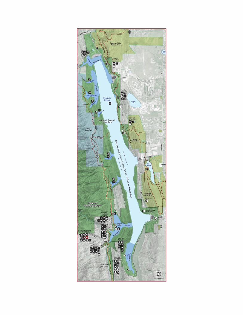
ATTACHMENT A COLORADO-BIG THOMPSON PROJECT MAP


ATTACHMENT B
HORSETOOTH RESERVOIR MAP

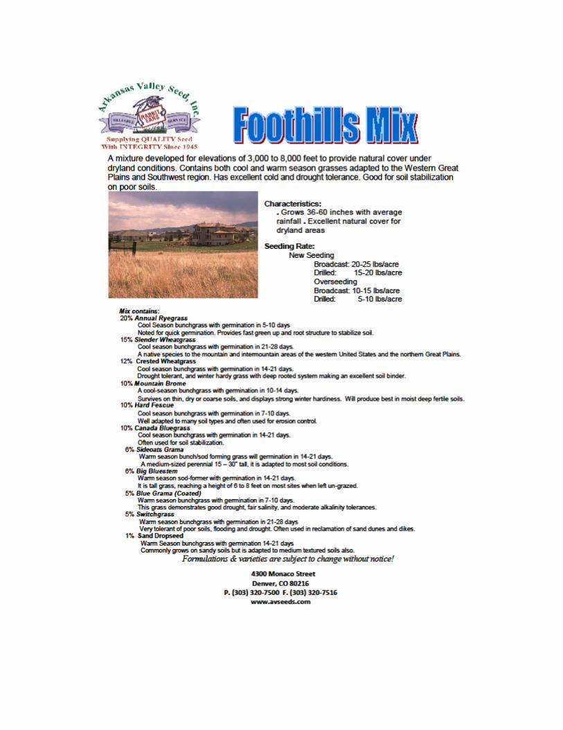
ATTACHMENT C APPROVED RESEEDING MIXTURE

ATTACHMENT C Colorado Historic Preservation Officer
Section 106 Consultation
