sonar and high resolution seismic studies in the eastern...
TRANSCRIPT
Turkish Journal of Earth Sciences (Turkish J. Earth Sci.), Vol. 11, 2002, pp. 61-81. Copyright ©TÜB‹TAK
61
Sonar and High Resolution Seismic Studiesin the Eastern Black Sea
GÜNAY Ç‹FÇ‹, DERMAN DONDURUR & MUSTAFA ERGÜN
Dokuz Eylül University, Department of Geophysics, Buca, TR-35160 ‹zmir - TURKEY(e-mail: [email protected])
Abstract: The Black Sea is one of the largest inland seas in the world. Off the shelf, the water depth quicklyplunges to an average depth of 2 km. The Black Sea sediments are rich in calcite and organic carbon, the lattershowing a high degree of preservation due to anoxia in the waters below 100-150 m. Slope failures and sedimentinstability related to immense gas and gas hydrate accumulations are serious problems that can lead to the failureof offshore installations. Marine geophysical surveys have been carried out in the Eastern Black Sea basin usingstate-of the-art technology to produce sonar and high-resolution maps. A number of prominent structures weredetected in the area such as slumping, sliding, pockmarks, faults and dome-like structures. In the Turkish nearshore and the abyssal plain, shallow gas accumulations have been detected and are continuous about 25-65 mbeneath the seafloor. The gas-bearing strata appear as bright spots and cloudy spots, sometimes pockmarks andacoustic blanking. The sediments on the Turkish shelf contain certain concentrations of gas which can seep to theseabed surface and generate pockmarks. Gas-hydrate layers in the sediments often appears as dark and strongreflection pockets on sub-bottom profiler records.
Key Words: eastern Black Sea Basin, sonar records, high resolution seismics, gas accumulation in marinesediments, gas hydrates
Do¤u Karadeniz Baseninde Sonar ve Yüksek Ayr›ml› Sismik Çal›flmalar
Özet: Karadeniz, Dünya’n›n en büyük iç denizlerinden biridir. fielften uzaklaflt›kça, su derinli¤i h›zla ortalama 2km‘ye iner. Karadeniz tortullar›, kalsit ve organik karbon aç›s›ndan oldukça zengin olup, bu durum, 100-150 mderinlikten itibaren bafllayan oksijensiz ortam nedeniyle yüksek derecede korunum oldu¤unu göstermektedir.Yo¤un gaz ve gaz hidrat oluflumu birikimi nedeniyle, denizel mühendislik yap›lar›n›n y›k›lmas›na neden olabilenyamaç kaymalar› ve tortullar›n durays›zlaflmas› önemli bir sorun oluflturmaktad›r. Sonar ve yüksek ayr›ml› kesitlerinoluflturulmas› için, Do¤u Karadeniz baseninde bir dizi deniz jeofizi¤i çal›flmas› yap›lm›flt›r. Bölgede, kütle düflmeleri,kaymalar, deniz taban›na gaz s›zmalar›, faylar ve dom benzeri yap›lar gibi birkaç önemli oluflum gözlenmifltir.Türkiye yak›nlar›nda ve abisal düzlemde, deniz taban›n›n 25-65 m alt›nda devam eden s›¤ gaz birikimi gözlenmifltir.Gaz içeren ortamlar, parlak ve gölgeli noktalar, s›z›nt›lar ve akustik boflluklar olarak kendini göstermektedir.Türkiye flelfi tortullar› belirli yo¤unluklarda gaz içermekte olup, bunlar yer yer deniz taban›na s›zarak çöküntüalanlar› (pockmark) oluflturmaktad›r. Tortullardaki gaz hidrat tabakalar›, yüksek ayr›ml› sismik kesitler üzerindekoyu renkli ve yüksek genlikte yans›ma paketleri fleklinde gözlenmektedir.
Anahtar Sözcükler: Do¤u Karadeniz baseni, sonar kay›tlar›, yüksek ayr›ml› sismik, denizel tortullarda gaz birikimi,gaz hidratlar
Introduction
The Black Sea, one of the largest inland seas in the worldand lying at the junction between Europe and Asia, is bothoceanographically and geologically unique because of itsanoxic layer below 100-150 m. Although there is anexcessive supply of terrigenous sediment input into theBlack Sea, pelagic sedimentation plays the major role inthe deepest parts of the basin.
Since 1991, the group formed around theUNESCO/TREDMAR Training-Through-Research
program has investigated the Black Sea in collaborationwith other groups. During these surveys, SIMRAD EM12S low-frequency multibeam and SEABAT echosounderswere used to obtain bathymetric charts and reflectivitymaps of the seafloor. In addition, a MAK-1 deep-tow sidescan-sonar and sub-bottom profiler system was used toget acoustic images of the seafloor and shallowsediments.
The SIMRAD EM 12S multibeam echosounderoperates at 13 kHz frequency and has an angular
coverage of 1200 m. The main objectives of theechosounder system are to (a) obtain accurate water-depth information in the survey corridor in order todetermine absolute bathymetric contours; (b) obtainbathymetric profiles along certain corridors; and (c)identify large geomorphological elements, such ascontinental slopes, submarine canyons and seafloorslopes.
The MAK-1 combined side-scan sonar and sub-bottomprofiler system has a swath range of up to 500 m perside in long-range mode (30 kHz), and up to 200 m perside in high-resolution mode (100 kHz). The sub-bottomprofiler system works at a frequency of 6 kHz and theobjectives of the full system are to: (a) identify smallgeomorphological elements, such as creep, mud slides,pock marks and sand ripples; (b) identify areas withdifferent seabed sediments in conjunction with gravitycorer information; (c) locate and identify artificial seabedfeatures, such as wrecks, obstacles, debris, exposedsubmarine cables or pipelines; (d) identify areas ofoffshore activities (dredging, dumping, etc.); (e)determine shallow geology, including the thickness ofsurficial sediments and transitions between differentlayers; and (f) detect the presence of shallow gas, muddiapirs, faults, slumps, etc.
In this study, the side scan sonar and the sub-bottomprofiler data, obtained during these expeditions will begiven together with general outlines of the majorfeatures. Figure 1 shows the sample locations for thedata (solid circles) presented of this study in the easternBlack Sea region. The numbers indicate data numbers,appearing in the text as figure numbers. Data numbers 3to 5 are from the Russian shelf, continental slope andapron areas; data number 6 is unique section from theabyssal plain of the basin region, whereas data numbers7 to 14 indicate Turkish shelf, continental slope andapron areas.
General Tectonics and Structural Elements of theBlack Sea
The Black Sea is located within complex folded chains ofthe Alpine system, represented by the Balkanides-Pontides to south, the Caucasus to the east, and the YaylaRange in the Crimea to the north (Figure 2). The BlackSea represents one of the deepest intra-continental basins
in the world and yet is poorly understood in terms of themechanism controlling its subsidence history. The BlackSea has a key role in the understanding of the Alpineorogeny in Turkey, and has recently drawn considerableattention because of its petroleum potential (Okay et al.1994; Robinson et al. 1996; Görür 1997; Kazmin et al.2000).
Continental mid-Black Sea Ridge (Finetti et al. 1988;Robinson et al. 1996): (1) the E-W–trending oceanicWestern Black Sea Basin (WBSB), and (2) the NE-trending Eastern Black Sea Basin (EBSB) floored byoceanic or highly attenuated continental crust. Accordingto most modern views and consistent with thegeological/geophysical evidence, the deep Black Sea basinsdo not show a "granitic" layer, but a lower crust withabout a 6.8 km.s-1 seismic velocity, indicating oceanic-type crust (Ross 1977). The Black Sea comprises twoextensional basins separated by a NW-SE–trending.
Mountain-building processes and subsequent erosionof the mountains around the basin edges havecontributed to high sediment input. Seismic studiesindicate a 15-km-thick blanket of Cretaceous to Recentsediments (Zonenshain & Le Pichon 1986; Finetti et al.1988) with unusually low seismic velocities (3.0-4.5km/s; fiengör & Y›lmaz 1981). Several models have beenproposed for the opening of the basins. The first modelsuggests that both the WBSB and EBSB commencedopening simultaneously in the Late Cretaceous or earlierdue to the southward drift of the Pontide arc andclockwise rotation of the Andrusov Rise (Zonenshain & LePichon 1986; Finetti et al. 1988). According to thesecond model, the WBSB is a back-arc basin developedabove the northward-subducting Neotethyan Ocean bythe rifting of a juvenile continental-margin magmatic arcduring the Early Cretaceous (Adamia et al. 1974; Hsü etal. 1977; Letouzey et al. 1977; Görür 1988, 1991;Manetti et al. 1988). Recently, Görür (1997) suggestedthat the break-out of continental crust and the start ofspreading occurred during the Cenomanian-Campanianinterval. Okay et al. (1994) claimed that the ‹stanbul zonerifted off of the northern passive margin of the Black Seaby back-arc extension during Albian-Cenomanian time,then drifted southward along the Western Crimea fault inthe east and western Black Sea fault in the west resultingin the opening of the WBSB. Simultaneous separation ofthe Andrusov Rise and the Shatsky Rise by rifting and
GEOPHYSICAL STUDIES IN THE EASTERN BLACK SEA
62

G. Ç‹FÇ‹ et al.
63
Figu
re 1
. Sa
mpl
e lo
catio
ns f
or t
he d
ata
used
in t
his
stud
y (s
olid
circ
les)
. Th
e nu
mbe
rs n
ext
to t
he c
ircle
s co
rres
pond
to
the
figur
e nu
mbe
rs.
The
prof
ile d
irect
ions
are
indi
cate
d in
eac
h fig
ure.

GEOPHYSICAL STUDIES IN THE EASTERN BLACK SEA
64
Zone
Figu
re 2
.G
ener
al t
ecto
nic
fram
ewor
k of
the
Bla
ck S
ea a
nd s
urro
undi
ng r
egio
n (a
fter
Fine
tti
et a
l.19
88;
Rob
inso
n et
al.
1996
; Ka
zmin
et a
l.20
00).

anticlockwise rotation of the Shatsky Rise gave rise to theopening of the EBSB. According to the model of Robinsonet al. (1995, 1996), the WBSB opened via back-arcrifting of the Pontides from the Black Sea margin in theLate Barremian-Albian time. EBSB is much younger andopened in Late Palaeocene and Early-Middle Eocene dueto anticlockwise rotation of the Shatsky Rise, and MiddlePalaeocene back-arc extension was superimposed uponthe East Basin (Spadini et al. 1997). Okay & fiahintürk(1997) suggested a model that argues againstanticlockwise rotation of the Shatsky Rise since there wasno corresponding and/or shortening in the GreaterCaucasus. They claimed that the WBSB opened inBarremian-Albian time as a back-arc basin behind thePontide arc. The EBSB opened in Eocene time followingthe compressional phase in the eastern Pontides.According to this model, most of the western and easternbasins opened in the Eocene simultaneously, resultingfrom the southward drift of the Pontides andaccompanying clockwise rotation of the Andrusov Rise(Kazmin et al. 2000).
The Shatsky Ridge is a buried regional feature,located between the overthrusts of the Greater Caucasusrange and the deep Eastern Basin. It is a massive, upliftedcrustal block with a highly asymmetrical shape. Theconsolidated crust of the Shatsky Ridge is 20- to 25- km-thick (Ergün & Çifçi 1999). The thickness of the overlyingsediments increases from 1.5 to 9 km in the northeast.The southwestern slope of the Shatsky Ridge is verysteep and forms a passive margin to the Eastern Basin asa system of listric faults. The Eastern Basin has a pre-Cenozoic basement measured to be at an average depthof 12 km. The basin has been filled with sediments ofMesozoic to Quaternary age. The Mesozoic sediments areintensely faulted and are overlain by a sequence ofyounger sediments (Finetti et al. 1988).
The transition from the eastern Black Sea Basin to theTurkish margin is marked by the Archangelsky Ridge,which is the southward continuation of the mid Black SeaRidge. The Turkish continental slope developed towardthe basin margin of the Archangelsky Ridge (Figure 2).On both sides, the Archangelsky Ridge is bounded bynormal faults. These faults are of Palaeocene age and areoverlain by more recent sediments (Ivanov et al. 1992).The Archangelsky Ridge is bound to the south by theeastern Pontide belt, a complex terrane formed by a
sequence of orogenic events during the Mesozoic andCenozoic.
The active North Anatolian dextral wrench faultdivides the Pontides into northern and southern zones.The northern zone, forming the Turkish margin of theBlack Sea, comprises by Upper Cretaceous and Eocenevolcanics, asymmetric overturned folds and southwarddipping thrusts (‹zdar & Ergün 1989).
Interpretation of the Data from Eastern Black SeaBasin
The eastern Black Sea has all the geomorphologicalelements of a normal deep-water basin (i.e., shelf,continental slope, continental rise (apron) and abyssalplain; Çifçi et al. 1998). Several investigations haveallowed us to determine the geomorphological elementsof the shelf, continental slope, apron and abyssal plain. Inthis study, the data compiled from the eastern Black Seaare grouped into shelf, slope and abyssal plain regions.Therefore, each region and its major shallow geophysicaland geological features will be discussed separately.
Russian Shelf
The Russian shelf has a flat, smooth surface, with ageneral inclination of 0.4°. The coastal slope extendsfrom the coastline to the 50-m-depth contour. The verydistinct shelf edge marks the transition to the continentalslope and coincides with the 100-m-contour. The seabedsediments consist of clayey silt and clay with shellfragments. The total thickness of the soft sedimentsvaries mainly between 5 and 7 m. In the area of the 30-m-depth contour, the soft sediment cover has a thicknessof 10 to 12 m. A clay layer with shell fragments occurbelow the clayey silt layer. This clay layer almost cropsout at the seabed surface in the area between the 40- and60-m-contours. Slumping of soft sediments is observedbetween the 80- and 90-m-depth contours, and is causedby the topography of the upper boundary rock.
Between the 10- and 105-m water-depth contours,the sediment cover overlies bedrock. This bedrock is acontinuation of coastal structures represented by almostvertical layers of carbonate flysch, which were derivedfrom the erosion of rising fold structures and which havebeen subsequently deformed by continuing orogenicmovements. The surface of the bedrock has been
G. Ç‹FÇ‹ et al.
65
detected at a depth of 10 m below the seabed.Undulations in the bedrock surface were caused byerosion and occur in the area of the 70- to 80-m-depthcontour. The upper surface of the sediment cover followsthe topography of the underlying bedrock.
Outcrops as 3- to 4-m-high blocks have beenobserved between the shoreline and the 10-m water-depth contour. These rock outcrops and blocks areassociated structurally with the outcrops on shore.Anomalous acoustic contacts have been detected in thearea around the 90-m-depth contour, and probably resultfrom clay cropping out through the sediment cover.
General slope-gradient changes from place to place,with some hillocks up to 5-m-high. The nature of thesehillocks is as yet unknown. It is possible to attribute themdue to an underwater spring.
Russian Continental Slope
The Russian continental slope has concave morphologicalcharacteristics in which the gradient becomesprogressively gentler as it is traced downward toward thefoot of the slope. This gradient resulted from a cycle oferosion which cause of the parallel retreat of the slopeand the development of a random network of dendriticvalleys. The initial part of the continental slope is situatedbetween the 100- and 200-m-depth contours. Thebedrock surface crops out in this area at the 105-m-contour. Then the continental slope deepens to 1510 mand has a maximum slope angle of 18.7°. The slope is cutby minor and major canyons that become broad U-shapedvalleys in the deeper parts of the slope. The canyons aredivided by small crests. The U-shaped canyons comprisewide troughs with flat bottoms and steep slopes (up to25°). The bottoms of canyons are defined by hardacoustic deformation which show strong backscatteringon sonar records. The ridges show up as relatively highbackscattering and acoustic shades in canyon areas, andlow backscattering in slope areas. Rough relief exists inthis area. The ridge slopes are made up of hard clay thatis covered by thin layers of recent sediments. Slumpprocesses are observed at the ends of these ridges. Theslope sediments consist of very soft clay that is liable tocreeping and slumping (Figure 3). The sub-bottomprofiler records reveal chaotic and distorted bedding nearthe seabed.
Russian Apron
This apron area is defined by several ridges andsubmarine valleys that have E-W orientations that parallelthe coastline. The ridges, remnants of an anticlinoriumwhich fades out to the west may be regarded as acontinuation of the structures of the western Caucasusstructure. Quaternary sediments, with thicknessesranging between 0 and several 100 m, lie unconformablyupon older rocks.
In this area, sub-bottom profiler records in manycases show a series of parallel thin-bedded sediments cutby faulting due to the presence of shallow gas. Figure 4shows the profiler record of an indistinct structure at thebase of the slope, which may be a slump body or anoutcrop of older consolidated rock. The sediments on theridges consist of very soft to stiff clay. Figure 5 shows thesub-bottom profiler and side-scan sonar records of thetop of a ridge.
Slump bodies are covered by very thin (1 m) layers ofparallel-bedded sediments. Faulting cuts the sediments inthe submarine valleys. This faulting is related to thepresence of shallow gas, that has resulted in circularpockmarks with diameters of up to 100 m at the surface.Comparable features are found on deeper parts of theTurkish continental shelf. The transition to the horizontalflat, abyssal plain is abrupt.
Abyssal Plain
The abyssal plain of the eastern Black Sea basin is ahorizontal, flat area with a fairly constant depth of 2130m. The observed sequence comprises rather continuouswell-bedded reflectors that are interrupted in places bythe piercing of gas and associated disturbances in thesedimentary sequence. Side-scan records exhibit noapparent relief. The prominent type of bottom surfacetype is the smooth, horizontal seafloor (Figure 6).Therefore, the horizontal movement of sediments in thisregion is uncommon.
Turkish Apron
The Turkish apron defines the transition from the abyssalplain to the continental slope between 1800 and 2140 m.The slope apron is characterized by gentle gradients, thedisappearance of channels, and gentle sub-horizontal,
GEOPHYSICAL STUDIES IN THE EASTERN BLACK SEA
66

G. Ç‹FÇ‹ et al.
67
Figu
re 3
.Su
b-bo
ttom
pro
filer
rec
ord
show
ing
infil
l of
soft
sedi
men
ts a
t th
e R
ussi
an c
ontin
enta
l slo
pe o
f th
e ea
ster
n Bl
ack
Sea.
Maj
or c
lay
accu
mul
atio
n re
sults
in a
n ac
oust
ic b
lank
ing
zone
.

GEOPHYSICAL STUDIES IN THE EASTERN BLACK SEA
68
Figu
re 4
.Su
b-bo
ttom
pro
filer
rec
ord
from
the
Rus
sian
apr
on s
how
ing
min
or g
as r
eser
voirs
and
con
solid
ated
sed
imen
ts a
t th
e ba
se o
f a
ridge
slo
pe.

G. Ç‹FÇ‹ et al.
69
Figure 5. Record example of side-scan sonar (top) and sub-bottom profiler record (bottom) showing erosional truncation and bedding outcrop at thetop of the ridge. The outcrop is defined as a high-backscattering line on the sonograph.

GEOPHYSICAL STUDIES IN THE EASTERN BLACK SEA
70
Figu
re 6
.Si
de s
can-
sona
r (to
p) a
nd s
ub-b
otto
m p
rofil
er r
ecor
d (b
otto
m)
show
ing
para
llel w
ell-l
ayer
ed a
nd u
ndef
orm
ed s
edim
ents
of
the
east
ern
Blac
k Se
a ab
yssa
l pla
in.

well-bedded formations of recent soft-uninduratedsediments.
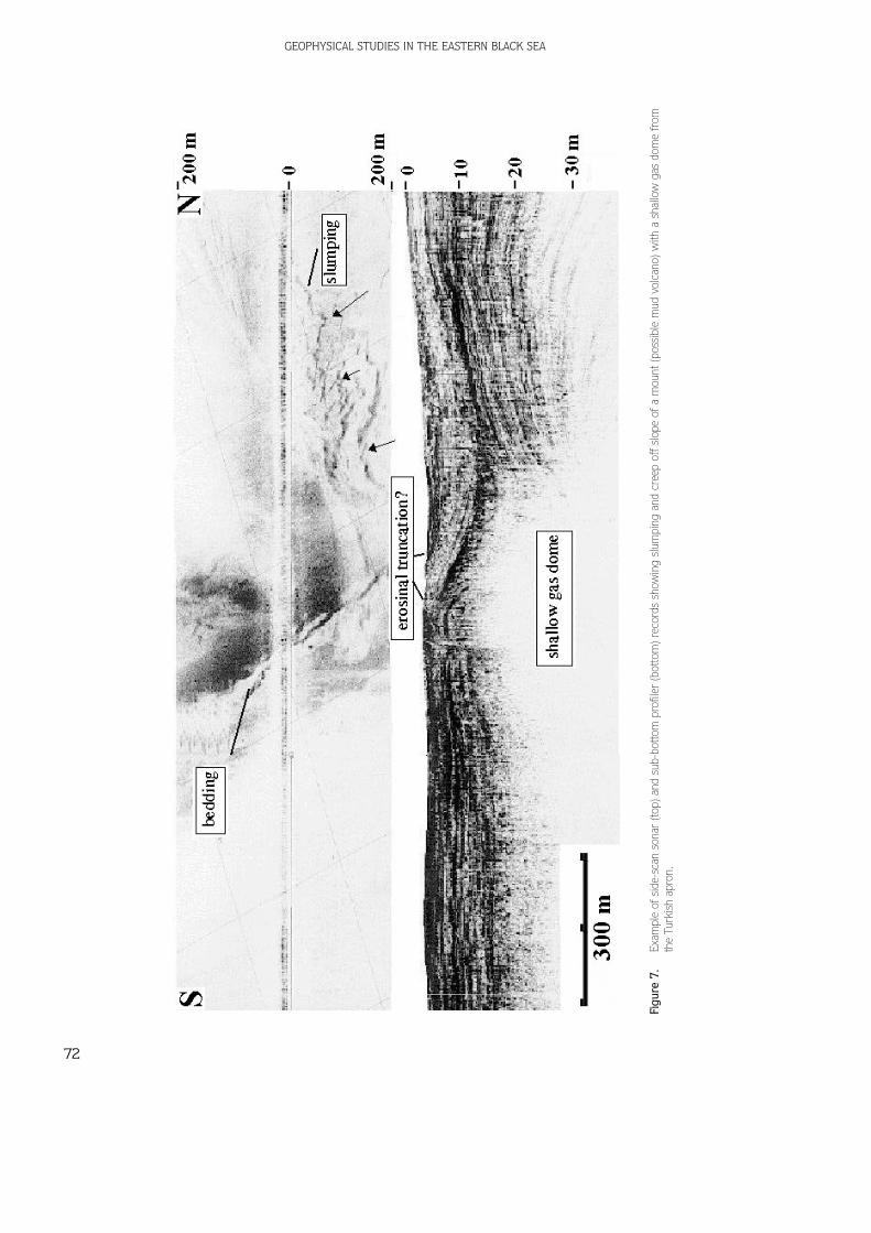
A seamount, with a diameter of 2500 m and a relativeheight of 60 m, is observed on the Turkish apron. Thismount may be the remnant of a mud volcano and slump-slides of the slopes on both sides (Figure 7). The depth ofshallow gas within this area is less than 10 m. Moreslump features and normal faults are located in this area.
The sub-bottom profiler data show an acousticmigrating wave pattern in the upper 100 m of the sub-bottom (Figure 8). This pattern most likely representssediment waves formed by density currents originatingfrom the southeast. These density currents are believedto have been initiated by sediment outflow from theTurkish coast located to the southeast of this area.
The side-scan sonar records display numerous sinuouslines which may represent initial tension fractures in theuppermost sediments. These fractures are considered tobe related to sediment instability which is due to thepresence of shallow gas.
Discontinuous acoustic blanking by shallow gas isobserved extensively within the sub-bottom sediments ofthe Turkish apron. High-amplitude reflectors areobserved between the areas of acoustic blanking atdepths of 15 to 40 m. These reflectors may represent gashydrates.
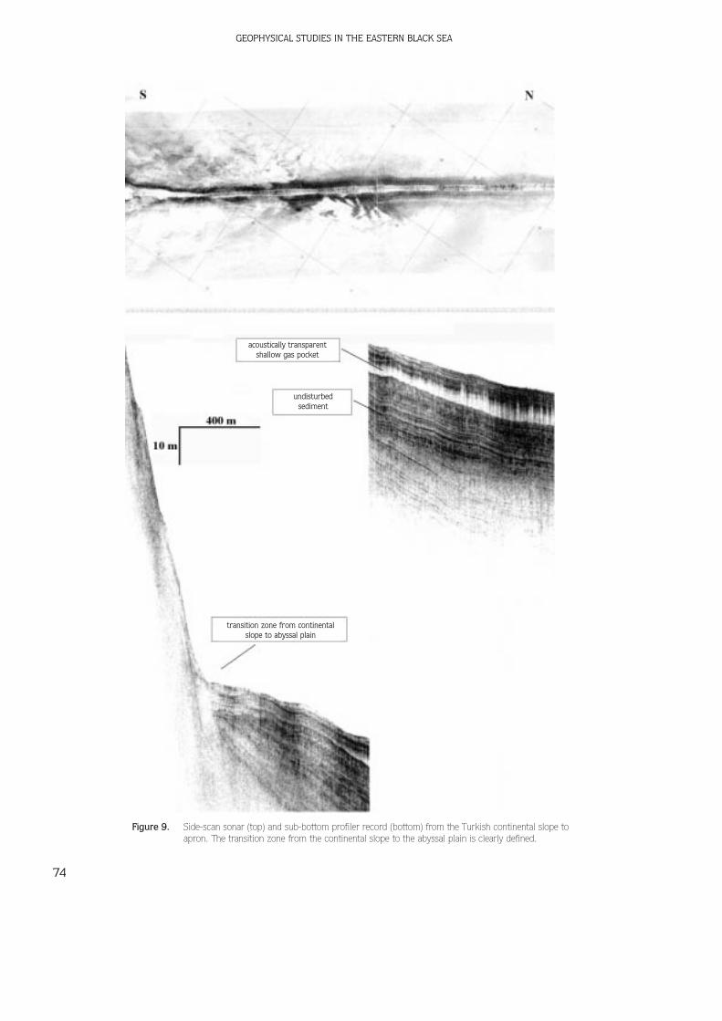
Turkish Continental Slope
The continental slope deepens from 600 to 1800-2000m (Figure 9) and comprises rectilinear gullies and V-likechannels. In contrast to the concave Russian continentalslope, the Turkish continental slope has a convexmorphology. The slope gradient becomes progressivelysteeper as it is traced downward and this is a result ofeither mass movement or structural control. Thecontinental slope is not cut by many canyons and valleys.The sediments on the continental slope show slump andcreep structures. Seabed slumping and creep occur mainlyin areas with slope gradients over 2°; this has been clearlyidentified both by slide faults on the sonar and especiallyby landslides on sub-bottom profile records. The channelscan be identified clearly on sonar mosaics, bathymetriccharts and sub-bottom profiler records, but are mostvisible on the cross-lines of sub-bottom profiles.
The velocity and direction of the sliding and flowingdown of material is not constant along the slope. Thesediment transportation direction is controlled by thegeneral directions of the slopes and channels.
The seismic records show another interesting,acoustically anomalous reflector as a sequence of pockets.These anomalous reflectors are interpreted as gas-(mostly methane) transformed, solid-case gas hydrates,sometimes gas-hydrate crystals, and are typicallyrepresented by dark strong reflections (Figure 10).
Turkish Shelf
The shelf edge (slope) is located at a water depth of about100. Strong reflections were determined beneath theseafloor at about 15-45 m (Figure 11). These strongreflection packets can be interpreted as gas-hydratelayers. Hydrates can form only at certain temperaturesand certain pressures (Stoll & Bryan 1979; Sloan 1990).Stable-methane hydrates are found at temperature andpressure conditions that exist near and just beneath theseafloor on continental margins with high rates ofsedimentation, and where water depths exceed 500 m(Xia et al. 2000). Gas hydrates are a type of naturalformation that contains large amounts of methane, alsoknown as natural gas, and water in the form of ice. Theyare a potential source - possibly a very important source- of energy for the future. However, little is currentlyknown about cost-effective ways to make hydrates anenergy resource.
Studying and understanding hydrates are importantfor a variety of reasons: (1) hydrates have potential as afuture energy resource; (2) hydrates may be a source andalso a sink for atmospheric methane. Betterunderstanding of these natural deposits may increase ourunderstanding of climate change, (3) Hydrates affect thestrength of the sediments in which they are found, areaswith hydrates appear to be less stable than other areas ofthe seafloor; (4) gas hydrates may be a hydrocarbonindicator where the seafloor is at greater depth; and (5)hydrates currently cause blocking in some underwaternatural-gas pipelines. This problem had an increasinglynegative impact as gas producers drill wells in deeperwater.
Consequently, it is important to determine thepresence of gas haydrates prior to the construction of
G. Ç‹FÇ‹ et al.
71
GEOPHYSICAL STUDIES IN THE EASTERN BLACK SEA
72
Figu
re 7
.Ex
ampl
e of
sid
e-sc
an s
onar
(to
p) a
nd s
ub-b
otto
m p
rofil
er (
botto
m)
reco
rds
show
ing
slum
ping
and
cre
ep o
ff sl
ope
of a
mou
nt (
poss
ible
mud
vol
cano
) w
ith a
sha
llow
gas
dom
e fr
omth
e Tu
rkis
h ap
ron.

G. Ç‹FÇ‹ et al.
73
Figu
re 8
.Si
de-s
can
sona
r re
cord
(top
) sho
win
g sl
umpi
ng a
nd c
reep
ing.
Slu
mp
slid
e bo
dies
ove
rlie
the
mig
ratin
g w
ave-
patte
rn s
edim
ents
on
sub-
botto
m p
rofil
er r
ecor
d (b
otto
m) f
rom
the
Turk
ish
apro
n.
GEOPHYSICAL STUDIES IN THE EASTERN BLACK SEA
74
Figure 9. Side-scan sonar (top) and sub-bottom profiler record (bottom) from the Turkish continental slope toapron. The transition zone from the continental slope to the abyssal plain is clearly defined.
acoustically transparentshallow gas pocket
undisturbedsediment
transition zone from continentalslope to abyssal plain

G. Ç‹FÇ‹ et al.
75
Figu
re 1
0.Su
b-bo
ttom
pro
filer
rec
ord
show
ing
syn-
sedi
men
tary
thr
ust
faul
ts a
nd a
gas
hyd
rate
laye
r as
a s
tron
g re
flect
or in
the
upp
er p
art
of t
he T
urki
sh c
ontin
enta
l slo
pe.

GEOPHYSICAL STUDIES IN THE EASTERN BLACK SEA
76
Figu
re 1
1.Su
b-bo
ttom
pro
filer
rec
ord
from
the
Tur
kish
she
lf ar
ea s
how
ing
two
pock
mar
ks a
s sm
all d
epre
ssio
ns a
nd s
tron
gly
refle
ctiv
e ga
s hy
drat
e la
yers
.

G. Ç‹FÇ‹ et al.
77
underwater structures related to military defence, and togas and oil exploration and production. Lack of stabilitymight also be a factor in climate change.
The Turkish shelf area is divided into three differentparts. The first is a sub-horizontal plateau and ischaracterized by pockmarks - circular depressions withdiameters up to 50 m and relative depths of severalmeters (Figure 11). These features up as dark reflectors
on side scan-sonar records (Figure 12). The origin ofthese pockmarks is probably related to local subsidenceand faulting due to gas escape. Pockmarks aredepressions in sediments caused by seepage of fluidsthrough the seafloor. In the Black Sea, pockmarks arecaused mainly by biogenetic gas escape and locally byhydrothermal gas escape. The second feature is the steepshelf slope, which exhibits minor and major northward-
Figure 12. Side-scan sonar (top) and sub-bottom profiler record (bottom) from the Turkish shelf. Gas-escape features resulting in normalfaulting, subsidence and pockmarks on the seabed. The pockmarks are identified as circular patches on the sonographs.
-
GEOPHYSICAL STUDIES IN THE EASTERN BLACK SEA
78
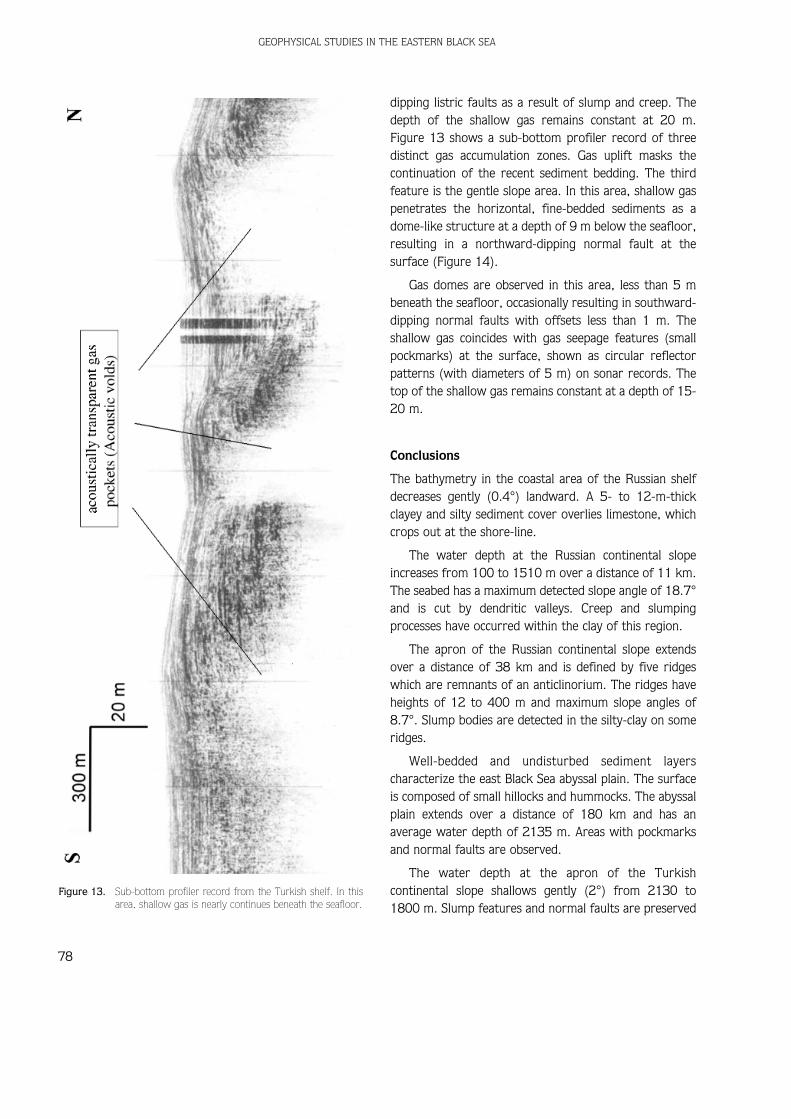
dipping listric faults as a result of slump and creep. Thedepth of the shallow gas remains constant at 20 m.Figure 13 shows a sub-bottom profiler record of threedistinct gas accumulation zones. Gas uplift masks thecontinuation of the recent sediment bedding. The thirdfeature is the gentle slope area. In this area, shallow gaspenetrates the horizontal, fine-bedded sediments as adome-like structure at a depth of 9 m below the seafloor,resulting in a northward-dipping normal fault at thesurface (Figure 14).
Gas domes are observed in this area, less than 5 mbeneath the seafloor, occasionally resulting in southward-dipping normal faults with offsets less than 1 m. Theshallow gas coincides with gas seepage features (smallpockmarks) at the surface, shown as circular reflectorpatterns (with diameters of 5 m) on sonar records. Thetop of the shallow gas remains constant at a depth of 15-20 m.
Conclusions
The bathymetry in the coastal area of the Russian shelfdecreases gently (0.4°) landward. A 5- to 12-m-thickclayey and silty sediment cover overlies limestone, whichcrops out at the shore-line.
The water depth at the Russian continental slopeincreases from 100 to 1510 m over a distance of 11 km.The seabed has a maximum detected slope angle of 18.7°and is cut by dendritic valleys. Creep and slumpingprocesses have occurred within the clay of this region.
The apron of the Russian continental slope extendsover a distance of 38 km and is defined by five ridgeswhich are remnants of an anticlinorium. The ridges haveheights of 12 to 400 m and maximum slope angles of8.7°. Slump bodies are detected in the silty-clay on someridges.
Well-bedded and undisturbed sediment layerscharacterize the east Black Sea abyssal plain. The surfaceis composed of small hillocks and hummocks. The abyssalplain extends over a distance of 180 km and has anaverage water depth of 2135 m. Areas with pockmarksand normal faults are observed.
The water depth at the apron of the Turkishcontinental slope shallows gently (2°) from 2130 to1800 m. Slump features and normal faults are preserved
Figure 13. Sub-bottom profiler record from the Turkish shelf. In thisarea, shallow gas is nearly continues beneath the seafloor.

G. Ç‹FÇ‹ et al.
79
Figu
re 1
4.Su
b-bo
ttom
pro
filer
rec
ord
show
ing
a ga
s do
me,
pen
etra
ting
into
the
sed
imen
t se
quen
ce r
esul
ting
in a
nor
mal
fau
lting
in t
he o
verly
ing
sedi
men
ts in
the
Tur
kish
she
lf ar
ea.

in this area. The Turkish continental slope extends over adistance of 15 km and the water depth shallows from1800 to 300 m. The seabed has a maximum detectedslope angle of 12.6°. At the Turkish continental slope,creep and slumping processes occur in the soft silt.
The Turkish shelf is divided into three areas, namely asub-horizontal plateau, a steep shelf slope and a gentleshelf slope. Throughout the Turkish shelf, shallow gashas been detected in sub-bottom profiler records.Pockmarks occur within the sub-horizontal plateau andgentle shelf slope. Slump and creep features are detectedon the steep shelf slope. Shallow gas is nearly continuous
beneath the seafloor at water depths of 25-65 m. Gashydrates are observed in the shelf and slope areas asstrong reflections on sub-bottom profiler sections.
Acknowledgements
The authors would like to thank anonymous reviewersfor their incisive reviews and suggestions that improvedthe paper significantly. We particularly thank ErdinBozkurt for his background information on the geologicalsetting of Black Sea. Steven K. Mittwede helped with theEnglish.
GEOPHYSICAL STUDIES IN THE EASTERN BLACK SEA
80
ADAM›A, S.H., GAMKREL›DZE, I.P., ZAKAR›ADZE, G.S. & LORDK›PAN›DZE, M.B.1994. Adjharo-Trialet trough and the Black Sea formationproblem. Geotectonics 1, 78-94.
Ç‹FÇ‹, G., KRUGLYAKOV, V., ERGÜN, M. & POMOMORYOV, I. 1998. Acousticanomalies in gas saturated-shallow sediments in the eastern BlackSea. 12th International Petroleum Congress and Exhibition ofTurkey Proceedings, 400-411.
ERGÜN, M & Ç‹FÇ‹, G. 1999. Gas saturated shallow sediments in theeastern Black Sea and geohazard effects. Offshore TechnologyConference Proceedings, 621-630.
FINETTI, I., BRICCHI, G., DEL BEN, A., PIPAN, M. & XUAN, Z. 1988.Geophysical study of the Black Sea. Bulletino di Geofisica Teoricaed Applicata 30, 197-324.
GÖRÜR, N. 1988. Timing of opening of the Black Sea basin.Tectonophysics 147, 247-262.
GÖRÜR, N. 1991. Aptian-Albian palaeogeography of Neo-Tethyandomain. Palaeogeography, Palaeoclimatology, Palaeoecology 87,267-288.
GÖRÜR, N. 1997. Cretaceous syn- to post-rift sedimentation on thesouthern continental margin of the western Black Sea basin. In:ROB›NSON, A.G. (ed) Regional and Petroleum Geology of the BlackSea and Surrounding Region. American Association of PetroleumGeologists Memoir 68, 227-240.
HSÜ, K.J., NACEV, I.K. & VUCHEV, V.T. 1977. Geologic evolution ofBulgaria in the light of plate tectonics. Tectonophysics 40, 245-256.
IVANOV, M.K., LIMONOV, A.F. & WOODSIDE, J.M. 1992. Geological andgeophysical investigations in Mediterranean and Black seas.UNESCO Reports in Marine Sciences 56, 208 p.
‹ZDAR, E. & ERGÜN, M. 1989. Recent geological evolution of the BlackSea: an overview. In: ‹ZDAR, E. & MURRAY, J.W. (eds) Black SeaOceanography. Kluwer Academical Publications, The Netherlands,379-388.
KAZM›N, V.G., SCHRE›DER, A.A. & BULYCHEV, A.A. 2000. Early stages ofevolution of the Black Sea. In: BOZKURT, E., WINCHESTER, J.A. &PIPER, J.D.A. (eds) Tectonics and Magmatism in Turkey and theSurrounding Area. Geological Society, London, SpecialPublications 173, 235-249.
LETOUZEY, J., BIJOU-DUVAL, B., DORKEL, A., GONNARD, R., KRISTCHEV, K.,MONTADERT, L. & SUNGURLU, O. 1977. The Black Sea: a marginalbasin; geophysical and geological data. In: BIJOU-DUVAL, B. &MONTADERT, L. (eds) International Symposium on the StructuralHistory of the Mediterranean Basins, Editions Technip, Paris,363-376.
MANETT›, P., BOCCALETT›, M. & PECCER›LLO, A. 1988. The Black Sea:remnant of a marginal basin behind the Srednorgie-Pontidesisland arc system during the Upper Cretaceous-Eocene times.Bulletino di Geofisica Teorica ed Applicata 30, 39-51.
OKAY, A.‹., fiENGÖR, A.M.C. & GÖRÜR, N. 1994. Kinematic history of theopening of the Black Sea and its effect on the surroundingregions. Geology 22, 267-270.
OKAY, A.‹. & fiAH‹NTÜRK, Ö. 1997. Geology of the Eastern Pontides. In:ROB›NSON, A. G. (ed) Regional and Petroleum Geology of the BlackSea and Surrounding Region. American Association of PetroleumGeologists Memoir 68, 19-38.
ROB›NSON, A.G., SPAD›N›, G., CLOET›NGH, S. & RUDAT, J. 1995.Stratigraphic evolution of the Black Sea: inferences from basinmodeling. Marine and Petroleum Geology 12, 821-835.
ROB›NSON, A.G., RUDAT, J.H., BANKS, C.J. & W›LES, R.L.F. 1996.Petroleum geology of the Black Sea. Marine and PetroleumGeology 13, 195-223.
ROSS, D.A. 1977. The Black Sea and the Sea of Azov. In: NAIRN, A.E.M.,KANES, W.H. & STEHLI, F.G. (eds) The Ocean Basins and Margins.Plenum Publications, New York, 445-481.
References

SPAD›N›, G., ROB›NSON, A.G. & CLOET›NGH, S. 1997. Thermomechanicalmodeling of Black Sea basins formation, subsidence andsedimentation. In: ROB›NSON, A.G. (ed) Regional and PetroleumGeology of the Black Sea and Surrounding Region. AmericanAssociation of Petroleum Geologists Memoir 68, 291-312.
SLOAN, E.D. 1990. Clathrate Hydrates of Natural Gases. Marcel DekkerPublications, New York.
STOLL, R.D. & BRYAN, G.M. 1979. Physical properties of sedimentscontaining gas hydrates. Journal of Geophysical Research 84,1629-1634.
fiENGÖR, A.M.C. & Y›LMAZ, Y. 1981. Tethyan evolution of Turkey: a platetectonic approach. Tectonophysics 75, 181-241.
XIA, G., SEN, M.K. & STOFFA, P.L. 2000. Mapping of elastic properties ofgas hydrates in the Carolina Trough by waveform inversion.Geophysics 65, 735-744.
ZONENSHA›N, L.P. & LE P›CHON, X. 1986. Deep basins of the Black Sea andCaspian Sea as remnants of Mesozoic back-arc basins.Tectonophysics 123, 181-211.
G. Ç‹FÇ‹ et al.
81
Received 26 February 2001; revised typescript accepted 19 October 2001