somerset economic impact assessment of the winter 2013/14 ... · somerset economic impact...
TRANSCRIPT
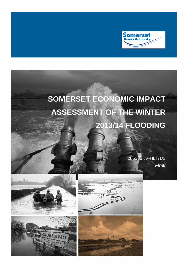
SOMERSET ECONOMIC IMPACT
ASSESSMENT OF THE WINTER
2013/14 FLOODING
285333KV-HLT/1/3
Final
Somerset Economic Impact Assessment
of the Winter 2013/14 Flooding
Somerset Economic Impact Assessment of the winter
2013/14 Flooding
285333KV-HLT/1/3
Prepared by Parsons Brinckerhoff Riverside Chambers
Castle Street Taunton
Somerset TA14AP
Somerset Economic Impact Assessment
of the Winter 2013/14 Flooding
Prepared by Parsons Brinckerhoff
CONTENTS Page
List of Abbreviations i
Definitions i
Executive Summary iii
1 Introduction 1
1.1 Overview 1
1.2 Background 1
1.3 Study area 2
1.4 Overview of assessment methods 2
1.5 Structure of the report 4
2 Summary of aggregate costs of the winter 2013/14 floods in Somerset 5
2.1 Overview 5
2.2 Direct impacts 5
2.3 Indirect impacts SLM and Wider Somerset impact 5
2.4 Qualitative assessment 6
3 Summary of direct impacts by category 7
3.1 Overview 7
3.2 Rail 8
3.3 Local Government and emergency costs 9
3.4 Residential property 11
3.5 Highway and travel 13
3.6 Agriculture and environmental 16
3.7 Social impacts 17
3.8 Business premises 18
3.9 Utility costs 20
4 Summary of indirect impacts 23
4.1 Overview 23
4.2 Methodology 23
4.3 Business survey 25
4.4 GVA impacts of the Somerset winter 2013/14 flooding 26
5 QualItative assessment 27
5.1 Overview 27
5.2 Impact of flooding on strategic infrastructure and Hinkley Point 27
5.3 Impact on unregistered businesses 28
5.4 On-going impacts 29
5.5 Wider South West impacts 29
5.6 Future flooding scenarios 32
5.7 Tourism impacts 32
5.8 Case studies of businesses indirectly impacted 33
5.9 Qualitative assessment summary 34
Somerset Economic Impact Assessment
of the Winter 2013/14 Flooding
Economic Impact Assessment of flood full report.docx Prepared by Parsons Brinckerhoff February 2015 for Somerset County Council / Environment Agency
6 Overall Summary 35
6.1 Overview 35
Figures 37
Appendices
Appendix 1 – Data sources
Appendix 2 – Transport User Benefits Appraisal (TUBA) – Inputs and Outputs
Appendix 3 – GVA assessment model
Appendix 4 – Business survey questionnaire and summary of main findings
List Tables Table 1: Summary of direct impacts ........................................................................................................ 5 Table 2: Summary of GVA impact ........................................................................................................... 6 Table 3: Rail costs 2013/14 flooding ....................................................................................................... 9 Table 4: Local government and emergency costs 2013/14 flooding ..................................................... 11 Table 5: Costs to residential property 2013/14 flooding ........................................................................ 13 Table 6: TEE cost of road closures due to the Somerset winter 2013/14 flooding ............................... 15 Table 7: Road closure costs 2013/14 flooding ...................................................................................... 15 Table 8: Agricultural and environmental costs 2013/14 flooding........................................................... 17 Table 9: Social costs 2013/14 flooding .................................................................................................. 18 Table 10: Costs to business premises 2013/14 flooding ....................................................................... 20 Table 11: Utility costs 2013/14 flooding ................................................................................................. 21 Table 12: Business survey sampling framework ................................................................................... 26 Table 13: GVA impacts of the winter 2013/14 floods ............................................................................ 27 List of Figures Figure 1: Study area .............................................................................................................................. 37 Figure 2: Road closures ........................................................................................................................ 37 Figure 3: 2013/14 flooding extents ........................................................................................................ 37 Figure 4: Future flooding scenario 2013/14 +250MM AOD .................................................................. 37 Figure 5: Future flooding scenario 2013/14 +500MM AOD .................................................................. 37 List of Photographs Photograph 1: Flooding of the railway between Bridgwater and Taunton (Network Rail)....................... 8 Photograph 2: Flooded bungalow in Moorland (EA) ............................................................................. 12 Photograph 3: Flooded home and destroyed shed ............................................................................... 12 List of Charts Chart 1: Total economic impact to Somerset’s economy of the flooding that occurred on the Somerset Levels and Moors between December 2013 and March 2014................................................................ iii Chart 2: Overview of the Somerset Economic Impact Assessment of the winter 2013-14 flooding ....... iv Chart 3: GVA assessment methodology ............................................................................................... 24
Somerset Economic Impact Assessment
of the Winter 2013/14 Flooding
Prepared by Parsons Brinckerhoff - i -
LIST OF ABBREVIATIONS
AOD Above Ordnance Datum
BSG Business Support Grant
BV Black and Veatch
CAB Citizens Advice Bureau
DEFRA Department for Food and Rural Affairs
DfT Department for Transport
EA Environment Agency
FGW First Great Western
FCERM Flood and Coastal Erosion Risk Management
GIS Geographical Information System
GVA Gross Value Added
IDB Internal Drainage Board
LiDAR Light Detection and Ranging
LSOA Lower Super Output Area
MCM Multi-Coloured Manual
NHS National Health Service
ONS Office for National Statistics
PB Parsons Brinckerhoff
SCC Somerset County Council
SIC Standard Industrial Classification
SLM Somerset Levels and Moors
SWRC South West Research Company
TUBA Transport User Benefit Appraisal
DEFINITIONS
Direct Impact Impacts that occurred at the time of the flooding between December 2013 and March 2014 affecting humans, assets, property and any other objects in the areas that had physical contact with the flood.
Indirect impact Impacts induced by the interruption of business activities and the consequential indirect economic losses that occurred inside the SLM and outside the flooded area but within Somerset. These losses are caused by direct costs and/or business interruption costs. Indirect impacts are prompted by the physical stock of capital which is damaged, transmitted through the inter-linkages of economic systems and resulting in a disruption of economic flows.
Qualitative The assessment of impacts that cannot be accurately assessed due to insufficient data and absence of established assessment methodologies.

Somerset Economic Impact Assessment
of the Winter 2013/14 Flooding
Economic Impact Assessment of flood full report.docx Prepared by Parsons Brinckerhoff - iii -
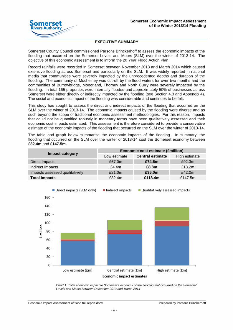
EXECUTIVE SUMMARY
Somerset County Council commissioned Parsons Brinckerhoff to assess the economic impacts of the flooding that occurred on the Somerset Levels and Moors (SLM) over the winter of 2013-14. The objective of this economic assessment is to inform the 20 Year Flood Action Plan.
Record rainfalls were recorded in Somerset between November 2013 and March 2014 which caused extensive flooding across Somerset and particularly on the SLM. It was widely reported in national media that communities were severely impacted by the unprecedented depths and duration of the flooding. The community of Muchelney was cut-off by the flood waters for over two months and the communities of Burrowbridge, Mooorland, Thorney and North Curry were severely impacted by the flooding. In total 165 properties were internally flooded and approximately 50% of businesses across Somerset were either directly or indirectly impacted by the flooding (see Section 4.3 and Appendix 4). The social and economic impact of the flooding was considerable and continues to be felt.
This study has sought to assess the direct and indirect impacts of the flooding that occurred on the SLM over the winter of 2013-14. The economic impacts caused by the flooding were diverse and as such beyond the scope of traditional economic assessment methodologies. For this reason, impacts that could not be quantified robustly in monetary terms have been qualitatively assessed and their economic cost impacts estimated. This assessment is therefore considered to provide a conservative estimate of the economic impacts of the flooding that occurred on the SLM over the winter of 2013-14.
The table and graph below summarise the economic impacts of the flooding. In summary, the flooding that occurred on the SLM over the winter of 2013-14 cost the Somerset economy between £82.4m and £147.5m.
Impact category Economic cost estimate (£million)
Low estimate Central estimate High estimate
Direct Impacts £57.0m £74.6m £92.3m
Indirect Impacts £4.4m £8.8m £13.2m
Impacts assessed qualitatively £21.0m £35.0m £42.0m
Total Impacts £82.4m £118.4m £147.5m
Chart 1: Total economic impact to Somerset’s economy of the flooding that occurred on the Somerset Levels and Moors between December 2013 and March 2014
0
20
40
60
80
100
120
140
160
Low estimate (£m) Central estimate (£m) High estimate (£m)
£ m
illio
n
Economic impact estimates
Direct impacts (SLM only) Indirect impacts Qualitatively assessed impacts

Somerset Economic Impact Assessment
of the Winter 2013/14 Flooding
Prepared by Parsons Brinckerhoff - iv -
The chart below illustrates the processes involved in the economic impact assessment and provides definitions for the three categories of the impact assessment.
Chart 2: Overview of the Somerset Economic Impact Assessment of the winter 2013-14 flooding
In many cases the impact of flooding is still not fully understood by the community and the impacts are still being felt today by many. Therefore, the assessment should be considered as a snapshot at the time of the flooding rather than necessarily a comprehensive review of the economic damages, which can only be achieved sometime after the event.
Somerset Economic Impact Assessment of the Winter 2013-14 Flooding
Direct impacts
(Impacts that occurred at the time of the flooding on the SLM affecting humans, assets, property and any other objects in the areas that had physical contact
with the flood)
£57m (low estimate) £74.6m (central estimate)
£92.3m (high estimate)
Indirect impacts
(Impacts induced by the interruption of business
activities and the consequential indirect
economic losses that occur inside (SLM) and outside
the flooded area (Somerset))
£4.4m (low estimate)
£8.8m (central estimate) £13.2m (high estimate)
Qualitatively assessed impacts
(The assessment of impacts
that cannot be accurately assessed due to insufficient
data and absence of established assessment
methodologies)
£21m (low estimate) £35m (central estimate)
£42m (high estimate)
Total economic impact to Somerset’s economy of the flooding that occurred on the Somerset Levels and Moors between December 2013 and March 2014.
£82.4m (low estimate)
£118.4m (central estimate) £147.5m (high estimate)

Somerset Economic Impact Assessment
of the Winter 2013/14 Flooding
Economic Impact Assessment of flood full report.docx Prepared by Parsons Brinckerhoff - v -

Somerset Economic Impact Assessment
of the Winter 2013/14 Flooding
Prepared by Parsons Brinckerhoff - 1 -
1 INTRODUCTION
1.1 Overview
1.1.1 Somerset County Council (SCC) commissioned Parsons Brinckerhoff (PB) and their sub-consultants (Black & Veatch and Coast Communications) in July 2014 to assess the economic impacts of the winter 2013/14 flooding that occurred on the Somerset Levels and Moors (SLM). In general the economic assessment has focussed on the economic impact of flooding from the River Parrett and River Tone and related moors. The assessment considered the direct, the indirect and the strategic economic impacts caused by the unprecedented levels of flooding that occurred for several months over the winter of 2013/14.
1.1.2 The findings of the study will be used to help inform the 20 Year Flood Action Plan1.
The 20 Year Flood Action Plan, now part of the Somerset Rivers Authority, will set out the long term sustainable future for the SLM, therefore potential flooding intervention options need to be carefully assessed and founded on a robust evidence base that sets the case for why the preferred intervention is fundamental to the smooth operation of the economy in Somerset and the wider South West. This report will form part of that evidence base.
1.1.3 To support the 20 Year Flood Action Plan, this study has collated and analysed the data and information provided by various organisations to establish the costs that the Somerset winter 2013/14 flooding had on the SLM economy and the wider Somerset economy. The study was undertaken in accordance with established assessment methodologies and practises to ensure adherence to the principles of “The Green Book: Appraisal and Evaluation in Central Government” (HM Treasury).
1.1.4 In addition to the assessment of impacts that can be robustly quantified in monetary terms, the study also considered impacts less quantifiable such as the impacts on non-registered businesses and the ongoing impacts being experienced by residents and businesses due to flood relief works and associated road closures. For this reason three economic impact costs are reported. The direct and indirect costs are founded on robust evidence bases and established assessment methodologies. The third cost includes estimates of the less quantifiable impacts.
1.2 Background
1.2.1 Over the winter of 2013-14, between November 2013 and March 2014, record levels of rainfall fell in Somerset. This resulted in extensive flash and fluvial flooding that severely impacted the SLM. Whilst certain moors flood annually for 2-3 weeks, the winter 2013-14 flooding saw not only the flooding of the majority of the moors on the Somerset Levels, but also adjoining roads and properties. The flooding didn’t retreat within a few weeks and remained for up to three months in some locations. The extent of the flooding and the duration in particular is what caused the unprecedented impact to Somerset’s economy. The communities of Muchelney and Thorney were totally surrounded by flood water and almost all of the properties in the village of
1 The 20 Year Flood Action Plan sets six key objectives:
1. Reduce the frequency, depth and duration of flooding. 2. Maintain access for communities and businesses. 3. Increase resilience to flooding for families, agriculture, businesses, communities and wildlife. 4. Make the most of the special characteristics of the Somerset Levels and Moors. 5. Ensure strategic transport connectivity, both within Somerset and through the county to the South West peninsula.
(source: The Somerset Levels and Moors Flood Action Plan, Executive Summary (2014))
Somerset Economic Impact Assessment
of the Winter 2013/14 Flooding
Prepared by Parsons Brinckerhoff - 2 -
Moorland were internally flooded. In total 165 properties on the SLM suffered internal flooding.
1.2.2 The flooding caused damage to properties, agricultural land, infrastructure and the environment. It also caused 81 road closures across Somerset of varying durations - some roads remained closed for up to three months which severely impacted on residents, commuters and businesses. Businesses in the flooded areas were particularly impacted either directly or indirectly. Some businesses could not be accessed and consequently experienced operational difficulties caused by staff not being able to access work, difficulties receiving supplies, distributing goods, and providing services.
1.3 Study area
1.3.1 The study area includes Somerset County and the SLM which cover an area of 60,000 hectares. Figure 1 shows the study area and the 2013/14 flooding extents which covered an area of 15,000 hectares. Assessments of direct damages are provided for the SLM. Separate indirect assessment results are provided for the SLM and Somerset County.
1.3.2 This study has focused on the impacts of the SLM flooding on the Somerset economy, although it should be recognised that the impacts of the flooding were far broader ranging than this. Impacts of the flooding were felt throughout the South West peninsula, through severed communication links and the common perception that the region was inaccessible.
1.4 Overview of assessment methods
1.4.1 This economic impact assessment quantifies the economic value in monetary terms of the direct and indirect consequences
2 of the flooding that occurred over the winter
of 2013/14 in Somerset. The assessment was broadly divided into the following main categories:
1. Direct impacts
2. Indirect impacts
3. Impacts qualitatively assessed
Direct impacts
1.4.2 Direct impacts are impacts that occurred at the time of the flooding and include damage to houses, schools, highway infrastructure, furniture, cars, machinery, power plant, agricultural land, water supply, etc. Specifically, this assessment has assessed the tangible and intangible impacts of the flooding on the following categories in line with the Defra/Environment Agency Flood and Coastal Erosion Risk Management (FCERM) appraisal process:
Rail costs
Local government and emergency costs
2 For the purposes of this assessment indirect consequences have been assessed as the impact on GVA as set out in Section
4.
Somerset Economic Impact Assessment
of the Winter 2013/14 Flooding
Prepared by Parsons Brinckerhoff - 3 -
Residential property costs
Highway costs
Agriculture and the environmental costs
Social costs
Business premises costs
Utility costs
1.4.3 Information and data required to assess the direct impacts of the winter 2013/14 flooding was provided by SCC, local authorities, Network Rail, the National Health Service (NHS), Citizens Advice Bureau (CAB), emergency services and other organisations that were impacted by flooding.
Indirect impacts
1.4.4 Flooding restricts and in some cases stops businesses from operating as they normally would. Businesses are primarily impeded by the impacts of flooding on accessibility. Limited road or rail access makes it almost impossible for staff to get to work and for services and supplies to be delivered. This impacts on the economies of not only flooded areas but also the wider economy. Economic impacts ricochet and can be felt considerable distances from the flooded areas. These are known as ‘downward multiplier effects’. For example, a cut-off manufacturer located in the flooded area cannot produce what it would normally manufacture. This not only impacts on the turnover and profits of the manufacturer but also the purchasing powers of its employees and the productivity of its suppliers. The combined value of these economic losses impacts GVA.
1.4.5 Gross Value Added (GVA) measures the value of economic output in a particular area and as such is arguably the best indicator of economic impact at the regional level. GVA measures the contribution to the economy of each individual producer, industry or sector in the United Kingdom.
1.4.6 Income by industry is a key measure included in the make-up of GVA and as such business hours lost due to flooding is a good proxy to calculating GVA. For this reason a specific question regarding lost business hours was asked in a random selection survey of businesses in the SLM and Somerset undertaken by Coast Communications.
1.4.7 Survey results were analysed by Standard Industrial Classification (SIC) and scaled up to reflect all businesses by SIC in the SLM and Somerset.
Qualitative assessment
1.4.8 A qualitative assessment of impacts that are not traditionally included in Department of Environment, Food and Rural Affairs (Defra) compliant economic impact assessments has been undertaken in an attempt to ascertain the ‘true impact’ of the Somerset winter 2013/14 flooding. Due to data availability and project constraints it has not been possible to accurately assess these impacts within an established assessment framework. For these reasons the following impact categories have been qualitatively assessed and their economic costs broadly estimated.
Strategic infrastructure

Somerset Economic Impact Assessment
of the Winter 2013/14 Flooding
Prepared by Parsons Brinckerhoff - 4 -
Unregistered businesses
On-going consequential impacts
Wider economic impacts outside Somerset
1.4.9 The qualitative assessment also assesses the impact of two ‘more severe’ future flooding scenarios. The ‘more severe’ scenarios are based on plans produced by the Environment Agency using LIDAR data (see Figure 3 to Figure 5 of this report). The plans show flooding extents if flood levels were to rise from the 2013/14 depths by +250mm above ordnance datum (AOD) and +500mm AOD. Without any mitigation, the economic consequences of these ‘more severe’ future flooding scenarios would be considerable due to the impact of the flooding on the economy of Bridgwater and other urban areas that narrowly avoided the flooding in 2013/14.
1.5 Structure of the report
1.5.1 The report is structured as follows:
Section 2 – Summary of aggregate costs of the winter 2013/14 floods in Somerset
Section 3 – Summary of direct impacts by category
Section 4 – Summary of indirect impacts
Section 5 – Qualitative assessment
Section 6 – Overall summary

Somerset Economic Impact Assessment
of the Winter 2013/14 Flooding
Prepared by Parsons Brinckerhoff - 5 -
2 SUMMARY OF AGGREGATE COSTS OF THE WINTER 2013/14 FLOODS IN SOMERSET
2.1 Overview
2.1.1 This section of the report provides a summary of the direct, indirect and qualitative impacts of the flooding that occurred in the SLM over the winter of 2013/14. Low, central and high economic cost estimates are reported due to the complexities involved in assessing economic impacts of flooding events.
2.1.2 In summary, the flooding that occurred on the SLM over the winter of 2013/14 cost the Somerset economy between £82.4m and £147.5m.
2.2 Direct impacts
2.2.1 Table 1 below contains a summary of the direct costs of the winter 2013/14 flooding classified by category of impact. A more detailed breakdown of costs is provided in Section 3 of this report.
Category of direct impact
Low estimate (£million)
Central estimate (£million)
High estimate (£million)
2013/14 levels 2013/14 levels 2013/14 levels
Rail impacts 12.8 17 21.3
Local government and emergency response impacts
14.3 16.8 19.3
Residential property impacts 12 16 20
Highway and travel impacts 9 12 15
Agricultural and environmental impacts
4.1 5.5 6.9
Social impacts 1.6 3.2 4.8
Impacts to business premises 2.5 3.3 4.1
Utility impacts 0.7 0.8 0.9
Total direct costs 57 74.6 92.3
Table 1: Summary of direct impacts
2.3 Indirect impacts*SLM and Wider Somerset impact
2.3.1 Table 2 below summarises the indirect impact of the SLM flooding on businesses in Somerset in terms of GVA impact. The GVA impact ranged from £4.4m to £13.2m.
Somerset Economic Impact Assessment
of the Winter 2013/14 Flooding
Economic Impact Assessment of flood full report.docx Prepared by Parsons Brinckerhoff February 2015 for Somerset County Council / Environment Agency - 6 -
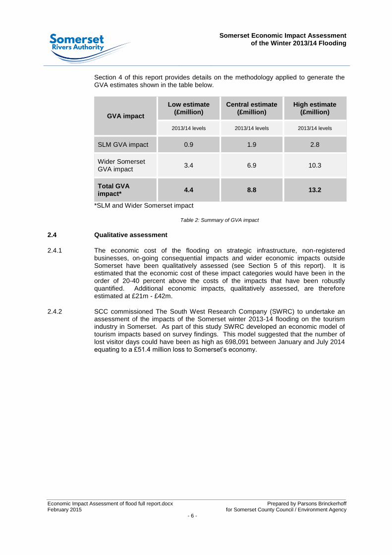
Section 4 of this report provides details on the methodology applied to generate the GVA estimates shown in the table below.
GVA impact
Low estimate (£million)
Central estimate (£million)
High estimate (£million)
2013/14 levels 2013/14 levels 2013/14 levels
SLM GVA impact 0.9 1.9 2.8
Wider Somerset GVA impact
3.4 6.9 10.3
Total GVA impact*
4.4 8.8 13.2
*SLM and Wider Somerset impact
Table 2: Summary of GVA impact
2.4 Qualitative assessment
2.4.1 The economic cost of the flooding on strategic infrastructure, non-registered businesses, on-going consequential impacts and wider economic impacts outside Somerset have been qualitatively assessed (see Section 5 of this report). It is estimated that the economic cost of these impact categories would have been in the order of 20-40 percent above the costs of the impacts that have been robustly quantified. Additional economic impacts, qualitatively assessed, are therefore estimated at £21m - £42m.
2.4.2 SCC commissioned The South West Research Company (SWRC) to undertake an assessment of the impacts of the Somerset winter 2013-14 flooding on the tourism industry in Somerset. As part of this study SWRC developed an economic model of tourism impacts based on survey findings. This model suggested that the number of lost visitor days could have been as high as 698,091 between January and July 2014 equating to a £51.4 million loss to Somerset’s economy.

Somerset Economic Impact Assessment
of the Winter 2013/14 Flooding
Prepared by Parsons Brinckerhoff - 7 -
3 SUMMARY OF DIRECT IMPACTS BY CATEGORY
3.1 Overview
3.1.1 The impacts of winter 2013/14 flooding have been determined through discussions with many stakeholders. In many cases the impact of flooding is still not fully understood by the community and the impacts are still being felt today by many. Therefore, the assessment should be considered as a snapshot at the time of the flooding rather than necessarily a comprehensive review of the economic damages which can only be achieved sometime after the event.
3.1.2 In general the assessment has built on data provided by stakeholders. The analysis generally follows principles set out in Flood and Coastal Erosion Risk Management: A Manual for Economic Appraisal Flood Hazard Research Centre and Environment Agency 2013. This is otherwise referred to as The Multi-Coloured Manual 2013 or MCM (2013).
3.1.3 Where possible data provided has been cross checked against recorded flood levels (recorded in gauging stations across the area by the Environment Agency) and hydraulic model data. Recorded flood data has also been assessed geographically (to accurately determine location, depth and duration of flooding where possible) and has used the Environment Agency’s National Receptor Dataset.
3.1.4 A sequential approach to the analysis has been undertaken:
Drawing on stakeholders understanding of the qualitative impact
Quantifying the impact (depth duration etc. of flooding)
Deriving monetary valuations for these impacts. In some cases the stakeholder may undertake this stage as well for some specialist categories. Where practical these assessments have been reviewed.
3.1.5 In this section the estimated flood damage is expressed in economic rather than financial terms in order to reflect the costs to the national economy. The wider impact on the local economy is considered separately in section 4. In Section 3 taxes on goods and services (e.g. VAT) are excluded as they are transfers from the payee to the exchequer. Goods damaged or lost by households and businesses are valued at their remaining value (typically at half-life) rather than at the full replacement cost which is usually compensated by insurance under ‘new for old’ policies.
3.1.6 There are a range of uncertainties. Some relate to incomplete data (for example, the number of businesses directly flooded is not accurately known because of unregistered businesses) or due to limitations in the analysis tools available. It is widely recognised for example that aiming to attribute an economic impact to social impacts is challenging and the tools available are currently insufficient to undertake the assessment accurately. These uncertainties are discussed for each category below.

Somerset Economic Impact Assessment
of the Winter 2013/14 Flooding
Economic Impact Assessment of flood full report.docx Prepared by Parsons Brinckerhoff February 2015 for Somerset County Council / Environment Agency - 8 -
3.2 Rail
Description of damage or cost
3.2.2 The railway line between Bridgwater and Taunton was severely flooded and in the Fordgate area on North Moor. A total of 4.5 miles of track were directly impacted and closed by flooding. The Bridgwater to Castle Cary line was threatened although ultimately not closed.
3.2.3 Both routes are classified as Primary Routes by Network Rail with line speeds between 100 and 110 mph.
Photograph 1: Flooding of the railway between Bridgwater and Taunton (Network Rail)
3.2.4 The Bridgwater to Taunton line supports an intensive service mix of long distance Cross Country services linking the South West with Bristol, The Midlands, The North and North West and Scotland and Regional FGW Services linking Exeter, Weston Super Mare and Bristol. In total the route is used by approximately 80 trains per day.
Somerset Economic Impact Assessment
of the Winter 2013/14 Flooding
Prepared by Parsons Brinckerhoff - 9 -
3.2.5 The Castle Cary to Taunton line links the South West directly to London via Westbury and Reading and supports a peak service of half hourly services to / from London and an hourly off peak service pattern.
3.2.6 Network Rail confirmed that damage was sustained to the signalling, the track and various other components of the railway infrastructure.
3.2.7 Network Rail confirmed that compensation would be paid to the train operating companies to compensate for provision of buses, train diversions and related costs.
3.2.8 Network Rail has also considered the ‘value of time’ to passengers associated with the disruption to the rail service.
Economic methodology and key assumptions
3.2.9 Estimates of the costs of the above were provided by Network Rail.
Results and Commentary
3.2.10 Network Rail reported the main costs were:
Direct damage: £4m
Compensation costs to Train Operating Companies: £6.5m
Loss of value of time due to disruption: £6.5m
Best estimate of economic damage £17.0m
Confidence & Likely range Confidence +/- 25%
Likely range £12.8m to £21.3m
Unquantified damages Network rail confirm that the disruption associated with wider network closures
in conjunction with the flooding at Fordgate have not been assessed.
Freight losses
Potential areas for further analysis Assess unquantified damages.
Refine assessment once compensation with Train Operating Companies has
been agreed.
Table 3: Rail costs 2013/14 flooding
3.3 Local Government and emergency costs
Description of damage or cost
3.3.1 The Environment Agency, local government and the emergency services (including military assistance) incurred significant costs through providing incident management and emergency response during the period of flooding. The Environment Agency’s
Somerset Economic Impact Assessment
of the Winter 2013/14 Flooding
Economic Impact Assessment of flood full report.docx Prepared by Parsons Brinckerhoff February 2015 for Somerset County Council / Environment Agency - 10 -
Bridgwater incident room was officially opened and fully staffed from 23 December 2013 until 13 March 2014. It was open for 11 weeks and 3 days.
3.3.2 The Environment Agency carried out pumping significantly in excess of that normally undertaken for winter land drainage. At the peak of the pumping operation, there were 128 pumps in operation on the rivers Parrett, Tone, Yeo and Isle (29 permanent/fixed pumps, 80 temporary pumps hired by the EA and 19 ‘Dutch’ pumps). These were operating as and when river levels allowed.
3.3.3 Subsequent asset recovery costs incurred by the Environment Agency in repairing damage to flood defence assets after the water had subsided are also included in this assessment.
Economic methodology and key assumptions
3.3.4 Estimates of costs incurred for incident management, emergency response, pumping and subsequent asset recovery were provided by the Environment Agency.
3.3.5 Details of costs incurred by Local Authorities were derived from Bellwin claims data provided by the District and County councils. Bellwin claims allow certain local government costs to be reimbursed from central Government. However, Bellwin claim data only represents a proportion of the costs, but is the best data available. For example salaries for existing staff directed to work on flood related activities in normal hours are not eligible under the Bellwin scheme.
3.3.6 Assessments of emergency services costs were provided by the police, fire and rescue and ambulance services and by the military in respect of emergency assistance.
Results and Commentary
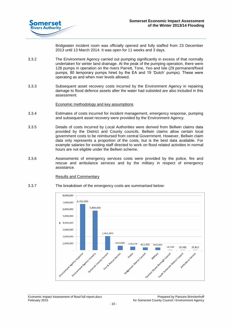
3.3.7 The breakdown of the emergency costs are summarised below:
Somerset Economic Impact Assessment
of the Winter 2013/14 Flooding
Prepared by Parsons Brinckerhoff - 11 -
3.3.8 The largest costs relate to post flood asset recovery both to Environment Agency assets (embankments, pumping stations etc.) and to the highway network managed by Somerset County Council. Large costs were incurred in temporary pumping through the extended event. Other costs generally to District Councils and the emergency services relate to event management and response.
Best estimate of economic cost £16.8m
Confidence & Likely range Confidence +/- 15%
Likely range £14.3m to £19.3m
Unquantified costs Costs incurred to local authorities which are not eligible under the Bellwin
scheme are generally not quantified.
Potential areas for further analysis Other costs to Local Authorities could be assessed if data is available.
Table 4: Local government and emergency costs 2013/14 flooding
3.4 Residential property
Description of damage or cost
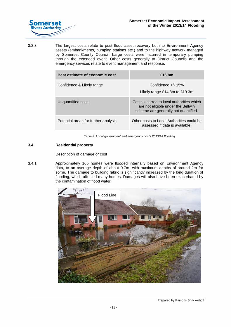
3.4.1 Approximately 165 homes were flooded internally based on Environment Agency data, to an average depth of about 0.7m, with maximum depths of around 2m for some. The damage to building fabric is significantly increased by the long duration of flooding, which affected many homes. Damages will also have been exacerbated by the contamination of flood water.
Flood Line
Somerset Economic Impact Assessment
of the Winter 2013/14 Flooding
Economic Impact Assessment of flood full report.docx Prepared by Parsons Brinckerhoff February 2015 for Somerset County Council / Environment Agency - 12 -
Photograph 2: Flooded bungalow in Moorland (EA)
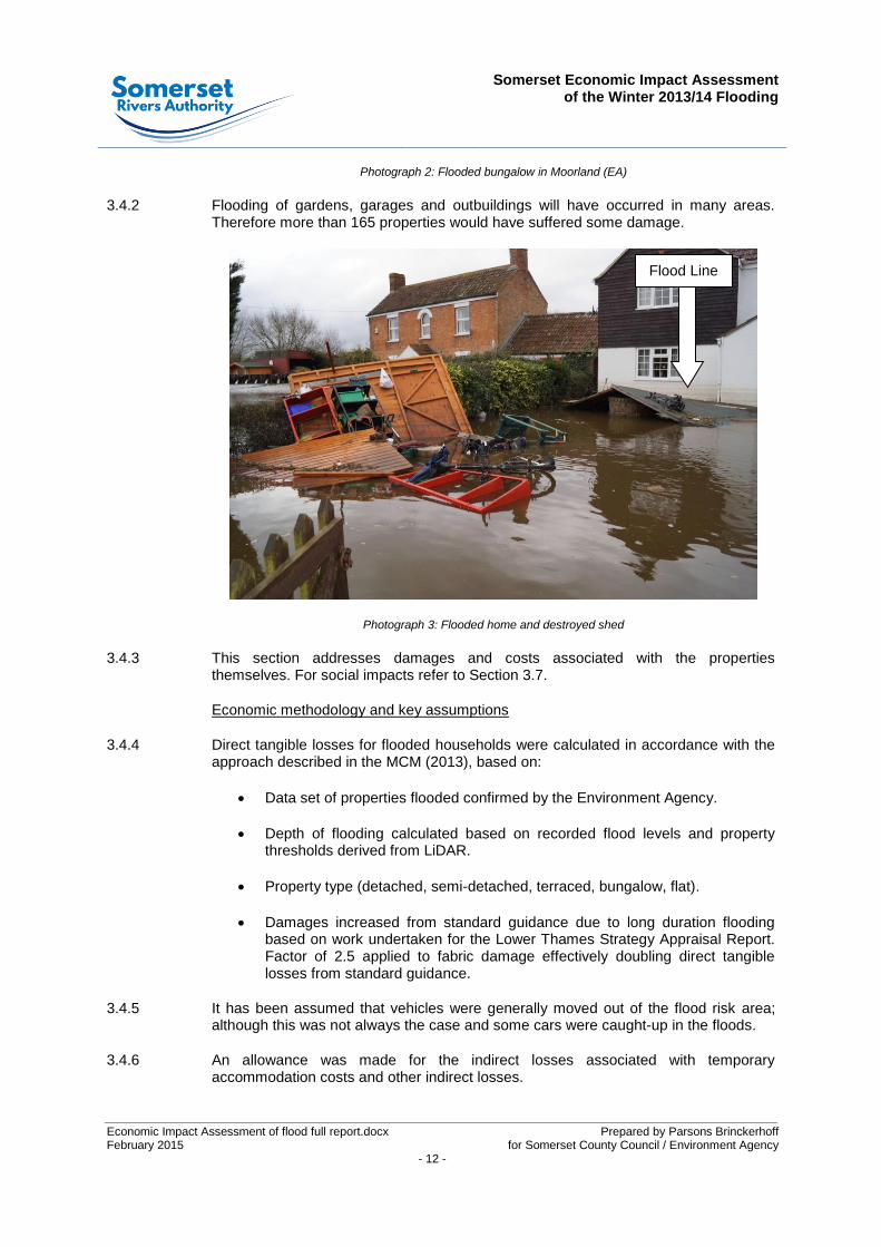
3.4.2 Flooding of gardens, garages and outbuildings will have occurred in many areas. Therefore more than 165 properties would have suffered some damage.
Photograph 3: Flooded home and destroyed shed
3.4.3 This section addresses damages and costs associated with the properties themselves. For social impacts refer to Section 3.7.
Economic methodology and key assumptions
3.4.4 Direct tangible losses for flooded households were calculated in accordance with the approach described in the MCM (2013), based on:
Data set of properties flooded confirmed by the Environment Agency.
Depth of flooding calculated based on recorded flood levels and property thresholds derived from LiDAR.
Property type (detached, semi-detached, terraced, bungalow, flat).
Damages increased from standard guidance due to long duration flooding based on work undertaken for the Lower Thames Strategy Appraisal Report. Factor of 2.5 applied to fabric damage effectively doubling direct tangible losses from standard guidance.
3.4.5 It has been assumed that vehicles were generally moved out of the flood risk area; although this was not always the case and some cars were caught-up in the floods.
3.4.6 An allowance was made for the indirect losses associated with temporary accommodation costs and other indirect losses.
Flood Line
Somerset Economic Impact Assessment
of the Winter 2013/14 Flooding
Prepared by Parsons Brinckerhoff - 13 -
Results and Commentary
3.4.7 Although a relatively small number of properties were directly flooded the depth and exceptional duration of flooding caused significant damage, suffering and disruption. Economic flood damages varied considerably, most were within the range of £75,000 to £150,000 per property. Insurance claims will normally be higher reflecting the normal approach taken by insurers to pay ‘new for old’ which actually provides some betterment.
3.4.8 The Citizens Advice Bureau reported that around 17% of properties flooded were not insured for flood risk.
Best estimate of economic cost £16.0m
Confidence & Likely range Confidence +/- 25%
Likely range £12.0m to £20m
Unquantified costs Vehicle losses
Refer to Section 3.7 for social impacts
Potential areas for further analysis Cross referencing of recorded insurance claims (where available) would assist in
further substantiation of estimates.
Further specific research into long duration flood damage for property typical of the Somerset Levels area
would help to substantiate estimates.
Table 5: Costs to residential property 2013/14 flooding
3.5 Highway and travel
Description of cost
3.5.1 The flooding that occurred in Somerset over the winter of 2013/14 caused a total of 81 road closures. The location of these road closures is shown on Figure 2 to the rear of this report. Many of the roads shown on Figure 2 are lightly trafficked routes and were closed for only short durations. Furthermore, alternative similar length routes could be easily found, and therefore, the economic costs associated with these road closures would have been negligible and as such have not been included in this economic assessment. In agreement with SCC, 25 ‘significant’ road closures were identified and included in this assessment. Details of the 25 road closures included in this assessment are provided with this report as Appendix 2.
3.5.2 In addition to the economic costs of the road closures, the flooding, in certain locations, damaged highway assets. The additional costs of repairing damaged highway assets were also captured in this economic appraisal. The economic costs of road closures and highway asset damage are detailed in Section 3.3 above.
Somerset Economic Impact Assessment
of the Winter 2013/14 Flooding
Economic Impact Assessment of flood full report.docx Prepared by Parsons Brinckerhoff February 2015 for Somerset County Council / Environment Agency - 14 -
Economic methodology and key assumptions
3.5.3 The road closure costs were assessed using Department for Transport (DfT) Transport Users Benefit Appraisal (TUBA). TUBA is transport economic appraisal guidance designed to carry out transport scheme economic appraisal in accordance with DfT’s published guidance Units A.1 of the WebTAG guidance. It implements a ‘willingness to pay’ approach to economic appraisal. The technical inputs that went into the TUBA modelling are shown in Appendix 2.
3.5.4 Whilst this assessment is not assessing a new transport scheme, key inputs to TUBA, however, are perceived value of time and vehicle operating costs. Both of these inputs are variables of road closures and can therefore be appraised.
3.5.5 This assessment has not considered the potential impact of increased congestion on the road network caused by additional traffic flows due to diversions routes. Nor has it considered the potential increase in road safety impacts due to a possible increase in road congestion.
3 For this reason, the economic cost of the road closures in
Somerset over the 2013/14 winter reported in Table 6 are considered to be a conservative estimate.
Results and commentary
3.5.6 Table 6 below shows the breakdown of the Transport Economic Efficiency costs of the road closures during the Somerset winter 2013/14 flooding. A TUBA output table showing the costs associated with each closure is included with this report as Appendix 2. The values in the table below are presented as minus values due to additional travel time costs and vehicle operating costs associated with the diversion routes.
3 Potential impacts caused by congestion have not been assessed due to scope limitations and data availability.

Somerset Economic Impact Assessment
of the Winter 2013/14 Flooding
Prepared by Parsons Brinckerhoff - 15 -
Transport Economic Efficiency Costs (£million)
CONSUMER COSTS
Travel Time
Vehicle Operating Costs
Sub-total £-4.65m
BUSINESS COSTS
Travel Time
Vehicle Operating Costs
Sub-total £-3.53m
ALL USERS
Travel Time
Vehicle Operating Costs
Sub-total £-8.18m
GREEN HOUSE GASES
£-0.19m
Sub-total £-0.19m
INDIRECT TAXATION REVENUES
£0.89m
Sub-total £0.89m
TOTAL £-7.48m
Table 6: TEE cost of road closures due to the Somerset winter 2013/14 flooding
3.5.7 The TUBA model calculated the cost to the economy of road closures totalling approximately 49,700 hours. The cost of these road closures was £7.5m, which equates to a per hour cost of £150. Roads in Somerset were actually closed for a total of 80,000 hours, approximately 30,000 more hours than were actually assessed. Therefore, a tentative estimate of the full cost of road closures to the economy in Somerset over the 2013/14 winter was £12m.
Best estimate of economic cost £12.0m
Confidence & Likely range Confidence +/- 25%
Likely range £9m to £15m
Unquantified costs Congestion caused by diverted traffic
and potential impact on collisions.
Potential areas for further analysis Analysis of the impacts on diversion
routes.
Table 7: Road closure costs 2013/14 flooding

Somerset Economic Impact Assessment
of the Winter 2013/14 Flooding
Economic Impact Assessment of flood full report.docx Prepared by Parsons Brinckerhoff February 2015 for Somerset County Council / Environment Agency - 16 -
3.6 Agriculture and environmental
Description of damage or cost
3.6.1 Flooding of varying depths and durations affected approximately 12,800 Ha of pasture and 1,100 Ha of arable land on the SLM, with many areas experiencing flooding for durations of over 50 days.
3.6.2 The highest damages were caused to the Parrett and Tone Moors (i.e. land south of the Poldens). Whilst it is acknowledged that damage was also caused in the Brue and Axe catchment this has not been quantified, but is recommended for further assessment, see below.
3.6.3 The environmental impact of the flooding is subject to continuing assessment. Natural England has published a review An assessment of the effects of the 2013-14 flooding on the wildlife and habitats of the SLM. The review identified some environmental impacts associated with the flooding but the impact was variable depending on the specific habitat and species being considered.
3.6.4 At this stage it is considered that it is not possible to put a monetary value to the environmental impact. In general it appears that many wetland habitats and species were tolerant to flooding or have been able to recover relatively quickly. However, it is possible that longer term impacts will only be identified in the future. At this stage it is considered that any economic evaluation of this event is unlikely to be practical as the impacts have not yet been sufficiently quantified and may ultimately not be significant.
Economic methodology and key assumptions
3.6.5 An assessment of agricultural impacts was based on specialist advice on work carried out for the Internal Drainage Board (IDB) and using flood extents calculated in this study.
3.6.6 The gross arable and pasture field areas calculated were adjusted to account for physical features e.g. ditches and land usage.
3.6.7 The assessment of impacts on arable and pasture fields accounted for the following:
improved or unimproved grassland pasture (with damage higher on improved grassland)
yield loss, strongly related to the duration of flooding
extra inputs (e.g. reseeding)
loss of grazing days
repairs, clean-up and other costs
3.6.8 Damage to farmsteads (i.e. the farm buildings and stores) has been covered in the business premises category.
Results and Commentary
3.6.9 Agricultural impacts are sensitive to the following factors:
Somerset Economic Impact Assessment
of the Winter 2013/14 Flooding
Prepared by Parsons Brinckerhoff - 17 -
Cumulative impacts – some areas flooded in 2013-14 had not fully recovered from the effects of the summer and autumn flooding in 2012, increasing the impacts as agriculture was less resilient to further flooding.
The pumping of water from North Moor and Curry Moor in mid-March is likely to have reduced damage by avoiding the higher flood damages in the growing season.
3.6.10 Flood damages per hectare vary considerably depending on the crop, flood duration and whether grassland is improved or unimproved. Over 90% of the agricultural damages are associated with pasture with damage on pasture varying between £82 and £944 per Ha.
Best estimate of economic cost £5.5m
Confidence & Likely range Confidence +/- 25%
Likely range £4.1m to £6.9m
Unquantified costs Damage to farmsteads and machinery
(included in Section 3.5 Business Premises).
Potential areas for further analysis
Assessment of Brue & Axe areas
Further assessment of agricultural recovery
Table 8: Agricultural and environmental costs 2013/14 flooding
3.7 Social impacts
Description of damage or cost
3.7.1 The geographic extent, depth and duration of flooding of the 2014 flood are unusual in a UK context. The slow but relentless rise of flooding during January and February 2014 caused considerable concern to the local communities and significant social distress.
3.7.2 Local organisations such as the Citizens Advice Bureau as well as the NHS and others were approached for a qualitative view of the impact of the flooding.
3.7.3 The impact on mental health, depression and anxiety to the local community has been described as ‘devastating’. There was concern that there would be a longer term impact beyond the event itself, as residents returned to communities flooded in the event.
3.7.4 Other social impacts are related to disruption to communities such as Muchelney due to communities being cut off by road. Generally communities were not completely cut off, but required alternative methods of transportation (boats/ amphibious vehicles etc.). Significant delays and disruption were caused over a period of 3 months in some cases. In other cases there were significant diversions required to avoid flooded roads to get from home to work for example. Diversion costs are considered in Section 3.5.
Somerset Economic Impact Assessment
of the Winter 2013/14 Flooding
Economic Impact Assessment of flood full report.docx Prepared by Parsons Brinckerhoff February 2015 for Somerset County Council / Environment Agency - 18 -
Economic methodology and key assumptions
3.7.5 The economic cost of psychological impacts was assessed based on estimated treatment costs for mild depression of about £1000 per person. This was used as a proxy for psychological impacts and applied to the full residential population directly affected by property flooding, on the basis of the high level of distress caused by the depth and duration of flooding.
3.7.6 The same impact was assumed to be applied to 10% of the population of the wider area significantly affected by the flooding to account for the lesser impact of concern about potential flooding and disruption affecting the wider area. A population of approximately 26,000 was considered reasonably representative of those that were situated in areas adjacent to known flooding. This population was derived from the Office for National Statistics Lower Super Output Areas (LSOA) in conjunction with recorded flood maps.
3.7.7 An assessment was made for disruption to the community of Muchelney as the village was cut off by road for approximately 3 months. It is assumed that each resident suffers 2 hours delay per day and this is assessed as a ‘value of time’ consistent with highway economic assessments. This assessment was compared with views from local residents.
3.7.8 Generally it is accepted that the tools available to assess economically the impact of distress and the impact on health are limited. It is recognised that even aiming to do so can tend to under value the individuals response to the flooding.
Results and Commentary
3.7.9 The social impacts of flooding are summarised below, and are considered likely to under estimate the true impact.
Best estimate of economic cost £3.2m
Confidence & Likely range Confidence +/- 50%
Likely range £1.6m to £4.8m
Unquantified costs Disruption to education
Longer term impacts
Potential areas for further analysis Further research is required to improve
the assessment methodology
Table 9: Social costs 2013/14 flooding
3.8 Business premises
Description of damage or cost
3.8.1 A number of business premises, including farmsteads, industrial units, shops and other enterprises were subjected to significant depths of flooding. Damages were exacerbated by the duration of flooding and contamination of flood water.

Somerset Economic Impact Assessment
of the Winter 2013/14 Flooding
Prepared by Parsons Brinckerhoff - 19 -
3.8.2 This category considers the direct impact to premises, business stock and equipment and repair costs. Wider impacts due to loss of trade and disruption to businesses are discussed in Section 4.
Economic methodology and key assumptions
3.8.3 Local Authority Economic Development Officers provided details of commercial properties known to have flooded from records of business support grant applications (provided to assist businesses to recover after the floods). However, it is recognised that this is a limited subset of all the businesses which flooded as not all businesses would have been aware of or applied for the grants. This data was cross checked against Environment Agency records of flooding.
3.8.4 It is recognised that a number of residential properties that flooded would have also included home businesses. Records indicate that some of these applied for a business support grant but many will have not done so. Based on available data it is estimated that approximately 25 home businesses may have been flooded.
3.8.5 Floor areas and depths of flooding for known commercial premises were calculated from mapping data. Standard cost data per square metre floor area for long duration flooding of commercial premises from the MCM 2013 were applied to offices, shops, industrial premises and analogous businesses.
3.8.6 The flooding of farmsteads (farm buildings, stores, agricultural plant etc.) was significant. Approximately 12 farmsteads flooded across the SLM based on flood mapping data and interviews with farmers.
3.8.7 The data available for commercial property is incomplete. The local authorities recognise that available statistics do not fully record the number and scale of businesses particularly in rural areas.
Results and commentary
3.8.8 The assessment concludes that:
Sub Category Number of
Commercial Units
Mean Economic Damage per Unit
£million
Total £million (Rounded)
General commercial
property 23 £0.09m (Note 1) £2m
Farmsteads 12 £0.08m £1m
Home Businesses 25 £0.01m (Note 2) £0.25m
Note 1: Whilst the mean value has been reported, each property was considered individually with the range of damage between £7,000 and £400,000.
Note 2: For home businesses the valuation is the extra flood damage above that for a home. The residential damage has been assessed in Section 3.4.
Somerset Economic Impact Assessment
of the Winter 2013/14 Flooding
Economic Impact Assessment of flood full report.docx Prepared by Parsons Brinckerhoff February 2015 for Somerset County Council / Environment Agency - 20 -
Best estimate of economic cost £3.3m
Confidence & Likely range Confidence +/- 25%
Likely range £2.5m to £4.1m
Unquantified costs
Records of commercial flooding are incomplete.
Damage to churches, community halls and other community buildings have not
been assessed.
Potential areas for further analysis
Cross referencing of recorded insurance claims (where available) would assist in
further substantiation of estimates.
Individual economic damage surveys could be undertaken to improve
understanding.
Table 10: Costs to business premises 2013/14 flooding
3.9 Utility costs
Description of damage or cost
3.9.1 Costs incurred by utility providers include direct damage to assets and costs incurred providing flood protection to assets and / or mitigating the effects of flooding to customers.
Economic methodology and key assumptions
3.9.2 Assessments of damages and other costs were provided by Wessex Water, Bristol Water, National Grid, Wales and West Utilities and Western Power Distribution.
Results and commentary
3.9.3 The main costs have fallen to Wessex Water in relation to tankering, pump hire, premature failure of equipment and additional power. Had the event been more severe then impacts on National Grid assets and other utilities would have been more significant.
Somerset Economic Impact Assessment
of the Winter 2013/14 Flooding
Prepared by Parsons Brinckerhoff - 21 -
Best estimate of economic cost £ 0.8m
Confidence & Likely range Confidence +/- 15%
Likely range £0.7m to £0.9m
Unquantified costs
It is likely that some of wider management costs to the utilities in
relation to the flooding have not been fully captured.
Potential areas for further analysis
Anecdotal evidence suggests that higher costs would have been incurred with a
more extreme flood and a review is recommended.
Table 11: Utility costs 2013/14 flooding

Somerset Economic Impact Assessment
of the Winter 2013/14 Flooding
Prepared by Parsons Brinckerhoff - 23 -
4 SUMMARY OF INDIRECT IMPACTS
4.1 Overview
4.1.1 This section of the report sets out the indirect impact results of the study in terms of impact on GVA (In basic terms GVA is an economic measure of business productivity/output). This section also sets out the assessment methodology that was applied and provides a summary of the main findings from the business survey that was commissioned to garner the impacts experienced by the business community in the study area.
4.1.2 GVA measures the value of economic output in a particular area and as such is arguably the best indicator of economic impact at the regional level. GVA measures the contribution to the economy of each individual producer, industry or sector in the United Kingdom. The assessment methodology that was applied for this study, therefore, used economic metric to ascertain GVA impact by Standard Industrial Classifications (SIC, ONS 2007) for businesses located in the SLM and Somerset County.
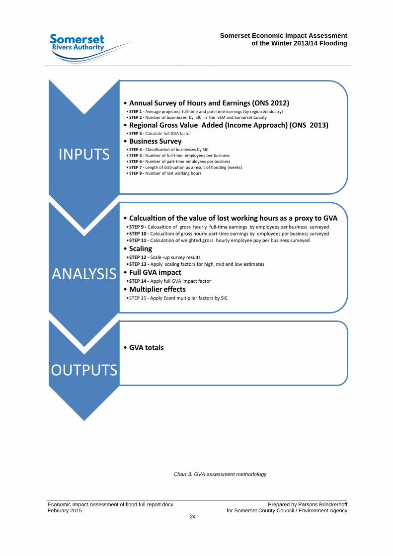
4.2 Methodology
4.2.1 The flow chart overleaf illustrates the processes involved in the assessment of GVA impacts. In summary, business survey findings and average hourly income by SIC derived from the ONS Annual Survey of Hours and Earnings (2012) were used as proxies to calculate GVA impact. This approach broadly follows the methodology as set out in the Defra/EA toolkit entitled ‘Flood and coastal erosion risk management and the local economy’ (Frontier economics, November 2014). Key extracts from the bespoke GVA assessment model developed for this assessment are included with this report as Appendix 3.
Somerset Economic Impact Assessment
of the Winter 2013/14 Flooding
Economic Impact Assessment of flood full report.docx Prepared by Parsons Brinckerhoff February 2015 for Somerset County Council / Environment Agency - 24 -
Chart 3: GVA assessment methodology
INPUTS
• Annual Survey of Hours and Earnings (ONS 2012) •STEP 1 - Average projected full-time and part-time earnings (by region &industry)
•STEP 2 - Number of businesses by SIC in the SLM and Somerset County
• Regional Gross Value Added (Income Approach) (ONS 2013) •STEP 3 - Calculate full GVA factor
• Business Survey •STEP 4 - Classification of businesses by SIC
•STEP 5 - Number of full-time employees per business
•STEP 6 - Number of part-time employees per business
•STEP 7 - Length of distruption as a result of flooding (weeks)
•STEP 8 - Number of lost working hours
ANALYSIS
• Calcualtion of the value of lost working hours as a proxy to GVA •STEP 9 - Calcualtion of gross hourly full-time earnings by employees per business surveyed
•STEP 10 - Calcualtion of gross hourly part-time earnings by employees per business surveyed
•STEP 11 - Calculation of weighted gross hourly employee pay per business surveyed
• Scaling •STEP 12 - Scale -up survey results
•STEP 13 - Apply scaling factors for high, mid and low estimates
• Full GVA impact •STEP 14 - Apply full GVA impact factor
• Multiplier effects •STEP 15 - Apply EconI multiplier factors by SIC
OUTPUTS
• GVA totals
Somerset Economic Impact Assessment
of the Winter 2013/14 Flooding
Prepared by Parsons Brinckerhoff - 25 -
4.3 Business survey
4.3.1 A business survey was undertaken by Coast Communications over a period of three weeks from 11
th to the 29
th August 2014. The purpose of the survey was to collect a
representative sample of flooding impacts experienced by industry type across the SLM and Somerset County. A snap-shot of the key survey responses is provided below:
50% of businesses surveyed across Somerset were impacted by flooding.
86% of businesses surveyed across Somerset were impacted by road closures.
20% of businesses impacted in the flooded wards lost business hours equating to a per hour GVA loss of £19.09.
12% of businesses impacted in Somerset located outside the flooded wards lost business hours equating to a per hour GVA loss of £20.45.
4.3.2 The following section provides a summary of the survey methodology. Appendix 4 of this report is the survey questionnaire and a synopsis of the main survey findings.
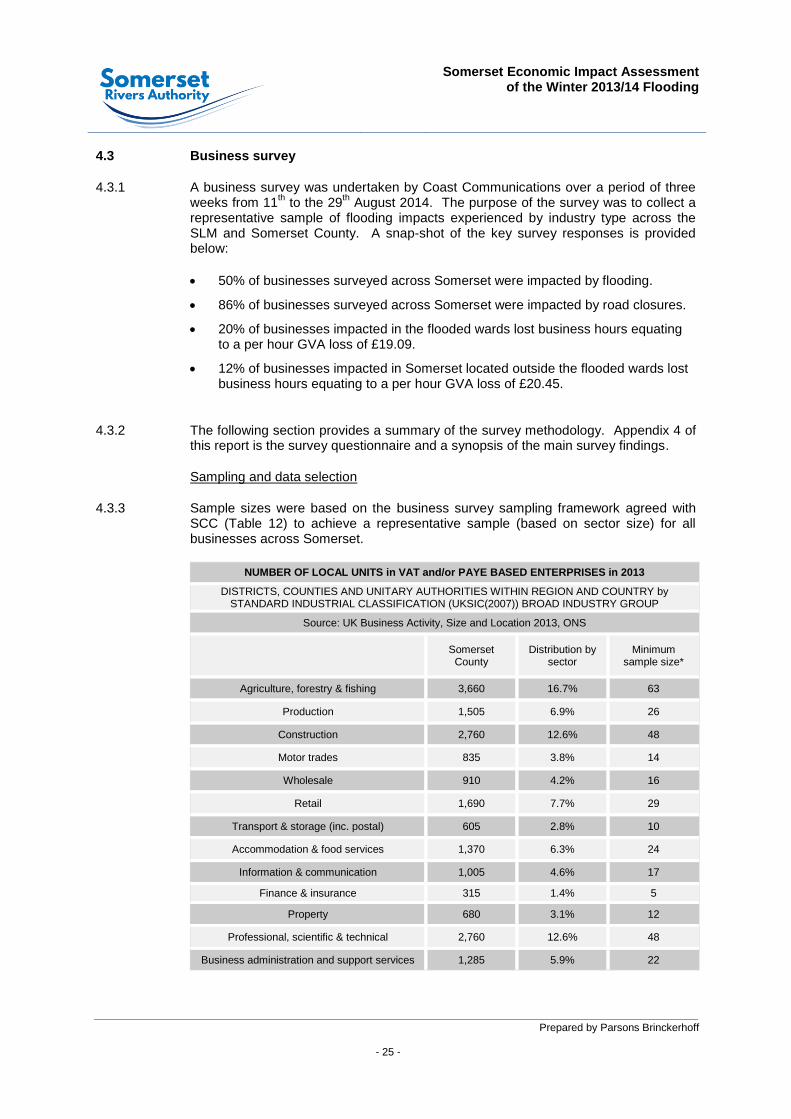
Sampling and data selection
4.3.3 Sample sizes were based on the business survey sampling framework agreed with SCC (Table 12) to achieve a representative sample (based on sector size) for all businesses across Somerset.
NUMBER OF LOCAL UNITS in VAT and/or PAYE BASED ENTERPRISES in 2013
DISTRICTS, COUNTIES AND UNITARY AUTHORITIES WITHIN REGION AND COUNTRY by STANDARD INDUSTRIAL CLASSIFICATION (UKSIC(2007)) BROAD INDUSTRY GROUP
Source: UK Business Activity, Size and Location 2013, ONS
Somerset
County Distribution by
sector Minimum
sample size*
Agriculture, forestry & fishing 3,660 16.7% 63
Production 1,505 6.9% 26
Construction 2,760 12.6% 48
Motor trades 835 3.8% 14
Wholesale 910 4.2% 16
Retail 1,690 7.7% 29
Transport & storage (inc. postal) 605 2.8% 10
Accommodation & food services 1,370 6.3% 24
Information & communication 1,005 4.6% 17
Finance & insurance 315 1.4% 5
Property 680 3.1% 12
Professional, scientific & technical 2,760 12.6% 48
Business administration and support services 1,285 5.9% 22
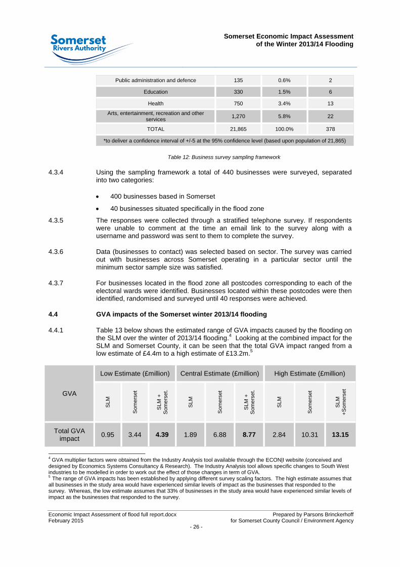
Somerset Economic Impact Assessment
of the Winter 2013/14 Flooding
Economic Impact Assessment of flood full report.docx Prepared by Parsons Brinckerhoff February 2015 for Somerset County Council / Environment Agency - 26 -
Public administration and defence 135 0.6% 2
Education 330 1.5% 6
Health 750 3.4% 13
Arts, entertainment, recreation and other services
1,270 5.8% 22
TOTAL 21,865 100.0% 378
*to deliver a confidence interval of +/-5 at the 95% confidence level (based upon population of 21,865)
Table 12: Business survey sampling framework
4.3.4 Using the sampling framework a total of 440 businesses were surveyed, separated into two categories:
400 businesses based in Somerset
40 businesses situated specifically in the flood zone
4.3.5 The responses were collected through a stratified telephone survey. If respondents were unable to comment at the time an email link to the survey along with a username and password was sent to them to complete the survey.
4.3.6 Data (businesses to contact) was selected based on sector. The survey was carried out with businesses across Somerset operating in a particular sector until the minimum sector sample size was satisfied.
4.3.7 For businesses located in the flood zone all postcodes corresponding to each of the electoral wards were identified. Businesses located within these postcodes were then identified, randomised and surveyed until 40 responses were achieved.
4.4 GVA impacts of the Somerset winter 2013/14 flooding
4.4.1 Table 13 below shows the estimated range of GVA impacts caused by the flooding on the SLM over the winter of 2013/14 flooding.
4 Looking at the combined impact for the
SLM and Somerset County, it can be seen that the total GVA impact ranged from a low estimate of £4.4m to a high estimate of £13.2m.
5
GVA
Low Estimate (£million) Central Estimate (£million) High Estimate (£million)
SLM
Som
ers
et
SLM
+
Som
ers
et.
SLM
Som
ers
et
SLM
+
Som
ers
et.
SLM
Som
ers
et
SLM
+
So
me
rset
Total GVA impact
0.95 3.44 4.39 1.89 6.88 8.77 2.84 10.31 13.15
4 GVA multiplier factors were obtained from the Industry Analysis tool available through the ECON|I website (conceived and
designed by Economics Systems Consultancy & Research). The Industry Analysis tool allows specific changes to South West industries to be modelled in order to work out the effect of those changes in term of GVA. 5 The range of GVA impacts has been established by applying different survey scaling factors. The high estimate assumes that all businesses in the study area would have experienced similar levels of impact as the businesses that responded to the survey. Whereas, the low estimate assumes that 33% of businesses in the study area would have experienced similar levels of impact as the businesses that responded to the survey.
Somerset Economic Impact Assessment
of the Winter 2013/14 Flooding
Prepared by Parsons Brinckerhoff - 27 -
Table 13: GVA impacts of the winter 2013/14 floods
5 QUALITATIVE ASSESSMENT
5.1 Overview
5.1.1 This section of the report provides a qualitative assessment of the flooding impacts on:
strategic infrastructure and Hinkley;
non-registered businesses;
on-going consequential impacts; and
the wider South West region.
It also qualitatively assesses the on-going consequential impacts of the flooding and considers the impact of ‘more severe’ future flooding scenarios.
5.1.2 Data availability, limited assessment guidance, and project limitations have not enabled a quantitative evidence based economic assessment of these areas to be undertaken. However, it has been possible from the information collected to provide a considered estimate as to the economic impact of the flooding on these areas. The following sections set out these estimates. These figures should be treated with caution and will need to be confirmed with further research. Despite being qualitative estimates, they give an indication of the broader ranging economic impacts of flooding events and as such the conservative nature of traditional economic impact assessments.
5.1.3 To give the reader a better understating of the sort of impacts experienced by indirectly impacted businesses, Section 5.8 below presents three case studies of businesses impacted by the flooding. Business survey findings and information on the indirect impacts of the flooding provided by district councils through Business Support Grant (BSG) claims has helped to establish a clear picture of the difficulties experienced by businesses both during and after the flooding.
5.2 Impact of flooding on strategic infrastructure and Hinkley Point
5.2.1 Flooding of the SLM Area could have an impact on the delivery and operation of Hinkley Point in two ways: delays in the delivery of materials and labour during construction; and through increased congestion on routes to the site which has come about due to the diversion of traffic from flooded routes elsewhere.
Delivery of materials
5.2.2 The direct delivery of materials for construction and to and from the supply chain is unlikely to be affected by flooding. These materials will be delivered via the local and national strategic road network, which was for the most part unaffected by the flooding in 2014 (only a small part of the A303 was closed for a few hours) and the supply chain is likely to cluster around locations with good accessibility to the strategic road network and to the site, such as M5 Junctions 23 and 24.
5.2.3 The clustering of businesses around good, reliable transport links will mean that the areas likely to flood will not have the opportunities for investment from the Hinkley Point supply chain that other areas of the county will receive, thereby reducing the
Somerset Economic Impact Assessment
of the Winter 2013/14 Flooding
Economic Impact Assessment of flood full report.docx Prepared by Parsons Brinckerhoff February 2015 for Somerset County Council / Environment Agency - 28 -
potential for economic growth in these areas. However, this effect is not restricted to businesses solely related to the Hinkley Point supply chain, but all businesses who decide to avoid these areas due to reliability and increased risks and associated costs, such as insurance premiums.
Labour
5.2.4 During construction, it is anticipated that 60% of staff (which will total 5,000 workers per day at the peak of construction) are not local and can be based in specific accommodation on or near the site (a small proportion will be accommodated off-site, but still local to the site). The remaining staff will be recruited locally and in-line with the major populations of the county are likely to originate from Bridgwater and Taunton, with a minority coming from wider afield in Yeovil, Bristol and Exeter (Source: Hinkley Point Transport Statement). All these locations have good links with the local and national strategic road network and should remain accessible. A very small proportion of staff who live in the rural areas affected by flooding, could find difficulties in getting to work, but the risk to the delivery of Hinkley Point because of this will be remote.
5.2.5 During the operation of Hinkley Point, workers will be wholly based locally and are expected to reside in the main urban areas of the County or in the major cities just outside. There will be a small proportion of the work force that will choose to reside outside these areas and these run the risk of being unable to reach the site in their normal commuting times during periods of flooding. The likelihood of any of these individuals being critical to the delivery of Hinkley is very low.
5.2.6 The strategic rail connection was out of operation south of Bridgwater for two months in 2014 due to flooding inundating the line, but services were still able to operate from the north down to Bridgwater and rail replacement services catered for other movements. Whilst this is costly and disruptive, and has widespread economic impacts, it is clear that EDF could provide workaround solutions for their workforce in the event of a further incident.
Increased congestion
5.2.7 The effect of increased congestion on the ability of the workforce and materials to reach the site will be low. There might be some short term pain for a few peak hours in known congestion hotspots (e.g. the A358 through Henlade and Taunton Road between Huntsworth and Taunton), but this is likely to be a few days and for less than an hour. Even considering some of the larger diversions, in terms of volumes of traffic displaced and duration of diversion, such as Burrowbridge, the amount of traffic diverted during the peak hours is low enough to be obscured by the impact of naturally occurring daily variations in traffic flows.
5.3 Impact on unregistered businesses
5.3.1 There were 21,865 VAT and/or PAYE based enterprises in Somerset (ONS, 2013). However, this figure doesn’t account for unregistered
6 businesses, which according
to the ONS ‘Characteristics of Home Workers, 2014’ comprise approximately 10% of the South West’s working age population. These statistics suggest that there could be
6 Those businesses run by self-employed people that are not large enough to be VAT registered and do not have a PAYE
scheme and therefore will not appear on the government business register.
Somerset Economic Impact Assessment
of the Winter 2013/14 Flooding
Prepared by Parsons Brinckerhoff - 29 -
as many as 30,000 unregistered businesses in Somerset that would not have been captured in the business survey sample.
7
5.3.2 Despite the complexities and challenges involved in determining the number of unregistered businesses adversely impacted by the flooding, it should be acknowledged that unregistered businesses in the UK and in Somerset in particular represent a significant proportion of the economy (it is estimated that unregistered businesses in Somerset contribute approximately 5% of Somerset’s GVA). In the UK there were an estimated 2,740,000 unregistered businesses at the start of 2013, representing 56.0% of all private sector businesses (Department for Business Innovation & Skills (BIS), ‘Business Population Estimates for the UK and Regions 2014’, October 2013). In 2012 an estimate of unregistered business turnover as a proportion of all business turnover in the UK was 2.9% (BIS, 2012).
5.4 On-going impacts
5.4.1 Although the water levels receded in February 2014, the consequences of the flooding were still being felt by many residents and businesses on the SLM. Ongoing consequences of the flooding included:
Road closures due to mitigation works – for example, between 29/09/14-31/12/14 for installation of culverts at Beer Wall, and on Law Lane between Muchelney and Drayton due to road raising as part of 20 year Flood Action Plan.
Stress and hardship caused by living in temporary accommodation and rebuilding homes.
Loss of trade for businesses reliant on pass-by trade.
5.4.2 The economic impact of on-going flooding consequences has not been assessed in this study due to data availability and study constraints. Despite this, it should be recognised that the economic impacts of flooding events do not stop with the receding of the water, but continue for many months and in some cases years afterwards.
5.5 Wider South West impacts
5.5.1 This study has focused on the direct and indirect impacts of the flooding that occurred on the SLM over the winter of 2013/14 and the impact of this flooding on the Somerset economy (it has not considered the impacts of coastal flooding that occurred in Somerset). The reality is that the economic impacts are far broader ranging and not restricted to the boundaries of Somerset County. The Somerset flooding is also likely to have impacted on the economies of the adjoining counties of Devon, Wiltshire and Dorset. It is also likely to have impacted on the economy of Cornwall and the Unitary Authority of Bristol. However, the scope of this study did not include the assessment of these wider economic impacts and as such is considered to be a conservative estimate of the true economic impacts of the flooding.
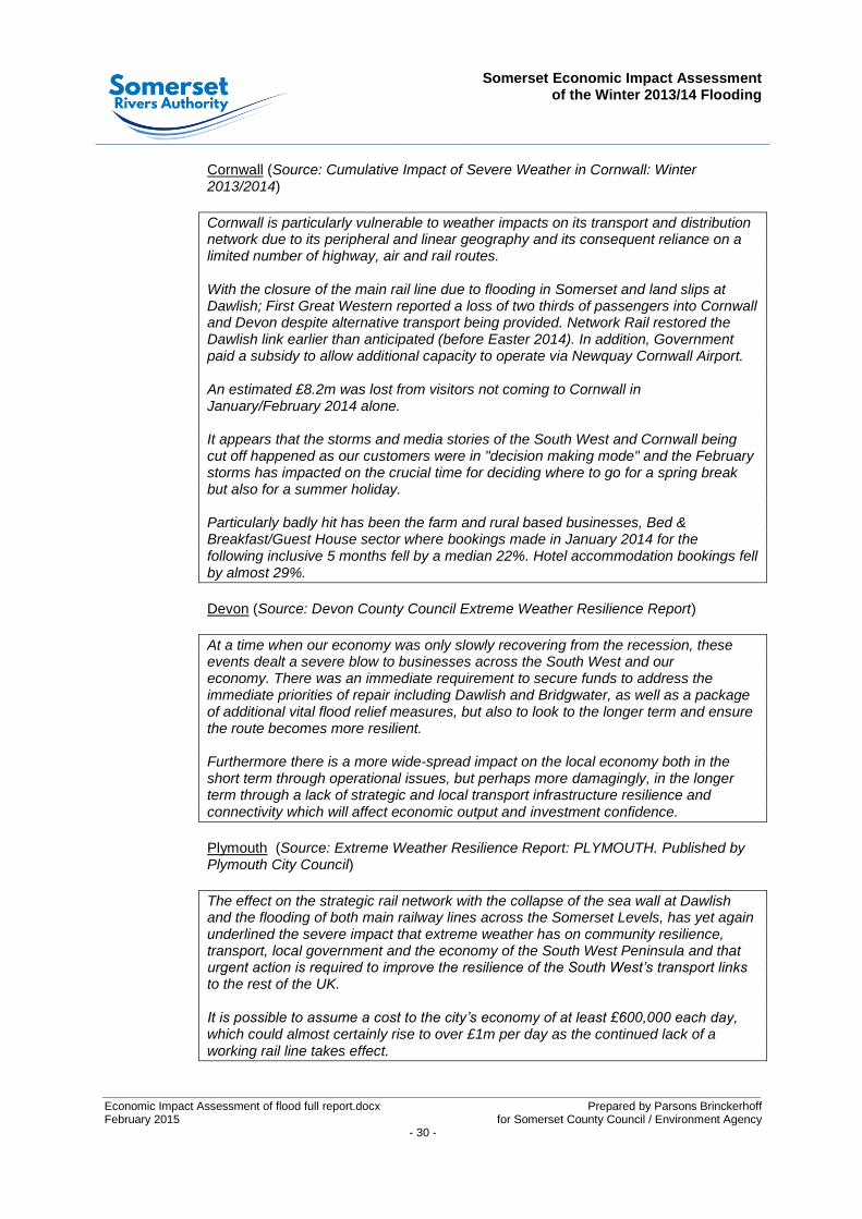
5.5.2 Extracts relating to economic impacts caused by the flooding taken from Severe Weather Reports for Cornwall, Devon, Plymouth and Torbay are provided below:
7 Further research is required to accurately determine the proportion of unregistered self-employed home-based workers in
Somerset.
Somerset Economic Impact Assessment
of the Winter 2013/14 Flooding
Economic Impact Assessment of flood full report.docx Prepared by Parsons Brinckerhoff February 2015 for Somerset County Council / Environment Agency - 30 -
Cornwall (Source: Cumulative Impact of Severe Weather in Cornwall: Winter 2013/2014)
Cornwall is particularly vulnerable to weather impacts on its transport and distribution network due to its peripheral and linear geography and its consequent reliance on a limited number of highway, air and rail routes. With the closure of the main rail line due to flooding in Somerset and land slips at Dawlish; First Great Western reported a loss of two thirds of passengers into Cornwall and Devon despite alternative transport being provided. Network Rail restored the Dawlish link earlier than anticipated (before Easter 2014). In addition, Government paid a subsidy to allow additional capacity to operate via Newquay Cornwall Airport. An estimated £8.2m was lost from visitors not coming to Cornwall in January/February 2014 alone. It appears that the storms and media stories of the South West and Cornwall being cut off happened as our customers were in "decision making mode" and the February storms has impacted on the crucial time for deciding where to go for a spring break but also for a summer holiday. Particularly badly hit has been the farm and rural based businesses, Bed & Breakfast/Guest House sector where bookings made in January 2014 for the following inclusive 5 months fell by a median 22%. Hotel accommodation bookings fell by almost 29%.
Devon (Source: Devon County Council Extreme Weather Resilience Report)
At a time when our economy was only slowly recovering from the recession, these events dealt a severe blow to businesses across the South West and our economy. There was an immediate requirement to secure funds to address the immediate priorities of repair including Dawlish and Bridgwater, as well as a package of additional vital flood relief measures, but also to look to the longer term and ensure the route becomes more resilient. Furthermore there is a more wide-spread impact on the local economy both in the short term through operational issues, but perhaps more damagingly, in the longer term through a lack of strategic and local transport infrastructure resilience and connectivity which will affect economic output and investment confidence.
Plymouth (Source: Extreme Weather Resilience Report: PLYMOUTH. Published by Plymouth City Council)
The effect on the strategic rail network with the collapse of the sea wall at Dawlish and the flooding of both main railway lines across the Somerset Levels, has yet again underlined the severe impact that extreme weather has on community resilience, transport, local government and the economy of the South West Peninsula and that urgent action is required to improve the resilience of the South West’s transport links to the rest of the UK. It is possible to assume a cost to the city’s economy of at least £600,000 each day, which could almost certainly rise to over £1m per day as the continued lack of a working rail line takes effect.

Somerset Economic Impact Assessment
of the Winter 2013/14 Flooding
Prepared by Parsons Brinckerhoff - 31 -
The impact of flooding and strong winds have caused disruption to the functioning of our economy, with businesses experiencing significant economic costs. Working with our sub-regional partners, we need to convince Government to support investment in new resilient and “future proofed‟ infrastructure. The Plymouth Chamber of Commerce has surveyed over 342 businesses across the South West Peninsula highlighting the difficulties and costs faced by local businesses in light of the recent travel disruption caused by severe weather and flooding.
26% of respondents reported that more than 75% of their annual turnover comes from outside of the South West
75% of businesses are experiencing difficulties with the closure of rail links as a result of recent flooding and storm disruption
66% of Plymouth businesses reported that the disruption has caused difficulties in winning new business
89% of businesses reported that the disruption is affecting their ability to meet with business contacts directly as rail passengers
35% of Plymouth businesses use South West rail infrastructure to get to and from
other parts of the UK on a weekly basis
Torbay (Source: Extreme Weather Resilience Report: Torbay. Published by Torbay Council)
The flooding events, storm surges, tidal issues and high winds experienced in Torbay had a significant impact on individual people, communities and infrastructure underlining the impact that extreme weather can have on community resilience, transport, local government and the economy. As well as direct impacts on infrastructure, there were wider impacts on the Torbay economy. A total of 227 Torbay businesses responded to a flood impact survey issued by the Torbay Development Agency (TDA) in February 2014 where 35% said that their business had been directly affected by flooding. The main economic impacts of the extreme weather were being the inability to travel to customers or customers travelling to the Bay and the additional cost and time involved in travel. Torbay’s location and infrastructure continues to be vulnerable and is highly reliant on a small number of strategic transport routes meaning that closures, incidents and delays on the highway and rail network can be very significant. The economic impact of the storms on the local economy both in the short term through operational issues, but perhaps more damagingly, in the longer term through a lack of transport resilience that affects economic output, investment confidence and the perception of Torbay as a place to do business. Particularly vulnerable to these effects is the tourist industry which is a significant part of Torbay’s economy.
Somerset Economic Impact Assessment
of the Winter 2013/14 Flooding
Economic Impact Assessment of flood full report.docx Prepared by Parsons Brinckerhoff February 2015 for Somerset County Council / Environment Agency - 32 -
5.6 Future flooding scenarios
5.6.1 Flood extents for a hypothetical scenario with water depths 500mm greater than the maxima experienced in 2013/14 have been produced by the Environment Agency for the 2013/14 flooding. These have been compared to maximum extents for 2013/14 based on analysis of recorded satellite imagery to enable a qualitative comparison of the impacts. It must be recognised that increasing flood depths by 500mm only serves to identify areas where flooding may occur in more severe events. However increasing flood levels by 500mm in many areas will represent a very severe fluvial flood event.
5.6.2 The main implications of this hypothetical increased water level are:
deeper flood depths on the moors;
longer duration flooding (due to increased time to drain); and
increased flood extents – flooding affecting more properties, businesses and infrastructure.
5.6.3 The increases in flood depths and duration would both be expected to increase
damages but the impacts will vary significantly – in some cases damages would be significantly increased, but where flood depths and durations were already extreme the additional increase in the damages might be relatively small.
5.6.4 For this reason the qualitative assessment focuses on the estimated change in flood extents. A high-level comparison of extents is presented below:
The most significant potential impact on residential and commercial properties is in the areas of Stock Moor and Hamp on the outskirts of Bridgwater. There may be a flow path to these areas resulting from very high flood levels on Hay Moor (from flooding on North Moor). There is a pumping station at Stock Moor, which might alleviate some of the projected flooding.
There could also be locally significant increases in flood extents in various smaller communities across the Parrett & Tone Moors.
There are likely to be large increases in flood extents affecting farmland.
There is likely to be increased disruption to travel – we understand that the Castle Cary – Bridgwater line came close to flooding in 2013/14 and assume train services would probably be suspended if flood depths were significantly deeper.
5.6.5 This high-level assessment confirms that an increase in overall flood depths of
500mm above the maximum experienced in 2013/14 would be likely to significantly increase the impacts, both in terms of extents and severity of impacts.
5.7 Tourism impacts
5.7.1 The SWRC undertook an assessment of the impacts of the flooding during winter 2013/14 on the tourism industry in Somerset. SWRC modelling, based on the survey, suggests the number of lost tourism days could be as high as 698,091 between January and July 2014 equating to a £51.4 million loss to Somerset’s economy.
Somerset Economic Impact Assessment
of the Winter 2013/14 Flooding
Prepared by Parsons Brinckerhoff - 33 -
5.8 Case studies of businesses indirectly impacted
5.8.1 The analysed findings of the business survey show that 6,928 registered businesses in Somerset (1,122 in wards directly impacted by the flooding and 5,806 in the rest of Somerset) were indirectly impacted by flooding. The experiences of these businesses are presented below:
Case Study 1: Indirect impacts to a small business located in Hambridge
A small business with 15 employees located in Hambridge was impacted by the flooding from 24/12/2013 to 10/03/2014. Due to flooded roads surrounding the business, customers and employees found access difficult and the business was unable to maintain a key contract during the flooded period. The business owner recorded a fall in revenue during this period of £26,000 compared to the previous year and has indicated that a negative perception of the area has caused a reduction in returning and new customers.
In an attempt to attract customers, the business has launched a marketing campaign including the development of a website to help improve business resilience moving into the future. This has been partly funded by a BSG.
Case Study 2: Indirect impacts to a small wedding venue located in Muchelney
A small wedding venue with 2 employees located in Muchelney was impacted by the flooding from 28/12/13 to 14/04/14. In addition to being directly impacted by the flooding it was also indirectly impacted and continues to feel the impacts of the flooding though a reduction in bookings and general interest. The business owner has said that some couples are put off the venue by the thought of their special day being ruined by flooding.
During the flooding period two weddings were cancelled at a loss of £6,600. There were also no viewings over the three month period from January to March. The business would have expected at least 20 viewings during this period securing at least 3 bookings. This combined with the negative perception of the location amongst prospective couples has and is continuing to place stress on the business and its future success.
In an attempt to restore custom and combat negative perceptions, the business has launched a marketing campaign partly funded by a BSG.
Case Study 3: Indirect impacts to a public house cut-off by flooding
A public house located near Langport was inaccessible by road for much of January and February 2014. Compared with the same period the previous year turnover was down by approximately £30,000 and consequently staff hours were reduced. The landlord has also seen a reduction in regular customers since the flooding, as some regulars switched to public houses that were accessible during the flooding, but have not switched back. With the assistance of a BSG, the pub has launched a marketing campaign in an attempt to increase custom.
Somerset Economic Impact Assessment
of the Winter 2013/14 Flooding
Economic Impact Assessment of flood full report.docx Prepared by Parsons Brinckerhoff February 2015 for Somerset County Council / Environment Agency - 34 -
5.9 Qualitative assessment summary
5.9.1 The economic impacts of the flooding that occurred in Somerset over the winter of 2013/14 were more extensive than could be reliably assessed using traditional assessment methodologies. For this reason a qualitative assessment was undertaken to qualitatively appraise the impacts of the flooding on strategic infrastructure projects, impacts on unregistered businesses, ongoing consequential impacts and wider economic impacts outside of Somerset. Although data and time to adequately appraise these impacts has been limited, it is estimated that the combined economic impact of these additional assessment categories could be in the order of 20-40% (£21m-£42m) above the economic impact that has been quantitatively assessed.
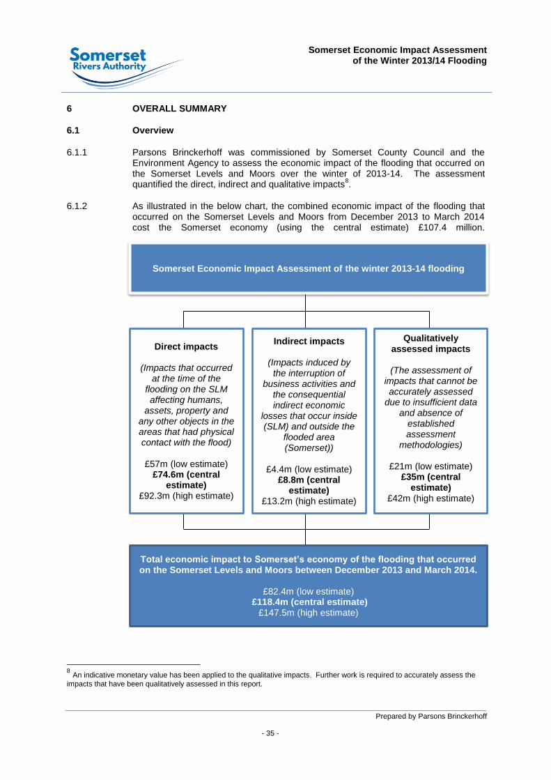
Somerset Economic Impact Assessment
of the Winter 2013/14 Flooding
Prepared by Parsons Brinckerhoff - 35 -
6 OVERALL SUMMARY
6.1 Overview
6.1.1 Parsons Brinckerhoff was commissioned by Somerset County Council and the Environment Agency to assess the economic impact of the flooding that occurred on the Somerset Levels and Moors over the winter of 2013-14. The assessment quantified the direct, indirect and qualitative impacts
8.
6.1.2 As illustrated in the below chart, the combined economic impact of the flooding that occurred on the Somerset Levels and Moors from December 2013 to March 2014 cost the Somerset economy (using the central estimate) £107.4 million.
8 An indicative monetary value has been applied to the qualitative impacts. Further work is required to accurately assess the
impacts that have been qualitatively assessed in this report.
Somerset Economic Impact Assessment of the winter 2013-14 flooding
Direct impacts
(Impacts that occurred at the time of the
flooding on the SLM affecting humans,
assets, property and any other objects in the areas that had physical contact with the flood)
£57m (low estimate)
£74.6m (central estimate)
£92.3m (high estimate)
Indirect impacts
(Impacts induced by the interruption of
business activities and the consequential indirect economic
losses that occur inside (SLM) and outside the
flooded area (Somerset))
£4.4m (low estimate)
£8.8m (central estimate)
£13.2m (high estimate)
Qualitatively assessed impacts
(The assessment of
impacts that cannot be accurately assessed
due to insufficient data and absence of
established assessment
methodologies)
£21m (low estimate) £35m (central
estimate) £42m (high estimate)
Total economic impact to Somerset’s economy of the flooding that occurred on the Somerset Levels and Moors between December 2013 and March 2014.
£82.4m (low estimate)
£118.4m (central estimate) £147.5m (high estimate)


Prepared by Parsons Brinckerhoff - 37 -
FIGURES
Figure 1: Study area
Figure 2: Road closures
Figure 3: 2013/14 flooding extents
Figure 4: Future flooding scenario 2013/14 +250MM AOD
Figure 5: Future flooding scenario 2013/14 +500MM AOD


Somerset Economic Impact Assessment
of the Winter 2013/14 Flooding Appendices
Prepared by Parsons Brinckerhoff
APPENDICES

Somerset Economic Impact Assessment
of the Winter 2013/14 Flooding Appendices
Prepared by Parsons Brinckerhoff
Appendix 1 – Data sources
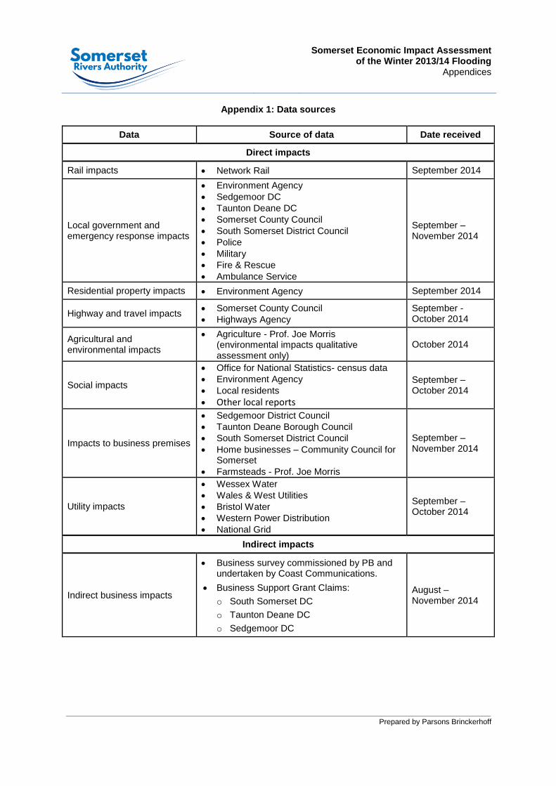
Somerset Economic Impact Assessment
of the Winter 2013/14 Flooding Appendices
Prepared by Parsons Brinckerhoff
Appendix 1: Data sources
Data Source of data Date received
Direct impacts
Rail impacts Network Rail September 2014
Local government and emergency response impacts
Environment Agency
Sedgemoor DC
Taunton Deane DC
Somerset County Council
South Somerset District Council
Police
Military
Fire & Rescue
Ambulance Service
September – November 2014
Residential property impacts Environment Agency September 2014
Highway and travel impacts Somerset County Council Highways Agency
September - October 2014
Agricultural and environmental impacts
Agriculture - Prof. Joe Morris (environmental impacts qualitative assessment only)
October 2014
Social impacts
Office for National Statistics- census data
Environment Agency
Local residents
Other local reports
September – October 2014
Impacts to business premises
Sedgemoor District Council
Taunton Deane Borough Council
South Somerset District Council
Home businesses – Community Council for Somerset
Farmsteads - Prof. Joe Morris
September – November 2014
Utility impacts
Wessex Water
Wales & West Utilities
Bristol Water
Western Power Distribution
National Grid
September – October 2014
Indirect impacts
Indirect business impacts
Business survey commissioned by PB and undertaken by Coast Communications.
Business Support Grant Claims:
o South Somerset DC
o Taunton Deane DC
o Sedgemoor DC
August – November 2014

Somerset Economic Impact Assessment
of the Winter 2013/14 Flooding Appendices
Prepared by Parsons Brinckerhoff
Appendix 2 – Transport User Benefits Appraisal (TUBA) – Inputs and Outputs

Somerset Economic Impact Assessment
of the Winter 2013/14 Flooding Appendices
Prepared by Parsons Brinckerhoff
Appendix 3 – GVA assessment model

Somerset Economic Impact Assessment
of the Winter 2013/14 Flooding Appendices
Prepared by Parsons Brinckerhoff
Appendix 4 – Business survey questionnaire and summary of main findings