soils of the lac la hache - clinton area britism columbia ... · soils of the lac la hache -...
TRANSCRIPT


SOILS OF THE
LAC LA HACHE - CLINTON AREA
BRITISM COLUMBIA
K *Id. G. VALENTINE AND A. SCIJ,ORI
Agriculture Canada, Vancouver, British Columbia
Report No. 25 British Columbia Soi1 Survey
Research Branch, Agriculture Canada 1980

Copies of this publication are available from:
B.C. Pedology Unit Research Branch, Agriculture Canada Research Station 6660 N. W. Marine Drive Vancouver, B.C. V6T 1x2
Land Resource Research Institute Contribution No. LLRI 63
0 Minister of Supply and Services Canada 1980
Cat. No. A 57-435E
ISBN O-662-1 1090-O
CONTENTS
PAGE
LIST OF TABLES
LIST OF FIGURES
ERRATA (map)
ALPHABETICAL LIST OF SOILS
PREFACE
PART 1. 1.1
1.2
1.3 1.4
GENERAL DESCRIPTION OF THE AREA
LOCATION CLIMATE
GEOLOGY AND PHYSIOGRAPHY
VEGETATION
PART 2. 2.1 2.11
2.12 2.13
2.2
2.2.1 2.2.2
2.2.3 2.2.4 2.2.5
THE SOILS
INTRODUCTION SURVEY AND MAPPING PROCEDURES RELIABILITY
SOIL ASSOCIATIONS AND MAP UNITS DESCRIPTION OF THE SOILS
PRESENTATION AND MCTHODS OF ANALYSIS
SOILS OF THE QUESNEL HIGHLANDS SOILS OF THE CARIBOO MIDLANDS: NORTHERN SECTION SOILS OF THE CARIBOO MIDLANDS: SOUTHERN SECTION
SOILS OF THE SOUTHERN UPLANDS
FART 3. SOIL INTERPRETATIONS
3.1 INTRODUCTION: CANADA LAND INVENTORY MAPS
3.2 SOIL INTERPRETATIONS: FORESTRY AND AGRICULTURE
3.2.1 FORESTRY
3.2.2 AGRICULTURE
PART 4. 4.1
DERIVED AND INTERPRETIVE MAPS DERIVED AND INTERPRETIVE MAPS FROM THE CANSIS
CARTOGRAPHIC FILE
REFERENCES
iv
iv
iv
v
vi
11 11
11 12
14 14
17 29 57
75
95
96 96
106
111
117

iv
LIST OF TABLES
PAGE
1.
2.
3.
4.
5.
6.
1.
2.
3.
1.
2.
Selected Climatic Data
Soi1 Associations and Biogeoclimatic Zones
according to Krajina and Annas and Coupé
Forestry Interpretations for the dominant soi1
in each Association
Forestry Interpretations for the miner soils
Soi1 Capability for Agriculture for the dominant
soi1 in each Association
Soi1 Capability for Agriculture of the minor soils
LIST OF FIGURES
Northeast corner of the soi1 map; (A) printed; (B) computer
A portion of the map index Linkage for the Lac la Hache-
Clinton soi1 map.
A "Geological Materials" map derived from the northeast
corner of the Lac la Hache-Clinton soi1 map.
ERRATA (soi1 map)
Tu3-Tr1/4 map symbol on western edge of map at approximate
latitude 51'32' North should be Tu2-Tr1/4.
Tul-Tr1/3-4 uncolored linked area at approximately 51°54'N,
121'42'W northwest of Cariboo Nature Park
3. The symbol Tu3 in Glacial Till cross section
southern section) at the foot of the map
There is no such group of soils mapped.
(Cariboo Midlands:
is superfluous.
3
8
98
103
107
109
113
114
115

Alphabetical List of Soils
Archie Beaverdam
Big Bar Bobtail
Bowman
Buffalo
Canim Carson
Cavanaugh
Chasm Community Courtney Dog Creek
Elliot
Eugene oxeter
Frances
Gang
Page 18 58
60
20
76
30
32
78
80
62
82
84
86
34
36
38
88
90
Page Helena 40
Holden 64
Kerr 92
Larghetto 22
LOlO 24
Neilson 42
Rail 44
Soues 66
Spout 26
Stalle 46
Tatton 48
Timber 68
Trurans 50 Tubbs 70
Tunkwa 72
Tyee 52
Williams Lake 54

vi
PREFACE
The design of the Lac la Hache-Clinton soi1 map and report is different from
most others that bave been published in British Columbia. Forma1 printed soi1 reports,
typeset and bound, take a long time to publish. Maps cari be produced more quickly.
There are many parts of British Columbia where the soils have been mapped, but the in-
formation still awaits compilation and publication. Therefore a number of maps and
reports, of which the Lac la Hache-Clinton is the first, bave been planned in order to
make the information available more quickly. Much more information has been put into the
map than before. Indeed for some purposes the map could be used by itself. The report
has been reduced in size considerably by referring to other published material wherever
possible, and using alternative forms of presentation such as computer print outs of soi1
descriptions. Inevitably such a shortened publication Will not contain a11 the information
that a land manager may need. In such cases users are encouraged to approach the authors
for additional information. Other similar maps and reports are planned, principally in the
Cariboo, Chilcotin and Peace River regions. The authors would welcome comments on the
usefulness of this publication.
Many people helped in the preparation of the soi1 map and the report. The authors
wisS to thank Mr. T.M. Lord, Dr. J.A. Shields, Mr. J.H. Day, Mr. J.L. Nowland and Mr. B.E.
Edwards a11 of the Land Resource Research Institute, Agriculture Canada for help with the
content and design. The soi1 map was prepared by the Cartography Section, Land Resource
Research Institute, Ottawa.
The following people assisted with field and mapping work: D. Hodgson, B. Thomson,
S. Miller and J. Stobbe. Soi1 analyses were done by K.S. Chan. G.A. Young and N. Gough gave
advice and supplied descriptions for soils on the southern and eastern borders respectively.
Mr. G.E. Cheesman, Ministry of the Environment and Mr. D.G. Schaefer, Environment
Canada, provided climate information.
M-f. R. Coupe and Dr. R.M. Annas of the Ministry of Forests helped with the vegetation
section.
The computer printouts of the soi1 descriptions were prepared by Mr. M. Brown and
reproduction was arranged by Mr. R. Reid, Ministry of the Environment.
Mr. IJ. Watt, Ministry of Forests and Elr. R.C. Kowall, Ptinistry of the Environment
gave helpful advice in the preparation of the forestry interpretations.
Ms. J. Melzer did the final typing for direct reproduction.
The caver photograph is courtesy of the British Columbia Government (Photo No. 8343).

PART 1
GENERAL DESCRIPTION
OF THE AREA
:. j ;.. :Y,
.: -’ ‘.

1.1 LOCATION
This report describes the soils of about 7700 km2 in south-central British Columbia. The actual location is shown on the Key Map in the lower left hand corner of the soi1 map. The
National Topographie map sheet covered is the west half of 92 P.
The principal settlements are Clinton, Lac la Hache and 100 Mile House. Forestry forms the basis of the economy. Agriculture is limited to ranching. Natural grasslands,
wetland meadows and forest range provide grazing for cattle. The attractive scenery of the Cariboo mith its forests, meadows and lakes is encouraging an expanding tourist industty based
on camping, fishing, hunting and riding.

1.2 CLLMATE
A concise description of the climate of the interior Plateau of British Columbia
is given by Schaefer (1978), and a more detailed account of the climate of the Cariboo Forest
Region is given by Chilton (1979). As these authors point out the climate of the area is
influenced regionally by the Coast Mountains and locally by elevation and aspect. The Coast
Mountains limit the effects of the moist Pacifie air. The plateau and especially some
southern valleys are relatively dry (see the data for Ashcroft in Table l), although the
precipitation is well distributed throughout the year. Precipitation increases towards the
north and towards higher elevations. The protection of the Coast Mountains also contributes
to a continental temperature regime. The January-July mean temperature range for both 150
Mile House and Ashcroft is over 25OC. At Ashcroft this is caused by hot summers (mean daily
temperature for July is 21.4"C), while cold Winters are more the cause at 150 Mile House
(mean daily temperature for January is -11.2"C). Apart from some very favoured aspects in
the southern valleys the frost free period is quite short.
Summer heat and relatively little precipitation leads to soi1 moisture deficits
over a11 the map area apart from possibly some north-facing slopes of the Quesnel Highlands.
Moisture deficits increase towards the south and towards lower elevations and the season of
deficit becomes longer. Therefore, over most of the area plant growth has to contend with
significant soi1 moisture stress in the summer. Low winter temperatures that cari freeze
the soi1 down to 50 cm are another aspect of the climate that are significant to the soi1
system. Under these conditions physical and chemical reactions in the soil, such as swelling
and shrinking, leaching and weathering, are most prevalent in the spring and fall.

3
TABLE 1 SELECTED CLIMATIC DATA
Station Elev. Mean Mean cm> Annual Jan.
Temp ("C) Temp ("C)
Long Term Atmospheric Environment Service Stations
150 Mile House 737 4.1 -11.2 Ashcroft 304 8.7 -6.5
Short term Atmospheric Environment Service Stations
Jesmond 115% 3.2 -9.3 100 Mile House 914 4.4 -9.4 70 Mile House 1106 2.0 -11.6 Loon Lake 838 4.7 -9.9
Mean May-Sept Snowfall Annual pptn bd (cm) wtnbd
Long ter-m Atmospheric Environment Service Stations
150 Mile House 425 222 142
Ashcroft 213 105 50
Short term Atmospheric Environment Service Stations
Jesmond 411 220 163E
lOO.Mile House 401 212 146E 70 Mile House 355 197 146E Loon Lake 329 178 128E
Mean July Temp ("C)
15.8 1354 76
21.4 2417 160
14.3 1097 54 15.9 1379 77
13.5 949 11 16.8 1485 66
P.E.T.(3) (4
536 314 Apr.-Sept.
551 446 March-Oct.
490 270 May-Sept.
515 303 Apr.-Sept.
525 328 Apr.-Sept.
583 405 Apr.-Sept.
GDD(l) FFP(2) (5.0°C) ooc
Moisture(4) Moisture Deficit Deficit
bd Season
1. GDD: Growing Degree Days - degree days accumulated above 5.O"C base
2. FFP: Freeze Free Period (days) 3. Potential Evapotranspiration based on latent evapotranspiration after Baier
and Robertson (1965) with a conversion after Holmes and Robertson (1958)
4. Moisture Deficit = Precipitation - P.E.T. E. Estimate based on Nov. - March precipitation
1.3 GEOLOGY AND PHYSIOGRAPHY
The map area covers part of the Fraser and Thompson plateaus (Holland 1964). The
hardrock geology has been discussed by Campbell and Tipper (1971) and Tipper (1971) has also
described the glacial landforms and Pleistocene history.
For the purposes of the survey the map sheet was divided into three physiographic
areas as shown in the upper right hand corner of the soi1 map. In the northeast there is a
mountainous area of mainly igneous rocks: THE QUESNEL HIGHLANDS. Most of the area is a level
or gently undulating lava plateau: THE CARIBOO MIDLANDS. In the southwest there are a number
of mountain ranges underlain by a variety of rock types: THE SOUTHERN UPLANDS. The corres-
ponding areas of Holland (1964) are as follows: The Quesnel Highlands - an unmapped outlier
of the Quesnel Highlands; The Cariboo Midlands - the Fraser Plateau, small parts of the
Thompson Plateau and the Fraser Basin; The Southern Uplands - The Marble and Camelsfoot Ranges.
Each area contains a distinct group of soils, largely as a result of the contrasting
geology and physiography. For this reason the descriptions of the soils in the map legend and
in the report are arranged by physiographic area.
THE QUESNEL HIGHLANDS range in elevation from about 1,000 m above sea level just
north of 100 Mile House to 1,660 m on the summit of Timothy Mountain. The bedrock geology is
a complex of intrusive diorite, granodiorite and gabbro, plus augite andesite lavas and
sedimentary rocks of the Nicola group. The whole area was covered by ice up to 8,500 years
ago (Prest 1969), SO the mountain slopes are mantled with glacial till or colluvium whose
composition is closely related to the bedrock. The soi1 parent materials are therefore
moderately acid to neutral gravelly loams or sandy loams. On many summits bedrock reaches
or approaches the surface. Between Bradley Creek and the northeast corner of the area the
intrusive rocks are exposed at the surface. These rocks have a strong pattern of cross
jointing. Small organic meadows occupy the hollows at the junction of two joints. The
valleys between the mountains are often narrow. Their bottomlands usually contain fluvial
sediments near the streams, flanked on either side by very coarse textured fluvioglacial
deposits.
THE CARIBOO MIDLANDS is a large level or gently undulating plateau extending across
the whole map sheet from the northwest to the southeast corner. Most of it is underlain by
Miocene and Pliocene olivine basalt and basalt andesite lavas. It ranges in elevation from
1,000 m to 1,300 m asl, although isolated plugs of dolerite rise sharply above this level at
Lone Butte and Mount Begbie. South of the Bonaparte River the plateau rises to over 1,600 m
and is underlain by dacite, andesite and basalt of the Eocene Skull Hi11 formation.

5
Ice receded from the whole plateau towards the northeast between 10,000 and
9,500 years ago leaving three main types of glacial deposits. Over most of the plateau
ice deposited loamy glacial till, which often has a very complex hummocky surface with
numerous enclosed hollows that are now occupied by lakes or organic meadows. Where large
volumes of meltwater flowed from the melting ice a veneer of very coarse sands and gravels
was deposited in a variety of topographie forms ranging from flat plains, to the ridges and
humps of eskers, kames and deltas. The distribution of these materials is very patchy but
the two largest occurrences are on the northeast side of the Marble Range and around Rail
Lake. Surface drainage is usually absent. The third type of deposit is the stratified
lacustrine silt that is found in many of the enclosed or ice dammed depressions of the
plateau. The principal exposures are in the Bridge Creek valley around 100 Nile House
and near Beaverdam Lake. These sediments are thinly plastered on the valley sides or form
benches bordering the creeks.
A number of large rivers have tut down through the plateau lavas to form
deep valleys. Basalt lavas are often exposed on the steep Upper slopes and colluvium occurs
on the lower slopes. The San José and Bonaparte Rivers, and Bridge and Laon Creeks are the
major examples.
THE SOUTHEW CPLANDS in the southwest are composed of the Narble Range, the Edge
Hills, the Camelsfoot Range and the valley of the Fraser River. The topography is rugged
with steep slopes, deep river valleys and bedrock often at or near the surface. The elevation
ranges from 300 m as1 in the bottom of the Fraser canyon to nearly 2,000 m as1 in the Edge
Hills and over 2,200 m as1 on the summit of Mount Bowman in the Narble Range.
The mountains of the Narble Range are formed from the massive limestone of the
Permiam Marble Canyon formation. They are well dissected by numerous streams which occas-
ionally disappear underground especially towards the northeast. The slopes are mantled by
highly calcareous sandy loam glacial till and colluvium. These unconsolidated slope deposits
decrease in thickness with altitude, and bedrock exposures are common on the mountain summits.
The Edge Hills are composed of chert, argillite, siltstone and limestone of the
Permian Pavilion Group. Their topography is similar to the Marble Range but the slope
deposits are not SO calcareous.
Below the slopes of the Edge Hills the Fraser River and small tributary streams
have tut down through very complicated unconsolidated sediments, and are now eroding the
underlying bedrock. T~US below about 900 m there are numerous isolated sloping benches
separated by steep sided ravines. The benches usually have a tore of glacial till or
lacustrine deposits overlain by fluvial fan gravels.

6
The top few centimetres of a11 minera1 soils in the area is a thin veneer of eolian fine sand and silt. It is thickest on the benches of the Fraser River, and thinnest in the Quesnel Highlands. In many places, especially in the southwest, it contains considerable amounts of volcanic ash. This layer is rarely more than 25 centimeters thick SO it has an insignificant effect on topography, but has a very
important effect on surface soi1 characteristics.

1.4 VEGETATION
Krajina (1969) described four Biogeoclimatic zones within the map area. The
names of these zones appear in the legend on the soi1 map. More recently a study of the
vegetation of the Cariboo Forest Region by Annas and Coupé (1979) has redefined the
original zones, and in fact now describes five within the map area. Table 2 shows the
names of the zones that each soi1 association is most commonly found within according to
the two studies. The more recently defined zones correspond quite closely with the phy-
siographic areas that have been described in section 1.3. The following description of
the vegetation of the area Will use the newer zone names. The common names of plants are
also taken from the publication by Annas and Coupe' (1979).
In the Quesnel Highlands of the northeast a wet subzone of the Engelmann Spruce -
Subalpine Fir zone occurs at higher elvations and the Sub-Boreal zone (with Douglas fir)
at the lower elevations. Subalpine fir and Engelmann spruce (with lodgepole pine on drier
sites) are the main trees in the higher zone where abundant soi1 moisture and frozen soils
in winter are controlling conditions. White rhododendron, ta11 blue huckleberry, Sitka
valerian, and bunchberry are common plants in the well developed shrub and herb layers.
Mosses form the ground caver under closed canopies. In the Sub-Boreal Spruce zone temperatures
are higher, soi1 moisture is less abundant and the soils are frozen for a shorter period.
Douglas fir, white spruce, lodgepole pine and trembling aspen are the main tree species.
Thimbleberry, false box, wild sasparilla and bunchberry are among the more common shrubs
and herbs.
The Interior Douglas Fir zone corresponds almost exactly with the Cariboo Midlands
physiographic area. However, the dividing line between its two subzones (drier - south, and
wetter - north) is further south than the division between the northern and southern sections
of the Cariboo Midlands. The most common tree in the northern subzone where there is some
moisture deficit in summer is the Douglas fir. Other trees include lodgepole pine, trembling
aspen, Rocky Mountain juniper and white spruce. Pinegrass dominates the herb layer with
kinnikinnick. The shrub layer is less dense but includes soapberry and rose. This vegetation
assemblage is typical of about three quarters of the map sheet. It covers the major portion
of the undulating plateau surface stretching from just north of Clinton to the northern border
of the map. The drier subzone, where more severe summer soi1 moisture deficits occur is to
be found in the valleys around Clinton. The forest of Douglas fir and Ponderosa pine is open.
Pinegrass and bluebunch wheatgrass are the main grasses. There are few shrubs.
The four biogeoclimatic zones that occur in the Southern Uplands reflect the greater
range of elevation, which (with aspect) influences temperatures, precipitation effectiveness
and soi1 moisture deficit. At the lowest elevations on the terraces of the Fraser River high
summer temperatures, high potential evapotranspiration rates and severe soi1 moisture deficits

Table 2: Soi1 Associations and Biogeoclimatic Zones according to Krajina, and Annas and Coupé
Soi1 Association
The Quesnel Highlands
Biogeoclimatic Zones (and subzones)
after Krajina (1969) after Annas and Coupé (1979) (1)
Archie ESSF(2) Bobtail Larghetto LOlO Spout
IDF ESSF ESSF IDF (wet)
The Cariboo Midlands: northern section
Buffalo Canim Eugene Elliot Exeter Helena Neilson Rail Stalle Tatton n-e Trurans Williams L .ake
CALP CALP IDF CALP CALP CALP CALP CALP IDF CALP CALP CALP CALP
The Cariboo Midlands: southern section
Big Bar Beaverdam Chasm Holden Soues Timber Tubbs Tunkwa
The Southern Uplands
Bowman Cavanaugh Carson Courtney Community Dog Creek Frances Gang Kerr
CALP CALP IDF (dry) CALP (dry) IDF (dry) CALP (dry) CALP CALP
IDF IDF (dry) ESSF PPBG IDF (dry) IDF PPBG PPBG ESSF (Krumholz)
ESSF (b-wet) SBS (b) ESSF (b-wet) ESSF (b-wet) SBS (b)
IDF (b-wet) TDF (b-wet) IDF (b-wet) IDF (b-wet) IDF (b-wet) IDF (b-wet) IDF (b-wet) IDF (b-wet) IDF (b-wet) IDF (b-wet) IDF (b-wet) IDF (b-wet IDF (b-wet)
IDF (b-wet) IDF (b-wet) IDF (a-dry) IDF (b-wet) IDF (a-dry) IDF (b-wet) IDF (b-wet) IDF (b-wet)
IDF (b-wet) ESSF (a-dry) ESSF (a-dry) PPBG (c) ESSF (a-dry) PPBG (c) IDF (a-dry) PPBG (c) AT
(1) plus further modifications, persona1 communications R. Annas and R. Coupé, Research
Division, British Columbia Ministry of Forests
(2) Biogeoclimatic Zone names from both sources:
AT Alpine Tundra
ESSF Engelmann Spruce - Subalpine Fir
SBS Sub-Boreal Spruce
IDF Interior Douglas Fir
CALP Cariboo Aspen-Lodgepole Pine - Douglas Fir
PPBG Ponderosa Pine - Bunchgrass

9
lead to sagebrush and bluebunch wheatgrass,with almost no trees. At higher elevations
within the zone Ponderosa pine and Douglas fir occur. Next in the elevation succession
is the Interior Douglas Fir zone. Both subzones probably occur, but in narrow bands on
the steeply sloping topography. The same plants are found as on the plateau to the north
and east. Above this in the Marble Range, Edge hills and Camelsfoot Range is the drier
subzone of the Engelmann Spruce - Subalpine Fir zone. The climate is cold and dry, as it
is situated in the rainshadow of the Coast Mountains. The predominance of lodgepole pine
and a sparser shrub and herb layer are the most obvious reflections of the greater summer
moisture deficit compared to the wetter subzone in the Quesnel Highlands. Whitebark pine,
subalpine fir and Engelmann spruce are the other principal trees. Common juniper, soap-
berry, grouseberry and lupins are common in the shrub and herb layers. Finally on a few
windswept peaks of the Marble Range there are expanses of the Alpine Tundra zone, especially
on dry south-facing slopes. The few trees such as subalpine fir and whitebark pine are
stunted. There are some shrubs such as willow and common juniper, and many herbs, grasses,
sedges and mosses.

PART 2
THE SOILS

2.1 INTRODUCTION
2.1.1 Survey and Mapping Procedures
Before the soils were mapped in the field areas which were assumed to contain
similar soils had been marked on aerial photographs. Field work involved checking these
areas to determine the types of soils within them. Boundaries between contrasting soils
were mapped using changes in visible landscape features such as vegetation, slope or white
alkaline efflorescence that could be associated with the difference between the adjacent
soils. Wherever possible features were chosen that were visible on aerial photographs.
No soi1 boundaries were ever located by digging holes systematically on either side of
them. There was not enough time.
Soi1 properties of a given area were recorded by noting external features SUC~ as
slope, aspect, vegetation, stoniness and erosion. Then such properties as texture, drainage,
root penetration and the sequence of horizons would be recorded from soi1 pits or road cuts.
Gradually a list of soils was developed to caver the whole area by grouping similar soils
together. The soils were classified according to the Revised System of Soi1 Classification
for Canada (Canada Soi1 Survey Committee 1973). It should be noted that this system has
been superseded by the Canadian System of Soi1 Classification (Canada Soi1 Survey Committee
1978), but the earlier classification has been retained in this report. Eventually the soils
were given names from the areas where they were first found, plus symbols to denote the names.
The final list became the legend on the soi1 map. At the end of each field season typical
sections of the major soils were described and sampled in detail. Boundaries between soi&
were plotted on aerial photographs (1:63,360 scale) in the field. They were then transferred
to base maps (1:50,000) in the office. The soi1 map is published at a scale of 1:125,000.
This type of survey procedure is appropriate to a survey intensity of level 4.
Nearly a11 traveses were by surface vehicle or helicopter. Almost a11 boundaries were in-
ferred and most delineations (areas on the map) were checked.
Further information about soils and soi1 classification in British Columbia may be
found in the Soi1 Landscapes of British Columbia (Valentine et al, 1978).
2.1.2 Reliability
Field work involved travelling a11 theavailable roads and tracks by motor vehicle.
Areas inaccessibleto motor vehicles were checked by helicopter. As was pointed out in the
previous section much of the mapping was done by inferring soi1 boundaries from aerial photo-
graphs. Moreover on a reconnaissance survey of this intensity, although some soi1 areas Will
be checked more than once, other inaccessible ones Will not be checked at ail. It is obvious
therefore that the symbols within any area on the map Will not describe accurately 100X of

12
what is in that area. What percentage then cari they be expected to describe? Various tests
in other parts of British Columbia have shown that mapping accuracy cari range from about 65%
to 85% (according to the accessibility and complexity of the landscape) when air photo inter-
pretation and ground observations are combined. The same range of accuracy probably applies
to this map area. At the foot of the soi1 map there is a small inset map entitled "Access
and Relative Mapping Accuracy". It shows three classes of accessibility. The corresponding
mapping accuracy or reliability would be probably as follows:
Dense road network 85% map reliability
Sparse road network 75% I, II
Helicopter access, 65;% I: 11
very few roads
These figures were confirmed for one map unit by checking the soils along transects in five
areas chosen at random. A total of 48 sites were inspected. The results were as follows:
Map Unit Tyee .1 (Te 1)
Soi1 Sites that met criteria for principal soi1 of map unit
Soi1 Sites that were closely similar to principal soi1 of map unit (could be put to same use)
Soi1 Sites that were significantly different from any described for the map unit
Total %
23 48
18 37
7 15
The number of different soi1 sites is within the stated limits (15%) but the number of closely
similar soils is rather high (37%).
The soi1 map shows different areas that have certain ranges of soils and soi1
properties. The reliability or accuracy of these ranges varies from one part of the map
to another. It is never 100%. Therefore, to determine the qualities of a soi1 at a
particular location a site inspection must be made.
2.1.3. Soi1 Associations and Map Units
At the scale used in the Lac la Hache-Clinton survey individual soils could not be
shown on the map. Therefore groups of soils that consistently occur together are shown. Such
a group of soils is called a SOIL ASSOCIATION.
A SOIL ASSOCIATION is a group of related soils developed on similar
parent materials, which differ due to different soi1 water regimes, or other
characteristics such as depth to bedrock. The soils will occur under

13
similar climatic conditions and usually within one physiographic area
or vegetation zone. A SOIL ASSOCIATION is named after its most common soil.
A soi1 association Will contain several soils, but the full range may not occur
everywhere in the landscape. In this case each group of soils that is mapped from within
the association is given a number. For instance the Spout Association includes a deep well
drained soil, a wet soi1 and a shallow soil. Often only the deep soi1 and the wet soi1 occur
together. These two soils are designated Spout 1. Al1 three soils together are Spout 2.
Wherever possible groups of soils from only one association are shown on the map as a SINGLE
MAP UNIT. The convention is illustrated below:
Single Map Unit Symbol Soils Included % of single map unit
Spout 1 St 1 Deep well drained soi1 60 wet soi1 25
Spout 2 St 2 Deep well drained soi1 60 wet soi1 shallow soi1 25
In many parts of the Lac la Hache - Clinton map different soi1 associations were
too intimately mixed to be shown separately on the map. Elsewhere it was sometimes impossible
to map the precise boundaries between soi1 associations in the time allotted for the survey.
Both of these situations forced the soi1 mappers to group soils from different associations
within one area on the map. This produced a COMPOUND MAP UNIT. For instance the Spout 1
soils are often shown with the Bobtail 2 soils. The Bobtail 2 soils, like Spout 2, include
a deep well drained soil, a wet soi1 and a shallow soil. But, the Bobtail soils differ from
the Spout soils due to the alkalinity of their parent materials, their classification and
their associated vegetation and topography. The convention for a COMPOUND MAB UNIT is
illustrated below:
Compound Map Unit Symbol Soils Included % of compound map unit
Spout 1 plus Bobtail 2 St 1 - Deep well drained Spout
Bt 2 Wet Spout 60
Deep well drained Bobtail Wet Bobtail 25 Shallow Bobtail
The soi1 associations have been described in the legend and colored on the map
according to the physiographic area in which they most commonly occur. Al1 the soils of the
Quesnel Highlands are colored shades of pink or mauve. The soils of the Cariboo Midlands
(northern section) are colored green, those of the Cariboo Midlands (southern section) are
colored blue or grey, and the Southern Uplands are yellow and orange. The major soils of
each association are described in the legend blocks on the right. Each block representing
a physiographic area is color coded. Cross sections illustrate the landscape relationships
of the associations. The landscape positions of the individual soils within each association
are illustrated by the four cross sections at the foot of the map. The associations are again
arranged by physiographic area in color coded strips.

14
2.2 DESCRIPTION OF THE SOILS
2.2.1 Presentation and Methods of Analysis
The following sections contain information about the soi1 associations. They
bave been arranged by physiographic area in the same way as they are shown in the map
legend. A description of the profile, the immediate site and the analytical results (when
available) of the most common soi1 in each association is reproduced from information
stored in the British Columbia Soi1 Data File. Brief descriptions of the map units of each
association are given on the page opposite the description of the major soil. There are no
descriptions of the rock land types. They occur only as small inclusions within some soi1
map units, which is where they are described. After each map unit symbol there is the
number of areas on the map that have that symbol and the total area in hectares that they
caver.
The methods of soi1 analysis that were used to obtain the results given in the
reproductions of the Soi1 Data File are as follows:
Colour 1 and 2: Colors refer to the P!unsell Soi1 Color designations. Colors
1 and 2 are colors of the soi1 in different states.
pH 1: pH in CaC12 solution after the method of Schofield and Taylor (1955).
pH 2: pH in water with a 1:l soil:water paste.
Organic Carbon: Elethod of Peech given in Atkinson (1958). For organic horizons
the samples were ashed at 400°C in a muffle furnace and the
organic matter content calculated as percent loss of weight.
Ritrogen: The total N Kjeldahl method given in Atkinson (1958).
Ash: The minera1 fraction in organic soi1 horizons was calculated from the loss
of weight after ignition to 400°C.
Ca Carb. Equiv.: Calcium Carbonate Equivalent was measured by the method of
Schollenberger (1958).
Exchangeable Cations and Cation Exchange Capacity (C.E.C.): methods of Peech given
in Atkinson (1958).
Elect. Cond.: Electrical Conductivity measured by the saturated paste method in
Richards (1954).
Extractable Fe and Al: Oxalate method of McKeague and Day (1966). Where two
results are given the second one is the pyrophosphate method of
Bascomb (1968).
P : Easily soluble phosphorous; Bray method in Atkinson (1958).
S : Easily soluble sulphur; method of Johnson and Nishita (1952).
Mn : Extractable manganese by pyrophosphate method of Bascomb (1968).
15
Particle Size: Sand, silt and clay by the pipette method of Kilmer and Alexander (1949).
Coarse Fragments: The volume of particles larger than 2 mm in diameter was estimated in the field.
Further conventions for describing soils in the field, or the class limits for
characteristics such as slope, cari be found in the Canadian System of Soi1 Classification
(Canada Soi1 Survey Committee 1978). Definitions of soi1 ternm not explained in this
report may be found in the Glossary of Terms in Soi1 Science (Canada Soi1 Survey Committee 1976).

17
2.2.2. Soils of the Quesnel Highlands
Tbe mountain soils of the Quesnel Highlands have developed from gravelly loam or
sandy loam glacial till and colluvium. The properties of the soi1 parent materials are closely
related to the underlying bedrock. The moderately high rainfall and cool temperatures give
only slight soi1 moisture deficits in the summer. Leaching rates are the highest in the map
sheet. The forest of Engelmann spruce, Douglas fir and subalpine fir with a dense understory
of shrubs and herbs supplies considerable litter to the soils. However, this litter layer is
often poorly decomposed. Al1 these factors combine to produce the most acid soils in the map
sheet, with any accumulation of carbonates well below 100 cm. Clay has been washed out of the
surface horizons and deposited in the subsurface horizons of the glacial till soils (Bobtail, Sprout and Archie). This produces a denser layer that may hold up water for a long time in
the spring giving cold wet soils. The colluvial soils on the steeper slopes appear to be subject
to too much down slope movement for such a clay layer to develop (Lolo and Larghetto).
On the map a11 the soils of the Quesnel Highlands have been colored shades of pink or
mauve. They are described in the right hand legend in the block colored pink. A cross section
shows the landscape relationships of the various associations. The landscape positions of the
individual soils in each association are shown in the four cross sections at the foot of the map in the strip colored pink.

18
ARCHIE ASSOCIATION
PROFILE DtS”?,P,,w, -_-_-_-___-_-_-_-_-
l.4 F2
A tZ
B T1
oc
c
13-28
zt>-46
4b-66
66-112
2.515.0/4.0 N”*S1
2.5*fJ.0,4.0 ORI
5.015.013.0 HOIST
5.GYh.0/3*0 OUI
5.OY5.0/2.0 HO1ST
S.0*6.*/Z.O OHI
5.014.0/2.” “015,
5.OIl.0/2.0 DRY
1FXT”RF STR”CnJRE , CONS<STENCE ROOTS ,
AwNo*N*
SANDY LOIN GUANULIR FHI*BLE ABUNOINT
SANOY LOAH GRANWAR FRI*Bl-E ABVNOIN,
SAHDI LOIN ‘R*NCL*R FRIABLE *B”NO*NT
PHISICAL d CHtYlcAL DATA -__-____-_-_____--- -__
PH 1 PH 2 EXCHANGEABLE CATIONS~YE1100Gl C.E.C. EXTRICTAH‘E FE,%, ËXTRACTARLE AL(%>
"*L"E VI -VE OR‘ANIC HORI Z"N
NI TROGEN CA MG NA 1. OETERY I NE0 CAWON x x
CIESUL T RESWT
0.9 0.5

19
Map Cnits of the Archie Association
Ac 1 (2 areas: 545 ha): The deep, moderately well drained soi1 occurs with small areas of
shallow soils over bedrock, and coarse textured soils with accumulations of Fe and
Al in the B horizon (Orthic Humo-Ferric Podzols). The topography ranges from
strongly to very steeply sloping.
Ac 1 - St 2 (1 area:- 504 ha): The group of soils described above in the Ac 1 map unit is
associated with small areas of the three Spout soils (well drained, imperfectly drained and shallow to bedrock) on the boundary betweea the Engelmann Spruce -
Subalpine Fir and the Sub-Boreal Spruce zones.
Ac 1 - Lg 1 (1 area: 922 ha): A single area of strongly to very steeply sloping topography
contains the soils of the Ac 1 map unit, plus on the steeper slopes moderately coarse textured and slightly acid to neutral colluvial soils, some of which are shallow to
bedrock (Larghetto soils).
Ac 1 - Rk 1 (2 areas: 227 ha): Small granitic rock outcrops and talus slopes occur with the soils of the Ac 1 map unit on strongly to very steeply sloping topography.
Ac 2 (1 area: 676 ha): The deep moderately well drained soi1 occurs with small areas of wet
imperfectly drained soils and shallow soils over bedrock on gently to steeply sloping
topography.
Ac 2 - Rk 1 - St 2 (1 area: 464 ha): -- This is a large very complex map unit which contains a number of soils that could not be mapped separately. The soils of the Ac 2 map unit are associated with smaller areas of granitic rock outcrops on the ridge crests and the less acid, well drained Spout soils on the lower slopes. The topography ranges
from very gently sloping on the rounded ridges to very steeply sloping on the valley sides.

20 *t********t*********************~***~****~~************************************~****.********************************.**************
RESOVHCE LNALY515 BRANCH YINISTRY OF EN”*RONYENT
SOIL: BOUTAIL 1 N,b: V2PI.i YICTORII\. B.‘. SVYYIRY DITE: &PR 25. ,978 PAGE: 01
*****l******l*******************************************************************************************************~****~*******~**
BOBTAIL ASSOCIATION

Map Units of the Bobtail Association ~.
Bt 1 (7 areas: 5475 ha) : This map unit occurs on the gently to strongly sloping lower mountain slopes towards the western edge of the Quesnel Highlands. The deep,
moderately well drained soils are associated with small areas of wet imperfectly
drained soils.
Bt 1 - St 2 (3 areas: 2543 ha): On some moderately to steeply sloping mid sections of
mountain slopes the soils of the Bt 1 map unit are associated with the three Spout soils (well and imperfectly drained and shallow to bedrock) on medium
textured less acid till.
Bt 1 - Tr 2 (2 areas: 1838 ha): _~ Some meltwater channels containing the very coarse textured
Trurans soils and some lava bedrock occur in wide valley bottoms with the soils of
the Bt 1 map unit.
St 2: (5 areas: 5058 ha): The deep moderately well drained soils occur with small areas of shallow soils over bedrock and wet imperfectly drained soils. The topography is
moderately to steeply sloping.
Bt 2 - St 2 (9 areas: -10,600 ha): This is a common map unit on the moderately to steeply
sloping Upper mountain slopes. The soils of the Bt 2 map unit are associated with
small areas of the three Spout soils (well and imperfectly drained and shallow to bedrock) on medium textured, slightly acid till.
Bt 2 - St 2 - Rk 1 (1 area: 3846 ha): A large map unit on the southem edge of the Quesnel Highlands contains the soils of the Bt 2 - St 2 map unit plus granitic rock outcrops on strongly to very steeply sloping topography. The soils and rock outcrops are SO
mixed up that it was impossible to map them separately.
Bt 2 - St 2 - Rk 2 (2 areas: 1737 ha): -- These two map units are very similar to the one
designated Bt 2 - St 2 - Rk 1 but the rock outcrops are composed of andesite and greywacke.

22
RFSO”HCE ANALYSIS BRANC”
slJ1L: LAH‘HET10 NTS: YYP15 MINlSTRY UF ENVIRONMENT
YICI”H‘A. B.C. SUYYIRY DATE : APR 25.1978 PA‘E: 0,
+*****+********+**************+L***********************************************************************************.********
LARGHETTO ASSOCIATION DATt OF b”R”tY: 74 SuRVtYOH: NG SAHPL ING PURPUSE : HECONNAISANCt SUHVEY
KELOYNA. B.C.H.*. d R.*.B.
LO‘ATION CL*SS*F,C*7,oN SLOPE -- - - - - -_ ____-_-_-_____ - - - -
I’ARCNT MITCRIAL 8. LArnFOH” BÊUROCK ~-_-___-_-_-___---_-____ - - - - -
GENE, ‘C YI\IEk,EL C”LL”“IiaL DP7H TO HEDROCK 30 CM. DRILIN INTRuSIVÉ iPLUTONIC>
DUA INCIGE “EU DR*, MD RUMFF MED*“* PERWEIfsILI,Y RAP ID ,Nf=ILTR*TION “ERY RIPID
c- 3 NONE bAtmI LO*Y SHOOTH
STRUCIURELESS NON STICKY “ERY CO*RSE “ERY FRIABLE cAdAN”LAR LOOSE
NDNPL*ST,C
NOte SAANDY L”AM 5IH”CT”RfLtSS SCOCITH
NON STICKY ‘RAVELLY “ERY CIJAHBE “ERY FRIIBLE
‘**N”L*R LDOSE NONPL*STIC
B HI
I<3- NONE SANDY LOPIM STR”CT”RELESS SMUO,” GRIVELLY
NON STICKY “ERY CUAHSE VERY FRIIBLE GRINULAH LDDSE
NONPLAST IC

23
Map Units of the Larghetto Association -
Lg 1 (1 area: 43 ha): A small area on the eastern edge of the map sheet contains mainly deep, well drained, moderately coarse textured, colluvial soils on strongly to
steeply sloping topography. There are small areas of shallow soils over bedrock.
Lg 1 - Ac 1 (3 areas: 759 ha): On the strongly to very steeply sloping topography east and west of Lang Lake the two soils of the Lg 1 map unit occur with strall areas of Archie soils. The Archie soils include deep, moderately well drained, medium acid soils with some shallow soils over bedrock and some coarse textured, acid
soils with Fe and Al accumulation in the B horizon.
24
*+t************C**C**************************+**t**********+****L*+**t***+t***L***t*L***t*****t**+*****l*********t**+*t**t******tt*
RESOVHCE ANALYSIS BRANCH HINISTRY OF ENVIRONMENT
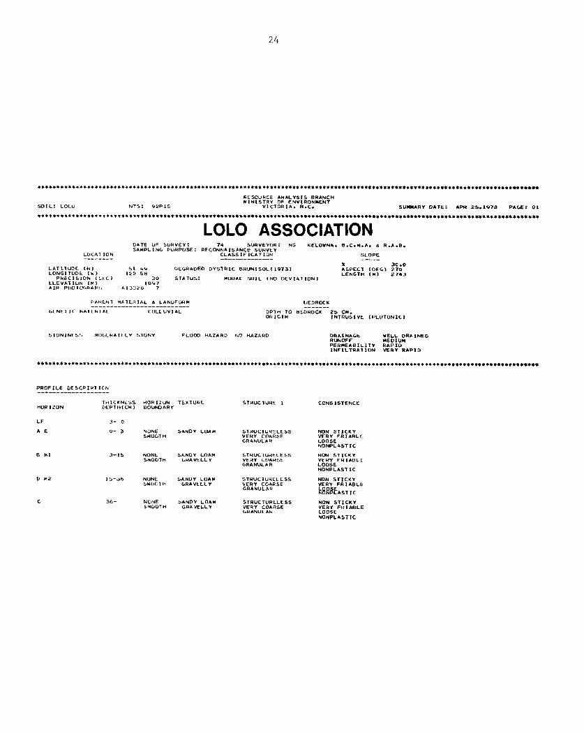
SDIL: LOL" NTS: VPP15 VICTOR**. B.‘. SUMkmRY DITE: APR 25.1978 PAGE: 01
LOLO ASSOCIATION DATE “F SUHVEI: 74 SuRVtYOR: NG KELOYNA. B.C.H.I\. L R**&. SAMPLIN‘ PURPOSE: RFCONNI ISIINCE S”R”~Y
LD‘AT ION CLASSIFlC*TION S‘OPE
x 30.0 L*Tll”DE. <N, 51 4‘4 “EGRADED DYSTRlC BR”N,SOL~19731 LONGIT”Dt th >
ASPECT IDEG) 270 120 se
PkECISlOlu (‘k-Cl LENGTH <Y> 2743
30 ST* Tus: MODAL SD1L (No DEVIATION, KLEY*T IUN IN) IO’r7 h.,R P,tD1P‘R&P+, A13320 7
P‘tkkN1 HATERIAL .3 LAN”FDRH BEDRDCL -- - - - - - - - - - - - - - - - - - - - - - - - - - - - - -
‘CNET ,t HAIERIAL C”LL”“,AL DPTH TO BEDRDCK 25 CM. DHIGIN INTR”SI”E ,PL”TONIC>
STON~NLSS HOYER~TECI SION1 FL”cm HAZPIRD NO “AZARD DRAIN*‘t RUNDFF
*~~l”;RAINED
PERYEABILITY RAPID lNF1LTRAllON YERY RAPID
PROFILE “CS‘RIP, 1C.N
THlCKNC5.S “DRIZUN TEXTURC STU”C T”HE 1 CONS ISTENCE WR 1 Z”N DtPIH,CMl BD”NDARI
LF 3- 0
AE o- 3 NONE SMLIOT n
SI\ND” L”A84 5TR”CT”“ELESS NON STICKY “FR” CDARSE “ERI FRIABLE GRANULAH LOOSE
NONPLISTIC
SAND1 LON4 STRUClURELtSS NON STICKV ‘Y*vELLY “ERI COIUSE “LRY FRIABLE
GRAHU‘LR LOOSE NONPLASTIC
SANOV LDAY STR”‘T”RLLESS NON STICKY 6RAVELLY VERY COARSE VERV FRIAEILt
GRANULAR N8RBE ASTIC
C 30- NONE SANDY LOI” SMODT H GRAVELLY
STRuCTuRtLESS “ERY CO&RSE ‘RANUL,W

25
Map Units of the Lolo Association
Lo 1 (3 areas: 1931ha): Deep, reell drained soils developed on moderately coarse textured,
acid colluvium occur on strongly to very steeply topography on the far eastern edge of the map. Small areas of shallow soils over granitic bedrock occur with them.
Lo 1 - Ac 1 (1 area: 129 ha): A small map unit on steeply to very steeply sloping topography contains the two soils of the Lo 1 map unit and the three soils of the Archie
association. The latter soils are deep, moderately well drained, medium acid, on glacial till, with some shallow soils over bedrock and some coarse textured acid
soils with Fe and Al accumulations in the B horizon.
26
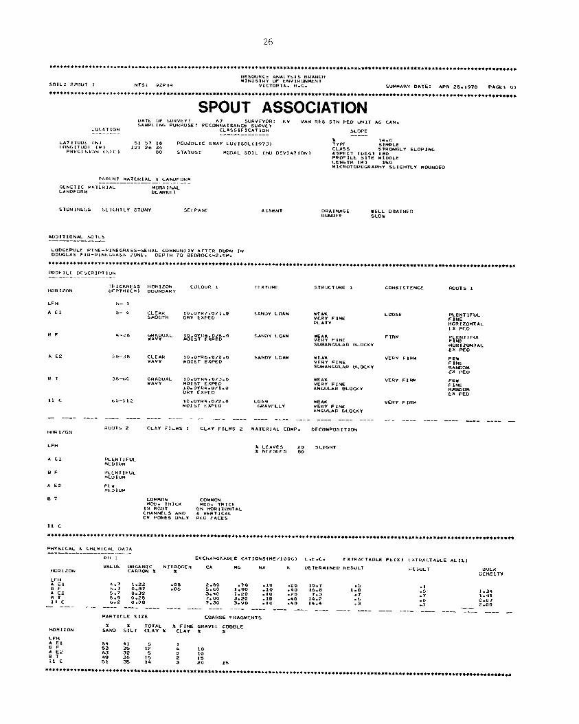
SPOUT ASSOCIATION
P*RtNT HATCHIAL d LANDFOHY _~-~--- - - -_--~--_-_--_-_
GENETIC YATLRIAL YDR.4 INAL LANDFOR” bLANI<E T
TFXTVRE
CU*!4 IEAK “El?” FIRY w*“ELLI VER-f FINE
ANGUUR B‘CKKY
-- - - - - - - - - - - - - - - - - - - - - - - - - -__ - - - - ____ - - - _- - - _
Y*TER,*L COYP. DECOYPLISITIW

27
Nap Units of the Spout Association --~-
St 1 (2 areas: 166 ha): Two small map units bordering Spout Lake contain the deep, well drained Spout soils on slightly acid, gravelly loam glacial till, with small areas of wet imperfectly drained soils in low spots. The topography is gently to moderately sloping.
St 1 - Hl 1 (1 area: 788 ha): On the northem edge of the map there is a map unit where the two soils of the St 1 map unit are combined with small areas of Helena soils that
normally are found in the Cariboo Midlands. The Helena soils are predominantely deep, well drained and moderately alkaline on gravelly sandy loam glacial till. There are also some wet imperfectly drained soils.
St 2 (4 areas: 1440 ha): Deep well drained soils developed on slightly acid gravelly loam
glacial till occur with small areas of shallow soils over bedrock and wet imperfectly drained soils. The topography is moderately to steeply sloping. The four areas
mapped are often on north-facing slopes.
St 2 - Rl 1 (1 area: 553 ha): In a small upland area the three soils of the St 2 map unit are
associated with the moderately well decomposed organic Rail soils that have developed in depressions.
St 2 - Rk 1 (1 area: 743 ha): Just north of Lang Lake the three soils of the St 2 map unit over
with small outcrops of granitic bedrock on moderately to steeply sloping topography.
St 2 - Bt 2 (2 areas: 825 ha): The three soils of the St 2 map unit occur with small areas of Bobtail soils (deep, moderately well drained, shallow over bedrock and wet imperfectly
drained) on strongly to steeply sloping topography.
St 2 - Bt 1 (4 areas: 4828 ha>: The highlands north of Timothy Mountain contain an assemblage
of soils that are the same as the St 2 - Bt 2 map unit apart from the absence of the Bobtail soils that are shallow to bedrock. The topography is moderately to steeply
sloping.
St 2 - Ac 2 (1 area: 1418 ha): ~. On Timothy Mountain the three soils of the St 2 map unit are associated with small areas of the soils of the Ac 2 map unit (deep, moderately well
drained, wet imperfectly drained and shallow soils over bedrock). The Archie soils
occur at the higher elevations.
St 2 - Ac 2 - Rk 1 (1 area: 557 ha): South of Lang Lake there is an area that is very similar
to the St 2 - Ac 2 map unit described above except that it contains small outcrops of
granitic bedrock. The topography is very irregular changing from very gently sloping on the ridge tops to very steeply sloping on the Upper mountain sides.

29
2.2.3 Soils of the Cariboo Midlands: Northern Section .-
The soils of the northern section of the Cariboo Midlands have developed from a
variety of glacial and postglacial surficial materials under a cool, relatively dry climate.
The topography is an undulating plateau surface with many enclosed depressions. In places
small rivers have tut shallow valleys into the plateau surface. Most of the vegetation is an
open forest of Douglas fir, lodgepole pine and pine grass. In the valleys and some plateau
depressions there are limited expanses of grassland. The northern section of the Cariboo
Midlands is slightly wetter and cooler than the southern section. This difference in climate
is the principal cause of the difference between the soils of the two sections.
The textures of the glacial till soils ranges from gravelly loam or clay loam (Tyee
and Williams Lake) to gravelly sandy loam (Canim, Eugene and Helena). Clay has been washed
out of the surface horizons and deposited in the subsurface horizons. This produces a denser
layer that holds up water, especially in the spring, and may restrict root growth. Towards
the east, carbonates have been leached to below 90 cm in the soi1 profile (Tyee, Helena and
Eugene). However, in the west evapotranspiration rates are higher, leaching less effective
and carbonate accumulations occur above this level (Williams Lake). Al1 glacial till soils
(except Canim) have an open forest caver which provides only a thin poorly decomposed organic surface.
The very coarse textured fluvioglacial soils (Trurans and Stalle) have a much lower water storage capacity than the till soi&. They are rapidly drained, with neither carbonate
accumulations nor fine textured impeding layers in the subsoil.
Both forested and grassland soils have developed from the lacustrine silts in and adjacent to the Bridge Creek Valley. The forested soils (Exeter) are found in the Upper,
moister areas of the former lacustrine basins. In the lower and warmer parts, and an exposed
southern slopes higher evapotranspiration rates produce grassland soils (Buffalo). Under conditions of extreme evapotranspiration and the lateral transfer of soi1 water, soluble salts
accumulate to form saline soils.
Organic soils (Rail) occur in the very poorly drained enclosed depressions on the
plateau.
iiarrow strips of fluvial soils (Elliot and Neilson) along stream courses have a grass,
sedge and willow vegetation caver and are mildly alkaline. They have a wide range of textures
and drainage conditions.
On the map a11 the soils of the Cariboo Midlands, northern section, are colored shades of green. They are described in the right hand legend in the block colored green. A cross section shows the landscape relationship of the various associations. The landscape positions of the individual soils in each association are shown in the four cross sections at the foot of
the map in the strip colored green.

30
************C****r**~********************************************~******************************************************************
RL50UPCC *NP.LYSIS BRANCH MINISTRI “F EN”,RONHENT
SJoLL: uuFF*Lu t l,TL: QWL1 VICTORIA, i3.C. SUMHARY o*TL: APR 25.1978 P*Gt: 0,
*********+,***I***I*****~****~******~***********************************************~******************~****************************
BUFFALO ASSOCIATION YATL ‘F ,“H”tY: S”H”tY”H: KY IIMwL1h‘ PUIIPCJSE: RCC”NtL,SANCE S”K”kY VAN HES *TN PLD “i-417 AG ‘IN. LLC.4, ILIN <.LAS*IFIC*T*c>N SLUPL -------- -----_--_--_-- ----- x 6.0 L*TII”DE <N, fi, 34 zz Ut.TklIC DbHK LHCY,lV73> CLpISb MDDERPITELI SLDPIN‘ L”NGIT”Gt ,w, Iki 17 “3 ASW‘T ILEGI 180 PHt‘lSIUk (Si.‘, uo S,*TVS: MclDflL SOIL CIrO ULY,ATlOk~ PROFILE SITE MIDDLF CkNGTH (Ml *IcRLTOPOGR*PnY’LOE”EL
I.I\ldLNT M*TtHIAL d LAhDF”kM -_-----_------------------ ‘ENCT IC MOL>,F 1 Lh GLACICI ‘ENkTL‘ HATCh1s.L LPI‘“S,RINC LPINUF”RM TEKR*CtcJ ROCTlh‘ o+v,,. HO <Y,. SLEP*‘E
HORI 2”N
A”
A HE
a HI
b Hi
C%
II c rc
- - - - - - __-
“OR I .z”N
Ati
* HE
8 *1
H Plz
CK
II c K
PHYSI‘AL d ‘titM“AL OA,A ____--- - - -___--_-- - - -~-~
Fin r tXC,+*P.GE*bLt CATIoNS~ME/100‘, Ç.É.C. PAkTICLE 51X

31
Map Units of the Buffalo Association
Bf 1 (7 areas: 2131 ha): In some depressional basins of the plateau a deep, well drained, medium textured soi1 is associated with small areas of saline soils. The topography ranges from very gently to moderately sloping. 'Ihe vegetation is a caver of Kentucky
blue grass, saltgrass and sedges.
Bf 1 - Hl 1 (3 areas: 988 ha): In some areas the boundary between the grassland lacustrine
soils and the forested glacial till soils is very irregular. In this case the two
soils of the grassland BE 1 map unit have had to be mapped with two of the Helena soils (the deep, well drained soil, and the wet imperfectly drained soil). The
topography is gently to moderately sloping.
Bf 2 (3 areas: 278 ha). Three small areas at the south end of Lac la Hache contain the two
soils of the Bf 1 map unit plus small lower terrace flats with deep, moist, highly carbonated Black grassland soils. The topography is very gently to moderately sloping.
The moist Black soils have a mixture of sedges and Kentucky blue grass.
Bf 2 - Ex 1 (2 areas: 645 ha): In some areas the boundary between the grassland and forest
soils on the lacustrine silts is very irregular. In two such areas the three soils
of the Bf 2 map unit (grassland) have been mapped with the deep, well drained forested
Exeter soils. The topography varies from gently to moderately sloping.

32 +***tt**l*******+*t********************.********~****~*~******************~****~**********************~*************************.**
CANIM ASSOCIATION
3- 0
o- 4
4-10
1 o-25
25-46
**-SO
SO-120
--- --
RCJOTS 2
*kS”ND*NT MEDIUM
IHUNLXNT MEDIUM
-- ---- --- _-- ---_ _-__
CLAY FILMS , CARBON*TE DESCRIPTION
- - - - - - - - - - - - - - - - - - - - - - - - - - - - - -
EFFERVESCENCE MATEF2IAL COMP. DECOYPOSITION
33
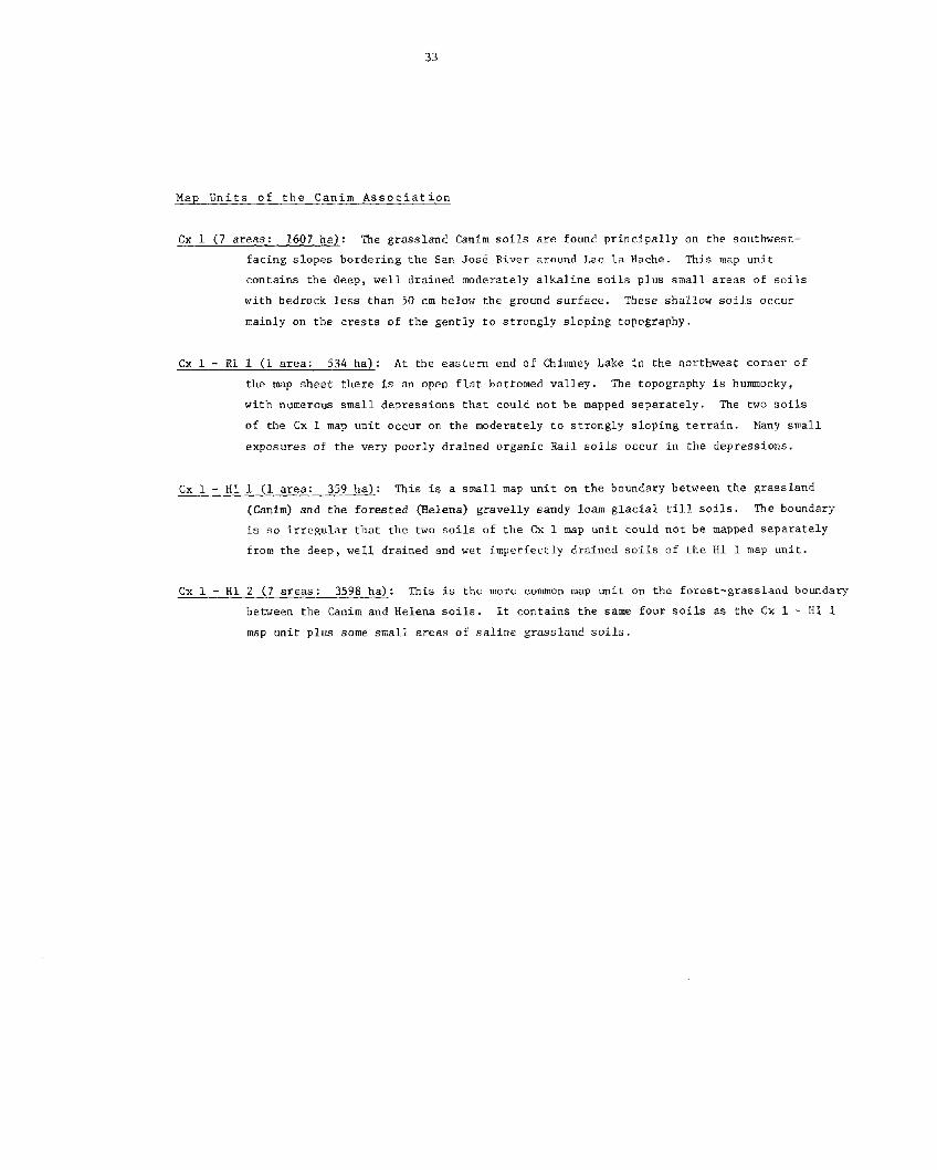
Map L'nits of the CGim Association
Cx 1 (7 areas: 1607 ha): The grassland Canim soils are found principally on the southwest- facing slopes bordering the San José River around Lac la Hache. This map unit
contains the deep, well drained moderately alkaline soils plus small areas of soils
with bedrock less than 50 cm below the ground surface. These shallow soils occur mainly on the crests of the gently to strongly sloping topography.
Cx 1 - Rl 1 (1 area: 534 ha): At the eastem end of Chimney Lake in the northwest corner of the map sheet there is an open flat bottomed valley. The topography is hummocky,
with numerous small depressions that could not be mapped separately. The two soils of the Cx 1 map unit occur on the moderately to strongly sloping terrain. Many small exposures of the very poorly drained organic Rail soils occur in the depressions.
Cx 1 - Hl 1 (1 area: 359 ha): This is a small map unit on the boundary between the grassland (Canim) and the forested (Relena) gravelly sandy loam glacial ri11 soils. The boundary is SO irregular that the two soils of the Cx 1 map unit could not be mapped separately
from the deep, well drained and wet imperfectly drained soils of the Hl 1 map unit.
Cx 1 - Hl 2 (7 areas: 3598 ha): This is the more common map unit on the forest-grassland boundary
between the Canim and Helena soils. It contains the same four soils as the Cx 1 - Hl 1
map unit plus some small areas of saline grassland soils.
34
RESOURCE I\NALYS,S BRPINCH
%IL: ELL‘OT 1 YINISTRY OF EH”,RONMENT
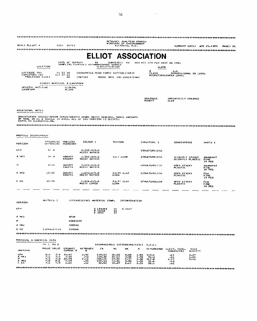
NT5: 9PP13 VICTORIA, B.C. SVHYARI DATE: *PR 25.19-m PAGE: 01
ELLIOT ASSOCIATION D.ATE OF SUHVÉI: KV SAMPL I NG PURPOSE : . ..ONN*.S*NC~*SU~v’t”“,~ “AN RE5 STN PCD UNIT *G C*N.
L”‘AT1”N cL*ssIFIc*TILrw SLOPE -- - - - - - - - - - - - - -_-_____ - - - - -
LATITUDE (r-4, SI 57 39 ‘ONGITUOE C*l
CARBONATED HEC0 NUHIC YLEYSDLllV73, *il 47 53
ii!,*,, D%ESSrONAL TO LEVEL
PRECI s *ON t SC, 00 STATUS: HODAL SDIL ,MJ DE”**TIm, WICP.OTOPOGR*PHY LEVEL
“AHCNT LI*TELIAL 6 LANDFORM __~__--- - - - - -____-________
GENETIC HATCRIAL FLUVIAL LANDFORH PL*IN
DRAlN*GE RUNOFF
IMPERFECTLI DR*,NED SLOW
*DD,T,ON*L MTt5
UNDISTURBEO SEDLES-*RHOY GR*SS-SYOOTH BROME “!*TER HEMLOCK. SMALL *MoUNTS OF MARC IN H. .3 SNAILS IN *wL2. DEPT” TU GEDR”CK=Y.%4.
ALL OF CKG HORIZON 1s GLEYED.
***************i***********,*********************************************************************************************************
PROFILL DES‘HIPTIDN ___-_________--- -_
HORIZON
LF”
A “K,
”
A kW2
c KG
-- - - - - -_
THICKNCSS HOHIZON “EPTH(C”, BOUNO*RI
s- 0
o- e
b-13
13-33
33-75
- - - - - - - -
HUTTLEL I
S.OY4.0/1*0
I\RRUPT S”O”T”
IIfiRlJFT SHOOT”
PIBRUPT SYOOTH
-- --- ---- ---- ---- ---- -
EFFERVESCENCE Y*,ERI*L COYP. DECOUPOSTTlOh
x LE*VES SL 1 CHT
x REEF 40 40
WEAK
LODER* TE
STRONG
STRONG
2.5Y2.0/0.0 STHUCTURELESS H”1ST M*TRIX
SILT LOAH STRucTURELE5S
COLOUF? , TEXTURE STRUCTURE I CONSI STENCE RDOTS 1
SLIGHTLI STICKY *BUND*NT SLIGHTLY PL*ST,C FINE
IN PED
2.5Y2.0/0.0 STRUCTUHELE~S “015, HITRIX
“ERY STICKY *aUND*NT PLASTIC FIM
IN PED
SILTY CL/IY LOI\”
STRUCTURELES YERI ST ICKY PLIST 1‘
FE” FINE IN PED
5.OY4.0,l.O MOIS, EXPED
SILTY CLAY LOIN
STRUCTURELESS VERY STICKY PL*STIC
FEU FINE IN PED
PH , PH 2 EXCH*NGE*BLk CATIONS(ME/lOOC~ C.E.C.
i-OORIZON “*L”E VALVE ORGANIC NI TRU‘EN CA MG NA 1.
CARBON X OETERYINED LLECT. CONU. BULK
x ( MHHOWCM 1 ULNSITY

35
Fap Units of the Elliot Association
El 1 (12 areas: 2015 ha): The soils of this map unit have developed in the moderately fine textured fluvial sediments deposited by the small streams that occupy the
bottomlands of the valleys running across the plateau. The topography is usually a series of narrow low terraces, which are often flooded in the spring. The
vegetation is a mixture of sedges, sea-side arrow grass and willows. The map unit
contains a number of different soils. Most are wet for much of the time that they are not frozen. They contain large amounts of calcium carbonate, and have large
quantites of organic matter in the surface horizons.
El 1 - Tr 1 (1 area: 305 ha): Just east of Watch Lake is a broad shallow valley where areas of fluvial sediments (Elliot soils) are mixed with smaller areas of fluvioglacial
sediments (Trurans soils). Most of this map unit contains the same soils as in the
Ee 1 map unit, but there are also small areas of deep, rapidly drained, very coarse textured soils which contain no carbonates (Tr 1).
36
PESDURCE ANALYSIS BRANCH
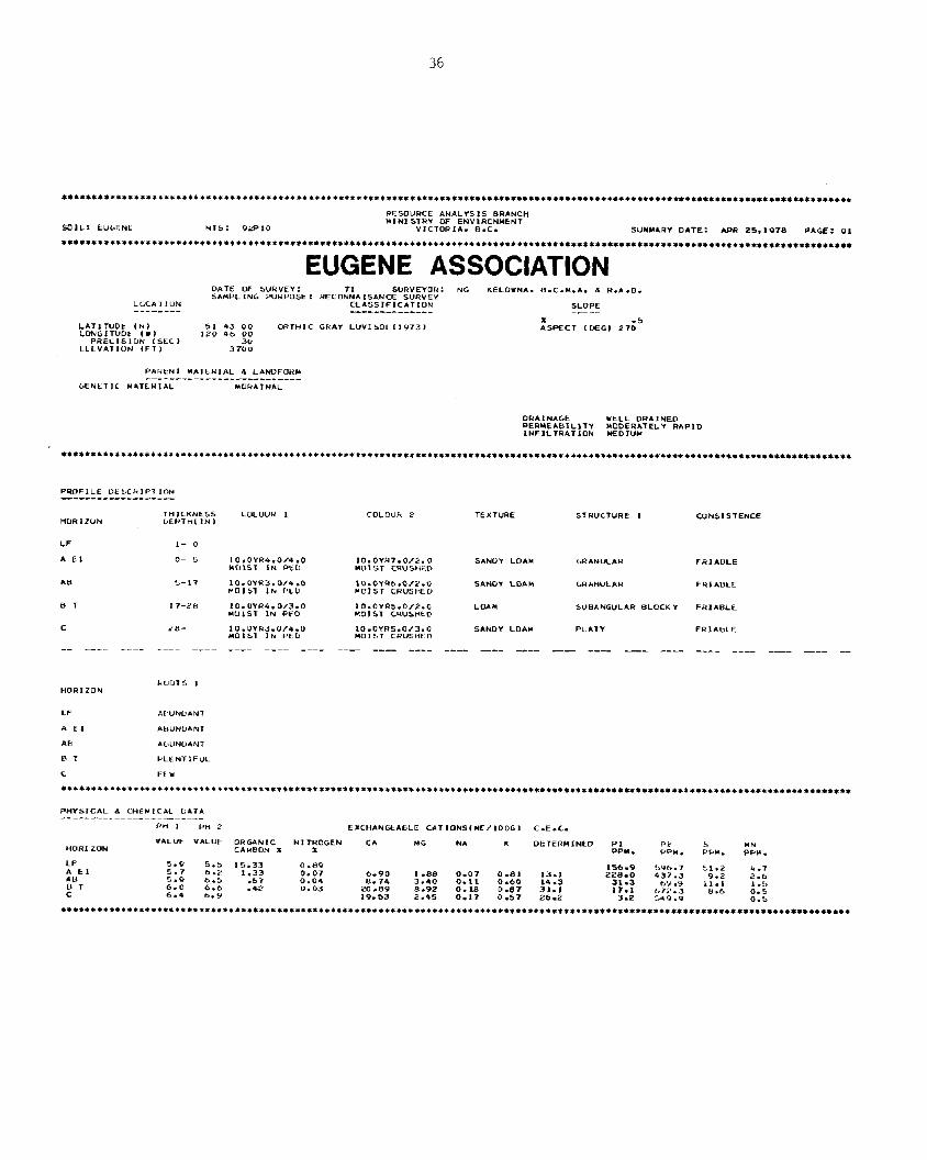
EUGENE ASSOCIATION DATE OF b”R”tY: SURVEYOR: NG KELOWNA. B.C.M.A. .X R.A.S. SAHP‘ ING PURPOSE : RECoW*mKE SURVEY
LCCATIDN CLASSIFICATION SLOPE -- - - - - - - __-___-_-____- - - - -
LATInJDt (N) 51 43 00 ORTHIC ‘RAY L”“1SclL,1973, LONGITUDt (W) 120 46 00
PRECISION (St‘> ELEV*ITI”N (Fl, 372
PAHLNT HLTERIAL L LANDFCUW --_-- -____________________
GENtTIC “ATÇUIAL HDWAINAL
DRIINI\GE UE‘L DRAINED PERHEABILITY INFILTRATION
Mm~m;;‘“’ RAPID
PRDF‘LE “kb‘kIPT,ON -----_-_______-c_
CONSISTENCE
LF 1- 0
A El o- 5 10,01R4.0/4.0 IO.OYH7.0/2.0 SAND” LOAW GRANULAR HUIS1 IN PkD MD1 ST CRUSHFD
*a S-17 10.OY*3.0/4.0 LO.OYRb.O/ï.” SANDY LUA” ‘RANULAR MOIST IN F’LD YDIST CRUSHED
e T 17-28 IO.OYR4.0/3.0 IO~OYRS.0/2.0 LO*N b”BANC”LAR 8LOCK V MO151 IN PCD MO,ST CUUSHCD
c iztt- ,O.“IR3.“/4.0 10.0YR5.0/3.0 SANDY COAM PLATY M0‘5T IN PED YCIST CP”SHED
-- - - - - - - - - - - - -_- - - - - - - - - - - - - - - - - - - - - - - - - - - - - - - - - - - - - __ __-_ ___ ___
FRIABLE
FRIABLE
FRIABLE
FRlltl‘E
- - - - -_-_ - - - - - -
LF AT”N”ANT
A El AH”N,,ANT
AB Ab”NDAN1
BT !-‘LENTIF”L
c FEY
*********************+***+t*l***l*****+*4******************************************************************************************
P”YS,‘AL 4. ‘“EH,C*L U*T* - - - - - - -_-- -__-_-_-_-__
PH I WI 2 EXCHANGEABLE ‘ATIONS,NE/,OOG, C.E.C.
HORI LON “*L”b VALUE ORGANIC NITHOGEN CA Ht NA K
CAHBDN I DETERMINE0 P, Pk
x MN
PPY. PPY. km. PPY *
5:; 5.5 ’ 15.33 0.89
25 1.33 0.07
156.9 ‘946.7
2:: 6.00 t .*a 0.07
51.2 0.81 13.1
.42 -57 0.04 a.74 3.40 0.11
2:
0.40 L4.3 228.0 31.3 0.03 20 .a9 8.92
6.4 0.18 0.87
437.3 69 -9 31.1
Il.1 9.2 2:: 1.5 17.1
19.53 2.45 0.17 ‘72.3 8.6 0.57 2L .2 3.2 549.9 0::
37
Map Units of the Eugene Association
Ee 1 (12 areas: 4146 ha): On the eastern border of the map sheet the deep, well drained
Eugene soils occur with small areas of wet imperfectly drained soils on neutral gravelly sandy loam glacial till. The topography of the plateau varies from
gently to steeply sloping.
Ee 1 - Tu 1 (3 areas: 1112 ha): In this map unit the two soils of the Ee 1 map unit are
combined with small areas where the surface of the glacial till has been washed with large volumes of post glacial meltwater. This has left a thin, crudely
stratified layer of sands and gravels on the surface in some shallow depressions
on the eastern border of the map area. The Tubbs soils have developed in these materinls and include a deep, well drained, moderately alkaline soi1 with small portions of a wet, imperfectly drained soil.
Ee 2 (4 areas: 1681 ha): The Ee 2 map unit occurs on the higher portions of the plateau where small areas of soi1 on ridge crests have bedrock within 50 cm of the surface.
The predominant soils are the same as in the Eel map unit. The topography is irregular varying from gently sloping on the crests to steeply sloping bordering
some valleys.

EXETER ASSOCIATION
STR”CT”Rt 1
**********~***C***+***********~~****************************~*~***************,***********~***~*************************************
PHYSlClaL d ~HtYICAL bAlk - - -_-- - - - - -_-- - - - - - - - - - -
L’I, 1 tXCHAN‘EAt,LE CATIDNS~HL/~OOC, C.E.C. PARTICLE 51x

39
Map Units of the Exeter Association
Ex 1 (9 areas: 8744 ha): The Ex 1 map unit is composed of forested soils on moderately alkaline lacustrine silts. DeepI well drained, stone-free soils (most of which
have an accumulation of clay in the subsoil) occur on gently to moderately
sloping topography in the Upper parts of the small lacustrine basins on the plateau.
Ex 1 - Bf 1 (5 areas: 4919 ha): In some areas the boundary between the forest soils (Exeter) and the grassland soils (Buffalo) on the lacustrine silts is very irregular. The two
groups of soils could not be mapped separately. In this map unit the most common
soils are the two included in the Ex 1 map unit. They occur with small areas of deep,
well drained soils (some of which are saline) that have a vegetation caver of Kentucky
blue grass, saltgrass and sedges. The topography is gently to moderately sloping.
Exl- Bf 2 (7 areas: 6939 ha): This map unit is very similar to the Ex 1 - Bf 1 map unit except that the expanses of Buffalo soils extend down into the bottoms of the grassland
depressions on the plateau surface. Therefore, at these lowest positions they include
small areas of deep, moist, highly carbonated Black soils, which have a caver of sedges
and Kentucky blue grass. The topography ranges from very gently to strongly sloping.

HELENA ASSOCIATION DATE OF SWYEI: S*lwLING PVHPOSE: RECoNN&,SANt?c~R:EI: KV V*N RES LOCATION CL**S~FrC*TION -------_ ___--_---
COLCWR 2 TEXTURE
41
Map Units of the Helena Association
The Helena soils are very common and have many map units. The five single map units are described below, followed by a list of their compound map units , with brief notes on the minor soils only.
-1 This is a very common map unit on the gently to moderately sloping
surface of the plateau. D-p, well drained soils with an accumulation of clay in the
subsoil have developed on moderately alkaline , gravelly sandy loam glacial till. There
is an open forest of Douglas fir, with pinegrass and kinnikinnick. There are small areas
of wet, imperfectly drained soils.
Hl 1 - Bf 1 (4 areas: 2057 ha): Grassland lacustrine soils at lower elevations, some saline.
El 1 - Bt 1 (1 area: 2356 ha): Forested mildly alkaline glacial till at higher elevations.
Hl 1 - Cx 1 - Rl 1 (1 area: 15 ha): Grassland till, very poorly drained organics in depressions.
Hl 1 - Ex 1 (1 area: 295 ha): Forested lacustrine soils at lower elevations. Hl 1 - St 1 (1 area: 2048 ha) : Forested acid glacial till at higher elevations.
Hl 1 - Tr 2 (1 area: 349 ha): Meltwater channels with coarse textured acid soils.
Hl 1 - Tu 1 (3 areas: 1556 ha): Forested coarse textured alkaline glacial till.
Hl 2 (3 areas: 891 ha): This map unit contains the deep well drained soi1 of the Hl map unit plus small areas of grassland some of which are saline.
Hl 2 - Cx 1 - Rl 1 (4 areas: 8883 ha): Grassland till and wet organic, hummocky topography.
Hl 2 - Cx 1 (2 areas: 1461 ha): Grassland glacial till at lower elevations. Hl 2 - Rl 1 (5 areas: 5302 ha) : Very poorly drained organic soils in depressions.
Hl 3 (12 areas: 12621 ha): Small areas of soils that have bedrock within 50 cm of the surface occur with the two soils of the Hl 1 map unit on higher parts of the plateau having gently to steeply sloping topography.
Hl 3 - Rk 4 (1 area: 44 ha): Exposed bedrock lava cliffs at Upper elevations. Hl 3 - Tu 2 (9 areas: 2359 ha): Forested coarse textured alkaline glacial till.
Hl 4 (14 areas: 2&594 ha): In this map unit the ground is covered with many very large boulders of basalt lava. More boulders are buried in the soil. There are very large areas of this map unit between Lac la Hache and the Dog Creek valley. The other soils are similar
to those in the Hl 1 map unit.
Hl 4 - Rk 3 (2 areas: 177 ha): Exposed lava cliffs at edge of plateau.
Hl 4 - Rl 1 (4 areas: 21,146 ha): Organics in depressions between boulder fields.
Hl 4 - Tr 1 (1 area: 851 ha): Forested coarse textured acid soils.
HI 5 (8 areas: 9131 ha): In this map unit deep, well drained and wet imperfectly drained soils similar to those in the Hl 1 map unit have developed on pinkish materials.
Hl 5 - Bd 1 (3 areas: 571 ha): Grassland lacustrine soils at lower elevations. Hl 5 - Hd 1 (1 area: 657 ha): Forested coarse textured alkaline soils.
Hl 5 - Tr 1 (1 area: 1264 ha): Forested coarse textured acid soils.
42
NEILSON ASSOCIATION
PAs.kNT M*TEMIAL d LAhLJFORN ___--____-__-_-_-_-_-- -
‘.‘zktTIC LIAILC<,AL FL”“‘ AL LANDFWN TERRACED
R”071NG DiPl” vo ‘Y. SELPAGt cm* ,N*‘E RUNDFF
RAPIDCI DRIINED MED IV”
*DD*T*oN*L NUTES -- - - - - - - - - - - - - -
LODGLPLICE. P‘hC <*AT”RE AND RLutNtRATING, PINEGRASS *ND KINNIKINNLCI. U=n CUNTAINS &“NL NEt”Lts AND cAzASbR0”lS WIT” SOYE CH*RC”*L. SILT CONCRLTIW45 Ih CKI. DEPT” TO bEm?“CK=3”.
*****t********t***C*********t********************~***********************************************~***********************
PROFILE DtS‘R,Pl,“N
C”LO”R z TEXTVHE STRUCTIIRE I
“NSPECIFIED COMMON FINE THRO”G”O”T “I\THIX SPHERICAL
STRON‘
STRONG
-- - - - - - - - - - - - - - - - - - - - - - - - - - - - - - - - - - - - - - - - - - - - - - - - - - - - - - _-__ - - - - - - - - - - - - - - - - -
DECOYPOSITION HORIZON
******+********************+****+********************************************************************************************* ****t*+******t***C*t+++i*++*++*+ilt+********~********************************~*************************************~****************************

43
Map Units of the Neilson Association
Nl 1 (1 area: 700 ha): There are moderately coarse textured, mildly alkaline, fluvial sediments in the bottomlands of parts of the Dog Creek valley. The soils that
have developed on them are predominantly deep and rapidly drained with an open
forest caver of lodgepole pine. There are some small depressions with wet soils
that contain large amounts of calcium carbonate and organic matter in the surface
horizons. The low, terraced, topography is very gently to gently sloping.
RAIL ASSOCIATION “AIE OF b”H”tY: KV SANPLI NG P”kPOSE : REC”NN*,**N‘ESVR~:~’
“AN RES STN Pto “NIT *G CAN.
Lcc*T ION CLAS5IFICATIUN SLOPE -- - - - -__ - - - - - - - ____ - - - - -
L*T‘T”oE CN, 5, 58 22 0.0
LoN6IT”ot <w, IYPIC MESIS”Ll1973,
121 27 06 :LAS.* DEPRESS,ONAL TO LEVEL
PRECISION t CCC) 00 STATU$.: MODAL SolL (NO OE”II\TION, Y,‘R*lOPOGR~PHY LEVEL
GÉNETIC C*Ttk‘AL OR‘ANIC L*NoFOHH L;LINKET
SECPAGE PRESENT ORA*N*GE VERY WORLY DRAINE0 RUNOFF PONDE0
AOOITIONAL N”Tts
UNDISTUHht~ SEDOtS-!KRUts BIRCH-wILLOS-“OSSES. SEO‘E PINO REEOS VALES FOR HORlZONS 01.02.04. <I 05. ARE 100%. Y”OD VALUE FOR “CII*IL”N 04 IS 20x
100X. 60%. 6 100X. RESPECTIVELY.
DEPTH TCI “ED”“C,c=t,H. BM H”R,ZON 15 YOLCANlC AS,,.
***t***************************tt*********~********************************~************.**~*************************,*******
PROFILE DES‘klPTIDN
TI1ICKNESS “OR ‘zut. “DRI *ON UtPT”<CM) HO”ND*Rl
0 MI O-16 CLEAR SH”07H
0 HZ 36-6l IRHVPT SMDOTH
BM 61-64 ABRUPT SYOOT”
0 H3 64-114 CLEAR “A”I
OH 114-145 CLEAR IAVY
CG 145-180
- - _- - - - - - - - - - - - - - ____ ---- --- ---- ---- ---- --- --- ---- __-- ---- __- -- --- ---- -- -- -
‘EMENTATI ON HDRIZDN *GENT/DESC”,P.
0 Y1
0 H2
BM HUM”5 AL”“IN”M
0 M3
0”
CG 1 ROM
COLDUR I TCXTVHE SIRUCTURE 1 CONSISTENCE
10.OYR3.0/2.0 LET NATURAL IO.OYR3.0/2.0
YET PRESSE0
lO.OYR2.5,4.0 LE1 NATURAL 10.OYR3.0,4.0 IET PRESSE0
10.01R6.0/3.0 CUIRSE SANDY WT NATURAC
STRUCTURELESS L”AH
NON STIO<V
10.0YR4.0,3.0 YET NA,“R*L lo.*YR4.0,3.0 IET PRESSE0
10.OVR3.0/1.5 YET NATURAL 10.OYR3.0/,.5 !#ET PRESSE0
5.0wi5.0/*.0 S1LTY CL*” *ET NITURLIL
STRVCTVRELESS LOAH
SLIGHTLI ST,CKY
DEtOHP”SIT,DN “000 YATERIAL Y. FI”RE
SLIGHT R”66EO 40
SLIGHT R”6BtD 40
SLIGHT SIZECCM, 02 R”B6ED 40 %VOLUME MDDERATELY .%,
MODERA TE R”““E 0 20
PHISICAL L CHtiHIEAL DIT* __-___--_-_-____-_--__
PH 1 EXCHANLEABLE CATIONSCYE/lOOGl C.E.C. PARTICLE SIZE
HORIZON VAL”& “RGINIC NITRO6EN X AZ,” c* Y‘ N*
CIREION x x K DETERYI NE0 aux
DENSITV S:ND x TIITAL
SILT CLAY x X FINE
CLAI
6.3 43.04
2:: 44.37
7.54 S.? 41.47 5.5 41.18 6.6 -52
26 63.10 73.60 12.50 80.70
127.40 8.90

45
Map Units of the Rail Association
Rl 1 (37 areas: 4057 ha): The Rail soils are mapped in the small enclosed depressions on
the plateau surface or in the flat bottomlands of the shallow valleys. The pre-
dominant type of soi1 in this map unit is very poorly drained and is formed of moderately decomposed, medium acid organic materials that are over 1 m thick.
Around the borders of the depressions or near the sloping valley sides the organic materials are much thinner and tbe lower part of the soi1 is mineral. The vegetation is usually a mixture of sedges, grasses, willows, and grandular birch. The topography
is level to very gently undulating.
As the Rail soils occur in small isolated depressions they often had to be mapped with the inter-
vening soil. In the following compound map units only the intervening soils are described.
Rl I - Bf 2 (2 areas: 505 ha): Grassland soils (some of which are saline or calcareous) that have developed from lacustrine silts that encircle the depressions.
Rl 1 - Bt 1 (2 areas: 228 ha): Forested soils on glacial till at Upper elevations.
Rl 1 - Cx 1 (1 area: 645 ha): South of Lac la Hache many depressions contain Rail soils
surrounded by smaller areas of grassland soils developed on glacial till (Cx 1).
Rl 1 - Hd 1 (3 areas: 795 bal: Very.coarse textured mildly alkaline soils.
Rl 1 - Hd 4 (1 area: 984 ha): Very coarse textured, rapidly drained, mildly alkaline soils on sinuous fluvioglacial ridges (eskers).
Rl 1 - Tu 1 (1 area: 85 ha): Coarse textured soils on alkaline glacial till.
Rl 1 - Hd 1 - Tu 1 (4 areas: 878 bal: A combination of the Rl 1 - Hd 1 and Rl 1 - Tu 1 map units.
Rl 1 - Hl 1 (1 area: 94 ha): Forested soils on mildly alkaline glacial till.
Rl 1 - Hl 2 (6 areas: 860 ha): Complex pattern, grassland and forest soils on glacial till.
Rl 1 - Se 1 (1 area: 488 ha) and Rl 1 - Tr 1 (4 areas: 607 ha): Very coarse textured soils
on slightly acid fluvioglacial materials. The Stolle soils (Se) have a higher base
status, than the Trurans soils (Tr).
Rl 1 - Tr 2 (2 areas: 140 ha): Meltwater channels with coarse textured acid soils.

46
**2**************************************************~***********************************~*************************************.****
RESOURCE INALISIS BR*NC” YINISTRY DF ENVIRONMENT
SO ,L: STOLLL NTS: CJP 2 “ICTORI*. 8.C. S”M)r*RI DATE: APR 25.1978 PAGE: 0,
+**t**t+****+******t**********************************~********~**************~*****************************************************
STOLLE ASSOCIATION DITE OF 5”HYtY: SUHVEYOR: NG KELDWru. 8.C.M.*. d R.A.8. SIYPL IN‘ PURPOSE : RECOtkISANCE SURVEY
LO‘*T,ON CL*SSIFIC*TION SLOPE -- - - - - - - - - - - - - - - - - - - - - - -
LAlITUDE (N> ASPECT (DEG, 360
SI 08 DD LDNGITUDt <Y,
ORTTHIC EUTRIC BR”N,SOC,,973, 120 52 00
PRECISION (XC> ELEVATION <FT, 34::
PARENT “ATCRIAL d LANDFOR”
‘ENETIC H”DIF‘tR GLACI” GENETIC MATERIIIL FLuvII\L
DR**N*GE R*P,DLI DRAINE‘, PERMEIBILITY YODERITELI R*P,D IKILTR*TION MED run
PROFILE DcxWIPTION _-- -_____--- - - - -_
7H1CKNESS COLOUR 1 CDLDVR 2 HOR LZON MPTH< IN,
TEXTURE STRUCTURE 1 UJNSISTENCE
LF Y- 0
BM o-15 7.5YR4.0/4.0 ,O.OYR4.0/4.0 SINDY LO*Y SINGLE GR*IN LOOSE HDIST IN PED MOIST CRVSHED
c 15-34 T.SYRb.0/4.0 10.OYR6.0/4.0 SAND C>INGLE GRIIN LOOSE MOIST IN PED MOIST CRUSHED
R 34-
- - - - - - - - - - - - - - - - - - - - - - - - - - - - - - - - - - - - - -_- ___ - - -_ __ __ ____ - - - - - -__ _-- - - - - _- - _
R”OT5 ,
HORIZON
BM *t”ND*Nt
t PLENTIFVL
R
PHYSICIL d CHE*IC*L DATA -__-_-_-_-______-_-___
PH 1 PH 2 EXCHANGE*BLE CATIOMS(ME/100G) C.E.C. tXTH*‘t*BLt FE(X) EXTRACTABLE *L(X,
VALUE VI\L”E ORGANIC NI TROGEN CA M‘ NA K HORIZDN
DETERYINED RESLIT RESULT RESULT RESVLT CARHON x %
LF BM 2: 55::
20.62 -88 0 -80 .07 Z-96 c 9.57 -06 -41 15.6 6.2
5.6 -8 .I
2.82 1.07 -0 .*
R -05 -09 ..8
- - - - - - - - - - - - - - - - - - - - - - - - - - - - - - - - - - - - - - - - - - - - - - - - _- - - - - - - - - - - - - - - - - - - - - - - - - - - -

47
Map Units of the Stolle Association
Se 1 (1 area: 140 ha): Very coarse textured, rapidly drained soi&, developed on slightly
acid fluvioglacial materials occur on the lower slopes of valleys in the northeast border of the map area. Some soils have a slightly impeded drainage due to an
accumulation of clay in the subsoil. The topography is moderately to steeply
sloping.
Se 1 - Ac 1 (1 area: 389 ha): '510 small valleys in the northeast border of the map ares contain, on their lower slopes, the two soils of the Se 1 map unit, plus small
areas of moderately well drained, medium textured soils (some of which are
shallow over bedrock), developed from moderately acid glacial til:. The topography is gently to moderately sloping.
Se 1 - Ex 1 (2 areas: 595 ha): In the Bridge Creek valley near Forest Grove the soils of
the Se 1 map unit occur with small areas of well drained, forested soils developed on moderately alkaline, lacustrine silts. The topography is gently to moderately
sloping.

TATTON ASSOCIATION L’tlTC “F b”Y”LY: h 7 ~“RVLYL’H: KV “AN RES STN PkD “NIT A‘ CAN. SA#PClNG P”F‘P”SE : Fc~Cl,NNAISL.NCE StJCYkY
LUCA r ,I,N CLASSIF,CA,,“N LLOC‘ -__----- -------_----__ -----
l P.hkkl *I\*LR,*L L C*NLJF”k* - - - - - - - - - - - - - - - - - - - - - - - - - -
‘LNCTI‘ &tA,ct,,*c ‘ILL”” I AL LANDFCll<lr. “LNkEl.
SttP*‘E *t.strv,
AU Iü-Il3
11 CJ 7 te-40
II é‘ eu-70
11 c 70-110
--- ---- -___ -- ---- ---- ---- ---- -
**********f*********I****************************************************************************************************************
P”YSlC*L a ‘HEIICCL L>*T* _-_--__-_-- -___-__-_-~--
CCAkSI EWA<rlrEhlS

49
Map Units of the Tatton Association
Ta 1 (19 areas: 2544 ha): This map unit occurs on the Upper slopes of the valleys which are tut into the plateau. Moderately well drained, deep soils developed on
mildly alkaline colluvium are associated with some small areas of soi1 which have lava bedrock within 50 cm of the surface. The topography varies from
moderately to extremely sloping, and there is often a quite dense forest caver
of Douglas fir.

TRURANS ASSOCIATION
ADDITIGhAC NLTL: - - - - - - - - - - - - - - -
LDDGEPOLE PlhL .rNLLtHANN SPk”Ct.AN” PINE‘RASS AtGENtHATIN‘ ~~F?IL CDHW”NIIY. ULPT” TO “t”HO‘L=bM*
******t**l**********~~~***~*t*******1**********t**t**tt*****************************************************************~***.~*~*******
II tK 1 S-323 ‘RI\C”IL SM”OTk
II t A&-102
CUOUR I TkXT”RE STRUCTURE f CONS, STENCE RODTS 1
SOFT PLENTIFUL MEDIUY EX PED
PLENT IF”L FXNZ EX PED
PLENTIFUL FINE
LOCJSE YERI FEI FINE
- - - - - - - - - - - - - - - - - - - _
kO”TL. 2 *ATERI*L COMP. DECOMPOSITION
PHYSICltL d CHLtrl‘hL DAT*
CO*RSE FRAGHkN,S
‘R*“u C”“hLL HOHIZUN * x

51
Map Units of the Trurans Association
Tr 1 (6 areas: 7274 ha): The Trurans soils have developed from very gravelly coarse
textured fluvioglacial materials. A rapidly drained, slightly acid soi1 occurs with small areas of soils having a clay accumulation in the subsoil. They are
found on the undulating plateau surface with an open forest of lodgepole pine and
a ground caver of pine grass and kinnikinnick.
Tr 1 - Ex 1 (2 areas: 453 ha) : North of Green Lake there is a complex intermixture of fluvioglacial and lacustrine deposits. Small areas of the deep well drained
forested Exeter soils (Ex 1) occur with the two soils of the Tr 1 map unit on
gently to moderately sloping topography.
Tr 1 - Hl 1 (2 areas: 1396 ha): Two valleys north of Lac la Hache contain a layer of
fluvioglacial gravels over glacial till. The predominant soils are those
contained in the Tr 1 map unit, but in some areas the till is exposed at the
surface, and deep, well drained and wet imperfectly drained Helena (Hl 1) soils
occuc.
Tr 1 - Rl 1 (2 areas: 433 ha): The two soils of the Tr 1 map unit are associated with the Rail soils (Rl 1) in enclosed depressions of the undulating plateau.
Tr 1 - Hl 1 - Rl 1 (1 area: 4223 ha): The soils are a combination of the Tr 1 - Hl 1 and
Tr 1 - Rl 1 map units. The topography is gently to moderately sloping.
Tr 2 (5 areas: 4816 ha): Deep, sinuous meltwater channels contain the soils of the Tr 1 map unit. Small outcrops of lava bedrock are sometimes exposed at the Upper edges of the channels.
Tr 2 - Rk 3 (4 areas: 948 ha): Similar to the Tr 2 map unit except that the outcrops of lava
bedrock on the Upper slopes of the meltwater channels are much more extensive.
Tr 3 (5 areas: 562 ha): This map unit represents old deltas. The best examples are near Watson Lake, west of Forest Grove and on the north side of Lac la Hache. The
Trurans soils (Tr 1) occur on these deep, stratified, loose, very coarse textured
deposits.
Tr 3 - Tu 1 (1 area: 67 ha): A delta with the Tr 1 soils is encircled by areas of coarse
textured glacial till with deep, well drained (with some imperfectly drained) soils (Tu 1).
Tr 4 (3 areas: 1225 ha): The soils of the Tr 1 map unit occur on steep sided, sinuous ridges
(eskers).
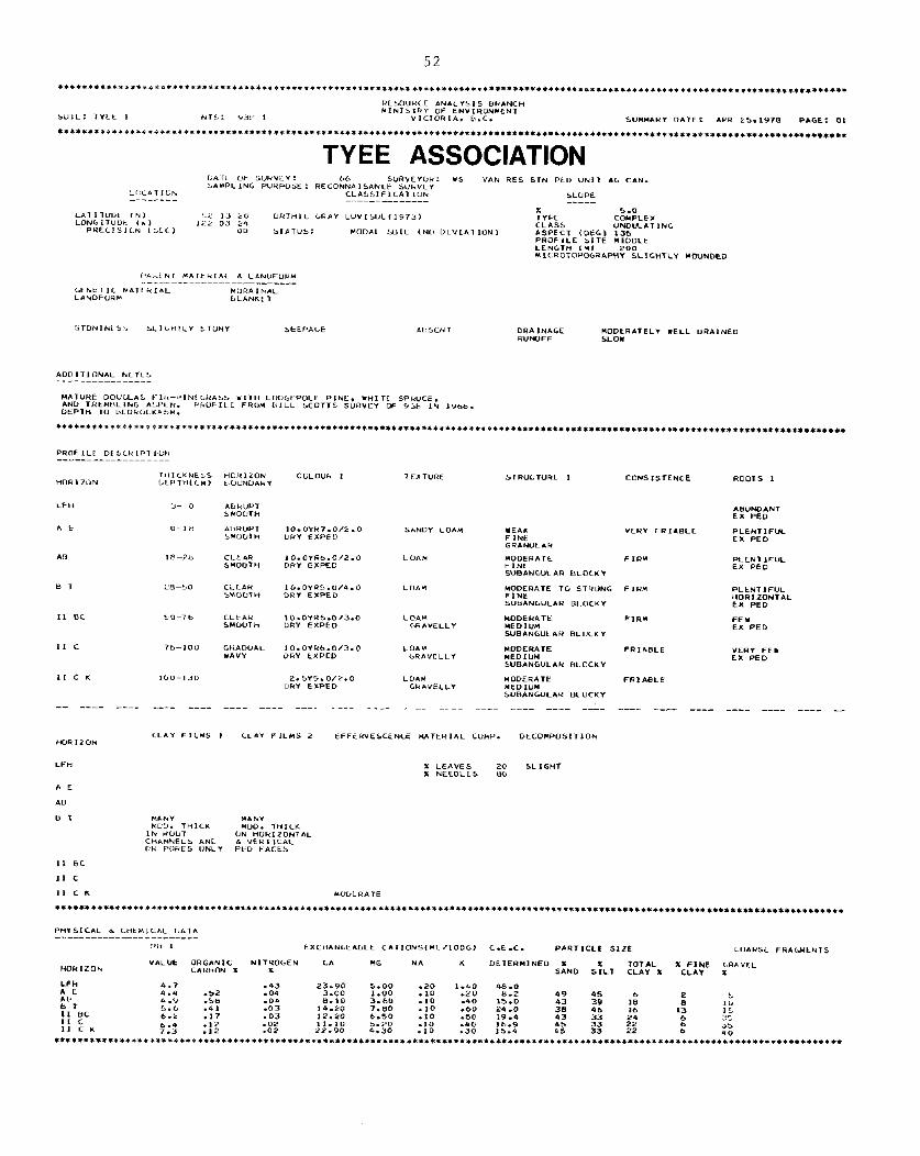
52
TY EE ASSOCIATION
ORA INAGE MODkRATELI XELL “RA,NEO R”WFF SLOW
“ALUt OR‘*NIC NI TROGEN ‘A MG NA K DtTERHINED X TOTL>L c*Fmm * x
X FINE <.RA “EL SP<ND S:LT CLAY * cL*Y x
.43 23.90 5.00 ‘**O .09 3.00 1.00 ::: -20 z-2
.09 8.10 3.60 .10 -40 E.:o -03 I4.20 7.80 -10 .c>o 29.0 -03 12.20 6.50 .*o .SO 19.4 :X2 11.10 5.20 -10 .4* 16.9
22.90 4.30 .10 .30 15.4
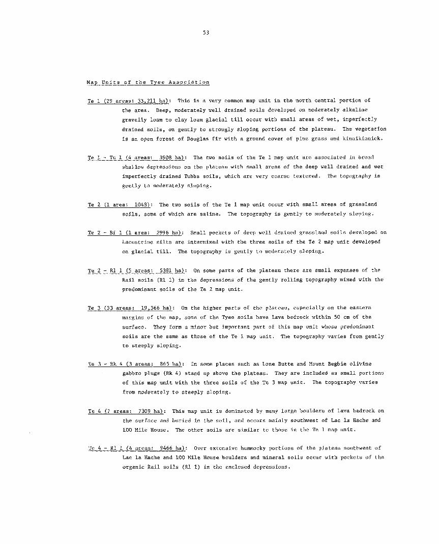
53
Map Units of the Tyee Association
Te 1 (29 areas: 33,211 ha): This is a very common map unit in the north central portion of
the area. Deep, moderately well drained soils developed on moderately alkaline
gravelly loam to clay loam glacial till occur with small areas of wet, imperfectly drained soils, on gently to strongly sloping portions of the plateau. The vegetation
is an open forest of Douglas fir with a ground caver of pine grass and kinnikinnick.
Te 1 - Tu 1 (4 areas: 3908 ha): The two soils of the Te 1 map unit are associated in broad
shallow depressions on the plateau with small areas of the deep well drained and wet imperfectly drained Tubbs soils, which are very coarse textured. The topography is gently to moderately sloping.
Te 2 (1 area: 1045): The two soils of the Te 1 map unit occur with small areas of grassland
soils, some of which are saline. The topography is gently to moderately sloping.
Te 2 - Bf 1 (1 area: 2996 ha): Small pockets of deep well drained grassland soils developed on Lacustrine silts are intermixed with the three soils of the Te 2 map unit developed
on glacial till. The topography is gently to moderately sloping.
Te 2 - RI 1 (5 areas: 5381 ha): On some parts of the plateau there are small expanses of the
Rail soils (Rl 1) in the depressions of the gently rolling topography mixed with the predominant soils of the Te 2 map unit.
Te 3 (33 areas: 19,366 ha): On the higher parts of the plateau, especially on the eastem
margins of the map, some of the Tyee soils have lava bedrock within 50 cm of the
surface. They form a minor but important part of this map unit whose predominant soils are the same as those of the Te 1 map unit. The topography varies from gently to steeply sloping.
Te 3 - Rk 4 (3 areas: 865 ha): In some places such as Lone Butte and Nount Begbie olivine gabbro plugs (Rk 4) stand up above the plateau. They are included as small portions
of this map unit with the three soils of the Te 3 map unit. The topography varies from moderately to steeply sloping.
Te 4 (7 areas: 7309 ha): This map unit is dominated by many large boulders of lava bedrock on
the surface and buried in the soil, and occurs mainly southwest of Lac la Hache and 100 Mile House. The other soils are similar to those in the Te 1 map unit.
Te 4 - Rl 1 (4 areas: 9466 ha): Over extensive hummocky portions of the plateau southwest of Lac la Hache and 100 Mile House boulders and minera1 soils occur with pockets of the
organic Rail soils (Rl 1) in the enclosed depressions.

S”““ARI DA7E: APR 25.1978 PAGE: OI
WILLIAMS LAKE ASSOCIATION
DRI\ INAGE RUNOFF
MOOERATELY YELL DRALNEO MEDIUM
HA,“RL V”“<.LhL F LH-PINt‘HAbL.. BCIJHULK VLPTH=SM.
******f**i****~*rl******~*****~***~********************~**********************************************~******~******~*********~*****
PROFILL “tt.‘&,PT1‘1k -_-___--__--_--_
“OkILON
LFH
A t
AB
B 71
H TZ
8‘
11 c ) r
II c
IHICKNESS HOK I LUN ‘ULOUR 1 L.JCPIH,‘C, B”“NDAHY
T CXTURE CONSISTENCE ROOTS ,
A- c
o- 5
L, I Ffwst 1 HHLL”L*R
‘LAY LOA” “COERll? F IRH ‘HAVELLY MED,“”
ANGULAR B‘O‘KY
CL** LOAM ‘H*“tCCY
-- - - - - - - - - - - - - - - - - - - - - - - -_- -___ ____ ____ - - - - - - - - - - - - - - - - - - - - ___ _
CLAY FILMS 1 CLAY FILMS 2 EFFERVESCENLE MA7 LRIAL ‘OHP. DECOHPDS171DN
HANY HANY H”lJ. THI‘K M”O. 7HlCK
IN HCIUT ON HOk IZONTPIC CiIANNËLS AND b “ERTICI\L OR PURES “PLI Ptc! F*=ES
PHISICAL A ‘FIEMl‘AL DAT* ___-____--___-_-________
LLARS~~ FHA‘LlthTS

55
Map Units of the Williams Lake AssociatLon
Wl 1 (6 areas: 16,006 ha): This map unit occurs on the undulating plateau north and
south of Chimney Lake in the northwest corner of the map. A deep, moderately
well drained soi1 is associated with mal1 areas of a wet, imperfectly drained
soi1 on moderately alkaline gravelly clay loam glacial till. There is an open
forest of Douglas Fir.
Wl 1 - Rl 1 (1 area: 1037 ha): Small areas of the very poorly drained organic Rail soils
occur with the two soils from the Wl 1 map unit on the gently to moderately
sloping plateau surface.
Wl 2 - Rl 1 (1 area: 4354 ha): South of Chimney Lake there is a very hummocky portion of
the plateau, where small expanses of grassland soils developed on glacial till,
occur between the principal two forested Williams Lake soils on the higher land
(Wl 2) and the very poorly drained organic Rail soils (Rl 1) in the depressions.
Wl 3 (2 areas: 4957 ha): This map unit is dominated by many large boulders of lava bedrock
that lie on the surface or are buried in the soil. It occurs south and east of
Chimney Lake on the gently to moderately sloping plateau. The other soils are
similar to those in the Wl 1 map unit.
Wl 3 - Rl 1 (1 area: 163 ha): In a small map unit southeast of Chimney Lake the boulder
fields and their intervening soils occur with isolated pockets of the organic Rail
soils (Rl 1) in the enclosed depressions.

57
2.2.4. -ils of the Cariboo Midlands: Southern Section
The soils of the southern section of the Cariboo Midlands have developed from a
variety of glacial and postglacial surficial materials, under a climate that is warmer and drier than the northern section. Evapotranspiration rates are therefore higher, effective
leaching is less, and soi1 moisture deficits during the growing season are greater. As a result there are a number of differences from the northern section in the types of soils that
occur in equivalent landscape positions. The forest caver is more open with more lodgepole pine, less Douglas fir,andPonderosa pine appears in places. Grassland soils with significant
growing season soi1 moisture deficits are much more common, and more of them are saline. Organic soils are less common. Instead wet, or moist minera1 soils are found in the equivalent
landscape positions. Soi1 carbonates have been leached to only shallow depths in many soils, and the leaching of clay from the surface into the subsoil is also less marked.
The forested soils on glacial till are allmildly or moderately alkaline, and only
one has a medium base status with a marked accumulation of clay in the subsoil (Tunkwa). The
other two have a high base status, which is dominated by calcium (Timber and Tubbs). The
grassland soils on glacial till (Big Bar) are more extensive than in the north, but are often scattered in small pockets through the forest.
There are very large areas of soils on fluvioglacial sands and gravels (Holden) in association with the soils derived from water worked glacial till (Tubbs), especially towards
the west, between Gustafsen Lake in the north and the flanks of the Marble Range in the south.
As the ice melted it deposited extensive but quite thin layers of sand and grave1 in these areas. It was often impossible to map the Holden and Tubbs soils separately as the thickness
and type of deposit was difficult to predict from aerial photographs. The Holden soils have
a high base status and a low water holding capacity.
No significant area of soils developed on lacustrine silts occurs under forest. Virtually a11 the Beaverdam soils have a grass caver (heavily overgrazed), and many of them
in the lower spots are either saline (sodium and magnesium salts) or carbonated (calcium salts).
On the steep slopes of the Bonaparte River and Loon Creek valleys aspect is extremely important in determining the type of soils that occur. Forested soils on colluvium under an
open forest canopy (Chasm) occur on the cooler north and east facing slopes, and grassland soils (Soues) occur on the warmer and drier south and west facing slopes.
On the map a11 the soils of the Cariboo Midlands, southern section, are colored shades of blue or grey. They are described in the right hand legend in the block colored blue. A cross
section shows the landscape relationships of the various associations. The landscape positions of
the individual soils in each association are shown in the four cross sections at the foot of the map in the strip colored blue.

RESOVRCE ANILISIS SRIHCH
SOIL: sE*“ERD*Y 1 NTS: 929 5 NlNISTR1 OF ENVIROHYENI
YICTORII* B.C. SUNNARI DITE: *PR 25.1978 PIGE: 0,
BEAVERDAM ASSOCIATION
PAREN, H*TER**L d LANDFORY -- -____--- - - - - - -_-_
GENETIC UTERIAL LINOFOR*
LACUSTRINE R”LL,rn PL*IN
CONS1 SlENCE ROOTS I

59
MaR Units of the Beaverdam Association
Bd 1 (6 areas: 1113 ha): The soils of this map unit have been developed from strongly
alkaline, silt loam lacustrine materials. They are deep, moderately well drained and some of them have a large carbonate content. The vegetation is a heavily over-
grazed grassland, and the topography is usually very gently to moderately sloping.
Bd In this map unit there are small areas of grassland soils on
strongly alkaline glacial till (Bb 1). Most of them are deep and well drained, but a few are saline or have bedrock at shallow depths. The topography is gently to moderately sloping.
Bd 1 - Hd 1 (4 areas: 2351 ha): The soils of the Bd 1 map unit are mixed with small areas of
soils developed on very coarse textured mildly alkaline fluvioglacial materials
(Hd 1). The latter soils are deep, and rapidly drained. The topography is hummocky, ranging from very gently to moderately sloping. Lakes occupy some small depressions.
Bd 2 (4 areas: 2105 ha): Small areas of wet, poorly drained soils which have a large carbonate content occur with the soils of the Bd 1 map unit. They are in the hollows of the
very gently to moderately sloping topography.
Bd 2 - Hd 1 (1 area: 291 ha): This small area is very similar to the Bd 1 - Hd 1 map unit
except it includes the wet poorly drained highly carbonated soils of the Bd 2 map unit.
Bd 2 - Rl 1 (1 area: 3221 ha): South of Beaverdam Lake the soils of the Bd 2 map unit occur with small areas of the organic Rail soils. The terrain is hummocky with the topography
ranging from very gently to moderately sloping.
Bd 3 (8 areas: 1619 ha): This map unit contains small areas of saline soils in addition to the
soils of the Bd 2 unit. The surface of many of these saline and carbonated soils is either bare, or has a sparse caver of saltgrass.
Bd 4 (5 areas: 1312 ha): This map unit contains small areas of forested soils on lacustrine
materials in addition to the soils of the Bd 1 map unit. The topography is gently to
moderately sloping.
Bd 4 - Rd 1 (2 areas: 1473 ha): Two large, shallow, hurmnocky depressions contain the soils of
the Bd 4 map unit plus the rapidly drained soils on fluvioglacial materials of the
Hd 1 map unit. The topography is very gently to moderately sloping. Many small lakes occur in the enclosed hollows.

60
************+******P****~**********~***********************************************~*****************************~*************~****
BIG BAR ASSOCIATION
-- --_- _--- ---- ---- ---- ---- ---- ---- ---- ---- ---- ---- ---- ---- ---- --- ---- ---- ---- ---- ---- _-

61
Map Units of the Big Bar Association -- --
Bb 1 (1 area: 1244 ha): Just north of the Marble Range there are some expanses of grassland
soils on strongly alkaline, gravelly sandy loam glacial till. Most of the soils are deep and well drained, but there are a few areas of saline soils, and soils with
lava bedrock within 50 cm of the surface. The topography is moderately to strongly
sloping.
Bb 1 - Hd 1 (1 area: 631 ha): In the valley of Big Bar Creek near the northern end of the Marble range there is one area where the three soils of the Bb 1 map unit are associated with deep raidly drained soils developed on very coarse textured mildly
alkaline fluvioglacial materials (Bd 1).
Bb 1 - Tw 1 (2 areas: 477 ha): Northwest of Meadow Lake the three grassland soils on glacial
till of the Bb 1 map unit are associated with small patches of forest soils that are mainly deep and well drained, but a few of them are wet and imperfectly drained. The topo-
graphy is gently to moderately sloping.
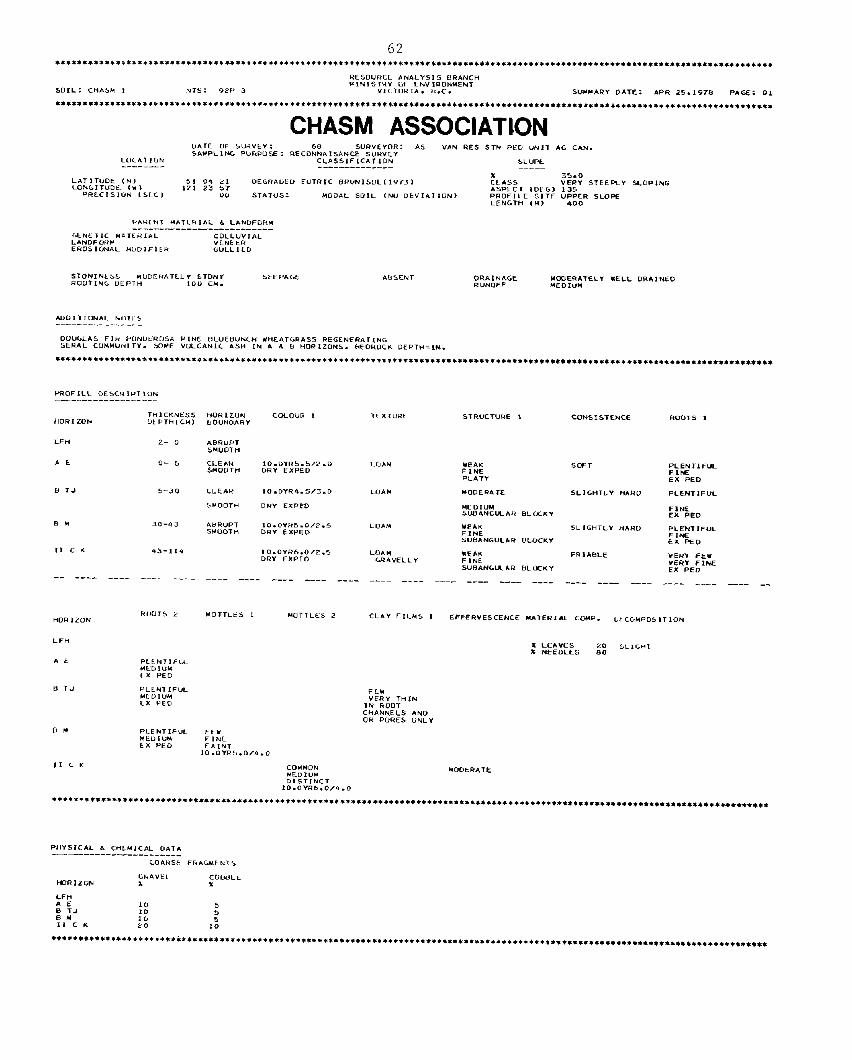
62 *t*****+*f************************~******************~*******************~**~*******************************************************
RESDVRCE *NALYSIS BIUNC” )rlN,STHY OF ENVIRDNWENT
SOIL: CHAb” I NTS: 9PP 3 VICTURIA. k.C. S”CPN+” DATE: APR 25.197* PAGE: 0,
******************9*i**i**t*++i*+t*t+*+*************************~*******~********************************************~**************
CHASM ASSOCIATION DIxTE ut= b”ta”tl: 08 SURYEICR: *s “PIN RES STN PED “N1T GIG ‘IN. SAMPLING PURPOSE: RECDNNAI.sANCE SVRYLY L”‘A7 LDN CLASSIFICATION SLUPE -- - - - - - - - ---_-^---_-_- - - - -
LATIT”Dt (N, 51 “4 21 DE‘RAUED EUTRIC BR”N,SDL(lV73, LON‘ITUDL ,Y 1
:Us* 35.0
121 23 57 “ERY STEERI 5LOPIM.G
PRECISIUN ‘SC‘, ASPECT ,DEG, 135
0” STATU*: MODAL SO!L ,Nu DEVIAT‘ON, PROFILE SITE “WFZ *LOPE LEN‘T” ,H,
STONINtbi HUDEHATLLv STONI RO”T1N‘ “EP,H 100 CH.
5EEPAGE
ADDIT,ONAL hOTES -- - - - -_-- - - - - - -
DD”‘L.45 FIH P”NUu?“SA PINB tlL”tB”N‘H YHEATGRASS REGENER*TI,,G SkRAL COHMVNI TY. SOHE ““LCANI‘ AS” IN * d H HORIZclNS. HEDROCI DEPT”=IH.
t*C***********************************************************************************~****~****************************************
HIOFILt DL5CHIPTI”N ---^--------------
THICKNESS “OR IZ”N COCOUR 1 HORIZON
TEXTURC ut PTHIC”) tJO”ND*R”
STRUCTURE 1 CONSISTENCE ROOTS 1
Lt=” 2- 0 ABRUPT SHUOT”
A t cl- 5 CLE AH 10.0YR5.5/2.0 LOAH 5HOOTH
IEAK DRY EXPED
50FT FINE
PLENTJFUL FINE
PLATY EX PED
t( TJ 5-30 CLEAH ,O.OYR4.5/3.0 L”A&I YODERATC SLILHTLI HARD PLENT‘FVL
SHOOTH DRY EXPED HE OI”” SVBAN‘ULAH BLOCKY
FINE EX PED
BM 30-43 A”R”P, 10.0”H5.0/2.5 LD*H SMOOTH
YEIK DRI EXPED FINE
SLIGHTLY “*RD PLENTIFUL
*“B*NG”LAR ~‘“CKY FINE EX PED
,t t K 43-114 IO.OYHb.0/*.5 COAM DRY EXPED
WEAK GR*“ELL Y
FRIABLE FINE
YERY FEI
SUBANGUAR B‘OCKY E”&D *NE -- - - - - - - - - - - - - - - - - - - - - ____ ____ - - - - - - - - - - - - - - - - - - -_ _-- - ____ ____ - - - - - - - - - - - - - - _- - - -__ __
Km 1 Z”N HOTTLES 2 CLAY FILMS , EFFERVESCENCE H*TERI*L COWP. Lt CYMPOL, T ION
FE* VER,’ THIN
IN RclOT CHANNELS *ND OR PORES ONL,’
811
PHISICIL d ‘“LMICAL DI\T* --______--____--____^___
CO*RSt FHPIGMENTS
GLPIVEC HORIZON
C”tVILt 2. +
LFH *E B TJ :o BM
b 10
II c K 20 1:
********+*+************+**f**************~**~*********************~****~*****************~*********************************************

63
Map Units of_the Chasm Association
Cm 1 (7 areas: 3921*: This map unit contains deep, moderately well drained soils developed on mildly alkaline, gravelly loam colluvium, plus small areas of soils where basalt
bedrock is within 50 cm of the surface. It is found on the strongly to extremely sloping sides of the deep valleys that have been tut into the plateau. The aspect
of most of these slopes with the Chasm soils is north or east facing. Map units of
the Soues soils occur on the drier south and west facing slopes. There is an open forest caver of Douglas fir and Ponderosa pine with a surface of bluebunch wheat grass.
Many of the valleys tut into the plateau are quite narrow, SO that the contrasting soils on opposite slopes, or in the bottomlands had to be mapped as the following compound map units:
Cm 1 - SO 1 (11 areas: 12,371 ha): Uere the soils of the Cm 1 map unit are mapped with the deep,
moderately well drained soi& that have developed on similar colluvium on the drier
south and west facing slopes. Their vegetation is a sparse caver of Ponderosa pine with
bluebunch wheat grass. The valley sides are strongly to extremely sloping.
Cm 1 - Rk 3 (8 areas: - 7000 ha).: This map unit occurs on some of the steeper valley sides where
exposures of olivine basalt bedrock occur at the lip of the plateau. Steep talus
slopes are often found below these basalt cliffs and then below that are the soils
of the Cm 1 map unit. The topography is steeply to extremely sloping.
Cm 1 - SO 1 - Rk 3 (2 areas: 1647 ha): -~- Two especially deep narrow valleys (one of which forms
Chasm Park) contain a combination of the soils of the Cm 1 - SO 1 and Cm 1 - Rk 3 map units.
Cm 1 - FS 1 (1 area: 1714 ha): The valley southwest of Clinton contains the soils of the Cm 1
map unit, plus small stretches of deep, but imperfectly drained soils on the medium
textured, miI.dly alkaline fluvial deposits adjacent to the stream.
Cm 1 - FS 1 - Rl 1 (1 area: 565 ha): Northwest of Clinton there are small flats in the bottom
of the valley which contain the very poorly drained, organic Rail soils (Rl 1). The
other soils are the same as in the Cm 1 - FS 1 map unit. The topography varies from very gently to strongly sloping.
Cm 1 - Hd 1 (1 area: 34 ha): A very small map unit east of Upper Loon Lake contains the soils
of the Cm 1 map unit plus small areas of deep, rapidly drained soils developed on
very coarse textured , mildly allcaline fluvioglacial materials.

64
HOLDEN ASSOCIATION
kAhtt.7 KnTtHIAL b L*NOFUk* - - - - - - - - - - - -_--_-__-_____
‘ENET 1‘ MIL-IF 1Lc1 ‘LACIL GtNtTIC M*lklt,CIL FLbVIAL L*NDFLf.” HLI\NKL T
btEF.AGE ORAIWIGC RAPIO‘Y OHA IHLO RVNOFF MEOIUH
H”k,P”N C”L”“U 1 TtXT”R.5 “O”NDAk”
STRUCTURE 1 CONSIS,FNCE kO”TS 1
AB”N”ANT FINE EX PEO
*bWD*NT FIN.?z EX PEO
PLENTIFUL FINE EX PEO
PLEHTLFUL F IkE EX PEO
PLENT IFUL F INE EX PED
FEU FINE cx PEO
-- - - - - - - - -__ -
*‘R”PT S”O‘,T”
AU”“P, SHDUTH
11 b H2
11 tic
II c K1 STRVCTURELE’S VE RI FR LAOLE
STRUCTVRELESS LOOSE
STRVCTURELtSb LOOSE
111 c !A
LOAMY SewO “ERY LHAYELLY
-- - - - - - - - - - - - - - - - - - - - - - - - - - - - - - -__- __- - -_- -__- -__ - - - -

65
Map Units of the Holden Association
The Holden soils are very common and have a number of map units. The single map units are des- cribed below, followed by a list of their compound units,with brief notes on the minor soils only.
Hd 1 (4 areas: 1525 ha): The Holden soils have developed from gravelly, very coarse, textured
mildly alkaline fluvioglacial deposits. This map unit includes a deep, rapidly drained soi1 with small areas of soils having a slight clay accumulation in the subsoil. It
is found on the undulating plateau surface, with an open forest of lodgepole pine and
a groundcover of pine grass and kinnikinnick.
Hd 1 - Tw 1 (4 areas: 2018 ha): Small areas of deep, well and imperfectly drained soils developed
on gravelly silt loam, mildly alkaline glacial till (nY 1). The topography is gently to strongly sloping.
Hd 1 - Tu 1 (3 areas: 2780 ha): Large complex shallow depressions contain a mixture of glacio- fluvial gravels and water sorted glacial till which are mildly alkaline and very coarse
textured. The topography is very gently to moderately sloping.
Hd 1 - Hl 5 (7 areas: 7323 ha): Small areas of deep, well and imperfectly drained soils developed on reddish colored gravelly sandy loam glacial till.
Hd 1 - Bw 1 (1 area: 2281 ha): Small areas of deep well drained soils developed on strongly alkaline glacial till which is derived from limestone. The topography is gently to strongly sloping.
Hd 1 - Bd 1 (2 areas: 2031 ha): Some deep, moderately well drained soils (some of which are
highly calcareous) occur on lacustrine silts.
Hd 2 (3 areas: 3526 ha): On the east side of the Marble Range there are deep sinuous meltwater
channels tut into the surface of the plateau. The two soils of the Hd 1 map unit occur in the bottoms of the channels and on the plateau surface adjacent to the edges. Small outcrops of lava bedrock are sometimes exposed at the upper edges of the channel.
Hd 2 - Tw 1 (1 area: 14,058 ha): In between the meltwater channels are deep, well and imperfectly drained Tunkwa soils on gravelly silt loam glacial till.
Hd 2 - Tu 1 (2 areas: 824 ha): There are small areas of deep, well and imperfectly drained soils on stratified glacial till.
Hd 4 (2 areas: 828 ha): Here the two soils of the Hd 1 map unit occur on the steep sided, sinuous ridgas (eskers) that are found in some of the broad shallow meltwater channels on the plateau.
Hd 4 - Bw 1 (1 area: 158 ha): There are small areas of deep, well drained soils on strongly alkaline glacial till.
Hd 4 - Rl 1 (4 areas: 3713 ha): There are small areas of very poorly drained organic Rail soils in very gently sloping meadows.

SOUES ASSOCIATION
GkAbLrAL ,O.‘YR5-0,P.O *A”I URI EXPE”
10.OYRS.012.0 L>MI EXPED
---- ---- ---- -___ ___

67
Map Units of the Soues Association
So 1 (2 areas: 456 ha)-: This mzip unit contains deep, moderately well drained soils developed on moderately alkaline, very gravelly sandy loam colluvium, plus small areas of soils where the basalt bedrock is within 50 cm of the surface. It is found on the strongly
to extremely sloping sides of the deep valleys that have been tut into the plateau.
The aspect of most of the slopes where the Soues soils predominate is south or south-
west. Elsewhere they are associated with the Chasm soils. The vegetation caver is
Ponderosa pine and bluebunch wheat grass. Towards the north Douglas fir gradually
becomes more common than Ponderosa pine.
SO 1 - Cm 1 (7 areas: 4165 ha): Here the soils of the SO 1 map unit occur with the deep moderately
well drained soils that have developed from similar colluvium on the cooler and moister north and east facing slopes. There is a considerable amount of Douglas fir in the forest
caver .
SO 1 - Rk 3 (1 area: 307 ha): This map unit occurs in a steep sided valley near Clinton where
exposures of olivine basalt bedrock occur at the lip of the plateau. Steep talus slopes
are found below the basalt cliffs and then below that are the soils of the SO 1 map unit. The topography is steeply to extremely sloping.
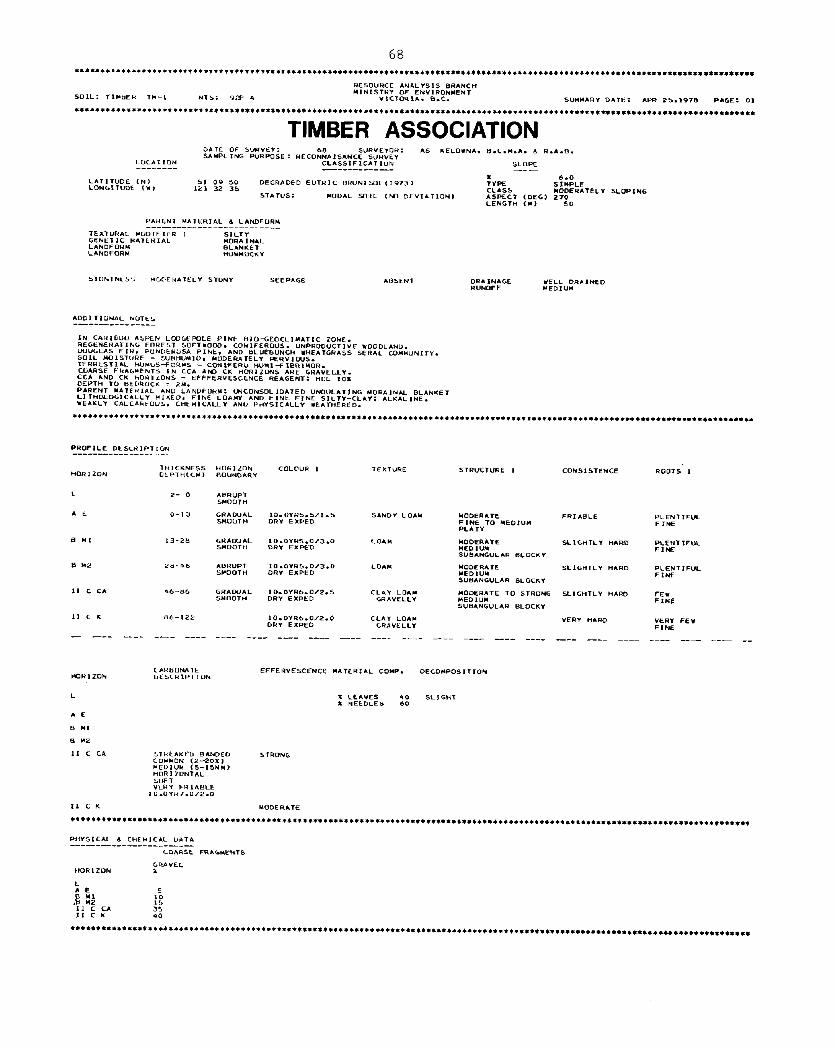
TIMBER ASSOCIATION
L P- 0
A E o-13
b Y, L3-28
b Y2 i>b-46
II c CA 46-ti6
II ‘ K 86-122
- --- ---- --- --_.
VER-f “*RD “kW FE” l=,NE
- - - - - - - - - - - - - - - - - - - - - - - -

69
Map Units of the Timber Association
Tm 1 (7 areas: 5424 hd: This map unit occurs on some lower and drier portions of the plateau edge near Clinton. The soils are predominantly deep and well drained, though some
are imperfectly drained and some have an accumulation of clay in the subsoil. They
have developed from mildly alkaline gravelly clay loam glacial till. The open forest caver is mixed Douglas fir and Ponderosa pine, with a ground caver of bluebunch wheat
gras. The topography is gently to moderately sloping.

TUBBS ASSOCIATION
- ---- ---- ---- ---- ---- ---- ---- _-- ___
“OR I ZON RO”TS 2 CLAY FILMS 1 C*RBONATE
DESCRIPTION
LF”
AE *gyJ”
tx Pt.0
71
Map Units of the Tubbs Association
Tu 1 (2 areas: 259 ha): This map unit contains predominantly deep, well drained soils
developed on moderately alkaline very coarse textured glacial till that is crudely
stratified. There are also small areas of imperfectly drained soils, and soils that have an accumulation of clay in the subsoil. The plateau surface is gently
to strongly sloping. There is an open forest of Douglas fir, with a ground caver
of pine grass and kinnikinnick.
The soils of the Tubbs association could rarely be separated from the surrounding soils, as
the boundaries of the stratified glacial till could not be mapped very accurately from aerial
photographs. Consequently, large expanses of the Tubbs soils are mapped with other soils in the following compound map units. Cnly the minor soils are given in the following descriptions.
Tu 1 - Bd 1 (5 areas: 937 ha): There are small areas of the grassland Beaverdam soils developed
from strongly alkaline lacustrine silt loam, on gently to moderately sloping topography.
Tu 1 - Hd 1 (11 areas: 63,538 ha): There are small areas of very coarse textured, mildly
alkaline soils on gently to moderately sloping topography.
Tu 1 - Rl 1 (4 areas: 1232 ha): A number of small depressions contain the organic Rail soils.
Tu 1 - Hd 1 - Rl 1 (1 area: 1061 ha): This map unit contains a combination of the soils from
the Tu 1 - Hd 1 and Tu 1 - Rl 1 map units.
Tu 1 - Hl 1 (4 areas: 1729 ha), and Tu 1 - Hl 3 (1 area: 871ha) and Tu 1 - Hl 5 (3 areas
6338 ha): Small areas with combinations of the Helena soils: (Hl 1) well and imperfectly
drained, (Hl 3) as Hl 1 plus areas with shallow bedrock, (Hl 5) as Hl 1 but reddish
parent material.
Tu 1 - Te 1 (2 areas: 745 ha) and Tu 1 - Te 3 (1 area: 595 ha): Two combinations of the Tyee
soils: either deep well and imperfectly drained (Te 1) or deep, well and imperfectly
drained, plus some shallow soils over bOedrock (Te 3).
Tu 1 - Tr 1 (21 areas: 25,974 ha) and Tu 1 - Tr 2 (2 areas: 2638 ha): Two combinations of the
Trurans soils; either the deep, rapidly drained soils (Tr 1) or soils near meltwater channels (Tr 2).
Tu 1 - Tr 1 - Rl 1 (2 areas: 10,907 ha): This map unit contains the same soils as the Tu 1 -
Tr 1 map unit, plus the organic Rail soils.
Tu 2 - Tr 1 (4 areas: 3167 ha) and Tu 2 - Hd 1 (3 areas: 6565 ha): Well drained Tubbs soils
some of which are shallow over bedrock (Tu 2) are associated with deep rapidly drained soils developed on either slightly acid (Tr l), or mildly alkaline (Hd 1) very coarse textured glaciofluvial deposits.

72
*****+****t*************t****************************************4*************************************4*****************************
TUNKWA ASSOCIATION DATE OF S”R”éY: 08 S”R”EY”R: A5 “AN RE5 STN PEU “NIT A‘ CAN. SAHPL ING WRPOSE : RECONNAISANCE S”H”EY
LO‘*T 16N CLASSIFICAT ,ON SLOPE -- - - - - - - - - - - - - - - - - - - - - - -
14.0 LPITIIUDE CN, SI os 24 “RTHIC CRAY L”“ISOL<1973, LAS, ‘0NGlT”Dk c*,
STRONGLY YOPING 1.2, 22 OY
PREClSI6N ,SEC, ASPECT (DEti> 90
66 STATVS: MODAL SOIL ,N6 DEYIATION, PROFILÉ SITE “;m;LE LEHGTH (MI
PARENT HATEHIAL 6 LANDFUH,, - - - - - - - - - - - - - -_-____-- - -
GENÉTIC âA,ERIAL LANDFORM EROSIONAI- HUDIF ,ER ‘ULLIEO
STONINESS YLIDERATEL” STONY ROOT ING WPTH 100 CN.
SEEPIGE Ab5EN T DRAINAGE YELL DRAINECI RUNUFF YEDIVY
ADDIT,ONAL NOTES -- - - - -_-- - -_--
50ME “DLCANI‘ asn IN A d b HURlZONL. DEPTH TO BEDROCK=4Y, DOUGLAS-F‘H LuD‘LPOLt PINE-PINE‘HASS REGENkRATING SERAL COHH”NITY.
PRUFlLE DES& ,PT ION -- - - - - - - - - - - - - - - -
“DR 1 Z”N
LF”
A E
7” ICKNESS HORIZON COLOVR 1 DEPTHCC”, BOVNDARY
TEXTURE STR”CT”RE ,
ABYUPT 10.0YRJ.5/2.0 S1LT LO*N WEAK SHOOT” MU1 ST LXPED FINE
10.“1R6.D,2.0 PLATY DR” EXPFD
CONSISTENCE ROOTS I
SOFT
PLENTIFUL FINE EX PED
PLENT IF”‘ FINE EX PED
bT
Il CR K
II c K
15-4, uH*o”*L lO.bYR4.D/P.D CLAY LO*N STRWG FIA”I
HARD DRY EXPED
FE” “ED,“@4 FINE 5”BANG”LAR BLO‘KY EX PED
4 I-b1 GWDUIL 10 .OYR5.0/2.5 51LT LOAM “EAK XI”I
WR6 DRY EXPED
FE* ‘RAVLLLY FINE
SUBANGULAR BLOCKY FINE EX PED
‘I-11” lO.OYR5.0/2.5 SIC1 L”AM WEAK DRY EXPED
FRIABLE FEY YRAYELLY VERY FINE TO FINE FINE
SUBANGULAA BLOCXY EX PED
-- .-s-s ---- ---- ---- ---- ---- ---- ---- --- ---- ---- ---- ---- _-__ ____ ---- -- ---- ---- --- ---- __
HOUT 2 YUTTLYS , HOR 1 LON
CLIY FILMS 1 CLAY FIL”S 2 WFEHVESCENCE MATEHIAL COYP. otc6LIPusIl I”N
LFH
LE
PLCNT IFUL HCDIUM tx PEU
PLENlIFUL FE* MED,“” FINE EX PEU DISTlNCl
IO.OYR5.0/4.0
* LEIYES 30 hLI6H-i X NEEDLES 70
BT t-LENT IFUL ML Dl”” LX F’E”
COVYON *ou. THICK EY” . THlClc
IN ROOT ON HORI ZDNTAL CHANNELS AND d “LRTIEAL OR PORE5 ONLY PED FACES
Il CB K FF” “ERY THIN
1N ROO, CHAHNELS AND OR PORES ONLY
“ODERATE
II c K MUOERATE **L*******+******+**+I+*+***~**********************************************************************************************~************
PtwSICAL d CHLHI‘AL DI\T,% -___-__-_-___-__-_
PH 1 EXCHANGEABLE CATIONSlHE/lOOC) C.E.C. PIRTICLE SILE
VALUE “NGAN‘C NI TROGEN CA HOR 1 ZON
Y‘ N1 K CARBON X x
OETERYINED BUK DE?45121 Y,,
LFH
8: 5:;
1.30 -10 6.20 2.60 .*o 0.70 -10
.&a 14.1 14.10 12.90
1.01 II Cb K -20 6.8 -90 -10 36.2
::2 z % 3: 1;
II c K 7.1 .*0 5 2
1.78 1 - ---- ---- ---- ---- ---- ---- --- -- ---- _-_ --- --- --- ---- --- -- --- ---- ---- --- _--- _-
‘“AISE FRAC.LENTS
GRAVEL ‘OBILE HOR I ZON x *

73
Map Units of the Tunkwa Association
Tw 1 (35 areas: 21,748 ha): This map unit occurs on the rolling plateau north and south of
Loon Lake. The soils are mainly deep and well drained (with some imperfectly drained) and have developed on mildly alkaline gravelly silt loam glacial till. The open forest is a mixture of Douglas fir, lodgepole pine with some Ponderosa pine in the south. The topography varies from gently to strongly sloping.
Tw 1 - Bd 4 (5 areas: 681 ha): In some hummocky broad shallow depressions the soils of the Tw 1 map unit occur with both grassland and forested Beaverdam soils developed on
strongly alkaline lacustrine silts at the lower elevations.
'51 1 - Hd 1 (7 areas: 14,411 ha) and Tw 1 - Rd 2 (3 areas: 3369 ha): In these map units the 'J& 1 soils occur with two map units of the Holden soils, either the deep, rapidly drained soils on the gently sloping plateau (Hd l), or the deep rapidly drained soils,
plus some that are shallow to bedrock associated with meltwater channels (Hd 2).
Tw 1 - Rl 1 (1 area: 144 ha): Small areas of the organic Rail soils occur in the wet depressionr
of the hurmnocky topography.
Tw 1 - Hd 1 - Rl 2 (2 areas: 7566 ha): This map unit contains a combination of the soils in the Tw 1 - Hd 1 and Tw 1 - Rl 1 map units.
-1 The soils of the Tw 1 map unit are associated at the edge of the
plateau with the Chasm soils developed on mildly alkaline colluvium.
Tw 1 - Hl 5 (4 areas: 28,135 ha): On large areas of the gently to moderately sloping plateau north and south of the Bonaparte River the soils of the Tw 1 map unit are associated with smaller areas of the deep, well drained and imperfectly drained Helena soils developed on reddish moderately alkaline gravelly sandy loam glacial till.
Tw 1 - Tr 1 (1 area: 1847 ha) and Tw 1 - Tr 2 (1 area: 331 ha): Just south of Loon Lake the
soils of the Tw 1 map unit occur with deep, rapidly drained, coarse textured soils, either on the plateau surface (Tr 1) or adjacent to meltwater channels (Tr 2).
TWl- Tu 1 (1 area: 932 ha): Just north of the Marble Range a gently to moderately sloping
portion of the plateau contains the soils of the Tw 1 map unit plus smaller areas of soils developed on coarse textured, stratified glacial till.
% 2 (12 areas: 7048 ha): On the higher points of the rolling plateau north and south of Loon
Lake there are areas where some of the Tunkwa soils are shallow with bedrock within 50 cm of the surface.

75
2.2.5. Soils of the Southern Uplands - -
The variation in climate, topography and bedrock types is greater in the Southern
Uplands than in either of the other two physiographic areas. The climate during the growing season ranges from hot and dry on the lower benches of the Fraser River to cool and moist on
the summits of the Marble Range. The elevation difference between these two areas is about 1900 m: from 300 m at the Fraser River to over 2200 m on the Summit of Nount Bowman. The
topography is rugged with many steep, and sometimes precipitous slopes. Soi1 materials are
therefore often disrupted by downslope movement, and in extreme cases the soi1 surface is
being stripped by erosion. The bedrock of the Marble Range is limestone, producing highly
calcareous soils. The bedrock of the Edge Hills is chert, siltstone, argillite and some limestone, giving soils that are considerably less calcareous. The parent materials of the
soils on the highly dissected benches above the Fraser River are very complex. The bulk of
the deposits are a mixture of glacial till and fluvioglacial deposits, but the Upper metre or two is usually formed of gravelly fluvial fans overlain by eolian silt. The vegetation on the
lower benches is a sparse caver of sagebrush and bluebunch wheat grass. On the higher benches
Ponderosa pine appears. The slopes of the mountains have an open Douglas fir forest, and the
summits have stunted whitebark pine and juniper.
The soils of the Marble Range are calcareous, thin and droughty, because limestone
weathers by solution leaving only a small volume of residual weathering products, and water moves rapidly out of the soi1 profile into the permeable rock. Numerous angular fragments
of limestone occur throughout the soi1 profile to the surface. The soils formed on the gravelly
sandy loam glacial till of the lower slopes (Bowman) have an accumulation of clay in the subsoil. The colluvial soils on the Upper slopes (Carson and Community) do not. On the cool, moist
summits the soils (Kerr) contain large amounts of organic matter and volcanic ash in the Upper horizons.
The colluvial soils of the Edge Hills (Cavanaugh) are very coarse textured, do not have an accumulation of clay in the subsoil, and are far less calcareous than the soils of the
Marble Range.
The very dry conditions on the Fraser River benches have produced grassland soils on moderately alkaline parent materials (Courtney and Dog Creek). A11 the benches are highly
dissected by large gullies, with steeply sloping sides. The Upper horizons of the weakly
developed gulley soils are constantly being eroded (Gang). Weakly developed soils, some of which are saline, also occur on the alluvial floodplains of the Bonaparte River and Loon Creek
valleys (Frances).
On the map a11 the soils of the Southern Uplands are colored shades of yellow or orange. They are described in the right hand legend in the block colored yellow. A cross section shows the landscape relationships of the various associations. The landscape positions of the individual soils in each association are shown in the four cross sections at the foot of the map in the strip colored yellow.

76
BOWMAN ASSOCIATION
c K1
c iP
- - - - - - -_
“OR I ZON
LFH
*e
81
c *a
3- 0
O-13
13-30
30-96
ah-64
64-115
- - - - -_
N”“TS Y
PLENT IF”L C<!A”SE
PLENT 1F”L COIRSC LX PED
FEY CO*RSE t-r PED
FEI ‘0.4RSE t* 8x0

77
Map Units of the jowman Association
Bw 1 (9 areas: 9272x: This map unit occurs on the lower slopes of the Marble Range. Deep, well drained soils (most of which have an accumulation of clay in the subsoil) occur on strongly alkaline, very gravelly sandy loam glacial till. The topography is very
varied, ranging from gently to very steeply sloping.
Bw 1 - Cw 1 (1 area: 33 ha): In a very small area in the extreme south the soils of the Bw 1 map unit occur with small exposures of deep, rapidly drained soils on moderately
alkaline, very coarse textured colluvium. The topography varies from strongly to very steeply sloping.
Bw 1 - Hd 1 (3 areas: 1954 ha) and & 1 - Hd 2 (2 areas: 678 ha): On some of the lowest slopes - of the Marble Range (mainly on the eastern side) the soils of the Bw 1 map unit occur with two map units of the Holden soils. The Holden map units include either the deep,
rapidly drained soils on mildly alkaline fluvioglacial materials on the gentlyto steeply
sloping plateau (Hd l), or the deep rapidly drained soils plus some that are shallow to bedrock associated with meltwater channels (Hd 2 ).

78
- - - - - - - - - - - - - - - - - - - -_-_ -_-- -_- ‘ENETIC HATERIAL “HIGIN C*NOF”RH
y.m.~;‘“’ SED‘HEN,ARY yw~““’ PRDP. FINE ‘hAlteEU
LIMESTONE

Map Units of the Carson Association
Cs 1 (4 areas: 583 ha): This map unit occurs predominantly on the south facing upper slopes
and ridge crests of the Marble Range. Deep, well drained soils developed on mod-
erately alkaline, gravelly loam colluvium are associated with small areas where the
soils are shallow, and limestone bedrock is within 50 cm of the surface. The topography
varies from steeply to very steeply sloping. The vegetation on these drier south facing
slopes is mainly Douglas fir and pinegrass.
Cs 1 - Kr 1 (27 areas: 11,556 ha): In these areas the soils of the Cs 1 map unit are associated
at the highest elevations with small areas of well drained soils (some of which are shallow over limestone bedrock), which have a surface capping of volcanic ash, and a vegetation community of whitebark pine and juniper. The topography varies from strongly
to very steeply sloping.
Cs 2 (26 areas: 12,925 ha): This map unit occurs predominantly on the upper north facing slopes
of the Marble Range. It contains deep well drained soils (some of which have an
accumulation of clay in the subsoil), that have developed on moderately alkaline,
gravelly loam colluvium. The topography varies from steeply to extremely sloping. On these cooler and moister north facing slopes the Douglas fir forest has a more
closed canopy than in the Cs 1 map unit.

80
REsa”HCE ANI\LYS,S BRIwCt-4 HINJSTRY OF ENYJRONYENT
SOJC: CA”INA”Uk MS: 921 3 “ICTORI*. BIC. S”YLIARY DATE: APR 25.19-m PAGE: 01
************************************************************************************************************************************
CAVANAUGH ASSOCIATION “.ATt: OF S”R”tY: 28 7 74 S”R”EY0.Q: cil KEL**N*. SAHPL ING PUHWSE : RECONNAISANCE SURYEY
LOCATION CLASSIFICATION -- - - - - - - - - - - -_-__-
L*TIT”DE CN, 50 13 LON~ITUDL (Y,
DEGRADED EUTRIC BR”NJSOL~J973J 12, 05
PRt‘ISIDN c SEC, ST*T”S: ELEVATLON CH, 52
MODAL 5oIL <NO DEVIATION,
e.c.l4.*. 6 R.A.S.
SLOPE -- - - -
x 15.0 TYPE s IYPLE cL*ss STEEPLY SLOPING ASPECT IUEGJ 210 PROFILE SJTE UPPER SLOR YJCR”TDP”GRAP”I LEVEL
P*RENT YI\TERIAL & L*NvFOR* _-- -___-_________--_--__
TEXT”R*L LOU‘FILR I GRAYELLY ‘ENETIC MATERJAL cou”“I*L LANDFORY FAN
STONINESS HLIDERATLLY STONY ROOTIN‘ WPIH 80 CM.
F LOOD H*z*RD NO “AZAHD SEEPAGE r%J2=TGE
RAPIDLY ORAJNED ABSENT YERY SLOW
PERUEABILJTY RAPID INFILTRATION YEDIUM
**************+*+*****ttt++*t+t************************************************************************************************************
PROF ILE OELCRJPT ION
HDR IZON THICKNESS “EPTH‘CM,
LF B- 0
A E O-17
BM 17-42
BC K 42-62
c KJ 62-60
c K.2 SO-
HORIZON TEXTURE STR”CT”RE I B”“NDARY
ABRUPT SHcl0Tk
CLEAR LOAMY SAND SYOOT”
STR”CT”RELES.5 MEDIUM Tel CO*RSE SINGLE GRAIN
CLEAR L0U-f SAND STRUCTURELESS SMOOT ” GRAVELLY MEDI”” TO CO*RSE
SINGLE GRAIN
SEo^%B SAND GRAVELLY
STRUCTURELES MEDIUN TO CO*RSE SINGLE GRAIN
DJFFVSE SAND STRVCIURELESS S”“OT H GRAYELLY HEOI”Y TO COIRSE
SINGLE GR*IN
SAND STR”cT”RELESS ‘R*“E L‘Y HEDIUM TO t0ARs.E
SINGLE GRAIN
CONSISTENCE RDOTS 1 EFFERVESCENCE
LODSE gyp*“T “ERY IEAK
RANDOY EX PED
LOOSE AB”ND*NT YODER*TE F,NE RANDOY EX PED
LOOSE MODERATE
PHISICAL d ‘HÉHJCAL bATA _--_______-___--_--___
PH 1 P” 2 EXCHINGEISLE CATIONS~WE/lOOGJ C.E.C. tXTR*CT*BLE t=tcri> EXTRACTIBLE *L,XJ
VALUE “PIL”E OR‘INIC NI TROGEN c* MG NA K DETERYINEO HESULT WESULT HORIZON CAR6ON x x
LF 2:
5.5 Y::
-3s *E 2::
-31 :40 -06 14.14 4 -57 -05 .a* J9.0
K: 6.6 ::: -04 -02 :!?t: . 6.81 2.33 123 .32 22 -17 Z-5 . 0.1 0.1 6.8 7.1
c K2 7.9 7.4 - -_- - - - _- -_ - - - - - -__ -_-- - - _- -_ -__ - - -_ -__- - - - - - - - - - - - - -_ - - - - - - - - - - - - - - - - - - - - - - - -
CO*RSE FRAGMENTS
F-1 “ORIZUN PPLI. ZP”. % “OL FAVEL
24.6 z-3’ :o JO 17.4 . 27.0 0.6 30 3”: 30.5 30 30 12.4

81
Map Units of the Cavanaugh Association
Cg 1 (16 areas: 5610 ha).: This map unit occurs on north facing slopes and ridge crests in the
Edge Hills. It contains deep, rapidly drained soils (some of which have an accumulation
of clay in the subsoil) devéloped on mildly alkaline very coarse textured colluvium.
The topography varies from gently sloping on the ridge crests to very steeply sloping on the mountain sides.
Cg 1 - Rk 6 (12 areas: 3312 ha): On some of the summits and more precipitous slopes argillite,
silt stone and chert outcrops are associated with the soils of the Cg 1 map unit. The topography varies from moderately sloping on the summits to extremely sloping on the
mountain sides. Talus slopes occur below some of the rock outcrops.
Cg 2 (9 areas: 7481 ha): This map unit occurs on the warmer and drier south facing slopes in the Upper elevations of the Edge Hills. The soils are deep and rapidly drained and have formed on the same colluvium as those of the Cg 1 map unit. However, the soils are drier
than those in the Cg 1 map unit, and the Douglas fir forest is more open. The topography
varies from moderately to very steeply sloping.
Cg 2 - Rk 6 (1 area: 644 ha): In an area east of the Fraser River there are exposures of argillite,
siltstone and chert bedrock, with the soils of the Cg 1 map unit below them, on the
steeply to very steeply sloping topography.

COMMUNITY ASSOCIIATION L>ATE (IF s”H”EY: tii 7 74 s”k”kYOH: GI KELOYNA. 8.C.M.A. d R.*.R. SAHPL I N‘ P”I+“SE : RECONNA~SANCE SUHVEY LD‘ATIUN CLISSIFICAT I”N SLDPE -------- --_-----__--_- -----
DHA IN*GE WELL DRAINED R”N”FF MEDI”+A PER”t*H,LIT* MODERATE INFILTRA7I0N HED,“H
ROUTING DEPTH 1s “F‘OY PS‘M. trkDROCK 1s “LLOY 1SOCt4.
***+***************************************~***********************************************************~****************************
PRDF,LE DES‘RIPTION -- - - - - - - - - - - - - - - -
THICKNESS HOHIZUN TEXTURE STR”C7”Rt 1 HORIZc!)U DEPTH( CH a BOVNDARY
LF 15- Y CLElaR b”OOT”
ASH o- 3 ‘CEAR XAVY
9 “1 a-13 ‘LE*#4 **“Y
c is-
PHYSICAL 6 cHEHI‘*L “,%,A _--_--______--- - - -_-____
PM 1 Ph 2 EY‘W.N‘EA6Lt ‘ATIOHS(ME/IOOG~ C.E.‘. LXlRACTAhLE FL(X) tXTR*CT*rLt AL(Z)
VALUE VALUE DR‘ANIC NITROGEN CA “b NA I( H”RLZ”h
DETERYINED RESULT CAHUON x x
RP S”LT

83
Map Units of the Community Association ~-
Cw 1 (2 areas: 777 ha): This map unit occurs in the extension of the Plarble Range towards Pavilion Mountain, in the extreme south of the map area. Deep, rapidly drained
soils developed on moderately alkaline, very coarse textured colluvium are the predominant soi&. There are small areas of soils that have an accumulation of clay in the subsoil. There is a considerable amount of volcanic ash in the surface
horizons of both types of SOUS. The topography varies from strongly to very steeply
sloping.
cw 1 - Kr 1 (1 area: 91 ha): This small map unit occurs on the ridge where the soils of the
Cw 1 map unit are associated with deep well drained soils (and some soils that have shallow bedrock) developed on very gravelly sandy loam colluvium (Kerr soils). The
Kerr soils have considerable accumulations of organic matter and volcanic ash in the surface horizons. The topography varies from steeply to very steeply sloping.

84
COURTNEY ASSOCIATION LU‘SXT ION -- - -__-_
LATIT”Dk ‘h, LONGITUDE 11,
PRECISIUN (CL‘, ELE”**luh ,w>
DATE OF b”R”tl: 23 0 73 5”K”clDk: SAMPL ‘NC P”RPl2SE : RECDNNA * SANCE sutwt‘l
CL*Ss*FlCATrDN -- - - - - - - - - - - -
5” 47 “RTHIC BR”YNl1973, 121 OF
30 305
GI KELDVNA. D.C.H.PI. 6 Rd.B.
SLDPE -- - - -
5.0 LECT IDEY, 180
PI\kLNT HATERIAL L L*NDFOH” - - - - - - - - - -_--_--_--_-- - - - -
‘CNET‘C H*TLH,AL COLLUVIAL LINDFDRC Fw4
ST”NINL5S “t*Y STUNY DRAlN*GL IELL DRAINED
t*+******+*t******t*******~*****************************************************************************~***************************
PRDFfLE DESCRIPTION -_-_____-_-_--_-__
*n O-10 ABHVP, lO.OYH5.0/2.0 SANDY LOIN CDARSE DRY GRAYELL Y PLATY
BM 10-30 ABNUPT 7.5YW4.0,P.O SANDY LOAY YEAK DkY GH.4”LLLI YEDIUY TO ‘DANSE
S”B*NG”L*H kJLOCKI
c CA 30-bb A”R”P, 10.OYRS.0,S.O LDAMY SIND GR*NVLAR DRI ‘IAVELLY
CI< ba- 10*0YRS.0‘4.0 LOAYY SAND ‘RANUAR (IRI CIRAYLLLY
CONS.1 STLNCE RDDTS I
SOFT *B”ND*NT
SDFT PLENTIFUL
LDOSE l=tw
LMSE FEV
PHISICAL 8. ‘HtHICIL UATI - - - - - - -_- - - - - - - - - - - - - -
P” 1 PH 2 EXCHANGEABLE CATIONSlME~lOOGl C.E.C.
“*LUE VALUE OR‘ANI c NITRO‘EN CA HU NA K DETERMINED PI s CARBLN x
MN x PPY. PPY. 6-P”.
7.3 2:
1.17 -11 11.84 6.69 -04 7.3
1.31 11.0 -94 -17 13.61 -07 ::4
S:b z-4”: . 1.16 -71 -08 18.85 -24 1 .28 15:1 E-b ::ô 12.4 . 9.8 2:. 24.3
4.3 21 . 4 ::5

85
Map Units of the Courtney Association ~- --
Ct 1 (1 area: 133 ha): - A large sloping bench on the east side of the Fraser River contains
predominantly deep, well drained soils developed on moderately alkaline, very coarse textured mixed deposits. There are also small areas of soils that are highly cal- careous, and some that are very weakly developed. The vegetation is a heavily over-
grazed caver of sagebrush and bluebunch wheat grass. The topography is moderately
to strongly sloping.
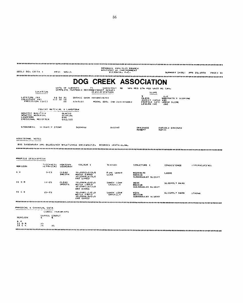
86
DOG CREEK ASSOCIATION DATE OF SWVEI: 71 SVRYEYDH: Lit3 SAHPL IN‘ PURPOSE : RECONN*,S#.NCE SUHVÉY “IN RES STN PE” “NI-I *G CAN. ‘“C*TIclN CL*SSll-,t*T,ON SLDPE -------_ ---------___ ---- LATITUDE (NI 51 5” 31 LONGITUDC tw, OHTHIC DARK BHDWNL1973)
122 32 50 CL,,, UO&TELI SLOPING
PRECISION (SLC, 00 5TAT”S: MODAL SDIL (M DEVIATION, ASPECT (MG> 180 PROFILE SITE UPPER SLDPE LENGTH LMI 200
DRI ‘NAGE RUMFF
*DDIIIDN*L PIOTES -_--I-_-_-_-_
SI‘ S*GÉbR”SH I\Nb O‘“Et<“NC” YHLAT‘HASS DMH*AîED. BEDROCY DFPTH=Q.PM.
*t***+*****+***+*****t*C*******************~***********************~**********************************************************~*****~**
HDR 1ZON
AH
11 B ”
TEXTURE STRUCTURE I
o-13 CLEAH 1O~OIR3.0/3.5 F1NE SANDY SYDDTH
YDDER*TE UDIST EXPED
LDDSE LOAM
lO.OYR4.0/3.5 MEDIVY
DRY EXPED SVBAN‘VLIR BL UCKY
13-25 CLFAR *O.OlR4.0/2.5 SANDY LDAM 6UOOTH
IE*K norsi EXPED ‘HAVLLLI
SL ,G”TL v “*RD
10.0YRS~0/3.0 MEDIUM SVBANGUAH ~LDCKI
DRI EXPED

a7
Map Units of the Dog Creek Association
The Dog Creek soils never form the major portion of a map unit. They are included with two map units of the Gang association in some highly dissected topography on either side of the
Fraser River.
DC 1 (included with Gg 1): These soils are deep and rapidly drained. They have been formed
on moderately alkaline mixed materials under a heavily overgrazed vegetation caver
of sagebrush and bluebunch wheat grass. They are very similar to the Courtney soils, but have more organic matter in the upper horizons, because they occur in a slightly
cooler and moister environment.

88
**+**************4******~*************************************************~*********************************************************
FRANCES ASSOCIATION U*Tt cc= SVRYEY: 72 SUHYEYUH: KV SAHPLING PURPOSE: RECONNAISANCE SUHYEI “AN RES STN Pto UNIT CI‘ C*N. L”CAT ION CLLSS,FIC*T,ON SLOPt ----__------_- -----
LATIT”Dk (i-4, 51 03 25 “RTHIC “L‘OsoL11973, * L”N“NDt ,Y, lill 33 45 TYPE &$LE sT*T”b: CLASS MODAL SO1L ,Nll DEY1A710N> ‘E NTLY SLDP IN‘ ISPECT ,DtG> 135
YICROTOPOGR*PHY SLIGHTLY MO”NO~~
PAHLhT MATtklAL A LANUFCIRH --_-- - -_-_--_____--- - -~--~
ltXl”R*L YLDIF IER 1 SlLTY LANDFOR” TEWFIACtLJ
SLEPA‘C ALISEN, DR**NAGt IMPEWFECTLI DRIINED RUNCWF YEDIVH
*DDIT,ONAC N07tC - - - - - - - - - - - - - - - -
PIRcNr HP<TEI<IA‘ AND LANDFORM: LIIHOLDGICALLY H‘XC-0.
WCDNLULIOATED FLUVIAL TERR*CL. FINL L”I\MY AND FINL SILTY: “EAKLY CLLCARE
CHkH,CACLY AhD PhlSIC#lLLI YE*TeRtD. FINE S‘LTI. ALKALINE N,NEfi*L b”,L.
:O”s.
HORIZON t FFERW SCENCE HATER ~AL COHP. DECOMPOSITION

89
Map Units of the Frances Association -~-
FS 1 (2 areas: 449 ha): This map unit occurs on the narrow fluvial bottomlands of the Loon
Creek and Bonaparte River valleys. The predominant soils are very weakly developed and imperfectly drained. They have formed on deep, mildly alkaline, silt loam fluvial
materials. The vegetation is a grassland-sedge community. In some areas over which
the streams flood regularly there are layered soils produced by repeated additions of sediments to the surface. The topography varies from very gently to moderately sloping.
FS 1 - Rl 1 (2 areas: 409 ha): In these areas the soils of the FS 1 map unit are associated with very poorly drained organic Rail soils (Rl 1) in the lowest portions of the floodplains. The topography varies from very gently to moderately sloping.
FS l. - Tm 1 (1 area: 467 ha): At the head of Loon Lake the soils of the FS 1 map unit occur with
small areas of deep and vell drained soils developed on mildly alkaline gravelly clay loam glacial till. The vegetation on these glacial till soils is a mixture of Douglas
fir and Ponderosa pine. The topography varies from very gently to moderately sloping.
FS 2 (1 area: 442 ha): This map unit occurs in the valley south of Clinton. The soils of the
FS 1 map unit are associated with small areas, on the lower terraces, of saline soils,
that have also developed from the silt loam fluvial materials. The topography varies
from very gently to moderately undulating.

90
GANG ASSOCIATION DATE OF S”HYtY: S”H”EI”H: AS SAMPL IN‘ P”HP”SE : RECONN*I**NCE SUHYEV “I\N RES *TN PED UNIT A‘ C*N. LUCAI 1UN CLASSIF,tAT,ON SLOW -----_-- ------------ -----
PAHkNI HATL.HI*L b LAN”l=“HH -- - - - - - - - - - - - - - - - - - - - - - - -
LtNEII‘ H”b,F,kF< 6L.C 1” GENETIC MATEHIAL I=L”“**L LANOFDRM FIN EROSIONAL M”DIl=,ER G”is 1 ED
SEEP*‘t *“SENT
fiO”, 2 EFFERVESCENCE HOH‘Z”N

91
Mao Units of the Gang Association
Ggl (2 areas: 1312 ha): This map unit occurs on the rugged, gullied topography adjacent to
the Fraser River. Very weakly developed, rapidly drained soils have formed on
moderately alkaline, mixed materials. Their upper horizons are subject to extreme
erosion in many places. The ground is either bare, or covered with sparse sagebrush and bluebunch wheat grass. The gullies have moderately to very steeply sloping sides.
Cg 1 - Ct 1 (1 area: 152 ha and Gg 1 - DC 1 (2 areas: 571 ha): The soils of the gullied Gg 1
map unit occur with small areas of deep, well drained soils developed on moderately alkaline mixed materials, on the flatter bench surfaces between the gullies. The topography ranges from moderately to very steeply sloping.

92
KERR ASSOCIATION DATE OF SURVEY: *“R”CY”R: AS “AN RE!5 s*YPL , NG PURPOSE : HA%*,S*NCE S”R”kY
CLASSIFICATIDN -- - - - - - - - - - - - -
STN Ptv UNIT A‘ CAN.
SLOPE ---
CL*55 &%Y *LDP*Nt CIS=+C, (DE‘, 270 PRDFILk SITE C#?ES, LENGTH <H, MICROT”PD‘RAPHY2YODER*~~~~ MO”NDE0
LUCA ICN -- - - - - - -
LATITUDE ,N> LON61T”V~ ,*,
GENETlC HA,Ef.,AL C”LL”“II\L “I<I‘,* SED‘MENT*HI LANDFOC<” t’L*NKtT PHYSICAL PROP. FINE GRAINED ‘tNET1‘ WAltRIAL tDLI*N NAME LIHESTOHE LANDFVhM i.lL*NKLT
WELL DRIINEV RAPID
ADDITIONAL NuTtb - - - - - - - - - - - - - -
- - - - - - - - - - - - - - - - - - - - - - - - - - - - - - - - - - - - - - - - - - - - --^- __-_ - - - - - - - - - - - -_ - - - - -_- _- _- _

93
Map Units of the Kerr Association
Kr 1 - Cs 1 (2 areas: 225 ha): Two ridge crests in the Marble Range contain predominantly deep, well drained soils developed on moderately alkaline, very gravelly sandy loam
colluvium. The soils have considerable amounts of volcanic ash and organic matter in their upper horizons, and some of them are shallow over bedrock. The vegetation
includes sparse stunted whitebark pine and juniper with numerous herbs and grasses.
These are the soils of the Kr 1 map unit. There are also small areas, on lower slopes of deep, well drained soils developed on similar colluvium, that do not have
the large amounts of volcanic ash and organic matter in the upper horizons. The vegetation here is Douglas fir, pine grass and kinnikinnick. These are the soils of
the Cs 1 map unit. The topography varies from strongly to very steeply sloping.
Kr 1 - Cs 1 - Rk 5 (20 areas: 6706 ha): This is the map unit that occurs over most of the
summits and ridge crests in the Marble Range. There is a mixture of contrasting
soils in this landscape. In addition to the soils included in the Kr 1 - Cs 1 map unit there are exposures of limestone bedrock, and below them talus slopes, on the
highest portions of the summits and ridges. The topography varies from strongly to
very steeply sloping.

PART 3
SOIL INTERPRETATIONS

3.1 INTRODUCTION: CA,NADA LAND INVENTORY MAPS
Information about soi1 cari be used to estimate the capability of a piece of land to
sustain various types of land use. As part of the Canada Land Inventory the soils were classed for forestry, agriculture, recreation and wildlife. Maps and short reports were prepared. They provide an estimate of the capability of the land considering its physical characteristics.
Economies and location are not taken into account. Some of these surveys have already been published:
Land Capability for Forestry: Lac la Hache 92 P/NW
Land Capability for Forestry: Clinton 92 P/SW Soi1 Capability for Agriculture: Clinton 92 P/SW
Land Capability for Wildlife - Waterfowl: Bonaparte River 92 P
Land Capability for Wildlife - Ungulates: Bonaparte River 9.2 P Land Capability for Recreation: Bonaparte River 92 P
A land capability map is also available for much of the Cariboo and Chilcotin area
(92 P, 92 0, 93 A/SE and SW 93 BISE and SW). It was made by comparing the capability maps for the
individual types of land use.
Land Capability Analysis: Cariboo Area
These published maps and some of the yet unpublished ones may be obtained from:
The Map Librarian or Canada Map Office Resource Analysis Eranch Surveys and Mapping Branch Ministry of the Environment Department of Cnergy, Mines Parliament Bldgs and Resources Victoria, British Columbia Ottawa, Ontario V8V 1x4 KlA OE9
Al1 the above land capability maps are published at a scale of 1:125,000 (apart from the Cariboo Area which is 1:250,000). As such they are suitable for broad scale planning, but
not for site specific interpretations.

96
3.2 SOIL INTERPRETATIONS: FORESTRY AND AGRICULTURE
The Canada Land Inventory maps show the soi1 or land capability of particular areas.
They are suitable for regional planning. They are less suitable for the evaluation of a specific
site, because areas on the map usually contain a range of capability classes. This is because they usually contain a range of soils.
In the following sections there are interpretations for forestry and agriculture relating to the individual soils. Areas delineated on the map Will have one or more soi1
associations within them. They Will therefore contain a number of different though related soils. The soi1 legend was designed to help a person locate each of these soils in the field.
The main association legend down the right hand side, helps him to identify the association with its dominant and minor soils. Then the four cross sections below the map show him the location of each of those dominant and minor soils. Ke should therefore be able to identify the particular soi1 he is standing on or looking at. The tables of interpretations in the following sections are arranged in the same way. The first table gives various interpretations or limitations of the dominant soi1 in each association. The second table gives the same information for the miner soils.
In this second table many of the soils have been grouped, as for instance a11 the poorly drained soils in the Tyee, Helena, Eugene, Williams Lake, Timber, Tunkwa and Tubbs associations Will bave similar if not the same limitations.
3.2.1. Forestry
Forested land accounts for over 90 percent of the total surveyed areas, with about 20
percent in mature forests, 60 percent in immature forests and 10 percent as non-productive forest land. The capability of the soils to support a11 aspects of a forest harvesting operation is therefore of great importance to the local economy.
Detailed interpretations of the soils for various forest management considerations are given in Tables 3 and 4. The first table deals with the dominant soils in each association and the second with the minor soils. These interpretations are for specific soils but some general- izations cari be made regarding timber harvesting on the main types of surficial materials in the
area.
The land covered by glacials is usually gently to strongly sloping and Will present few prc>blems for main line road construction. There Will be few areas where erosion or stream sedimentation are liable. The texture of the glacial till varies from gravelly sandy loam to gravelly clay loam. Therefore it contains enough fine materials to form a satisfactory binding
agent for a road bed and to allow road cuts to maintain their angle without slumping. Some
trafficability problems Will occur in the spring when the combination of snow melt, flat topography

97
and the fine textured subsoils will combine to produce very wet surface conditions. There are also certain areas with large boulders on the surface that Will present traffic problems. They are in the areas mapped as Hl 4, Te 4 and Wl 3.
The areas with surficial colluvium will present more problems to timber harvesting,
although they have higher capability for tree growth especially in the Quesnel Highlands. Erosion,
stream sedimentation and slumping of road cuts is likely on this steeper terrain where downslope
movement of the surface materials is active. Bedrock at a shallow depth may need blasting or if smoothed by glacial action, it may provide a lubricated surface over which the colluvium will move downslope.
Only in the northeast of the map sheet are there any significant areas of forested
lacustrine and fluvial materials. They are fine textured silts forming sloping or hummocky
terraces with steep outer scarps. The nature of the materials rather than the topography Will
cause the most problems to timber harvesting. During wet periods they retain surface moisture
for a long time either due to the accumulation of clay in the subsoils of the forested Gray
Luvisols or due to the accumulation of sodium and magnesium plus clay in some of the grassland soils. During dry periods the surface becomes pulverized by wheeled vehicles and the individual
particles are easily blown away by wind. Trafficability is therefore a problem. Slumps and
flows are also liable in these uniform sediments which do not have a range of particle sises to
increase their cohesion. Erosion due to drainage diversion in road building is highly likely.
The fluvioglacial deposits tend to be coarse textured gravels and sands, which have
accumulated along or adjacent to linear meltwater depressions. They are therefore suitable for
road locations as they are usually on subdued topography. They will provide good road bed
material and Will drain quickly after wet periods. However, they may need the addition of some
finer binding materials to form a good road surface and in many areas they form only a thin veneer over the glacial till. Old deltas and eskers should therefore by located for deep grave1 sources. They are mapped as Tr 3, Tr 4, Hd 3 or Hd 4. Although they Will cause few engineering problems these coarse textured materials support only moderate to poor tree growth due to soi1 moisture
deficiencies.
One proviso is necessary. The interpretations in Tables 3 and 4 cannot be regarded as
"site specific". Not a11 the problems mentioned in the text or in the tables may be encountered in any particular place. This section must be used as a guide to the types of problems that may
be encountered. Whether they will or not, and how difficult they Will be to overcome in a particular
place, must be determined by on site inspection.
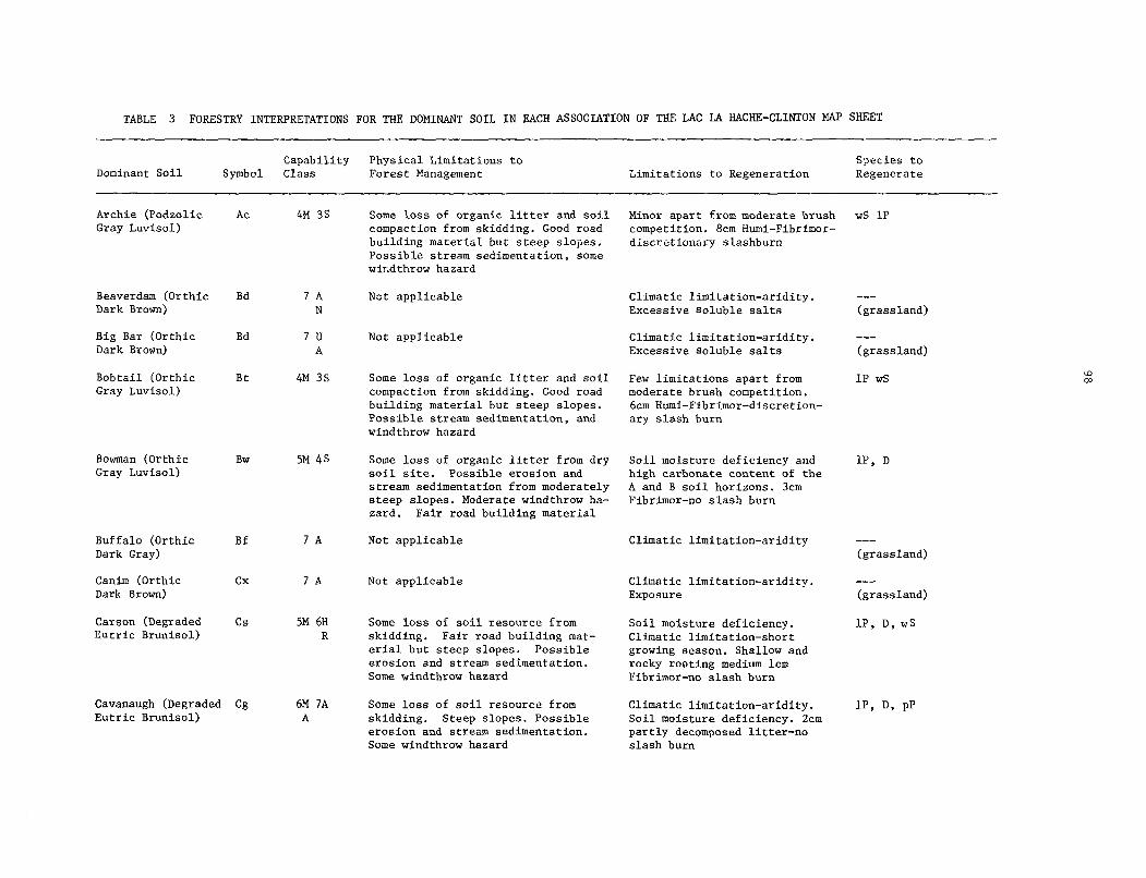
TABLE 3 FORESTRY INTERPRETATIONS FOR THE DOMINANT SOIL IN EACH ASSOCIATION OF THE LAC LA HACHE-CLINTON MAP SHEET
Dominant Soi1 Capability Physical Limitations to Species to
Symbol Class Forest Management Limitations to Regeneration Regenerate
Beaverdam (Orthic Bd 7A Not applicable Dark Brown) N
Big Bar (Orthic Bd 7u Not applicable Dark Brown) A
Bobtail (Orthic Bt 4M 3s Some loss of organic litter and soi1 Gray Luvisol) compaction from skidding. Good road
building material but steep slopes. Possible stream sedimentation, and windthrow hazard
Bowman (Orthic Gray Luvisol)
BW 5M 4S Some loss of organic litter from dry soi1 site. Possible erosion and stream sedimentation from moderately steep slopes. Moderate windthrow ha- zard. Fair road building material
Buffalo (Orthic Bf 7A Not applicable Dark Gray)
Canim (Orthic Dark Brown)
cx 7A Not applicable
Carson (Degraded cs 5M 6H Some loss of soi1 resource from Cutric Brunisol)
Soi1 moisture deficiency. R skidding. Fair road building mat- Climatic limitation-short
erial but steep slopes. Possible growing season. Shallow and erosion and stream sedimentation. rocky roating medium lcm Some windthrow hazard Fibrimor-no slash burn
Cavanaugh (Degraded Cg 6M ?A Some loss of soi1 resource from Eutric Brunisol) A skidding. Steep slopes. Possible
erosion and stream sedimentation. Some windthrow hazard
Archie (Podzolic Ac 4M 3s Some loss of organic litter and soi1 Gray Luvisol) compaction from skidding. Good road
building material but steep slopes. Possible stream sedimentation, some wir.dthrow hazard
Minor apart from moderate brush competition. 8cm Humi-Fibrimor- discretionary slashburn
Climatic limitation-aridity. Excessive soluble salts
Climatic limitation-aridity. Excessive soluble salts
Few limitations apart from moderate brush competition. 6cm Humi-Fibrimor-discretion- ary slash burn
Soi1 moisture deficiency and high carbonate content of the A and B soi1 horizons. 3cm Fibrimor-no slash burn
Climatic limitation-aridity
Climatic limitation-aridity. Exposure
Climatic limitation-aridity. Soi1 moisture deficiency. 2cm partly decomposed litter-no slash burn
ws 1P
-em
(grassland)
--- (grassland)
1P ws
lP, D
--- (grassland)
--- (grassland)
lP, D, wS
lp, D, PP

TABLE 3 (cent.) FORESTRY INTERPRETATIONS FOR THE DOMINANT SOIL IN EACH ASSOCIATION OF THE LAC LA HACHE-CLINION MAP SHEET
Dominant Soi1 Capability Physical Limitations to Species to
Symbol Class Forest Management Limitations to Regeneration Regenerate
Chasm (Degraded Cm 6A JA Some loss of soi1 resource and soi1 Climatic limitation-aridity, lp, D, PP Eutric Brunisol) compaction from skidding. Fair road exposure.2cm Fibrimor - no slash
building material but steep slopes. burn Possible erosion and stream sedimen- tation. Some windthrow hasard
Community (Orthic Cw 5M 6M Some loss of organic litter from Climatic limitation-aridity. 1P D Eutric Brunisol) A skidding. Fair road building material Soi1 moisture deficiency. 15cm
but steep slopes. Possible erosion and Fibrimor-no slash burn stream sedimentation, some windthrow hazard
Courtnay (Orthic Brown)
Dog Creek (Orthic Dark Brown)
Elliot (Carbonated Rego Humic Gleysol)
Eugene (Orthic Gray Luvisol)
Exeter (Orthic Gray Luvisol)
ct 7A Not applicable Climatic limitation-aridity
DC
El
7A
JW N
Not applicable
Not applicable
Ee 5A 4M 6A Miner apart from some liability to destroy the organic litter with skidding,and trafficability problems due to wetness in the spring. Good road building material.
Ex 4s 5A Compaction of soi1 from skidding. Trafficability problems due to water retention of fine silt. Possible erosion and stream sedimentation from silts. Poor road building material.
Frances (Orthic FS JW Regosol) N
Gang (Orthic Gg 7A Regosol) U
Not applicable
Not applicable
Climatic limitation-aridity
Periodic flooding and high carbonate content of soi1
Climatic limitation-aridity. Fibrimor-no slash burn.
Minor apart from same brush compatition, frost heaving and a climatic limitation of aridity. 8cm Humi-Fibrimor-discretionary slash burn
--- (grassland)
s-e
(grassland)
-a-
(sedge meadow)
IP, D
D, WS
Periodic flooding and excessive --- soluble salts (sedge meadow)
Climatic limitation-aridity. --- Exposure (grassland)

TABLE 3 (cent.) FORESTRY INTERPRETATIONS FOR THE DOMINANT SOIL IN EACH ASSOCIATION OF THE LAC IA HACHE-CLINTON MAP SHEET
Dominant Soi1 Capability Physical Limitations to Species to
Symbol Glass Forest Management Limitations to Regeneration Regenerate
Helena (Orthic Hl Gray Luvisol)
Holden (Degraded Hd Eutric Brunisol)
Kerr (Orthic Kr 7H Melanic Brunisol) R
Larghetto(Degraded Lg Eutric Brunisol)
4M 3s R
Lolo (Degraded Lo Dystric Brunisol)
Nielson (Degraded Nl Eutric Brunisol)
Rail (Typic Mesisol)
Rl
5A 4M 6A
6M SA A
4M 3s R
6A 5A
7w
Minor apart from some liability to destroy the organic litter with skid- ding,and trafficability problems due to wetness in the spring. Good road building material
Liability to destroy organic litter in such a dry soi1 environment. Fair road building material.
Not applicable
Fair road building material but steep slopes. Possible erosion and stream sedimentation from road construction. Some windthrow hazard.
Fair road building material but steep slopes. Possible erosion and stream sedimentation from road construction. Some windthrow hazard.
Liability to destroy the organic
Climatic limitation-aridity. 5cm Fibrimor-no slash burn
lP, D
Climatic limitation-aridity. lP, D Soi1 moisture deficiency. 3cm Fibrimor-no slash burn
Climatic limitation-cold temp- --- eratures-short growing season ("Krumholz" community)
Miner apart from moderate brush ws, 1p competition. 3cm Fibrimor-no slash burn
Minor apart from moderate brush ws, 1P competition. 3cm Fibrimor-no slash burn
Climatic limitation-aridity. litter in such a dry soi1 environment. Soi1 moisture deficiency. 3cm Poor road building material Fibrimor-no slash burn
Not applicable Excess soi1 moisture
IP, D
--- (Sedge community)
8

TABLE 3 (cent.) FORESTRY INTERPRETATIONS FOR THE DOMINANT SCIL IN EACH ASSOCIATION OF THE LAC LA HACHE-CLINTON MAP SHEET
Dominant Soi1 Capability Physical Limitations to Species to
Symbol Class Forest Management Limitations to Regeneration Regenerate
Rockland 1 & 2 (Quesnel High- lands)
Rockland 3, 4, 5 and 6
Soues (Orthic Dark Brown)
Spout (Podzolic Gray Luvisol)
Stalle (Orthic Eutric Brunisol)
Tatton (Orthic Gray Luvisol)
Timber (Degraded Eutric Brunisol)
Trurans (Degraded Dystric Brunisol)
Rk gM R 7:
Rk 7R
SO ?A 6A
St 4M 35
Se M 6A SA
Ta 5A 4M
Tm 6A
Tr M 6A 5A
Exposed and shallow bedrock. Possi- ble loss of limited soi1 resource from skidding and erosion. Road building problems from bedrock.
Not applicable.
Loss of organic litter in dry soi1 environment. Fair road building material but steep slopes. Possible erosion and stream sedimentation.
Some loss of organic litter and soi1 compaction from skidding. Good road building material but steep slopes. Possible erosion and stream sedimen- tation some windthrow hasard.
Liability to destroy organic litter in such a dry soi1 environment. Fair road building material.
Some loss of soi1 resource from skidding. Good road building mate- rial but steep slopes. Possible erosion and some windthrow hasard.
Minor apart from some liability to destroy the organic litter with skidding,and trafficability pro- blems due to wetness in the spring. Good road building material.
Liability to destroy organic litter in such a dry soi1 environment. Fair road building material,
Very shallow and rocky rooting medium. Soi1 moisture deficiency 2-3 cm Fibrimor - no slashburn
Exposed bedrock. little or no rooting medium. 1-2 cm Fibrimor - no slashburn
Climatic limitation - aridity. Exposure 3 cm Fibrimor - no slashburn
Miner apart from some brush competition. 8 cm Humi-Fibrimor discretionary slashburn
Climatic limitation - aridity. Soi1 moisture deficiency. 2 cm Fibrimor - no slashburn
Climatic limitation - aridity. 6 cm Humi-Fibrimor - discretio- nary slashburn
Climatic limitation - aridity. 4 cm Fibrimor - no slashburn
Climatic limitation - aridity. Soi1 moisture deficiency. 2 cm Fibrimor - no slashburn
ws, 1P
D, lp, PP
ws, 1P
lP, D
lP, D
D, lp, PP
lP, D
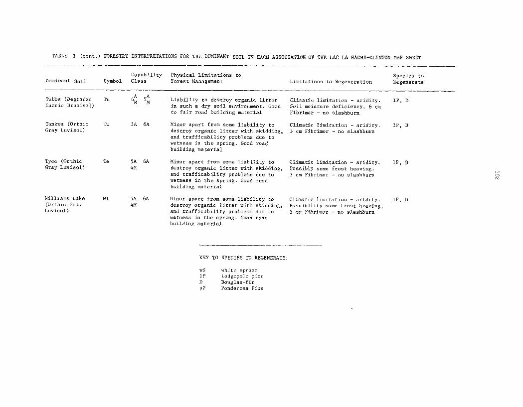
TABLE 3 (cent.) FORESTRY INTERPRETATIONS FOR THE DOMINANT SOIL IW EACH ASSOCIATION OF THE LAC LA HACHE-CLINTON MAP SHEET
Capability Physical Limitations to Species to Dominant Soi1 Symbol Class Forest Management Limitations to Regeneration Regenerate
Tyee (Orthic Gray Luvisol)
Te 5A 6A 4M
Williams Lake (Orthic Gray
Luvisol)
Wl 5A 6A 4M
Tubbs (Degraded Tu Eutric Brunisol)
6; 5; Liability to destroy organic litter Climatic limitation - aridity. in such a dry soi1 environment. Good Soi1 moisture deficiency. 6 cm to fair road building material Fibrimor - no slashburn
Tunkwa (Orthic Tw 5A 6A Minor apart from some liability to Gray Luvisol) destroy organic litter with skidding,
and trafficability problems due to wetness in the spring. Good road building material
Climatic limitation - aridity. 3 cm Fibrimor - no slashburn
Minor apart from some liability to destroy organic litter with skidding, and trafficability problems due to wetness in the spring. Good road building material
Climatic limitation - aridity. Possibly some frost heaving. 3 cm Fibrimor - no slashbum
Minor apart from some liability to destroy organic litter with skidding, and trafficability problems due to wetness in the spring. Good road building material
Climatic limitation - aridity. Possibility some frost heaving 3 cm Fibrimor - no slashburn
lP, D
IP, D
lP, D
lP, D
KEY TO SPECIES TO REGENERATE:
ws white spruce 1P lodgepole pine D Douglas-fir PP Ponderosa Pine

TABLE 4 FORESTRY INTERPRETATIONS FOR THE MINOR SOILS OF THE LAC LA HACHE-CLINTON Iti\P SHEET
Minor Soils
Map Units in which Soi1 Moisture Capa- the minor soils regime and bility Physical Limitations Limitations to Species to are to be found. drainage class. Class to Forest Management Regeneration Regenerate
Gleyed soils associated with forested soils on glacial till in the Quesnel Highlands
Gleyed soils associated with forested soils on glacial till in the Cariboo Midlands
Btl Bt2 Humid St1 st2 imperfectly Ac2 drained
35 4W
Tel Te3 Hll H13 Subhumid, H15 Eel Ee2 Wll imperfectly Twl Tw2 Tml Tul drained
3s 4W
Lithic soils (shallow Bt2 St2 Acl torock)associated Ac2 with forested soils on glacial till in the
Highlands Quesnel
Lithic soils (shallow Te3 H13 mrock)associated Ee2 Tu2 with forested soils on Twl glacial till in the Cariboo Midlands
Lithic soils (shallow Lgl Lol torock)associated with forested soils on colluvium in the Ques- ne1 Highlands -
Humid, well drained
M 5R
Subhumid M well drained 5R
Humid, well drained
gM R
U 7R
Trafficability problems, loss of organic topsoil on skid roads, soi1 com- paction due to high moisture content. Road building problems due to high water content.
Trafficability problems, loss of organic topsoil on skid roads, soi1 com- paction and road buil- ding poblems due to high water content.
Loss of shallow soi1 resource from skidding. Moderate liability to windthrow. Possible stream sedimentation. Fair road building mate- rials but steep slopes.
LOS~ of shallow soi1 resource from skidding. Moderate liability to windthrow. Fair road building materials, apart from bedrock pro- blems.
Loss of shallow soi1 resource from skidding and erosion. High lia- bility to windthrow. Possible stream sedi- mentation. Fair road building material but steep slopes
Few limitations apart ws, 1P from moderate brush competition. 8-10 cm. Humi-fibrimor - slash- burn.
Few limitations apart lP, D, wS from moderate brush competition. 6-8 Humi- Fibrimor - discretio- nary slash burn.
Shallow and rocky roo- wS, lP, D ting medium. little brush competition. 4-6 cm Fibrimor - no slash- burn.
Shallow and rocky roo- lP, D. ting medium. Soi1 mois- ture deficiency. Some brush competition. 2-4 cm Fibrimor - no slash- bum
Shallow and rocky roo- wS, 1P ting medium. Slight soi1 moisture defici- ency. Some brush com- petition 3-4 cm Fibrimor - no slashburn

TABLE 4 (cent.) FORESTRY INTERPRETATIONS FOR THE MINOR SOILS OF THE LAC LA HACHE-CLINTON MAP SHEET
Minor Soils
Map Units in which Soi1 Moisture Capa- the minor soils regime and bility Physical Limitations Limitations to Species to are to be found. drainage class. Glass to Forest Management Regeneration Regenerate
Lithic soils (shallow Ta1 Cm1 -- Subhumid to gM LOSS of shallow soi1 to bedrock) associated Csl Krl semiarid well R with forested soils on
resource from skidding drained
colluvium in the Cari- 7" and erosion. High lia- R bility to windthrow.
boo Midlands and Sou- - Possible stream sedimen- thern Uplands tation. Steep slopes.
Fair road building mate- tials apart from bedrock problems
Lithic soils (shallow -- to bedrock) associated with soils of k environments
Cxl Tr2 Bbl Hd2 Sol
A Semiarid well 7R to rapidly drained
not applicable
Soils with large basalt boulders on and under the surface
Saline and/or highly calcareous soils usually in depressions
Grassland soils asso- ciated with forested Gray Luvisols
Forested Gray Luvi- sols and Dystic Brunisols associated with Eutric Brunisols on colluvium in the Southern Uplands
Te4 H14 W13
Te2 H12 W12 Bfl Bf2 Bbl Bd1 Bd3 Bd4 Fs2 Ctl
Te2 H12 W12
cs2 Cwl cg1 cg2
Subhumid, S
well 5R
drained 6' R
Semiarid to N
Subarid mode- 7A
rately well drained
Semiarid 7A moderately well drained
Subhumid, well 5M drained M
6A
Serious access problems Climatic limitation - lP, D for harvesting equip- aridity. Rocky rooting ment. Very poor road medium 2-4 Fibrimor - building materials no slashburn
Not applicable Excessive soluble --- salts. Climatic limi- (grassland) tation - aridity
Not applicable
Loss of soi1 resource from skidding and ero- sion. Some liability to windthrow and stream sedimentation. Fair road building material but steep slopes
Shallow and rocky lP, D. rooting medium. Soi1 moisture deficiency. Some b-rush competi- tion. 2-4 cm Fibrimor - no slashburn
Climatic limitation- --- aridity. shallow and (grassland) rocky rooting medium.
Climatic limitation - --- aridity. Exposure (grassland)
Climatic limitation - lP, D. aridity. Soi1 mois- ture deficiency. 2-3 cm Fibrimor - no slash- bum
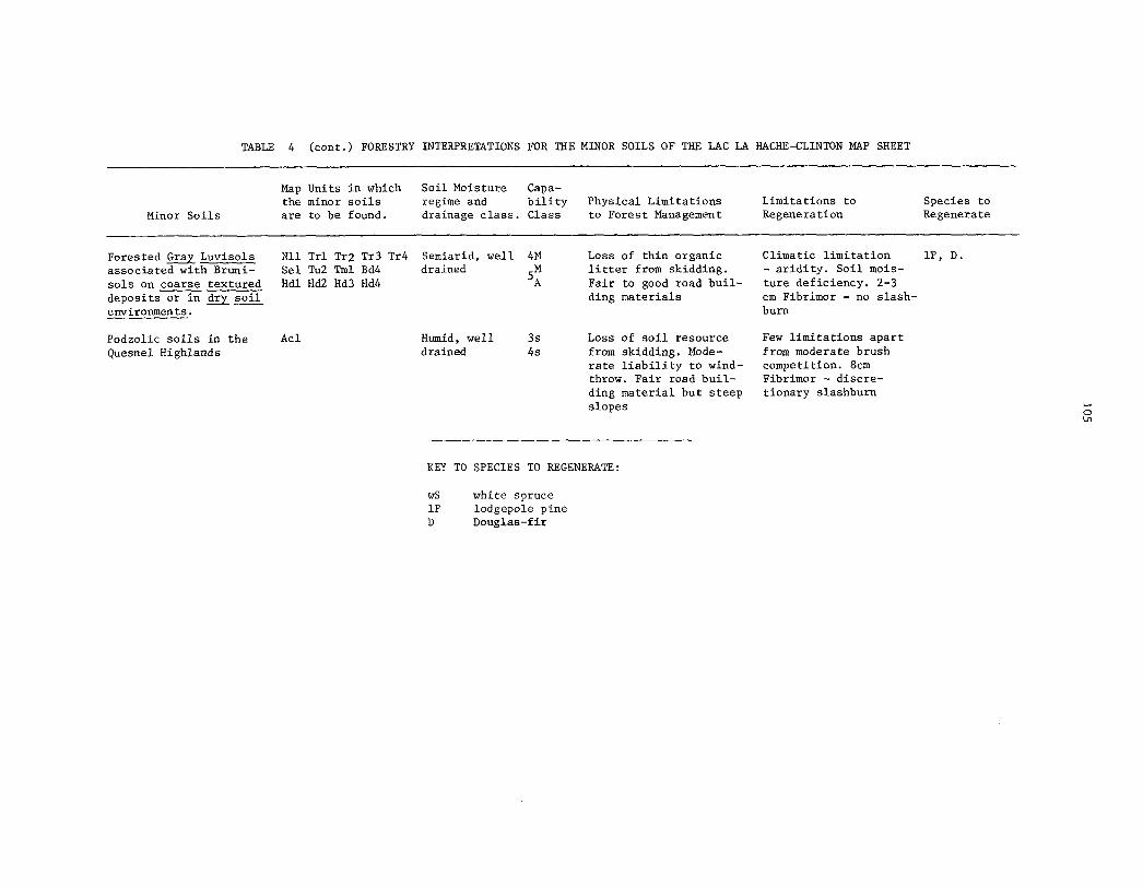
TABLE 4 (cent.) FORESTRY INTERPRETATIONS FOR THE MINOR SOILS OF THE LAC LA HACHE-CLINTON MAP SHEET
Minor Soils
Map Units in which Soi1 Moisture Capa- the minor soils regime and bility Physical Limitations Limitations to Species to are to be found. drainage class. Glass to Forest Management Regeneration Regenerate
Forested Gray Luvisols Nil Trl Tr2 Tr3 Tr4 Semiarid, well 4M Loss of thin organic Climatic limitation lP, D. associated with Bruni- Sel Tu2 Tml Bd4 drained M
58 litter from skidding. - aridity. Soi1 mois-
sols on coarse textured Hdl Hd2 Hd3 Hd4 Fair to good road buil- ture deficiency. 2-3 deposits or in & soi1 ding materials cm Fibrimor - no slash- environments. burn
Podzolic soils in the Acl Humid, well 3s Loss of soi1 resource Few limitations apart Quesnel Highlands drained 4s from skidding. Mode- from moderate brush
rate liability to wind- competition. 8cm throw. Fair road buil- Fibrimor - discre- ding material but steep tionary slashburn slopes
KEY TO SPECIES TO REGENERATE:
ws white spruce 1P lodgepole pine D Douglas-fir

106
3.2.2. Agriculture
Before the soi1 capability for agriculture could be determined the climatic capability
of the area had to be estimated. This was done by setting up a series of short term weather stations
and relating the data collected to the nearby long term Atmospheric Environment Service stations. The results are published in two maps (Climate Capability for Agriculture 92 P/NW and 92 P/SW) and are available from:
The Map Librarian Resource Analysis Branch Kinistry of the Environment Parliament Buildings Victoria, British Columbia V8V 1X4
The climate classes vary from 3 in some valleys such as near Lac la Hache to 7 on the summits of the Marble Range. The principal climatic limitations in the valleys and on the plateau of the Cariboo Midlands are aridity, lack of heat units or occasional low temperatures during the
growing season. Cenerally low temperatures in the growing season reduce the climate class to 6 or 7 in the Quesnel Highlands and Southern Uplands.
The Agricultural Capability classes and the soi1 limitations are given in Tables 5 and 6. The first table deals with the dominant soils in each association and the second with the minor
soils. A number of soils span two or three classes of climate capability. Their agriculture cap-
ability is listed for each climate class. The classes reflect the capability of the soils to pro- duce a range of field crops. Some soils may have a high capability for a single speciality crops. This is not considered. Location and economic market factors are not considered either. Further
information about the soi1 capability classification for agriculture may be obtained from the
publication of the Canada Land Inventory (1965).

107
TABLE 5 SOIL CAPABILITY FOR AGRICULTURE OF THE DOMINANT SOIL IN EACH ASSOCIATION OF THE LAC LA HACHE-CLINTON MAP SHEET
Dominant Climate Capability Class Principal soi1 limitations Soi1 (Symbol) 3 4 5 6 7 (apart from soF1 climate)
Archie (Ac) 5-7 6-7 7 steep topography and limited natural fertility
Beaverdam (Bd) 5-6 5-6
Big Bar (Bb)
Bobtail (Bt)
Bowman (Bw)
3-5
4
4
4-5
4
5-6
5-6
5-6 6-7
Buffalo (Bf)
Canim (Cx)
Carson (Cs)
Cavanaugh (Cg)
Chasm (Cm)
5
5-6
limited natural fertility and sloping topography
stoniness and sloping topography
stoniness and sloping topography
limited natural fertility, stoniness and steep topography
sloping topography
stoniness and sloping topography
6-7
7
steep topography
6-7 steep topography
6-7 6-7 steep topography and low moisture holding capacity
Community (Cw)
Courtney (Ct)
7 steep topography
5-6
Dog Creek (DC) 5-6
sloping topography and low moisture holding capacity
sloping topography and low moisture holding capacity
Elliot (El) 5
Eugene (Ee) 5-6 6
Exeter (Ex) 4-5 5
excess water in soi1
sloping topography and stoniness
limited natural fertility and sloping topography
Frances (FS)
Gang KW
5-6 6 excess water in soi1
steep topography and active erosion
Helena (Hl) 4-6 5-6 6
Holden (Hd) 4-5 5-6 6-7
stoniness and sloping topography
low moisture holding capacity, very coarse textures and sloping topography
Kerr (Kr) 7 steep topography and shallow soils over bedrock
Larghetto (Lg) 5-7 6-7 7 steep topography and limited natural fertility

108
TABLE 5 (C~NTD) SOIL CAPABILITY FOR AGRICULTURE OF THE DOMINANT SOIL IN EACH ASSOCIATION OF THE LAC LA HACHE-CLINTON MAP SHEET
Dominant Soi1 (Symbol)
Lolo (Lo)
Climate Capability Class Principal soi1 limitations 3 4 5 6 7 (apart from soi1 climate)
S-7 6-7
Neilson (Nl) 5-6
Rail (Rl) 6-7 6-7 6-7
Rockland (Rk) 7 7
Soues (SO) 6-7 6-7
Spout (St) 5-6 6-7
sto11e (Se) 5-6 6
Tatton (Ta)
Timber (Tm)
Trurans (Tr)
5-6
5
4-5 5-6
5-6 5-6
5-6
4-5 5-6
5--6
6
6
Tubbs (Tu) 6
Tunkwa (Tw)
Tyee (Te)
Williams Lake (Wl)
7 steep topography and limited natural fertility
low moisture holding capacity and sloping topography
6-7 excess water in soi1
7 7 bedrock at or very near surface
steep topography and low moisture holding capacity
steep topography and stoniness
low moisture holding capacity, stoniness and sloping topography
steep topography and stoniness
stoniness and sloping topography
low moisture holding capacity, stoniness and sloping topography
low moisture holding capacity, stoniness and sloping topography
stoniness and sloping topography
stoniness and sloping topography
stoniness and sloping topography

109
TABLE 6 SOIL CAPABILITY FOR AGRICULTURE OF THE MINOR SOILS OF THE LAC LA HACHE-CLINTON MAP SHEET
Minor Soils
Map Units in which the minor soils Climate Capability Class Principal soi1 limitations are to be found. 3 4 5 6 7 (apart from soi1 climate)
Gleyed soils associated with forested soils on glacial till in the
Highlands Quesnel
Gleyed soils associated with forested soils on glacial till in the Cariboo Midlands
Lithic soils (shallow nrock)associated with forested soils on glacial till in the
Highlands Quesnel
Lithic soils (shallow mrock)associated with forested soils on glacial till in the Cariboo Midlands
Lithic soils (shallow torock)associated with forested soils on colluvium in the
Highlands Quesnel
Lithic soils (shallow torock)associated with forested soils on colluvium -in the Cariboo Midlands and Southem Uplands
Lithic soils (shallow torock)associated with soils of e environments
Soils with large basalt boulders on and under the surface
Saline and/or highly Te2 H12 W12 Bfl calcareous soils Bf2 Bbl Bd1 Bd3 usually in depressions Bd4 Fs2 Ctl
Grassland soils asso- ciated with forested Gray Luvisols
Te2 H12 W12
Btl Bt2 St1 st2 Ac2
Tel Te3 Hll H13 H15 Eel Ee2 Wll TwlTw2 Tml Tu1
Bt2 St2 Acl Ac2
6 6
5 6 6
excess water in soi1 and stoniness
excess water in soi1 and stoniness
6-J 6-J shallow soils over bedrock and steep topography
Te3 H13 Ee2 Tw2 Tu2
Lgl Lol 6-7 6-7
Ta1 Cm1 6-7 6-7 6-J 7 shallow soils over bedrock Csl Krl and steep topography
Cxl Tr2 Bbl Hd2 Sol
Te4 H14 W13 6
6 6-J 6-7 shallow soils over bedrock stoniness and sloping topography
7 shallow soils over bedrock and steep topography
6 6 6-7
5 5-6
5 5
shallow soils over bedrock stoniness and sloping topography
6 many large boulders on the surface
salinity and excess water in soi1
sloping topography and stoniness

110
TABLE 6 (C~NTD). SOIL CAPABILITY FOR AGRICULTURE OF THE MINOR SOILS OF THE LAC LA HACHE-CLINTON MAP SHEET
Minor Soils
Map Units in which the minor soils Climate Capability Glass Principal soi1 limitations are to be found. 3 4 5 6 7 (apart from soi1 climate)
Forested Gray Luvi- cs2 cwl 6 6 6-7 7 sols and Dystric
steep topography and cg1 cg2 stoniness
Brunisols associated with Eutric Brunisols on colluvium in the Southem Uplands
Forested Gray Luvisols Nil Trl Tr2 Tr3 5 5 6 associated with Bruni- Tr4 Sel Tu2 Tml sols on coarse textured Bd4 Hdl Hd2 Hd3 deposits or in & soi1 Hd4 environments
low moisture holding capacity and stoniness
Podzolic soils in the Acl 6-7 6-7 7 Quesnel Highlands
limited natural fertility and steep topography
PART 4
DERIVED AND INTERPRETIVE MAPS

4.1 DERIVED AND INTERPRETIVE MAPS FROM THE CANSIS CARTOGRAPHIC FILE
A reference was made in Part 3 to a number of capability maps that have been published
based on soi1 information for the Lac la Hache-Clinton area. Agriculture Canada is able to produce
other maps based on the soi1 information. These may be either further interpretive maps like the
soi1 capability for agriculture, or they may be derived from the original soi1 information, such as maps of texture, slope or drainage. They cari be made because the original boundaries and map unit
symbols are stored in a computer as part of the Canadian Soi1 Information System (CanSIS).
Soi1 maps are drafted by the Cartography Section in the Land Resource Research Institute of Agriculture Canada, Ottawa. As part of the procedure map unit symbols and the location of map
unit boundaries are recorded in a computer. The soi1 map is therefore stored in its color printed
form, or as a black and white printout from the computer. Figure 1 shows the two forms from the
northeast corner of the Lac la Hache-Clinton map. In conjunction with the computer map there is also a list of a11 the map unit symbols and the area they caver. This list is called the "map index linkage". A portion of the map index linkage for the Lac la Hache-Clinton map is shown in
Figure 2. It includes, for example, a11 the map unit symbols for the Archie association, which may
be found in various parts of Figure 1. Therefore, Agriculture Canada has the means to list, by their symbols, a11 the map units of a soi1 map, and to reproduce the map itself as lines and symbols on a
plain transparent sheet of paper. This provides the basis for the production of additional types of derived or interpretive maps as the need arises.
It is possible that a map showing only the different types of geological materials is required. Such a map in fact has been made. The procedure involves replacing the original map
unit symbol by a new symbol which indicates the type of geological material. The same boundaries are retained, with the exception of those that have the same new symbols on either side. In this case the boundary is deleted. No new boundaries are added. Figure 3 shows the gological materials map for the same area as Figure 1. The Archie, Rockland and Spout map unit symbols have now been replaced by, among others, symbols such as M and M8-R2. The new symbols denote moraine and moraine ~ ~ (80%) plus rockland (20%). The computer also prints out a table showing the total area and number of units represented by the new symbols. A portion of this table for t;le "M" and WM8-R2" symbols is also included in Figure 4.
SO far the following derived or interpretive maps have been produced for the Lac la
Hache-Clinton sheet:
Geological materials Boulder fields Soi1 moisture regimes
Organic soils Capability for trailriding
A microfiche copy of these maps has been included in this report. Original full-size maps are available from The Library, Resource Analysis Branch, Ministry of Environment, Parliament
Buildings, Victoria, B.C. VBV 1X4. Tel. (604) 387-6995.

112
If future users of the soi1 information need other types of derived or interpretive
maps they should contact the senior author of this report at the following address:
British Columbia Pedology Unit Agriculture Canada 6660 N.W. Marine Drive Vancouver, British Columbia V6T 1x2 Tel. (604) 224-4355


LNK0151 MAP INDEX LINKAGE FOR LLH-C 92P/NW,SW
NO. OF TOTAL TOTAL TOTAL AREAS ACREAGE HECTARES SQ MILES
6 1
2 1
5433.6 2278.4
190.8 371.5
1245.5 160.4
1187.2
2198.92 922.03
77.22 150.32 504.02
64.89 480.46
8.49 3.56 0.30 0.59 1.95 0.26 1.86
13137.9 5316.80 20.53 11467.3 4640.75 17.92
1670.6 676.06 2.62
FIRST / UNIQUE SYMBOL
19 A- 20 Acl-Ld1/5-7 2: AGl-RKl/4-7
Acl-R&l/5-7 23 ACl-SI2/3-7 24 A-t1/517 25 Ag/6-7
26 Ac2 27 28
AC2-R--S-/2-7 Ac2/3-6
Figure 2. A portion of the map index linkage for the Lac la Hache-Clinton soi1 map. It shows the number of areas
and their total acreage represented by the map units of the Archie Association - Acl and Ac2. (zz is a symbol used in the
computer for water bodies - lakes etc).


117
REFERENCES
Annas, R.M. and Coupé, R. (eds). 1979. Biogeoclimatic Zones and Subzones of the Cariboo
Forest Region. Min. Forests, Victoria, 103 pp. Atkinson, H.J., Giles, G.R., MacLean, A.J. and Wright, J.R. 1958. Chemical Methods of
Soi1 Analysis. Contrib. No. 169 (Revised), Chem. Div., Sci. Serv., CDA, Ottawa. Baier, W. and Robertson, G.W. 1965. Estimation of latent evaporation from simple weather
observations. Can. J. Plant Sci. 45: 276-234. Bascomb, C.L. 1968. Distribution of pyrophosphate-extractable iron and organic carbon in
soils of various groups. J. Soi1 Sci. 19: 251-268.
Canada Land Inventory. 1965. Soi1 Capability Classification for Agriculture. Canada Land
Inventory, Rept. No. 2, Can. Dept. Forestry, Ottawa. Canada Soi1 Survey Committee. 1973. The Revised System of Soi1 Classification for Canada.
Proc. 9th meeting Canada Soi1 Survey Comm., Saskatoon, Sask. Canada Soi1 Survey Committee. 1976. Glossary of Terms in Soi1 Science. CDA. Publ. No. 1459
(Revised), Ottawa, 44 pp. Canada Soi1 Survey Committee. 1978. The Canadian system of soi1 classification. Can. Dep.
Agric. Publ. 1646. Supply and Services Canada, Ottawa, Ont. 164 pp.
Campbell, R.B. and Tipper, H.W. 1971. Geology of the Bonaparte Lake map area, British
Columbia. Mem. No. 363, Geol. Surv. Can., Dept. Energy, Mines and Resources, 100 p.
Chilton, R. 1979. Climate in Annas, R.H. and Coupé, R. (eds). - Biogeoclimatic Zones and
Subzones of the Cariboo Forest Region. Min. Forests, Victoria, 23-28. Holland, S.S. 1964. Landforms of British Columbia, a physiographic outline. Br. Col. Dept.
Mines and Pet. Res. Bull. 48, 138 pp. Holmes, R.M. and Robertson, G.W. 1958. Conversion of latent evaporation to potential evapo-
transpiration. Can. J. Plant Sci. 33: 164-172.
Johnson, C.M. and Nishita, H. 1952. Microestimation of sulfur in plant materials, soils and irrigation waters. Anal. Chem. 24: 736-742.
Kilmer, V.J. and Alexander, L.T. 1949. Methods of making mechanical analyses of soils. Soi1 Sci. 63: 15-24.
Krajina, V.J. 1969. Ecology of Forest Trees in British Columbia. Ecol. of Western North America, 2(l): 1-146.
McKeague, J.A. and Day, J.H. 1966. Dithionite - and oxalate - extractable Fe and Al as aids in differentiating various classes of soils. Can. J. Soi1 Sci. 46: 13-22.
Prest, V.K. 1969. Retreat of Wisconsin and Recent Ice in North America. Map 12578. Geol. Surv. Can., Dept. Energy, llines and Resources, Ottawa.
Richards, L.A. (ed). 1954. Diagnosis and Improvement of Saline and Alkali soils. U.S. Salinit
Laboratory, U.S. Dept. Agr. Hbk. No. 60, 160 pp. Schaefer, D.G. 1978. Climate in Valentine, K.W.G., Sprout, P.N., Baker, T.E. and Lavkulich, L.1 -
(eds). The Soi1 Landscapes of British Columbia. Min. Environment, Victoria, 3-10.

\ i
Schofield, R.K. and Taylor, A.W. Proc. 19: 164-167.
Schollenberger, C.J. and Whittaker, C.W. 1958. Improved determination of carbonates in
1955. The measurement of soi1 pH. Soi1 Sci. Soc. Amer.
soils. Soi1 Sci. 85: 10-13.
Tipper, H.W. 1971. Glacial Geomorphology and Pleistocene History of Central British
Columbia. Bull. No. 196, Geol. Surv. Can., Dept. Energy, Mines and Resources,
Ottawa.
Valentine, K.W.G., Sprout, P.N., Baker, T.E. and Lavkulich, L.M. (eds). 1978. The Soi1
Landscapes of British Columbia. Min. Environment, Victoria, 197 pp.
