soil—landscape relationships in the piedmont of maryland1
TRANSCRIPT
DIVISION S-5—SOIL GENESIS, MORPHOLOGY,AND CLASSIFICATION
Soil-Landscape Relationships in the Piedmont of Maryland1
R. G. DARMODY AND J. E. Foss2
ABSTRACTA study was conducted to investigate and model the soil-landscape
relationships in the Piedmont of Maryland. The soil series of partic-ular interest were the Chester, Glenelg, and Elioak series of TypicHapludults. Results indicate that Elioak soil is a relict paleosol. Astone line separating strongly weathered Elioak soil material fromsilty overburden was revealed in several excavations. Particle-sizeanalyses and elemental analyses of silt fractions confirmed these dis-continuities. Comparisons with known and radiocarbon-dated loessdeposits on the eastern shore of Maryland indicate that the siltyoverburden on the Piedmont is loess which was deposited after10,520 ± 240 years B. P. Where the loess is thick, as on gentle slopes,Chester soils are mapped. Where the relict paleosol has been essen-tially eroded away, as on steeper slopes, Glenelg soils are mapped.
1 Scientific Article no. A-3035 and Contribution no. 6098 of theMaryland Agricultural Experiment Station, Dep. of Agronomy,College Park, MD 20742. Received 24 Aug. 1981. Approved 14 Dec.1981.
Portions of this work initially presented before Division S-5 SoilScience Society of America, at Detroit, Mich., December 1980.The work reported here is part of a Ph.D. dissertation by the SeniorAuthor: Geomorphic and Pedologic Relationships of Elioak andAssociated Soils in the Piedmont of Maryland.
2 Formerly Graduate Research Assistant and Professor of SoilScience, respectively, Dep. of Agronomy, Univ. of Maryland. NowAssistant Professor of Pedology, Dep. of Agronomy, University ofIllinois, Urbana, IL 61801, and Chairman, Dep. of Soil Science,North Dakota State Univ., respectively.
Additional Index Words: loess, Elioak, Chester, Glenelg, stone line,saprolite.
Darmody, R. G., and J. E. Foss. 1982. Soil-landscape relationshipsin the Piedmont of Maryland. Soil Sci. Soc. Am. J. 46:588-592.
THE Piedmont province of Maryland occupies about6,400 km2 or about one-fourth of the land area
of the state. It is bounded on the west by CatoctinMountain, on the south by the Potomac River, on theeast by the fall line, and on the north by the Penn-sylvania border. This, the state's most rapidly urban-izing province, has under its rolling landscape thestate's oldest and most complex rocks (Volkes andEdwards, 1974). These rocks are, in places, highlyweathered and blanketed by a layer of saprolite upto 61 m in thickness (Nutter and Otton, 1969).
Of the upland soils in the Piedmont developed insaprolite from acid crystalline rocks, Elioak soils arethe most strongly developed. Elioak soils are classi-fied, according to Soil Taxonomy (Soil Survey Staff,1975), in the clayey, kaolinitic, mesic family of TypicHapludults. They occupy upland positions on the sum-mits and upper slopes in the Piedmont. Slopes range
DARMODY & FOSS: SOIL-LANDSCAPE RELATIONSHIPS IN THE PIEDMONT OF MARYLAND 589
from 0 to 30%. Occupying similar, often adjacent po-sitions on similar slopes and developed from what isconsidered to be similar parent materials are two otherTypic Hapludults, Chester and Glenelg. These are inthe fine-loamy, mixed mesic family. Chester soils havea solum thicker than 76 cm and are less micaceousthan Glenelg soils (Reybold and Matthews, 1976). Thesimilarity of these two series often makes it difficultto separate them in the field. In addition, the possi-bility of a loessial component in Piedmont soils hasbeen suggested by previous workers (Cleaves et al.,1974; Reybold and Matthews, 1976). Manor soils,coarse-loamy, micaceous, mesic Typic Dystrochrepts,also occur on adjacent areas most often with, but notconfined to, steeper slopes. Glenville soils occupysmall areas on the same landscapes in heads of minordrains. They are classified as fine-loamy, mixed, mesicAquic Fragiudults.
Loess has been described in nearby areas of theMid-Atlantic states. Tedrow et al. (1953) found loessdeposits up to 3 m in thickness on the Piedmont ofNew Jersey. Carey et al. (1976) identified a well-sorted, discontinuous silty mantle in southeasternPennsylvania as loess. In Maryland, Foss et al. (1978)described loess on the upper eastern shore and Cleaveset al. (1974) suggested the possibility of loess on thePiedmont.
The objectives of this investigation were to: (i) de-velop models to demonstrate pedogenic and geo-morphic relationships in the Piedmont of Maryland;and (ii) determine if loess was present on the Piedmont.
METHODS AND MATERIALSField
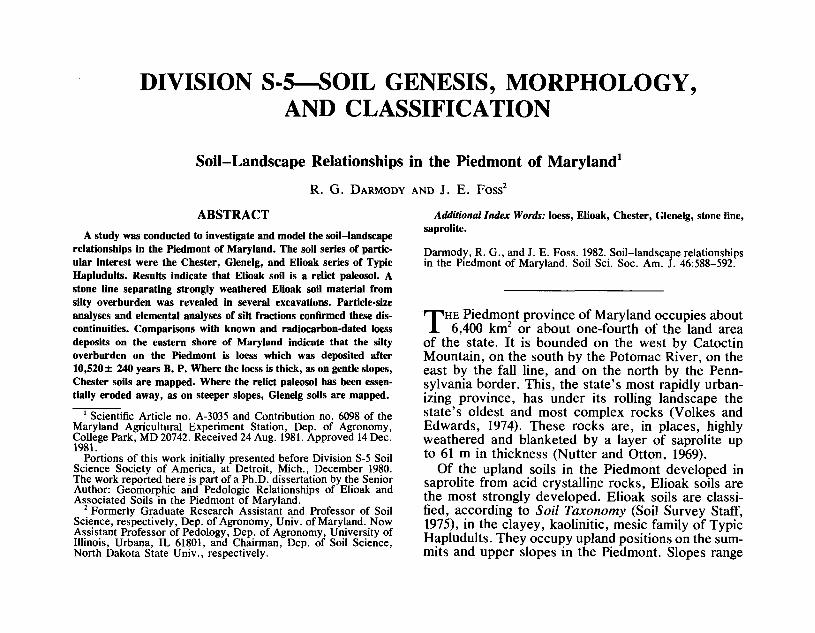
Reconnaissance sampling sites were chosen from areasmapped as Elioak in published soil surveys of Baltimore,Carroll, Harford, Frederick, Howard, and Montgomerycounties in Maryland. Sites were selected to give a repre-sentative sample of all bedrock types over the entire areaof the Piedmont with large areas of soil mapped as Elioak.Samples were collected, where the rocks permitted, to adepth of 180 cm in 10-cm increments with a standard 7.5cm in diameter bucket auger at 54 sites. In addition, slopetransects were conducted at six sites to determine the re-lationship between soil variability and slope. Figure 1 showsthe location of the reconnaissance sites.
Sites for detailed profile descriptions were chosen fromthe reconnaissance sites on the basis of profile character-istics, parent material, and accessibility. The objective wasto observe in detail those pedons which appeared to fit thesoil survey series description for Elioak on a variety ofbedrock types. In addition, Glenelg and Chester pedonsadjacent to Elioak pedons were also sampled. Where con-ditions permitted, an excavation was made at each site toa depth below the bottom of the BC horizon. The profilewas sampled by horizon to the bottom of the pit, and ad-ditional samples were taken by bucket auger to 4 m belowthat, stones permitting. Figure 1 indicates the location ofthe detailed study sites.
LaboratoryParticle-size distribution was determined by the pipette
method (Day, 1965). Total zirconium, titanium, iron, andcalcium in the fine and coarse silts were determined byx-ray spectroscopy following methods outlined by Beavers(1960) and Alexander et al. (1962), except that boric acid
_PE N N S VI. V A N.IIA
/ BALTIMORE j * H A R F O R D
Fig. 1 — Distribution of reconnaissance and detailed sampling sites.More than one profile may have been examined at each site. Notall sites could be shown at this scale.
was used as a binder for the pellets. Calculations of meanand median particle size and sorting coefficients were madeby the methods of Folk (1974). Mineralogy of <2-/xm ma-terial was determined using a Norelco x-ray diffractometerfollowing the sample preparation procedure outlined byJackson (1969).
RESULTS AND DISCUSSIONOn the basis of field morphological evidence, and
supported by particle size and mineralogical analysesin the laboratory, about 20% of the Elioak soils werefound to be truncated in the B horizon and cappedby a silty mantle. Of these, about 40% had a stoneline at the contact. Table 1 gives the morphologicaldata for a representative pedon. Hues of the siltymantle were 10YR to 7.5YR. The underlying paleosolhue was 2. SYR. An argillic horizon has developedboth in the silty mantle and in the residuum. In someareas, where the silty mantle was thicker than 75 cm,possibly due to slumping or slope wash, a fragipanwas developed above the discontinuity. If this oc-curred at the head of a drainageway, the soil wasmapped as Glenville series, a fine loamy, mixed, mesicAquic Fragiudult (Soil Survey Staff, 1975).
Soil particle-size data are given in Table 2. Thestone line separating the silty cap from the paleosolis indicated by the 18% >2-mm fraction in the 2Btblhorizon (Table 2). Clay-free silt contents ranged from65.1 to 75.5% for the silty mantle and from 14.5 to42.2% for the paleosol. The silty mantle was bettersorted than the paleosol. Sorting coefficients rangedfrom 3.1 to 4.6 for the silty mantle and from 11.6 to
590 SOIL SCI. SOC. AM. J. , VOL. 46, 1982
Table 1—Morphology of the Chester profile and underlying Elioak paleosol. t
Depth, cm
0-1010-2222-4545-7474-100
100-130130-180330-340
HorizonAEBEBt2Btbl2Btb22Btb32C
Moist color
10YR3/310YR4/47.5YR5/67.5YR5/62.5YR4/62.5YR4/62.5YR4/6variegated
Texture
silsilclsiclcccIcos
Structure
IfsbkImsbk2msbk2msbk2csbk2cprcprSaprolite
Clay skins
nonenonenonefewcommonmanymanynone
Consistence
mfrmfrmfrmfrmfrmfrmfrmvfr
Boundary
asascscwcwgwci-
t The abbreviations used for soil characteristics are given in Soil Survey Staff (1951, p. 139). The pedon described here was S79 Md 3-1.
Table 2—Particle-size analysis of the Chester profile and underlying Elioak paleosol. tParticle-size analysis
Depth, cm
0-1010-2222-4545-7574-100
100-130130-180330-340
Horizon
AEBEBt2Btbl2Btb22Btb32C
>2
72254
18786
2-0.05
26.029.720.216.834.735.635.477.5
0.05-0.002
53.555.351.651.725.324.823.617.9
< 0.002
20.515.028.231.540.039.641.04.6
Clay free silt
67.365.171.975.542.241.140.014.5
GraphicmeanMz
2842211428292730
MedianMd
2830242221222165
SortingSot
3.53.53.14.6
11.612.012.03.2
t Pedon S79Md 3-1.j So = Trask's Sorting Coefficient (Folk, 1974).
%K20 %CaO0 2 4 0 0.1 0.2 0.3
%Fe20315 20
%Ti0225 0 0.5 1.0 1.50
50
100*••*
y 15O^^£ 200aQ 250
300
350
400
S79MD3-1
_ Fine silt,_„ Coarse silt
%Zr02.05 -10 .15x .20
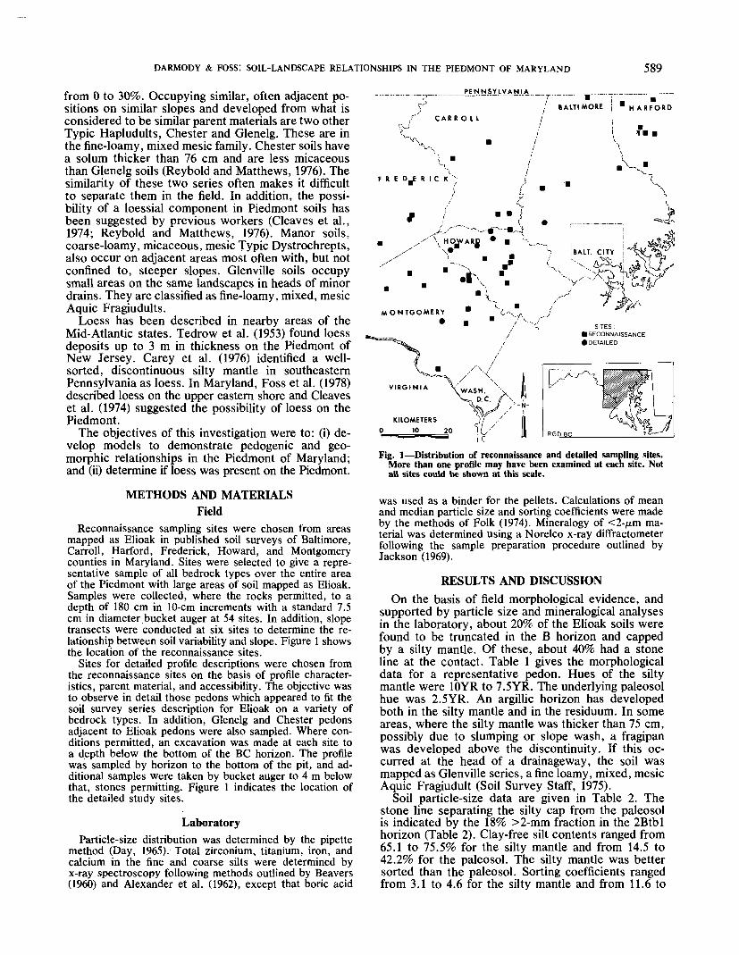
Fig. 2—Distribution of Ca, K, Fe, Ti, and Zr expressed as oxides in coarse and fine silts with depth in the Chester soil and underlying Elioakpaleosol, pedon S79 Md 3-1. Dashed line indicates lithologic discontinuity.
%K20:Zr02 %CaO:Zr02 %Fe203:Zr02 %Ti02:Zr020 25 SO 75 0 0.5 1j0 1.5 O 100 200 300 400 50O 5 10 15 20 25 3O
50
100
E 150
JC 200"a0 250a
300
350
400
S79MD3-1— Fine silt,-. Coarse silt
.-/---V--
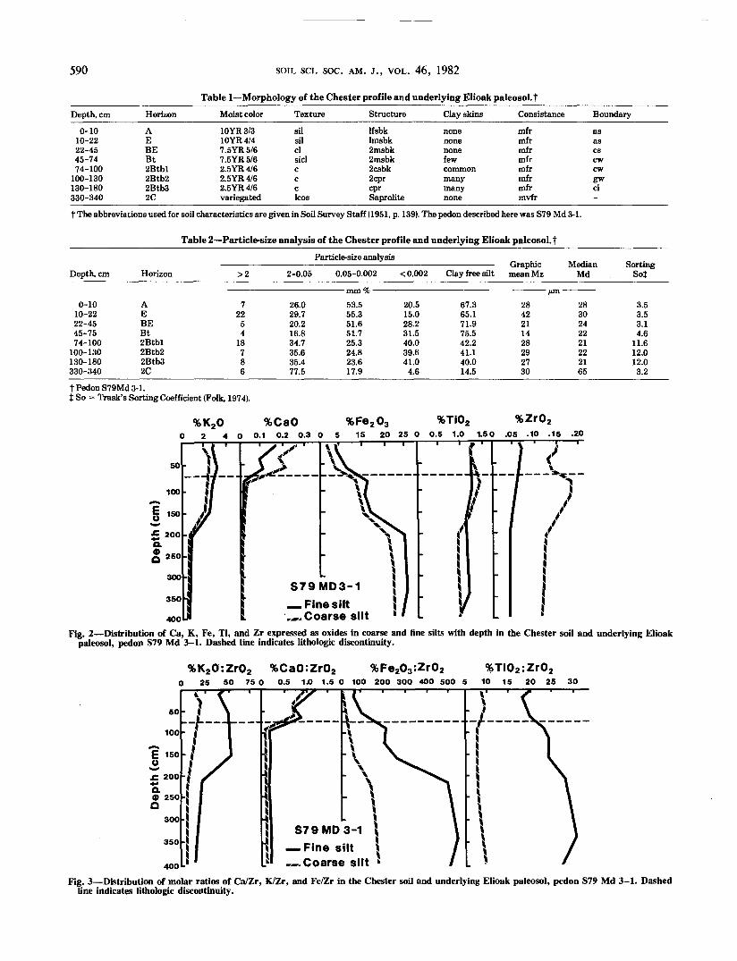
Fig. 3—Distribution of molar ratios of Ca/Zr, K/Zr, and Fe/Zr in the Chester soil and underlying Elioak paleosol, pedon S79 Md 3-1. Dashedline indicates lithologic discontinuity.
DARMODY & FOSS: SOIL-LANDSCAPE RELATIONSHIPS IN THE PIEDMONT OF MARYLAND 591
Table 3—Clay (< 2 ;tm) mineralogy of the Chester profileand underlying Elioak paleosol. t
Depth, cm Horizon Vr Chl Kl Qr Gi Go
0-1010-2222-4545-7474-100
100-130130-180330-340
AEBEBt2Btbl2Btb22Btb32C
XX§XXXXXXXX-
XXXXXXXXXXXX
_XIX-_---
XXXXXXXXXXXXXXXXXXX
XXXXXXXXXXXX
_--XXXXXXX
_--XXXXXXX
tPedonS79Md3-l.i Mi = mica, Vr = vermiculite, Chl = chlorite, Kl = kaolinite, Qr =
quartz, Gi = gibbsite, Go = geothite.§ X = < 10% Low; XX = 10-30% Medium; XXX = 30-70% High.1 Chlorite is most probably dioctahedral, formed by transformation of
vermiculite.
Table 4—Slope distribution of selected soil series in thePiedmont of Maryland, f
SoilSlope class frequency Weighted
—— averageF slope
ManorGlenelgChesterElioak
0.1§0.65.03.3
22.155.768.073.9
38.735.225.520.7
28.18.41.52.1
10.10.100
0.9000
15977
t Reybold and Matthews (1976); Smith and Matthews (1975); Matthewsand Hershberger (1968); Matthews (1960,1969); Matthews et al. (1961).
t Slope classes: A, 0-3%; B, 3-8%; C, 8-15%; D, 15-25%; E, 25-40%; F,45-65%.
§ Represents percentage of total acreage of soil series mapped in particularslope class.
12.0 for the paleosol. The saprolite below the paleosolwas as well sorted as the silty mantle, apparentlyreflecting the uniformity of grain size of the parentrock.
The clay mineralogy of the representative pedon isgiven in Table 3. The mineralogy classes are "mixed"in the silty mantle and "kaolinitic" in the paleosol bythe system of Soil Survey Staff (1975). All of thesurficial silty caps found in this study tended to havemore quartz, vermiculite, mica, and chlorite than theunderlying residuum which contained more kaolinite,gibbsite, and goethite. The increase in kaolinite, gibb-site, and goethite below the lithologic discontinuityindicates more intense weathering.
Figure 2 gives the elemental distribution for the fineand coarse silt fractions for the representative pedon.These show two weathering zones and verified fieldobservations of lithologic discontinuities in many ofthe profiles studied. The molar ratios (Fig. 3) alsoshow two weathering zones in this representativepedon. Similar observations were made in five otherprofiles. These data are not reported here. The siltymantle on these soils has an elemental content anda clay mineralogy which compare well with knownloess deposits identified on the eastern shore of Mary-land (Foss et al., 1978). In addition, the soils devel-oped in those deposits have similar argillic horizonexpression. The Bt/A clay ratio was 1.65 for theknown loess and 1.54 for the Piedmont silty mantle.These lines of evidence suggest that the silty mantledetected on the Piedmont is contemporaneous withthe known loess deposits on the eastern shore ofMaryland which have been radio-carbon dated at10,520± 240 years B. P. (Foss et al., 1978). Sourcearea was believed to be the Chesapeake Bay region.Some of the material on the Piedmont may also haveoriginated from this large source area. It appears,however, because of the relatively high mica contentin the Piedmont material, that some contribution frommore local sources was also made. The loess on thePiedmont also appears similar to, although thinner andmore discontinuous than, that reported in New Jerseyby Tedrow et al. (1953) and in Pennsylvania by Careyet al. (1976).
Table 4 gives the distribution of slopes for Manor,Glenelg, Chester, and Elioak soils as mapped in thePiedmont of Maryland. Data were obtained by takingthe weighted average on an area basis of each slope
class in published Soil Surveys (Matthews, 1960,1969;Matthews et al., 1961; Matthews and Hershberger,1968; Reybold and Matthews, 1976; Smith and Mat-thews, 1975). Elioak and Chester soils are mapped onthe most gentle 'slopes of the four soils. They werenot mapped in slope classes steeper than D, and theirweighted average slope is 7%. Manor soils, while oc-curring on gentle A slopes, are also mapped on slopesas steep as F. Their weighted average slope is 15%.Glenelg soils are intermediate, occurring in slopeclasses ranging from A to E. Their weighted averageslope is 9%.
SUMMARY AND CONCLUSIONSSoil Genesis and Landscape Evolution
Of the 61 Elioak profiles examined, 13 were trun-cated in the B horizon and capped by a silty mantle.Five of those had a stone line at the contact. Ele-mental, particle size, and mineralogical analyses sug-gest that the overlying material correlates with loessdeposits on the eastern shore of Maryland which areabout 10,000 years old. In addition, the Piedmont siltymantle appears to be similar to other late Pleistoceneloess deposits found in nearby states. Source area wasprobably the Chesapeake Bay region. Analyses indi-cate that the underlying material is intensely weath-ered. Elioak soils can be considered as relict paleosolsthat developed during an interglacial period such asthe Sangamon or Yarmouth. They can serve as strati-graphic markers of former land surfaces. This can aidin differentiating between Chester and Glenelg soils.
Glenelg soils would be those well-developed resid-ual soils formed from micaceous, acid crystallinerocks. They have formed on surfaces where the formerElioak soils were essentially eroded away during thePleistocene, and do not have a significant loessial com-ponent. As such, they can be thought of as being indynamic equilibrium with the present climate actingon the micaceous, acid crystalline rocks. Chestersoils, on the other hand, have formed, at least in part,in loess deposits which blanketed the late Pleistocenelandscape. Since that time, the loess has slumped andmixed with the underlying material. Stone lines andabrupt lithologic discontinuities are in soils where theloess blanketed a well-developed Elioak soil protectedat the surface by lag deposits. If the loess blanketedan area without a residual Elioak, much mixing with
592 SOIL SCI. SOC. AM. J . , VOL. 46, 1982
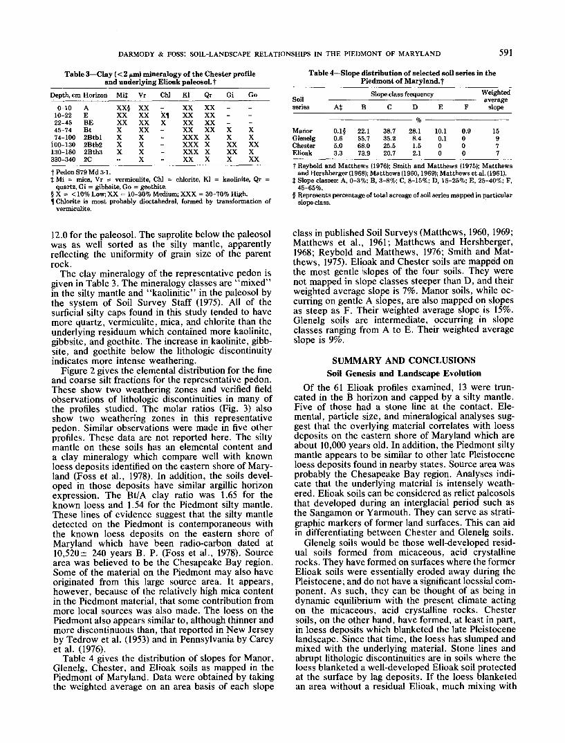
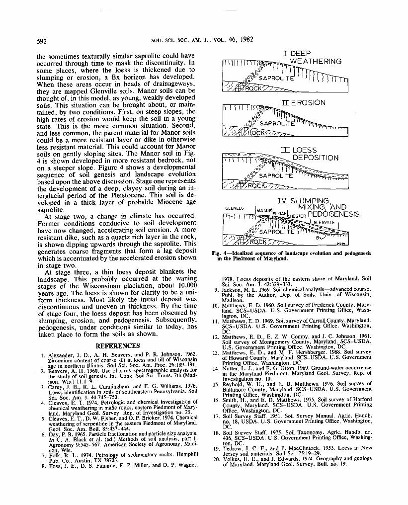
the sometimes texturally similar saprolite could haveoccurred through time to mask the discontinuity. Insome places, where the loess is thickened due toslumping or erosion, a Bx horizon has developed.When these areas occur in heads of drainageways,they are mapped Glenville soils. Manor soils can bethought of, in this model, as young, weakly developedsoils. This situation can be brought about, or main-tained, by two conditions. First, on steep slopes, thehigh rates of erosion would keep the soil in a youngstate. This is the more common situation. Second,and less common, the parent material for Manor soilscould be a more resistant layer or dike in otherwiseless resistant material. This could account for Manorsoils on gently sloping sites. The Manor soil in Fig.4 is shown developed in more resistant bedrock, noton a steeper slope. Figure 4 shows a developmentalsequence of soil genesis and landscape evolutionbased upon the above discussion. Stage one representsthe development of a deep, clayey soil during an in-terglacial period of the Pleistocene. This soil is de-veloped in a thick layer of probable Miocene agesaprolite.
At stage two, a change in climate has occurred.Former conditions conducive to soil developmenthave now changed, accelerating soil erosion. A moreresistant dike, such as a quartz rich layer in the rock,is shown dipping upwards through the saprolite. Thisgenerates coarse fragments that form a lag depositwhich is accentuated by the accelerated erosion shownin stage two.
At stage three, a thin loess deposit blankets thelandscape. This probably occurred at the waningstages of the Wisconsinan glaciation, about 10,000years ago. The loess is shown for clarity to be a uni-form thickness. Most likely the initial deposit wasdiscontinuous and uneven in thickness. By the timeof stage four, the loess deposit has been obscured byslumping, erosion, and pedogenesis. Subsequently,pedogenesis, under conditions similar to today, hastaken place to form the soils as shown.
I DEEPWEATHERING
U | | Hfn?•°<f/Go
t,°o' ' ' ' ''fiV SAPROLITE
in LOESSDEPOSITION
GLENELG
-i-Kr-rrntff!W. SLUMPING,
MAN0. MIXING, ANDI CHESTER PEDOGENESIS
a.,'oe,•o^'SAPROL'l T
Fig. 4—Idealized sequence of landscape evolution and pedogenesisin the Piedmont of Maryland.